Embed Size (px)
Citation preview

U.S. Department of the InteriorU.S. Geological Survey
Radon-222 in the Ground Waterof Chester County, Pennsylvaniaby Lisa A. Senior
Water-Resources Investigations Report 98-4169
prepared in cooperation with theCHESTER COUNTY WATER RESOURCES AUTHORITYand theCHESTER COUNTY HEALTH DEPARTMENT
Lemoyne, Pennsylvania1998

ii
U.S. DEPARTMENT OF THE INTERIORBRUCE BABBITT, Secretary
U.S. GEOLOGICAL SURVEYCharles G. Groat, Director
For additional information Copies of this report may bewrite to: purchased from:
District Chief U.S. Geological SurveyU.S. Geological Survey Branch of Information Services840 Market Street Box 25286Lemoyne, Pennsylvania 17043-1584 Denver, Colorado 80225-0286

iii
Abstract . . . . . . . . . . . . . . . . . . . . . . . . . . . . . . . . . . . . . . . . . . . . . . . . . . . . . . . . . . . . . . . . . . . . . . . . . . . . . . . . . . . . 1
Introduction . . . . . . . . . . . . . . . . . . . . . . . . . . . . . . . . . . . . . . . . . . . . . . . . . . . . . . . . . . . . . . . . . . . . . . . . . . . . . . . . 1
Purpose and scope . . . . . . . . . . . . . . . . . . . . . . . . . . . . . . . . . . . . . . . . . . . . . . . . . . . . . . . . . . . . . . . . . . . . . 2
Description of Chester County . . . . . . . . . . . . . . . . . . . . . . . . . . . . . . . . . . . . . . . . . . . . . . . . . . . . . . . . . . . 2
Well-numbering system. . . . . . . . . . . . . . . . . . . . . . . . . . . . . . . . . . . . . . . . . . . . . . . . . . . . . . . . . . . . . . . . . 2
Previous studies . . . . . . . . . . . . . . . . . . . . . . . . . . . . . . . . . . . . . . . . . . . . . . . . . . . . . . . . . . . . . . . . . . . . . . . 2
Acknowledgments . . . . . . . . . . . . . . . . . . . . . . . . . . . . . . . . . . . . . . . . . . . . . . . . . . . . . . . . . . . . . . . . . . . . . 2
Radon-222 in ground water . . . . . . . . . . . . . . . . . . . . . . . . . . . . . . . . . . . . . . . . . . . . . . . . . . . . . . . . . . . . . . . . . . . 3
Hydrogeologic setting and sources of radon-222 in rocks in Chester County . . . . . . . . . . . . . . . . . . . . . . . . . 3
Lithology . . . . . . . . . . . . . . . . . . . . . . . . . . . . . . . . . . . . . . . . . . . . . . . . . . . . . . . . . . . . . . . . . . . . . . . . . . . . . 4
Ground-water system . . . . . . . . . . . . . . . . . . . . . . . . . . . . . . . . . . . . . . . . . . . . . . . . . . . . . . . . . . . . . . . . . . 5
Sources of radon-222 in rocks . . . . . . . . . . . . . . . . . . . . . . . . . . . . . . . . . . . . . . . . . . . . . . . . . . . . . . . . . . . . 5
Radon-222 in ground water in Chester County. . . . . . . . . . . . . . . . . . . . . . . . . . . . . . . . . . . . . . . . . . . . . . . . . . 12
Methods of data collection and analysis . . . . . . . . . . . . . . . . . . . . . . . . . . . . . . . . . . . . . . . . . . . . . . . . . . 12
Sample selection . . . . . . . . . . . . . . . . . . . . . . . . . . . . . . . . . . . . . . . . . . . . . . . . . . . . . . . . . . . . . . . . 13
Sample collection. . . . . . . . . . . . . . . . . . . . . . . . . . . . . . . . . . . . . . . . . . . . . . . . . . . . . . . . . . . . . . . . 13
Laboratory analysis. . . . . . . . . . . . . . . . . . . . . . . . . . . . . . . . . . . . . . . . . . . . . . . . . . . . . . . . . . . . . . 15
Statistical analysis . . . . . . . . . . . . . . . . . . . . . . . . . . . . . . . . . . . . . . . . . . . . . . . . . . . . . . . . . . . . . . . 15
Spatial distribution and factors affecting spatial distribution . . . . . . . . . . . . . . . . . . . . . . . . . . . . . . . . 15
Lithology . . . . . . . . . . . . . . . . . . . . . . . . . . . . . . . . . . . . . . . . . . . . . . . . . . . . . . . . . . . . . . . . . . . . . . 18
Hydrogeologic setting and well characteristics . . . . . . . . . . . . . . . . . . . . . . . . . . . . . . . . . . . . . . 21
Relation to other dissolved constituents in ground water . . . . . . . . . . . . . . . . . . . . . . . . . . . . . . . . . . . 23
Temporal variability . . . . . . . . . . . . . . . . . . . . . . . . . . . . . . . . . . . . . . . . . . . . . . . . . . . . . . . . . . . . . . . . . . . 24
Summary . . . . . . . . . . . . . . . . . . . . . . . . . . . . . . . . . . . . . . . . . . . . . . . . . . . . . . . . . . . . . . . . . . . . . . . . . . . . . . . . . . 25
References cited . . . . . . . . . . . . . . . . . . . . . . . . . . . . . . . . . . . . . . . . . . . . . . . . . . . . . . . . . . . . . . . . . . . . . . . . . . . . 30
ILLUSTRATIONS
PLATES[in pocket]
Plate 1. Geology and concentration of radon-222 in ground-water samples from 534 wells,Chester County, Pennsylvania, 1986-96
2. Geology and location of 534 wells sampled for radon-222, Chester County,Pennsylvania, 1986-96
FIGURES
Figure 1. Map showing geologic terranes of Chester County, Pennsylvania . . . . . . . . . . . . . . . . . . . . 4
2. Diagram showing uranium-238 radioactive decay series. . . . . . . . . . . . . . . . . . . . . . . . . . . . 7
CONTENTS
Page

iv
Figures 3-7. Graphs showing:
3. Gamma-ray logs and uranium and thorium content of rock samples fromwells CH-3315 and CH-3122 in the Chickies Quartzite . . . . . . . . . . . . . . . . . . . 10
4. Gamma-ray logs from wells CH-249 and CH-4147 in the Ledger Dolomiteand uranium and thorium content of rock samples from well CH-249 . . . . . . 11
5. Gamma-ray logs from well CH-4269 in the Brunswick Group, well CH-4761in the Peters Creek Schist, and well CH-4404 in the Elbrook Limestone . . . . . 12
6. Cumulative frequency of radon-222 concentrations in ground-water samplesfrom 534 wells . . . . . . . . . . . . . . . . . . . . . . . . . . . . . . . . . . . . . . . . . . . . . . . . . . . . . . 16
7. Boxplots showing distributions of radon-222 concentrations in ground water bygeologic unit in statistically ranked order . . . . . . . . . . . . . . . . . . . . . . . . . . . . . . . . . . . . 19
8-10. Graphs showing:
8. Temporal variations of depth to water and concentrations of dissolvedradon-222, radium-226, radium-228, and sulfate measured monthly forwell CH-3335, September 1988 to April 1992 . . . . . . . . . . . . . . . . . . . . . . . . . . . . 26
9. Relation between depth to water and radon-222 and sulfate concentrationsin monthly samples from well CH-3335, September 1988 to April 1992 . . . . . 27
10. Temporal variation of radon-222 concentrations in samples from and depthto water in wells CH-1514, CH-3484, CH-4339, and CH-5238, April 1996to April 1997 . . . . . . . . . . . . . . . . . . . . . . . . . . . . . . . . . . . . . . . . . . . . . . . . . . . . . . . 28
TABLES
Table 1. Stratigraphic column of geologic units in Chester County, Pennsylvania . . . . . . . . . . . . . . 6
2. Average uranium abundance in the earth’s crust and some sedimentary andigneous rocks . . . . . . . . . . . . . . . . . . . . . . . . . . . . . . . . . . . . . . . . . . . . . . . . . . . . . . . . . . . . . 8
3. Geologic unit, lithologic code, aquifer code, and area of geologic units, listed inorder of increasing area; number of wells sampled for radon 1986-96 andaverage sample density in geologic units . . . . . . . . . . . . . . . . . . . . . . . . . . . . . . . . . . . . 14
4. Summary statistics of radon-222 concentrations in ground water in geologicunits listed in order of increasing median concentrations . . . . . . . . . . . . . . . . . . . . . . 17
5. Range of radon-222 concentrations in water from 28 wells sampled on two ormore dates . . . . . . . . . . . . . . . . . . . . . . . . . . . . . . . . . . . . . . . . . . . . . . . . . . . . . . . . . . . . . . 22
6. Range of radon-222 concentrations in replicate samples of ground waterfrom 13 wells . . . . . . . . . . . . . . . . . . . . . . . . . . . . . . . . . . . . . . . . . . . . . . . . . . . . . . . . . . . . 24
7. Wells sampled for radon, 1986-96. . . . . . . . . . . . . . . . . . . . . . . . . . . . . . . . . . . . . . . . . . . . . . . 33
8. Results of analyses for radon-222, uranium, radium-226, radium-228, major ions,and physical and chemical properties in ground-water samples from 534 wells,summer 1986 through spring 1997 . . . . . . . . . . . . . . . . . . . . . . . . . . . . . . . . . . . . . . . . . . 47
ILLUSTRATIONS—Continued
Page

v
Sea level: In this report, “sea level” refers to the National Geodetic Vertical Datum of 1929—a geodeticdatum derived from a general adjustment of the first-order level nets of the United States and Canada,formerly called Sea Level Datum of 1929.
Abbreviated water-quality units used in report:ppm, parts per millionmg/L, milligrams per literµg/L, micrograms per literµS/cm, microsiemens per centimeter at 25 degrees CelsiuspCi/L, picocuries per liter
Radioactivity Units
A commonly used unit of measure for radioactivity is the picocurie. One Curie is the activity of onegram of radium-226, which is equal to 3.7 × 10¹⁰ atomic disintegrations per second; a picocurie is 10-12
Curies, which is about equal to 2.2 atomic disintegrations per minute. Activity refers to the decay of aradioactive substance, which is measured by the number of particles emitted by a radionuclide per unit oftime. The rate of decay is proportional to the number of atoms of a radioactive substance present, andinversely proportional to its half life, which is the time necessary for the substance to lose half itsradioactivity. Activity is defined as being equal to n ⋅ λ, where n is the number of atoms of a radionuclideand λ is the decay constant. The decay constant, λ, is equal to the natural logarithm of 2 divided by thehalf-life of the radionuclide. Although picocurie is strictly a measure of activity, this report uses the termconcentration to refer to measurements of radon-222 in picocuries per liter (activity per volume).
Lengthinch (in) 2.54 centimeterfoot (ft) 0.3048 meter
Areasquare mile (mi2) 2.590 square kilometer
Flow rategallon per minute (gal/min) 0.06309 liter per second
Radioactivitypicocurie per liter (pCi/L) 0.037 becquerel per liter
Temperaturedegree Fahrenheit (°F) °C=5/9.(°F-32) degree Celsius
CONVERSION FACTORS AND ABBREVIATIONS
Multiply By To obtain
1
ABSTRACT
Radon-222 concentrations in ground water in31 geologic units in Chester County, Pa., were mea-sured in 665 samples collected from 534 wells from 1986to 1997. Chester County is underlain by schists,gneisses, quartzites, carbonates, sandstones, shales, andother rocks of the Piedmont Physiographic Province. Onaverage, radon concentration was measured in waterfrom one well per 1.4 square miles, throughout the759 square-mile county, although the distribution ofwells was not even areally or among geologic units.
The median concentration of radon-222 in groundwater from the 534 wells was 1,400 pCi/L (picocuriesper liter). About 89 percent of the wells sampled con-tained radon-222 at concentrations greater than300 pCi/L, and about 11 percent of the wells sampledcontained radon-222 at concentrations greater than5,000 pCi/L. The highest concentration measured was53,000 pCi/L. Of the geologic units sampled, the medianradon-222 concentration in ground water was greatest(4,400 pCi/L) in the Peters Creek Schist, the secondmost areally extensive formation in the county. Signifi-cant differences in the radon-222 concentrations inground water among geologic units were observed. Gen-erally, concentrations in ground water in schists,quartzites, and gneisses were greater than in groundwater in anorthosite, carbonates, and ultramafic rocks.The distribution of radon-222 in ground water is relatedto the distribution of uranium in aquifer materials of thevarious rock types.
Temporal variability in radon-222 concentrationsin ground water does not appear to be greater thanabout a factor of two for most (75 percent) of wells sam-pled more than once but was observed to range up toalmost a factor of three in water from one well. In watersamples from this well, seasonal variations wereobserved; the maximum concentrations were measuredin the fall and the minimum in the spring.
INTRODUCTION
Radon-222 is a naturally occurring radioactivegas that can be present in ground water. Radon-222concentrations in ground water are related to the
uranium concentrations in the aquifer materialand, in general, appear to differ by geologic unit(Loomis, 1987; Michel and Jordana, 1987). To mini-mize health risks associated with this naturallyoccurring radioactive gas, the U.S. EnvironmentalProtection Agency (USEPA) had proposed a maxi-mum contaminant level (MCL) of 300 pCi/L forradon-222 in drinking water (U.S. EnvironmentalProtection Agency, 1991); however, the USEPAwithdrew the proposed MCL for radon-222 indrinking water in 1997 (Federal Register Docu-ment 97-20666, filed August 5, 1997) and has beendirected to promulgate a final regulation byAugust 1999 [Safe Drinking Water Act Amend-ments of 1996, section 1412(b)(13)(D-E)].
In Chester County, Pa., many residences andbusinesses rely for drinking water supplies onground water that can contain elevated concentra-tions of radon-222. Data on the concentrations ofradon-222 in ground water in Chester County havebeen collected by the U.S. Geological Survey(USGS) since 1986 as part of studies done in coop-eration with county and state agencies and awatershed association. Most of the ground-watersamples contained radon-222 at concentrationsexceeding 300 pCi/L (the proposed MCL for radonthat was withdrawn in 1997), and concentrationsas high as 53,000 pCi/L were measured. Althoughmany samples had been collected, the data prior to1995 were insufficient to characterize radon-222concentrations in ground water in Chester Countyas a whole because (1) data on radon-222 ground-water concentrations in some geologic units werelimited or missing, (2) the spatial distribution ofsamples was uneven, and (3) little was knownabout temporal variations and the uranium con-tent of geologic units. Most samples for radon-222analysis collected prior to 1995 generally werefrom wells sampled for other studies and were notevenly distributed throughout the county or in allgeologic units. For example, many wells were sam-pled as part of the Chester County ground-watermonitoring program that emphasizes sampling ofwells near suspected point and nonpoint sourcesof contamination regardless of geologic setting orspatial distribution. Therefore, additional data on
RADON-222 IN THE GROUND WATER OF
CHESTER COUNTY, PENNSYLVANIA
by Lisa A. Senior

2
radon-222 concentrations in ground water werecollected by USGS in 1995-97 to provide betterinformation on the spatial and temporal distribu-tion of radon-222 in ground water. This work wasdone by USGS in cooperation with the ChesterCounty Water Resources Authority and the Ches-ter County Health Department.
Purpose and Scope
This report presents data on radon-222 concen-trations in ground-water samples collected byUSGS in Chester County from 1986 to 1997.Radon-222 concentrations in ground water aresummarized for the county and for the major geo-logic units that are used for drinking water supply.The relation between radon-222 concentrations inground water and geologic unit is discussed toprovide a better understanding of the spatial dis-tribution of radon-222 in ground water of thecounty. In addition, results of analyses of samplescollected from several wells over periods rangingfrom 1 to 3 years are discussed to provide betterunderstanding of the temporal variability ofradon-222 in ground water. These data can be usedby residents and businesses in the county who relyon ground water for supply and by public healthofficials and planners to help assess possible healthrisks posed by radon-222 in ground water.
Description of Chester County
Chester County encompasses 759 mi2 in thePiedmont Physiographic Province of southeasternPennsylvania (Berg and others, 1989). The topogra-phy of the Piedmont Physiographic Province ischaracterized by gently rolling uplands dissectedby narrow valleys. Elevation of the land surfaceranges from about 100 to 1,040 ft above sea level inChester County. The county is underlain predomi-nantly by metamorphic rocks of igneous and sedi-mentary origin.
Chester County has a modified humid conti-nental climate. Winters are mild to moderatelycold and summers are warm and humid. Normalmean annual air temperatures at the National Oce-anic and Atmospheric Administration (NOAA)weather station in West Chester, Pa. (pl. 2), for1961-90 is 52.9 °F (11.6 °C) (Owenby and Ezell,1992). Normal mean temperature for 1961-90 forJanuary, the coldest month, is 29.5 °F (-1.4 °C), andnormal mean temperature for July, the warmestmonth, for 1961-90 is 74.8 °F (23.8 °C). Normal
mean annual precipitation for 1961-90 is 45.88 in. atWest Chester. Precipitation is distributed fairlyevenly throughout the year.
The population of Chester County from the1990 census is 376,396 (Chester County PlanningCommission, 1994). Much of the county is rural.About 580 mi2 (76 percent) of the county area issparsely developed, which includes agricultural,recreation, wooded, and vacant land (DelawareValley Regional Planning Commission, 1994).Many residences and businesses in rural areas useprivate wells for water supply.
Well-Numbering System
The well-numbering system used in this reportconsists of an abbreviation prefix followed by asequentially-assigned local well number. The pre-fix is a county abbreviation, and the prefix “CH”denotes a well in Chester County. In addition tothe local well number, each well or spring isassigned a unique 15-digit site-identification num-ber, on the basis of the latitude and longitude (indegrees, minutes, and seconds) of the well and atwo-digit site sequence number.
Previous Studies
Data on radon concentrations in ground waterin Chester County were published in Sloto (1989)and Sloto (1994). The extent and distribution ofradium and radon in ground water in the ChickiesQuartzite in Chester County, as well as in theneighboring counties in southeastern Pennsylva-nia, were studied 1986-89 (Cecil and others, 1991;Senior and Vogel, 1995). Seasonal variations inradium and radon concentrations in water fromone well sampled over 3 years was described bySenior (1992). Radon concentrations in groundwater in the Red Clay Creek and West Valley CreekBasins, Chester County, are presented in Senior(1996) and Senior and others (1997), respectively.Lindsey and Ator (1996) made a regional assess-ment of radon concentrations in ground water inthe Lower Susquehanna Basin, including part ofwestern Chester County.
Ackno wledgments
The cooperation of well owners who madetheir wells accessible for water samples and water-level measurements is greatly appreciated, espe-cially those owners that allowed repeated sam-pling of their wells for temporal variability studies.
3
RADON-222 IN GROUND WATER
Radon-222 can migrate away from its source inrock materials because of differences in physicaland chemical properties. Radon-222 is a virtuallyinert gas and the only member of the uranium-238decay series that is in the gaseous state under stan-dard temperature and pressure conditions.Radon-222 and its parents are soluble under differ-ent geochemical conditions. For example, uraniumis most soluble in oxidizing waters in the +6 oxida-tion state (especially as a uranyl complex UO2+)and in the +8 oxidation state (uranyl carbonates atpH greater than 8) (Langmuir, 1978). Radium isfound only in the +2 oxidation state and is mostmobile in reducing, chloride-rich ground waterwith elevated total dissolved solids (Tanner, 1964).
Differences in the chemical properties of radio-nuclides within a decay series may result in parti-tioning of the radionuclides within a closedphysical-chemical system. In a closed ground-water system, where no intermediate decay prod-uct of the uranium-238 or other radionuclide decayseries is lost, secular equilibrium is reached after aperiod based on the half-life of the longest-livedintermediate radionuclide of the decay series. Sec-ular equilibrium describes a state in which activi-ties of parents and daughter products in a decayseries are equal, and mass ratios are fixed at someconstant value. Radon-222 reaches 99-percent equi-librium with its parent, radium-226, after about25.4 days (Durrance, 1986, p. 286). In an open sys-tem, if partitioning results in transport of somedecay products or parent radionuclides out of thesystem, secular equilibrium no longer prevails.Many ground-water systems are open systems atthe local scale.
The dominant means of radon-222 migrationfrom sources in aquifer materials is mechanicaltransport as a solute in flowing ground water(Durrance, 1986, p. 209). Radon can physicallyenter the ground-water system from aquifer mate-rials by (1) alpha recoil of radon-222, the productnucleus of alpha decay, resulting in ejection fromthe parent radium-226 atom in a solid (crystalstructure or disordered surface condition);(2) diffusion through mineral grains; and(3) diffusion and transport in rock mass, includingfractures (Andrews and Wood, 1972; Durrance,1986).
Many studies have shown that radon-222 isnot supported by its parent radium-226 in solution,which means that the amount of dissolved
radium-226 generally is insufficient to generate theobserved amount of radon-222 in ground water.Most radon-222 in ground water is derived fromradium-226 in the solid phase of aquifer materials(in minerals in the rock matrix and on fracture sur-faces), which in turn is ultimately derived fromuranium-238 and subsequent daughters (fig. 3).Radon-222 commonly is present in ground waterin concentrations that are greater than that of anyof its parents because solubility limits on theseradionuclides are greater than those for radon-222in most ground waters.
Radon-222 concentrations in ground watervary because of variable concentrations of sourcesin the aquifer materials, emanation rates from min-eral sources, aquifer porosity, and permeability.King and Connor (1989) published calculationsthat show for a given radium-226 (or uranium-238)content of rock, variations in the normal range ofemanation coefficients (10 to 30 percent) and aqui-fer porosity (5 to 35 percent) can cause radon con-centrations to vary by up to an order of magnitude.In their study, the spatial distribution of elevatedradon-222 concentrations in ground water isdescribed and related to factors that includesources within the aquifer, lithology, aquifer andwell-construction characteristics, ground-waterchemistry, and hydrogeologic setting.
HYDROGEOLOGIC SETTING ANDSOURCES OF RADON-222
IN ROCKS OF CHESTER COUNTY
In Chester County and elsewhere in the Pied-mont Physiographic Province, the fractured bed-rock generally acts as an unconfined aquifer that isrecharged by precipitation and discharges water tostreams. Ground-water-flow systems tend to be oflocal rather than regional extent. Lithology, geo-logic structure, the ground-water system, andsources of radon-222 in rocks are described belowto provide a basis for understanding relationsbetween the occurrence of radon-222 in groundwater, uranium content of aquifer materials, andhydrogeologic factors, including aquifer perme-ability, ground-water chemistry, and flow ofground water in the county. The hydrogeology andground-water-flow systems in major rock types inChester County are described in more detail bySloto (1994) and Vogel and Reif (1993).

4
Lithology
The geologic units mapped in Chester Countycan be grouped into three terranes composed ofrelated groups that reflect the origin, metamorphic,and structural history of the rocks (fig. 1) (Sloto,1994, p. 6). The Brandywine terrane in southernChester County includes Paleozoic metasedimen-tary rocks (schists and phyllites), felsic and maficgneisses, and mafic and ultramafic rocks. The Lan-caster terrane in northern Chester County includesthe Chester Valley sequence of Paleozoic metamor-
phosed clastic and carbonate rocks and Precam-brian anorthosite and gneisses. These Precambriangneisses and anorthosite form a group known asthe Honeybrook massif, and the Paleozoic sedi-ments form the Chester Valley Sequence (fig. 1).The Mesozoic terrane in the northernmost part ofChester County includes sandstones, shales, con-glomerate, and diabase. Much of the current struc-ture of rocks in Chester County was formed duringthe early Paleozoic when a tectonic collision at theeastern edge of North America caused folding ofcontinental shelf rocks and thrusting of oceanic
Figure 1. Geologic terranes of Chester County, Pennsylvania. (From Sloto, 1994, fig. 3.)

5
sediments and magmatic arc rocks over the Gren-ville (Precambrian) basement and Paleozoic clasticand carbonate rocks (Wagner and Srogi, 1987,p. 22). The Mesozoic rocks of northernmost Ches-ter County were deposited during continental rift-ing in the Triassic and Jurassic that resulted in theformation of the Newark Basin.
The stratigraphic column for geologic unitsmapped in Chester County is shown in table 1. Thenomenclature for geologic units in the county isthat of the Pennsylvania Geological Survey (PAGS)as presented in Sloto (1994). North of the ChesterValley, some geologic units were remapped sincepublication of the map by Berg and others (1980),whereas south of the Chester Valley, much of theoriginal mapping is retained. Other reports prior toSloto (1994) used the previous PAGS nomenclature(Berg and others, 1980). USGS nomenclature forthe geologic units is given by Lyttle and Epstein(1987).
Ground-W ater System
The bedrock water-table aquifer in ChesterCounty is recharged directly by precipitation thatinfiltrates through the overlying soil and saprolite(decomposed bedrock) and from lateral inflowfrom adjacent geologic units. Thickness of soil andsaprolite and depth to competent bedrock varies,ranging from less than 10 ft to more than 80 ft, butcommonly is about 20 to 40 ft. The saprolite typi-cally has greater porosity and storage than the frac-tured bedrock. Together, the bedrock and over-lying saprolite can act as a single water-table aqui-fer (Vogel and Reif, 1993, p. 12), although in placesthe weathered zone acts as a confining or semicon-fining layer. Openings to the surface and withinthe aquifer have developed along a complex inter-connected network of bedding, joints, and struc-turally controlled planes, such as cleavage, faults,and fractures. In carbonate aquifers especially,these openings may be enlarged by mineral disso-lution.
Ground-water flow is driven by the hydraulicgradient through a network of fractures. Manywells intercept more than one water-bearing frac-ture. Each fracture opening penetrated by a wellcan have a different hydraulic head; ground waterflows from areas of higher head to areas of lowerhead. Analysis of frequency of water-bearingzones (water-producing fractures) for 1,414 wellsin Chester County indicates most (92 percent)water-bearing zones are within 200 ft of land sur-face (Sloto, 1994, p. 16). The frequency of water-
bearing zones decreases with depth, and no suchzones are reported at depths greater than 600 ftbelow land surface. The data are sparse for depthsgreater than 600 ft but do not preclude ground-water flow at such depths. This analysis supportsthe model of a shallow, local flow system in Ches-ter County, similar to that in other geologic units inthe Piedmont (Trainer, 1988).
Generally, the water table is a subdued replicaof the topography, and ground-water divides coin-cide with ridge tops. Median depth to water tendsto be greater in wells on hilltops than in wells onslopes. Springs on slopes are indicative of a shal-low water table and (or) a local flow system. Geo-logic units that are relatively resistant to erosionform ridges. Ground water recharged there candischarge to streams, springs, and to adjacent geo-logic units. Wells in the fractured bedrock, espe-cially in upland areas, generally supply water thatwas recharged locally.
Sour ces of Radon- 222 in Roc ks
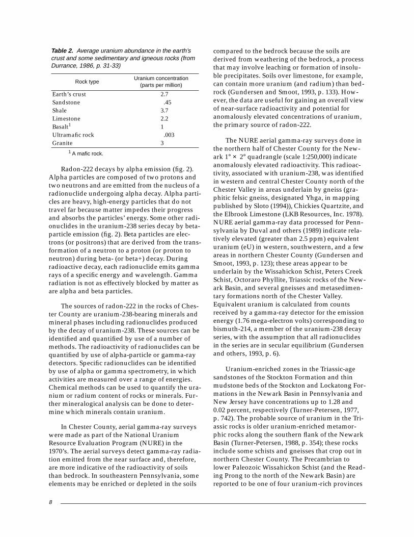
Radon-222 is a naturally occurring radionu-clide produced from the radioactive decay of ura-nium-238, the most abundant of the naturallyoccurring isotopes of uranium. Uranium is presentin small amounts in many minerals. Uranium con-centrations generally differ among rock types andcan vary considerably within one geologic unit.Shales and granites typically contain more ura-nium than limestone or basalt, for example(table 2).
Uranium-238 is the primary parent of theradioactive-decay series that includes radium-226(Ra-226) and its daughter product radon-222 andends in the stable isotope lead-206 (Pb-206) (fig. 2).Uranium-238 has a long half-life of 4.5 × 10⁹ yearsand, therefore, decays slowly. Other radionuclidesin the decay series have half-lives many orders ofmagnitude shorter and decay rapidly. Radium-226has a half-life of 1,600 years and radon-222 has ahalf-life of 3.82 days. Radon-222 is the most abun-dant isotope of radon. Rn-220 and Rn-219 are otherless abundant short-lived naturally occurringradon isotopes that belong to the thorium-232 anduranium-235 decay series, respectively. Rn-220 andRn-219 are difficult to measure because of their lowabundance and short half-lives of 55.6 and 3.92 sec-onds, respectively. Another consequence of theshort half-lives of Rn-220 and Rn-219 is that theseisotope have little time to migrate from theirsources (Durrance, 1986, p. 209).

6
Table 1. Stratigraphic column of geologic units in Chester County, Pennsylvania (from Sloto, 1994, p. 7)
Age Structural group Geologic unit
Quaternary AlluviumTertiary Pensauken and Bridgeton Formations,
undividedBryn Mawr Formation
Early Jurassic Newark Supergroup DiabaseLate Triassic Brunswick Group
Hammer Creek Formation1
Lockatong FormationStockton Formation
Ordovician and Cambrian Chester Valley Sequence Conestoga LimestoneElbrook LimestoneLedger DolomiteKinzers LimestoneVintage Dolomite
Cambrian and Late Precambrian Antietam Quartzite and Harpers Phyllite,undivided
Chickies QuartziteAge uncertain, probably Cambrian Baltimore Mafic Complex Serpentinized ultramafite
Gabbro and metagabbroLate Precambrian to middle Ordovician Glenarm Supergroup Peters Creek Schist
Octoraro PhylliteWissahickon SchistCockeysville MarbleSetters Quartzite
Age unknown, probably late Precambrianand(or) early Paleozoic
PegmatiteultramafitemetadiabaseMetagabbromafic gneiss, amphibolite faciesmarble
Precambrian Avondale, West Chester, andWoodville massifs2
Felsic gneiss, amphibolite faciesMafic gneiss, amphibolite faciesFelsic gneiss, granulite faciesMafic gneiss, granulite faciesmarble
Precambrian Mine Ridge massif Felsic and mafic gneissPrecambrian Honey Brook massif Anorthosite
Felsic gneiss, amphibolite faciesGraphitic felsic gneiss, amphibolite faciesFelsic and intermediate gneiss,
amphibolite faciesBanded mafic gneiss, amphibolite faciesFelsic gneiss, granulite faciesGraphitic felsic gneiss, granulite faciesmarbleMafic gneiss, granulite facies
1 Quartz-pebble conglomerate of the Brunswick Formation of McGreevy and Sloto (1977).2 Includes Baltimore gneiss and gabbro of Bascom and Stose (1932), and granite gneiss, gabbroic gneiss and gabbro, and
gabbro of McGreevy and Sloto (1977).

7
Figure 2. Uranium-238 radioactive decay series (from U.S. Environmental Protection Agency, 1981).
234U92
2.5 × 10⁵ yr
230Th90
8 × 10⁴ yr
226Ra88
1,620 yr
222Rn86
3.8 da
218Po84
3 min
214Pb8227 min
238U92
4.5 × 10⁹ yr
234Pa91
6.8 hr
234Th9024 da
210Bi83
5 da
214Po84
1.6 × 10⁻⁶ sec
210Pb8220 yr
214Bi8320 min
206Pb82
Stable
210Po84
138 da
210Po84
138 da
α
β
α
α
α
α
ααα
β
β
β
β
β
α = alpha decayβ = beta decay
THE URANIUM-238 SERIES
α
β Atomic weightAtomic numberHalf-life
U, uranium; Th, thorium; Pa,protactinium; Ra, radium; Po,polonium; Pb, lead; Bi, bismuth
yr, year; da, day; hr, hour; min,minute; sec, second
EXPLANATION
8
Radon-222 decays by alpha emission (fig. 2).Alpha particles are composed of two protons andtwo neutrons and are emitted from the nucleus of aradionuclide undergoing alpha decay. Alpha parti-cles are heavy, high-energy particles that do nottravel far because matter impedes their progressand absorbs the particles’ energy. Some other radi-onuclides in the uranium-238 series decay by beta-particle emission (fig. 2). Beta particles are elec-trons (or positrons) that are derived from the trans-formation of a neutron to a proton (or proton toneutron) during beta- (or beta+) decay. Duringradioactive decay, each radionuclide emits gammarays of a specific energy and wavelength. Gammaradiation is not as effectively blocked by matter asare alpha and beta particles.
The sources of radon-222 in the rocks of Ches-ter County are uranium-238-bearing minerals andmineral phases including radionuclides producedby the decay of uranium-238. These sources can beidentified and quantified by use of a number ofmethods. The radioactivity of radionuclides can bequantified by use of alpha-particle or gamma-raydetectors. Specific radionuclides can be identifiedby use of alpha or gamma spectrometry, in whichactivities are measured over a range of energies.Chemical methods can be used to quantify the ura-nium or radium content of rocks or minerals. Fur-ther mineralogical analysis can be done to deter-mine which minerals contain uranium.
In Chester County, aerial gamma-ray surveyswere made as part of the National UraniumResource Evaluation Program (NURE) in the1970’s. The aerial surveys detect gamma-ray radia-tion emitted from the near surface and, therefore,are more indicative of the radioactivity of soilsthan bedrock. In southeastern Pennsylvania, someelements may be enriched or depleted in the soils
compared to the bedrock because the soils arederived from weathering of the bedrock, a processthat may involve leaching or formation of insolu-ble precipitates. Soils over limestone, for example,can contain more uranium (and radium) than bed-rock (Gundersen and Smoot, 1993, p. 133). How-ever, the data are useful for gaining an overall viewof near-surface radioactivity and potential foranomalously elevated concentrations of uranium,the primary source of radon-222.
The NURE aerial gamma-ray surveys done inthe northern half of Chester County for the New-ark 1° × 2° quadrangle (scale 1:250,000) indicateanomalously elevated radioactivity. This radioac-tivity, associated with uranium-238, was identifiedin western and central Chester County north of theChester Valley in areas underlain by gneiss (gra-phitic felsic gneiss, designated Yhga, in mappingpublished by Sloto (1994)), Chickies Quartzite, andthe Elbrook Limestone (LKB Resources, Inc. 1978).NURE aerial gamma-ray data processed for Penn-sylvania by Duval and others (1989) indicate rela-tively elevated (greater than 2.5 ppm) equivalenturanium (eU) in western, southwestern, and a fewareas in northern Chester County (Gundersen andSmoot, 1993, p. 123); these areas appear to beunderlain by the Wissahickon Schist, Peters CreekSchist, Octoraro Phyllite, Triassic rocks of the New-ark Basin, and several gneisses and metasedimen-tary formations north of the Chester Valley.Equivalent uranium is calculated from countsreceived by a gamma-ray detector for the emissionenergy (1.76 mega-electron volts) corresponding tobismuth-214, a member of the uranium-238 decayseries, with the assumption that all radionuclidesin the series are in secular equilibrium (Gundersenand others, 1993, p. 6).
Uranium-enriched zones in the Triassic-agesandstones of the Stockton Formation and thinmudstone beds of the Stockton and Lockatong For-mations in the Newark Basin in Pennsylvania andNew Jersey have concentrations up to 1.28 and0.02 percent, respectively (Turner-Petersen, 1977,p. 742). The probable source of uranium in the Tri-assic rocks is older uranium-enriched metamor-phic rocks along the southern flank of the NewarkBasin (Turner-Petersen, 1988, p. 354); these rocksinclude some schists and gneisses that crop out innorthern Chester County. The Precambrian tolower Paleozoic Wissahickon Schist (and the Read-ing Prong to the north of the Newark Basin) arereported to be one of four uranium-rich provinces
Table 2. Average uranium abundance in the earth’scrust and some sedimentary and igneous rocks (fromDurrance, 1986, p. 31-33)
Rock typeUranium concentration
(parts per million)
Earth’s crust 2.7Sandstone .45Shale 3.7Limestone 2.2Basalt1 1Ultramafic rock .003Granite 3
1 A mafic rock.

9
of crystalline rocks in the eastern United States(Turner-Petersen, 1980; Grauch and Zarinski,1976).
Gamma-ray logging of wells can provide dataon natural radioactivity of the bedrock. The mainsources of natural gamma-ray activity are ura-nium-238 and thorium-232 series radionuclidesand potassium-40. Radionuclides can be differen-tially distributed in a geologic unit because of vari-ability in source areas and depositional processesin sedimentary rocks or other formation processesfor igneous and metamorphic rocks. In ChesterCounty, the USGS has logged wells in several geo-logic units including wells in the Chickies Quartz-ite as part of a study of radium and radon (Seniorand Vogel, 1995) and in schists, shales, and carbon-ates for other studies. Analyses of rock samples(well cuttings) from boreholes were done for a fewwells to quantify uranium and thorium content ofzones associated with elevated gamma-ray activ-ity. Examples of gamma-ray logs of wells drilled inrocks with variable radioactivity in ChesterCounty are shown in figure 3. In these wells, whichpenetrate the Chickies Quartzite, low gamma-rayactivity is associated with low uranium and tho-rium content of the well cuttings and high gamma-ray activity with high uranium (up to 8.1 ppm) andthorium content. Well CH-3122 was drilledthrough the Chickies Quartzite into the underlyingmafic gneiss (fig. 3), which has a low uranium con-tent typical of mafic rocks (table 2). Variableamounts of radioactivity on logs from two wellspenetrating carbonate rocks are shown in figure 4.The large gamma-ray spike in well CH-249 drilledin the Ledger Dolomite and elevated uranium con-tent of well cuttings (up to 18.4 ppm) from thiswell (fig. 4) indicate an uranium enrichment that isnot typical of carbonate rocks. Zones of elevatedgamma-ray activity are not commonly observed inlogs of wells completed in carbonate rocks in Ches-ter County. Many gamma-ray logs of wells such asCH-4147 in carbonate rocks indicate relatively lowradioactivity (fig. 4), although zones of elevatedradioactivity in the weathered overburden and atdepths in bedrock have been detected. The ura-nium content of rocks in Chester County may devi-ate significantly from estimates of averageuranium content for rock types (table 2). For exam-ple, the uranium content of rock samples from theChickies Quartzite ranged from 0.8 to 8.1 ppm(Senior and Vogel, 1995, p. 32-33); the overallmedian was about 2.5 ppm.
Other examples of gamma-ray logs in ChesterCounty for wells completed in the Brunswick For-mation and Peters Creek Schist indicate a magni-tude of gamma-ray activity (fig. 5) intermediatebetween the higher radioactivity of some wells inthe Chickies Quartzite (fig. 3) and the lower radio-activity of the wells completed in typical carbonaterocks such as the Elbrook Limestone (fig. 5). Someapparent differences in radioactivity may be afunction of well diameter, because the gamma-rayactivity is attenuated over distance to the detectorand casing dampens the signal. On logs run inwells in the Brunswick Group and other Triassicrocks (Lockatong and Stockton Formations) inMontgomery and Bucks Counties to the east ofChester County, thin zones of extremely elevatedgamma-ray activity are commonly observed (Slotoand others, 1996; Sloto and Schreffler, 1994), andsimilar zones might be expected in these rocks inChester County.
Of the wells logged in Chester County for vari-ous projects, only wells in the Chickies Quartzite(Senior and Vogel, 1995) and one in carbonaterocks were sampled for radon; among these, sam-ples of water from wells CH-3315, CH-3122, andCH-249 (figs. 3 and 4) were analyzed for radon-222. Results of those analyses are discussed later inthis report.
Mineral hosts for uranium in the noncarbonatemetasedimentary rocks of Chester County includethe heavy resistate minerals zircon and monazite.These minerals were isolated from well cuttings inthe Chickies Quartzite and determined to be radio-active (Senior and Vogel, 1995). Allanite, anotherradioactive mineral, has been reported in severallocalities in Chester County (Wherry, 1908). Resultsof stream sediment surveys made for the NUREprogram indicate that elevated concentrations ofuranium are probably associated with zircon in thecrystalline Piedmont rocks on the 1° × 2° Newarkquadrangle. The bulk uranium content of streamsediments in places in northern Chester Countywas more than 15 ppm, indicating relative ura-nium enrichment (Heffner, 1980). Zircons also havebeen identified in the gneisses of the Honeybrookmassif, Wissahickon Schist, Octoraro Phyllite (for-merly mapped as albite-chlorite WissahickonSchist), and Antietam Quartzite in Chester County(Dryden and Dryden, 1964). The heavy resistateminerals in the clastic Paleozoic sediments werederived from the weathering of the Precambrianbasement rocks that could have been enriched inuranium.

10
0 1,200200 400 600 800 1,000
NATURAL-GAMMA RAY ACTIVITY,IN COUNTS PER SECOND
0
300
20
40
60
80
100
120
140
160
180
200
220
240
260
280
DE
PT
H, I
N F
EE
T B
ELO
W L
AN
D S
UR
FAC
E0 1,200200 400 600 800 1,000
NATURAL-GAMMA RAY ACTIVITY,IN COUNTS PER SECOND
]-- 0.8 ppm U, 2.2 ppm Th
]-- 3.8 ppm U, 15 ppm Th
]--3.6 ppm U, 11 ppm Th
]-- 9.3 ppm U, 6.8 ppm Th
]-- 0.6 ppm U, 0.5 ppm Th
]--2.3 ppm U, 0.4 ppm Th
]-- 2.1 ppm U, 6.8 ppm Th
]
]
]-6.6 ppm U, 43 ppmTh
8.1 ppm U, 61 ppm Th
5.1 ppm U, 31 ppm Th
CH-3315
(WATER-BEARING ZONESAT 70 AND 100 FEET
BELOW LAND SURFACE)
CH-3122
(WATER-BEARING ZONESAT 140, 240, AND 265 FEETBELOW LAND SURFACE)
LIGHT QUARTZITE
DARK QUARTZITE
DARK QUARTZITE
CONGLOMERATE
MAFIC GNEISS
EXPLANATIONURANIUM (U) AND THORIUM (Th) CONTENT
Figure 3. Gamma-ray logs and uranium and thorium content of rock samples from wells CH-3315 andCH-3122 in the Chickies Quartzite, Chester County, Pennsylvania.
LIGHT QUARTZITE
APPROXIMATE BOUNDARY BETWEENROCK TYPES
IN PARTS PER MILLION (ppm)

11
Figure 4. Gamma-ray logs from wells CH-249 and CH-4147 in the Ledger Dolomite and uraniumand thorium content of rock samples from well CH-249, Chester County, Pennsylvania.
0 35050 100 150 200 250 300
NATURAL-GAMMA RAY ACTIVITY,IN COUNTS PER SECOND
0
600
50
100
150
200
250
300
350
400
450
500
550
DE
PT
H, I
N F
EE
T B
ELO
W L
AN
D S
UR
FAC
E
]--18.4 ppm U, 1.5 ppm Th
]--2.3 ppm U, 1.6 ppm Th
0 35050 100 150 200 250 300
NATURAL-GAMMA RAY ACTIVITY,IN COUNTS PER SECOND
0
600
50
100
150
200
250
300
350
400
450
500
550
CASING TO 54 FEET
CASING TO 92 FEET
CH-4147, 8-INCH WELL
EXPLANATION
URANIUM (U) AND THORIUM (Th) CONTENT INPARTS PER MILLION (ppm)
CH-249, 6-INCH WELL(WATER-BEARING ZONESAT 65, 350-370, 480-485,
AND 560-565 FEET BELOWLAND SURFACE)

12
RADON-222 IN GROUND WATERIN CHESTER COUNTY
Concentrations of radon-222 in ground waterin Chester County are described based on samplescollected from 1986-1997. Many of these sampleswere collected during sampling of wells for objec-tives other than an assessment of radon in groundwater. Additional wells specifically were sampled
in 1995 to improve spatial distribution of data onradon-222 in ground water and to include areas ofthe county with few or no data.
Methods of Data Collection and Anal ysis
Data collection was designed to (1) character-ize radon-222 concentrations in ground water inChester County and (2) determine the associationbetween radon-222 concentrations in ground water
Figure 5. Gamma-ray logs from well CH-4269 in the Brunswick Group, well CH-4761 in the Peters CreekSchist, and well CH-4404 in the Elbrook Limestone, Chester County, Pennsylvania.
0 300100 200
NATURAL GAMMA,IN COUNTS PER SECOND
0
220
20
40
60
80
100
120
140
160
180
200
DE
PT
H, I
N F
EE
T B
ELO
W L
AN
D S
UR
FAC
E
CH-4269Brunswick Group
0 300100 200
NATURAL GAMMA,IN COUNTS PER SECOND
CH-4761Peters Creek Schist
CH-4404Elbrook Limestone
0 300100 200
NATURAL GAMMA,IN COUNTS PER SECOND

13
and geologic unit (formation) in the county. Anareally-weighted stratified random samplingscheme with geologic units as a category was usedto determine the number and distribution of addi-tional samples required to represent all geologicunits. All samples were collected by the same pro-cedures. Geologic units were chosen as a samplingcategory because soil and bedrock chemical andhydrologic characteristics control the concentra-tion of radon-222 in ground water. Geologic unitswere determined from available geologic maps,which were digitized to create digital geologic unitspatial data sets in a Geographic Information Sys-tem (GIS).
Sample Selection
The sampling scheme provided spatially dis-tributed samples (data) throughout the county inalmost all of the geologic units, excluding only afew units with very small areal extent. Thirty-ninegeologic units, not including unconsolidated ter-tiary and quaternary sediments, have beenmapped in Chester County (pl. 1; Sloto, 1994);wells in 31 geologic units were sampled for radon(table 3). The geologic units Harpers Phyllite andAntietam Quartzite are grouped as undividedunits and serpentinite and ultramafite were com-bined. Areas of the county underlain by each geo-logic unit were calculated from digitized data inGIS spatial data sets (table 3). The samplingscheme was designed to provide about one site(well) per 2 mi2 of area underlain by each geologicunit. The overall average sample density for thecounty is about one well per 1.4 mi2, but site den-sity for geologic units that were sampled rangedfrom one site (well) per 0.3 mi2 to one site per6.5 mi2. The distribution of sites differs from aneven areal coverage largely because some geologicunits were sampled more extensively for otherstudies prior to 1995.
Geologic units (pl. 1) that were not sampledbecause of limited areal extent included marble(also mapped as Franklin Marble) (m, 0.003 mi2),metagabbro (mgb, 0.005 mi2), marble (Ybm,0.007 mi2), marble (Yhm, 0.10 mi2), metadiabase(md, 0.44 mi2), metagabbro and gabbro (Cgb,2.18 mi2), Vintage Limestone (Cv, 2.73 mi2), anddiabase (Jrd, 5.77 mi2). In addition, neither of thetwo tertiary unconsolidated sedimentary unitsmapped in Chester County, Pensauken andBridgeton Formations, undivided (Tpb, 0.04 mi2)and Bryn Mawr Formation (Tbm, 0.17 mi2), weresampled.
Sample Collection
A total of 665 samples from 534 wells were col-lected for radon-222 analysis from November 1986through April 1997. Twenty-eight of the 534 wellswere resampled at least once including one wellsampled monthly for 3 years, one well monthly for4 months, four wells sampled quarterly for 1 year,five wells sampled bi-monthly for over 1 year, and17 wells twice at irregular intervals of months toyears. Repeat sampling of a few wells continuedthrough April 1997, but no new wells were sam-pled after September 1996. Thirteen wells wererepeatedly sampled at different time intervalswhile pumping during a site visit. Radon-222 con-centrations from the first sampling event of wellssampled more than once were used in statisticalanalysis and are plotted on plate 1.
Most sampling sites were domestic wellsequipped with submersible pumps. Data on wellconstruction (depth and length of casing), wellyield, and specific capacity were generally fromdriller reports and were available for most wells.Data on well construction and location are listed intable 7 at the back of the report. The depth to waterwas measured, when possible, in the well prior topumping, and the rate and duration of pumpingprior to sampling was recorded. Most pumpingrates ranged from about 4 to 10 gal/min. All filtersand treatment systems were bypassed. Wells werepumped until temperature and specific conduc-tance stabilized, usually after 30 to 60 minutes.Probes to monitor temperature and specific con-ductance were placed below the surface of a con-tinuously overflowing sampling container sup-plied by the well discharge; use of the overflowingcontainer reduced contact of the water with theatmosphere.
Field measurements of pH, temperature, alka-linity, dissolved-oxygen concentration, and specificconductance were made by established methods(Wood, 1976). Alkalinity was determined by titra-tion to the point of inflection (usually between 4.5and 5.0 pH units) and is reported as milligrams perliter of calcium carbonate (CaCO3). Bicarbonate(HCO3) is assumed to be the dominant componentof alkalinity in dilute ground waters with neutralto acidic pH and (or) organic content. Dissolved-oxygen concentration was determined by use ofthe azide modification of the Winkler titrationmethod (American Public Health Association andothers, 1976).

14
Table 3. Geologic unit, lithologic code, aquifer code, and area of geologic units, listed in order of increasing area;number of wells sampled for radon 1986-96 and average sample density in geologic units, Chester County,Pennsylvania
[mi2, square miles]
Geologic unitLithologic
code(see plate 1)
Aquifercode
Area(mi2)
Percentof county
area
Numberof wellssampled
Averagesampledensity(mi2 persample)
Mafic gneiss, amphibolite facies Ybma 400MFCGP 0.36 0.05 1 0.4Kinzers Limestone Ck 377KZRS .72 .09 1 .7Pegmatite pg 000PGMT 1.11 .15 3 .4Lockatong Formation Trl 231LCKG 4.62 .61 6 .8Graphitic felsic gneiss, granulite facies Yhgg 400GPCGG 5.25 .69 2 2.6Mafic gneiss, amphibolite facies ma 000MFCGH 6.36 .84 10 .6Mafic gneiss, granulite facies Ybmg 400MFCGP 6.52 .86 1 6.5Mafic gneiss, granulite facies Yhmg 400MFCGG 7.29 .96 3 2.4Felsic gneiss, amphibolite facies Yhfa 400FLCGA 7.48 .98 3 2.5Harpers Phyllite/Antietam Quartzite, undivided CZah 377AMHP 8.17 1.08 15 .5Cockeysville Marble ck 300CCKV 9.67 1.27 19 .5Elbrook Limestone Ce 371ELBK 10.26 1.35 11 .9Setters Quartzite st 300STRS 10.50 1.38 18 .6Hammer Creek Formation Trh 231HMCK 11.22 1.48 11 1.0Felsic and mafic gneiss Ymfa 400FMFG 11.60 1.53 9 1.3Ledger Dolomite Cl 377LDGR 12.71 1.67 25 .5Serpentinite, ultramafite1 Csp, um 000SRPN 12.75 1.68 7 1.8Conestoga Limestone OCc 367CNSG 14.40 1.87 13 1.1Anorthosite Yhan 000ANRS 15.44 2.03 7 2.2Banded mafic gneiss, amphibolite facies Yhma 400BMFGA 17.46 2.30 8 2.2Stockton Formation Trs 231SCKN 24.53 3.23 16 1.5Brunswick Group Trb 231BRCK 26.28 3.46 22 1.2Chickies Quartzite Zch 377CCKS 26.96 3.55 87 .3Graphitic felsic gneiss, amphibolite facies Yhga 400GPCGA 29.43 3.88 13 2.3Felsic and intermediate gneiss, amphibolite facies Ybfa 400FLCGH 35.33 4.65 27 1.3Felsic and intermediate gneiss, amphibolite facies Yhia 400FCIGA 36.46 4.80 20 1.8Felsic gneiss, granulite facies Ybfg 400FLCGP 39.41 5.19 15 2.6Octoraro Phyllite oct 300WSCKA 47.97 6.32 20 2.4Felsic gneiss, granulite facies Yhfg 400FLCGG 54.15 7.13 14 3.9Peters Creek Schist pc 300PRCK 69.88 9.20 35 2.0Wissahickon Schist wb 300WSCKO 184.26 24.27 92 2.0All units 2 748.55 98.5 534 1.4
1 Combined map units Csp (8.77 mi2) and um (3.98 mi2).2 Total area of county is about 759 mi2 but some geologic units were not sampled.
15
Samples for radon-222 analysis by liquid scin-tillation were collected with a syringe from a con-tinuously overflowing beaker (U.S. EnvironmentalProtection Agency, 1978). Duplicate samples werecollected routinely for quality-assurance purposesat all wells prior to October 1993. After October1993, single samples were collected for analysis.Sequential samples were collected at a few wells todetermine variability in radon concentration dur-ing pumping.
Laboratory Analysis
Ground-water samples collected in 1995-97 forthis study were analyzed for dissolved major ions,nutrients, selected minor ions, metals, andradon-222. Many ground-water samples analyzedfor radon-222 for other studies also were analyzedfor these constituents. Analysis of ground-watersamples for inorganic constituents was done by theUSGS National Water-Quality Laboratory (NWQL)by use of standard methods (Fishman and Fried-man, 1989; Faires, 1993). The NWQL has set a min-imum reporting level (MRL) for inorganic com-pounds on the basis of the accuracy of the labora-tory’s methods. Results of available analyses formajor ions, nutrients, radium-226, radium-228, anduranium are given in table 8 at the back of thereport.
Radon-222 concentrations in samples collec-ted 1986-88 were measured by liquid scintillationby use of methods outlined by Pritchard andGesell (1977) at the University of Maine1, Orono,Maine. After 1988, radon-222 analyses were doneat the NWQL by use of similar methods. From 1986to 1993, radon-222 concentrations were reported asthe mean of results of duplicate sample analyses.After September 1993, the energy window of thescintillation counter at NWQL was narrowed,which, in most cases, did not affect results by morethan 5 percent (decrease) (A. Mullin, U.S. Geologi-cal Survey, oral commun., June 1997), and analysisof sample duplicates was discontinued. Results ofradon analyses of all samples are presented intable 8 at the back of the report. Counting errors atthe 95-percent confidence interval also are pre-sented in table 8 to quantify uncertainty of labora-tory analyses.
Statistical Analysis
Hydrologic data, and water-quality data inparticular, commonly are not normally distributed(Helsel, 1987, p. 180). In normally distributed datasets, the mean and median are equivalent or veryclose in value; in data sets that are not normallydistributed, the mean and median are not equiva-lent. Water-quality data commonly are positivelyskewed (mean is greater than median). Nonpara-metric statistics commonly are used to analyzedata when the distribution of the data is unknownor not normal, such as environmental data that canbe badly skewed. Nonparametric statistical analy-ses use ranked values of variables. Because calcula-tions are performed on ranked data rather thanactual values, nonparametric statistics can handleless-than values that arise when data are boundedat the detection limit of the analytical method andconcentrations are reported as less than the detec-tion limit.
Nonparametric statistics were used in dataanalysis of radon-222 concentrations and their rela-tion to lithology and other variables. Differencesbetween groups, on the basis of the categories ofgeologic unit (lithology), were determined by non-parametric analysis of variance (ANOVA) by useof the Krusal-Wallis test. This method can be usedon groups of unequal sample sizes. To determinethe relative ranking of radon-222 concentrations ingeologic units, a multiple comparison test by useof the Krusal-Wallis statistic (Campbell and Skill-ing, 1985; Helsel and Hirsch, 1992, p. 201) was per-formed. Significant relations between a factor, suchas well depth or depth to water, and the observedwater-quality variable were determined by use oftwo-tail nonparametric Spearman rho (rs) correla-tion statistical tests. The selected significance levelof statistical tests was 0.05, which corresponds to a95-percent confidence interval.
Spatial Distrib ution andFactor s Aff ecting Spatial Distrib ution
The distribution of radon-222 concentrationsin ground water depends on the distribution of itsparent, radium-226 of the uranium-238 decayseries, in the aquifer as well as other physical andchemical factors such as the radon emanation effi-ciency, aquifer porosity, permeability, and rate ofground-water flow. Many of these factors differ byrock type (lithology) and, therefore, radon-222 con-centrations may be expected to differ by lithology.
1 The use of names of private laboratories is foridentification purposes only and does not constituteendorsement by the U.S. Geological Survey.

16
Although the 534 wells sampled for radon-222in Chester County are not spaced evenly through-out the county (table 3, pl. 1), the data represent allmajor geologic units and, therefore, are summa-rized to provide an estimate of the overall distribu-tion of radon in ground water in the county. Geolo-gic units with greater sample density (table 3) arebetter characterized than those with lower sampledensity. Summary statistics are given in table 4.
The cumulative frequency of radon-222 concentra-tions are shown in figure 6. The lowest concentra-tion measured was 50 pCi/L, which is about equalto the minimum reporting level for the analyticalmethod. The maximum concentration measuredwas 53,000 pCi/L. About 89 percent (473) of the534 wells sampled contained dissolved radon-222in concentrations above the proposed MCL of300 pCi/L. This percentage is slightly higher than
Figure 6. Cumulative frequency of radon-222 concentrations in ground-water samples from 534 wells,Chester County, Pennsylvania.
0
1.0
0.1
0.2
0.3
0.4
0.5
0.6
0.7
0.8
0.9
CU
MU
LAT
IVE
FR
EQ
UE
NC
Y
10 100,000100 1,000 10,000
RADON-222 CONCENTRATION, IN PICOCURIES PER LITER
NUMBER OF WELLS SAMPLED = 534

17
Table 4. Summary statistics of radon-222 concentrations in ground water in geologic units in Chester County,Pennsylvania, listed in order of increasing median concentrations
[--, data not available or not calculated]
Geologic unitLithologic
code(see plate 1)
Number ofsamples
Radon-222 concentration (picocuries per liter)
Minimum10th
percentileMedian
90thpercentile
Maximum
Serpentinite, ultramafite Csp, um 7 50 -- 150 -- 2,700Mafic gneiss, granulite facies Ybmg 1 -- -- 170 -- --Graphitic felsic gneiss, granulite facies Yhgg 2 130 -- 175 -- 220Kinzers Limestone Ck 1 -- -- 190 -- --Felsic gneiss, granulite facies Ybfg 15 70 105 300 5,200 10,000Anorthosite Yhan 7 80 -- 360 -- 800Lockatong formation Trl 6 265 -- 405 -- 960Ledger Dolomite Cl 25 80 90 430 1,390 5,810Elbrook Limestone Ce 12 50 80 435 1,630 2,000Mafic gneiss, amphibolite facies ma 10 100 110 580 990 1,010Mafic gneiss, amphibolite facies Ybma 1 -- -- 600 -- --Felsic gneiss, granulite facies Yhfg 14 170 190 610 3,325 4,400Conestoga Limestone OCc 12 480 490 720 1,980 2,050Felsic and intermediate gneiss,
amphibolite faciesYhia 20 135 180 1,150 7,730 9,800
Stockton Formation Trs 16 610 680 1,200 1,940 2,200Hammer Creek Formation Trh 11 680 680 1,300 2,695 2,900Brunswick Formation Trb 22 200 590 1,450 2,300 3,500Cockeysville Marble ck 19 180 240 1,500 3,400 4,700Mafic gneiss, granulite facies Yhmg 3 1,100 -- 1,500 -- 2,700Wissahickon Schist wb 92 130 320 1,500 4,220 11,000Setters Quartzite st 18 365 480 1,590 3,920 5,000Banded mafic gneiss, amphibolite facies Yhma 8 490 -- 1,600 -- 53,000Felsic and intermediate gneiss,
amphibolite faciesYbfa 27 130 260 1,700 4,250 9,000
Chickies Quartzite Zch 87 180 415 2,170 7,990 32,280Graphitic felsic gneiss, amphibolite facies Yhga 13 250 280 2,500 9,560 11,000Felsic and mafic gneiss Ymfa 9 600 -- 2,800 -- 22,000Octoraro Phyllite oct 20 220 1,340 2,910 6,350 15,000Pegmatite pg 3 480 -- 3,400 -- 4,600Harpers Phyllite/Antietam Quartzite,
undividedCZah 15 230 560 3,400 14,231 25,830
Felsic gneiss, amphibolite facies Yhfa 3 680 -- 3,500 -- 6,900Peters Creek Schist pc 35 1,800 2,370 4,400 7,440 9,135All units 534 50 270 1,400 5,500 53,000

18
that determined for the state as a whole on thebasis of results of a survey of 989 private wells inPennsylvania in which 80 percent of the sampledwells contained radon-222 concentrations greaterthan 300 pCi/L (Swistock and others, 1993). About12 percent (63) of wells sampled in Chester Countycontained radon-222 concentrations that equaledor exceeded 5,000 pCi/L, and about 2 percent ofthe samples contained radon concentrationsgreater than or equal to 10,000 pCi/L. The overallmedian concentration of radon-222 is 1,400 pCi/L.An estimate of the median for the county adjustedfor area of geologic units can be calculated byassuming the median for each geologic unit is agood estimate of radon-222 in ground water in thatunit and then weighting the median of radon-222in ground water in each geologic unit (table 4) bythe percentage of area represented by that unit inthe county (table 3); this area-weighted median is1,700 pCi/L.
These data for Chester County are similar tothose reported for other areas with similar geologyin the eastern United States. For example, in watersamples from 68 wells in the Piedmont Physio-graphic Province in South Carolina, radon-222 con-centrations ranged from 400 to 59,000 pCi/L; themedian concentration was 2,300 pCi/L (King andothers, 1982, p. 1175). In a study of the occurrenceof radon-222 and other radioactivity in publicwater supplies of the United States, highestradon-222 concentrations generally were associ-ated with the Appalachian Highlands, Piedmontand New England Physiographic Provinces (Hessand others, 1985). In a study of 989 private wells inPennsylvania, high concentrations of radon-222 inwell water were measured in all regions of thatstate but were most prevalent near the ReadingProng (Swistock and others, 1993), which is part ofthe New England Physiographic Province (fig. 1).Although radon-222 concentrations in groundwater in the Piedmont rocks are greater than inmany areas of the United States, much higherradon-222 concentrations in ground water havebeen measured in some other areas; for example,radon concentrations of up to 1,000,000 pCi/L ormore were measured in water from wells in NewEngland and Colorado (Hess and others, 1985,p. 570; A. Mullin, U.S. Geological Survey, oral com-mun., June 1997).
Lithology
The concentrations of radon-222 in groundwater differ among the geologic units in ChesterCounty. Summary statistics for each geologic unit
are listed in order of increasing median concentra-tions in table 4. Medians are a better measure of thecentral tendency than means because radon-222concentrations in ground water commonly are log-normally distributed apparently because of theheterogeneous distribution of uranium in aquifers(Zikovsky and Chah, 1990). The distribution ofradon-222 concentrations in ground water in geo-logic units is shown in figure 7. Data for geologicunits with only one sample is shown as a singlepoint (or outlier). The distributions reflect differ-ences in chemical and physical factors between thegeologic units.
Statistical tests (Kruskal-Wallis) indicate signif-icant differences in the distribution of radon-222concentrations in the ground water of some geo-logic units. In figure 7, boxplots of actual valuesare shown in order (decreasing) of ranked distribu-tions of radon-222 concentrations in geologic units.Statistically significant differences betweenradon-222 concentrations in geologic units areindicated by lack of overlap in bars above boxplots(fig. 7). Geologic units with fewer than six sampleswere not included in the statistical analysis.Ground water in the Peters Creek Schist has thehighest median radon-222 concentration of4,400 pCi/L and the highest ranked distribution ofradon-222 in ground water compared to other geo-logic units. The distribution of radon-222 in thePeters Creek Schist is statistically greater thanradon-222 in ground water in all other geologicunits except the felsic and mafic gneiss (fig. 7).
Ground water in the ultramafite/serpentinite unithas the lowest median radon-222 concentration of150 pCi/L (table 4, fig. 7).
Generally, the geologic units with statisticallyhigher radon-222 concentrations in ground waterinclude schists and phyllite, quartzites, pegmatite,and some gneisses; units with statistically lowerradon-222 concentrations in ground water includethe Triassic rocks and some limestones, schists, andgneisses. Geologic units with the lowest radon-222concentrations include limestones, dolomite,anorthosite, ultramafic rocks (including serpen-tinite), and some gneisses.
The radon-222 concentrations in ground water(table 4) in the geologic units are indicative of theuranium content of aquifer materials and generallyare consistent with reported average uranium con-centrations of various rock types, except for sand-stone (table 2). Many quartzites (metamorphosedsandstone) in Chester County contain detrital min-erals other than quartz and probably contain more

19
Figure 7. Distributions of radon-222 concentrations in ground water by geologic unit in statistically ranked order, Chester County, Pennsylvania.Differences in radon-222 concentrations in ground water are statistically significant (95-percent confidence interval) between the indicated groups ofgeologic units (see table 1, plate 1 for explanation of lithologic code abbreviations).
10,000
60,000
10,000
20,000
30,000
40,000
50,000
pc
Ym
fa oct
CZ
ah
Yhf
a pg Zch
Yhg
a
Yhm
a
Yhm
g st
Ybf
a
Trb
wb
Trh
Yhi
a
Trs ck
OC
c
Yhf
g
Ybm
a
Ybf
g
ma Cl
Trl
Ce
Yha
n
um Ck
Yhg
g
Ybm
g
LITHOLOGIC CODE FOR AQUIFER
0
10,000
1,000
2,000
3,000
4,000
5,000
6,000
7,000
8,000
9,000
RA
DO
N-2
22 C
ON
CE
NT
RAT
ION
, IN
PIC
OC
UR
IES
PE
R L
ITE
R
EXPLANATION
25th percentile
Median
75th percentile
the interquartile range outside the quartileData value less than or equal to 1.5 times
interquartile range outside the quartileand more than 1.5 times theOutlier data value less than or equal to 3
the interquartile range outside the quartileOutlier data value more than 3 times
Proposed maximum contaminant level of 300 pCi/L
Median concentration (1,400 pCi/L)of radon-222 in water from 534 wells
Statistically similar radon-222 concentrations

20
uranium than an average sandstone. The uraniumcontent of granite and shale is on average greaterthan in limestone, basalt, sandstone, and ultrama-fic rocks (table 2). The felsic gneisses in ChesterCounty are similar to granites in composition, andground water in some of these rocks containradon-222 concentrations higher than in the car-bonates (limestone and dolomite), some maficgneisses, and ultramafic rocks. Ground water insome schists and phyllite in Chester County, whichare metamorphosed clastic sediments includingshale, also contains relatively elevated concentra-tions of radon-222. Rock samples of the HarpersPhyllite and Antietam Quartzite, undivided, inYork County, Pa., contained from 3.6 to 5.7 ppmuranium (Senior and Vogel, 1995, p. 32-33).
The highest radon-222 concentrations mea-sured were in ground water in gneisses andmetasedimentary rocks. NURE data indicated ele-vated uranium anomalies in some of these rocks.Radon concentrations in ground water were ashigh as 53,000 pCi/L in banded mafic and felsicgneiss, amphibolite facies; 32,280 pCi/L in theChickies Quartzite; 25,830 pCi/L in the HarpersPhyllite and Antietam Quartzite, undivided;22,000 pCi/L in felsic and mafic gneiss of the MineRidge massif; and 15,000 pCi/L in the OctoraroPhyllite. Wells in the Chickies Quartzite, HarpersPhyllite-Antietam Quartzite, undivided, and felsicand mafic gneiss produced the highest percentageof water samples with concentrations of radon-222above 20,000 pCi/L compared to other formations.The sample with the greatest radon-222 concentra-tion measured (53,000 pCi/L) was collected from awell drilled very near the mapped contact betweenthe Chickies Quartzite and the underlying bandedmafic and felsic gneiss; this well could be com-pleted in the Chickies Quartzite as indicated by thepH of the water, which was in the range typicallyobserved for ground water in the Chickies Quartz-ite rather than the gneiss (table 8).
Although uranium mineralization has beenreported in the Stockton and Lockatong Forma-tions (Turner-Peterson, 1977), the distribution ofradon-222 concentrations in ground water in theTriassic sedimentary rocks does not indicate ele-vated uranium concentrations in these rocks com-pared to the county as a whole. Because theuranium-enriched layers in these rocks tend to bethin, water-bearing zones may not frequentlyintersect them, and therefore, ground water inthese rocks frequently may not contain elevatedconcentrations of radon-222. Ground water in the
Lockatong Formation contains some of the lowestradon-222 concentrations of geologic units sam-pled in the county. The radon-222 concentrations inthe Brunswick Group (predominantly shale andsiltstone), Hammer Creek Formation (conglo-mer-ate), Stockton Formation (predominantly sand-stone), and Lockatong Formation (calcareoussiltstone and shale) are similar to or slightly lowerthan those reported for these rocks in BucksCounty, Pa., to the east (Sloto and Schreffler, 1994).
The range of radon-222 concentrations inground water differed among geologic units inChester County, from about a factor of two to morethan two orders of magnitude, although some dif-ferences may be because of variable sample size.The largest range of radon-222 concentrations werein geologic units (Chickies Quartzite, WissahickonSchist) with the largest number of samples (table 4)and, therefore, the most likely to include extremevalues of a sample population. However, the rangeof radon-222 concentrations probably reflect partlyvariable distribution of uranium or radium-226 inthe aquifer and partly variable distribution ofother aquifer properties affecting radon-222 con-centrations in ground water. In rock samples of theChickies Quartzite, the geologic unit with the larg-est range of radon-222 concentrations (from 180 to32,280 pCi/L, more than two orders of magni-tude), uranium concentrations ranged over morethan an order of magnitude (from 0.6 to 8.1 ppm)(Senior and Vogel, 1995, p. 32-33). Water from wellCH-249 contained 5,800 pCi/L radon-222, thehighest concentration measured in the LedgerDolomite; concentrations of uranium from 2.3 to18 ppm were measured in rock cuttings from thiswell, but the main water-bearing zone at about420 ft is near a zone of elevated gamma-ray activ-ity (fig. 4). For geologic units with at least 10 sam-ples, the range in radon-222 concentrations wasleast in ground water in the Stockton Formation,Hammer Creek Formation, and the ConestogaLimestone, which may indicate that uranium-238or radium-226 concentrations in water-bearingzones of these aquifer materials are less variablethan in other geologic units.
A map of geologic units grouped by ranges inmedian concentrations of radon-222 in groundwater (from high to low) is shown on plate 1. Thesegroups correspond roughly to the groups of geo-logic units with statistically significant differencesin radon-222 concentrations in ground watershown in figure 7 but are not exactly the samebecause of overlap between statistical groups. The

21
spatial pattern of geologic units with elevatedradon-222 concentrations in ground water is con-sistent with a north-east trending pattern of ele-vated eU determined from NURE data (Duval andothers, 1989) in western and northern ChesterCounty. While these groups may be useful inassessing the general radon potential of groundwater in each geologic unit, differences within geo-logic units are apparent when the data are studiedin more detail. For example, radon-222 concentra-tions in ground water in the lower member of theChickies Quartzite, the Hellam Conglomerate, wasfound to be significantly greater than those inground water in the overlying quartzite (Seniorand Vogel, 1995). Also, in the Red Clay CreekBasin, ground water in the Wissahickon Schist inthe northern part of the basin contained higherradon-222 concentrations than ground water in theWissahickon Schist in the southern part of thebasin (Senior, 1996).
Some aquifers that represent a large percent-age of land area in Chester County have among thehighest radon-222 concentrations in ground water.The Peters Creek Schist, the second most areallyextensive unit (about 70 mi2 or 9 percent of thecounty; table 3), has the highest median radon-222concentration in ground water of all geologic unitsin the county. The Octoraro Phyllite, which under-lies about 48 mi2 or 6 percent of the county, has amedian of 3,000 pCi/L for radon-222 in groundwater. The Wissahickon Schist is the most areallyextensive unit in the county (184 mi2 or about24 percent of county area) and has a medianradon-222 concentration of 1,400 pCi/L, the sameconcentration as for the county as a whole.
Hydrogeologic Setting andWell Characteristics
Relations between the concentrations ofradon-222 in ground water and hydrogeologic set-ting and well characteristics for each geologic unitwere tested statistically by use of a two-tail non-parametric Spearman rho correlation. Few correla-tions were statistically significant (95-percentconfidences level), and of those, no variable wassignificant for many geologic units (table 5). Forexample, radon-222 concentrations were inverselycorrelated with well depth for the Chickies Quartz-ite (n = 34), Harpers Phyllite and Antietam Quartz-ite, undivided (n = 8), felsic and intermediategneiss (n = 8), felsic gneiss, granulite facies (n = 6),and Lockatong Formation (n = 3) but not signifi-cantly correlated for any other geologic units. Dif-
ferences in radon-222 concentrations in groundwater between topographic settings (hilltop, slope,or valley) were tested by use of ANOVA andKrusal-Wallis statistic. No statistically significantdifferences in radon-222 concentrations in varioustopographic settings were determined, althoughsignificant differences were indicated for othervariables (well depth, depth to water, and wellyield). The lack of strongly significant relationsbetween radon-222 concentrations and well char-acteristics and topographic setting probably indi-cate that hydrogeologic controls on radon-222 inground water are difficult to determine on aregional basis. Further limitations on a statisticalapproach to identify relations between radon-222and these variables are small sample sizes for somegeologic units.
Despite the lack of strong statistically signifi-cant correlations, the relation between hydrogeo-logic setting and radon-222 concentrations inground water sometimes can be identified whenseveral factors are considered. For example, wellson slopes tend to have higher yields than wells onhills, indicating greater permeability and greaterprobability of dilution of radon-222 in groundwater. In the Chickies Quartzite, however, groundwater in rocks underlying hilltops commonly con-tained lower concentrations of radon-222 thanground water on slopes. Possible explanations forthis observation include (1) the less resistant Hel-lam Conglomerate member of the formation con-tained more uranium than rocks underlying ridgetops and (2) radium-226, the direct parent ofradon-222, was leached more extensively fromrocks in the recharge areas of the ridge tops thanfrom rocks down the flow path on the slopes andperhaps even precipitated in aquifer materialsunderlying the slopes (Senior and Vogel, 1995).Ground water must flow directly past aquifermaterials bearing uranium-238 or radium-226 toacquire radon-222. Radon-222 concentrations dif-fered by more than one order of magnitude in thetwo wells shown in figure 3. Well CH-3315 wascompleted in the Chickies Quartzite on a hilltopand well CH-3122 was completed in the lower Hel-lam Conglomerate member on the underlyingslope. Water-bearing zones in well CH-3315 are inrocks with low uranium concentrations and hence,the radon-222 concentration in water from the wellis relatively low, 330 pCi/L. In contrast, water-bearing zones in well CH-3122 are in rocks with
22
Table 5. Range of radon-222 concentrations in water from 28 wells sampled on two or more dates, Chester County,Pennsylvania
Local wellnumber
CH-
Geologicunit
Number ofsamples
Time interval,if regular
Radon-222 concentration (picocuries per liter)
MinimumDate of
minimumMaximum
Date ofmaximum
DifferencePercentagedifference1
Carbonate rocks
1985 OCc 2 639 09-08-86 780 08-16-93 141 222740 OCc 2 730 07-12-89 2,054 06-27-88 1,324 1892161 Cl 2 1,120 06-27-88 1,900 09-05-90 780 702746 Cl 2 120 08-30-90 171 09-09-86 51 433516 ck 2 1,900 08-02-93 1,900 07-13-94 0 04344 ck 4 Quarterly 3,100 03-31-93 3,400 06-16-93 300 10
Median of 6 wells in carbonate rocks 220 33
Schists and quartzites
75 wb 2 2,900 08-23-90 4,223 07-14-86 1,324 461720 wb 4 Quarterly 3,800 06-10-93 4,500 04-06-93 700 183445 wb 2 980 07-12-94 1,200 08-19-93 220 224343 wb 4 Quarterly 2,000 12-30-92 2,200 09-23-93 200 104345 wb 2 380 08-19-93 420 07-11-94 40 11
85 oct 2 2,647 07-21-86 4,100 08-04-89 1,453 551514 pc 8 Bi-monthly 3,800 08-28-95 4,200 10-22-96 400 114274 pc 4 Quarterly 7,000 03-31-93 8,200 09-16-93 1,200 1714730 st 2 2,000 09-07-93 2,100 07-11-94 100 51616 Zch 2 3,395 11-12-86 3,665 10-23-87 270 81617 Zch 6 Monthly 2280 06-03-87 1,100 08-01-91 820 2933112 Zch 2 590 08-28-87 750 06-01-89 160 273331 Zch 2 710 10-05-90 822 08-23-88 122 173335 Zch 38 Monthly 2,800 05-31-89 7,900 01-31-89 5,100 182
Median of 14 wells in schists and quartzites 335 20
Gneisses
3384 Ybfa 2 890 07-13-94 1,700 09-08-93 810 913430 Ybfa 2 1,200 08-04-93 1,500 07-12-94 300 253482 Ybfa 2 2,200 07-13-94 2,400 07-27-93 200 93484 Ybfa 9 Bi-monthly 7,600 12-23-96 9,305 04-30-97 1,700 224339 Yhia 8 Bi-monthly 1,500 12-23-96 2,700 06-27-96 800 534773 Yhia 3 2,300 06-27-96 2,600 04-23-96 300 135238 Yhia 8 Bi-monthly 870 12-23-96 1,600 09-28-95 730 844027 Yhga 7 Bi-monthly 3,500 02-28-97 7,400 09-29-95 3,900 111
Median of 8 wells in gneisses 765 39Median of 28 wells 350 24
1 Percent difference = [(maximum - mininum)/minimum] × 100.2 This value may be low because of sample loss before analysis; later concentrations were consistently equal to or greater
than 1,000 pCi/L; consequently, actual difference between maximum and minimum concentrations would be substantially less—seetable 7.

23
elevated uranium concentrations and theradon-222 concentration in water from the well isrelatively high, 9,200 pCi/L.
Without detailed studies, the relation betweenhydrogeologic setting and radon-222 concentra-tions is difficult to determine. Radon-222 concen-trations in closely spaced wells with similarcharacteristics in the same hydrogeologic settingcan vary by an order of magnitude or more (Seniorand Vogel, 1995, p. 68-69). Each fracture intersectedby a well can contribute water with concentrationsof radon-222 different than that in water fromother fractures. Heterogeneous distribution of ura-nium-238 and its daughter products (down toradium-226), aquifer porosity, and mineralogy willresult in heterogeneous distribution of radon-222concentrations in ground water, even on a localscale.
Relation to Other Dissolved Constituentsin Gr ound W ater
The chemical composition of ground water dif-fers by geologic unit, as does radon-222 concentra-tion, because of differences in mineralogy ofaquifer materials. Ground water in the carbonate-rock aquifers, and to a lesser extent the Triassicsedimentary rocks, typically has elevated alkalin-ity (bicarbonate) and hardness (calcium plus mag-nesium), near neutral pH (7.0), and lowerradon-222 concentrations compared to the gener-ally soft and slightly acidic (pH less than 7.0)ground water in the schists, quartzites, and felsicrocks (table 8). Ground water in ultramafite (ser-pentinite) commonly has elevated magnesium con-centrations and pH compared to ground water inother geologic units. Differences in chemical com-position of ground water in rock types in ChesterCounty are described by Poth (1973), Sloto, (1994),Senior (1996), and Senior and others (1997).
Because radon-222 is relatively inert,radon-222 concentrations in ground water areunlikely to be controlled chemically. In a study ofradium and radon for 160 wells in the ChickiesQuartzite, few statistically significant correlationswere found between radon-222 and other chemicalconstituent concentrations in ground water, andthose correlations were relatively weak (Senior andVogel, 1995). Other studies have reported a similarlack of correlation between dissolved radon-222and other chemical constituents in ground water inother aquifers (Szabo and Zapecza, 1991, p. 262-263; Lico and Rowe, 1991, p. 287). No strong rela-
tions between chemical constituents and radon-222concentrations are indicated for geologic units inChester County. The few statistically significantcorrelations (Spearman rho) between radon-222and major dissolved constituents were positive forsome geologic units but negative for others. Forexample, radon-222 concentrations in groundwater are negatively correlated with dissolved sul-fate concentrations in the Wissahickon Schist andthe Chickies Quartzite, positively correlated withdissolved sulfate in the Peters Creek Schist, andnot significantly correlated with dissolved sulfatein the Ledger Dolomite. The inverse relationbetween sulfate and radon-222 in rocks of similarcompositions, such as the schists and quartzite,suggests that the correlations may not be due togeochemical controls or that the relation betweenchemistry of ground water and radon is complex.
Data for the Chickies Quartzite and other geo-logic units in Chester County indicate concentra-tions (activities) of radon-222 generally are not insecular equilibrium or correlated with the concen-trations of radium-226 and uranium, parents ofradon-222, in ground water (Senior and Vogel,1995; table 8). This implies that the main source ofradon-222, radium-226, and its parents is in thesolid phase of aquifer materials, rather than in theground water, and that geochemical controls onsolubility and mobility of uranium, radium, andother products in the decay series differ. In addi-tion, because of their longer half-lives, radium-226and its parents can migrate farther from sources inthe aquifer than radon-222, and, therefore,radium-226 and its parents may become spatiallyseparated from radon-222 in flowing groundwater. The lack of relation between radon-222 andits parents in ground water is apparent for analy-ses of ground water of a single rock type as well asfor comparisons between different rock types.
Ground waters with high uranium orradium-226 concentrations can have a wide rangeof radon-222 concentrations. Uranium is more sol-uble and is present in relatively higher concentra-tions in ground waters in carbonate rocks andTriassic-age sedimentary rocks than other rocks inthe county, but ground water in these rocks typi-cally contains relatively low concentrations ofradon-222. In exception to this observation, waterfrom one well in the Ledger Dolomite has unusu-ally high concentrations of uranium (97 µg/L)compared to ground water in the county overalland unusually high concentrations of radon-222(5,800 pCi/L) compared to water from other wells

24
in the formation. Ground water in the LockatongFormation has consistently detectable concentra-tions of uranium (up to 11 µg/L) but has amongthe lowest concentrations or radon-222 (maximumof 960 pCi/L) of geologic units in the county. Thechemistry of ground water that favors uranium orradium solubility perhaps can contribute to aleaching (and depletion) of these sources ofradon-222 from surfaces of the aquifer in contactwith ground water.
Temporal V ariability
Radon-222 concentrations in ground water canvary through time because of factors such as dilu-tion by recharge, changes in contributing areas ofthe aquifer as a result of pumping, or seasonal fluc-tuations in the water table. In other studies, signifi-cant temporal variability was observed in a studyof radon-222 concentrations in water from fivewells drilled in granites and gneisses in Connecti-cut; hourly samples ranged from 15,400 to28,400 pCi/L in 1 day and daily samples rangedfrom about 16,400 to 38,900 pCi/L over 2 weeks(McHone and Thomas, 1997). In Chester County,
data on temporal variability is available for28 wells that were resampled on two or moredates: 1 well (CH-3335) sampled monthly for3 years; 1 well (CH-1617) sampled monthly for4 months; 4 wells (CH-1720, CH-4274, CH-4343,CH-4344) sampled quarterly for about 9 months;5 wells (CH-1514, CH-3484, CH-4027, CH-4339,CH-5238) sampled bi-monthly for 1 year; and18 wells sampled twice at irregular intervals ofmonths to years (table 5). In addition, 13 wellswere sampled periodically while pumping toassess radon-222 variability during the period ofsample collection (30 minutes to 1 hour) (table 6).
The range of radon-222 concentrations forwells sampled on more than one date is given intable 5, and the complete time-series data are givenin table 8. The maximum difference in radon-222concentrations in two samples collected at one wellwas 5,100 pCi/L, and the median was 350 pCi/Lfor all 28 wells (table 5). Radon-222 concentrationsdiffered by less than 50 percent in more than half(17 of 28) of the wells sampled on more than onedate and varied by less than 100 percent (a factor oftwo) in 75 percent (21 of 28) of the wells. Some
Table 6. Range of radon-222 concentrations in replicate samples of ground water from 13 wells, Chester County,Pennsylvania
[gal/min, gallons per minute; --, no data]
Localwell
numberCH-
Geologicunit
Sample data Radon-222 concentration (picocuries per liter)
DateStart
time ofpumping
Pump-ingrate
(gal/min)
Numberof
samples
Time ofradon
minimum
Time ofradon
maximumMinimum Maximum Difference
Percentagedifference1
1514 pc 10-22-96 14:30 6.3 3 15:05 15:15 4,100 4,200 100 21720 wb 04-06-93 11:33 6.3 4 12:15 12:48 4,200 4,500 300 72593 st 09-09-93 11:55 4.2 2 12:43 12:40 470 540 70 133210 ck 08-10-93 15:15 15.8 2 16:00 15:56 270 290 20 73219 Zch 06-16-88 14:16 7.6 3 14:37 14:41 670 671 1 .13301 Ymfa 06-16-88 12:00 6.3 2 12:35 12:39 560 600 40 73445 wb 08-19-93 13:42 4.2 2 14:24 15:26 1,000 1,200 200 203484 Ybfa 10-22-96 12:16 5.0 3 12:51 12:57 8,100 8,400 300 44142 Cah 10-16-91 -- -- 2 09:44 09:45 3,300 3,400 100 34344 ck 06-16-93 10:43 9.5 2 11:22 11:28 3,400 3,400 0 04344 ck 07-07-94 12:07 9.5 2 12:51 12:47 3,100 3,100 0 05170 Yhfg 08-31-95 13:40 2 14:15 14:16 160 170 10 65272 Trs 10-12-95 16:33 4.8 2 17:15 16:53 540 610 70 135481 Yhfg 09-24-96 10:38 10.5 2 11:14 11:16 430 820 390 91
Median of 13 wells 70 6.51 Percent difference = [(maximum - minimum)/minimum] × 100.

25
variability may be caused by short-term fluctua-tions in concentration while pumping, althoughthis variability usually was relatively low, or sam-pling error. The difference between measuredradon-222 concentrations for replicate samples col-lected during one sampling event (typically about1 hour in duration) was less than 15 percent inmost (85 percent or 11 of 13) of the wells sampledmultiple times while pumping (table 6). Wells werepurged by pumping for about 30 minutes to 1 hourbefore sampling. In the study of temporal variabil-ity in wells in Connecticut, McHone and Thomas(1997, p. 29) report that radon-222 concentrationsin well-water samples collected from mid-morningto mid-afternoon were the most stable, possiblybecause of patterns of well use. Almost all well-water samples in Chester County were collected byUSGS from mid-morning to late afternoon.
Wells sampled several times at regular inter-vals provide data on seasonal variability. Of thewells that were sampled at regular time intervalsfor at least 1 year, significant repeatable seasonalfluctuations in radon-222 concentrations in groundwater of up to almost a factor of three wereobserved for only one well, CH-3335. Concentra-tions of radon-222 in ground water from wellCH-3335 were greatest in the fall and least in thespring and were inversely related to depth towater and sulfate concentrations (figs. 8, 9). Theseseasonal fluctuations in radon-222 were accompa-nied by similar fluctuations in concentrations ofradium-226 (parent of radon-222) and radium-228,although the ratios between these radionuclidesalso fluctuated, indicating possible seasonalchanges in source areas in the aquifer (Senior,1992). During the period of most active recharge inthe spring, sulfate concentrations increased whileradon-222 concentrations decreased, suggestingthat the reduction in radon-222 concentrations maybe because of dilution by sulfate-rich recharge.
In wells sampled periodically other thanCH-3335, radon-222 concentrations (table 8) didnot exhibit a strong seasonal pattern of fluctuationand were not consistently related to changes indepth to water (fig. 10). Data for these other wells,however, is more limited than for CH-3335 anddata for the five wells sampled in 1996, a year ofrecord-high precipitation, may not be representa-tive of average conditions. Nevertheless, some evi-dence of dilution by recharge is indicated.Observed radon-222 concentrations in five wellssampled bimonthly decreased during a period of
high water levels in December 1996, indicating atleast a short-term dilution by recharge. Decreasesup to 1,000 pCi/L (or 40 percent for well CH-4339)from the October 1996 sample were measured inthe December 1996 sample (fig. 10; table 8). Gener-ally, other water-quality constituents monitored(major ions, pH, dissolved oxygen, specific con-ductance, and alkalinity) varied little during themonitoring period, suggesting that ground waterin these wells has a relatively stable compositiondespite seasonal changes in recharge. Radon-222 inground water might be expected to come into equi-librium with sources in aquifer materials in about amonth [25.4 days, calculated by use of a formulafrom Durrance (1986, p. 286)].
SUMMARY
Radon-222 is a naturally occurring radioactivegas that is derived from the decay of uranium, issoluble in water, and commonly is present inground water. Radon-222 may pose a health risk.Radon-222 concentrations in ground water arerelated to the concentrations of uranium in aquifermaterials that differ in general by rock type.
Radon-222 concentrations measured in665 water samples collected from 534 wells inChester County, Pa., from 1986 to 1996 were usedto characterize the spatial and temporal distribu-tion of radon-222 in ground water in the county.Ground water in the fractured metamorphic, igne-ous, and sedimentary rocks that underlie thecounty is the main source of water supply formany homes and businesses. Data were collectedfor this and other studies. Samples collected in1995 were selected to complete the spatial distribu-tion in the most areally extensive geologic units inChester County. Thirty-nine bedrock geologicunits have been mapped in the county; 31 weresampled. Chester County is about 759 mi2 in area,and thus the average well density was about onewell per 1.4 mi2, although well density variedamong geologic units. Data on temporal variabilitywas compiled for samples collected through 1996,and a few wells were resampled through April1997 to complete a year-long study of temporalvariability of radon-222 in ground water.
The median concentration of radon-222 inground water for all 534 wells sampled was1,400 pCi/L, and the maximum concentrationmeasured was 53,000 pCi/L. Concentrations ofradon-222 greater than or equal to 10,000 pCi/Lwere measured in 2 percent (12 of 534) of wellssampled. About 89 percent of the wells sampled in
26
Figure 8. Temporal variations of depth to water and concentrations of dissolved radon-222, radium-226,radium-228, and sulfate measured monthly for well CH-3335, Chester County, Pennsylvania, September 1988to April 1992.
10
40
20
30
50
200
100
150
RA
DIU
M-2
28,
IN P
ICO
CU
RIE
S
0
20
10
RA
DIU
M-2
26,
IN P
ICO
CU
RIE
S
2,000
10,000
4,000
6,000
8,000
RA
DO
N-2
22,
S O N D J F M A M J J A S O N D J F M A M J J A S O N D J F M A M J J A S O N D J F M A1988 1989 1990 1991 1992
DATE
20
40
30
DE
PT
H T
O W
ATE
R,
LAN
D S
UR
FAC
EIN
FE
ET
BE
LOW
PE
R L
ITE
RIN
PIC
OC
UR
IES
PE
R L
ITE
RP
ER
LIT
ER
SU
LFAT
E,
IN M
ILLI
GR
AM
SP
ER
LIT
ER

27
Figure 9. Relation between depth to water and radon-222 andsulfate concentrations in monthly samples from well CH-3335,Chester County, Pennsylvania, September 1988 to April 1992.
22 4024 26 28 30 32 34 36 38DEPTH TO WATER, IN FEET BELOW LAND SURFACE
2,000
9,000
3,000
4,000
5,000
6,000
7,000
8,000R
AD
ON
-222
, IN
PIC
OC
UR
IES
PE
R L
ITE
R
22 4024 26 28 30 32 34 36 38DEPTH TO WATER, IN FEET BELOW LAND SURFACE
14
34
16
18
20
22
24
26
28
30
32
SU
LFAT
E, I
N M
ILLI
GR
AM
S P
ER
LIT
ER

28
the county contained radon-222 in concentrationsgreater than 300 pCi/L, the maximum contami-nant level proposed by the U.S. EnvironmentalProtection Agency for drinking water. Of the geo-logic units sampled, the median concentration ofradon-222 in ground water was greatest in thePeter Creek Schist (4,400 pCi/L). The Peters CreekSchist is the second most areally extensive geologicunit in the county, representing about 70 mi2 or9 percent of the county. The median concentration
of radon-222 in ground water in the WissahickonSchist, the most areally extensive (184 mi2 or24 percent) geologic unit in the county, was1,400 pCi/L. Other geologic units with relativelyhigh radon-222 ground-water concentrationsinclude the Harper Phyllite-Antietam Quartzite,undivided (median 3,700 pCi/L), Octoraro Phyllite(median 3,000 pCi/L), and felsic and mafic gneiss(median 2,800 pCi/L). Wells in the ChickiesQuartzite, Harpers Phyllite-Antietam Quartzite,
Figure 10. Temporal variation of radon-222 concentrations in samples from anddepth to water in wells CH-1514, CH-3484, CH-4339, and CH-5238, Chester County,Pennsylvania, April 1996 to April 1997.
0
10,000
1,000
2,000
3,000
4,000
5,000
6,000
7,000
8,000
9,000
RA
DO
N-2
22 C
ON
CE
NT
RAT
ION
,IN
PIC
OC
UR
IES
PE
R L
ITE
R
M A M J J A S O N D J F M A M1996 1997
DATE
10
40
15
20
25
30
35
DE
PT
H T
O W
ATE
R,
IN F
EE
T B
ELO
W L
AN
D S
UR
FAC
E
CH-3484
CH-1514
CH-4339
CH-3484
CH-1514
CH-4339
CH-5238
CH-5238

29
undivided, and felsic and mafic gneiss producedthe highest percentage of water samples with con-centrations of radon-222 above 20,000 pCi/L com-pared to other formations. Radon-222 concentra-tions can range over three orders of magnitude inground water from a geologic unit and can differsignificantly from well to well on a local scale.
Radon-222 concentrations in ground water inChester County appears to be related to the ura-nium concentration in aquifer materials. Rocks,such as schists and granites, typically containhigher uranium concentrations than rocks such aslimestones and ultramafic rocks. In ChesterCounty, radon-222 concentrations were greater inground water from schist, granites, gneisses, andquartzites than in most carbonate (limestone anddolomite) and ultramafic/serpentinite rocks. Mea-sured radon-222 concentrations were higher inwater from wells with water-bearing zones inrocks with elevated uranium content than in wellswith water-bearing zones in rocks with lower ura-nium content.
Radon-222 concentrations in ground water inChester County generally were not statistically sig-nificantly correlated with well characteristics, suchas depth or yield. Significant (95-percent confi-dence interval) Spearman rho inverse correlationsbetween well depth and radon-222 were indicatedfor some but not all geologic units. Radon-222 con-centrations generally also were not statistically sig-nificantly correlated with concentrations ofdissolved major ions, pH, and other chemical con-stituents. Weak, but significant, Spearman rhoinverse correlations between dissolved sulfate andradon-222 concentrations were indicated for somebut not all geologic units.
Temporal variations of radon-222 concentra-tions in ground water in wells sampled in ChesterCounty ranged up to a factor of almost three butwere less than a factor of two for most wells sam-pled on more than one date. Of wells sampled on aregular interval for at least a year, significant sea-sonal fluctuations of radon-222 concentrations inground water were observed for only one well. Inground water from this well, radon-222 concentra-tions were inversely related to the water level; thehighest radon-222 concentrations were detected inthe fall, when depth to water was greatest, and thelowest radon-222 concentrations were detected inthe spring, when depth to water was least.
REFERENCES CITED
American Public Health Association, AmericanWater Works Association, and Water PollutionControl Federation, 1976, Standard methodsfor the examination of water and waste-water: Washington, D.C., 1,193 p.
Andrews, J.N., and Wood, D.F., 1972, Mechanismof radon release in rock matrices and entry intoground waters: Trans. Inst. Min. Metall. Lond.Bull., v. 81, p. 197-208.
Bascom, Florence, and Stose, G.W., 1932,Description of the Coatesville and WestChester quadrangles: U.S. Geological SurveyAtlas, Folio 223, 15 p.
Berg, T.M., Edmunds, W.E., Geyer, A.R., Glover,A.D., Hoskins, D.M., MacLachlan, D.B., Root,S.I., Sevon, W.D., and Socolow, A.A., comps.,1980, Geologic map of Pennsylvania:Pennsylvania Geological Survey, 4th ser., map1, 3 pl., scale 1:250,000.
Berg, T.M, Barnes, J.H., Sevon, W.D., Skema, V.W.,Wilshusen, J.P., and Yannacci, D.S., 1989,Physiographic provinces of Pennsylvania:Pennsylvania Geological Survey, 4th ser., map13, scale 1:2,000,000.
Campbell, Gregory, and Skillings, J.H., 1985,Nonparametric stepwise multiple comparisonprocedures: Journal of American StatisticsAssociation, v. 80, p. 998-1,003.
Cecil, L.D., Senior, L.A., and Vogel, K.L., 1991,Radium-226, radium-228, and radon-222 inground water of the Chickies Quartzite,southeastern Pennsylvania, in Gundersen,L.C.S., and Wanty, R.B., eds., Field studies ofradon in rocks, soils, and water: U.S.Geological Survey Bulletin 1971, p. 267-277.
Chester County Planning Commission, 1994,Chester County Profile: West Chester, Pa.,Chester County Planning Commission.
Delaware Valley Regional Planning Commission,1994, Land use in the Delaware Valley 1970-1990: Philadelphia, Delaware Valley RegionalPlanning Commission Analytical Report No. 2.
Dryden, A.L., and Dryden, Clarissa, 1964, Source-rock heavy minerals of the Pennsylvania area:Bryn Mawr, Pa., Bryn Mawr Collegeunpublished manuscript, 58 p.
Durrance, E.M., 1986, Radioactivity in geology:principles and applications: New York,Halsted Press, 441 p.

30
Duval, J.S., Jones, W.J., Riggle, F.R., and Pitkin, J.A.,1989, Equivalent uranium map of contermi-nous United States: U.S. Geological SurveyOpen-File Report 89-478, 10 p.
Faires, L.M., 1993, Methods of analysis by the U.S.Geological Survey water quality laboratory—Determination of metals in water byinductively coupled plasma-mass spectro-metry: U.S. Geological Survey Open-FileReport 92-634, 28 p.
Fishman, M.J., and Friedman, L.C., eds., 1989,Methods for determination of inorganicsubstances in water and fluvial sediments:U.S. Geological Survey Techniques of WaterResources Investigations, book 5, chap. A1,545 p.
Grauch, R.I, and Zarinski, Katrin, 1976,Generalized descriptions of uranium-bearingveins, pegmatites, and disseminations in non-sedimentary rocks, Eastern United States:U.S. Geological Survey Open-File Report 76-582, 114 p.
Gundersen, L.C.S., and Smoot, J.P., 1993,Preliminary geologic radon potentialassessment of Pennsylvania, in Shumann, R.R.,ed., Geologic radon potential of EPA Region3: U.S. Geological Survey Open-File Report93-292-C, p. 105-145.
Gundersen, L.C.S., Schumann, R.R., and White,S.W., 1993, The USGS/EPA radon potentialassessments—an introduction, in Shumann,R.R., ed., Geologic radon potential of EPARegion 3: U.S. Geological Survey Open-FileReport 93-292-C, p. 1-35.
Heffner, J.D., 1980, Newark 1° × 2° NTMS Area—New Jersey, New York, and Pennsylvania:Aiken, S.C., E.I. du Pont de Nemours & Co.,Savannah River Laboratory Report for the U.S.Department of Energy DPST-79-146-9.
Helsel, D.R., 1987, Advantages of nonparametricprocedures for analysis of water-quality data:Hydrologic Sciences Journal, v. 32, no. 2,p. 179-190.
Helsel, D.R., and Hirsch, R.M., 1992, Statisticalmethods in water resources: New York,Elsevier, Studies in Environmental Science 49,522 p.
Hess, C.T., Michel, Jacqueline, Horton, T.R., andPrichard, H.M., 1985, The occurrence ofradioactivity in public water supplies in theUnited States: Health Physics, v. 48, no. 5,p. 553-586.
King, P.T., Michel, Jacqueline, and Moore, W.S.,1982, Ground water geochemistry of 228Ra,226Ra, and 222Rn: Geochimica etCosmochimica Acta, v. 46, p. 1,173-1,182.
King, P.T., and Connor, J.A., 1989, Discussion of“Radon distribution in domestic water ofTexas”: Ground Water, v. 27, no. 3., p. 403-404.
Langmuir, Donald, 1978, Uranium solution-mineral equilibria at low temperatures withapplications to sedimentary ore deposits, inUranium deposits, their mineralogy andorigin: Toronto, Canada, University ofToronto Press, Mineralogical Association ofCanada Short Course Handbook.
Lico, M.S., and Rowe, T.G, 1991, Radon ingroundwater of Carson Valley, West CentralNevada, in Gundersen, L.C.S., and Wanty, R.B.,eds., Field studies of radon in rocks, soils, andwater: U.S. Geological Survey Bulletin 1971,p. 279-288.
Lindsey, B.D., and Ator, S.W., 1996, Radon inground water of the Lower Susquehanna andPotomac River Basins: U.S. GeologicalSurvey Water-Resources Investigations Report96-4156, 6 p.
LKB Resources, Inc. 1978, NURE aerial gamma-rayand magnetic reconnaissance survey, Newarkquadrangle: U.S. Department of EnergyNURE Report GJBX-16 (78), 97 p.
Loomis, D.P., 1987, Radon-222 concentration andaquifer lithology in North Carolina: GroundWater Monitoring Review, v. 7, no. 2, p. 33-39.
Lyttle, P.T., and Epstein, J.B., 1987, Geologic map ofthe Newark 1° × 2° quadrangle, New Jersey,Pennsylvania, and New York: U.S. GeologicalSurvey Miscellaneous Investigations Series I-1715, 2 pls., scale 1:250,000.
McGreevy, L.J., and Sloto, R.A., 1977, Ground-water resources of Chester County,Pennsylvania: U.S. Geological Survey Water-Resources Investigations Report 77-67, 76 p.
McHone, N.W., and Thomas, M.A., 1997, Temporalvariations in private well water radon andradium levels in specific Connecticutgeological formations and effect on indoor

31
radon: Connecticut Department ofEnvironmental Protection Final ReportSIRG/68-032, 72 p.
Michel, Jacqueline and Jordana, M.J., 1987,Nationwide distribution of Ra-228, Ra-226,Rn-222, and U in ground water, in Graves,Barbara, ed., Radon, radium, and otherradioactivity in ground water—Hydrogeologic impact and application toindoor airborne contamination, Proceedings ofNational Water Well Association Conference,Somerset, New Jersey, 1987: Chelsea, Mich.,Lewis Publishers, Inc., p. 227-240.
Owenby, J.R., and Ezell, D.S., 1992, Monthly stationnormals of temperature, precipitation, andheating and cooling degree days 1961-90,Pennsylvania: National Oceanic andAtmospheric Administration NationalClimactic Data Center, Climatography of theUnited States no. 81.
Poth, C.W., 1973, Hydrology of the metamorphicand igneous rocks of central Chester County,Pennsylvania: Pennsylvania GeologicalSurvey, 4th ser., Water Resource Report 25,84 p.
Pritchard, H.M., and Gesell, T.F., 1977, Rapidmeasurement of 222Rn concentrations in waterwith a commercial liquid scintillationcounter: Health Physics, v. 33, p. 577-581.
Senior, L.A., 1992, Seasonal variability of radon-222, radium-226, and radium-228 in groundwater in a water-table aquifer, southeasternPennsylvania [abs.]: Geological Society ofAmerica Abstracts with Programs, v. 24, no. 3,p. 74.
_____1996, Ground-water quality and its relationto hydrogeology, land use, and surface-waterquality in the Red Clay Creek Basin, PiedmontPhysiographic Province, Pennsylvania andDelaware: U.S. Geological Survey Water-Resources Investigations Report 96-4288,122 p.
Senior, L.A., Sloto, R.A., and Reif, A.G., 1997,Hydrogeology and water quality of the WestValley Creek Basin, Chester County,Pennsylvania: U.S. Geological Survey Water-Resources Investigations Report 94-4137,160 p.
Senior, L.A., and Vogel, K.L., 1995, Radium andradon in ground water in the ChickiesQuartzite, southeastern Pennsylvania:U.S. Geological Survey Water-ResourcesInvestigations Report 92-4088, 145 p.
Sloto, R.A., 1989, Selected ground-water data,Chester County, Pennsylvania: U.S.Geological Survey Open-File Report 87-217,198 p.
_____1994, Geology, hydrology, and ground-waterquality of Chester County, Pennsylvania:West Chester, Pa., Chester County WaterResources Authority Water-Resource Report 2,127 p.
Sloto, R.A., and Schreffler, C.L., 1994,Hydrogeology and ground-water quality ofnorthern Bucks County, Pennsylvania:U.S. Geological Survey Water-ResourcesInvestigations Report 94-4109, 85 p.
Sloto, R.A., Macchiaroli, Paola, and Towle, M.T.,1996, Geohydrology of the Stockton Formationand cross-contamination through openboreholes, Hatboro Borough and WarminsterTownship, Pennsylvania: U.S. GeologicalSurvey Water-Resources Investigations Report96-4047, 49 p.
Swistock, B.R., Sharpe, W.E., and Robillard, P.D.,1993, A survey of lead, nitrate, and radoncontamination of private individual watersystems in Pennsylvania: Journal ofEnvironmental Health, v. 55, no. 5, p. 6-12.
Szabo, Zoltan and Zapecza, O.S., 1991, Geologicand geochemical factors controlling uranium,radium-226, and radon-222 in ground water,Newark Basin, New Jersey, in Gundersen,L.C.S., and Wanty, R.B., eds., Field studies ofradon in rocks, soils, and water: U.S.Geological Survey Bulletin 1971, p. 243-265.
Tanner, A.B., 1964, Physical and chemical controlson the distribution of radium-226 and radon-222 in ground water near Great Salt Lake,Utah, in Adams, J.A.S, and Lowder, W.M., eds.,The natural radiation environment: Chicago,Ill., University of Chicago Press, p. 253-278.
Trainer, F.W., 1988, Plutonic and metamorphicrocks, in Back, William, Rosenshein, J.S., andSeaber, P.R., eds., Hydrogeology: GeologicalSociety of America, Geology of NorthAmerica, v. 2, p. 367-380.

32
Turner-Peterson, C.E., 1977, Sedimentaryframework and uranium potential of theNewark Basin, Pennsylvania and New Jersey:
Economic Geology, v. 72, no. 4, p. 742-743.
_____1980, Sedimentology and uraniummineralization in the Triassic-Jurassic NewarkBasin, Pennsylvania and New Jersey, inTurner-Peterson, C.E, ed., Uranium insedimentary rocks: application to the faciesconcept to exploration: Denver, Colo.,Society of Economic Paleontologists andMineralogists Short Course Notes.
_____1985, Modes of uranium occurrence in blackmudstones in the Newark basin, Newarkbasin, New Jersey and Pennsylvania: U.S.Geological Survey Circular 946, p. 120-124.
_____1988, A comparison of uranium-bearingsequences in the Newark Basin, Pennsylvaniaand New Jersey, and the San Juan Basin, NewMexico, in Foehlich, A.J., and Robinson, G.R.Jr., eds., Studies of the early Mesozoic Basins ofthe Eastern United States: U.S. GeologicalSurvey Bulletin 1776, p. 350-356.
U.S. Environmental Protection Agency, 1978,Radon in water sampling program: Office ofDrinking Water, EPA/EERF - Manual-78-1,11 p.
_____1981, Radioactivity in drinking water: EPA57019-81-002.
_____1991, Primary drinking water regulations,Radionuclides; proposed rules: U.S. Code ofFederal Regulations, Title 40, Federal register,July 18, 1991, v. 56, no. 138, p. 33,050-33,127.
Vogel, K.L., and Reif, A.G., 1993, Geohydrologyand simulation of ground-water flow in theRed Clay Creek Basin, Chester County,Pennsylvania and New Castle County,Delaware: U.S. Geological Survey Water-Resources Investigations Report 93-4055, 111 p.
Wagner, M.E., and Srogi, Leeann, 1987, EarlyPaleozoic metamorphism at two crustal levelsand a tectonic model for the Pennsylvania-Delaware piedmont: Geological Society ofAmerica Bulletin, v. 99, p. 113-126.
Wherry, E.T., 1908, Radio-Active minerals found inPennsylvania and their effect on thephotographic plate: Journal of FranklinInstitute, v. 165, p. 59-78.
Wood, W.W., 1976, Guidelines for collection andfield analysis of ground-water samples forselected unstable constituents: U.S. GeologicalSurvey Techniques of Water-ResourcesInvestigations, book 1, chap. D2, 24 p.
Zikvosky, Lubomir, and Chah, Badr, 1990, Thelognormal distribution of radon concentrationin ground water: Ground Water, v. 28, no. 5,p. 673-676.

33
Table 7. Wells sampled for radon in Chester County, Pennsylvania, 1986-96
USGS well number: 4-digit number assigned by USGS that follows a 2-letter abbreviation for county (CH- for Chester
County).
Township or borough: Name refers to township unless noted as Boro for Borough.
Use of site: U, unused; W, withdrawal; O, observation.
Use of water: A, air conditioning; C, commercial; H, domestic; I, irrigation; N, industrial; P, public supply; S, stock; T,
institutional; U, unused; Z, other miscellaneous.
Aquifer codes: 000ANRS, anorthosite (Yhan); 000MFCGH, mafic gneiss, amphibolite facies (ma); 000PGMT,
pegmatite (pg); 000SRPN, serpentinite and ultramafite (Csp, um); 231BRCK, Brunswick Group (Trb);
231HMCK, Hammer Creek Formation (Trh); 231LCKG, Lockatong Formation (Trl); 231SCKN, Stockton
Formation (Trs); 300CCKV, Cockeysville Marble (ck); 300PRCK, Peters Creek Schist (pc); 300STRS, Setters
Quarztite (st); 300WSCKA, Octoraro Phyllite (oct); 300WSCKO, Wissahickon Schist (wb); 367CNSG,
Conestoga Limestone (OCc); 371ELBK, Elbrook Limestone (Ce); 377AMHP, Antietam Quartzite-Harpers
Phyllite, undivided (ZCah); 377CCKS, Chickies Quartzite (Zch); 377KZRS, Kinzers Limestone (Ck); 377LDGR,
Ledger Dolomite (Cl); 400BMFGA, banded mafic gneiss, amphibolite facies (Yhma); 400FCIGA, felsic and
intermediate gneiss, amphibolite facies (Yhia); 400FLCGA, felsic gneiss, amphibolite facies (Yhfa); 400FLCGG,
felsic gneiss, granulite facies (Yhfg); 400FLCGH, felsic and intermediate gneiss, amphibolite facies (Ybfa);
400FLCGP, felsic gneiss, granulite facies (Ybfg); 400FMFG, felsic and mafic gneiss (Ymfa); 400GPCGA,
graphitic felsic gneiss, amphibolite facies (Yhga); 400GPCGG, graphitic felsic gneiss, granulite facies (Yhgg);
400MFCGG. mafic gneiss, granulite facies (Yhmg); 400MFCGH, mafic gneiss amphibolite facies (Ybma);
400MFCGP, mafic gneiss, granulite facies (Ybmg).
Diameter of casing is in inches (in.)
Discharge in gallons per minute (gal/min) is reported rate of pumping and commonly is indicative of well yield.
Water level is in feet below land surface. Altitude of land surface is estimated from topographic maps. Datum is
National Geodetic Vertical Datum of 1929.
--, no data

34
Table 7. Wells sampled for radon-222 in Chester County, Pennsylvania, 1986-96—Continued
Localwell
numberCH-
Aquifercode
Latitude(degrees)
Longitude(degrees)
Township orborough
Datewell
constructed
Depthof well(feet)
Bottomof casing
(feet)
Diameterof casing
(in.)
Primaryuse of
site
Primaryuse ofwater
Discharge(gal/min)
Datewaterlevel
measured
Waterlevel(feet)
21 300WSCKO 395254 0754410 E MARLBOROUGH TWP 12-17-54 135 27 6 U H -- 11-22-55 24.2
26 000MFCGH 395021 0755220 KENNETT TWP 04-20-72 155 -- 6 U U -- 04-20-72 .00
30 300STRS 395046 0754150 KENNETT TWP 01-01-25 86.0 66 6 W I -- -- --
71 300CCKV 395011 0754348 NEW GARDEN TWP -- 50.3 50 6 W H -- 03-15-57 8.67
75 300WSCKO 394735 0755809 OXFORD BORO 12-22-38 400 70 8 W P 116 12-22-38 .00
83 300WSCKA 395346 0754210 E MARLBOROUGH T -- 220 -- -- W H -- -- --
85 300WSCKA 395706 0754530 W BRADFORD TWP 00-00-72 307 -- -- W P 40 07-21-86 56.4
86 377CCKS 400227 0754308 E BRANDYWINE TW 00-00-65 300 33.7 6 W H 25 07-25-86 65
87 300WSCKA 395705 0754527 W BRADFORD TWP -- 305 52 -- W P 50 00-00-72 41
88 377LDGR 400234 0753426 E WHITELAND TWP -- -- -- -- W H -- -- --
118 300WSCKA 400055 0753614 W WHITELAND TWP 01-01-61 100 -- 6 W H -- 06-27-86 26.9
202 371ELBK 400404 0752845 TREDYFFRIN TWP 01-01-29 -- -- -- W H 30 11-01-83 3.10
204 371ELBK 400404 0752900 TREDYFFRIN TWP 01-01-63 170 22 5 W H 4.0 10-20-83 2.12
245 371ELBK 400355 0752911 TREDYFFRIN TWP 06-27-58 560 37.5 6 W H 20 10-21-64 18
249 377LDGR 400103 0753901 W WHITELAND TWP 12-01-86 600 -- 8 W P 100 -- --
255 300WSCKA 400200 0753148 WILLISTOWN TWP 12-06-55 160 24 6 W H 1.0 12-06-55 42.0
293 377CCKS 400422 0753128 TREDYFFRIN TWP 04-01-27 90 -- 10 W P 96 04-01-27 19.0
307 367CNSG 400124 0753741 W WHITELAND TWP 01-01-58 139 24 6 U N 100 -- --
333 377CCKS 400504 0752904 SCHUYKILL TWP 08-01-77 265 48 6 W H 4.0 11-15-86 50.5
386 231SCKN 400300 0753237 E PIKELAND TWP -- 108 -- -- W H -- -- --
410 400FLCGH 395240 0753908 PENNSBURY TWP 01-01-70 270 40 6 W H -- 08-26-86 32.8
412 400BMFGA 395957 0755039 VALLEY TWP 04-15-68 377 22 6.25 W H .5 04-15-68 40.0
417 377CCKS 395728 0755707 W SADSBURY 03-01-86 160 35 6.5 W H 20 11-24-86 50.6
418 377CCKS 400740 0755230 W NANTMEAL TWP 06-21-78 140 82 6 W H 15 12-05-86 93.6
427 377CCKS 400837 0755107 W NANTMEAL TWP 01-01-77 -- -- -- W H -- -- --
505 377CCKS 400535 0752847 SCHUYKILL TWP -- -- -- -- W H -- 05-08-87 45.5
509 300WSCKO 395157 0755106 LONDONDERRY TWP -- 100 -- 6 W C 18 01-01-25 20.0
605 400FLCGP 395819 0753156 EAST GOSHEN TWP 01-01-62 130 28 6 W H 4.0 08-01-62 30.0
693 377CCKS 400614 0754154 W VINCENT TWP 11-07-73 145 83.5 6.25 W H 60 11-07-73 60
703 377AMHP 400854 0755017 WEST NANTMEAL 02-13-87 208 45 6 W H 1.5 06-05-87 82.3
754 400FLCGH 395534 0754036 POCOPSON TWP 06-01-59 321 38.5 5.6 W H 8.0 10-15-63 42.1
770 300STRS 395238 0754138 E MARLBOROUGH T 01-01-32 94 60 6 W H -- 01-01-32 3.0
848 300WSCKO 395359 0754519 EAST MARLBOROUG 01-01-68 80.0 43 6 W H 7.0 09-01-68 40.0
895 300CCKV 395438 0754841 WEST MARLBOROUG -- 67.0 -- 10 W H -- 09-18-63 52.0
929 300WSCKO 395504 0755038 WEST MARLBOROUG 01-01-40 180 -- 10 W H -- -- --
945 377CCKS 395918 0755002 VALLEY TWP -- 80.0 -- -- W H -- 11-14-63 36.1
952 300PRCK 395626 0755101 E FALLOWFIELD TWP 01-01-45 100 -- 6 W H -- -- --
989 367CNSG 395737 0755357 SADSBURY TWP 09-03-63 50 42 6 W H -- 09-03-63 26.0
991 377CCKS 395810 0755343 SADSBURY TWP 01-01-50 131 60 6 W T -- 10-02-63 18.0
992 377HRPR 395808 0755303 SADSBURY TWP 01-01-49 125 120 6 W H 30 05-27-64 8.00
1000 300PRCK 395433 0755436 HIGHLAND TWP 06-25-63 210 110 6 W H 15 08-21-63 33.0
1005 300WSCKA 395648 0755427 HIGHLAND TWP 01-01-40 105 -- -- W H -- 08-02-63 28.0

35
1074 377HRPR 395703 0755850 ATGLEN BORO 01-02-47 160 -- 8 W N 23 08-06-63 43.0
1089 377CCKS 400909 0755038 ELVERSON BORO 05-01-84 140 80 6 W H 40 06-12-87 90.9
1090 377CCKS 400108 0755458 WEST CALN TWP 07-26-79 63 21 6 W H 20 06-17-87 29
1091 377CCKS 400030 0755542 WEST CALN TWP 12-11-75 153 39 6 W H 5 12-11-75 45
1092 377CCKS 400335 0754905 W BRANDYWINE TWP -- 95 -- -- W H 12 06-23-87 40
1093 377CCKS 400225 0753814 W WHITELAND TWP -- 150 43 6 W H 5 06-26-87 59.8
1094 377CCKS 400254 0755313 WEST CALN TWP 01-01-81 155 -- -- W H 22 06-26-87 70
1095 377CCKS 395817 0755313 SADSBURY TWP 03-01-78 150 63 6 W H 10 -- --
1096 377CCKS 400206 0755337 WEST CALN TWP 07-19-87 120 42 6 W H 10 07-29-87 29.9
1097 377AMHP 400214 0755551 WEST CALN TWP 04-14-78 200 21 6 W H 6 08-04-87 82
1098 377CCKS 400246 0755423 WEST CALN TWP 04-11-77 200 40 6 W H 9 -- --
1099 400FLCGG 400927 0754927 ELVERSON BORO 01-01-74 -- -- -- W H -- 08-06-87 24
1106 300WSCKA 395807 0754557 E FALLOWFIELD TWP 01-01-66 -- -- 6 W H -- 06-23-87 3.2
1110 300WSCKO 400114 0753223 WILLISTOWN TWP -- -- -- 5.5 W H -- 06-30-86 33.6
1123 400FLCGP 395854 0753435 WEST GOSHEN TWP -- -- -- 6 W H -- 07-09-86 28.6
1213 377CCKS 400224 0754055 UWCHLAN TWP 02-26-71 70 40 6.25 W H 15 01-01-74 29.0
1217 377CCKS 400216 0754056 UWCHLAN TWP 01-01-72 120 75 6 W H 15 02-01-74 18.0
1262 400MFCGG 400339 0755609 HONEY BROOK TWP 08-03-68 43 43 6 W H 15 03-04-74 27.0
1265 377CCKS 400708 0755506 HONEY BROOK TWP 10-29-68 110 86 6 W H 25 -- --
1268 400FLCGG 400506 0755536 HONEY BROOK TWP 09-24-69 100 75 6 W H 8 09-24-69 36.0
1272 400MFCGG 400400 0755609 HONEY BROOK TWP 05-27-71 183 30 6 W H 5.0 02-28-74 41.0
1281 400FLCGG 400538 0755330 HONEY BROOK TWP 08-12-67 94 40 6 W H 75 08-12-67 3.00
1286 377CCKS 400359 0755146 HONEY BROOK TWP 07-18-68 182 35 6 U U 5.0 -- --
1296 377CCKS 400338 0755144 HONEY BROOK TWP 01-01-71 123 40 6.25 W H 15 -- --
1299 300WSCKO 395420 0753937 POCOPSON TWP 09-28-57 215 55 8 W T 75 09-28-57 2.00
1311 000ANRS 400547 0755037 W NANTMEAL TWP 04-30-69 85.0 52 6 W H 30 03-15-74 15.7
1315 377LDGR 400205 0753723 W WHITELAND TWP 01-01-52 107 90 8 W P 200 11-01-52 22.0
1316 377LDGR 400205 0753721 W WHITELAND TWP 06-13-53 85 74 8 W P 150 09-01-53 22.0
1361 377HRPR 400109 0755455 W CALN TWP 06-23-70 101 20 6 W H 10 03-28-74 36.0
1364 377CCKS 400241 0755352 W CALN TWP 00-00-73 183 39 6 W H 12 04-01-74 31.0
1367 377CCKS 400300 0755237 W CALN TWP 10-24-72 280 63 6 W H 25 -- --
1376 377CCKS 400046 0755211 WEST CALN TWP 09-20-71 75.5 21.6 6 W H 18 09-20-71 35.0
1434 400FLCGG 400634 0754600 WALLACE TWP 11-13-69 107 87 6 W H 60 04-18-74 17.5
1435 400FLCGG 400706 0754315 E NANTMEAL TWP 10-16-72 85 40 6 W H 40 -- --
1478 400FLCGG 400935 0754321 WARWICK TWP 07-19-73 60 30 6 W H 25 07-19-73 30.0
1483 231SCKN 401020 0754335 WARWICK TWP 02-17-71 108 45 6 W H 40 04-01-74 17.0
1496 231HMCK 401143 0754148 S COVENTRY TWP 06-30-70 108 70 6 W H 50 06-01-70 65.0
1499 231LCKG 401039 0753911 S COVENTRY TWP 06-28-69 600 82 8 W T 380 06-01-69 161
1501 231SCKN 401032 0753947 S COVENTRY TWP 07-03-68 225 56 6 W H 4.0 -- --
1514 300PRCK 395912 0753940 E BRADFORD TWP 06-09-72 99 41 6 W H 30 06-09-72 35.0
1528 231HMCK 401259 0754055 N COVENTRY TWP 10-06-69 125 47 6 W H 12 -- --
1547 231BRCK 401200 0753546 E COVENTRY TWP 10-24-67 123 24 6 W H 12 -- --
Table 7. Wells sampled for radon-222 in Chester County, Pennsylvania, 1986-96—Continued
Localwell
numberCH-
Aquifercode
Latitude(degrees)
Longitude(degrees)
Township orborough
Datewell
constructed
Depthof well(feet)
Bottomof casing
(feet)
Diameterof casing
(in.)
Primaryuse of
site
Primaryuse ofwater
Discharge(gal/min)
Datewaterlevel
measured
Waterlevel(feet)

36
1564 231LCKG 400928 0753455 E VINCENT TWP 04-14-72 138 40 6 W H 32 -- --
1565 231LCKG 400935 0753604 E VINCENT TWP 09-28-67 198 23 6 W H 8.0 -- --
1567 231BRCK 400954 0753545 E VINCENT TWP 02-24-73 105 28 7 W H 40 05-20-74 15.0
1593 231SCKN 400800 0753432 E PIKELAND TWP 10-02-67 98 24 6 W H 15 10-02-67 16.0
1599 400GPCGA 400501 0753856 W PIKELAND TWP 04-02-73 255 245 6 W H 150 04-02-73 17.0
1613 400GPCGA 400536 0753815 W PIKELAND TWP 01-01-68 168 60 6 W H 100 05-01-74 48.0
1616 377CCKS 400329 0753622 CHARLESTOWN TWP 01-01-73 130 79 6 W H 35 07-19-90 34.2
1617 377CCKS 400338 0753527 CHARLESTOWN TWP 04-11-73 194 50 6 W H 5.0 04-11-73 93.0
1618 377CCKS 400417 0753411 CHARLESTOWN TWP 08-11-72 240 96 6 W H 4.0 -- --
1627 400FCIGA 400537 0753307 CHARLESTOWN TWP 11-11-66 280 41 6 W Z 20 11-11-66 42.0
1651 300PRCK 394555 0760301 W NOTTINGHAM TW 03-10-71 134 46 6 W H 12 03-19-71 45.0
1659 000SRPN 394411 0760018 W NOTTINGHAM TW 11-06-70 83.0 29 6 W H 12 11-01-70 18.0
1703 300WSCKO 394445 0755802 E NOTTINGHAM TW 05-18-72 146 106 6 W H 15 06-20-74 21.0
1709 300PRCK 394859 0755917 L OXFORD TWP 07-27-67 109 40 6 W H 15 07-27-67 48.0
1720 300WSCKO 394803 0755638 L OXFORD TWP 08-21-69 111 78 6 W H 10 06-24-74 31.0
1727 300PRCK 395120 0755831 U OXFORD TWP 02-16-68 80 16 6 W H 15 02-16-68 32.0
1737 300WSCKO 394752 0755459 L OXFORD TWP 09-06-66 68 36 6 W H 25 09-06-66 33.0
1742 300PRCK 395024 0755941 U OXFORD TWP 10-22-68 200 20 6 W H 2.0 10-22-68 53.0
1761 000SRPN 394407 0755625 ELK TWP 07-22-68 73 21 6 W H 30 07-22-68 5.00
1765 300WSCKO 394620 0755412 NEW LONDON TWP 08-24-66 72 52 6 W H 25 08-24-66 38.0
1829 300WSCKO 394456 0754938 FRANKLIN TWP 01-01-66 165 54 6 W H 15 11-01-66 31
1843 300PRCK 395540 0755253 HIGHLAND TWP 09-26-68 130 19 6 W H 10 09-26-68 42.0
1846 300WSCKA 395737 0755058 E FALLOWFIELD T 05-17-71 105 35 6 W H 15 05-17-71 15.0
1954 300STRS 395002 0754602 NEW GARDEN TWP 04-25-67 101 70 6 W C 20 08-28-74 24.0
1978 371ELBK 400231 0753347 E WHITELAND TWP 05-25-68 500 34 8 W I 75 09-26-83 3.59
1981 300WSCKA 400126 0753419 E WHITELAND TWP 12-08-67 240 20 6 W H 2.0 12-09-67 38.0
1985 367CNSG 400238 0753203 E WHITELAND TWP 03-24-70 320 36 6 W H 2.0 10-11-83 27.0
2015 300CCKV 395010 0754320 KENNETT TWP 06-13-66 197 49 6 W H 20 09-24-74 19.0
2021 300WSCKO 394933 0754038 KENNETT TWP 09-17-70 97.0 61 6 W H 30 09-17-70 5.00
2033 300CCKV 395228 0754219 E MARLBOROUGH T 03-14-73 84.0 62 6 W H 25 03-14-73 20.0
2067 400FLCGH 395132 0754520 E MARLBOROUGH T 06-19-67 175 70 6 W H 30 10-03-74 65.0
2071 300STRS 395058 0753940 KENNETT TWP 05-25-73 230 198 6 W H 15 05-25-73 25.0
2084 400FLCGP 395947 0753047 WILLISTOWN 01-01-70 104 68 6 W H 23 11-01-74 21.0
2095 400FLCGP 400021 0752811 WILLISTOWN TWP 04-18-69 280 74 6 W H 6.0 11-07-74 34.4
2108 400FLCGP 400130 0752547 EASTTOWN TWP 05-22-67 86.0 59 5 O Z 30 11-08-74 17.9
2113 377CCKS 400120 0754144 E CALN TWP 01-01-66 155 35 6 W I 32 11-01-66 63.0
2115 377CCKS 400046 0754440 CALN TWP 01-01-67 137 12 6 W H 8.0 06-01-67 64.0
2138 371ELBK 400350 0752915 TREDYFFRIN TWP 01-01-58 252 -- -- W H 9.0 -- --
2161 377LDGR 400118 0753832 W WHITELAND TWP 01-01-68 97.0 37 6 W C 5.0 11-01-68 12.0
2186 300WSCKO 394755 0755839 L OXFORD TWP 01-01-41 400 56 8 W P 90 05-01-41 3.00
2189 300WSCKO 394646 0755925 OXFORD BORO 01-01-67 430 50 8 W P 72 02-01-67 10.0
2197 377CCKS 400512 0752910 SCHUYLKILL TWP 01-01-53 -- -- -- W H -- -- --
Table 7. Wells sampled for radon-222 in Chester County, Pennsylvania, 1986-96—Continued
Localwell
numberCH-
Aquifercode
Latitude(degrees)
Longitude(degrees)
Township orborough
Datewell
constructed
Depthof well(feet)
Bottomof casing
(feet)
Diameterof casing
(in.)
Primaryuse of
site
Primaryuse ofwater
Discharge(gal/min)
Datewaterlevel
measured
Waterlevel(feet)

37
2271 000ANRS 400425 0754908 WEST BRANDYWINE 11-10-72 100 62 6 W H 35 -- --
2279 300PRCK 395916 0753819 WEST GOSHEN TWP 02-22-73 145 24 7 W H 8.0 02-22-73 28.0
2293 400FLCGH 395549 0753418 WESTTOWN TWP 01-01-69 90 35 6 W H 24 07-01-69 10.0
2308 300WSCKO 400049 0753249 EAST GOSHEN TWP 10-10-66 128 40 6 W H 12.0 10-11-66 37.0
2315 377CCKS 400239 0753715 W WHITELAND TWP 05-20-68 175 154 6 W H 50.0 05-20-68 35.0
2317 400FLCGG 401006 0754314 WARWICK TWP 07-20-73 86 32 6 W Z 18.0 07-20-73 4.00
2342 400FLCGH 395213 0754119 E MARLBOROUGH T 05-06-74 152 51 6 W H 100 05-06-74 55.0
2347 400GPCGA 400640 0753341 CHARLESTOWN TWP 01-14-74 225 21 6 W H 60.0 01-14-74 105
2348 377LDGR 400038 0754011 E CALN TWP 06-07-74 100 48 7 W C 100 06-07-84 25.3
2402 377LDGR 400323 0753150 E WHITELAND TWP -- -- -- -- W H -- -- --
2403 377CCKS 395936 0755425 WEST CALN TWP -- 50 -- -- W H -- -- --
2410 377CCKS 400301 0755451 WEST CALN TWP 06-15-78 145 20.2 6 W H 10.0 07-24-80 52.9
2411 377LDGR 400329 0753155 E WHITELAND TWP -- -- -- -- W H -- 10-14-83 28.6
2417 377CCKS 400117 0755415 WEST CALN TWP -- -- -- -- W H -- -- --
2418 377CCKS 400340 0755012 WEST BRANDYWINE 08-27-80 -- -- -- W H -- -- --
2429 377CCKS 400227 0754312 E BRANDYWINE TW -- -- -- -- W P -- -- --
2436 377CCKS 400313 0753655 W PIKELAND TWP -- -- -- -- W H -- -- --
2451 300WSCKO 395727 0754149 W BRADFORD TWP -- -- -- -- W H -- -- --
2461 300WSCKO 394940 0755239 PENN TWP -- -- -- -- W I -- -- --
2465 231LCKG 400930 0753212 E PIKELAND TWP -- -- -- -- W H -- -- --
2494 377LDGR 400334 0753138 E WHITELAND TWP -- 380 -- -- W H -- 10-21-78 72.1
2497 377LDGR 400136 0753855 W WHITELAND TWP 01-01-59 150 -- -- W I 500 07-03-84 30.0
2505 300PRCK 395707 0754414 W BRADFORD TWP -- -- -- -- W H -- -- --
2513 300STRS 395223 0754426 E MARLBOROUGH T 07-29-76 200 25 6 W H 20 08-04-83 24.3
2541 377CCKS 400254 0753358 E WHITELAND TWP -- -- -- -- W H -- 09-26-83 42.8
2543 377LDGR 400244 0753337 E WHITELAND TWP -- 60 -- -- W H -- 09-26-83 29.6
2555 377CCKS 400422 0753316 E WHITELAND TWP 01-01-60 80 -- -- W H -- 09-28-83 40.2
2560 371ELBK 400427 0753206 CHARLESTOWN TWP 12-01-81 247 201 6 W H 30 09-28-83 132
2574 377LDGR 400423 0753101 TREDYFFRIN TWP -- -- -- -- W H -- 09-29-83 100
2586 300CCKV 395040 0754037 KENNETT TWP 11-17-76 57 87 6 W H 15 09-26-83 17.7
2593 300STRS 395053 0754319 KENNETT TWP 09-01-80 206 40 6 W H 5 09-27-83 21.7
2596 000MFCGH 394958 0754211 KENNETT SQUARE 05-01-78 195 50 6 W H 20 09-28-83 34.4
2611 371ELBK 400344 0753111 TREDYFFRIN TWP -- -- -- -- W H -- 09-29-83 23.6
2634 371ELBK 400330 0753036 TREDYFFRIN TWP -- 110 -- -- W H -- 10-19-83 41.5
2676 371ELBK 400402 0753047 TREDYFFRIN TWP -- -- -- -- W H -- -- --
2677 371ELBK 400356 0752952 TREDYFFRIN TWP -- -- -- -- W H -- -- --
2714 377LDGR 400102 0754236 CALN TWP -- 12.0 -- -- W P 500 06-04-84 0.0
2719 300WSCKA 400020 0754011 E CALN TWP 11-01-80 100 60.0 6 W C 20 06-05-84 35.0
2723 367CNSG 400103 0753958 E CALN TWP -- 180 -- 6 W H -- 06-06-84 29.8
2724 377LDGR 400033 0754009 E CALN TWP 05-30-73 100 71 6.25 W C 25 06-07-84 28.5
2725 371ELBK 400058 0753848 E CALN TWP 00-00-67 40 -- 6 W H -- 06-07-84 5.60
2728 377LDGR 400053 0753918 W WHITELAND TWP 12-03-83 62.0 21.0 6 W C 24 06-07-84 19.8
Table 7. Wells sampled for radon-222 in Chester County, Pennsylvania, 1986-96—Continued
Localwell
numberCH-
Aquifercode
Latitude(degrees)
Longitude(degrees)
Township orborough
Datewell
constructed
Depthof well(feet)
Bottomof casing
(feet)
Diameterof casing
(in.)
Primaryuse of
site
Primaryuse ofwater
Discharge(gal/min)
Datewaterlevel
measured
Waterlevel(feet)
38
2730 377LDGR 400108 0753825 W WHITELAND TWP 05-11-79 43 27.0 6 W C 60 06-08-84 7.58
2740 367CNSG 400153 0753535 W WHITELAND TWP 01-01-19 150 -- 8 W T -- -- --
2742 377LDGR 400227 0753613 W WHITELAND TWP -- 53 -- 6 W H -- 06-12-84 3.60
2743 377LDGR 400224 0753705 W WHITELAND TWP -- -- -- 6 W H -- 06-12-84 18.8
2746 377LDGR 400200 0753650 W WHITELAND TWP 02-08-77 220 40 6 W H 30 06-12-84 18.2
2752 400FLCGH 395753 0753742 E BRADFORD TWP -- -- -- -- W Z -- -- --
2755 300WSCKO 395153 0755119 LONDONDERRY TWP 00-00-52 117 -- -- W H -- 06-26-84 24.9
2766 300STRS 395100 0755031 LONDON GROVE TWP 00-00-60 -- -- -- W H -- 06-26-84 8.81
2769 300STRS 395131 0755034 LONDON GROVE TW -- -- -- -- W H -- 06-24-84 --
2777 300CCKV 395045 0754742 LONDON GROVE TW -- 62 -- -- W H -- 06-27-84 26.5
2806 400FCIGA 400010 0754654 CALN TWP 07-01-75 -- -- -- W H -- -- --
2828 367CNSG 395750 0755302 SADSBURY TWP 12-01-81 146 86 6 W H 20 11-14-84 29.5
2840 367CNSG 395713 0755556 W SADSBURY TWP -- 25 -- 6 W S -- 11-17-84 15.6
2847 377CCKS 400320 0753553 CHARLESTOWN TWP -- 123 89 6 W H 15 09-05-87 60
2874 400FLCGP 395730 0753405 WEST GOSHEN TWP 00-00-54 85 -- 6 W H -- 08-15-86 30.7
2969 300WSCKA 395949 0753908 EAST BRADFORD T -- -- -- 6 W H -- 07-22-87 31.4
2998 400FLCGG 400611 0755438 HONEYBROOK TWP 01-01-63 73 -- -- W H -- -- --
3026 400FLCGP 395850 0753300 EAST GOSHEN TWP 08-14-69 120 -- -- W H 5.0 08-14-69 37.0
3048 400FMFG 395811 0755443 SADSBURY TWP 07-15-70 78 40 6 W H 30 07-15-70 40.0
3073 000MFCGH 395323 0753500 BIRMINGHAM TWP 01-01-73 143 -- 6 W H 100 -- --
3076 377CCKS 400221 0755304 WEST CALN TWP -- -- -- -- W H -- -- --
3079 377HRPR 400454 0752817 TREDYFFRIN TWP 09-01-78 182 146 6 W H 12 07-27-87 61.2
3086 400FCIGA 400439 0753325 CHARLESTOWN TWP 03-22-78 125 55 6 W H 23 08-07-87 38.6
3087 377CCKS 400325 0753555 CHARLESTOWN TWP 08-19-83 160 21 6 W H 10 08-13-87 47
3088 377CCKS 400305 0753651 CHARLESTOWN TWP 06-86 280 168 6 W H 2 07-08-90 49.5
3089 400FCIGA 400222 0754418 E BRANDYWINE TW 04-02-75 210 55 6 W H 5 08-12-87 46.2
3090 400FCIGA 400158 0754415 E BRANDYWINE T 08-15-78 170 20 6 W H 8 08-12-87 35.3
3092 231LCKG 400927 0753358 EAST VINCENT T -65 400 -- -- W H -- -65 25
3099 231BRCK 401004 0753625 E VINCENT TWP -- -- -- -- W H -- -- --
3100 231BRCK 400947 0753350 E VINCENT TWP 10-01-86 150 -- -- W H -- -- --
3103 231BRCK 401049 0753816 E VINCENT TWP 00-00-75 190 -- 6 W H -- 10-12-89 43.7
3105 231HMCK 401050 0754024 S COVENTRY TWP 00-00-75 265 -- 6 W H -- -- --
3106 231SCKN 400911 0753604 EAST VINCENT TW 00-00-69 110 -- -- W H 22.0 -- --
3107 231SCKN 401117 0754330 WARWICK TWP -- -- -- -- W H -- -- --
3108 231HMCK 401253 0753952 N COVENTRY TWP 01-01-68 130 -- -- W H -- -- --
3111 377CCKS 400315 0753540 E WHITELAND TWP 06-28-82 146 20 6 W H 7 08-26-87 30.3
3112 377CCKS 400508 0752919 SCHUYKILL TWP 10-01-81 263 24 6 W H 3.5 08-28-87 70
3113 377CCKS 400507 0752907 TREDYFFRIN TWP 03-01-79 220 20 6 W H 4 03-01-79 15
3114 377CCKS 400408 0753415 CHARLESTOWN TWP 10-01-79 248 60 6 W H -- 08-29-87 105
3115 231BRCK 401336 0754136 N COVENTRY TWP 00-00-78 90 -- -- W H -- -- --
3116 231BRCK 401246 0753810 EAST COVENTRY T -- -- -- -- W C -- -- --
3117 400FCIGA 400148 0754301 E BRANDYWINE T 03-01-83 100 40 6 W H 45 -- --
Table 7. Wells sampled for radon-222 in Chester County, Pennsylvania, 1986-96—Continued
Localwell
numberCH-
Aquifercode
Latitude(degrees)
Longitude(degrees)
Township orborough
Datewell
constructed
Depthof well(feet)
Bottomof casing
(feet)
Diameterof casing
(in.)
Primaryuse of
site
Primaryuse ofwater
Discharge(gal/min)
Datewaterlevel
measured
Waterlevel(feet)

39
3118 300PRCK 395443 0755527 HIGHLAND TWP 12-29-81 275 122 6 W H 4.5 -- --
3119 300PRCK 395337 0755505 W FALLOWFIELD T 01-01-81 -- -- -- W H -- -- --
3120 300PRCK 395251 0755815 W FALLOWFIELD T 07-30-79 300 20 6 W H .5 -- --
3121 231HMCK 401152 0753834 EAST COVENTRY T 01-01-63 70 -- -- W H -- -- --
3122 377CCKS 400206 0755336 WEST CALN TWP 09-02-87 270 56 6 W H 18 09-04-87 37
3123 377CCKS 400227 0755229 WEST CALN TWP -- -- -- -- W H -- 09-02-87 66.5
3124 377CCKS 400315 0755230 WEST CALN TWP 07-01-84 185 42 6 W H 8 09-02-87 41.3
3125 377CCKS 400224 0754327 E BRANDYWINE TW 03-05-79 103 44 6 W H 11 09-01-87 35.9
3126 377CCKS 400213 0754240 E BRANDYWINE T 02-00-79 100 46 6 W H 7.5 09-01-87 49.8
3127 377CCKS 400232 0754107 UWCHLAN TWP 10-01-83 81 27 6 W H 35 -- --
3128 377CCKS 400419 0753358 CHARLESTOWN TWP 01-29-79 165 40 6 W H 6 09-03-87 97.7
3129 300STRS 395057 0754007 KENNETT TWP 00-00-69 225 -- -- W H -- -- --
3131 377CCKS 400207 0755337 WEST CALN TWP 09-03-87 155 58 6 W H 15 09-04-87 52
3132 377CCKS 400418 0753400 CHARLESTOWN TWP 03-26-79 143 21 6 W H 5 03-26-79 58
3133 377CCKS 400217 0755343 WEST CALN TWP 01-01-87 155 98 6 W - -- 10-21-87 9.95
3134 300STRS 395122 0755032 LONDON GROVE T 11-00-85 100 -- 6 W H 12.0 -- --
3135 400FCIGA 400358 0753503 CHARLESTOWN TWP 09-26-86 291 44 6 W H 2 09-05-87 66.8
3136 377AMHP 400318 0753526 E WHITELAND TWP -- 200 -- -- W H -- -- --
3150 231SCKN 400656 0753240 CHARLESTOWN TWP 00-00-86 -- -- 6 W H -- 09-21-87 19.5
3160 377CCKS 400404 0755156 HONEYBROOK TWP 09-00-87 330 72 6 W H 7 09-16-87 32.8
3166 377CCKS 400253 0755358 WEST CALN TWP 09-18-87 277 99 6 W H 2.3 09-18-87 71.9
3168 377CCKS 400109 0754320 E BRANDYWINE TW 09-25-78 188 38.5 6 W H 3 09-29-87 79.6
3184 231BRCK 400935 0753318 E PIKELAND TWP -- -- -- 6 W H -- 10-08-87 52.5
3189 377CCKS 400236 0755440 WEST CALN TWP 10-00-87 220 60 6 W H -- -- --
3210 300CCKV 395035 0754223 KENNETT SQUARE 10-25-76 101 38 8 W N 200 09-01-87 22
3214 377CCKS 400037 0755502 WEST CALN TWP 10-00-79 70 42 6 W - 30 10-22-87 36.8
3215 377CCKS 400332 0753615 CHARLESTOWN TWP -- 109 -- -- W H -- -- --
3219 377CCKS 400243 0755343 WEST CALN TWP 10-09-87 335 60 6 W H 4 06-16-88 66
3272 231BRCK 401107 0753559 S COVENTRY TWP -- -- -- 6 W H -- 12-07-87 27.4
3301 400FMFG 395914 0755538 SADSBURY TWP -- 175 -- 6 W H -- 06-16-88 40.2
3310 300WSCKO 394947 0754203 KENNETT TWP -- 63 -- -- W H -- -- --
3315 377CCKS 400238 0755356 WEST CALN TWP 07-29-88 225 26 6 W H 3 09-01-88 44.9
3316 300WSCKO 395154 0755509 W FALLOWFIELD T -- -- -- -- W S -- -- --
3325 377CCKS 395920 0755755 W SADSBURY TWP -- -- -- -- W H -- 08-16-88 46.2
3326 377CCKS 400005 0755415 WEST CALN TWP 00-00-87 200 74 6 W H 4 08-16-88 47.5
3327 377CCKS 400212 0755411 WEST CALN TWP 12-00-77 195 21 6 W P 3 08-26-88 80.5
3328 377CCKS 400105 0755348 WEST CALN TWP 00-00-80 -- -- 6 W H -- -- --
3329 377CCKS 400251 0755312 WEST CALN TWP 11-00-85 175 34.1 6 W H 8.0 08-22-88 31.0
3330 377CCKS 400010 0755650 W SADSBURY TWP 00-00-65 87 35 6 W H 40 00-00-87 15
3331 377CCKS 400507 0752924 SCHUYLKILL TWP 00-00-57 120 -- -- W H -- -- --
3332 377AMHP 400125 0755602 WEST CALN TWP -- -- -- -- W H -- 08-30-88 53.4
3333 377CCKS 400457 0753002 TREDYFFRIN TWP 00-00-60 -- -- -- W H -- -- --
Table 7. Wells sampled for radon-222 in Chester County, Pennsylvania, 1986-96—Continued
Localwell
numberCH-
Aquifercode
Latitude(degrees)
Longitude(degrees)
Township orborough
Datewell
constructed
Depthof well(feet)
Bottomof casing
(feet)
Diameterof casing
(in.)
Primaryuse of
site
Primaryuse ofwater
Discharge(gal/min)
Datewaterlevel
measured
Waterlevel(feet)

40
3334 377CCKS 400510 0752925 SCHUYLKILL TWP 10-00-83 243 121 6 W H 20 09-06-88 68.3
3335 377CCKS 400332 0753618 CHARLESTOWN TWP 09-27-82 150 20 6 W H 20 09-06-88 33.8
3336 400BMFGA 400454 0753046 CHARLESTOWN TWP 11-00-86 280 84 6 W H 8 09-06-88 46.6
3337 377CCKS 400232 0755257 WEST CALN TWP 10-15-86 120 78 6 W H 8 09-08-88 28.6
3338 377CCKS 400421 0753400 CHARLESTOWN TWP -- 143 42 6 W H 6 09-08-88 45.5
3339 377CCKS 400348 0753515 CHARLESTOWN TWP 05-09-86 220 98 6 W H 9 09-09-88 69.9
3355 377CCKS 400519 0752917 SCHUYLKILL TWP 00-00-55 450 -- -- W H -- 06-01-89 190
3356 300WSCKO 395313 0754517 E MARLBOROUGH T 05-00-85 280 60 6 W H 15 06-02-89 81.3
3357 231SCKN 400812 0753417 E PIKELAND TWP -- 300 -- 6 W H -- 06-12-89 30.9
3358 400FMFG 395902 0755122 VALLEY TWP 00-00-41 30 30 -- W H -- -- --
3359 231SCKN 400822 0753421 E PIKELAND TWP 03-01-60 94 -- -- W H -- -- --
3360 377CCKS 400517 0752916 SCHUYLKILL TWP 06-01-81 245 -- -- W H -- 07-03-89 61.3
3361 400MFCGH 395629 0753427 WESTTOWN TWP 00-00-64 -- -- -- W H -- -- --
3362 377LDGR 400220 0753647 W WHITELAND TWP -- 52 42 -- W H -- -- --
3363 377LDGR 400156 0753629 W WHITELAND TWP -- -- -- -- W H -- -- --
3364 367CNSG 395807 0755144 VALLEY TWP 00-00-39 -- -- -- W H -- 07-25-89 5.50
3365 377CCKS 400237 0755406 WEST CALN TWP 04-01-89 255 80 -- W H 5.0 08-01-89 14.1
3382 400FLCGH 395202 0754108 E MARLBOROUGH T 08-16-85 140 39 6 W H 35 06-26-89 23.0
3383 300WSCKO 395254 0754340 E MARLBOROUGH T 03-85 200 50 6 W H 4.0 06-27-89 5.5
3384 400FLCGH 395201 0754216 E MARLBOROUGH T 00-00-78 80 -- -- W H -- 06-28-89 11.9
3392 300WSCKO 395255 0754234 E MARLBOROUGH T 03-23-89 412 -- -- W H 12 06-29-89 27.9
3396 400FLCGH 395143 0754245 E MARLBOROUGH T 06-29-78 240 78 6 W H 6 06-30-89 55.0
3398 400FLCGH 395157 0754059 E MARLBOROUGH T 09-00-83 200 40 6 W H 8 07-03-89 29.3
3405 000MFCGH 395041 0753858 KENNETT TWP 10-00-78 135 24 6 W H 5 07-10-89 31.8
3426 300WSCKO 395022 0754103 KENNETT TWP 11-00-88 125 105 6 W H 50 07-17-89 16.0
3430 400FLCGH 395123 0754002 KENNETT TWP 08-17-88 575 55 6 W H 5 07-18-89 41.7
3432 300WSCKO 395008 0754037 KENNETT TWP 09-23-66 115 30.5 6.6 W H 17 07-18-89 50.1
3434 300WSCKO 395004 0753956 KENNETT TWP 00-00-72 125 -- -- W H 25 07-18-89 14.8
3441 300WSCKO 394853 0754340 NEW GARDEN TWP 11-00-88 120 60 6 W H 14 07-20-89 25.8
3444 000MFCGH 395033 0753936 KENNETT TWP 00-00-75 -- -- -- W H -- 07-20-89 19.4
3445 300WSCKO 394833 0754401 NEW GARDEN TWP 02-00-88 225 100 6 W H 10 07-21-89 25.9
3447 300WSCKO 394939 0754000 KENNETT TWP 06-00-87 510 70 6 W H 6.0 07-21-89 60.7
3448 300WSCKO 394900 0754406 NEW GARDEN TWP 11-20-78 300 26 6 W H -- 07-21-89 17.1
3458 000MFCGH 394952 0754152 KENNETT TWP 10-00-87 180 57 6 W H 20.0 08-01-89 4.10
3467 400FLCGH 395135 0754131 E MARLBOROUGH T 00-00-68 57 48 -- W H -- -- --
3468 000MFCGH 394948 0754213 KENNETT TWP 00-00-28 60 -- -- W H -- -- --
3469 300WSCKO 394942 0754414 NEW GARDEN TWP 00-00-59 104 -- -- W H 2.0 -- --
3470 300WSCKO 394947 0754342 NEW GARDEN TWP 01-00-62 68 -- -- W H -- -- --
3471 300STRS 395049 0754034 KENNETT TWP 00-00-52 -- -- -- W H -- -- --
3472 300WSCKO 394757 0754333 NEW GARDEN TWP 03-00-27 155 -- 4 W I 4 -- --
3473 300STRS 395053 0753958 KENNETT TWP 06-00-72 180 85 6 W H 2.0 08-23-89 -.45
3474 300CCKV 395008 0754441 NEW GARDEN TWP 00-00-69 70 -- -- W H 75 08-24-89 7.35
Table 7. Wells sampled for radon-222 in Chester County, Pennsylvania, 1986-96—Continued
Localwell
numberCH-
Aquifercode
Latitude(degrees)
Longitude(degrees)
Township orborough
Datewell
constructed
Depthof well(feet)
Bottomof casing
(feet)
Diameterof casing
(in.)
Primaryuse of
site
Primaryuse ofwater
Discharge(gal/min)
Datewaterlevel
measured
Waterlevel(feet)

41
3478 300WSCKO 394927 0754304 KENNETT TWP 00-00-70 -- -- 6 W H -- 08-03-89 9.96
3482 400FLCGH 395115 0754411 E MARLBOROUGH T 05-10-76 195 40 6 W H 6.0 08-04-89 19.5
3484 400FLCGH 395054 0754506 NEW GARDEN TWP 11-00-87 100 35 6 W H 30 08-04-89 14.1
3485 300WSCKO 394927 0754429 NEW GARDEN TWP 08-00-78 154 53 6 W H 10 08-07-89 18.0
3487 400FLCGH 395121 0753940 KENNETT TWP 10-00-86 305 54 6 W H 8.0 07-25-89 23.5
3488 300WSCKO 394956 0754439 NEW GARDEN TWP 05-00-87 126 60 6 W H 25 08-07-89 8.33
3495 400FLCGP 395215 0754533 W MARLBOROUGH T 05-01-76 116 80 6 W H 22 08-07-89 19.7
3504 300WSCKO 395406 0754418 E MARLBOROUGH T 12-14-88 250 80 6 W H 30 08-08-89 25.1
3506 300WSCKO 395318 0754527 E MARLBOROUGH T 05-00-85 285 53 6 W H 5.0 08-10-89 22.1
3513 300WSCKO 394832 0754447 NEW GARDEN TWP 03-08-77 76 36 5.6 W H 7.0 08-23-89 7.0
3516 300CCKV 395131 0754544 W MARLBOROUGH T 02-15-66 150 27 6 W H 12 08-16-89 17.3
3532 400FLCGH 395037 0754514 NEW GARDEN TWP 00-00-89 450 80 4 W C 80 09-05-89 3.28
3533 300STRS 395020 0754508 NEW GARDEN TWP 00-00-58 68 -- -- W H -- 09-05-89 7.06
3539 300WSCKO 395005 0754228 KENNETT TWP -- -- -- 5.5 W H -- 08-30-89 22.9
3540 400FLCGP 395650 0753526 WEST GOSHEN TWP 00-00-65 90 -- 5.5 W H 21.5 08-30-89 5.19
3543 400FLCGH 395141 0754320 E MARLBOROUGH T 09-10-86 75 45 6 W H 30 09-05-89 7.70
3551 377CCKS 400228 0753544 W WHITELAND TWP -- -- -- -- W H -- -- --
3558 300WSCKO 394902 0754125 KENNETT TWP 09-10-82 401 55 6 W H 1.0 08-11-89 76.0
3561 300WSCKO 395058 0753837 KENNETT TWP 00-00-51 53 -- 6 W H -- 09-25-89 15.7
3573 300WSCKO 394804 0754232 KENNETT TWP 00-00-49 140 -- -- W H 5.5 09-12-89 34.2
3580 300WSCKO 394912 0754005 KENNETT TWP 05-00-83 144 70 6 W H 120 09-27-89 6.91
3613 231HMCK 401250 0754059 N COVENTRY TWP 04-00-89 147 101 6.25 W H 60 11-22-89 41.4
3624 300WSCKO 395200 0755026 LONDON GROVE T 05-13-86 33 3 6 O U -- 11-29-89 9.41
3625 300WSCKO 395147 0755034 LONDON GROVE T 12-26-84 70 -- 6 O U -- 11-28-89 33.4
3627 300WSCKO 395154 0755057 LONDON GROVE T 12-13-77 130 -- 6 O U -- 11-27-89 28.0
3640 231BRCK 401316 0754210 N COVENTRY TWP 10-00-86 155 60 6.25 W H 20 12-10-89 37.0
3655 231BRCK 401302 0754315 N COVENTRY TWP -- 174 -- -- W H -- 12-18-89 80.1
3657 231HMCK 401236 0754331 N COVENTRY TWP 08-07-78 94 53 6 W H 15 12-18-89 23.8
3673 231HMCK 401342 0754318 N COVENTRY TWP 07-29-75 160 68 6 W C 30 12-24-89 63.7
3719 377CCKS 400214 0753912 W WHITELAND TWP -- -- -- -- W H -- -- --
3758 231HMCK 401058 0753835 S COVENTRY TWP -- -- -- -- W H -- 02-11-90 103
3837 231BRCK 401408 0754001 N COVENTRY TWP 00-00-20 60 -- -- W H -- 03-13-90 18.6
3838 231BRCK 401411 0754213 N COVENTRY TWP 00-00-75 -- -- -- W H -- 01-16-90 18.3
3841 231BRCK 401406 0753922 N COVENTRY TWP 00-00-90 -- -- -- W H -- 03-15-90 28.0
3859 367CNSG 400214 0753343 E WHITELAND TWP -- -- -- -- W Z -- 11-09-83 24.6
3867 400GPCGA 400557 0754013 W VINCENT TWP 07-00-83 120 73 6 W H 30 05-23-90 38.4
3873 400FLCGG 400753 0754019 W VINCENT TWP 00-00-58 202 -- 6 W H 4 05-24-90 16.9
3900 400FLCGG 400826 0753912 W VINCENT TWP 07-00-86 197 42.1 6 W H 5 06-11-90 34.9
3926 377LDGR 400233 0753556 W WHITELAND TWP 11-00-87 50 10 .5 O U 3 05-30-90 9.71
3932 300WSCKO 395156 0755102 LONDONDERRY TWP -- -- -- -- W N -- -- --
3936 400FCIGA 400551 0753512 W PIKELAND TWP 07-00-84 97 31.8 6 W H 12 07-20-90 40.1
3941 400FCIGA 400452 0753424 CHARLESTOWN 02-00-87 337 44.3 6 W H 15 -- --
Table 7. Wells sampled for radon-222 in Chester County, Pennsylvania, 1986-96—Continued
Localwell
numberCH-
Aquifercode
Latitude(degrees)
Longitude(degrees)
Township orborough
Datewell
constructed
Depthof well(feet)
Bottomof casing
(feet)
Diameterof casing
(in.)
Primaryuse of
site
Primaryuse ofwater
Discharge(gal/min)
Datewaterlevel
measured
Waterlevel(feet)

42
3944 400FCIGA 400424 0753524 CHARLESTOWN TWP 10-00-78 223 47 6 W H 2.5 07-28-90 56.0
3953 400FCIGA 400609 0753139 CHARLESTOWN TWP 00-00-73 400 40 6 W H 9 07-31-90 37.8
3970 400FCIGA 400503 0753138 CHARLESTOWN TWP 00-00-48 275 150 8 W H -- 08-17-90 43.6
3982 400FCIGA 400559 0753157 CHARLESTOWN TWP 08-00-86 205 67 6 W H 9 08-25-90 46.0
4004 300WSCKO 395312 0754313 E MARLBOROUGH T -- 365 -- -- W T -- -- --
4005 300WSCKO 394832 0754357 NEW GARDEN TWP 00-00-85 250 -- -- W I -- -- --
4006 300PRCK 395340 0755525 W FALLOWFIELD T -- -- -- -- W H -- 08-21-90 36.9
4007 300STRS 395013 0754643 NEW GARDEN TWP 10-04-47 -- -- 6.25 W H -- -- --
4008 400FLCGP 395220 0754733 W MARLBOROUGH T -- -- -- -- W H -- -- --
4009 300PRCK 395334 0755519 W FALLOWFIELD T 10-00-67 -- -- -- W H -- 08-24-90 21.8
4010 000ANRS 400527 0754710 WALLACE TWP 12-16-83 75 36 6 W H 50 08-30-90 22.7
4022 000ANRS 400454 0755116 HONEYBROOK TWP 09-00-79 120 60 6 W H 15 08-31-90 2.05
4023 300WSCKO 395108 0753829 KENNETT TWP 06-00-54 125 -- -- W H -- -- --
4024 400FLCGH 395200 0754056 E MARLBOROUGH T 09-00-75 90 -- 6 W H 5 09-04-90 17.0
4025 000ANRS 400516 0755103 HONEYBROOK TWP 10-00-81 120 61 6 W H 100 09-05-90 6.53
4026 300CCKV 394617 0754449 NEW GARDEN TWP 00-00-85 90 -- 6 W H -- 09-07-90 10.1
4027 400GPCGA 400448 0753710 W. PIKELAND TWP 00-00-86 410 -- 6 W H 9 09-16-90 23.5
4075 400GPCGA 400757 0753618 W VINCENT TWP 00-00-84 197 42.2 6 W H 18 09-30-90 43.4
4118 300WSCK 394638 0755636 E NOTTINGHAM T 05-00-84 160 63 6 W H 20 07-08-91 44.1
4119 300PRCK 394854 0760107 L OXFORD TWP 02-20-51 81 39 6 W H 15 -- --
4120 000SRPN 394338 0760239 NOTTINGHAM TWP 00-00-73 140 -- -- W H -- -- --
4121 300WSCKO 394913 0754631 NEW GARDEN TWP 00-00-45 90 -- 6 W H -- 07-16-91 10.1
4122 300WSCKO 394814 0754643 NEW GARDEN TWP -- 140 -- -- W I -- -- --
4123 400FLCGP 395559 0753953 E BRADFORD TWP 00-00-70 110 -- 6 W H 6 -- --
4124 400GPCGA 400503 0753859 W PIKELAND TWP 00-00-40 -- -- -- W H -- -- --
4125 300WSCKO 395106 0753828 KENNETT TWP -- -- -- -- W H -- 08-07-91 32.4
4126 300WSCKO 394752 0755828 L OXFORD TWP 00-00-37 118 -- -- W H -- -- --
4127 300PRCK 395319 0755521 W FALLOWFIELD T -- -- -- -- W H -- -- --
4128 300PRCK 395333 0755519 W FALLOWFIELD T 00-00-46 -- -- -- W H -- -- --
4129 367CNSG 400026 0754009 EAST CALN TWP 00-00-61 54 -- 6 W H -- 09-09-91 11.1
4133 300WSCKO 394858 0754823 LONDON GROVE T 10-21-77 235 67 8 W I 412 11-29-77 42.0
4137 377AMHP 400205 0755542 WEST CALN TWP 00-00-91 69 -- 6 W H -- 05-20-91 43.7
4138 377AMHP 400308 0755540 HONEY BROOK TWP 00-00-91 -- -- 6 W H -- 05-23-91 20.7
4142 377AMHP 400142 0755441 WEST CALN TWP 01-24-90 200 40 6 W H 10 05-21-91 56.0
4143 377AMHP 400059 0755517 WEST CALN TWP 00-00-91 126 70 6 W H 6.0 05-21-91 66.8
4148 300PRCK 395909 0753847 E BRADFORD TWP -- -- -- -- W H -- -- --
4261 400FCIGA 400111 0754918 W BRANDYWINE T 06-28-78 100 80 6 W H 80 05-30-92 31.1
4270 300PRCK 395332 0755521 W FALLOWFIELD T 12-30-91 150 66 6 W H 10 08-07-92 28.9
4271 000SRPN 395423 0754311 NEWLIN TWP 07-00-89 342 60 6 W H 8.0 08-20-92 70.0
4272 300PRCK 394523 0760443 W NOTTINGHAM T 00-00-42 37 -- 6 W H -- -- --
4273 300PRCK 394438 0760356 W NOTTINGHAM T 12-09-81 185 49 6 W H 8 09-09-92 34.5
4274 300PRCK 394439 0760356 W NOTTINGHAM T 10-16-81 305 61 6 W H 2.5 09-09-92 45.7
Table 7. Wells sampled for radon-222 in Chester County, Pennsylvania, 1986-96—Continued
Localwell
numberCH-
Aquifercode
Latitude(degrees)
Longitude(degrees)
Township orborough
Datewell
constructed
Depthof well(feet)
Bottomof casing
(feet)
Diameterof casing
(in.)
Primaryuse of
site
Primaryuse ofwater
Discharge(gal/min)
Datewaterlevel
measured
Waterlevel(feet)

43
4275 300WSCKO 394656 0755518 E NOTTINGHAM T 11-00-90 -- -- 6 W H -- 09-09-92 13.8
4276 231BRCK 401220 0753937 N COVENTRY TWP 00-00-40 -- -- -- W C -- -- --
4277 231HMCK 401254 0753949 N COVENTRY TWP -- -- -- -- W H -- -- --
4278 231HMCK 401244 0753906 N COVENTRY TWP -- -- 80 6 W H -- -- --
4291 000PGMT 395137 0754928 LONDON GROVE T 07-00-61 134 30 -- W H 5 -- --
4292 367CNSG 400106 0753815 W WHITELAND TWP 00-00-85 152 -- 6 W H -- 09-28-92 27.4
4293 377LDGR 400113 0753827 W WHITELAND TWP -- -- -- -- W H -- -- --
4294 300WSCKO 394857 0755042 LONDON GROVE T 10-00-84 210 65 6 W H 13 09-29-92 23.5
4295 300WSCKO 394913 0755023 LONDON GROVE T 06-00-48 121 25 -- W H 90 09-29-92 18.0
4296 300WSCKO 394647 0754849 FRANKLIN TWP -- -- -- -- W H -- 10-28-92 24.9
4297 300WSCKO 394752 0755822 L OXFORD TWP 08-00-84 165 101 6 W H 30 10-01-92 19.8
4298 400GPCGA 400458 0753857 W PIKELAND TWP 11-06-85 165 159 6 W H 100 10-07-92 20.3
4299 000MFCGH 394659 0754504 NEW GARDEN TWP 08-00-86 266 63 6 W H 50 12-09-92 20.5
4339 400FCIGA 400238 0754659 E BRANDYWINE T 04-22-80 120 20 6 W H 1 07-23-93 28.5
4341 300WSCKO 394726 0755055 NEW LONDON TWP 05-00-87 140 -- 6 W H 35 12-17-92 40.4
4342 300WSCKO 395038 0755136 PENN TWP 05-00-91 260 86 6 W H 10 12-22-92 44.0
4343 300WSCKO 395330 0754344 E MARLBOROUGH T 10-22-76 160 85 6 W H 4 12-30-92 55.5
4344 300CCKV 395231 0754201 E MARLBOROUGH T 10-18-63 95 54.5 6 W H 142 03-31-93 --
4345 300WSCKO 394842 0754238 KENNETT TWP 06-12-76 100 24 6 W H 15 08-19-93 27.0
4361 300WSCKO 394917 0754228 KENNETT TWP 04-00-88 222 75 6 W H 8 08-26-93 20.3
4362 300WSCKO 395003 0753838 KENNETT TWP 00-00-59 154 -- -- W H -- -- --
4409 231SCKN 401001 0753957 S COVENTRY TWP -- 65.7 -- -- W H -- 07-20-93 9.28
4410 300WSCKO 395307 0754343 E MARLBOROUGH T 10-26-84 280 80 6 W H 10 07-21-93 29.7
4411 300PRCK 395655 0754400 W BRADFORD TWP -- 105 -- -- W H -- 07-21-93 11.1
4412 400FLCGH 395158 0754318 E MARLBOROUGH T 06-27-83 68 34 6 W H 25 07-28-93 17.5
4414 300WSCKO 395316 0754408 E MARLBOROUGH T 02-15-67 157 -- 6 W H 15 08-04-93 43.0
4415 400FLCGH 395129 0754159 E MARLBOROUGH T 20-00-87 305 70 6 W H 1 08-05-93 52.4
4416 300WSCKO 394919 0754336 NEW GARDEN TWP 03-00-91 242 84 6 W H 5 08-18-93 49.6
4417 300STRS 395100 0754048 KENNETT TWP 02-00-92 123 60 6 W H 25 08-24-93 21.2
4418 400FLCGH 395130 0754140 E MARLBOROUGH T 03-00-90 342 120 6 W H 12 08-25-93 5.37
4441 400GPCGA 400359 0754130 U UWCHLAN TWP 00-00--76 -- -- 6 W H -- 06-01-94 5.27
4491 231BRCK 401338 0753602 E COVENTRY TWP 00-00--73 120 -- 6 W H -- 07-22-93 59.4
4493 231BRCK 401353 0753618 E COVENTRY TWP 00-00--76 155 -- 6 W H -- 07-27-93 71.5
4495 300WSCKO 394516 0760046 E NOTTINGHAM T -- -- -- -- W C -- -- --
4496 231BRCK 401033 0753534 E VINCENT TWP 00-00--88 120 -- 6 W H -- 08-12-93 9.80
4497 231SCKN 400749 0753238 SCHUYLKILL TWP -- -- -- -- W H -- -- --
4498 231SCKN 400713 0752803 SCHUYLKILL TWP -- -- -- -- W C -- -- --
4499 377LDGR 400104 0753835 W WHITELAND TWP -- -- -- -- W C -- -- --
4500 300WSCKO 394648 0760017 E NOTTINGHAM T -- 103 -- -- W H -- 08-19-93 22.9
4501 300WSCKO 394756 0755816 L OXFORD TWP -- -- -- -- W H -- -- --
4502 231BRCK 401243 0753514 E COVENTRY TWP -- -- -- -- W H -- -- --
4539 400FCIGA 400229 0754656 E BRANDYWINE T -- -- -- 6 W H -- 07-27-93 17.2
Table 7. Wells sampled for radon-222 in Chester County, Pennsylvania, 1986-96—Continued
Localwell
numberCH-
Aquifercode
Latitude(degrees)
Longitude(degrees)
Township orborough
Datewell
constructed
Depthof well(feet)
Bottomof casing
(feet)
Diameterof casing
(in.)
Primaryuse of
site
Primaryuse ofwater
Discharge(gal/min)
Datewaterlevel
measured
Waterlevel(feet)

44
4546 367CNSG 395702 0755712 W SADSBURY TWP 00-00--78 109 -- 6 W H -- 08-23-93 18.0
4547 000GRGS 395940 0755412 WEST CALN TWP 00-00--63 65 -- -- W H -- -- --
4548 300CCKV 394922 0755003 WEST GROVE BORO -- 89 -- -- W P -- 08-24-93 52
4549 000MFCGH 394802 0754615 NEW GARDEN TWP -- 60 -- -- W P -- -- --
4550 231SCKN 400652 0752819 SCHUYLKILL TWP -- 150 -- -- W U 78 08-26-93 17
4551 300CCKV 394925 0754632 AVONDALE BORO -- 100 -- -- W C -- -- --
4552 300CCKV 395024 0754317 KENNETT TWP -- 80 -- -- W C 200 -- --
4553 300PRCK 395614 0754357 NEWLIN TWP -- 75.5 -- -- W H -- 09-07-93 19.4
4578 400FMFG 395904 0755316 SADSBURY TWP 12-00-84 80 50 6 W H 6 08-04-93 14.5
4601 377ANTM 400032 0755704 W SADSBURY TWP -- 120 -- 6 W H -- 08-10-93 54.8
4602 300PRCK 395740 0754204 W BRADFORD TWP 03-19-66 115 26 6 W H 17 -- --
4604 400BMFGA 395947 0755728 W SADSBURY TWP 12-18-84 300 58 6 W H 1.5 08-10-93 77.1
4693 400FMFG 395845 0755711 W SADSBURY TWP 10-00-79 250 25 6 W H 2 08-23-93 72.3
4727 300WSCKO 394906 0754214 KENNETT TWP 02-23-80 140 35 6 W H 20 08-31-93 34.0
4728 300CCKV 395230 0754150 E MARLBOROUGH T 10-00-87 355 62 6 W H 12 09-01-93 6.82
4729 300CCKV 395223 0754235 E MARLBOROUGH T 01-00-74 95 -- -- W H -- -- --
4730 300STRS 395048 0754136 KENNETT TWP 11-00-88 160 61 6 W I 30 09-07-93 11.8
4731 300STRS 395234 0754252 E MARLBOROUGH T -- -- -- -- W H -- -- --
4740 400BMFGA 400146 0755227 WEST CALN TWP 02-00-93 318 -- 6 W H -- 11-07-93 9.97
4766 400FLCGA 400103 0754846 W BRANDYWINE TWP 10-00-87 280 -- -- W H 8 01-15-93 20.8
4767 377AMHP 400123 0755444 WEST CALN TWP 00-00-92 230 40 -- W H -- -- --
4768 231LCKG 400918 0753032 SCHUYLKILL TWP -- -- -- -- W H -- 08-14-95 39.4
4769 231BRCK 401107 0753432 E VINCENT TWP 06-30-94 237 60 6.25 W - -- 08-16-95 60.0
4770 400GPCGA 400409 0753843 UWCHLAN TWP -- -- -- -- W - -- -- --
4771 377CCKS 400122 0755432 WEST CALN TWP 08-16-94 210 63 -- W H 20 08-22-95 71.3
4772 300WSCKA 400045 0753813 W WHITELAND TWP -- -- -- -- W H -- 08-23-95 26.5
4773 400FCIGA 400237 0754354 E BRANDYWINE T 00-00-84 -- -- -- W H -- 08-29-95 27.7
4774 400FCIGA 400308 0754051 UWCHLAN TWP 00-00-63 67 -- -- W H -- -- --
4775 400FLCGA 401015 0754734 WARWICK TWP 11-28-61 60 -- -- W H 30 -- --
4776 400GPCGA 400337 0754452 E BRANDYWINE -- -- -- -- W H -- -- --
4777 400GPCGG 400811 0754948 W NANTMEAL TWP 10-00-93 -- -- -- W H -- 08-31-95 21.5
4778 400FCIGA 400016 0754732 CALN TWP -- -- -- -- W H -- 09-06-95 40.2
4779 400FMFG 395902 0755138 VALLEY TWP -- 24 -- -- W - -- -- --
4780 400FLCGA 400146 0754837 W BRANDYWINE T 12-00- 89 135 -- -- W H -- -- --
4781 000ANRS 400533 0754850 W NANTMEAL TWP -- 60 -- -- W - -- 09-07-95 6.71
4782 400FLCGG 400702 0755106 HONEYBROOK TWP 02-00-86 155 -- -- W H 20 09-20-95 36.0
4801 231BRCK 401228 0753532 E COVENTRY TWP 11-00-71 120 46 6 W N 100 06-01-94 14.4
4802 377KZRS 400055 0754218 CALN TWP 00-00-72 250 -- 6 W C -- 06-08-94 12.4
4803 231BRCK 401017 0753529 E VINCENT TWP -- 108 -- -- W H -- -- --
4804 377LDGR 400327 0753148 E WHITELAND TWP 11-14-57 82 23.5 -- W H 5 -- --
4805 371ELBK 400241 0753321 E WHITELAND TWP 09-09-49 210 -- -- -- H -- -- --
4806 300WSCKO 394750 0755829 L OXFORD TWP - -37 -- -- 6 H -- -- --
Table 7. Wells sampled for radon-222 in Chester County, Pennsylvania, 1986-96—Continued
Localwell
numberCH-
Aquifercode
Latitude(degrees)
Longitude(degrees)
Township orborough
Datewell
constructed
Depthof well(feet)
Bottomof casing
(feet)
Diameterof casing
(in.)
Primaryuse of
site
Primaryuse ofwater
Discharge(gal/min)
Datewaterlevel
measured
Waterlevel(feet)

45
4807 300WSCKO 394812 0754429 NEW GARDEN TWP -- -- -- -- W N -- 07-05-94 8.43
4808 000MFCGH 394758 0754504 NEW GARDEN TWP -- -- -- -- W H -- 07-06-94 33.4
4809 300STRS 395044 0754356 NEW GARDEN TWP -- -- -- -- W H -- 07-12-94 41.6
4815 400GPCGA 400447 0754312 U UWCHLAN TWP 00-00-51 90 -- 6 W H -- 06-03-94 36.8
4934 300PRCK 395335 0755635 W FALLOWFIELD 02-05-91 135 73.4 5 W H 3.33 12-23-93 9.5
4931 300WSCKO 394426 0755335 ELK TWP 11-00-92 132 59 6 W H 5.28 12-15-93 25.9
4932 300WSCKO 394606 0760020 NOTTINGHAM 09-08-81 143 52 6 W H 6.19 12-14-93 43.2
4933 300WSCKO 394759 0755603 LOWER OXFORD 00-00-76 157 87 5 W H 6.92 11-24-93 34.3
5065 300WSCKO 395554 0754247 NEWLIN TWP -- -- -- 6 W H -- 08-19-94 68.9
5087 400BMFGA 400202 0755040 WEST CALN TWP 04-22-82 96 46 6 W H 90 08-17-94 13.5
5088 400BMFGA 400152 0755127 WEST CALN TWP 00-00-55 -- -- -- W H -- -- --
5089 400BMFGA 400151 0755126 WEST CALN TWP 00-00-60 51 -- 5 W H -- 08-17-94 15.0
5090 300PRCK 395712 0754409 W BRADFORD TWP -- -- -- -- W H -- 09-07-94 62.3
5091 377AMHP 400106 0755523 WEST CALN TWP 00-00-48 98 -- 6 W H -- 09-08-94 42.4
5170 400FLCGG 400708 0754408 E NANTMEAL TWP 03-00-90 180 40 6 E A 15 04-06-95 35.1
5220 300PRCK 395709 0754416 W BRADFORD TWP -- -- -- 6 W H -- 07-31-95 58.3
5221 400FLCGH 395105 0754121 KENNETT TWP -- 80 -- -- W H -- -- --
5222 300CCKV 395017 0754427 NEW GARDEN TWP -- -- -- -- W I -- -- --
5223 300WSCKO 394918 0754508 NEW GARDEN TWP -- -- -- 6 W I -- 08-07-95 20.4
5225 000SRPN 394427 0760221 NOTTINGHAM TWP -- 284 -- -- W C -- -- --
5226 000SRPN 394347 0760311 NOTTINGHAM TWP 01-00-90 180 -- 6 W H 17 -- --
5227 300WSCKA 395924 0754056 E BRADFORD TWP -- -- -- -- W H -- -- --
5228 300WSCKO 395345 0754132 POCOPSON TWP 11-00-94 275 85 6 W H 25 08-10-95 35.4
5229 300WSCKO 394942 0754200 KENNETT TWP 00-00-81 160 -- 6 W H 6 08-10-95 44.6
5230 300PRCK 395207 0755755 W FALLOWFIELD T 11-00-83 145 59 6 W H 25 08-14-95 66.7
5231 300WSCKO 395010 0755544 U OXFORD TWP -- 100 70 6 W H -- 08-14-95 30.5
5232 300WSCKA 400140 0753223 WILLISTOWN TWP 00-00-62 97 -- 8 W H -- 08-15-95 41.8
5234 300WSCKA 395805 0754730 E FALLOWFIELD T 07-00-89 260 36 6 W H 2 08-23-95 36.3
5235 300PRCK 395657 0754852 E FALLOWFIELD T 00-00-88 132 -- 6 W H -- 08-24-95 52.0
5236 400FLCGP 395656 0753848 E BRADFORD TWP 00-00-60 132 34 6 W H 55 -- --
5237 300WSCKA 395759 0754342 W BRADFORD TWP -- -- -- -- W H -- -- --
5238 400FCIGA 400227 0754637 E BRANDYWINE T 08-20-79 170 -- -- W H -- 09-28-95 42.4
5239 000ANRS 400621 0754734 WALLACE TWP -- -- -- -- W H -- 09-29-95 13.2
5240 400FLCGG 400833 0754814 W NANTMEAL TWP -- -- -- -- W H -- -- --
5245 300PRCK 395607 0754644 NEWLIN TWP -- -- -- -- W H -- 08-28-95 32.7
5246 300WSCKA 395524 0755726 W FALLOWFIELD T 00-00-73 250 -- -- W H 3 08-29-95 20.9
5247 300PRCK 395442 0755739 W FALLOWFIELD T 00-00-72 206 -- -- W H -- 08-29-95 132
5248 300PRCK 394751 0760127 L OXFORD TWP -- 52 -- -- W H -- -- --
5249 000PGMT 394800 0754318 NEW GARDEN TWP 07-20-60 123 65 6 W H 20 -- --
5250 000PGMT 395535 0754425 NEWLIN TWP 05-00-83 125 44 6 W H 15 08-31-95 45.6
5251 300WSCKO 395426 0753605 BIRMINGHAM TWP 10-00-083 145 -- 6 W H -- 09-01-95 29.0
5252 400FLCGP 400000 0753238 EAST GOSHEN TWP 00-00-62 130 -- -- W H -- -- --
Table 7. Wells sampled for radon-222 in Chester County, Pennsylvania, 1986-96—Continued
Localwell
numberCH-
Aquifercode
Latitude(degrees)
Longitude(degrees)
Township orborough
Datewell
constructed
Depthof well(feet)
Bottomof casing
(feet)
Diameterof casing
(in.)
Primaryuse of
site
Primaryuse ofwater
Discharge(gal/min)
Datewaterlevel
measured
Waterlevel(feet)

46
5253 400FLCGP 395918 0752853 WILLISTOWN TWP -- -- -- -- W H -- -- --
5254 400FLCGH 395833 0752840 WILLISTOWN TWP -- -- -- -- W H -- -- --
5255 400FLCGH 395556 0753251 THORNBURY TWP -- -- -- -- W H -- -- --
5256 400FMFG 395825 0755823 W SADSBURY TWP 08-15-92 200 36 6 W S -- 09-06-95 32.6
5257 400FLCGP 400110 0752835 WILLISTOWN TWP -- -- -- -- W H -- -- --
5258 400MFCGP 400056 0752916 WILLISTOWN TWP 00-00-86 400 -- 6 W H 1 09-19-95 124
5259 400FLCGH 395610 0753343 WESTTOWN TWP 00-00-63 -- -- 6 W H -- 09-20-95 10.3
5260 400FLCGH 395612 0753347 WESTTOWN TWP -- -- -- -- W H -- -- --
5261 400FLCGH 395614 0753357 WESTTOWN TWP -- -- -- -- W H -- 09-26-95 35.4
5262 300WSCKA 400348 0752532 TREDYFFRIN TWP -- 75 -- -- W H -- 09-27-95 25.7
5263 300WSCKA 400301 0752759 TREDYFFRIN TWP 00-00-78 200 -- 6 W H -- -- --
5267 400GPCGG 400849 0754137 E NANTMEAL TWP 07-00-78 99 40 6.25 W H 30 09-20-95 50.2
5268 400GPCGG 400848 0754136 E NANTMEAL TWP 11-28-87 360 40 6 W H .5 09-20-95 28.0
5269 231SCKN 400911 0753646 E VINCENT TWP 07-11-74 97 47 6 W H 10 10-11-95 28.1
5270 231SCKN 400922 0753647 E VINCENT TWP 03-16-73 85 24 6 W H 12 10-11-95 9.00
5271 400MFCGG 400807 0753742 W VINCENT TWP -- -- -- -- W H -- 10-12-95 31.9
5272 231SCKN 400918 0753658 E VINCENT TWP -- -- -- -- W H -- -- --
5469 000SRPN 400047 0753127 WILLISTOWN TWP -- -- -- -- W H -- 08-08-96 19.5
5470 300PRCK 394847 0755824 L OXFORD TWP 10-00-92 120 97 6 W C 45 08-22-96 25.0
5471 300CCKV 394958 0754802 LONDON GROVE T -- -- -- -- W - -- -- --
5472 400FMFG 395914 0755349 SADSBURY TWP -- 95 -- -- W H -- 08-28-96 10.8
5473 400BMFGA 400213 0755129 WEST CALN TWP 09-12-62 75 25 6.25 W H 35 08-29-96 39.2
5474 300WSCKO 394942 0754958 LONDON GROVE T -- -- -- -- W H -- 08-30-96 47.3
5475 300WSCKA 395722 0754546 WEST BRADFORD T 00-00-71 -- -- -- W H -- -- --
5476 300WSCKO 394732 0755610 E NOTTINGHAM T 05-00-96 390 -- -- W H 8 09-04-96 31.8
5477 300WSCKO 394620 0755612 E NOTTINGHAM T 11-00-95 345 92 6 W H 4 09-04-96 43.4
5478 300CCKV 395009 0754708 LONDON GROVE T 00-00-90 -- -- 6 W H -- 09-05-96 16.4
5479 300WSCKO 394913 0755229 PENN TWP 00-00-39 105 -- 5 W H -- 09-05-96 8.00
5480 300WSCKO 395343 0754353 E MARLBOROUGH T 04-00-83 166 85 6 W H 10 09-11-96 20.4
5481 400FLCGG 400620 0754335 U UWCHLAN TWP 00-00-87 -- -- 6 W H -- 09-24-96 15.3
Table 7. Wells sampled for radon-222 in Chester County, Pennsylvania, 1986-96—Continued
Localwell
numberCH-
Aquifercode
Latitude(degrees)
Longitude(degrees)
Township orborough
Datewell
constructed
Depthof well(feet)
Bottomof casing
(feet)
Diameterof casing
(in.)
Primaryuse of
site
Primaryuse ofwater
Discharge(gal/min)
Datewaterlevel
measured
Waterlevel(feet)

47
Table 8. Results of analyses for radon-222, uranium, radium-226, radium-228, major ions, and physical and chemicalproperties in ground-water samples from 534 wells, Chester County, Pennsylvania, summer 1986 through spring 1997
USGS well number: 4-digit number assigned by USGS that follows a 2-letter abbreviation for county (CH- for Chester
County).
Aquifer codes: 000ANRS, anorthosite (Yhan); 000MFCGH, mafic gneiss, amphibolite facies (ma); 000PGMT,
pegmatite (pg); 000SRPN, serpentinite and ultramafite (Csp, um); 231BRCK, Brunswick Group (Trb);
231HMCK, Hammer Creek Formation (Trh); 231LCKG, Lockatong Formation (Trl); 231SCKN, Stockton
Formation (Trs); 300CCKV, Cockeysville Marble (ck); 300PRCK, Peters Creek Schist (pc); 300STRS, Setters
Quarztite (st); 300WSCKA, Octoraro Phyllite (oct); 300WSCKO, Wissahickon Schist (wb); 367CNSG,
Conestoga Limestone (OCc); 371ELBK, Elbrook Limestone (Ce); 377AMHP, Antietam Quartzite-Harpers
Phyllite, undivided (ZCah); 377CCKS, Chickies Quartzite (Zch); 377KZRS, Kinzers Limestone (Ck); 377LDGR,
Ledger Dolomite (Cl); 400BMFGA, banded mafic gneiss, amphibolite facies (Yhma); 400FCIGA, felsic and
intermediate gneiss, amphibolite facies (Yhia); 400FLCGA, felsic gneiss, amphibolite facies (Yhfa); 400FLCGG,
felsic gneiss, granulite facies (Yhfg); 400FLCGH, felsic and intermediate gneiss, amphibolite facies (Ybfa);
400FLCGP, felsic gneiss, granulite facies (Ybfg); 400FMFG, felsic and mafic gneiss (Ymfa); 400GPCGA,
graphitic felsic gneiss, amphibolite facies (Yhga); 400GPCGG, graphitic felsic gneiss, granulite facies (Yhgg);
400MFCGG. mafic gneiss, granulite facies (Yhmg); 400MFCGH, mafic gneiss amphibolite facies (Ybma);
400MFCGP, mafic gneiss, granulite facies (Ybmg).
Counting errors give analytical uncertainty at the 2 sigma or 95-percent confidence level
µS/cm, microsiemens per centimeter at 25 degrees Celsius
mg/L, milligrams per liter
µg/L, micrograms per liter
pCi/L, picocuries per liter
CE, counting error
°C, degrees Celsius
--, no data

48
Table 8. Results of analyses for radon-222, uranium, radium-226, radium-228, major ions, and physical and chemicalproperties in ground-water samples from 534 wells, Chester County, Pennsylvania, summer 1986 through spring1997—Continued
Localwell
number
Aquifercode
Date(YYYYMMDD)
Time(HHMM)
Watertemperature
(°C)
Specificconductance
(µS/cm)
Dissolvedoxygen(mg/L)
pHAlkalinity(mg/L asCaCO3)
Calcium(mg/L)
Magnesium(mg/L)
Sodium(mg/L)
Potassium(mg/L)
CH-1311 000ANRS 19950927 1447 11.5 271 8.2 5.9 29 -- -- -- --
2271 000ANRS 19860822 1120 14.0 165 -- 6.3 -- 17 3.3 8.2 0.80
4010 000ANRS 19900830 1555 14.5 139 8.3 6.0 -- 14 3.5 6.8 .80
4022 000ANRS 19900831 1540 14.5 229 7.1 6.5 -- 25 5.2 8.7 1.7
4025 000ANRS 19900905 1144 14.0 162 8.0 5.9 -- 15 2.3 8.1 .80
4781 000ANRS 19950907 1531 15.5 545 4.6 6.1 66 -- -- -- --
5239 000ANRS 19950929 1404 11.5 182 8.5 5.7 28 -- -- -- --
26 000MFCGH 19930817 1215 17.5 218 .7 8.0 69 27 5.0 6.7 3.0
2596 000MFCGH 19930811 1417 14.0 428 9.3 6.4 65 39 17 9.2 2.4
3073 000MFCGH 19860906 1310 12.5 165 -- 6.3 -- 14 4.7 7.1 2.4
3405 000MFCGH 19930809 1326 13.0 172 9.3 6.4 49 15 8.1 5.1 1.4
3444 000MFCGH 19930810 1336 13.0 213 5.4 7.7 69 21 9.0 5.9 4.4
3458 000MFCGH 19890803 1432 13.5 268 2.2 7.8 -- -- -- -- --
3468 000MFCGH 19890814 1350 16.0 248 10.2 5.7 -- -- -- -- --
4299 000MFCGH 19921209 1057 12.5 243 1.5 7.0 57 -- -- -- --
4549 000MFCGH 19930824 1700 14.0 740 9.4 6.1 63 80 25 22 5.8
4808 000MFCGH 19940706 1642 13.0 348 6.1 6.2 49 32 10 13 3.1
4291 000PGMT 19920916 1436 13.5 137 8.9 6.0 15 9.1 3.4 5.8 2.5
5249 000PGMT 19950831 1600 12.5 67 8.8 5.9 15 -- -- -- --
5250 000PGMT 19950831 1800 15.0 105 9.8 6.4 19 -- -- -- --
1659 000SRPN 19910711 1045 14.5 405 3.0 8.4 -- 3.1 50 3.6 .50
1761 000SRPN 19910822 1152 14.0 457 1.8 8.5 -- 4.2 59 2.3 .20
4120 000SRPN 19910711 1400 15.0 310 2.9 9.1 -- 2.1 35 1.9 .30
4271 000SRPN 19920820 1030 13.5 218 6.4 9.3 119 -- -- -- --
5225 000SRPN 19950808 1500 13.0 239 1.0 10 111 1.1 30 2.1 .50
5226 000SRPN 19950808 1630 14.0 298 1.0 9.5 148 1.1 43 1.0 .20
5469 000SRPN 19960808 1347 13.5 95 7.9 6.3 38 6.1 4.9 4.7 1.2
1547 231BRCK 19860819 1400 15.0 350 -- 7.0 -- 41 15 11 1.2
1567 231BRCK 19870813 1222 13.0 340 5.8 6.9 -- 55 8.2 11 1.3
3099 231BRCK 19870813 1058 17.0 190 2.6 6.2 -- 19 5.2 7.5 3.7
3100 231BRCK 19870813 1432 13.0 290 6.6 7.4 -- 39 7.5 10 1.1
3103 231BRCK 19870817 1258 15.0 90 7.8 6.1 -- 7.7 2.5 4.7 .50
3115 231BRCK 19870828 1050 13.0 220 8.8 6.8 -- 18 8.6 11 1.2
3116 231BRCK 19870828 1225 14.5 350 6.9 7.2 -- 48 12 9.7 .80
3184 231BRCK 19960828 1230 13.5 608 4.7 7.3 136 71 24 14 1.6
3272 231BRCK 19910717 1315 15.0 182 8.2 5.5 -- -- -- -- --
3640 231BRCK 19900827 1730 13.0 98 1.8 5.7 -- 6.9 3.0 4.2 .90
3655 231BRCK 19900828 1059 12.5 103 9.0 5.3 -- 3.0 1.8 10 .80
3837 231BRCK 19900828 0848 13.5 211 7.6 5.7 -- 18 4.3 11 .80
3838 231BRCK 19900827 1927 13.0 66 9.6 5.5 -- 4.0 1.8 5.1 .90
3841 231BRCK 19910717 1630 16.5 205 6.0 5.6 -- -- -- -- --
4276 231BRCK 19920914 1419 16.0 258 5.3 5.0 2 -- -- -- --
4491 231BRCK 19930722 1500 17.0 260 7.6 6.6 62 35 4.1 11 .80

49
Table 8. Results of analyses for radon-222, uranium, radium-226, radium-228, major ions, and physical and chemicalproperties in ground-water samples from 534 wells, Chester County, Pennsylvania, summer 1986 through spring1997—Continued
Chloride(mg/L)
Sulfate(mg/L)
Fluoride(mg/L)
Silica(mg/L)
Ammonium(mg/Las N)
Nitrate(mg/Las N)
Radon-222(pCi/L)
CERadon-222
(pCi/L)
Uranium(µg/L)
Radium-228(pCi/L)
Radium-226(pCi/L)
Aquifercode
Wellnumber
39 -- -- -- <0.015 7.00 360 22 -- 000ANRS CH-1311
11 11 <0.10 28 -- -- 312 -- <0.40 <2.0 -- 000ANRS 2271
15 5.2 -- 23 .010 5.80 800 55 -- -- -- 000ANRS 4010
7.8 9.8 -- 30 .010 4.80 <80 45 -- -- -- 000ANRS 4022
-- -- -- 31 .010 1.30 420 34 -- -- -- 000ANRS 4025
89 35 <.10 -- .020 1.20 670 26 -- -- -- 000ANRS 4781
5.5 -- -- -- -- 6.40 240 19 -- -- -- 000ANRS 5239
5.1 20 .20 18 .020 .370 210 34 -- -- -- 000MFCGH 26
28 63 <.10 27 .020 1.0 520 47 -- -- -- 000MFCGH 2596
7.6 28 .20 25 -- -- 1,010 -- <.40 <2.0 -- 000MFCGH 3073
5.5 16 <.10 30 .010 2.40 330 46 -- -- -- 000MFCGH 3405
3.8 24 <.10 20 .010 .990 790 50 -- -- -- 000MFCGH 3444
14 24 -- -- <.010 5.30 640 42 -- -- -- 000MFCGH 3458
14 43 -- -- <.010 8.60 97 28 -- -- -- 000MFCGH 3468
12 35 <.10 -- .020 .340 850 28 -- -- -- 000MFCGH 4299
58 140 <.10 20 .020 24.0 480 37 -- -- -- 000MFCGH 4549
32 19 .20 28 <.010 11.0 640 25 -- -- -- 000MFCGH 4808
2.5 30 <.10 24 <.010 1.80 4,600 42 -- -- -- 000PGMT 4291
5.5 -- -- -- <.015 1.40 480 22 -- -- -- 000PGMT 5249
2.9 -- -- -- <.015 .620 3,400 50 -- -- -- 000PGMT 5250
13 9.3 <.10 21 .020 1.30 150 44 -- -- -- 000SRPN 1659
5.4 3.5 <.10 28 .020 .050 120 48 -- -- -- 000SRPN 1761
10 7.3 <.10 8.7 .010 1.40 630 46 -- -- -- 000SRPN 4120
4.5 7.7 .10 -- .010 .830 <80 40 -- -- -- 000SRPN 4271
1.5 7.8 <.10 .22 <.015 <.050 50 15 <1.0 -- -- 000SRPN 5225
1.8 8.5 <.10 2.2 <.015 .130 190 18 <1.0 -- -- 000SRPN 5226
3.1 .60 <.10 32 .020 1.00 2,700 45 <1.0 -- -- 000SRPN 5469
18 30 <.10 31 -- -- 1,285 -- 1.2 <2.0 -- 231BRCK 1547
27 13 .10 22 -- -- 840 -- 1.4 <.50 0.50 231BRCK 1567
6.2 27 .20 18 -- -- 520 -- 1.7 2.0 1.4 231BRCK 3099
9.2 13 .10 26 -- -- 2,155 -- .60 <.90 <.20 231BRCK 3100
2.5 1.1 .10 27 -- -- 755 -- <.05 <.80 <.20 231BRCK 3103
14 23 .10 27 -- -- 1,540 -- <.05 1.4 .59 231BRCK 3115
20 8.6 .10 27 -- -- 1,615 -- 1.6 <.60 .55 231BRCK 3116
83 19 <.10 17 <.015 4.40 1,400 35 3.0 -- -- 231BRCK 3184
10 20 <.10 -- -- -- 2,100 72 -- -- -- 231BRCK 3272
3.7 15 -- 17 .010 .500 1,500 35 -- -- -- 231BRCK 3640
21 2.6 -- 12 .010 .600 960 36 -- -- -- 231BRCK 3655
14 31 -- 25 <.010 4.50 2,100 44 -- -- -- 231BRCK 3837
4.3 7.7 -- 18 <.010 .900 1,300 36 -- -- -- 231BRCK 3838
11 30 <.10 -- .020 6.90 1,800 63 -- -- -- 231BRCK 3841
34 17 <0.10 -- <.010 5.00 1,400 28 -- -- -- 231BRCK 4276
7.9 27 <.10 31 .010 4.00 2,300 43 -- -- -- 231BRCK 4491

50
CH-4493 231BRCK 19930727 1220 15.5 445 1.1 7.6 136 54 17 13 2.7
4496 231BRCK 19930812 1030 14.0 443 4.0 6.8 76 55 11 14 1.3
4502 231BRCK 19930823 1240 14.0 240 4.4 6.0 40 22 8.2 8.5 .80
4769 231BRCK 19950816 0850 13.5 322 10.3 6.5 81 32 9.8 14 .90
4801 231BRCK 19940601 1648 13.5 228 6.8 5.6 11 12 6.9 14 1.2
4803 231BRCK 19940609 1224 14.0 349 1.3 7.4 102 47 4.1 14 .60
1496 231HMCK 19870818 1206 12.5 29 8.7 5.1 -- .70 .77 2.0 .80
1528 231HMCK 19860908 1140 13.5 205 -- 6.7 -- 19 7.6 9.9 1.0
3105 231HMCK 19870818 1047 15.5 255 3.3 7.8 -- 31 10 8.9 .80
3108 231HMCK 19870821 1340 16.5 230 6.8 7.4 -- 26 9.1 8.9 1.0
3121 231HMCK 19870901 0950 14.0 118 7.1 5.2 -- 6.1 3.7 7.3 1.2
3613 231HMCK 19900827 1510 13.0 138 7.9 6.3 -- 16 3.2 8.6 .50
3657 231HMCK 19900828 1255 13.0 81 8.4 5.8 -- 2.3 2.9 6.9 .90
3673 231HMCK 19900828 1420 13.5 129 6.6 6.1 -- 11 3.0 7.8 .70
3758 231HMCK 19900827 1208 13.0 150 8.4 6.8 -- 19 5.7 4.9 .60
4277 231HMCK 19920915 1234 14.0 128 13.1 6.5 56 -- -- -- --
4278 231HMCK 19920915 1532 14.5 175 7.0 5.8 31 9.6 3.8 15 1.2
1499 231LCKG 19870820 1156 18.5 880 6.3 7.4 -- 170 14 18 .60
1564 231LCKG 19870817 1030 13.5 650 2.0 7.5 -- 72 33 15 1.8
1565 231LCKG 19860903 1300 13.5 378 -- 7.7 -- 38 17 18 .80
2465 231LCKG 19870812 1404 14.0 500 6.6 7.3 -- 66 19 15 1.4
3092 231LCKG 19870812 1535 15.0 490 -- 7.3 -- 66 17 13 1.2
4768 231LCKG 19950814 1302 14.5 365 2.8 7.4 147 .04 .03 89 .20
386 231SCKN 19860811 1515 15.0 290 -- 7.1 -- -- -- -- --
1483 231SCKN 19870821 1110 14.0 440 3.1 5.8 -- 45 14 18 1.0
1501 231SCKN 19870820 1325 19.0 180 8.6 6.3 -- 18 4.3 9.3 .80
1593 231SCKN 19860904 1230 13.0 460 -- 7.1 -- 67 7.0 9.0 1.1
3106 231SCKN 19870818 1400 14.5 330 3.0 6.9 -- 34 9.8 17 .90
3107 231SCKN 19870821 1222 12.5 135 10.4 6.2 -- 10 4.5 5.3 2.3
3150 231SCKN 19930805 1600 14.0 400 4.1 7.4 165 61 11 7.6 .90
3357 231SCKN 19890612 1537 13.5 340 2.0 6.3 -- -- -- -- --
3359 231SCKN 19890630 1400 13.5 278 10.2 6.4 -- -- -- -- --
4409 231SCKN 19930720 1410 16.0 420 2.8 6.4 87 39 10 35 .90
4497 231SCKN 19930812 1355 16.0 300 4.9 6.0 40 23 5.7 23 1.1
4498 231SCKN 19930816 1130 17.5 282 5.2 7.1 102 32 9.8 10 .80
4550 231SCKN 19930826 0800 14.0 320 6.8 7.1 104 49 4.6 9.3 .90
4550 19930831 0830 -- -- -- -- -- -- -- -- --
5269 231SCKN 19951011 1210 13.5 324 7.0 6.7 71 35 8.0 12 .90
5270 231SCKN 19951011 1407 13.5 191 6.1 6.1 40 18 3.3 11 1.0
5272 231SCKN 19951012 1633 14.0 283 6.9 6.3 47 32 6.2 9.2 1.0
5272 19951012 1715 -- -- -- -- -- -- -- -- --
71 300CCKV 19930830 1410 14.0 680 3.8 7.6 161 78 41 3.6 3.1
895 300CCKV 19900907 1143 14.5 258 9.5 6.1 -- 17 9.7 10 1.6
Table 8. Results of analyses for radon-222, uranium, radium-226, radium-228, major ions, and physical and chemicalproperties in ground-water samples from 534 wells, Chester County, Pennsylvania, summer 1986 through spring1997—Continued
Localwell
number
Aquifercode
Date(YYYYMMDD)
Time(HHMM)
Watertemperature
(°C)
Specificconductance
(µS/cm)
Dissolvedoxygen(mg/L)
pHAlkalinity(mg/L asCaCO3)
Calcium(mg/L)
Magnesium(mg/L)
Sodium(mg/L)
Potassium(mg/L)

51
18 67 <0.10 17 0.020 1.70 1,500 35 -- -- -- 231BRCK CH-4493
10 95 <.10 18 .030 8.00 1,300 58 -- -- -- 231BRCK 4496
7.5 42 <.10 23 <.010 5.20 3,500 55 -- -- -- 231BRCK 4502
19 18 <.10 32 .050 9.00 200 19 -- -- -- 231BRCK 4769
24 24 <.10 24 <.010 5.40 2,300 45 -- -- -- 231BRCK 4801
1.9 65 .10 22 .020 <.050 940 52 -- -- -- 231BRCK 4803
2.5 .40 .10 11 -- -- 690 -- <0.05 <0.60 <0.10 231HMCK 1496
14 18 <.10 29 -- -- 1,875 -- .90 <2.0 -- 231HMCK 1528
3.6 11 .10 19 -- -- 905 -- 4.3 <.80 <.20 231HMCK 3105
2.6 8.5 .10 30 -- -- 1,245 -- .23 <.80 <.20 231HMCK 3108
6.7 18 <.10 17 -- -- 990 -- <.05 <.80 <.20 231HMCK 3121
7.5 3.2 -- 29 .010 .700 1,700 38 -- -- -- 231HMCK 3613
3.5 6.4 -- 31 .010 4.60 680 34 -- -- -- 231HMCK 3657
2.1 12 -- 27 <.010 2.00 1,500 39 -- -- -- 231HMCK 3673
3.4 1.1 -- 26 .020 .600 1,300 36 -- -- -- 231HMCK 3758
2.0 5.5 <.10 -- <.010 1.20 2,900 37 -- -- -- 231HMCK 4277
21 19 <.10 29 <.010 2.80 1,400 32 -- -- -- 231HMCK 4278
9.2 390 .20 22 -- -- 265 -- <.05 <.80 <.20 231LCKG 1499
68 39 .10 16 <.010 3.80 945 -- 8.6 <.50 .17 231LCKG 1564
7.0 7.7 .20 15 -- -- 962 -- 6.0 <2.0 -- 231LCKG 1565
31 31 .10 16 .010 5.30 420 -- 1.6 <.50 .24 231LCKG 2465
39 35 .10 14 -- -- 390 -- 11 <.70 <.20 231LCKG 3092
6.3 30 <.10 13 .040 .54 300 21 6.0 -- -- 231LCKG 4768
21 12 -- -- -- -- 1,050 -- -- -- -- 231SCKN 386
75 33 .10 21 -- -- 1,330 -- <.05 <.70 <.20 231SCKN 1483
16 4.1 .10 21 -- -- 1,835 -- .20 <1.0 <.20 231SCKN 1501
32 24 <.10 15 -- -- 709 -- 1.4 <2.0 -- 231SCKN 1593
25 20 .10 28 -- -- 1,050 -- .15 <.50 <.20 231SCKN 3106
7.2 10 <.10 25 -- -- 730 -- <.0 <.70 <.20 231SCKN 3107
16 16 <.10 20 .010 2.00 940 58 -- -- -- 231SCKN 3150
12 26 -- -- <.010 4.50 1,300 41 -- -- -- 231SCKN 3357
26 4.0 -- -- .020 5.40 1,400 63 -- -- -- 231SCKN 3359
42 18 .10 23 .020 6.10 2,200 33 -- -- -- 231SCKN 4409
48 9.9 <.10 23 .020 3.30 1,700 59 -- -- -- 231SCKN 4497
10 19 <.10 32 .030 2.80 1,500 47 -- -- -- 231SCKN 4498
19 20 <.10 24 .040 3.10 1,100 47 -- -- -- 231SCKN 4550
-- -- -- -- -- -- -- -- -- -- -- 4550
17 18 <.10 30 <.015 6.00 940 30 -- -- -- 231SCKN 5269
9.6 14 <.10 28 <.015 4.40 1,400 35 -- -- -- 231SCKN 5270
22 14 <.10 24 <.015 4.30 610 24 -- -- -- 231SCKN 5272
-- -- -- -- -- -- 540 23 -- -- -- 5272
27 110 <.10 14 .030 18.0 990 42 -- -- -- 300CCKV 71
49 1.4 -- 11 <.010 3.90 3,400 56 -- -- -- 300CCKV 895
Table 8. Results of analyses for radon-222, uranium, radium-226, radium-228, major ions, and physical and chemicalproperties in ground-water samples from 534 wells, Chester County, Pennsylvania, summer 1986 through spring1997—Continued
Chloride(mg/L)
Sulfate(mg/L)
Fluoride(mg/L)
Silica(mg/L)
Ammonium(mg/Las N)
Nitrate(mg/Las N)
Radon-222(pCi/L)
CERadon-222
(pCi/L)
Uranium(µg/L)
Radium-228(pCi/L)
Radium-226(pCi/L)
Aquifercode
Wellnumber

52
CH-2015 300CCKV 19890830 1110 13.5 331 0.2 6.8 -- -- -- -- --
2033 300CCKV 19960911 1628 14.0 402 7.6 7.4 115 55 16 3.3 2.5
2586 300CCKV 19890808 1235 16.0 208 4.1 5.5 -- -- -- -- --
2777 300CCKV 19900906 1302 13.5 380 8.6 6.6 -- 42 15 9.8 4.5
3210 300CCKV 19930810 1515 15.0 848 2.4 7.3 258 79 41 25 5.9
3210 19930810 1600 16.0 848 2.4 7.3 258 75 42 25 5.7
3474 300CCKV 19890824 1055 16.5 502 4.9 7.7 -- -- -- -- --
3516 300CCKV 19930802 1428 13.5 830 7.3 7.2 250 87 51 9.0 2.2
3516 19940713 1500 13.5 855 7.1 7.0 292 82 49 9.2 --
4026 300CCKV 19900907 1506 12.5 248 <.1 6.7 -- 26 6.0 7.2 2.1
4344 300CCKV 19930331 1513 12.5 254 4.9 6.3 35 21 9.4 10 1.8
4344 19930616 1043 12.5 248 7.0 6.1 51 25 7.3 11 2.1
4344 19930616 1128 12.5 248 7.0 6.1 51 -- -- -- --
4344 19930927 1030 13.0 266 5.3 6.0 41 24 6.8 11 2.0
4344 19940707 1207 11.5 273 5.0 5.9 53 25 7.4 11 --
4344 19940707 1247 11.5 273 5.0 5.9 53 -- -- -- --
4548 300CCKV 19930824 1500 15.0 325 7.2 7.2 114 45 9.3 6.3 1.9
4551 300CCKV 19930826 1430 14.0 803 3.2 7.0 306 82 48 24 2.9
4552 300CCKV 19930830 1210 15.0 600 3.8 7.6 212 68 36 7.6 2.9
4728 300CCKV 19930901 1658 13.5 333 .2 8.0 119 37 16 4.7 3.1
4729 300CCKV 19930902 1111 16.5 430 6.0 7.8 144 58 15 4.5 <.10
5222 300CCKV 19950802 1830 15.0 1,200 .7 7.2 306 110 69 27 11
5471 300CCKV 19960822 1503 17.5 754 4.6 7.1 244 77 40 13 8.0
5478 300CCKV 19960905 1155 13.5 804 3.2 7.0 227 84 47 6.1 4.8
952 300PRCK 19950830 1515 14.0 265 8.6 5.8 13 -- -- -- --
1000 300PRCK 19860825 1130 13.5 125 -- 6.8 -- 14 4.2 4.2 .50
1514 300PRCK 19950828 1030 14.0 150 8.2 5.8 17 -- -- -- --
1514 19960423 1513 14.0 132 8.9 5.4 16 9.8 4.0 6.2 1.1
1514 19960626 1450 14.5 139 9.0 5.8 15 9.9 4.2 6.4 1.2
1514 19960826 1416 14.0 150 9.0 5.4 13 11 4.6 6.5 1.1
1514 19961022 1430 14.0 138 9.6 5.7 16 9.9 3.8 6.4 1.1
1514 19961022 1431 -- -- -- -- -- -- -- -- --
1514 19961022 1515 -- -- -- -- -- -- -- -- --
1514 19961223 1351 13.5 135 9.2 5.4 27 9.8 4.0 6.0 1.1
1514 19970228 1518 13.5 145 8.6 5.5 19 11 4.5 6.4 1.1
1514 19970430 1521 14.0 149 8.3 5.1 13 11 4.8 6.4 1.1
1514 19970702 1409 -- 151 -- 5.4 -- 11 4.9 6.9 --
1651 300PRCK 19910709 1440 14.5 98 9.2 6.4 -- 6.5 2.0 6.0 1.8
1709 300PRCK 19910709 1145 15.0 177 9.0 5.7 -- 15 8.3 11 1.5
1727 300PRCK 19870831 1102 13.0 155 7.5 5.3 -- 12 4.7 5.4 1.2
1742 300PRCK 19950814 1400 13.0 360 1.8 7.0 64 -- -- -- --
1843 300PRCK 19950829 1830 14.0 155 9.6 6.0 12 -- -- -- --
2279 300PRCK 19920908 1545 14.5 201 8.7 6.2 13 17 7.0 4.3 1.0
Table 8. Results of analyses for radon-222, uranium, radium-226, radium-228, major ions, and physical and chemicalproperties in ground-water samples from 534 wells, Chester County, Pennsylvania, summer 1986 through spring1997—Continued
Localwell
number
Aquifercode
Date(YYYYMMDD)
Time(HHMM)
Watertemperature
(°C)
Specificconductance
(µS/cm)
Dissolvedoxygen(mg/L)
pHAlkalinity(mg/L asCaCO3)
Calcium(mg/L)
Magnesium(mg/L)
Sodium(mg/L)
Potassium(mg/L)
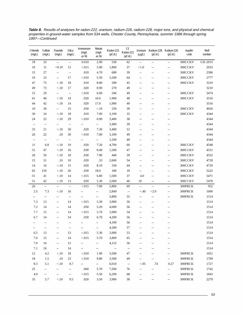
53
18 33 -- -- 0.010 2.90 530 62 -- -- -- 300CCKV CH-2015
16 11 <0.10 12 <.015 5.90 1,800 37 <1.0 -- -- 300CCKV 2033
15 27 -- -- .010 4.70 680 39 -- -- -- 300CCKV 2586
10 33 -- 17 <.010 5.50 3,200 64 -- -- -- 300CCKV 2777
47 75 <.10 18 .010 8.80 290 45 -- -- -- 300CCKV 3210
49 73 <.10 17 .020 8.90 270 49 -- -- -- 3210
15 29 -- -- <.010 6.00 240 49 -- -- -- 300CCKV 3474
41 46 <.10 14 .020 16.0 1,900 48 -- -- -- 300CCKV 3516
44 42 <.10 14 .020 17.0 1,900 40 -- -- -- 3516
10 30 -- 23 .030 <.10 250 39 -- -- -- 300CCKV 4026
30 24 <.10 18 .010 7.00 3,100 35 -- -- -- 300CCKV 4344
24 22 <.10 29 <.010 6.90 3,400 38 -- -- -- 4344
-- -- -- -- -- -- 3,400 39 -- -- -- 4344
25 21 <.10 30 .020 7.30 3,400 53 -- -- -- 4344
26 22 .10 30 <.010 7.00 3,100 49 -- -- -- 4344
-- -- -- -- -- -- 3,100 49 -- -- -- 4344
11 6.8 <.10 19 .020 7.20 4,700 60 -- -- -- 300CCKV 4548
51 47 <.10 16 .030 8.40 1,500 47 -- -- -- 300CCKV 4551
26 50 <.10 18 .030 7.90 440 39 -- -- -- 300CCKV 4552
15 31 .10 10 .020 .33 2,600 54 -- -- -- 300CCKV 4728
14 16 <.10 15 .020 8.10 330 44 -- -- -- 300CCKV 4729
65 150 <.10 20 .030 18.0 180 18 -- -- -- 300CCKV 5222
31 41 <.10 14 <.015 6.80 1,500 37 4.0 -- -- 300CCKV 5471
51 42 <.10 13 .020 5.30 2,600 46 10 -- -- 300CCKV 5478
26 -- -- -- <.015 7.00 5,800 69 -- -- -- 300PRCK 952
2.5 7.3 <.10 16 -- -- 2,849 -- <.40 <2.0 -- 300PRCK 1000
-- -- -- -- -- -- 3,800 55 -- -- -- 300PRCK 1514
7.3 13 -- 14 <.015 5.30 3,900 56 -- -- -- 1514
7.2 14 -- 14 .050 5.20 4,000 56 -- -- -- 1514
7.7 15 -- 14 <.015 5.70 3,900 54 -- -- -- 1514
6.7 14 -- 14 .030 6.70 4,200 56 -- -- -- 1514
-- -- -- -- -- -- 4,100 56 -- -- -- 1514
-- -- -- -- -- -- 4,200 57 -- -- -- 1514
6.5 13 -- 13 <.015 5.30 3,900 53 -- -- -- 1514
7.0 15 -- 14 <.015 5.70 3,800 65 -- -- -- 1514
7.0 16 -- 15 -- -- 4,152 56 -- -- -- 1514
7.1 16 -- 14 -- -- -- -- -- -- -- 1514
12 4.2 <.10 18 <.010 1.90 3,500 47 -- -- -- 300PRCK 1651
18 1.5 .10 23 <.010 9.80 3,500 49 -- -- -- 300PRCK 1709
8.3 5.1 <.10 8.7 -- -- 6,010 -- <.05 .74 0.27 300PRCK 1727
25 -- -- -- .060 5.70 7,500 76 -- -- -- 300PRCK 1742
4.9 -- -- -- <.015 5.50 6,200 68 -- -- -- 300PRCK 1843
35 5.7 <.10 9.5 .020 3.50 3,900 38 -- -- -- 300PRCK 2279
Table 8. Results of analyses for radon-222, uranium, radium-226, radium-228, major ions, and physical and chemicalproperties in ground-water samples from 534 wells, Chester County, Pennsylvania, summer 1986 through spring1997—Continued
Chloride(mg/L)
Sulfate(mg/L)
Fluoride(mg/L)
Silica(mg/L)
Ammonium(mg/Las N)
Nitrate(mg/Las N)
Radon-222(pCi/L)
CERadon-222
(pCi/L)
Uranium(µg/L)
Radium-228(pCi/L)
Radium-226(pCi/L)
Aquifercode
Wellnumber

54
CH-2505 300PRCK 19860711 1145 14.0 260 -- 7.6 -- -- -- -- --
3118 300PRCK 19870831 1500 15.5 115 9.8 5.6 -- 5.9 4.3 6.8 0.80
3119 300PRCK 19870831 1345 15.0 260 2.0 5.3 -- 11 7.6 25 3.5
3120 300PRCK 19870831 1220 14.5 180 9.9 6.4 -- 17 6.0 5.7 1.0
4006 300PRCK 19900821 1433 12.5 200 9.6 5.3 -- -- -- -- --
4009 300PRCK 19900824 1415 13.5 321 6.5 5.9 -- -- -- -- --
4119 300PRCK 19910710 1600 14.0 310 9.2 5.8 -- 23 13 5.7 1.2
4127 300PRCK 19910826 1037 14.5 258 1.0 6.3 -- -- -- -- --
4128 300PRCK 19910827 1005 14.0 360 5.1 5.2 -- -- -- -- --
4148 300PRCK 19921006 1330 13.5 240 2.8 6.7 37 21 7.1 8.6 .80
4270 300PRCK 19920810 1136 13.5 575 .6 6.9 112 -- -- -- --
4272 300PRCK 19920902 1414 16.0 222 8.8 5.9 9 19 6.5 8.3 2.1
4273 300PRCK 19920909 1055 13.5 308 8.0 6.1 20 23 9.0 14 1.8
4274 300PRCK 19921130 1049 13.5 278 8.2 6.6 20 22 9.9 10 1.7
4274 19930331 1115 13.5 262 7.6 6.6 18 22 6.6 10 2.1
4274 19930614 1056 13.5 274 7.7 6.4 22 24 10 11 1.8
4274 19930916 1011 13.5 288 8.0 6.6 26 24 10 12 1.5
4411 300PRCK 19930721 1600 15.0 460 .1 7.4 75 65 7.5 13 3.9
4553 300PRCK 19930907 1246 14.0 96 8.6 6.1 20 7.8 3.8 4.5 1.1
4602 300PRCK 19950816 1645 13.0 373 6.6 5.9 21 -- -- -- --
4934 300PRCK 19940719 1400 12.5 213 9.2 6.1 16 17 7.1 6.2 .80
5090 300PRCK 19940907 1325 12.5 323 7.9 6.3 57 39 8.0 14 2.2
5220 300PRCK 19950731 1610 13.0 360 .2 7.6 90 48 8.5 7.7 2.2
5230 300PRCK 19950814 1530 15.0 148 8.3 5.5 7 -- -- -- --
5235 300PRCK 19950824 1830 13.0 218 6.7 5.6 15 -- -- -- --
5245 300PRCK 19950828 1800 13.5 215 9.0 6.7 48 -- -- -- --
5247 300PRCK 19950829 1700 13.0 240 7.2 6.6 25 -- -- -- --
5248 300PRCK 19950830 1300 14.0 200 9.3 5.5 8 -- -- -- --
5470 300PRCK 19960822 1058 13.5 54 9.3 5.4 1 2.9 1.5 4.5 .80
30 300STRS 19950802 1400 15.0 699 3.8 5.5 20 56 25 26 7.5
770 300STRS 19930722 1249 14.0 1,010 .4 5.8 58 120 33 17 5.6
1954 300STRS 19860815 1130 14.5 105 -- 6.3 -- 6.8 3.8 3.5 2.3
2071 300STRS 19930809 1057 13.5 43 8.5 6.0 5 .81 2.0 1.8 1.6
2513 300STRS 19930803 1148 14.0 208 6.9 6.5 54 19 7.5 6.6 1.3
2593 300STRS 19930909 1155 14.0 392 10.2 6.4 33 35 13 15 3.6
2593 300STRS 19930909 1156 14.0 392 10.2 6.4 33 38 13 17 3.5
2766 300STRS 19870903 1255 15.0 279 6.2 5.5 -- 20 7.9 14 1.7
2769 300STRS 19860714 1240 14.0 285 -- 6.2 -- -- -- -- --
3129 300STRS 19870902 1145 14.5 122 9.3 5.4 -- 9.0 3.5 4.2 2.7
3134 300STRS 19870903 1147 13.0 265 6.4 6.1 -- 23 12 7.6 1.3
3471 300STRS 19890816 1430 13.0 169 5.7 5.8 -- -- -- -- --
3473 300STRS 19890823 1630 15.0 220 4.6 6.2 -- -- -- -- --
3533 300STRS 19931122 1235 14.0 210 9.8 6.4 36 24 4.3 4.9 3.1
Table 8. Results of analyses for radon-222, uranium, radium-226, radium-228, major ions, and physical and chemicalproperties in ground-water samples from 534 wells, Chester County, Pennsylvania, summer 1986 through spring1997—Continued
Localwell
number
Aquifercode
Date(YYYYMMDD)
Time(HHMM)
Watertemperature
(°C)
Specificconductance
(µS/cm)
Dissolvedoxygen(mg/L)
pHAlkalinity(mg/L asCaCO3)
Calcium(mg/L)
Magnesium(mg/L)
Sodium(mg/L)
Potassium(mg/L)

55
7.1 54 -- -- -- -- 4,456 -- -- -- -- 300PRCK CH-2505
9.3 .30 <0.10 11 -- -- 9,135 -- <0.05 -- -- 300PRCK 3118
39 18 <.10 11 -- -- 7,220 -- <.05 2.2 0.78 300PRCK 3119
12 15 .10 9.9 -- -- 2,485 -- .54 .88 .26 300PRCK 3120
23 10 -- -- <0.010 9.30 3,700 46 -- -- -- 300PRCK 4006
34 17 -- -- .010 12.0 4,800 66 -- -- -- 300PRCK 4009
14 31 <.10 12 .020 19.0 4,300 49 -- -- -- 300PRCK 4119
14 .80 <.10 -- .020 .57 6,900 86 -- -- -- 300PRCK 4127
31 10 <.10 -- .030 17.0 4,200 64 -- -- -- 300PRCK 4128
27 16 <.10 13 <.010 1.90 5,600 44 -- -- -- 300PRCK 4148
63 53 .10 -- .020 .60 4,400 45 -- -- -- 300PRCK 4270
8.9 51 <.10 15 .020 6.70 5,200 51 -- -- -- 300PRCK 4272
49 27 <.10 14 .020 5.30 7,400 49 -- -- -- 300PRCK 4273
29 25 <.10 19 .020 6.60 8,000 73 -- -- -- 300PRCK 4274
23 21 <.10 31 .010 7.00 7,000 48 -- -- -- 4274
32 25 <.10 16 .010 7.20 8,000 52 -- -- -- 4274
32 25 <.10 18 .020 7.30 8,200 76 -- -- -- 4274
55 56 <.10 22 .040 <.050 5,800 53 -- -- -- 300PRCK 4411
2.6 18 .10 17 .020 1.10 3,900 110 -- -- -- 300PRCK 4553
45 -- -- -- <.015 11.0 2,200 40 -- -- -- 300PRCK 4602
16 5.2 <.10 13 .010 12.0 3,900 57 <.40 -- -- 300PRCK 4934
42 26 <.10 15 .020 5.00 7,000 74 -- -- -- 300PRCK 5090
24 47 <.10 15 <.015 <.05 2,000 41 -- -- -- 300PRCK 5220
13 -- -- -- .050 9.70 7,000 72 -- -- -- 300PRCK 5230
16 -- -- -- .020 5.10 5,400 66 -- -- -- 300PRCK 5235
2.7 -- -- -- <.015 2.60 3,100 49 -- -- -- 300PRCK 5245
16 -- -- -- <.015 5.60 1,800 38 -- -- -- 300PRCK 5247
11 -- -- -- <.015 9.10 3,900 57 -- -- -- 300PRCK 5248
3.7 <.10 <.10 12 <.015 3.80 4,300 60 -- -- -- 300PRCK 5470
46 120 <.10 18 <.015 27.0 1,200 33 -- -- -- 300STRS 30
110 130 <.10 30 .050 38.0 1,200 39 -- -- -- 300STRS 770
3.6 13 <.10 16 -- -- 1,582 -- -- <.40 <2.0 300STRS 1954
2.0 .20 <.10 12 .010 1.40 930 52 -- -- -- 300STRS 2071
8.2 14 <.10 23 .010 4.60 5,000 60 -- -- -- 300STRS 2513
16 67 .30 22 .020 15.0 540 60 -- -- -- 300STRS 2593
16 69 <.10 23 .010 15.0 470 58 -- -- -- 300STRS 2593
34 11 .10 25 -- -- 3,790 -- .22 1.8 .29 300STRS 2766
-- -- -- -- -- -- 3,047 -- -- 4.0 -- 300STRS 2769
6.6 18 <.10 18 -- -- 900 -- <.40 .20 -- 300STRS 3129
27 <.20 .10 41 -- -- 365 -- <.05 <.70 <.20 300STRS 3134
9.6 30 -- -- <.010 1.30 490 57 -- -- -- 300STRS 3471
11 37 -- -- .030 1.30 2,900 50 -- -- -- 300STRS 3473
7.0 25 <.10 16 .010 6.70 3,800 57 -- -- -- 300STRS 3533
Table 8. Results of analyses for radon-222, uranium, radium-226, radium-228, major ions, and physical and chemicalproperties in ground-water samples from 534 wells, Chester County, Pennsylvania, summer 1986 through spring1997—Continued
Chloride(mg/L)
Sulfate(mg/L)
Fluoride(mg/L)
Silica(mg/L)
Ammonium(mg/Las N)
Nitrate(mg/Las N)
Radon-222(pCi/L)
CERadon-222
(pCi/L)
Uranium(µg/L)
Radium-228(pCi/L)
Radium-226(pCi/L)
Aquifercode
Wellnumber

56
CH-4007 300STRS 19900821 1737 13.5 391 8.0 6.7 -- -- -- -- --
4417 300STRS 19930824 1308 13.5 217 .4 7.4 53 24 5.6 5.5 4.4
4730 300STRS 19930907 1553 13.5 1,010 .7 7.0 146 150 31 12 8.7
4730 19940711 1523 13.0 1,100 .5 6.7 145 150 32 12 --
4731 300STRS 19930910 1440 15.0 340 6.6 6.7 82 33 8.9 21 5.5
4809 300STRS 19940712 1448 13.5 266 8.0 6.3 54 29 4.5 8.6 2.1
83 300WSCKA 19860711 1340 13.0 220 -- 7.6 -- -- -- -- --
85 300WSCKA 19860721 1130 13.0 322 -- 7.1 -- -- -- -- --
85 19890804 1100 13.0 299 3.3 6.6 -- -- -- -- --
87 300WSCKA 19890804 1055 13.5 300 7.4 5.6 -- -- -- -- --
118 300WSCKA 19950907 1700 13.5 180 8.4 5.7 11 -- -- -- --
255 300WSCKA 19950913 1100 13.5 700 3.4 6.3 54 -- -- -- --
1005 300WSCKA 19950829 1310 12.5 157 9.3 5.9 9 -- -- -- --
1106 300WSCA 19950824 1600 13.0 124 9.6 5.8 7 -- -- -- --
1846 300WSCKA 19950828 1630 14.0 380 7.0 6.4 49 -- -- -- --
1981 300WSCKA 19860827 1030 13.5 170 -- 6.0 -- 13 4.6 11 1.0
2719 300WSCKA 19930715 1525 14.5 160 8.2 6.0 22 11 5.4 5.7 1.8
2969 300WSCKA 19920831 1200 14.5 251 11.6 5.9 18 18 9.2 7.7 .70
4772 300WSCKA 19950823 1024 12.5 183 9.3 6.0 33 19 6.7 2.9 .70
5227 300WSCKA 19950810 1048 13.0 96 4.6 5.8 23 5.9 4.0 3.9 .40
5232 300WSCKA 19950815 1525 14.0 245 8.0 5.4 7 -- -- -- --
5234 300WSCKA 19950823 1630 15.0 180 6.0 6.9 42 -- -- -- --
5237 300WSCKA 19950828 1430 13.0 133 7.9 6.3 22 -- -- -- --
5246 300WSCKA 19950829 1520 13.0 289 8.4 6.5 30 -- -- -- --
5262 300WSCKA 19950927 1345 14.0 190 5.4 6.2 20 -- -- -- --
5263 300WSCKA 19950928 1200 13.5 305 4.6 6.8 77 -- -- -- --
5475 300WSCKA 19960903 1303 14.5 314 9.0 5.9 10 10 12 25 .90
21 300WSCKO 19930721 1401 14.0 160 12.1 6.2 13 13 6.3 6.1 1.8
75 300WSCKO 19860714 1400 14.0 165 -- 5.6 -- -- -- -- --
75 19900823 1410 13.0 192 8.5 5.2 -- -- -- -- --
509 300WSCKO 19910904 1232 13.0 217 9.3 6.3 -- -- -- -- --
848 300WSCKO 19890823 1137 12.5 53 10.4 5.3 -- -- -- -- --
929 300WSCKO 19950830 1700 13.0 245 8.8 6.1 23 -- -- -- --
1110 300WSCKO 19960814 1418 14.0 185 1.7 7.1 36 17 4.5 11 .90
1299 300WSCKO 19860806 1515 -- -- -- -- -- -- -- -- --
1703 300WSCKO 19910805 1405 14.5 76 7.5 6.5 -- 3.2 1.8 5.2 1.5
1720 300WSCKO 19921001 1415 13.5 239 5.9 6.0 37 -- -- -- --
1720 19930406 1133 13.0 240 6.3 5.9 21 17 7.5 15 3.0
1720 19930406 1155 12.0 246 -- -- -- -- -- -- --
1720 19930406 1247 13.5 234 -- -- -- -- -- -- --
1720 19930610 1613 13.5 253 6.0 5.9 9 19 8.0 16 3.0
1720 19930916 1254 13.5 302 6.9 6.0 52 19 8.1 24 2.9
1737 300WSCKO 19910711 1629 14.0 235 7.6 6.4 -- 11 5.9 9.8 1.0
Table 8. Results of analyses for radon-222, uranium, radium-226, radium-228, major ions, and physical and chemicalproperties in ground-water samples from 534 wells, Chester County, Pennsylvania, summer 1986 through spring1997—Continued
Localwell
number
Aquifercode
Date(YYYYMMDD)
Time(HHMM)
Watertemperature
(°C)
Specificconductance
(µS/cm)
Dissolvedoxygen(mg/L)
pHAlkalinity(mg/L asCaCO3)
Calcium(mg/L)
Magnesium(mg/L)
Sodium(mg/L)
Potassium(mg/L)

57
5.9 25 -- -- 0.010 4.00 3,700 45 -- -- -- 300STRS CH-4007
1.6 42 0.10 24 .020 <.05 2,100 49 -- -- -- 300STRS 4417
85 160 <.10 15 .040 24.0 2,000 98 -- -- -- 300STRS 4730
82 150 .10 19 .020 34.0 2,100 41 -- -- -- 4730
10 47 <.10 22 .080 5.20 1,600 61 -- -- -- 300STRS 4731
16 2.6 <.10 24 <.010 14.0 590 25 -- -- -- 300STRS 4809
13 30 -- -- .020 .12 219 -- -- -- -- 300WSCKA 83
12 31 -- -- -- -- 2,647 -- -- -- -- 300WSCKA 85
11 30 -- -- .010 3.10 4,100 54 -- -- -- 85
21 29 -- -- .020 9.00 4,400 55 -- -- -- 300WSCKA 87
21 -- -- -- <.015 3.30 1,700 37 -- -- -- 300WSCKA 118
150 -- -- -- -- .62 2,500 45 -- -- -- 300WSCKA 255
15 -- -- -- <.015 8.50 1,700 38 -- -- -- 300WSCKA 1005
9.6 -- -- -- .020 4.90 3,800 55 -- -- -- 300WSCKA 1106
46 -- -- -- <.015 7.40 3,500 52 -- -- -- 300WSCKA 1846
28 10 <.10 8.1 -- -- 2,816 -- <0.40 <2.0 -- 300WSCKA 1981
6.8 24 <.10 9.4 <.010 3.10 2,400 40 -- -- -- 300WSCKA 2719
30 29 .10 7.7 .010 3.70 3,000 38 -- -- -- 300WSCKA 2969
6.9 24 <.10 6.0 .020 3.70 15,000 110 -- -- -- 300WSCKA 4772
7.0 1.0 <.10 11 <.015 1.30 4,000 57 -- -- -- 300WSCKA 5227
43 -- -- -- .050 5.10 1,300 35 -- -- -- 300WSCKA 5232
3.2 -- -- -- <.015 1.60 2,500 41 -- -- -- 300WSCKA 5234
11 -- -- -- <.015 3.20 6,500 71 -- -- -- 300WSCKA 5237
25 -- -- -- <.015 3.60 2,700 47 -- -- -- 300WSCKA 5246
26 -- -- -- <.015 2.30 3,700 55 -- -- -- 300WSCKA 5262
37 -- -- -- -- 1.00 4,200 56 -- -- -- 300WSCKA 5263
50 24 <.10 4.5 <.015 7.20 5,000 61 <1.0 -- -- 300WSCKA 5475
9.8 19 <.10 17 <.010 6.90 1,300 31 -- -- -- 300WSCKO 21
21 5.0 -- -- .020 7.60 4,224 -- -- -- -- 300WSCKO 75
26 16 -- -- <.010 7.40 2,900 56 -- -- -- 75
8.4 20 <.10 -- <.010 15.0 1,600 100 -- -- -- 300WSCKO 509
2.5 <1.0 -- -- <.010 2.40 200 38 -- -- -- 300WSCKO 848
18 -- -- -- <.015 13.0 1,100 32 -- -- -- 300WSCKO 929
10 9.9 .10 12 .030 1.50 2,600 43 <1.0 -- -- 300WSCKO 1110
9.5 29 -- -- -- -- 624 -- -- -- -- 300WSCKO 1299
3.0 3.0 .10 19 <.010 2.20 2,900 42 -- -- -- 300WSCKO 1703
21 2.4 <.10 -- <.010 11.0 3,900 55 -- -- -- 300WSCKO 1720
22 3.0 <.10 28 .010 11.0 4,500 46 -- -- -- 1720
-- -- -- -- -- -- 4,200 44 -- -- -- 1720
-- -- -- -- -- -- 4,500 47 -- -- -- 1720
27 3.4 <.10 28 .010 11.0 3,800 42 -- -- -- 1720
40 4.0 <.10 30 .010 13.0 4,100 58 -- -- -- 1720
16 4.6 <.10 14 .020 14.0 2,500 56 -- -- -- 300WSCKO 1737
Table 8. Results of analyses for radon-222, uranium, radium-226, radium-228, major ions, and physical and chemicalproperties in ground-water samples from 534 wells, Chester County, Pennsylvania, summer 1986 through spring1997—Continued
Chloride(mg/L)
Sulfate(mg/L)
Fluoride(mg/L)
Silica(mg/L)
Ammonium(mg/Las N)
Nitrate(mg/Las N)
Radon-222(pCi/L)
CERadon-222
(pCi/L)
Uranium(µg/L)
Radium-228(pCi/L)
Radium-226(pCi/L)
Aquifercode
Wellnumber

58
CH-1765 300WSCKO 19910822 1512 13.5 164 9.9 5.7 -- 9.4 6.6 5.2 2.1
1829 300WSCKO 19950831 1340 13.5 849 7.0 5.3 11 -- -- -- --
2021 300WSCKO 19930907 1427 14.5 164 8.6 6.3 18 15 4.9 6.1 1.4
2186 300WSCKO 19930818 1130 13.5 141 7.2 6.1 20 11 4.8 6.5 1.7
2189 300WSCKO 19930818 1400 14.0 325 1.2 6.3 76 30 11 18 2.3
2308 300WSCKO 19860905 1220 13.5 115 -- 6.0 -- 4.0 6.5 7.1 .70
2451 300WSCKO 19910715 1653 15.0 163 8.2 6.5 -- -- -- -- --
2461 300WSCKO 19950808 1110 13.5 229 6.4 5.9 22 16 7.5 7.9 3.0
2755 300WSCKO 19910823 1438 14.5 197 7.6 5.9 -- -- -- -- --
3310 300WSCKO 19890602 1509 15.5 309 12.6 5.5 -- -- -- -- --
3316 300WSCKO 19900906 1540 12.5 193 0 6.8 -- -- -- -- --
3356 300WSCKO 19890602 1147 15.5 220 7.0 5.8 -- -- -- -- --
3383 300WSCKO 19930908 1747 13.5 240 1.1 7.1 70 24 8.6 8.2 2.7
3392 300WSCKO 19930908 1604 13.5 252 .4 7.4 68 29 6.8 9.9 1.3
3426 300WSCKO 19930901 0929 14.5 805 .4 7.6 258 86 50 9.2 2.9
3432 300WSCKO 19930908 1006 13.0 167 .8 7.1 58 15 5.9 8.3 2.6
3434 300WSCKO 19930831 1630 13.5 228 9.9 6.3 26 19 8.2 7.1 1.4
3441 300WSCKO 19930909 1043 12.5 159 .2 7.1 51 17 3.6 6.0 2.0
3445 300WSCKO 19930819 1342 15.0 160 .3 6.3 37 19 2.7 5.2 1.9
3445 19930819 1450 14.0 165 .4 6.3 48 18 2.6 5.5 .90
3445 19940712 1220 14.5 158 .3 6.9 39 18 2.7 4.7 --
3447 300WSCKO 19930812 1210 14.5 267 4.4 6.4 136 31 8.6 8.2 3.4
3448 300WSCKO 19930909 1252 14.0 215 4.8 6.7 41 18 7.0 11 3.4
3469 300WSCKO 19890815 1400 17.5 198 2.8 6.4 -- -- -- -- --
3470 300WSCKO 19890816 1110 15.5 132 8.1 6.1 -- -- -- -- --
3472 300WSCKO 19890817 1545 14.0 320 9.9 6.1 -- -- -- -- --
3478 300WSCKO 19890901 1027 14.0 224 1.0 9.5 -- -- -- -- --
3485 300WSCKO 19930812 1020 14.0 144 7.9 6.0 15 9.9 3.6 7.6 3.2
3488 300WSCKO 19930902 1641 14.0 208 .4 6.3 51 12 3.5 21 2.9
3504 300WSCKO 19930720 1300 14.5 110 6.2 6.3 26 7.2 3.5 8.1 2.3
3506 300WSCKO 19930708 1412 13.0 140 7.9 6.2 67 10 3.9 7.7 2.0
3513 300WSCKO 19930902 1507 13.5 260 5.2 6.2 34 21 7.6 12 2.9
3539 300WSCKO 19890830 1357 14.0 202 <.1 6.3 -- -- -- -- --
3558 300WSCKO 19930830 1015 13.5 295 .2 7.9 96 45 5.1 5.7 4.0
3561 300WSCKO 19910814 1231 14.0 196 6.2 6.6 -- -- -- -- --
3573 300WSCKO 19930909 1545 15.0 248 9.0 6.3 28 19 8.0 11 3.0
3580 300WSCKO 19930826 1658 14.0 177 7.7 6.5 45 17 4.1 6.9 2.2
3624 300WSCKO 19900718 1015 14.0 236 <.1 6.3 -- -- -- -- --
3625 300WSCKO 19900716 1500 18.5 159 6.5 5.6 -- -- -- -- --
3627 300WSCKO 19900716 1330 16.0 185 10.0 5.7 -- -- -- -- --
3932 300WSCKO 19900718 1111 19.5 690 7.0 5.0 -- -- -- -- --
4004 300WSCKO 19900801 1055 19.0 137 4.9 7.2 -- -- -- -- --
4005 300WSCKO 19900814 1539 13.5 152 6.0 6.7 -- -- -- -- --
Table 8. Results of analyses for radon-222, uranium, radium-226, radium-228, major ions, and physical and chemicalproperties in ground-water samples from 534 wells, Chester County, Pennsylvania, summer 1986 through spring1997—Continued
Localwell
number
Aquifercode
Date(YYYYMMDD)
Time(HHMM)
Watertemperature
(°C)
Specificconductance
(µS/cm)
Dissolvedoxygen(mg/L)
pHAlkalinity(mg/L asCaCO3)
Calcium(mg/L)
Magnesium(mg/L)
Sodium(mg/L)
Potassium(mg/L)

59
20 3.0 <0.10 13 0.010 8.00 1,400 52 -- -- -- 300WSCKO CH-1765
130 -- -- -- <.015 36.0 1,500 36 -- -- -- 300WSCKO 1829
4.9 29 .10 26 .020 3.50 2,400 100 -- -- -- 300WSCKO 2021
8.3 5.3 <.10 17 <.010 7.10 5,200 63 -- -- -- 300WSCKO 2186
38 23 .10 26 .020 2.40 4,300 58 -- -- -- 300WSCKO 2189
7.7 3.2 <.10 10 -- -- 1,887 -- <0.40 <2.0 -- 300WSCKO 2308
-- -- -- -- .020 2.20 2,200 35 -- -- -- 300WSCKO 2451
10 2.6 <.10 20 <.015 15.0 3,000 47 -- -- -- 300WSCKO 2461
21 .6 <.10 -- .020 10.0 1,500 51 -- -- -- 300WSCKO 2755
26 34 -- -- <.010 12.0 240 41 -- -- -- 300WSCKO 3310
6.7 21 -- -- .010 <.100 11,000 130 -- -- -- 300WSCKO 3316
10 25 -- -- <.010 6.90 4,200 58 -- -- -- 300WSCKO 3356
9.8 28 <.10 17 .020 .710 1,300 50 -- -- -- 300WSCKO 3383
21 15 .10 18 <.010 1.80 2,000 56 -- -- -- 300WSCKO 3392
16 110 .20 17 .120 11.0 490 43 -- -- -- 300WSCKO 3426
3.6 14 <.10 22 <.010 1.00 670 47 -- -- -- 300WSCKO 3432
8.1 29 .10 25 .020 8.40 520 43 -- -- -- 300WSCKO 3434
5.2 18 .10 28 .010 .100 1,500 66 -- -- -- 300WSCKO 3441
3.9 28 .10 32 .020 <.050 1,000 64 -- -- -- 300WSCKO 3445
4.4 28 .10 32 .030 <.050 1,200 64 -- -- -- 3445
3.5 26 .20 32 <.010 <.050 980 30 -- -- -- 3445
6.3 24 <.10 24 .020 1.20 1,200 65 -- -- -- 300WSCKO 3447
8.3 42 .10 30 <.010 <.050 400 58 -- -- -- 300WSCKO 3448
15 15 -- -- <.010 1.60 2,500 84 -- -- -- 300WSCKO 3469
3.3 16 -- -- <.010 2.70 690 58 -- -- -- 300WSCKO 3470
11 49 -- -- <.010 4.90 510 55 -- -- -- 300WSCKO 3472
6.4 15 -- -- .020 <.100 320 65 -- -- -- 300WSCKO 3478
7.9 21 .10 23 .010 2.70 460 59 -- -- -- 300WSCKO 3485
11 30 .20 22 .090 <.050 650 45 -- -- -- 300WSCKO 3488
7.0 2.7 <.10 29 <.010 4.40 3,600 39 -- -- -- 300WSCKO 3504
8.8 7.7 <.10 22 .020 5.60 2,300 38 -- -- -- 300WSCKO 3506
9.6 24 <.10 32 .020 11.0 1,800 53 -- -- -- 300WSCKO 3513
6.1 42 -- -- .010 <.10 180 62 -- -- -- 300WSCKO 3539
6.0 32 .10 16 .020 1.30 2,000 49 -- -- -- 300WSCKO 3558
17 15 <.10 -- <.010 2.40 330 48 -- -- -- 300WSCKO 3561
4.9 35 <.10 17 <.010 12.0 1,800 69 -- -- -- 300WSCKO 3573
4.8 26 .10 26 .010 2.30 1,900 50 -- -- -- 300WSCKO 3580
18 11 -- -- .090 .800 680 35 -- -- -- 300WSCKO 3624
12 <1.0 -- -- -- -- 1,500 43 -- -- -- 300WSCKO 3625
4.9 <1.0 -- -- .060 15.0 400 37 -- -- -- 300WSCKO 3627
87 150 -- -- -- -- 730 36 -- -- -- 300WSCKO 3932
3.9 6.0 -- -- .050 .400 280 54 -- -- -- 300WSCKO 4004
4.4 30 -- -- <.010 .700 1,600 40 -- -- -- 300WSCKO 4005
Table 8. Results of analyses for radon-222, uranium, radium-226, radium-228, major ions, and physical and chemicalproperties in ground-water samples from 534 wells, Chester County, Pennsylvania, summer 1986 through spring1997—Continued
Chloride(mg/L)
Sulfate(mg/L)
Fluoride(mg/L)
Silica(mg/L)
Ammonium(mg/Las N)
Nitrate(mg/Las N)
Radon-222(pCi/L)
CERadon-222
(pCi/L)
Uranium(µg/L)
Radium-228(pCi/L)
Radium-226(pCi/L)
Aquifercode
Wellnumber

60
CH-4023 300WSCKO 19900904 1247 15.5 249 7.0 5.7 -- -- -- -- --
4118 300WSCKO 19910708 1450 14.0 94 9.0 5.7 -- 2.6 5.0 2.9 1.3
4121 300WSCKO 19910716 1844 14.0 275 3.4 6.5 -- -- -- -- --
4122 300WSCKO 19910719 1600 15.0 690 7.0 5.7 -- -- -- -- --
4125 300WSCKO 19910807 1203 13.5 153 4.7 6.3 -- -- -- -- --
4126 300WSCKO 19910807 1545 13.5 202 9.2 5.9 -- -- -- -- --
4133 300WSCKO 19950807 1505 12.5 220 .1 6.6 39 17 5.8 10 3.3
4275 300WSCKO 19920909 1627 14.0 154 7.1 6.0 21 -- -- -- --
4294 300WSCKO 19920929 1323 13.0 119 6.0 6.8 23 -- -- -- --
4295 300WSCKO 19920929 1634 14.5 133 .7 7.0 60 -- -- -- --
4296 300WSCKO 19921028 1252 13.5 109 10.1 6.6 12 -- -- -- --
4297 300WSCKO 19921001 1743 13.5 228 7.2 6.2 22 -- -- -- --
4341 300WSCKO 19921217 1105 11.0 520 5.6 6.1 23 52 21 12 3.0
4342 300WSCKO 19921222 0948 12.0 146 <.1 6.8 28 7.6 4.9 7.5 3.1
4343 300WSCKO 19921230 0928 12.5 174 <.1 6.9 28 4.0 4.5 8.3 1.7
4343 19930401 1029 12.5 122 <.1 6.8 64 3.9 4.3 8.2 1.7
4343 19930610 1020 13.5 119 <.1 6.8 21 4.1 4.7 8.2 1.7
4343 19930923 1006 13.5 128 <.1 6.8 33 4.0 4.3 8.4 1.7
4345 300WSCKO 19930819 1123 14.0 120 10.0 6.0 18 9.8 3.0 5.1 1.7
4345 19940711 1042 13.5 107 9.0 6.1 22 8.2 2.6 4.7 --
4361 300WSCKO 19930826 1235 13.5 58 9.5 6.6 13 3.2 .75 4.2 1.5
4362 300WSCKO 19930830 1550 13.5 149 7.3 6.2 27 11 4.8 6.5 2.2
4410 300WSCKO 19930721 1120 13.5 201 .4 7.2 42 16 8.6 11 2.5
4414 300WSCKO 19930804 1051 14.0 229 5.3 6.3 22 16 5.8 14 2.4
4416 300WSCKO 19930818 1447 13.5 228 .3 6.4 28 21 5.5 10 2.0
4495 300WSCKO 19930819 1230 15.0 89 6.8 5.6 10 4.0 1.9 8.1 1.4
4500 300WSCKO 19930819 1530 15.0 335 8.0 5.8 15 22 8.4 20 3.0
4501 300WSCKO 19930819 1715 14.5 190 4.0 6.0 31 14 6.2 9.0 2.5
4727 300WSCKO 19930831 1316 15.0 162 10.0 6.4 22 15 3.7 6.2 2.2
4806 300WSCKO 19940628 1516 12.0 248 9.4 5.7 26 14 7.1 11 3.3
4807 300WSCKO 19940705 1214 14.0 162 .9 6.6 51 13 3.8 8.3 1.8
4931 300WSCKO 19940721 1010 13.0 74 10.0 5.3 6 2.8 3.1 3.3 1.7
4932 300WSCKO 19940718 1330 13.0 154 9.3 5.7 10 9.9 5.2 6.5 1.8
4933 300WSCKO 19940714 1000 14.5 106 8.9 7.4 14 5.6 3.4 6.6 1.4
5065 300WSCKO 19950817 1615 13.0 147 .0 7.2 43 -- -- -- --
5223 300WSCKO 19950807 1300 13.0 510 1.0 6.0 65 51 18 17 4.5
5228 300WSCKO 19950810 1400 13.0 119 .1 7.1 31 5.4 4.9 7.4 1.7
5229 300WSCKO 19950810 1630 13.0 375 6.4 6.2 33 37 14 7.9 2.4
5231 300WSCKO 19950814 1730 13.0 161 9.0 5.9 20 -- -- -- --
5251 300WSCKO 19950901 1610 13.5 135 <.1 6.8 33 -- -- -- --
5474 300WSCKO 19960830 0845 13.5 124 2.9 6.7 33 11 3.2 5.2 1.7
5476 300WSCKO 19960904 1100 13.0 158 3.4 6.8 44 14 3.4 10 1.7
5477 300WSCKO 19960904 1504 12.5 126 7.1 5.9 10 8.4 3.9 5.9 1.7
Table 8. Results of analyses for radon-222, uranium, radium-226, radium-228, major ions, and physical and chemicalproperties in ground-water samples from 534 wells, Chester County, Pennsylvania, summer 1986 through spring1997—Continued
Localwell
number
Aquifercode
Date(YYYYMMDD)
Time(HHMM)
Watertemperature
(°C)
Specificconductance
(µS/cm)
Dissolvedoxygen(mg/L)
pHAlkalinity(mg/L asCaCO3)
Calcium(mg/L)
Magnesium(mg/L)
Sodium(mg/L)
Potassium(mg/L)
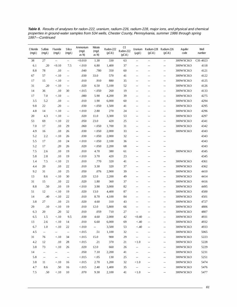
61
38 27 -- -- <0.010 1.30 330 63 -- -- -- 300WSCKO CH-4023
6.1 .20 <0.10 7.5 <.010 6.80 1,400 37 -- -- -- 300WSCKO 4118
8.8 78 .10 -- .040 .780 350 60 -- -- -- 300WSCKO 4121
67 57 <.10 -- .030 33.0 570 41 -- -- -- 300WSCKO 4122
17 15 <.10 -- .010 .910 880 35 -- -- -- 300WSCKO 4125
31 .20 <.10 -- .020 6.50 5,100 52 -- -- -- 300WSCKO 4126
14 36 .10 30 <.015 <.050 260 19 -- -- -- 300WSCKO 4133
17 7.0 <.10 -- .080 5.90 4,200 39 -- -- -- 300WSCKO 4275
3.5 5.2 .10 -- .010 1.90 6,000 60 -- -- -- 300WSCKO 4294
9.8 22 .20 -- .030 <.050 1,500 41 -- -- -- 300WSCKO 4295
4.8 14 <.10 -- <.010 2.80 270 24 -- -- -- 300WSCKO 4296
20 4.3 <.10 -- .020 11.0 3,300 53 -- -- -- 300WSCKO 4297
53 69 <.10 22 .050 23.0 420 25 -- -- -- 300WSCKO 4341
7.0 17 .10 29 .060 <.050 1,700 31 -- -- -- 300WSCKO 4342
4.9 16 .10 26 .030 <.050 2,000 33 -- -- -- 300WSCKO 4343
5.2 2.2 <.10 26 .030 <.050 2,000 32 -- -- -- 4343
5.5 17 .10 24 <.010 <.050 2,100 36 -- -- -- 4343
5.2 17 .20 26 .020 <.050 2,200 68 -- -- -- 4343
7.5 2.6 .10 19 .010 4.70 380 61 -- -- -- 300WSCKO 4345
5.8 2.8 .10 19 <.010 3.70 420 23 -- -- -- 4345
1.4 7.5 <.10 21 .010 .770 320 41 -- -- -- 300WSCKO 4361
4.4 20 .10 22 .010 3.30 320 37 -- -- -- 300WSCKO 4362
9.2 31 .10 25 .050 .076 2,900 39 -- -- -- 300WSCKO 4410
13 8.6 <.10 30 .020 12.0 2,200 49 -- -- -- 300WSCKO 4414
31 15 .10 22 .020 1.80 360 37 -- -- -- 300WSCKO 4416
8.8 .50 .10 19 <.010 3.90 3,000 82 -- -- -- 300WSCKO 4495
51 12 <.10 19 .020 13.0 4,400 87 -- -- -- 300WSCKO 4500
14 .40 <.10 22 .010 8.70 4,100 84 -- -- -- 300WSCKO 4501
3.8 27 .10 23 .020 4.60 310 43 -- -- -- 300WSCKO 4727
29 .10 <.10 19 .010 12.0 5,800 66 -- -- -- 300WSCKO 4806
6.3 20 .20 32 .010 .059 710 27 -- -- -- 300WSCKO 4807
6.5 1.5 <.10 9.5 .030 4.60 2,000 42 <0.40 -- -- 300WSCKO 4931
13 2.6 <.10 14 .010 6.60 6,000 69 <.40 -- -- 300WSCKO 4932
6.7 1.0 <.10 22 <.010 -- 3,500 53 <.40 -- -- 300WSCKO 4933
4.5 -- -- -- <.015 .51 1,100 32 -- -- -- 300WSCKO 5065
31 76 <.10 34 <.015 15.0 900 29 -- -- -- 300WSCKO 5223
4.2 12 .10 28 <.015 .21 370 21 <1.0 -- -- 300WSCKO 5228
3.8 73 <.10 26 .020 12.0 660 26 -- -- -- 300WSCKO 5229
14 -- -- -- .050 7.10 2,200 41 -- -- -- 300WSCKO 5231
5.8 -- -- -- <.015 <.05 130 25 -- -- -- 300WSCKO 5251
3.8 11 <.10 16 <.015 2.70 1,200 32 <1.0 -- -- 300WSCKO 5474
4.7 8.6 .50 16 <.015 2.40 1,400 35 -- -- -- 300WSCKO 5476
7.5 .50 <.10 10 .070 9.30 2,100 41 <1.0 -- -- 300WSCKO 5477
Table 8. Results of analyses for radon-222, uranium, radium-226, radium-228, major ions, and physical and chemicalproperties in ground-water samples from 534 wells, Chester County, Pennsylvania, summer 1986 through spring1997—Continued
Chloride(mg/L)
Sulfate(mg/L)
Fluoride(mg/L)
Silica(mg/L)
Ammonium(mg/Las N)
Nitrate(mg/Las N)
Radon-222(pCi/L)
CERadon-222
(pCi/L)
Uranium(µg/L)
Radium-228(pCi/L)
Radium-226(pCi/L)
Aquifercode
Wellnumber

62
CH-5479 300WSCKO 19960905 1450 13.5 82 6.7 6.0 23 5.5 1.7 6.6 1.7
5480 300WSCKO 19960911 1351 13.5 73 6.5 6.6 30 6.1 1.7 5.9 1.0
307 367CNSG 19910716 1240 22.0 670 7.0 6.9 -- 84 22 22 1.3
989 367CNSG 19880810 1245 14.0 490 5.8 5.6 -- -- -- -- --
1985 367CNSG 19860908 1415 13.5 480 -- 7.3 -- 60 20 17 1.7
1985 19930816 1700 15.0 495 6.1 7.5 183 58 18 15 1.5
2723 367CNSG 19910911 1235 13.5 855 8.4 7.2 -- 100 20 29 2.6
2740 367CNSG 19880627 1545 12.5 440 10.0 7.1 -- -- -- -- --
2740 19890712 1405 15.5 472 5.6 7.3 -- -- -- -- --
2828 367CNSG 19870729 1330 13.0 677 6.6 7.0 -- 92 12 25 3.0
2840 367CNSG 19880810 1040 13.0 560 5.8 7.0 -- -- -- -- --
3364 367CNSG 19890725 1518 16.0 409 7.2 7.2 -- -- -- -- --
3859 367CNSG 19930715 1000 15.5 760 <.1 7.4 280 78 26 40 2.3
4129 367CNSG 19910909 1540 15.0 805 3.8 7.0 -- 130 25 14 2.6
4292 367CNSG 19920928 1323 12.5 351 2.3 7.2 202 48 8.9 8.9 .80
4546 367CNSG 19930823 1620 14.5 -- 7.2 7.4 143 71 6.4 4.9 1.8
202 371ELBK 19960910 1159 15.0 733 .8 7.0 240 75 40 18 3.0
204 371ELBK 19960807 1353 13.5 1,010 3.5 7.0 283 96 62 21 2.8
245 371ELBK 19960909 1354 13.0 585 8.5 7.3 204 61 38 5.9 2.1
1978 371ELBK 19930630 1424 14.0 410 11.2 7.2 151 42 15 11 1.6
2138 371ELBK 19860912 1125 13.0 480 -- 7.6 -- 53 29 3.7 1.4
2560 371ELBK 19960910 1003 15.0 1,160 4.8 7.0 244 110 58 29 3.3
2611 371ELBK 19940706 1112 11.0 650 6.5 7.1 304 64 41 16 1.8
2634 371ELBK 19880815 1600 13.5 480 9.0 7.3 -- -- -- -- --
2676 371ELBK 19950817 0905 14.5 790 1.1 6.9 321 81 52 13 2.9
2677 371ELBK 19890629 1040 11.5 653 7.6 7.2 -- -- -- -- --
2725 371ELBK 19910905 1530 14.0 500 4.6 7.5 -- 67 15 11 1.9
4805 371ELBK 19940622 1502 12.5 599 7.6 7.1 226 56 30 20 2.0
703 377AMHP 19870605 1300 12.0 160 7.6 6.1 -- 12 6.2 5.8 3.2
992 377AMHP 19870728 1700 13.0 265 .7 5.0 -- 7.1 6.7 22 5.0
1074 377AMHP 19860813 1210 15.0 530 -- 4.2 -- -- -- -- --
1097 377AMHP 19870804 1415 13.0 121 8.7 4.9 -- 4.5 5.6 4.7 3.8
1361 377AMHP 19860808 1540 12.0 170 -- 5.3 -- 2.6 2.4 22 2.1
3079 377AMHP 19870727 1550 13.5 103 <.1 6.6 -- 3.6 4.0 2.9 3.0
3136 377AMHP 19870908 1305 12.5 150 7.5 4.9 -- 3.2 3.1 15 2.8
3332 377AMHP 19880830 1450 12.0 150 9.0 5.7 -- 11 4.5 5.7 3.0
4137 377AMHP 19911015 1225 14.0 101 6.0 5.1 -- -- -- -- --
4138 377AMHP 19950906 1749 12.0 50 6.8 5.8 15 -- -- -- --
4142 377AMHP 19911016 0944 -- -- -- -- -- -- -- -- --
4142 19911016 0945 11.0 60 9.6 6.1 -- -- -- -- --
4143 377AMHP 19911015 1340 13.0 100 7.4 4.9 -- -- -- -- --
4601 377AMHP 19950906 1428 14.5 223 2.3 4.9 8 -- -- -- --
4767 377AMHP 19950810 1416 11.5 52 7.8 5.6 6 .87 1.8 2.3 1.7
Table 8. Results of analyses for radon-222, uranium, radium-226, radium-228, major ions, and physical and chemicalproperties in ground-water samples from 534 wells, Chester County, Pennsylvania, summer 1986 through spring1997—Continued
Localwell
number
Aquifercode
Date(YYYYMMDD)
Time(HHMM)
Watertemperature
(°C)
Specificconductance
(µS/cm)
Dissolvedoxygen(mg/L)
pHAlkalinity(mg/L asCaCO3)
Calcium(mg/L)
Magnesium(mg/L)
Sodium(mg/L)
Potassium(mg/L)

63
4.0 0.90 <0.10 25 <0.015 2.60 3,700 54 <1.0 -- -- 300WSCKO CH-5479
3.9 .80 <.10 20 <.015 1.20 2,100 41 <1.0 -- -- 300WSCKO 5480
52 31 .10 8.8 .020 3.80 510 65 -- -- -- 367CNSG 307
22 51 -- -- -- -- 800 -- .01 <1.0 0.16 367CNSG 989
33 32 1.4 8.0 -- -- 639 -- 1.2 2.0 -- 367CNSG 1985
31 29 1.2 7.5 .030 1.20 780 40 -- -- -- 1985
46 66 .20 11 <.010 3.40 590 37 -- -- -- 367CNSG 2723
16 37 -- -- -- -- 2,054 -- .28 -- -- 367CNSG 2740
17 37 -- -- .020 4.50 730 30 -- -- -- 2740
26 33 .10 13 -- -- 520 -- 2.4 <.50 .33 367CNSG 2828
24 36 -- -- -- -- 600 -- .26 <1.0 .07 367CNSG 2840
17 19 -- -- <.010 4.70 1,800 42 -- -- -- 367CNSG 3364
68 47 .20 9.4 <.010 .390 1,100 35 -- -- -- 367CNSG 3859
28 62 <.10 15 <.010 4.00 800 62 -- -- -- 367CNSG 4129
17 15 <.10 7.5 .010 1.70 480 24 -- -- -- 367CNSG 4292
16 31 .10 11 .020 6.70 860 39 -- -- -- 367CNSG 4546
25 32 .20 8.3 <.015 1.40 470 23 2.0 -- -- 371ELBK 202
110 25 .40 7.7 .020 .22 2,000 41 -- -- -- 371ELBK 204
9.9 20 .20 8.8 <.015 3.30 660 26 -- -- -- 371ELBK 245
20 16 <.10 8.6 .040 2.90 500 27 -- -- -- 371ELBK 1978
12 21 .20 8.2 -- -- 306 -- <.40 <2.0 -- 371ELBK 2138
150 51 <.10 24 <.015 3.70 400 22 -- -- -- 371ELBK 2560
24 28 .10 6.3 .020 2.00 380 22 <1.0 -- -- 371ELBK 2611
6.7 37 -- -- -- -- 142 -- .16 <1.0 .07 371ELBK 2634
32 78 .20 9.8 .030 2.20 49 15 -- -- -- 371ELBK 2676
11 32 -- -- -- -- 220 43 -- -- -- 371ELBK 2677
22 22 <.10 7.9 -- -- 540 90 -- -- -- 371ELBK 2725
33 29 <.10 10 .010 2.40 780 31 -- -- -- 371ELBK 4805
13 5.6 .10 21 -- -- 228 -- .14 <1.0 <.20 377CCKS 703
15 13 .10 8.3 -- -- 5,275 -- .05 2.0 1.8 377AMHP 992
16 260 -- -- -- -- 2,637 -- .50 <2.0 -- 377AMHP 1074
6.8 4.9 .10 11 -- -- 2,835 -- <.05 -- -- 377AMHP 1097
38 3.1 <.10 7.1 -- -- 4,013 -- <.40 <.80 .36 377AMHP 1361
2.0 9.8 .20 19 -- -- 1,075 -- <.05 <2.0 -- 377AMHP 3079
24 12 .10 6.9 -- -- 785 -- <.05 <.90 .64 377AMHP 3136
9.9 5.8 .10 12 <.010 7.80 25,829 -- <.01 12 2.9 377AMHP 3332
-- -- -- -- -- -- 4,700 42 -- 1.3 .08 377AMHP 4137
1.3 -- -- -- <.015 .08 1,100 32 -- -- -- 377AMHP 4138
-- -- -- -- -- -- 3,400 40 -- -- -- 377AMHP 4142
-- -- -- -- -- -- 3,300 40 -- -- -- 4142
-- -- -- -- -- -- 6,500 46 -- -- -- 377AMHP 4143
21 -- -- -- <.015 10.0 5,500 64 -- -- -- 377AMHP 4601
4.4 4.9 <.10 7.6 .020 .73 1,700 38 -- -- -- 377AMHP 4767
Table 8. Results of analyses for radon-222, uranium, radium-226, radium-228, major ions, and physical and chemicalproperties in ground-water samples from 534 wells, Chester County, Pennsylvania, summer 1986 through spring1997—Continued
Chloride(mg/L)
Sulfate(mg/L)
Fluoride(mg/L)
Silica(mg/L)
Ammonium(mg/Las N)
Nitrate(mg/Las N)
Radon-222(pCi/L)
CERadon-222
(pCi/L)
Uranium(µg/L)
Radium-228(pCi/L)
Radium-226(pCi/L)
Aquifercode
Wellnumber

64
CH-5091 377AMHP 19940908 1540 11.0 115 8.6 5.3 4 2.5 4.5 5.6 2.7
86 377CCKS 19860725 1115 12.0 140 -- 6.0 -- 3.4 3.0 16 2.3
293 377CCKS 19861113 1000 11.5 340 6.6 6.4 -- 27 14 19 1.6
333 377CCKS 19861115 1230 11.5 189 6.1 4.8 -- 9.7 7.8 8.3 2.2
417 377CCKS 19861124 1300 11.5 77 5.2 5.2 -- 2.2 2.5 3.8 3.5
418 377CCKS 19861205 1200 11.5 41 6.2 4.9 -- .50 .70 2.7 2.5
427 377CCKS 19861205 1330 11.0 19 9.0 5.2 -- .40 .50 1.2 .7
505 377CCKS 19870508 1300 12.0 125 8.8 5.9 -- 12 3.1 4.4 1.9
693 377CCKS 19870529 1330 14.0 64 8.0 5.9 -- 7.0 2.0 2.4 1.0
945 377CCKS 19861113 1315 14.0 93 5.2 5.5 -- 4.0 4.4 2.7 3.4
991 377CCKS 19860718 1210 17.0 55 -- 5.7 -- -- -- -- --
1089 377CCKS 19870612 1130 12.0 145 7.3 5.3 -- 4.4 3.5 12 3.9
1090 377CCKS 19870617 1400 12.0 76 -- 4.7 -- 1.8 3.0 4.4 1.5
1091 377CCKS 19870618 1330 12.0 39 5.1 4.8 -- .47 1.0 3.8 2.0
1092 377CCKS 19870623 1645 13.5 62 8.4 5.0 -- .44 1.3 8.6 1.6
1093 377CCKS 19870626 1130 13.0 193 8.0 5.6 -- 5.4 4.7 19 3.7
1094 377CCKS 19870626 1640 11.5 10 11.3 5.2 -- .10 .37 1.5 .8
1095 377CCKS 19870728 1230 13.5 163 7.3 4.7 -- 3.7 6.6 11 3.3
1096 377CCKS 19870729 1545 11.5 15 10.2 4.9 -- .46 .45 1.5 1.4
1098 377CCKS 19870805 1600 11.5 70 10.0 4.7 -- .64 2.7 2.4 1.4
1213 377CCKS 19870702 1045 12.5 203 7.3 5.3 -- 8.0 10 2.2 11
1217 377CCKS 19870630 1520 14.0 114 8.8 5.6 -- 9.6 2.5 6.8 2.5
1265 377CCKS 19861121 1130 11.5 229 2.3 4.8 -- 3.2 4.6 26 2.1
1286 377CCKS 19861201 1430 11.5 200 6.0 4.6 -- 2.5 2.5 29 4.6
1296 377CCKS 19870902 1700 13.0 118 9.5 4.8 -- 2.2 1.8 13 4.3
1364 377CCKS 19860718 1445 16.5 85 -- 4.7 -- -- -- -- --
1367 377CCKS 19870805 1400 13.0 70 9.1 4.5 -- 1.7 3.1 4.3 2.4
1376 377CCKS 19870904 1645 12.0 131 3.2 4.8 -- 3.6 3.2 13 2.1
1616 377CCKS 19861112 1240 12.0 203 5.1 5.3 -- 6.6 5.4 22 1.6
1616 19871023 1500 12.0 242 6.4 5.1 -- 6.8 5.5 23 1.3
1617 377CCKS 19870603 1149 13.0 116 8.2 4.7 -- 5.2 3.5 7.5 1.1
1617 19910801 1730 12.5 111 8.0 4.6 -- 5.0 3.8 6.2 1.1
1617 19910910 1414 12.5 110 8.5 4.6 -- 5.3 3.8 5.0 1.2
1617 19910930 1656 12.0 109 8.8 4.7 -- 5.1 3.7 4.8 1.1
1617 19911104 1423 12.0 107 8.6 4.7 -- 5.2 3.8 4.3 1.2
1617 19920107 1200 12.0 115 7.8 4.8 -- -- -- -- --
1618 377CCKS 19870522 1400 13.5 164 7.4 4.6 -- 3.5 6.8 7.5 4.8
2113 377CCKS 19861110 1500 -- -- -- -- -- 7.8 3.3 13 1.6
2115 377CCKS 19861110 1100 11.5 127 10.6 6.6 -- 13 5.0 3.9 2.2
2197 377CCKS 19860715 1635 12.0 40 -- 5.0 -- -- -- -- --
2315 377CCKS 19890808 1655 17.5 84 8.7 6.0 -- -- -- -- --
2403 377CCKS 19860808 1330 13.5 112 -- 5.2 -- -- -- -- --
2410 377CCKS 19861120 1200 -- -- -- -- -- 6.3 4.3 11 1.2
Table 8. Results of analyses for radon-222, uranium, radium-226, radium-228, major ions, and physical and chemicalproperties in ground-water samples from 534 wells, Chester County, Pennsylvania, summer 1986 through spring1997—Continued
Localwell
number
Aquifercode
Date(YYYYMMDD)
Time(HHMM)
Watertemperature
(°C)
Specificconductance
(µS/cm)
Dissolvedoxygen(mg/L)
pHAlkalinity(mg/L asCaCO3)
Calcium(mg/L)
Magnesium(mg/L)
Sodium(mg/L)
Potassium(mg/L)

65
13 0.70 <0.10 8.6 0.010 4.90 4,900 61 <1.0 -- -- 377AMHP CH-5091
8.6 24 .20 7.6 -- -- 3,207 -- -- -- -- 377CCKS 86
28 46 <.10 12 -- -- 320 -- .30 3.5 1.6 377CCKS 293
6.5 62 .10 8.8 -- -- 1,317 -- .30 22 9.5 377CCKS 333
7.8 2.7 <.10 10 -- -- 4,315 -- .17 <1.0 .48 377CCKS 417
4.9 1.4 <.10 9.0 -- -- 9,266 -- .32 7.6 2.9 377CCKS 418
2.8 .4 <.10 6.4 -- -- 273 -- .16 1.8 .78 377CCKS 427
10 12 <.10 18 -- -- 397 -- .21 .60 <.10 377CCKS 505
8.2 .6 .20 18 -- -- 2,231 -- .26 <.60 <.20 377CCKS 693
4.3 13 <.10 8.7 -- -- 3,119 -- .15 <1.0 .82 377CCKS 945
-- -- -- -- -- -- 9,087 -- -- 3.5 1.6 377CCKS 991
21 .7 <.10 12 -- -- 3,629 -- <.05 22 9.5 377CCKS 1089
9.0 9.6 .20 6.7 -- -- 1,415 -- <.05 <1.0 .48 377CCKS 1090
5.8 3.7 .10 10 -- -- 3,335 -- <.05 7.6 2.9 377CCKS 1091
7.3 7.4 .10 8.3 -- -- 415 -- <.05 1.8 .78 377CCKS 1092
34 8.3 .10 12 -- -- 2,993 -- <.05 .60 <.10 377CCKS 1093
2.4 <.2 .10 6.0 -- -- 2,073 -- <.05 <.60 <.20 377CCKS 1094
12 7.4 .10 9.8 -- -- 5,630 -- .18 <1.0 <.20 377CCKS 1095
1.9 .3 .10 8.0 -- -- 4,790 -- <.05 <1.0 .82 377CCKS 1096
5.4 5.6 .10 7.1 -- -- 490 -- <.05 3.6 1.4 377CCKS 1098
8.7 37 .20 7.0 -- -- 1,200 -- .09 2.9 2.1 377CCKS 1213
8.7 6.6 .10 22 -- -- 1,745 -- <.05 .70 .93 377CCKS 1217
58 1.8 <.10 7.1 -- -- 370 -- .18 2.7 2.7 377CCKS 1265
44 2.6 <.10 9.0 -- -- 3,280 -- .18 12 .40 377CCKS 1286
24 10 .10 9.6 -- -- 1,935 -- .24 6.3 4.8 377CCKS 1296
-- -- -- -- -- -- 955 -- -- 21 -- 377CCKS 1364
8.2 .30 .10 7.4 -- -- 7,255 -- .35 9.9 3.8 377CCKS 1367
13 11 .10 7.0 -- -- 5,820 -- .06 -- -- 377CCKS 1376
35 27 <.10 5.7 -- -- 3,395 -- .30 26 2.5 377CCKS 1616
36 26 .10 5.7 -- -- 3,665 -- .87 29 4.1 1616
14 25 .10 6.5 -- -- 280 -- .25 17 3.7 377CCKS 1617
8.9 22 -- 6.4 <.010 1.10 1,100 43 -- -- -- 1617
9.1 27 -- 6.6 <.010 1.00 1,100 55 -- -- -- 1617
8.0 25 .20 6.5 .030 1.20 1,000 33 -- -- -- 1617
7.3 25 .20 6.6 <.010 1.20 1,000 33 -- -- -- 1617
-- -- -- -- -- -- 1,000 37 -- -- -- 1617
17 26 .30 9.3 -- -- 1,894 -- .21 32 3.7 377CCKS 1618
16 27 <.10 4.7 -- -- 2,170 -- .22 12 1.7 377CCKS 2113
2.3 21 <.10 19 -- -- 1,595 -- .25 <1.0 <.60 377CCKS 2115
-- -- -- -- -- -- 2,584 -- -- 13 -- 377CCKS 2197
3.1 <1.0 -- -- .020 3.30 18,000 87 -- 377CCKS 2315
18 11 -- -- -- -- 1,525 -- <.40 4.0 -- 377CCKS 2403
23 .90 <.10 16 -- -- 8,577 -- .15 4.9 2.3 377CCKS 2410
Table 8. Results of analyses for radon-222, uranium, radium-226, radium-228, major ions, and physical and chemicalproperties in ground-water samples from 534 wells, Chester County, Pennsylvania, summer 1986 through spring1997—Continued
Chloride(mg/L)
Sulfate(mg/L)
Fluoride(mg/L)
Silica(mg/L)
Ammonium(mg/Las N)
Nitrate(mg/Las N)
Radon-222(pCi/L)
CERadon-222
(pCi/L)
Uranium(µg/L)
Radium-228(pCi/L)
Radium-226(pCi/L)
Aquifercode
Wellnumber
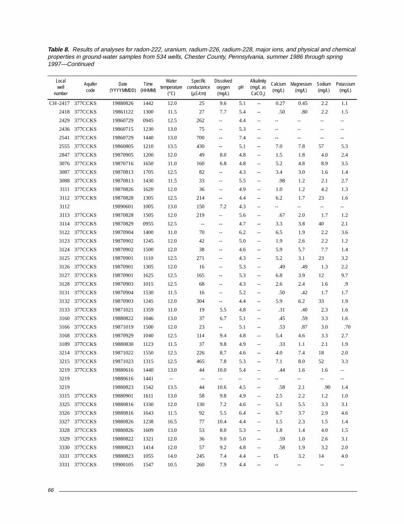
66
CH-2417 377CCKS 19880826 1442 12.0 25 9.6 5.1 -- 0.27 0.45 2.2 1.1
2418 377CCKS 19861122 1300 11.5 27 7.7 5.4 -- .50 .80 2.2 1.5
2429 377CCKS 19860729 0945 12.5 262 -- 4.4 -- -- -- -- --
2436 377CCKS 19860715 1230 13.0 75 -- 5.3 -- -- -- -- --
2541 377CCKS 19860729 1440 13.0 700 -- 7.4 -- -- -- -- --
2555 377CCKS 19860805 1210 13.5 430 -- 5.1 -- 7.0 7.8 57 5.3
2847 377CCKS 19870905 1200 12.0 49 8.0 4.8 -- 1.5 1.8 4.0 2.4
3076 377CCKS 19870716 1650 11.0 160 6.8 4.8 -- 5.2 4.8 8.9 3.5
3087 377CCKS 19870813 1705 12.5 82 -- 4.3 -- 3.4 3.0 1.6 1.4
3088 377CCKS 19870813 1430 11.5 33 -- 5.5 -- .98 1.2 2.1 2.7
3111 377CCKS 19870826 1620 12.0 36 -- 4.9 -- 1.0 1.2 4.2 1.3
3112 377CCKS 19870828 1305 12.5 214 -- 4.4 -- 6.2 1.7 23 1.6
3112 19890601 1005 13.0 150 7.2 4.3 -- -- -- -- --
3113 377CCKS 19870828 1505 12.0 219 -- 5.6 -- .67 2.0 1.7 1.2
3114 377CCKS 19870829 0955 12.5 -- -- 4.7 -- 3.3 3.8 40 2.1
3122 377CCKS 19870904 1400 11.0 70 -- 6.2 -- 6.5 1.9 2.2 3.6
3123 377CCKS 19870902 1245 12.0 42 -- 5.0 -- 1.9 2.6 2.2 1.2
3124 377CCKS 19870902 1500 12.0 38 -- 4.6 -- 5.9 5.7 7.7 1.4
3125 377CCKS 19870901 1110 12.5 271 -- 4.3 -- 5.2 3.1 23 3.2
3126 377CCKS 19870901 1305 12.0 16 -- 5.3 -- .49 .49 1.3 2.2
3127 377CCKS 19870901 1625 12.5 165 -- 5.3 -- 6.8 3.9 12 9.7
3128 377CCKS 19870903 1015 12.5 68 -- 4.3 -- 2.6 2.4 1.6 .9
3131 377CCKS 19870904 1530 11.5 16 -- 5.2 -- .50 .42 1.7 1.7
3132 377CCKS 19870903 1245 12.0 304 -- 4.4 -- 5.9 6.2 33 1.9
3133 377CCKS 19871021 1359 11.0 19 5.5 4.8 -- .31 .40 2.3 1.6
3160 377CCKS 19880822 1046 13.0 37 6.7 5.1 -- .45 .59 3.3 1.6
3166 377CCKS 19871019 1500 12.0 23 -- 5.1 -- .53 .87 3.0 .70
3168 377CCKS 19870929 1040 12.5 114 9.4 4.8 -- 5.4 4.6 3.3 2.7
3189 377CCKS 19880830 1123 11.5 37 9.8 4.9 -- .33 1.1 2.1 1.9
3214 377CCKS 19871022 1550 12.5 226 8.7 4.6 -- 4.0 7.4 18 2.0
3215 377CCKS 19871023 1315 12.5 465 7.8 5.3 -- 7.1 8.0 52 3.3
3219 377CCKS 19880616 1440 13.0 44 10.0 5.4 -- .44 1.6 1.6 --
3219 19880616 1441 -- -- -- -- -- -- -- -- --
3219 19880823 1542 13.5 44 10.6 4.5 -- .58 2.1 .90 1.4
3315 377CCKS 19880901 1611 13.0 58 9.8 4.9 -- 2.5 2.2 1.2 1.0
3325 377CCKS 19880816 1330 12.0 130 7.2 4.6 -- 5.1 5.5 3.3 3.1
3326 377CCKS 19880816 1643 11.5 92 5.5 6.4 -- 6.7 3.7 2.9 4.6
3327 377CCKS 19880826 1238 16.5 77 10.4 4.4 -- 1.5 2.3 1.5 1.4
3328 377CCKS 19880826 1609 13.0 53 8.0 5.3 -- 1.8 1.4 4.0 1.5
3329 377CCKS 19880822 1321 12.0 36 9.0 5.0 -- .59 1.0 2.6 3.1
3330 377CCKS 19880823 1414 12.0 57 9.2 4.8 -- .58 1.9 3.2 2.0
3331 377CCKS 19880823 1055 14.0 245 7.4 4.4 -- 15 3.2 14 4.0
3331 377CCKS 19900105 1547 10.5 260 7.9 4.4 -- -- -- -- --
Table 8. Results of analyses for radon-222, uranium, radium-226, radium-228, major ions, and physical and chemicalproperties in ground-water samples from 534 wells, Chester County, Pennsylvania, summer 1986 through spring1997—Continued
Localwell
number
Aquifercode
Date(YYYYMMDD)
Time(HHMM)
Watertemperature
(°C)
Specificconductance
(µS/cm)
Dissolvedoxygen(mg/L)
pHAlkalinity(mg/L asCaCO3)
Calcium(mg/L)
Magnesium(mg/L)
Sodium(mg/L)
Potassium(mg/L)

67
2.6 0.40 <0.10 7.9 <0.010 0.59 3,558 -- <0.01 <1.0 0.47 377CCKS CH-2417
3.3 1.1 <.10 8.8 -- -- 1,328 -- .12 2.6 <.70 377CCKS 2418
39 47 -- -- -- -- 1,229 -- -- -- -- 377CCKS 2429
-- -- -- -- -- -- 416 -- -- -- -- 377CCKS 2436
60 45 -- -- -- -- 177 -- -- -- -- 377CCKS 2541
120 1.0 <.10 11 <.010 .72 2,299 -- <.40 <2.0 -- 377CCKS 2555
7.6 .90 <.10 9.7 -- -- 3,725 -- .08 2.9 .78 377CCKS 2847
14 3.6 .20 9.7 -- -- 7,840 -- .12 10 2.4 377CCKS 3076
3.2 24 .20 5.8 -- -- 335 -- <.05 32 8.7 377CCKS 3087
2.7 1.8 .10 10 -- -- 7,260 -- <.05 <.70 .38 377CCKS 3088
7.1 4.2 <.10 7.3 -- -- 970 -- <.05 2.3 1.2 377CCKS 3111
20 34 .20 4.4 -- -- 590 -- <.05 44 8.0 377CCKS 3112
12 25 -- -- <.010 2.90 750 46 -- -- -- 3112
4.2 9.0 .10 8.2 -- -- 1,335 -- 1.1 -- -- 377CCKS 3113
83 3.9 .10 8.1 -- -- 590 -- <.05 54 5.2 377CCKS 3114
2.3 1.9 .10 11 -- -- 9,195 -- .13 1.8 1.0 377CCKS 3122
3.2 9.2 .10 9.5 -- -- 6,460 -- .55 8.0 2.1 377CCKS 3123
9.7 45 .10 8.0 -- -- 3,705 -- .07 2.7 2.4 377CCKS 3124
18 41 .50 6.8 -- -- 625 -- .10 8.0 4.9 377CCKS 3125
2.1 1.7 .10 9.4 -- -- 6,920 -- <.05 <.80 <.20 377CCKS 3126
12 18 .10 9.9 -- -- 6,440 -- .09 6.7 1.2 377CCKS 3127
3.1 23 .20 5.8 -- -- 1,085 -- <.05 30 11 377CCKS 3128
1.8 .70 <.10 8.4 -- -- 4,680 -- .08 3.4 .68 377CCKS 3131
42 28 .30 7.4 -- -- 1,355 -- <.05 55 31 377CCKS 3132
2.6 2.0 .10 9.5 -- -- 4,425 -- <.05 <.80 .77 377CCKS 3133
6.0 1.4 .10 6.5 <.010 .290 1,704 -- <.01 1.5 .20 377CCKS 3160
6.0 .20 .10 7.4 -- -- 836 -- <.05 4.1 1.5 377CCKS 3166
5.6 31 .10 8.7 -- -- 700 -- <.05 17 2.1 377CCKS 3168
3.1 .40 .10 7.9 <.010 1.70 2,690 -- .03 2.4 4.2 377CCKS 3189
39 15 .10 9.0 -- -- 5,820 -- .11 8.7 5.2 377CCKS 3214
100 14 .10 7.3 -- -- 630 -- .08 25 5.4 377CCKS 3215
-- -- -- 6.0 <.010 .230 670 -- -- 13 4.6 377CCKS 3219
-- -- -- -- -- -- 671 -- -- 16 6.2 377CCKS 3219
1.8 10 .10 5.8 .020 .270 772 -- .02 -- -- 377CCKS 3219
1.9 15 .10 5.9 <.010 .280 325 -- .04 19 5.3 377CCKS 3315
6.0 14 .10 7.8 <.010 6.00 1,314 -- .10 10 6.2 377CCKS 3325
2.6 .60 .10 14 .010 .720 32,280 -- 1.0 <1.0 1.2 377CCKS 3326
3.2 17 .20 6.1 .020 .540 843 -- .09 28 12 377CCKS 3327
6.0 <.20 <.10 13 <.010 1.40 26,097 -- .32 <1.0 1.0 377CCKS 3328
5.5 2.6 <.10 6.6 <.010 <.100 2,208 -- .04 <1.0 1.9 377CCKS 3329
8.0 1.3 .10 7.1 <.010 1.50 1,525 -- .03 1.9 3.1 377CCKS 3330
22 27 .20 5.4 <.010 9.90 822 -- .07 160 12 377CCKS 3331
-- -- -- -- -- -- 710 86 -- -- -- 377CCKS 3331
Table 8. Results of analyses for radon-222, uranium, radium-226, radium-228, major ions, and physical and chemicalproperties in ground-water samples from 534 wells, Chester County, Pennsylvania, summer 1986 through spring1997—Continued
Chloride(mg/L)
Sulfate(mg/L)
Fluoride(mg/L)
Silica(mg/L)
Ammonium(mg/Las N)
Nitrate(mg/Las N)
Radon-222(pCi/L)
CERadon-222
(pCi/L)
Uranium(µg/L)
Radium-228(pCi/L)
Radium-226(pCi/L)
Aquifercode
Wellnumber

68
CH-3333 377CCKS 19880906 1215 12.5 75 6.0 4.9 -- 1.1 2.9 2.8 3.9
3334 377CCKS 19880906 1405 12.0 49 10.1 5.1 -- .82 2.3 1.9 1.1
3335 377CCKS 19880906 1653 12.5 370 2.6 4.6 -- 5.7 8.0 45 2.4
3335 19881128 1555 11.5 320 -- 4.8 -- -- -- -- --
3335 19881228 1301 11.5 350 1.8 4.6 -- -- -- -- --
3335 19890131 1544 11.5 370 1.4 4.6 -- -- -- -- --
3335 19890228 1434 11.0 403 2.8 4.6 -- -- -- -- --
3335 19890501 1152 11.5 475 3.3 4.7 -- -- -- -- --
3335 19890330 1253 11.0 409 3.4 4.9 -- -- -- -- --
3335 19890531 1102 12.0 408 6.0 4.9 -- -- -- -- --
3335 19890628 1152 12.5 440 1.6 4.6 -- -- -- -- --
3335 19890731 1328 12.0 477 2.6 4.7 -- -- -- -- --
3335 19890829 1639 13.0 455 1.8 4.5 -- -- -- -- --
3335 19890929 1234 12.0 422 .9 4.6 -- -- -- -- --
3335 19891030 1158 12.0 418 2.2 4.6 -- -- -- -- --
3335 19891127 1328 11.5 408 2.3 4.5 -- -- -- -- --
3335 19900103 1153 11.5 359 3.2 4.7 -- -- -- -- --
3335 19900213 1351 10.5 370 5.6 5.0 -- -- -- -- --
3335 19900403 1134 10.5 323 4.5 4.8 -- -- -- -- --
3335 19900427 1216 13.5 455 3.9 4.7 -- -- -- -- --
3335 19900531 1309 11.5 412 4.0 5.0 -- -- -- -- --
3335 19900628 1529 12.5 420 3.2 4.7 -- -- -- -- --
3335 19900727 1319 12.5 388 2.3 4.6 -- -- -- -- --
3335 19900829 1626 12.0 388 1.4 4.7 -- -- -- -- --
3335 19900928 1530 11.5 382 1.6 4.6 -- -- -- -- --
3335 19901102 1647 11.5 358 1.5 5.0 -- -- -- -- --
3335 19901206 1506 11.0 351 1.5 4.7 -- -- -- -- --
3335 19910102 1450 11.0 292 2.6 5.0 -- 6.3 7.3 40 2.7
3335 19910204 1616 11.0 456 1.6 4.8 -- -- -- -- --
3335 19910228 1433 11.5 448 1.5 4.5 -- -- -- -- --
3335 19910328 1118 11.5 373 3.9 5.1 -- -- -- -- --
3335 19910426 1613 11.5 412 3.8 5.1 -- -- -- -- --
3335 19910603 1554 12.0 442 2.2 4.5 -- -- -- -- --
3335 19910627 1205 12.0 430 1.3 4.7 -- 6.9 8.5 62 2.3
3335 19910910 1209 12.5 370 .9 4.5 -- 6.0 7.6 49 2.9
3335 19910930 1520 12.0 360 1.5 4.7 -- 5.8 7.3 48 2.7
3335 19911104 1649 12.0 361 1.5 4.7 -- 5.4 7.2 47 2.8
3335 19911204 1550 12.0 295 3.0 5.0 -- 6.2 6.4 35 3.4
3335 19920107 1354 12.0 379 1.6 4.6 -- -- -- -- --
3335 19920302 1547 11.5 363 1.5 4.9 -- -- -- -- --
3335 19920429 1413 12.0 435 1.7 5.2 -- -- -- -- --
3337 377CCKS 19880908 1333 12.0 29 10.4 5.7 -- 1.6 .61 1.8 1.2
3338 377CCKS 19880908 1558 12.0 160 6.6 4.5 -- 3.7 5.8 9.3 2.2
Table 8. Results of analyses for radon-222, uranium, radium-226, radium-228, major ions, and physical and chemicalproperties in ground-water samples from 534 wells, Chester County, Pennsylvania, summer 1986 through spring1997—Continued
Localwell
number
Aquifercode
Date(YYYYMMDD)
Time(HHMM)
Watertemperature
(°C)
Specificconductance
(µS/cm)
Dissolvedoxygen(mg/L)
pHAlkalinity(mg/L asCaCO3)
Calcium(mg/L)
Magnesium(mg/L)
Sodium(mg/L)
Potassium(mg/L)

69
4.8 15 0.10 8.8 0.030 0.810 2,799 -- 0.17 25 3.7 377CCKS CH-3333
3.1 11 <.10 8.0 <.010 <.100 1,287 -- .01 12 1.1 3334
86 19 .10 7.4 .220 2.60 5,523 -- .21 150 14 3335
-- -- -- -- -- -- 6,700 -- -- -- -- 3335
-- -- -- -- -- -- 7,500 -- -- 131 13.7 3335
92 17 -- -- .250 2.40 7,900 65 -- 155 15.3 3335
100 23 -- -- .390 2.50 5,900 79 -- 130 10.7 3335
120 29 -- -- .130 2.60 3,800 51 -- 86.3 6.9 3335
95 29 -- -- .190 2.70 3,600 73 -- 80.7 6.6 3335
94 31 -- -- .020 1.90 2,800 29 -- 64.2 4.4 3335
110 28 -- -- .080 2.60 4,300 91 -- 81.1 6.2 3335
120 27 -- -- .100 2.90 4,300 65 -- 82.0 6.1 3335
110 24 -- -- .200 2.90 4,800 96 -- 99.6 8.4 3335
110 19 -- -- .240 2.80 6,300 78 -- 119 10.1 3335
110 20 -- -- .230 3.00 6,100 53 -- 120 10.9 3335
100 18 -- -- .180 2.80 6,900 40 -- 135 12.0 3335
86 17 -- -- .110 2.90 6,000 55 -- -- -- 3335
95 29 -- -- .020 2.20 3,600 86 -- -- -- 3335
87 20 -- -- .150 2.30 3,400 48 -- 82 6.5 3335
100 27 -- -- .050 2.30 4,700 58 -- 102 8.2 3335
94 25 -- -- .040 2.20 3,600 60 -- 84 6.2 3335
100 25 -- -- .080 2.50 5,500 68 -- 95 8.5 3335
95 20 -- -- .150 2.70 6,300 65 -- 123 10.6 3335
94 17 -- -- .190 2.70 6,400 53 -- 121 10.7 3335
88 20 .20 -- .180 2.70 6,600 60 -- 135 13.5 3335
78 19 .40 -- .280 2.60 6,700 60 -- 133 14.2 3335
85 19 .30 -- .270 2.50 6,600 70 -- 145 13.8 3335
74 22 .20 6.3 .120 1.90 5,200 72 -- 107 9.8 3335
110 23 .10 -- .340 3.10 4,800 93 -- 105 9.0 3335
110 26 -- -- -- -- 5,200 73 -- 116 10.5 3335
76 30 -- -- .090 2.20 2,800 63 -- 65 5.3 3335
90 32 -- -- .080 2.30 2,800 51 -- 63 5.0 3335
110 27 -- -- 0.110 3.00 4,900 46 -- 77 9.3 3335
100 21 -- 6.8 .210 3.00 6,200 95 -- 97 8.6 3335
90 17 -- 7.2 .280 2.40 7,300 80 -- 105 10.9 3335
83 18 .10 7.1 .330 2.80 7,100 79 -- 136 13.4 3335
85 16 .20 7.2 .300 2.60 7,300 55 -- 135 14.5 3335
70 18 <.10 6.2 -- -- 5,500 49 -- 115 13.7 3335
98 17 .20 -- .340 2.40 7,100 61 -- 92 9.9 3335
90 17 .10 -- .280 2.50 6,900 52 -- 145 12.9 3335
100 20 <.10 -- .190 2.80 7,100 54 -- 126 13.1 3335
2.2 1.6 <.10 9.6 .010 .110 30,601 -- .04 -- -- 377CCKS 3337
13 31 .20 7.8 .010 2.20 2,387 -- .14 -- -- 377CCKS 3338
Table 8. Results of analyses for radon-222, uranium, radium-226, radium-228, major ions, and physical and chemicalproperties in ground-water samples from 534 wells, Chester County, Pennsylvania, summer 1986 through spring1997—Continued
Chloride(mg/L)
Sulfate(mg/L)
Fluoride(mg/L)
Silica(mg/L)
Ammonium(mg/Las N)
Nitrate(mg/Las N)
Radon-222(pCi/L)
CERadon-222
(pCi/L)
Uranium(µg/L)
Radium-228(pCi/L)
Radium-226(pCi/L)
Aquifercode
Wellnumber

70
CH-3339 377CCKS 19880909 1527 11.5 110 8.1 5.3 -- 3.3 3.3 9.5 2.0
3355 377CCKS 19890601 1347 12.5 172 2.4 6.8 -- -- -- -- --
3360 377CCKS 19890703 0930 12.5 51 11.0 5.8 -- -- -- -- --
3365 377CCKS 19890801 1440 11.5 26 10.6 4.8 -- -- -- -- --
3551 377CCKS 19890905 1443 13.0 33 10.2 5.3 -- -- -- -- --
3719 377CCKS 19900105 1141 13.0 193 4.9 5.6 -- -- -- -- --
4771 377CCKS 19950822 1002 12.5 116 6.7 5.9 33 1.0 1.7 18 2.0
4802 377CCKS 19940608 1359 13.5 620 2.9 7.1 248 66 36 11 2.2
88 377LDGR 19860729 1300 13.5 600 -- 7.5 -- -- -- -- --
249 377LDGR 19870825 1220 13.0 380 1.0 7.8 -- 50 16 4.8 2.1
1315 377LDGR 19920928 0950 13.0 403 7.0 7.4 163 36 23 8.0 1.1
1316 377LDGR 19920928 1000 13.5 459 9.2 7.6 156 42 26 15 1.2
2161 377LDGR 19880627 1135 15.0 510 4.8 7.5 -- -- -- -- --
2161 19900905 0928 14.5 575 3.5 6.8 -- 99 11 3.5 1.6
2348 377LDGR 19880624 1415 14.0 850 1.8 7.3 -- -- -- -- --
2402 377LDGR 19940607 1639 12.5 1,270 .6 7.1 398 78 56 91 6.1
2411 377LDGR 19890822 1620 14.5 990 .5 7.1 -- -- -- -- --
2494 377LDGR 19890726 1345 13.0 1,080 4.7 7.2 -- -- -- -- --
2497 377LDGR 19950821 1250 13.5 393 6.7 6.9 148 37 22 10 1.1
2543 377LDGR 19940615 1432 11.5 1,040 8.9 6.8 308 84 54 40 2.7
2574 377LDGR 19960913 1219 14.5 1,460 <.1 6.2 74 44 35 160 6.2
2714 377LDGR 19860725 1330 12.5 285 -- 7.6 -- -- -- -- --
2724 377LDGR 19900831 1253 13.0 1,010 .7 6.5 -- 120 51 26 3.8
2728 377LDGR 19930713 1615 15.5 740 3.4 7.4 225 77 22 34 2.7
2730 377LDGR 19910911 1535 12.5 500 3.6 7.3 -- 73 15 12 1.4
2742 377LDGR 19910912 1058 13.5 645 7.0 7.5 -- 65 38 15 1.1
2743 377LDGR 19890718 1125 15.5 290 2.6 7.9 -- -- -- -- --
2746 377LDGR 19860909 1400 15.5 650 -- 7.2 -- 64 38 26 3.1
2746 19900830 1255 15.0 765 5.0 7.0 -- 67 39 26 3.8
3362 377LDGR 19890717 0940 17.0 595 8.0 7.4 -- -- -- -- --
3363 377LDGR 19890718 1605 12.5 780 4.8 7.2 -- -- -- -- --
3926 377LDGR 19910425 1000 16.5 530 8.6 7.3 -- 58 33 4.2 1.4
4293 377LDGR 19920928 1506 16.0 498 3.2 7.1 224 77 16 15 --
4499 377LDGR 19930816 1430 13.5 500 4.0 7.3 209 68 15 12 9.4
4804 377LDGR 19940616 1018 12.0 860 4.0 7.0 283 60 39 48 2.7
412 400BMFGA 19860909 1200 12.5 135 -- 6.2 -- 12 6.1 3.0 1.6
3336 400BMFGA 19880906 1850 11.5 105 6.4 5.9 -- 9.3 3.8 5.7 1.3
4604 400BMFGA 19950828 1640 13.0 141 4.4 6.1 55 -- -- -- --
4740 400BMFGA 19950929 1700 12.5 230 3.0 6.4 46 -- -- -- --
5087 400BMFGA 19940823 1124 12.5 87 8.2 6.2 26 6.5 3.4 3.0 .40
5088 400BMFGA 19940831 1102 13.0 206 7.9 6.0 24 18 7.1 7.0 .60
5089 400BMFGA 19940831 1343 12.0 215 7.7 6.0 26 16 6.8 10 .60
5473 400BMFGA 19960829 1420 13.0 252 6.2 6.2 48 24 7.9 9.2 1.7
Table 8. Results of analyses for radon-222, uranium, radium-226, radium-228, major ions, and physical and chemicalproperties in ground-water samples from 534 wells, Chester County, Pennsylvania, summer 1986 through spring1997—Continued
Localwell
number
Aquifercode
Date(YYYYMMDD)
Time(HHMM)
Watertemperature
(°C)
Specificconductance
(µS/cm)
Dissolvedoxygen(mg/L)
pHAlkalinity(mg/L asCaCO3)
Calcium(mg/L)
Magnesium(mg/L)
Sodium(mg/L)
Potassium(mg/L)

71
17 5.7 <0.10 11 <0.010 1.20 5,386 -- 0.10 -- -- 377CCKS CH-3339
4.8 4.0 -- -- -- -- 960 45 -- -- -- 377CCKS 3355
3.4 7.0 -- -- -- -- 4,800 58 -- -- -- 377CCKS 3360
2.3 <1.0 -- -- <.010 .360 720 48 -- -- -- 377CCKS 3365
2.7 <1.0 -- -- .010 .980 1,500 39 -- -- -- 377CCKS 3551
-- -- -- -- -- -- 870 85 -- -- -- 377CCKS 3719
8.3 1.3 <.10 10 .020 2.10 6,500 72 -- -- -- 377CCKS 4771
38 28 <.10 21 .010 2.20 190 17 <1.0 -- -- 377CCKS 4802
28 32 -- -- -- -- 635 -- -- -- -- 377LDGR 88
8.6 28 .20 8.6 .050 5.00 5,810 -- 97 20 98 377LDGR 249
17 11 <.10 7.6 .010 4.50 350 25 -- -- -- 377LDGR 1315
25 18 <.10 7.5 <.010 5.00 290 25 -- -- -- 377LDGR 1316
12 48 -- -- -- -- 1,120 -- .56 1.1 .42 377LDGR 2161
14 46 .20 8.9 <.010 2.80 1,900 60 -- -- -- 2161
38 130 -- -- -- -- 622 -- .80 <1.0 .35 377LDGR 2348
180 41 <.10 11 .840 2.70 510 23 -- -- -- 377LDGR 2402
110 42 -- -- 2.50 1.50 190 41 -- -- -- 377LDGR 2411
8.3 73 -- -- .010 8.10 1,800 36 -- -- -- 377LDGR 2494
24 7.7 <.10 9.6 .020 3.90 120 16 -- -- -- 377LDGR 2497
100 40 .50 5.6 .020 9.30 490 23 -- -- -- 377LDGR 2543
350 40 <.10 5.2 .070 2.00 97 16 <1.0 -- -- 377LDGR 2574
13 7.7 -- -- .020 1.50 256 -- -- -- -- 377LDGR 2714
46 240 <.10 9.7 .280 1.60 680 50 -- -- -- 377LDGR 2724
66 36 <.10 8.0 .030 2.60 730 27 -- -- -- 377LDGR 2728
22 18 <.10 6.7 -- -- 1,000 40 -- -- -- 377LDGR 2730
30 30 <.10 7.6 <.010 13.0 <80 26 -- -- -- 377LDGR 2742
3.3 13 -- -- .010 .530 430 32 -- -- -- 377LDGR 2743
49 28 .10 7.7 -- -- 171 -- <.40 <2.0 -- 377LDGR 2746
48 31 <.10 8.0 .030 4.60 120 51 -- -- -- 2746
15 26 -- -- .020 9.70 <80 38 -- -- -- 377LDGR 3362
37 26 -- -- 0.020 8.50 260 31 -- -- -- 377LDGR 3363
14 27 <0.10 6.4 <.010 11.0 190 49 -- -- -- 377LDGR CH-3926
19 22 .10 8.7 .010 2.00 1,000 28 -- -- -- 377LDGR 4293
25 25 <.10 8.1 .380 1.80 870 42 -- -- -- 377LDGR 4499
90 31 <.10 9.6 .010 3.40 220 19 -- -- -- 377LDGR 4804
3.0 21 <.10 23 -- -- 4,195 -- .70 <2.0 -- 400BMFGA 412
5.4 3.0 .10 21 .010 .260 486 -- <.01 <1.0 .06 400BMFGA 3336
3.4 -- -- -- <.015 1.10 53,000 200 -- -- -- 400BMFGA 4604
11 -- -- -- -- 8.80 2,000 41 -- -- -- 400BMFGA 4740
2.7 8.3 <.10 18 <.010 .450 500 24 <1.0 -- -- 400BMFGA 5087
13 23 <.10 28 <.010 5.50 3,000 50 <1.0 -- -- 400BMFGA 5088
12 21 <.10 25 <.010 8.50 1,200 33 <1.0 -- -- 400BMFGA 5089
17 24 <.10 20 <.015 5.70 1,000 30 <1.0 -- -- 400BMFGA 5473
Table 8. Results of analyses for radon-222, uranium, radium-226, radium-228, major ions, and physical and chemicalproperties in ground-water samples from 534 wells, Chester County, Pennsylvania, summer 1986 through spring1997—Continued
Chloride(mg/L)
Sulfate(mg/L)
Fluoride(mg/L)
Silica(mg/L)
Ammonium(mg/Las N)
Nitrate(mg/Las N)
Radon-222(pCi/L)
CERadon-222
(pCi/L)
Uranium(µg/L)
Radium-228(pCi/L)
Radium-226(pCi/L)
Aquifercode
Wellnumber

72
CH-1627 400FCIGA 19860820 1600 14.0 235 -- 6.1 -- 21 5.5 12 4.3
2806 400FCIGA 19950828 1207 13.5 208 3.4 5.7 36 -- -- -- --
3086 400FCIGA 19870807 1440 11.5 175 8.6 5.7 -- 14 4.5 8.0 2.1
3089 400FCIGA 19870812 1620 12.5 95 -- 6.5 -- 9.1 3.8 4.5 1.9
3090 400FCIGA 19870812 1350 11.5 131 -- 5.6 -- 10 4.0 6.6 1.5
3117 400FCIGA 19870831 1510 12.0 77 -- 5.3 -- 5.3 2.7 5.2 1.1
3135 400FCIGA 19870905 1330 11.5 152 7.5 5.1 -- 6.2 3.3 14 1.7
3936 400FCIGA 19950919 1005 13.5 317 8.0 6.2 67 -- -- -- --
3941 400FCIGA 19950912 1432 13.5 196 9.4 5.7 36 -- -- -- --
3944 400FCIGA 19950912 1631 13.0 270 1.2 6.4 46 -- -- -- --
3953 400FCIGA 19950907 1540 14.5 406 4.7 6.6 120 -- -- -- --
3970 400FCIGA 19950929 1644 12.5 209 7.4 6.5 44 -- -- -- --
3982 400FCIGA 19950928 1328 14.5 81 9.5 5.6 13 -- -- -- --
4261 400FCIGA 19960815 1130 13.0 160 9.1 6.4 25 18 4.8 3.2 1.4
4339 400FCIGA 19950921 1344 12.5 205 8.9 5.7 20 15 5.6 7.4 3.5
4339 19960422 1125 12.5 159 9.0 5.7 14 13 4.4 6.0 --
4339 19960627 0910 12.5 172 9.0 6.0 14 13 5.0 6.5 --
4339 400FCIGA 19960827 1025 12.5 175 9.2 6.2 15 15 5.3 6.7 --
4339 19961022 0922 12.5 175 9.4 5.7 27 14 4.9 6.6 --
4339 19961223 1037 12.0 136 9.6 5.9 10 10 3.6 4.9 --
4339 19970228 0950 12.0 160 9.3 5.7 17 12 4.6 6.3 --
4339 19970423 1033 12.5 159 9.4 5.3 18 13 4.9 5.7 --
4339 19970626 1540 12.5 177 9.0 5.5 21 13 4.8 6.4 --
4539 400FCIGA 19950921 1622 12.5 158 9.5 5.5 18 11 4.9 4.0 2.5
4773 400FCIGA 19950829 1217 14.5 87 10.3 5.7 21 -- -- -- --
4773 19960423 1209 12.0 92 10.9 5.9 13 5.4 2.0 6.8 --
4773 19960627 1413 13.0 91 10.1 5.8 14 4.9 2.0 7.4 --
4774 400FCIGA 19950829 1657 12.5 148 8.9 5.9 35 -- -- -- --
4778 400FCIGA 19950906 1106 13.5 348 4.6 5.8 41 30 9.9 8.5 5.5
5238 400FCIGA 19950928 1527 12.5 203 9.0 5.8 33 16 6.3 5.2 3.6
5238 19960422 1540 12.0 408 9.4 6.0 18 36 16 6.6 --
5238 19960627 1121 12.0 249 8.0 6.2 28 23 9.0 6.1 --
5238 19960826 1618 12.5 246 7.8 6.3 22 21 8.2 6.3 --
5238 19961022 1446 12.5 233 8.6 5.9 26 21 7.3 6.0 --
5238 19961223 1317 11.5 221 8.9 5.7 21 17 8.2 5.1 --
5238 19970228 1149 11.5 210 7.8 5.7 31 17 7.2 5.5 --
5238 19970423 1312 11.5 215 8.0 5.4 34 20 7.8 5.5 --
5238 19970625 1109 12.5 219 8.3 5.5 32 19 7.0 5.8 --
4766 400FLCGA 19950828 1511 13.5 233 7.1 5.4 22 -- -- -- --
4775 400FLCGA 19950830 1238 13.5 124 4.2 6.0 30 -- -- -- --
4780 400FLCGA 19950907 1201 15.5 520 7.8 5.5 19 -- -- -- --
1099 400FLCGG 19870806 1440 13.5 100 10.0 5.1 -- 7.3 3.3 3.6 3.6
1268 400FLCGG 19950905 1555 12.5 155 8.2 6.0 22 -- -- -- --
Table 8. Results of analyses for radon-222, uranium, radium-226, radium-228, major ions, and physical and chemicalproperties in ground-water samples from 534 wells, Chester County, Pennsylvania, summer 1986 through spring1997—Continued
Localwell
number
Aquifercode
Date(YYYYMMDD)
Time(HHMM)
Watertemperature
(°C)
Specificconductance
(µS/cm)
Dissolvedoxygen(mg/L)
pHAlkalinity(mg/L asCaCO3)
Calcium(mg/L)
Magnesium(mg/L)
Sodium(mg/L)
Potassium(mg/L)

73
32 26 0.10 24 -- 1.60 319 -- <0.40 <2.0 -- 400FCIGA CH-1627
14 -- -- -- 0.020 2.00 2,300 42 -- -- -- 400FCIGA 2806
27 4.8 .10 18 -- -- 470 -- <.05 <.60 <0.20 400FCIGA 3086
2.0 3.0 .10 21 -- -- 135 -- <.05 -- <.10 400FCIGA 3089
9.6 24 .10 19 -- -- 2,145 -- <.05 <.70 <.20 400FCIGA 3090
6.6 17 .10 18 -- -- 8,165 -- 1.7 1.7 1.1 400FCIGA 3117
29 1.0 .10 11 -- -- 3,800 -- <.05 <.70 .38 400FCIGA 3135
60 -- -- -- -- 1.30 860 29 -- -- -- 400FCIGA 3936
5.2 -- -- -- -- 4.50 1,000 30 -- -- -- 400FCIGA 3941
16 -- -- -- -- .940 1,700 37 -- -- -- 400FCIGA 3944
34 -- -- -- <.015 .480 170 17 -- -- -- 400FCIGA 3953
8.3 -- -- -- -- 1.80 460 23 -- -- -- 400FCIGA 3970
3.4 -- -- -- -- 1.30 290 20 -- -- -- 400FCIGA 3982
4.1 18 <.10 14 .020 4.00 550 24 <1.0 -- -- 400FCIGA 4261
9.6 28 <.10 18 <.015 5.50 2,000 41 -- -- -- 400FCIGA 4339
6.4 25 -- 19 <.015 4.70 2,100 42 -- -- -- 4339
7.6 25 -- 19 .050 4.70 2,700 47 -- -- -- 4339
8.0 26 -- 20 <.015 5.40 2,100 41 -- -- -- 400FCIGA 4339
7.8 26 -- 19 .030 5.10 2,500 47 -- -- -- 4339
5.2 22 -- 17 .020 3.20 1,500 37 -- -- -- 4339
7.3 24 -- 18 <.015 4.30 2,100 51 -- -- -- 4339
6.4 24 -- 20 <.015 4.09 2,216 43 -- -- -- 4339
7.5 24 -- 19 <.015 4.92 2,212 42 -- -- -- 4339
10 19 <.10 15 <.015 3.90 1,000 31 -- -- -- 400FCIGA 4539
4.2 -- -- -- <.015 .440 2,400 46 -- -- -- 400FCIGA 4773
5.2 19 -- 19 <.015 .360 2,600 46 -- -- -- 4773
5.1 20 -- 19 .050 .280 2,300 43 -- -- -- 4773
8.1 -- -- -- <.015 .830 1,300 35 -- -- -- 400FCIGA 4774
45 22 <.10 18 <.015 6.20 9,800 88 -- -- -- 400FCIGA 4778
9.5 28 <.10 17 <.015 5.60 1,600 36 -- -- -- 400FCIGA 5238
89 24 -- 16 <.015 5.30 1,100 31 -- -- -- CH-5238
29 29 -- 17 .060 5.70 1,400 35 -- -- -- 5238
21 28 -- 18 <.015 6.90 1,400 35 -- -- -- 5238
17 28 -- 18 .030 5.80 1,400 35 -- -- -- 5238
23 26 -- 14 .020 4.40 870 29 -- -- -- 5238
14 28 -- 17 <.015 5.10 1,300 41 -- -- -- 5238
15 29 -- 19 <.015 5.18 1,328 34 -- -- -- 5238
15 28 -- 17 <.015 5.20 1,678 39 -- -- -- 5238
20 -- -- -- <.015 6.10 3,500 51 -- -- -- 400FLCGA 4766
7.2 -- -- -- <.015 2.30 680 28 -- -- -- 400FLCGA 4775
80 -- -- -- .020 12.0 6,900 71 -- -- -- 400FLCGA 4780
8.6 5.7 .10 15 -- -- 440 -- <.05 .73 .15 400FLCGG 1099
8.6 -- -- -- <.015 8.50 4,400 58 -- -- -- 400FLCGG 1268
Table 8. Results of analyses for radon-222, uranium, radium-226, radium-228, major ions, and physical and chemicalproperties in ground-water samples from 534 wells, Chester County, Pennsylvania, summer 1986 through spring1997—Continued
Chloride(mg/L)
Sulfate(mg/L)
Fluoride(mg/L)
Silica(mg/L)
Ammonium(mg/Las N)
Nitrate(mg/Las N)
Radon-222(pCi/L)
CERadon-222
(pCi/L)
Uranium(µg/L)
Radium-228(pCi/L)
Radium-226(pCi/L)
Aquifercode
Wellnumber

74
CH-1281 400FLCGG 19950905 1340 13.0 264 5.6 6.3 34 -- -- -- --
1281 19970909 1145 12.5 270 5.3 5.5 47 26 6.5 7.4 1.8
1434 400FLCGG 19950927 1753 11.5 128 9.2 5.8 19 -- -- -- --
1435 400FLCGG 19860820 1320 13.0 133 -- 5.7 -- 11 3.8 5.2 1.3
1478 400FLCGG 19950920 1659 13.0 162 7.6 6.1 23 -- -- -- --
2317 400FLCGG 19940906 1242 11.5 138 7.5 6.0 30 14 4.2 5.1 .90
2998 400FLCGG 19870716 1345 12.5 340 8.0 5.4 -- 33 10 11 3.0
3873 400FLCGG 19950928 1537 13.0 126 8.0 5.7 21 -- -- -- --
3900 400FLCGG 19950926 1602 12.0 102 9.8 5.8 7 -- -- -- --
4782 400FLCGG 19950920 1444 13.0 142 8.5 6.1 30 -- -- -- --
5170 400FLCGG 19950831 1340 13.5 181 8.0 5.8 24 -- -- -- --
5170 19950831 1416 13.5 181 -- -- -- -- -- -- --
5240 400FLCGG 19950929 1627 12.5 177 8.5 5.5 19 -- -- -- --
5481 400FLCGG 19960924 1038 11.5 59 9.8 5.8 17 5.8 1.9 2.7 .70
5481 19960924 1116 11.5 59 9.8 5.8 17 -- -- -- --
410 400FLCGH 19860826 1500 -- -- -- -- -- -- -- -- --
754 400FLCGH 19950817 1240 14.0 390 7.4 6.3 73 -- -- -- --
2067 400FLCGH 19930802 1617 13.0 442 3.6 7.5 149 47 21 7.4 7.4
2293 400FLCGH 19860906 1020 13.5 380 -- 5.5 -- 32 12 17 4.0
2342 400FLCGH 19930729 1550 14.0 179 <.1 6.6 37 10 5.3 5.7 3.6
2752 400FLCGH 19900905 1425 13.5 480 2.7 5.8 -- -- -- -- --
3382 400FLCGH 19930910 1249 13.0 164 9.6 6.0 22 14 4.3 7.0 1.3
3384 400FLCGH 19930908 1256 14.0 360 9.2 6.3 37 32 11 15 <.10
3384 19940713 1703 14.5 428 10.4 6.0 39 42 12 15 --
3396 400FLCGH 19930727 1549 14.0 191 3.8 6.7 62 20 5.5 6.6 3.7
3398 400FLCGH 19930729 1336 14.0 212 <.1 6.9 35 20 5.1 6.6 3.3
3430 400FLCGH 19930804 1438 13.5 252 6.1 6.5 40 28 6.4 5.2 <.10
3430 19940712 0917 13.5 251 4.1 6.2 43 23 6.4 5.3 --
3467 400FLCGH 19890809 1435 13.5 360 4.4 6.0 -- -- -- -- --
3482 400FLCGH 19930727 1258 13.5 269 5.8 6.3 47 28 7.1 10 3.5
3482 19940713 1310 12.0 308 5.3 6.4 72 39 8.1 9.2 --
3484 400FLCGH 19930803 1431 14.0 360 6.5 5.7 27 27 14 11 3.0
3484 19940713 1041 12.5 360 6.2 5.7 18 29 14 11 --
3484 19960423 1253 13.0 334 6.7 5.4 22 24 14 10 3.0
3484 19960626 1240 13.0 343 6.7 5.7 16 24 14 11 3.1
3484 19960826 1155 13.0 349 6.8 5.3 16 26 14 11 3.0
3484 19961022 1216 13.0 368 6.4 5.3 20 24 14 11 3.0
3484 19961022 1256 -- -- -- -- -- -- -- -- --
3484 19961022 1257 -- -- -- -- -- -- -- -- --
3484 19961223 1153 12.5 342 7.0 5.4 24 23 14 10 2.7
3484 19970228 1408 12.0 365 6.2 5.3 24 25 14 12 3.1
3484 19970430 1323 12.5 369 6.4 5.0 19 27 14 12 3.1
3484 19970702 1046 -- 366 -- 5.2 -- 27 15 12 --
Table 8. Results of analyses for radon-222, uranium, radium-226, radium-228, major ions, and physical and chemicalproperties in ground-water samples from 534 wells, Chester County, Pennsylvania, summer 1986 through spring1997—Continued
Localwell
number
Aquifercode
Date(YYYYMMDD)
Time(HHMM)
Watertemperature
(°C)
Specificconductance
(µS/cm)
Dissolvedoxygen(mg/L)
pHAlkalinity(mg/L asCaCO3)
Calcium(mg/L)
Magnesium(mg/L)
Sodium(mg/L)
Potassium(mg/L)

75
19 -- -- -- <0.015 10.0 1,300 34 -- -- -- 400FLCGG CH-1281
19 20 <0.10 23 <.015 9.37 1,208 34 <1.0 -- -- 1281
10 -- -- -- <.015 1.90 1,300 34 -- -- -- 400FLCGG 1434
8.2 12 <.10 19 -- -- 422 -- <.40 <2.0 -- 400FLCGG 1435
6.8 -- -- -- -- 4.30 760 27 -- -- -- 400FLCGG 1478
5.5 15 <.10 21 .020 2.40 780 28 <1.0 -- -- 400FLCGG 2317
60 3.0 .10 19 .020 14.0 2,050 -- <.05 <.70 <0.20 400FLCGG 2998
13 -- -- -- -- 3.00 460 23 -- -- -- 400FLCGG 3873
7.8 -- -- -- -- 3.20 210 20 -- -- -- 400FLCGG 3900
9.0 4.4 <.10 -- <.015 5.30 1,800 39 -- -- -- 400FLCGG 4782
11 -- -- -- <.015 3.90 170 18 -- -- -- 400FLCGG 5170
-- -- -- -- -- -- 160 18 -- -- -- 5170
12 -- -- -- <.015 9.90 330 20 -- -- -- 400FLCGG 5240
2.7 1.0 <.10 20 <.015 .970 430 26 <1.0 -- -- 400FLCGG 5481
-- -- -- -- -- .970 820 32 -- -- -- 5481
26 63 -- -- -- -- 4,038 -- -- -- -- 400FLCGH 410
40 -- -- -- .060 4.10 130 18 -- -- -- 400FLCGH 754
12 33 <.10 14 .020 7.60 850 42 -- -- -- 400FLCGH 2067
72 32 <.10 19 -- -- 139 -- <.40 <2.0 -- 400FLCGH 2293
4.3 40 .10 28 .010 <.050 2,500 82 -- -- -- 400FLCGH 2342
43 40 -- -- <.010 6.20 550 36 -- -- -- 400FLCGH 2752
3.8 29 .10 25 .020 4.50 2,700 69 -- -- -- 400FLCGH 3382
36 74 .10 24 .020 1.20 1,700 53 -- -- -- 400FLCGH 3384
57 64 <.10 24 .030 .820 890 29 -- -- -- 3384
5.3 13 <.10 23 .020 1.40 1,100 33 -- -- -- 400FLCGH 3396
3.9 50 .10 29 .020 <.050 2,200 80 -- -- -- 400FLCGH 3398
6.9 36 <.10 21 .030 3.00 1,200 45 -- -- -- 400FLCGH 3430
6.3 36 .10 21 <.010 3.60 1,500 37 -- -- -- 3430
29 17 -- -- <.010 15.0 2,700 60 -- -- -- 400FLCGH 3467
25 26 <.10 20 .020 3.50 2,400 40 -- -- -- 400FLCGH 3482
28 27 <.10 21 .020 1.90 2,200 42 -- -- -- 3482
47 31 <.10 24 .020 8.30 9,000 74 -- -- -- 400FLCGH 3484
50 27 <.10 24 .010 7.00 9,000 83 -- -- -- 3484
44 28 -- 22 <.015 9.60 7,800 77 -- -- -- 3484
50 27 -- 22 .050 8.10 8,300 79 -- -- -- 3484
48 28 -- 22 <.015 8.40 8,100 79 -- -- -- 3484
58 28 -- 22 .030 7.40 8,400 79 <1.0 -- -- 3484
-- -- -- -- -- -- 8,100 80 -- -- -- 3484
-- -- -- -- -- -- 8,400 81 -- -- -- 3484
23 40 -- 20 .020 7.40 7,600 75 -- -- -- 3484
55 27 -- 23 <.015 6.80 8,800 98 -- -- -- 3484
59 28 -- 24 -- -- 9,305 82 -- -- -- 3484
59 29 -- 23 -- -- -- -- -- -- -- 3484
Table 8. Results of analyses for radon-222, uranium, radium-226, radium-228, major ions, and physical and chemicalproperties in ground-water samples from 534 wells, Chester County, Pennsylvania, summer 1986 through spring1997—Continued
Chloride(mg/L)
Sulfate(mg/L)
Fluoride(mg/L)
Silica(mg/L)
Ammonium(mg/Las N)
Nitrate(mg/Las N)
Radon-222(pCi/L)
CERadon-222
(pCi/L)
Uranium(µg/L)
Radium-228(pCi/L)
Radium-226(pCi/L)
Aquifercode
Wellnumber

76
CH-3487 400FLCGH 19930728 1330 12.5 193 0.1 6.6 46 17 7.0 5.6 3.1
3532 400FLCGH 19931116 1440 13.0 595 3.3 6.1 64 71 16 15 3.8
3543 400FLCGH 19930901 1215 15.0 273 6.9 5.7 22 23 9.4 9.8 2.0
4008 400FLCGH 19900823 1647 14.5 309 1.3 7.1 -- -- -- -- --
4024 400FLCGH 19900904 1545 13.5 222 7.1 5.9 -- -- -- -- --
4412 400FLCGH 19930728 1637 13.0 243 7.5 6.0 -- 20 9.4 7.4 2.7
4415 400FLCGH 19930805 1402 16.0 330 4.0 6.3 41 32 9.7 10 3.2
4418 400FLCGH 19930825 1452 14.0 235 .4 6.3 71 25 7.9 6.6 3.6
5221 400FLCGH 19950801 1420 14.5 625 4.2 5.8 26 69 25 12 3.1
5254 400FLCGH 19950913 1300 14.0 165 8.3 6.2 21 -- -- -- --
5255 400FLCGH 19950914 1500 13.0 445 6.3 6.1 43 -- -- -- --
5259 400FLCGH 19950920 1350 13.5 390 7.7 6.0 31 24 20 9.8 1.8
5260 400FLCGH 19950926 1600 13.0 290 6.2 6.2 49 23 10 13 3.5
5261 400FLCGH 19950926 1300 13.0 190 9.2 5.9 16 14 6.7 5.6 2.6
605 400FLCGP 19950907 1445 13.5 399 1.0 7.1 83 -- -- -- --
1123 400FLCGP 19950911 1600 14.0 175 7.6 6.2 33 -- -- -- --
2084 400FLCGP 19860905 1400 12.5 112 -- 6.7 -- 7.5 6.4 4.6 1.3
2095 400FLCGP 19950824 1240 14.0 149 7.2 6.1 26 -- -- -- --
2108 400FLCGP 19950918 1600 13.0 233 7.0 6.4 57 -- -- -- --
2874 400FLCGP 19950914 1245 14.0 504 7.6 6.2 62 -- -- -- --
3026 400FLCGP 19950906 1620 13.0 248 7.0 6.2 38 -- -- -- --
3495 400FLCGP 19930722 1558 14.0 92 9.2 6.4 43 9.4 1.5 5.2 .50
3540 400FLCGP 19890830 1635 14.5 840 .6 6.3 -- -- -- -- --
4008 400FLCGH 19900823 1647 14.5 309 1.3 7.1 -- -- -- -- --
4123 400FLCGP 19910720 1055 14.0 180 7.2 6.2 -- -- -- -- --
5236 400FLCGP 19950828 1210 12.0 279 2.2 6.8 64 -- -- -- --
5252 400FLCGP 19950906 1440 13.0 183 7.0 6.2 29 -- -- -- --
5253 400FLCGP 19950912 1520 12.5 110 9.4 6.2 16 -- -- -- --
5257 400FLCGP 19950919 1230 13.0 95 9.0 6.1 20 -- -- -- --
3048 400FMFG 19860822 1330 12.5 185 -- 5.8 -- 14 4.9 8.4 2.7
3301 400FMFG 19880616 1240 11.5 34 8.1 5.3 -- -- -- -- --
3301 19880616 1241 -- -- -- -- -- 1.5 1.4 1.9 .80
3358 400FMFG 19890615 1115 13.0 252 6.4 5.9 -- -- -- -- --
4547 400FMFG 19930824 1125 15.0 122 7.8 5.4 11 6.9 4.1 5.9 2.8
4578 400FMFG 19950828 1816 13.5 222 8.2 5.5 9 -- -- -- --
4693 400FMFG 19950828 1440 13.0 320 1.2 6.8 95 -- -- -- --
4779 400FMFG 19950907 0844 16.0 416 5.7 5.9 59 27 16 22 5.7
5256 400FMFG 19950906 1257 14.0 400 4.0 6.9 90 -- -- -- --
5472 400FMFG 19960828 1549 13.5 122 8.1 5.9 20 7.2 5.4 4.9 1.8
1599 400GPCGA 19930722 1120 14.5 159 5.7 7.1 64 26 2.0 4.2 .90
1613 400GPCGA 19860805 1515 15.5 200 -- 6.1 -- 22 3.9 7.2 2.0
2347 400GPCGA 19950926 1406 12.5 540 .1 6.9 67 -- -- -- --
3867 400GPCGA 19950928 1500 13.5 125 9.0 6.2 20 -- -- -- --
Table 8. Results of analyses for radon-222, uranium, radium-226, radium-228, major ions, and physical and chemicalproperties in ground-water samples from 534 wells, Chester County, Pennsylvania, summer 1986 through spring1997—Continued
Localwell
number
Aquifercode
Date(YYYYMMDD)
Time(HHMM)
Watertemperature
(°C)
Specificconductance
(µS/cm)
Dissolvedoxygen(mg/L)
pHAlkalinity(mg/L asCaCO3)
Calcium(mg/L)
Magnesium(mg/L)
Sodium(mg/L)
Potassium(mg/L)

77
4.5 26 0.10 26 0.030 <0.050 540 68 -- -- -- 400FLCGH CH-3487
50 110 <.10 26 .020 8.90 4,200 56 -- -- -- 400FLCGH 3532
33 29 <.10 25 .020 4.10 2,600 56 -- -- -- 400FLCGH 3543
4008
13 34 -- -- <.010 3.80 2,700 71 -- -- -- 400FLCGH 4024
5.6 46 <.10 16 .010 6.40 5,800 89 -- -- -- 400FLCGH 4412
23 25 <.10 25 .020 12.0 1,700 71 -- -- -- 400FLCGH 4415
11 24 .10 21 .020 <.050 510 37 -- -- -- 400FLCGH 4418
35 130 <.10 28 .020 26.0 3,100 49 -- -- -- 400FLCGH 5221
4.7 -- -- -- -- 5.00 810 27 -- -- -- 400FLCGH 5254
68 -- -- -- -- 4.40 3,400 53 -- -- -- 400FLCGH 5255
64 24 <.10 29 <.015 6.40 510 24 -- -- -- 400FLCGH 5259
35 21 <.10 22 <.015 3.10 1,600 37 -- -- -- 400FLCGH 5260
7.3 20 <.10 20 <.015 7.90 290 21 -- -- -- 400FLCGH 5261
43 -- -- -- <.015 .580 250 19 -- -- -- 400FLCGP 605
14 -- -- -- -- 4.00 260 19 -- -- -- 400FLCGP 1123
2.3 1.4 .40 34 -- -- 71 -- <0.40 -- -- 400FLCGP 2084
8.8 -- -- -- <.015 3.50 200 19 -- -- -- 400FLCGP 2095
13 -- -- -- -- 6.30 590 24 -- -- -- 400FLCGP 2108
77 -- -- -- -- 9.60 130 18 -- -- -- 400FLCGP 2874
26 -- -- -- <.015 4.30 1,000 29 -- -- -- 400FLCGP 3026
1.4 .80 <.10 25 <.010 .79 10,000 71 -- -- -- 400FLCGP 3495
100 96 -- -- .020 11.0 430 60 -- -- -- 400FLCGP 3540
9.8 42 -- -- <.010 1.40 2,000 50 -- -- -- 400FLCGP 4008
2.3 35 .10 -- .010 3.50 1,400 39 -- -- -- 400FLCGP 4123
6.5 -- -- -- <.015 <.050 300 20 -- -- -- 400FLCGP 5236
14 -- -- -- <.015 3.40 780 27 -- -- -- 400FLCGP 5252
5.6 -- -- -- -- 2.60 220 20 -- -- -- 400FLCGP 5253
2.7 -- -- -- -- 4.40 210 18 -- -- -- 400FLCGP 5257
19 9.3 <.10 16 -- -- 2,450 -- <.40 -- -- 400FMFG 3048
-- -- -- -- <.010 .110 600 -- .01 <1.0 0.03 400FMFG 3301
2.8 .80 .10 9.8 560 -- -- -- -- 3301
22 20 -- -- <.010 2.60 5,100 63 -- -- -- 400FMFG 3358
18 2.8 .10 11 .010 3.40 960 41 -- -- -- 400FMFG 4547
15 -- -- -- <.015 8.20 22,000 130 -- -- -- 400FMFG 4578
13 -- -- -- <.015 1.40 2,700 46 -- -- -- 400FMFG 4693
57 26 <.10 17 <.015 4.80 10,000 90 -- -- -- 400FMFG 4779
19 -- -- -- <.015 3.50 2,800 48 -- -- -- 400FMFG 5256
8.9 1.5 <.10 19 <.015 5.40 7,200 72 <1.0 -- -- 400FMFG 5472
2.3 5.6 <.10 23 .010 1.80 2,500 45 -- -- -- 400GPCGA 1599
23 16 <.10 23 -- -- 246 -- <.40 -- -- 400GPCGA 1613
87 -- -- -- -- <.050 320 22 -- -- -- 400GPCGA 2347
3.1 -- -- -- -- 2.80 720 26 -- -- -- 400GPCGA 3867
Table 8. Results of analyses for radon-222, uranium, radium-226, radium-228, major ions, and physical and chemicalproperties in ground-water samples from 534 wells, Chester County, Pennsylvania, summer 1986 through spring1997—Continued
Chloride(mg/L)
Sulfate(mg/L)
Fluoride(mg/L)
Silica(mg/L)
Ammonium(mg/Las N)
Nitrate(mg/Las N)
Radon-222(pCi/L)
CERadon-222
(pCi/L)
Uranium(µg/L)
Radium-228(pCi/L)
Radium-226(pCi/L)
Aquifercode
Wellnumber

78
CH-4027 400GPCGA 19950929 1510 13.5 147 3.6 6.8 67 -- -- -- --
4027 19960423 1659 11.0 136 5.2 6.9 56 18 5.0 5.5 2.1
4027 19960626 1637 20.5 164 4.4 7.0 67 18 5.0 5.3 2.4
4027 19960826 1554 20.5 170 3.6 6.1 65 19 5.2 5.3 2.3
4027 19961022 1610 13.5 167 7.6 6.8 55 18 5.0 5.3 2.1
4027 19961223 1540 8.5 166 10.4 6.7 58 18 5.0 5.0 2.1
4027 19970228 1700 9.0 167 9.4 6.7 54 18 5.0 5.2 2.0
4075 400GPCGA 19950919 1351 12.5 375 8.4 5.9 24 -- -- -- --
4124 400GPCGA 19910814 1730 14.0 50 5.0 5.9 -- -- -- -- --
4298 400GPCGA 19921007 0803 12.0 151 6.6 6.7 61 -- -- -- --
4441 400GPCGA 19950929 1500 14.0 148 8.1 6.2 18 -- -- -- --
4770 400GPCGA 19950817 1422 15.0 291 5.7 5.5 43 27 9.1 8.2 2.2
4776 400GPCGA 19950830 1743 14.5 170 7.0 5.9 39 -- -- -- --
4777 400GPCGA 19950831 1642 12.5 144 .1 6.6 53 -- -- -- --
4815 400GPCGA 19960815 1434 13.0 315 6.6 5.9 30 29 11 8.2 2.0
5267 400GPCGG 19950920 1430 12.0 475 <.1 5.0 4 -- -- -- --
5268 400GPCGG 19950920 1520 13.0 154 7.0 6.1 26 -- -- -- --
1262 400MFCGG 19950906 1621 14.0 174 9.4 6.2 116 -- -- -- --
1272 400MFCGG 19911015 1640 12.0 208 7.9 5.9 -- -- -- -- --
5271 400MFCGG 19951012 1504 13.0 90 7.8 5.7 13 -- -- -- --
3361 400MFCGH 19890712 1100 13.0 425 6.2 5.8 -- -- -- -- --
5258 400MFCGP 19950919 1400 13.0 350 1.1 7.9 84 -- -- -- --
Table 8. Results of analyses for radon-222, uranium, radium-226, radium-228, major ions, and physical and chemicalproperties in ground-water samples from 534 wells, Chester County, Pennsylvania, summer 1986 through spring1997—Continued
Localwell
number
Aquifercode
Date(YYYYMMDD)
Time(HHMM)
Watertemperature
(°C)
Specificconductance
(µS/cm)
Dissolvedoxygen(mg/L)
pHAlkalinity(mg/L asCaCO3)
Calcium(mg/L)
Magnesium(mg/L)
Sodium(mg/L)
Potassium(mg/L)
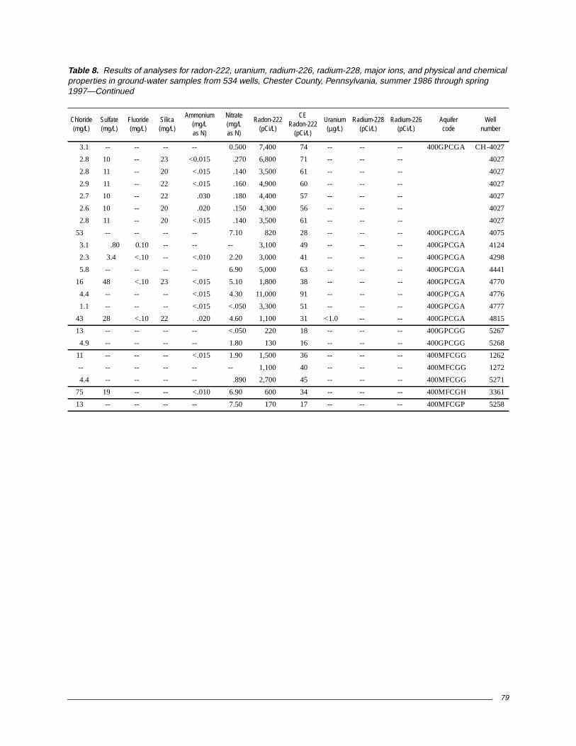
79
3.1 -- -- -- -- 0.500 7,400 74 -- -- -- 400GPCGA CH-4027
2.8 10 -- 23 <0.015 .270 6,800 71 -- -- -- 4027
2.8 11 -- 20 <.015 .140 3,500 61 -- -- -- 4027
2.9 11 -- 22 <.015 .160 4,900 60 -- -- -- 4027
2.7 10 -- 22 .030 .180 4,400 57 -- -- -- 4027
2.6 10 -- 20 .020 .150 4,300 56 -- -- -- 4027
2.8 11 -- 20 <.015 .140 3,500 61 -- -- -- 4027
53 -- -- -- -- 7.10 820 28 -- -- -- 400GPCGA 4075
3.1 .80 0.10 -- -- -- 3,100 49 -- -- -- 400GPCGA 4124
2.3 3.4 <.10 -- <.010 2.20 3,000 41 -- -- -- 400GPCGA 4298
5.8 -- -- -- -- 6.90 5,000 63 -- -- -- 400GPCGA 4441
16 48 <.10 23 <.015 5.10 1,800 38 -- -- -- 400GPCGA 4770
4.4 -- -- -- <.015 4.30 11,000 91 -- -- -- 400GPCGA 4776
1.1 -- -- -- <.015 <.050 3,300 51 -- -- -- 400GPCGA 4777
43 28 <.10 22 .020 4.60 1,100 31 <1.0 -- -- 400GPCGA 4815
13 -- -- -- -- <.050 220 18 -- -- -- 400GPCGG 5267
4.9 -- -- -- -- 1.80 130 16 -- -- -- 400GPCGG 5268
11 -- -- -- <.015 1.90 1,500 36 -- -- -- 400MFCGG 1262
-- -- -- -- -- -- 1,100 40 -- -- -- 400MFCGG 1272
4.4 -- -- -- -- .890 2,700 45 -- -- -- 400MFCGG 5271
75 19 -- -- <.010 6.90 600 34 -- -- -- 400MFCGH 3361
13 -- -- -- -- 7.50 170 17 -- -- -- 400MFCGP 5258
Table 8. Results of analyses for radon-222, uranium, radium-226, radium-228, major ions, and physical and chemicalproperties in ground-water samples from 534 wells, Chester County, Pennsylvania, summer 1986 through spring1997—Continued
Chloride(mg/L)
Sulfate(mg/L)
Fluoride(mg/L)
Silica(mg/L)
Ammonium(mg/Las N)
Nitrate(mg/Las N)
Radon-222(pCi/L)
CERadon-222
(pCi/L)
Uranium(µg/L)
Radium-228(pCi/L)
Radium-226(pCi/L)
Aquifercode
Wellnumber


![RC-7 Radon Slides Zielinski.ppt [Sólo lectura]5EC43B63-E6C2-40DA-8EC4-9E13155… · Radon in Environment • Radon-222 is a naturally occurring decay products of radium- 226, the](https://img.dokumen.tips/doc/110x75/5fbef3f713230d71d22e9917/rc-7-radon-slides-slo-lectura-5ec43b63-e6c2-40da-8ec4-9e13155-radon-in-environment.jpg)