Embed Size (px)
Citation preview
Journal of Northwest Anthropology, Memoir 7:167–194 2012
RADIOCARBON DATES AND COMMUNITY MOBILITY PATTERNS ON THE COLUMBIA PLATEAU
Kenneth M. Ames
ABSTRACT
This chapter examines community mobility patterns on the Columbia Plateau over the past 6000 years or so. It uses the structure of suites of radiocarbon dates to measure the relative permanence of residential occupations at three major residential sites: the Kartar phase occupation at 45-OK-11, the Wildcat phase at Wildcat Canyon, and the second occupation of the Miller site, on Strawberry Island. The Kartar and Strawberry Island occupations were likely much shorter then previously thought; sampling issues cloud the analysis of the Wildcat Phase dates. The study indicates that larger residential aggregations post ca. 2000 cal B.P. were not accompanied by increased degrees of sedentism.
Introduction
Evidence for large residential aggregations is generally thought to appear in the archaeological record of the Columbia Plateau between ca. 500 B.C. and A.D. 500 (e.g., Schalk 1987; Schalk et al. 1995; Prentiss et al. 2005; Chatters 2006). These aggregations seem to be a dramatic change in residential patterns. The Plateau’s archaeological record spans at least the last 14,000 calendar years (Gilbert et al. 2008), and for much of that lengthy period, residential sites are small, with very few dwellings (e.g., Connolly 1999). Houses are present in the record after ca. 5000 B.C. (Ames 2000), but these generally occur singly, or as part of small clusters of contemporary structures. The development of larger aggregations or villages was probably accompanied by changes in mobility patterns and land use practices in the hinterlands of these places (Chatters 2006). In fact, hinterlands may have formed (Endzweig 1994; Pettigrew and Hodges 1995; Schalk et al. 1995; Hess 1997). Some areas that previously had been used residentially were now exploited logistically by task groups. The aggregations seem to have developed in proximity to productive salmon fisheries, and many archaeologists have proposed that salmon production was intensified at this time. The overall purpose of the research described in this chapter is to examine these aggregations as mobility strategies at two scales: the household and the community (Varian 1999). It is part of a larger project on the evolution of mobility patterns on the Plateau. However, this chapter focuses on community-level mobility. Archaeologists usually view increased aggregation size as indicating increased sedentism. That does not seem to be the case on the Plateau. Sedentism is widely viewed by archaeologists as a significant development whenever and wherever it happens. It may be a precondition for subsistence intensification, for increased levels of social and economic complexity, and for population growth, among other things. However, its causal role in these and other changes is not straightforward. Part of the difficulty is that

168
“sedentism” is not a unitary phenomenon (Ames 1991). “Sedentism” has a number of dimensions (Ames 1991; Table 1) and selection may act differently on each. Varian (1999) also thinks that sedentism is scalar, and he proposes three distinct scales: the individual, the household, and the community. In some cases, sedentariazation (increased levels of sedentism) probably occurred at all three levels simultaneously, which is the generally unexamined expectation of most archaeologists. However, as Varian demonstrates for the Southwest, it is possible for communities to be relatively sedentary, while households are somewhat mobile, and individuals very mobile. The long-term consequences of sedentism will differ among these alternatives.
Sedentism and Mobility
Marshall (Ames and Marshall 1980) discussed Nez Perce settlement patterns at two scales: the individual and society. Marshall used the term habitation patterns for the ways in which individuals distributed themselves across a landscape through time. He suggested that habitation patterns were partially idiosyncratic and were based on social as well as ecological factors. Settlement patterns were society level phenomena. Echoing Marshall, Varian (1999) argues that groups have more than one mobility strategy at the same time, and that these strategies may be organized along a variety of dimensions. His dimensions differ from mine (Ames 1991; Table 1). My dimensions are essentially rulers with which archaeologists can measure different aspects of residential mobility and residential site organizations, while Varian’s dimensions, like Marshall’s habitation patterns, are the dimensions along which the people themselves organize their mobility practices. These can include gender, age, and marital status, and can operate at different scales (individuals, task groups). In his study, Varian is particularly concerned with these different scales, more so than with the various dimensions. He focuses on three scales: the individual, the household, and the community. The individual is the individual actor; this is the level of Marshall’s habitation patterns. Varian defines households similarly to most other archaeologists: “. . . a household is defined as a group of individuals who share a common residence and who cooperate regularly in a number of
TABLE 1. DIMENSIONS OF SEDENTISM (AMES 1991).
Duration: How long a residential site is occupied during an annual cycle. Most definitions of semi-sedentism are definitions of short-duration occupations. The site is occupied for only one or two seasons. Seasonality of Residence: The seasons during which the residential site is occupied. Permanence: The number of annual cycles (years) a site is occupied or reoccupied. Size: Areal extent of the residential site. Organization: The degree to which the areas within the household or residential site are functionally or socially differentiated. Structure: The degree to which organization is repeated across the site or among sites. Investment: Amount of labor, time, and materials expended on the residential site.
169
basic economic and social tasks . . . Households are defined in terms of what they do, not on the basis of kin relations. . . .” (Varian 1999:16). In this, he is firmly in the tradition of household analyses that has its roots in the work of Netting (1993), and Wilk and Rathje (e.g., Wilk and Rathje 1982). Households are operationalized archaeologically by studying houses, which is the practice followed here. Various authors have pointed to the weaknesses of this approach (e.g., Hendon 1996), but, as most conclude, there is really no archaeological alternative. For Varian, communities “are groups of many households that live close together, have regular face-to-face interaction, and share the use of local, social and natural resources” (Varian 1999:19). He stresses that communities are structured by time: community members must live in the same place most of the time for face-to-face interaction to occur; by geography: they occupy bounded spaces that must be small enough to permit face-to-face interaction; and by demography: minimally there are lower and upper size boundaries within which face-to-face interaction can occur. He also emphasizes that communities are structured socially, by shared access to resources, resources that can be themselves social (fellow community members) and natural (land, water, resource patches). Finally, he sees communities as being both people and places, with place including the built environment. This is the level of Marshall’s settlement patterns. Varian operationalizes households and communities at three phenomenological levels beyond houses: residential sites, localities, and regions. Residential sites have middens, one or more houses, and distinct boundaries. A locality is a geographic entity bigger than a residential site, but smaller than a region. Essentially, a locality is a community or cluster of communities and their hinterland or catchment area. Regions are the “sustaining area” of many communities. In Varian’s study, it was the Mesa Verde region of the Southwest. In this study, it is the southern Columbia Plateau. Varian views mobility as part of the mode of production; it is through mobility that individuals and households gain access to critical natural and social resources. In the former case people position themselves to gain access to water, resources patches, lithic quarries, and the like, in the latter case, to gain access to other community members for a variety of purposes. Access to natural resources is ensured through systems of land tenure. While Varian’s theory and methodology are based to a major degree on hunter-gatherer studies, they require some modification to be applicable to the full span of Plateau prehistory. Prior to ca. 5000 B.C., there is no consistent evidence for the existence of households. These early groups were probably immediate-return foragers, and the basic “residential” groups were probably bands and family groups that periodically came together into large temporary aggregations or fandangos (Thomas 1981) and then dispersed. It is well known that in such groups individual mobility can also be high. It can be difficult in such cases to speak in terms of systems of land tenure. However, as will be developed below, there is mortuary evidence to indicate groups with consistent ties to particular places or areas, suggesting the existence of a “community” larger than mobile bands. Shifting mobility patterns are issues of dynamics in time and space. In this chapter, radiocarbon dates are used to explore those dynamics and so the chapter is also an exploration in the use of radiocarbon dates for purposes other than simple dating. There is a long tradition in the Northwest of using radiocarbon dates to measure changes in population (e.g., Fladmark 1975; Chatters 1995; Ames 2000). The assumption of that work is that there is a general relationship between numbers of people and amounts of datable cultural charcoal. The issue here is somewhat different, but still within the same general category of approach: using 14C data sets to measure the frequency and duration of site occupations. As will be seen below, the effort is not entirely successful. It is useful, however, because the analysis raises questions about the nature of radiocarbon data sets, including how archaeologists choose dates.

170
The Columbia Plateau
The Columbia Plateau (Fig. 1) is the southern portion of the Plateau Culture Area and the Intermontane Plateau physiographic province of northwestern North America. The Columbia Plateau (hereafter the Plateau) spans the crest of the Cascade Mountain in the west to the crest of the Bitterroot Mountain Range of the Rocky Mountains in the east. It extends south from the Okanogan Mountains in northern Washington State into central Oregon and southwestern Idaho State, where it merges culturally into the Great Basin. The Plateau’s central feature is the Columbia Basin, a depression in the center of the region filled with vast sheets of Miocene basalt. This lava plain tilts down to the west and is lowest along the eastern flanks of the Cascades. It rises gradually to the east by more than 600 meters with the adjacent mountains much higher. The region’s rivers, including the Columbia River, the Snake River, and their tributaries, are entrenched in deep canyons in the northern and eastern portions of the Plateau, but flow through relatively low terrain in some parts of the southwestern portions. The Plateau has a continental climate, with cold winters and hot summers. Rainfall comes from the west, off the Pacific Ocean. Thus, the very low western portions of the Plateau are the driest because they lie in the Cascade’s rain shadow. Rainfall increases to the east. The uplands flanking the basin are forested, while the basin itself is covered with a shrub and bunch grass steppe. This description elides great ecological diversity, particularly in the Plateau’s wetter and higher portions.
Early Modern Period (A.D. 1720–1855): Aggregations, Residential And Mobility Patterns
The horse arrived on the Plateau sometime around A.D. 1720. Prior to that date, peoples on the Plateau were pedestrian hunters, fishers, and gatherers; after that date, they could ride and haul freight on horseback. Thus, Early Modern mobility patterns may have been quite different from those of preceding periods. However, they provide a necessary background for the discussion that follows. Two forms of aggregation occurred regularly during the Early Modern period: winter villages and summer root ground camps (Marshall 1977; Ames and Marshall 1980; Walker 1998). Winter villages were located along major rivers and tributaries, generally where there was access to wood and other resources. In the 19th century, these included horse pastures. Winter aggregations could be quite small, a few families, or quite large, numbering into the several hundred. Winter villages were generally associated with cemeteries and were the location of winter ceremonial activity. Winter houses were long lodges (see below). Summer houses were smaller, conical mat lodges. Other structures associated with villages/aggregations were sweat lodges and menstrual huts. Generally, in the spring and early summers people scattered in family and task groups from their winter residences to harvest a variety of resources. Among these were roots. While some roots were dispersed across the landscape, others, such as camas (Camassia quamash) grew in dense and productive stands. Large human aggregations, sometimes numbering into the thousands (Ames and Marshall 1980) formed around certain very large and productive camas meadows in the late summer. Resource-based aggregations also occurred in late summer at major fishing localities. The most important and famous of these was at the eastern end of the Columbia Gorge where the Columbia River entered a series of rapids and narrows permitting fish to be taken in large numbers.
171
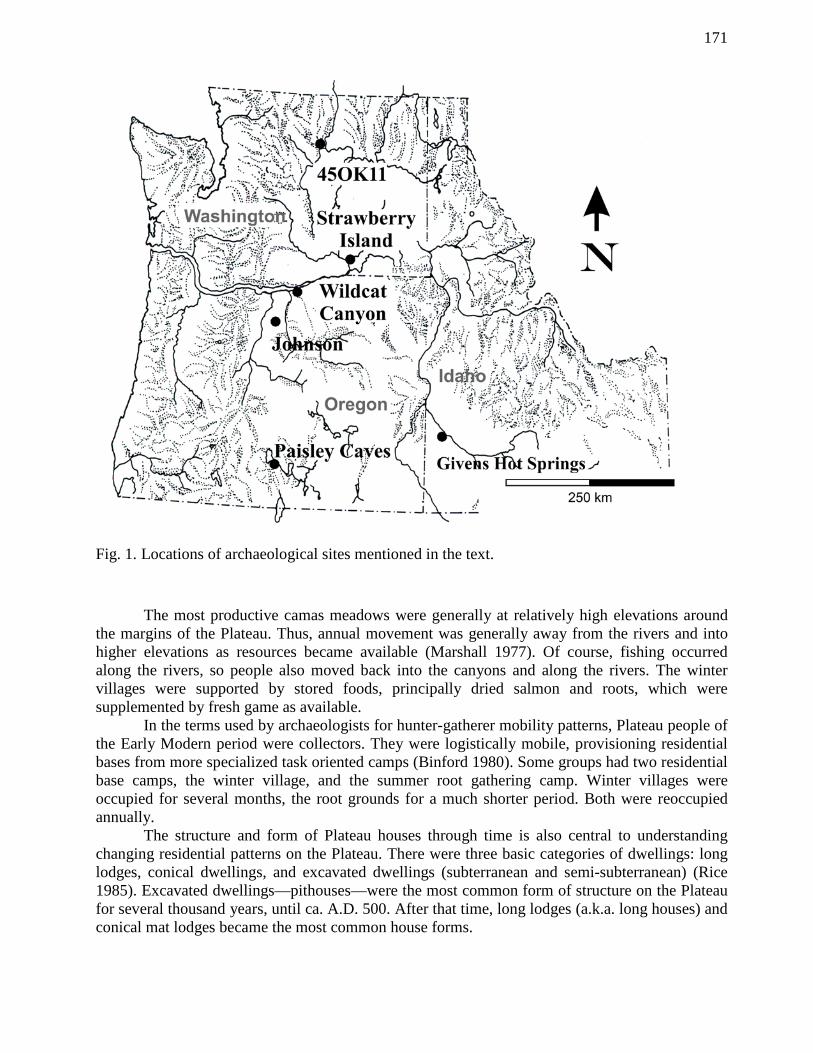
Fig. 1. Locations of archaeological sites mentioned in the text. The most productive camas meadows were generally at relatively high elevations around the margins of the Plateau. Thus, annual movement was generally away from the rivers and into higher elevations as resources became available (Marshall 1977). Of course, fishing occurred along the rivers, so people also moved back into the canyons and along the rivers. The winter villages were supported by stored foods, principally dried salmon and roots, which were supplemented by fresh game as available. In the terms used by archaeologists for hunter-gatherer mobility patterns, Plateau people of the Early Modern period were collectors. They were logistically mobile, provisioning residential bases from more specialized task oriented camps (Binford 1980). Some groups had two residential base camps, the winter village, and the summer root gathering camp. Winter villages were occupied for several months, the root grounds for a much shorter period. Both were reoccupied annually. The structure and form of Plateau houses through time is also central to understanding changing residential patterns on the Plateau. There were three basic categories of dwellings: long lodges, conical dwellings, and excavated dwellings (subterranean and semi-subterranean) (Rice 1985). Excavated dwellings—pithouses—were the most common form of structure on the Plateau for several thousand years, until ca. A.D. 500. After that time, long lodges (a.k.a. long houses) and conical mat lodges became the most common house forms.

172
Long lodges were pole structures with rounded ends, covered with tule or bark mats. In the southern Plateau, they were often built over a pit about a meter deep. The houses could be as much as 6 m high and over 9 m long. Houses over 30 m in length are reported in ethnohistorical sources (e.g., Moulton 1988). Long lodges were the most common form of winter dwelling during the Early Modern period (A.D. 1720–1850) and were used well into the Late Modern period (A.D. 1850–present). Long lodges were a flexible house form, allowing for rapid expansion and contraction in the size of co-residential groups. This flexibility could either be a consequence of or a contributor to variable household and community sizes. Single structures could even be large enough, as they sometimes were, to house entire communities. The mat lodge was built around a foundation cone of three or four poles, which were covered with tule or cattail mats, over which more poles were placed to hold the mats down. The structures were sometimes placed over shallow excavations 30 cm or so deep, and ranged in diameter between about 3 m to some 6 m. During the Early Modern period, they were used widely on the southern Plateau, particularly as a summer dwelling, and as a house for family sized groups. Semi-subterranean houses were variable in size and construction. In more northerly areas, probably with heavy snowfall, they had quite substantial roofs, and heavy interior roof supports, while in the southern Plateau and deep canyons, the roof support was much lighter, probably poles set over the excavation. Houses with substantial roofs had roof entrances, those with lighter roofs, side entrances. While pit houses were generally circular, they were also sometimes square. The interior pits were usually fairly simple, with vertical or slopping walls, but pits with benches or multiple levels also occurred, although these were relatively uncommon. Pithouses were generally 4 to 8 m in diameter, although both smaller and larger structures existed. The pits ranged from 30 cm to 2 m in depth.
Ancient Plateau Mobility Patterns
Paleoarchaic/Archaic (ca. 11,400 B.C.–6000 B.C.) While the earliest evidence for humans in the general region at Paisley Cave (Fig. 1) date ca. 12,500–12,000 B.C. (Gilbert et al. 2008) the nature and cultural affiliations of this Late Pleisticene occupation is poorly known. The Plateau’s earliest well documented cultural materials are Paleoarchaic (Beck and Jones 1997) Western Stemmed Windust tradition materials in southeastern Washington State and central Idaho. In addition Paleowestern/Clovis (Beck and Jones 1997; Reid, Root, and Hughes 2008) materials are very thinly scattered across the region. Beck and Jones (2010) argue that Western Stemmed was at least contemporary with Clovis, if not earlier. This is of course controversial (Beck and Jone 2012, Fiedel and Morrow 2012) and is beyond the scope of this chapter. Elsewhere, Paleowestern/Clovis dates between ca. 11,100 B.C. and 10,900 B.C. (Hamilton and Briggs 2007; Waters and Stafford 2007; Beck and Jones 2010). The Plateau’s earliest radiocarbon dates are associated with Windust materials and cluster between ca. 11,200 and 9600 B.C. (Ames 2000). In addition to Windust, there is evidence for a second Paleoarchaic culture on the Plateau, with artifacts very similar to Haskett materials found in the western Great Basin. Presently, the reported Haskett-like materials are from a single site (Galm and Gough 2000), which appears to have been a temporary camp. This raises the possibility that multiple cultural traditions were present in the Plateau in the Paleoarchaic. The Paleoarchaic and Archaic people were very mobile (Ames 1988, 2000). Populations were probably very small, perhaps only a very few hundred or thousand people. Windust mobility strategies exhibit some degree of logistic movement, including at least one residential base and some degree of functional differentiation among sites (Ames 1988). Movements may also have
173
been “tethered” with people returning to the same locality repeatedly, raising the possibility of communities tied to particular localities and territories. The sole excavated residential site contains relatively substantial site furniture, including ground stone abraders or slabs (Connolly 1999) and possibly multiple huts. At least one site (Marmes Rockshelter) was occasionally reused for mortuary purposes. By 7000 B.C., people were fully foragers. However, reuse of Marmes for mortuary purposes continued. Marmes might well be considered what Schlanger terms a “persistent place” (Schlanger 1993), a place that, over the long-term, structures cultural landscapes through reuse, anchoring movement and social ties although its function and meaning might change through time.
Early Pacific Period (ca. 6000–1200 B.C.) Early Pacific (EP) mobility patterns are controversial. At the beginning of the period, the region was inhabited by foragers (Ames and Maschner 1999). Interpreting the subsequent record is both challenging and interesting. The records for houses, mobility patterns, subsistence patterns and mortuary patterns seem in some ways contradictory. The oldest substantial residential structure on the Plateau is at the Johnson site, and dates between 5500 and 4300 B.C. It is in upland north central Oregon (Pettigrew and Schalk 1995). After this, a series of sites dating between 4000 B.C. and ca. 2000 B.C. have substantial, semi-subterranean pithouses. The bulk of these structures date between 3000 B.C. and 2500 B.C. Construction of houses appears to have stopped on the Plateau for a few centuries after 2000 B.C. (Ames 1991, 2000; Chatters 1995). These EP structures are distributed from British Columbia to southwestern Idaho (Ames 2000). With the exception of the Johnson site, they are located along the region’s major rivers. There is some possibility of other, upland houses, however (Reid 1992). Chatters (2006) suggests they were used for relatively short periods. However, the houses sometimes contain multiple, large anvils and hopper mortar bases representing significant investments of time and labor in processing equipment (Ames 2000) and hence in the locality as well. The extent of middens and other debris also suggests relatively lengthy occupations (Ames 1991, 2000) and probably stable, long-term household or community ties. The associated residential patterns are another subject of dispute. Some suggest they were part of a pattern of very stable or low mobility tethered foraging in which people were able to reuse base camps for several years until they depleted adjacent resources and then moved (e.g., Lohse and Sammons-Lohse 1986; Chatters 1995; Prentiss et al. 2005). Others (e.g., Schalk and Atwell 1994), myself included, argue that residential stability on the Plateau could only be possible with logistical mobility and storage. At present, however, I must admit evidence for storage is nil, unless the structures themselves are the storage facilities, and evidence for logistical mobility is weak. Task-specific sites exist, but they are ambiguous in nature (Campbell 1985; Reid and Chatters 1997). The houses were large, with mean floor areas of 71 m2, suggesting households of perhaps six to ten people (Ames 1991). These are the largest mean floor areas/period for houses over the last 6000 years on the Plateau. They are also the least variable in size, as measured by coefficients of variation (standard deviation/mean). The CV is .42 (mean is 71 m2, standard deviation 30 m2 for a CV of .42). There is general agreement that the associated communities were small, with only one to three structures at a time. There is no persuasive evidence for larger, multihouse communities. The houses are contemporary with some elaborate cemeteries dating between ca. 5000 and 2500 B.C. The highly structured spatial organization of at least some of these, as well as their contents (Pavesic 1985), is persuasive evidence they were cemeteries, rather than persistent
174
places (e.g., Littleton and Allen 2007). These cemeteries are found in central and southern Idaho, where they constitute the Western Idaho Archaic Burial Complex (WIABC) (Pavesic 1985). Pavesic argues that the WIABC also includes Archaic/EP burials along the Snake River in Washington State. In Idaho, individuals were interred in flexed positions, commonly in sandy knolls near large rivers, although at least one cemetery is in a mountain meadow and another a rockshelter. People may have been transported and reburied after exposure and possibly defleshing (Reid and Chatters 1997). Red ocher and Olivella shells are common grave goods, as are large well-made bifaces, including so-called turkey-tailed blades, large side notched points and caches of bifaces and blanks. Much less common grave goods include dogs, bone and shell beads, pipes, hematite crystals, bone tools, and chipped stone and ground stone tools, including pumice shaft straighteners (Pavesic 1985; Reid and Chatters 1997). Reid and Chatters (1997) argue these practices were the result of communal reburial by small, dispersed mobile groups. Pavesic (personal communication) strongly disagrees with these conclusions, arguing that the cemeteries were associated with large, stable residential groups, such as those indicated by the Johnson Site, the Givens Hot Springs Site on the Snake River in southwest Idaho (Green 1993), and others. In any case, the consistent use of such places over a long period might also suggests relatively stable territories and some level of territorial affiliation during the Archaic on the Plateau. In the terms outlined at the beginning of this chapter, individuals and local groups may have been mobile, while territorial groups (communities or those participating in the burial ritual) may have been spatially quite stable. A number of researchers have noted a significant but very poorly understood regional event around ca. 2000 B.C. Ames (1991) and Chatters (1989) first documented it as a gap in dated house floors. Goodale, Prentiss, and Kuijt (2006) term it a “hiatus” lasting about 200 years on the Upper Columbia while Schalk et al. (1995) document a much more extensive “pause in land use” in central and northeastern Oregon between 3200 and 2000 B.C.
Middle Pacific (1800 B.C.–A.D. 200/500) Middle Pacific (MP) populations were larger than during previous periods (Ames 1991, 2000; Chatters 1995; Ames and Maschner 1999). Logistical mobility patterns were clearly present (Chatters 1995; Prentiss et al. 2005; Goodale, Prentiss, and Kuijt 2006). Goodale, Prentiss, and Kuijt’s term “dispersed generalized collectors” is apt (2006). They also note the possibility of occasional larger aggregations in optimal localities. The origins of this general pattern are controversial (e.g., Prentiss and Chatters 2003); that is an issue beyond the scope of this chapter. In any case, occupations of residential sites were much briefer during the MP than during the EP, probably lasting only a few years, rather than a generation or more (Ames 1991; Prentiss et al. 2005). Pithouses were again present, but were smaller; with mean house sizes ranging from ca. 36 m2 to about 55 m2 (Ames 1991). While smaller, they were much more variable in size, with CVs between .58 and .78 (Ames 1991; Prentiss et al. 2005). Communities were small, with only one to a few pithouses. However, villages were associated with cemeteries, suggesting long-term social and territorial ties to village locations (Ames 2000). High household and community mobility, coupled with the cemeteries and other data (Prentiss et al. 2005) indicates residential sites may have shifted regularly through a defined territory. Territory sizes may have decreased through the period (Hess 1997; Connolly 1999).
Late Pacific (A.D. 200/500–A.D. 1720) Populations peaked during the Late Pacific (LP) period. Large aggregations appear at some point during this period (Hayden 1997; Ames and Maschner 1999; Ames 2000; Prentiss et al.
175
2005; Chatters 2006). Mobility patterns became increasingly logistical while mobility levels remained high. On the Columbia Plateau, house forms changed, pithouses were gradually replaced by long lodges and mat lodges, perhaps reflecting a shift to more changeable household sizes. This shift began around A.D. 500 and was virtually complete by A.D. 1000 (Rice 1985; Ames 1991, 2000). Pithouses continued in use on the Fraser-Thompson Plateau in British Columbia. Both house and community sizes varied from quite small to very large, with perhaps several hundred people in a community. Mean house sizes ranged from 51 to 63 m2, but with CVs of .83. This variability may reflect the shift from pit dwellings to long lodges, but it may indicate increased levels of social inequality as well, an inference supported by Schulting’s analysis of Columbia Plateau mortuary data (Schulting 1995). Variability in house sizes at villages in south central British Columbia, such as Keatley Creek (Hayden 1997) and the Bridge River Site (Prentiss et al. 2008) has been taken as evidence for social inequality. Communities were associated with cemeteries and extensive storage features, including storage caves, strongly indicating village territories. A number of researchers (e.g., Endzweig 1994; Pettigrew and Hodges 1995; Schalk et al. 1995; Hess 1997) suggest that regional settlement patterns shifted from villages scattered through the uplands to villages concentrated along the rivers. Exploitation of the uplands then required long distance logistical forays. By implication at least, these new aggregations were also more sedentary. While these researchers tend to attribute the shift to climate change or population growth, Chatters (2006) sees it as a consequence of a documented increase in warfare. The period after ca. A.D. 1300 is marked by population decline (Ames 1991, 2000; Prentiss et al. 2005). The large aggregations that had formed previously, at least in British Columbia, appear to have dispersed (Prentiss et al. 2005). As Prentiss et al. (2005) point out, this period is particularly poorly known archaeologically.
Discussion The evidence sketched above indicates that during the Paleoarchaic and Archaic periods there were high levels of mobility. However, there are also suggestions of long-term community or social group level ties to particular places or regions including burial localities and perhaps very favored residential locations. The pit dwellings that appear after 5500 B.C. seem to be associated with mobility patterns tethered to long-term residential localities and, at least in some areas, to cemeteries and stable persistent places. These connections to specific localities may have endured for centuries. This would suggest low levels of both household and community mobility. Household mobility appears to have increased in the MP and continued high in the LP. The issue addressed here is whether community mobility was also high (low permanence sedentism) as well. Again, it is important to conceptualize individual, household and community mobility as separate dimensions of mobility. Leaving individual mobility aside, one can speak of mobility patterns in which a community is sedentary over long periods (decades, centuries) and the households that comprise the community are equally sedentary (high permanence). One can also imagine a circumstance where the community is very sedentary, but households move in and out (high permanence at the community level, relatively low household level permanence). Alternatively, a community may be sedentary in one place for a short period (a few years, a few decades), thus display low permanence, but households remain in the community (high permanence at the household level), or alternatively, there is low permanence at the community and household level (households move in and out). The question asked here then is what were the levels of community permanence on the Plateau during the Pacific period?
176
Measuring Mobility
In this chapter, the degree of mobility at the community level is measured along the dimension of permanence, or the number of years a place was occupied. Measuring the permanence of communities is done here using suites of radiocarbon dates. The analysis focuses on sites with relatively large suites of dates (more than four), and a rather lengthy process of evaluating samples of radiocarbon dates. The method is described below. In this section, I use dates (Table 2) from three sites (Fig. 1). As part of the research described here, I examined a larger sample of data sets. However, that work is not complete, and these three are adequate for the argument advanced here. Further, one is the best-documented example of a chronologically late, large aggregation site on the Columbia Plateau. It is the Strawberry Island Village site (a.k.a. the Miller site) on Strawberry Island, near the confluence of the Snake River with the Columbia. The other two are 45-OK-11, one of the earliest pithouse sites on the Plateau, and Wildcat Canyon, an example of a residential site whose occupations span much of the Pacific period, including the apparent shift to large residential sites. It is also a pithouse village with an associated cemetery. One key issue that had to be addressed was whether significant temporal gaps or fluc-tuations in the number of dates in a site’s radiocarbon date set were consequences of fluctuations in site occupation (including abandonment) or in atmospheric 14C. Most archaeologists are aware of the effects of changing levels of atmospheric 14C on our ability to calibrate radiocarbon dates to the calendar. However, these fluctuations can also affect temporal patterning of the 14C record. To control for this, as is explained in more detail below, I simulated samples of radiocarbon dates from the three sites. To estimate the occupation spans of these three sites, using their radiocarbon dates, I followed these steps: The maximum potential occupation span was based on the complete uncalibrated and calibrated radiocarbon sample minus the oldest and youngest dates. As the reader will see, the uncalibrated and calibrated spans sometimes differed by several hundred years. Ultimately, we are interested in the span of calendar years. To test samples for internal coherence, I used CALIB 5.01’s t-test module to determine whether a sample of radiocarbon dates were statistically identical or not. If they were, I averaged statistically identical samples and used the resulting two-sigma age span. The temporal patterning of the uncalibrated dates was examined graphically using the radiocarbon module in Kintigh’s Tools for Quantitative Archaeology (Kintigh 2006). The module produces a probability plot for uncalibrated radiocarbon dates analogous to the familiar probability plots for calibrated dates. The temporal patterning of the calibrated dates was examined graphically using the Plot facility in CALIB 5.01 (Stuiver and Reimer 1993; Stuiver, Reimer, and Reimer 2005). This facility produces a single plot of the pooled probabilities of the age spans of calibrated dates in the sample. To simulate the radiocarbon samples, I used the radiocarbon date simulation module in OxCal 3.1 (Ramsey 1995, 2001) (Table 3). OxCal simulates a radiocarbon date for an inputted calendar date. Ten runs were done for each sample. The number of calendar dates in each simulation was the number of radiocarbon dates in each site sample. OxCal asks for a sigma. For each site, the sigma was the mean sigma of the date sample, minus the largest and smallest individual sigmas. Increments between simulated dates were based on mean increments between dates in the sample. An averaged calendar date was used as the basis for each simulation. Lower and upper limits of the simulation were set at a 0.1 confidence limit; in other words, simulations
177
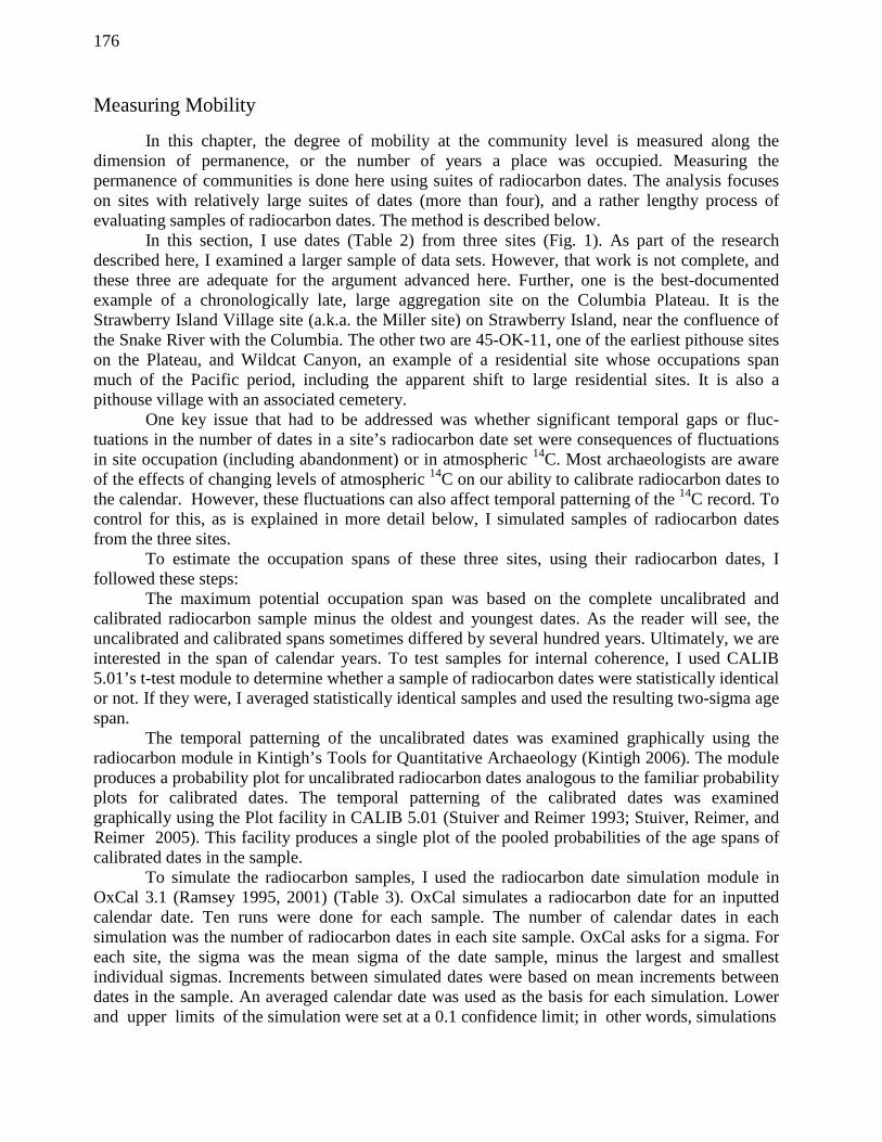
TABLE 2. RADIOCARBON DATES USED IN THIS STUDY.
Site Centroid Sigma Lab Number Source
45-OK-11 4010 110 B-4296 Lohse 1984, Appendix A
45-OK-11 4100 130 B-4289 Lohse 1984, Appendix A
45-OK-11 4130 110 TX-3380 Lohse 1984, Appendix A
45-OK-11 4160 120 B-4288 Lohse 1984, Appendix A
45-OK-11 4170 110 B-4294 Lohse 1984, Appendix A
45-OK-11 4200 80 TX-3379 Lohse 1984, Appendix A
45-OK-11 4240 85 TX-3383 Lohse 1984, Appendix A
45-OK-11 4250 80 B-4284 Lohse 1984, Appendix A
45-OK-11 4390 220 B-4291 Lohse 1984, Appendix A
45-OK-11 4420 120 B-4295 Lohse 1984, Appendix A
45-OK-11 4440 100 B-4287 Lohse 1984, Appendix A
45-OK-11 4490 120 B-4295 Lohse 1984, Appendix A
45-OK-11 4680 330 TX-3384 Lohse 1984, Appendix A
Wildcat Canyon (35-GM-9) 500 150 M - 1119 Dumond and Minor 1983
Wildcat Canyon (35-GM-9) 1010 150 I-1327 Dumond and Minor 1983
Wildcat Canyon (35-GM-9) 1025 200 I - 808 Dumond and Minor 1983
Wildcat Canyon (35-GM-9) 1400 90 GaK-1668 Dumond and Minor 1983
Wildcat Canyon (35-GM-9) 1400 150 I -504 Dumond and Minor 1983
Wildcat Canyon (35-GM-9) 1430 90 GaK-1667 Dumond and Minor 1983
Wildcat Canyon (35-GM-9) 1790 275 I - 809 Dumond and Minor 1983
Wildcat Canyon (35-GM-9) 1860 260 GaK-1664 Dumond and Minor 1983
Wildcat Canyon (35-GM-9) 2025 150 M-1120 Dumond and Minor 1983
Wildcat Canyon (35-GM-9) 2460 110 Gak-1665 Dumond and Minor 1983
Strawberry Island Village (45-FR-5) 140 80 WSU-1889 Schalk 1983, Table 4 -1
Strawberry Island Village (45-FR-5) 260 90 WSU-1892 Schalk 1983, Table 4 -1
Strawberry Island Village (45-FR-5) 410 130 WSU-1893 Schalk 1983, Table 4 -1
Strawberry Island Village (45-FR-5) 440 90 WSU-1894 Schalk 1983, Table 4 -1
Strawberry Island Village (45-FR-5) 450 80 WSU-1890 Schalk 1983, Table 4 -1
Strawberry Island Village (45-FR-5) 480 80 WSU-1891 Schalk 1983, Table 4 -1
Strawberry Island Village (45-FR-5) 530 80 WSU-1699 Schalk 1983, Table 4 -1
Strawberry Island Village (45-FR-5) 610 90 WSU-1698 Schalk 1983, Table 4 -1
Strawberry Island Village (45-FR-5) 1395 80 WSU-2241 Schalk 1983, Table 4 -1
178
were continued until only one of the ten simulated radiocarbon dates fell within a single sigma of the oldest and youngest radiocarbon date in the site sample. Runs usually were continued two or three dates beyond that point. These upper and lower limits were used to set the potential time period from which the sample could have been drawn. Simulations were used to calculate expecteds: i.e., based on the distributions of simulated dates, what was the expected distribution of radiocarbon dates in a sample of n dates through the time span set by the confidence limits? The expecteds were matched visually against the temporal distribution of the sample. The simulations and expecteds often allowed the probable time span of the sample to be further shortened.
Case Studies
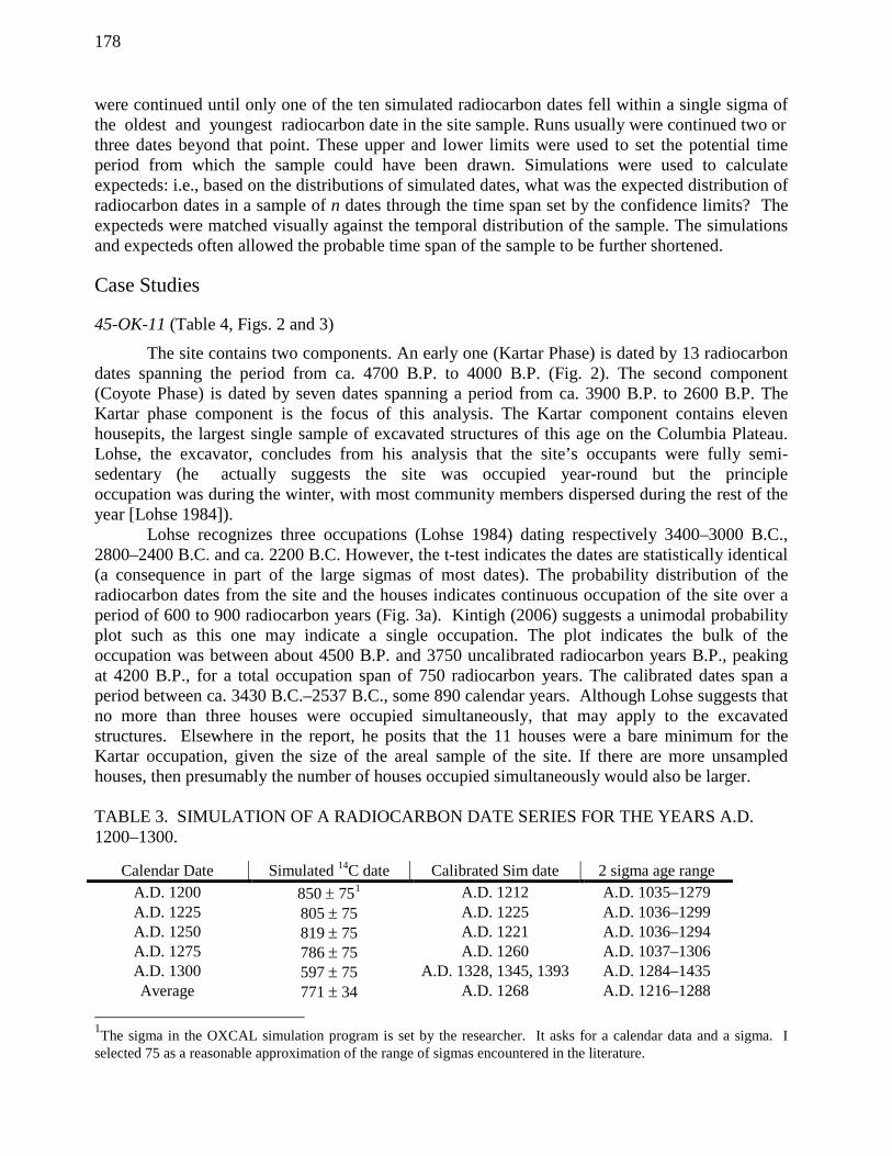
45-OK-11 (Table 4, Figs. 2 and 3)
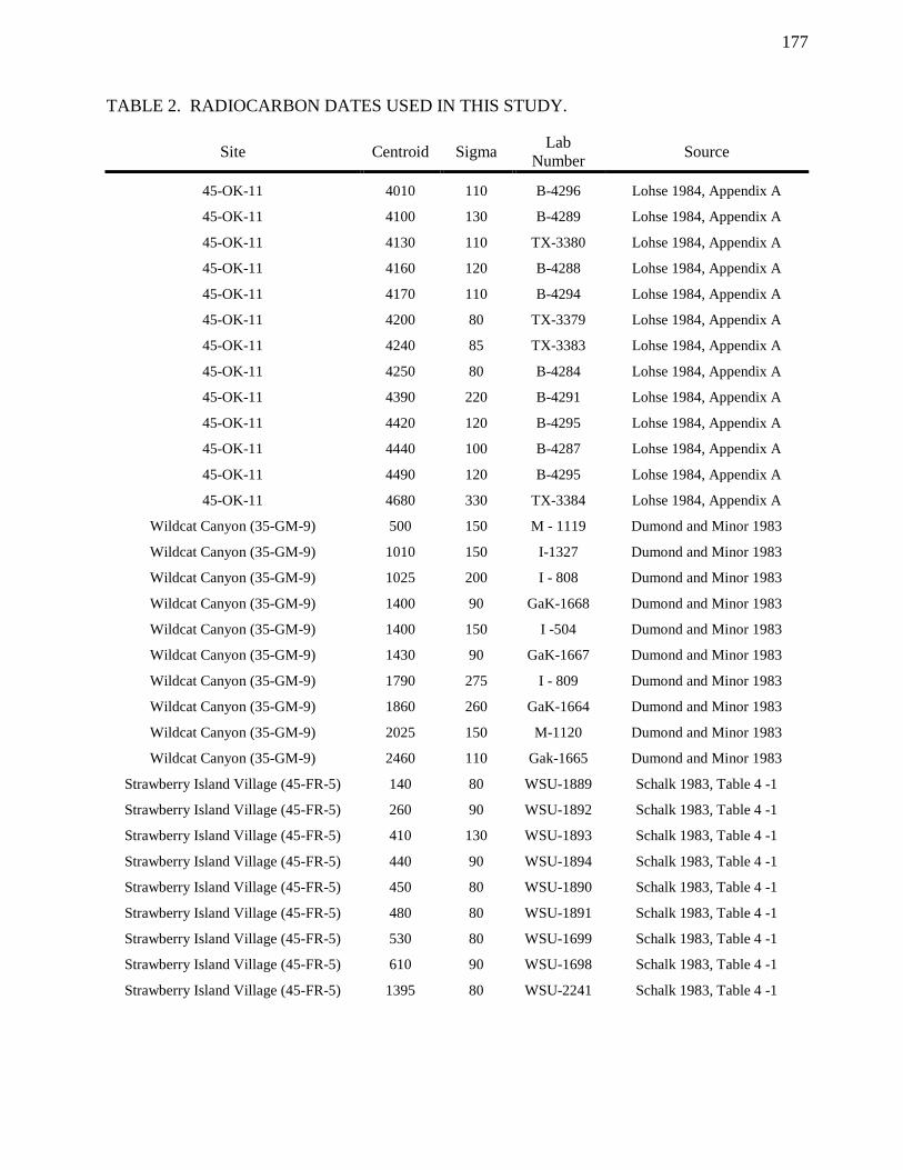
The site contains two components. An early one (Kartar Phase) is dated by 13 radiocarbon dates spanning the period from ca. 4700 B.P. to 4000 B.P. (Fig. 2). The second component (Coyote Phase) is dated by seven dates spanning a period from ca. 3900 B.P. to 2600 B.P. The Kartar phase component is the focus of this analysis. The Kartar component contains eleven housepits, the largest single sample of excavated structures of this age on the Columbia Plateau. Lohse, the excavator, concludes from his analysis that the site’s occupants were fully semi-sedentary (he actually suggests the site was occupied year-round but the principle occupation was during the winter, with most community members dispersed during the rest of the year [Lohse 1984]). Lohse recognizes three occupations (Lohse 1984) dating respectively 3400–3000 B.C., 2800–2400 B.C. and ca. 2200 B.C. However, the t-test indicates the dates are statistically identical (a consequence in part of the large sigmas of most dates). The probability distribution of the radiocarbon dates from the site and the houses indicates continuous occupation of the site over a period of 600 to 900 radiocarbon years (Fig. 3a). Kintigh (2006) suggests a unimodal probability plot such as this one may indicate a single occupation. The plot indicates the bulk of the occupation was between about 4500 B.P. and 3750 uncalibrated radiocarbon years B.P., peaking at 4200 B.P., for a total occupation span of 750 radiocarbon years. The calibrated dates span a period between ca. 3430 B.C.–2537 B.C., some 890 calendar years. Although Lohse suggests that no more than three houses were occupied simultaneously, that may apply to the excavated structures. Elsewhere in the report, he posits that the 11 houses were a bare minimum for the Kartar occupation, given the size of the areal sample of the site. If there are more unsampled houses, then presumably the number of houses occupied simultaneously would also be larger. TABLE 3. SIMULATION OF A RADIOCARBON DATE SERIES FOR THE YEARS A.D. 1200–1300.
Calendar Date Simulated 14C date Calibrated Sim date 2 sigma age range A.D. 1200 850 ± 751 A.D. 1212 A.D. 1035–1279 A.D. 1225 805 ± 75 A.D. 1225 A.D. 1036–1299 A.D. 1250 819 ± 75 A.D. 1221 A.D. 1036–1294 A.D. 1275 786 ± 75 A.D. 1260 A.D. 1037–1306 A.D. 1300 597 ± 75 A.D. 1328, 1345, 1393 A.D. 1284–1435 Average 771 ± 34 A.D. 1268 A.D. 1216–1288
1The sigma in the OXCAL simulation program is set by the researcher. It asks for a calendar data and a sigma. I selected 75 as a reasonable approximation of the range of sigmas encountered in the literature.
179
The simulation analysis (Table 4; Fig. 3c) suggests first that while the Kartar occupation may have been as long, or even longer, than that suggested by the radiocarbon date sample, there are grounds for concluding that the occupation was shorter, perhaps 300 or 400 years long, rather than 700 or 1200 years although that latter possibility cannot be eliminated. First, the cluster of radiocarbon dates between 4500 and 4100 rcy B.P. is not predicted by the simulation. Since the sample size is too small for a chi-square, the patterning was explored by a second simulation, in which radiocarbon dates were generated from a sample of calendar dates spanning shorter periods of time. The full 45-OK-11 radiocarbon sample was most closely duplicated by a simulated sample dating between 2976 B.C. and 2568 B.C. (Table 4), 409 calendar years. This possibility potentially alters our general understanding of residential patterns at the site. Occupation may have been on the scale of decades rather than centuries: 11 houses over 1200 years are one house/109 years, or every four generations or so; 11 houses over 409 years are one house/37 years, or roughly one house every one to two generations. The former suggests the site TABLE 4. SUMMARY OF THE ANALYSIS OF THE KARTAR RADIOCARBON DATE SAMPLE 45-0K-11: Kartar Phase:
• Sample Size: 13 14C dates (Fig. 2) o 4680 ± 300 to 4010 ± 110, mean date 4245 ± 31. Time span 670 years o Calibrated: 3431 B.C.–2654 B.C., mean date 2882 B.C. Time span 1224 calendar years
• Sample statistically identical at .95 level (given sigmas), t-test statistic = 20.25, chi square value is 21, with 12 degrees of freedom. This suggests possibility of a much shorter occupation than generally thought.
• Pooled probabilities of uncalibrated dates (Fig. 3a) suggests an occupation of perhaps 500 or more years.
• Pooled probabilities of calibrated radiocarbon dates (Fig. 3b) suggests, in contrast, a potentially lengthy occupation. The two sigma span is 3519 B.C.–2296 B.C. (p = 1); the one sigma span is 3102 B.C.–2565 B.C. (p = .94).
• Simulation (Fig. 3c): o .1 Confidence level span (maximum span): 5079–3791 B.P., 1037 rc years 3945–2619 B.C., 1362 years
o Temporal distribution of dates does not completely fit expected. 2 peaks in dates, 3 dates between 4499–4400 B.P., and 7 dates between 4299 –4100 B.P. The first peak is predicted by expected (2 dates) the second is not (2 dates). A simulated sample drawn from this latter 200 year period closely approximate the real sample.
• Span of simulated dates that most closely approximates sample is between 2976 B.C.–2568 B.C., or 408 calendar years, 4385–4056, or 328 radiocarbon years.
Conclusions: While it is possible that the date sample represents a lengthy period, the analysis suggests that the occupation span may have been shorter than previously thought. The minimum estimate for this shorter occupation is 200 years, with 300 to 400 years a more conservative possibility.

180
Fig. 2. Calibrated radiocarbon dates from 45-OK-11, Kartar Phase. was generated by household mobility operating at the scale of multiple generations, with one household returning to the site once a century or so. This suggests a pattern of sedentism in which households were sedentary wherever they happen to be, but they moved around the landscape in slow motion as it were (every few generations) perhaps on a regular route that reused residential sites. The latter required either a household return once a generation or two, or, possibly, continuous occupation by one or two households. This would be the high permanence sedentism envisioned by Lohse. Either way, however, there is no evidence for a multi-house community. A problem that was not addressed in the foregoing is whether data sets of radiocarbon dates with relatively large sigmas can be used to measure cultural dynamics that occur at a rate that falls within the sigmas. Discussion of this problem is deferred until the conclusions.
35-GM-9, Wildcat Canyon (Table 5; Figs. 4 and 5)
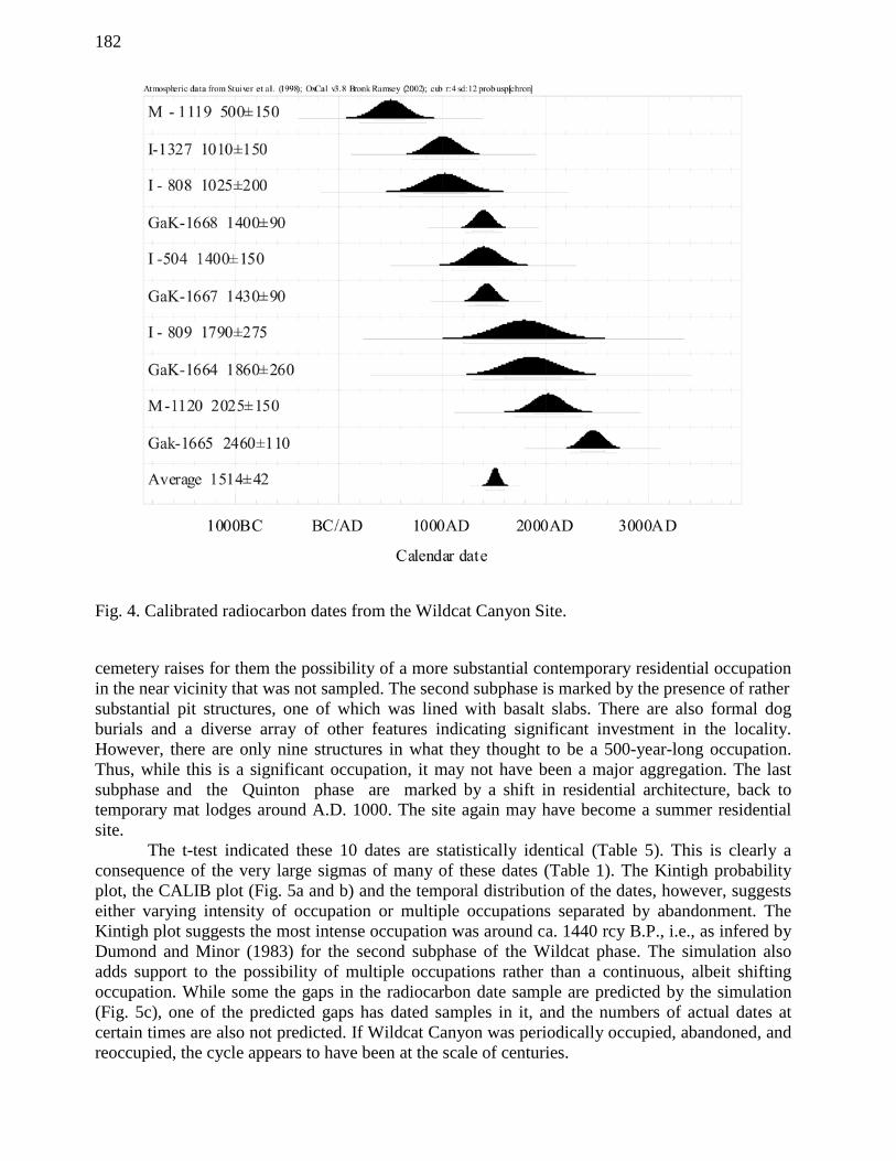
Wildcat Canyon is located on the Oregon shore of the Columbia River, about 65 km above the eastern end of the Columbia River Gorge (Dumond and Minor 1983). The University of Oregon excavated the site over a number of years in the 1960s. While occupations were not continuous, cumulatively they span most of the Plateau’s 11,000-year prehistory. I am concerned here with what is termed the Wildcat Phase, which contains evidence of both residential
181
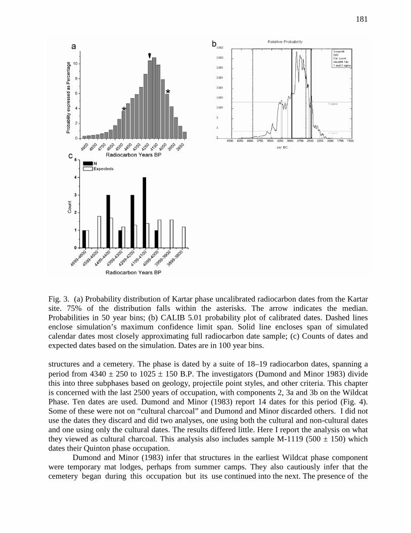
Fig. 3. (a) Probability distribution of Kartar phase uncalibrated radiocarbon dates from the Kartar site. 75% of the distribution falls within the asterisks. The arrow indicates the median. Probabilities in 50 year bins; (b) CALIB 5.01 probability plot of calibrated dates. Dashed lines enclose simulation’s maximum confidence limit span. Solid line encloses span of simulated calendar dates most closely approximating full radiocarbon date sample; (c) Counts of dates and expected dates based on the simulation. Dates are in 100 year bins. structures and a cemetery. The phase is dated by a suite of 18–19 radiocarbon dates, spanning a period from 4340 ± 250 to 1025 ± 150 B.P. The investigators (Dumond and Minor 1983) divide this into three subphases based on geology, projectile point styles, and other criteria. This chapter is concerned with the last 2500 years of occupation, with components 2, 3a and 3b on the Wildcat Phase. Ten dates are used. Dumond and Minor (1983) report 14 dates for this period (Fig. 4). Some of these were not on “cultural charcoal” and Dumond and Minor discarded others. I did not use the dates they discard and did two analyses, one using both the cultural and non-cultural dates and one using only the cultural dates. The results differed little. Here I report the analysis on what they viewed as cultural charcoal. This analysis also includes sample M-1119 (500 ± 150) which dates their Quinton phase occupation. Dumond and Minor (1983) infer that structures in the earliest Wildcat phase component were temporary mat lodges, perhaps from summer camps. They also cautiously infer that the cemetery began during this occupation but its use continued into the next. The presence of the
182
Fig. 4. Calibrated radiocarbon dates from the Wildcat Canyon Site. cemetery raises for them the possibility of a more substantial contemporary residential occupation in the near vicinity that was not sampled. The second subphase is marked by the presence of rather substantial pit structures, one of which was lined with basalt slabs. There are also formal dog burials and a diverse array of other features indicating significant investment in the locality. However, there are only nine structures in what they thought to be a 500-year-long occupation. Thus, while this is a significant occupation, it may not have been a major aggregation. The last subphase and the Quinton phase are marked by a shift in residential architecture, back to temporary mat lodges around A.D. 1000. The site again may have become a summer residential site. The t-test indicated these 10 dates are statistically identical (Table 5). This is clearly a consequence of the very large sigmas of many of these dates (Table 1). The Kintigh probability plot, the CALIB plot (Fig. 5a and b) and the temporal distribution of the dates, however, suggests either varying intensity of occupation or multiple occupations separated by abandonment. The Kintigh plot suggests the most intense occupation was around ca. 1440 rcy B.P., i.e., as infered by Dumond and Minor (1983) for the second subphase of the Wildcat phase. The simulation also adds support to the possibility of multiple occupations rather than a continuous, albeit shifting occupation. While some the gaps in the radiocarbon date sample are predicted by the simulation (Fig. 5c), one of the predicted gaps has dated samples in it, and the numbers of actual dates at certain times are also not predicted. If Wildcat Canyon was periodically occupied, abandoned, and reoccupied, the cycle appears to have been at the scale of centuries.
183
TABLE 5. SUMMARY OF THE ANALYSIS OF THE WILDCAT CANYON RADIOCARBON DATE SAMPLE. Wildcat Canyon:
• Sample size 10 14C dates (Fig. 4) o 2460 ± 100 to 800 ± 500, time span 1660 rcy, mean of 1514 ± 42 o c 704 B.C.–A.D. 1256, time span 1960 cy
• T-test indicates the radiocarbon dates are statistically different at .95 confidence level, t-test = 112.86, with a chi square value of 22.4, 13 degrees of freedom. The size of the sigmas makes it extremely difficult to tease out temporal variation in intensity of occupation
• Pooled probabilities of uncalibrated radiocarbon dates (Fig. 5a) suggests a possible 1,400–2,000 year occupation span with as many as five occupation episodes.
• Pooled probabilities of calibrated radiocarbon dates suggests lengthy occupation span perhaps marked by varying degrees of occupational intensity (Fig. 5b). The two sigma calibrated age span is 797 B.C.–A.D. 1305 (p = .99); the one sigma span is 194 B.C.–A.D. 894 (p = .96).
• Simulation (Fig. 5c); o .1 confidence level span (maximum span):
2830–1060 B.P. 1760 radiocarbon years 1015 B.C.–A.D. 1145 2160 calendar years
o It did not prove feasible to significantly reduce the time spans indicated by either the date sample, or the simulations.
Conclusions: The pooled probabilities and simulations suggest significant temporal variation in the intensity of occupation at Wildcat during the period discussed here. This variation may reflect continual varying levels of occupation, periods of abandonment masked by the sigmas of the dates, or it may be an artifact not of occupation, but of how the 14C sample was collected and evaluated. The variation in numbers of radiocarbon dates could reflect how the site excavators collected and chose charcoal to date. For example, there are three dates at ca. 1400 B.P. While not actually the case here, such a cluster could result from collecting charcoal from a single feature and so be the product of field sampling rather than prehistoric occupation intensity. In this sample, three dates (Gak-1669, Gak-1666, and Gak-1667) are from the same feature (Feature 217). Dumond and Minor describe this as a living floor, although it was originally described as a semi-subterranean pit house. They suggest it may not have been deep enough to be a pit dwelling and so may have been a mat lodge. The three dates are 3380 ± 260 (not included here), 2950 ± 110 and 1430 ± 150 respectively. These dates may reflect old wood, multiple occupations of the features and so on. There are no grounds in the published record, however, to either discard or combine any of these dates. I used the two that fell within my arbitrary cut-off date. In sum, while there may have been a cycle of community mobility in which Wildcat Canyon was occupied every few centuries, sampling issues cloud any such inference.
The Strawberry Island Village Site (Table 6; Figs. 6 and 7)
The Strawberry Island Village site (a.k.a. the Miller site) is located on a large island in the Snake River close to that river’s confluence with the Columbia River (Cleveland 1976, 1978; Schalk 1983). It is the best-known instance of a large, late aggregation site on the Columbia Plateau. It is pocked by 133 visible depressions, many of which represent pithouses, mat lodges, or long lodges. The depressions represent two occupations, an earlier pithouse occupation, and a
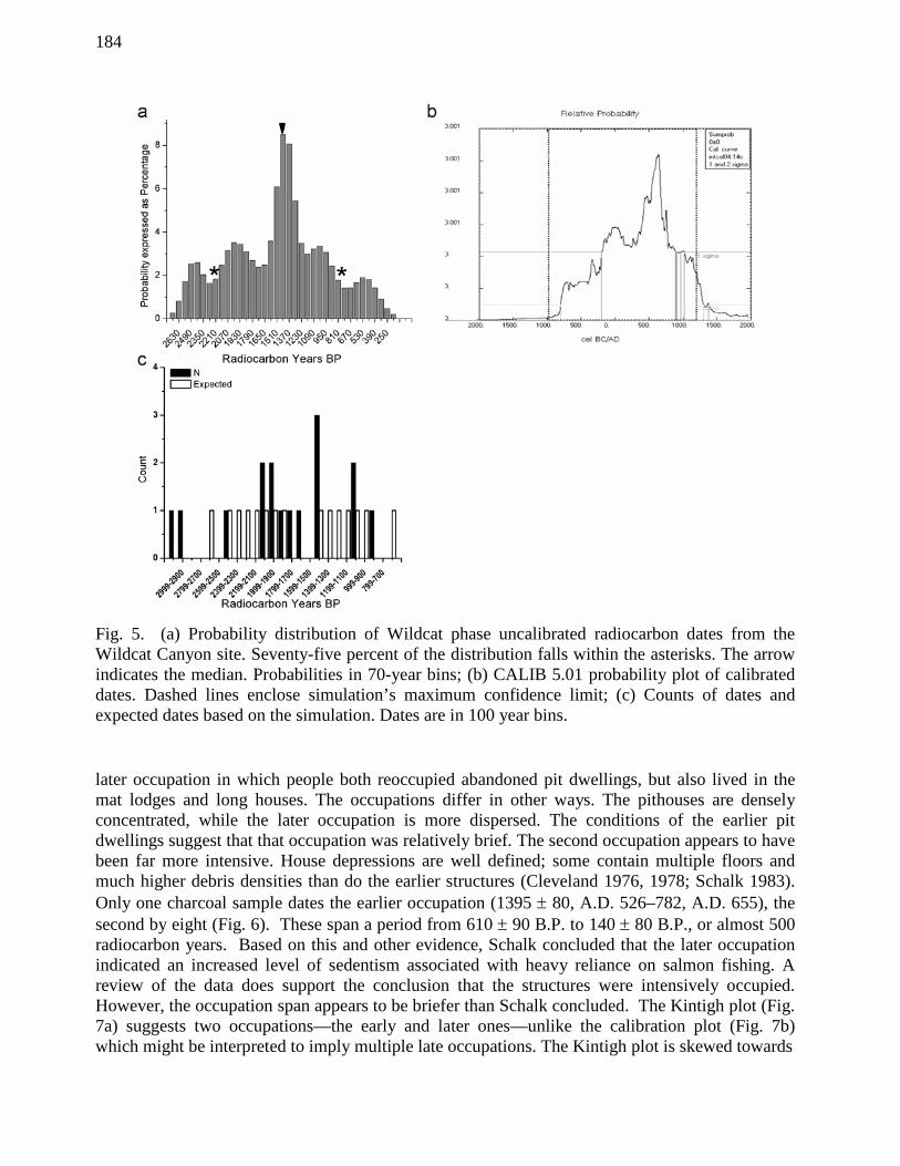
184
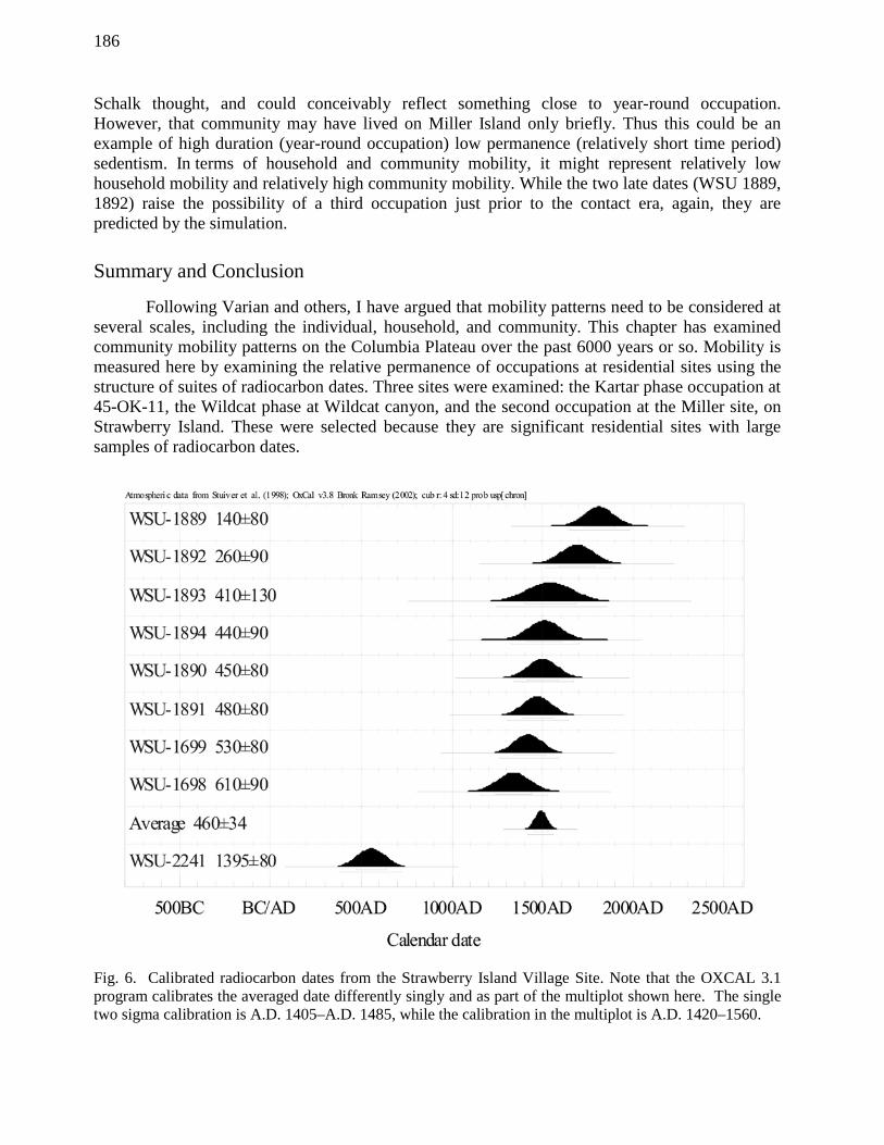
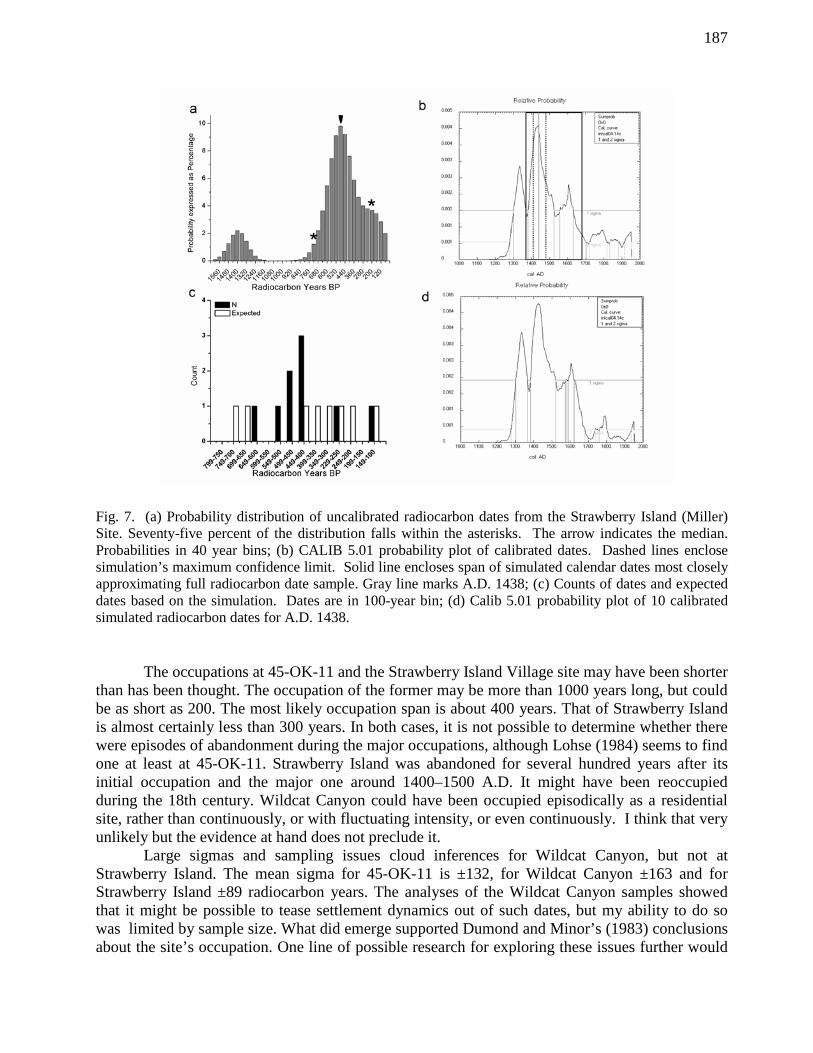
Fig. 5. (a) Probability distribution of Wildcat phase uncalibrated radiocarbon dates from the Wildcat Canyon site. Seventy-five percent of the distribution falls within the asterisks. The arrow indicates the median. Probabilities in 70-year bins; (b) CALIB 5.01 probability plot of calibrated dates. Dashed lines enclose simulation’s maximum confidence limit; (c) Counts of dates and expected dates based on the simulation. Dates are in 100 year bins. later occupation in which people both reoccupied abandoned pit dwellings, but also lived in the mat lodges and long houses. The occupations differ in other ways. The pithouses are densely concentrated, while the later occupation is more dispersed. The conditions of the earlier pit dwellings suggest that that occupation was relatively brief. The second occupation appears to have been far more intensive. House depressions are well defined; some contain multiple floors and much higher debris densities than do the earlier structures (Cleveland 1976, 1978; Schalk 1983). Only one charcoal sample dates the earlier occupation (1395 ± 80, A.D. 526–782, A.D. 655), the second by eight (Fig. 6). These span a period from 610 ± 90 B.P. to 140 ± 80 B.P., or almost 500 radiocarbon years. Based on this and other evidence, Schalk concluded that the later occupation indicated an increased level of sedentism associated with heavy reliance on salmon fishing. A review of the data does support the conclusion that the structures were intensively occupied. However, the occupation span appears to be briefer than Schalk concluded. The Kintigh plot (Fig. 7a) suggests two occupations—the early and later ones—unlike the calibration plot (Fig. 7b) which might be interpreted to imply multiple late occupations. The Kintigh plot is skewed towards

185
TABLE 6. SUMMARY OF THE ANALYSIS OF THE STRAWBERRY ISLAND SITE RADIOCARBON DATE SAMPLE. Strawberry Island (The Miller Site): The site contains two major residential occupations (Fig. 6).
1. Occupation 1 is dated by a single sample (1395 ± 80, A.D. 526–782, A.D. 655). It is comprised entirely of circular pit structures;
2. Focus here is on second occupation.
Occupation 2
• Sample size: 8 14C dates o 610 ± 90 to 140 ± 140, mean date 460 ± 34. Time span 470 years o Calibrated: A.D. 1350–A.D. 1808, mean A.D. 1438, Time span 458
• Sample of 8 dates, 610+90–140+80 statistical different at .95 level. T-test statistic = 22.47, with a chi square value of 14.1 and 7 degrees of freedom
• Sample of 7 dates, 610 ± 90–260 ± 90, statistically identical at .95 level with a t-test statistic of 8.76, a chi square value of 12.6 with 6 degrees of freedom. This suggests the possibility of a relatively short period of occupation.
• Probability plot of the uncalibrated dates suggests a single late occupation of perhaps 400+ years duration (between asterisks in Fig. 7a).
• Probability plots of the dates from Occupation 2 (Fig. 7b) produce two sigma calibrated range of A.D. 1277–1682 (p = .96) and a single sigma range of A.D. 1384–1522 (p = .62)
• Simulation (Fig. 7c): o .1 confidence level span (maximum span):
653–187 B.P. or 466 radiocarbon years A.D. 1379–1674 or 295 calendar years
o Simulation for year A.D. 1438 produces closest fit for actual sample (Fig. 8c) o Temporal distribution of dates does not fit expecteds (Fig. 8b), so probably not a
random sample of period. There are five dates between 550 and 400 B.P. where 1.3 dates are predicted. Sample (exclusive of 140 B.P. date) could be produced by an occupation-spanning period between 550 and 400 B.P.
Conclusions: The actual occupation span was probably considerably shorter than suggested by the original sample of dates. It could be as short as 150 calendar years, or even shorter, or as long as 400 or more years. Given the number of houses assigned to this occupation, this raises the possibility of a very large, albeit short-lived aggregation. the latest portion of the occupation. However, this pattern is predicted by the simulation (Fig. 7c). The pattern of dates produced by the simulation is also most closely approximated by the 10 simulated dates for the year A.D. 1438, which when calibrated and plotted, produced a probability plot virtually identical to that produced by the full suite of late dates (Fig. 7b and 7d). The analysis suggests that the occupation may have been as long as 300 years and as short as 150 years, or even shorter. While I cannot at present demonstrate it, I think the shorter span is the more likely. In fact, I think that the calibrated two-sigma age span for the sample of seven dates, A.D.1409–1474, or– 65 years—may be an accurate estimate. But, in any case, a maximum occupation of 150 to 300 years is a strong inference. The implication is that the occupation was much more intense than
186
Schalk thought, and could conceivably reflect something close to year-round occupation. However, that community may have lived on Miller Island only briefly. Thus this could be an example of high duration (year-round occupation) low permanence (relatively short time period) sedentism. In terms of household and community mobility, it might represent relatively low household mobility and relatively high community mobility. While the two late dates (WSU 1889, 1892) raise the possibility of a third occupation just prior to the contact era, again, they are predicted by the simulation.
Summary and Conclusion
Following Varian and others, I have argued that mobility patterns need to be considered at several scales, including the individual, household, and community. This chapter has examined community mobility patterns on the Columbia Plateau over the past 6000 years or so. Mobility is measured here by examining the relative permanence of occupations at residential sites using the structure of suites of radiocarbon dates. Three sites were examined: the Kartar phase occupation at 45-OK-11, the Wildcat phase at Wildcat canyon, and the second occupation at the Miller site, on Strawberry Island. These were selected because they are significant residential sites with large samples of radiocarbon dates.
Fig. 6. Calibrated radiocarbon dates from the Strawberry Island Village Site. Note that the OXCAL 3.1 program calibrates the averaged date differently singly and as part of the multiplot shown here. The single two sigma calibration is A.D. 1405–A.D. 1485, while the calibration in the multiplot is A.D. 1420–1560.
187
Fig. 7. (a) Probability distribution of uncalibrated radiocarbon dates from the Strawberry Island (Miller) Site. Seventy-five percent of the distribution falls within the asterisks. The arrow indicates the median. Probabilities in 40 year bins; (b) CALIB 5.01 probability plot of calibrated dates. Dashed lines enclose simulation’s maximum confidence limit. Solid line encloses span of simulated calendar dates most closely approximating full radiocarbon date sample. Gray line marks A.D. 1438; (c) Counts of dates and expected dates based on the simulation. Dates are in 100-year bin; (d) Calib 5.01 probability plot of 10 calibrated simulated radiocarbon dates for A.D. 1438. The occupations at 45-OK-11 and the Strawberry Island Village site may have been shorter than has been thought. The occupation of the former may be more than 1000 years long, but could be as short as 200. The most likely occupation span is about 400 years. That of Strawberry Island is almost certainly less than 300 years. In both cases, it is not possible to determine whether there were episodes of abandonment during the major occupations, although Lohse (1984) seems to find one at least at 45-OK-11. Strawberry Island was abandoned for several hundred years after its initial occupation and the major one around 1400–1500 A.D. It might have been reoccupied during the 18th century. Wildcat Canyon could have been occupied episodically as a residential site, rather than continuously, or with fluctuating intensity, or even continuously. I think that very unlikely but the evidence at hand does not preclude it. Large sigmas and sampling issues cloud inferences for Wildcat Canyon, but not at Strawberry Island. The mean sigma for 45-OK-11 is ±132, for Wildcat Canyon ±163 and for Strawberry Island ±89 radiocarbon years. The analyses of the Wildcat Canyon samples showed that it might be possible to tease settlement dynamics out of such dates, but my ability to do so was limited by sample size. What did emerge supported Dumond and Minor’s (1983) conclusions about the site’s occupation. One line of possible research for exploring these issues further would
188
be to simulate data sets for different patterns of residential mobility and see what sample sizes are needed to actually detect those patterns. In addition to sample size, sample selection is another problem area. Archaeologists usually chose samples for radiocarbon dating to establish lower and upper limiting dates, confirm early ages and definitively date features. Sample selection can also be driven by the vagaries of organic preservation and other taphonomic issues. Archaeologists do not (or rarely) sample explicitly to date patterning in the past such as demographic changes, rates of change, or shifting settlement patterns. Sample selection is also driven by budgets. As difficult as it can be to select samples to meet multiple goals, larger samples may be relatively inexpensive in terms of the data on dynamics they can produce. In the analyses here, despite various problems certain patterns do seem to have emerged. Based on these three case studies, there is no evidence for increased sedentism (as measured by settlement permanence) accompanying larger aggregations on the Plateau. The Strawberry Island Village site has evidence of two relatively large communities; both appear to have been short-lived. The first, a pithouse community, occupied a portion of the island around A.D. 655. Evidence suggests the occupation of individual structures was light and short-lived. In contrast, the second occupation, at ca. A.D. 1438 (almost a millennium later) appears to have been very intense at the household level, perhaps even year-round. However, it also seems to have been short lived. In sum, large Late Pacific aggregations may not necessarily indicate increased sedentism, at least at the community level. Possible exceptions to this include places with productive and stable resource patches, such as at Celilo Falls at the upstream end of the Columbia Gorge, where enormous quantities of running salmon were maximally accessible (see Prentiss et al. 2005 for other examples). What may be more interesting, however, is the length of the episodes of occupation and abandonment hinted at by the data presented here. It was speculated above that 45-OK-11 may have been occupied somewhere from every 30 to 90 years. These are short enough to speak of a cycle of occupation/abandonment perhaps governed by cycles of resource patch depletion/ recovery. They also hint at regular patterns of household movement across the landscape. In contrast, if we accept the patterning of dates from Wildcat Canyon as reflecting cycles of occupation, it appears to have been reoccupied only every few hundred years for periods of varying lengths. The two Strawberry Island occupations are separated by perhaps a millennium. It is difficult to call that a cycle of occupation and reoccupation; two discrete occupational events is more accurate. To conclude by pushing these data probably farther than they should be pushed, the Kartar pattern may have been one of spatially dispersed communities comprised of single households either shifting around the landscape, regularly reoccupying residential localities, or fixed at those localities for long periods of time. Community territories may have been quite durable, lasting centuries. These territories were fixed by persistent places and by nodes such as cemeteries. This pattern is like that envisioned by Chatters and others (Lohse and Sammons-Lohse 1986; Chatters 1995; Prentiss et al. 2005) but more similar to Schalk and Atwell’s rest-rotation collecting (Schalk and Atwell 1994, Burtchard 1998). This pattern contrasts in ways with the post-A.D. 1 pattern which is marked by considerable ebb and flow. The notion here is that a household returns to the same location after a fallow period of some duration, over time generating clusters of house depressions. Habitation patterns are fluid. Households aggregate and disperse. Aggregations may be brief, lasting only a few decades, or be somewhat longer-lived, lasting a few centuries. They do not appear to coalesce in the same place more than once. If they do, it is only after significant spans of time. Fixed places in this ebb and flow may include some highly favored residential localities, such as Celilo, cemeteries, and large-scale storage facilities, such as caves.
189
ACKNOWLEDGMENTS
This chapter is a revised version of a paper entitled “Long-term Trends on the Southern Columbia Plateau: Settlement Patterns, Interaction Networks and Social Complexity” originally presented at the 66th annual meetings, Society for American Archaeology, New Orleans in 2001. I thank Anna Prentiss and Ian Kuijt for their invitation to participate in that symposium. I also thank Jerry Galm for his invitation to participate in this volume. A number of people contributed to this chapter through discussions of Plateau ethnography and archaeology and radiocarbon dating. They include Max Pavesic, Al Marshall, Frank Leonhardy, Jim Chatters, Anna Prentiss, Ian Kuijt, Lee Lyman, Randall Schalk, Greg Burtchard, Tom Green and many others. Max taught me a lot, especially during the two-man Idaho Archaeology symposia we held on our highway archaeologist road trips through Idaho in the mid-1970s. Neither Max, nor any of these others, are responsible for any errors here.
REFERENCES CITED
Ames, Kenneth M. 1988 Early Holocene Forager Mobility Strategies on the Southern Columbia Plateau. In Early Human Occupation in Western North America, edited by J. A. Willig, C. M. Aikens and J. L. Fagan, pp. 325–360. Nevada State Museum Anthropological Papers, 21. Carson City.
1991 Sedentism, a Temporal Shift or a Transitional Change in Hunter-Gatherer Mobility Strategies. In Between Bands and States: Sedentism, Subsistence, and Interaction in Small Scale Societies, edited by Susan Gregg, pp. 108–133. Southern Illinois University Press, Carbondale.
2000 Kennewick Man: Cultural Affiliation Report, Chapter 2: Review of the Archaeological Data. Report prepared for the National Park Service. http://www.cr.nps.gov/aad/kennewick/AMES.HTM.
Ames, Kenneth M. and Alan G. Marshall 1980 Villages, Demography and Subsistence Intensification on the Southern Columbia Plateau. North American Archaeologist, 2(1):25–52.
Ames, Kenneth M. and Herbert G. D. Maschner 1999 Peoples of the Northwest Coast: Their Archaeology and Prehistory. Thames and Hudson
Ltd., London.
Beck, Charlotte and George T. Jones 1997 The Terminal Pleistocene/Early Holocene Archaeology of the Great Basin. Journal of World Prehistory, 11(2):161–236.
2010 Clovis and Western Stemmed: Population Migration and the Meeting of Two Technologies in the Intermountain West. American Antiquity,75(1):81–116. 2012 Clovis and Western Stemmed Again: Reply to Fiedel and Morrow. American Antiquity, 77(2):386–397.
190
Binford, Lewis R. 1980 Willow Smoke and Dog’s Tails: Hunter-Gatherer Settlement Systems and Archaeological Site Formation. American Antiquity, 45(1):4–20.
Burtchard, Gregory C 1998 Environment, Prehistory & Archaeology of Mount Rainier National Park, Washington.
Technical Report prepared for National Park Service, Seattle Washington. http://www.nps.gov/history/history/online_books/mora/archaeology/contents.htm
Campbell, Sarah K (editor) 1985 Summary of Results, Chief Joseph Dam Cultural Resources Project, Washington. Office of Public Archaeology, University of Washington, Seattle.
Chatters, James C. 1989 Resource Intensification and Sedentism on the Southern Plateau. Archaeology in Washington, I:1–20.
1995 Population Growth, Climatic Cooling, and the Development of Collector Strategies on the Southern Plateau, Western North America. Journal of World Prehistory, 9(3):341– 400.
2006 The Influence of the Bow and Arrow on Village Formation on the Columbia Plateau. In Complex Hunter-Gatherers: Evolution and Organization of Prehistoric Communities on the Plateau of Northwestern North America edited by William C. Prentiss and Ian Kuijt, pp. 67–83. University of Utah Press, Salt Lake City.
Cleveland, Gregory C. 1978 Second Annual Interim Report on the Archaeological Investigations at the Miller Site on Strawberry Island, A Late Prehistoric Village Near Burbank, Washington. Washington State University Washington. Archaeological Research Center Project Report 72. Pullman.
Cleveland, Gregory C. (editor) 1976 Preliminary Archaeological Investigations at the Miller Site, Strawberry Island, 1976: A Late Prehistoric Village Near Burbank, Franklin County, Washington. Washington State University. Washington Archaeological Research Center Project Report 46. Pullman.
Connolly, Thomas J. 1999 Newberry Crater: A Ten-Thousand-Year record of Human Occupation and Environmental Change in the Basin-Plateau Borderlands. University of Utah Anthropological Papers. University of Utah, Salt Lake City.
Dumond, Don E. and Rick Minor 1983 Archaeology in the John Day Reservoir: The Wildcat Canyon Site (35-GM-9). University of Oregon Anthropological Papers, 30. Eugene.
Endzweig, Pamela E. 1994 Late Archaic Variability and Change on the Southern Columbia Plateau: Archaeological Investigations in the Pine Creek Drainage of the Middle John Day River, Wheeler County, Oregon. Doctoral dissertation, University of Oregon. University Microfilms International, Ann Arbor.
191
Fiedel, Stuart J. and Julie Morrow 2012 Comment on “Clovis and Western Stemmed: Population Migration and the Meeting of
Two Technologies in the Intermountain West” by Charlotte Beck and George T. Jones. American Antiquity, 77(2):376–385.
Fladmark, Knut. R. 1975 A Paleoecological Model for Northwest Coast Prehistory. Archaeological Survey of Canada, Mercury Series, 43, Ottawa.
Galm, Jerry R., and Stan Gough 2000 Site 45KT1362, a c. 10,000 y B.P. Occupation in Central Washington. Current Research in the Pleistocene, 17(29–31).
Gilbert, M. Thomas P., Dennis L. Jenkins, Anders Götherstrom,Nuria Naveran, Juan J. Sanchez, Michael Hofreiter, Philip Francis Thomsen, Jonas Binladen, Thomas F. G. Higham, Robert M. Yohe II, Robert Parr, Linda Scott Cummings, and Eske Willerslev 2008 DNA from Pre-Clovis Human Coprolites in Oregon, North America. Science, 320:786– 789.
Goodale, Nathan B., William C. Prentiss and Ian Kuijt 2006 Cultural Complexity: A New Chronology of the Upper Columbia Plateau. In Complex Hunter-Gatherers: Evolution and Organization of Prehistoric Communities on the Plateau of Northwestern North America edited by William C. Prentiss and Ian Kuijt, pp 36–48. University of Utah Press, Salt Lake City.
Green, Thomas J. 1993 Aboriginal Residential Structures in Southern Idaho. Journal of California and Great Basin Archaeology, 15(1):58–72.
Hamilton, Marcus J. and Briggs Buchanan 2007 Spatial Gradients in Clovis-age Radiocarbon Dates across North America Suggest Rapid Colonization from the North. Proceedings of the National Academy of Science, 104(40): 15625–15630.
Hayden, Brian 1997 The Pithouses of Keatley Creek. Case Studies in Archaeology. Harcourt Brace College Publishers, Fort Worth, TX.
Hendon, Michele 1996 Archaeological Approaches to the Organization of Domestic Labor: Household Practice and Domestic Relations. Annual Review of Anthropology, 25:45–61.
Hess, Sean C. 1997 Rocks, Range and Renfrew: Using Distance-decay Effects to Study Late Pre-Mazama Period Obsidian Acquisition and Mobility in Oregon and Washington. Doctoral dissertation, Washington State University Pullman. University Microfilms International, Ann Arbor.
Kintigh, Keith W. 2006 Tools for Quantitative Archaeology: Programs for Quantitative Analysis in Archaeology. Keith W. Kintigh, Tempe.
192
Littleton, Judith and Harry Allen 2007 Hunter-Gatherer Burials and the Creation of Persistent Places in Southeastern Australia. Journal of Anthropological Archaeology, 26(2):283–298.
Lohse, Ernest S. 1984 Archaeological Investigations at Site 45-OK-11, Chief Joseph Project, Washington. University of Washington, Office of Public Archaeology, Seattle.
Lohse, Ernest S. and Diane Sammons-Lohse 1986 Sedentism on the Southern Plateau: A Matter of Degree Related to the Easy and Efficient Exploitation of Resources. Northwest Anthropological Research Notes, 20(2):115–136.
Marshall, Alan G. 1977 Nez Perce Social Groups: An Ecological Interpretation. Doctoral dissertation, Washington State University, Pullman. University Microfilms International, Ann Arbor.
Moulton, Gary S. (editor) 1988 The Journals of the Lewis & Clark Expedition, Volume 5, July 28–November 1, 1805. University of Nebraska Press, Lincoln.
Netting, Robert McC. 1993 Smallholders, Householders: Farm Families and the Ecology of Intensive, Sustainable Agriculture. Stanford University Press, Stanford, CA.
Pavesic, Max G. 1985 Cache Blades and Turkey Tails: Piecing Together the Western Idaho Archaic Burial Complex. In Stone Tool Analysis: Essays in Honor of Don E. Crabtree, edited by Mark G. Plew, James C. Woods and Max G. Pavesic, pp. 55–89. University of New Mexico Press, Albuquerque.
Pettigrew, Richard M. and Charles M. Hodges 1995 Prehistoric Hunter-Gatherer Land-Use Systems: Pacific Northwest. In Synthesis of Findings, edited by M. Moratto. Archaeological Investigations PGT-PG&E Expansion Project Idaho, Washington, Oregon, and California. Vol. IV. INFOTEC Research , Inc., Fresno.
Pettigrew, Richard M. and Randall F. Schalk 1995 Site 35-JE-51B (The Johnson Site). In Archaeological Investigations PGT-PG&E Pipeline Expansion Project Idaho, Washington, Oregon, and California. Volume IIB, Book 1 of 2, Summary Reports: Prehistoric Sites Oregon, edited by Randall F. Schalk, Richard M. Pettigrew, Clayton G. Lebow, Michael J. Moratto and Ricky G. Atwell, pp. 8-1–8- 87, Michael J. Moratto, general editor. INFOTEC Research, Inc., Fresno, CA.
Prentiss, Anna Marie, Guy Cross, Thomas A. Foor, Mathew Hogan, Dirk Markle and David S. Clarke 2008 Evolution of a Late Prehistoric Winter Village on the Interior Plateau of British Columbia: Geophysical Investigations, Radiocarbon Dating, and Spatial Analysis of the Bridge River Site. American Antiquity, (73)1:59–81.
Prentiss, William C. and James C. Chatters 2003 Cultural Diversification and Decimation in the Prehistoric Record. Current Anthropology, 44(1):33–58.
193
Prentiss, William C., James C. Chatters, Michael Lenert, David S. Clarke and Robert C. O’Boyle 2005 The Archaeology of the Plateau of Northwestern North America During the Late Prehistoric Period (3500–200 B.P.): Evolution of Hunting and Gathering Societies. Journal of World Prehistory, 19(1):47–118.
Ramsey, Christopher Bronk 1995 Radiocarbon Calibration and Analysis of Stratigraphy: The OxCal Program. Radiocarbon, 37(2):425–430.
2001 Development of the Radiocarbon Calibration Program OxCal. Radiocarbon, 43(2A):355– 363.
Reid, Kenneth C. 1992 Housepits and Highland Hearths: Comparative Chronologies for the Snake River and Blue Mountains. Presented at the 45th Northwest Anthropological Conference, Burnaby, B.C.
Reid, Kenneth C. and James C. Chatters 1997 Kirkwood Bar: Passports in Time Excavations at 10IH699 in the Hells Canyon National Recreation Area, Wallowa-Whitman National Forest. Rainshadow Research Project Report 28 and Applied Paleoscience Project Report F-6, Pullman, WA.
Reid, Kenneth C., Matthew K. Root and Richard E. Hughes 2008 The Copper Creek Clovis Point From Hells Canyon, Northeastern Oregon. Journal of California and Great Basin Anthropology, 28:75–84.
Rice, Harvey S. 1985 North American Dwellings and Attendant Structures on the Southern Columbia Plateau. Report in Archaeology and History 100–44. Eastern Washington University, Archaeological and Historical Services, Cheney, WA.
Schalk, Randall F. 1983 The 1978 and 1979 Excavations at Strawberry Island in the McNary Reservoir. Washington State University, Laboratory of Archaeology and History, Project Report 19, Pullman. Schalk, Randall (editor) 1987 Archeology of the Morris Site (35GM91) on the John Day River, Gilliam County, Oregon. University of Washington Office of Public Archaeology, Seattle.
Schalk, Randall F. and Ricky G. Atwell 1994 Research Design for Prehistoric Archaeology. In Archaeological Investigations,
PGT0PG&E Pipeline Expansion Project, Idaho, Washington, Oregon, and California; Volume 1 Project Overview, Research Design and Archaeological Inventory edited by Michael J. Moratto. Prepared for Bechtel Corporation. San Francisco. INFOTEC Research, Inc., Fresno, California; and Far Western Anthropological Research Group, Inc., Davis, California.
Schalk, Randall. F., Ricky. G. Atwell, William. R. Hildebrandt, Clayton. G. Lebow, Peter Mikkelsen and Richard. M. Pettigrew 1995 Mobility and Intensification. In Synthesis of Findings, edited by M. J. Moratto. Archaeological Investigations PGT-PG&E Expansion Project Idaho, Washington, Oregon, and California. vol. IV. INFOTEC Research, Inc., Fresno.
194
Schlanger, Sarah 1993 Recognizing Persistent Places in Anasazi Settlement Systems. In Space, Time, and Archaeological Landscapes, edited by Jacqueline Rossignol and LuAnn Wandsnider, pp. 91–112. Plenum Press, New York.
Schulting, Rick J. 1995 Mortuary Variability and Status Differentation on the Columbia Plateau. Archaeology Press, Simon Fraser University, Burnaby.
Stuiver, Minze and Paula.J. Reimer 1993 Extended 14C Database and Revised CALIB Radiocarbon Calibration Program. Radiocarbon, 35: 215–230.
Stuiver, Minze, Paula J. Reimer and Ron Reimer 2005 CALIB Manual. Electronic document, http://www.calib.qub.ac.uk/crev50/manual/09/02/2005 14:48:42. Quaternary Isotope Laboratory, University of Washington, Seattle. Accessed 24 May 2010.
Thomas, David Hurst 1981 Complexity among Great Basin Shoshoneans: The World’s Least Affluent Hunter- Gatherers. In Affluent Foragers: Pacific Coasts East and West, edited by Shuzo Koyama and David H. Thomas, pp. 19–52. Senri Ethnological Studies, 9. National Museum of Ethnology, Osaka.
Varian, Mark D. 1999 Sedentism and Mobility in a Social Landscape: Mesa Verde and Beyond. University of Arizona Press, Tucson.
Walker, Deward E. (editor) 1998 Handbook of North American Indians, Vol. 12, Plateau. Smithsonian Institution, Washington, D.C.
Waters, Michael R. and Thomas W. Stafford Jr. 2007 Redefining the Age of Clovis: Implications for the Peopling of the Americas. Science, 315:1122–1126.
Wilk, Robert R. and William L. Rathje 1982 Household Archaeology. American Behavioral Scientist, 25(6):631–640.


![F RADIOCARBON, UNIVERSITY OF TEXAS RADIOCARBON DATES II · F RADIOCARBON, Vor,. 6, 1964, P. 138-159] UNIVERSITY OF TEXAS RADIOCARBON DATES II M. A. TAMERS, F. J. PEARSON, JR., and](https://img.dokumen.tips/doc/110x75/606d59c493119417f12a3a02/f-radiocarbon-university-of-texas-radiocarbon-dates-ii-f-radiocarbon-vor-6.jpg)