Embed Size (px)
Citation preview
(Results-Framework Document)
for
R F D
GSI
(2012-2013)

Section 1:Vision, Mission, Objectives and Functions
Results-Framework Document (RFD) for GSI-(2012-2013)
· To develop GSI into a world-class institution for fundamental as well as applied geosciences, keeping up with thelatest technologies and methodologies. · To create a close-knit national Geoscientific community through leadershipand collaborative partnerships and · To acquire and provide expertise and widely disseminate Geoscientificinformation to facilitate informed decision-making by policy makers and public and enable use to Geoscientific data forsustainable socio-economic development.
Mission
GSI is executing its Geoscientific programmes in five Missions. To ensure smooth planning and evaluation of
programme, there would be three Support System. The five Missions as well as the three Support Systems are as
follows: - Five Missions I. Baseline Geoscience Data generation; II. Natural Resources Assessment; III.
Geoinformatics; IV Fundamental & Multidisciplinary Geosciences and Special studies; V. Training & Capacity
building; Support SystemThree Support Systems are viz (1) S&T Support System 2) Administrative Support System
and (3) Policy Support Systems to the Missions to provide the requisite support and crosscutting co-ordination.
Objective
1 Earth Science Data Generation
2 Dissemination of Earth Science Data
3 Improvement in the functioning of GSI
4 Capacity Building in Earth Science Sector
5 Quality Management of Geoscientific Activities
Functions
Enable and facilitate providing of objective, impartial and up-to-date geological expertise and geoscientific information of all kinds,
particularly for decision-making for policy, commercial, economic and societal needs.
1
Systematically document the geology and geological processes of the surface and subsurface of India and its offshore areas using the
latest and most cost-effective techniques and methodologies, including geophysical and geochemical and geological surveys
2
Develop and continually enhance GSI’s core competence in survey and mapping through continued accretion, management, co-
ordination and utilization of spatial databases (including those acquired through remote sensing) and function as a ‘Repository’ or
‘clearing house’ for the purpose and use new and emerging computer-based technologies for dissemination of geographic information
and other spatial data, through cooperation and collaboration with other stakeholders in the Geoinformatics sector
3
Explore (through ground, airborne, satellite, and marine surveys) and scientifically assess mineral, energy and water resources for the
country and facilitate their optimal exploration through information dissemination.
4
Maintain a leadership role in the geological field and develop partnerships with Central, State and other institutions, to help create
enhanced executional capability and capacity in the field of geology in furtherance of
5
Vision
page : 2 of 21 Generated on : 18/04/2012
Section 1:Vision, Mission, Objectives and Functions
Results-Framework Document (RFD) for GSI-(2012-2013)
GSI’s Vision and the objectives of this Charter.
Coordinate geoscientific activities with stakeholders in all sectors related to geosciences in order to help sustainably manage our natural
resources, including water.
6
Conduct multidisciplinary as well as fundamental Geoscientific research and studies (including Geotechnical investigations, physical,
chemical and biological hazard investigations, climate change geostudies, paleogeostudies etc.) and foster partnerships with State and
Central research and academic intuitions for the purpose.
7
Actively participate in internal collaborative projects to improve our understanding of the earth and its ecosystem and its geology,
including studies related to tectonics, global warming and climate change and Polar studies.
8
Generally advance the cause of the geosciences by documentation, propagation, archiving and education, including creation and
management of museums, monuments and parks, archives, libraries and other facilities for use of students researches and the public. In
particular constantly endavour to popularize Geoscience at school and university levels through production and distribution of high quality
audio-visual and printed material, and through the medium of the internet. Also hold exhibitions and special events to bring geoscientific
concepts before the public.
9
page : 3 of 21 Generated on : 18/04/2012

Section 2:Inter se Priorities among Key Objectives, Success indicators and Targets
Results-Framework Document (RFD) for GSI -(2012-2013)
Objective Weight Action Unit
Target / Criteria Value
Weight
80%100% 70% 60%90%
Very Good Fair PoorExcellent GoodSuccessIndicator
Earth Science Data Generation 44.00 Ground Survey SpecialisedThematic Mappingon 1:25,000 scale(in Sq. km.)
Sq Kms 17500 16500 1600017000180004.00[1] [1.1] [1.1.1]
Area to be coveredunder GeochemicalMapping (GCM) on1:50,000 scale (inSq. km.)
Sq Kms 70000 67000 6500068000750007.00[1.1.2]
Area to be coveredunder GPM1:50,000 scale (inSq. km.)
Sq Kms 26500 25500 2500026000270004.00[1.1.3]
Marine & Coastal survey Swath Bathymetrywithin EEZ & TW
Sq Kms 56000 53000 5000055000570003.00[1.2] [1.2.1]
Mapping within TWand adjoining EEZ
Sq Kms 1650 1550 1500160017002.00[1.2.2]
Airborne Survey Multisensor(TOASS) Survey
LineKms
29000 27000 2600028000300002.49[1.3] [1.3.1]
Heliborne Survey LineKms
15000 12000 1000013000160001.50[1.3.2]
Intensify regionalexploration of minerals.
Annual increment toNational MineralInventory ( for FieldSeasons (F.Ss)ending 31st March2012)
Date 28/02/2013 21/03/2013 --15/03/201331/01/20134.00[1.4] [1.4.1]
Large ScaleMapping (LSM) on1: 25,000 to 10,000scale.
Sq Kms 4100 4000 3900405042004.00[1.4.2]
Drilling (in mt.)Mission-IIA
Metre 24500 23500 2300024000250002.00[1.4.3]
page : 4 of 21 Generated on : 18/04/2012

Section 2:Inter se Priorities among Key Objectives, Success indicators and Targets
Results-Framework Document (RFD) for GSI -(2012-2013)
Objective Weight Action Unit
Target / Criteria Value
Weight
80%100% 70% 60%90%
Very Good Fair PoorExcellent GoodSuccessIndicator
Drilling (in mt.)Mission-IIB
Metre 42500 41500 4100042000430005.00[1.4.4]
Climate change andNatural Hazard Studies
Taking up seismicmicrozonation /hazard assessmentof cities
Nos ofcities
6 4 3582.00[1.5] [1.5.1]
Taking up oflandslide hazardassessment studies( nos. of projects)
Nos 10 8 79122.00[1.5.2]
Glaciological studiesincluding polarregions
Nos 3 1 --241.00[1.5.3]
Dissemination of Earth Science Data 10.00 Finalization and circulationof reports
Circulation offinalised Reports2010-12 (100% ofReports)
Date 31/10/2012 31/12/2012 31/01/201330/11/201230/09/20121.50[2] [2.1] [2.1.1]
Monitoring ofcirculation by GSI ofNGCM Reports ofthe Field Season2009-10 ending 30September 2010
Date 31/07/2012 30/09/2012 31/10/201231/08/201230/06/20121.50[2.1.2]
Geoinformatics Services &products - uploading ofdata for F.Ss ending: 31March 2012
Uploading of allreport circulated forthe FS 2010-12 asper disseminationpolicy
Date 31/01/2013 15/03/2013 --28/02/201331/12/20121.50[2.2] [2.2.1]
Uploading of GCMreports for the FS2009-10 as perdissemination policy
Date 31/10/2012 31/12/2012 31/01/201330/11/201230/09/20121.50[2.2.2]
page : 5 of 21 Generated on : 18/04/2012

Section 2:Inter se Priorities among Key Objectives, Success indicators and Targets
Results-Framework Document (RFD) for GSI -(2012-2013)
Objective Weight Action Unit
Target / Criteria Value
Weight
80%100% 70% 60%90%
Very Good Fair PoorExcellent GoodSuccessIndicator
Publications GSI publications Nos 14 12 1113152.00[2.3] [2.3.1]
Peer reviewedScientificpublications byscientists of GSI inNational andInternationalscientific journals(including GSI’s)
Nos 30 20 1525402.00[2.3.2]
Improvement in the functioning of GSI 18.00 Online implementation ofvarious working modulesthrough GSI portal
Online approval ofFSP items byFSPMIS module
% ofonlinevis-a-visall
80 60 5070901.00[3] [3.1] [3.1.1]
Onlineimplementation ofLaboratoryManagementModule
% ofonlinetransactions vs.all
80 60 5070901.00[3.1.2]
updating of HRMISdatabase
% ofpossibleupdates
80 60 5070950.50[3.1.3]
Implementation ofLeave Module
% ofonlineapply vs.all
80 60 5070950.50[3.1.4]
Phase III GSI Portal Project– Implementation of OnlineCore Business IntegratedSystem.(OCBIS)
EFC Approval Date 31/10/2012 28/02/2013 --31/12/201231/08/20121.00[3.2] [3.2.1]
Short listing ofVendor/ firm forimplementing project
Date 28/02/2013 -- --31/03/201331/01/20131.00[3.2.2]
Award of WorkContract
Date 31/03/2013 -- -- --15/03/20130.99[3.2.3]
page : 6 of 21 Generated on : 18/04/2012

Section 2:Inter se Priorities among Key Objectives, Success indicators and Targets
Results-Framework Document (RFD) for GSI -(2012-2013)
Objective Weight Action Unit
Target / Criteria Value
Weight
80%100% 70% 60%90%
Very Good Fair PoorExcellent GoodSuccessIndicator
Procurement of OceanGoing Research Vessel.
Procurement Action:Payment of 4thinstallment.
Date 15/11/2012 -- --30/11/201231/10/20122.00[3.3] [3.3.1]
Procurement Action:Payment of 5thinstallment
Date -- -- -- --31/03/20132.00[3.3.2]
National Aero-geophysicalMapping
Short listing ofconsultant formaking the DPR
Date 07/06/2012 25/06/2012 30/06/201215/06/201231/05/20121.00[3.4] [3.4.1]
Issue of work orderfor appointment ofconsultant formaking the DPR
Date 15/06/2012 30/06/2012 07/07/201225/06/201207/06/20121.00[3.4.2]
Submission of DPRof NAGMP to MoM
Date 25/10/2012 15/11/2012 30/11/201207/11/201215/10/20121.00[3.4.3]
Implementation of Cabinetapproval for ‘Restructuringof GSI’
Notification of RRsfor Gr. A & B (S&Tand non S&T)
Date 30/11/2012 31/01/2013 --31/12/201231/10/20121.00[3.5] [3.5.1]
Biannual Meeting of CGPB 1st Meeting Date 30/09/2012 -- -- --31/08/20121.00[3.6] [3.6.1]
2nd Meeting Date 10/03/2013 -- -- --28/02/20131.00[3.6.2]
Biannual Meetings of 12CGPB Committees
1st Meeting Date 31/08/2012 -- -- --31/07/20121.00[3.7] [3.7.1]
2nd Meeting Date 10/02/2013 -- -- --31/01/20131.00[3.7.2]
Capacity Building in Earth Science Sector 8.00 Training Courses by GSITI Training courses forGSI officers
Nos ofcourses
70 60 5565756.00[4] [4.1] [4.1.1]
Training courses forothers. (State Govts,PSUs, InternationalParticipants etc.)
Nos ofcourses
6 4 --572.00[4.1.2]
page : 7 of 21 Generated on : 18/04/2012

Section 2:Inter se Priorities among Key Objectives, Success indicators and Targets
Results-Framework Document (RFD) for GSI -(2012-2013)
Objective Weight Action Unit
Target / Criteria Value
Weight
80%100% 70% 60%90%
Very Good Fair PoorExcellent GoodSuccessIndicator
Quality Management of GeoscientificActivities
8.00 Peer Review of FSPProgrammes
Internal PeerReview of 100%field items proposedfor FS 2013-14.
Date 07/02/2013 -- -- --31/01/20131.00[5] [5.1] [5.1.1]
External PeerReview of 20% fielditems proposed forFS 2013-14.
Date 25/02/2013 -- -- --07/02/20131.00[5.1.2]
Reviews / monitoring Holding of StageReview Meeting
Date 15/11/2012 25/11/2012 30/11/201220/11/201231/10/20121.00[5.2] [5.2.1]
Holding of TermReview Meetings
Date 18/03/2013 25/03/2013 --20/03/201315/03/20131.00[5.2.2]
Implementation ofpeer reviewrecommendationsfor enhancement offield targets underdifferent missions[Mission-I: BaselineGeoscience Data;Mission-II : NaturalResourceAssessment;Mission-III:Geoinformatics;Mission-IV :Fundamental andMultidisciplinaryGeosciences andMission-V : CapacityBuilding & Training( for the FieldSeason 2013-14 i.e.04/13 – 03/14)
Date 07/02/2013 -- --15/02/201331/01/20131.00[5.2.3]
page : 8 of 21 Generated on : 18/04/2012

Section 2:Inter se Priorities among Key Objectives, Success indicators and Targets
Results-Framework Document (RFD) for GSI -(2012-2013)
Objective Weight Action Unit
Target / Criteria Value
Weight
80%100% 70% 60%90%
Very Good Fair PoorExcellent GoodSuccessIndicator
* Mandatory Objective(s)
Peer Review of 75%reports of the FieldSeason 2010-12 i.e.period ending 31March 2012.
Date 31/01/2013 10/03/2013 --28/02/201331/12/20121.00[5.2.4]
Quarterly Monitoringof achievements ofthe targets for eachMission (Mission-I:STM – 15000 sq.km.; GCM : 46000sq. km.; GPM:22000 sq. km.; MultiSensor Survey :25000 LKm.;Bathymetry:5000 lkm; SwathBathymetry: 50,000sq. km.; Systematiccoverage within TW& adjacent EEZ :1700 Sq.km.;Mission – II: LSM :2500 sq. km.; DM:40 sq. km.; Drilling:66000 m; Mission –III: 30 Nos. Items;Mission – IV: 127Nos. Items; Mission-V : 80 Nos. items)for the Field Season2012-13 ending: 31March 2013
Nos 3 1 --242.00[5.2.5]
page : 9 of 21 Generated on : 18/04/2012
Section 2:Inter se Priorities among Key Objectives, Success indicators and Targets
Results-Framework Document (RFD) for GSI -(2012-2013)
Objective Weight Action Unit
Target / Criteria Value
Weight
80%100% 70% 60%90%
Very Good Fair PoorExcellent GoodSuccessIndicator
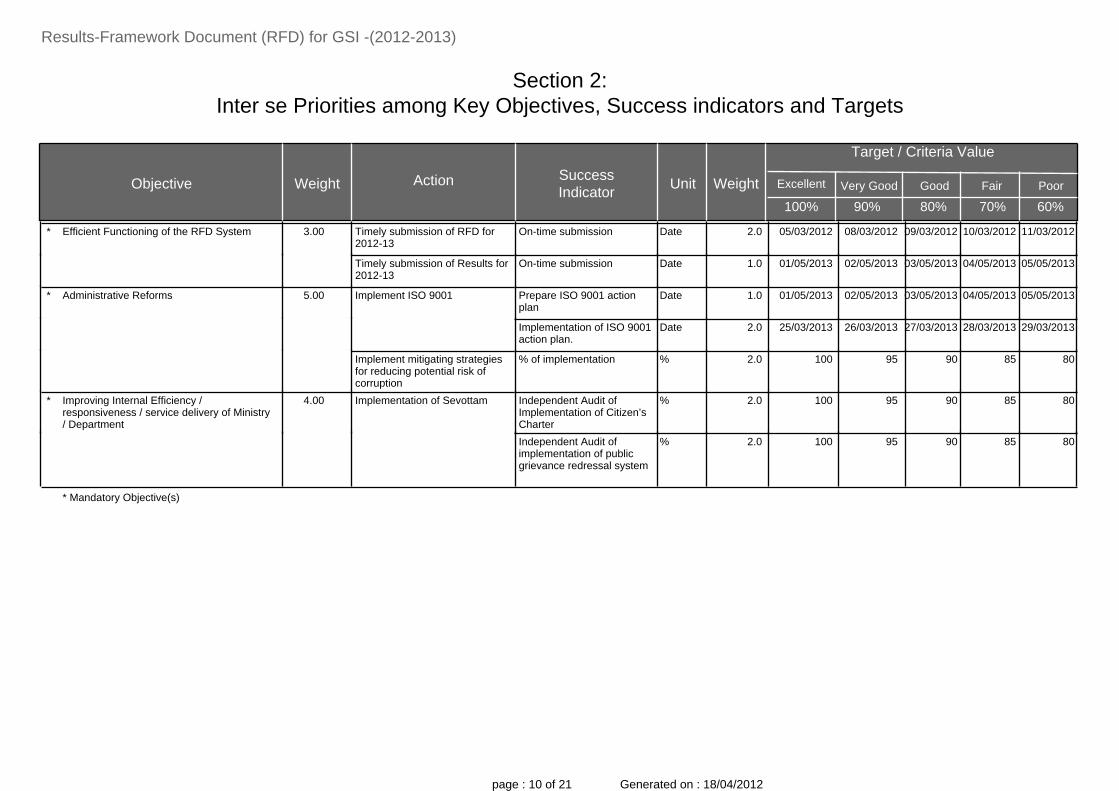
Efficient Functioning of the RFD System 3.00 Timely submission of RFD for2012-13
On-time submission Date 08/03/2012 10/03/2012 11/03/201209/03/201205/03/20122.0*
Timely submission of Results for2012-13
On-time submission Date 02/05/2013 04/05/2013 05/05/201303/05/201301/05/20131.0
Administrative Reforms 5.00 Implement ISO 9001 Prepare ISO 9001 actionplan
Date 02/05/2013 04/05/2013 05/05/201303/05/201301/05/20131.0*
Implementation of ISO 9001action plan.
Date 26/03/2013 28/03/2013 29/03/201327/03/201325/03/20132.0
Implement mitigating strategiesfor reducing potential risk ofcorruption
% of implementation % 95 85 80901002.0
Improving Internal Efficiency /responsiveness / service delivery of Ministry/ Department
4.00 Implementation of Sevottam Independent Audit ofImplementation of Citizen’sCharter
% 95 85 80901002.0*
Independent Audit ofimplementation of publicgrievance redressal system
% 95 85 80901002.0
* Mandatory Objective(s)
page : 10 of 21 Generated on : 18/04/2012

Section 3:Trend Values of the Success Indicators
Results-Framework Document (RFD) for GSI -(2012-2013)
Target Value ProjectedValue for
Objective ProjectedValue for
Action Success Indicator
FY 10/11
Unit
FY 12/13FY 11/12 FY 13/14
Actual Value Actual Value
FY 14/15
8890 17500Sq KmsSpecialised ThematicMapping on 1:25,000scale (in Sq. km.)
Earth Science Data Generation Ground Survey 17500 1750011000[1] [1.1] [1.1.1]
25489.6 70000Sq KmsArea to be coveredunder GeochemicalMapping (GCM) on1:50,000 scale (in Sq.km.)
70000 7000038000[1.1.2]
17643.5 26500Sq KmsArea to be coveredunder GPM 1:50,000scale (in Sq. km.)
40000 4500019000[1.1.3]
30390 56000Sq KmsSwath Bathymetrywithin EEZ & TW
Marine & Coastal survey 60000 6000063000[1.2] [1.2.1]
2220 1650Sq KmsMapping within TWand adjoining EEZ
2000 20001500[1.2.2]
4227 29000Line KmsMultisensor (TOASS)Survey
Airborne Survey 30000 300004000[1.3] [1.3.1]
-- 15000Line KmsHeliborne Survey 16500 16500 --[1.3.2]
31/12/2010 28/02/2013DateAnnual increment toNational MineralInventory ( for FieldSeasons (F.Ss) ending31st March 2012)
Intensify regionalexploration of minerals.
28/02/2014 28/02/201523/12/2011[1.4] [1.4.1]
2424.83 4100Sq KmsLarge Scale Mapping(LSM) on 1: 25,000 to10,000 scale.
4500 50001878.9[1.4.2]
15939.98 24500MetreDrilling (in mt.)Mission-IIA
30000 3000016726.75[1.4.3]
42020.55 42500MetreDrilling (in mt.)Mission-IIB
45000 4500045088.85[1.4.4]
page : 11 of 21 Generated on : 18/04/2012

Section 3:Trend Values of the Success Indicators
Results-Framework Document (RFD) for GSI -(2012-2013)
Target Value ProjectedValue for
Objective ProjectedValue for
Action Success Indicator
FY 10/11
Unit
FY 12/13FY 11/12 FY 13/14
Actual Value Actual Value
FY 14/15
-- 6Nos ofcities
Taking up seismicmicrozonation / hazardassessment of cities
Climate change andNatural Hazard Studies
6 6 --[1.5] [1.5.1]
-- 10NosTaking up of landslidehazard assessmentstudies( nos. of projects)
10 10 --[1.5.2]
-- 3NosGlaciological studiesincluding polar regions
3 3 --[1.5.3]
-- 31/10/2012DateCirculation of finalisedReports 2010-12(100% of Reports)
Dissemination of Earth Science Data Finalization andcirculation of reports
-- -- --[2] [2.1] [2.1.1]
-- 31/07/2012DateMonitoring ofcirculation by GSI ofNGCM Reports of theField Season 2009-10ending 30 September2010
-- -- --[2.1.2]
-- 31/01/2013DateUploading of all reportcirculated for the FS2010-12 as perdissemination policy
Geoinformatics Services& products - uploading ofdata for F.Ss ending: 31March 2012
-- -- --[2.2] [2.2.1]
-- 31/10/2012DateUploading of GCMreports for the FS2009-10 as perdissemination policy
-- -- --[2.2.2]
-- 14NosGSI publicationsPublications 15 15 --[2.3] [2.3.1]
-- 30NosPeer reviewedScientific publicationsby scientists of GSI inNational and
40 50 --[2.3.2]
page : 12 of 21 Generated on : 18/04/2012

Section 3:Trend Values of the Success Indicators
Results-Framework Document (RFD) for GSI -(2012-2013)
Target Value ProjectedValue for
Objective ProjectedValue for
Action Success Indicator
FY 10/11
Unit
FY 12/13FY 11/12 FY 13/14
Actual Value Actual Value
FY 14/15
International scientificjournals (includingGSI’s)
-- 80% ofonline vis-a-vis all
Online approval of FSPitems by FSPMISmodule
Improvement in the functioning of GSI Online implementation ofvarious working modulesthrough GSI portal
90 100 --[3] [3.1] [3.1.1]
-- 80% ofonlinetransactions vs. all
Online implementationof LaboratoryManagement Module
90 100 --[3.1.2]
-- 80% ofpossibleupdates
updating of HRMISdatabase
90 100 --[3.1.3]
-- 80% ofonlineapply vs.all
Implementation ofLeave Module
90 100 --[3.1.4]
-- 31/10/2012DateEFC ApprovalPhase III GSI PortalProject – Implementationof Online Core BusinessIntegratedSystem.(OCBIS)
-- -- --[3.2] [3.2.1]
-- 28/02/2013DateShort listing of Vendor/firm for implementingproject
-- -- --[3.2.2]
-- 31/03/2013DateAward of WorkContract
-- -- --[3.2.3]
-- 15/11/2012DateProcurement Action:Payment of 4thinstallment.
Procurement of OceanGoing Research Vessel.
-- -- --[3.3] [3.3.1]
-- 31/03/2013DateProcurement Action:Payment of 5thinstallment
-- -- --[3.3.2]
page : 13 of 21 Generated on : 18/04/2012

Section 3:Trend Values of the Success Indicators
Results-Framework Document (RFD) for GSI -(2012-2013)
Target Value ProjectedValue for
Objective ProjectedValue for
Action Success Indicator
FY 10/11
Unit
FY 12/13FY 11/12 FY 13/14
Actual Value Actual Value
FY 14/15
-- 07/06/2012DateShort listing ofconsultant for makingthe DPR
National Aero-geophysical Mapping
-- -- --[3.4] [3.4.1]
-- 15/06/2012DateIssue of work order forappointment ofconsultant for makingthe DPR
-- -- --[3.4.2]
-- 25/10/2012DateSubmission of DPR ofNAGMP to MoM
-- -- --[3.4.3]
-- 30/11/2012DateNotification of RRs forGr. A & B (S&T andnon S&T)
Implementation ofCabinet approval for‘Restructuring of GSI’
-- -- --[3.5] [3.5.1]
25/08/2010 30/09/2012Date1st MeetingBiannual Meeting ofCGPB
30/09/2013 30/09/201424/08/2011[3.6] [3.6.1]
03/02/2011 10/03/2013Date2nd Meeting 10/03/2014 10/03/201502/02/2012[3.6.2]
-- 31/08/2012Date1st MeetingBiannual Meetings of 12CGPB Committees
31/08/2013 31/08/2014 --[3.7] [3.7.1]
-- 10/02/2013Date2nd Meeting 10/02/2014 10/02/2015 --[3.7.2]
53 70Nos ofcourses
Training courses forGSI officers
Capacity Building in Earth ScienceSector
Training Courses byGSITI
75 7595[4] [4.1] [4.1.1]
-- 6Nos ofcourses
Training courses forothers. (State Govts,PSUs, InternationalParticipants etc.)
6 6 --[4.1.2]
-- 07/02/2013DateInternal Peer Reviewof 100% field itemsproposed for FS 2013-14.
Quality Management of GeoscientificActivities
Peer Review of FSPProgrammes
-- -- --[5] [5.1] [5.1.1]
-- 25/02/2013DateExternal Peer Reviewof 20% field itemsproposed for FS 2013-14.
-- -- --[5.1.2]
page : 14 of 21 Generated on : 18/04/2012

Section 3:Trend Values of the Success Indicators
Results-Framework Document (RFD) for GSI -(2012-2013)
Target Value ProjectedValue for
Objective ProjectedValue for
Action Success Indicator
FY 10/11
Unit
FY 12/13FY 11/12 FY 13/14
Actual Value Actual Value
FY 14/15
-- 15/11/2012DateHolding of StageReview Meeting
Reviews / monitoring -- -- --[5.2] [5.2.1]
-- 18/03/2013DateHolding of TermReview Meetings
-- -- --[5.2.2]
-- 07/02/2013DateImplementation of peerreviewrecommendations forenhancement of fieldtargets under differentmissions [Mission-I:Baseline GeoscienceData; Mission-II :Natural ResourceAssessment; Mission-III: Geoinformatics;Mission-IV :Fundamental andMultidisciplinaryGeosciences andMission-V : CapacityBuilding & Training (for the Field Season2013-14 i.e. 04/13 –03/14)
-- -- --[5.2.3]
-- 31/01/2013DatePeer Review of 75%reports of the FieldSeason 2010-12 i.e.period ending 31March 2012.
-- -- --[5.2.4]
-- 3NosQuarterly Monitoring ofachievements of thetargets for eachMission (Mission-I:STM – 15000 sq. km.;GCM : 46000
-- -- --[5.2.5]
page : 15 of 21 Generated on : 18/04/2012

Section 3:Trend Values of the Success Indicators
Results-Framework Document (RFD) for GSI -(2012-2013)
Target Value ProjectedValue for
Objective ProjectedValue for
Action Success Indicator
FY 10/11
Unit
FY 12/13FY 11/12 FY 13/14
Actual Value Actual Value
FY 14/15
-- 08/03/2012DateOn-time submissionEfficient Functioning of the RFDSystem
Timely submission of RFD for2012-13
-- ----*
-- 02/05/2013DateOn-time submissionTimely submission of Resultsfor 2012-13
-- ----
-- 02/05/2013DatePrepare ISO 9001 action planAdministrative Reforms Implement ISO 9001 -- ----*
-- 26/03/2013DateImplementation of ISO 9001action plan.
-- ----
-- 95%% of implementationImplement mitigating strategiesfor reducing potential risk ofcorruption
-- ----
-- 95%Independent Audit ofImplementation of Citizen’sCharter
Improving Internal Efficiency /responsiveness / service delivery ofMinistry / Department
Implementation of Sevottam -- ----*
* Mandatory Objective(s)
sq. km.; GPM: 22000sq. km.; Multi SensorSurvey : 25000 LKm.;Bathymetry:5000lkm; SwathBathymetry: 50,000 sq.km.; Systematiccoverage within TW &adjacent EEZ : 1700Sq.km.; Mission – II:LSM : 2500 sq. km.;DM: 40 sq. km.;Drilling: 66000 m;Mission – III: 30 Nos.Items; Mission – IV:127 Nos. Items;Mission-V : 80 Nos.items) for the FieldSeason 2012-13ending: 31 March 2013
page : 16 of 21 Generated on : 18/04/2012

Section 3:Trend Values of the Success Indicators
Results-Framework Document (RFD) for GSI -(2012-2013)
Target Value ProjectedValue for
Objective ProjectedValue for
Action Success Indicator
FY 10/11
Unit
FY 12/13FY 11/12 FY 13/14
Actual Value Actual Value
FY 14/15
-- 95%Independent Audit ofimplementation of publicgrievance redressal system
-- ----
* Mandatory Objective(s)
page : 17 of 21 Generated on : 18/04/2012
Section 4: Description and Definition of Success Indicators and Proposed Measurement Methodology
Results-Framework Document (RFD) for GSI -(2012-2013)
1. Central Geological Programming Board (CGPB) has been meeting once a year in the past. It has been revamped inMarch, 2009 and mandated to meet twice a year, the second meeting to review progress. It will evaluate GSI’ssuccess in switching over to mission mode.The 50th meeting of the Central Geological Programming Board (CGPB) was held on 2nd and 3rd February 2012 atNew Delhi. Hon’ble Minister of Mines inaugurated the Exhibition and Shri Vishwapati Trivedi, Secretary ( Mines)to the Government of India chaired the meeting. 2. GSI portal :- Under a Planning Commission Scheme of Rs. 25 crores, GSI has implemented Phase I and II of its WebPortal Project between 2004-2008. Phase III of the Project is to focus on (a) spatial (map) data (b) data centres (c) datarepositories and the systems development for the purpose.3. Request for Proposal (RFP)4. National Mineral Inventory (NMI)5. Detailed Project Report (DPR)6. System Requirement Specification (SRS)7. Expenditure Finance Committee (EFC)8. Online Core Business Integrated System (OCBIS)
page : 18 of 21 Generated on : 18/04/2012

Results Framework Document (RFD) for GSI (2012-2013)
Section 5:
Specific Performance Requirements from other Departments
Specific performance requirements from other departments that arecritical for delivering agreed results:
1. GSI had proposed 710 crores (excluding construction budget of 74 crores) as the financial Plan
Outlay (BE) for all the schemes i.e. survey and mapping, mineral exploration, special investigation, R&D,
HRD, modernization and replacement and Tribal / SCSP sub-plan. However, the Department of
Expenditure has indicated an allocation of 194 crores as Budget Outlay for GSI for FY 2012-13, that
excludes the committed OGRV payment of 4th and 5th installments i.e. 216.50 crores. Department of
Expenditure has indicated that this amount of 216.50 crores will be made available in the second and third
batch of Supplementary grants of FY 2012-13. The tentative distribution of indicative Plan funds of 194
crores is as follows:
1. Survey and mapping : 69.34 crores
2. Mineral Exploration : 25.00 crores
3. Spl. Investigation : 08.00 crores
4. R&D and Antarctica : 08.00 crores
5. Information Dissemination : 18.00 crores
6. HRD : 11.00 crores
7. Modernization : 46.90 crores
8. TSP &SCSP : 07.76 crores
However, the above will be grossly inadequate and additional sum of 86.00 crores will be needed to
implement the field season programme for 2012-13 of GSI which is approved by the CGPB on 2nd and 3rd
February 2012 and to achieve the target fixed in Section: 2.
As indicated in the examination of Demands of Grants for the year 2012 –13 Revised
Physical Targets of Important Mission Components after reduction in outlay ( 194 crores) is
as follows
Sl.No Mission/Component
Revised Targets
01.04.12 - 31.03.13
due to reduced outlay
01 Special Thematic Mapping 15,000 Sq.Km
02 Geochemical Mapping 46,000 Sq.Km
03 Geophysical Mapping 22,000 Sq.Km
04Aerial Survey Multisensor/
Aeromagnetic Mapping
25,000 lKm +
10,000 lKm Heliborne
page : 19 of 21 Generated on : 18/04/2012
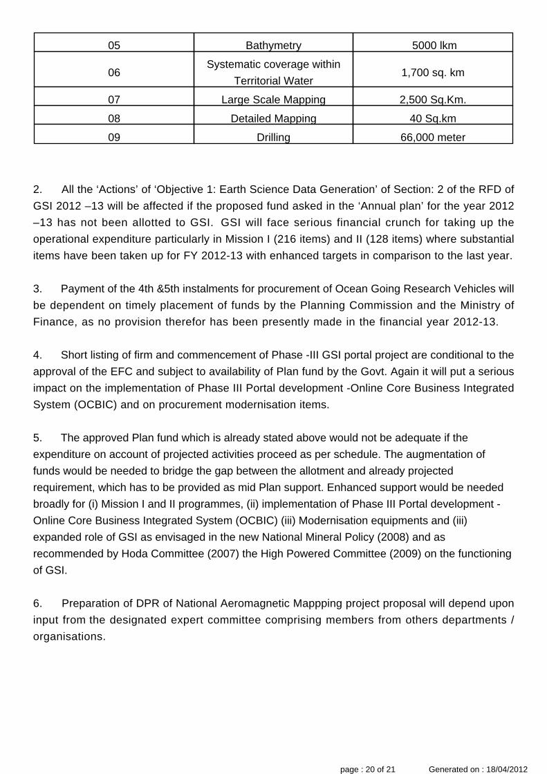
2. All the ‘Actions’ of ‘Objective 1: Earth Science Data Generation’ of Section: 2 of the RFD of
GSI 2012 –13 will be affected if the proposed fund asked in the ‘Annual plan’ for the year 2012
–13 has not been allotted to GSI. GSI will face serious financial crunch for taking up the
operational expenditure particularly in Mission I (216 items) and II (128 items) where substantial
items have been taken up for FY 2012-13 with enhanced targets in comparison to the last year.
3. Payment of the 4th &5th instalments for procurement of Ocean Going Research Vehicles will
be dependent on timely placement of funds by the Planning Commission and the Ministry of
Finance, as no provision therefor has been presently made in the financial year 2012-13.
4. Short listing of firm and commencement of Phase -III GSI portal project are conditional to the
approval of the EFC and subject to availability of Plan fund by the Govt. Again it will put a serious
impact on the implementation of Phase III Portal development -Online Core Business Integrated
System (OCBIC) and on procurement modernisation items.
5. The approved Plan fund which is already stated above would not be adequate if the
expenditure on account of projected activities proceed as per schedule. The augmentation of
funds would be needed to bridge the gap between the allotment and already projected
requirement, which has to be provided as mid Plan support. Enhanced support would be needed
broadly for (i) Mission I and II programmes, (ii) implementation of Phase III Portal development -
Online Core Business Integrated System (OCBIC) (iii) Modernisation equipments and (iii)
expanded role of GSI as envisaged in the new National Mineral Policy (2008) and as
recommended by Hoda Committee (2007) the High Powered Committee (2009) on the functioning
of GSI.
6. Preparation of DPR of National Aeromagnetic Mappping project proposal will depend upon
input from the designated expert committee comprising members from others departments /
organisations.
05 Bathymetry 5000 lkm
06Systematic coverage within
Territorial Water1,700 sq. km
07 Large Scale Mapping 2,500 Sq.Km.
08 Detailed Mapping 40 Sq.km
09 Drilling 66,000 meter
page : 20 of 21 Generated on : 18/04/2012
Section 6:Outcome/Impact of Department/Ministry
Results-Framework Document (RFD) for GSI -(2012-2013)
Outcome/Impact ofDepartment/Ministry
Jointly responsible forinfluencing this outcome /impact with the following
department (s) / ministry(ies)
SuccessIndicator
FY 10/11 FY 12/13FY 11/12 FY 13/14 FY 14/15Unit
2424.83 4100Large Scale Mapping (LSM) on1: 25,000 to 10,000 scale
Facilitate exploration bymineral sector
MECL, State Governments of all mineral-bearing States
4500 50001878.91 Sq Km
28/02/2013Annual increment to NationalMineral Inventory ( for the FSsperiod ending 31 March 2012)
Increase in resources ofNational Mineral Inventories
IBM, State Governments of all mineral-bearing States
28/02/2014 28/02/201531/12/20112 Date
30 40Spatial dataEnable creation anddissemination of geo-spatialdatabases
Ministry of Environment and Forests andState Governments of all mineral bearingstates
45 50353 GB
53 70Training CoursesCapacity Building inGeosciences
All organizations of the country relatedwith Geosciences
75 75954 Nos
31/12/2012Peer review of 75% reports ofF.S. 2010-12
Quality, peer reviewed –Reports of GSI
5 Date
page : 21 of 21 Generated on : 18/04/2012


![[Arnold Goldman] the Monster Makers Mask Makers](https://img.dokumen.tips/doc/110x75/5695d4df1a28ab9b02a31e8f/arnold-goldman-the-monster-makers-mask-makers.jpg)