Embed Size (px)
Citation preview

lable at ScienceDirect
Quaternary International 223-224 (2010) 312e326
Contents lists avai
Quaternary International
journal homepage: www.elsevier .com/locate/quaint
Quaternary volcano-lacustrine patterns and palaeobotanical datain southern Armenia
V. Ollivier a,*, S. Nahapetyan b, P. Roiron c, I. Gabrielyan d, B. Gasparyan e, C. Chataigner f, S. Joannin g,J.-J. Cornée g, H. Guillou h, S. Scaillet h, P. Munch i,j, W. Krijgsman k
a Laboratoire Méditerranéen de Préhistoire Europe Afrique, UMR 6636, 13100 Aix-en-Provence, FrancebDepartment of Cartography and Geomorphology, Yerevan State University, ArmeniacCentre de Bio-Archéologie et d'Ecologie, UMR 5059, Montpellier, Franced Institute of Botany, National Academy of Sciences of the Republic of Armenia, Armeniae Institute of Archaeology and Ethnography, National Academy of Sciences of the Republic of Armenia, ArmeniafMaison de l'Orient, UMR 5133, Lyon, FrancegUMR 5125 PEPS, Université Lyon 1, Bt Géode, 11-45 bd du 11 novembre, 69622 Lyon Cedex, Franceh Laboratoire des Sciences du Climat et de l'Environnement, UMR 1572, Gif sur Yvette, FranceiUniversité de Provence, case 67, 3 place Victor Hugo, 13331 Marseille cedex 3, FrancejUMR 5243 – Géosciences Montpellier CC. 60, place E. Bataillon, 34095 Montpellier cedex 5, Francek Paleomagnetic Laboratory, Utrecht University, The Netherlands
a r t i c l e i n f o
Article history:Available online 18 February 2010
* Corresponding author. Tel.: þ33 0688678062.E-mail address: [email protected] (V. Olliv
1040-6182/$ e see front matter � 2010 Elsevier Ltd adoi:10.1016/j.quaint.2010.02.008
a b s t r a c t
The morphogenetic evolution of the Lesser Caucasus has been strongly influenced by Plio-Quaternaryvolcanic and tectonic events and Pleistocene glaciations. Fluvio-lacustrine environments, indicated bydiatomaceous deposits, prevailed in the Syunik region of southern Armenia during the Pliocene andPleistocene. The Pleistocene diatomaceous deposits studied contain leaf impressions and pollen, allowinglocal palaeoclimatic reconstructions. The chronology of morphogenetic events has been determined by17 radiometric dates (K/Ar, Ar/Ar, U/Th), palaeomagnetic investigations and is placed in a spatial contextby a detailed geomorphological map and a 24-km geological transect of the Vorotan valley, the main areastudied. Before 1.21 Ma, tectonic movements (antecedents of the lower part of the Vorotan valley)generated extensive lake formations with diatomaceous deposits. From 993 ka, volcanic eruptionsproduced lava flows that covered the fluvio-lacustrine accumulations. During Marine Isotopic Stages 12,6 and 4, glaciers and fluvio-glacial deposits were probably present overall the principal uplands andvalleys of southern Armenia. At 53.68 ka (MIS 3), 12.6 ka, 10.78 ka and 4.14 ka (MIS 1), the developmentof travertines on some slopes and in some valleys highlights temperate and humid climatic phases.Palaeobotanical studies of leaf and pollen floras show that the vegetation changed several times fromforested to steppic phases in response to the climate oscillations of the Lower Pleistocene. This workproposes a first morphogenic and palaeoclimatic reconstruction from the lower Pleistocene to thePostglacial period, when the first settlements of the population in the Lesser Caucasus were influencedby tectono-volcanic events, lake level changes and glacialeinterglacial oscillations forced by the obliquityorbital parameter (41 ky cycles).
� 2010 Elsevier Ltd and INQUA. All rights reserved.
1. Introduction
Multidisciplinary studies of Plio-Quaternary geomorphologicand palaeoclimatic evolution have rarely been attempted inEurasia. In the Syunik region (southern Armenia, Fig. 1) several
ier).
nd INQUA. All rights reserved.
geomorphological units provide rich sources of informationabout Quaternary landscape evolution and palaeoclimate. In themain valleys, diatomaceous fluvio-lacustrine deposits withpalaeontological content (leaf imprints, pollen, insects andmammal bones) are related to major volcanic activity, basalticflows and tectono-orogenic movements that occurred during theQuaternary period.
The recent discovery of indicators of early prehistoric humanoccupation in Georgia (Dmanisi) around 1.81 Ma (Gabunia et al.,

Fig. 1. Geographical map of south-eastern Armenia showing the study area.
V. Ollivier et al. / Quaternary International 223-224 (2010) 312e326 313
2000, 2002) and the numerous Palaeolithic (middle to upper)sites studied by the French Caucase Mission (French ForeignMinistry, CNRS and the UMR 5133 from the Maison de l'Orientof University of Lyon, France) in Armenia, underline the necessityof understanding the climate, the palaeoenvironmental contextand the landscape in which the first human populations began tosettle the Caucasus and Eurasia during the Quaternary.
Several Russian collectors deposited the first palaeobotanicalspecimens of these diatomaceous lacustrine deposits from Syunikin the Department of Paleobotany of the Komarov BotanicalInstitute of Saint Petersburg prior to 1937. The first studies on thefossil flora of this area were published by Kryshtofovich (1939).The Armenian researchers A.L. Takhtajan and N.G. Gokhtunicollected plant fossils from the Sisian region after 1940 anddeposited them in the Botanical Institute of Yerevan (Takhtajanand Gabrielyan, 1948; Gokhtuni, 1987, 1988, 1989). Since 1990, I.G. Gabrielyan has collected and studied fossil plants from variouslocalities including those from the area of Sisian (Vorotan groupfloras).
A synthesizing work on these floras remains to be undertaken,as does a detailed chronostratigraphic study in order to define therelative positions of all the layers and to correlate the lake depositswith the Quaternary volcanic episodes. A study of climate quanti-fication from fossil floras was carried out recently (Bruch andGabrielyan, 2002).
In the mountains and secondary valleys, glacial landforms suchas moraines, erratic blocks and fluvio-glacial deposits providea basis for palaeogeographical and palaeo-climatological recon-struction up until the Late Quaternary period. In some valleys,postglacial deposits including travertines and alluvial terraces givesome insights into evolution linked to the complex global envi-ronmental history since the lower Pleistocene.
The study is focused on the Vorotan valley area (Syunik) whichcontains a suite of interesting geomorphological units with greatpalaeoenvironmental analysis potential. The goal of the researchis to better understand Quaternary vegetation and climate fluc-tuations, in the context of volcanic and tectonic activity, extensivelake development, glacial systems, and general morphogenic

V. Ollivier et al. / Quaternary International 223-224 (2010) 312e326314
variability. A detailed picture of the vegetation in connection withall these parameters allows construction of a preliminary overallpattern of Quaternary paleoenvironmental evolution.
This paper presents a first Quaternary landscape reconstructionfor southern Armenia with the objectives of (a) identifyingprecisely periods of large lake development related to the volcanicactivity which represent attractive environment to the earliesthuman occupations presumed in the region; (b) defining themorphoclimatic components, the rhythms and the chronology ofthe major Quaternary morphogenic events in southern Armenia;(c) establishing the basis of a preliminary Quaternary environ-mental reference pattern, from local to general importance, usefulto the archaeological research in Lesser Caucasus.
2. General environmental context
2.1. Present climate and vegetation of the area
The region under study ranges from 1200 to 2200 m in eleva-tion. In the 1300e1500 m zonel, the climate is cool temperate.Above, it is a cool mountain climate. In the central area (near thetown of Sisian) the mean annual temperature is 6.6 �C, and in thenorth-western area from 2000 m to 2200e2300 m it is 2.7 �C (nearSpandaryan Lake). The mean annual precipitation varies accordingto altitude: from 1300 to 1500 m in altitude, 350e400 mm; from1500 to 2000 m, 400e500 mm; higher than 2000 m, 500e600 mmand above (Baghdasaryan, 1958). Precipitation is mainly concen-trated in spring and autumn (Baghdasaryan, 1958).
This territory is mostly covered with steppic vegetation. Thelower mountain zones are covered by Festuca and Stipa steppeswith Festuca ovina, Festuca chalcophaea, Stipa capillata, Dactylisglomerata, Koeleria cristata, Alopecurus aequalis, Bromus squarrosus,etc. On upper zones, dominant steppic species are Astragalus aureusand Astragalus microcephalus, while Poa alpina is prevalent in thesubalpine and alpine grasslands (Maghakyan, 1948). Deciduousforests remain locally on northern slopes in the south-eastern partof the Sisian region near the villages of Arevis and Dastakert (Fig. 1),and in the southern part of the region near the villages of Darbasand Ltsen (Fig. 1). The main tree and shrub species in these forestsare Quercus macranthera, Carpinus betulus, Acer campestre, Aceribericum, Pyrus caucasica, Ulmus minor (foliacea), Salix caprea,Juniperus polycarpos, Juniperus oblonga, Crataegus caucasica, Coto-neaster integerrima, Viburnum lantana, and Lonicera caucasica(Maghakyan, 1948).
2.2. Geological and geomorphological setting of the Sisian region
The Syunik volcanic massif, which occupies all the left bank ofthe Vorotan River from the north-west to the south-east, isalmost entirely covered with Neogene and Quaternary volcanicrocks, as well as volcanic detrital rocks and lacustrine sediments.It corresponds to the south-eastern part of the Pambak-Sevan-Syunik fault zone, one of the main active structures of the region(Philip et al., 2001). This massif is characterized by great varia-tions in absolute and relative altitudes. Some volcanic mountainsexceed 3500 m (Tsitsernakasar: 3594 m; Tskhuk: 3582 m; MetsIshkhanasar: 3549 m; Aramazd: 3392 m) rising to between 1000and 1500 m above the surrounding peripheral lava plateaux (inthe main study area), the altitude of which is 1400e2000 m. TheVorotan valley (Fig. 1), with canyons that reach a depth of 500 to800 m close to the village of Vaghatin, forms a border betweenthe volcanic massif of Syunik and the northern part of the foldedand fractured chain of Zangezur, which is a recently upliftedAlpine chain.
According to most geologists, a significant uplift of the AmulsarMountain separated the Vorotan and Arpa valleys during theMiocene. Some authors think that the Vorotan River was discon-nected from the Arpa River in the area of Spandarian and Goraykeven before the uplift of Amulsar Mountain and that they werejoined together upstream (Balyan, 1969; Gevorgyan, 1986;Gaginyan, 1989) at the same period. The transformation of theVorotan palaeo-valley into a system of lacustrine basins probablyoccurred during the Pliocene. The Quaternary Sisian basin,according to an uplift rate of around 3 mm/year during the lastmillion years in the Lesser Caucasus (Mitchell andWestaway,1999),was probably around 300 m lower than today.
The present-day Vorotan valley is closely related to the Plio-Pleistocene palaeo-valley and appears as a synclinal-grabensystem of connected canyons and valleys. The entire valley has anirregular transverse profile. The left bank consists of structuralterraces in thick volcanic flows of the Syunik massif, whereas theright bank, steep and heavily dissected by lateral ravines, iscomposed of sedimentary and volcanogenic rocks of the Zange-zur chain (Jurassic and Cretaceous deposits, Palaeogene intrusivegranitic rocks).
After the Shaghap basin, located in the upstream part of the areastudied (Fig. 1), the river flows into a deep canyon, which is formedby the contact between the lava and the volcanic Eocene rocks.Then the valley widens out gradually and emerges in the Sisianbasin, where the Vorotan River receives an important tributaryfrom the right bank, the Sisian River. In this valley and the Sisiandepression diatomaceous fluvio-lacustrine units and alluvialdeposits are the main components of the landscape, with basalticflows and metamorphic rock on the surrounding hills.
The diatomaceous deposits reach thicknesses of 100e450 m.This sediment preserves many plant fossils (primarily leaves andpollen) and some animal remains, generally well preserved. TheK/Ar and Ar/Ar dates on the associated basaltic flows andpumices, as well as the palaeomagnetic results, suggest thatthese lacustrine formations developed from the Lower to MiddlePleistocene.
Downstream from the Sisian basin, the Vorotan River continuesin a canyon which descends gradually and reaches a depth of morethan 700 m in the area of Tatev village (Fig. 1). After the confluencewith the Goris River, the valley becomes embanked and connectswith the Hagaru valley.
3. Methodology
3.1. Geomorphology, radiometric chronologyand magnetostratigraphy
Field observations were used to draw a geomorphological mapof the area that includes the lacustrine diatomaceous basins as wellas the basaltic flows, glacial landforms and alluvial deposits (Fig. 2).The various outcrops with fossil flora are indicated.
A geological transect, 24-km in length and oriented from WeEto NEeSW (Figs. 3e5) indicates the relationship betweenmorphology and the organisation of the stratigraphical units. Manynatural sections in the palaeo-valley deposits and a borehole on theright bank of the Vorotan River (Matevosov,1984e1985) expose thesuccession of geological events. The most complete fluvio-lacus-trine stratigraphical sequence (Shamb section, Figs. 6 and 7) wassampled and investigated for its sedimentological characteristicsand its potential for chronological, palaeontological and geophysi-cal analysis.
Ten basalt samples, one scoria and two pumices, were taken forK/Ar and Ar/Ar analyses. The basalt samples come from theUytseAghitueShamb zone: the scoria was removed from the

Fig. 2. Geomorphological map of the middle reaches of the Vorotan River.
V. Ollivier et al. / Quaternary International 223-224 (2010) 312e326 315
slopes of the Arpablur volcanic cone (Fig. 2) and the pumicesamples were collected in the Shamb section (Fig. 2).
Standard methodology for K/Ar dating was utilised (Guillouet al., 2010; Dalrymple and Lanphere, 1969; Chernyshev et al.,
2006). Age determinations were performed in the CEA labora-tory at Gif-sur-Yvette (France). The fraction size of the materielanalysed is between 0.250 and 0.125 mm, ultrasonically washedin HC2H3O2.

Fig. 3. UytseAghitu geomorphological transect.
V. Ollivier et al. / Quaternary International 223-224 (2010) 312e326316
The constants used are:
lb¼ 4.962�10�10/al3¼ 0.572�10�10/al30 ¼ 0.0088� 10�10/a
AGE ¼ 1� 0 �ln"lb þ
�l3 þ l03
�� 0 � �
40Ar40 þ 1
#
lb þ l3 þ l3 l3 þ l3 K40K/K¼ 1.167�10�4 g/g
Error on the age is at 2s.The Ar/Ar samples (pumices) were irradiated in the nuclear
reactor at the McMaster University in Hamilton (Canada). Agedeterminations were performed in the Geosciences Azur laboratoryat Nice (France). The detailed Ar/Ar results and methodology aregiven in the paper by Joannin et al. (2010).
In addition, four travertine formations were sampled for U/Thdating the freshwater travertine of Uyts in the upstream part of theVorotan valley, freshwater travertines of Shamb in the middle partof the Vorotan valley and the hydrothermal travertine of Tatev inthe downstream part of the Vorotan valley (Figs. 1, 2 and 8).
U/Th age determinations were performed in the IFM-GEOMARlaboratory at Kiel (Germany). U/Th dating was based on 230Th/234Umeasurements of the travertine facies. It is important to make surethat samples have not been previously contaminated by thorium ofdifferent ages (Eikenberg et al., 2001). Consequently, it is necessaryto measure the 230Th/232Th ratio so that the results can be trusted.High ratios, up to 17 (Bischoff et al., 1988) or 20 (Ivanovich andHarmon, 1992), indicate that detrital contamination by Th isnegligible and allow acceptance of dates. Nevertheless, low valuesof this ratio do not systematically invalidate the dates. In severalcases, reliable dates have been obtained evenwhen the 230Th/232Th
Fig. 4. AghitueShamb geom
ratio was very low (Quinif, 1989; Ambert et al., 1995; Mlakar et al.,1999). Dates based on U/Th measurements can be compared to thecalendar chronology without calibration.
The magnetostratigraphy of the Shamb section (Joannin et al.,2010) was established from eighteen oriented samples. Thesesamples were treated in the Fort Hoofddijk laboratory of UtrechtUniversity using compressed air. The natural remanent magneti-zation (NRM) was measured on a horizontal cryogenic magne-tometer. The direction of the NRM component was calculated byprincipal-component analysis. The thermal demagnetizationdiagrams are characterized by linear decay of NRM to a tempera-ture of 360 �C.
3.2. Palaeoecological in situ sampling and laboratory analysis
More than 8000 leaf imprints samples were collected from theShamb section and several other nearby localities (Brnakot, Tolors,Uyts). The best preserved samples were photographed or drawnand identified with reference to botanical material held in theherbarium of the Botanical institute of National Academy ofSciences of Yerevan. One hundred palynologic samples of theShamb section were analysed and correlated with the macro-botanical data (Joannin, 2007). Samples were processed usinga standard method adapted from Cour (1974). HCl and HF attackswere followed by residue sieving between 160 mm and 10 mm andenrichment process (using ZnCl2 at density 2). They were treatedand analysed in the PEPS laboratory (University of Lyon 1, France).
4. Results
4.1. Geochronology
Seventeen dates were obtained on various materials such aspumices interbedded in the diatomaceous deposits, basalt flows,
orphological transect.
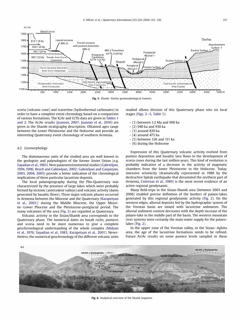
Fig. 5. ShambeDarbas geomorphological transect.
V. Ollivier et al. / Quaternary International 223-224 (2010) 312e326 317
scoria (volcanic cone) and travertine (hydrothermal carbonates) inorder to have a complete event chronology based on a comparisonof various formations. The K/Ar and U/Th data are given in Tables 1and 2. The Ar/Ar results (Joannin, 2007; Joannin et al., 2010) aregiven in the Shamb stratigraphy description. Obtained ages rangebetween the Lower Pleistocene and the Holocene and provide aninteresting Quaternary event chronology of southern Armenia.
4.2. Geomorphology
The diatomaceous units of the studied area are well known tothe geologists and palynologists of the former Soviet Union (e.g.Sayadian et al.,1983). Newpalaeoenvironmental studies (Gabrielyan,1994, 1996; Bruch and Gabrielyan, 2002; Gabrielyan and Gasparyan,2003, 2004, 2005) provide a better indication of the chronologicalimplications of these particular lacustrine deposits.
The local palaeogeography during the Plio-Quaternary wascharacterized by the presence of large lakes which were probablyformed by tectonic (antecedent valleys) and volcanic activity (damsgenerated by basaltic flows). Three major volcanic phases occurredin Armenia between the Miocene and the Quaternary (Karapetyanet al., 2001): during the Middle Miocene, the Upper Mioce-neeLower Pliocene and the Pleistocene-postglacial period. Themany volcanoes of the area (Fig. 2) are regarded as Quaternary.
Volcanic activity in the Sisian/Shamb area corresponds to theQuaternary phase. The numerical dates on basalt rocks, pumicesand scoria need to be more numerous to give a completegeochronological understanding of the whole complex (Midyanet al., 1976; Sayadian et al., 1983; Karapetyan et al., 2001). Never-theless, the numerical geochronology of the different volcanic units
Fig. 6. Analytical overview o
studied allows division of this Quaternary phase into six localstages (Figs. 2e5, Table 1):
- (1) between 1.2 Ma and 990 ka- (2) 940 ka and 930 ka- (3) around 820 ka- (4) around 475 ka- (5) between 126 and 111 ka- (6) during the Holocene
Expression of this Quaternary volcanic activity evolved frompumice deposition and basaltic lava flows to the development ofscoria cones during the last million years. This kind of evolution isprobably indicative of a decrease in the activity of magmaticchambers from the lower Pleistocene to the Holocene. Today,intensive seismicity (dramatically represented in 1988 by thedestructive Spitak earthquake that devastated the northern part ofArmenia, Cisternas et al., 1989) is the most recent evidence of anactive regional geodynamic.
Many field-trips in the Sisian-Shamb area (between 2003 and2006) enabled precise definition of the borders of palaeo-lakesgenerated by this regional geodynamic activity (Fig. 2). On thewestern edges, alluvial deposits fed by the hydrographic system ofthe Vorotan basin are mixed with lacustrine sediments. Thealluvial sediment content decreases with the depth increase of thepalaeo-lake in the middle part of the basin. The western mountainriver systems were certainly the main water supply for the palaeo-lakes (Fig. 2).
In the upper zone of the Vorotan valley, in the SisianeAghituarea, the age of the lacustrine formations needs to be refined.Future Ar/Ar results on some pumice levels sampled in these
f the Shamb sequence.

Fig. 7. Stratigraphic section of Shamb.
V. Ollivier et al. / Quaternary International 223-224 (2010) 312e326318
formations and a K/Ar basalt sample collected in a flow under thepaleo-lake deposits will further support the numerical chronology(Ollivier et al., 2007). In the middle zone of the Vorotan valley, thegeomorphological and geochronological data extracted from theAghitueVaghatineShamb area place the entire local complex inthe lower Quaternary period. The dating results of the basalticflows covering these diatomaceous lacustrine formations (withburned contact) fall between 993� 22 ka and 934� 20 ka; (Figs. 4and 5, Table 1).
The south-east system at the highest altitude between Dastakertand Darbas localities is the oldest in the area, and it is probablylinked to upper Pliocene tecto-orogenic activity. Sedimentary faciesin these deposits show numerous preliminary silicifications(nodules and interstratified levels, Fig. 8). This important diageneticevolution and the higher topographical position (testifying totectonic activity) of the deposits indicate a pre-Quaternary originfor the Dastakert and Darbas formations (Figs. 2 and 5).
According to the dating of a basalt flow at 475�11 ka over flu-vio-glacial formations and glacial deformations of the paleo-lakedeposits, most of the Quaternary basaltic flows on the left bank ofthe Vorotan River were glaciated not later than at least MIS 12 (Figs.
2 and 3 and Table 1). Glacial and periglacial remnants are repre-sented as moraines, erratic blocks, fluvio-glacial deposits, rochesmoutonnées, striated rocks and periglacial slope formations (Fig. 8).Frequently, the older diatomaceous lacustrine deposits, well strat-ified, were pushed by the glacier advance and represent a uniqueform of moraine. During the last deglaciation, fluvio-glacialdischarge frequently impacted the lacustrine deposits in the valleyand resulted in a warped stratigraphy with interpenetrationbetween pebbles and diatomaceous layers (Fig. 8). The evidence ofseveral glaciations described at relatively modest altitudes (bottomof the Vorotan valley around 1500 m) underline the important roleof the Quaternary cold episodes in the Pleistocene morphody-namics of southern Armenia, which represents a new majorelement in the understanding of the southern Caucasus and itsQuaternary paleoclimates.
Most of the major valleys (Sisian, Vaghatin and Shamb basins)contain upper Pleistocene or postglacial alluvial formations (Fig. 2)affected by fitting or terracing and sometimes associated withtravertine deposits (Uyts and Shamb, notably). The geomorpho-logical organisation of these formations depends on the palae-oclimatic and/or orogenic conditions that occurred between thelast glacial periods and the present-day.
The 24-km transect undertaken (Figs. 3e5) shows the variousgeomorphological units that illustrate the diachronic phases ofQuaternary geomorphic evolution proposed:
- Diatomaceous lacustrine deposits, lower Pleistocene;- Basaltic flows, lower to upper Pleistocene;- Glacial remnants, middle to upper Pleistocene;- Alluvial deposits (detrital and/or travertine); upper Pleistoceneand/or postglacial times.
In the area, the different Quaternary morphosedimentary unitsare successively intercalated or interstratified. Abandonment,erosion surface morphology, geometry of the formations andradiometric dating give clues to understanding the event chro-nology of a composite Quaternary morphogenesis.
4.3. Palaeoecology
4.3.1. Stratigraphy of the main leaf flora locality: ShambMany fossil outcrops of the Sisian region (Vorotan Group fossils,
Fig. 10) have already been sampled previously by Gabrielyan (1994,1996). To supplement the lists of flora and clarify the stratigraphicsections in a correct chronostratigraphic scale, study was under-taken of the diatomaceous formations of Aghitu (N 39�5101300, E046�0601300, altitude 1522 m, Fig. 2), Uyts-2 (N 39�3401200, E46�0501000, altitude 1605 m, Fig. 2), Brnakot-2 (N 39�3003400, E46�0000200, altitude 1671 m, Fig. 2) and Tolors (N 39�2800400, E046�0101100, altitude 1680 m, Fig. 2).
Each of the site stratigraphies shows diatomaceous layersinterstratified with pebbles or grey sandy fluviatile units that arecovered by lower to middle Pleistocene basaltic flows (993� 22 kato 475�11 ka, Table 1, Figs. 2e5). Many fossils were collected ineach locality and represent various and outstanding palae-ontological specimens: leaf imprints, seeds, insects and a vertebrateskeleton in Uyts-2 site (Lepus species, Fig. 10, Gabrielyan et al.,2005). In some places such as the Brnakot-2 locality, leaf imprintsgive an idea of the palaeogeographical and spatial organisation ofthe lakes, with sandy layers richer in water plants (Potamogeton)that indicate the proximity of lake banks in shallow-water envi-ronments. By far the richest andmost beautiful section of lacustrinediatomites was that of Shamb (Figs. 6 and 8), an abrupt cliff in theleft bank of the Vorotan River that contains a long sediment profile

Fig. 8. A review of geomorphological units of the area studied.
V. Ollivier et al. / Quaternary International 223-224 (2010) 312e326 319

Table 1K/Ar dates (LSCEeCEAeCNRS, France).
Sample ID Weightmolten (g)
K* (wt.%) 40Ar* (%) 40Ar*
(10�12 mol/g)
40Ar* mean weight(�1s)
40Ar*/40K(10�5)
Age� 2s, ka
Experience no.
V0-027282 1.07058 2.656� 0.027 4.080 4.7187298 0.91141 2.656� 0.027 4.105 4.451 4.574� 0.019 5.769 993� 22
PR-56780 1.01989 2.665� 0.027 6.863 4.3106796 1.06928 2.665� 0.027 7.099 4.403 4.356� 0.017 5.476 942� 20
V0-017281 1.05224 3.072� 0.037 5.582 4.9517297 1.15649 3.072� 0.037 6.059 5.055 5.002� 0.020 5.455 939� 20
PR-76801 2.46800 3.072� 0.037 25.800 4.9916817 2.15518 3.072� 0.037 42.584 4.965 4.978� 0.018 5.429 934� 20
PR-46625 1.60022 3.528� 0.035 19.913 5.7386641 1.02721 3.528� 0.035 4.969 5.688 5.715� 0.022 5.428 934� 20
SHAMB-227104 1.49254 3.412� 0.034 8.757 4.8807120 1.53515 3.412� 0.034 7.771 4.816 4.849� 0.018 4.761 819� 18
UY-047232 1.02020 2.499� 0.025 5.040 1.9927250 0.99227 2.499� 0.025 5.114 2.131 2.057� 0.011 2.758 475� 11
PR-66781 1.08420 2.490� 0.025 6.212 5.3056797 2.60782 2.490� 0.025 4.592 5.506 5.459� 0.048 7.345 126� 3
PR-26604 1.49025 2.457� 0.025 6.759 5.0446620 2.67667 2.457� 0.025 14.346 5.264 5.214� 0.034 7.110 122� 3
PR-16603 1.41035 2.383� 0.024 1.304 4.8516619 1.42617 2.383� 0.024 0.920 4.314 4.568� 0.055 6.422 111� 4
PR-36612 0.59541 2308 �0.291 �0 e 0.10 0 (Holocene)6634 0.49728 2308 0.012 2.9 e e
V. Ollivier et al. / Quaternary International 223-224 (2010) 312e326320
(N 39�2801100, E 046�0803300, altitude at the level of the VorotanRiver: 1340 m).
The Shamb formation (Fig. 6) is cut by normal eastewest faults,with strong dip and collapse of the southern compartments. Thesefaults affect the summit basalt dated to 934 ka, and they inducerepetitions of the diatomite succession. In addition, important land-slides towards thesouthaffect thehigherpartof theoutcrop, coveringthe layers in situ. Nevertheless, two well-preserved continuoussections established a 115-m composite succession (Fig. 7). A detailedstratigraphic analysiswas carried out (Fig. 7) and sampleswere takenfor palaeomagnetic and Ar/Ar dating. Macroflora and pollen samples(from the whole succession) also were taken.
The palaeomagnetic results reveal reversed polarity for theentire Shamb section (Fig. 7). Taking into account the age of thedifferent basalts covering the local upper diatomites (between993� 22 ka and 934� 20 ka, Figs. 4e8, Table 1), and those of thetwo volcanic pumices levels (T5: 1, 21 Ma and T7: 1, 10 Ma, Fig. 7),
Table 2U/Th dates (IFM-GEOMAR, Kiel, Germany).
Sample Age � min-Age, Ky max-Age, Ky 238U, p
Tat1 4.14 0.36 3.78 4.50 0.1277Uyts 6 10.78 1.79 9.01 12.58 0.609Sha2 12.6 3.81 8.40 16.03 0.698Sha1 53.68 1.96 51.74 55.66 1.9947
Sample 230Th/232Th,dpm/dpm
�, dpm/dpm 238U/232Th,dpm/dpm
�, dpm/dpm 230Th/238U,dpm/dpm
Tat1 5.31 0.27 57.2 0.8 0.09283Uyts 6 1.874 0.012 11.682 0.040 0.16044Sha2 1.272 0.005 3.953 0.009 0.32171Sha1 19.22 0.47 31.31 0.25 0.61405
the fluvio-lacustrine deposits of Shamb appear to belong to thereversed Matuyama chron, between the normal Olduvai andJaramillo subchrons. The complete results of the Ar/Ar dating aregiven by Joannin et al. (2010).
In the basal part of the section (sedimentary unit A, Fig. 7),zones disturbed by many undulations between two non-deformed levels could correspond to seismites formed at theinterface between water and sediment. These facies appear asvisco-plastic deformations with sloping pleats, stretched layersand diapiric injections leading to the formation of pillow and ballstructures, and sometimes to a blending of various facies (sand-stone-tuff-diatomites).
The next part of the section (sedimentary unit B, C and D, Fig. 7)contains rhythmic sedimentary sequences, each a few decimetersor more thick, with altering coarse and fine facies. Several upperhorizontal grey pumice zones of variable thickness (2e4 m) alter-nate with the diatomite levels, themselves crossed by fine
pm �, ppm 232Th, ppb �, ppb 230Th, ppt �, ppt
0.0018 6.91 0.02 0.197 0.0100.000 161.298 0.546 1.62 0.010.000 546.449 1.283 3.72 0.01
2 0.00211 197.22 1.56 20.307 0.467
�, dpm/dpm 230Th excess/238U,dpm/dpm
�, dpm/dpm 234U/238U,dpm/dpm
�, dpm/dpm
0.00483 0.08234 0.00581 2.2064 0.03410.00092 0.10908 0.01715 1.1579 0.00070.00094 0.16994 0.05060 1.6030 0.00080.01414 0.5949 0.0162 1.4956 0.0025

Fig. 9. Glacial deformation from MIS 12.
V. Ollivier et al. / Quaternary International 223-224 (2010) 312e326 321
(centimetric-scale) sandy oxidized beds. Some remains of basalticflows appear on the hills which dominate the section (Figs. 4e7). Ageodesic reference mark (1520 m) is at the top of one. At the basalpart of this volcanic flow is the contact between basalt and diato-mites, which have a dark, then reddish aspect over approximately30 cm, indicating that they were burned by the lava in fusion(Fig. 8). In this zone, the greater age of the lake deposits comparedto this lava flow is reinforced by the K/Ar analysis (sample 6625:934� 20 ka).
The sedimentary sequences defined in the Shamb stratigraphyindicate a succession of lacustrine environments with pelagic dia-toms or clay-silt deposits with fluvio-lacustrine indications (streambottom or localised alluvial perturbations of the lacustrine sedi-mentary units). The palaeohydrology changed from high-energy tolow-energy in a volcanic environment with explosive eruptionsrepresented by the numerous pumice levels partly dated by Ar/Aranalysis.
4.3.2. PalaeovegetationPalaeovegetation dynamics were reconstructed with reference
to the Shamb and Uyts subgroup floras (Aghitu, Uyts, Tolors,Brnakot). The species identified from the Shamb stratigraphy arepresented in Table 3.
Some of the species, preserved in the lacustrine sediments of theupper basin of the Vorotan River were growing near the shore ofthe palaeo-lake and others were arboreal species on northernslopes. Most of the shrubs were from open vegetation on southernslopes. Some herbaceous species are represented by fruits or seeds(e.g. Carex, Daucus, Heracleum).
These rich macrofloras do not indicate the steppic phasesbecause the leaf remains of herbaceous species are not preserved.On the other hand, pollen grains of herbaceous plants arepreserved alongside those of woody plants. The understanding ofthe evolution of the vegetation over time requires not only a goodchronological definition, but also joint micro- and macroflorastudies of the same horizons. Of the nearly 100 species of fossilplants of the Vorotan group, in present-day Armenia eight speciesare absent e Osmunda regalis, Quercus castaneifolia, Quercus cerris,Alnus incana, Salix cinerea, Callitriche stagnalis, Potamogeton colo-ratus, Potamogeton compressus. One species, Populus gokhtuniae, isextinct (Gabrielyan, 2002).
In the modern flora of the Sisian region (headwaters of theVorotan river) more than 40 fossil species (e.g. Acer hyrcanum,A. ibericum, Berberis vulgaris, C. betulus, L. caucasica,Malus orientalis,Prunus divaricata, Q. macranthera, Rosa spinosissima, V. lantana,Thymus kotschyanus, Lemna trisulca) are present. All these speciescould be considered to be pre-Quaternary relicts.
During the Pleistocene in the Vorotan region, some species grewin mixed deciduous mountain and high mountain forests (e.g. Acerlaetum, Acer platanoides, Acer trautvetteri, C. betulus, Quercus iberica,Q. macranthera, Tilia begoniifolia), while other taxa tolerating drierconditions had a sparser distribution (e.g. A. ibericum, Celtis cau-casica, Cotinus coggygria, J. polycarpos, Paliurus spina-christi, Pistaciasp.). Some species present are mountain steppe bushes (e.g. Spiraeahypericifolia, R. spinosissima, Lonicera iberica), while near the riversandmarshes Carex bohemica,O. regalis, Phragmites australis, Populusalba, Populus nigra, Salix triandra, Salix wilhelmsiana probablyoccurred. Aquatic species (C. stagnalis, Ceratophyllum demersum,L. trisulca, Myriophyllum spicatum, Potamogeton perfoliatus, Pota-mogeton pectinatus) grew either in the lake or stagnant ponds.
A palynological analysis of a hundred samples from the Shambsection (Joannin, 2007; Joannin et al., 2010) shows three unitsseparated by two important gaps. However, the pollen diagram(Joannin, 2007; Joannin et al., 2010) indicates steppic phases,mainly with herbaceous species and Artemisia, alternating withforested phases with riparian and mesophilous taxa indicatinga more humid climate.
4.3.3. PalaeoclimateThe macroflora studies show that, compared to the present day,
there were warm, humid climatic conditions along the upperVorotan River during the lower Pleistocene. The water zones werediminished and the composition of the water plants changed; thetemperate forest vegetation was reduced as well. The sparse treesand shrub vegetation which always existed in the area are presenttoday. More xerophytic or less thermophilous plants werepreserved, corresponding to a dry continental climate. The vege-tation in the region tends towards more xerophitisation, in relationto the continentalisation of the climate, compared to the beginningof the Quaternary period.
The preliminary palaeo-climatological results, based on thequantitative analyses of the fossil plants of the Uyts subgroup andthe Shamb locality, and their comparison with correspondingspecies of modern vegetation (Mosbrugger and Utescher, 1997)were produced by Bruch and Gabrielyan (2002). For the LowerPleistocene, the quantitative results provided the correspondingdata; mean annual temperature (MAT) in the Sisian depressionwas9.6e13.8 �C (6.6 �C today); mean annual precipitation (MAP) was630e1180 mm (400e500 mm today). Other quantitative resultsprovided corresponding data in the Shamb depression: meanannual temperature (MAT) was 12.9e13.8 �C (8e9 �C today); meanannual precipitation (MAP) was 630e1210 mm (350e400 mmtoday).
However, for the Lower Pleistocene, these results are related toonly two leaf floras of the Sisian region. No pollen flora of that zone

Fig. 10. Fossils remains of the Vorotan group localities (leaves, insects and bones).
V. Ollivier et al. / Quaternary International 223-224 (2010) 312e326322

Table 3List of Pleistocene macrofloras of the Sisian region.
Taxa Levels Taxa Levels
GYMNOSPERMAE RosaceaeCupressaceae 38 Cerasus avium K
1 Juniperus polycarpos D, F, G, H, L 39 Crataegus sp. E40 Malus sp. F
ANGIOSPERMAE DICOTYLEDONES 41 Prunus sp. F42 Pyrus sp. E
Ceratophyllaceae 43 Rosa sp. E, F2 Ceratophyllum demersum B, E, F 44 Sorbus armeniaca F3 Ceratophyllum sp. J 45 Sorbus sp. F
46 Spiraea crenata B, F, GBerberidaceae 47 Spiraea hypericifolia B, E, F, G
4 Berberis sp. F, K 48 Spiraea sp. D, F, H, J, K
Polygonaceae Haloragaceae5 Polygonaceae sp. A 49 Myriophyllum spicatum A, F6 Rumex obtusifolius F Myriophyllum sp. C, F, G, J
Fagaceae Aceraceae7 Quercus boissieri F, G 50 Acer campestre K8 Quercus castaneifolia F, K 51 Acer hyrcanum F9 Quercus cerris K 52 Acer ibericum C, D, E, F, G, K, L10 Quercus iberica C, E, F, G 53 Acer laetum E, F, I, J, K11 Quercus macranthera E, F, G 54 Acer platanoides F12 Quercus sp. E, F, H, J, K, L 55 Acer pseudoplatanus F
56 Acer trautvetteri FBetulaceae 57 Acer sp. H, J, L
13 Alnus incana F14 Betula pubescens F Rhamnaceae15 Betula sp. A, D, E, F, I, J, K, L 58 Paliurus spina-christi F16 Carpinus betulus J, K
AnacardiaceaeSalicaceae 59 Cotinus coggygria C, F, K
17 Populus alba F, G18 Populus x canescens F Apiaceae19 Populus gokhtuniae E, F 60 Heracleum sosnowskyi F20 Populus nigra B, F, M 61 Heracleum sp. E, F, J21 Populus sp. I22 Salix aegyptiaca E, F Caprifoliaceae23 Salix alba E, F, K 62 Lonicera iberica F24 Salix caprea F 63 Lonicera sp. F25 Salix excelsa C, F26 Salix pentandra E, F Oleaceae27 Salix wilhelmsiana E, F 64 Fraxinus sp. F, J, K
Tiliaceae MONOCOTYLEDONES28 Tilia begoniifolia F Potamogetonaceae29 Tilia sp. K 65 Potamogeton compressus F
66 Potamogeton pectinatus FUlmaceae 67 Potamogeton perfoliatus B
30 Celtis caucasica C 68 Potamogeton sp. A, F, G, J, K31 Celtis sp. D, F, L32 Ulmus glabra F Cyperaceae33 Ulmus minor E, F, G 69 Carex sp. cf. C. bohemica F34 Ulmus sp. D, F, H, I, J, K, L35 Zelkova carpinifolia F Poaceae
70 Phragmites australis B, FBrassicaceae 71 Phragmites sp. G
36 Thlaspi arvense A 72 Poaceae sp. A, F, J
Grossulariaceae37 Ribes sp. E, F
V. Ollivier et al. / Quaternary International 223-224 (2010) 312e326 323
was taken into account for the quantitative analysis, which relatesonly to interglacial phases.
5. Quaternary landscape evolution synthesis
All the data collected allow, despite some gaps in the eventchronology, a first attempt at an overall palaeoenvironmental andmorphogenic synthetic reconstruction of southern Caucasus land-scape evolution from the lower Pleistocene to the postglacial period(Fig. 11).
5.1. Lower Pleistocene
Grounded on eroded relief of metamorphic Cretaceous lime-stones and Eocene volcanic deposits (tufa breccia and porphyrite,Figs. 4 and 5), Quaternary basaltic flows (dams) and tecto-orogenicmovements (antecedents of the downstream part of the valley)generated extensive lacustrine environments (Fig. 2). The lowerPleistocene lacustrine system of Shamb, with younger fluvio-lacustral facies, seems to be linked with the Darbas system(silicificated facies with diagenetic evolution) as a result of the

Fig. 11. Morphogenic synthetic reconstruction of southern Caucasus landscape evolution from the lower Pleistocene to the Postglacial period. Lacustral environment ¼ L: lakeVolcanism ¼ P: pumices; BF: basaltic flow; C: volcanic cone; Glacial Landform ¼ G: varying glacial evidence; FG: Fluvio-Glacial; M: Moraine Travertine; FT: Freshwater travertine;Alluvial ¼ T: Terrace.
V. Ollivier et al. / Quaternary International 223-224 (2010) 312e326324
abandonment surface-1 and erosion surface-1 depicted in Fig. 5.Lakes extended throughout the Sisian and Shamb basins. As in thePliocene, shallow waters, a volcanic environment and moretemperate and humid climatic conditions than today generated theintensive development of diatoms and the accumulation of fluvio-lacustrine diatomite deposits between 1.7 and 1 Ma (Fig. 7).Explosive eruptions erosion of volcanic slopes led to the formationof pumice deposits and volcanogenic sandy layers in erosivecontact (during short alluvial phases due to lake level fluctuationsinduced by tectonic or climatic variability) interstratified into thesediatomaceous lacustrine deposits. The palynological analysis of theShamb stratigraphy (Fig. 7, Joannin, 2007; Joannin et al., 2010)highlights the alternation between cold steppic phases withtemperate and more humid forested phases, which could corre-spond to the confirmation of glacialeinterglacial oscillations forcedby the obliquity orbital parameter (41-ky cycles).
From 993� 22 ka to 819�18 ka, basaltic lava flows from thenearby Yantapa, Dashtapa and Chobanmaz volcanoes covered thediatomaceous deposits (Fig. 2). During this event, the large lakescertainly vanished. This is indicated by the direct contact betweenbasaltic flows and metamorphosed limestones, in some places nearthe lake deposits, which suggest a substantial erosion episodebetween 1 Ma and 942� 20 ka (Fig. 4). The deep burned area ofcontact between lava and diatomite in some places and the lack ofassociated pillow lava morphology support this conclusion.
After 819�18 ka, major tectonic activity occurred, withantecedent movement represented by numerous normal faultsconcerning the diatomaceous lacustrine deposits and the datedbasalts in the Shamb area (Figs. 4 and 5). During this geodynamicevent, the Vorotan River began a major incision phase that couldcorrespond to erosion surface-2 (Figs. 5 and 8).
5.2. Middle Pleistocene
Evidence for middle Pleistocene landscape evolution is less wellknown in the study area. However, in the UytseShamb zone,a basaltic flowdated at 475�11 ka covered glacial deposits that canbe attributed consequently to the MIS 12 or 14 glaciation (Fig. 3).
These deposits (Fig. 9) are represented by compressed, distortedlacustrine diatomaceous and sandy deposits oversaturated byglacial meltwater. The entire formation was thereafter mixed andcovered by a moraine of striated basaltic blocks and fluvio-glacialmaterial.
The geometric and chronostratigraphic organisation of theseunits in the Vorotan Canyon suggests major incision periods poste-rior to 819�18 ka and at least prior to 475�11 ka (Figs. 3 and 5).Following these incision stages, the paleovalley was occupied byglaciers and lava flows during the cold climate episodes and theeruptive volcanic phases of the middle Pleistocene. This vigorousmorphogenic dynamic is related to the combined effects of the lowerto middle Pleistocene climatic variability and tecto-orogenic activity.
5.3. Upper Pleistocene
After an undated incision phase, presumably related to themiddle Pleistocene period, the upper Pleistocene testimoniesevidence consists of fluvio-glacial deposits, attributed to MIS 6,covered with three Eemian basaltic flows (respectively dated at126� 3 ka, 122� 3 ka and 111�4 ka, Figs. 3 and 4) including brecciaformations. After a period of apparent geomorphic stasis,fluvioglacial materials from MIS-4/2 accumulated on some nearbybasaltic plateaux (Figs. 3 and 4) underlining the importance of thelast glaciation's influence in the morphogenesis of southernArmenia. In some lateral valleys upstream from the Shamb forma-tion, glacier advance has created moraines, “roches moutonnées”and erratic blocks (Fig. 8). Some cavities within Eemian or lowerPleistocene basaltic flows were filled with diatomaceous depositsand volcanic blocks during the same glacial progression (Fig. 4).
During MIS 3, favourable humid-temperate climatic conditionsand bicarbonate-saturated waters produced travertine formationsin the Shamb valley (Fig. 5). These travertinous sequences weredated to 53.68 ka (Table 2), corresponding to the well- documentedMoershoofd-Pile interstadial, a succession of short-termwarm andcold phases (Coope and Angus, 1975; Coope et al., 1997;Vandenberghe et al., 1998; Van Andel, 2002; Guiter et al., 2003).Recent works demonstrated the global continental effects of this

V. Ollivier et al. / Quaternary International 223-224 (2010) 312e326 325
climatic period at similar latitudes (althoughunder aMediterraneanclimate) in the red soil deposits of southern France (Ollivier, 2006).
A linear incision phase associated with the 53.68 ka travertineformation produced erosion surface-3 on the lacustrine diatom-aecous deposits of Shamb (Fig. 5) andprobably the erosion surface-1in the Uyts locality upstream (Fig. 3). Glacial advance andcontraction into these valleys, during the cold conditions of theMIS-2, left two terraced moraine deposits at Shamb, indicating twoclimatic upheavals (Last Glacial Maximum?).
5.4. Postglacial period
The glacialepostglacial transition is recorded in the transversevalleys by periglacial slope formations, fluvio-glacial, and alluvialdeposits. Compared to the Pleistocene large basaltic flows, thePostglacial local volcanic activity is typically illustrated by scoriacone development (Arpablur volcano with Holocene 40Ar/40Kdating, Table 1 and Fig. 2; Spandarian cone in the upper valley).Postglacial warming is indicated by the development of Uyts(10.78 ka, Table 2, Fig. 3) and Shamb 2 (12.6 ka, Table 2, Fig. 5)freshwater travertines (corresponding as well to the Postglacialalluvial surface 1, Figs. 3 and 5). These carbonate formations are notthick and have fossilised grass imprints without any ligneouselements. Could these indicate the establishment of the present-day steppic climate during the Lateglacial/Holocene period?
After 10.78 ka, two linear river thalweg incisions separated bytwo alluvial accumulations occur. Considering the geometry of thedifferent alluvial deposits along the area of the Vorotan valleystudied, the second postglacial alluvial phase (Figs. 3 and 5)probably corresponds downstream to the Tatev hydrothermalformation level dated at 4.14 ka (Table 2, Figs. 1 and 8).
Currently, a new thalweg incision is occurring, dismantling thelower alluvial terrace levels of the valleys. The coupled effects ofclimatic changes (alternation of humid temperate to dry cold phases)and tecto-orogenic activities (antecedence with a high uplifting rate,Mitchell and Westaway, 1999) are probably the major driving forcesof a tumultuous Caucasian Quaternary morphogenesis. Finally, thescale of these landscape mutations can be illustrated by the verydeep valley incision (around 100 m deep) chronologically well-defined between 53.68 ka and 4.14 ka by the Shamb and Tatevtravertine formations. However, questions remain about the impactof the human occupations on Holocene morphogenesis.
6. Conclusion
The surveys and specific studies carried out in SouthernArmenia indicate the extreme complexity (multiplicity of para-meters and large scale changes) of Quaternary morphogenesis inthe region and the need to further develop research in this field.The existence of many lacustrine environments rich in plantremains since at least the Middle Pleistocene on the territory ofwhat is today Armenia has been established. The fossil florascontained in these Quaternary deposits make it possible to recon-struct the evolution of the vegetation of this area over time. Today,the landscape is very open and the principal plant communities aresteppe formations with Artemisia. Some remnants of forests survivein places on inaccessible northern slopes. The rich fossil florasindicate that the forest formations were dominant for long periodsduring the Quaternary.
However, these macroflora are represented only by woody plantremains. They do not provide information on the cold steppephases dominated by herbaceous taxa which were too fragile toleave imprints. On the other hand, this steppe vegetation can bewell observed in the pollen diagrams. The diatomaceous sedimentsprovide good preservation of fossil pollen grains. The palynological
analyses provide invaluable information on the evolution of thevegetation over time. A future comparison of the microflora andmacroflora of the same lacustrine sites will provide further infor-mation and will enable better interpretation.
This preliminary Quaternary morphological scheme highlightsthe importance of volcanic events, evidence for repeated glacia-tions in southern Caucasus and the reflection of MIS 3 Interstadialand Postglacial warming through the development of travertineformations. All these field studies must be further pursued in orderto obtain a better paleoenvironmental reconstruction, including therhythms and modalities of the overall changes.
Archaeological surveys carried out during recent years indicatethat prehistoric humans occupied several caves located at the baseof lava flows and open-air sites, leaving behind lithic material andcharcoal. The reconstitution of the Quaternary landscapes corre-sponding to these occupations and their evolution over time willprovide information on the context in which early humans lived(Gabrielyan and Gasparyan, 2003; Gabrielyan et al., 2004;Gabrielyan et al., 2005; Liagre et al., 2006).
Acknowledgements
This study is financed by the D.G.R.C.S.T of the French ForeignMinistry and by the French ECLIPSE program of the CNRS(Quaternary environments of the Lesser Caucasus: forcing ofvolcanism, glaciations and man). We are grateful to Gwen Straussand to Elizabeth Willcox for correcting the English manuscript.
References
Ambert, P., Quinif, Y., Roiron, P., Arthuis, R., 1995. Les travertins de la vallée du Lez.(Montpellier, Sud de la France). Datation 230Th/234U et environnement pléisto-cènes. Comptes Rendus de l'Académie des Sciences Paris 321 (série IIa), 667e674.
Baghdasaryan, A.B., 1958. The Climate of Armenian SSR. Yerevan University Press,150 pp. (in Russian).
Balyan, S.P., 1969. Structural geomorphology of Armenian highland and nearlyterritories. Geomorphology of Armenian SSR, Yerevan University Press, pp.1e390 (in Russian).
Bischoff, J.L., Rosenbauer, R.J., Tavoso, A., Lumley, H.de, 1988. A test of Uranium-series dating of fossil tooth enamel result from Tournal Cave (France). AppliedGeochemistry 3, 145e151.
Bruch, A.A., Gabrielyan, I.G., 2002. Quantitative data of the Neogene climaticdevelopment in Armenia and Nakhichevan. Acta Universitatis Carolinae e
Geologica 46 (4), 41e48.Chernyshev, I.V., Lebedev, V.A., Arakelyants, M.M., 2006. KeAr dating of Quaternary
volcanics: methodology and interpretation of results. Petrology 14 (1), 62e80.Cisternas, A., Philip, H., Bousquet, J.C., Cara, M., Deschamps, A., Dorbath, L.,
Dorbath, C., Haessler, H., Jimenez, E., Nercessian, A., Rivera, L., Romanowicz, B.,Gvishiani, A., Shebalin, N.V., Aptekman, I., Arefiev, F., Borisov, B.A., Gorshkov, A.,Graizer, V., Lander, A., Pletnev, K., Roghozin, A.I., Tatevossian, R., 1989. TheSpitak (Armenia) earthquake of 7 December 1988: field observations, seis-mology and tectonics. Nature 339, 675e679.
Coope, G.R., Angus, R.B., 1975. An ecological study of a temperate interlude in themiddle of the last glaciation based on fossil Coleopteran from Isleworth, Mid-dlesex. Journal of Animal Ecology 44, 365e391.
Coope, G.R., Gibbard, P.L., Hall, A.R., Preece, R.C., Robinson, J.E., Sutcliffe, A.J., 1997.Climatic and environmental reconstructions based on fossil assemblages fromthe middle Devensian deposits of the river Thames at South Kensingston,central London. Quaternary Science Reviews 16, 1163e1195.
Cour, P., 1974. Nouvelles techniques de détection des flux et de retombées polli-niques: étude de la sédimentation des pollens et des spores à la surface du sol.Pollen et Spores 16 (1), 103e141.
Dalrymple, G.B., Lanphere, M.A., 1969. PotassiumeArgon Dating: Principles, Tech-niques, and Applications to Geochronology. W.H. Freeman and Co., San Fran-cisco, 428 pp.
Eikenberg, J., Vezzu, G., Zumsteg, I., Bajo, S., Ruethi, M., Wyssling, G., 2001. Precisetwo chronometer dating of Pleistocene travertine: the 230Th/234U and226Raex/226Ra (0) approach. Quaternary Science Reviews 20, 1935e1953.
Gabrielyan, I.G., 1994. The PlioceneePleistocene Floras from the Vorotan River Basin(South-East Armenia). Ph.D. thesis, Yerevan, 108 pp. (in Russian).
Gabrielyan, I.G., 1996. Fruit and seed imprints of Acer, Carpinus and Fraxinus fromthe Upper PlioceneeLower Pleistocene in Armenia. In: Fifth QuadriennalConference of the IOP, Santa Barbara, pp. 31.
Gabrielyan, I.G., 2002. The Late PlioceneeEarly Pleistocene species of poplar Populusgokhtuniae sp. nov. (Salicaceae) from the Vorotan river basin in the South-East

V. Ollivier et al. / Quaternary International 223-224 (2010) 312e326326
of Armenia. Flora, Vegetation and Plant Research of Armenia 14, 10e13 (inRussian).
Gabrielyan, I.G., Gasparyan, B.Z., 2003. The condition of habitation of early man inthe Canyon of the Vorotan River by paleontological data. In: InternationalScience Conference of Archaeology, Ethnology and Folklore of Caucasus, Yer-evan, pp. 23e29 (in Russian).
Gabrielyan, I., Gasparyan, B., Nahapetyan, S., Marjanyan, M., Pipoyan, S., Roiron, P.,Chataigner, S., Ollivier, V., Bruch, A., 2004. The palaeoenvironment in the Vor-otan river basin (Republic of Armenia) in PlioceneePleistocene (on Shambsubgroup localities of flora and fauna). In: International Science Conference ofArchaeology, Ethnology and Folklore of Caucasus, Tbilisi, pp. 44e46 (inRussian).
Gabrielyan, I., Gasparyan, B., Manaseryan, N., Mirzoyan, L., 2005. The New Palae-ozoology Locality of Uyts-2. The Culture of Ancient Armenia, Yerevan 13, pp.5e11 (in Russian).
Gabunia, L., Vekua, A., Lordkipanidze, D., Swisher III, C., Ferring, R., Justus, A.,Nioradze, M., Tvalchrelidze, M., Anton, S., Bosinssky, G., Jöris, O., Lumley, M.A.de,Maisuradze, G., Mouskhelishvili, A., 2000. Earliest Pleistocene hominid cranialremains from Dmanisi, Republic of Georgia: taxonomy, geological setting, andage. Science 288, 1019e1025.
Gabunia, L., Lumley, M.A.de, Vekua, A., Lordkipanidze, D., Lumley, H.de, 2002. Décou-verte d'un nouvel hominidé à Dmanissi. Comptes Rendues Palévol 1, 243e253.
Gaginyan, R., 1989. The History of Development of the Relief of Modern Zangezur inNeogenic and Anthropogenic, Scientific Notes of the Yerevan State University 2,pp. 126e134 (in Russian).
Gevorgyan, F., 1986. Volcanic upland. Geomorphology of Armenian SSR (Yerevan),114e140 (in Armenian).
Gokhtuni, N.G., 1987. The new data on Sisianian fossil flora (Armenia). BiologicalJournal (Yerevan) 40 (6), 500e503 (in Russian).
Gokhtuni, N.G., 1988. Quercus macranthera F. et M. ex Hohen. in Sisianian fossil flora.Biological Journal (Yerevan) 41 (10), 863e864 (in Russian).
Gokhtuni, N.G., 1989. Representative of family of Aceraceae, Anacardiaceae andBetulaceae in Sisianian fossil flora. Biological Journal (Yerevan) 42 (12),500e503 (in Russian).
Guillou, H., Van Vliet-Lanoë, B., Guðmundsson, A., Nomade, S., 2010. New unspikedKeAr ages of Quaternary sub-glacial and sub-aerial volcanic activity in Iceland.Quaternary Geochronology 5 (1), 10e19.
Guiter, F., Andrieu-Ponel, V., De Beaulieu, J.-L., Chedaddi, R., Calvez, M., Ponel, P.,Reille, M., Keller, T., Goeury, C., 2003. The last climatic cycles in Western Europe:a comparison between long continuous lacustrine sequences from France andother terrestrial records. Quaternary International 11, 59e74.
Ivanovich, M., Harmon, R.S., 1992. Uranium Series Disequilibrium: Applications toEarth, Marine and Environmental Sciences. Clarendon Press, Oxford.
Joannin, S., Cornée, J.-J., Münch, P., Fornari, M., Vasiliev, L., Krijgsman, W.,Nahapetyan, S., Gabrielyan, I., Ollivier, V., Roiron, P., Chataigner, C., 2010. EarlyPleistocene climatic cycles in continental deposits of the Lesser Caucasus ofArmenia inferred from palynology, magnetostratigraphy, and 40Ar/39Ar datingof volcanic tuffs. Earth and Planetary Science Letters 291, 149e158.
Joannin, S., 2007. Changements climatiques en Méditerranée à la transition Pléis-tocène inférieur-moyen: pollens, isotopes stables et cyclostratigraphie. Thesis,Claude Bernard University, Lyon-1, France, 254 pp.
Karapetyan, S.G., Jrbashian, R.T., Mnatsakanian, A., 2001. Late-collision rhyoliticvolcanism in the NeE part of the Armenian Highland. Journal of Volcanologyand Geothermal Research 112, 189e220.
Kryshtofovich, A.N., 1939. Contribution to the history of vegetation of the NorthDvina River basin and the Transcaucasia. Journal of Botany (St. Petersburg) 24(5e6), 369e377 (in Russian).
Liagre, J., Gasparian, B., Ollivier, V., Nahapetyan, S., 2006. The site of Angeghakot 1(Armenia) and the identification of the Mousterian cultural facies of “Yerevanpoints” type in the southern Caucasus. Paléorient 32 (1), 5e18.
Maghakyan, A.K., 1948. The remains of forests in Sisian region of Armenian SSR.Information of Academy of Sciences of Armenian SSR. Natural Sciences (Yer-evan) 1 (1), 3e19 (in Russian).
Matevosov, K.A., 1984e1985. Core No. 45, Report No. 5033, Map No. 637. Institute ofGeological Sciences of Armenia, Yerevan (in Russian).
Midyan, A.G., Mikayelyan, L.E., Mnatsakanyan, A.D., 1976. Anthropogenic extrusivein Armenian SSR. In: Collections of Science Works of the Yerevan PolytechnicalInstitute. Mining, Metallurgy, Practical Geology 3, Band 18, pp. 172e179 (inRussian).
Mitchell, J., Westaway, R., 1999. Chronology of Neogene and Quaternary uplift andmagmatism in the Caucasus: constraints from KeAr dating of volcanism inArmenia. Tectonophysics 304, 157e186.
Mlakar, J.-L., Degaugue, F., Leroy, S., Guendon, J.-L., Ambert, P., 1999. Les travertins dela Guisane (col du Lautaret, Hautes-Alpes, France): caractères, datations etpaléoenvironnement alpin holocène. Etudes de géographie physique. no. XXVIIIe Actes du colloque “la montagne méditerranéenne”, pp. 75e80.
Mosbrugger, V., Utescher, T., 1997. The coexistence approach e a method forquantitative reconstructions of Tertiary terrestrial palaeoclimate data usingplant fossils. Paleogeography, Palaeoclimatology, Palaeoecology 134, 61e86.
Ollivier V., 2006. Continuités, instabilités et ruptures morphogéniques en Provencedepuis la dernière glaciation. Travertinisation, détritisme et incisions sur lepiémont sud du Grand Luberon (Vaucluse, France). Relations avec les change-ments climatiques et l'anthropisation, Thèse de doctorat de GéographiePhysique, Université de Provence U1, 357 pp.
Ollivier, V., Roiron, P., Gabrielyan, Y., Nahapetyan, S., 2007. Variations bioclimatiqueset rythmicité des dynamiques morphogéniques quaternaires en Arménie: uneanalyse pluridisciplinaire. In: Chataignier, C. (Ed.), Mission Caucase. Rapportscientifique sur les opérations effectuées en 2007. D.G.R.C.S.T. CNRS. Ministèredes Affaires Etrangères, 136 pp.
Philip, H., Avagyan, A., Karakhanian, A., Ritz, J.-F., Rebai, S., 2001. Estimating sliprates and recurrence intervals for strong earthquakes along an intracontinentalfault: example of the Pambak-Sevan-Sunik fault (Armenia). Tectonophysics 343,205e232.
Quinif, Y., 1989. La datation UraniumeThorium. Speleochronos 1, 3e22.Sayadian, Y.V., Aleshinskaya, Z.V., Pirumova, L.G., Rybakova, N.O., 1983. On the age,
interrelations and conditions of the formation of Pliocene continental depositsof the Syunik plateau. Problems of Geology of Quaternary period of Armenia(Yerevan), 45e59 (in Russian).
Takhtajan, A.L., Gabrielyan, A.A., 1948. The experiences of stratigraphic correlationof volcaneous suites and freshwater deposits of Pliocene and Pleistocene ofSmall Caucasus. Reports of Academy of Sciences of Armenia SSR 8 (5), 211e216(in Russian).
Van Andel, Tjeerd H., 2002. The climate and landscape of the middle part of theWeichselian glaciation in Europe: the stage 3 project. Quaternary Research 57,2e8.
Vandenberghe, J., Coope, R., Kasse, K., 1998. Quantitative reconstructions of palae-oclimates during the Last InterglacialeGlacial in western and central Europe: anintroduction. Journal of Quaternary Science 13, 361e366.