Embed Size (px)
Citation preview

ARTICLE IN PRESS
Quaternary Science Reviews 26 (2007) 876–893
Quaternary marine terraces on Sal Island (Cape Verde archipelago)
C.
island is volca
preserved ar
0277-3791/$ - se
doi:10.1016/j.qu
Zazoa,�, J.L. Goyb, C.J. Dabrioc, V. Solerd, Cl. Hillaire-Marcele, B. Ghalebe,
J.A. Gonzalez-Delgadob, T. Bardajıf, A. CaberoaaDepartamento de Geologıa, Museo Nacional de Ciencias Naturales, CSIC, Jose Gutierrez Abascal, 2. 28006, Madrid, SpainbDepartamento de Geologıa, Facultad de Ciencias, Universidad de Salamanca. 37008, Salamanca, Spain
cDepartamento de Estratigrafıa, Facultad de Ciencias Geologicas and Instituto de Geologıa Economica CSIC. Universidad Complutense,
28040, Madrid, SpaindEstacion Volcanologica de Canarias, CSIC, Avda. Astrofısico Fco. Sanchez 3, 38206 La Laguna-Tenerife, Spain
eGEOTOP-UQAM, Montreal, Canada H3C 3P8fDepartamento de Geologıa, Facultad de Ciencias, Universidad de Alcala, 28871-Alcala de Henares, Spain
Received 11 July 2006; accepted 18 December 2006
Abstract
The Quaternary sedimentary record of Sal Island includes marine and related aeolian and alluvial fan deposits. The substratum of the
nic, with ages between 25 and 0.6Ma. Quaternary marine units generally occur as raised marine terraces forming a broad
staircase between elevations of 55–60m and present sea level. Terraces include a basal conglomerate overlaid by calcarenite; both host
corals, algae and molluscs.
A chronostratigraphic framework for the Middle Pleistocene to Holocene units has been generated based on a geomorphologic map of
the Quaternary landforms and associated deposits and morphosedimentary analysis, with support of laboratory dating: U-series by
TIMS in corals, 14C analyses, palaeomagnetic measurements, and K/Ar ages from other literature. U-series dating of corals from marine
terraces provides benchmarks for the Last Interglacial (Oxygen Isotope Substage 5e) and Holocene deposits. The present elevation of the
marine terraces and their staircase arrangement suggest a change in vertical movement trend around 330 ka from an uplift to either
subsidence or stabilization.
r 2007 Elsevier Ltd. All rights reserved.
1. Introduction
The Cape Verde archipelago is an unusually well-
Canary Islands on Fuerteventura and Lanzarote Islands(Zazo et al., 2002).Despite the excellent exposures on Sal Island, Quatern-
ea for studying recent vertical crustal move- ary deposits have received very little attention, except for
ments related to volcanic activity and/or tectonics.Additionally it allows investigation of behaviour, intensityand trajectories of the oceanic currents forming the so-called ‘‘Subtropical North Atlantic Gyre’’ in the recent pastas well as in the present.Sal Island, one of the easternmost islands of thearchipelago, is extremely arid and offers easy access tothe well-preserved Quaternary deposits, particularly to theraised marine terraces. These landforms are very similar innumber and elevation to those studied by us in the eastern
�Corresponding author. Tel.: +34914111328x1189;
fax: +34915644740.
E-mail address: [email protected] (C. Zazo).
e front matter r 2007 Elsevier Ltd. All rights reserved.
ascirev.2006.12.014
papers by Lecointre (1962, 1963, 1965) which cited threemarine terraces containing the warm-water gastropodStrombus bubonius at elevations of 55–13, 7–8m, andaround mean sea level. A comparison between the coasts ofMorocco and the Mediterranean Sea led Lecointre toassign these terraces to the Anfatian (Tyrrhenian I ¼Eutyrrhenian), Ouljian (Tyrrhenian II ¼ Neotyrrhenian)and Flandrian (Mellahian) respectively. This chronologyhas been followed in later studies (Serralheiro, 1967; Silvaet al., 1990, etc.) devoted to volcanic rock and also tothose having to do with to the faunal content ofthe topographically-low (between 0 and 5m) deposits(Garcıa-Talavera and Bacallado, 1981; Garcıa-Talavera,1999).
This study provides the first geomorphologic map of theQuaternary landforms and associated deposits includingthe sequence of raised marine terraces and the associatedterrestrial and transitional deposits, the main sedimento-
archipelago with only a few, isolated mountains. Thehighest of these is The Monte Grande (elevation: 406m) atthe northeastern part of the island (Fig. 2). The climate inthe island is tropical-dry. During the dry season (Novem-
ARTICLE IN PRESS
E
C. Zazo et al. / Quaternary Science Reviews 26 (2007) 876–893 877
logical and morphological features and (still under study)the faunal content. A chronostratigraphic framework hasbeen generated by means of palaeomagnetic analyses,K–Ar dating (Torres et al., 2002a), U-series measurements(mainly on corals) and radiocarbon dating. This paperfocuses on the raised Quaternary marine terraces in orderto investigate sea level changes and possible vertical crustalmovements. It also supplies data for an improved knowl-edge of the source areas of the ‘‘Senegalese fauna’’ that isthought to have migrated from tropical Atlantic regionsinto the Mediterranean Sea, where it spread extensivelyduring the Last Interglacial (OIS 5).
2. Physiographical and geological setting
The Cape Verde archipelago consists of ten main islandsof volcanic origin located in the central Atlantic Ocean(Fig. 1A), 450 km off the African mainland (Senegal) and2500 km east from the Mid-Atlantic ridge. Together withthe Azores, Salvagens, Canary and Madeira archipelagos,they form the Macaronesian bio-geographic region, a termcoined in the 19th century by Barker-Webb and Berthelot(1836–1840) to include islands with volcanic substrata anda marked endemic species. The islands are in the path ofthe Northern Hemisphere trade-winds and are separated inwindward and leeward islands (Fig. 1B). Besides theprevailing trade winds felt all along the year, the warmeastern harmattan blows between December and April.
Sal Island (one of the Windward Islands) is 216 km2 insurface area. It is also topographically the flattest of the
EUROP
NORTHAMERICA 0°A
SOUTH AMERICA
AFRICAATLANTIC OCEAN
Caribbean Sea
Equator
Tropic of Cancer
Gulf of GuineCape Verde I.
Canary I.
Azores I.
Madeira I.Salvagens I.
Ascension I. Azores, Madeira, Canar ySalvagens and CapeVerde Archipelagos form the "Macaronesian"biogeographic region.
Mediterranean S
Fig. 1. (A) Location map of Cape Verde Islands in eastern North Atlantic O
winds.
ber–June) mean temperatures are 28 1C, but in the rainyseason (August–October) mean temperatures fall toaround 19 1C. Rain is very scarce (mean annual rainfall�102mm), and the island lacks permanent surficial watercourses even during the rainy season. In fact, the island isthe most arid of the whole archipelago. The mean annualaverage tidal range in these islands is 1m.The available geochronologic data (Torres et al., 2002a)
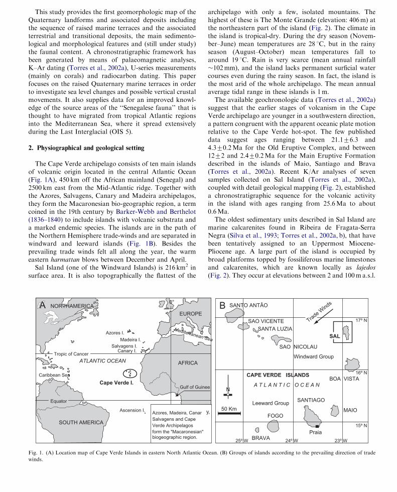
suggest that the earlier stages of volcanism in the CapeVerde archipelago are younger in a southwestern direction,a pattern congruent with the apparent oceanic plate motionrelative to the Cape Verde hot-spot. The few publisheddata suggest ages ranging between 21.176.3 and4.370.2Ma for the Old Eruptive Complex, and between1272 and 2.470.2Ma for the Main Eruptive Formationdescribed in the islands of Maio, Santiago and Brava(Torres et al., 2002a). Recent K/Ar analyses of sevensamples collected on Sal Island (Torres et al., 2002a),coupled with detail geological mapping (Fig. 2), establisheda chronostratigraphic sequence for the volcanic activityin the island with ages ranging from 25.6Ma to about0.6Ma.The oldest sedimentary units described in Sal Island are
marine calcarenites found in Ribeira de Fragata-SerraNegra (Silva et al., 1993; Torres et al., 2002a, b), that havebeen tentatively assigned to an Uppermost Miocene-Pliocene age. A large part of the island is occupied bybroad platforms topped by fossiliferous marine limestonesand calcarenites, which are known locally as lajedos
(Fig. 2). They occur at elevations between 2 and 100ma.s.l.
SANTO ANTÂO
de WindsB
SANTA LUZIA
SAO VICENTE
SAO NICOLAU
BOA VISTA
MAIO
SANTIAGO
Praia
FOGO
BRAVA
SAL
A T L A N T I C O C E A N
CAPE VERDE ISLANDS
17º N
16º N
15º N
25º W 24º W 23º W
50 Km
N
Windward Group
Leeward Group
Tra
e
,
ea
cean. (B) Groups of islands according to the prevailing direction of trade

(above sea level) and are marine terraces of Pleistocene age(Torres et al., 2002b).
3. Materials and methods
Torres et al. (2002a, b) described and mapped in detail thevolcanic rocks of Sal Island. In contrast, Quaternarysedimentary rocks received less attention, as only Pleisto-cene and Holocene deposits were differentiated (Fig. 2) and
ARTICLE IN PRESS
Monte Grande-Pedra Lume Fm.(0.6 ± 0.2 Myr)
Plio-Pleistocene deposits
Holocene deposits
Serra Negra Fm.(5.6 ± 0.2 Myr)
Ponta do Altar-Baleia Complex(6.7± 0.6 Myr)
Main Eruptive Fm.(15.8± 0.9 to 9.7 ± 0.5 Myr)
Ancient Eruptive Complex(25.6 ± 1.1 to 16.3 ± 0.6 Myr)
N
Pedra LumePalmeira Espargos
SantaMaría
Ponta doLeme Velho
Ponta Norte
Cascalho
SECTIO N A
SECTION B
SECTION C
R. Salina
SalinasMonteCurral
SerraNegra
M. Filho
Curralona
Lajedo do Tarafo
Lavrador
Rabo de Junco
Cagarral
MonteGrande
Ponta deCasaca
Mte.Leste
Buracona
Baleia
PontaPalhona
Ponta Preta
Terra Boa
Ponta doVermelho
PontaVermelha
Ponta do Sinó
Ponta daFragata
Figure 3
LomaBranca
Algodoeiro
Lajedo de Soco
rro
Baia daMurdeira
P. daBicuda
P. do Altar
16º 50' N
16º 45' N
16º 40' N
16º 35' N
23º 00' W 22º 55' W
M.Açucar
0 1 2 Km
Geodetic bench mark (m)
Paleomagnetic sample/site
4
16561
12
4
40
99
107
110
173
406
263
46
55
Fig. 7
Fig. 14
Fig. 8
Fig. 12
Fig. 11
Fig. 4
Fig. 9AFigs. 9B, C
Fig. 10
Fig. 5
8
7
6
5
4
321
1
Fig. 2. Geologic map of Sal Island (modified after Torres et al., 2002a) with sections depicted in Fig. 6 and location of photographs.
C. Zazo et al. / Quaternary Science Reviews 26 (2007) 876–893878
3.1. Air photo-mapping and field investigations
The first step was to construct a detailed geomorphologicmap of the Quaternary landforms and associated marineand terrestrial deposits, and the volcanic rocks related withthem, based on aerial photographs scaled 1:15.000 (year1991) and to field check the features represented (Fig. 3).Data were transferred to the topographic 1:25.000 (sheets27-Preguic-a, 28-Espargos, and 29-Santa Maria) andgeologic (sheets I and II) maps, and checked in the field.
few lithologic details offered.Sampling of morphosedimentary units was preceded by
facies analysis of sedimentary units aimed to separateshallow marine, beach, lagoon and terrestrial (alluvial fanand sand dunes) coastal facies. This is essential as a meansof fixing the present topographic elevation of a givenmarine unit with respect to the present sea level, used asdatum, and to reveal any possible eustatic oscillation of sealevel.In this paper the elevations of marine terraces refer to
the mean high tide level (datum ¼ 0m), and the altitudes

have been measured in the inner part of the marine edge(the shoreline angle) using topographic maps, altimeterand rod. We consider that the mapped marine terracedeposits represent sea-level highstands during either inter-
3.2. Paleontology
Fossils have been collected from the marine terraces anda palaeontologic study is underway. The study pays
ARTICLE IN PRESSC. Zazo et al. / Quaternary Science Reviews 26 (2007) 876–893 879
glacial or interstadial episodes (Oxygen Isotope Stage-OISor Oxygen Isotopic Substage-OISS). In the case of theLast Interglacial (OISS 5e), two different events havebeen mapped. Marine terraces have been numberedfollowing the stratigraphic order from T.1 (the oldest)through T.16 (the youngest, see Fig. 3 legend). MostHolocene deposits are beach barrier—lagoon systems andaeolian sands.
T.5
4140 30
ab
Pontado Sinó
Ba
ia
do
A
lgo
do
eiro
PontaPreta
S
Cemetery
C. Branca
Fátima
16º 36' N
22º 55' W22º 56' W
1
224
3
Roa
dfr
om
Santa
Marí
ato
Esparg
os
0
T.5
38
T.7
T.7
T.8
T.11-12T.13
T.11-12
T.10
T.9
T.10
T.14
T.14
T.13 T.15
T.15
T.16
T.16
T.6
38
12
8
8
3
16
3
2
2
11
2
2
15
18
16
14
17
3
3
35
31
SantaCruz
Ligthouse
N
10
20
30
Fig. 3. Geomorphologic map and legend of Quaternary landforms
particular attention to Strombus bubonius and the accom-panying fauna—usually referred to as the ‘‘Senegalesewarm fauna’’—which colonized the coasts of the westernMediterranean (Hearty et al., 1986; Cuerda, 1989; Goy etal., 1993; Hillaire-Marcel et al., 1996; Zazo et al., 2003),Canary Islands (Meco et al., 1997; Zazo et al., 2002, 2004)and other Macaronesian archipelagos (Garcıa-Talavera,1987, 1999; Avila, 2000; Callapez and Ferreira Soares,
RAISED MARINE TERRACES
AND
andonned saltpans
Ponta doLeme Velho
Ponta Jalunga
Co
sta
da
Fra
ga
ta
ANTA MARIA
ASSOCIATED TERRESTRIAL DEPOSITS
SOUTH OF SAL ISLAND
(CAPE VERDE)
16º 38' N
16º 37' N
22º 54' W
1
500 1000m
T.5
T.6
T.8T.9
8
2
2
10
6
5
5
613
5
4
3
4
6.5
T.16T.15
and associated deposits in southern Sal Island (Cape Verde).

ARTICLE IN PRESS
Volcanic rocks0.6 +/-0.2 Myr (N. Island)
Aeolian sand dunes D4
Alluvial fans
PL
IO-P
LE
IST
OC
EN
EM
IOC
EN
EM
IDD
LE
PL
EIS
TO
CE
NE
EA
RL
Y P
LE
IST
OC
EN
EL
AT
E P
LE
IST
OC
EN
E L
AT
E P
LE
IST
OC
EN
E-
HO
LO
CE
NE
Marine terrace T.16
Marine terrace T.15
Marine terrace T.14
Marine terrace T.13
Marine terrace T.11/12
Marine terrace T.10
Marine terrace T.9
Marine terrace T.8
Marine terrace T.7
Marine terrace T.6
Marine terrace T.5
Marine terrace T.4
+1 m
+2.5 m
+4 m
+6 m
+9 m
+12 m
+13 m
+18 m
+23 m
+24 m
+38 m
+44 m
+47 m
+52 m
Colluvium andalluvial fans
Alluvialcones
Beach
Colluvium andalluvial fans
Aeolian sand sheet
Elevations(metres)
Parabolic sand dunes
Interdune depression
Longitudinal sand dunes
Transversesand dunes
Marine terrace T.2
Aeolian sand dunes D2
Aeolian sand dunes D3
Karstification
Complex of Marine Units
Marine conglomerate
Volcanic rocks 5.7 Myr
Marine calcarenites
Aeolian sand dunes D1
Marine oscillations
Elevations (m) after Carta Militar de Portugal (1968)
Contour lines (m) after Carta Militar de Portugal (1968)
Superposition of terracesSupposed fault
Wide marine terrace
Salt pans (abandoned)
Patches of marine deposits
Major escarpmentbetween terraces
+55-60 m?Marine terrace T.1
Marine terrace T.3
N 70-155ºE
N 30-155ºE
N 30-155ºE
Valley fill
Beach barrier (1 to 4)/lagoon systems
Ma
pp
ed
in
Fig
ure
3
LagoonBeach ridge
(15.8-9.7 Myr)? Volcanic rocks
5
10
4 Geodetic bench mark (m)
Hermitage Cottage
Fig. 3. (Continued)
C. Zazo et al. / Quaternary Science Reviews 26 (2007) 876–893880

2000; Avila et al., 2002) during some of the Pleistoceneinterglacials. Some palaeoecological conditions of thisfauna have been deduced by comparing the morphosedi-mentary record and faunal content of the two most recent
HNO3 to increase the yield of U (see Hillaire-Marcel et al.,1996 for more details). Measurements were made on a VG-Sector thermal ionization mass spectrometer equippedwith an electrostatic filter and an ion-counting device.
ARTICLE IN PRESSC. Zazo et al. / Quaternary Science Reviews 26 (2007) 876–893 881
marine terraces with the results by Morri and Bianchi(1995) and Morri et al. (2000) on living shallow epibenthiccommunities.
Fossil corals found in the marine terrace depositsreceived special attention because they are the marineorganisms most suitable for U-series dating. A major issueis to differentiate hydrozoan from true scleractinian corals.
3.3. Petrology
Thin sections of lithified sediments in the oldest marineterraces were used to study microfacies and cements, wichmay yield a better interpretation of sedimentary facies.Thin sections are particularly helpful in the cementedcarbonate deposits, where sedimentary discontinuities aredifficult to trace in the field, and only apparently-massivemorphosedimentary units are observed. The final aim ofthese studies is to reconstruct sea-level oscillations.
3.4. Paleomagnetic analysis
42 cores for paleomagnetic analysis were drilled in situand oriented by a solar compass in the sedimentaryComplex of Marine Units (C.M.U.), some of the cementedmarine terrace deposits, and the volcanic rocks of theMonte Grande Formation. From these cores we extracted71 samples. The natural magnetic remanization (NRM)measurements were performed in an Agico JR4 magnet-ometer, using stepped thermal demagnetization to 600 1Cin a Sconstedt TDS-1 oven.
The thermal treatment worked well with the majority ofthe samples, with the exception of those from MonteGrande, that seem to be affected by electrical discharges,presenting highly erratic initial NMR directions that didnot improve with thermal treatment. Alternating fieldtreatment above 30 mT allowed this superimposed viscouscomponent to be removed and the positive polarity of thisformation to be established.
3.5. 14C analysis
A few AMS radiocarbon analyses were carried out onshells extracted from the lowest marine terrace, and onrecent aeolian deposits at Geochron Laboratories (Cam-bridge, Mass, USA).
3.6. U-series measurements
Samples were mechanically cleaned and crushed in anagate mortar. Aliquots were put aside for aragonite-calciteand stable isotope measurements. Analytical proceduresfor U and Th separation followed Edwards et al. (1987),with a modified two stage extraction with 6N HCl and 7N
The overall analytical reproducibility, as estimated fromreplicate measurement of standards, is usually better than70.5% (72s error) for U and Th concentrations as well asfor 234U/238U and 230Th/234U ratios (Table 1).
3.7. X-ray determination of aragonite—Calcite ratios
Determination of calcite/aragonite ratios was madeusing X-ray diffraction measurements (Davies and Hooper,1963), with a Siemens D 5000 instrument (CoKa radia-tion). We used the aragonite 111 and calcite 104 reflectionpeaks and expressed aragonite contents in percent of totalcarbonate from (111/111+104) ratios. Measurements ofstandard aragonite-calcite mixtures for calibration pur-poses show that either peak heights or peak areas can beused. Replicate measurements of laboratory standardsshow a reproducibility of about 5% (7 1s).
4. Results and discussion
4.1. The geomorphologic map of the Quaternary Landforms
and associated deposits
We mapped the entire Sal Island. In the north, some ofthe marine terraces rest directly on top of the youngestvolcanic rocks of the island, which is most interesting froma geochronologic point of view. In this paper we onlypresent a map of the southern part of the island, where themost complete succession of marine and terrestrialmorphosedimentary units is exposed (Fig. 3).We have distinguished sixteen marine terraces (T.1
trough T.16 in stratigraphic order) that lay at elevationsbetween 55ma.s.l. and modern sea level (0m). Some ofthem are of quite broad and their deposits rest uponerosion surfaces cut by waves onto volcanic rocks, anobservation that suggests that they probably represent longperiods of stable sea level. These features have beenindicated in the map and legend (Fig. 3), along with themain paleo-cliffs separating consecutive terraces. Eleva-tions (in metres) refer to the altitude a.s.l. of the shorelineangle. Some terraces, such as T.11 and T.12, occurvertically stacked in the mapped sections.. This is alsoindicated in the legend of the map.Holocene marine deposits lack the morphological
expression of emergent terraces, but still have thesedimentary signature of beaches or beach barrier-lagoon,and aeolian systems.
4.2. Marine deposits
4.2.1. Pre-Quaternary deposits
The oldest sedimentary unit described in Sal Island iscomposed of marine calcarenites (Silva et al., 1990, 1993;

ARTIC
LEIN
PRES
STable 1
U-series measurements, d13C and d18O in samples from Sal Island
Sample # Sample ID Arag.% 238U (ppm) 232Th (ppb) 234U/238U� 230Th/234U� 230Th/232Th� Calc.age (ka) d234U0 % Group d13C d18O
Coral samples
S03-64 Favia fragum 98.7 2.50570.015 2.27870.016 1.152570.0086 0.001670.0001 6.3470.46 0.18 70.013�� 15379�� A 1.34 0.26
S03-57 Unidentified coral n.d. 2.473970.0151 129.6471.4092 1.202070.0073 0.662770.1240 43.2970.93 114.8 +4/�3.8 280710 B — —
S03-65 Favia fragum 97.8 2.90970.018 0.402970.0048 1.129370.0100 0.689170.0100 171727302 122.9 +3.6/�3.4 183714 B 1.14 �2.40
S03-68-1 Siderastrea radians n.d. 2.70370.015 1.64770.011 1.097670.0062 0.658670.0047 3624735 114.2 +1.6/�1.5 13579 B �0.77 �2.20
S03-68-2-e S. radians (top) 89.4 2.419770.0013 36.04470.028 1.122070.0094 0.697270.0088 160.572.1 125.7 +3.2/�3.1 174713 B �0.07 �2.33
S03-68-2-d S. radians (interm.) 98.1 2.730470.0018 3.05070.029 1.121470.0068 0.703470.0074 2158731 127.8 72.7 174710 B 0.08 �2.24
S03-68-2-c S. radians (middle) 98.25 2.664870.0119 0.40270.003 1.118070.0067 0.697170.0071 157987190 125.8 +2.6/�2.5 169710 B 0.24 �2.19
S03-68-2-b S. radians (interm.) 100 2.762970.0017 2.76270.034 1.115070.0067 0.705170.0100 2404745 128.5 +3.7/�3.5 166710 B 0.20 �1.74
S03-68-2-a S. radians (bottom) 98.3 2.70370.0015 7.63370.006 1.103070.0011 0.705870.0104 843712 129.2 +4.0/�3.8 14972 B 0.01 �2.01
S03-69 Siderastrea radians 80.4 2.76770.016 40.7270.36 1.100870.0088 0.645370.0080 147.572.1 110.2 72.5 138712 B 1.37 �2.88
S02-8 Unidentified coral n.d. 1.447370.0066 51.8370.36 1.125370.0086 1.034870.0108 99.471.1 44 — — —
S02-9 Favia fragum 56.8 2.71370.014 13.27770.093 1.099770.0099 0.97170.0112 666.877.5 312 +26/�21 241722 C 2.03 �1.15
S03-54 Siderastrea radians n.d. 2.75270.026 2.36470.027 1.065070.0094 0.967170.0128 3663765 322 +35/�26 162723 C �2.90 �7.19
S03-55 Siderastrea radians 98.8 2.87970.019 1.610470.0037 1.064470.0071 0.977070.0209 56817177 343 +73/�43 170719 C 1.82 �2.49
S03-73 Favia fragum 94.8 2.46770.014 17.9270.13 1.071670.0077 0.973270.0083 438.774.5 330 +24/�19 182720 C 1.49 �1.89
S03-70 Siderastrea radians 95.4 3.27270.020 4.67870.049 1.035570.0071 1.000570.0104 2214731 44 — D �1.79 �2.99
S03-77 Siderastrea radians n.d. 2.34870.019 0.065870.0011 1.015670.0058 1.019270.0113 410572*103 44 — D 2.89 �2.65
S03-79 Favia fragum 0 2.610470.0014 10.40070.089 1.002170.0049 1.004970.0084 772.579.4 44 — D — —
Other measurements
S03-58 Millepora sp. 98.8 0.845070.0040 153.771.2 1.151670.0060 oo oo Modern 11576 A 0.74 0.10
S03-51 Millepora sp. 96.6 0.670970.0044 0.79170.009 1.169970.0075 0.002570.0017 7.575.1 0.3 70.2�� 17078** A 1.20 �0.07
S03-52 Dendropoma sp. 98.1 0.772770.0043 5.98970.052 1.162370.0100 0.015970.0013 7.2770.58 1.7 70.1�� 163710** A 0.96 �0.58
S03-74 Millepora sp. 80.8 0.837970.0045 104.271.18 1.162770.0100 0.623970.0124 17.8270.39 103.0 +5.4/�4.6�� 218713** B 1.37 0.73
S03-61 Millepora sp. 78.9 0.572070.0030 5.82670.049 1.112770.0100 0.699070.0141 233.574.8 126.6 +5.1/�4.9 161714 B 1.29 �2.11
S03-62 Unid. shell fragment n.d. 0.160570.0014 0.81470.013 1.202070.0103 0.731470.0225 529718 135.0 +8.5/�7.9 296715 B — —
S03-74 Glycymeris sp. n.d. 0.176670.0009 11.7770.11 1.122170.0089 0.566570.0088 29.1470.50 89.1 +2.3/�2.2�� 218713�� B — —
S03-57 Rodolite n.d. 0.637070.0060 195.374.0 1.181070.0180 0.463070.0120 5.4570.17 66.4 72.5�� 280710�� ? — —
SO3-2 Dendropoma sp. n.d. 0.233770.0012 51.11670.010 1.155470.0098 0.667170.0115 10.7670.19 115.4 +3.7/�3.6 216714 B — —
S03-66 Millepora sp. 90.9 1.150770.0058 20.0070.15 1.155770.0077 0.999770.0104 193.572.3 340 +28/�23 408720 C 1.35 �0.53
�Activity ratios.��Ages and initial composition requiring correction due to high detrital content; A: recent (or late Holocene); B: assigned to OISS 5e; C and D older sets of samples (see Fig. 14).
C.
Za
zoet
al.
/Q
ua
ternary
Scien
ceR
eviews
26
(2
00
7)
87
6–
89
3882

Torres et al., 2002a, b) belonging to the Fragata Formationthat occur sandwiched between the volcanic Main Eruptiveand Serra Negra Formations (Fig. 4). Silva et al. (1993)suggested an Uppermost Miocene, probably Pliocene, age
vertically-stacked marine units, older than the succession ofmarine terraces but younger than the pre-Quaternarydeposits described above. We refer informally to thesemarine deposits as the Complex of Marine Units (CMU,
ARTICLE IN PRESSC. Zazo et al. / Quaternary Science Reviews 26 (2007) 876–893 883
for the calcarenites (Fig. 3). In the same section (Fig. 4) thevolcanic rocks of the Serra Negra Formation are coveredby an up-to 8 m-thick marine conglomerate which Silva etal. (1993) assigned to the Quaternary. After considering theposition of these deposits in the stratigraphic section, wehypothesize that they are somewhat older (Plio-Pleistocene,Figs. 3 and 4). The deposits reach a maximum elevation ofca 70m and are covered by the oldest aeolianitesrecognized on the Island (D1), which host terrestrialgastropods (Helix sp.).
4.2.2. The complex of marine units
The extensive surface that forms the Tarafo and Socorrolajedos (Fig. 2) cuts the sequence of marine and aeoliandune deposits described above. The surface is incised bycreeks, two of which are the Ribeiras de Beirona andMadama do Baixo. The walls of these creeks expose several
Plio-Pleistocene,marine conglomerate
Fragata Fm.
D1
Serra Negra Fm.
Main Eruptive Fm.
Fig. 4. Panorama of Ribeira (ravine) de Fragata and Serra Negra, with
the oldest sedimentary marine units recognized in Sal Island.
T.1
CMU
Lajedo de Tarafo a
Fig. 5. Panorama of the Complex of Marine Units (CMU) and the overlying T
between Lajedos do Socorro and do Tarafo. Explanation in text.
Fig. 5) because they are actually a vertical superposition ofunits separated by erosional, and in some cases karstified,surfaces. The CMU rests unconformably on an erosionsurface cut onto the volcanic rocks, hence the laterallyvariable thickness between 4 and 8m.The lowermost sub-unit consists of white, poorly sorted
packstone to grainstone, with angular pebbles of volcanicrocks. The locally abundant fossils include coralline algaeand molluscs, but most are poorly preserved. Burrowing islow to medium, both parallel and normal to bedding.Despite a general nodular appearance, parallel-laminationand (local) wave-ripple cross-lamination are preserved. Insome places, there is a prograding pattern to the SW (1 inFig. 5), probably a function of the underlying erosionsurface. We interpret these sediments as an open-shelf,marine deposit.The lowermost sub-unit is overlain by an erosion
surface, which in turn is covered by a light-brownfossiliferous conglomerate including clasts of the under-lying white limestone. The thickness of this sub-unitexceeds one meter (west of the outcrop), but it pinchesout to the east, while changing to cross-bedded calcarenite.This basal sub-unit is covered by yellowish, fossiliferous(mainly molluscs and coralline algae) calcarenites arrangedin three large-scale, low-angle, cross-bedded sub-units. Thedip of cross bedding in the two lower subunits is N70 1E (2aand 2b in Fig. 5), whereas in the third, uppermost subunit(not visible in Fig. 5) it is N250 1E. A peculiar feature of thetwo first subunits is the occurrence, at the toe of the cross-bedded units, of smaller-scale planar cross bedding, verymuch like that found in the plunge-step of the lowerforeshore. Therefore, at first sight, these units could bemistaken as prograding beaches, but we interpret these
nd Socorro
Rabo de Junco
1
K
K2b2a
.1 in the western wall of Ribeira de Beirona, near Lavrador summit (65m),

subunits to be deposited in spillover-like carbonate shoalssubjected to oceanic (NE) or wind-driven (SW) surfacecurrents. The small-scale cross bedding could represent thesudden decrease of water velocity at the rear, lee side of the
conglomerate with sparite cement, which differentiates itmarkedly from the Complex of Marine Units.A large part of Sal Island is occupied by broad surfaces
(marine terraces ¼ T) underlain by fossiliferous carbonate
ARTICLE IN PRESS
A
C. Zazo et al. / Quaternary Science Reviews 26 (2007) 876–893884
(partially exposed?) shoals.A reddish karstified calcarenitic unit (3 in Fig. 5) forms
the top of this Complex.
4.2.3. Raised marine terraces and associated terrestrial
deposits
The top of the Complex of Marine Units is a karstifiedsurface with associated red sandy clay (K in Fig. 5), thatsuggests an episode of subaerial exposure. A later marinetransgression was responsible for the deposition of theoldest, topographically higher, marine terrace preserved inthe Island at an elevation of 55ma.s.l., although locally itmay reach 60ma.s.l. This terrace consists of a 2–4m ofwell-cemented fossiliferous calcarenite (grainstone) and
NWSECTION
Lajedo dos Espargos Lajedo do Tarafo
+44m+47m
+52m
SECTION B
W
W
+2.5m+1m
+4m+6m
+9m+12m
+13m+18m+16m
BaiaAlgodoeiro
SECTION C
+55m
+50m
wave-cutplatform
9.7 Myr
9.7 M
N 70ºEN 155ºE
N 155ºE
25 Myr
D4
D3
D2
T.15T.16
T.14T.13
T.11/12T.10
T.9
N 30-70ºE
N 155ºE
N 30-70ºE
T.1
T.1T.2
T.2
T.3T.4
15 km
2.3 km
3.6 km
T.8
CM
Fig. 6. Synthetic sections of marine terraces (T.1–T.16) and associated aeolia
direction (N1551E) and palaeomagnetic results (7, normal /reverse) have bee
sediments. The most complete sequence crops out in thecentre of the island (Fig. 2, Fig. 6, sections A, B and C) in abroad arch open to the southwest, that extends from Salairport to Serra Negra forming a staircase-like arrange-ment of marine terraces resting upon the volcanic rocks,between 55ma.s.l. and sea level.The most complete sequence consists of 16 marine
terraces (T1–T16) and unconsolidated beach barriers(Fig. 3). The usual sedimentary succession of a marineterrace consists of a basal wave-cut erosion surface whichoriginated during the transgressive stage, followed upwardsby the highstand deposits. In detail, the sedimentarysequence is made up of a basal conglomerate (pebblesand boulders of volcanic rocks) embedded in carbonate
SELajedo do Socorro Serra Negra (104m)
Ribeira deFragata
+55m
E
NE S
+22m+24m
+38m31m
CasaBranca +44m
LombaBranca
(70m)
?
karst surface
D1Marine conglom.(Plio-Pleistocene)
Lavrador
Fragata Fm.(Late Miocene-
Pliocene?)
D2
yr
9.7 Myr
5.7 MyrT.1?
T.1
T.4T.5
T.7T.6
U
n dunes (D1 to D4) overlying volcanic rocks. Main tectonic micro-faults
n indicated. (See Fig. 2 for location.)

mud which consists of the remains of red coralline algae(Melobesia). Grain size tends to decrease upwards passinginto skeletal calcarenite (Fig. 7). Sedimentary structuresinclude wave-ripple cross bedding and cross lamination,
distinguished (at 55–13m, 8–7m, and 5m to current sealevel). Due to the fact that Lecointre did not present a mapfor the terraces, we could not recognize them in thosemapped in Fig. 3.
ARTICLE IN PRESS
upper foreshore
plunge step
swash bar(ridge)
upper shoreface
pot hole
lower foreshore10 cm
rucksackE WProgradation: N290ºE
Fig. 8. Sedimentary facies of coastal deposits in the upper part of T.15
(OISS 5e) at Cascalho. Note a pot hole filled with Holocene marine
sediments in the lower right corner.
C. Zazo et al. / Quaternary Science Reviews 26 (2007) 876–893 885
parallel lamination gently (51) inclined seaward (Fig. 8),and various types of burrowing. These are interpreted asnearshore (upper shoreface) and foreshore deposits. Theaverage thickness of terrace deposits does not surpass 3m.
One of the terraces is actually a vertical stacking(superposition) of terrace deposits T.11 and T.12 (Fig. 3)separated by an erosion surface. T.11 deposits are crossedby numerous joints and small fractures that do notcontinue into T.12. The basal conglomerate of T.12includes fragments derived from the underlying terrace.Out of the mapped area, these two terraces can be easilyseparated.
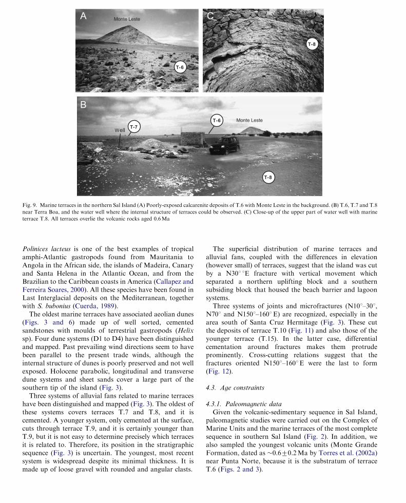
The northern part of the island was affected by recentvolcanic activity (�0.6Ma). Here, the oldest representativeof the stair-like sequence of marine terraces occurs atelevations of 25–26ma.s.l. near Morinho do Filho andMonte Leste (Fig. 2). Sheet flow deposits from thesemountains have largely obliterated the marine depositswhich are reduced to discontinuous patches. However,water wells excavated in the area allow observation of atleast 2m of fossiliferous (molluscs and corals) calcarenites(Fig. 9). Fossils in the oldest units are S. bubonius and A.
senilis, which are recrystallized or reduced to moulds.Nevertheless, Lecointre (1962, 1963) reported the presenceof S. bubonius and A. senilis in the three terraces that he
Rabo de JuncoA
B
B
Fig. 7. Sedimentary facies (conglomerates and calcarenites) of T.15 (OISS
5e) in Ribeira Fonte do Estado (south Baia da Murdeira). (A) Panorama
of outcrop and vertical joints referred to in text. (B) Close up of the basal
conglomeratic facies.
A detailed paleontological study is presently underway,but we report some preliminary findings here. The largestnumber of identifiable species was collected in the morerecent terraces on the southern half of the Island. Strombus
latus Gmelin (S. bubonius Lamark), A. senilis Linne, Conus
ermineus Born (C. testudinarius Martini), Cardita senega-
lensis Reeve, Harpa rosea Lamark, Favia fragum Esper,and Siderastrea radians Pallas are found in deposits as oldas those of terrace T.5, particularly at the Casa Branca site(Fig. 10A and B) that is one of the best outcrops in thearea. However, the richest faunas are associated withterraces T.13, T.14, T.15 and T.16 where, besides theformer species, there are also abundant Polinices lacteus
Guilding, Cantharus viverratus Kiener (C. variegatus Gray),Cardita senegalensis Reeve, the hydrocoral Millepora sp.,and the corals Favia fragum Esper and Siderastrea radians
Pallas, of which S. radians is the only one showingconstructional capability.The study and comparison of present-day molluscs with
those found in six outcrops of coastal deposits at elevationsbetween high tide and 5ma.s.l. (Garcıa-Talavera, 1999)adds a longer list of species. This author concluded that‘‘fossil’’ and ‘‘present’’ faunas are similar and, besidesmany endemic species, include species of the Mediterra-nean-Lusitanian and the western African tropical pro-vinces (Garcia-Talavera and Bacallado, 1981; Rolan,2005). The tropical amphi-Atlantic species are mainlyrepresented by C. ermineus and P. lacteus. Conus ermineus
is common on the western African coasts from theSahara to Angola, and on the eastern American coasts ofBrazil, Antilles, Central America, Gulf of Mexico andthe Bahamas (Callapez and Ferreira Soares, 2000).
Polinices lacteus is one of the best examples of tropicalamphi-Atlantic gastropods found from Mauritania toAngola in the African side, the islands of Madeira, Canaryand Santa Helena in the Atlantic Ocean, and from the
The superficial distribution of marine terraces andalluvial fans, coupled with the differences in elevation(however small) of terraces, suggest that the island was cutby a N301 1E fracture with vertical movement which
ARTICLE IN PRESS
T-6
T-8
T-8
B
A CMonte Leste
Monte Leste
WellT-7
T-6
Fig. 9. Marine terraces in the northern Sal Island (A) Poorly-exposed calcarenite deposits of T.6 with Monte Leste in the background. (B) T.6, T.7 and T.8
near Terra Boa, and the water well where the internal structure of terraces could be observed. (C) Close-up of the upper part of water well with marine
terrace T.8. All terraces overlie the volcanic rocks aged 0.6Ma
C. Zazo et al. / Quaternary Science Reviews 26 (2007) 876–893886
Brazilian to the Caribbean coasts in America (Callapez andFerreira Soares, 2000). All these species have been found inLast Interglacial deposits on the Mediterranean, togetherwith S. bubonius (Cuerda, 1989).
The oldest marine terraces have associated aeolian dunes(Figs. 3 and 6) made up of well sorted, cementedsandstones with moulds of terrestrial gastropods (Helix
sp). Four dune systems (D1 to D4) have been distinguishedand mapped. Past prevailing wind directions seem to havebeen parallel to the present trade winds, although theinternal structure of dunes is poorly preserved and not wellexposed. Holocene parabolic, longitudinal and transversedune systems and sheet sands cover a large part of thesouthern tip of the island (Fig. 3).
Three systems of alluvial fans related to marine terraceshave been distinguished and mapped (Fig. 3). The oldest ofthese systems covers terraces T.7 and T.8, and it iscemented. A younger system, only cemented at the surface,cuts through terrace T.9, and it is certainly younger thanT.9, but it is not easy to determine precisely which terracesit is related to. Therefore, its position in the stratigraphicsequence (Fig. 3) is uncertain. The youngest, most recentsystem is widespread despite its minimal thickness. It ismade up of loose gravel with rounded and angular clasts.
separated a northern uplifting block and a southernsubsiding block that housed the beach barrier and lagoonsystems.Three systems of joints and microfractures (N101–301,
N701 and N1501–1601E) are recognized, especially in thearea south of Santa Cruz Hermitage (Fig. 3). These cutthe deposits of terrace T.10 (Fig. 11) and also those of theyounger terrace (T.15). In the latter case, differentialcementation around fractures makes them protrudeprominently. Cross-cutting relations suggest that thefractures oriented N1501–1601E were the last to form(Fig. 12).
4.3. Age constraints
4.3.1. Paleomagnetic data
Given the volcanic-sedimentary sequence in Sal Island,paleomagnetic studies were carried out on the Complex ofMarine Units and the marine terraces of the most completesequence in southern Sal Island (Fig. 2). In addition, wealso sampled the youngest volcanic units (Monte GrandeFormation, dated as �0.670.2Ma by Torres et al. (2002a)near Punta Norte, because it is the substratum of terraceT.6 (Figs. 2 and 3).

Some samples of marine deposits, mainly calcareous incomposition, contain significant amounts of volcanic clastswith high natural magnetic remanization intensity. Thisresults in a high dispersion of the paleomagnetic measure-
established, it becomes very difficult to accurately measurethe direction of the virtual geomagnetic pole. The polarityresults have been summarized in Fig. 13.Samples collected (Figs. 2 and 6, sections A and C) from
ARTICLE IN PRESS
Sample site/
marine unitsPolarity Declination
T 15
CMU
T 1
T 5
T 6
T 7
T 8
360 90 180 270270
8
7
6
5
4
3
2
1
1
Location in Figs. 2 and 6
Fig. 13. Paleomagnetic data.
Fig. 12. Joint systems in T.15 (OISS 5e), Cascalho.
T.5
A
Casa Branca
Casa Branca
B
T.5T.6
T.7
Fig. 10. Casa Branca (A) Low-angle cross bedding of south-west
prograding foreshore facies, terrace T.5. (B) Panorama of the staircase-
like arrangement of terraces T.5–T.7.
N70ºEN10ºE N20ºE
50 cm
50 cm
N150ºEVolcanic rocks
N20ºE
T.10
Fig. 11. Joint and microfault systems in T.10 near bench mark 12
(between Ponta Preta and Santa Cruz ermitage).
C. Zazo et al. / Quaternary Science Reviews 26 (2007) 876–893 887
ments such that, although a magnetic polarity can be
the CMU, terrace T.1 (2 samples in Lajedo do Tarafo) andterrace T.5 (Casa Branca) suggest a reverse polarity. Incontrast, samples from terraces T.6–T.8, all of which areinset into T.5 at Casa Branca (Fig. 10B), have a normalpolarity. A normal, positive polarity was also measured interrace T.15 near Cascalho (Fig. 8). The polarity ofvolcanic Monte Grande Formation is normal, which isconcordant with the K/Ar age of 0.670.2Ma (Torres etal., 2002a) assigned to this Formation.
4.3.2. U-series data
Data on coral samples broadly define four sets of valuesidentified by the letters A to D in Table 1 and relevant

figures. Group A corresponds to samples from unconso-lidated deposits of very late Holocene age. Group Brepresents samples dating from the Last Interglacial (OISS5e), with some outliers corresponding to corals showing
account for such a trend (e.g., Thompson et al., 2004), buttheir impact on the calculated ages seems of minorincidence here, as illustrated by seriate measurements inone S. radians sample showing three growth phases, the last
ARTICLE IN PRESSC. Zazo et al. / Quaternary Science Reviews 26 (2007) 876–893888
20% or more calcite contents (Fig. 14). Such recrystallizedsamples do not show significant changes in their total Ucontent (Table 1) and their 234U/238U activity ratios stillshow a near-marine signature (Fig. 14). Complementarymeasurements on mollusc shells and hydrozoan skeletons(Millepora sp.), most likely from Last Interglacial age,based on field and geochemical evidence, were performedin order to better constrain the isotopic signature of anydiagenetic uranium (e.g., Kaufman et al., 1996) in suchdeposits. They depict 234U/238U activity ratios in the1.12–1.2 range, thus accounting for the relatively lowexcess in 234U shown by the partly recrystallized corals.Otherwise, most Last Interglacial corals are relatively wellclustered but nonetheless depict a slight trend above thetheoretical 234U/238U value expected for ‘‘marine uranium’’in this range of age (Fig. 15). Several processes may
1.3kyrkyr 1.3
100
kyr
200
kyr
300
kyr
400
kyr
500
kyr
>20%ratio
130 1501109070500
100
200
300
400
Age (ka)
δ23
4U
Coral samplesOther samples
Seawater Uranium
B-samples (Table I)
Fig. 15. Isotopic composition (activity ratio) of uranium vs. calculated
ages in samples assigned to the Last Interglacial (B samples from Table 1).
Even coral samples (with 2–3 ppm of authigenic U) show some scatter of
values indicating a relatively open geochemical behaviour. See Chen et al.
(1986) or Delanghe et al. (2002) with reference to the isotopic signature of
seawater uranium.
1.01.00.90.80.70.6 1.10.5
1.1
1.2
1.0
1.1
1.2
>20%calcite
B C
D
calcite
MIOCENE230Th / U activity ratio234
U/
U
act
ivity
23
823
4
Fig. 14. U-series abacus showing the distribution of sample groups B, C
and D (see text).
two of which are separated by a stage of intense bio-erosion (see Fig. 16). In this sequence, despite the fact thatthe outlier part of the coral shows a relatively high calcitecontent (about 10%), all ages are concordant within their2s-standard deviation. Stable isotope compositions in thismultiphase coral are also well clustered, suggesting anarrow range of environmental conditions. The low d18Ovalues (Table 1), compared with those of Millepora
samples, suggest growth in shallow warm pools of waters(Table 2).Finally, sample groups C and D represent clusters in the
320–340Ka range, and near 230Th/234U secular equili-brium, respectively (Fig. 13). Here again, most samplessuggest some 234U-excess, thus are relatively open systems.One cannot totally discard the possibility that group Crepresents an enhanced diagenetic impact on older samples,possibly from group D. However, the relatively narrowisotopic cluster (Fig. 13) and U-content (2.7 ppm) in groupC samples, compared with group D samples, would becompatible with a tentative OIS 9 assignment. With oneexception, all S. radians samples from these two groupsshow d18O values not unlike those of sample S03 68-2(Table 1), thus suggesting similar growth conditions and arelatively good preservation of the original isotopicsignature.
4.3.3. Radiocarbon data
Two samples have been collected from the lowermostterraces: one in the calcarenites with Ostrea strentina (T.15,14C age 24,8707960 yr BP, certainly a minimum age) atCascalhos (Fig. 8); a second in the conglomeratic deposits
Fig. 16. Sample S0-68 (Siderastrea radians) from the basal conglomerate
of T.15 at the same locality of Fig. 7. Samples for U-series measurements
have been taken in the lower (a, b), middle (c) and upper (d, e) growth
stages (see corresponding results in Table 1). Note (left) that bioerosion
was intense following the second stage thus suggesting minimum time
interval for the coral growth interruption, but the persistence of relatively
calm conditions to allow growth stage 3 to follow on top of the coral.

with S. bubonius (T.16, 14C age441,430 yr BP) at Ponta doLeme Velho (Fig. 3). 14C data suggest a pre-Holocene agefor these terraces.
We also sampled the aeolian systems overlying the oldest
present data for those older than T.13, here assignedtentatively to the OIS 9. The Last Interglacial (OIS 5)records two high sea levels represented by terraces T.15 andT.16 (Fig. 3). Terrace T.15 has a clear OISS 5e age based
ARTICLE IN PRESS
Table 2
Location, topographic elevations, and ages deduced from field and isotopic data for samples presented in Table 1, reworked sample
Sample # Locality Elevation
(m a.s.l.)
Calcul. age
(ky)
7 Group Chronology of marine terraces (T)
and beach barriers, deduced from
isotopic and field data (see Fig. 3)
Coral samples
S03-64 Ponta Preta (Baia
Algodoeiro)
0 0.18� 70.013 A Holocene
S03- 57 Ponta do Leme Velho 1.8 114.8 74 B T.15
S03-65 Santa Maria Bay 2.5 122.9 +3.6/�3.4 B T.15
S03-68-1 South Baia da Murdeira 0 114.2 +1.6/�1.5 B T.15
S03-68-2-e South Baia da Murdeira 0 125.7 +3.2/�3.1 B T.15
S03-68-2-d South Baia da Murdeira 0 127.8 72.7 " T.15
S03-68-2-c South Baia da Murdeira 0 125.8 +2.6/�2.5 " T.15
S03-68-2-b South Baia da Murdeira 0 128.5 +3.7/�3.5 " T.15
S03-68-2-a South Baia da Murdeira 0 129.2 +4.0/�3.8 " T.15
S03-69 South Baia da Murdeira 0 110.2 72.5 B T.15
S02-8 Ponta Preta (Baia
Algodoeiro)
3 44 T.14
S02-9 Ponta Preta (Baia
Algodoeiro)
6 312 +26/�21 C T.13
S03-54 Santa Maria—Ponta do
Leme Velho
5 322 +35/26 C T.13
S03-55 Ponta do Leme Velho—
Pta. Jalunga
1.25�� 343 +73/�43 C T.13
S03-73 Baleia 5.5 330 +24/�19 C T.13
S03-70 South Baia da Murdeira 12 44 D T.10
S03-77 Ponta Vermelha—Ponta
Palona
7 44 D T.15
S03-79 Ponta Palona—Ponta
Norte
2 44 D Miocene
Other measurements
S03-58 Ponta Jalunga 0 Modern A Holocene
S03-51 Ponta do Leme Velho 0 0.3� 70.2 A Holocene
S03-52 Santa Maria—Ponta do
Leme Velho
0.25 1.7� 70.1 A Holocene
S03-74 Baleia 7.5 103.0� +5.4/�4.6 B T.15
S03-61 NW Cemetery (Santa
Maria)
2 126.6 +5.1/�4.9 B T.15
S03-62 NW Cemetery (Santa
Maria)
1.5 135.0 +8.5/�7.9 B T.16
S03-74 Baleia 7.5 89.1� +2.3/�2.2 B T.15
S03-57 Ponta do Leme Velho 1.8 66.4� 72.5 ? T.15
S03-2 Santa Maria Bay 1.5 . +3.7/�3.6 B T.16
S03-66 South Baia da Murdeira 4 340 +28/�23 C T.13
�Ages requiring corretion due to detrital contents.��Elevation measured at the sea front of the marine terrace.
C. Zazo et al. / Quaternary Science Reviews 26 (2007) 876–893 889
modern beach barrier near the Ponta do Sino Lighthouse(1500m SW of Santa Marıa, Fig. 3). The age of a shell ofthe terrestrial gastropod Zootecus insularis is 5,940750 14Cyr BP (6775–6750 cal yr BP).
4.3.4. Chronological framework
In the Legend of the geomorphologic map (Fig. 3),relative chronology is based on regional stratigraphic data,isotopic and palaeomagnetic analyses. However, assign-ment of a given terrace to a specific OIS is not easy with the
on U-series measurements (Table 1), however the few U-series data from T.16 impede assignation to a specific LastInterglacial substage, However, field data suggest an ageslightly more recent for T.16, as it occurs inset into T15.This suggests a fall in sea level followed by a new rise thatdid not reach the former elevation but excavated the‘‘micro-cliff’’ separating these two terraces observed westof Santa Maria Cemetery (Fig. 3). Small oscillations in sealevel during the final phase of sedimentation of unit T.16favoured the formation of a barrier that enclosed a lagoon.

The overall trend in this period (OISS5e) was towards arelative fall in sea level. Additional examples of twosuperposed, offlapping prograding units inside the OIS 5edeposits have been observed, for example around Cascal-
earlier interglacial, waters around Sal Island were at leastas warm as they are nowadays.Therefore, it seems logical to assume that larvae of these
species were transported by the oceanic superficial currents
ARTICLE IN PRESSC. Zazo et al. / Quaternary Science Reviews 26 (2007) 876–893890
ho-Murdeira, on the western fac-ade of Sal Island. Theseare separated by an erosional surface with basal conglom-erate that overlies the burrowed berm facies of theunderlying unit (the one pictured in Fig. 8; the upper oneis not visible in that photograph as it crops out closerto the sea).
Taking this into account, along with the low elevation ofthe shoreline angles of T.15 (p 2.5m a.s.l.), and T.16 (1ma.s.l.), and the absence of major erosional surfaces orintervening terrestrial deposits separating T.15 and T.16,one is lead to suggest a double highstand inside OISS 5e,which would include both terraces, rather than assigningT.16 to either OIS 5c or 5a.
As in Canary Islands (Zazo et al., 2002), the terracecorresponding to OIS 7 has not been positively identified,probably due to both the scarcity of dating and the lowaltitude reached by the Last Interglacial deposits in botharchipelagos (p 2.5m). Nevertheless, T.14 could be apossible candidate.
4.4. Some palaeoecological information deduced from
molluscs
The species S. bubonius, C. testudinarius, C. viverratus,and C. senegalensis are a part of ‘‘Senegalese warm fauna’’,first defined by Gignoux (1913) and Issel (1914). Thisfaunal assemblage is particularly interesting because itmigrated to the Mediterranean Sea during some of theQuaternary interglacials, namely the Last Interglacial(Hearty et al., 1986; Cuerda, 1989; Hillaire-Marcel et al.,1996; Goy et al., 1993; Zazo et al., 2003). During the LastInterglacial, some of these species lived in the coasts ofAzores (Garcıa-Talavera, 1987, 1999; Avila, 2000) andCanary Islands (Meco et al., 1997, 2002; Zazo et al., 2002,2003) that are a part of the Macaronesia biogeographicalregion. The Senegalese warm fauna is extinct nowadays inthe coast of the Mediterranean Sea, Azores and CanaryIslands.
The cited species, and particularly S. bubonius (S. latus),live nowadays on sandy bottoms rich in algae (the maindiet of Strombus) in sheltered realms such as bays andlagoons. They require minimum depths of 4m (Morri etal., 2000), with sea surface temperatures between 21 and26 1C, mean annual temperature 23.5 1C, and salinity35 p.s.u. (practical salinity units) (NOAA-WOA, 2001).Our data indicate that such palaeoecological conditionsexisted in Cape Verde during the Middle and LatePleistocene (OIS 9 and OISS 5e), as we have found largeaccumulations of S. bubonius shells both in Late Pleisto-cene (fossil) and present beaches and beach barriers of thesouthern (Santa Maria Bay) and south-eastern (betweenPonta do Leme Velho and Ponta Jalunga) coasts of SalIsland. Thus, during the Last Interglacial, and at least one
to distances exceeding 3000 km and reached the Mediter-ranean Sea. We suggest that the Cape Verde Archipelagowas one of the source areas of the ‘‘Senegalese fauna’’.These currents are the Pleistocene ancestors of the presentSubtropical North Atlantic Gyre formed by Gulf, Azores,Canary and North Equatorial currents, but with differenttrajectories, surface temperatures, intensities and velocities.Similar migrations to the north of tropical waters havebeen described in the western Atlantic Ocean (Muhs et al.,2002) during the Last Interglacial.
4.5. Paleo-sea levels and vertical movements.
The elevation reached by sea level during OISS 5e isrelatively well constrained because it is represented by themost ubiquitous and well-preserved set of emergent littoralfeatures around many coastlines of the world. However,there are noticeable divergences concerning the number ofhighstands that occurred during the Last Interglacial. Dataon the relative sea-level elevation during OISS 5e ontectonically stable coasts of Western Australia (Stirlinget al., 1998), located far from the former ice sheets, suggesta sea-level highstand from 12871 to 11671Ka at least3m.a.s.l during this time. A sea level elevation of about 5ma.s.l. during the peak of OISS 5e (132–120Ka) has beensuggested by Chen et al. (1991) in the Bahamas and byMuhs et al. (2002, 2004) in Bermuda Island and Florida.However, two different highstands have been stated byHearty (2002) in Bermuda: the first one, recorded at about2.5m a.s.l., developed between 132 and 125Ka, and thesecond one, being registered by a notch and small rubblebenches at 6m a.s.l. and possibly as high as 9m.a.s.l.,generated between 120 and 115Ka. Two or three marineterraces have been recorded in tectonically actives areas ofHaiti (Dumas et al., 2006) and Barbados (Schellmann andRadtke, 2004) respectively. In Haiti, these two marineterraces developed between 130.5 and 122Ka with paleo-sea-level at 5m a.s.l. for the older one and 2.7m a.s.l for theyounger one. In Barbados, Schellmann and Radtke (2004)suggested palaeosea-levels at 6, 4ma.s.l., and �8m belowsea level (b.s.l.), about 132, 128 and 118Ka, respectively. Ineastern Atlantic, geomorphologic and stratigraphic datafrom Canary Islands suggest the existence of two high-stands between 0 and 2m a.s.l., recorded as clastic marinedeposits (shoreface and foreshore beach facies) with 230Thages around 118716Ka. They are separated by interven-ing alluvial or colluvial deposits but, unfortunately, neitherU-series ages nor amino-acid data allowed to discriminatebetween them (Zazo et al., 2002).Referring to OISS 5c (�100Ka), most data from both
stable (Stirling et al., 1998, etc.) and unstable (Schellmannet al., 2004; Dumas et al., 2006) Atlantic coasts suggest thatsea level at this time was several metres (the proposed

figures range between �8 and �25m) lower than thepresent sea level.
Concerning the OISS 5a (�80Ka), a relative highstandclose or slightly above present sea level has been stated by
part of the Quaternary if the terraces older than the pre-recent volcanic activity in the island are also considered.This change in the vertical trend has also been reported inthe Canary Islands (Zazo et al., 2002).
ARTICLE IN PRESSC. Zazo et al. / Quaternary Science Reviews 26 (2007) 876–893 891
Hearty and Kaufman (2000) in the Bahamas, by Muhs etal. (2002) in Bermuda, and by Ludwig et al. (1996) inFlorida and Bermuda. U-series coral ages from the USAtlantic Coastal Plain (Wehmiller et al., 2004) suggest apaleo sea level slightly above present at 80Ka. InBarbados, Schellmann et al. (2004) recognized a doublesealevel oscillation around 85 ka and 77–74Ka, withpalaeo sealevels at ca �21 and �19mb.s.l. In Haiti, Dumaset al. (2006) also distinguished two sealevel highstands: theolder around �82Ka with palaeo sealevel ��11m b.s.l.,and a younger episode at �76Ka with palaeo sea-level��13/�10m b.s.l.
The exact sea levels reached during OIS 7 highstands arestill poorly constrained. A sea level elevation a few metres(�2m) above present during OIS 7 has been suggested intectonic stable coasts of the Atlantic as Bermuda (Hearty,2002; Muhs et al., 2002) and Florida (Muhs et al., 2004),the Bahamas (Hearty and Kaufman, 2000). These dataconflict with those obtained by Bard et al. (2002) inArgentarola Cave (Italy), a region considered tectonicallystable based on the continuous elevation (�5–6m) of theOISS 5e deposits, which suggests a palaeosea-level between�9 and �18m b.s.l. (202–290Ka).
Studies from Henderson Island, in the equatorial PacificOcean (Stirling et al., 2001) suggest that sea level was a fewmeters higher than the present during OIS 9 at �330Ka.The number and elevation of the sequence of marineterraces at Sal Island are similar to those found in CanaryIslands (Zazo et al., 2002, 2004). Geological field data andmorpho-sedimentary analysis supported by U-series, K/Ar,and 14C dating, and amino-acid racemization data allowedto identify the marine deposits corresponding to OIS 9which, in Lanzarote Island occur at elevations 0–1m a.s.l.,and are covered by Last Interglacial deposits. The marineterrace corresponding to OIS 7 has not been positivelyidentified, although some morphological evidences suggestthat it may be present along the south-western coast ofFuerteventura Island. As said before, Zazo et al. (2002)recognized two highstands inside the peak of the LastInterglacial (OISS 5e).
In Sal Island, the marine terraces corresponding to theLast Interglacial are T.15 and T.16. U-series data assign anOISS 5e age (�129–110Ka) to terrace T.15 but, as saidbefore, field data lead us to also include T.16 in OISS 5e.
The available Th-ages for T.13 agree with the assignedOIS 9 age (at +6m); therefore, it seems probable that T.14may represent OIS 7.
The elevations of the younger terraces suggest that SalIsland can be considered stable, or slightly subsiding, atleast since the Last Interglacial. In contrast, the manymarine terraces deposited between 600Ka (the age of themore recent volcanism in Sal) and 330Ka point to anupward movement, a trend that can be extended to a large
5. Conclusions
This paper presents the first geomorphologic map ofQuaternary landforms and associated marine and terres-trial deposits in Sal Island (Cape Verde Archipelago). Upto 16 marine terraces (T.1 to T.16) have been distinguished.Terraces occur in a staircase-like arrangement ranging inelevation from 55–60m a.s.l. down to present sea level.Pleistocene marine terraces and Holocene beach-barrier
and lagoon systems are well exposed along the southerncoast, which is sheltered from the prevailing NE tradewinds. In contrast, narrow erosional platforms with littleassociated deposits are the norm along the more exposednorthern coast.The sequence of terraces is complete in the southern part
of the island, whereas in the northern half, where volcanicactivity took place around 0.6Ma, the oldest preservedterrace is T.6 (�25m a.s.l.)U-series measurements, mainly in coral cobbles, allow
distinguishing deposits from the Last Interglacial age(OISS 5e), characterised by geometry (staircase arrange-ment) and sedimentary facies (interbedded lagoon deposits)that suggest the occurrence of two highstands (T.15 andT.16), the older with a palaeo seal-evel at 2.5m a.s.l. higherthan the younger at 1m a.s.l. Terrace T.13 (at 6m a.s.l.)yielded ages in the range of OIS 9.The still ongoing analyses of fossil faunas indicate that
the most characteristic (Strombus bubonius) species of theso-called ‘‘Senegalese fauna’’ lived in Sal Island since atleast the Early Pleistocene (T.5, 38m a.s.l.). This fauna is ofinterest because it spreads into the Mediterranean particu-larly during the Last Interglacial. The present optimumenvironments for this fauna in Sal Island (Morri et al.,2000) coincide precisely with those interpreted in the fossilrecord from the Middle and Late Pleistocene, particularlyreferred to as Strombus bubonius (S. latus).Quaternary tectonic activity in the Island can be deduced
from sets of joints and microfractures that affect themarine terraces deposits. The superficial distribution ofmorphosedimentary units suggests that a major fracturedirected N201–301E crosses the Island favouring thedeposition of marine terraces and alluvial fan depositsmainly in the upthrown fault block, and beach-barrier andlagoon systems in the downthrown fault block.A change in vertical movement trend from uplift to
subsidence or stability of Sal Island is suggested to haveoccurred around 330Ka.
Acknowledgements
Research financed by Spanish Projects CGL2005-01336/BTE and CGL2005-04655/BTE. CHM acknowledges

financial support from the Science and EngineeringResearch Council of Canada and the UNESCO Chair forGlobal Change Study of Universite du Quebec a Montreal.Thanks are due to Jennifer McKay and Michel Preda
Hearty, P.J., Miller, G.H., Stearns, C.E., Szabo, B.J., 1986. Aminostrati-
graphy of Quaternary shorelines in the Mediterranean basin. Geol.
Soc. Am. Bull 97, 850–858.
Hillaire-Marcel, Cl., Gariepy, Cl., Ghaleb, B., Goy, J.L., Zazo, C.,
Cuerda, J., 1996. U-series measurements in Tyrrhenian deposits from
ARTICLE IN PRESSC. Zazo et al. / Quaternary Science Reviews 26 (2007) 876–893892
(from GEOTOP) for their analytical support. This paper isa contribution to IGCP495 (Quaternary Land Ocean
Interactions: Driving Mechanisms and Coastal Responses)and INQUA Commission on Coastal and Marine Pro-cesses.
References
Avila, S.P., 2000. Shallow-water marine molluscs of the Azores
Archipelago: biogeographical relationships. Life and Marine Sciences
2 (A), 99–131.
Avila, S.P., Amen, R., Azevedo, J.M.N., Cachao, M., Garcıa-Talavera,
F., 2002. Checklist of the Pleistocene marine molluscs of Prainha and
Lagoinhas (Santa Maria Island, Ac-ores). Ac-oreana 9 (4), 343–370.
Bard, E., Antonioli, F., Silenzi, S., 2002. Sea-level during the penultimate
interglacial period based on a submerged stalagmite from Argentarola
Cave (Italy). Earth Planetary Science Letters 196, 135–146.
Barker-Webb, P., Berthelot, S., 1836–1840. Histoire naturelle des Iles
Canaries, 3 Vol.Ed. Bethune, Paris.
Callapez, P., Ferreira Soares, A., 2000. Late Quaternary warm marine
mollusks from Santa Maria (Ac-ores): paleoecologic and plaeobiogeo-
graphic considerations. Ciencias da Terra (UNL) 14, 313–322.
Chen, J.H., Edwards, R.L., Wasserburg, G.J., 1986. 238U, 234U and 232Th
in seawater. Earth and Planetary Science Letters 80, 241–252.
Chen, J.H., Curran, H.A., White, B., Wasserburg, G.J., 1991. Precise
chronology of the Last Interglacial period 238U, 234Th data from fossil
coral reefs in the Bahamas. Geological Society of America Bulletin
103, 82–97.
Cuerda, J., 1989. Los tiempos cuaternarios en Baleares, Conselleria de
Cultura, Educacio i Esports, Govern Balear, 310 pp.
Davies, T.T., Hooper, P.R., 1963. The determination of the calcite/
aragonite ratio in mollusc shells by X-ray diffraction. Mineralogical
Magazine 33, 608–612.
Delanghe, D., Bard, E., Hamelin, B., 2002. New TIMS constraints on the
uranium-238 and uranium-234 in seawaters from the main ocean
basins and the Mediterranean Sea. Marine Chemistry 80, 79–93.
Dumas, B., Hoang, C.T., Raffy, J., 2006. Record of MIS 5 sea-level
highstads based on U/Th dated coral terraces of Haiti. Quaternary
International 145–146, 106–118.
Edwards, R.L., Chen, J.H., Wasserburg, G.J., 1987.238U–234U–230Th–232Th systematics and the precise measurements of
time over the past 500,000 years. Earth and Planetary Science Letters
81, 175–192.
Garcıa-Talavera, F., 1987. Fauna tropical en el Neotirreniense de Santa
Maria (I. Azores). Labori Societa Italiana di Malacologia 23, 439–443.
Garcıa-Talavera, F., 1999. Fauna malacologica del Cuaternario marino de
Cabo Verde. Revista Academia Canaria de las Ciencias 11 (3–4), 9–25.
Garcıa-Talavera, F., Bacallado, J.J., 1981. Nuevas aportaciones a la fauna
de gasteropodos marinos (Mollusca, Gastropoda) de las Islas de Cabo
Verde. Boletın Instituto Espanol de Oceanografıa 6 (328), 202–207.
Gignoux, M., 1913. Les formations marines pliocenes et quaternaires de
l’Italie du sud et de la Sicile. Annales Universite de Lyon 36.
Goy, J.L., Zazo, C., Bardajı, T., Somoza, L., Causse, C., Hillaire-Marcel,
C., 1993. Elements d’une chronostratigraphie du Tyrrhenien des
regions d’Alicante-Murcia, Sud-est de l’Espagne. Geodinamica Acta
6–2, 103–119.
Hearty, P.J., 2002. Revision of the late Pleistocene stratigraphy of
Bermuda. Sedimentary Geology 153, 1–21.
Hearty, P.J., Kaufman, D.S., 2000. Whole-rock aminostratigraphy and
Quaternary sea-level history of the Bahamas. Quaternary Research 54,
163–173.
Mallorca. Further evidence for two Last-Interglacial high sea-levels in
the Balearic Islands. Quaternary Science Reviews 15, 53–62.
Issel, A., 1914. Lembi fossiliferi quaternari e resentı nella Sardegna
meridionale. Accademia Nazionale dei Lincei, Serie 5 (23), 759–770.
Kaufman, A., Ghaleb, B., Wehmiller, J.F., Hillaire-Marcel, C., 1996.
Uranium concentration and isotope ratio profiles within Mercenaria
shells: Geochronological implications. Geochimica et Cosmochimica
Acta 19, 3735–3746.
Lecointre, G., 1962. Le Quaternaire de l’ıle de Sal (archipel du Cap-Vert).
Compte Rendue Sommaire des Seances Societe Geologique de France,
3-92.
Lecointre, G., 1963. Sur les terrains sedimentaires de l’Ile de Sal, avec
Remarque sur les isles de Santiago et Maio (Archipel du Cap Vert).
Garcia de Orta, Serie Geologia, Lisboa II (2), 275–289.
Lecointre, G., 1965. Le Quaternaire marin de l’Afrique du nord-ouest.
Quaternaria VII, 9–28.
Ludwig, K.R., Muhs, D.R., Simmons, K.R., Halley, R.B., Shinn, E.A.,
1996. Sea-level records at �80Ka from tectonically stable platforms:
Florida and Bermuda. Geology 24, 211–214.
Meco, J., Petit-Maire, N., Fontugne, M., Shimmield, G., Raoms, A.J.,
1997. The Quaternary deposits in Lanzarote and Fuerteventura
(eastern Canary Islands, Spain): and overview. In: Meco, J., Petit-
Maire, N. (Eds.), Climates of the Past. IUGS-UNESCO-Universidad
de las Palmas de Gran Canaria, pp. 123–136.
Morri, C., Bianchi, C.N., 1995. Ecological niches of hermatypic corals at
Ilha do Sal (Arquipelago de Cabo Verde). Boletin do Museu
Municipal de Funchal, Madeira 4, 473–485.
Morri, C.R., Cattaeno-Vietti, G., Sartoni, G., Banchi, N., 2000. Shallow
epibenthic communities of Ilha do Sal (Cape Verde Archipelago,
eastern Atlantic). Arquipelago. Life and Marine Sciences. Ponta
Delgada. Ac-ores 2 (Suppl. A), 157–165.
Muhs, D.R., Simmons, K.R., Steinke, B., 2002. Timing and warmth of the
Last Interglacial period: New U-series evidence from Hawaii and
Bermuda and a new fossil compilation for North America. Quaternary
Science Reviews 21, 1355–1383.
Muhs, D.R., Wehmiller, J.F., Simmons, K., York, L., 2004. Quaternary
Sea-Level history of the United States. In: Gillespie, A.R., Porter, S.C.,
Atwater, B.F. (Eds.), The Quaternary Period in the United States.
Elsevier, Amsterdam, pp. 147–183.
NOAA-WOA, 2001. /http://www.iridl.ldeo.columbia.edu/SOURCES/
NOAA/NODC/WOA01/SRolan, E., 2005. Polyplacophora and Gastropoda Part 1. In: Groh, K.,
Strack, H.L., Templado, J., Valdes, A. (Eds.), Malacological fauna
from the Cape Verde Archipelago. Conch Books, p. 455.
Schellmann, G., Radtke, U., 2004. A revised morpho-and chronostrati-
graphy of the Late and Middle Pleistocene coral reef terraces on
Southern Barbados (West Indies). Earth-Science Reviews 64, 157–187.
Schellmann, G., Radtke, U., Potter, E.K., Esat, T.M., McCulloch, M.T.,
2004. Comparison of ESR and TIMS U/Th dating of marine isotope
stage (MIS) 5e, 5c, and 5a coral from Barbados—implications for palaeo
sea-level changes in the Caribbean. Quaternary International 120, 41–50.
Serralheiro, A., 1967. Sobre as praias antigas de algunas ilhas de Cabo
Verde. Garcia de Orta, Serie Geologia, Lisboa 15 (1), 123–138.
Silva, L.C., Serralheiro, A., Maecdo, J.R., Gome, A., Torres, A., 1990.
Carta geologica de Cabo Verde, Ilha do Sal (folhas 1 e 2), first ed.
Instituto de Investigac-ao Cientifica Tropical, Lisboa.
Silva, L., Torres, P., Figueiredo, M.O., Palacios, T., 1993. Fosfatizac- ao de
rochas basalticas da ilha do Sal, archipelago de Cabo Verde. Garcia de
Orta, Serie de Geologia, Lisboa 15 (1–2), 1–22.
Stirling, C.H., Esat, T.M., Lambeck, K., McCulloch, M.T., 1998. Timing
and duration of the Last Interglacial: evidence for a restricted interval
of widespread coral reef growth. Earth and Planetary Science Letters
160, 745–762.

Stirling, C.H., Esat, T.M., Lambeck, K., McCulloch, M.T., Blake, S.G.,
Lee, D.C., Halliday, A.N., 2001. Science 291, 290–293.
Thompson, W.G., Spiegelman, M.W., Goldstein, S.L., Speed, R.C., 2004.
An open-system model for U-series age determinations of fossils
corals. Earth and Planetary Science Letters 210, 365–381.
Zazo, C., Goy, J.L., Hillaire-Marcel, C., Gillot, P.Y., Soler, V., Gonzalez,
J.A., Dabrio, C.J., Ghaleb, B., 2002. Raised marine sequences of
Lanzarote and Fuerteventura revisited—a reappraisal of relative sea-
level changes and vertical movements in the eastern Canary Islands
during the Quaternary. Quaternary Science Reviews 21, 2019–2046.
ARTICLE IN PRESSC. Zazo et al. / Quaternary Science Reviews 26 (2007) 876–893 893
Torres, P.C., Silva, L.C., Serralheiro, A., Tassinari, C., Munha, J., 2002a.
Enquadramento geocronologico pelo metodo K/Ar das principais
sequencias vulcano-estratigraficas da Ilha do Sal–Cabo Verde. Garcia
de Orta, Serie Geologia, Lisboa 18 (1–2), 9–13.
Torres, P.C., Silva, L.C., Serralheiro, A., Mendes, M.H., Macedo, J.,
Mote Gomes, A., 2002b. Geologia da Ilha do Sal. Serie de Ciencias da
Terra 10. Geological Sheets I–II, 1–57.
Wehmiller, J.F., Simmons, K.R., Cheng, H., Edwards, R.L., Martin-
McNaughton, J., York, L.L., Krantz, D.E., Shen, C., 2004. Uranium-
series coral ages from the US Atlantic Coastal Plain—the ‘‘80 ka
problem’’ revisited. Quaternary International 120, 3–14.
Zazo, C., Goy, J.L., Dabrio, C.J., Bardajı, T., Hillaire-Marcel, C., Ghaleb,
B., Gonzalez, J.A., Soler, V., 2003. Pleistocene raised marine terraces
of the Spanish Mediterranean and Atlantic coasts: records of coastal
uplift, sea-level highstands and climate changes. Marine Geology 194,
103–133.
Zazo, C., Goy, J.L., Bardajı, T., Gonzalez, J.A., Hillaire-Marcel, C.,
Dabrio, C.J., Lario, J., Civis, J., Luque, L., Ghaleb, B., Borja, F.,
Silva, P.G., Gonzalez-Hernandez, F., Soler, V., Gillot, P.Y., 2004. El
efecto de los ciclos climaticos en las variaciones del nivel del mar.
Miscelanea en Homenaje a Emiliano Aguirre, vol. I. Geologıa, Museo
Arqueologico Regional, Alcala de Henares, pp. 156–167.