Embed Size (px)
Citation preview

Quaternary archives in the Iberian Peninsula
&
WestMed
PROCEEDINGS
OF THE MEETING
Progress in Quaternary archive studies inthe Iberian Peninsula
Sevilla (Spain), 12. – 13. 03. 2015
F. Díaz del Olmo & D. Faust
(Editors)
Published with the financial assistance of the CEIMAR (Campus of International
Excellence of the sea). University of Huelva
Book and cover design by Fernando Díaz del Olmo & Carmen Pacheco Rubio
Front cover photo: Alluvial archive (Algabarrilla ALG 1 profile- Guadalquivir‟s
alluvial terrace-level 12), by F. Díaz del Olmo
Edited from the abstracts sent by authors
Printed by Copiarobel S.L.
Seville (Spain), February 2015
Research- Acknowledgement:
GeoCroQ Project (HAR2011-23798)
Contribution of the INQUA Spanish committee
A contribution to Past4Future: European
interdisciplinary research on past warm climate
periods

3
L I S T O F P A R T I C I P A N T SRESEARCH E MAIL RESEARCH COUNTRY
Almeida Paiva, Andre [email protected] Portugal
Antoine, Pierre [email protected] France
Baena Escudero, Rafael [email protected] Spain
Bardají, Teresa [email protected] Spain
Bartz, Melanie [email protected] Germany
Baumgart, Philipp [email protected] Germany
Borja Barrera,César [email protected] Spain
Borja Barrera, Francisco [email protected] Spain
Brueckner, Helmut [email protected] Germany
Cáceres Puro, Luis Miguel [email protected] Spain
Calvo Zapata, Fco. Rubén [email protected] Spain
Clemente Pérez, Mª José [email protected] Spain
Costa, Ana [email protected]
[email protected] Portugal
Costas, Susana [email protected] Portugal
Cunha, Pedro [email protected] Portugal
Díaz del Olmo, Fernando [email protected] Spain
Dinis, Pedro [email protected] Portugal
Domínguez Llosa, Ricardo [email protected] Equatorial Guinea
Faust, Dominik [email protected]
dresden.de Germany
Fletcher, William John [email protected] United Kingdom
Fontes, Lisa [email protected] United States
Fornos Asto, Joan J. [email protected] Spain
Freitas, MariaConceiçao [email protected] Portugal
G. Silva, Pablo [email protected] Spain
Gil Garbi, Héctor [email protected] Spain
Gomes, Alberto [email protected] Portugal
Gómez Gutiérrez, Paula [email protected] Spain
Gómez Pujol, Lluís [email protected] Spain
Goy, José Luis [email protected] Spain
Daura, Joan [email protected] Spain
Sanz, Montserrat [email protected] Spain
Haubold, Fritz [email protected] Germany
Heinrich, Hartmut [email protected] Germany
Hepp, Joannes [email protected] Germany
Hobie, Nicole
Jordá Pardo, Jesús F. [email protected] Spain
Kehl, Martin [email protected] Germany
Klein, Torsten [email protected] Germany
Lario, Javier [email protected] Spain
Leira Campos, AntonManoel [email protected] Portugal
Lopes, Vera [email protected] Portugal
Luís, Leena [email protected] Portugal
Martins, Antonio [email protected] Portugal
Mendes, Isabel [email protected] Portugal
Micha Ondo, Antonio Equatorial Guinea

4
RESEARCH E MAIL RESEARCH COUNTRY
Monge Gómez, Mª Guadalupe [email protected] Spain
Moreno, Davinia [email protected] Spain
Muñoz García, María Belén [email protected] Spain
Oliva, Marc [email protected] Spain
Ollivier, Vincent [email protected] France
Pain, Colin [email protected] Spain
Recio Espejo, José M. [email protected] Spain
Reddad, Hanane [email protected] Morocco
Reicherter, Klaus [email protected] Germany
Ries, Johannes [email protected] Germany
RIXHON, GILLES [email protected] Germany
Rodríguez Vidal, Joaquín [email protected] Spain
Roettig, Christopher-Bastian [email protected]
Germany
Roquero, Elvira [email protected] Spain
Sánchez Vizcaino, Jesús [email protected] Spain
Sanjurjo, Jorge [email protected] Spain
SantiestebanNavar, Juan
Ignacio [email protected] Spain
Schmitt, Felicitas [email protected] Germany
Schneider, Heike [email protected] Germany
Schröder, Tabea [email protected] Germany
Shäfer, Imke [email protected] Germany
Shulte, Lothar [email protected] Spain
Soriano, Asunción [email protected] Spain
Stokes, Martin [email protected] United Kingdom
Tifratine, Salma [email protected] France
Van'tHoff, Jasmijn [email protected] Germany
Vázquez, Juan [email protected] Spain
Vis, Geert-Jan [email protected] Holland
Wolf, Daniel [email protected] Germany
Zazo, Cari [email protected] Spain
Zech, Michael [email protected] Germany
-Zech, Roland
-Zech, Jana [email protected] Germany
Zilelhofer, Christoph [email protected] Germany
Zöller, Ludwig [email protected] Germany

5
P R E F A C E
Archive investigation for the purpose of environmental and
climate change is a large interdisciplinary research field in geoscience. Twenty-five years ago (1989-2014) a group of young quaternarist researchers published the first progress in quaternary archive studies on Western Andalusian Region.
Then, twenty-five years later, this conference aims to follow up research in Quaternary science of the Iberian Peninsula and to give insight into new methodological and conceptual approaches. New results of different archive studies should be presented in a broader context.
We would like to discuss standpoints and perspectives of researchers from different geoscientific disciplines.
Five leading TOPICS of Quaternary archives are been proposed as organization-criterion of the communications (oral and poster presentations) sent by the researchers who attend this meeting:
Coastal and karstic archives Methods applied to archives and open topics
Aeolian archives Alluvial archives
Human occupation archives and climate change
The organizing committee is pleased that Dr. Hartmut Heinrich had accepted our invitationto be our invited speaker, who will give insight in his research and discovery of the well-known “Heinrich-Events”.
Aswell, this committee has a double reason to be grateful.

6
The accompagnement of all the valiously international researchers that integrate the scientific committee:
Dr. Pierre Antoine (France) Dr. Helmut Brückner (Germany) Dr. José S. Carrión (Spain) Dr. Ian Candy (Great Britain) Dr. Norm Catto (Canada) Dr. Clive Finlayson (Gibraltar; Great Britain) Dr. Will Fletcher (Great Britain) Dr. Vincent Ollivier (France) Dr. Pablo G. Silva Barroso (Spain) Dr. Heinz Veit (Switzerland) Dr. Yurena Yanes (USA) Dr. Cari Zazo (Spain) Dr. Christoph Zielhofer (Germany)
And on the other hand, the inestimable support that the Journal Quaternary International (QI) has offered to the Proceedings of both oral and poster presentations to be peer-reviewed for a publication in the journal.
QI already accepted our proposal for a special volume titled:
Progress in Quaternary archive studies in the Western Mediterranean (with the short title: “Quat archives West Med”).
Finally, to stand out the support of the meeting crew (C. Pacheco, S. Vélez, A. Sigüenza, V. Varo, C. Ortega, A. Zumárraga) in the organization of this meeting.
All the information and contents of this meeting is set-up on the meeting Website http:/congreso.us.es/Quaternaryspain
The organizing committee Fernando Díaz del Olmo
Dominik Faust José Manuel Recio Espejo
Joaquín Rodríguez Vidal César Borja Barrera
Daniel Wolf

7
G U E S T L E C T U R E R
Heinrich Events: Fortunate Coincidences
Hartmut Heinrich Federal Maritime and Hydrographic Agency (Hamburg/Germany)
In most cases research is targeted to prove or disprove a scientific hypothesis within a research interest. However, sometimes it is the case that –surprisingly- an unintended observation is made that subsequently has a remarkable influence on one or even more scientific fields. It is even more surprising when a scientist who is not familiar with the research field makes such an important observation. Such a case is the discovery of the so-called Heinrich events (HEs), which was a by-product of a research programme within an oceanographic feasibility study on nuclear waste disposal.
HEs were catastrophic collapses of continental ice sheets during the last glacial that had a remarkable influence on the global climate during their occurrence and, in consequence were dominating physical and biogeochemical processes on land and in the seas, as well as all kind of life on Earth. Besides the analytical capacity for understanding processes the global occurrence of the climatic consequences makes HEs also a perfect stratigraphic tool. Therefore, HEs had and still have an imprint on a large variety of research fields. Since one of the presumable physical triggers of HEs was ocean warming the present trend of anthropogenic climate warming bears the risk of triggering extraordinary large ice discharges from Greenland or the Antarctic, with probably unwanted effects on nature and human societies. Research on ice shield dynamics and on all kind of consequences of possible collapses is therefore imperative.
The evening talk will give insight into the discovery of the HEs and points to some scientific and other consequences.

8

9
T O P I C I N D E X
Coastal and karstic archives
Oral presentation chair: William Fletcher
Poster presentation chair: Christoph Zielhofer
Methods applied to archives and open topics
Oral presentation chair: Helmut Brückner
Poster presentation chair: Christoph Zielhofer
Aeolian archives
Oral presentation chair: Pablo G. Silva Barroso
Poster presentation chair: Christoph Zielhofer
Alluvial archives
Oral presentation chair: Pierre Antoine
Poster presentation chair: Christoph Zielhofer
Human occupation archives and climate change
Oral presentation chair: Vincent Ollivier
Poster presentation chair: Christoph Zielhofer

10

11
Coastal and karstic archives
Oral presentation chair: William Fletcher
Leira M., Freitas M.C., Andrade C., Cruces A., Paio V., Moreira S.,
Connor, S: Links between Holocene environmental change and
paleolimnological development in wet dune slacks (SW Portugal).
P. G. Silva, P. Huerta, J. Elez, J. Civis, K. Reicherter, E. Roquero, J.
Fernández-Cobo, M.A. Perucha, T. Bardají, C. J. Dabrio, C. Zazo, J.L.
Goy: Giant catastrophic cascade events induced by the Zanclean
flooding of the Mediterranean in the Gibraltar Arc (South Spain).
J. Lario, C. Zazo, J.L. Goy, A. Cabero, T. Bardají, F. Borja, C.J. Dabrio,
P.G. Silva, C. Borja, J. Civis, J.A. González-Delgado, C. Spencer and J.
Alonso-Azcárate: Geological records of Holocene extreme wave events
(EWE) in SW Iberia: Tsunami and storm surge deposits
Heike Schneider, Dana Höfer, Carmen Trog and Roland Mäusbacher:
Holocene environmental reconstruction along the southern Portuguese
coastal region (Algarve)
M.B. Muñoz-García, J. Cruz, J. Martín-Chivelet, A.I. Ortega, M.J.
Turrero: From fabric microstratigraphy of stalagmites to environmental
changes affecting the process of calcite precipitation. A case study from
two caves in N Spain.
M.A. Soriano, H. Gil, A. Luzón, A. Pocoví, A. Pérez and M.A.
Marazuela: Usefulness of the study of palaeokarst affecting Quaternary
deposits in the Central Ebro Basin

12
Poster presentation chair: Christoph Zielhofer
Mendes, I., López-González, N., Lobo, F.J., Bárcenas, P., Fernández-
Salas, L.M., Schönfeld, J., Ferreira, Ó.: The evolution of the Guadalfeo
submarine delta (northern Alboran Sea) during the last ca. 200 years.
Victor J. Polyak, Bogdan P. Onac, Yemane Asmerom, Joan J. Fornos
Asto, Jeffrey A. Dorale, Paola Tuccimei: Sea-level stability during
Marine Isotope Stage 5e: Evidences from POS (Phreatic Overgrowths on
Speleothems) in Mallorca, western Mediterranean.
Oana A. Dumitru, Bogdan P. Onac, Victor J. Polyak, Yemane Asmerom,
Joan J . Fornos: Speleothem growth rate and stable isotope record
during the last interglacial from a Campanet cave stalagmite (Mallorca,
Western Mediterranean): evidences for significant hydro-climate
changes.
Clemente, M.J., Rodríguez-Vidal, J., Cáceres, L.M., González-
Regalado, M.L., Gómez, P., Toscano, A., Abad, M., Ruiz, F., Campos, J.,
Bermejo, J., Gómez-Toscano, F., González-Regalado, F.: Estuarine
coastal barriers as archive of high-energy events during the mid-late
Holocene (Gulf of Cádiz, SW Spain): Human implications.
Rodríguez-Vidal, J., Cáceres, L.M., Gómez, P., Finlayson, C.,
Finlayson, G.: Plio-Pleistocene archive of highstand sea-cave markers in
the Rock of Gibraltar.
Vincent Ollivier: Reading the sequences: A two-step look on
Mediterranean Holocene fluvial tufa deposits evolution inferred by
climatic and anthropogenic parameters.
13
Juan Vázquez-Navarro: Inventory of large blanket tufa deposits in the
Iberian Peninsula. Geomorphological response to paleoclimatic and
tectonic changes during the Pleistocene.
14
Links between Holocene environmental change and
paleolimnological development in wet dune slacks (SW
Portugal). Leira M.
1, Freitas M.C.
1, Andrade C.
1, Cruces A.
1, Paio V.
1, Moreira S.
1,
Connor S.2
1 IDL, Universidade de Lisboa, Edifício C6, Piso 3, Campo Grande, 1749-016 Lisboa, Portugal
2 School of Earth, Atmosphere and Environmen, Monash University, Clayton, VIC 3800, Australia
Poço do Barbaroxa de Baixo (BB)is a shallow (<1m depth) and small
(surface <0.4km2) open water dune slack of the SW Portuguese coast, which
occasionally dries out in summer. A sediment core (330 cm) was analyzed for
diatom content, TOC, TN, TS, 13
C, and 15
N, and an age model was
constructed using AMS 14
C dates. The core consists of peat and peaty sand
sediments. The combined record extends back to 7,500 14
C BP and the age
model suggests a three-stage sedimentation history. Sedimentation rates were
relatively high in the earliest part of the record (~1 mm yr-1
) and continued in a
linear fashion until at least 5,200 cal yr BP. After 5,200 cal yr BP (115 cm),
sedimentation rate slows down (0.04 mm yr-1
). At this stage, organic carbon
content results suggest a change toward more inorganic sedimentation. After
2,600 cal yr BP (102 cm), sedimentation rate increases again (0.4 mm yr-1
). The
analyzed proxies behaved differently according to water body extension,
watershed variation and/or changes in environmental conditions andallow the
establishment of an evolutionary model. Eustasy was the dominating element on
the evolution of BBduring the early Holocene. Diatom and 13
C data showed
that highermarine influence was recorded during this period.This is followed,
duringthe mid Holocene, by a lengthy phase of relative stabilityin freshwater
conditions, punctuated with several reversal pulses in the environmental
conditions though, accompanied by more nutrient rich conditions according to
TOC and diatom data. Local forcing factors seemed to play an increasingly
major role coincident with the decrease of the mean sea-level rise rate. During
the last period, which extends since 2,600 cal yr BP until present, a progressive
return to more brackish conditions takes place while open water habitats remain.
At the same time, the input of autochthonous organic matter to the system
significantly increased, as indicated by the C/N record, and was accompanied
by an intensification of aeolian activity, as reflected by the highest frequency of
deposited sand layers during the whole studied period. In the most recent
decades human intervention becomes evident.

15
Giant catastrophic cascade events induced by the Zanclean
flooding of the Mediterranean in the Gibraltar Arc (South
Spain). P. G. Silva
1, P. Huerta
1, J. Elez
1, J. Civis
1,2, K. Reicherter
3, E. Roquero
4,J.
Fernández-Cobo1, M.A. Perucha
2, T. Bardají
5, C. J. Dabrio
6, C. Zazo
7, J. L.
Goy1
1 Dpto. Geología, Universidad de Salamanca. Escuela Politécnica Sup Ávila. Spain. 2 Instituto Geológico y Minero de España (IGME). Ríos Rosas, 23. 28003-Madrid. Spain. 3 Institute of Neotectonics and Natural Hazards, RWTH Aachen University, 52064 Aachen
(Germany). 4 Dpto. Edafología, Universidad Politécnica de Madrid. 28040-Madrid. Spain. 5 Dpto. Geología, Universidad de Alcalá de Henares, 28871- Alcalá de Henares, Madrid, Spain. 6 Dpto. Estratigrafía, Universidad Complutense de Madrid. 28040-Madrid. Spain. 7 Dpto. Geología, Museo Nacional de Ciencias Naturales (CSIC), 28006-Madrid, Spain.
For first time Pliocene Zanclean littoral deposits are documented in the
Mediterranean side of the Gibraltar Strait axis (Algeciras Bay, South Spain). In
spite of the limited extension of the exiting outcrops (Los Barrios, San Bernabé,
Adalides hill), surveyed sedimentary sequences record the catastrophic
consequences of the rapid refilling of the desiccated Mediterranean Basin
during the Zanclean Flood after the Messinian Salinity Crisis (MCS).
During the MCS the Gibraltar Arc worked as a gigantic kilometric
threshold damming the Atlantic waters. Evaluation of associated drawdown (-
1000 m), time of refilling (c. 3 years) and associated rates of water re-loading
(c. 10 m/week) available from recent models agree with the occurrence of a
mega-case of Reservoir-Induced Seismicity (RIS) at the end, or soon after, the
Zanclean Flood. Onshore geological data from the Algeciras Bay indicate the
occurrence of outsized landslides and giant tsunami events during the Zanclean
Period, as indicated by the biostratigraphy of the foraminifera in the disturbed
littoral sediments (distinctive presence of G. nephentes in the disturbed
sediments). The deca-kilometric dimensions of landslides and slumps, the
metric-sized scale of the related soft-sediment deformation and slumped
structures and subsequent tsunami-transported boulders (up to 3 m in diameter),
points to the occurrence of strong seismic event(s) causing these outsized
earthquake secondary effects.
The tsunami reached a maximum height up to 95 m (Adalides Hill,
Algeciras), only comparable to those occurred in the Lituya Bay in Alaska
during the first half of the 20th century. The evaluation of the equivalent
column of water (EQCW = 204.8 m) and associated water overloading (2.08
MPa) on the ancient offshore slope of the Gibraltar Strait triggered by the rapid
Zanclean flood, exceeded by several orders of magnitude those related with

16
common cases of RIS (EQCW= 100 m; 0.3 - 0.5 MPa) causing moderate events
of magnitude 5.5-6.0 Mw. Evaluations from regression relationships of RIS
parameters and earthquake magnitude developed in this study agree with the
occurrence of strong seismic events (Mw ≥ 8.5) as a consequence of the
Zanclean flood triggering catastrophic secondary effects, such as the outsized
landsliding of the nearly entire western margin of the Algeciras Bay (7 km
long), triggering a giant tsunami up to 95 m high. These catastrophic giant
cascade events earthquake – large scale landsliding and subsequent giant
tsunami, originated and shaped the Algeciras Bay Basin allowing the onset of
the following Plio-Quaternary sedimentation in the area.
Acknowledgments: Work supported by the Spanish MINECO research
projects CGL2012-37281-C02.01 (QTECTBETICA - USAL), CGL2012-33430
(MNCN - CSIC) and by the EUROCORES-TOPOMED PROGRAM through the
Spanish research project CGL2008-03474-E/BTE (CSIC; 2009-2012): USAL
TopoMed-Spain Onshore Research Group.

17
Geological records of Holocene extreme wave events (EWE) in
SW Iberia: Tsunami and storm surge deposits J. Lario*, C. Zazo, J.L. Goy, A. Cabero, T. Bardají, F. Borja, C.J. Dabrio, P.G.
Silva, C. Borja, J. Civis, J.A. González-Delgado, C. Spencer and J. Alonso-
Azcárate * Facultad de Ciencias, Universidad Nacional de Educación a Distancia (UNED), Spain.
Geomorphological and sedimentological features generated by extreme
wave events (EWE) are common along the coasts of the Gulf of Cadiz, and
have been assigned to either tsunami or storm surges (Lario et al., 2010, 2011).
During recent years, numerous studies intended to characterize the
sedimentological features of tsunami and storm events concluded that the
deposits generated by both types of events exhibit similar textural, structural
and sedimentary properties (Morton et al., 2007, 2008a, 2008b; Jaffe et al.,
2008). A common conclusion is that, as such deposits indicate only the
occurrence of a high energy event, the marine origin of the event, and the
inundation of coastal areas by sea water, they can only be referred to as extreme
wave events or EWE.
In SW Iberia, the studies of the on-shore record of these events have also
attempted to distinguish features produced by tsunami and other extreme wave
events (EWE), such as severe storm surges. Most surveys of EWEs in the area
have concentrated on Guadalquivir, Tinto-Odiel and Guadalete estuaries, the
littoral lowlands of the south-eastern coast of the Gulf of Cadiz, the area around
Algeciras, and the Algarve. These studies described the sedimentary record of
high energy events in the Gulf of Cadiz and concluded that a majority of them
were of tsunamigenic origin. Lario et al. (2010, 2011) summarized these studies
and concluded that highly destructive EWE events in this area occur with a
periodicity of 1200-1500 yr, but not all were tsunamigenic.
In this work we review the last studies about tsunami and other EWE in
SW Iberia, supported by on-shore and off-shore geological and
geomorphological evidence, covering the last 7000 yr. The more recent events
also incorporate archaeoseismic evidence for Roman times, and historical
written reports, such as the Lisbon Event , which have been recently checked
and validated with various palaeoseismological and archaeoseismological
analyses. However, the causative seismic source, or sources, for damaging
tsunami in the area remains obscure, even in the case of the most recent
historical event, the well-documented 1755 AD tsunami of the Lisbon
earthquake.
Acknowledgments: Spanish Projects CGL2012-33430, CGL2012-37581-
CO2-01 and CGL2013-42847-R.. It is a contribution of the Spanish Working
18
Group of IGCP Project 588 and of the 1299 INQUA Project “EEE
Parameterization”.
References
Jaffe, B.E., Morton, R.A, Kortekaas, S., Dawson, A.G., Smith, D.E., Gelfenbaum, G.,
Foster, I.D.L., Long, D., Shi, S., 2008. Reply to Bridge, 2008. Discussion of
articles in "Sedimentary features of tsunami deposits". Sed. Geol. 211, 95-97.
Morton, R.A., Gelfenbaum, G., Jaffe, B.E., 2007. Physical criteria for distinguishing
sandy tsunami and storm deposits using modern examples. Sed. Geol. 200,184-
207.
Morton, R.A., Goff, J.R., Nichol, S.L. 2008a. Hydrodynamic implications of textural
trends in sand deposits of the 2004 tsunami in Sri Lanka. Sed. Geol. 207, 56–
64.
Morton, R.A., Richmond, B.M., Jaffe, B.E., Gelfenbaum, G. 2008b. Coarse clast coastal
ridges of the Caribbean region: a reevaluation of processes and origins. J. Sed.
Res. 78, 624–637.
Lario, J., Luque, L., Zazo, C. Goy, J.L., Spencer, C., Cabero, A., Bardají, T., Borja, F.,
Dabrio, C.J., Civis, J., González-Delgado, J.A., Borja, C., Alonso-Azcárate, J.,
2010. Tsunami vs. Storm surge deposits: a review of the sedimentological and
geomorphological records of extreme wave events (EWE) during the Holocene
in the Gulf of Cadiz, Spain. Z. Geomorph. 54, Suppl.3, 301-316.
Lario, J., Zazo, C., Goy, J.L., Silva, P.G., Bardají, T., Cabero, A., Dabrio, C.J., 2011.
Holocene paleotsunami catalogue of SW Iberia. Quaternary International, 242:
196-200.

19
Holocene environmental reconstruction along the southern
Portuguese coastal region (Algarve) Heike Schneider, Dana Höfer, Carmen Trog and Roland Mäusbacher Friedrich-Schiller-University Jena, Institute of Geography, Löbdergraben 32, D-07734 Jena,
Germany
The importance of multi-proxy analyses for detailed reconstructions of
environmental evolutions increases with the request to understand the complex
earth evolution processes.In coastal areas the comparison of neighbouring
estuaries enables the understanding of the natural preconditions, the vegetation,
settlement and climate conditions in the surrounding areas as well as the
sedimentation processes influenced by the sea, by the catchment or high energy
events.
Reconstruction of the early and mid-Holocene evolution of four estuaries
along the Algarve coast reveals a similar development with fluvial
sedimentation until marine transgression at around 8000 cal BP. Depending on
morphology of the palaeovalleys the begin of transgression process is different.
A very different evolution is visible after transgression maximum,
although the siltation of the most estuaries is finished at about 2000 cal BP.
After this time flood plain sedimentation characterises this areas. At about 1000
cal BP wide parts were drained to gain meadows and arable land. In the
catchments erosion rates drastically increase according to rising human impact.
Only large systems (cf. Alvor estuary) are characterised by tidal marshes until
present.
In addition to anthropogenic influences also climate signals are detectable.
Dryer periods are proven according to pollen indication and charcoal counting
between 6500 and 6100 cal BP, between 5200 and 4600 cal BP, between 4200
and 3100 cal BP, at around 2700 and 1800 cal BP and between 1300 and 800
cal BP. These periods are correlated with higher sediment input from the
catchments. Furthermore the formation of natural barriers in front of the
estuaries force the increasing accumulation of fine clastic material, whereas
high energy events cause both – erosion as well as accumulation processes.
In Addition, our experiences show that only a sufficient number of 14C-
datings reveal the identification of changes in sediment input and accumulation
rates. Short term high energy events also effect a change in frontal barrier
systems and so the accumulation regime in the estuaries. In the course of
investigation it was also possible to determine some tsunamis, so the tsunami of
the earthquake of Lisbon from 1755.
20
From fabric microstratigraphy of stalagmites to environmental
changes affecting the process of calcite precipitation. A case
study from two caves in N Spain. M.B. Muñoz-García
1, J. Cruz
1,2, J. Martín-Chivelet
1,2, A.I. Ortega
3, M.J.
Turrero4
1Dpto. Estratigrafía, Fac. CC. Geológicas, Universidad Complutense de Madrid, 28040 Madrid,
Spain.
2 Instituto de Geociencias IGEO (CSIC-UCM). C/ José Antonio Novais 12, 28040 Madrid, Spain.
3CENIEH. Paseo Sierra de Atapuerca s/n, 09002 Burgos, Spain.
4 Ciemat, Dpto. Medioambiente. Avda. Complutense 22, 28040 Madrid, Spain.
Speleothems have been broadly studied as archives of the Quaternary
climate. One of the proxies preserved in stalagmites corresponds to the
stratigraphic patterns of carbonate microfabrics. These fabrics are strongly
dependent of a wide range of factors that include environmental parameters
from outside the caves (such as rainfall, vegetation type, and soil thickness),
from the epikarst (residence time of the water in the aquifer and water-rock
interactions) and from within the cave itself (e.g. humidity, microbial
activity…). As these are modulated by global, regional, and local
climatic/environmental changes, the fabric microstratigraphy of the speleothems
can be used as a tool for their reconstruction.
In the last few years, some progress has been done in the task of
deciphering speleothem microstratigraphy (Muñoz-García et al., 2006; Martín-
Chivelet et al., 2013). Lately, Frisia (2015) has summarized her previous works
to generate a method for obtaining “standardized” microstratigraphic logs of
fabrics to allow comparison of records obtained from different stalagmites. The
codes proposed by Frisia (2015) comprise all the so-far known microfabrics in
calcitic and aragonitic stalagmites and flowstones. Hence, the factors invoked to
explain the genesis of the different fabrics are of very different nature (drip rate,
Mg concentration, presence of organic matter…).
This work aims to test this method in four calcite stalagmites that present
only some of the most common fabrics. This designedly narrowing in the
variety of fabrics allows introducing a slight alteration to the codes proposed by
Frisia (2015) in order to obtain microstratigraphic logs that can be related to
changes in humidity only, likely derived from shifts in the hydric balance above
the cave. This enhances the possibility of comparing these logs with
independent proxies, such as stable isotope or trace element records. The
studied specimens were recovered from two different karst systems: Sierra de
Atapuerca and Ojo Guareña, both located in the province of Burgos, in northern

21
Spain. For this preliminary test of the method a relatively short period of time
has been selected (2200 to 900 yr BP).
References Frisia, S. (2015) International Journal of Speleology 44 (1), 1-16.
Martín-Chivelet, J., Muñoz-García, Ortega, M.B., A.I., Cruz-Martínez, J., Garralón, A.,
Turrero, M.J., (2013) Ciências da Terra 18, 117-120.
Muñoz, M.B., Martín-Chivelet, J., Rossi, C., Ford, D.C., Schwarcz, H.P. (2006) Karst
waters Institute Special Publication 10, 60-63.
This is a contribution to Project CGL2013-43257-R of MINECO (Spain).
We thank the authorities of the Junta de Castilla y León for permissions and
support, and Grupo Espeleológico Edelweiss for speleological advice and help
during cave work.

22
Usefulness of the study of palaeokarst affecting Quaternary
depositsin the Central Ebro Basin M.A. Soriano, H. Gil, A. Luzón, A. Pocoví, A. Pérez and M.A. Marazuela Departamento de Ciencias de la Tierra. Facultad de Ciencias. Universidad de Zaragoza. c/
Pedro Cerbuna 12. 50009 Zaragoza. Spain.
Studies in the Quaternary sediments of the central Ebro Basin that overlie
Miocene evaporites, illustrate the existence of deformation at least since the
Early Pleistocene. Very often, fluvial, alluvial and aeolian architectural
elementsare affected by deformation structures that reflect the actuation of
mechanisms different to the sedimentary processes. Most of these anomalous
patterns have been interpreted as karstic in origin both syn and post-
sedimentary. In previous works, some structures interpreted as palaeodolines
were used to establish a genetic classification of present dolines. However, such
deposits involve much more information of karst as it offera wider time window
for the analysis of these processes, help to better understand its evolutionary
pattern and, at the same time, reveal a close interaction between karstification
and sedimentation. For this reasons, we have studied these palaeostructures
applying a multidisciplinary approach.
In general, these deformation structures have been studied in artificial
sections (quarries, roads, railway). This permits a direct access to its inner
structure, and then to analyse the sediment characteristics, the deformation
structures affecting them as well as sampling for dating. The geometry of each
structure and the above mentioned data facilitate the determination of the type
of palaeoform to which corresponds the analysed palaeostructure, the genetic
mechanisms that cooperated in their development, the evolutionary stages
involved, contextualize the palaeoenvironmental conditions under which the
structure was developed and, finally, determine the influence of karstification in
sedimentation. In addition, dating of materials can inform about periods of
more intense karstification and also how long extended the natural evolution of
that palaeoforms under investigation.
Most of the studied shapes have been interpreted as corresponding to
diverse type of palaeo-dolines, depressions of variable size and conduits.
Processes that generated these palaeoforms were mainly dissolution, suffosion
and collapse. It is frequent the temporal succession and repetition of those
processes causing alternating episodes of subsidence or collapse of the affected
materials. Depressions of decametric lengtharean example of evolution pattern,
in which tilted and fractured deposits have been affected in the central area by
later collapses with vertical o sub-vertical walls. In other cases, synforms
hundreds of metres length, filled by detrital facies, show important changes on
thickness and growth strata in the margins revealing the existence of
23
synsedimentary depocentres. Besides, previous to sedimentation of Quaternary
materials, dissolution processes affected the Neogene evaporites. In this
framework, discontinuities, both stratigraphic and structural, were preferential
paths for water circulation.
Moreover, these studies reveal different examples ofthe influence of karst
activity on sedimentation. Karstification caused the generation of subsiding
areas that if placed below the sedimentary surface could have risen to the
generation of depocentres as small lacustrine zones or aggrading areas as thick
channels, among others. Subsidence contributes to increase of accommodation
space given rise the preservation of easily erodible fine grain-size sediments and
well-sorted non-cemented aeolian sands, in an area where gravel braided
channels dominated.

24
The evolution of the Guadalfeo submarine delta(northern
Alboran Sea) during the last ca. 200 years Mendes, I.1,*, López-González, N.2, Lobo, F.J. 3, Bárcenas, P.4, Fernández-
Salas, L.M5, Schönfeld, J.6, Ferreira, Ó.1 1CIMA, Universidade do Algarve, Campus de Gambelas, 8005-139 Faro, Portugal
2Instituto Español de Oceanografía, Centro Oceanográfico de Málaga, 29640 Fuengirola, Spain
3Instituto Andaluz de Ciencias de la Tierra (CSIC-Universidad de Granada), 18100 Armilla,
Granada, Spain
4Dpto. Análisis Matemático, Facultad de Ciencias, Universidad de Málaga, 29080 Málaga,
Spain
5Instituto Español de Oceanografía, CentroOceanográficode Cádiz, 11006Cádiz, Spain
6GEOMAR Helmholtz-ZentrumfürOzeanforschung Kiel, Germany
The Guadalfeosubmarine delta is located on the northern Alboran Sea shelf
in the western Mediterranean Sea. The sedimentary dynamics of the deltaic
system is governed by the discharge of one of the major rivers in this area
draining the western sector of the near-coastal Sierra Nevada Mountains.The
area is under the influence of a Mediterranean climate, with high spatial and
temporal (i.e., inter- and intra-annual) rain variability.Major anthropogenic
forcing affected the river system during the 1930‟s, with the deviation of the
main river channel 2.5 km to the west, to its present position. More recently, the
construction of Béznar (1977-1985) and Rules (1993-2003) dams have also
contributed to limitthe amount of sediments exported to the deltaic system.
In order to understand the interaction between river discharges and the
evolution of the submarine delta at different timescales, sediment cores were
collected off the ancient (core 13) and present-day (cores12 and 15) river
courses. A chronological framework was performed and combined with
sedimentological and benthic foraminiferal analyses.
Radiocarbon dating of plant debris from the base of the cores indicates that
the sedimentary record goes back 200 years.In core 13, the variations between
coarse and fine fractions along the core and the upward increase of benthic
foraminiferal population density, would indicate that deposition possibly
occurred until the deviation of the main river course to its present position. In
the lower part of core 12, the strong alternation between coarse and fine
sediment texturesand the variable amounts of benthic foraminiferal speciesare
interpreted as the result of an active fluvial regime.
The upper part, with high percentages of fine sediments and high values of
population density, could be attributed tothe stabilization of the river course in
its present-day location. Core 15, located at 11 m water depth, showed the
highest content of gravel in the lower part of the core, high contents of silt at

25
two core depths and increased percentages of sand to the top, indicating the
strong influence of human interventions in the river basin and consequent
changes in the sediment supply to the Guadalfeo submarine delta.

26
Sea-level stability during Marine Isotope Stage 5e: Evidences
from POS (Phreatic Overgrowths on Speleothems) in Mallorca,
western Mediterranean. Victor J. Polyak
1, Bogdan P. Onac
2, YemaneAsmerom
1, Joan J. Fornos
3,
Jeffrey A. Dorale4, PaolaTuccimei
5
1) Department of Earth and Planetary Sciences, University of New Mexico, Albuquerque, NM
87131-0001, USA
2) School of Geosciences, University of South Florida, 4202 E. Fowler Ave., NES 107, Tampa, FL
33620, USA
3) Departament de Ciències de la Terra, Universitat de les IllesBalears, Crta. Valldemossa km
7.5, 07122 Palma (Mallorca), Spain
4) Department of Earth and Environmental Sciences, University of Iowa, USA.
5) Department of Earth Sciences, “Roma Tre” University, Italy
Sea level behavior during marine isotope stage (MIS) 5e of the last
interglacial (LIG) is of great interest because it serves as an analogy for
Holocene sea level behavior. Unlike the stable Holocene, significant rises of
several meters have been reported during MIS-5e.
Caves and their deposits are important contributors to sea-level studies.
Phreatic overgrowths on speleothems (POS) and submerged vadose
speleothems from coastal caves have been used to reconstruct past sea-levels.
Cave sites along the southern and eastern coasts of Mallorca host
abundant vadose speleothems encrusted by carbonate overgrowths making them
ideal for reconstructing at high precision past high and low sea level stands. The
LIG sea-level record of western Mediterranean had been constructed from U-
series analyses of 23 POS samples from 13 littoral caves.
Assuming that POSs are accurate indicators of past sea-level positions,
and Mallorca is dominated by an eustatic sea-level signal with minimal
influence from glacio-hydro-isostatic effects, our results suggest that MIS-5e
was exceptionally stable at ~2.25 ± 0.75 m apsl for 11,000 yrs starting at 127.5
kyr b2k. The MIS-5a highstand (~1 m apsl) at ~81 kyr b2k was short-lived
(~1,500 years), which may explain why it has been so elusive. We note fast ~20
m sea-level fluctuations bounding both MIS-5e and MIS-5a; explanations for
these abrupt and rapid rising and falling are necessary for modeling future
changes in sea level.
Acknowledgements: This research has been supported by a NSF grant
AGS 1103108 to BPO, VJP and JAD and by the MINECO projects CGL 2010-
18616 and CGL-2013-48441-P to JJF.

27
Speleothem growth rate and stable isotope record during the
last interglacial from a Campanet cave stalagmite (Mallorca,
Western Mediterranean): evidences for significant hydro-
climate changes. Oana A. Dumitru
1,2, Bogdan P. Onac
2, Victor J. Polyak
3, YemaneAsmerom
3,
Joan J. Fornos4
1)Department of Geology, Babes-Bolyai University, Kogalniceanu 1, 4000084 Cluj-Napoca,
Romania
School of Geosciences, University of South Florida, 4202 E. Fowler Ave., NES 107, Tampa, FL
33620, USA
3) Department of Earth and Planetary Sciences, University of New Mexico, Albuquerque, NM
87131-0001, USA
4) Departament de Ciències de la Terra, Universitat de les IllesBalears, Crta. Valldemossa km
7.5, 07122 Palma (Mallorca), Spain
The Campanet Cave lies on the foothill of Serra de Tramuntana, in the
NW part of Mallorca. Developed in Late Triassic (Rhaetian) dolomites, shows a
total length of 397 m, descending to a depth of 50 m from the surface. The cave
is well-decorated with a variety of speleothems. The CAM stalagmite (22.5 cm
tall) was collected from a poorly ventilated chamber (Sala del Llac) near the far
end of the cave. The mean annual cave temperature and relative humidity are
21ºC and >95%, respectively. Sample powders hand drilled out from the CAM-
01 stalagmite were analyzed and dated on a Thermo Neptune multi-collector
inductively coupled plasma mass spectrometer (MC-ICP-MS) at the Radiogenic
Isotope Lab of the University of New Mexico in Albuquerque. 448 carbonate
subsamples (80-120 μg each) were drilled out along the growth axis using a
Sherline Micro-mill. The 13
C/12
C and 18
O/16
O ratios were measured using a
Thermo Delta V isotope ratio mass spectrometer at the Stable Isotope
Laboratory, School of Geosciences, University of South Florida. Twenty-five
U-Th ages constrain the stalagmite growth from 120,143 to 4,656 (±0.3) yr BP,
with a large range in growth rates, from 0.76 to 7.6 μm/yr.
The beginning of a 14 kyr hiatus occurring between 66.7 and 53.1 kyrs BP
coincides with the onset of Heinrich Event 6 (HE-6). The coupled δ13
C and δ18
O
evidence from CAM-01 stalagmite suggests moisture source and availability in
western Mediterranean have undergone major shifts within MIS 5. Effective
precipitation must have remained above a threshold value over the investigated
period to allow the growth of the stalagmite. Significant differences are
observed between growth rates during glacial, stadial, and interglacial periods,
with maximum rates occurring during MIS 5e and 5a, coincident with
maximum summer insolation. Significant drop in growth rate occurs at the
beginning of stadial MIS 5d and remained low during MIS 5c and b, likely in
response to a decrease in the amount of precipitation. The growth rate
dramatically decreased during the shift towards colder and/or drier conditions at

28
the onset of MIS 4. Except for the 14 kyr hiatus, CAM-01 stalagmite
maintained low but stable growth rate during MIS 4 and 3. Our CAM-01
growth rate data suggest dropping SSTs as a cause of reduced transport of
moisture to the Mediterranean region.
Acknowledgements: A collaborative NSF grant AGS 1103108 to BPO
and VJP and the MINECO grants CGL2010-18616 and CGL2013-48441-P to
JJF funded this research. We are grateful to the owner of Coves de Campanet
for granting permission to carry out this study. This paper is a result of a
research made possible by the financial support of the Sectorial Operational
Programme for Human Resources Development 2007-2013, co-financed by the
European Social Fund, under the project POSDRU/159/1.5/S/132400 - “Young
successful researchers – professional development in an international and
interdisciplinary environment”.

29
Estuarine coastal barriers as archive of high-energy events
during the mid-late Holocene (Gulf of Cádiz, SW Spain):
Human implications. Clemente, M.J.
1,Rodríguez-Vidal, J.
1*, Cáceres, L.M.
1, González-Regalado,
M.L.1, Gómez, P.
1, Toscano, A.
1, Abad, M.
2, Ruiz, F.
1, Campos, J.
3, Bermejo,
J.3, Gómez-Toscano, F.
3,González-Regalado, E.
4
(1) Departamento de Geodinámica y Paleontología, Facultad de Ciencias Experimentales,
Campus del Carmen, Av. Tres de Marzo s/n, 21071 Huelva, Spain.
(2) Departamento de Geología, Facultad de Ingeniería, Universidad de Atacama, C/ Copayapu
485,Copiapó (Chile).
(3) Departamento de Historia I, Facultad de Humanidades, Av. Tres de Marzo s/n, 21071 Huelva,
Spain.
(4) Departamento de Ingeniería del Diseño. Escuela Politécnica Superior. C/ Virgen de África, 7,
41011 Sevilla, Spain.
During the mid-late Holocene many coastal changes have occurred with
rising sea-level and with terrestrial environmental changes affecting run-off and
sediment transport.
The coastal plains and the near-shore environment offer a very dynamic
archive which holds the possibility of better understanding the relationships
between marine and terrestrial records.
This archive includes lagoonal, aeolian, intertidal and marine sediments
preserved within a range of geomorphic features including dunes, barriers,
back-barriers, and estuaries. As many key archaeological sites are coastal, the
land-sea interaction is important for better understanding of historical human
settlements. Geomorphological, sedimentological and palaeoenvironmental
approaches in geoarchaeological studies frequently lack the integration of
archaeological and historical data. This work therefore aims to provide a
multidisciplinary platform to define the relationship between the coastal
environmental evolution and the human population of some Atlantic Iberian
estuaries in the Gulf of Cádiz.

30
Plio-Pleistocene archive of highstand sea-cave markers in the Rock of
Gibraltar.
Rodríguez-Vidal, J.1, Cáceres, L.M.1, Gómez, P.1, Finlayson, C.2,
Finlayson, G.2
(1) Departamento de Geodinámica y Paleontología, Facultad de Ciencias
Experimentales, Campus del Carmen, Av. Tres de Marzo s/n, 21071 Huelva,
Spain.
(2) The Gibraltar Museum, 18-20 BombHouseLane, Gibraltar.
Several sets of staircased Quaternary marine deposits can be
observedalongthe Gibraltar coast ranging from 0 to 210 m above the present
mean sea level (amsl).The geomorphological survey establishes both types of
highstand marine markers, erosional and depositional, from 180−210 m amsl
(Pliocene) to the present datum (Quaternary).
Marine terraces are located inside the caves and along the Rock slopes,
buried by lowstand scree breccia and climbing dunes. Former papers display at
least 12 levels raised at heights of 1−3, 7−9, 15−17, 20−25, 30−40, 50−60,
80−86, 90−130, 180−190, about 210, and possibly 240−250 moreven 300 m.
Bioerosion marine markers are also staircased as single or composite sea caves
and other minor features as notch, wave-cut platform, algal encrustations and
lithophagid borings.The Gibraltar mean tectonic uplift value of 0.05±0.01
mm/yr is maintained from 200 ka to the present. Before this, at least to 250 ka,

31
the mean uplift rate was higher (0.33±0.05 mm/yr), possibly compatible with
major tectonic events in response to a NNW−SSE compressive stress field
between Africa and Iberia.
The rising rate history of the Rock peninsula is preserved as a staircased
landscape with five main morphotectonic steps (Figure 1) between 1 and 25m
(mid-late Pleistocene), 30−60 m, 80−130 m (early-middle Pleistocene),
180−210 m (Pliocene), and above (late Miocene?). Thehigher are older than
lower ones and all of them represent the Mediterranean high stand story during
the Pliocene and Quaternary times.
32
Reading the sequences: A two-step look on
MediterraneanHolocene fluvial tufa deposits evolution inferred
by climatic and anthropogenic parameters Vincent Ollivier Aix Marseille University, CNRS, MCC, LAMPEA UMR 7269, 5 rue du Château de l'Horloge,
13094, Aix-en-Provence, France.
The Mediterranean Holocene fluvial tufa (MHFT) deposits are numerous
and well-studied quaternary archives.
Tufa studies are generally concentrated on macro and micro facies,
geochemistry, biochemistry, isotopic and various biologic macro remains
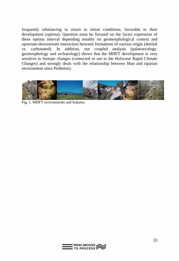
analysis. But tufa environment (fig. 1) also produces complex stratigraphy
inferred by climatic and anthropogenic factors that must be both spatially and
sequentially analyzed. MHFT growth on the course of spring emergence
environments but are frequently supplied by different watershed and coupled
with detrital fluvial sediments and formations. Sequences are complex and
generally reflect the paleohydrology and biotope changes. In some case, MHFT
sequences follow a cyclic sedimentary pattern corresponding to geomorphic and
environmental changes. An efficient reading and understanding of the
carbonated sequences facies cyclic succession allows to identify morphogenic
trend ruptures like incisions and stasis that had previously been unseen in the
generic alluvial sequences deposits.The geometry of the formations and the
morphogenic trend curve are thus redefined and the MHFT growth and decline
chronology revisited. Formerly attributed to the Preboreal and Atlantic periods,
with a decline during Neolithic to Roman times, the MHFT development is now
attributed to the Lateglacial period with a main dismantlement during the Little
Ice Age. Paleohydrological dynamic (stream speed and reservoir supply) is also
specified by the concretion faciology into the sedimentary sequences.
Impact of the Human mode of occupation are also recorded at the scale of
the sequence through macrofacies and paleoecological changes. Those different
aspect underline the extreme complexity of the MHFT sedimentary archives
portraying mosaic environments with various micro-response to environmental
changes.
A two-step look is necessary to understand the complete system which
offers a composite reading grid of the paleoenvironmental evolution. 1)
Spatialization in the reading of the sequences, with 3D channel
modeling/understanding is essential to determine the relative stream speed that
characterize the facies, the “hidden sedimentary ruptures” (incisions) and their
signification. 2) Stratigraphic succession on MHFT is generally cyclic and, due
to their physico-chemical and bio-chemical origin, the systems are resilient and
33
frequently rebalancing to return to initial conditions, favorable to their
development (optima). Question must be focused on the facies expression of
these optima interval depending notably on geomorphological context and
upstream-downstream interaction between formations of various origin (detrital
vs. carbonated). In addition, our coupled analysis (palaeoecology,
geomorphology and archaeology) shows that the MHFT development is very
sensitive to biotope changes (connected or not to the Holocene Rapid Climate
Changes) and strongly deals with the relationship between Man and riparian
environment since Prehistory.
Fig. 1. MHFT environments and features.

34
Inventory of large blanket tufa deposits in the Iberian
Peninsula. Geomorphological response to paleoclimatic and
tectonic changes during the Pleistocene Juan Vázquez-Navarro Geography Department, UAM. Spain.
Tufa deposits are associated with the dynamics of karstic systems and
provide records of past hydrological and climatic conditions. When hard waters
intersect the topographic surface, tufa precipitation occurs as a consequence of
CO2 out-gassing. There is a type of tufa deposits rarely described until now: the
blanket one. It´s a mixture of perched spring deposits and alluvial tufa staircase
terraces and they consist in regularized platforms (glacis or piedmont in French
terminology, Vaudour, 1982) ranging in magnitude from 1 to 40 km wide. Such
landforms can agradate regarding less the underlying topography, regularizing
it. The biggest complex described in literature is located in Antalya (Turkey)
and it has an estimated age from lower to middle Pleistocene. Until now, in the
Iberian Peninsula, such outcrops has been neglected by regional geology,
identifying them wrongly as lacustrine tertiary deposits sedimented in closed
basins. However, a recent global inventory on tufa deposits of Spain (González
Martín and González Amuchastegui, 2014), allowed the recognition of several
new blanket surfaces covering great extension, being among the biggest known
examples of its kind on Earth. Besides its relevance as geological heritage, those
blanket deposits might represent alternatively a) reference geomorphic
expression surfaces of wet periods, since they are correlated with the odd-
numbered isotopic periods established in marine logs or b) geomorphic
response to tectonic forcing due to aquifers disruption, when intersection of
ground waters with the surface occurs as springs precipitating tufa carbonates.
In this contribution, an overall review of previously unreported
sedimentary tufa blanket buildings in Spain has been summarized. Special focus
has been done on the cases of the Iberian Range, an intraplate thrust-belt formed
in Cenozoic times and characterized by a dome-shaped topography. Its
formation has been related to the Middle Eocene-Middle Miocene compressive
inversion of a Mesozoic extensional basin. It is mostly composed of carbonates
hosting extensive and continuous karstic aquifers which allowed the formation
of pervasive tufa outcrops. In some cases, blanket deposits are clearly liked to
extensional faults doming and uplifting in the eastern Iberian Chain, linked to
the opening of the Valencia Trough and the Mediterranean margin.
Blanket tufa deposits have distinct behavior than detrital staircase river
terraces in that their base level are not a reference of landscape evolution and
measurement of incising rates as has been attempted regularly in bibliography,
can be misleading. However, they do represent unequivocal exoreic drainage

35
pattern, and therefore, some are here claimed as evidence for inception of basin
capture.
Fig. A) Upper: blanket tufa surface in the Cabriel Basin (cuenca), overlying in angular
uncorformity with Mesozoic and Tertiary deposits. It shows a slight slope, prograding
downstream the paleodrainage, which is coincident to the actual one. It has been disected 200
meters by Narboneta and Garaballa rivers. It does represent an exorehic behaviour of Landete
sector in Tertiary Teruel Basin B) Lower: Example of “El Oro” blanket tufa surface perched 250
meters above the Jucar talweg (Valencia)

36
Methods applied to archives and open topics
Oral presentation chair:Helmut Brückner
Martin Kehl, Simone Klumpp, Jörg Linstädter, Gerd-Christian Weniger:
Micromorphological features of in-situ or reworked shelter sediments of the
Iberian Peninsula.
Davinia Moreno, Christophe Falguères, Pierre Voinchet, Jean-Jacques Bahain:
On the potential of ESR dating of optically bleached quartz grains from karstic
environment.
Roland Zech: Compound-specific radiocarbon dating of leaf waxes.
Johannes Hepp, Roland Zech, Kazimierz Rozanski, Wolfgang Zech, Bruno
Glaser, Michael Zech: Coupling 18O and 2H biomarker analyses in paleoclimate
research: potential, conceptual model and a first application study from East
Africa.
Ludwig Zoeller, Dominik Faust: Luminescence dating of Quaternary sediments
in Spain – problems and first results.
M. Oliva; E. Serrano; A. Gómez-Ortiz; J.A. González Martín; A. Nieuwendam;
D. Palacios; A. Pérez-Alberti; J. Ruiz-Fernández; M. Valcárcel & G. Vieira: The
periglaciation of the Iberian Peninsula.
Michael Zech, Sebastian Kreutzer, Tomasz Goslar, Sascha Meszner, Roland
Zech, Cameron McIntyre, Timothy Eglinton, Dominik Faust, Markus Fuchs:
Quantifying post-sedimentary n-alkane contamination in loess using 14C and
OSL dating.
Sanjurjo-Sánchez, J.; Arce Chamorro, C.; Vidal Romaní, J.R.; Vaqueiro, M.:
Al-bearing organic speleothems in granite caves or NW Iberia:
characterization and chronology.

37
Poster presentation chair: Christoph Zielhofer
Martin Kehl, Nicole Klasen, Christoph Burow, Helmut Brückner, Gerd-
Christian Weniger: Luminescence dating of Iberian cave sequences – potential
and drawbacks.
L. del Valle, J.J. Fornós , L. Gómez-Pujol, F. Pomar, V. Anechitei-Deacu, A.
Timar-Gabor: Luminescence Dating on Middle to Late Pleistocene Eolianites
from Eivissa, Western Mediterranean.
Díaz del Olmo, F., Recio Espejo, J. M., Borja Barrera, C.: Doñana, a zonal and
azonal pedogenesis archives for the Holocene (SW, Spain).
Fritz Haubold, Maximilian Klöcker, Dominik Faust: Measuring soil erosion by
means of a low-cost photogrammetry.

38
Micromorphological features of in-situ or reworked shelter
sediments of the Iberian Peninsula Martin Kehl
1, Simone Klumpp
1, Jörg Linstädter
2, Gerd-Christian Weniger
2,3
1 Institute of Geography, University of Cologne, Albertus-Magnus-Platz, 50923 Cologne,
Germany. 2 Institute of Prehistoric Archaeology, University of Cologne, Albertus-Magnus-Platz, 50923
Cologne, Germany. 3 Neanderthal Museum, Talstr. 300, 40822 Mettmann, Germany.
Iberian cave and rock shelter sequences provide invaluable archives of
cultural and paleoenvironmental change with more than 150 palaeolithic sites
documenting human occupation by Neanderthals or anatomically modern
humans and at least 35 sites providing interesting palynological records.
The processes of sediment accumulation and post-depositional reworking
within shelters are often not clearly understood. This shortcoming contributes to
frequent dispute on the stratigraphic integrity of sediment sequences and of
archaeological materials embedded therein and samples extracted for dating. In
general, site formation may involve phases of strongly reduced sediment
accumulation, partial sediment erosion and sediment mixing by natural and
anthropogenic processes. Some of these processes may be readily identified in
the field, but a microscopic approach may prove useful, in particular for
distinguishing in-situ archaeological layers (and embedded finds) from
reworked materials. In the framework of the CRC 806 „Our way to Europe“, we
conducted micromorphological investigations at several Middle to Upper
Palaeolithic sites in Iberia including the caves of Arbreda, Las Palomas de Teba,
La Güelga and Morín.
Besides observation with the petrographic microscope under plain
polarized light and crossed polarizers we used the feature analyst tool of
ArcGIS to automatically estimate pore space and numbers of archaeologically
relevant particles such as bone fragments. We found a set of
micromorphological features which indicate in-situ preserved archaeological
levels while others give strong evidence for post-occupational reworking or
mixing. In-situ layers often show subhorizontal orientation of elongated rock
fragments, an increased degree of compaction, remnants of surface seals,
evidence for trampling and internal layering. Reworked deposits may show
rolled aggregates and concretions, a low degree of compaction and lack of
surface features. Internal layering is lacking. In addition, the amount of bone
fragments is significantly lower in reworked layers. Micromorphology thus
provides an important tool to distinguish in-situ and reworked layers and to
thereby clarify site formation in order to set up more reliable (chrono-)
stratigraphic frameworks of shelter deposits.

39
On the potential of ESR dating of optically bleached quartz
grains from karstic environment Davinia Moreno
1,2, Christophe Falguères
2, Pierre Voinchet
2& Jean-Jacques
Bahain2
1 Centro Nacional de Investigación sobre la Evolución Humana (CENIEH). Paseo de Atapuerca,
nº 3 09002 (Burgos, Spain) 2 Département de Préhistoire, Muséum National d’Histoire Naturelle, UMR7194, 1 rue René
Panhard, 75013 Paris, France
Electron Spin Resonance (ESR) dating of quartz grains extracted from
sediment is based on the detection of radiation-induced paramagnetic centers.
Similarly to Optically Stimulated Luminescence (OSL) dating, the ESR signal
measured in quartz may be reset by optical bleaching, allowing thus to date the
moment when the sediment has been last exposed to sunlight. Actually, there is
quite a wide range of ESR dating studies of optically bleached quartz grains
from fluvial, eolian and littoral context, but so far the specific application to
karstic environment has never been reported.
Taken into account that many prehistoric sites have been discovered in
caves, their study provides an important source of evidence about the first
human settlement in Europe and the establishment of an accurate chronological
framework is highly needed. In that regard, ESR dating of quartz extracted from
cave sediment mightprovide some useful chronological information, especially
in the case of azoic, not volcanic or too old deposits that preclude the use of
other numerical methods such as luminescence or Ar/Ar.
The present study reports ESR dating results of quartz grains from the
Gran Dolina site in Atapuerca (Spain). The sedimentary infilling of Gran Dolina
represents one of the most complete Pleistocene sequences with a thickness of
about 18m divided into 11 lithostratigraphic units including several
archaeological levels. In particular, the upper part of the sequence (from TD6 to
TD10 levels) has been extensively dated in the recent years by means of various
techniques such as combined ESR/U-series, luminescence (TL, IRSL, TT-
OSL), U-series and magnetostratigraphy. Consequently, the data set available is
an excellent independent age control to evaluate the consistency of the ESR age
estimates that have been obtained. This comparison will provide a good
overview of the real potential of this application in cave environment.

40
Compound-specific radiocarbon dating of leaf waxes Roland Zech
n-Alkanes and n-carboxylic acids are essential constituents of leaf waxes.
They are well preserved in sediments and paleosols and can therefore be used as
“biomarkers” for paleovegetation and -climate reconstructions (Eglinton and
Eglinton, 2008). Thanks to recent technological developments it is now possible
to perform “compound-specific” radiocarbon analyses on leaf waxes, i.e. to
determine the 14
C content of specific homologues (n-alkane and n-carboxylic
acid chain lengths). In this contribution, the basic principles of compound-
specific radiocarbon dating shall be outlined, followed by a presentation of first
applications of this new
technique.
The figure shows the
radiocarbon ages for bulk
organic material (treated with
HCl to remove carbonates and
fulvic acids), the even-chain n-
carboxylic acids (FAMES), and
specific n-alkane homologues
for sample Cr 20, which is 29±3
ka (from Häggi et al., 2014).
This corroborates the
synsedimentary nature of long-
chain leaf waxes, and illustrates
the feasibility and potential of
compound-specific radiocarbon dating in loess-paleosols.
References
Eglinton, T. I. and Eglinton, G. (2008). Molecular proxies for paleoclimatology,
Earth Planet. Sci. Lett., 275, 1–16.
Häggi et al. (2014). On the stratigraphic integrity of leaf-wax biomarkers in loess
paleosols. Biogeosciences 11, 2455–2463.

41
Coupling 18O and 2H biomarker analyses in paleoclimate
research: potential, conceptual model and a first application
study from East Africa Johannes Hepp, Roland Zech, Kazimierz Rozanski, Wolfgang Zech, Bruno
Glaser, Michael Zech
We couple compound-specific δ2H results of leaf wax-derived n-alkanes
with compound-specific δ18O results of hemicellulose-derived sugars extracted
from the loess-paleosol-sequence Maundi on Mt. Kilimanjaro. This coupling
allows the reconstruction of a ca. 100 ka record of isotopic composition of leaf
water. This in turn allows (i) using deuterium-excess of leaf water as proxy for
palaeohumidity and (ii) reconstructing the isotopic composition of precipitation.
Our results suggest and corroborate (Zech et al., 2013) that sedimentary
δ2H leaf wax records should not be interpreted directly in terms of reflecting
δ2Hprec because variable leaf water evaporative enrichment can strongly
overprint δ2Hprec signals. Furthermore, our d-excess record as proxy for
palaeohumidity does not support the interpretation of δ2Hprec in terms of an
“amount-effect” in East African palaeoclimate studies.
References
Zech, R., Zech, M., Marković, S., Hambach, U. and Huang, Y., 2013. Humid
glacials, arid interglacials? Critical thoughts on pedogenesis and paleoclimate based on
multi-proxy analyses of the loess-paleosol sequence Crvenka, Northern Serbia.
Palaeogeography, Palaeoclimatology, Palaeoecology 387, 165-175.
42
Luminescence dating of Quaternary sediments in Spain –
problems and first results Ludwig Zoeller(University of Bayreuth)and Dominik Faust(TU Dresden)
It is desirable to use specific luminescence emissions from pure mineral
grains for dating. This is, however, not always possible or easy. The only
ubiquitous mineral that can be purified from mineral mixtures by physical and
chemical treatments is quartz. The OSL from quartz has, however, a low
saturation dose in most cases liming the upper dating limit to ca. 100 ka or less.
If the natural OSL signal is close to saturation age underestimates may occur.
As stable quartz luminescence cannot be stimulated by IR the IRSL dating
technique can be applied to feldspar-bearing sediments with up to 10-fold
higher saturation dose. The upper dating limit of feldspar-derived IRSL is,
however, often hampered by so-called anomalous fading, i.e. a long-term
instability of the signal independent from its thermal stability. Uncorrected
anomalous fading can also leadsevere to age underestimates. In recent years,
however, laboratory procedures (e.g., pIR-IRSL dating) have been developed to
reduce anomalous fading to a tolerable minimum, thus enabling to produce
reasonable ages of up to ca. 300 to 350 ka.
OSL quartz dating was applied to aeolian sediments in Spain ranging from
a few decades (Doñana dunes) to ca. 100 ka (loess in the Upper Tajo Basin and
desert margin loess from Lanzarote Island). Ages of ca. 170 ka were obtained
using red TL emissions from quartz grains heated by lava flows on Lanzarote
Island and confirmed by ESR dating of terrestrial shells whereas OSL dating
failed for samples >ca. 100 ka old. Saharan dust atmospheric input to aeolianite-
paleosol sequences of northern Fuerteventura Island yielded IRSL ages between
ca. 4 and ca. 280 ka and now allow for a first chronostratigraphic frame of these
sequences reflecting changes in paleo-moisture. Our results suggest a
significantly older chronology for the eolianite-paelosol sequences than
previous studies based on radiocarbon, amino acid and OSL ages.The studies in
Fuerteventura and Central Spain are part of ongoing work.

43
The periglaciation of the Iberian Peninsula M. Oliva; E. Serrano; A. Gómez-Ortiz; J.A. González Martín; A. Nieuwendam;
D. Palacios; A. Pérez-Alberti; J. Ruiz-Fernández; M. Valcárcel & G. Vieira
Active periglacial processes are currently marginal in the Iberian
Peninsula, spatially limited to the highest mountain ranges. However, a wide
variety of periglacial deposits and landforms is distributed in low- and mid-
altitude environments, which shows evidence of past periods with enhanced
periglacial activity.
The purpose of the present research is to summarize the present
knowledge on periglacial conditions in the Iberian Peninsula with a focus on the
paleo-perspective. The chronological framework for periglacial activity has
been based on four main stages: Last Glaciation, transition to the Holocene, the
Holocene and present-day processes. This study focuses on the highest massifs
(Pyrenees, Cantabrian Range, Galician mountains, Portuguese ranges, Central
Iberian Range, Iberian Range, Sierra Nevada) as well as in other lower elevation
environments, namely from the central Iberian Meseta.
Significant advances have been achieved over the last decades regarding
the geochronology of periglacial activity in the past. Whilst periglacial studies
until the 80‟s and 90‟s were mostly focus on the geomorphological mapping,
description and relative dating of inactive landforms and deposits, during the
last decade there has been a significant increase in the number of studies centred
on the monitoring of present-day processes as well as in the age control of
periglacial phenomena through absolute datings techniques.
During the Last Glaciation the periglacial belt extended to much lower
altitudes than today, reaching sea level in the NW corner of the Iberian
Peninsula. A wide range of geomorphological landforms and sedimentary
records is indicative of very active periglacial processes, in some cases related
to permafrost conditions. Most of the inactive landforms and deposits in low
and mid elevations in Iberia are related to these phase. The massive deglaciation
of Iberian massifs was accompanied by the gradual increase of temperatures.
This phase was only interrupted by a short period with colder conditions (Late
Glacial) that reactivated periglacial processes in the formerly glaciated cirques
of the highest lands. During the Holocene periglacial processes have been active
only in the highest ranges, shifting in altitude according to the regime of
temperature and moisture conditions. The Little Ice Age saw the reactivation of
periglacial activity in lower elevations than today. Currently, periglacial
processes are only active in elevations exceeding 2500 m in the southern ranges
and above 2000-2200 m in the northern massifs.

44
Quantifying post-sedimentary n-alkane contamination in loess
using 14C and OSL dating Michael Zech, Sebastian Kreutzer, Tomasz Goslar, Sascha Meszner, Roland
Zech, Cameron McIntyre, Timothy Eglinton, Dominik Faust, Markus Fuchs
There is an ongoing discussion whether n-alkane biomarkers – and
organic matter (OM) from loess in general – reflect a syn-sedimentary
paleoenvironmental and paleoclimate signal or whether they are significantly
post-sedimentary contaminated namely by root-derived OM. We present
radiocarbon data for the bulk n-alkane fraction of lipid extracts and
luminescence ages for the Middle to Late Weichselian loess-paleosol sequence
of Gleina in Saxony, Germany. Three of four biomarker radiocarbon dataare
younger than the sedimentation ages as assessed by optically stimulated
luminescence (OSL) dating, indicating a post-sedimentary rejuvenation of the
bulk n-alkane fraction.
In order to estimate the post-sedimentary contamination more
quantitatively, we apply a 14C mass balance calculation based on the measured
pMC (percent modern carbon) values, the calculated syn-sedimentary pMC
values and pMC values suspected to reflect likely time points of post-
sedimentary contamination. Accordingly, no extensive modern, last decadal
and/or 3 ka BP root/rhizomicrobial contamination can be asserted.

45
Al-bearing organic speleothems in granite caves or NW Iberia:
characterization and chronology Sanjurjo-Sánchez
1,2, J., Arce Chamorro
1,2, C., Vidal Romaní
1,2, J.R., Vaqueiro
2,
M. 1Instituto Universitario de Geología “Isidro Parga Pondal”. Universidade da Coruña, A Coruña,
Spain 2Clube Espeleolóxico “A Trapa” (CETRA), c/Manuel de Castro 8-3D. 36210 Vigo (España)
Water trickling through the discontinuities of granitic massifs causes rock
weathering, resulting in mineral deposits within rock fissures and caves
(speleothems). Granite caves are considered as pseudokarst. In such cavities few
deposits can be found. The most common mineralogy of the deposits found are
opal-A, secondary evansite and Al-bearing organic compounds (often called
pigotite). They usually grow by accretion of concentric layers and the formation
of some of them (as it has been reported at least for opal-A deposits) is caused
by a significant biological activity of microorganisms. They also contain spores,
pollen grains and diatoms, so it has been proposed their use as
palaeoevironmental records. However, there are still too many uncertainties
about their chronology and formation process.
The Al-bearing organic compounds (or pigotite) have been described as a
salt composed of alumina and organic acids forming incrustations on the walls
of granitic fissures and caves. However both it their mineral and chemical
characteristics and formation process are unknown. It has been considered as an
organic substance derived from the decay of moist moorlands above cavesbut
the their organic carbon content is around 5% and the information given by
references is imprecise or still incomplete.
The biggest reported deposit was located in Trapa Cave, Galicia, NW
Spain. A previous study on the composition and formation of such speleothems
provided that pigotite is formed by a rhythmic accretion structure in concentric
layers as it occurs in calcite speleothems. Such layers alternatively show light
cream (Al-rich) and dark red colour (Fe-rich) that has been associated to
seasonal changes (winter-summer deposition) similar to varves of lake deposits.
Radiocarbon dating provided ages ranging from 1500 to 3000 years BP for such
deposits.We have studied and characterized a Al-bearing organic deposit in
Trapa Cave, other probably associated sediments (within upper levels of the
same cave) and surface soils to characterise and understand the process that
result in the formation of such Al-bearing organic compounds. We also have
dated some samples by radiocarbon and luminescence dating to assess the age
of formation of the deposits. Our results indicate that they are fine grain
deposits saturated in water and rich in organic C (ranging 5-10%). The organic

46
matter is composed of soil compounds but also microorganisms. The mineral
components are mainly oxides but also quartz, feldspars and heavy minerals are
present, while clay minerals are almost absent. The age of the sediments
corresponds to the Late Holocene, not older than 2 ka.

47
Luminescence dating of Iberian cave sequences – potential and
drawbacks Martin Kehl
1, Nicole Klasen
1, Christoph Burow
1, Helmut Brückner
1, Gerd-
Christian Weniger2,3
1 University of Cologne, Institute of Geography, Albertus-Magnus-Platz, 50923 Cologne,
Germany 2 Neanderthal Museum, Talstraße 300, 40822 Mettmann, Germany 3 Institute of Prehistoric Archaeology, University of Cologne, Albertus-Magnus-Platz, 50923
Cologne, Germany.
The transition from Neanderthals to early anatomically modern humans
(AMH) in Iberia is documented in at least 28 cavesor rockshelters, which
contain both Mousterian and Early Upper Palaeolithic (EUP) layers. The timing
of the transition and of Neanderthal demise is a matter of dispute. The
radiocarbon method is afflicted by large uncertainties due to contamination of
samples with young 14C and incomplete understanding of taphonomic
processes within caves. Other geochronological dating methods attracted less
attention, because appropriate samples such as stalagmitic crusts for U/Th
dating or convenient sediments for luminescence age estimates are often not
available. During the last years, the Cologne luminescence lab has been
investigating several series of sediment samples from Middle to Upper
Palaeolithic sites in Iberia, applying various dating protocols. At the sites
Jarama VI and Cueva Antón, fluvial deposits intercalated by cultural layers
were analysed and plausible postIR-IRSL290° ages were determined, which
corresponded well with other luminescence dating protocols (e.g., OSL on
quartz using single aliquots and single grains) as well as with new radiocarbon
dates (Kehl et al. 2013, Burow et al., submitted).
At the site of Las Palomas de Teba, Middle Palaeolithic layers and
covering slope deposits were sampled. Age estimates received by OSL and
postIR-IRSL290° were partly younger than previous archaeological age
estimates, probably related to reworking of archaeological materials.
Luminescence properties of silty deposits at the site Finca Dona Martina were
inappropriate for luminescence dating as indicated by the laboratory
experiments (preheat plateau test and dose recovery test). This failure is most
likelyrelated to the sediment composition, which contained detrital silt from the
shelter roof above the archaeological layers. Currently, samples from the sites
La Boja, Quebrada, Cova Negra de Xátiva and Cueva Arbreda are under study.
Preheat plateau and dose recovery tests of the quartz samples failed for most
samplesor the quartz luminescence signalwas found to be in saturation.
Overall, our experience from the seven different sites indicated that in
most casesquartz was less suitable for luminescence dating and therefore,
48
further measurements will concentrate on feldspar dating.Moreover, those
deposits showing clear features of fluvial deposition such as cross-bedding or
fine lamination gave more reliable results than silty cultural layers mainly
derived from disintegration of the cave wall.
References
Kehl, M., Chr. Burow, A. Hilgers, M. Navazo, A. Pastoors, G.-C. Weniger, R.
Wood, J.F. Jordá Pardo (2013): Late Neanderthals at Jarama VI (Central Iberia)? –
Quaternary Research 80, 218-234.
Burow, Chr., M. Kehl, A. Hilgers, G.-C. Weniger, D. Angelucci, V. Villaverde, J.
Zapata, J. Zilhão, submitted: Luminescence dating of fluvial deposits in the rock shelter
of Cueva Antón, Spain. Submitted to Geochronometria.

49
Luminescence Dating on Middle to Late Pleistocene Eolianites
from Eivissa, Western Mediterranean. L. del Valle
1, J.J. Fornós
1, L. Gómez-Pujol
1,2, F. Pomar
1,V. Anechitei-Deacu
3,4
y A.Timar-Gabor3,4
1) Departament de Ciències de la Terra, Universitat de les Illes Balears. Ctra. de Valldemossa
km 7,5 07122 Palma (Illes Balears).
2) SOCIB, Balearic Islands Coastal Observing and Forecasting System. ParcBit, Ctra.
deValldemossa, km 7,4 07122 Palma (IllesBalears)
3) Faculty of Environmental Sciences and Engineering, Babes-Bolyai University, Cluj-Napoca,
Romania.Interdisciplinary Research Institute on Bio-Nano-Science of Babes-Bolyai
University, Cluj-Napoca
This study deals with the sedimentary and stratigraphical description of
Pleistocene deposits fromsix coastal areas of Eivissa (Balearic Islands). Twenty
two sedimentary facies have been described involving the succession of eolian,
colluvial and edaphic environments. Carbonate sandstones, breccias and silty
deposits are the main component of these sequences. Despite the extensive
eolian systems outcropping along the coast of Eivissa, there are very few studies
performed to chronological framework of these deposits.
Luminescence measurements were carried out using an automated RisØ
TL/OSL-DA-20 reader in the Luminescence Dating Laboratory of Babes-Bolyai
University (Cluj-Napoca, Romania) under low intensity red light. For the
deposits in north-western part of the Island (CalaXuclar) involved SAR-OSL
dating on aliquots of fine (4-11 µm) and coarse (63-/90 -250 µm) quartz
extracted from CalaBassa site (south-western Eivissa) the SAR-OSL protocol
was applied on aliquots of fine (4-11 µm) and medium (63-90µm) quartz grains
as well as on coarse quartz of different grain sizes (90-125 µm, 125-180 µm,
180-250 µm) (Anechitei-Deacu et al, 2014). Where in other sites (South:
EsCodolar; South-western: CalaCompte, Cap Negret and South-eastern:
S‟estanyol) involved dating on aliquots of coarse (63-250 µm) grained quartz.
OSL dating of nineteen eolian levels indicate that their deposition took place
between the Middle and Upper Pleistocene, establishing a paleoclimatic
evolution since 70 ka to 570 Ka. From the sedimentological and stratigraphic
analysis, in conjunction with OSL data we can state that the eolian activity in
the island of Eivissa took place during cold periods (MIS 14, 12, 10, 8, 6 and 4).
Similar results have been obtained from many sites along the western
Mediterranean Sea such as Mallorca (PomariCuerda, 1979; Nielsen et al, 2004),
and the Italian coast (Andreucci et al, 2009; Pascucci et al, 2014).
Acknowledgements: This research has been supported by the MINECO
projects CGL 2010-18616 and CGL-2013-48441-P.

50
Doñana, a zonal and azonal pedogenesis archives for the
Holocene (SW, Spain) Díaz del Olmo, F.1, Recio Espejo, J. M.2, Borja Barrera, C.1: 1.Universidad de Sevilla (Spain)
2.Universidad de Córdoba (Spain)
The soil (paleosoils or old soils, profiles or horizons), is one of the leading
archives for the study of the Quaternary evolution regarding emerged
landscapes, with applications into the geomorphological, sedimentological and
environmental research.
This work shows an application of the use of the edaphic archive for the
palaeoenvironmental evolution interpretation, from the Upper-Pleistocene to the
present on the Aeolian Littoral Sand Sheet at El Abalario-Doñana (MELAD), in
Doñana coast (Huelva, Spain). The zone has formed by a complex system
composed principally by quartz sand (>80%). Five morphosedimentary units
were recognized in MELAD: stabilzed aeolian deposits in down position with
ancient vegetation; stabilized aeolian deposits in upper position with ancient
vegetation, humid character and small-lakes; stabilized aeolian deposits in upper
position with ancient vegetation at dry character; semiactive dunes; and active
dunes.
From the MELAD base, including into morphosedimentary unities and its
geomorphological surface, three edafic-weathering sequences are identified:
1) A basal weathering compoused by sandy-clayey removed deposit
where quartz predominanting in sands and kaolinites in the clay minerals from
Late Pleistocene.
2) A sequence with high zonal signification; this means wet
Mediterranean climatic character, whose soils are evolutionated in dune
complexes represented by Luvisol-soils (Upper and Middle Holocene),
Arenosol-Luvisol-soils (Late Holoceno and present) up to Haplic-Arenosol
(present), with presence of illites, kaolinites and vermiculites.
3) Another azonal, therefore, with soils influenced by the effects of a
acidophic geomorphological environment, with porose areas and other ones
with obstructed drainage (dune / small-lakes systems) with quartz, high level
smectite contentand low level kaolinite proportion.Two are the main kinds of
soils and weathering:
3.1. Vertisols (Middle Holocene) and degrading Vertisols by
gleycification processes (Vertic Stagnic Luvisol, Chromic Stagnic Luvisol) and
protopodsolization (Stagnic Podsoluvisol) (Late Holocene and present).
51
3.2. In the semiactive and active dunes (Late Holocene tothe present)
with great presence of illmenite, has great participation in the currently different
pedological processes (browning and podsolization).
Acknowledgements: This research has been supported by the Projects OAPN
036/2008 & GeoCroQ (HAR2011-23798).

52
Measuring soil erosion by means of a low-cost photogrammetry Fritz Haubold, Maximilian Klöcker & Dominik Faust Technische Universität Dresden, Institute of Geography, Germany
Like the Mediterranean many climates are characterized by a more or less
large seasonality of rainfall. Areas of such rainfall regimes are prone to soil
erosion. Since ancient times soil erosion has stripped the Ethiopian landscapes
and many attempts were made to control it. Although soil erosion is a natural
process it mainly is driven by land use practice, namely deforestation. Climate
change may accelerate the processes. In its extended form it even cuts a
particular landscape into pieces. Our research makes an attempt to evaluate the
effectiveness of the different soil and water conservation measures.
The study area is located near the town of Aje, about 35 km west of the
city of Shashamene, East Shewa, Oromiya, Ethiopia. The main aim is to
provide suggestions for improving soil conservation practices. In order to
quantify soil erosion a low-cost and user-friendly most recent approach of close
range photogrammetry was applied. Usually high-resolution topography survey
and data collection is associated with major expenditures of equipment and
logistics. Traditional photogrammetric methods require 3-D location and pose
of the camera and thus are very inflexible to changing conditions during the
study. In addition they often need particular knowledge of technique and
technology.
Figure 1: Photo of a medium sized gully (left) and model derived from it (right). Made
by Maximilian Klöcker
The type of the photogrammetric technique applied can be described as
„structure-from-motion‟. That means the camera pose and scene geometry are
solved automatically that facilitates the use without detailed understanding in
theoretical photogrammetry. Extensive photosets of multiple overlapping
images were taken with a customer-grade digital camera. It is possible to
generate from these photosets high-resolution digital models which provide an
extraordinary overview of the gullies‟ shape. Furthermore these models allow

53
high accuracy measurements. For example it is possible to measure the
thickness of soil layers, distances and even volume calculations of how much
soil has already been eroded. We implemented this technique to a remote
tropical area to test its capacity, applicability, and usability in problems of soil
erosion. First results suggest that it best fits to such environments.

54
Aeolian archives
Oral presentation chair: Pablo G. Silva Barroso
Imke Kathrin Schäfer, Matthias Suhr, Daniel Wolf and Roland Zech: Leaf
wax biomarkers in a Loess-Paleosol Sequence in El Paraíso, Spain.
Christoph Zielhofer, William Fletcher, Steffen Mischke, Marc de Batist:
Younger Dryas and Holocene hydroclimatic variability and aeolian history of
the Middle Atlas (Morocco).
Susana Costas, FilipaNaughton and Hans Renssen: Major episodes of aeolian
activity in the central coast of Portugal since the LGM.
P. Baumgart, D. Wolf, R.C. Zapata, J.S. Vizcaino, D. Faust: Loess-palaeosol-
sequences in the Tajo basin - distribution and stratification.
Poster presentation chair: Christoph Zielhofer
H. Gil, A. Luzón, M.A. Soriano, A. Pérez and A. Pocoví: Early to Late
Pleistocene aeolian deposits in the central Ebro Basin (NE Spain): new clues for
deducing Pleistocene environmental variability in this area.
F.R. Calvo, J. Sánchez, A. Acosta, D. Faust, D. Wolf, P. Baumgart:
Granulometrical, Mineralogical and Geochemical Characterization from a
Loess Palaeosols Sequence in the Tagus Basin.
Pedro P. Cunha, Pedro Dinis, António A. Martins, Martin Stokes: Sedimentary
characterization of a succession of aeolian sands in the Tejo River lower valley
– a record of environmental changes of western Iberia during the Late
Pleistocene to Holocene.
Christopher-B. Roettig; Daniel Wolf; Philipp Baumgart; Thomas Kolb;
Dominik Faust: Aeolianite Sequences on Fuerteventura with different
characteristics.
55
Leaf wax biomarkers in a Loess-Paleosol Sequence in El
Paraíso, Spain Imke Kathrin Schäfer*, Matthias Suhr**, Daniel Wolf ** and Roland Zech* *University of Bern, Institute for Physical Geography, Hallerstrasse 12, 3012 Bern, Switzerland
**Technical University of Dresden, Department of Geography, Helmholtzstraße 10
01069 Dresden, Germany
Leaf wax biomarkers such as long chain n-alkanes and n-carboxylic acids
are resistant against degradation and can be stable even under geological
conditions, that‟s why they are often used for the reconstruction of
paleoenvironmental conditions (e.g. Hinrichs et al. 1998). Adequate archives
are either marine sediments or, in the terrestrial environment, Loess-Paleosol
Sequences (LPS).
Results from earlier biomarker studies of LPS showed that the homologue
distribution pattern of the long chain n-alkanes can be used to distinguish
between the inputs of different vegetation forms, e.g. forest vegetation vs.
grasses (Zech et al. 2011) but changes of the pattern due to degradation in the
upper soil need to be considered (Zech et al. 2013). Moreover, a compound
specific stable hydrogen analysis of leaf wax remnants has gained more and
more attention because the organic hydrogen originating from
photosynthesizing organisms can be used as paleohydrological proxy (Sachse et
al. 2012).
To assess the potential of the leaf wax biomarkers for paleoclimate and
paleohydrological reconstruction we analysed 32 samples from a LPS in El
Paraíso, Central Spain. For further proxy evaluation we will also analyse
samples from the vegetation cover.
References
Hinrichs K.-U., Rinna J. and Rullkötter J. (1998). Late Quaternary
paleoenvironmental conditions indicated by marine and terrestrial molecular biomarkers
in sediments from the Santa Barbara basin. In: Wilson R.C. and Tharp, V.L. (eds),
Proceedings of the fourteenth annual Pacific climate (PACLIM) conference, April 6-9,
1997. Interagency Ecological Program, Technical Report, 57, California Department of
Water Resources, Marysville (CA), 125-133.
Sachse D., Billault I., Bowen G. J., Chikaraishi Y., Dawson T. E., Feakins S. J.,
Freeman K. H., Magill C.R., McInerney F. A., Van der Meer M. T.J., Polissar P.,

56
Robins R. J., Sachs J. P., Schmidt H.-L., Sessions A. L., White J. W.C., West J. B. and
Kahmen A. (2012). Molecular Paleohydrology: Interpreting the Hydrogen-Isotopic
Composition of Lipid Biomarkers from Photosynthesizing Organisms. Annu. Rev.
Earth Planet. Sci. 40, 221–49.
Zech M., Zech R., Buggle B. and Zöller L. (2011). Novel methodological
approaches in loess research – interrogating biomarkers and compound-specific stable
isotopes. Quaternary Science Journal, 60(1), 170–187.
Zech M., Krause T., Meszner S. and Faust D. (2013). Incorrect when uncorrected:
Reconstructing vegetation history using n-alkane biomarkers in loess-paleosol
sequences - A case study from the Saxonian loess region, Germany. Quaternary
International 296, 108-116.

57
Younger Dryas and Holocene hydroclimatic variability and
aeolian history of the Middle Atlas (Morocco) Christoph Zielhofer, William Fletcher, Steffen Mischke, Marc de Batist
In this study we present a 20 m long lacustrine core record from the
Middle Atlas in Morocco. The Lake Sidi Ali record features a continuous high-
resolution archive from the Younger Dryas up to the Late Holocene. The core
chronology is based on 210Pb sampling and 14C dated pollen concentrates.
Hence, the Sidi Ali record provides, in addition to a detailed multi-proxy
stratigraphical record, a robust chronological model allowing comparisons
within the wider Western Mediterranean region. For the first time the
hydroclimatic transition from the Younger Dryas to the Early Holocene is
documented in a continuous matter from the North African mountainous
environments.
The terrestrial input into the lake is dominated by aeolian silts. XRF
provenance analyses from the core and a regional terrestrial transect point to
alternating dust origins strongly coupled to sub-millennial scale North Atlantic
climatic cyclicity. Here, enhanced Early and Mid-Holocene dust supplies from
the south correspond with cold Bond events. However, the Holocene dust input
includes a second superimposed provenance signal which corresponds
chronologically to the end of the monsoonal-driven African Humid Period. Sidi
Ali hydrological proxies from the lake clearly show a hydroclimatic see-saw
with mountainous environments from Southeastern Spain. We postulate the
impact of authigenic Western Mediterranean cylones here.
In conclusion, the Lake Sidi Ali record from the North African
mountainous desert margin is highly sensitive to Late Pleistocene to Holocene
Rapid Climate Changes. The reconstructed sub-millennial to centennial scale
hydroclimatic variability and aeolian history reveal evidence for changing
impacts of North Atlantic, Saharan and Mediterranean air masses in the Western
Mediterranean.

58
Major episodes of aeolian activity in the central coast of
Portugal since the LGM Susana Costas1, FilipaNaughton2 and Hans Renssen3 1CIMA, Universidade do Algarve, Portugal
2IPMA, Portugal
3Department of Earth Sciences, Faculty of Earth and Life Sciences, VrijeUniversiteit
Amsterdam,The Netherlands
The existence of vast and fixed transgressive dune fields along the
European coasts suggests dramatic changes in the factors controlling the
formation of these systems, namely windiness and sediment availability. In this
regard, the analysis of dune fields not only provides significant insights about
local conditions promoting the migration and formation of such systems, as it
also has a great potential unraveling past atmospheric circulation regimes. The
latter can be of great importance as atmospheric circulation uses to leave few
direct traces in the geological record, making reconstructions of this crucial
element of the climate system inherently difficult.
Here, we investigate the archive of aeolian activity preserved in Caparica,
central coast of Portugal, using geophysical and dating techniquesto determine
major episodes of aeolian activity in the western coast of the Iberian Peninsula
since the Last Glacial Maximum. The results are used to support the
reconstruction of windfield regimes during the identified episodes. The analysis
of the internal architecture obtained using Ground Penetrating Radar (GPR), the
ages of the identified units from Optically Stimulating Luminescence (OSL),
and the texture of the sediments support episodes of enhanced westerly winds
during the last termination (20 to 11.5ka) and the Holocene. Using clusters of
ages within the entire dunefield we detected major episodes of aeolian activity
centered at 0.35, 1.10, 5.60, and 17.5 ka. Remarkably, all identified episodes
occurred during well-known climate events such as the Heinrich event 1 (18 to
15 ka), the Mid-Holocene (6.0-5.0 ka), the Terminal Classic Period (ca1.2-1.0
ka), and the Little Ice Age (0.71-0.13 ka), suggesting a significant climate
influence. Additionally, we compared our results with present day analogs to
identify favorable conditions for dune formation and encroachment, finding out
that present conditions cannot explain the formation of explored dune fields and
that required conditions include very strong westerly winds sustained by longer
than today periods and the equator ward migration of the jet stream as a
consequence of a relative (during the Holocene) and very strong (during the last
termination) cooling over the northernmost Atlantic.

59
Loess-palaeosol-sequences in the Tajo basin - distribution and
stratification P. Baumgart*1, D. Wolf*1, R.C. Zapata2, J.S. Vizcaino2, D. Faust1 1 Institute of Geography, Dresden University of Technology, Germany
2 Departamento de Ingenieria Geologica y Minera, Universidad de Castilla La Mancha, Spain
Loess and loess-related sediments are sensitive recorders of palaeo-
environmental conditions and may provide detailed information related to
palaeo-climatic configuration. In the southern part of the Madrid Basin, we
found up to 8 m thick deposits of aeolian origin including several palaeosol
formations. The considered time span comprises at least the last glacial and
thus, these loess sequences represent outstanding terrestrial archives, especially
as environmental information is rare for this time period in central Spain.
A comprehensive study of seven representative loess-palaeosol sequences
is presented based on several field campaigns and different analytical
approaches. Loess deposits are mainly located on middle to late Pleistocene
fluvial terraces along the Tajo river. Beside aeolian dynamics, likewise fluvial
processes as well as slope processes are documented within the sections. To
built up a consistent stratigraphy we used rock magnetic analyses that turned
out to be a suitable tool for the correlation of different sediment profiles.
According to field data as well as palaeo-environmental magnetic data we can
actually define following three-fold division: a first phase of strong fluvial
relocation of soil material and weathered marl sediments; a second phase of
aeolian deposition with strong slope-depending relocation and intense palaeosol
formation; and a third phase of "pure" aeolian loess accumulation with just
weak differentiations within the upper parts of the investigated profiles.
Challenging issues are to (i) work out the just slight patterns of
pedogenetic overprint within the uppermost profile sections, (ii) to provide a
reliable chronological resolution, and (iii) to determine sediment proveniences.
60
Early to Late Pleistocene aeolian deposits in the central Ebro
Basin (NE Spain): new clues for deducing
Pleistoceneenvironmental variability in this area H. Gil, A. Luzón, M.A. Soriano, A. Pérez and A. Pocoví Departamento de Ciencias de la Tierra. Facultad de Ciencias.Universidad de Zaragoza. c/ Pedro
Cerbuna 12. 50009 Zaragoza. Spain.
Recent sedimentological and geomorphological studies carried out in the
Quaternary deposits that form the terraces of the Ebro River have revealed
significant accumulation of aeolian deposits throughout the Pleistocene in the
central part of the Ebro Basin. These exceptional deposits provide new data on
the characteristics of the palaeoenvironments developed permitting a better
approximation to the palaeogeographical evolution in an area where,
traditionally, only alluvial systems had been interpreted.
This finding plays an outstanding role. Indeed, although the presence of
aeolian dunes Late Pleistocene to Holocene age is relatively common in the
coastline of the Spanish territory and diverse aeolian landforms Late Pleistocene
to Holocene age have been described in different areas of the Duero Basin and
in the La Mancha region, this had not be the case of the Ebro Basin where only
recent scarce aeolian landforms had been reported till the moment. Besides,
when described, they were more related with erosive processes (yardangs) than
with wind-related deposition activity (some loess accumulations in valley
bottoms or in leeward slopes, and decimetric-high dunes).
Lithological features of the deposits integrating the terraces are very
heterogeneous (mainly gravels, sands and rare mud). Gravel features indicate
they were mainly deposited in braided fluvial systems in which longitudinal
gravel bars and channels prevailed. Fluvial activity dominated in periods of high
availability of water. Laterally to the braided system, alluvial fans coming from
Neogene materials of neighbouring reliefs inside the Ebro Basin, sporadically
interacted with the main channel net.
But, as pointed previously, the most relevant conclusion is that encased in
gravel well-sorted sands in until 4m-thick bodies appear. Grain size
distributions, sedimentary structures, geometry of deposits and paleocurrents,
permit to interpret most part of the sandy bodies as aeolian deposits. Transverse
dunes are the dominant forms but sand complex dunes, sand sheets, and loess
have been also identified; moreover faceted clasts and interdune deposits are
quite common. OSL dating and palaeomagnetism studies show that aeolian
accumulations existed, at least, since the Early Pleistocene. In a climate context
characterised by glacial and interglacial periods the genesis of aeolian deposits
was favoured by stage of low water discharge where alluvial plains acted as a
sand source for wind action.

61
It is noteworthy the preservation of thick non-cemented sandy deposits in
a setting dominated by fluvial sedimentation and gravel deposition. The study
of a great number of artificial slopes, mainly on quarries, shows that
karstification played an important role in sand preservation, since most of sands
levels appear in synsedimentary subsiding areas.

62
Granulometrical, Mineralogical and Geochemical
Characterization from a Loess Palaeosols Sequence in the
Tagus Basin
F.R. Calvo* (1), J. Sánchez (1), A. Acosta (2), D. Faust (3), D. Wolf (3) P.
Baumgart (3)
Dpto. de Ingeniería Civil y de la Edificación, E.T.S.I. Caminos, Canales y Puertos, Universidad
de Castilla La Mancha. Ciudad Real, Spain.
Dpto. de Química Física, Facultad de CC. Químicas, Universidad de Castilla La Mancha.
Ciudad Real, Spain.
Lehrstuhl Physische Geographie. Institut für Geographie. Dresden, Germany.
This paper presents the results of the investigation of a loess-paleosol
sequence of Middle Valley of the Tagus river, called Paraíso Profile.
Information of granulometry, mineralogy and geochemistry are given. This
profile (depth 8m) has been selected because it is the most complete from seven
sections studied. The sampling for analysis was performed according to
stratigraphic and sedimentological criteria, by taking samples in each discrete
level of the sequence. Detailed and well recorded grain size, mineralogical and
geochemical variations have been observed.
Within the sequence can be differentiated four parts from the bottom to
the top, each one of them with different granulometric characteristics. The main
mode of this section is marked in the coarse silt fraction (between 40 and 60
μm.), while the secondary modes, when present, are observed in the clay size
(about 1 μm.) and fine sand (between 127 -140μm.). From a mineralogical point
of view, the sequence presents a greater abundance of carbonate minerals
(Calcite [≈40%] and Dolomite [≈20%]) than of silicate minerals (Quartz
[≈30%], Feldspars [≈ <10%], mainly potassic feldspars and of clay minerals
(unmeasured). The lowermost part of the sequence is characterized by its
content of Gypsum [≈1%]. Its interesting to highlight the widespread increase in
carbonates in the finer fractions and silicates in the coarser fractions. For
geochemical analysis see the table below.
Together with all these previous analyses have been carried out SEM
studies that have allowed to show the general morphology of the samples, and
Elements SiO2 Fe2O3 MgO Al2O3 CaO Na2O K2O TiO2 SO3 Sr Other
Elements LOI
% 30,04 2,1 3,03 8,2 25,68 0,26 1,71 0,47 2,17 0,16 0,24 25,94
63
particularly single grains. With this technique, we have noted the presence of
two types of carbonates, primary (grains of different morphologies) and
secondary (coating over other mineral grains). Also, in general terms, it has
been found a high degree of angularity in the grains, typical of eolian deposits,
being predominant in the quartz grains, in which their characteristic conchoidal
fracture is observed.
All these different studies have allowed a new comprehensive approach
about a loess profile in Spain, providing a high-resolution record of loess-
paleosol sequence from a granulometric, mineralogical and geochemical point
of view. This paper is the beginning of a series of investigations that will be
providing about loess deposits in the middle valley of the Tagus river.

64
Sedimentary characterization of a succession of aeolian sands
in the Tejo River lower valley – a record of environmental
changes of western Iberia during the Late Plistocene to
Holocene Pedro P. Cunha1, Pedro Dinis1, António A. Martins2& Martin Stokes 3 1 - MARE – Marine and Environmental Sciences Centre, Universidade de Coimbra, Dep.
Ciências da Terra, Portugal.
2 - Centro de Geofísica, Universidade de Évora, Dep. Geociências, Portugal; [email protected]
3 - School of Geography, Earth and Environmental Sciences, University of Plymouth, UK.
Aeolian sands have been recognized along the Tejo River valley in
Portugal. Someof these sediments occur intercalated with fluvial deposits of the
youngest terrace of the Lower Tejo (the Terrace T6 of a suit of six) but they
constitute almost always a cover unit. This unit, named Carregueira Sands, is up
to 15 m thick and covers the terrace staircase along the SE river valley margin
at altitudes ranging from 30 m to 150 m. The Carregueira Sands were dated by
Quartz OSL as 31Ka (base) to 4 ka (top). The best exposures are located at sand
pits near Carregueira village and were used for the sedimentological
characterization here presented.
The unit is interpreted as recording climbing dunes, organized into a
stacked succession of <3.5 m thick cross-bedded sub-units, corresponding to
dune foresets, intercalated with palaeosoils. Palaeocurrents indicate sand
transport towards SE, suggesting sand sourcing from the exposed alluvial plain.
Eleven facies were recognized, including dominant aeolian deposits,
intercalated with thin paleosoils, mud lenses (wet interdune) and minor fluvial
deposits. Large scale tabular, tangential or slightly trough cross-bedded sets
(0.5-3.5 m thick) consisting of medium-grained sands are the most expressive
aeolian dune deposits. Aeolian deposits are also represented by decimetre to
meter thick massive, low angle or horizontally stratified fine to medium
grainedsands (4 facies).
Fluvial facies are represented by small sized (up to 1 m thick,
width/height ratios of 0.5-5) channel-shapedbeds formed by well-rounded
gravel in a moderately sorted sandy matrix (2 facies), horizontally laminated
sand-mud beds (1 facies) andtabular laterally persistent faint laminated or
massive fine to medium sands with floating rounded pebbles (2 facies). The wet
interdune/paleosoil facies are sub-horizontal decimetre thick sand beds with
significant silt-clay fraction (up to 30 %).The grain-size distributions of aeolian
and sandy fluvial sediments are similar, being dominated by medium sand
particles (modal sizes of 0.25-0.5 mm). However, aeolian sediments are always

65
unimodal whilst sandy fluvial sediments usually integrate subsidiary
populations of coarse silt and, occasionally, pebble. Thickness of the Aeolian
sets tends to decrease upwards. The presence of micaceous lamina, moderate
amounts of mud (up to 5 %), relatively coarsegrain-size, poor sorting and the
dominant weak roundness of the quartz grains indicate short aeolian transport.
The aeolian sands should be mainly derived from the Tejo alluvial plain during
cold and dry periods, when the river undergone incisionand the vegetation
diminished. The dunes climbed the slopes of the left margin of the valley,
forced by strong NWAtlantic winds. The aeolian sub-units record long periods
of wind controlled sand accretion, punctuated by episodes of dune stabilization
and vegetation development (interstadials).

66
Aeolianite Sequences on Fuerteventura with different
characteristics Christopher-B. Roettig1; Daniel Wolf1; Philipp Baumgart1; Thomas Kolb2;
Dominik Faust1 [1] Dresden University of Technology; [2] University of Bayreuth
Volcanism as well as fluvial and aeolic processes shaped the landscape of
Fuerteventura, one of the easternmost Canary Islands. The local archives
support information about the different tracks of the sediments: i. High
carbonatic dune sediments, consisting of shells and molluscs from the local
shelf, ii.Loess-like sediments, characterized by finesand and silt originated from
the local shelf and even silt and long-range-transport-dust from the african
continent and iii. Different tephra accumulations, most probably from eruptions
on the island itself.
The main tasks are to divide the different accumulation-, soil forming- and
erosion-phases, to set up a stratigraphy and to correlate soils and sediments
(startigraphical units) over longer distances and to come up with a scenario of
landscape evolution. Based on that we want to infer to the different climatic
conditions of the last glacials.
The first sites of northern Fuerteventura give an overview of the different
appearances at the same stratigraphical position. Obviously it is a consequence
of small-scale changeovers. As first result we present a standard profile of the
studied sites so far. Furthermore we want to give insight into the causes of the
multi-faced soils and sediments and present the reliable characteristics of them.
67
Alluvial archives Oral presentation chair: Pierre Antoine
Rafael Baena-Escudero; José J. Fernández-Caro; Inmaculada Guerrero-
Amador; María Patrocinio Espigares; Sergio Ros-Montoya; José Carlos Posada-
Simeón: Evidence of huge Hippopotamus in the Pleistocene from T12 terrace
deposits located on the River Guadalquivir (La Rinconada, Seville, Spain):
stratigraphic meaning and palaeoenvironmental value.
Geert-Jan Vis, CornelisKasse, Dick Kroon, JefVandenberghe, Simon Jung,
Susana M. Lebreiro, Teresa Rodrigues: Time-integrated 3D late Quaternary
sediment-depocentre migration in the Tagus depositional system: from river
valley to abyssal plain.
L. Schulte, R. Julià, A. Hilgers, F. Carvalho, F. Burjachs: River response to
environmental changes during the Late Pleistocene to Holocene transition
inferred fromfluvial archives, tufa and slope deposits in the southeastern
Iberian Peninsula.
António A. Martins, Pedro P. Cunha, André Paiva, João Cabral, & Martin
Stokes: Geomorphological cartography on the River Tejo lower valley –
implications for interpretation of landscape and environmental changes of
western Iberia inthe last 2 Ma.
A. Gomes, P. P. Cunha, F. Lopes, A. A. Martins, D. I. Pereira, & J. Cabral: The
terraces staircases of Douro River at the Pocinho and Barca D’Alva sectors(NE
Portugal) – records for the interpretation of the evolution of W Iberia during
Quaternary.
Wolf, D., Faust, D.: Flood periods are wet periods? - A critical examination of
Atlantic River Basins in Spain.
Poster presentation chair: Christoph Zielhofer
Melanie Bartz, Gilles Rixhon, Dominik Brill, Josef Eiwanger, Gerd-Christian
Weniger, Abdeslam Mikdad, Helmut Brückner: Quaternary fluvial
environments in the eastern Rif (Morocco) – the case study of Wadi Selloum in
the vicinity of the prehistoric site Ifrin’Ammar.
68
Borja, F.; Díaz del Olmo, F.; Caro, J.A.; Recio, J.M.; Borja, C.; Valiente,
J.A.: The Upper Pleistocene and Holocene sequence in the Guadalquivir,s
floodplain (Seville, Spain): from a fluvial system to an aggradation and
shallowing-upward alluvial processes.
Dominik Faust, Daniel Wolf: Tectonic Signals in Fluvial Archives – Jarama
River in Central Spain
Daura, J., Sanz, M., Ramos, J., Julià, R., Riera, S., Miras, Y., Allué, E.,
Picornell, Ll., Domènech, R., Fornós, J.J., López-Reyes, D:
Palaeoenvironmental reconstruction of the Llobregat River between VI to IV
millennia cal. BP from the Cal Maurici sediment archives (Barcelona, NE
Iberian Peninsula).
J. Sanjurjo-Sanchez, C. Arce Chamorro, W. Viveen, A. Goy-Diz:
Palaeoenvironmental data from fluvial deposits associated to ancient fishing
weirs in the Miño River, NW Iberia.
Arce Chamorro, C., Sanjurjo-Sánchez, J., Vidal-Romaní, J.R.:Dating fluvial
terraces of the River Mero Basin (NW Iberian Peninsula) by luminescence.
P.G. Silva, E. Roquero, M. López-Recio, P. Huerta, A. Martínez-Graña: Valley
incision trends and subsequent chronosequences of fluvial terraces for Atlantic
large rivers in the Iberian Peninsula and Northern Europe.
Stokes, M., Mather, A.E. Geach, M.R., Ilott, S., Meikle, Whitfield, E.:
Chronologies of long-term Quaternary fluvial terrace archives in the Eastern
Betic Cordillera, SE Spain.

69
Evidence of huge Hippopotamus in the Pleistocene from T12
terrace deposits located on the River Guadalquivir (La
Rinconada, Seville, Spain): stratigraphic meaning and
palaeoenvironmental value. Rafael Baena-Escudero; José J. Fernández-Caro; Inmaculada Guerrero-Amador;
María Patrocinio Espigares; Sergio Ros-Montoya; José Carlos Posada-Simeón.
A new assemblage of remains of larger mammal of the Pleistocene with
Elephas antiquus, Bos primigenius e Hippopotamus amphibius, amongst others,
has been found in the fluvial deposits of the Guadalquivir River in La
Rinconada (Seville, Spain) associated to acheulean lithic industry. In Spain, the
presence of Hippopotamus in the fluvial records is scarce limited, in the case of
those of greater size (H. antiques), to the Jucar terraces of +60 meters
(Fuensanta del Júcar), Guadiana (Valverde 1), and tributaries of the Jarama
River in Cabecera (Pontón de la Oliva), while in the paleoenvironment
lacustrine system they are located in the basins of Guadix-Baza (VentaMicena,
Barranco León, Fuente Nueva III, Huéscar I) and Banyoles (Incarcal) dating
between 800 and 1600 ka. As for the H. Amphibius, species still present in
Africa, the same are registered in the terraces of the Tagus River (Pinedo a +25-
30 m; Toledo, Salchicha Inferior, Buena Vista Inferior a +40-45 m), as in the
Jarama River (Arganda I +30-32 m) as well as in the last lacustrine sediments of
Guadix-Baza (Solana de Zamborino) in the Middle Pleistocene (ca. 280 to 400
ka). In this last case its presence is always associated to lithic industry as well to
taxa like Elephas (paleoxodon) antiques, Bos, Equus, Cervus elaphus ..., that
indicate humid and mild conditions of the Middle Pleistocene during the MIS
11, MIS 10/9; MIS 9; MIS 8/9 and MIS 7 isotopic stages (Santonja& Pérez-
González, 2010; Mazza&Bertini, 2012; Hugues et al., 2014).
The deposits of the T12 terrace of the Guadalquivir River in La Rinconada
at +26-32 m, show a complex stratigraphic presence with a overlaying of
alluvial deposits clearly dating from before 150 ky and of probable initiation in
the full Middle Pleistocene (ca.450-490 ka, Baena et al. 2014). Amongst the
hippopotamus new dental remains now located, those from the base of the
sediments of this terrace (left and right inferior canines), indicate the existence
of, at least, two adult individuals with dimensions of the teeth unknown in Spain
and only comparable in Occidental Europe to those H. antiques fossils found in
Upper Valdano and Collecurti Italy of more than 1 Ma, or those H. amphibius
of Barrington (U.K.) of more recent age (MIS 5e). Additionally that means that
the presence extralarge specimens along with men during the Middle
Pleistocene, a interesting and controversial paleoenvironment marked by the
70
existence of humid and mild macrofauna in the Valley of the Guadalquivir
River in a cold isotopic stage (MIS 12).
References
Santonja, M. & Pérez González, A. (2010). Mid-Pleistocene Acheulen industrial
complex in the Iberian Península. Quaternary International, 223-224:154-161.
Mazza, P.P.A. &Bertini, A. (2012). Were Pleistocene hippopotamuses exposed to
climated-driven body size changes? Boreas, 42:194-209.
Hugues-Alexandre, B., Santonja, M; Pérez González, A; Panera, J.; Rubio-Jara,
S. (2014). Climate and environments during Marina Isotope Stage 11 in the central
Iberian Peninsula: the herpetofaunal assemblage from the Acheulean site of Áridos-1,
Madrid. QuaternaryScienceReview 94: 7-21.

71
Time-integrated 3D late Quaternary sediment-depocentre
migration in the Tagus depositional system: from river valley to
abyssal plain Geert-Jan Vis1, CornelisKasse, Dick Kroon, JefVandenberghe, Simon Jung,
Susana M. Lebreiro, Teresa Rodrigues 1: presenting author, TNO Geological Survey of the Netherlands, PO Box 80015, 3508TA
Utrecht, Netherlands
Quantification of sediment volumes in continental to deep ocean basins is
key to understanding processes of sediment distribution in source-to-sink
depositional systems.
We present the first quantification of sediment-volume changes in basins
along the course of a major southwest European river during the deglaciation.
The salient points of this quantitative record in the Tagus and equivalent North
Atlantic basins show crucial roles for sea level, climate and land-use in the
distribution of sediments. Bypassing of sediments starved the Tagus basins, and
subsequently sedimentation mainly occurred on the Tagus Abyssal Plain during
the sea-level low stand of the Last Glacial Maximum. The main sediment
depocentre rapidly shifted via the continental shelf to the Lower Tagus Valley
during sea-level rise in the deglaciation period.
Summary figure of Tagus depocentres since ~18 ka with respect to relative sea level
(RSL).

72
Finally, the main sediment depocentre shifted further landwards into the
Lower Tagus Valley during sea-level high stand in the Holocene (last 7 ky).
During the high stand phase, sediment flux increased up to 2.5 times, due
to climate and land-use changes. The average catchment denudation rate (0.01
mm/y) is in agreement with those of other European catchments. However, the
denudation rate increased from ~0.05 mm/y (12-0 ka) to ~0.13 mm/y (7-0 ka),
corroborating the intensified sediment flux during the last 7 ky.
This study clearly demonstrates the added value of detailed knowledge of
3D depocentre distribution, size and chronology. This allowed us to identify an
increased sediment flux during the last 7 ky, which was not identified using
local observations from boreholes alone.
73
River response to environmental changes during the Late
Pleistocene to Holocene transition inferred from fluvial
archives, tufa and slope deposits in the southeastern Iberian
Peninsula L. Schulte
1, R. Julià
2, A. Hilgers
3, F. Carvalho
1, F. Burjachs
4
1 Department of Physical Geography and ICREA Academia, University of Barcelona, Spain 2 Institute of Earth Science “Jaume Almera”, CSIC, Spain 3 Institute of Geography, University of Cologne, Germany 4 ICREA at the Catalan Institute of Human Palaeoecology and Social Evolution (IPHES), Spain
Fluvial archives, tufa and slope deposits in the River Aguas basin provide
paleoenvironmental proxies sensitive to climate changes during the last 170 kyr.
From the chronostratigraphic data sets we establish a model of Late Pleistocene
and Holocene river dynamics that focuses on erosion and aggradation pulses in
the southern Iberian Peninsula.
U/Th and OSL dating define the major periods of freshwater tufa
formation of the Alfaix tufa platform located at 12 km from the Mediterranean.
The tufa aggradation ranges from 169 to 26 kyr interrupted by at least four
incision events: 167-148 kyr, 148-110 kyr, around 95 kyr and at 71 kyr.
Aggradation of the River Aguas ceased after 26 kyr and incision occurred
during OIS 2.
Downstream, at 7 km from the coastline, a 5 m-thick sedimentary record
shows fluvial, alluvial and colluvial aggradation periods from 49 kyr on as
indicated by isothermal luminescence dating. Each of the 8 sedimentary pulses
ends with a weak or moderate soil formation (higher TOC at the top and CaCO3
at the base). Major tendencies of geochemical data series such as Fe and
magnetic susceptibility correlate closely with the variability of the δ18
O record
of core MD95-2040 from the Atlantic Iberian margin. The timing of these
pulses may be triggered by climate deterioration. Major unconformities
(erosion) coincide with lower δ18
O values (cooler climate pulse) and periods of
soil formation (stability) correlate with higher δ18
O values (warmer climate
pulses).
Subsequently to the river incision in the Alfaix tufa surface the terraces
T4a and T4b were deposited in the Aguas river system. OSL dating of the T4a
channel deposit in the Rambla de Hornos, tributary of the River Aguas,
provides maximum ages of 28, 20 and 18 kyr. Furthermore, short climatic
events, such as the Younger Dryas, produced two more river incision episodes
during OIS 2. During the Holocene incision stopped and terraces are composed
of point bar deposits accumulated by meandering rivers with less sediment
discharge. 14
C- and 210
Pb-ages and pottery fragments, date the deposition to the
Atlantic period, early Middle Ages, Little Ice Age (LIA) and the 20th century.

74
Nonetheless, for river systems influenced by tectonics, climate and sea-
level changes it is difficult to assess the weight of each controlling factor.
Regarding the three mechanisms of Pleistocene river dynamics in middle-size
catchment areas of the littoral region of southeast Spain, our results support the
hypothesis that large scale tectonics triggered the general down-cutting trend,
whereas the main aggradation and incision phases occurred during periods of
major sea-level changes. Over short-time scales the influence of climate
variability, as documented by pollen records, plays a decisive role. The incision
events of the River Aguas around 72, 25 and 11 kyr occurred simultaneously
with the decrease of the arboreal vegetation indicated by the pollen records of
the Padul basin (Pons and Reille, 1988) and the Alfaix tufa platform. Thus, the
river responses to the three cyclic mechanisms operate at different time scales
although synergetic processes should be considered with respect to the
magnitude of abrupt incision/aggradation events.

75
Geomorphological cartography on the River Tejo lower valley
–implications for interpretation of landscape and
environmental changes of western Iberia inthe last 2 Ma António A. Martins
1, Pedro P. Cunha
2, André Paiva
3, João Cabral
4& Martin
Stokes5
1 - Centro de Geofísica, Universidade de Évora, Dep. Geociências, Portugal. 2 - MARE – Marine andEnvironmentalSciences Centre, Universidade de Coimbra, Dep. Ciências
da Terra, Portugal. 3 - Univ. Coimbra, Departamento de Ciências da Terra, Portugal. 4 - IDL, Lisbon University, Faculty of Sciences, Portugal. 5 - School of Geography, Earth and Environmental Sciences, University of Plymouth, UK.
Since the second half of the 90s of the last century, geomorphological
cartography in some reaches ofthe Lower River Tejo (Portugal) was undertaken
(Martins, 1999; Cunha, et al., 2008; Martins, et al., 2009, 2010a). Up to six
terraces were identified in reach I (Ródão), reach III (Abrantes) and reach IV
(V.N.Barquinha–V.F.Xira). A resistant Paleozoic basement proved to be
favorable to the development of a narrow valley with almost no terraces. On the
contrary, reaches located upstream of resistant local base levels or with a
substratum of Cenozoic sediments promoted the valley enlargement and alluvial
aggradation. A long-term trend of incision driven by regional uplift, punctuated
by episodes of valley enlargement and aggradation promoted byhigh sea-level
periods was considered in the formation of the terrace staircase (Martins et al.,
2010b).
This contributionfocuson the unpublished terrace sequence of reach IV,
located just upstream of the modern estuary. Geomorphological mappingat a
25,000 scalereveals an asymmetrical development of the terraces in reach
IV.The asymmetric development of the terraces indicates differential uplift. In
the Chamusca area up to ca. 30 m of differential upliftis estimated to have
occurred after the formation of terrace T3 (minimum age of340 ka). Since the
beginning of down-cuttingin the Piacenzian-Gelasian culminant surface (the
Tejo River alluvial plain before the incision stage), the geometry of the valley
evolved from broadly aggradation surfaces in the older terraces (T1 to T4) to a
more narrow and incised valley coeval of the lower and younger terraces (T5
and T6). This featureis widespreadinthe Tejoupstream reaches, up to 200 km
fromthe river mouth. This change intime of the valley geometry is insufficiently
understood, but the terrace elevations and the available ages (postIR-IRSL for
the younger terraces, T6, T5 and T4, Cunha et al., 2012; ESR for the T4 to T1,
Rosina et al., 2014) suggests longer periods of valley enlargement and
aggradation for the older terraces, compared with the younger terraces possibly
due to the acceleration of uplift.The cartography also evidences the Holocene
alluvial plain, and a late Pleistocene aeolian sand unit only represented in the
eastern margin of the valley.

76
References
Cunha, P.P., Martins, A.A., Huot, S., Murray, A., Raposo, L., 2008. Dating the
Tejo River lower terraces in the Ródão area (Portugal) to assess the role of tectonics and
uplift. Geomorphology 102, 43–54.
Cunha, P.P., Almeida, N.A., Aubry, T., Martins, A.A., Murray, A.S., Buylaert,
J.P., Sohbati, R., Raposo, L., Rocha, L., 2012. Records of human occupation from
Pleistocene river terrace and aeolian sediments in the Arneiro depression (Lower Tejo
River, central eastern Portugal). Geomorphology165–166, 78–90.
Martins, A.A., 1999. Caracterização Morfotectónica e Morfossedimentarda Bacia
do Baixo Tejo (Pliocénico e Quaternário). PhDthesis, Univ. Évora,500 p.
Martins, A.A., Cunha, P.P., Huot, S., Murray, A., Buylaert, J.P., 2009.
Geomorphological correlation of the tectonically displaced Tejo river terraces (Gavião-
Chamusca area, Portugal) supported by luminescence dating. QuaternaryInternational
199, 75–91.
Martins, A.A., Cunha, P.P., Rosina, P., Oosterbeck, L., Cura, S., Grimaldi, S.,
Gomes, J., Buylaert, J.-P., Murray, A.S., Matos, J., 2010b. Geoarchaeology of
Pleistocene open air sites in the Vila Nova da Barquinha-Santa Cita area (Lower Tejo
Riverbasin, central Portugal). Proceedings of the Geologists Association 121, 128–140.
Martins, A.A., Cunha, P.P., Buylaert, J.P., Huot, S., Murray, A., Dinis, P., Stokes,
M.,2009b. K-feldspar IRSL dating of a Pleistocene river terrace sequence of theLower
Tejo River (Portugal, western Iberia). Quaternary Geochronology, 5, 176-180.
Rosina, P. Voinchet, P., Bahain, J-J, Cristovão, J., Falguères, C., 2014. Dating the
onset of Lower Tagus River terrace formation using electron spin resonance. Journal of
Quaternary Science, 29(2), 153-162.
Work supported by project PTDC/GEO-GEO/2860/2012, approved by the
FCT and co-founded by the FEDER.

77
The terraces staircases of Douro River at the Pocinho and
Barca D’Alva sectors (NE Portugal) – records for the
interpretation of the evolution of W Iberia during Quaternary A. Gomes1, P. P. Cunha 2, F. Lopes 3, A. A. Martins 4,D. I. Pereira 5 & J.
Cabral 6 1CEGOT, Dep. of Geography, University of Porto, Portugal.
2 MARE – Marine and Environmental Sciences Centre, University of Coimbra, Dep. of Earth
Sciences, Portugal.
3Centro de Geofísica, Dep. of Geosciences, University of Évora, Portugal.
4Centro de Ceofisica, University of Coimbra, Dep. of Earth Sciences, Portugal.
5Geology Centre, University of Porto; Earth Sciences Department, University of Minho.
6 IDL, Lisbon University, Faculty of Sciences, Portugal.
In the Iberia Peninsula, the process leading to the drainage of the Douro
basin towards the Atlantic at the latest Cenozoic remains a major
geomorphological challenge (Pereira et al., 2000; Anton et al., 2012),
particularly understanding the connection between the geomorphological
evolution of the trunk river and its tributaries in the Portuguese sector, that
captured the drainage of the previously endorheic Douro Cenozoic basin (in
Spain). However, geomorphological and sedimentological data are available to
interpretthe ongoing incision stage punctuated by episodes of valley
enlargement and aggradation leading to the formation of fill and rocky terraces
(Cunha et al., 2010). These terraces are well individualized at confined areas of
the Douro and Sabor valleys, as well as on other tributaries rivers of the
Portuguese part of the basin.
This contribution isfocused on the Douro River terrace staircasesin two
reaches, Pocinho and Barca D‟Alva. Geomorfological mapping and
luminescence dating, of the lower terraces (with sedimentary deposits), are also
presented and discussed. Furthermore, the control of river evolution byclimate,
tectonics and eustasyisalso interpreted.
The fluvial staircases on both reaches are similar for the lower fill terrace,
located just above the actual alluvial plain (T1=±10/15m). It comprises mainly
fine sands that give quartz-OSL of24 to 14 ka. For the upper terraces,
significant differences between the fluvial staircases were identified: a) more
levels of fill terraces exist at the Barca D‟Alvareach (4-5 levels at Quinta da
Canameira site and 2-3 at Barca D‟Alva site) than for Pocinhoreach (2); b) also
differences in sedimentary architecture and lithology can be identified: the
second fluvial terrace above actual alluvial plain (T2), tends to be coarser and
was explored, at Barca D‟Alva, by the Romans for gold. For the T2 terrace, the
quartz-OSL dates obtained are minimum ages(>122 ka).However, using asthe
pIR-IRSL method (K-feldspar), ages up to >360ka (+47.5m; terrace T3) were
obtained.The differences between the studied fluvial staircases, despite of local
geological/geomorphological conditions, seem to reflect regional tectonic

78
conditioning, since these fill terraces are well preserved in small NNE-SSW
elongated depressions. The faults that bound these depressions are also
responsible for the preservation of Paleogene-Pliocene sediments along these
small sinistral strike-slip basins, which support the hypothesis of a reactivation
of Variscan strike-slip faults that are well impressed on the relief of the area,
particularlyfor the Pocinho staircase where one of thelower terraces (the T2) are
thrusted by the basement (granite).
References
Antón,L.,Rodés, A., De Vicente,G., Pallàs, R., Garcia-Castellanos, D., Stuart,
F.M. Braucher, R., Bourlès,D. 2012. Quantification of fluvial incision in the Duero
Basin (NW Iberia) from longitudinal profile analysis and terrestrial cosmogenic nuclide
concentrations. Geomorphology 165–166, 50–61.
Cunha, P.P.; Lopes, F.C.; Gomes, A.; Pereira, D.I.; Cabral, J.; De Vicente, G. &
Martins, A.A., 2010. Os terraços do rio Douro como indicadores de desnivelamentos
tectónicos e do soerguimento crustal (área do Pocinho, zona de falha da Vilariça).
IBERFAULT 2010, Sigüenza, 27-29 October, Abstracts Vol., 45-48.
Pereira, D.I.; Alves, M.I.C.; Araújo, M. A. & Cunha, P.P. (2000) - Estratigrafia e
interpretação paleogeográfica do Cenozóico continental do norte de Portugal. Ciências
da Terra (UNL), 14, 73-82.
This work is part of the activities of the project PTDC/GEO-
GEO/2860/2012, approved by the Fundação para a Ciência e a Tecnologia and
co-founded by the FEDER.
79
Flood periods are wet periods? - A critical examination of
Atlantic River Basins in Spain. Wolf, D., Faust, D. Institute of Geography, Technical University of Dresden, Helmholtzstr. 10, 01062 Dresden.
In the Mediterranean realm, environmental changes and related effects on
landscape dynamics during the Holocene attracted the interest of research for a
long time now. Especially in view of the high fragility of numerous
Mediterranean landscape units, the interrelation between certain climate
changes and triggering of geomorphological systems gains particular
importance. However, the reaction of river systems on climatic variations is still
a subject of controversy. In this context, periods of observed high flood activity
on the Iberian Peninsula are frequently correlated with more humid climate
conditions.
A basic assumption for our contribution to this issue is that floodplain
dynamics of appropriate river systems may be suitable to indicate landscape
dynamics on catchment scale. Therefore, we investigated fluvial sediment
successions of different river systems in Spain (Jarama, Guadalete &
Guadalquivir) in order to work out periods of floodplain/landscape activity and
floodplain/landscape stability. Activity periods are characterized by the
occurrence of high floods as well as overbank sedimentation of cohesive flood
loams, which in turn, provides information on the intensity of catchment
erosion. The correlation with numerous comparative studies on terrestrial
archives of regional significance revealed that periods of floodplain
sedimentation may be linked to phases of climatic aridification. As arid periods
are generally accompanied by increased rainfall variability, runoff may be
generated by extreme precipitation events on the one hand and by diminishing
of vegetation leading to reduced infiltration and increased slope erosion on the
other hand.
The spatio-temporal distribution of fluvial dynamic phases over SW and
Central Spain as well as a comparison with marine coring along the Iberian
Margin strengthen this assumption of a climate-driven occurrence of high-flood
events.
Thus, we expect that high-flood events that are recorded in floodplain
records can be attributed to heavy precipitation events, but not in a sense of
humid periods; instead high rainfall variability under more arid climatic
conditions may be crucial.

80
Quaternary fluvial environments in the eastern Rif (Morocco) –
the case study of Wadi Selloum in the vicinity of the prehistoric
site Ifri n’Ammar Melanie Bartz1*, Gilles Rixhon1, Dominik Brill1, Josef Eiwanger2, Gerd-
Christian Weniger3, Abdeslam Mikdad4& Helmut Brückner1 1 Institute of Geography, University of Cologne, Albertus-Magnus-Platz, 50923 Köln
(Cologne)/Germany
2Commission for Archaeology of Non-European Cultures (KAAK), Dürenstr. 35-37, 53173
Bonn/Germany
3 Neanderthal Museum, Talstraße 300, 40822 Mettmann/Germany
4 Institut National des Sciences de l'Archéologie et du Patrimoine (INSAP), 1, rue Ghandi,
Rabat/Morocco
The impact of environmental changes on the emergence and dispersal of
anatomically modern humans (AMH) is particularly important in North Africa,
since the Straits of Gibraltar might have served as western migration route for
the AMH from Africa to Europe. The prehistoric rock shelter of Ifri n‟Ammar
in NE Morocco reveals discontinuous Middle and Late Palaeolithic occupation
phases since ~170 ka.
Our study focusses on fluvial deposits of Wadi Selloum in the direct
vicinity of Ifri n‟Ammar, to reconstruct local palaeoenvironmental features in
the eastern Rif Mts. The major tools are the application of geochronological
techniques (e.g. dating with OSL) as well as sedimentological and geochemical
studies. While analyses of grain-size and X-ray fluorescence of major and trace
elements were carried out in order to document phases of morphodynamic
activity, palaeosols were studied as indicators of morphodynamic
stability.Oxygen and carbon stable isotope ratios of the Wadi Selloum
gastropods (Otala cf. lactea) provide a further proxy for reconstructing climatic
changes during the time of human occupation in the Ifri n‟Ammar rock shelter.
Wadi Selloum deposits yield ages ranging from 1.3 ± 0.2 ka (quartz, fine
sand fraction) to at least 94.0 ± 7.7 ka (potassium feldspar, postIRIR290, fine
sand fraction). Our study reveals phases of overbank aggradation around 60 ka
and 90 ka, intercalated with periods of even higher morphodynamic activity.

81
The Upper Pleistocene (with lithic industries) and Holocene
sequence in the Guadalquivir’s floodplain (Seville, Spain): from
a fluvial system to an aggradation and shallowing-upward
alluvial processes F. Borja
1; F. Díaz del Olmo
2; J.A. Caro
3; J.M. Recio
3; C. Borja
2; J.A. Valiente
4.
1Univ. de Huelva; 2Univ. de Sevilla; 3Univ. de Córdoba; 4f9 arqueología constructiva S.L.
The Guadalquivir River‟s alluvial floodplain around Seville city (SW of
Spain), about 25 km from the mouth‟s estuary into the Atlantic Ocean, current
Guadalquivir‟s marsh (closed estuary by littoral spit and dunes systems), shows
alluvial sedimentary fillings, of heterogonous thickness of approximately 20 m
from Upper Pleistocene to recent historical periods (19th and 20
th century).
The thickest stratigraphic sequences are located in the eastern sector of the
city, whence comes from which we present in this paper (JMC sequence), in
order to show a alluvial model of the transit from the Middle Upper Pleistocene
(< 62 ky BP) to the Middle Holocene in the moment of the fulfilment of the
Rise of Sea Level (RSL) transgression (ca. 6,5 ky BP), a phase in which it is
configured the big inlet of the Guadalquivir‟s marshes (open estuary) (Zazo et
al., 2008).
The JMC sequence, developed onto the Upper Miocene marls (Blue Marls
Fm), shows a thick alluvial stratigrahpy of 20 m, with 4 sedimentary
assemblages:
-First ensemble (-11,80/-2,00 m): Deposit of alluvial bars with lateral
migration in alluvial sinuous system. System of bars with big pebbles (centile
290 mm), gravels and fine-gravels (centile 143 mm) superimposed, with
plentiful silt-sand matrix (with visible planar structure) (Gp) (Miall, 1977).
Lithologically, the pebbles are in quartzite (34%), quartz (26%), various
metamorphic stones (11%), sandstone (8%) and other lithologies (21%), with
roundness shapes which index of roundness (Ir) is for quartzite 0,44 (Mode) and
for quartz 0,5 (Mode), and tendency to spherical shape (Mode of flatness Index
-If- of quartzite 1,75; and of quartz 1,50). From the upper stratigraphic section
they are recovered 8 pieces of well-rounded lithic industry (R3) in quartzite
(maximum length: 245 mm); and 2 in flint, one of these well-rounded (R3) and
the other one slightly rounded (R1) (maximum length: 50 mm).To the top (-2,18
m.) a loam-sandy level has provided a chronology of 62 ky BP (OSL on quartz
silts matrix).
-Second ensemble (-2,00/-1,08 m.): Deposit of alluvial over-flooding with
the upper level alternately emerged and presence of alluvial peat. It is
constituted by silt-clayey sediments with fine-gravels floating on the matrix and
some fine-gravels (centile <1 cm.), bars of dominant quartzite and quartz. To
the top it is located one chopper without rounding (R0) of metamorphic nature
(Length: 137 mm) inserted in a loam-clayey facies with abundant rests of O.M.,

82
bioturbation and ponds vegetation. For correlation with the western sequences
of the Guadalquivir‟s alluvial floodplain (Borja et al., 2011), the chronology of
this assemblage is late Upper Pleistocene/Lateglacial(27 ky BP 14
C-AMS).
-Third ensemble (-1,08/+0,72 m.): Deposit of alluvial over-flooding with
marginal facies of laminated sediments (crevasse-splay). They are formed from
massive sandy-clayey sediments, with abundant O.M and roots fragments;
those, at bottom, present a thick lamination from an accumulation of fine-
gravels and sands; to the top they become mainly loamy with an abundance of
bioturbation, roots and gastropods. This assemblage provides chronologies
between 8 ky BP (peat level in laminated deposits, 14
C AMS) and 6 ky BP
(charcoal) (Borja et al., 2008).
-Fourth ensemble (+0,72/4,40 m.): Deposit of alluvial floodplain with
edaphic features. These are loam-sandy sediments with scattered gravels and
fine-gravels levels and thick clayey levels, with edaphic episodes, gastropods
and bioturbation. Chronologically they correspond to many historical episodes,
from the Roman period and The Middle Ages to the contemporary clayey
episodes (19th and 20
th century).
Therefore, the JMC sequence shows for the transit to the Upper
Pleistocene to the Holocene a double sedimentary system:
Firstly, a thick detrital series of alluvial gravels of the Upper Pleistocene
(correlative to MIS 4), with well-rounded lithic industries whose chronology
and stratigraphy link to the Guadalquivir‟s terraces from the Upper Pleistocene
(T12, T13 the PSG, Pleistocene Sequence of the Guadalquivir river valley)
(Caro et al., 2011). The industries are correlated to The Middle Palaeolithic
(Mode 3) displaced within an alluvial sinuous environment from the habitual
workshops of knapping. The transit from alluvial gravels of the Upper
Pleistocene to the sequences of Lateglacial/Holocene happens through a strong
erosive unconformity (contact between assemblages 1 and 2), from which it is
settled the second sedimentary system. It is about an alluvial vertical model,
ensembles of facies of sedimentary aggradation in floodplain, dominating
deposits of over-flooding and to the top, episodes of emergences (ensemble 3
and afterwards 4). The without rounded industry located in this system gives
evidence of presence of human activity in the floodplain. The correlation
between this second system (ensemble 3) and the phase of fulfilment of the Rise
of Sea Level (RSL) Holocene transgression (ca. 6,5 ky BP) in the
Guadalquivir‟s marshes, which are constituted as an open estuary(Zazo et al.,
2008), shows an alluvial shallowing-upward sequence with two levels of
emerged floodplains temporary, one of these in the base (ensemble 2) and the
other to the top (ensemble 3). For Reineck & Singh (1980) this kind of sequence
constitutes a model of sedimentation with high influence of terrigenous tidal
environment.

83
Acknowledgements
Financial support from Spanish Projects GeoCroQ HAR2011-23798 and
CGL2008-04000/BTE; Research contract Aos
68/83 University of Huelva.
Research Group PAIDI RNM 279.This is a contribution to IGCP 588.
References
Borja, F., Hunt, M.A., Ubera, J.L., Zazo, C., Dabrio, C.J., Goy, J.L., Barral, M.A., Llergo,
Y. y Borja, C., 2008. Estudio geoarqueológico de la Vega de Sevilla. Reconstrucción
paleogeográfica del sector interno del estuario del Guadalquivir durante el Holoceno.
En: S. Rovira M. García-Heras, M. Gener y I. Montero (eds.). Actas VII Congreso
Ibérico de Arqueometría. Editorial Quadro. Madrid. 87-96.
Borja, F., Borja, C., Jiménez, A., Díaz del Olmo, F. y Recio, J.M., 2011. Estudio
geoarqueológico del entorno del Teatro Romano de Itálica (Santiponce, Sevilla,
España). Aproximación a la secuencia del sector occidental de la Vega del Guadalquivir
durante el Holoceno superior. En: V. Turu y A. Constante (eds.). El Cuaternario en
España y áreas afines. Avances en 2011. AEQUA. Andorra. 247-250.
Caro Gómez, J.A., Díaz del Olmo, F., Cámara Artigas, R., Recio Espejo, J.M. & Borja
Barrera, C., 2011. “Geoarchaeological alluvial terrace system in Tarazona:
Chronostratigraphical transition of Mode 2 to Mode 3 during the middle-upper
pleistocene in the Guadalquivir River valley (Seville, Spain)”. Quaternary
International, 243(1):143-160.
Miall, A.D., 1977. A review of the braided-river depositional environment. Earth-
Science Reviews, 13:1-62.
Reineck, H. E. and Singh, I. B. 1980. Depositional sedimentary environments with
reference to terrigenous clastics. Springer-Verlag, Berlin.
Zazo, C., Dabrio, C.J.. Goy, J.L., Lario, J., Cabero, A., Silva, P.G., Bardají, T. Mercier,
N., Borja, F., Roquero, E., 2008. The coastal archives of the last 15 ka in the
Atlantic-Mediterranean. Quaternary International. 181:72-87.

84
Tectonic Signals in Fluvial Archives – Jarama River in Central
Spain Dominik Faust & Daniel Wolf TU Dresden, Germany
River dynamics are controlled by climate, tectonics, human impact and
intrinsic factors related to the physiographic constellation of the catchment. To
identify the importance of each factor controlling river behavior is a
complicated task. During our research on the fluvial history of the Rio Jarama,
we could observe halokinetic features leading to special system response in
terms of non expective sedimentation and erosion features over a longer time
span. The halokinetic uplift seems to be a rapid movement resulting in different
features compared to those of slow tectonic uplift movements.
According to our findings the River Jarama reacts with strong erosion in
the uplift area that washed out all sediments over the entire floodplain of about
1.5km width. After a longer time span of erosion (according to dating it lasted
ca. 10 ka), sedimentation started at about 5 ka with very coarse gravels that
were deposited by a braided river over the entire floodplain. The sedimentation

85
of coarse gravels lasted about 2 ka leaving a gravel body of more than 2 m. The
system calms down at about 3 ka starting with sandy deposits and the tendency
to meander. Halokinetic disturbance features were then completely smoothed.
Even today the floodplain longitudinal gradient is still steeper in this part of the
river section.

86
Palaeoenvironmental reconstruction of the Llobregat River
between VI to IV millennia cal. BP from the Cal Maurici
sediment archives (Barcelona, NE Iberian Peninsula) Daura, J., Sanz, M., Ramos, J., Julià, R., Riera, S., Miras, Y, Allué, E.,
Picornell, Ll., Domènech, R., Fornós, J.J., López-Reyes, D.
Coastal ecosystems, in particular large deltas and wetlands, are areas of
high productivity of food resources, as has been demonstrated by the
archaeological and palaeoenvironmental record. During prehistoric and
protohistoric times the evidence of littoral exploitation becomes an important
factor in human resources. Moreover, behavioural and social implications are
derived from this littoral procurement, as the mobility or prehistoric exchange
based on marine elements found away from the seacoast.
The littoral plain of Barcelona is a depression crossed by the Llobregat
river between Collserola and Garraf mountain range where several Neolithic to
Bronze Age sites yielded a number of malacological and fish bone signalling
marine and shore resource use and a strength interaction between earlier farmer
communities and marine ecosystems. Away from the coast, several sites yielded
ornaments made of diversified marine materials that are indicative that shells
were transported inland as a result of humans groups and coastal shore
interaction.
However, our knowledge of past littoral ecosystems from a multi-approx
data is poorly recorded in this area and it is essential to evaluate the ecological
conditions for human procurement. Our archaeological investigation is focused
on several test pits developed in Cal Maurici site and provides an opportunity to
examine the environmental conditions during the Late Prehistory and can be
used to assess foraging areas for human groups. Stratigraphical and ecofactual
analyses are carried out in Cal Maurici site (6171 to 3712 cal BP), depicting a
complex palaeoenvironmental evolution in the area of Llobregat delta over 3000
years.

87
Palaeoenvironmental data from fluvial deposits associated to
ancient fishing weirs in the Miño River, NW Iberia. J. Sanjurjo-Sanchez
1, C. Arce Chamorro
2, W. Viveen
1,2*, A. Goy-Diz
3
1Instituto Universitario de Geologia, Edificio de Servicios Centrales de Investigacion, Campus de
Elviña, University of A Coruña, 15071, A Coruña, Spain 2Soil Geography and Landscape Group, Wageningen University, P.O. Box 47, NL-6700 AA,
Wageningen, the Netherlands 3Facultad de Humanidades, University of Santiago de Compostela, Spain
Fluvial sediments provide palaeoenvironmental records of the Quaternary.
In some cases, fluvial depositsare caused by anthropogenic process that changes
the water regime of rivers in some river stretches.
This is the case of present dams. It has been reported that some dams, or
at least partial dams existed from some thousands of years ago for fishing
purposes or water use in canals. This is the case of some fishing weirs. In a
recently published work it has been demonstrated that some thick deposits can
be related with this kind of structures that partially dam the river water.
Optically stimulated luminescence (OSL) has recently provided the burial age
of fluvial deposit caused by a fishing weir in historic times in NW Iberia.
OSLwas used due to the absence of either datable organic or carbonaceous
compounds, showing a 1300 year old reconstructed fluvial record that does not
match with known climate fluctuations in the area. At least three sedimentation
phases have been identified in the sediment record. In this work the sedimentary
features of such deposit are explored to get palaenvironmental data that could be
linked to either natural climatic/environmental changes (middle age warm
period of the little ice age) or anthropogenic process that affected to the
landscape.
The deposit is made of fine to medium size sand, indicating no significant
changes in the water flux and sedimentation conditions during most of the
sedimentation record. Grain analyses indicate a high homogeneity in the
mineral components of the deposit layers. The mineralogy fit the composition
of the granitic rocks of the surroundings (and some km upstream), indicating no
significant changes in the source of materials and transport and a major
contribution of materials of the nearby landscapes of the weirs. Moreover,
significant changes in the roundness and sphericity of the grains are not
observed. However, the analyses of organic carbon, N, S and isotopic analyses
of C and N on organic matter have indicated the major contribution of
phytoplankton to the organic matter deposited in the uppermost 4 m of the
deposit whilefor the lowermost layers results indicate the main contribution of
terrestrial plants to the organic matter due to anthropogenic activity in the
surrounding landscapes. The strong differences in the sedimentation rates
88
observed in the three sedimentation phases can be linked to anthropogenic
activities in the surroundings of the weirs. Such data have also been compared
with historical data. The interpretation of results shows a strong anthropogenic
effect on the deposition in the river stretch.

89
Dating fluvial terraces of the River Mero Basin (NW Iberian
Peninsula) by luminescence Arce Chamorro, C., Sanjurjo-Sánchez, J., Vidal-Romaní, J.R. Instituto Universitario de Geología “Isidro Parga Pondal”. Universidade da Coruña, A Coruña,
Spain
The Mero River basin (A Coruña, Spain) drains an area of 345 km2
and
flows into the Ria of A Coruña (NW of the Iberian Peninsula). The basin is
developed on two lithologies: schists (70% of the area) and graniodiorite
(30% of the area), with aclearly asymmetrical distribution of river courses in
the schistose area (Rivers Mero, Barcés, Brexa, Govia) over the granodiorite
area (River Valiña). The main peculiarity of the Galician river networkis the
poorly developed terrace deposits, exceptin river courses that flow through
areas of suitable lithology (e.g. quartzite, quartz).
In the MeroBasin, despite the unfavourable lithology river terraces are
well developed although they are essentially found on the schistose areas. They
are quartz and quartzite gravel deposits embeddedin a clay-silt richmatrix. The
older relative chronology of such deposits has been established on the fact that
the location of the headwaters of the river network (Barcés River) starts in the
Basin of Meirama, of Neogene age. This provides a minimum age forthe river
network and also for the Ria of A Coruña.
In this work we have applied optically stimulated luminescence (OSL)
dating to establish the chronology of different terrace deposits of the Mero
Basin. OSL dating provides the burial age of Quaternary deposits. It has been
applied to some basins in the NW of the Iberian Peninsula with limited results
due to the predominant lithology of this area, dominated by granitic rocks with
high content on radioactive isotopes (238
U, 235
U, 232
Th and 40
K).Such
contentresults in high radiation dose-rates that hinder the use of OSL dating to
get ages older than 20-40 ka, due to the saturation of the OSL signals of
quartz. Even the use of infrared stimulated luminescence (IRSL) on feldspars
(that typically saturates at higher doses allowing dating deposits up to 0.5 Ma)
provided ages not beyond 100 ka.
However, the studied terraces of the Mero Basin correspond to materials
of low radioactive isotope content due in the schist lithology. Thus, the
application of OSL for dating the terraces has led toget older ages for the
development of the in land river network of the MeroBasin. Now it is assigned
to theUpper Quaternary, fitting the chronology obtained by cosmogenic
isotopes and OSL for terraces of the final extentof the River Miño. Considering
that the Galician estuaries (Rias) and river systems that flow into the mare much

90
older, this contradiction, at least for the Mero, can be attributed to are cycling of
the materials forming the river several times during the Quaternary and may be
the UpperTertiary.

91
Valley incision trends and subsequent chronosequences of
fluvial terraces for Atlantic large rivers in the Iberian
Peninsula and Northern Europe. P.G. Silva (1), E. Roquero (2), M. López-Recio (3), P. Huerta (1), A. Martínez-
Graña (1) 1 Dpto. Geología, Universidad de Salamanca. Escuela Politécnica Sup Ávila. Spain. 2 Dpto. Edafología, Universidad Politécnica de Madrid. 28040-Madrid. Spain. 3 Dpto. Prehistoria y Arqueología, Universidad Autónoma de Madrid. Spain.
This work analyze the age-height terrace relationships for different
Atlantic river valleys in western Europe in order to compare trends of valley
incision throughout the Quaternary Period in response to climatic (global sea-
level changes), tectonic (differential uplift) and typical intrinsic factors
controlling fluvial behaviors (mainly catchment area and distance to the main
river outlets into the Atlantic Ocean, in this case). As showed by preliminary
approaches developed by the authors for Atlantic rivers in Spain (Silva et al.,
2013; Roquero et al., 2014), general curves illustrating valley incision result
from 3rd
Order Polynomial regression equations between numerical ages and
relative heights of fluvial terraces above the respective river thalwegs. In this
work we use about one hundred published geochronological data (OSL, TL,
Th/U, AAR) and paleomagnetic relative ages for valleys of central Spain and
Portugal (Tagus and Duero river basins), Northwest France (Somme, Seine,
Loire, Creuse) and southern England (Thames and Solent). In all the cases the
obtained curves illustrating valley incision have correlation ratios (R2) above
0.9 and display similar sigmoidal geometries featuring significant changes in
incision rates in response relevant sea-level changes in the Atlantic from the end
of the so called Middle Pleistocene transition (MPT) from 0.7 Ma BP.
Fig.1. 3rd Order Polynomic
regression lines illustrating valley incision trends for the
Atlantic catchments of Central
Spain, Portugal, France and England. In the north
Euro-pean cases most of the
data come from valley zones located less than 300 km away
from their respective outlets
into the Atlantic and terrace height distribution is mainly
controlled their distance to
the outlets.

92
Only the data for Central Spain, behave in a different way with a nearly
constant incision trend from the end of the Gelasian (c. 1.8 Myr). This can be
explained by the important role of differential uplift, and westward tilting, of the
entire Iberian Peninsula as a consequence of the asymmetric erosional
unloading triggered from the Messinian Salinity Crisis in the Mediterranean
catchment; An isostatic process, still relevant during the Early Pleistocene, that
shaped the fluvial basins in the Iberian Peninsula and sustained high incision
rates throughout the Quaternary in Northern Europe the presence of the Alps
constituted a important geomorphic threshold concealing the propagation of a
similar process to the North, where valley incision was mainly controlled by
climatically driven sea-level changes.
Work supported by the Spanish MINECO research projects CGL2012-
37281-C02.01 (QTECTBETICA - USAL) and CGL2012-33430 (MNCN -CSIC).

93
Chronologies of long-term Quaternary fluvial terrace archives
in the Eastern Betic Cordillera, SE Spain 1Stokes, M.,
1Mather, A.E.
1Geach, M.R.,
2Ilott, S.
3Meikle,
4Whitfield, E.
1School of Geography, Earth and Environmental Sciences, Plymouth University, UK 2Institute of Petroleum Engineering, Heriot Watt University, Edinburgh, UK 3Golder Associates, Sydney, Australia 4School of Natural Sciences and Psychology, Liverpool John Moores University, UK
The Betic Cordillera comprises a series of intra-montane Neogene
sedimentary basins that have developed as part of the ongoing collision between
Africa and Europe.
During the Quaternary basins in the Eastern Betic Cordillera have become
inverted, characterised by 1) a switch from marine to continental conditions
within the final stages of sedimentary basin infilling and 2) erosion of the
sedimentary basins by drainage network incision, characterised by headward
erosion, drainage network expansion and basin-scale re-organisations through
capture. The erosional stage is recorded by an inset sequence of soil capped
fluvial and fan terraces comprising 1-15m sediment aggradations of overlying
an erosional surface cut into underlying bedrock. These landforms have aspatial
and temporal distributionlinked to Quaternary climate and base-level change
histories, with base level influenced by interplay between uplift, sea-level
changes and river captures.
The stratigraphic framework of the terrace archives have traditionally
been based upon relative dating methods using combinations of landform
height, degree of soil development (calcretes, redness) and lithostratigraphic
characteristics.
These methods have revealed a regional pattern of up to 5 landform
levels. In the Sorbas and Tabernas basins the terraces are inset into a top basin
fill surface. Cosmogenic dating of this surface in the Sorbas basin indicates a 1-
1.2Ma (Early Quaternary) age. The higher and older terraces of Levels 1 and 2
span the Middle Quaternary based primarily on cosmogenic dating from the
Sorbas and Carboneras basins. The lower and younger terraces of Levels 3-5
span the Late Quaternary (143-2Ka) based upon OSL dating. These OSL dated
younger terraces show some relationship of climate changes to terrace
formation and abandonment,characterised by cold stage aggradation and
complex incision patterns during climate transitions. The cosmogenic dated
older terraces show less clear climate relationships. However,the burial and
exposure ages do highlight the potential for providing age constraint insights
into Early-Middle Quaternary landscape development during a hitherto little

94
quantified time period for SE Spain and the Eastern Betic Cordillera. To explore
the regional landform stratigraphic framework and its drivers of environmental
change we compare the cosmogenic and OSL dated terrace sequences from the
Carboneras-Sorbas-Tabernas-Vera Basins to other dated terrestrial (lake,
landslide, travertine, speleothem) and marine archives within the Eastern Betic
Cordillera region.The comparison of these dated time series archives allow for
an updated model of Quaternary landscape development in the Eastern Betic
Cordillera to be proposed.

95
Human occupation archives and climate change
Oral presentation chair: Vincent Ollivier
V. Lopes, M.C. Freitas, C. Andrade, S. Moreira, A. Bento, M.C. Cabral, A.
Cearreta, M. Cachão, M. F. Araújo: Environmental evolution of the Pederneira
lowland (W Portugal) during the Holocene – a multi proxy study.
Juan I. Santisteban, Rosa Mediavilla, Alberto Celis, Silvino Castaño,
Almudena de la Losa: Millennial aridity cycles as a driver of human occupation
in central Spain: a reinterpretation.
Ana M. Costa, M. Conceição Freitas, Pablo Arias, Mariana Diniz, Ana Cristina
Araújo, César Andrade, Aurora Rodrigues, João Duarte, Mário Cachão, Manel
Leira: Lower Sado basin sediments: a source of information for the late
Mesolithic behaviour.
Lisa M. Fontes: The Initial Magdalenian at Urtiaga Cave (Deba, Gipuzkoa,
Spain): A Preliminary Presentation.
L. Luís, R. Danielsen, Bas van Geel, P.M. Mendes, M. Sim-sim, V. Lopes & C.
Andrade, M. C. Freitas: Holocene environmental changes along the Portuguese
SW coast; a contribution based on pollen and non-pollen palynomorphs to
disentangle the impact of climate and human driven changes.
William Fletcher, Jennifer Campbell, Sebastien Joannin, Steffen
Mischke, Christoph Zielhofer: Perspectives on early Holocene
environmental and climatic changes in the western Mediterranean and
NW Africa: a view from the Middle Atlas, Morocco.
J. van ´t Hoff, T. Schröder, M. Melles, K. Reicheter:
Palaeoclimatological research of the Early Quaternary from the Laguna
de Medina, Cádiz, Spain.
Felicitas Schmitt: A Window within the Holocene:The Chalcolithic in
the Micro-Region of Azután (Toledo, Spain).

96
Poster presentation chair: Christoph Zielhofer
Heike Schneider: Roman land use patterns on the Iberian Peninsula – a result
of natural conditions and economic strategies.
H. Reddad, M. El Ghachi, Y. El Khalki, A. Roujjati, M. Taeib, F. Thevenon, B.
Damnati: Moroccan lacustrine records suggest a variable positive state of the
North Atlantic Oscillation during the early to mid-Holocene.
Jesús F. Jordá Pardo, J. Emili Aura Tortosa, Esteban Álvarez Fernández,
Bárbara Avezuela Aristu, Ernestina Badal García, Adolfo Maestro González,
Juan V. Morales Pérez, Manuel Pérez Ripoll, Mª. Paz Villalba Currás: The
archaeological record of the Cave of Nerja (Malaga, Andalusia, Spain) and its
contribution to the study of the palaeoenvironment during the Late Upper
Pleistocene and the Early Holocene of southern Iberia.
Torsten Klein, Wiebke Bebermeier, Jan Krause, Brigitta Schütt: The
Palaeogeographical Situation of a Possible Phoenician Anchorage in the
Hinterland of the Phoenician Settlement in Modern Ayamonte (Province of
Huelva/ Lower Andalusia).
Tabea Schroeder, JasmijnVan’t Hoff, Helmut Brueckner, Martin Melles,
Klaus Reicherter: Quaternary palaeoclimatological results of the Laguna de
Medina, Cadiz, Spain.
J. B. Ries, F. M. Thomas, M. Trunk, A. Birster, M. Czechowski, C. Eichberg,
B. Kausch, R. Hansen, M. Schumacher, M. Seeger: Los Bañales, reservoir
sediments as indicators for land-use changes and geomorphodynamic processes
– geomophological and palynological investigations on sediments of a roman
reservoir.

97
Environmental evolution of the Pederneira lowland (W
Portugal) during the Holocene – a multi proxy study V. Lopes*, M.C. Freitas*, C. Andrade*, S. Moreira*, A. Bento**, M.C.
Cabral*, A. Cearreta***, M. Cachão*, M. F. Araújo**** *Instituto Dom Luiz, Faculdade de Ciências, Universidade de Lisboa, Edifício C6, 3º Piso,
Campo Grande, 1749-016 Lisboa,Portugal.
**Robertson CGG, Tyn-Y.Coed, Llandudno, LL30 1SA, UK
*** Facultad de Ciencia y Tecnología, Universidad del País Vasco UPV/EHU, Apartado 644,
48080 BilbaoSpain
****Centro de Ciências e Tecnologias Nucleares, Instituto Superior Técnico, Universidade de
Lisboa, Estrada Nacional 10 (km 139,7), 2695-066 Bobadela LRS - Portugal
The Pederneira lowland, located south of Nazaré (western central
Portugal), is at present an alluvial plain with a surface of 22km2 and a maximum
height of 10m (a.s.l). The paleosurface that accommodated water and sediments
throughout the Holocene hasan estimated volume of about 2x10⁸ m
3. In order to
understand the evolution of the basin during the last 10 ka, a multiproxy study
(sedimentological - texture, composition; paleontological - foraminifera,
ostracods, nannoplankton; geochemical and geochronological) of a long core
(29.30m-NZS2) has been undertaken under the project PTDC/CTE-GEX/
65789/2006.
Results allowed the definition of four major lithostratigraphic units which
correspond to distinct sedimentary environments reflecting changes in
sedimentation constrains.
The basal Unit I (-25.05 to -17.14ma.s.l) consists of coarsesandy
sediments, azoic, deposited until c.9600 cal BP in a high-energy fluvial
environmentcontemporaneousof a lower sea-level.
Subunit IIA from c.9600 to c. 5012 cal BP (-17.14 to- 5.35m a.s.l) is
characterized by muddy sediments deposited in a low energy, confined
environment (lagoonal/estuarine). The earliest signature of marine influence is
registered at the base, corresponding to the first pulse of a rising sea level
attempting to drown the Pleistocene valley. A few valves of brackish and littoral
marine ostracods species, frequent in outer estuaries, occur. Information given
by nannoplakton and foraminifera indicate that marine influence began at c.
9246 cal BP (-16.01m a.s.l) with a variable expression but increasing to the top
of the Subunit. The content of paleosalinity geochemical indicators (S, Cl and
Br) and the proportion of marine bioclasts also increases towards the top of
Subunit IIA too. Subunit IIB, consistingof mud, was deposited between c.5012
and c. 3641cal BP (-5.35 to -2.14m a.s.l). The maximum marine influence
occurred during this time interval, evidenced by the highest values of
paleosalinity geochemicalproxies and CaCO3content.Euryhaline species of

98
foraminifera are present in high abundance and diversity as well as
nannoplankton typical of marine conditions, the latter decreasing towards the
top of Subunit IIB indicating the establishment of more confined conditions;
abundant forms of both marine and brackish ostracods also occur, the latter
being the only present at the top of the Subunit, above -3.88m.
Unit III (-2.14 to 0.41m a.s.l/c.3641to c.988 cal BP) consists of peat and
muddy azoic sediments deposited in a marginal low-energy environment and
corresponding to a decrease in the intensity of the marine signal and an
increasing terrestrialization of this paralic system.
The topUnit IV (0.41 to 4.25m a.s.l), deposited after the 12th century,
correspond to coarser sandy, azoic materialin a more energetic
environment,resulting from the progradation of the Alcôa River alluvial fan and
plain sediments over the former lagoon, which contributed to the complete
infilling of the lowland.

99
Millennial aridity cycles as a driver of human occupation in
central Spain: a reinterpretation. Juan I. Santisteban
1, Rosa Mediavilla
2, Alberto Celis
3, Silvino Castaño
2,
Almudena de la Losa 1Dpt. Stratigraphy, Fac. Geological Sciences, Univ. Complutense de Madrid. 2Instituto Geológico y Minero de España, Madrid, España. 3Museo Comarcal de Daimiel, Daimiel, España.
Two main periods of pre-Muslim human occupancy at the surroundings of
Las Tablas de Daimiel National Park are documented by archaeological sites
and classical sources: the Motillas culture (Bronze Age) and the Ibero-Roman
period.
Classicalinterpretations, based on the presence of hydraulic structures
(wells and dams), assumed that the settlement took place during arid periods.
However, the sedimentological and geochemical records of Las Tablas de
Daimiel National Park point to human occupancy during wet periods and
cessation of this occupation at arid periods.
These aridity periods result from a combination of out-of-phase changes
in water supply and temperature that took place ca. 1.5 ka BP, ca. 3 ka BP and,
the oldest one, ending around 5 ka BP, and they could be correlated to Bond
events number 1, 2 and 4.As in other locations, Bond event 3 (around 4.2 ka
BP) is not present and, for this period, wet conditions due to enhanced water
supply during a colder period are invoked.
These results led to the hypothesis that those hydraulic structures were
built to obtain clean water (wells during the Bronze Age) and to sanitize waters
and to increase their energy (dams during the Ibero-Roman Period).

100
Acknowledgements: This research is supported by the Spanish Ministry of
Science and Innovation Research GrantCGL2011-30302-C02-01 –
“Reconstrucción paleoclimática y paleohidrológica del Alto Guadiana (Tablas
de Daimiel)” and by the IGCP Project 618 –“Palaeoclimate information
obtained from past-recharged groundwater”. Thanks to the staff of the Las
Tablas de Daimiel National Park and to the Museo Comarcal de Daimiel for
their help and support.

101
Lower Sado basin sediments: a source of information for the
late Mesolithic behaviour Ana M. Costa
1,2,3, M. Conceição Freitas
3, Pablo Arias
2, Mariana Diniz
4, Ana
Cristina Araújo1, César Andrade
3, Aurora Rodrigues
5, João Duarte
5, Mário
Cachão3, Manel Leira
3
1 – LARC/DGPC and EnvArch / CIBIO / InBIO, Rua da Bica do Marquês 2, 1300-087 Lisboa
2 –IIIPC, Universidade de Cantábria, Avda de los Castros S/N, 39005 Santander
3 –IDL, Universidade de Lisboa, Campo Grande, Edifício C6, Piso 3, Campo Grande, 1749-016
Lisboa
4 – UNIARQ, Universidade de Lisboa, Alameda da Universidade, 1600-214 Lisboa
5 – Instituto Hidrográfico, Rua das Trinas 49, 1296-093 Lisboa
Around 8000 years BP, the lower Sado valley was densely occupied by
late Mesolithic communities and are latively high consumption of marine
resources was identified. Eleven sites, usually describe as shellmiddens have
been identified ca. 30km upstream the present day estuary and ca. 45km of the
present coastline.
Despite the unknown extension of the marine influence, it is fairly evident
that the Early Holocene sea level rise produced the floodingof the pre-incised
Sado valley. Did marine water reach the area of the Sado valley occupied by the
Mesolithic groups, influencing the local biodiversity? Did they exploit the
shellfish in the vicinity of their settlements, or did they collectthem elsewhere
closer to the Sado mouth?
To characterize the environmental conditions of the Lower Sado valley
experienced by Mesolithic people 8000 years ago, a 690 cm sediment corewas
collected in the alluvial plain near the Arapouco shellmidden, in the Sado left
margin. The coredsediment was measured for magnetic susceptibility,
macroscopically described and sub-sampled. Sub-samples have been studied for
sedimentology (texture, organic and calcium carbonate contents), geochemistry
(organic carbon, nitrogen, 13
C and 15
N) and microfossil (calcareous
nannoplankton and foraminifera) proxies. A 14
C date of 3300 cal BP was
obtained from organic sediment collected at 355cm core depth (radiocarbon
dating of the base of the coreis still in progress).
The core is composed by mud with the exception of 40cm at the very base
and two lenses occurring between 627-630cm and 633-635cm that consist of
sand. Whole shells of Scrobicularia plana were found at ~515cm and~573cm
depth, but calcareous nannoplankton and foraminifera are absent. A marine
influence index (Ft) was determined using the higher (marine) and lower
(terrestrial) measured13
C values.

102
All the analysed proxies show a major difference in the depositional
environment at ~350 cm depth (~1.2m below mean sea level - msl) ca. 3300 cal
BP.Between the core base (ca.-4m msl) and - 1.2 msl (3300 cal BP) the
Arapouco section was influenced by marine/brackish water and sedimentation is
compatible with a marginal intertidal flat. The marine influence decreases up-
core and above ca. -1.2m msl the fluvial/terrestrial influence dominates the
sedimentation pattern. The top 200 cm correspond to the aggradation of an
alluvial plain.
Sea level curves established for Portugal indicate that 8000 years ago
relative mean sea level stood at around 8m below present day level attaining
ca.-4m around 7500 cal BP. However, there is a range of uncertainty associated
to these figures. The lack of objective dating of the base of the core
preventsassessingwhether this section of the Sado valley was under marine
influence during the Mesolithic occupation, but the analysis made on the
sediment core collected at Arapouco are providing data to build the middle/late
Holocene history for this section of the valley.

103
The Initial Magdalenian at Urtiaga Cave (Deba, Gipuzkoa,
Spain): A Preliminary Presentation Lisa M. Fontes
1,2
1Department of Anthropology and 2Latin American and Iberian Institute, University of New
Mexico MSC01-1040. 1 University of New Mexico, Albuquerque, NM 87131
Urtiaga cave (Deba, Gipuzkoa) is an extraordinarily rich, multi-
component Magdalenian site whose materials have remained largely unstudied
since their excavation in 1928-1936.
Level F, which dates to 17,050 +/-140 BP, has long been considered the
remnants of Lower Magdalenian occupations at Urtiaga. However, recent
systematic analyses of the lithic industry revealed an assemblage with mixed
Solutrean and Lower Magdalenian elements, which together with previous
analyses of faunal and osseous industry indicate that Urtiaga Level F pertains to
the Initial Magdalenian period, making it the first site in Gipuzkoa that can
testify to important technological changes associated with the gradually
warming, yet fluctuating climate immediately following the Last Glacial
Maximum.
This preliminary presentation discusses the Initial Magdalenian lithic
industry recovered from Urtiaga, including: (1) from where the flints were
procured and what this indicates about Initial Magdalenian territory sizes; (2)
how materials were manufactured at the site and what kinds of tools were made;
and (3) how this assemblage relates to other Initial Magdalenian sites in the
Vasco-Cantabrian region.
These first results demonstrate in situ regional human behavioral
adaptations during the Solutrean-Magdalenian transition, a time when the
Vasco-Cantabrian environmental patchwork wasshifting and human groups
were beginning to expand their territories outside of southern refugia, initiating
the Magdalenian networks that would later traverse the European continent.

104
Holocene environmental changes along the Portuguese SW
coast; a contribution based on pollen and non-pollen
palynomorphs to disentangle the impact of climate and human
driven changes L. Luís
(1,2,3), R. Danielsen
(4), Bas van Geel
(3), P.M. Mendes
(4), M. Sim-sim
(1,5) V.
Lopes(2)
& C. Andrade (2)
, M. C. Freitas(2)
, (1) Universidade de Lisboa, Faculdade de Ciências de Lisboa, DBV, Centro de Biologia
Ambiental, C2, Campo Grande, 1749016 Lisboa, Portugal. (2) Universidade de Lisboa,
Faculdade de Ciências de Lisboa, Departamento de Geologia, Centro de Geologia, C6, 3º Piso,
Campo Grande, 1749-016 Lisboa, Portugal. (3) Institute for Biodiversity and Ecosystem
Dynamics, University of Amsterdam, Science Park 904, P.O. Box 94248, 1090 GE Amsterdam,
Netherlands (4) Laboratório de Arqueociências, LARC/CIBIO-InBIO, Rua da Bica do Marquês
2, 1300-087 Lisboa, Portugal. (5) Museu Nacional de História Natural e da Ciência, Jardim
Botânico/CBA, Rua da Escola Politécnica, nº 58, 1250-102 Lisboa, Portugal.
Depositional systems such as lagoons and estuaries are natural archives of
information about coastal and environmental changes that occurred in the past.
In the particular case of the Portuguese coastal fringe an evolutionary model
based on sedimentological, palaeoecological and geochronological data has
been proposed.
To improve the resolution of that model, pollen-based environmental
reconstructions were made from a 4.96m-long core (LSA4) collected in the
permanently flooded domain of the Santo André lagoon. The sedimentological
analysis and 14
C dating of the core allowed the identification of four major
lithostratigraphical units, accumulated after 6300 cal BP.
Vegetation in the region reflects a Mediterranean climate, indicated by the
dominance of pollen from a local Quercus forest and Mediterranean shrubs.
From c. 5000 cal BP, the decrease/replacement of an existing Pinus forest by
evergreen forest suggests a regional drying trend that was also observed
elsewhere in southern Iberia.
Anthropogenic influence on the vegetation (deforestation and evidence for
grazing and agriculture) is detected from around 5000 cal BP. From around
2500-1500 cal BP, human impact on the vegetation is distinct and continuous.
Following the reforestation 200–300 years ago human impact becomes
predominant in the pollen diagram.
The study represents a high resolution and well-dated pollen record of the
southwestern Portuguese coast obtained from the sediments that were deposited
in the Santo André lagoon during the Holocene. It gives a relevant contribution
and improvement of the Santo André evolutionary model concerning
palaeoclimatological and human-induced influences.

105
Perspectives on early Holocene environmental and climatic
changes in the western Mediterranean and NW Africa: a view
from the Middle Atlas, Morocco William FLETCHER
1, Jennifer CAMPBELL
1, Sebastien JOANNIN
2, Steffen
MISCHKE3, Christoph ZIELHOFER
4
1Geography, School of Environment, Education and Development, The University of Manchester,
United Kingdom 2Centre de Bio-Archeologieetd'EcologieUMR 5059, Montpellier, France 3Faculty of Earth Sciences, University of Iceland, Reykjavik, Iceland 4University of Leipzig, Institute for Geography, Leipzig, Germany
The understanding of environmental and climatic change in the Iberian
Peninsula should be situated in the wider regional context of the Western
Mediterranean and Atlantic margins. Here wepresent results of centennial-
scalepalynologicaland charcoal analyses as part of a multiproxy
palaeoecological and palaeolimnologicalstudy of sediment cores from Lake Sidi
Ali in the Middle Atlas, Morocco (33° 03 N, 05° 00 W; 2,080 m a.s.l.).
Absolute dating via AMS 14
C dates on pollen concentrates indicate that
the new record includes the onset of the Holocene and early Holocene – both
poorly known in the regional context. Pollen assemblages are dominated by
steppicherbs, evergreen Quercus and Cedrusatlantica, and reveal the
progressive development of montane forest from the onset of the Holocene
onwards. The local establishment of Cedrusatlantica is marked, however, by
abrupt setbacks during the early Holocene at ca. 10.3 ka and 8.4 ka.The
population collapses of Cedrusatlantica occur along side increases in evergreen
Quercus and steppic taxa. Background regional fire regime is furthermore
enhanced following these events. The combined indications from vegetation
composition and regional fire levels suggest shifts towards drier, high fire-
regime, and possibly warmer conditions at these times. The record provides the
first indications of centennial-scale instabilities in the terrestrial ecosystems of
the Middle Atlas during the early Holocene. The findings support a regional
signature of North Atlantic early Holocene cooling events, as previously
detected in the Iberian Peninsula and Alboran basin. The long recovery time of
Cedrusatlantica populations between these events (ca. 1500 years) has
implications for the resilience of Cedrusatlantica in the face of current climate
change.

106
Palaeoclimatological research of the Early Quaternary from the
Laguna de Medina, Cádiz, Spain. J. van ´t Hoff a, T. Schröder b, M. Melles a, K. Reicheter b a Institute of Geology and Mineralogy, University of Cologne, Germany
b Institute of Neotectonics and Natural Hazards, RWTH Aachen, Germany
Our work (C3 project) is a contribution to the CRC 806 “Our way to
Europe”,dealing with the climatic and environmental changes in the Upper
Pleistocene –Middle Holocene of the Iberian Peninsula (IP) and its connection
to human migration. The connection between archeological and geological
archives is one of the aims of this research. The question of the Late Quaternary
climate in the Western Mediterranean and its influence on human migration is
still not, or more over contradictory answered. This is probably due to scarce
investigable archives on the Southern Iberian Peninsula.
The climate had strong influence on the migration of early humans
(Finlayson et al. 2006). (Bard 2013) stated, that transformations resulting out of
increasing demographic pressure due to climate lead to the rise of civilizations
like the Egyptian and the Mediterranean climate is one of the most sensitive to
changes (Beklioglu et al. 2007). Short term climate changes like the Heinrich-
events (HE), which lead to arid and cold conditions on the southern IP (Bout-
Roumazeilles et al. 2007) (Bard et al. 2000), could have affected human
populations even more because of the shorter time of adaption. Lakes constitute
excellent climate archives (Cohen 2003) and in Southern Spain they are often
endorheic, which makes them even more sensitive to changes of the climate
(Corella et al. 2011). Lacustrine deposits of Holocene age on the IP were
investigated, but most of these archives lack a sub millennial resolution (Corella
et al. 2011).
In this study, the lacustrine deposit of the Laguna de Medina, the second
largest inland salt lake of Andalusia (De Vicente et al. 2012), is investigated. In
September 2014 two sediment cores with a total length of 21,34 m were drilled
with the use of a platform (N36°37´04,380 /W06°03´12,720; water depth 1,7
m). The cores were scanned by the MSCL every centimetre for magnetic
susceptibility and by the XRF-scanner for elements (every 0.2 cm) and
radiographic photos (every 0.02 cm). Samples of 2 cm were taken every 6 cm
for grain size analyses, TIC/TOC, CNS, ostracods, diatoms and plant remains
and every 24 cm for pollen analyses.
The Laguna de Medina contains a more or less continuous record of past
conditions. After (Reed et al. 2001), these lake sediments demonstrate high
variations of water depth and salinity, at least of the last 8700 years. Moreover,

107
the lake shows a trend of perennial conditions in earlier times to ephemeral
conditions, closely linked to climate. Our preliminary results show a high
resolution signal of probably the last 20 000 years, which will lead to a much
better understanding of the relation between climate and human migration on
the IP because of our multi-proxy approach and a close interfingering with
archaeologists working in the nearest archaeological sites.
References
Bard, E., 2013. Climate change. Out of the African Humid Period.
Science (New York, N.Y.), 342(6160), pp.808–9. Bard, E. et al., 2000. Hydrological Impact of Heinrich Events in the
Subtropical Northeast Atlantic. Science, 289(August), pp.1321–1324.
Beklioglu, M. et al., 2007. State of the art in functioning of shallow mediterranean lakes: workshop conclusions. Hydrobiologia, 584, pp.317–326.
Bout-Roumazeilles, V. et al., 2007. Connection between South Mediterranean climate and North African atmospheric circulation during the last 50,000yrBP North Atlantic cold events. Quaternary Science Reviews, 26(25-28), pp.3197–3215.
Cohen, A.S., 2003. Paleolimnology - The History and Evolution of Lake Systems 1st ed., Oxford University Press, Inc.
Corella, J.P. et al., 2011. Climate and human impact on a meromictic lake during the last 6,000 years (Montcortès Lake, Central Pyrenees, Spain). Journal of Paleolimnology, 46(3), pp.351–367.
Finlayson, C. et al., 2006. Late survival of Neanderthals at the southernmost extreme of Europe. Nature, 443(7113), pp.850–3.
Reed, J.M., Stevenson, A.C. & Juggins, S., 2001. A multi-proxy record of Holocene climatic change in southwestern Spain : the Laguna de Medina, Cádiz. The Holocene, 11, pp.707–719.
. De Vicente, I. et al., 2012. Nutrient and sediment dynamics in a
Mediterranean shallow lake in southwest Spain. Limnetica, 31(2).

108
A Window within the Holocene:The Chalcolithic in the Micro-
Region of Azután (Toledo, Spain) Felicitas Schmitt M.A PhD student in the Collaborative Research Center 1070 Resource Cultures of the Eberhard
Karls-Universität Tübingen (Germany), Gartenstr. 29, 72074 Tübingen
During the age of the Holocene rapid changes took place, at least if we
regard it from the archaeological perspective. Not only did the Homo sapiens in
many regions adapt a mainly sedentary lifestyle, the society also transformed
step by step from a hunter-gatherer society to one based on agriculture and
animal husbandry. Another significant event in prehistoric archaeology was the
first use of metal ores. In the Iberian Peninsula the first metal used was copper
and first evidence can be found during the 4th millennium BC. The period of
interest in this case study is the one referring to the Iberian Copper Age (or
Chalcolithic), from the end of the 4th to the beginning of the 2
nd millennium BC.
In relation to the Quaternary, we investigate in a very brief window but within
this time frame important socio-cultural and environmental transformations
took place.
This study belongs to an interdisciplinary framework of scientific research
within the Collaborative Research Center 1070 Resource Cultures, subproject
A02 “Many ores and-culturallittle change in connection with the use of
resources in the later prehistory of the Iberian. Case study 2, in Azután (Toledo,
Spain), focuses on the Chalcolithic and its objective is to track the so-far poorly
known settlement patterns as well as local resources and how the use of said
resources formed the prehistoric environment.
The center of the Iberian Peninsula showed a lack of investigation till the
end of the 1980s. For the past 25 years the knowledge regarding the prehistory
of the Mesetas has increased, although compared to the South of the Iberian
Peninsula the broader context of settlement hierarchies and the society structure
is still mostly unidentified.
In an area formerly only known for megalithic burials, detailed surveys
were undertaken in the spring of 2014 in collaboration between the universities
of Tübingen and Alcalá de Henares. The collected material leaves no doubt, that
there is a settlement at the southern bank of the river Tajo which refers to the
dolmen that is only little more than 1km away. The preliminary results show
clear settlement continuity at least from the end of the Neolithic period through
the whole sequence of the Copper Age (end of 4th till end of 3
rd millennium
BC). Further investigations of satellite images (SPOT 5 PNT) also revealed at
least two enclosures which are already typical for other areas of the Peninsula
109
during the Copper Age. In October 2014 geomagnetic surveys were carried out
in order to visualize possible archaeological structures. With the help of
pedology and palynology we aim to reconstruct the society, its use of the
environment (all kinds of resources) and the ways of communication during a
time 5000 years ago.

110
Roman land use patterns on the Iberian Peninsula – a result of
natural conditions and economic strategies Heike Schneider Friedrich-Schiller-University Jena, Institute of Geography, Löbdergraben 32, D-07734 Jena,
Germany
Sedimentological and palynological investigations of roman sediments on
the Iberian Peninsula bears some problems) because of the semiarid climate and
the special roman agricultural innovations, which influenced the soil erosion as
well as the changes in sediment transport in the fluvial systems. It is known that
the romans followed special agricultural strategies for land use and landscape
managing, but information about concrete changes in the landcape during the
roman time in high resolution is rare until now. An investigation of different
geo-bio archives like floodplaines, estuaries, archeological excavations and
roman reservoirs gives an idea about the different use of several landscapes.
The results show in all sites a preroman land use with extensive agrarian
mixed economy. A decrease of intensityis visibleat 2250 cal. BP, but animal
husbandry was still important. At the beginning of the roman period appears a
change in the composition of grassland types, which shows a richer and more
distinctive spectrum of species. The intensification continues throughout the
following centuries and culminates in the time period between 1800 and 1500
cal. BP. At the same time a strong cultivation of land is recognizable. The
adoption of roman settlement structures by the Visigoths around 1500 cal. BP
leads also to continuation of the roman land use patterns, but also to a slight
decrease of use intensity. This trend is resumed especially between 1400 and
1200 cal. BP. The land use increases drastically at the beginning of the Islamic
occupationand even more distinctive in second Islamic occupation period
around 1000 cal. BP.The comparison between charcoal values and pollen
combination allowed conclusions according climate development.
According to the results, it is to resume that the regular purpose of roman
reservoirs is reflected in their size. Smaller water storages, which were built for
the safety of sources or to store a winter‟s rain, carried water only seasonally.
Unfortunately, their sediments cannot be evaluated palynologically.
Overall the reservoirs are excellent archives, even though not all of them
are suitable for multidisciplinary analysis.The comparison of very different
archives arises the opportunity for reconstruction of land use during Roman
Time in several types of landscapes and in this way the use structures in
adaption to landscape and climate conditions.

111
Moroccan lacustrine records suggest a variable positive state of
the North Atlantic Oscillation during the early to mid-
Holocene. H. Reddad
(1), M. El Ghachi
(1), Y. El Khalki
(1), A. Roujjati
(2), M. Taeib
(3), F.
Thevenon (4)
and B. Damnati (5)
(1)Sultan Moulay Slimane University, FLSHBM, Department of Physical Geography, Beni Mellal,
Morocco (2)Cadi AyadUniversity, FSTM, Department of Earth Sciences, Marrakech, Morocco (3) CEREGE. Aix-en Provence. France (4) Institute F.-A. Forel, University of Geneva, Versoix, Switzerland (5) Abdel Malek Essaâdi University, FSTT, Department of Earth Sciences, Tangier, Morocco
We present a multiproxy analysis using mineralogy, geochemistry,
palynology and microcharcoal data from a 200cm lacustrine record (Lake Ifrah
(33.33°N, 04.56°W, 1610 m), Middle Atlas, Morocco) providing a
reconstruction of fire activity during the Holocene.
Results show a significant increase in microcharcoal abundance, between
10,800 and 4,500 cal yr BP, which likely reflects regional emissions from forest
fires, which in turn were associated to prolonged periods of drought, as inferred
by synchronous abrupt decreases in surface runoff input records (e.g. organic
matter, trace elements and magnetic susceptibility) and increases in carbonate
content, calcite and Mg–calcite concentrations. Furthermore, results suggest
important climate implications concerning the evolution of the North Atlantic
Oscillation (NAO).
A comparison of the multiproxy data from Lake Ifrah with other NAO
related proxy records confirms that the early to mid-Holocene was dominated
by positive NAO conditions. Changes in fire activity in the southwestern
Mediterranean region during this period suggest a regional millennial-scale
climatic control fire activity through the amount of fuel pyrophile. According to
Davis and Stevenson (2007), marked increase in fire frequency occurred
between 8800 and 8000 yr BP both in southern and northeastern Spain, with an
expansion of fire-tolerant evergreen oak and a decline in lake level; this increase
fire activity was largely attributed to the northward shift of the subtropical high
pressure in the Mediterranean Basin, which has not only increased summer
aridity, but also caused a conflicting regional warming to cooling characterizing
the 8200 years BP event in the northern part of the Mediterranean Basin and
Northern Europe (Davis et al., 2007). This regional anti-phase is probably
related to the variability of the North Atlantic Oscillation and the persistence of
the positive anomaly during this period. A similar pattern of the NAO has been
suggested to explain the vegetation changes on the Iberian Peninsula (Davis et
al., 2007; Vannière et al., 2010). An atmospheric configuration close to one of

112
the major situations positive NAO could have prevailed during this period of
aridity, involving high pressure stability in the Southwest Mediterranean Basin
and favoring the movement of the westerliers to the north. Such pattern has
certainly decreased precipitation and increased flammability of vegetation. This
situation is also supported by the reconstruction of the NAO pattern during the
Holocene from the mass balance of glaciers in Norway (Nesje et al., 2001).

113
The archaeological record of the Cave of Nerja (Malaga,
Andalusia, Spain) and its contribution to the study of the
palaeoenvironment during the Late Upper Pleistocene and the
Early Holocene of southern Iberia Jesús F. Jordá Pardo
1, J. Emili Aura Tortosa
2, Esteban Álvarez Fernández
3,
Bárbara Avezuela Aristu1, Ernestina Badal García
3, Adolfo Maestro González
4,
Juan V. Morales Pérez3, Manuel Pérez Ripoll
3and Mª. Paz Villalba Currás
5
1 Laboratorio de Estudios Paleolíticos. Dpto. de Prehistoria y Arqueología. Facultad de
Geografía e Historia. Universidad Nacional de Educación a Distancia. Paseo Senda del Rey
7. E-28040 Madrid · 2Departament de Prehistòria i Arqueologia. Universitat de València. Avda. Blasco Ibañez, 28. E-
46001 València 3Dpto. de Prehistoria, Historia Antigua y Arqueología. Facultad de Geografía e Historia.
Universidad de Salamanca. Calle Cerrada de Serranos s/n. E-37002 Salamanca 4 Departamento de Investigación y Prospectiva Geocientífica. Instituto Geológico y Minero de
España. Calle Calera, 1. E-28760 Tres Cantos (Madrid) 5 Dpto. de Paleontología. Facultad de Geología. Universidad Complutense de Madrid. Ciudad
Universitaria. Calle José Antonio Novais, 12. E-28040 Madrid
We present the palaeogeographic, palaeoclimatic and
palaeoenvironmental changes occurred during the Upper Pleistocene and the
Early Holocene in the southern Mediterranean coast of the Iberian Peninsula in
the eastern sector of the province of Malaga, at south of the Sierra de Almijara.
The study of these changes has been made from the analysis of
bathymetric and geomorphological mapping of the coastal submarine in the
studied area, the record of the sea surface temperature of the Alboran Sea from
the MD95-2043 core and the radiometric, archaeological and palaeobiological
data provided bythe stratigraphic record of the external chambers of the ancient
entrance of the Nerja Cave (Nerja, Malaga, Andalusia, Spain).
This sedimentary record was placed in the cavity between the final stages
of the Late Pleistocene and the Holocene, covering the end of OIS3, the OIS2
and the first half of OIS1 with a chronological span between 29600 and 3940
years cal BP, according to the information provided by radiocarbon dating. To
be more precise: this sedimentation began in the interstadial complex GI4
immediately after Heinrich event 3 and ended in the chronozone Subatlantic
with twelve stages of development of erosion and sedimentation that have six
occupational episodes well-defined (Gravettian, Solutrean, Magdalenian,
Epipaleolithic, Neolithic and Chalcolithic) and a worse delimited period
(Mesolithic) separated by hiatuses of varying duration.

114
During the Upper Pleistocene and Early Holocene the position of the sea
surface was located at different levels below their current position, which
conditioned the emergence of a coastal strip of varying amplitude overtime, in
which, human populations living inthe Nerja Cave developed their activities.
Throughout that period we also observed a marked variation in the surface
temperature of sea water and a series of changes in the position of the
bioclimatic beltsin the Sierra de Almijara and in the composition of vegetation
and vertebrate and invertebrate fauna that were consumed by the prehistoric
inhabitants of the Cave of Nerja.
In this contextit should be noted the abundant presence in the record of the
cavity of marine fauna (echinoids, crustaceans, molluscs, fish, birds, mammals),
among which, several species of northern latitudes and colder waters are
included, currently outside the Mediterranean.
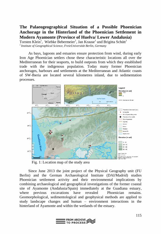
115
The Palaeogeographical Situation of a Possible Phoenician
Anchorage in the Hinterland of the Phoenician Settlement in
Modern Ayamonte (Province of Huelva/ Lower Andalusia) Torsten Klein
1, Wiebke Bebermeier
1, Jan Krause
1 und Brigitta Schütt
1
1 Institute of Geographical Science, FreieUniversität Berlin, Germany
As bays, lagoons and estuaries ensure protection from wind, during early
Iron Age Phoenician settlers chose these characteristic locations all over the
Mediterranean for their seaports, to build outposts from which they established
trade with the indigenous population. Today many former Phoenician
anchorages, harbours and settlements at the Mediterranean and Atlantic coasts
of SW-Iberia are located several kilometres inland, due to sedimentation
processes.
Fig. 1: Location map of the study area
Since June 2013 the joint project of the Physical Geography unit (FU
Berlin) and the German Archaeological Institute (DAI/Madrid) studies
Phoenician settlement activity and their environmental implications by
combining archaeological and geographical investigations of the former coastal
site of Ayamonte (Andalusia/Spain) immediately at the Guadiana estuary,
where previous excavations have revealed Phoenician remains.
Geomorphological, sedimentological and geophysical methods are applied to
study landscape changes and human – environment interactions in the
hinterland of Ayamonte and within the wetlands of the estuary.

116
This specific study aims to investigate whether the scenario, in which the
nowadays silted-up bay-like environment of the Estero de la Nao - a tidal
channel and small tributary within the lower Guadiana estuary - could have
served as a natural prehistoric harbor location for the seafaring Phoenician
population, is true or not.
The focus is set on a systematic analysis of sedimentological data
provided byvibracoring. The lithostratigraphy of three sediment cores, arranged
in one E-W striking transect and dated by AMS radiocarbon dating, shows that
at least since 7000 years BP open water conditions within a marine embayment
characterised by sedimentation under estuarine conditions prevailed for several
millennia. However, despite these favorable maritime conditions a small top
layer of stiff, organic rich mud indicating tidal-flat and salt-marsh deposits
indicates recentsilting-up processes of the former open sea areas. Additionally,
several distinct shelly units give evidence on apparently instantaneous
environmental changes like energy wave events (EWE).

117
Quaternary palaeoclimatological results of the Laguna de
Medina, Cadiz, Spain Tabea Schroeder[1]; Jasmijn Vant Hoff[2]; Helmut Brueckner[3]; Martin
Melles[2]; Klaus Reicherter[1] 1Inst. of Neotectonics and Natural Hazards, RWTH Aachen University, Germany;
2Institute of Geology and Mineralogy,University of Cologne, Germany;
3Institute of Geography, University of Cologne, Germany
The lacustrine deposits of the Laguna de Medina in southern Spain, the
second largest inland salt lake of Andalusia situated in Triassic gypsum karst,
have been investigated.
Two sediment cores with a total length of 21,34 m were drilled from a
platform. The cores were scanned by MSCL in centimeter distance for magnetic
susceptibility and by the XRF-scanner for different elements (every 0.2 cm) and
radiographic photos. Samples of 2 cm thick intervals were taken every 6 cm for
grain size analyses, TIC/TOC, CNS, ostracods, diatoms and plant remains and
every 24 cm for pollen analyses.
Preliminary results of the Laguna de Medina record cover a more or less
continuous record of sediments and, hence, a tool to unravel past conditions.The
lake sediments demonstrate high variations of water depth and salinity, at least
of the last c. 8700 years. Moreover, the lake shows a trend of perennial
conditions in earlier times to ephemeral conditions, closely linked to climate
and associated changes. Our preliminary results show a high resolution signal of
probably the last 20 000 years, which will lead to a much better understanding
of the relation between climate and human migration on the Iberian Peninsula
because of our multi-proxy approach and a close interfingering with
archaeologists working in the nearest archaeological sites (within the frame of
the German research project C3 of the www.SFB806.de).

118
Los Bañales, reservoir sediments as indicators for land-use
changes and geomorphodynamic processes –geomophological
and palynological investigations on sediments of a roman
reservoir J. B. Ries, F. M. Thomas, M. Trunk, A. Birster, M. Czechowski, C. Eichberg,
B. Kausch, R. Hansen, M. Schumacher, M. Seeger
The geoarchaeological and palaeogeographical research of the roman
settlement of Los Bañales in the northeast of the Ebro Basin is still at its
beginning. First field research at the Presa de Cubalmena dam, probably built
for water supply of the settlement, suggests that its sediments represent a
continuous archive between the pre-roman settlement time up to the middle of
the 3rd
century AC. There could be found several indicators for a landscape
evolution, vegetation and the effect of grazing, clearing, agricultural use,
colonisation of the catchment as well as on soil erosion processes.
The results of geomorphological, palynological and sedimentological
analysis indicate the occurrence of phases with higher vegetation density
corresponding to a lower geomorphodynamic activity, as well as phases with
intensified land-use with grazing and agriculture. Sediment cores down to a
depth of 2.5 m, show a 14
C maximum age 4420 +/- 30 BP (early Bronze Age) as
well as several other ages corresponding to pre-roman Iron Age and Roman
times. The dating results within the Roman phase are partially inverse,
indicating erosion processes transporting older material into the reservoir and its
sedimentation on younger material. This is supported by high concentration of
HPC-spores (a taxon related to dung) and Pinus pollen, which indicate high
grazing intensity, forest-clearance and the following land-use change. But a
clear evidence for these findings has still to be found. Therefore, additional field
and lab work is planned: digging a profile for a comprehensive characterisation
of the sediments and the analysis of undisturbed core material with computer
tomography. The latter method, which is still in an experimental phase, shall
help to identify sediment layers which cannot be discerned visually.

119
CONTENTS

120
121
CONTENTS
LIST OF PARTICIPANTS ........................................................................ 3
PREFACE .................................................................................................. 5
GUEST LECTURER ................................................................................. 7
TOPIC INDEX ........................................................................................... 9
Coastal and karstic archives .................................. 11
Links between Holocene environmental change and
paleolimnological development in wet dune slacks (SW Portugal). ..... 14
Giant catastrophic cascade events induced by the Zanclean
flooding of the Mediterranean in the Gibraltar Arc (South Spain). ....... 15
Geological records of Holocene extreme wave events (EWE) in
SW Iberia: Tsunami and storm surge deposits ...................................... 17
Holocene environmental reconstruction along the southern
Portuguese coastal region (Algarve) ...................................................... 19
From fabric microstratigraphy of stalagmites to environmental
changes affecting the process of calcite precipitation. A case study from
two caves in N Spain. ............................................................................ 20
Usefulness of the study of palaeokarst affecting Quaternary
depositsin the Central Ebro Basin ......................................................... 22
The evolution of the Guadalfeo submarine delta(northern Alboran
Sea) during the last ca. 200 years .......................................................... 24
Speleothem growth rate and stable isotope record during the last
interglacial from a Campanet cave stalagmite (Mallorca, Western
Mediterranean): evidences for significant hydro-climate changes. ....... 27
Estuarine coastal barriers as archive of high-energy events during
the mid-late Holocene (Gulf of Cádiz, SW Spain): Human implications.
............................................................................................................... 29
Reading the sequences: A two-step look on
MediterraneanHolocene fluvial tufa deposits evolution inferred by
climatic and anthropogenic parameters ................................................. 32

122
Inventory of large blanket tufa deposits in the Iberian Peninsula.
Geomorphological response to paleoclimatic and tectonic changes
during the Pleistocene ............................................................................ 34
Methods applied to archives and open topics ...... 36
Micromorphological features of in-situ or reworked shelter
sediments of the Iberian Peninsula ........................................................ 38
On the potential of ESR dating of optically bleached quartz grains
from karstic environment ...................................................................... 39
Compound-specific radiocarbon dating of leaf waxes ................. 40
Coupling 18O and 2H biomarker analyses in paleoclimate
research: potential, conceptual model and a first application study from
East Africa ............................................................................................. 41
Luminescence dating of Quaternary sediments in Spain – problems
and first results ...................................................................................... 42
The periglaciation of the Iberian Peninsula .................................. 43
Quantifying post-sedimentary n-alkane contamination in loess
using 14C and OSL dating .................................................................... 44
Al-bearing organic speleothems in granite caves or NW Iberia:
characterization and chronology ............................................................ 45
Luminescence dating of Iberian cave sequences – potential and
drawbacks .............................................................................................. 47
Luminescence Dating on Middle to Late Pleistocene Eolianites
from Eivissa, Western Mediterranean. .................................................. 49
Doñana, a zonal and azonal pedogenesis archives for the Holocene
(SW, Spain) ........................................................................................... 50
Measuring soil erosion by means of a low-cost photogrammetry 52
Aeolian archives ...................................................... 54
Leaf wax biomarkers in a Loess-Paleosol Sequence in El Paraíso,
Spain ...................................................................................................... 55
Younger Dryas and Holocene hydroclimatic variability and
aeolian history of the Middle Atlas (Morocco) ..................................... 57
Major episodes of aeolian activity in the central coast of Portugal
since the LGM ....................................................................................... 58

123
Loess-palaeosol-sequences in the Tajo basin - distribution and
stratification ........................................................................................... 59
Early to Late Pleistocene aeolian deposits in the central Ebro Basin
(NE Spain): new clues for deducing Pleistoceneenvironmental
variability in this area ............................................................................ 60
Granulometrical, Mineralogical and Geochemical Characterization
from a Loess Palaeosols Sequence in the Tagus Basin ......................... 62
Sedimentary characterization of a succession of aeolian sands in
the Tejo River lower valley – a record of environmental changes of
western Iberia during the Late Plistocene to Holocene ......................... 64
Aeolianite Sequences on Fuerteventura with different
characteristics ........................................................................................ 66
Alluvial archives ...................................................... 67
Evidence of huge Hippopotamus in the Pleistocene from T12
terrace deposits located on the River Guadalquivir (La Rinconada,
Seville, Spain): stratigraphic meaning and palaeoenvironmental value. 69
Time-integrated 3D late Quaternary sediment-depocentre
migration in the Tagus depositional system: from river valley to abyssal
plain ....................................................................................................... 71
River response to environmental changes during the Late
Pleistocene to Holocene transition inferred from fluvial archives, tufa
and slope deposits in the southeastern Iberian Peninsula ...................... 73
Geomorphological cartography on the River Tejo lower valley –
implications for interpretation of landscape and environmental changes
of western Iberia inthe last 2 Ma ........................................................... 75
The terraces staircases of Douro River at the Pocinho and Barca
D‟Alva sectors (NE Portugal) – records for the interpretation of the
evolution of W Iberia during Quaternary .............................................. 77
Flood periods are wet periods? - A critical examination of Atlantic
River Basins in Spain. ........................................................................... 79
Quaternary fluvial environments in the eastern Rif (Morocco) –
the case study of Wadi Selloum in the vicinity of the prehistoric site Ifri
n‟Ammar................................................................................................ 80
The Upper Pleistocene (with lithic industries) and Holocene
sequence in the Guadalquivir‟s floodplain (Seville, Spain): from a
fluvial system to an aggradation and shallowing-upward alluvial
processes ................................................................................................ 81

124
Tectonic Signals in Fluvial Archives – Jarama River in Central
Spain ...................................................................................................... 84
Palaeoenvironmental reconstruction of the Llobregat River
between VI to IV millennia cal. BP from the Cal Maurici sediment
archives (Barcelona, NE Iberian Peninsula) .......................................... 86
Palaeoenvironmental data from fluvial deposits associated to
ancient fishing weirs in the Miño River, NW Iberia. ............................ 87
Dating fluvial terraces of the River Mero Basin (NW Iberian
Peninsula) by luminescence................................................................... 89
Valley incision trends and subsequent chronosequences of fluvial
terraces for Atlantic large rivers in the Iberian Peninsula and Northern
Europe. .................................................................................................. 91
Chronologies of long-term Quaternary fluvial terrace archives in
the Eastern Betic Cordillera, SE Spain .................................................. 93
Human occupation archives and climate change 95
Environmental evolution of the Pederneira lowland (W Portugal)
during the Holocene – a multi proxy study ........................................... 97
Millennial aridity cycles as a driver of human occupation in central
Spain: a reinterpretation. ....................................................................... 99
Lower Sado basin sediments: a source of information for the late
Mesolithic behaviour ........................................................................... 101
The Initial Magdalenian at Urtiaga Cave (Deba, Gipuzkoa, Spain):
A Preliminary Presentation .................................................................. 103
Holocene environmental changes along the Portuguese SW coast;
a contribution based on pollen and non-pollen palynomorphs to
disentangle the impact of climate and human driven changes ............ 104
Perspectives on early Holocene environmental and climatic
changes in the western Mediterranean and NW Africa: a view from the
Middle Atlas, Morocco ........................................................................ 105
Palaeoclimatological research of the Early Quaternary from the
Laguna de Medina, Cádiz, Spain. ........................................................ 106
A Window within the Holocene:The Chalcolithic in the Micro-
Region of Azután (Toledo, Spain) ....................................................... 108
Roman land use patterns on the Iberian Peninsula – a result of
natural conditions and economic strategies ......................................... 110

125
Moroccan lacustrine records suggest a variable positive state of the
North Atlantic Oscillation during the early to mid-Holocene. ............ 111
The archaeological record of the Cave of Nerja (Malaga,
Andalusia, Spain) and its contribution to the study of the
palaeoenvironment during the Late Upper Pleistocene and the Early
Holocene of southern Iberia ................................................................ 113
The Palaeogeographical Situation of a Possible Phoenician
Anchorage in the Hinterland of the Phoenician Settlement in Modern
Ayamonte (Province of Huelva/ Lower Andalusia) ............................ 115
Quaternary palaeoclimatological results of the Laguna de Medina,
Cadiz, Spain ......................................................................................... 117
Los Bañales, reservoir sediments as indicators for land-use
changes and geomorphodynamic processes –geomophological and
palynological investigations on sediments of a roman reservoir ......... 118