Embed Size (px)
Citation preview
PYROCLASTIC ROCKS AS A TOOL TO EVALUATE GEOTHERMAL SYSTEMS IN THE KENYAN RIFT VALLEY
SGL 413: PROJECT IN GEOLOGY
BY
NYUTU K. NJAU
REG. NO: I13/21990/2007
A RESEARCH PROJECT SUBMITTED IN PARTIAL FULFILLMENT FOR THE AWARD OF BACHELOR OF SCIENCE DEGREE IN GEOLOGY,
DEPARTMENT OF GEOLOGY,
UNIVERSITY OF NAIROBI
3rd JUNE, 2011

Pyroclastic Rocks as a Tool to Evaluate Geothermal Systems in the Rift NYUTU K. N. (2011)
ii
DECLARATION Student Declaration
I hereby certify this project as my original work and has never been presented for examination by any
other person. No publication or reproduction of this document should be done without my permission or
liars with the Department of Geology at the University of Nairobi.
SIGN…………………………………… DATE…………………………………….
NYUTU KEVIN NJAU
REG. NO: I13/21990/2007
Approval by the Supervisor
This project has been submitted for examination with my approval as the supervisor
SIGN………………………………….... DATE……………………………………..
NAME………………………………….
Supervisor
Approval by the Course Tutor
This project has been submitted for examination with my approval as the coordinator
SIGN…………………………………… DATE………………………………………
DR. D. O. OLAGO

Pyroclastic Rocks as a Tool to Evaluate Geothermal Systems in the Rift NYUTU K. N. (2011)
iii
ABSTRACT Pyroclastic rocks when studied keenly would be a big boost to identifying the geothermal system of a targeted area and better still a geothermal prospecting tool in potential regions, even before other surface investigations are undertaken. It is such factors as volume and characteristics-both chemical and physical, of these rocks that need to be looked at on a wider scope. Pyroclastics refer to tephra produced by the expansion of magmatic gases and is a collective term for tuffs, ash, and ignimbrites (pumice-rich pyroclasic flows). Among other factors that will be explained later, pyroclastic rocks can be used to estimate the size of their parental chamber, indicate both host rock permeability and existence of water in the thermal system, and reconstruct the host rock lithology and stratigraphy beneath the volcano.
This project is aimed at creating more deserved attention on pyroclastics in Kenya’s geothermal- potential areas, most of which happen to occur in the Rift, for detailed analyses in the prospecting stages. Excellent examples of the use of pyroclastic rocks and lithic constituents in exploration for geothermal reservoirs are provided by studies in the Latium volcanic province of Italy, Taupo in New Zealand, and Nisyros in Greece.

Pyroclastic Rocks as a Tool to Evaluate Geothermal Systems in the Rift NYUTU K. N. (2011)
iv
ACKNOWLEDGEMENT In sincere gratitude, my foremost appreciation goes to God, for having enabled me pursue the career of my dreams and giving me the insight of venturing out even further. I thank my mother, Mary, for all her unlimited support, encouragement and positive attitude. The same goes to my father, Joseph, for his admiration. Not to be forgotten are my brother Amos and friend Hazel for their moral support. The geology class of 2011 is much thanked and will forever be remembered, as well as the staff of the Department of Geology, University of Nairobi, for their patience and guidance. The author is greatly indebted to KenGen for granting permission to use the library in steps of searching for data to this project.

Pyroclastic Rocks as a Tool to Evaluate Geothermal Systems in the Rift NYUTU K. N. (2011)
v
DEDICATION This project is dedicated to my mother, Mary, father, Joseph, brother, Amos, and friend Hazel. It also goes out to all my geology classmates, class of 2011, and all those who love and appreciate volcanoes.

Pyroclastic Rocks as a Tool to Evaluate Geothermal Systems in the Rift NYUTU K. N. (2011)
vi
TABLE OF CONTENT DECLARATION .................................................................................................................................... ii
ABSTRACT ........................................................................................................................................... iii
ACKNOWLEDGEMENT ...................................................................................................................... iv
DEDICATION ........................................................................................................................................ v
TABLE OF CONTENT .......................................................................................................................... vi
LIST OF FIGURES ................................................................................................................................ ix
LIST OF TABLES ................................................................................................................................. ix
CHAPTER ONE ..................................................................................................................................... 1
INTRODUCTION ................................................................................................................................... 1
1.1 Introduction ............................................................................................................................. 1
1.1.1 General Introduction of the Study Areas .................................................................................. 1
1.1.1.1 Olkaria and Longonot Volcanic Centers............................................................................ 1
1.1.1.2 The Menengai Volcanic Field ........................................................................................... 2
1.1.1.3 Silali Caldera .................................................................................................................... 2
1.2 Statement of the Problem ............................................................................................................... 2
1.3 Aim ............................................................................................................................................... 2
1.4 Specific Objectives ........................................................................................................................ 2
1.5 Research Questions ........................................................................................................................ 3
1.6 Methodology ................................................................................................................................. 3
1.7 Previous Works ............................................................................................................................. 3
CHAPTER TWO .................................................................................................................................... 4
PYROCLASTIC ROCKS AS A TOOL TO EVALUATE VOLCANIC SYSTEMS IN THE KENYAN RIFT VALLEY ....................................................................................................................................... 4
2.1 The Rift Valley .............................................................................................................................. 4

Pyroclastic Rocks as a Tool to Evaluate Geothermal Systems in the Rift NYUTU K. N. (2011)
vii
2.2 South-Rift Volcano Centers ........................................................................................................... 6
2.2.1 Olkaria Volcanic Complex ...................................................................................................... 6
2.2.1.1 Distribution of Pyroclastics Found Around Olkaria ........................................................... 7
2.2.1.2 The Longonot Pyroclastics ............................................................................................... 8
2.2.1.3 A Lithological Discussion on the Pyroclastics ................................................................... 9
2.2.1.4 Stratigraphy of Olkaria Geothermal Field ......................................................................... 9
2.2.1.5 Hydrothermal Alteration ................................................................................................. 10
2.2.2 The Menengai Volcanic Complex ......................................................................................... 10
2.2.2.1 Distribution of pyroclastics around Menengai ................................................................. 11
2.2.2.2 Geochemistry ................................................................................................................. 12
2.3 North-Rift Volcano Centers ......................................................................................................... 12
2.3.1 Silali Volcano ....................................................................................................................... 12
2.3.1.1 Stratigraphy .................................................................................................................... 13
2.3.1.2 Petrography and Mineral Chemistry................................................................................ 15
2.3.1.3 Geochemistry ................................................................................................................. 15
CHAPTER THREE ............................................................................................................................... 16
DISCUSSION ....................................................................................................................................... 16
3.1 Introduction ................................................................................................................................. 16
3.2 Subsurface thermal energy estimates ............................................................................................ 16
3.3 Pyroclastic rock volumes ............................................................................................................. 16
3.4 Lithic ejecta: An important geothermal prospecting tool ............................................................... 17
3.5 Hydrothermal Alteration .............................................................................................................. 19
3.5.1 Characterization and Interpretation ........................................................................................ 20
3.5.2 Mapping Alteration Mineralogy ............................................................................................ 24

Pyroclastic Rocks as a Tool to Evaluate Geothermal Systems in the Rift NYUTU K. N. (2011)
viii
CHAPTER FOUR ................................................................................................................................. 25
CONCLUSION AND RECOMMENDATION ...................................................................................... 25
REFERENCES...................................................................................................................................... 26

Pyroclastic Rocks as a Tool to Evaluate Geothermal Systems in the Rift NYUTU K. N. (2011)
ix
LIST OF FIGURES Figure 2.1: The Kenya Rift Valley showing boundary faults and Quartenary-Recent volcanoes................ 4
Figure 2.2: Quaternary-Recent volcanoes of the south-central Kenya Rift ................................................ 6
Figure 2.3: A sketch showing the field relationships between the outcropping lithologies in northern Olkaria complex ...................................................................................................................................... 7
Figure 2.4: A Sketch showing field relationships of the lithologies outcropping in southern Olkaria ........ 8
Figure 2.5: A sketch showing a north-south cross-section stratigraphic relationship between outcropping lithologies ............................................................................................................................................... 9
Figure 2.6: Location of Menengai Geothermal Prospect showing fumaroles, major faults, and sampling points .................................................................................................................................................... 10
Figure 2.7: Geological map of Menengai Geothermal prospect area ..................................................... 11
Figure 2.8: Distribution of Quaternary central volcanoes in the northern Gregory Rift. Location of Silali volcano is outlined ................................................................................................................................ 12
Figure 2.9: Topographic profiles across Silali volcano. Vertical exaggeration X2 ................................. 14
Figure 2.10: Sketch sections of the geology of Silali caldera. ................................................................. 14
Figure 2.11: A cross-section of the western flanks of Silali. Horizontal scale = vertical scale ................ 15
Figure 3.1: An example of lithic stratigraphy determined by correlations in a geothermal well is in Nisyros, Greece. .................................................................................................................................... 18
Figure 3.2: Review of hydrothermal alteration facies and characteristic mineral assemblages shown as a function of temperature and depth ......................................................................................................... 19
Figure 3.3: Models of two types of fossil hydrothermal systems that are responsible for epithermal ore deposits. ................................................................................................................................................ 20
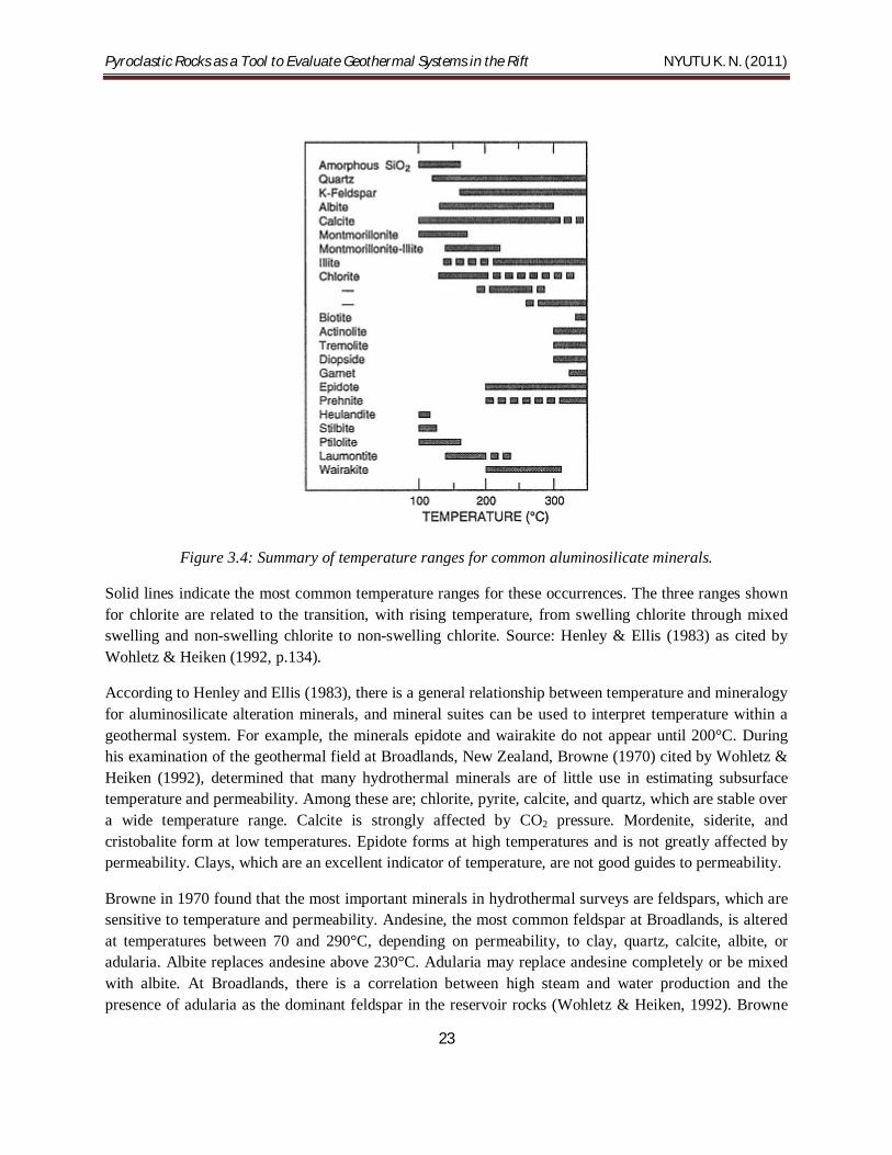
Figure 3.4: Summary of temperature ranges for common aluminosilicate minerals. ............................... 23
LIST OF TABLES Table 3.1: Replacement products of major mineral phases ..................................................................... 21
Table 3.2: The relative order of replacement during alteration for primary minerals in various hydrothermal systems ............................................................................................................................ 22

Pyroclastic Rocks as a Tool to Evaluate Geothermal Systems in the Rift NYUTU K. N. (2011)
1
CHAPTER ONE
INTRODUCTION
1.1 Introduction Four volcanic fields; Olkaria, Longonot, Menengai, and Silali, have been chosen for this study. Their pyroclastic occurrences have been noted in detail, according to literature, as well as their distribution, stratigraphy, correlation, and physical and chemical properties. The description of the latter is based on parental magma composition. Analyses of lithic fragments in the pyroclastic rocks could tell us what type of thermal and hydrothermal regimes are present in the sub-surface. Geothermal systems refer to the ideal components that can support viable geothermal production. The components are; a permeable reservoir rock, water, and a heat source.
In the discussion, factors and estimates determined by pyroclastic rocks are explained on a wider scope. The characteristics of the pyroclastics from the four centers, more so abundance and hydrothermal alteration, are compared to those in other geothermal fields where such studies have already been done. The positive relations indicate that the method can work in geothermal exploration in the Kenyan Rift Valley. The practice is simple and cost-effective. However, the challenge remains in establishing pyroclastic research-units locally. This can be ensured if much emphasis is accorded to this rather interesting type of volcanic ejecta.
1.1.1 General Introduction of the Study Areas The areas of study are the Olkaria, Longonot, Menengai, and Silali volcanic centers.
1.1.1.1 Olkaria and Longonot Volcanic Centers The neighbouring Quaternary silicic volcanic fields of Olkaria and Longonot lie between 0°55' S, 36°26' E and 1°10' S, 36°20' E, at the southern end of a chain of eight Quaternary caldera complexes and two non-caldera Quaternary complexes in the central trough of the Gregory Rift, Kenya.
The Olkaria volcanic complex is characterized by comendite lava flows and pyroclastics on the surface and basalts, trachytes, and tuffs in the subsurface (Lagat, 2003). The lithostratigraphy of the Olkaria geothermal area as revealed by data from geothermal wells and regional geology can be divided into six main groups (Lagat, 2003): Proterozoic “basement” formations, Pre-Mau Volcanics, Mau Tuffs, Plateau Trachytes, Olkaria Basalt and Upper Olkaria volcanics.
The activity directly associated with formation of Longonot started 0.4 Ma BP and can be described in three main periods namely pre-caldera, syn-caldera and post-caldera (Lagat, 2003). A series of arcuate ridges on the northern, western and the southern parts of the summit crater indicate existence of a caldera (Lagat, 2003). Trace element of studies done on Longonot volcanics indicate that they are comagmatic, thus suggesting the presence of a large, highly evolved and long lived magmatic system under the caldera (Clarke et al. 1990). Geotermica Italiana (n.d) explained that the presence of hydrothermally altered lithics indicates that the geothermal system under the volcano must have attained >250°C.

Pyroclastic Rocks as a Tool to Evaluate Geothermal Systems in the Rift NYUTU K. N. (2011)
2
1.1.1.2 The Menengai Volcanic Field The Menengai Geothermal Prospect is located in the central section of the Kenyan Rift Valley, the area north of Lake Nakuru and south of Lake Bogoria. The extent of the prospect covers an area of approximately 600 km2 characterized by a complex geological setting with the Menengai caldera being notably the major geological feature in the area and of significant geothermal potential (Kanda, 2010).
Menengai has been active from about 0.4 -0.3 Ma B.P (Gislason, 1989). The formation of the shield volcano began about 200,000 years ago and was followed by the eruption of two voluminous ash-flow tuffs, each preceded by major pumice falls (Kanda, 2010). There are more than 70 post caldera lava flows over the caldera floor, the youngest of which may be only a few hundred years old (Kanda, 2010). The caldera of Menengai volcano lies immediately north of Lake Nakuru, but ignimbrites and air-fall tuffs from the volcano cover some 1350 km2 (Leat & Macdonald, 1984) extending into Molo area (Jennings, 1971).
1.1.1.3 Silali Caldera Silali, situated at 1°10' N and 36°12' E, and 50 km north of Baringo, is the largest Quaternary caldera volcano in the northern Gregory Rift and is composed predominantly of peralkaline trachytic lavas and pyroclastic deposits, and mildly alkaline to transitional basalts. Silali is a broad, low-angle shield, with a basal diameter of 30 km by 25 km slightly elongate in a N-S direction, rising 760 m above the rift floor (Smith et al. 1995). The shield of Silali is broadly symmetrical with flank gradients varying between 3° and 7°, the western flanks are however steeper and have a step-like profile (Smith et al. 1995). The summit of Silali is dominated by a spectacular caldera, elliptical in plan, measuring 7.5 km by 5 km, with a long axis trending to 300°, and has unbreached walls that reach a maximum height of 340 m (Smith et al. 1995). The combination of a broad, flat top, short and steep upper slope and a deep wide caldera indicates that Silali is morphologically comparable to many large basaltic shield volcanoes, particularly those of the Galapagos Islands (Nordlie, 1973; Chadwick & Howard, 1991).
1.2 Statement of the Problem Geothermal prospecting in Kenya, and particularly in the Rift, has seen little in the study of pyroclastic rocks, yet they are very important indicators of the kind of thermal regimes, geothermal systems and sub-surface hydrothermal resources that may be present in a volcanic field. Pyroclastic rocks bear important physical and chemical properties that could be used to the advantage of exploration through detailed analyses. Their abundance reflects huge geothermal potential.
1.3 Aim To illustrate how pyroclastic rocks can be used to indicate, identify, and establish geothermal systems in the Kenyan Rift Valley.
1.4 Specific Objectives (i) To study the stratigraphy, correlation, occurrence and distribution of pyroclastic rocks in some of
the volcanic centers of the Rift

Pyroclastic Rocks as a Tool to Evaluate Geothermal Systems in the Rift NYUTU K. N. (2011)
3
(ii) To identify the physical and chemical characteristics exhibited by these pyroclastic rocks
(iii) To study the alteration and other secondary effects that these pyroclastic rocks have been subjected to, and their influence on permeability and interpretation on thermal and hydrothermal activities in the subsurface
1.5 Research Questions (i) How are pyroclastic rocks stratified in the overall geology, and distributed in the discussed
volcanic centers of the Rift?
(ii) What physical and chemical characteristics do these pyroclastic rocks exhibit?
(iii) What is the influence of alteration and other secondary effects on permeability, and their interpretation on thermal and hydrothermal subsurface activities?
1.6 Methodology (i) Library literature- Publications on the fields of interest from the KenGen library
(ii) Internet sources- Electric books and journals touching on pyroclastic distribution in some of the volcanic centers and where the concept title has been applied to other geothermal fields in different parts of the world
1.7 Previous Works Up to date, no descriptive studies on pyroclastic rocks have been done in the specific context of their use as a tool for geothermal exploration.
Their mention has however been exceedingly covered in the geology of already surveyed areas both in the north- and south-rift areas. In Olkaria and Menengai, pyroclastics were discussed in the overall geology by Odongo (1984), Muchemi & Odongo (1985), Mungania (1992, 1995), and Omenda (1994). The Menengai geothermal field has been poorly covered on areas of pyroclastic description, petrogenesis, and mineralogy, although Leat (1983) and Jones (1984) carried out field survey and the geological evolution of Menengai respectively. Mungania (1999) too did some work on an overview of Menengai’s geology. It is hoped that more will be done now especially that active drilling is taking place. Silali caldera has similarly not received much attention on detailed pyroclastic studies. Smith et al. (1995) and Macdonald et al. (1995) however did commendable work on the geochronology and petrogenesis of Silali respectively. More work is also expected here in the near future since the caldera holds immense geothermal potential.

Pyroclastic Rocks as a Tool to Evaluate Geothermal Systems in the Rift NYUTU K. N. (2011)
4
CHAPTER TWO
PYROCLASTIC ROCKS AS A TOOL TO EVALUATE VOLCANIC SYSTEMS IN THE KENYAN RIFT VALLEY
2.1 The Rift Valley The East African Rift System extends southwards from the Red sea for a distance of about 3000 km. Within East Africa, it is represented by the Western Rift and the Eastern Rift, of which the Gregory Rift Valley is that part lying within Kenya and northern Tanzania (King, 1978).
Figure 2.1: The Kenya Rift Valley showing boundary faults and Quartenary-Recent volcanoes
Source: Scott & Skilling (1999).

Pyroclastic Rocks as a Tool to Evaluate Geothermal Systems in the Rift NYUTU K. N. (2011)
5
The Gregory Rift Valley was initiated in the early Miocene times as a downwarp along the continental watershed on a land surface having considerable relief (up to 2000 m). Subsequent faulting produced a graben about 80 km wide and some 450 km in length, to the north and south of which the faults splay outwards over much broader zones (King, 1978).
A summarized structural sequence of the Rift Valley by Nyambok (1983) is given below;
(i) Domal uplift caused by convection currents and accumulation by extensional crustal thinning with phonolites erupting on the west rift- Miocene epoch
(ii) Downwarping and major boundary faulting accompanied by powerful basaltic and trachy-phonolitic volcanism on the floor of the Rift Valley- Pliocene epoch
(iii) Closely-spaced sub-parallel faults across the whole width of the Rift Valley floor accompanied by volcanism of the trachytic ignimbrites- Quartenary
(iv) Faulting in a narrow central belt accompanied by intense central volcanic activity which gave rise to a number of trachytic calderas. Small plugs also built on the rift floor, and some central volcanoes on the rift shoulders- Quartenary

Pyroclastic Rocks as a Tool to Evaluate Geothermal Systems in the Rift NYUTU K. N. (2011)
6
2.2 South-Rift Volcano Centers
Figure 2.2: Quaternary-Recent volcanoes of the south-central Kenya Rift
Source: Scott & Skilling (1999).
2.2.1 Olkaria Volcanic Complex Olkaria has been deemed as a ‘complex’ (Macdonald et al., 1987; B.G.S., 1990) because of the fact that it has numerous volcanic centers with over eighty small issue points occurring in groups of coalesced domes, deep crater rows and fissure-related eruptions. The complex covers an estimated area of 200 km2.
The surface lithologies in Olkaria comprise of alkali rhyolitic lavas and pyroclastics (Mungania, 1995). Interestingly, despite the wide occurrence of the latter, the amount of study done has been minimal, a fact that is contributed to the mode of emplacement of the tephra deposits which involves instantaneous eruption, transportation and deposition. In addition, several possible centers are localized to each other and the origin of the tephras could be any of them (Mungania, 1995).

Pyroclastic Rocks as a Tool to Evaluate Geothermal Systems in the Rift NYUTU K. N. (2011)
7
2.2.1.1 Distribution of Pyroclastics Found Around Olkaria According to Mungania (1995), pyroclastic deposits in and around Olkaria are grouped into Olkaria group and Longonot pyroclastics. The Olkaria group consist of three members; the upper, middle and lower members. The Longonot pyroclastics on the other hand are the Longonot ash fall and the Longonot pumice deposit. The latter show similar depositional characteristics with some Olkaria pyroclastics indicating that at some time Olkaria and Longonot were erupting simultaneously.
The Olkaria Group
The upper member- Is made up of thick horizons of ash dunes, sub-parallel and accretionary lapilli. They are products of phreatomagmatic eruptions from within Olkaria and possibly located along the ring structure (Mungania, 1995). They are prominently exposed in Ol Njorowa gorge, over the ring domes and some gullies over the south. This formation’s age is shown to be more than 3280 years (B.G.S., 1990).
Figure 2.3: A sketch showing the field relationships between the outcropping lithologies in northern Olkaria complex
Source: Mungania (1995).
The middle member- Is distinguished by the pyroclastic fall deposit comprised of pale to gray-coloured pumice and ash. Lava lithics and bread-crust bombs indicate a proximal phase for the outcrops exposed in Ol Njorowa gorge and gullies in the southwest around Loiroguwa Hill (Mungania, 1995).The age indicated is > 9150 years before present (B.G.S., 1990). Towards the west and south of Olkaria, they grade into grayish to weathered (dirty brown) pumice lapilli with palaeosoils- possibly termed Maiella tuffs in earlier reports.
The lower Olkaria pyroclastics- are divided into two members;
(i) Reworked volcanoclastics, that are only exposed in the Ol Njorowa gorge and consist of sandstone and silt-sized volcanic clastic rock fragments with carbonaceous and siliceous concretions (Mungania, 1995). These indicate lacustrine and/or alluvial environment of deposition. Age for the diatomaceous earth-bearing horizons is > 9150 years before present. (B.G.S., 1990).

Pyroclastic Rocks as a Tool to Evaluate Geothermal Systems in the Rift NYUTU K. N. (2011)
8
(ii) Pantelleritic pyroclastics, are also only exposed in the Ol Njorowa gorge around the deepest part and are lowest, stratigraphically, exposed around here (Mungania, 1995). Composition is welded fall and very proximal ignimbrite (B.G.S., 1990).
Figure 2.4: A Sketch showing field relationships of the lithologies outcropping in southern Olkaria
Source: Mungania (1995).
2.2.1.2 The Longonot Pyroclastics Longonot lies east of Olkaria. It recently had sub-plinian eruption phases (Mungania, 1995), and some of its pyroclastic products cover some places in Olkaria. The Longonot pyroclastics consist of the Longonot ash, which is a light grey to greyish, very fine grained ash fall deposit indicative of a high degree of fragmentation of the magma column. The deposits consist of pumice lapilli and bedded ash. B.G.S (1990), has suggested a phreatomagmatic mode of origin for this deposit. The best deposits however are exposed by gullies inside the Longonot caldera and the west slopes of the present Longonot peak (Mungania, 1995). Absolute age indicated for this deposit is 3280 +/- 120 years, (B.G.S., 1990). The deposit where found overlies all Olkaria rocks except Ololbulot lava which overlies the deposit at some places (Mungania, 1995).
Pyroclastic Rocks as a Tool to Evaluate Geothermal Systems in the Rift NYUTU K. N. (2011)
9
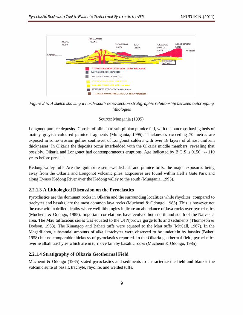
Figure 2.5: A sketch showing a north-south cross-section stratigraphic relationship between outcropping lithologies
Source: Mungania (1995).
Longonot pumice deposits- Consist of plinian to sub-plinian pumice fall, with the outcrops having beds of mainly greyish coloured pumice fragments (Mungania, 1995). Thicknesses exceeding 70 metres are exposed in some erosion gullies southwest of Longonot caldera with over 18 layers of almost uniform thicknesses. In Olkaria the deposits occur interbedded with the Olkaria middle members, revealing that possibly, Olkaria and Longonot had contemporaneous eruptions. Age indicated by B.G.S is 9150 +/- 110 years before present.
Kedong valley tuff- Are the ignimbrite semi-welded ash and pumice tuffs, the major exposures being away from the Olkaria and Longonot volcanic piles. Exposures are found within Hell’s Gate Park and along Ewaso Kedong River over the Kedong valley to the south (Mungania, 1995).
2.2.1.3 A Lithological Discussion on the Pyroclastics Pyroclastics are the dominant rocks in Olkaria and the surrounding localities while rhyolites, compared to trachytes and basalts, are the most common lava rocks (Muchemi & Odongo, 1985). This is however not the case within drilled depths where well lithologies indicate an abundance of lava rocks over pyroclastics (Muchemi & Odongo, 1985). Important correlations have evolved both north and south of the Naivasha area. The Mau tuffaceous series was equated to the Ol Njorowa gorge tuffs and sediments (Thompson & Dodson, 1963). The Kinangop and Bahati tuffs were equated to the Mau tuffs (McCall, 1967). In the Magadi area, substantial amounts of alkali trachytes were observed to be underlain by basalts (Baker, 1958) but no comparable thickness of pyroclastics reported. In the Olkaria geothermal field, pyroclastics overlie alkali trachytes which are in turn overlain by basaltic rocks (Muchemi & Odongo, 1985).
2.2.1.4 Stratigraphy of Olkaria Geothermal Field Muchemi & Odongo (1985) stated pyroclastics and sediments to characterize the field and blanket the volcanic suite of basalt, trachyte, rhyolite, and welded tuffs.

Pyroclastic Rocks as a Tool to Evaluate Geothermal Systems in the Rift NYUTU K. N. (2011)
10
2.2.1.5 Hydrothermal Alteration The Olkaria geothermal field is characterized by a low intensity of alteration. In most cases, voids and fractures are only partially filled by secondary minerals and the primary minerals show very little effect of fluid and rock interaction (Muchemi & Odongo, 1985).
K.P.C (1984) as cited by Muchemi & Odongo (1985) believed that the Olkaria field is a relatively young geothermal system since epidote was found to occur at measured downhole temperatures below its thermal stability limit, for example, OW-10 at 620 m deep with temperatures below 240°C.
More commonly, the secondary mineral assemblage includes chlorites, zeolites, chalcedonic silica, quartz, calcite, albite, iron oxides and other oxides, adularia, pyrite, epidote and clay minerals. Chlorites are the most common alteration minerals by percentage, for example, well OW-301 from 1616 m to 1619 m, except in oxidation-dominated areas. Other dominant minerals are calcite and Fe-oxides, abundant in basalt scoria (Muchemi & Odongo, 1985).
2.2.2 The Menengai Volcanic Complex
Figure 2.6: Location of Menengai Geothermal Prospect showing fumaroles, major faults, and sampling points
Source: Kanda (2010).

Pyroclastic Rocks as a Tool to Evaluate Geothermal Systems in the Rift NYUTU K. N. (2011)
11
The Menengai Geothermal Prospect lies in the central part of the Kenyan rift, the area north of Lake Nakuru and south of Lake Bogoria. The prospect area covers an area approximately 600 km2 characterized by a complex geological setting with Menengai caldera being notably the major geological feature in the area (Kanda, 2010).
Menengai has been active from about 0.4 to 0.3Ma before present (Gislason, 1989). The formation of the volcano began about 200,000 years ago and was followed by the eruption of two voluminous ash-flow tuffs, each preceded by major pumice falls (Kanda, 2010). Air fall tuffs from the volcano cover an estimated area 1350 km2 (Leat & McDonald, 1984) extending into the Molo area (Jennings, 1971).
2.2.2.1 Distribution of pyroclastics around Menengai Lower Menengai Tuff
According to Leat (1983), two ash flows outcrop in the caldera walls; the first located about 20 km north-west of the caldera. Here, an ash flow 7 m thick cap about 20 m of largely reworked tuffs. The pyroclastics are from two different episodes, as told both by sequence and dating. The lower ash flow in the caldera wall is dated 29,000 years (Leat, 1983). Jones (1975), and Jones & Lippard (1979) state the lower Menengai tuff to occur northwards beyond the equator and within the caldera of Kilombe.
Upper Menengai Tuff
The lower Menengai tuff is separated from the younger, upper Menengai-derived tuffs of Jones (1975), by a series of alluvial sediments, the Esageri Beds, well exposed in gullies around the edge of the Rongai plain. The upper Menengai tuff covers a vast area with distal equivalents seen as far as Lake Bogoria. The other notable areas are Rongai plain, Molo River, and Kilombe caldera- where the ash flow must have climbed 150 m in 2 km (Jones, 1975). To the west of the southern end of Lake Bogoria, the ash flow is confined to valleys.
Figure 2.7: Geological map of Menengai Geothermal prospect area
Source: KenGen (2004).

Pyroclastic Rocks as a Tool to Evaluate Geothermal Systems in the Rift NYUTU K. N. (2011)
12
The presence of two large-volume ash flow tuffs at Menengai convinced Leat in 1984 that two phases of caldera collapse had occurred.
2.2.2.2 Geochemistry Menengai volcano, as told by Leat & McDonald (1984), has had a complex geochemical evolution resulting from the interplay of magma mixing, crustal fractionation and liquid differentiation. The volcano did experience two eruptive episodes of ash flow tuffs with the second associated with the formation of the present caldera. The first ash flow recorded enrichment in Fe, Mn, Cs, Hf, Nb, Ni, Pb, Rb, Ta, Th, U, Y, Zn, and the REE, including Eu. The other probable elements are Na, Cl, and F. The zonation was due to liquid state differentiation. The second caldera collapse yielded ash flow tuff rich in Ba.
2.3 North-Rift Volcano Centers
2.3.1 Silali Volcano
Figure 2.8: Distribution of Quaternary central volcanoes in the northern Gregory Rift. Location of Silali volcano is outlined
Source: Smith et al. (1995).
Pyroclastic Rocks as a Tool to Evaluate Geothermal Systems in the Rift NYUTU K. N. (2011)
13
Silali, at 1°10' N, 36°12' E, is the largest Quartenary Caldera volcano in the northern Gregory Rift and is composed entirely of peralkaline trachytic lavas and pyroclastic deposits, and mildly alkaline to transitional basalts (Smith et al., 1995). The caldera collapse is thought to have been caused by a variety of processes including lateral magma drainage and small explosive activity (William et al., 1984; Dunkley et al., 1994). Silali is the largest and most spectacular of the northern rift volcanoes, located 50 km north Lake Baringo.
2.3.1.1 Stratigraphy On the basis of geochronology, spatial distribution and vent location, Silali’s stratigraphy is divided into four informal groups: the Caldera Wall Group, the Western Flank Group, the Pre-Caldera Group and the Post-Caldera Group (Smith et al., 1995). Silali is composed dominantly of trachytic and basaltic lava with minor volumes of hawaiite, mugearite, phonolite and some mixed rocks.
Caldera Wall Group
Smith et al. (1995) stated the Caldera Wall Group to comprise of an alternating sequence of trachyte lavas and pyroclastic deposits and represented the final stages of a prolonged phase of activity which constructed the main volcanic shield. The Kapedo tuffs were the result of a major phase of an explosive trachytic volcanism on the early shield. They represent two distinct styles of pyroclastic activity (Upper and Lower deposits) separated by a period of intermediate lava effusion, faulting, and erosion (Smith et al., 1995). From the second cycle of trachytic pyroclastic activity (Upper pyroclastic) in the north wall are polymictic and lithic-rich trachytic breccias, up to 115 m thick, overlain by normal and reverse graded pumice-rich units, 5-10 m thick, interleaved with streakly welded zones with flattened fiamme and microgabbroic bombs (Smith et al., 1995). The unit of welded air-fall tuff occurring throughout in the west wall of the caldera attains a maximum thickness of 33 m (Smith et al., 1995).
The distal equivalents of the Kapedo tuffs are exposed to the west of the caldera near Kapedo village. Here, up to 10 m of well-bedded and normally graded trachytic pumice-rich tuffs can be traced laterally for up to 15 km north of Silali and 19 km to the west of the rift wall.
Western Flank Group
On the western flank of Silali, the Arzett tuffs represented a minor phase of explosive trachytic activity and separated the Discoid and Summit trachytes lava units. The Arzett tuffs comprise of up to 40 m of stratified pumice-lapilli tuffs, breccias and glassy-welded air-fall units from which feldspar separates (sample SIL-5) have yieled an 40Ar/39Ar age of 123+(-) 3ka (Smith et al., 1995).
Post-Caldera Group
The only significant mention of pyroclastics here is the thin veneer of consolidated trachytic pumice lapilli-tuff and ash that obscures the contact between the basalt and trachyte lavas everywhere on the floor of the caldera. The deposits extend around the summit and upper flanks of Silali and thicken eastward, suggesting that source areas were located outside the caldera in the younger center of the Black Hills- an area of activity 9 km long and 4.5 km wide located on the upper-eastern flanks immediately east of the

Pyroclastic Rocks as a Tool to Evaluate Geothermal Systems in the Rift NYUTU K. N. (2011)
14
caldera rim (Smith et al., 1995). Smith & Dunkley (1990b), and Dunkley et al. (1994), both reported a significant geothermal activity within the caldera and on the upper eastern flanks.
Figure 2.9: Topographic profiles across Silali volcano. Vertical exaggeration X2
Source: Smith et al. (1995).
Sketch section of the geology of Silali caldera. Compiled from oblique 35 mm transparencies and photographs. Scales are approximate, vertical scale = horizontal scale (Adapted from Smith et al., 1995).
Figure 2.10: Sketch sections of the geology of Silali caldera.
Compiled from oblique 35 mm transparencies and photographs. Scales are approximate, vertical scale = horizontal scale. Source: Smith et al. (1995).

Pyroclastic Rocks as a Tool to Evaluate Geothermal Systems in the Rift NYUTU K. N. (2011)
15
Figure 2.11: A cross-section of the western flanks of Silali. Horizontal scale = vertical scale
Source: Smith et al. (1995).
2.3.1.2 Petrography and Mineral Chemistry The pyroclastics of the Silali caldera, mainly in the form of tuffs and breccias, pumice lapilli, air-fall and surge deposits, originated from trachytic magmas. These trachytes evolved by fractional crystallization, combined with assimilation of crust during or after fractionation (Macdonald et al., 1995). Macdonald et al. (1995) classified the trachytes into two-feldspar and one-feldspar varieties. The latter are dominant but have less phenocrysts than the two-feldspar varieties. The more evolved varieties of trachyte tend to be aphyric and glassy. Subhedral phenocrysts of sodic andesine coexist with anorthoclase in the two-felsdpar rocks. Augite, titanomagnetite, olivine, and apatite are the phenocryst phases. In the one-feldspar rocks, the generalized mineralized assemblage is alkali feldspar + clinopyroxene + titanomagnetite + fayalite (Macdonald et al., 1995). The two-feldspar rocks are composed of the following trachytoid groundmass: alkali feldspar + opaque ores + clinopyroxene rimmed by blue-brown amphibole, while in the one-feldspar trachytes, the dominant ferromagnesian groundmass is riebeckite-arfvedsonite, coexisting with alkali feldspar, titanomagnetite and occasionally quartz.
2.3.1.3 Geochemistry The Silali trachytes contain both silica over-saturated and silica under-saturated varieties. The oversaturated types occur in the Western Flank and Pre-Caldera groups. Trachytes of the Caldera Wall and Post-Caldera groups are well undersaturated (Macdonald et al., 1995). In the Western Flank group, the trachytes were described as silica-oversaturated and peralkaline varying from types relatively high in Al2O3, MgO, CaO, TiO2, P2O3, Ba, and Sr to more strongly peralkaline rocks higher in SiO2, FeO, NaO2, Rb, Nb, REE, Th, Zn, and Zr (Macdonald et al., 1995). The most evolved samples have the highest levels of incompatible trace elements (e.g. Zr and Nb). The ranges of Zr and Nb contents in the trachytes of the Pre-Caldera group are comparable to those in the Western Flanks (Macdonald et al., 1995).
Compositional variation within the Post-Caldera trachytes is comparable to that in the Western Flanks rocks, in that, Al2O3, MgO, CaO, TiO2, Ba, and Sr decrease while FeO, Na2O, and incompatible trace elements increase (Macdonald et al., 1995).
Pyroclastic Rocks as a Tool to Evaluate Geothermal Systems in the Rift NYUTU K. N. (2011)
16
CHAPTER THREE
DISCUSSION
3.1 Introduction This chapter will deal with properties of pyroclastics in length, and how they have been used to explore for geothermal systems in different parts of the world. The chapter acts as a link between what has been noted about the pyroclastics of the four volcanic centers and future prospect programmes, based on case studies in other geothermal fields of the world. Of emphasis however is Silali because of the enormous potential recorded by both past and recent surveys. To the other volcanic centers, notably the south-rift ones, the chapter only serves as a confirmatory ledge, since production is already underway.
3.2 Subsurface thermal energy estimates Wohletz & Heiken (1992, p.42-44) stated that “the most widely applied estimates for thermal energy in magmatic systems underlying volcanic fields are based on volume and age of the most recent volcanism associated with these systems. As discussed in Chapter 1, Smith and Shaw (1975; 1979), have used this approach in estimating thermal energies of magmatic systems. Volumes are inferred from caldera size, vent distribution, seismic shadows, fracture patterns, topographic uplift, geophysical anomalies, and estimates of silicic ejecta volume. If a volcano produces chemically evolved (non-basaltic) products especially those spanning andesite (sic) through dacitic and rhyolitic composition it is very likely that magma has formed a crustal magma chamber and has differentiated on its path to the surface. Because differentiation is a time-dependent process, evolved compositions can indicate prolonged residence in the crust, during which a significant amount of heat flowed from the magma into crustal rocks. The larger the magma chamber, the larger is the thermal resource, which is a measure of the amount of the economically useful energy. The thermal resource (Htr) of a magmatic heat source is proportional to the volume of rock (Vtr) that exceeds the minimum temperature for economic heat extraction (qtr)”.
3.3 Pyroclastic rock volumes Pyroclastic rock volumes provide the simplest method of estimating magma-chamber volumes for eruptions of evolved magmas in many localities (Wohletz & Heiken, 1992). Several methods can be used to calculate the volumes of pyroclastic products. Froggatt’s 1982 comparison of the three types of volume estimation (cited in Wohletz & Heiken, 1992, p.45) is based on:
Mathematical models of aerial dispersion
Field measurements of area and volume Vs thickness
Measurements of crystal-to-glass ratio
The first method is based on an assumption put forward by Froggatt (1982) and Pyle (1989), as cited by Wohletz & Heiken (1992, p.45-46) who mentioned that pyroclastic deposits exponentially decrease in thickness with distance from the vent if there is no significant ponding of the deposit in topographically
Pyroclastic Rocks as a Tool to Evaluate Geothermal Systems in the Rift NYUTU K. N. (2011)
17
low areas. The second method requires many field measurements of thickness for logarithmic plots of isopach area or volume Vs thickness. An isopach is an isocline that connects points of equal thickness of geological stratum formation or group of formations. A sum for all isopachs gives the total volume. It is Walker in 1980 (cited in Wohletz & Heiken, 1992, p.45) who proposed the third method; in estimating volumes when a significant proportion of ash (< 2 mm) has been carried to great distances from the vent and can therefore be measured in the field. An assumption on this method is that all crystals, being denser than glass, fall out near the vent and that large pumices show average magma ratios for glass to crystals.
Wohletz & Heiken (1992) showed that it would be possible to obtain measurement of a thermal resource by recalculating the volumes of volcanic products, pyroclastics included, and by assuming that they represent some fraction of the magma chamber using the equation;
Htr α Vtr = Vtr,
Where Htr is the thermal resource proportional to Vtr, the rock volume. Below is an example is given by Wohletz & Heiken (1992, p.46, 47);
“A young silicic pyroclastic deposit for which V= 1.0 km3: the thermal resource (Htr) of the magma chamber (volume= 6.5 km3) is shown as a function of kinetic energy of the eruption that emplaced the deposit. Assuming a conservative 1% recovery of the thermal resource, the potential resource for this system is estimated by tapping 250°C from fluids from the associated hydothermal or hot dry rock system. About 850 kJ/kg is available from the saturated vapour produced; if one allows for a conservative 14% turbine cycle efficiency for saturated vapour cooled to 50°C, then wells producing ~ 600 tons/hour would generate nearly 19 MWe for 30 years by either hydrothermal or hot dry rock methods (Wohletz & Heiken, 1992)”.
The simple thermal resource estimation described above would however need to have volcanic products erupted from a crustal magma chamber that is sufficiently young to retain much of its initial heat (Wohletz & Heiken, 1992).
3.4 Lithic ejecta: An important geothermal prospecting tool Lithic ejecta can provide information (Wohletz & Heiken, 1992) about;
Subvolcanic stratigraphy
Aquifer depth and physical properties
Aerial extent of the fluid reservoir in a volcanic region
Chemical and thermal regime at depth
An in-depth study as that by Barberi et al. in 1988 (cited in Wohletz & Heiken, 1992, p.89), involves the “collection of tephra samples, petrographic microscopic point counts of lithic constituents abundances, comparisons of the abundances with stratigraphic position in both the tephra deposit and the regional rocks, and X-ray analyses of alteration assemblages found in lithic fragments”. A good example of the

Pyroclastic Rocks as a Tool to Evaluate Geothermal Systems in the Rift NYUTU K. N. (2011)
18
correlation between basement stratigraphy and lithic fragments comes from the geothermal investigatios on the island of Nisyros, Greece.
An example given below shows the eruptive sequence and a correlation between its lithic constituents and basement lithology encountered in a geothermal well.
Figure 3.1: An example of lithic stratigraphy determined by correlations in a geothermal well is in Nisyros, Greece.
The eruptive sequence shown is a magmatic-phase pumice fallout on a paleosol substrate that is overlain by dune- and massive-bedded hydromagmatic tephra capped by a lava. Lithic fragments from the magmatic-phase deposits correspond to impermeable strata that are logged in the geothermal well, whereas the lithic fragments in the hydromagmatic-phase deposits correspond to deeper, increasingly permeable strata. Hydrothermal alteration observed in the geothermal well increases downward from argillic (A) through argillic-phyllitic (AF), phyllitic-propylitic (FP), and propylitic (P) to thermally metamorphosed rock (PM). Source: Barberi (1985) cited in Wohletz & Heiken (1992, p.93).
The thermal regime of basement rocks is also reflected by lithic constituents found in pyroclastic rocks. Through a careful study of the paragenesis of alteration minerals in lithic fragments, including stable isotope variations and fluid inclusion analyses such as Cl-, SO4, NH4, and SiO2, it is possible to work out not only the geochemical nature of hydrothermal fluids at depth but also their evolution with time and thermal regime (Wohletz & Heiken, 1992). In the example above from Nisyros, the four zones of secondary minerals found in the geothermal well are, with increasing depth; argillic, argillic-phyllitic,

Pyroclastic Rocks as a Tool to Evaluate Geothermal Systems in the Rift NYUTU K. N. (2011)
19
phyllitic-propylitic, and propylitic mineral assemblages, the lowest three of which show up in lithic fragments from the tephra deposit.
Below is an illustration that reviews basic hydrothermal alteration facies and equilibrium temperature represented by the mineral assemblages that characterize each facies.
Figure 3.2: Review of hydrothermal alteration facies and characteristic mineral assemblages shown as a function of temperature and depth
Source: Wohletz & Heiken, (1992).
Secondary mineral assemblages in volcaniclastic rocks are a good indicator of burial depth (Viereck et al., 1982), as cited in Wohletz & Heiken (1992, p.91). Glass shards commonly alter during diagenesis to zeolites, feldspars, opal-ct, and quartz as well as smectite clays and consequently can indicate temperature and burial depth.
Excellent examples on the use of hydrovolcanic tephra and lithic constituents in exploration for geothermal reservoirs are provided by studies in the Latium volcanic province of Italy, which includes the Vulsini (tephra) volcanic complex, Vico volcano, the Sabatini volcano complex, and the Albani volcanic complex.
3.5 Hydrothermal Alteration By Henley & Ellis’s (1983) definition, hydrothermal alteration is a general term embracing the mineralogical, textural, and chemical response of rocks to a changing thermal or chemical environment in presence of hot water, steam, or gas.
Pyroclastic Rocks as a Tool to Evaluate Geothermal Systems in the Rift NYUTU K. N. (2011)
20
By mapping alteration mineral assemblages at the surface (but more commonly within drill- holes), it is possible to locate the zones with the highest temperatures, pressures, or permeabilities all of which are important in geothermal exploration (Wohletz & Heiken, 1992).
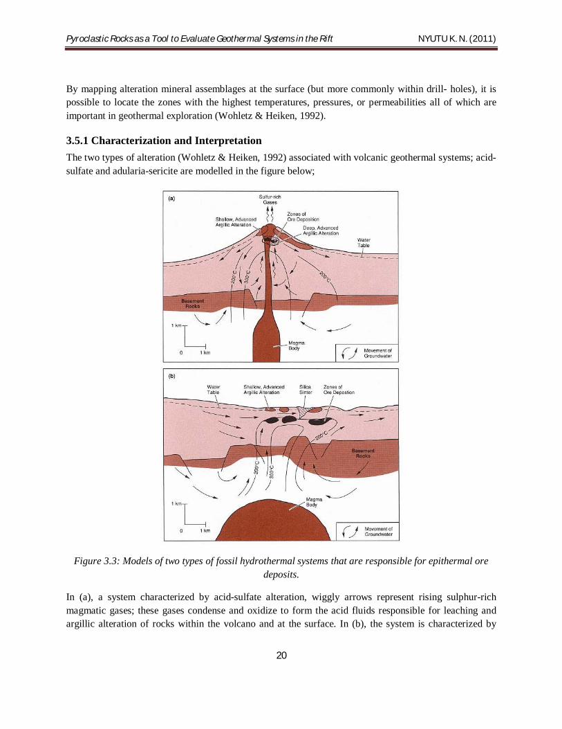
3.5.1 Characterization and Interpretation The two types of alteration (Wohletz & Heiken, 1992) associated with volcanic geothermal systems; acid-sulfate and adularia-sericite are modelled in the figure below;
Figure 3.3: Models of two types of fossil hydrothermal systems that are responsible for epithermal ore deposits.
In (a), a system characterized by acid-sulfate alteration, wiggly arrows represent rising sulphur-rich magmatic gases; these gases condense and oxidize to form the acid fluids responsible for leaching and argillic alteration of rocks within the volcano and at the surface. In (b), the system is characterized by

Pyroclastic Rocks as a Tool to Evaluate Geothermal Systems in the Rift NYUTU K. N. (2011)
21
adularia-sericite alteration. Alkali-chloride waters have a neutral pH. Source: Henley & Ellis (1983) and Heald et al. (1987) as cited by Wohletz & Heiken (1992, p.132).
Acid-sulfate alteration occurs within the uppermost parts of a volcano or along caldera ring fractures where there is abundant, cool groundwater; acid-sulfate water is formed where the groundwater mixes with rising magmatic gases. Heald et al. 1987 study (cited in Wohletz & Heiken, 1992, p.130) found out that adularia-sericite alteration occurs within a flow regime high above or adjacent to a deep heat source and is characterized by neutral pH and alkalichloride waters. Alteration rank, used as an empirical indication of temperature and permeability within a volcanic field, is determined through studies of secondary minerals; for example, Brown in 1977 as cited by Wohletz & Heiken (1992, p.130) established that epidote is an indicator of high temperature and adularia is characteristic of high temperature and high permeability within a hydrothermal system.
Browne described 51 hydrothermal minerals found in active geothermal systems; some of these minerals also occur in low-grade metamorphic rocks. The water/rock interactions in the system result in alteration of, first, volcanic glass, and then a sequence of mineral phases replacing them, leaching them, or depositing new minerals in available pore space. Typical alteration replacement products are listed in the table below;
Table 3.1: Replacement products of major mineral phases
Source: Brown (1977) as cited by Wohletz & Heiken (1992, p.134).
Original mineral or phase Replacement products
Volcanic glass Zeolites (for example, mordenite and laumontite), crystobalite, quartz, calcite, clays (for example montmorillonite).
Magnetite, Ilmenite, Titanomagnetite Pyrite, leucoxene, sphene, pyrhhotite, hematite.
Pyroxene, Amphibole, Olivine, Biotite Chlorite, illite, quartz, pyrite, calcite, anhydrite
Calcic plagioclase Calcite, albite, adularia, wairakite, quartz, anhydrite, chlorite, illite, kaolin, montmorillonite, epidote.
Anorthoclase, Sanidine, Orthoclase Adularia.
The mineral assemblage depends on temperature, pressure, fluid composition, and permeability, and the sequence of mineral alteration and replacement varies from system to system (Wohletz & Heiken, 1992) as shown in the table below for several hydrothermal systems.

Pyroclastic Rocks as a Tool to Evaluate Geothermal Systems in the Rift NYUTU K. N. (2011)
22
Table 3.2: The relative order of replacement during alteration for primary minerals in various hydrothermal systems
Source: Browne (1982) as cited by Wohletz & Heiken (1992, p.135)
Primary mineral New Zealand Fields (Taupo volcanic zone)
Ngawha Olkaria Phillipines and Indonesia
Volcanic glass First Absent First First
Magnetite, Titanomagnetite, Ilmenite
Second Second Fifth Second
Pyroxene, Amphibole, Olivine
Third Absent Second Third
Biotite Fourth-fifth Second Absent Rare?
Calcic-plagioclase Fourth-fifth Albite present Third Absent
Microcline, Sanidine, Orthoclase
Absent Third Fourth Absent
Quartz Not affected Not affected Not affected Absent
Pyroclastic Rocks as a Tool to Evaluate Geothermal Systems in the Rift NYUTU K. N. (2011)
23
Figure 3.4: Summary of temperature ranges for common aluminosilicate minerals.
Solid lines indicate the most common temperature ranges for these occurrences. The three ranges shown for chlorite are related to the transition, with rising temperature, from swelling chlorite through mixed swelling and non-swelling chlorite to non-swelling chlorite. Source: Henley & Ellis (1983) as cited by Wohletz & Heiken (1992, p.134).
According to Henley and Ellis (1983), there is a general relationship between temperature and mineralogy for aluminosilicate alteration minerals, and mineral suites can be used to interpret temperature within a geothermal system. For example, the minerals epidote and wairakite do not appear until 200°C. During his examination of the geothermal field at Broadlands, New Zealand, Browne (1970) cited by Wohletz & Heiken (1992), determined that many hydrothermal minerals are of little use in estimating subsurface temperature and permeability. Among these are; chlorite, pyrite, calcite, and quartz, which are stable over a wide temperature range. Calcite is strongly affected by CO2 pressure. Mordenite, siderite, and cristobalite form at low temperatures. Epidote forms at high temperatures and is not greatly affected by permeability. Clays, which are an excellent indicator of temperature, are not good guides to permeability.
Browne in 1970 found that the most important minerals in hydrothermal surveys are feldspars, which are sensitive to temperature and permeability. Andesine, the most common feldspar at Broadlands, is altered at temperatures between 70 and 290°C, depending on permeability, to clay, quartz, calcite, albite, or adularia. Albite replaces andesine above 230°C. Adularia may replace andesine completely or be mixed with albite. At Broadlands, there is a correlation between high steam and water production and the presence of adularia as the dominant feldspar in the reservoir rocks (Wohletz & Heiken, 1992). Browne

Pyroclastic Rocks as a Tool to Evaluate Geothermal Systems in the Rift NYUTU K. N. (2011)
24
and Ellis (1970) as cited by Wohletz & Heiken (1992) noted that pyrrhotite occurs above 180°C but is limited to impermeable zones.
3.5.2 Mapping Alteration Mineralogy The Geological Survey of Japan considers mapping hydrothermal alteration zones an extremely important element in geothermal exploration. Alteration zones point out the areas of greatest temperature and permeability (Wohletz & Heiken, 1992). They also guide exploration geologists to hidden systems or to ancient spring activity. The mapping process involves systematic sampling across the study area and analysis of mineral phases by XRD and petrography (Wohletz & Heiken, 1992). Study areas can range from a general map of hundreds of square kilometers which will often show the relationship of hydrothermal systems to large features such as calderas, to small areas of less than 1 km where detailed variations in alteration can be documented (Wohletz & Heiken, 1992).
An example of this type of exploration technique is in the eastern Hachimantai Geothermal Area, Honshu, where there are many geothermal areas scattered throughout an 800 km2 volcanic field (Geological Survey of Japan, 1986; Nakamura et al., 1981) as cited by Wohletz & Heiken (1992).

Pyroclastic Rocks as a Tool to Evaluate Geothermal Systems in the Rift NYUTU K. N. (2011)
25
CHAPTER FOUR
CONCLUSION AND RECOMMENDATION From the geology and description of pyroclastic rocks in the four volcanic centers, it is seen that the fragmental ejecta forms massive deposits with significant thicknesses. This adds to the fact that pyroclastics form the greatest volume by percentage of the volcanics in the Gregory Rift Valley. The large structural features, notably calderas, in these centers are lined with pyroclastic deposits along ring fractures thus giving us the impression of similarly large magmatic chambers and thermal resources underneath. The physical and chemical characteristics of these rocks, and particularly the alteration sequences, have indicated young geothermal systems, hydrothermal resources, and the presence of shear zones, all which are excellent components to supporting further geothermal production in Kenya.
Following such gains, it is recommended that more serious work on pyroclastic studies be done in our rift section. This would involve re-mapping of the deposits as a single entity, working out their correlations, reconstructing their stratigraphy, and carrying out detailed chemical and physical analyses. Alteration studies and alteration mapping should also be done, with the aim of delineating possible hidden faults and fracture zones as well as thermal gradients. For these to be achieved, geothermal companies in the country should create in their exploration programmes, long-term research units involved in volcanological and pyroclastic studies. Expertise and nurturing in these fields is highly encouraged.
Closing with Omenda’s (1994, p.1) remarks;
“It is also our intention to make the study of the (sic) pyroclastics routine (sic) for future geothermal prospecting since identification and examination of hydrothermally altered lithic fragments may give us an idea to the sub-surface thermal regime, permeability, and depth to the resource”.

Pyroclastic Rocks as a Tool to Evaluate Geothermal Systems in the Rift NYUTU K. N. (2011)
26
REFERENCES
B.G.S., 1992. An interim report on the geology and geothermal activity of the Barrier volcanic complex, Northern Gregory Rift, Kenya: draft.
Dunkley, P.N., Smith, M., Allen, D.J., and Darling, W.G., 1994. The geothermal activity and geology of the northern sector of the Kenya Rift Valley. British Geological Survey, Research Report SC/93/1, Keyworth, Nottingham.
Sigurdsson, H., (ed). Encyclopedia of Volcanoes, San Diego: Academic Press, 1442 pp.
Heald, P., Foley, N.K., and Hayba, D.O., 1987. Comparative anatomy of volcanic-hosted epithermal deposits: acid-sulfate and adularia-sericite deposits. Econ. Geol. 82, 126.
Jones, W.B., and Lippard, S.J., 1979. New age determinations and geology of the Kenya Rift- Kavirondo Rift junction, W Kenya. J. geol. Soc. London. 136, 693-704.
Kanda, I., 2010. Geochemical exploration of geothermal prospects: A case study of Menengai, Kenya. In: UNU-GTP presentations, Kenya, 29th October to 19th November 2010.
King, B.C., 1978. Structural and volcanic evolution of the Gregory Rift Valley. Geological Society of London, 152, 297-310.
Lagat, J., 2003. Geology and the thermal systems of the southern segments of the Kenya Rift. Int. Geo. Conf., Reykjavik, September 2003.
Leat, P.T., 1983. The structural and geochemical evolution of Menengai caldera volcano, Kenya Rift Valley. Unpubl. PhD. thesis, Univ. Lancaster.
Leat, P.T., 1984. Geological evolution of the trachytic caldera volcano Menengai, Kenya Rift Valley. Journal of the Geological Society London 141, 1057-1069.
Macdonald, R., Davies, G.R., Upton, B.G.J., Dunkley, P.N., Smith, M., and Leat, P.T., 1995. Journal of the Geological Society London 152, 703-720.
McCall, G.J.H., and Hornung, G., 1972. A geochemical study of Silali volcano, Kenya, with special reference to the origin of the intermediate-acid eruptives of the central Rift Valley. Tectonophysics 15, 97-113.
Muchemi, J., and Odongo, M.E., 1985. Petrography and stratigraphic correlation of the Olkaria field.
Mungania, J., 1992. Preliminary field report on the geology of volcanic complex with emphasis on domes area field investigations.
Mungania, J., 1995. Tephra deposits in Olkaria and surrounding.

Pyroclastic Rocks as a Tool to Evaluate Geothermal Systems in the Rift NYUTU K. N. (2011)
27
Nyambok, I.O., 1983. Evolution of the E.A.R.S, with special emphasis on the Central Rift of Kenya.
Odongo, M.E., 1984. Geology of Olkaria geothermal field.
Omenda, P.A., 1994. Tephrachronology of the Quartenary Kenya Rift Valley volcanics: a proposal for future studies in geothermal prospects.
Omenda, P.A., 2005. The geology and geothermal activity of the East African Rift System. In: UNU-GTP presentations, Naivasha, November 2005.
Simiyu, S.M., 2008. Application of micro-seismic methods to geothermal exploration: Examples from the Kenya Rift. In: UNU-GTP presentation, Naivasha, 24th October to 17th November 2008.
Smith, M.D., Deino, P., Williams, L.A.G., and McCall, J.G.H., 1995. Geochronology, stratigraphy, and structural evolution of Silali volcano, Gregory Rift, Kenya. Journal of the Geological Society London, 152.
Thompson, A.O., and Dodson, R.G., 1963. Geology of the Naivasha area.
Wohletz, K., and Heiken, G., 1992. Volcanology and geothermal energy, California: University of California Press, 432 pp.