Embed Size (px)
Citation preview
Pycnocline Dynamics in an Abandoned and Flooded Mine
Georg H. E. Wieber1,2, Frieder Enzmann1, Michael Kersten1
1Johannes Gutenberg Universität, Angewandte Geologie, Mainz, Germany, [email protected]
2Landesamt für Geologie und Bergbau Rheinland-Pfalz, Mainz, Germany, [email protected]
Abstract
Data from our time-lapse sampling and measurement campaign on an abandoned mine in Germany revealed an unstable stratification. Significant but reversible dynamics in pycnocline depths were found to be due to changes in physico-chemical characteristics of the upper water layer above a stagnant water body with high mineralization and density. We observed at times the collapse of the stratification. The dynamics of the layering was caused by an increase in temperature, mineralization, and thickness of the upper layer, hence decreasing the density difference until reestablishing of the upper layer by groundwater recharge of low density.
Key words: Mine water, abandoned mine, pycnocline dynamics
Introduction
This study was performed on one of the many abandoned and flooded mines in the Siegerland-Wied-District of the Rhenish Massif, a Variscan mountain range in the central part of Germany mainly consisting of Devonian schists. Within the area, there are a large number of historical iron and non-iron ore deposits. Mining continued over a period of more than 2000 years but ultimately ceased in 1965. Because of subvertical oriented ore veins, the underground mining reached depths of more than 1000 m. Our aim was to investigate the mine “Grube Georg” for their hydrothermal reservoir and storage potential [1]. The water body in flooded mines is often stratified. However, unlike the case with open waters, data on dynamics of this stratification are scarce.
Geology of the mine “Grube Georg”
The abandoned mine “Grube Georg” is situated in the Wied Ore District in the middle of the Rhenish Massif near the town Willroth directly beside the national highway A3. The dominating Devonian schists are hydrogeologically characterized as joint aquifers with low rock permeability. Interbedding layers of greywacke and sandstone have higher permeability. Fractured quartz and ore veins may also store groundwater. In particular, the mined and backfilled ore veins have high water capacities of ±50%. The ore veins are intensively divided by geological fault zones.
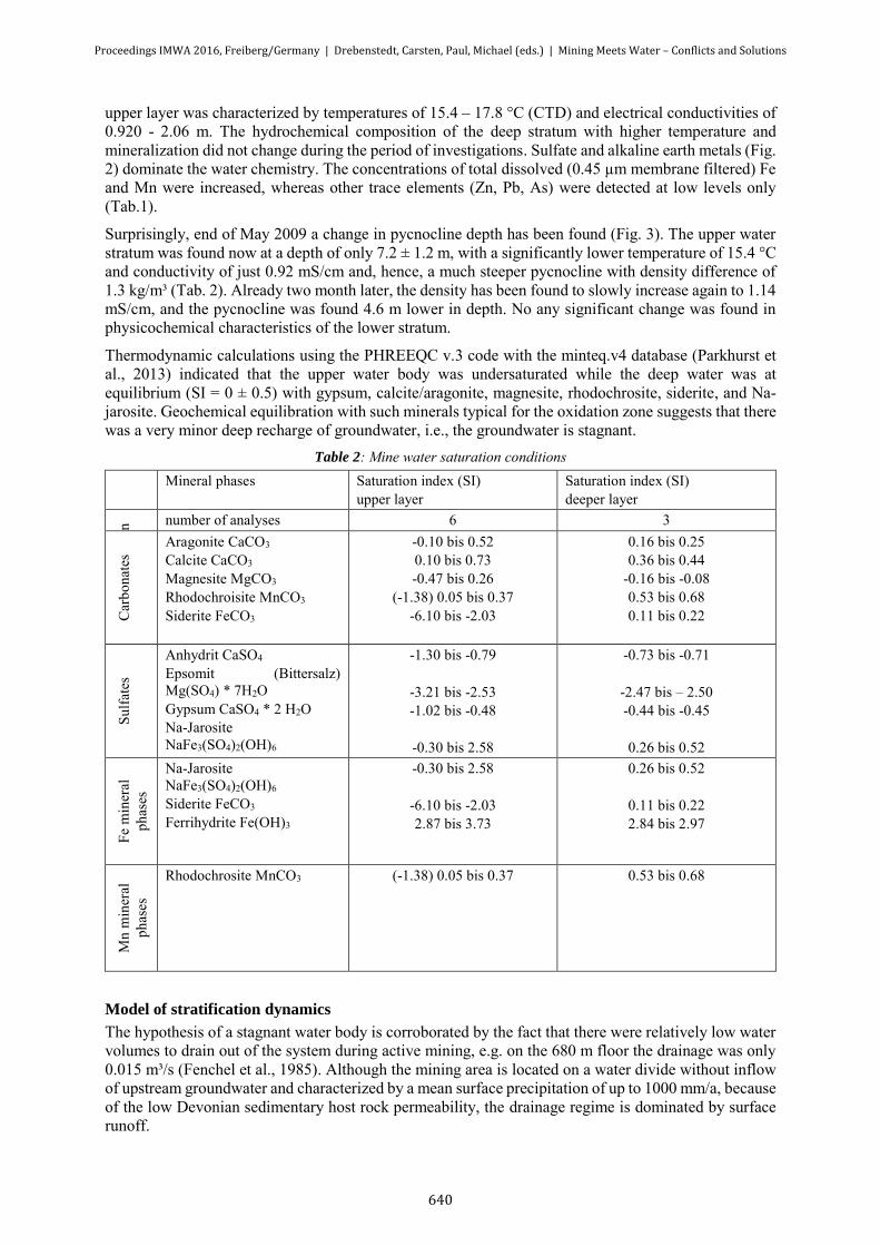
The mine was opened up by two transport shafts, one ventilation shaft, and 23 deep mining tunnels (Fig. 1). The two main shafts were worked down to 967 m and 907 m depth below surface. The mineralization within the steeply inclined veins is dominated by siderite (FeCO3). The ore veins covered an area of up to 860 m² on the 100 m floor, 4790 m² on the 600 m adit, and 2060 m² on the 800 m floor.
During mining activities, the veins were excavated completely and the caverns refilled by excavation material. The volume of mined veins can be estimated at nearly two Mio. m³. The stagnant water within the drained shafts, adits, and fillings has still a volume of about one Mio. m³ (Wieber et al., 2011). While the hydraulics can be described simply as a communicating pipe system controlled by the open shafts and adits, there are also high permeability zones of mined veins and other voids with stope fillings. Both laminar and/or turbulent flow is to be expected in such complex hydraulic systems (Wolkersdorfer, 2006).
Proceedings IMWA 2016, Freiberg/Germany | Drebenstedt, Carsten, Paul, Michael (eds.) | Mining Meets Water – Conflicts and Solutions
637

Figure 1: Cross profile of the mine “Grube Georg”, Rhenish Massif (Germany)
Hydrochemistry of the mine water
The mine water level was detected at a depth of about 100 m. Groundwater of the saturated zone is actually accessible by shaft #2 only [4] . Water was sampled and analyzed at times over a couple of years (Tab. 1). A debris barrier within shaft #2 hampered measurements below a depth of 65 m.
Figure 2 Piper diagram of mine water
Proceedings IMWA 2016, Freiberg/Germany | Drebenstedt, Carsten, Paul, Michael (eds.) | Mining Meets Water – Conflicts and Solutions
638
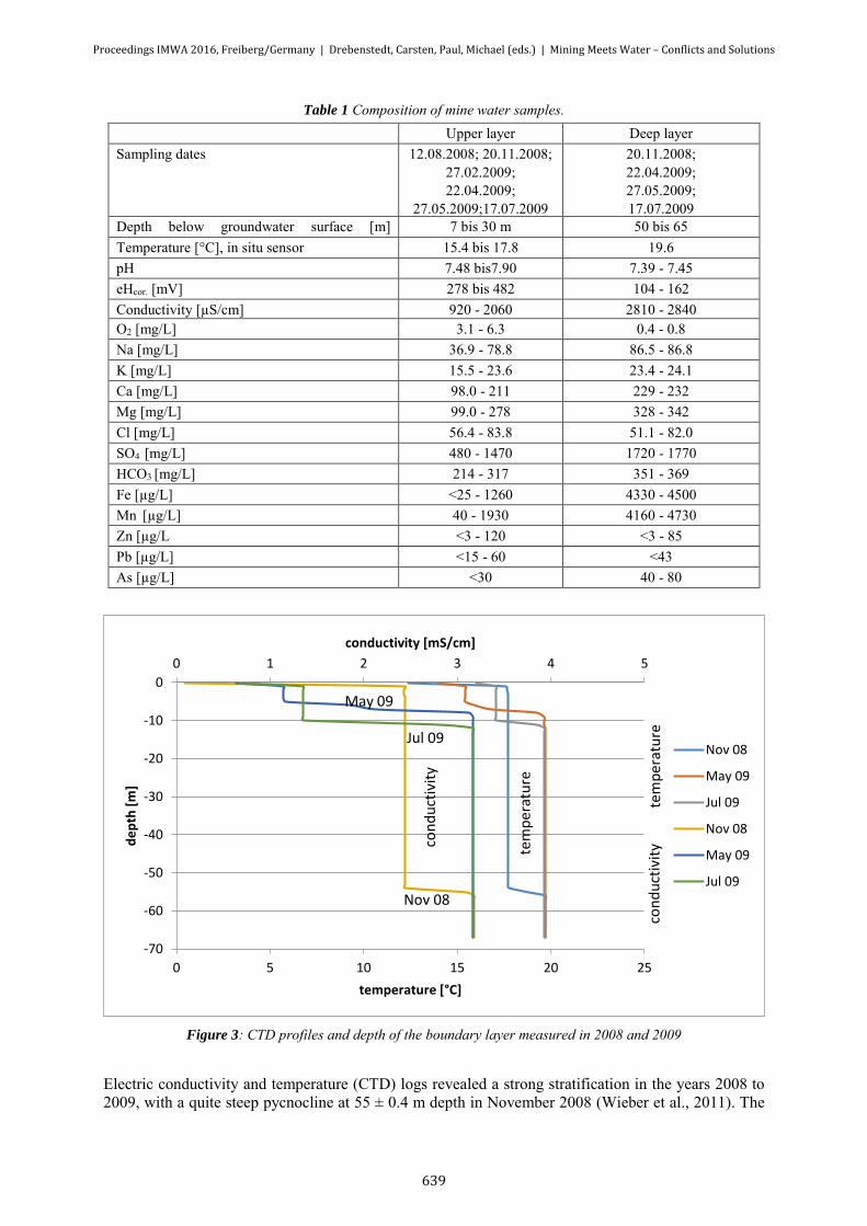
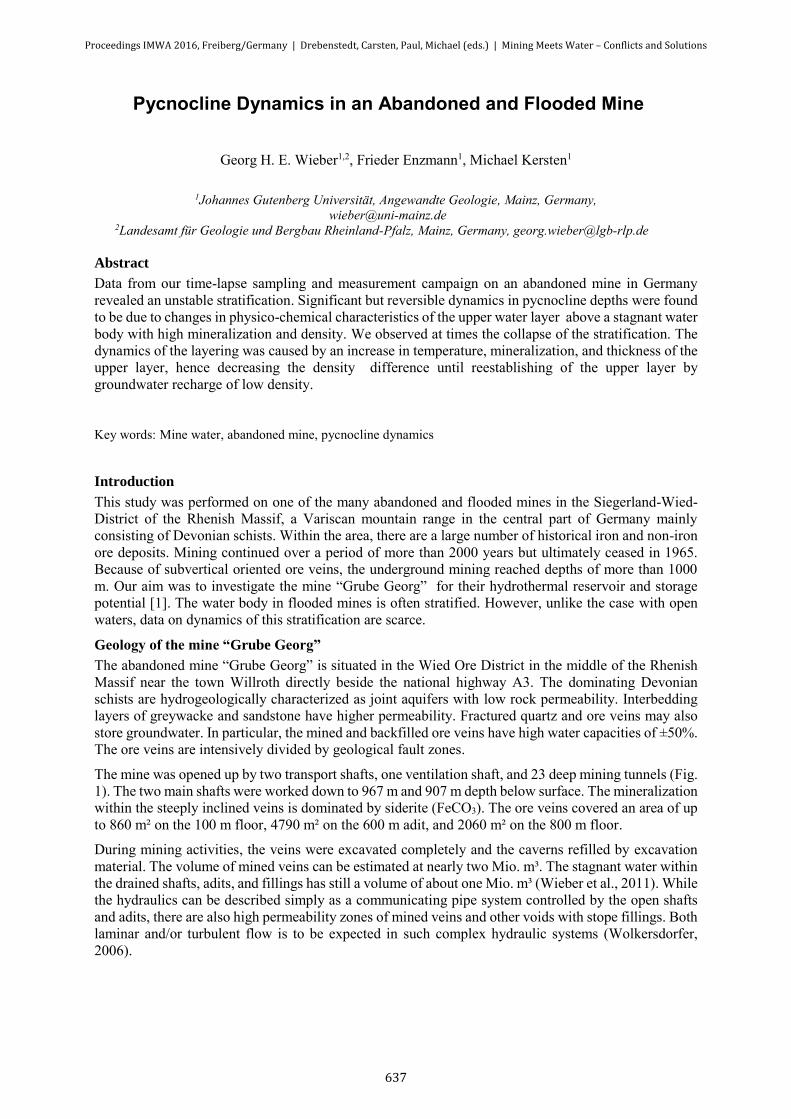
Table 1 Composition of mine water samples. Upper layer Deep layer Sampling dates 12.08.2008; 20.11.2008;
27.02.2009; 22.04.2009;
27.05.2009;17.07.2009
20.11.2008; 22.04.2009; 27.05.2009; 17.07.2009
Depth below groundwater surface [m] m(([([[m][m]
7 bis 30 m 50 bis 65 Temperature [°C], in situ sensor 15.4 bis 17.8 19.6 pH 7.48 bis7.90 7.39 - 7.45 eHcor. [mV] 278 bis 482 104 - 162 Conductivity [µS/cm] 920 - 2060 2810 - 2840 O2 [mg/L] 3.1 - 6.3 0.4 - 0.8 Na [mg/L] 36.9 - 78.8 86.5 - 86.8 K [mg/L] 15.5 - 23.6 23.4 - 24.1 Ca [mg/L] 98.0 - 211 229 - 232 Mg [mg/L] 99.0 - 278 328 - 342 Cl [mg/L] 56.4 - 83.8 51.1 - 82.0 SO4 [mg/L] 480 - 1470 1720 - 1770 HCO3 [mg/L] 214 - 317 351 - 369 Fe [µg/L] <25 - 1260 4330 - 4500 Mn [µg/L] 40 - 1930 4160 - 4730 Zn [µg/L <3 - 120 <3 - 85 Pb [µg/L] <15 - 60 <43 As [µg/L] <30 40 - 80
Figure 3: CTD profiles and depth of the boundary layer measured in 2008 and 2009
Electric conductivity and temperature (CTD) logs revealed a strong stratification in the years 2008 to 2009, with a quite steep pycnocline at 55 ± 0.4 m depth in November 2008 (Wieber et al., 2011). The
0 1 2 3 4 5
-70
-60
-50
-40
-30
-20
-10
0
0 5 10 15 20 25
conductivity [mS/cm]
de
pth
[m
]
temperature [°C]
Nov 08
May 09
Jul 09
Nov 08
May 09
Jul 09
con
du
ctiv
ity
tem
per
atu
re
con
du
ctiv
ity
tem
per
atu
re
Nov 08
Jul 09
May 09
Proceedings IMWA 2016, Freiberg/Germany | Drebenstedt, Carsten, Paul, Michael (eds.) | Mining Meets Water – Conflicts and Solutions
639
upper layer was characterized by temperatures of 15.4 – 17.8 °C (CTD) and electrical conductivities of 0.920 - 2.06 m. The hydrochemical composition of the deep stratum with higher temperature and mineralization did not change during the period of investigations. Sulfate and alkaline earth metals (Fig. 2) dominate the water chemistry. The concentrations of total dissolved (0.45 µm membrane filtered) Fe and Mn were increased, whereas other trace elements (Zn, Pb, As) were detected at low levels only (Tab.1).
Surprisingly, end of May 2009 a change in pycnocline depth has been found (Fig. 3). The upper water stratum was found now at a depth of only 7.2 ± 1.2 m, with a significantly lower temperature of 15.4 °C and conductivity of just 0.92 mS/cm and, hence, a much steeper pycnocline with density difference of 1.3 kg/m³ (Tab. 2). Already two month later, the density has been found to slowly increase again to 1.14 mS/cm, and the pycnocline was found 4.6 m lower in depth. No any significant change was found in physicochemical characteristics of the lower stratum.
Thermodynamic calculations using the PHREEQC v.3 code with the minteq.v4 database (Parkhurst et al., 2013) indicated that the upper water body was undersaturated while the deep water was at equilibrium (SI = 0 ± 0.5) with gypsum, calcite/aragonite, magnesite, rhodochrosite, siderite, and Na-jarosite. Geochemical equilibration with such minerals typical for the oxidation zone suggests that there was a very minor deep recharge of groundwater, i.e., the groundwater is stagnant.
Table 2: Mine water saturation conditions Mineral phases Saturation index (SI)
upper layer Saturation index (SI) deeper layer
n number of analyses 6 3
Car
bona
tes
Aragonite CaCO3 Calcite CaCO3 Magnesite MgCO3
Rhodochroisite MnCO3 Siderite FeCO3
-0.10 bis 0.52 0.10 bis 0.73 -0.47 bis 0.26
(-1.38) 0.05 bis 0.37 -6.10 bis -2.03
0.16 bis 0.25 0.36 bis 0.44
-0.16 bis -0.08 0.53 bis 0.68 0.11 bis 0.22
Sulfa
tes
Anhydrit CaSO4 Epsomit (Bittersalz) Mg(SO4) * 7H2O Gypsum CaSO4 * 2 H2O Na-Jarosite NaFe3(SO4)2(OH)6
-1.30 bis -0.79
-3.21 bis -2.53 -1.02 bis -0.48
-0.30 bis 2.58
-0.73 bis -0.71
-2.47 bis – 2.50 -0.44 bis -0.45
0.26 bis 0.52
Fe m
iner
al
phas
es
Na-Jarosite NaFe3(SO4)2(OH)6 Siderite FeCO3 Ferrihydrite Fe(OH)3
-0.30 bis 2.58
-6.10 bis -2.03 2.87 bis 3.73
0.26 bis 0.52
0.11 bis 0.22 2.84 bis 2.97
Mn
min
eral
ph
ases
Rhodochrosite MnCO3
(-1.38) 0.05 bis 0.37
0.53 bis 0.68
Model of stratification dynamics
The hypothesis of a stagnant water body is corroborated by the fact that there were relatively low water volumes to drain out of the system during active mining, e.g. on the 680 m floor the drainage was only 0.015 m³/s (Fenchel et al., 1985). Although the mining area is located on a water divide without inflow of upstream groundwater and characterized by a mean surface precipitation of up to 1000 mm/a, because of the low Devonian sedimentary host rock permeability, the drainage regime is dominated by surface runoff.
Proceedings IMWA 2016, Freiberg/Germany | Drebenstedt, Carsten, Paul, Michael (eds.) | Mining Meets Water – Conflicts and Solutions
640

A key to understand this anomalous pycnocline dynamics lies in the decline of the density difference. In between August 2008 to November 2008, it decreased from 0.47 kg/m3 to 0.35 kg/m3. This was due to increasing mineralization of the upper stratum as indicated by a rise in conductivity and decreasing undersaturation with respect to above mentioned minerals. This increasing mineralization has led to a break-up of the stratification in between 11/2008 and 5/2009. For reestablishing of the fresh water stratum, and a rise in depth of the pycnocline by 2 m/month, a groundwater drainage of 40 m³/month is necessary.
Table 3: Mine water densities Sampling dates Density of the upper
layer (kg/m³) Density of the deep layer
(kg/m³) Difference (kg/m³)
12.08.2008 1000.61 1001.08 0.47 20.11.2008 1000.73 1001.08 0.35 17.07.2009 999.77 1001.08 1.31
Main implications of the knowledge about the dynamics in physicochemical water characteristics are for the potential use of the mine water body as a geothermal reservoir and storage system (Wieber et al., 2011). This may become severely hampered by a less stable temperature regime. Therefore, the pycnocline dynamics has to be monitored to understand the extent and key factors driving this dynamics.
References
Wieber, G., Landschreiber, K., Pohl, S., Streb, C. (2011): Geflutete Grubenbaue als Wärmespeicher. – In: bbr Fachmagazin für Brunnen- und Leitungsbau, 5/2011: pp. 34-40, Bonn.
Wolkersdorfer, C. (2006): Water Management at Abandoned Flooded Underground Mines. – 465 p, (Habilschrift TU Freiberg); Berlin (Springer).
Parkhurst D.L., Appelo C.A.J.: Description of input and examples for PHREEQC version 3 - A computer program for speciation, batch-reaction, one-dimensional transport, and inverse geochemical calculations (http://pubs.usgs.gov/tm/06/a43/), 2013.
Hoffmann, A. (1964): Beschreibung rheinland-pfälzischer Bergamtsbezirke, Band 1, Bergamtsbezirk Betzdorf. 260 p., Essen.
Fenchel, W., Gies, H., Gleichmann, H.-D., Hellmund, W., Hentschel, H., Heyl, K.E., Hüttenhain, H., Langenbach, U., Lippert, H.-J., Lusznat, M., Meyer, W., Pahl, A., Rao, M.S., Reichenbach, R., Stadler, G., Vogler, H. & Walther, H. (1985): Sammelwerk Deutsche Eisenerzlagerstätten, I. Eisenerze im Grundgebirge (Varistikum), 1. Die Sideriterzgänge im Siegerland-Wied-Distrikt. – Geol. Jb. Reihe D (Mineralogie, Petrographie, Geochemie, Lagerstättenkunde), H. 77, 517 p., Hannover.
Proceedings IMWA 2016, Freiberg/Germany | Drebenstedt, Carsten, Paul, Michael (eds.) | Mining Meets Water – Conflicts and Solutions
641