Embed Size (px)
Citation preview
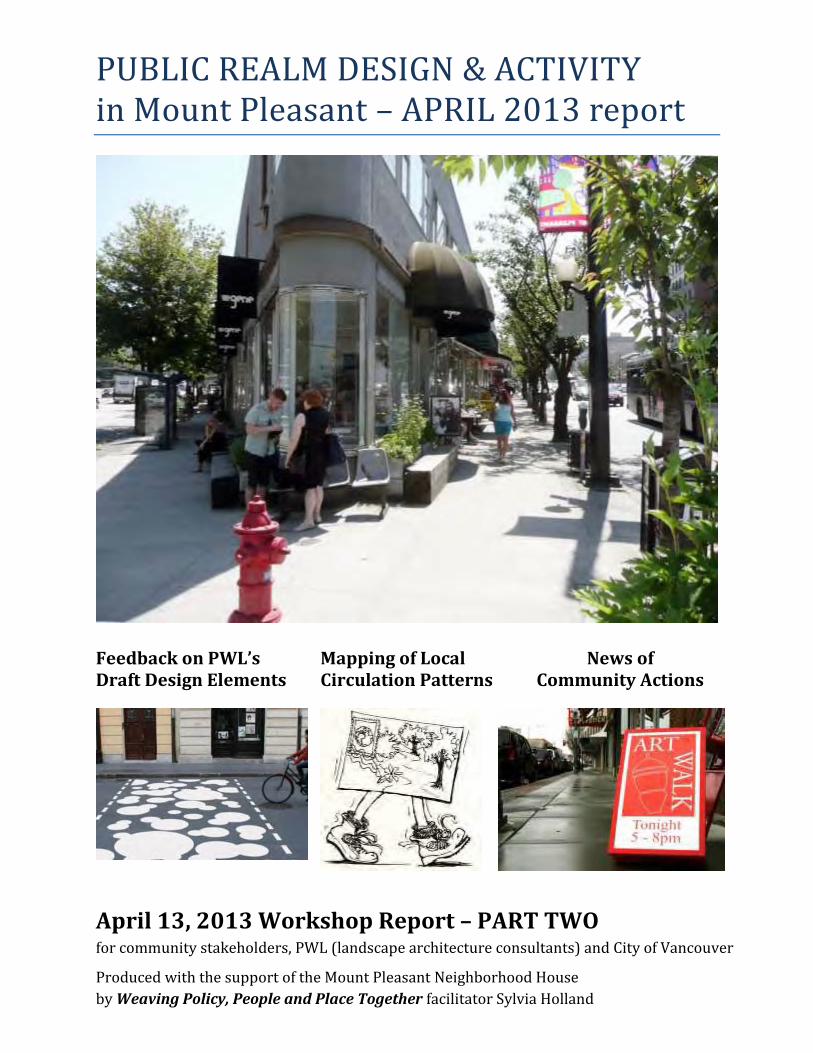
PUBLIC REALM DESIGN & ACTIVITY in Mount Pleasant – APRIL 2013 report
Feedback on PWL’s Draft Design Elements
Mapping of Local Circulation Patterns
News of Community Actions
April 13, 2013 Workshop Report – PART TWO for community stakeholders, PWL (landscape architecture consultants) and City of Vancouver
Produced with the support of the Mount Pleasant Neighborhood House
by Weaving Policy, People and Place Together facilitator Sylvia Holland
PUBLIC REALM in Mount Pleasant – April 2013 workshop report Page 2
Thanks to all whose time and attention nourished fruitful exchange
towards a lively public realm that serves many beautifully,
and thanks to everyone who continues to create it.
This stakeholder engagement process was facilitated by the Mount Pleasant Neighborhood House
with support from the Real Estate Foundation of BC and the Vancouver Foundation,
for the benefit of community members, City planners and engineers, and other design consultants.
In co-operation with :
PUBLIC REALM in Mount Pleasant – April 2013 workshop report Page 3
Table of Contents
Synopsis ........................................................................................................................................................ 4
Purpose of the Workshop ............................................................................................................................. 5
Summary of Professional Design Work ......................................................................................................... 6
Community Contributions in the Design Process ......................................................................................... 7
Related Documents – See Appendices 1 and 2......................................................................................... 7
Implementation of Design Recommendations ............................................................................................. 8
Community Concerns about Implementation .......................................................................................... 9
APPRECIATIONS—Community responses to PWL work-in-progress .......................................................... 10
HOT TOPICS for Local Area Stakeholders—“Need Improvement” ............................................................. 13
Other observations regarding interests and issues raised ..................................................................... 17
RECOMMENDATIONS / DISCUSSION of the Hot Topics .............................................................................. 18
Section 1: Arterial Walkability (Broadway, Main) ................................................................................... 18
Section 2: Strengthening Business Districts through Public Realm Changes ......................................... 23
Section 3: Combining (or Separating) Cycling & Walking Routes .......................................................... 26
Section 4: Street Crossings and Road Art / Method of Marking ............................................................. 27
Section 5: Improving Inter-Neighbourhood Connectivity ...................................................................... 28
Section 6: Ecological Considerations in Mount Pleasant Public Realm ................................................. 30
Section 7: Laneway Treatment .............................................................................................................. 32
Section 8: Acknowledgement of Aboriginal Presence, Heritage, Art and Culture ................................. 37
Community-Led Initiatives – ADDITIONAL PRESENTATIONS ...................................................................... 39
Livable Laneways .................................................................................................................................... 39
St. George Rainway ................................................................................................................................. 41
Research on Resilience emerging from Community Involvement in Place-Making ............................... 41
Broadway East Public Realm – Revitalization Projects ........................................................................... 44
Immediate Next Steps ................................................................................................................................. 47
Regarding questions raised in the workshop ......................................................................................... 47
Appendix 1: PART 1 Table of Contents – March 7th Workshop Report...................................................... 49
Appendix 2: OTHER RESOURCES from Community.................................................................................... 51
Appendix 3: PWL DESIGN PRESENTATION ................................................................................................. 54
Appendix 4: QUESTIONS & RESPONSES ..................................................................................................... 55
Appendix 5: Current CIRCULATION HABITS (Community Mapping) ......................................................... 59
Appendix 6: Workshop Team ..................................................................................................................... 60
PUBLIC REALM in Mount Pleasant – April 2013 workshop report Page 4
Synopsis
The concepts embedded in PWL’s draft work resonated with Mount Pleasant community members.
Workshop participants were enthusiastic . . . and also highly pragmatic in their response.
The proposals won majority support from attendees. The plan is hitting the mark with what community
members would like in their future. A key concern was that the movement, all in the right directions, simply
didn’t go far enough.
“Longer green fingers” (in lane enhancement), strengthening circulation between neighborhoods and not
just Mount Pleasant loops, extending the community mosaic of public art beyond the triangle heart where
Main, Broadway and Kingsway meet; considering the natural landscape with reference to birds and other
habitat (not creek history alone), pushing the “business signage as public art” into fast-track support with
permit approvals and fiscal incentives for such innovative design investments by small businesses, putting
more attention on Watson Street development in the pedestrian network . . . these were some of the ways
in which local stakeholders said “play it out further.”
Overall, with affirmation that the directions all make sense, the interest is in “seeing a clear proposal now
for how the transition can happen,” understanding better the financing of all the proposed changes, and
having action priorities clear, as well as quick movement on the least costly of creative moves.
Hot topics in this mid-April review were making the arterials more walkable (“not ghetto-izing Broadway,”
considering bump-outs in the wide avenues intersecting Lower Main to add mini-plazas or more green, etc.),
putting more focus on design directions that will guide existing and new businesses in specific contributions
to the public realm, leaning towards separating pedestrian and cycling networks to a greater degree, and
strengthening inter-neighbourhood connectivity. A key concern is pedestrian and cycling routing across
Great Northern Way Campus, across the rail tracks, and northward to Strathcona, Gastown and the
viaduct/Downtown. Enhancement of a pedestrian route between Main and Commercial Drive, another
important shopping district for residents, is also a perceived need. Clarifying the strategy for establishing
and sustaining a “community mosaic of public art” was called for. So too was embedding some recognition
in the public realm of Aboriginals’ considerable presence, heritage, and arts and culture in the area.
The road art proposed for mid-block crossings and as a possible way of distinguishing shopping areas won
high praise at first. Dialogue led to the resolution that textured treatment at roundabouts and mid-block
crossings was preferable to painted treatment alone. There was also a call for a unifying mark that would
apply to all shopping districts in Mount Pleasant—if not in the road art, then through lighting, banners, or
some other design element. Canopy protection over sidewalks and other open spaces, amenities that
support exchange of local information, and stronger combination of function and art (in bike racks and/or
seating as well as signs) were requested.
Recommendations are included in each of the eight sections (divided by hot topic).
The workshop closed with multiple presentations from community networks: Livable Laneways Society, the
St. George Rainway group, an affiliated researcher exploring the impact of place-making (with green
infrastructure) on the overall resiliency and capacity of a community, and various action teams working in
the East Broadway revitalization area. These speakers, film clips, and slide presentations were also received
with high interest and positive feedback on evaluation forms.
PUBLIC REALM in Mount Pleasant – April 2013 workshop report Page 5
Purpose of the Workshop
March 7th Lead-Up: Progress in Part I A diverse group of community members met for both parts of the workshop, and in Part 1 on March 7, the
participants began by comparing perspectives on the foundation for Mount Pleasant’s public realm design,
namely its identity as a neighbourhood. The groups began by answering the question, “Does each of the
four shopping districts of Mount Pleasant have a distinct identity?”
A second aim was to gather local knowledge of valued places in or near each shopping district and to map
these “sweet spots.” The maps then illustrated what matters to community members in their public realm
experience—day or night, weekday or weekend. Neighbours’ stories were solicited along with the maps, to
help reveal more of the distinctive character of Mount Pleasant.
A third aim was to better understand locals’ walking routes. Again using maps showing the green spaces in
the neighbourhood, community members identified the route they preferred for connecting those spaces
and also marked how they would enhance their green circuit. (Multiple maps resulted from this activity).
The reason for beginning with shopping districts is that this is the primary focus in the public realm design
that the City of Vancouver has commissioned from a landscape architectural firm (PWL Partnership), and
PWL sought more local insight for their team’s design work.
Click this link for the Part 1 report of community input on March 7. An outline of its contents is also
included in Appendix 1 of this report.
Part II In a follow-up workshop—Part 2 on April 13, 2013—PWL’s emergent design recommendations were
reviewed with community members. This document summarizes community feedback.
The intention of the Part II workshop was to identify aspects of the Mount Pleasant Public Realm Plan that
reflect some city-wide consistencies – and to identify other elements that are distinctive to Mount Pleasant.
Opportunities for customizing spaces or amenities in the public realm through local stakeholders’
involvement were also explored.
In addition, community presentations highlighted local activities that are already influencing the distinctive
nature of the public realm in Mount Pleasant. The relevance of these activities to neighbourhood well-being,
from various perspectives, was explored. Both long-term goals and short-term opportunities for others’
involvement were communicated.
Further exploration of frequent walking routes, and the reasons for taking those particular routes, was also
part of the April 2013 workshop. Results of that mapping by many community members are now being used
by PWL (the City’s design consultants) to strengthen recommendations on proposed enhancements of
pedestrian and cycling routes through Mount Pleasant. See Appendix 3 for a look at the maps.

PUBLIC REALM in Mount Pleasant – April 2013 workshop report Page 6
Summary of Professional Design Work
The PWL Partnership team (landscape architects/designers/technicians) prepared six maps of
Mount Pleasant and, for perusal before the workshop activities, seven presentation boards.
A spoken presentation by Derek Lee was accompanied by illustrated concepts with precedent
examples from other locations. This April 13 presentation was one of emerging concepts: i.e.,
draft work.
The presentation boards and maps will be presented again to the general public on April 27
during a City-hosted Open House event.
The six maps—see details in the PWL presentation—focus, respectively, on the following:
1. Public Open Space – Parks, Pocket Parks, Plazas, Boulevard Parks – existing and proposed
2. Enhanced Pedestrian Network – including proposed laneways to enhance, potential mid-
block crossings, proposed boulevard parks, and target areas for reinforcing connectivity
across Great Northern Way
3. Emerging Concepts for Public Art / Community and Culture Celebration – including
potential gathering spaces to enhance, proposed “public events roads and laneways
closures,” potential spaces for temporary public art and performances, potential permanent
art sites, a possible “heart of the community” mosaic, and proposed area in which to
encourage imaginative business signage as public art (relaxation of signage by-laws)
4. Historical Celebration – an inventory of heritage elements of the landscape, with marking of a
proposed St. George Rainway and there (on St. George) and elsewhere in the neighbourhood,
proposed creek commemoration sites with “opportunities to celebrate the water”
5. Cycling Network – including existing local street bikeways, painted bike lanes, separated
bikeways, and also potential future bike routes (east-west, north-south, and along Kingsway)
6. Green Canopy – the existing “Great Street Tree Network,” partial and sporadic street trees
network, and existing parks.
The maps and the rest of the slide presentation can be viewed online by clicking this link.
Further design work will be completed by PWL before a second Open House event that City planners
have scheduled for June 15.
Ongoing consultation between the professional design team and City of Vancouver staff (planners,
urban designers, engineering staff, etc.) is part of the design process.
Following the June 15th Open House, City staff will review both the work of commissioned designers
and also the community input as they complete their recommendations to Council.
October 8, 2013 is the target date for City staff to present the Public Realm recommendations to
Council.

PUBLIC REALM in Mount Pleasant – April 2013 workshop report Page 7
Community Contributions in the Design Process
In the April 2013 workshop session hosted by the Neighbourhood House, participants included
residents from all quadrants of the neighbourhood. During the opening, individuals stood, in turn,
to indicate the specific sub-area in which they live (or where their business is based), revealing a
balanced distribution from across Mount Pleasant.
As with Part 1, participants also included community service providers, local business
representatives (principally through representatives of Kingsgate Mall Merchants Association and
the Mount Pleasant Business Improvement Association), community relations liaison from Great
Northern Way Campus ad also (as observers) the owners/developers of Kingsgate Mall, and people
representing numerous volunteer organizations (Mount Pleasant Implementation Committee,
advisory group to the City on implementing the Community Plan; Green Streets corps,
The Drift and Mount Pleasant Artists Society, St. George Rainway, False Creek Watershed Society,
Livable Laneways, Projects in Place, etc.).
Approximately half of the 61 participants on April 13th had also been part of the earlier workshop on
March 7 (80 registrants in Part 1)—meaning a core of continuity, while simultaneously welcoming
fresh eyes and the local experience of others.
Besides participating in this two-part workshop series with design consultants hired by the City,
many Mount Pleasant community members have been contributing in recent months through other
workshops and collaborative endeavours to cconsider opportunities and investments in the public
realm. See Appendix 2 for more detail on inter-related activity.
Related Documents – See Appendices 1 and 2
PUBLIC REALM in Mount Pleasant – April 2013 workshop report Page 8
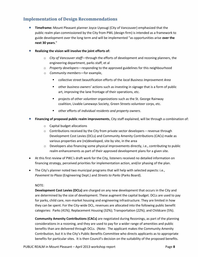
Implementation of Design Recommendations
Timeframe: Mount Pleasant planner Joyce Uyesugi (City of Vancouver) emphasized that the
public realm plan commissioned by the City from PWL (design firm) is intended as a framework to
guide development over the long term and will be implemented “as opportunities arise over the
next 30 years.”
Realizing the vision will involve the joint efforts of:
o City of Vancouver staff—through the efforts of development and rezoning planners, the
engineering department, parks staff, et al
o Property developers—responding to the approved guidelines for this neighbourhood
o Community members—for example,
collective street beautification efforts of the local Business Improvement Area
other business owners’ actions such as investing in signage that is a form of public
art, improving the lane frontage of their operations, etc.
projects of other volunteer organizations such as the St. George Rainway
coalition, Livable Laneways Society, Green Streets volunteer corps, etc.
other efforts of individual residents and property owners.
Financing of proposed public realm improvements, City staff explained, will be through a combination of:
o Capital budget allocations
o Contributions received by the City from private sector developers – revenue through
Development Cost Levies (DCLs) and Community Amenity Contributions (CACs) made as
various properties are (re)developed, site by site, in the area
o Developers also financing some physical improvements directly, i.e., contributing to public
realm enhancements as part of their approved development plans for a given site.
At this first review of PWL’s draft work for the City, listeners received no detailed information on
financing strategy, perceived priorities for implementation action, and/or phasing of the plan.
The City’s planner noted two municipal programs that will help with selected aspects: i.e.,
Pavement to Plaza (Engineering Dept.) and Streets to Parks (Parks Board).
NOTE:
Development Cost Levies (DCLs) are charged on any new development that occurs in the City and
are determined by the size of development. These augment the capital budget. DCLs are used to pay
for parks, child care, non-market housing and engineering infrastructure. They are limited in how
they can be spent. For the City-wide DCL, revenues are allocated into the following public benefit
categories: Parks (41%); Replacement Housing (32%); Transportation (22%); and Childcare (5%).
Community Amenity Contributions (CACs) are negotiated during Rezonings, as part of the planning
considerations in a rezoning, and they are used to pay for a wider range of amenities and public
benefits than are delivered through DCLs. (Note: The applicant makes the Community Amenity
Contribution, but it is the City’s Public Benefits Committee who directs applicants as to appropriate
benefits for particular sites. It is then Council’s decision on the suitability of the proposed benefits.

PUBLIC REALM in Mount Pleasant – April 2013 workshop report Page 9
Community Concerns about Implementation
Community concern was expressed that there is “not enough density and development activity at
the moment to support and fund the infrastructure proposed.” (The City planner had indicated
that implementation would occur “largely through development.”)
Others liked the “ambitious” nature of the plan but noted on their comment sheets that there
“needed to be more guidance for new development (private land) so that new fabric would
integrate well with the existing fabric shown.”
Feedback from community members about what is missing and important included a call for “a
proposal to illustrate quickly the transition (the “how”) from existing conditions to a future state.”
Elaborating on this need, a participant wrote:
o “To generate and benefit from meaningful insights, participants need to be exposed to
this information quickly and insightfully. … [This is] essential to advance a comprehensive
engagement of all walking into the room.”
In addition to other questions raised about specific aspects of the emergent design (see Appendix 4)
a further query received in summary feedback forms was:
“If tax increase is needed to implement this plan, will this be put to a vote?”
Workshop participants accepted the clarification from municipal staff that the current design work
commissioned from PWL Partnership has, contractually, been limited largely to public realm
enhancements in the shopping districts in Mount Pleasant. Nonetheless, workshop input showed
that their appreciation of “public realm” extends across the whole neighbourhood.
Community members noted a need for greater emphasis on ecological heritage and wellbeing
in the neighbourhood’s public realm plan.
o Thinking long-term, a “7 Generations ahead” perspective
o Paying more attention to the benefits of access to nature—its restorative value for
humans, especially in urban settings
Plans for car traffic changes on St. George Street are wanted. Is there a traffic plan change
anticipated as part of the Rainway project? St. George access is important to two residential areas:
between Broadway and 12th Avenue, and also between 12th Avenue and Kingsway.
How to manifest and integrate the public art proposed (for example, the idea of a community mosaic
in the triangle heart): this is also a topic on which community respondents propose more discussion.
Other community guidance on implementing proposed public realm enhancements can be found
in the Recommendations / Discussion section following the summary of specific Hot Topics.
The following statement—penned on a workshop evaluation form on April 13, 2013—captures both
the positive and practical mood of the participants that was evident in many ways. “First of all,
thank you for all of the improvements that have been introduced into Main Street already. I am a
big fan of the Livable Laneways program and any initiatives to enhance laneways. I am also looking
for low-cost improvements that can facilitate change quickly, which will then allow time for the
bigger and more expensive improvements to happen over time.”

PUBLIC REALM in Mount Pleasant – April 2013 workshop report Page 10
APPRECIATIONS—Community responses to PWL work-in-progress
On being prompted with “What’s on the mark?” community members noted these aspects of the PWL
draft plan:
Uses: the street uses; bike routes; spaces for pedestrians; marking bike and pedestrian routes; the
walkways; links to South East False Creek and to Great Northern Way campus; more intensive use of
existing public space by converting streets to parks, adding parkettes, lane enhancement.
“Taming the streets”—making many routes more pedestrian friendly; recapturing space for more
walkways and bikeways. More potential for block and street parties.
Outdoor spaces for social gatherings: reclaiming some of the parking spaces as public spaces; turning
some parking spaces into green spaces; plazas on Main & Broadway; opportunities to gather outside,
on the street or elsewhere outdoors “because it doesn’t happen as much here as elsewhere in
Vancouver.” “The variety of public gathering areas in bringing people outside and together.”
Community members like spaces such as Parallel Park beside JJ Bean (14th and Main). Also like the idea
of a plaza with artist studios on the edges—the “concept of art/production” spilling out to the street.
Liked examples given of open rooms, tree canopy ceilings, vacant lot use, new plaza at Fraser.
o But want some covered spaces. “Need canopies in public gathering areas.”
o Cover the transit plazas. “This is important because we need to continue to encourage
people to use transit over cars. I depend on transit and am used to getting wet, but notice
that for others it is a big deterrent.”
o Need some covered spaces that will support performances as well as other gatherings.
Movement up /down Main Street from the heart
Laneway treatment overall; laneways being better utilized (for walking, biking, green space).
The focus on the Main Street alley (west side of Main). Laneway connectivity in the overall plan.
o But extend it farther: need longer “green fingers” in the neighbourhood via the lanes.
Young people will prosper with more attention to the lanes.
o Laneway activation for bike route—but go deeper into neighbourhood with this idea, too.
o Alley off 10th Avenue is well lit and feels safe—this lane is best restricted to walkers
because 10th Avenue, as “a bike highway,” is not experienced as very safe for pedestrians.
o 11th Avenue is a pedestrian route, whereas 10th Avenue is the bike highway.
o Alley off 12th Avenue is also well lit—another good route for walkers, too.
o Laneway revitalization as a “quieter face of Broadway.”
Public art potential—the community mosaic idea in the triangle “heart” of the neighbourhood
o Play the whole mural out farther too. (“Art in/on the street”)
o Love the attention to public art and temporary art.
o Like the community engagement in this mosaic of public art concept.
o Easy to do—without taking on a lot. Invitation to creativity in the public spaces.
o Need to provide some resources to enable residents to contribute to this beautification.
o Liked murals at 7th Avenue and complementary additions to murals.
PUBLIC REALM in Mount Pleasant – April 2013 workshop report Page 11
o Suggestion to incorporate more building murals also.
Positive reference to murals on side of Burgoo restaurant and also at Main & 17th.
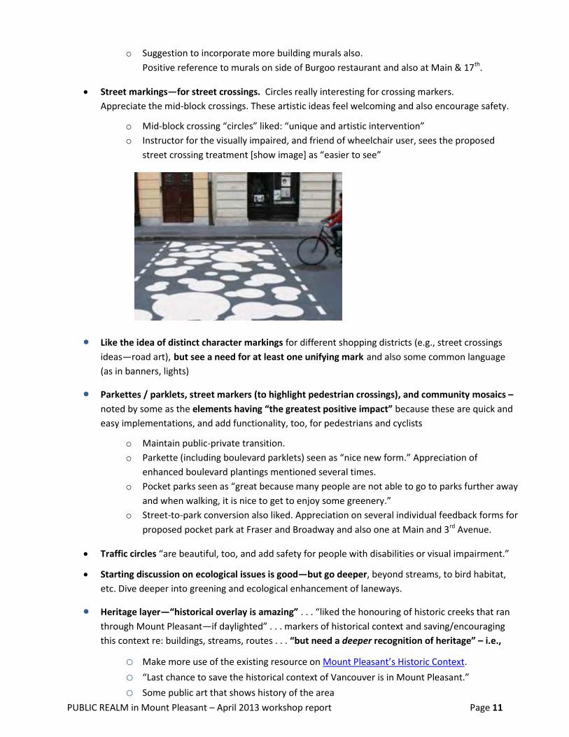
Street markings—for street crossings. Circles really interesting for crossing markers.
Appreciate the mid-block crossings. These artistic ideas feel welcoming and also encourage safety.
o Mid-block crossing “circles” liked: “unique and artistic intervention”
o Instructor for the visually impaired, and friend of wheelchair user, sees the proposed
street crossing treatment [show image] as “easier to see”
Like the idea of distinct character markings for different shopping districts (e.g., street crossings
ideas—road art), but see a need for at least one unifying mark and also some common language
(as in banners, lights)
Parkettes / parklets, street markers (to highlight pedestrian crossings), and community mosaics –
noted by some as the elements having “the greatest positive impact” because these are quick and
easy implementations, and add functionality, too, for pedestrians and cyclists
o Maintain public-private transition.
o Parkette (including boulevard parklets) seen as “nice new form.” Appreciation of
enhanced boulevard plantings mentioned several times.
o Pocket parks seen as “great because many people are not able to go to parks further away
and when walking, it is nice to get to enjoy some greenery.”
o Street-to-park conversion also liked. Appreciation on several individual feedback forms for
proposed pocket park at Fraser and Broadway and also one at Main and 3rd Avenue.
Traffic circles “are beautiful, too, and add safety for people with disabilities or visual impairment.”
Starting discussion on ecological issues is good—but go deeper, beyond streams, to bird habitat,
etc. Dive deeper into greening and ecological enhancement of laneways.
Heritage layer—“historical overlay is amazing” . . . “liked the honouring of historic creeks that ran
through Mount Pleasant—if daylighted” . . . markers of historical context and saving/encouraging
this context re: buildings, streams, routes . . . “but need a deeper recognition of heritage” – i.e.,
o Make more use of the existing resource on Mount Pleasant’s Historic Context. o “Last chance to save the historical context of Vancouver is in Mount Pleasant.” o Some public art that shows history of the area

PUBLIC REALM in Mount Pleasant – April 2013 workshop report Page 12
Food network in the green canopy—the idea of incorporating more fruit trees on the streets—and
the combined potential of a stronger food network via the green canopy and pocket parks.
Bike service points along the bike routes
Plan seen as “lots of charm, visual appeal—elements that would draw me to spend more time in
this neighbourhood” . . . “with great opportunities to enhance street-level vitality and activity
through the interesting developments of lanes, encouragement of events, and public-infused art.”
“Strong on creativity.”
“Intentions [of the design team] and participation [of community in the design process] are
worthwhile.” “First time hearing about this: really cool ideas with the parks/parkettes and all the
laneway ideas.” “Really like the plan overall—love the potential of the plan.”
For reference, click here to open the slide presentation by the PWL design team
Images courtesy of PWL workshop presenters

PUBLIC REALM in Mount Pleasant – April 2013 workshop report Page 13
HOT TOPICS for Local Area Stakeholders—“Need Improvement”
Broadway (arterial) character – improving attractiveness and walkability of this shopping street
(vs. the obvious emphasis on enhancing parallel side streets for pedestrians and cyclists)
o “Not ghetto-izing Broadway”
o Concern that Main gets over-emphasized as a “great street”—Broadway outshone.
o Need to connect Main and Broadway more strongly.
o Need to focus on Broadway between Cambie and Main.
o Need to address how to add tree canopy on Broadway.
o Need to strengthen vitality and appeal of Broadway East also—around Fraser Street.
Western-centric nature of the plan that PWL is producing for the City of Vancouver
(too little focus on the eastern quadrants of the neighbourhood)
o For example, no acknowledgment of Glen Drive cycling route (important north-south
connection) in the cycling network map
Ecological heritage—and the need for some wilderness experience in the city
(more than celebrating historical creek flows)
o PWL plan appreciated for ecological potential –but seen as risking “over design.”
o Need some messiness in the green spaces too, for more urban “wilderness” experience.
o Need attention to more than water in ecological considerations—e.g., bird habitat.
o Leave a space in the plan for new “wilderness intervention.”
o Like PWL’s appreciation of “messy vitality” in the neighbourhood (and some of its
industrial and other grit)—but need to have some “messy vitality” in the green space, too
Inter-neighbourhood connectivity—given insufficient attention
o Need for improved pedestrian/cycling route(s) north-south, not only to Great Northern
Way Campus, but also from Mount Pleasant to Strathcona; Mount Pleasant to Gastown.
Glen Street bike route is missing from the map as important route to GNW and beyond.
Main Street bike lane is dangerous for cyclists now because of the frequency with
which drivers open vehicle doors from the parking lane.
More than “sharrows” (painted indicators of a shared lane) needed on Main Street
cycling route – or else an alternative connection between Mount Pleasant (across
GNW campus) to Strathcona. North connection seen as weak overall: need better cycling connection to viaduct
and Gastown.
NOTE 1: This circulation issue was also raised by community members during the Urban
Design Framework sessions (Broadway East, and Lower Main) led by COV urban designers
on February 27, 2012, in the collaborative design sessions hosted by the City of Vancouver
to engage Mount Pleasant community members.
NOTE 2: On April 13, 2013, one respondent did note appreciation for the connection from
Mount Pleasant to the GNW campus, across 5th Avenue to GNW, shown in the PWL draft.
PUBLIC REALM in Mount Pleasant – April 2013 workshop report Page 14
o Stronger east-west neighbourhood connectivity also: between Main Street and
Commercial Drive, two shopping streets that are highly used by Mount Pleasant residents
Perceived need for design guidelines and amenity contributions for an
east-west pedestrian route from Main to Commercial
o Also see connection to the vibrant commercial / industrial spaces in the north-west
section of Mount Pleasant as missing – and important because people who work there
could/would/should shop and eat in Mount Pleasant.
Proposed street crossings: road art to mark pedestrian crossings (mid-block or otherwise)
o Loved the artistic treatment suggested (graphic of differently sized circles, for instance, for
mid-block crossings)—but further feedback showed more interest in consistency of design
(to indicate “You’re in Mount Pleasant”) than interest in having every street crossing
variable in artwork (or every shopping district differ in this treatment).
o Also need to make markings, and all walking areas, be child-friendly and inspiring to
children. Take into account strollers and slow walkers (aging population and many families
with babies in Mount Pleasant).
o More formalized pedestrian crossings are seen by some as essential on Main (i.e., lights at
every block, at 13th, 15th, etc.) but this was a minority view registered
o Bump-outs recommended at intersections of side streets off Main, reducing the crossing
length in the north-south direction at each side street: this won more collective support
Whether to combine or separate cycling/walking routes—e.g., when enhancing tree canopy, etc.
o Bike routes seen as having the best tree canopies now.
o Walking and cycling don’t have to be mutually exclusive—but at the very least, we need
much better marking (of pedestrian path vs. cycling path) to make it safer for walkers.
o See further discussion in the Recommendations section.
o A lot of discussion includes bikeways but no one from the bike community [cycling
associations and services] attended. Note the bike shops in the retail study area.
Inadequate attention to development of Watson Street—which historically was a laneway hub, and
which the Community Plan also notes as meriting “special site” attention
Feasibility / livability of the laneway proposals – and flexibility of municipal government re:
allowing commercial enterprises, for instance, to have a laneway address (and not a street front
address), yet still operate legally within the neighbourhood / city
Nature of pedestrian amenities proposed: strong interest was expressed in the following
(more than heritage cairns)
o Most importantly--covered spaces for social connection: rain protection over at least
some seating areas—this is missing from the PWL plan. Plazas need some covered areas.
o Amenities that support (enhance) communication between community members:
e.g., local bulletin boards, especially in pocket park locations. Digital sign boards for events
also. Smart-phone app connection to local news—and signage to prompt use of the app?
PUBLIC REALM in Mount Pleasant – April 2013 workshop report Page 15
o Bike racks (or other functional amenities) that are art: combining sculpture and function,
or combining other artistic expression with functionality (e.g., in bicycle racks, benches,
waste receptacles, other street furniture)—integrate art with infrastructure more,
including the seating designs within parkettes and boulevard parks.
NOTE: This latter interest was also part of community input during an earlier workshop
(see November 3, 2012 workshop hosted by Weaving Policy, People and Place Together—
Mount Pleasant Neighbourhood House on “Re-Imagining Broadway East,” which built on
earlier recommendations of walking tour participants in September 2012).
o Create a movie wall for summer gatherings that will foster interaction between residents;
encourages families to come into public spaces. Could happen on wall of The Foundation,
having people gather in parking lot to the north at Main and 7th.
o Concern expressed that BC heritage cairns, if more created here, would require
maintenance and a budget item to pay for it.
More practicality in the public realm design for shopping areas
o Seen as a “pretty” plan. “Nothing in the plan that really supports businesses.”
o Need more attention to business signage.
o Need to draw focus to historical buildings, too.
o Also improved street signage to support business.
o Need to build on the professionally designed murals in the area. “Please involve
professional artists in the neighbourhood. Murals designed by children or non-artists
would look out of place. The involvement of professional artists in mural work is
important to support businesses.”
o “ If signs as public art is also an idea that the community supports, then why not provide
grants to businesses to help them redesign their signage and provide support to help
them get through the City sign permit process.” Fast track or otherwise facilitate approval
of these “public art as signs.”
o Not enough emphasis on how to attract more traffic to the business districts.
o Need specific attention to revitalization of the East Broadway shopping area.
o Set standards of quality for newcomers to Mount Pleasant to uphold.
Directions for semi-private / semi-public spaces in new development
o Need clear guidelines for effective development of this aspect also
Heritage recognition
o No inclusion of the Aboriginal history, art and cultural influence, and presence here.
o Mount Pleasant was historically important to First Nations. It is also now the 3rd largest
concentration of First Nations people in Vancouver. Need reflection of Aboriginal heritage
in the public realm, too.
Idea of creating a public space “to celebrate women, men and families” so that there is more focus
on creating healthy communities.
Wheelchair access – need effective transitions to raised surfaces
PUBLIC REALM in Mount Pleasant – April 2013 workshop report Page 16
Attention to transit-oriented development—see a need to look more at T-O-D impact on the heart
of the neighbourhood with overlay of transit-oriented development at Main/Kingsway,
Main/Broadway
Skytrain station locations – impact on activity and pedestrian circulation
o VCC (Vancouver Community College) to Clark
o Great Northern Way station
o Kingsway/Broadway/Main node
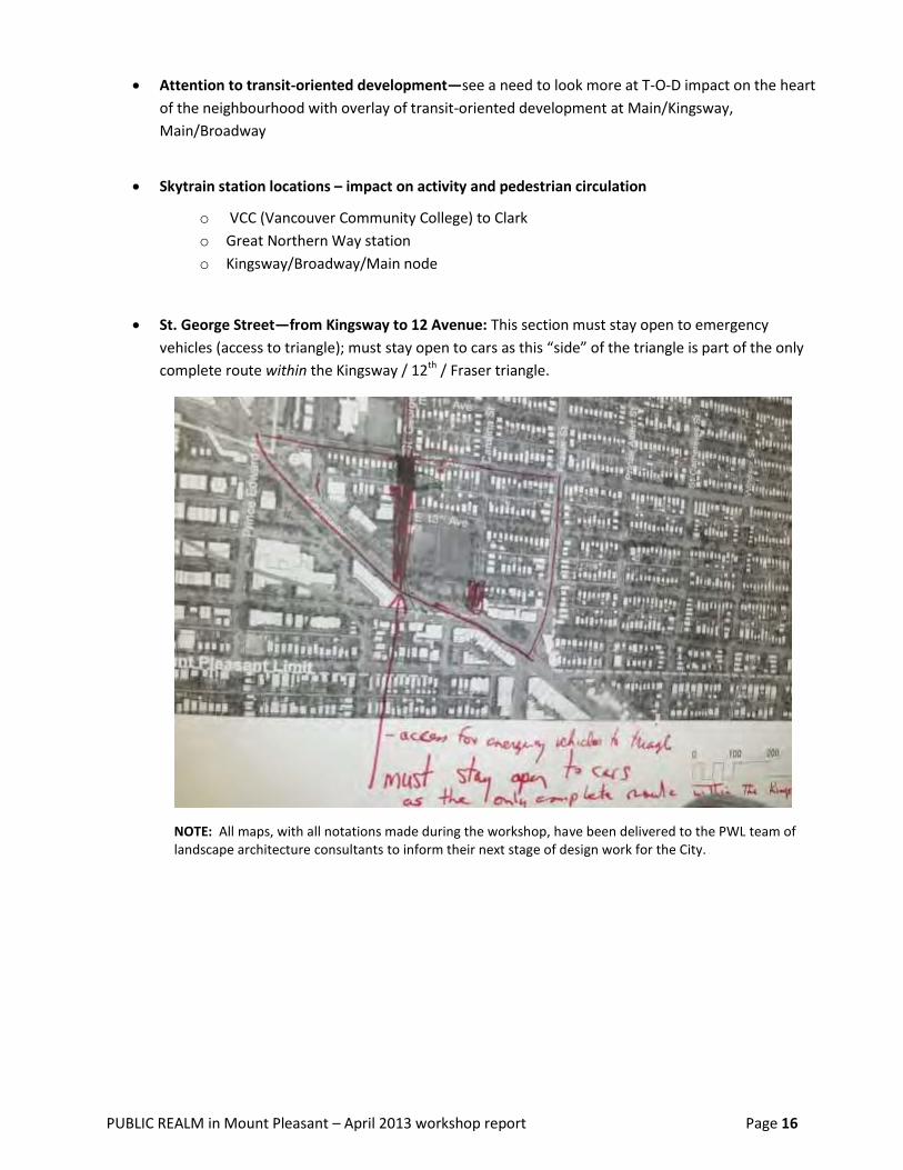
St. George Street—from Kingsway to 12 Avenue: This section must stay open to emergency
vehicles (access to triangle); must stay open to cars as this “side” of the triangle is part of the only
complete route within the Kingsway / 12th / Fraser triangle.
NOTE: All maps, with all notations made during the workshop, have been delivered to the PWL team of landscape architecture consultants to inform their next stage of design work for the City.

PUBLIC REALM in Mount Pleasant – April 2013 workshop report Page 17
Other observations regarding interests and issues raised
Parks and plazas were not a “hot topic” for participants in the April 13, 2013 workshop.
PWL landscape architects showed a map that included:
(a) proposed new pocket park locations
(b) “boulevard parklets” as a consistent partial-block feature on all side streets running east or west
off Main and also . . . running north and south off Broadway at in the shopping districts
(c) SIX proposed locations for small neighbourhood plazas plus
(d) street-to-park conversions (with Parks Board funding potentially) and pavement-to-plaza
conversions (with Engineering Dept. funding potential) in another two locations.
These maps were available at every table throughout the workshop.
Why community members did not specifically respond to these recommendations is not known.
Possible explanations include:
they supported them (and felt no further comment necessary)
they did not register the recommendations (because maps held a lot of detail and there were
also multiple maps at each table, showing different aspects of proposed enhancement
maps shown as slides were hard to read from many locations in the room, given the scale used
by PWL and the complexity on each map)
they simply did not have time (given higher importance they placed on other discussion topics).
When the large group of participants broke into smaller circles, with each of the smaller dialogue
circles focused on a particular hot topic, the lead designer for PWL proposed that one group discuss
parks and plazas further. That discussion space was established (with facilitation support available)
. . . but no participants chose to gather there. (One workshop participant noted “plaza connecting
Jonathan Rogers Park to Broadway” as the design aspect s/he most wanted to talk about . . . but did
not move later to join a discussion group on parks and plazas.)
To gather community feedback on this particular aspect of the PWL plan,
it could be useful for municipal planners to include a specific question on the community comment
forms used during the intended June 15th (2013) Open House – and/or the earlier April 27th (2013)
Open House to be hosted by the City of Vancouver -- when presentation materials on the proposed
Public Realm Plan for the neighbourhood are on display for the general public again.
Additionally, or alternatively, community members can review the draft PWL concepts for Mount
Pleasant (see Appendix 3) and then send comment via e-mail, fax or regular mail to City of Vancouver
(attention: Mount Pleasant planner Joyce Uyesugi –[email protected] ). The hyperlink in
Appendix 3 leads to all of the maps produced by PWL designers as part of their draft public realm plan
for the neighbourhood. The hyperlink also leads to other visual information: i.e., relevant examples
from elsewhere, plus imagined possibilities for selected sites in Mount Pleasant.
Not all areas of the Mount Pleasant neighbourhood are seen as appropriate for more greening:
active industrial areas may not allow the approach proposed in other parts of Mount Pleasant.
Also on individual comment sheets: visual permeability and pass-throughs as “the design aspect
most wanted to talk about.”

PUBLIC REALM in Mount Pleasant – April 2013 workshop report Page 18
RECOMMENDATIONS / DISCUSSION of Hot Topics
Section 1: Arterial Walkability (Broadway, Main)
Add SEATING. Recommendation 1:
Small, movable arrangements or more permanent arrangements
May be attached to a business—or not
Add more installations like Parallel Park, designed and built by local resident/landscape architect
Travis Martin (with materials/build support from the City’s VIVA program and, later, corporate
support from JJ Bean to maintain the amenity).
On Broadway, must be on the north side to catch the sunlight
On the south side of Broadway, wrapping around corners would work
—locating the seats on the north-south side street, very close to Broadway
Using GREEN BUFFERS. Recommendation 2:
Leave parking spaces on the road—but add a green buffer between the road and sidewalk to make it
feel much quieter and safer for pedestrians.
Need permeability between parked cars and businesses: pedestrian openings in the green buffer.
From whatever small spaces we can eliminate parking, claim more green space.
o where off-street parking exists (for instance, off lanes)
o on a temporary basis when there are special events, also reclaim more “parklets”
SOFTEN the CURB. Recommendation 3:
As at Granville and Nelson
Create shallow curves only, to indicate parking space.
BULGE-OUTS on east/west side streets off Lower Main Recommendation 4:
Take advantage of the really wide existing side streets (see scenarios 1 and 2 on next page sketches)
and do big “bulges” into the intersections (for greening).
Or narrow the streets at these intersections to create mini-plazas by also taking over some parking
spaces on Main Street.
Some COVERED SPACES for rain protection Recommendation 5:
Want some canopies / awnings / rain protection of some sort: how does this happen?
“How do you standardize this requirement?” wondered community members.
o By policy, making it a business responsibility?
o By embedding various options (together creating a standardized package of choices:
dimensions / materials / etc.) from which architects can choose?

PUBLIC REALM in Mount Pleasant – April 2013 workshop report Page 19
NOTE: All maps, with all notations made during the workshop, have been delivered to the PWL team of landscape architecture consultants to inform their next stage of design work for the City.
Main Street “bump-outs”
recommended on the wide
side streets
PUBLIC REALM in Mount Pleasant – April 2013 workshop report Page 20
BIKE CORRAL on side streets instead of bike racks on the sidewalk Recommendation 6:
– so as not to impede pedestrian flow
Higher number of PEDESTRIAN CROSSINGS—on Main Street Recommendation 7:
Lessening the “big gaps” between existing traffic lights—and adding pedestrian lights or other
crossing indicators at 11th, 13th and 15th Avenues, for example
In high traffic areas, also create railings a foot from the road—to prevent jaywalking and bikes
crossing in dangerous areas.
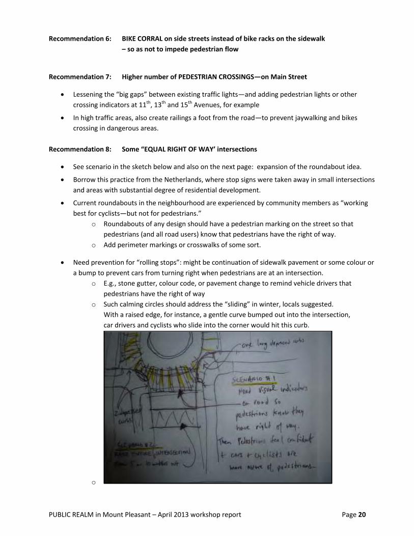
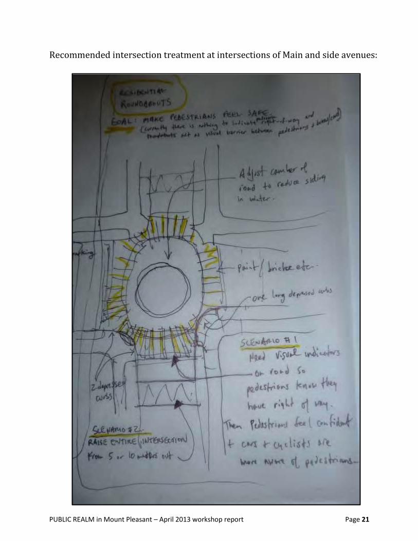
Some “EQUAL RIGHT OF WAY’ intersections Recommendation 8:
See scenario in the sketch below and also on the next page: expansion of the roundabout idea.
Borrow this practice from the Netherlands, where stop signs were taken away in small intersections
and areas with substantial degree of residential development.
Current roundabouts in the neighbourhood are experienced by community members as “working
best for cyclists—but not for pedestrians.”
o Roundabouts of any design should have a pedestrian marking on the street so that
pedestrians (and all road users) know that pedestrians have the right of way.
o Add perimeter markings or crosswalks of some sort.
Need prevention for “rolling stops”: might be continuation of sidewalk pavement or some colour or
a bump to prevent cars from turning right when pedestrians are at an intersection.
o E.g., stone gutter, colour code, or pavement change to remind vehicle drivers that
pedestrians have the right of way
o Such calming circles should address the “sliding” in winter, locals suggested.
With a raised edge, for instance, a gentle curve bumped out into the intersection,
car drivers and cyclists who slide into the corner would hit this curb.
o
PUBLIC REALM in Mount Pleasant – April 2013 workshop report Page 21
Recommended intersection treatment at intersections of Main and side avenues:
PUBLIC REALM in Mount Pleasant – April 2013 workshop report Page 22
Require PERMEABILITY (for walkers) when approving NEW BUILDING Recommendation 9:
developments.
At Kingsway and Broadway, create a pass-through to enable pedestrians to cross through rather
than having to walk around.
o For example, where Our Town café is. Can the Watson Street lane be extended?
o Can the same action be taken on other sharp corners?
Add UNDERGROUND MALL and WALKWAYS with SUBWAY development. Recommendation 10:
Sidewalks on Broadway are not wide enough to absorb additional pedestrian traffic if/when Skytrain
comes through this corridor. If rapid transit is put underground, then also create underground malls
and walkways as a positive pedestrian experience.
Create several exits from the Skytrain to make that experience pedestrian-friendly—and not like the
Broadway & Cambie station’s exit. Community members described the latter as “failed” and “a
dangerous intersection” for pedestrians.
Make some BUS BULGES more creative spaces. Recommendation 11:
PIGEON CRAP BY-LAW Recommendation 12:
Need a by-law so businesses have to have a net or some other way to capture excrement so that
pedestrians are less at risk of a “hit.””
PUBLIC REALM in Mount Pleasant – April 2013 workshop report Page 23
Section 2: Strengthening Business Districts through Public Realm Changes
In reviewing PWL’s draft concepts and maps, community members expressed concern that there was not
enough attention to making the business districts more attractive to pedestrian traffic and, through public
realm measures, making each business district more viable for businesses as long-term locations.
Workshop participants considered the types of businesses active in Mount Pleasant (manufacturing, retail,
car services, etc.), local weather impact on pedestrian traffic, how public transportation can contribute to
increasing and facilitating business access/use, and the contributory role potential of various parties.
DESIGNERS could identify areas for “SPECIAL” PUBLIC ART (related to district Recommendation 13:
identity) and add guidelines to reinforce the distinctive identity of each district.
For example, public art guidelines applicable to bike racks in the Broadway West “Fleece District”
and different guidelines for “Hops Valley / Brewery District” on Lower Main
Businesses that are moving in, or thinking about locating in an area, need to know what the “design
vision” of the neighbourhood is intended to be.
The vision / design guidelines need to be readily accessible to business operators and commercial /
mixed use land owners/purchasers.
Cycling to be glorified in the “fleece district” (Broadway West) – and lane access to retail outlets to
be strongly encouraged or required in this area.
Community members recommend that PWL designers help with directions for businesses to
contribute to community—offering guidelines for signage, artful amenities, outside seating, etc.
Privately owned properties also ought to be consulted for validation of the “design vision”.
Add RAINY CITY GUIDELINES—such as requiring property developers to create Recommendation 14:
CANOPIES over the public realm immediately outside business premises.
BIA (Mount Pleasant Business Improvement Area association) should work with Recommendation 15:
MAJOR RETAILERS (e.g., sporting goods retailers) to encourage them to contribute
to the public realm—through sponsorship of distinctive public art such as
professionally designed murals, commissioning of sculptural bike racks, parkette
amenities, signs that also function as public art.
What will draw more pedestrians to an area? WIDENING SIDEWALKS for planters, Recommendation 16:
cycling, and more room for walkers – collective or CITY-LEVEL INITIATIVE required
What could businesses do to draw more people? BUSINESSES to participate in or Recommendation 17:
be initiators of “taking care of” their neigbourhoods, by controlling litter and
garbage, creating outdoor seating, planting more greenery, etc.
PUBLIC REALM in Mount Pleasant – April 2013 workshop report Page 24
Major retailers especially, such as Mountain Equipment Co-op, should be encouraged to introduce
animation elements in their local neighbourhoods. The City and the local BIA could work together to
encourage more businesses to contribute to the public realm.
Could major retailers, in turn, encourage smaller businesses to make some form of contribution too?
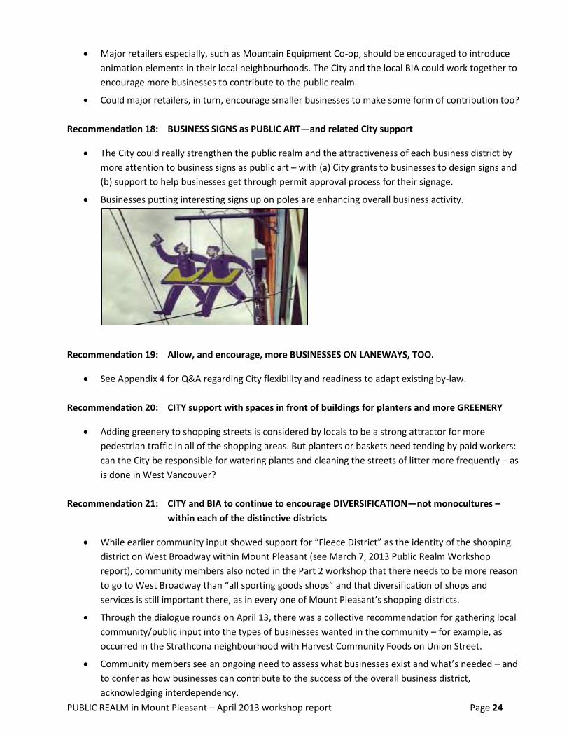
BUSINESS SIGNS as PUBLIC ART—and related City support Recommendation 18:
The City could really strengthen the public realm and the attractiveness of each business district by
more attention to business signs as public art – with (a) City grants to businesses to design signs and
(b) support to help businesses get through permit approval process for their signage.
Businesses putting interesting signs up on poles are enhancing overall business activity.
Allow, and encourage, more BUSINESSES ON LANEWAYS, TOO. Recommendation 19:
See Appendix 4 for Q&A regarding City flexibility and readiness to adapt existing by-law.
CITY support with spaces in front of buildings for planters and more GREENERY Recommendation 20:
Adding greenery to shopping streets is considered by locals to be a strong attractor for more
pedestrian traffic in all of the shopping areas. But planters or baskets need tending by paid workers:
can the City be responsible for watering plants and cleaning the streets of litter more frequently – as
is done in West Vancouver?
CITY and BIA to continue to encourage DIVERSIFICATION—not monocultures – Recommendation 21:
within each of the distinctive districts
While earlier community input showed support for “Fleece District” as the identity of the shopping
district on West Broadway within Mount Pleasant (see March 7, 2013 Public Realm Workshop
report), community members also noted in the Part 2 workshop that there needs to be more reason
to go to West Broadway than “all sporting goods shops” and that diversification of shops and
services is still important there, as in every one of Mount Pleasant’s shopping districts.
Through the dialogue rounds on April 13, there was a collective recommendation for gathering local
community/public input into the types of businesses wanted in the community – for example, as
occurred in the Strathcona neighbourhood with Harvest Community Foods on Union Street.
Community members see an ongoing need to assess what businesses exist and what’s needed – and
to confer as how businesses can contribute to the success of the overall business district,
acknowledging interdependency.

PUBLIC REALM in Mount Pleasant – April 2013 workshop report Page 25
Other implementation considerations that were raised:
Increase beautification by incorporating practicality: e.g., channeling water runoff into rain gardens.
Cable cars within Mount Pleasant (e.g., small-scale funicular for the top of the rise to Fraser) – an
incentive to travel along Broadway East for the fun of it. Practical? Feasible?
Potential to create a historical appreciation of Davidson Batteries (which recently ended its multi-
decade-long presence)
Small parks attract various types of users; at night, drinkers and drug users who leave litter (some of
it bio-hazardous), may disturb residents with noise, and are “the usual suspects” in car and business
break-ins and vandalism. City statistics or research into how these places/parks positively contribute
to community environment (safety aspect) are needed.
Small businesses are being pushed out because of rising rent prices. There needs to be support for
pop-up businesses, food carts, temporary businesses, etc.
Broadway East Revitalization:
Very diverse business area (35+ types of businesses)
Many small “mom and pop” businesses that exist in this community
Business outreach with business owners and commercial properties—discussion about what the
area could become— has been initiated and needs to continue.
o Work with the BIA and recognize joint promotional opportunities.
o Focus on key businesses – e.g., Anna’s Cake House, long established in Broadway East – to
help better organize this neighbourhood.
o Keep identifying types of services missing in the area: e.g., bakery, bank, fresh produce,
etc.
o Outreach to / involvement of services should also be part of the development.
o Keep finding ways for small businesses to participate in the community more – invest in
[place-making?] education and service.
Use “private public libraries” (such as on 10th Avenue, near St. George) for getting pamphlets out in
the neighbourhood.
Consider business tents – or a community trailer or shop – that small businesses could share and
alternate between.
Also consider monthly outdoor markets for local businesses to promote their businesses.
Regarding the older buildings that need revitalization –upgrades to be paid for by whom?
Large gap in Broadway East: there is nothing in the 400 block where the Teamsters’ building is.
Lido under construction – What’s going on there? Permit? Zoning? Do they have their liquor license?
(Re-opening as public house in late summer/fall: bar / music performance venue. Owner is also
opening comfort food restaurant near Fraser & south-side Kingsway.)
Kingsgate Mall – Extended hours, design of new entrances (changed layout) may not be possible due
to existing corridors.

PUBLIC REALM in Mount Pleasant – April 2013 workshop report Page 26
Section 3: Combining (or Separating) Cycling & Walking Routes
Two concerns underpinned the dialogue on whether to combine or separate cycling and walking routes
(as an overall strategy, recognizing that all routes are likely to attract individuals from both user groups).
Safety is the first concern: the visibility of walkers on cycling routes, and also the degree to which
each network is well lit.
Awareness is the second concern. What is the mapping strategy? What public education will
supplement the recommended public realm design? What route guides, and what rules, will apply
on each network? What signage will be put in place? What pavement markings will be used? (on
bike routes as well as enhanced pedestrian routes)
Combine TWO USAGES—NOT THREE—as a GUIDING PRINCIPLE in the plan. Recommendation 22:
Walkers in the April 2013 workshop, exploring as a group the recommended pedestrian and cycling
networks mapped by the PWL, welcomed the idea of separate routes for walkers and cyclists.
Combination bike/walk routes work fine, when no cars are allowed on the route.
Bike/drive routes also work okay, in workshop participants’ view (except along Lower Main).
Walk/drive can go together well because streets are wide and well-lit in most of Mount Pleasant.
On wide streets such as Broadway, they see the potential for adequate light, safety and visibility for
walkers to move safely, along with motor vehicles and bicycles—and they envision Broadway as a
good walking corridor when revitalized with further trees. Strengthening the Broadway connection
to Main is important in community members’ view. On narrower streets, such as 10th Avenue, they
see safety as a key risk if this is treated as both the key east-west cycling route and a preferred
pedestrian route.
Because 10th Avenue is experienced as a “Bike Highway,” community members supported the idea
of instead enhancing the lane between 12th and 13th Avenues as an east-west pedestrian route,
especially since that lane is already well lit and felt by residents to be a safe walking environment.
NOTE 1: GREEN CANOPY deserves just as much attention on pedestrian routes as on cycling routes.
NOTE 2: Community members also advise that car use (traffic stats) be taken into account first,
before finalizing “enhanced pedestrian” and “cycling” routes on the Mount Pleasant maps. Which
routes are the routes that cars are using most often now?
Add SIGNAGE that will DIRECT CYCLISTS on non-bike routes to the bike routes. Recommendation 23:
Pavement signage (and/or other signs—but pavement signage is a recommended component) is
needed to redirect cyclists from “pedestrian only” or walk/drive routes to the cycling route network.
o Paint bicycle icons to highlight cycling routes.
o Paint white circle graphics to highlight the pedestrian routes.
(Note: somewhat conflicting recommendation about how to mark pedestrian crossings)
This signage is also seen as a critical component of public education for drivers.
Vehicle users need ongoing education about where the bike routes are.

PUBLIC REALM in Mount Pleasant – April 2013 workshop report Page 27
CARS to be welcome on triangle sides at south end of St. George RAINWAY Recommendation 24:
In the view of workshop participants, car access remains important on the
Fraser – Prince Edward – 12th Avenue – Kingsway edges of this “vibrant triangle” that is a relatively
high-density residential development. See map on page 16.
NORTH-SOUTH LINK needs STRENGTHENING at Great Northern Way Recommendation 25:
—to safely enable cyclists and pedestrians of all ages from Mount Pleasant to move
across Great Northern Way Campus to connect with the Strathcona neighbourhood.
Add a cycling / pedestrian bridge over the rail tracks, as part of this north-south route for biking and
for pedestrians. Enhancing this connectivity is seen as very important for Mount Pleasant residents.
The view was expressed by multiple speakers that there is “no way to get to Strathcona safely.”
Design this route so that it is safe for children.
Invite Our Community Bikes people (not-for-profit, cooperatively run, full service bike repair shop
and education organization, associated with the PEDAL Foundation, in Mount Pleasant1), along with
other cycling associations, to provide input and feedback into this aspect of the design.
CONNECT PARKS with the CYCLING ROUTES Recommendation 26:
– and mark these together, better, with both maps and signs.
Section 4: Street Crossings (Road Art / Method of Marking)
TEXTURED CROSSINGS are recommended over paint. Recommendation 27:
Though the initial round of feedback showed community interest in the visually compelling road art
proposed for street crossings (and the idea that different graphics might be used in different
shopping districts), further dialogue resulted in the recommendation that a unified treatment was
preferable for Mount Pleasant.
Unified signage (road graphic) and/or a distinctive texture is thought to increase road users’
awareness of pedestrian crossings.
Textured crossings for cyclists and pedestrians are seen as a stronger tool for ensuring that drivers
notice and respect these other road users.
Textured crossings are also preferred as more durable than paint and a more decorative element.
o CAVEAT: Be cautious, added an instructor working with the visually impaired, in proposing
(selecting) textured pavement treatments: these can be uncomfortable for people with
any mobility impairment.
1 On Ontario Street, between 2
nd and 3
rd Avenues

PUBLIC REALM in Mount Pleasant – April 2013 workshop report Page 28
Section 5: Improving Inter-Neighbourhood Connectivity
The concerns about inter-neighbourhood connectivity indicate, above all, that community members do not
see Mount Pleasant as an island. They instinctively look at more than central shopping districts when coming
together to talk about public realm vision, design and investments.
Easing pedestrian and cyclist circulation between Mount Pleasant and neighbourhoods to the north
(Strathcona, Gastown, Downtown and the emerging “neighbourhood” on and beside Great Northern Way
Campus) is something that needs attention, in residents’ view. This need was discussed both in terms of
individuals’ own interests and also with respect to larger circulation patterns (of others) and dangers that
they are witnessing. Additionally (see page 16 also), connectivity between Main Street and Commercial
Drive (another important shopping district for Mount Pleasant residents) is important for pedestrians too.
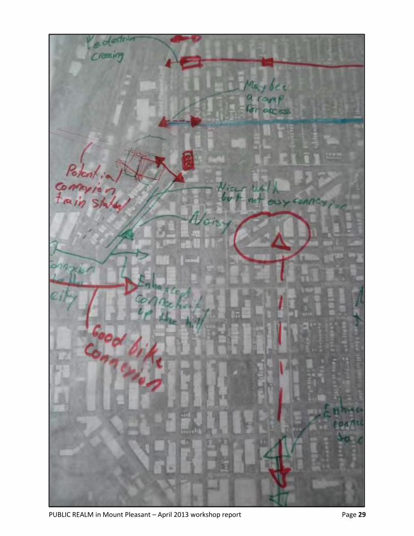
INCREASE connections from 5th Avenue to GREAT NORTHERN WAY. Recommendation 28:
More pedestrian crossings across Great Northern Way, to the GNW campus, are definitely
needed—especially a pedestrian / cyclist ramp at St. George. (see rough map on next page)
Enhance the crossings with parklets at Prince Edward and Great Northern Way.
1st AVENUE enhancement Recommendation 29:
First Avenue is an important connection between Downtown, the Main Street station to the north-
west, and Mount Pleasant. This node needs public realm enhancement.
EAST-WEST CONNECTIONS—strengthen one more route. Recommendation 30:
Maintain the strong 10th Avenue connection between neighbourhoods.
Need to enhance another east-west connection north of Broadway: 10th Avenue is too far uphill to
walk to, to reach a pleasant walking route.
A better pedestrian route is needed to Cambie shopping district from the north-east section of
Mount Pleasant—either along Broadway, 8th, or another avenue or lane—because 10th Avenue,
while highly valued, serves as a “bike highway” and is not experienced as a safe route for walkers.
NOTE also the recommendation (section 3) to enhance the lane between 12th and 13th Avenues as
a good walkers’ route from Main to Cambie.
OTHER CONNECTIONS TO THE NORTH Recommendation 31:
As noted with the cycling/walking route discussion (see recommendation 25), need an overpass to
Strathcona neighbourhood (from both east and west sides of the Mount Pleasant neighbourhood).
Better north-south bicycling connections to Downtown are needed—e.g., on Quebec, or Main,
Station Street—to reach eastern Downtown (e.g., Gastown, Railtown, Georgia Viaduct area).
Also need recognition of the Glen Drive cycling route on the eastern side of Mount Pleasant
Enhance FRASER STREET as preferred route TO SOUTHERN NEIGHBOURHOODS. Recommendation 32:
PUBLIC REALM in Mount Pleasant – April 2013 workshop report Page 29

PUBLIC REALM in Mount Pleasant – April 2013 workshop report Page 30
Section 6: Ecological Considerations in Mount Pleasant Public Realm
GUIDING PRINCIPLE: Trusting, and cultivating, public intelligence about nature—Recommendation 33:
with respect to existing natural landscape in this community and the possibility of
natural landscape; and also in terms of education for both adults and children—was
recommended as a guiding principle in the Mount Pleasant Public Realm Plan.
DEEPER INVESTIGATION of NATURAL ELEMENTS in the public realm plan Recommendation 34:
What excites community members is the biodiversity in the city. They want to embrace and
celebrate it. Ecological heritage and wilderness are important elements of a neighbourhood’s public
realm plan, in their view.
Currently present in South-East False Creek, for instance, are many birds, including many species of
songbird. Also present are junior salmon, herring, native bees (underground species), and other
indicators of ecological diversity. The continuum from this natural heritage to backyards, and to
street trees in the vertical stratification of the natural landscape, is important to residents who
would like to see it recognized in the public realm plan for the neighbourhood.
o Species such as the native underground bee species are meaningful for production in
other gardens. A potential future location for these bees is in roundabouts.
Community members said that more value needs to be placed on the ecological layer of this
neighbourhood’s public realm plan, including more emphasis on the sacredness of water.
Separate STORM-WATER RUN-OFF from SEWAGE LINE. Harvest for WETLAND. Recommendation 35:
A concern is the current system of directing storm water discharge into False Creek, contributing to
a dirtier False Creek. A solution is to create a freshwater wetland on the False Creek Flat.
Such a wetland is seen as “most functional public realm change,” “biggest bang for [public] dollars.”
The low topography of the flat makes this a “low-hanging fruit to pluck” in the implementation of
desired changes in the public realm for the neighbourhood.
Partner with local schools and park (occupying natural and historic wetland) to collect rain water
and create “pocket wetlands.”
A demonstration project has been started, as part of the St. George Rainway initiative.
Separation of storm-water runoff from the #6 sewage line (which currently has cleaning solvents
entering it, and whose contents are sent to the Iona sewage plant for treatment) is recommended.
Provide, in such wetland creation, a natural corridor for animals, including accommodation for large
mammals (e.g., coyote, sightings of which have occurred as far north as 16th and Ontario).
Migratory routes study is needed.
Incorporate First Nations’ perspective on water into “pocket wetlands” creation.
PUBLIC REALM in Mount Pleasant – April 2013 workshop report Page 31
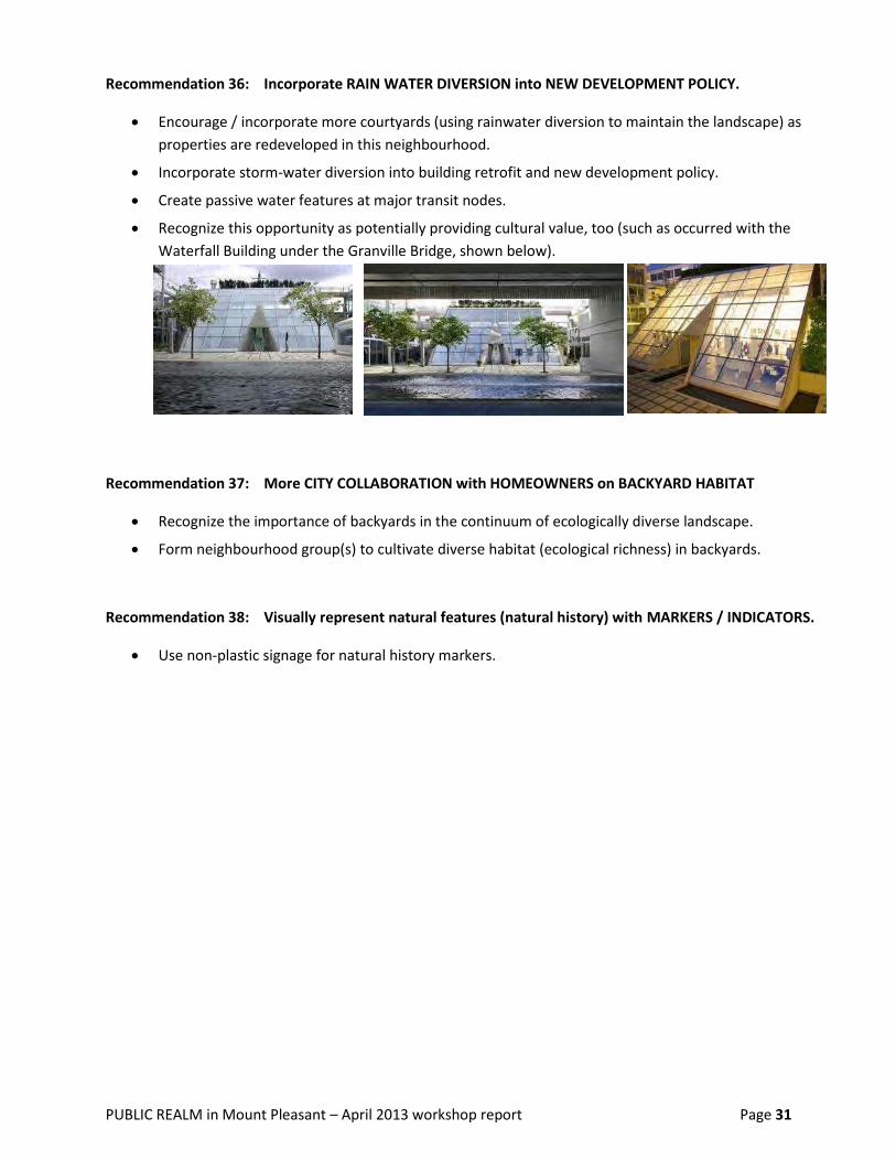
Incorporate RAIN WATER DIVERSION into NEW DEVELOPMENT POLICY. Recommendation 36:
Encourage / incorporate more courtyards (using rainwater diversion to maintain the landscape) as
properties are redeveloped in this neighbourhood.
Incorporate storm-water diversion into building retrofit and new development policy.
Create passive water features at major transit nodes.
Recognize this opportunity as potentially providing cultural value, too (such as occurred with the
Waterfall Building under the Granville Bridge, shown below).
More CITY COLLABORATION with HOMEOWNERS on BACKYARD HABITAT Recommendation 37:
Recognize the importance of backyards in the continuum of ecologically diverse landscape.
Form neighbourhood group(s) to cultivate diverse habitat (ecological richness) in backyards.
Visually represent natural features (natural history) with MARKERS / INDICATORS. Recommendation 38:
Use non-plastic signage for natural history markers.

PUBLIC REALM in Mount Pleasant – April 2013 workshop report Page 32
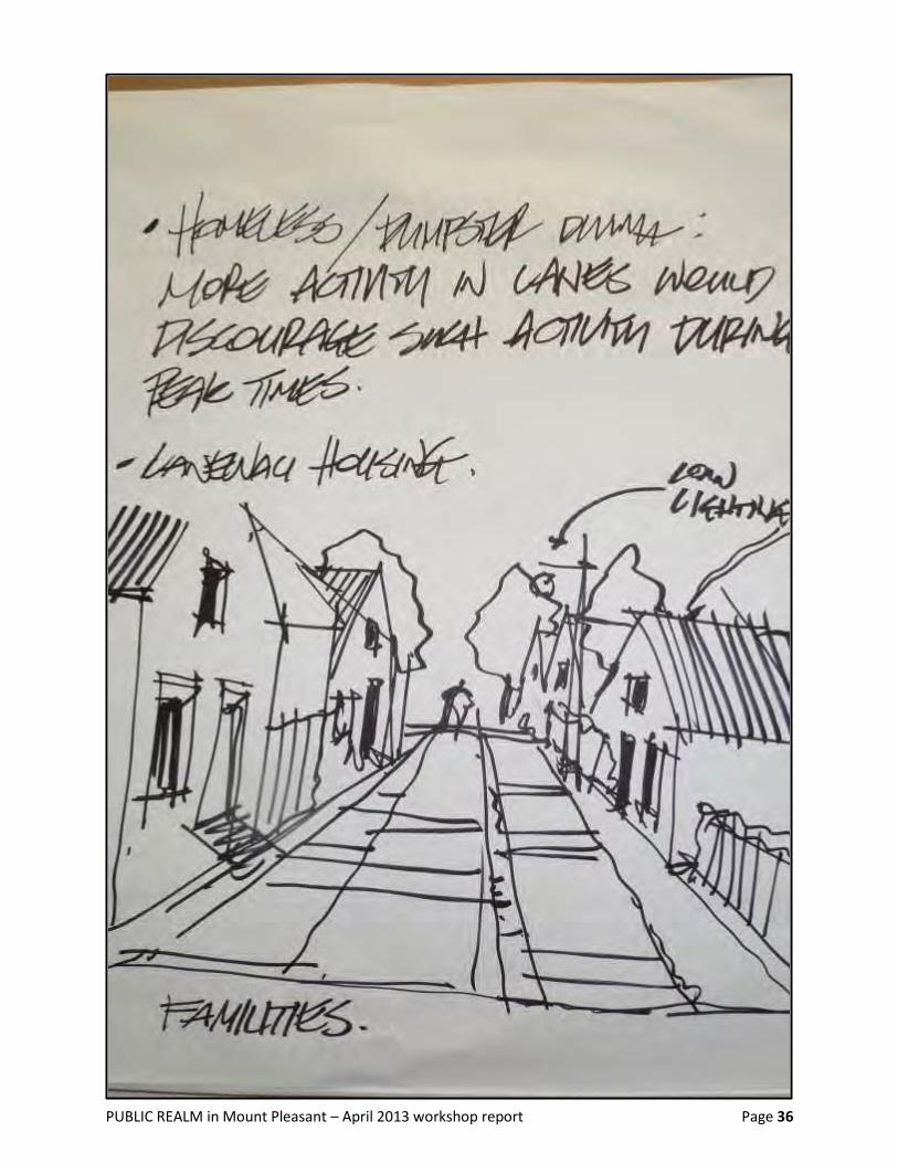
Section 7: Laneway Treatment
In the discussion about “What excites /disturbs you about the laneway ideas and recommendations?”
community members mentioned the following:
Concern about businesses’ parking needs west of Main
Parking access for both townhouses and businesses east of Main
Service area (commercial loading / unloading) on Watson Street – i.e., multiple uses of Watson
Difficulty of continuing along Watson Street given the lack of safe crossings at 12th and 16th Avenues
– need for heightened accessibility at these locations, but concern that existing buildings at 12th and
16th will make change hard – low feasibility of a continuous path for walkers on Watson?
Interest / excitement expressed about a different characteristic for lanes (vs. main streets), as in a
different paving style – and the opportunity to capture the more historical context of Mount
Pleasant in the lane routes, given that Mount Pleasant is one of the few neighbourhoods in
Vancouver with a lot of history (in terms of city development)
Interest in laneway housing as contributing to an easy street-to-lane, lane-to-street walking pattern
Concern about homeless people (“who identify and rely on ‘good’ garbage cans/bins”) – how can a
good balance be achieved in developing laneways and also acknowledging homeless people?
Walkability of specific blocks – and “between blocks” spaces such as the challenging crossings at 12th
and 16th (to walk on Watson).
City of Vancouver to encourage property owners to take responsibility for Recommendation 39:
laneway enhancement by adopting SMALLER CONTAINERS FOR WASTE.
San Francisco example was used as relevant precedent.
For Watson Street, 12th and 16th Avenue pedestrian CROSSINGS at OTHER STREETS. Recommendation 40:
Add appropriate signage?
Use Main Street as the other part of the “loop.”
Encourage big or small loops for people to use on Main Street for shopping purposes.
Place more focus on street-to-lane, lane-to-street walking patterns, i.e., looping rather than
continuous lane circuit.

PUBLIC REALM in Mount Pleasant – April 2013 workshop report Page 33
Develop the service area ON WATSON by adding MORE SIDEWALK CAFÉS that Recommendation 41:
front onto this “lane-like” street.
Wherever possible, BRIDGE the lane (Watson) – linking buildings “over the top of Recommendation 42:
the lane” so as to address business concerns about service bays while also
increasing the use of public realm property, and potentially also increasing sunlight
into these new spaces for cafes and/or public art.
Quebec and 2nd development was used as an example in this discussion.
(details not given in recorder’s notes)
Use glass block, lighting on the top, special plants to draw attention to this “ceiling on the space”
and pedestrian-friendly locations above.
Add BIG RAIN COVER (different characteristics on different lanes), LIGHTING, and Recommendation 43:
PLACES FOR CHILDREN on lanes, to make these routes much more enticing.
UNIFY the energy (street to lane). Recommendation 44:
For example, by encouraging windows to the back (to make lane more visible).
At the same time, encourage the development of blocks with different characteristics, i.e.,
unified from the street front to the lane environment, but different block feeling in different parts of
Mount Pleasant.
Encourage a walking pattern in which people move easily from street to lane, lane to street.
Encourage / allow property owners to also play with different character of the lane according to the
season as another option.
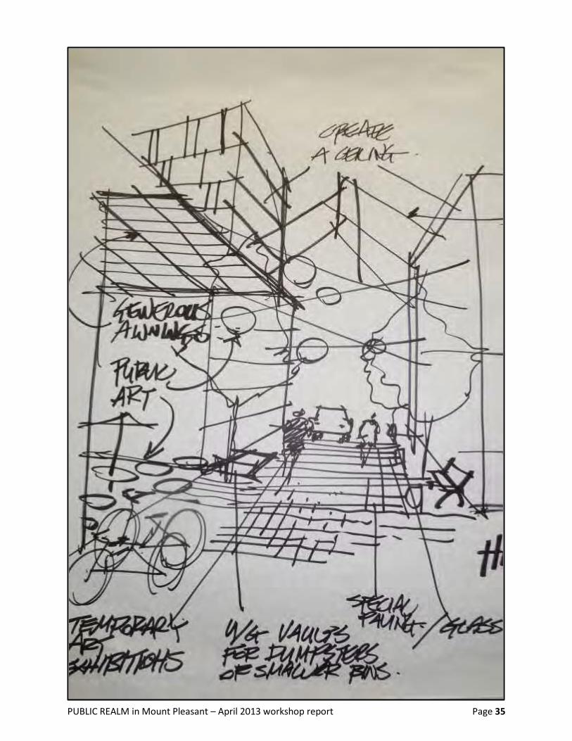
Group recommendations captured visually by PWL team member Derek Lee
(see next 3 pages)

PUBLIC REALM in Mount Pleasant – April 2013 workshop report Page 34
PUBLIC REALM in Mount Pleasant – April 2013 workshop report Page 35
PUBLIC REALM in Mount Pleasant – April 2013 workshop report Page 36

PUBLIC REALM in Mount Pleasant – April 2013 workshop report Page 37
Section 8: Acknowledgement of Aboriginal Presence, Heritage, Art and Culture
The Mount Pleasant Community Plan, in Section 3.8 on Heritage guidelines, embeds a commitment to
“Neighbourhood founders acknowledgment.”
On page 11 of the Plan, this direction appears: “Respect and honour the history, traditions and current
presence of Aboriginal peoples and sites; investigate opportunities to deliver tangible support for Aboriginal
projects and initiatives, including locations and spaces to mark cultural observances.”
In discussing their concern that the emerging concepts plan of the PWL team does not yet sufficiently
recognize Aboriginal heritage2, presence or art and culture, community members observed the following:
Mount Pleasant has the third highest concentration of Aboriginal people, amongst all Vancouver
neighbourhoods.
Clusters of Native housing exist now on the eastern edge of the neighbourhood (Clark Street).
An Aboriginal day care centre is situated on the border of South China Creek Park in Mount Pleasant.
Aboriginal cultural activities are part of the Mount Pleasant Neighbourhood House programs:
800 East Broadway—at Prince Albert, where a new open space may also be created.
La Boussole on East Broadway is a Francophone community centre that support Métis people.
(in the 600 block, south side, of East Broadway)
A new community centre—the Broadway Youth Resource Centre—will include services to Aboriginal
youth. Several floors of housing above it will be managed by the Vancouver Native Housing Society
(at Broadway and Fraser—a site which also abuts a potential new open space on Fraser Street,
between Broadway and the Sahalli Park entrance at 8thAvenue).
The Native Education College is on 5th Avenue at Scotia. It is a structure whose architectural form is
reminiscent of traditional longhouses, and a hub of Aboriginal activity.
Celebrate Aboriginal people and culture in the public realm through murals, other Recommendation 45:
pictures, history markers / education tied to connectivity (historic routes) and/or
mid-block crossings (graphic art on roads).
THREE PEDESTRIAN CROSSINGS were recommended as locations for such crossing Recommendation 46:
treatment, given the location of Aboriginal-focused services/facilities.
Broadway crossing at Scotia / Kingsway
Between Fraser and Carolina Streets – noted as mid-block crossing on East Broadway
Between St. George and Guelph Streets – also noted as mid-block crossing on East Broadway.
2 PWL’s map “to celebrate the rich history of Mount Pleasant” includes one historic Indigenous trail.
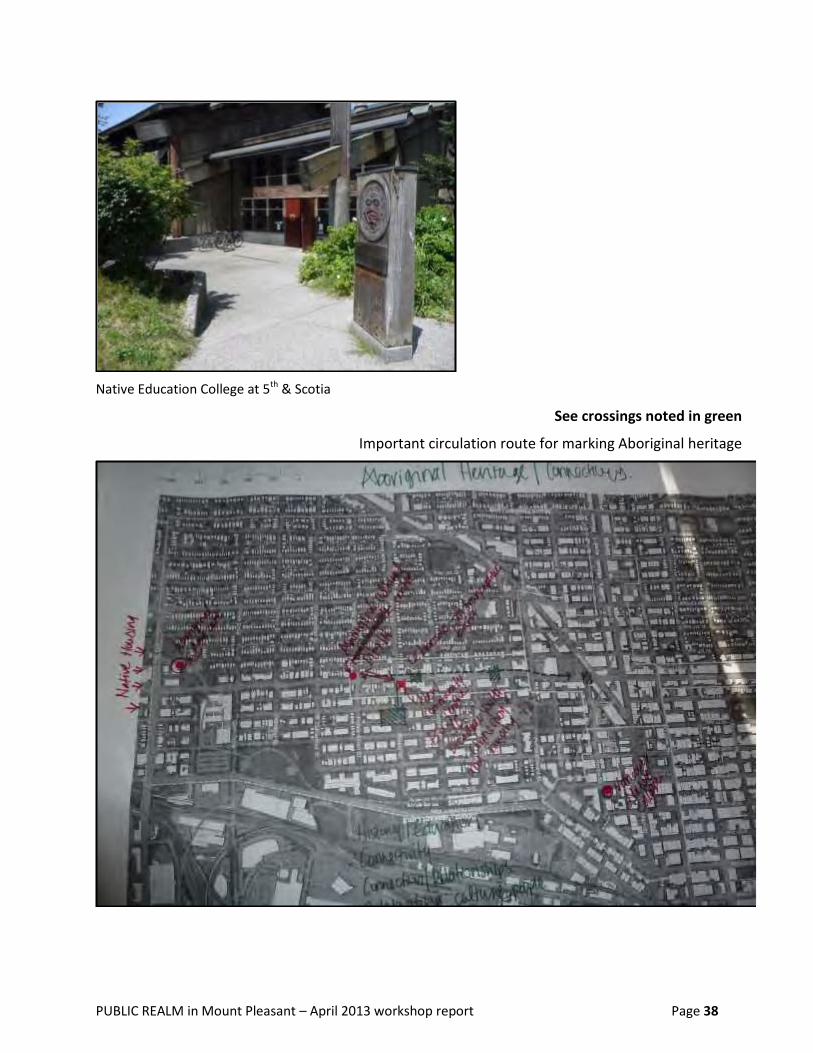
PUBLIC REALM in Mount Pleasant – April 2013 workshop report Page 38
Native Education College at 5th & Scotia
See crossings noted in green
Important circulation route for marking Aboriginal heritage
PUBLIC REALM in Mount Pleasant – April 2013 workshop report Page 39
Community-Led Initiatives – ADDITIONAL PRESENTATIONS
Livable Laneways
Livable Laneways was founded in Mount Pleasant and is a not-for-profit society working on both
short-term and long-term laneway animation3. A majority of its directors live in Mount Pleasant.
While acknowledging garbage, parking and public perception challenges,
the Livable Laneway directors and other volunteers have been focusing on:
o Events programming in commercial lanes
Night markets (produce, crafts, fashion, vintage goods, plants)
Performances (musical, theatrical, laser graffiti, fashion shows)
Fundraising barbecue cook-offs engaging local restaurants
In 2013: expanded site and programming – working with the Mount Pleasant BIA
(Business Improvement Area association) to extend the Autumn Shift Festival to
include not only several blocks of Main Street but also more than one block of
laneway environment—for a “non-linear” festival experience that occupies more of
the street/lane grid for public events
o Physical enhancements of both short- and longer-term nature
Such as planters in laneways; re-usable staging; decking (all short-term examples)
Also working collaboratively with property developers, as happened with Collection
45 mixed-use development on East 8th Avenue, to create a more pleasing ambience
on the laneway face of new development that will last for decades
o Changing the way lanes operate
For example, by spearheading a Zero Waste project with the local Business
Improvement Area, to clean bins more regularly and to reduce dumpster usage.
Livable Laneways Society has partnered with the local Business Improvement Area (MPBIA), the
Vancouver Design Nerds, independent musicians and artists and various arts organizations (e.g., The
Drift, Beaumont Studio, Mount Pleasant Artists Society, etc.), other local vendors (e.g., Blim, Victory
Gardens , etc.) and other societies (e.g., Vancouver Shade Garden Society for plant sales), Zero
Waste Challenge teams and others.
o In their events programming, they have been supported by VIVA Vancouver (2011, 2012).
o For small-scale amenity development (e.g., planters), they have been supported by the
Vancouver Foundation’s Neighbourhood Small Grants and also corporate sponsors.
Inspired by what has been possible with laneway development in other cities (such as Melbourne,
Australia), this organization has a three-year history of various projects in Vancouver.
To date, its projects have largely focused on piloting change in the commercial lane beside the Lee
Building (Main and Broadway) and extending from Broadway to 7th Avenue.
3 NOTE: The Mount Pleasant Community Plan (section 4.4) calls for development of a Laneway Strategy as part
of the Public Realm Plan for Mount Pleasant, and using Mount Pleasant as a pilot area for testing suitable
locations for laneway animation, for the benefit of the entire City.

PUBLIC REALM in Mount Pleasant – April 2013 workshop report Page 40
While lanes are still (in LL Directors’ perception) appropriately described as “marginal places,”
the LL directors see significant potential in lanes for a rising number of uses.
Livable Laneways president Rob Sutherland also showed workshop participants a short
documentary on accomplishments to date. The film highlights Laneway Night Markets and other
programming organized by Livable Laneways for summer 2012.
o The LL documentary was created by filmmaker Ana Mateescu, who moved to Mount
Pleasant three years ago as a Romanian immigrant. Ana told workshop participants her
story of arriving with little English language skill, working as a cleaner at first, and getting
to know her neighbourhood. “Mount Pleasant is what helped me to grow.” Ana said it was
her neighbourhood experience that encouraged her to go to film school. She is now
undertaking graduate studies in interactive documentary approaches to community
mapping and community building. In her Masters studies at ECUAD, the Emily Carr
University of Art and Design, she intends to develop a web platform for the documentary
story series she is creating about Mount Pleasant.
o More information about the neighbourhood features, residents and enterprises, and local
character that Ana is capturing as a documentary film-maker can be found on Erin’s
Neighbourhood Facebook page

PUBLIC REALM in Mount Pleasant – April 2013 workshop report Page 41
St. George Rainway
The St. George Rainway network, connected to the False Creek Watershed Society, is a community
network of residents that includes educators, local architects/ designers, ecologists, researchers and
other neighbours. Their work is collaborative in nature, inter-generational in focus, and rooted in a
commitment “to talk together. “
More information about their activities—intended to support a healthy watershed, a pleasing
environment for walkers and cyclists, and strong community connections—can be found online:
http://mtpleasantwatershed.wordpress.com/ and also at
https://www.facebook.com/media/set/?set=a.357919460946159.82600.140223206049120&type=1
In connecting to watershed study and exploration, they take steps to connect with First Nations
history and teaching about water and the land, and to other intercultural wisdom about water.
Rita Wong, one of the St. George Rainway coordinators, describes the coalition’s work as being
about Deep History, a Deep Future, and a Deep Sense of Home.
To date, the St. George Rainway work has included:
o Street parties to raise awareness and build connections
o A parade event to celebrate the waterway
o Design workshops to explore the potential of creek daylighting, street enhancement,
storm-water management, passive water features, etc.
o Story-telling workshops to explore the natural and cultural history of the creek and the
land on which it flows (see the video ELEMENTAL: earth produced by the Vancouver
Storytelling Institute: http://www.youtube.com/watch?v=M8MaaB1DMzM&feature=plcp)
o Design and creation of a road mural over the old creek route
o Community building of a cob and mosaic bench at the original headwaters of the creek
(see link above to ELEMENTAL: earth)
o Stone art work to commemorate the St. George Creek further north
o Creation of Gather Round, a public meeting spot south of the mural
o Planning of a Creek Forum (to be held on June 8th this year).
Other short-term initiatives envisioned include the creation of rain gardens.
The long-term vision is one of a more resilient community whose members are not only connected
to the natural history and resources of the place they inhabit, but who are also strongly connected
to one another.
Recognizing significant potential in this group’s design work, the City of Vancouver’s senior urban
designer (Scot Hein) has also produced a preliminary schematic for the Rainway evolution.
Research on Resilience as a result of Community Involvement in Place-Making
Joshua Welsh is a Masters of Landscape Architecture candidate with 10 years of design projects
background, whose thesis work at the University of British Columbia (School of Architecture and
Landscape Architecture) is a research project on green infrastructure.
More specifically, Josh’s research is exploring the impact on community vitality and capacity when
individuals in a neighbourhood work collaboratively on green infrastructure: building it and then
also maintaining. Does it help them rise to any unforeseen challenges that may face the community
(whether scarcity-based or of another nature)?
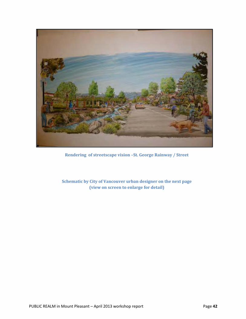
PUBLIC REALM in Mount Pleasant – April 2013 workshop report Page 42
Rendering of streetscape vision –St. George Rainway / Street
Schematic by City of Vancouver urban designer on the next page
(view on screen to enlarge for detail)
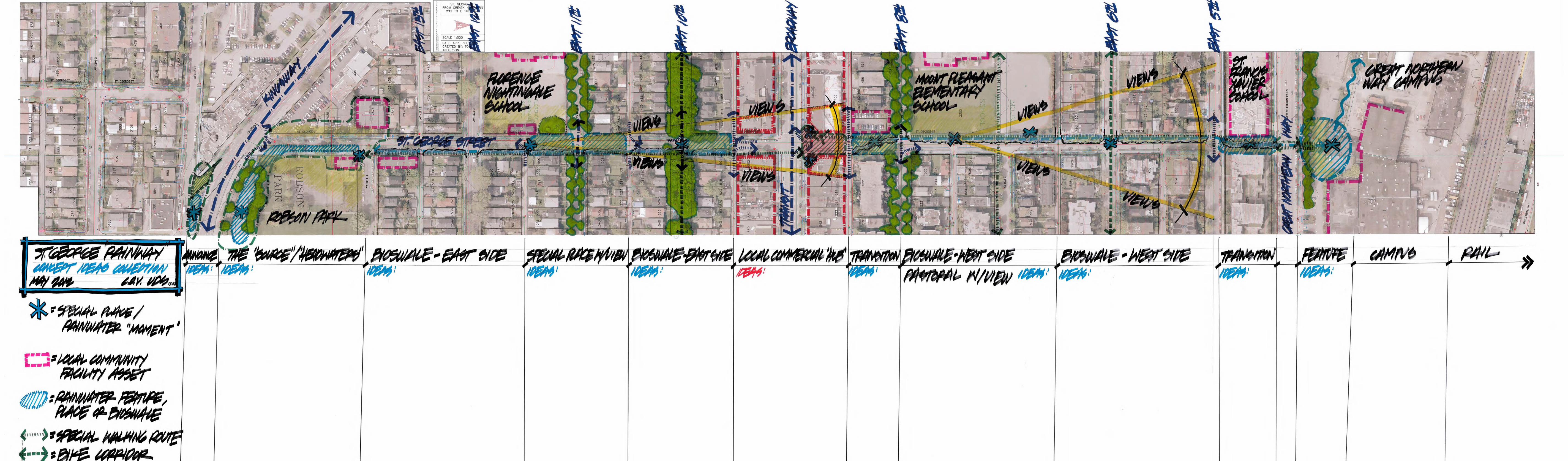

PUBLIC REALM in Mount Pleasant – April 2013 workshop report Page 46
Broadway East Public Realm – Revitalization Projects
Through the Weaving Policy, People and Place Together initiative sponsored by the Mount Pleasant
Neighbourhood House, community members have collaborated to identify ways in which the street
experience in this revitalization area could be improved through immediate action moves that are
not dependent on major property redevelopment happening first, the arrival of new enterprises, or
significant infrastructure changes first being completed by municipal government.
o Residents have worked together with MPNH staff, local business leaders (MPBIA
directors, Kingsgate Mall Merchants Association manager, individual business owners),
and other community service agencies located on Broadway East (such as La Boussole) or
soon relocating there (such as the Broadway Youth Resource Centre) or managing new
housing on this street (such as Vancouver Native Housing Society).
Twenty-five possibilities were explored (December-January meetings).
Six are currently active projects (February-April activity . . . ongoing).
The next two pages summarize five of those projects. (The sixth is a vacant lot strategy: a
collaboration between the owner of a property long without an active use, the Mount Pleasant
Business Improvement Area and its Zero Waste Challenge team, and Livable Laneways.)
Possible Ways for Local Businesses & Other Neighbours to Contribute
Promote Accommodate Coordinate Sponsor Donate
Display and distribute a flyer with a map of participating venues
Advertise with a poster in your window, email to your customers, etc.
Encourage one or more of your business neighbours to also join the fun
Encourage other neighbours to help make it happen
Allot outdoor space (small or large) for temporary art or performance
Allot indoor space to displaying an artist’s work for one or two weekends this year*
*could be a business, could be a service agency, or could be another facility on Broadway East
Join an organizing team
Offer practical tips to any of the teams
Connect with artists and performers you know
Experimentally, on one or two dates this year, have a “mix and mingle” open house
Find some way to “spillover” onto the street during one or more special events
Donate food or beverages to make an event welcoming, more sociable
At set-up, help with other supplies or tools
Design or print posters or another promotional aid
Offer a hand to help with some other step.

PUBLIC REALM in Mount Pleasant – April 2013 workshop report Page 47
Broadway East REVITALIZATION ACTION PROPOSALS for 2013 with Mount Pleasant Neighbourhood House partnership support
Since City Council approved the Mount Pleasant Community Plan, community members have been thinking a lot about
“people power” and revitalization: neighbours working together, businesses teaming up, and community service providers
joining in. Small projects can signal positive change to everyone who lives and works in the neighbourhood (and to those
who visit, regularly or not). This flyer captures five of the ideas that excited Mount Pleasant residents, service providers
on Broadway East, and other local business reps when they got together over the winter to talk about action to help
Broadway East steadily improve.
Community members envision making a small impact in just one or two locations to start—and then building from that
experience to try something larger while longer-term changes happen with new businesses coming to the street, properties
being redeveloped, City modifications to public space, and so on. They picture more people returning to shop, eat, and use
other services on Broadway East because they like the street more—and because it’s the buzz.
How would a local business operator gain from participating?
People seeing you as an asset, and a valued partner, on Broadway East. A more cheerful public mood. Seeing new faces.
Getting to know your neighbours better. Liking even more the location you chose! A contribution could be as simple as
putting a poster in your window to advertise a special event. On learning about the project ideas, you may think of
something unique, or you could choose one of the suggested ways in which business or land owners can help.
If any of the ideas interest you, please use the contacts in this flyer. Come out on April 27 for the
street party at Fraser and Broadway, for a conversation about how to make this happen (Saturday—between 12 and 2:30).
Or join your neighbours in an action planning evening on Tuesday, April 30 (6-9 pm) at the Neighbourhood House.
Call Jocelyne Hamel at the Neighbourhood House: 604-879-8208 or email [email protected]– 800 East Broadway.
There are many place-making actions that community members can take to add vitality, warmth and delightful surprise to
the area. Ideas in the following short overview came from community members talking with one another – first, in walking the
Broadway East area together, then in a “Re-Imagining Broadway East” workshop and follow-up gatherings.
Project 1 – Art Walks on Broadway The IDEA is to bring art (perhaps a performer, too) and folks interested in art to local businesses, including art in
unexpected places, for a few special evenings—a bit like The Drift on Main Street.
This project aims to change the perception of the East Broadway corridor
from a place you walk/drive through to a destination/point of interest.
Community members would like to match artists with unique and unexpected
venues (e.g., a “pop up” gallery location perhaps, but also maybe art in a
laundromat, car shop, martial arts studio, butcher shop?) and to work with
local businesses to host a special evening in a few venues. The first Art Walk
could happen in June (on Celebrate Mount Pleasant Day), the second in
September, with a few more events in 2014. In creating an artistic offering to
inspire community interaction, we provide a source of neighbourhood pride
while introducing more people to established businesses on Broadway East
Email [email protected] to get involved.
Project 2 – Inspirational Walking Tours, Inspirational Signs The IDEA is Wayfinding: Self-Guided Walks (2014, with preparation over the fall/winter /spring of 2013-14):
using local stories and hidden assets to orient both the newcomer and the longtime resident to the neighbourhood;
possibly adding “Go Local” signs to show pedestrians goods and services and other sweet spots within a 5-minute walk.

PUBLIC REALM in Mount Pleasant – April 2013 workshop report Page 48
Project 3 – Special Event Street Closure & Street Party The IDEA is to expand on Mount Pleasant Neighbourhood House’s annual street festival (late September) and rebrand it as
a community festival focused on the whole of Broadway East and the transformations happening in this neighbourhood. This
MetamorFest event could, at first, include a number of “off Broadway” locations (e.g., Fraser and Broadway, Prince Albert and
Broadway, Guelph and Broadway) focusing on activities at key corners—then, with more
experience, make a bigger statement by closing Broadway East for a one-day special event.
The festival will build on the established partnership between the Neighbourhood House
and Western Front New Music Society. Planning group representation comprises Kingsgate
Mall Merchants Association, Mount Pleasant Business Improvement Area (MPBIA),
Mount Pleasant Neighbourhood House staff, Livable Laneways Society, and residents.
Several other local groups
have committed to
participate in the festival, as they have in the past. MPNH has
submitted an application to the City of Vancouver Community
Neighbourhood Arts Development grant for the rebranded
festival, and is working with the committee to generate
additional resources.
Through such a "highly visible to all" step, we celebrate the
diversity and cultures in this area through art, music, food,
and other demonstrations – and by organizing a street closure and large event, we cultivate the spirit that there is "no
hurdle too great in revitalizing this area—anything is possible.”
Project 4 – Benches & Planters
The IDEA is to provide benches and planters to
locations that the City converts to a street plaza or
pocket park (these new amenities still protecting
commercial lane access).
The outcome of Phase 1 is a sample bench—
following City specifications for maximum size for
sidewalk use—to try out in different locations
between Prince Edward and Prince Albert.
Phase 2 is a community building blitz which might produce as many as 20 benches and 20 planters for installation
throughout the Broadway East area, including new public open spaces.
Project 5 – Community Art (Murals, Bench & Tile Trail) Strengthen relationships through creating something tangible together -- not just talking together! Encourage people to
walk the area because of interesting discoveries on both Broadway and side streets. Encourage community members to
"dream bigger" and get involved in enhancements of shared spaces. Encourage people to see
the public realm (streets, sidewalks, etc.) as shared space
where good connections occur. By beginning with a
constructive response to vandalism, show resilience and
creativity.
The IDEA is to involve local businesses, community agencies,
youth and other community members with one or more artists
to conceive, then create public art. Undertake a first project in
2013 at the east end of the shopping district (at Prince Albert). Then add another project at Broadway and
Fraser and perhaps another at the west end of the district.

PUBLIC REALM in Mount Pleasant – April 2013 workshop report Page 49
Immediate Next Steps
PWL continues design work on the plan for Mount Pleasant.
City of Vancouver staff and PWL liaise on technical feasibility of all recommendations and inter-
departmental support for the proposals.
April 27 - COV Open House - Presentation boards on view for more individual comment (along with
other data from City staff on public benefits strategy and sub-area urban design frameworks).
Hosted at the Neighbourhood House. City’s Open House preceded by a “street fair” in Fraser Street
at Broadway: temporary street closure on location of proposed new public plaza; multiple activities.
April 30 - Community ACTION TEAMS meeting at MPNH -Enlivening Broadway East Public Realm
Ongoing – Various community-initiated ACTION INITIATIVES progress, under the leadership of
Mount Pleasant residents, local business and community service providers working collaboratively.
June 1 - Celebrate Mount Pleasant Day! potentially with 1st Art Walk Night on Broadway East
June 15 - Final Open House hosted by City of Vancouver staff before the staff recommendations go
to Council—further design and strategy details available at this public event.
September 14 - Main Street closure for special event – Autumn Shift– MPBIA, Livable Laneways
September 29 – Broadway (or “off Broadway” corner venues) - MetamorFest + Art Walk Night
October 8 - Presentation of Mount Pleasant Public Realm recommendations to Council
Regarding questions raised in the workshop – directed to City and PWL:
The workshop time allocation was not long enough to respond to all of the questions directed to the
design consultants and/or City planner.
With this report, all outstanding questions have been forwarded to City staff (through Mount
Pleasant Community Planner Joyce Uyesugi) and to the PWL design team (through key contacts
Margot Long, Derek Lee and Leandre Bérubé Lebrun). See the summary of questions in Appendix 4.
The Mount Pleasant Neighbourhood House (MPNH) staff can forward a Q&A update to workshop
participants (and post the update online) before the City’s Open House in mid-June, incorporating
any written responses received from these resource persons.
June 15 – Participate in this City-hosted Open House to see presentations on the more complete
design recommendations and to discuss interests with municipal planners then.
Summer (or September) 2013 – If it happens that there is strong community interest in further
conversation on residual questions and questions are substantive enough to warrant investment in
another public event, MPNH can host a follow-up dialogue session to help deepen understanding.
Alternatively, e.g., if City of Vancouver staff are not available to participate, MPNH, through MPIC
member Jocelyne Hamel (Executive Director of the Neighbourhood House), may request of the City
that a dialogue be scheduled instead as part of a monthly Mount Pleasant implementation
Committee (MPIC) meeting which can be attended by other Mount Pleasant community members.

PUBLIC REALM in Mount Pleasant – April 2013 workshop report Page 50
Appendices 1-5

Appendix 1: PART 1 Table of Contents – March 7th Workshop REPORT
Purpose of the Workshop ............................................................................................................................. 4
Part I .......................................................................................................................................................... 4
Part II ......................................................................................................................................................... 4
Shopping Area Locations ............................................................................................................................... 5
Distinctiveness of the Shopping Areas: The Essence .................................................................................... 6
Factors in distinction ................................................................................................................................. 6
Geographic experience – important distinctions ..................................................................................... 6
Character – key distinctions ...................................................................................................................... 7
Other important reminders ...................................................................................................................... 7
Degree of similarity ................................................................................................................................... 7
Broadway West essence – outdoorsy, sporty, innovative ........................................................................ 8
Broadway East essence – friendly, edgy and social, spontaneous ........................................................... 9
Lower Main essence – artsy, Bohemian, gateway district ........................................................................ 9
Uptown essence – full of surprises, a vibrant village, a place “to linger” ............................................... 10
Perceived Needs / Recommended Enhancements ..................................................................................... 11
Inter-neighbourhood circulation ............................................................................................................ 11
Broadway West ....................................................................................................................................... 11
Broadway East ......................................................................................................................................... 12
Lower Main ............................................................................................................................................. 13
Uptown ................................................................................................................................................... 14
Descriptive Names for Each District ............................................................................................................ 15
Memorable Elements of Each District ........................................................................................................ 17
Broadway West ....................................................................................................................................... 17
Broadway East ......................................................................................................................................... 19
Lower Main ............................................................................................................................................. 21
Uptown ................................................................................................................................................... 23
Sweet Spots in the Neighbourhood ............................................................................................................ 25
What is a “sweet spot”? .......................................................................................................................... 25
Sweet spots where? ................................................................................................................................ 25
Explanation of Appendices 3-5 ............................................................................................................... 25
Examples of “sweet spots” ..................................................................................................................... 25
Themes arising from sweet spot mapping .............................................................................................. 26
PUBLIC REALM in Mount Pleasant – March 7, 2013 workshop report Page 3
Purpose of mapping sweet spots ............................................................................................................ 26
Important Design Themes already embedded in the Community Plan ..................................................... 27
Linking Green Spaces in the Neighbourhood .............................................................................................. 28
Existing Green Spaces ............................................................................................................................. 29
Similarities in the recommended Circulation Routes ............................................................................. 30
Differences in the maps .......................................................................................................................... 30
Importance of “Blue Way” enhancement in multiple districts ............................................................... 31
Next Step in this Design Work ................................................................................................................ 31
Registration Link to Next Community Workshop ................................................................................... 31
Recommended Walking Routes – best ways to connect the green spaces................................................ 32
Green Circuit Proposal – Possibility Map 1 ............................................................................................. 32
Green Circuit Proposal – Possibility Map 2 ............................................................................................. 36
Green Circuit Proposal – Possibility Map 3 ............................................................................................. 38
Appendix 1: Community contributors to public realm design work .......................................................... 41
Appendix 2: Workshop team ..................................................................................................................... 42
Appendix 3: Sweet Spot MAPS – Distribution by District .......................................................................... 43
Appendix 4: Sweet Spots by District – DESCRIPTION and LOCATION ........................................................ 49
Appendix 5: Sweet Spots by District – Organized BY THEME .................................................................... 55
This stakeholder engagement process was facilitated by the Mount Pleasant Neighbourhood House
with support from the Real Estate Foundation of BC and the Vancouver Foundation, for the benefit of
community members, City planners and engineers, and other design consultants.
In co-operation with :

PUBLIC REALM in Mount Pleasant – April 2013 workshop report Page 51
Appendix 2: OTHER RESOURCES from Community
The following resources were created or acquired through the Weaving Policy, People and Place Together
initiative of the Mount Pleasant Neighbourhood House. They capture additional community input relevant
to the design, programming and ongoing enhancement of public realm in Mount Pleasant.
Public Realm Workshop - Part 1 March 7, 2013
Summary of community input on the “essence” (distinctiveness) of each of the four shopping areas in
Mount Pleasant, on perceived needs and recommended public realm enhancements in each of these
sub-areas, descriptive names for the shopping areas, sweet spot maps, and suggestions for effectively
linking green spaces in the neighbourhood. March 2013.
Walkshops Report
Specific to the Broadway East area in Mount Pleasant (including the 5-block shopping district on which the
City is focusing revitalization efforts, and extending slightly beyond this shopping area) — this document
summarizes the recommendations of 40 individuals who walked this sub-area in small groups over several
days in September 2012. Their revitalization recommendations largely concern the public realm.
Walkers recommendations
These slides illustrate the ideas in the recommendations from walkshop participants –focused on enhancing
the Broadway East sub-area. October 2012.
Walkshops Review - Broadway East
This survey report captures the input of a different group of community members (31 in total)
responding to the walkshop participants’ recommendations about public realm changes to make in the
Broadway East area. The survey was conducted in early November 2012.
Inspiration Afternoon Workshop Report – Re-Imagining Broadway East
Additional input from the group of 31 (reviewers of walkshop recommendations) during a weekend
workshop on re-imagining this sub-area (Broadway East). November 2012. NOTE: Special places throughout
the eastern half of Mount Pleasant were also mapped in a follow-up workshop in mid-November 2012.
Target Sites suggested for first public realm improvements – in Broadway East
Recommended locations for “early wins” – arising from walkshops with local community members.
September-October 2012.
Broadway East Urban Design - More Neighbourhood Input
Additional and more detailed recommendations (not from a single resident as the report’s sub-title suggests
but rather, from a small group of Mount Pleasant residents who took the initiative to not only do further
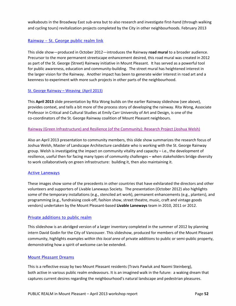
PUBLIC REALM in Mount Pleasant – April 2013 workshop report Page 52
walkabouts in the Broadway East sub-area but to also research and investigate first-hand (through walking
and cycling tours) revitalization projects completed by the City in other neighbourhoods. February 2013
Rainway - St. George public realm link
This slide show—produced in October 2012—introduces the Rainway road mural to a broader audience.
Precursor to the more permanent streetscape enhancement desired, this road mural was created in 2012
as part of the St. George (Street) Rainway initiative in Mount Pleasant. It has served as a powerful tool
for public awareness, education and community-building. The street mural has heightened interest in
the larger vision for the Rainway. Another impact has been to generate wider interest in road art and a
keenness to experiment with more such projects in other parts of the neighbourhood.
St. George Rainway – Weaving (April 2013)
This April 2013 slide presentation by Rita Wong builds on the earlier Rainway slideshow (see above),
provides context, and tells a bit more of the process story of developing the rainway. Rita Wong, Associate
Professor in Critical and Cultural Studies at Emily Carr University of Art and Design, is one of the
co-coordinators of the St. George Rainway coalition of Mount Pleasant neighbours.
Rainway (Green Infrastructure) and Resilience (of the Community): Research Project (Joshua Welsh)
Also an April 2013 presentation to community members, this slide show summarizes the research focus of
Joshua Welsh, Master of Landscape Architecture candidate who is working with the St. George Rainway
group. Welsh is investigating the impact on community vitality and capacity – i.e., the development of
resilience, useful then for facing many types of community challenges – when stakeholders bridge diversity
to work collaboratively on green infrastructure: building it, then also maintaining it.
Active Laneways
These images show some of the precedents in other countries that have exhilarated the directors and other
volunteers and supporters of Livable Laneways Society. The presentation (October 2012) also highlights
some of the temporary installations (e.g., stenciled art work), permanent enhancements (e.g., planters), and
programming (e.g., fundraising cook-off, fashion show, street theatre, music, craft and vintage goods
vendors) undertaken by the Mount Pleasant-based Livable Laneways team in 2010, 2011 or 2012.
Private additions to public realm
This slideshow is an abridged version of a larger inventory completed in the summer of 2012 by planning
intern David Godin for the City of Vancouver. This slideshow, produced for members of the Mount Pleasant
community, highlights examples within this local area of private additions to public or semi-public property,
demonstrating how a spirit of welcome can be extended.
Mount Pleasant Dreams
This is a reflective essay by two Mount Pleasant residents (Travis Pawluk and Naomi Steinberg),
both active in various public realm endeavours. It is an imagined walk in the future: a waking dream that
captures current desires regarding the neighbourhood’s natural landscape and pedestrian pleasures.

PUBLIC REALM in Mount Pleasant – April 2013 workshop report Page 53
Action Proposals for January 17, 2013
Community input regarding “best action moves to take in the short term” to help revitalize the public realm
in the East Broadway shopping district
Action Proposals for January 30, 2013
Initial action plans to help revitalize the Broadway East public realm, building on the outcomes of December
and mid-January workshops re: “first move” actions given highest priority by the community working group
(based, in part, on the interest and capacity of volunteers to lead these efforts)
Broadway East Revitalization Action_Proposal_130321
March 2013 summary of further action, including hurdle analysis and adaptive responses, on 5 initiatives to
add intriguing elements and greater social interaction to the public realm on East Broadway
Lastly, two documents NOT produced through the Weaving initiative,
but created with extensive community input and referred to in the body of this report:
Mount Pleasant Community Plan – approved by Council in November 2010
Historical Context Statement for Mount Pleasant – created by heritage consultants for the City,
with the assistance of a local Working Group of Mount Pleasant residents
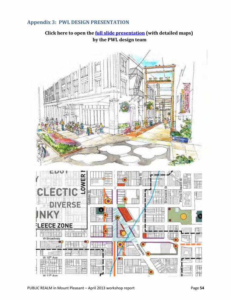
PUBLIC REALM in Mount Pleasant – April 2013 workshop report Page 54
Appendix 3: PWL DESIGN PRESENTATION
Click here to open the full slide presentation (with detailed maps)
by the PWL design team

PUBLIC REALM in Mount Pleasant – April 2013 workshop report Page 55
Appendix 4: Community QUESTIONS & City / Designer RESPONSES
In the April 13, 2013 workshop on Mount Pleasant’s Public Realm (with community members, PWL design
consultants and City of Vancouver staff), the following questions were raised by community members.
Answers that appear in regular font were provided during the workshop. Information source is bracketed.
Any questions answered after the workshop (because the workshop was not long enough for every question
to be answered before the close) will appear in a later edition of this appendix. Responses provided by the
City, the PWL design team or other resource persons, if delivered after the workshop, appear in italic font.
New Rapid Transit / Skytrain Impact
When the subway {or Skytrain] extension is built, where will it run – and where will the Q1
station be?
[ City response ] Two station locations are anticipated: (1) Main and Broadway,
and also (2) on Great Northern Way Campus, on the north side of Terminal.
[ Translink response ] M. Babiuk, a community member who is a Translink
planner, offered a further update. “Appreciating that the City has a view about preferred
location,” the Translink planner noted that “multiple options are under consideration, and no
option has yet been chosen. In all options under Translink consideration, there is a station at
Main and Broadway. In some but not all of the options, there is a station on the GNW campus
also.”
[ Community comments ] “Main / Kingsway / Broadway rapid transit station
(if underground) should have entrances/exits at all corners. Note that the Cambie/Broadway
station has an entry on one corner only—Please don’t make the same mistake.”
“Route could go above ground to Prince Edward, then turn west underground to continue
along Broadway, emerging above ground again at Cambie, and then as streetcar to UBC.
Surface route is much less expensive than underground.”
Will a station for a new UBC transit line from Vancouver Community College (VCC) and Q2
Clark Street be located at Kingsgate Mall (intersection of Kingsway and Main)?
See City and Translink responses to Q1 re: Main & Broadway transit station.
Could the Main/Kingsway / Broadway station include an underground Mall and Q3
subway street crossings to eliminate on-grade pedestrian crossings here?

PUBLIC REALM in Mount Pleasant – April 2013 workshop report Page 56
Scope of the Public Realm Design Why does the planning process go so few blocks east? Q4
[ City response ]
In contracting with PWL Partnership to create a Public Realm Plan for Mount Pleasant, the
City specifically requested that PWL focus their work on the shopping districts. PWL is
working within the scope parameters that the City established as an implementation priority.
Logistics and Financing of Implementation How will this all be paid for? Q5
“If a tax increase is needed to implement this plan, will this be put to a vote?” Q6
How does a change in use actually happen? (e.g., to convert an existing residential or Q7
commercial lot to a park or plaza?) Would the City purchase land?
Re: change of use, Broadway Plaza between Columbia and Manitoba— Q8
can you comment on how a change of use can happen in this particular location?
What is the action focus? Q9
“Everything, including the kitchen sink, here. KISS. What is the focus for action?”
Plans for car traffic changes on St. George Street are wanted. Q10
Is there a traffic plan change anticipated as part of the Rainway project?
How does this public realm plan address community homeless concerns? Q11
Walking Routes & Connectivity Will there be recommendations made regarding such pragmatics as enhanced sidewalk Q12
width? enhanced street lighting, etc.?
What about closing some streets permanently? Vancouver has some of the “most paving Q13
areas” of any North American City . . . “time to give this back to people and nature.”
Why an attack on cars—why not any non-walking streets in this public realm plan? Q14
How are we going to better connect Mount Pleasant to Strathcona? Q15
(e.g., across Great Northern Way campus and rail lines?)
Is there a plan for a central enhanced walking route between Main Street and Q16
Commercial Drive?
Safety in Walking Routes How will safety be addressed in laneway pedestrian routes? Q17
On the proposed laneway pedestrian routes, how will street crossings be handled? and
lighting? Are additional safety measures through other design intended?
PUBLIC REALM in Mount Pleasant – April 2013 workshop report Page 57
At Main & 8th, left-turning vehicles (headed north down Main, then turning left onto 8th Q18
Avenue) are dangerous to pedestrians. How will safety be improved here?
This is especially a problem during rush hours.
How will individual safety issues be addressed elsewhere in the neighbourhood? Q19
Example: identifying well-lit streets and ill-lit streets; acting on poorly lit areas.
Pocket parks attract drinking and drugs. There are 3 new social housing developments Q20
in the neighbourhood. How does the plan address this risk?
Laneways—Garbage Pickup & Trash Dumpsters in laneways . . . livable? Unattractive!!! How would dumpster arrangement Q21
change with this plan to make more lanes attractive as pedestrian routes? How do we
reconcile laneway activation with laneways being used for garbage pickup [not restricted to
dumpster management only]?
Culture and Connectivity How can we learn from, and respect, First Nations perspectives, histories and knowledge Q22
of this area? [How will that interest and respect be reflected in this plan?}
On walkways and bikeways, how can we also make the greater connections to celebrate Q23
people and diversity? Inclusion of an “all ages attraction” might be a way?
Benefits for Business What is in this plan for business? Will a business owner contemplating moving into one of Q24
Mount Pleasant’s shopping districts be able to tell from the final public realm plan what the
distinctive shopping area “design directions” are? Will a current or prospective business
operator be able to tell, from the final plan, what the feeling / style of a sub-area is? Will the
public realm plan for Mount Pleasant’s shopping areas include a description of the types of
businesses already clustered (and/or expected to cluster) in this “district”?
Adding greenery to shopping streets is a strong attractor for more pedestrian traffic. But Q25
planters or baskets need tending by paid workers: can the City be responsible for watering
plants and cleaning the streets of litter more frequently – as is done in West Vancouver?
Businesses on laneways—like the concept, but currently City of Vancouver will not Q26
permit a commercial business to operate with a laneway (only) address. Is there
flexibility on the part of the City to change this policy?
[City response] This level of regulatory detail is not expected to appear in the Public
Realm Plan produced by PWL for municipal government. The City is also not likely to change
this business licensing policy on a neighbourhood basis: such a change would have to be city-
wide. Laneway animation is expected to occur largely through new development—and in this
respect, building use that fronts onto the lane can include several types of use: laneway
housing, artists’ studios, and potentially also other types of business. The actual address of
these laneway businesses might still refer to the street nearest the lane.
PUBLIC REALM in Mount Pleasant – April 2013 workshop report Page 58
Amenities—Current & Potential What is happening to the urban garden on 3rd and Scotia? Q27
Where can more urban gardens “pop” up in this neighbourhood? Q28
NOTE: Other concerns not directly related to workshop focus/scope: How to retain and enhance affordability (housing, etc.) in this neighbourhood? Q29
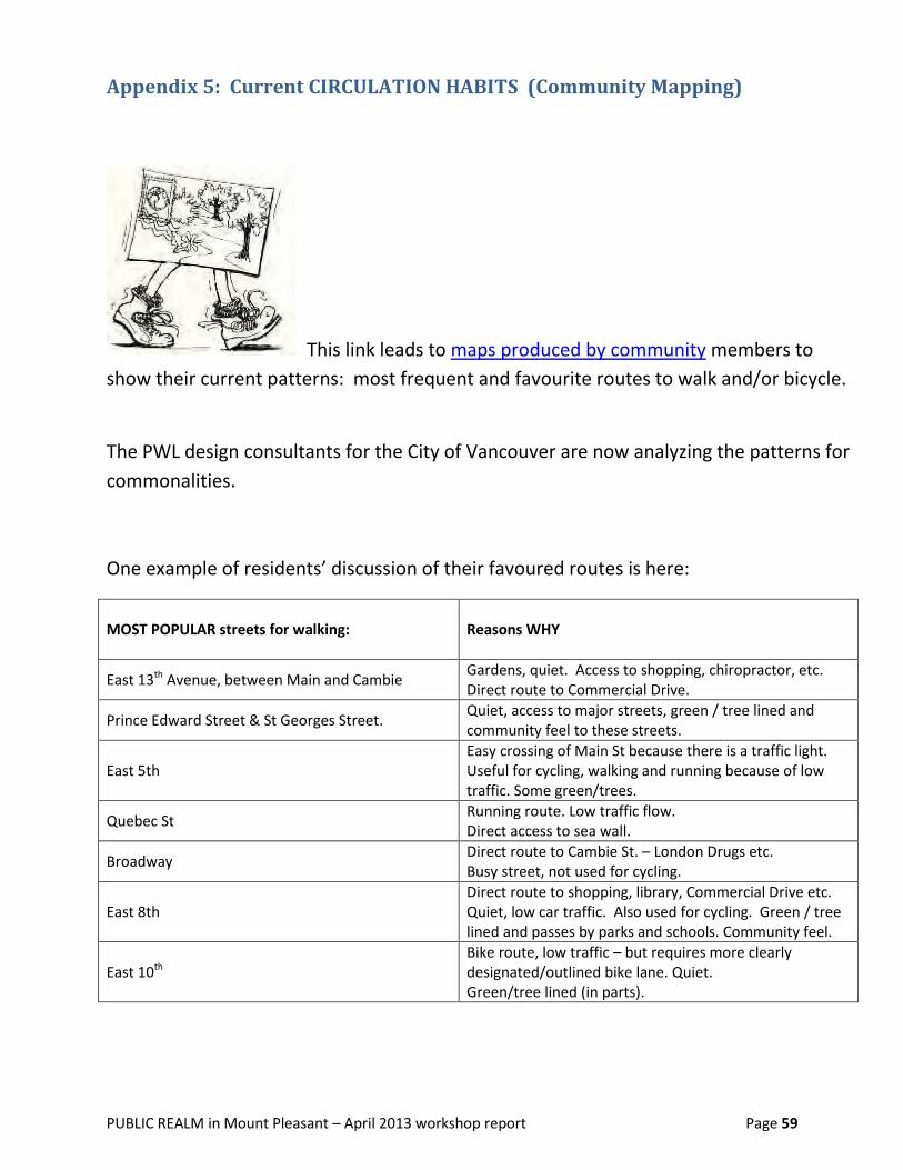
PUBLIC REALM in Mount Pleasant – April 2013 workshop report Page 59
Appendix 5: Current CIRCULATION HABITS (Community Mapping)
This link leads to maps produced by community members to
show their current patterns: most frequent and favourite routes to walk and/or bicycle.
The PWL design consultants for the City of Vancouver are now analyzing the patterns for
commonalities.
One example of residents’ discussion of their favoured routes is here:
MOST POPULAR streets for walking: Reasons WHY
East 13th Avenue, between Main and Cambie Gardens, quiet. Access to shopping, chiropractor, etc. Direct route to Commercial Drive.
Prince Edward Street & St Georges Street. Quiet, access to major streets, green / tree lined and community feel to these streets.
East 5th Easy crossing of Main St because there is a traffic light. Useful for cycling, walking and running because of low traffic. Some green/trees.
Quebec St Running route. Low traffic flow. Direct access to sea wall.
Broadway Direct route to Cambie St. – London Drugs etc. Busy street, not used for cycling.
East 8th Direct route to shopping, library, Commercial Drive etc. Quiet, low car traffic. Also used for cycling. Green / tree lined and passes by parks and schools. Community feel.
East 10th Bike route, low traffic – but requires more clearly designated/outlined bike lane. Quiet. Green/tree lined (in parts).

PUBLIC REALM in Mount Pleasant – April 2013 workshop report Page 60
Appendix 6: Workshop Team
Mount Pleasant Neighbourhood House (MPNH) host team:
Project Facilitator – Sylvia Holland – for Weaving Policy, People and Place Together
MPNH staff
o Jocelyne Hamel (Executive Director))
o Blanca Salvatierra (Community Developer)
o Jieni He (Community Developer Intern)
o Askar Baudin (Facilities Supervisor)
o MPNH Community Kitchen team
MPNH volunteers – assisting with recording / small group work
o Sebastian Merz
o Sonja van Putten
PWL Partnership landscape architectural team, consultants to COV
Landscape Architect – Derek Lee
Landscape Designer – Léandre Bérubé Lebrun
Landscape Designer – Mary Wong
Landscape Architectural Technologist – Sarah Dickie
City of Vancouver (COV) presenter / neighbourhood liaison
Mount Pleasant Community Planner – Joyce Uyesugi
For “hot topic” dialogue recording:
Arterial Walkability (Broadway, Main) – recorder: Jocelyne Hamel (MPNH)
Business District Enhancement – recorder: Sonja van Putten (MPNH)
Combining Cycling / Walking Routes – and Street Crossings -- recorder: Sebastian Merz (MPNH)
Laneway Enhancement – recorders: Jieni He (MPNH) & Derek Lee (PWL)
Inter-Neighborhood Connectivity – recorder: Leandre Bérubé LeBrun (PWL)
Ecological Heritage & Urban Wilderness --- recorder: Mary Wong (PWL)
Aboriginal Heritage, Presence & Culture – recorder: Sarah Vickie (PAWL)