Embed Size (px)
Citation preview

South-Central Florida MetroplexPreliminary Designs
https://www.faa.gov/nextgen/nextgen_near_you/community_involvement/florida/Modernization of Our National AirspaceFAA
PUBLIC INFORMATION WORKSHOP
South-Central Florida Metroplex
FEDERAL AVIATION ADMINISTRATION

South-Central Florida MetroplexPreliminary Designs
https://www.faa.gov/nextgen/nextgen_near_you/community_involvement/florida/Modernization of Our National AirspaceFAA
Welcome
Welcome to the FAA’s Workshop on the South-Central Florida Metroplex.
The designs you will see tonight are preliminary. We welcome your input.
You may provide your comments tonight in writing, or you may leave your comments at this website:
https://www.faa.gov/nextgen/nextgen_near_you/community_involvement/florida/

South-Central Florida MetroplexPreliminary Designs
https://www.faa.gov/nextgen/nextgen_near_you/community_involvement/florida/Modernization of Our National AirspaceFAA
Environmental Study Process
South-Central Florida MetroplexPreliminary Designs
https://www.faa.gov/nextgen/nextgen_near_you/community_involvement/florida/Modernization of Our National AirspaceFAA
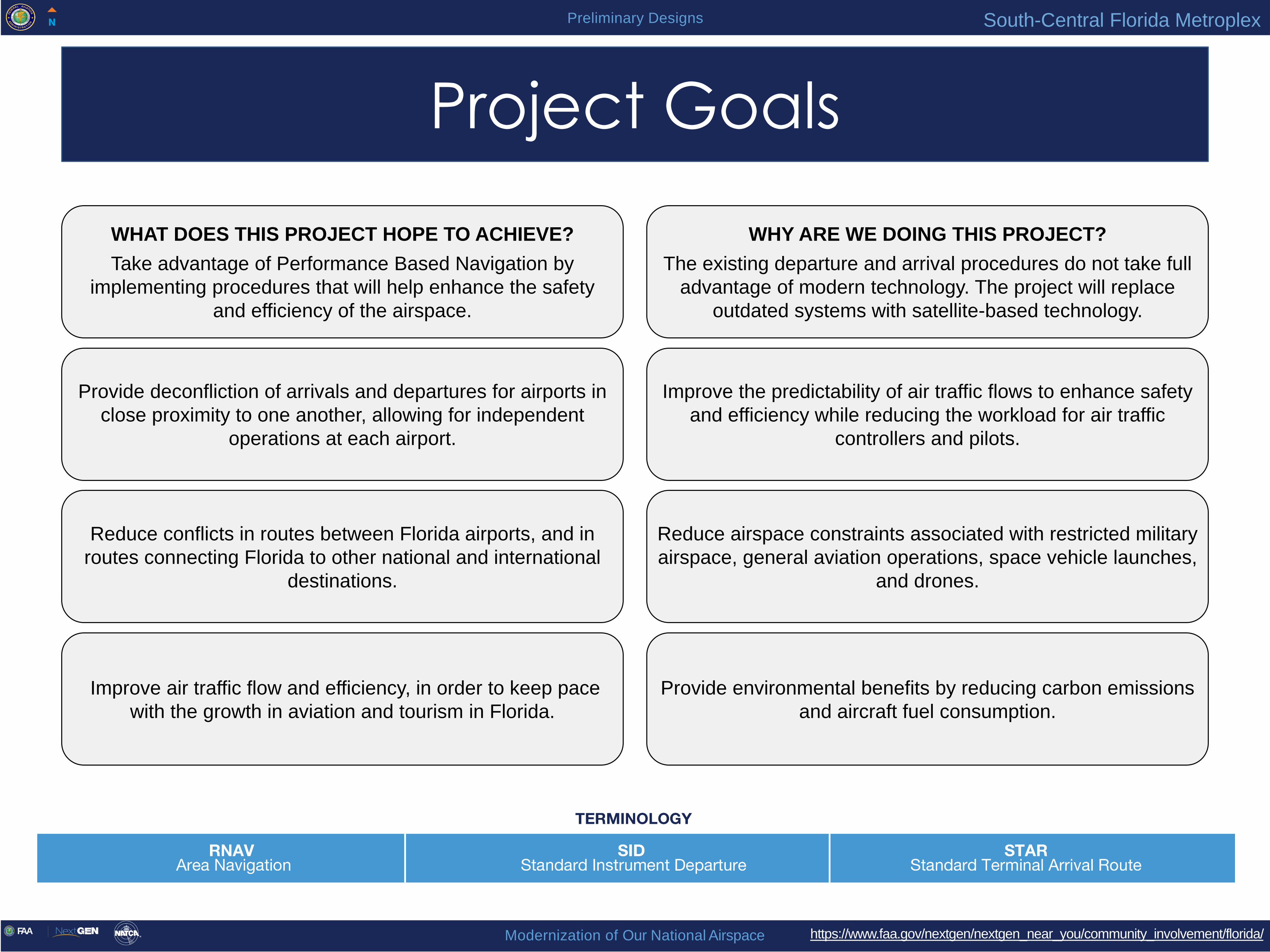
Project Goals
WHAT DOES THIS PROJECT HOPE TO ACHIEVE?
Take advantage of Performance Based Navigation by
implementing procedures that will help enhance the safety
and efficiency of the airspace.
WHY ARE WE DOING THIS PROJECT?
The existing departure and arrival procedures do not take full
advantage of modern technology. The project will replace
outdated systems with satellite-based technology.
Provide deconfliction of arrivals and departures for airports in
close proximity to one another, allowing for independent
operations at each airport.
Improve the predictability of air traffic flows to enhance safety
and efficiency while reducing the workload for air traffic
controllers and pilots.
Reduce conflicts in routes between Florida airports, and in
routes connecting Florida to other national and international
destinations.
Reduce airspace constraints associated with restricted military
airspace, general aviation operations, space vehicle launches,
and drones.
Improve air traffic flow and efficiency, in order to keep pace
with the growth in aviation and tourism in Florida.
Provide environmental benefits by reducing carbon emissions
and aircraft fuel consumption.

South-Central Florida MetroplexPreliminary Designs
https://www.faa.gov/nextgen/nextgen_near_you/community_involvement/florida/Modernization of Our National AirspaceFAA
Metroplex Project Phases
Study Phase• Approximately 9 months
• Coordination with airports
Design and Procedure
Development
• Approximately 12 months
• Public workshops and comments
Operational, Environmental,
and Safety Review
• Approximately 12 months
• Draft Environmental Assessment (EA)
• Public workshops and comments
Implementation and Training
• Approximately 12 months
• Final EA/Record of Decision and public notification
• Training, procedure publication and implementation
Post-Implementation
• Approximately 7 months
• Post-implementation analysis
• Procedure adjustments
We are here

South-Central Florida MetroplexPreliminary Designs
https://www.faa.gov/nextgen/nextgen_near_you/community_involvement/florida/Modernization of Our National AirspaceFAA
SRQ
OPF
PIE
MIA
FXE
PBI
TPA
FLL
MCO
ORL
PGD
BCT
SFB
07FA
LAL
ISM
TMB
SUA
LEE
VNC
MLB
Metroplex Study Area Overview Map
• Overview of the 21
airports included in the
Metroplex

South-Central Florida MetroplexPreliminary Designs
https://www.faa.gov/nextgen/nextgen_near_you/community_involvement/florida/Modernization of Our National AirspaceFAA
FLL REGAE/SNAPR SIDs
LLBOW
LLEGG
MRLEE
CLPSO
ROOOM
YOLLO
LRICK
AGERS
DUYAT
FLL Fort Lauderdale—Hollywood
International Airport
Area Navigation (RNAV) Standard Instrument Departures
(SIDs)AARPS ONE FEELX ONE GLADZ ONE MHITO ONE REGAE ONE SNAPR ONE TWZTR ONE
East Flow Full View
• Jet aircraft departing to the east
from FLL would follow these
Standard Instrument Departures
(SIDs)
MHITO and GLADZ SID departures
would initially depart navigating via
the SID but would be vectored by
ATC after departure
The proposed GLADZ SID would
be used primarily for departures
landing in Cuba, Key West, and
Mexico
• Air Traffic Controllers (ATC) may
direct aircraft away from the
procedure to avoid hazardous
weather, for operational need, or
for safety
• Radar track data are a sample
from January to May 2018
GAYTR

South-Central Florida MetroplexPreliminary Designs
https://www.faa.gov/nextgen/nextgen_near_you/community_involvement/florida/Modernization of Our National AirspaceFAA
FLL
LLBOW
LLEGG
MRLEE
CLPSO
ROOOM
YOLLOLRICK
REGAE/SNAPR SIDs
FLL Fort Lauderdale—Hollywood
International Airport
Area Navigation (RNAV) Standard Instrument Departures
(SIDs)AARPS ONE FEELX ONE GLADZ ONE MHITO ONE REGAE ONE SNAPR ONE TWZTR ONE
East Flow Close View
• Jet aircraft departing to the east
from FLL would follow these
Standard Instrument Departures
(SIDs)
MHITO and GLADZ SID departures
would initially depart navigating via
the SID but would be vectored by
ATC after departure
The proposed GLADZ SID would
be used primarily for departures
landing in Cuba, Key West, and
Mexico
• Air Traffic Controllers (ATC) may
direct aircraft away from the
procedure to avoid hazardous
weather, for operational need, or
for safety
• Radar track data are a sample
from January to May 2018

South-Central Florida MetroplexPreliminary Designs
https://www.faa.gov/nextgen/nextgen_near_you/community_involvement/florida/Modernization of Our National AirspaceFAA
FLL
PERTS
AGERS
BEEDZ
JMACA
SHELZ
HEPAD
DUSKE
DREDS
TIDEZ
SEAZZ
LNKIN
DUYAT
GAYTR
FLL Fort Lauderdale—Hollywood
International Airport
Area Navigation (RNAV) Standard Instrument Departures
(SIDs)AARPS ONE FEELX ONE GLADZ ONE MHITO ONE REGAE ONE SNAPR ONE TWZTR ONE
West Flow Full View
• Jet aircraft departing to the west
from FLL would follow these
Standard Instrument Departures
(SIDs)
MHITO and GLADZ SID departures
would initially depart navigating via
the SID but would be vectored by
ATC after departure
The proposed GLADZ SID would
be used primarily for departures
landing in Cuba, Key West, and
Mexico
• Air Traffic Controllers (ATC) may
direct aircraft away from the
procedure to avoid hazardous
weather, for operational need, or
for safety
• Radar track data are a sample
from January to May 2018

South-Central Florida MetroplexPreliminary Designs
https://www.faa.gov/nextgen/nextgen_near_you/community_involvement/florida/Modernization of Our National AirspaceFAA
FLL
AA
RP
S SID
TIDEZ
DREDSSEAZZHEPAD
DUSKE
SHELZ
JMACA
BEEDZ
FLL Fort Lauderdale—Hollywood
International Airport
Area Navigation (RNAV) Standard Instrument Departures
(SIDs)AARPS ONE FEELX ONE GLADZ ONE MHITO ONE REGAE ONE SNAPR ONE TWZTR ONE
West Flow Close View
• Jet aircraft departing to the west
from FLL would follow these
Standard Instrument Departures
(SIDs)
MHITO and GLADZ SID departures
would initially depart navigating via
the SID but would be vectored by
ATC after departure
The proposed GLADZ SID would
be used primarily for departures
landing in Cuba, Key West, and
Mexico
• Air Traffic Controllers (ATC) may
direct aircraft away from the
procedure to avoid hazardous
weather, for operational need, or
for safety
• Radar track data are a sample
from January to May 2018
South-Central Florida MetroplexPreliminary Designs
https://www.faa.gov/nextgen/nextgen_near_you/community_involvement/florida/Modernization of Our National AirspaceFAA
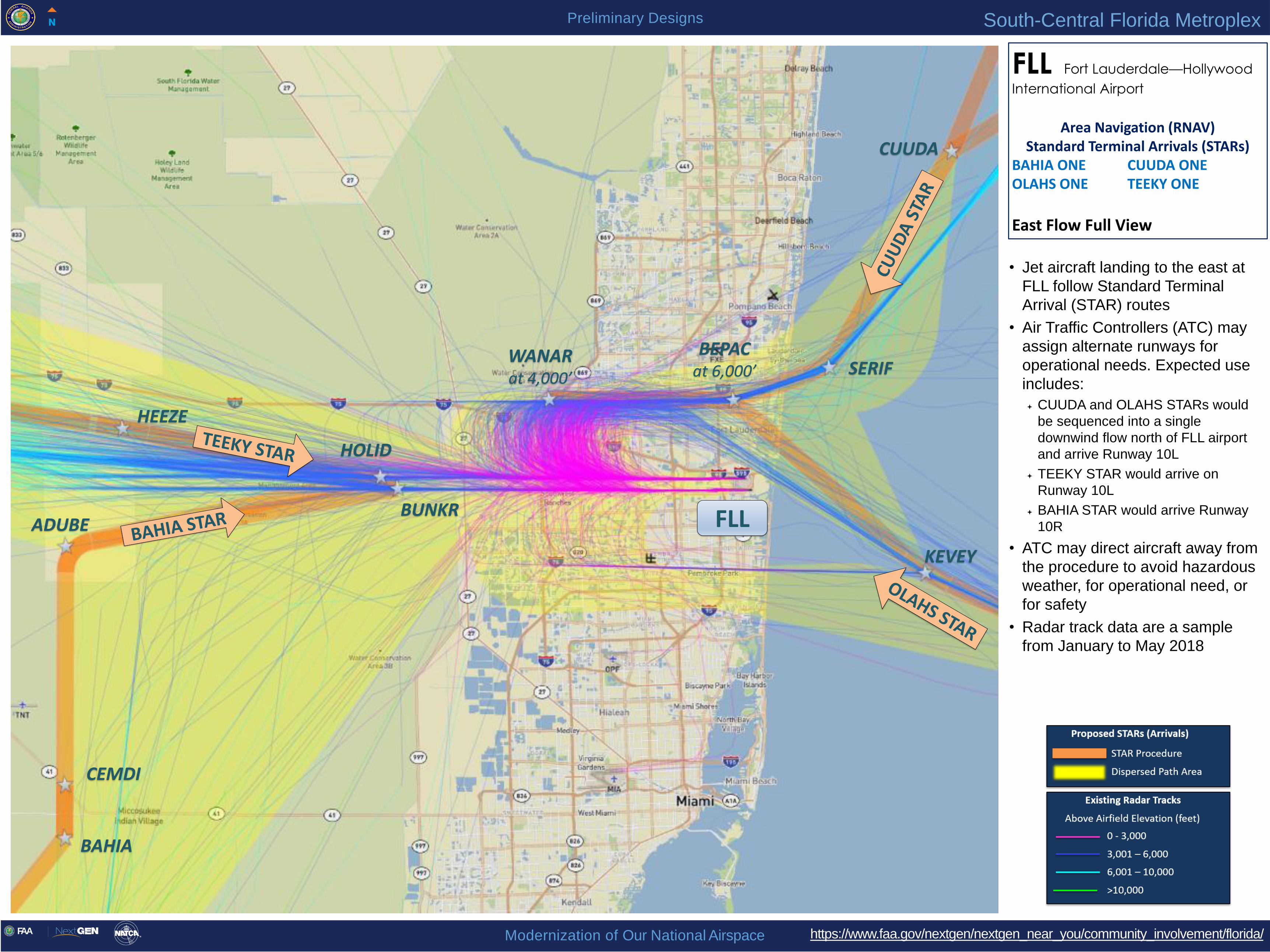
FLL
KEVEY
SERIF
CUUDA
BUNKR
HOLID
CEMDI
ADUBE
HEEZE
BEPACat 6,000’
WANARat 4,000’
FLL Fort Lauderdale—Hollywood
International Airport
Area Navigation (RNAV) Standard Terminal Arrivals (STARs)
BAHIA ONE CUUDA ONE OLAHS ONE TEEKY ONE
East Flow Full View
• Jet aircraft landing to the east at
FLL follow Standard Terminal
Arrival (STAR) routes
• Air Traffic Controllers (ATC) may
assign alternate runways for
operational needs. Expected use
includes:
CUUDA and OLAHS STARs would
be sequenced into a single
downwind flow north of FLL airport
and arrive Runway 10L
TEEKY STAR would arrive on
Runway 10L
BAHIA STAR would arrive Runway
10R
• ATC may direct aircraft away from
the procedure to avoid hazardous
weather, for operational need, or
for safety
• Radar track data are a sample
from January to May 2018
BAHIA

South-Central Florida MetroplexPreliminary Designs
https://www.faa.gov/nextgen/nextgen_near_you/community_involvement/florida/Modernization of Our National AirspaceFAA
BUNKR
FLL
WANARat 4,000’
BEPACat 6,000’
FLL Fort Lauderdale—Hollywood
International Airport
Area Navigation (RNAV) Standard Terminal Arrivals (STARs)
BAHIA ONE CUUDA ONE OLAHS ONE TEEKY ONE
East Flow Close View
• Jet aircraft landing to the east at
FLL follow Standard Terminal
Arrival (STAR) routes
• Air Traffic Controllers (ATC) may
assign alternate runways for
operational needs. Expected use
includes:
CUUDA and OLAHS STARs would
be sequenced into a single
downwind flow north of FLL airport
and arrive Runway 10L
TEEKY STAR would arrive on
Runway 10L
BAHIA STAR would arrive Runway
10R
• ATC may direct aircraft away from
the procedure to avoid hazardous
weather, for operational need, or
for safety
• Radar track data are a sample
from January to May 2018

South-Central Florida MetroplexPreliminary Designs
https://www.faa.gov/nextgen/nextgen_near_you/community_involvement/florida/Modernization of Our National AirspaceFAA
FLL
TEEKY STARFAMBA
at 6,000’
QDAWGGOYLEFIPKO
CUUDA
CRNVL
FLL Fort Lauderdale—Hollywood
International Airport
Area Navigation (RNAV) Standard Terminal Arrivals (STARs)
BAHIA ONE CUUDA ONE OLAHS ONE TEEKY ONE
West Flow Full View
• Jet aircraft landing to the west at
FLL would follow Standard
Terminal Arrival (STAR) routes
• Air Traffic Controllers (ATC) may
assign alternate runways for
operational needs. Expected
use includes:
CUUDA STAR arrivals would
arrive Runway 28R
OLAHS STARs arrivals would
arrive runway 28L
TEEKY and BAHIA STAR arrivals
would be sequenced into a single
downwind flow north of FLL airport
and arrive Runway 28R
• ATC may direct aircraft away
from the procedure to avoid
hazardous weather, for
operational need, or for safety
• Radar track data are a sample
from January to May 2018

South-Central Florida MetroplexPreliminary Designs
https://www.faa.gov/nextgen/nextgen_near_you/community_involvement/florida/Modernization of Our National AirspaceFAA
FLL
TEEKY STAR
OLAHS STAR
GOYLE
FAMBAat 6,000’
FLL Fort Lauderdale—Hollywood
International Airport
Area Navigation (RNAV) Standard Terminal Arrivals (STARs)
BAHIA ONE CUUDA ONE OLAHS ONE TEEKY ONE
West Flow Close View
• Jet aircraft landing to the west at
FLL would follow Standard
Terminal Arrival (STAR) routes
• Air Traffic Controllers (ATC) may
assign alternate runways for
operational needs. Expected
use includes:
CUDDA STAR arrivals would
arrive Runway 28R
OLAHS STARs arrivals would
arrive runway 28L
TEEKY and BAHIA STAR arrivals
would be sequenced into a single
downwind flow north of FLL airport
and arrive Runway 28R
• ATC may direct aircraft away
from the procedure to avoid
hazardous weather, for
operational need, or for safety
• Radar track data are a sample
from January to May 2018

South-Central Florida MetroplexPreliminary Designs
https://www.faa.gov/nextgen/nextgen_near_you/community_involvement/florida/Modernization of Our National AirspaceFAA
FXEMNUDO
GABOW
FXEFort Lauderdale Executive Airport
Area Navigation (RNAV) Standard Instrument Departures
(SIDs)GABOW ONE
All Flows Full View
• Jet aircraft departing from FXE
flying to the Caribbean and South
America would fly this Standard
Instrument Departure (SID)
• Departing jet aircraft typically
would fly along the same paths
and at similar altitudes as they do
today to join the GABOW SID at
MNUDO
• ATC may direct aircraft away from
the procedure to avoid hazardous
weather, for operational need, or
for safety

South-Central Florida MetroplexPreliminary Designs
https://www.faa.gov/nextgen/nextgen_near_you/community_involvement/florida/Modernization of Our National AirspaceFAA
FXE
MRLIN
REELN
FXEFort Lauderdale Executive Airport
Area Navigation (RNAV) Standard Terminal Arrivals (STARs)
HAAVI ONE
All Flows Full View
• Jet aircraft arriving to FXE from
the north would fly this Standard
Terminal Arrival (STAR)
• Arriving jet aircraft typically
would fly along the same paths
over the land as they do today, at
potentially lower altitudes
• ATC may direct aircraft away
from the procedure to avoid
hazardous weather, for
operational need, or for safety