Embed Size (px)
Citation preview

Provision of silt traps- Monitoring Report
Action C4
LIFE09 NAT/IE/000220 BLACKWATER SAMOK
July 2015
The IRD Duhallow LIFE Project is supported through the LIFE financial instrument of the European
Community.

Contents Executive Summary ................................................................................................................... 3
Background ................................................................................................................................ 4
Field Drain Silt Trapping ....................................................................................................... 4
Forestry Drain Silt Trapping .................................................................................................. 5
Site Description .......................................................................................................................... 6
Methods...................................................................................................................................... 7
Field Drain Silt Traps............................................................................................................. 7
Forestry Drain Attenuation .................................................................................................... 7
Results ........................................................................................................................................ 9
Farm Drain Silt Traps ............................................................................................................ 9
Forestry Drain Attenuation .................................................................................................. 14
Conclusion ............................................................................................................................... 16
References ................................................................................................................................ 18
Appendix .................................................................................................................................. 20

LIFE09 NAT/IE/000220 Blackwater SAMOK Page 3
Executive Summary
A key aim of this action was to develop and place wetlands and silt traps to intercept soiled
water from forestry drains.
Walkover surveys at the onset of the project identified that farm drains were a major source of
silt to the River Allow. It was estimated that 86 of farm drains were discharging directly into
the SAC, with 30 actively eroding.
A survey of silt traps already in place in the upland area of the Allow catchment receiving
drainage water from forestry found that 55% were not functionally optimally and needed to be
services on a more regular basis.
The project found that the risk of silt loss and damage to the SAC increased with drainage
maintenance of the opening drains.
The DuhallowLIFE project developed a project innovation “silt trapping technique” for
farmland drains, which was found to be effective in entrapping silt before it was transferred
thorough the farm drain network to the SAC.
Initial plans to develop large wetlands which could function as water attenuation areas met
with difficulties due to licensing concerns (SPA and SAC with different criteria and
environmental windows).
A customised technique was developed to place small attenuation wetlands in forest drainage
networks using a novel approach.

LIFE09 NAT/IE/000220 Blackwater SAMOK Page 4
Background
Field Drain Silt Trapping
Agricultural drainage is practiced worldwide (Oosterbaan, 1994). It is one of the main measures
of improving farmland as many sectors in agriculture benefit from reduced water levels in soil
(Oosterbaan, 1994; Burdon, 1986). If drainage is implemented and sustained in an effective
manner it can increase productivity and improve grazing conditions on heavy, wet soils (Touhy
et al., 2012).
In some soils, the natural drainage processes are sufficient for growth and production of
agricultural crops, but in many other soils, artificial drainage is needed for efficient agricultural
production (EPA, 2012). The soils in the Allow Catchment are poorly drained with low
permeability subsoils. This has led to artificial drainage being common place along the Allow
River and the presence of significant pathways for nutrients and sediment entering the main
channel (Tedd, 2014).
Under the Drainage (Ireland) Act of 1842 many river catchments were modified. Consequent
drainage schemes added to the decline of many of the lowland rivers (Anon., 2010). Farm
drains that flow directly into streams and rivers have the potential to carry silt and nutrients in
the main channel which can reduce water quality (Busman & Sands, 2012; NZ Landcare Trust,
2010). Instream habitats can be affected by agricultural drainage (Blann, et al., 2009 ) and can
be detrimental to aquatic species such as Atlantic salmon and Freshwater pearl mussel
(Extence, et al., 2013;Convery, 2013; Anon, 2010; Heywood & Walling, 2007)
A walkover survey of the Allow River in 2009 (Anon., 2010) listed field drainage as one of
seven high risk categories affecting Freshwater Pearl Mussels. The study also found that field
drainage was evident at 20% of high risk sites.
The DuhallowLIFE project (LIFE09 NAT/IE/000220 Blackwater SAMOK) identified six
newly opened or newly cleaned drains that had the potential to add significant amounts of
sediment to the Allow. Silts trapping systems (See appendix) were installed to prevent material
from entering the main channel.

LIFE09 NAT/IE/000220 Blackwater SAMOK Page 5
Forestry Drain Silt Trapping
The potential environmental impacts from forestry includes alterations to the site hydrology
particularly in peatland areas, potential increased run off during wet weather, increased nutrient
loading, increased acidification over certain soil and bedrock types, and siltation associated
with forestry operations (planting, thinning, road building and harvesting) (Rodgers, et al.,
2008). The latter is potentially the greatest issue for established forestry operations in upper
River Allow catchment. Anon (2010) states that the "threat from forestry operations in pearl
mussel catchments can be significant"
Road/Trackside forestry drains tend to be more shallow that agricultural drains. Hence, a
different approach to the installation of silt boxes was explored. A silt trapping technique was
developed and trialled in a forestry drain near the source of the River Allow.
This document reports on the efficacy of this innovative system on three of the six sites treated.
These three sites have continuous flows and therefore carry material to the main channel
continually. The other three are dry drains (only flow during heavy rain events). This document
also illustrates the development and trialling of a silt trapping pool using grassed up geotextile
bags in a forestry drain.

LIFE09 NAT/IE/000220 Blackwater SAMOK Page 6
Site Description
Figure 1 River Allow catchment area
The River Allow catchment is 310km2 (Figure 1). The three major rivers that drain the
catchment are the Allow, Dalua and Brogeen. The main agricultural land use in the catchment
is pasture with dairying and sucklers forming the majority of farming practices.
The majority (70%) of the soils in the Allow catchment are deep, poorly drained mineral soils.
Blanket peat covers approximately 5% of the catchment, mostly in upland reaches. Mineral
alluvium is associated with the river channels, while shallow well drained mineral soils make
up the remaining soil type in the catchment (EPA/Teagasc, 2006; Tedd, 2014).
The River Allow catchment rivers (Allow, Dalua, Brogeen, Glenlara and Owenkeale) form part
of the Blackwater River (Cork/Waterford) Special Area of Conservation (Natura 2000 site
code: 002170). These tributaries provide important habitat for Freshwater pearl mussel
Margaritifera margaritifera, Atlantic salmon Salmo salar and European otter Lutra lutra, all
of which a listed in the Annex II of EU Habitats Directive.
The upper reaches of the Allow catchment contain the Stack's to Mullaghareirk Mountains,
West Limerick Hills and Mount Eagle Special Protection Area, which was designated as such
for Hen Harrier Circus cyaneus (listed in Annex I of the EU Bird's Directive)

LIFE09 NAT/IE/000220 Blackwater SAMOK Page 7
Methods
Field Drain Silt Traps
Six drains/small streams had silt traps installed. All silt trapping systems were installed in
freshly cleaned out drains or small streams. Three drains are dry for most of the year and three
have a constant flow of water. The latter will, for the rest of this document, be referred to as
streams.
The silt trapping systems, or treatment trains, that were installed in the streams were maintained
and emptied as required. On two occasions, silt boxes in two treatment trains were found to be
covered. The material was prevented from entering the main channel due to the structure of the
silt traps. The weight of the excess material was calculated and added to the total amount of
material trapped.
As the water in these streams has a constant flow, material such as silt and gravel was carried
towards the main channel of the Allow River. The silt boxes were installed to prevent the
majority of this material from entering the main channel and posing a risk to salmon spawning
beds and juvenile freshwater pearl mussels.
The percentage of fine materials trapped in the three stream treatment trains was
extrapolated from samples taken
The weight of material trapped by the silt traps in the streams, and prevented from
entering the main channel, was also extrapolated from these samples. As was the
extra excess sediment caught in the traps.
Forestry Drain Attenuation
Bags made of biodegradable geotextile were assembled on the grounds of the James O’Keeffe
Institute and filled with gravel, sand and compost, following a modified procedure outlined by
Alexander (2003). Wild grass seed was also added to the compost to encourage quick growth
of leaf and root. The bags were then transported to a forestry drain, which was adding sediment
to the main channel, in the Mullaghareirk Mountains near the source of the River Allow (ITM:
528590,619358).

LIFE09 NAT/IE/000220 Blackwater SAMOK Page 8
Once the drain was cleared of overhanging vegetation, the bags were then installed in a layered
manner so to create a wall at the downstream end of the pool (Figure 11 - Appendix). The bed
of the drain was then partially excavated, by hand, to create a pool.
The geotextile bags are designed to decompose over time, leaving an earthen bank to attenuate
water and prevent silt and other fine materials entering the main channel. As the water builds
up clean water will filter through the bank and even spill over the top. The method can be used
as best practice in other forestry drains as it is a straightforward, low maintenance technique at
trapping silt.

LIFE09 NAT/IE/000220 Blackwater SAMOK Page 9
Results
Farm Drain Silt Traps
Figure 2 Locations of silt traps installed by the LIFE project along the Allow River
Figure 3 Size and extent of the catchments of each drain and stream treated with silt traps

LIFE09 NAT/IE/000220 Blackwater SAMOK Page 10
Table 1 Details of the six sites where silt traps were installed along the Allow River
Location (ITM) Rathranna (538463, 606388) Drain Catchment Area (ha) 6.89 Date installed 10/10/2013 Volume of box (m³) 0.165 Height of drain (m) 1 Length of drain/stream (m) 694 415
Closest trap to river (m) 216
Location Bawnmore South (539305, 609928) Drain Catchment Area (ha) 68.54 Date installed 28/08/2013 Volume of box (m³) 0.165 Height of drain (m) 1.2 Length of drain/stream (m) 1454
Closest trap to river (m) 104
Location Curraheen (539281, 610537) Drain Catchment Area(ha) 5.35 Date installed 28/08/2013 Volume of box (m³) 0.081 Height of drain (m) 0.7 Length of drain/stream (m) 380
Closest trap to river (m) 25
Location Kilknockane (539495, 611902) Drain Catchment Area(ha) 7.83 Date installed 27/05/2013 Volume of box (m³) 0.165 Height of drain (m) 0.5 Length of drain/stream (m) 450
Closest trap to river (m) 140
Location Kilberrihert (539490, 611902) Drain Catchment Area(ha) 129.31 Date installed 09/05/2013 Volume of box (m³) 0.165 Height of drain (m) 0.8 Length of drain/stream (m) 1874
Closest trap to river (m) 25
Location Knockskavane (534524, 615516) Drain Catchment Area(ha) 0.71 Date installed 14/09/2013 Volume of box (m³) 0.165 Height of drain (m) 0.8 Length of drain/stream (m) 165
Closest trap to river (m) 2.5

LIFE09 NAT/IE/000220 Blackwater SAMOK Page 11
Table 2 Dates when the silt traps in the streams were emptied
Location Bawnmore South Date 02/09/2013 18/03/2014 07/04/2014 02/09/2014
03/02/2015
Total times emptied 5
Location Curraheen Date 02/09/2013
18/03/2014
Total times emptied 2
Location Kilberrihert Date 22/05/2013 12/03/2014 26/04/2014
09/03/2015
Total times emptied 4
Table 3 Weights and volumes of samples taken from each stream silt trap. Total amount of material retained in each trap was extrapolated from these weights and volumes.
Silt Trap Sample Wet (kg) Dry (kg)
Water Content (%)
Silt Content (%)
Volume (m³)
Extrapolated weigh for silt box (kg)
Wet weight (kg)
Bawnmore South Upper 1.85 1.77
4.29 8.40
0.00112 260.586 271.77
1.40 2.8mm 0.00084
0.23 1mm 0.00016
0.11 300μm 0.00008
0.03 <300μ
m 0.00004 Bawnmore South Middle 1.56 1.27
18.75 14.06
0.00108 193.106 229.32
0.54 2.8mm 0.00035
0.54 1mm 0.00052
0.17 300μm 0.00018
0.005 <300μ
m 0.00002 Bawnmore South Lower 1.45 1.20
20.93 15.27
0.00111 177.995 215.25
0.52 0.00034
0.49 0.00042
0.17 0.00018
0.012 0.00016 Curraheen (Upper) 1.61 1.22
24.22 57.50
0.0014 68.989 85.70
0.007 2.8mm 0.00014
0.51 1mm 0.00043
0.61 300μm 0.00073

LIFE09 NAT/IE/000220 Blackwater SAMOK Page 12
0.09 <300μ
m 0.00013 Curragheen (Lower) 0.89 0.61
32.06 49.04
0.00083 59.689 78.82
0.089 2.8mm 0.00015
0.22 1mm 0.00026
0.27 300μm 0.00030
0.02 <300μ
m 0.00011 Kilberrihert (Upper) 1.24 0.75
31.67 33.26
0.00060 206.955 272.49
0.26 2.8mm 0.00018
0.24 1mm 0.00016
0.18 300μm 0.00018
0.067 <300μ
m 0.00006 Kilberrihert (Mid) 1.39 0.944
32.33 17.43
0.00095 164.226 217.31
0.56 2.8mm 0.00024
0.21 1mm 0.00043
0.11 300μm 0.00016
0.04 <300μ
m 0.00011 Kilberrihert (Lower) 1.25 0.82
34.45 27.20
0.00139 97.126 130.58
0.22 2.8mm 0.00035
0.37 1mm 0.00056
0.14 300μm 0.00041
0.08 <300μ
m 0.00006
Table 4 Sediment and fine material weights extrapolated from samples taken from each silt trap
Silt Trap Sample Number of times emptied Extrapolated weight of sediment for trap (kg)
Extrapolated mass of fines (kg)
Percentage Fine material (< 1mm)
Bawnmore South (Upper) 5 1302.93 109.50 8.40
Bawnmore South (Mid) 5 965.53 135.78 14.06
Bawnmore South (Lower) 5 889.98 135.88 15.27
Curraheen (Upper) 2 137.98 79.33 57.50
Curraheen (Lower) 2 119.38 58.55 49.04
Kilberrihert (Upper) 4 827.82 275.31 33.26
Kilberrihert (Mid) 4 656.91 114.47 17.43
Kilberrihert (Lower) 4 388.50 105.68 27.20 Table 5 Extrapolated weight of excess material removed from treatment trains
Volume of excess material removed (m3)
Weight of excess material removed (kg)
Bawnmore South (Lower) 0.282 303.848
Bawnmore South (Mid) 0.045 52.665
Bawnmore South (Upper) 0.225 355.344

LIFE09 NAT/IE/000220 Blackwater SAMOK Page 13
Kilberrihert (Upper) 0.054 67.73089161
Kilberrihert (Mid) 0.054 53.74678609
Kilberrihert (Lower) 0.054 31.78674104
Table 6 Total amount of sediment and instream material prevented from entering the main Allow River channel.
Site Weight of material removed (kg)
Bawnmore South 3870.30
Curragheen 257.36
Kilberrihert 2026.49
LIFE09 NAT/IE/000220 Blackwater SAMOK Page 14
Forestry Drain Attenuation
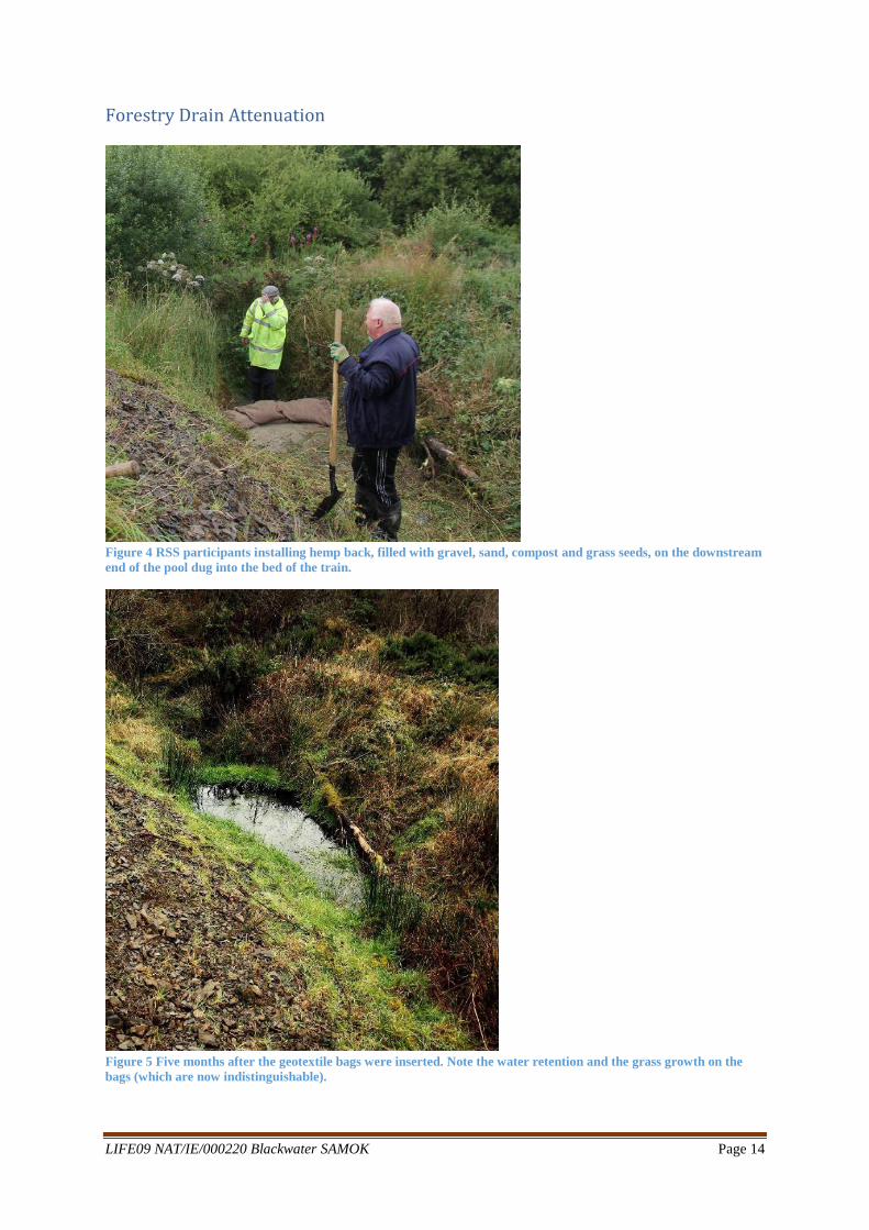
Figure 4 RSS participants installing hemp back, filled with gravel, sand, compost and grass seeds, on the downstream end of the pool dug into the bed of the train.
Figure 5 Five months after the geotextile bags were inserted. Note the water retention and the grass growth on the bags (which are now indistinguishable).

LIFE09 NAT/IE/000220 Blackwater SAMOK Page 15
Figure 6 Side-view of where the geotextile bags were place five months previous. (Note the algal growth in the retained water, indicating the attenuation of not only silt and water but also of nutrients).

LIFE09 NAT/IE/000220 Blackwater SAMOK Page 16
Conclusion
Two of the three streams (Bawnmore South and Kilberrihert) that had treatment trains installed
had historically been straightened (OSI, 2015). Straightening a channel can increase the slope
of it bed. Consequently, the channel will erode the river or streambed and carry this sediment
and material further downstream (Environment Agency, 2013; Mihov & Hristov, 2011). These
two streams if left untreated with the silt trap system developed by the LIFE project would
have added more than 5.8t of sediment and loose material to the Allow River.
One of these streams, Bawnmore South, prevented 3.87t from entering the main channel. The
silt traps installed in this stream retained over 380kg of fine materials (sediment less than 1mm
in diameter). The treatment train in this stream was installed in August 2013. In the than two
years it trapped 3870.30kg of material. The location at which this stream enters the Allow is
the one of the most important sites for Freshwater pearl mussels in the catchment. The project
team counted over 650 individual mussels within 60m downstream of where the stream enters
the main channel.
The stream at Kilberrihert would have transported over 2t of material into the Allow were the
silt traps not in place. The drain was cleared in 2013 and before the treatment drain was installed
high volumes of silt and fine materials must have been washed into the Allow River. In the two
years that the treatment train has been in place 495.46kg of fine materials have been trapped.
Approximately 380m upstream of where the stream enters the Allow is a site with high levels
of erosion. The drain at this point is over 4m deep. This may be due to the straightening of the
stream in the past and the source of much of the material that has been caught in the silt traps.
The stream at Curragheen from which the final sediment samples were taken is a narrow stream
approximately 75cm in width. It is less disturbed that the other two streams; Bawnmore South
has cattle entering it upstream of the project works as has Kilberrihert. Kilberrihert has the
aforementioned deep eroding action. Both silt traps at Curragheen, on average, recorded over
their sampled volumes as having over 50% fine materials.
It was stated that the sheer size of silt trap required to improve freshwater pearl mussel habitat
and reach favourable conditions were impractical (Magee, M., 2013). The results of this study
shows that a treatment train of three silt traps, as long as it is maintained, has the potential to
prevent over 2t of sediment from entering a river over a two-year period. In plain terms; a well

LIFE09 NAT/IE/000220 Blackwater SAMOK Page 17
maintained treatment train of silt traps can prevent one tonne a year from causing potential
harm to freshwater pearl mussels and fish spawning grounds.
The silt trapping procedure that was done at the forestry drain has the potential to become best
practice for silt and water attenuation in the forestry sector. This is especially the case post
clear-felling when soils are exposed and the risk of river channel siltation increases. While only
one forestry drain was treated in this manner, its development and trial was an indicator of the
efficacy at retaining of silt and nutrients (Figure 6).
The forestry and agricultural drains, that were treated by the project, enter the River Allow
SAC. Siltation and nutrient enrichment for agriculture and forestry are two of the biggest
threats facing freshwater pearl mussels (Anon., 2010). Hence, there is a requirement for the
continual maintenance of each of the two designs of silt traps.

LIFE09 NAT/IE/000220 Blackwater SAMOK Page 18
References
Alexander, R. (2003). Standard Specifications for Compost for Erosion/Sediment Control.
Apex, North Carolina: R. Alexander Associates. Inc.
Anon. (2010). Freshwater Pearl Mussel Second Draft Allow Sub-Basin Management Plan.
National Parks and Wildlife Service.
Blann, K., Anderson, J., Sands, G., & Vondracek, B. (2009 ). Effects of Agricultural Drainage
on Aquatic Ecosystems: A Review. Critical Reviews in Environmental Science and
Technology 39 (11), 909-1001.
Burdon, D. (1986). Hydrogeological Aspects of Agricultural Drainage in Ireland.
Environmental Geology and Water Sciences. Volume 9 (1), 41-65.
Busman, L., & Sands, G. (2012). Agricultural Drainage. Retrieved June 15, 2015, from
University of Minnesota:
http://www.extension.umn.edu/agriculture/water/agricultural-drainage-publication-
series/
Convery, F. (2013). Reflections—Shaping Water Policy: Reflections—Shaping Water Policy:.
Review of Environmental Economics and Policy 7 (1), 156-174.
Environment Agency. (2013). Restoring meanders to straightened rivers. In E. Agency,
Manual of River Restoration Techniques.
EPA. (2012, June 27). Drainage. Retrieved June 15, 2015, from U.S. Environmental Protection
Agency: http://www.epa.gov/oecaagct/ag101/cropdrainage.html
EPA/Teagasc. (2006). Indicative Soil Map of Ireland (Scale: 1:100,000).
Extence, C., Chadd, R., England, J., Dunbar, M., Wood, P., & Taylor, E. (2013). The
assessment of fine sediment accumulation in rivers using macro-invertebrate
community response. River Research and Applications, 29 (1), 17-55.
Heywood, M., & Walling, D. (2007). The sedimentation of salmonid spawning gravels in the
Hampshire Avon catchment, UK: implications for the dissolved oxygen content of
intragravel water and embryo survival. Hydrological Processes 21 (6), 770-788.

LIFE09 NAT/IE/000220 Blackwater SAMOK Page 19
Magee, M. (2013). Practical measures undertaken in Donegal and Northern Ireland as part of
the INTERREG project. Practical implementation of freshwater pearl mussel
conservation measures - Conference, (pp. 8-10). Letterkenny, Co. Donegal.
Mihov, S., & Hristov, I. (2011). Anthropogenic changes in river corridors and their impacts. In
S. Mihov, & I. Hristov, River Ecology (pp. 21-28). Vienna: WWF.
NZ Landcare Trust. (2010, June). Keeping our water clean. Retrieved June 10, 2015, from NZ
Landcare Trust: http://www.landcare.org.nz/files/file/213/silt-trap-fact-sheet.pdf
Oosterbaan, R. (1994). Agricultural Drainage Criteria . In H. Ritzema, Drainage Principals
and Applications (p. Chapter 17). Wageningen, Netherlands: International Institute for
Land Clamation and Improvement (ILRI), Publication 16, 2nd revised edition.
OSI. (2015). Public Map Viewer. Retrieved June 10, 2015, from Ordnace Survey of Ireland:
http://maps.osi.ie/publicviewer/#V2,539854,611944,10,0
Tedd, K. (2014). Characterisation of River Allow Catchment. Environmental Protection
Agency’s Water Framework Directive Integration and Coordination Unit.
Touhy, P., Fenton, O., & Humphreys, J. (2012, November/December). Dig into the figures
before breaking ground. Today's Farm: Volume 23 (6). Teagasc.

LIFE09 NAT/IE/000220 Blackwater SAMOK Page 20
Appendix
Figure 7 Silt trap installed in stream at Kilberrihert
Figure 8 Upstream view of the treatment train installed at Kilberrihert
Flow of water

LIFE09 NAT/IE/000220 Blackwater SAMOK Page 21
Figure 9 Hessian bag trialled to assess the growth of grass through the material. (Ten days after grass seeds were applied).
Figure 10 Same hessian bag with grass growth after three weeks.

LIFE09 NAT/IE/000220 Blackwater SAMOK Page 22
Figure 11 Construction of water attenuation pool