Embed Size (px)
Citation preview

Proposed speculative 2D and 3D seismic surveys off the South and
East Coast of South Africa
Environmental Management Programme
SLR Project No.: 720.16030.00003
Report No.: 2
Revision No.: 0
July 2017
Petroleum Geo-Services
Proposed speculative 2D and 3D seismic surveys off the South and
East Coast of South Africa
Environmental Management Programme
SLR Project No.: 720.16030.00003
Report No.: 2
Revision No.: 0
July 2017
Petroleum Geo-Services


SLR Consulting (South Africa) (Pty) Ltd Page ii
SLR Ref. 720.16030.00003
Report No.2
Proposed speculative 2D and 3D seismic surveys off the South and
East Coast of South Africa- Environmental Management Programme July 2017
EXECUTIVE SUMMARY
1. INTRODUCTION 1.1 BACKGROUND
In March 2017, Petroleum Geo-Services (PGS) submitted an application for a Reconnaissance Permit to the
Petroleum Agency SA (PASA) in order to apply to undertake speculative two-dimensional (2D) and three-
dimensional (3D) seismic surveys in a number of petroleum licence blocks off the South and East Coast of
South Africa. Section 74 of the Mineral and Petroleum Resources Development Act (No. 28 of 2002)
(MPRDA) makes provision for such an application.
Although survey commencement would ultimately depend on a permit award date and the availability of the
survey vessel, it is anticipated that the surveys would commence in December 2017. The duration of the
surveys would be dependent on whether the 2D and 3D surveys are run concurrently or at a different times,
however, it is anticipated that the surveys would be completed by the end of May 2018.
PASA has requested that in order for PGS to obtain a Reconnaissance Permit they must prepare a ‘plan for
managing potential environmental impacts that may result from the proposed operation and consult with
affected parties’ and submit it to them for consideration and for approval by the Minister of Mineral
Resources. For this application, the plan is referred to as an Environmental Management Programme
(EMP)1.
PGS appointed SLR Consulting (South Africa) (Pty) Ltd (SLR) to compile the EMP and undertake the
required public participation process for the proposed speculative seismic surveys.
A draft version of the EMP was distributed for review and comment from 11 May to 12 June 2017. However,
stakeholders requested an extension to the comment period as they felt they were unable to provide comment within the
original timeframe. In addition, Petroleum Geo-Services (PGS) subsequently reduced the extent of the proposed
Reconnaissance Permit Application area with associated changes to the proposed two-dimensional (2D) and three-
dimensional (3D) seismic survey target areas. As a result, amendments to the EMP recommendations were also
required. The original boundary of the proposed Reconnaissance Permit Application area is shown in Figure A. The
revised boundary area is illustrated in Figure B.
An additional notification letter was circulated to Interested & Affected Parties (I&APs) on 31 May 2017 to inform
them of: (i) the revision to the Reconnaissance Permit Application area boundary, (ii) amendment of the EMP
recommendations, and (iii) that the comment and review period had been extended to 30 June 2017.
Nineteen I&APs provided written submissions during the comment period. The compilation of this report has been
informed by comments received from I&APs on a draft version of this report. All significant changes to the original
report are underlined and in a different font (Times New Roman) to the rest of the text.
1 There is currently no legislated environmental process prescribed for a Reconnaissance Permit application. A legislated
Environmental Impact Assessment process in terms of the National Environmental Management Act, 1998 (No. 107 of 1998) is thus
not required.

SLR Consulting (South Africa) (Pty) Ltd Page iii
SLR Ref. 720.16030.00003
Report No.2
Proposed speculative 2D and 3D seismic surveys off the South and East Coast of South Africa
Environmental Management Programme July 2017
Figure A: Original Reconnaissance Permit Application area boundary (red outline) and preliminary 2D seismic survey lines and 3D seismic survey target areas.

SLR Consulting (South Africa) (Pty) Ltd Page iv
SLR Ref. 720.16030.00003
Report No.2
Proposed speculative 2D and 3D seismic surveys off the South and East Coast of South Africa
Environmental Management Programme July 2017
Figure B: Revised Reconnaissance Permit Application area boundary (red outline) and preliminary 2D seismic survey lines and 3D seismic survey target area.

SLR Consulting (South Africa) (Pty) Ltd Page v
SLR Ref. 720.16030.00003
Report No.2
Proposed speculative 2D and 3D seismic surveys off the South and
East Coast of South Africa
Environmental Management Programme
July 2017
2. EMP APPROACH AND METHODOLOGY 2.1 OBJECTIVES The objectives for the EMP process are:
To provide a reasonable opportunity for I&APs to be consulted on the proposed project;
To ensure that potential key environmental issues and impacts that could result from the proposed
project are identified;
To assess potential impacts related to the proposed project;
To present appropriate mitigation or optimisation measures to minimise potential impacts or enhance
potential benefits; and
Through the above, to ensure informed, transparent and accountable decision-making by the relevant
authorities.
2.2 PUBLIC PARTICIPATION PROCESS
The public participation tasks as part of the EMP process include the following:
1. A preliminary I&AP database has been compiled of authorities (local and regional), Non-Governmental
Organisations, Community-based Organisations and other key stakeholders (including the fishing
industry, overlapping and neighbouring users with delineated boundaries in the oil/gas and mining
industries). This database was compiled using databases of previous studies in the area. A total of
183 I&APs have been registered on the project database to date (refer to Appendix 1.1).
2. Advertisements announcing the proposed project and the availability of the Draft EMP for public
review and comment were placed in four regional newspapers (Mercury, Daily Dispatch, The Herald,
and Die Burger Eastern Cape - see Appendix 1.2);
3. I&APs were notified of the availability of the Draft EMP for a review and comment period between
11 May to 12 June 2017. A copy of the Executive Summary was included with the notification letter.
An additional notification letter was distributed to I&APs on 31 May 2017 to inform them of the revision to the
Reconnaissance Permit Application area boundary and that the comment and review period had been extended to
30 June 2017 (see Appendix 1.3); and
4. PGS has been in discussions with existing exploration right and technical cooperation permit holders
and applicants in the proposed Reconnaissance Permit area (refer to Table. 3.1). Consent from the right
and permit holders will be submitted to PASA upon receipt; and
5. Nineteen I&APs provided written submissions during the review and comment period on the draft report. These
included comments relating to, amongst others, potential impacts on the fishing sector, marine fauna and cultural
heritage resources. Comments have been collated and responded to in a Comments and Responses Report (see
Appendix 1.4). Copies of the written comments received are included in Appendix 1.5.
2.3 SPECIALIST STUDIES AND REPORT COMPILATION
The specialist studies and other relevant information have been integrated into this EMP. Many of the issues
associated with seismic surveys are generic in nature and have been assessed based on previous seismic
survey programmes off the coast of South Africa and the Generic EMPr2 prepared for seismic surveys in
2 Crowther Campbell & Associates and Centre for Marine Studies (1999) Generic Environmental Programme Reports for oil and gas
exploration off the coast of South Africa. Volume 4: Generic Manual for the preparation of a Lease Specific Environmental
Management Programme Report for seismic surveys. Petroleum Agency of South Africa, Cape Town, South Africa.

SLR Consulting (South Africa) (Pty) Ltd Page vi
SLR Ref. 720.16030.00003
Report No.2
Proposed speculative 2D and 3D seismic surveys off the South and
East Coast of South Africa
Environmental Management Programme
July 2017
South Africa. Recommendations proposed are based on specialist input and are in line with the Generic
EMPr and the general principles of the Joint Nature Conservation Committee (JNCC) seismic guidelines.
The EMP aims to present all information in a clear and understandable format and suitable for easy
interpretation by authorities, I&APs and other key stakeholders (e.g. operator and/or contractors).
2.4 WAY FORWARD
After closure of the comment period, the Draft EMP was updated into this Final EMP. This EMP has been submitted to
PASA for consideration and for approval by the Minister of Mineral Resources in terms of the MPRDA. The Final
EMP has also been made available to I&APs for information purposes.
3. PROJECT DESCRIPTION
3.1 GENERAL INFORMATION
3.1.1 Reconnaissance Permit Applicant
PGS as the applicant for the Reconnaissance Permit will also be the operator for the proposed project.
Address: Petroleum Geo-Services
No. 4, The Heights
Brooklands,
Weybridge
Surrey KT13 0NY
United Kingdom
Project Manager: Mr John Sheehan (Project Manager - Africa, Middle East, CIS)
Telephone: +44 (0) 1932 376 000
Facsimile: +44 (0) 1932 376 111
Cell: +44 (0) 7825 844 425
E-mail: [email protected]
3.1.2 Existing Permit and Right Holders (and Applicants)
The revised Reconnaissance Permit area includes a number of licence blocks off the South and East Coasts
of South Africa (refer to Figure B). The Reconnaissance Permit area is approximately 227 584 km2 in extent.
The area is situated between approximately 15 km and 250 km offshore, roughly between Mossel Bay and
Port Edward. No seismic survey acquisition would be undertaken within a 15 km buffer off the coast. The
inclusion of a 15 km buffer is based on previous seismic applications off the South and East Coasts.
As mentioned in Section 2.2, PGS is required to obtain written consent from the existing exploration right and
technical cooperation permit holders and applicants within the proposed Reconnaissance Permit area.

SLR Consulting (South Africa) (Pty) Ltd Page vii
SLR Ref. 720.16030.00003
Report No.2
Proposed speculative 2D and 3D seismic surveys off the South and
East Coast of South Africa
Environmental Management Programme
July 2017
3.2 SEISMIC SURVEY
Seismic surveys are carried out during marine oil and gas exploration in order to investigate subsea
geological formations. During seismic surveys high-level, low frequency sounds are directed towards the
seabed from near-surface sound sources towed by a seismic vessel. Signals reflected from geological
interfaces below the seafloor are recorded by multiple receivers (or hydrophones) towed in a single or
multiple streamer. Analyses of the returned signals allow for interpretation of subsea geological formations.
For this investigation PGS is proposing to undertake speculative 2D and 3D seismic surveys. The proposed
2D survey would cover two target areas with a total length of approximately 7 000 km and the proposed 3D
survey would cover a single area of up to 4 000 km2 (see Figure B). Although survey commencement would
ultimately depend on a permit award date and the availability of a survey vessel, it is anticipated that the
surveys would commence in December 2017. The duration of the surveys would be dependent on whether
the 2D and 3D surveys are run concurrently or at a different times, however it is anticipated that the surveys
would be completed by the end of May 2018.
At this stage no vessels have been contracted for the proposed survey. Thus, specific detail would only be
available when the operator has appointed a contractor/s and contracted vessel/s. The specific details of the
contractor/s and vessel/s would be compiled into an Environmental Notification that would be prepared and
submitted to PASA for information purposes 30 days prior to the commencement thereof.
The seismic surveys would be conducted using a purpose-built seismic vessel. The seismic survey vessel
would travel along transects of a prescribed grid within the proposed survey area, which have been carefully
chosen to cross any known or suspected geological structures in the area. During surveying, the seismic
vessel would travel at a speed of between four and six knots (i.e. 2 to 3 metres per second).
A 2D seismic survey would typically involve a towed airgun array, which provides the seismic source energy
for the profiling process, and a seismic wave detector system, usually known as a hydrophone streamer.
The sound source or airgun array would be situated some 100 m to 200 m behind the vessel at a depth of
5 to 10 m below the surface. A 2D survey typically involves a single streamer. The array could be up to
10 000 m long.
3D seismic surveys are typically applied to promising petroleum prospects to assist in fault interpretation,
distribution of sand bodies, estimates of oil and gas in place and the location of exploration wells. A 3D
survey operation requires multiple traverses of the survey area over the region of interest. Typically the
surface sail line tracks of the vessel are separated by half the streamer array width.
Under the Convention on the International Regulations for Preventing Collisions at Sea (COLREGS, 1972,
Part B, Rule 18), survey vessels that are engaged in surveying or towing operations are defined as a “vessel
restricted in its ability to manoeuvre” which requires that power-driven and sailing vessels give way to a
vessel restricted in her ability to manoeuvre. Vessels engaged in fishing shall, so far as possible, keep out of
the way of the seismic survey operation. Furthermore, under the Marine Traffic Act, 1981 (No. 2 of 1981), a
vessel (including seismic arrays) used for the purpose of exploration or exploitation of the seabed fall under
the definition of an “offshore installation” and as such it is protected by a 500 m safety zone. It is an offence
for an unauthorised vessel to enter the safety zone. A support vessel may be required to perform logistics
support to the seismic vessel.

SLR Consulting (South Africa) (Pty) Ltd Page viii
SLR Ref. 720.16030.00003
Report No.2
Proposed speculative 2D and 3D seismic surveys off the South and
East Coast of South Africa
Environmental Management Programme
July 2017
4. DESCRIPTION OF THE AFFECTED ENVIRONMENT
4.1 PHYSICAL OCEANOGRAPHY
The proposed Reconnaissance Permit area falls within the offshore area of the South and East coasts of
South Africa. The majority of the East Coast region has a narrow continental shelf and a steep continental
slope. A prominent feature on the continental shelf is the Tugela Bank, located to the north of the proposed
survey area. The Tugela Bank is interrupted by two canyons, namely the large and prominent Tugela
Canyon and the smaller Goodlad Canyon. To the south, the continental margin descends into the Natal
Valley. Along the East Coast, south of the Tugela Bank, the bathymetry drops steeply at the coast to
approximately 50 m. In the region of Algoa Bay, the narrow shelf characterising the East Coast widens, with
depth increasing gradually to the shelf break. Between 22° E and 26° E, the shelf break indents towards the
coast forming the Agulhas ‘bight’. At the apex of the Agulhas Bank the shelf widens to 250 km. Major
bathymetric features on the Agulhas Bank include the Alphard Banks, the Agulhas Arch and Alphard Rise.
Outside the shelf break, depth increases rapidly to more than 1 000 m.
Whereas the East Coast is primarily linear, the coastline of the South Coast is characterised by a number of
capes separated by sheltered sandy embayments.
The oceanography off the South and East coast is almost totally dominated by the warm Agulhas Current.
Currents over the inner and mid-shelf (to depths of 160 m) are weak and variable, with velocities along the
eastern half of the South Coast ranging from 25 to 75 cm/sec midshelf and 10 to 40 cm/sec nearshore.
Eastward flow may occur close inshore, being particularly strong off Port Elizabeth. Bottom water shows a
persistent westward movement, although short-term current reversals may occur. The surface waters of the
Agulhas Current may be over 25º C in summer and 21º C in winter and have lower salinities than the
Equatorial Indian Ocean and South Indian Ocean Central water masses found below.
In the sea areas off Durban, the majority of swells are from the south and south-south-west. During summer
and autumn, some swells also arrive from the east. On the South Coast, the majority of waves arrive from
the south-west quadrant, dominating wave patterns during winter and spring. During summer, easterly wind-
generated ‘seas’ occur.
Tides are typically semi-diurnal along the South and East coasts with an average tidal range of between 0.5
m during neap tides and 1.5 to 2.0 m during springs
Wind-driven upwelling occurs in the nearshore along the South Coast, especially when easterly winds blow
during summer. Such upwelling usually begins at the prominent capes and progresses westwards.
4.2 BIOLOGICAL OCEANOGRAPHY
South Africa is divided into nine bioregions. The proposed Reconnaissance Permit area is located within four
of these, namely Agulhas, Natal, Indo-Pacific Offshore and West Indian Offshore. The ecosystem threat
status of the benthic habitat types and the offshore pelagic habitat types along most of the East Coast, and
within in the proposed project area have been rated as ‘least threatened’ reflecting the great extent of these
habitats within the South African Exclusive Economic Zone (EEZ).
The nutrient-poor characteristics of the Agulhas Current water are reflected in comparatively low primary
productivity on the continental shelf inshore throughout most of the proposed project area. The Agulhas
Bank (particularly the western portion) is an important spawning area for a variety of pelagic species,
including anchovy, pilchard and horse mackerel.

SLR Consulting (South Africa) (Pty) Ltd Page ix
SLR Ref. 720.16030.00003
Report No.2
Proposed speculative 2D and 3D seismic surveys off the South and
East Coast of South Africa
Environmental Management Programme
July 2017
On the Tugela Bank and the shallow-water mud banks along the north-east coast of KwaZulu-Natal, a
number of larger crustacean species form the basis for a small multispecies trawl fishery. The species in
question include various penaeid prawns, as well as pink and red prawns, langoustines and red crab. The
shallow-water penaeid prawns typically occur on unconsolidated sandy to muddy sediments in <50 m depth
on the Tugela and St Lucia Banks, whereas the deep-water species occur at depths between 360-460 m.
Other deep-water crustaceans that may occur in the proposed Reconnaissance Permit area are the shovel-
nosed crayfish (Scyllarides elisabethae) and the Natal deep-sea rock lobster. Along the South Coast,
information on invertebrates occurring beyond 30 m is sparse. The squid (Loligo vulgaris reynaudii) occurs
extensively on the Agulhas Bank out to the shelf edge. The South Coast rock lobster occurs on rocky
substrate in depths of 90 to 170 m.
The ichthyofauna on the South and East coasts is diverse, comprising a mixture of temperate and tropical
species. As a transition zone between the Agulhas and Benguela current systems, the South Coast
ichthyofauna includes many species occurring also along the West and/or East coasts. The seabed of the
Agulhas Bank substrate is also diverse comprising areas of sand, mud and coral thereby contributing to
increased benthic fauna and fish species. Small pelagic shoaling species occurring along the South Coast
include anchovy, pilchard, round herring, chub mackerel and horse. Large migratory pelagic species that
occur in offshore waters and beyond the shelf break include dorado, sailfish and black, blue and striped
marlin, frigate tuna, skipjack, longfin tuna/albacore, bigeye tuna, yellowfin tuna, southern bluefin tuna and
bluefin tuna. There is a high diversity of teleosts (bony fish) and chondrichthyans (cartilaginous fish)
associated with the inshore and shelf waters of the South and East coasts, many of which are endemic to the
Southern African coastline and form an important component of the demersal trawl and long-line fisheries.
The Cape hake is distributed widely on the Agulhas Bank, while the deep-water hake is found further
offshore in deeper water. Apart from the hakes, numerous other by-catch species are landed by the South
Coast demersal trawling fishery including panga, kob, gurnard, monkfish, John Dory and angel fish.
Five species of turtle occur along the South and East Coast, namely the leatherback (Critically Endangered),
the loggerhead (Endangered), the green (Endangered) turtle, Olive Ridley (Vulnerable) and hawksbill
(Critically Endangered) turtle. Both the leatherback and the loggerhead turtle nest on the beaches of the
northern KwaZulu-Natal coastline between October and February, extending into March. The southern
extremity of the nesting area is thus located over 100 km to the north of the proposed Reconnaissance
Permit area. Hatchlings are born from late January through to March when the Agulhas Current is warmest.
Once hatchlings enter the sea, they move southward in the Agulhas Current and are thought to remain in the
southern Indian Ocean gyre for the first five years of their lives.
Overall, 60 species of seabirds are known, or thought likely to occur, along the South Coast. Thirteen
species breed within the South Coast region. These include Cape gannets (Algoa Bay islands), African
penguins (Algoa Bay islands), Cape cormorants (a small population at Algoa Bay islands and mainland
sites), white-breasted cormorant, Roseate tern (Bird and St Croix Islands), Damara tern (inshore between
Cape Agulhas and Cape Infanta), Swift tern (Stag Island) and kelp gulls. African penguin colonies along the
South Coast occur at Dyer Island, Cape Recife and on the Algoa Bay islands (St Croix Island, Jaheel Island,
Bird Island, Seal Island, Stag Island and Brenton Rocks). Forty-six seabird species occur commonly along
the East coast. As the East Coast provides few suitable breeding sites for coastal and seabirds, only three
species (Grey-headed gull, Caspian tern and Swift tern breed regularly along the coast.
The cetacean fauna of the South and East coasts comprise 34 species of whales and dolphins known
(historic sightings or strandings) or likely (habitat projections based on known species parameters) to occur
here. The distribution of whales and dolphins on the South and East coasts can largely be split into those
associated with the continental shelf and those that occur in deep, oceanic waters. Species from both
environments may, however, be found associated with the shelf (200 - 1 000 m), making this the most
species-rich area for cetaceans. Cetacean density on the continental shelf is usually higher than in pelagic

SLR Consulting (South Africa) (Pty) Ltd Page x
SLR Ref. 720.16030.00003
Report No.2
Proposed speculative 2D and 3D seismic surveys off the South and
East Coast of South Africa
Environmental Management Programme
July 2017
waters as species associated with the pelagic environment tend to be wide-ranging across thousands of
kilometres. The most common species within the proposed survey areas (in terms of likely encounter rate
not total population sizes) are likely to be the common bottlenose dolphin, long finned pilot whale, Southern
Right whale and humpback whale. Southern Right whales migrate to the southern Africa subcontinent to
breed and calve, where they tend to have an extremely coastal distribution mainly in sheltered bays (90% <2
km from shore). Winter concentrations have been recorded all along the South and East coasts of South
Africa as far north as Maputo Bay, with the most significant concentration currently on the South Coast
between Cape Town and Port Elizabeth. They typically arrive in coastal waters off the South Coast between
June and November each year, although animals may be sighted as early as April and as late as January.
The majority of humpback whales on the South and East coasts of South Africa are migrating past the
southern African continent. The main winter concentration areas for humpback whales on the East Coast
include Mozambique, Madagascar, Kenya and Tanzania. Humpbacks have a bimodal distribution off the
East Coast, most reaching southern African waters around April, continuing through to September/October
when the southern migration begins and continues through to December. The calving season for humpback
whales extends from July to October, peaking in early August. Off Cape Vidal whale abundances peak
around June/July on their northward migration, although some have been observed still moving north as late
as October. Southward moving animals on their return migration were first seen in July, peaking in August
and continuing to late October.
The Cape fur seal is the only seal species that has breeding colonies along the South Coast, namely at Seal
Island in Mossel Bay, on the northern shore of the Robberg Peninsula in Plettenberg Bay and at Black Rocks
(Bird Island group) in Algoa Bay.
4.3 HUMAN UTILISATION
There are ten commercial fisheries active in the vicinity of the proposed survey area, including demersal
trawl, mid-water trawl, demersal long-line (hake- and shark-directed), large pelagic long-line, small pelagic
purse-seine, traditional line fish, south coast rock lobster, KwaZulu-Nata crustacean trawl, and squid jig
fisheries.
A large number of vessels navigate along the South and East coasts on their way around the southern
African subcontinent. The majority of this vessel traffic, including commercial and fishing vessels, remains
relatively close inshore and is, therefore, expected to pass through the proposed survey area.
The proposed survey area includes a number of petroleum license blocks off the South and East coasts of
South Africa. PGS will obtain written consent from all the respective licence holders / applicants in the
proposed survey areas. There are no currently production activities within the proposed Reconnaissance
Permit area.
Permits for the prospecting of glauconite and phosphorite have been issued for Areas 251 and 257 in
2012/2013. In addition, a licence has been granted for the prospecting of marine phosphates in the
Outeniqua West Licence Area on the eastern Agulhas Bank between the 180 m and 500 m isobaths.
Numerous conservation areas and marine protected areas (MPAs) exist along the South and East coasts,
although none fall within the proposed survey area.

SLR Consulting (South Africa) (Pty) Ltd Page xi
SLR Ref. 720.16030.00003
Report No.2
Proposed speculative 2D and 3D seismic surveys off the South and
East Coast of South Africa
Environmental Management Programme
July 2017
5 IMPACT ASSESSMENT CONCLUSIONS
5.1 CONCLUSIONS
A summary of the assessment of potential environmental impacts associated with the proposed seismic
surveys is provided in Table 1.
Table 1: Summary of the significance of potential impacts of the proposed 2D and 3D speculative seismic surveys off the South and East Coasts of South Africa.
Potential impact Probability
(with mitigation)
Significance
Without
mitigation
With
mitigation
Normal seismic / support vessels and helicopter operation:
Emissions to the atmosphere Definite VL VL
Deck drainage into the sea Highly probable VL VL
Machinery space drainage into the sea Highly probable VL VL
Sewage effluent into the sea Definite VL VL
Galley waste disposal into the sea Highly probable VL VL
Solid waste disposal into the sea Improbable Insig. INSIG.
Accidental oil spill during
bunkering / refuelling
Within port limits Improbable Insig. INSIG.
Offshore Improbable L VL
Noise from seismic and support vessel operations Probable VL VL
Noise from helicopter operation Improbable L-M VL
Impact of seismic noise on marine fauna:
Plankton Probable VL VL
Invertebrates Physiological injury Improbable VL VL
Behavioural avoidance Probable VL VL
Fish Physiological injury Improbable L VL
Behavioural avoidance Improbable L VL
Spawning and recruitment Improbable L VL
Masking sound and communication Improbable VL VL
Indirect impacts on food sources Improbable VL VL
Diving seabirds Physiological injury Improbable L VL
Behavioural avoidance Improbable L VL
Indirect impacts on food sources Improbable VL VL
Non-diving seabirds Physiological injury Improbable Insig. INSIG.
Behavioural avoidance Improbable Insig. INSIG.
Turtles Physiological injury Improbable L VL
Behavioural avoidance Probable L VL
Reproductive success Improbable L VL
Masking sound and communication Improbable Insig. INSIG.
Indirect impacts on food sources Improbable VL VL
Seals Physiological injury Improbable VL VL
Behavioural avoidance Improbable VL VL
Masking sound and communication Probable VL VL
Indirect impacts on food sources Probable VL VL
Mysticetes Cetaceans Physiological injury Probable M L
Behavioural avoidance Probable L - M VL - L
Masking sound and communication Probable VL VL

SLR Consulting (South Africa) (Pty) Ltd Page xii
SLR Ref. 720.16030.00003
Report No.2
Proposed speculative 2D and 3D seismic surveys off the South and
East Coast of South Africa
Environmental Management Programme
July 2017
Potential impact Probability
(with mitigation)
Significance
Without
mitigation
With
mitigation
Indirect impacts on food sources Probable VL VL
Odontocetes Cetaceans Physiological injury Probable M L
Behavioural avoidance Probable L VL
Masking sound and communication Probable L L
Indirect impacts on food sources Probable VL VL
Impact on other users of the sea:
Fishing industry Demersal trawl Highly Probable VL VL
Mid-water Trawl Probable L L
Hake demersal long-line Highly Probable VL VL
Shark demersal long-line Highly Probable VL VL
Large pelagic long-line Probable L - VL L - VL
Traditional line-fish Probable L L
Small pelagic purse-seine Highly Probable VL VL
South Coast rock lobster Probable L L
Squid jig Highly Probable VL VL
Fisheries research Improbable VL VL – INSIG.
Marine transport routes Probable M L
Marine prospecting, mining,
exploration and production
Prospecting Improbable Insig. INSIG.
Exploration Improbable VL VL
Mining and production Improbable NO IMPACT
Socio-economic impact:
Impact of job creation and business opportunities Probable VL (+ve) VL (+VE)
Recreation and tourism Improbable VL VL
VH=Very High - H=High - M=Medium - L=Low - VL=Very Low - Insig = insignificant - All impacts are negative
In overall summary, the majority of the impacts associated with seismic survey operations would be of short-
term duration and limited to the immediate survey area. Thus, the impacts are considered to be of
INSIGNIFICANT to LOW significance after mitigation.
However, two key issues assessed in this study are likely to result in impacts of more substantial
significance. These are:
the potential impact on turtles and cetaceans (physiological injury and behavioural avoidance) as a
result of seismic noise; and
The potential impact on the fishing industry (vessel interaction, disruption to fishing operations and
reduced catch) due to the presence of the survey vessel with its associated safety zone, potential fish
avoidance of the survey target areas and changes in feeding behaviour.
The potential impacts on turtles has been assessed to be of VERY LOW significance with mitigation as the
proposed target areas are located more than 200 km south of the main turtle nesting sites on the KwaZulu-
Natal coast. However, hatchlings and juveniles may be encountered within the proposed survey target areas,
as they move southward in the Agulhas Current after emerging from their nesting sites (from late summer
onwards). As the hatchlings are weak swimmers, they are more vulnerable to collision with the towed
equipment and to direct seismic noise impacts from the air-guns. In order to mitigate the potential impact on
turtles, it is recommended that the surveys located in the northern portion of the proposed Reconnaissance Permit
Application area should, as far as possible be undertaken in December, well ahead of the turtle hatching
period. Various other measures are recommended to further mitigate the potential impact on turtles, e.g.

SLR Consulting (South Africa) (Pty) Ltd Page xiii
SLR Ref. 720.16030.00003
Report No.2
Proposed speculative 2D and 3D seismic surveys off the South and
East Coast of South Africa
Environmental Management Programme
July 2017
“soft-starts”, temporary termination of survey, the use of ‘turtle-friendly’ tail buoys or fitting existing tail buoys
with either exclusion or deflector 'turtle guards', etc.
The potential impacts on cetaceans has been assessed to have VERY LOW to LOW significance, however
the impact could be of much higher significance due to the limited understanding of how short-term effects of
seismic surveys relate to longer term impacts. For example, if a sound source displaces a species from
important breeding areas for a prolonged period, impacts at the population level could be more significant.
The proposed surveys are scheduled to be undertaken outside of the main Southern Right migration /
breeding period of June to the end of November. However, humpback whales making their return journey
from higher latitudes in November / December may still be encountered, particularly in the northern portion of
the proposed Reconnaissance Permit area. In order to accommodate these humpback whales it is
recommended that the proposed surveys in the western 3D target area and the 2D survey lines offshore of
Port Elizabeth and East London be undertaken between January and May. As for turtles, various other
measures are recommended to further mitigate the potential impact on cetaceans, including the use of PAM
technology, a 30-minute pre-watch period, 20-minute “soft-start” procedure, temporary termination of survey,
etc.
The potential impact on the fishing industry ranges from VERY LOW (demersal trawl, hake demersal long-
line, shark demersal long-line, small pelagic purse-seine and squid jig) to LOW (mid-water trawl, large
pelagic long-line, traditional line fish and south-coast rock lobster) significance with and without mitigation.
Research has shown that seismic surveys may lead to a reduction in catch rates. If fish avoid the survey
area and / or change their feeding behaviour it could have a significant impact on the fishing industry.
However, estimates of the distance from the airgun at which a decline in catch rates was observed, the
duration of that impact and the percentage reduction in catch rate were generally very low, with exception of
the mid-water trawl fishery which would have a much larger reduction of catch (in the worst-case scenario).
In general, it has been found that behavioural effects are short-term with duration of the effect being less
than or equal to the duration of exposure, although these vary between species and individuals, and are
dependent on the properties of the received sound.
Similarly, any interaction between the survey vessels and fishing vessels could increase the significance of
the impact on these sectors. Thus it is important that the operator engage with the fishing industry prior to
and during the survey operations in order to establish the location of current fishing effort and, where
possible, to adjust the survey plan to accommodate fishing. In addition, it is recommended that Radio
Navigation Warnings and Notices to Mariners are distributed throughout the seismic survey periods. The
placement of an on-board FLO would also help ensure that ongoing communication (via daily reports) is
maintained between the survey vessels and the fishing industry and other users of the sea. This proposed
regular communication with fishing vessels in the vicinity of the proposed survey operations would minimise
the potential disruption to fishing operations and risk of gear entanglements.
SLR is of the opinion that based on the findings of the impact assessment, (potential impacts generally of
VERY LOW to LOW significance after mitigation) a positive decision should be made by the Minister of
Mineral Resources (or delegated authority) in this regard.

SLR Consulting (South Africa) (Pty) Ltd Page xiv
SLR Ref. 720.16030.00003
Report No.2
Proposed speculative 2D and 3D seismic surveys off the South and
East Coast of South Africa
Environmental Management Programme
July 2017
5.2 RECOMMENDATIONS FOR MITIGATION
5.2.1 COMPLIANCE WITH EMP AND MARPOL STANDARDS
All phases of the proposed project (including pre-establishment phase, establishment phase,
operational phase, and decommissioning and closure phase) must comply with the EMP presented in
Chapter 7. In addition, the seismic and support vessels must ensure compliance with the MARPOL
73/78 standards.
5.2.2 PERMIT / EXEMPTION REQUIREMENTS
In terms of the Marine Living Resources Act, 1998 (No. 18 of 1998) it is illegal for any vessel to
approach to or remain within 300 m of whales within South African waters without a permit or
exemption. Thus, if the operator or seismic contractor are not able to comply with this restriction, an
application should be made to DEA for a permit or exemption.
5.2.3. COMMUNICATION WITH KEY STAKEHOLDERS
Prior to survey commencement the following key stakeholders should be consulted and informed of
the proposed survey activity (including navigational co-ordinates of the survey area, timing and
duration of proposed activities) and the likely implications thereof:
> Fishing industry / associations:
- SA Deep-Sea Trawling Industry Association (SADSTIA);
- South East Coast Inshore Fishing Association (SECIFA);
- SA Midwater Trawling Association;
- SA Hake Longline Association (SAHALLA);
- Shark Longline Association;
- South African Tuna Long-Line Association (SATLA);
- SA Marine Linefish Management Association (SAMLMA);
- SA Pelagic Fishing Industry Association (SAPFIA);
- South Coast Rock Lobster Association; and
- SA Squid Management Industrial Association (SASMIA).
> Other:
- PASA;
- DAFF;
- Transnet National Ports Authority;
- SAMSA;
- South African Navy Hydrographic office; and
- Overlapping and neighbouring right holders.
These stakeholders should again be notified at the completion of surveying when the survey vessel
and support vessels are off location.
The operator must request, in writing, that the South African Navy Hydrographic office release Radio
Navigation Warnings and Notices to Mariners throughout the survey periods. The Notice to Mariners
should give notice of (1) the co-ordinates of the proposed survey area, (2) an indication of the
proposed timeframes of surveys and day-to-day location of the survey vessel(s), and (3) an indication
of the 500 m safety zones and the proposed safe operational limits of the survey vessel. These
Notices to Mariners should be distributed timeously to fishing companies and directly onto vessels
where possible;

SLR Consulting (South Africa) (Pty) Ltd Page xv
SLR Ref. 720.16030.00003
Report No.2
Proposed speculative 2D and 3D seismic surveys off the South and
East Coast of South Africa
Environmental Management Programme
July 2017
An independent on-board FLO who is familiar with fisheries operational in the area must be appointed
for the duration of the survey operations. The FLO should provide a fisheries facilitation role to identify
and communicate with fishing vessels in the area to reduce the risk of gear interaction between fishing
and survey activities. The FLO should:
> report on vessel activity daily;
> advise on actions to be taken in the event of encountering fishing gear;
> provide back-up on-board facilitation with the fishing industry and other users of the sea; and
> set up a daily electronic reporting routine to keep key stakeholders informed of survey activity
and progress and fisheries, environmental issues.
In addition to the above, the FLO should assist in the identification of current fishing target areas to,
where possible, allow for the adjustment of the survey plan to accommodate fishing.
Any fishing vessels target a radar range of 12 nm from the survey vessel should be called via radio
and informed of the navigational safety requirements around the survey vessel;
Ongoing notification is to be undertaken throughout the duration of survey with the submission of daily
reports (via email) indicating the vessel’s location to key stakeholders, as appropriate;
Any dispute arising with other right holders should be referred to DMR or PASA for resolution; and
Marine mammal incidence data and seismic source output data arising from the survey should be
made available, if requested, to the Marine Mammal Institute, DEA, DAFF and PASA for analyses of
survey impacts in local waters.
5.2.4 VESSEL SAFETY
All vessels must be certified for seaworthiness through an appropriate internationally recognised
marine certification programme (e.g. Lloyds Register, Det Norske Veritas). The certification, as well as
existing safety standards, requires that safety precautions would be taken to minimise the possibility of
an offshore accident;
Collision prevention equipment should include radar, multi-frequency radio, foghorns, etc. Additional
precautions include:
> A support / chase vessel with an on-board FLO familiar with the fisheries expected in the area;
> The existence of an internationally agreed 500 m safety zone around the survey vessel;
> Cautionary notices to mariners; and
> Access to current weather service information.
The vessels are required to fly standard flags, lights (three all-round lights in a vertical line, with the
highest and lowest lights being red and the middle light being white) or shapes (three shapes in a
vertical line, with the highest and lowest lights being balls and the middle light being a diamond) to
indicate that they are engaged in towing surveys and are restricted in manoeuvrability, and must be
fully illuminated during twilight and night; and
Report any emergency situation to SAMSA.
5.2.5 EMISSIONS, DISCHARGES INTO THE SEA AND SOLID WASTE
Ensure adequate maintenance of diesel motors and generators to minimise emissions to the
atmosphere;
Route deck and machinery space drainage to a separate drainage system (oily water catchment
system) for treatment to ensure compliance with MARPOL (15 ppm);
Ensure all process areas are bunded to ensure drainage water flows into the closed drainage system;
Use drip trays to collect run-off from equipment that is not contained within a bunded area and route
contents to the closed drainage system;

SLR Consulting (South Africa) (Pty) Ltd Page xvi
SLR Ref. 720.16030.00003
Report No.2
Proposed speculative 2D and 3D seismic surveys off the South and
East Coast of South Africa
Environmental Management Programme
July 2017
Use low toxicity, biodegradable detergents during deck cleaning to further minimise the potential
impact of deck drainage on the marine environment;
Ensure adequate maintenance of all hydraulic systems and frequent inspection of hydraulic hoses;
Undertake spill management training and awareness of crew members of the need for thorough clean-
up of any spillages immediately after they occur, as this would minimise the volume of contaminants
washing off decks;
Initiate an on-board waste minimisation system;
Ensure on-board solid waste storage is secure;
Ensure that waste (solid and hazardous) disposal onshore is carried out in accordance with the
appropriate laws and ordinances; and
Prepare a project specific Emergency Response Plan and Shipboard Oil Pollution Emergency Plan for
the proposed seismic survey, which defines the organisational structure and protocols that would be
implemented to respond to any incident (including accidental oil / fuel spills) in a safe, rapid, effective
and efficient manner.
5.2.6 OFFSHORE BUNKERING
Offshore bunkering should not be undertaken in the following circumstances:
> Within 50 nm of the coast;
> Wind force and sea state conditions of 6 or above on the Beaufort Wind Scale;
> During any workboat or mobilisation boat operations;
> During helicopter operations;
> During the transfer of in-sea equipment; and
> At night or times of low visibility.
Support vessels must have the necessary spill response capability to deal with accidental spills in a
safe, rapid, effective and efficient manner; and
Crew must be trained in spill management.
5.2.7 JOB CREATION AND THE GENERATION OF DIRECT REVENUES
The use of local companies for support services should be promoted as far as possible.
5.2.8 VESSEL LIGHTING
Lighting on-board survey vessels should be reduced to the minimum safety levels to minimise
stranding of pelagic seabirds on the survey vessels at night. All stranded seabirds must be retrieved
and released during daylight hours.
5.3 MITIGATION RECOMMENDATIONS SPECIFIC TO SEISMIC SURVEYS
5.3.1 SURVEY TIMING AND SCHEDULING
The surveys located in the northern portion of the proposed Reconnaissance Permit Application area should, as
far as possible, be planned to avoid the period after turtles have hatched and drift southward in the
Agulhas Current (from late summer onwards). Thus, it is recommended that these surveys be
undertaken before the peak hatchling period, thus in December.
The seismic surveys should be undertaken outside of the key Southern Right migration and breeding period
which extends from the beginning of June to the end of November. In order to accommodate humpback whales

SLR Consulting (South Africa) (Pty) Ltd Page xvii
SLR Ref. 720.16030.00003
Report No.2
Proposed speculative 2D and 3D seismic surveys off the South and
East Coast of South Africa
Environmental Management Programme
July 2017
that may still be moving southwards on their return migrations from higher latitudes as late as December, the
surveys in the western-most 3D target area and the 2D survey target lines located between Port Elizabeth and
KwaZulu-Natal should be undertaken between January and May.
5.3.2 EQUIPMENT
‘Turtle-friendly’ tail buoys should be used by the survey contractor or existing tail buoys should be
fitted with either exclusion or deflector 'turtle guards'.
5.3.3 SEISMIC SURVEY PROCEDURES
PAM technology
> The survey vessel must be fitted with PAM technology, which detects animals through their
vocalisations. Due to the proximity of some of the target areas to the coast and the likelihood of
encountering small odontocetes that frequent the nearshore areas, it is recommended that, as a
minimum, PAM technology is used during the pre-watch period and when surveying at night or
during adverse weather conditions and thick fog.
> The PAM hydrophone streamer should ideally be towed behind the airgun array to minimise the
interference of vessel noise, and should be fitted with two hydrophones to allow directional
detection of cetaceans.
> In order to avoid unnecessary delays to the survey programme, it is recommended that a spare
PAM cable and sensor are kept onboard should there be any technical problems with the
system. However, if there is a technical problem with PAM during surveying, visual watches
must be maintained by the MMO during the day and night-vision/infra-red binoculars must be
used at night while PAM is being repaired.
“Soft-start” procedure, pre-watch period and airgun firing
> A “soft-start” procedure of a minimum of 20 minutes’ duration must be implemented when
initiating airgun tests (a single or a number of airguns at full power)3 and / or seismic surveying.
This requires that the sound source be ramped from low to full power rather than initiated at full
power, thus allowing a flight response by marine fauna to outside the zone of injury or
avoidance.
> “Soft-start” procedures must only commence once it has been confirmed for at least a 30-minute
period (visually and using PAM technology during the day and using only PAM technology at
night or during periods of poor visibility) that there is no cetacean activity within 500 m of the
vessel. Similarly, it must also be confirmed (visually during the day and using night-vision/infra-
red binoculars at night) that there is no seabird (significant diving activity), turtle or seal activity
within 500 m of the vessel just prior to initiating the “soft-start” procedure.
> “Soft-starts” should be delayed until such time as this area is clear of seabirds (diving), turtles,
seals or cetaceans. In the case of turtles and cetaceans the “soft-start” procedure should not
begin until after the animals depart the 500 m exclusion zone or 30 minutes after they are last
seen. In the case of seals, which are often attracted to survey vessels, the normal “soft-start”
procedures should be allowed to commence, if after a period of 30 minutes seals are still within
500 m of the airguns.
> All breaks in airgun firing of longer than 20 minutes must be followed by a 30-minute pre-shoot
watch and a “soft-start” procedure of at least 20 minutes prior to the survey operation
continuing. In order to facilitate a more effective timing of proposed operations when surveying
3 Note: If the intention is to test a single airgun on low power then a “soft-start” is not required.

SLR Consulting (South Africa) (Pty) Ltd Page xviii
SLR Ref. 720.16030.00003
Report No.2
Proposed speculative 2D and 3D seismic surveys off the South and
East Coast of South Africa
Environmental Management Programme
July 2017
in deeper waters, the 30-minute pre-shoot watch can commence before the end of the survey
line (whilst the airguns are still firing). Breaks of shorter than 20 minutes should be followed by
a visual assessment for marine mammals and turtles within the 500 m mitigation zone (not a 30-
minute pre-shoot watch) and a “soft-start” of similar duration.
> The use of the lowest practicable airgun volume, as defined by the operator, should be defined
and enforced.
> During surveying, airgun firing should be terminated when:
- obvious negative changes to turtle, seal and cetacean behaviour is observed;
- turtles or cetaceans are observed within 500 m of the operating airgun and appear to be
approaching the firing airgun; or
- there is mass mortality of fish or mortality / injuries to seabirds, turtles, seals or cetaceans
as a direct result of the survey.
> The survey should remain terminated until such time the time MMO / PAM operator confirms
that:
- turtles or cetaceans have moved to a point that is more than 500 m from the source;
- despite continuous observation, 30 minutes has elapsed since the last sighting of the
turtles or cetaceans within 500 m of the source; and
- risks to seabirds, turtles, seals or cetaceans have been significantly reduced.
> A log of all termination decisions must be kept (for inclusion in both daily and “close-out”
reports).
MMO and PAM operator
> An independent on-board MMO and a PAM operator must be appointed for the duration of the
seismic survey. The MMO and PAM operator must have experience in seabird, turtle and
marine mammal identification and observation / detection techniques.
> The duties of the MMO would be to:
Marine fauna:
- Confirm that there is no marine faunal activity within 500 m of the seismic source array
prior to commencing with the “soft-start” procedures;
- Record pre-shoot observation regime;
- Record survey activities, including sound levels, “soft-start” procedures and survey
periods (duration);
- Monitor marine faunal activity during daytime surveying. Observe and record responses
of marine fauna to the seismic survey, including seabird, turtle, seal and cetacean
incidence and behaviour and any mortality or injuries of marine fauna as a result of the
seismic survey. Data captured should include species identification, position
(latitude/longitude), distance from the vessel, swimming speed and direction
(if applicable) and any obvious changes in behaviour (e.g. startle responses or changes
in surfacing/diving frequencies, breathing patterns) as a result of the survey activities; and
- Request the temporary termination of the seismic survey, as appropriate. It is important
that the MMOs’ decisions to terminate firing are made confidently and expediently;
Other:
- Record meteorological conditions;
- Monitor compliance with international marine pollution regulations (MARPOL 73/78
standards); and
- Prepare daily reports of all observations. These reports should be forwarded to the key
stakeholders, as appropriate.
> The duties of the PAM operator would be to:
- Ensure that hydrophone streamers are optimally placed within the towed array;
- Confirm that there is no cetaceans activity within 500 m of the vessel prior to commencing
with the “soft-start” procedures;

SLR Consulting (South Africa) (Pty) Ltd Page xix
SLR Ref. 720.16030.00003
Report No.2
Proposed speculative 2D and 3D seismic surveys off the South and
East Coast of South Africa
Environmental Management Programme
July 2017
- Record survey activities, including sound levels, “soft-start” procedures and survey
periods (duration);
- Record pre-shoot observation regime;
- Monitor cetacean activity during daytime and night time surveying. Record species
identification, position (latitude/longitude) and distance from the vessel, where possible;
and
- Request the temporary termination of the seismic survey, as appropriate.
> All data recorded by the MMO and PAM operator should form part of the survey “close-out”
report.
5.4 MITIGATION RECOMMENDATIONS SPECIFIC TO HELICOPTER OPERATIONS (WHERE
REQUIRED)
Flight paths must be pre-planned to ensure that no flying occurs over MPAs (Goukamma, Robberg,
Tsitsikammama, Sardinia Bay MPA, Bird Island, Amathole MPA and Aliwal Shoal), seal (Seal Island,
Robberg Peninsula and Black Rocks) and seabird colonies (Algoa Bay islands, St Croix Island, Jaheel
Island, Bird Island, Seal Island, Stag Island and Brenton Rocks);
Extensive coastal flights (parallel to the coast within 1 nm of the shore) should be avoided. There is a
restriction of coastal flights (parallel to the coast within 1 nm of the shore) on the South Coast between
the months of June and November to avoid Southern Right whale breeding areas;
The operator must comply with the Seabirds and Seals Protection Act, 1973, which prohibits the wilful
disturbance of seals on the coast or on offshore islands.
The contractor should comply fully with aviation and authority guidelines and rules; and
All pilots must be briefed on ecological risks associated with flying at a low level parallel to the coast.
* * *

SLR Consulting (South Africa) (Pty) Ltd Page xx
SLR Ref. 720.16030.00003
Report No.2
Proposed speculative 2D and 3D seismic surveys off the South and
East Coast of South Africa
Environmental Management Programme
July 2017
PROPOSED SPECULATIVE 2D AND 3D SEISMIC SURVEYS OFF THE SOUTH AND
EAST COAST OF SOUTH AFRICA
TABLE OF CONTENTS
DOCUMENT INFORMATION ............................................................................................................................. I
EXECUTIVE SUMMARY .................................................................................................................................... II
TABLE OF CONTENTS .................................................................................................................................. XX
1 INTRODUCTION ...................................................................................................................................... 1
1.1 BACKGROUND ............................................................................................................................. 1
1.2 ASSUMPTIONS AND LIMITATIONS OF THIS EMP .................................................................... 2
1.3 STRUCTURE OF THIS REPORT ................................................................................................. 2
2 APPROACH AND METHODOLOGY ...................................................................................................... 4
2.1 LEGISLATIVE REQUIREMENTS ................................................................................................. 4 2.1.1 Mineral and Petroleum Resources Development Act, 2002 ............................................................ 4 2.1.2 National Environmental Management Act, 1998.............................................................................. 4 2.1.3 Other Relevant Legislation .............................................................................................................. 4
2.2 EMP PROCESS ............................................................................................................................ 5
2.2.1 Objectives ........................................................................................................................................ 5 2.2.2 Specialist studies ............................................................................................................................. 6
2.2.3 EMP compilation ............................................................................................................................. 6
2.2.4 Public participation process ............................................................................................................. 6
3 PROJECT DESCRIPTION ....................................................................................................................... 8
3.1 GENERAL INFORMATION ........................................................................................................... 8 3.1.1 Reconnaissance permit applicant .................................................................................................... 8 3.1.2 Existing permit and right holders (and applicants) ........................................................................... 8
3.1.3 Details of reconnaissance area nd survey extent ............................................................................ 8 3.1.4 Environmental policy statement ..................................................................................................... 12
3.1.5 Monitoring and performance assessment ..................................................................................... 12 3.1.6 Plans and procedures for environmental related emergencies and remediation ........................... 13
3.2 SEISMIC SURVEYS .................................................................................................................... 13 3.2.1 Introduction .................................................................................................................................... 13
3.2.2 Survey methodology and airgun array ........................................................................................... 14 3.2.3 Sound pressure emission levels .................................................................................................... 15 3.2.4 Recording equipment .................................................................................................................... 15 3.2.5 Vessel exclusion zone ................................................................................................................... 16
3.2.6 Support services ............................................................................................................................ 16 3.2.7 Environmental notification ............................................................................................................. 16
4 THE AFFECTED ENVIRONMENT ........................................................................................................ 18
4.1 INTRODUCTION ......................................................................................................................... 18
4.2 METEOROLOGY ........................................................................................................................ 18 4.2.1 South coast.................................................................................................................................... 18
4.2.2 East coast ...................................................................................................................................... 19
4.3 PHYSICAL OCEANOGRAPHY ................................................................................................... 20 4.3.1 Bathymetry and Sediments ........................................................................................................... 20 4.3.2 Water Masses and Circulation ....................................................................................................... 22 4.3.3 Swells and Waves ......................................................................................................................... 24 4.3.4 Tides .............................................................................................................................................. 24 4.3.5 Upwelling ....................................................................................................................................... 24

SLR Consulting (South Africa) (Pty) Ltd Page xxi
SLR Ref. 720.16030.00003
Report No.2
Proposed speculative 2D and 3D seismic surveys off the South and
East Coast of South Africa
Environmental Management Programme
July 2017
4.3.6 Turbidity ......................................................................................................................................... 25 4.3.7 Nutrient Distribution ....................................................................................................................... 25
4.4 BIOLOGICAL OCEANOGRAPHY ............................................................................................... 26 4.4.1 Introduction .................................................................................................................................... 26
4.4.2 Offshore region .............................................................................................................................. 27
4.5 HUMAN UTILISATION ................................................................................................................ 46 4.5.1 Fisheries ........................................................................................................................................ 46
4.5.2 Shipping transport ......................................................................................................................... 64
4.5.3 Exploration, production and mining ............................................................................................... 64
4.5.4 Undersea cables ............................................................................................................................ 67
4.5.5 Marine archaeological sites ........................................................................................................... 68
4.5.6 Ammunition dump sites ................................................................................................................. 68
4.5.7 Conservation areas and marine protected areas ........................................................................... 69
5 ENVIRONMENTAL IMPACT ASSESSMENT ....................................................................................... 72
5.1 IMPACT OF NORMAL SEISMIC / SUPPORT VESSELS ........................................................... 72 5.1.1 Emissions to the atmosphere ........................................................................................................ 72 5.1.2 Discharges/disposal to the sea ...................................................................................................... 73 5.1.3 Noise from vessel and helicopter operations ................................................................................. 79
5.2 IMPACTS OF 2D/3D SEISMIC NOISE ON MARINE FAUNA .................................................... 82 5.2.1 Potential impacts on plankton ........................................................................................................ 82 5.2.2 Potential impacts to marine invertebrates ...................................................................................... 83 5.2.3 Potential impacts on fish ................................................................................................................ 84 5.2.4 Potential impacts on seabirds ........................................................................................................ 88 5.2.5 Potential impacts on turtles ........................................................................................................... 91 5.2.6 Potential impacts on seals ............................................................................................................. 95 5.2.7 Potential impact on cetaceans (whales and dolphins) ................................................................... 97
5.3 IMPACT ON OTHER USERS OF THE SEA ............................................................................. 103 5.3.1 Potential impact on fishing industry ............................................................................................. 103 5.3.2 Potential impact on marine transport routes ................................................................................ 111 5.3.3 Potential impact on marine prospecting, mining, exploration and production activities ............... 113
5.4 SOCIO-ECONOMIC IMPACT OF EXPLORATION ACTIVITIES ............................................... 114
5.4.1 Potential impact related to job creation and business opportunities ............................................ 114 5.4.2 Potential impact on recreation and tourism ................................................................................. 115
6 CONCLUSIONS AND RECOMMENDATIONS ................................................................................... 117
6.1 CONCLUSIONS ........................................................................................................................ 117
6.2 RECOMMENDATIONS FOR MITIGATION .............................................................................. 120 6.2.1 Compliance with emp and marpol standards ............................................................................... 120 6.2.2 Permit / exemption requirements ................................................................................................. 120 6.2.3 Communication with key stakeholders ........................................................................................ 120 6.2.4 Vessel safety ............................................................................................................................... 121 6.2.5 Emissions, discharges into the sea and solid waste .................................................................... 122 6.2.6 Offshore bunkering ...................................................................................................................... 122 6.2.7 Job creation and the generation of direct revenues ..................................................................... 122 6.2.8 Vessel lighting ............................................................................................................................. 123
6.3 MITIGATION RECOMMENDATIONS SPECIFIC TO SEISMIC SURVEYS ............................. 123 6.3.1 Survey timing and scheduling ...................................................................................................... 123 6.3.2 Equipment ................................................................................................................................... 123 6.3.3 Seismic survey procedures.......................................................................................................... 123
6.4 MITIGATION RECOMMENDATIONS SPECIFIC TO HELICOPTER OPERATIONS (WHERE REQUIRED) ............................................................................................................... 125
7 ENVIRONMENTAL MANAGEMENT PROGRAMME ......................................................................... 126
8 REFERENCES ..................................................................................................................................... 142

SLR Consulting (South Africa) (Pty) Ltd Page xxii
SLR Ref. 720.16030.00003
Report No.2
Proposed speculative 2D and 3D seismic surveys off the South and
East Coast of South Africa
Environmental Management Programme
July 2017
LIST OF FIGURES
Figure 3-1: Original Reconnaissance Permit Application area boundary (red outline) and preliminary 2D seismic survey
lines and 3D seismic survey target areas. 9 Figure 3-2: Revised Reconnaissance Permit Application area boundary (red outline) and preliminary 2D Seismic survey
lines and 3D seismic survey target area. 10 Figure 3-3: Principles of offshore 2D / 3D seismic surveys (from fishsafe.eu). 13 Figure 3-4: Typical configuration for a 3D seismic survey operation. safe operational limits applicable to both
2D and 3D surveys are also shown. 14 Figure 3-5: A typical pressure signature produced on firing of an airgun. 15 Figure 4-1: Average sea level pressure (top; hpa) and wind speed and direction (bottom; m.s-1) for the period
1979 – 2009 for both the atlantic and indian oceans from ncep reanalysis data. images provided from the NCEP reanalysis site 19
Figure 4-2: Location of the Proposed Reconnaissance Permit area in relation to bathymetric features and submarine canyons and feeder-valleys situated off the South and East Coast of South Africa. 21
Figure 4-3: The Proposed Reconnaissance Permit area in relation to coastal and offshore benthic habitat types off the South and East Coast of South Africa (Adapted From Sink et al. 2012). 22
Figure 4-4: The predominance of the agulhas current in the oceanography of the Proposed Reconnaissance Permit Area (White Outline). 23
Figure 4-5: Areas of upwelling off the south and east coasts. redrawn from Dingle et al. (1987). 25 Figure 4-6: The Proposed Reconnaissance Permit Area (red outline) in relation to the inshore and offshore
bioregions of South Africa (Adapted from Lombard et al., 2004). 27 Figure 4-7: The Proposed Reconnaissance Permit Area (red polygon) in relation to the ecosystem threat status
for coastal and offshore benthic habitat types (Adapted from Sink et al. 2012). 27 Figure 4-8: The Proposed Reconnaissance Permit Area in relation to important fishing banks, pelagic and
demersal fish and squid spawning areas (After Anders, 1975, Crawford et al., 1987, Hutchings, 1994). The 200 m depth contour is also shown. 29
Figure 4-9: The Proposed Reconnaissance Permit Area In Relation To The Agulhas Inshore Reef And Hard Ground Habitat Types In Relation To The Southern Portion Of The Project Area (Adapted From Sink Et Al. 2012a). 32
Figure 4-10: The Proposed Reconnaissance Permit Area in relation to the home and core ranges of loggerheads and leatherbacks during inter-nesting (Oceans And Coast, Unpublished Data). 37
Figure 4-11: The Proposed Reconnaissance Permit Area (white polygon) in relation to the spatial distribution of satellite tagged loggerhead females (2011/2012; Oceans and Coast, Unpublished Data). 38
Figure 4-12: The Proposed Reconnaissance Permit Area (white polygon) in relation to the post-nesting distribution of nine satellite tagged leatherback females (1996 – 2006; Oceans and Coast, Unpublished Data). 38
Figure 4-13: Schematic diagram of trawl gear typically used by demersal trawlers. 47 Figure 4-14: Location Of The Proposed Reconnaissance Permit Area In Relation To Inshore And Offshore
Demersal Trawl Sectors (2000 To 2014). 48 Figure 4-15: Location of the Proposed Reconnaissance Permit Area in relation to the mid-water trawl fishery
(2003 to 2014). 49 Figure 4-16: Schematic diagram showing the typical configuration of mid-water trawl gear. 50 Figure 4-17: Typical configuration of demersal (bottom-set) hake long-line gear used in South African Waters. 51 Figure 4-18: Location of the Proposed Reconnaissance Permit Area in relation to hake-directed demersal long-
line catch (2000 - 2014). 51 Figure 4-19: Location of the Proposed Reconnaissance Permit Area in relation to shark-directed demersal long-
line catch (2007 - 2014). 52 Figure 4-20: Typical pelagic long-line configuration targeting tuna, swordfish and shark species. 53 Figure 4-21: Location of the Proposed Reconnaissance Permit Area in relation to large pelagic long-line catch
(2000 - 2014). 53 Figure 4-22: The Proposed Reconnaissance Permit Area in relation to main area of fishing effort in the
traditional line fishery. 54 Figure 4-23: The Proposed Reconnaissance Permit Area In relation to the distribution of fishing effort by the
small pelagic purse seine fishery (2000 to 2014). 56 Figure 4-24: Typical gear configuration of a pelagic purse seine vessel targeting small pelagic species. 56 Figure 4-25: The Proposed Reconnaissance Permit Area in relation to the spatial distribution of effort expended
by the south coast rock lobster fishery (2008 – 2012). 57 figure 4-26: the Proposed Reconnaissance Permit Area in relation to the squid jig fishery effort (2012 - 2015). 59 Figure 4-27: The Proposed Reconnaissance Permit Area in relation to the spatial distribution of research trawls
conducted between 1985 and 2013. 61

SLR Consulting (South Africa) (Pty) Ltd Page xxiii
SLR Ref. 720.16030.00003
Report No.2
Proposed speculative 2D and 3D seismic surveys off the South and
East Coast of South Africa
Environmental Management Programme
July 2017
Figure 4-28: Density of anchovy and spatial distribution of survey tracks undertaken during the acoustic biomass survey by daff during may 2014. 62
Figure 4-29: Density of sardine and spatial distribution of survey tracks undertaken during the acoustic biomass survey by daff during may 2014. 62
Figure 4-30: Density of anchovy and spatial distribution of survey tracks undertaken during the acoustic biomass survey by daff during november 2014. 63
Figure 4-31: Density of sardine and spatial distribution of survey tracks undertaken during the acoustic biomass survey by daff during november 2014. 63
Figure 4-32: Major shipping routes along the east coast of south africa. data from the south african centre for oceanography. Approximate location of the reconnaissance permit area is also shown. 64
Figure 4-33: Petroleum licence blocks off the West, South and East Coasts of South Africa (After PASA, 2017). 65 Figure 4-34: Diamond Fields International’s proposed outeniqua west prospecting licence area in relation to the
licence blocks off the South Coast (Extracted from the Background Information Document Prepared by CSIR, February 2013). 66
Figure 4-35: Schematic of location of manganese nodules off Southern Africa, showing petroleum licence blocks. modified from Rogers (1995) and Fuggle & Rabie (1992). 67
Figure 4-36: Configuration of the current african undersea cable systems, 2016 (From Http://Www.Manypossibilities.Net). 68
Figure 4-37: Location of ammunition dump sites (•) along the East Coast, with Petroleum License Blocks (not all shown). From Chart San 50, 56 & 57. 69
Figure 4-38: Project - environment interaction points on the east and south coasts, illustrating the location of the Proposed Reconnaissance Permit Area (Red outline) in relation to seabird and seal colonies, seasonal whale populations and reserves and Marine Protected Areas. 70
Figure 5-1: Summary of the different fisheries operating off the South and East Coast in relation to the Proposed Reconnaissance Permit Area. 107
LIST OF TABLES
Table 4.1: Tide data (m) for different sites along the South and East coasts (from SA Tide Tables, 1995 &
2009). ....................................................................................................................................................... 24 Table 4.2: Some of the more important large migratory pelagic fish likely to occur in the offshore regions of
the South and East Coasts. ..................................................................................................................... 34 Table 4.3: Breeding resident seabirds found on the South Coast, and their conservation status (adapted from
CSIR and CCA, 1998). ............................................................................................................................. 39 Table 4.4: Resident and fairly-common to common visiting seabirds present along the kwazulu-Natal coast
(from CSIR 1998). .................................................................................................................................... 40 Table 4.5: Cetaceans occurrence off the South and East Coasts of South Africa, their seasonality and likely
encounter frequency with proposed seismic survey operations. .............................................................. 42 Table 5.1: Impact of atmospheric emissions from the seismic and support vessels. ................................................ 73 Table 5.2: Impact of deck drainage from the survey and support vessels. ............................................................... 74 Table 5.3: Impact of machinery space drainage from the survey and support vessels. ............................................ 75 Table 5.4: Impact of sewage effluent discharge from the survey and support vessels. ............................................ 76 Table 5.5: Impact of galley waste disposal from the survey and support vessels. .................................................... 76 Table 5.6: Impact of solid waste disposal from the survey and support vessels. ...................................................... 77 Table 5.7: Impact of an accidental oil spill during bunkering operations. ................................................................. 79 Table 5.8: Impact of noise from seismic and support vessel operations. .................................................................. 80 Table 5.9: Impact of noise from helicopter operations. ............................................................................................. 81 Table 5.10: Impact of seismic noise on plankton. ....................................................................................................... 82 Table 5.11: Impact of seismic noise on marine invertebrates. .................................................................................... 84 Table 5.12: Impact of seismic noise on fish. ............................................................................................................... 87 Table 5.13: Impact of seismic noise on diving seabirds. ............................................................................................. 90 Table 5.14: Impact of seismic noise on non-diving seabirds. ...................................................................................... 91 Table 5.15: Impact of seismic noise on turtles. ........................................................................................................... 93 Table 5.16: Impact of seismic noise on seals. ............................................................................................................ 96 Table 5.17: Impact of seismic noise on mysticete cetaceans (baleen whales). ........................................................ 101 Table 5.18: Impact of seismic noise on odontocete cetaceans (toothed whales and dolphins). ............................... 102 Table 5.19: Potential impact on fishing sectors operating off the South and East Coast. ......................................... 108 Table 5.20: Potential impact on fishing research off the South and East Coasts. ..................................................... 111 Table 5.21: Impact on marine traffic and transport routes. ....................................................................................... 112 Table 5.22: Impact on marine prospecting, mining, exploration and production activities. ....................................... 114

SLR Consulting (South Africa) (Pty) Ltd Page xxiv
SLR Ref. 720.16030.00003
Report No.2
Proposed speculative 2D and 3D seismic surveys off the South and
East Coast of South Africa
Environmental Management Programme
July 2017
Table 5.23: Impact of job creation and the generation of direct revenues. ............................................................... 115 Table 5.24: Assessment of the potential impact on tourism and recreation. ............................................................. 116 Table 6.1: Summary of the significance of potential impacts of the proposed 2D and 3D speculative seismic
surveys off the South and East coasts of South Africa. ......................................................................... 118
LIST OF APPENDICES
Appendix 1: Public Participation Process
Appendix 1.1: I&AP database
Appendix 1.2: Advertisements
Appendix 1.3: I&AP Notification letters
Appendix 1.4: Comments and Responses Report
Appendix 1.5: Copies of written comments received
Appendix 2: Convention for assigning significance ratings to impacts
Appendix 3: Specialist Studies
Appendix 3.1: Fishing Industry Assessment
Appendix 3.2: Marine Faunal Assessment

SLR Consulting (South Africa) (Pty) Ltd Page xxv
SLR Ref. 720.16030.00003
Report No.2
Proposed speculative 2D and 3D seismic surveys off the South and
East Coast of South Africa
Environmental Management Programme
July 2017
ACRONYMS AND ABBREVIATIONS
Below a list of acronyms and abbreviations used in this report.
Acronyms /
Abbreviations Definition
3D Two-dimensional
3D Three-dimensional
CEAPSA Certified Environmental Practitioner of South Africa
DEA Department of Environmental Affairs
EAP Environmental Assessment Practitioner
ECO Environmental Control Officer
EIA Environmental Impact Assessment
EMPr Environmental Managements Programme
ER Exploration Right
FLO Fisheries Liaison Officer
GN Government Notice
I&APs Interested and Affected Parties
MARPOL International Convention for the Prevention of Pollution from Ships, 1973/1978
MMO Marine Mammal Observer
MPRDA Minerals and Petroleum Resources Development Act, 2002 (No. 28 of 2002)
NEMA National Environmental Management Act, 1998 (No. 107 of 1998)
PAM Passive Acoustic Monitoring
PASA Petroleum Agency of South Africa
PGS Petroleum Geo-Services
Pr.Sci.Nat. Registered Professional Natural Scientist
SAMSA South African Maritime Safety Authority
SAN South African Navy
SLR SLR Consulting (South Africa) (Pty) Ltd

SLR Consulting (South Africa) (Pty) Ltd Page 1
SLR Ref. 720.16030.00003
Report No.2
Proposed speculative 2D and 3D seismic surveys off the South and
East Coast of South Africa - Environmental Management Programme July 2017
1 INTRODUCTION
This chapter provides background to the proposed project, presents the assumptions and limitations of the
study, and describes the structure of the report.
BACKGROUND 1.1
In March 2017, PGS submitted an application for a Reconnaissance Permit to the Petroleum Agency SA
(PASA) in order to apply to undertake speculative two-dimensional (2D) and three-dimensional (3D) seismic
surveys in a number of petroleum licence blocks off the South and East Coast of South Africa. Section 74 of
the Mineral and Petroleum Resources Development Act (No. 28 of 2002) (MPRDA) makes provision for such
an application.
Although survey commencement would ultimately depend on a permit award date and the availability of a
survey vessel, it is anticipated that the surveys would commence in December 2017. The duration of the
surveys would be dependent on whether the 2D and 3D surveys are run concurrently or at a different times,
however, it is anticipated that the surveys would be completed by the end of May 2018.
PASA has requested that in order for PGS to obtain a Reconnaissance Permit they must prepare a ‘plan for
managing potential environmental impacts that may result from the proposed operation and consult with
affected parties’ and submit it to them for consideration and for approval by the Minister of Mineral
Resources. For this application, the plan is referred to as an EMP1.
PGS has appointed SLR Consulting (South Africa) (Pty) Ltd (SLR) to compile this EMP and undertake the
required public participation process for the proposed speculative seismic surveys.
A draft version of the EMP was distributed for review and comment from 11 May to 12 June 2017. However,
stakeholders requested an extension to the comment period as they felt they were unable to provide comment within the
original timeframe. In addition, Petroleum Geo-Services (PGS) subsequently reduced the extent of the proposed
Reconnaissance Permit Application area with associated changes to the proposed two-dimensional (2D) and three-
dimensional (3D) seismic survey target areas. As a result, amendments to the EMP recommendations were also
required. The original boundary of the proposed Reconnaissance Permit Application area is shown in Figure 3.1. The
revised boundary area is illustrated in Figure 3.2.
An additional notification letter was circulated to Interested & Affected Parties (I&APs) on 31 May 2017 to inform
them of: (i) the revision to the Reconnaissance Permit Application area boundary, (ii) amendment of the EMP
recommendations, and (iii) that the comment and review period had been extended to 30 June 2017.
Nineteen I&APs provided written submissions during the comment period. The compilation of this report has been
informed by comments received from I&APs on a draft version of this report. All significant changes to the original
report are underlined and in a different font (Times New Roman) to the rest of the text.
1 There is currently no legislated environmental process prescribed for a Reconnaissance Permit application. A legislated
Environmental Impact Assessment process in terms of the National Environmental Management Act, 1998 (No. 107 of 1998) is thus
not required.
SLR Consulting (South Africa) (Pty) Ltd Page 2
SLR Ref. 720.16030.00003
Report No.2
Proposed speculative 2D and 3D seismic surveys off the South and
East Coast of South Africa - Environmental Management Programme July 2017
ASSUMPTIONS AND LIMITATIONS OF THIS EMP 1.2
This EMP was prepared with the following assumptions and limitations:
SLR has been provided with all relevant project description information;
There will be no significant changes to the project description or surrounding environment between the
completion of the report and implementation of the proposed project that could substantially influence
findings, recommendations with respect to mitigation and management, etc.;
The assessment is based, to a large extent, on a generic description of 2D and 3D seismic survey
operations;
The study assumes that all mitigation measures incorporated into the project description would be
implemented as proposed; and
Specialists were provided with all relevant information required in order to produce accurate and
unbiased assessments.
These assumptions and limitations, however, are not considered to have any negative implications in terms
of the credibility of the results of the study or the required management actions included in this EMP.
STRUCTURE OF THIS REPORT 1.3
This report consists of eight chapters and five appendices as shown below.
Section Contents
Executive Summary Provides an overview of the main findings of the EMP.
Chapter 1 Introduction
Provides background to the proposed project, the assumptions and limitations of the study, and
describes the structure of the report.
Chapter 2 Approach and methodology
Covers the legislative requirements of the EMP process and presents the process undertaken.
Chapter 3 Project description
Provides general information on the proposed project, a general description of seismic surveys
and provides details on the proposed surveys.
Chapter 4 The affected environment
Describes the existing biophysical and socio-economic environment that could be affected by
the proposed project.
Chapter 5 Environmental Impact Assessment
Describes and assesses the potential impacts of the proposed project on the affected
environment. It also presents mitigation measures that could be used to reduce the significance
of any negative impacts or enhance any benefits.
Chapter 6 Conclusion and recommendations
Provides conclusions to the EMP and summarises the recommendations for the proposed
project.
Chapter 7 Action Plan and Procedures
Provides a detailed Action Plan and Procedures for implementing the EMP.
Chapter 8 References
Provides a list of the references used in compiling this report.
Appendices
Appendix 1 Public Participation Process
Appendix 1.1 I&AP database
Appendix 1.2 Advertisements
Appendix 1.3 I&AP Notification letters
Appendix 1.4 Comments and Responses Report
Appendix 1.5 Copies of written comments received
Appendix 2 Convention for assigning significance ratings to impacts

SLR Consulting (South Africa) (Pty) Ltd Page 3
SLR Ref. 720.16030.00003
Report No.2
Proposed speculative 2D and 3D seismic surveys off the South and
East Coast of South Africa - Environmental Management Programme July 2017
Section Contents
Appendix 3 Specialist Studies
Appendix 3.1 Fishing Industry Assessment
Appendix 3.2 Marine Faunal Assessment

SLR Consulting (South Africa) (Pty) Ltd Page 4
SLR Ref. 720.16030.00003
Report No.2
Proposed speculative 2D and 3D seismic surveys off the South and
East Coast of South Africa - Environmental Management Programme July 2017
2 APPROACH AND METHODOLOGY
This chapter outlines the key legislative requirements for the proposed project and outlines the methodology
and public participation process undertaken in the study.
LEGISLATIVE REQUIREMENTS 2.1
2.1.1 MINERAL AND PETROLEUM RESOURCES DEVELOPMENT ACT, 2002
In terms of the MPRDA, a Reconnaissance Permit must be obtained prior to the commencement of any
reconnaissance activities. A requirement for obtaining a Reconnaissance Permit is that an applicant must
submit an application in terms of Section 74(1) of the MPRDA to the designated agency, and they must
accept the application within 14 days if, inter alia, no other person holds a Technical Co-operation Permit,
Exploration Right or Production Right for petroleum over any part of the proposed permit area. If the
application for a Reconnaissance Permit is accepted (post 8 December 2014), the designated agency must
request that the applicant comply with Chapter 5 of NEMA with regards to consultation and reporting.
It should be noted that there is no legislated process prescribing the environmental approval procedure to
follow in order to obtain a Reconnaissance Permit. Thus, the procedure followed in this EMP process is
based on PASA’s acceptance of the Reconnaissance Permit application whereby they requested that a ‘plan
be developed for managing potential environmental impacts that may result from the proposed operation and
that affected parties are notified and consulted’.
2.1.2 NATIONAL ENVIRONMENTAL MANAGEMENT ACT, 1998
The Environmental Impact Assessment (EIA) Regulations 2014 (as amended) promulgated in terms of
Chapter 5 of NEMA, as amended, provide for the control of certain listed activities. These activities are
prohibited until Environmental Authorisation has been obtained from the competent authority.
There are currently no listed activities applicable to Reconnaissance Permits or seismic surveys in the EIA
Regulations 2014 (as amended). Thus, Environmental Authorisation is not required in terms of NEMA.
2.1.3 OTHER RELEVANT LEGISLATION
In addition to the foregoing, PGS must also comply with the provisions of other relevant international and
national legislation and conventions, which include, but are not limited to, the following:
International Marine Pollution Conventions
International Convention for the Prevention of Pollution from Ships, 1973/1978 (MARPOL);
Amendment of the International Convention for the Prevention of Pollution from Ships, 1973/1978
(MARPOL) (Bulletin 567 – 2/08);
International Convention on Oil Pollution Preparedness, Response and Co-operation, 1990 (OPRC
Convention);
United Nations Convention on Law of the Sea, 1982 (UNCLOS);
Convention on the Prevention of Marine Pollution by Dumping of Wastes and Other Matter, 1972
(the London Convention) and the 1996 Protocol (the Protocol);
International Convention relating to Intervention on the High Seas in case of Oil Pollution Casualties
(1969) and Protocol on the Intervention on the High Seas in Cases of Marine Pollution by substances
other than oil (1973);

SLR Consulting (South Africa) (Pty) Ltd Page 5
SLR Ref. 720.16030.00003
Report No.2
Proposed speculative 2D and 3D seismic surveys off the South and
East Coast of South Africa - Environmental Management Programme July 2017
Basel Convention on the Control of Trans-boundary Movements of Hazardous Wastes and their
Disposal (1989); and
Convention on Biological Diversity (1992).
Other International Legislation
International Commission on Radiological Protection (ICRC); and
International Atomic Energy Agency (IAEA) Regulations for the Safe Transport of Radioactive
Material, 1984.
Other South African Legislation
Carriage of Goods by Sea Act, 1986 (No. 1 of 1986);
Dumping at Sea Control Act, 1980 (No. 73 of 1980);
Hazardous Substances Act, 1983 and Regulations (No. 85 of 1983);
Marine Living Resources Act, 1998 (No. 18 of 1998);
Marine Traffic Act, 1981 (No. 2 of 1981);
Marine Pollution (Control and Civil Liability) Act, 1981 (No. 6 of 1981);
Marine Pollution (Prevention of Pollution from Ships) Act, 1986 (No. 2 of 1986);
Marine Pollution (Intervention) Act, 1987 (No. 65 of 1987);
Maritime Safety Authority Act, 1998 (No. 5 of 1998);
Maritime Safety Authority Levies Act, 1998 (No. 6 of 1998);
Maritime Zones Act 1994 (No. 15 of 1994);
Merchant Shipping Act, 1951 (No. 57 of 1951);
Mine Health and Safety Act, 1996 (No. 29 of 1996);
National Environmental Management: Air Quality Act, 2004 (No. 39 of 2004);
National Environmental Management: Biodiversity Act, 2004 (No. 10 of 2004);
National Environmental Management: Integrated Coastal Management Act, 2008 (No. 24 of 2008);
National Environmental Management: Waste Act, 2008 (No. 59 of 2008);
National Heritage Resources Act, 1999 (No. 25 of 1999);
National Nuclear Energy Regulator Act, 1999 (No. 47 of 1999);
National Ports Act, 2005 (No. 12 of 2005);
National Water Act, 1998 (No. 36 of 1998);
Nuclear Energy Act, 1999 (No. 46 of 1999);
Occupational Health and Safety Act, 1993 (No. 85 of 1993) and Major Hazard Installation Regulations;
Sea-Shore Act, 1935 (No. 21 of 1935);
Sea Birds and Seals Protection Act, 1973 (No. 46 of 1973);
Ship Registration Act, 1998 (No. 58 of 1998); and
Wreck and Salvage Act, 1995 (No. 94 of 1995).
EMP PROCESS 2.2
2.2.1 OBJECTIVES
The objectives of the EMP process are:
To provide a reasonable opportunity for I&APs to be consulted on the proposed project;
To ensure that potential key environmental issues and impacts that could result from the proposed
project are identified;
To assess potential impacts related to the proposed project;
To present appropriate mitigation or optimisation measures to minimise potential impacts or enhance
potential benefits; and

SLR Consulting (South Africa) (Pty) Ltd Page 6
SLR Ref. 720.16030.00003
Report No.2
Proposed speculative 2D and 3D seismic surveys off the South and
East Coast of South Africa - Environmental Management Programme July 2017
Through the above, to ensure informed, transparent and accountable decision-making by the relevant
authorities.
2.2.2 SPECIALIST STUDIES
Two specialist studies were undertaken to address the key issues that required further investigation, namely
the potential impact on fishing and marine fauna. The specialists and their details are provided in Table 2.1.
The specialist studies involved the gathering of data relevant to identifying and assessing environmental
impacts that may occur as a result of the proposed project. These impacts were then assessed according to
pre-defined rating scales (see Appendix 2). Specialists also recommended appropriate mitigation / control or
optimisation measures to minimise potential negative impacts or enhance potential benefits, respectively.
Table 2.1: List of specialist studies and specialists.
No. Specialist
study Specialist/s Qualifications Company Appendix
1 Fishing
Mr Dave Japp MSc (Ichthyology and Fisheries
Science), Rhodes University Capricorn Marine
Environmental 3.1
Ms Sarah Wilkinson BSc (Hons) (Botany),
University of Cape Town
2 Marine fauna Dr Andrea Pulfrich
PhD (Fisheries Biology),
Christian-Albrechts University,
Kiel, Germany
Pisces
Environmental
Services (Pty) Ltd
3.2
2.2.3 EMP COMPILATION
The specialist studies and other relevant information have been integrated into this EMP. Many of the issues
associated with seismic surveys are generic in nature and have been assessed based on previous seismic
survey programmes off the coast of South Africa and the Generic EMPr25
prepared for seismic surveys in
South Africa. Recommendations proposed are based on specialist input and are in line with the Generic
EMPr and the general principles of the Joint Nature Conservation Committee (JNCC) seismic guidelines.
The EMP aims to present all information in a clear and understandable format and suitable for easy
interpretation by authorities, I&APs and other key stakeholders (e.g. operator and/or contractors).
2.2.4 PUBLIC PARTICIPATION PROCESS
The public participation tasks as part of the EMP process include the following:
1. A preliminary I&AP database has been compiled of authorities (local and regional), Non-Governmental
Organisations, Community-based Organisations and other key stakeholders (including the fishing
industry, overlapping and neighbouring users with delineated boundaries in the oil/gas and mining
2 Crowther Campbell & Associates and Centre for Marine Studies (1999) Generic Environmental Programme Reports for oil and gas
exploration off the coast of South Africa. Volume 4: Generic Manual for the preparation of a Lease Specific Environmental
Management Programme Report for seismic surveys. Petroleum Agency of South Africa, Cape Town, South Africa.

SLR Consulting (South Africa) (Pty) Ltd Page 7
SLR Ref. 720.16030.00003
Report No.2
Proposed speculative 2D and 3D seismic surveys off the South and
East Coast of South Africa - Environmental Management Programme July 2017
industries). This database was compiled using databases of previous studies in the area. A total of
183 I&APs have been registered on the project database to date (refer to Appendix 1.1).
2. Advertisements announcing the proposed project and the availability of the Draft EMP for public
review and comment were placed in four regional newspapers (Mercury, Daily Dispatch, The Herald,
and Die Burger Eastern Cape - see Appendix 1.2);
3. I&APs were notified of the availability of the Draft EMP for a review and comment period between
11 May to 12 June 2017. A copy of the Executive Summary was included with the notification letter. As
noted above, an additional notification letter was distributed to I&APs on 31 May 2017 to inform them of the
revision to the Reconnaissance Permit Application area boundary and that the comment and review period had
been extended to 30 June 2017 (see Appendix 1.3);
4. PGS has been in discussions with existing exploration right and technical cooperation permit holders
and applicants in the proposed Reconnaissance Permit area (refer to Table. 3.1). Consent from the right
and permit holders will be submitted to PASA upon receipt; and
5. Nineteen I&APs provided written submissions during the review and comment period on the draft report. These
included comments relating to, amongst others, potential impacts on the fishing sector, marine fauna and cultural
heritage resources. Comments have been collated and responded to in a Comments and Responses Report (see
Appendix 1.4). Copies of the written comments received are included in Appendix 1.5.
2.2.5 WAY FORWARD
After closure of the comment period, the Draft EMP was updated into this Final EMP. This EMP has been submitted to
PASA for consideration and for approval by the Minister of Mineral Resources in terms of the MPRDA. The Final
EMP has also been made available to I&APs for information purposes.

SLR Consulting (South Africa) (Pty) Ltd Page 8
SLR Ref. 720.16030.00003
Report No.2
Proposed speculative 2D and 3D seismic surveys off the South and
East Coast of South Africa - Environmental Management Programme July 2017
3 PROJECT DESCRIPTION
This chapter provides general information on the proposed project, the general location of the proposed 2D
and 3D speculative seismic surveys, and a brief description of typical seismic surveys.
GENERAL INFORMATION 3.1
3.1.1 RECONNAISSANCE PERMIT APPLICANT
PGS as the applicant for the Reconnaissance Permit will also be the operator for the proposed project.
Address: Petroleum Geo-Services
No. 4, The Heights
Brooklands,
Weybridge
Surrey KT13 0NY
United Kingdom
Project Manager: Mr John Sheehan (Project Manager - Africa, Middle East, CIS)
Telephone: +44 (0) 1932 376 000
Facsimile: +44 (0) 1932 376 111
Cell: +44 (0) 7825 844 425
E-mail: [email protected]
3.1.2 EXISTING PERMIT AND RIGHT HOLDERS (AND APPLICANTS)
The proposed Reconnaissance Permit area includes a number of licence blocks off the South and East
Coasts of South Africa (see Figure 3.1 and Table 3.1). Licence block rights/permit holders and applicants
within the proposed Reconnaissance Permit area are listed in Table 3.1.
As mentioned in Section 2.2.4, PGS is required to obtain written consent from the existing exploration right
and technical cooperation permit holders and applicants within the proposed Reconnaissance Permit area.
3.1.3 DETAILS OF RECONNAISSANCE AREA AND SURVEY EXTENT
The revised Reconnaissance Permit area is approximately 227 584 km2 in extent. The area is situated
between approximately 15 km and 250 km offshore, roughly between Mossel Bay and Port Edward. No
seismic survey acquisition would be undertaken within a 15 km off the coast. The inclusion of a 15 km buffer
is based on previous seismic applications off the South and East Coasts (see Figure 3.1). The co-ordinates
of the boundary points of the revised Reconnaissance Permit area are provided in Table 3-2 below.
It is proposed that, subject to the agreement with existing rights/permit holders and vessel availability, the 2D
survey would cover two target areas with a total length of approximately 7 000 km and the proposed 3D survey
would cover a single area of up to 4 000 km2. Although survey commencement would ultimately depend on a
permit award date and the availability of a survey vessel, it is anticipated that the surveys would commence
in December 2017. The duration of the surveys would be dependent on whether the 2D and 3D surveys are
run concurrently or at a different times, however it is anticipated that the surveys would be completed by the
end of May 2018.

SLR Consulting (South Africa) (Pty) Ltd Page 9
SLR Ref. 720.16030.00003
Report No.2
Proposed speculative 2D and 3D seismic surveys off the South and East Coast of South Africa
Environmental Management Programme July 2017
Figure 3-1: Original Reconnaissance Permit Application area boundary (red outline) and preliminary 2D seismic survey lines and 3D seismic survey target areas.

SLR Consulting (South Africa) (Pty) Ltd Page 10
SLR Ref. 720.16030.00003
Report No.2
Proposed speculative 2D and 3D seismic surveys off the South and East Coast of South Africa
Environmental Management Programme July 2017
Figure 3-2: Revised Reconnaissance Permit Application area boundary (red outline) and preliminary 2D seismic survey lines and 3D seismic survey target area.

SLR Consulting (South Africa) (Pty) Ltd Page 11
SLR Ref. 720.16030.00003
Report No.2
Proposed speculative 2D and 3D seismic surveys off the South and
East Coast of South Africa - Environmental Management Programme July 2017
Table 3.1: List of right holders (and applicants) in the revised Reconnaissance Permit Application area
boundary.
NO. RIGHT HOLDER CONTACT DETAILS
1.
Total Exploration and Production South Africa
Address: 7 West Quay Block A 3rd Floor, V&A Waterfront Cape Town Contact person: Damion Kombol Email: [email protected] Tel: +27 21 003 4143
2.
ExxonMobil Exploration and Production South Africa Limited
Address: Cube Workspace, Room 308 3rd Floor Icon Building, Corner Lower
Long and Hans Strijdom Cape Town Contact person: Peter Claypool Email: [email protected] Tel: +27 21 412 1538 Fax: 086 575 2307
3.
Silver Wave Energy Address: 10 Anson Road #31–10 SINGAPORE 079903 Contact person: Lee Kong Lin Email: [email protected] Tel: +65 6236 0611 Fax: +65 6236 0614
4.
OK Energy Address: 49 Mill Lane Chalgrove, OX4475L United Kingdom Contact person: Erika Syba Email: [email protected] Tel: +44 7973 342877
5.
Impact Africa Address: Church Gate 11 Church Street West Working, Surrey GU216DJ United Kingdom Contact person: Steve Ilett Email: [email protected] Tel: +44 (0) 1483 750 588 Fax: +44 (0) 1483 730 255
6.
New Age Algoa Address: Unit 511, 5th Floor, The Cliffs Block 2 Niagra Way
Tygerfalls Bellville 7536 Contact person: Dave Loran Email: [email protected] cc: [email protected] Tel: +27 11 944 6900
7.
Rift Petroleum Address: 30 A Brook Street London, W1K5DJ United Kingdom
Tel: +44 20 7016 5130
8.
Canadian Natural Resources
Address: St Magnus Heights Guild Street Aberdeen AB116NJ United Kingdom Contact person: Keith Thornton Email: [email protected] Tel: +44 01 4834 01401
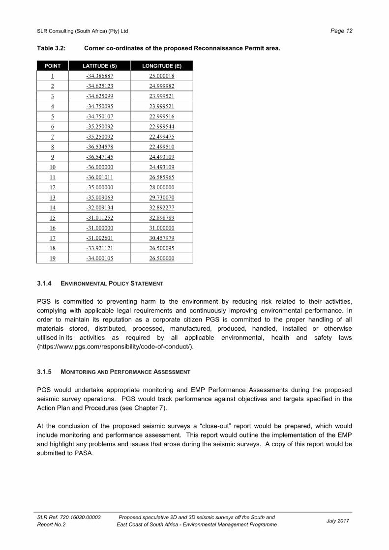
SLR Consulting (South Africa) (Pty) Ltd Page 12
SLR Ref. 720.16030.00003
Report No.2
Proposed speculative 2D and 3D seismic surveys off the South and
East Coast of South Africa - Environmental Management Programme July 2017
Table 3.2: Corner co-ordinates of the proposed Reconnaissance Permit area.
POINT LATITUDE (S) LONGITUDE (E)
1 -34.386887 25.000018
2 -34.625123 24.999982
3 -34.625099 23.999521
4 -34.750095 23.999521
5 -34.750107 22.999516
6 -35.250092 22.999544
7 -35.250092 22.499475
8 -36.534578 22.499510
9 -36.547145 24.493109
10 -36.000000 24.493109
11 -36.001011 26.585965
12 -35.000000 28.000000
13 -35.009063 29.730070
14 -32.009134 32.892277
15 -31.011252 32.898789
16 -31.000000 31.000000
17 -31.002601 30.457979
18 -33.921121 26.500095
19 -34.000105 26.500000
3.1.4 ENVIRONMENTAL POLICY STATEMENT
PGS is committed to preventing harm to the environment by reducing risk related to their activities,
complying with applicable legal requirements and continuously improving environmental performance. In
order to maintain its reputation as a corporate citizen PGS is committed to the proper handling of all
materials stored, distributed, processed, manufactured, produced, handled, installed or otherwise
utilised in its activities as required by all applicable environmental, health and safety laws
(https://www.pgs.com/responsibility/code-of-conduct/).
3.1.5 MONITORING AND PERFORMANCE ASSESSMENT
PGS would undertake appropriate monitoring and EMP Performance Assessments during the proposed
seismic survey operations. PGS would track performance against objectives and targets specified in the
Action Plan and Procedures (see Chapter 7).
At the conclusion of the proposed seismic surveys a “close-out” report would be prepared, which would
include monitoring and performance assessment. This report would outline the implementation of the EMP
and highlight any problems and issues that arose during the seismic surveys. A copy of this report would be
submitted to PASA.
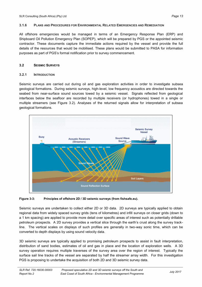
SLR Consulting (South Africa) (Pty) Ltd Page 13
SLR Ref. 720.16030.00003
Report No.2
Proposed speculative 2D and 3D seismic surveys off the South and
East Coast of South Africa - Environmental Management Programme July 2017
3.1.6 PLANS AND PROCEDURES FOR ENVIRONMENTAL RELATED EMERGENCIES AND REMEDIATION
All offshore emergencies would be managed in terms of an Emergency Response Plan (ERP) and
Shipboard Oil Pollution Emergency Plan (SOPEP), which will be prepared by PGS or the appointed seismic
contractor. These documents capture the immediate actions required by the vessel and provide the full
details of the resources that would be mobilised. These plans would be submitted to PASA for information
purposes as part of PGS’s formal notification prior to survey commencement.
SEISMIC SURVEYS 3.2
3.2.1 INTRODUCTION
Seismic surveys are carried out during oil and gas exploration activities in order to investigate subsea
geological formations. During seismic surveys, high-level, low frequency acoustics are directed towards the
seabed from near-surface sound sources towed by a seismic vessel. Signals reflected from geological
interfaces below the seafloor are recorded by multiple receivers (or hydrophones) towed in a single or
multiple streamers (see Figure 3.2). Analyses of the returned signals allow for interpretation of subsea
geological formations.
Figure 3-3: Principles of offshore 2D / 3D seismic surveys (from fishsafe.eu).
Seismic surveys are undertaken to collect either 2D or 3D data. 2D surveys are typically applied to obtain
regional data from widely spaced survey grids (tens of kilometres) and infill surveys on closer grids (down to
a 1 km spacing) are applied to provide more detail over specific areas of interest such as potentially drillable
petroleum prospects. A 2D survey provides a vertical slice through the earth’s crust along the survey track-
line. The vertical scales on displays of such profiles are generally in two-way sonic time, which can be
converted to depth displays by using sound velocity data.
3D seismic surveys are typically applied to promising petroleum prospects to assist in fault interpretation,
distribution of sand bodies, estimates of oil and gas in place and the location of exploration wells. A 3D
survey operation requires multiple traverses of the survey area over the region of interest. Typically the
surface sail line tracks of the vessel are separated by half the streamer array width. For this investigation
PGS is proposing to undertake the acquisition of both 2D and 3D seismic survey data.

SLR Consulting (South Africa) (Pty) Ltd Page 14
SLR Ref. 720.16030.00003
Report No.2
Proposed speculative 2D and 3D seismic surveys off the South and
East Coast of South Africa - Environmental Management Programme July 2017
3.2.2 SURVEY METHODOLOGY AND AIRGUN ARRAY
The seismic surveys would be conducted using purpose-built seismic vessels. The seismic vessels would
travel along transects of a prescribed grid within the survey areas that have been carefully chosen to cross
any known or suspected geological structures. During surveying, the seismic vessels would travel at a
speed of between four and six knots (i.e. 2 to 3 metres per second).
The seismic surveys would involve towed airgun arrays, which provides the seismic source energy for the
profiling process, and seismic wave detector systems, usually known as hydrophone streamers.
The anticipated airgun and hydrophone array would be dependent on whether a 2D or 3D seismic survey is
undertaken. The sound source or airgun array (one for 2D and two for 3D) would be situated some 80 m to
150 m behind the vessel at a depth of 5 m to 25 m below the surface. A 2D survey typically involves a single
streamer, whereas 3D surveys use multiple streamers (up to 12 streamers spaced 100 m apart). The array
can be up to 12 000 m long. The streamer/s would be towed at a depth of between 6 m and 30 m and would
not be visible, except for the tail-buoy at the far end of the cable. A typical 3D seismic survey configuration
and safe operational limits (applicable to both 2D and 3D surveys) are illustrated in Figure 3.3.
Figure 3-4: Typical configuration for a 3D seismic survey operation. Safe operational limits applicable to both
2D and 3D surveys are also shown.
Airguns, which are the most common sound source used in modern seismic surveys, would be used for the
proposed survey. The airgun is an underwater pneumatic device from which high-pressure air is released
suddenly into the surrounding water. On release of pressure the resulting bubble pulsates rapidly producing
an acoustic signal that is proportional to the rate of change of the volume of the bubble. The frequency of
the signal depends on the energy of the compressed air prior to discharge. Airguns are used on an
individual basis (usually for shallow water surveys) or in arrays. Arrays of airguns are made up of towed
parallel strings, usually comprised of between 12 and 70 airguns in total. The airgun would be fired at
approximately 10 to 20 second intervals.
Paravane
3 km
4 km
4 km
3 km
8 km
12 km
6 km 6 km
Airgun array
Hydrophone streamers
Tail-buoys
DAYLIGHT EXCLUSION ZONE
NIGHT TIME EXCLUSION ZONE
Not to scale

SLR Consulting (South Africa) (Pty) Ltd Page 15
SLR Ref. 720.16030.00003
Report No.2
Proposed speculative 2D and 3D seismic surveys off the South and
East Coast of South Africa - Environmental Management Programme July 2017
The sound waves are reflected by boundaries between sediments of different densities and returned signals
are recorded by hydrophones mounted inside streamer cables and transmitted to the seismic vessel for
electronic processing. Analyses of the returned signals allow for interpretation of subsea geological
formations.
3.2.3 SOUND PRESSURE EMISSION LEVELS
A single airgun could typically produce sound levels in the order of 220-230 dB re 1 mPa @ 1m, while arrays
produce sounds typically in the region of 250 dB re 1 mPa @ 1m. The majority of energy produced is in the
0 to 120 Hz bandwidth, although energy at much higher frequencies is also recorded. High-resolution
surveys and shallow penetration surveys require relatively high frequencies of 100 to 1000 Hz, while the
optimum wavelength for deep seismic work is in the 10 to 80 Hz range.
One of the required characteristics of a seismic shot is that it is of short duration (the main pulse is usually
between 5 and 30 milliseconds). The main pulse is followed by a negative pressure reflection from the sea
surface of several lower magnitude bubble pulses (see Figure 3.4). Although the peak levels during the shot
may be high, the overall energy is limited by the duration of the shot.
Figure 3-5: A typical pressure signature produced on firing of an airgun.
3.2.4 RECORDING EQUIPMENT
Signals reflected from geological discontinuities below the seafloor are recorded by hydrophones mounted
inside streamer cables. Hydrophones are typically made from piezoelectric material encased in a rubber
plastic hose. This hose containing the hydrophones is called a streamer. The reflected acoustic signals are
recorded and transmitted to the seismic vessel for electronic processing. Analyses of the returned signals
allow for interpretation of subsea geological formations.

SLR Consulting (South Africa) (Pty) Ltd Page 16
SLR Ref. 720.16030.00003
Report No.2
Proposed speculative 2D and 3D seismic surveys off the South and
East Coast of South Africa - Environmental Management Programme July 2017
3.2.5 VESSEL EXCLUSION ZONE
The acquisition of high quality seismic data requires that the position of the survey vessel and the array be
accurately known. Seismic surveys consequently require accurate navigation of the sound source over pre-
determined survey transects. This, and the fact that the array and the hydrophone streamer(s) need to be
towed in a set configuration behind the survey vessel, means that the survey operation has little
manoeuvrability while operating.
Under the Convention on the International Regulations for Preventing Collisions at Sea (COLREGS, 1972,
Part B, Rule 18), survey vessels that are engaged in surveying or towing operations are defined as “vessel
restricted in its ability to manoeuvre”31
which requires that power-driven and sailing vessels give way to a
vessel restricted in its ability to manoeuvre. Vessels engaged in fishing shall, so far as possible, keep out of
the way to a vessel restricted in its ability to manoeuvre. Furthermore, under the Marine Traffic Act, 1981
(No. 2 of 1981), a vessel (including array of airguns and hydrophones) used for the purpose of exploiting the
seabed falls under the definition of an “offshore installation” and as such it is protected by a 500 m safety
zone. It is an offence for an unauthorised vessel to enter the safety zone. In addition to a statutory 500 m
safety zone, a seismic contractor would typically request a safe operational limit (that is greater than the
500 m safety zone) that it would like other vessels to stay beyond. Typical safe operational limits for a 2D
and 3D survey are illustrated in Figure 3.3.
At least a 500 m exclusion zone would need to be enforced around the survey vessel (including its array of
airguns and hydrophones) at all times. A chase boat with appropriate radar and communications would be
used during the seismic survey to warn vessels that are in danger of breaching the exclusion zone.
The 500 m safety zone and proposed safe operational limits would be communicated to key stakeholders
well in advance of the proposed exploration programme. Notices to Mariners will also be communicated
through the proper channels.
3.2.6 SUPPORT SERVICES
A support vessel may be required to perform logistics support to the seismic vessel.
Bunkering of the survey vessels is expected to be undertaken at port of operation or at sea during the
survey. Standard operating procedures for refuelling would be adhered to at all times.
3.2.7 ENVIRONMENTAL NOTIFICATION
At this stage no vessels have been contracted for the proposed surveys. Thus, specific detail would only be
available when the operator has appointed a contractor/s and contracted vessel/s. The specific details of the
contractor/s and vessel/s would be compiled into an Environmental Notification that would be prepared and
3 Definition: The term “vessel restricted in her ability to manoeuvre” means a vessel which from the nature of her work is restricted in
her ability to manoeuvre as required by these Rules and is therefore unable to keep out of the way of another vessel. The term
“vessels restricted in their ability to manoeuvre” shall include but not be limited to:
(i) a vessel engaged in laying, servicing, or picking up a navigation mark, submarine cable or pipeline;
(ii) a vessel engaged in dredging, surveying or underwater operations;
(iii) a vessel engaged in replenishment or transferring persons, provisions or cargo while underway;
(iv) a vessel engaged in the launching or recovery of aircraft;
(v) a vessel engaged in mine clearance operations; and
(vi) a vessel engaged in a towing operation such as severely restricts the towing vessel and her tow in their ability to deviate from their course.

SLR Consulting (South Africa) (Pty) Ltd Page 17
SLR Ref. 720.16030.00003
Report No.2
Proposed speculative 2D and 3D seismic surveys off the South and
East Coast of South Africa - Environmental Management Programme July 2017
submitted to PASA for information purposes 30 days prior to the commencement thereof. The Environmental
Notification would include the following:
Survey lines/areas;
Survey timing and duration;
Contractor details (if applicable);
Vessel and airgun/hydrophone array specifications;
Plans not included in the EMP (e.g. ERP and SOPEP); and
Details of Marine Mammal Observer, Passive Acoustic Monitoring Operator and Fisheries Liaison
Officer, where applicable.
SLR Consulting (South Africa) (Pty) Ltd Page 18
SLR Ref. 720.16030.00003
Report No.2
Proposed speculative 2D and 3D seismic surveys off the South and
East Coast of South Africa - Environmental Management Programme July 2017
4 THE AFFECTED ENVIRONMENT
This chapter provides a description of the South and East Coast regions and the environment likely to be
affected by the proposed seismic surveys.
INTRODUCTION 4.1
The proposed Reconnaissance area is approximately 227 584 km2
in extent stretching roughly between
Mossel Bay in the Western Cape and Port Edward in KwaZulu-Natal. The proposed survey area is located
beyond the 50 m depth contour, with the closest point to shore being approximately 15 km (see Figure 3-2).
The South Coast region is typically defined as lying between Cape Agulhas (34° 35'S; 20° 00'E) and Cape
Padrone (33° 45'S; 26° 30'E). The region is dominated by the Agulhas Bank, a roughly 116 000 km2
triangular extension of the continental shelf. The Agulhas Bank represents a transition zone between the
warm Agulhas Current waters to the east and the cool waters of the Benguela system to the west. The
coastline is characterised by a number of capes separated by sheltered sandy embayments.
The East Coast region lies between Cape Padrone (33° 45S, 26° 30'E) and the Mozambique Border at
Ponta do Ouro (26° 40'S, 32° 52'E) to the offshore limit of the South African Exclusive Economic Zone
(EEZ)4.2The oceanography of this coast is almost totally dominated by the warm Agulhas Current that flows
southwards along the shelf edge (Schumann, 1998).
METEOROLOGY 4.2
4.2.1 SOUTH COAST
The main features affecting the weather patterns along the South Coast are the mid-latitude cyclones
generated to the south-west of the country and the South Atlantic and Indian Ocean high pressure cells
(Shannon, 1985; Preston-Whyte and Tyson, 1988) (see Figure 4-1). The northward movement and
weakening of the high-pressure cells during winter and the corresponding northward shift of easterly-moving
mid-latitude cyclones (which occur to the south of the region in summer) cause the frontal systems and their
associated westerly winds to move overland, affecting coastal weather patterns (Heydorn and Tinley, 1980;
Schumann, 1998). Associated with the passage of mid-latitude cyclones are the shallow low-pressure
systems that move around the coast from west to east ahead of frontal systems (Heydorn and Tinley, 1980).
These may produce warm offshore winds followed by colder westerly to south-westerly winds (Schumann,
1998). Westerly winds predominate in winter, with a marked increase in easterly wind direction in summer.
Gale force winds are most frequent in winter, frequently reaching gale force strengths. During summer,
easterly wind directions increase markedly resulting in roughly similar strength/frequency of east and west
winds during that season (Jury 1994). The strongest winds are observed at capes, including Agulhas,
Infanta, Cape Seal, Robberg and Cape Recife (Jury & Diab 1989). Calm periods are most common in
autumn (CSIR & CCA, 1998).
4 The Exclusive Economic Zone is the zone extending from the coastline out to a distance of 200 nautical miles within which South
Africa holds exclusive economic rights.

SLR Consulting (South Africa) (Pty) Ltd Page 19
SLR Ref. 720.16030.00003
Report No.2
Proposed speculative 2D and 3D seismic surveys off the South and
East Coast of South Africa - Environmental Management Programme July 2017
Figure 4-1: Average sea level pressure (top; hPa) and wind speed and direction (bottom; m.s-1) for the period 1979 – 2009 for both the Atlantic and Indian Oceans from NCEP reanalysis data. Images provided from the NCEP reanalysis site
(http://www.esrl.noaa.gov/psd/data/reanalysis/reanalysis.shtml).
4.2.2 EAST COAST
The meteorology of the southern half of the East Coast (Cape Padrone to southern KwaZulu-Natal) is also
affected by the position and seasonal movements of both the South Atlantic and Indian Ocean anticyclone
cells, and mid-latitude cyclones that originate from the westerly wind belt (Schumann, 1998) (see Figure 4-1).
South-westerly winds result from the eastward moving mid-latitude cyclones (and their associated coastal
low pressure systems) and prevail during both summer and winter, although the occurrence of north-east
winds increases during summer (Schumann, 1998). The varying temperatures between the land and
adjacent ocean set up a land-sea breeze system over the east coast (Tyson and Preston-Whyte, 2000). The
sea breeze (towards the interior) can contribute towards the north-east winds experienced over the east
coast. The land breeze (towards the sea), which usually starts from late afternoon / evening until the morning
the next day, is often more noticeable during the winter months. Berg winds are another important feature
over the coastal region. These winds develop due to strong continental anticyclones over the interior, and
are most common in late winter and early spring (Tyson and Preston-Whyte, 2000).

SLR Consulting (South Africa) (Pty) Ltd Page 20
SLR Ref. 720.16030.00003
Report No.2
Proposed speculative 2D and 3D seismic surveys off the South and
East Coast of South Africa - Environmental Management Programme July 2017
Hunter (1988) reports that the basic weather cycle along the KwaZulu-Natal coast is related to the eastward
movement of the coastal low pressures generated along the West Coast during pre-frontal conditions. These
coastal lows are normally about 100 km wide (Schumann, 1998) and move anti-clockwise along the South
African coast (Jury et al., 1990) at about 6-30 m/s (Schumann, 1998), thereby traversing the East Coast in
under three days (CSIR, 1998.). As the coastal low approaches a KwaZulu-Natal coastal location, north-east
winds freshen (occasionally reaching gale force). Once the coastal low passes, winds change to very strong
(often gale force) south-westerly winds and such conditions may persist for more than a day before returning
to north-east winds via the south-east. Coastal lows may affect weather conditions up to 100 km offshore.
During summer, winds generally blow from a north-easterly direction along the KwaZulu-Natal coast, while
during winter, there is an increase in cross-coast flow due to the occurrence of land-sea breeze systems and
berg winds from the north-west. The sea-breeze, however, is not as pronounced as the land-breeze,
especially during winter (Hunter, 1988). Indeed, land-breeze may at times reach speeds of 9 m.sec-1
and
affect conditions 60 km offshore (Hunter, 1981). Hunter (1988) reports that in the Durban area, September is
the stormiest month while June has the least winds.
According to both Hunter (1988) and Schumann (1998), less regular weather patterns that may affect the
climate off the East Coast include low pressure cells that are at times present for several days north-east of
Durban, cut-off low pressure cells, and tropical cyclones (during summer and autumn). In some cases,
extreme weather conditions associated with these systems, may produce strong winds (and gusts) and very
rough sea conditions.
The air temperature for the KwaZulu-Natal coast is characterised by a relatively low seasonal range with
average summer maximum temperatures being 26˚C and winter 22˚C. On a diurnal scale large variations
especially during berg wind events when temperatures exceed 35˚C (Schumann, 1988).
PHYSICAL OCEANOGRAPHY 4.3
4.3.1 BATHYMETRY AND SEDIMENTS
The majority of the East Coast region has a narrow continental shelf and a steep continental slope.
A prominent feature on the continental shelf is the Tugela Bank, located to the north of the proposed survey
area between 28° 30’ S and 30° 20’ S, where the continental shelf widens to 50 km offshore, the maximum
width reached along the East Coast (Lutjeharms et al., 1989) and the continental slope is more gentle
(Martin & Flemming, 1988). The Tugela Bank is interrupted by two canyons, namely the large and prominent
Tugela Canyon and the smaller Goodlad Canyon. To the south, the continental margin descends into the
Natal Valley (see Figure 4-2).
Along the East Coast, south of the Tugela Bank, the bathymetry drops steeply at the coast to approximately
50 m. In the region of Algoa Bay, the narrow shelf characterising the East Coast widens, with depth
increasing gradually to the shelf break at a depth of 140 m off Port Elizabeth, 130 m off Cape St Francis and
300 m south of Cape Agulhas (Birch & Rogers, 1973). Between 22° E and 26° E, the shelf break indents
towards the coast forming the Agulhas ‘bight’ (Schumann, 1998). At the apex of the Agulhas Bank the shelf
widens to 130 nm (250 km). Major bathymetric features on the Agulhas Bank include the Alphard Banks,
situated south of Cape Infanta, the Agulhas Arch and Alphard Rise (Birch & Rogers 1973; (CCA & CSIR,
1998). Outside the shelf break, depth increases rapidly to more than 1 000 m (Hutchings, 1994).
Whereas the East Coast is primarily linear, the coastline of the South Coast is characterised by a number of
capes separated by sheltered sandy embayments. Sand dominates both the inshore and offshore surficial
sediments south of Durban, although a substantial gravel component is present on the middle and outer
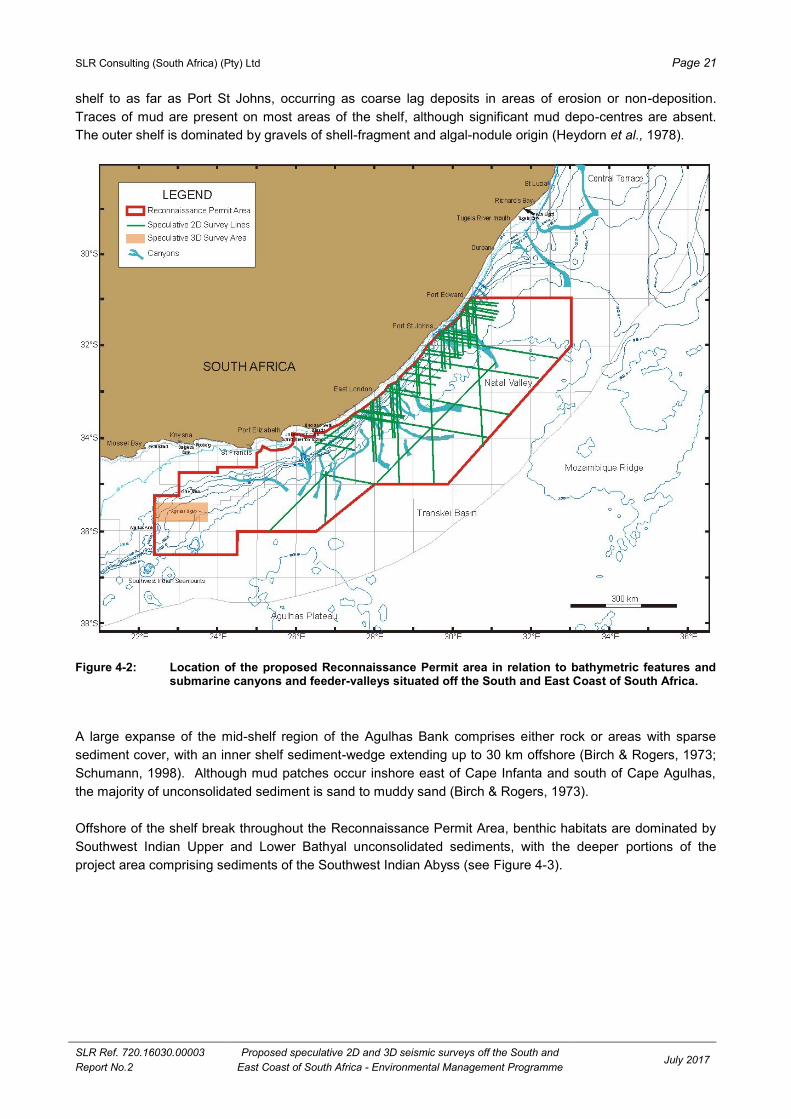
SLR Consulting (South Africa) (Pty) Ltd Page 21
SLR Ref. 720.16030.00003
Report No.2
Proposed speculative 2D and 3D seismic surveys off the South and
East Coast of South Africa - Environmental Management Programme July 2017
shelf to as far as Port St Johns, occurring as coarse lag deposits in areas of erosion or non-deposition.
Traces of mud are present on most areas of the shelf, although significant mud depo-centres are absent.
The outer shelf is dominated by gravels of shell-fragment and algal-nodule origin (Heydorn et al., 1978).
Figure 4-2: Location of the proposed Reconnaissance Permit area in relation to bathymetric features and submarine canyons and feeder-valleys situated off the South and East Coast of South Africa.
A large expanse of the mid-shelf region of the Agulhas Bank comprises either rock or areas with sparse
sediment cover, with an inner shelf sediment-wedge extending up to 30 km offshore (Birch & Rogers, 1973;
Schumann, 1998). Although mud patches occur inshore east of Cape Infanta and south of Cape Agulhas,
the majority of unconsolidated sediment is sand to muddy sand (Birch & Rogers, 1973).
Offshore of the shelf break throughout the Reconnaissance Permit Area, benthic habitats are dominated by
Southwest Indian Upper and Lower Bathyal unconsolidated sediments, with the deeper portions of the
project area comprising sediments of the Southwest Indian Abyss (see Figure 4-3).

SLR Consulting (South Africa) (Pty) Ltd Page 22
SLR Ref. 720.16030.00003
Report No.2
Proposed speculative 2D and 3D seismic surveys off the South and
East Coast of South Africa - Environmental Management Programme July 2017
Figure 4-3: The proposed Reconnaissance Permit area in relation to coastal and offshore benthic habitat types off the South and East Coast of South Africa (adapted from Sink et al. 2012).
4.3.2 WATER MASSES AND CIRCULATION
The oceanography off the South and East coast is almost totally dominated by the warm Agulhas Current
(see Figure 4-4). The current forms between 25° and 30° S, flowing southwards along the shelf edge of the
East Coast of southern Africa as part of the anticyclonic Indian Ocean gyre, before retroflecting between 16°
and 20° E (Schumann, 1998). It is a well-defined and intense jet some 100 km wide and 1 000 m deep
(Schumann, 1998), flowing in a south-west direction at a rapid rate, with current speeds of 2.5 m/sec or more
and water transport rates of over 60 × 106 m
3/sec have being recorded (Pearce et al., 1978; Gründlingh,
1980). Following its divergence into deep water off the Tugela Bank, the Agulhas Current re-attaches itself
to the coast, south of Durban where the continental shelf again narrows, until off Port Edward it is so close
inshore that the inshore edge (signified by a temperature front) is rarely discernible (Pearce, 1977). On the
eastern half of the South Coast, the Agulhas Current flows along the shelf break at speeds of up to 3 m/sec,
diverging inshore of the shelf break south of Still Bay (34° 28' S, 21° 26' E) before realigning to the shelf
break off Cape Agulhas (Heydorn & Tinley, 1980). The Agulhas Current may produce large meanders with
cross shelf dimensions of approximately 130 km, which move downstream at approximately 20 km per day.
It may also shed eddies, which travel at around 20 cm/sec and advect onto the Agulhas Bank (Swart &
Largier, 1987). After detaching from the shelf edge at 15° E, the Agulhas Current retroflects and flows
eastwards (Schumann, 1998).
Agulhas Inshore Hard Grounds
Agulhas Inshore Reef
Agulhas Mixed Sediment Inner Shelf
Agulhas Mixed Sediment Outer Shelf
Agulhas Outer Shelf Reef
Natal Canyon
Natal Muddy Inshore
Natal Muddy Shelf
Natal Muddy Shelf Edge
Natal Sandy Inshore
Natal Sandy Shelf
Natal Sandy Shelf Edge
Natal Gravel Shelf
Natal Gravel Shelf Edge
Natal Inshore Gravel
Southwest Indian Abyss
Southwest Indian Abyss with Ferro-Manganese Deposits
Southwest Indian Lower Bathyal
Southwest Indian Lower Bathyal with Ferro-Manganese Deposits
Southwest Indian Seamounts
Southwest Indian Upper Bathyal
Agulhas Canyon
Agulhas Sandy Inner shelf
Agulhas Sandy Inshore
Agulhas Sandy Outer Shelf
Agulhas Sandy Shelf Edge
Agulhas Shelf Edge Reef
Agulhas Gravel Inner Shelf
Agulhas Gravel Outer Shelf
Agulhas Gravel Shelf Edge
Agulhas Hard Inner Shelf
Agulhas Hard Outer Shelf
Agulhas Hard Shelf Edge
Agulhas Inner Shelf Reef
Agulhas Inshore Gravel

SLR Consulting (South Africa) (Pty) Ltd Page 23
SLR Ref. 720.16030.00003
Report No.2
Proposed speculative 2D and 3D seismic surveys off the South and
East Coast of South Africa - Environmental Management Programme July 2017
Figure 4-4: The predominance of the Agulhas Current in the oceanography of the proposed Reconnaissance Permit area (white outline).
Currents over the inner and mid-shelf (to depths of 160 m) are weak and variable, with velocities along the
eastern half of the South Coast ranging from 25 to 75 cm/sec midshelf and 10 to 40 cm/sec nearshore.
Eastward flow may occur close inshore (Boyd et al., 1992; Boyd & Shillington, 1994), being particularly
strong off Port Elizabeth. Bottom water shows a persistent westward movement, although short-term current
reversals may occur (Swart & Largier, 1987; Boyd & Shillington, 1994; CCA & CSIR, 1998).
As the Agulhas Current originates in the equatorial region of the western Indian Ocean its waters are
typically blue and clear, with low nutrient levels. The surface waters are a mix of Tropical Surface Water
(originating in the South Equatorial Current) and Subtropical Surface Water (originating from the mid-latitude
Indian Ocean). The surface waters of the Agulhas Current may be over 25º C in summer and 21º C in winter
and have lower salinities than the Equatorial Indian Ocean and South Indian Ocean Central water masses
found below. Surface water characteristics, however, vary due to insolation and mixing (Schumann, 1998).
South Indian Ocean Central Water of 14º C and a salinity of 35.3 ppt occurs below the surface water layers
at between 150 to 800 m depth. The deeper waters comprise, from shallowest to deepest, Antarctic
Intermediate Water, North Indian Deep Water, North Atlantic Deep Water and Antarctic Bottom Water. Sub-
tropical Surface Water of between 15 and 20º C often intrudes into the Agulhas Current at depths of 150 to
200 m from the east (Schumann, 1998).
Seasonal variation in temperatures is limited to the upper 50 m of the water column (Gründlingh, 1987),
increasing offshore towards the core waters of the Agulhas Current. South of Mbashe and East London, a
persistent wedge of cooler water is present over the continental shelf during summer (Beckley & Van
Ballegooyen, 1992), extending northwards to the southern KwaZulu-Natal coast in winter. This wedge is
typically cooler than 19° C, but may be cooler than 16° C between East London and Port Alfred, and south of

SLR Consulting (South Africa) (Pty) Ltd Page 24
SLR Ref. 720.16030.00003
Report No.2
Proposed speculative 2D and 3D seismic surveys off the South and
East Coast of South Africa - Environmental Management Programme July 2017
Mbashe. Inshore, waters are warmest during autumn, with warm water tongues found off Cape Recife (near
Port Elizabeth) from January to March and off Knysna from October to January and during August. Warm
water also tends to bulge towards Knysna between April and July and during September (Christensen,
1980).
Strong and persistent thermoclines are common over the shelf, extending inshore during the summer, but
breaking down during the cooler and windier winter conditions (Schumann & Beekman, 1984; Boyd &
Shillington, 1994). Thermoclines at the eastern edge of the South Coast are located at 20 to 40 m depth,
whereas they are deeper at the western edge (40 to 60 m) (Largier & Swart, 1987).
4.3.3 SWELLS AND WAVES
In the sea areas off Durban, the majority of swells are from the south and south-south-west, with the largest
attaining >7 m. During summer and autumn, some swells also arrive from the east. The less regular
weather patterns affecting the East Coast (e.g. low pressure cells present north-east of Durban, cut-off low
pressure cells and tropical cyclones) strongly influence the wave climate, resulting in swells in excess of
10 m (Hunter, 1988; Schumann, 1998). The giant waves (>20 m high) that are at times encountered within
the Agulhas Current (Heydorn & Tinley, 1980), arise from the meeting of the south-westerly swells and the
southerly flowing Agulhas Current.
On the South Coast, the majority of waves arrive from the south-west quadrant (Whitefield et al., 1983),
dominating wave patterns during winter and spring (Carter & Brownlie, 1990). Waves from this direction
frequently exceed 6 m (Swart & Serdyn 1981, 1982) and can reach up to 10 m (Heydorn, 1989). During
summer, easterly wind-generated ‘seas’ occur (Heydorn & Tinley, 1980; Heydorn, 1989; Carter & Brownlie,
1990).
4.3.4 TIDES
Tides are typically semi-diurnal along the South and East coasts with an average tidal range of between
0.5 m during neap tides and 1.5 to 2.0 m during springs (Schumann, 1988). The tidal range increases slightly
from west to east. Tides propagate from west to east along the South African coast eastwards of Cape Point,
so that high water is earlier in the west than east along the South Coast (Schumann, 1998).
Table 4.1: Tide data (m) for different sites along the South and East coasts (from SA Tide Tables, 1995 & 2009).
Site MLWS MLWN ML MHWN MHWS HAT
Mossel Bay 0.25 0.84 1.13 1.41 2.00 2.42
Knysna 0.36 0.90 1.16 1.43 1.96 2.31
Port Elizabeth 0.29 0.84 1.09 1.35 1.90 2.35
Durban 0.27 0.97 1.20 1.48 2.11 2.47
MLWS - Mean low water spring MHWN - Mean high water neap
MLWN - Mean low water neap MHWS - Mean high water spring
ML - Mean level HAT - Highest astronomical tide
4.3.5 UPWELLING
Wind-driven upwelling occurs inshore along the South Coast, especially during summer when easterly winds
prevail (Schumann et al., 1982; Walker, 1986; Schumann, 1998). Such upwelling usually begins at the
prominent capes and progresses westwards (Schumann et al., 1982; Schumann, 1988). Marked changes in

SLR Consulting (South Africa) (Pty) Ltd Page 25
SLR Ref. 720.16030.00003
Report No.2
Proposed speculative 2D and 3D seismic surveys off the South and
East Coast of South Africa - Environmental Management Programme July 2017
sea surface temperatures (up to 8°C) have been reported within a few hours during such upwelling
(Hutchings, 1994).
Intensive upwelling of Indian Ocean Central Water occurs periodically over the shelf and shelf edge along
the inner boundary of the Agulhas Current (Schumann, 1998) (see Figure 4-5). Such upwelling is generally
as a result of frictional interactions between the Agulhas Current and bottom topography (Hutchings, 1994).
This shelf edge upwelling largely defines the strong thermocline topography of the Agulhas Bank region.
Cold water, upwelled over the shelf edge, forms the basal layer on the shelf, while intrusive plumes of more
saline surface water replenish the warm mixed water at the surface, resulting in intensive thermo- and
haloclines. These dominate in summer and are broken down through turbulence in winter.
A cool ridge of upwelled water (evident in a shallow thermocline) extends in a north-east/south-west line over
the mid-shelf regions inshore of the Agulhas Current (Swart and Largier, 1987; Boyd & Shillington, 1994;
Schumann, 1998). This ridge divides the waters of the Agulhas Bank into the two-layered structure in the
inshore region and a partially mixed structure in the eastern offshore region (Schumann, 1998).
Figure 4-5: Areas of upwelling off the South and East coasts. Redrawn from Dingle et al. (1987).
4.3.6 TURBIDITY
Natural turbidity and/or suspended sediment concentration measurements from the South and East coasts
are sparse. Suspended sediment distributions within South African nearshore waters range between 5 mg/l
to 5 g/l (Zoutendyk, 1985). The higher values are associated with high wave conditions resulting from storms
and/or flood-waters as substantial sediment loads are also deposited into the East Coast marine
environment by summer river run-off (Flemming and Hay, 1988).
4.3.7 NUTRIENT DISTRIBUTION
Nitrate-nitrogen concentrations in Agulhas Current source water range from 7 to 10 M/l, while those of sub-
thermocline water may be up to 20 M/l (Carter et al., 1987). Primary production is nitrogen-limited in the

SLR Consulting (South Africa) (Pty) Ltd Page 26
SLR Ref. 720.16030.00003
Report No.2
Proposed speculative 2D and 3D seismic surveys off the South and
East Coast of South Africa - Environmental Management Programme July 2017
upper layers of the euphotic zone, but light-limited in the sub-surface chlorophyll maximum layer (Probyn and
Lucas, 1987). During winter, when the water column is well mixed, bottom nutrients mix upwards and nutrient
concentrations in the surface waters are higher than in summer (CSIR and CCA, 1998).
The tropical surface waters of the East Coast of South Africa are typically nutrient poor. Surface values along
the East Coast of South Africa range between 0.3 and 0.83 mol/l. However, regions of high nutrient content
are closely associated with local variations in the Agulhas Current flow. One area rich in nutrients is the
upwelling cell of St Lucia, where colder, more saline and nutrient-rich subtropical surface water is upwelled
onto the shelf near Richards Bay. There is a steady decrease in concentrations with distance southwards,
terminating more or less at the boundary between the upwelling cell and the waters of the Natal Bight. The
other potential source for nutrients is the inflow from the many rivers that drain this coastline such as the
Tugela River, which has been known to enhance the nitrate-nitrogen relationship by 1µM. Seasonal variation
in nutrient concentrations along this coastline are weak. The main driver of nutrients onto the shelf is through
interaction with the Agulhas Current. Except for the Natal Pulse which results in an extensive offshore
meander, the path and flow rate of the current is incredibly stable.
Correlating to the high levels of nutrients found in the St Lucia upwelling cell are increased levels of
chlorophyll-a ranging between 1.2 mg/m3 and 1.5 mg/m
3. One may, therefore, conclude that this upwelling
cell is predominantly active throughout the year and has a notable impact on the primary productivity and
therefore probably on the ecology of a substantial part of the Natal Bight as a whole.
BIOLOGICAL OCEANOGRAPHY 4.4
4.4.1 INTRODUCTION
South Africa is divided into nine bioregions. The proposed Reconnaissance Permit Area falls into three of
these, namely Agulhas, Indo-Pacific Offshore and West Indian Offshore (see Figure 4-6) (Lombard et al.
2004).
The South African National Biodiversity Institute (SANBI) has initiated a process to identify potential benthic
priority areas for spatial management in the offshore environment that require protection (Sink, et. al., 2012).
The ecosystem threat status of the benthic habitat types and the offshore pelagic habitat types along most of
the East Coast, and within in the proposed project area have been rated as ‘least threatened’ reflecting the
great extent of these habitats within the South African Exclusive Economic Zone (EEZ) (Sink et al. 2012)
(Figure 4-7).
Communities within the offshore marine habitat are comparatively homogenous, largely as a result of the
greater consistency in water temperature at depths around the South African coastline, than in the shallower
coastal waters. The biological communities occurring in the proposed Reconnaissance Permit area consist of
many hundreds of species, often displaying considerable temporal and spatial variability (even at small
scales). The deep-water marine ecosystems comprise a limited range of habitats, namely unconsolidated
seabed sediments, deep-water reefs and the water column. The biological communities ‘typical’ of these
habitats are described briefly below, focussing both on dominant, commercially important and conspicuous
species, as well as potentially threatened species.

SLR Consulting (South Africa) (Pty) Ltd Page 27
SLR Ref. 720.16030.00003
Report No.2
Proposed speculative 2D and 3D seismic surveys off the South and
East Coast of South Africa - Environmental Management Programme July 2017
Figure 4-6: The proposed Reconnaissance Permit area (red outline) in relation to the inshore and offshore
bioregions of South Africa (adapted from Lombard et al., 2004).
Figure 4-7: The proposed Reconnaissance Permit area (red polygon) in relation to the ecosystem threat
status for coastal and offshore benthic habitat types (adapted from Sink et al. 2012).
4.4.2 OFFSHORE REGION
4.4.2.1 Plankton
(a) Phytoplankton
The nutrient-poor characteristics of the Agulhas Current water are reflected in comparatively low primary
productivity on the continental shelf inshore throughout most of the proposed project area with mean
chlorophyll a concentrations of 1.46 mg/m3 in the top 30 m of the water column in inshore areas (<200 m

SLR Consulting (South Africa) (Pty) Ltd Page 28
SLR Ref. 720.16030.00003
Report No.2
Proposed speculative 2D and 3D seismic surveys off the South and
East Coast of South Africa - Environmental Management Programme July 2017
depth) dropping to 1.00 mg/m3 further offshore (200 m to 500 m depth) (Brown et al., 1991; Brown, 1992).
Chlorophyll a concentrations vary seasonally, being minimal in winter and summer (<1 to 2 mg/m3) and
maximal (2 to 4 mg/m3) in spring and autumn (Brown, 1992). Lower concentrations are partly due to nutrient
limitation due to the strong summer thermoclines or light limitations due to deep mixing in winter (Probyn et
al., 1994), but if the thermocline falls within the 1% light depth, phytoplankton biomass can increase
dramatically, with sub-surface chlorophyll concentration maxima often being in excess of 10 mg/m3 (Carter et
al., 1987; Hutchings, 1994). Chlorophyll concentrations can also be high where upwelling occurs at the coast
(Probyn et al., 1994). Along the eastern half of the South Coast, phytoplankton concentrations are usually
higher than further west and the phytoplankton comprises predominantly large cells (Hutchings, 1994).
Primary productivity in inshore areas along the KwaZulu-Natal coast are similarly low, with chlorophyll a
concentrations ranging between 0.03 and 3.88 µg/l (Carter & Schleyer, 1988).
(b) Zooplankton
Zooplankton and ichthyoplankton abundances in the proposed project area will reflect localised areas of
higher primary productivity. On the East Coast, continental shelf waters support greater and more variable
concentrations of zooplankton biomass than offshore waters (Beckley & Van Ballegooyen 1992), with
species composition varying seasonally (Carter & Schleyer 1988). Copepods represent the dominant species
group (Carter & Schleyer 1988), but chaetognaths are also abundant (Schleyer 1985). On the South Coast
zooplankton communities have comparatively high species diversity (De Decker, 1984), with standing stocks
along the eastern half of the South Coast ranging from 3 – 6 gC/m2. The South Coast mesozooplankton
(>200 μm) is dominated by the calanoid copepod Calanus aghulensis, which associates with shallow
thermoclines and the mid-shelf cool water ridge (Verheye et al., 1994). This species may contribute up to
85% of copepod biomass in the region and is an important food source for pelagic fishes (Peterson et al.,
1992). Biomass of mesozooplankton increases from west (~0.5 to ~1.0 gC/m2) to east
(~1.0 to ~2.0 gC/m2), mirroring the eastward increase in chlorophyll a concentrations, peaking on the central
and eastern Agulhas Bank during summer in association with the subsurface ridge of cool upwelled water.
Macrozooplankton (>1600 μm) standing stocks are estimated to be 0.079 gC/m2 between Cape Agulhas and
Cape Recife (Verheye, unpublished data). Dense swarms of euphausiids dominate this zooplankton
component and form an important food source for pelagic fishes (Cornew et al., 1992; Verheye et al., 1994).
(c) Ichthyoplankton
A variety of pelagic fish species, including anchovy, round herring and horse mackerel, spawn east of Cape
Agulhas between the shelf-edge upwelling and the cold-water ridge (Hutchings et al. 2002) (see Figure 4-8).
The eggs and larvae spawned in this area are thought to largely remain on the Agulhas Bank, although
some may be carried to the West Coast or be lost to the Agulhas Current retroflection (Hutchings, 1994;
Duncombe Rae et al., 1992). Pilchards also spawn on the Agulhas Bank (Crawford, 1980), with adults
moving eastwards and northwards after spawning. Round herring are also reported to spawn along the
South Coast (Roel & Armstrong, 1991). Demersal species that spawn along the South Coast include the
cape hake and kingklip, the latter spawning off the shelf edge to the south of St Francis and Algoa Bays
(Shelton, 1986; Hutchings, 1994) (Figure 4.8). Squid (Loligo spp.) spawn principally in the inshore waters
(<50 m) between Knysna and Port Elizabeth, with larvae and juveniles spreading westwards. Their
distribution and abundance is highly erratic and linked to temperature, turbidity, and currents (Augustyn et al.
1994).
The inshore area of the Agulhas Bank, especially between the cool water ridge and the shore, serve as an
important nursery area for numerous linefish species (e.g. dusky kob Argyrosomus japonica, elf Pomatomus
saltatrix, seventy-four Polysteganus undulosus, steenbras Petrus rupestrus, black musselcracker
Cymatoceps nasutus, leervis Lichia amia, white musselcracker Sparodon durbanensis, silverbream
Rhabdosargus holubi, strepie Sarpa salpa, geelbek Atractoscion aequidens, carpenter Argyrozona

SLR Consulting (South Africa) (Pty) Ltd Page 29
SLR Ref. 720.16030.00003
Report No.2
Proposed speculative 2D and 3D seismic surveys off the South and
East Coast of South Africa - Environmental Management Programme July 2017
argyrozona and garrick Lichia amia) (Wallace et al. 1984; Smale et al. 1994). Adults undertake spawning
migrations along the South Coast into KwaZulu-Natal waters during the winter months (Beckley & van
Ballegooyen 1992). Following spawning during spring and summer (November to April), the eggs and larvae
are dispersed southwards by the Agulhas Current, with juveniles occurring on the inshore Agulhas Bank
(Van der Elst 1976, 1981; Garret 1988). In the case of the carpenter, a high proportion of the reproductive
output comes from the central Agulhas Bank and the Tsitsikamma Marine Protected Area (MPA) Section of
the Garden Route National Park, and two separate nursery grounds appear to exist, one near Port Elizabeth
and a second off the deep reefs off Cape Agulhas, with older fish spreading eastwards and westwards (van
der Lingen et al. 2006).
Figure 4-8: The proposed Reconnaissance Permit area in relation to important fishing banks, pelagic and demersal fish and squid spawning areas (after Anders, 1975, Crawford et al., 1987, Hutchings, 1994). The 200 m depth contour is also shown.
The Tugela Banks, as well as the many estuaries along the KwaZulu-Natal coastline, are similarly used as a
nursery area by numerous fish species (e.g. squaretail kob and various sciaenids, such as snapper, sin
croaker and beareded croaker) due to suitable food sources and protection from predators in the turbid water
(Fennesy 1994).
The inshore portions of the project area thus overlap with major fish spawning and migration routes, and
ichthyoplankton abundance in inshore waters over the continental shelf (<200 m) is likely to be seasonally
high. Larval concentrations vary between 0.005 and 4.576 larvae/m3 decreasing rapidly with distance
offshore (Beckley & Van Ballegooyen 1992). In the offshore portion of the project area, ichthyoplankton
abundance is, however, expected to be low.

SLR Consulting (South Africa) (Pty) Ltd Page 30
SLR Ref. 720.16030.00003
Report No.2
Proposed speculative 2D and 3D seismic surveys off the South and
East Coast of South Africa - Environmental Management Programme July 2017
4.4.2.2 Invertebrates
The benthic biota of offshore soft bottom substrates constitutes invertebrates that live on (epifauna) or
burrow within (infauna) the sediments and are generally divided into megafauna (animals >10 mm),
macrofauna (>1 mm) and meiofauna (<1 mm). The structure and composition of benthic soft-bottom
communities is primarily a function of abiotic factors such as water depth and sediment grain size, but others
such as current velocity and organic content abundance also play a role (Snelgrove & Butman, 1994; Flach
& Thomsen, 1998; Ellingsen, 2002). Further shaping is derived from biotic factors such as predation, food
availability, larval recruitment and reproductive success. The high spatial and temporal variability for these
factors results in seabed communities being both patchy and variable. In nearshore waters where sediment
composition is naturally patchy, and significant sediment movement may be induced by the dynamic wave
and current regimes (Fleming & Hay 1988), the benthic macrofauna are typically adapted to frequent
disturbance. In contrast, further offshore where near-bottom conditions are more stable, the macrofaunal
communities will primarily be determined by sediment characteristics and depth.
Due to the lack of information on benthic macrofaunal communities beyond the shelf break, no description
can be provided for the proposed Reconnaissance Permit area. However, with little sea floor topography
and hard substrate, such areas are likely to offer minimal habitat diversity or niches for animals to occupy.
Detritus-feeding crustaceans, holothurians and echinoderms tend to be the dominant epi-benthic organisms
of such habitats.
Deep-water crustaceans that may occur in the proposed Reconnaissance Permit area are the shovel-nosed
crayfish (Scyllarides elisabethae) and the deep-water rock lobster (Palinurus gilchristi). The shovel-nosed
crayfish primarily occurs on gravelly seabed at depths of around 150 m, although it is sometimes found in
shallower water, with a distribution range extending from Cape Point to Maputo. The deep-water rock lobster
occurs on rocky substrate in depths of 90 - 170 m between Cape Agulhas and southern KwaZulu-Natal.
Larvae drift southwards in the Agulhas Current, settling in the south of the Agulhas Bank before migrating
northwards again against the current to the adult grounds (Branch et al. 2010). Other rock lobster species
occurring on the east coast include the East Coast rock lobster (Palinurus homarus) and the painted spiny
lobster (Palinurus versicolor), both of which, however, are typically associated with shallow-water reefs
(Branch et al. 2010).
Information on invertebrates occurring beyond 30 m along the South Coast is sparse. The squid (Loligo
vulgaris reynaudii) occurs extensively on the Agulhas Bank out to the shelf edge (500 m depth contour)
increasing in abundance towards the eastern boundary of the South Coast, especially between Plettenberg
Bay and Algoa Bay (Augustyn 1990; Sauer et al. 1992; Augustyn et al. 1994). Adults are normally
distributed in waters >100 m, except along the eastern half of the South Coast where they also occur
inshore, forming dense spawning aggregations at depths between 20 - 130 m (Augusty 1990; Downey
2014). The most important spawning grounds are between Plettenberg Bay and Algoa Bay (Augustyn
1990), these having been linked to specific spawning habitat requirements (Roberts & Sauer 1994; Roberts
2005). Spawning aggregations are a seasonal occurrence, reaching a peak between September and
December (Augustyn et al. 1992). Eggs are typically laid on sand and low relief reefs in large and sheltered
bays, with environmental conditions playing an important role in the migration of the adults into the spawning
areas. Following passive and active planktonic phases, juveniles move offshore, dispersing over the shelf
over the full range of their distribution (southern Namibia to East London), eventually returning as adults to
their spawning grounds (Augustyn et al. 1992).
Other rock lobster species typically associated with shallow-water reefs on the South Coast include the West
Coast rock lobster (Jasus lalandii), Long-legged spiny lobster (Panulirus longipes), and the ornate spiny
lobster (Panulirus ornatus), although the West Coast lobster has been recorded at depths of 120 m (Branch
et al. 2010).

SLR Consulting (South Africa) (Pty) Ltd Page 31
SLR Ref. 720.16030.00003
Report No.2
Proposed speculative 2D and 3D seismic surveys off the South and
East Coast of South Africa - Environmental Management Programme July 2017
Pelagic invertebrates that may be encountered in the proposed Reconnaissance Permit area are the
colossal squid Mesonychoteuthis hamiltoni and the giant squid Architeuthis sp. Both are deep dwelling
species, with the colossal squid’s distribution confined to the entire circum-antarctic Southern Ocean, while
the giant squid is usually found near continental and island slopes all around the world’s oceans. Both
species could thus potentially occur in the project area, although the likelihood of encounter is extremely low.
Growing to in excess of 10 m in length, they are the principal prey of the sperm whale, and are also taken by
beaked whaled, pilot whales, elephant seals and sleeper sharks. Nothing is known of their vertical
distribution, but data from trawled specimens and sperm whale diving behaviour suggest they may span a
depth range of 300 – 1,000 m. They lack gas-filled swim bladders and maintain neutral buoyancy through an
ammonium chloride solution occurring throughout their bodies.
4.4.2.3 Reef Communities
The subtidal shallow reefs of the East Coast range from rich, coral-encrusted sandstone reefs in the north to
the more temperate rocky reefs further south. The proposed Reconnaissance Permit area is located south
of the Maputaland Coral Reef system which extends from Kosi Bay to Leven Point. South of the
iSimangaliso Wetland Park (St Lucia) reef habitat is provided by rock outcrops, although both hard and soft
corals still occur. Both reef types are characterised by diverse invertebrate and ichthyofaunal biota of Indo-
Pacific origin. The invertebrate benthic communities associated with hard substrata boast a high diversity of
hard and soft corals, sponges, tunicates and bivalve molluscs. Mobile benthic organisms associated with the
reefs include a wide variety of echinoderms (urchins, starfish and sea cucumbers), gastropod molluscs and
crustaceans. The coral reef habitat also provides shelter and a food source for the highly diverse Indo-
Pacific reef fish community.
Both the coral-dominated reefs off Sodwana Bay and the sandstone reefs off Durban and the KwaZulu-Natal
South Coast (both to the north of the proposed Reconnaissance Permit area) are popular amongst divers for
their wealth of invertebrate and fish diversity. Along the East Coast south of Port St Johns, the intertidal and
shallow subtidal reefs support a wide diversity of marine flora and fauna and a relatively high percentage of
endemic species (Turpie et al. 2000, Awad et al. 2002). However, information about benthic reef
communities and hard grounds is limited to descriptions of reef ecosystems in the Pondoland area (Celliers
et al. 2007), and the Goukamma area between Knysna and Mossel Bay (Götz et al. 2009).
The nearshore reefs of the Pondoland coast shelter a mix of subtropical and warm-temperate fauna that
manifest both a latitudinal and longitudinal shift in benthic composition over a relatively short distance. There
is a change from low-diversity macroalgae dominated communities on the shallow high-profile reefs in the
north to high-diversity communities dominated by sponges, ascidians and bryozoans, on low-profile deeper
reefs and reefs to the south. The shallow-water algae-dominated habitats also harbour hard corals
(Stylophora pistillata), with wave action strongly influencing the community structure. The shift from a habitat
defined primarily by phototropism to a benthic community dominated by suspension-feeders is probably
driven by higher sediment loads and the greater availability of nutrients coming from the numerous rivers
along this portion of the coast. The reduction in available light with depth similarly allows non-phototrophic
species to compete with algae for space on the reef.
Inshore of the south-western portion of the proposed Reconnaissance Permit area, at depths between 5 m
and 30 m, lie the Agulhas Inshore Reef and Agulhas Inshore Hard Ground benthic habitats, identified by
Sink et al. (2012a) as ‘Critically endangered - Moderately protected’, and ‘Vulnerable - Moderately protected’,
respectively. These reefs and hard grounds extend from the Mbashe River (east of East London) to Cape
Point (see Figure 4-9). The reefs are considered to be warm temperate reefs, which have a more
heterogeneous community structure when compared with those in the Southwestern Cape and KwaZulu-
Natal inshore regions.

SLR Consulting (South Africa) (Pty) Ltd Page 32
SLR Ref. 720.16030.00003
Report No.2
Proposed speculative 2D and 3D seismic surveys off the South and
East Coast of South Africa - Environmental Management Programme July 2017
In the Port Elizabeth area, reefs to approximately 30 m depth also show relatively distinct changes in
community structure, being characterised by diverse reef assemblages dominated by cauliflower soft coral
(Sink et al. 2011). Further south off Goukamma, the reefs are characterised by equally distributed high and
low profile areas. The benthic taxa were dominated by bryozoans and sponges (22.9% and 21.1%
respectively), followed by gorgonians (16.4%), ascidians (13.7%) and algae (10.1%). Crinoids (8.4%) and
hydrozoans (7.5%) constituted <10% of the overall occurrence. Community composition in this area was
found to be strongly affected by linefishing, with higher abundance of algae and crinoids at fished sites, and
higher sponge cover on reefs within the Goukamma MPA.
In recent years there has also been increasing interest in deep-water corals and sponges because of their
likely sensitivity to disturbance and their long generation times. These benthic filter-feeders generally occur
at depths exceeding 150 m. Some coral species form reefs while others are smaller and remain solitary.
Corals and sponges add structural complexity to otherwise uniform seabed habitats thereby creating areas of
high biological diversity (Breeze et al., 1997; MacIssac et al., 2001). Their frameworks offer refugia for a
great variety of invertebrates and fish (including commercially important species) within or in association with
the living and dead frameworks. The Agulhas Bank hosts a diversity of deep-water corals and sponges
(Plate 4.1a & b), that have establish themselves below the thermocline where there is a continuous and
regular supply of concentrated particulate organic matter, caused by the flow of a relatively strong current.
Substantial shelf areas should thus potentially be capable of supporting rich, deep-water benthic, filter-
feeding communities.
Figure 4-9: The proposed Reconnaissance Permit area in relation to the Agulhas Inshore Reef and Hard Ground habitat types in relation to the southern portion of the project area (adapted from Sink et al. 2012a).

SLR Consulting (South Africa) (Pty) Ltd Page 33
SLR Ref. 720.16030.00003
Report No.2
Proposed speculative 2D and 3D seismic surveys off the South and
East Coast of South Africa - Environmental Management Programme July 2017
Plate 4.1: Offshore benthic communities occurring on reefs on the central Agulhas Bank include
protected cold water porcelain coral Allopora nobilis, sponges, crinoids and bryozoans (a),
whereas a variety of habitat-forming sponges, colonial ascidians and hydroids occur on sandy
seabed (b). (Photos: Andrew Penney).
4.4.2.4 Fishes
The ichthyofauna on the South and East coasts is diverse, comprising a mixture of temperate and tropical
species. As a transition zone between the Agulhas and Benguela current systems, the South Coast
ichthyofauna includes many species occurring also along the West and/or East coasts. The seabed of the
Agulhas Bank substrate is also diverse comprising areas of sand, mud and coral thereby contributing to
increased benthic fauna and fish species. Marine fish can generally be divided in three different groups,
pelagic (those species associated with water column), demersal (those associated with the substratum) or
meso-pelagic (fish found generally in deeper water and may be associated with both the seafloor and the
pelagic environment). Pelagic species include two major groups, the planktivorous clupeid-like fishes such as
anchovy or pilchard and piscivorous predatory fish. Demersal fish can be grouped according to the
substratum with which they are associated, for example rocky reef or soft substrata. It must be noted that
such divisions are generally simplistic, as certain species associate with more than one community.
(a) Pelagic species
Small pelagic shoaling species occurring along the South Coast include anchovy (Engraulis encrasicolus),
pilchard (Sardinops sagax), round herring (Etrumeus japonicas), chub mackerel (Scomber japonicas) and
horse mackerel (Trachurus trachurus capensis). Anchovies are usually located between the cool upwelling
ridge and the Agulhas Current (Hutchings, 1994) and are larger than those of the West Coast. Having
spawned spawn intensively in an area around the 200 m depth contour between Mossel Bay and
Plettenberg Bay between October and January, most adults move inshore and eastwards ahead of warm
Agulhas Current water. The Agulhas Bank area is, however, is not considered an important anchovy
recruitment ground (Hampton, 1992). Round herring juveniles similarly occur inshore along the South Coast,
but move offshore with age (Roel et al., 1994; Hutchings, 1994).
Pilchards are typically found in water between 14°C and 20°C. Spawning occurs on the Agulhas Bank during
spring and summer (Crawford, 1980), with recruits being found inshore along the South Coast (Hutchings,
1994). It is thought that the Agulhas Bank may be a refuge for pilchard under low population levels and,
therefore, vital for the persistence of the species (CCA & CSIR, 1998). During the winter months of June to
August, the penetration of northerly-flowing cooler water along the Eastern Cape coast and up to southern
KwaZulu-Natal effectively expands the suitable habitat available for this species, resulting in the movement
of large shoals northwards along the coast in what has traditionally been known as the ‘sardine run’. The
b) a)

SLR Consulting (South Africa) (Pty) Ltd Page 34
SLR Ref. 720.16030.00003
Report No.2
Proposed speculative 2D and 3D seismic surveys off the South and
East Coast of South Africa - Environmental Management Programme July 2017
shoals can attain lengths of 20 to 30 km and are typically pursued by Great White Sharks, Copper Sharks,
Common Dolphins, Cape Gannets and various other large pelagic predators (www.sardinerun.co.za). Catch
rates of several important species in the recreational shoreline fishery of KwaZulu-Natal have been shown to
be associated with the timing of the sardine run (Fennessey et al., 2010). Other pelagic species that migrate
along the coast include elf (Pomatomus saltatrix), geelbek (Atractoscion aequidens), yellowtail (Seriola
lalandi), kob (Argyrosomus sp) seventy-four (Cymatoceps nasutus), strepie (Sarpa salpa), Cape stumpnose
(Rhabdosargus holubi) and mackerel (Scomber japonicus), which are all regular spawners within KwaZulu-
Natal waters (Van der Elst, 1988).
The fish most likely to be encountered on the shelf, beyond the shelf break and in the offshore waters of the
proposed Reconnaissance Permit area are the large migratory pelagic species, including various tunas,
billfish and sharks (Van der Elst 1988; Smale et al. 1994), many of which are considered threatened by the
International Union for the Conservation of Nature (IUCN), primarily due to overfishing (see Table 4.2).
The great white shark Carcharodon carcharias is a significant apex predator in the Algoa Bay area,
particularly in the vicinity of the seal colony at Black Rocks. Although not necessarily threatened with
extinction, great whites are listed in Appendix II (species in which trade must be controlled in order to avoid
utilization incompatible with their survival) of Convention on International Trade in Endangered Species
(CITES) and is described as ‘vulnerable’. Great White sharks migrate along the entire South African coast,
typically being present at seal colonies during the winter months, but moving nearshore during summer
(Johnson et al. 2009). Recent research at Mossel Bay into the residency patterns revealed that male sharks
display low site fidelity, often rapidly moving in an out of the area. Females in contrast, display high site
fidelity and may remain resident in the area for up to two months (Koch & Johnson 2006). Great white
sharks are, however, capable of transoceanic migrations (Pardini et al. 2001; Bonfil et al. 2005; Koch &
Johnson 2006), with recent electronic tag data suggesting links between widely separated populations in
South Africa and Australia and possible natal homing behaviour in the species. Although during
transoceanic migrations they appear to spend most of the time just below the sea surface, frequent deep
dives to a much as 980 m are made whilst en route. Long-distance return migrations along the South African
coast are also frequently undertaken, particularly by immature individuals (Bonfil et al. 2005). These coastal
migrations, which are thought to represent feeding-related events, traverse the proposed Reconnaissance
Permit area.
Table 4.2: Some of the more important large migratory pelagic fish likely to occur in the offshore regions of the South and East Coasts.
Common Name Species IUCN Conservation Status
Tunas
Southern Bluefin Tuna Thunnus maccoyii Critically Endangered
Bigeye Tuna Thunnus obesus Vulnerable
Longfin Tuna/Albacore Thunnus alalunga Near Threatened
Yellowfin Tuna Thunnus albacares Near Threatened
Frigate Tuna Auxis thazard Least concern
Eastern Little Tuna/Kawakawa Euthynnus affinis Least concern
Skipjack Tuna Katsuwonus pelamis Least concern
Billfish
Blue Marlin Makaira nigricans Vulnerable
Striped Marlin Kajikia audax Near Threatened
Sailfish Istiophorus platypterus Least concern
Swordfish Xiphias gladius Least concern
Black Marlin Istiompax indica Data deficient

SLR Consulting (South Africa) (Pty) Ltd Page 35
SLR Ref. 720.16030.00003
Report No.2
Proposed speculative 2D and 3D seismic surveys off the South and
East Coast of South Africa - Environmental Management Programme July 2017
Common Name Species IUCN Conservation Status
Pelagic Sharks
Great Hammerhead Shark Sphyrna mokarran Endangered
Smooth Hammerhead shark Sphyrna zygaena Vulnerable
Pelagic Thresher Shark Alopias pelagicus Vulnerable
Bigeye Thresher Shark Alopias superciliosus Vulnerable
Common Thresher Shark Alopias vulpinus Vulnerable
Dusky Shark Carcharhinus obscurus Vulnerable
Great White Shark Carcharodon carcharias Vulnerable
Shortfin Mako Isurus oxyrinchus Vulnerable
Longfin Mako Isurus paucus Vulnerable
Whale Shark Rhincodon typus Vulnerable
Blue Shark Prionace glauca Near Threatened
(b) Demersal species
There is a high diversity of Teleosts (bony fish) and Chondrichthyans (cartilaginous fish) associated with the
inshore and shelf waters of the South and East coasts, many of which are endemic to the Southern African
coastline and form an important component of the demersal trawl and long-line fisheries.
The Cape hake (Merluccius capensis) is distributed widely on the Agulhas Bank, while the deep-water hake
(Merluccius paradoxus) is found further offshore in deeper water (Boyd et al., 1992; Hutchings, 1994).
Juveniles of both species occur throughout the water column in shallower water than the adults. Kingklip
(Genypterus capensis) is also an important demersal species, with adults distributed in deeper waters along
the whole of the South Coast, especially on rocky substrate (Japp et al., 1994). They are reported to spawn
in an isolated area beyond the 200 m isobaths between Cape St Francis and Port Elizabeth during spring
(see Figure 4.8). Juveniles occur further inshore. The Agulhas or East Coast sole (Austroglossus pectoralis)
inhabits inshore muddy seabed (<125 m) on the shelf between Cape Agulhas and Algoa Bay (Boyd et al.,
1992). Apart from the above-mentioned target species, numerous other by-catch species are landed by the
South Coast demersal trawling fishery including panga (Pterogymnus laniarius), kob (Argyrosomus
hololepidotus), gurnard (Chelidonichthyes spp.), monkfish (Lophius sp.), John Dory (Zeus capensis) and
angel fish (Brama brama).
The shallower inshore areas (<100 m) along the South and East coasts comprise a varied habitat of rocky
reefs and soft-bottom substrates, which support a high diversity of endemic sparid and other teleost species
(Smale et al., 1994), some of which move into inshore protected bays to spawn (Buxton, 1990) or undertake
spawning migrations up the coast to KwaZulu-Natal. Those species that undertake migrations along the
South and East coasts include red steenbras, white steenbras (summer), kob, geelbek and elf (winter).
Spawning of the majority of species endemic to the area occurs in spring and summer. Many of these
species form an important component of the commercial and recreational linefishery (see Table 4.2).
Furthermore, there are numerous pelagic species that frequent nearshore waters and are targeted by line-
fishermen.
A wide variety of chondrichthyans occur in nearshore waters of the South Coast, some of which, such as St
Joseph shark (Callorhincus capensis), soupfin shark (Galeorhinus galeus) and biscuit skate (Raja straeleni),
are also landed by the trawl and line fishery.

SLR Consulting (South Africa) (Pty) Ltd Page 36
SLR Ref. 720.16030.00003
Report No.2
Proposed speculative 2D and 3D seismic surveys off the South and
East Coast of South Africa - Environmental Management Programme July 2017
4.4.2.5 Turtles
Five species of turtle occur along the South and East Coast, namely:
Green (Chelonia mydas): The green turtle is listed as “Endangered” in the IUCN Red Data listing. It is
a non-breeding resident in northern KwaZulu-Natal, with the nearest breeding grounds are on the
islands of Europa and Tromelin (well to the north of the Reconnaissance Permit Area) in the Mozambique
Channel.
Leatherback (Dermochelys coriacea): The leatherback is described as “Critically Endangered”.
Leatherback turtles inhabit the deeper waters of the Atlantic Ocean and are considered a pelagic
species. They travel the ocean currents in search of their prey (primarily jellyfish) and may dive to over
100 m and remain submerged for up to 54 minutes (Hays et al., 2004; Lambardi et al., 2008). They
come into coastal bays and estuaries to mate, and lay their eggs on the adjacent beaches.
Loggerhead (Caretta caretta): The loggerhead is listed as “Vulnerable”. Loggerheads tend to keep
more inshore, hunting around reefs, bays and rocky estuaries along the African East Coast, where
they feed on a variety of benthic fauna including crabs, shrimp, sponges, and fish. In the open sea
their diet includes jellyfish, flying fish, and squid (www.oceansafrica.com/turtles.htm).
Olive Ridley (Lepidochelys olivacea): Olive Ridley is listed as “Vulnerable”. The Olive Ridley turtle is
rare in South African East Coast waters occurring as occasional strays.
Hawksbill turtle (Eretmochelys imbricata): Hawksbill is described as “Critically Endangered”. The
hawksbill turtle occurs only as a visitor to the South African East Coast as it breeds in Madagascar and
Mauritius.
Both the leatherback and the loggerhead turtles nest on the beaches of the northern KwaZulu-Natal
coastline (and thus over 300 km to the north of the proposed Reconnaissance Permit area) between October
and February, extending into March. During the breeding season the turtles concentrate in nearshore areas,
north of Cape Vidal to mate, before the females emerge on the beaches to lay their eggs. Hatchlings are
born from late January through to March when the Agulhas Current is warmest. Once hatchlings enter the
sea, they drift southward in the Agulhas Current (Hughes, 1989) and may therefore be encountered in the
inshore portions of the project area and therefore overlapping the proposed 2D and 3D survey areas.
After approximately 10 years, juvenile loggerheads return to coastal areas to feed on crustaceans, fish and
molluscs and subsequently remain in these neritic habitats (Hughes 1974b). In contrast, leatherbacks
remain in pelagic waters until they become sexually mature and return to coastal regions to breed.
Loggerheads reach sexual maturity at about 36 years of age whereas leatherbacks reach maturity at 15
years (Tucek et al. Submitted). It has been estimated that only 1 to 5 hatchlings survive to adulthood
(Hughes 1974b; de Wet 2013).
Sea turtles are highly migratory and travel extensively throughout their entire life cycle. Adult turtles migrate
thousands of kilometres between foraging and breeding grounds, returning to their natal beaches (Hughes
1996; Papi et al. 2000; Schroeder et al. 2003). Satellite tracking of female loggerhead and leatherback turtles
during inter-nesting periods revealed that loggerheads remained close to the shore (within the boundaries of
the iSimangaliso Wetland Park) between nesting events (see Figure 4-10), whereas leatherbacks travelled
greater distances (more than 300 km) and beyond the borders of the MPA. This led to a southward
extension of the MPA in order to include a greater portion of the core range of inter-nesting leatherbacks and
provide better protection. The proposed 2D and 3D survey areas lie over 200 km to the south of the inter-nesting
migration area.

SLR Consulting (South Africa) (Pty) Ltd Page 37
SLR Ref. 720.16030.00003
Report No.2
Proposed speculative 2D and 3D seismic surveys off the South and
East Coast of South Africa - Environmental Management Programme July 2017
Figure 4-10: The proposed Reconnaissance Permit area in relation to the home and core ranges of loggerheads and leatherbacks during inter-nesting (Oceans and Coast, unpublished data).
Female turtles do not nest every year due to the high energetic costs of reproduction (Wallace & Jones
2008). During this remigration interval they travel thousands of kilometres (particularly leatherbacks) with
ocean currents in search of foraging grounds (Luschi et al. 2003a; Luschi et al. 2003b). Turtles marked with
titanium flipper tags have revealed that South African loggerheads and leatherbacks have a remigration
interval of 2 – 3 years, migrating to foraging grounds throughout the South Western Indian Ocean (SWIO) as
well as in the eastern Atlantic Ocean. They follow different post-nesting migration routes(Hughes et al. 1998;
Luschi et al. 2006), with loggerheads preferring to stay inshore whilst travelling northwards to foraging
grounds along the southern Mozambican coastline or crossing the Mozambique Channel to forage in the
waters off Madagascar (see Figure 4-11). In contrast, leatherbacks move south with the Agulhas Current to
deeper water in high-sea regions to forage(Hughes et al. 1998; Luschi et al. 2003b; Luschi et al. 2006), with
some individuals following the Benguela Current along the west coast of South Africa, as far north as central
Angola (see Figure 4-12) (de Wet 2013). Both species are thus highly likely to be encountered in the project
area during their foraging migrations.
While these turtle species are of global conservation concern, monitoring along the South African East Coast
has demonstrated that populations have begun increasing under protective measures (Branch et al., 1994).
Since concerted turtle conservation efforts began in KwaZulu-Natal in the early 1960s, the average number
of nesting leatherback females has risen from only five in 1966 to over 90 in the early 2000s. The number of

SLR Consulting (South Africa) (Pty) Ltd Page 38
SLR Ref. 720.16030.00003
Report No.2
Proposed speculative 2D and 3D seismic surveys off the South and
East Coast of South Africa - Environmental Management Programme July 2017
loggerhead turtles has also risen from less than 100 in the early 1960s to approximately 2 000 currently
nesting annually within the Maputaland Marine Reserve (Mann-Lang, 2000).
Figure 4-11: The proposed Reconnaissance Permit area (white polygon) in relation to the spatial distribution of
satellite tagged loggerhead females (2011/2012; Oceans and Coast, unpublished data).
Figure 4-12: The proposed Reconnaissance Permit area (white polygon) in relation to the post-nesting
distribution of nine satellite tagged leatherback females (1996 – 2006; Oceans and Coast, unpublished data).

SLR Consulting (South Africa) (Pty) Ltd Page 39
SLR Ref. 720.16030.00003
Report No.2
Proposed speculative 2D and 3D seismic surveys off the South and
East Coast of South Africa - Environmental Management Programme July 2017
4.4.2.6 Seabirds
South Coast seabirds can be categorized into three categories: ‘breeding resident species’, ‘non-breeding
migrant species’ and ‘rare vagrants’ (Shaughnessy, 1977; Harrison, 1978; Liversidge & Le Gras, 1981; Ryan
& Rose, 1989). Overall, 60 species are known, or thought likely to occur, along the South Coast. Fifteen
species breed within the South Coast region (see Table 4.3), including Cape gannets (Algoa Bay islands),
African penguins (Algoa Bay islands), Cape cormorants (a small population at Algoa Bay islands and
mainland sites), whitebreasted cormorant, roseate tern (Bird and St Croix Islands), damara tern (inshore
between Cape Agulhas and Cape Infanta), swift term (Stag Island) and kelp gulls. Although none of these
breed within the proposed Reconnaissance Permit area, a number of species breed along the adjacent
mainland coast; a breeding colony of Cape Cormorant has recently established on Robberg Peninsula
(Marnewick et al. 2015), kelp gulls breed in high numbers on the Keurbooms River estuary spit (Witteveen
2015) and African Black Oystercatcher, Caspian Tern and White-fronted Plover breed on many of the
beaches between Plettenberg Bay and the eastern boundary of the Tsitsikamma Section of the Garden
Route National Park.
On the Agulhas Bank seabirds at times intensively target shoals of pelagic fish. Small pelagic species such
as anchovy and pilchard form important prey items for Agulhas Bank seabirds, particularly the Cape gannet,
the African penguin and the various cormorant species. Most of the breeding resident seabird species feed
on fish (with the exception of the gulls, which scavenge, and feed on molluscs and crustaceans). Feeding
strategies include surface plunging (gannets and terns), pursuit diving (cormorants and penguins) and
scavenging and surface seizing (gulls). All these species feed relatively close inshore, although gannets and
kelp gulls may feed further offshore.
African penguin colonies along the South Coast occur at Dyer Island, Cape Recife and on the Algoa Bay
islands (St Croix Island, Jaheel Island, Bird Island, Seal Island, Stag Island and Brenton Rocks). The African
penguin forages at sea with most birds being found within 20 km of the coast. The majority of Algoa Bay
penguins forage to the south of Cape Recife and thus inshore and to the west of the proposed 2D survey
lines between Eat London and Port Elizabeth. African penguins mainly consume pelagic shoaling fish
species such as anchovy, round herring, horse mackerel and pilchard, and their distribution is consistent with
that of the pelagic shoaling fish, which occur within the 200 m isobath.
Forty-six seabird species occur commonly along the East coast (see Table 4.4). As the East Coast provides
few suitable breeding sites for coastal and seabirds, only three species (Grey-headed gull, Caspian tern and
Swift tern) breed regularly along the coast (CSIR, 1998). Many of the river mouths and estuaries along the
East Coast, however, serve as important roosting and foraging sites for coastal and seabirds birds (Underhill
& Cooper, 1982; Turpie, 1995). The birds most likely to be encountered off the East Coast are the pelagic
migrant species such as albatross, petrels and shearwaters. Encounter rates are likely to be higher during
winter months and during the inshore sardine ‘run’, when many of the pelagic species come inshore to follow
the shoals northwards up the coast (O’Donoghue et al. 2010). Coastal species may be encountered in the
inshore areas off Durban, particularly in the vicinity of larger estuaries (Mgeni, Mhlali).
Table 4.3: Breeding resident seabirds found on the South Coast, and their conservation status (adapted from CSIR and CCA, 1998).
Scientific name Common name Conservation status
Haematopus moquini African black oystercatcher Near Threatened
Spheniscus demersus African Penguin Endangered
Phalacrocorax carbo Great Cormorant Least Concern
Phalacrocorax capensis Cape Cormorant Endangered
Phalacrocorax neglectus Bank Cormorant Endangered
Microcarbo coronatus Crowned Cormorant Near Threatened

SLR Consulting (South Africa) (Pty) Ltd Page 40
SLR Ref. 720.16030.00003
Report No.2
Proposed speculative 2D and 3D seismic surveys off the South and
East Coast of South Africa - Environmental Management Programme July 2017
Scientific name Common name Conservation status
Phalacrocorax carbo White-breasted Cormorant Not assessed
Morus capensis Cape Gannet Vulnerable
Larus dominicanus Kelp Gull Least Concern
Larus cirrocephalus Greyheaded Gull Least Concern
Larus hartlaubii Hartlaub's Gull Least Concern
Hydroprogne caspia Caspian Tern Vulnerable
Sterna bergii Swift Tern Least Concern
Sterna dougallii Roseate Tern Least Concern
Sterna balaenarum Damara Tern Near Threatened
Table 4.4: Resident and fairly-common to common visiting seabirds present along the KwaZulu-Natal coast (from CSIR 1998).
Scientific name Common name Status
Diomedea exulans Wandering albatross Non-breeding winter visitor. Most abundant
off continental shelf
Diomedea cauta Shy albatross Non-breeding winter visitor
Diomedea melanophris Blackbrowed albatros Non-breeding winter visitor
Diomedea chlororhynchos Yellownosed albatross Non-breeding winter visitor
Macronectes giganteus Southern giant petrel Non-breeding winter visitor
Macronectes halli Northern giant petrel Non-breeding winter visitor
Daption capense Pintado petrel Non-breeding visitor, mainly in winter
Pterodroma macroptera Greatwinged petrel Non-breeding winter visitor
Pterodroma mollis Softplumaged petrel Non-breeding visitor, mainly in winter
Pachyptila vittata Broadbilled prion Non-breeding visitor, mainly in winter
Procellaria aequinoctialis Whitechinned petrel Non-breeding visitor, mainly in winter
Calonectris diomedea Cory's shearwater Summer visitor
Puffinus gravis Great shearwater Summer vagrant
Puffinus griseus Sooty shearwater Non-breeding visitor, mainly in winter
Hydrobates pelagicus European storm petrel Non-breeding visitor, mainly in summer
Oceanodroma leucorhoa Leach's storm petrel Summer vagrant
Oceanites oceanicus Wilson's storm petrel Non-breeding visitor, common year round
Morus capensis Cape gannet Common, follows 'sardine run'
Stercorarius parasiticus Arctic skua Summer visitor from Palaearctic
Catharacta skua Antarctic skua Present all year, more abundant in winter
Larus dominicanus Kelp gull Year-round visitor from South & West Coast
Larus cirrocephalus Greyheaded gull Coastal breeding resident
Hydroprogne caspia Caspian tern Coastal breeding resident
Sterna bergii Swift tern Coastal breeding resident
Sterna paradisaea Arctic tern Summer visitor from Palaearctic
Sterna sandvicensis Sandwich tern Summer visitor from Palaearctic
Sterna bengalensis Lesser crested tern Visitor to the coast, mainly in summer
Sterna albifrons Little tern Palaearctic migrant, common in summer
Sterna hirundo Common tern Summer visitor from Palaearctic

SLR Consulting (South Africa) (Pty) Ltd Page 41
SLR Ref. 720.16030.00003
Report No.2
Proposed speculative 2D and 3D seismic surveys off the South and
East Coast of South Africa - Environmental Management Programme July 2017
4.4.2.7 Marine mammals
The marine mammal fauna occurring off the South Coast of South Africa include cetaceans (whales and
dolphins) and seals.
(a) Cetaceans
The cetacean fauna of the South and East coasts comprise between 28 and 38 species of whales and
dolphins known (historic sightings or strandings) or likely (habitat projections based on known species
parameters) to occur here (see Table 4.5). The offshore areas have been particularly poorly studied with
almost all available information from deeper waters (>200 m) arising from historic whaling records.
Information on smaller cetaceans in deeper waters is particularly poor.
The distribution of whales and dolphins on the South and East coasts can largely be split into those
associated with the continental shelf and those that occur in deep, oceanic waters. Species from both
environments may, however, be found associated with the shelf (200 - 1 000 m), making this the most
species-rich area for cetaceans. Cetacean density on the continental shelf is usually higher than in pelagic
waters as species associated with the pelagic environment tend to be wide-ranging across thousands of
kilometres.
Cetaceans comprised two basic taxonomic groups: the mysticetes (filter-feeding baleen whales) and the
odontocetes (toothed predatory whales and dolphins).
Mysticete cetaceans occurring in the proposed Reconnaissance Permit area include the southern right,
humpback, blue, fin, sei, minke, dwarf minke and inshore Bryde’s whale. Most of these species occur in
pelagic waters, with only occasional visits into shelf waters. All of these species show some degree of
migration either to, or through, the proposed Reconnaissance Permit area when en route between higher-
latitude feeding grounds (Antarctic or Subantarctic) and lower-latitude breeding grounds. Depending on the
ultimate location of these feeding and breeding grounds, seasonality off South Africa can be either unimodal
(usually in June-August, e.g. minke and blue whales) or bimodal (usually May-July and October-November,
e.g. fin whales), reflecting a northward and southward migration through the area. As whales follow
geographic or oceanographic features, the northward and southward migrations may take place at difference
distances from the coast, thereby influencing the seasonality of occurrence at different locations. Due to the
complexities of the migration patterns, each species is discussed in further detail below.
The most abundant baleen whales off the coast of South Africa are Southern Right (listed as
Vulnerable) and humpback whales (listed as Endangered).
Southern Right whales migrate to the southern Africa subcontinent to breed and calve, where they
tend to have an extremely coastal distribution mainly in sheltered bays (90% <2 km from shore; Best,
1990, Elwen & Best, 2004). Winter concentrations have been recorded all along the South and East
coasts of South Africa as far north as Maputo Bay, with the most significant concentration currently on
the South Coast between Cape Town and Port Elizabeth. They typically arrive in coastal waters off
the South Coast between June and November each year, although animals may be sighted as early
as April and as late as January. While in local waters, southern rights are found in groups of 1 to 10
individuals, with cow-calf pairs predominating in inshore nursery areas. From July to October, animals
aggregate and become involved in surface-active groups, which can persist for several hours. Best
(2000) estimated that Southern Right population was increasing at approximately 7% per annum. The
most recent abundance estimate for the South African Southern Right whale population (2008) puts
the population at approximately 4 600 individuals of all age and sex classes, which is thought to be at
least 23% of the original population size (Brandão et al., 2011). However, the annual aerial surveys off
the South African South Coast between Lambert’s Bay on the West Coast and Nature’s Valley
(Plettenberg Bay) conducted in October 2015 and 2016 revealed a considerable drop in numbers
throughout their range.

SLR Consulting (South Africa) (Pty) Ltd Page 42
SLR Ref. 720.16030.00003
Report No.2
Proposed speculative 2D and 3D seismic surveys off the South and East Coast of South Africa
Environmental Management Programme July 2017
Table 4.5: Cetaceans occurrence off the South and East Coasts of South Africa, their seasonality and likely encounter frequency with proposed seismic survey operations.
Common Name Species Shelf Offshore
Seasonality
(note: letters refer to
months of the year)
Likely encounter freq.
Delphinids
Common bottlenose dolphin Tursiops truncatus Yes Yes Year round Monthly
Indo-Pacific bottlenose dolphin Tursiops aduncus Yes Year round Monthly
Common (short beaked) dolphin Delphinus delphis Yes Yes Year round Monthly
Common (long beaked) dolphin Delphinus capensis Yes Year round Monthly
Fraser’s dolphin Lagenodelphis hosei Yes Year round Occasional
Spotted dolphin Stenella attenuata Yes Yes Year round Occasional
Striped dolphin Stenella coeruleoalba Yes Year round Occasional
Spinner dolphin Stenella longirostris Yes Year round Occasional Indo-Pacific humpback dolphin Sousa chinensis Yes Year round Monthly
Long-finned pilot whale Globicephala melas Yes Year round <Weekly
Short-finned pilot whale Globicephala macrorhynchus Yes Year round <Weekly
Killer whale Orcinus orca Occasional Yes Year round Occasional
False killer whale Pseudorca crassidens Occasional Yes Year round Monthly
Risso’s dolphin Grampus griseus Yes (edge) Yes Year round Occasional
Pygmy killer whale Feresa attenuata Yes Year round Occasional
Sperm whales
Pygmy sperm whale Kogia breviceps Yes Year round Occasional
Dwarf sperm whale Kogia sima Yes Year round Occasional
Sperm whale Physeter macrocephalus Yes Year round Occasional
Beaked whales
Cuvier’s Ziphius cavirostris Yes Year round Occasional
Arnoux’s Beradius arnouxii Yes Year round Occasional
Southern bottlenose Hyperoodon planifrons Yes Year round Occasional
Strap-toothed whale Mesoplodon layardii Yes Year round Occasional
Longman’s Mesoplodon pacificus Yes Year round Occasional True’s Mesoplodon mirus Yes Year round Occasional
Gray’s Mesoplodon grayi Yes Year round Occasional
Blainville’s Mesoplodon densirostris Yes Year round Occasional
Strap-toothed whale Mesoplodon layardii Yes Year round Occasional

SLR Consulting (South Africa) (Pty) Ltd Page 43
SLR Ref. 720.16030.00003
Report No.2
Proposed speculative 2D and 3D seismic surveys off the South and East Coast of South Africa
Environmental Management Programme July 2017
Common Name Species Shelf Offshore
Seasonality
(note: letters refer to
months of the year)
Likely encounter freq.
Baleen whales
Antarctic Minke Balaenoptera bonaerensis Yes Yes >Winter Monthly
Dwarf minke B. acutorostrata Yes Year round Occasional
Fin whale B. physalus Yes MJJ & ON, rarely in
summer
Occasional
Pygmy Blue whale B. musculus brevicauda Yes MJJ Occasional
Blue whale B. musculus Yes MJJ Occasional
Sei whale B. borealis Yes MJ & ASO Occasional
Bryde’s (inshore) B brydei (subspp) Yes Year round Occasional
Bryde’s (offshore) B. edeni (offshore form) Yes Year round Occasional
Pygmy right Caperea marginata Yes Year round Occasional
Humpback Megaptera novaeangliae Yes Yes AMJJASOND Daily
Southern right Eubalaena australis Yes JJASON Daily

SLR Consulting (South Africa) (Pty) Ltd Page 44
SLR Ref. 720.16030.00003
Report No.2
Proposed speculative 2D and 3D seismic surveys off the South and
East Coast of South Africa - Environmental Management Programme July 2017
The majority of humpback whales on the South and East coasts of South Africa are migrating past the
southern African continent. The main winter concentration areas for humpback whales on the East
Coast include Mozambique, Madagascar, Kenya and Tanzania. Three principal migration routes for
humpback whales in the south-west Indian Ocean have been proposed. On the first route up the East
Coast, the northern migration reaches the coast in the vicinity of Knysna continuing as far north as
central Mozambique. The second route approaches the coast of Madagascar directly from the south,
possibly via the Mozambique Ridge. The third, less well established route, is thought to travel up the
centre of the Mozambique Channel to Aldabra and the Comore Islands (Findlay et al., 1994; Best et
al., 1998). Humpbacks have a bimodal distribution off the East Coast, most reaching southern African
waters around April, continuing through to September/October when the southern migration begins
and continues through to December. The calving season for humpback whales extends from July to
October, peaking in early August (Best 2007). Cow-calf pairs are typically the last to leave southern
African waters on the return southward migration, although considerable variation in the departure
time from breeding areas has been recorded (Barendse et al., 2010). Off Cape Vidal whale
abundances peak around June/July on their northward migration, although some have been observed
still moving north as late as October. Southward moving animals on their return migration were first
seen in July, peaking in August and continuing to late October (Findlay & Best, 1996a, b). The highest
concentrations of humpback whales in or near the Reconnaissance Permit Area can be expected in June - July
and October - December.
The smallest of the baleen whales, the pygmy right whale occurs along the southern African east
coast to as far north as 30°S. There are no data on the abundance or conservation status of this
species, although it was not subjected to commercial whaling so the population is expected to be near
to original numbers. Sightings of this species at sea are rare (Best 2007) due in part to their small size
and inconspicuous blows. Density in the project area is likely to be low.
Two types of Bryde’s whales are recorded from South African waters - a smaller neritic form (of which
the taxonomic status is uncertain) and a larger pelagic form described as Balaenoptera brydei. The
migration patterns of Bryde’s whales differ from those of all other baleen whales in the region as they
are not linked to seasonal feeding patterns. The inshore population is unique in that it is resident year
round on the Agulhas Bank, only undertaking occasional small seasonal excursions up the east coast
during winter. Sightings over the last two decades suggest that the distribution of this population has
shifted eastwards. This is a small population, which may be decreasing in size (Penry 2010)
suggesting that it is unlikely to be frequently encountered in the proposed survey area. The offshore
form is unlikely to be encountered off the South Coast.
Sei whales (listed as Endangered) migrate through South African waters to unknown breeding
grounds further north. Their migration pattern shows a bimodal peak with numbers on the East Coast
highest in June (on the northward migration) and with a second larger peak in September. Almost all
information is based on whaling records (1958-1963). All whales were caught in waters deeper than
200 m, with most deeper than 1 000 m (Best & Lockyer, 2002). There is no current information on
abundance or distribution patterns in the region.
Fin whales (listed as Vulnerable) were historically caught off the East Coast of South Africa, with a
unimodal winter (June-July) peak in catches off Durban. However, as northward moving whales were
still observed as late as August/September, it is thought that the return migration may occur further
offshore. Some juvenile animals may feed year round in deeper waters off the shelf (Best, 2007).
There are no recent data on abundance or distribution of fin whales off Southern Africa.
Although blue whales (listed as Endangered) were historically caught in high numbers off Durban,
showing a single peak in catches in June/July. Sightings of the species in the area between 1968 and

SLR Consulting (South Africa) (Pty) Ltd Page 45
SLR Ref. 720.16030.00003
Report No.2
Proposed speculative 2D and 3D seismic surveys off the South and
East Coast of South Africa - Environmental Management Programme July 2017
1975 were rare and concentrated in March to May (Branch et al., 2007). However, scientific search
effort (and thus information) in pelagic waters is very low. The chance of encountering the species in
the proposed survey area is considered low.
Two forms of minke whale occur in the southern Hemisphere, the Antarctic minke whale
(Balaenoptera bonaerensis) and the dwarf minke whale (B. acutorostrata subsp.). Antarctic minke
whales range from the pack ice of Antarctica to tropical waters and are usually seen more than 50 km
offshore. Off Durban Antarctic minke whales were reported to increase in numbers in April and May,
remaining at high levels through June to August and peaking in September (Best 2007). The dwarf
minke whale has a more temperate distribution than the Antarctic minke and they do not range further
south than 60-65°S. Dwarf minke whales occur closer to shore than Antarctic minkes and have been
seen <2 km from shore on several occasions around South Africa, particularly on the East Coast
during the ‘sardine run’ (O’Donoghue et al. 2010a, 2010b, 2010c). Both species are generally solitary
and densities in the Proposed Reconnaissance Permit area are likely to be low.
Sperm whales are the largest of the toothed whales and have a complex, well-structured social system
with adult males behaving differently from younger males and female groups. They live in deep ocean
waters, occasionally coming into depths of 200 to 500 m on the shelf (Best, 2007). Seasonality of
catches off the East Coast suggest that medium- and large-sized males are more abundant during
winter, while female groups are more abundant in summer, although animals occur year round (Best,
2007). Sperm whales feed at great depth, during dives in excess of 30 minutes, making them difficult
to detect visually. Kogia species are most frequently occur in pelagic and shelf edge waters, are thus
likely to occur in the survey area at low levels; seasonality is unknown.
There are almost no data available on the abundance, distribution or seasonality of the smaller odontocetes
(including the beaked whales and dolphins) known to occur in oceanic waters off the shelf of South and East
coasts of South Africa. Beaked whales are all considered to be true deep water species usually being seen
in waters in excess of 1 000 – 2 000 m depth (Best, 2007). All the beaked whales that may be encountered
in the Reconniasance Permit area are pelagic species that tend to occur in small groups of usually less than
five individuals, although larger aggregations of some species are known (MacLeod & D’Amico 2006, Best
2007). Their presence in the area may fluctuate seasonally, but insufficient data exist to define this clearly.
Killer whales are found in all oceans from the equator to the ice edge and occur year round in low densities
off the South Africa coast (Best et al. 2010). Killer whales are found in all depths from the coast to deep
open ocean environments and may thus be encountered at low levels in the proposed Reconnaissance
Permit area.
Long-finned pilot whales display a preference for temperate waters and are usually associated with the
continental shelf or deep water adjacent to it (Mate et al. 2005; Findlay et al. 1992; Weir 2011). They are
regularly seen associated with the shelf edge by marine mammal observers (MMOs) and fisheries observers
and researchers operating off southern Africa. The distinction between long-finned and short finned pilot
whales is difficult to make at sea. As the latter are regarded as more tropical species (Best 2007), it is likely
that the vast majority of pilot whales encountered in the Proposed Reconnaissance Permit area will be short-
finned. Pilot whales are likely to be among the most commonly encountered odontocetes in the project area.
Two species of common dolphin are currently recognised, the short-beaked common dolphin (Delphinus
delphis) and the long-beaked common dolphin (Delphinus capensis). Although common dolphins occur
world-wide in warm-temperate and tropical waters, off South Africa the short-beaked appear to prefer
offshore habitats, whereas the long-beaked seems to be distributed as a series of disjunct populations in
nearshore waters greater than 500 m deep. During winter they migrate from the Eastern Cape into KwaZulu-
Natal waters following the ‘sardine run’ (Cockcroft & Peddemors 1990; O’Donoghue et al. 2010a, 2010b,
SLR Consulting (South Africa) (Pty) Ltd Page 46
SLR Ref. 720.16030.00003
Report No.2
Proposed speculative 2D and 3D seismic surveys off the South and
East Coast of South Africa - Environmental Management Programme July 2017
2010c). The species most likely to be encountered in the survey area is the long-beaked common dolphin.
The Indo-Pacific humpback dolphin has a more or less continuous distribution from Danger Point in the
Western Cape to Mozambique, Tanzania, Kenya, the Comoros Islands and the western coast of
Madagascar. It is primarily a shallow-water species restricted to <50 m depth. Localised populations in the
Plettenberg Bay - Algoa Bay region are concentrated around shallow reefs. Seasonal movements and
migrations are not characteristic of the species, but in Algoa Bay sightings rate and group size appears to
increase between January and April, and again in September. There is considerable concern over the future
of this species in the subregion resulting in it being listed as ‘Vulnerable’ in the South African Red Data Book
(Peddemors et al. 2004), but ‘Data deficient’ by the IUCN. Encounters with this species in the proposed
Reconnaissance Permit area is likely to be very low.
Several other species of dolphins that might occur in the deeper waters of impact area at low levels include
the pygmy killer whale, Risso’s and Fraser’s dolphins, and the pan tropical spotted dolphin, and striped
dolphins (Findlay et al. 1992; Best 2007). Nothing is known about the population size or density of these
species in the project area but encounters would likely be rare due to their shallow habitat preferences.
(b) Seals
The Cape fur seal (Arctocephalus pusillus pusillus) is the only seal species that has breeding colonies along
the South Coast, namely at Seal Island in Mossel Bay, on the northern shore of the Robberg Peninsula in
Plettenberg Bay and at Black Rocks (Bird Island group) in Algoa Bay.
The timing of the annual breeding cycle is very regular occurring between November and January. Breeding
success is highly dependent on the local abundance of food, territorial bulls and lactating females being most
vulnerable to local fluctuations as they feed in the vicinity of the colonies prior to and after the pupping
season (Oosthuizen 1991).
Seals are highly mobile animals with a general foraging area covering the continental shelf up to 120 nautical
miles offshore (Shaughnessy, 1979), with bulls ranging further out to sea than females. The movement of
seals from the three South Coast colonies is poorly known, however, although limited tracking of Algoa Bay
animals has suggested these seals to be feeding in the inshore region south of Cape Recife. The diet varies
with season and availability and includes pelagic species such as horse mackerel, pilchard and hake, as well
as squid and cuttlefish.
HUMAN UTILISATION 4.5
4.5.1 FISHERIES
The South African fishing industry consists of at least 20 commercial sectors operating within the country’s
200 nautical mile Exclusive Economic Zone (EEZ). The following fisheries are active in the vicinity of the
proposed Reconnaissance Permit area
Demersal trawl;
Mid-water trawl;
Demersal long-line (hake- and shark-directed);
Pelagic long-line (tuna- and shark-directed);
Traditional line fish;
Small pelagic purse-seine;
South Coast rock lobster;
Squid jig;

SLR Consulting (South Africa) (Pty) Ltd Page 47
SLR Ref. 720.16030.00003
Report No.2
Proposed speculative 2D and 3D seismic surveys off the South and
East Coast of South Africa - Environmental Management Programme July 2017
Small scale fisheries; and
Beach-seine and gill net.
4.5.1.1 Demersal trawl
Demersal trawl is South Africa’s most valuable fishery accounting for approximately half of the income
generated from commercial fisheries. Demersal trawlers operate extensively around the coast primarily
targeting the bottom-dwelling (demersal) species of hake (Merluccius paradoxus and M. capensis). Main by-
catch species include monkfish (Lophius vomerinus), kingklip (Genypterus capensis) and snoek (Thyrsites
atun). The hake-directed trawl fishery is split into two sub-sectors: a small inshore trawling sector that
operates on the South Coast mainly from the harbours of Mossel Bay and Port Elizabeth, and a large deep-
sea trawl sector operating on both the South and West Coasts.
Deep-sea trawlers may not fish shallower than 110 m depth or within 20 nm of the coast. In addition, rocky
terrain largely forces trawlers to concentrate on the offshore edge of the Agulhas Bank. Inshore trawl
grounds are located between Cape Agulhas and the Great Kei River. In this region hake directed trawling is
most intense along the 100 m depth contour, although in the vicinity of Mossel Bay trawling occurs close
inshore. Hake is targeted further offshore in traditional grounds between 100 m and 160 m depth in fishing
grounds known as the Blues located on the Agulhas Bank.
The towed gear typically consists of trawl warps, bridles and trawl doors, a footrope, headrope, net and
codend (see Figure 4-13). The monk-directed trawlers use slightly heavier trawl gear, trawl at slower speeds
and for longer periods (up to eight hours) compared to the hake-directed trawlers (60 minutes to four hours).
Monk gear includes the use of “tickler” chains positioned ahead of the footrope to chase the monk off the
substrate and into the net.
Figure 4-13: Schematic diagram of trawl gear typically used by demersal trawlers.

SLR Consulting (South Africa) (Pty) Ltd Page 48
SLR Ref. 720.16030.00003
Report No.2
Proposed speculative 2D and 3D seismic surveys off the South and
East Coast of South Africa - Environmental Management Programme July 2017
The total trawl footprint within the South African EEZ is approximately 70 400 km2 of which offshore grounds
amount to 57 420 km2 and inshore grounds 12 983 km
2. The 2016 annual Total Allowable Catch (TAC) of
hake across all sectors targeting hake was set at 147 500 t. The majority of this is allocated to the demersal
trawl sector comprising the offshore (83.9%) and inshore (6.2%) trawl fisheries. The remaining TAC is
allocated to the demersal longline (6.6%), handline (1.8%) and mid-water trawl sectors as well as
subsistence fishers (1.5%).
The proposed 2D survey lines and 3D survey area overlap with a part of the eastern extent of the offshore trawling
ground situated on the eastern edge of the Agulhas Bank. The proposed survey area covers approximately
300 km2 of trawling ground (see Figure 4-14), which is equivalent to 0.4% of the fishing ground available to
the sector. An average of 0.3% of the total fishing effort expended by the fishery and 0.5% of the total catch was
recorded within the proposed survey operation areas – this amounts to an annual average of 1 156 fishing hours and 712
tons per year. Activity within the proposed target area occurs year-round, without any clear seasonal patterns
in fishing effort.
4.5.1.2 Mid-water trawl
The mid-water trawl fishery targets adult horse mackerel (Trachurus capensis), which aggregate in highest
concentration on the Agulhas Bank. Shoals of commercial abundance are found in limited areas and the
spatial extent of mid-water trawl activity is relatively limited when compared to that of demersal trawling.
Fishing grounds are condensed into three areas on the shelf edge of the South and East coasts:
1. Between 22ºE and 23ºE at a distance of approximately 70 nm offshore from Mossel Bay;
2. Between 24ºE to 27ºE at a distance of approximately 30 nm offshore; and
3. South of the Agulhas Bank between 21°E and 22°E.
Figure 4-14: Location of the proposed Reconnaissance Permit area in relation to inshore and offshore
demersal trawl sectors (2000 to 2014).

SLR Consulting (South Africa) (Pty) Ltd Page 49
SLR Ref. 720.16030.00003
Report No.2
Proposed speculative 2D and 3D seismic surveys off the South and
East Coast of South Africa - Environmental Management Programme July 2017
These grounds range in depth from 100 m to 400 m. However, isolated trawls are occasionally made further
offshore in deeper water (up to 650 m). The proposed 3D survey area overlaps with a small portion of the mid-
water trawl fishing grounds situated on the eastern extent of the Agulhas Bank. In addition, 2D survey lines overlap
with the fishing grounds situated between 26.5°E and 27°E (see Figure 4-15). Approximately 1 650 km2 of the
fishing grounds coincide with the proposed Reconnaissance Permit area which is equivalent to
approximately 6.9 % of the total ground available to the fishery. An annual average of approximately 9.1 %
(863 tons) of the total catch (all species landed) was taken within this area between 2003 to 2014.
Figure 4-15: Location of the proposed Reconnaissance Permit area in relation to the mid-water trawl fishery
(2003 to 2014).
Mid-water trawling gear configuration is similar to that of demersal trawlers, except that the net is
manoeuvred vertically through the water column. Currently the MFV Desert Diamond is the only dedicated
mid-water trawler. The towed gear may extend up to 1 km astern of the vessel and comprises trawl warps,
net and cod-end (see Figure 4-16). Once the gear is deployed, the net is towed for several hours at a speed
of 4.8 to 6.8 knots predominantly parallel with the shelf break. Mid-water trawling can occur at any depth
between the seabed and the surface of the sea without continuously touching the bottom. However, in
practice, mid-water trawl gear does occasionally come into contact with the seafloor.

SLR Consulting (South Africa) (Pty) Ltd Page 50
SLR Ref. 720.16030.00003
Report No.2
Proposed speculative 2D and 3D seismic surveys off the South and
East Coast of South Africa - Environmental Management Programme July 2017
Figure 4-16: Schematic diagram showing the typical configuration of mid-water trawl gear.
4.5.1.3 Demersal long-line fisheries
In South Africa the demersal long-line fishery operates in well-defined areas extending along the shelf break
from Port Nolloth to Cape Agulhas and is comprised of the hake-directed, with a small non-targeted
commercial by-catch that includes kingklip, and shark-directed demersal long-line sectors.
Bottom-set long-line gear is robust and comprises two lines as well as dropper lines with subsurface floats
attached (see Figure 4-17). Lines are typically between 10 km and 20 km in length, carrying between 6 900
and 15 600 hooks each. Baited hooks are attached to the bottom line at regular intervals (1 to 1.5 m) by
means of a snood. Gear is usually set at night at a speed of between five and nine knots. Once deployed
the line is left for up to eight hours before it is retrieved. A line hauler is used to retrieve gear (at a speed of
approximately one knot) and can take six to ten hours to complete. During hauling operations a demersal
long-line vessel would be severely restricted in manoeuvrability.
Shark-directed demersal long-line sector
The demersal shark fishery targets soupfin shark, smooth-hound shark, spiny dogfish, St Joseph shark,
Charcharhinus spp., rays and skates. Other species which are not targeted but may be landed include cape
gurnards, jacopever and smooth hammerhead shark. Catches are landed at the harbours of Cape Town,
Hout Bay, Mossel Bay, Plettenberg Bay, Cape St Francis, Saldanha Bay, St Helena Bay, Gansbaai and Port
Elizabeth and currently six permit holders have been issued with long-term rights to operate within the fishery
(these rights are currently subject to reallocation).
The fishery operates in coastal waters, predominantly inshore of the 150 m isobaths. The target areas for
the proposed 2D and 3D seismic surveys do not coincide with these fishing grounds (see Figure 4-19) and
the sector is therefore unlikely to be affected by the exclusion zone that would be in effect around the survey
vessel. Effort is continuous throughout the year with a relative increase between May and October.
Trawl door: 3500 kg
Trawl net
Cod-end
Warp

SLR Consulting (South Africa) (Pty) Ltd Page 51
SLR Ref. 720.16030.00003
Report No.2
Proposed speculative 2D and 3D seismic surveys off the South and
East Coast of South Africa - Environmental Management Programme July 2017
Figure 4-17: Typical configuration of demersal (bottom-set) hake long-line gear used in South African waters.
Figure 4-18: Location of the proposed Reconnaissance Permit area in relation to hake-directed demersal
long-line catch (2000 - 2014).

SLR Consulting (South Africa) (Pty) Ltd Page 52
SLR Ref. 720.16030.00003
Report No.2
Proposed speculative 2D and 3D seismic surveys off the South and
East Coast of South Africa - Environmental Management Programme July 2017
Figure 4-19: Location of the proposed Reconnaissance Permit area in relation to shark-directed demersal
long-line catch (2007 - 2014).
4.5.1.4 Large pelagic long-line fishery
The large pelagic long-line fishery operates year-round, extensively within the South African EEZ targeting
primarily tuna and swordfish. Due to the highly migratory nature of these species, stocks straddle the EEZ of
a number of countries and international waters. As such they are managed as a “shared resource” amongst
various countries. There are currently 30 commercial large pelagic fishing rights issued for South African
waters and there are 21 vessels active in the fishery.
This type of long-line gear targets pelagic species and therefore extends downwards from the sea surface. A
drifting long-line consists of a mainline kept near the surface or at a certain depth by means of regularly
spaced floats and with relatively long snoods (short sections of monofilament line) with baited hooks, evenly
spaced on the mainline (see Figure 4-20). Drifting long-lines are set vertically, each line hanging from a float
at the surface. A single main line consists of twisted rope (6 to 8 mm diameter) or a thick nylon monofilament
(5 to 7.5 mm diameter). The mainline of a pelagic long-line can be over 100 km long. Droppers with the hook
and bait on one end are attached to the main line by clips at intervals of 20 to 30 m. A dropper can be made
up of several parts and be up to 45 m long. Buoys are attached to the main line by buoy-lines at intervals to
keep the mainline near the surface. Various types of buoys are used in combinations to keep the mainline
near the surface and locate it should the line be cut or break for any reason. Each end of the line is marked
by a Dahn Buoy and Radar reflector, which marks its position for later retrieval by the fishing vessel. A line
may be left drifting for a considerable length of time and is retrieved by means of a powered hauler at a
speed of approximately 1 knot. During hauling a vessel’s manoeuvrability will be severely restricted and, in
the event of an emergency, the line may be dropped to be hauled in at a later stage.

SLR Consulting (South Africa) (Pty) Ltd Page 53
SLR Ref. 720.16030.00003
Report No.2
Proposed speculative 2D and 3D seismic surveys off the South and
East Coast of South Africa - Environmental Management Programme July 2017
The fishery operates extensively from the continental shelf break into deeper waters, year-round with a
relative increase in effort during winter and spring. The sector operates across the entire extent of the
proposed Reconnaissance Permit area (see Figure 4-21) with approximately 6.8% of the total effort
expended by the sector and over the period 2000 to 2014 within this area. It is important to note that the
longline vessels based at the ports of Richards Bay and Durban target East Coast fishing grounds
exclusively and the proposed surveys would therefore have a greater impact on the vessels that operate in
these areas.
Figure 4-20: Typical Pelagic long-line configuration targeting tuna, swordfish and shark species.
Figure 4-21: Location of the proposed Reconnaissance Permit area in relation to large pelagic long-line catch (2000 - 2014).

SLR Consulting (South Africa) (Pty) Ltd Page 54
SLR Ref. 720.16030.00003
Report No.2
Proposed speculative 2D and 3D seismic surveys off the South and
East Coast of South Africa - Environmental Management Programme July 2017
4.5.1.5 Traditional line fishery
This fishery includes commercial, subsistence and recreational sectors. The South African commercial line
fishery is the country’s third most important fishery in terms of total tons landed and economic value.
The bulk of the fishery catch is made up of approximately 35 species. Different assemblages of species are
targeted according to the region in which they are being fished and include tuna species, sparidae,
serranidae, caragidae, scombridae and sciaenidae. In South Africa effort is managed geographically with
the spatial effort of the fishery divided into three zones. The majority of the catch (up to 97%) is landed by the
Cape commercial fishery, which operates on the continental shelf mostly up to a depth of 200 m from the
Namibian border on the West Coast to the Kei River in the Eastern Cape. Up to 3 000 boats are involved in
the fishery on the national level, 450 of which are involved in the commercial fishery.
Records of fishing activity off the East Coast are predominantly in coastal waters inshore of the 100 m
isobath, with fishing vessels generally ranging up to a maximum of 30 nm offshore (see Figure 4-22). The
proposed Reconnaissance Permit area covers approximately 11 220 km2 of fishing ground, which is
equivalent to 11.8% of the total fishable area available to the sector. The amount of catch recorded within this
area over the period 2000 to 2014 was 194 t per year or 1.5% of the total catch landed by the sector. Over the
period 2000 to 2012, the fishery reported an average annual catch of 13 082 tons. Recent landings have
diminished since the reduction of commercial effort. Average annual catches for the sector were reported as
8 551 tons over the period 2008 to 2012 compared to 15 913 tons over the period 2000 to 2007.
Line fishing techniques consist of hook and line deployments (up to 10 hooks per line) and differ from the
pelagic long-line fishing technique in that the use of set long-lines is not permitted.
Figure 4-22: The proposed Reconnaissance Permit Area in relation to main area of fishing effort in the
traditional line fishery.

SLR Consulting (South Africa) (Pty) Ltd Page 55
SLR Ref. 720.16030.00003
Report No.2
Proposed speculative 2D and 3D seismic surveys off the South and
East Coast of South Africa - Environmental Management Programme July 2017
4.5.1.6 Small pelagic purse seine fishery
The small pelagic purse seine fishery is the largest South African fishery by volume and the second most
important in terms of value. Small pelagic species abundance and distribution fluctuates considerably in
accordance with the upwelling ecosystem in which they exist. The two main targeted species are sardine and
anchovy, with associated by-catch of round herring (red-eye) and juvenile horse mackerel.
The pelagic purse-seine fishery targets small mid-water and surface-shoaling species such as sardine,
anchovy, juvenile horse mackerel and round herring using purse-seine fishing techniques. Annual landings
have fluctuated between 300 000 and 600 000 tons over the last decade, with average landings of 468 000
tons (all species) recorded per annum between 2000 and 2012. During 2014 the fishery landed 375 000
tons.
The South African fishery, consisting of approximately 101 vessels, is active all year round with a short break
from mid-December to mid-January (to reduce impact on juvenile sardine), with seasonal trends in the
specific species targeted. The geographical distribution and intensity of the fishery is largely dependent on
the seasonal fluctuation and geographical distribution of the targeted species. Fishing grounds occur
primarily along the Western Cape and Eastern Cape coast up to a distance of 100 km offshore, but usually
closer inshore. The sardine-directed fishery tends to concentrate effort in a broad area extending from
Lambert’s Bay, southwards past Cape Town towards Cape Point and then eastwards along the coast to
Mossel Bay and Port Elizabeth. The anchovy-directed fishery takes place predominantly on the South-West
Coast from Lambert’s Bay to Cape Point and is most active in the period from March to September. Round
herring is targeted when available and specifically in the early part of the year (January to March) and is
distributed from Lambert’s Bay to south of Cape Point.
The proposed Reconnaissance Permit area covers approximately 600 km2 of fishable area (see Figure 4-23),
within which an average catch of 203 t per year were recorded (0.04% of the total national landings over the
period 2000 to 2014). The purse-seine sector does not operate eastward of 27°E and therefore would not be
affected by the indicative 2D survey lines located to the east of this line of latitude.
The targeted species are surface-shoaling and once a shoal has been located the vessel will steam around it
and encircle it with a large net, extending to a depth of 60 m to 90 m (Figure 4-24). Netting walls surround
aggregated fish, preventing them from diving downwards. These are surface nets framed by lines: a float line
on top and lead line at the bottom. Once the shoal has been encircled the net is pursed, hauled in and the
fish pumped on board into the hold of the vessel. It is important to note that after the net is deployed the
vessel has no ability to manoeuvre until the net has been fully recovered on board. Vessels usually operate
overnight and return to offload their catch the following day.
4.5.1.7 South coast rock lobster
South Coast Rock Lobster (Palinurus gilchristi) occurs on the continental shelf of the South Coast between
depths of 50 m and 200 m. The stock is fished in commercially viable quantities in two areas off the South
Coast, the first is on the Agulhas Bank approximately 200 km offshore and the second is within 50 km of the
shoreline between Mossel Bay and East London.
The proposed Reconnaissance Permit area falls within a portion of the fishing grounds located to the west of
East London and inshore of the 200 m bathymetric contour (see Figure 4-25). The proposed 2D seismic survey
lines overlap with approximately 7 696 km2 of fishing ground – this is approximately 15.4% of the total fishable area
available to the sector. The fishery is restricted from operating far offshore by the Agulhas Current.
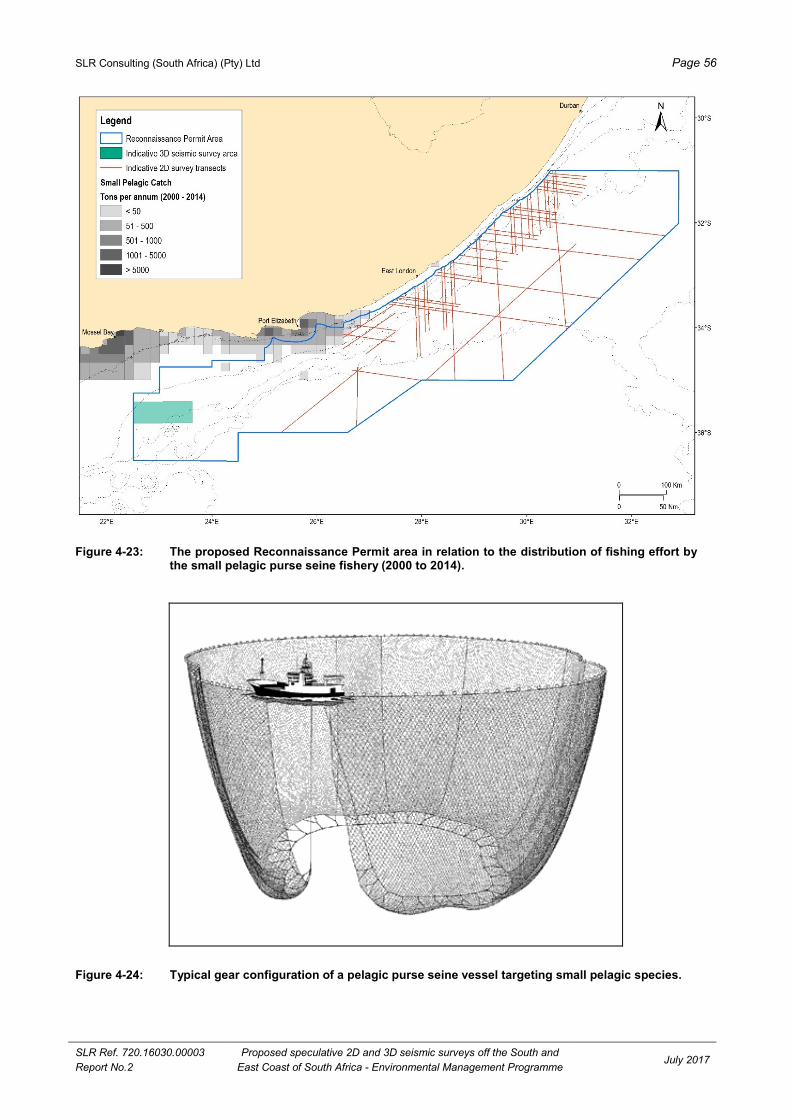
SLR Consulting (South Africa) (Pty) Ltd Page 56
SLR Ref. 720.16030.00003
Report No.2
Proposed speculative 2D and 3D seismic surveys off the South and
East Coast of South Africa - Environmental Management Programme July 2017
Figure 4-23: The proposed Reconnaissance Permit area in relation to the distribution of fishing effort by the small pelagic purse seine fishery (2000 to 2014).
Figure 4-24: Typical gear configuration of a pelagic purse seine vessel targeting small pelagic species.
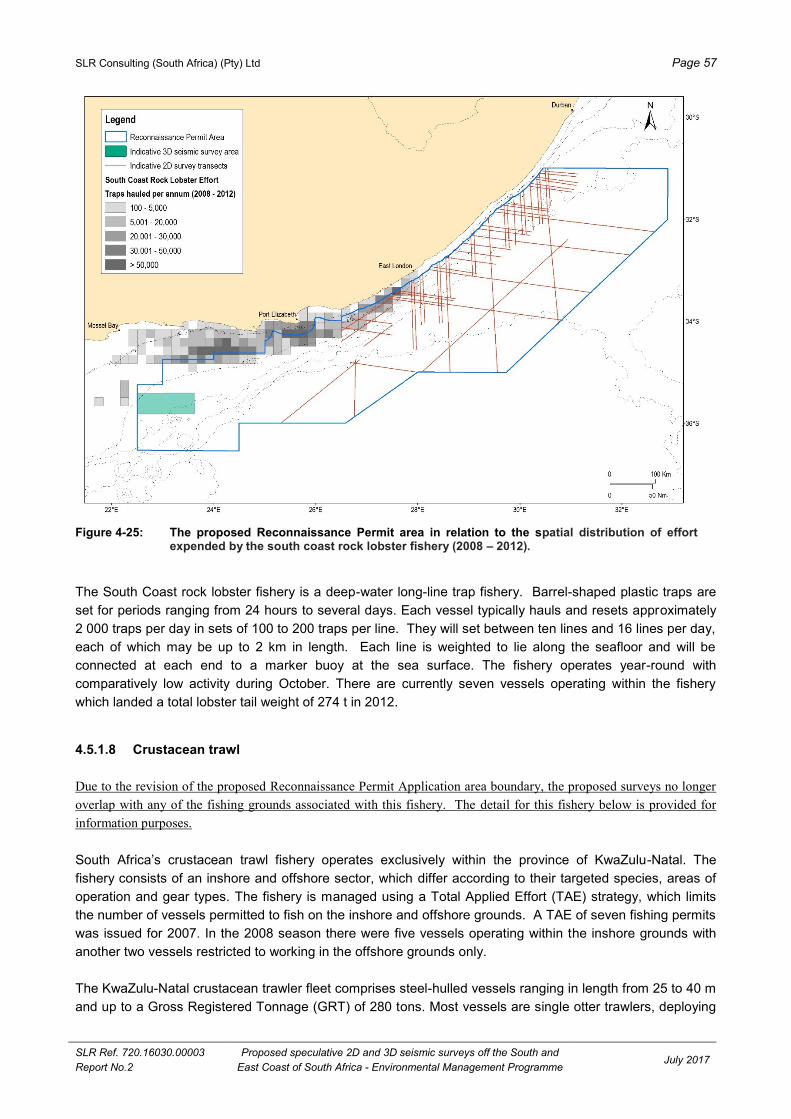
SLR Consulting (South Africa) (Pty) Ltd Page 57
SLR Ref. 720.16030.00003
Report No.2
Proposed speculative 2D and 3D seismic surveys off the South and
East Coast of South Africa - Environmental Management Programme July 2017
Figure 4-25: The proposed Reconnaissance Permit area in relation to the spatial distribution of effort expended by the south coast rock lobster fishery (2008 – 2012).
The South Coast rock lobster fishery is a deep-water long-line trap fishery. Barrel-shaped plastic traps are
set for periods ranging from 24 hours to several days. Each vessel typically hauls and resets approximately
2 000 traps per day in sets of 100 to 200 traps per line. They will set between ten lines and 16 lines per day,
each of which may be up to 2 km in length. Each line is weighted to lie along the seafloor and will be
connected at each end to a marker buoy at the sea surface. The fishery operates year-round with
comparatively low activity during October. There are currently seven vessels operating within the fishery
which landed a total lobster tail weight of 274 t in 2012.
4.5.1.8 Crustacean trawl
Due to the revision of the proposed Reconnaissance Permit Application area boundary, the proposed surveys no longer
overlap with any of the fishing grounds associated with this fishery. The detail for this fishery below is provided for
information purposes.
South Africa’s crustacean trawl fishery operates exclusively within the province of KwaZulu-Natal. The
fishery consists of an inshore and offshore sector, which differ according to their targeted species, areas of
operation and gear types. The fishery is managed using a Total Applied Effort (TAE) strategy, which limits
the number of vessels permitted to fish on the inshore and offshore grounds. A TAE of seven fishing permits
was issued for 2007. In the 2008 season there were five vessels operating within the inshore grounds with
another two vessels restricted to working in the offshore grounds only.
The KwaZulu-Natal crustacean trawler fleet comprises steel-hulled vessels ranging in length from 25 to 40 m
and up to a Gross Registered Tonnage (GRT) of 280 tons. Most vessels are single otter trawlers, deploying

SLR Consulting (South Africa) (Pty) Ltd Page 58
SLR Ref. 720.16030.00003
Report No.2
Proposed speculative 2D and 3D seismic surveys off the South and
East Coast of South Africa - Environmental Management Programme July 2017
nets from the stern or side at a speed of two to three knots. Tickler chains may be used. Trawl net sizes
range from 25 m to 72 m footrope length, with a minimum mesh size of 60 mm. The duration of a typical
trawl is approximately four hours. Trip lengths range from three to four weeks and vessels may carry a crew
of up to 20.
The inshore fishery is based on white prawns (Fennereopenaeus indicus), tiger prawns (Penaeus monodon)
and brown prawns (Metapenaeus monoceros), which occur on the shallow water mud banks along the north-
east coast of KwaZulu-Natal. There are few areas within the habitat distribution of penaeid prawns that are
suitable for trawling due to the steep drop off of the continental shelf on the East Coast. The shelf widens
between Durban and Richards Bay to form the Tugela Bank - a muddy/sandy area relatively sheltered from
the fast-flowing Agulhas current. The inshore fishery mainly operates on the Tugela Bank in water depths of
up to 100 m and within 10 nautical miles of the shore. There is a seasonal closure of the Tugela Bank
grounds in order to minimise high bycatch levels. Therefore, trawlers operate only within these inshore
grounds during the period March to August. During the summer months (February to May) activity shifts
northwards towards St Lucia, where the fishery targets bamboo prawns (Penaeus japonicus) in addition to
white prawns, tiger prawns and brown prawns.
The catch composition within the fishery typically comprises 20% prawn species, while approximately 10% of
the remainder of the catch is also retained for its commercial value and includes crab, octopus, squid,
cuttlefish and linefish. The remainder of the catch is discarded.
The prawn species on which the inshore fishery is based are fast-growing and are dependent on estuarine
environments (such as the St Lucia, and Amatikulu and Tugela River mouths) during the early phase of their
life cycle. Prolonged closure of estuary mouths has had important implications for the recruitment success of
crustaceans and the crustacean trawl industry. Digby et al. (2011) found that the closure of the Lake St Lucia
mouth has had a significant impact on the recruitment of juveniles to the marine environment with resulting
showing a decrease in prawn species diversity and abundance between 2004 and 2007.
The offshore (deep-water) fishery operates mainly between water depths of 100 m and 600 m from
Amanzimtoti in the south to Cape Vidal in the north. The boundary between the delimitation of offshore and
inshore fisheries is situated at the 100 m bathycontour. Offshore trawling takes place year-round. Targeted
species include pink prawns (Haliporoides triarthus), red prawns, langoustines (Metanephrops andamanicus
and Nephropsis stewarti), red crab (Chaceon macphersoni) and deep-water rock lobster (Palinurus
delagoae). Catches are packed and frozen at sea and landed at the ports of Richards Bay or Durban.
4.5.1.9 Squid jig
Chokka squid (Loligo vulgaris reynaudii) is distributed from the border of Namibia to the Wild Coast. Along
the South Coast adult squid is targeted in spawning aggregations on fishing grounds extending from
Plettenberg Bay to Port Alfred between 20 m and 120 m depths (see Figure 4-26). The most important
spawning grounds are between Plettenberg Bay and Algoa Bay (Augustyn 1990), these having been linked
to specific spawning habitat requirements (Roberts & Sauer 1994; Roberts 2005). Spawning aggregations
are a seasonal occurrence reaching a peak between September and December (Augustyn et al. 1992). It is
a short-lived species of approximately 18 months. The fishery is seasonal, with most effort conducted
between November and March.
The squid fishery is managed in terms of the Total Allowable Effort (TAE) allowed within the fishery and also
sees an annual four week closure between October and November during which time the Department of
Agriculture, Forestry and Fisheries (DAFF) undertakes a survey on spawning aggregations in the bay areas.
An additional industry-imposed 3-month closed season was introduced in 2014. The timing of closure is

SLR Consulting (South Africa) (Pty) Ltd Page 59
SLR Ref. 720.16030.00003
Report No.2
Proposed speculative 2D and 3D seismic surveys off the South and
East Coast of South Africa - Environmental Management Programme July 2017
typically during March, April and May or April, May and June – but the decision is made during the Industry’s
annual general meeting held in October each year. The period of this closure coincides with a drop-off in
adult spawning activity and a reduction in catches.
Fishing rights were issued to 121 companies for the period 2006 to 2013 with the number of crew and
vessels active within the fishery listed as 2 422 and 136, respectively. A maximum landed catch of 12 000
tons was recorded in 2003/4 with a levelling-off thereafter to 9 000 tons between 2005 and 2012. The annual
average catch value is approximately R180 million. Over the period 2012 to 2015, an average of 7.2 t of
squid was caught within the proposed survey area per year – this is equivalent to 0.1% of the total annual
catch. The affected area is situated between 26°30´E and 27°30´E where the fishery operates primarily
inshore of the 100m isobath (see Figure 4 9).
Figure 4-26: The proposed Reconnaissance Permit area in relation to the squid jig fishery effort (2012 -
2015).
4.5.1.10 Small scale fisheries
Small-scale fishers fish to meet food and basic livelihood needs, and may be directly involved in harvesting,
processing and distribution of fish for commercial purposes. These fishers traditionally operate on nearshore
fishing grounds, using traditional low technology or passive fishing gear to harvest marine living resources on
a full-time, part-time or seasonal basis. Fishing trips are usually a single day in duration and
fishing/harvesting techniques are labour intensive. The equipment used by small scale fishers includes
rowing boats in some areas, motorized boats on the south and west coast and simple fishing gear including
hands, feet, screw drivers, hand lines, prawn pumps, rods with reels, gaffs, hoop nets, gill nets, seine/trek
nets and semi-permanently fixed kraal traps.

SLR Consulting (South Africa) (Pty) Ltd Page 60
SLR Ref. 720.16030.00003
Report No.2
Proposed speculative 2D and 3D seismic surveys off the South and
East Coast of South Africa - Environmental Management Programme July 2017
Small scale fishers are an integral part of the rural and coastal communities in which they reside and this is
reflected in the socio-economic profile of such communities. In the Eastern Cape, KwaZulu-Natal and the
Northern Cape, small scale fishers live predominantly in rural areas while those in the Western Cape live
mainly in urban and peri-urban areas. Small scale fisheries resources are managed in terms of a community-
based co-management approach that aims to ensure that harvesting and utilisation of the resource occurs in
a sustainable manner in line with the ecosystems approach.
The small-scale fisheries policy proposes that certain areas on the coast be prioritized and demarcated as
small-scale fishing areas. In some areas access rights could be reserved exclusively for use by small-scale
fishers. The community, once they are registered as a community-based legal entity, could apply for the
demarcation of these areas and should conflict arise, it should be referred to conflict resolution under the
Policy. The policy also requires a multi-species approach to allocating rights, which will entail allocation of
rights for a basket of species that may be harvested or caught within particular designated areas. DAFF
recommends five basket areas: 1. Basket Area A – The Namibian border to Cape of Good Hope – 57
different resources 2. Basket Area B – Cape of Good Hope to Cape Infanta – 109 different resources 3.
Basket Area C – Cape Infanta to Tsitsikamma – 107 different resources 4. Basket Area D – Tsitsikamma to
the Pondoland MPA – 138 different resources 5. Basket Area E – Pondoland MPA to the Mozambican
border – 127 different resources.
4.5.1.11 Beach-seine and gill net
There are a number of active beach-seine and gill-net operators throughout South Africa (collectively
referred to as the “netfish” sector). Initial estimates indicate that there are at least 7 000 fishermen active in
fisheries using beach-seine and gill nets, mostly (86%) along the West and South coasts. Those fishermen
utilize 1 373 registered and 458 illegal nets and report an average catch of 1 600 tons annually, constituting
60% harders (Liza richardsonii), 10% St Joseph shark (Callorhinchus capensis) and 30% "bycatch" species
such as galjoen (Dichistius capensis), yellowtail (Seriola lalandii) and white steenbras (Lithognathus
lithognathus). Catch composition by mass varies between 70, 74 and 90% harders off the Western, Southern
and Eastern Cape coasts respectively to 88% sardine in KwaZulu-Natal. Catch-per-unit-effort declines
eastwards from 294 and 115 kg·net-day−1 for the beach-seine and gill-net fisheries respectively off the West
Coast to 48 and 5 kg·net-day−1 off KwaZulu-Natal. Consequently, the fishery changes in nature from a
largely commercial venture on the West Coast to an artisanal/subsistence fishery on the East Coast.
The fishery is managed on a TAE basis with a fixed number of operators in each of 15 defined areas. The
number of Rights Holders for 2014 was listed as 28 and 162 for beach-seine and gill-net, respectively
(DAFF, 2014). Permits are issued solely for the capture of harders, St Joseph and species that appear on
the ‘bait list’. The exception is False Bay, where Right Holders are allowed to target linefish species that they
traditionally exploited.
Fishing effort is coastal, with beach-seines set between 50 m and 100 m offshore and gill-nets unlikely to be
set in waters deeper than 50 m.
4.5.1.12 Fisheries Research
Surveys of demersal fish resources are carried out in January (West Coast survey) and May (South-East
Coast survey) each year by the DAFF in order to set the annual TACs for demersal fisheries. Stratified,
bottom trawls are conducted to assess the biomass, abundance and distribution of hake, horse mackerel,
squid and other demersal trawl species on the shelf and upper slope of the South African coast. The gear
configuration is similar to that of commercial demersal trawlers, however, nets are towed for a shorter
duration of generally 30 minutes per tow. Trawl positions are randomly selected to cover specific depth

SLR Consulting (South Africa) (Pty) Ltd Page 61
SLR Ref. 720.16030.00003
Report No.2
Proposed speculative 2D and 3D seismic surveys off the South and
East Coast of South Africa - Environmental Management Programme July 2017
strata that range from the coast to the 1 000 m bathymetric contour, thus within the proposed
Reconnaissance Permit area (see Figure 4-27). Approximately 120 trawls are conducted during each survey
over a period of approximately one month.
The biomass of small pelagic species is also assessed bi-annually by an acoustic survey. The first of these
surveys is timed to commence mid-May and runs until mid-June while the second starts in mid-October and
runs until mid-December. During these surveys the survey vessel travels pre-determined transects
(perpendicular to bathymetric contours) running offshore from the coastline to approximately the 200 m
bathymetric contour, thus within the proposed Reconnaissance Permit area. The surveys are designed to
cover an extensive area from the Orange River (West Coast) to Port Alfred (East Coast). The layout of
survey tracks undertaken during the May and November acoustic biomass surveys (2014) is shown in
Figure 4-27 to Figure 4-31.
Figure 4-27: The proposed Reconnaissance Permit area in relation to the spatial distribution of research
trawls conducted between 1985 and 2013.

SLR Consulting (South Africa) (Pty) Ltd Page 62
SLR Ref. 720.16030.00003
Report No.2
Proposed speculative 2D and 3D seismic surveys off the South and
East Coast of South Africa - Environmental Management Programme July 2017
Figure 4-28: Density of anchovy and spatial distribution of survey tracks undertaken during the acoustic biomass survey by DAFF during May 2014.
Figure 4-29: Density of sardine and spatial distribution of survey tracks undertaken during the acoustic
biomass survey by DAFF during May 2014.
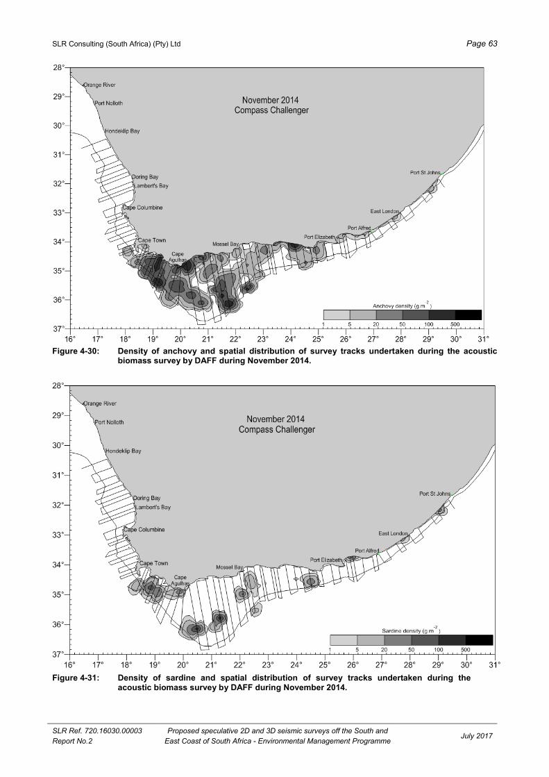
SLR Consulting (South Africa) (Pty) Ltd Page 63
SLR Ref. 720.16030.00003
Report No.2
Proposed speculative 2D and 3D seismic surveys off the South and
East Coast of South Africa - Environmental Management Programme July 2017
Figure 4-30: Density of anchovy and spatial distribution of survey tracks undertaken during the acoustic
biomass survey by DAFF during November 2014.
Figure 4-31: Density of sardine and spatial distribution of survey tracks undertaken during the acoustic biomass survey by DAFF during November 2014.

SLR Consulting (South Africa) (Pty) Ltd Page 64
SLR Ref. 720.16030.00003
Report No.2
Proposed speculative 2D and 3D seismic surveys off the South and
East Coast of South Africa - Environmental Management Programme July 2017
4.5.2 SHIPPING TRANSPORT
A large number of vessels navigate along the West, South and East coasts on their way around the southern
African subcontinent. The majority of shipping traffic is located on the outer edge of the continental shelf
(between 12 and 24 nm offshore). Thus, the proposed Reconnaissance Permit area is located where the
majority of the shipping traffic traverses the South and East coasts of South Africa (see Figure 4-32).
Important commercial harbours along the East Coast include Port Elizabeth, East London, Durban and
Richards Bay.
Figure 4-32: Major shipping routes along the east coast of South Africa. Data from the South African Centre for Oceanography. Approximate location of the Reconnaissance Permit area is also shown.
4.5.3 EXPLORATION, PRODUCTION AND MINING
4.5.3.1 Oil and gas exploration and production
Oil and gas exploration and production is currently undertaken in a number of licence blocks off the South
and East coasts of South Africa (see Figure 4-33).
Exploration
The proposed survey area includes a number of license blocks off the South and East coasts of South Africa
(see Figure 3.1). Licence block rights holders and applicants are listed in Table 3.1. As mentioned in Section
2.2.4, PGS is required to obtain written consent from the existing exploration right and technical cooperation
permit holders and applicants within the proposed Reconnaissance Permit area.
Existing Production
PetroSA operates the F-A production platform, which was brought into production in 1992. The F-A platform
is located 85 kilometres south of Mossel Bay in a water depth of 102 meters. Gas and associated
condensate from the associated gas fields (F-A, E-M and South Coast Gas) are processed through the
platform. The produced gas and condensate are exported through two separate 93 km pipelines to the
PetroSA Gas-to-Liquid (GTL) plant in Mossel Bay.
Cape Town Saldanha
Richards Bay
Port Elizabeth
30ºS
20ºE

SLR Consulting (South Africa) (Pty) Ltd Page 65
SLR Ref. 720.16030.00003
Report No.2
Proposed speculative 2D and 3D seismic surveys off the South and East Coast of South Africa
Environmental Management Programme July 2017
Figure 4-33: Petroleum licence blocks off the West, South and East coasts of South Africa (after PASA, 2017).

SLR Consulting (South Africa) (Pty) Ltd Page 66
SLR Ref. 720.16030.00003
Report No.2
Proposed speculative 2D and 3D seismic surveys off the South and
East Coast of South Africa - Environmental Management Programme July 2017
4.5.3.2 Prospecting and mining of other minerals
Glauconite and phosphate
Glauconite pellets (an iron and magnesium rich clay mineral) and bedded and peletal phosphorite occur on
the seafloor over large areas of the continental shelf on the West and South-West Coasts. These represent
potentially commercial resources that could be considered for mining as a source of agricultural phosphate
and potassium (Birch 1979a & b; Dingle et al. 1987; Rogers and Bremner 1991). Green Flash Trading
received their prospecting rights for Areas 251 and 257 in 2012/2013. The prospecting rights for Agrimin1,
Agrimin2 and SOM1 have expired (Jan Briers, DMR pers. comm., December 2013).
Diamond Fields International Ltd has been granted a licence to prospect for marine phosphates in the
Outeniqua West Licence Area on the eastern Agulhas Bank between the 180 m and 500 m isobaths. The
proposed Outeniqua West prospecting licence area extends from approximately longitude 20°E to 23°6 E
and from latitude 34°S to 36.8°S with a surface area of 47 468 km2 (see Figure 4-34).
Manganese nodules in ultra-deep water
Rogers (1987, 1995) and Rogers and Bremner (1991) report that manganese nodules enriched in valuable
metals occur in deep water areas (>3 000 m) on the South and East coasts (Figure 4-35). The nickel, copper
and cobalt contents of the nodules fall below the current mining economic cut-off grade of 2%. The
proposed survey area would not overlap with these areas.
Figure 4-34: Diamond Fields International’s proposed Outeniqua West prospecting licence area in relation to the licence blocks off the South Coast (extracted from the Background Information Document prepared by CSIR, February 2013).

SLR Consulting (South Africa) (Pty) Ltd Page 67
SLR Ref. 720.16030.00003
Report No.2
Proposed speculative 2D and 3D seismic surveys off the South and
East Coast of South Africa - Environmental Management Programme July 2017
Figure 4-35: Schematic of location of manganese nodules off Southern Africa, showing petroleum licence
blocks. Modified from Rogers (1995) and Fuggle & Rabie (1992).
4.5.4 UNDERSEA CABLES
There are a number of submarine telecommunications cable systems across the Atlantic and the Indian
Ocean (see Figure 4-36), including inter alia:
South Atlantic Telecommunications cable No.3 / West African Submarine Cable / South Africa Far
East (SAT3/WASC/SAFE): This cable system is divided into two sub-systems, SAT3/WASC in the
Atlantic Ocean and SAFE in the Indian Ocean. The SAT3/WASC sub-system connects Portugal
(Sesimbra) with South Africa (Melkbosstrand). From Melkbosstrand the SAT-3/WASC sub-system is
extended via the SAFE sub-system to Malaysia (Penang) and has intermediate landing points at
Mtunzini South Africa, Saint Paul Reunion, Bale Jacot Mauritius and Cochin India (www.safe-
sat3.co.za).
Eastern Africa Submarine Cable System (EASSy): This is a high bandwidth fibre optic cable system,
which connects countries of eastern Africa to the rest of the world. EASSy runs from Mtunzini (off the
East Coast) in South Africa to Port Sudan in Sudan, with landing points in nine countries, and
connected to at least ten landlocked countries.
West Africa Cable System (WACS): WACS is 14 530 km in length, linking South Africa (Yzerfontein)
and the United Kingdom (London). It has 14 landing points, 12 along the western coast of Africa
(including Cape Verde and Canary Islands) and 2 in Europe (Portugal and England) completed on
land by a cable termination station in London.
African Coast to Europe (ACE): The ACE submarine communications cable is a 17 000 km cable
system along the West Coast of Africa between France and South Africa (Yzerfontein).
There is an exclusion zone applicable to the telecommunication cables 1 nm (approximately 1.9 km) each
side of the cable in which no anchoring is permitted.

SLR Consulting (South Africa) (Pty) Ltd Page 68
SLR Ref. 720.16030.00003
Report No.2
Proposed speculative 2D and 3D seismic surveys off the South and
East Coast of South Africa - Environmental Management Programme July 2017
Figure 4-36: Configuration of the current African undersea cable systems, 2016 (From http://www.manypossibilities.net).
4.5.5 MARINE ARCHAEOLOGICAL SITES
In terms of the National Heritage Resources Act (No. 25 of 1999), any wreck, being any vessel, aircraft or
any part thereof, older than 60 years lying in South Africa’s territorial waters or maritime cultural zone is
protected. The majority of known wrecks lost along the South and East coasts are located in relatively
shallow water close inshore (Turner, 1988). These are important archaeological sites as they represent an
almost complete microcosm of their historical periods. As a result, wrecks older than 60 years old are
declared national monuments (Gribble, 1997).
4.5.6 AMMUNITION DUMP SITES
The location of the ammunition dumpsites situated along the East Coast and details of dumped ammunition
are given on the relevant SAN charts (see Figure 4-37). There are three ammunition dumpsites within the
proposed Reconnaissance Permit area.
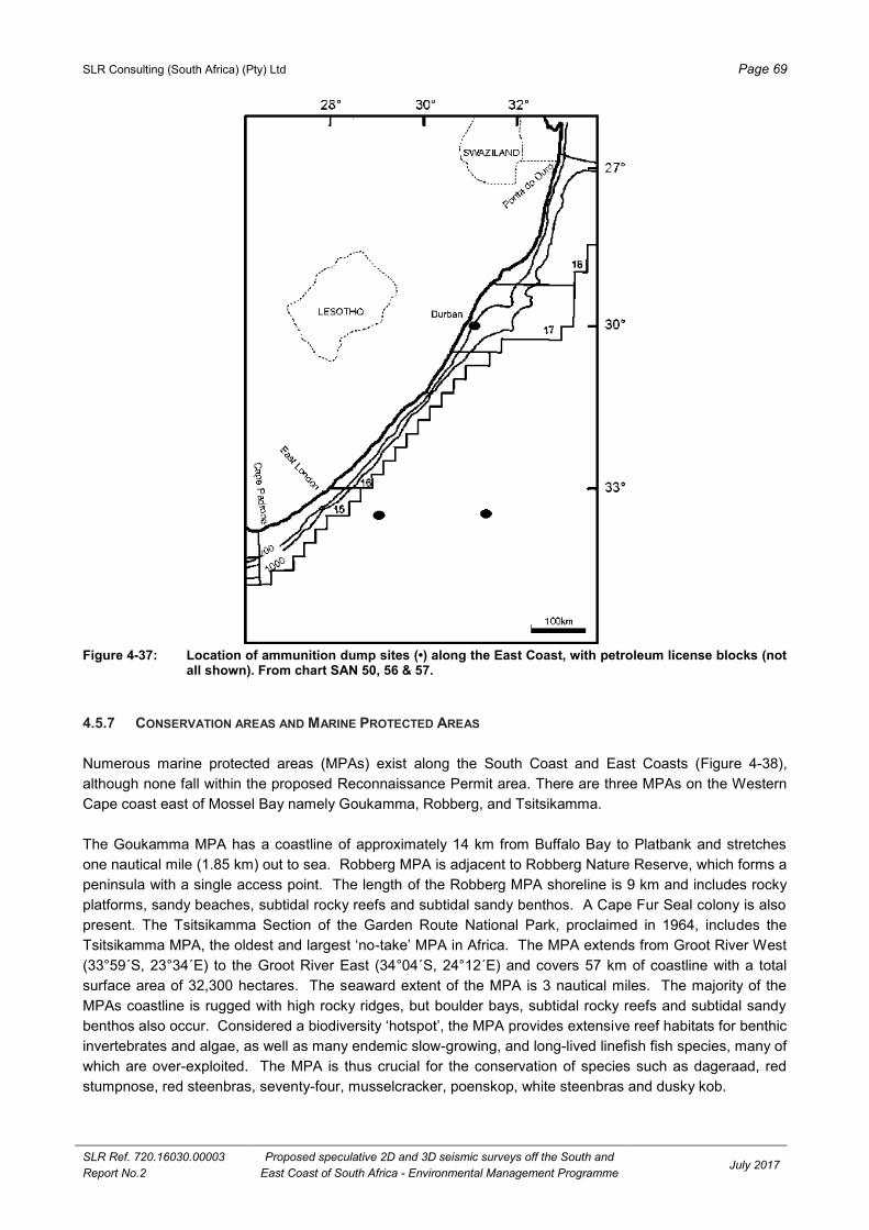
SLR Consulting (South Africa) (Pty) Ltd Page 69
SLR Ref. 720.16030.00003
Report No.2
Proposed speculative 2D and 3D seismic surveys off the South and
East Coast of South Africa - Environmental Management Programme July 2017
Figure 4-37: Location of ammunition dump sites (•) along the East Coast, with petroleum license blocks (not
all shown). From chart SAN 50, 56 & 57.
4.5.7 CONSERVATION AREAS AND MARINE PROTECTED AREAS
Numerous marine protected areas (MPAs) exist along the South Coast and East Coasts (Figure 4-38),
although none fall within the proposed Reconnaissance Permit area. There are three MPAs on the Western
Cape coast east of Mossel Bay namely Goukamma, Robberg, and Tsitsikamma.
The Goukamma MPA has a coastline of approximately 14 km from Buffalo Bay to Platbank and stretches
one nautical mile (1.85 km) out to sea. Robberg MPA is adjacent to Robberg Nature Reserve, which forms a
peninsula with a single access point. The length of the Robberg MPA shoreline is 9 km and includes rocky
platforms, sandy beaches, subtidal rocky reefs and subtidal sandy benthos. A Cape Fur Seal colony is also
present. The Tsitsikamma Section of the Garden Route National Park, proclaimed in 1964, includes the
Tsitsikamma MPA, the oldest and largest ‘no-take’ MPA in Africa. The MPA extends from Groot River West
(33°59´S, 23°34´E) to the Groot River East (34°04´S, 24°12´E) and covers 57 km of coastline with a total
surface area of 32,300 hectares. The seaward extent of the MPA is 3 nautical miles. The majority of the
MPAs coastline is rugged with high rocky ridges, but boulder bays, subtidal rocky reefs and subtidal sandy
benthos also occur. Considered a biodiversity ‘hotspot’, the MPA provides extensive reef habitats for benthic
invertebrates and algae, as well as many endemic slow-growing, and long-lived linefish fish species, many of
which are over-exploited. The MPA is thus crucial for the conservation of species such as dageraad, red
stumpnose, red steenbras, seventy-four, musselcracker, poenskop, white steenbras and dusky kob.

SLR Consulting (South Africa) (Pty) Ltd Page 70
SLR Ref. 720.16030.00003
Report No.2
Proposed speculative 2D and 3D seismic surveys off the South and
East Coast of South Africa - Environmental Management Programme July 2017
Figure 4-38: Project - environment interaction points on the East and South coasts, illustrating the location of the proposed Reconnaissance Permit area (red outline) in relation to seabird and seal colonies, seasonal whale populations and reserves and marine protected areas.
Eastern Cape MPAs include the Sardinia Bay MPA at Cape Recife, the Bird Island MPA in Algoa Bay, the
Amathole MPA in the vicinity of East London, and the Dwesa-Cwebe, Hluleka and Pondoland MPAs located
on the Wild Coast.
The Sardinia Bay MPA has a shoreline 7 km in length and extends one nautical mile seawards of the high-
water mark, between Schoenmakerskop and Bushy Park. It contains representative habitat including rocky
platforms, sandy beaches, subtidal rocky reefs, and subtidal sandy benthos.
Bird Island MPA was declared in 2004 for biodiversity conservation reasons, and declared as part of Addo
Elephant National Park in 2005. The reserve boundaries of the Algoa Bay Island nature reserve extend 500
m offshore of the islands as MPAs. The Bird Island group (Bird, Seal, Stag and Black Rock) are situated at
the north eastern end of Algoa Bay close to Woody Cape. These islands are the only important seabird
islands along a 1 800 km stretch of coastline between Dyer Island near Hermanus in the Western Cape and
Inhaca Island in Mozambique. These islands together with St Croix, Jahleel and Brenton Islands (also in
Algoa Bay) are classed as Important Bird Areas (IBAs), because they regularly support significant numbers
of globally threatened bird species as well as holding large concentrations of seabirds. Six of the 14 South
African resident seabird species breed either on the islands or at the adjacent coast. The islands play an
important national and international role in the conservation of Cape Gannet, African Penguin and Roseate
Tern. The islands form ecological distinct subtidal habitats, containing many endemic invertebrates, algae
and linefish (e.g. santer and red roman). Black Rocks is an important seal breeding colony, and serves as a

SLR Consulting (South Africa) (Pty) Ltd Page 71
SLR Ref. 720.16030.00003
Report No.2
Proposed speculative 2D and 3D seismic surveys off the South and
East Coast of South Africa - Environmental Management Programme July 2017
great white shark feeding area. The MPA is also of particular importance to the threatened abalone as
abalone poaching activities are strictly controlled. A larger MPA of an envisaged 120 000 ha, which will form
part of a national conservation area, the Greater Addo Elephant National Park, has been proposed.
The Amathole MPA comprised the three former closed areas, namely from Christmas Rock to the Gxulu
River mouth, from Nahoon Point to Gonubie Point, and from the Nyara River mouth to the Kei River mouth.
KwaZulu-Natal boasts three Marine Protected Areas. The Maputaland and St Lucia Marine Reserves form a
continuous protected area stretching 150 km from the Mozambique border southwards to Cape Vidal, and 3
nautical miles out to sea. They are components of the iSimangaliso Wetland Park. The MPA protects a
large number of turtle nesting sites; the migration of whales, dolphins and whale-sharks offshore;
coelacanths in the submarine canyons; and a considerable number of waterfowl associated with the
iSimangaliso Wetland Park, including large breeding colonies of pelicans, storks, herons and terns.
The Aliwal Shoal MPA is situated on the south coast between Umkomaas and Ocean View. The Aliwal
Shoal MPA is 125 km2 in size, approximately 18 km long and stretches ~4 nautical miles offshore. Further
south lies the small Trafalgar Marine Reserve, which stretches for only 6 km along the KwaZulu-Natal south
coast adjacent to the Mpenjati Nature Reserve, and extends 500 m offshore.
4.5.7.1 World Heritage Site
The iSimangaliso Wetland Park is recognised as a wetland of international importance under the Ramsar
Convention and has been designated a World Heritage Site in terms of the World Heritage Convention Act
(No. 49 of 1999). The iSimangaliso Wetland Park covers an area on 324 441 ha, including 230 km of
coastline from Kosi Bay (bordering Mozambique) to south of Maphelane and three nautical miles out to sea.
The Park is governed by the National Environmental Management Protected Areas Act (No. 57 of 2003). In
terms of Section 48(1) no person may conduct commercial prospecting or mining activities within a World
Heritage Site. In addition, Section 50(5) states that no development is permitted in a World Heritage Site
without prior written approval from the management authority, namely iSimangaliso Wetland Park Authority.
The proposed Reconnaissance Permit area lies over 350 km south of the World Heritage Site.
4.5.7.2 Proposed Offshore Marine Biodiversity Protection Areas
Using biodiversity data mapped for the 2004 and 2011 National Biodiversity Assessments a systematic
biodiversity plan has been developed for the South African coast with the objective of identifying both coastal
and offshore priority areas for MPA expansion. To this end, numerous offshore focus areas were identified
for protection between 17°E and 25°E, and these carried forward through Operation Phakisa for the
proposed development of offshore MPAs. Those within the Reconnaissance Permit Area are shown in
Figure 4-38. There is overlap of the Amathole Extension A proposed MPA with the proposed 2D survey lines
between East London and Port Elizabeth. There is also overlap of the Amathole Extension A, Extension B,
Extension C and Protea Banks proposed offshore MPA with the proposed 2D survey area.
Hope Spots are defined by Mission Blue of the Sylvia Earle Alliance as special conservation areas that are
critical to the health of the ocean. The first six Hope Spots were launched in South Africa in 2014 and
include Aliwal Shoal in KwaZulu-Natal, Algoa Bay, Plettenberg Bay, Knysna, the Cape Whale Coast
(Hermanus area) and False Bay in the Western Cape. Of these, the Algoa Bay, Plettenberg Bay and
Knysna Hope Spots are located within and adjacent to (inshore) the Reconnaissance Permit area.

SLR Consulting (South Africa) (Pty) Ltd Page 72
SLR Ref. 720.16030.00003
Report No.2
Proposed speculative 2D and 3D seismic surveys off the South and
East Coast of South Africa - Environmental Management Programme July 2017
5 ENVIRONMENTAL IMPACT ASSESSMENT
This chapter describes and assesses the significance of potential impacts related to the proposed
speculative 2D and 3D seismic surveys off the South and East Coasts of South Africa. The potential impacts
of the proposed activities are addressed in three categories, namely:
1. Seismic and support vessels operation;
2. Impacts of seismic noise on marine fauna; and
3. Impacts of seismic activities on other users of the sea.
All impacts are systematically assessed and presented according to predefined rating scales
(see Appendix 2). For each potential impact a table is provided that summarises the significance level
assessment for that impact. Mitigation or optimisation measures are proposed which could ameliorate the
negative impacts or enhance potential benefits, respectively. The status of all impacts should be considered
to be negative unless otherwise indicated. The significance of impacts with and without mitigation is also
assessed.
Unless otherwise indicated, all potential impacts discussed below would be for the duration of the survey
operations only, i.e. short term (six months), due to the transient nature of survey activities.
IMPACT OF NORMAL SEISMIC / SUPPORT VESSELS 5.1
5.1.1 EMISSIONS TO THE ATMOSPHERE
Description of impact
Emissions to the atmosphere during the seismic surveys may include exhaust gases from the use of diesel
as fuel for generators and motors, and the burning of wastes.
Diesel exhaust comprises mainly carbon dioxide (CO2) as well as several toxic gases such as nitrogen
oxides (NOX), sulphur oxides (SOX) and carbon monoxide (CO). In addition, diesel combustion can produce
hydrocarbons (Total Hydrocarbons and Volatile Organic Compounds). Smoke and particulate matter (soot)
are also produced during diesel combustion.
Incineration of waste on board would also release soot as well as CO, CO2 and dioxins (depending on the
composition of the waste). In South African waters, the incineration of waste requires an Atmospheric
Emission Licence in terms of the Environmental Management: Air Quality Act, 2004. Thus general waste
would in all likelihood rather be stored on board for later onshore disposal.
Assessment
The atmospheric emissions from the seismic and support vessels are expected to be similar to those from
similar diesel-powered vessels of comparable tonnage (approximately 3 000 - 5 000 tonnes), with the
addition of the emissions from the airgun compressors. Should solid waste be incinerated on board, the
volumes would be minimal and hence the volume of atmospheric emissions. Incineration must comply with
the relevant MARPOL 73/7851
standards.
5 MARPOL 73/78 is an International Convention for the Prevention of Pollution from Ships 1973, as modified by the Protocol of 1978
relating thereto. All vessels operating within the South African Exclusive Economic Zone are required to conform to legal
requirements for waste management and pollution control, including the Marine Pollution Act (No. 2 of 1986 – which incorporate
MARPOL 73/78 standards) and the Dumping at Sea Control Act (No. 73 of 1965). These Acts make provision for the discharge of
sewage, plastics, oil, galley wastes, hazardous liquids and packaged hazardous material.

SLR Consulting (South Africa) (Pty) Ltd Page 73
SLR Ref. 720.16030.00003
Report No.2
Proposed speculative 2D and 3D seismic surveys off the South and
East Coast of South Africa - Environmental Management Programme July 2017
The potential impact of emissions to the atmosphere during seismic survey operations would be limited to
the survey area, of low intensity and is considered to be of VERY LOW significance with or without the
implementation of mitigation measures (see Table 5.1).
Mitigation
No mitigation is deemed necessary, but it is recommended that all diesel motors and generators receive
adequate maintenance to minimise soot and un-burnt diesel released to the atmosphere.
Table 5.1: Impact of atmospheric emissions from the seismic and support vessels.
RATING SCALES WITHOUT MITIGATION WITH MITIGATION
Extent Local
No mitigation is considered
necessary.
Duration Short-term
Intensity Low
Significance Very Low
Status Negative
Probability Definite
Confidence High
Nature of cumulative impact Other activities that may contribute to the cumulative impact on the
marine environment include other mining, exploration and production
projects, other fishing and maritime activities, etc. Cumulative impact is
considered to be of VERY LOW significance.
Degree to which impact can be reversed Fully reversible
Degree to which impact may cause
irreplaceable loss of resources
Low
Degree to which impact can be
mitigated
None
5.1.2 DISCHARGES/DISPOSAL TO THE SEA
Discharges from the seismic and support vessels to the marine environment would include deck drainage,
machinery space drainage, sewage, galley wastes, solid wastes and accidental hydrocarbon spills.
5.1.2.1 Deck drainage
Description of impact
Drainage of deck areas from precipitation, sea spray or routine operations (e.g. deck and equipment cleaning
and fire drills) may result in small volumes of oils, solvents or cleaners being introduced into the marine
environment.
Assessment
The discharge into the sea of any oil or oily mixture that may originate from the seismic and support vessels
is prohibited in terms of Regulation 21 of MARPOL (Annex I), except when the oil content of the discharge
without dilution does not exceed 15 ppm. To ensure MARPOL compliance all deck drainage from work
spaces should be collected and piped into an on-board sump tank for treatment prior to discharge.
Oily waste substances would be shipped to land for treatment and disposal. If no such equipment is
available oily water would be retained on-board and disposed of at an appropriate onshore facility.
Due to the small volumes lost overboard, the potential impact of deck drainage on the marine environment
would therefore be of low intensity across the Reconnaissance Permit area over the short-term, and is
considered to be of VERY LOW significance with or without mitigation (see Table 5.2).

SLR Consulting (South Africa) (Pty) Ltd Page 74
SLR Ref. 720.16030.00003
Report No.2
Proposed speculative 2D and 3D seismic surveys off the South and
East Coast of South Africa - Environmental Management Programme July 2017
Mitigation
The following measures are recommended for mitigation of deck drainage discharges from vessels:
A Shipboard Oil Pollution Emergency Plan (SOPEP) must be prepared for all vessels and be in place
at all times during operation;
Deck drainage should be routed to a separate drainage system (oily water catchment system) for
treatment to ensure compliance with MARPOL 73/78 standards (i.e. 15 ppm before discharge);
All process areas should be bunded to ensure drainage water flows into the closed drainage system;
Drip trays should be used to collect run-off from equipment that is not contained within a bunded area
and the contents routed to the closed drainage system;
Low-toxicity biodegradable detergents should be used in cleaning of all deck spillage;
All hydraulic systems should be adequately maintained and hydraulic hoses should be frequently
inspected; and
Spill management training and awareness should be provided to crew members of the need for
thorough cleaning-up of any spillages immediately after they occur in order to minimise the volume of
contaminants washing off decks.
Table 5.2: Impact of deck drainage from the survey and support vessels.
RATING SCALES WITHOUT MITIGATION WITH MITIGATION
Extent Local Local
Duration Short-term Short-term
Intensity Low Low
Significance Very Low VERY LOW
Status Negative Negative
Probability Highly Probable Highly Probable
Confidence High High
Nature of cumulative impact Other activities that may contribute to the cumulative impact on the
marine environment include other mining, exploration and production
projects, other fishing and maritime activities, etc. Cumulative impact is
considered to be of VERY LOW significance.
Degree to which impact can be reversed Fully reversible
Degree to which impact may cause
irreplaceable loss of resources
Low
Degree to which impact can be
mitigated
None
5.1.2.2 Machinery space drainage
Description of impact
Small volumes of oil such as diesel fuel, lubricants, grease, etc. used within the machinery space of the
seismic and support vessels could enter the marine environment.
Assessment
All operations would comply fully with international agreed standards regulated under MARPOL 73/78.
All machinery space drainage would pass through an oil/water filter to reduce the oil in water concentration to
less than 15 ppm, in accordance with Regulation 21 of MARPOL (Annex 1). If no such equipment is
available oily water would be retained on board and disposed of at an appropriate onshore facility.
Concentrations of oil reaching the marine environment through drainage of machinery spaces are, therefore,
expected to be low. Based on the small volumes and high energy sea conditions, the potential impact of

SLR Consulting (South Africa) (Pty) Ltd Page 75
SLR Ref. 720.16030.00003
Report No.2
Proposed speculative 2D and 3D seismic surveys off the South and
East Coast of South Africa - Environmental Management Programme July 2017
such low concentrations would be of low intensity and limited to the proposed Reconnaissance Permit area
over the short-term. The potential impact of machinery space drainage on the marine environment is
therefore considered to be of VERY LOW significance with or without mitigation (see Table 5.3).
Mitigation
Mitigation is as for deck drainage (see Section 5.1.2.1).
Table 5.3: Impact of machinery space drainage from the survey and support vessels.
RATING SCALES WITHOUT MITIGATION WITH MITIGATION
Extent Local Local
Duration Short-term Short-term
Intensity Low Low
Significance Very Low VERY LOW
Status Negative Negative
Probability Highly Probable Highly Probable
Confidence High High
Nature of cumulative impact Other activities that may contribute to the cumulative impact on the
marine environment include other mining, exploration and production
projects, other fishing and maritime activities, etc. Cumulative impact is
considered to be of VERY LOW significance.
Degree to which impact can be reversed Fully reversible
Degree to which impact may cause
irreplaceable loss of resources
Low
Degree to which impact can be
mitigated
None
5.1.2.3 Sewage
Description of impact
Sewage poses an organic and bacterial loading on the natural degradation processes of the sea, resulting in
an increased biological oxygen demand (BOD). This could result in anaerobic conditions in the marine
environment. Although treated sewage would also increase BOD, it does not pose a bacterial load.
Assessment
The duration of the proposed seismic survey operations are expected to take in the order of six months,
depending on, amongst other things, weather conditions. The volumes of sewage wastes released from the
seismic and support vessels would be small and comparable to volumes produced by vessels of similar crew
compliment (up to 50 people).
All sewage would be treated to the required MARPOL 73/78 standard prior to release into the marine
environment, where the high wind and wave energy is expected to result in rapid dispersal. Discharges of
sewage, according to MARPOL 73/78 standards, would be comminuted and disinfected prior to disposal to
the marine environment if between 4 nm (± 7.5 km) and 12 nm (± 22 km) from the coast, and no disposal
would occur within 4 nm (± 7.5 km) of the coast. While disposal beyond 12 nm does not require treatment, it
is expected that the survey vessel(s) would continue to treat sewage irrespective of the vessel distance off
the coast. Sewage would not be discharged instantaneously but at a moderate rate when the vessel is en
route and travelling at no less than 4 knots.
Based on the small volumes and high energy sea conditions, the potential impact of sewage effluent from
vessels on the marine environment is expected to be limited to the survey area over the short-term, and is
therefore considered to be of VERY LOW significance with or without mitigation (see Table 5.4).

SLR Consulting (South Africa) (Pty) Ltd Page 76
SLR Ref. 720.16030.00003
Report No.2
Proposed speculative 2D and 3D seismic surveys off the South and
East Coast of South Africa - Environmental Management Programme July 2017
Mitigation
Ensure compliance with the MARPOL 73/78 standards.
Table 5.4: Impact of sewage effluent discharge from the survey and support vessels.
RATING SCALES WITHOUT MITIGATION WITH MITIGATION
Extent Local Local
Duration Short-term Short-term
Intensity Low Low
Significance Very Low VERY LOW
Status Negative Negative
Probability Definite Definite
Confidence High High
Nature of cumulative impact Other activities that may contribute to the cumulative impact on the
marine environment include other mining, exploration and production
projects, other fishing and maritime activities, etc. Cumulative impact is
considered to be of VERY LOW significance.
Degree to which impact can be reversed Fully reversible
Degree to which impact may cause
irreplaceable loss of resources
Low
Degree to which impact can be
mitigated
None
5.1.2.4 Galley waste
Description of impact
Galley wastes, comprising mostly of biodegradable food waste, would place a small organic and bacterial
loading on the marine environment.
Assessment
The volume of galley waste from a survey and support vessel would be small and comparable to wastes
from any vessel of a similar crew compliment (up to 50 people). Discharges of galley wastes, according to
MARPOL 73/78 standards, would be comminuted to particle sizes smaller than 25 mm prior to disposal to
the marine environment if less than 12 nm (± 22 km) from the coast and with no disposal within 3 nm
(± 5.5 km) of the coast.
Based on the small volumes and high energy sea conditions, the potential impact of galley waste disposal on
the marine environment would be of low intensity and limited to the proposed Reconnaissance Permit area
over the short-term. The potential impact of galley waste on the marine environment is therefore considered
to be of VERY LOW significance with or without mitigation (see Table 5.5).
Mitigation
Ensure compliance with the MARPOL 73/78 standards.
Table 5.5: Impact of galley waste disposal from the survey and support vessels.
RATING SCALES WITHOUT MITIGATION WITH MITIGATION
Extent Local Local
Duration Short-term Short-term
Intensity Low Low
Significance Very Low VERY LOW

SLR Consulting (South Africa) (Pty) Ltd Page 77
SLR Ref. 720.16030.00003
Report No.2
Proposed speculative 2D and 3D seismic surveys off the South and
East Coast of South Africa - Environmental Management Programme July 2017
RATING SCALES WITHOUT MITIGATION WITH MITIGATION
Status Negative Negative
Probability Highly Probable Highly Probable
Confidence High High
Nature of cumulative impact Other activities that may contribute to the cumulative impact on the
marine environment include other mining, exploration and production
projects, other fishing and maritime activities, etc. Cumulative impact is
considered to be of VERY LOW significance.
Degree to which impact can be reversed Fully reversible
Degree to which impact may cause
irreplaceable loss of resources
Low
Degree to which impact can be
mitigated
None
5.1.2.5 Solid waste
Description of impact
The accidental release of solid waste comprising non-biodegradable domestic waste, packaging and
operational industrial waste into the sea could pose a hazard to marine fauna, may contain contaminant
chemicals and could end up as visual pollution at sea, on the seashore or on the seabed.
Assessment
Solid waste generated during the seismic survey operations (excluding galley waste) would be transported to
shore for disposal at a licensed landfill facility or an alternative approved facility. Consequently there would
be no impact on the marine environment. However, there could be incidents (e.g. blown by wind) which
could result in a small amount of waste entering the marine environment.
The potential impact of the disposal of solid waste from vessels on the marine environment is therefore
considered to be INSIGNIFICANT (see Table 5.6).
Mitigation
The following measures are recommended for the mitigation of waste:
Initiate an on-board waste minimisation system;
On-board solid waste storage is to be secure; and
The disposal of waste (solid and hazardous) onshore must be in accordance with the appropriate laws
and ordinances.
Table 5.6: Impact of solid waste disposal from the survey and support vessels.
RATING SCALES WITHOUT MITIGATION WITH MITIGATION
Extent Local Local
Duration Short-term Short-term
Intensity Zero Zero
Significance Insignificant INSIGNIFICANT
Status Negative Negative
Probability Improbable Improbable
Confidence Medium Medium
Nature of cumulative impact Other activities that may contribute to the cumulative impact on the
marine environment include other mining, exploration and production
projects, other fishing and maritime activities, etc. Cumulative impact is
considered to be of VERY LOW significance.

SLR Consulting (South Africa) (Pty) Ltd Page 78
SLR Ref. 720.16030.00003
Report No.2
Proposed speculative 2D and 3D seismic surveys off the South and
East Coast of South Africa - Environmental Management Programme July 2017
RATING SCALES WITHOUT MITIGATION WITH MITIGATION
Degree to which impact can be reversed Fully reversible
Degree to which impact may cause
irreplaceable loss of resources
Low
Degree to which impact can be
mitigated
None
5.1.2.6 Accidental oil spill during bunkering / refuelling
Description of impact
Accidental hydrocarbon spills of varying sizes could result from related operations, for example the bunkering
of fuel oil at sea. This scenario assumes that an accidental spillage of fuel oil would occur.
Assessment
Spillages and leakages during bunkering operations are a primary source of oil pollution from ships. Many of
the spillages that occur can be attributed to human error. Thus all bunkering operations should be carefully
planned and executed in accordance with MARPOL 73/78 standards.
Spillages and leakages during bunkering operations are generally relatively small (< 1 000 litres). Bunkering
operations are expected to take place within the port of operation or at sea during the survey. Bunkering
within the port limits would be less likely to be affected by environmental factors (e.g. sea state and wind)
and any accidental spills would be easier to contain and remediate. Any spill within the port limits would be
managed in accordance with the port’s local oil spill contingency plan. The impact associated with an oil spill
within the port limits is considered to be INSIGNIFICANT.
Accidental spillages from offshore bunkering operations would be more difficult to contain. However, since
no bunkering is permitted to take place within 50 nm from the coast, a small spill would most likely disappear
before reaching the shore due to evaporative processes and the high energy marine environment off the
South and East coasts. Any spills would be managed in accordance with procedures specified in the project
specific Emergency Response Plan and Shipboard Oil Pollution Emergency Plan. Since a small spill would
most likely never reach the coast, the potential impact on the biophysical environment is expected to be
localised, of medium to high intensity over the short-term, and is therefore considered to be of LOW
significance without mitigation and VERY LOW with mitigation (see Table 5.7).
Mitigation
PGS and/or the appointed survey contractor, as applicable, must prepare a project specific
Emergency Response Plan and SOPEP for the each of the proposed survey operations, which defines
their organisational structure and protocols that would be implemented to respond to any incident
(including accidental oil / fuel spills) in a safe, rapid, effective and efficient manner;
Offshore bunkering should not be undertaken in the following circumstances:
> Within 50 nm of the coast;
> Wind force and sea state conditions of 6 or above on the Beaufort Wind Scale;
> During any workboat or mobilisation boat operations;
> During helicopter operations;
> During the transfer of in-sea equipment; and
> At night or times of low visibility.
Support vessels must have the necessary spill response capability to deal with accidental spills in a
safe, rapid, effective and efficient manner; and
Crew must be trained in spill management.

SLR Consulting (South Africa) (Pty) Ltd Page 79
SLR Ref. 720.16030.00003
Report No.2
Proposed speculative 2D and 3D seismic surveys off the South and
East Coast of South Africa - Environmental Management Programme July 2017
Table 5.7: Impact of an accidental oil spill during bunkering operations.
RATING SCALES WITHOUT MITIGATION WITH MITIGATION
Accidental spillages related to bunkering operations in port
Extent Local Local
Duration Short-term Short-term
Intensity Zero Zero
Significance Insignificant INSIGNIFICANT
Status Negative Negative
Probability Improbable Improbable
Confidence Medium Medium
Accidental spillages related to offshore bunkering operations
Extent Local Local
Duration Short-term Short-term
Intensity Medium to High Medium
Significance Low VERY LOW
Status Negative Negative
Probability Improbable Improbable
Confidence Medium Medium
Nature of cumulative impact Other activities that may contribute to the cumulative impact on the
marine environment include other mining, exploration and production
projects, other fishing and maritime activities, etc. Cumulative impact is
considered to be of LOW significance.
Degree to which impact can be reversed Fully reversible
Degree to which impact may cause
irreplaceable loss of resources
Low
Degree to which impact can be
mitigated
Low
5.1.3 NOISE FROM VESSEL AND HELICOPTER OPERATIONS
5.1.3.1 Noise from survey and support vessel operations
Impact description
The noise from seismic and support vessels could result in localised disturbance of marine fauna.
Impact assessment
Noise from seismic and support vessels is likely to be no higher than that from other shipping vessels in the
region. The potential impact of noise from seismic and support vessel operations on marine fauna is
expected to be limited to the survey area (but localised at any one time) and of low intensity in the short-
term. The significance of this impact is therefore assessed to be VERY LOW with and without mitigation
(Table 5.8).
Mitigation measures
No measures are deemed necessary to mitigate noise impacts from seismic and support vessel operations.

SLR Consulting (South Africa) (Pty) Ltd Page 80
SLR Ref. 720.16030.00003
Report No.2
Proposed speculative 2D and 3D seismic surveys off the South and
East Coast of South Africa - Environmental Management Programme July 2017
Table 5.8: Impact of noise from seismic and support vessel operations.
RATING SCALES WITHOUT MITIGATION WITH MITIGATION
Extent Local
No mitigation is considered
necessary.
Duration Short-term
Intensity Low
Significance Very Low
Status Negative
Probability Probable
Confidence Medium
Nature of cumulative impact Other activities that may contribute to the cumulative impact on the
marine fauna include other mining, exploration and production projects,
other fishing and maritime activities, etc. Cumulative impact is
considered to be of MEDIUM significance.
Degree to which impact can be reversed Fully reversible
Degree to which impact may cause
irreplaceable loss of resources
Low
Degree to which impact can be
mitigated
None
5.1.3.2 Noise from helicopter operations
Impact description
Although no crew changes are anticipated during the proposed surveys, helicopters could (although highly
unlikely) be utilised in an emergency situation to transfer crew between the seismic vessel and the mainland,
which could result in localised disturbance of marine fauna.
Impact assessment
Low altitude flight paths over bird breeding colonies could result in temporary abandonment of nests and
exposure of eggs and chicks leading to increased predation risk. There are 13 species of seabirds that
breed within the South Coast region, including Cape Gannets (Algoa Bay islands), African Penguins (Algoa
Bay islands), Cape Cormorants (a small population at Algoa Bay islands and mainland sites), Whitebreasted
Cormorant, Roseate Tern (Bird and St Croix Islands), Damara Tern (inshore between Cape Agulhas and
Cape Infanta), Swift Term (Stag Island) and Kelp Gulls. African Penguin colonies along the South Coast
occur at Dyer Island, Cape Recife and on the Algoa Bay islands (St Croix Island, Jaheel Island, Bird Island,
Seal Island, Stag Island and Brenton Rocks). The East Coast provides few suitable breeding sites for coastal
seabirds.
In addition, low altitude flight paths over seal colonies can cause stampedes of animals to sea resulting in
trampling of pups and nesting seabirds within seal colonies. There are seal breeding colonies located at Seal
Island in Mossel Bay, on the northern shore of the Robberg Peninsula in Plettenberg Bay and at Black Rocks
(Bird Island group) in Algoa Bay. The timing of the annual breeding cycle is very regular occurring between
November and January.
In terms of the Marine Living Resources Act, 1998 (No 18 of 1998) it is illegal for any vessel, including
aircraft, to approach to within 300 m of whales within South African waters without a permit or exemption.
Disturbance of cetaceans by helicopter would depend on the distance and altitude of the aircraft from the
animals (particularly the angle of incidence of helicopter noise to the water surface) and the prevailing sea
conditions.
SLR Consulting (South Africa) (Pty) Ltd Page 81
SLR Ref. 720.16030.00003
Report No.2
Proposed speculative 2D and 3D seismic surveys off the South and
East Coast of South Africa - Environmental Management Programme July 2017
Indiscriminate or direct flying over seabird or seal colonies (or flying low level parallel to the coast) and
cetaceans could have a significant disturbance impact on breeding success or mortalities of juveniles.
Although such impacts would be local in the area of the colony, they may have wider ramifications over the
range of affected species and are deemed to range from low to high intensity. The significance of the
potential impact is considered to range from low to medium significance, if helicopter flight paths cross any
of these areas at an altitude of less than 500 m. With the implementation of the suggested mitigation
measures, this impact is expected to be VERY LOW (see Table 5.9).
Mitigation measures
Flight paths must be pre-planned to ensure that no flying occurs over MPAs (Goukamma, Robberg,
Tsitsikammama, Sardinia Bay MPA, Bird Island, and Amathole MPA), seal (Seal Island, Robberg
Peninsula and Black Rocks) and seabird colonies (Algoa Bay islands, St Croix Island, Jaheel Island,
Bird Island, Seal Island, Stag Island and Brenton Rocks);
Extensive coastal flights (parallel to the coast within 1 nautical mile of the shore) must be avoided.
There is a restriction of coastal flights (parallel to the coast within 1 nautical mile of the shore) on the
South Coast between the months of June and November to avoid Southern Right whale breeding
areas;
Aircraft may not approach to within 300 m of whales in terms of the Marine Living Resources Act, 1998
without a permit;
The operator must comply with the Seabirds and Seals Protection Act, 1973, which prohibits the wilful
disturbance of seals on the coast or on offshore islands;
The contractor should comply fully with aviation and authority guidelines and rules; and
All pilots must be briefed on ecological risks associated with flying at a low level parallel to the coast.
Table 5.9: Impact of noise from helicopter operations.
RATING SCALES WITHOUT MITIGATION WITH MITIGATION
Extent Local Local
Duration Short-term Short-term
Intensity Low to High Low
Significance Low to Medium VERY LOW
Status Negative Negative
Probability Improbable Improbable
Confidence Medium Medium
Nature of cumulative impact Other activities that may contribute to the cumulative impact on the
marine fauna include other aviation activities along the coast related to
tourism, recreation, police, etc. Cumulative impact is considered to be
of LOW significance.
Degree to which impact can be reversed Fully reversible
Degree to which impact may cause
irreplaceable loss of resources
Low
Degree to which impact can be
mitigated
None

SLR Consulting (South Africa) (Pty) Ltd Page 82
SLR Ref. 720.16030.00003
Report No.2
Proposed speculative 2D and 3D seismic surveys off the South and
East Coast of South Africa - Environmental Management Programme July 2017
IMPACTS OF 2D/3D SEISMIC NOISE ON MARINE FAUNA 5.2
This section assesses the potential impacts related to 2D and 3D seismic survey noise on marine fauna.
5.2.1 POTENTIAL IMPACTS ON PLANKTON
Plankton, which are species that are unable to determine their direction of travel within the water column,
comprise bacterioplankton (bacterial component of plankton), phytoplankton (floral plankton) and
zooplankton (faunal plankton). Zooplankton includes ichthyoplankton (planktonic larval stages of fish and
invertebrates and eggs) as well as holoplankton (species that spend their entire life-cycle as plankton).
Description of impact
Potential impacts of seismic pulses on plankton could include physiological injury and/or mortality.
No behavioural avoidance of the seismic survey area by plankton or invertebrates would occur. Limited
indirect impacts may arise from effects on predators or prey.
Assessment
Review of the literature suggests that mortality or injury to plankton would occur in the immediate vicinity of
the airgun sound source within metres of the firing airguns. Impacts would thus be of high intensity at very
close range (< 5 m from the airguns), but this would be no more significant than the effect of the wash from
ships propellers and bow waves. The proposed survey area overlaps with anchovy and pilchard egg
distribution along the east coast between Port Elizabeth and Port Edward (see Figure 4-8). Various reef fish
are also reported to spawn on deep-water (>30 m) reefs along the South Coast and undertake spawning
migrations eastwards along the coast to KwaZulu-Natal. The location of the proposed survey areas,
however, suggests that overlap will be minimal. As the survey is scheduled over a six month period,
commencing in summer, there would be some temporal overlap with the spawning periods of commercially
important species.
Considering the spatial extent of the spawning areas and the anticipated timing of the proposed surveys, as
well as the fact that plankton distribution is naturally temporally and spatially variable with high natural
mortality rates (with 36% of the phytoplankton and 5% of the zooplankton estimated to be lost to the seabed
annually), any impacts are considered to be of low to negligible intensity across the proposed
Reconnaissance Permit area and for the duration of the surveys (short-term). The overall potential impact of
seismic noise on plankton is considered to be localised and of low intensity in the short-term. Thus this
potential impact is considered to be VERY LOW with and without mitigation (see Table 5.10).
Mitigation
No mitigation measures are deemed necessary.
Table 5.10: Impact of seismic noise on plankton.
RATING SCALES WITHOUT MITIGATION WITH MITIGATION
Extent Local
No mitigation is considered
necessary.
Duration Short-term
Intensity Low
Significance Very Low
Status Negative
Probability Probable
Confidence Medium

SLR Consulting (South Africa) (Pty) Ltd Page 83
SLR Ref. 720.16030.00003
Report No.2
Proposed speculative 2D and 3D seismic surveys off the South and
East Coast of South Africa - Environmental Management Programme July 2017
Nature of cumulative impact Other activities that may contribute to the cumulative impact on plankton
include other exploration activities off the South and East Coast.
Cumulative impact is considered to be of VERY LOW significance.
Degree to which impact can be reversed Fully reversible
Degree to which impact may cause
irreplaceable loss of resources
Low
Degree to which impact can be
mitigated
None
5.2.2 POTENTIAL IMPACTS TO MARINE INVERTEBRATES
Description of impact
Most marine invertebrates do not possess hearing organs that perceive sound pressure, although many
have mechanoreceptors or statocyst organs that are sensitive to hydroacoustic disturbances. Potential
impacts of seismic pulses on invertebrates could include physiological injury and behavioural avoidance of
the proposed Reconnaissance Permit area. Masking of environmental sounds and indirect impacts due to
effects on predators or prey have not been documented and are highly unlikely.
Assessment
Physiological injury and mortality
There is little published information on the effects of seismic surveys on invertebrate fauna. It has been
postulated, however, that shellfish, crustaceans and most other invertebrates can only hear seismic survey
sounds at very close range (< 15 m away). This implies that only surveys conducted in very shallow water
would have any detrimental effects on invertebrates associated with the seabed.
Species of potential concern in the proposed Reconnaissance Permit area are the commercially fished deep-
water rock lobster, which occurs on rocky substrate in depths of 90 to 170 m, and the squid, which occurs
extensively on the Agulhas Bank out to the shelf edge (500 m depth contour). Adult squid are normally
distributed in waters >100 m, except along the eastern half of the South Coast where they also occur
inshore, forming dense seasonal spawning aggregations at depths between 20 and 130 m. The closest the
proposed surveys would be located to squid spawning grounds would be over 50 km to the east. Thus, the
proposed surveys are unlikely to affect their feeding and spawning behaviour.
However, as the proposed surveys would be conducted in excess of 50 m depth, the received noise at the
seabed would be within the far-field range and outside of distances at which physiological injury of the
above-mentioned invertebrates would be expected. Thus, the potential physiological injury or mortality of
invertebrates is consequently deemed of low intensity across the proposed Reconnaissance Permit area and
for duration of the proposed surveys. The impact is considered to be of VERY LOW significance with and
without mitigation (see Table 5.11).
Behavioural avoidance of seismic survey areas
There is also little published information on the effects of seismic surveys on the response of invertebrate
fauna to seismic impulses. Limited avoidance of airgun sounds may occur in mobile neritic and pelagic
invertebrates and is deemed to be of low intensity. As the proposed survey would be conducted further than
15 km off the coast, in excess of 50 m water depth, the received noise at the seabed would be within the far-
field range and outside of distances at which avoidance by benthic invertebrates would be expected.
The potential impact of seismic noise on invertebrate behaviour is consequently deemed of low intensity
across the proposed Reconnaissance Permit area for the survey duration. Thus this potential impact is
considered to be VERY LOW with and without mitigation (see Table 5.11).

SLR Consulting (South Africa) (Pty) Ltd Page 84
SLR Ref. 720.16030.00003
Report No.2
Proposed speculative 2D and 3D seismic surveys off the South and
East Coast of South Africa - Environmental Management Programme July 2017
Mitigation
No mitigation measures are deemed necessary.
Table 5.11: Impact of seismic noise on marine invertebrates.
RATING SCALES WITHOUT MITIGATION WITH MITIGATION
Physiological injury
Extent Local
No mitigation is considered
necessary.
Duration Short-term
Intensity Low
Significance Very Low
Status Negative
Probability Improbable
Confidence Medium
Behavioural avoidance
Extent Local
No mitigation is considered
necessary.
Duration Short-term
Intensity Low
Significance Very Low
Status Negative
Probability Probable
Confidence Medium
Nature of cumulative impact Other activities that may contribute to the cumulative impact on the
marine invertebrates include other exploration activities off the South
and East Coast. Cumulative impact is considered to be of LOW
significance.
Degree to which impact can be reversed Fully reversible
Degree to which impact may cause
irreplaceable loss of resources
Low
Degree to which impact can be
mitigated
None
5.2.3 POTENTIAL IMPACTS ON FISH
The potential impact of seismic noise on fish larvae is discussed under Section 5.2.1 above and this section
discusses the impact on adult fish only.
Description of impact
A review of the available literature suggests that potential impacts of seismic pulses to fish species (including
sharks) could include physiological injury / mortality, behavioural avoidance of seismic survey area, masking
of environmental sounds and communication, and indirect impacts due to effects on predators or prey.
Assessment
Impacts on fish are summarised in Table 5.12.
Physiological injury and mortality
The greatest risk of physiological injury or mortality from seismic sound sources is for species that establish
home ranges on shallow-water reefs or congregate in inshore waters to spawn, and those displaying an
instinctive alarm response to hide on the seabed or in the reef rather than flee. Large demersal or reef-fish
species with swim-bladders are also more susceptible than those without this organ. Such species may

SLR Consulting (South Africa) (Pty) Ltd Page 85
SLR Ref. 720.16030.00003
Report No.2
Proposed speculative 2D and 3D seismic surveys off the South and
East Coast of South Africa - Environmental Management Programme July 2017
suffer severe hearing damage and the adverse effect may intensify and last for a considerable time after the
termination of the sound source.
The most likely fish species to be encountered in the proposed Reconnaissance Permit area are the large
pelagic species (e.g. the highly migratory tuna and billfish). These species show seasonal associations with
underwater feature such as canyons and seamounts. As the surveys are scheduled during the summer of
2017/2018 there is a high likelihood that the survey vessels would encounter tuna and billfish en route to
their seasonal aggregation around the seamounts (specifically Child’s Bank off Namaqualand and Tripp
Seamount off southern Namibia). However, given the high mobility of most large pelagic species, it is
assumed that the majority of fish species would avoid seismic noise at levels below those where
physiological injury or mortality would result. Furthermore, in many of the large pelagic species, the swim-
bladders are either underdeveloped or absent, and the risk of physiological injury through damage of this
organ is therefore lower.
Possible injury or mortality in pelagic species could occur on initiation of a sound source at full pressure in
the immediate vicinity of fish, or where reproductive or feeding behaviour override a flight response to
seismic survey sounds. The proposed Reconnaissance Permit Area overlaps with various seamounts and important
fishing banks (including the Southwest Indian Seamounts and Grue Bank), however the proposed 3D target area and 2D
survey lines do not overlap within any of these. The likelihood of encountering feeding aggregations of large pelagic
species is low. However, should an encounter occur, the potential physiological impact on migratory pelagic species,
would be of high intensity but the duration of the impact on the population would be limited to the short-term. The
impact is, therefore, considered to be of low significance without mitigation and of VERY LOW significance
with mitigation measures (see Table 5.12).
Behavioural avoidance of seismic survey areas
Behavioural responses to seismic sounds have been documented at received levels of about 160 dB re
1 µPa @ 1m. Responses are varied and include avoidance of seismic survey areas, changes in depth
distribution and schooling behaviour, startle response and changes in feeding behaviours of some fish.
Behavioural effects are generally short-term with duration of the effect being less than or equal to the
duration of exposure, although these vary between species and individuals, and are dependent on the
properties of the received sound. However, there have been recent concerns that seismic survey activities in
southern Namibia and the Australian Bight are responsible for substantially reduced catches of albacore and
southern bluefin tuna. According to other sources, it is probable that fluctuating tuna catches are caused by
a number of variables (e.g. fluctuation of fishing effort, general decline in longfin tuna abundance and
changes in fishing strategy) (Attwood 2014).
The potential impact on fish behaviour could be of high intensity (particularly in the near-field of the airgun
array), over the short-term (with duration of the effect being less than or equal to the duration of exposure,
although these vary between species and individuals, and are dependent on the properties of the received
sound), but limited to the immediate survey areas. Any observed effects are unlikely to persist for more than
a few days after termination of airgun use. Consequently it is considered to be of low significance without
mitigation and VERY LOW significance with mitigation.
Spawning and reproductive success
Fish populations could be further impacted if behavioural responses result in deflection from migration paths
or disturbance of spawning. If fish on their migration paths or spawning grounds are exposed to powerful
external forces, they may be disturbed or even cease spawning altogether thereby affecting recruitment to
fish stocks. The magnitude of effect in these cases would depend on the biology of the species and the
extent of the dispersion or deflection. Studies undertaken experimentally exposing the eggs and larvae of
various fish species to airgun sources, however, identified mortalities and physiological injuries at very close
range (< 5 m) only. Considering the wide range over which the potentially affected species occur, the

SLR Consulting (South Africa) (Pty) Ltd Page 86
SLR Ref. 720.16030.00003
Report No.2
Proposed speculative 2D and 3D seismic surveys off the South and
East Coast of South Africa - Environmental Management Programme July 2017
relatively short duration of the seismic surveys and that migration routes do not constitute narrow restricted
paths, the impact is considered to be of low significance without, and VERY LOW significance with mitigation
measures.
Masking of environmental sounds and communication
Fish deliberately produce sounds by three processes, including by stridulation (caused by friction of adjacent
skeletal components), by vibration of the swimbladder, or by rapid head movement. Chorus sounds range
across frequencies higher than the majority of produced seismic survey energy, but some frequency overlap
may occur.
Communication and the use of environmental sounds by fish in the offshore environment off the South and
East Coast of South Africa are unknown. However, impacts arising from masking of sounds are expected to
be of low intensity due to the duty cycle of seismic surveys (one firing every 10 to 15 seconds) in relation to
the more continuous biological noise. Furthermore, as the proposed surveys would be conducted more than
15 km off the coast in excess of 50 m depth, any effects on demersal fish species would be in the far field.
Such impacts would occur across the Reconnaissance Permit area in the short-term, and are consequently
considered of VERY LOW significance with and without mitigation.
Indirect impacts due to effects on predators or prey
The assessment of indirect effects of seismic surveys on fish is limited by the complexity of trophic pathways
in the marine environment. The impacts are difficult to determine and would depend on the diet make-up of
the fish species concerned and the effect of seismic surveys on the diet species. Indirect impacts of seismic
surveying could include attraction of predatory species such as sharks to small pelagic fish species stunned
by seismic noise. In such cases where feeding behaviour overrides a flight response to seismic survey
sounds, injury or mortality could result if the seismic sound source is initiated at full power in the immediate
vicinity of the feeding predators. Little information is available on the feeding success of large migratory
species in association with seismic survey noise. Considering the extensive range over which large pelagic
fish species feed in relation to the proposed Reconnaissance Permit area and the low abundance of pelagic
shoaling species that constitute their main prey, the impact is likely to be of low intensity in the short-term.
The significance of impact is consequently deemed VERY LOW with or without mitigation.
Mitigation
Implement a “soft-start” procedure of a minimum of 20 minutes’ duration when initiating airgun tests
(a single or a number of airguns at full power)62
and / or seismic surveying. This requires that the
sound source be ramped from low to full power rather than initiated at full power, thus allowing a flight
response to outside the zone of injury or avoidance. Such a “soft-start” procedure would allow fish to
move out of the survey areas and thus avoid potential physiological injury as a result of seismic noise;
All breaks in airgun firing of longer than 20 minutes must be followed by a “soft-start” procedure of at
least 20 minutes prior to the survey operation continuing. Breaks of shorter than 20 minutes should be
followed by a “soft-start” of similar duration; and
Airgun firing should be terminated if mass mortalities of fish as a direct result of shooting are observed.
62
Note: If the intention is to test a single airgun on low power then a “soft-start” is not required.

SLR Consulting (South Africa) (Pty) Ltd Page 87
SLR Ref. 720.16030.00003
Report No.2
Proposed speculative 2D and 3D seismic surveys off the South and
East Coast of South Africa - Environmental Management Programme July 2017
Table 5.12: Impact of seismic noise on fish.
RATING SCALES WITHOUT MITIGATION WITH MITIGATION
Physiological injury
Extent Local Local
Duration Short-term Short-term
Intensity Low (benthic) to
Medium-High (pelagic)
Very Low (benthic) to
Low - Medium (pelagic)
Significance Low VERY LOW
Status Negative Negative
Probability Improbable (benthic) to
Probable (pelagic) Improbable (benthic and pelagic)
Confidence Medium Medium
Behavioural avoidance
Extent Local Local
Duration Short-term Short-term
Intensity Low to Medium Low to Medium
Significance Low VERY LOW
Status Negative Negative
Probability Probable Improbable
Confidence Medium Medium
Spawning and reproductive success
Extent Local Local
Duration Short-term Short-term
Intensity High Low to Medium
Significance Low VERY LOW
Status Negative Negative
Probability Probable Improbable
Confidence Medium Medium
Masking of environmental sounds and communication
Extent Local Local
Duration Short-term Short-term
Intensity Low Low
Significance Very Low VERY LOW
Status Negative Negative
Probability Improbable Improbable
Confidence Low Low
Indirect impacts
Extent Local Local
Duration Short-term Short-term
Intensity Low Very Low
Significance Very Low VERY LOW
Status Negative Negative
Probability Improbable Improbable
Confidence Low Low
Nature of cumulative impact Other activities that may contribute to the cumulative impact on fish
include other exploration activities off the South and East Coast.
Cumulative impact is considered to be of LOW significance.
Degree to which impact can be reversed Fully reversible

SLR Consulting (South Africa) (Pty) Ltd Page 88
SLR Ref. 720.16030.00003
Report No.2
Proposed speculative 2D and 3D seismic surveys off the South and
East Coast of South Africa - Environmental Management Programme July 2017
Degree to which impact may cause
irreplaceable loss of resources
Low
Degree to which impact can be
mitigated
None to Low
5.2.4 POTENTIAL IMPACTS ON SEABIRDS
Description of effect
Among the marine avifauna occurring along the South and East Coasts, it is only the species that feed by
plunge-diving or that rest on the sea surface (non-diving), which may be affected by the underwater noise of
seismic surveys. Potential impacts of seismic pulses to seabirds could include physiological injury,
behavioural avoidance of the seismic survey area and indirect impacts due to effects on predators or prey.
Assessment
Impacts on seabirds are summarised in Table 5.13 (diving seabirds) and 5.14 (non-diving seabirds).
Physiological injury and mortality
Diving seabirds are all highly mobile and would be expected to flee from approaching sound sources at
distances well beyond those that could cause physiological injury, although initiation of a sound source at
full power in the vicinity of diving seabirds could result in injury or mortality where feeding behaviour override
a flight response to seismic survey sounds.
Most of the seabird species forage at sea with most birds being found relatively close inshore (up to 20 km).
African Penguins and Cape Gannets are, however, known to forage up to 60 km and 140 km offshore,
respectively. The African penguin colonies along the South Coast occur at Dyer Island, Cape Recife and on
the Algoa Bay islands (St Croix Island, Jaheel Island, Bird Island, Seal Island, Stag Island and Brenton
Rocks). Cape Gannets are also known to breed on the Algoa Bay islands. There is thus a high likelihood of
the survey encountering both foraging penguins and Cape gannets from the Bird Island group and the Addo
MPA.
The majority of Algoa Bay penguins forage to the south of Cape Recife and thus inshore and to the west of
the proposed 2D survey lines located between Canon Rocks (north of Port Elizabeth) and offshore of the mouth of the
Fish River (south of East London). With respect to the Cape Gannet breeding areas, Bird Island (of the Algoa
Bay Island group) is the nearest (with the closest point of the above-mentioned proposed 2D survey lines located
approximately 30 km to the south-east).
A single airgun could typically produce sound levels of the order of 220-230 dB re 1μPa at 1 m, while arrays
produce sounds typically in the region of 250 dB re 1μPa at 1m. The majority of energy produced is in the
0 to 120 Hz bandwidth, although energy at much higher frequencies is also recorded. As the amplitude of
sound waves generally declines (attenuates) with distance from the source, the attenuation being frequency
dependent, with stronger attenuation at higher frequencies. The decay of a sound wave will further be
dependent on local conditions such as water temperature, water depth, bottom conditions and depth at
which the signal is generated. The transmission loss (TL) due to spherical spreading (TL = 20 log r, where r
is the distance from the sound source) results in the sound intensity falling by 6 dB for each doubling of the
range. A source level of 250 dB re 1μPa at 1 m could thus result in a 60 dB drop in sound level over a
distance of ~1 km (i.e. at approximately 1 km from the source the level would drop to 190 dB and at 30 km
from the source the level would drop to less than 163 dB). The transmission loss over a distance of 30 km would
suggest that the sound intensity would most likely be well below threshold levels of penguins and Cape
Gannets in the immediate vicinity of the above-mentioned breading areas located approximately 30 km from
the closest point of the proposed 2D survey lines located between Canon Rocks (north of Port Elizabeth) and
offshore of the mouth of the Fish River (south of East London).

SLR Consulting (South Africa) (Pty) Ltd Page 89
SLR Ref. 720.16030.00003
Report No.2
Proposed speculative 2D and 3D seismic surveys off the South and
East Coast of South Africa - Environmental Management Programme July 2017
Given the high mobility of diving sea birds, and the attenuation of the sounds over the 30 km distance, the
seismic noise perceived by the birds would be at levels below those where physiological injury or mortality
would result. To put this into context in relation to other ambient marine noise levels, large commercial
vessels typically produce sounds with source levels in the 180 - 195 dB re 1 μPa @ 1 m range with peak
levels in the 10 – 50 Hz frequency band. These vessels may travel closer to the shore than the proposed
survey acquisition. As such the proposed seismic surveys would generate sound levels that could be lower
than the ambient sounds levels generated by other commercial vessels. It is also important to consider the
surveying speed (4-6 kn) would ensure the duration of the potential impact would only be a few hours in the
closest proximity to the Cape Gannet and penguin colonies.
The potential for physiological impact of seismic noise on diving birds (especially Cape Gannets and African
penguins) could be of high intensity but would be limited to the immediate survey area and survey duration
(short-term). The potential physiological impact on diving species is considered to be of low significance
without mitigation and VERY LOW significance with mitigation.
No physiological injury or mortality impacts would occur in non-diving seabirds, as flying seabirds are highly
mobile and would be expected to flee from approaching seismic noise sources at distances well outside of
that that could cause physiological injury. The potential physiological impact on non-diving species is
considered to be INSIGNIFICANT.
Behavioural avoidance of seismic survey area
Diving birds would be expected to hear seismic sounds at considerable distances, as they have
good hearing at low frequencies (which coincide with seismic shots). Response distances are, however,
speculative as no empirical evidence is available. As noted above, African penguins and Cape gannets
would forage up to 60 km and 140 km, respectively, offshore of the Algoa Bay Islands.
It would be expected that these bird species would hear seismic sounds linked to the proposed 2D and 3D
survey areas between East London and Port Elizabeth, as they have good hearing at low frequencies (which
coincide with seismic shots). However, following the discussion provided above, any behavioural avoidance
by diving seabirds would be limited to within the long range of the operating airgun and over very short
periods only.
The impact is likely to be of medium to high intensity in the short-term, as avoidance behaviour would only
last for as long as the seismic noise continues (but only a couple of hours in any one location). The potential
impact on the behaviour of diving seabirds is considered to be of low significance without mitigation and of
VERY LOW significance with mitigation.
The behavioural impact of seismic noise on non-diving seabirds is considered to be INSIGNIFICANT.
Indirect impacts due to effects on predators or prey
The assessment of indirect effects of seismic surveys on diving seabirds is limited by the complexity of
trophic pathways in the marine environment and depends on the diet make-up of the bird species concerned
and the effect of seismic surveys on the diet species. No information is available on the feeding success of
seabirds in association with seismic survey noise. With few exceptions, most plunge-diving birds forage on
small shoaling fish prey species relatively close to the shore and are unlikely to feed extensively in offshore
waters that would be targeted during the proposed seismic survey.
The broad ranges of potential fish prey species (in relation to potential avoidance patterns of seismic surveys
of such prey species), the low likelihood of encountering diving birds and extensive ranges over which most
seabirds feed suggest that indirect impacts would be of VERY LOW significance with and without mitigation.

SLR Consulting (South Africa) (Pty) Ltd Page 90
SLR Ref. 720.16030.00003
Report No.2
Proposed speculative 2D and 3D seismic surveys off the South and
East Coast of South Africa - Environmental Management Programme July 2017
Mitigation
Recommendations to mitigate the potential impacts on seabirds are the same as recommended for fish
(see Section 5.2.3). In addition, the following is recommended:
No data acquisition activities should take place within a 20 km buffer of Bird Island;
An area with a radius of 500 m be scanned (visually during the day) by an independent on-board
observer or Marine Mammal Observer (MMO) for the presence of diving seabirds prior to the
commencement of “soft-starts”. “Soft-start” procedures must only commence once it has been
confirmed that there is no significant diving seabird activity within 500 m of the vessel;
Daylight observations of the survey area should be carried out by an independent on-board observer
or MMO. Seabird incidence and behaviour should be recorded. Any attraction of predatory seabirds
by mass disorientation and stunning of fish as a result of seismic survey activities, and incidents of
feeding behaviour near the hydrophone streamer, should be recorded;
If obvious mortality or injuries to seabirds are observed, the survey should be terminated temporarily
until such time as the MMO confirms that the risk to diving seabirds has been significantly reduced.
It is important that the MMOs’ decisions to terminate firing are made confidently and expediently.
In this light it is suggested that MMOs advise when the survey is to be terminated and a log of all
termination decisions is kept (for inclusion in both daily and close out reports);
Lighting on-board the survey vessel should be reduced to minimum safety levels to minimise stranding
of pelagic seabirds on the survey vessels at night. All stranded seabirds must be retrieved and
released during daylight hours; and
All data recorded by the MMO should form part of a survey close-out report. Furthermore, daily
reports should be forwarded to the necessary stakeholders to ensure compliance with the mitigation
measures.
Table 5.13: Impact of seismic noise on diving seabirds.
RATING SCALES WITHOUT MITIGATION WITH MITIGATION
Physiological injury
Extent Local Local
Duration Short-term Short-term
Intensity High Low
Significance Low VERY LOW
Status Negative Negative
Probability Probable Improbable
Confidence Medium Medium
Behavioural avoidance
Extent Local Local
Duration Short-term Short-term
Intensity Medium to High Low
Significance Low VERY LOW
Status Negative Negative
Probability Probable Improbable
Confidence Medium Medium
Indirect impacts
Extent Local Local
Duration Short-term Short-term
Intensity Low Low
Significance Very Low VERY LOW
Status Negative Negative
Probability Probable Probable

SLR Consulting (South Africa) (Pty) Ltd Page 91
SLR Ref. 720.16030.00003
Report No.2
Proposed speculative 2D and 3D seismic surveys off the South and
East Coast of South Africa - Environmental Management Programme July 2017
RATING SCALES WITHOUT MITIGATION WITH MITIGATION
Confidence Low Low
Nature of cumulative impact Other activities that may contribute to the cumulative impact on diving
seabirds include other exploration activities off the South and East
Coast. Cumulative impact is considered to be of LOW significance.
Degree to which impact can be reversed Fully reversible
Degree to which impact may cause
irreplaceable loss of resources
Low
Degree to which impact can be
mitigated
None to Low
Table 5.14: Impact of seismic noise on non-diving seabirds.
RATING SCALES WITHOUT MITIGATION WITH MITIGATION
Physiological injury
Extent Local Local
Duration Short-term Short-term
Intensity Zero Zero
Significance Insignificant Insignificant
Status Negative Negative
Probability Improbable Improbable
Confidence High High
Behavioural avoidance
Extent Local Local
Duration Short-term Short-term
Intensity Zero Zero
Significance Insignificant Insignificant
Status Negative Negative
Probability Improbable Improbable
Confidence High High
Nature of cumulative impact Other activities that may contribute to the cumulative impact on non-
diving seabirds include other exploration activities off the South and
East Coast. Cumulative impact is considered to be of INSIGNIFICANT.
Degree to which impact can be reversed Fully reversible
Degree to which impact may cause
irreplaceable loss of resources
Low
Degree to which impact can be
mitigated
None
5.2.5 POTENTIAL IMPACTS ON TURTLES
Description of impact
The most likely impacts on turtles from seismic survey operations include physiological injury (including
disorientation) or mortality from seismic noise and collision with or entanglement in towed seismic apparatus,
behavioural avoidance of seismic survey areas and indirect effects due to the effects of seismic sounds on
prey species.
Assessment
Five species of turtle occur along the East Coast of South Africa, namely:

SLR Consulting (South Africa) (Pty) Ltd Page 92
SLR Ref. 720.16030.00003
Report No.2
Proposed speculative 2D and 3D seismic surveys off the South and
East Coast of South Africa - Environmental Management Programme July 2017
Leatherback (Critically Endangered): Leatherback turtles inhabit the deeper waters of the Atlantic
Ocean and are considered a pelagic species. They come into coastal bays and estuaries to mate, and
lay their eggs on the adjacent beaches;
Loggerhead (Endangered): Loggerheads tend to keep more inshore, hunting around reefs, bays and
rocky estuaries along the African East Coast;
Hawksbill (Critically Endangered): The hawksbill turtle occurs only as a visitor to our coast as it breeds
in Madagascar and Mauritius;
Green (Endangered): The green turtle is a non-breeding resident in northern KwaZulu-Natal, with the
nearest breeding grounds on the islands of Europa and Tromelin in the Mozambique channel; and
Olive Ridley (Vulnerable): The Olive Ridley turtle is rare in South African waters occurring as
occasional strays.
Both leatherback and loggerhead turtles migrate to their breeding sites on the northern KwaZulu-Natal
coastline during the summer months between October and February (extending into March), with peak
nesting during December and January. During the breeding season the turtles concentrate in nearshore
areas and nest on the beaches of northern KwaZulu-Natal, over 200 km to the north of the proposed
Reconnaissance Permit area. Abundances in the survey area are thus likely to be low. Hatchlings and juveniles
may, however, be encountered in the survey area, particularly from late summer onwards as they move
southward in the Agulhas Current.
Impacts on turtles are summarised in Table 5.15.
Physiological injury and mortality
The overlap of turtle hearing sensitivity with the higher frequencies produced by airguns suggest that turtles
may be considerably affected by seismic noise. Recent evidence, however, suggests that turtles only detect
airguns at close range (<10 m) or are not sufficiently mobile to move away from approaching airgun arrays
(particularly if basking). Initiation of a sound source at full power in the immediate vicinity of a swimming or
basking turtle would be expected to result in physiological injury. The potential impact could therefore be of
high intensity, but remain within the short-term.
There is also the potential for collision between adult turtles and the seismic vessels or entanglement of
turtles in the towed seismic equipment and surface floats. The potential impact on turtles is highly
dependent on the abundance and behaviour of turtles in the Reconnaissance Permit area at the time of the
surveys. Although, the abundance of adult turtles along the South and East Coasts is low, hatchlings and
juveniles may be more frequently encountered from March onwards. However, considering the relatively low
abundance of both adult and juvenile turtles in relation to the extent of the survey area, the likelihood of
encountering turtles during the proposed survey operations is expected to be low. Impacts through collision
or entanglement would be of low intensity and short-term.
The potential physiological impact on turtles and the potential for mortality through collision or entanglement
is considered to be of low significance without mitigation, and VERY LOW significance with mitigation.
Behavioural avoidance of seismic survey areas
Behavioural changes by turtles in response to seismic sounds range from startle response and avoidance by
fleeing an operating sound source, through to apparent lack of movement away from active airgun arrays.
The impact of seismic sounds on turtle behaviour is of high intensity, but would persist only for the duration
of the survey, and be restricted to the survey areas.
Given the general extent of turtle migrations relative to seismic survey target grid and the low abundance of
turtles in the area, the impact of seismic noise on turtle migrations is deemed to be of low significance
without mitigation and VERY LOW with mitigation.

SLR Consulting (South Africa) (Pty) Ltd Page 93
SLR Ref. 720.16030.00003
Report No.2
Proposed speculative 2D and 3D seismic surveys off the South and
East Coast of South Africa - Environmental Management Programme July 2017
Reproductive success
If seismic surveys are undertaken in turtle mating grounds, near the nesting beaches where the animals
congregate before laying their eggs or offshore of nesting areas where turtles assemble between nesting
events, avoidance of the area in response to the seismic noise could result in the locally nesting population
failing to reproduce. Furthermore, if surveys are conducted during the breeding season when turtles
aggregate, there is a higher likelihood of collision or entanglement with the survey equipment, which could in
turn also affect reproductive and recruitment success.
The proposed survey could also affect hatchling survival. Following the emergence of hatchlings on the
beaches of northern KwaZulu-Natal between January and March, they maintain mostly a pelagic existence
offshore in the Agulhas Current. As hatchlings are weak swimmers they are more vulnerable to collision with
the towed equipment and to direct seismic noise impacts from the airguns, which may stun them and render
them more vulnerable to predation.
The effect of seismic surveys on reproductive and recruitment success would be of high intensity but would
vary with the extent, distance offshore and timing of the proposed surveys. If reproductive and recruitment
success is affected, this could impact population size beyond the short-term to the medium-term. The
northern-most proposed 2D survey lines (offshore of Port Edward) are located well to the south of the main turtle
nesting areas (greater than 200 km) and the proposed surveys would primarily occur in waters further than
15 km from the shore. However, hatchling survival may be affected in the survey area as they drift
southwards in the Agulhas Current. The impact of seismic noise or potential collision on reproductive
success and hatchling survival is deemed to be of low significance without mitigation and VERY LOW with
mitigation.
Masking of environmental sounds and communication
Breeding adults of sea turtles undertake large migrations between distant foraging areas and their nesting
sites on the beaches of northern KwaZulu-Natal during the summer months October to March, with peak
nesting during December and January. Although it is speculated that turtles may use acoustic cues for
navigation during migrations, information on turtle communication and the effect of seismic noise is lacking.
There is no information available in the literature on the effect of seismic noise in masking environmental
cues and communication in turtles, but their expected low abundance in the survey area during the proposed
scheduling of the survey (December - May) would suggest that the potential significance of this potential
impact (should it occur) would be INSIGNIFICANT.
Indirect impacts due to effects on predators or prey
The diets of the common South African turtle species are remarkably diverse. As the proposed
Reconnaissance Permit area is located well to the south of the main turtle nesting areas (greater than
200 km), destruction or adverse modification of critical habitat would thus be insignificant, and the effects of
seismic surveys on the feeding behaviour of turtles is thus expected to be VERY LOW both with and without
mitigation.
Table 5.15: Impact of seismic noise on turtles.
RATING SCALES WITHOUT MITIGATION WITH MITIGATION
Physiological injury
Extent Local Local
Duration Short-term Short-term
Intensity High Low
Significance Low VERY LOW
Status Negative Negative
Probability Probable to highly probable Probable

SLR Consulting (South Africa) (Pty) Ltd Page 94
SLR Ref. 720.16030.00003
Report No.2
Proposed speculative 2D and 3D seismic surveys off the South and
East Coast of South Africa - Environmental Management Programme July 2017
RATING SCALES WITHOUT MITIGATION WITH MITIGATION
Confidence Medium Medium
Behavioural avoidance
Extent Local Local
Duration Short-term Short-term
Intensity High Low
Significance Low VERY LOW
Status Negative Negative
Probability Highly Probable Probable
Confidence High High
Reproductive success
Extent Local Local
Duration Medium-term Short-term
Intensity High Low
Significance Low Very Low
Status Negative Negative
Probability Improbable Improbable
Confidence High High
Masking of environmental sounds and communication
Extent Local Local
Duration Short-term Short-term
Intensity Very Low Very Low
Significance Insignificant INSIGNIFICANT
Status Negative Negative
Probability Improbable Improbable
Confidence Low Low
Indirect impacts
Extent Local Local
Duration Short-term Short-term
Intensity Low Very Low
Significance Very Low VERY LOW
Status Negative Negative
Probability Improbable Improbable
Confidence Low Low
Nature of cumulative impact Other activities that may contribute to the cumulative impact on turtles
include other exploration activities off the East Coast. Cumulative
impact is considered to be of VERY LOW to LOW significance.
Degree to which impact can be reversed Fully reversible
Degree to which impact may cause
irreplaceable loss of resources
Low
Degree to which impact can be
mitigated
None to Low
Mitigation
Recommendations to mitigate the potential impacts on turtles are the same as recommended for seabirds
(refer to Section 5.2.4). In addition, the following is recommended:
The surveys located in the northern portion of the proposed Reconnaissance Permit Application area should, as
far as possible, be planned to avoid the period after turtles have hatched and drift southward in the
Agulhas Current (from late summer onwards). Thus, it is recommended that these surveys be
undertaken before the peak hatchling period, thus in December.
SLR Consulting (South Africa) (Pty) Ltd Page 95
SLR Ref. 720.16030.00003
Report No.2
Proposed speculative 2D and 3D seismic surveys off the South and
East Coast of South Africa - Environmental Management Programme July 2017
The MMO should record incidence of turtles and their responses to seismic shooting, including
position, distance from the vessel, swimming speed and direction and obvious changes in behaviour
(e.g. startle responses or changes in surfacing/diving frequencies, breathing patterns, etc.). It is
important that the identification and behaviour of the animals are recorded accurately along with sound
levels. MMOs should therefore have experience in identification and differentiation of marine species,
as well as observation techniques. The observer should also record (1) all “soft-starts” and pre-firing
observation regimes, (2) incidence of feeding behaviour of predators within the hydrophone streamers,
and (3) sightings of any injured or dead protected species, regardless of whether the injury or death
was caused by the seismic vessel itself. If the injury or death was caused by a collision with the
seismic vessel, the date and location (coordinates) of the strike and the species or a description of the
animal should be recorded;
‘Turtle-friendly’ tail buoys should be used by the survey contractor or existing tail buoys should be fitted
with either exclusion or deflector 'turtle guards'; and
Seismic shooting must be terminated temporarily when obvious negative changes to turtle behaviour is
observed, if animals are observed within 500 m of the operating airgun and appear to be approaching
the firing airgun or there is mortality or injuries to turtles as a direct result of the survey. The survey
should be terminated until such time the MMO confirms that:
> Turtle/s has moved to a point that is more than 500 m from the source;
> Despite continuous observation, 30 minutes has elapsed since the last sighting of the turtle/s
within 500 m of the source; and
> Risk to turtles has been significantly reduced.
5.2.6 POTENTIAL IMPACTS ON SEALS
Description of impact
Review of the available literature suggests that potential impacts of seismic pulses on Cape fur seals could
include physiological injury, behavioural avoidance of the proposed survey areas, masking of environmental
sounds and underwater communication and indirect impacts due to effects on predators or prey.
Assessment
The Cape fur seal is the only species of seal resident along the South and East Coasts, occurring
at numerous breeding and non-breeding sites on the mainland and on nearshore islands and reefs. Seal
colonies in the vicinity of the proposed 2D survey lines located between Canon Rocks (north of Port Elizabeth) and
offshore of the mouth of the Fish River (south of East London) are located at Black Rocks (Bird Island group) in
Algoa Bay. Seals are highly mobile animals with a general foraging area covering the continental shelf up to
120 nm (approximately 220 km) offshore. Thus it is likely that they could be encountered in the proposed
Reconnaissance Permit area during the proposed 2D survey operations. Impacts on seals are summarised
in Table 5.16.
Physiological injury and mortality
The potential for physiological injury to seals from seismic noise is expected to be low as it is assumed that
highly mobile creatures such as fur seals would avoid severe sound sources at levels below those at which
discomfort occurs, although Cape fur seals have been recorded to approach operational seismic survey
gear. Their tendency to swim at or near the surface would expose them to reduced sound levels when in
close proximity to an operating airgun array.
The potential impact of physiological injury to seals as a result of seismic noise is therefore deemed to be of
medium intensity and would be limited to the proposed Reconnaissance Permit area, although injury could
extend beyond the survey duration. However, as the survey area is located within the foraging range of
seals, encounters are highly likely and the significance of the impact is thus rated as VERY LOW with and
without mitigation.

SLR Consulting (South Africa) (Pty) Ltd Page 96
SLR Ref. 720.16030.00003
Report No.2
Proposed speculative 2D and 3D seismic surveys off the South and
East Coast of South Africa - Environmental Management Programme July 2017
Behavioural avoidance of seismic survey areas
Although partial avoidance (to less than 250 m) of operating airguns has been recorded for some seal
species, Cape fur seals appear to be relatively tolerant to loud noise pulses and, despite an initial startle
reaction, individuals quickly revert back to normal behaviour.
The potential avoidance of seismic survey areas is thus considered to be of low to medium intensity and
limited to the survey area and duration. The potential impact of seal behaviour in response to seismic
surveys is considered to be of VERY LOW significance with or without mitigation.
Masking of environmental sounds and communication
The fact that seals have acute underwater directional hearing suggests that sound is used in orientating
underwater. True seals have been shown to use underwater vocalisation in both orientation and
communication. The use of underwater sounds for environmental interpretation and communication by Cape
fur seals is unknown, although masking is likely to be limited by the low duty cycle of seismic pulses (one
pulse every 10 to 15 seconds). The impact of masking is considered to be of VERY LOW significance with
and without mitigation.
Indirect impacts due to effects on predators or prey.
The assessment of indirect effects of seismic surveys on Cape fur seals is limited by the complexity of
trophic pathways in the marine environment and depends on the diet make-up of the species (and the
flexibility of the diet) and the effect of seismic surveys on the diet species. The broad ranges of fish prey
species (in relation to the avoidance patterns of seismic surveys of such prey species) and the extended
foraging ranges of Cape fur seals suggest that indirect impacts due to effects on predators or prey in the
proposed Reconnaissance Permit area would be of VERY LOW significance with and without mitigation.
Mitigation
Recommendations to mitigate the potential impacts on seals are similar to that recommended for turtles
(refer to Section 5.2.5), except that:
No data acquisition activities should take place within 20 km of Bird Island;
“Soft-start” procedures should be allowed to commence for at least a 20-minute duration if, after a
period of 30 minutes, seals are still within 500 m of the airguns;
Airgun firing should be terminated temporarily if any obvious negative changes to seal behaviour is
observed in close proximity to firing airguns or there is any obvious mortality or injuries to seals as a
direct result of the survey; and
The MMO’s daily report should record general seal activity, numbers and any noticeable change in
behaviour.
Table 5.16: Impact of seismic noise on seals.
RATING SCALES WITHOUT MITIGATION WITH MITIGATION
Physiological injury
Extent Local Local
Duration Short-term Short-term
Intensity Medium Low
Significance Very Low VERY LOW
Status Negative Negative
Probability Probable Improbable
Confidence Medium Medium
Behavioural avoidance
Extent Local Local
Duration Short-term Short-term
Intensity Low to Medium Low

SLR Consulting (South Africa) (Pty) Ltd Page 97
SLR Ref. 720.16030.00003
Report No.2
Proposed speculative 2D and 3D seismic surveys off the South and
East Coast of South Africa - Environmental Management Programme July 2017
RATING SCALES WITHOUT MITIGATION WITH MITIGATION
Significance Very Low VERY LOW
Status Negative Negative
Probability Probable Improbable
Confidence High High
Masking of environmental sounds and communication
Extent Local Local
Duration Short-term Short-term
Intensity Low Low
Significance Very Low VERY LOW
Status Negative Negative
Probability Probable Probable
Confidence Medium Medium
Indirect impacts
Extent Local Local
Duration Short-term Short-term
Intensity Low Low
Significance Very Low VERY LOW
Status Negative Negative
Probability Probable Probable
Confidence High High
Nature of cumulative impact Other activities that may contribute to the cumulative impact on seals
include other exploration activities off the South and East Coast.
Cumulative impact is considered to be of LOW significance.
Degree to which impact can be reversed Fully reversible
Degree to which impact may cause
irreplaceable loss of resources
Low
Degree to which impact can be
mitigated
None to Very Low
5.2.7 POTENTIAL IMPACT ON CETACEANS (WHALES AND DOLPHINS)
Description of impact
Review of the available literature suggests that potential impacts of seismic pulses on cetaceans (whales
and dolphins) could include physiological injury, behavioural avoidance of seismic survey areas, masking of
environmental sounds and communication, and indirect impacts due to effects on predators or prey.
Assessment
A wide diversity of cetaceans (between 28 and 38 species) may be encountered within the proposed
Reconnaissance Permit area, with varying likelihood of being encountered (see Section 4.4.2.7). The terms
“whales” and “dolphins” relate to the size of cetacean species, but the group can best be divided into
odontocete (toothed whales and dolphins) that are resident or migratory and mysticete (filter-feeding baleen
whales) that are largely migratory. Marked differences occur in the hearing of odontocete cetaceans and
mysticete cetaceans, with mysticete hearing centred at below 1 kHz, while odontocete hearing is centred at
frequencies of between 10 and 100 kHz. These species may react to seismic shots at long ranges, but
hearing damage from seismic shots is only likely to occur at close range.
Impacts on mysticete cetaceans and odontocete cetaceans are summarised in Tables 5.17 and 5.18,
respectively.

SLR Consulting (South Africa) (Pty) Ltd Page 98
SLR Ref. 720.16030.00003
Report No.2
Proposed speculative 2D and 3D seismic surveys off the South and
East Coast of South Africa - Environmental Management Programme July 2017
Physiological injury
Physiological injury to cetaceans can result from exposure to high sound levels through a number of
avenues, including trauma to both auditory and non-auditory tissues as shifts of hearing threshold
(as permanent (PTS) or temporary threshold shifts (TTS)), direct tissue damage, acoustically induced
decompression sickness or other non-auditory physiological effects.
Typical sound source levels of 243-249 dB re 1 µPa @1 m exceed the source levels required for hearing
damage (PTS and TTS) in cetaceans. Available information suggests that the animal would need to be in
close proximity to operating airguns to suffer physiological injury, and being highly mobile it is assumed that
they would avoid sound sources at distances well beyond those at which injury is likely to occur. However,
avoidance may be complicated by the multipath nature of sound in the ocean. Mitigation involving a “soft-
start” procedure would help alert cetaceans to the increasing sound level and promote movement away from
the sound source. Deep-diving cetacean species may, however, be more susceptible to acoustic injury,
particularly in the case of seafloor-focussed seismic surveys, where the downward focussed impulses could
trap deep diving cetaceans within the survey pulse, as escaping towards the surface would result in
exposure to higher sound level pulses.
Available information also suggests that baleen whales and the larger toothed whales would be very
receptive to the sound produced by seismic airgun arrays and consequently these groups may be more
affected by this type of disturbance than smaller toothed whales. Cetaceans likely to be encountered within
the proposed Reconnaissance Permit area, include those migrating through the area to mate and breed.
The majority of baleen whales migrate to the southern African subcontinent to breed during winter months.
Humpback whales are reported to reach the coast in the vicinity of Knysna on their northern migrations
around April, continuing through to September/October when the southern migration begins and continues
through to December. Southern Right whales arrive in coastal waters on the South Coast in June, building
up to a maximum in September/October and departing again in December. The proposed survey areas thus
lie within the migration paths of Humpback and Southern Right whales, but offshore and largely to the east of
areas frequented by Southern Right whales for mating and breeding. As the survey is proposed for the
summer months (December to May) encounters with migrating Southern Right whales should be minimal.
Humpbacks on their return journey in November/December may still be encountered, particularly in the
northern portions of the Reconnaissance Permit area. In addition, the surveys are likely to frequently
encounter resident odontocetes such as common dolphins and pilot whales which are present year-round,
and may encounter sperm whales in offshore areas.
The potential impact of physiological injury to both mysticetes and resident odontocetes as a result of high-
amplitude seismic sounds is deemed to be of high intensity, but would be limited to the immediate vicinity of
operating airguns within the proposed Reconnaissance Permit area. The potential impact on both mysticetes
and odontocetes is considered to be of medium significance before mitigation and LOW significance with
mitigation.
Behavioural avoidance of seismic survey areas
Mysticete cetaceans appear to avoid impulsive sounds of received levels greater than 150 to 180 dB, while
subtle behavioural responses have been noted at levels of above 120 dB. Although behavioural avoidance
of seismic noise by baleen whales is highly likely, such avoidance is generally considered of minimal impact
in relation to the distances of migrations of the majority of mysticete cetaceans. As noted above, the survey
area overlaps with the migration route of both humpback and Southern Right whales. However, as the
proposed surveys are scheduled outside of the main winter migration periods (beginning of June to end of
November), interactions with migrating whales should be low.

SLR Consulting (South Africa) (Pty) Ltd Page 99
SLR Ref. 720.16030.00003
Report No.2
Proposed speculative 2D and 3D seismic surveys off the South and
East Coast of South Africa - Environmental Management Programme July 2017
Of greater concern than general avoidance of migrating whales is avoidance of critical feeding or breeding
habitats. Displacement from a critical habitat is particularly important if the sound source is located at an
optimal feeding or breeding ground or areas where mating, calving or nursing occurs. The winter breeding
concentrations of humpback whales is situated on the East Coast of Africa, from northern KwaZulu-Natal
northwards, over 500 km to the north-east of the northern boundary of the Reconnaissance Permit Area.
Southern Right whales, however, currently have their most significant winter concentrations on the South
Coast between Port Elizabeth and Cape Town. The nearshore areas of the De Hoop MPA and
St. Sebastian Bay at Cape Infanta are key nursery areas for Southern Right whales. The proposed
Recognisance Permit area does not overlap with nearshore coastal regions typically utilised by Southern
Right whales as a mating, calving, or nursery grounds.
The potential impact of behavioural avoidance of seismic survey target areas by mysticete cetaceans is
considered to be of high intensity and for the duration of the survey operations. Considering the distribution
ranges of most species of cetaceans, the impact of seismic surveying is considered of low (for Southern
Right whales) to medium (for humpbacks in November/December) significance before mitigation. Limiting
seismic surveys to outside of the winter/spring (June to December) migration would reduce the intensity of
potential impacts to low resulting in VERY LOW (southern rights) to LOW (humpbacks in
November/December) significance after mitigation.
There is very limited information on the response of odontocete cetaceans to seismic surveys. The available
information demonstrates that the larger toothed whales will be very receptive to the sound produced by
seismic airgun arrays and consequently this group may be more affected by this type of disturbance than
smaller toothed whales. No seasonal patterns of abundance are known for odontocetes that may occur in
the proposed Reconnaissance Permit area. The potential impact of behavioural avoidance of the proposed
survey areas by odontocetes is considered to be of medium to high intensity across the Reconnaissance
Permit area and for the duration of the surveys. Although the overall significance varies between species, it
is considered to be of low significance before mitigation and VERY LOW with mitigation.
Masking of environmental sounds and communication
Mysticete cetaceans appear to vocalise almost exclusively within the frequency range of the maximum
energy of seismic survey noise, while odontocete cetaceans vocalise at frequencies higher than these.
Since noise in the mid-frequency range can travel far, masking of communication sounds produced by
whistling dolphins and blackfish3 is likely. In the migratory baleen whale species, vocalisation increases
once they reach the breeding grounds and on the return journey in November / December when
accompanied by calves. However, masking of communication signals is likely to be limited by the low duty
cycle of seismic pulses (one firing impulse every 10 to 15 seconds). Consequently the intensity of impact on
mysticetes is likely to be low, and high in the case of odontocetes, over the proposed target areas and of short
duration. The impact for mysticetes is considered to be of VERY LOW, both with and without mitigation and
for odontocetes would of low significance without mitigation and of VERY LOW significance with mitigation.
Indirect impacts due to effects on predators or prey.
The majority of mysticete cetaceans would undertake little feeding within breeding ground waters and rely on
blubber reserves for the migrations from the feeding grounds. Therefore, the indirect effect on their food
source is considered to be of VERY LOW significance.
The assessment of indirect effects of seismic surveys on resident odontocete cetaceans is limited by the
complexity of trophic pathways in the marine environment and depends on the diet make-up of the species
(and their flexibility in their diet) and the effect of seismic surveys on the diet species. However, it is
3 The term blackfish refers to the delphinids: Melon-headed whale, Killer whale, Pygmy Killer Whale, False Killer Whale, Long-finned
Pilot Whale and Short-finned Pilot Whale.

SLR Consulting (South Africa) (Pty) Ltd Page 100
SLR Ref. 720.16030.00003
Report No.2
Proposed speculative 2D and 3D seismic surveys off the South and
East Coast of South Africa - Environmental Management Programme July 2017
expected that both fish and cephalopod prey of toothed whales and dolphins may be affected over limited
areas. The broad ranges of prey species (in relation to the avoidance patterns of seismic surveys of such
prey species) suggest that indirect impacts due to effects on prey would be VERY LOW before and after
mitigation.
Mitigation
Recommendations to mitigate potential impacts on cetaceans are similar to that recommended for turtles
(refer to Section 5.2.5). In addition, the following is recommended:
The seismic surveys should be undertaken outside of the key Southern Right migration and breeding period
which extends from the beginning of June to the end of November. In order to accommodate humpback whales
that may still be moving southwards on their return migrations from higher latitudes as late as December, the
surveys in the western-most 3D target area and the 2D survey target lines located between Port Elizabeth and
KwaZulu-Natal should be undertaken between January and May;
As no seasonal patterns of abundance are known for odontocetes occupying the proposed study area,
a precautionary approach to avoiding impacts throughout the year is recommended;
The survey vessels must be fitted with Passive Acoustic Monitoring (PAM) technology, which detects
animals through their vocalisations. PAM technology must be used during the 30-minute pre-watch
period and when surveying at night or during adverse weather conditions and thick fog;
“Soft-start” procedures must only commence once it has been confirmed (visually and using PAM
technology during the day and using only PAM technology at night or during periods of poor visibility)
that there is no cetacean activity within 500 m of the vessel. This pre-watch period should be for at
least 30 minutes prior to the commencement of the “soft-start” procedures, so that deep- or long-diving
species can be detected;
The implementation of “soft-start” procedures of a minimum of 20 minutes’ duration on initiation of
seismic surveying would mitigate any extent of physiological injury in most mobile vertebrate species
as a result of seismic noise and is consequently considered a mandatory management measure for
the implementation of the proposed seismic survey;
If cetaceans are observed within 500 m of the airguns during the pre-watch period, the “soft-start”
procedure should be delayed until such time as this area is clear of cetaceans, and should not begin
until after the animals depart the 500 m exclusion zone or 30 minutes after they are last seen;
All breaks in airgun firing of longer than 20 minutes must be followed by a 30-minute pre-shoot watch
and a “soft-start” procedure of at least 20 minutes prior to the survey operation continuing. In order to
facilitate a more effective timing of proposed operations when surveying in deeper waters, the 30-
minute pre-shoot watch can commence before the end of the survey line (whilst the airguns are still
firing). Breaks of shorter than 20 minutes should be followed by a visual assessment for marine
mammals within the 500 m mitigation zone (not a 30-minute pre-shoot watch) and a “soft-start” of
similar duration;
During night-time line changes low level warning airgun discharges should be fired at regular intervals
in order to keep animals away from the survey operation while the vessel is repositioned for the next
survey line;
The use of the lowest practicable airgun volume should be defined by the operator and enforced;
In terms of the Marine Living Resources Act, 1998 (No. 18 of 1998) it is illegal for any vessel to
approach or remain within 300 m of whales within South African waters without a permit or exemption.
If the operator or seismic contractor are not able to comply with this restriction, it is recommended that
an application be made to DEA for a permit or exemption; and
Marine mammal incidence data and seismic source output data arising from the survey should be
made available, if requested, to the Marine Mammal Institute, DEA, DAFF and PASA for analyses of
survey impacts in local waters.

SLR Consulting (South Africa) (Pty) Ltd Page 101
SLR Ref. 720.16030.00003
Report No.2
Proposed speculative 2D and 3D seismic surveys off the South and
East Coast of South Africa - Environmental Management Programme July 2017
Table 5.17: Impact of seismic noise on mysticete cetaceans (baleen whales).
RATING SCALES WITHOUT MITIGATION WITH MITIGATION
Physiological injury
Extent Local Local
Duration Short-term Short-term
Intensity High Low to Medium
Significance Medium LOW
Status Negative Negative
Probability Probable Probable
Confidence Medium Medium
Behavioural avoidance
Extent Local Local
Duration Short-term Short-term
Intensity High Low
Significance Low (southern right) to Medium
(humpbacks)
VERY LOW (southern right) to LOW
(humpbacks)
Status Negative Negative
Probability Probable Probable
Confidence High High
Masking of environmental sounds and communication
Extent Local Local
Duration Short-term Short-term
Intensity Low Low
Significance Very Low VERY LOW
Status Negative Negative
Probability Probable Probable
Confidence Medium Medium
Indirect impacts
Extent Local Local
Duration Short-term Short-term
Intensity Very Low Very Low
Significance Very Low VERY LOW
Status Negative Negative
Probability Probable Probable
Confidence High High
Nature of cumulative impact Other activities that may contribute to the cumulative impact on
mysticete cetaceans include other exploration activities off the South
and East Coast. Cumulative impact is considered to be of LOW
significance.
Degree to which impact can be reversed Fully reversible
Degree to which impact may cause
irreplaceable loss of resources
Low
Degree to which impact can be
mitigated
None to Low

SLR Consulting (South Africa) (Pty) Ltd Page 102
SLR Ref. 720.16030.00003
Report No.2
Proposed speculative 2D and 3D seismic surveys off the South and
East Coast of South Africa - Environmental Management Programme July 2017
Table 5.18: Impact of seismic noise on odontocete cetaceans (toothed whales and dolphins).
RATING SCALES WITHOUT MITIGATION WITH MITIGATION
Physiological injury
Extent Local Local
Duration Short-term Short-term
Intensity High Low to Medium
Significance Medium LOW
Status Negative Negative
Probability Probable Probable
Confidence Medium Medium
Behavioural avoidance
Extent Local Local
Duration Short-term Short-term
Intensity Medium to High Low to Medium
Significance Low VERY LOW
Status Negative Negative
Probability Probable Probable
Confidence High High
Masking of environmental sounds and communication
Extent Local Local
Duration Short-term Short-term
Intensity High Low
Significance Low LOW
Status Negative Negative
Probability Probable Probable
Confidence Medium Medium
Indirect impacts
Extent Local Local
Duration Short-term Short-term
Intensity Low Low
Significance Very Low VERY LOW
Status Negative Negative
Probability Probable Probable
Confidence Medium Medium
Nature of cumulative impact Other activities that may contribute to the cumulative impact on
odontocete cetaceans include other exploration activities off the South
and East Coast. Cumulative impact is considered to be of LOW
significance.
Degree to which impact can be reversed Fully reversible
Degree to which impact may cause
irreplaceable loss of resources
Low
Degree to which impact can be
mitigated
None to Low

SLR Consulting (South Africa) (Pty) Ltd Page 103
SLR Ref. 720.16030.00003
Report No.2
Proposed speculative 2D and 3D seismic surveys off the South and
East Coast of South Africa - Environmental Management Programme July 2017
IMPACT ON OTHER USERS OF THE SEA 5.3
5.3.1 POTENTIAL IMPACT ON FISHING INDUSTRY
5.3.1.1 Potential impact on fishing sectors
Description of impact
The proposed surveys could result in impacts on fishing as a result of the 500 m safety zones around the
survey vessels. In addition to the statutory 500 m safety zone, a seismic contractor would request a safe
operational limit (that is greater than the 500 m safety zone) that it would like other vessels to stay beyond.
Typical safe operational limits for 2D and 3D surveys are illustrated in Error! Reference source not found..
The operator would commission support / chase vessels equipped with appropriate radar and
communications to patrol the area during the seismic survey to ensure that other vessels adhere to the safe
operational limits. The estimated
3 km turning circle radius would also make the effective area of operation slightly larger than the actual
survey acquisition areas.
Studies have demonstrated that seismic surveys may also to lead to reduces catch rates not only in the
immediate vicinity of the airgun but also in a wider area due to fish avoidance of the seismic survey area and
changes in feeding behaviour. Estimates of the distance from the airgun at which a decline in catch rates
has been observed, the duration of that impact and the magnitude of the impact (percentage reduction in
catch rate) varied considerably between studies.
The potential impacts on the various fishing sectors operating off the East Coast of South Africa are
presented below.
Assessment
Ten fishing sectors that could be affected by the proposed surveys operate off the South and East Coasts
(see Figure 5-1), including: demersal trawl, mid-water trawl, hake-directed demersal long-line, shark-directed
demersal long-line, large pelagic long-line, traditional line-fish, small pelagic purse seine, South Coast rock
lobster and squid-jig fishery. The potential impacts on these fisheries are described and assessed below.
It is noted that the small scale fishery and the beach-seine and gill net fishery would not be affected by the
proposed surveys as these are typically restricted to the near-shore outside of the proposed survey target
areas. In addition, due to the revision of the proposed Reconnaissance Permit Application area boundary, no impacts
on the Kwazulu-Natal crustacean trawl fishery are anticipated. Furthermore, the proposed surveys would not
influence the sardine run (which is targeted by the beach-seine and gill net fishery) that usually takes place
any time from June to September. This is located outside of the proposed survey period of December 2017
and May 2018.
Demersal trawl
The demersal trawl fishery operates extensively around the South African coastline. As the demersal trawl
fishery does not operate eastward of 27°E, it would not be affected by the indicative 2D survey lines to the east
of this line of latitude. However, the 2D survey lines to the west of 27°E overlap with grounds fished by both the
inshore and offshore demersal trawl fleets and coincides with approximately 300 km2 of trawling ground (see
Figure 4-14). This amounts to approximately 0.4 % of the fishing ground available to the sector. During the
period 2000 to 2014, 0.3 % of the total fishing effort expended by the fishery was recorded within the affected
area. Based on the total average national catch over this same period, it is estimated that the potential
reduction in catch due to the influence of the acoustic signal within the maximum zone of disturbance would
be between 140 and 1 900 tons (0.3% - 1.3% of total annual landings) over the duration of the surveys (180
days).

SLR Consulting (South Africa) (Pty) Ltd Page 104
SLR Ref. 720.16030.00003
Report No.2
Proposed speculative 2D and 3D seismic surveys off the South and
East Coast of South Africa - Environmental Management Programme July 2017
The impact on the demersal trawl sector is considered to be localised and of medium intensity in the short-
term. As the fishery operates year-round, the overall significance is expected to be VERY LOW both with
and without mitigation (see Table 5.19).
Mid-water trawl
The mid-water trawl fishery targets adult horse mackerel. The proposed 3D survey area and several 2D survey
lines overlap with fishing grounds situated on the eastern extent of the Agulhas Bank and between 26.5°E and 27°E,
respectively (see Figure 4-15). This amounts to approximately 6.9 % of the total fishing ground available to the
sector. During the period 2003 to 2014, 9.1 % of the total catch of horse mackerel landed by the fishery was
recorded within this area. Based on the total average national catch over this same period, it is estimated
that the potential reduction in catch due to the influence of the acoustic signal within the maximum zone of
disturbance would be between 170 and 2 405 tons (1.8 % - 25.3 % of total annual landings) over the duration of
the surveys (180 days).
The potential impact on the mid-water trawl fishery in the survey area is local to regional in extent and of
medium intensity in the short-term. The overall impact is considered to be LOW with and without mitigation
(see Table 5.19). It should be noted that trawl vessels are restricted in manoeuvrability when gear is
deployed. Therefore, direct communication from the survey vessel would be required in order to request
trawl vessels to keep clear of the survey vessel.
Hake directed demersal long-line
The demersal hake-directed long-line fishery does not operate eastward of 26°E and thus, would not be
affected by the proposed 2D seismic survey lines. The amount of fishing effort recorded within the proposed
3D seismic survey target area is negligible (<0.01 % of the total fishing effort of the period 2000 to 2014).
Based on the total average national catch over this same period, it is estimated that the potential reduction in
catch due to the influence of the acoustic signal within the maximum zone of disturbance would be between
1.2 and 4.3 tons (0.01 % - 0.05 % of total annual landings) over the duration of the surveys (180 days).
The potential impact on the demersal hake-directed long-line fishery in the proposed Reconnaissance Permit
area is local in extent and of low intensity in the short-term. As the fishery operates year-round, the overall
impact is considered to be VERY LOW with and without mitigation (see Table 5.19).
Shark directed demersal long-line
The demersal shark-directed long-line fishery predominantly operates in waters inshore of the 100 m
isobaths. The proposed seismic survey target areas are not anticipated to coincide with these fishing
grounds, thus the fishery is unlikely to be affected by the safety exclusion zone associated with the proposed
survey vessels. With respect to the potential reduction in catch due to the influence of the acoustic signal
within the maximum zone of disturbance of the proposed surveys, it is estimated that the total drop in catch
would be less than 0.4 tons (0.2 % of total annual catch) over the duration of the surveys (180 days).
The potential impact on the demersal shark-directed long-line fishery in the proposed Reconnaissance
Permit area is local in extent and of low intensity in the short-term. The overall impact is considered to be
INSIGNIFICANT with and without mitigation (see Table 5.19).
Large pelagic long-line
This sector utilises surface long-lines to target migratory pelagic species including albacore tuna, yellowfin
tuna, bigeye tuna, swordfish and various shark species. The fishery operates year-round and the spatial
distribution is extensive from the continental shelf break into deeper waters and occurs across the entire
proposed Reconnaissance Permit area. Over the period 2000 to 2014, approximately 6.8 % of the total effort
expended by the sector was recorded in the proposed Reconnaissance Permit area (approximately 100 sets
per year or 245 250 hooks per year). Based on the total average national catch, it is estimated that the

SLR Consulting (South Africa) (Pty) Ltd Page 105
SLR Ref. 720.16030.00003
Report No.2
Proposed speculative 2D and 3D seismic surveys off the South and
East Coast of South Africa - Environmental Management Programme July 2017
potential reduction in catch due to the influence of the acoustic signal within the maximum zone of
disturbance of the proposed surveys would be between 25 and 138 tons (1 % - 5.4 % of total annual landings)
over the duration of the surveys (180 days). The impact on the large pelagic long-line sector is considered to
be local to regional in extent and of medium intensity in the short-term. The overall significance is expected
to be LOW to VERY LOW both with and without mitigation (see Table 5.19).
Traditional linefish
The proposed Reconnaissance Permit area covers approximately 11 220 km2 of fishing ground for the
traditional linefish fishery. This is equivalent to 11.8 % of the total fishable area available to the sector. Over
the period 2000 to 2014, catch taken within the proposed Reconnaissance Permit area amounted to 194 tons
per year. This is equivalent to 1.5 % of the national catch reported by the fishery. Based on the total average
national catch over this same period, it is estimated that the potential reduction in catch due to the influence
of the acoustic signal within the maximum zone of disturbance would be between 14 and 160 tons (0.1 % -
1.2 % of total annual landings) over the duration of the surveys (180 days).
Due to the degree of overlap expected between the fishery and survey operations, the potential short
duration impact on the traditional linefish fishery would be of local extent and medium intensity. The potential
impact on the fishery is considered to be of VERY LOW significance with and without mitigation.
Small pelagic purse seine
The proposed Reconnaissance Permit area covers approximately 600 km2 of fishable area for the small
pelagic purse seine fishery, within which an average of 203 tons per annum was caught during the period of
2000 to 2014. This is equivalent to 0.04 % of the total national landings over this period. Based on the total
average national catch over this same period, it is estimated that the potential reduction in catch due to the
influence of the acoustic signal within the maximum zone of disturbance would be between 40 and 433 tons
(less than 0.01 % of total annual landings) over the duration of the surveys (180 days). The potential impact on
the small pelagic purse seine fishery would be of local extent and low intensity. The potential impact on the
fishery is considered to be of VERY LOW significance with and without mitigation (see Table 5.19).
South Coast rock lobster
The fishing grounds for this fishery are located between 20° E and 28° E. The proposed Reconnaissance
Permit area directly overlaps with approximately 7 696 km2 of the fisheries fishing grounds. This equates to
approximately 15.4 % of the total fishable area available to the sector (refer to Figure 4-25). Over the period
of 2008 to 2012, an average of 316 600 traps per year were set within the proposed Reconnaissance Permit
area with a catch of 52.2 tons (tail weight). This is equivalent to 11.5 % of the total effort and 14 % of the
national catch for the sector.
As the proposed Reconnaissance Permit area is located offshore beyond the 50 m depth contour, the
received noise at the seabed would thus be within the far-field range, and outside of distances at which
physiological injury of these invertebrates would be expected. Based on the current understanding of the
effects of seismic activity on the species, it is considered unlikely that catch rates of crustaceans would be
affected by the noise generated during the seismic survey. Thus, the impact on the fishery relates exclusively
to the physical displacement of fishing effort from the survey areas. Although fishing gear is left on the
seabed to soak for a period of up to several days, the fishing gear is connected to surface marker buoys by
lines which pose a snagging risk with towed survey gear.
The potential impact on this fishery would be of regional extent and medium intensity, over the short term.
The potential impact on the fishery is considered to be of LOW significance with and without mitigation (see
Table 5.19).

SLR Consulting (South Africa) (Pty) Ltd Page 106
SLR Ref. 720.16030.00003
Report No.2
Proposed speculative 2D and 3D seismic surveys off the South and
East Coast of South Africa - Environmental Management Programme July 2017
Squid jig
The squid jig fishery operates in waters inshore of the 100 m isobaths, predominately between Mossel Bay
and East London (refer to Figure 4-26). Over the period 2012 to 2015, an average of 7.2 tons per year of
squid was caught within the proposed Reconnaissance Permit application area. This is equivalent to 0.1 % of
the total annual catch. The potential impact on the squid jig fishery in the proposed Reconnaissance Permit
area is assessed to be local in extent and of medium intensity in the short-term. The overall impact is
considered to be of VERY LOW significance with and without mitigation (see Table 5.19). Whilst the
duration of the proposed survey operations is expected to be 180 days, the noise generated during the
survey could have the potential to affect the recruitment of the fishery in the medium-term. Timing of the
survey on the south coast to avoid the spawning period between September and late December could
mitigate the magnitude of the impact on the fishery.
Mitigation
The mitigation measures recommended for fish (refer to Section 5.2.3) would reduce the significance of
potential impacts on some of the above-mentioned fisheries. In addition, the following mitigation measures
would minimise disruptions to survey and fishing operations.
Prior to survey commencement the following key stakeholders should be consulted and informed of
the proposed survey activity (including navigational co-ordinates of the survey area, timing and
duration of proposed activities) and the likely implications thereof:
> Fishing industry / associations: SA Deep-Sea Trawling Industry Association (SADSTIA), South
East Coast Inshore Fishing Association (SECIFA), SA Midwater Trawling Association, SA Hake
Longline Association (SAHALLA), Shark Longline Association, South African Tuna Long-Line
Association (SATLA), SA Marine Linefish Management Association (SAMLMA), SA Pelagic
Fishing Industry Association (SAPFIA), South Coast Rock Lobster Association, and SA Squid
Management Industrial Association (SASMIA).
> Other key stakeholders: DAFF, Transnet National Ports, SAMSA and South African Navy
Hydrographic office.
These stakeholders should again be notified at the completion of surveying when the survey vessel
and support vessels are off location.
The operator must request, in writing, that the South African Navy Hydrographic office release Radio
Navigation Warnings and Notices to Mariners throughout the survey periods. The Notice to Mariners
should give notice of (1) the co-ordinates of the proposed survey areas, (2) an indication of the
proposed survey timeframes and day-to-day location of the survey vessel, and (3) an indication of the
500 m safety zones and the proposed safe operational limits of the survey vessel. These Notices to
Mariners should be distributed timeously to fishing companies and directly onto vessels where
possible;
An independent onboard Fisheries Liaison Officer (FLO) who is familiar with fisheries operational in
the area must be appointed for the duration of the survey. The FLO should provide a fisheries
facilitation role to identify and communicate with fishing vessels in the area to reduce the risk of gear
interaction between fishing and survey activities. The FLO should:
> report on vessel activity daily;
> advise on actions to be taken in the event of encountering fishing gear; and
> set up a daily electronic reporting routine to keep key stakeholders informed of survey activity
and progress and fisheries and environmental issues.
In addition to the above, the FLO should assist in the identification of current fishing target areas to,
where possible, allow for the adjustment of the survey plan to accommodate fishing.
The survey vessel should be accompanied by a chase boat;
Any fishing vessel targets at a radar range of 12 nm from the survey vessels should be called via radio
and informed of the navigational safety requirements around the survey vessels.
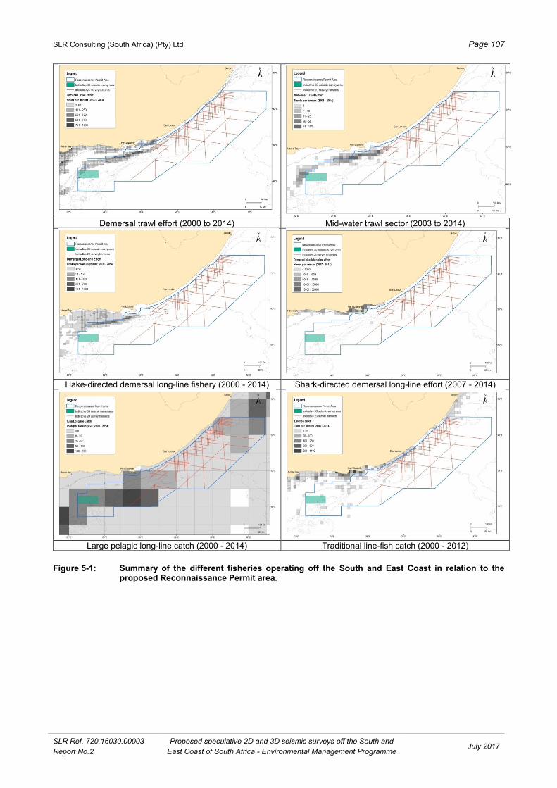
SLR Consulting (South Africa) (Pty) Ltd Page 107
SLR Ref. 720.16030.00003
Report No.2
Proposed speculative 2D and 3D seismic surveys off the South and
East Coast of South Africa - Environmental Management Programme July 2017
Demersal trawl effort (2000 to 2014) Mid-water trawl sector (2003 to 2014)
Hake-directed demersal long-line fishery (2000 - 2014) Shark-directed demersal long-line effort (2007 - 2014)
Large pelagic long-line catch (2000 - 2014) Traditional line-fish catch (2000 - 2012)
Figure 5-1: Summary of the different fisheries operating off the South and East Coast in relation to the proposed Reconnaissance Permit area.

SLR Consulting (South Africa) (Pty) Ltd Page 108
SLR Ref. 720.16030.00003
Report No.2
Proposed speculative 2D and 3D seismic surveys off the South and
East Coast of South Africa - Environmental Management Programme July 2017
Small pelagic purse-seine effort (2000 - 2014) South coast rock lobster catch (2008 – 2012)
Squid-jig fishery (2012 - 2015)
Figure 5.1 (cont.): Summary of the different fisheries operating off the South and East Coast in relation to the
proposed Reconnaissance Permit area.
Table 5.19: Potential impact on fishing sectors operating off the South and East Coast.
RATING SCALES WITHOUT MITIGATION WITH MITIGATION
Demersal Trawl
Extent Local Local
Duration Short-term Short-term
Intensity Medium Medium
Significance Very Low VERY LOW
Status Negative Negative
Probability Highly Probable Highly Probable
Confidence High High
Mid-water Trawl
Extent Regional Regional
Duration Short-Term Short-Term
Intensity Medium Medium
Significance Low LOW
Status Negative Negative
Probability Probable Probable
Confidence High High
Hake-directed demersal long-line
Extent Local Local

SLR Consulting (South Africa) (Pty) Ltd Page 109
SLR Ref. 720.16030.00003
Report No.2
Proposed speculative 2D and 3D seismic surveys off the South and
East Coast of South Africa - Environmental Management Programme July 2017
RATING SCALES WITHOUT MITIGATION WITH MITIGATION
Duration Short-term Short-term
Intensity Low Low
Significance Very Low VERY LOW
Status Negative Negative
Probability Highly Probable Highly Probable
Confidence High High
Shark-directed demersal long-line
Extent Local Local
Duration Short-term Short-term
Intensity Low Low
Significance Very Low VERY LOW
Status Negative Negative
Probability Highly Probable Highly Probable
Confidence High High
Large pelagic long-line
Extent Local to Regional Local to Regional
Duration Short-Term Short-Term
Intensity Medium Medium
Significance Low to Very Low LOW TO VERY LOW
Status Negative Negative
Probability Probable Probable
Confidence High High
Traditional linefish
Extent Regional Regional
Duration Short-Term Short-Term
Intensity Medium Medium
Significance Low LOW
Status Negative Negative
Probability Probable Probable
Confidence High High
Small pelagic purse seine
Extent Local Local
Duration Short-term Short-term
Intensity Low Low
Significance Very Low VERY LOW
Status Negative Negative
Probability Highly Probable Highly Probable
Confidence High High
South Coast rock lobster
Extent Regional Regional
Duration Short-Term Short-Term
Intensity Medium Medium
Significance Low LOW
Status Negative Negative
Probability Probable Probable
Confidence High High
Squid jig
Extent Local Local
Duration Short-term Short-term

SLR Consulting (South Africa) (Pty) Ltd Page 110
SLR Ref. 720.16030.00003
Report No.2
Proposed speculative 2D and 3D seismic surveys off the South and
East Coast of South Africa - Environmental Management Programme July 2017
RATING SCALES WITHOUT MITIGATION WITH MITIGATION
Intensity Medium Medium
Significance Very Low VERY LOW
Status Negative Negative
Probability Highly Probable Highly Probable
Confidence High High
Nature of cumulative impact Other activities that may contribute to the cumulative impact on those
fishing sectors operating in the area include other exploration activities
off the South and East Coast. Cumulative impact is considered to be of
LOW significance.
Degree to which impact can be reversed Fully reversible
Degree to which impact may cause
irreplaceable loss of resources
Low
Degree to which impact can be
mitigated
None to Very Low
5.3.1.2 Potential impact on fisheries research
Description of impact
Fisheries research on demersal and small pelagic fish resources are undertaken by DAFF off the South
African coastline on a bi-annual basis in order to set the annual TAC. The presence of the survey vessel,
and associated 500 m safety zone and proposed safe operational limits, could interfere with these research
surveys should they occur in similar areas at the same time. In addition, fish could temporarily avoid the
survey area while the seismic source array is active. There are potentially three research surveys that could
take place in the proposed Reconnaissance Permit area, namely: a demersal trawl for hake, an acoustic
survey for small pelagic species and squid surveys.
Assessment
The Demersal Trawl survey normally takes place in either April/May or September/October (the periods
selected may vary). The survey is normally a random depth-stratified bottom trawl targeting primarily hake
but also other demersal species such as squid. As the survey site selection is random, the location of each
survey cannot be predicted until the planning stages prior to survey commencement. In the proposed
Reconnaissance Permit area, the number of random trawls is unlikely to exceed 5 trawls over a period of no
more than five days.
A single acoustic survey of small pelagic species is undertaken once a year across the Agulhas Bank
(normally between May and June of each year). These are normally undertaken along a fixed transect
working east to west and from shallow to deep. The research survey vessel would likely be present in the
vicinity of the proposed 3D seismic operations for a short period approximating no more than five days.
Different vessels are generally used for the squid surveys during the closed squid fishing season in October/
November. These surveys may use a specialised research vessel or commercial vessel with suitable
acoustic equipment. These surveys also simultaneously test catch rates of squid using jigs. Squid surveys
primarily occur in the bay areas of the south coast, in particular Cape St Francis where the target is the squid
aggregations. These surveys are unlikely to coincide with any of the proposed seismic survey operations.
The fish stock biomass assessments from the above-mentioned trawls and acoustic surveys undertaken by
DAFF could be influenced if sampling is undertaken within 33 km (estimate) of active airguns. If the two
activities occur simultaneously, the significance of the potential impact of the sound generated during the
seismic operations on fisheries research surveys would be of local extent, short-term duration and of medium

SLR Consulting (South Africa) (Pty) Ltd Page 111
SLR Ref. 720.16030.00003
Report No.2
Proposed speculative 2D and 3D seismic surveys off the South and
East Coast of South Africa - Environmental Management Programme July 2017
to high intensity. The overall significance of the impact on the research surveys would be considered VERY
LOW with and without mitigation. If the proposed seismic survey were timed to avoid the periods during
which the various research surveys would take place, the overall significance would be reduced to
INSIGNIFICANT (see Table 5.20).
Mitigation
Mitigation is the same as for the fishing industry described above (Section 5.4.1.1)
Table 5.20: Potential impact on fishing research off the South and East Coasts.
RATING SCALES WITHOUT MITIGATION WITH MITIGATION
Extent Local Local
Duration Short-Term Short-Term
Intensity Medium to High Medium to Low
Significance Very Low VERY LOW to INSIGNIFICANT
Status Negative Negative
Probability Probable Improbable
Confidence High High
Nature of cumulative impact Other activities that may contribute to the cumulative impact on fishing
research surveys include other exploration activities off the South and
East Coast. Cumulative impact is considered to be of VERY LOW
significance.
Degree to which impact can be reversed Fully Reversible
Degree to which impact may cause
irreplaceable loss of resources
Low
Degree to which impact can be
mitigated
None to Low
5.3.2 POTENTIAL IMPACT ON MARINE TRANSPORT ROUTES
Description of impact
The acquisition of high quality data requires that the position of the survey vessel is accurately known and
that the survey vessel would need to travel in uninterrupted lines. For this reason the survey vessel
(together with the towed array and hydrophone streamers) is considered to be restricted in its ability to
manoeuvre and under COLREGS, 1972 (Part A, Rule 10) requires that power-driven and sailing vessels give
way to a vessel restricted in its ability to manoeuvre. Vessels engaged in fishing are also required to, so far
as possible, keep out of the way of a vessel restricted in its ability to manoeuvre. Furthermore, under the
Marine Traffic Act, 1981, a vessel (including array of airguns and hydrophones) used for the purpose of
exploiting the seabed falls under the definition of an “offshore installation” and as such it is protected by a
500 m safety zone. It is an offence for an unauthorised vessel to enter the safety zone. In addition to a
statutory 500 m safety zone, a seismic contractor would request a safe operational limit (that is greater than
the 500 m safety zone) that it would like other vessels to stay beyond. Typical safe operational limits are
illustrated in Figure 3.3.
The presence of the survey vessels with the associated 500 m safety zone and proposed safe operational
limits could interfere with shipping in the area.
Assessment
A large number of vessels navigate along the South and East Coasts on their way around the southern
African subcontinent (see Figure 4-32). The majority of this vessel traffic, including commercial and fishing
vessels, remains relatively close inshore and is, therefore, expected to pass inshore of the proposed survey
operations. North- and south-bound cargo vessels usually remain over the mid-shelf (100 m isobath), while

SLR Consulting (South Africa) (Pty) Ltd Page 112
SLR Ref. 720.16030.00003
Report No.2
Proposed speculative 2D and 3D seismic surveys off the South and
East Coast of South Africa - Environmental Management Programme July 2017
tankers and bulk carriers usually remain further offshore. The latter do, however, move closer inshore to
escape extremely rough conditions that develop within the Agulhas Current. Some offshore commercial
traffic departs east off the East Coast. Important commercial harbours include Mossel Bay, Port Elizabeth,
East London, Durban and Richards Bay.
Although the safety zone around the survey vessel would be relatively small, all vessels would be prohibited
from entering this area resulting in disruptions and/or delays. The displacement of shipping would thus be
limited to within the extreme near vicinity of the survey vessel. This is normally mitigated by a notice to
mariners and regular communication through daily notifications.
The potential impact on shipping traffic in the proposed Reconnaissance Permit area is considered to be
regional, of high intensity in the short-term. The significance of this potential impact is therefore assessed to
be medium without mitigation and LOW with mitigation (see Table 5.21).
Mitigation
Recommendations to mitigate the potential impacts on marine transport routes are similar to that
recommended for fishing (refer to Section 4.5.1). In addition, the following is recommended:
All vessels must be certified for seaworthiness through an appropriate internationally recognised
marine certification programme (e.g. Lloyds Register, Det Norske Veritas). The certification, as well as
existing safety standards, requires that safety precautions would be taken to minimise the possibility of
an offshore accident;
Collision prevention equipment should include radar, multi-frequency radio, foghorns, etc. Additional
precautions include:
> A support / chase vessel with an on-board FLO who is familiar with the fisheries expected in the
area;
> The existence of an internationally agreed 500 m safety zone around the survey vessels;
> Cautionary notices to mariners; and
> Access to current weather service information.
The vessels are required to fly standard flags, lights (three all-round lights in a vertical line, with the
highest and lowest lights being red and the middle light being white) or shapes (three shapes in a
vertical line, with the highest and lowest lights being balls and the middle light being a diamond) to
indicate that they are engaged in towing surveys and are restricted in manoeuvrability, and must be
fully illuminated during twilight and night; and
Report any emergencies to SAMSA.
Table 5.21: Impact on marine traffic and transport routes.
RATING SCALES WITHOUT MITIGATION WITH MITIGATION
Extent Regional Regional
Duration Short-term Short-term
Intensity High Medium
Significance Medium LOW
Status Negative Negative
Probability Probable Probable
Confidence Medium Medium
Nature of cumulative impact Other activities that may contribute to the cumulative impact on shipping
traffic include other exploration and fishing activities off the South and
East Coast. Cumulative impact is considered to be of LOW
significance.
Degree to which impact can be reversed Fully reversible

SLR Consulting (South Africa) (Pty) Ltd Page 113
SLR Ref. 720.16030.00003
Report No.2
Proposed speculative 2D and 3D seismic surveys off the South and
East Coast of South Africa - Environmental Management Programme July 2017
RATING SCALES WITHOUT MITIGATION WITH MITIGATION
Degree to which impact may cause
irreplaceable loss of resources
Low
Degree to which impact can be
mitigated
Low
5.3.3 POTENTIAL IMPACT ON MARINE PROSPECTING, MINING, EXPLORATION AND PRODUCTION
ACTIVITIES
Description of impact
The presence of the survey vessels with the associated 500 m safety zone and proposed safe operational
limits could interfere with other prospecting, mining, exploration and production activities in the area.
Assessment
Prospecting and mining
The issuing of rights for different minerals in the same area could result in a conflict between right holders.
The proposed Reconnaissance Permit area overlaps partly with a phosphate prospecting area
(see Figure 4-34). Given the small area of overlap in relation to the overall size of the identified prospecting
areas, as well as the short duration of the survey activities, it is unlikely prospecting operations would be
affected.
The potential impact on prospecting in the proposed Reconnaissance Permit area is considered to be
localised and of very low intensity in the short-term. The significance of this potential impact is thus
assessed to be INSIGNIFICANT with and without mitigation (see Table 5.22).
Exploration and production
Exploration for oil and gas is currently undertaken in a number of licence blocks off the West, South and East
coasts of South Africa (see Figure 4-33). The survey vessels would need to exit the proposed Recognisance
Permit area during line changes, which may, although unlikely, have an impact on adjacent exploration right
holders and associated exploration activities. The potential impact on exploration activities, although unlikely,
is considered to be localised, of low to medium intensity in the short-term. The significance of this impact is
assessed to be VERY LOW with and without mitigation (see Table 5.22).
There are no current development or production activities off the East Coast. The closest production related
activities are located in Block 9 on the South Coast, approximately to the west of the proposed
Reconnaissance Permit area. Thus, the proposed exploration activities would have NO IMPACT on other
production related activities.
Mitigation
PGS should engage timeously with overlapping and neighbouring right holders in order to discuss the
scheduling of the proposed survey in relation to current / proposed exploration activities. This would
involve pre-survey notification of navigational co-ordinates of the survey area, timing and duration of
proposed activities; and
Any dispute arising with other right holders should be referred to the DMR or PASA for resolution.

SLR Consulting (South Africa) (Pty) Ltd Page 114
SLR Ref. 720.16030.00003
Report No.2
Proposed speculative 2D and 3D seismic surveys off the South and
East Coast of South Africa - Environmental Management Programme July 2017
Table 5.22: Impact on marine prospecting, mining, exploration and production activities.
RATING SCALES WITHOUT MITIGATION WITH MITIGATION
Prospecting
Extent Local Local
Duration Short-term Short-term
Intensity Very Low Very Low
Significance Insignificant INSIGNIFICANT
Status Negative Negative
Probability Improbable Improbable
Confidence High High
Exploration
Extent Local Local
Duration Short-term Short-term
Intensity Low to Medium Low
Significance Very Low VERY LOW
Status Negative Negative
Probability Improbable Improbable
Confidence High High
Nature of cumulative impact Other activities that may contribute to the cumulative impact on marine
prospecting, mining, exploration and production activities include other
exploration activities off the South and East coast of South Africa.
Cumulative impact is considered to be of VERY LOW significance.
Degree to which impact can be reversed Fully reversible
Degree to which impact may cause
irreplaceable loss of resources
Low
Degree to which impact can be
mitigated
Very Low
SOCIO-ECONOMIC IMPACT OF EXPLORATION ACTIVITIES 5.4
5.4.1 POTENTIAL IMPACT RELATED TO JOB CREATION AND BUSINESS OPPORTUNITIES
Description of impact
The proposed survey operations would create a minor number of local employment and business
opportunities. Direct revenues would be generated as a result of the proposed survey activities. Revenue
generating activities are related to the actual operations and include refuelling, vessel / gear repair, port dues
and hire of local fishing vessels as support vessel.
Assessment
Offshore exploration is highly technical and requires specialised survey vessels and crews, none of which
are based in South Africa. Thus job opportunities during the survey operations would also be very limited.
There would, however, be opportunities for local companies to provide support services during the proposed
survey operations, e.g. vessel supplies, support vessels, etc. In addition, opportunities are further limited by
the very short duration of the proposed operations (i.e. 180 days).
The overall positive impact of job creation and the generation of direct revenues is considered to be local in
extent and of very low to low intensity over the short-term. Thus the potential impact of job creation during
this phase of exploration is considered to be VERY LOW (positive) with and without mitigation (see
Table 5.23).

SLR Consulting (South Africa) (Pty) Ltd Page 115
SLR Ref. 720.16030.00003
Report No.2
Proposed speculative 2D and 3D seismic surveys off the South and
East Coast of South Africa - Environmental Management Programme July 2017
Mitigation
The use of local companies for support services should be promoted as far as possible.
Table 5.23: Impact of job creation and the generation of direct revenues.
RATING SCALES WITHOUT MITIGATION WITH MITIGATION
Extent Local Local
Duration Short-term Short-term
Intensity Very Low Very Low
Significance Very Low VERY LOW
Status Positive Positive
Probability Probable Probable
Confidence Medium Medium
Nature of cumulative impact Other activities that may contribute to the cumulative impact of job
creation and the generation of direct revenues include other exploration
activities off the coast of South Africa. Cumulative impact is considered
to be of LOW (positive) significance.
Degree to which impact can be reversed Fully reversible
Degree to which impact may cause
irreplaceable loss of resources
N/A
Degree to which impact can be
mitigated
None
5.4.2 POTENTIAL IMPACT ON RECREATION AND TOURISM
Description of impact
Recreational vessels (including dive charter vessels) would be required to stay out of the 500 m safety zone
(in terms of the Marine Traffic Act, 1981) and give way to a seismic vessel while it is restricted in its ability to
manoeuvre (in terms of COLREGS, 1972). The presence of the survey vessels could thus interfere with
tourism (mainly diving) activities off the East Coast. In addition, seismic noise could have an impact on the
divers hearing if the survey operations take place in close proximity to popular dive sites.
Assessment
Diving is one of the more popular tourist attractions along the East Coast. The warm clear waters and
abundant and diverse reef fauna along the KwaZulu-Natal coast has resulted in the Sodwana Bay, Aliwal
Shoal and Protea Bank (approximately 450, 85 and 18 km north of the proposed Reconnaissance Permit Area,
respectively) regions and surrounding reefs being popular recreational dive (scuba) centres. There are
numerous popular dive sites located along the East Coast (such as Danger Point, Three Sisters and Nahoon Reef
offshore of East London, as well as Algoa Bay), which generally occur relatively close inshore in water depths up
to 40 m water depth. It is anticipated that these dive sites would not overlap directly with the area of survey
operations, as the sites are generally located on the shelf inshore of the proposed Reconnaissance Permit
area (i.e. inshore of 15 km of the coast).
The operation of an airgun creates propagating pressure (sound) waves through the water and to a much
lesser extent through the air. The sound waves generated extend radially from the source. Those which
travel upward reach the surface of the sea and to a large extent are reflected or dissipated at this interface.
Some do escape into the air to create the ‘muffled’ pop that characterises airgun operations at the surface.
The sound waves that travel downwards reach the seabed and further reflection and attenuation occurs,
although enough penetrate and return from the subsurface rock layers to provide the data for seismic
analysis. The sound waves that travel sideways continue until they meet an object or are dissipated by
normal decay of the signal (Macduff-Duncan & Davies, 1995).
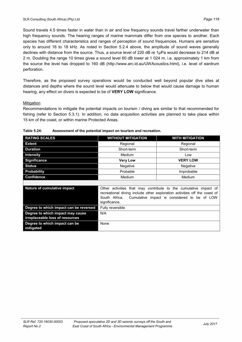
SLR Consulting (South Africa) (Pty) Ltd Page 116
SLR Ref. 720.16030.00003
Report No.2
Proposed speculative 2D and 3D seismic surveys off the South and
East Coast of South Africa - Environmental Management Programme July 2017
Sound travels 4.5 times faster in water than in air and low frequency sounds travel farther underwater than
high frequency sounds. The hearing ranges of marine mammals differ from one species to another. Each
species has different characteristics and ranges of perception of sound frequencies. Humans are sensitive
only to around 16 to 18 kHz. As noted in Section 5.2.4 above, the amplitude of sound waves generally
declines with distance from the source. Thus, a source level of 220 dB re 1µPa would decrease to 214 dB at
2 m. Doubling the range 10 times gives a sound level 60 dB lower at 1 024 m, i.e. approximately 1 km from
the source the level has dropped to 160 dB (http://www.arc.id.au/UWAcoustics.html), i.e. level of eardrum
perforation.
Therefore, as the proposed survey operations would be conducted well beyond popular dive sites at
distances and depths where the sound level would attenuate to below that would cause damage to human
hearing, any effect on divers is expected to be of VERY LOW significance.
Mitigation
Recommendations to mitigate the potential impacts on tourism / diving are similar to that recommended for
fishing (refer to Section 5.3.1). In addition, no data acquisition activities are planned to take place within
15 km of the coast, or within marine Protected Areas.
Table 5.24: Assessment of the potential impact on tourism and recreation.
RATING SCALES WITHOUT MITIGATION WITH MITIGATION
Extent Regional Regional
Duration Short-term Short-term
Intensity Medium Low
Significance Very Low VERY LOW
Status Negative Negative
Probability Probable Improbable
Confidence Medium Medium
Nature of cumulative impact Other activities that may contribute to the cumulative impact of
recreational diving include other exploration activities off the coast of
South Africa. Cumulative impact is considered to be of LOW
significance.
Degree to which impact can be reversed Fully reversible
Degree to which impact may cause
irreplaceable loss of resources
N/A
Degree to which impact can be
mitigated
None

SLR Consulting (South Africa) (Pty) Ltd Page 117
SLR Ref. 720.16030.00003
Report No.2
Proposed speculative 2D and 3D seismic surveys off the South and
East Coast of South Africa - Environmental Management Programme July 2017
6 CONCLUSIONS AND RECOMMENDATIONS
PGS is proposing to undertake 2D and 3D seismic survey operations in various licence blocks off the South
and East Coasts of South Africa. The proposed Reconnaissance Permit area is approximately 227 584 km2
in extent and is situated between approximately 15 km and 250 km offshore, roughly between Mossel Bay
and Port Edward. Although survey commencement would ultimately depend on a permit award date and the
availability of a survey vessel, it is anticipated that the surveys would commence in December 2017. The
duration of the surveys would be dependent on whether the 2D and 3D surveys are run concurrently or at a
different times, however it is anticipated that the surveys would be completed by the end of May 2018.
In order to undertake the proposed speculative surveys, PGS lodged an application for a Reconnaissance
Permit with PASA in terms of Section 74 of the MPRDA. PASA accepted its application on 9 March 2017 and
requested that PGS prepare a ‘plan for managing potential environmental impacts that may result from the
proposed operation and consult with affected parties’ and submit it to them for consideration and for approval
by the Minister of Mineral Resources. In this regard, PGS appointed SLR to compile this EMP and
undertake the required public participation process for the proposed speculative seismic surveys.
Specialists were appointed to address the two key issues, namely the effect on the fishing industry and
effects on marine fauna. The findings of the specialist studies and other relevant information have been
integrated and synthesised into this EMP.
This chapter summarises the key findings of the study and presents mitigation measures that should be
implemented if the proposed survey operations go ahead.
CONCLUSIONS 6.1
6.1.1 GENERAL CONCLUSIONS
A summary of the assessment of potential environmental impacts associated with the proposed seismic
survey operations is provided in Table 6.1.
In overall summary, the majority of the impacts associated with seismic survey operations would be of short-
term duration and limited to the immediate survey area. Thus, the impacts are considered to be of
INSIGNIFICANT to LOW significance after mitigation.
However, two key issues assessed in this study are likely to result in impacts of more substantial
significance. These are:
the potential impact on turtles and cetaceans (physiological injury and behavioural avoidance) as a
result of seismic noise; and
the potential impact on the fishing industry (vessel interaction, disruption to fishing operations and
reduced catch) due to the presence of the survey vessel with its associated safety zone, potential fish
avoidance of the survey target areas and changes in feeding behaviour.
The potential impacts on turtles has been assessed to be of VERY LOW significance with mitigation as the
proposed target areas are located more than 200 km south of the main turtle nesting sites on the KwaZulu-
Natal coast. However, hatchlings and juveniles may be encountered within the proposed survey target areas,
as they move southward in the Agulhas Current after emerging from their nesting sites (from late summer
onwards). As the hatchlings are weak swimmers, they are more vulnerable to collision with the towed
equipment and to direct seismic noise impacts from the air-guns. In order to mitigate the potential impact on
turtles, it is recommended that the surveys located in the northern portion of the proposed Reconnaissance Permit

SLR Consulting (South Africa) (Pty) Ltd Page 118
SLR Ref. 720.16030.00003
Report No.2
Proposed speculative 2D and 3D seismic surveys off the South and
East Coast of South Africa - Environmental Management Programme July 2017
Application area should, as far as possible be undertaken in December, well ahead of the turtle hatching
period. Various other measures are recommended to further mitigate the potential impact on turtles, e.g.
“soft-starts”, temporary termination of survey, the use of ‘turtle-friendly’ tail buoys or fitting existing tail buoys
with either exclusion or deflector 'turtle guards', etc.
Table 6.1: Summary of the significance of potential impacts of the proposed 2D and 3D speculative seismic surveys off the South and East coasts of South Africa.
Potential impact Probability
(with mitigation)
Significance
Without
mitigation
With
mitigation
Normal seismic / support vessels and helicopter operation:
Emissions to the atmosphere Definite VL VL
Deck drainage into the sea Highly probable VL VL
Machinery space drainage into the sea Highly probable VL VL
Sewage effluent into the sea Definite VL VL
Galley waste disposal into the sea Highly probable VL VL
Solid waste disposal into the sea Improbable Insig. INSIG.
Accidental oil spill during
bunkering / refuelling
Within port limits Improbable Insig. INSIG.
Offshore Improbable L VL
Noise from seismic and support vessel operations Probable VL VL
Noise from helicopter operation Improbable L-M VL
Impact of seismic noise on marine fauna:
Plankton Probable VL VL
Invertebrates Physiological injury Improbable VL VL
Behavioural avoidance Probable VL VL
Fish Physiological injury Improbable L VL
Behavioural avoidance Improbable L VL
Spawning and recruitment Improbable L VL
Masking sound and communication Improbable VL VL
Indirect impacts on food sources Improbable VL VL
Diving seabirds Physiological injury Improbable L VL
Behavioural avoidance Improbable L VL
Indirect impacts on food sources Improbable VL VL
Non-diving seabirds Physiological injury Improbable Insig. INSIG.
Behavioural avoidance Improbable Insig. INSIG.
Turtles Physiological injury Improbable L VL
Behavioural avoidance Probable L VL
Reproductive success Improbable L VL
Masking sound and communication Improbable Insig. INSIG.
Indirect impacts on food sources Improbable VL VL
Seals Physiological injury Improbable VL VL
Behavioural avoidance Improbable VL VL
Masking sound and communication Probable VL VL
Indirect impacts on food sources Probable VL VL
Mysticetes Cetaceans Physiological injury Probable M L
Behavioural avoidance Probable L - M VL - L
Masking sound and communication Probable VL VL
Indirect impacts on food sources Probable VL VL
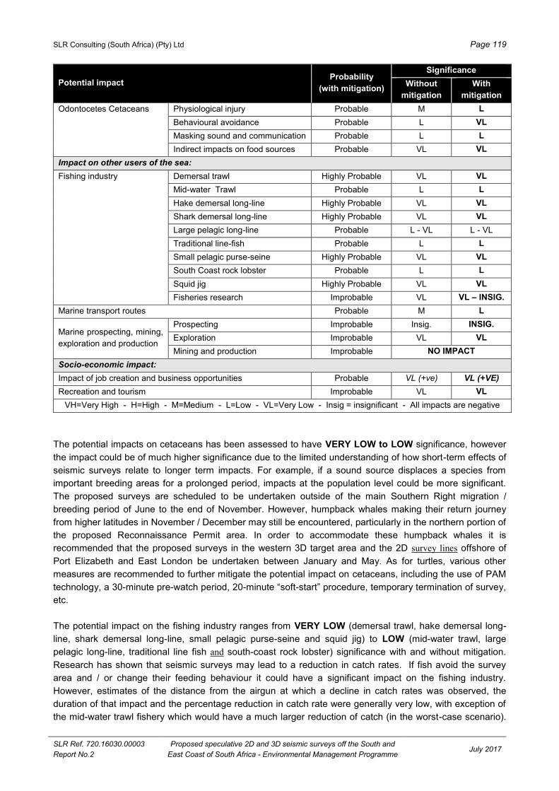
SLR Consulting (South Africa) (Pty) Ltd Page 119
SLR Ref. 720.16030.00003
Report No.2
Proposed speculative 2D and 3D seismic surveys off the South and
East Coast of South Africa - Environmental Management Programme July 2017
Potential impact Probability
(with mitigation)
Significance
Without
mitigation
With
mitigation
Odontocetes Cetaceans Physiological injury Probable M L
Behavioural avoidance Probable L VL
Masking sound and communication Probable L L
Indirect impacts on food sources Probable VL VL
Impact on other users of the sea:
Fishing industry Demersal trawl Highly Probable VL VL
Mid-water Trawl Probable L L
Hake demersal long-line Highly Probable VL VL
Shark demersal long-line Highly Probable VL VL
Large pelagic long-line Probable L - VL L - VL
Traditional line-fish Probable L L
Small pelagic purse-seine Highly Probable VL VL
South Coast rock lobster Probable L L
Squid jig Highly Probable VL VL
Fisheries research Improbable VL VL – INSIG.
Marine transport routes Probable M L
Marine prospecting, mining,
exploration and production
Prospecting Improbable Insig. INSIG.
Exploration Improbable VL VL
Mining and production Improbable NO IMPACT
Socio-economic impact:
Impact of job creation and business opportunities Probable VL (+ve) VL (+VE)
Recreation and tourism Improbable VL VL
VH=Very High - H=High - M=Medium - L=Low - VL=Very Low - Insig = insignificant - All impacts are negative
The potential impacts on cetaceans has been assessed to have VERY LOW to LOW significance, however
the impact could be of much higher significance due to the limited understanding of how short-term effects of
seismic surveys relate to longer term impacts. For example, if a sound source displaces a species from
important breeding areas for a prolonged period, impacts at the population level could be more significant.
The proposed surveys are scheduled to be undertaken outside of the main Southern Right migration /
breeding period of June to the end of November. However, humpback whales making their return journey
from higher latitudes in November / December may still be encountered, particularly in the northern portion of
the proposed Reconnaissance Permit area. In order to accommodate these humpback whales it is
recommended that the proposed surveys in the western 3D target area and the 2D survey lines offshore of
Port Elizabeth and East London be undertaken between January and May. As for turtles, various other
measures are recommended to further mitigate the potential impact on cetaceans, including the use of PAM
technology, a 30-minute pre-watch period, 20-minute “soft-start” procedure, temporary termination of survey,
etc.
The potential impact on the fishing industry ranges from VERY LOW (demersal trawl, hake demersal long-
line, shark demersal long-line, small pelagic purse-seine and squid jig) to LOW (mid-water trawl, large
pelagic long-line, traditional line fish and south-coast rock lobster) significance with and without mitigation.
Research has shown that seismic surveys may lead to a reduction in catch rates. If fish avoid the survey
area and / or change their feeding behaviour it could have a significant impact on the fishing industry.
However, estimates of the distance from the airgun at which a decline in catch rates was observed, the
duration of that impact and the percentage reduction in catch rate were generally very low, with exception of
the mid-water trawl fishery which would have a much larger reduction of catch (in the worst-case scenario).

SLR Consulting (South Africa) (Pty) Ltd Page 120
SLR Ref. 720.16030.00003
Report No.2
Proposed speculative 2D and 3D seismic surveys off the South and
East Coast of South Africa - Environmental Management Programme July 2017
In general, it has been found that behavioural effects are short-term with duration of the effect being less
than or equal to the duration of exposure, although these vary between species and individuals, and are
dependent on the properties of the received sound.
Similarly, any interaction between the survey vessels and fishing vessels could increase the significance of
the impact on these sectors. Thus it is important that the operator engage with the fishing industry prior to
and during the survey operations in order to establish the location of current fishing effort and, where
possible, to adjust the survey plan to accommodate fishing. In addition, it is recommended that Radio
Navigation Warnings and Notices to Mariners are distributed throughout the seismic survey periods. The
placement of an on-board FLO would also help ensure that ongoing communication (via daily reports) is
maintained between the survey vessels and the fishing industry and other users of the sea. This proposed
regular communication with fishing vessels in the vicinity of the proposed survey operations would minimise
the potential disruption to fishing operations and risk of gear entanglements.
SLR is of the opinion that based on the findings of the impact assessment, (potential impacts generally of
VERY LOW to LOW significance after mitigation) a positive decision should be made by the Minister of
Mineral Resources (or delegated authority) in this regard.
RECOMMENDATIONS FOR MITIGATION 6.2
6.2.1 COMPLIANCE WITH EMP AND MARPOL STANDARDS
All phases of the proposed project (including pre-establishment phase, establishment phase,
operational phase, and decommissioning and closure phase) must comply with the EMP presented in
Chapter 7. In addition, the seismic and support vessels must ensure compliance with the MARPOL
73/78 standards.
6.2.2 PERMIT / EXEMPTION REQUIREMENTS
In terms of the Marine Living Resources Act, 1998 (No. 18 of 1998) it is illegal for any vessel to
approach to or remain within 300 m of whales within South African waters without a permit or
exemption. Thus, if the operator or seismic contractor are not able to comply with this restriction, an
application should be made to DEA for a permit or exemption.
6.2.3 COMMUNICATION WITH KEY STAKEHOLDERS
Prior to survey commencement the following key stakeholders should be consulted and informed of
the proposed survey activity (including navigational co-ordinates of the survey area, timing and
duration of proposed activities) and the likely implications thereof:
> Fishing industry / associations:
- SA Deep-Sea Trawling Industry Association (SADSTIA);
- South East Coast Inshore Fishing Association (SECIFA);
- SA Midwater Trawling Association;
- SA Hake Longline Association (SAHALLA);
- Shark Longline Association;
- South African Tuna Long-Line Association (SATLA);
- SA Marine Linefish Management Association (SAMLMA);
- SA Pelagic Fishing Industry Association (SAPFIA);
- South Coast Rock Lobster Association; and
- SA Squid Management Industrial Association (SASMIA).

SLR Consulting (South Africa) (Pty) Ltd Page 121
SLR Ref. 720.16030.00003
Report No.2
Proposed speculative 2D and 3D seismic surveys off the South and
East Coast of South Africa - Environmental Management Programme July 2017
> Other:
- PASA;
- DAFF;
- Transnet National Ports Authority;
- SAMSA;
- South African Navy Hydrographic office; and
- Overlapping and neighbouring right holders.
These stakeholders should again be notified at the completion of surveying when the survey vessel
and support vessels are off location.
The operator must request, in writing, that the South African Navy Hydrographic office release Radio
Navigation Warnings and Notices to Mariners throughout the survey periods. The Notice to Mariners
should give notice of (1) the co-ordinates of the proposed survey area, (2) an indication of the
proposed timeframes of surveys and day-to-day location of the survey vessel(s), and (3) an indication
of the 500 m safety zones and the proposed safe operational limits of the survey vessel. These
Notices to Mariners should be distributed timeously to fishing companies and directly onto vessels
where possible;
An independent on-board FLO who is familiar with fisheries operational in the area must be appointed
for the duration of the survey operations. The FLO should provide a fisheries facilitation role to identify
and communicate with fishing vessels in the area to reduce the risk of gear interaction between fishing
and survey activities. The FLO should:
> report on vessel activity daily;
> advise on actions to be taken in the event of encountering fishing gear;
> provide back-up on-board facilitation with the fishing industry and other users of the sea; and
> set up a daily electronic reporting routine to keep key stakeholders informed of survey activity
and progress and fisheries, environmental issues.
In addition to the above, the FLO should assist in the identification of current fishing target areas to,
where possible, allow for the adjustment of the survey plan to accommodate fishing.
Any fishing vessels target a radar range of 12 nm from the survey vessel should be called via radio
and informed of the navigational safety requirements around the survey vessel;
Ongoing notification is to be undertaken throughout the duration of survey with the submission of daily
reports (via email) indicating the vessel’s location to key stakeholders, as appropriate;
Any dispute arising with other right holders should be referred to DMR or PASA for resolution; and
Marine mammal incidence data and seismic source output data arising from the survey should be
made available, if requested, to the Marine Mammal Institute, DEA, DAFF and PASA for analyses of
survey impacts in local waters.
6.2.4 VESSEL SAFETY
All vessels must be certified for seaworthiness through an appropriate internationally recognised
marine certification programme (e.g. Lloyds Register, Det Norske Veritas). The certification, as well as
existing safety standards, requires that safety precautions would be taken to minimise the possibility of
an offshore accident;
Collision prevention equipment should include radar, multi-frequency radio, foghorns, etc. Additional
precautions include:
> A support / chase vessel with an on-board FLO familiar with the fisheries expected in the area;
> The existence of an internationally agreed 500 m safety zone around the survey vessel;
> Cautionary notices to mariners; and
> Access to current weather service information.

SLR Consulting (South Africa) (Pty) Ltd Page 122
SLR Ref. 720.16030.00003
Report No.2
Proposed speculative 2D and 3D seismic surveys off the South and
East Coast of South Africa - Environmental Management Programme July 2017
The vessels are required to fly standard flags, lights (three all-round lights in a vertical line, with the
highest and lowest lights being red and the middle light being white) or shapes (three shapes in a
vertical line, with the highest and lowest lights being balls and the middle light being a diamond) to
indicate that they are engaged in towing surveys and are restricted in manoeuvrability, and must be
fully illuminated during twilight and night; and
Report any emergency situation to SAMSA.
6.2.5 EMISSIONS, DISCHARGES INTO THE SEA AND SOLID WASTE
Ensure adequate maintenance of diesel motors and generators to minimise emissions to the
atmosphere;
Route deck and machinery space drainage to a separate drainage system (oily water catchment
system) for treatment to ensure compliance with MARPOL (15 ppm);
Ensure all process areas are bunded to ensure drainage water flows into the closed drainage system;
Use drip trays to collect run-off from equipment that is not contained within a bunded area and route
contents to the closed drainage system;
Use low toxicity, biodegradable detergents during deck cleaning to further minimise the potential
impact of deck drainage on the marine environment;
Ensure adequate maintenance of all hydraulic systems and frequent inspection of hydraulic hoses;
Undertake spill management training and awareness of crew members of the need for thorough clean-
up of any spillages immediately after they occur, as this would minimise the volume of contaminants
washing off decks;
Initiate an on-board waste minimisation system;
Ensure on-board solid waste storage is secure;
Ensure that waste (solid and hazardous) disposal onshore is carried out in accordance with the
appropriate laws and ordinances; and
Prepare a project specific Emergency Response Plan and Shipboard Oil Pollution Emergency Plan for
the proposed seismic survey, which defines the organisational structure and protocols that would be
implemented to respond to any incident (including accidental oil / fuel spills) in a safe, rapid, effective
and efficient manner.
6.2.6 OFFSHORE BUNKERING
Offshore bunkering should not be undertaken in the following circumstances:
> Within 50 nm of the coast;
> Wind force and sea state conditions of 6 or above on the Beaufort Wind Scale;
> During any workboat or mobilisation boat operations;
> During helicopter operations;
> During the transfer of in-sea equipment; and
> At night or times of low visibility.
Support vessels must have the necessary spill response capability to deal with accidental spills in a
safe, rapid, effective and efficient manner; and
Crew must be trained in spill management.
6.2.7 JOB CREATION AND THE GENERATION OF DIRECT REVENUES
The use of local companies for support services should be promoted as far as possible.

SLR Consulting (South Africa) (Pty) Ltd Page 123
SLR Ref. 720.16030.00003
Report No.2
Proposed speculative 2D and 3D seismic surveys off the South and
East Coast of South Africa - Environmental Management Programme July 2017
6.2.8 VESSEL LIGHTING
Lighting on-board survey vessels should be reduced to the minimum safety levels to minimise
stranding of pelagic seabirds on the survey vessels at night. All stranded seabirds must be retrieved
and released during daylight hours.
MITIGATION RECOMMENDATIONS SPECIFIC TO SEISMIC SURVEYS 6.3
6.3.1 SURVEY TIMING AND SCHEDULING
The surveys located in the northern portion of the proposed Reconnaissance Permit Application area should, as
far as possible, be planned to avoid the period after turtles have hatched and drift southward in the
Agulhas Current (from late summer onwards). Thus, it is recommended that these surveys be
undertaken before the peak hatchling period, thus in December.
The seismic surveys should be undertaken outside of the key Southern Right migration and breeding period
which extends from the beginning of June to the end of November. In order to accommodate humpback whales
that may still be moving southwards on their return migrations from higher latitudes as late as December, the
surveys in the western-most 3D target area and the 2D survey target lines located between Port Elizabeth and
KwaZulu-Natal should be undertaken between January and May.
6.3.2 EQUIPMENT
‘Turtle-friendly’ tail buoys should be used by the survey contractor or existing tail buoys should be
fitted with either exclusion or deflector 'turtle guards'.
6.3.3 SEISMIC SURVEY PROCEDURES
PAM technology
> The survey vessel must be fitted with PAM technology, which detects animals through their
vocalisations. Due to the proximity of some of the target areas to the coast and the likelihood of
encountering small odontocetes that frequent the nearshore areas, it is recommended that, as a
minimum, PAM technology is used during the pre-watch period and when surveying at night or
during adverse weather conditions and thick fog.
> The PAM hydrophone streamer should ideally be towed behind the airgun array to minimise the
interference of vessel noise, and should be fitted with two hydrophones to allow directional
detection of cetaceans.
> In order to avoid unnecessary delays to the survey programme, it is recommended that a spare
PAM cable and sensor are kept onboard should there be any technical problems with the
system. However, if there is a technical problem with PAM during surveying, visual watches
must be maintained by the MMO during the day and night-vision/infra-red binoculars must be
used at night while PAM is being repaired.
“Soft-start” procedure, pre-watch period and airgun firing
> A “soft-start” procedure of a minimum of 20 minutes’ duration must be implemented when
initiating airgun tests (a single or a number of airguns at full power)4 and / or seismic surveying.
This requires that the sound source be ramped from low to full power rather than initiated at full
4 Note: If the intention is to test a single airgun on low power then a “soft-start” is not required.

SLR Consulting (South Africa) (Pty) Ltd Page 124
SLR Ref. 720.16030.00003
Report No.2
Proposed speculative 2D and 3D seismic surveys off the South and
East Coast of South Africa - Environmental Management Programme July 2017
power, thus allowing a flight response by marine fauna to outside the zone of injury or
avoidance.
> “Soft-start” procedures must only commence once it has been confirmed for at least a 30-minute
period (visually and using PAM technology during the day and using only PAM technology at
night or during periods of poor visibility) that there is no cetacean activity within 500 m of the
vessel. Similarly, it must also be confirmed (visually during the day and using night-vision/infra-
red binoculars at night) that there is no seabird (significant diving activity), turtle or seal activity
within 500 m of the vessel just prior to initiating the “soft-start” procedure.
> “Soft-starts” should be delayed until such time as this area is clear of seabirds (diving), turtles,
seals or cetaceans. In the case of turtles and cetaceans the “soft-start” procedure should not
begin until after the animals depart the 500 m exclusion zone or 30 minutes after they are last
seen. In the case of seals, which are often attracted to survey vessels, the normal “soft-start”
procedures should be allowed to commence, if after a period of 30 minutes seals are still within
500 m of the airguns.
> All breaks in airgun firing of longer than 20 minutes must be followed by a 30-minute pre-shoot
watch and a “soft-start” procedure of at least 20 minutes prior to the survey operation
continuing. In order to facilitate a more effective timing of proposed operations when surveying
in deeper waters, the 30-minute pre-shoot watch can commence before the end of the survey
line (whilst the airguns are still firing). Breaks of shorter than 20 minutes should be followed by
a visual assessment for marine mammals and turtles within the 500 m mitigation zone (not a 30-
minute pre-shoot watch) and a “soft-start” of similar duration.
> The use of the lowest practicable airgun volume, as defined by the operator, should be defined
and enforced.
> During surveying, airgun firing should be terminated when:
- obvious negative changes to turtle, seal and cetacean behaviour is observed;
- turtles or cetaceans are observed within 500 m of the operating airgun and appear to be
approaching the firing airgun; or
- there is mass mortality of fish or mortality / injuries to seabirds, turtles, seals or cetaceans
as a direct result of the survey.
> The survey should remain terminated until such time the time MMO / PAM operator confirms
that:
- turtles or cetaceans have moved to a point that is more than 500 m from the source;
- despite continuous observation, 30 minutes has elapsed since the last sighting of the
turtles or cetaceans within 500 m of the source; and
- risks to seabirds, turtles, seals or cetaceans have been significantly reduced.
> A log of all termination decisions must be kept (for inclusion in both daily and “close-out”
reports).
MMO and PAM operator
> An independent on-board MMO and a PAM operator must be appointed for the duration of the
seismic survey. The MMO and PAM operator must have experience in seabird, turtle and
marine mammal identification and observation / detection techniques.
> The duties of the MMO would be to:
Marine fauna:
- Confirm that there is no marine faunal activity within 500 m of the seismic source array
prior to commencing with the “soft-start” procedures;
- Record pre-shoot observation regime;
- Record survey activities, including sound levels, “soft-start” procedures and survey
periods (duration);
- Monitor marine faunal activity during daytime surveying. Observe and record responses
of marine fauna to the seismic survey, including seabird, turtle, seal and cetacean
incidence and behaviour and any mortality or injuries of marine fauna as a result of the

SLR Consulting (South Africa) (Pty) Ltd Page 125
SLR Ref. 720.16030.00003
Report No.2
Proposed speculative 2D and 3D seismic surveys off the South and
East Coast of South Africa - Environmental Management Programme July 2017
seismic survey. Data captured should include species identification, position
(latitude/longitude), distance from the vessel, swimming speed and direction
(if applicable) and any obvious changes in behaviour (e.g. startle responses or changes
in surfacing/diving frequencies, breathing patterns) as a result of the survey activities; and
- Request the temporary termination of the seismic survey, as appropriate. It is important
that the MMOs’ decisions to terminate firing are made confidently and expediently;
Other:
- Record meteorological conditions;
- Monitor compliance with international marine pollution regulations (MARPOL 73/78
standards); and
- Prepare daily reports of all observations. These reports should be forwarded to the key
stakeholders, as appropriate.
> The duties of the PAM operator would be to:
- Ensure that hydrophone streamers are optimally placed within the towed array;
- Confirm that there is no cetaceans activity within 500 m of the vessel prior to commencing
with the “soft-start” procedures;
- Record survey activities, including sound levels, “soft-start” procedures and survey
periods (duration);
- Record pre-shoot observation regime;
- Monitor cetacean activity during daytime and night time surveying. Record species
identification, position (latitude/longitude) and distance from the vessel, where possible;
and
- Request the temporary termination of the seismic survey, as appropriate.
> All data recorded by the MMO and PAM operator should form part of the survey “close-out”
report.
MITIGATION RECOMMENDATIONS SPECIFIC TO HELICOPTER OPERATIONS (WHERE 6.4
REQUIRED)
Flight paths must be pre-planned to ensure that no flying occurs over MPAs (Goukamma, Robberg,
Tsitsikammama, Sardinia Bay MPA, Bird Island, and Amathole MPA), seal (Seal Island, Robberg
Peninsula and Black Rocks) and seabird colonies (Algoa Bay islands, St Croix Island, Jaheel Island,
Bird Island, Seal Island, Stag Island and Brenton Rocks);
Extensive coastal flights (parallel to the coast within 1 nm of the shore) should be avoided. There is a
restriction of coastal flights (parallel to the coast within 1 nm of the shore) on the South Coast between
the months of June and November to avoid Southern Right whale breeding areas;
The operator must comply with the Seabirds and Seals Protection Act, 1973, which prohibits the wilful
disturbance of seals on the coast or on offshore islands.
The contractor should comply fully with aviation and authority guidelines and rules; and
All pilots must be briefed on ecological risks associated with flying at a low level parallel to the coast.

SLR Consulting (South Africa) (Pty) Ltd Page 126
SLR Ref. 720.16030.00003
Report No.2
Proposed speculative 2D and 3D seismic surveys off the South and
East Coast of South Africa - Environmental Management Programme July 2017
7 ENVIRONMENTAL MANAGEMENT PROGRAMME
This chapter lists the auditable environmental protection activities and procedures required to avoid or
minimise impacts on the environment from the proposed seismic surveys within the proposed
Reconnaissance Permit area located the South and East Coast of South Africa. It also indicates who is the
responsible party and includes a compliance audit column () for auditing purposes and the requirements for
closure. The specific environmental protection activities and procedures are addressed under each of the
project life cycle phases listed below:
7.1 PLANNING PHASE
7.1.1 Seismic survey timing and scheduling
7.1.2 Survey equipment
7.1.3 Survey personnel
7.1.4 Preparation of subsidiary plans
7.1.5 Stakeholder consultation and notification
7.1.6 Permits / exemptions
7.2 ESTABLISHMENT PHASE
7.2.1 Compliance with the EMP
7.2.2 Environmental awareness training
7.2.3 Notifying other users of the sea
7.3 OPERATIONAL PHASE
7.3.1 Adherence to the EMP
7.3.2 Communication with other users of the sea and
resource managers
7.3.3 Prevention of emergencies
7.3.4 Dealing with emergencies including major oil spills
7.3.5 Seismic survey procedure and monitoring
7.3.6 Pollution control and waste management
7.3.7 Equipment loss
7.3.8 Use of helicopters
7.3.9 Bunkering / refuelling at sea
7.3.10 Vessel lighting
7.4 DECOMMISSIONING AND CLOSURE PHASE
7.4.1 Survey vessels to leave area
7.4.2 Inform key stakeholders of survey completion
7.4.3 Final waste disposal
7.4.4 Information sharing
7.4.5 Compile seismic survey “close-out” reports

SLR Consulting (South Africa) (Pty) Ltd Page 127
SLR Ref. 720.16030.00003
Report No.2
Proposed speculative 2D and 3D seismic surveys off the South and East Coast of South Africa
Environmental Management Programme July 2017
7.1 PLANNING PHASE
PROJECT PHASE
AND ACTIVITIES:
ENVIRONMENTAL
OBJECTIVES:
AUDITABLE MANAGEMENT ACTIONS TO BE TAKEN TO MEET THE
ENVIRONMENTAL MANAGEMENT PLAN REPORT OBJECTIVES:
RESPONSI-
BILITY: TIMING:
REQUIREMENT
FOR “CLOSE-
OUT” REPORT:
7.1.1 SEISMIC
SURVEY TIMING
AND SCHEDULING
Minimise impact on
cetaceans and turtles
The surveys located in the northern portion of the proposed Reconnaissance Permit
Application area should, as far as possible, be planned to avoid the period after turtles
have hatched and drift southward in the Agulhas Current (from late summer
onwards). Thus, it is recommended that these surveys be undertaken before the
peak hatchling period, thus in December.
The seismic surveys should be undertaken outside of the key Southern Right migration and
breeding period which extends from the beginning of June to the end of November. In
order to accommodate humpback whales that may still be moving southwards on their
return migrations from higher latitudes as late as December, the surveys in the western-
most 3D target area and the 2D survey target lines located between Port Elizabeth and
KwaZulu-Natal should be undertaken between January and May.
PGS Prior to
finalisation of
survey schedule
/ timing
MMO close-out
report
7.1.2 SURVEY
EQUIPMENT
Minimise impact on
cetaceans and turtles
Use ‘turtle-friendly’ tail buoys. Alternatively, the existing tail buoys should be fitted
with either exclusion or deflector 'turtle guards' to prevent turtle entrapment.
The Marine Mammal Observer (MMO) shall inspect tail buoys prior to the survey
to ensure guards are in place. If turtles are observed to be trapped, survey
operations will be ceased until the animal can be freed from the towed equipment.
PGS /
Survey
Contractor
Prior to
commencement
of operation
MMO close-out
report
Seismic surveys:
The seismic survey vessel must be fitted with Passive Acoustic Monitoring (PAM)
technology.
PAM technology must be used during both the pre-watch period and when the
airguns are active (including “soft-starts”, airgun tests and surveying) and when
surveying at night or during adverse weather conditions and thick fog.
In order to avoid unnecessary delays to the survey programme, it is recommended
that a spare PAM cable and sensor are kept onboard should there be any
technical problems with the system.
PAM operator
close-out report
7.1.3 SURVEY
PERSONNEL
Minimise impact on
marine fauna
Seismic surveys:
Appoint an independent on-board MMO and PAM operator for the duration of the
survey.
The MMO and PAM operator must have experience in seabird, turtle and marine
mammal identification and observation / detection techniques.
PGS Prior to
commencement
of operation
MMO and PAM
operator close-
out reports
Minimise impact on
other users of the sea
Appoint an independent on-board Fisheries Liaison Officer (FLO).
The FLO must be familiar with fisheries operating in the area.
FLO close-out
report

SLR Consulting (South Africa) (Pty) Ltd Page 128
SLR Ref. 720.16030.00003
Report No.2
Proposed speculative 2D and 3D seismic surveys off the South and East Coast of South Africa
Environmental Management Programme July 2017
7.1 PLANNING PHASE
PROJECT PHASE
AND ACTIVITIES:
ENVIRONMENTAL
OBJECTIVES:
AUDITABLE MANAGEMENT ACTIONS TO BE TAKEN TO MEET THE
ENVIRONMENTAL MANAGEMENT PLAN REPORT OBJECTIVES:
RESPONSI-
BILITY: TIMING:
REQUIREMENT
FOR “CLOSE-
OUT” REPORT:
7.1.4
PREPARATION OF
SUBSIDIARY
PLANS
Preparation for any
emergency that could
result in an
environmental impact
Ensure the following plans are prepared and in place:
> Shipboard Oil Pollution Emergency Plan (SOPEP) as required by MARPOL;
> Emergency Response Plan (including MEDIVAC plan); and
> Waste Management Plan (see contents in Section 7.3.6).
In addition to the above, ensure that:
> There is adequate protection and indemnity insurance cover for oil pollution
incidents; and
> There is a record of the vessel’s seaworthiness certificate and/or classification
stamp.
PGS and
Survey
Contractor
Prior to
commencement
of operation
Confirm
compliance and
justify any
omissions
7.1.5
STAKEHOLDER
CONSULTATION
AND NOTIFICATION
PASA notification Compile the specific details of each survey into a Survey Notification document
and submit to Petroleum Agency of south Africa (PASA). The notification should
provide details on the following:
> Survey plan / lines;
> Survey timing and duration;
> Contractor details;
> Vessel specifications (including relevant certification and insurance);
> Emergency Response Plan;
> Shipboard Oil Pollution Emergency Plan (SOPEP); and
> Details of MMO, PAM operator and FLO.
PGS 30-days prior to
commencement
of operations or
as requested by
PASA
Confirm that
notification was
sent to PASA
Stakeholder
notification
Prior to survey commencement the following key stakeholders should be
consulted and informed of the proposed survey activity (including navigational co-
ordinates of the survey area, timing and duration of proposed activities) and the
likely implications thereof:
> Fishing industry / associations:
- SA Deep-Sea Trawling Industry Association (SADSTIA);
- South East Coast Inshore Fishing Association (SECIFA);
- SA Midwater Trawling Association;
- SA Hake Longline Association (SAHALLA);
- Shark Longline Association, South African Tuna Long-Line Association
(SATLA);
- SA Marine Linefish Management Association (SAMLMA);
- SA Pelagic Fishing Industry Association (SAPFIA);
- South Coast Rock Lobster Association; and
- SA Squid Management Industrial Association (SASMIA).
Other:
- PASA;
PGS 30 days prior to
commencement
of operations
Provide copies of
all
correspondence

SLR Consulting (South Africa) (Pty) Ltd Page 129
SLR Ref. 720.16030.00003
Report No.2
Proposed speculative 2D and 3D seismic surveys off the South and East Coast of South Africa
Environmental Management Programme July 2017
7.1 PLANNING PHASE
PROJECT PHASE
AND ACTIVITIES:
ENVIRONMENTAL
OBJECTIVES:
AUDITABLE MANAGEMENT ACTIONS TO BE TAKEN TO MEET THE
ENVIRONMENTAL MANAGEMENT PLAN REPORT OBJECTIVES:
RESPONSI-
BILITY: TIMING:
REQUIREMENT
FOR “CLOSE-
OUT” REPORT:
- Department of Agriculture, Fisheries and Forestry (DAFF);
- Transnet National Ports Authority;
- South African Maritime Safety Authority (SAMSA);
- South African Navy Hydrographic office; and
- Overlapping and neighbouring right holders.
The notification must also invite stakeholders to be included on the daily report
distribution list (only those included on the daily notification database will receive
further notification during the survey).
Dispute resolution Any dispute arising with other right holders should be referred to Department of
Mineral Resources (DMR) or PASA for resolution.
PGS As required Decision taken
by DMR or PASA
7.1.6 PERMITS /
EXEMPTIONS
Compliance with
legislative
requirements
If necessary, apply to (Department of Environmental Affairs (DEA) for a permit or
exemption to approach to or remain within 300 m of whales (see note below). The
application for a permit or request for an exemption should be submitted to:
- Zintle Mapekula, email: [email protected]; or
- Gcobani Popose, email: [email protected]).
Notes:
In terms of the Marine Living Resources Act, 1998 (No. 18 of 1998):
No person may approach within 300 m of a whale by vessel, aircraft or other
means without a permit;
A vessel approached by a whale is required to distance itself at 300 m from the
whale, unless in possession of a permit;
A vessel may not proceed directly through a school of dolphins or porpoises; and
No person shall attempt to feed, harass, disturb or kill great white sharks,
dolphins, seals or turtles.
PGS or
Survey
Contractor
Prior to
commencement
of operations
Provide copy of
permit /
exemption
7.1.7 APPROVAL
OF EMP
Compliance with
legislative
requirements
Verify that the EMP has been approved by PASA. PGS Prior to
commencement
of operations
Provide
Minister’s
approval letter

SLR Consulting (South Africa) (Pty) Ltd Page 130
SLR Ref. 720.16030.00003
Report No.2
Proposed speculative 2D and 3D seismic surveys off the South and East Coast of South Africa
Environmental Management Programme July 2017
7.2 ESTABLISHMENT PHASE
PROJECT PHASE
AND ACTIVITIES:
ENVIRONMENTAL
OBJECTIVES:
AUDITABLE MANAGEMENT ACTIONS TO BE TAKEN TO MEET THE
ENVIRONMENTAL MANAGEMENT PLAN REPORT OBJECTIVES:
RESPONSI-
BILITY: TIMING:
REQUIREMENT
FOR “CLOSE-
OUT” REPORT:
7.2.1 COMPLIANCE
WITH EMP
Operator and
contractor to commit
to adherence to
environmental
protection activities
and procedures
Verify that a copy of the approved EMP is supplied to all Contractors and is on-
board the survey and support vessels during the operations.
Operator to commit organisation and Contractor to meet the requirements of the
EMP.
Verify procedures and systems for compliance are in place.
Verify correct equipment and personnel are available to meet the requirements of
the EMP.
PGS Prior to
commencement
of operation
Ensure that a
copy of the EMP
is provided to the
vessel and that
an
acknowledgment
of receipt form is
signed
7.2.2
ENVIRONMENTAL
AWARENESS
TRAINING
Ensure personnel are
appropriated trained
Undertake Environmental Awareness Training (including spill management) to
ensure the vessel’s personnel are appropriately informed of the purpose and
requirements of the EMP.
Verify responsibilities are allocated to personnel.
PGS / MMO Copy of
attendance
register
7.2.3 NOTIFYING
OTHER USERS OF
THE SEA
Ensure that other
users are aware of the
seismic survey
Request, in writing, that the South African Navy Hydrographic office release Radio
Navigation Warnings and Notices to Mariners throughout the survey periods. The
Notice to Mariners should give notice of (1) the co-ordinates of the proposed
survey areas, (2) an indication of the proposed timeframes of surveys and day-to-
day location of the survey vessel(s), and (3) an indication of the 500 m safety
zones and the proposed safe operational limits of the survey vessel(s).
Notices to Mariners should also be distributed to fishing companies and directly
onto vessels where possible.
PGS / MMO Notice to
mariners to be
issued 24 hours
prior to start
Confirm that
notices were
sent to relevant
parties
Provide copies of
notices and list
of those to whom
it was sent

SLR Consulting (South Africa) (Pty) Ltd Page 131
SLR Ref. 720.16030.00003
Report No.2
Proposed speculative 2D and 3D seismic surveys off the South and East Coast of South Africa
Environmental Management Programme July 2017
7.3 OPERATIONAL PHASE
PROJECT PHASE
AND ACTIVITIES:
ENVIRONMENTAL
OBJECTIVES:
AUDITABLE MANAGEMENT ACTIONS TO BE TAKEN TO MEET THE
ENVIRONMENTAL MANAGEMENT PLAN REPORT OBJECTIVES:
RESPONSI-
BILITY: TIMING:
REQUIREMENT
FOR “CLOSE-
OUT” REPORT:
7.3.1 ADHERENCE
TO THE EMP
Operate in an
environmentally
responsible manner
Comply fully with the EMP (compliance would mean that all activities were
undertaken successfully and details recorded);
Subscribe to the principles of an internationally acceptable Environmental
Management System on-board the vessels. This includes environmental
awareness training, waste management and environmental monitoring, record
keeping and continuous improvement; and
PGS /
Survey
Contractor
Throughout
programme
Copies of self-
audit reports
7.3.2
COMMUNICATION
WITH OTHER
USERS OF THE
SEA AND
RESOURCE
MANAGERS
Promote cooperation
and successful
multiple use of the
sea, including
promotion of safe
navigation
Daily reports shall be submitted, via email, to key stakeholders and those
stakeholders that request to be notified during the survey (see Section 7.1.5).
Daily reports should include, but not limited to, the following:
> Survey details (incl. percentage completion & start-up procedure);
> Vessel interaction;
> Meteorological Conditions;
> Observation times and sightings;
> Waste management; and
> Survey strategy (incl. survey progress and next line to be acquired).
MMO During
operations as
required
Provide copies of
written notices
and list of those
to whom it was
sent
Keep constant watch for approaching vessels during operations.
Warn by radio and chase boat if required.
The FLO should provide a fisheries facilitation role to identify and communicate
with fishing vessels in the area to reduce the risk of gear interaction between
fishing and survey activities. The duties of the FLO include:
> Reporting on vessel activity daily;
> Advising on actions to be taken in the event of encountering fishing gear;
> Providing back-up on-board facilitation with the fishing industry and other
users of the sea; and
> Daily electronic reporting on vessel activity and recording of any
communication and/or interaction.
Officer on
watch / FLO
Throughout
operation
Daily reports and
FLO close-out
report
Call, via radio, any vessel targets at a radar range of 12 nm from the survey vessel
to inform them of the safety requirements around the survey vessel.
FLO Daily reports and
FLO close-out
report

SLR Consulting (South Africa) (Pty) Ltd Page 132
SLR Ref. 720.16030.00003
Report No.2
Proposed speculative 2D and 3D seismic surveys off the South and East Coast of South Africa
Environmental Management Programme July 2017
7.3 OPERATIONAL PHASE
PROJECT PHASE
AND ACTIVITIES:
ENVIRONMENTAL
OBJECTIVES:
AUDITABLE MANAGEMENT ACTIONS TO BE TAKEN TO MEET THE
ENVIRONMENTAL MANAGEMENT PLAN REPORT OBJECTIVES:
RESPONSI-
BILITY: TIMING:
REQUIREMENT
FOR “CLOSE-
OUT” REPORT:
7.3.3 PREVENTION
OF EMERGENCIES
Minimise disruption to
other legitimate users
of the sea by
respecting their rights
and the chance of
emergency occurring
and subsequent
damage to the
environment
Co-operate with other legitimate users of the sea to minimise disruption to other
marine activities.
Vessels are required to fly standard flags, lights (three all-round lights in a vertical
line, with the highest and lowest lights being red and the middle light being white) or
shapes (three shapes in a vertical line, with the highest and lowest lights being balls
and the middle light being a diamond) to indicate that the seismic vessel is engaged
in towing surveys and is restricted in manoeuvrability.
Use warning lights during twilight and at night and in periods of low visibility.
Maintain standard visual watch procedures (see Section 7.3.2).
Maintain 500 m safety zone around survey vessel through Notices to Mariners and
Navigation Warnings.
24 hr chase boat on patrol during seismic surveying.
Radio communication to alert approaching vessels (see Section 7.3.2).
Use flares or fog horn where necessary.
Practice weekly emergency response drills.
Ensure vessel has access to current weather service information.
Establish lines of communication with emergency response agencies/facilities:
SAMSA, DEA: Marine and Coastal Pollution Management, Smit Amandla Marine
and Port Captain(s).
Survey
Contractor /
FLO
Throughout
operation
Record any
incidents outside
of normal
occurrence

SLR Consulting (South Africa) (Pty) Ltd Page 133
SLR Ref. 720.16030.00003
Report No.2
Proposed speculative 2D and 3D seismic surveys off the South and East Coast of South Africa
Environmental Management Programme July 2017
7.3 OPERATIONAL PHASE
PROJECT PHASE
AND ACTIVITIES:
ENVIRONMENTAL
OBJECTIVES:
AUDITABLE MANAGEMENT ACTIONS TO BE TAKEN TO MEET THE
ENVIRONMENTAL MANAGEMENT PLAN REPORT OBJECTIVES:
RESPONSI-
BILITY: TIMING:
REQUIREMENT
FOR “CLOSE-
OUT” REPORT:
7.3.4 DEALING
WITH
EMERGENCIES
INCLUDING MAJOR
OIL SPILLS (owing
to collision, vessel
break-up, refuelling
etc.)
Minimise damage to
the environment by
implementing
response procedures
efficiently
Adhere to obligations regarding other vessels in distress.
Implement emergency plans in Section 7.1.4.
Notify SAMSA about wrecked vessels (safety and pollution) and the Department of
Finance (salvage, customs, royalties). Provide location details to South African
Navy (SAN) Hydrographer.
Vessels must have the necessary spill response capability to deal with accidental
spills in a safe, rapid, effective and efficient manner.
In the event of a routine incident (e.g. onboard spill or leak) confined to the survey
vessel or other incident that does not pose a risk of major harm to the environment
or people, then the following steps may be taken:
> Mobilisation of onboard response person or team to:
- contain the spill and shut off or control the source of the incident event;
- clean up the spill or take steps to rectify the incident consequences.
> Complete an incident report form;
> Conduct an investigation; and
> Close out the incident.
In the event of a major oil spill (emergency):
> Notify (a) the Principal Officer of the nearest SAMSA office, (b) the DEA's
Chief Directorate of Marine & Coastal Pollution Management in Cape Town
and (c) Smit Amandla Marine. Information that should be supplied when
reporting a spill includes:
- Name and contact details of person reporting the incident;
- The type and circumstances of incident, ship type, port of registry, nearest
agent representing the ships company;
- Date and time of spill;
- Location (co-ordinates), source and cause of pollution;
- Type and estimated quantity of oil spilled and the potential and probability
of further pollution;
- Weather and sea conditions; and
- Action taken or intended to respond to the incident.
> Mobilise on-board resources and take all practical steps on the seismic vessel
to contain the oil spill; and
> Adhere to all notification, investigation procedures, and reporting
requirements.
Where diesel, which evaporates relatively quickly, has been spilled, the water
should be agitated or mixed using a propeller boat/dinghy to aid dispersal and
PGS In the event of
accident / spill
Record of all
spills (Spill
Record Book),
including spill
reports;
emergency
exercises and
audit records.
Incident log

SLR Consulting (South Africa) (Pty) Ltd Page 134
SLR Ref. 720.16030.00003
Report No.2
Proposed speculative 2D and 3D seismic surveys off the South and East Coast of South Africa
Environmental Management Programme July 2017
7.3 OPERATIONAL PHASE
PROJECT PHASE
AND ACTIVITIES:
ENVIRONMENTAL
OBJECTIVES:
AUDITABLE MANAGEMENT ACTIONS TO BE TAKEN TO MEET THE
ENVIRONMENTAL MANAGEMENT PLAN REPORT OBJECTIVES:
RESPONSI-
BILITY: TIMING:
REQUIREMENT
FOR “CLOSE-
OUT” REPORT:
evaporation.
Dispersants should not be used without authorisation of DEA (Marine & Coastal
Pollution Management).
Dispersants should not be used:
> On diesel or light fuel oil;
> On heavy fuel oil;
> On slicks > 0.5 cm thick;
> On any oil spills within 5 nautical miles off-shore or in depths less than 30
metres; and
> In areas far offshore where there is little likelihood of oil reaching the shore.
Dispersants are most effective:
> On fresh crude oils; under turbulent sea conditions (as effective use of
dispersants requires mixing); and
> When applied within 12 hours or at a maximum of 24 hours.
The volume of dispersant application should not exceed 20-30% of the oil volume.
7.3.5 SEISMIC
SURVEY
PROCEDURE AND
MONITORING
Reduce disturbance of
marine life, particularly
cetaceans (whales
and dolphins), seals,
turtles and seabirds
(particularly penguins)
MMO and PAM operator:
An on-board MMO and PAM operator shall be assigned to perform marine
mammal observations / detections and notifications.
PGS MMO & PAM
operator close-
out reports
Source level:
Ensure the lowest practicable seismic source array volume to achieve the
geophysical objective is defined and used throughout the survey period.
PGS Prior to survey
operations
PAM equipment:
The PAM hydrophone streamer should ideally be towed behind the airgun array to
minimise the interference of vessel noise, and should be fitted with two
hydrophones to allow directional detection of cetaceans.
If there is a technical problem with PAM during surveying, visual watches must be
maintained by the MMO during the day and night-vision / infra-red binoculars must
be used at night while PAM is being repaired.
PAM
operator
MMO & PAM
operator close-
out reports
Pre-shoot watch:
Undertake a pre-shoot watch (prior to soft-starts) in order to confirm there is no
diving seabird (significant diving activity), seal, turtle or cetacean activity within
500 m of the seismic source array. The period of confirmation for cetaceans must
be at least 30 minutes.
MMO/ PAM
operator
Prior to “soft-
start”
procedures
MMO & PAM
operator close-
out report

SLR Consulting (South Africa) (Pty) Ltd Page 135
SLR Ref. 720.16030.00003
Report No.2
Proposed speculative 2D and 3D seismic surveys off the South and East Coast of South Africa
Environmental Management Programme July 2017
7.3 OPERATIONAL PHASE
PROJECT PHASE
AND ACTIVITIES:
ENVIRONMENTAL
OBJECTIVES:
AUDITABLE MANAGEMENT ACTIONS TO BE TAKEN TO MEET THE
ENVIRONMENTAL MANAGEMENT PLAN REPORT OBJECTIVES:
RESPONSI-
BILITY: TIMING:
REQUIREMENT
FOR “CLOSE-
OUT” REPORT:
The pre-survey watch is to be undertaken visually and using PAM technology
during the day and using only PAM technology at night or during periods of poor
visibility.
“Soft-start” procedure:
All initiations of airgun tests (a single or a number of airguns at full power)1 and / or
seismic surveying must be carried out as “soft-starts” for a minimum of 20
minutes. This requires that the sound source be ramped from low to full power
rather than initiated at full power, thus allowing a flight response by marine fauna
to outside the zone of injury or avoidance.
“Soft-starts” should be delayed until such time as this area is clear of seabirds
(diving), turtles, seals or cetaceans.
> In the case of turtles and cetaceans the “soft-start” procedure should not begin
until after the animals depart the 500 m exclusion zone or 30 minutes after
they are last seen.
> In the case of seals, which are often attracted to survey vessels, the normal
“soft-start” procedures should be allowed to commence, if after a period of 30
minutes seals are still within 500 m of the airguns.
PGS Prior to airgun
tests (at full
power) and
surveying
MMO & PAM
operator close-
out report
Break in seismic acquisition:
All breaks in seismic acquisition of longer than 20 minutes must be followed by the
60-minute pre-shoot watch and a “soft-start” procedure of at least 20 minutes prior
to the survey operation continuing.
In order to facilitate a more effective timing of proposed operations when
surveying in deeper waters, the 60-minute pre-shoot watch can commence before
the end of the survey line (whilst the airguns are still firing).
Breaks shorter than 20 minutes should be followed by a visual scan for marine
mammals within the 500 m mitigation zone (not a 60 minute pre-shoot watch) and
a “soft-start”, of similar duration.
PGS After breaks in
seismic
acquisition
MMO & PAM
operator close-
out report
1 Note: If the intention is to test a single airgun on low power then a “soft-start” is not required.

SLR Consulting (South Africa) (Pty) Ltd Page 136
SLR Ref. 720.16030.00003
Report No.2
Proposed speculative 2D and 3D seismic surveys off the South and East Coast of South Africa
Environmental Management Programme July 2017
7.3 OPERATIONAL PHASE
PROJECT PHASE
AND ACTIVITIES:
ENVIRONMENTAL
OBJECTIVES:
AUDITABLE MANAGEMENT ACTIONS TO BE TAKEN TO MEET THE
ENVIRONMENTAL MANAGEMENT PLAN REPORT OBJECTIVES:
RESPONSI-
BILITY: TIMING:
REQUIREMENT
FOR “CLOSE-
OUT” REPORT:
Monitoring:
MMO is to monitor survey operations visually during the day. Duties include:
> Confirm that there is no marine faunal activity within 500 m of the seismic
source array prior to commencing with the “soft-start” procedures.
> Record pre-shoot observation regime.
> Record survey activities, including sound levels, “soft-start” procedures and
survey periods (duration).
> Monitor marine faunal activity during daytime surveying. Observe and record
responses of marine fauna to the seismic survey, including seabird, turtle, seal
and cetacean incidence and behaviour and any mortality or injuries of marine
fauna as a result of the seismic survey. Data captured should include species
identification, position (latitude/longitude), distance from the vessel, swimming
speed and direction (if applicable) and any obvious changes in behaviour (e.g.
startle responses or changes in surfacing/diving frequencies, breathing
patterns) as a result of the survey activities.
> Requesting the temporary termination of seismic acquisition, as appropriate;
> Recording meteorological conditions.
> Monitoring compliance with international marine pollution regulations
(MARPOL 73/78 standards).
> Preparing daily reports of all observations.
PAM operator is monitor at night and during periods of poor visibility. Duties
include:
> Ensure that hydrophone streamers are optimally placed within the towed
array.
> Confirm that there is no cetaceans activity within 500 m of the vessel prior to
commencing with the “soft-start” procedures.
> Record survey activities, including sound levels, “soft-start” procedures and
survey periods (duration).
> Record pre-shoot observation regime.
> Monitor cetacean activity during daytime and night time surveying. Record
species identification, position (latitude/longitude) and distance from the
vessel, where possible.
> Request the temporary termination of the seismic survey, as appropriate.
MMO / PAM
operator
Throughout
survey
operations
MMO & PAM
operator close-
out report
Temporary termination of seismic acquisition:
During surveying, airgun firing should be terminated when:
> obvious negative changes to turtle, seal and cetacean behaviour is
PGS /
Survey
Contractor
Throughout
survey
operations
MMO & PAM
operator close-
out report

SLR Consulting (South Africa) (Pty) Ltd Page 137
SLR Ref. 720.16030.00003
Report No.2
Proposed speculative 2D and 3D seismic surveys off the South and East Coast of South Africa
Environmental Management Programme July 2017
7.3 OPERATIONAL PHASE
PROJECT PHASE
AND ACTIVITIES:
ENVIRONMENTAL
OBJECTIVES:
AUDITABLE MANAGEMENT ACTIONS TO BE TAKEN TO MEET THE
ENVIRONMENTAL MANAGEMENT PLAN REPORT OBJECTIVES:
RESPONSI-
BILITY: TIMING:
REQUIREMENT
FOR “CLOSE-
OUT” REPORT:
observed;
> turtles or cetaceans are observed within 500 m of the active sound source
and appear to be approaching the sound source; or
> there is visual evidence of mass mortality of fish or mortality / injuries to
seabirds, turtles, seals or cetaceans as a direct result of the seismic survey.
The survey should be terminated until such time the MMO / PAM operator
confirms that:
> Turtles or cetaceans have moved to a point that is more than 500 m from
the sound source;
> Despite continuous observation, 30 minutes has elapsed since the last
sighting of the turtles or cetaceans within 500 m of the sound source; and
> Risks to seabirds, turtles, seals or cetaceans have been significantly
reduced.
A log of all termination decisions must be kept.
and MMO /
PAM
operator
7.3.6 POLLUTION
CONTROL AND
WASTE
MANAGEMENT of
products disposed
of: into the air
(exhausts, cfcs and
incinerators), to sea
(sewage, food, oils),
to land (used oils
etc, metals,
plastics, glass, etc.)
Minimise pollution and
maximise recycling by
implementing and
maintain pollution
control and waste
management
procedures at all times
Implement Waste Management Plan (see Section 7.1.4). The plan must comply
with legal requirements for waste management and pollution control (for air and
water quality levels at sea) and ensure "good housekeeping" and monitoring
practices:
> General waste:
- Initiate a waste minimisation system.
- No disposal overboard.
- Ensure on-board solid waste storage is secure.
- Transport ashore for disposal. Retain waste receipts. Note: Incineration
would require an Atmospheric Emissions Licence.
> Galley (food) waste:
- No disposal within 3 nm of the coast.
- Disposal further than 3 nm needs to be comminuted to particle sizes
smaller than 25 mm.
- Minimise the discharge of waste material should obvious attraction of
fauna be observed.
> Deck drainage:
- Deck drainage should be routed to a separate drainage system (oily water
catchment system).
- Ensure all process areas are bunded to ensure drainage water flows into
the closed drainage system.
- Use drip trays to collect run-off from equipment that is not contained within
PGS Throughout
operation
Provide
summary of
waste record
book / schedule
and receipts.
Manifest
required for all
shipments to
shore.
Report
occurrence of
minor oil spills
and destination
of wastes.
MMO & PAM
operator close-
out report.
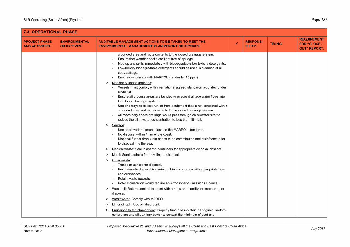
SLR Consulting (South Africa) (Pty) Ltd Page 138
SLR Ref. 720.16030.00003
Report No.2
Proposed speculative 2D and 3D seismic surveys off the South and East Coast of South Africa
Environmental Management Programme July 2017
7.3 OPERATIONAL PHASE
PROJECT PHASE
AND ACTIVITIES:
ENVIRONMENTAL
OBJECTIVES:
AUDITABLE MANAGEMENT ACTIONS TO BE TAKEN TO MEET THE
ENVIRONMENTAL MANAGEMENT PLAN REPORT OBJECTIVES:
RESPONSI-
BILITY: TIMING:
REQUIREMENT
FOR “CLOSE-
OUT” REPORT:
a bunded area and route contents to the closed drainage system.
- Ensure that weather decks are kept free of spillage.
- Mop up any spills immediately with biodegradable low toxicity detergents.
- Low-toxicity biodegradable detergents should be used in cleaning of all
deck spillage.
- Ensure compliance with MARPOL standards (15 ppm).
> Machinery space drainage:
- Vessels must comply with international agreed standards regulated under
MARPOL.
- Ensure all process areas are bunded to ensure drainage water flows into
the closed drainage system.
- Use drip trays to collect run-off from equipment that is not contained within
a bunded area and route contents to the closed drainage system
- All machinery space drainage would pass through an oil/water filter to
reduce the oil in water concentration to less than 15 mg/l.
> Sewage:
- Use approved treatment plants to the MARPOL standards.
- No disposal within 4 nm of the coast.
- Disposal further than 4 nm needs to be comminuted and disinfected prior
to disposal into the sea.
> Medical waste: Seal in aseptic containers for appropriate disposal onshore.
> Metal: Send to shore for recycling or disposal.
> Other waste:
- Transport ashore for disposal.
- Ensure waste disposal is carried out in accordance with appropriate laws
and ordinances.
- Retain waste receipts.
- Note: Incineration would require an Atmospheric Emissions Licence.
> Waste oil: Return used oil to a port with a registered facility for processing or
disposal.
> Wastewater: Comply with MARPOL.
> Minor oil spill: Use oil absorbent.
> Emissions to the atmosphere: Properly tune and maintain all engines, motors,
generators and all auxiliary power to contain the minimum of soot and

SLR Consulting (South Africa) (Pty) Ltd Page 139
SLR Ref. 720.16030.00003
Report No.2
Proposed speculative 2D and 3D seismic surveys off the South and East Coast of South Africa
Environmental Management Programme July 2017
7.3 OPERATIONAL PHASE
PROJECT PHASE
AND ACTIVITIES:
ENVIRONMENTAL
OBJECTIVES:
AUDITABLE MANAGEMENT ACTIONS TO BE TAKEN TO MEET THE
ENVIRONMENTAL MANAGEMENT PLAN REPORT OBJECTIVES:
RESPONSI-
BILITY: TIMING:
REQUIREMENT
FOR “CLOSE-
OUT” REPORT:
unburned diesel.
> Other hazardous waste:
- Record types and volumes of chemical and hazardous wastes (e.g. neon
lights, fluorescent tubes, toner cartridges, batteries, etc.) and destination
thereof.
- Send to designated onshore hazardous disposal site. Retain waste
receipts.
Ensure all crew is trained in spill management.
7.3.7 EQUIPMENT
LOSS
Minimise hazards left
on the sea bed or
floating in the water
column, and inform
relevant parties
Keep a record of lost equipment and all items lost overboard and not recovered.
When any item that constitute a seafloor or navigation hazard are lost on the sea
bed, or in the sea, a standard form must be completed which records the date and
cause of loss, details of equipment type, vessel Sea Control location, sea state
and weather, and the nature of the sea bed. Pass information to PASA and
SAMSA.
Notify SAN Hydrographer, relevant fishing associations. SAN Hydrographer will
send out Notice to Mariners with this information.
PGS /
Survey
Contractor
and FLO
Throughout
operation, in the
event of an
incident
Provide a list of
lost equipment
and a copy of
record sheet
7.3.8 USE OF
HELICOPTERS for
emergencies.
Minimise disturbance /
damage to marine and
coastal fauna
Flight paths must be pre-planned to ensure that no flying occurs over MPAs
(Goukamma, Robberg, Tsitsikammama, Sardinia Bay MPA, Bird Island and
Amathole MPA), seal (Seal Island, Robberg Peninsula and Black Rocks) and
seabird colonies (Algoa Bay islands, St Croix Island, Jaheel Island, Bird Island,
Seal Island, Stag Island and Brenton Rocks);
Report any deviations from set flight plans.
Extensive coastal flights (parallel to the coast within 1 nm of the shore) should be
avoided. There is a restriction of coastal flights (parallel to the coast within 1 nm of
the shore) on the South Coast between the months of June and November to
avoid Southern Right whale breeding areas.
Comply with the Marine Living Resources Act, 1998 which prohibits aircrafts
approaching within 300 m of whales without a permit or exemption (see
Section 7.1.6).
Comply with the Seabirds and Seals Protection Act, 1973, which prohibits the
wilful disturbance of seals on the coast or on offshore islands.
Comply with aviation and authority guidelines and rules.
Brief all pilots on the ecological risks associated with flying at a low level parallel to
the coast.
Helicopter
contractor
As required Submit copy of
set flight path
Copies of reports
on deviations
from set flight
paths

SLR Consulting (South Africa) (Pty) Ltd Page 140
SLR Ref. 720.16030.00003
Report No.2
Proposed speculative 2D and 3D seismic surveys off the South and East Coast of South Africa
Environmental Management Programme July 2017
7.3 OPERATIONAL PHASE
PROJECT PHASE
AND ACTIVITIES:
ENVIRONMENTAL
OBJECTIVES:
AUDITABLE MANAGEMENT ACTIONS TO BE TAKEN TO MEET THE
ENVIRONMENTAL MANAGEMENT PLAN REPORT OBJECTIVES:
RESPONSI-
BILITY: TIMING:
REQUIREMENT
FOR “CLOSE-
OUT” REPORT:
7.3.9 BUNKERING /
REFUELLING AT
SEA
Minimise damage to
marine and coastal
fauna
Transfer of oil at sea is not permitted within the economic zone (i.e. 200 miles from
the coast) without the permission of SAMSA. Submit an application (including
location, supplier and timing) in terms of Regulation 14 to the Principal Officer at
the port nearest to where the transfer is to take place.
Offshore bunkering should not be undertaken in the following circumstances:
> Within 50 nm of the coast;
> Wind force and sea state conditions of 6 or above on the Beaufort Wind
Scale;
> During any workboat or mobilisation boat operations;
> During helicopter operations;
> During the transfer of in-sea equipment; and
> At night or times of low visibility.
Ensure support vessels must have the necessary spill response capability to deal
with accidental spills in a safe, rapid, effective and efficient manner
PGS /
Survey
Contractor
As required, 5
days prior to
refuelling
Confirm that a
notice was sent
to SAMSA
7.3.10 VESSEL
LIGHTING
Minimise impact on
seabirds
Lighting on-board survey vessels should be reduced to the minimum safety levels
to minimise stranding of pelagic seabirds on the survey vessels at night.
All stranded seabirds must be retrieved and released during daylight hours
PGS /
Survey
Contractor
Results of faunal
monitoring

SLR Consulting (South Africa) (Pty) Ltd Page 141
SLR Ref. 720.16030.00003
Report No.2
Proposed speculative 2D and 3D seismic surveys off the South and East Coast of South Africa
Environmental Management Programme July 2017
7.4 DECOMMISSIONING AND CLOSURE PHASE
PROJECT PHASE
AND ACTIVITIES:
ENVIRONMENTAL
OBJECTIVES:
AUDITABLE MANAGEMENT ACTIONS TO BE TAKEN TO MEET THE
ENVIRONMENTAL MANAGEMENT PLAN REPORT OBJECTIVES:
RESPONSI-
BILITY: TIMING:
REQUIREMENT
FOR “CLOSE-
OUT” REPORT:
7.4.1 SURVEY
VESSELS TO
LEAVE AREA
Leave survey area as
it was prior to survey
Ensure that all deployed equipment is retrieved. PGS On completion
of survey
7.4.2 INFORM KEY
STAKEHOLDERS
OF SURVEY
COMPLETION
Ensure that relevant
parties are aware that
the seismic campaign
is complete
Inform the PASA and other key stakeholders (see Section 7.1.5) of the survey
completion.
PGS Within two
weeks after
completion of
survey
Copies of
notification
documentation
required.
7.4.3 FINAL WASTE
DISPOSAL
Minimise pollution and
ensure correct
disposal of waste
Dispose all waste retained on-board at a licensed waste site using a licensed waste
disposal contractor.
PGS When vessel is
in port
Receipt required
from contractor
7.4.4 INFORMATION
SHARING
Information sharing Take steps to share data collected during the survey (e.g. marine mammal incidence
and behaviour), if requested, to resource managers (including Marine Mammal
Institute, DEA, DAFF and PASA).
PGS As requested
7.4.5 COMPILE
SEISMIC SURVEY
“CLOSE-OUT”
REPORTS
Ensure corrective
action and compliance
and contribute towards
improvement of EMP
implementation
Compile a “close-out” report at the end of each survey.
The “close-out” report must be based on requirements of the monitoring and EMP.
Provide information / records as indicated in the “close-out” report column of the
EMP.
Provide a copy of the report to PASA.
PGS Within 60 days
post surveying
or as requested
by PASA

SLR Consulting (South Africa) (Pty) Ltd
SLR Ref. 720.16030.00003
Report No.2
Proposed speculative 2D and 3D seismic surveys off the South and
East Coast of South Africa - Environmental Management Programme July 2017
Page 142
8 REFERENCES
ANDERS, A.S., 1975. Pilchard and anchovy spawning along the Cape east coast. S. Afr. ship. news fish.
ind. rev. 30 (9): 53-57.
AUGUSTYN, C.J. 1990. Biological studies on the chokker squid Loligo vulgaris reynaudii (Caphalopoda:
Myopsida) on spawning grounds off the south-east coast of South Africa. S. Afr. J. mar. Sci., 9: 11-
26.
AUGUSTYN, C.J., LIPINSKI, M.R., SAUER, W.H.H., ROBERTS, M.J. and MITCHELL-INNES, B.A. 1994.
Chokka squid on the Agulhas Bank: life history and ecology. S. Afr. J. Sci., 90: 143-153.
AWAD, A.A., GRIFFITHS, C.L. and TURPIE, J.K. 2002. Distribution of South African marine benthic
invertebrates applied to the selection of priority conservation areas. Diversity and Distributions 8:
129–145
BANKS, A. BEST, P.B., GULLAN, A., GUISSAMULO, A., COCKCROFT, V. & K. FINDLAY, 2011. Recent
sightings of Southern Right whales in Mozambique. Document SC/S11/RW17 submitted to IWC
Southern Right Whale Assessment Workshop, Buenos Aires 13-16 Sept. 2011.
BARENDSE, J., BEST, P.B., THOMTON, M., POMILLA, C. CARVALHO, I. & H.C. ROSENBAUM, 2010.
Migration redefined ? Seasonality, movements and group composition of humpback whales
Megaptera novaeangliae off the west coast of South Africa. Afr. J. mar. Sci., 32(1): 1-22.
BECKLEY, L.E. and VAN BALLEGOOYEN, R.C. 1992. Oceanographic conditions during three
ichthyoplanktonsurveys of the Agulhas Current in 1990/91. S. Afr. J. mar. Sci., 12: 83-93.
BEST, P.B., 1990. Trends in the inshore right whale population off South Africa, 1969-1987. Marine
Mammal Science, 6: 93-108.
BEST, P.B., 2000. Coastal distribution, movements and site fidelity of right whales (Eubalaena australis) off
South Africa, 1969-1998. S. Afr. J. mar. Sci., 22: 43 – 56.
BEST, P.B., 2001. Distribution and population separation of Bryde’s whale Balaenoptera edeni off southern
Africa. Mar. Ecol. Prog. Ser., 220: 277 – 289.
BEST, P.B., 2007. Whales and Dolphins of the Southern African Subregion. Cambridge University Press,
Cape Town, South Africa.
BEST, P.B., BUTTERWORTH, D.S. & L.H. RICKETT, 1984. An assessment cruise for the South African
inshore stock of Bryde’s whale (Balaenoptera edeni). Report of the International Whaling
Commission, 34: 403-423.
BEST, P.B., FINDLAY, K.P., SEKIGUCHI, K., PEDDEMORS, V.M., RAKOTONIRINA, B., ROSSOUW, A.
AND D. GOVE, 1998. Winter distribution and possible migration routes of humpback whales
Megaptera novaeangliae in the southwest Indian Ocean. Mar. Ecol. Prog. Ser. 162: 287 - 299.
BEST, P.B. & C.H. LOCKYER, 2002. Reproduction, growth and migrations of sei whales Balaenoptera
borealis off the west coast of South Africa in the 1960s. South African Journal of Marine Science, 24:
111-133.

SLR Consulting (South Africa) (Pty) Ltd
SLR Ref. 720.16030.00003
Report No.2
Proposed speculative 2D and 3D seismic surveys off the South and
East Coast of South Africa - Environmental Management Programme July 2017
Page 143
BIRCH, G.F. and ROGERS, J. 1973. Nature of the seafloor between Lüderitz and Port Elizabeth. S. Afr.
ship. news .fish. ind. rev., 39 (7): 56-65.
BONFIL, R., MEYER, M., SCHOLL, M.C., JOHNSON, R., O’BRIEN, S., OOSTHUIZEN, H., SWANSON, S.,
KOTZE, D. and PATERSON, M., 2005. Transoceanic migration, spatial dynamics, and population
linkages of white sharks. Science 310: 100-103.
BOYD, A.J. and SHILLINGTON, F.A. 1994. Physical forcing and circulation patterns on the Agulhas Bank.
S. Afr. J. Sci., 90: 114-120.
BOYD, A.J., TAUNTON-CLARK, J. and OBERHOLSTER, G.P.J. 1992. Spatial features of the nearsurface
and midwater circulation patterns off western and southern South Africa and their role in the life
histories of various commercially fished species. S. Afr. J. mar. Sci., 12: 189-206.
BRANCH, G.M., GRIFFITHS, C.L., BRANCH, M.L., and BECKLEY, L.E. 2010. Two Oceans. Struik Nature,
Cape Town, South Africa, revised edition, 456pp
BRANCH, T.A., STAFFORD, K.M., PALACIOS, D.M., ALLISON, C., BANNISTER, J.L., BURTON, C.L.K.,
CABRERA, E., CARLSON, C.A., GALLETTI VERNAZZANI, B., GILL, P.C., HUCKE-GAETE, R.,
JENNER, K.C.S., JENNER, M.-N.M., MATSUOKA, K., MIKHALEV, Y.A., MIYASHITA, T.,
MORRICE, M.G., NISHIWAKI, S., STURROCK, V.J., TORMOSOV, D., ANDERSON, R.C., BAKER,
A.N., BEST, P.B., BORSA, P., BROWNELL JR, R.L., CHILDERHOUSE, S., FINDLAY, K.P.,
GERRODETTE, T., ILANGAKOON, A.D., JOERGENSEN, M., KAHN, B., LJUNGBLAD, D.K.,
MAUGHAN, B., MCCAULEY, R.D., MCKAY, S., NORRIS, T.F., OMAN WHALE AND DOLPHIN
RESEARCH GROUP, RANKIN, S., SAMARAN, F., THIELE, D., VAN WAEREBEEK, K. & R.M.
WARNEKE, 2007. Past and present distribution, densities and movements of blue whales in the
Southern Hemisphere and northern Indian Ocean. Mammal Review, 37 (2): 116-175.
BRANDÃO, A., BEST, P.B. & D.S. BUTTERWORTH, 2011. Monitoring the recovery of the Southern Right
whale in South African waters. Paper SC/S11/RW18 submitted to IWC Southern Right Whale
Assessment Workshop, Buenos Aires 13-16 Sept. 2011.
BROWN, P.C. 1992. Spatial and seasonal variation in chlorophyll distribution in the upper30m of the photic
zone in the southern Benguela/Agulhas region. S. Afr. J. mar. Sci., 12: 515-525.
BUXTON, C.D., 1990. The reproductive biology of Chrysoblephus laticeps and C. christiceps (Teleostei:
Sparidae). J. Zool. Lond. 220: 497-511.
CARTER, R.A. and BROWNLIE, S. 1990. Estuaries of the Cape, Part II: Synopses of available information
on individual systems. Report No. 34: Kafferkuils (CSW 24) and Duiwenshok (CSW 23). Heydorn,
A.E.F. and Morant, P.D. (eds). Stellenbosch, CSIR Research Report 43, 86pp.
CARTER, R.A. and D’AUBREY, J. 1988. Inorganic nutrients in Natal continental shelf waters. In: Coastal
ocean sciences of Natal, South Africa (Ed. E.H. Schumann). Springer-Verlag, Berlin., 131-151.
CARTER, R.A., McMURRAY, H.F. and LARGIER, J.L. 1987. Thermocline characteristics and phytoplankton
dynamics in Agulhas Bank waters. S. Afr. J. mar. Sci., 5: 327-336.
CARTER, R.A. and SCHLEYER, M.H. 1988. Plankton distributions in Natal coastal waters. In: Coastal
ocean sciences of Natal, South Africa (Ed. E.H. Schumann). Springer-Verlag, Berlin., 152-177.

SLR Consulting (South Africa) (Pty) Ltd
SLR Ref. 720.16030.00003
Report No.2
Proposed speculative 2D and 3D seismic surveys off the South and
East Coast of South Africa - Environmental Management Programme July 2017
Page 144
CHRISTENSEN, M.S. 1980. Sea-surface temperature charts for southern Africa, south of 26°S. S. Afr. J.
Sci., 76 (12): 541-546.
CLARK, M.R., O’SHEA, S., TRACEY, D. & B. GLASBY, 1999. New Zealand region seamounts. Aspects of
their biology, ecology and fisheries. Report prepared for the Department of Conservation,
Wellington, New Zealand, August 1999. 107 pp.
COCKCROFT, V.G. & V.M. PEDDEMORS, 1990. Seasonal distribution and density of common dolphins
Delphinus delphis off the south-east coast of southern Africa. S. Afr. J. mar. Sci. 9: 371-377.
CONVENTION ON BIOLOGICAL DIVERSITY (CBD), 2013. Report of the Southern Indian Ocean regional
workshop to facilitate the description of ecologically or biologically significant marine areas.
UNEP/CBD/RW/EBSA/SIO/1/4. www.cbd.int/doc/?meeting=EBSA-SIO-01
CORNEW, S., STUART, V. and BECKLEY, L.E. 1992. Population structure, biomass and distribution of
Nyctiphanes capensis (Euphausiacea) in the vicinity of Algoa Bay, South Africa. S. Afr. J. Zoo., 27
(1): 14-20.
CRAWFORD, R.J.M. 1980. Seasonal patterns in South Africa’s western Cape purse-seine fishery. J. Fish.
Biol., 16 (6): 649-664.
CRAWFORD, R.J.M., SHANNON, L.V. and POLLOCK, D.E., 1987. The Benguela Ecosystem. Part IV. The
major fish and invertebrate resources. Oceanogr. Mar. Biol. Ann. Rev. 25: 353-505.
CROWTHER CAMPBELL & ASSOCIATES and CSIR, 1998. Environmental Impact Assessment for the
proposed extension of the ORIBI oil production facility and hydrocarbon exploration off the Southern
Cape Coast. Report No. SOE01OE/2.
CROWTHER CAMPBELL & ASSOCIATES CC AND CENTRE FOR MARINE STUDIES (CCA & CMS).
2001. Generic Environmental Management Programme Reports for Oil and Gas Prospecting off the
Coast of South Africa. Prepared for Petroleum Agency SA, October 2001.
CSIR, 1998. Environmental Impact Assessment for the Proposed Exploration Drilling in Petroleum
Exploration Lease 17/18 on the Continental Shelf of KwaZulu-Natal, South Africa. CSIR Report
ENV/S-C 98045.
CSIR, 2007. Environmental Studies in the Richards Bay outfalls region. Report No. 20. Surveys made
during 2006/2007. CSIR Report CSIR/NRE/PW/ER /2006/0068/C.
CSIR, 2009. Environmental studies in the Richards Bay offshore outfalls region. Report No. 22. Surveys
made in 2008/2009. CSIR Report CSIR/NRE/CO/ER/2010/0010/B.
DE DECKER, A.H.B. 1984. Near-surface copepod distribution in the South-Western Indian and South-
Eastern Atlantic Ocean. Ann. S. Afr. Mus., 93 (5): 303-370.
DE WET, A. 2013. Factors affecting survivorship of loggerhead (Caretta caretta) and leatherback
(Dermochelys coriacea) sea turtles of South Africa. MSc, Nelson Mandela Metropolitan University.
DOWNEY, N.J., 2014. The Role of the Deep Spawning Grounds in Chokka Squid (Loligo reynaudi
D’Orbigny, 1845) Recruitment. PhD Thesis, Rhodes University, Grahamstown, pp135.

SLR Consulting (South Africa) (Pty) Ltd
SLR Ref. 720.16030.00003
Report No.2
Proposed speculative 2D and 3D seismic surveys off the South and
East Coast of South Africa - Environmental Management Programme July 2017
Page 145
DUNCOMBE RAE, C.M., F.A. SHILLINGTON, J.J. AGENBAG, J. TAUNTON-CLARK and GRUNDLINGH,
M.L. 1992. An Agulhas ring in the South Atlantic Ocean and its interaction with the Benguela
upwelling frontal system. Deep-Sea Research 39: 2009-2027.
ELLINGSEN, K.E., 2002. Soft-sediment benthic biodiversity on the continental shelf in relation to
environmental variability. Marine Ecology Progress Series, 232: 15-27.
ELWEN, S. & P.B. BEST, 2004. Environmental factors influencing the distribution of Southern Right whales
(Eubalaena australis) on the South Coast of South Africa I: Broad scale patterns. Mar. Mammal Sci.,
20 (3): 567-582.
EZEMVELO KZN WILDLIFE, 2012. Focus areas for additional marine biodiversity protection in KwaZulu-
Natal, South Africa. Unpublished Report - Jan 2012. Scientific Services, Ezemvelo KZN Wildlife:
Durban. Pp 62.
FAO, 2008. International Guidelines for the Management of Deep-Sea Fisheries in the High Seas.
SPRFMO-VI-SWG-INF01
FENNESSY, S.T., 1994a. The impact of commercial prawn trawlers on linefish off the north coast of Natal,
South Africa. South African Journal of Marine Science 14: 263-279.
FENNESSY, S.T., 1994b. Incidental capture of elasmobranchs by commercial prawn trawlers on the Tugela
FINDLAY, K.P. 1989. The distribution of cetaceans off the coast of South Africa and South West
Africa/Namibia. Unpublished MSc. Thesis, University of Pretoria Town. 110pp.
FINDLAY, K.P. AND P.B. BEST, 1996a. Estimates of the numbers of humpback whales observed migrating
past Cape Vidal, South Africa, 1988-1991. Mar Mammal Sci., 12(3): 354-370.
FINDLAY, K.P. AND P.B. BEST, 1996b. The Migrations of Humpback Whales past Cape Vidal, South
Africa, and a Preliminary Estimate of the Population Increase Rate. Rep Int Whal Commn.
SC/A06/HW16
FINDLAY, K.P., BEST, P.B., PEDDEMORS, V.M. AND D. GOVE, 1994. The distribution and abundance of
humpback whales on the southern and central Mozambique winter grounds. Rep Int Whal Commn
44: 311-320.
FINDLAY, K.P., BEST, P.B., ROSS, G.J.B. and COCKCROFT, V.G. 1992. The distribution of small
odontocete cetaceans off the coasts of South Africa and Namibia. S. Afr. J. mar. Sci., 12: 237-270.
FLACH, E. and THOMSEN, L. 1998. Do physical and chemical factors structure the macrobenthic
community at a continental slope in the NE Atlantic? Hydrobiologia, 375/376: 265-285.
FLEMMING, B. and HAY, R., 1988. Sediment distribution and dynamics on the Natal continental shelf. In:
Coastal ocean sciences of Natal, South Africa (Ed. E.H. SCHUMANN). Springer-Verlag, Berlin., 47-
80.
GÖTZ, A., KERWATH, S.E., ATTWOOD, C.G. and SAUER, W.H.H. 2009. Effects of fishing on a temperate
reef community in South Africa 2: benthic invertebrates and algae. African Journal of Marine Science
31: 253-262.
SLR Consulting (South Africa) (Pty) Ltd
SLR Ref. 720.16030.00003
Report No.2
Proposed speculative 2D and 3D seismic surveys off the South and
East Coast of South Africa - Environmental Management Programme July 2017
Page 146
GROENEVELD, J.C. & R. MELVILLE-SMITH, 1995. Spatial and temporal availability in the multispecies
crustacean trawl fishery along the east coast of South Africa and southern Mozambique, 1988–93.
South African Journal of Marine Science, 15: 123-136.
GRÜNDLINGH, M.L. 1980. On the volume transport of the Aguhas Current. Deep-Sea Res., 27: 557-563.
HALL, J.D. and JOHNSON, C.S. 1972. Auditory thresholds of a killer whale (Orcinus orca) Linnaeus. J
Acoust. Soc. Am., 52(2): 515-517.
HAMPTON, I, 1992. The role of acoustic surveys in the assessment of pelagic fish resources on the South
African continental shelf. In: Benguela Trophic Functioning, PAYNE, A.I.L., BRINK, K.H., MANN,
K.H. and HILBORN, R. (Eds.) S. Afr. J. mar. Sci., 12: 1031-1050.
HARRIS, J.M., LIVINGSTONE, T., LOMBARD, A.T., LAGABRIELLE, E., HAUPT, P., SINK, K., MANN, B. &
M. SCHLEYER, 2011. Marine Systematic Conservation Assessment and Plan for KwaZulu-Natal -
Spatial priorities for conservation of marine and coastal biodiversity in KwaZulu-Natal. Ezemvelo
KZN Wildlife.
HARRIS, R. E., MILLER, G.W. and RICHARDSON, W.E. 2001. Seal responses to airgun sounds during
summer seismic surveys in the Alaskan Beaufort Sea. Mar. Mamm. Sci., 17(4): 795-812.
HARRISON, P., 1978. Cory’s Shearwater in the Indian Ocean. Cormorant. 5: 19-20.
HAYS, G.C. HOUGHTON, J.D.R., ISAACS, C. KING, R.S. LLOYD, C. & P. LOVELL, 2004. First records of
oceanic dive profiles for leatherback turtles, Dermochelys coriacea, indicate behavioural plasticity
associated with long-distance migration. Animal Behaviour, 67: 733-743.
HEYDORN, H.J. 1989. Estuaries of the Cape, Part II: Synopses of available information on individual
systems. Report No. 39: Quko (CSE 56). HEYDORN, A.E.F. and MORANT, P.D. (eds).
Stellenbosch, CSIR Research Report 437, 66pp.
HEYDORN, A.E.F. and TINLEY, K.L. 1980. Estuaries of the Cape, Part I. Synopsis of the Cape coast.
Natural features, dynamics and utilization. Stellenbosch, CSIR Research Report 380, 97 pp.
HEYDORN, A.E.F., BANG, N.D., PEARCE, A.F., FLEMMING, B.W., CARTER, R.A., SCHLEYER, M.H.,
BERRY, P.F., HUGHES, G.R., BASS, A.J., WALLACE, J.H. VAN DER ELST, R.P., CRAWFORD,
R.J.M. AND SHELTON, P.A. 1978. Ecology of the Agulhas Current region: an assessmnet of
biological responses to environmental parameters in the south- west Indian ocean. Trans. roy. Soc.
S. Afr., 43(2) : 151-190.
HUGHES, G.R. 1974a. The Sea Turtles of South East Africa I. Status, morphology and distributions. Investl.
Rep. Oceanogr. Res. Inst. 35.
HUGHES, G. R. 1974b. The sea turtles of south east Africa. PhD, University of Natal.
HUGHES, G.R., 1996. Nesting of the Leatherback turtle (Dermochelys coriacea) in Tongaland, KwaZulu-
Natal, South Africa 1963-1995. Chelonian Conservation and Biology, 2, 153 - 158.
HUGHES, G.R., 2012. Between the Tides: In Search of Sea Turtles, Jacana.

SLR Consulting (South Africa) (Pty) Ltd
SLR Ref. 720.16030.00003
Report No.2
Proposed speculative 2D and 3D seismic surveys off the South and
East Coast of South Africa - Environmental Management Programme July 2017
Page 147
HUGHES, G.R., LUSCHI, P., MENCACCI, R. & F. PAPI, 1998. The 7000 km journey of a leatherback turtle
tracked by satellite. Journal of Experimental Marine Biology and Ecology, 229: 209 - 217.
HUNTER, I.T., 1988. Climate and weather off Natal. In: Coastal ocean sciences of Natal, South Africa (Ed.
E.H. Schumann). Springer-Verlag, Berlin, 81-100.
HUTCHINGS, L. 1994. The Agulhas Bank: a synthesis of available information and a brief comparison with
other east-coast shelf regions. S. Afr. J. Sci., 90: 179-185.
HUTCHINGS, L., BECKLEY, L.E., GRIFFITHS, M.H., ROBERTS, M.J., SUNDBY, S. and VAN DER LINGEN
C. 2003. Spawning on the edge: spawning grounds and nursery areas around the southern African
coastline. Marine and Freshwater Research 53: 307-318.
JAPP, D.W., SIMS, P. and SMALE, M.J. 1994. A review of the fish resources of the Agulhas Bank. S. Afr. J.
Sci., 90: 123-134.
JOHNSON, R., BESTER M.N., DUDLEY, S.F.J., OOSTHUIZEN, W.H., MEŸER, M., HANCKE, L. & E.
GENNARI, 2009. Coastal swimming patterns of white sharks (Carcharodon carcharias) at Mossel
Bay, South Africa. Environ Biol Fish, 85: 189–200.
JOINT NATURE CONSERVATION COMMITTEE (JNCC), 2010. JNCC guidelines for minimising the risk of
disturbance and injury to marine mammals from seismic surveys. August 2010
JURY, M.R. 1994. Meteorology of eastern Agulhas Bank. S. Afr. J. Sci., 90: 109-113.
JURY, M.R. and DIAB, R., 1989. Wind energy potential in the Cape coastal belt. S. Afr. Geogr. J., 71: 3-11.
KETTEN, D.R., LIEN, J. and TODD, S. 1993. Blast injury in humpback whale ears: evidence and
implications. J. Acoust. Soc. Am., 94(3 Pt 2): 1849-1850.
KOCH, A. & R. JOHNSON, 2006. White Shark abundance: not a causative factor in numbers of shark bite
incidents. In NEL, D.C. & T.P. PESCHAK (eds) Finding a balance: White shark conservation and
recreational safety in the inshore waters of Cape Town, South Africa; proceedings of a specialist
workshop. WWF South Africa Report Series - 2006/Marine/001.
LAMBARDI, P., LUTJEHARMS, J.R.E., MENACCI, R., HAYS, G.C. & P. LUSCHI, 2008. Influence of ocean
currents on long-distance movement of leatherback sea turtles in the Southwest Indian Ocean.
Marine Ecology Progress Series, 353: 289–301.
LARGIER, J.L. and SWART, V.P. 1987. East-west variation in thermocline breakdown on the Agulhas Bank.
In: The Benguela and Comparable Ecosystems, PAYNE, A.I.L., GULLAND, J.A. and BRINK, K.H.
(Eds.), S. Afr. J. mar. Sci., 5: 263-272.
LIVERSIDGE, R. and LE GRAS, G.M. 1981. Observations of seabirds off the eastern Cape, South Africa,
1953-1963. In: Proceedings of the symposium on birds of the sea and shore, 1979. COOPER, J.
(Ed.). 149-167.
LOMBARD, A.T., STRAUSS, T., HARRIS, J., SINK, K., ATTWOOD, C. and HUTCHINGS, L. 2004. National
Spatial Biodiversity Assessment 2004: South African Technical Report Volume 4: Marine
Component.

SLR Consulting (South Africa) (Pty) Ltd
SLR Ref. 720.16030.00003
Report No.2
Proposed speculative 2D and 3D seismic surveys off the South and
East Coast of South Africa - Environmental Management Programme July 2017
Page 148
LUSCHI, P., HAYS, G.C. & F. PAPI, 2003a. A review of long-distance movements by marine turtles, and the
possible role of ocean currents. Oikos, 103, 293 – 302.
LUSCHI, P., LUTJEHARMS, J.R.E., LAMBARDI, P., MENCACCI, R., HUGHES, G.R. & G.C. HAYS, 2006.
A review of migratory behaviour of sea turtles off southeastern Africa. South African Journal of
Science, 102, 51 - 57.
LUSCHI, P., SALE, A., MENCACCI, R., HUGHES, G.R., LUTJEHARMS, J.R.E. & F. PAPI, 2003b. Current
transport of leatherback sea turtles (Dermochelys coriacea) in the ocean. Proceedings of the Royal
Society: Biolgical Sciences, 270, 129 - 132.
LUTJEHARMS, J.R.E., GRÜNDLINGH, M.L. & R.A. CARTER, 1989. Topographically induced upwelling in
the Natal Bight. S. Afr. J. Sci., 85 (5): 310-316.
MacLEOD, C.D. & A. D’AMICO, 2006. A review of beaked whale behaviour and ecology in relation to
assessing and mitigating impacts of anthropogenic noise. Journal of Cetacean Research and
Management 7(3): 211–221.
MacISSAC, K., BOURBONNAIS, C., KENCHINGTON, E.D., GORDON JR. & S. GASS, 2001. Observations
on the occurrence and habitat preference of corals in Atlantic Canada. In: (eds.) J.H.M. WILLISON,
J. HALL, S.E. GASS, E.L.R. KENCHINGTON, M. BUTLER, AND P. DOHERTY. Proceedings of the
First International Symposium on Deep-Sea Corals. Ecology Action Centre and Nova Scotia
Museum, Halifax, Nova Scotia.
MARNEWICK, M.D., RETIEF, E.F., THERON, N.T., WRIGHT, D.R., ANDERSON, T.A., 2015. Important Bird
and Biodiversity Areas of South Africa. Johannesburg: BirdLife South Africa.
MARTIN, A.K. and FLEMMING, B.W. 1988. Physiography, structure and geological evolution of the Natal
continental shelf. In: Coastal ocean sciences of Natal, South Africa (Ed. E.H. Schumann). Springer-
Verlag, Berlin., 11-46.
McCLURG, T.P. 1998. Benthic Macrofauna. In: Environmental Studies in the Richards Bay offshore outfalls
region. Report No. 11. Surveys made during 1997. East Coast Program; Division of Water,
Environment and Forestry Technology; CSIR, Durban. CSIR Report ENV/ECP/EXT:97-JEC17.
McCLURG, T.P., BLAIR, A. and GUMEDE, S.V. 1999. Benthic Fauna. In: Environmental Studies in the
Richards Bay offshore outfalls region. Report No. 12. Surveys made during 1998. East Coast
Program; Division of Water, Environment and Forestry Technology; CSIR, Durban. CSIR Report
ENV/ECP/EXT:98-JEOOF.
McCLURG, T.P., BLAIR, A. and GUMEDE, S.V. 2000. Benthic fauna. In: Environmental Studies in the
Richards Bay offshore outfalls region. Report No. 13. Surveys made during 1999. East Coast
Program; Division of Water, Environment and Forestry Technology; CSIR, Durban. CSIR Report
ENV-D-C-2000-011.
McCLURG, T.P., BLAIR, A. and GUMEDE, S.V. 2001. Benthic fauna. In: Environmental Studies in the
Richards Bay offshore outfalls region. Report No. 14. Surveys made during 2000. East Coast
Program; Division of Water, Environment and Forestry Technology; CSIR, Durban. CSIR Report
ENV-D-C-2001-015.
McCLURG, T.P., BLAIR, A. and GUMEDE, S.V. 2002. Benthic fauna. In: Environmental Studies in the
Richards Bay offshore outfalls region. Report No. 15. Surveys made during 2001. East Coast

SLR Consulting (South Africa) (Pty) Ltd
SLR Ref. 720.16030.00003
Report No.2
Proposed speculative 2D and 3D seismic surveys off the South and
East Coast of South Africa - Environmental Management Programme July 2017
Page 149
Programme; Division of Water, Environment and Forestry Technology; CSIR, Durban. CSIR Report
ENV-D-C-2002-003
McCLURG, T.P., BLAIR, A. and MAPUKATA, T. 2003. Benthic fauna. In: Environmental Studies in the
Richards Bay offshore outfalls region. Report No. 16. Surveys made during 2002. East Coast
Programme; Division of Water, Environment and Forestry Technology; CSIR, Durban. CSIR Report
ENV-D-C-2003-003.
McCLURG, T.P., BLAIR, A. and MAPUKATA, T. 2004. Benthic fauna. In: Environmental Studies in the
Richards Bay offshore outfalls region. Report No. 17. Surveys made during 2003. East Coast
Programme; Division of Water, Environment and Forestry Technology; CSIR, Durban. CSIR Report
ENV-D-C-2004-013.
McCLURG, T.P. and BLAIR, A. 2005. Benthic fauna. In: Environmental Studies in the Richards Bay offshore
outfalls region. Report No. 18. Surveys made during 2004. East Coast Programme; Division of
Water, Environment and Forestry Technology; CSIR, Durban. CSIR Report ENV-D-C-2005-031.
McCLURG, T.P. and BLAIR, A. 2006. Benthic fauna. In: Environmental Studies in the Richards Bay offshore
outfalls region. Report No. 19. Surveys made during 2005. CSIR Report
CSIR/NRE/PW/ER/2006/0068/C.
McCLURG, T.P. and BLAIR, A. 2007. Benthic fauna. In: Environmental Studies in the Richards Bay offshore
outfalls region. Report No. 20. Surveys made during 2006/2007. CSIR Report
CSIR/NRE/ECO/ER/2008//0027/C.
McCLURG, T.P. and BLAIR, A. 2008. Environmental studies in the Richards Bay offshore outfalls region.
Report No. 21. Surveys made in 2007/2008. CSIR Report CSIR/NRE/ECO/ER/2008/ 0145/C.
O’DONOGHUE, S.H., DRAPEAU, L., DUDLEY, S.F.J. & V.M. PEDDEMORS, 2010a. The KwaZulu-Natal
sardine run: shoal distribution in relation to nearshore environmental conditions, 1997 to 2007.
African Journal of Marine Science 32: 293–307.
O’DONOGHUE, S.H., DRAPEAU, L. & V.M. PEDDEMORS, 2010b. Broad-scale distribution patterns of
sardine and their predators in relation to remotely sensed environmental conditions during the
KwaZulu-Natal sardine run. African Journal of Marine Science 32: 279–291.
O’DONOGHUE, S.H., WHITTINGTON, P.A., DYER, B.M. & V.M. PEDDEMORS, 2010b. Abundance and
distribution of avian and marine mammal predators of sardine observed during the 2005 KwaZulu-
Natal sardine run survey. African Journal of Marine Science 32: 361–374.
OOSTHUIZEN W.H., 1991. General movements of South African (Cape) fur seals Arctocephalus pusillus
pusillus from analysis of recoveries of tagged animals. S. Afr. J. Mar. Sci., 11: 21-30.
PAPI, F., LUSCHI, P., AKESSON, S., CAPOGROSSI, S. & G. HAYS, 2000. Open-sea migration of
magnetically disturbed sea turtles. Journal of Experimental Biology, 203: 3435-3443.
PARDINI, A.T., JONES, C.S., NOBLE, L.R., KREISER, B., MALCOLM, H., BRUCE, B.D., STEVENS, J.D.,
CLIFF, G., SCHOLL, M.C., FRANCIS, M., DUFFY, C.A.J. and MARTIN, A.P., 2001. Sex-biased
dispersal of great white sharks. Nature 412: 139 – 140.

SLR Consulting (South Africa) (Pty) Ltd
SLR Ref. 720.16030.00003
Report No.2
Proposed speculative 2D and 3D seismic surveys off the South and
East Coast of South Africa - Environmental Management Programme July 2017
Page 150
PEARCE, A.F. 1977a. The shelf circulation off the east coast of South Africa. CSIR Professional Research
Series, 1, 220 pp.
PEARCE, A.F. 1977b. Some features of the upper 500 m of the Agulhas Current. Journal of Marine
Research. 35: 731-753.
PEARCE, A.F., SCHUMANN, E.H. and LUNDIE, G.S.H. 1978. Features of the shelf circulation off the Natal
Coast. S. Afr. J. Sci., 74: 328-331.
PEDDEMORS, V.M., ATKINS S. & W.H. OOSTHUIZEN, 2004. Sousa plumbea-Indian Ocean Humpback
Dolphin. Pages 660-661. In: FRIEDMANN Y. & B. DALY eds. Red Data Book of the Mammals of
South Africa: A Conservation Assessment. CBSG Southern Africa, Conservation Breeding Specialist
Group (SSC/IUCN), Endangered Wildlife Trust, South Africa.
PEDDEMORS, V.M. & W.H. OOSTHUIZEN, 2004. Tursiops aduncus- Indian Ocean Bottlenose Dolphin.
Pages 666-667. In: FRIEDMANN Y. & B. DALY eds. Red Data Book of the Mammals of South
Africa: A Conservation Assessment. CBSG Southern Africa, Conservation Breeding Specialist
Group (SSC/IUCN), Endangered Wildlife Trust, South Africa.
PENNEY, A.J. and PULFRICH, A. 2004. Recovery and Rehabilitation of Deepwater Marine Diamond Mining
Operations off the Southern African West Coast. Report to De Beers Marine, South Africa, May
2004. 92pp.
PENRY, G.S., 2010. Biology of South African Bryde’s whales. PhD Thesis. University of St Andrews,
Scotland, UK.
PROBYN, T.A., MITCHELL-INNES, B.A., BROWN, B.A., HUTCHINGS, L. and CARTER, R.A., 1994. A
review of primary production and related processes on the Agulhas Bank. S. Afr. J. Sci., 90: 160-
173.
PULFRICH, A. and PENNEY, A.J. 1999. The effects of deep-sea diamond mining on the benthic community
structure of the Atlantic 1 Mining Licence Area. Annual Monitoring Report – 1998. Prepared for De
Beers Marine (Pty) Ltd by Marine Biology Research Institute, Zoology Department, University of
Cape Town and Pisces Research and Management Consultants CC. pp 49.
ROBERTS, M.J., 1998. The influence of the environment on chokka squid Loligo vulgaris reynaudii
spawning aggregations: Steps towards a quantified model. South African Journal of Marine Science,
20: 267–284.
ROBERTS, M.J., 2005. Chokka squid (Loligo vulgaris reynaudii) abundance linked to changes in South
Africa’s Agulhas Bank ecosystem during spawning and the early life cycle. ICES Journal of Marine
Science, 62: 33–55.
ROBERTS, M.J., SAUER, W.H.H., 1994. Environment: the key to understanding the South African chokka
squid (Loligo vulgaris reynaudii) life cycle and fishery? Antarctic Science, 6: 249-258.
ROBERTS, M.J., DOWNEY, N.J., SAUER, W.H.H., 2012. The relative importance of shallow and deep shelf
spawning habitats for the South African chokka squid (Loligo reynaudii). ICES Journal of Marine
Science, doi:10.1093/icesjms/fss023.

SLR Consulting (South Africa) (Pty) Ltd
SLR Ref. 720.16030.00003
Report No.2
Proposed speculative 2D and 3D seismic surveys off the South and
East Coast of South Africa - Environmental Management Programme July 2017
Page 151
ROBERTS, M.J., VAN DER LINGEN, C.D. & M. VAN DEN BERG, 2010. Shelf currents, lee-trapped and
transient eddies on the inshore boundary of the Agulhas Current, South Africa: their relevance to the
KwaZulu-Natal sardine run. African Journal of Marine Science 32: 423–447.
ROEL, B.A. and ARMSTRONG, M.J. 1991. The round herring Etrumeus whiteheadi and anchovy Engraulis
capensis off the east coast of southern Africa. S. Afr. J. mar. Sci., 11: 227-249.
ROEL, B.A., HEWITSON, J., KERSTAN, S. and HAMPTON, I. 1994. The role of the Agulhas Bank in the life
cycle of pelagic fish. S. Afr. J. Sci., 90: 185-196.
ROGERS, A.D., 1994. The biology of seamounts. Advances in Marine Biology, 30: 305–350.
ROGERS, A.D., 2004. The biology, ecology and vulnerability of seamount communities. IUCN, Gland,
Switzerland. Available at: www.iucn.org/themes/ marine/pubs/pubs.htm 12 pp.
ROGERS, A.D., CLARK, M.R., HALL-SPENCER, J.M. and GJERDE, K.M. 2008. The Science behind the
Guidelines: A Scientific Guide to the FAO Draft International Guidelines (December 2007) For the
Management of Deep-Sea Fisheries in the High Seas and Examples of How the Guidelines May Be
Practically Implemented. IUCN, Switzerland, 2008.
SAUER, W.H.H., SMALE, M.J. and LIPINSKI, M.R. 1992. The location of spawning grounds, spawning and
shoaling behaviour of the squid Loligo vulgaris reynaudii (D’Orbigny) off the eastern Cape coast,
South Africa. Mar. Biol., 114: 97-107.
SCHROEDER, B.A., FOLEY, A.M. & D.A. BAGLEY, 2003. Nesting patterns, reproductive migrations, and
adult foraging areas of loggerhead turtles. Loggerhead sea turtles, 114-124.
SCHUMANN, E.H., 1986. Bottom boundary layer observations inshore of the Agulhas Current. S. Afr. J.
mar. Sci., 4: 93-102.
SCHUMANN, E.H. 1988. Physical oceanography off Natal. In: Coastal ocean sciences of Natal. South
Africa (Ed. E.H. Schumann). Springer Verlag, Berlin. 101-130.
SCHUMANN, E.H. 1998. The coastal ocean off southeast Africa, including Madagascar coastal segment
(15, W). In: The Sea, Vol.11. Robinson, A.R. and Brink, K. (eds). John Wiley & Sons, Inc.
SCHUMANN, E.H., ROSS, G.J.B. and GOSCHEN, W.S., 1988. Cold water events in Algoa Bay and Cape
south coast, South Africa, in March/April, 1987. S. Afr. J. Sci., 84: 579-584.
SHANNON, L.V. 1985. The Benguela ecosystem Part I. Evolution of the Benguela, physical features and
processes. Oceanogr. Mar. Biol. Ann. Rev., 23: 105-182.
SHAUGHNESSY, P.D. 1977. Flock size in Sabine’s Gull. Cormorant. 3: 17.
SHAUGHNESSY, P.D. 1979. Cape (South African) fur seal. In: Mammals in the Seas. F.A.O. Fish. Ser., 5,
2: 37-40.
SHELTON, P.A. 1986. Life-history traits displayed by neritic fish in the Benguela Current Ecosystem. In: The
Benguela and Comparable Ecosystems, PAYNE, A.I.L., GULLAND, J.A. and BRINK, K.H. (Eds.). S.
Afr. J. mar. Sci., 5: 235-242.

SLR Consulting (South Africa) (Pty) Ltd
SLR Ref. 720.16030.00003
Report No.2
Proposed speculative 2D and 3D seismic surveys off the South and
East Coast of South Africa - Environmental Management Programme July 2017
Page 152
SINK, K.J., ATTWOOD, C.G., LOMBARD, A.T., GRANTHAM, H., LESLIE, R., SAMAAI, T., KERWATH, S.,
MAJIEDT, P., FAIRWEATHER, T., HUTCHINGS, L., VAN DER LINGEN, C., ATKINSON, L.J.,
WILKINSON, S., HOLNESS, S. & T. WOLF, 2011. Spatial planning to identify focus areas for
offshore biodiversity protection in South Africa. Unpublished Report. Cape Town: South African
National Biodiversity Institute.
SINK, K., HOLNESS, S., HARRIS, L., MAJIEDT, P., ATKINSON, L., ROBINSON, T., KIRKMAN, S.,
HUTCHINGS, L., LESLIE, R., LAMBERTH, S., KERWATH, S., VON DER HEYDEN, S., LOMBARD,
A., ATTWOOD, C., BRANCH, G., FAIRWEATHER, T., TALJAARD, S., WEERTS, S., COWLEY, P.,
AWAD, A., HALPERN, B., GRANTHAM, H. and T. WOLF, 2012. National Biodiversity Assessment
2011: Technical Report. Volume 4: Marine and Coastal Component. South African National
Biodiversity Institute, Pretoria.
SMALE, M.J., KLAGES, N.T., DAVID, J.H.M. and COCKROFT, V.G. 1994. Predators of the Agulhas Bank.
S. Afr. J. Sci., 90: 135-142.
SNELGROVE, P.V.R. and BUTMAN, C.A. 1994. Animal-sediment relationships revisited: cause versus
effect. Oceanography & Marine Biology: An Annual Review, 32: 111-177.
STEFFANI, N. 2007a. Biological Baseline Survey of the Benthic Macrofaunal Communities in the Atlantic 1
Mining Licence Area and the Inshore Area off Pomona for the Marine Dredging Project. Prepared for
De Beers Marine Namibia (Pty) Ltd. pp. 42 + Appendices.
STEFFANI, N. 2007b. Biological Monitoring Survey of the Macrofaunal Communities in the Atlantic 1 Mining
Licence Area and the Inshore Area between Kerbehuk and Bogenfels. 2005 Survey. Prepared for
De Beers Marine Namibia (Pty) Ltd. pp. 51 + Appendices.
STEFFANI, N., 2009a. Assessment of mining impacts on macrofaunal benthic communities in the Northern
Inshore Area of the De Beers ML3 mining licence area – 18 months post-mining. Prepared for De
Beers Marine. Pp. 47 + Appendices.
STEFFANI, N., 2009b. Biological monitoring surveys of the benthic macrofaunal communities in the Atlantic
1 Mining Licence Area and the inshore area - 2006/2007. Prepared for De Beers Marine Namibia
(Pty) Ltd, pp. 81 + Appendices
STEFFANI, N., 2010a. Biological Monitoring Surveys of the Benthic Macrofaunal Communities in the
Atlantic 1 Mining Licence Area – 2008. Prepared for De Beers Marine Namibia (Pty) Ltd, pp. 40 +
Appendices
STEFFANI, N., 2010c. Assessment of Mining Impacts on Macrofaunal Benthic Communities in the Northern
Inshore Area of the De Beers Mining Licence Area 3. Prepared for De Beers Marine. Pp. 30 +
Appendices.
STEFFANI, C.N. and PULFRICH, A. 2004a. Environmental Baseline Survey of the Macrofaunal Benthic
Communities in the De Beers ML3/2003 Mining Licence Area. Prepared for De Beers Marine South
Africa, April 2004., 34pp.
STEFFANI, N. and PULFRICH, A. 2004b. The potential impacts of marine dredging operations on benthic
communities in unconsolidated sediments. Specialist Study 2. Specialist Study for the Environmental
Impact Report for the Pre-feasibility Phase of the Marine Dredging Project in Namdeb’s Atlantic 1

SLR Consulting (South Africa) (Pty) Ltd
SLR Ref. 720.16030.00003
Report No.2
Proposed speculative 2D and 3D seismic surveys off the South and
East Coast of South Africa - Environmental Management Programme July 2017
Page 153
Mining Licence Area and in the nearshore areas off Chameis. Prepared for PISCES Environmental
Services (Pty) Ltd, September 2004.
STEFFANI, C.N. and PULFRICH, A. 2007. Biological Survey of the Macrofaunal Communities in the Atlantic
1 Mining Licence Area and the Inshore Area between Kerbehuk and Lüderitz 2001 – 2004 Surveys.
Prepared for De Beers Marine Namibia, March 2007, 288pp.
SWART, V.P. and LARGIER, J.L. 1987. Thermal structure of Agulhas Bank water. In: The Benguela and
Comparable Ecosystems, PAYNE, A.I.L., GULLAND, J.A. and BRINK, K.H. (Eds.), S. Afr. J. mar.
Sci., 5: 243-254.
SWART, D.H. and SERDYN, J. de V. 1981. Statistical analysis of visually observed wave data from
voluntary observing ships (VOS) for the South African east coast. Stellenbosch. NRIO. Unpublished
data.
SWART, D.H. and SERDYN, J. de V. 1982. Statistical analysis of visually observed wave data from
voluntary observing ships (VOS) for the South African east coast. CSIR Report T/ (to be published).
TUCEK, J., NEL, R., GIRANDOT, M. & G. HUGHES, (Submitted). Estimating reproductive age and size of
loggerhead sea turtles. Endangered Species Research.
TURPIE, J.K., 1995. Prioritizing South African estuaries for conservation: A practical example using
waterbirds. Biol. Cons., 74: 175-185.
TURPIE, J.K., BECKLEY, L.E. and KATUA, S.M. 2000. Biogeography and selection of priority areas for
conservation of South African coastal fishes. Biological Conservation 92: 59–72.
UNDERHILL, L.G. and COOPER, J. 1982. Counts of waterbirds at coastal wetlands in southern Africa. 1978
to 1981. Unpublished MS. PFIAO.
VAN DER ELST, R. 1976. Game fish of the east coast of southern Africa. I: The biology of the elf
Pomatomus saltatrix (Linneaus) in the coastal waters of Natal. ORI Investl. Rep., 44. 59pp.
VAN DER ELST, R. 1981. A Guide to the Common Sea Fishes of Southern Africa. Struik, Cape Town:
367pp.
VAN DER ELST, R. 1988. Shelf ichthyofauna of Natal. In: Coastal ocean sciences of Natal, South Africa
(Ed. E.H. Schumann). Springer-Verlag, Berlin: 209-225.
VAN DER LINGEN, C.D., HUTCHINGS, L., BRUNDRIT, G.B., BYRNE, D.A., DUNCOMBE RAE, C.M.,
DURHOLTZ, M.D., HUNTER, I., LUTJEHARMS, J.R.E., SHANNON, L.V. and L.A. STAEGEMANN,
2006. Report of the BCLME Southern Boundary Workshop. Cape Town, 3-5 May 2006.
VERHEYE, H.M., HUTCHINGS, L., HUGGETT, J.A., CARTER, R.A., PETERSON, W.T. and PAINTING,
S.J. 1994. Community structure, distribution and trophic ecology of zooplankton on the Agulhas
Bank with special reference to copepods. S. Afr. J. Sci., 90: 154-165.
WALKER, N.D., 1986. Satellite observations of the Agulhas Current and episodic upwelling south of Africa.
Deep-Sea Research. 33: 1083-1106.

SLR Consulting (South Africa) (Pty) Ltd
SLR Ref. 720.16030.00003
Report No.2
Proposed speculative 2D and 3D seismic surveys off the South and
East Coast of South Africa - Environmental Management Programme July 2017
Page 154
WALLACE, B.P. & T.T. JONES, 2008. What makes marine turtles go: a review of metabolic rates and their
consequences. Journal of Experimental Marine Biology and Ecology, 356: 8-24.
WALLACE, J.H., KOK, H.M., BUXTON, C.D. and BENNETT, B. 1984. Inshore small-meshed trawling
survey of the Cape South Coast. Part 1. Introduction, methods, stations and catches. S. Afr. J. Zool.,
19 (3): 154-164.
WEIR, C.R. 2007. Observations of Marine Turtles in Relation to Seismic Airgun Sound off Angola. Marine
Turtle Newsletter, 116: 17-20.
WHITEFIELD, A.K., ALLANSON, B.R. and HEINECKEN, T.J.E. 1983 Estuaries of the Cape, Part II:
Synopses of available information on individual systems. Report No. 22: Swartvlei (CMS 11).
HEYDORN, A.E.F. and GRINDLEY, J.R. (eds). Stellenbosch, CSIR Research Report 421, 62pp.
WILKINSON, S. & D.W. JAPP, 2017. Proposed speculative 2D and 3D seismic surveys off the South and
East Coast of South Africa. Specialist Study on the Impact on the Fishing Industry.
WITTEVEEN, M., 2015. The influence of a changing environment on the breeding biology and diet of Kelp
Gulls (Larus dominicanus vetula) in Plettenberg Bay, South Africa. MSc Thesis, University of Cape
Town, pp130.