Embed Size (px)
Citation preview
Notice of Intent
Proposed Site Improvements
Vertex Pharmaceuticals
1 Harbor Street, Boston
Boston, Massachusetts
Prepared for Vertex Pharmaceuticals, Inc.
Boston, MA
Prepared by
Boston, Massachusetts
August 22, 2018

Notice of Intent
Proposed Site Improvements
Vertex Pharmaceuticals
1 Harbor Street, Boston
Boston,
Massachusetts
Prepared for Vertex Pharmaceuticals, Inc.
50 Northern Avenue
Boston, MA 02210
617‐961‐5144
Prepared by
99 High Street, 10th Floor
Boston, MA 02110
617‐724‐7000
August 2018

\\vhb\proj\Boston\14307.00 Vertex Mech Upgrades\reports\BCC\NOI\Vertex-NOI.docx i Table of Contents
Table of Contents
Notice of Intent Forms
WPA Form 3 MassDEP Fill Transmittal Form City of Boston Filing Fee Calculation
Figures
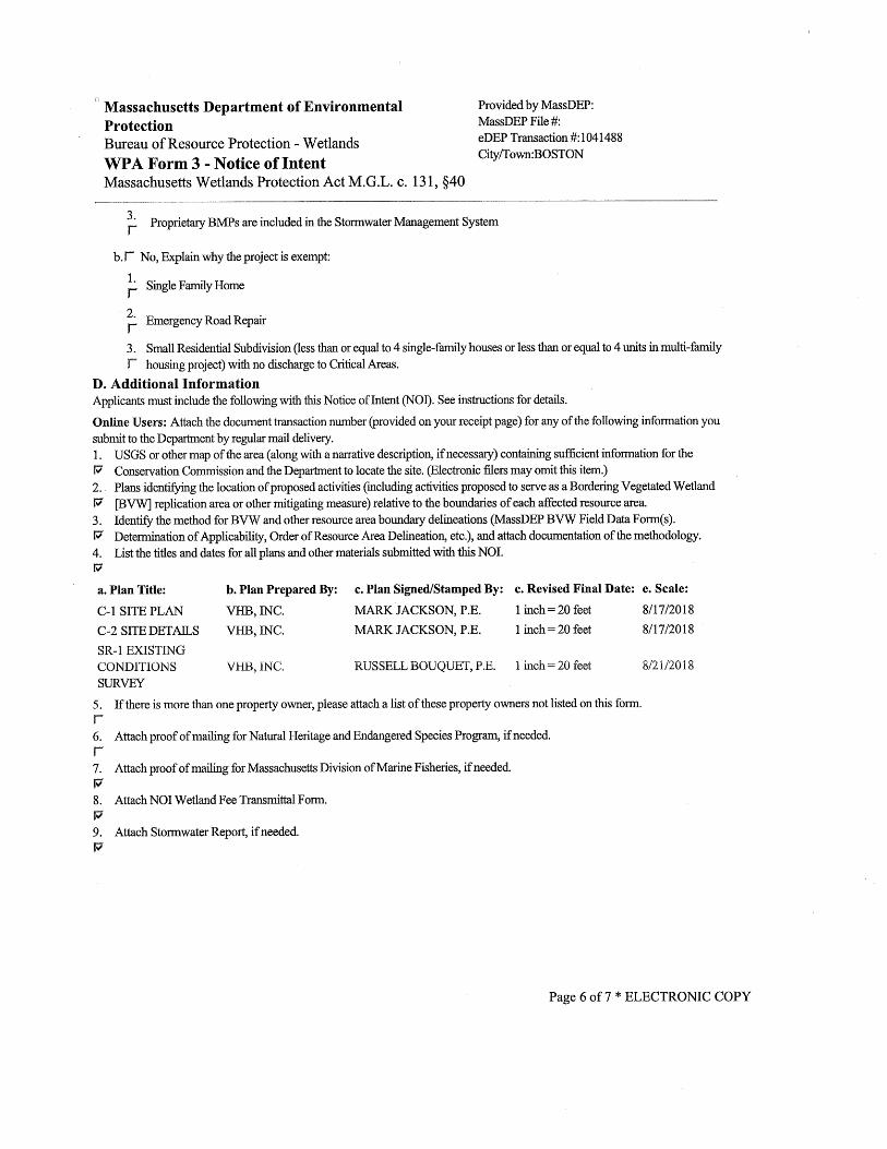
Attachment A—NOI Narrative ........................................................................................ A‐1
Introduction .................................................................................................. A-1 Wetland Resource Areas ............................................................................. A-1 Proposed Improvements .............................................................................. A-2 Mitigation Measures ..................................................................................... A-4 Regulatory Compliance ................................................................................ A-6 Summary ...................................................................................................... A-7
Attachment B – Abutter Information
Attachment C – Stormwater Memorandum
Attachment D – Project Plans

\\vhb\proj\Boston\14307.00 Vertex Mech Upgrades\reports\BCC\NOI\Vertex-NOI.docx ii Table of Contents
Notice of Intent
WPA Form 3
NOI Wetland Fee Transmittal Form

Vanasse Hangen Brustlin, Inc. (VHB)
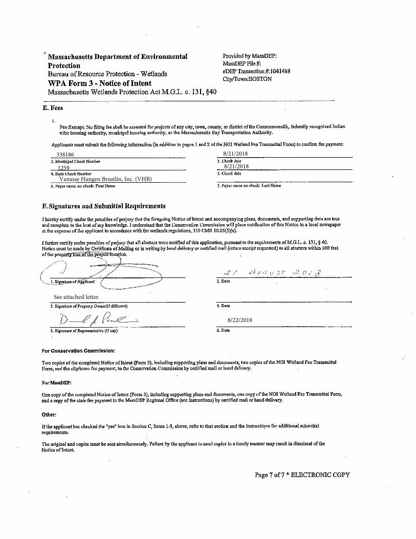
338186 8/21/2018
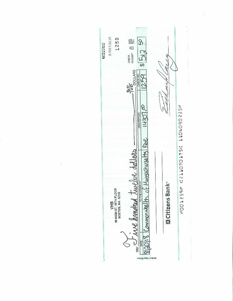
1259 8/21/2018
See attached letter.
8/22/2018
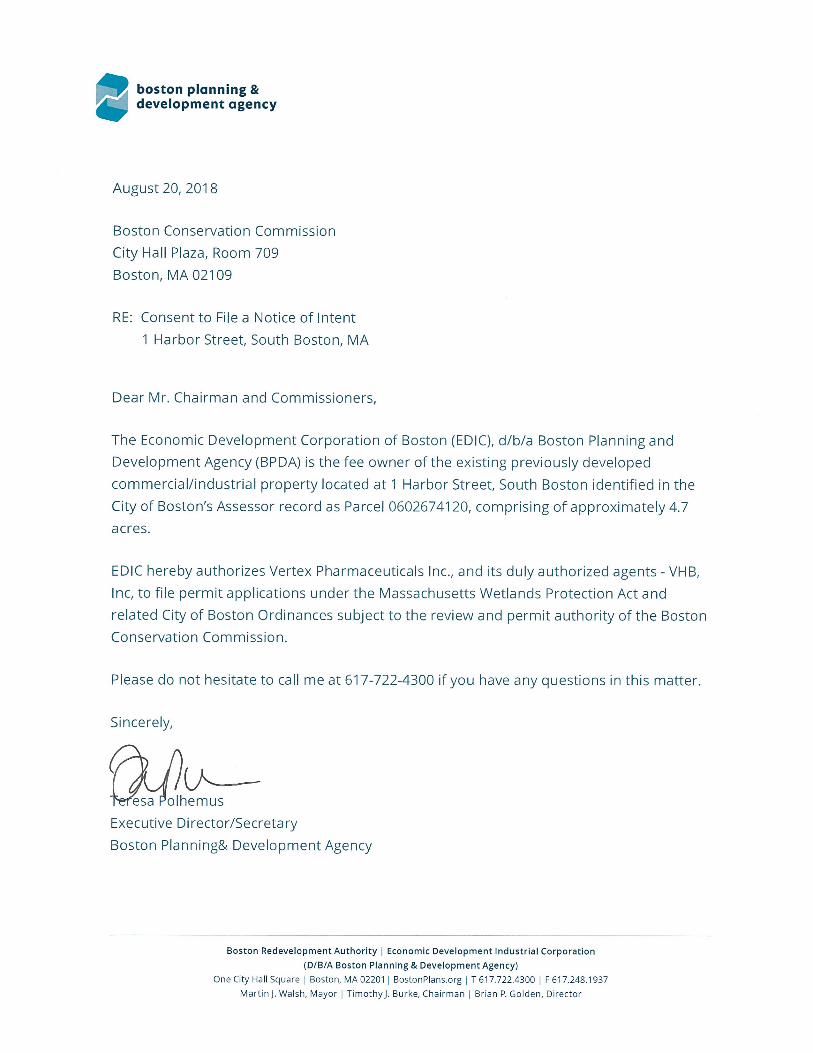
boston planning &development agency
August 20, 201 8
Boston Conservation CommissionCity Hall Plaza, Room 709Boston, MA 02109
RE: Consent to File a Notice of Intent1 Harbor Street, South Boston, MA
Dear Mr. Chairman and Commissioners,
The Economic Development Corporation of Boston (EDIC), d/b/a Boston Planning andDevelopment Agency (BPDA) is the fee owner of the existing previously developedcommercial/industrial property located at 1 Harbor Street, South Boston identified in theCity of Boston’s Assessor record as Parcel 0602674120, comprising of approximately 4.7acres.
EDIC hereby authorizes Vertex Pharmaceuticals Inc., and its duly authorized agents - VHB,Inc, to file permit applications under the Massachusetts Wetlands Protection Act andrelated City of Boston Ordinances subject to the review and permit authority of the BostonConservation Commission.
Please do not hesitate to call me at 617-722-4300 if you have any questions in this matter.
Sincerely,
IhemusExecutive Director/SecretaryBoston Planning& Development Agency
Boston Redevelopment Authority Economic Development Industrial corporation(D/B/A Boston Planning & Development Agency)
One City Hall Square Boston, MA 02201 BostonPlans.org T 617.722.4300 F 617.248.1937Martini. Walsh, Mayor Timothyj. Burke, chairman Brian P. Golden, Director
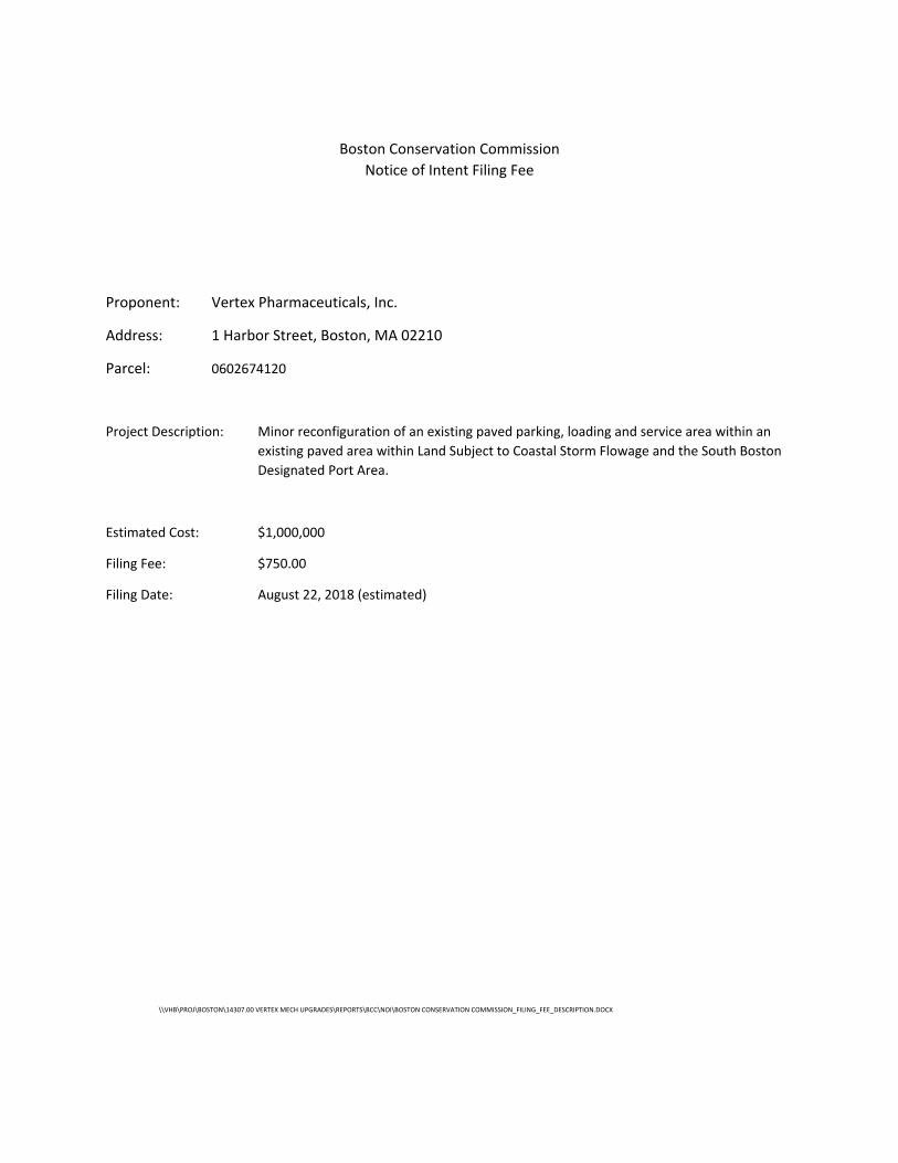
Boston Conservation Commission
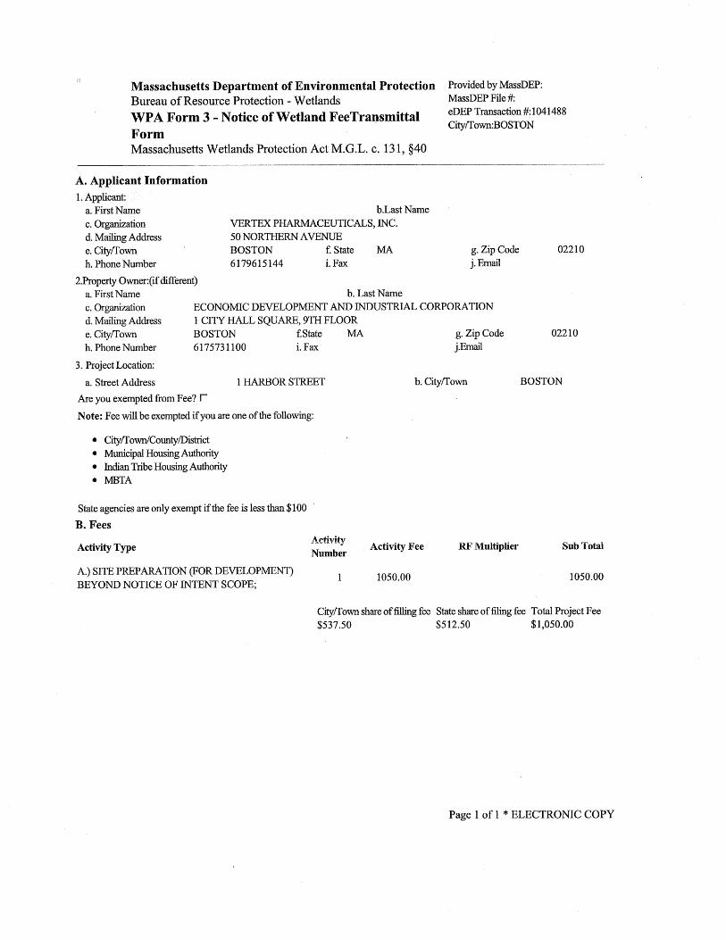
Notice of Intent Filing Fee
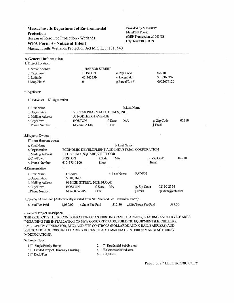
Proponent: Vertex Pharmaceuticals, Inc.
Address: 1 Harbor Street, Boston, MA 02210
Parcel: 0602674120
Project Description: Minor reconfiguration of an existing paved parking, loading and service area within an
existing paved area within Land Subject to Coastal Storm Flowage and the South Boston
Designated Port Area.
Estimated Cost: $1,000,000
Filing Fee: $750.00
Filing Date: August 22, 2018 (estimated)
\\VHB\PROJ\BOSTON\14307.00 VERTEX MECH UPGRADES\REPORTS\BCC\NOI\BOSTON CONSERVATION COMMISSION_FILING_FEE_DESCRIPTION.DOCX
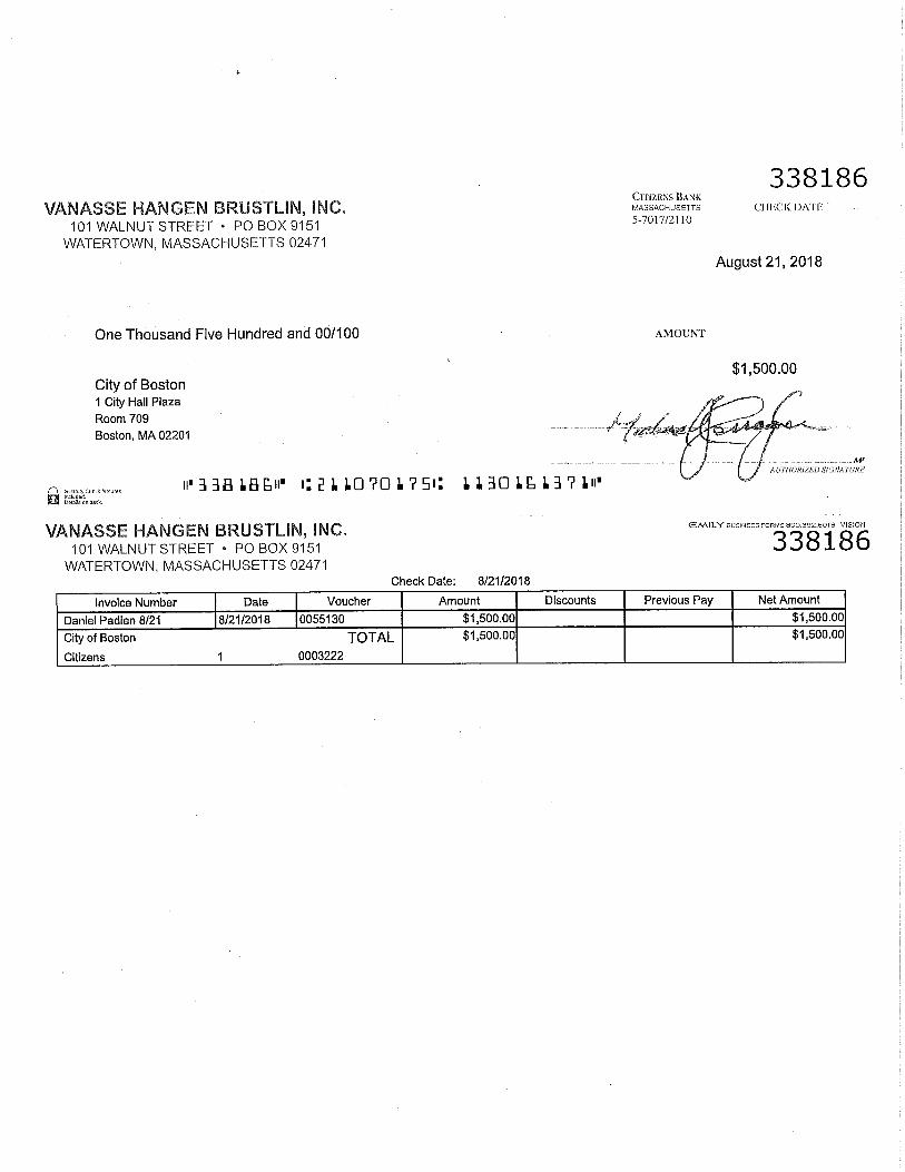
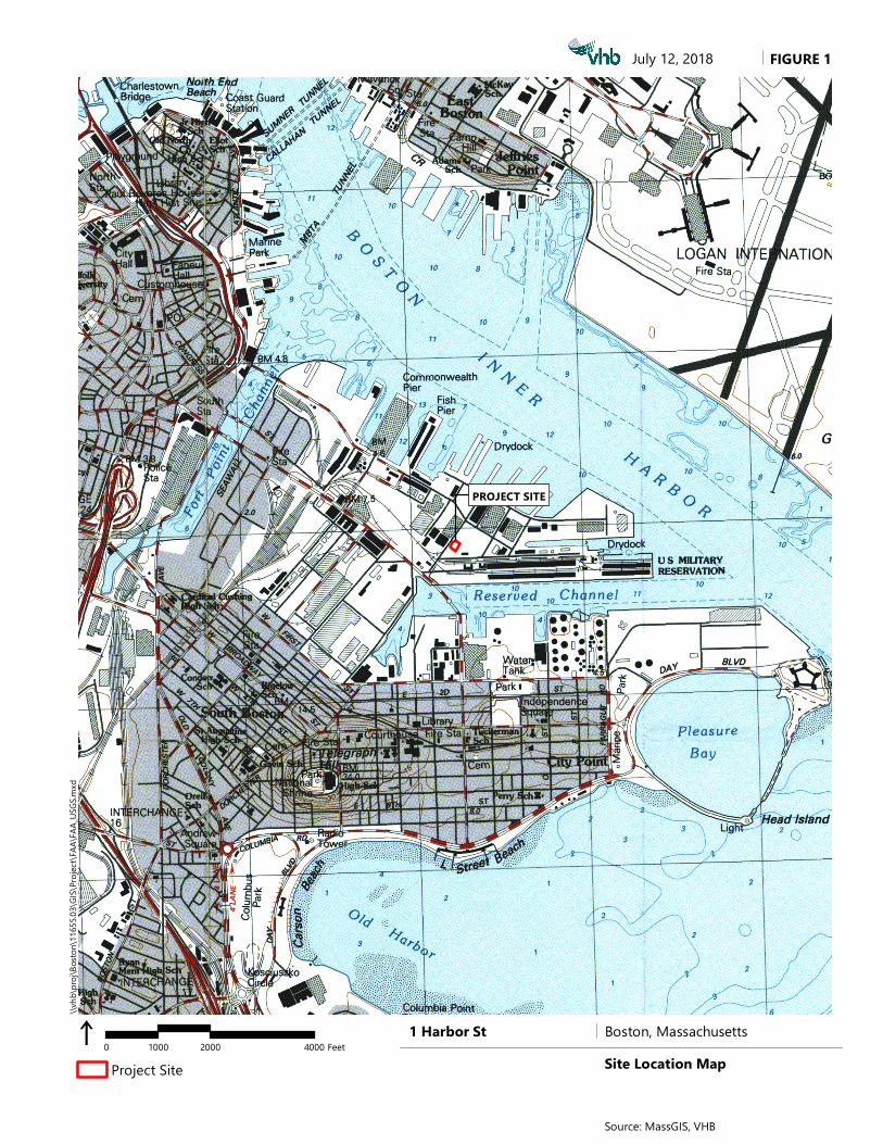
FIGURE 1
i 0 2000 40001000 Feet
July 12, 2018\\v
hb\p
roj\Bo
ston\1
1655
.03\G
IS\Pro
ject\F
AA\FA
A_US
GS.m
xd
Project Site
Source: MassGIS, VHB
Boston, MassachusettsSite Location Map
1 Harbor St
PROJECT SITE
PROJECT SITE
HARBO
R STR
EET
DRYDOCK AVENUE
FIGURE 2\\v
hb\p
roj\Bo
ston\1
1655
.03\G
IS\Pro
ject\F
AA\FA
A_Ae
rial.m
xd
i 0 100 20050 Feet
Project Site
July 12, 2018
Aerial Map
Source: VHB, MassGIS, FAA
Boston, Massachusetts1 Harbor St
USGS The National Map: Orthoimagery. Data refreshed October 2017.
National Flood Hazard Layer FIRMette
0 500 1,000 1,500 2,000250Feet
Ü
71°2
'26.08
"W
42°20'56.59"N
71°1'48.62"W
42°20'30.00"N
SEE FIS REPORT FOR DETAILED LEGEND AND INDEX MAP FOR FIRM PANEL LAYOUT
SPECIAL FLOODHAZARD AREAS
Without Base Flood Elevation (BFE)Zone A, V, A99
With BFE or Depth Zone AE, AO, AH, VE, ARRegulatory Floodway
0.2% Annual Chance Flood Hazard, Areasof 1% annual chance flood with averagedepth less than one foot or with drainageareas of less than one square mile Zone XFuture Conditions 1% AnnualChance Flood Hazard Zone XArea with Reduced Flood Risk due toLevee. See Notes. Zone XArea with Flood Risk due to Levee Zone D
NO SCREEN Area of Minimal Flood Hazard Zone X
Area of Undetermined Flood Hazard Zone D
Channel, Culvert, or Storm SewerLevee, Dike, or Floodwall
Cross Sections with 1% Annual Chance17.5 Water Surface Elevation
Coastal Transect
Coastal Transect BaselineProfile BaselineHydrographic Feature
Base Flood Elevation Line (BFE)
Effective LOMRs
Limit of StudyJurisdiction Boundary
Digital Data AvailableNo Digital Data AvailableUnmapped
This map complies with FEMA's standards for the use of digital flood maps if it is not void as described below. The basemap shown complies with FEMA's basemap accuracy standardsThe flood hazard information is derived directly from theauthoritative NFHL web services provided by FEMA. This mapwas exported on 7/12/2018 at 12:22:53 PM and does notreflect changes or amendments subsequent to this date andtime. The NFHL and effective information may change orbecome superseded by new data over time.This map image is void if the one or more of the following mapelements do not appear: basemap imagery, flood zone labels,legend, scale bar, map creation date, community identifiers,FIRM panel number, and FIRM effective date. Map images forunmapped and unmodernized areas cannot be used forregulatory purposes.
Legend
OTHER AREAS OFFLOOD HAZARD
OTHER AREAS
GENERALSTRUCTURES
OTHERFEATURES
MAP PANELS
8
1:6,000
B 20.2
The pin displayed on the map is an approximate point selected by the user and does not represent an authoritative property location.

Attachment A
Notice of Intent Narrative
Introduction
Wetland Resource Areas
Proposed Improvements
Mitigation Measures
Regulatory Compliance
Summary

\\vhb\proj\Boston\14307.00 Vertex Mech Upgrades\reports\BCC\NOI\Vertex-NOI.docx A‐1 Attachment A — NOI Narrative
A. A
Attachment A
NOI Narrative
On behalf of Vertex Pharmaceuticals, Inc. (the applicant), VHB, Inc. respectfully
submits this Notice of Intent (NOI) pursuant to the Massachusetts Wetlands
Protection Act (MGL Chapter 131, Section 40) seeking an Order of Conditions for
work within Land Subject to Coastal Storm Flowage and the South Boston
Designated Port Area.
Introduction
The Applicant, Vertex Pharmaceuticals, Inc., proposes to complete certain minor
improvements to the existing paved parking, loading and service area at their
existing manufacturing facility located at 1 Harbor Street in the South Boston
Designated Port Area.
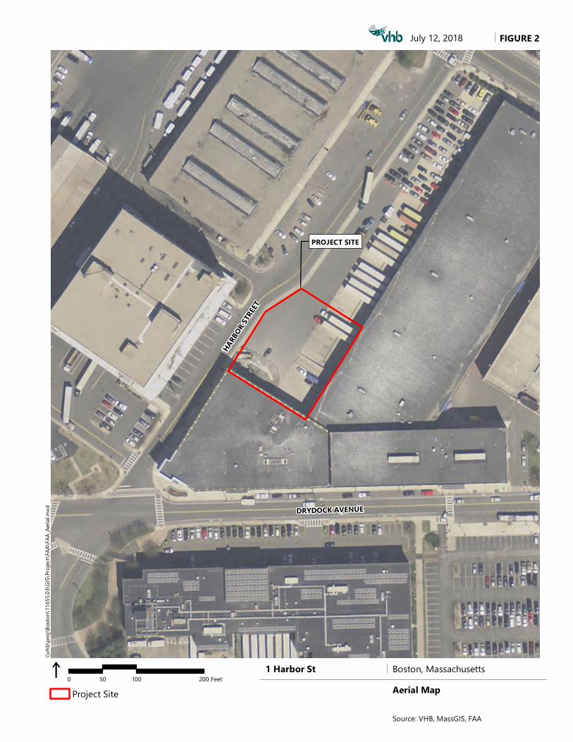
The project site consists of approximately 0.4 acres of previously developed entirely
paved land adjacent to a one‐story light‐industrial building located at 1 Harbor Street
in South Boston (See Figure 1 – Site Location and Figure 2 – Aerial Map).
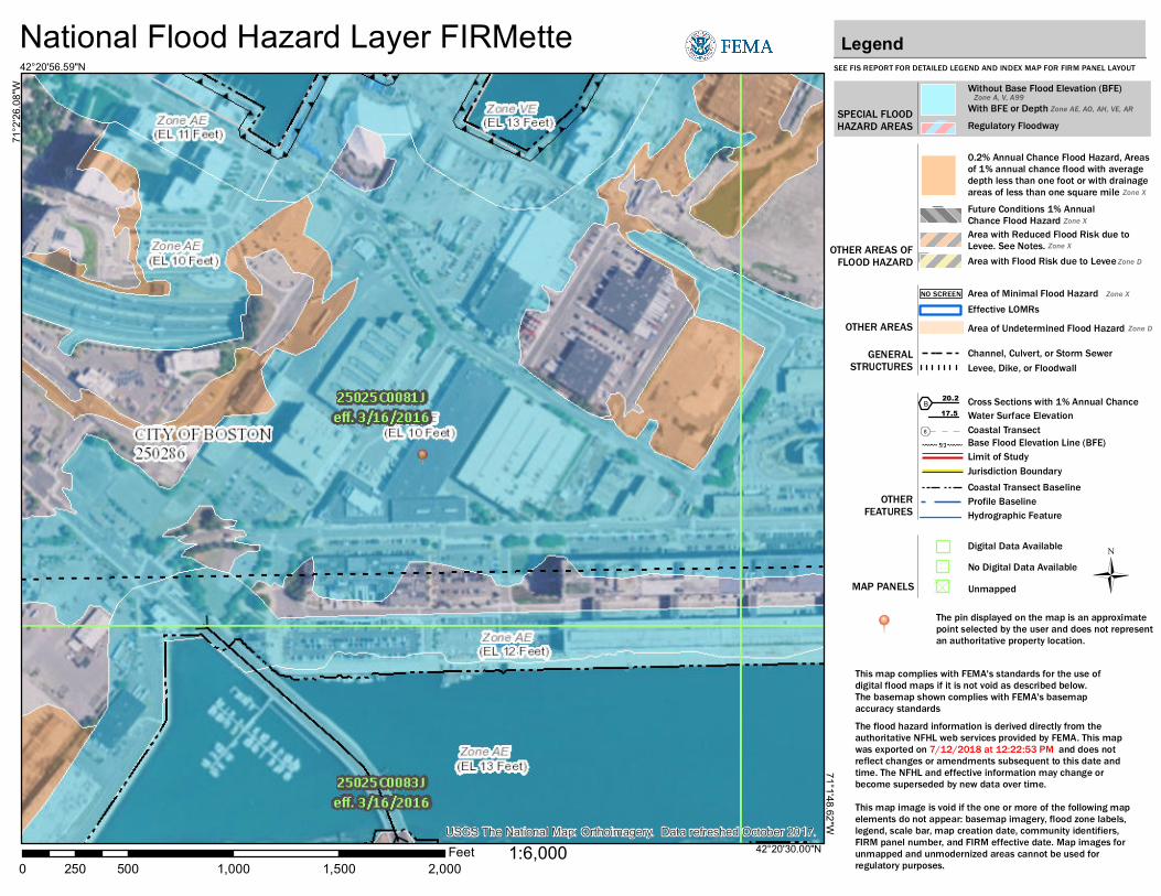
The project site is approximately 1,300 feet from the waters of Boston Harbor and
does not contain any vegetated wetland resource areas or buffer zone. However, the
site is located within a FEMA‐mapped coastal floodplain regulated as Land Subject
to Coastal Storm Flowage and is also within the South Boston Designated Port Area.
The planned improvements include reconfiguration of the Project Site to
accommodate operational changes, optimization of building system, installation of a
new emergency generator and physical separation of loading docks from these
reconfigured service areas.
Wetland Resource Areas
The Project Site contains the following state‐regulated wetland resource areas and
buffer zones.
\\vhb\proj\Boston\14307.00 Vertex Mech Upgrades\reports\BCC\NOI\Vertex-NOI.docx A‐2 Attachment A — NOI Narrative
Land Subject to Coastal Storm Flowage
Land Subject to Coastal Storm Flowage is defined at 310 CMR 10.04 (2) as land
subject to any inundation caused by coastal storms up to and including that caused
by the 100‐year storm, surge of record or storm of record, whichever is greater.
This so‐called 100‐year storm, defined by Federal Emergency Management Agency
(FEMA) storm with a 1 percent chance of occurring any year. The most recently
Flood Insurance Rate Map (FIRM) indicates this modeled storm has a base flood
elevation of 10 feet NAVD88 (15.65 feet Boston City Base).
The entire project site is located within this coastal floodplain and therefore within
the state‐regulated resource area Land Subject to Coastal Storm Flowage.
Designated Port Area
Designated Port Areas are defined at 310 CMR 10.26 as those areas designated in
301 CMR 25.00: Designation of Port Areas.
The Project Site is located within the South Boston Designated Port Area (DPA)
delineated pursuant to 301 CMR 25.00 by the Massachusetts Office of Coastal Zone
Management pursuant the Federal Coastal Zone Management Act. A copy of the
most recently issued DPA boundary map depicting this area is attached to this
Notice of Intent.
Natural Heritage Resources / Outstanding Resource Waters
The Project Site is located in a densely developed area of South Boston formerly part
of the South Boston Naval Annex. No portion of the Site is located within a Zone II
Interim Wellhead Protection Area1. Furthermore, the Project Site does not contain
any known occurrence of Estimated Habitat of Rare Wildlife or Priority Habitat of
Endangered Species.2
Proposed Improvements
The proponent plans to implement a series of small changes to the existing paved
loading and service area in two phases including:
1 DEP, 2012. Approved Wellhead Protection Areas (Zone II). 2 Massachusetts Natural Heritage and Endangered Species Program, MassGIS.
\\vhb\proj\Boston\14307.00 Vertex Mech Upgrades\reports\BCC\NOI\Vertex-NOI.docx A‐3 Attachment A — NOI Narrative
Phase 1
Placement of concrete “Jersey” barriers and steel and concrete bollards to
delineate loading and non‐loading areas to protect existing and proposed
equipment;
Minor building modifications to accommodate the installation of three new
loading bay doors and the removal of four existing roll‐up doors;
Installation of new steel stair and ladder on the existing building façade;
Installation of new ground‐mounted steel dunnage and an above‐grade Air‐
Cooled Chiller;
Future Phase
Installation of a new pad‐mounted, emergency generator at grade level;
Installation of a lab waste storage;
Installation of a new ground‐level trash compactor;
The proposed improvements are depicted on the attached project plans. The Exterior
Building Elevation Plan (Sheet 003‐1‐A20‐01) indicates the proposed elevations for
each piece of mechanical equipment proposed to be installed at the site
Table 1 provides a summary of the existing and proposed site grades and the
elevation for each piece of mechanical equipment to reinstalled at the site.
Table 1 Site and Equipment Elevations
Project Element Existing Site
Grade
Proposed Site
Grade
Equipment Elevation
Bottom of Framing
Steel Frame Stairs 15.1 15.1 15.1
Concrete K‐Rail Barrier 15.1 – 15.3 15.1 – 15.3 15.1 – 15.3
Trask Compactor 15.1 15.1 15.1
Chiller 15.3 – 19.1 15.3 – 16.0 19.4
Waste Water Holding Tank 16.6 16.6 19.4
Emergency Generator 16.1 – 16.6 19.4
Parking Space Re‐striping 15.5 15.5 NA
1. All elevations in feet, Boston City Base (BCB).
2. Existing elevations based on actual Field Survey, August 2018.
The applicant will protect wetland resource areas from impacts during construction
through the implementation of an erosion and sedimentation control program. This
\\vhb\proj\Boston\14307.00 Vertex Mech Upgrades\reports\BCC\NOI\Vertex-NOI.docx A‐4 Attachment A — NOI Narrative
program includes provisions to minimize areas of disturbance through phasing and
sequencing, to limit erosion through stabilization of disturbed surfaces, and to prevent
sediment from leaving the site by installing structural controls. The stormwater runoff
generated from the project will be collected and treated in accordance with design
guidelines3 developed by Department of Environmental Protection (DEP) and
standards contained in the WPA Regulations. Construction‐phase mitigation
measures are described below.
Resource Area Impacts
The Project Site is located entirely within a previously developed area located in a
FEMA‐mapped coastal floodplain associated with Boston Harbor, regulated as Land
Subject to Coastal Storm Flowage (LSCSF), and located within the South Boston
Designated Port Area. As described above, work proposed within LSCSF includes
the minor construction of minor site improvements within approximately 23,700
square feet of an existing paved parking, loading and service area.
There are no general performance standards for work is LSCSF formalized under the
Massachusetts Wetlands Protection Act (MWPA) and no applicable performance
standards for work within a Designated Port Area that is outside other state‐
regulated resource areas.
Mitigation Measures
The applicant proposes to implement a series of mitigation measures to prevent
short‐ and long‐term impacts to Land Subject to Coastal Storm Flowage and the
downgradient waters of Boston Harbor. Proposed mitigation measures include
sediment and erosion controls, structural practices and non‐structural practices as
described below.
Erosion and Sediment Control
An erosion and sedimentation control program will be implemented to minimize
temporary impacts to wetland resource areas during the construction phase of the
Project. The program incorporates Best Management Practices (BMPs) specified in
guidelines developed by the DEP4 and the U.S. Environmental Protection
Agency (EPA)5.
3 DEP, 2008. Massachusetts Stormwater Handbook. 4 DEP, 1997. Massachusetts Erosion and Sediment Control Guidelines for Urban and Suburban Areas: A Guide for
Planners, Designers, and Municipal Officials. 5 EPA, 2007. Interim Developing Your Stormwater Pollution Prevention Plan: A Guide for Construction Sites. Office of
Water. Report EPA 833-R-060-04.
\\vhb\proj\Boston\14307.00 Vertex Mech Upgrades\reports\BCC\NOI\Vertex-NOI.docx A‐5 Attachment A — NOI Narrative
Proper implementation of the erosion and sedimentation control program will:
minimize exposed soil areas through sequencing and temporary stabilization;
place structures to manage stormwater runoff and erosion; and,
establish a permanent stabilized cover as soon as practicable.
The following sections describe the controls that will be used and practices that will
be followed during construction. These practices comply with criteria contained in
the NPDES General Permit for Discharges from Large and Small Construction
Activities issued by the EPA.
Site Control
Prior to any excavation, the contractor will establish a limit of work and perimeter
control (fence) to avoid unnecessary vehicle traffic. No temporary soil stockpile
areas are anticipated but if small stockpiles are necessary, they will be surrounded by
erosion controls of covered by plastic sheeting as appropriate to avoid or minimize
potential to water quality or downstream wetlands or waterways.
Pavement Sweeping
The paved areas within, or adjacent to the Project Site will be mechanically swept on
an as‐needed basis to avoid tracking of dirt or sediment from the Project Site onto
city streets.
Catch Basin Protection
The Project does not include the construction of any new or reconfigured catch basins
or stormwater inlets. Stormwater flow will be directed to the existing closed
stormwater management system in the surrounding paved areas. All catch basins
collecting stormwater runoff from the Project Site will be protected by non‐woven
catch basin inlet filter inserts at (i.e. Siltsac or acceptable substitute). Catch basin inlet
protection measures will be inspected on a daily basis and replaced as necessary
throughout construction. Accumulated sediment in catch basin sumps will be
removed at project completion.
Maintenance
The contractor or subcontractor will be responsible for implementing each
control described above.

\\vhb\proj\Boston\14307.00 Vertex Mech Upgrades\reports\BCC\NOI\Vertex-NOI.docx A‐6 Attachment A — NOI Narrative
The on‐site contractor will inspect all sediment and erosion control structures
periodically and after each rainfall event. Records of the inspections will be
prepared and maintained on‐site by the contractor.
Damaged or deteriorated items will be repaired immediately after identification.
Sediment that is collected in structures shall be disposed of properly and covered
if stored on‐site.
Erosion control structures shall remain in place, at a minimum, while on‐site
areas are disturbed. If the planned improvements are completed in two or
phases, erosion controls may be removed and re‐installed to accommodate
operational needs.
Regulatory Compliance
The Project includes work within Land Subject to Coastal Storm Flowage (LSCSF)
and a Designated Port Area (DPA), jurisdictional areas subject to the Massachusetts
Wetlands Protection Act necessitating the filing of this Notice of Intent and receipt of
an Order of Conditions from the Boston Conservation Commission.
Compliance with the Massachusetts Wetlands Protection Act (M.G.L. c. 131 § 40) and
its implementing regulations (310 CMR 10.00) is outlined below.
Land Subject to Coastal Storm Flowage
The planned improvements will not appreciably alter the Land Subject to Coastal
Storm Flowage at the Project Site. The planned improvements are limited to
temporary construction‐phase impacts and the installation of equipment and site
control measures. No gross changes in site elevation are proposed and no alterations
that could affect the elevation of floodwaters during a 1 percent annual storm.
The Massachusetts Wetland Regulations (310 CMR 10.00) do not impose any
performance standards for work in Land Subject to Coastal Storm Flowage, in part
because the placement of fill within the coastal floodplain does not alter the
predicted flood elevations during coastal storms.
Designated Port Areas
The planned improvements are located in the South Boston Designated Port Area
(DPA). The regulations at 310 CMR 10.26(1) establish presumptions for Land Under
the Ocean when it is located within a DPA. Additionally, presumptions of
non‐significance are stipulated for the following resource areas:
salt marshes
coastal dunes
\\vhb\proj\Boston\14307.00 Vertex Mech Upgrades\reports\BCC\NOI\Vertex-NOI.docx A‐7 Attachment A — NOI Narrative
land under salt ponds
coastal beaches
tidal flats
barrier beaches
rocky intertidal shores and
land containing shellfish
However, no presumptions of significance are stipulated for Land Subject to Coastal
Storm Flowage.
Consistent with the lack or performance standards for work in Land Subject to
Coastal Storm Flowage, there are no performance standards or presumptions of
significance for work within a Designated Port Are that is also within Land Subject to
Coastal Storm Flowage.
Stormwater Management
The Project has been designed in accordance with the Massachusetts Stormwater
Handbook, and meets all applicable stormwater management standards for a
redevelopment project located in a coastal floodplain.
The planned improvements will have no appreciable effect on the volume or peak
velocity of runoff from the site because the entire is presently and will be paved under
proposed conditions.
A stormwater management analysis and compliance documentation is provided as
an attachment to this Notice of Intent including the following required elements:
Project description;
Site description;
Summary of existing drainage conditions;
Summary of proposed drainage conditions;
Regulatory compliance narrative documenting compliance with all applicable
stormwater management standards, and
Complete DEP Stormwater Management Form.
Summary
Vertex Pharmaceuticals, Inc. proposes certain minor improvements to their existing
facility at 1 Harbor Street in South Boston, located within Land Subject to Coastal
Storm Flowage and the South Boston Designated Port Area. The Project Site is
located approximately 1,300 from the waters of Boston Harbor, contains no open
water, vegetated wetlands or buffer zone.
\\vhb\proj\Boston\14307.00 Vertex Mech Upgrades\reports\BCC\NOI\Vertex-NOI.docx A‐8 Attachment A — NOI Narrative
The planned improvements are limited to changes to the existing paved areas and
include installation of mechanical building systems such as an emergency generator,
air handling equipment, relocation and reconfiguration of loading dock and
installation of site management controls (bollards and concrete k‐rails).
The Project will not have any adverse effects of any protected wetland resource area
and fully complies with all applicable provisions of the Massachusetts Wetlands
Regulations.
Attachment B
Abutter Information
Notice to Abutters
Abutters List

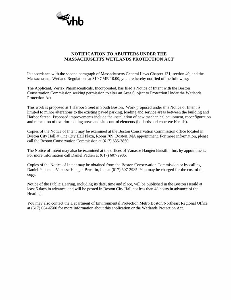
NOTIFICATION TO ABUTTERS UNDER THE MASSACHUSETTS WETLANDS PROTECTION ACT
In accordance with the second paragraph of Massachusetts General Laws Chapter 131, section 40, and the Massachusetts Wetland Regulations at 310 CMR 10.00, you are hereby notified of the following: The Applicant, Vertex Pharmaceuticals, Incorporated, has filed a Notice of Intent with the Boston Conservation Commission seeking permission to alter an Area Subject to Protection Under the Wetlands Protection Act. This work is proposed at 1 Harbor Street in South Boston. Work proposed under this Notice of Intent is limited to minor alterations to the existing paved parking, loading and service areas between the building and Harbor Street. Proposed improvements include the installation of new mechanical equipment, reconfiguration and relocation of exterior loading areas and site control elements (bollards and concrete K-rails). Copies of the Notice of Intent may be examined at the Boston Conservation Commission office located in Boston City Hall at One City Hall Plaza, Room 709, Boston, MA appointment. For more information, please call the Boston Conservation Commission at (617) 635-3850 The Notice of Intent may also be examined at the offices of Vanasse Hangen Brustlin, Inc. by appointment. For more information call Daniel Padien at (617) 607-2985. Copies of the Notice of Intent may be obtained from the Boston Conservation Commission or by calling Daniel Padien at Vanasse Hangen Brustlin, Inc. at (617) 607-2985. You may be charged for the cost of the copy. Notice of the Public Hearing, including its date, time and place, will be published in the Boston Herald at least 5 days in advance, and will be posted in Boston City Hall not less than 48 hours in advance of the Hearing. You may also contact the Department of Environmental Protection Metro Boston/Northeast Regional Office at (617) 654-6500 for more information about this application or the Wetlands Protection Act.
PROJECT SITE
HARBO
R STR
EET
MASSACHUSETTS TURNPIKE
MASSP
ORT HAU
L ROAD
DRYDOCK AVENUE
NORTHERN AVENUE
0602674155
0602674125
0602674175
0602674225
0602674150
0602674018
0602674115
\\vhb
\proj
\Bosto
n\116
55.03
\GIS\
Projec
t\FAA
\FAA_
Aeria
l.mxd
i 0 200 400100 FeetProject Site100-ft Project Parcel BufferParcel Boundary
Abutting Economic Development ParcelAbutting Private Parcel
August 21, 2018
Property Ownership
Source: VHB, MassGIS, FAA
Boston, Massachusetts1 Harbor St
Parel ID Owner Site Address 602674155 ECONOMIC DEVELOPMENT CHANNEL ST602674125 ECONOMIC DEVELOPMENT 12 DRYDOCK AV602674175 ECONOMIC DEVELOPMENT 5 -11 DRYDOCK AV602674225 ECONOMIC DEVELOPMENT 306 R NORTHERN AV602674150 ECONOMIC DEVELOPMENT 12 CHANNEL ST602674115 ECONOMIC DEVELOPMENT 2 HARBOR ST602674018 JAMESTOWN I DESIGN PLACE LP 1 DESIGN CENTER PL
Abutters Names and Addresses
The following ownership data taken from City of Boston Assessor Database, 8/17,2018
Parcel ID Site Address Owner Name and Address
602674155 CHANNEL ST
ECONOMIC AND INDUSTRIAL CORPORATION OF BOSTON ONE CITY HALL SQUARE BOSTON, MA 02201
602674125 12 DRYDOCK AV
602674175 5 ‐11 DRYDOCK AV
602674225 306 R NORTHERN AV
602674150 12 CHANNEL ST
602674115 2 HARBOR ST
602674018 1 DESIGN CENTER JAMESTOWN I DESIGN PLACE LP 1 DESIGN CENTER PL BOSTON MA 02210

Attachment C
Stormwater Memorandum

swcheck • 04/01/08 Stormwater Report Checklist • Page 1 of 8
Massachusetts Department of Environmental Protection Bureau of Resource Protection - Wetlands Program
Checklist for Stormwater Report
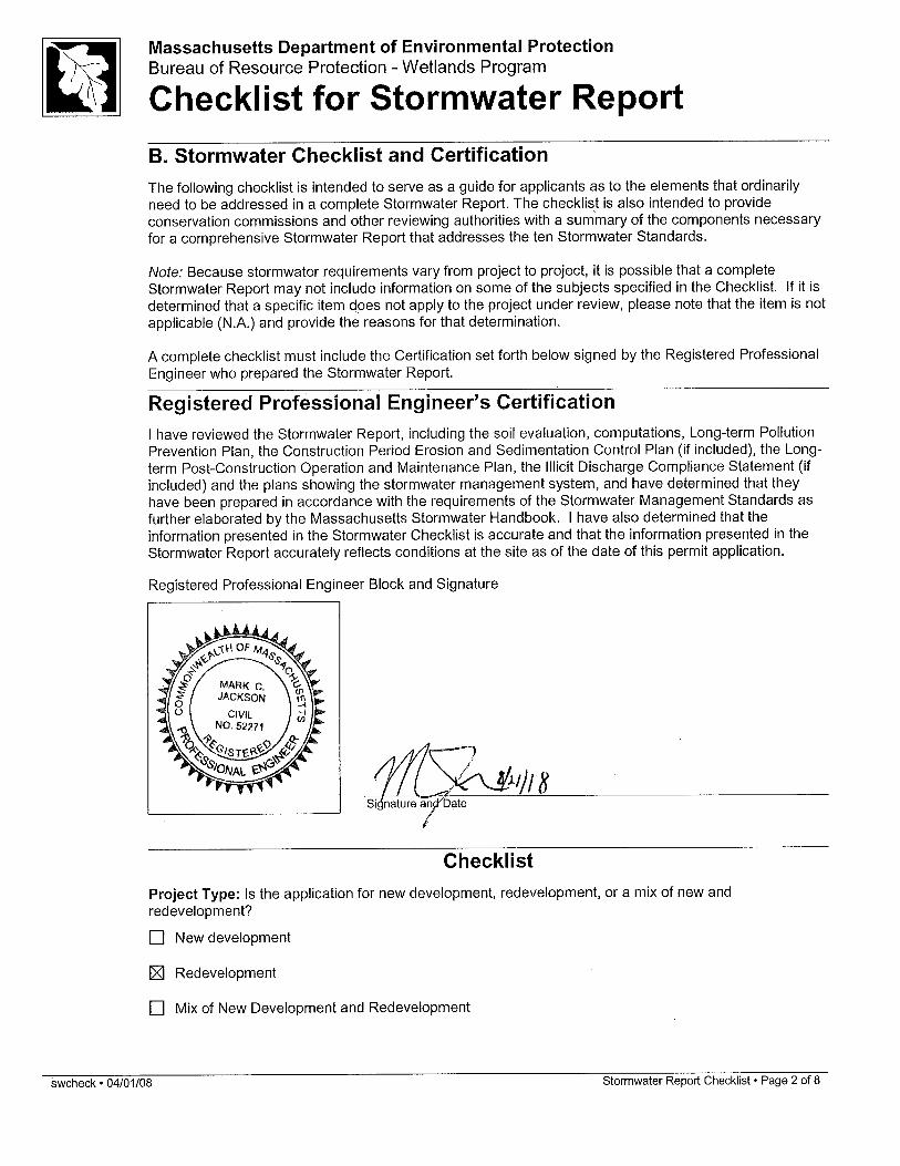
A. Introduction Important: When filling out forms on the computer, use only the tab key to move your cursor - do not use the return key.
A Stormwater Report must be submitted with the Notice of Intent permit application to document compliance with the Stormwater Management Standards. The following checklist is NOT a substitute for the Stormwater Report (which should provide more substantive and detailed information) but is offered here as a tool to help the applicant organize their Stormwater Management documentation for their Report and for the reviewer to assess this information in a consistent format. As noted in the Checklist, the Stormwater Report must contain the engineering computations and supporting information set forth in Volume 3 of the Massachusetts Stormwater Handbook. The Stormwater Report must be prepared and certified by a Registered Professional Engineer (RPE) licensed in the Commonwealth. The Stormwater Report must include:
The Stormwater Checklist completed and stamped by a Registered Professional Engineer (see page 2) that certifies that the Stormwater Report contains all required submittals.1 This Checklist is to be used as the cover for the completed Stormwater Report.
Applicant/Project Name Project Address Name of Firm and Registered Professional Engineer that prepared the Report Long-Term Pollution Prevention Plan required by Standards 4-6 Construction Period Pollution Prevention and Erosion and Sedimentation Control Plan required
by Standard 82 Operation and Maintenance Plan required by Standard 9
In addition to all plans and supporting information, the Stormwater Report must include a brief narrative describing stormwater management practices, including environmentally sensitive site design and LID techniques, along with a diagram depicting runoff through the proposed BMP treatment train. Plans are required to show existing and proposed conditions, identify all wetland resource areas, NRCS soil types, critical areas, Land Uses with Higher Potential Pollutant Loads (LUHPPL), and any areas on the site where infiltration rate is greater than 2.4 inches per hour. The Plans shall identify the drainage areas for both existing and proposed conditions at a scale that enables verification of supporting calculations.
As noted in the Checklist, the Stormwater Management Report shall document compliance with each of the Stormwater Management Standards as provided in the Massachusetts Stormwater Handbook. The soils evaluation and calculations shall be done using the methodologies set forth in Volume 3 of the Massachusetts Stormwater Handbook. To ensure that the Stormwater Report is complete, applicants are required to fill in the Stormwater Report Checklist by checking the box to indicate that the specified information has been included in the Stormwater Report. If any of the information specified in the checklist has not been submitted, the applicant must provide an explanation. The completed Stormwater Report Checklist and Certification must be submitted with the Stormwater Report.
1 The Stormwater Report may also include the Illicit Discharge Compliance Statement required by Standard 10. If not included in the Stormwater Report, the Illicit Discharge Compliance Statement must be submitted prior to the discharge of stormwater runoff to the post-construction best management practices. 2 For some complex projects, it may not be possible to include the Construction Period Erosion and Sedimentation Control Plan in the Stormwater Report. In that event, the issuing authority has the discretion to issue an Order of Conditions that approves the project and includes a condition requiring the proponent to submit the Construction Period Erosion and Sedimentation Control Plan before commencing any land disturbance activity on the site.
swcheck • 04/01/08 Stormwater Report Checklist • Page 3 of 8
Massachusetts Department of Environmental Protection Bureau of Resource Protection - Wetlands Program
Checklist for Stormwater Report
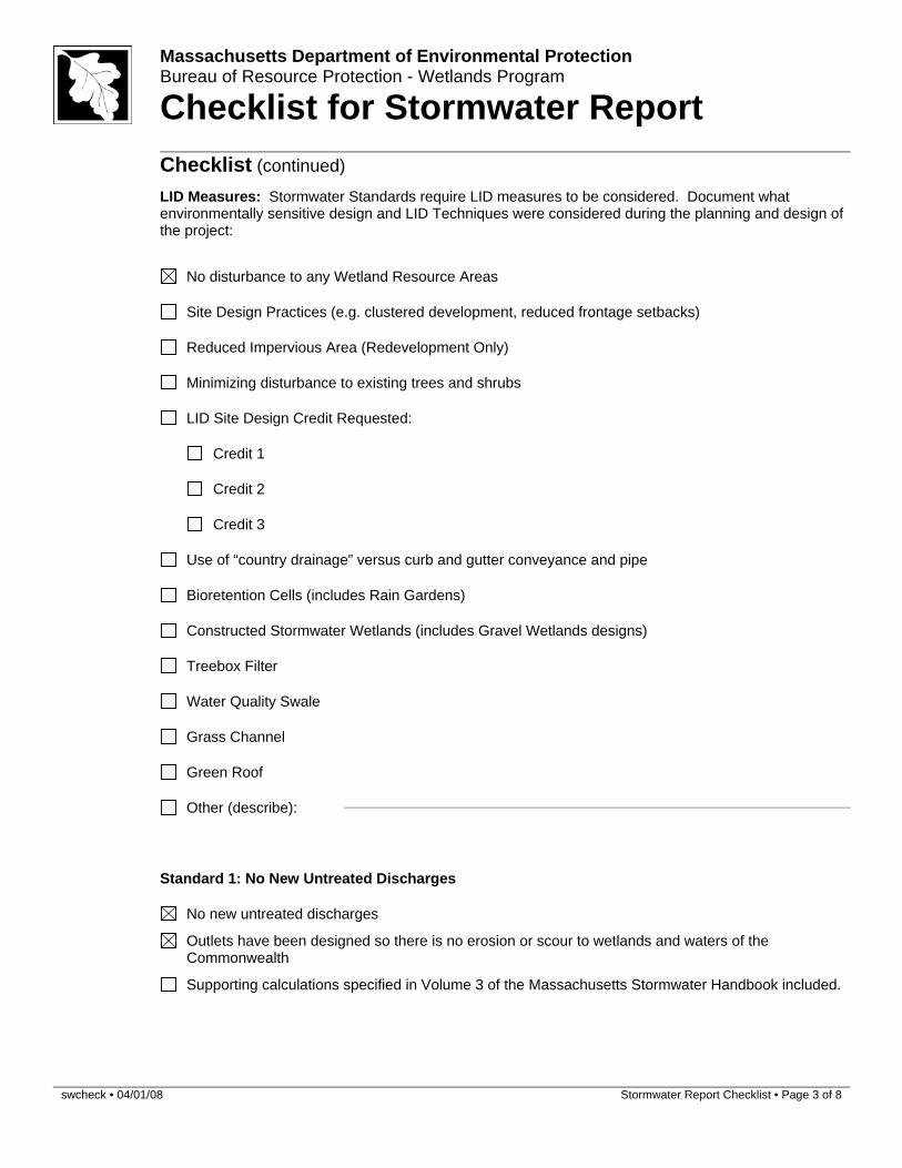
Checklist (continued) LID Measures: Stormwater Standards require LID measures to be considered. Document what
environmentally sensitive design and LID Techniques were considered during the planning and design of the project:
No disturbance to any Wetland Resource Areas
Site Design Practices (e.g. clustered development, reduced frontage setbacks)
Reduced Impervious Area (Redevelopment Only)
Minimizing disturbance to existing trees and shrubs
LID Site Design Credit Requested:
Credit 1
Credit 2
Credit 3
Use of “country drainage” versus curb and gutter conveyance and pipe
Bioretention Cells (includes Rain Gardens)
Constructed Stormwater Wetlands (includes Gravel Wetlands designs)
Treebox Filter
Water Quality Swale
Grass Channel
Green Roof
Other (describe):
Standard 1: No New Untreated Discharges
No new untreated discharges
Outlets have been designed so there is no erosion or scour to wetlands and waters of the Commonwealth
Supporting calculations specified in Volume 3 of the Massachusetts Stormwater Handbook included.
swcheck • 04/01/08 Stormwater Report Checklist • Page 4 of 8
Massachusetts Department of Environmental Protection Bureau of Resource Protection - Wetlands Program
Checklist for Stormwater Report
Checklist (continued)
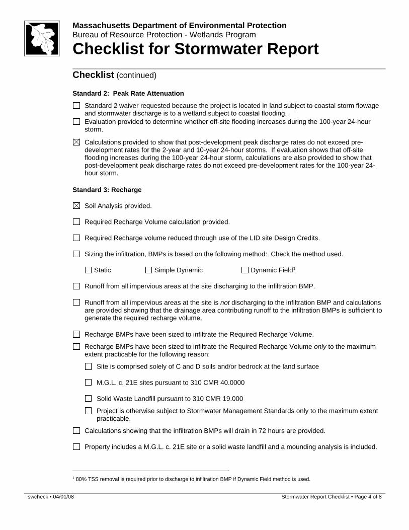
Standard 2: Peak Rate Attenuation
Standard 2 waiver requested because the project is located in land subject to coastal storm flowage and stormwater discharge is to a wetland subject to coastal flooding.
Evaluation provided to determine whether off-site flooding increases during the 100-year 24-hour storm.
Calculations provided to show that post-development peak discharge rates do not exceed pre-
development rates for the 2-year and 10-year 24-hour storms. If evaluation shows that off-site flooding increases during the 100-year 24-hour storm, calculations are also provided to show that post-development peak discharge rates do not exceed pre-development rates for the 100-year 24-hour storm.
Standard 3: Recharge
Soil Analysis provided.
Required Recharge Volume calculation provided.
Required Recharge volume reduced through use of the LID site Design Credits.
Sizing the infiltration, BMPs is based on the following method: Check the method used.
Static Simple Dynamic Dynamic Field1
Runoff from all impervious areas at the site discharging to the infiltration BMP.
Runoff from all impervious areas at the site is not discharging to the infiltration BMP and calculations
are provided showing that the drainage area contributing runoff to the infiltration BMPs is sufficient to generate the required recharge volume.
Recharge BMPs have been sized to infiltrate the Required Recharge Volume.
Recharge BMPs have been sized to infiltrate the Required Recharge Volume only to the maximum extent practicable for the following reason:
Site is comprised solely of C and D soils and/or bedrock at the land surface
M.G.L. c. 21E sites pursuant to 310 CMR 40.0000
Solid Waste Landfill pursuant to 310 CMR 19.000
Project is otherwise subject to Stormwater Management Standards only to the maximum extent practicable.
Calculations showing that the infiltration BMPs will drain in 72 hours are provided.
Property includes a M.G.L. c. 21E site or a solid waste landfill and a mounding analysis is included.
1 80% TSS removal is required prior to discharge to infiltration BMP if Dynamic Field method is used.
swcheck • 04/01/08 Stormwater Report Checklist • Page 5 of 8
Massachusetts Department of Environmental Protection Bureau of Resource Protection - Wetlands Program
Checklist for Stormwater Report
Checklist (continued)
Standard 3: Recharge (continued)
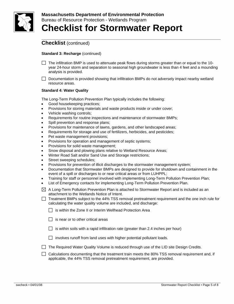
The infiltration BMP is used to attenuate peak flows during storms greater than or equal to the 10-
year 24-hour storm and separation to seasonal high groundwater is less than 4 feet and a mounding analysis is provided.
Documentation is provided showing that infiltration BMPs do not adversely impact nearby wetland resource areas.
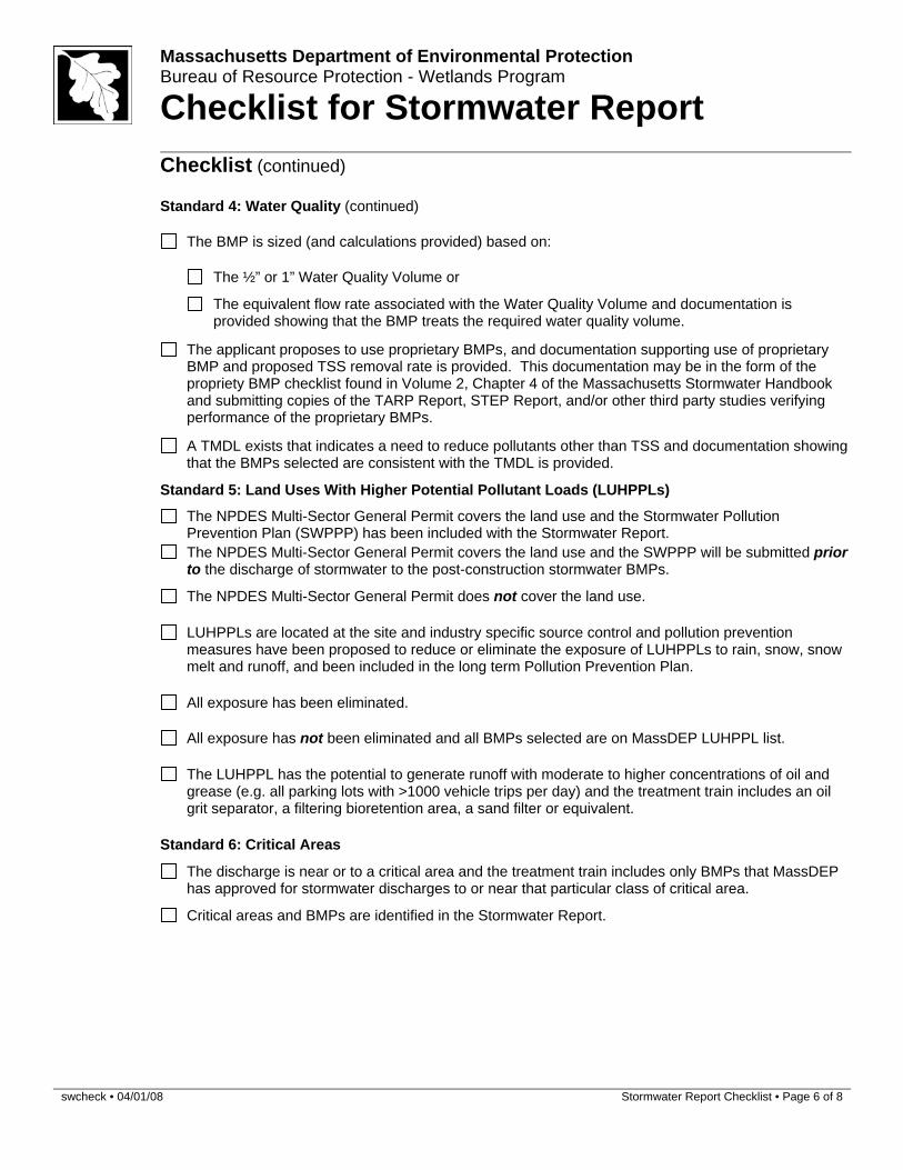
Standard 4: Water Quality
The Long-Term Pollution Prevention Plan typically includes the following: Good housekeeping practices; Provisions for storing materials and waste products inside or under cover; Vehicle washing controls; Requirements for routine inspections and maintenance of stormwater BMPs; Spill prevention and response plans; Provisions for maintenance of lawns, gardens, and other landscaped areas; Requirements for storage and use of fertilizers, herbicides, and pesticides; Pet waste management provisions; Provisions for operation and management of septic systems; Provisions for solid waste management; Snow disposal and plowing plans relative to Wetland Resource Areas; Winter Road Salt and/or Sand Use and Storage restrictions; Street sweeping schedules; Provisions for prevention of illicit discharges to the stormwater management system; Documentation that Stormwater BMPs are designed to provide for shutdown and containment in the
event of a spill or discharges to or near critical areas or from LUHPPL; Training for staff or personnel involved with implementing Long-Term Pollution Prevention Plan; List of Emergency contacts for implementing Long-Term Pollution Prevention Plan.
A Long-Term Pollution Prevention Plan is attached to Stormwater Report and is included as an attachment to the Wetlands Notice of Intent.
Treatment BMPs subject to the 44% TSS removal pretreatment requirement and the one inch rule for calculating the water quality volume are included, and discharge:
is within the Zone II or Interim Wellhead Protection Area
is near or to other critical areas
is within soils with a rapid infiltration rate (greater than 2.4 inches per hour)
involves runoff from land uses with higher potential pollutant loads.
The Required Water Quality Volume is reduced through use of the LID site Design Credits.
Calculations documenting that the treatment train meets the 80% TSS removal requirement and, if applicable, the 44% TSS removal pretreatment requirement, are provided.
swcheck • 04/01/08 Stormwater Report Checklist • Page 6 of 8
Massachusetts Department of Environmental Protection Bureau of Resource Protection - Wetlands Program
Checklist for Stormwater Report
Checklist (continued)
Standard 4: Water Quality (continued)
The BMP is sized (and calculations provided) based on:
The ½” or 1” Water Quality Volume or
The equivalent flow rate associated with the Water Quality Volume and documentation is provided showing that the BMP treats the required water quality volume.
The applicant proposes to use proprietary BMPs, and documentation supporting use of proprietary
BMP and proposed TSS removal rate is provided. This documentation may be in the form of the propriety BMP checklist found in Volume 2, Chapter 4 of the Massachusetts Stormwater Handbook and submitting copies of the TARP Report, STEP Report, and/or other third party studies verifying performance of the proprietary BMPs.
A TMDL exists that indicates a need to reduce pollutants other than TSS and documentation showing
that the BMPs selected are consistent with the TMDL is provided.
Standard 5: Land Uses With Higher Potential Pollutant Loads (LUHPPLs)
The NPDES Multi-Sector General Permit covers the land use and the Stormwater Pollution
Prevention Plan (SWPPP) has been included with the Stormwater Report.
The NPDES Multi-Sector General Permit covers the land use and the SWPPP will be submitted prior
to the discharge of stormwater to the post-construction stormwater BMPs.
The NPDES Multi-Sector General Permit does not cover the land use.
LUHPPLs are located at the site and industry specific source control and pollution prevention measures have been proposed to reduce or eliminate the exposure of LUHPPLs to rain, snow, snow melt and runoff, and been included in the long term Pollution Prevention Plan.
All exposure has been eliminated.
All exposure has not been eliminated and all BMPs selected are on MassDEP LUHPPL list.
The LUHPPL has the potential to generate runoff with moderate to higher concentrations of oil and grease (e.g. all parking lots with >1000 vehicle trips per day) and the treatment train includes an oil grit separator, a filtering bioretention area, a sand filter or equivalent.
Standard 6: Critical Areas
The discharge is near or to a critical area and the treatment train includes only BMPs that MassDEP
has approved for stormwater discharges to or near that particular class of critical area.
Critical areas and BMPs are identified in the Stormwater Report.
swcheck • 04/01/08 Stormwater Report Checklist • Page 7 of 8
Massachusetts Department of Environmental Protection Bureau of Resource Protection - Wetlands Program
Checklist for Stormwater Report
Checklist (continued)
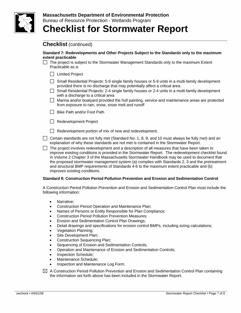
Standard 7: Redevelopments and Other Projects Subject to the Standards only to the maximum extent practicable
The project is subject to the Stormwater Management Standards only to the maximum Extent
Practicable as a:
Limited Project
Small Residential Projects: 5-9 single family houses or 5-9 units in a multi-family development
provided there is no discharge that may potentially affect a critical area.
Small Residential Projects: 2-4 single family houses or 2-4 units in a multi-family development with a discharge to a critical area
Marina and/or boatyard provided the hull painting, service and maintenance areas are protected
from exposure to rain, snow, snow melt and runoff
Bike Path and/or Foot Path
Redevelopment Project
Redevelopment portion of mix of new and redevelopment.
Certain standards are not fully met (Standard No. 1, 8, 9, and 10 must always be fully met) and an
explanation of why these standards are not met is contained in the Stormwater Report.
The project involves redevelopment and a description of all measures that have been taken to improve existing conditions is provided in the Stormwater Report. The redevelopment checklist found in Volume 2 Chapter 3 of the Massachusetts Stormwater Handbook may be used to document that the proposed stormwater management system (a) complies with Standards 2, 3 and the pretreatment and structural BMP requirements of Standards 4-6 to the maximum extent practicable and (b) improves existing conditions.
Standard 8: Construction Period Pollution Prevention and Erosion and Sedimentation Control
A Construction Period Pollution Prevention and Erosion and Sedimentation Control Plan must include the following information:
Narrative; Construction Period Operation and Maintenance Plan; Names of Persons or Entity Responsible for Plan Compliance; Construction Period Pollution Prevention Measures; Erosion and Sedimentation Control Plan Drawings; Detail drawings and specifications for erosion control BMPs, including sizing calculations; Vegetation Planning; Site Development Plan; Construction Sequencing Plan; Sequencing of Erosion and Sedimentation Controls; Operation and Maintenance of Erosion and Sedimentation Controls; Inspection Schedule; Maintenance Schedule; Inspection and Maintenance Log Form.
A Construction Period Pollution Prevention and Erosion and Sedimentation Control Plan containing
the information set forth above has been included in the Stormwater Report.
swcheck • 04/01/08 Stormwater Report Checklist • Page 8 of 8
Massachusetts Department of Environmental Protection Bureau of Resource Protection - Wetlands Program
Checklist for Stormwater Report
Checklist (continued)
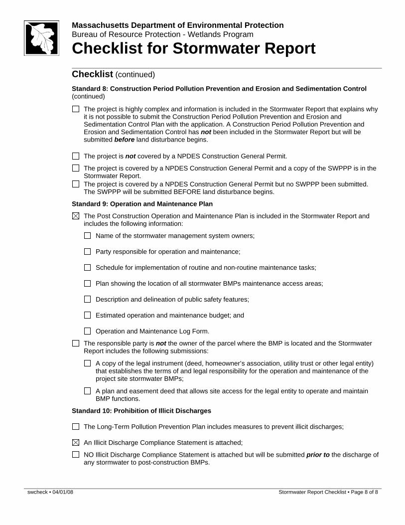
Standard 8: Construction Period Pollution Prevention and Erosion and Sedimentation Control (continued)
The project is highly complex and information is included in the Stormwater Report that explains why it is not possible to submit the Construction Period Pollution Prevention and Erosion and Sedimentation Control Plan with the application. A Construction Period Pollution Prevention and Erosion and Sedimentation Control has not been included in the Stormwater Report but will be submitted before land disturbance begins.
The project is not covered by a NPDES Construction General Permit.
The project is covered by a NPDES Construction General Permit and a copy of the SWPPP is in the
Stormwater Report.
The project is covered by a NPDES Construction General Permit but no SWPPP been submitted.
The SWPPP will be submitted BEFORE land disturbance begins.
Standard 9: Operation and Maintenance Plan
The Post Construction Operation and Maintenance Plan is included in the Stormwater Report and
includes the following information:
Name of the stormwater management system owners;
Party responsible for operation and maintenance;
Schedule for implementation of routine and non-routine maintenance tasks;
Plan showing the location of all stormwater BMPs maintenance access areas;
Description and delineation of public safety features;
Estimated operation and maintenance budget; and
Operation and Maintenance Log Form.
The responsible party is not the owner of the parcel where the BMP is located and the Stormwater
Report includes the following submissions:
A copy of the legal instrument (deed, homeowner’s association, utility trust or other legal entity) that establishes the terms of and legal responsibility for the operation and maintenance of the project site stormwater BMPs;
A plan and easement deed that allows site access for the legal entity to operate and maintain
BMP functions.
Standard 10: Prohibition of Illicit Discharges
The Long-Term Pollution Prevention Plan includes measures to prevent illicit discharges;
An Illicit Discharge Compliance Statement is attached;
NO Illicit Discharge Compliance Statement is attached but will be submitted prior to the discharge of
any stormwater to post-construction BMPs.
D-1 Stormwater Report
Stormwater Management Narrative
This Stormwater Management Narrative has been prepared to demonstrate compliance with the Massachusetts Stormwater Management Standards in accordance with the Massachusetts Wetlands Protection Act Regulations (310 CMR 10.00) and Water Quality Certification Regulations (314 CMR 9.00) for a redevelopment project.
Project Description
Vertex Pharmaceuticals, Inc. (“Vetex” or the “Proponent”) plans to implement a series of small changes to the existing paved loading and service area at the site in two phases. Proposed Actions (Phase 1)
Placement of concrete “Jersey” barriers and steel and concrete bollards to delineate loading and non-loading areas to protect existing and proposed equipment;
Minor building modifications to accommodate the installation of three new loading bay doors and the removal of four existing roll-up doors;
Installation of new steel stair and ladder on the existing building façade; Installation of new ground-mounted steel dunnage and an above-grade Air-Cooled
Chiller; Future Actions (Phase 2)
Installation of a new pad-mounted, emergency generator at grade level and a combined footprint of approximately 190 SF;
Installation of a lab waste storage tank with secondary concrete containment with a combined footprint of approximately 625 SF;
Installation of a new ground-level trash compactor; While these changes are important to site operations, they are de minimis with respect to the Wetlands Protection Act and its protection of the public interests in regulated wetland resource areas because they will not alter an area subject to protection, as defined at 310 CMR 10.04. The proposed modifications are:
1. Limited to minor alterations to existing paved and developed areas within Land Subject to Coastal Storm Flowage, for which there are no performance standards;
2. Located approximately 1,300 feet from the waters of Boston Harbor and does not contain
any open water, vegetated wetlands or buffer zones;
Vertex Pharmaceuticals
D-2 Stormwater Report
3. Will not confine, restrict or redirect any floodwaters that may reach the site during a large storm event;
Site Description
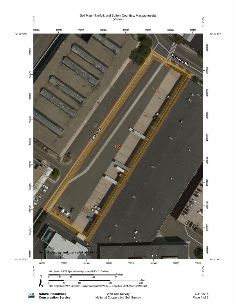
The project site consists of approximately 0.4 acres of previously developed entirely paved land adjacent to a one-story light-industrial building located at 1 Harbor Street in South Boston. The project site is approximately 1,300 feet from the waters of Boston Harbor. It does not contain any vegetated wetland resource areas or buffer zone. However, the site is located within a FEMA-mapped coastal floodplain in a designated Zone AE with a base flood elevation of 10 feet NAVD88 (see attached Firm excerpt). We understand the site is subject to the jurisdiction of the Massachusetts Wetlands Protection Act. The National Resources Conservation Service (NRCS) has classified surface soils on the site as urban fill (see attached soil map).
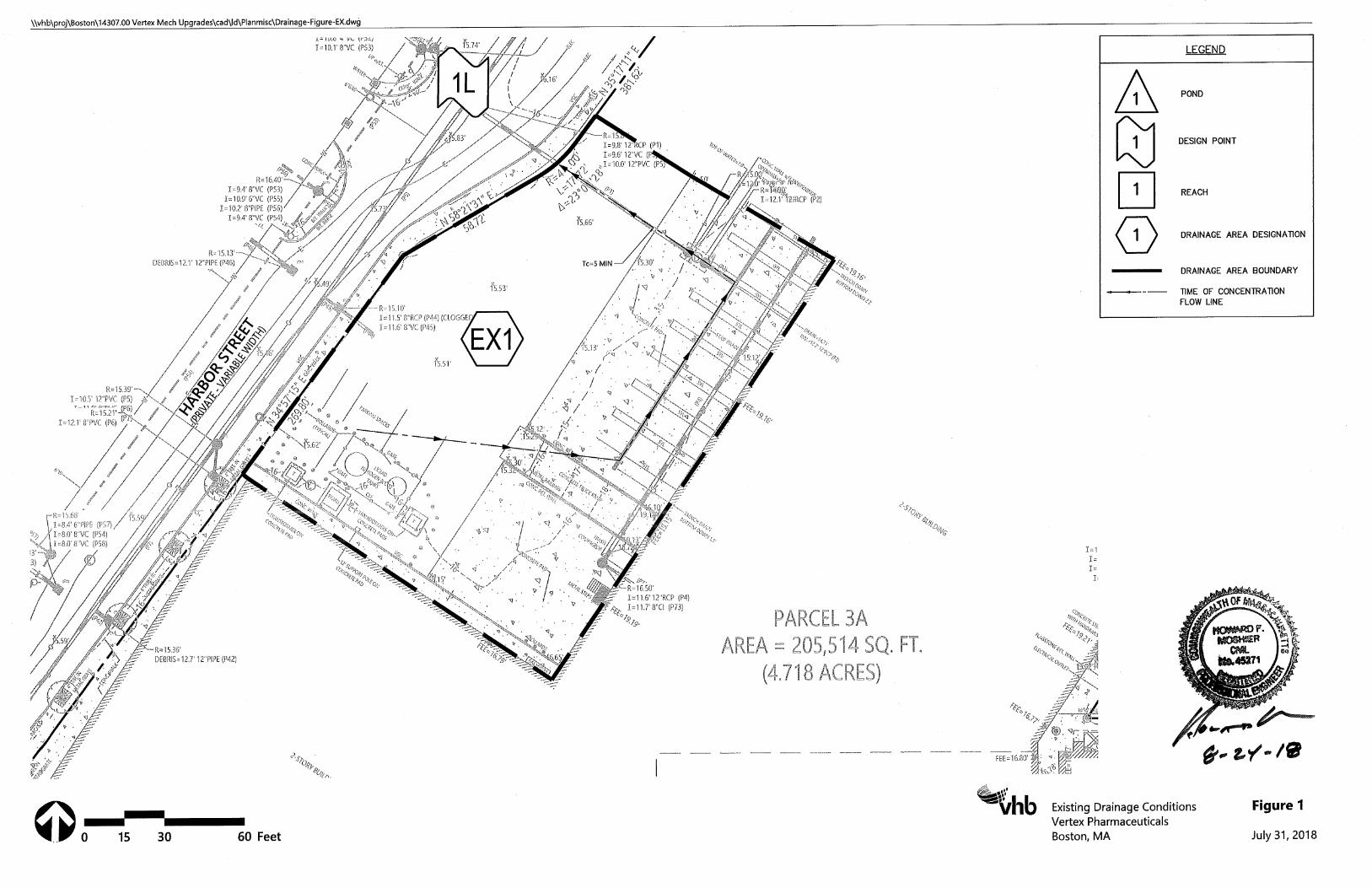
Existing Drainage Conditions
Under existing conditions, the Project Site is fully developed. The paved area adjacent to the 1-story building ranges in elevation from 16.5-feet to 15-feet. Stormwater is collected on site via a large trench drain and piped through a water quality unit before overflowing to a 12-inch drain in Harbor Street. Stormwater ultimately discharges into the Boston Harbor through SDO 225.
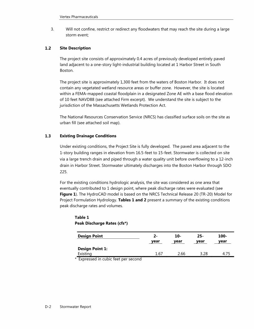
For the existing conditions hydrologic analysis, the site was considered as one area that eventually contributed to 1 design point, where peak discharge rates were evaluated (see Figure 1). The HydroCAD model is based on the NRCS Technical Release 20 (TR-20) Model for Project Formulation Hydrology. Tables 1 and 2 present a summary of the existing conditions peak discharge rates and volumes.
Table 1 Peak Discharge Rates (cfs*)
Design Point 2-year
10-year
25-year
100-year
Design Point 1: Existing 1.67 2.66 3.28 4.75
* Expressed in cubic feet per second
Vertex Pharmaceuticals
D-3 Stormwater Report
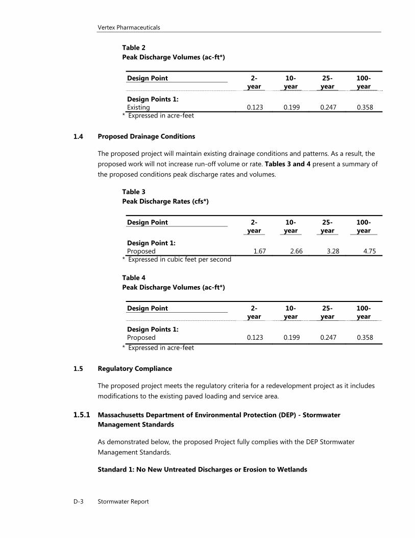
Table 2 Peak Discharge Volumes (ac-ft*)
Design Point 2-year
10-year
25-year
100-year
Design Points 1: Existing 0.123 0.199 0.247 0.358
* Expressed in acre-feet
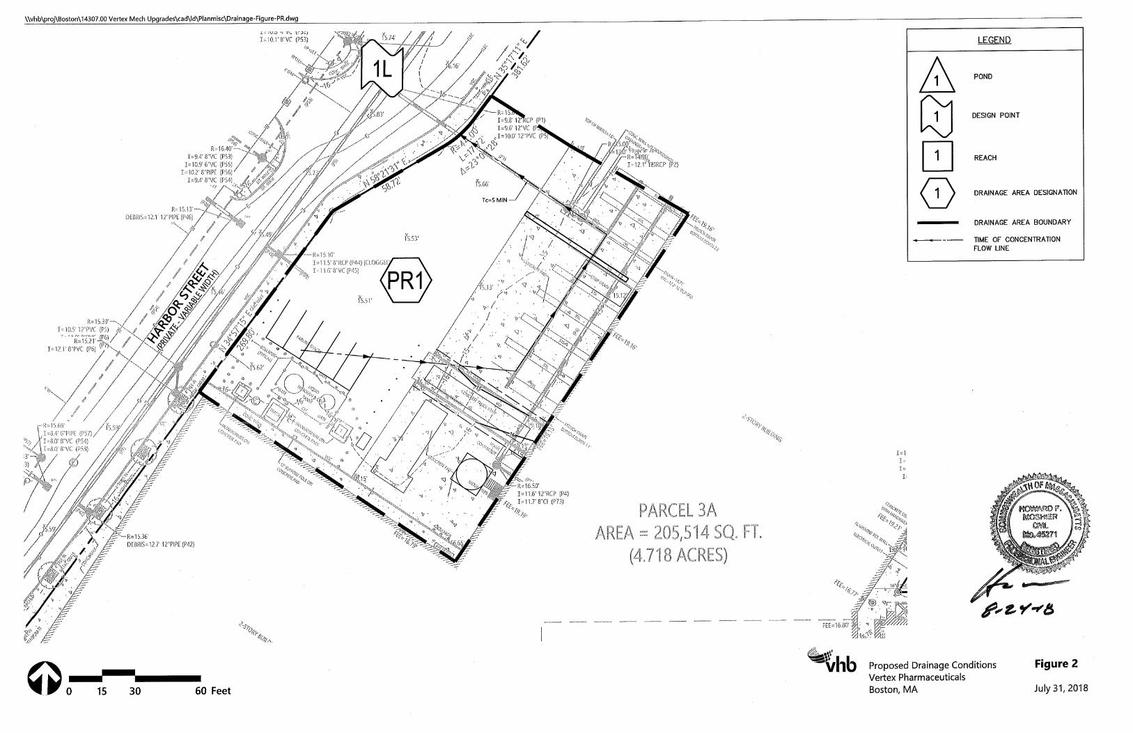
Proposed Drainage Conditions
The proposed project will maintain existing drainage conditions and patterns. As a result, the proposed work will not increase run-off volume or rate. Tables 3 and 4 present a summary of the proposed conditions peak discharge rates and volumes.
Table 3 Peak Discharge Rates (cfs*)
Design Point 2-year
10-year
25-year
100-year
Design Point 1: Proposed 1.67 2.66 3.28 4.75
* Expressed in cubic feet per second Table 4 Peak Discharge Volumes (ac-ft*)
Design Point 2-year
10-year
25-year
100-year
Design Points 1: Proposed 0.123 0.199 0.247 0.358
* Expressed in acre-feet
Regulatory Compliance
The proposed project meets the regulatory criteria for a redevelopment project as it includes modifications to the existing paved loading and service area.
1.5.1 Massachusetts Department of Environmental Protection (DEP) - Stormwater Management Standards
As demonstrated below, the proposed Project fully complies with the DEP Stormwater Management Standards.
Standard 1: No New Untreated Discharges or Erosion to Wetlands
Vertex Pharmaceuticals
D-4 Stormwater Report
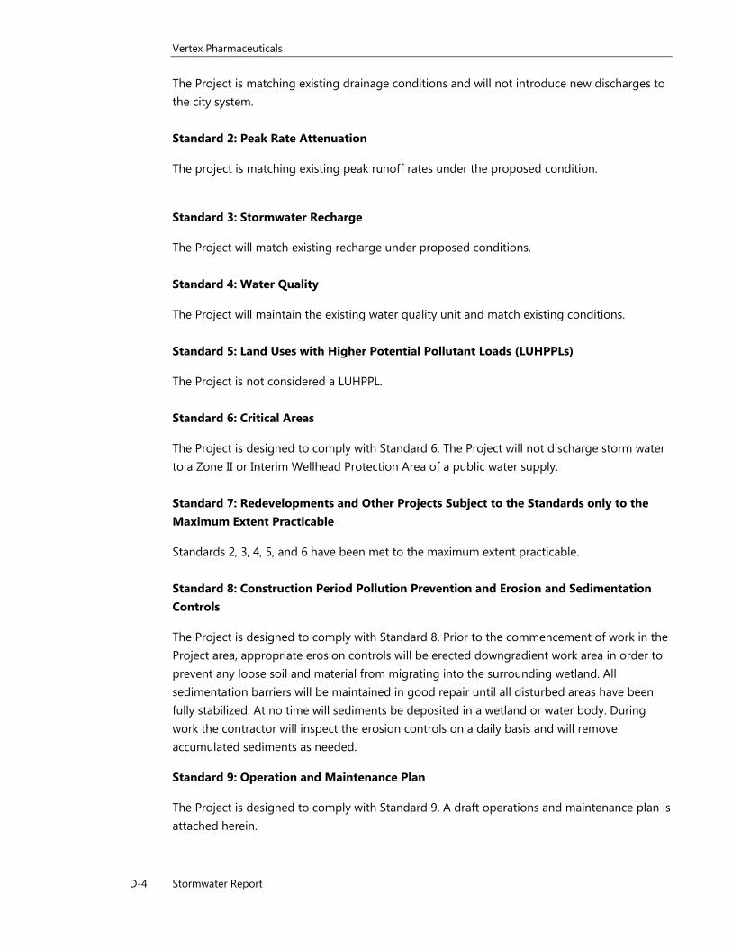
The Project is matching existing drainage conditions and will not introduce new discharges to the city system. Standard 2: Peak Rate Attenuation
The project is matching existing peak runoff rates under the proposed condition.
Standard 3: Stormwater Recharge
The Project will match existing recharge under proposed conditions. Standard 4: Water Quality
The Project will maintain the existing water quality unit and match existing conditions. Standard 5: Land Uses with Higher Potential Pollutant Loads (LUHPPLs)
The Project is not considered a LUHPPL. Standard 6: Critical Areas
The Project is designed to comply with Standard 6. The Project will not discharge storm water to a Zone II or Interim Wellhead Protection Area of a public water supply. Standard 7: Redevelopments and Other Projects Subject to the Standards only to the Maximum Extent Practicable
Standards 2, 3, 4, 5, and 6 have been met to the maximum extent practicable. Standard 8: Construction Period Pollution Prevention and Erosion and Sedimentation Controls
The Project is designed to comply with Standard 8. Prior to the commencement of work in the Project area, appropriate erosion controls will be erected downgradient work area in order to prevent any loose soil and material from migrating into the surrounding wetland. All sedimentation barriers will be maintained in good repair until all disturbed areas have been fully stabilized. At no time will sediments be deposited in a wetland or water body. During work the contractor will inspect the erosion controls on a daily basis and will remove accumulated sediments as needed.
Standard 9: Operation and Maintenance Plan
The Project is designed to comply with Standard 9. A draft operations and maintenance plan is attached herein.
Vertex Pharmaceuticals
D-5 Stormwater Report
Standard 10: Prohibition of Illicit Discharges
The Project is designed to comply with Standard 10. There are no illicit discharges to the stormwater management system. There are no sources of water discharges other than rainfall.
Vertex Pharmaceuticals
D-6 Stormwater Report
Long Term Stormwater Maintenance Measures
The following maintenance program is proposed to ensure the continued effectiveness of the water quality controls previously described.
Paved areas will be swept semi-annually. Routinely pick up and remove litter from the Project Site in addition to regular pavement sweeping.
Structural Stormwater Management Devices
The project does not include any structural stormwater management devices.
Responsible Party
Vertex Pharmaceutical, Inc.’s property manager shall be responsible for inspection and maintenance procedures described herein.
Vertex Pharmaceuticals
D-7 Stormwater Report
Spill Response Procedure Initial Notification In the event of a spill the facility and/or construction manager or supervisor will be notified immediately. Facility Manager (name) ________________________________________________ ________________________________________________ Facility Manager (phone) ________________________________________________ ________________________________________________ Construction Manager (name) ________________________________________________ ________________________________________________ Construction Manager (phone) ________________________________________________ ________________________________________________ Assessment - Initial Containment The supervisor or manager will assess the incident and initiate containment control measures with the appropriate spill containment equipment included in the spill kit kept on-site. The supervisor will first contact the Fire Department and then notify the Police Department, Board of Health and Conservation Commission. The fire department is ultimately responsible for matters of public health and safety and should be notified immediately. Fire Department Phone: 911 Police Department: 911 Board of Health Phone: Conservation Commission Phone: Further Notification Based on the assessment from the Fire Chief, additional notification to a cleanup contractor may be made. The Massachusetts Department of Environmental Protection (DEP) and the EPA may be notified depending upon the nature and severity of the spill. The Fire Chief will be responsible for determining the level of cleanup and notification required. The attached list of emergency phone numbers shall be posted in the main construction/facility office and readily accessible to all employees.

Vertex Pharmaceuticals
D-8 Stormwater Report
Vertex Pharmaceuticals
D-9 Stormwater Report
HAZARDOUS WASTE / OIL SPILL REPORT
Date / / Time AM / PM
Exact location (Transformer #)
Type of equipment Make Size
S / N Weather Conditions
On or near water Yes If yes, name of body of water
No
Type of chemical / oil spilled
Amount of chemical / oil spilled
Cause of spill
Measures taken to contain or clean up spill
Amount of chemical / oil recovered Method
Material collected as a result of clean up
drums containing
drums containing
drums containing
Location and method of debris disposal
Name and address of any person, firm, or corporation suffering damages
Procedures, method, and precautions instituted to prevent a similar occurrence from recurring
Spill reported to General Office by Time AM / PM
Spill reported to DEP / National Response Center by
DEP Date / / Time AM / PM Inspector
NRC Date / / Time AM / PM Inspector
Additional comments
Soil Map—Norfolk and Suffolk Counties, Massachusetts(Vertex)
Natural ResourcesConservation Service
Web Soil SurveyNational Cooperative Soil Survey
7/31/2018Page 1 of 3
4690
080
4690
100
4690
120
4690
140
4690
160
4690
180
4690
200
4690
220
4690
240
4690
260
4690
080
4690
100
4690
120
4690
140
4690
160
4690
180
4690
200
4690
220
4690
240
4690
260
332260 332280 332300 332320 332340 332360 332380 332400
332260 332280 332300 332320 332340 332360 332380 332400
42° 20' 48'' N71
° 2
' 11'
' W42° 20' 48'' N
71° 2
' 4'' W
42° 20' 41'' N
71° 2
' 11'
' W
42° 20' 41'' N
71° 2
' 4'' W
N
Map projection: Web Mercator Corner coordinates: WGS84 Edge tics: UTM Zone 19N WGS840 45 90 180 270
Feet0 10 20 40 60
MetersMap Scale: 1:978 if printed on A portrait (8.5" x 11") sheet.
Soil Map may not be valid at this scale.
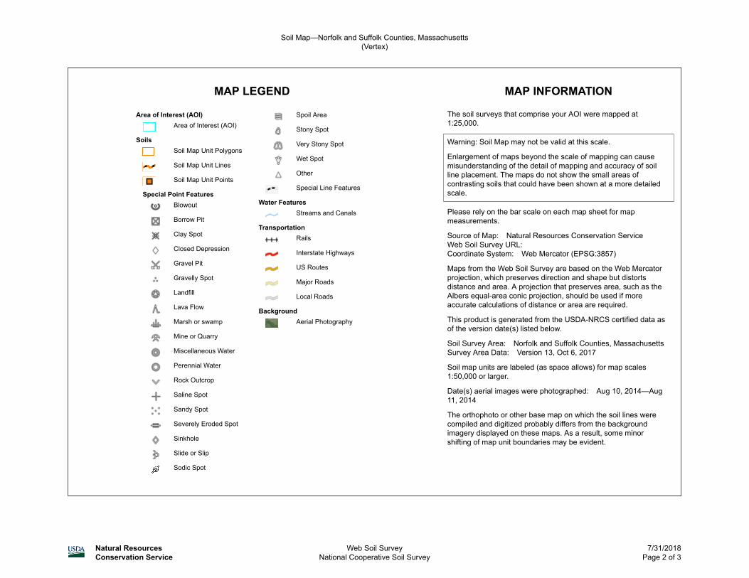
MAP LEGEND MAP INFORMATION
Area of Interest (AOI)Area of Interest (AOI)
SoilsSoil Map Unit Polygons
Soil Map Unit Lines
Soil Map Unit Points
Special Point FeaturesBlowout
Borrow Pit
Clay Spot
Closed Depression
Gravel Pit
Gravelly Spot
Landfill
Lava Flow
Marsh or swamp
Mine or Quarry
Miscellaneous Water
Perennial Water
Rock Outcrop
Saline Spot
Sandy Spot
Severely Eroded Spot
Sinkhole
Slide or Slip
Sodic Spot
Spoil Area
Stony Spot
Very Stony Spot
Wet Spot
Other
Special Line Features
Water FeaturesStreams and Canals
TransportationRails
Interstate Highways
US Routes
Major Roads
Local Roads
BackgroundAerial Photography
The soil surveys that comprise your AOI were mapped at 1:25,000.
Warning: Soil Map may not be valid at this scale.
Enlargement of maps beyond the scale of mapping can cause misunderstanding of the detail of mapping and accuracy of soil line placement. The maps do not show the small areas of contrasting soils that could have been shown at a more detailed scale.
Please rely on the bar scale on each map sheet for map measurements.
Source of Map: Natural Resources Conservation ServiceWeb Soil Survey URL: Coordinate System: Web Mercator (EPSG:3857)
Maps from the Web Soil Survey are based on the Web Mercator projection, which preserves direction and shape but distorts distance and area. A projection that preserves area, such as the Albers equal-area conic projection, should be used if more accurate calculations of distance or area are required.
This product is generated from the USDA-NRCS certified data as of the version date(s) listed below.
Soil Survey Area: Norfolk and Suffolk Counties, MassachusettsSurvey Area Data: Version 13, Oct 6, 2017
Soil map units are labeled (as space allows) for map scales 1:50,000 or larger.
Date(s) aerial images were photographed: Aug 10, 2014—Aug 11, 2014
The orthophoto or other base map on which the soil lines were compiled and digitized probably differs from the background imagery displayed on these maps. As a result, some minor shifting of map unit boundaries may be evident.
Soil Map—Norfolk and Suffolk Counties, Massachusetts(Vertex)
Natural ResourcesConservation Service
Web Soil SurveyNational Cooperative Soil Survey
7/31/2018Page 2 of 3
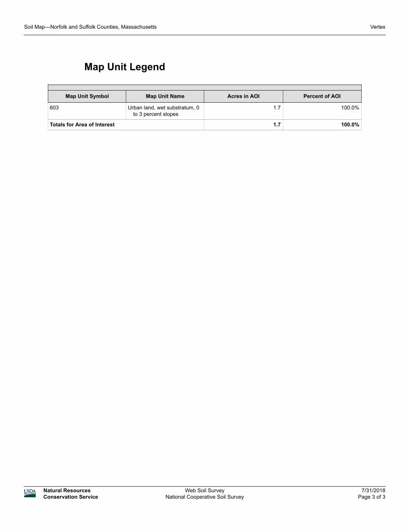
Map Unit Legend
Map Unit Symbol Map Unit Name Acres in AOI Percent of AOI
603 Urban land, wet substratum, 0 to 3 percent slopes
1.7 100.0%
Totals for Area of Interest 1.7 100.0%
Soil Map—Norfolk and Suffolk Counties, Massachusetts Vertex
Natural ResourcesConservation Service
Web Soil SurveyNational Cooperative Soil Survey
7/31/2018Page 3 of 3
Stormwater Management System Operations and Maintenance Plan
1 Harbor Street
Boston, Massachusetts

Table of Contents
Project Information ............................................................................................................... 5
A. Maintenance of Stormwater Management Systems .......................................... 9
A.1 Structural Stormwater Management Devices ..................................... 9
A.1.1 Trench Drains ......................................................................... 9
B. Operations & Maintenance Plan Summary ...................................................... 13
B.1 Routine Maintenance Checklists ....................................................... 13 B.2 Reporting and Documentation ......................................................... 13 B.3 Long Term Maintenance/ Evaluation Checklist ................................ 14 B.4 Maintenance Checklists and Device Location Maps ......................... 15
Attachment A – Long‐Term Pollution Prevention Plan

\\vhb\proj\Boston\14307.00 Vertex Mech Upgrades\reports\BCC\NOI\14307-O&M-Narrative.doc
4 1 Harbor Street, Boston, MA: Maintenance of Stormwater Management Systems
\\vhb\proj\Boston\14307.00 Vertex Mech Upgrades\reports\BCC\NOI\14307-O&M-Narrative.doc
5 1 Harbor Street, Boston, MA: Maintenance of Stormwater Management Systems
Project Information
Site Location
1 Harbor Street, Boston, Massachusetts 02210
Property Owner
City of Boston
Economic Development and Industrial Corporation
Tenant
Vertex Pharmaceuticals
Contact:
Stan Glushik
Telephone: 617-961-5144

\\vhb\proj\Boston\14307.00 Vertex Mech Upgrades\reports\BCC\NOI\14307-O&M-Narrative.doc
6 1 Harbor Street, Boston, MA: Maintenance of Stormwater Management Systems
\\vhb\proj\Boston\14307.00 Vertex Mech Upgrades\reports\BCC\NOI\14307-O&M-Narrative.doc
7 1 Harbor Street, Boston, MA: Maintenance of Stormwater Management Systems
Section A
Maintenance of Stormwater
Management Systems

\\vhb\proj\Boston\14307.00 Vertex Mech Upgrades\reports\BCC\NOI\14307-O&M-Narrative.doc
8 1 Harbor Street, Boston, MA: Maintenance of Stormwater Management Systems
\\vhb\proj\Boston\14307.00 Vertex Mech Upgrades\reports\BCC\NOI\14307-O&M-Narrative.doc
9 1 Harbor Street, Boston, MA: Maintenance of Stormwater Management Systems
A. Maintenance of Stormwater Management Systems
A.1 Structural Stormwater Management Devices
A.1.1 Trench Drains
The site contains a landowner owned and maintained trench drain. The tenant,
Vertex, will inspect the portion of the trench drain located within the lease
boundaries quarterly and remove sediments as necessary.
Inspections and Cleaning
All catch basins, area drains, and drain manholes shall be inspected at least four
times per year and cleaned at least once per year.
Sediment (if more than six inches deep) and/or floatable pollutants shall be
removed from the trench drain and disposed of at an approved offsite facility in
accordance with all applicable regulations.
Any structural damage or other indication of malfunction will be reported to the
site manager and repaired as necessary.
During colder periods, the trench drain grates must be kept free of snow and ice.
During warmer periods, the catch basin and area drain grates must be kept free
of leaves, litter, sand, and debris.

\\vhb\proj\Boston\14307.00 Vertex Mech Upgrades\reports\BCC\NOI\14307-O&M-Narrative.doc
10 1 Harbor Street, Boston, MA: Maintenance of Stormwater Management Systems
\\vhb\proj\Boston\14307.00 Vertex Mech Upgrades\reports\BCC\NOI\14307-O&M-Narrative.doc
11 1 Harbor Street, MA: Operations and Maintenance Summary
Section B
Operations and Maintenance
Summary

\\vhb\proj\Boston\14307.00 Vertex Mech Upgrades\reports\BCC\NOI\14307-O&M-Narrative.doc
12 1 Harbor Street, MA: Operations and Maintenance Summary
\\vhb\proj\Boston\14307.00 Vertex Mech Upgrades\reports\BCC\NOI\14307-O&M-Narrative.doc
13 1 Harbor Street, MA: Operations and Maintenance Summary
B. Operations & Maintenance Plan Summary
This Operation and Maintenance Plan has been prepared in accordance with the
Stormwater Management Policy developed by the DEP and CZM. It specifies
operational practices and drainage system maintenance requirements for the project.
B.1 Routine Maintenance Checklists
Routine required maintenance is described in Section A. The following checklists are
to be used by the property manager to implement and document the required
maintenance and inspection tasks.
B.2 Reporting and Documentation
The site supervisor shall be responsible for ensuring that the scheduled tasks as
described in this plan are appropriately completed and recorded in the Maintenance
Log. Accurate records of all inspections, routine maintenance and repairs shall be
documented and these records shall be available for inspection upon request.
The Maintenance Log shall:
Document the completion of required maintenance tasks.
Identify the person responsible for the completion of tasks.
Identify any outstanding problems, malfunctions or inconsistencies
identified during the course of routine maintenance.
Document specific repairs or replacements.
\\vhb\proj\Boston\14307.00 Vertex Mech Upgrades\reports\BCC\NOI\14307-O&M-Narrative.doc
14 1 Harbor Street, MA: Operations and Maintenance Summary
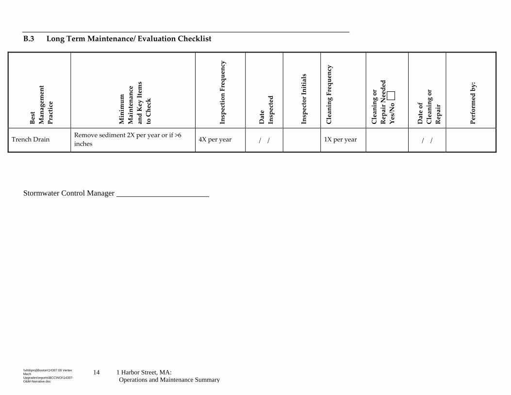
B.3 Long Term Maintenance/ Evaluation Checklist
Best
Management
Practice
Minimum
Maintenance
and Key Items
to Check
Inspection Frequency
Date
Inspected
Inspector Initials
Cleaning Frequency
Cleaning or
Repair Needed
Yes/No
Date of
Cleaning or
Repair
Performed by:
Trench Drain Remove sediment 2X per year or if >6
inches 4X per year / / 1X per year / /
Stormwater Control Manager
\\vhb\proj\Boston\14307.00 Vertex Mech Upgrades\reports\BCC\NOI\14307-O&M-Narrative.doc
15 1 Harbor Street, MA: Operations and Maintenance Summary
B.4 Maintenance Checklists and Device Location Maps
These checklists are provided for the maintenance crew to photocopy and use when
conducting inspections and cleaning activities to the stormwater management
systems.

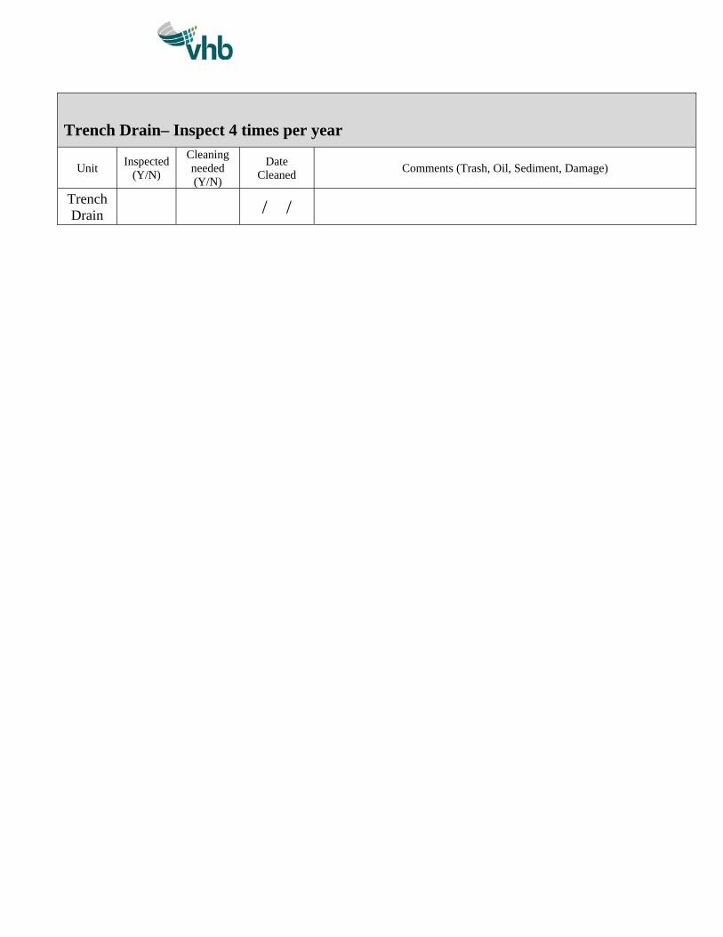
Trench Drain– Inspect 4 times per year
Unit Inspected
(Y/N)
Cleaning needed (Y/N)
Date Cleaned
Comments (Trash, Oil, Sediment, Damage)
Trench Drain
/ /

\\vhb\proj\Boston\14307.00 Vertex Mech Upgrades\reports\BCC\NOI\14307-O&M-Narrative.doc
1 Harbor Street, MA: Operations and Maintenance Summary
Maintenance Checklists Owner must keep 7 years Keep a blank checklist and photocopy as necessary

1 Vertex 1 Harbor Street: Long Term Pollution Prevention Plan
Long‐Term Pollution
Prevention Plan

2 Vertex 1 Harbor Street: Long Term Pollution Prevention Plan
Long‐Term Pollution
Prevention Plan
This Long‐Term Pollution Prevention Plan has been developed to establish site
management practices that improve the quality of stormwater discharges from the
Project.
Potential Sources of Pollution
Construction Site Pollutant
Pollutant-Generating Activity
Pollutants or Pollutant Constituents (that could be discharged if exposed to stormwater)
Location on Site (or reference logistics plans where this is shown)
Paving Operations Concrete constituents
Painting Paint
Vehicles Petroleum-based products
Cleared & Graded Areas Soil erosion
Portable Toilets (if used) Sewage
Fuel Tanks Fuel oil, gasoline, other fuels
Storage Areas Soil erosion, fuel oil, gasoline, asphalt, concrete, vehicle fluids, paints, solvents, pesticides, fertilizer
Add information as necessary.
3 Vertex 1 Harbor Street: Long Term Pollution Prevention Plan
Pollutant Control Approach
Maintenance of Pavement Systems
Standard Asphalt Pavement
Regular maintenance of pavement surfaces will prevent pollutants such as oil and
grease, trash, and sediments from entering the stormwater management system. The
following practices should be performed:
Inspect pavement areas monthly. Sweep or vacuum pavement areas as
necessary with a commercial cleaning unit and dispose of removed material.
Check loading docks and dumpster areas frequently for spillage and/or
pavement staining and clean as necessary
Routinely pick up and remove litter from the parking areas, islands, and
perimeter landscaping.
Management of Snow and Ice
Storage and Disposal
Snow shall be managed on pavement surfaces, so sand and salt may be swept in the
spring or removed as snow melts and drains through the stormwater management
system. Key practices for the safe storage and disposal of snow include:
Under no circumstances shall snow be disposed or stored in stormwater basins,
ponds, rain gardens, swales, channels, or trenches.
Monitor application rates of deicing materials on pavement areas and reduce
application rate accordingly.
Salt and Deicing Chemicals
The amount of salt and deicing chemicals to be used on the site shall be reduced to
the minimum amount needed to provide safe pedestrian and vehicle travel. The
following practices should be followed to control the amount of salt and deicing
materials that come into contact with stormwater runoff:
Devices used for spreading salt and deicing chemicals should be capable of
varying the rate of application based on the site specific conditions.
Specific environmentally sensitive areas should be designated as no and/or
reduced salt areas.
Alternate materials should be used in place of standard salt and deicing
chemicals in specific environmentally sensitive areas where possible.
4 Vertex 1 Harbor Street: Long Term Pollution Prevention Plan
Sand and salt should be stockpiled under covered storage facilities that prevent
precipitation and adjacent runoff from coming in contact with the deicing
materials
Management of Vehicle Operations
Fueling and Maintenance of Equipment or Vehicles
When fueling or maintaining equipment or vehicles, the contractor will adhere to the
following requirements (CGP 2.3.3.1):
If applicable, comply with the Spill Prevention Control and Countermeasures
(SPCC) requirements in 40 CFR 112 and Section 311 of the CWA;
Ensure adequate supplies are available at all times to handle spills, leaks, and
disposal of used liquids;
Use drip pans and absorbents under or around leaky vehicles;
Dispose of or recycle oil and oily wastes in accordance with other federal, state,
tribal, or local requirements;
Clean up spills or contaminated surfaces immediately, using dry clean up
measures where possible, and eliminate the source of the spill to prevent a
discharge or a furtherance of an ongoing discharge; and
Do not clean surfaces by hosing the area down.
Vehicle Washing
As listed in CGP 2.3.3.2, the contractor must provide an effective means of
minimizing the discharge of pollutants from equipment and vehicle washing, wheel
wash water, and other types of washing. Effective controls include, but are not
restricted to, locating activities away from surface waters and stormwater inlets or
conveyances and directing wash waters to a sediment basin or sediments trap, using
filtration devices, such as filter bags or sand filters, or using other similarly effective
controls. For compliance with Part 2.3.1.4, for storage of soaps, detergents, or
solvents, the contractor must provide either cover (e.g., plastic sheeting or temporary
roofs) to prevent these detergents from coming into contact with rainwater, or a
similarly effective means designed to prevent the discharge of pollutants from these
areas.
Concrete trucks will not be allowed to wash out or discharge surplus concrete or
drum wash water on the site without controls that contain all surplus concrete and
washwater.
5 Vertex 1 Harbor Street: Long Term Pollution Prevention Plan
Storage of Hazardous Materials
Store waste in sealed containers, which are constructed of suitable materials to
prevent leakage and corrosion, and which are labeled in accordance with
applicable Resource Conservation and Recovery Act (RCRA) requirements and
all other applicable federal, state, tribal, or local requirements;
Store all containers that will be stored outside within appropriately sized
secondary containment (e.g., spill berms, decks, spill containment pallets) to
prevent spills from being discharged, or provide a similarly effective means
designed to prevent the discharge of pollutants from these areas (e.g., storing
chemicals in covered area or having a spill kit available on site); and
Clean up spills immediately, using dry clean‐up methods where possible, and
dispose of used materials properly.
Hosing will not be utilized as a method to clean surfaces or spills.
Eliminate the source of the spill to prevent a discharge or a furtherance of an
ongoing discharge.
All hazardous waste materials (e.g., petroleum products, solvents) will be disposed
in the manner specified by local and state regulation, or by the manufacturer. Site
personnel will be instructed in these practices, and the site construction supervisor
will be responsible for seeing that these procedures are followed.
6 Vertex 1 Harbor Street: Long Term Pollution Prevention Plan
Spill Prevention and Response Plan
The following practices will be followed for spill control, notification and
cleanup:
The construction superintendent responsible for the daily operations will
be the spill prevention and cleanup coordinator. He will designate at
least three other site personnel to receive spill prevention and cleanup
training. These individuals will each become responsible for a particular
phase of prevention and cleanup. The names of the responsible spill
personnel will be posted in the material storage area and in the on‐site
office trailer.
Spills of toxic or hazardous material in excess of reportable quantities, as
established in the CGP, will be reported to the Massachusetts
Department of Environmental Protection Division of Hazardous Waste
(617) 292‐5851 and the National Response Center (800) 424‐8802.
All spills will be cleaned up immediately after discovery;
The spill area will be kept well ventilated and personnel will wear
protective clothing to prevent injury from contact with a hazardous
substance; and
Manufacturerʹs recommended methods for spill cleanup will be clearly
posted and site personnel will be informed of the procedures and the
location of the information and cleanup supplies;
Materials and equipment necessary for spill cleanup will be kept in the
material storage area on‐site. Equipment and materials will include, but
will not be limited to the emergency response equipment listed herein;
The following text is excerpted from the Project Stormwater Management System
Operations and Maintenance Manual.
A comprehensive Spill Prevention Control and Countermeasure (SPCC) plan
will be developed and implemented by the Project Owner and Tenant. At a
minimum the SPCC, will discuss:
Spill prevention equipment;
Spill prevention supplies provided on‐site; and
7 Vertex 1 Harbor Street: Long Term Pollution Prevention Plan
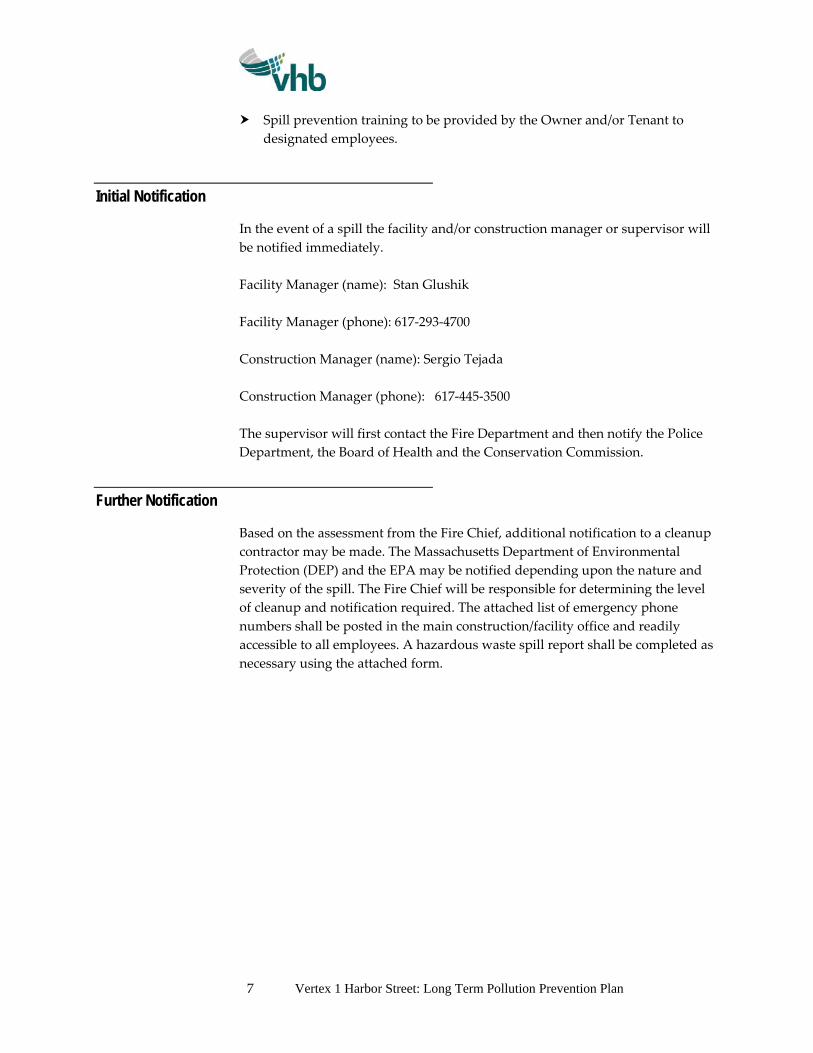
Spill prevention training to be provided by the Owner and/or Tenant to
designated employees.
Initial Notification
In the event of a spill the facility and/or construction manager or supervisor will
be notified immediately.
Facility Manager (name): Stan Glushik
Facility Manager (phone): 617‐293‐4700
Construction Manager (name): Sergio Tejada
Construction Manager (phone): 617‐445‐3500
The supervisor will first contact the Fire Department and then notify the Police
Department, the Board of Health and the Conservation Commission.
Further Notification
Based on the assessment from the Fire Chief, additional notification to a cleanup
contractor may be made. The Massachusetts Department of Environmental
Protection (DEP) and the EPA may be notified depending upon the nature and
severity of the spill. The Fire Chief will be responsible for determining the level
of cleanup and notification required. The attached list of emergency phone
numbers shall be posted in the main construction/facility office and readily
accessible to all employees. A hazardous waste spill report shall be completed as
necessary using the attached form.
8 Vertex 1 Harbor Street: Long Term Pollution Prevention Plan
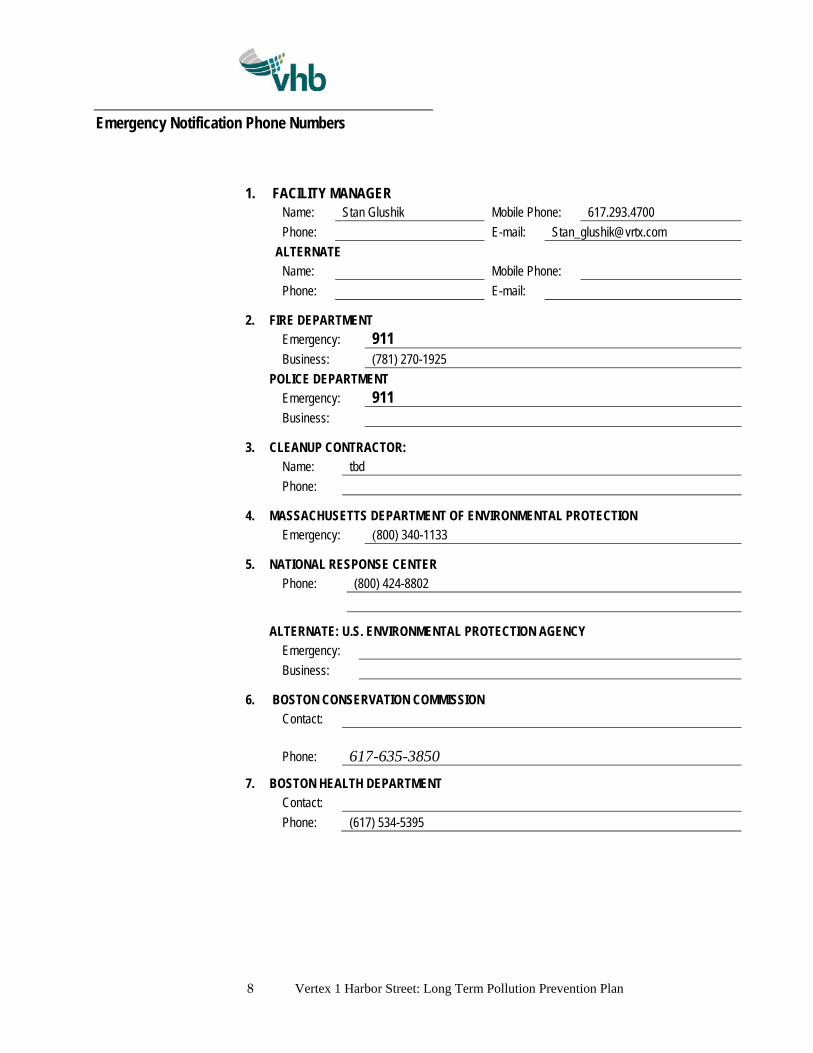
Emergency Notification Phone Numbers
1. FACILITY MANAGER Name: Stan Glushik Mobile Phone: 617.293.4700
Phone: E-mail: [email protected]
ALTERNATE
Name: Mobile Phone:
Phone: E-mail:
2. FIRE DEPARTMENT
Emergency: 911 Business: (781) 270-1925
POLICE DEPARTMENT
Emergency: 911 Business:
3. CLEANUP CONTRACTOR:
Name: tbd
Phone:
4. MASSACHUSETTS DEPARTMENT OF ENVIRONMENTAL PROTECTION
Emergency: (800) 340-1133
5. NATIONAL RESPONSE CENTER
Phone: (800) 424-8802
ALTERNATE: U.S. ENVIRONMENTAL PROTECTION AGENCY
Emergency:
Business:
6. BOSTON CONSERVATION COMMISSION
Contact:
Phone:
617-635-3850
7. BOSTON HEALTH DEPARTMENT
Contact:
Phone: (617) 534-5395
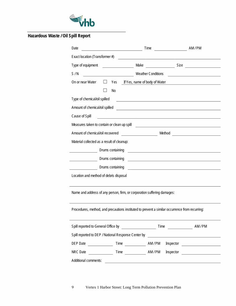
9 Vertex 1 Harbor Street: Long Term Pollution Prevention Plan
Hazardous Waste / Oil Spill Report
Date Time AM / PM
Exact location (Transformer #)
Type of equipment Make Size
S / N Weather Conditions
On or near Water ☐ Yes If Yes, name of body of Water
☐ No
Type of chemical/oil spilled
Amount of chemical/oil spilled
Cause of Spill
Measures taken to contain or clean up spill
Amount of chemical/oil recovered Method
Material collected as a result of cleanup:
Drums containing
Drums containing
Drums containing
Location and method of debris disposal
Name and address of any person, firm, or corporation suffering damages:
Procedures, method, and precautions instituted to prevent a similar occurrence from recurring:
Spill reported to General Office by Time AM / PM
Spill reported to DEP / National Response Center by
DEP Date Time AM / PM Inspector
NRC Date Time AM / PM Inspector
Additional comments:
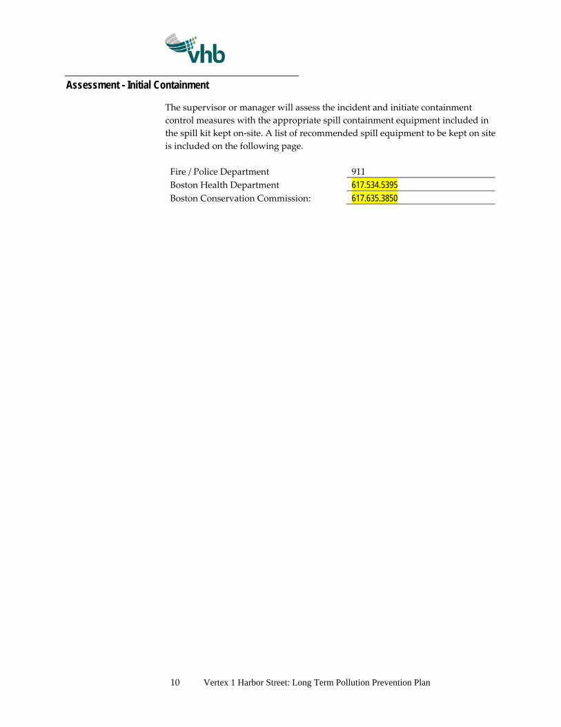
10 Vertex 1 Harbor Street: Long Term Pollution Prevention Plan
Assessment - Initial Containment
The supervisor or manager will assess the incident and initiate containment
control measures with the appropriate spill containment equipment included in
the spill kit kept on‐site. A list of recommended spill equipment to be kept on site
is included on the following page.
Fire / Police Department 911
Boston Health Department 617.534.5395
Boston Conservation Commission: 617.635.3850
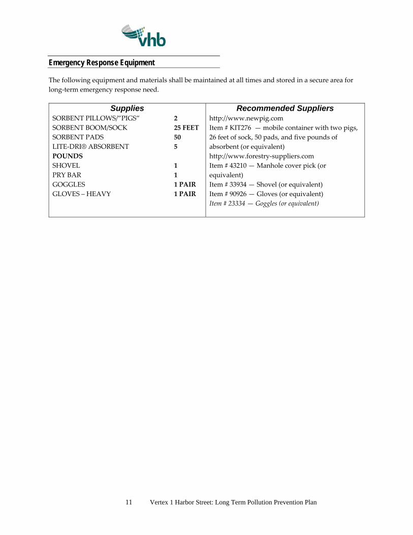
11 Vertex 1 Harbor Street: Long Term Pollution Prevention Plan
Emergency Response Equipment
The following equipment and materials shall be maintained at all times and stored in a secure area for
long‐term emergency response need.
Supplies SORBENT PILLOWS/”PIGS” 2
SORBENT BOOM/SOCK 25 FEET
SORBENT PADS 50
LITE‐DRI® ABSORBENT 5
POUNDS
SHOVEL 1
PRY BAR 1
GOGGLES 1 PAIR
GLOVES – HEAVY 1 PAIR
Recommended Suppliers http://www.newpig.com
Item # KIT276 — mobile container with two pigs,
26 feet of sock, 50 pads, and five pounds of
absorbent (or equivalent)
http://www.forestry‐suppliers.com
Item # 43210 — Manhole cover pick (or
equivalent)
Item # 33934 — Shovel (or equivalent)
Item # 90926 — Gloves (or equivalent)
Item # 23334 — Goggles (or equivalent)
Attachment D
Project Plans