Embed Size (px)
Citation preview
Technical Publication SJ93-4
PROPOSED FLOOD DETECTION SYSTEMSFOR THE
BLACK CREEK DRAINAGE BASIN,NORTHEAST FLORIDA
by
William L. Osburn, P.G.
/Professional GeologistLicense No. 0000089September 20, 1993
Seai
St. Johns River Water Management DistrictPalatka, Florida
1993
Northwest FloridaWater Management
District SuwanneeRiverWaterManagement
District
ManagementDistrict
St. Johns RlvWaterManagementDistrict:
Southwest 1Florida
WaterManagement
District
SouthFlorida WaterManagement
District
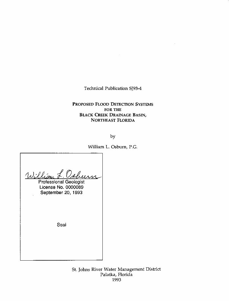
The St. Johns River Water Management District (SJRWMD) was created by the Florida Legislature in 1972to be one of five water management districts in Florida. It includes all or part of 19 counties in northeastFlorida. The mission of SJRWMD is to manage water resources to ensure their continued availability whilemaximizing environmental and economic benefits. It accomplishes its mission through regulation; appliedresearch; assistance to federal, state, and local governments; operation and maintenance of water controlworks; and land acquisition and management.
Technical reports are published to disseminate information collected by SJRWMD in pursuit of its mission.Copies of this report can be obtained from:
LibrarySt. Johns River Water Management District
P.O. Box 1429Palatka, FL 32178-1429
Phone: (904) 329-4132
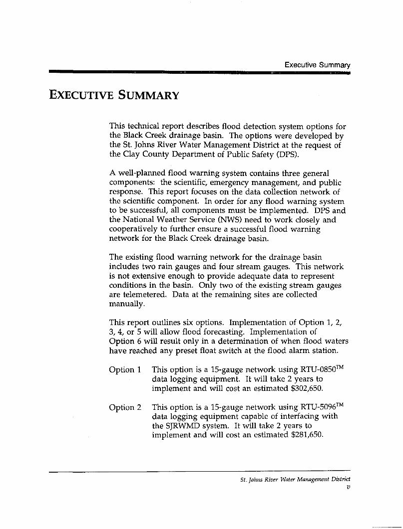
Executive Summary
EXECUTIVE SUMMARY
This technical report describes flood detection system options forthe Black Creek drainage basin. The options were developed bythe St. Johns River Water Management District at the request ofthe Clay County Department of Public Safety (DPS).
A well-planned flood warning system contains three generalcomponents: the scientific, emergency management, and publicresponse. This report focuses on the data collection network ofthe scientific component. In order for any flood warning systemto be successful, all components must be implemented. DPS andthe National Weather Service (NWS) need to work closely andcooperatively to further ensure a successful flood warningnetwork for the Black Creek drainage basin.
The existing flood warning network for the drainage basinincludes two rain gauges and four stream gauges. This networkis not extensive enough to provide adequate data to representconditions in the basin. Only two of the existing stream gaugesare telemetered. Data at the remaining sites are collectedmanually.
This report outlines six options. Implementation of Option 1, 2,3, 4, or 5 will allow flood forecasting. Implementation ofOption 6 will result only in a determination of when flood watershave reached any preset float switch at the flood alarm station.
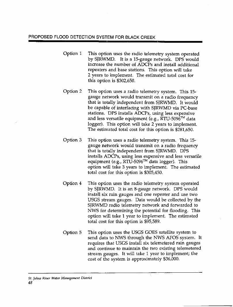
Option 1 This option is a 15-gauge network using RTU-0850™data logging equipment. It will take 2 years toimplement and will cost an estimated $302,650.
Option 2 This option is a 15-gauge network using RTU-5096™data logging equipment capable of interfacing withthe SJRWMD system. It will take 2 years toimplement and will cost an estimated $281,650.
St. Johns River Water Management DistrictV
PROPOSED FLOOD DETECTION SYSTEM FOR BLACK CREEK
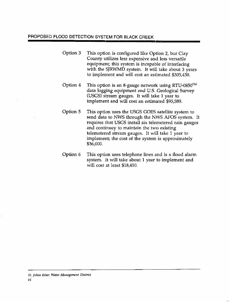
Option 3 This option is configured like Option 2, but ClayCounty utilizes less expensive and less versatileequipment; this system is incapable of interfacingwith the SJRWMD system. It will take about 3 yearsto implement and will cost an estimated $305,450.
Option 4 This option is an 8-gauge network using RTU-0850™data logging equipment and U.S. Geological Survey(USGS) stream gauges. It will take 1 year toimplement and will cost an estimated $95,589.
Option 5 This option uses the USGS GOES satellite system tosend data to NWS through the NWS AFOS system. Itrequires that USGS install six telemetered rain gaugesand continuey to maintain the two existingtelemetered stream gauges. It will take 1 year toimplement; the cost of the system is approximately$36,000.
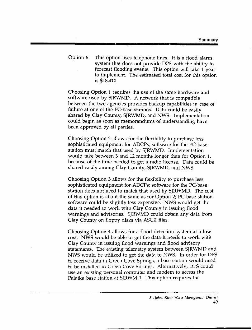
Option 6 This option uses telephone lines and is a flood alarmsystem. It will take about 1 year to implement andwill cost at least $18,410.
St. Johns River Water Management DistrictVI
Contents
CONTENTS
List of Figures viii
List of Tables ix
INTRODUCTION 1
EXISTING FLOOD WARNING SYSTEM 8Scientific Component 8Emergency Management Component 11
FLOOD FORECASTING SYSTEM 12Automated Data Collection Platforms 12Proposed Gauging Network 15Flood Forecasting 24System Costs—Fifteen-Gauge Network 25System Costs—Eight-Gauge Network 30Configuration Options 34
FLOOD ALARM SYSTEM 36Equipment 36System Configuration 38System Costs 39
SUMMARY 44
Literature Cited 51
Appendix—Sample National Weather Service Memorandum ofUnderstanding 53
St. Johns River Water Management Districtvii
PROPOSED FLOOD DETECTION SYSTEM FOR BLACK CREEK
FIGURES
1 Lower St. Johns River surface water basin 2
2 The Black Creek drainage basin 3
3 Components of a flood warning system 4
4 Hydrologic data collection stations in theBlack Creek drainage basin 9
5 Schematic of an automated rain gauge 13
6 Schematic of an automated stream gauge 14
7 Ideal location of rain and stream gauges in theBlack Creek drainage basin 17
8 Alternative location of rain and stream gaugesin the Black Creek drainage basin 18
9 Location of rain and stream gauges in theBlack Creek drainage basin that could beused in conjunction with radar 22
10 Schematic of a flood alarm 37
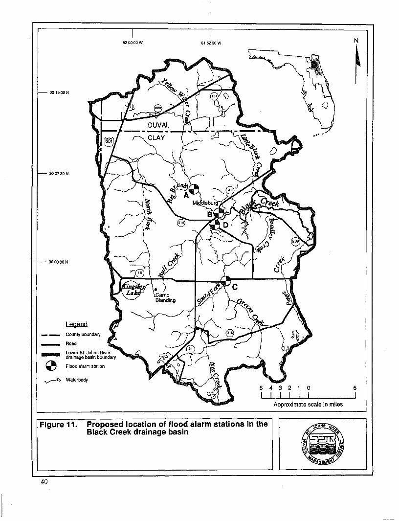
11 Proposed location of flood alarm stations inthe Black Creek drainage basin 40
12 Implementation schedule for a 15-gauge flooddetection and forecasting system for the BlackCreek drainage basin 45
St. Johns River Water Management District
mil
Tables
TABLES
1 Proposed 15-gauge network for the Black Creekdrainage basin 20
2 Proposed 8-gauge network for the Black Creekdrainage basin 21
3 Estimated basic costs for the 15-gauge networkthat could be used as part of the flood detectionsystem in the Black Creek drainage basin 26
4 Additional costs associated with the 15-gaugenetwork that could be used in the flooddetection system for the Black Creek drainagebasin 28
5 Estimated annual maintenance costs of a fullyimplemented 15-gauge network in the Black Creekdrainage basin 29
6 Estimated basic costs for the 8-gauge networkthat could be used as part of the flood detectionsystem in the Black Creek drainage basin 31
7 Additional costs associated with the 8-gaugenetwork that could be used in the flood detectionsystem for the Black Creek drainage basin 32
8 Estimated annual maintenance costs of a fullyimplemented 8-gauge network in the Black Creekdrainage basin 34
9 Estimated basic costs for the proposed flood alarmsystem in the Black Creek drainage basin 39
St. Johns River Water Management Districtix
PROPOSED FLOOD DETECTION SYSTEM FOR BLACK CREEK
10 Additional costs associated with the proposedflood alarm system for the Black Creek drainagebasin 41
11 Estimated annual maintenance costs of a proposedflood alarm system in the Black Creek drainagebasin 42
12 Summary of options for a Black Creek flooddetection gauging network or a flood alarmsystem 46
St. Johns River Water Management DistrictX
Introduction
INTRODUCTION
This technical report describes flood detection system options forthe Black Creek drainage basin. The options were developed bythe St. Johns River Water Management District (SJRWMD) at therequest of the Clay County Department of Public Safety (DPS).Any of these options can be incorporated into a flood warningsystem for the basin. Robison (1993) described the floodingcharacteristics of the Black Creek drainage basin andrecommended an initial size for an automated network of rainand stream gauges. Some of the flood detection system optionspresented in this report are based on the basic size and generalconfiguration of the network recommended by Robison (1993).
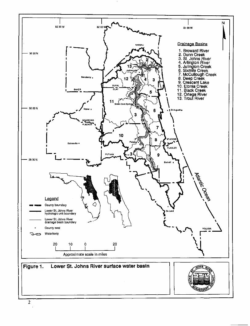
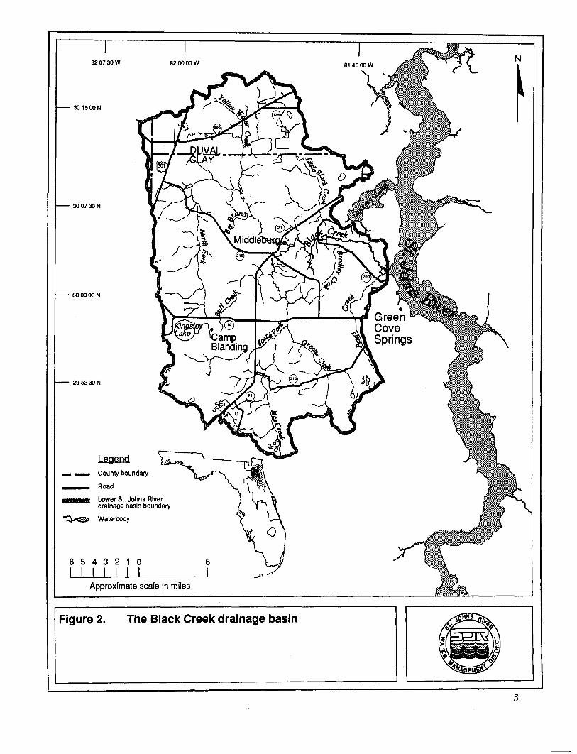
The Black Creek drainage basin is located within the lowerSt. Johns River surface water basin (Figure 1). Black Creek is theprimary tributary of the Black Creek drainage basin (Figure 2).The North Fork and South Fork join east of Middleburg to formBlack Creek. Black Creek flows into the St. Johns River, whichflows north to the Atlantic Ocean.
As demonstrated in September 1988, the potential for damagingfloods exists along Black Creek in and around Middleburg. Thepotential for property damage and loss of life caused by floodingwill increase as the population increases and the area is furtherdeveloped. Installation and management of a flood warningsystem will provide early warning of impending floods to arearesidents.
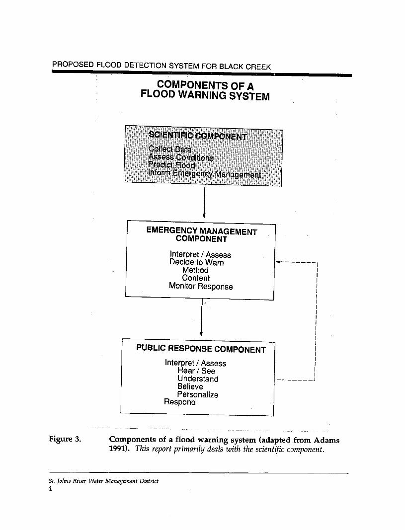
According to Adams (1991), the goal of any weather warningsystem, which can include a flood warning system, is "tomaximize the number of people who take appropriate and timelyaction to minimize death, injury, and property damage duringsevere weather and flooding." A well-planned warning systemcontains three general components: the scientific, emergencymanagement, and public response (Figure 3). Tasks performed as
St. Johns River Water Management DistrictI
8230W
3030N
8100W
Drainage Basins
1. Broward River2. Dunn Creek3. St. Johns River4. Arlington River5. Julington Creek6. Sixmile Creek7. McCullough Creek8. Deep Creek9. Crescent Lake10. Etonia Creek11. Black Creek12. Ortega River13. Trout River
30 DON• | SI Augustine
29 30 N
LegendCounty boundary
Lower St. Johns Riverhydrologic unit boundary
Lower St. Johns Riverdrainage basin boundary
County seat
Waterbody
20 10 0_L
20
Approximate scale in miles
Figure 1. Lower St. Johns River surface water basin
GreenCoveSprings
Legend
County boundary
Road
Lower St. Johns Riverdrainage basin boundary
6 5 4 3 2 1 0I I I I I II
Approximate scale in miles
Figure 2. The Black Creek drainage basin
PROPOSED FLOOD DETECTION SYSTEM FOR BLACK CREEK
COMPONENTS OF AFLOOD WARNING SYSTEM
SCIENTIFIC COMPONENT
Colfect DataAssess ConditionsPredict RoodInform Emergency Management
EMERGENCY MANAGEMENTCOMPONENT
Interpret / AssessDecide to Warn
MethodContent
Monitor Response
PUBLIC RESPONSE COMPONENT
Interpret / AssessHear / SeeUnderstandBelievePersonalize
Respond
Figure 3. Components of a flood warning system (adapted from Adams1991). This report primarily deals with the scientific component.
St. Johns River Water Management District4
Introduction
part of the scientific component include collecting rainfall andstream gauge data, assessing the data, predicting the potential forflooding, and informing authorities of an impending flood. Tasksperformed as part of the emergency management componentinclude interpreting flood prediction data, deciding whether ornot to warn the residents, deciding how to warn them and thecontent of the warning, and monitoring their response.Emergency management also includes increasing publicawareness by planning pre- and postflooding activities andrehearsals, training flood warning system personnel, andreviewing or monitoring all portions of the system. The publicresponse component involves how the residents interpret thewarning and how they respond to the flood warning message(i.e., hear, understand, believe, personalize, and act). All threegeneral components must be in place in order for a flood warningsystem to be successful. In addition, successful systems in theUnited States have been identified as being tied closely to theNational Weather Service (NWS).
This report on a proposed flood detection system describes onlypart of a flood warning system. It focuses on the detection anddata assessment subcomponents of the scientific component asthey relate to a complete flood warning system for the BlackCreek drainage basin in Clay County. This report does notinclude the emergency management and the public responsecomponents of a flood warning system. DPS must incorporate allthree components to have a successful flood warning system—theplacement of equipment alone will not result in a successful floodwarning system.
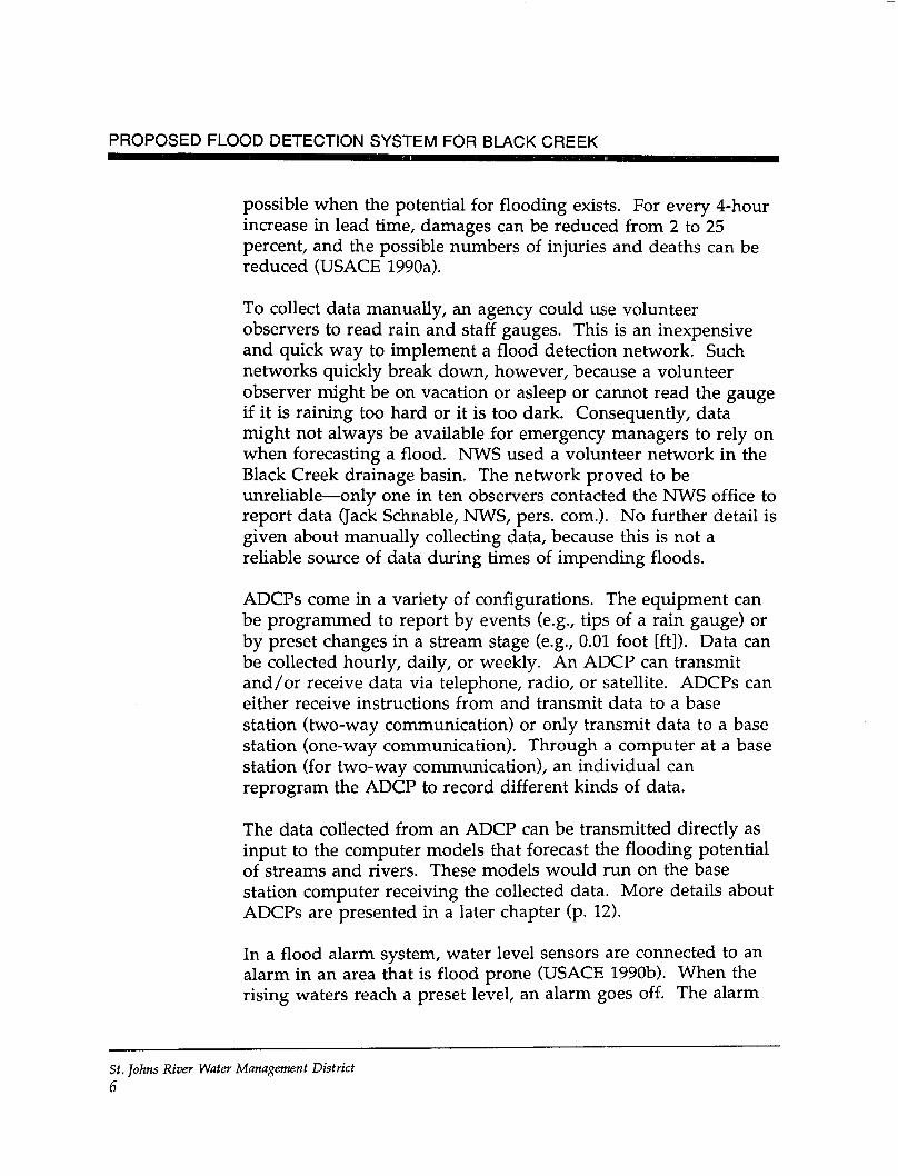
The detection subcomponent consists of collecting data from thefield and getting it to the organization(s) responsible for assessingthe flooding threat. Data can be collected manually, or data canbe collected through automated data collection platforms (ADCP).Rainfall and stream gauge data are not collected when a floodalarm is triggered by rising water.
The data assessment subcomponent involves quantifying theflooding threat. Emergency managers want the largest lead time
St. Johns River Water Management District5
PROPOSED FLOOD DETECTION SYSTEM FOR BLACK CREEK
possible when the potential for flooding exists. For every 4-hourincrease in lead time, damages can be reduced from 2 to 25percent, and the possible numbers of injuries and deaths can bereduced (USAGE 1990a).
To collect data manually, an agency could use volunteerobservers to read rain and staff gauges. This is an inexpensiveand quick way to implement a flood detection network. Suchnetworks quickly break down, however, because a volunteerobserver might be on vacation or asleep or cannot read the gaugeif it is raining too hard or it is too dark. Consequently, datamight not always be available for emergency managers to rely onwhen forecasting a flood. NWS used a volunteer network in theBlack Creek drainage basin. The network proved to beunreliable—only one in ten observers contacted the NWS office toreport data (Jack Schnable, NWS, pers. com.). No further detail isgiven about manually collecting data, because this is not areliable source of data during times of impending floods.
ADCPs come in a variety of configurations. The equipment canbe programmed to report by events (e.g., tips of a rain gauge) orby preset changes in a stream stage (e.g., 0.01 foot [ft]). Data canbe collected hourly, daily, or weekly. An ADCP can transmitand/or receive data via telephone, radio, or satellite. ADCPs caneither receive instructions from and transmit data to a basestation (two-way communication) or only transmit data to a basestation (one-way communication). Through a computer at a basestation (for two-way communication), an individual canreprogram the ADCP to record different kinds of data.
The data collected from an ADCP can be transmitted directly asinput to the computer models that forecast the flooding potentialof streams and rivers. These models would run on the basestation computer receiving the collected data. More details aboutADCPs are presented in a later chapter (p. 12).
In a flood alarm system, water level sensors are connected to analarm in an area that is flood prone (USAGE 1990b). When therising waters reach a preset level, an alarm goes off. The alarm
St. Johns River Water Management District
6
Introduction
could be audible in order to be heard locally, or it could trigger atelephone program that would automatically dial predeterminedtelephone numbers. This type of alarm would signal rising waterlevels in the Black Creek drainage basin when there is no leadtime for residents to take precautionary action. Because rainfalland stream stage data are not collected by a flood alarm system,the use of flood alarms precludes any flood forecasting. Moredetails on flood alarm stations are presented in a later chapter(p. 36).
St. Johns River Water Management District7
PROPOSED FLOOD DETECTION SYSTEM FOR BLACK CREEK
EXISTING FLOOD WARNING SYSTEM
The flood warning system operated by NWS in Clay County forthe Black Creek drainage basin contains two components of aflood warning system: the scientific component and theemergency management component.
SCIENTIFIC COMPONENT
The flooding potential of the Black Creek drainage basin isdetermined by evaluating radar-estimated rainfall and streamgauge data. Currently, rainfall and stream gauge data in theBlack Creek drainage basin are collected using a gaugingnetwork. Also, NWS uses WSR-57 radar units to estimaterainfall. The actual method of transmitting the data can varyfrom one site to the next.
Gauging Network
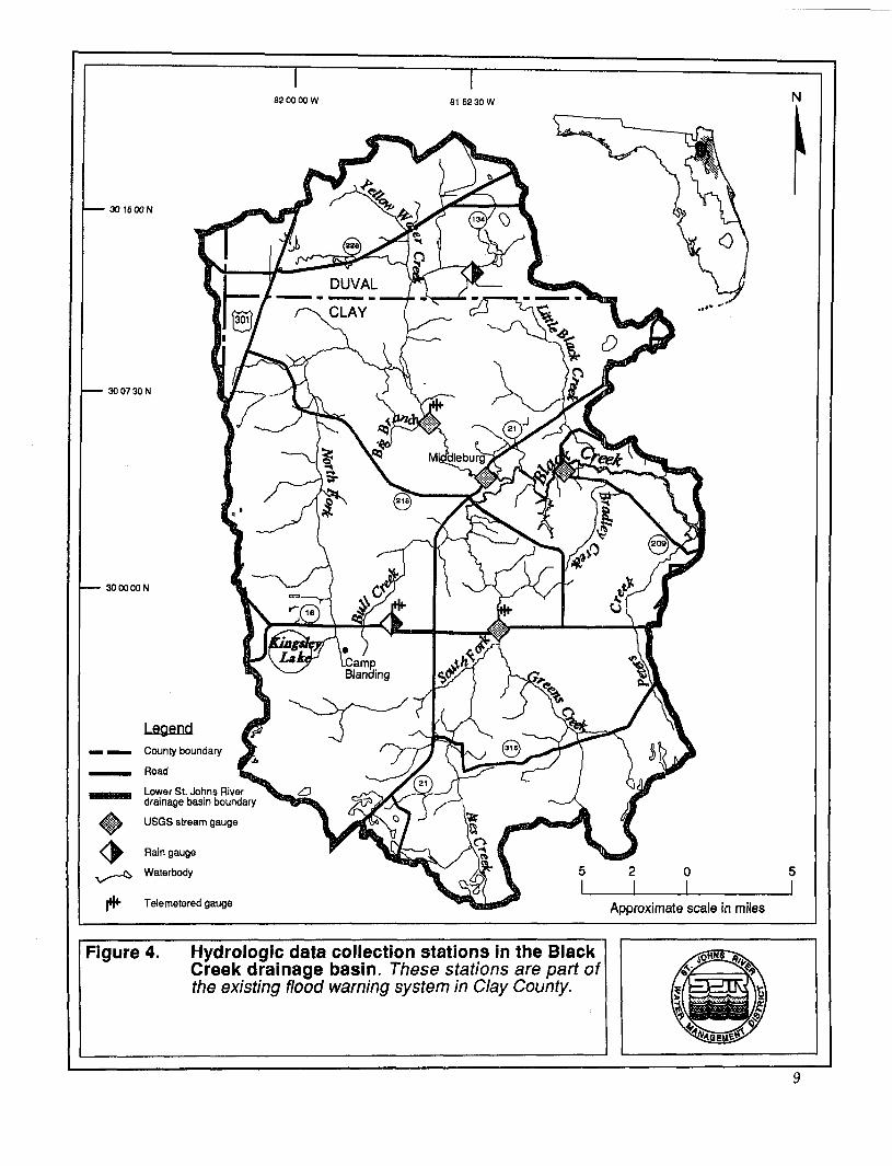
The gauging network in the Black Creek drainage basin iscomposed of six gauges (Figure 4). The rain gauge at the CecilField Weather Station (north of the Duval-Clay county line) hasthe longest period of record (since at least 1947). A rain gaugethat is operated by SJRWMD and located at the Penney Farmsfire tower (on State Road [S.R.] 16) has been recording since April1989. The U.S. Geological Survey (USGS) operates four recordingstream gauges in the drainage basin.
According to Robison (1993), rainfall data collected as part of thefire tower network operated by the Florida Division of Forestry isnot in a useable data base and is incomplete (i.e., missing data).Four of the five stations in the network (Louis Hill, Sun Garden,Black Creek, and Keystone Heights; see Robison 1993, p. 5) areoutside the Black Creek drainage basin. The fire tower nearPenney Farms is the only station in the basin. The fire towernetwork, per se, is not considered part of the existing floodwarning system network.
St. Johns River Water Management District8
82 00 00 W 81 52 30 W
30 16 DON
30 07 30 N
30 00 DON
Legend
County boundary
Road
Lower St. Johns Riverdrainage basin boundary
USGS stream gauge
Rain gauge
Waterbody
Telemetered gauge Approximate scale in miles
Figure 4. Hydrologic data collection stations in the BlackCreek drainage basin. These stations are part ofthe existing flood warning system in Clay County.
PROPOSED FLOOD DETECTION SYSTEM FOR BLACK CREEK
NWS uses the data collected from the existing rainfall and stagegauges in the basin along with data from WSR-57 radar units topredict the flooding potential on Black Creek. NWS uses theradar from Daytona Beach, Florida, and Waycross, Georgia, toestimate the rainfall in areas where there are no rainfall or stagegauges. The WSR-57 units are not very accurate.
NWS has plans to replace all WSR-57 radar units in Florida withWSR-88D units by 1998. These more sophisticated units arecapable of more accurately estimating rainfall. The WSR-88D unitclosest to the Black Creek drainage basin is located in Melbourne,Florida. It is too far from the Black Creek area to effectivelyestimate rainfall there. The next closest WSR-88D unit to beinstalled will be at the Weather Service Office in Jacksonville.This equipment should be installed in 1995.
Transmission of Data
Data gathered in the Black Creek drainage basin is eithertransmitted electronically (i.e., by satellite or radio telemetry) ordelivered manually.
USGS uses the GOES satellite system to transmit data collected atthe stream gauge (USGS 02246000) on the North Fork of BlackCreek, near Middleburg, and at the stream gauge (USGS02245500) on the South Fork of Black Creek. The nearest earth-based satellite receiving station is located in South Carolina at theUSGS Water Resources Division (WRD). A USGS computer inTallahassee, Florida, telephones the South Carolina site every4 hours and downloads station data, at which time station databecome available in the USGS-WRD Tallahassee computer. TheUSGS-WRD Orlando computer telephones the Tallahasseecomputer, further downloading the data. The data then becomeavailable to SJRWMD through a telephone modem. In addition,the same data are downloaded at Suitland, Maryland, into theNWS Automation of Field Operations and Services (AFOS) datadistribution network, which distributes data to all NWS offices.
St. Johns River Water Management District10
Existing Flood Warning System
The other three stream gauging stations operated by USGS onBlack Creek are included in a cooperative data-gathering programbetween SJRWMD and USGS. Data are collected by USGSpersonnel during bimonthly site visits and are deliveredmanually to the USGS-WRD Orlando computer.
SJRWMD uses a VHP radio telemetry network to transmit rainfalldata and ground water levels to computer base stations. WithinSJRWMD, there are three base stations, one of which is inPalatka. Each base station is the center of a local data network.Rainfall and ground water level data recorded at SJRWMD'sPenney Farms fire tower station are transmitted via VHP radio tothe SJRWMD Palatka base station.
EMERGENCY MANAGEMENT COMPONENT
Organizations participating in the existing flood warning systemfor Clay County, particularly for the Black Creek drainage basin,are DPS (the lead agency), the Clay County Sheriffs Office, andNWS. To date, DPS and the Clay County Sheriff's Office havenot been involved formally with NWS (NWS, pers. com.).
NWS is required by federal law to warn the public concerningadverse weather and stream conditions. NWS has located 13regional river forecast centers throughout the United States.Within each region, NWS maintains local forecast offices staffedby hydrologists. River forecast centers provide direct floodforecasts on the larger streams and rivers and generalized floodwatches and warnings for smaller streams. Staff at the AtlantaRiver Forecast Center and the Melbourne Forecast Office performhydrologic services for Clay County by issuing flood warningsand watches for the Black Creek drainage basin. The JacksonvilleWeather Service Office, a part of NWS, provides service to ClayCounty with other weather-related data.
St. Johns River Water Management District11
PROPOSED FLOOD DETECTION SYSTEM FOR BLACK CREEK
FLOOD FORECASTING SYSTEM
In order for an agency (e.g., NWS) to forecast the threat offlooding, the agency must arrange to have rainfall and streamstage data collected and transmitted to an organizationresponsible for assessing the flooding threat. ADCPs are one wayof collecting and transmitting data and are the preferredmechanism for collecting and transmitting data as part of agauging network. Data detection is part of the scientificcomponent of a flood warning system. A flood warning systemfor the Black Creek Basin will have the most flexibility and floodforecasting ability possible using ADCPs.
AUTOMATED DATA COLLECTION PLATFORMS
The optimal configuration of an ADCP includes the following.
• Automated rain gauges (Figure 5) and/or stream gauges(Figure 6) that collect data without the necessity ofindividuals being sent to the site to collect the datamanually
• Solar rechargeable batteries that power the ADCP
• A radio system that transmits data to a computer at thebase station
ADCPs operate based on either one-way or two-waycommunication. When an ADCP operates on two-waycommunication, it can receive instructions from the base station,such as reprogramming, or transmit data to the base station.Data or instructions are forwarded usually via VHP radio,although telephone or satellites can be used. Some systems basedon one-way communication can only transmit the data to the basestation. Other systems based on one-way communication receivedata, record the data on data loggers, and transmit the data to the
St. Johns River Water Management District12
Flood Forecasting System
ANTENNA
FUNNEL
ASSEMBLY
L I FT I NG
ROPE
TRANSMITTER
~—-— 'VTIPPING
MECHANISM
SIGNAL WIRE
GROUND
/ S U R F A C E
Figure 5. Schematic of an automated rain gauge
St. Johns River Water Management District13
PROPOSED FLOOD DETECTION SYSTEM FOR BLACK CREEK
TRANSMITTER
•ANTENNA
HYDRAULICDAMPINGDEVICE
COUNTERWEIGHT
FLOAT
Figure 6. Schematic of an automated stream gauge
St. Johns River Water Management DistrictU
Flood Forecasting System
base station. To get the data from the data loggers when they arenot transmitting, an individual must visit the site to collect thedata. To reprogram an ADCP, an individual must visit the siteand manually make the necessary changes.
The agency operating a flood detection network based on ADCPs,using any radio frequency (e.g., UHF, VHP), must apply to theFederal Communications Commission (FCC) for a license and anassigned radio frequency on which to transmit. FCC has reservedthe range from 169.020 to 172.000 megahertz for federal agenciesdealing with flood detection systems. Use of this frequency rangeby non-federal agencies, such as county governments or watermanagement districts, requires a federal government sponsor.Either the federal sponsor or the non-federal user may hold thelicense. The federal government sponsor for SJRWMD is NWS;SJRWMD holds the license. If a local agency elects to hold thelicense, the time involved to get the license could be four to sixtimes longer than if the agency had a federal sponsor hold thelicense.
In addition to monitoring for possible flood threats, ADCPs canbe used for other tasks. An ADCP can be wired for almost anytype of sensor that emits an electrical signal or has a switchclosure. Such sensors might monitor equipment, such as motorsat a sewage lift station, or monitor water or air quality. As anexample, DPS might use an ADCP to record changes in waterquality in Black Creek, for detecting possible acid or otherchemical spills. A change in the specific conductivity of thewater could reflect a change in the water quality.
PROPOSED GAUGING NETWORK
Robison (1993) and others concluded that streams in the BlackCreek drainage basin reflect basin rainfall events approximately20 to 26 hours after the event (lag time). This lag time is arelatively long lead time for many flood warning systems. Inbasins with a long lead time, such as the Black Creek drainagebasin, a flood detection system based on rainfall and streamgauges can be effective in identifying potential flooding threats.
St. Johns River Water Management District15
PROPOSED FLOOD DETECTION SYSTEM FOR BLACK CREEK
The placement of rain gauges is essential to maximize the leadtime, develop a stream forecast, and provide early warning toresidents.
Two different gauging networks are presented in this report.One uses 15 gauges based on a nonradar system; this networkdoes not use USGS gauges. The other network uses eight gaugesand the NWS WSR-88D radar system. Two of the eight gaugesare USGS stream gauges. The 8-gauge network could be entirelyoperated by USGS if the six rain gauges were to be installed byUSGS.
Fifteen-Gauge Network and No Radar
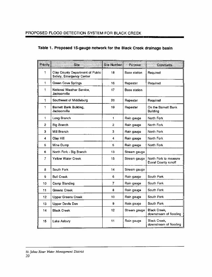
Robison (1993) recommended a flood warning network composedof 14 gauges: 11 rain and 3 stream. The 11 rain gauges willcollect data associated with the North Fork (five gauges), theSouth Fork (five gauges), and Black Creek, just downstream ofthe confluence of the North and South forks (one gauge). Two ofthe North Fork rain gauges should be located along Yellow WaterCreek in Duval County (Figure 7). The three stream gauges (onegauge at each location) will record stream levels on the NorthFork, the South Fork, and Black Creek just downstream of theconfluence of the North and South forks.
The gauging network as proposed by Robison (1993) may not bepractical for Clay County, because DPS would have to install,operate, and maintain the rain gauges in Duval County. Thesetwo gauges, however, could be located as far north in ClayCounty as possible (Figure 8) and still provide adequate data toforecast the flooding potential of Yellow Water Creek. Anadditional stream gauge should be added on Yellow Water Creekat the county boundary to measure runoff from the Duval Countyportion of the basin. These modifications to the Robisonrecommendation yield a gauging network of 15 gauges: 11 rainand 4 stream.
The modified or proposed gauging network can be installed inphases. Because the majority of historical flooding events have
St. Johns River Water Management District16
DUVAL
CLAY
Legend
County boundary
Road
Lower St. Johns Riverdrainage basin boundary
USGS stream gauge
Rain gauge
Waterbody5 4 3 2 1 0
Approximate scale in miles
Figure 7. Ideal location of rain and stream gauges in theBlack Creek drainage basin
17
82 00 00 W 81 52 30 W
30 1500 N
30 07 SON
30 00 DON
Legend
County boundary
Road
Lower St. Johns Riverdrainage basin boundary
USGS stream gauge
Rain gauge
Waterbody5 4 3 2 1 0I I I I I I
Approximate scale in miles
Figure 8. Alternative location of rain and stream gauges inthe Black Creek drainage basin. This proposednetwork of 15 gauges does not use radar.
18
Flood Forecasting System
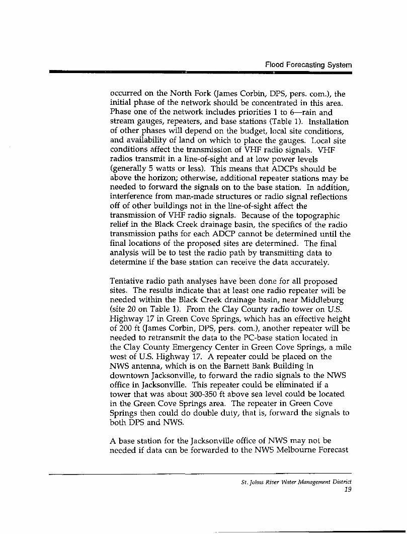
occurred on the North Fork (James Corbin, DPS, pers. com.), theinitial phase of the network should be concentrated in this area.Phase one of the network includes priorities 1 to 6—rain andstream gauges, repeaters, and base stations (Table 1). Installationof other phases will depend on the budget, local site conditions,and availability of land on which to place the gauges. Local siteconditions affect the transmission of VHP radio signals. VHPradios transmit in a line-of-sight and at low power levels(generally 5 watts or less). This means that ADCPs should beabove the horizon; otherwise, additional repeater stations may beneeded to forward the signals on to the base station. In addition,interference from man-made structures or radio signal reflectionsoff of other buildings not in the line-of-sight affect thetransmission of VHP radio signals. Because of the topographicrelief in the Black Creek drainage basin, the specifics of the radiotransmission paths for each ADCP cannot be determined until thefinal locations of the proposed sites are determined. The finalanalysis will be to test the radio path by transmitting data todetermine if the base station can receive the data accurately.
Tentative radio path analyses have been done for all proposedsites. The results indicate that at least one radio repeater will beneeded within the Black Creek drainage basin, near Middleburg(site 20 on Table 1). From the Clay County radio tower on U.S.Highway 17 in Green Cove Springs, which has an effective heightof 200 ft (James Corbin, DPS, pers. com.), another repeater will beneeded to retransmit the data to the PC-base station located inthe Clay County Emergency Center in Green Cove Springs, a milewest of U.S. Highway 17. A repeater could be placed on theNWS antenna, which is on the Barnett Bank Building indowntown Jacksonville, to forward the radio signals to the NWSoffice in Jacksonville. This repeater could be eliminated if atower that was about 300-350 ft above sea level could be locatedin the Green Cove Springs area. The repeater in Green CoveSprings then could do double duty, that is, forward the signals toboth DPS and NWS.
A base station for the Jacksonville office of NWS may not beneeded if data can be forwarded to the NWS Melbourne Forecast
St. Johns River Water Management District19
PROPOSED FLOOD DETECTION SYSTEM FOR BLACK CREEK
Table 1. Proposed 15-gauge network for the Black Creek drainage basin
Priority
1
1
1
1
1
1
2
3
4
5
6
7
8
9
10
11
12
13
14
15
Site
Clay County Department of PublicSafety, Emergency Center
Green Cove Springs
National Weather Service,Jacksonville
Southwest of Middleburg
Barnett Bank Building,Jacksonville
Long Branch
Big Branch
Mill Branch
Clay Hill
Mine Dump
North Fork - Big Branch
Yellow Water Creek
South Fork
Bull Creek
Camp Blanding
Greens Creek
Upper Greens Creek
Upper Devils Den
Black Creek
Lake Asbury
Site Number
18
16
17
20
19
1
2
3
4
5
13
15
14
6
7
8
10
9
12
11
Purpose
Base station
Repeater
Base station
Repeater
Repeater
Rain gauge
Rain gauge
Rain gauge
Rain gauge
Rain gauge
Stream gauge
Stream gauge
Stream gauge
Rain gauge
Rain gauge
Rain gauge
Rain gauge
Rain gauge
Stream gauge
Rain gauge
Comments
Required
Required
Required
On the Barnett BankBuilding
North Fork
North Fork
North Fork
North Fork
North Fork
North Fork to measureDuval County runoff
South Fork
South Fork
South Fork
South Fork
South Fork
Black Creek,downstream of flooding
Black Creek,downstream of flooding
St. Johns River Water Management District
20
Flood Forecasting System
Office. To do this, the existing telemetry network operated bySJRWMD could be utilized to send the data to SJRWMD, whichin turn would transmit the data to NWS in Melbourne. Thisoption, however, would require that the same kind of base stationequipment used by SJRWMD be purchased. There might beother costs associated with a partnership with SJRWMD—costsfor additional equipment or additional staff at Palatka.
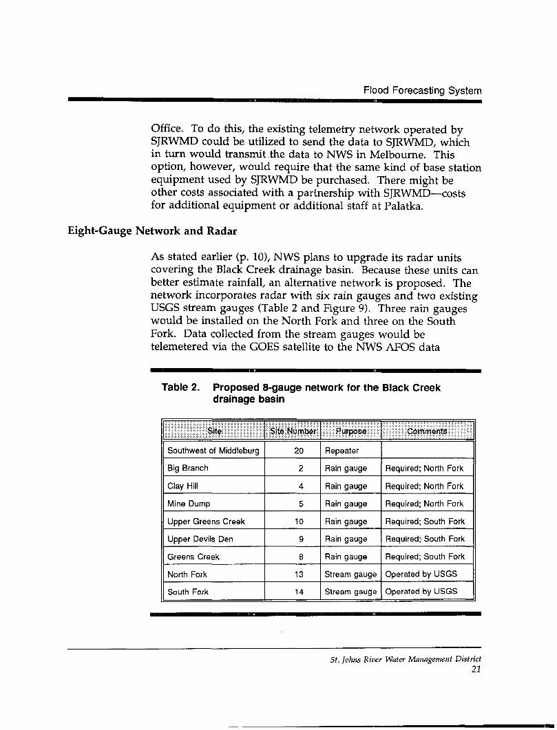
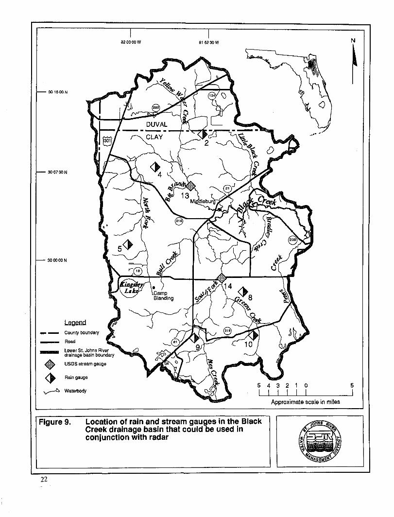
Eight-Gauge Network and Radar
As stated earlier (p. 10), NWS plans to upgrade its radar unitscovering the Black Creek drainage basin. Because these units canbetter estimate rainfall, an alternative network is proposed. Thenetwork incorporates radar with six rain gauges and two existingUSGS stream gauges (Table 2 and Figure 9). Three rain gaugeswould be installed on the North Fork and three on the SouthFork. Data collected from the stream gauges would betelemetered via the GOES satellite to the NWS AFOS data
Table 2. Proposed 8-gauge network for the Black Creekdrainage basin
Site
Southwest of Middleburg
Big Branch
Clay Hill
Mine Dump
Upper Greens Creek
Upper Devils Den
Greens Creek
North Fork
South Fork
Site Number
20
2
4
5
10
g
8
13
14
Purpose
Repeater
Rain gauge
Rain gauge
Rain gauge
Rain gauge
Rain gauge
Rain gauge
Stream gauge
Stream gauge
Comments
Required; North Fork
Required; North Fork
Required; North Fork
Required; South Fork
Required; South Fork
Required; South Fork
Operated by USGS
Operated by USGS
St. Johns River Water Management District21
82 00 00 W 81 52 30 W
30 15 DON
30 07 SON
30 00 DON
wjjb USGS stream gauge
/& Rain gauge
Waterbody
LegendCounty boundary
Road
Lower St. Johns Riverdrainage basin boundary
5 4 3 2 1 0I I I I I I
Approximate scale in miles
Figure 9. Location of rain and stream gauges in the BlackCreek drainage basin that could be used inconjunction with radar
22
Flood Forecasting System
distribution network. With the data collected by the rain andstream gauges and WSR-88D radar units, NWS can use its floodforecasting models to predict the potential for flooding in theBlack Creek drainage basin.
Using this type of network, only six rain gauges and a repeaterwould have to be purchased and installed, and the SJRWMDtelemetry system would be utilized to forward the rainfall data toNWS. The existing USGS stream gauges would also be utilized.The proposed network would result in a functioning flooddetection system.
If DPS wanted to receive data at its office in Green Cove Springs,however, Clay County would have two choices: (1) Clay Countycould purchase a base station as well as a repeater or (2) DPScould use an existing personal computer and modem to accessthe base station at SJRWMD. The second option requires thepurchase of REMDOS™ software.
Local site conditions affect the transmission of VHP radio signals.VHP radios transmit in a line of sight and at low power levels(generally 5 watts or less). This means that ADCPs should beabove the horizon; otherwise, additional repeater stations may beneeded to forward the signals to the base station. In addition,interference from man-made structures or radio signal reflectionsoff of other buildings not in the line of sight affect thetransmission of VHP radio signals. Because of the topographicrelief in the Black Creek drainage basin, the specifics of the radiotransmission paths for each ADCP cannot be determined until thefinal locations of the proposed sites are determined. The finalanalysis will be to test the radio path by transmitting data todetermine if the base station can receive the data accurately.
An alternative 8-gauge network might be installed and operatedby utilizing USGS to install and maintain the six rain gauges inaddition to the two existing USGS stream gauges. Under thisscenerio, all data would be transmitted via the GOES satellitesystem into the NWS AFOS system. To access the data, DPS
St. Johns River Water Management District23
PROPOSED FLOOD DETECTION SYSTEM FOR BLACK CREEK
would need to be able to tap into the USGS computer system inOrlando.
FLOOD FORECASTING
Flood forecasting is accomplished through computer modeling.Several modeling options are available.
• DOS-based models• QNX-based models• NWS models
If DPS plans to forecast flooding events using in-house models(DOS- or QNX-based), it should enter into an agreement withNWS to avoid sending out conflicting warnings to the publicduring a possible flood event (see appendix for a samplememorandum of understanding).
DOS-based Models
Robison (1993) simulated the flooding potential in the BlackCreek drainage basin using two hydrologic models: StreamflowSynthesis and Reservoir Regulation (SSARR) and Dynamic WaveOperational (DWOPER). These models run on a DOS-basedcomputer. The computers SJRWMD and NWS use for thetelemetry system are not DOS-based; the SJRWMD telemetrysystem is QNX-based. The data, therefore, must be transferredfrom one computer system to the other. This can be donemanually by re-entering the data or possibly via some automatedsystem that would have to be developed.
QNX-based Models
Other forecasting models are available that automatically use thereal-time data used by SJRWMD on the QNX operating system.These models operate on the same system that receives the data.The Sacramento River Model, the Antecedent Precipitation IndexModel, and the U.S. Army Corps of Engineers HEC1F use real-time data directly from the gauging networks. In addition, the
St. Johns River Water Management District24
Flood Forecasting System
River Forecast Model, which NWS uses, may be available in thefuture for use on microcomputers operating on a QNX systemthat collects real-time data.
NWS Models
Instead of using in-house models to predict flood events, DPScould take advantage of the services provided by NWS. TheAtlanta River Forecast Center of NWS already has theresponsibility to issue flood warnings and advisories for the BlackCreek drainage basin. NWS receives real-time satellite, radar,and other weather data from the surrounding region, whichallows NWS to determine if and when storms will be movinginto the Black Creek drainage basin. NWS uses its own models,such as the River Forecast Model. Currently, the data available toNWS are limited to those data that are recorded at the streamgauge on the North Fork (USGS 02246000) and at the rain gaugeat Penney Farms (SJRWMD station). These data are transmittedas either real-time or near real-time.
SYSTEM COSTS—FIFTEEN-GAUGE NETWORK
Anticipated costs for the modified or proposed gauging networkof 11 rain gauges, 4 stream gauges, 2 base stations, and3 repeaters are categorized into basic costs, additional costs, andmaintenance costs.
Basic Costs
The estimated basic cost of the proposed Black Creek drainagebasin flood detection gauging network is $188,550 (Table 3). Thecost could be spread over 2 years, which is the frequency periodof flood events. The estimate is based on the type of equipmentused by SJRWMD, Sierra-Misco DataCommand™ software, andSierra-Misco RTU-0850™ data loggers. This data logger uses two-way radio transmission.
The expenses could be reduced by using alternative equipmentand installing some of the equipment. Approximately $1,000 per
St. Johns River Water Management District25
PROPOSED FLOOD DETECTION SYSTEM FOR BLACK CREEK
Table 3. Estimated basic costs for the 15-gauge network that could beused as part of the flood detection system in the Black Creekdrainage basin
Site Type Priority Cost*
Pbasfe *
County station
Green Cove Springs
National Weather Service, Jacksonville Airport
Southwest of Middleburg
Barnett Bank Building, Jacksonville
Long Branch
Big Branch
Mill Branch
Clay Hill
Mine Dump
North Fork
Base station
Repeater
Base station
Repeater
Repeater
Rain gauge**
Rain gauge**
Rain gauge**
Rain gauge**
Rain gauge**
Stream gauge**
1
1
1
1
1
1
2
3
4
5
6
Subtotal
$21,000
9,000
21,000
9,000
6,950
7,920
7,920
7,920
7,920
7,920
8,620
I $115,170
Phase 2
Yellow Water Creek
South Fork
Bull Creek
Camp Blanding
Greens Creek
Upper Devils Den
Upper Greens Creek
Lake Asbury
Black Creek
Stream gauge**
Stream gauge"
Rain gauge**
Rain gauge**
Rain gauge**
Rain gauge**
Rain gauge**
Rain gauge**
Stream gauge**
7
8
9
10
11
12
13
14
15
Subtotal
8,620
8,620
7,920
7,920
7,920
7,920
7,920
7,920
8,620
| $ 73,380
Grand Total | $188,550
* Includes cost of computer software and installation
** Prices based on RTU-0850™ data logger. Use of 5096™ data logger would costapproximately $1,000 less per site.
St. Johns River Water Management District
26
Flood Forecasting System
site could be saved by using a one-way radio transmissionnetwork and Sierra-Misco 5096™ data loggers. If DPS intends touse ADCPs for purposes other than just collecting andtransmitting rainfall and stream gauge data (p. 15), the use ofone-way radio may make it more difficult to collect theseadditional data. Direct installation costs could be reduced if ClayCounty employees who will be maintaining the system assist inthe installation. This will enable the employees to gain valuableon-the-job training.
The basic cost might be increased by 20 percent to cover anyunanticipated additional expenses. This would amount toapproximately an additional $23,034 for year 1 and $14,676 foryear 2.
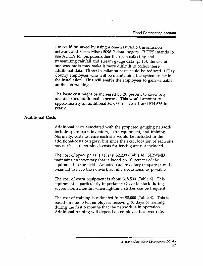
Additional Costs
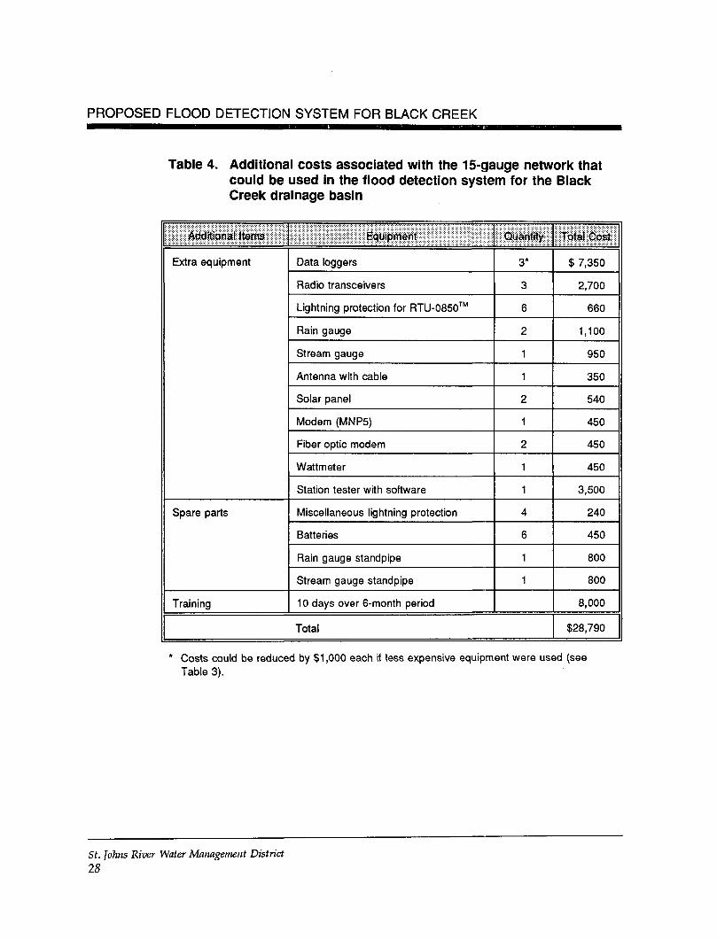
Additional costs associated with the proposed gauging networkinclude spare parts inventory, extra equipment, and training.Normally, costs to fence each site would be included in theadditional-costs category, but since the exact location of each sitehas not been determined, costs for fencing are not included.
The cost of spare parts is at least $2,290 (Table 4). SJRWMDmaintains an inventory that is based on 20 percent of theequipment in the field. An adequate inventory of spare parts isessential to keep the network as fully operational as possible.
The cost of extra equipment is about $18,500 (Table 4). Thisequipment is particularly important to have in stock duringsevere storm months, when lightning strikes can be frequent.
The cost of training is estimated to be $8,000 (Table 4). This isbased on one to ten employees receiving 10 days of trainingduring the first 6 months that the network is in operation.Additional training will depend on employee turnover rate.
St. Johns River Water Management District27
PROPOSED FLOOD DETECTION SYSTEM FOR BLACK CREEK
Table 4. Additional costs associated with the 15-gauge network thatcould be used in the flood detection system for the BlackCreek drainage basin
Additional Items
Extra equipment
Spare parts
Training
Equipment
Data loggers
Radio transceivers
Lightning protection for RTU-0850™
Rain gauge
Stream gauge
Antenna with cable
Solar panel
Modem (MNP5)
Fiber optic modem
Wattmeter
Station tester with software
Miscellaneous lightning protection
Batteries
Rain gauge standpipe
Stream gauge standpipe
1 0 days over 6-month period
Quantity
3*
3
6
2
1
1
2
1
2
1
1
4
6
1
1
Total
Total Cost
$ 7,350
2,700
660
1,100
950
350
540
450
450
450
3,500
240
450
800
800
8,000
$28,790
* Costs could be reduced by $1,000 each if less expensive equipment were used (seeTable 3).
St. Johns River Water Management District
28
Flood Forecasting System
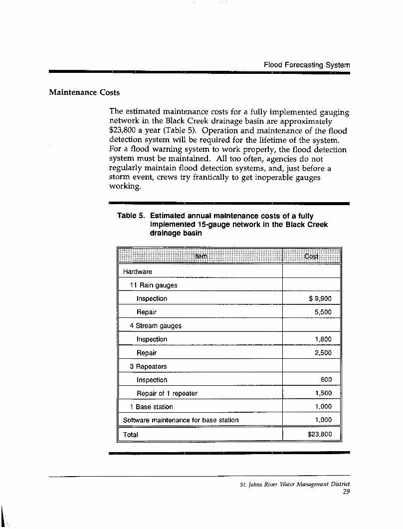
Maintenance Costs
The estimated maintenance costs for a fully implemented gaugingnetwork in the Black Creek drainage basin are approximately$23,800 a year (Table 5). Operation and maintenance of the flooddetection system will be required for the lifetime of the system.For a flood warning system to work properly, the flood detectionsystem must be maintained. All too often, agencies do notregularly maintain flood detection systems, and, just before astorm event, crews try frantically to get inoperable gaugesworking.
Table 5. Estimated annual maintenance costs of a fullyimplemented 15-gauge network in the Black Creekdrainage basin
item
Hardware
1 1 Rain gauges
Inspection
Repair
4 Stream gauges
Inspection
Repair
3 Repeaters
Inspection
Repair of 1 repeater
1 Base station
Software maintenance for base station
Total
Cost
$ 9,900
5,500
1,800
2,500
600
1,500
1,000
1,000
$23,800
St. Johns River Water Management District29
PROPOSED FLOOD DETECTION SYSTEM FOR BLACK CREEK
In the Black Creek drainage basin, storms that result in floodingoccur about every 2 years. It is very important for the systemoperator to invest about $23,800 each year to keep the gaugingnetwork operational.
Gauges should be checked on a regular basis. Rain gaugesshould be checked every other month for correct operation andcalibrated twice a year. Stream gauges should be calibratedmonthly at first (until confidence is established in the gauges),then calibrated every other month. SJRWMD presently checksstream gauges every other month to make sure they are stillcalibrated and checks rain gauges every other month. Gaugesshould be checked periodically to make sure they have not beenvandalized or struck by lightning. SJRWMD experiencesvandalism, especially in urban areas. RTU-0850™ data loggerscan be used to detect a removed rain gauge, an opened fence gateor door, or a tampered-with gauge. However, this informationmay not indicate the extent of the damage. During lightningseason, extra site inspections should be conducted.
SYSTEM COSTS—EIGHT-GAUGE NETWORK
Anticipated costs for the proposed gauging network of six raingauges, two USGS stream gauges, and one repeater and for theuse of NWS WSR-88D radar units are categorized into basic costs,additional costs, and maintenance costs.
Basic Costs
The estimated basic cost of the proposed Black Creek drainagebasin flood detection gauging network is $56,520 (Table 6). Directinstallation costs could be reduced if Clay County employees whowill be maintaining the system assist in the installation. This willenable the employees to gain valuable on-the-job training.
The basic costs might be increased by 20 percent to cover anyunanticipated additional expenses. This would amount toapproximately $11,304.
St. Johns River Water Management District30
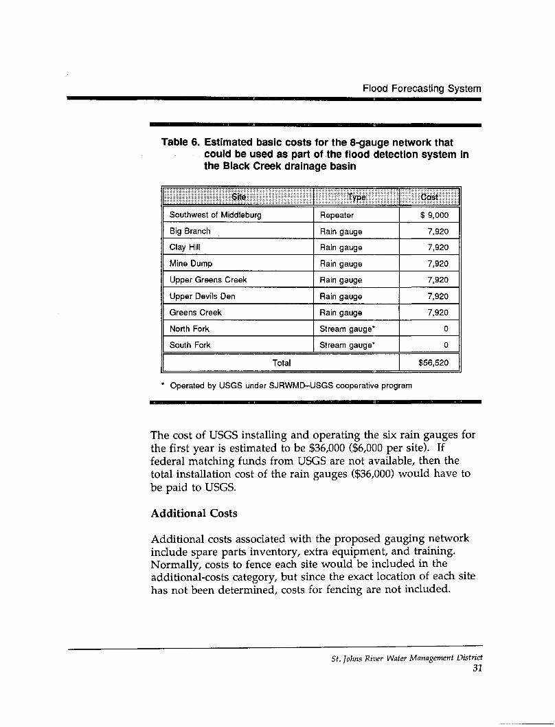
Flood Forecasting System
Table 6. Estimated basic costs for the 8-gauge network thatcould be used as part of the flood detection system inthe Black Creek drainage basin
Site
Southwest of Middleburg
Big Branch
Clay Hill
Mine Dump
Upper Greens Creek
Upper Devils Den
Greens Creek
North Fork
South Fork
Type
Repeater
Rain gauge
Rain gauge
Rain gauge
Rain gauge
Rain gauge
Rain gauge
Stream gauge*
Stream gauge*
Total
Cast
$ 9,000
7,920
7,920
7,920
7,920
7,920
7,920
0
0
$56,520
* Operated by USGS under SJRWMD-USGS cooperative program
The cost of USGS installing and operating the six rain gauges forthe first year is estimated to be $36,000 ($6,000 per site). Iffederal matching funds from USGS are not available, then thetotal installation cost of the rain gauges ($36,000) would have tobe paid to USGS.
Additional Costs
Additional costs associated with the proposed gauging networkinclude spare parts inventory, extra equipment, and training.Normally, costs to fence each site would be included in theadditional-costs category, but since the exact location of each sitehas not been determined, costs for fencing are not included.
St. Johns River Water Management District31
PROPOSED FLOOD DETECTION SYSTEM FOR BLACK CREEK
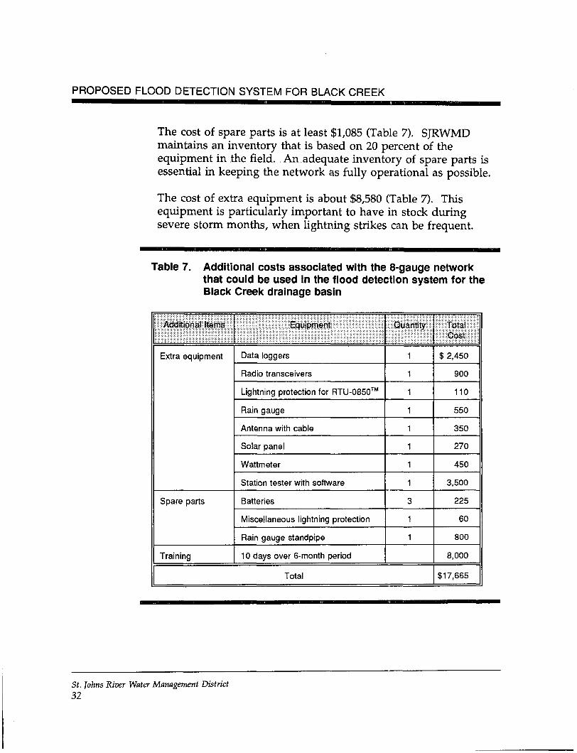
The cost of spare parts is at least $1,085 (Table 7). SJRWMDmaintains an inventory that is based on 20 percent of theequipment in the field. An adequate inventory of spare parts isessential in keeping the network as fully operational as possible.
The cost of extra equipment is about $8,580 (Table 7). Thisequipment is particularly important to have in stock duringsevere storm months, when lightning strikes can be frequent.
Table 7. Additional costs associated with the 8-gauge networkthat could be used in the flood detection system for theBlack Creek drainage basin
Additional Items
Extra equipment
Spare parts
Training
Equipment
Data loggers
Radio transceivers
Lightning protection for RTU-0850™
Rain gauge
Antenna with cable
Solar panel
Wattmeter
Station tester with software
Batteries
Miscellaneous lightning protection
Rain gauge standpipe
10 days over 6-month period
Quantity
1
1
1
1
1
1
1
1
3
1
1
Total
Total:Co$t
$ 2,450
900
110
550
350
270
450
3,500
225
60
800
8,000
$17,665
St. Johns River Water Management District32
Flood Forecasting System
The cost of training is estimated to be $8,000 (Table 7). This isbased on one to ten employees receiving 10 days of trainingduring the.first .6 months that the network is in operation.Additional training will depend on employee turnover rate.
Other costs might include a base station and repeater or thepurchase of REMDOS™ software for about $450 (see discussionon p. 23). These costs are not included in any of the optionspresented in this report.
There are no additional costs if USGS is to install and maintainthe rain gauges. However, the county cannot gain access to therainfall or stream stage data unless it is able to access either theUSGS computer or the SJRWMD telemetry base station. USGSrainfall data may not be available in the SJRWMD base stationcomputer due to a format incompatability between USGS andSJRWMD.
Maintenance Costs
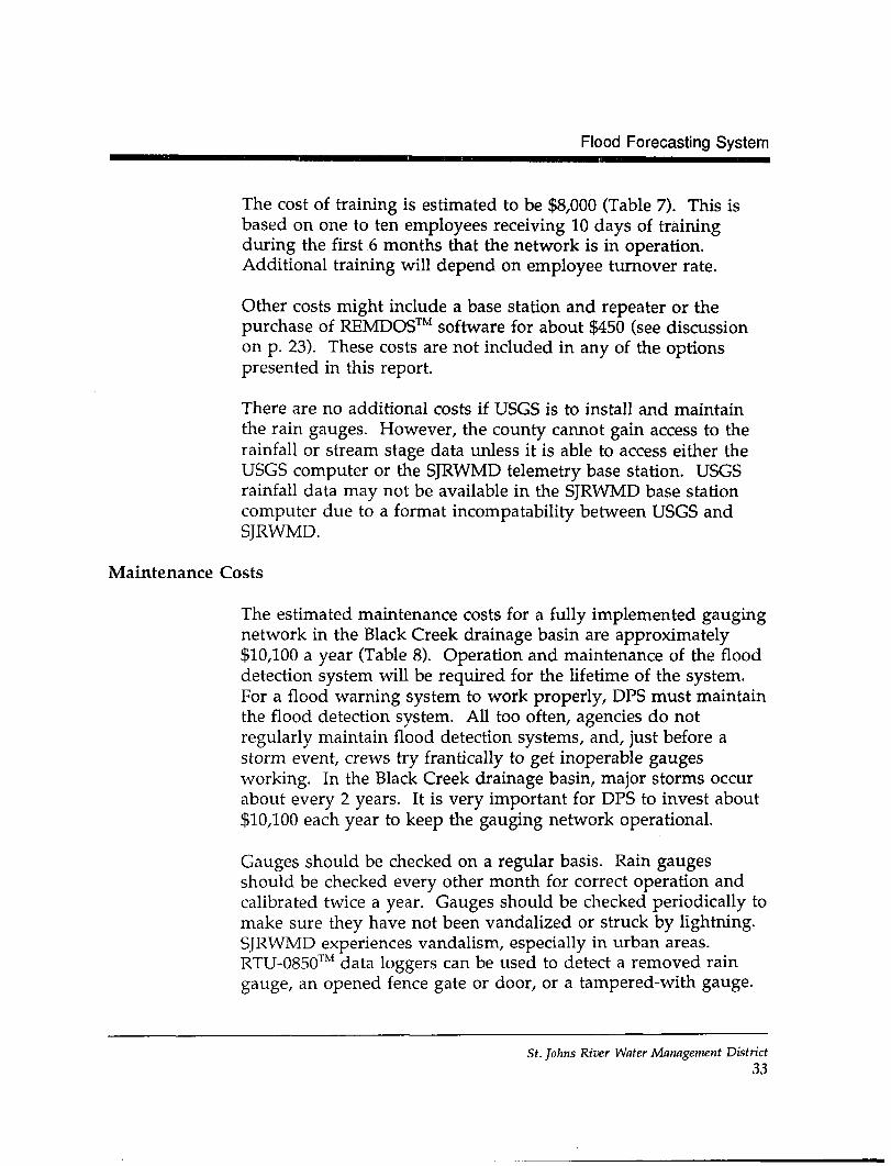
The estimated maintenance costs for a fully implemented gaugingnetwork in the Black Creek drainage basin are approximately$10,100 a year (Table 8). Operation and maintenance of the flooddetection system will be required for the lifetime of the system.For a flood warning system to work properly, DPS must maintainthe flood detection system. All too often, agencies do notregularly maintain flood detection systems, and, just before astorm event, crews try frantically to get inoperable gaugesworking. In the Black Creek drainage basin, major storms occurabout every 2 years. It is very important for DPS to invest about$10,100 each year to keep the gauging network operational.
Gauges should be checked on a regular basis. Rain gaugesshould be checked every other month for correct operation andcalibrated twice a year. Gauges should be checked periodically tomake sure they have not been vandalized or struck by lightning.SJRWMD experiences vandalism, especially in urban areas.RTU-0850™ data loggers can be used to detect a removed raingauge, an opened fence gate or door, or a tampered-with gauge.
St. Johns River Water Management District33
PROPOSED FLOOD DETECTION SYSTEM FOR BLACK CREEK
However, this information may not indicate the extent of damage.During lightning season, extra site inspections should beconducted.
Table 8. Estimated annual maintenance costs of a fullyimplemented 8-gauge network in the Black Creekdrainage basin
Item
Hardware
6 Rain gauges
Inspection
Repair
1 Repeater
Inspection
Repair
Total
Cost
$5,400
3,000
200
1,500
$10,100
The yearly maintenance costs for the USGS-mstalled rain gaugeswill be $36,000. If federal matching funds from USGS are notavailable, then the total yearly maintenance costs of the raingauges ($36,000) would have to be paid to USGS.
CONFIGURATION OPTIONS
One of the following options should be selected to implement aflood detection system, which provides the ability to forecastfloods.
Option 1 This option uses the radio telemetry system operatedby SJRWMD. It is a 15-gauge network. DPS wouldincrease the number of ADCPs and install additional
St. Johns River Water Management District34
Flood Forecasting System
repeaters and base stations. This option will take2 years to implement. The estimated Phase I cost forthis option is $167,760.
Option 2 This option uses a radio telemetry system other thanthat operated by SJRWMD. This 15-gauge networkwould transmit on a radio frequency that is totallyindependent from SJRWMD. It would be capable ofinterfacing with SJRWMD via PC-base stations. DPSinstalls ADCPs, using less expensive and less versatileequipment (e.g., RTU-5096™ data logger). Thisoption will take 2 years to implement. The estimatedPhase I cost for this option is $158,760.
Option 3 This option uses a radio telemetry system. This 15-gauge network would transmit on a radio frequencythat is totally independent from SJRWMD. It wouldnot be capable of interfacing with SJRWMD. Lessexpensive and less versatile ADCPs would beinstalled (e.g., the RTU-5096™ data logger). Thisoption will take 3 years to implement. The estimatedPhase I cost for this option is $158,760.
Option 4 This option uses the radio telemetry system operatedby SJRWMD. It is an 8-gauge network. Six raingauges and one repeater would be installed and twoUSGS stream gauges would be utilized. Data wouldbe collected by the SJRWMD radio telemetry networkand forwarded to NWS for determining the potentialfor flooding. This option will take 1 year toimplement. The estimated cost for this option is$84,285.
Option 5 This option uses the USGS GOES satellite system tosend data to NWS through the NWS AFOS system. Itrequires that USGS install six telemetered rain gaugesand continue to maintain the two existing telemeteredstream gauges. It will take 1 year to implement; thecost of the system is approximately $36,000.
St. Johns River Water Management District35
PROPOSED FLOOD DETECTION SYSTEM FOR BLACK CREEK
FLOOD ALARM SYSTEM
A flood alarm system is designed to detect only rising or fallingstream stages—not to forecast flooding events. This kind ofsystem usually has fewer gauge sites than flood detectionsystems; therefore, it is less expensive to install and easier tomaintain and operate (USAGE 1990b). The equipment used in aflood alarm system precludes the ability to collect various typesof data beyond the preset elevation of the water in a stream.
A flood alarm system detects when rising water levels reach apreset point, or points, at a station. Alarms do not have to beinstalled at existing stream gauging stations. Each flood alarmstation typically is located upstream of where flooding isexpected. Flood alarm stations provide early warning toresidents, depending on the rise time of the stream. If a streamtypically rises quite rapidly, a flood alarm system should not beused. In the Black Creek drainage basin, where lag time is about20 to 26 hours, a flood alarm system is practical and may be ofinterest to DPS.
The time between any two alarms from a flood alarm stationgives a rough indication of the rate of rise of the stream at thestation. When the flood alarm system is activated, the site shouldbe visited immediately to continue to evaluate the flooding threat.
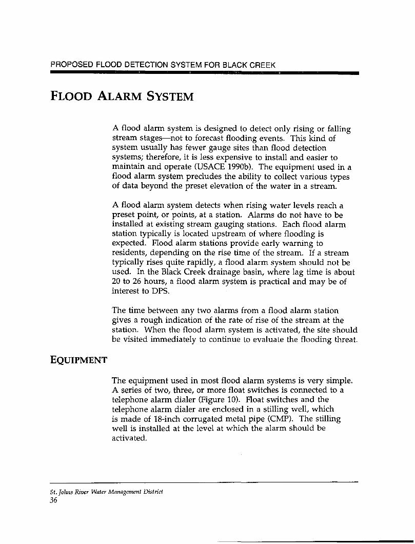
EQUIPMENT
The equipment used in most flood alarm systems is very simple.A series of two, three, or more float switches is connected to atelephone alarm dialer (Figure 10). Float switches and thetelephone alarm dialer are enclosed in a stilling well, whichis made of 18-inch corrugated metal pipe (CMP). The stillingwell is installed at the level at which the alarm should beactivated.
Si. Johns River Water Management District
36
Flood Alarm System
5u-Q» Protect Ion s. S
LJP- ^7ii
Phona LinaOut — ' «-l
High-stage Alarn /^Activation / yFloat Btflteh *•— '
Initial Alarm Shut- /\Off Plo«t Switch / ,
Initial Alarm ^- - / l
Float 9mch — '
I5
[*__
l
Lid hhndlo/- Phone Jack -^— " Plttno HrnO°
"1 Alarn NA Dl.l̂ j
A^ ?V I
^3 >^ J
Initfal AlarmS19«IJunction
-» Float Sional Cab lee
^
&/
.̂ - Claanouc Door
' Eye Bolt
jTroofi 5ci owi
Figure 10. Schematic of a flood alarm
St. JO/ZMS River Water Management District37
PROPOSED FLOOD DETECTION SYSTEM FOR BLACK CREEK
When the lowest float switch is activated, the telephone alarmdialer triggers a telephone program, which automatically dialspredetermined telephone numbers and plays a prerecordedmessage. As long as the water continues to rise, differentprerecorded messages are sent, depending on the float triggered.The audible signal goes off each time a float is triggered by therising water. The audible signal is preset to one level; it does notchange when a different alarm is triggered.
Telephone lines are important to the success of a flood alarmsystem. In Florida, telephone lines are affected greatly byweather conditions—especially lightning. Lightning can destroythe telephone line, telephone switching station, or a flood alarmstation just prior to flooding. The result is that the flood alarmsystem may become inoperable prior to or during floodingevents. As a result of lightning, SJRWMD has experiencednumerous problems with most of its electronic data loggersattached to telephone lines. This problem has made many of theSJRWMD sites impossible to operate during the lightning season.A possible alternative to telephone lines might be the use ofcellular phones.
SYSTEM CONFIGURATION
Two floodprone areas on Black Creek are of interest to ClayCounty. On the North Fork, the floodprone area of interestextends upstream from the confluence of the North and Southforks to approximately 1.75 miles (mi) above the S.R. 21bridge—a total distance of approximately 3.25 mi (Figure 2). Onthe South Fork, the floodprone area of interest extends upstreamfrom the confluence of the North and South forks toapproximately 2.75 mi above the S.R. 218 bridge—a total distanceof approximately 5.25 mi. In the immediate vicinity ofMiddleburg, only the S.R. 21 and S.R. 218 bridges cross tributariesto Black Creek; these bridges are ideal flood monitoring points.
Four flood alarm stations should be installed. Three sites are partof Robison's (1993) recommendation regarding the location ofstream gauges (flood forecasting system). Instead of installing
St. Johns River Water Management District38
Flood Alarm System
three stream gauges where USGS currently has recorders on theNorth and South forks, DPS could install the flood alarmequipment (Figure 11). Telephone lines would need to beavailable at these sites. If telephone lines are not available atthese USGS sites, then DPS would have to find other sites in thevicinity or consider using cellular phones. DPS would have toget permission to install a flood alarm station on privateproperty. The final alarm station should be located on the SouthFork as close as possible to the area that is inhabited.
SYSTEM COSTS
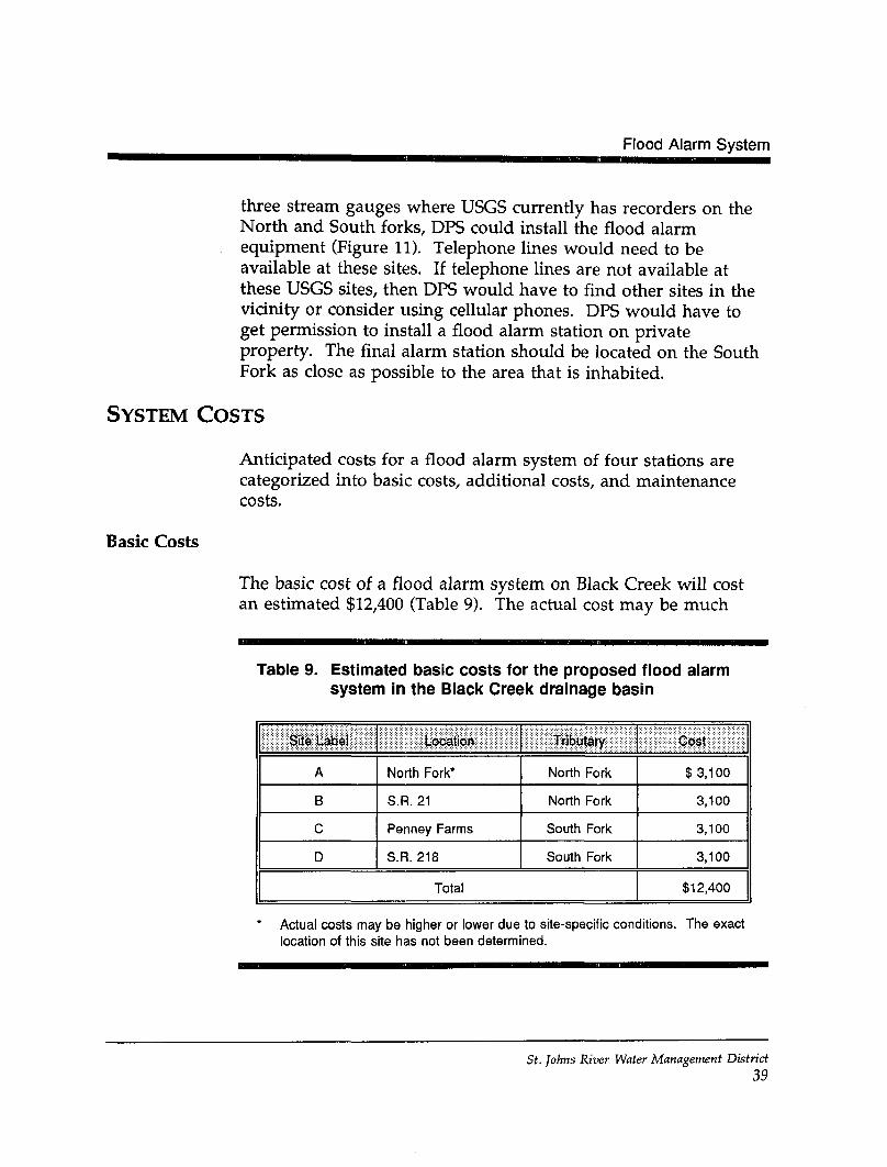
Anticipated costs for a flood alarm system of four stations arecategorized into basic costs, additional costs, and maintenancecosts.
Basic Costs
The basic cost of a flood alarm system on Black Creek will costan estimated $12,400 (Table 9). The actual cost may be much
Table 9. Estimated basic costs for the proposed flood alarmsystem in the Black Creek drainage basin
Site Ub01
A
B
c
D
LocsUofv
North Fork*
S.R. 21
Penney Farms
S.R. 218
Tributary
North Fork
North Fork
South Fork
South Fork
Total
Cost
$3,100
3,100
3,100
3,100
$12,400
Actual costs may be higher or lower due to site-specific conditions. The exactlocation of this site has not been determined.
St. Johns River Water Management District39
82 00 00 W 81 52 30 W
30 1500 N
30 07 30 N
30 00 00 N
Legend
County boundary
Road
Lower St. Johns Riverdrainage basin boundary
Flood alarm station
Waterbody
Approximate scale in miles
Figure 11. Proposed location of flood alarm stations in theBlack Creek drainage basin
40
Flood Alarm System
higher or lower, depending on site-specific installation costsrelated to items such as the length of the stilling well to beinstalled, the number of alarm points, the suitability of theplatform, and the availability of telephone lines. A gaugeupstream of the S.R. 21 bridge on the North Fork will be moreexpensive to install than at any of the other three stations becauseof installation of telephone lines.
Additional Costs
Additional costs associated with the proposed flood alarm system(four stations) include spare parts inventory and extra equipment.The cost of spare parts is at least $500; the cost of extraequipment is about $790 (Table 10).
Table 10. Additional costs associated with the proposed floodalarm system for the Black Creek drainage basin
Additional Items
Spare parts
Extra equipment
Equipment
Batteries
Battery charger
Blank tapes
NEMA box
Corrugated metal pipe
Telephone dialer
Float switches
Solar panels
Staff gauges
Quantity
2
1
2
1
1
1
4
2
6
Total
Total Cost
$160
40
50
150
100
250
200
100
240
$1,290
St. Johns River Water Management District41
PROPOSED FLOOD DETECTION SYSTEM FOR BLACK CREEK
Maintenance Costs
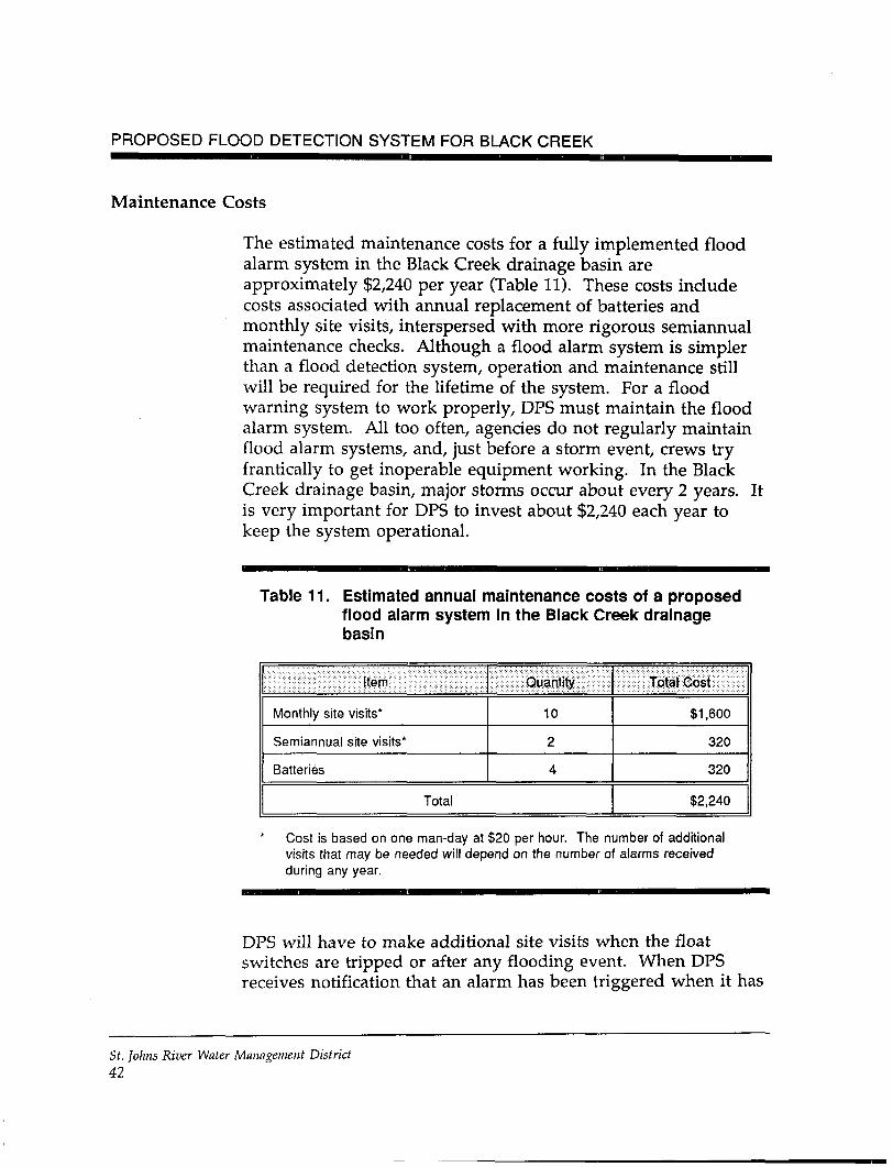
The estimated maintenance costs for a fully implemented floodalarm system in the Black Creek drainage basin areapproximately $2,240 per year (Table 11). These costs includecosts associated with annual replacement of batteries andmonthly site visits, interspersed with more rigorous semiannualmaintenance checks. Although a flood alarm system is simplerthan a flood detection system, operation and maintenance stillwill be required for the lifetime of the system. For a floodwarning system to work properly, DPS must maintain the floodalarm system. All too often, agencies do not regularly maintainflood alarm systems, and, just before a storm event, crews tryfrantically to get inoperable equipment working. In the BlackCreek drainage basin, major storms occur about every 2 years. Itis very important for DPS to invest about $2,240 each year tokeep the system operational.
Table 11. Estimated annual maintenance costs of a proposedflood alarm system in the Black Creek drainagebasin
item
Monthly sitQ visits*
Semiannual site visits*
Batteries
Quantity
10
2
4
Total
Total Cost
$1,600
320
320
$2,240
Cost is based on one man-day at $20 per hour. The number of additionalvisits that may be needed will depend on the number of alarms receivedduring any year.
DPS will have to make additional site visits when the floatswitches are tripped or after any flooding event. When DPSreceives notification that an alarm has been triggered when it has
St. Johns River Water Management District42
Flood Alarm System
not rained, DPS will need to check the site to make sure that ithas not been tampered with or vandalized. The staff gaugesalways should be checked for blockages or other problems afterany rise in water levels. Flood waters may block ports to stillingwells, deposit sediment in wells, or remove stilling wells.
St. Johns River Water Management District43
PROPOSED FLOOD DETECTION SYSTEM FOR BLACK CREEK
SUMMARY
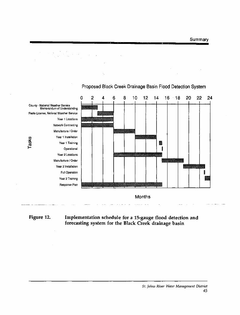
Equipment that is installed for a flood detection gauging networkor a flood alarm system is just a portion of a total flood warningsystem. The emergency management component of the systemshould be implemented at the same time a flood detectiongauging network or a flood alarm system (Figure 12) isimplemented. DPS will need to work closely with NWS to havea successful flood warning system, which will take time toimplement.
Choosing the actual locations for either gauges or alarms is veryimportant and affects the estimated costs of upgrading theexisting flood warning system. Locations for rain and streamgauges must be chosen so that VHP radio signals emanating fromeach ADCP reach either a repeater or the Clay County basestation, if installed. In addition, rain gauges must be located inrelatively open areas to record rainfall accurately. The location ofa second flood alarm station on the North Fork upstream of theS.R. 21 bridge can affect greatly the overall costs of a flood alarmsystem. Specifics about each site will be an integral part of anyquotation for installation. SJRWMD staff can assist Clay Countyin choosing the proper sites.
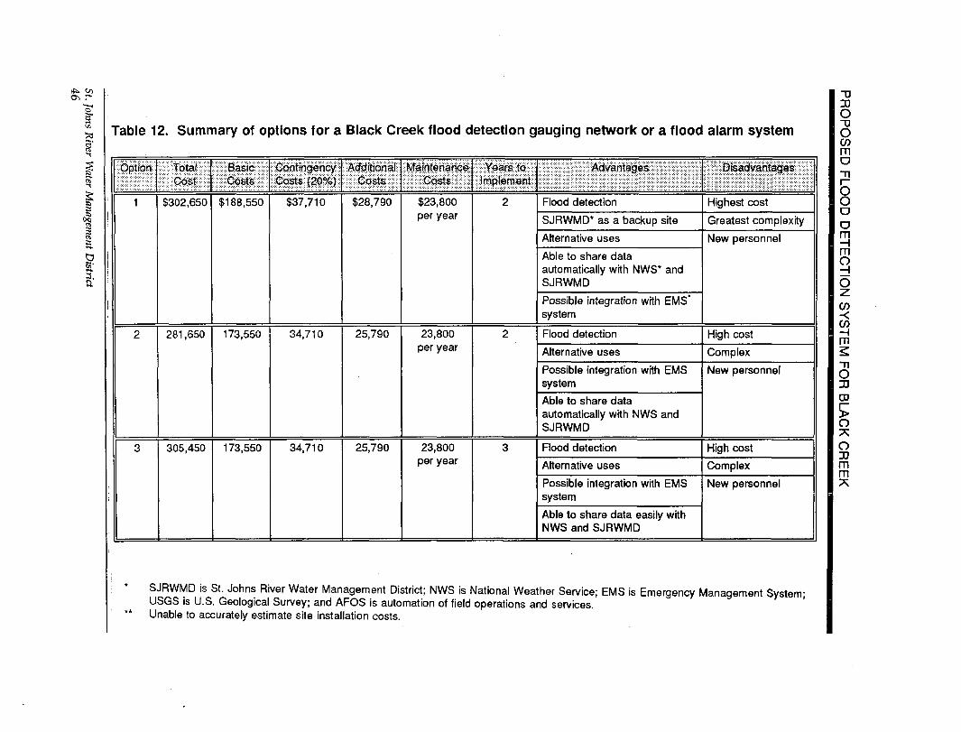
One of the following options (see Table 12) can be considered tobegin implementation of a flood detection gauging network or aflood alarm system, thereby replacing the existing flood warningsystem for the Black Creek drainage basin. Implementation ofOption 1, 2, 3, 4, or 5 will allow flood forecasting.Implementation of Option 6 will result only in a determination ofwhen flood waters have reached any preset float switch at theflood alarm station.
St. Johns River Water Management District44
Summary
County - National Weather ServiceMemorandum of Understanding
Radio License, National Weather Service
Year 1 Locations
Network Contracting
Manufacture / Order
(/; Year 1 Installation
*2 Year 1 Training
•"" Operational
Year 2 Locations
Manufacture / Order
Year 2 Installation
Full Operation
Year 2 Training
Response Plan
Proposed Black Creek Drainage Basin Flood Detection System
8 10 12 14 16 18 20 22 24
Months
Figure 12. Implementation schedule for a 15-gauge flood detection andforecasting system for the Black Creek drainage basin
St. Johns River Water Management District45
o-, r*
II
•
a
Table 12. Summary of options for a Black Creek flood detection gauging network or a flood alarm system
Option
1
2
3
TotalCost
$302,650
281,650
305,450
BasicCosts
$188,550
173,550
173,550
ContingencyCosts {20%)
$37,710
34,710
34,710
AdditionalCosts
$28,790
25,790
25,790
MaintenanceCosts
$23,800per year
23,800per year
23,800per year
Years toImplement
2
2
3
Advantages
Flood detection
SJRWMD* as a backup site
Alternative uses
Able to share dataautomatically with NWS* andSJRWMD
Possible integration with EMS'system
Flood detection
Alternative uses
Possible integration with EMSsystem
Able to share dataautomatically with NWS andSJRWMD
Flood detection
Alternative uses
Possible integration with EMSsystem
Able to share data easily withNWS and SJRWMD
Disadvantages
Highest cost
Greatest complexity
New personnel
High cost
Complex
New personnel
High cost
Complex
New personnel
SJRWMD is St. Johns River Water Management District; NWS is National Weather Service; EMS is Emergency Management System-USGS is U.S. Geological Survey; and AFOS is automation of field operations and services.Unable to accurately estimate site installation costs.
OTJOCOmo
OODO
mo
V)
m
OJJCD
5O7;oJJmm
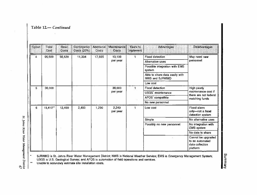
Table 12.— Continued
Option
4
5
6
TotalCost
95,589
36,000
18,410"
BasicCosts
56,520
12,400
ContingencyCosts (20%)
1 1 ,304
2,480
AdditionalCosts
17,665
1,290
MaintenanceCosts
10,100per year
36,000per year
2,240per year
Years toImplement
1
1
1
Advantages
Flood detection
Alternative uses
Possible integration with EMSsystem
Able to share data easily withNWS and SJRWMD
Low cost
Flood detection
USGS" maintenance
AFOS" compatible
No new personnel
Low cost
Simple
Possibly no new personnel
Disadvantages
May need newpersonnel
High yearlymaintenance cost ifthere are not federalmatching funds
Flood alarmonly — not a flooddetection system
No alternative uses
No integration withEMS system
No data to share
Cannot be upgradedto an automateddata collectionplatform
I
3.a
SJRWMD is St. Johns River Water Management District; NWS is National Weather Service; EMS is Emergency Management System;USGS is U.S. Geological Survey; and AFOS is automation of field operations and services.Unable to accurately estimate site installation costs.
V)c33
PROPOSED FLOOD DETECTION SYSTEM FOR BLACK CREEK
Option 1 This option uses the radio telemetry system operatedby SJRWMD. It is a 15-gauge network. DPS wouldincrease the number of ADCPs and install additionalrepeaters and base stations. This option will take2 years to implement. The estimated total cost forthis option is $302,650.
Option 2 This option uses a radio telemetry system. This 15-gauge network would transmit on a radio frequencythat is totally independent from SJRWMD. It wouldbe capable of interfacing with SJRWMD via PC-basestations. DPS installs ADCPs, using less expensiveand less versatile equipment (e.g., RTU-5096™ datalogger). This option will take 2 years to implement.The estimated total cost for this option is $281,650.
Option 3 This option uses a radio telemetry system. This 15-gauge network would transmit on a radio frequencythat is totally independent from SJRWMD. DPSinstalls ADCPs, using less expensive and less versatileequipment (e.g., RTU-5096™ data logger). Thisoption will take 3 years to implement. The estimatedtotal cost for this option is $305,450.
Option 4 This option uses the radio telemetry system operatedby SJRWMD. It is an 8-gauge network. DPS wouldinstall six rain gauges and one repeater and use twoUSGS stream gauges. Data would be collected by theSJRWMD radio telemetry network and forwarded toNWS for determining the potential for flooding. Thisoption will take 1 year to implement. The estimatedtotal cost for this option is $95,589.
Option 5 This option uses the USGS GOES satellite system tosend data to NWS through the NWS AFOS system. Itrequires that USGS install six telemetered rain gaugesand continue to maintain the two existing telemeteredstream gauges. It will take 1 year to implement; thecost of the system is approximately $36,000.
St. Johns River Water Management District48
Summary
Option 6 This option uses telephone lines. It is a flood alarmsystem that does not provide DPS with the ability toforecast flooding events. This option will take 1 yearto implement. The estimated total cost for this optionis $18,410.
Choosing Option 1 requires the use of the same hardware andsoftware used by SJRWMD. A network that is compatiblebetween the two agencies provides backup capabilities in case offailure at one of the PC-base stations. Data could be easilyshared by Clay County, SJRWMD, and NWS. Implementationcould begin as soon as memorandums of understanding havebeen approved by all parties.
Choosing Option 2 allows for the flexibility to purchase lesssophisticated equipment for ADCPs; software for the PC-basestation must match that used by SJRWMD. Implementationwould take between 3 and 12 months longer than for Option 1,because of the time needed to get a radio license. Data could beshared easily among Clay County, SJRWMD, and NWS.
Choosing Option 3 allows for the flexibility to purchase lesssophisticated equipment for ADCPs; software for the PC-basestation does not need to match that used by SJRWMD. The costof this option is about the same as for Option 2; PC-base stationsoftware could be slightly less expensive. NWS would get thedata it needed to work with Clay County in issuing floodwarnings and advisories. SJRWMD could obtain any data fromClay County on floppy disks via ASCII files.
Choosing Option 4 allows for a flood detection system at a lowcost. NWS would be able to get the data it needs to work withClay County in issuing flood warnings and flood advisorystatements. The existing telemetry system between SJRWMD andNWS would be utilized to get the data to NWS. In order for DPSto receive data in Green Cove Springs, a base station would needto be installed in Green Cove Springs. Alternatively, DPS coulduse an existing personal computer and modem to access thePalatka base station at SJRWMD. This option requires the
St. Johns River Water Management District49
PROPOSED FLOOD DETECTION SYSTEM FOR BLACK CREEK
purchase of REMDOS™ software. In order to expand thenetwork, additional stations would have to be created inconjunction with SJRWMD.
Choosing Option 5 allows for a flood detection system at thelowest initial costs. NWS would be able to get the data it needsto work with Clay County in issuing flood warnings and floodadvisory statements. In order for Clay County to access any ofthe data, it would need to have access to the USGS computer inOrlando or the SJRWMD telemetry base station in Palatka.However, the USGS rainfall data may not be available in theSJRWMD base station computer due to a format incompatabilitybetween USGS and SJRWMD.
Choosing Option 6 does not provide Clay County with the abilityto forecast floods. Clay County will be able to choose the streamstage levels that trigger the flood alarm. Clay County will choosethe location of the four alarm stations on the North and Southforks of Black Creek. A flood alarm system relies on thetelephone system rather than on VHP radios.
A gannt chart indicating an implementation schedule for aproposed Black Creek flood detection system was developed forOption 1 or 2 (Figure 12). The time estimated to install the firstphase is 15 months for Option 1 or 2. If the second phase isstarted upon completion of the first phase, the full networkshould be finished in another 9 months. Option 3 might take3 years to complete.
St. Johns River Water Management District50
Literature Cited
LITERATURE CITED
Adams, C. 1991. Emergency manager's severe weather informationneeds. Talk presented at Southwestern Association of ALERTSystems annual conference. Fort Collins, Colo.: ColoradoState University.
Gimmestad, B., and C. Barrett. 1986. The alert handbook. Atlanta,Ga.: National Oceanic and Atmospheric Administration.
Robison, C.P. 1993. Models for a preliminary flood warning systemfor the Black Creek drainage basin, northeast Florida. TechnicalPublication SJ93-3. Palatka, Fla.: St. Johns River WaterManagement District.
USAGE. 1990a. Flood warning and response system, Western branch,Patuxent River, Prince Georges County, Maryland. TechnicalData Report. Baltimore, Md.: U.S. Army Corps ofEngineers.
. 1990b. Kiowa Creek at Wiggins, Colorado, Section 22,Planning assistance to states, flood warning system. Omaha,Nebr.: U.S. Army Corps of Engineers.
St. Johns River Water Management District51
PROPOSED FLOOD DETECTION SYSTEM FOR BLACK CREEK
St. Johns River Water Management District52
Appendix
APPENDIX—SAMPLE NATIONAL WEATHERSERVICE MEMORANDUM OFUNDERSTANDINGSource: Gimmestad and Barrett 1986 (modified)
St. Johns River Water Management District53
PROPOSED FLOOD DETECTION SYSTEM FOR BLACK CREEK
St. Johns River Water Management District54
Appendix
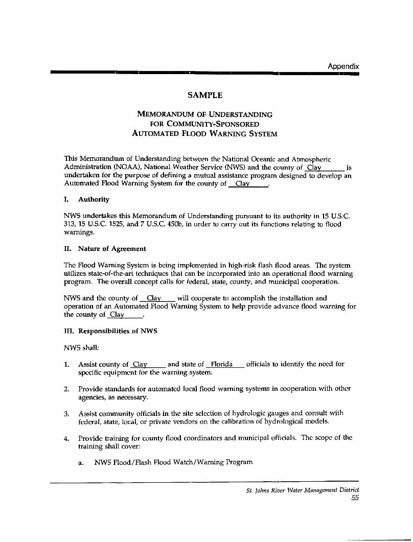
SAMPLE
MEMORANDUM OF UNDERSTANDINGFOR COMMUNITY-SPONSORED
AUTOMATED FLOOD WARNING SYSTEM
This Memorandum of Understanding between the National Oceanic and AtmosphericAdministration (NOAA), National Weather Service (NWS) and the county of Clay isundertaken for the purpose of defining a mutual assistance program designed to develop anAutomated Flood Warning System for the county of Clay .
I. Authority
NWS undertakes this Memorandum of Understanding pursuant to its authority in 15 U.S.C.313, 15 U.S.C. 1525, and 7 U.S.C. 450b, in order to carry out its functions relating to floodwarnings.
II. Nature of Agreement
The Flood Warning System is being implemented in high-risk flash flood areas. The systemutilizes state-of-the-art techniques that can be incorporated into an operational flood warningprogram. The overall concept calls for federal, state, county, and municipal cooperation.
NWS and the county of Clay will cooperate to accomplish the installation andoperation of an Automated Flood Warning System to help provide advance flood warning forthe county of Clay .
III. Responsibilities of NWS
NWS shall:
1. Assist county of Clay and state of Florida officials to identify the need forspecific equipment for the warning system.
2. Provide standards for automated local flood warning systems in cooperation with otheragencies, as necessary.
3. Assist community officials in the site selection of hydrologic gauges and consult withfederal, state, local, or private vendors on the calibration of hydrological models.
4. Provide training for county flood coordinators and municipal officials. The scope of thetraining shall cover:
a. NWS Flood/Flash Hood Watch/Warning Program
St. Johns River Water Management District55
PROPOSED FLOOD DETECTION SYSTEM FOR BLACK CREEK
b. Municipal Flood Warning Programs
c. Operation and maintenance procedures for communications and hydrologicinstrumentation
d. The need for emergency response planning
e. Periodic drills to test the program
5. Issue, according to the severity of the hydrometeorological threat, flash flood watch, flashflood warnings, or Local Statements.
6. In conjunction with the Federal Emergency Management Agency, assure that theactivities of the Automated Flood Warning System are coordinated with designatedmunicipal, county, state, and federal disaster officials.
7. Be responsible for obtaining Federal Communications Commission approval of thenecessary radio frequencies.
8. Assist in the site location of the field equipment and train the personnel in its operation.
9. Provide forecast advisory service for the selected river basins.
10. Provide system monitoring and consult with the community concerning forecast modelrecalibration needs, as required.
IV. Responsibilities of the county of Clay
The county shall:
1. Pay for the initial capital cost of flood warning equipment and all installation costs, withthe exception of river staff gauges and manual rain gauges, and pay for the capital cost ofmajor equipment replacement or upgrading for the continued operation of the floodwarning system.
The funding by the county of the operational and capital costs is conditional on theavailability of appropriated funds within the county budget.
Hood warning equipment may include any combination or all of the following:
a. Telemetered receiver, printers, and minicomputer systems
b. Telemetered rain gauges
c. Radio repeaters for radio-telemetry
St. Johns River Water Management District56
Appendix
d. Flash flood alarms
e. Telemetered river gauges
f. Software installation and model calibration
2. Operate, maintain, and assume recurring costs for those portions of the program of theflood warning system which include:
a. County operations center, including utilities and physical space
b. Equipment used to support the county program, including telemetered river andrain gauges, flash flood alarms, mini-computer systems, radio equipment, datareceivers, repeater system, staff gauges, and plastic rain gauges
c. Communications and utility costs to support the county activities
3. Designate a County Hood Warning Coordinator by title to be trained in and beresponsible for the operation of a county preparedness plan.
4. Prepare a county preparedness plan to detail the necessary responsible actions to betaken, including coordination with NWS whenever river and rainfall data indicate apossible need for statements and/or warnings. The plan will recognize that all floodwarnings, including flash flood warnings, are to be initiated by NWS except when, in thejudgment of the County Flood Warning Coordinator, an emergency situation exists andtime does not permit consultation with NWS. At such times, the coordinator may issue awarning to the public and local officials prior to informing NWS.
5. Establish a county communication and action center to operate continually or as requiredfor the purpose of:
a. Operating the automated data receiver and mini-computer communication center,where applicable
b. Receiving and recording all reports of rainfall and flood conditions
c. Promptly relaying or making available all such reports to the designated MunicipalFlood Warning Coordinator
d. Serving as the official distribution point for all warnings and statements issued byor for the designated County Hood Warning Coordinator
e. Ensuring, in addition to general public distribution, that flood warnings orstatements reach warning action points as listed in the county preparedness plan
St. Johns River Water Management District57
PROPOSED FLOOD DETECTION SYSTEM FOR BLACK CREEK
f. Relaying river and rainfall reports, flood data, and warnings to the NWS office inas soon as practicable after local requirements have been satisfied
V. Title to Equipment
Title to equipment purchased under this Memorandum of Understanding shall remain vestedwith the county of Pay
VI. Amendments or Modifications
This Memorandum of Understanding may be amended or modified by mutual agreement ofNWS and the county of Clay
VII. Termination
This Memorandum of Understanding may be terminated by either party upon sixty (60) dayswritten notice to the other party, notice to begin with date of mailing. Upon termination, allequipment listed by NWS as accountable shall be returned within sixty (60) days to NWS inthe condition it was at the time of termination.
VIII. Effective Date
This Memorandum of Understanding is effective as of the last date shown below uponexecution by both parties hereto.
Clay County Approved by:National Weather Service Director,
By:Region Headquarters
Title:
Signature
United States Department of CommerceNational Oceanic & Atmospheric AdministrationNational Weather Service
Prepared by:
Weather Service Forecast OfficeAddress:
Meteorologist in Charge
St. Johns River Water Management District58


![Detection of ICMP Flood DDoS Attack - IJCST Journal · Detection of ICMP Flood DDoS Attack Harshita [1], Ruchikaa Nayyar [2] Department of Information Technology IGDTUW New Delhi](https://img.dokumen.tips/doc/110x75/5e7b0df9ced04d37fe3dc88d/detection-of-icmp-flood-ddos-attack-ijcst-detection-of-icmp-flood-ddos-attack.jpg)