Embed Size (px)
Citation preview
Southern Site | View North
Proposed Development on
Northfleet Embankment East1. Context
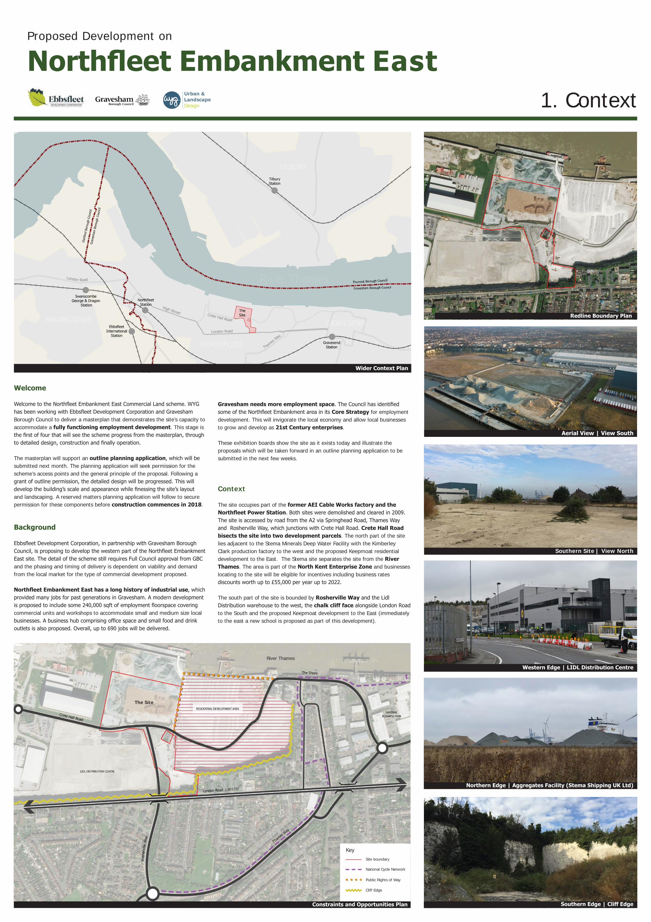
Wider Context Plan
Redline Boundary Plan
Constraints and Opportunities Plan
Key
Aerial View | View South
Western Edge | LIDL Distribution Centre
Northern Edge | Aggregates Facility (Stema Shipping UK Ltd)
Southern Edge | Cliff Edge
Site boundary
National Cycle Network
Public Rights of Way
Cliff Edge
( B2175)
Welcome
Welcome to the Northfleet Embankment East Commercial Land scheme. WYG has been working with Ebbsfleet Development Corporation and Gravesham Borough Council to deliver a masterplan that demonstrates the site’s capacity to accommodate a fully functioning employment development. This stage is the first of four that will see the scheme progress from the masterplan, through to detailed design, construction and finally operation.
The masterplan will support an outline planning application, which will be submitted next month. The planning application will seek permission for the scheme’s access points and the general principle of the proposal. Following a grant of outline permission, the detailed design will be progressed. This will develop the building’s scale and appearance while finessing the site’s layout and landscaping. A reserved matters planning application will follow to secure permission for these components before construction commences in 2018.
Background
Ebbsfleet Development Corporation, in partnership with Gravesham Borough Council, is proposing to develop the western part of the Northfleet Embankment East site. The detail of the scheme still requires Full Council approval from GBC and the phasing and timing of delivery is dependent on viability and demand from the local market for the type of commercial development proposed.
Northfleet Embankment East has a long history of industrial use, which provided many jobs for past generations in Gravesham. A modern development is proposed to include some 240,000 sqft of employment floorspace covering commercial units and workshops to accommodate small and medium size local businesses. A business hub comprising office space and small food and drink outlets is also proposed. Overall, up to 690 jobs will be delivered.
The Site
River Thames
Gravesham needs more employment space. The Council has identified some of the Northfleet Embankment area in its Core Strategy for employment development. This will invigorate the local economy and allow local businesses to grow and develop as 21st Century enterprises.
These exhibition boards show the site as it exists today and illustrate the proposals which will be taken forward in an outline planning application to be submitted in the next few weeks.
Context
The site occupies part of the former AEI Cable Works factory and the Northfleet Power Station. Both sites were demolished and cleared in 2009. The site is accessed by road from the A2 via Springhead Road, Thames Way and Rosherville Way, which junctions with Crete Hall Road. Crete Hall Road bisects the site into two development parcels. The north part of the site lies adjacent to the Stema Minerals Deep Water Facility with the Kimberley Clark production factory to the west and the proposed Keepmoat residential development to the East. The Stema site separates the site from the River Thames. The area is part of the North Kent Enterprise Zone and businesses locating to the site will be eligible for incentives including business rates discounts worth up to £55,000 per year up to 2022.
The south part of the site is bounded by Rosherville Way and the Lidl Distribution warehouse to the west, the chalk cliff face alongside London Road to the South and the proposed Keepmoat development to the East (immediately to the east a new school is proposed as part of this development).
Urban & Landscape Design

Viewpoint 1: Industrial Units on Northern Site
Illustrative Masterplan
The Proposal
The proposal consists of business premises of differing sizes and use classes of accommodation to allow a range of businesses to establish from small starter businesses to larger companies.
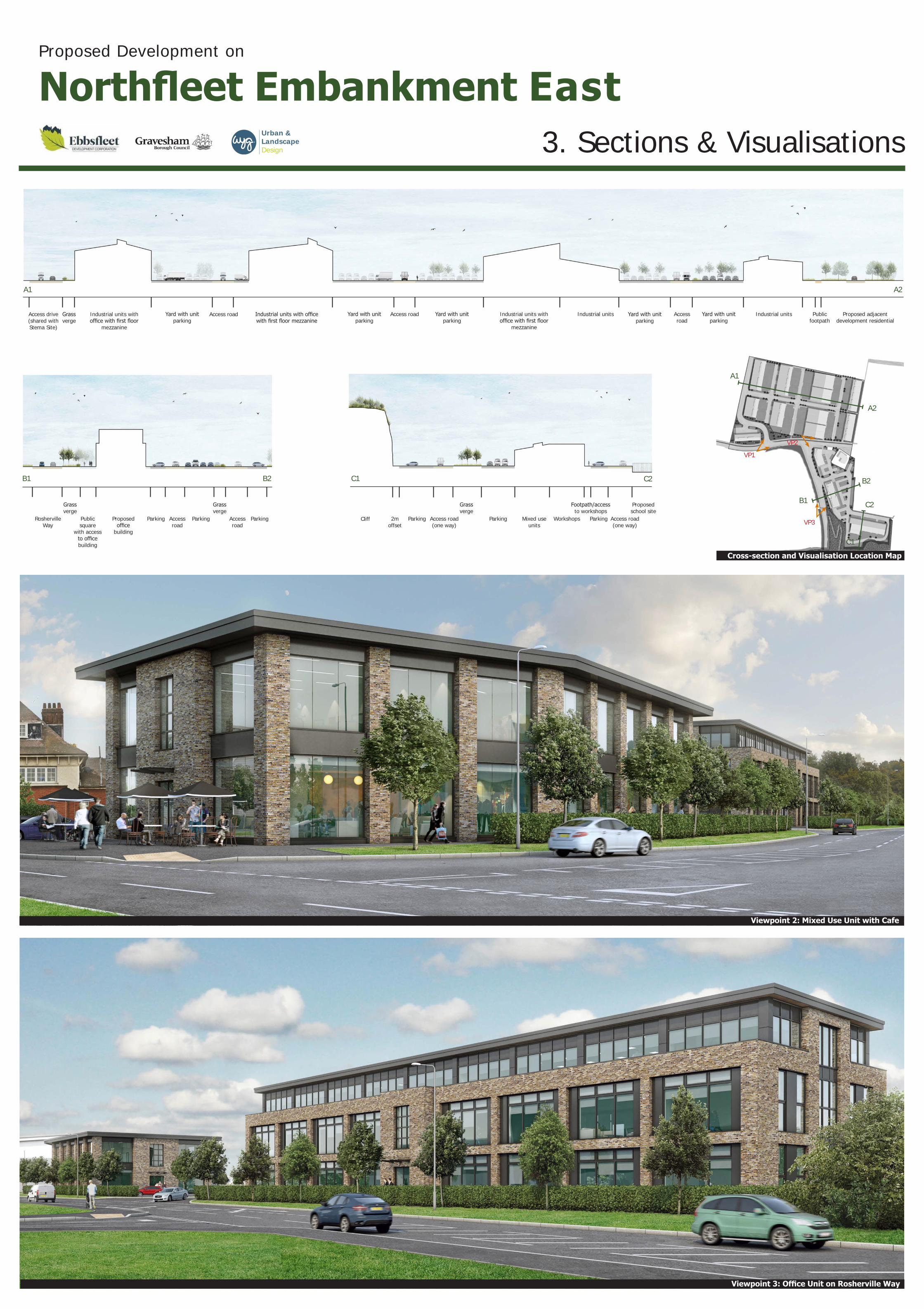
The north site will be occupied by 36 industrial units varying in size from 2659 to 10850 sq ft in size. The site is laid out to maximise its use and provide parking and yard areas for each of the business units. Site access will be from Crete Hall Road utilising the existing Stema access road. An east-west spine road will serve the business units. Pathway connections across the site connecting to the existing River Walkway and through to Crete Hall Road will provide good pedestrian access. The business units have been set back from the edge of Crete Hall Road to allow the introduction of a shared footpath/cycleway ensuring good access both east and west emphasised with planting of trees and hedgerows. On the north edge of the site a pathway with planting is established along the boundary with the Stema site to link to the River Walkway and ‘future proof’ the pathway should the opportunity arise to extend it further west along the River Edge.
The south site will be occupied by an office building intended as a business starter unit, a retail/office building fronting Crete Hall Road and Rosherville Way and a further 10 workshop units and 5no. industrial units varying in size from 1421 sq ft to larger units ranging to 4413 sq ft. The business starter building (Business Hub/Centre) and retail/office building are both setback from Rosherville Way allowing a buffer of planting (trees and low hedging) creating a safer and calmer environment away from the busy road and junction. The retail/office building has been positioned on the south east corner of Rosherville Way and Crete Hall Road to form a prominent ‘gateway’ building within the development. Parking will be provided for the offices and business units with yard spaces for the industrial units. A linked pathway will allow good pedestrian access across the site. An enclosed bike store hub will also be incorporated into the office/retail building to provide secure bike parking for site users.
A cycle path will be installed along Crete Hall Road connecting to proposed cycle paths on the Keepmoat residential site. Furthermore, the award-winning Fastrack bus service will be introduced to serve the Northfleet Riverside sites connecting the site to the local shopping areas and train stations.
Tree planting will be used to enhance the approaches to the site along the roads and enhance the landscape experience throughout the site. Hedgerow planting will provide a green structure of planting used to partially screen car parking from public areas and footpaths. The landscape strategy aims to improve the biodiversity of the site and provide connectivity for plants and animals as well as pedestrians.
The proposal will complement the residential scheme proposed by Keepmoat to the east. The form and scale of the business units and office buildings have been carefully configured along the boundary of the Keepmoat site and the development will form an important transition between the residential character of the Keepmoat development to the east and the industrial character of the Kimberley Clark Site to the west. The architectural style will reference the Henley building on the east edge of the Keepmoat site (one of the last remaining buildings associated with the former use of the site and noted for its art deco style) as well as elements of the Keepmoat development.
What happens next?
Following this exhibition an outline planning application will be submitted next month for the whole site bounded by the red line on the plans.
The plans and images shown on these boards are for illustrative purposes only. The detail of the buildings and layout will be determined through a reserved matters application following a grant of outline permission.
0 50m
Scale: 1:1000
Proposed Development on
Northfleet Embankment East2. MasterplanUrban &
Landscape Design
Stema Aggregates Site
Industrial Units
Office
Cafe/Office/Retail
Workshops & Industrial Units
Kimberly ClarkLTD Site
Proposed Keepmoat Residential Site
Proposed Primary School Site
Lidl DistributionSite
London Road B2175
Crete Hall Road
Rosherville Way
One Way
Access drive (shared with Stema Site)
Grass verge
Industrial units with office with first floor
mezzanine
Yard with unit parking
Access road Industrial units with office with first floor mezzanine
Yard with unit parking
Access road Yard with unit parking
Industrial units with office with first floor
mezzanine
Industrial units Yard with unit parking
Access road
Industrial units Public footpath
Proposed adjacent development residential
Rosherville Way
Grass verge
Public square
with access to office building
Proposed office
building
Parking Access road
Parking
Grass verge
Access road
Parking 2m offset
Cliff Parking Access road (one way)
Grass verge
Parking Mixed use units
Workshops
Footpath/access to workshops
Parking Access road (one way)
Yard with unit parking
A1 A2
B1 B2 C1 C2
Proposed school site
Viewpoint 2: Mixed Use Unit with Cafe
Viewpoint 3: Office Unit on Rosherville Way
A1
A2
B1
B2
C1
C2
Cross-section and Visualisation Location Map
VP3
VP1
VP2
Proposed Development on
Northfleet Embankment East3. Sections & VisualisationsUrban &
Landscape Design