Embed Size (px)
Citation preview
INTERNATIONAL JOURNAL OF GEOMATICS AND GEOSCIENCES
Volume 2, No 2, 2011
© Copyright 2010 All rights reserved Integrated Publishing services
Case study ISSN 0976 – 4380
Submitted on October 2011 published on November 2011 555
Property formation-Change in land related legal document TAN Liat Choon, Khadijah Binti HUSSIN
Universiti Teknologi Malaysia, Faculty of Geoinformation and Real Estate, 81310, Skudai,
Johor, Malaysia
ABSTRACT
In Malaysia, the cadastral system that has served us for more than a century may not be able
to continue doing so due to the lack of an advanced level of legal and technical framework. It
would appear, therefore, that the legal institutions needed to be further improved to enforce
land law satisfactorily. In view of the current Malaysian Cadastral System, the main task of
this research is to reformulate, further improve and enhance the usefulness of the existing
cadastral system and title registration of multi-layer properties. To realize this, the objectives
of this research are to examine the rights of land and property that dimension above, on and
below the ground surface as provided by the National Land Code 1965 (Act 56), Strata Title
Act 1985 (Act 318), the Building and Common Property (Maintenance and Management) Act
2007 (Act 663), Certified Plan and Document of Title, and to make recommendations for
changes to facilitate a modern Malaysian Cadastral and Land Administration Systems.
Keywords: 3D, Property rights, Cadastre, Land, Administration, Registration
1. Introduction
3D properties can divide into public ownership, common ownership, management ownership
and private ownership, the main problem is to clearly define and protect the rights in 3D
properties. Traditionally, the Malaysian Cadastral System consists of different structures.
Where, the jurisdiction for land registration is under the administration of the state
government while cadastral survey and mapping is under the federal government and is
managed by different government authorities. It was generally felt that, there should be one,
and only one, authority conferred with the power to grant and authenticate land titles. There
was concern that the security of tenures could otherwise be jeopardized.
In Malaysia, there is a lack of proper legislation regarding 3D property in land and cadastral
law to cater for the registration of any related legal and technical aspects. In this study,
feedback obtained from the questionnaires showed that 72% of the respondents were of the
opinion that there was no land law which incorporated the right for people to hold and
dispose of private rights in land in a 3D environment. Many conflicts seem to exist between
laws and statutes with the current cadastral status. Therefore, the rights associated with this
registration should be clear in the registry titles issued. About one-third of the respondents
thought that the current land laws defined 3D property rights clearly, while 58% thought that
they did not. Perhaps better 3D visualization should be developed and employed.
1.1 3D Property Rights
The concept of 3D property rights may vary depending on the national legal system (Stoter,
2002). According to Paulsson (2007), it is necessary to look at the legislations of different
countries that have implemented 3D property rights legislation in order to arrive at a
Property formation-Change in land related legal document
TAN Liat Choon, Khadijah Binti HUSSIN
International Journal of Geomatics and Geosciences
Volume 2 Issue 2, 2011 556
consensus for an exact definition. A common definition thus does not seem to exist. Hence,
each researcher dealing with this term would choose his or her own stipulated definition or
description.
2. Towards 3D Property Formation
Lately, the development of 3D cadastre registration are more on the technical part where
researchers study on the process of adding 3D cadastre objects in the current cadastre data
model and information, accessible amongst the Department of Survey and Mapping Malaysia,
State Land and Mines Office and District Land Office. Unfortunately, the two stated
database, which are Cadastral Data Management System (CDMS) and Computerized Land
Registration System (CLRS) database works separately in different authorities and is still not
in three-dimensional situation.
2.1 Ways to Achieve 3D Property Formation
In the way to achieve 3D property formation in Malaysia, we have to look into the issues
below:
1. The Cost of Transition
2. The Necessity of Changes in the Land Related Legislation
3. Handling of Cadastral Procedure
4. Definition of Boundary
5. Management of 3D Property
6. Fire Protection and Insurance in 3D Property
7. Building Renovation Issues
8. Registration of 3D Property Rights
9. Technical Issues
10. Organizational Issues
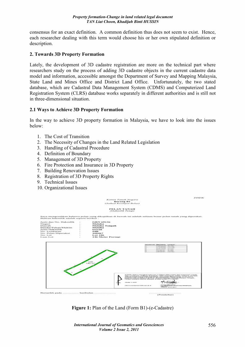
Figure 1: Plan of the Land (Form B1)-(e-Cadastre)

Property formation-Change in land related legal document
TAN Liat Choon, Khadijah Binti HUSSIN
International Journal of Geomatics and Geosciences
Volume 2 Issue 2, 2011 557
2.2 Related Legal Documents
There are three main legal documents beside Document of Title and certified plan that related
to 3D property type in Malaysia and as below:
11. National Land Code 1965 (Act 56)
12. Strata Title Act 1985 (Act 318)
13. Building and Common Property (Maintenance and Management) Act 2007 (Act
663)
2.3 Document of Title
There are six types of title depending on town land, village land or country land, the size,
which is more or less than ten acres, the term of years holding the land, and whether the land
has been performed the final survey. Recently, the implementation of e-Cadastre Malaysia
makes the format of Plan Of The Land (Form B1) in Document of Title simpler, however, it
still maintain all necessary attributes information. Sample copy of Plan of The Land (Form
B1) is shown in Figure 1 below.
Meanwhile, there are three types of title depending on different types of lands and areas
under Strata Titles Act 1985 (Act 318). Sample copy of strata title is shown in Figure 2
below.
Figure 2: Strata title
2.4 Cadastral Map (Certified Plan)
The authenticated cadastral map for Malaysia is called Certified Plan (CP). There are three
types of Certified Plan. Lately, the implementation of e-Cadastre Malaysia makes the format

Property formation-Change in land related legal document
TAN Liat Choon, Khadijah Binti HUSSIN
International Journal of Geomatics and Geosciences
Volume 2 Issue 2, 2011 558
of Certified Plan simpler, however, it still maintain the attributes information. Sample copy
of land parcel Certified Plan is shown in Figure 3 below.
Figure 3: Land parcel Certified Plan
Secondly, the Certified Strata Plan which contains the parcel information like floor areas,
parcel numbers, boundary dimensions where the buildings reside in a strata scheme and
additional information on the height of the building, number of floors/levels and the strata
parcels. However, there is no Certified Stratum Plan has been submitted until recently due to
lack of knowledge on cadastral survey and registration of stratum objects.
Figure 4: Certified Strata Plan

Property formation-Change in land related legal document
TAN Liat Choon, Khadijah Binti HUSSIN
International Journal of Geomatics and Geosciences
Volume 2 Issue 2, 2011 559
3. Recommendations for Amendment
As has been mentioned in this study, the need of the introduction of 3D property formation
exists in Malaysia, mainly in large cities. Therefore, we should look at the legal situations
where 3D property formation can be relevant and what changes should be made to the current
cadastral and land law in connection. Analysis of the Malaysian legislation allows us to state
that it already provides for some elements of three-dimensional concerning property. The
matter of ownership of these three dimensions has been very important concerning 3D
property rights.
3.1 National Land Code 1965 (Act 56)
Section 51 of the Code stated that land could presently be classified as land above the
shoreline, foreshore and seabed. New rules should be established due to the real need to be
able to create 3D properties in certain cases. Therefore, new interpretation of three-
dimensional property unit and three-dimensional property space should be given in section 5
and reads as follows:
“three-dimensional property unit” means a property unit which in its entirety
is delimited both horizontally and vertically.
“three-dimensional property space” means a space included in a property unit
other than a three-dimensional property unit and delimited both horizontally
and vertically.
Later, a new classification of land should be proposed immediate after section 51(1) and
reads as follows:
(1A) For the purpose of this Code, land shall also be classified as follows:
(a) three-dimensional property unit; and
(b) three-dimensional property space
Chapter 4, section 75A of the Code permits the use of air space above State land and reserved
land. The State Authority may in accordance approve the issue of a permit for a period not
exceeding twenty-one years for the purpose of erecting, maintaining and occupying a
structure on state land or reserved land, or over State land or reserved land as an adjunct to
any structure on the adjoining land. Air space includes dimension above the ground surface
for three-dimensional property unit and three-dimensional property space. Therefore, section
75A of the Code should be amended by adding a new paragraph right after second paragraph
of the existing section and reads as follows:
From the aforesaid it follows that a structure, as a rule, also includes three-
dimensional property unit and three-dimensional property space.
Section 92 of the Code stated the rights exercisable by any person or body to whom State
land has been alienated under final title and it shall include, first, the right to subdivide or
partition the land or building, or amalgamation it with other land or building, second, the
right to effect transfers, leases, charges, surrenders, and any other dealings, and finally the
right to dispose of the land or building, or any undivided share therein, by will. From the
above mentioned, it is to propose a new subsection 3 to be added and reads as follow:

Property formation-Change in land related legal document
TAN Liat Choon, Khadijah Binti HUSSIN
International Journal of Geomatics and Geosciences
Volume 2 Issue 2, 2011 560
(3) The rights exercisable by any person or body to whom State land has
been alienated under final title shall also include the rights for three-
dimensional property unit and three-dimensional property space.
Lastly, section 92A of the Code interprets underground land as land that lies below the
surfaces of the earth. Underground land includes dimension below the ground surface for
three-dimensional property unit and three-dimensional property space. Therefore, this
interpretation should be amended and the proposed wording reads as follows:
“underground land” means land which lies below the surfaces of the earth
and that shall also includes three-dimensional property unit and three-
dimensional property space.
3.2 Strata Titles Act 1985 (Act 318)
Section 6 of the Act stated that building having two or more storeys on alienated land held as
one lot under the final title shall be capable of being subdivided into parcels. In addition, any
land on the same lot shall also be capable of being subdivided into parcels each of which is to
be held under a strata title or an accessory parcel. New rules should be established due to the
real need for enabling the creation of 3D properties in certain cases. Therefore, new
interpretation of three-dimensional property unit and three-dimensional property space should
be given in section 4 and reads as follows:
“three-dimensional property unit” means a property unit which in its entirety
is delimited both horizontally and vertically.
“three-dimensional property space” means a space included in a property unit
other than a three-dimensional property unit and delimited both horizontally
and vertically.
Soon, a new subsection 1B to be added to section 6 and reads as follow:
(1B) From the aforesaid it follows that a building or land, as a rule, also
includes three-dimensional property unit and three-dimensional property
space.
Section 43 of the Act stated the duties and powers of Management Corporation. New rules
should be established due to the real need to enable the creation of 3D properties in certain
cases. Therefore, section 43 of the Act should be amended by adding a new wording after
subsection 8 and reads as follows:
(9) From the aforesaid it follows that the duties and powers, as a rule,
also include in three-dimensional property unit and three-dimensional
property space.
At the same time, section 44 of the Act illustrated by-laws for the regulation of a subdivided
building or land. New rules also should be established due to the real need to be able to
create 3D properties in certain cases. Therefore, section 44 of the Act should be amended by
adding a new clause after subsection 7 and reads as follows:

Property formation-Change in land related legal document
TAN Liat Choon, Khadijah Binti HUSSIN
International Journal of Geomatics and Geosciences
Volume 2 Issue 2, 2011 561
(8) From the aforesaid it follows that the by-laws, as a rule, also includes
in three-dimensional property unit and three-dimensional property space.
3.3 Building and Common Property (Maintenance and Management) Act 2007 (Act
663)
Owing to the real need to be able to create 3D properties in certain cases, new interpretation
of three-dimensional property unit and three-dimensional property space should be given in
section 2 and reads as follows:
“three-dimensional property unit” means a property unit which in its entirety
is delimited both horizontally and vertically.
“three-dimensional property space” means a space included in a property unit
other than a three-dimensional property unit and delimited both horizontally
and vertically.
Figure 5: Proposes land parcel Certified Plan (3D property)
Section 8 of the Act stated the powers of the Joint Management Body. New rules should be
established due to enable the creation of 3D properties in certain cases. Therefore, section 8
of the Act should be amended by adding a new clause after subsection 5 and reads as follows:
(6) From the aforesaid it follows that the powers, as a rule, also include
in three-dimensional property unit and three-dimensional property space.
Finally, section 14 of the Act illustrated house rules for the regulation of a subdivided
building or land. New rules also should be established due to the real need to be able to
create 3D properties in certain cases. Therefore, section 14 of the Act should be amended by
adding a new clause after subsection 2 and reads as follows:

Property formation-Change in land related legal document
TAN Liat Choon, Khadijah Binti HUSSIN
International Journal of Geomatics and Geosciences
Volume 2 Issue 2, 2011 562
(3) From the aforesaid it follows that the house rules, as a rule, also
includes in three-dimensional property unit and three-dimensional property
space.
3.4 Certified plan
In this study, it is to propose a litter minor changes to the format of the land parcel Certified
Plan where 3D property lot is indicated with backslash to the lot number (\ 17018 \).
The 3D property boundaries are specified by the specific line type of points on a dotted dash
line while the 3D property spaces are hatched and demarcated by a surface polygon. Sample
copies of 3D property proposes land parcel Certified Plan are shown in Figure 5. For
example, Lot 17018 is underground structure that dimension below ground surface, this
underground structure can be car parks or retail shops or for the proposes of utilities such as
tunnel can be considered as 3D properties, which different from other lots in the same
development.
Meanwhile, it is also to propose some minor changes to the format of the Certified Strata
Plan where 3D property parcel/3D property land parcel/3D property accessory parcel/3D
property mezzanine floor is indicated with backslash to the parcel or land parcel or accessory
parcel number (\ 1 \)/(\ L1 \)/(\ A1 \). The 3D property boundaries are specified by the
specific line type of points on a dotted dash line while the 3D property spaces are hatched and
demarcated by a surface polygon. In addition, it is suggested that synoptic drawings,
schematic drawings and detailed drawings in digital format to be attached to Department of
Survey and Mapping Malaysia upon submission.
Sample copies of 3D property proposes Certified Strata Plan, synoptic drawings, schematic
drawings and detailed drawings are shown in Figure 6, Figure 7, Figure 8 and Figure 9
respectively.
Figure 6: Proposes Certified Strata Plan (3D Property)

Property formation-Change in land related legal document
TAN Liat Choon, Khadijah Binti HUSSIN
International Journal of Geomatics and Geosciences
Volume 2 Issue 2, 2011 563
Figure 7: Proposes synoptic drawing (3D property)
Figure 8: Proposes schematic drawing (3D property)

Property formation-Change in land related legal document
TAN Liat Choon, Khadijah Binti HUSSIN
International Journal of Geomatics and Geosciences
Volume 2 Issue 2, 2011 564
Figure 9: Proposes detailed drawing (3D property)

Property formation-Change in land related legal document
TAN Liat Choon, Khadijah Binti HUSSIN
International Journal of Geomatics and Geosciences
Volume 2 Issue 2, 2011 565
3.5 Document of Title
In this study, it is to propose a few minor changes to the format of the form, where an
additional to be added in the express conditions. The document of title involved are Form
5BK, Form 5CK, Form 11AK, Form 5DK, Form 5EK, Form 11BK, Form 4(K) and Form
4A(K). The way it is designed is as below:
EXPRESS CONDITIONS
“The land comprised in this title is:
(a) A three-dimensional property unit that in it is entirely is delimited both
horizontally and vertically.
OR
(a) A three-dimensional property space included in a property unit other than
a three-dimensional property unit and delimited both horizontal and
vertically.
OR
(a) A traditional property unit that includes one or more three-dimensional
property space.
OR
(a) A joint property unit that in a whole is distinct both horizontally and
vertically.
OR
(a) A space contained in a traditional joint property unit and bound on both
horizontally and vertically.
OR
(a) A traditional joint property unit that includes one or more three-
dimensional joint property unit spaces.
OR
(a) A space of a building joint property unit or delimited both horizontally
and vertically.
OR
(a) A real property as new construction or conversion of three-dimensional
space.”
Apart from the above-mentioned amendments on express conditions, the Plan Of The Land in
Form B1 (for final title), Form B2 (for qualified title) and Plan Of Strata Title in Form S(K)
should follow the format of Certified Plan that generated by Department of Survey and
Mapping Malaysia. A 3D property Plan Of the Land in Form B1 and Form B2 is indicated
with backslash to the lot number (\ 106 \).
Meanwhile, a 3D property parcel/3D property land parcel/3D property accessory parcel/3D
property mezzanine floor in Plan Of Strata Title is indicated with backslash to the parcel or
land parcel or accessory parcel number (\ 1 \)/(\ L1 \)/(\ A1 \). The property boundaries for
3D property are specified by the specific line type of points on a dotted dash line. 3D
property spaces are hatched and demarcated by a surface polygon. Sample copies of 3D
property proposes Plan Of The Land (Form B1) and Plan Of Strata Title (Form S(K)) are
shown in Figure 10 and Figure 11.

Property formation-Change in land related legal document
TAN Liat Choon, Khadijah Binti HUSSIN
International Journal of Geomatics and Geosciences
Volume 2 Issue 2, 2011 566
Figure 10: Proposes Plan of the Land (3D property)
Figure 11: Proposes Plan of Strata Title (Form S(K)) (3D property)
4. Conclusion
The main purpose of this paper was to try to come to the generalized concept of 3D property
rights and to suggest the possibilities of the implementation of this concept into current
cadastral and land law practice in Malaysia as well as to identify possible problems emerging

Property formation-Change in land related legal document
TAN Liat Choon, Khadijah Binti HUSSIN
International Journal of Geomatics and Geosciences
Volume 2 Issue 2, 2011 567
in this connection and to suggest ways to solve them. In this respect, many legal, technical
and organizational matters should be investigated. This study is forced on the legal issues,
nevertheless, the overview of technical and organizational issues is provided for the
comprehensive understanding of the problem in question.
In order to establish an information base of the whole system, two technical issues should be
solved. One of them is the creation of the suitable data model for representing and managing
3D properties in the cadastral information system. The most optimal solution today is to use
object-oriented approach. The second issue is the way to conduct 3D cadastral mapping. It
should be carried out in carefully selected areas with the use of remote methods of data
acquisition, which are most effective for that purpose nowadays. The resulting products are
3D models that can be visualized and thus provide a clear insight into the property rights
associated with a particular 3D property.
5. References
1. Building and Common Property (Maintenance and Management) Act (2007),
Building and Common Property (Maintenance and Management) Act 2007 (Act 663).
As at 5th January 2010.
2. National Land Code (1965), National Land Code (Act 56 of 1965) & Regulations. As
at 20th January 2010.
3. Paulsson, J. (2007), 3D Property Rights-An Analysis of Key Factor Based on
International Experience. Ph.D. Thesis. Royal Institute of Technology, Stockholm,
Sweden.
4. Stoter, J. E. (2002), From 2D Parcels to 3D Registrations. 3D Cadastres: State-of-the-
art. GIM International. February 2002.
5. Strata Titles Act (1985), Strata Titles Act 1985 (Act 318) & Rules and Order. As at 1st
February 2010.