Embed Size (px)
Citation preview
January 2014 City Design Group
Project report
Our PlaceEnabling communities to characterise their neighbourhood
January 2014

January 2014 City Design Group
Our Place Project Report2
This document has been produced byPeter Insole, Senior Archaeological Officer, City Design Group and Richard Guise, Context4D
No portion of this document can be reproduced without the permission of City Design Group, Neighbourhoods and City Development, Bristol City Council
© Crown Copyright and database rights 2014 Ordnance Survey 100023406
© City Design Group January 2014

January 2014 City Design Group
Our Place Project Report 3
3 Follow on projects 33
4 Evaluation 37
5 Conclusion 47
1 Introduction 4
2 Case studies 13
Contents
1 Neighbourhood planning2 Development plan document 3 Conservation area appraisal 4 Proposed public realm improvements 5 Historic landscape understanding
1416182622
Appendix 1 - Mapping: A user’s guide to street surveys
Appendix 2 - Examples of notation sheets
Appendix 3 - IHBC Southwest conference
Appendix 4 - Our Place project products
57
69
75
80

January 2014 City Design Group
Our Place Project Report4
January 2014 City Design Group
Our Place Project Report 5
Project report
1 Introduction
January 2014 City Design Group
Our Place Project Report6
Summary
The Our Place project was designed and managed by the Bristol Historic Environment Record (HER)within the City Council’s City Design Group. The project was funded by English Heritage and was run in partnership with Richard Guise and James Webb of Context4D.
Our Place aimed to test a model approach that enables communities to identify and map the character of their local area. To achieve this a series of mapping events was programmed in a variety of locations and with diverse communities. The project also aimed to develop methodologies for capacity building within neighbourhoods and how these skills can be shared more widely.
The project promoted an approach where local understanding of character and wide community engagement is thoroughly embedded in any neighbourhood planning or design process.
At the end of each mapping event an ‘Our Place’ document defining the character of the area was produced. These documents were published in draft form on the Design Bristol ning social media site http://designbristol.ning.com/ and comments invited by the wider community.
Each mapping process also identified assets of heritage value and promoted nominations to Bristol’s Local List.
1 Introduction
Background
The Bristol HER is managed and maintained by the City Council’s multidisciplinary City Design Group (CDG). The Group aims to help shape new quality places and help to improve the quality of existing neighbourhoods (www.bristol.gov.uk/urbandesign). CDG is working with communities to achieve these aims through a programme of Conservation Area Character Appraisals, neighbourhood planning initiatives and landscape management projects. The Group is actively involved with the DCLG ‘Frontrunner’ (formerly ‘Vanguard’) Neighbourhood Planning project in Lockleaze where the council and community are working in partnership to deliver sustainable neighbourhood improvements.
The Conservation and Historic Environment policy (BCS22) in the Bristol Core Strategy, adopted in 2011, refers to the undertaking of a citywide urban context analysis. The document goes on to say that this analysis will contribute to the delivery of the policy and should be informed by community involvement.
With funding from the English Heritage HER21 initiative CDG developed the award winning ‘Know Your Place’ web resource (www.bristol.gov.uk/knowyourplace) which was launched in March 2011. The project to create the website and subsequent promotion (exhibitions, talks and conferences) has dramatically raised the profile of the HER and CDG.

January 2014 City Design Group
Our Place Project Report 7
From January 2013, the ‘Know Your Place’ resource has become the primary tool for creating a Local List for Bristol. Members of the public are able to use the website to nominate entries to the List and comment on nominations.
In March 2012, CDG in partnership with English Heritage held the Localism and Heritage conference in Bristol. The event was attended by Local Authority professionals and representatives from local groups chiefly from the Bristol area, but also from across the UK. Work groups at the conference explored concerns, opportunities and potential impacts on heritage assets that may result from the localism agenda, particularly with regard to the neighbourhood planning process (Localism and Heritage: Working Together Conference Report, 2012, page 29 http://designbristol.ning.com/profiles/blogs/localism-and-heritage-conference-report ). One of the key conclusions from the day was that delegates felt there should be more opportunities to involve a wider community demographic including school children.
Bristol has a range of active groups that are involved with neighbourhood issues. The multi-disciplinary nature of CDG and the innovative web resource ‘Know Your Place’ means that the team is ideally suited to help communities make informed decisions about their neighbourhoods.
Our Place aimed to draw on these strengths and opportunities and develop a transferable methodology that embeds community participation in the placemaking process.
“… more needs to be done for young people at school level,”
Localism and Heritage: Working Together
Fig 1 Localism and Heritage conference, 2012
January 2014 City Design Group
Our Place Project Report8
Aims and objectives
The project aimed to: Encourage greater participation in
neighbourhood planning related activities related to developing an understanding of place and heritage assets and effectively use this understanding to inform proposals.
To develop a transferable model or series of model approaches to public participation in place related analyses. This model will include involving schools and school children and hard to reach audiences as well as community and neighbourhood groups.
To widen awareness of and involvement in the Local List process and drive more content towards Know Your Place.
To create a greater understanding and appreciation of Bristol’s heritage including a more detailed understanding and appreciation of the 20th century fabric of the city.
To stimulate an awareness of neighbourhood qualities and sense of place and to identify their physical attributes.
One of the key objectives of the project was to establish a common language that would be appropriate for community use, but also fit for purpose in terms of planning policy and design processes.
1 Introduction
The aims of the project were met through a series of public workshop events that involved a variety of participants from local communities in three distinct neighbourhoods:
Easton/Whitehall (mixed residential area consisting of Victorian terraces and inter-post war council housing outside of any Conservation Area and with a large Asian and Somali population)
Fishponds (Medieval village subsumed within Victorian residential urban expansion, partly within the Stapleton and Frome Conservation Area)
St Pauls/St Agnes (Inner City residential area consisting of Victorian terraced housing and late 20th century developments outside of any Conservation Area, but within the area of the proposed Bristol Central Area Action Plan).
Westbury-on-Trym (historic village now subsumed within suburban interwar development. Westbury-on-Trym is a Conservation Area that is in need of review. The community are in the early stages of creating a neighbourhood design guide having decided against creating a Neighbourhood Plan).
Prior to these workshops elements of the Our Place approach were trialed at events at Lockleaze (a post war housing estate currently involved in the process of neighbourhood planning) and the Old City where public realm improvements are proposed.
The project used Design Bristol ning social media site as a communication tool for both promotion of the individual activities and publication of the results.

January 2014 City Design Group
Our Place Project Report 9
Fig 2 Community mapping
1 Whitehall
2 Oldbury Court
3 St Pauls
4 Westbury-on-Trym
5 Lockleaze
6 Old City
1 2
3 4
5 6

January 2014 City Design Group
Our Place Project Report10
The development of a tool for neighbourhood appraisal
The mapping technique used in the Our Place project has been developed from earlier work for undergraduate and post graduate planning and urban design students’ coursework, by Richard Guise, Context4D.
The aim was to expand the language to appraise urban places and use notation symbols to identify on maps the characteristics of particular townscapes. The mapping notation was initially took inspiration from Gordon Cullen’s publication ‘Notation’, in his short series published by Alcan, in 1967. (fig 3-1), and from Kevin Lynch in ‘The Image of the City’ (MIT 1960), (fig 3-2 and 3). These early works have been adapted and expanded by Richard Guise, who has developed the symbols and tested them over many years, with students, professionals and amenity groups.
The notation was further developed in a number of design guides produced by Context4D, for a number of local planning authorities, (fig 3-4), where it was recommended that developers use this technique to appraise their sites and site context as part of design statements to accompany planning applications.
A full description of notation that has resulted from testing and development during the Our Place project is provided in the User Guide (Appendix 1).
Fig 3 Notation publications
1 Notation, Gordon Cullen, 1967
2 The Image of the City, Kevin Lynch, 1960
1 2
1 Introduction
“The notation symbols have been designed to apply to the majority of urban environments, although there will always be some areas which have other distinguishing features, not included on the symbol sheet. The blank boxes on the sheets are indicators and reminders that groups should devise their own symbols as necessary.”
Participation in Heritage (section 4)

January 2014 City Design Group
Our Place Project Report 11
Fig 4 Notation styles
1 Extract from Notation, Gordon Cullen, 1967
2 Extract from The Image of the City, Lynch, 1960
3 Notation example, Context4D
1 2
3

January 2014 City Design Group
Our Place Project Report12
January 2014 City Design Group
Our Place Project Report 13
Project report
2 Case studies
January 2014 City Design Group
Our Place Project Report14
Neighbourhood planning
Lockleaze is an extensive post war housing estate in north Bristol and a priority regeneration area for the city. In 2012 Bristol City Council Cabinet approved the use of public funds and council assets at Gainsborough Square, to:
Deliver improvement in the quality and viability of the local centre and surrounding streets
Increase employment opportunities and housing number
Provide better links within the estate and to citywide destinations.
As a consequence of this commitment of funds City Design Group were tasked with managing a community consultation process to inform design proposals for neighbourhood regeneration.
The area is not a conservation area and contains no designated heritage assets although it lies immediately adjacent to the Grade II registered historic park and garden of Stoke Park.
Challenge
As a housing estate built in the late 40s and early 50s, Lockleaze has little perceived historic or character value in a traditional sense.
The regeneration of Lockleaze has been discussed for over 10 years with little or no visible signs of physical improvements. As a consequence existing amenity groups in the area are well organised action groups who have a clear view of the improvements that they want.
Despite these two issues City Design Group wanted to ensure that an understanding of context and community participation were both embedded within the design process.
Approach
It was decided to begin the engagement process and raise the interest in the physical environment of Lockleaze through a Know Your Bristol style community event. This is a tried and tested model that has been developed in partnership with the University of Bristol. At a Know Your Bristol event members of the public are invited to attend a local community facility to view a small exhibition of existing historic material and share their stories of the local area. At Lockleaze we held Know Your Lockleaze at the Cameron Centre, the local community venue. Ian Haddrell a local historian and author of books on the history of Lockleaze brought along his own archive of historic images and members of the university Know Your Bristol team assisted in recording oral histories and digitising people’s personal archive material. These digital records were then added to the community layer on Know Your Place.
Shortly following the Know Your Lockleaze event, City Design Group held a Placecheck event at the Cameron Centre. Placecheck is a National Heritage Protection Plan funded tool that consists of one or more walkabouts, followed by discussion and thinking about the next place making steps. The aim of the Lockleaze event was to encourage community participation in the neighbourhood design process of Gainsborough Square. The event began with a context mapping activity where members of the community were divided into four small groups and each given a corner of the square to map. Each group had a base map of part of the square, a simple notation key, clip board, coloured pens and a CDG facilitator.
Our Place Lockleaze
January 2014 City Design Group
Our Place Project Report 15
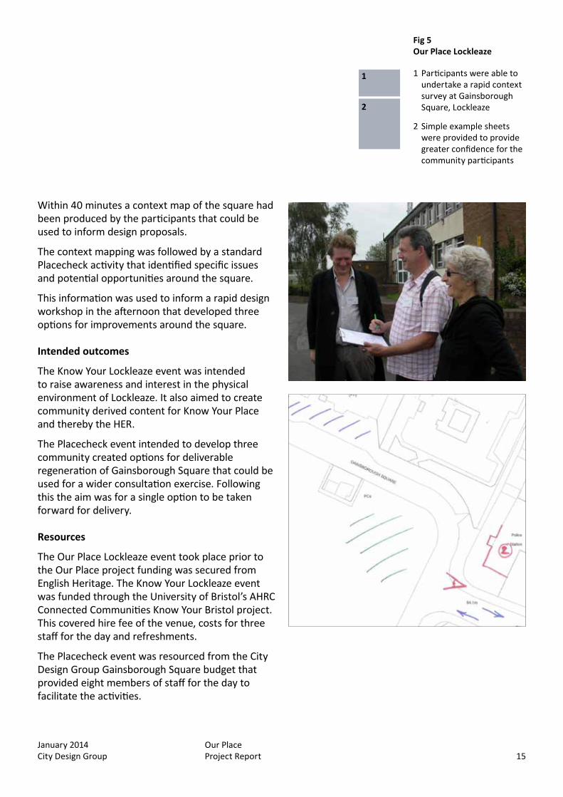
Within 40 minutes a context map of the square had been produced by the participants that could be used to inform design proposals.
The context mapping was followed by a standard Placecheck activity that identified specific issues and potential opportunities around the square.
This information was used to inform a rapid design workshop in the afternoon that developed three options for improvements around the square.
Intended outcomes
The Know Your Lockleaze event was intended to raise awareness and interest in the physical environment of Lockleaze. It also aimed to create community derived content for Know Your Place and thereby the HER.
The Placecheck event intended to develop three community created options for deliverable regeneration of Gainsborough Square that could be used for a wider consultation exercise. Following this the aim was for a single option to be taken forward for delivery.
Resources
The Our Place Lockleaze event took place prior to the Our Place project funding was secured from English Heritage. The Know Your Lockleaze event was funded through the University of Bristol’s AHRC Connected Communities Know Your Bristol project. This covered hire fee of the venue, costs for three staff for the day and refreshments.
The Placecheck event was resourced from the City Design Group Gainsborough Square budget that provided eight members of staff for the day to facilitate the activities.
Fig 5 Our Place Lockleaze
1 Participants were able to undertake a rapid context survey at Gainsborough Square, Lockleaze
2 Simple example sheets were provided to provide greater confidence for the community participants
1
2
January 2014 City Design Group
Our Place Project Report16
Actual outcomes
The community shared a lot of information about the history of Lockleaze enhancing the HER/KYP. The information provided helped us understand some significant issues about Lockleaze that we would have been unaware of without having the Know Your Lockleaze event. These include the strong sense of community in the place, in part born out of the early history of the estate where in the 1950s the community had few facilities and built their own community centre from former army Nissan huts. The stories also revealed how important the secondary school (now closed) and sports club (the Dings) was to community cohesion.
The context mapping and subsequent Placecheck activity rapidly introduced placemaking concepts such as scale, massing, street enclosure as well as demonstrating positive elements of the existing character such as views and permeability. This helped to enable a relatively sophisticated placemaking workshop that defined some regeneration options based on the funding and potential development parameters.
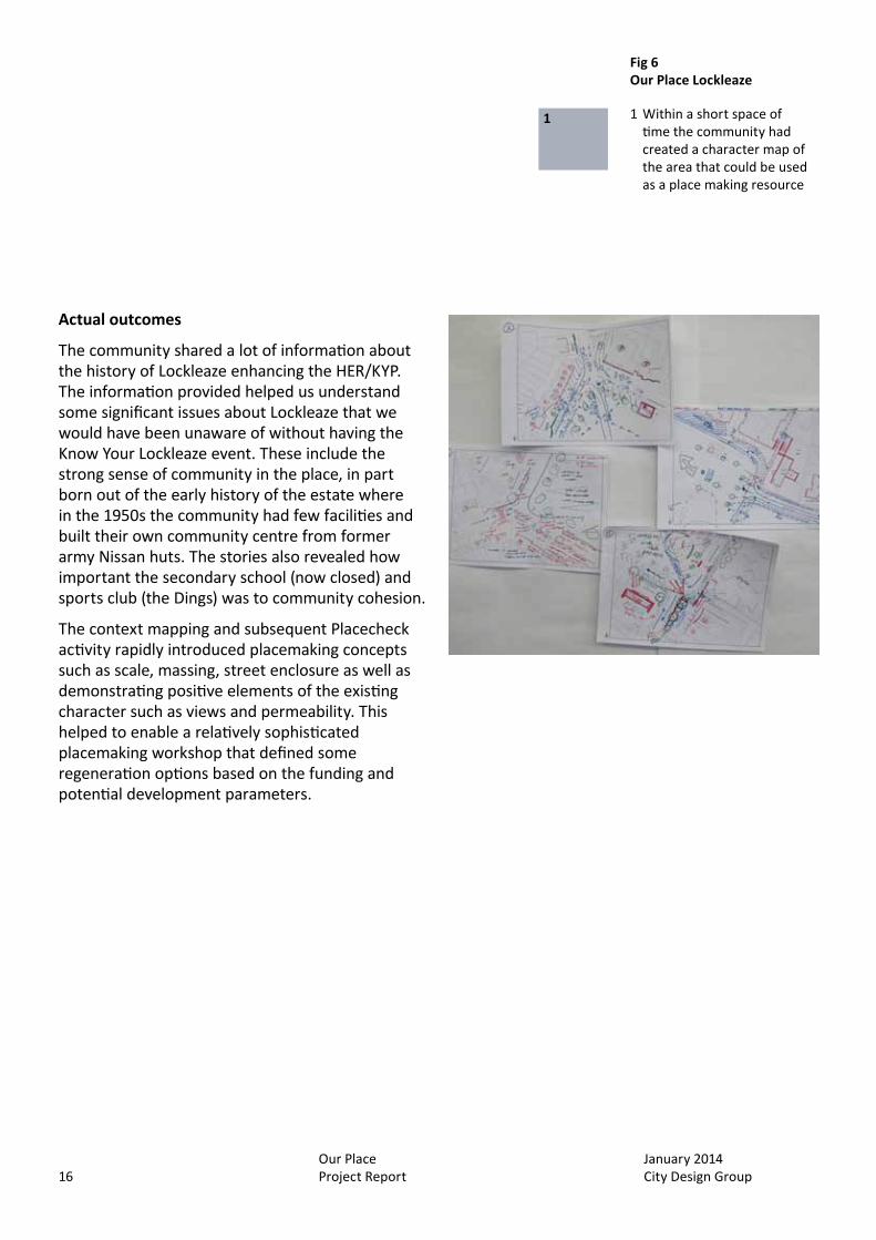
Fig 6 Our Place Lockleaze
1 Within a short space of time the community had created a character map of the area that could be used as a place making resource
1

January 2014 City Design Group
Our Place Project Report 17
Lessons learned
The whole series of activities raised an interesting question about who is the community that we are trying to engage with and encourage participation.
Members of the public who came to the Know Your Lockleaze event and shared their stories were not necessarily the same community who attended the place check event. This means that there was a potential disconnect between the understanding of local heritage and significance and the actual outcomes of the Placecheck event. In order to ensure that there was a direct relationship between the historical, social and cultural significance of the place and the regeneration proposals an officer or officers need to attend all the events and input where necessary. Ideally these connections would be community led, but Our Place Lockleaze has demonstrated that this is not always going to be possible.
One significant element highlighted through the consultation process demonstrates the value of community participation in the process. The context mapping identified that the buildings that provided a strong sense of enclosure around the square were three storeys high. When the regeneration options were proposing new structures of similar scale and massing there were some consultation responses that suggested this was too big until it was pointed out the context mapping undertaken by community participants had defined this existing appropriate scale and massing.
The collaboration of different stakeholders and pooling of resources from different, but associated projects enabled a very holistic approach, wide participation and clear, demonstrable outputs.
“…they all got together and they bought one of the huts from…the squatter’s camp and…they took it all down and they transported it up to Gainsborough Square on the corner facing Cameron Centre now and that was the first community place to get together…”
Know Your Lockleaze, June 2013
Fig 7 Our Place Lockleaze
1 Placecheck event, Cameron entre, Lockleaze, July 2012
1
January 2014 City Design Group
Our Place Project Report18
Development Plan Document
St Pauls is largely a Victorian inner city suburb interspersed with areas of post war low rise residential developments. There is an existing Neighbourhood Plan Supplementary Planning Document (SPD) for the area that details several sustainable future objectives. These include design considerations and lists 15 contextual issues that developers should consider as part of any planning process (http://www.bristol.gov.uk/sites/default/files/documents/planning_and_building_regulations/planning_policy/local_development_framework/SPD10%20-%20St%20Pauls.pdf).
As part of the developing Bristol Local Plan a Development Planning Document (DPD) covering specific planning issues in the central area (Bristol Central Area Plan) has been produced. To inform the spatial policies in this document City Design Group have worked on a Central Area Context Study that draws from existing conservation area documents and other studies.
Because the majority of St Pauls lies outside any designated conservation area the base line evidence to inform the St Pauls character area section of the context study was lacking. It was therefore proposed to use the Our Place methodology to define the character of St Pauls for the basis of the context study. This information would also address the 15 contextual issues identified in the existing SPD providing further clarity to potential developers.
Challenge
The character area of St Pauls as defined by the context study document consists of large areas post war low rise residential blocks that have a perceived low heritage and character value for people living outside of St Pauls.
The population of the area have also had limited involvement with planning related issues for a variety of reasons. Many people living in the area are recent migrants and some areas have traditionally had a transitory population.
These issues make this an area with a ‘hard to reach’ and ‘hard to engage’ demographic without major resource investment.
Approach
The challenges faced in terms of engagement and participation meant that we decided to begin with a school project and aim to reach the community through the children’s parents, their friends and neighbours.
We worked with Year 5 (9-10 years old) at St Barnabas Primary School, many of these children live within the St Pauls character area. The class was divided into 4 groups and each given a specific area to map using the notation sheet as a guide.
Following this we created a small exhibition of this character mapping that went on display for a week at the local community centre and invited members of the community to provide comments.
At the end of the exhibition we held a community character mapping event on the Saturday where we wanted to compare the children’s mapping with that of the wider community. We also used this event as taster session for participants for future Our Place activities.
Our Place St Pauls
January 2014 City Design Group
Our Place Project Report 19
Intended outcomes
The aim was to create an Our Place St Pauls document from the mapping work by the children and the community that defined the local character.
This would then be used to inform the St Pauls character area description in the Bristol Central Area Context Study.
Resources
The mapping activity with the school required four project staff for half a day. These consisted of two people from City Design Group and two from Context4D. Each mapping group also needed to be accompanied by a member from the school staff.
The exhibition was designed and printed by City Design Group and consisted of A1 posters on existing display boards. Space at the community centre was hired for the week and included hire for the community mapping event.
The community event was staffed by two members from the project team.
All costs including materials were resourced from the Our Place project budget.
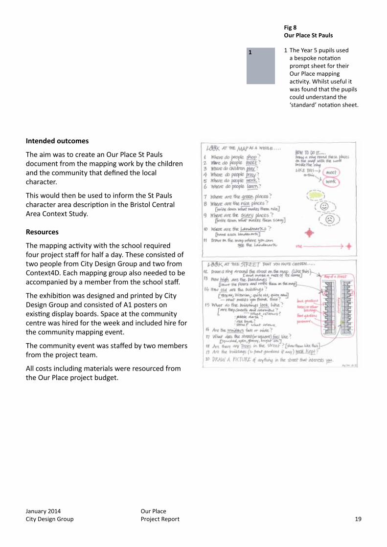
Fig 8 Our Place St Pauls
1 The Year 5 pupils used a bespoke notation prompt sheet for their Our Place mapping activity. Whilst useful it was found that the pupils could understand the ‘standard’ notation sheet.
1
January 2014 City Design Group
Our Place Project Report20
Actual outcomes
The most successful element of the St Pauls project was the work with the school. This produced good character maps that could be used for the exhibition. The work also complemented the pupil’s learning objectives in terms of geography as well as literacy and the school’s community curriculum that promotes the use of local resources for learning.
The community mapping event was less successful. Because of the project programme Our Place St Pauls was timetabled for March. This meant that we were taking a risk with the weather. The weather during the school activity day was dry, but overcast. For the community event the Saturday the temperature was freezing despite being dry. Consequently we had few participants, although there were a few parents from the school, and those that did attend were not able to work outside for long.
One successful element from community event was providing the taster session for future Our Place participants. This gave these members of the public encouragement and confidence for their own Our Place project.
Despite the limited output from the community mapping we were able to produce a draft Our Place St Pauls document that was published on Design Bristol http://designbristol.ning.com/profiles/blogs/our-place-st-pauls-draft-document and has gone on to inform the draft Central Area Context study http://www.bristol.gov.uk/sites/default/files/documents/planning_and_building_regulations/planning_policy/local_plans/City%20Centre%20Context%20Study%20-%20Section%204.pdf
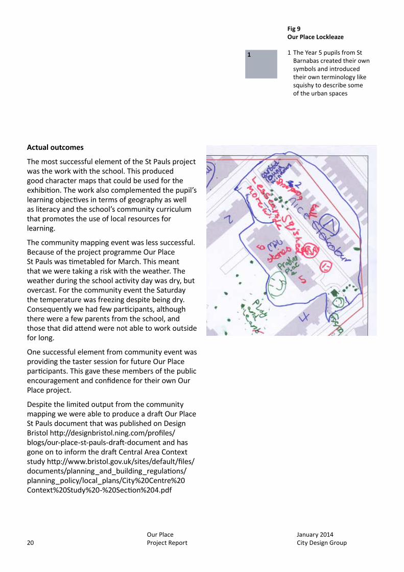
Fig 9 Our Place Lockleaze
1 The Year 5 pupils from St Barnabas created their own symbols and introduced their own terminology like squishy to describe some of the urban spaces
1

January 2014 City Design Group
Our Place Project Report 21
Lessons learned
Community character mapping will only have a chance of guaranteed success in the summer months. It is possible to cope with rain through the use of large umbrellas, but when it is bitterly cold a street mapping activity will be fairly unproductive.
Our Place St Pauls has demonstrated that working with an appropriate school group can produce meaningful results that are beneficial to the stakeholders as well as the school in terms of learning outcomes. The maps that were produced provided an interesting and unexpected perspective on the local area. The spaces around the low rise residential blocks that are often unvalued aesthetically by many Bristolians were regarded as important local assets by the children. These are car free green spaces that allow safe play with natural all round surveillance from the enclosing dwellings. The children also added their own notation and language to describe the aesthetics of a street, for example a Victorian terraced street was identified and described as ‘squashy’ that translates to tight urban grain as a technical definition.
Initially the standard notation sheet was simplified for the children to use, however, following liaison with the teacher and seeing how quickly the pupils gained an understanding of the task it became clear that the more standard form of notation could be used.
Year 5 is a good age group to work with because they do not have the same exam pressures as a Year 6 group would have, so there is a potential for more flexibility around timetabling and outputs.
It was clear from discussions with the class teacher that she immediately recognised the learning potential of the mapping activity and the use of notation.
This project also demonstrated that with the right communication strategy it is possible to reach the wider community through working with the local school.
Fig 10 Our Place St Pauls
1 Despite the cold community participants were able to map some of the local context1
January 2014 City Design Group
Our Place Project Report22
Conservation area appraisal
Westbury-on-Trym is a historic village that is now a suburb and local centre in north Bristol. The village centre including the church and medieval college site is a conservation area designated in 1971. However, the most recent document related to this designation is an enhancement statement from 1993 http://www.bristol.gov.uk/sites/default/files/documents/planning_and_building_regulations/conservation/conservation_area_enhancement_statements/02%20-%20Westbury-on-Trym.pdf
There are few large scale development pressures in the area, however, the local amenity group, the Westbury-on-Trym Society, has become concerned that incremental change is impacting on local character. As a result they have begun a process to create a Community Design Statement that will provide clear guidance for future change and development proposals in the area.
The society identified that stage one of this design statement process should be an assessment and boundary review of the existing conservation area followed by the characterisation of the surrounding areas that comprise the rest of their ward.
Consequently the society approached City Design Group for support being aware of the local authority’s conservation area appraisal programme. We offered to help through the Our Place project.
Challenge
We wanted to ensure that the notation system and character mapping approach being developed for the Our Place project would be flexible and robust enough to enable community groups to undertake conservation area character appraisals.
One of the objectives was to review the boundary of the conservation area and we needed to ensure that the Our Place system would enable this.
Approach
A community mapping activity day was organised at the Westbury-on-Trym village hall. The co-ordinating of this including invitations to participants was undertaken by the Westbury-on-Trym Society.
The event began with a short introduction that covered the historical development of Westbury-on-Trym using the Know Your Place resource.
Following this introduction the participants were divided into small groups and given a specific area to map using the notation sheet accompanied by an Our Place facilitator.
Intended outcomes
The mapping activity was intended to gather information to enable the production of an Our Place Westbury-on-Trym draft document that could then be assessed in order to ensure that the information produced could be taken forward for a draft conservation area character appraisal.
As with any Our Place activity it was hoped that nomination for the Local List would also be identified.
Our Place Westbury-on-Trym
January 2014 City Design Group
Our Place Project Report 23
Resources
The mapping activity day was staffed by four members of the Our Place project team and assisted by a placement student from the University of the West of England.
All costs including materials were resourced from the Our Place project budget.
Actual outcomes
The community mapping activity was attended by 20 members of the local community. This meant that we could map the whole conservation area in a single day and by the end of the week create a draft Our Place document that defined the local character.
We used this initial draft document to define individual character areas and propose amendments to the existing conservation area boundary.
There were some gaps in the data that means the draft document fell short of being a full character appraisal, however, members of the society were willing to address these in order to produce a consultation draft character appraisal.
The whole process took just over a week to create the draft document that was published on Design Bristol (http://designbristol.ning.com/profiles/blogs/our-place-westbury-on-trym) and presented to a Westbury-onTrym Society meeting and was very well received.
The society have already used the document to present evidence to a planning appeal and to a developer as part of a pre-application process.
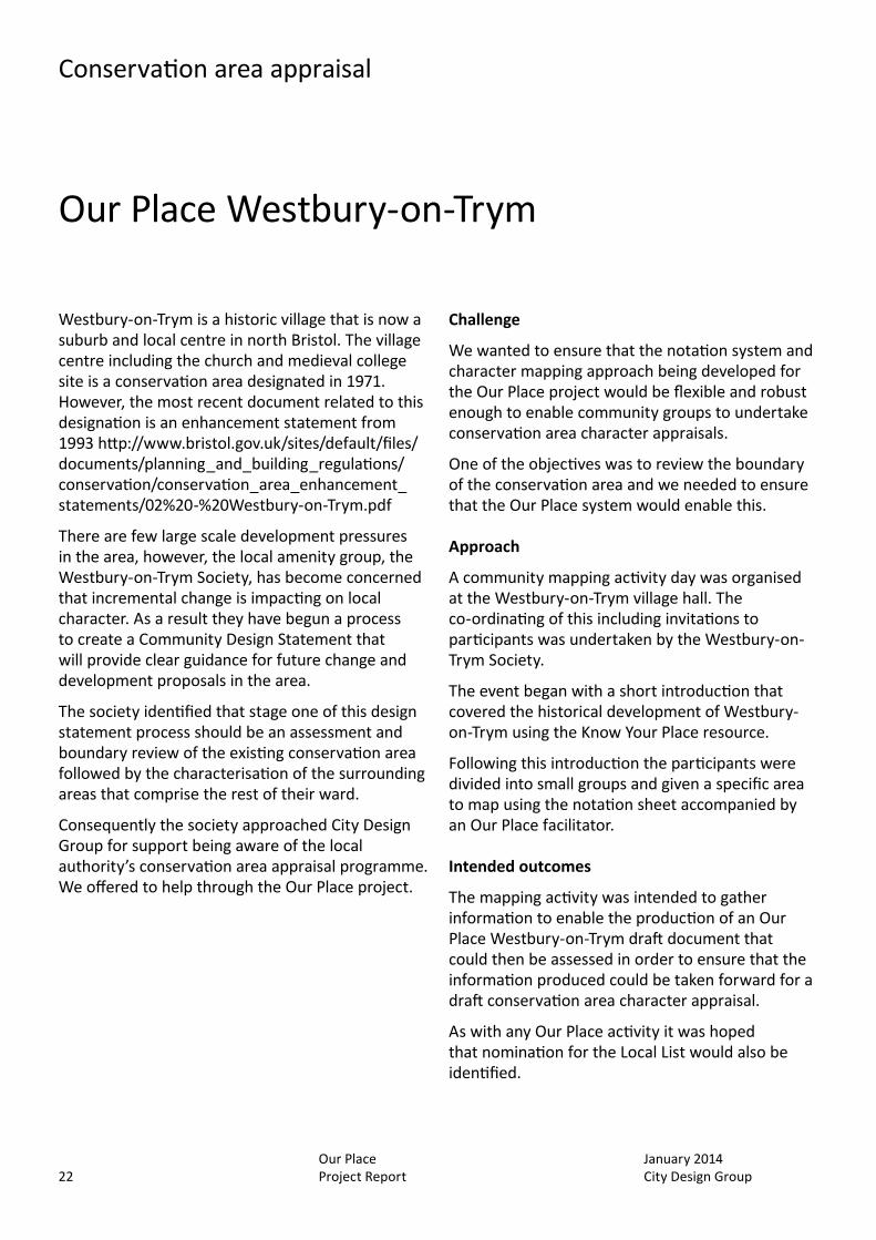
Fig 11 Our Place Westbury-on-Trym
1 Our Place Westbury-on-Trym used the local village hall as a base which provided plenty of space to gather round maps and discuss the activity
1

January 2014 City Design Group
Our Place Project Report24
Lessons learned
Working in partnership with a local amenity group who have a clear idea about what they want to achieve can produce effective results. The community are going to undertake further Our Place mapping of the whole of their local ward and use the base line evidence on character to inform their community plan (see section 4).
The project at Westbury-on-Trym has also demonstrated that using the Our Place approach it is possible to create a conservation area character appraisal very rapidly without being overly resource dependant. The process also ensures that the information can be presented to the authority in an appropriate format.
The most challenging aspect is the definition of character areas. This was very difficult for the participants to tackle and required the greatest amount of specialist support. In the end the Our Place team defined the character areas and asked the community to comment on them.
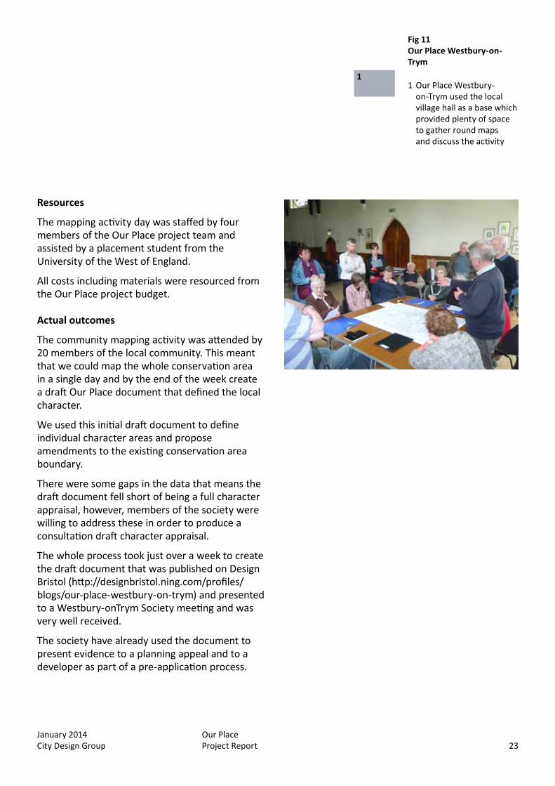
Fig 12 Community mapping
1 - 2 A lot of ground could be covered in a short space of time with the number of participants on the day
1
2
January 2014 City Design Group
Our Place Project Report 25
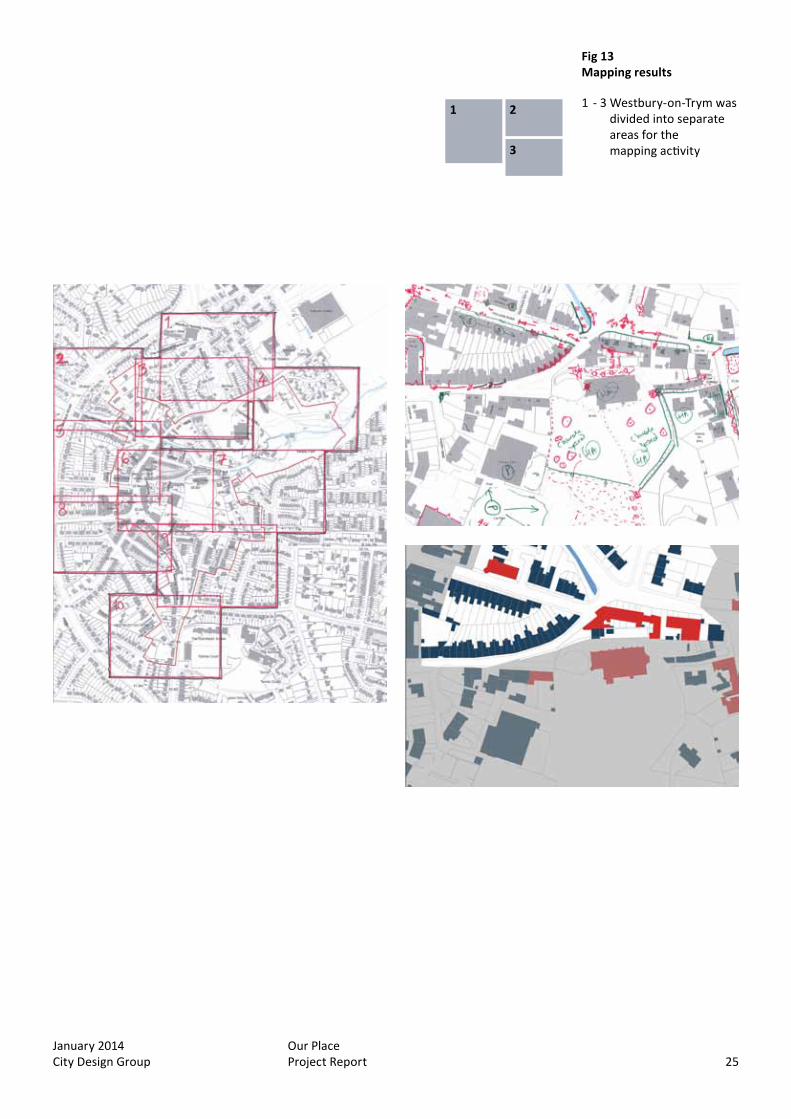
Fig 13 Mapping results
1 - 3 Westbury-on-Trym was divided into separate areas for the mapping activity
1 2
3
Fig 12 Community mapping
1 - 2 A lot of ground could be covered in a short space of time with the number of participants on the day
January 2014 City Design Group
Our Place Project Report26
Proposed public realm improvements
Whitehall is a Victorian residential suburb in east Bristol. It lies beyond the central area and generally has less development pressures than those faced by more central areas.
The area considered for this Our Place project is bisected by a former railway line that is now the popular and well used Bristol to Bath cycle path. Despite the success of this local resource there are areas of conflict between the different transport modes particularly relating to pedestrian safety and movement.
There are funding opportunities from neighbourhood budgets to enable public realm improvements that can address some of these issues. However, it is this type of incremental change that can often take place outside of any planning process and can often take little consideration of local character.
The area is not a conservation area and has no designated heritage assets within it, although there are many features in the local environment that could be considered for local listing.
Challenge
The challenge in Whitehall was similar to that in St Pauls. The local community have had little or no involvement or interest in planning and there is a general lack of appreciation of the distinctiveness of the area.
Approach
As with St Pauls it was intended that we should try and reach the local community through the local primary school.
We organised a mapping activity with Year 5 at Whitehall Primary School that lies at the centre of the area we wanted to cover. There were two year 5 classes which allowed us to cover a wide area in two sessions either side of morning break.
As with other Our Place activities the participants were divided into small groups and given a specific area to map. Each group was accompanied by an Our Place team member and a member of teaching staff.
After the mapping activity the pupils created their own exhibition about the local character of Whitehall for display to parents at the end of the week.
Intended outcomes
The mapping activity was intended to gather information to enable the production of an Our Place Whitehall draft document that could be used to guide public realm improvements.
As with any Our Place activity it was hoped that nomination for the Local List would also be identified.
Resources
The mapping activity day was staffed by four members of the Our Place project team.
All costs including materials were resourced from the Our Place project budget.
Our Place Whitehall

January 2014 City Design Group
Our Place Project Report 27
Actual outcomes
The pupils produced some excellent character maps using a standard notation sheet. They also captured a lot of images of the local area as each group had a digital camera with them.
Because the pupils were using a standard style notation sheet they were able to produce some detailed character defining maps. This is likely to have been helped by the fact that there is a general consistency to the built form and streetscape in the area, however, the identification of views and landmarks that are a particular feature of the local character was very successful.
The Our Place Whitehall draft document was published on Design Bristol http://designbristol.ning.com/profiles/blogs/our-place-whitehall
Lessons learned
One element that was less successful at Whitehall was the engagement with the local community. Better partnership working with neighbourhood teams would have helped the communication strategy with this project and potentially enabled wider participation.
It is also not clear how well the document will be used to inform public realm design because of this lacking connection to the neighbourhood teams and wider community.
Fig 14 Our Place Whitehall
1 - 2 Year 5 pupils produced their own display about their area and possible improvements
1
2
January 2014 City Design Group
Our Place Project Report28
Historic landscape understanding
Oldbury Court is a Grade II Registered historic park in northeast Bristol adjacent to the suburb of Fishponds. The open parkland fringed with woodland relates to a historic estate that was centred on the large formal house of Oldbury Court (demolished in the 1960s). Many surviving landscape elements were designed for the estate by Humphrey Repton in the early 19th century.
Adjacent to the estate is St Mathias, a Listed Grade II nineteenth century institutional campus currently used by the University of the West of England and numerous residential streets of terraced housing.
Oldbury Court is now a public open space with play area and woodland walks.
Part of the estate, the area of the St Mathias campus and neighbouring residential housing lies within the Stapleton and Frome Valley Conservation Area.
Challenge
At the Localism and Heritage conference in 2012 http://designbristol.ning.com/profiles/blogs/localism-and-heritage-conference-report the planning group in the Fishponds/Oldbury Court gave a presentation that covered the difficulties that they faced in encouraging engagement with planning.
Despite this the local area has already seen significant change and future development pressures are expected as large institutional campuses in the area including St Mathias are adapted for new uses.
Approach
As with St Pauls and Whitehall it was intended that we should try and reach the local community through the local primary school.
We organised a mapping activity with Year 5 at Frome Vale Academy that lies immediately adjacent to Oldbury Court. Over the course of a morning we accompanied the class for a mapping walk using a notation sheet that had been adapted to accommodate the identification of landscape features as well as the usual streetscape character.
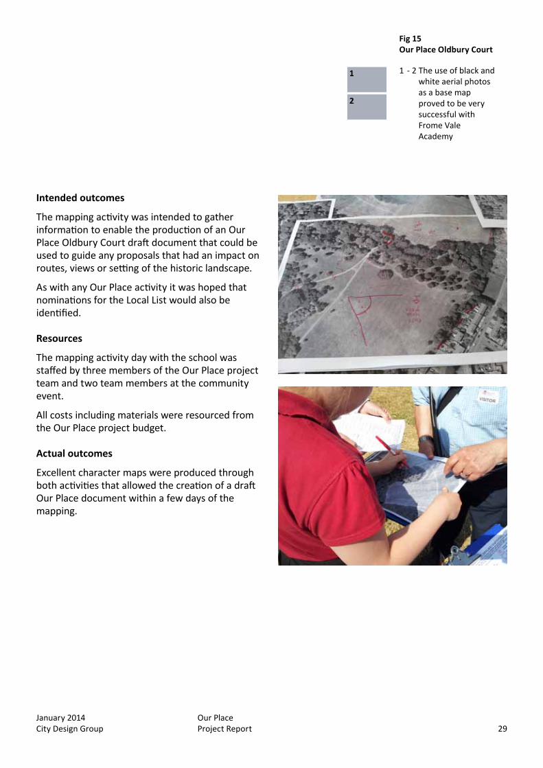
We experimented with using black and white aerial photographs as a base map instead of the usual Ordnance Survey mapping used in previous Our Place activities. This was to enable the easy identification of areas of woodland and informal routes that are not shown on OS mapping.
Over the course of the following week the pupils refined their character maps and added their own opinions about the area to create a classroom display.
On the Saturday at the end of the week we held a community mapping event that covered some of the same area as the pupils, but looked in detail at the interface between the residential streets and the parkland.
Throughout the Our Place Oldbury Court week twitter was used to continually record and communicate the results of the activities. This allowed for a subsequent Storify to be created http://storify.com/Locallearning/our-place-oldbury-court
This community mapping activity used a standard OS map base because it was focussed more on the built form of the local area.
Our Place Oldbury Court
January 2014 City Design Group
Our Place Project Report 29
Intended outcomes
The mapping activity was intended to gather information to enable the production of an Our Place Oldbury Court draft document that could be used to guide any proposals that had an impact on routes, views or setting of the historic landscape.
As with any Our Place activity it was hoped that nominations for the Local List would also be identified.
Resources
The mapping activity day with the school was staffed by three members of the Our Place project team and two team members at the community event.
All costs including materials were resourced from the Our Place project budget.
Actual outcomes
Excellent character maps were produced through both activities that allowed the creation of a draft Our Place document within a few days of the mapping.
Fig 15 Our Place Oldbury Court
1 - 2 The use of black and white aerial photos as a base map proved to be very successful with Frome Vale Academy
1
2

January 2014 City Design Group
Our Place Project Report30
Lessons learned
The standard urban landscape notation was relatively easy to adapt to a parkland environment and the use of black and white aerial images as a base map for landscape character mapping was very effective.
The use of social media through this project was also successful and would be more effective if the activities had a dedicated member of the team to co-ordinate this. The use of social media allows real time evaluation and communication with people unable to attend the activities. This dialogue can also be captured and presented using a tool like Storify.
Historic landscape understanding Fig 16 Our Place Oldbury Court
1 Plenary session at the end of the Our Place Oldbury Court community mapping event
1

January 2014 City Design Group
Our Place Project Report 31
The standard urban landscape notation was relatively easy to adapt to a parkland environment and the use of black and white aerial images as a base map for landscape character mapping was very effective.
The use of social media through this project was also successful and would be more effective if the activities had a dedicated member of the team to co-ordinate this. The use of social media allows real time evaluation and communication with people unable to attend the activities. This dialogue can also be captured and presented using a tool like Storify.
Teachers perceive the value of using mapping and notation as an educational tool.
Year 5 primary school pupils quickly grasp the comparative value of historic and contemporary maps, identifying key buildings and street alignments.
Most of the townscape concepts were understandable to both adult and school groups after a brief introduction and advice when starting the mapping.
The act of mapping became popular with the pupils. Teachers noted that the spatial awareness and graphic skills required were apparent in some pupils who were more reticent in other ways.
Sometimes within community groups debates would arise regarding the historic significance of an area, boundary or asset and the present day impact of the same. It was stressed by the team that the notation was concerned with the present character.
Case studies conclusions

January 2014 City Design Group
Our Place Project Report32
January 2014 City Design Group
Our Place Project Report 33
Project report
3 Follow on projects
January 2014 City Design Group
Our Place Project Report34
During the period of the Our Place pilot studies, the team was contacted by organisations who have heard of the project and wish to be involved in various ways.
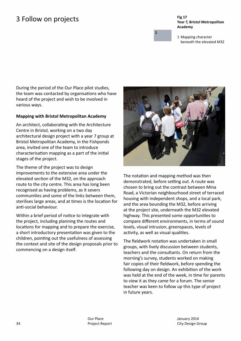
Mapping with Bristol Metropolitan Academy
An architect, collaborating with the Architecture Centre in Bristol, working on a two day architectural design project with a year 7 group at Bristol Metropolitan Academy, in the Fishponds area, invited one of the team to introduce characterisation mapping as a part of the initial stages of the project.
The theme of the project was to design improvements to the extensive area under the elevated section of the M32, on the approach route to the city centre. This area has long been recognised as having problems, as it severs communities and some of the links between them, sterilises large areas, and at times is the location for anti-social behaviour.
Within a brief period of notice to integrate with the project, including planning the routes and locations for mapping and to prepare the exercise, a short introductory presentation was given to the children, pointing out the usefulness of assessing the context and site of the design proposals prior to commencing on a design itself.
The notation and mapping method was then demonstrated, before setting out. A route was chosen to bring out the contrast between Mina Road, a Victorian neighbourhood street of terraced housing with independent shops, and a local park, and the area bounding the M32, before arriving at the project site, underneath the M32 elevated highway. This presented some opportunities to compare different environments, in terms of sound levels, visual intrusion, greenspaces, levels of activity, as well as visual qualities.
The fieldwork notation was undertaken in small groups, with lively discussion between students, teachers and the consultants. On return from the morning’s survey, students worked on making fair copies of their fieldwork, before spending the following day on design. An exhibition of the work was held at the end of the week, in time for parents to view it as they came for a forum. The senior teacher was keen to follow up this type of project in future years.
3 Follow on projects Fig 17 Year 7, Bristol Metropolitan Academy
1 Mapping character beneath the elevated M32
1
January 2014 City Design Group
Our Place Project Report 35
‘SHINE’ launch, Bristol. 26:09:13
Context4D was invited to give two ‘market place’ presentations of the mapping technique at the half day conference to launch ‘SHINE’, (Supporting Healthy Inclusive Neighbourhood Environments), a Health Integration Team. The theme of the presentations was to demonstrate the potential of mapping to assess neighbourhoods in terms of addressing opportunities for wellbeing; for instance, reducing obstacles to facilitate improved walking routes; locations for seating, tree planting etc. From discussion with the groups, representing community health workers and community representatives, it was clear that there was some enthusiasm for adopting and adapting the notation.
The invitation to participate stemmed from another initiative sponsored by the Architecture Centre, ‘Building Health’, where mapping adapted for similar purposes is being developed by Context4D.
Our Place Henleaze
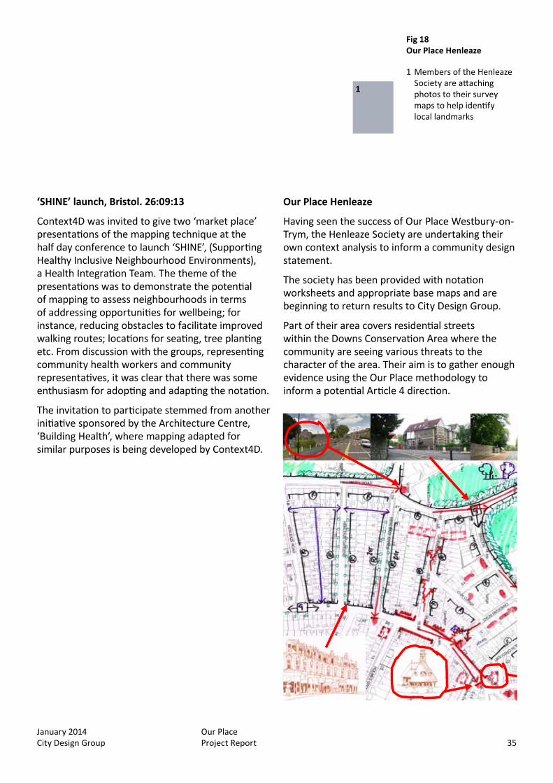
Having seen the success of Our Place Westbury-on-Trym, the Henleaze Society are undertaking their own context analysis to inform a community design statement.
The society has been provided with notation worksheets and appropriate base maps and are beginning to return results to City Design Group.
Part of their area covers residential streets within the Downs Conservation Area where the community are seeing various threats to the character of the area. Their aim is to gather enough evidence using the Our Place methodology to inform a potential Article 4 direction.
Fig 18 Our Place Henleaze
1 Members of the Henleaze Society are attaching photos to their survey maps to help identify local landmarks
1

January 2014 City Design Group
Our Place Project Report36
January 2014 City Design Group
Our Place Project Report 37
Project report
4 Evaluation
January 2014 City Design Group
Our Place Project Report38
4 Evaluation
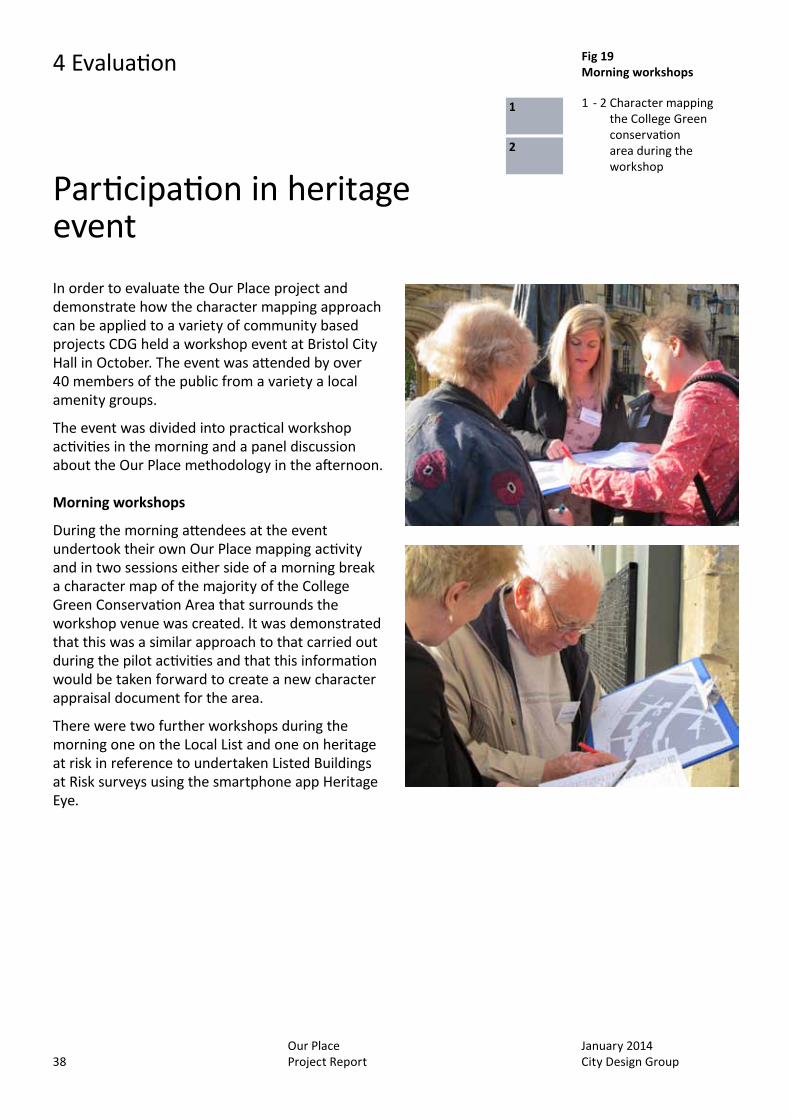
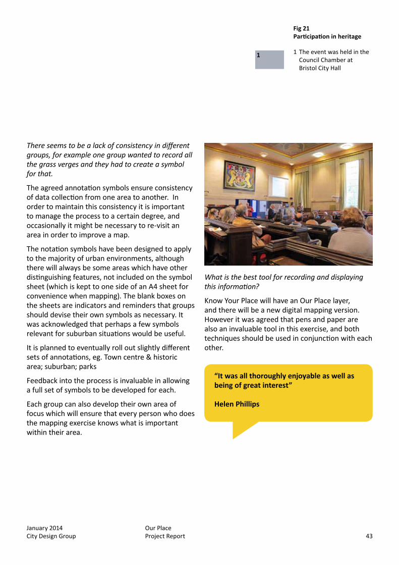
In order to evaluate the Our Place project and demonstrate how the character mapping approach can be applied to a variety of community based projects CDG held a workshop event at Bristol City Hall in October. The event was attended by over 40 members of the public from a variety a local amenity groups.
The event was divided into practical workshop activities in the morning and a panel discussion about the Our Place methodology in the afternoon.
Morning workshops
During the morning attendees at the event undertook their own Our Place mapping activity and in two sessions either side of a morning break a character map of the majority of the College Green Conservation Area that surrounds the workshop venue was created. It was demonstrated that this was a similar approach to that carried out during the pilot activities and that this information would be taken forward to create a new character appraisal document for the area.
There were two further workshops during the morning one on the Local List and one on heritage at risk in reference to undertaken Listed Buildings at Risk surveys using the smartphone app Heritage Eye.
Participation in heritage event
Fig 19 Morning workshops
1 - 2 Character mapping the College Green conservation area during the workshop
1
2

January 2014 City Design Group
Our Place Project Report 39
The process:1 The first stage was to encourage as many
people within the community to be involved as possible. They held a series of information meetings which people were invited to attend.
2 They decided how to structure the character appraisal in order to understand the landscape. They looked at the contents of a design statement, and devised a model which would allow them to organise the information in a logical fashion, starting with the assessment which would then lead on to the design response.
3 During this process, they decided to reassess the original conservation area boundary which was drawn up 40 years ago. They divided the ward map into phased areas; phase one being the current conservation area.
4 Following training in the form of an Our Place mapping workshop with Pete Insole from City Design Group, BCC, they were able to fully assess the area and apply the rules to their maps.
5 Once the mapping exercise was completed, in conjunction with Bristol City Council City Design Group they were able to produce the Our Place: Westbury-on-Trym document which is available to download from the Design Bristol website
Afternoon panel discussion
The afternoon session featured a panel discussion chaired by Richard Guise (Context4D) followed by questions from the floor. The panel consisted of Alan Aburrow & David Mayor, Westbury-on-Trym Society and Mark Logan, Fishponds who discussed their own Our Place projects.
Alan Aburrow and David Mayor from Westbury-on-Trym Society outlined how they created the basis of a conservation area character appraisal for Westbury-on-Trym in one week, based on the techniques which were taught in the mornings’ Our Place workshops.
Mark Logan explained how they did the same for an area of Fishponds called Oldbury Court.
Both pieces of work have led to the creation of draft Our Place documents which are available on the Design Bristol website.
Case study 1: Westbury-on-Trym – an example of a community plan, Alan Aburrow and David Mayor
Following the Localism Act communities with land which has development potential are able to create a neighbourhood plan. However the Westbury-on-Trym Society elected to develop a community plan for several reasons:
The process is less bureaucratic The community plan can still be used as a
guide for developers, to inform community design statements and neighbourhood planning initiatives
A more localised community plan fitted the need of the area better
Fig 19 Morning workshops
1 - 2 Character mapping the College Green conservation area during the workshop

January 2014 City Design Group
Our Place Project Report40
Q & A’s
What is the main difference between a community plan and a neighbourhood plan?
Westbury-on-Trym elected to do a community plan as there were no large tracks of the area suitable for development.
Neighbourhood plans have more sway with planners, because they constitute policy, but can take 2-3 years to produce and have to go to public consultation. Community plans, on the other hand, can be used as guidance.
Do all groups have to follow the same process and techniques?
Each community can choose a process for conducting the character appraisal of their area which best suits them and their local resources, using the agreed map annotations to maintain consistency. Bedminster have now started the process and are using a different technique.
Could you go on to re-assess the conservation area?
Yes. Westbury-on-Trym are looking into this possibility now. It is also important to take into consideration ward boundaries and how people define their own neighbourhood.
How easy is it to engage with the local community?
One of the biggest hurdles with such a project is attracting volunteers in the first place, and maintaining their engagement. Various techniques have been used such as posting information leaflets for local residents, and leaving them in public meeting places such as libraries, inviting residents to meetings and also utilising social media on the internet such as Facebook and Twitter. It is also possible to do the work with local schools, and by involving children it is hoped that their parents also become interested. However in reality there is often only a small group of people doing the majority of the work.
Did the notation encourage people to think about the places in between buildings?
Yes. The notation includes sub-areas such as views, streets and churchyards. It encourages people to look up instead of down, and often they will see things which they had not noticed before.
Fig 20 Panel discussion
1 David Mayor, Alan Aburrow and Mark Logan talk to Richard Guise
1
4 Evaluation
January 2014 City Design Group
Our Place Project Report 41
Case study 2: Oldbury Court – mapping historic parkland, Mark Logan
The Oldbury Court estate is an area of green space consisting predominately of woodland and parkland, so this represented a very different type of mapping exercise.
The mapping exercise was conducted by a group of local schoolchildren and local residents.
As well as looking at the parkland itself, they considered changes in view for example what would be seen if the trees were cut down.
They intend to do a follow-up piece of work in the winter when the leaves have fallen.
Alongside the mapping exercise, they found that accompanying photographic evidence works well. It has been suggested there be three key roles within each mapping group, someone to act as scribe, a photographer (all photographs should be cross-referenced with the annotated map), and observers.
Our Place creates a common language that can be linked to Planning Policy.
Base maps
It is possible to get base maps with the trees and other features already marked on them. Generally ordinance survey maps have been used as they are referenced within most planning documents. However it is also possible to use other maps, Google Earth maps, and even black and white air photographs as base maps.
The Oldbury Court Our Place document can be downloaded from the Design Bristol website.
Q&A’s
How do you overcome the problem of planners interpreting things differently? Eg. One house may get planning permission when another doesn’t.
It is the officers’ role to make sure that council representatives and officers understand the process and implications.
Is it becoming increasingly dependent on external sources?
There is a chance of getting funding from external sources when a group has this evidence base. Inspectors like to have a quantitative measurement of what is essentially a qualitative thing such as character, and BCC with Context4D are working to produce a document about this.
Some groups feel they have been forced to go down the community plan route as they cannot afford the time and resource to do a neighbourhood plan.
It is important to note that the two are not mutually exclusive. The work done for a community plan can be used in future neighbourhood plans. A community plan can be used as an evidence base and there is a need to educate other council officers to use it correctly.
Community involvement must form part of the process in order for it to become a consideration. The document will have more weight if you can provide evidence of community involvement.
January 2014 City Design Group
Our Place Project Report42
What are the best ways to engage with your local community?
Leaflet houses, and invite them to comment on the document.
Provide information boards in the local library or other community centre
Henleaze Society sent out a residents newsletter and created a website
Social media such as Facebook and Twitter was used by Oldbury Court. This is a great way to reach large numbers of people, for example the Castle Park Facebook page reached 5000 people in two weeks.
Links with other local organisations
It is important to use all forms of communications to ensure the widest group of people is reached. Each form of communication is not mutually exclusive.
General Questions and Answers
A short session of general questions and answers introduced by Peter Insole followed the panel discussion.
How does the Our Place project link to neighbourhood planning?
Our Place can also be used to identify potential public realm improvements which could be used for funding applications.
All Our Place projects consider the ‘strengths and weaknesses’ of an area, a table of which is included within the document. This allows communities to identify areas of opportunity. Doing the map itself is not the end product; it can then be used to develop real things as well as a method for accurately recording. It can also be used as a tool to open up a dialogue with other members of a community.
Who pays for printing of the documents?
The project is funded by English Heritage, however printing of documents is kept to a minimum. All of the Our Place documents will be available in PDF format to download from the Design Bristol website.
4 Evaluation
January 2014 City Design Group
Our Place Project Report 43
There seems to be a lack of consistency in different groups, for example one group wanted to record all the grass verges and they had to create a symbol for that.
The agreed annotation symbols ensure consistency of data collection from one area to another. In order to maintain this consistency it is important to manage the process to a certain degree, and occasionally it might be necessary to re-visit an area in order to improve a map.
The notation symbols have been designed to apply to the majority of urban environments, although there will always be some areas which have other distinguishing features, not included on the symbol sheet (which is kept to one side of an A4 sheet for convenience when mapping). The blank boxes on the sheets are indicators and reminders that groups should devise their own symbols as necessary. It was acknowledged that perhaps a few symbols relevant for suburban situations would be useful.
It is planned to eventually roll out slightly different sets of annotations, eg. Town centre & historic area; suburban; parks
Feedback into the process is invaluable in allowing a full set of symbols to be developed for each.
Each group can also develop their own area of focus which will ensure that every person who does the mapping exercise knows what is important within their area.
“It was all thoroughly enjoyable as well as being of great interest”
Helen Phillips
Fig 21 Participation in heritage
1 The event was held in the Council Chamber at Bristol City Hall
1
What is the best tool for recording and displaying this information?
Know Your Place will have an Our Place layer, and there will be a new digital mapping version. However it was agreed that pens and paper are also an invaluable tool in this exercise, and both techniques should be used in conjunction with each other.

January 2014 City Design Group
Our Place Project Report44
Could the nominations be voted for?
The Local List will be decided by a panel of judges from as many different organisations as possible. However Bob Jones from BCC will look into the possibility of also introducing a public vote, alongside the panel decision. However it is important that this does not hold up the process if it is implemented.
If a structure doesn’t make it onto the list, it will still appear on Our Place. With DM26 in place, Our Place can be used as the primary tool to ensure the character and distinctiveness of a place is maintained.
Some heritage is in fact more appropriate for inclusion on Our Place than on the Local List. For example a row of terraced houses which add a distinct character to an area.
Are owners within their rights to request their property is removed from the Local List?.
Yes, although the Local list does not change the legal status of a building. It doesn’t change permitted development rights if a building is outside a conservation area. However it can be used to feed into local planning applications. It is important when looking at a longer term strategic approach about what an area will look like over time and encouraging community support for the retention of assets. It won’t work overnight, but it allows people to argue for maintaining the local character of an area. For example, a development can be refused if it is not in accordance with DM26.
In order to argue that a structure adds to the local character and so needs protecting, it is important to know what the local character of an area is. This illustrates the importance of Our Place.
Will this project be rolled out into different areas of the country, and is it possible to input data from other areas into the software?
This will be up to the local authority where you are doing the work, however BCC is currently looking at how they could develop a model to roll this out to other local authorities. English Heritage does quote Know Your Place as an example of best practice.
Where can we get base maps from?
Peter Insole can print out base maps or send via PDF. You can also use ordinance survey maps and should ask for a Figure-Ground map. Generally scale A3 1:500 is used. A full ‘How-to’ guide is being produced as part of the project.
Can you revise the document easily once it has been published?
Yes. The historic environment is constantly evolving. The Our Place document can easily be amended and should not be considered a static piece of work. One purpose of community involvement from the beginning is to ensure the information within the document is kept up to date.
Is there any intention of publishing a list of Local List nominations?
All the nominations can be viewed on Know Your Place as a blue diamond, however it was agreed it would also be a good idea to publish a tabulated form.
4 Evaluation

January 2014 City Design Group
Our Place Project Report 45
“I found out an awful lot and am inspired to get involved in Know Your Place”
Amanda Feather
Fig 22 Participation in heritage
1 Henleaze Society work displayed at the event
2 The results of the morning mapping work
21

January 2014 City Design Group
Our Place Project Report46
January 2014 City Design Group
Our Place Project Report 47
Project report
5 Conclusion
January 2014 City Design Group
Our Place Project Report48
5 Conclusion
The Our Place project has been very successful and demonstrates the value of collaborative working.
The communities who have participated have all appreciated the value of the methodology in terms of being fun and engaging with meaningful, usable results. The level of enthusiasm amongst adult and pupil participants was quite striking.
In particular Our Place Westbury-on-Trym has demonstrated how much can be achieved in a short space of time with a committed team.
A standardised methodology
The project has applied the methodology to a variety of potential outputs and has created draft documents with less resource input from the local authority than previous planning guidance documents have required.
A series of digital representations of the notation symbols were created that allowed a standardised approach to presenting the character maps (fig 19-2/3).
Alongside these digital symbols an Our Place document template was established that contributed to the efficient production each of the project outputs.
The use of the Design Bristol ning social media site in conjunction with other social media tools such as Twitter helped to both publicise the project and present the outputs.
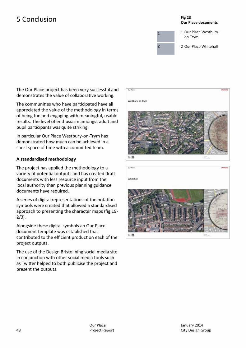
Fig 23 Our Place documents
1 Our Place Westbury-on-Trym
2 Our Place Whitehall
1
2
January 2014 City Design Group
Our Place Project Report 49
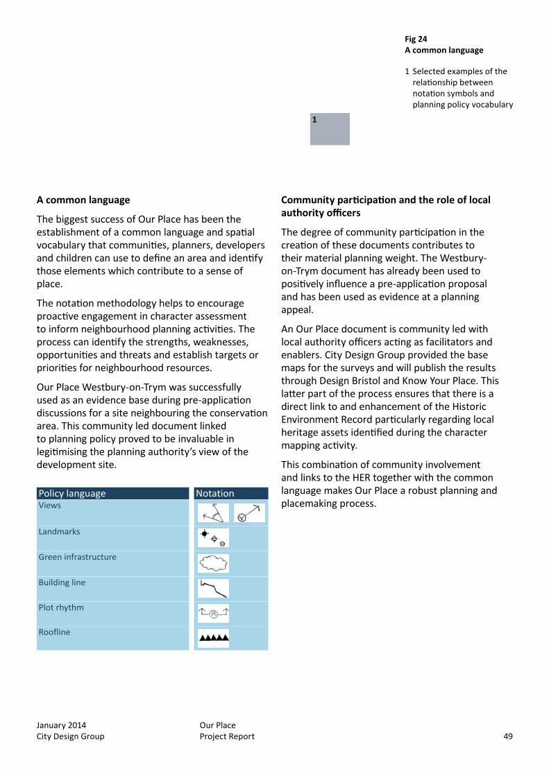
A common language
The biggest success of Our Place has been the establishment of a common language and spatial vocabulary that communities, planners, developers and children can use to define an area and identify those elements which contribute to a sense of place.
The notation methodology helps to encourage proactive engagement in character assessment to inform neighbourhood planning activities. The process can identify the strengths, weaknesses, opportunities and threats and establish targets or priorities for neighbourhood resources.
Our Place Westbury-on-Trym was successfully used as an evidence base during pre-application discussions for a site neighbouring the conservation area. This community led document linked to planning policy proved to be invaluable in legitimising the planning authority’s view of the development site.
IHBC Characterisation Conference
Our Place Creating a common language Policy language Notation Views
Landmarks
Green infrastructure
Building line
Plot rhythm
Roofline
Community participation and the role of local authority officers
The degree of community participation in the creation of these documents contributes to their material planning weight. The Westbury-on-Trym document has already been used to positively influence a pre-application proposal and has been used as evidence at a planning appeal.
An Our Place document is community led with local authority officers acting as facilitators and enablers. City Design Group provided the base maps for the surveys and will publish the results through Design Bristol and Know Your Place. This latter part of the process ensures that there is a direct link to and enhancement of the Historic Environment Record particularly regarding local heritage assets identified during the character mapping activity.
This combination of community involvement and links to the HER together with the common language makes Our Place a robust planning and placemaking process.
Fig 23 Our Place documents
1 Our Place Westbury-on-Trym
2 Our Place Whitehall
Fig 24 A common language
1 Selected examples of the relationship between notation symbols and planning policy vocabulary
1
January 2014 City Design Group
Our Place Project Report50
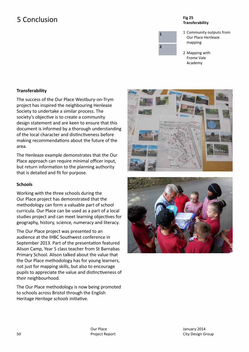
Transferability
The success of the Our Place Westbury-on-Trym project has inspired the neighbouring Henleaze Society to undertake a similar process. The society’s objective is to create a community design statement and are keen to ensure that this document is informed by a thorough understanding of the local character and distinctiveness before making recommendations about the future of the area.
The Henleaze example demonstrates that the Our Place approach can require minimal officer input, but return information to the planning authority that is detailed and fit for purpose.
Schools
Working with the three schools during the Our Place project has demonstrated that the methodology can form a valuable part of school curricula. Our Place can be used as a part of a local studies project and can meet learning objectives for geography, history, science, numeracy and literacy.
The Our Place project was presented to an audience at the IHBC Southwest conference in September 2013. Part of the presentation featured Alison Camp, Year 5 class teacher from St Barnabas Primary School. Alison talked about the value that the Our Place methodology has for young learners, not just for mapping skills, but also to encourage pupils to appreciate the value and distinctiveness of their neighbourhood.
The Our Place methodology is now being promoted to schools across Bristol through the English Heritage Heritage schools initiative.
5 Conclusion Fig 25 Transferability
1 Community outputs from Our Place Henleaze mapping
2 Mapping with Frome Vale Academy
1
2
January 2014 City Design Group
Our Place Project Report 51
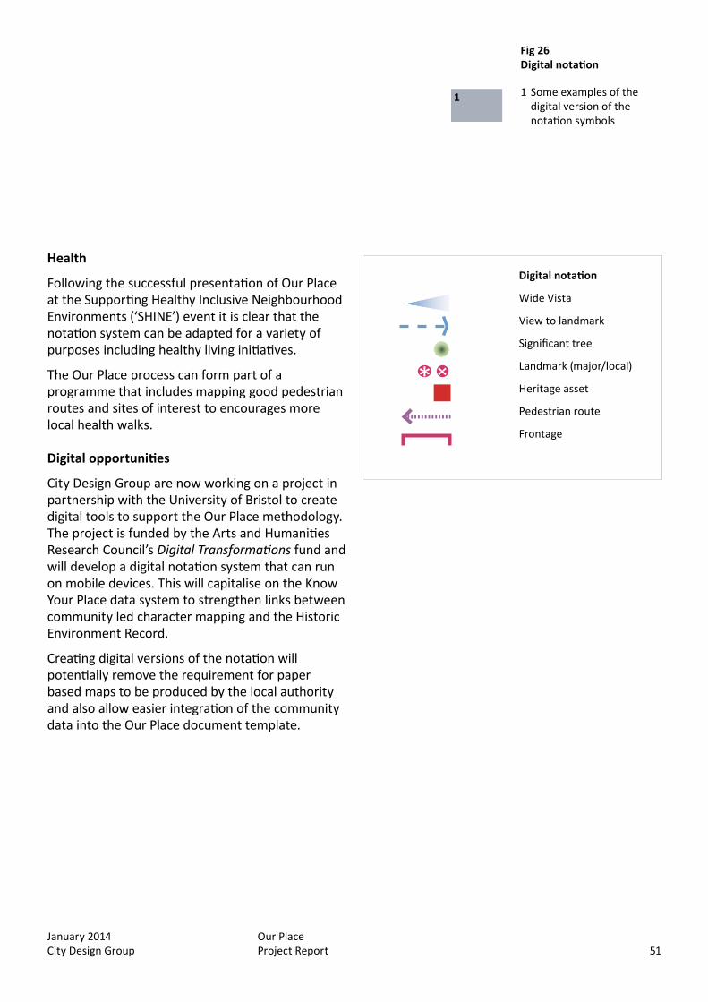
Health
Following the successful presentation of Our Place at the Supporting Healthy Inclusive Neighbourhood Environments (‘SHINE’) event it is clear that the notation system can be adapted for a variety of purposes including healthy living initiatives.
The Our Place process can form part of a programme that includes mapping good pedestrian routes and sites of interest to encourages more local health walks.
Digital opportunities
City Design Group are now working on a project in partnership with the University of Bristol to create digital tools to support the Our Place methodology. The project is funded by the Arts and Humanities Research Council’s Digital Transformations fund and will develop a digital notation system that can run on mobile devices. This will capitalise on the Know Your Place data system to strengthen links between community led character mapping and the Historic Environment Record.
Creating digital versions of the notation will potentially remove the requirement for paper based maps to be produced by the local authority and also allow easier integration of the community data into the Our Place document template.
Digital notation
Wide Vista
View to landmark
Significant tree
Landmark (major/local)
Heritage asset
Pedestrian route
Frontage
Fig 26 Digital notation
1 Some examples of the digital version of the notation symbols
1
Fig 25 Transferability
1 Community outputs from Our Place Henleaze mapping
2 Mapping with Frome Vale Academy
January 2014 City Design Group
Our Place Project Report52
5 Conclusion
National Heritage Protection Plan
The Our Place project set out to address aspects of all three activity topics under the ‘Protection of Significance’ section of the National Heritage Protection Plan:
5A Designation and registration tools 5B Management Frameworks 5C Historic Environment Records
Protection Result 5A4.1: Strategic assessment of guidance and training to encourage community participation in protecting heritage.
Each of the Our Place activities involved training of participants from different parts of the community and has created a toolkit that is already being put to use in other areas of Bristol. This is most notable in Henleaze where two individuals attended Our Place activities before co-ordinating their own mapping events.
The use of the notation encourages communities to create their own baseline evidence about their local historic character before engaging in neighbourhood planning processes.
This element also links to Protection Result 4A1.3: Developing tools for local communities to assess significance of their townscapes.
Protection Result 5A4.2: Development, promotion and integration of Local Lists into management systems to protect heritage.
The Our Place notation promotes the identification of local heritage assets and because the approach forms a direct link between communities and the HER the data about these assets can be immediately incorporated into the Local List.
All the Our Place activities identified previously unrecorded local heritage assets that have gone forward as nominations to the Local List.
Protection Result 5B2.1: Effective support for neighbourhood planning.
As demonstrated by Westbury-on-Trym at the Participation in Heritage event, the community recognises that the Our Place activity was a valuable part of the process to create their community plan.
This value was further demonstrated in Lockleaze within a more formal neighbourhood plan process where a notation exercise combined with an oral history event and Placecheck activity contributed to the formulation of regeneration proposals that were based on an understanding of the historic context.
Protection Result 5B2.2: Local designation process incorporated into community planning through neighbourhood engagement and action.
Our Place presentents a more participatory and bottom-up approach to communty planning. The participants to date have all expressed how enjoyable the activities can be and appreciate that Our Place creates usable results that define aspects of their local environment that require consideration in any planning process.
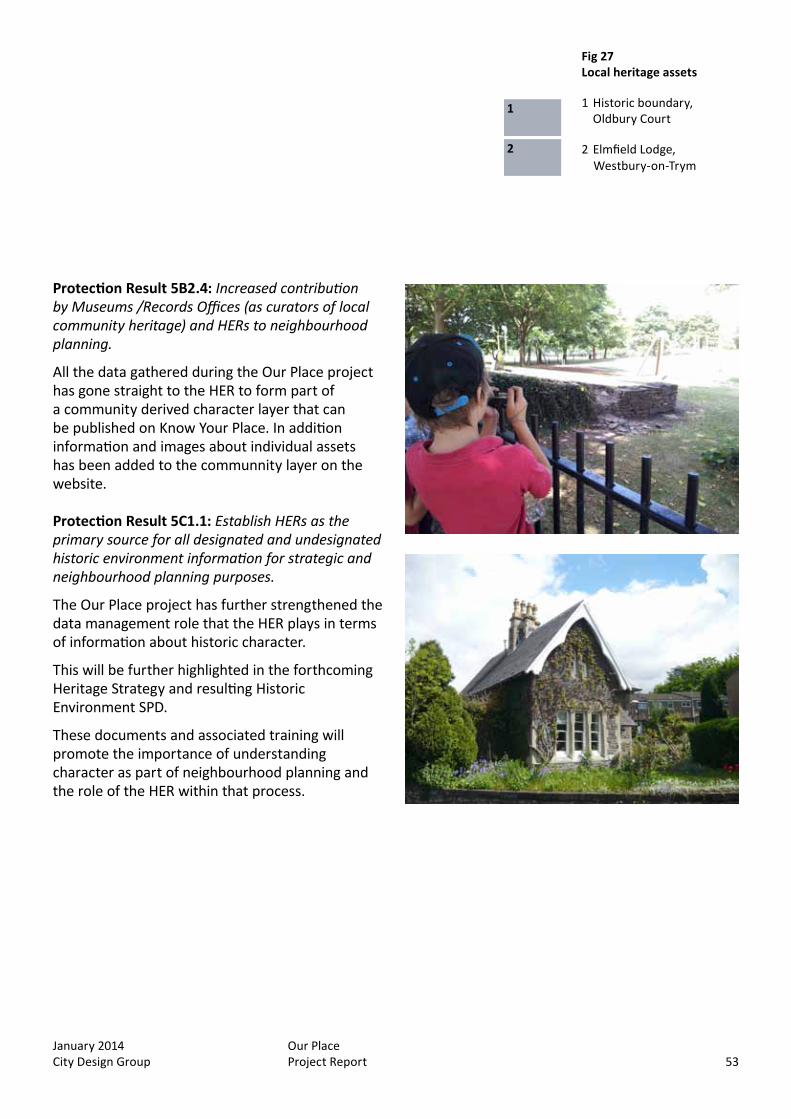
At Westbury-on-Trym an amendment to the existing conservation area boundary was proposed to include Elmfield Lodge (fig.27) as a result of the Our Place project.
January 2014 City Design Group
Our Place Project Report 53
Protection Result 5B2.4: Increased contribution by Museums /Records Offices (as curators of local community heritage) and HERs to neighbourhood planning.
All the data gathered during the Our Place project has gone straight to the HER to form part of a community derived character layer that can be published on Know Your Place. In addition information and images about individual assets has been added to the communnity layer on the website.
Protection Result 5C1.1: Establish HERs as the primary source for all designated and undesignated historic environment information for strategic and neighbourhood planning purposes.
The Our Place project has further strengthened the data management role that the HER plays in terms of information about historic character.
This will be further highlighted in the forthcoming Heritage Strategy and resulting Historic Environment SPD.
These documents and associated training will promote the importance of understanding character as part of neighbourhood planning and the role of the HER within that process.
Fig 27 Local heritage assets
1 Historic boundary, Oldbury Court
2 Elmfield Lodge,
1
2Westbury-on-Trym

January 2014 City Design Group
Our Place Project Report54
Embedding historic character in the process
Our Place alone will not secure the future of historic character although inputing the data into the HER is one of the strengths of the approach. The key to embedding the understanding of character into any planning process is to ensure that adequate policies and guidance are in place. The National Planning Policy Framework details the importance of understanding charcater and using baseline evidence about a local context to inform planning proposals (sections 7, 12 and paragraph 170). Bristol’s Local Plan includes policies that emphasise the role of local character and distinctiveness in making quality places.
The combination of community defined contextual data that is published and easily accessible alongside relevant policies should help to ensure that local character is used effectively to inform planning proposals. Supporting guidance and training will help to further embed an appropriate consideration of local character in the process.
The fact that the baseline evidence has been created through an open, participatory process should give Our Place documents a degree of planning weight especially after a period of wider consultation as would be expected for the creation of a community plan.
In line with protection results 5A4.1 and 5B2.2 (above), the raising of awareness and understanding within the local community enabled by an Our Place process will contribute to ensuring that local character and distinctiveness is embedded in any neighbourhood planning.
5 Conclusion Fig 28 Mapping
1 Feedback through an ‘instant’ exhibition following survey
1
Our Place mapping can contribute to: Identifying/quantifying elements of character Providing an evidence base for neighbourhood
plans Stimulating dialogue and negotiation, on
location Skills capacity and acquisition Extending the language of place Creating consistency in group appraisals Creating feedback through ‘instant’ exhibitions
following surveys
The Key is the Key: It acts as a checklist and ‘nudge’ to aid
structured observation It invites users ti add their own symbols It encourages engagement with the map It provides a vocabulary of place It should not exceed one side of A4 It could be digitised.
January 2014 City Design Group
Our Place Project Report 55
Acknowledgements
City Design Group and Context4D would like to thank English Heritage for their support throughout this project.
We would also like to thank the community and school participants from all the Our Place projects and the Participation in heritage event.
We are also very grateful to the IHBC Southwest committee and ‘SHINE’ co-ordinators for allowing us to present this project at their Bristol events.
Fig 28 Mapping
1 Feedback through an ‘instant’ exhibition following survey

January 2014 City Design Group
Our Place Project Report56
January 2014 City Design Group
Our Place Project Report 57
Appendix 1
Mapping: A user’s guide to street surveys

January 2014 City Design Group
Our Place Project Report58

January 2014 City Design Group
Our Place Project Report 59
Preliminary stage
A facilitator team
This team, often local authority planners, consultants, a community group, local school/s or a combination of these, should be established.
This will agree the aims of the survey and define the area to be covered, given constraints such as likely number of people expected to take part and available time. The team would be responsible for contacting prospective individuals or organisations to participate in the survey.
Ideally, the same area could be surveyed by 2 or 3 groups, for example representing different ages; for instance, school children (year 5 and upward), parents, or elderly people. This would offer different perspectives of the same area. More ambitious project planning might involve mixed groups of different age ranges and/or backgrounds, surveying the area at different times of the day, week or year.
Survey teams
These should preferably comprise 3 people; a lead observer, referring to a copy of the key, as a prompt; a map recorder, who will draw the notation symbols on the map; a second observer, who will take photos, write notes and talk with local people that they encounter. Ideally, the team should rotate roles during the survey, to refresh the operation. Any team with 4 or more members is in danger of losing the engagement of each member and become an obstruction on narrow pavements. A team with fewer than 3 members will find it difficult to handle all the operations and will lose the advantage of group discussion during the appraisal survey.
Fig 1 Preliminary stage
1 A facilitator team
2 A survey team
1
2
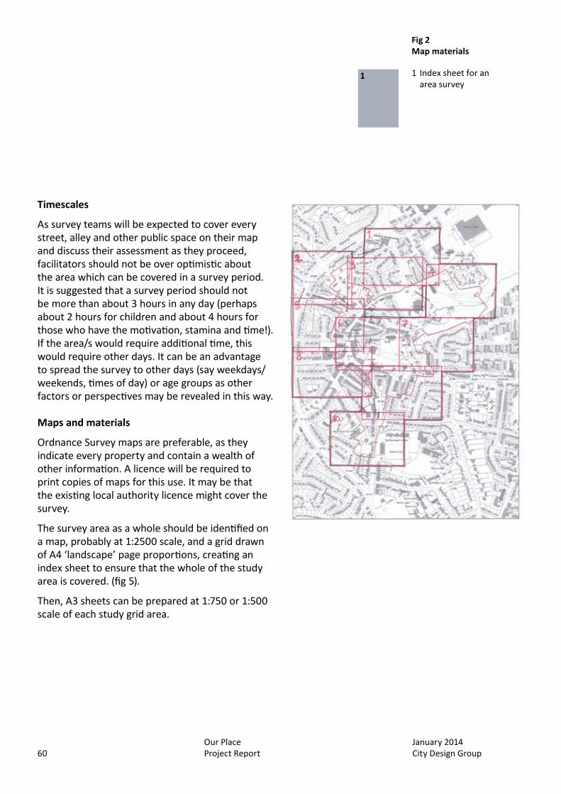
January 2014 City Design Group
Our Place Project Report60
Timescales
As survey teams will be expected to cover every street, alley and other public space on their map and discuss their assessment as they proceed, facilitators should not be over optimistic about the area which can be covered in a survey period. It is suggested that a survey period should not be more than about 3 hours in any day (perhaps about 2 hours for children and about 4 hours for those who have the motivation, stamina and time!). If the area/s would require additional time, this would require other days. It can be an advantage to spread the survey to other days (say weekdays/weekends, times of day) or age groups as other factors or perspectives may be revealed in this way.
Maps and materials
Ordnance Survey maps are preferable, as they indicate every property and contain a wealth of other information. A licence will be required to print copies of maps for this use. It may be that the existing local authority licence might cover the survey.
The survey area as a whole should be identified on a map, probably at 1:2500 scale, and a grid drawn of A4 ‘landscape’ page proportions, creating an index sheet to ensure that the whole of the study area is covered. (fig 5).
Then, A3 sheets can be prepared at 1:750 or 1:500 scale of each study grid area.
Fig 2 Map materials
1 Index sheet for an area survey
1
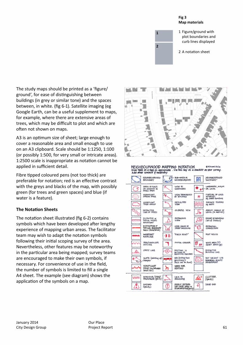
January 2014 City Design Group
Our Place Project Report 61
The study maps should be printed as a ‘figure/ground’, for ease of distinguishing between buildings (in grey or similar tone) and the spaces between, in white. (fig 6-1). Satellite imaging (eg Google Earth, can be a useful supplement to maps, for example, where there are extensive areas of trees, which may be difficult to plot and which are often not shown on maps.
A3 is an optimum size of sheet; large enough to cover a reasonable area and small enough to use on an A3 clipboard. Scale should be 1:1250, 1:100 (or possibly 1:500, for very small or intricate areas). 1:2500 scale is inappropriate as notation cannot be applied in sufficient detail.
Fibre tipped coloured pens (not too thick) are preferable for notation; red is an effective contrast with the greys and blacks of the map, with possibly green (for trees and green spaces) and blue (if water is a feature).
The Notation Sheets
The notation sheet illustrated (fig 6-2) contains symbols which have been developed after lengthy experience of mapping urban areas. The facilitator team may wish to adapt the notation symbols following their initial scoping survey of the area. Nevertheless, other features may be noteworthy in the particular area being mapped; survey teams are encouraged to make their own symbols, if necessary. For convenience of use in the field, the number of symbols is limited to fill a single A4 sheet. The example (see diagram) shows the application of the symbols on a map.
Fig 3 Map materials
1 Figure/ground with plot boundaries and curb lines displayed
2 A notation sheet
1
2
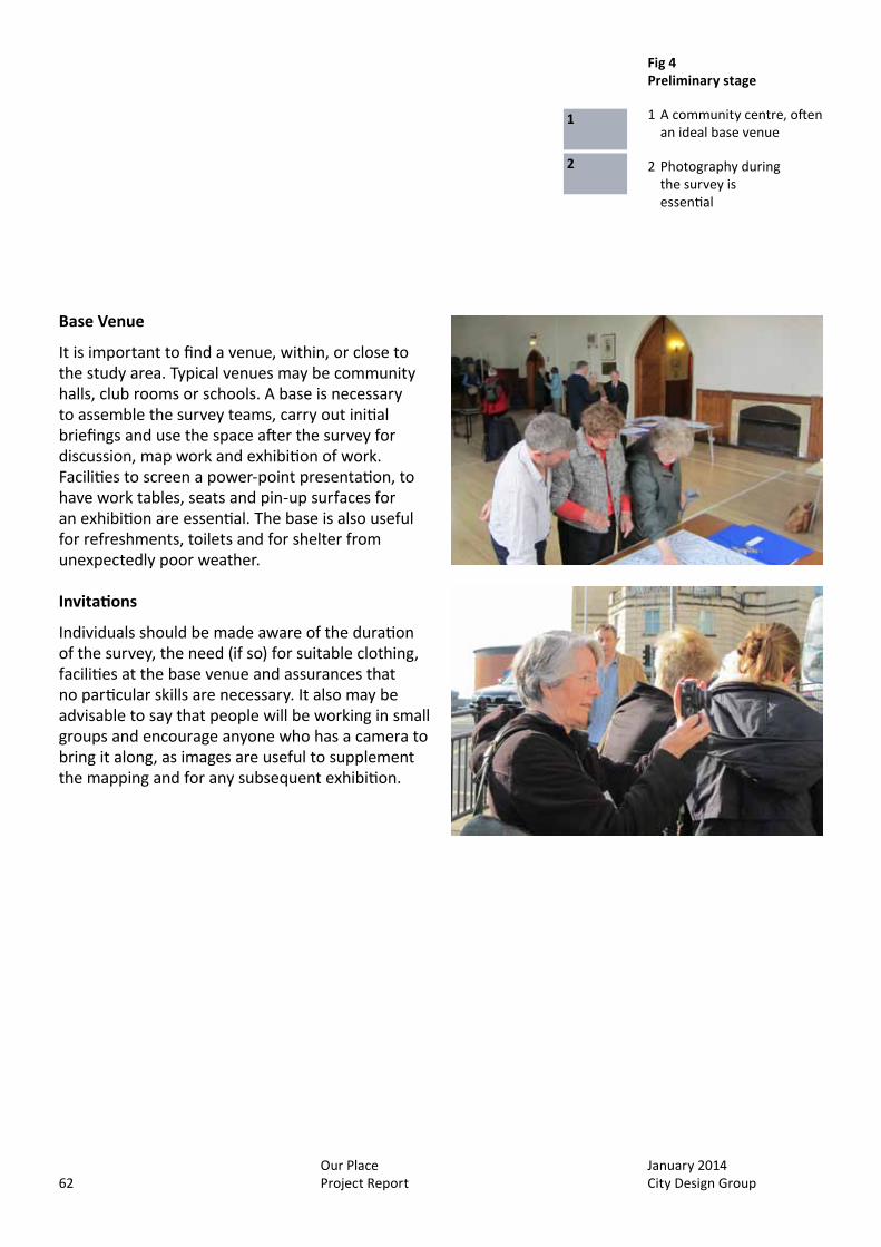
January 2014 City Design Group
Our Place Project Report62
Base Venue
It is important to find a venue, within, or close to the study area. Typical venues may be community halls, club rooms or schools. A base is necessary to assemble the survey teams, carry out initial briefings and use the space after the survey for discussion, map work and exhibition of work. Facilities to screen a power-point presentation, to have work tables, seats and pin-up surfaces for an exhibition are essential. The base is also useful for refreshments, toilets and for shelter from unexpectedly poor weather.
Invitations
Individuals should be made aware of the duration of the survey, the need (if so) for suitable clothing, facilities at the base venue and assurances that no particular skills are necessary. It also may be advisable to say that people will be working in small groups and encourage anyone who has a camera to bring it along, as images are useful to supplement the mapping and for any subsequent exhibition.
Fig 4 Preliminary stage
1 A community centre, often an ideal base venue
2 Photography during the survey is essential
1
2
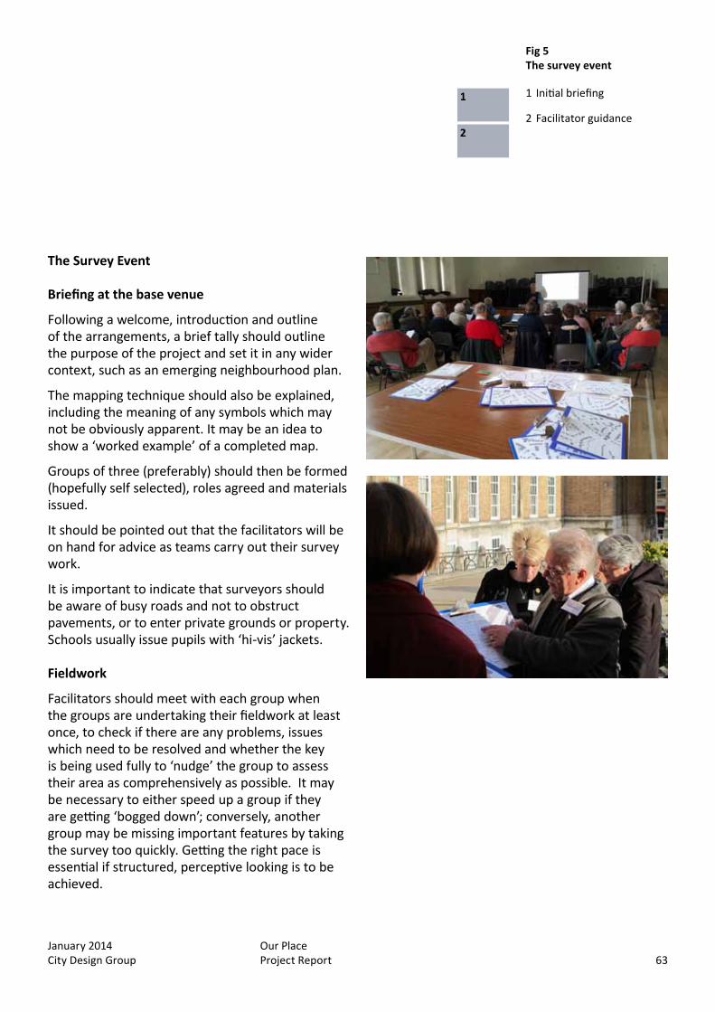
January 2014 City Design Group
Our Place Project Report 63
The Survey Event
Briefing at the base venue
Following a welcome, introduction and outline of the arrangements, a brief tally should outline the purpose of the project and set it in any wider context, such as an emerging neighbourhood plan.
The mapping technique should also be explained, including the meaning of any symbols which may not be obviously apparent. It may be an idea to show a ‘worked example’ of a completed map.
Groups of three (preferably) should then be formed (hopefully self selected), roles agreed and materials issued.
It should be pointed out that the facilitators will be on hand for advice as teams carry out their survey work.
It is important to indicate that surveyors should be aware of busy roads and not to obstruct pavements, or to enter private grounds or property. Schools usually issue pupils with ‘hi-vis’ jackets.
Fieldwork
Facilitators should meet with each group when the groups are undertaking their fieldwork at least once, to check if there are any problems, issues which need to be resolved and whether the key is being used fully to ‘nudge’ the group to assess their area as comprehensively as possible. It may be necessary to either speed up a group if they are getting ‘bogged down’; conversely, another group may be missing important features by taking the survey too quickly. Getting the right pace is essential if structured, perceptive looking is to be achieved.
Fig 4 Preliminary stage
1 A community centre, often an ideal base venue
2 Photography during the survey is essential
Fig 5 The survey event
1 Initial briefing
2 Facilitator guidance
1
2
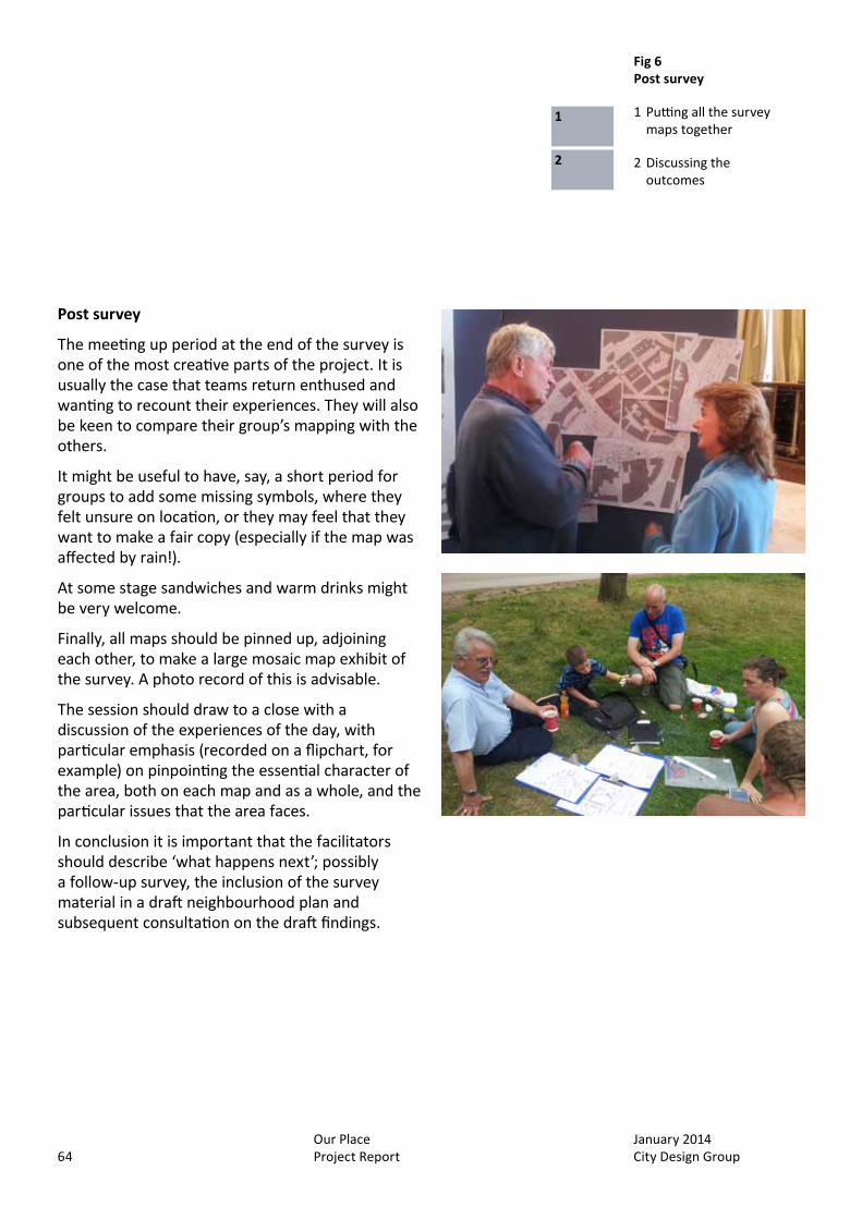
January 2014 City Design Group
Our Place Project Report64
Post survey
The meeting up period at the end of the survey is one of the most creative parts of the project. It is usually the case that teams return enthused and wanting to recount their experiences. They will also be keen to compare their group’s mapping with the others.
It might be useful to have, say, a short period for groups to add some missing symbols, where they felt unsure on location, or they may feel that they want to make a fair copy (especially if the map was affected by rain!).
At some stage sandwiches and warm drinks might be very welcome.
Finally, all maps should be pinned up, adjoining each other, to make a large mosaic map exhibit of the survey. A photo record of this is advisable.
The session should draw to a close with a discussion of the experiences of the day, with particular emphasis (recorded on a flipchart, for example) on pinpointing the essential character of the area, both on each map and as a whole, and the particular issues that the area faces.
In conclusion it is important that the facilitators should describe ‘what happens next’; possibly a follow-up survey, the inclusion of the survey material in a draft neighbourhood plan and subsequent consultation on the draft findings.
Fig 6 Post survey
1 Putting all the survey maps together
2 Discussing the outcomes
1
2
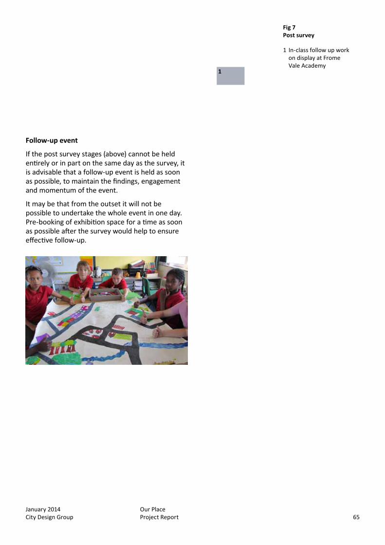
January 2014 City Design Group
Our Place Project Report 65
Follow-up event
If the post survey stages (above) cannot be held entirely or in part on the same day as the survey, it is advisable that a follow-up event is held as soon as possible, to maintain the findings, engagement and momentum of the event.
It may be that from the outset it will not be possible to undertake the whole event in one day. Pre-booking of exhibition space for a time as soon as possible after the survey would help to ensure effective follow-up.
Fig 7 Post survey
1 In-class follow up work on display at Frome Vale Academy
1

January 2014 City Design Group
Our Place Project Report66
Fig 8 The Our Place process
1 Our Place process diagram1

January 2014 City Design Group
Our Place Project Report 67
Fig 8 The Our Place process
1 Our Place process diagram
Fig 9 Our Place
1 An example of a completed survey
1

January 2014 City Design Group
Our Place Project Report68

January 2014 City Design Group
Our Place Project Report 69
Appendix 2
Examples of notation sheets

January 2014 City Design Group
Our Place Project Report70
Appendix 2
Standard neighbourhood notation as used during Our Place Westbury-on-Trym
Examples of notation sheets

January 2014 City Design Group
Our Place Project Report 71
Notation for school groups as used by Year 5 from Whitehall Primary School during Our Place Whitehall
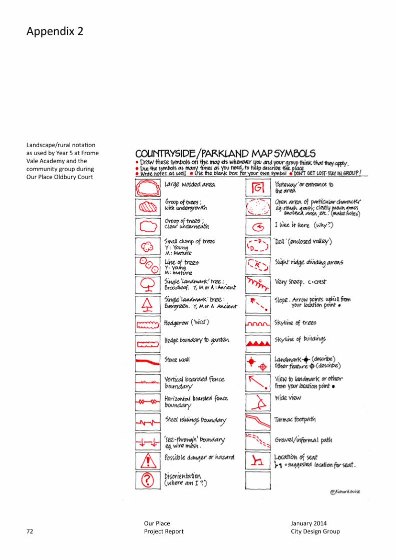
January 2014 City Design Group
Our Place Project Report72
Appendix 2
Landscape/rural notation as used by Year 5 at Frome Vale Academy and the community group during Our Place Oldbury Court

January 2014 City Design Group
Our Place Project Report 73

January 2014 City Design Group
Our Place Project Report74
January 2014 City Design Group
Our Place Project Report 75
Appendix 3
IHBC Southwest conference
January 2014 City Design Group
Our Place Project Report76
Extracts from the powerpoint presentation provided at the IHBC Southwest conference, September 2013
Appendix 3
IHBC Southwest conference
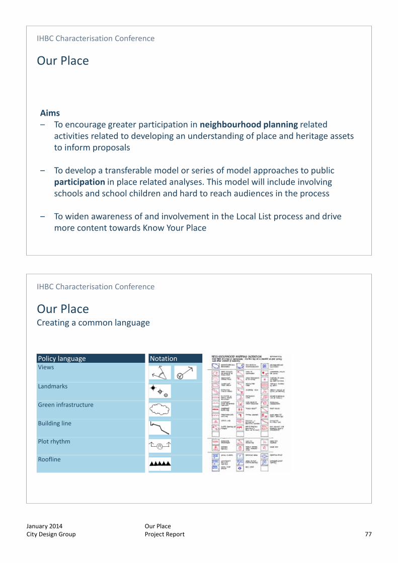
January 2014 City Design Group
Our Place Project Report 77
IHBC Characterisation Conference
Our Place
Aims‒ To encourage greater participation in neighbourhood planning related
activities related to developing an understanding of place and heritage assets to inform proposals
‒ To develop a transferable model or series of model approaches to public participation in place related analyses. This model will include involving schools and school children and hard to reach audiences in the process
‒ To widen awareness of and involvement in the Local List process and drive more content towards Know Your Place
IHBC Characterisation Conference
Our PlaceCreating a common language
Policy language NotationViews
Landmarks
Green infrastructure
Building line
Plot rhythm
Roofline

January 2014 City Design Group
Our Place Project Report78
IHBC Characterisation Conference
Our PlaceCreating a common language
IHBC Characterisation Conference
Our PlaceCreating a common language
Bristol Central Area Context Study
Neighbourhood public realm proposals
Conservation Area Character Appraisal

January 2014 City Design Group
Our Place Project Report 79
IHBC Characterisation Conference
Results
‒ Standardised and consistent approach
‒ Enjoyable and engaging for participants
‒ Rapid
‒ Informs neighbourhood planning and design responses
‒ Common language that links to policy
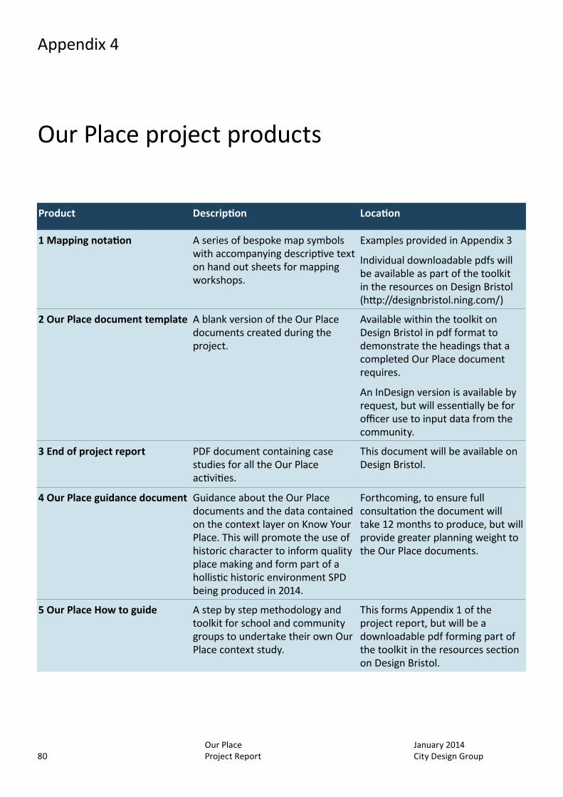
January 2014 City Design Group
Our Place Project Report80
Appendix 4
Product Description Location
1 Mapping notation A series of bespoke map symbols with accompanying descriptive text on hand out sheets for mapping workshops.
Examples provided in Appendix 3
Individual downloadable pdfs will be available as part of the toolkit in the resources on Design Bristol (http://designbristol.ning.com/)
2 Our Place document template A blank version of the Our Place documents created during the project.
Available within the toolkit on Design Bristol in pdf format to demonstrate the headings that a completed Our Place document requires.
An InDesign version is available by request, but will essentially be for officer use to input data from the community.
3 End of project report PDF document containing case studies for all the Our Place activities.
This document will be available on Design Bristol.
4 Our Place guidance document Guidance about the Our Place documents and the data contained on the context layer on Know Your Place. This will promote the use of historic character to inform quality place making and form part of a hollistic historic environment SPD being produced in 2014.
Forthcoming, to ensure full consultation the document will take 12 months to produce, but will provide greater planning weight to the Our Place documents.
5 Our Place How to guide A step by step methodology and toolkit for school and community groups to undertake their own Our Place context study.
This forms Appendix 1 of the project report, but will be a downloadable pdf forming part of the toolkit in the resources section on Design Bristol.
Our Place project products

January 2014 City Design Group
Our Place Project Report 81
Product Description Location
6 Our Place documents produced during the project
PDF documents that define the character/context for any given area as identified by the community using the Our Place methodology.
Each of these are available for download from the Design Bristol website, but have been circulated to the relevant communities either through the original point of contact (Oldbury Court, Westbury-on-Trym) or the neighbourhood partnership team (St Pauls, Whitehall).