Embed Size (px)
Citation preview

2016 - 2019
Project outcome

BESTSDI project outcome
As any Erasmus+ Capacity Building within the scope of Higher Education project, the BESTSDI has set number of project activities and outcomes which should be achieved during the project lifetime. The project activities and subsequently the outcomes have been packed in three groups focusing on (1) the development and implementation of Spatial Data Infrastructure (SDI) curriculum in the study programmes of project partners; (2) creation of preconditions (developing human and technical capacities) for the implementation of developed curriculum and establishing new awareness of the role of academic institutions in the development of national SDI’s, and (3) new forms of cooperation with other SDI stakeholders, governmental and business sector in particular. All of them have been addressed and achieved.
Based on the Status and Requirement analysis conducted within the frame of the project, SDI curriculum has been specified and subsequently developed encompassing 9 modules and 70 topics. Depending on study profile and relevance of SDI for each of them, the partners have implemented study programmes, modules, courses or part of courses in the third year of project life-time. In total 142 courses have been modernised with SDI content and given at partner universities. Those courses have been attended by 3.128 students who have highly appreciated them and awarded an average grade of 3.43 (on a scale of 1 to 4) to courses. Those results show that the expected outcomes have been achieved, however, this process of introducing new SDI content will continue also after the project lifetime, and several new study programmes are under preparation with new SDI content.
The creation of curriculum itself is not sufficient for the introduction of new study programmes, modules or even courses if there are no human and technical capacities. Therefore, two summer schools were organised in Split within the scope of the project offering intensive theoretical and practical training in the field of SDI and related topics for 40 teachers, each of them developing human resources at partner universities. The effects of the training were visible not only in the conducted SDI courses during the third year of project lifetime but also in the number of scientific and professional articles and presentations given and two books on SDI published by consortia partner team members. Along with IT, educational and sensor equipment which has been specified in accordance with specific need of each partner, purchased and installed at 15 faculties in partner countries, the project has also created necessary preconditions for successful implementation of developed SDI curriculum.
The fact that academic institutions and business sector are passive in establishment and development of SDI’s at national, regional and local levels in the countries of the region has been addressed by the project in several ways. The cooperation has been established with National Mapping and Cadastre Agencies in the Western Balkans and with Swedish funded IMPULS project, focused on the development of National SDI’s in those countries. Furthermore, the academic institutions have provided for the first time their Annual National SDI Report for three subsequent years (2017, 2018 and 2019) offering academic view on the development of SDI in their countries. Those efforts resulted in intensification of cooperation among the governmental and academic institutions. Moreover, in all five partner countries, the lifelong learning programmes for the professionals in the field of SDI have been created and courses offered, building new
This brochure is a compilation of all the final achievements of BESTSDI project in which all project partners contribute to. The brochure presents the key project outcomes, quality improvements of higher education in Geographical Information Science and Technology, new and innovative education programme developments, lifelong learning courses, the partnerships with public authorities and business sector to develop the annual national SDI reports, the dissemination of project experiences and results.

form of cooperation between the business and academic sectors. The long-lasting outcome of those activities is raising awareness of new role of academic institutions in the development of SDI in partner countries.
However, to be honest, when launching the BESTSDI in November 2016, we were not fully aware of the complexity of the task that the project consortia intended to perform. Therefore, the project execution has resulted in several activities that have initially not been defined as specific project tasks with targeted outcomes. For example, the teaching activity related to spatial data was not a platform enough to introduce the work on the development of curriculum related to spatial data infrastructure in broad spectrum of study programmes. Thus, after investing a lot of effort in partner communication and education in the past three years, common understanding of spatial data and SDI has been achieved. After conducting several surveys among the stakeholders, we have found out that the lack of common understanding is a major problem, and we find the achievement of common understanding among the consortia partners to be one of our major outcomes.
Main objective of this brochure is to present conducted activities and achieved results through the words of project beneficiaries, the partner institutions, and contribute further to project and Erasmus programme visibility. Further, since BESTSDI project has quit uniquely included academic institutions which deliver eight different study programmes, the brochure is showing relevance of SDI curriculum for different types of study programmes emphasising necessity of its inclusion in higher education study programmes in general. Therefore, the brochure is covering four main project objectives: training of teachers and procurement of equipment aiming to create preconditions to improve quality of higher education in field of SDI, development of new and innovative education SDI programme, introduce and implement lifelong learning programmes at partner universities and develop new forms and achieve new level of cooperation with SDI stakeholders, public and business sector.
Željko Bačić, University of Zagreb

Improving the quality of higher education in Geographical Science and Technology
The following sections present the initiatives taken by the partners of BESTSDI to improve the quality of higher education in Geographical Information Science and Technology.
IMPROVING THE QUALITY THROUGH TRAINING OF TEACHERS
The goal of Work Package: The development of training the teachers from the partner universities to teach courses in English was included in the project curriculum. For this purpose, the appointed task group prepared summer schools’ program, materials, lecturers and technical details important for their successful execution. In order to implement new SDI content in educational curricula of the partner universities, Summer Schools were organised in 2017 and 2018.
Figure 1: First and second Summer School in Split
The first Summer School was held from the 3rd to the 7th of July 2017 at the University of Split, Croatia. The goal of the first Summer School was to transfer theoretical and practical knowledge about SDI mostly from program countries to partner countries. The second goal was to transfer teaching methods and approaches in teaching and implementing the SDI. The third goal was to exchange relevant and valuable information and ideas through teachers.
The second Summer School was held from the 26th to the 30th of June 2018 at University of Split, Croatia. The goal of this second Summer School was to prepare teachers for delivering lectures in SDI courses in the next academic year through their presentations on the content of SDI curriculum using teaching material. According to lecturers, previously planned presentations covered all three modules (basic, advanced and LLL courses).
One of the goals of the Summer Schools related to preparing the teachers for lecturing in SDI courses in the next academic year (or, if not possible, later) has been achieved. All the partners’ faculty teachers held demonstration lectures. The presented courses were improved based on discussions and observations written in forms. The Summer Schools created an important base for the production of courses that were delivered in the 3rd year of the project. Each partner university will train its students according to the new or improved curricula being implemented. The form of interaction through Summer Schools programme turned out to be quite useful in sharing knowledge, ideas and good practice, and we are going to use it as positive experience in possible future projects.
Jelena Kilić, University of Split

BENEFITS AND IMPACT OF ERASMUS+ BESTSDI PROJECT
The BESTSDI Project meets the needs of the Faculty of Forestry Sciences. We highly appreciate the opportunity of acquiring collective skills, experience, and wisdom on SDI issues from a lot of other people from both target groups (SDI providers and SDI users). The main benefits and impacts from BESTSDI Project for Agricultural University of Tirana, Faculty of Forestry Sciences partner are as follows:
1. Introducing SDI and related concepts, and developing learning materials for the following new courses for both undergraduate and graduate study programs in forest management:
a. Introduction to GIS; b. Land Use and GIS; c. Topographic Cartography; d. Forest Cadastre and GIS; e. National Forest Inventories and Remote Sensing.
2. Opening the SDI laboratory equipped with one Master
PC, 19 Lab PC and three GNNS-GIS equipment units (figure 2). The GIS/RS Laboratory will serve as an academic teaching facility as a support to the undergraduate and postgraduate program of studies of the Forestry Sciences Faculty curriculum, and as a facility for faculties and staff of Agricultural University of Tirana and other academic institutions who wish to use SDI techniques in research endeavours.
3. Organizing the training activities supporting the Albanian National Environmental Agency during 2017-2018 together with the Agricultural University of Sweden and Swedish Forest Agency (as facilitators of the process) that implement the process of National Forests and Pastures Inventory (NFPI) in the following topics:
a. Planning and establishment of the sample plots network of the NFPI Pilot survey; b. Presentation of the OPEN Foris as the basis of NFPI data collection; c. Testing OPEN Foris data collection system; d. Data collection process, data validation and data processing of the Pilot Survey; e. Use of the measurement devices for data collection (GPS, Vertex 5); f. Testing the NFPI database and NFPI data collection process in real conditions based on
OPEN Foris (software and tools).
Spiro Grazhdani, Agricultural University of Tirana
EVALUATION OF IMPLEMENTATION
In the course of two semesters, 98 courses were given at 17 faculties within the 11 partner universities. Some courses were new, while the others were adapted to include one or more SDI topics. The courses were attended by 2662 students. At the end of the courses, the students were asked to evaluate the course from different perspectives. Besides questions regarding the intensity of the course (lecture volume, exercises and/or group work, the evaluation related to the following aspects:
The extent to which the SDI content and exercises were well fit in the course;
The quality of the SDI lectures and exercises;
The usefulness of the provided SDI content;
Whether the SDI content was well adapted to already gained knowledge and skills;
Figure 2: SDI laboratory Agricultural University of Tirana
The relevance of the provided SDI content for the professional development and for the study
year in which it was given;
The degree to which the SDI content represents a clear and focused unit;
The quality and usefulness of the SDI lab equipment;
The overall rating of the adapted or new course.
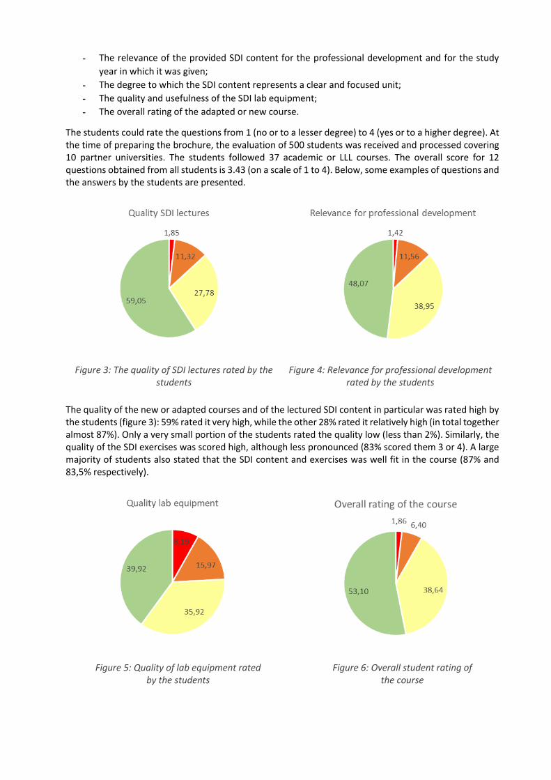
The students could rate the questions from 1 (no or to a lesser degree) to 4 (yes or to a higher degree). At the time of preparing the brochure, the evaluation of 500 students was received and processed covering 10 partner universities. The students followed 37 academic or LLL courses. The overall score for 12 questions obtained from all students is 3.43 (on a scale of 1 to 4). Below, some examples of questions and the answers by the students are presented.
Figure 3: The quality of SDI lectures rated by the students
Figure 4: Relevance for professional development rated by the students
The quality of the new or adapted courses and of the lectured SDI content in particular was rated high by the students (figure 3): 59% rated it very high, while the other 28% rated it relatively high (in total together almost 87%). Only a very small portion of the students rated the quality low (less than 2%). Similarly, the quality of the SDI exercises was scored high, although less pronounced (83% scored them 3 or 4). A large majority of students also stated that the SDI content and exercises was well fit in the course (87% and 83,5% respectively).
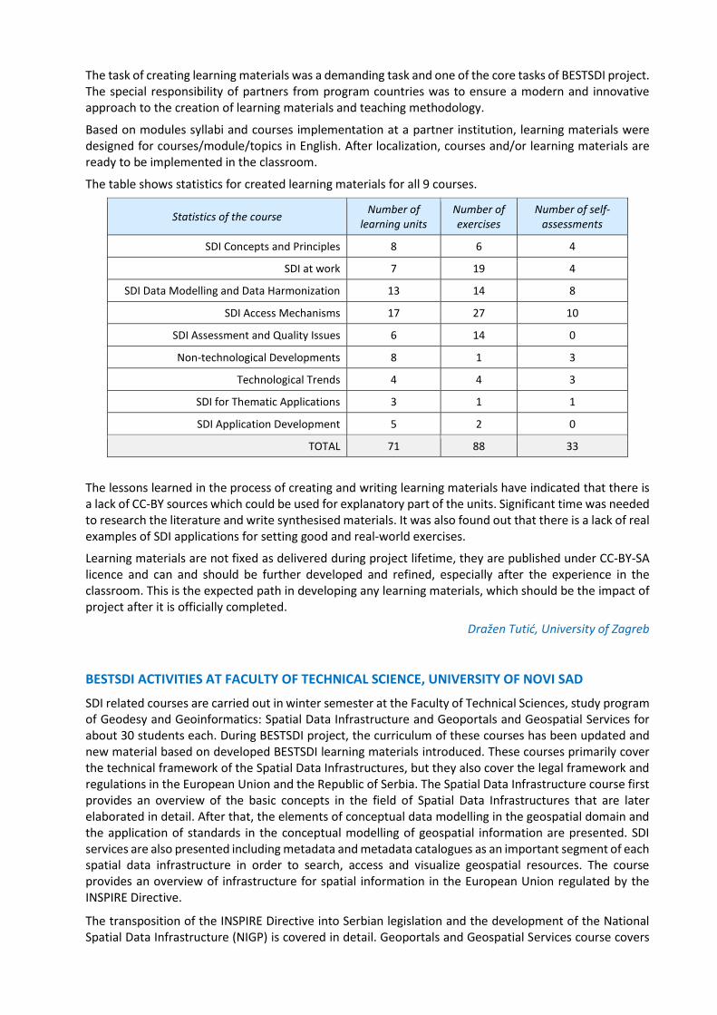
Figure 5: Quality of lab equipment rated by the students
Figure 6: Overall student rating of the course

The students found the courses also very relevant for their professional development: 87% of the students scored them 3 or 4 from this perspective (figure 4). The same number of students rated the SDI content useful or very useful (87%). On the other hand, 23% of the students stated that the SDI content did not very well match their prior knowledge and skills. In other words, the SDI topic is rather new for them and different from other topics they are used to.
The SDI content was deemed to be very appropriate for the study year in which it was given. The students used new equipment (laptops, servers, other materials) which were highly appreciated, even though 24% of them indicated there were some quality issues (figure 5), and also the usefulness was questioned by some of them (17%). Finally, the overall rating of the adapted/new courses was high: 53% of the students were very satisfied, while the other 39% were satisfied (figure 6).
Danny Vandenbroucke, KU Leuven

Developing new and innovative education programme
The development of new and innovation education was carried out in Work Package 2. The following sections present some new and innovative education programmes of 6 partners.
NEW CURRICULA BRINGS NEW LEARNING MATERIALS …
The specific BESTSDI project objectives were to develop, test and adapt new curricula, courses, learning materials and tools within the field of SDI. Learning materials in the form of lecture notes, recorded lectures, assignments, data, and reading instructions etc. were created in order to conduct the academic subjects as specified by the project curriculum (in English and national languages).
Learning materials were developed by courses which followed structure of modules (building blocks) of the BESTSDI core curriculum but not always with one-to-one relation. For the initial set of modules, one course was developed for each module as shown in the figure 7.
Figure 7: Initial SDI Learning Building Blocks
For a specialized set of modules, the relation between courses and modules is as shown in the figure 8.
Figure 8: Specialized SDI Learning Building Blocks
The task of creating learning materials was a demanding task and one of the core tasks of BESTSDI project. The special responsibility of partners from program countries was to ensure a modern and innovative approach to the creation of learning materials and teaching methodology.
Based on modules syllabi and courses implementation at a partner institution, learning materials were designed for courses/module/topics in English. After localization, courses and/or learning materials are ready to be implemented in the classroom.
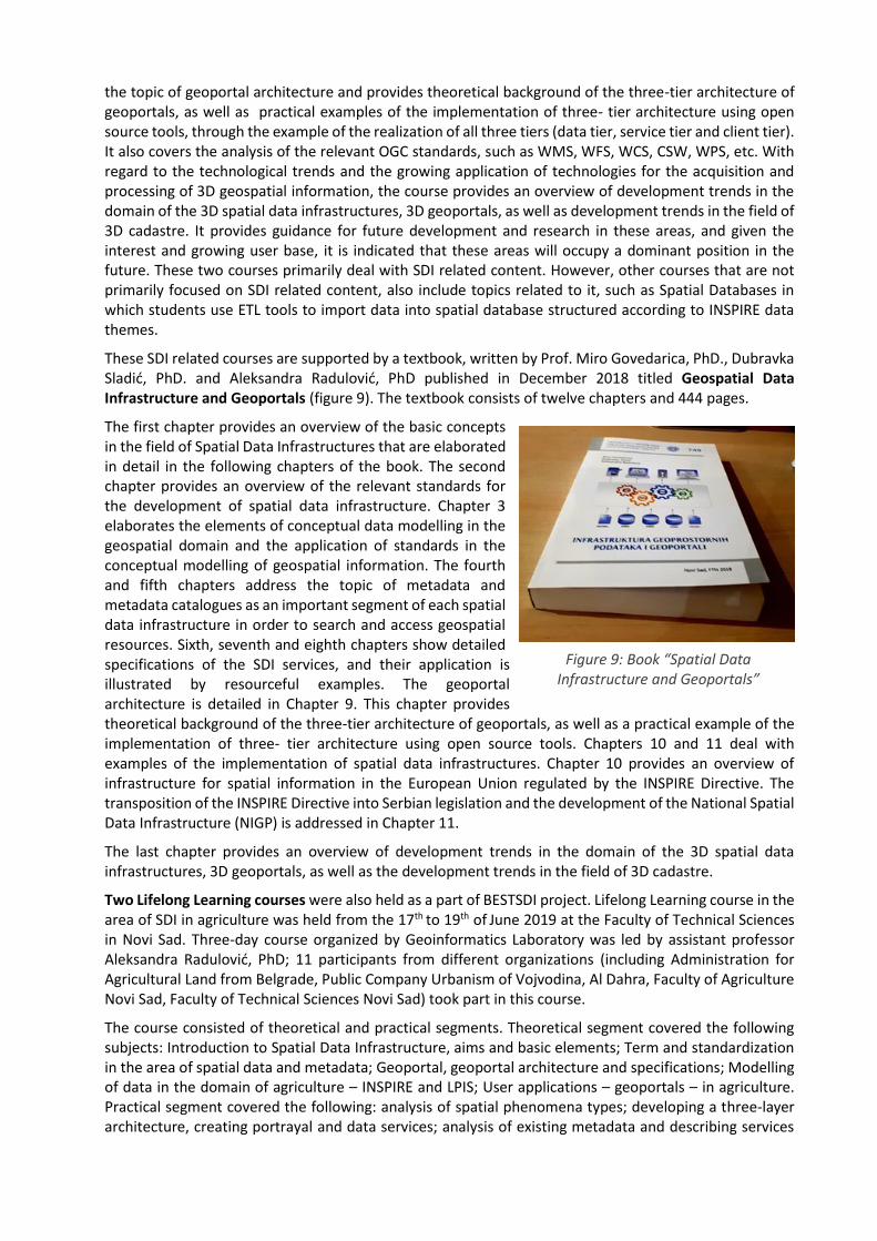
The table shows statistics for created learning materials for all 9 courses.
Statistics of the course Number of
learning units Number of exercises
Number of self-assessments
SDI Concepts and Principles 8 6 4
SDI at work 7 19 4
SDI Data Modelling and Data Harmonization 13 14 8
SDI Access Mechanisms 17 27 10
SDI Assessment and Quality Issues 6 14 0
Non-technological Developments 8 1 3
Technological Trends 4 4 3
SDI for Thematic Applications 3 1 1
SDI Application Development 5 2 0
TOTAL 71 88 33
The lessons learned in the process of creating and writing learning materials have indicated that there is a lack of CC-BY sources which could be used for explanatory part of the units. Significant time was needed to research the literature and write synthesised materials. It was also found out that there is a lack of real examples of SDI applications for setting good and real-world exercises.
Learning materials are not fixed as delivered during project lifetime, they are published under CC-BY-SA licence and can and should be further developed and refined, especially after the experience in the classroom. This is the expected path in developing any learning materials, which should be the impact of project after it is officially completed.
Dražen Tutić, University of Zagreb
BESTSDI ACTIVITIES AT FACULTY OF TECHNICAL SCIENCE, UNIVERSITY OF NOVI SAD
SDI related courses are carried out in winter semester at the Faculty of Technical Sciences, study program of Geodesy and Geoinformatics: Spatial Data Infrastructure and Geoportals and Geospatial Services for about 30 students each. During BESTSDI project, the curriculum of these courses has been updated and new material based on developed BESTSDI learning materials introduced. These courses primarily cover the technical framework of the Spatial Data Infrastructures, but they also cover the legal framework and regulations in the European Union and the Republic of Serbia. The Spatial Data Infrastructure course first provides an overview of the basic concepts in the field of Spatial Data Infrastructures that are later elaborated in detail. After that, the elements of conceptual data modelling in the geospatial domain and the application of standards in the conceptual modelling of geospatial information are presented. SDI services are also presented including metadata and metadata catalogues as an important segment of each spatial data infrastructure in order to search, access and visualize geospatial resources. The course provides an overview of infrastructure for spatial information in the European Union regulated by the INSPIRE Directive.
The transposition of the INSPIRE Directive into Serbian legislation and the development of the National Spatial Data Infrastructure (NIGP) is covered in detail. Geoportals and Geospatial Services course covers
the topic of geoportal architecture and provides theoretical background of the three-tier architecture of geoportals, as well as practical examples of the implementation of three- tier architecture using open source tools, through the example of the realization of all three tiers (data tier, service tier and client tier). It also covers the analysis of the relevant OGC standards, such as WMS, WFS, WCS, CSW, WPS, etc. With regard to the technological trends and the growing application of technologies for the acquisition and processing of 3D geospatial information, the course provides an overview of development trends in the domain of the 3D spatial data infrastructures, 3D geoportals, as well as development trends in the field of 3D cadastre. It provides guidance for future development and research in these areas, and given the interest and growing user base, it is indicated that these areas will occupy a dominant position in the future. These two courses primarily deal with SDI related content. However, other courses that are not primarily focused on SDI related content, also include topics related to it, such as Spatial Databases in which students use ETL tools to import data into spatial database structured according to INSPIRE data themes.
These SDI related courses are supported by a textbook, written by Prof. Miro Govedarica, PhD., Dubravka Sladić, PhD. and Aleksandra Radulović, PhD published in December 2018 titled Geospatial Data Infrastructure and Geoportals (figure 9). The textbook consists of twelve chapters and 444 pages.
The first chapter provides an overview of the basic concepts in the field of Spatial Data Infrastructures that are elaborated in detail in the following chapters of the book. The second chapter provides an overview of the relevant standards for the development of spatial data infrastructure. Chapter 3 elaborates the elements of conceptual data modelling in the geospatial domain and the application of standards in the conceptual modelling of geospatial information. The fourth and fifth chapters address the topic of metadata and metadata catalogues as an important segment of each spatial data infrastructure in order to search and access geospatial resources. Sixth, seventh and eighth chapters show detailed specifications of the SDI services, and their application is illustrated by resourceful examples. The geoportal architecture is detailed in Chapter 9. This chapter provides theoretical background of the three-tier architecture of geoportals, as well as a practical example of the implementation of three- tier architecture using open source tools. Chapters 10 and 11 deal with examples of the implementation of spatial data infrastructures. Chapter 10 provides an overview of infrastructure for spatial information in the European Union regulated by the INSPIRE Directive. The transposition of the INSPIRE Directive into Serbian legislation and the development of the National Spatial Data Infrastructure (NIGP) is addressed in Chapter 11.
The last chapter provides an overview of development trends in the domain of the 3D spatial data infrastructures, 3D geoportals, as well as the development trends in the field of 3D cadastre.
Two Lifelong Learning courses were also held as a part of BESTSDI project. Lifelong Learning course in the area of SDI in agriculture was held from the 17th to 19th of June 2019 at the Faculty of Technical Sciences in Novi Sad. Three-day course organized by Geoinformatics Laboratory was led by assistant professor Aleksandra Radulović, PhD; 11 participants from different organizations (including Administration for Agricultural Land from Belgrade, Public Company Urbanism of Vojvodina, Al Dahra, Faculty of Agriculture Novi Sad, Faculty of Technical Sciences Novi Sad) took part in this course.
The course consisted of theoretical and practical segments. Theoretical segment covered the following subjects: Introduction to Spatial Data Infrastructure, aims and basic elements; Term and standardization in the area of spatial data and metadata; Geoportal, geoportal architecture and specifications; Modelling of data in the domain of agriculture – INSPIRE and LPIS; User applications – geoportals – in agriculture. Practical segment covered the following: analysis of spatial phenomena types; developing a three-layer architecture, creating portrayal and data services; analysis of existing metadata and describing services
Figure 9: Book “Spatial Data Infrastructure and Geoportals”

using metadata; creating and analysis of user application for registration of agricultural parcels and other applications based on JavaScript spatial libraries.
Lifelong Learning course in the area of SDI in Smart Cities was held from the 24th to the 26th of June 2019 at the Faculty of Technical Sciences in Novi Sad (figure 10). Three-day course organized by Geoinformatics Laboratory was led by associate professor PhD Dubravka Sladić. The course also involved participants from different organizations. The course consisted of theoretical and practical part. Theoretical part covered the following subjects: Introduction to Smart City Paradigm, Smart Cities and IoT, Spatial Data Infrastructure and Smart Cities, 3D Spatial Data Infrastructure for Smart Cities – 3D Geoportals, 3D city models and 3D cadastre. Practical part covered the following: development of simple mobile app for monitoring free parking spots based on Leaflet JS library in an online editor; Establishment of SDI architecture on city level using open source software (QGIS, Geoserver, GeoNetwork) – from creation of spatial data to its distribution; Creating online 3D city model using OGC CityGML standard and Cesium JS library – 3D City DB; Implementation of 3D cadastre using OpenBIM format and BIMServer.
Figure 10: Participants of Lifelong Learning course in the area of SDI in Smart Cities
Erasmus+ project BESTSDI was presented to the participants, as well as the book “Spatial Data Infrastructure and Geoportals” written by Miro Govedarica, Dubravka Sladić and Aleksandra Radulović. At the end of the course, the head of Geoinformatics Laboratory, professor PhD Miro Govedarica congratulated participants on successfully taken course and gave them the certificates of attendance.
Dušan Jovanović, University of Novi Sad
NEW MATERIALS AND TEXTBOOK “BASICS OF SPATIAL DATA INFRASTRUCTURE”
At the beginning of this project, spatial data infrastructure was included to lesser extent in undergraduate and graduate studies at Faculty of Civil Engineering, University of Sarajevo. Today, three years later, we can say that all BESTSDI objectives have been fully met and incorporated in several courses of the study program of geodesy and at the departments for roads and transportation and hydrotechnics.
Throughout the project BESTSDI, the existing courses were updated and also some new courses were introduced. These SDI related courses are supported by a textbook, written by Prof. Slobodanka Ključanin, PhD, Prof. Vesna Poslončec-Petrić, PhD and Prof. Željko Bačić, PhD published in Sarajevo in 2018 titled Basics of Spatial Data Infrastructure (figure 11). The textbook consists of 6 chapters and 166 pages. This book has primarily an educational function, promotional function and compiles acquired experience from implemented projects or from participation in projects.

The first chapter provides introduction to spatial data infrastructure. The authors aim to provide basic definitions of what data and data sharing are, introducing the SDI and the introduction to the INSPIRE Directive, Implementation Rules and the INSPIRE organization. In the second chapter – Data Quality – the authors explain in detail the importance of the quality of spatial data, technology and standards, as well as the processing and storage of data. Chapter 3 gives an overview of technologies needed to access and distribute spatial data. Chapter 4 provides basic information on the importance of establishing the NSDI, the institutional, technological and financial frameworks for NSDI implementation, as well as their benefit. In the fifth chapter, the adjustment of national regulations in accordance with INSPIRE is described (basic knowledge of metadata, harmonization, dissemination and SDI Geoportal). Chapter 6 presents a comparative analysis of the Strategies and Business models from eight countries: Sweden, Norway, Indonesia, India, Croatia, North Macedonia, Slovenia and the United Kingdom.
Suada Džebo and Ammar Šarić, University of Sarajevo
IMPLEMENTATION OF NEW COURSES AND STUDY PROGRAM
The Implementation of New Courses and Study Programs was achieved under the Task 2.7 "Running the courses with the students of WP2b Development – Implementation of curriculum" in accordance with the structure proposed in Project description, the consultations were conducted at the Kick-off meeting of the Project on November 14-16, 2016 in Zagreb.
The specific BESTSDI project objectives are to develop, test and adapt new curricula, courses, learning material and tools in the field of SDI. The incorporation of SDI and other modern concepts based on spatial data and information will help the graduates who have attended the new courses to efficiently provide spatial data and services for SDI users when entering the job market. The partners are actually carrying out some courses simultaneously with the development of new curriculum that include the SDI contents. These courses are at both levels of studying, Bachelor and Master. They are mostly included in the study programs of Geodesy, Geoinformatics and Geo-Environment. The goal of this Task was to make a clear view of the existing running courses and to give a clear view of the SDI contents included in these courses. Figure 12 shows the table used to collect the data from partners Universities.
Nr. Course Study Semester Teachers Number of Students
Volume of SDI Content
Credits ECTS
Teaching Materials
1 Mine Modeling Bachelo
r 1
Edmond Hoxha
25 30% 5 1. Hoxha E. Lesson 2. Kuka R. Mining modelling 3. Micromine Manual
2 Mine Modeling Master 1 Edmond Hoxha
20 30% 5 1. Hoxha E. Lesson 2. Kuka R. Mining modelling 3. Micromine Manual
3 GIS Bachelo
r 2
Edmond Hoxha
20 20% 5 1. Hoxha E. Sistemet e Informacionit GIS 2. Muka G., Hoxha E. ArcGIS
4 GIS Master 2 Edmond Hoxha
25 20% 5 1. Hoxha E. Sistemet e Informacionit GIS 2. Muka G., Hoxha E. ArcGIS
5 Digital
Cartography Bachelo
r 2 Gafur Muka 20 30% 3.5 Muka G. Digital Cartography
6 Photogrammetry Master 2 Boris Strati 20 30% 5 Lessons
7 Satellite Geodesy & Hydrography
Master 2 Boris Strati 20 30% 5 Lessons
8 Remote Sensing Bachelo
r 2
Spartak Kuçaj
20 30% 3.5 Kuçaj S. Telerilevation
Figure 12: Table used to collect the data from partner's universities (FCE Faculty of Geology and Mining
Figure 11: Basics of Spatial Data
Infrastructure

At the end of this study we can conclude the following: [1]. From 16 University Partners, 12 Universities have reported the Executed Courses. Four other
partners are not included in this study. [2]. In total, there are 142 courses run by 12 Partners; [3]. Out of 142 Courses: a) 8 courses have 100% SDI Content; b) 17 Courses have around 50% SDI
Content; c) 117 Courses have less than 50% SDI Content; [4]. There are 61 courses at Bachelor level; [5]. There are 74 courses at Master level; [6]. SDI content is apparently included at both levels, Bachelor and Master. [7]. The total number of students attending these courses organized by 16 Partners is around 3218; [8]. The average number of students per group around 23 students; [9]. There are 258 teaching materials used in 142 courses (Lessons & Text Books) The following chart
shows the % of SDI content
Figure 13 presents a chart showing the distribution of SDI content.
Figure 13: SDI Content chart
Based on these conclusions, we provide the following recommendations: [1]. It is highly recommended to increase the Content of the SDI in different subjects, especially at
Master level; [2]. It is recommended to include new Courses (subjects) dedicated to SDI concepts; [3]. It is strongly recommended to review the existing courses with the purpose of increasing SDI
content; [4]. The unification and exchange of text books among partners is recommended for similar subject. [5]. It is highly recommended to train teachers in SDI and GIS subjects
Edmond Hoxha, Polytechnic University of Tirana, Albania
NEW STUDY PROGRAM OF GEODESY AND GEOINFORMATICS AT THE UNIVERSITY OF BANJA LUKA
The first cycle of studies lasts for years with eight semesters (Bachelor of Geodesy - 240 ECTS), according to the Rulebook on the list of vocational, academic and scientific titles (2014). The acquired qualification profile is equivalent to ISCED Level 6 - The International Standard Classification of Education and Level 6 EQF - The European Qualifications Framework. The subject of accreditation was a new study program of geodesy - the first cycle (240 ECTS), which was modified from the existing one - accredited in 2007 and upgraded in 2014, which included teaching through 68 subjects. One of the overarching principles that was sought in the preparation of the Feasibility Study Elaboration of Study program of Geodesy - the first cycle was the integrity of the teaching process in which knowledge and skills in the field of geodesy are transferred to students - interdisciplinary, through professional engineering subjects grouped by narrow scientific fields in the teaching form of lectures, exercises and hands-on work, which supports an integrated approach to studying. Professional courses in the new program will be delivered through 6 narrow scientific fields:

- Geodetic reference systems - Survey - Cadastre and real estate management - Geoinformatics - Photogrammetry and remote sensing - Cartography (mathematical, general, digital, creation and duplication of plans and maps)
During the year 2018, the self-evaluation of the Study Program of Geodesy was performed as part of the process of re-accreditation of the Geodesy Study Program. All of these activities provided a good starting point for making changes to the first cycle of studies. The used approach was to incorporate SDI concepts in most courses in the new study program as a basis. According to the new program, the first cycle of studies is foreseen to be carried out through 44 subjects, out of which over 60% have topics related to SDI, while some subjects are exclusively topics related to this field. Given the insufficient knowledge and opportunities provided by the SDI concept, it is necessary in various ways to promote and educate the personnel who will adequately integrate these concepts in all areas of work and activities of different state institutions, as well as private entities through which standardization and adequate exchange of data will be enabled. Surely, to make this possible, it was necessary to modify the curricula and adapt them to the needs of the economy, especially those of specific subjects, in order to provide a quality staff that will enable the implementation of these requirements. In addition to training new staff, it is also necessary to organize courses for lifelong learning that are tailored to the needs of business entities.
Within the scope of the project, the equipment was provided for the implementation of modernized curricula at the University of Banja Luka in order to carry out teaching activities adequately related both to theoretical and practical training at the academic level at the Bachelor studies and in lifelong learning courses. Additionally, through the BESDTSDI project, Memorandum for Understanding will be established between the project partners in order to have a formal framework for future exchange and harmonization of curricula, learning materials, mobility at partner institutions, etc. which will be an important part of including materials in our own learning materials. Currently, the new study program of Geodesy is in the process of accreditation in the Ministry of Education and Culture of the Republic of Srpska, while the document has received the approval of all instances at the level of the University of Banja Luka. The classes under the new program are expected to start from the academic year 2020/2021. In the academic year 2018/2019, the corrections were made in the existing materials within the allowed changes of up to 20% based on new learning materials related to the narrow scientific field of Geodetic survey and Geoinformatics on topics related to SDI.
Within the BESTSDI project at the Faculty of Architecture – Civil Engineering – Geodesy of the University of Banja Luka, we prepared two lifelong learning (LLL) courses. In the joint workshop of the IMPULS and BESTSDI projects in April 2018, the importance of LLL courses was discussed. Most SDI stakeholders have expressed a great need for lifelong learning in order to train staff who will adequately be able to implement the SDI within their authority. So, within the BESTSDI project, two courses which were held in the first week of October 2019 are:
1. Basics of SDI for Providers - A course that presents the SDI concepts and technology for spatial data providers for beginners (engineers who produce new spatial data sets based on observation and measuring or on spatial analysis of the existing data. In this course, the beginners will acquire knowledge related to: understanding and explaining the SDI concepts and components, understanding the main chapters of the INSPIRE Directive, identification and description of principles, concepts and characteristics of web services, understanding and describing OGC standard specifications for CSW, WMS, WFS with practical use, use of web services for downloading data within the GIS applications or web maps.
Figure 14: Practical and laboratory work of 2nd and 4th year students, July 2019
2. Setting-up of OGC Web Service - A course that presents the service settings (WMS, WFS, CSW) for spatial data providers. In this course, learners will acquire knowledge related to: settings for creating web services, configuring and setting up WMS, operational WFS and CSW and testing the quality of their characteristics and attributes.
Mladen Amović, University of Banja Luka
IMPLEMENTATION OF NEW COURSES AND STUDY PROGRAM AT THE FACULTY OF CIVIL ENGINEERING SUBOTICA, UNIVERSITY OF NOVI SAD
The start of the activities within the BESTSDI project at the Faculty of Civil Engineering Subotica, University of Novi Sad, coincided with the effort made by the faculty to establish a new study programme in the field of the Geodesy. The first step towards the creation of this study programme was to evaluate similar study programmes and to identify current state of Geodesy in the country and in the wider region. In that sense, the activities conducted within the BESTSDI project served as an excellent starting point for our new study programme. We had an opportunity to learn from our project partners and to incorporate contemporary achievements into the new programme that have become the basis of modern geodesy, most prominently SDI content. The analysis of the feedback from project partners during the preparation of the upgraded BESTSDI project curricula motivated us to create a study programme that has increased workload focused on practical work with the students.
Our new study programme of geodesy considers therefore the fact that living in the world of constant changes and rapid technological development requires a new approach to learning about space. The practice requests results at glance, in real time, which can be supported only by contemporary, multidisciplinary, and flexible education process.

In line with that, we created a study programme based on theoretically approved knowledge, boosted at the same time by learning about breakthrough technologies and SDI. The goal was to educate an engineer capable of entering labour market immediately after graduating.
Our study program is designed as a Bachelor study program that lasts for four years and consists of general and professional courses. General courses cover the fields of math, physics, statistics, geoinformatics, foreign languages, and law, providing the basic knowledge needed for further application courses.
The content of professional courses can be roughly divided into the following categories:
o surveying (instrumentation and measuring methods), o theoretical geodesy (reference systems, physical characteristics of the Earth, gravity field, etc), o engineering geodesy (application in civil, architectural, and mechanical engineering), o satellite and airborne geodesy (navigation, satellite methods, photogrammetry and remote
sensing), and o land management (cadastre, land consolidation, real estate appraisal).
The contents of the courses are carefully prepared to make them interesting and, at the same time, meaningful and useful, with all relevant topics included. Optional courses are created in a flexible way, allowing updates aligned with the technological development. We have a strong connection with practice, achieved in collaboration with private surveying companies. The benefits of such cooperation are the opportunity to approach the latest technologies, and students practice in the private sector, preparing them for independent work immediately after their graduation.
At the end of all four summer semesters the students’ practice is organised, supervised by teachers. During the practice in surveying, reference networks, engineering geodesy, and cadastre, all performed in the same workspace, the students demonstrate their theoretical knowledge and the ability to connect various geodetic fields.
After graduating, our engineers are capable of performing each engineering task in practice. The ones that plan to further extend their academic knowledge can enter any Master programme and continue their academic education
Figure 15: Practical work with 1st year students, June 2019
With respect to all this, our new Study programme "Geodesy" has fulfilled wider objectives of the BESTSDI project aimed at improving the quality of higher education in the field of SDI and enhanced skill level of our students. Our new study programme also fulfilled the specific project objectives such as: adaptation of the course curriculum, upgrading the existing undergraduate and graduate geodesy and geoinformatics curricula. Apart from creating the new study program, as a part of our BESTSDI activities, we have upgraded 9 existing courses in the field of civil engineering by incorporating SDI content into them.
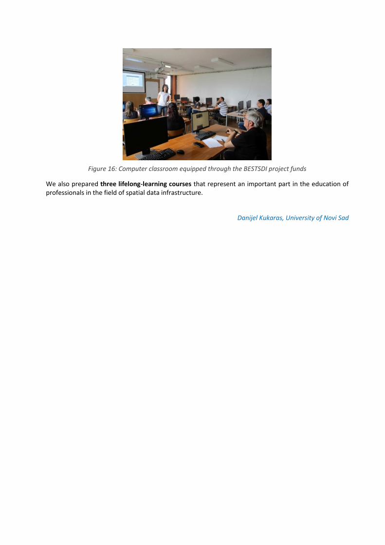
Figure 16: Computer classroom equipped through the BESTSDI project funds
We also prepared three lifelong-learning courses that represent an important part in the education of professionals in the field of spatial data infrastructure.
Danijel Kukaras, University of Novi Sad

LIFELONG LEARNING COURSES
GENERAL
The dissemination & exploitation was carried out by WP4 which is divided into five tasks and one of them is related to LLL: Task 4.2 - Life-long learning (LLL) courses for professionals.
The result expected by WP4 directly related to LLL is a sufficient number of professionals attending the LLL courses developed within the frame of the project and who were able to act as promoters of SDI and the development of a sustainable LLL model. To achieve the expected project result, each partner was required to conduct a minimum of three (3) LLL courses for professionals during the 3rd year of the project lifetime.
WORK IN PROGRESS
Within the LLL planning process, a questionnaire related to gathering initial information about the planned LLL courses was sent to all partners in July 2018. The collected responses served as a source of ideas for the implementation of the courses among other partners.
The main questions were how the LLL courses should be prepared and executed, what the main thematic area should be, whether the assistance of other partners will be needed, and a brief description of how the course should be conducted.
Specific questions were related to the details of the planned LLL course (proposed name, relation to the BEST SDI curriculum building block, timeframe for the implementation and planned duration of the LLL course, method of financing rate, the main form of the LLL course, expected number of participants and testing of participants' knowledge).
During the LLL implementation process, a questionnaire designed to collect information about the completed LLL courses was sent to all partners in March 2019. The questions were consistent with the initial course planning questionnaire.
This questionnaire will be open permanently throughout the project duration and will eventually be the basis for all conducted LLL courses. In order to provide data available to everyone, a link to these answers can be found at the project web site.
Additionally, the evaluation forms for professionals attending LLL courses were prepared within the Task 2.7 (in English and Croatian) and delivered to all partners in January 2019, with the note that evaluation forms must be used each time the course is completed.
TASK REPOSITORY
Finally, in the light of the full availability of all data within the frame of the project, all partners were asked to download from the project website a brief report regarding the organized LLL course, the scanned attendance list and evaluation forms, materials that the partners used in the LLL course.
Hrvoje Meaški, University of Zagreb

LIFELONG LEARNING education for Agricultural Extension Services
Learning is journey for life. Lifelong learning is voluntary, rather than compulsory, and is completely self-motivated – with the main goal being to improve personal or professional development.
In order to perform their job successfully, agricultural advisors need to keep up with the latest technologies in the field of their interest and to continuously improve their capacities and knowledge. Knowledge, skills and competences of advisers could be improved through continuous professional trainings and courses.
Two types of training are foreseen by the Law on Extension Services in Agriculture of the Federation of Bosnia and Herzegovina:
o training to become a certified agricultural advisor, o annual training of certified advisors.
Faculty of Agricultural and Food Sciences, University of Sarajevo is one of the authorized institutions to conduct trainings prescribed by the Program for theoretical and practical training for certification, conducting professional examination and issuing certification for agricultural advisors as well as for conducting obligatory annual training for certified agricultural advisors in the following areas of advisory activities:
1. crop production, vegetable growing, agricultural mechanization and economy of these productions,
2. fruit growing, agricultural mechanization and economy of these productions, 3. grape growing, agricultural mechanization and economy of these productions, 4. cattle breeding, aquaculture, agricultural mechanization and economy of these productions, 5. rural development.
In collaboration with the Federal Ministry of Agriculture, Water Management and Forestry, our faculty organized the first trainings for agricultural extension advisors. The trainings were held in the period from the 2nd to the 6th of September 2019 in the faculty premises.
Figure 17: 1st trainings for agricultural extension advisors at the Faculty of Agricultural and Food Sciences University of Sarajevo
In accordance with the needs and actual topics, one of the training topics was the Spatial Data Infrastructure and application of information systems in the sector of agriculture. In addition to the theoretical part, the training included the demonstration of practical examples that facilitated the understanding of Spatial Data Infrastructure and its importance in the processes of evaluation, planning and decision making.
The BESTSDI project team of the faculty participated in the training having an opportunity to demonstrate the knowledge and skills acquired through the project. Taking the discussion with participants, their interest and needs in conducting daily activities into consideration, it is beyond doubt that more practical examples and exercise need to be involved. The equipment purchased within the frame of BESTSDI project will be used for practical work in future training.

The introduction of Spatial Data Infrastructure into the training for Agricultural Extension Services is a very important step in ensuring the sustainability of the project results after the completion of the project.
Melisa Ljuša and Hamid Čustović, University of Sarajevo
LLL COURSES AT FACULTY OF MINING, GEOLOGY AND CIVIL ENGINEERING, UNIVERSITY OF TUZLA
Faculty of Mining, Geology and Civil Engineering is a higher educational institution that organizes and conducts academic studies in the domain of engineering sciences including the scientific fields of mining, geological engineering, civil engineering and safety studies. During six decades of work, the Faculty as an educational institution developed also into a scientific institution that has accomplished numerous significant domestic, European and international projects. Its scientific and educational activities are organized through five study departments and 15 scientific fields.
As the activity of Erasmus+ BESTSDI project in Work package 2a, the equipment purchases and installation (12 PCs, 2 laptops, 1 server, 1 storage unit and 1 projector) were completed at the Faculty in April 2018.
The BESTSDI project’s activities and importance for the improvement of the curriculum at the Faculty were presented in the University Newspaper. There was also the article "Development of new education programs in the field of Spatial Data Infrastructure (IPP) in Bosnia and Herzegovina (BESTSDI project)" published in Journal of the Faculty of Mining, Geology and Civil Engineering, No.6, 2018.
Within the frame of Work package 2b, a few parts of SDI curricula have been introduced and implemented in local curriculum during the academic year 2018-19: Geology study program (the courses Geographic Information Systems and Environmental Geology) and Mining study program (the course Fundamentals of Geographic Information Systems.
The BESTSDI project is particularly important for fostering lifelong learning (LLL) courses at partner universities.
Figure 19: Participants of LLL course "Application and significance of Spatial Data Infrastructure content (SDI) in High Schools and Higher education in Tuzla Canton”
The LLL course "Application and significance of Spatial Data Infrastructure content (SDI) in High Schools and Higher education in Tuzla Canton" was organized in June 2019 (figure 18). The course was attended by professors of informatics, and engineers who work in high schools (figure 19). This workshop was
Figure 18: Poster for LLL course organized in June 2019 in Tuzla

supported by the Ministry of Education and Science of Tuzla Canton recognizing the course as a contribution to their professional training. After the first such course, 13 teachers received certificates of completion of the workshop.
Mirza Ponjavić and Rejhana Dervišević, University of Tuzla
QUALIFICATION WORKSHOPS (LLL) AT THE FACULTY OF GEOLOGY AND MINING, TIRANA
During April and May 2019, three Qualification Workshops (LLL) were held for experts from public and private institutions. The workshops were organized by the Department of Mining Resources Engineering, Faculty of Geology and Mining, PUT, in the framework of the BESTSDI Erasmus+ project.
Figure 20: Participants of LLL course "Application and significance of Spatial Data Infrastructure content (SDI) in High Schools and Higher education in Tuzla Canton”
The workshops were organized with theoretical and practical lectures. The seminar topics were GIS, SDI, Mining Surveying, Rocks Mechanic, Remote Sensing, and Photogrammetry. At the end of the seminar cycle, the closing ceremony took place with the participation of the Dean of the Faculty of Geology and Mining where the Certificates were distributed (figure 20).
Edmond Hoxha, Polytechnic University of Tirana
IMPACT ON LABOUR MARKET AND SOCIETY
The ‘BESTSDI/EuroSDR Academia-Business Survey on needs and cooperation in the field of Spatial Data Infrastructure (SDI)’ was performed in June 2019 with a strong focus on the impact on labour market and society. A questionnaire was sent to potential stakeholders in the Western Balkans and European Union. The questionnaire was prepared and distributed in Albanian, Croatian, English, Macedonian, and Serbian languages and contained 19 questions dealing with the knowledge and skills provided by academic institutions in field of SDI, academia-business cooperation and its influence on labour market, SDI-future, and hampering factors. In total, we received 134 responses, out of which 72 were from the Western Balkans and 62 from the European Union. The survey suggests strongly that the lack of qualified personnel is a major bottleneck for the further development of SDI (in particular relevant for the Western Balkans region). Academic SDI-education is considered to be very relevant but needs to be better co-ordinated with the technological developments (such as Big Data, Blockchain, Linked Data, Artificial Intelligence). The labour market expects that professionals have basic knowledge and certain advanced skills related to cartography, earth observation, photogrammetry, data analytics/modelling/ manipulation. Companies find academic SDI-education important for organizing workshops/seminars, sharing experiences and running possible joint project. It also appears that Vocational Education and Lifelong Learning are also relevant for the labour market although less important than academic SDI-education. The results were presented and discussed at the Final Conference (Sarajevo, 3 September 2019)
Joep Crompvoets, KU Leuven

Partnerships with public authorities and business sector – Annual National SDI Reports
ANNUAL NATIONAL SDI REPORTS
The coordination of stakeholders at the national level of partner countries was defined as an independent specific task focused on emphasizing the importance of stakeholder’s coordination in their effort to develop study program content harmonized with their needs and to disseminate the project results to broad academic and professional audience. This task was accomplished at the national level, organized and performed by the National Coordinator in each partner country, supported by Project Office and Project Advisory Committee and monitored through the delivery of annual National progress reports.
One of the important outcomes of BESTSDI project was creation, preparation and drafting of Annual National Spatial Data Infrastructure (NSDI) Reports for five partner countries. It was the first time that academic view about the establishment of the NSDI in partner countries has been written down and presented to other major stakeholders. The aim of this activity is to contribute to further development of NSDI in respective countries, and promote the creation among stakeholders, as well as to raise awareness of the role of academic society in SDI development in academic society itself and among other stakeholders.
For each year of project lifetime, a Report was prepared (figure 21). The first National SDI Reports focused on providing the overview of the status of SDI education and development in a respective country. In the second National SDI Reports, the partners were focused on the implementation of new curriculum in their study programs, and in the third National SDI Reports, there was a general overview given about the first impact of the project, achieved networking and perspective.
The prepared National SDI Reports were disseminated among the stakeholders who were asked to review them. The reviews were used to improve the quality of the reports and of the addressed activities in the project.
All National SDI Reports prepared within the frame of BESTSDI project are public and can be freely downloaded as follows:
Albania (Year 1: ALB; Year 2: ALB, EN, Year 3: ALB, EN) Bosnia and Herzegovina (Year 1: BOS; Year 2: BOS, EN; Year 3: EN) Kosovo (Year 1: ALB; Year 2: ALB, EN, Year 3: ALB, EN) Montenegro (Year 1: MNE, Year 2: MNE, EN; Year 3: EN) Serbia (Year 1: SRB; Year 2: SRB, EN, Year 3: EN)
The success of the whole project, besides the introduction of new curriculum and its implementation at partner universities, should therefore be measured based on the penetration of project information into the academic and professional society.
Vesna Poslončec-Petrić, University of Zagreb
Figure 21: BESTSDI Annual National SDI reports

POLYTECHNIC UNIVERSITY OF TIRANA, FACULTY OF CIVIL ENGINEERING
BESTSDI Project paid special attention to the status, involvement and activities of all stakeholders in NSDI arena in Albania. This aspect was indeed a very important issue in the context of fulfilling the main objective of BESTSDI project related to the evolution of Geospatial Education Curricula to support the development in all dimensions of SDI-s in the Balkans partner countries.
The concept of involvement of stakeholders in the SDI process is related to the fact that NSDI is the core, key product and future obligation in the use of geospatial data and information. In other words, NSDI is a necessary tool to be used by future users in order to achieve standards and requirements related to geospatial data and information at national and international level. In the process of implementation of BESTSDI Project in the course of the last three years, many efforts have been made to learn about the status of stakeholders in Albania to involve them in the process and make them active contributors to the project Objectives and domestic SDI developments. This activity is also presented and reflected in the annual SDI National Reports.
Thus, during the first year of the project, 2017, the main stakeholders in public, non-public and private sectors were identified through Albanian UPT & UBT partners, as well as their status with regard to SDI and the NSDI Law 12/72. Referring to this year, it was defined that:
- State Authority of Geospatial Information (ASIG), established according to the NSDI Law 12/72, approved in 2012 by the Parliament, with the status of coordination and responsibly in the creation of SDI, became fully active and functional.
By defining ASIG as a responsible state authority and coordinator, we note that the coordinating function is a general duty and obligation to be fulfilled. ASIG has really done a remarkable effort to accomplish this function, especially with public institutions, the situation seems positive and continues to be developing.
- The National Geoinformation Board attached to ASIG has been established according to the Law.
According to the Law 12/72 and some DCM, in the context of implementation of INSPIRE and creation of SDI, the stakeholders in Albania were analysed and the important stakeholders in producing, providing and applying the geodata defined as follows:
1. Public Sector Stakeholders such as IPRO (Immovable Property Registration Office), ALUIZNI (Agency for Legalization of Informal Buildings and Construction), INSTAT (Institute of Statistics), Informatics Digitalization Agency, Ministry of Agriculture, Ministry of Transport, Institute of Monuments, Interior Minister (local government), Municipality of Tirana, Urban Planning Institute, Albanian Geological Service, UPT, UBT, etc.
2. Private sector Stakeholders, of which the most active were: Geo Consulting Ltd., MOG, Lorenco & CO. Sh.p.k., Gjeo-VJOSA Ltd., Geotrim Ltd., IKUB INFO, GIS-DATA, Geodesy & Infrastructure, GentALBA, IMB, etc. Private sector has had its representatives in the Board of Geoinformation ever since 2016.
3. Others, e.g. foreigner stakeholders: Kartverket (Norwegian Mapping Authority), JICA by Government of Japan, BESTSDI Project, GEOWEB Project, etc.
In the second year of BESTSDI project (2018), an increase of Stakeholders activities was reported.
Public institutions (marked as Stakeholders) were fully active in the process of creating the metadata and state standards, based on INSPIRE standards (14 received approvals and decision by DCM until 2018 and 8 of them in 2019), in the process of coordination, and in the process of data sharing and access. Three Public institutions created their own portals (AMBU Portal – Water Cadaster WMS/ WFS, DPGJCV Portal – Address book WMS/WFS, ARRSH WEB- GIS Portal WMS/WFS) in agreement with ASIG, with reference to ASIG portal (https://geoportal.asig.gov.al), took part in the process of project designing related to SDI, downloading and uploading of geodata to ASIG portal. This marked the start of data harmonization process. They took part in the BESTSDI questionnaires and were regularly informed by the partner coordinator of National Reports, and almost regularly through the documents of Best SDI project on the development and results of the Project.

Private Sector stakeholders were also active in project questionnaires, in attending the various activities (Seminars, LLL courses realized), in promoting the importance of SDI, in enforcing the coordination with ASIG and other organizations, supporting various documents with data for BESTSDI project like SDI National Reports, Intermediate or specific reports of WP of Projects. The contribution of Albanian stakeholders to support the BESTSDI Seminar in Tirana, organised in spring 2019, was notable in their participation, interest, logistic and hospitality.
During the years 2018 and 2019, they were very active in implementing some projects launched by ASIG complement to NSDI components and architecture.
The University in the capacity of a stakeholder is trying to support the SDI in other forms like the organisation of questionnaires, presentation of papers on SDI at International Conferences organised by FCE and FGM, organization of LLL courses, creation of curricula in collaboration with ASIG, invitation of part-time guest professors, specialists from ASIG, to teach SDI, etc.
It is very important to underline the specific interest and support of Norway and Japan Governments who have implemented a series of which projects related to NSDI, like: production of the basic 3D map for Tirana- Durres Region, implementation of the project on tide gauges stations for the determination of Mean See Level and of the ALBCORS, some activities related to Local Geoid determination, etc.
One of the indicators highlighting the activities of ASIG and of all the stakeholders, as well as of the progress in their coordination and cooperation, is the finalisation of the institutional model named: Organization of NSDI/ “National Structure for Geospatial Information” which covers all relations between the ASIG and any stakeholders (figure 22).
Figure 22: National structure for geospatial information
One of the tasks set out in the BESTSDI project goals is to organize Lifelong Learning courses. In the joint workshop of IMPULS and BESTSDI projects, organized in Banja Luka, Bosnia and Herzegovina, in April 2018, there was the importance of organising the refreshment courses of basic and essential knowledge related to NSDI discussed. At the end of 2018, the Department of Geodesy at the Civil Engineering Faculty, UPT compiled a program of topics that will be presented to specialists who have previously completed their studies in geodesy. As a part of the realization of this BESTSDI project objective, the Department of Geodesy organized in July 2019 the BESTSDI Training Workshop on LLL in cooperation with the State Authority for Geospatial Information (ASIG).
It was attended by the Master of Science students in "Geodesic Engineering" (FCE), the experts of state institutions such as National Territorial Planning Agency, Albanian Geological Service, Institute of Construction, Municipality of Tirana, Territorial Development Agency, Military Geographic Institute and Infrastructure, Immovable Properties Registration Office, State Authority for Geospatial Information (ASIG) and private companies - land surveying companies. The topics discussed were: 1. Inspire and NSDI, Architecture and Legislation (SDI Concepts and Principles). 2. Main themes in SDI (Ortho-photo and Spatial Databases and Web-GIS), (SDI Data Modelling and Data Harmonization). 3. Working with Portals and Data sets (SDI Access Mechanisms) and 4. SDI for Thematic Applications (figure 23).
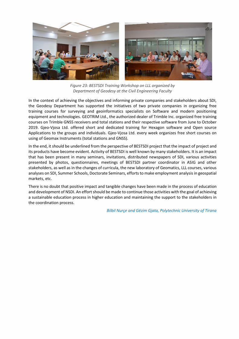
Figure 23: BESTSDI Training Workshop on LLL organized by Department of Geodesy at the Civil Engineering Faculty
In the context of achieving the objectives and informing private companies and stakeholders about SDI, the Geodesy Department has supported the initiatives of two private companies in organizing free training courses for surveying and geoinformatics specialists on Software and modern positioning equipment and technologies. GEOTRIM Ltd., the authorized dealer of Trimble Inc. organized free training courses on Trimble GNSS receivers and total stations and their respective software from June to October 2019. Gjeo-Vjosa Ltd. offered short and dedicated training for Hexagon software and Open source Applications to the groups and individuals. Gjeo-Vjosa Ltd. every week organizes free short courses on using of Geomax Instruments (total stations and GNSS).
In the end, it should be underlined from the perspective of BESTSDI project that the impact of project and its products have become evident. Activity of BESTSDI is well known by many stakeholders. It is an impact that has been present in many seminars, invitations, distributed newspapers of SDI, various activities presented by photos, questionnaires, meetings of BESTSDI partner coordinator in ASIG and other stakeholders, as well as in the changes of curricula, the new laboratory of Geomatics, LLL courses, various analyses on SDI, Summer Schools, Doctorate Seminars, efforts to make employment analysis in geospatial markets, etc.
There is no doubt that positive impact and tangible changes have been made in the process of education and development of NSDI. An effort should be made to continue those activities with the goal of achieving a sustainable education process in higher education and maintaining the support to the stakeholders in the coordination process.
Bilbil Nurçe and Gëzim Gjata, Polytechnic University of Tirana
Dissemination of the project experiences and results
The goal of the Work Package 4 (WP4), Dissemination & Exploitation, on the one hand is efficient dissemination of project results and information about SDI in partner countries but also in the whole region and outside of it, and on the other hand it is an extension of cooperation between partner countries beyond the project lifetime. The WP4 covered the entire project period, but intensive activities were conducted in the 2nd and 3rd year of the project lifetime when the products and results were available for dissemination and exploitation.
Each project partner had the obligation to promote the project idea as wide as possible and as much as possible in order to increase the general knowledge about SDI in the target sectors (data management and SDI users), to increase the awareness of the project and its results within its main target groups (students, institutions professionals and external universities) and to assure that the project results will be maintained and further developed after the completion of the project.
The initial activities within the frame of WP4 started with developing the "Communication plan". For the purpose of efficient communication, the task 4.1 “Development of Communication Plan” was defined. The deliverable of work in this task group was the Communication Plan (CP) of the BESTSDI project.
The second task, Lifelong Learning course execution, was one of the key activities within the frame of WP4. The first results of this task were presented in the Podgorica workshop.
Dissemination and exploitation of project results depended on available products and materials. For this purpose, the task group (T4.3) was established to organize, prepare and support production of project products, project curriculum primarily, but also other documents, leaflets, web-site notices, e-newsletter, etc.). This task was finished in the beginning of the 3. year of project lifetime.
In the task 4.4., the Plan for Dissemination and Exploitation of Results, including the analysis of target groups and their perception of SDI before project results were disseminated, the development of tools and methods for dissemination and the dissemination plan were created.
Based on the prepared plan, there were 108 activities in total carried out as shown in a table below.
Type of dissemination Units Percentage (%)
WEB news 40 37
Journal news 6 5
Press conference 1 1
Meetings 20 19
Invited lectures 5 5
Exhibition booth 8 7
Conference paper 1 1
Conference presentation 14 13
Journal papers 6 5
Books 2 2
Other 5 5
The activities related to exploiting the project and making it possible to extend its lifespan were also an integral part of WP4. For the purpose of continuing the project-related activities, a specific framework is

needed to regulate future relationships among project partners. For this purpose, an extensive research has been conducted which has resulted in the development and dissemination of a Consortium Argument (Memorandum of Understanding). This agreement regulates the extension of the project-related activities for a period of 5 years. The Consortium Argument is also a solid basis for enhancing collaboration among project partners and opens the possibility for joint participation in new projects.
Gjorgji Gjorgijev, Ss. Cyril and Methodius University, Skopje

Experiences of the users in SDI education
At the beginning of BESTSDI project, spatial data infrastructure was not much included in the study programs at our Faculty. Today, three years later, we can say that all BESTSDI objectives have been fully achieved and incorporated in several courses of the studies of geodesy and at the department for roads and transportation and hydrotechnics. We developed new education programme about SDI through adapting new curricula at
Master’s degree studies of geodesy.
Three years ago, we didn't have any subject dealing with SDI compared to several new subjects today: Spatial base and SDI, WEB-GIS, GIS in spatial planning, Geospatial analysis. The Department for roads and transportation adapted one existing subject in the Master’s degree studies (i.e. Spatial planning) with relevant SDI topics. Same lectures are held also in the Department for Hydrotechnics. In this way, all our graduate students are now familiar with the basics of SDI, and advanced SDI problems related to studying geodesy.
This project had great impact on improving the level of competences and knowledge of our students and professors.
Ammar Šarić, Faculty of Civil Engineering University of Sarajevo
The possibility to obtain high quality information quickly and efficiently from a large number of spatial data is one of the fundamental tasks and goals of spatial data infrastructure. The presence of SDI at various management levels provides more rational usage of natural and social resources in the world at national, regional and global level. The level of the development of a country is measured today by the level of organization and interconnection of spatial data infrastructures within its institutions that are responsible for the collection, updating and storage of data. One of the conditions for the
access of Bosnia and Herzegovina to the EU is also the establishment of Spatial Data Infrastructure at the state level, as well as the identification of spatial data sources, the creation of spatial data and metadata models, the specification of technologies to be applied in data collection, legal framework for data management and presentation, co-ordination of policies and standards, as well as providing access to various users.
In my experience gathered over many years working with spatial data and implementing them in a unique system (SDI of B&H), I often come across incompatible data, incomplete documents etc., therefore, the education supported by offered programs of LLL is inevitable.
Amra Imamović, Institute for Spatial and Urban Planning, Tuzla Canton
The significance of SDI in Bosnia and Herzegovina has been recognized by physical planners as a very important infrastructure needed to discover necessary spatial data. SDI is a novelty in Bosnia and Herzegovina that requires the education to be organised both within the frame of higher education and of new offered programs of lifelong learning in order to make it possible for physical planners to be successfully included into the application of SDI.
Hamdija Efendić, director of the Institute for Development Planning in the Canton Sarajevo

BESTSDI project has significantly enhanced the quality of teaching in the study program of geodesy and geomatics at the Faculty of Technical Sciences in Novi Sad. Within the scope of the project, there was the equipment supplied that made it possible to acquire new knowledge through teaching activities and student projects, as well as through the preparation of final theses. In several subjects in the field of geoinformation, the teachers
have trained the students in the field of SDI within the frame of their lectures and student projects, which consequently resulted in a book written by prof. Govedarics, prof. Sladić and assistant professor Radulović that deals with the topic of SDI and presents a significant source of information needed for education in this field.
Bojan Popović, PhD student, Faculty of Technical Science, Novi Sad
As students, we got the opportunity to recognize the main idea and purpose of the spatial data infrastructure in various examples when attending the courses „Spatial Data Infrastructure and Standardisation“ and „Geoportals and Geospatial Services“. We also had the opportunity to learn how important it actually is to harmonize the national spatial data infrastructure with the development of spatial data infrastructure in the European Union. This procedure also needs to be a set of organized and fundamental processes in the
society in order to make relevant and high quality geographical data available as the basis for gradual creation of harmonized spatial data infrastructure for the purpose of formulating, implementing, supervising and evaluation when making decision at the level of European Union from the perspective of territorial influence.
Within the frame of independent research in the field of spatial data infrastructure, as well as within the frame of organized „Lifelong Learning“ courses in newly equipped laboratory, it could be concluded that the development of new products and services has led to the development of new market branches, as well as of new generation of young engineers, i.e. experts who work on the spatial data collection and management, i.e. on spatial data infrastructure in general.
Stevan Milovanov, PhD student, Faculty of Technical Science, Novi Sad
I think that modern approach to the education in the field of Spatial Data Infrastructure taken in the courses of the study program of geodesy and geoinformatics has contributed to better understanding of the field. The accompanying equipment supplied within the scope of the project BESTSDI has supported all activities and has been an important part of teaching activities and practical training, as well as of student works and projects. Apart
from that, „Lifelong Learning“ courses organised within the frame of the projects have been very important for all interested parties who have thus expanded their knowledge or have learned new information that they can use in their activities.
Igor Ruskovski, PhD student, Faculty of Technical Science, Novi Sad
The theory of physical planning provides the answer to the question how the contents in the space can be arranged and used in the best way. We believe that both agriculture and farming land are an integral part of the entire space. The evaluated categories classified in agro-zones are the basis of physical planning of farming land in FB&HK, and well updated and accurate cadastral records in local communities (municipalities) harmonized with the property records in land registry are the basis of good evaluation of land. Only
such well organised data can provide a good basis for the evaluation and zoning in further planning in agriculture, even in changing the farming land use. Thus, based on well organised Map of farming land use value based on evaluation categories classified in agro-zones, it is possible to change the farming land use, and based on cadastral class, i.e. on cadastral income, the charge for land use change can be calculated. It is today unthinkable to create the Map of farming land use value without GIS tools. The physical planning of agricultural land made in such a way would be a very good basis for future planning or regrouping projects, or even better, for land consolidation projects. Without the project of land

regrouping and consolidation, the agricultural production at the territory of FB&H will stagnate. The creation of such unique basis requires a developed spatial data infrastructure.
Ejub Trako, Federal Institute for Agropedology
„Referring to the need for massive collection of data and the exchange of geospatial data, the knowledge of spatial data infrastructure is of utmost importance for us. In the courses Spatial Data Infrastructure and Geoportal and Geoservices, the students get acquainted with the basic principles of SDI standardisation and architecture. Both subjects are designed in a modern way, conducted professionally and provide the possibility of practical application of acquired knowledge.
Milan Gavrilović, M.Sc., Faculty of technical Sciences, Novi Sad
As a student at Master degree study program of Sustainable Land Management and Management in Rural Areas, I have encountered for the first time two subjects where spatial data infrastructure has been taught: Basics of GIS and Basics of Cartography in Physical Planning. Within the scope of the subject Basics of Cartography in Physical Planning I was additionally involved in the task focused on the research of National Spatial Data Infrastructure in the region countries. My research has shown that all countries in the region have quite developed NSDI and geoportals, which was not the case in the B&H
at that time. It has changed in the meantime. The official web site of NSDI and INSPIRE of Bosnia and Herzegovina functions perfectly today. Young people need to learn more about modern approaches and technologies in order to be prepared for the challenges that lie ahead.
Amila Kešmer, student; Faculty of Agriculture and Food Sciences, University in Sarajevo major in Sustainable Land Management and Management in Rural Areas
I was faced with the concept of spatial data infrastructure for the first time within the scope of subjects in the study program of Sustainable Land Management and Management in Rural Areas. Excellent teachers provided for me the possibility to get acquainted with the significance of these study fields for the entire society in Bosnia and Herzegovina, related both to useful usage of products in administration, scientific circles,
and to benefits for “common citizens”. I think that the projects focused on making the spatial data infrastructure available to a lot of people are very useful and necessary for our community. I recommend the introduction of SDI subjects into other study programs for the purpose of better and high-quality education and preparation for professional challenges.
Selman Edi Kaloper, student, Faculty of Agriculture and Food Sciences, University in Sarajevo major in Sustainable Land Management and Management in Rural Areas
The major Sustainable Land Management and Management in Rural Areas offered the subjects to me that follow in a modern way the development and introduction of new approaches and technologies of spatial data usage like GIS, Agro-Ecological Zoning, etc. During my studies, I followed the activities of BESTSDI Erasmus+ project, and we also participated in the discussion and in the development of curriculum. Due to the teachers of these subjects who transfer knowledge, habits and goals to their students with great
enthusiasm, this major functions as a unique research group. It is especially great pleasure to work in the new GIS laboratory furnished with new and modern equipment due to the Erasmus+ BESTSDI project.
Amina Salihagić, student, Faculty of Agriculture and Food Sciences, University in Sarajevo
This field is taught at the Faculty of Technical Sciences within the scope of two courses; Infrastructure of Geospatial Data where the students get acquainted with the standardisation and architecture of SDI systems, and Geoportals and Geospatial Services where we can expand our knowledge by applying most recent web technologies. The interest of students in this topic can also be seen in the fact that the largest number of diploma theses was prepared exactly in these fields.
During all these years, I have been led by the statement given by Confucius: “Choose a job you love, and you will never have to work a day in your life”.
Aleksandar Andrejević, Faculty of Technical Sciences
The BESTSDI project has been a great success. An enormously active and engaged community of 16 academic organisations managed to develop and implement an impressive number of SDI-related curricula and course components. The project delivers important building blocks for developing local competencies needed for the establishment, maintenance and utilisation of spatial data infrastructures in the Western Balkans region.
Due to the newly formed network of various SDI stakeholders amongst the academic institutions, both spatial data providers and spatial data users gained a better understanding of critical success factors for SDIs. Especially in this particular respect, many findings are also of paramount importance for countries with already well-established SDIs. It can be anticipated, that this new level of cooperation amongst the project partners will quickly lead to new projects and institutional relationships, which take (not only) Western Balkans SDIs to yet another level.
Andreas Wytzisk, Bochum University of Applied Sciences

Organized by:
ERASMUS+ KA2 CBHE PROJECT „WESTERN BALKANS ACADEMIC EDUCATION EVOLUTION AND PROFESSIONALS
SUSTAINABLE TRAINING AND SPATIAL DATA INFRASTRUCTURES – BESTSDI“ 574150-EPP-1-2016-1-HR-EPPKA2-CBHE-JP
Published by:
University of Zagreb, Faculty of Geodesy
For the publisher: Almin Đapo
Editors:
Vesna Poslončec-Petrić, Željko Bačić, Joep Crompvoets
Graphical design: Valentina Vuković
Printed by: BIGRAF d.o.o., Zagreb
Issue: 1000
ISBN: 978-953-6082-25-4


![Final report on the outcome of the project [/34.32MB]](https://img.dokumen.tips/doc/110x75/586cb5481a28ab816d8bb7e7/final-report-on-the-outcome-of-the-project-pdf-file3432mb.jpg)


![080708_Positive Pre-Feasibility Outcome for Cloncurry Copper Project[1]](https://img.dokumen.tips/doc/110x75/577d36381a28ab3a6b92846a/080708positive-pre-feasibility-outcome-for-cloncurry-copper-project1.jpg)