Embed Size (px)
Citation preview
GEOGRAPHY
HIGHER LEVEL AND STANDARD LEVEL
PAPER 2 - RESOURCES BOOKLET
Friday 14 November 2003 (morning)
N03/320/RESOURCESIB DIPLOMA PROGRAMMEPROGRAMME DU DIPLÔME DU BIPROGRAMA DEL DIPLOMA DEL BI
883-025 4 pages
INSTRUCTIONS TO CANDIDATES
Do not open this resources booklet until instructed to do so.Use the resources as appropriate to the questions in paper 2.
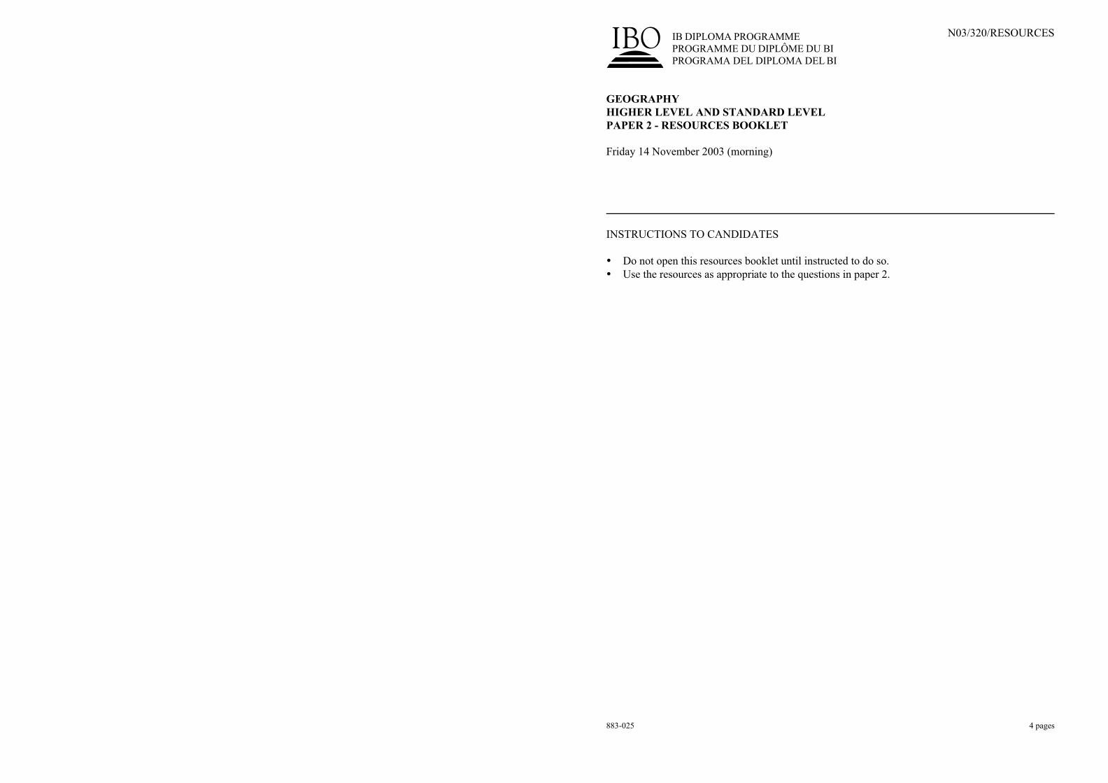
C11. Topographic m
apping
The m
ap ex
tract (scale : 1:5
0 0
00) an
d th
e aerial photo
grap
h sh
ow
an area o
f rugged
terrain an
d a h
ighly
inden
ted co
astline
in th
e north
west o
f Ireland.
– 2
–N
03/3
20/R
ESO
UR
CES
883-0
25
© Ordnance Survey Ireland and Government of Ireland.
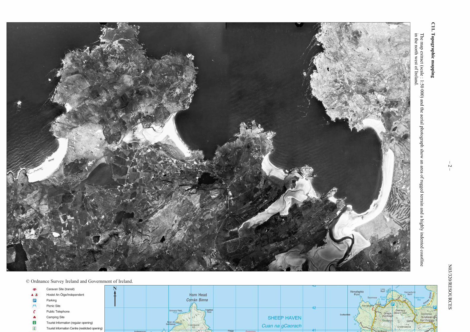
Caravan Site (transit)
Hostel An Óige/Independent
Parking
Picnic Site
Public Telephone
Camping Site
Tourist Information (regular opening)
Tourist Information Centre (restricted opening)
Viewpoint
N
– 3 –
N03/320/RESOURCES
883-025
Tu
rn
over
Viewpoint
Nature Reserve
National Trust
Motorway (Junction)
National Primary Road
National Secondary Road
Dual Carriageway
Regional Road
Third Class Road
Other Roads
Track
Built Up Area
Airport
Airfield
Post Office
Police
Power Station (Hydro)
Power Station (Fossil)
Electricity Transmission Line
TV Mast
Church or Chapel
Cathedral
Triangulation Pillar
Graticule Intersection
Golf Course or Links
Waymarked Walks; Unmarked
Ferry (Vehicle)
Ferry (Passenger)
Railways
Industrial Line
Tunnel
Level Crossing
Station
International Boundary
County Boundary
National Park
Forest Park
Dept. of Defence Property
Coniferous Plantation
Natural Woodland
Mixed Woodland
Named Antiquities
Enclosure (e.g. Ringfort)
Battlefield (with date)
10m Contour Interval
50m Contour Interval
Spot Height
Lake
Canal, Canal (dry)
River or Stream
Boating Activities
Lighthouse in use/disuse
High Water Mark
Low Water Mark
Beach
1 KILOMETRES 0 1 2 3 4 5 6 7 8 9 10 KILOMETRES
1 STATUTE MILES 0 1 2 3 4 5 6 STATUTE MILES
SCALE 1 : 50 000
A3.
Arid
enviro
nm
ents a
nd
their m
an
agem
ent
(b)
Stru
ctured
qu
estion
The d
iagram
belo
w sh
ow
s the ch
anges in
the area o
f the S
ahara (in
km
2) from
1980 to
1990 an
d th
e percen
tage rain
fall variatio
n
from
the m
ean fo
r the sam
e perio
d.
[Source: h
ttp://ag
.arizona.ed
u/~
lmilich
/bound.h
tml]
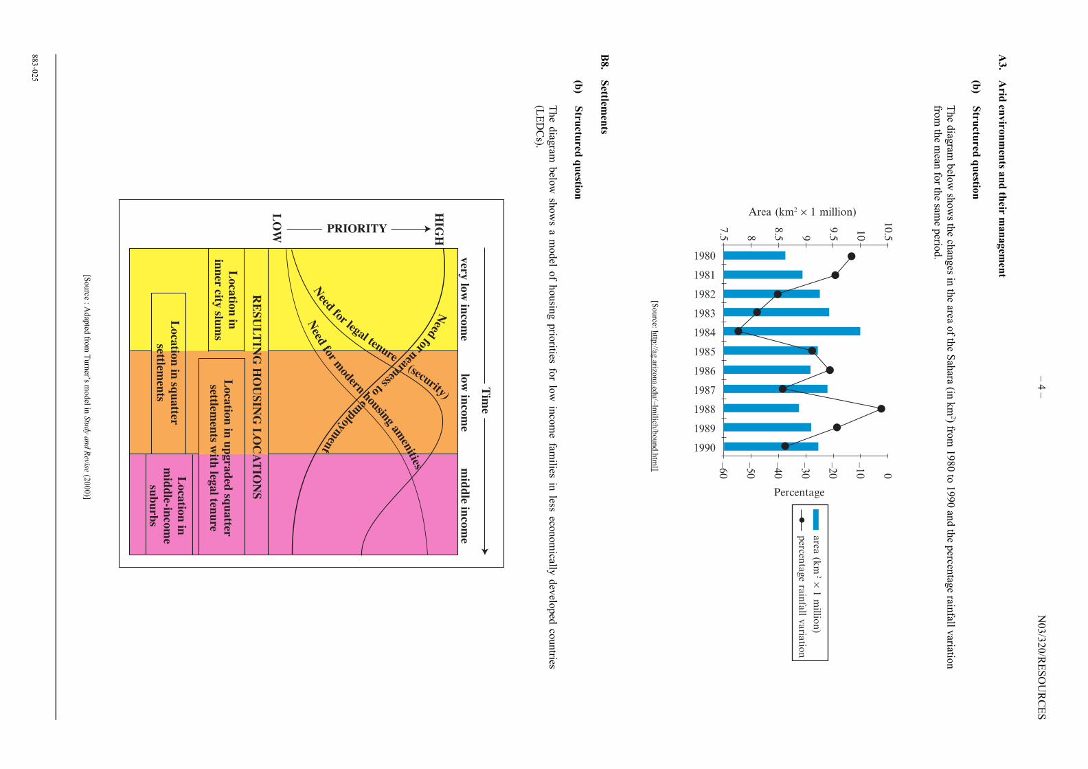
B8.
Settlem
ents
(b)
Stru
ctured
qu
estion
The d
iagram
belo
w sh
ow
s a model o
f housin
g p
riorities fo
r low
inco
me fam
ilies in less eco
nom
ically d
evelo
ped
countries
(LED
Cs).
[Source : A
dap
ted fro
m T
urn
er’s model in
Stu
dy a
nd R
evise (2
000)]
– 4
–N
03/3
20/R
ESO
UR
CES
883-0
25
1980
1981
1982
1983
1984
1985
1986
1987
1988
1989
1990
Area (km2 × 1 million)10.5
10
9.59
8.58
7.5
0
–10
–20
–30
–40
–50
–60
Percentage
area
( km
2 × 1
millio
n)
percen
tage ra
infa
ll varia
tion
Lo
catio
n in
inn
er city slu
ms
Loca
tion
in
mid
dle-in
com
e
sub
urb
s
LO
W
HIG
H
very
low
inco
me
low
inco
me
mid
dle in
com
e
Tim
e
PRIORITY
Need
fornearnessto
employm
ent
Need
for legal tenure(security)
Need
form
odernhousing
amen
ities
Lo
catio
n in
up
gra
ded
squ
atter
settlemen
ts with
legal ten
ure
Lo
catio
n in
squ
atter
settlemen
ts
RE
SU
LT
ING
HO
US
ING
LO
CA
TIO
NS


![cPROGRAMA DEL DIPLOMA DEL BI IB DIPLOMA PROGRAMME … · depende del enantiómero usado. La adrenalina (una hormona que se utiliza tambiØn como droga) es una molØcula quiral. [1]](https://img.dokumen.tips/doc/110x75/5e6cfa4ad98b227f65165657/cprograma-del-diploma-del-bi-ib-diploma-programme-depende-del-enantimero-usado.jpg)