Embed Size (px)
Citation preview
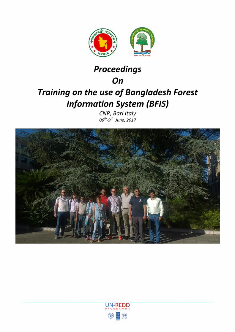
Proceedings On
Training on the use of Bangladesh Forest Information System (BFIS)
CNR, Bari Italy 06th-9th June, 2017

2
The UN-REDD Programme, implemented by FAO, UNDP , has two components: (i) assisting in developing countries to
prepare and implement national REDD strategies and mechanisms; (ii) supporting the development of normative
solutions and standardized approaches based on sound science for a REDD instrument linked with the UNFCCC. The
programme helps empower countries to manage their REDD processes and will facilitate access to financial and
technical assistance tailored to the specific needs of the countries.
The application of UNDP and FAO rights-based and participatory approaches will also help ensure the rights of
indigenous and forest-dwelling people are protected and the active involvement of local communities and relevant
stakeholders and institutions in the design and implementation of REDD plans.
The programme is implemented through the UN Joint Programmes modalities, enabling rapid initiation of
programme implementation and channelling of funds for REDD efforts, building on the in-country presence of UN
agencies as a crucial support structure for countries. The UN-REDD Programme encourage coordinated and
collaborative UN support to countries, thus maximizing efficiencies and effectiveness of the organizations’ collective
input, consistent with the “One UN” approach advocated by UN members.
CONTACTS:
Rakibul Hassan Mukul
Project Director
UNREDD National Programme
Email: [email protected]
Matieu Henry
Chief Technical Advisor
Food & Agriculture Organization of The United Nations
Email: [email protected]
Suggested Citation: Henry M. and Sarker N. 2017. Proceedings of the training on use of Bangladesh Forest
Information System, June, 2017, Bangladesh Forest Department and Food and Agricultural Organization of the
United Nations. Dhaka, Bangladesh.
Disclaimer
This report is designed to reflect the activities and progress related to the Bangladesh forest information system
development process. This report is not authoritative information sources – it does not reflect the official position of
the supporting international agencies including Forest Department, UNDP and FAO should not be used for official
purposes. Should readers find any errors in the document or would like to provide comments for improving the
quality they are encouraged to contact the above author.
3
Executive summery
The training on the use of Bangladesh Forest Information System (BFIS) was organized Consiglio Nazionale delle
Ricerche(CNR) and arranged by FAO. The training sessions conducted by BFIS developers from CNR. A four days
training program for the forest department officials, Ministry of Environment and Forest (MoEF) and Bangladesh
Computer Council (BCC) mainly focused to familiarize government personnel with the Bangladesh Forest Information
system and its functionalities before the launch of the BFIS. The training started on 6th June, 2017 and ended on 9th
June, 2017 at Consiglio Nazionale delle Ricerche(CNR), Bari, Italy.
Total six participants from Bangladesh and five participants from CNR attended the training. The participants were
from the Forest Department, MoEF, FAO, BCC and Consiglio Nazionale delle Ricerche(CNR)
The objectives of the training to be introduced with the BFIS geoportal and receive good understanding of the BFIS
portal functionalities and database maintenance.
The participants were nominated from different background realizing their involvement with the BFIS geoportal for
the future maintenance and further development. During the training technology experts from Bangladesh and CNR
have shared their expertise in order to develop a robust and well functional web-based platform to share the
geospatial information.
The training ended up with great satisfactory outcomes. Experts shared their knowledge and participants responded
very well. Participants became familiar with LCCS3/LCML on which the national land representation system has been
developed. Through the explanation of the definition of the content of technical presentation, and practical training
and test, participants realized the necessity of web-based geoportal like BFIS.
4
TABLE OF CONTENTS
EXECUTIVE SUMMERY .................................................................................................................................. 5
1 INTRODUCTION …………………………………………………………………………………………………………………………………………5
2 OBJECTIVES ……………………………………………………………………………………………………………………………………………………5
3 ACTIVITIES……………………………………………………………………………………………………………………………………………………..5
3.1 1st Day of training .............................................................................................................................................. 5
3.2 2nd Day of training………………………………………………………………………………………………………………………………………. 7
3.3 3rd Day Training……………………………………………………………………………………………………………………………………….
3.4 4th Day Training………………………………………………………………………………………………………………………………………….
4 RECOMMENDATIONS FOR NEXT STEP………………………………………………………………………………………………………. 8
5 CONCLUSION………………………………………………………………………………………………………………………………………………..8
6 Appendix-1: Agenda……………………………………………………………………………………………………………………………….9
7 Appendix-2: participants list…………………………………………………………………………………………………………………………10

5
1 INTRODUCTION
Bangladesh faces several issues related to inconsistency of land representation between (sub-) national legends and
over time such as (1) incomplete datasets may mean that some land cover/use may not be represented, (2) If
different national datasets exist they may vary, e.g., in their estimates of forest land area, and thus limit the
integration of sub-national data and activities, and (3) inappropriate description and documentation of the national
classification system limits its use by different entities and individuals over time and the overall sustainability of the
system. The inconsistency between the land representation systems of existing datasets (forest inventory and land
cover map) impacts the robustness of the results used to assess trends in land cover/use change and forest cover
and stock change.
In Bangladesh, the information about land cover and forest inventory serves multiple purposes, such as commercial
uses, natural resources management and conservation, climate change mitigation and tracking of greenhouse gas
emissions. During the last decades several national and international entities were involved in land cover/land use
mapping, at different levels, by making use of remote sensing and ancillary data (Akhter & Shaheduzzaman, 2013).
Akhter and Shaheduzzaman (2013) have made an inventory of national and sub-national land cover products and
forest inventory data in Bangladesh. But due to differences in organizational purposes, methodologies, boundaries,
definitions, classification systems, varying means and capacities, the different land cover maps are different and not
comparable in time and space.
Thus, there is a long-standing data integration problem in Bangladesh in the domain of land cover mapping and
forest inventory: how to reconcile semantic differences between classification systems. This hinders for example
comparative analysis of multi-temporal mappings (for change detection) as also data validation. Additionally there is
much interest in being able to use one thematic dataset as basis for reporting on classes from another classification,
for example because of its better spatial coverage or accuracy. The need to improve the interoperability between
datasets can be achieved overcoming differences in data semantics.
LCCS3, which is based on the Land Cover Meta Language (LCML) ontology, is the user-friendly data model that allows
the translation of different legends to a common language. By using LCML common semantic framework (based on
the objects), users can easily re-interpret the maps assuring a basic semantic interoperability, while maintaining the
flexibility of the legend to focus on specific details. Through a bottom-up approach, local knowledge can be
integrated in the legend to accommodate the context of the intended used of the data.
It is thus expected that the harmonization of the existing classification systems will help to reduce the reporting
burden, thus reducing costs and, in some cases, also improving the quality, robustness, completeness and
transparency of the information.
The BFIS geoportal will offer a web-based platform both the Geopspatial and LCCS type data will be stored to run
queries and extract information of various information like carbon content per hector or forest type, wood volume
per hector or forest type, biomass per hector or forest type, similarity assessment and so on.
As a part of preparation to for government officials this training was organized by CNR with FAO and the financial
support from USAID. The training workshop took place on 6th-9th June, 2017 at Bari, Italy.
The training was attended by the DCF of RIMS Unit and one forest department official, one official from MoEF,
one national data center official from BCC and 2 FAO officials. This training was inaugurated and facilitated by
Matieu Henry, Chief technical advisor of National forest Inventory project of FAO. He explained the background
of the development of National Forest Information System and the significant application of the BFIS geoportal
6
in the context of Bangladesh. Mr. Zaheer Iqbal, DCF, RIMS Unit of Forest Department explained the BFI design
and activities of ongoing forest inventory to CNR.
2 OBJECTIVES
1. Finalization of the Bangladesh Forest Information System Design
2. Preparation of all the necessary documentation before the launch of the BFIS
3. Prepare BFD and BCC staff for the management and maintenance of the data under the BFIS
4. Transfer ability to manage, modify, upload and download data related to land cover, forest cover,
volume, biomass and stocks at national scale.
3 ACTIVITIES
• It was a four days training workshop, where each day segmented into different sessions and activities
(appendix 1). Presentation of the general system framework mainly focused to provide a clear conception of
the BFIS platform. A brief presentation on LCCS3/LCML explained the methodology of sementic analyst for
assessing semantic similarity of Land Features which is one of the major challenges the Remote Sensing
community has to face to cope both for the increasing production of Land Information and the necessity to
have an effective and functional integration of them.
• Tutorials on the frontend functionalities and backend maintenance explained the content management and
admin tasks respectively.
• Through the group works and practice session the participants got the opportunity to learn about the
innovative method called “Semantic Analyst”.
• During the group discussion new ideas have been proposed to the developers of BFIS to consider as new
functions.

7
3.1 1st Day of the training
Session -1
At the very first day of the training CNR has introduced with the activities and presented the research projects. CNR
works with the University of Bari to support ongoing research and projects, thus CNR provide technical and
laboratory support to the students to run their projects and research activities. Participants have been taken to labs
of CNR and there the researcher from different fields showed some work on modern technology oriented. It was a
great opportunity to know very closely about CNRs’ contributions.
Session-2
In the second session developers from CNR presented the general system framework of BFIS to recap the
background of system architecture development and integration with the GeoDASH platform. Mr. Nicola Mosca,
researcher of CNR presented the BFIS Architecture to explain how the BFIS has been built on top of the GeoDASH
with newly added functionalities and tools of LCCS3/LCML along with some future works. Later he presented BFIS
service API.
GeoExt
OpenLayers
Django
Tomcat
Geoserver
Postgres/PostGIS
Document-oriented DB Data Management
Backend services (python+java)
Presentation layer
GeoDASH Architecture
8
3.2 2nd Day of the training
Session -1
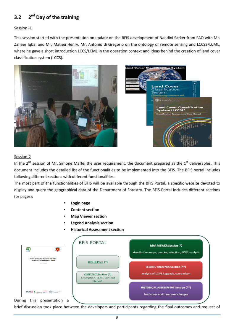
This session started with the presentation on update on the BFIS development of Nandini Sarker from FAO with Mr.
Zaheer Iqbal and Mr. Matieu Henry. Mr. Antonio di Gregorio on the ontology of remote sensing and LCCS3/LCML,
where he gave a short introduction LCCS/LCML in the operation context and ideas behind the creation of land cover
classification system (LCCS).
Session-2
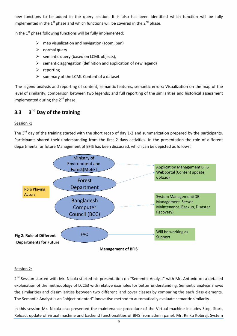
In the 2nd session of Mr. Simone Maffei the user requirement, the document prepared as the 1st deliverables. This
document includes the detailed list of the functionalities to be implemented into the BFIS. The BFIS portal includes
following different sections with different functionalities.
The most part of the functionalities of BFIS will be available through the BFIS Portal, a specific website devoted to
display and query the geographical data of the Department of Forestry. The BFIS Portal includes different sections
(or pages):
• Login page
• Content section
• Map Viewer section
• Legend Analysis section
• Historical Assessment section
During this presentation a
brief discussion took place between the developers and participants regarding the final outcomes and request of
9
new functions to be added in the query section. It is also has been identified which function will be fully
implemented in the 1st phase and which functions will be covered in the 2nd phase.
In the 1st phase following functions will be fully implemented:
map visualization and navigation (zoom, pan)
normal query
semantic query (based on LCML objects),
semantic aggregation (definition and application of new legend)
reporting
summary of the LCML Content of a dataset
The legend analysis and reporting of content, semantic features, semantic errors; Visualization on the map of the
level of similarity; comparison between two legends; and full reporting of the similarities and historical assessment
implemented during the 2nd phase.
3.3 3nd Day of the training
Session -1
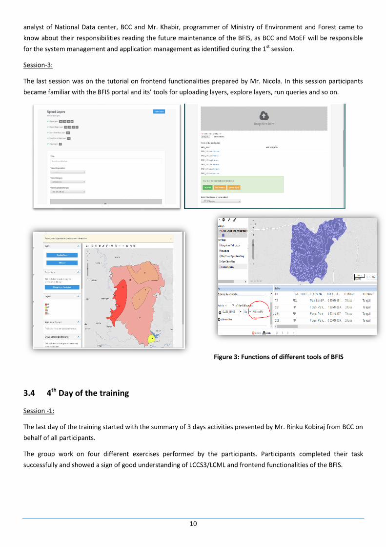
The 3rd day of the training started with the short recap of day 1-2 and summarization prepared by the participants.
Participants shared their understanding from the first 2 days activities. In the presentation the role of different
departments for future Management of BFIS has been discussed, which can be depicted as follows:
Fig 2: Role of Different
Departments for Future
Management of BFIS
Session 2:
2nd Session started with Mr. Nicola started his presentation on “Sementic Analyst” with Mr. Antonio on a detailed
explanation of the methodology of LCCS3 with relative examples for better understanding. Semantic analysis shows
the similarities and dissimilarities between two different land cover classes by comparing the each class elements.
The Semantic Analyst is an “object oriented” innovative method to automatically evaluate semantic similarity.
In this session Mr. Nicola also presented the maintenance procedure of the Virtual machine includes Stop, Start,
Reload, update of virtual machine and backend functionalities of BFIS from admin panel. Mr. Rinku Kobiraj, System
10
analyst of National Data center, BCC and Mr. Khabir, programmer of Ministry of Environment and Forest came to
know about their responsibilities reading the future maintenance of the BFIS, as BCC and MoEF will be responsible
for the system management and application management as identified during the 1st session.
Session-3:
The last session was on the tutorial on frontend functionalities prepared by Mr. Nicola. In this session participants
became familiar with the BFIS portal and its’ tools for uploading layers, explore layers, run queries and so on.
Figure 3: Functions of different tools of BFIS
3.4 4th Day of the training
Session -1:
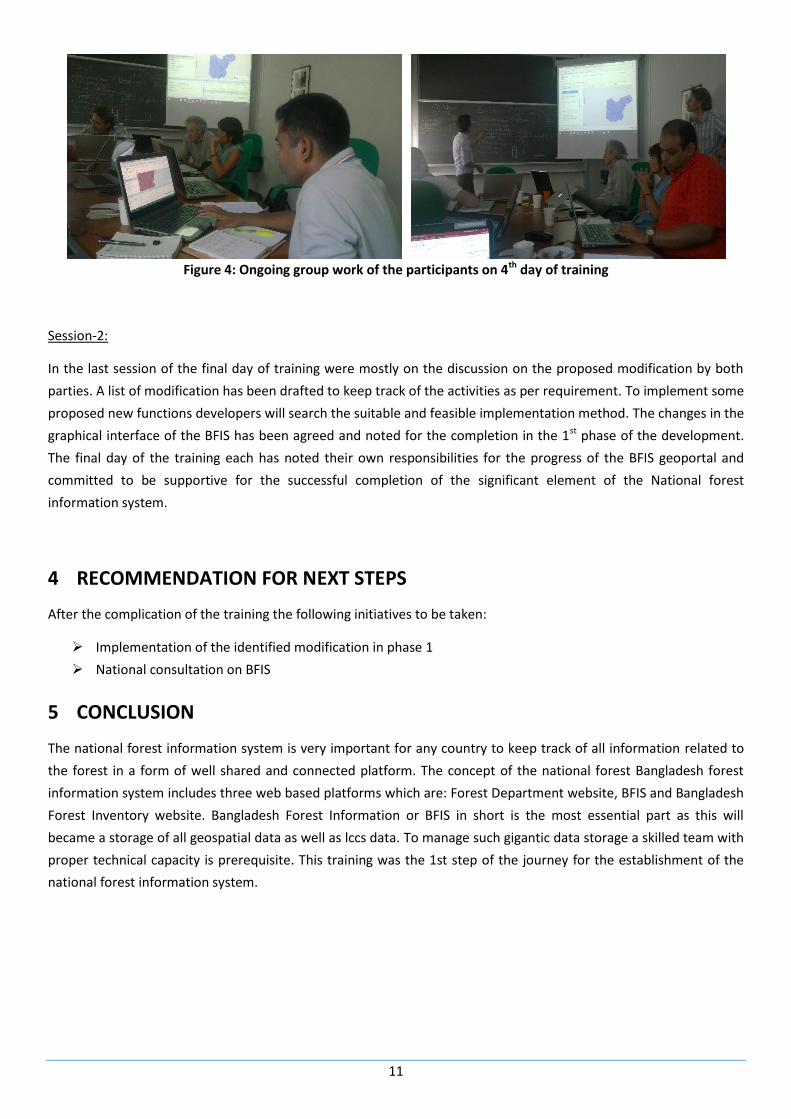
The last day of the training started with the summary of 3 days activities presented by Mr. Rinku Kobiraj from BCC on
behalf of all participants.
The group work on four different exercises performed by the participants. Participants completed their task
successfully and showed a sign of good understanding of LCCS3/LCML and frontend functionalities of the BFIS.
11
Figure 4: Ongoing group work of the participants on 4th day of training
Session-2:
In the last session of the final day of training were mostly on the discussion on the proposed modification by both
parties. A list of modification has been drafted to keep track of the activities as per requirement. To implement some
proposed new functions developers will search the suitable and feasible implementation method. The changes in the
graphical interface of the BFIS has been agreed and noted for the completion in the 1st phase of the development.
The final day of the training each has noted their own responsibilities for the progress of the BFIS geoportal and
committed to be supportive for the successful completion of the significant element of the National forest
information system.
4 RECOMMENDATION FOR NEXT STEPS
After the complication of the training the following initiatives to be taken:
Implementation of the identified modification in phase 1
National consultation on BFIS
5 CONCLUSION
The national forest information system is very important for any country to keep track of all information related to
the forest in a form of well shared and connected platform. The concept of the national forest Bangladesh forest
information system includes three web based platforms which are: Forest Department website, BFIS and Bangladesh
Forest Inventory website. Bangladesh Forest Information or BFIS in short is the most essential part as this will
became a storage of all geospatial data as well as lccs data. To manage such gigantic data storage a skilled team with
proper technical capacity is prerequisite. This training was the 1st step of the journey for the establishment of the
national forest information system.
12
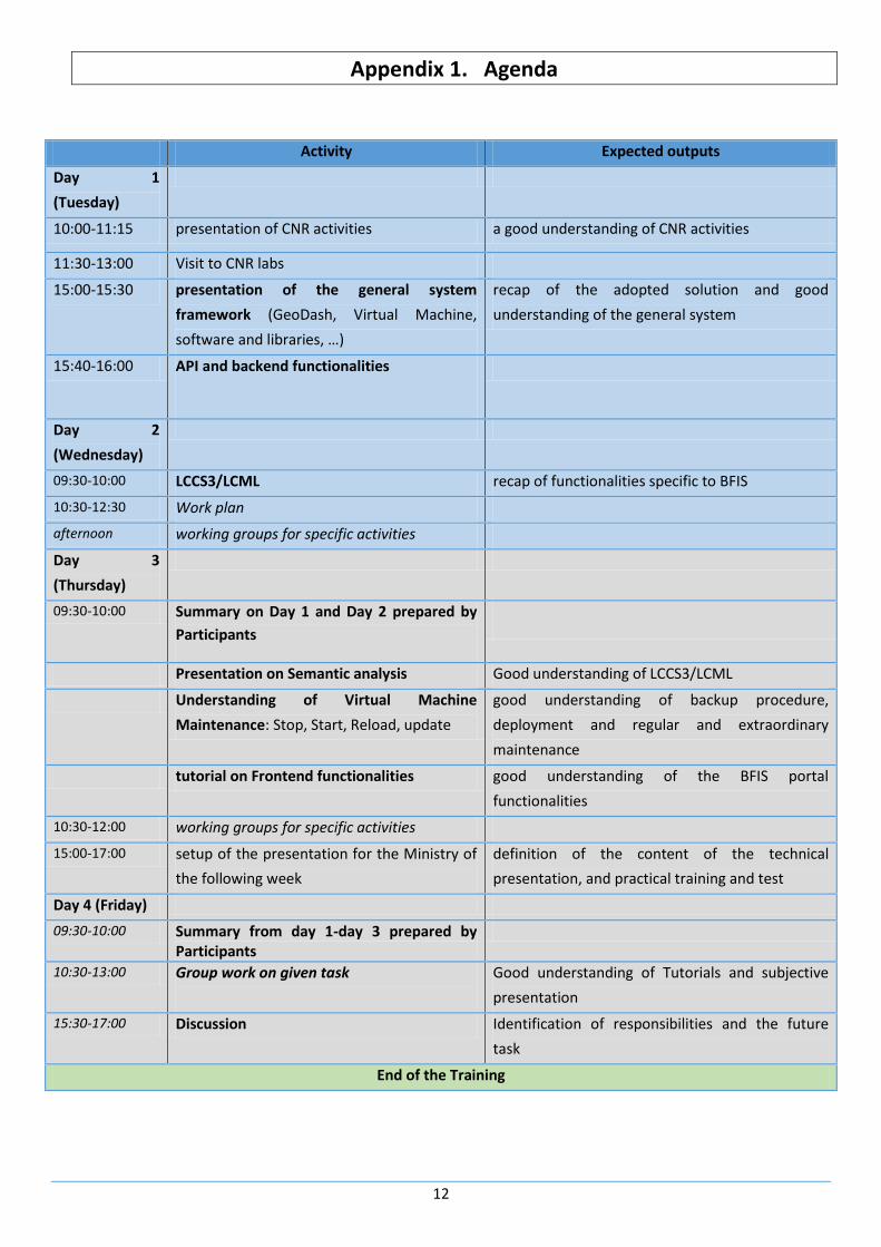
Appendix 1. Agenda
Activity Expected outputs
Day 1
(Tuesday)
10:00-11:15 presentation of CNR activities a good understanding of CNR activities
11:30-13:00 Visit to CNR labs
15:00-15:30 presentation of the general system
framework (GeoDash, Virtual Machine,
software and libraries, …)
recap of the adopted solution and good
understanding of the general system
15:40-16:00 API and backend functionalities
Day 2
(Wednesday)
09:30-10:00 LCCS3/LCML recap of functionalities specific to BFIS
10:30-12:30 Work plan
afternoon working groups for specific activities
Day 3
(Thursday)
09:30-10:00 Summary on Day 1 and Day 2 prepared by
Participants
Presentation on Semantic analysis Good understanding of LCCS3/LCML
Understanding of Virtual Machine
Maintenance: Stop, Start, Reload, update
good understanding of backup procedure,
deployment and regular and extraordinary
maintenance
tutorial on Frontend functionalities good understanding of the BFIS portal
functionalities
10:30-12:00 working groups for specific activities
15:00-17:00 setup of the presentation for the Ministry of
the following week
definition of the content of the technical
presentation, and practical training and test
Day 4 (Friday)
09:30-10:00 Summary from day 1-day 3 prepared by Participants
10:30-13:00 Group work on given task
Good understanding of Tutorials and subjective
presentation
15:30-17:00 Discussion Identification of responsibilities and the future
task
End of the Training
13
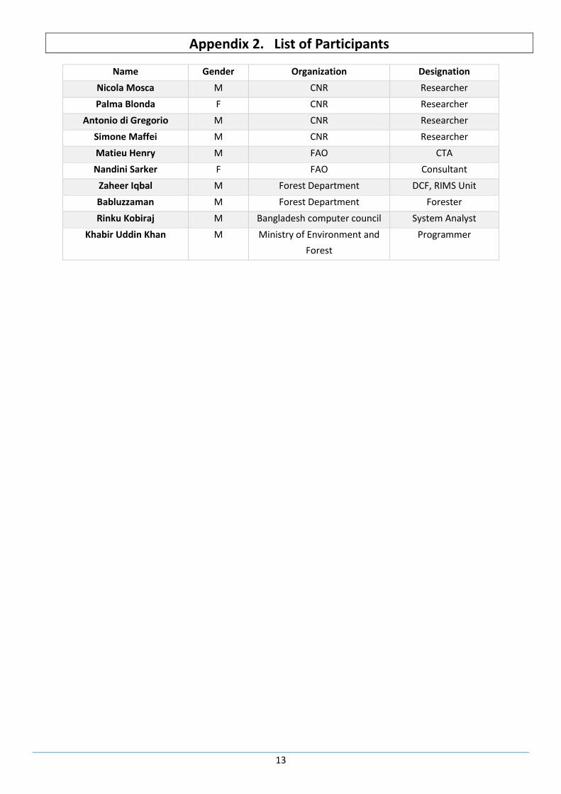
Appendix 2. List of Participants
Name Gender Organization Designation
Nicola Mosca M CNR Researcher
Palma Blonda F CNR Researcher
Antonio di Gregorio M CNR Researcher
Simone Maffei M CNR Researcher
Matieu Henry M FAO CTA
Nandini Sarker F FAO Consultant
Zaheer Iqbal M Forest Department DCF, RIMS Unit
Babluzzaman M Forest Department Forester
Rinku Kobiraj M Bangladesh computer council System Analyst
Khabir Uddin Khan M Ministry of Environment and
Forest
Programmer


![BANGLADESH NATIONAL CONSERVATION STRATEGYbforest.portal.gov.bd/sites/default/files/files/bforest...NATIONAL CONSERVATION STRATEGY LAND RESOURCES NURUL ISLAM NAZEM [2] 1.1. GENERAL](https://img.dokumen.tips/doc/110x75/5f050f207e708231d4110df1/bangladesh-national-conservation-national-conservation-strategy-land-resources.jpg)


![arthistoryteachingresources.orgarthistoryteachingresources.org/.../2015/12… · Web view · 2015-12-11The reasons for the gender gap [among Wikipedia editors] are up for debate:](https://img.dokumen.tips/doc/110x75/5ab151407f8b9a1d168c6bf4/arthist-web-view2015-12-11the-reasons-for-the-gender-gap-among-wikipedia-editors.jpg)


