Embed Size (px)
Citation preview
“ICT for better tomorrow”
Proceedings of the International
Symposium on ICT for Environmental
Sustainability
23rd
- 25th
June 2014
Edited by
V. P. A. Weerasinghe
W. M. D. N. Wijeyaratne
Organized by
Department of Zoology, University of Kelaniya,
Sri Lanka
and
KISSEL Group, Ibaraki University, Hitachi, Japan

ii
This publication may be cited as;
Proceedings of the International Symposium on Information and
Communication Technology for Environmental Sustainability,
V. P. A. Weerasinghe and W. M. D. N. Wijeyaratne (Eds.), Department
of Zoology, University of Kelaniya, Kelaniya, Sri Lanka 75 pp.
The publisher, editors wish to make clear that the opinions expressed and
data appearing in the articles are of sole responsibility of the authors.
Accordingly the publisher and editors accept no responsibility or liability
whatsoever for contents of the articles appearing in this publication.
ISBN: 978-955-4563-21-6
Published by:
Department of Zoology,
University of Kelaniya,
Kelaniya,
Sri Lanka.

iii
Acknowledgements
Prof. Y.M. SunandaMaddumaBandara
Vice-Chancellor, University of Kelaniya, Sri Lanka
Prof. Satoru Ozawa - Ibaraki University, Japan
Prof. Tomio Takara - University of the Ryukyus, Japan
Prof. Franz-Josef Behr -Stuttgart University of Applied Sciences, Germany
Prof. N. A. K. P. J. Seneviratne
Dean, Faculty of Science, University of Kelaniya, Sri Lanka
Prof. S.R.D. Kalingamudali
Director, Research Services Center, University of Kelaniya, Sri Lanka
Prof. W.U. Chandrasekara
Head, Department of Zoology, University of Kelaniya, Sri Lanka
Dr. NalinWarnajith - Ibaraki University, Japan
Dr. D.D.G.L. Dahanayaka - Ibaraki University, Japan
Department of Zoology, University of Kelaniya, Sri Lanka
Prof. (Mrs.) A. Pathiratne Demonstrators
Prof. U.S. Amerasinghe Ms. T.U.N. Kaluarachchi -
Prof. (Mrs.) M.Hettiarachchi Ms. H.M.R.T. Samarakoon
Prof.(Mrs.) R.K.S. Dias Ms. C. Mohotti
Dr. G. A. S. M. Ganehiarachchi Ms. N.G. Dissanayaka
Prof.(Mrs.) L. D. Amarasinghe Mr. D.S.N. Munasinghe
Dr. U.P.K. Epa Mr. S.N. Weerakoon
Dr. M.M.M. Najim
Dr.(Mrs.) M.D.M.D.W.M.M.K.Yatawara Senior technical officers
Dr.(Mrs.) R. Bandara Ms. H.D.Y. Karunaratne
Ms. N.K. Ranawaka Mr. R.P.K.C Rajapakse
Technical staff members
Undergraduate students
Ms. N.P. Moragoda
Ms. T. M. S. D. G. Silva
Mr. M.P. Gunawardana (Postgraduate Student University of Peradeniya)

iv
Symposium Coordinator: Dr. (Mrs.) V. P. A. Weerasinghe
Organizing Committee:
University of Kelaniya
Dr. (Mrs.) V. P. A. Weerasinghe
Dr. (Mrs.) W. M. D. N. Wijeyaratne
Prof. M. J. S. Wijeyaratne
Ibaraki University, Japan Prof. Satoru Ozawa
Dr. NalinWarnajith
Dr. D. D. G. L. Dahanayaka
Cover design: Dr. (Mrs.) V. P. A. Weerasinghe,
Mr. R. P. K. C Rajapakse
Organizing assistance: Ms. T. U. N. Kaluarachchi
Ms. H. M. R. T. Samarakoon
Ms. C. Mohotti
Ms. N. G. Dissanayaka
Mr. S. N. Weerakoon
Mr. D. S. N. Munasinghe
Mr. M. P. Gunawardana
Mr. R. P. K. C Rajapakse
v
TABLE OF CONTENTS
Page No
Key note speech :
SPEECH ANALYSIS AND SYNTHESIS OF RYUKYUAN AND
ASIAN LANGUAGES
Tomio Takara
01
Key note speech :
SOME OBSERVATIONS ON COMMON PATTERNS IN
INFORMATION TECHNOLOGY
Franz-Josef Behr
03
Plenary session speech :
GEODATA FOR HUMANITARIAN AFFAIRS IN UN
ORGANISATIONS
Franz-Josef Behr
05
TECHNICAL SESSION ON DISASTER MANAGEMENT
THE SOUTHWEST MONSOON OF 2013: ITS DISASTROUS
IMPACT ON THE BALAPITIYA FISHING POPULATION OF
COASTAL SOUTHWEST SRI LANKA AND THE URGENT
NEED FORINFORMATION COMMUNICATION
TECHNOLOGY (ICT) APPLICATION
S.K.Mohamed Ali and R.K. Chaminda Kumara
09
MODELING AND MAPPING OF RISK ASSESSMENT FROM
DANGEROUS GORASHI LAKE USING GEOINFORMATICS
Naveed Mustafa, Arshad Ashraf, Bashir Ahmad, Muhammad
Bilal Iqbal and RozinaNaz
11
COMBATING WITH AVALANCHE DISASTERS USING
GOOGLE EARTH - A CASE STUDY OF GYARI SECTOR
AVALANCHE IN PAKISTAN
ShahidParvez, Zafar Iqbal Zafar and Hafiz Ali Imran
12
TECHNICAL SESSION ON CLIMATE CHANGE
EVALUATION OF THE TRENDS IN CLIMATE CHANGE WITH
RESPECT TO SEVERITY AND FREQUENCY OF
OCCURRENCE OF WET AND DRY EVENTS OF RAINFALL IN
ATHTHANAGALU OYA BASIN
N.W.B.A.L Udayanga and M.M.M. Najim
15

vi
DYNAMIC TRENDS OF RAINFALL EXTREMES IN SRI
LANKA
R.M.S.S.Sanjeewani and L. Manawadu
17
ICT FOR SUSTAINABLE GROWTH IN THE WORLD
G. Dassanayake, G. Dahanayake, N. Warnajith, A. Minato,
M. Itaba and S. Ozawa
19
ROLE OF COMMUNICATION TECHNOLOGY AND
INDIGENOUS KNOWLEDGE IN PROMOTING CLIMATE
CHANGE ADAPTATION IN SRI LANKA
Kalpana R. Ambepitiya
20
TECHNICAL SESSION ON REMOTE SENSING AND GIS
EUTROPHICATION TRENDS IN BOLGODA NORTH LAKE,
SRI LANKA.
B.D.C. Perera, M.J.S. Wijeyaratne, D.D.G.L. Dahanayaka,
H. Tonooka, A. Minato, S. Ozawa2
23
LOCATING SUITABLE SITES FOR SOLID WASTE
LANDFILLS IN MATARADISTRICT USING GIS AND AHP
N.T. Jayawickrama and V.P.A. Weerasinghe
24
GREEN SPACE PLANING USING GIS AND REMOTE
SENSING FOR CITY OF COLOMBO, SRI LANKA
M. S. P. M. Siriwardane, Jagath Gunatilake and
S. Sivanantharajah
25
MAPPING OF WATER POLLUTION IN PATTIWILA AREA
OF GAMPAHA DISTRICT, SRI LANKA, USING SURFACE
INTERPOLATION METHOD
L. N.W. Perera and V.P.A. Weerasinghe
27
IMPACT OF GLOBAL WARMING ON LANDSLIDES: A CASE
STUYDY IN WALAPANE DIVISIONAL SECRETARY
DIVISION IN NUWARAELIYA DISTRICT, SRI LANKA
V. P.A. Weerasinghe and Yashoba Sirisena
28
EVALUATION OF THE SPATIAL AND TEMPORAL TRENDS
IN HOUSEHOLD SOLID WASTE DISPOSAL IN SRI LANKA
USING GEO-INFORMATICS AND STATISTICAL TOOLS
N.W.B.A.L Udayanga , K.A.R.K Kodituwakku
29

vii
SUITABILITY ASSESSMENT FOR CULTIVATION OF
SUGARCANE IN THE MONARAGALA DISTRICT, SRI
LANKA USING GIS
Y.M.P. Samarasinghe, P. Wickramagamage, and
K. Shanmuganathan
31
INEXPENSIVE SENSOR NETWORK SOLUTION FOR
ENVIRONMENT MONITORING
K.N.S. Warnajith, S.H.P.K. Lakesh, A. Minato and S. Ozawa
32
TECHNICAL SESSION ON GREEN ICT
AN EFFECTIVE MODEL FOR SUCCESSFUL ICT
PROFESSIONALS IN SRI LANKA
Shamitha Pathiratne
35
ADOPTION FOR ICT AND E–COMMERCE SERVICES IN
HOSPITALITY INDUSTRY - CHALLENGES AND
OPPORTUNITIES
D.A.K. Anupama Damunupola
36
APPLICATION OF INFORMATION AND COMMUNICATION
TECHNOLOGY IN TOURISM SECTOR DEVELOPMENT:
THE CASE OF JAFFNA DISTRICT
S.Yoharajan
38
TECHNICAL SESSION ON WASTE MANAGEMENT
E-WASTE GENERATION AND MANAGEMENT PRACTICES
IN JAFFNA AND NALLUR DIVISIONAL SECRETARIAT
DIVISIONS, SRI LANKA – A BASE LINE STUDY
Kayathiri.K, E.Y.A. Charles and S.N. Surendran
43
TOWARDS A SAARC REGIONAL CONVENTION ON SOUND
E-WASTE MANAGEMENT
P.R.K Dayaratne
45
TECHNICAL SESSION ON MULTIMEDIA TECHNIQUES
AN ADAPTIVE HISTOGRAM EQUALIZATION ALGORITHM
FOR ENHANCE MAMMOGRAMS
A.S. Amarasinghe and D.P. Abeysooriya
49

viii
TECHNICAL SESSION ON ECOSYSTEMS
FLOW MODELLING IN NILLAMBE OYA, SRI LANKA
M.P. Gunawardena and M.M.M. Najim
53
TWO DIMENSIONAL NUMERICAL SIMULATION OF
RIVERBED VARIATION IN IN MOUNTAINOUS RIVER
BEND
Dang Truong An and Park Sang Deog
55
DOES MANGROVE FUNCTION AS SINK OR SOURCE OF
PHOSPHORUS FOR ITS ADJACENT RIVER? A CASE STUDY
IN MANGROVE DISTURBED BY TYPHOON IN CAN GIO
MANGROVE BIOSPHERE RESERVE
Phạm Quynh Huong, Ho Phan Minh Uyen, Le NgọcTran,
Le XuanThuyen, Tran Triet
57
ENVIRONMENTAL FLOW VARIATION DUE TO MINI-
HYDRO DIVERSION AT GURUGODA OYA, SRI LANKA
D.S.N. Munasinghe and M.M.M. Najim
58
APPLICATION OF MASS BALANCE MODELLING TO
ASSESS THE EFFECTS OF FISH STOCKING ON THE
ENERGY FLOW IN A RESERVOIR ECOSYSTEM
PreethaPanikar, M. Feroz Khan and A.P. Sharma
60
TECHNICAL SESSION ON E-LEARNING
KNOWLEDGE SHARING AND MANAGEMENT
APPLICATION FOR NATIONAL WILDLIFE TRAINING
CENTER, SRI LANKA
W.A.K.L.M. Wickramasingha, E.P. Kudavidanage
S. Vasanthapriyan and T.S. Priyadarshana
65
INFLUENCE OF HUMAN COMPUTER INTERACTION IN
LEARNING MANAGEMENT SYSTEM
S. Thuseethan and S. Vasanthapriyan
67
THE ROLE OF ICT IN STUDENTS AND THEIR TERTIARY
STUDIES IN SAMOA
Edna TemeseUalesi , Satoru Ozawa and Atsushi Minato
68
SURVEY ON METADATA STANDARDS FOR AN E-
TEACHING ENVIRONMENT
S. Vasanthapriyan
69

ix
USE OF KISSEL SERVER AS A PLATFORM FOR THE
EXPANSION OF RESEARCH ON THE WATER QUALITY OF
ASIAN WATER BODIES
D.D.G.L. Dahanayaka, H. Tonooka, M.J.S. Wijeyaratne,
A. Minato and S. Ozawa
70
NOVEL APPROACH FOR ANALYZING BRAHMI SCRIPTS
D. Bandara, N. Warnajith, A. Minato and S. Ozawa
72
TEACHERS’ PERCEPTIONS ON THE INCORPORATION OF
INFORMATION AND COMMUNICATION TECHNOLOGIES
(ICT) IN SCHOOL COUNSELING
Shamitha Pathiratne
73
FEASIBILITYSTUDYONTHEWIRELESSMESHNETWORKAS
ANALTERNATIVEWI-FINETWORKINGFORENTERPRISES
D.S.S. Matharage and M.K.D. Padmasiri
75

“ICT for better tomorrow”
Proceedings of the International
Symposium on ICT for Environmental
Sustainability
23rd
- 25th
June 2014
Edited by
V. P. A. Weerasinghe
W. M. D. N. Wijeyaratne
Organized by
Department of Zoology, University of Kelaniya,
Sri Lanka
and
KISSEL Group, Ibaraki University, Hitachi, Japan

ii
This publication may be cited as;
Proceedings of the International Symposium on Information and
Communication Technology for Environmental Sustainability,
V. P. A. Weerasinghe and W. M. D. N. Wijeyaratne (Eds.), Department
of Zoology, University of Kelaniya, Kelaniya, Sri Lanka 75 pp.
The publisher, editors wish to make clear that the opinions expressed and
data appearing in the articles are of sole responsibility of the authors.
Accordingly the publisher and editors accept no responsibility or liability
whatsoever for contents of the articles appearing in this publication.
ISBN: 978-955-4563-21-6
Published by:
Department of Zoology,
University of Kelaniya,
Kelaniya,
Sri Lanka.
iii
Acknowledgements
Prof. Y.M. SunandaMaddumaBandara
Vice-Chancellor, University of Kelaniya, Sri Lanka
Prof. Satoru Ozawa - Ibaraki University, Japan
Prof. Tomio Takara - University of the Ryukyus, Japan
Prof. Franz-Josef Behr -Stuttgart University of Applied Sciences, Germany
Prof. N. A. K. P. J. Seneviratne
Dean, Faculty of Science, University of Kelaniya, Sri Lanka
Prof. S.R.D. Kalingamudali
Director, Research Services Center, University of Kelaniya, Sri Lanka
Prof. W.U. Chandrasekara
Head, Department of Zoology, University of Kelaniya, Sri Lanka
Dr. NalinWarnajith - Ibaraki University, Japan
Dr. D.D.G.L. Dahanayaka - Ibaraki University, Japan
Department of Zoology, University of Kelaniya, Sri Lanka
Prof. (Mrs.) A. Pathiratne Demonstrators
Prof. U.S. Amerasinghe Ms. T.U.N. Kaluarachchi -
Prof. (Mrs.) M.Hettiarachchi Ms. H.M.R.T. Samarakoon
Prof.(Mrs.) R.K.S. Dias Ms. C. Mohotti
Dr. G. A. S. M. Ganehiarachchi Ms. N.G. Dissanayaka
Prof.(Mrs.) L. D. Amarasinghe Mr. D.S.N. Munasinghe
Dr. U.P.K. Epa Mr. S.N. Weerakoon
Dr. M.M.M. Najim
Dr.(Mrs.) M.D.M.D.W.M.M.K.Yatawara Senior technical officers
Dr.(Mrs.) R. Bandara Ms. H.D.Y. Karunaratne
Ms. N.K. Ranawaka Mr. R.P.K.C Rajapakse
Technical staff members
Undergraduate students
Ms. N.P. Moragoda
Ms. T. M. S. D. G. Silva
Mr. M.P. Gunawardana (Postgraduate Student University of Peradeniya)
iv
Symposium Coordinator: Dr. (Mrs.) V. P. A. Weerasinghe
Organizing Committee:
University of Kelaniya
Dr. (Mrs.) V. P. A. Weerasinghe
Dr. (Mrs.) W. M. D. N. Wijeyaratne
Prof. M. J. S. Wijeyaratne
Ibaraki University, Japan Prof. Satoru Ozawa
Dr. NalinWarnajith
Dr. D. D. G. L. Dahanayaka
Cover design: Dr. (Mrs.) V. P. A. Weerasinghe,
Mr. R. P. K. C Rajapakse
Organizing assistance: Ms. T. U. N. Kaluarachchi
Ms. H. M. R. T. Samarakoon
Ms. C. Mohotti
Ms. N. G. Dissanayaka
Mr. S. N. Weerakoon
Mr. D. S. N. Munasinghe
Mr. M. P. Gunawardana
Mr. R. P. K. C Rajapakse

v
TABLE OF CONTENTS
Page No
Key note speech :
SPEECH ANALYSIS AND SYNTHESIS OF RYUKYUAN AND
ASIAN LANGUAGES
Tomio Takara
01
Key note speech :
SOME OBSERVATIONS ON COMMON PATTERNS IN
INFORMATION TECHNOLOGY
Franz-Josef Behr
03
Plenary session speech :
GEODATA FOR HUMANITARIAN AFFAIRS IN UN
ORGANISATIONS
Franz-Josef Behr
05
TECHNICAL SESSION ON DISASTER MANAGEMENT
THE SOUTHWEST MONSOON OF 2013: ITS DISASTROUS
IMPACT ON THE BALAPITIYA FISHING POPULATION OF
COASTAL SOUTHWEST SRI LANKA AND THE URGENT
NEED FORINFORMATION COMMUNICATION
TECHNOLOGY (ICT) APPLICATION
S.K.Mohamed Ali and R.K. Chaminda Kumara
09
MODELING AND MAPPING OF RISK ASSESSMENT FROM
DANGEROUS GORASHI LAKE USING GEOINFORMATICS
Naveed Mustafa, Arshad Ashraf, Bashir Ahmad, Muhammad
Bilal Iqbal and RozinaNaz
11
COMBATING WITH AVALANCHE DISASTERS USING
GOOGLE EARTH - A CASE STUDY OF GYARI SECTOR
AVALANCHE IN PAKISTAN
ShahidParvez, Zafar Iqbal Zafar and Hafiz Ali Imran
12
TECHNICAL SESSION ON CLIMATE CHANGE
EVALUATION OF THE TRENDS IN CLIMATE CHANGE WITH
RESPECT TO SEVERITY AND FREQUENCY OF
OCCURRENCE OF WET AND DRY EVENTS OF RAINFALL IN
ATHTHANAGALU OYA BASIN
N.W.B.A.L Udayanga and M.M.M. Najim
15
vi
DYNAMIC TRENDS OF RAINFALL EXTREMES IN SRI
LANKA
R.M.S.S.Sanjeewani and L. Manawadu
17
ICT FOR SUSTAINABLE GROWTH IN THE WORLD
G. Dassanayake, G. Dahanayake, N. Warnajith, A. Minato,
M. Itaba and S. Ozawa
19
ROLE OF COMMUNICATION TECHNOLOGY AND
INDIGENOUS KNOWLEDGE IN PROMOTING CLIMATE
CHANGE ADAPTATION IN SRI LANKA
Kalpana R. Ambepitiya
20
TECHNICAL SESSION ON REMOTE SENSING AND GIS
EUTROPHICATION TRENDS IN BOLGODA NORTH LAKE,
SRI LANKA.
B.D.C. Perera, M.J.S. Wijeyaratne, D.D.G.L. Dahanayaka,
H. Tonooka, A. Minato, S. Ozawa2
23
LOCATING SUITABLE SITES FOR SOLID WASTE
LANDFILLS IN MATARADISTRICT USING GIS AND AHP
N.T. Jayawickrama and V.P.A. Weerasinghe
24
GREEN SPACE PLANING USING GIS AND REMOTE
SENSING FOR CITY OF COLOMBO, SRI LANKA
M. S. P. M. Siriwardane, Jagath Gunatilake and
S. Sivanantharajah
25
MAPPING OF WATER POLLUTION IN PATTIWILA AREA
OF GAMPAHA DISTRICT, SRI LANKA, USING SURFACE
INTERPOLATION METHOD
L. N.W. Perera and V.P.A. Weerasinghe
27
IMPACT OF GLOBAL WARMING ON LANDSLIDES: A CASE
STUYDY IN WALAPANE DIVISIONAL SECRETARY
DIVISION IN NUWARAELIYA DISTRICT, SRI LANKA
V. P.A. Weerasinghe and Yashoba Sirisena
28
EVALUATION OF THE SPATIAL AND TEMPORAL TRENDS
IN HOUSEHOLD SOLID WASTE DISPOSAL IN SRI LANKA
USING GEO-INFORMATICS AND STATISTICAL TOOLS
N.W.B.A.L Udayanga , K.A.R.K Kodituwakku
29

vii
SUITABILITY ASSESSMENT FOR CULTIVATION OF
SUGARCANE IN THE MONARAGALA DISTRICT, SRI
LANKA USING GIS
Y.M.P. Samarasinghe, P. Wickramagamage, and
K. Shanmuganathan
31
INEXPENSIVE SENSOR NETWORK SOLUTION FOR
ENVIRONMENT MONITORING
K.N.S. Warnajith, S.H.P.K. Lakesh, A. Minato and S. Ozawa
32
TECHNICAL SESSION ON GREEN ICT
AN EFFECTIVE MODEL FOR SUCCESSFUL ICT
PROFESSIONALS IN SRI LANKA
Shamitha Pathiratne
35
ADOPTION FOR ICT AND E–COMMERCE SERVICES IN
HOSPITALITY INDUSTRY - CHALLENGES AND
OPPORTUNITIES
D.A.K. Anupama Damunupola
36
APPLICATION OF INFORMATION AND COMMUNICATION
TECHNOLOGY IN TOURISM SECTOR DEVELOPMENT:
THE CASE OF JAFFNA DISTRICT
S.Yoharajan
38
TECHNICAL SESSION ON WASTE MANAGEMENT
E-WASTE GENERATION AND MANAGEMENT PRACTICES
IN JAFFNA AND NALLUR DIVISIONAL SECRETARIAT
DIVISIONS, SRI LANKA – A BASE LINE STUDY
Kayathiri.K, E.Y.A. Charles and S.N. Surendran
43
TOWARDS A SAARC REGIONAL CONVENTION ON SOUND
E-WASTE MANAGEMENT
P.R.K Dayaratne
45
TECHNICAL SESSION ON MULTIMEDIA TECHNIQUES
AN ADAPTIVE HISTOGRAM EQUALIZATION ALGORITHM
FOR ENHANCE MAMMOGRAMS
A.S. Amarasinghe and D.P. Abeysooriya
49

viii
TECHNICAL SESSION ON ECOSYSTEMS
FLOW MODELLING IN NILLAMBE OYA, SRI LANKA
M.P. Gunawardena and M.M.M. Najim
53
TWO DIMENSIONAL NUMERICAL SIMULATION OF
RIVERBED VARIATION IN IN MOUNTAINOUS RIVER
BEND
Dang Truong An and Park Sang Deog
55
DOES MANGROVE FUNCTION AS SINK OR SOURCE OF
PHOSPHORUS FOR ITS ADJACENT RIVER? A CASE STUDY
IN MANGROVE DISTURBED BY TYPHOON IN CAN GIO
MANGROVE BIOSPHERE RESERVE
Phạm Quynh Huong, Ho Phan Minh Uyen, Le NgọcTran,
Le XuanThuyen, Tran Triet
57
ENVIRONMENTAL FLOW VARIATION DUE TO MINI-
HYDRO DIVERSION AT GURUGODA OYA, SRI LANKA
D.S.N. Munasinghe and M.M.M. Najim
58
APPLICATION OF MASS BALANCE MODELLING TO
ASSESS THE EFFECTS OF FISH STOCKING ON THE
ENERGY FLOW IN A RESERVOIR ECOSYSTEM
PreethaPanikar, M. Feroz Khan and A.P. Sharma
60
TECHNICAL SESSION ON E-LEARNING
KNOWLEDGE SHARING AND MANAGEMENT
APPLICATION FOR NATIONAL WILDLIFE TRAINING
CENTER, SRI LANKA
W.A.K.L.M. Wickramasingha, E.P. Kudavidanage
S. Vasanthapriyan and T.S. Priyadarshana
65
INFLUENCE OF HUMAN COMPUTER INTERACTION IN
LEARNING MANAGEMENT SYSTEM
S. Thuseethan and S. Vasanthapriyan
67
THE ROLE OF ICT IN STUDENTS AND THEIR TERTIARY
STUDIES IN SAMOA
Edna TemeseUalesi , Satoru Ozawa and Atsushi Minato
68
SURVEY ON METADATA STANDARDS FOR AN E-
TEACHING ENVIRONMENT
S. Vasanthapriyan
69
ix
USE OF KISSEL SERVER AS A PLATFORM FOR THE
EXPANSION OF RESEARCH ON THE WATER QUALITY OF
ASIAN WATER BODIES
D.D.G.L. Dahanayaka, H. Tonooka, M.J.S. Wijeyaratne,
A. Minato and S. Ozawa
70
NOVEL APPROACH FOR ANALYZING BRAHMI SCRIPTS
D. Bandara, N. Warnajith, A. Minato and S. Ozawa
72
TEACHERS’ PERCEPTIONS ON THE INCORPORATION OF
INFORMATION AND COMMUNICATION TECHNOLOGIES
(ICT) IN SCHOOL COUNSELING
Shamitha Pathiratne
73
FEASIBILITYSTUDYONTHEWIRELESSMESHNETWORKAS
ANALTERNATIVEWI-FINETWORKINGFORENTERPRISES
D.S.S. Matharage and M.K.D. Padmasiri
75
1
Proceedings of the International Symposium on ICT for Environmental Sustainability
KEY NOTE SPEECH
SPEECH ANALYSIS AND SYNTHESIS OF RYUKYUAN AND
ASIAN LANGUAGES
Tomio Takara
The Dean, Faculty of Engineering, University of the Ryukyus, Japan.
Communication and processing using audio and video devices, which is
called multimedia communication, is developing along with the
development of high speed computers and high speed communication
networks. Speech synthesis and automatic speech recognition techniques
are being used in daily life as the high-tech human interface using
speech. However, such techniques are mainly developed for languages
of European countries, Japan, China etc. Speech synthesis and
recognition for minor languages have not been developed yet. Therefore,
a general speech synthesis system which could be applied to such
languages have been constructed by extending the Ryukyu dialect
speech synthesis system (RDSS).
In this system, phoneme unit is extended from mora only to also demi
syllable, and the accent rule is extended from pitch accent only to tone
and stress accent. This system was applied to Thai, Vietnamese,
Bangladesh, and Myanmar languages and the systems were evaluated.
The first version of speech synthesis systems were constructed using the
RDSS. Then, the quality of the synthesized speech was evaluated, and
the problems were detected in order to increase the quality to the level
used in daily life.
Because Thai, Vietnamese and Myanmar are tonal languages, the tones
represented mainly by fundamental frequency (F0) were researched. For
Thai speech synthesis system, an extension of generative model of F0
contour for tonal language was applied. Listening tests were performed
to evaluate the intelligibility and the generative model for Thai words
was observed to be effective.
In the Vietnamese Text-To-Speech system, the results were as follows:
(1) Power system control was applied for synthesizing broken and drop
tones; (2) Drop tone and the first part of Broken tone were comparable;
and (3) for the perception, Drop tone had a perceptual threshold of F0,
and F0 of final part of Broken tone had a minor effect.

2
Proceedings of the International Symposium on ICT for Environmental Sustainability
In the Bangladesh system, nasality perception of Bangladesh vowels by
Bangla and Japanese listeners were discussed. Interestingly, Japanese
listeners perceive most Bangla nasal /~i/ as Japanese non-nasal /u/,
which showed that perception depends on listener‘s mother languages.
In the research of Myanmar speech synthesis, F0 normalization and
duration normalization were applied for tone rules. The high
intelligibility of synthesized tone was confirmed through listening test of
synthesized words.
Professor Tomio Takara is the Dean of
Faculty of Engineering, University of the
Ryukyus, Japan. He received his BS
degree in Physics from Kagoshima
University, Japan, in 1976 and ME degree
and Doctoral degree in Information
Processing from Tokyo Institute of
Technology, Japan in 1979 and 1983,
respectively. He was a visiting scientist at
the Carnegie Mellon University in 1991-
1992. He has been a Professor in the Department of Information
Engineering, University of the Ryukyus, Japan, since 1995. He had
received the 1990 Okinawa Society Award for Encouragement of Study
on Okinawa. His current research interests are in the field of spoken
language processing and machine intelligence.

3
Proceedings of the International Symposium on ICT for Environmental Sustainability
KEY NOTE SPEECH
SOME OBSERVATIONS ON COMMON PATTERNS IN
INFORMATION TECHNOLOGY
Franz-Josef Behr
Stuttgart University of Applied Sciences, Stuttgart University of Applied
Sciences, Schellingstr, 24, 70174 Stuttgart, Germany
Nearly in all scientific disciplines the structuring, collection,
compilation, and encoding of digital data plays an increasing role. Huge
amounts of data are collected by various governmental and non-
governmental organisations. Interoperable communication and exchange
of data and services enable the usage of these data. Overall, an
increasing complexity of information and communication technology
can be observed. People have to deal with thiee challenges parallely to
their own specific fields of work, i.e. surveying, botany, geology etc.
In this context it can be helpful to recognize general patterns occuring
throughout different approaches for data modeling, processing, and
encoding. Such patterns comprise identity of features, single features
and collections, structuring vocabularies by namespaces, separating
information chunks, adding semantics, openess, networking, service
orientation and interoperability.
The knowledge of these patterns can help to understand information
handling as it is used in applied computer science. In addition, it
contributes to the IT related developments in everybody‘s own field of
expertise.
4
Proceedings of the International Symposium on ICT for Environmental Sustainability
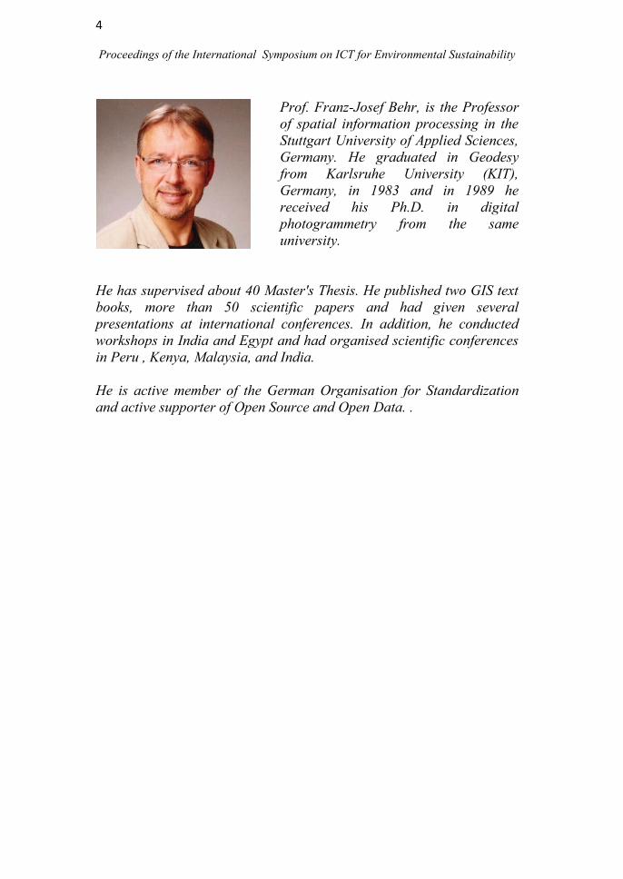
Prof. Franz-Josef Behr, is the Professor
of spatial information processing in the
Stuttgart University of Applied Sciences,
Germany. He graduated in Geodesy
from Karlsruhe University (KIT),
Germany, in 1983 and in 1989 he
received his Ph.D. in digital
photogrammetry from the same
university.
He has supervised about 40 Master's Thesis. He published two GIS text
books, more than 50 scientific papers and had given several
presentations at international conferences. In addition, he conducted
workshops in India and Egypt and had organised scientific conferences
in Peru , Kenya, Malaysia, and India.
He is active member of the German Organisation for Standardization
and active supporter of Open Source and Open Data. .

5
Proceedings of the International Symposium on ICT for Environmental Sustainability
PLENARY SESSION SPEECH
GEODATA FOR HUMANITARIAN AFFAIRS IN UN
ORGANISATIONS
Franz-Josef Behr
Stuttgart University of Applied Sciences, Schellingstr, 24, 70174 Stuttgart,
Germany
ABSTRACT
The aims of the international community as summarized by the Charter of
the United Nations are; to maintain international peace and security, to
develop friendly relations among nations based on respect for the
principle of equal rights and self-determination of peoples, and to achieve
international co-operation in solving international problems of economic,
social, cultural, or humanitarian character, and in promoting and
encouraging respect for human rights and for fundamental freedoms
for all.
To achieve these aims a complex system of organizational units were
created. This presentation introduces this ecosystem with focus on bodies
providing or using geodata. A closer look to some units, i.e., UNEP,
OCHA, UNOSAT, will be given, including their websites and the
tools used.
The collaboration between involved actors is needed. Some approaches to
overcome obstacles hampering interoperability such as CODs, FODs, P-
Codes, and Linked Data with respect to general applicability in the
geospatial field will be explained.

6
Proceedings of the International Symposium on ICT for Environmental Sustainability

7
Proceedings of the International Symposium on ICT for Environmental Sustainability
Technical Session
on
Disaster Management

8
Proceedings of the International Symposium on ICT for Environmental Sustainability

9
Proceedings of the International Symposium on ICT for Environmental Sustainability
THE SOUTHWEST MONSOON OF 2013: ITS DISASTROUS
IMPACT ON THE BALAPITIYA FISHING POPULATION OF
COASTAL SOUTHWEST SRI LANKA AND THE URGENT NEED
FOR INFORMATION COMMUNICATION TECHNOLOGY (ICT)
APPLICATION
S.K.Mohamed Ali1*
and R.K. Chaminda Kumara2
1Department of Geography, University of Ruhuna, Sri Lanka
2Faculty of Graduate Studies, University of Kelaniya, Sri Lanka
*Corresponding author: [email protected]
ABSTRACT
Monsoon was traditionally defined as a seasonal reversing wind
accompanied by corresponding changes in the precipitation but is now
understood as the seasonal change in atmospheric circulation and
precipitation associated with the asymmetric heating of land and sea. Sri
Lanka is affected annually both by the southwest and northeast monsoons
and shows marked variations from intensified disastrous situations to
failure. The 2013 southwest monsoon brought disaster to the fishing
population of the southwest quadrant especially Balapitiya Divisional
Secretariat Division (DSD). Its impact peaked on June 8th
with the
sudden intensification of the system resulting in high wind and
precipitation that led to human death and property loss. The highest
number of deaths, missing and injured were reported from Balapitiya
DSD. The main objective of the present investigation was to study the
damaging effect of the southwest monsoon of 8th
June 2013 on the fishing
population of the most affected Grama Niladhari (GN) divisions of the
Balapitiya DSD. Other objectives were to find out whether an early
warning had been issued, the observations of the fishing community on
the intensified monsoon situation, safety measures adopted by the
community during the disaster, their traditional knowledge on identifying
a severe weather situation and the nature of damages to vegetation. The
study area covered Ahungalla, Weliwathugoda, Wellabada,
Werathuduwa, Brahmanawaththa south and Brahmanawaththa north
Grama Niladhari (GN) Divisions. The primary method used was a
questionnaire survey on the affected fishing population. Random
sampling technique based on the list of affected families provided by the
GN of the affected divisions was used to select the sample. Forty
questionnaires were administered to each GN division except
Brahmanawatte north (39) totaling to 279 affected families in the study

10
Proceedings of the International Symposium on ICT for Environmental Sustainability
area. Other supplementary methods used were interviews, personal and
group discussions and case studies. The study was under taken in July
2013. Simple statistical methods such as percentages were used to analyze
the data. Result show that there were 24 deaths (out of 27 in Sri Lanka) in
the study area. 35.06% said the most serious damage were to their fishing
materials, 29.22% said they were unable to go fishing as a result of bad
weather. 84.94% said that no early warnings were issued before the
disaster and 56.90% have seen uprooted trees in the study area. As
protection methods 56.48% had stayed inside the house. Use of ICT as an
early warning measure could have saved many human lives if applied
during this disaster situation.
Key words: ICT, Southwest monsoon, Coastal fishing population,
Balapitiya, Damages

11
Proceedings of the International Symposium on ICT for Environmental Sustainability
MODELİNG AND MAPPİNG OF RİSK ASSESSMENT
FROM DANGEROUS GORASHİ LAKE USİNG
GEOİNFORMATİCS
Naveed Mustafa*, Arshad Ashraf, Bashir Ahmad, Muhammad Bilal
Iqbal and Rozina Naz
Climate Change, Alternate Energy and Water Resources Institute
(CEAWRI), National Agricultural Research Center (NARC), Chack
Shazad, Park Road, Islamabad, Pakistan *Corresponding author: [email protected]
ABSTRACT
Peoples on mountains are living with disasters such as landslides,
avalanches, rainfall flash floods, earthquakes, snow fall flash floods and
glacial lake out flood events. With the phenomenon of climate change, the
frequency of such disaster events increases. Pakistan is most affected due
to climate change because of alarming situation of glaciers depletion in
Hindu Kush, Karakorum and Himalayan (HKH) region. The HKH region
is the hot spot for climate effects. Pakistan is a country which not
contributes much release of greenhouse gasses that are the major cause of
global warming and climate changes as compare to developed countries.
The climatic condition dramatically affects the land and economy in this
part of world due to heavy intensity of flood and cloud burst rainfall
events which cause of flash floods and landslides. The Gorashi lake which
is formed due to a landslide event is highly dangerous because there are
about eight glacial lakes in its catchments. If any of these lakes breaks,
water volume of Gorashi lake will be increased causing a landslide. The
water flow from Gorashi lake causes heavy floods with landslide material.
This type of event can be disastrous for downstream villages such as
Ghandoos, Kharmang and Gambat Brok.
Using Geo-Informatics tools (GIS and Remote Sensing), the damaged
area, crops losses and Economic losses are calculated and post disaster
damages can be assessed. Safe locations for affectees are also be
suggested thus minimizing the losses.
Key words: Geographic Information System, Remote Sensing, Hindu
Kush, Karakorum and Himalayan), Disasters, Glacial Lake out Floods.
12
Proceedings of the International Symposium on ICT for Environmental Sustainability
COMBATING WITH AVALANCHE DISASTERS USING
GOOGLE EARTH - A CASE STUDY OF GYARI SECTOR
AVALANCHE IN PAKISTAN
* Shahid Parvez, Zafar Iqbal Zafar and Hafiz Ali Imran
Department of Space Science, University of the Punjab, Lahore, Pakistan *Corresponding author: [email protected]
ABSTRACT
Snow avalanches are highly lethal disasters due to their sudden
occurrence and impacts. In Pakistan, a similar incident was occurred at
Gyari Sector on 07 April 2012 at 2:00 a.m. killing 140 people. A study
was conducted to monitor the major causes of such huge human losses, as
well as to provide suggestions for future preventive measures. Pakistan,
being Alpine glacier and Snowpack resource rich country, always requires
proper monitoring, mapping and estimation of these avalanche prone
areas for better planning and decision making. Environmental monitoring
and mapping of all these very important areas of natural resources, can
easily be addressed with advanced technologies of Remote Sensing and
GIS. In the present study, free satellite images as well as DEM of Google
Earth were utilized as the major data source to investigate Gyari Sector
avalanche incident. Besides this, 3D Profiling utility of Google Earth was
used for tracking potential avalanche paths and their slopes. It was noted
that the Gyari Sector infrastructure was established exactly in the line of
an avalanche path. The path of this avalanche which had smashed out all
the buildings, people, and other infrastructure, was thoroughly
investigated using Google Earth utilities. The slope of this avalanche path
was calculated to be 37.27o, which falls under the maximum danger zone
limit of avalanche occurrence. Alternate future options for installation of
necessary infrastructure in the adjoining areas are also proposed in this
study. Moreover, possible pre-emptive measures to retaining the existing
site are also discussed. Remote Sensing and GIS techniques, in general,
and Google Earth techniques, in particular, are found to be very useful in
monitoring and mapping avalanche disasters as well as for their
combatting efforts.
Key words: Avalanche, Disaster Management, Remote Sensing, Google
Earth, Gyari Sector
13
Proceedings of the International Symposium on ICT for Environmental Sustainability
Technical Session
on
Climate Change

14
Proceedings of the International Symposium on ICT for Environmental Sustainability

15
Proceedings of the International Symposium on ICT for Environmental Sustainability
EVALUATION OF THE TRENDS IN CLIMATE CHANGE WITH
RESPECT TO SEVERITY AND FREQUENCY OF OCCURRENCE
OF WET AND DRY EVENTS OF RAINFALL IN ATHTHANAGALU
OYA BASIN
N.W.B.A.L Udayanga and M.M.M. Najim*
Department of Zoology, Faculty of Science, University of Kelaniya,
Kelaniya. Sri Lanka *Corresponding Author: [email protected]
ABSTRACT Socioeconomic aspects of life have changed due to alterations in the
climatic patterns. Sri Lanka needs to pay more attention to the climate
extremes as the available water resources are directly affected by these
changes. Hence planning and management of water resources based on
climatic patterns play a key role in sustainable development. Sustainable
planning and management of water resources of Aththanagalu Oya that
feeds many large and small scale multi-purpose water extraction schemes
in Sri Lanka is vital in the event of climate change. Thus, an analysis of
the shifts and trends of climatic patterns with respect to wet and dry
events within the Aththanagalu Oya basin was carried out to evaluate the
state and the extent of climate change using Standardized Precipitation
Index(SPI). Daily rainfall data covering the period from January 1991 to
February 2011 of Henarathgoda, Vincit, Chesterford, Kirindiwela,
Nittambuwa and Pasyala rainfall gauging stations which are located
within the Aththanagalu Oya catchment area were obtained from the
Department of Meteorology, Sri Lanka. Two periodic intervals of years
(1991-2000 and 2001-2011) were formulated and monthly accumulated
rainfall for each month of the considered periods were used as the input to
the SPI Model in Mat Lab R2007b (version 7.5). The events were ranked
into five classes (normal, mild moderate, severe and extreme) based on
the severity of each event and the variations in climate (with respect to
SPI) were evaluated using Paired Chi-Square method. A decrease in dry
events and an increase of the wet events in the climatic pattern of recent
years (2001-2011) compared to the past (from 1991 to 2000) in Vincit,
Kirindiwela, Nittambuwa and Pasyala could be observed in accordance
with the SPI analysis while an opposite trend was observed in
Henarathgoda and Chesterford. Unlike the predictions of many studies
which expect significant alterations in climate patterns in the recent years
than the past years, according to the SPI approach, only the wet events of

16
Proceedings of the International Symposium on ICT for Environmental Sustainability
Pasyala (a significant increasing trend of wetness) and the dry events of
Vincit (a significant decreasing trend of dryness) indicate significant
alterations in climatic patterns while the climatic variations indicated by
the rest of the areas are statistically insignificant. Hence, a significant
increase in wetness in Vincit and Pasyalain terms of both severity and
frequency of occurrence with variations of rainfall seasonality could be
predicted in accordance with the SPI.
Key words: climate change, wetness, dryness, severity, frequency, SPI

17
Proceedings of the International Symposium on ICT for Environmental Sustainability
DYNAMIC TRENDS OF RAINFALL EXTREMES IN SRI
LANKA
R.M.S.S.Sanjeewani* and L. Manawadu
Department of Geography, University of Colombo, Colombo, Sri Lanka. *Corresponding Author: [email protected]
ABSTRACT
Changes in extreme weather and climate events have significant impacts
on environment and are among the most serious challenges to the society.
Among them floods and droughts are crucial weather extremes. To date,
these hazardous extremes are becoming more frequent. World
Meteorological Organization (WMO) emphasizes the importance of the
studies relevant to the above phenomena and motivates the countries by
providing necessary indices and guidelines on analyzing these weather
extremes.
Sri Lanka is also undergoing these weather extremes and among them
severe rainfall extreme events are one of the frequent weather hazards.
These events cause vast damages to many sectors. Therefore, it is a timely
important to identify the spatial and temporal dynamics of rainfall
extremes over the country to examine the trends in frequency and
intensity of extreme rainfall events.
This study was mainly based on ascertaining the dynamic trends of
rainfall extremes across the country for the period of 1981 to 2010.
Extreme rainfall events were identified using daily rainfall data collected
from the Meteorological Department for the particular period. The
RClimDex 1.0 package, designed by the Expert Team on Climate Change
Detection and Indices (ETCCDI) was used in this analysis. WMO also
recommended this package for analyzing extreme weather events
providing guidelines in 2009. Ten rainfall extremes indices including
frequency indicators and intensity indicators were utilized in identifying
extreme events.
Based on the main objective, trends of above mentioned two index types
were analyzed using different techniques. Spatial and temporal trends
were mapped using IDW interpolation technique in Geographical
Information System. Box plots and basic statistics were used to analyze
the spatial and temporal trends of rainfall extremes. Non parametric Mann

18
Proceedings of the International Symposium on ICT for Environmental Sustainability
Kendall test was used to detect the trends and their significance using
XLStat software.
Most of the extremes were concentrated in the southern eastern quarter of
the country. There too higher influence was seen in Western Province
including Colombo, Ratmalana. Likewise eastern regions including
Trincomalee, Batticaloare were exposed to risk of the rainfall extremes.
Inversely dry extremes occur in other dry zonal regions. But the impact is
becoming lesser. Ratmalana is highlighted with significant increasing
trends in most of the wet extremes excluding simple daily intensity index
and consecutive wet days. Nuwara Eliya shows the decreasing trends of
almost all the extreme indices. However, with the passage of time,
decreasing trends of intensity indicators of Rathnapura were visible even
though the trends were not significant. Rathnapura is the region which has
mostly succumbed to the impact of rainfall extremes as most of annual
maxima of extremes in Sri Lanka are recorded in Rathnapura. This impact
seems to be shifting towards western province. These detections of trends
of spatial and temporal patterns of rainfall extremes facilitate in decision
making and planning related to disaster management and development in
Sri Lanka.
Key words: Extreme rainfall events, frequency indicators, intensity
indicators, spatial pattern, temporal trends.

19
Proceedings of the International Symposium on ICT for Environmental Sustainability
ICT FOR SUSTAINABLE GROWTH IN THE WORLD
G. Dassanayake*, G. Dahanayake, N. Warnajith, A. Minato,
M. Itaba and S. Ozawa
KISSEL Group, Ibaraki University, Japan.
*Corresponding author: [email protected]
ABSTRACT
Information and Communication Technologies (ICTs), including
satellites, mobile phones or the Internet, play a key role in addressing the
major challenges related with climate change and sustainable
development. ICTs can play a significant role to improve the carbon
footprint of cities by moving to a more intelligent use of energy.
Climate change has risen rapidly up the agenda of international
organizations, governments, communities, universities and industry
sectors in the past decade, reflecting the growing impact of climatic
manifestations at multiple levels with the potential to become a major
disruptive factor in the achievement of economic growth and
development over the next fifty years, climate change is playing an
increasing role in processes of policy design, strategy implementation,
livelihood maintenance and business practices around the world.
This paper aims to raise awareness of the need to design and implement
strategies for the ICT sector to better prepare for, respond and adjust to
the impacts of short-term and long-term climatic manifestations. It gives
an overview of the importance of adaptation for the ICT sector and of the
challenges and opportunities resulting from this adaptation. It
also describes the ICT sector's current response to climate change and
gives a list of suggested adaptation actions.
ICTs are fundamental for monitoring climate change, mitigating and
adapting to its effects and assisting in the transition towards a green
economy. By raising awareness of the role of ICTs, it is promoting
transformative solutions that can ensure a sustainable future for all.
Keywords: ICT, Internet, Climate change, Sustainability, Climate
Change

20
Proceedings of the International Symposium on ICT for Environmental Sustainability
ROLE OF COMMUNICATION TECHNOLOGY AND
INDIGENOUS KNOWLEDGE IN PROMOTING CLIMATE
CHANGE ADAPTATION IN SRI LANKA
Kalpana R. Ambepitiya
Saegis Campus, 135, S De S Jayasinghe Mawatha, Nugegoda,
Sri Lanka
ABSTRACT
Climate Change and its impact are a growing concern of the modern
world. Most of the present climate problems have occurred as a result of
technological and scientific successes. Scientific mode of production and
consumption has led to the problem of climate change because of the
ignorance of morality and ethics of development as well as sustainable
traditional knowledge. Modern scientific knowledge is trying to find a
solution to the sustainable development, but at the same time it cannot be
ignored the fact that the Traditional Knowledge is equally important to
supplement the scientific knowledge. Climate change is an ecological
problem so, the knowledge and people who are close to the nature will
have potential solution and their involvement must come into policy
discussion. To identify how information and communication technology
(ICT) can use indigenous knowledge of people to promote climate change
adaptation and to study the ways of using communication technology to
create awareness of climate change adaptation among publics in Sri
Lanka are the main objectives of this study. A descriptive research
methodology is used for this study and administered to a selected sample
from a specific population included with executives who are from private
and public sector offices. The study was carried out for six months using a
questionnaire as the survey instrument. This paper discussed the
importance of acquiring the traditional knowledge of people and how the
available information is being disseminated through ICT in Sri Lanka.
Literature outlines the importance of applying traditional knowledge
which leads to a sustainable living environment and the methods of ICT
used to promote climate change adaptation in other countries. It can be
concluded from the present study that ICT is a key to the modern world to
promote indigenous knowledge to facilitate climate change adaptation and
create awareness of its impact to Sri Lanka.
Key words: Climate change, adaptation, indigenous knowledge, ICT,
internet, promotions

21
Proceedings of the International Symposium on ICT for Environmental Sustainability
Technical Session
on
Remote Sensing and GIS

22
Proceedings of the International Symposium on ICT for Environmental Sustainability
23
Proceedings of the International Symposium on ICT for Environmental Sustainability
EUTROPHICATION TRENDS IN BOLGODA NORTH LAKE, SRI
LANKA
B.D.C. Perera1, M.J.S. Wijeyaratne
1*, D.D.G.L. Dahanayaka
2,
H. Tonooka2, A. Minato
2, S. Ozawa
2
1 Department of Zoology, University of Kelaniya,Kelaniya, Sri Lanka 2Graduate School of Science and Engineering, Ibaraki University,
Hitachi, Japan *Corresponding author: [email protected]
ABSTRACT
Chlorophyll-a (Chl-a) concentration in the Bolgoda North Lake (06.400–
06. 480 N; 079. 55
0-079. 58
0E), which is a shallow brackish water body
situated in the western coastal region of Sri Lanka, was determined
through correlating Advanced Space-borne Thermal Emission and
Reflection Radiometer (ASTER) optical sensor data with in-situ data
measured from April 2013 to October 2013 in 05 sampling sites. ASTER
band ratio of B1/B2 which gave the highest correlation with in-situ Chl-a
data was used to generate 15 m resolution Chl-a distribution maps.
Chl-a distribution maps generated using ASTER data indicated that most
areas of Bolgoda North Lake were eutrophic. Some regions of the Weras
Ganga which flows into the Lake showed very high Chl-a concentrations
during April indicating hypereutrophic conditions while in June,
September and October these areas indicated eutrophic conditions.
Observations on land use pattern revealed that industrial zones border
these areas. High Chl-a concentrations were also observed in the areas
bordered by the lands with low income houses from which household
waste as well as sewage are discharged directly to the lake.
Chl-a distribution maps developed for 2005, 2008, 2010 and 2011
revealed that eutrophication of the Bolgoda North Lake has gradually
increased in the recent past. This may possibly be due to the increase in
the industrial effluents as a result of industrial development in the area
and also due to increased population of low income groups that live in
some areas bordering the lake.
Key words: Bolgoda Lake, ASTER, Eutrophication, Chlorophyll-a
24
Proceedings of the International Symposium on ICT for Environmental Sustainability
LOCATING SUITABLE SITES FOR SOLID WASTE LANDFILLS
IN MATARADISTRICT USING GIS AND AHP
N.T. Jayawickrama and V.P.A. Weerasinghe*
Department of Zoology, University of Kelaniya, Kelaniya, Sri Lanka *Corresponding Author: [email protected]
ABSTRACT
Landfill site selection in highly populated areas is a critical issue in
today‘s society because of its enormous impact on the economy, ecology
and the environmental health of the region. Present study was conducted
to find suitable locations for landfills in Matara district, which is a highly
urbanized area. Geographic Information Systems and Analytic Hierarchy
Process were integrated in this study to solve the landfill site selection
problem. Waste collection and population data of the study area were
used to estimate the cumulative waste amounts up to the year 2020 and
the minimum effective area needed for landfill sites.
Eleven landfill siting constraint criterion maps including surface water,
forest reserves, wetlands, coastal zone, rainfall, town centres, residential
areas, important buildings, major roads and railways, slope and soil were
prepared and unsuitable areas for landfills were determined according to
the existing regulations. Further evaluation of the remaining suitable areas
in three categories of high, medium and low priority for being suitable for
landfill sites was done using factor criteria.
Depending on the relative importance of the identified criteria, weights
were calculated by Analytic Hierarchy Process and were incorporated in
to the analysis. The maps prepared for each criterion were then overlaid
in Geographic Information Systems environment to obtain the final
suitability. The resulting final factor map shows a land area of 112.4 km2
from Matara district as highly suitable for landfill areas.
Field investigations show that Thalpawila, Parawahera and Kekanadura
have most suitable areas for landfill sites at Matara district.
Key words: AHP, criterion, GIS, landfill

25
Proceedings of the International Symposium on ICT for Environmental Sustainability
GREEN SPACE PLANING USING GIS AND REMOTE SENSING
FOR CITY OF COLOMBO, SRI LANKA
M. S. P. M. Siriwardane1*
, Jagath Gunatilake2 and
S. Sivanantharajah3
1Postgraduate Institute of Science, University of Peradeniya,
2Department of Geology, Faculty of Science, University of Peradeniya,
3GIS Division, Survey Department of Sri Lanka
*Corresponding Author: [email protected]
ABSTRACT
The rapid growth of human population, their demands, and constructed
environment have replaced the natural environment in a significant way.
Therefore, people reconsider building up natural environment with
artificial constructions. This study is focused on sustainable development
of Urban Green Spaces (UGS), Geographic Information Systems (GIS)
and Remote Sensing (RS) technologies are very important for the study as
they have powerful spatial scientific approaches.
The present study area was Colombo Municipal Council (CMC)
administrative area with three objectives. Identification and analyzing of
existing green areas and their patterns was one objective. This was done
through supervised image classification method using high resolution
satellite images. After extracting the vegetation cover, central place theory
was used to understand the existing patterns.
The second objective was to analyze the green areas with the natural and
human factors, such as, buildings, transportation networks, bare lands,
urban heat hot spots, air pollution contaminations etc. These factors were
weighted under existing urban regulations in Sri Lanka and developed a
multi criteria model for analyzing the suitability of expanding green
spaces. According to the results, the most suitable area is less than 1% of
the total area. But 39% of the land is suitable for expanding green spaces
while another 40% cannot be expanded. Moderate suitable area is around
20%. Using these results three dimensional models and accessibility
models were developed to understand the applicability of green spaces in
selected portions of land.
Cartographic and web based GIS outputs were created to disseminate the
results as the third objective to engage responsible parties for the planning
operations. Urban planners, designers and decision makers can use the

26
Proceedings of the International Symposium on ICT for Environmental Sustainability
results as a decision support system with the comments submitted by the
community.
The applicability of GIS and Remote Sensing improves the decision
making power for planning green spaces towards sustainable conservation
processes in urban environment.
Key words: Urban green spaces (UGS), geographic information systems
(GIS), remote sensing (RS), central place theory

27
Proceedings of the International Symposium on ICT for Environmental Sustainability
MAPPING OF WATER POLLUTION IN PATTIWILA AREA OF
GAMPAHA DISTRICT, SRI LANKA, USING SURFACE
INTERPOLATION METHOD
L. N.W. Perera and V.P.A. Weerasinghe*
Department of Zoology, Faculty of Science, University of Kelaniya,
Kelaniya, Sri Lanka *Corresponding Author: [email protected]
ABSTRACT
Industries can be a huge source of water pollution and extremely harmful
effects could be produced when there are no proper effluent discharge
mechanisms. Residents in the Mabima West, Pattivila North and Pattivila
South Grama Niladhari (GN) divisions of the Biyagama Divisional
Secretary‘s Division in Sri Lanka also have health problems due to the
water pollution in this area. Some years ago, the Pattiwila canal, which is
a stream running through these GN Divisions was directly connected to
the livelihood of the people living in Mabima and the Pattiwila region but
today the water quality of this canal has been negatively affected by the
wastewater discharges from several industrial activities of the study area.
Sapugaskanda oil refinery, Sapugaskanda diesel power plant and gas
filling industries are most possible effluent discharge sources to the
Pattiwila canal.
The present study was carried out to investigate the spatial variation of
water quality in the study area using surface interpolation method and
compare with relevant water quality standards. Fourteen water quality
parameters of surface and ground water in seven sampling sites were
analyzed according to the standard procedures. Data was interpolated
using ArcGIS 9.1 software and Inverse distance weighting (IDW) method
was used as the surface interpolation method.
Results indicated that, oil and grease levels in water exceed the water
quality standard for use as raw water for public water supplies and
drinking purposes. It is not safe to use water as raw water for public water
supplies, drinking purposes and irrigation and agriculture purposes
without proper treatment, especially for oil and grease.
Key words: Oil and grease, water pollution, surface interpolation

28
Proceedings of the International Symposium on ICT for Environmental Sustainability
IMPACT OF GLOBAL WARMING ON LANDSLIDES: A CASE
STUYDY IN WALAPANE DIVISIONAL SECRETARY DIVISION
IN NUWARAELIYA DISTRICT, SRI LANKA
V. P.A. Weerasinghe* and Yashoba Sirisena
Department of Zoology, University of Kelaniya, Kelaniya, Sri Lanka *Corresponding Author: [email protected]
ABSTRACT
Landslides are a great threat to human lives and environment, especially
in the upland areas of Sri Lanka. Walapane Divisional Secretary‘s
Division, has been identified as the highest landslide prone area of the
Nuwara Eliya district. As an area with minute level of anthropogenic
activities, its landslides are directly influenced by the climate and
topography of the area.
The aim of this study was to identify the effect of global warming on
temperature and rainfall of the Walapane Divisional Secretary‘s Division
area. Rainfall and temperature data were analyzed using Mann-Kendal
test and regression analysis to detect the trends. The topography of the
area was analyzed using GIS packages. Integration of climate and
topography was also done using GIS.
The study revealed that there is evidence of impacts of global warming in
the study area. Both the annual and seasonal analysis showed a
significantly increased temperature trend over the years. Annual and
South-West monsoon rainfall revealed a declining trend while North-East
monsoon rainfall revealed an increasing trend. To find out the effect of
global warming on landslide occurrence in the study area, climate-
landslide relationships were analyzed. Results revealed that landslides are
highly triggered by the North-East monsoon. Most of the landslide events
were observed to trigger after sudden, heavy, daily rainfall that prevailed
for a short time period. Such rainfalls are observed to be consequences of
global warming.
Topographical characteristics such as slope, hill shading and aspects of
the land slide locations which mainly govern the amount of water that
could be received in those areas also determine the amount of water that
could be retained. Landslide locations at higher elevations with moderate
hill shading and aspect face to the North-East monsoon showed an
increasing trend of rainfall during the past decades.
Key words: Landslides, rainfall, topography, temperature
29
Proceedings of the International Symposium on ICT for Environmental Sustainability
EVALUATION OF THE SPATIAL AND TEMPORAL TRENDS IN
HOUSEHOLD SOLID WASTE DISPOSAL IN SRI LANKA USING
GEO-INFORMATICS AND STATISTICAL TOOLS
N.W.B.A.L Udayanga*, K.A.R.K Kodituwakku
Department of Zoology, Faculty of Science, University of Kelaniya,
Kelaniya, Sri Lanka *Corresponding Author: [email protected]
ABSTRACT
Generation of solid waste in large quantities and their improper disposal
associated with the accelerated economic and technological advancement
and population growth have raised growing concerns throughout the
world including Sri Lanka. The complication of the composition and the
quantitative increase of household waste have become a major issue in Sri
Lanka. Localized trends in solid waste disposal play a critical role in
drafting of policies and management plans for effective management of
solid waste. Thus, a statistics and geoinformatics based analysis of the
recent trends in household solid waste disposal was carried out to identify
the characteristic disposal methods of household solid waste of each
district, and to evaluate both spatial and temporal trends in household
solid waste disposal patterns in Sri Lanka in order to facilitate the
effective management of solid waste. Commonly practiced household
solid waste disposal methods and percentage contribution of each method
in each district in 2006-2007, 2009-2010 and 2012-2013 were obtained
from the Department of Census and Statistics, Sri Lanka. The data were
then subjected to Principal Component Analysis (PCA) to identify the
major characteristic household solid waste disposal methods and the
temporal variation of the household solid waste disposal methods in each
district, by using PRIMER V 5.2.9. software package. Characteristic
disposal method(s) of household solid waste in each district during the
study period were recognized based on the scores of the Principal
Components and districts that exhibit similarities in the disposal methods
were grouped into clusters. Spatial maps of above recognized clusters that
exhibit similar characteristic disposal methods were prepared using Arc
GIS 9.2 and the spatial and temporal variation of such clusters were
analyzed to identify the recent trends in household solid waste disposal.

30
Proceedings of the International Symposium on ICT for Environmental Sustainability
Significant temporal variations in household solid waste disposal
practices could be identified in many districts including Colombo, Galle,
Kandy, Polonnaruwa, Anuradhapura where several districts including
Gampaha and Batticaloa exhibited unchanged characteristic disposal
practices throughout the years. The utilization of geo-informatics and
statistical tools facilitate the identification of characteristic solid waste
disposal methods and their temporal and spatial trends. Hence, the geo-
informatics and statistical tools could be utilized by the government sector
to evaluate the effectiveness of existing solid waste management plans
and practices as well as in drafting new policies and plans for solid waste
disposal, rather than relying on the traditional approaches.
Key words: Household solid waste, disposal practices, GIS, temporal,
spatial, trends

31
Proceedings of the International Symposium on ICT for Environmental Sustainability
SUITABILITY ASSESSMENT FOR CULTIVATION OF
SUGARCANE IN THE MONARAGALA DISTRICT, SRI LANKA
USING GIS
Y.M.P. Samarasinghe*1, P. Wickramagamage
2 and
K. Shanmuganathan3
1 Postgraduate Institute of Agriculture,
2 Department of Geography
University of Peradeniya, Peradeniya, Sri Lanka 3
Sugarcane Research Institute, Uda Walewe, Sri Lanka. *Corresponding Author: [email protected]
ABSTRACT
Sri Lanka‘s total annual requirement of sugar is 550,000 tons and only
10% of it is produced locally. The necessity for self sufficiency in sugar is
identified and the current extent of cultivation of sugarcane has to be
expanded for the production of sugar while making use of other
byproducts. This requires identification of suitable areas for sugarcane
cultivation in the dry zone and intermediate zone of Sri Lanka without
causing environmental consequences or influencing the production of
other crops. This study attempts to identify areas suitable for sugarcane
cultivation in the Moneragala district based on a set of criteria; Soil
aspects, environmental aspects, legal aspects and climatic aspects.
Boolean approach was applied for the suitability assessment assisted by
GIS.
Monaragala district extends up to 5659 km2 of area and belongs to both
Intermediate and dry zones. Study revealed that 36% of the total extent is
suitable for sugarcane cultivation with necessary management practices.
Dry zone area within the Monaragala district encountered with water
scarcity problem for both Yala and Maha planting conditions where the
issue is severe in Yala planting. Feasibility for the usage of surface water
resources has to be carried out for discovering solutions for this issue. The
intermediate zone areas do not have issues of water scarcity for
cultivation of sugarcane and therefore water availability criteria was
excluded for this zone. The study can be executed for other districts for
the expansion of sugarcane cultivation and the development of sugar
industry in Sri Lanka.
Key words: Boolean approach, feasibility, GIS, management practices,
suitability assessment, water scarcity

32
Proceedings of the International Symposium on ICT for Environmental Sustainability
INEXPENSIVE SENSOR NETWORK SOLUTION FOR
ENVIRONMENT MONITORING
K.N.S. Warnajith*, S.H.P.K. Lakesh, A. Minato and S. Ozawa
Graduate School of Science and Engineering, Ibaraki University,
Hitachi, Japan *Corresponding Author: [email protected]
ABSTRACT
Sensor Networks are designed for specific applications which range from
small-size healthcare systems to large scale environmental monitoring
systems. The design of sustainable sensor networks is a very challenging
issue. With the aid of rapid development of the modern technology,
commercial equipments for monitoring environment factors have been
introduced so frequently. However, the cost of these equipments becomes
the main problem when developing a sensor network. Also, energy
consumption of these equipment is another problem. In this paper, these
factors were considered and a sensor network implementation which uses
small low cost Linux board (Raspberry Pi) and low cost sensors was
introduced. A small microcontroller was used as the interface between the
sensor and the Linux Board and the functionality of this microcontroller
was also discussed. This was tested for recording CO2 content,
temperature and spectrum data. A practical method for continuous power
supply for the developed system was also described and application in
large scale environment was also proposed.
Key words: Sensor networks, sustainability, Raspberry Pi,
microcontrollers

33
Proceedings of the International Symposium on ICT for Environmental Sustainability
Technical Session
on
Green ICT

34
Proceedings of the International Symposium on ICT for Environmental Sustainability
35
Proceedings of the International Symposium on ICT for Environmental Sustainability
AN EFFECTIVE MODEL FOR SUCCESSFUL ICT
PROFESSIONALS IN SRI LANKA
Shamitha Pathiratne
TEC Sri Lanka, No 66/1, Walter Gunasekara Mawatha, Nawala
ABSTRACT
Information technology industry has become one of the primary
indicators of economic outlook in any country. People who work and
study in this field are the significant factors that drive information
technology. The Ministry of Telecommunication and Information
Technology has the important mission to promote ICT in Sri Lanka.
Therefore, ICT labor should have enough resources with high potential,
knowledge and skills.This research focuses on how inner characteristics
and personalities affect IT professionals in Sri Lanka.
The objective of this study was to find out the whether the 13 Kings
Model which deals with thinking preferences and Big 5 personality can be
used to find out the strength of an IT professional. A self administered
psychology questionnaire consisting of 130 closed questions was used in
the present study where the sample size used was 495.
The ICT work force can be divided into two groups as high skilled and
low skilled. The number of low skilled is about 50% higher than the
number of high skilled. The 9 IT jobs can be separated as 6 high skilled
jobs and 3 low skilled jobs.
Findings of the Study reveals that the 13 Kings Model is an effective
career path model which can be used to determine thinking preferences
and personality of IT professionals enabling the identification of their
strengths, thus contributing to develop the intellectual capital of an
organization. If the professional knows their strengths, they can find the
suitable or preferred job which can consequently improve their
performance and career path.
Key words: IT professional, career path model, thinking preference, big 5
personality, human resource planning.
36
Proceedings of the International Symposium on ICT for Environmental Sustainability
ADOPTION FOR ICT AND E-COMMERCE SERVICES IN
HOSPITALITY INDUSTRY - CHALLENGES AND
OPPORTUNITIES
D.A.K. Anupama Damunupola
Faculty of Management,
Uva Wellassa University, Sri Lanka.
ABSTRACT
Over the last six decades, tourism has experienced continued expansion
and diversification with the rapid growth of technological advancements.
Effective and high-speed Information and Communication Technology
(ICT) infrastructure and software applications are crucial for the
development of hospitality industry as it offers great opportunity to
increase customer value, enhance customer satisfaction and achieve
business excellence and high profits.
The Central Reservations Systems (CRS), Front-office information
systems, booking information systems, hotel management information
systems, Global Distribution Systems (GDS), property management
systems and Destination Integrated Computerized Information
Reservation Management Systems (DICIRMS) are some of the main
information technologies that serve hospitality industry today. However,
the development of ICT has also led to changes in demand and supply of
the industry while offering personalized hospitality experiences for
holiday makers. e – word of mouth publicity, online travel review sites
and the social networking sites encourage travellers to share information
and research on their dreamed travel destination. As a result, today
tourists have become more demanding for ‗value for money and time‘
services.
E-commerce has recorded a significant growth as a convenient way of
buying and selling goods and services over the internet. Hospitality
industry is one of those which is fully benefited from the e- commerce
services. Hospitality industry ‗Information Technology Investments‘ are
often made to improve performance. This study aims to examine the
e-commerce usage and the implementation of ICT for hospitality industry.
The findings of the research include number of factors which can be
identified behind the immense growth of the ICT and e-commerce

37
Proceedings of the International Symposium on ICT for Environmental Sustainability
services usage. Further those would be beneficial for the hospitality
industry policy makers and the stakeholders to design innovative,
attractive tourist products to increase the guest satisfaction.
The development of ICT and e-commerce offers competitive advantages
such as, improved employee productivity and enhanced revenue
generation, and also contributes to low labor-costs, cheap raw materials,
improve the country‘s infrastructure, communication channels, legislation
and so on. The revolution of ICT and e-commerce brought some
challenges which influence at both microeconomic and macroeconomic
environment levels. These include, lack of trust on online services,
insecurity of personal information, lack of infrastructure and poor
knowledge of its operation. The expansion of e-commerce services and
demand will significantly change the labor market. Further high
implementation cost, labor intensive certification process, lack of
awareness, limited infrastructure facilities are some of the key barriers
that delay adopting ICT and e-commerce services. ‗Broadband promoting
Initiative‘, affordable prices, convenience, wide availability, instant
connectivity and lifestyle etc also motivate people for online transactions.
Hence it is essential to have legal policy where government and
regulatory bodies are collaborating on a wider platform to ensure e-
commerce law to protect the consumer. More over, awareness and
training is needed for ICT at various levels of hospitality enterprises.
Government policies and regulations, size of the establishment, financial
capacity etc. are equally important factors affecting e -commerce adoption
in hospitality industry.The Internet and the e –commerce has dramatically
changed the entire hospitality industry while playing a vital role in
promoting, integrating and building brand loyalty in tourism.
Key words: Hospitality industry, ICT, e-commerce, services

38
Proceedings of the International Symposium on ICT for Environmental Sustainability
APPLICATION OF INFORMATION AND COMMUNICATION
TECHNOLOGY IN TOURISM SECTOR DEVELOPMENT: THE
CASE OF JAFFNA DISTRICT
S.Yoharajan
Postgraduate Institute of Science, University of Peradeniya,
Peradeniya, Sri Lanka
ABSTRACT
Over the past decade, tourism has become the largest industry
worldwide in terms of employment and share of global gross domestic
product. In Sri Lanka, Tourism sector attracted a record one million
tourists to the country for the first time in history in 2012. However,
multiplicity of tourism sector agencies (Local Authorities, Provincial
Councils and Line Ministry) has lead to fragmented and segmented
system of plans, where each agency prepares a plan independently.
Most decisions on development, even on local level activities, are
made by bureaucrats. The main objective of this study was to examine
the possibilities of community‘s involvement to develop the tourism
sector with the application of Information and Communication
Technology (ICT). This paper investigates the practical usage of ICT
for the benefit of sustainable tourism development. For this purpose, it
mainly concentrates on web based systems and Geoinformatics. This
research mainly focuses on Jaffna district which has a good blend of
aspects in tourism. Thousands of international and local tourists are
visiting Jaffna area every year. This study highlights the present status
of tourism sector in this area and also point out few drawbacks. It also
recommends some future initiatives for betterment of this sector. In
this methodology, the traditional vertical planning process is
transformed into a horizontal planning process, where local
government and other planning entities work together and explore the
possibilities of tourism sector planning with indigenous knowledge.
Sustainable tourism development has a lot to benefit from applying
ICT. In Jaffna, application of ICT and Geoinformatics in tourism
sector is still immature. Collecting accurate and updated data (spatial
and aspatial) necessitates proper coordination among all stakeholders.
Disseminating useful information regarding places of interest, cultural
events, religious festivals, etc. to worldwide audience through websites

39
Proceedings of the International Symposium on ICT for Environmental Sustainability
and social media is an important step to be done professionally.
Tourism management which includes suitable site selection,
destination management, natural resource management, infrastructure
facilities, market analysis, manage tourists flow, tracking tourist
vehicles and future planning activities have a lot to benefit from using
Geoinformatics. This is also considered as a tool for measuring,
monitoring and forecasting tourism impacts as well as decision
making. This can also be used to identify environmentally sensitive
areas which should not be disturbed by tourism.
Key Words: Geoinformatics, information and communication technology
(ICT), indigenous knowledge, people‘s participation, sustainable tourism
development

40
Proceedings of the International Symposium on ICT for Environmental Sustainability
41
Proceedings of the International Symposium on ICT for Environmental Sustainability
Technical Session
on
Waste Management

42
Proceedings of the International Symposium on ICT for Environmental Sustainability

43
Proceedings of the International Symposium on ICT for Environmental Sustainability
E-WASTE GENERATION AND MANAGEMENT PRACTICES IN
JAFFNA AND NALLUR DIVISIONAL SECRETARIAT
DIVISIONS, SRI LANKA – A BASE LINE STUDY
Kayathiri.K1*
, E.Y.A. Charles2 and S.N. Surendran
3
1*
Faculty of Graduate Studies, University of Jaffna 2 Department of Computer Science, University of Jaffna
3 Department of Zoology, University of Jaffna
*Corresponding author: [email protected]
ABSTRACT
The post-conflict development state of Jaffna District has resulted
in increased e-waste generation and the problems associated with it. In
this phase of development, Jaffna peninsula faces several environmental
problems which need an urgent attention.
This baseline study was conducted to estimate the magnitude and
flow of e-waste generation and to understand the e-waste management
practices in Jaffna district. It was conducted in the Jaffna and Nallur
Divisional Secretariat Divisions in Jaffna District from February to
August 2013 targeting households and corporate as key consumers. Using
skip sampling method, random samples of two hundred households in
each GN divisions were selected and interviewed. Six offices were
selected to represent government, banks and telecom companies.
Results of the household survey were compared with the usage of
items reported in the 2004 – Consumer Finance and Socio-Economic
Survey conducted by the Central Bank of Sri Lanka. The survey revealed
that the usage of refrigerators has increased to 58% from 12.8% while the
usage of washing machines has increased to 34% from 0.8%. The usage
of televisions has increased to 98% from 43.9%.
The survey at the corporate reveled that out of their total electrical
and electronic equipments desktop computer shows high percentage
(28%) of usage. Significantly greater percentage (22%) of LED/LCD
screen monitors are used while the usage of CRT monitors is
comparatively less (6%). A large number of (9%) air conditioners are in
use.
80% of the households are keeping their e-waste at home and are
reluctant to throw them as waste. Similarly all public offices keep e-waste
until they are auctioned. Large enterprises send their e-waste to the head
offices which are located in Colombo. There are no e-waste collection

44
Proceedings of the International Symposium on ICT for Environmental Sustainability
centers in Jaffna. Even though a large number of people can distinguish
(70%) e-waste, 100% of households are not aware of what happens to the
equipment they have discarded as general waste. Similarly the corporates
are also unaware of it.
The study also tried to estimate the increase of equipment usage
through the electricity consumption. There is a high increase in electrical
and electronic equipment usage in Jaffna district which will increase the
e-waste dramatically. Also there is a severe lack of knowledge regarding
e-waste. Establishing an e-waste collection centre in Jaffna district is an
essential need. General public should be made aware of the negative
impacts of uncontrolled disposal of e-waste.
Key words: E-waste management.
45
Proceedings of the International Symposium on ICT for Environmental Sustainability
TOWARDS A SAARC REGIONAL CONVENTION ON SOUND E-
WASTE MANAGEMENT
P.R.K Dayaratne
Department of Inland Revenue,Colombo 02, Sri Lanka
ABSTRACT
The accelerated rate of technological advancement has led to an
increasing rate of consumption and rapid rate of obsolescence of electrical
and electronic products. Thus, electrical and electronic waste (e-waste)
has currently become the largest growing waste stream. In the year 2012,
almost 48.9 million metric tons of e-waste was produced around the
world, which is an average of 7 kg for each of the 7 billion world
population. The current practices of e-waste management in South Asian
Association for Regional Coorperation (SAARC) countries experience a
number of dilemmas like health risk raised due to primitive disposal and
informal recycling methods; lack of comprehensively documented data
which make difficulty in realizing the magnitude of the problem;
inadequate financial strength; lack of skilled and professional workforce
with diverse management, organizational and logistical experience; lack
of legislation or enforcement surrounding; and lack of objective to
evaluate the alternatives in economically sustainable and environmentally
sensitive management of e-waste. This study is an attempt to put forward
a presumable regional approach to diminish the emerging problem of e-
waste of SAARC countries. The methodology adopted was desk research
techniques. The paper suggests possible course of action which is
intended to address the e-waste problem of SAARC region covering; (1)
undertake regional awareness campaigns on health risks associated with
e-wastes; and implement and enforce regional minimum health standards
to minimize the adverse effects of e-waste on the environment and human
health; (2) create a regional database to develop a comprehensive
understanding of the main sources of electrical and electronic equipment
(EEE) imports, and the extent, status and trends of e-waste movement
around the SAARC region; and establish regional minimum technical
standards for major categories of imported EEE; (3) establish a funding
organization to finance for inventory, collection, storage, recycling and
removal of e-wastes and for research and development; (4) maintain a
regional task force with experienced and expertise individuals in the

46
Proceedings of the International Symposium on ICT for Environmental Sustainability
management and operation of e-waste collection actions; and establish a
regional training center to train the people engaged in the field; (5)
establish a regional research center; and develop proper guidance on e-
waste handling and best practice in Extended Producer Responsibility
(EPR) and end of life management options. In order to make the approach
reality, the paper emphasizes the obligation of a SAARC regional
convention on sound e-waste management.
Key words: e-waste management, SAARC, convention, electrical and
electronic equipment (EEE)

47
Proceedings of the International Symposium on ICT for Environmental Sustainability
Technical Session
on
Multimedia Techniques

48
Proceedings of the International Symposium on ICT for Environmental Sustainability
49
Proceedings of the International Symposium on ICT for Environmental Sustainability
AN ADAPTIVE HISTOGRAM EQUALIZATION ALGORITHM
FOR ENHANCE MAMMOGRAMS
A.S. Amarasinghe* and D.P. Abeysooriya
Department of Information Technology, Middlesex University
The Burroughs, London NW4 4BT, United Kingdom *Corresponding author: [email protected]
ABSTRACT
Breast cancer is one of the leading cancers in the female population and
most of them are lethal; to save lives breast cancer should be identified in
its early stage. In Sri Lanka 25% of the detected cancers are recognized as
breast cancers in each successive year between 2000 to 2005.
Mammography is the most successful method to diagnose breast cancers.
Mostly mammograms are poor quality images, and doesn‘t provide any
hard evidence to diagnose cancers although it has the accuracy of 80% -
90%. And this is where the mammogram enhancement is essentially
needed. Among various image enhancement techniques, histogram
equalization is the most convenient method to enhance images. But
unfortunately many prevailing histogram equalization techniques are not
suitable for mammogram enhancement, because they can‘t accurately
separate noise from the image. Detecting cancers in a Mammogram is
rather delicate process which needs fairly controlled image enhancement
with noise reduction. The proposed histogram equalization technique can
control the amount of enhancement and it intelligently separates the noise
from the interested regions and enhances the suspicious areas.
Many histogram equalization methods are available to enhance images.
But the common problem with all these algorithms is they did not concern
about the actual intensities of the pixels at all. In fact, this leads the whole
image enhancement into failures by over enhancing the images. However,
lack of controllability is the major obstacle to use histogram equalization
in mammogram enhancement. Actual intensities of the pixels must be
contributed to the process of enhancement to control the amount of
enhancement and prevent destroying the valuable information. The
proposed algorithm uses a set of candidate intensities to pick the most
appropriate intensity for the enhancement just like a genetic algorithm.
Newly taken mammograms were used to experiment the power of
enhancement of the algorithm. The image samples were taken from the
Karapitiya hospital, Galle, Sri Lanka, with the authorization from the
Director there. The major concerns were how well the algorithm can
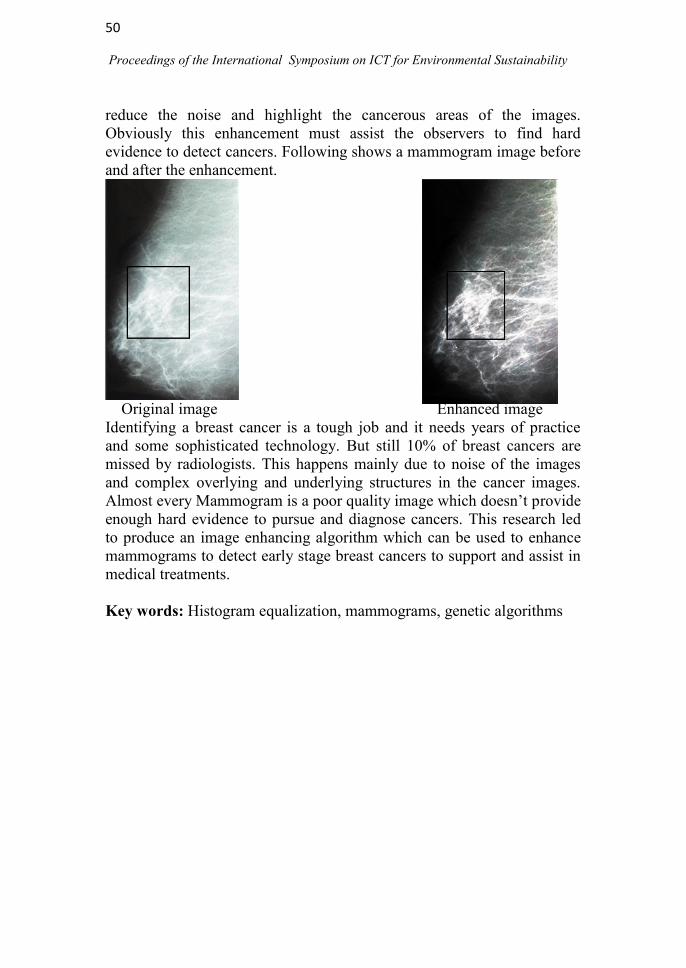
50
Proceedings of the International Symposium on ICT for Environmental Sustainability
reduce the noise and highlight the cancerous areas of the images.
Obviously this enhancement must assist the observers to find hard
evidence to detect cancers. Following shows a mammogram image before
and after the enhancement.
Original image Enhanced image
Identifying a breast cancer is a tough job and it needs years of practice
and some sophisticated technology. But still 10% of breast cancers are
missed by radiologists. This happens mainly due to noise of the images
and complex overlying and underlying structures in the cancer images.
Almost every Mammogram is a poor quality image which doesn‘t provide
enough hard evidence to pursue and diagnose cancers. This research led
to produce an image enhancing algorithm which can be used to enhance
mammograms to detect early stage breast cancers to support and assist in
medical treatments.
Key words: Histogram equalization, mammograms, genetic algorithms

51
Proceedings of the International Symposium on ICT for Environmental Sustainability
Technical Session
on
Ecosystems

52
Proceedings of the International Symposium on ICT for Environmental Sustainability
53
Proceedings of the International Symposium on ICT for Environmental Sustainability
FLOW MODELLING IN NILLAMBE OYA, SRI LANKA
M.P. Gunawardena and M.M.M. Najim*
Department of Zoology, Faculty of Science, University of Kelaniya,
Kelaniya. Sri Lanka *Corresponding Author: [email protected]
ABSTRACT Flooding and flow changes in rivers and streams due to anthropogenic
activities are the major problems worldwide as well as in Sri Lanka. To
address these issues, proper monitoring of flow patterns and prediction of
flow changes are necessary; However, daily monitoring and data
collection is greatly time consuming and costly. Therefore, development
and application of models for accurate simulation of flow variations will
be a vital requirement for the management of these ecosystems. In order
to address these concerns, a study was done with the objective of
calibrating and validating a model based on climatic, landuse and flow
data and to determine whether the calibrated model could be applied to
predict flow variations.
HEC-HMS 3.5 model which was developed by the United States Army
Corps of Engineers was used to simulate flow variation of the Nillambe
Oya catchment which is located within the central highlands of the mid
and upcountry wet zone. During the period from May 2013 to September
2013, flow was measured in nine selected days. Rainfall data, other
meteorological data and flow data for eight years (October 1991 to
September 1999) were obtained from the Environment and Forest
Division of the Mahaweli Authority and the Meteorology Department of
Sri Lanka. Daily flow data for five years (October 1991 to September
1996) were used to calibrate the model and another set of flow data for
five years (October 1994 to September 1999) were used to validate the
model. The flow values that were measured in situ during May 2013 to
September 2013 were statistically tested with flow values simulated by
the model.
Obtained residual plots and calculated percentage residuals of the
calibration and validation produced results with high R squared values
(above 0.65) and residual percentages within ±1SD and ±2SD above 85%
and 95%, respectively. The properly calibrated and validated HEC-HMS
3.5 computer model can be reliably used to simulate flows of Nillambe
Oya. Snyder unit hydrograph method, as the transformation method,
simulates flows reliably in the study catchment, along with initial loss

54
Proceedings of the International Symposium on ICT for Environmental Sustainability
method. Therefore, HEC-HMS 3.5 model can reliably be used to estimate
flow volumes that are available to Hydropower generation, drinking water
supply and agricultural purposes while maintaining ecological harmony
with the riverine ecosystem.
Key words: Calibration, catchment, flow, HEC-HMS, modelling,
validation

55
Proceedings of the International Symposium on ICT for Environmental Sustainability
TWO DIMENSIONAL NUMERICAL SIMULATION OF
RIVERBED VARIATION IN
IN MOUNTAINOUS RIVER BEND
Dang Truong An1*
and Park Sang Deog2
1Department of Physic and Physics Engineering, University of Sciences,
Vietnam National University, 227,Nguyen Van Cu Str., 5 Dist,
HCM City, Viet Nam 2Department of Civil Engineering, Gangneung-Wonju National
University,7, Jukheon-gil, Gangneung, Gangwon, 210-702, Korea *Corresponding Author: [email protected]
ABSTRACT
Flow of the mountainous river is a complex phenomenon, which is
characterized by steep slopes, water depths in the order of the height of
the roughness elements, a wide range of bed material sizes, and distinct
bed structures. The mountainous river may be defined as a stream in a
mountain area with steep channel slopes ranging from 0.1 to 10% or
more. Our current knowledge of flow of the mountainous river was
slowly improving and making certain progress. However, it was
remaining a challenge due to the lack of understanding of the
interrelationship between flow and sediment. The bed material of the
mountainous rivers is often a bed mixture of sands, gravels, cobbles, and
boulders up to 1 or 2m in diameter. Sediment transport capacities during
flood events can reach very high values and bed load may contains a high
portion of gravel, cobbles and boulders. Thus, sediment transport
dynamics in these channels may substantially differ from those in low-
gradient channels. In the past, most numerical models have been
developed in lower gradient channels. In the recent decades, more and
more flow and sediment transport models have been developed for steep
channels. Prediction of flow in the mountainous river may depend on
most common equations not considering the morphological peculiarities
of the research areas in conjunction with their limited capability. Bed load
equations developed by several authors for low slope rivers are rarely
applicable to steep river in mountain areas.
Researches on the flow and sediment transport problems in open
channels with steep slope is usually very difficult. This is a complicated
subject due to abrupt changes in bed topography, rapid variations in flow
regime as well as large roughness elements, etc. In this study, numerical
model was developed to calculate flow and bed level variation in open

56
Proceedings of the International Symposium on ICT for Environmental Sustainability
channels with steep slopes where the maximum bed material size is in the
range of cobbles. Governing equations are discretized using the finite
difference method on staggered grid. The model system consists of a flow
module, a sediment transport module and a bed level variation module.
The flow module is based on the mass and momentum conservation
equations in two-dimensional Cartesian coordinates. The bed level
variation module is based on the sediment continuity equation and gain
material distribution is applied for individual size fractions. The sediment
transport module comprises empirical bed load formulas. Numerous
equations have been developed and widely used to predict bed-load
transport rate. Unfortunately, the predicted bed load transport rate often
differs by orders of magnitude, as well as giving little confidence in the
computation results. In addition, local conditions of specific application
areas are often very different compared with laboratory conditions where
bed-load formulae were constructed. For this reason, in this research an
empirical formula for calculating bed load transport rate was developed.
Flow and sediment transport modules are simulated in a decoupled
manner.
Numerical model has been tested by simulating the flow situation in
the experimental channel and simulating a flood event in open channel
bend. The first experimental case concerns the aggradation in an
experimental channel, and the second case concerns the bed level
variation during a flood event in the Asungjun section of the Yangyang
Namdae mountainous-river with complex geometry. The simulation
results are compared with data from experimental and field
measurements. Detailed comparison results of the water surface elevation
shows generally good agreement. For the bed level variation simulation
results are quite consistent with measured data.
Key words: Open channels, steep slope, sediment transport, bed level
variation, empirical formula

57
Proceedings of the International Symposium on ICT for Environmental Sustainability
DOES MANGROVE FUNCTION AS SINK OR SOURCE OF
PHOSPHORUS FOR ITS ADJACENT RIVER? A CASE STUDY IN
MANGROVE DISTURBED BY TYPHOON IN CAN GIO
MANGROVE BIOSPHERE RESERVE
Phạm Quynh Huong*, Ho Phan Minh Uyen, Le NgọcTran,
Le Xuan Thuyen, Tran Triet
Department of Ecology and Evolutionary Biology, Faculty of Science,
National University of Ho Chi Minh City, Viet Nam *Corresponding Author: [email protected]
ABSTRACT A vast area of mangrove in Can Gio Mangrove Biosphere Reserve was
destroyed by a typhoon named Durian in December 2006. After the
typhoon, trunks, branches and twigs were left on the spot. The
decomposition of these materials was expected to affect the nutrient
dynamics in the mangrove sediment and tidal creek. Therefore, this
research was conducted to study the phosphorus dynamics in a tidal creek
and test if this mangrove functions as a source or a sink of phosphorus for
its adjacent river.
The surface water and floating litter were taken during 24 hours on spring
tide from a tidal creek connecting the mangrove and its adjacent river.
The physicochemical properties of the creek water were measured directly
in field. The content of soluble reactive phosphorus (SRP), total
particulate phosphorus (TPP), and phosphorus (P) content in the floating
litter were determined to calculate the amount of P exchanged between
the mangrove and river. Map Info Professional was used to calculate the
cross-section area of the creek and the data analysis was performed with
SG Plus Centurion XVI.
Most of the floating litter were twigs and small wood pieces from the
mangrove (62% of the total weight of floating litter). The average amount
of floating litter exported from the mangrove was 305.83 gh-1
. The
average amount of P exported from the mangrove through the floating
litter was 452.3 mgh-1
. SRP in the creek derived from the higher nutrient
concentration pore-water from the mangrove sediment which came into
the creek during the ebb. The amount of P entering the mangrove was
2013.56 gday-1
, while the amount of P exported from the mangrove was
2232.78 gday-1
. Due to the decomposition of trunks and branches
remained on the mangrove floor after the typhoon, the disturbed
mangrove functioned as a source of P for its adjacent river.
Key Words: Mangrove creek, litter, phosphorus

58
Proceedings of the International Symposium on ICT for Environmental Sustainability
ENVIRONMENTAL FLOW VARIATION DUE TO MINI-HYDRO
DIVERSION AT GURUGODA OYA, SRI LANKA
D.S.N. Munasinghe and M.M.M. Najim*
Department of Zoology, Faculty of Science, University of Kelaniya,
Kelaniya, Sri Lanka *Corresponding Author: [email protected]
ABSTRACT Quantification of amounts of flows that could be diverted maintaining
desired ecosystem conditions is difficult, and thus, water allocation
among sectors including the environment, has emerged a growing concern
in Sri Lanka. Therefore, this research focused on quantifying optimum
flows that has to be maintained below the weir site of a mini-hydro power
plant located at Morontota, Sri Lanka through Environmental Flow
Assessment and to predict whether the flows of the Hungampola
South/Morontota village section of Gurugoda Oya would be sufficient to
sustain riverine biodiversity.
The HEC-HMS 3.5 model was calibrated and validated for the
Holombuwa catchment of the Gurugoda Oya basin. The GIS layers that
were needed as input data for flow simulation were prepared using Arc
GIS 10.0 and the calibrated and validated model was applied to the
Alapalawela sub catchment located within the Holombuwa catchment, to
generate flows for the past twenty three years (1991-2013). Simulated
stream flows were characterized using thirty two different hydrological
parameters. The Range of Variability Approach (RVA) targets to be
maintained below the weir site were calculated using flows before
hydropower diversions, and the rate of non-attainment of flows were
determined for past scenarios (2011-2013).
According to the RVA, Environmental Flow is not maintained at present
in Gurugoda Oya below the weir. Mean rate of non-attainment of the flow
of Gurugoda Oya after mini hydropower diversion is around 45%
suggesting moderate level of hydrologic alteration due to impoundment.
Rate of non-attainment of the indicators of hydrological alterations (IHA)
group 1 parameters are in between 33% - 100%. Except for the magnitude
and duration of rate of non-attainment of means of 90 day minima and all
maxima values which attain a steady 0%, all other group 2 parameters
vary between 33% - 67%. In the IHA group 3, timing of lower limit of

59
Proceedings of the International Symposium on ICT for Environmental Sustainability
annual extreme water condition could not be calculated because flow of
Gurugoda Oya assumes the same minimal flow for several days, showing
more than one annual minima. Annual maxima show a rate of non-
attainment of 33%. Rate of non-attainment of the IHA group 4 and 5 both
vary between 0% - 100%. Therefore, Hydropower diversions from
Gurugoda Oya that deals with damming of the stream needs extensive
analysis of environmental impacts due to changes in flow regimes. The
RVA targets defined by this study could be of significance for ecosystem
management and restorations plans, and could provide ecological
operations for the weir.
Key words: Diversion, environmental flow, HEC-HMS, mini hydro-
power, modeling, Range of Variability Approach
60
Proceedings of the International Symposium on ICT for Environmental Sustainability
APPLICATION OF MASS BALANCE MODELLING TO ASSESS
THE EFFECTS OF FISH STOCKING ON THE ENERGY FLOW
IN A RESERVOIR ECOSYSTEM
Preetha Panikar*1, M. Feroz Khan
1 and A.P. Sharma
2
1Research Centre of Central Inland Fisheries Research Institute,
Hessarghatta, Bangalore, India 2Central Inland Fisheries Research Institute, Barrackpore, Kolkota, India
*Corresponding author: [email protected]
ABSTRACT
The impact of fish stock supplementation on the energy flow in
Hemavathy reservoir ecosystem in Karnataka, South India was assessed
using mass balance modeling. The mass balanced model structured
around thirteen ecological groups which included the nonliving group,
detritus. Hemavathy Reservoir with an area of about 9162 ha was
constructed in 1981, on the river Hemavathy for irrigation purpose in
Karnataka. The fish landings data of Hemavathy reservoir was collected
and studied for three years from 1983 by earlier workers. During this
period there was no systematic stocking of fish in this reservoir. Central
Inland Fisheries Research Institute investigated this reservoir in 2002 to
2004 when regular stocking and harvesting regime had become an
established management practice. Hence the present study was conducted
to analyse the impact of fish stocking on the energy flow and ecosystem
maturity of a reservoir ecosystem by comparing two scenarios; pre- and
post- fish stocking regimes. The mass-balance models of the reservoir
ecosystem were constructed for two periods, 1984 and 2003 using
Ecopath with Ecosim software to compare the fluctuations that occurred
within each of these years before systematic stocking and post-stocking
period. Flow at the trophic level II largely involves the zooplankton (the
dominant herbivore), bottom biota and the two groups of fishes the minor
carps and the exotic carps. Though aquatic birds occupy the highest
trophic levels in both phases, among fish groups Eels in the pre-stocking
phase and murrels in post-stocking phase occupy top trophic levels. The
pattern of energy flow through the network is described in terms of the
number of trophic interactions of each group and the mean length of
pathways (MLP) through the network. For top predators, the number of
connections was high (78–233) and with a high number of steps (MLP =
3.69). In the middle of the trophic chain, the exotic carps and major carps
61
Proceedings of the International Symposium on ICT for Environmental Sustainability
were (MLP = 2.87 &2.27) and the groups at the bottom of the pyramid
like zooplankton and bottom biota are characterized by low numbers of
trophic interactions (2 & 3 respectively) and path lengths (2.0). The
ecotrophic efficiency of the carps were low in post-stocking phase
showing these groups were not heavily exploited by the fishermen but the
increase in biomass due to stocking are evident. The resilience of
reservoir ecosystem before stocking the reservoir and the impact on
ecosystem after fish stocking were compared using various indices of
ecosystem maturity. A decrease of the flow of the system from pre-stock
to post-stock is evident (22.28%). The system overhead was higher by
0.29% in the post-stock phase indicating maturity. The ecosystem indices
tested indicate that the reservoir during post-stock phase was in a more
resilient state compared to the pre-stock phase. The maturity of the
ecosystem showed an improvement which indicates a positive impact of
stocking.
Key words: Ecosystem maturity, Indian major carps, mass balance
modelling, trophic levels, diet composition, reservoir fisheries.

62
Proceedings of the International Symposium on ICT for Environmental Sustainability

63
Proceedings of the International Symposium on ICT for Environmental Sustainability
Technical Session
on
E-Learning

64
Proceedings of the International Symposium on ICT for Environmental Sustainability

65
Proceedings of the International Symposium on ICT for Environmental Sustainability
KNOWLEDGE SHARING AND MANAGEMENT APPLICATION
FOR NATIONAL WILDLIFE TRAINING CENTER, SRI LANKA
W.A.K.L.M. Wickramasingha*1, E.P. Kudavidanage
2,
S. Vasanthapriyan1 and T.S. Priyadarshana
2
1 Department of Computing and Information Systems,
Sabaragamuwa University, Sri Lanka. 2 Department of Natural Resources, Sabaragamuwa University, Sri
Lanka. *Corresponding Author: [email protected]
ABSTRACT
There is a critical need to share and manage biodiversity data for
conservation purposes. A comprehensive inventory of biodiversity data
on a location together with information on subjects such as habitat use,
conservation status, availability of specimens and previous research can
benefit both researchers and decision makers. The National Wildlife
Training Center (NWTC) is located in the dry zone, close to Minneriya–
Giritale Nature Reserve Block II. It is surrounded by well grown Tropical
dry mixed forests and harbors a diverse array of fauna and flora including
many endemics and nationally threatened species. The center provides
compulsory training to staff of the Department of Wildlife Conservation
and has facilities for researchers. It is currently being developed to
become an International Training School. Therefore, there is a great
necessity to have well documented information on the biodiversity of the
locality that can be accessed by visitors, trainees and researchers. In
addition an advance form of a database can assist to monitor the use of the
specimen collection at the museum and help future development of the
site that might affect some of the faunal habitats. Thus this project aims to
provide knowledge sharing and management solutions using Information
and Communication Technology. The objectives of the study are to
provide knowledge sharing and management solutions for using Girithale
National Training Center as a model, assist maintaining the specimen
collection, provide remote access to users, to reduce barrier between
researches and application, to simplify the data searching process and to
promote data driven decision making.
The project used both primary and secondary data. A biodiversity survey
was conducted around the training center in the sanctuary since no

66
Proceedings of the International Symposium on ICT for Environmental Sustainability
previous intensive study on the site has been carried out. The field data as
well records from the specimen collection was used as the primary source
for project. The research reports at the center were used as secondary
sources. The data sharing platform constructed is a web site developed
using PHP and the Data base using MySQL. Maps were prepared using
digital image processing, use queries, search engine or artificial
intelligence agent to retrieve data. In addition a mobile web page was also
created. The NWTC could host this web site as a knowledge sharing
center.
This system provides a knowledge sharing and management system that
will help to protect rare and threaten habitats of Girithale and also will
provide easy access to different studies conducted. Thus it finally will
reduce the gap between conservationists, researchers, decision makers and
public and will also facilitate more informed decision making and
efficient use of resources.
Key words: Knowledge sharing, database management, conservation,
decision makers, biodiversity
67
Proceedings of the International Symposium on ICT for Environmental Sustainability
INFLUENCE OF HUMAN COMPUTER INTERACTION IN
LEARNING MANAGEMENT SYSTEM
S. Thuseethan and S. Vasanthapriyan*
Department of Computing and Information Systems,
Sabaragamuwa University of Sri Lanka, Belihuloya, Sri Lanka *Corresponding Author: [email protected]
ABSTRACT The word E-learning in many developing and developed countries is
inseparable from the field of education and more common in nature. The
usefulness of Learning Management Systems in e-learning lies not only in
performing the academic task itself but also in sharing of knowledge
between users, which includes academics and students. The current trend
in developing Learning Management Systems is largely empirical, and
academically sound learning experiences are still absent. At the first
glance faster, more flexible, more natural, easier and more convenient
means for users and Learning Management Systems to interchange
information are required. In user‘s perspective, the use of Learning
Management System is constrained by the human‘s perceptual and
cognitive abilities. On the other hand, in computer side, it constrained
only by devices used in the system and the limitations in software design.
The best way to overcome both types of constraints therefore now totally
lies in designing the user interface rather than the internal system design.
In this research appropriate strategies for developing interfaces to
Learning Management Systems at a national level were considered. The
issues in designing interfaces for Learning Management System for
academics are little different from the design standard of interfaces taken
from the literature of Human Computer Interaction standards. These
differences were considered with the help of a survey done in an
academic organization and are described, explained, and clarified. Finally
we came up with some modification of standards with the help of existing
standards in Human Computer Interaction and with the research output.
This type of Human Computer Interaction standards for Learning
Management System can satisfy the desires of its intended academic users
and deliver a suitable opening for advance research and development.
Key words: E-learning, human computer interaction, learning
management system

68
Proceedings of the International Symposium on ICT for Environmental Sustainability
THE ROLE OF ICT IN STUDENTS AND THEIR TERTIARY
STUDIES IN SAMOA
Edna Temese Ualesi *, Satoru Ozawa and Atsushi Minato
Ibaraki University, Graduate School of Science and Engineering,
Hitachi city, Japan. *Corresponding Author: [email protected]
ABSTRACT
Information and Communication Technologies play a paramount role in
the development of Education worldwide including small island nations
such as Samoa. The availability of vast Information and advance
technological developments in Tertiary Education Institutions allow
students to encounter the frequent use of ICT in their studies. This paper
is based on the role of ICT in Tertiary Education in Samoa. The study was
conducted using 300 randomly selected students regardless of which
Institution they are enrolled in. Data were collected by questionnaires and
interviews and analyzed by Microsoft Excel. The study revealed that
Information and Communication Technologies profoundly contributes in
improving their learning skills and simplifying their ways of studying,
and have paved the way to their academic success. The study also showed
need of improving ICT resources as the increasing numbers of students
limit the access to various Information and Communication Technologies.
Key words: ICT, e-learning, education

69
Proceedings of the International Symposium on ICT for Environmental Sustainability
SURVEY ON METADATA STANDARDS FOR AN E-TEACHING
ENVIRONMENT
S. Vasanthapriyan
Department of Computing and Information Systems,
Sabaragamuwa University of Sri Lanka, Belihuloya, Sri Lanka.
ABSTRACT
E--teaching is commonly referred to as the intentional use of networked
information and communications technology (ICT) in teaching and
learning processes. In order to be easily retrieved, shared and used by
different users and for different purposes, the various types of e- teaching
documents have to be described following common schemes and rules
e.g. specifications or standards and metadata. But the web lacks a uniform
organization scheme that would allow easy access to these e-teaching
material. It means that there should be efficient accessibility and the
recoverability of educational resources. This objective can be gained
using the ―Metadata Standards‖. Several institutions and professionals
have established Metadata Standards. In this research, a survey was
carried out to find out the existing Metadata Standards and their
characteristics to propose common Metadata standards to the e—teaching
environment. Therefore, the retrieval of information of various types
including print, images, animations, presentations, audio, and video in the
environment can be easily done.
Keywords: E—teaching, metadata, semantic web

70
Proceedings of the International Symposium on ICT for Environmental Sustainability
USE OF KISSEL SERVER AS A PLATFORM FOR THE
EXPANSION OF RESEARCH ON THE WATER QUALITY OF
ASIAN WATER BODIES
D.D.G.L. Dahanayaka1*
, H. Tonooka1, M.J.S. Wijeyaratne
2, A.
Minato1 and S. Ozawa
1
1 Graduate School of Science and Engineering, Ibaraki University,
Hitachi, Japan 2 Department of Zoology, University of Kelaniya, Kelaniya, Sri Lanka
*Corresponding Author: [email protected]
ABSTRACT
Monitoring of all relevant aspects of water bodies is highly important for
their sustainable use. To achieve this all research findings should be easy
accessible and presenting those in a user friendly manner will be highly
advantageous. Therefore, development of a database on the coastal water
bodies of Sri Lanka on KISSEL server system was initiated, for the
benefit of all interest groups including the general public. Presently it
contains water quality data of lagoons and estuaries for over two decades.
This was extended from a local scale to a regional scale. In this extension,
algorithm improvement or tuning based on in-situ data sets was carried
out for optimization. The aim was to expand the databases on water
bodies using satellite analysis within selected Asian countries. It was
initiated through KISSEL server system to benefit pollution monitoring
and sustainable use of water bodies. Water bodies of Japan, Sri Lanka,
Vietnam, Thailand, Indonesia and Philippines were selected considering
their economic and ecological importance. In-situ research parallel to
satellite overpass were conducted on the following water bodies. Local
Universities and/or Research Institutes collaborated with the collection of
field data and will involve in future continuous monitoring programs and
KISSEL related activities.
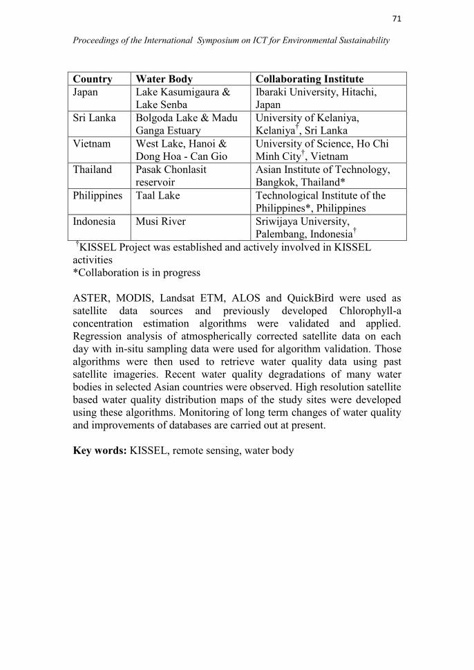
71
Proceedings of the International Symposium on ICT for Environmental Sustainability
Country Water Body Collaborating Institute
Japan Lake Kasumigaura &
Lake Senba
Ibaraki University, Hitachi,
Japan
Sri Lanka Bolgoda Lake & Madu
Ganga Estuary
University of Kelaniya,
Kelaniya†, Sri Lanka
Vietnam West Lake, Hanoi &
Dong Hoa - Can Gio
University of Science, Ho Chi
Minh City†, Vietnam
Thailand Pasak Chonlasit
reservoir
Asian Institute of Technology,
Bangkok, Thailand*
Philippines Taal Lake Technological Institute of the
Philippines*, Philippines
Indonesia Musi River Sriwijaya University,
Palembang, Indonesia†
†KISSEL Project was established and actively involved in KISSEL
activities
*Collaboration is in progress
ASTER, MODIS, Landsat ETM, ALOS and QuickBird were used as
satellite data sources and previously developed Chlorophyll-a
concentration estimation algorithms were validated and applied.
Regression analysis of atmospherically corrected satellite data on each
day with in-situ sampling data were used for algorithm validation. Those
algorithms were then used to retrieve water quality data using past
satellite imageries. Recent water quality degradations of many water
bodies in selected Asian countries were observed. High resolution satellite
based water quality distribution maps of the study sites were developed
using these algorithms. Monitoring of long term changes of water quality
and improvements of databases are carried out at present.
Key words: KISSEL, remote sensing, water body

72
Proceedings of the International Symposium on ICT for Environmental Sustainability
NOVEL APPROACH FOR ANALYZING BRAHMI SCRIPTS
D. Bandara*1,2
, N. Warnajith1, A. Minato
1 and S. Ozawa
1
1 Graduate School of Science and Engineering, Ibaraki University,
Hitachi, Japan 2 Department of Archaeology, Colombo, Sri Lanka
*Corresponding Author: [email protected]
ABSTRACT
Writing is one of the most important inventions of humankind. There are
few main languages in the ancient world. Among these ancient languages
Sanskrit was used in the Indo region. Brahmi script is one of the most
important ancient letters in South Asia. It became the matrix of
Debanagari character used for Sanskrit and Hindi. The people of Sri
Lanka are fortunate that some of the writing of their ancestors is
preserved on various inscriptions found throughout the country. These
inscriptions have been discovered under the drip ledges of caves, rocks,
pillars and slabs. Inscribed gold, silver and copper plates have been
discovered as well. On the decipherment of these inscriptions, historical,
linguistic and paleographical conclusions could be arrived at.
The source data of this study is already published as gray scale images of
early Brahmi script. These images are taken from the paper copies of
inscriptions called as estampages (rubbed copy). Up to the present,
reading and analyzing these inscriptions are done manually. The aim of
this study was to develop algorithms based on image data of these
estampages and implement a digital data repository. The process of this
study can be divided into several stages as follows: (1). Producing precise
alphabet fonts of early Brahmi scripts from photographic data, (2).
Development of a precise method of identification of ancient letters with
the aid of the alphabet fonts, which leads to automatic reading of ancient
inscriptions by computers, (3). Database implementation for the analysis,
(4). Development of web based interface for scholars over KISSEL
network to share the knowledge and experience among the KISSEL users.
Key words: Brahmi scripts, alphabet fonts, image database

73
Proceedings of the International Symposium on ICT for Environmental Sustainability
TEACHERS’ PERCEPTIONS ON THE INCORPORATION OF
INFORMATION AND COMMUNICATION TECHNOLOGIES
(ICT) IN SCHOOL COUNSELING
Shamitha Pathiratne
TEC Sri Lanka, No 66/1, Walter Gunasekara Mawatha, Nawala
ABSTRACT
This study was carried out to determine the different perspectives of Sri
Lankan teachers on the use and application of ICT in guidance counseling
and the school counselor‘s advocacy role.
Participants of the study were the teachers of public and private schools in
Gampaha District who are handling the counseling role. The participants
have experience as elementary grade teachers, as guidance counselors,
and as teacher in-charge/principals. The study employed a snowball
sampling technique that requires others to recommend teachers who they
believe can have experience about the amalgamation of information
technology in teaching and counseling. The open-ended formats or
interviews were used to investigate the (a) different uses of ICT [e.g.
internet, e-mail], (b) problems/issues/gaps on the use and application of
ICT or computer technology, and (c) innovative ways in using ICT in
counseling.
The views of the teacher-participants on ICT use generated the themes on
(1) storing, encoding and preparing materials/documents, (2) retrieving,
distributing and utilizing data/information related to school counseling,
and (3) other uses for entertainment, leisure and recreational activities.
As to the potential uses of ICT, the subjects generated various uses as
what they practice and what they have learned from their undergraduate
courses on technology in education and knowledge management in
education. The issues and problems were mostly related to the economic
aspects, costs, administrators‘ attitudes towards the use of ICT, quality of
information and on the issue of commercialism. Innovative programs
presented dealt on the individual needs of the pupils and on the career
services, but not on the ways to improve the professional capabilities of
the guidance counselors. Continuous re-training and establishment of a
well-defined capacity building program for guidance counselors focusing
on individual skills of the counselors as to the other uses and application

74
Proceedings of the International Symposium on ICT for Environmental Sustainability
of ICT are needed. School counselors should be guided through school-
based in-service training and education ministry or government -
sponsored programs on capacity building by putting emphases on the
benefits of ICT use as well as case presentations of the various
experiences of counselors in Sri Lanka about ICT integration in the
implementation of the school guidance programs.
Keywords: ICT, guidance and counseling, ICT and education, teachers,
Sri Lanka
75
Proceedings of the International Symposium on ICT for Environmental Sustainability
FEASIBILITY STUDY ON THE WIRELESS MESH NETWORK
AS AN ALTERNATIVE WI-FI NETWORKING FOR
ENTERPRISES
D.S.S. Matharage and M.K.D. Padmasiri*
Department of Human Resource Management, Faculty of Commerce and
Management Studies, University of Kelnaiya, Sri Lanka.
*Corresponding Author: [email protected]
ABSTRACT
Wireless Mesh network architecture and its importance as a n
alternative Wi-Fi networking, applications of mesh networks, and
methods of implementing mesh networks are discussed in the
present paper.
CINEC play ground was selected as the test bed of this study.
Results of the test cases which were carried out to determine
link quality source routing, data throughput and multi-hop
function of the mesh networks with the aid of laptops and
external USB Wi-Fi dongles and future expansions of the
wireless mesh networks with 802.11.s standard are also described
KEYWORDS: Wireless mesh network; Alternative Wi-Fi network