Embed Size (px)
Citation preview

PROBABILISTIC SEISMIC HAZARD ASSESSMENT OF EAST MALAYSIA
USING PROPOSED EMPIRICAL GMPE FOR SHALLOW
CRUSTAL EARTHQUAKE
NOOR SHEENA HERAYANI BINTI HARITH
A thesis submitted in fulfilment of the
requirements for the award of the degree of
Doctor of Philosophy (Civil Engineering)
Faculty of Civil Engineering
Universiti Teknologi Malaysia
JANUARY 2016

iii
To my beloved husband, children and family members

iv
ACKNOWLEDGEMENT
In preparing this thesis, I hereby would like to acknowledge with many
people, researchers, academicians, and practitioners. They have contributed
towards my understanding and thoughts. In particular, I wish to express my
sincere appreciation to my main thesis supervisor, Professor Dr. Azlan Bin Adnan,
for encouragement, helpful reviewer, critics and friendship. I am also very
thankful to my advisor Professor Dr. Ir. Karim Mirasa for his guidance, advices
and motivation. Without their continued support and interest, this thesis would not
have been the same as presented here.
I am also indebted to Universiti Malaysia Sabah (UMS) and Higher
Ministry of Education for funding my Ph.D. study. Librarians at UTM, Ecole
Polytechnique Federal de Lausanne of Switzerland also deserve special thanks
for their assistance in supplying the relevant literatures and sharing knowledge.
Acknowledgement also goes to Malaysian Meteorological Department, Malaysia
(MMD), website of United State Geological Survey (USGS) and ISC for allowing
me to use the data for the analysis.
My sincere appreciation also extends to all my colleagues especially
Mr. Abdollahvaez Shoustari and others who have provided assistance at
various occasions. Their views and tips are useful indeed. Unfortunately, it is not
possible to list all of them in this limited space. I am grateful to my husband,
daughter and all my family members for their endless support and motivation.
v
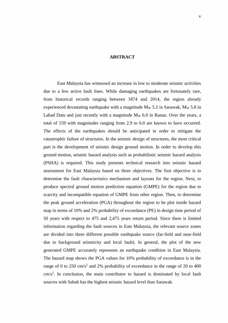
ABSTRACT
East Malaysia has witnessed an increase in low to moderate seismic activities
due to a few active fault lines. While damaging earthquakes are fortunately rare,
from historical records ranging between 1874 and 2014, the region already
experienced devastating earthquake with a magnitude MW 5.2 in Sarawak, MW 5.8 in
Lahad Datu and just recently with a magnitude MW 6.0 in Ranau. Over the years, a
total of 159 with magnitudes ranging from 2.9 to 6.0 are known to have occurred.
The effects of the earthquakes should be anticipated in order to mitigate the
catastrophic failure of structures. In the seismic design of structures, the most critical
part is the development of seismic design ground motion. In order to develop this
ground motion, seismic hazard analysis such as probabilistic seismic hazard analysis
(PSHA) is required. This study presents technical research into seismic hazard
assessment for East Malaysia based on three objectives. The first objective is to
determine the fault characteristics mechanism and layouts for the region. Next, to
produce spectral ground motion prediction equation (GMPE) for the region due to
scarcity and incompatible equation of GMPE from other region. Then, to determine
the peak ground acceleration (PGA) throughout the region to be plot inside hazard
map in terms of 10% and 2% probability of exceedance (PE) in design time period of
50 years with respect to 475 and 2,475 years return period. Since there is limited
information regarding the fault sources in East Malaysia, the relevant source zones
are divided into three different possible earthquake source (far-field and near-field
due to background seismicity and local fault). In general, the plot of the new
generated GMPE accurately represents an earthquake condition in East Malaysia.
The hazard map shows the PGA values for 10% probability of exceedance is in the
range of 0 to 250 cm/s2 and 2% probability of exceedance in the range of 20 to 400
cm/s2. In conclusion, the main contributor to hazard is dominated by local fault
sources with Sabah has the highest seismic hazard level than Sarawak.
vi
ABSTRAK
Kawasan Malaysia Timur mempunyai garisan sesar yang mampu
menghasilkan gempa bumi bermagnitud rendah dan sederhana. Sementara gempa
yang memusnahkan adalah jarang berlaku, rekod sejarah diantara tahun 1874 hingga
2014 menunjukkan kawasan ini pernah mengalami kejadian gempa bermagnitud MW
5.2 di Sarawak, MW 5.8 di Lahad Datu dan baru-baru ini MW 6.0 di Ranau.
Sepanjang tahun tersebut, sebanyak 159 jumlah gempa bumi bermagnitud 2.9 hingga
6.0 telah direkodkan. Kesan akibat gempa bumi hendaklah diambil kira bagi
mengelakkan kegagalan dalam struktur. Reka bentuk yang sedia ada perlu
dipertingkatkan dengan memasukkan elemen-elemen penilaian bahaya sismik
menggunakan pendekatan kebarangkalian atau PSHA. Di dalam kajian ini, terdapat
tiga objektif yang perlu dicapai pada akhir kajian. Objektif pertama adalah untuk
menentukan ciri-ciri mekanisma dan susun atur sesar di kawasan Malaysia Timur.
Objektif kedua adalah untuk menghasilkan spektrum persamaan ramalan gerak tanah
(GMPE) bagi rantau ini kerana persamaan GMPE dari rantau lain adalah kurang
serasi. Akhir sekali adalah penentuan nilai pecutan tanah maksimum (PGA) untuk
rantau ini diplotkan di dalam peta sismik pada 10% dan 2% kebarangkalian
dilangkaui dalam reka bentuk tempoh 50 tahun, masing-masing 475 dan 2,475 tahun
tempoh ulangan. Oleh kerana terdapat sedikit informasi berkaitan sesar di rantau ini,
garisan sesar dibahagikan kepada tiga kemungkinan (sesar jarak jauh dan jarak dekat
yang terdiri daripada taburan sismik serta garisan sesar tempatan). Merujuk kepada
peta sismik untuk kebarangkalian dilangkaui pada 10%, nilai PGA adalah antara 0
hingga 250 cm/s2 dan kebarangkalian dilangkaui pada 2% pula, adalah antara 20
hingga 400 cm/s2. Kesimpulannya, punca kebarangkalian adalah tinggi disebabkan
oleh garisan sesar tempatan di mana Sabah mempunyai nilai tertinggi berbanding
Sarawak.

vii
TABLE OF CONTENTS
CHAPTER TITLE PAGE
DECLARATION ii
DEDICATION iii
ACKNOWLEDGEMENTS iv
ABSTRACT v
ABSTRAK vi
TABLE OF CONTENTS vii
LIST OF TABLES x
LIST OF FIGURES xii
LIST OF ABBREVIATIONS xvii
LIST OF SYMBOLS xviii
LIST OF APPENDICES xix
1 INTRODUCTION 1
1.1 General 1
1.2 Seismology and Earthquake Genesis 2
1.3 Background 5
1.4 Problem Statement 11
1.5 Objectives 12
1.6 Scope and Limitation 13
1.7 Research Methodology 13
1.7.1 Fault Identification 14
1.7.2 Ground Motion Prediction Equation 15
1.7.3 Probabilistic Seismic Hazard Analysis 16
viii
1.8 Significance of Research 16
1.9 Organization of Thesis 17
2 LITERATURE REVIEW 19
2.1 Introduction 19
2.2 Seismotectonic Zoning 20
2.2.1 East Malaysia Earthquake Catalog 22
2.2.2 Definition of East Malaysia Geological
Fault and Source Zonation
28
2.2.3 East Malaysia Geological Features 29
2.2.4 Previous Zonation Models 31
2.2.5 Seismic Hazard Studies in East Malaysia 37
2.3 Ground Motion Prediction Equation 42
2.3.1 Description of the GMPEs Considered 43
2.3.2 GMPE Comparative Study 48
2.4 Response Spectral of East Malaysia 52
3 SEISMIC HAZARD ANALYSIS 54
3.1 Introduction 54
3.2 Probabilistic Seismic Hazard Analysis (PSHA) 55
3.3 Flow Chart of PSHA 56
3.3.1 Compilation of Earthquake Catalog 59
3.3.2 Earthquake Source Location 59
3.3.3 Development of new GMPE 59
3.3.4 Earthquake Ground Motion Parameter 60
3.3.5 Computation of Seismic Hazard 60
3.4 Earthquake Catalogue Analysis 60
3.4.1 Earthquake Size Analysis 61
3.4.2 Declustering Algorithm 63
3.4.3 Completeness Analysis 65
3.5 Source Zone Delineation 68
3.6 Seismic Hazard Parameter 75
3.7 Seismic Hazard Computation 79

ix
3.8 GMPE Development for East Malaysia 81
4 RESULTS AND DISCUSSION 87
4.1 Introduction 87
4.2 Analysis and Comparison of New Equation with
Earthquake Records
88
4.3 Logic Tree Scheme 94
4.4 Evaluation of Seismic Hazard Map 98
4.4.1 Effect of far field earthquake 99
4.4.2 Hazard Map due to Background Point
Source
102
4.4.3 Hazard Map due to Fault Source 105
4.4.4 Final Hazard Map 107
4.5 Uniform Hazard Response Spectrum for East
Malaysia
110
4.6 Discussion 111
5 CONCLUSION AND RECOMMENDATIONS 117
5.1 Introduction 117
5.2 Concluding Remarks 118
5.3 Recommendation 119
REFERENCES 121
APPENDICES 133-203

x
LIST OF TABLES
TABLE NO. TITLE PAGE
1.1 Published MMI scale in East Malaysia region 8
2.1 Details of earthquake data from different sources 23
2.2 Previous earthquake data collection 24
2.3 Relationship between Modified Mercalli Scale (MMI)
and body wave magnitude, mb
25
2.4 Sample of earthquake events with a magnitude of 5.0
or above in study area
28
2.5 Fault characteristics around Sulawesi 34
2.6 MMI scale and PGA predicted values for 10% and
2% probability of exceedance in East Malaysia
39
2.7 Prediction equation from stable tectonic region 46
2.8 Prediction equation from active tectonic region 47
3.1 Correlative relationships between MW and MS and Mb 63
3.2 Window algorithm for removing aftershock 65
3.3 Recurrence parameters for all source zones 78
3.4 Prediction model coefficients and associated standard
deviations for East Malaysia
86
4.1 Logic tree weight distribution adopted in the present
study for treating epistemic uncertainties in the hazard
analysis of shallow crustal fault
97
4.2 Logic tree weight distribution adopted in the present
study for treating epistemic uncertainties in the hazard
analysis of background treated as point and fault as
line and area source
113

xi
4.3 Logic tree weight distribution adopted in the present
study for treating epistemic uncertainties in the hazard
analysis of the subduction zone
114
4.4 PGA results comparison given by different weighted
due to local background earthquake and fault source at
10% probability of exceedance
115
4.5 PGA results comparison given by different weighted
due to local background earthquake and fault source at
2% probability of exceedance
115

xii
LIST OF FIGURES
FIGURE NO. TITLE PAGE
1.1 Plate Tectonic Setting of Southeast Asia 3
1.2 Primary types of tectonic plate boundaries 4
1.3 Active Mensaban and Lobou-Lobou faults within
Crocker fault zone
6
1.4 Seismic geometry of local earthquake around Sabah 6
1.5 Seismic geometry of local fault and earthquakes
around Sarawak
7
1.6 Number of local earthquakes with a magnitude greater
than 2.0 reported in each decade (1874-2014) around
East Malaysia
9
1.7 Earthquake events distribution map in the study area
from year 1874 to 2014
10
1.8 Flow Chart of Research Methodology 14
2.1 Seismotectonic settings around Malaysia region 21
2.2 Modified Mercalli Intensities (MMI) in Malaysia 22
2.3 Distribution of local background epicenters with a
magnitude ranging from 2.0–7.9 around East Malaysia
since 1874 until 2014
26
2.4 Distribution of epicenters surrounding East Malaysia
since 1900 – 2014
27
2.5 Distribution of local earthquakes and fault sources
around East Malaysia region
29
2.6 GPS result of East Malaysia 31
2.7 East Malaysia Seismic Source Model 32
xiii
2.8 Geological map and fault lineaments around Borneo
Island
33
2.9 Earthquake source zone around East Malaysia 34
2.10 Tectonic settings that built up around Sulawesi (i.e.
North Sulawesi Trench and several shallow crustal
faults; Palu-Koro, Matano and Walanae strike slip
fault)
35
2.11 Source zone area of East Malaysia region 36
2.12 Seismic zone of Sabah, as illustrated in the MMD
report
37
2.13 Modified Mercalli Intensity (MMI) of East Malaysia 40
2.14 East Malaysia hazard map for 10% probability of
exceedance
41
2.15 Peak ground acceleration (PGA) maps for (a) 475 years
and (b) 2,475 years
41
2.16 Comparison of prediction equation models with
recorded PGA at bedrock in East Malaysia from
shallow crustal earthquakes for the range of magnitude;
(a) MW 2.8 to 3.2; (b) MW 3.3 to 3.7; (c) MW 3.8 to 4.2
49
2.17 Comparison of prediction equation models with
recorded PGA at bedrock in East Malaysia from
shallow crustal earthquakes for the range of magnitude;
(d) MW 4.3 to 4.7; (e) MW 4.8 to 5.2; (f) MW 5.3 to 5.7
50
2.18 Comparison of prediction equation models with
recorded PGA at bedrock in East Malaysia from
shallow crustal earthquakes for the range of magnitude;
(g) MW 5.8 to 6.2; (h) MW 6.3 to 6.7; (i) MW 7.3 to 7.7
51
2.19 Uniform hazard response spectrum on bedrock in
Malaysia
53
3.1 Flow chart of probabilistic seismic hazard analysis for
this study
58
3.2 Illustration of shock 64

xiv
3.3 Distribution of catalogue from completeness analysis
(i.e. strike-slip, subduction and background
earthquakes)
67
3.4 Shallow crustal and subduction zone from Sulawesi
and Philippines
69
3.5 Line and area sources of local fault 71
3.6 Background source proposed in this study 72
3.7 Model for magnitude distribution based on earthquake
source zonation considered in this study
73
3.8 Schematic representation of point source 74
3.9 Schematic representation of line source 74
3.10 Schematic representation of area source 74
3.11 Frequency-Magnitude relationship for background
point source in Central Sabah with values obtained for
parameters ‘a’ and ‘b’ were 2.3542 and 0.7774,
respectively
75
3.12 Frequency-Magnitude relationship for areal fault in
Ranau with values obtained for parameters ‘a’ and ‘b’
were 2.4637 and 0.7641, respectively
76
3.13 Frequency-Magnitude relationship for shallow crustal
Mindanao 1 with values obtained for parameters ‘a’
and ‘b’ were 4.2142 and 0.8052, respectively
76
3.14 Frequency-Magnitude relationship for subduction
megathrust in Sulawesi with values obtained for
parameters ‘a’ and ‘b’ were 4.2513 and 0.7856,
respectively
77
3.15 Seismic stations in East Malaysia and the earthquake
epicentre occurred during the year 2004 until 2012,
carrying a magnitude less and more than MW 5.0
82
3.16 Distribution of data used in terms of magnitude and
distance on EC8 soil class A
83
xv
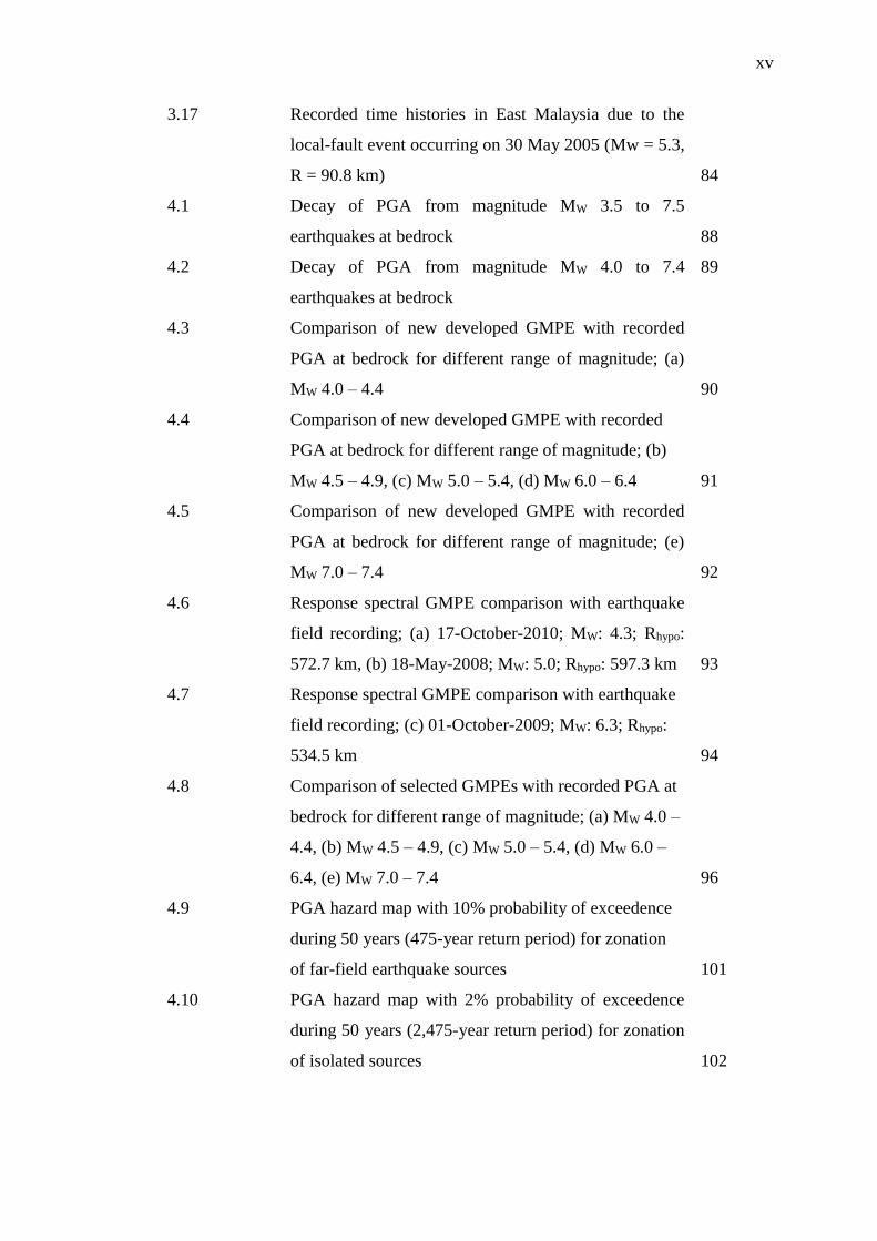
3.17 Recorded time histories in East Malaysia due to the
local-fault event occurring on 30 May 2005 (Mw = 5.3,
R = 90.8 km)
84
4.1 Decay of PGA from magnitude MW 3.5 to 7.5
earthquakes at bedrock
88
4.2 Decay of PGA from magnitude MW 4.0 to 7.4
earthquakes at bedrock
89
4.3 Comparison of new developed GMPE with recorded
PGA at bedrock for different range of magnitude; (a)
MW 4.0 – 4.4
90
4.4 Comparison of new developed GMPE with recorded
PGA at bedrock for different range of magnitude; (b)
MW 4.5 – 4.9, (c) MW 5.0 – 5.4, (d) MW 6.0 – 6.4
91
4.5 Comparison of new developed GMPE with recorded
PGA at bedrock for different range of magnitude; (e)
MW 7.0 – 7.4
92
4.6 Response spectral GMPE comparison with earthquake
field recording; (a) 17-October-2010; MW: 4.3; Rhypo:
572.7 km, (b) 18-May-2008; MW: 5.0; Rhypo: 597.3 km
93
4.7 Response spectral GMPE comparison with earthquake
field recording; (c) 01-October-2009; MW: 6.3; Rhypo:
534.5 km
94
4.8 Comparison of selected GMPEs with recorded PGA at
bedrock for different range of magnitude; (a) MW 4.0 –
4.4, (b) MW 4.5 – 4.9, (c) MW 5.0 – 5.4, (d) MW 6.0 –
6.4, (e) MW 7.0 – 7.4
96
4.9 PGA hazard map with 10% probability of exceedence
during 50 years (475-year return period) for zonation
of far-field earthquake sources
101
4.10 PGA hazard map with 2% probability of exceedence
during 50 years (2,475-year return period) for zonation
of isolated sources
102
xvi
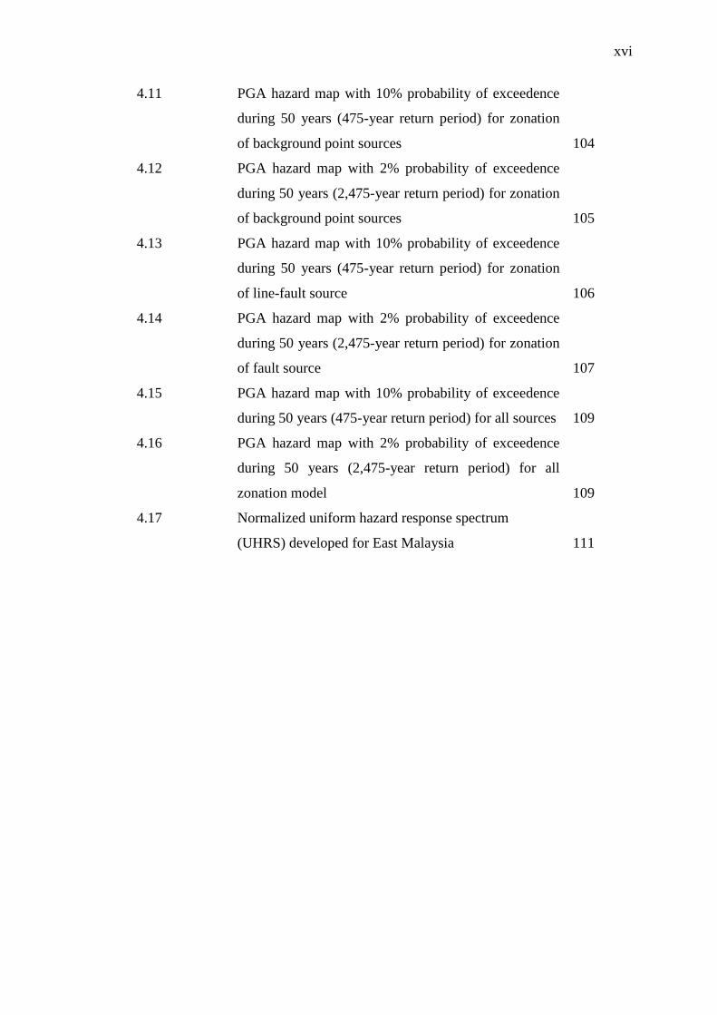
4.11 PGA hazard map with 10% probability of exceedence
during 50 years (475-year return period) for zonation
of background point sources
104
4.12 PGA hazard map with 2% probability of exceedence
during 50 years (2,475-year return period) for zonation
of background point sources
105
4.13 PGA hazard map with 10% probability of exceedence
during 50 years (475-year return period) for zonation
of line-fault source
106
4.14 PGA hazard map with 2% probability of exceedence
during 50 years (2,475-year return period) for zonation
of fault source
107
4.15 PGA hazard map with 10% probability of exceedence
during 50 years (475-year return period) for all sources
109
4.16 PGA hazard map with 2% probability of exceedence
during 50 years (2,475-year return period) for all
zonation model
109
4.17 Normalized uniform hazard response spectrum
(UHRS) developed for East Malaysia
111
xvii
LIST OF ABBREVIATIONS
ACR - Active Continental Region
ANSS - Advanced National Seismic System
CMT - Harvard Centroid Moment Tensor
GMPE - Ground motion prediction equation
GPS - Global Positioning System
GSHAP - Global Seismic Hazard Assessment Program
ISC - International Seismological Centre
MMD - Malaysian Meteorological Department
MMI - Modified Mercalli Intensity
PGA - Peak ground acceleration
PSHA - Probabilistic Seismic Hazard Analysis
NEIC - National Earthquake Information Centre
NGDC - National Geophysical Data Centre
RSA - Response spectral acceleration
SCR - Stable Continental Region
UHRS - Uniform hazard response spectrum
USGS - United States Geological Survey

xviii
LIST OF SYMBOLS
Mb - Short period P-wave magnitude
ML - Local magnitude
Mmax - Maximum magnitude
Mmin - Minimum magnitude
MS - Surface-wave magnitude
MW - Moment magnitude
Rhypo - Distance in hypocenter
σ - Standard deviation
λ - Recurrence rate

xix
LIST OF APPENDICES
APPENDIX TITLE PAGE
A1 MMD Seismic Stations Code And Location 133
A2 Earthquake Epicenter 134
A3 Time History Plot 135
CHAPTER 1
INTRODUCTION
1.1 General
An earthquake is an event where two pieces of the earth’s crust shift against
each other and create a series of vibrations. An earthquake can occur anywhere, and
thousands happen every day around the world, creating events such as faulting,
tsunamis, volcanos, landslides and liquefaction. This seismic vibration will cause the
ground to shake in a way that might affect densely urbanized regions and can cause
damage and loss of life to human beings. An earthquake itself might not kill people,
but the structure collapsing due to it will. The buildings or structures must be able to
sustain the seismic load so the loss of life can be prevented. Seismic activity refers to
earthquakes experienced over a period of time. Most parts of the world experience at
least occasional shallow earthquakes from low to high intensity.
A region where the number of seismic activities is low is known as a stable
continental region (SCR) and active seismicity for active continental region (ACR).
Seismic hazard analysis in SCR and ACR is different in terms of the definition of
seismic sources and ground-motion prediction equation (GMPE). The faults are often
not known in SCR and there are more uncertainties in the characteristics of seismic
sources in comparison to ACR. It should be noted, however, that the geographic
distribution of smaller earthquakes is less completely determined than more severe
quakes, partly because the availability of relevant data is dependent on the distribution
of observatories.

2
In the first chapter, the nature and the causes of earthquakes will be
explained. The types of plate boundaries that create earthquakes are described. Based
on this general view about earthquakes, the situation of earthquakes in East Malaysia
is evaluated. Previously, damaging earthquakes were fortunately rare in East
Malaysia; however, the increment in the number of small earthquakes each day and a
sudden magnitude 6.0 earthquake that occurred recently has proven that the region
has already experienced devastating earthquakes. There will be three objectives to
cover throughout the whole study in performing seismic hazard analysis for East
Malaysia, including six scopes and limitations. The research of methodology
throughout the study is being summarized in this chapter. The significance of this
research in potentially estimating future earthquakes is also explained. The
organization of the thesis is described in the final section.
1.2 Seismology and Earthquake Genesis
From a seismological view, movements underground are governed by the
earth’s crust. The earth’s crust can be categorized into six continental tectonic plates
around the world, namely African, American, Antarctic, Australia-Indian, Eurasian
and Pacific, with a few others subcontinents in smaller plates. It is known that plates
are moving and are part of an active, fragile and not rigid crust. Plate boundaries are
prone to earthquakes because the motion of tectonic plates creates tension that can
cause significant shaking when the stress gets released. The frequency of earthquakes
is much greater in areas around the plate boundaries (Kramer, 1996). South-East
Asia is considered to be one of the most seismically active and tectonically complex
regions (Yin, 2010). It is well known that the deformation of South East Asia was a
combined result of continental collision and oceanic subduction (Gero et al., 2000,
2001). As an example, the northward moving Indo-Australian plate is colliding with
the Eurasian plate (rate of spreading 6.0 cm/year) (Hall, 2011) and the
west/northwestern part of the Philippine Sea plate is subducting beneath the
continental Eurasian plate (rate of spreading 11.0 cm/year) (Cardwell et al., 1980,
Metcalfe, 2011, Smoczyk et al., 2013), as shown in Figure 1.1. The rate of spreading
means it can store up to a few centimeters at average per year to be released in

3
infrequent earthquakes. At the South East of the Eurasian plate, the location of
Sundaland comprises the Malay Peninsula, Sumatra, Java, Borneo and Palawan. The
Sundaland block moves eastward at a velocity of 6.0 to 10.0 mm/year from south to
north respectively (Simons et al., 2007).
Figure 1.1: Plate Tectonic Setting of Southeast Asia (Alexander et al., 2006)
In terms of plate boundaries, they can be divided into three main categories,
namely convergent, divergent and transform boundaries, as illustrated in Figure 1.2.
Convergent boundaries occur when two plates collide, crushing and diving under one
another with the oceanic or continental crust. These phenomena are known as the
subduction zone. The deeper-focus earthquakes commonly occur in patterns called
Benioff zones that dip into the Earth, indicating the presence of a subducting slab.
Dip angles of these slabs average about 45°, with some shallower and others nearly
vertical. Usually, Benioff zones coincide with tectonically active island arcs such as
the Sumatran subduction zone. A dense plate is plunges steeply through the earth’s
crust that can be as much as 300 km deep. Divergent boundaries are when two plates
are pulling apart from each other. Land masses separate and oceans are born
between them where it grows wider over time. Transform boundaries occur when

4
two plates are sliding horizontally past one another. These are also known more
commonly as faults. During an earthquake the rocks usually move several
centimeters, or even as much as a few meters. This movement releases the energy
that was stored in the rocks, which creates an earthquake. The stresses on both sides
of a fault cause the rocks to deform plastically. The description of how earthquakes
occur is called the elastic rebound theory.
Figure 1.2 Primary types of tectonic plate boundaries (modified from Kramer,
1996)
Usually, a major or even moderate earthquake of shallow focus is followed
by many other earthquakes. Seismic source zones are the representation of uniform
seismicity characteristics such as focal depth, seismicity rate and maximum
magnitude. The characterizations rely on geological, seismological, geophysical and
geotechnical investigations. Each piece of earthquake data is chosen within an
enclosed area that are likely to occur within a source zone of equally related
seismicity and tectonism. In those active tectonic regions, localization of faults that
cause earthquakes are often very accurate due to the high rate of occurrence of events
and the fact that a relatively large amount of research is performed. However, in
seismic hazard analysis, the small amount of earthquake data is not the factor in
predicting future earthquakes. The results of De Vos et al. (2010) shows that an
important factor of hazard estimate is source zonation. It has been agreed by

5
Ornthammarath et al. (2011) on the importance of characterizing the earthquake
source especially for low-rate seismicity region that could produce a better seismic
hazard assessment.
1.3 Background
East Malaysia consists of the Malaysian states of Sabah and Sarawak, and the
Federal Territory of Labuan bordered internationally with Brunei Darussalam and
Kalimantan, Indonesia located on the island of Borneo. East Malaysia is considered
as a stable continental shield region at the triple junction zone of convergence
between the Philippine, Indian-Australian and Eurasian Plates (Simons et al., 2007)
with moderate seismicity (Alexander et al., 2006, 2008). According to the historical
records; there has been a low amount of moderate earthquake activity across the East
Malaysia region that has caused casualties, damage to properties and created narrow
fissures in the ground (Tjia, 2007, Leyu, 2009, Chai et al., 2009, Azhari, 2012, Mohd
Hazreek et al., 2012). In recent years, East Malaysia has witnessed an increase in low
to moderate seismic activities due to a few active fault lines since it was first
monitored years ago by Leyu et al. (1985).
In accordance with Tjia (2007), Sabah experienced moderate seismicity in the
active Mensaban, and Lobou-Lobou fault zones (Figure 1.3) located in Kundasang,
Ranau, which have brought earthquakes that caused light damage to infrastructures.
The major faults around Sabah include the Belait Fault, Crocker Fault, Jerudong
Fault, Mensaban Fault, Mulu Fault and the Pegasus Tectonic Line, and they can be
illustrated in Figure 1.4.

6
Figure 1.3 Active Mensaban and Lobou-Lobou faults within Crocker fault zone
(Tjia, 2007, Leyu, 2009)
Figure 1.4 Seismic geometry of local earthquake around Sabah (Alexander et al.,
2006)
7
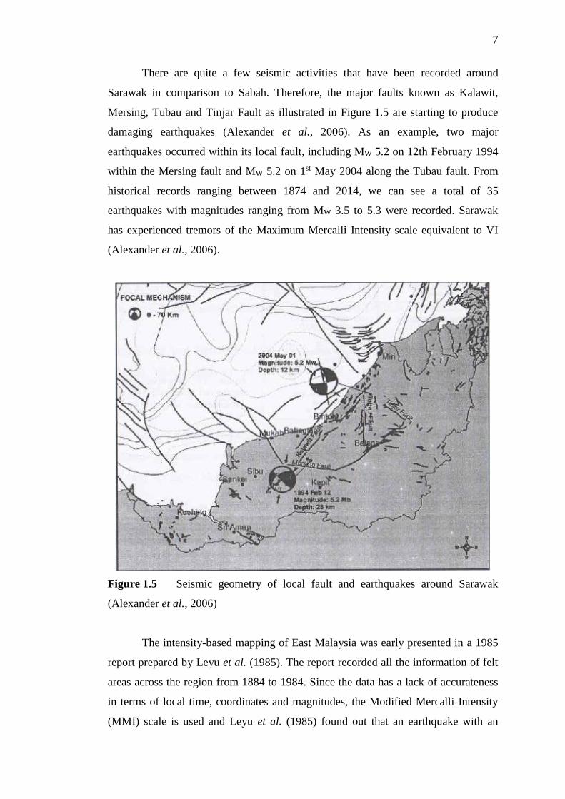
There are quite a few seismic activities that have been recorded around
Sarawak in comparison to Sabah. Therefore, the major faults known as Kalawit,
Mersing, Tubau and Tinjar Fault as illustrated in Figure 1.5 are starting to produce
damaging earthquakes (Alexander et al., 2006). As an example, two major
earthquakes occurred within its local fault, including MW 5.2 on 12th February 1994
within the Mersing fault and MW 5.2 on 1st May 2004 along the Tubau fault. From
historical records ranging between 1874 and 2014, we can see a total of 35
earthquakes with magnitudes ranging from MW 3.5 to 5.3 were recorded. Sarawak
has experienced tremors of the Maximum Mercalli Intensity scale equivalent to VI
(Alexander et al., 2006).
Figure 1.5 Seismic geometry of local fault and earthquakes around Sarawak
(Alexander et al., 2006)
The intensity-based mapping of East Malaysia was early presented in a 1985
report prepared by Leyu et al. (1985). The report recorded all the information of felt
areas across the region from 1884 to 1984. Since the data has a lack of accurateness
in terms of local time, coordinates and magnitudes, the Modified Mercalli Intensity
(MMI) scale is used and Leyu et al. (1985) found out that an earthquake with an
8
intensity of III to VII occurring across the East Malaysia region. The recent MMI
scale can be seen in Majid et al. (2007) statement and Leyu (2009), where the MMI
scale seems to increase from VII to VIII (Table 1.1). The severe damage of buildings
due to fault movement has created enough concern to understand the seismically
potential zones of the region (Mohd Hazreek et al., 2012).
Table 1.1: Published MMI scale in East Malaysia region
Reference MMI scale
Leyu et al. (1985) III - VII
Majid et al. (2007) V – VII
Leyu (2009) V – VIII
The historical earthquake records in East Malaysia have only been compiled
and interpreted over a few years, so they will not give a true indication of the seismic
potential within an area (Emad, 2005). The statistics for an updated earthquake
recorded from 1874 through 2014 represented by magnitude indicates a large
increment of earthquake events for the last 140 years (Figure 1.6). The whole catalog
shows that for the period 1874 to 1976, the data’s poor quality may be due to a lack
of observations. However, it can be observed that a moment magnitude greater than
4.7 was reported in this period. In the records from 1976 – 2014 better data can be
observed.

9
Figure 1.6 Number of local earthquakes with a magnitude greater than 2.0
reported in each decade (1874-2014) around East Malaysia
In accordance with previous historical earthquake record and studies in
seismic monitoring in Malaysia by previous researchers (Alexander et al., 2006; Tjia,
2007; Alexander et al., 2008; Leyu, 2009; Chai et al., 2009; Azhari, 2012; Mohd
Hazreek et al., 2012), the seismicity of East Malaysia is classified as a low to
moderate earthquake. Figure 1.7 shows the distribution of local earthquake data in
the study area representing moment magnitude ranging between 2.0 and 7.9.
0
5
10
15
20
25
187
4
188
1
188
8
189
5
190
2
190
9
191
6
192
3
193
0
193
7
194
4
195
1
195
8
196
5
197
2
197
9
198
6
199
3
200
0
200
7
201
4
Num
ber
of
Ear
thq
uak
e
Years

10
Figure 1.7 Earthquake events distribution map in the study area from year 1874
to 2014
In the seismic design of structures, the most critical part is the development
of seismic design ground motion. In order to develop this ground motion, seismic
hazard analysis such as probabilistic seismic hazard analysis (PSHA) is required.
PSHA requires a strong ground motion prediction equation (GMPE) to estimate
earthquake ground motion parameters characterizing the earthquake source,
propagation path and geological conditon. Seismic hazard analysis is different in
terms of definition of seismic sources and GMPE. Unfortunately, there is no GMPE
that was derived previously for the condition in the East Malaysia region (Adnan,
2008). The GMPE that is available may not be suitable for handling accurately the
low-to-moderate earthquake condition in East Malaysia as applied to other models,
which might provide different estimates at a large distance (Chintanapakdee et al.,
2008; Chandler et al., 2004, 2006). In the recent past, sufficient ground motion
records from low-to-moderate magnitudes have become available to help derive
equations, since there are various lists of currently available GMPE, as seen in
Douglas (2004, 2011) and Douglas et al. (2010). The GMPEs that are available make
it possible to be investigated and tested their sensitivity with the ground motion

11
records (Cotton et al., 2006). A large number of GMPE databases are necessary to
illustrate the situation that may occur, especially for a region with no GMPE (Sabetta
et al., 2005).
1.4 Problem Statement
While damaging earthquakes are fortunately rare in East Malaysia when
compared to seismically active regions, in the history of earthquakes, the region
already experienced devastating earthquake with a magnitude of MW 5.8 on 26th July
1976 centered in Lahad Datu, and just recently a MW 6.0 on 05 June 2015 in Ranau.
All signs indicate that it will continue to have the same problem in the future. The
highest intensity of these earthquakes reached VIII degrees, and they will cause
serious economic loss and social unrest. Over the past 114 years, a total of 124 with
magnitudes ranging from 2.9 to 6.0 are known to have occurred.
According to a national Annex for the Eurocode 8, it is necessary to give
priority to public safety by designing buildings or structures that are earthquake
proof. In understanding earthquake behavior, characteristics and distribution, coupled
with appropriate mitigation measures, it is possible to reduce their adverse impact
and degree of damages. Although numerous conducted studies have explained the
effect of seismic loading on buildings in Malaysia, it has not always been adequately
considered in the Malaysian construction code. The occurrence of ground shaking in
the past, mainly due to active fault zones able to cause casualties and damage to
properties and unfortunately the majority of existing buildings were built
consequently without seismic consideration. Earthquakes are acts of nature, and
therefore their occurrence cannot be avoided. A number of local earthquakes of low-
to-moderate magnitude (more than magnitude 2.0) have occurred in the past. The
earthquake events have increased by about 30% since reported by the Malaysian
Meteorological Department (MMD) in 2007. As a result of increasing seismic
activities around the region, East Malaysia is experiencing more tremors and there is
a need to design for seismic loadings. Even though the seismicity of this area is much
12
lower than other moderate seismicity regions, the seismic risk cannot be regarded as
negligible.
Since engineering structures respond differently to different frequencies,
there should be information about the dominant frequencies that are present in
seismic waves that occur in particular areas. In areas where the limiting value of
ground acceleration is expected to be exceeded for a return period of 475 years,
engineers have to design their structures in such a way that they are resistant to the
accelerations and frequencies that could be expected.
1.5 Objectives
This study presents technical research into seismic hazard assessment for East
Malaysia. The selection of seismic parameters, methods of analysis and the final
evaluation for the seismic hazard analysis are based on three objectives.
i) To determine the fault characteristics mechanism and layouts for the East Malaysia
region. This consideration is taking care because the region is being affected by
shallow crustal faults and a subduction zone in the surrounding region, as well as
local faults that have recently been considered as active in generating earthquakes.
ii) To produce a local ground motion prediction equation (GMPE) suitable for the
region due to the scarcity and incompatible equation of GMPE from other regions.
iii) To determine the peak ground acceleration (PGA) and response spectral
acceleration (RSA) to be a plot in map. The probabilistic seismic hazard assessment
(PSHA) is performed for 2% and 10% probability of exceedance in a design time
period of 50 years or the corresponding to return period of approximately 475 and
2,475 years respectively.
13
1.6 Scope and Limitation
The following tasks are performed for this study:
1. Review and research literature on available regional geological and tectonic
environments to identify the regional earthquake activity and prepare a
seismic sources zone map for use in seismic hazard analysis. The procedure
will consider the faults, lineaments and shear zones which are associated with
earthquakes of magnitudes of more than MW 2.9.
2. Evaluate regional historical seismic data to provide seismic parameters for the
source zone models influencing the East Malaysia region.
3. Selection of appropriate ground motion prediction equation (GMPE) for the
types of faults present in the region to be used in the assessment of ground
motion hazard. It is considered one of the critical factors in seismic hazard
analysis. There has been a number of attenuation relations derived in the last
two decades since the records of ground motions became more available. In
general, they are categorized according to tectonic environment (i.e.
subduction zone and shallow crustal earthquakes) and site condition.
4. Determine seismic hazard parameters such as, a-b value and magnitude
maximum, which will be used in probabilistic seismic hazard analysis
(PSHA).
5. Calculate a rock level peak ground acceleration (PGA) and response spectrum
acceleration corresponding to 10% and 2% probability of exceedance in 50
years.
6. Develop a uniform hazard response spectrum (UHRS) at rock level for 5%
damping and 10% and 2% probability of exceedance in 50 years.
1.7 Research Methodology
In general, the methodology throughout the study is divided into three steps
(Figure 1.8). The first step is the determination of the fault characteristics mechanism
and layouts for the East Malaysia region. The assessment includes an earthquake
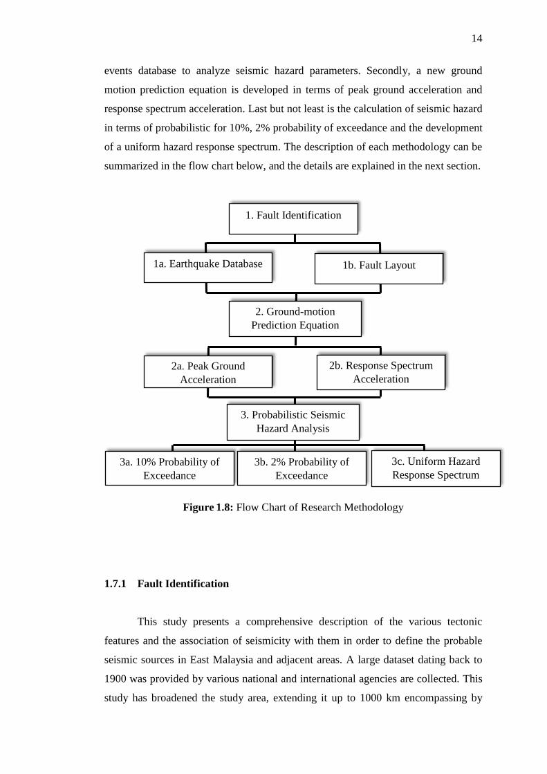
14
events database to analyze seismic hazard parameters. Secondly, a new ground
motion prediction equation is developed in terms of peak ground acceleration and
response spectrum acceleration. Last but not least is the calculation of seismic hazard
in terms of probabilistic for 10%, 2% probability of exceedance and the development
of a uniform hazard response spectrum. The description of each methodology can be
summarized in the flow chart below, and the details are explained in the next section.
Figure 1.8: Flow Chart of Research Methodology
1.7.1 Fault Identification
This study presents a comprehensive description of the various tectonic
features and the association of seismicity with them in order to define the probable
seismic sources in East Malaysia and adjacent areas. A large dataset dating back to
1900 was provided by various national and international agencies are collected. This
study has broadened the study area, extending it up to 1000 km encompassing by
1. Fault Identification
2. Ground-motion
Prediction Equation
3. Probabilistic Seismic
Hazard Analysis
1b. Fault Layout 1a. Earthquake Database
2a. Peak Ground
Acceleration
2b. Response Spectrum
Acceleration
3a. 10% Probability of
Exceedance
3b. 2% Probability of
Exceedance
3c. Uniform Hazard
Response Spectrum
15
latitudes 50S to 100N and longitudes 1050E to 1250E. An attempt has been made to
delineate seismic source zones in the study area based on the seismicity parameters.
Seismicity parameters and the maximum probable earthquake for these source zones
were evaluated and used in the hazard evaluation.
The link between the database and any calculational model for deriving
hazard levels is a regional seismotectonic model, which should be based on a
coherent merging of the regional databases. In the construction of a model, all
existing interpretations of the seismotectonics of the region that may be found in the
available literature will be taken into account. The procedure will integrate the
elements of the seismological, geophysical and geological databases in order to
construct a coherent seismotectonic model (or alternative models) consisting of a
discrete set of seismogenic structures.
1.7.2 Ground Motion Prediction Equation
Since there is no new development of ground motion prediction equation
(GMPE) for East Malaysia until recently, the GMPE for rock sites in the East
Malaysia region is developed for peak ground acceleration (PGA) and response
spectral acceleration (RSA). There has been a number of attenuation relations
derived in the last two decades since the records of ground motions have become
more available. In general, they are categorized according to tectonic environment
(i.e. subduction zone and shallow crustal earthquakes) and site condition. The GMPE
that is available may not be suitable for handling accurately the low-to-moderate
earthquake conditions in East Malaysia. In order to perform seismic hazard analysis
for a site region, it is fundamental to determine the GMPE using available ground
motion records from the region. The modelling of seismic hazard analysis should
capture the uncertainties about earthquake input parameters such as magnitude and
distance of the earthquake. It is considered one of the critical factors in seismic
hazard analysis.

16
1.7.3 Probabilistic Seismic Hazard Analysis
Probabilistic seismic hazard analysis or PSHA is the process of evaluating the
design parameters of earthquake ground motion at a particular site quantitatively.
The ground motion parameters that become considered in this assessment are peak
ground acceleration and response spectral acceleration. PSHA will be performed
using the below approaches.
There are four steps that should be conducted in PSHA:
1. Earthquake data collection
2. Characterize seismic source in terms of magnitude and distance.
3. Identifying earthquake ground motion parameter
4. Calculate seismic hazards on selected locations.
Two hazard levels were produced in PSHA, such as 10% and 2% probability
of exceedance in 50 years ground motions or corresponding to 475 and 2,475 years
return periods of earthquakes, respectively. The hazard also is being calculated
separately for a range of frequencies into one uniform hazard response spectrum or
UHRS by using the same source zone model spectral prediction model. From this we
can build up a spectrum that reflects the real levels of hazard at the site at all
frequencies.
1.8 Significance of Research
The most effective way to reduce disasters caused by earthquakes is to
estimate the seismic hazard and to disseminate this information for use in improved
building design and construction. The seismic activity in and around East Malaysia
emphasizes the importance of defining the seismic zoning of the country and the
need for the assessment of seismic hazard based on the available geophysical,
geological, and seismological database. The seismic hazard analysis has become
more important in Malaysia for the safety requirements of engineering structures and
public interest.

17
In order to predict the size of future earthquakes, analysis of seismic activity
for the past few decades needs to be further studied. A step by step process such as
seismic hazard analysis is required to achieve the results. SHA can be performed by
doing a Probabilistic Seismic Hazard Analysis (PSHA) step. It is mathematical
procedure involving probabilistic study to assess the answer for uncertainties about
seismic location, earthquake size and shaking intensity that might happen in the
future. In the probabilistic study, two main parameters are important: the limitation
of magnitude and distance. Several attenuation functions that are suitable for
situations in East Malaysia are considered.
Seismic hazard analysis is often studied for a place with high earthquake
potential or near to the epicenter. Malaysia is known as a stable continent free from
earthquakes. However, it has been recently recognized that this region, even at rather
remote distances, is at significant seismic risk from two main active earthquake
sources i.e. Indonesia and Philippines. East Malaysia has a dense population and is
going through a development boom. Due to the fact that it is free from earthquakes,
many buildings were designed without considering seismic loading.
The increasing number of earthquakes around the East Malaysia region with
the evidence from historical documents and reports and paleoseismic studies makes it
strongly recommended for hazard map production. The production of the map is
important, especially when it comes to seismic evaluation of existing structures or
building a new one, particularly for nonlinear response history analysis. The current
available earthquake database makes it possible to develop a new GMPE to predict
future earthquakes.
1.9 Organization of Thesis
This thesis was developed into 5 chapters. The first chapter described nature
and the causes of earthquakes around the world. In Chapter 2 the historical record of
earthquakes from low-to-moderate magnitude dating back to 1900, typically in East
Malaysia, were investigated. There are already previous seismic hazard maps done

18
for this region however, it may be different in terms of the applied GMPE and source
zonation used. The available literatures was reviewed and discussed on the topics of
GMPE and then compared with available data recorded.
In Chapter 3 the analysis on compiled earthquake database collected from
various sources and prepared a complete catalog of East Malaysia and the adjoining
area was analyzed. This chapter also provided a procedure in deriving a new ground
motion prediction equation (GMPE) in terms of response spectral acceleration and
the development of seismic hazard maps at 2% and 10% probability of exceedance
for use in the seismic design of building structures.
Chapter 4 comprised the results of the hazard calculations in terms of hazard
curves and hazard spectra for the selected sites. This chapter also explained the
results of the hazard assessment in the form of hazard maps. All the input parameters
that were mentioned in Chapter 3 are used and comparisons among the respective
maps are carried out. Finally, the most important conclusions that were drawn from
the studies are discussed and summarized in Chapter 5.

120
zonation model. This will be helpful in reducing the uncertainty due to variation of
seismicity parameters.
The PGA and RSA values at ground surface may vary significantly from the
values at bedrock level. These variations, either amplification or de-amplification, will
depend upon the site conditions. The seismic waves will travel differently through the
overlying soil, which tends to increase the peak ground acceleration (PGA) values.
Thus, the site characterization has to be done by considering four different site classes,
including site class A to D.
Although the new GMPE here is important to predict the seismicity pattern
across the region, more work is needed to refine the analysis. The curve-fitting of the
new GMPE seems to not accurately match the earthquake records for magnitude
between MW 3.3 to 5.7 at a distance less than 100 km. Therefore, this study
recommended to make a separate GMPE equation for this range of magnitude. More
observations, especially for small earthquake ground-motion are needed with further
seismo-tectonic research is recommended by incorporating epistemic variability. This
study also recommended to refine some parameters used in the development of GMPE
by including hanging wall effects, dividing faulting mechanism to three main
categories such as reverse, strike-slip and normal faulting) and nonlinear soil response
in the analysis.

REFERENCES
Adnan, A., Hendriyawan, A. M. And Selvanayagam, P.N. and Marto. A. (ed.) (2008).
Development of Seismic Hazard Maps of East Malaysia: Advances in
Earthquake Engineering Application, UTM.
Alexander, Y., Liau, A., Hamzah, M., Ramli, M. Y., Mat Taib, M. B., Ali, A., Ariffin,
H., Ismail, B. and Tjia, H. D. (2008). Seismic and Tsunami Hazards and Risks
Study in Malaysia. In: (JMG), M. A. G. D. M. (ed.) Assessment of the Seismic
Threats to Malaysia from Major Earthquake in the Southeast Asian Region.
Kuala Lumpur: Ministry of Natural Resources and Environment.
Alexander, Y., Suratman, S., Liau, A., Hamzah, M., Ramli, M. Y., Ariffin, H., Abd.
Manap, M., Mat Taib, M. B., Ali, A. and Tjia, H. D. (2006). Study on the
Seismic and Tsunami Hazards and Risks in Malaysia. In: (JMG), M. A. G. D.
M. (ed.) Report on the Geological and Seismotectonic Information of
Malaysia. Kuala Lumpur: Ministry of Natural Resources and Environment.
Allagu, B., Gary Nichols and Robert Hall (2003). The Origin of the 'Circular Basins'
of Sabah, Malaysia. Geological Society of Malaysia, 46, 335-351.
Allagu, B. A. R. H. Tectonic Evolution and Sedimentation of Sabah, North Borneo,
Malaysia (2009). AAPG International Conference and Exhibition, Cape
Town, South Africa.
Anbazhagan, P., Vinod, J. S. and Sitharam, T. G. (2009). Probabilistic seismic hazard
analysis for Bangalore. Natural Hazards, 48, 145-166.
Atkinson, G. M., and Boore, D. M. (1995). New Ground Motion relations for Eastern
North America. Bulletin Seismological Society America, 85, 17-30.
Atkinson, G. M., and Boore, D. M. (2006a). Earthquake Ground-Motion Prediction
Equations for Eastern North America. Bulletin of the Seismological Society
of America, 96, 2181-2205.
122
Atkinson, G. M., and Boore, David M. (2006b). Erratum to Earthquake Ground-
Motion Prediction Equations for Eastern North America. Bulletin of the
Seismological Society of America, 97, 1032.
Atkinson, G. M., and Boore, David M. (2011). Modifications to Existing Ground-
Motion Prediction Equations in Light of New Data. Bulletin of the
Seismological Society of America, 101, 1121-1135
Azhari, B. M. (2012). Monitoring Active Faults in Ranau, Sabah Using GPS. 19th
United Nations Regional Cartographic Conference for Asia and the Pacific.
Bangkok, Thailand.
Baker, J. W. (2013). Probabilistic Seismic Hazard Analysis, White Paper Version.
Balaguru, A., and Nichols, G. (2004). Tertiary Stratigraphy and Basin Evolution,
Southern Sabah (Malaysian Borneo). Journal of Asian Earth Sciences, 23,
537-554.
Beauval, C., Yepes, H., Palacios, P., Segovia, M., Alvarado, A., Font, Y., Aquilar, J.,
Troncoso, L. and Vaca, S. (2013). An Earthquake Catalog for Seismic Hazard
Assessment in Ecuador. Bulletin of the Seismological Society of America,
103, 773-786.
Bommer, J. J., Scherbaum, F., Bungum, H., Cotton, F., Sabetta, F. and Abrahamson,
N. A. (2005). On the use of logic trees for ground-motion prediction equations
in seismic-hazard analysis. Bulletin of the Seismological Society of America,
95, 377-389.
Boore, D. M. (1997a). Erratum to Equations for Estimating Horizontal Response
Spectra and Peak Acceleration from Western North American Earthquakes:
A Summary of Recent Work. Seismological Research Letters, 68, 128-153.
Boore, D. M., Joyner, William B., and Fumal, Thomas E. (1997b). Equations for
Estimating Horizontal Response Spectra and Peak Acceleration from
Western North American Earthquakes: A Summary of Recent Work.
Seismological Research Letters, 68, 128-153.
Boore, D. M., and Bommer, Julian, J. (2005). Processing of Strong-Motion
Accelerograms: Needs, Options and Consequences. Soil Dynamics and
Earthquake Engineering, 25, 93-115.
Boore, D. M. and Atkinson, G. M. (2008). Ground-Motion Prediction Equations for
the Average Horizontal Component of PGA, PGV, and 5%-Damped PSA at
Spectral Periods between 0.01 and 10.0 Earthquake Spectra, 24, 99-138.

123
Campbell, K. W. (2003a). Erratum to Prediction of Strong Ground Motion Using the
Hybrid Empirical Method and Its Use in the Development of Ground-Motion
(Attenuation) Relations in Eastern North America. Bulletin of the
Seismological Society of America, 93, 1012-1033.
Campbell, K. W. (2003b). Prediction of Strong Ground Motion Using the Hybrid
Empirical Method and Its Use in the Development of Ground-Motion
(Attenuation) Relations in Eastern North America. Bulletin of the
Seismological Society of America, 93, 1012-1033.
Cardwell, R. K., Isaacks, B. L. and Karig, D. E. (1980). The Spatial Distribution of
Earthquakes, Focal Mechanism Solutions, and Subducted Lithosphere in the
Philippine and Northeastern Indonesian Islands. The Tectonic and Geologic
Evolution of Southeast Asian Seas and Islands. American Geophysical
Union.
CEN (2003). Eurocode 8: Design of structures for Earthquake Resistance. Part 1:
General rules, Seismic actions and rules for Buildings. Final draft prEN:
1998.
Celine Beauval and Oona Scotti (2004). Quantifying Sensitivities of PSHA for France
to Earthquake Catalog Uncertainties, Truncation of Ground Motion
Variability, and Magnitude Limits. Seismological Society of America, 94, 5,
1579-1594.
Chai, M. F., Asmadi Bin Abdul Wahab, Norhadizah Binti Mohd Khalid, Nasrul Hakim
Bin Hashim, Muhammad Nazri Bin Noordin and Mohd Rosaidi Bin Che Abas
(2009). Tsunami Databases for The National Tsunami Early Warning Centre
Of Malaysia: Toward The Implementation Plan Of Regional Tsunami Watch
Providers (RTWP). In: Malaysian Meteorological Department, MMD and
MOSTI.
Chandler, A. M., and Lam, N. T. K. (2004). An attenuation model for distant
earthquakes. Earthquake Engineering & Structural Dynamics, 33, 183-210.
Chandler, A. M., Lam, N. T. K. and Tsang, H. H. (2006). Regional and local factors
in attenuation modelling: Hong Kong case study. Journal of Asian Earth
Sciences, 27, 892-906.
Chintanapakdee, C., Naguit, M. E. and Charoenyuth, M. (2008). Suitable Attenuation
Model for Thailand. The 14th World Conference on Earthquake Engineering
(14WCEE). Beijing, China.
124
Clément, C., Scotti, O., Bonilla, L. F., Baize, S. and Beauval, C. (2004). Zoning versus
faulting models in PSHA for moderate seismicity regions: preliminary results
for the Tricastin nuclear site, France. Bollettino Di Geofisica Teorica Ed
Applicata, 45, 187-204.
Cornell, C. A. (1968). Engineering seismic risk analysis. Bulletin of the Seismological
Society of America, 58, 1583-1606.
Cotton, F., Scherbaum, F., Bommer, J. J. and Bungum, H. (2006). Criteria for selecting
and adjusting ground-motion models for specific target regions: Application
to Central Europe and rock sites. Journal of Seismology, 10, 137-156.
Cullen, A. B. (2010). Transverse segmentation of the Baram-Balabac Basin, NW
Borneo: refining the model of Borneo's tectonic evolution. Petroleum
Geoscience, 16, 3-29.
Cullen, A. B., Zechmeister, M. S., Elmore, R.D., and Pannalal, S.J. (2012).
Paleomagnetism of the Crocker Formation, Northwest Borneo: Implications
for Late Cenozoic Tectonics. Geosphere, 8, 1146-1169.
Dahle, A., Climent, A., Taylor, W., Bungum, H., Santos, P., Ciudad Real, M.,
Linholm, C., & Strauch, W., and Segura, F. (1995). New spectral strong
motion attenuation models for Central America. Proceedings of the Fifth
International Conference on Seismic Zonation, Nice, France, 1005-1012.
Das, R., Wason, H. R. and Sharma, M. L. (2011). Global regression relations for
conversion of surface wave and body wave magnitudes to moment
magnitude. Natural Hazards, 59, 801-810.
Das, S., Gupta, I. D. and Gupta, V. K. (2006). A Probabilistic Seismic Hazard Analysis
of Northeast India. Earthquake Spectra, 22, 1-27.
De Vos, D., Femke, G. and Hanneke, P. U. U. (2010). Probabilisitic Seismic Hazard
Assessment for the Southern part of the Netherlands. Master, Utrecht
University.
Delavaud, E., Cotton, F., Akkar, S., Scherbaum, F., Danciu, L., Beauval, C., Drouet,
S., Douglas, J., Basili, R. and Sandikkaya, M. A. (2012). Toward a ground-
motion logic tree for probabilistic seismic hazard assessment in Europe.
Journal of Seismology, 16, 451-473.
Delfebriyadi (2008) Studi Hazard Kegempaan Wilayah Propinsi Banten dan DKI
Jakarta. Teknika Unand, 1, 6-15.
125
Denis, N. K. T., and Lamy, J. M. (1990). Tectonic Evolution of the NW Sabah
Continental Margin since the Late Eocene. Geological Society Malaysia, 27,
241-260.
Dieter, F., Udo Barckhausen, Ingo Heyde, Mark Tingay and Nordin Ramli (2008).
Seismic Images of a Collision Zone Offshore NW Sabah/Borneo. Marine and
Petroleum Geology, 25, 606-624.
Domenico, G. S. W., Donat Fäh, Nicolas Deichmann, Souad Sellami, Sarah Jenny, M.
Baer, F. Bay, A. Becker, F. Bernardi, J. Braunmiller, M. Ferry, M. Garcia-
Jimenez, M. Gisler, S. Heimers, S. Husen, P. Kästli, U. Kastrup, F. Kind, U.
Kradolfer, M. Mai, S. Maraini, K. Monecke, M. Schnellmann, D.
Schorlemmer, G. Schwarz-Zanetti, S. Steimen, J. Wössner and A. Wyss
(2004). Seismic Hazard Assessment of Switzerland. In: Service, S. S. (ed.)
Service, S. S. Swiss Federal Institute of Technology Zurich: Swiss Federal
Institute of Technology Zurich.
Douglas, J. (2004). Ground motion estimation equations 1964–2003. Reissue of ESEE
Report No. 01-1: ‘A comprehensive worldwide summary of strong-motion
attenuation relationships for peak ground acceleration and spectral ordinates
(1969 to 2000)’ with corrections and additions. London: Imperial College of
Science, Technology and Medicine; London; U.K.
Douglas, J. (2011). Ground-motion prediction equations 1964–2010.
Douglas, J., Faccioli, E., Cotton, F. and Cauzzi, C. (2010). Selection of ground-motion
prediction equations for GEM1. GEM Technical Report 2010-E1, GEM
Foundation, Pavia, Italy.
Duni, L., Kuka, N., Kuka, Sh. and Fundo, A. (2010). Towards a New Seismic Hazard
Assessment of Albania. Proc. of 14ECEE, Ohrid, August 30-September, 3,
2010.
Emad, A. M. A. (2005). Historical Seismicity of the Stable Continental Regions
(SCRs) In the Arabian Plate (Preliminary Study). Mesf Cyber Journal of Earth
Science, 3, 22-41.
Frankel, A. (1995). Mapping seismic hazard in the central and eastern United States.
Seismological Research Letters, 66 (4), 8-21.
Fukushima, Y., Köse, O., Yürür, T., Volant, P., Cushing, E., and Guillande, R. (2002).
Attenuation Characteristics of Peak Ground Acceleration from Fault Trace of
126
the 1999 Kocaeli (Turkey) Earthquake and Comparison of Spectral
Acceleration with Seismic Design Code. Journal of Seismology, 379-396.
Fuller, M., Jason R. Ali, Steve J. Moss, Gina Marie Frost, Bryan Richter, and Achmad
Mahfi (1999). Paleomagnetism of Borneo. Journal of Asian Earth Sciences,
17, 3-24.
Gardner, J. K., and Knopoff, L. (1974). Is the sequence of earthquakes in Southern
California, with aftershocks removed, Poissonian? Bulletin of the
Seismological Society of America, 64, 1363-1367.
Gero, W. M., Matthias, B., Detlef, A., Christoph, R. and Ewald, Reinhart (2000).
Crustal motion in E- and SE-Asia from GPS measurements. Earth Planets
Space, 52, 713-720.
Gero, W. M., Yue, Q. Y., Sheng, Y. Z., Christoph, R., Matthias, B., Ewald, R., Wim,
S., Boudewijn, A., Christophe, V., Nicolas, C.R., Xavier, L. P., Peter, M. and
Saskia, M. (2001). Crustal motion and block behaviour in SE-Asia from GPS
measurements. Earth and Planetary Science Letters, 187.
Giardini, D., Grünthal, G., Shedlock, K. M. and Zhang, P. (1999). The GSHAP Global
Seismic Hazard Map.
Grünthal, G., and Wahlström, R (2001). Sensitivity of parameters for probabilistic
seismic hazard analysis using a logic tree approach. Journal of Earthquake
Engineering, 5, 309-328.
Gupta, I. D. (2006). Delineation of probable seismic sources in India and
neighbourhood by a comprehensive analysis of seismotectonic characteristics
of the region. Soil Dynamics and Earthquake Engineering, 26, 766-790.
Gutenberg, B., and Richter, C. F. (1956). Earthquake Magnitude, Intensity, Energy,
and Acceleration (Second Paper). Seismological Society of America Bulletin,
46, 105-145.
Hall, R. (2011). Australia–SE Asia collision: plate tectonics and crustal flow.
Geological Society, London, Special Publications, 355, 75-109.
Hanks, T. C., and Kanamori, H. (1979). A Moment Magnitude Scale. Journal of
geophysical Research, 84, 2348-2350.
Heaton, T. H., Tajima, F. and Mori, A. W. (1986). Estimating Ground Motions using
Recorded Accelerograms. Surveys in Geophysics, 8, 25-83.

127
Hee, M. C. (2014). Preview of Natinal Annex to EC8: Seismic Loadings for Peninsular
Malaysia, Sabah and Sarawak. Jurutera: The Montly Bulletin of the
Institution of Engineers, Malaysia. Institution of Engineers, Malaysia.
Hendriyawan (2006). Seismic Macrozonation of Peninsular Malaysia and
Microzonation of Kuala Lumpur City Center and Putrajaya. PhD, Universiti
Teknologi Malaysia.
Hesse, S., Back, S. and Franke, D. (2009). The Deep-Water Fold-And-Thrust Belt
Offshore NW Borneo: Gravity-Driven Versus Basement-Driven Shortening.
GSA Bulletin, 121, 939-953.
Hinz, K., Fritsch, J., Kempter, E. H. K., Mohammad, A. Manaf, Meyer, J., Mohamed,
D., Vosberg, H., Weber, J. and Benavidez, J. (1989). Thrust Tectonics along
the North-Western Continental Margin of Sabah/Borneo. Geologische
Rundschau, 78, 705-730.
Hutchison, C. S. (2005). Geology of North West Borneo: Sarawak, Brunei, and Sabah,
Elsevier, Boston.
Hutchison, C. S. (2010). The North-West Borneo Trough. Marine Geology, 271, 32-
43.
Hutchison, C. S., Bergman, Steven C., Swauger, David A. and Graves, John E. (2000).
A Miocene Collisional Belt in North Borneo: Uplift Mechanism and Isostatic
Adjustment Quantified by Thermochronology. Journal of the Geological
Society, 157, 783-793.
Irsyam, M., Dangkua, D. T., Hendriyawan, Hoedajanto, D., Hutapea, B. M., Kertapati,
E. K., Boen, T. and Petersen, M. D. (2008). Proposed Seismic Hazard Maps
of Sumatra and Java Islands and Microzonation Study of Jakarta city,
Indonesia. Journal of Earth System Science, 117, 665-878.
Janez K. Lapajne, Barbara ˇSket Motnikar, Blaˇz Zabukovec and Polona Zupanˇciˇ.
(1997). Spatially Smoothed Seismicity Modelling of Seismic Hazard in
Slovenia. Journal of Seismology 1, 73–85.
Julio Garcia, Dario Slejko, Alessandro Rebez, Marco Santulin and Leonardo Alvarez
(2008). Seismic Hazard Map for Cuba and Adjacent Areas Using the Spatially
Smoothed Seismicity Approach, Journal of Earthquake Engineering, 12:2,
173-196.
Kramer, S. L. A. (1996). Geotechnical Earthquake Engineering, Prentice Hall PTR.
128
Lewis, S. D. (1991). Geophysical Setting of the Sulu and Celebes Seas. Proceedings
of the Ocean Drilling Program, Scientific Results. 65-73.
Leyu, C. H. (2009). Seismic and Tsunami Hazards and Risks Study in Malaysia. In:
MOSTI (ed.) Summary for Policy Makers.
Leyu, C. H., Chong, C. F., Arnold, E.P., Kho, Sai-L., Lim, Y. T., Subramaniam, M.,
Ong, T. C.,Tan, C. K., Yap, K. S., Shu, Y. K. and Goh, H. L. (1985). Series
on Seismology Malaysia. In: Arnold., E. P. Southeast Asia Association of
Seismology and Earthquake Engineering (SEASEE).
Majid, T. A., Zaini, S. S., Nazri, F. M., Arshad, M. R. and Suhaimi, I. F. M. (2007).
Development of Design Response Spectra for Northern Peninsular Malayisa
Based on UBC 97 Code. The Institution of Engineers Malaysia, 68, 7.
Masyhur Irsyam, I. W. S., Fahmi Aldiamar, Sri Widiyantoro, Wahyu Triyoso, Danny
Hilman Natawidjaja, Engkon Kertapati, Irwan Meilano, Suhardjono M.
Asrurifak and Ir. M. Ridwan (2010). Ringkasan Hasil Studi Tim Revisi Peta
Gempa Indonesia 2010. In: Indonesia, T. R. P. G. (ed.). Teknik Sipil ITB,
Litbang Jalan PU, Geofisika ITB, Geoteknologi LIPI, Pusat Penelitian
Geologi, Geodesi ITB, BMKG-Geofisika, and Litbang Kim PU.
Mcguire, R. K. (1976). FORTRAN Computer Program for Seismic Risk Analysis. US
Geological Survey Open File Report, 67-76.
Mcguire, R. K. (2008). Probabilistic seismic hazard analysis: Early history.
Earthquake Engineering & Structural Dynamics, 37, 329-338.
Metcalfe, I. (2011). Palaeozoic–Mesozoic history of SE Asia. The SE Asian Gateway:
History and Tectonics of the Australia–Asia Collision. Geological Society,
London, Special Publications, 355, 7-35.
Mohd Hazreek, Z. A., R. S., Fauziah Ahmad, Devapriya Chitral Wijeyesekera and
Mohamad Faizal Tajul Baharuddin (2012). Seismic Refraction Investigation
on Near Surface Landslides at the Kundasang area in Sabah, Malaysia.
Procedia Engineering, 50, 516-531.
Mohd Rosaidi, B. C. A. (2001). Earthquake Monitoring in Malaysia. Seismic Risk
Seminar.
Moss, S. J., and Chambers, J. L. C. (1999). Tertiary facies architecture in the Kutai
Basin, Kalimantan, Indonesia. Journal of Asian Earth Sciences, 17, 157-181.

129
Moss, S. J., and Moyra, E. J. Wilson (1998). Biogeographic Implications of the
Tertiary Palaeogeographic Evolution of Sulawesi and Borneo. Biogeography
and Geological Evolution of SE Asia, 133-163.
Moyra, E., Wilson J. and Moss, Steve, J. (1999). Cenozoic palaeogeographic evolution
of Sulawesi and Borneo. Palaeogeography, Palaeoclimatology,
Palaeoecology, 145, 303-337.
Narayanan, S. P., Mohd Redzuan Abdul Hamid and Muhamad Afiq Rosli (2013).
Seismic Evaluation of High Rise Structures in Malaysia. International Journal
of Applied Engineering Research, 8, 1459-1477.
Ornthammarath, T., Warnitchai, P., Worakanchana, K., Zaman, S., Sigbjörnsson, R.
and Lai, C. G. (2011). Probabilistic seismic hazard assessment for Thailand.
Bulletin of Earthquake Engineering, 9, 367-394.
Pacheco, J. F. and Sykes, L. R. (1992). Seismic moment catalog of Large Shallow
Earthquakes, 1900 to 1989. Bulletin of the Seismological Society of America,
82, 1306-1349.
Pailoplee, S., Sugiyama, Y. and Charusiri, P. (2010). Probabilistic seismic hazard
analysis in Thailand and adjacent areas by using regional seismic source
zones. Terrestrial, Atmospheric and Oceanic Sciences, 21, 757-766.
Pan, T.-C., and Megawati, Kusnowidjaja (2002). Estimation of peak ground
accelerations of the Malay Peninsula due to distant Sumatra earthquakes.
Bulletin of the Seismological Society of America, 92, 1082-1094.
Pappin, J. W., Yim, P. H. I. and Koo, C. H. R. (2011). An Approach for Seismic Design
in Malaysia Following the Principles of Eurocode 8. Jurutera: The montly
Bulletin of the Institution of Engineers, Malaysia, 22-28.
Peng, Y., Zhang, Lifang., Lv, Yuejun., and Xie, Zhuojuan (2012). Methods for
Estimating Mean Annual Rate of Earthquakes in Moderate and Low
Seismicity Regions. Earthquake Research in China, 26.
Petersen, M. D., Harmsen, S., Mueller, C., Haller, K., Dewey, J., Luco, N., Crone, A.,
Lidke, D. and Rukstales, K. (2007). Documentation for the Southeast Asia
seismic hazard maps. Administrative Report September, 30, 2007.
Petersen, M. D., Harmsen, S., Mueller, C., Haller, K., Dewey, J., Luco, N., Crone, S.,
Rukstales, K. and Lidke, D. (2008). New Usgs Southeast Asia Seismic
Hazard Maps. In: WCEE, ed. World Conference on Earthquake Engineering,
October 12-17, Beijing, China. WCEE.

130
Pezeshk, S., Zandieh, A. and Tavakoli, B. (2011). Hybrid Empirical Ground-Motion
Prediction Equations for Eastern North America Using NGA Models and
Updated Seismological Parameters. Bulletin of the Seismological Society of
America, 101, 1859-1870.
Power, M. S. (1996). Characteristics of seismic hazard in stable continental regions
and active regions: Relevance for developing seismic design criteria. Worl
Conference on Earthquake Engineering. Elsevier Science Ltd.
Rangin, C., and Silver, E. (1990). Geological Setting of the Celebes and Sulu Seas.
Proceedings of the Ocean Drilling Program, Initial Reports. 35-42.
Rangin, C. and Silver, E. A. (1991). Neogene tectonic evolution of the Celebes-Sulu
basins: new insights from Leg 124 drilling.
Reiter, L. (1991). Earthquake Hazard Analysis: Issues and Insights. New York, NY:
Columbia University Press.
Richter, C. F. (1935). An instrumental earthquake magnitude scale. Bulletin of the
Seismological Society of America, 25, 1-35.
Robert, H. (2002). Cenozoic Geological and Plate Tectonic Evolution of SE Asia and
The SW Pacific: Computer-based Reconstructions, Model and Animations.
Journal of Asian Earth Sciences, 20, 353-41.
Robert, H., and D. J. Blundell (1996). Tectonic Evolution of SE Asia: Introduction.
Geological Society Special Publication, 106, vii-xiii.
Russell, L. W. and C., S. Mueller (2001). Central US Earthquake Catalog for Hazard
Maps of Memphis, Tennessee. Engineering Geology, 62, 19-29.
Sabetta, F., Lucantoni, A., Bungum, H. and Bommer, J. J. (2005). Sensitivity of PSHA
results to ground motion prediction relations and logic-tree weights. Soil
Dynamics and Earthquake Engineering, 25, 317-329.
Sadigh, K., Chang, C.-Y., Egan, J.A., Makdisi, F. and Youngs, R.R. (1997).
Attenuation Relationships for Shallow Crustal Earthquakes Based on
California Strong Motion Data. Seismological Research Letters, 68, 180-189.
Sapin, F., Pubellier, M., Lahfid, A., Janots, D., Aubourg, C. and Ringenbach, J. C.
(2011). Onshore record of the subduction of a crustal salient: example of the
NW Borneo Wedge. Terra Nova, 23, 232-240.
Sapin, F., I. Hermawan, M. Pubellier, C. Vigny, and J. C. Ringenbach (2013). The
Recent Convergence on the NW Borneo Wedge. A crustal Scale Gravity
Gliding Evidence from GPS. Geophys. J. Int. 193, 2, 549-556.

131
Scherbaum, F., Bommer, J. J., Bungum, H., Cotton, F. and Abrahamson, N. A. (2005).
Composite Ground-motion Models and Logic Trees: Methodology,
sensitivities, and uncertainties. Bulletin of the Seismological Society of
America, 95, 1575-1593.
Scordilis, E. M. (2006). Empirical Global Relations Converting M S and m b to
Moment Magnitude. Journal of Seismology, 10, 225-236.
Simons, W. J. F., Socquet, A., Vigny, C., Ambrosius, B. A. C., Haji Abu, S.,
Promthong, C., Subarya, C., Sarsito, D. A., Matheussen, S., Morgan, P. and
Spakman, W. (2007). A decade of GPS in Southeast Asia: Resolving
Sundaland motion and boundaries. Journal of Geophysical Research: Solid
Earth, 112, B06420.
Sitharam, T. G., Naveen, James, Vipin, K. S., and Raj, K. Ganesha (2012). A Study
on Seismicity and Seismic Hazard for Karnataka State. Journal Earth System
Science, 121, 475-490.
Smoczyk, G. M., Hayes, G.P., Hamburger, M.W., Benz, H.M., Villaseñor, Antonio,
and Furlong, K.P. (2013). Seismicity of the Earth 1900–2012 Philippine Sea
Plate and vicinity. In: U.S. GEOLOGICAL SURVEY OPEN-FILE REPORT
2010–1083-M. S.
Stiphout, T., Zhuang, J. and Marsan, D. (2012). Seismicity declustering. In:
ANALYSIS, C. O. R. F. S. S.
Tate, R. B. (1992). The Mulu Shear Zone- A major Structural Feature of NW Borneo.
Geol. Soc. Malaysia Bulletin, 31, 51-65
Tianqing Cao, M. D. P., and Michael S. Reichle (1996). Seismic Hazard Estimate from
Background Seismicity in Southern California. Bulletin of the Seismological
Society of America, 86, 1372-1381.
Tjia, H. D. (2007). Kundasang (Sabah) At the Intersection of Regional Fault Zones of
Quaternary Age. Geological Society of Malaysia. Geological Society of
Malaysia: Geological Society of Malaysia.
Torild, V. E., Femke Goutbeek, Hein Haak and Bernard Dost (2006). Seismic Hazard
Due to Small-Magnitude, Shallow-Source, Induced Earthquakes in the
Netherlands. Engineering Geology, 87, 105-121.
Torregossa, R. F., Sugito, M. and Nojima, N. (2001). Strong motion simulation for the
Philippines based on seismic hazard assessment. Journal of Natural Disaster
Science, 23, 35-51.
132
Toro, G. R. (2002). Modification of the Toro et al. (1997) Attenuation Equations for
Large Magnitudes and Short Distances. In: RISK ENGINEERING, I. (ed.)
Rev.3 Paducah Report.
Toro, G. R., Abrahamson, N. A. and Schneider, J. F. (1997). Model of Strong Ground
Motions from Earthquakes in Central and Eastern North America: Best
Estimates and Uncertainties. Seismological Research Letters, 68, 41-57.
United State Geological Survey, U. and N. E. I. C., NEIC. (2008). Seismic Hazard of
Western Indonesia [Online]. USGS and NEIC. Available:
http://earthquake.usgs.gov/research/hazmaps/products_data/ [Accessed 15
February 2013].
Utsu, T. (2002). Relationships between magnitude scales. In: SEISMOLOGY, I. H. O.
E. A. E.
Wahlstrom, R. and Grunthal, G. (2001). Probabilistic Seismic Hazard Assessment
(Horizontal PGA) for Fennoscandia using the Logic Tree Approach for
Regionalization Model. Seismological Research Letters, 72, 1, 33-45.
Wason, H. R., Das, R. and Sharma, M. L. (2012). Magnitude conversion problem using
general orthogonal regression. Geophysical Journal International, 190, 1091-
1096.
Yin, A. (2010). Cenozoic Tectonic Evolution of Asia: A Preliminary Synthesis.
Tectonophysics, 488, 293-325.
Zare, M., Ghafory-Ashtiany, M. and Bard, P.-Y. (1999). Attenuation Law for the
Strong Motions in Iran. Proceedings of the Third International Conference
on Seismology and Earthquake Engineering, Tehran, I.R. Iran. SEE3.
Zhao, J. X., Zhang, J., Asano, A., Ohno, Y., Oouchi, T., Takahashi, T., Ogawa, H.,
Irikura, K., Thio, H. K. and Somerville, P. G. (2006). Attenuation relations of
strong ground motion in Japan using site classification based on predominant
period. Bulletin of the Seismological Society of America, 96, 898-913.