Embed Size (px)
Citation preview

Western Australian Carbon Farming and Land Restoration Program
Priority Investment Co-benefits Standard

Priority Investment Co-benefits Standard June 2021 Page 2 of 47
Contents
Purpose of the Priority Investment Co-benefits Standard .......................................................... 3
Definitions ...................................................................................................................................... 4
1. Biodiversity and conservation co-benefits .......................................................................... 6
1.1 Guiding principles .................................................................................................................................... 6 1.1.1 Biodiversity value of revegetation .......................................................................................................................... 6 1.1.2 Proximity to high biodiversity area or assets .......................................................................................................... 6 1.1.3 Landscape connectivity ......................................................................................................................................... 6 1.1.4 Degree of fragmentation ........................................................................................................................................ 7
1.2 Documentation to satisfy the biodiversity and conservation co-benefit criteria ............................... 7 1.2.1 Potential information sources ................................................................................................................................ 7
1.3 Measurement, monitoring, and reporting of biodiversity and conservation co-benefits .................. 8
2. Agricultural productivity co-benefits.................................................................................. 10
2.1 Guiding principles .................................................................................................................................. 10 2.1.1 Resilience of agricultural practices ...................................................................................................................... 10 2.1.2 Agricultural productivity ....................................................................................................................................... 10
2.2 Documentation to satisfy the agricultural productivity co-benefit criteria ....................................... 10 2.2.1 Potential information sources .............................................................................................................................. 10
2.3 Measurement, monitoring, and reporting of agricultural productivity co-benefits ......................... 11
3. Soil health co-benefits ........................................................................................................ 12
3.1 Guiding principles .................................................................................................................................. 12 3.1.1 Soil health ............................................................................................................................................................ 12 3.1.2 Soil erosion response .......................................................................................................................................... 12
3.2 Documentation to satisfy the soil health co-benefit criteria .............................................................. 12 3.2.1 Potential information sources .............................................................................................................................. 12
3.3 Measurement, monitoring, and reporting of soil health co-benefits ................................................. 13
4. Salinity mitigation co-benefits ............................................................................................ 15
4.1 Guiding principles .................................................................................................................................. 15 4.1.1 Salinity response ................................................................................................................................................. 15
4.2 Documentation to satisfy the salinity mitigation co-benefit criteria ................................................. 15 4.2.1 Potential information sources .............................................................................................................................. 15
4.3 Measurement, monitoring, and reporting of salinity mitigation co-benefits .................................... 16
5. Aboriginal economic and cultural co-benefits ................................................................... 17
5.1 Guiding principles .................................................................................................................................. 17 5.1.1 Aboriginal ownership ........................................................................................................................................... 17 5.1.2 Aboriginal land ..................................................................................................................................................... 17 5.1.3 Aboriginal economic opportunities ....................................................................................................................... 17 5.1.4 Alignment to Aboriginal cultural values ................................................................................................................ 18
5.2 Documentation to satisfy the Aboriginal economic and cultural co-benefit criteria ....................... 18 5.2.1 Potential information sources .............................................................................................................................. 18
5.3 Measurement, monitoring, and reporting of Aboriginal economic and cultural co-benefits .......... 19
Appendices .................................................................................................................................. 21 Appendix A - South West Land Division .............................................................................................................................. 21 Appendix B – Approved Emissions Reduction Fund carbon farming method activity and monitoring requirements ............ 22 Appendix C – Carbon Farming and Land Restoration Program Co-benefits Information Portal User Guide ....................... 29 Appendix D – Biodiversity and conservation co-benefit eligibility example (Part 1) ............................................................. 40 Appendix E – Biodiversity and conservation co-benefit eligibility example (Part 2).............................................................. 41 Appendix F – Agricultural productivity co-benefit eligibility example .................................................................................... 42 Appendix G – Soil health co-benefit eligibility example ........................................................................................................ 43 Appendix H – Salinity mitigation co-benefit eligibility example ............................................................................................. 44 Appendix I – Aboriginal economic and cultural co-benefit eligibility example....................................................................... 45 Appendix J – Site plan example .......................................................................................................................................... 46 Appendix K – Example of additional information to support the project site plan ................................................................. 47

Priority Investment Co-benefits Standard June 2021 Page 3 of 47
Purpose of the Priority Investment Co-benefits Standard
The Carbon Farming and Land Restoration Program (CF-LRP) will facilitate carbon-farming projects and carbon sequestration activities that deliver environmental, social and economic co-benefits in the South West Land Division (Appendix A).
This document supports proponents identify co-benefits and develop a plan to monitor and report on their delivery, required as part of the Expression of Interest (EOI).
Projects chosen to participate in the CF-LRP will deliver one or more priority co-benefits:
• biodiversity and conservation
• agricultural productivity
• salinity mitigation
• soil health
• Aboriginal economic and cultural opportunities.
The Co-benefits Priority Investment Plan provides an overview of the co-benefits in table form.
Proponents can choose to demonstrate any combination of co-benefit categories using any number of suitable criteria within each category.
The Co-benefits Standard ensures rigour and a strong evidence base for achievement of the five CF-LRP co-benefits. This document details the:
• priority co-benefits eligible for consideration;
• examples of potential evidence, data and information sources that can be referenced in an EOI; and
• co-benefit measurement, monitoring, and reporting requirements.
The co-benefits selected will be measured and reported on at agreed milestones by the project proponent.
Independent verification of co-benefits is not required, however, appropriate planning for the delivery of co-benefits will be part of the project selection process. A voluntary verification scheme can be used at the proponent’s own cost.
The Carbon Farming and Land Restoration Program Co-benefits Information Portal has been developed to provide GIS mapping and information to support co-benefit identification.
Other sources of information or data can be used to demonstrate Co-benefit eligibility requirements. All information and data sources need to be fully referenced in the EOI and other reporting or planning documentation. An example of additional information that can be provided to demonstrate eligibility requirements can be found in Appendix K.
It is a requirement of the EOI that a site plan be included. An example site plan is provided in Appendix J. An example of a detailed site plan can be found here.

Priority Investment Co-benefits Standard June 2021 Page 4 of 47
Definitions
Australian Carbon Credit Unit (ACCU): a tradeable financial product that represents one tonne of carbon dioxide equivalent abated. The Clean Energy Regulator issues and regulates ACCUs. Bodies purchasing ACCUs to offset their emissions includes the Emissions Reduction Fund acting on behalf of the Australian Government.
Biodiversity: the variability among living organisms and the ecosystems of which those organisms are a part and includes diversity within native species and between native species, diversity of ecosystems, and diversity of other biodiversity components.
Biodiversity component: native species, habitats, ecological communities, genes, ecosystems and ecological processes.
Biological corridors: areas of vegetation that allow animals to travel from one patch of native vegetation to another. Biological corridors are generally considered to be linear strips of remnant vegetation or revegetation which directly connect patches of native vegetation to one another.
Carbon: a key element of most, but not all, greenhouse gases, such as carbon dioxide and methane.
Carbon farming: management activities that sequester (store) carbon in vegetation and soil.
Carbon method: methodology determinations (or methods) lay out the rules for emissions reduction projects under the Emissions Reduction Fund (ERF). The method sets out the detailed rules and processes for how to carry out a project and measure the resulting reductions in emissions in legislation. The Clean Energy Regulator is responsible for developing new ERF methods.
Carbon sequestration: storing carbon in vegetation (biomass) as it grows, or in soil.
Climate Solutions Fund (CSF): an Australian Government initiative that provides an additional $2 billion to the $2.55 billion Emissions Reduction Fund.
Co-benefit: the environmental, social, or economic benefits arising from a carbon farming project in addition to carbon abatement.
Co-benefits Standard: the framework that ensures there is rigour and a strong evidence base behind the co-benefits attached to the CF-LRP projects.
Contract: the formal agreement between the proponent and the Regional Business Development Corporation that outlines the expectations of both parties, including project milestones.
Conservation: preservation and protection of biodiversity and biodiversity components, including maintenance and restoration.
Ecological linkages: patches of vegetation that act as stepping-stones of habitat for the movement of organisms across the landscape.
Emissions Reduction Fund (ERF): a scheme in which the Australian Government purchases the lowest cost abatement (in the form of ACCUs) from a range of sources, providing an incentive to businesses, households, and landowners to proactively reduce their emissions. The ERF is the Australian Government’s framework for crediting ACCUs, purchasing ACCUs through reverse auctions, and safeguarding the emissions reductions achieved.
Expression of Interest (EOI): the initial process for proponents to provide information and outline the activities and co-benefits of the proposal for review by CF-LRP assessment and advisory panels.

Priority Investment Co-benefits Standard June 2021 Page 5 of 47
Funding Agreement: A legal document that outlines the terms, conditions and obligations of funding, project delivery, accountability for both the Rural Business Development Corporation and the funded business or entity.
Local corridor: vegetation linking one area of habitat to another; permits fauna to move between areas and increase interconnection for flora species (i.e. pollination).
Native vegetation: plants endemic to Western Australia, including trees, shrubs, herbs and grasses. Native vegetation provides habitat for plants and animals and delivers a range of ecosystem services.
Natural Resource Management (NRM) Groups: NRM groups are community based, incorporated associations that work with a diverse range of stakeholders including range of farmers, communities, landcarers and non-government organisations (NGOs) to deliver outcomes for environmental, sustainable agriculture / industries and indigenous land management.
Productivity: the quantity of output produced with a given quantity of inputs. Improving productivity on farms allows farmers to produce more output (e.g. crops) using fewer inputs (e.g. fertiliser), contributing to business profitability.
Project: a set of activities consistent with an approved carbon method and eligibility requirements for registration with the Clean Energy Regulator (CER) or activities that sequester carbon but do not meet CER requirements and meet the requirements for funding under the Carbon Farming and Land Restoration Program.
Proponent: An individual or entity with the legal right to undertake a project under the Scheme that submits, or intends to submit an EOI.
Regional Business Development Corporation (RBDC): The corporation established under the Rural Business Development Corporation Act 2000 (WA) that administers approved assistance schemes to foster the development of rural businesses on behalf of the Western Australian Government; the approving authority and administrator of the Scheme
Resilience: the ability of natural systems to absorb and recover from shocks and stresses, and continue to grow despite them.
Revegetation: the re-establishment of endemic native vegetation in degraded areas, e.g. forming a corridor between two important ecosystems, or re-establishing vegetation in areas of low representation.

Priority Investment Co-benefits Standard June 2021 Page 6 of 47
1. Biodiversity and conservation co-benefits
1.1 Guiding principles
The CF-LRP seeks to maximise the environmental outcomes of carbon farming projects, guided by the following principles:
• Maintain or improve the biodiversity value of environmental attributes.
• Revegetate areas with the greatest conservation outcomes.
There are four categories of biodiversity and conservation co-benefits, as outlined below.
1.1.1 Biodiversity value of revegetation
Eligibility: The project area includes environmental attributes of significance.
The project area must include one or more of the following:
a) Complex vegetation structure and composition
b) Rare or otherwise significant species or threatened species
c) The potential for environmental outcomes to be achieved
1.1.2 Proximity to high biodiversity area or assets
Eligibility: The project area adjoins high biodiversity areas or assets.
The project area must adjoin, contain, or be within one or more of the following:
a) Existing conservation areas1 or recovery catchments2
b) Threatened and priority flora or fauna species3
c) Threatened ecological communities4
d) Conservation covenants
e) A Ramsar wetland5
1.1.3 Landscape connectivity
Eligibility: The project contributes to the improvement of landscape connectivity.
The project must implement either:
a) Strategic corridors – improve the condition and/or size of biological corridors or
ecological linkages between conservation areas, including the planting of local vegetation
corridors, the buffering of remnant vegetation, and creating new ‘block’ plantings b) Local corridors – connect remnant vegetation in the project area with plantings of a width,
structure, and composition that is significant and appropriate to local environmental
assets6
c) Wetland corridors – improve the condition of vegetation along watercourses (e.g. riparian
areas, lakes, swamps, wetlands)
1 As defined by Conservation Park, National Park, Nature Reserve, State Forest, 5(1)(g) Reserve and 5(1)(h) Reserve in the ‘DBCA legislated lands and waters’ data layer in the CF-LRP Co-benefits Portal 2 As defined by ‘Natural diversity recovery catchments (existing)’, ‘Natural diversity recovery catchments (potential)’, and ‘Water resource recovery catchments’ data layers in the CF-LRP Co-benefits Portal 3 As defined by the ‘Threatened and priority flora’ and ‘Threatened and priority flora’ data layers in the CF-LRP Co-benefits Portal 4 As defined by the ‘Threatened ecological communities’ data layer in the CF-LRP Co-benefits Portal 5 As defined by the ‘Ramsar sites’ data layer in the CF-LRP Co-benefits Portal 6 DPIRD notes that while a 100m width is a recognised benchmark in some settings, it is not relevant for
all vegetation types and landscapes, or for the shape of proposed parcels of revegetation.

Priority Investment Co-benefits Standard June 2021 Page 7 of 47
1.1.4 Degree of fragmentation
Eligibility: The native vegetation remaining in the project area equals between 10-70% of the total project area7.
1.2 Documentation to satisfy the biodiversity and conservation co-benefit criteria
Alongside a description of proposed activities, the Expression of Interest must supply documentation of how the project intends to deliver demonstrable biodiversity and conservation outcomes8. Examples of such documentation are:
• Photographic evidence of current state of project area
• Satellite imagery and mapping of proposed project area
• Certificate of Title demonstrating conservation covenant
• Results from an independent assessment (e.g., from an ecologist, local Landcare group, NRM group, etc.) using an acceptable multi-criteria spatial analysis that incorporates key input data
• Evidence of landscape connectivity – satellite imagery of proposed project area that includes proposed corridor width, length, structure, composition, and distance from existing landscape features (remnant vegetation, conservation area, wetland system)
• Evidence of fragmentation – satellite imagery of project area that includes surrounding area for context, area of proposed project, and area of current native vegetation extent within the project area
1.2.1 Potential information sources
Proponents may wish to use the information sources below to identify and validate the project’s potential biodiversity and conservation co-benefits. Local landcare and natural resource management groups (NRM) may also be sources of relevant information.
• Naturemap, DBCA (website). Online mapping tool for Western Australia's flora and fauna using information from the WA Herbarium and the WA Museum, DBCA's threatened flora and fauna databases, fauna survey returns database, the Salinity Action Plan survey, and many other observational surveys. This may help with identifying local flora & fauna species.
• Florabase, DBCA (website). A web-based database of the flora of Western Australia providing scientific information including descriptions, maps, images, conservation status. Florabase can provide results based on a number of fields including search criteria such as by local government area. This may help with identifying local species for revegetation planning.
• Native Vegetation Handbook Series, DPIRD (website). A series of handbooks based on local government areas that identify many environmental values including, landscape, soil and vegetation units / systems. Documents many locally occurring plant species listed by vegetation unit.
• South West Regional Ecological Linkages, DBCA 2009 (pdf)
• Threatened species and communities (Data sources and Recovery Plans), DBCA (webpage)
7 Higher percentages (greater than 30%) of existing remnant native vegetation will be looked upon
favourably in the assessment process.
8 Proponents should document in their Expression of Interest any activities that improve biodiversity and conservation outcomes. These activities can include but are not limited to pest management, strategic weed control to enhance remnant vegetation, environmentally appropriate management regimes that promote regeneration or improvement in the condition of remnant. Any management regimes beyond proposed revegetation activities will need to demonstrate a measurable conservation benefit.

Priority Investment Co-benefits Standard June 2021 Page 8 of 47
• Revegetation guide to the central Wheatbelt, DAFWA 1991 (pdf)
• Riparian plants of the Avon Catchment, Department of Water 2004 (pdf)
• River Restoration manual, DWER (webpage)
• A Guide to Preparing Revegetation Plans for Clearing Permits, DWER 2018 (pdf)
• Native Vegetation Condition Assessment and Monitoring Manual for Western Australia, DEC 2009 (pdf)
• Wheatbelt Region Parks and Reserves Management Plan, DBCA 2019 (pdf)
• A guide to the assessment of applications to clear native vegetation, DWER 2014 (pdf)
• The Biodiversity Conservation Act 2016 (pdf)
An interactive mapping tool of the co-benefit categories is available on the Carbon Farming and Land Restoration Program Co-benefits Information Portal. This tool gathers publicly available information from a variety of sources to assist proponents identify the project’s potential to deliver the investment priorities of the CF-LRP. The Portal will support decisions made by the Investment Assessment Panel.
Proponents should use the Portal in conjunction with other information sources and on-ground evidence to validate the potential co-benefits associated with a project. Use of the Portal should be noted in the Expression of Interest. Refer to Appendix C for a Portal User Guide.
Datasets available in the Portal to demonstrate biodiversity and conservation co-benefits include:
• Threatened and priority fauna
• Threatened and priority flora
• Threatened ecological communities
• Water – hydrography
• Ramsar sites
• Natural diversity recovery catchments (existing and potential)
• Water resource recovery catchments
• Native vegetation extent
• DBCA lands of interest
• DBCA legislated lands and waters
Two examples of how proponents can demonstrate biodiversity and conservation co-benefit eligibility are provided in Appendices D & E.
1.3 Measurement, monitoring, and reporting of biodiversity and conservation co-benefits
Proponents will be need to provide details of how they plan to measure, monitor, and report on the effectiveness of the project in progressing towards and achieving the co-benefits specified in the contract between the proponent and the Regional Business Development Corporation.
Table 1 provides examples of how a proponent could report on the project’s co-benefits. Other reporting methods can be proposed in the Expression of Interest. Refer to Section 1.2.1 for information sources that can assist in verifying co-benefit outcomes.
Proponents can provide additional information above the minimum requirements to monitor and report on the identified co-benefits. The quality of the proposed reporting approach will form part of the assessment and selection process.
Delivery milestones will be based on the Expression of Interest, be negotiated with the Recipient, and documented in the Project Schedule. Co-benefits will need to be baselined, monitored and reported on within the chosen contract period (e.g. within 7 years) to the satisfaction of the review panel using evidence that most accurately and reliably validates the project’s co-benefits.

Priority Investment Co-benefits Standard June 2021 Page 9 of 47
Table 1: Monitoring and reporting requirements of biodiversity and conservation co-benefits
Co-benefit Example monitoring and reporting requirements
1.1.1 Biodiversity value of revegetation
• Photographic evidence and satellite imagery of vegetation
growth
• List of plant species and planting/seeding design (e.g.
species mapped to soil unit, orders with nurseries & seed
suppliers) demonstrating provenance and/or species diversity
• Results from independent assessment of revegetation value
• Documentation (e.g. independent ecological assessment
and/or surveys, government agency reports or tools) that
confirm significant species (i.e. rare, threatened) have
increased in density, diversity or occurrence.
1.1.2 Proximity to high biodiversity value or assets
• Satellite imagery demonstrating distance from biodiversity
asset. The project should be at a suitable distance from or
adjoin areas/assets of high biodiversity value to effectively
produce the identified conservation impact.
1.1.3 Landscape connectivity
• Photographic evidence and/or satellite imagery, before,
during and after project commencement, demonstrating
increased vegetation cover and evidence of ecological
linkages/ evidence of improved connectivity.
• Photographic evidence and/or satellite imagery, before,
during and after project commencement, demonstrating
enhanced riparian and/or wetland revegetation.
1.1.4 Degree of fragmentation
• Photographic evidence and/or satellite imagery, before,
during and after project commencement, demonstrating
improved connectivity of remnant vegetation and/or increased
density or area of vegetation.

Priority Investment Co-benefits Standard June 2021 Page 10 of 47
2. Agricultural productivity co-benefits
2.1 Guiding principles
The CF-LRP seeks to support agricultural productivity outcomes that provide public benefits, guided by the following principles:
• Preserve high-value agricultural land
• Build resilience and enable adaptability to changing climate pressures across the state’s agricultural landscape
There are two agricultural productivity co-benefit categories, as outlined below.
2.1.1 Resilience of agricultural practices
Eligibility: The project increases the resilience9 of agricultural practices.
The project must demonstrate one or more of the following:
a) Increase the resilience of agricultural practices
b) Provide annual and/or perennial fodder and shelter options on high-risk agricultural
land10
2.1.2 Agricultural productivity
Eligibility: The project provides alternative land uses on low productivity or high-risk agricultural land10
2.2 Documentation to satisfy the agricultural productivity co-benefit criteria
Alongside a description of proposed activities, the Expression of Interest will need to supply documentation that demonstrates how the project proposes to provide measureable agricultural productivity outcomes that deliver public good. Examples of such documentation are:
• A farm/land management plan outlining the current climatic challenges and projected benefits to agricultural productivity and/or increased resilience to climate change or other environmental threats (e.g. salinity, erosion).
• Results that demonstrate the proposed project will be conducted on low productivity land (e.g. from an independent assessment (from local Landcare group, NRM group, etc.) using an acceptable multi-criteria spatial analysis).
2.2.1 Potential information sources
Proponents may wish to use the below information sources to validate the project’s potential agricultural productivity co-benefits.
• Western Australian Soil Health Strategy - Draft 2020
An interactive mapping tool of the co-benefit categories is available on the Carbon Farming and Land Restoration Program Co-benefits Information Portal. This tool gathers publicly available information from a variety of sources to assist proponents identify the project’s potential to deliver the investment priorities of the CF-LRP. The Portal will support decisions made throughout the assessment process.
Proponents should use the Portal in conjunction with other information sources and on-ground evidence to validate the potential co-benefits associated with a project. Use of the Portal should be noted in the Expression of Interest. Refer to Appendix D for a Portal User Guide.
9 For the purposes of the CF-LRP, ‘resilience’ is defined as ‘the ability of agricultural/farm systems to
recover from shocks and stresses caused by changing climate pressures and adapt in order to continue
and grow’.
10 Refer to the ‘Land capability’ data layers in CF-LRP Information Portal

Priority Investment Co-benefits Standard June 2021 Page 11 of 47
Datasets available in the Portal to demonstrate agricultural productivity co-benefits include:
• Waterlogging risk
• Water repellence risk
• Average height above valley floor
• Land capability
o Annual horticulture
o Perennial horticulture
o Dryland cropping
o Grazing
o Vineyards
An example of how proponents can demonstrate agricultural productivity co-benefit eligibility is provided in Appendix F.
2.3 Measurement, monitoring, and reporting of agricultural productivity co-benefits
Proponents will be need to provide details of how they plan to measure, monitor, and report on the effectiveness of the project in progressing towards and achieving the co-benefits specified in the contract between the proponent and the Regional Business Development Corporation.
Table 2 provides examples of how a proponent could report on the project’s co-benefits. Other reporting methods can be proposed in the Expression of Interest. Refer to Section 2.2.1 for information sources that can assist in verifying co-benefit outcomes.
Proponents can provide additional information above the minimum requirements to monitor and report on the identified co-benefits. The quality of the proposed reporting approach will form part of the assessment and selection process.
Delivery milestones will be based on the Expression of Interest, be negotiated with the Recipient, and will be documented in the Project Schedule Co-benefits will need to be baselined, monitored and reported on within the chosen contract period (e.g. within 7 years) to the satisfaction of the review panel using evidence that most accurately and reliably validates the project’s co-benefits.
Table 2: Monitoring and reporting requirements of agricultural productivity co-benefits
Co-benefit Example monitoring and reporting requirements
2.1.1 Resilience of agricultural practices
• Satellite and/or photographic imagery, before, during and
after project commencement, demonstrating growth of
pasture, and foraging shrub options
• List of species composition of project (e.g. contracts with
seed suppliers, nurseries), demonstrating use of species
targeted to remediate areas of low productive
• Stubble retention measurements
• Economic data or results from an independent assessment
that demonstrate agricultural practices have improved
2.1.2 Agricultural productivity
• Documentation indicating the project will be conducted on
low productivity land must be supplied prior to signing of the
Funding Agreement. As such, there are no monitoring and
evaluation requirements for the Agricultural productivity co-
benefit. Proponents can suggest reporting metrics relevant
to their proposed activity.

Priority Investment Co-benefits Standard June 2021 Page 12 of 47
3. Soil health co-benefits
3.1 Guiding principles
The CF-LRP seeks to fund carbon farming projects that contribute to improvements to soil quality, guided by the following principles:
• Preserve topsoil and prevent further degradation
• Increase the amount of soil organic carbon sequestered in soils
• Reduce the risk of wind and water erosion
There are two soil health co-benefit categories, as outlined below.
3.1.1 Soil health
Eligibility: The project improves the soil quality of the project area.
The project must either:
a) Improve nutrient use efficiency
b) Improve input use efficiency
c) Increase soil organic carbon levels
d) Improve plant available water and rainfall use efficiency
Note on 3.1.1
a) To improve nutrient use efficiency, DPIRD encourages a whole farm nutrient mapping
(WFNM) procedure. The WFNM process is:
▪ collect a representative sample for every paddock on the farm
▪ analyse each sample for phosphorus (P), potassium (K), sulphur (S), its phosphorus buffering index and pH
▪ assess the soil test data against nationally agreed critical values
▪ prepare colour-coded maps to assist in fertiliser decision-making
▪ getting nutrient delivery right
c) Increased soil organic carbon levels needs to be demonstrated within the contract length (e.g. within 7 years)
3.1.2 Soil erosion response
Eligibility: The project reduces soil erosion risk by increasing the surface area of groundcover and ensuring it remains above 50% all year.
3.2 Documentation to satisfy the soil health co-benefit criteria
Alongside a description of proposed activities, the Expression of Interest will need to supply documentation of how the project proposes to demonstrably improve soil health or reduce erosion risk. Examples of such documentation are:
• Photographic, satellite imagery, and mapping of proposed project area (demonstrating baseline groundcover levels)
• Mapping of project area using soil sampling indicating baseline soil organic carbon levels
3.2.1 Potential information sources
Proponents may wish to use the below information sources to validate the project’s potential soil health co-benefits.
• Western Australian Soil Health Strategy - Draft 2020, DPIRD (pdf)
• Managing Soil Organic Matter: A Practical Guide, GRDC 2013 (webpage)
• Managing soils, DPIRD (webpage)

Priority Investment Co-benefits Standard June 2021 Page 13 of 47
• Whole farm nutrient mapping, DPIRD 2020
• soilquality.org.au, 2021 (webpage)
• The Soil Quality eBook series, available through Apple books
▪ Soil Quality: 1 Constraints to Plant Production
▪ Soil Quality: 2 Integrated Soil Management
▪ Soil Quality: 3 Soil Organic Matter
▪ Soil Quality: 4 Soil Acidity
An interactive mapping tool of the co-benefit categories is available on the Carbon Farming and Land Restoration Program Co-benefits Information Portal. This tool gathers publicly available information from a variety of sources to assist proponents identify the project’s potential to deliver the investment priorities of the CF-LRP. The Portal will support decisions made throughout the assessment process.
Proponents should use the Portal in conjunction with other information sources and on-ground evidence to validate the potential co-benefits associated with a project. Use of the Portal should be noted in the Expression of Interest. Refer to Appendix C for a Portal User Guide.
Datasets available in the Portal to demonstrate agricultural productivity co-benefits include:
• Water erosion risk
• Wind erosion risk
An example of how proponents can demonstrate Soil health co-benefit eligibility is provided in Appendix G.
3.3 Measurement, monitoring, and reporting of soil health co-benefits
Proponents will be need to provide details of how they plan to measure, monitor, and report on the effectiveness of the project in progressing towards and achieving the co-benefits specified in the contract between the proponent and the Regional Business Development Corporation.
Table 3 provides examples of how a proponent could report on the project’s co-benefits. Other reporting methods can be proposed in the Expression of Interest. Refer to Section 3.2.1 for information sources that can assist in verifying co-benefit outcomes.
Proponents can provide additional information above the minimum requirements to monitor and report on the identified co-benefits. The quality of the proposed reporting approach will form part of the assessment and selection process.
Delivery milestones will be based on the Expression of Interest, be negotiated with the Recipient, and will be documented in the Project Schedule. Co-benefits will need to be baselined, monitored and reported on within the chosen contract period (e.g. within 7 years) to the satisfaction of the review panel using evidence that most accurately and reliably validates the project’s co-benefits.
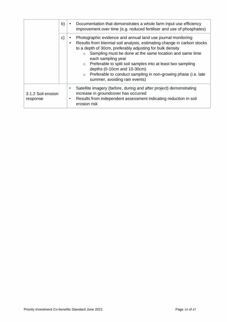
Table 3: Monitoring and reporting requirements of soil health co-benefits
Co-benefit Example monitoring and reporting requirements
3.1.1 Soil health
• Farm land management plan that indicates activities initiated to change
existing soil condition
• Results from independent assessment indicating improvement in soil
health beyond the baseline
a) • Documentation that demonstrates a whole farm nutrient mapping
process has been implemented
Priority Investment Co-benefits Standard June 2021 Page 14 of 47
b) • Documentation that demonstrates a whole farm input use efficiency
improvement over time (e.g. reduced fertiliser and use of phosphates)
c) • Photographic evidence and annual land use journal monitoring
• Results from biennial soil analysis, estimating change in carbon stocks
to a depth of 30cm, preferably adjusting for bulk density
o Sampling must be done at the same location and same time
each sampling year
o Preferable to split soil samples into at least two sampling
depths (0-10cm and 10-30cm)
o Preferable to conduct sampling in non-growing phase (i.e. late
summer, avoiding rain events)
3.1.2 Soil erosion response
• Satellite imagery (before, during and after project) demonstrating
increase in groundcover has occurred
• Results from independent assessment indicating reduction in soil
erosion risk

Priority Investment Co-benefits Standard June 2021 Page 15 of 47
4. Salinity mitigation co-benefits
4.1 Guiding principles
The CF-LRP seeks to maximise the environmental outcomes of carbon farming projects, guided by the following principles:
• Protect assets at risk from salinity
• Prevent the further degradation of salt-affected land
There is one salinity mitigation co-benefit category, as outlined below.
4.1.1 Salinity response
Eligibility: The project ameliorates salt-affected land.
The project must either:
a) Be in proximity11 to priority landscapes at risk from salinity12
b) Be in proximity11 to priority flora or fauna at risk from salinity13
c) Be in proximity11 to threatened ecological communities at risk from salinity14
d) Prevent the further degradation of salt-affected land
4.2 Documentation to satisfy the salinity mitigation co-benefit criteria
To claim the salinity mitigation co-benefit, the Expression of Interest will need to supply documentation of how the project proposes to deliver a demonstrable salinity response, alongside a description of proposed activities. Examples of such documentation are:
• Satellite imagery and mapping that demonstrates the project area’s distance from priority assets at risk from salinity (km).
• Results from an independent assessment (e.g., from local Landcare group, NRM group, etc.) using an acceptable multi-criteria spatial analysis that demonstrates the work is being conducted in areas where salinity mitigation can be achieved.
• Estimates or measurement of the location, extent, and severity of salinity these can include: ▪ mapping the location, extent and severity of salinity ▪ mapping the apparent electrical conductivity of soil using an electromagnetic
induction (EM) device ▪ biomass mapping using satellite imagery
4.2.1 Potential information sources
Proponents may wish to use the below information sources to validate their project’s potential salinity mitigation co-benefits.
• Management of Salinity, Western Australian Auditor General’s Report 2018 (pdf)
• Salinity Investment Framework Interim Report – Phase I, DWER 2003 (pdf)
• Salinity Investment Framework, DPIRD and DWER 2005 (pdf)
• Salinity Investment Framework, Phase II, DPIRD and DWER 2006 (pdf)
• Impact of farm forestry on dryland salinity: a modelling case study, 2004 (pdf)
11 For the purposes of the CF-LRP, ‘proximity’ is considered as a distance that enables the activity to have
a positive impact on the intended co-benefit outcome.
12 As defined by the ‘Priority landscapes at risk from salinity’ data layer in the CF-LRP Information Portal 13 As defined by the ‘Threatened and priority fauna at risk from salinity’ and ‘Threatened and priority flora at risk from salinity’ data layers in the CF-LRP Information Portal 14 As defined by the ‘Threatened ecological communities at risk from salinity’ data layer in the CF-LRP Information Portal

Priority Investment Co-benefits Standard June 2021 Page 16 of 47
• Measuring soil salinity, DPIRD 2020 (webpage)
• Assessing saline areas in Western Australia, DPIRD 2020 (webpage)
• Map Information - Normalised Difference Vegetation Index, Bureau of Meteorology 2021 (webpage)
An interactive mapping tool of the co-benefit categories is available on the Carbon Farming and Land Restoration Program Co-benefits Information Portal. This tool gathers publicly available information from a variety of sources to assist proponents identify the project’s potential to deliver the investment priorities of the CF-LRP. The Portal will support decisions made throughout the assessment process.
Proponents should use the Portal in conjunction with other information sources and on-ground evidence to validate the potential co-benefits associated with a project. Use of the Portal to should be noted in the Expression of Interest. Refer to Appendix C for a Portal User Guide.
Datasets available in the Portal to demonstrate salinity mitigation co-benefits include:
• Threatened ecological communities, priority flora and fauna at risk from salinity
• Natural diversity recovery catchments (existing and potential)
• Priority landscapes at risk from salinity
• Salinity risk
• Average height above valley floor
• Mapped as saline (1987 and 1995)
An example of how proponents can demonstrate Salinity co-benefit eligibility is provided in Appendix H.
4.3 Measurement, monitoring, and reporting of salinity mitigation co-benefits
Proponents will be need to provide details of how they plan to measure, monitor, and report on the effectiveness of the project in progressing towards and achieving the co-benefits specified in the contract between the proponent and the Regional Business Development Corporation.
Table 4 provides examples of how a proponent could report on the project’s co-benefits. Other reporting methods can be proposed in the Expression of Interest. Refer to Section 4.2.1 for information sources that can assist in verifying co-benefit outcomes.
Proponents can provide additional information above the minimum requirements to monitor and report on the identified co-benefits. The quality of the proposed reporting approach will form part of the assessment and selection process.
Delivery milestones will be based on the Expression of Interest, be negotiated with the Recipient, and will be documented in the Project Schedule. Co-benefits will need to be baselined, monitored and reported on within the chosen contract period (e.g. within 7 years) to the satisfaction of the review panel using evidence that most accurately and reliably validates the project’s co-benefits.
Table 4: Monitoring and reporting requirements of salinity mitigation co-benefits
Co-benefit Example monitoring and reporting requirements
4.1.1 Salinity response
• Estimates or measurement of the location, extent, and
severity of salinity, before project commencement and at the
end of the contract period, demonstrating salinity has
declined. Methods include:
o mapping the location, extent and severity of salinity
o mapping the apparent electrical conductivity of soil using
an electromagnetic induction (EM) device
o Biomass (normalised difference vegetation index)
mapping using satellite imagery
Evidence of actions taken to protect the ameliorated land (e.g. fencing of fodder bush to enable stock management).

Priority Investment Co-benefits Standard June 2021 Page 17 of 47
5. Aboriginal economic and cultural co-benefits
5.1 Guiding principles
The CF-LRP seeks to ensure the co-benefits projects can provide for Aboriginal people are recognised, and opportunities developed, guided by the following principles:
• Encourage non-Aboriginal carbon farming proponents to identify any potential role for Aboriginal people in their project
• Acknowledge the connection Aboriginal people have to the land
• Promote the recognition of Aboriginal cultural values
There are four Aboriginal economic and cultural co-benefit categories, as outlined below.
5.1.1 Aboriginal ownership
Eligibility: The project involves direct participation by Aboriginal people. Either the project owners are Aboriginal people, project partners are Aboriginal people, or the project directly involves Aboriginal participation.
5.1.2 Aboriginal land
Eligibility: The project takes place on Aboriginal land, including land under management.
This includes:
• Aboriginal freehold
• Land held or owned by Aboriginal organisations
• Land held with the Indigenous Land and Sea Corporation
• Land held with the Aboriginal Lands Trust
• Land with a native title determination
• Land that is subject to a registered native title claim
• Land where there is an Indigenous Land Use Agreement (ILUA) in place.
5.1.3 Aboriginal economic opportunities
Eligibility: The project provides economic opportunities to Aboriginal people.
The project must achieve one or more of the following:
a) Contribute to the development of Aboriginal business
b) Collaborate with and/or provide opportunities for an Aboriginal Controlled Community
Organisation
c) Provide local Aboriginal employment opportunities
d) Provide recognised training opportunities for Aboriginal people
e) Contribute to research or demonstration of new abatement opportunities, such as fire
regime management in the south west, native forest protection and farm forestry, or
traditional food or fibre enterprises or activities
Note on 5.1.3
e) Harvesting is incompatible with some ERF vegetation methods. Therefore, projects funded
under the ACCU Plus stream may not be able to partake in research or demonstration of
traditional food or fibre enterprises or activities. Proponents must ensure it does not
undertake activities that compromise the project’s ERF eligibility for registration or issuance
of ACCUs. Refer to Appendix B for ERF method activity and monitoring requirements

Priority Investment Co-benefits Standard June 2021 Page 18 of 47
5.1.4 Alignment to Aboriginal cultural values
Eligibility: The project promotes the recognition of Aboriginal cultural values.
The project must achieve one or more of the following:
a) Align with and promote Aboriginal cultural values (e.g. restoration of land, reconnection
to land, handing down of traditional knowledge, protection of sites of significance, or
other Aboriginal cultural values)
b) Contribute to the identification, protection, or restoration of Aboriginal heritage sites
c) Contribute to local or regional cultural mapping
How Aboriginal economic and cultural co-benefits may be recorded may differ from community to community. The CF-LRP has a commitment to ensuring that Aboriginal voices guide the development of this reporting model and shape the material that either directly or indirectly affects them.
As such, ongoing input from Aboriginal people and organisations on how the Co-benefits Standard can be improved or expanded will be sought.
5.2 Documentation to satisfy the Aboriginal economic and cultural co-benefit criteria
Alongside a description of proposed activities, the Expression of Interest will need to supply documentation demonstrating how the project will provide demonstrable positive outcomes for Aboriginal people. Examples of such documentation are:
• Evidence of Aboriginal ownership or participation – this could include an Indigenous Corporation Number (ICN), registration with the Aboriginal Business Directory WA, a Supply Nation search, statements by Aboriginal participants or photographic evidence, as examples.
• Linkages to Aboriginal land – this could include Title deeds to project land, Native Title Determination or claim, the project lead is Prescribed Body Corporate, registration of a native title claim, and ILUA, as examples.
• Evidence the project provides economic opportunities to Aboriginal people – this could include evidence of Aboriginal employment, training opportunities, or business development, such as a memorandum of understanding or other agreements, including supplier contracts, as examples.
• Alignment with the strategic intent of local Aboriginal groups, as identified in relevant documentation and websites.
• Statements by Aboriginal project owners, participants or beneficiaries of the:
▪ Carbon farming project’s meaning for and importance to the community.
▪ Cultural benefits associated with delivering the carbon farming project.
5.2.1 Potential information sources
Proponents may wish to use the information sources below to validate the project’s potential Aboriginal economic and cultural co-benefits.
• Local Aboriginal groups and organisations
• Office of the Registrar of Indigenous Corporations
• Prescribed Bodies Corporate, Registered Native Title Bodies Corporate, Aboriginal groups, and organisations
• Department of Planning, Lands and Heritage
• Strategic plans, guiding documents, goals and objectives identified in relevant documentation and websites.
An interactive mapping tool of the co-benefit categories is available on the Carbon Farming and Land Restoration Program Co-benefits Information Portal. This tool gathers publicly available information from a variety of sources to assist proponents identify the project’s potential to

Priority Investment Co-benefits Standard June 2021 Page 19 of 47
deliver the investment priorities of the CF-LRP. The Portal will support decisions made throughout the assessment process.
Proponents should use the Portal in conjunction with other information sources and on-ground evidence to validate the potential co-benefits associated with a project. Use of the Portal should be noted in the Expression of Interest. Refer to Appendix C for a Portal User Guide.
Datasets available in the Portal to demonstrate Aboriginal economic and cultural opportunities co-benefits include:
• Aboriginal heritage places
• Aboriginal Lands Trust Estate
An example of how proponents can demonstrate Aboriginal economic and cultural co-benefit eligibility is provided in Appendix I.
5.3 Measurement, monitoring, and reporting of Aboriginal economic and cultural co-benefits
Proponents will be need to provide details of how they plan to measure, monitor, and report on the effectiveness of the project in progressing towards and achieving the co-benefits specified in the contract between the proponent and the Regional Business Development Corporation.
Table 5 provides examples of how a proponent could report on the project’s co-benefits. Other reporting methods can be proposed in the Expression of Interest. Refer to Section 5.2.1 for information sources that can assist in verifying co-benefit outcomes.
The proponent can decide what level of rigour above minimum requirements will be provided to monitor and report on the identified co-benefits. The robustness of the reporting approach will form part of the assessment and selection process.
Delivery milestones will be based on the Expression of Interest and specified in the final contract. Co-benefits will need to be monitored and reported on within the chosen contract period (e.g. within 7 years) to the satisfaction of the review panel using evidence that most accurately and reliably validates the project’s co-benefits.
Table 5: Monitoring and reporting requirements of Aboriginal economic and cultural co-benefits
Co-benefit Examples of monitoring and reporting requirements
5.1.1 Aboriginal ownership
• Evidence of ownership or participation by Aboriginal people
demonstrated via Indigenous Corporation Number,
registration with the Aboriginal Business Directory WA, a
Supply Nation search, statements by Aboriginal participants
or photographic evidence.
• If evidence of all instances of Aboriginal ownership or
participation were supplied prior to signing of the contract,
there would be no monitoring and evaluation requirements.
5.1.2 Aboriginal land
• Documentation indicating a linkage to Aboriginal land (e.g.
Title deeds to project land, Native Title Determination or
claim, the project lead is Prescribed Body Corporate,
registration of a native title claim, ILUA) must be supplied
prior to signing of the contract. As such, there are no
monitoring and evaluation requirements.
5.1.3 Aboriginal economic opportunities
• Statements by Aboriginal project owners, participants or
beneficiaries of how the project has provided economic
opportunities to Aboriginal people.

Priority Investment Co-benefits Standard June 2021 Page 20 of 47
• Evidence of contracts, memorandum of understanding, or
other agreements with Aboriginal businesses.
• Evidence that the project has provided employment and/or
training opportunities for Aboriginal people (e.g. certifications,
photographic evidence, statements from participants).
5.1.4 Alignment to Aboriginal cultural values
• Statements by Aboriginal project owners, participants or
beneficiaries of what the carbon farming project means for
the community and the cultural benefits associated with
delivering a carbon farming project.
• Documentation that confirms the project aligns with the
strategic intent of local Aboriginal groups.

Priority Investment Co-benefits Standard June 2021 Page 21 of 47
Appendices
Appendix A - South West Land Division

Priority Investment Co-benefits Standard June 2021 Page 22 of 47
Appendix B – Approved Emissions Reduction Fund carbon farming method activity and monitoring requirements
Sourced from the Australian Government’s Emissions Reduction Fund.
Agriculture methods
Measurement of soil carbon sequestration in agricultural systems method
Carbon method activity requirements Carbon method monitoring requirements
• Within broad parameters, landholders have a choice of which land
management activities to implement to build soil carbon within cropping,
grazing or horticultural production systems. Activities must be new or
materially different from the land management activity conducted during
the 10 year baseline period, and must reasonably be expected to
sequester carbon in the soil.
• The land must have been used throughout the 10-year baseline period
for pasture, cropping, or bare fallow and must not have been forest land
at any point during the baseline period. It cannot currently be forest land.
The baseline period must also have not involved drainage of a wetland.
• Some activities, such as permanent destocking and addition of coal or
coal based products, are specifically excluded.
• Eligible activities include:
- re-establishing or rejuvenating a pasture by seeding;
- establishing, and permanently maintaining, a pasture where there
was previously no pasture, such as on cropland or bare fallow;
- retaining stubble after a crop is harvested
• Proponents should seek professional guidance on best approaches to
improve soil condition.
• Projects must measure the soil carbon stocks at the project site before
the new management actions are implemented and at regular intervals
during the project to estimate carbon sequestration.
• Emissions from other sources that have changed as a result of the
project such as emissions from livestock, tillage events and applications
of lime or synthetic fertiliser must be factored in to the abatement
calculations.
• Projects are subject to permanence obligations. This means the project
must be maintained for a nominated period of either 100 or 25 years.
• Projects nominating a 25-year permanence period are subject to a 20
per cent discount on the number of credits they receive
Estimating sequestration of carbon in soil using default values (model-based soil carbon)
Carbon method activity requirements Carbon method monitoring requirements
• Soil carbon is primarily made up of decomposing organic material. In
agricultural systems, the roots, stems and leaves of crops or pasture
grasses can be cycled into the soil and broken down, where some
remains as soil carbon. Management practices that increase the amount
of biomass incorporated into the soil, and/or reduce the amount of
• This method requires monitoring of soil and emission sources to ensure
that the activities are undertaken in accordance with the method.
• CEAs must also be monitored every six months to ensure that vegetation
ground cover is maintained.
• Section 89 of the method provides that a carbon estimation area must
not have more than 30% bare soil, or less than 70% vegetation

Priority Investment Co-benefits Standard June 2021 Page 23 of 47
organic matter that is released from soils, can lead to improvements in
soil carbon levels.
• For this method, landholders may undertake one or more project
management activities:
- Increasing biomass yields (sustainable intensification) on crop or
pasture areas by optimising fertiliser, applying lime, introducing
irrigation, or pasture renovation (pasture only).
- Converting land under crops to pasture (conversion to pasture).
- Retaining crop residue in field rather than burning or baling it
(stubble retention).
• The following requirements need to be met to ensure a project is eligible
under this method:
- The project must take place on agricultural land that has been
cropped, grazed or bare fallowed at least once in the five years
before the project application date. Eligible agricultural land can be
identified using the sequestration values maps.
- The land for the project must be divided into one or more carbon
estimation areas (CEA). One of the three project management
activities may be undertaken on each CEA.
- For sustainable intensification, the relevant CEA must have
deficient soil that can be improved by undertaking two of the
management actions.
- For conversion to pasture, the relevant CEA must be under crops
and/or bare fallowed for five years before the land is established as
pasture.
- For stubble retention, no burning or baling can occur in the relevant
CEA more than once every five years while the area is under
crops.
• Project management activities must be undertaken for the nominated
permanence period (25 or 100 years). Landholders have the flexibility to
move between different management actions in recognition of the
changing conditions on agricultural land.
• Landholders should seek expert advice before undertaking any
Emissions Reduction Fund project to understand which activities suit
their land and which method best fits their business needs.
groundcover, for more than three consecutive soil monitoring periods
during the project.
• A soil monitoring period is three months. Failing to meet this requirement
could impact upon the allocation of carbon credits for the project.
• Project records are critical because they will be used to calculate the
abatement that has been achieved by the project.
• Projects are required to submit a report to the Clean Energy Regulator
every six months to five years.
• A registered greenhouse and energy (NGERS) auditor must audit
projects. A list of registered auditors is available on the Clean Energy
Regulator website

Priority Investment Co-benefits Standard June 2021 Page 24 of 47
Vegetation methods
Reforestation and afforestation V2.0
Carbon method activity requirements Carbon method monitoring requirements
• Establish forest through planting trees species local to the project area
on cleared land.
• Mallee species must only be planted where annual rainfall is under 600
mm.
• The project area must have grazed, cropped, or allowed to lie fallow for
at least five years prior to project commencement.
• Projects are subject to permanence obligations. This means the project
must be maintained for a nominated period of either 100 or 25 years.
• The plantings must have the potential to reach forest cover (20 per cent
crown cover consisting of trees that are at least two metres tall).
• The trees may not be harvested except for in very limited circumstances
such as hazard reduction.
• Tree products such as firewood, fruits and nuts cannot be commercially
harvested from the planting.
• One preparation burn can be carried out prior to planting.
• Fertiliser can be applied no more than once in every 25-year period.
• One or more strata must be defined in the project area.
• Project area monitored for disturbances such as fire.
• Projects require regular reporting (at least once every five years) to
demonstrate project requirements are being met, and to report on carbon
abatement.
Reforestation by Environmental or Mallee Plantings – FullCAM
Carbon method activity requirements Carbon method monitoring requirements
• Establish forest through planting tree species local to the project area.
• The plantings must include tree or mallee species native to the local
area.
• Mallee species must only be planted where annual rainfall is under 600
mm.
• The project area must have been clear of forest cover for at least five
years prior to project commencement.
• Projects are subject to permanence obligations. This means the project
must be maintained for a nominated period of either 100 or 25 years.
• The plantings must have the potential to reach forest cover (20 per cent
crown cover consisting of trees that are at least two metres tall).
• The trees may not be harvested except for in very limited circumstances
such as hazard reduction.
• Project area monitored for growth of seedlings and disturbances such as
fire.
• Projects require regular reporting (at least once every five years) to
demonstrate project requirements are being met, and to report on carbon
abatement.
• Projects must also be audited by a registered national greenhouse and
energy reporting (NGER) auditor.

Priority Investment Co-benefits Standard June 2021 Page 25 of 47
• Tree products such as firewood, fruits and nuts cannot be commercially
harvested from the planting.
• If the land has been lawfully cleared in the past, it must have occurred
more than seven years ago, or five years ago if the land was cleared by
previous holders.
• Projects cannot be established on land that has been cleared unlawfully.
Native forests from managed regrowth
Carbon method activity requirements Carbon method monitoring requirements
• Projects under this method capture carbon by changing land management practices to regrow native forest on land where vegetation has been removed for grazing or cropping purposes.
• Landholders promote regrowth of native forest by ceasing clearing of aboveground vegetation. In addition, landholders may exclude livestock, change the timing and extent of grazing, or manage non-native plant species or feral animals.
• The method uses the Full Carbon Accounting Model (FullCAM) to work out the carbon captured by the regenerating forest. Impacts of disturbances such as fires are also accounted for.
• Projects are subject to permanence obligations. This means the project must be maintained for a nominated period of either 100 or 25 years.
• Projects need to meet the following requirements to be eligible under this method: - The land must have been subject to at least one comprehensive
vegetation clearing for grazing or cropping use. - The land must not have had forest cover in the 10 years
before commencing the project. - Before the clearing occurred, there must have been forest cover
(20% crown cover consisting of trees that are at least two metres tall) on the land.
- The regrowth must have the potential to reach forest cover. - The regrowth may only be grazed by livestock if the grazing does
not prevent the vegetation reaching or maintaining forest cover. - The regrowth cannot be harvested except in very limited
circumstances such as hazard reduction. - The project must establish forest cover only through the
promotion of natural regrowth of vegetation. Projects cannot direct seed or plant trees.
• Projects cannot be established on land that has been cleared unlawfully.
• Project proponents are required to monitor regrowth of vegetation and account for disturbances such as fire.
• Projects must report regularly (at least once every five years) to demonstrate method requirements are being met and to report on carbon abatement.
• Projects are required to: - follow the requirements of the Carbon Farming Initiative
Mapping Guidelines and - take into account guidance on stratification, evidence and records
for projects under Human-Induced Regeneration and Native Forest from Managed Regrowth methods (published by the Clean Energy Regulator).
• Projects must also be audited by a registered national greenhouse and
energy reporting (NGER) auditor.

Priority Investment Co-benefits Standard June 2021 Page 26 of 47
Avoided clearing of native regrowth
Carbon method activity requirements Carbon method monitoring requirements
• Landholders that have historically cleared native forest can instead maintain the forest. Emissions are avoided by not clearing the forest and carbon is stored in trees as they grow.
• To calculate the amount of emissions that would be avoided by not clearing the forest, the method compares a projected baseline in which the project area is regularly cleared with the scenario in which the forest is protected. Emissions from fires and other natural disturbances are also accounted for when modelling emissions avoidance.
• The method uses the Full Carbon Accounting Model (FullCAM) to work out the avoided emissions resulting from the project.
• Projects are subject to permanence obligations. This means the project must be maintained for a nominated period of either 100 or 25 years.
• Requirements for eligibility include: - The land on which the project will be carried out must have native
forest cover (20% crown cover consisting of trees that are at least two metres tall).
- There must be evidence that the land was cleared at least twice in the past.
- The project proponent must have the right to clear the land again without restriction.
• The project proponent must be able to demonstrate an intention to clear
the land again in the absence of participating in the Emissions Reduction
Fund (or register a carbon project with the Clean Energy Regulator).
• Projects must monitor forest health in the project area and check for disturbances to forest cover such as fire.
• Projects require regular reporting (at least once every five years) to demonstrate that project requirements are being met and to report on emissions avoidance.
• Projects must also be audited by a registered national greenhouse and
energy reporting (NGER) auditor.
Plantation forestry
Carbon method activity requirements Carbon method monitoring requirements
• Establish new plantation forests or transition existing plantation estates
from short-rotation to long-rotation plantation forests. Plantations must be
managed with the intention of harvesting for forest products.
• Eligible activities include:
- Establishing a new plantation forest on land that has had no
plantation forest for seven years
- Converting a short-rotation plantation to a long-rotation plantation,
where the conversion might occur either part-way through the
• A permanence period discount of 25 per cent is applied to a project’s net
abatement for short-rotation (20 years or less) plantation forestry projects
that elect a 25-year permanence period. A 20 per cent permanence
discount is applied to all other plantation forestry projects.

Priority Investment Co-benefits Standard June 2021 Page 27 of 47
short-rotation plantation cycle, or following harvest of a short-
rotation plantation
- Maintaining a pre-existing plantation forest that meets the eligibility
requirements of the plantation forestry method, but was established
under another method.
• Projects are subject to permanence obligations. This means the project
must be maintained for a nominated period of either 100 or 25 years.
• Prior to registration, participants must notify the Department of
Agriculture and Water Resources of their proposal. The Minister for
Agriculture determines if the project may lead to an undesirable impact
on agricultural production.
• The method uses the Full Carbon Accounting Model (FullCAM) to
calculate carbon stock.
• Eligibility is restricted to plantations established in regions defined under
the national plantation inventory.
• Plantations managed as part of a forestry managed investment scheme
are ineligible.
Measurement based methods for new farm forestry plantations
Carbon method activity requirements Carbon method monitoring requirements
• A project involves establishing and maintaining trees as either permanent
plantings or in harvest plantations. Trees can be planted as seedlings or
seeds in belt or block plantings, at a density that will allow them to
achieve 'forest cover'. This means that trees must have the potential to
grow to at least two metres tall, and reach a crown cover of at least 20
per cent of the area.
• The project area must have included land used for grazing or cropping,
or land that was fallow between grazing or cropping, for at least five
years prior to project commencement.
• The method uses the Full Carbon Accounting Model (FullCAM) to work out the carbon captured by the regenerating forest. Impacts of disturbances such as fires are also accounted for.
• For permanent plantings, once the planting is established, it must be maintained in such a way that the trees can reach and maintain crown cover. For harvest projects, you must propose a specific management regime, which may include: - planting
- weed control
• Projects require regular reporting (at least once every five years) to
demonstrate that project requirements are being met.
• A carbon inventory must be conducted at least every 5 years from the
first offsets report.

Priority Investment Co-benefits Standard June 2021 Page 28 of 47
- harvesting
- debris removal, and rotation length (i.e. the length of time between
planting and harvesting).
• Project trees must not be removed once established. In a harvest project,
commercial harvesting of project trees is permitted.
• Harvest projects must conform to the following criteria:
- if rainfall is more than 400 mm per year, plantations can occupy an
area no more than 100 hectares, or 30 per cent of a farm
(whichever is the smaller)
- if rainfall is less than 400 mm per year, plantations can occupy an
area no more than 300 hectares, or 30 per cent of a farm
(whichever is the smaller).
• Projects are subject to permanence obligations. This means the project
must be maintained for a nominated period of either 100 or 25 years.
Avoided deforestation V1.1
Carbon method activity requirements Carbon method monitoring requirements
• A project protects native forest in areas that would otherwise be cleared
for crops or grassland. The forest must be managed to achieve a mix, in
terms of composition and structure, of trees, shrubs and understorey
plants that occur naturally in the area of the project.
• A clearing consent for the forest must have been issued before 1 July
2010.
• Thinning of trees for the purposes of promoting biodiversity or vegetation
growth is permitted, as long as 95 per cent of the thinned wood remains
in the area it was thinned.
• Up to 5 per cent of wood from the forest can be collected for personal
use, such as fencing or household firewood.
• The native forest cannot be converted to plantation or settlements.
• Wood cannot be removed from the forest for commercial purposes or
firewood.
• The first offsets report must provide information related to the:
- baseline deforestation plan
- evidence of the mix of species, and
- map of the project area.

Priority Investment Co-benefits Standard June 2021 Page 29 of 47
Appendix C – Carbon Farming and Land Restoration Program Co-benefits Information Portal User Guide
About
The Carbon Farming and Land Restoration Program (CF-LRP) Information Portal is a spatial data and digital mapping service. The Portal can assist carbon farming project proponents identify the project’s potential to deliver the investment priorities of the CF-LRP:
• biodiversity and conservation co-benefits
• agricultural productivity co-benefits
• soil health co-benefits
• salinity mitigation co-benefits
• Aboriginal economic and cultural co-benefits.
This tool gathers publicly available information from a variety of sources to assist proponents identify the project’s potential to deliver the investment priorities of the CF-LRP. The information provided in the Portal is to be used to assist with the initial development of a project. Proponents should use the Portal in conjunction with other information sources and on-ground evidence to validate the potential co-benefits associated with a project. Proponents should indicate the use of the Portal in their Expression of Interest. The Portal will support the decisions of the Investment Assessment Panel.
Note: Some of the datasets included in the Portal are the result of a coarse-grain, landscape-scale analysis. A degree of spatial flexibility around the edges of corridors or locations should be used to take into account this disparity in scale when assessing a project’s feasibility or suitability for funding.
Any queries regarding the application of the data, including those relating to Biodiversity and Conservation, should be directed to the Department of Primary Industries and Regional Development by emailing [email protected]. Access the CF-LRP Portal here.
Data Selection
Located on the application header (top right of your screen) are six data theme icons. You can start your search by browsing these themes. Data has been categorised according to the co-benefit investment priorities of the CF-LRP:
Biodiversity and conservation
Agricultural productivity
Soil health
Salinity mitigation
Aboriginal economic and cultural opportunities
Making a data layer selection from any of the themes (and relevant drop down boxes) will result in that layer being displayed on the map. Given the volume of data contained in the Portal, you may need to turn layers on and off as you navigate through the map.

Priority Investment Co-benefits Standard June 2021 Page 30 of 47
Map Navigation Tips
Use the mouse to zoom and drag the map to any location. Layers in ALL CAPS have sub-layers (e.g. BOUNDARIES). Sub-layers will only display if both the main layer and sub-layer boxes are ticked. Zooming in/out is achieved by moving the mouse scroll wheel forward (zoom in) or back (zoom out). If the mouse is not equipped with a scroll wheel use the zoom in/zoom out tool located on either the right side, or bottom left of the screen. Greyed-out layers are too detailed to display if the map is zoomed out (e.g. Land Tenure). You will need to zoom in until the data becomes visible. Click the legend icon to see detailed legend information. Information will display as layers are added to the map.
Additional Mapping Resource
NRInfo - (natural resource information) provides you access to digital mapping and information for natural resources across Western Australia. This information may be used for regional and strategic planning, and for identifying areas needing more intensive assessment.
Acknowledgements
The data sets in this Portal have been collated from a range of State agencies. Download a full list of data sets and their sources for more information.
Display page
A scale can be found at the bottom left of the screen. You can find you address via the search bar at the top of the screen, underneath the Portal heading. Four tools can be found on the top left of the screen.
Measurement
Add Data
Draw
Info Summary
Measurement
Select the measurement tool you would like to use – Area, Distance, or Location. Distance can measure length and perimeter. Location places a pindrop to mark a single point on the map and provide GPS coordinates. Left click to begin tracing your project area and left click again to create a corner. Repeat until the total area is captured and Double left click to complete your shape.

Priority Investment Co-benefits Standard June 2021 Page 31 of 47
Units of measurement can be changed via the drop down menu; and include hectares, metres, kilometres etc. Clicking the Clear button removes the measurement from the display.
The measurement tool can be used to calculate the following values in the Carbon Farming & Land Restoration Program Expression of Interest:
• Carbon Estimation area i.e. the project area
• Current vegetation cover (approximate %) in the project area
• Measurements for activities, i.e. length or hectares of planting / seeding
• Any other values that can be spatially measured using polygons or lines.
Add Data
Data can be uploaded as a file or via a URL. Accepted file formats are .shp, CSV, KML, GPX, GeoJSON.
Draw
This tool allows you to draw in a point, line, polygon, or add a label to the map. The colour, width, transparency, and size of draw tools can be adjusted. Click to start adding a shape or hold down and let go to finish.

Priority Investment Co-benefits Standard June 2021 Page 32 of 47
Notes about drawing
Select drawing tools
• Select the drawing tool that suits your purposes. Drawing tools include points, a number of line
options and polygon styles, and symbols such as circles, triangles, squares etc.
• More accurate ‘drawing’ can be achieved by zooming into your project / activity area at the
closest resolution that captures the total draw area on the screen.
* Please note – Close the Draw tool to zoom in or out.
Text & draw colour, width & transparency
• Select the colour of the drawn tool – there are a number of predetermined options, however the
shade of a selected colour can be changed by clicking on the ‘Colour bar’; the transparency of
the colour can be changed on the ‘Transparency bar’.
*Handy hints:
➢ We recommend ‘testing’ both text and draw functions prior to commencing. ➢ You may find it easier to draw and view objects by changing the transparency to >50% ➢ Light coloured text may be easier to view depending on the background or imagery. ➢ The ‘Clear’ function can be used to delete all text or objects.
➢ ‘Undo’ will delete the last drawn text or object. ➢ Use the ‘Outline Colour & Width’ features to make changes to your objects.
➢ To draw a coloured outline only (no “fill” colour), change the Transparency to 100%.
➢ You may need to change the colour and or size of text so that it displays well.
➢ Font size and colour can be changed without re-entering text.

Priority Investment Co-benefits Standard June 2021 Page 33 of 47
Text boxes
Text can be added using the text tool . When you have entered the required text, a pop-up box will appear at your cursor and will prompt where the point can be added. If you want to reposition the text box, use the undo feature and move the text box.
Area & perimeter measurements
The ‘Show area measurement’ and ‘Show perimeter measurement’ features can be enabled to automatically calculate and display the units of measurement once a feature has been drawn. Units of measurement can be changed via the drop down menus.

Priority Investment Co-benefits Standard June 2021 Page 34 of 47
Deleting drawn areas & text
Use the ‘Undo’ function to delete the last object drawn. In the example below if the green area (57.6 hectares) was drawn first and the orange area (30.9 hectares) drawn second, ‘Undo’ will delete the orange image only.
Use the ‘Clear’ To delete ALL drawn images and text.
To re-establish image/s that have just been ‘Cleared’, select the ‘Undo’ feature.

Priority Investment Co-benefits Standard June 2021 Page 35 of 47
Info Summary
Provides a count and list of features that are visible in the current map extent as you zoom in or out. Values are only shown if a layer is turned on and visible.
Three tools can be found on the right side, or bottom left of the screen, depending on your browser.
My Location
Default Extent
Zoom in and out
My Location
Easily find your property by selecting this tool. Your current location will be indicated by a blue dot. You may have to grant permission for your web browser to access your location.
Default Extent
Return to the original map extent.
Zoom in and out
Manually adjust the map extent by zooming in and out.
Layers toolbar
At the top of screen, a toolbar allows you to view all the layers in the project and helps you manage their visibility.
Investment priorities

Priority Investment Co-benefits Standard June 2021 Page 36 of 47
Five of the icons in the layers panel depict the CF-LRP investment priorities
• Biodiversity and conservation
• Agricultural productivity
• Salinity mitigation
• Soil health
• Aboriginal economic and cultural
Data layers contained within each of these five themes can assist in identifying and validating the potential co-benefits associated with a project. Click on the arrow to the left of the layer name to view legend. Layers named in all-capitals indicates a group that can be expanded. The following toolbars and datasets are available in the Portal:
Legend - View what layers are currently set as visible.
Biodiversity & conservation – layers available include, Threatened & Priority fauna, Threatened & Priority flora, Threatened Ecological Communities, Water – hydrography, Ramsar sites, Natural Diversity recovery Catchments (existing & potential), Water Resource Recovery Catchments, Native vegetation extent, DBCA lands of Interest, DBCA Legislated lands and Waters
Agricultural Productivity – layers available include, Waterlogging risk, Water repellence risk, Average height above valley floor, Land Capability
Salinity mitigation – layers available include, Threatened Ecological Communities, Threatened & Priority fauna and flora at risk from salinity, Natural Diversity recovery Catchments (existing & potential), Priority landscapes at risk from salinity, Salinity risk, Average height above valley floor and salinity mapping
Soil health - layers available include, Water erosion, Wind erosion
Aboriginal economic and cultural– layers available include, Aboriginal heritage places, Aboriginal Lands Trust Estate
General – layers available include, Area-based Emissions Reduction Fund projects, Agricultural properties, South West Land Division, Local government authorities
Print – more information on the print functionality can be found here
More –information on the print functionality can be found here
After selecting an icon, three buttons to the right of the heading allow you to minimise, maximise, and close the layer group. A search button allows you to look for key words.

Priority Investment Co-benefits Standard June 2021 Page 37 of 47
General
View layers that are non-specific to the investment priorities.
This tool allows you to download and save maps. Select the Print button to begin the download process. Selecting MAP_ONLY as the layout will save the current map extent and all visible layers. Selecting A4 Portrait / A4 Landscape / A3 Portrait / A3 Landscape as layouts includes a title, scale, and legend of visible layers. As attachments to an Expression of, this is the preferred layout. Maps can be saved in several different formats (AIX, EPS, GIF, JPG, PDF, PNG32, PNG8, SVG, SVGZ). As attachments to an Expression of Interest, preferred formats are JPG and PDF. *Handy hint: you may need to re-centre or zoom out to fit all of your property and drawn feature and text on a Print version.
You can use the Clear prints feature to delete PDFs that you have previously created.

Priority Investment Co-benefits Standard June 2021 Page 38 of 47
* An alternative way to provide a map is to take a screenshot of your project in the Portal and paste into in a Word document or similar application. You may find this easier if you want to add additional text to describe the activities and other attributes of the site. An example of using screenshots pasted into Word has been provided below.
More
Your browser may not display all available tools. Select the More icon to view additional tools.
• Basemap gallery - you can change which basemap is displayed, including satellite and topographic imagery.
• About – provides an overview of the CF-LRP investment priorities and use of the Information Portal.
• Bookmark – click to bookmark the current map location and zoom.

Priority Investment Co-benefits Standard June 2021 Page 39 of 47
Learn more about map attributes
By selecting a visible feature (e.g. threatened and priority fauna, Ramsar site). You can learn more about that particular feature. Depending on your browser display, you may have to click the arrow on the pop up to learn more.
Click on the arrow located at the base of the screen to open the attributes table and learn more about each feature on the map, layer by layer.
Each row in the table represents a feature and each column contains a particular piece of information about the feature.
Attributes can be filtered by the map extent. This can help you see exactly what features are near your property and the proposed project location.
You can filter the attribute table to only display certain features.
Select the Options drop down menu and select filter
As an example, you could filter the Fauna class on the Threatened and priority fauna layer to only display ‘BIRD’ and ‘REPTILE’ features.
Need help?
Any queries regarding the use of the Portal can be sent to [email protected]
OR

Priority Investment Co-benefits Standard June 2021 Page 40 of 47
Appendix D – Biodiversity and conservation co-benefit eligibility example (Part 1)

Priority Investment Co-benefits Standard June 2021 Page 41 of 47
Appendix E – Biodiversity and conservation co-benefit eligibility example (Part 2)

Priority Investment Co-benefits Standard June 2021 Page 42 of 47
Appendix F – Agricultural productivity co-benefit eligibility example

Priority Investment Co-benefits Standard June 2021 Page 43 of 47
Appendix G – Soil health co-benefit eligibility example

Priority Investment Co-benefits Standard June 2021 Page 44 of 47
Appendix H – Salinity mitigation co-benefit eligibility example

Priority Investment Co-benefits Standard June 2021 Page 45 of 47
Appendix I – Aboriginal economic and cultural co-benefit eligibility example
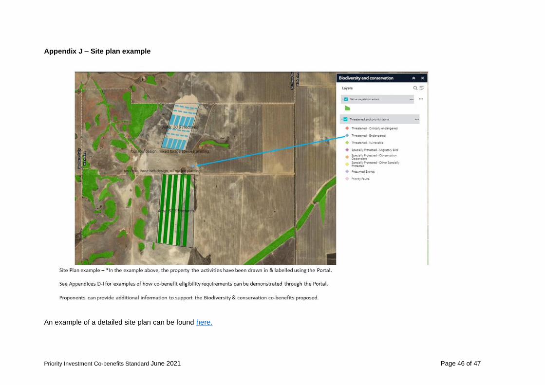
Priority Investment Co-benefits Standard June 2021 Page 46 of 47
Appendix J – Site plan example
An example of a detailed site plan can be found here.

Priority Investment Co-benefits Standard June 2021 Page 47 of 47
Appendix K – Example of additional information to support the project site plan
Important disclaimer The Chief Executive Officer of the Department of Primary Industries and Regional Development and the State of Western Australia accept no liability whatsoever by reason of negligence or otherwise arising from the use or release of this information or any part of it.
Copyright © Department of Primary Industries and Regional Development, 2021


![Beaufort County Comprehensive Plan Priority Investment · “A priority investment element [is required] that analyzes the likely federal, state, and local funds available for public](https://img.dokumen.tips/doc/110x75/5f802af089fd184b0f46ea51/beaufort-county-comprehensive-plan-priority-investment-aoea-priority-investment.jpg)