Embed Size (px)
Citation preview
JOURNAL OF QUATERNARY SCIENCE (2003) 18(2) 107–120Copyright 2003 John Wiley & Sons, Ltd.Published online in Wiley InterScience (www.interscience.wiley.com). DOI: 10.1002/jqs.738
Preservation potential for Late Quaternary riveralluviumJOHN LEWIN and MARK G. MACKLIN*Institute of Geography and Earth Sciences, The University of Wales, Aberystwyth, Ceredigion, SY23 3DB, Wales, UK
Lewin, J. and Macklin, M. G. 2003. Preservation potential for Late Quaternary river alluvium. J. Quaternary Sci., Vol. 18 pp. 107–120. ISSN 0267-8179.
Received 9 February 2002; Revised 1 November 2002; Accepted 17 November 2002
ABSTRACT: Valley sequences of Late Quaternary alluvial units reflect alluvial preservation as wellas alluvial production factors. Effects of lateral channel migration, incision, aggradation and channelstability on preservation potential are explored and then considered in the light of 14 available datasets: cartographically dated and model data based on lateral channel migration; well-mapped anddated Late Quaternary valley unit surveys; and composite age–frequency plots for dated alluvialunits and flood sediments.
Despite much expectable variation between sites, and the complex effects of river-activitycombinations, a common characteristic of the data sets examined is the significance of preservationfactors. Lateral migration tends to eliminate older units as it creates new alluvial deposits,whereas incision may lead to the preferential preservation of older units beyond the incision slot.Aggradational environments are likely to preserve more complete records, although simultaneouslateral migration may eliminate, possibly repeatedly, the upper parts of alluvial units. The commonpattern of inset and incised streams within Pleistocene and early Holocene fills or bedrock givesfinite extent to later units within narrowing valleys so that development of new valley-floor unitsis necessarily at the expense of reprocessing earlier ones. Floods associated with both slack waterdeposits and berms are also responsible for the removal of accessible earlier materials, thus limitingthe preserved record of earlier events.
In light of these censoring effects of river activities, the sequence of preserved Late Quaternaryunits within UK sequences is reconsidered. It is concluded that preservation potential factors haveled to spatial and temporal bias in the alluvial record, and that both here and elsewhere preservationpotential needs to be considered systematically alongside variable sedimentation resulting fromallogenic environmental factors when interpreting the alluvial archive. Copyright 2003 JohnWiley & Sons, Ltd.
Journal of Quaternary Science
KEYWORDS: Quaternary; preservation potential; river alluviation.
Introduction
The rapidly expanding interest in Late Pleistocene andHolocene river sediments has been especially focused ondistinguishing and dating alluvial units, and interpreting theirpresence and sequence in terms of allogenic environmen-tal factors that have enhanced sediment delivery to, anddeposition in, floodplain environments. These factors includethe after-effects of Pleistocene glaciation, especially in theLate-glacial and early Holocene (Starkel, 1990; Rose, 1995);Holocene climatic variability, in particular as affecting vege-tation cover or flood frequency (Knox, 1983, 1993; Starkel,1983, 1996; Macklin and Lewin, 1993; Rumsby and Mack-lin, 1996) and anthropogenic effects, which vary in their
* Correspondence to: Prof. Mark G. Macklin, Institute of Geography and EarthSciences, The University of Wales, Aberystwyth, Ceredigion, SY23 3DB, UK.E-mail: [email protected]
impact and timing according to the local history of defor-estation, agriculture, mineral extraction and settlement (Knox,1977; Starkel, 1987; Robinson, 1992; Macklin and Lewin,1997).
Much less attention has been given to the site preservationpotential of near-surface alluvial units once formed. Toa variable extent, laterally and vertically mobile riversrework valley-floor materials over time so that even wheresedimentation at particular periods did occur, the evidence forit may now have been partly or entirely removed. Modellingof alluvial architecture under conditions of aggradation andavulsion (Allen, 1978; Bridge and Leeder, 1979; Mackey andBridge, 1995; Heller and Paola, 1996) or aggradation andmeandering (Gross and Small, 1998) has been helpful forthe interpretation of stacked multiple alluvial units. Nearthe surface, where the alluvial record is incomplete andessentially only a partial ‘archive of remnants’, there isgood reason to consider removal patterns as systematicallyas depositional ones.
108 JOURNAL OF QUATERNARY SCIENCE
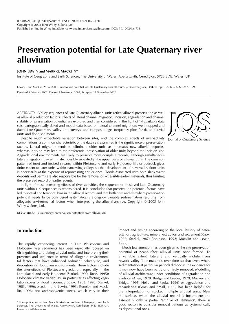
Alluvial unit preservation potential and riveractivity
The preservation potential of alluvial units relates to thevarying form of subsequent river activity—lateral channelmigration, incision, aggradation/avulsion or stability. All theseare variable in their operation in space and time withincomplexly operating catchment systems (Schumm, 1977). Foran alluvial unit at a given site, Fig. 1 illustrates hypotheticalrelationships between preservation potential and four formsof river activity. Potential is related where possible to ageand distance from dominant river location on valley floors.Three cases (A, B, G) are derived from previous work by
Everitt (1968) for a meandering river, Graf (1981) for abraided one, and Wolman and Leopold (1957) for overbanksedimentation.
Points to note about each of the four major categories ofchannel activity are as follows:
Lateral migration may involve channel margin (relativelycoarse) and overbank (generally fine) sedimentation, which isthen reworked as the channel or multichannel system recrossesits previous zone of sedimentation. For meandering, a negativeexponential relationship between age and preservation poten-tial has been proposed by Everitt (1968), but the situationwith braided systems with a belt of channels shifting laterallymay be somewhat different, involving avulsive relocation andbar/island development as well as lateral shift. Graf (1981)has shown that there can be preferred channel occupation
Figure 1 Alluvial unit preservation potential under contrasting river activity regimes: (A), (B) and (G) are based on relationships suggested byEveritt (1968), Graf (1981) and Wolman and Leopold (1957). Preservation is expressed in relation to unit age (A, C, E and G) and with respect tolocation in relation to the dominant channel on the valley floor
Copyright 2003 John Wiley & Sons, Ltd. J. Quaternary Sci., Vol. 18(2) 107–120 (2003)

PRESERVATION POTENTIAL OF ALLUVIUM 109
Figure 2 Preservation of alluvial units under lateral migration: (A) by meandering, (B) by braiding, and (C) involving lateral migration andaggradation
corridors together with other parts of the valley floor thatrarely figure as channel locations.
Preservation of types of alluvial units also may be selective(Fig. 2). With repeated meander growth and cut-offs, it is theabandoned channel fills adjacent to valley margins that aremore likely to be preserved than the more extensive point barmaterials (Fig. 2A). With braiding and avulsive abandonment,at least where the active zone only partly occupies availablevalley floors, there seems to be more complete preservationof the whole range of active sedimentation environments(Fig. 2B).
It is also interesting to note that the planform of terracedmargins may preserve as a template the outline of adjacentformer channel patterns, even where alluvial materials relatedto such channels have been removed. Meandering channelscan leave large-scale arcuate scallops, or sometimes a seriesof short arc lengths as confined loops translate down valley(Lewin and Brindle, 1977). The terraced margins of braid plainstend to be straighter, with relatively smaller notches created byone of several channels into which flow may be divided, andwithout the higher ‘attack’ angles of highly sinuous meanderingstreams (cf. Warburton et al., 1993).
Channel incision is associated with isolation and preserva-tion of alluvial units beyond the incision slot and its floor.Within the incised zone, the channel may exhibit con-fined lateral migration, enlarging the new valley floor atits margins, with age relationships comparable to A and Babove (Fig. 1). But confined migration may be laterally inhib-ited by the greater thickness of alluvial fill to be removedthan is present on the active floodplain, or by bedrockand cemented materials (see Lewin and Brindle (1977) fordiscussion). It is therefore the floor enlargement zone along-side the river channel between terrace margins (Fig. 1, Cand D) that has a potential preservation–age relationshipthat is intermediate between that of the active incision
floor and older (and more distant from the incised chan-nel) units.
Aggradation allows for preservation by burial, partly withinan aggrading channel zone, but also by overbank sedimen-tation up to flood limits outside it (Fig. 1E). Thus detailedrelationships depend on the actual nature of the aggradationzone, with episodic burial within the channel zone. Beyondthis zone, burial (and the record of sedimentation events)will be dependent on flood frequency and rates of overbanksedimentation in particular events and locations.
Aggradation may occur alongside lateral migration. Thiscan have the effect of preserving only the lower partsof the prior sedimentation succession (Fig. 2C) becausethe upper parts are removed, possibly repeatedly, by thelaterally sweeping channel. Avulsions commonly accompanyaggradation because vertical accretion in and alongsidechannels is more rapid than in more distant flood basins.This differential elevation effect favours successful avulsion(see Bridge and Leeder, 1979; Mackey and Bridge, 1995).
Channel stability may involve very little channel or channel-margin sedimentation; with overbank sedimentation becomingself-limiting as the elevation of the floodplain is built up,restricting overbank flows and the sedimentation that ensues(Fig. 1G).
Preservation potentials for alluvial units under these differentchannel activity states relate to the futures of individual units.The complete mosaic of units of different age depends onthe total suite of channel activity since periods of formationof particular units. For example, persistent incision maylead to the formation of a flight of small-scale age unitsdeposited alongside the incision channel. This may occur ifrates of valley-floor widening by lateral channel migrationare sufficient in comparison to incision rates. Alternatively,relatively rapid incision may produce no significant alluviationas it occurs. Both may allow preservation outside the incision
Copyright 2003 John Wiley & Sons, Ltd. J. Quaternary Sci., Vol. 18(2) 107–120 (2003)
110 JOURNAL OF QUATERNARY SCIENCE
zone of an extensive suite of multi-aged pre-incision deposits,which relate to the previous history of alluviation, reworkingand removal.
Allogenic factors may produce changes in channel pat-tern, either involving changes in channel dimension andassociated erosion/sedimentation rates, or transformations inchannel patterns themselves (metamorphoses in the sense ofSchumm, 1969). The type of pattern transformation may affectpreservation potential. Where braiding is replaced by mean-dering or anastomosis, and possibly where active meanderingis replaced by anastomosis, there is likely to be enhancedpreservation of prior alluvial units because of the contractionin the lateral extent of active erosion/sedimentation zones.Abandoned channels may form sites for the accumulation offine materials and organics, possibly over an extended timeperiod that would not have been available with a fixed pat-tern type. Changes in the reverse direction—where enhancedsediment delivery and channel activity promote channel zoneexpansion—would appear to lead either to burial or enhanceddestruction of existing channel patterns and associated allu-vial units.
Testing preservation-potential models
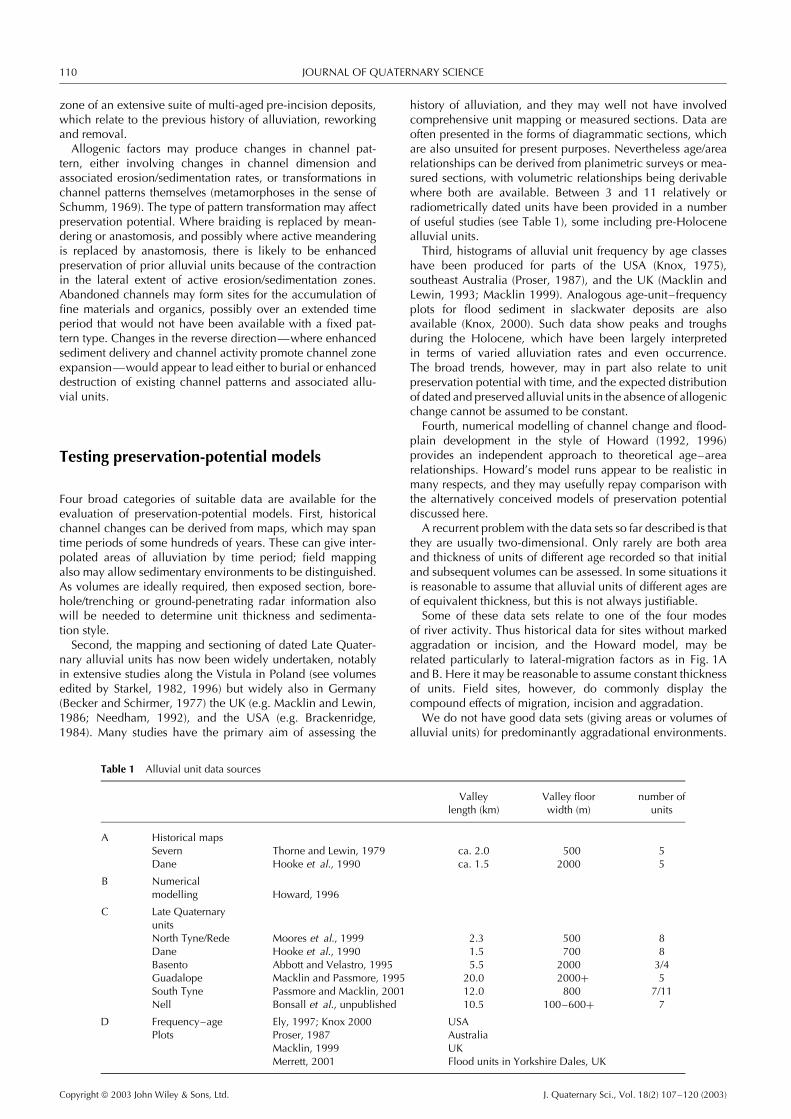
Four broad categories of suitable data are available for theevaluation of preservation-potential models. First, historicalchannel changes can be derived from maps, which may spantime periods of some hundreds of years. These can give inter-polated areas of alluviation by time period; field mappingalso may allow sedimentary environments to be distinguished.As volumes are ideally required, then exposed section, bore-hole/trenching or ground-penetrating radar information alsowill be needed to determine unit thickness and sedimenta-tion style.
Second, the mapping and sectioning of dated Late Quater-nary alluvial units has now been widely undertaken, notablyin extensive studies along the Vistula in Poland (see volumesedited by Starkel, 1982, 1996) but widely also in Germany(Becker and Schirmer, 1977) the UK (e.g. Macklin and Lewin,1986; Needham, 1992), and the USA (e.g. Brackenridge,1984). Many studies have the primary aim of assessing the
history of alluviation, and they may well not have involvedcomprehensive unit mapping or measured sections. Data areoften presented in the forms of diagrammatic sections, whichare also unsuited for present purposes. Nevertheless age/arearelationships can be derived from planimetric surveys or mea-sured sections, with volumetric relationships being derivablewhere both are available. Between 3 and 11 relatively orradiometrically dated units have been provided in a numberof useful studies (see Table 1), some including pre-Holocenealluvial units.
Third, histograms of alluvial unit frequency by age classeshave been produced for parts of the USA (Knox, 1975),southeast Australia (Proser, 1987), and the UK (Macklin andLewin, 1993; Macklin 1999). Analogous age-unit–frequencyplots for flood sediment in slackwater deposits are alsoavailable (Knox, 2000). Such data show peaks and troughsduring the Holocene, which have been largely interpretedin terms of varied alluviation rates and even occurrence.The broad trends, however, may in part also relate to unitpreservation potential with time, and the expected distributionof dated and preserved alluvial units in the absence of allogenicchange cannot be assumed to be constant.
Fourth, numerical modelling of channel change and flood-plain development in the style of Howard (1992, 1996)provides an independent approach to theoretical age–arearelationships. Howard’s model runs appear to be realistic inmany respects, and they may usefully repay comparison withthe alternatively conceived models of preservation potentialdiscussed here.
A recurrent problem with the data sets so far described is thatthey are usually two-dimensional. Only rarely are both areaand thickness of units of different age recorded so that initialand subsequent volumes can be assessed. In some situations itis reasonable to assume that alluvial units of different ages areof equivalent thickness, but this is not always justifiable.
Some of these data sets relate to one of the four modesof river activity. Thus historical data for sites without markedaggradation or incision, and the Howard model, may berelated particularly to lateral-migration factors as in Fig. 1Aand B. Here it may be reasonable to assume constant thicknessof units. Field sites, however, do commonly display thecompound effects of migration, incision and aggradation.
We do not have good data sets (giving areas or volumes ofalluvial units) for predominantly aggradational environments.
Table 1 Alluvial unit data sources
Valleylength (km)
Valley floorwidth (m)
number ofunits
A Historical mapsSevern Thorne and Lewin, 1979 ca. 2.0 500 5Dane Hooke et al., 1990 ca. 1.5 2000 5
B Numericalmodelling Howard, 1996
C Late QuaternaryunitsNorth Tyne/Rede Moores et al., 1999 2.3 500 8Dane Hooke et al., 1990 1.5 700 8Basento Abbott and Velastro, 1995 5.5 2000 3/4Guadalope Macklin and Passmore, 1995 20.0 2000+ 5South Tyne Passmore and Macklin, 2001 12.0 800 7/11Nell Bonsall et al., unpublished 10.5 100–600+ 7
D Frequency–age Ely, 1997; Knox 2000 USAPlots Proser, 1987 Australia
Macklin, 1999 UKMerrett, 2001 Flood units in Yorkshire Dales, UK
Copyright 2003 John Wiley & Sons, Ltd. J. Quaternary Sci., Vol. 18(2) 107–120 (2003)
PRESERVATION POTENTIAL OF ALLUVIUM 111
Although their stratigraphy has been studied in detail (for theUK see, e.g. Rose et al., 1980; Robinson, 1992; Brown et al.,1994; Rose, 1995), the Quaternary aggradational sequencesthat have been determined do not readily convert to the kindof data required for present purposes.
Different parts of catchments commonly show domination ofone process (say incision or aggradation) leading to differentialdown-valley preservation of units (see Lewin (1983) fordiscussion).
A model and field study of Germanoski and Harvey (1993)suggested that a decrease in upstream sediment deliverycould result in upstream incision and the developmentof inset terraces, this leading to aggradation downstream.This is a variant of Schumm’s model of complex responsewithin a catchment (see Schumm, 1977). Lower incisedsurfaces upstream can be stratigraphically equivalent tohigher depositional ones (in relation to channel elevation)downstream. Physically continuous terraces were also foundto be time-transgressive as the locus of deposition moveddownstream, and channel pattern change also moved spatiallyas well as temporally. There is clearly considerable scope forcatchment-wide modelling of preservation potential underdifferent combinations of process activities upstream anddownstream as well as testing preservation-potential modelswith observation data currently available as is undertaken here.
Cartographic data
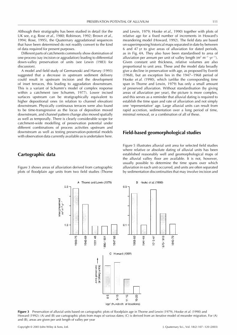
Figure 3 shows areas of alluviation derived from cartographicplots of floodplain age units from two field studies (Thorne
and Lewin, 1979; Hooke et al., 1990) together with plots ofrelative age for a fixed number of increments in Howard’smeandering model (Howard, 1992). The field data are basedon superimposing historical maps separated in date by between6 and 47 yr to give areas of alluviation for dated periods,as in Fig. 4A. They also have been standardised to area ofalluviation per annum per unit of valley length (m2 m−1 yr−1).Given constant unit thickness, relative volumes are alsoproportional to unit area. These and the model data broadlygive a decline in preservation with age, as proposed by Everitt(1968), but an exception lies in the 1947–1968 period ofHooke et al. (1990), which (unlike the corresponding timespan in Thorne and Lewin, 1979) has only a small amountof preserved alluviation. Without standardisation (by givingareas of alluviation per year), the picture is more complex,and this serves as a reminder that alluvial dating is required toestablish the time span and rate of alluviation and not simplyone ‘representative’ age. Large alluvial units can result fromrapid accretion, sedimentation over a long period of time,minimal removal, or a combination of all of these.
Field-based geomorphological studies
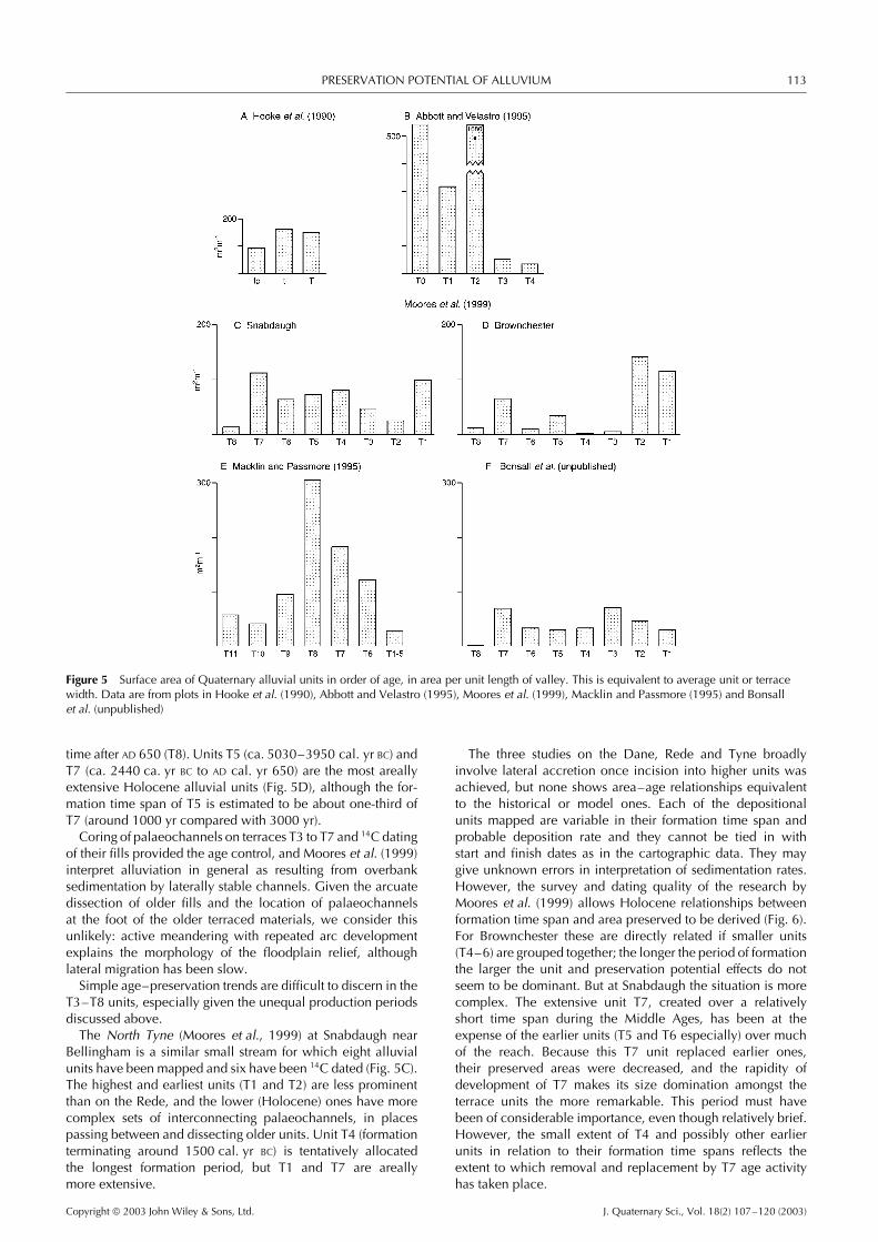
Figure 5 illustrates alluvial unit area for selected field studieswhere relative or absolute dating of alluvial units has beenestablished reasonably well and geomorphological maps ofthe alluvial valley floor are available. It is not, however,usually possible to determine the time spans over whichalluviation in each unit occurred, and units are often separatedby sedimentation discontinuities that may involve incision and
Figure 3 Preservation of alluvial units based on cartographic plots of floodplain age in Thorne and Lewin (1979), Hooke et al. (1990) andHoward (1992): (A) and (B) use cartographic plots from maps of various dates; (C) is derived from an iterative model of meander migration. For (A)and (B), areas are given per unit length of valley per year
Copyright 2003 John Wiley & Sons, Ltd. J. Quaternary Sci., Vol. 18(2) 107–120 (2003)
112 JOURNAL OF QUATERNARY SCIENCE
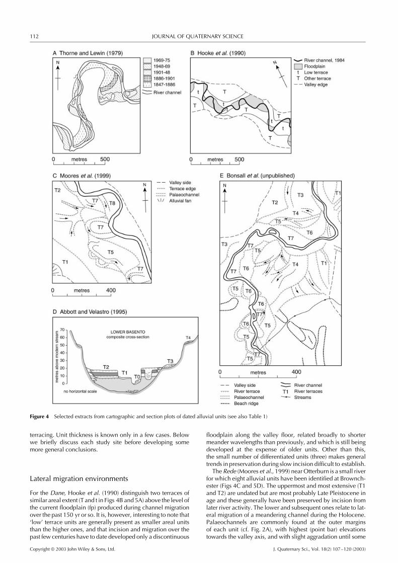
Figure 4 Selected extracts from cartographic and section plots of dated alluvial units (see also Table 1)
terracing. Unit thickness is known only in a few cases. Belowwe briefly discuss each study site before developing somemore general conclusions.
Lateral migration environments
For the Dane, Hooke et al. (1990) distinguish two terraces ofsimilar areal extent (T and t in Figs 4B and 5A) above the level ofthe current floodplain (fp) produced during channel migrationover the past 150 yr or so. It is, however, interesting to note that‘low’ terrace units are generally present as smaller areal unitsthan the higher ones, and that incision and migration over thepast few centuries have to date developed only a discontinuous
floodplain along the valley floor, related broadly to shortermeander wavelengths than previously, and which is still beingdeveloped at the expense of older units. Other than this,the small number of differentiated units (three) makes generaltrends in preservation during slow incision difficult to establish.
The Rede (Moores et al., 1999) near Otterburn is a small riverfor which eight alluvial units have been identified at Brownch-ester (Figs 4C and 5D). The uppermost and most extensive (T1and T2) are undated but are most probably Late Pleistocene inage and these generally have been preserved by incision fromlater river activity. The lower and subsequent ones relate to lat-eral migration of a meandering channel during the Holocene.Palaeochannels are commonly found at the outer marginsof each unit (cf. Fig. 2A), with highest (point bar) elevationstowards the valley axis, and with slight aggradation until some
Copyright 2003 John Wiley & Sons, Ltd. J. Quaternary Sci., Vol. 18(2) 107–120 (2003)
PRESERVATION POTENTIAL OF ALLUVIUM 113
Figure 5 Surface area of Quaternary alluvial units in order of age, in area per unit length of valley. This is equivalent to average unit or terracewidth. Data are from plots in Hooke et al. (1990), Abbott and Velastro (1995), Moores et al. (1999), Macklin and Passmore (1995) and Bonsallet al. (unpublished)
time after AD 650 (T8). Units T5 (ca. 5030–3950 cal. yr BC) andT7 (ca. 2440 ca. yr BC to AD cal. yr 650) are the most areallyextensive Holocene alluvial units (Fig. 5D), although the for-mation time span of T5 is estimated to be about one-third ofT7 (around 1000 yr compared with 3000 yr).
Coring of palaeochannels on terraces T3 to T7 and 14C datingof their fills provided the age control, and Moores et al. (1999)interpret alluviation in general as resulting from overbanksedimentation by laterally stable channels. Given the arcuatedissection of older fills and the location of palaeochannelsat the foot of the older terraced materials, we consider thisunlikely: active meandering with repeated arc developmentexplains the morphology of the floodplain relief, althoughlateral migration has been slow.
Simple age–preservation trends are difficult to discern in theT3–T8 units, especially given the unequal production periodsdiscussed above.
The North Tyne (Moores et al., 1999) at Snabdaugh nearBellingham is a similar small stream for which eight alluvialunits have been mapped and six have been 14C dated (Fig. 5C).The highest and earliest units (T1 and T2) are less prominentthan on the Rede, and the lower (Holocene) ones have morecomplex sets of interconnecting palaeochannels, in placespassing between and dissecting older units. Unit T4 (formationterminating around 1500 cal. yr BC) is tentatively allocatedthe longest formation period, but T1 and T7 are areallymore extensive.
The three studies on the Dane, Rede and Tyne broadlyinvolve lateral accretion once incision into higher units wasachieved, but none shows area–age relationships equivalentto the historical or model ones. Each of the depositionalunits mapped are variable in their formation time span andprobable deposition rate and they cannot be tied in withstart and finish dates as in the cartographic data. They maygive unknown errors in interpretation of sedimentation rates.However, the survey and dating quality of the research byMoores et al. (1999) allows Holocene relationships betweenformation time span and area preserved to be derived (Fig. 6).For Brownchester these are directly related if smaller units(T4–6) are grouped together; the longer the period of formationthe larger the unit and preservation potential effects do notseem to be dominant. But at Snabdaugh the situation is morecomplex. The extensive unit T7, created over a relativelyshort time span during the Middle Ages, has been at theexpense of the earlier units (T5 and T6 especially) over muchof the reach. Because this T7 unit replaced earlier ones,their preserved areas were decreased, and the rapidity ofdevelopment of T7 makes its size domination amongst theterrace units the more remarkable. This period must havebeen of considerable importance, even though relatively brief.However, the small extent of T4 and possibly other earlierunits in relation to their formation time spans reflects theextent to which removal and replacement by T7 age activityhas taken place.
Copyright 2003 John Wiley & Sons, Ltd. J. Quaternary Sci., Vol. 18(2) 107–120 (2003)

114 JOURNAL OF QUATERNARY SCIENCE
Figure 6 Area of unit preserved versus formation time span for two alluvial sections in the River North Tyne, UK. Data obtained from plots inMoores et al. (1999)
Incision/aggradation environments
Four examples of well-dated alluvial sequences illustrate theconsiderable variety in preservation potential that may arise,both when incision and aggradation (cut and fill) sequencesoccur, and when alluviation episodes are superimposed onlong-term valley floor incision.
The Lower Basento draining to the Ionian Sea in southernItaly has been studied in detail (Fig. 4D and 5B) by Abbott andVelastro (1995), who mapped four terraces (numbered T1–T4from youngest to oldest) as well as the active floodplain (theirT0). In both areal extent and especially underlying fill volumeand complexity, the alluvial units are very different. Thehighest terraces (T3 and T4) are isolated Pleistocene remnantspreserved on the valley sides; the more erosion-vulnerablemodern valley floor (T0) and late Holocene terrace (T1) areinset within a massive aggradational sequence which exhibitsphased accumulation (evidenced by soil development) anddissection. Terrace 2 (late Holocene) represents the highestsurface of this stacked and complex accumulation (over 18 mthick), which commenced with lacustrine/palustrine deposits.It is the extent (both vertically and laterally) of this unit thatensures the dominance of T2 in the age/area plot of Fig. 5B,whereas T0 appears to have developed at the expense ofT1. Abbott and Velastro (1995) compare this stacked anddifferentially preserved stratigraphy with that found in theCacchiavia Valley further to the southwest, where episodic cutand fill phases are more prominent, with three sets of fill eachinset within progressively older and larger excavated trenchesfound in the middle part of the valleys, and developed afteraround 5700 cal. yr BP.
The Guadalope (Macklin and Passmore, 1995; Fuller et al.,1996) draining to the River Ebro in northern Spain containsa sequence of some 11 alluvial terraces ranging from 4to 81 m above present river level (Fig. 5E). The older andhigher ones (T1–T5) are limited in extent. Stratigraphy anddating (using luminescence techniques) of the Late Pleistocenesequence T6–T10 has been well established in the incisionsequence. The areal extent of units shows that the units ofintermediate age (T7 and T8) are usually dominant, dating tothe Late Pleistocene (marine oxygen isotope stages 5e–3) atCastelseras. It is suggested that phases of aggradation relateto cold or cooling climatic phases. Although the preservationopportunity for this unusually complete record results fromincision, probably tectonically controlled, it is again difficultto see any clear age–preservation patterns.
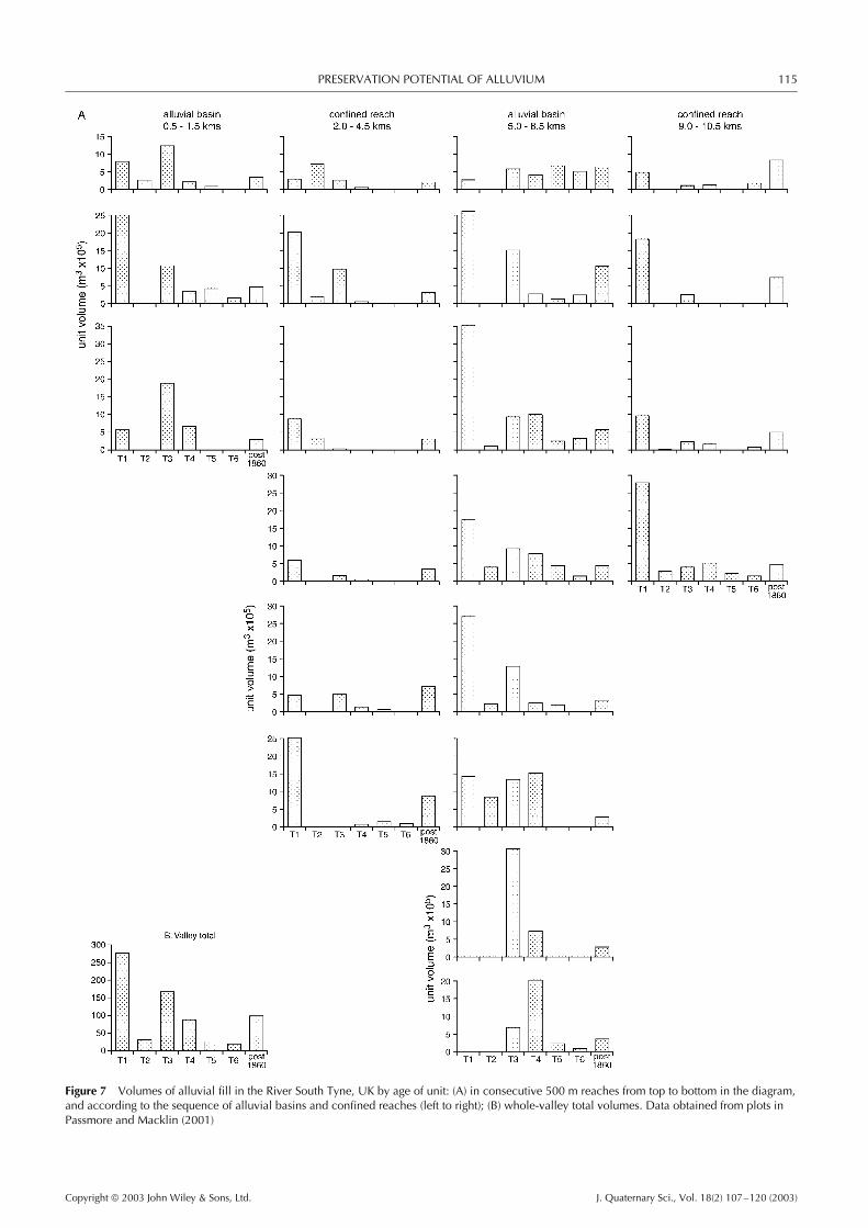
The South Tyne provides a third example in which,exceptionally, in the literature, the volumes of alluvial unitsin a 10.5 km reach have been surveyed and dated (Passmoreand Macklin, 2001). It was estimated that around half the LatePleistocene to Holocene alluvium once present still remains
on the valley floor. Variable rates of reworking and sedimenttransfer have prevailed, both spatially and temporally, as thevalley has become entrenched in older deposits. Figure 7 plotsthe volumes of fill in each unit for 0.5 km reaches sequentiallydown-valley. The present valley floor is divided into alluvialbasins separated by confined reaches (Macklin and Lewin,1989), and the Passmore and Macklin (2001) study involvestwo confined and two basin reaches.
The pre-Holocene unit (T1) and the post-AD 1860 valley floorare found in both basins and confined reaches. The extensiveT3 unit, dated to 1275 cal. yr BC to AD cal. yr 1160, is thedominant younger unit within the basins. Where it is welldeveloped, it appears to have cannibalised accessible olderalluvial units so that there is a reciprocal relationship betweenthe volume of younger and older (cannibalised) units.
The River Nell, in western Scotland (Figs 4E and 5F), showsoverall a relatively even distribution of terrace areas overtime (Bonsall et al., unpublished). However, these are againspatially complex in this area of post-glacial isostatic recovery.Thus terraces 1–4 are individually large units found onlyinland from the post-glacial shoreline (i.e. to the north andeast of the beach ridges in Fig. 4E); terraces 5–7 are foundboth there but also to the south beyond the former shorelinewhere they are incised into the newly exposed surface.
In summary, these four examples illustrate highly contrastedalluvial production and preservation patterns over time. Abbottand Velastro’s (1995) study involves three different contexts(valley-side straths, a thick aggradational sequence, and insetalluvial reworking), whereas the Guadalope and Nell involvetectonic and glacio-tectonic uplift enhancing terrace formationand preservation in general, but without clear evidence of thedominance of production or preservation factors from onetime period to the next. The South Tyne is characterised bymore general preservation of older remnants and selectivecannibalisation of middle-age units. Here there is clearevidence of unequal preservation within a gently incisingsystem, with strong alluviation at one period necessarilyleading to a lesser preservation of prior units (cf. the Snabdaughlateral accretion example above).
Alluvial unit frequency plots
Four frequency plots are illustrated in Fig. 8. Previous interpre-tations have focused on identifying distribution peaks and theirpossible coincidence with climatic or anthropogenic forcingfactors, or, in the case of flood deposits, the historical incidenceof flood episodes. The increasing quantity of dates available
Copyright 2003 John Wiley & Sons, Ltd. J. Quaternary Sci., Vol. 18(2) 107–120 (2003)
PRESERVATION POTENTIAL OF ALLUVIUM 115
Figure 7 Volumes of alluvial fill in the River South Tyne, UK by age of unit: (A) in consecutive 500 m reaches from top to bottom in the diagram,and according to the sequence of alluvial basins and confined reaches (left to right); (B) whole-valley total volumes. Data obtained from plots inPassmore and Macklin (2001)
Copyright 2003 John Wiley & Sons, Ltd. J. Quaternary Sci., Vol. 18(2) 107–120 (2003)

116 JOURNAL OF QUATERNARY SCIENCE
Figure 8 Frequency by age plots of dated alluvial materials. Data from (A) Proser (1987), (B) Macklin (1999), (C) Ely (1997) in Knox (2000), and(D) Merrett (2001). Also shown by the asterisks on (B) and (D) are the timing of climatic deteriorations inferred from mire wet shifts at Bolton FellMoss (Barber et al., 1994) and Walton Moss (Hughes et al., 2000), Cumbria, England
has allowed refinement of the record, including a greater num-ber of shorter-span age classes (Fig. 8B, Macklin, 1999). Therefined record suggests that there are high-frequency ‘spikes’superimposed on broader trends in the distribution. The broadtrends, at least in part, appear to reflect the censoring ofolder materials by later river activity, whereas the spikes areinterpreted as resulting from allogenic environmental factors,
primarily climatically controlled changes in flood frequencyand magnitude. An apparently greater frequency of later unitsis present in all data sets, which show a broadly skewed popu-lation. Some earlier units and spikes are present that are likelyto be less explicable in preservation terms. Thus in the UK allu-vial record there are notable spikes centred on ca. 5000, 4000,1800 and 1000 cal. yr BP. The environmental circumstances
Copyright 2003 John Wiley & Sons, Ltd. J. Quaternary Sci., Vol. 18(2) 107–120 (2003)
PRESERVATION POTENTIAL OF ALLUVIUM 117
favourable to their preservation include both aggradation inlowland environments and upland incision, which has placedthe units beyond the reach of later river activity.
Discussion
In general, our review suggests strongly that it is unsafe toassume that an absence of dated and preserved units in thealluvial record reflects a lack of sedimentation at the time.Censoring effects on older units by actively eroding riversappear to be significant in the plots presented, and it seemsnecessary to establish whether factors that affect preservationhave been significant on a case-by-case basis.
The skewed and censored distributions of preserved units donot necessarily reflect the frequencies/sizes of units originallyformed. The preserved record also varies according to thetype of river activity, which may selectively remove oldermaterial (as with lateral migration), or recent materials (whereincision has restricted deposition within confined valley floors).With aggradation a more complete record may be preserved,although one that nonetheless may be self-limiting, as inthe case of overbank sedimentation. Alluvial reprocessingalso may lead to the selective preservation of only parts ofalluvial sequences—cut-off channels at floodplain margins orthe lower parts of alluvial units under coupled conditions ofaggradation and lateral migration, for example.
We have pointed to cases in which censoring activityimparts particular character to the alluvial record, includingreciprocal relationships between unit sizes resulting from‘cannibalisation’ of accessible older units by younger ones,and skewed age distributions in unit- or flood-frequency plots.A future step could involve more formal modelling of alluvialproduction/preservation than is presented here. Thus lateralmigration coupled with slow incision appears particularlyfavourable to the preservation of a more complete alluvialrecord, as Brackenridge (1984) has shown. Alluvial systemsmodelling of relative rates and styles of fluvial activity withincatchments should help to pinpoint both the conditions for,and the location of, the most complete alluvial successions infield situations.
River alluvial unit production andpreservation in the UK
The broader significance of the cases so far discussed maybe brought into focus by considering how preservation factors(involving lateral channel migration, incision and aggradation)may have contributed to the variable record of Late Quaternaryalluviation in the UK.
In Fig. 9 we present an interpretation of alluvial unitproduction and preservation in both upland and lowland UKriver systems over the past 20 000 yr. The relative elevation ofpreserved units over this time period is shown, together withthe likely process activity (lettered as in Fig. 1) and preservationpotential. As the result of major differences between runoff,sediment supply and river behaviour in upland catchmentsin the northern and western UK (that were glaciated duringthe Late Devensian Dimlington Stadial) and lowland basinsin the southern and eastern parts of the country (outsideDimlington Stadial ice limits), there have been significantvariations, both regionally and over time, in the preservation
of alluvial units. From the decay of the Dimlington Stadialice-sheet at ca. 20 000 cal. yrs BP, rates of sediment supplyand seasonal runoff (from snow- and/or ice-melt) resultedin river aggradation, and the burial and preservation ofalluvial units. Gravelly sediments of this period are foundin both uplands and lowlands; beyond glacial effect limits,periglacial activity led to a high input of coarse clasticmaterial. Lower sediment delivery to valley floors duringthe succeeding Windermere Interstadial promoted incisionin upland catchments, particularly those experiencing glacio-isostatic uplift, thus preferentially preserving Late DevensianDimlington Stadial age alluvial units and providing verylittle opportunity for the long-term survival and storage ofinterstadial alluvium. In lowland river systems, however,greater channel stability during this period, but with alimited degree of lateral reworking, increased the preservationpotential of interstadial alluvial units in comparison to uplandbasins. Rose (1995) has suggested that rivers adopted asingle-thread channel during this phase. A return to nearfull-glacial conditions during the Loch Lomond Stadial (ca.12 900–11 500 cal. yr BP) resulted in widespread valleyfloor aggradation, and indeed alluvial units of this periodare common both in upland and lowland UK, althoughdating control in the uplands is frequently rather poor. Itshould be noted that refilling of valley floors during theLoch Lomond Stadial was more marked and began earlierin upland than lowland catchments as a consequence ofbetter hillslope–channel coupling. The beginning of the LochLomond Stadial in many lowland basins was characterised byincision as increased river flow preceded increased sedimentdelivery (Rose et al., 1980).
From the beginning of the Holocene at around 11 500 cal. yrBP the behaviour of upland and lowland rivers, and theassociated alluvial unit preservation potential, have divergedwithin the UK. Following incision at the Loch LomondStadial–Holocene transition, lowland river systems haveepisodically aggraded their valley floors, with overbankfloodplain sedimentation rates increasing, particularly overthe past 4000–2000 yr as a result of anthropogenic catchmentdisturbance. Infilling of earlier palaeochannels of braidedand anastomosing streams has been significant (Brown et al.,1994). Partial stripping of early Holocene units is also inevidence at many sites, so that later Holocene sediments restdirectly on truncated earlier units or on Pleistocene gravels.Since the Middle Ages channel stabilisation and then floodprotection (predominantly through river engineering) havelimited overbank deposition, and this explains, at least in part,the decline in number of alluvial units since ca. 800 cal. yrBP (Fig. 8B). In upland river basins before ca. 6000 cal. yrBP, because of relatively high rates of channel incision andlateral reworking within the incised valley floors, very fewHolocene alluvial units were preserved. After 6000 cal. yr BPepisodic valley floor aggradation, caused by higher rates ofsediment delivery from hillslopes and tributary streams andlarger floods (both principally controlled by climate), has beensuperimposed on long-term channel incision and this hasresulted in better preservation of alluvial units, although oneunit may be formed at the expense of an earlier adjacent one.
Conclusions
Episodic alluviation has been characteristic of the Quaternary,particularly in mid-latitudes where glaciations (includingepisodes of meltwater drainage and deglaciation) have led
Copyright 2003 John Wiley & Sons, Ltd. J. Quaternary Sci., Vol. 18(2) 107–120 (2003)

118 JOURNAL OF QUATERNARY SCIENCE
Figure 9 An interpretation of alluvial unit production and preservation for the UK, over the past 20 000 yr. Upland river systems based onHoward et al. (2000), Macklin (1999), Macklin and Lewin (1986, 1993), Macklin et al. (1992), Moores et al. (1999) and Passmore et al. (1993).Lowland river systems based on Brown et al. (1994), Macklin (1999), Macklin and Lewin (1993), Rose (1995) and Rose et al. (1980)
to pulsed delivery of sediment to alluvial systems, whichthemselves may have been overridden and transformed (seee.g. Baker, 1973; Gibbard, 1988; Blum and Straffin, 2001). InHolocene research, there also has been growing emphasis onepisodic alluviation associated with periods of human activityand climatic variation (Knox, 1977, 1983; Macklin, 1999). Thispaper emphasises that this history also has to be seen in thelight of autogenic removal of alluvial units, and that this has tobe taken into account when interpreting an intermittent alluvialrecord. Different forms of river activity have differential effects.
1 Lateral migration tends to eliminate older units, giving anexpected age distribution that is skewed towards youngerunits if it is not combined with a high rate of aggradation(Fig. 3).
2 Incision may preferentially preserve older units outsidethe incision slot, especially the older units, that are moredistant from the actively incising channel and which may be
protected by bedrock or have a slow removal rate becauseof their bulk or composition (Figs 4 and 7).
3 Confined valleys with actively migrating channels mayeliminate nearly all earlier valley-floor deposits once down-valley migration by bends exceeds bend wavelength. Anabsence of particular mid-Holocene units in incised valleysmay reflect such removal as well as possible non-productionin the first place (Fig. 7).
4 Aggradational environments are likely to preserve themost complete alluvial record, reflecting allogenic supplyfactors (Fig. 9). But even here, lateral migration duringaggradation may remove the upper parts of alluvialsequences so that it is only the truncated lower membersthat are preserved. Where overbank environments aretopographically complex, alluviation may be patchy andrelated to available depressions (cf. Brown et al., 1994).
5 Valley-floor flood units can have truncated time distributionsin the sense that large floods may destroy the prior record of
Copyright 2003 John Wiley & Sons, Ltd. J. Quaternary Sci., Vol. 18(2) 107–120 (2003)
PRESERVATION POTENTIAL OF ALLUVIUM 119
alluviation, thus biasing the record towards the more recentevents, and towards larger floods in the older record wheretheir deposits are beyond the reach of later river activity(Fig. 8C).
6 Channel metamorphosis may enhance or diminish preser-vation potential according to the nature of transformationinvolved, as different types of channel pattern have differ-ences in the size and activity of their active zones.
Taking these preservation potential factors into account,some general features of the UK Holocene alluvial record maybe more readily interpreted. These include:
1 In upland environments, the preferential preservation ofolder units has accompanied river incision, together withthe elimination of early–middle Holocene units by activelymigrating streams. The broad increase in late Holoceneunits revealed by age–frequency plots (Fig. 8) is also to beexpected in lateral migration environments.
2 Low-energy aggrading environments may potentially pre-serve a temporally more continuous record, constrained byallogenic supply factors, particularly where the record isone of the fine overbank sedimentation from non-migratoryrivers. Even here, upstream generation of alluvial materialsby erosion of prior alluvial materials and phases of strippinghas to be considered.
It would seem advisable, given the selective nature ofalluvial preservation, as shown in particular here for the UK,to consider dated alluvial units generally on a case-by-casebasis in order to assess the possible role of removal sinceformation, particularly assessing the absence of alluvial unitsin terms of potential removal as well as initial non-productionin circumstances where autogenic river activity may have beensignificant.
Acknowledgements The authors wish to thank Dr Stephen Tooth forreviewing an earlier draft of this paper, and Dr Glenn Maas for his helpin deriving area data for mapped units. We also thank Dave Bridglandand Jim Knox, who refereed this paper, for their helpful comments.
References
Abbott JT, Velastro S. 1995. The Holocene alluvial records ofthe chorai of Metapontum, Basilicata and Croton, Calabria,Italy. In Mediterranean Quaternary River Environments, Lewin J,Macklin MG, Woodward JC (eds). Balkema: Rotterdam; 195–205.
Allen JRL. 1978. Studies in fluviatile sedimentation: an exploratoryquantitative model for the architecture of avulsion-controlledalluvial suites. Sedimentary Geology 21: 129–147.
Baker VR. 1973. Palaeohydrology and sedimentology of Lake Missoulaflooding in eastern Washington. Geological Society of AmericaSpecial Paper 144: 1–79.
Barber KE, Chambers FM, Maddy D, Stoneman RE, Brew JS. 1994. Asensitive high-resolution record of Late-Holocene climatic changefrom a raised bog in northern England. The Holocene 4: 198–205.
Becker B, Schirmer W. 1977. Palaeoecological study of the Holocenevalley development of the River Main, southern Germany. Boreas6(4): 303–321.
Blum MD, Straffin EC. 2001. Fluvial responses to external forcing:examples from the French Massif Central, the Texas Coastal Plain(USA), the Sahara of Tunisia and the Lower Mississippi Valley. InRiver Basin Sediment Systems: Archives of Environmental Change,Maddy D, Macklin MG, Woodward JC (eds). Balkema: Rotterdam;195–228.
Brackenridge GR. 1984. Alluvial stratigraphy and radiocarbon datingalong the Duck River, Tennessee: implications regarding flood-plainorigin. Geological Society of America Bulletin 95: 9–25.
Bridge JS, Leeder MR. 1979. A simulation model of alluvialstratigraphy. Sedimentology 26: 617–644.
Brown AG, Keough MK, Rice RJ. 1994. Floodplain evolution in theEast Midlands, United Kingdom: The Lateglacial and Flandrianalluvial record from the Soar and Nene valleys. PhilosophicalTransactions of the Royal Society of London Series A 348: 261–293.
Ely LL. 1997. Response of extreme floods in the southwestern UnitedSates to climate variations in the Late Holocene. Geomorphology19: 175–201.
Everitt BL. 1968. Use of the Cottonwood in an investigation of therecent history of a flood plain. American Journal of Science 266:417–439.
Fuller IC, Macklin MG, Passmore DG, Brewer PA, Lewin J,Wintle AG. 1996. Geochronologies and environmental records ofQuaternary fluvial sequences in the Guadalope basin, northeasternSpain, based on luminescence dating. In Global ContinentalChanges: the Context of Palaeohydrology, Branson J, Brown AG,Gregory KJ (eds). Special Publication 115, Geological SocietyPublishing House: Bath; 99–120.
Germanoski D, Harvey MD. 1993. Asynchronous terrace develop-ment in degrading braided channels. Physical Geography 14:16–38.
Gibbard PL. 1988. The history of the great northwest European riversduring the past three million years. Philosophical Transactions ofthe Royal Society of London Series B 318: 559–602.
Graf WL. 1981. Channel instability in a braided, sand bed river. WaterResources Research 17: 1087–1094.
Gross LJ, Small MJ. 1998. River and floodplain process simulationfor subsurface characterization. Water Resources Research 34:2365–2376.
Heller PL, Paola C. 1996. Downstream changes in alluvialarchitecture: an exploration of controls on channel-stackingpatterns. Journal of Sedimentary Research 66: 297–306.
Hooke JM, Harvey AM, Miller SY, Redmond CE. 1990. Thechronology and stratigraphy of the alluvial terraces of the RiverDane Valley, Cheshire, N.W. England. Earth Surface Processes andLandforms 15: 717–737.
Howard AD. 1992. Modelling channel migration and floodplainsedimentation in meandering streams. In Lowland Floodplain Rivers,Carling PA, Petts GE (eds). Wiley: Chichester; 1–41.
Howard AD. 1996. Modelling channel evolution and floodplainmorphology. In Floodplain Processes, Anderson MG, Walling DE,Bates PD (eds). Wiley: Chichester; 15–62.
Howard AJ, Macklin MG, Black S, Hudson-Edwards KA. 2000.Holocene river development and environmental change in upperWharfedale, Yorkshire Dales, England. Journal of QuaternaryScience 15(3): 239–252.
Hughes PDM, Mauquoy D, Barber KE, Langdon PG. 2000. Mire-development pathways and palaeoclimatic records from a fullHolocene peat archive at Walton Moss, Cumbria, England. TheHolocene 10(4): 465–479.
Knox JC. 1975. Concept of the graded stream. In Theories of LandformDevelopment, Melhorn WN, Flemal RC (eds). Publications inGeomorphology, State University of New York: Binghamton;169–198.
Knox JC. 1977. Human impacts on Wisconsin stream channels. Annalsof the Association of American Geographers 67: 323–342.
Knox JC. 1983. Responses of river systems to Holocene climates.In Late Quaternary Environments of the United States, Vol. 2,The Holocene, Wright HE Jr (ed.). University of Minnesota Press:Minneapolis; 26–41.
Knox JC. 1993. Large increases in flood magnitude in response tomodest changes in climate. Nature 361: 430–432.
Knox JC. 2000. Sensitivity of modern and Holocene floods to climatechange. Quaternary Science Review 19: 439–547.
Lewin J. 1983. Changes of channel patterns and floodplains. InBackground to Palaeohydrology: a Perspective, Gregory KJ (ed.).Wiley: Chichester; 303–319.
Lewin J, Brindle BJ. 1977. Confined meanders. In River ChannelChanges, Gregory KJ (ed.). Wiley: Chichester; 221–233.
Copyright 2003 John Wiley & Sons, Ltd. J. Quaternary Sci., Vol. 18(2) 107–120 (2003)
120 JOURNAL OF QUATERNARY SCIENCE
Mackey SD, Bridge JS. 1995. Three-dimensional model of alluvialstratigraphy: theory and application. Journal of SedimentaryResearch B65: 7–31.
Macklin MG. 1999. Holocene river environments in prehistoricBritain: human interaction and impact. Journal of QuaternaryScience 14: 521–530.
Macklin MG, Lewin J. 1986. Terraced fills of Pleistocene andHolocene age in the Rheidol Valley, Wales. Journal of QuaternaryScience 1(1): 21–34.
Macklin MG, Lewin J. 1989. Sediment transfer and transformation ofan alluvial valley floor: the River South Tyne, Northumbria, UK.Earth Surface Processes and Landforms 14: 233–246.
Macklin MG, Lewin J. 1993. Holocene alluviation in Britain.Zeitschrift fur Geomorphologie Supplement Bond 88: 109–122.
Macklin MG, Lewin J. 1997. Channel, floodplain and drainagebasin response to environmental change. In Applied FluvialGeomorphology for River Engineering and Management,Thorne CR, Hey RD, Newson MD (eds). Wiley: Chichester; 15–45.
Macklin MG, Passmore DG. 1995. Pleistocene environmental changein the Guadalope basin, northeast Spain: fluvial and archaeologicalrecords. In Mediterranean Quaternary River Environments,Lewin J, Macklin MG, Woodward JC (eds). Balkema: Rotterdam;103–113.
Macklin MG, Rumsby BT, Heap T. 1992. Flood alluviationand entrenchment: Holocene valley floor development andtransformation in the British uplands. Geological Society of AmericaBulletin 104: 631–643.
Merrett SP. 2001. Historic flooding and valley floor development,Yorkshire Dales, northern England. Unpublished PhD thesis,University of Leeds.
Moores AJ, Passmore DG, Stevenson AC. 1999. High resolutionpalaeochannel records of Holocene valley floor environments inthe North Tyne Basin, Northern England. In Fluvial Processesand Environmental Change, Brown AG, Quine TA (eds). Wiley:Chichester; 283–310.
Needham S. 1992. Holocene alluviation, interstratified settlementevidence in the Thames Valley at Runnymede Bridge. In AlluvialArchaeology in Britain, Needham S, Macklin MG (eds). OxbowMonograph 27: Oxford; 197–208.
Passmore DG, Macklin MG. 2001. Holocene sediment budgets in anupland gravel bed river: the River South Tyne, northern England. InRiver Basin Sediment Systems: Archives of Environmental Change,Maddy D, Macklin MG, Woodward JC (eds). Balkema: Rotterdam;423–444.
Passmore DG, Macklin MG, Brewer PA, Lewin J, Rumsby BT,Newson MD. 1993. Variability of Late Holocene braiding in Britain.
In Braided Rivers, Best JL, Bristow CS (eds). Special Publication 75,Geological Society: London; 205–229.
Proser IP. 1987. The history of Holocene alluviation in the southeasternhighlands of Australia. Search 18: 201–202.
Robinson M. 1992. Environment, archaeology and alluvium on theriver gravels of the South Midlands. In Alluvial Archaeology inBritain, Needham S, Macklin MG (eds). Oxbow Monograph 27:Oxford; 197–208.
Rose J. 1995. Lateglacial and early Holocene river activity in lowlandBritain. Palaeoklimatoforschung 14: 51–74.
Rose J, Turner C, Coope GR, Bryan MD. 1980. Channel changes inlowland river catchment over the last 13,000 years. In Timescalesin Geomorphology, Cullingford RA, Davidson DA, Lewin J (eds).Wiley: Chichester; 159–175.
Rumsby BT, Macklin MG. 1996. River response to the Last Neoglacialcycle (the ‘Little Ice Age’) in northern, western and central Europe.In Global Continental Changes: the Context of Palaeohydrology,Branson J, Brown AG, Gregory KJ (eds). Special Publication 115,Geological Society Publishing House: Bath; 217–233.
Schumm SA. 1969. River metamorphoses. Journal HydraulicsDivision, American Society of Civil Engineers 95: 255–273.
Schumm SA. 1977. The Fluvial System. Wiley: New York.Starkel L (ed.). 1982. Evolution of the Vistula Valley during the Last
15 000 Years. Polish Academy of Sciences: Wrøclaw.Starkel L. 1983. The reflection of hydrological changes in the fluvial
environments of the temperate zone during the last 15 000 years.In Background to Palaeohydrology: a Perspective, Gregory KJ (ed.).Wiley: Chichester; 213–235.
Starkel L. 1987. Man as a cause of sedimentological changes in theHolocene. Striae 26: 5–12.
Starkel L. 1990. Fluvial environment as an expression of geoecologicalchanges. Zeitschrift fur geomorphologie, Supplement Bund 79:133–152.
Starkel L (ed.). 1996. Evolution of the Vistula Valley during the last15 000 Years, Vol. VI. Polish Academy of Sciences: Wrøclaw.
Thorne CR, Lewin J. 1979. Bank processes, bed material movementand planform development in a meandering river. In Adjustments ofthe Fluvial System, Rhodes DD, Williams GP (eds). Kendall-Hunt:Dubuque; IA; 117–137.
Warburton J, Davies TRH, Mandl MG. 1993. A meso-scale fieldinvestigation of channel change and floodplain characteristics in anupland braided gravel-bed river, New Zealand. In Braided Rivers,Best JL, Bristow CS (ed.). Special Publication 75, Geological Society:London; 241–55.
Wolman MG, Leopold LB. 1957. Flood plains. United StatesGeological professional Paper 282-C: 87–109.
Copyright 2003 John Wiley & Sons, Ltd. J. Quaternary Sci., Vol. 18(2) 107–120 (2003)