Embed Size (px)
Citation preview
Preservation, Conservation and Planning in Historic TownsAuthor(s): T. R. SlaterSource: The Geographical Journal, Vol. 150, No. 3 (Nov., 1984), pp. 322-334Published by: The Royal Geographical Society (with the Institute of British Geographers)Stable URL: http://www.jstor.org/stable/634327 .
Accessed: 24/02/2014 07:01
Your use of the JSTOR archive indicates your acceptance of the Terms & Conditions of Use, available at .http://www.jstor.org/page/info/about/policies/terms.jsp
.JSTOR is a not-for-profit service that helps scholars, researchers, and students discover, use, and build upon a wide range ofcontent in a trusted digital archive. We use information technology and tools to increase productivity and facilitate new formsof scholarship. For more information about JSTOR, please contact [email protected].
.
The Royal Geographical Society (with the Institute of British Geographers) is collaborating with JSTOR todigitize, preserve and extend access to The Geographical Journal.
http://www.jstor.org
This content downloaded from 66.77.17.54 on Mon, 24 Feb 2014 07:01:20 AMAll use subject to JSTOR Terms and Conditions

The Geographical Journal, Vol. 150, No. 3, November 1984, pp. 322-334
PRESERVATION, CONSERVATION AND PLANNING IN HISTORIC TOWNS
T. R. SLATER
The plans of two Warwickshire towns are analysed in order to assess the effectiveness of planning policies for conservation of their townscapes in the first half of the twentieth century. Stratford-upon-Avon and Warwick were both the subject of commissioned planning reports by Patrick Abercrombie in the 1920s and the 1940s, respectively. The two reports provide a measure ofthe changing attitudes to planning in historic towns.
THE AIM OF THIS PAPER is to examine the planning policies effected in the first
half of the twentieth century in two historic Warwickshire towns in the light of our
existing understanding of the art/science of townscape management and related
geographical concepts. It forms part of the introductory work to a project initiated with J. W. R. Whitehand to provide some theoretical background for townscape management.
The idea of 'managing' the townscape of historic urban centres as distinct from
'preserving' particular historic buildings which happen to be in towns is a comparatively recent phenomenon in English planning. Though techniques of conserving historic areas are now better understood, and the concept of 'conservation areas' is enshrined in
legislation, there are few theoretical constructs upon which basic techniques can be built. At present, consetvation areas within historic towns are still very much at the
mercy of local government planning departments and the often conflicting political pressure groups of town-centre developers and conservationists. The latter remain a
minority of largely well-educated, prosperous and 'middle-class' inhabitants of
particular towns, often with very local interests, and historic townscapes lacking such interest groups can be damaged with little thought or concern (Hobhouse, 1971; Burke, 1974). Such a situation would apply particularly to townscapes deriving from the Industrial Revolution and few planners, for example, have given any consideration to
maintaining, even under museum conditions, any of the housing stock of the early nineteenth century.
In those smaller towns generally characterized as 'historic', that is to say those in which a substantial proportion of the town-centre buildings originates from the
pre-industrial era, the problems of accommodating modern commercial functions, retail outlets and motor cars are well known. There is now an extensive literature, largely of particular case studies, demonstrating both the destructive effects of bad
planning on individual towns and the continuing search for satisfactory methods of
positive planning by which historical townscapes can be maintained as functioning entities without losing their essential historicity (Esher, 1968; Buchanan, 1968).
The analysis of historical townscapes It is perhaps not surprising to find that, in a country where the impact of the industrial
era was first felt and where that impact was often so great as totally to submerge earlier
townscape forms, the analysis and the understanding of the processes which created historic towns are rather neglected topics amongst geographers and, indeed, amongst other scholars. In contrast, in central and eastern Europe where the effects of industrialization were less rapidly assimilated into the built fabric of towns and where societies as a whole were less urbanized than in Britain, there is a much stronger tradition of studying urban form and of understanding the importance of historical
townscapes as 'objectivations of the spirit' of the society living and working in them
(Schwind, 1951). This is most clearly seen in the considerable financial investment and detailed historical research which has accompanied the reconstruction of historic towns in Poland where strategic and deliberate destruction during the Second World War had
-? Mr T. R. Slater is a lecturer in the Department of Geography, University of Birmingham, P.O. Box 363, Birmingham B15 2TT. This paper was accepted for publication in October 1983.
0016-7398/84/0003-0322/$00.20/0 ? 1984 The Royal Geographical Society
This content downloaded from 66.77.17.54 on Mon, 24 Feb 2014 07:01:20 AMAll use subject to JSTOR Terms and Conditions

THE CONSERVATION OF HISTORIC TOWNS 323
removed as much as 95 per cent of the built fabric of some historic towns. Castles, churches and hundreds of ordinary buildings of the pre-industrial period were
destroyed to break the spirit of a particular cultural group?in this instance a nation?and subsequently have been painstakingly reconstructed at great economic
cost, and against many of the underlying political tenets of the present government, to renew and maintain that spirit (Cieslak and Biernat, 1975). Such reconstruction and restitution has happened elsewhere on a lesser scale, including in Britain, where the Rows of Chester, for example, form a well-known Victorian imitation of a preceding medieval townscape. Post-1945 reconstructions of this kind, however, are a
comparative rarity. Those historic towns which suffered substantial destruction from war-time bombing, such as Coventry or Exeter, chose to rebuild in the modern idiom rather than to reconstruct the destroyed townscape (Sharp, 1946).
It was perhaps in Germany that interest in the analysis of historic towns as physical entities first emerged and it is in that country that these interests have been consistently maintained (Whitehand, 1982). It was an emigre German, M. R. G. Conzen, who
brought many of the techniques to Britain and whose writings and research provide one of the few sources upon which to base the search for a firm basis for townscape management. His techniques of town-plan analysis would seem to offer a way forward and many of his concepts, such as the fringe-belt, the burgage cycle and plan-units, have now been developed by others (Whitehand, 1967, 1982). His ideas on urban conservation have had comparatively less impact, partly through their appearance in
publications not widely available, and partly because there is no 'finished package' which might be taken away and applied (Conzen, 1966, 1975). However, there is no doubt that Conzen sees the key to effective urban management as a thorough understanding of how the plan and built fabric ofthe town have evolved. The only other theme of consequence in the British geographical literature is the artistic approach of Ewart Johns (1965) and Gordon Cullen (1961) which links much more firmly with the work of the architect-trained men who formed an important contingent of the planning profession until comparatively recently. Here the significance of individual buildings and the aesthetics of their design is of prime concern and it is in this tradition, too, that the few historians who have ventured into this field, Hoskins (1955), Beresford (1974), and Clifton-Taylor (1972), for example, best fit.
In the context of the following case studies the Conzenian tradition cannot be expected to have had any impact in the period before 1950 upon the practicalities of townscape management but it provides a yard-stick by which the policies of the early twentieth century can be assessed. In contrast, the artistic-architectural tradition of townscape evaluation can be expected to be of rather more significance because of the predominance of architects in the early development of the town-planning profession.
The case studies Two neighbouring historic towns in Midland England were selected for study.
Stratford-upon-Avon is a medieval new town with a wealth of sixteenth and seventeenth century timber-framed buildings and an international fame derived from its being the birthplace of William Shakespeare. Warwick was an Anglo-Saxon burh, the military and administrative centre of the shire and, following the Norman Conquest, the caput of one of the most consistently powerful baronial families in England whose well-preserved medieval castle is the focus of an attractive townscape. In the twentieth century the revival of road transport has brought familiar problems of traffic congestion. Both towns are administrative centres, Warwick at County, and Stratford at District Council level, while Stratford is the market and shopping centre for much of south-west Warwickshire. Both towns have been subject to extensive residential expansion beyond the historic core, many residents journeying to work in the West Midlands conurbation, while their tourist function embraces local day visitors from the Midlands, short stop-over parties on long-distance coach tours. longer-stay hotel visitors and, at Stratford, visitors to the Shakespeare Memorial Theatre performances.
The problems of preservation, restoration and conservation of historic buildings and townscape in the light of these conflicting functions have long been recognized, and, in
This content downloaded from 66.77.17.54 on Mon, 24 Feb 2014 07:01:20 AMAll use subject to JSTOR Terms and Conditions
324 THE CONSERVATION OF HISTORIC TOWNS
Stratford, dates from the last quarter of the nineteenth century when both concerned individuals and groups activated a variety of schemes. Local government interest had to wait until the early twentieth century town-planning legislation. Both towns recognized their responsibilities and the particular problems of functional conflict and so, without
large staffs of planners themselves, commissioned the eminent town planner, Patrick Abercrombie, to prepare advisory planning reports to try to reconcile the demands of economic well-being and the physical conservation of their townscapes. The Stratford
report was prepared in 1923 (Abercrombie, 1923) and the Warwick report in 1947-8
(Abercrombie and Nickson, 1949). Prepared by the same man, they provide an illustration of the changing attitudes towards historic townscapes in the first half of the
century.
Stratford town plan.?The historic town plan of Stratford-upon-Avon is based almost
entirely upon the decisions taken in about 1196 by the Bishop of Worcester and his estate officials to found a new market town (Hollings, 1934-9). The town was
developed on the dry gravel-terrace site between the existing village of Stratford, grouped around the parish church, and the important routeways that crossed the Avon
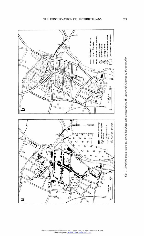
by means of a ford some half km to the north. The town was laid out on a grid plan of four streets by three streets, with a broad street provisions market-place leading up from the river crossing and a peripheral, triangular livestock market. Within the street blocks, properties were laid in plots of 18 x 60 m adding another element of regularity to the plan, but its rectangularity was softened because the town was developed over the ridge and furrow of open field land and plots were adjusted to fit the aratral curves of arable strips and furlong boundaries (Fig. lb) (Slater and Wilson, 1977). The town
prospered, though not to the extent that the full complement of tenements was ever
fully taken up for building purposes. This prosperity endowed the town with numerous
buildings which reflected the wealth ofthe community, including a parish church ofthe
highest quality, an early Tudor bridge, a guildhall, school and almshouses from the fifteenth century and fine timber-frame buildings from the late sixteenth and seventeenth centuries. Fires destroyed most medieval buildings in the town centre. A burst of prosperity in the period 1770-1830, based on local developments of road and canal transport, added estates of attractive small cottages to the north and south ofthe medieval town. The nineteenth century added banks and new shops in the town centre and railways, warehouses and prosperous villas on the fringe, but the impact of the Industrial Revolution largely passed the town by (Styles, 1945). In the twentieth
century its economy revived and housing developments have substantially increased the size of the town while its regional service function has led to considerable commercial pressures in the town centre for increased shopping space, pressures which have been accentuated by a rapid development of the tourist industry.
The significant features of the historic town plan remain the morphological frame
provided by the river Avon, the gravel terrace site and the gentle curves ofthe medieval
open field land; the planned nature of the town is readily apparent in the street grid, the
regular size of plots and of buildings erected upon them; the open spaces of Bridge Street and Rother Market emphasize the regional market function (Fig. lb); the traditional building materials of timber-framing, wattle and daub infill, locally-made bricks and local tiles for roofs provide distinctive colour for buildings, few of which exceed three storeys in height. Compared with Warwick the town plan is quite simple to 'read'.
Warwick town plan.?The site of Warwick, on a prominent sandstone knoll beside the Avon, has attracted settlement from the early prehistoric period. Archaeological excavation has shown extensive Neolithic occupation while the remains of a multi-vallate hill-fort are still prominent in the north-east quarter ofthe town. By the ninth century AD the site was probably a periodic market centre on the bounds of two
Anglo-Saxon kingdoms (Slater, 1982) and in the early tenth century it enters the historical record with the construction of an Aethelflaedan burh as part of the English defences against the Danes. By 1086, Domesday records over 250 households in the town centre, with suburbs, at least four churches, a mint and the castle which was to dominate the town for the next 800 years. In the medieval period a town wall, gates, a
This content downloaded from 66.77.17.54 on Mon, 24 Feb 2014 07:01:20 AMAll use subject to JSTOR Terms and Conditions
THE CONSERVATION OF HISTORIC TOWNS 325
This content downloaded from 66.77.17.54 on Mon, 24 Feb 2014 07:01:20 AMAll use subject to JSTOR Terms and Conditions

326 THE CONSERVATION OF HISTORIC TOWNS
friary and hospital were added, but though the town was a relatively prosperous market centre, it was overshadowed by the rapid growth of nearby Coventry and never attained the significance of other County towns. As at Stratford, the seventeenth century saw much rebuilding of timber-framed houses but within the medieval walls most of these were destroyed in a great fire in 1694. The rebuilding was in brick and tile in restrained Queen Anne and early Georgian styles. The eighteenth century was a period of
prosperity with the town a centre of 'County' society. The coming of the canal led to the establishment of early textile factories but the late arrival ofthe railway meant that, as at Stratford, the harsher effects of industrialization passed the town by (Stephens, 1969). The twentieth century has seen some housing development, but much of the commercial pressures of expanding retail provision have been absorbed by the
neighbouring town of Leamington Spa. In Warwick, it is the administrative offices associated with County government and courts which have been responsible for
development pressures in the historic town. The town plan is complex and reflects this long history. The street system is
dominated by an ancient route following the north bank of the Avon which gives the town a north-east?south-west axis. The line ofthe medieval walls is preserved between narrow intra- and extra-mural streets which ring the sandstone knoll and contain the town centre. Within this area the street pattern has a rectangularity which possibly reflects Aethelflaedan planning. A large peripherai market place in the north-west is
probably of Norman origin. Beyond the medieval wall line there are extensive suburbs
along the approach roads at the four cardinal compass points. The castle and its grounds dominate the river frontage, and eighteenth century Earls of Warwick were responsible for demolishing extensive areas of the town in order to provide a suitable landscape setting. They also closed and partially demolished the medieval bridge, providing a new river crossing further to the east (Fig. 2) (Slater, 1977).
The dominant building in the town is the parish church of St Mary which stands on the highest point of the knoll. Only in the approach from the south does the castle take over this role. The main axial street is dominated by brick and tile of the early eighteenth century, while in the northern quarter of the town, stone and stucco of the late eighteenth and early nineteenth century administrative buildings and courts are
prominent. Timber-framed houses with tile roofs are common in the suburbs especially in Mill Street and Bridge End to the south. This complex town plan of great historicity is far from easy to 'read' and contains a large number of quite small plan units which makes the conservation and management of its townscape a much more difficult
proposition.
The Abercrombie plans and their assessment Professor Sir Patrick Abercrombie was born in 1879 and had been articled to a
Manchester architect in 1897. Five years later he became a lecturer at the Liverpool School of Architecture. In 1909 he moved to the newly formed Department of Civic
Design in the university as Lever Research Fellow, became founder editor of the Town
Planning Review and began to travel widely in Europe (Dix, 1981). In 1915 he was
appointed to the chair in Civic Design which he was to occupy for 20 years. His
professional contacts, developed through the Town Planning Review, enabled an
extensive private planning practice to be built up, beginning with housing layouts but
quickly moving on to complete town-planning schemes following his award-winning
entry in the Dublin Town Planning Competition in 1914 (Nolan, 1917). A regional plan for the Doncaster area in 1920 opened up new horizons and, during the 1920s and
1930s, some 16 such regional plans were prepared. The Stratford report was produced, therefore, at a time when his eminence in the
profession was already well established and when his planning practice was extensive,
He was already familiar with the English Midlands and had visited many of the small
towns of the Cotswolds early in the century, appreciating to the full the architectural
qualities of the buildings and the beauty of the towns. By the 1920s, too, he was
convinced that town and country had to be planned in unison, a point strongly made in
both the studies which concern this paper.
This content downloaded from 66.77.17.54 on Mon, 24 Feb 2014 07:01:20 AMAll use subject to JSTOR Terms and Conditions

THE CONSERVATION OF HISTORIC TOWNS 327
This content downloaded from 66.77.17.54 on Mon, 24 Feb 2014 07:01:20 AMAll use subject to JSTOR Terms and Conditions
328 THE CONSERVATION OF HISTORIC TOWNS
During the Second World War, and already aged over 60, his output redoubled, beginning with the great County of London Plan published in 1943 and continuing with other plans for the Clyde Valley, the West Midlands and a variety of town plans. These latter included plans for rebuilding the bomb-devastated cities of Hull and Plymouth, and suggestions for the historic city of Edinburgh, for the fashionable seaside resort of Bournemouth, and for Warwick. Many of these plans were not especially influential in
determining the directions of future growth but elements of all of them can be seen in those towns today and they remained a source of inspiration as to what was possible. One reason for their neglect was the passing of the Town and Country Planning Act of 1947 which transferred planning work in Britain from the consultant firms to the new statutory local planning authorities, who were naturally concerned to make their own
reputation. Both these aspects can be appreciated in the fate of the Warwick report which, though prepared for the planning authority, provided them only with a basis for their own subsequent proposals.
Stratford-upon-A von Abercrombie's report on Stratford-upon-Avon was written in 1923 for the
Stratford-upon-Avon Preservation Committee for presentation to the town
Corporation. It had been initiated, as had the Preservation Committee itself, by proposals to build an aluminium factory in the town on land owned by the Corporation (Abercrombie, 1923). The realization that the revival of road transport in the first decades of the twentieth century had restored the town's economic advantages because of its location on an important node of the regional road network, meant that some
townspeople saw this factory as the shape of things to come and the Preservation Committee was formed to combat this prospect. Though written for the Preservation Committee, the report was not submitted for their approval; it was meant to represent an independent assessment of the recognized conflicts in planning for the future of the town.
Abercrombie structured his investigation of the town plan in terms of buildings. The
plot pattern and the arrangement of streets are not considered in any detail but some attention is paid to the situation of the town in terms of the surrounding countryside since this was perceived as 'Shakespeare's unmistakable country . . . absolutely English in its loveliness' (Abercrombie, 1923, p. 2). The analysis ofthe built structure inevitably concentrates upon facades, but careful distinction is made between the genuine half-timbered styles of the sixteenth and seventeenth centuries and subsequent restorations, reconstructions, replacements, and buildings in a variety of mock or neo-tudor styles (Fig. 1). The eighteenth century facades, plaster work and buildings are sympathetically described and the many small brick cottages of the eighteenth and
early nineteenth centuries are appreciated. Only the 'intrusive' styles ofthe nineteenth
century are vilified especially a 'portentous banking premises . . . Ruskinian- Venetian-Gothic carried out in busy terracotta' (p. 3) where 'the best intentions, uninformed by taste, may result in monstrous damage to the town'.
The recommendations made are entirely in keeping with this buildings-centred approach in which the architectural styles of the sixteenth to eighteenth centuries are viewed favourably and those of the nineteenth century unfavourably. In restorations the work of the seventeenth and eighteenth centuries were to be held in balance; reconstructive restoration needed to guard 'against a sense of artificial and promoted antiquity' and it was deemed unnecessary to require all new work to be in half-timbered
styles. Generally, it was hoped that there would be 'as little conspicuous building activity as possible, beyond genuine restorations and the replacement of quite indifferent buildings by well considered and legitimate reconstructions', together with 'the removal of the most serious of the injuries inflicted by the 19th century' (p. 8). The
countryside surrounding the town was viewed far more single-mindedly and the
proposed conservation was 'not a question of any great complexity. The general rule is . . . that any change must be a change for the worse' (p. 10). Factories were to be
prohibited, residential development controlled and special care taken of field paths. The general tenor of the report is strongly preservationist.
This content downloaded from 66.77.17.54 on Mon, 24 Feb 2014 07:01:20 AMAll use subject to JSTOR Terms and Conditions
THE CONSERVATION OF HISTORIC TOWNS 329
Aspects of the town's economy which Abercrombie considered deserving of
encouragement included its increasing importance for cultural activities, its high quality workshop and craft industries and making good the deficit of good hotel accommodation in the town, whereas suburban residential development, factory-based industry and the summer-season day visitor from the local regions are suggested as
problems where control needed to be exercised. The means of any such control were determined by the then-existing planning
legislation, namely the Town Planning Acts of 1909 and 1919 together with Corporation bye-laws and the controls exercised by particular institutional land-owners, notably the
Corporation itself, the Shakespeare Birthplace Trust and the Shakespeare Memorial Association. The efficacy of ownership control is extolled by Abercrombie and the 'greatest possible extension of the civic ownership of land' is urged. In detail, the town-planning powers required for the town centre were perceived in terms of the control over 'the appearance of buildings?their height, colour, material and style' (p. 21) and, to carry out this task, it was recommended that a specialist committee to advise the Corporation should 'contain persons of eminent authority in architecture, in
painting or sculpture, and in literature' (p. 24) together with the Mayor, a Corporation nominee and a Birthplace Trust representative.
Abercrombie provided a detailed zoning plan himself and discussed each area in some detail. The analysis of the historic centre, which he calls 'the Central Business district' (p. 26), contains the rather contradictory advice, considering what has gone before, that provision could be made for growth by rebuilding where appropriate, and converting houses into shops. Even more contradictory to the preservation ethos 'some of the large blocks could be cut through by new streets, if this were done without damaging any historic building: e.g., between Wood Street and Ely Street' (p. 26), the justification being that 'it is a mistake to spread out Business areas'. Detailed suggestions are made for particular problems of the moment including the parking of vehicles and excursion coaches, the location ofthe cattle market, insanitary buildings in the tenement courts and the preservation of riverside amenity.
Assessment.? In the 1920s the principal cause of conflict between the healthy economic development of the town and the preservation of its unique historical heritage was perceived in terms of a change in function from agricultural market town to industrial factory town. However, there was another conflict which Abercrombie succinctly summarized and which remains as real today as it was then: the conflict between the community's right to determine priorities in terms of its own local, economic and social interests as against the duty of conserving material remains held 'in trust for English-speaking culture' (p. vii). He noted that, in theory 'Stratford-upon-Avon is not likely to be insensible . .. ofthe value of its unique prestige . . . and the problem is to allow the development to take place without injuring the characteristics which promote it'. The guiding ethic ofthe report is pronounced to be to 'avoid inconsiderate development and inconsiderate conservation' (p. viii). In this it follows a policy which has remained the guiding ethic of British legislation right through to the present day?that historical places are living entities that should be ccwserved rather than preserved as museum pieces from the past.
In Stratford, in the 1920s, conservation was a matter of a detailed concern with buildings as individual entities. There is relatively little concern with the relationship between buildings, except in general aspects of height and building materials, or even with building interiors and rear elevations. Interest was manifestly in the facade. There is even less interest in the street spaces and plot pattern as an attribute to the historicity of Stratford's townscape and this is nowhere more apparent than in the suggestion that street blocks might be divided by new streets providing no historic buildings were demolished. There is some concern for townscape in the assessment of particular street scenes, notably Bridge Street and Waterside, and in the general warning against allowing tree-planting in the town centre, but most ofthe environmental concern is with rural scenes?the riverside landscape between Clopton Bridge and the medieval church, the paths between Stratford and Shottery and the nature of the villages and countryside around Stratford.
This content downloaded from 66.77.17.54 on Mon, 24 Feb 2014 07:01:20 AMAll use subject to JSTOR Terms and Conditions

330 THE CONSERVATION OF HISTORIC TOWNS
The fine judgement as to what was, and what was not, acceptable in architectural
styles and in the restoration of older buildings is particular to the time. The denigration of nineteenth century styles was common well into the 1960s, but today, the Venetian Gothic bank so decried by Abercrombie is a valued part of the street scene and has recently been cleaned. Indeed, the late Victorian banks provide a particularly fine series of buildings, all prominently placed at street corners. Similarly, the controversy and long discussion over the restoration/reconstruction of particular half-timbered
buildings was to be largely forgotten in the post-1950 period. But it was very much a live issue in the 1920s following the restoration which had been undertaken by such groups as the Birthplace Trust. Many of these restorations involved the complete replacement of existing facades by timbered fronts, often reconstructed on the flimsiest of evidence. Abercrombie's appreciation of the eighteenth century plasterwork on many buildings already heralded a new attitude which has continued to the present. Other debates remain controversial today. For example, his discussion of the merits or otherwise of
removing the Barclay's Bank building at the head of Bridge Street to expose the side of a timber-framed house finds remarkable parallel in the 1960s in the controversial
replacement of the Victorian market hall by Sir Frederick Gibberd's modern group of
shops with timber styling. This corner block was set back from the road to expose the side of a seventeenth century timber-framed building and allowed a more amenable intersection for motor traffic.
Another important point is the absence of any discussion of traffic problems. Indeed, greater consideration is given to the needs of pedestrians than of vehicles, which find a
place only in the context ofthe parking of excursion coaches. In many other respects the
report is perceptive of trends that were to be confirmed subsequently. The growing importance of the town as a shopping centre, and the need to concentrate the provision of shops by using the back land of tenements, presages the recent construction of a
shopping centre and multi-storey car park behind the street-frontage buildings of one street block; the shortage of good hotel accommodation was only resolved with the
building of the Stratford Hilton, again in the early 1970s; while the probability that industrial development would not prove to be a problem has been confirmed.
However, it has not proved possible to protect all ofthe surrounding countryside as the
pressure to provide high quality housing has increased, particularly since 1950.
Today the historic town centre is a conservation area, well over 300 of its historic
buildings are statutorily protected and there have been relatively few losses by demolition (Fig. lb). Vigorous amenity societies stand guard over the town's heritage and both its general economy and its tourist industry are flourishing. However, there can be no complacency that its heritage is 'safe'. New public buildings and the entrances to the multi-storey car park in Rother Market have caused serious disruption to the street facades, while extensions to the Shakespeare Centre beside the Birthplace have
replaced listed buildings and increased the modernity ofthe townscape around that key building, which had already long been isolated from its townscape by the
nineteenth-century restoration. There is little appreciation in planning documents of the rhythm of the street scene consequent on the planned medieval tenement pattern, nor of the gentle curves of the town plan deriving from the open field which preceded it. Rather there is a continuing concern with individual building facades and with traffic
problems (Norris, 1967, 1968).
Warwick. The report on Warwick was prepared between 1947 and 1949, in association with Richard Nickson, for the Warwick Borough Council. The 1947 Town and Country Planning Act had transferred planning powers in the town to the County Council (whose offices were in Warwick) but detailed implementation remained the
responsibility of the Borough Council. The report was prepared at the same time as one for the adjacent town of Leamington Spa and was published in book form with the some? what contradictory title of Warwick: its preservation and redevelopment (Abercrombie and Nickson, 1949). The report is considerably longer than that for Stratford has a substantive factual base of statistical information, much of it collected in surveys by the authors, and there is a wealth of illustration. It begins with an historical survey but this is not related to the plan development of the town. A second section analyses
This content downloaded from 66.77.17.54 on Mon, 24 Feb 2014 07:01:20 AMAll use subject to JSTOR Terms and Conditions

THE CONSERVATION OF HISTORIC TOWNS 331
'present conditions' with brief surveys of the region, functions, population, occupational structure, communications, land use and buildings. Much play is made of the considerable traffic problems engendered by journeys to work, weekend tourist traffic and through traffic on the major east-west and north-south routes through the town. All this traffic had to negotiate a town centre of narrow streets, steep gradients and
heavy pedestrian use. The most detailed treatment is given to the historic buildings of the town, in a third section, and there is a noticeable attempt to put them in their townscape setting. The dominance of St Mary's church tower is appreciated; the Georgian vernacular harmony of North Street is noted; 'the picturesque timbered buildings of the Leicester Hospital form an impressive climax to the jagged skyline of West Street1 (p. 55); the Castle Park is seen to be an important, if enclosed, aspect of the town; the dramatic view ofthe Castle from the bridge is discussed and the variety of building styles in harmonious groupings is seen to be characteristic of the town. The townscape approach to understanding the historic town is further emphasized by a photographic survey in the middle of the report.
The proposals put forward by Abercrombie to guide future planning in the borough can be divided into three parts: first, there were the general aspects of growth?an increase of population from 14000 to 17000; new housing to accommodate this population to be concentrated to the north of the town preserving the Castle Park and Lammas Field and preventing coalescence with Leamington; and industrial development to be directed towards existing concentrations of premises near the canal and railway. Secondly, there were the traffic proposals. These included a north-western by-pass, which had already been scheduled in planning proposals of the 1930s, and an inner-ring road which included a new Avon crossing. The by-pass was designed as a 'parkway1 with dual carriageways, cycle tracks and footpaths, and extensive landscaping. Thirdly, there were detailed proposals for the historic town. The whole plan was presented in a series of detailed, coloured plans with three stages for implementation over a 25-year period.
The proposals for the historic town centre are worth examining in some detail as they illustrate some of the problems of the townscape approach to management and the misunderstanding engendered by an inadequate knowledge of the historical development of the town plan. Abercrombie's view of medieval Warwick is explicitly stated; it was 'a compact town . . . enclosed within an encircling wall up to the foot of which swept the open Warwickshire countryside; it was entered only by three gateways and guarded by its castle. That is how it was' (p. 93). Clearly the extensive linear suburbs on all four approach roads were seen to be of no consequence. Their form is not respected in his proposals which were designed to emphasize the town centre by freeing the slopes of the knoll, on which the town is built, from development (Fig. 2(b)). The other proposals included the partial redevelopment and enlargement of the Market Place, the improvement of the environs of the East and West Gates, the extension of council offices on the north side ofthe town and the development of part of Priory Park with shops, housing and a hotel in order to relieve redevelopment pressure in the historic centre. The aim here was to reduce the density of building coverage, to remove the larger shops to the new precinct and to add car-parking space and improve access (Fig. 2b).
Plans for townscape improvements around the East and West Gates were given detailed treatment. In both instances the gates were set in pedestrian precincts to one side of a newly-inserted and intrusive road pattern. If this had been implemented, it would have done severe damage to the overall historic town plan in return for preserving two especially historic structures. Similarly damaging were the plans for the enlargement of the market place, though they have a greater historical precedent. They involved the removal of a block of inoffensive eighteenth-nineteenth century properties from ground which had been built on from at least the fourteenth century onwards (Stephens, 1969). However, undoubtedly the most destructive proposals were those for the inner-ring road which would have destroyed the northern extramural suburb of Saltisford. Finally, it is important to note Abercrombie's continued emphasis on the importance of 'three dimensionaF planning and 'the just relationship of building masses to natural contours or artificial Iayout' (p. 88).
This content downloaded from 66.77.17.54 on Mon, 24 Feb 2014 07:01:20 AMAll use subject to JSTOR Terms and Conditions
332 THE CONSERVATION OF HISTORIC TOWNS
Assessment.? The most clearly apparent change in attitude to the planning of historic towns between the 1920s and the 1940s was the overwhelming pre-eminence given to new road provisions to cope with, and cater for, the motor car. The street plan is seen to be anachronistic but, because of the historicity of the townscape, needs to be largely preserved. In some places townscape improvements suggest the closure of short stretches of road but new roads must be inserted into the plan to replace them and only the smallest areas are suggested for pedestrianization. Pedestrianization of historic streets is a development of the 1970s, not of the 1940s. All the proposed new roads are to strict dimensions suitable for motor traffic and are thereby totally at odds with the scale ofthe historic townscape. The (to modern conservationist eyes) horrific inner ring road proposal with its dual carriageways and large roundabouts is the worst of these schemes and has not been implemented. In contrast, the by-pass proposals for a
parkway road were beautifully executed but used an enormous quantity of land?a characteristic of 1930s road planning. When built, in the 1960s, the Warwick by-pass was more strictly utilitarian in nature.
The appreciation of particular historic buildings is much less prominent in the Warwick plan, partly as a result of the much wider scope of the planning report, but
partly also because of the changing emphasis towards townscape. Excepting the two
gates and the late eighteenth century Northgate Street, few buildings are singled out for individual attention. The vernacular harmony of High Street, Jury Street and Church Street seems to be less obviously appreciated, while individual timber-framed
buildings, though of as high a quality as in Stratford, do not have the attractions of
being associated with particular individuals. The street scenes in Mill Street and
Bridgend are especially neglected in this respect. Clearly Abercrombie's understanding of compatible land uses in historic centres has
undergone some reorientation. Whereas in the Stratford report the coincidence of historic buildings and shopping centres is positively encouraged, in Warwick the commercial focus is to be removed to the new Priory Park shopping centre and the historic town is to be used primarily for residences and administrative offices. The
majority of these precepts were to be rejected in the subsequent planning of the town. The commercial heart today remains the Market Place, and Priory Park centre was never built. The small precincts and new roads around the town gates have not been
constructed, and it is only in the redevelopment of much of the Market Place, Market Street and Brook Street that Abercrombie's influence can be seen in the modern plan. Unfortunately, his advice about the massing of buildings has also been ignored, with disastrous results on the northern approach to the town where the horizontal slab of new County Council offices has done irreparable harm. Small-scale buildings and the vertical emphasis of St Mary's tower are overwhelmed and the scale of the sandstone knoll is diminished by the new block.
Conclusion The Abercrombie plans for these two Midlands historic towns illustrate a number of
changing attitudes in the planning profession over the course of the first half of the twentieth century. In particular their concern moved on from the detailed architectural control of outstanding historic buildings?though this remains important and is enshrined in the legislation protecting listed buildings introduced in the 1940s?to the consideration of the whole ensemble of the townscape. This interest in townscape remained predominantly architectural in emphasis but, besides building facades, included the grouping of buildings along street frontages, street furniture, the three-dimensional effects of massing and long- and medium-distance prospects. A second change is in the necessary consideration of traffic problems. The intra-urban street network of the majority of historic towns was not designed for heavy motorized
transport and the initial reaction of planners was a twin-pronged attack: removing through traffic on to heavily engineered by-passes and ring roads and improving access in centres by widening some roads, removing constrictions in the network and
improving parking provision. Again, attitudes have continued to evolve in the period since 1950 with a modern emphasis on excluding motor vehicles through pedestrianization.
This content downloaded from 66.77.17.54 on Mon, 24 Feb 2014 07:01:20 AMAll use subject to JSTOR Terms and Conditions

THE CONSERVATION OF HISTORIC TOWNS 333
In none of these changes in the practicalities of planning or the appreciation of the
historicity of particular towns has there been any emphasis upon the development of the town plan. In both case-studies considered in this paper the planner, though aware of, and sensitive to, the historicity of the town with which he was dealing, produced recommendations directly at odds with the historical development of the town plan and its natural divisions. It is especially interesting that in the plan for Warwick, Abercrombie's proposals for the by-pass are carefully related to, and use, the fine grain of the countryside?existing hedgerows, woods, paths and lanes, yet his proposals for the historic town ignore the fine grain of streets, lanes, plots and buildings, particularly where road plans are concerned (Fig. 2).
Patrick Abercrombie was a town-planner of the first rank. His writing, teaching and
planning practice had an immense influence upon a whole generation of the planning profession and his changing perception of the ways in which historic towns could be planned are therefore of wider import than the two examples considered here. The actions of the planning profession as 'urban managers' are one element in the most recent development of historical townscapes in Britain. As such they are deserving of further, more detailed, investigation particularly with regard to their relationship with other societal groups influencing the townscape, from conservation groups to commercial developers. However, this study also points the need for further investigation of the intricate form and functional plan complexes that go to make up the historical expressiveness of different parts of towns. Thereby management techniques can be developed which are more sensitive to that historicity. Conzen (1975), has already outlined some of the constituents of a more sensitive townscape conservation policy and has established the relevance of geographical work to their development, but thus far his challenge has not been taken up. As a result, planners, in their role of conserving historic towns, remain uninfluenced by geographical plan analysis and their guiding ethic continues to be the townscape approach, with its resultant facadism, first developed in the inter-war period, and the protection, through architectural controls, of designated historic buildings, which has even earlier roots.
A ckno wledgements An earlier version of this paper was presented to the CUKANZUS '81 conference of historical geographers held in Toronto. I am grateful for comments made by participants at that conference and also to J. W. R. Whitehand.
References Abercrombie, P. and L. 1923 Stratford-upon-Avon: report on future development. Hodder &
Stoughton. Abercrombie, P. and Nickson, R. 1949 Warwick, its preservation and redevelopment.
Architectural Press. Beresford, M. W. 1974 The making of a townscape: Richard Paley in the east end of Leeds,
1771-1803. In Chalkin, C. W. and Havinden, M.A. (Eds), Rural change and urban growth. Longmans.
Buchanan, C. 1968 Bath, a study in conservation. H.M.S.O. Burke, G. 1974 Do residents care much about Reading? Built Environment March issue. Cieslak, E. and Biernat, C. 1975 Dzieje Gdanska. Gdansk: Seria Monografii Pomorskich. Clifton-Taylor, A. 1972 The pattern of English building. Faber & Faber. Conzen, M. R. G. 1966 Historical townscapes in Britain: a problem in applied geography, pp.
56-78 of House, J. W. (ed.) Northern geographical essays in honour of G. H. J. Daysh. University of Newcastle upon Tyne.
Conzen, M. R. G. 1975 Geography and townscape conservation, pp. 95-102 of Anglo-German symposium in applied geography, Giessener Geographische Schriften.
Cullen, G. 1961 Townscape. Architectural Press. Dix, G. 1981 Patrick Abercrombie, pp. 108-136 of Cherry, G. E. (ed.) Pioneers in British
planning. Architectural Press. Esher, Lord 1968 York, a study in conservation. H.M.S.O. Hobhouse, H. 1971 Lost London. Macmillan. Hollings, M. 1934-9 Red book of Worcester. Worcester Hist. Soc. 3. Hoskins, W. G. 1955 The making of the English landscape. Hodder & Stoughton.
This content downloaded from 66.77.17.54 on Mon, 24 Feb 2014 07:01:20 AMAll use subject to JSTOR Terms and Conditions

334 THE CONSERVATION OF HISTORIC TOWNS
Johns, E. 1965 British townscapes, Arnold. Nolan, J. 1917 Greater Dublin: competitive designs for the town plan of Dublin, Ireland.
Landscape Architecture 7, 2. Norris, R. M. W, 1967 Stratford-upon-Avon conservation area report. Stratford-upon-Avon. Norris, R. M. W. 1968 Stratford-upon-Avon draft town centre map and report.
Stratford-upon-Avon. Schwind, M. 1951 Kulturlandschaft als objektivierter Geist. Deutsche Geographische Blatter 46,
5-28. Sharp, T. 1946 Exeter phoenix: a plan for rebuilding. Architectural Press. Slater, T. R. and Wilson, C. 1977 Archaeology and development in Stratford-upon-Avon.
University of Birmingham. Slater, T. R. 1982 Urban genesis and medieval town plans in Warwickshire and Worcestershire.
Ch. 10 of Slater, T. R. and Jarvis, P. J. (eds.) Field and forest: an historical geography of Warwickshire and Worcestershire. Geobooks.
Stephens, W. B. 1969 Victoria County History of Warwickshire 8. Oxford U.P. Styles, P. (ed.) 1945 Victoria County History of Warwickshire 3. Athlone Press. Whitehand, J. W. R. 1967 Fringe belts: a neglected aspect of urban geography. Trans. Inst. Br.
Geogr. 41, 223-34. Whitehand, J. W. R. (ed.) 1982 The urban landscape: historical development and management.
Inst. Br. Geogr. Special Publn. 12, 1-24.
This content downloaded from 66.77.17.54 on Mon, 24 Feb 2014 07:01:20 AMAll use subject to JSTOR Terms and Conditions