Embed Size (px)
Citation preview


Presentation Overview
1. Study Background
2. Study Area 3. Study Process 4. Background
Study Overview 5. Potential
Additional Land Area
6. Next Steps

Study Background
• The Premier Gateway Phase 1B Secondary Plan Study is designed to: – develop appropriate land use policies and
designations for the Phase 1B Employment Area
– identify the location of up to 75 ha of land to be designated for employment and added to the Premier Gateway Employment Area as land east of Premium Outlets is unavailable for development until the GTA West Corridor EA process is completed.

Study Area
• Study Area

Approach/Methodology

Background Study
• Background Study lays groundwork for detailed planning and analysis: – Introduces the Study; – Outlines relevant policy framework; – Summarizes existing conditions and current
influences; – Discusses implications for Study Area; and, – Identifies potential locations for up to 75 ha of
additional employment lands.

Policy Framework
• Secondary Plan – will build on current Provincial, Regional and
Town policy framework – required as a basis for development
• Natural Heritage System may be refined but must be protected
• Impacts on agriculture must be mitigated where settlement expansion proposed

Policy Framework
• Employment Area – Southern half of Study Area is designated
“Urban Area/Employment Area” with Regional Phasing to 2021 in ROPA 43 and “Phase 1B Employment Area” in OPA No. 10 (pending Regional approval)
– Certain areas in north half identified as Future Strategic Employment Areas in HROP
– OPA 10 provides for evaluation of alternative locations to accommodate up to additional 75 ha to 2021
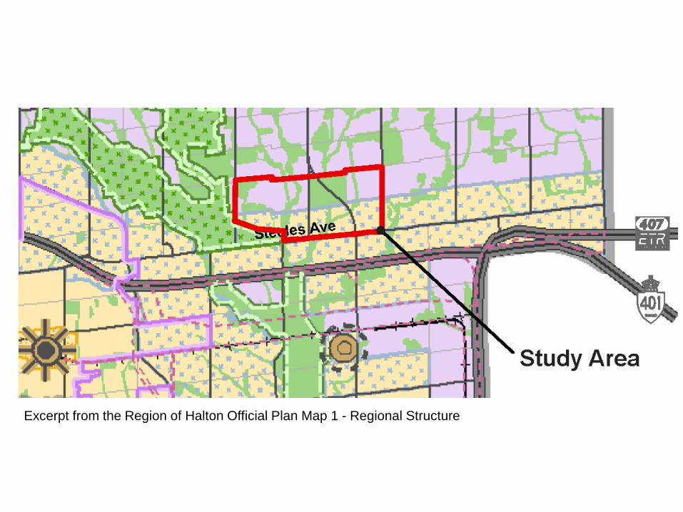
Excerpt from the Region of Halton Official Plan Map 1 - Regional Structure

Excerpt from the Region of Halton Official Plan Map 1C – Future Strategic Employment Areas

Excerpt from the Town of Halton Hills Official Plan Map A1 – Land Use Plan


Policy Framework
• Existing Rural Residential Concentration – Hornby – Area unlikely to redevelop for employment
uses in the short term; – May be zoned to permit existing residential
and related uses; – Buffers to be provided between Hornby and
future employment lands; and, – Hornby to be considered in developing road
network.

Policy Framework
• Prime Agricultural Area – HROP identifies the majority of the lands
outside the Urban Area as Prime Agricultural Lands

Excerpt from the Region of Halton Official Plan Map 1E – Agricultural System and Settlement Areas

Policy Framework
• Identified Mineral Resource Area – HROP identifies a small area in the northeast
section of the Study Area – Such areas are generally required to be
protected for future extraction – However, alternative development may be
permitted if certain criteria are satisfied – In this case, the resource is a shale resource
and there are extensive reserves of shale in Halton a factor in any determination of the need for protection

Excerpt from the Region of Halton Official Plan Map 1F – Identified Mineral Resource Areas

Technical Studies
• Detailed technical studies are being undertaken as part of the Secondary Plan.
• Scoped Subwatershed Study is well underway – requires data collection for one more season and then data synthesis.
• Available information allows establishment of key current influences.
• These continue to be reviewed, revised and/or expanded as more detailed information becomes available.
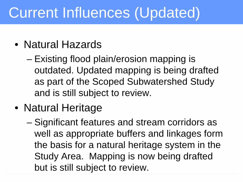
Current Influences (Updated)
• Natural Hazards – Existing flood plain/erosion mapping is
outdated. Updated mapping is being drafted as part of the Scoped Subwatershed Study and is still subject to review.
• Natural Heritage – Significant features and stream corridors as
well as appropriate buffers and linkages form the basis for a natural heritage system in the Study Area. Mapping is now being drafted but is still subject to review.


Current Influences
• Topography The Study Area has rolling topography
with relatively high gradient and some well-defined valley features.


Current Influences
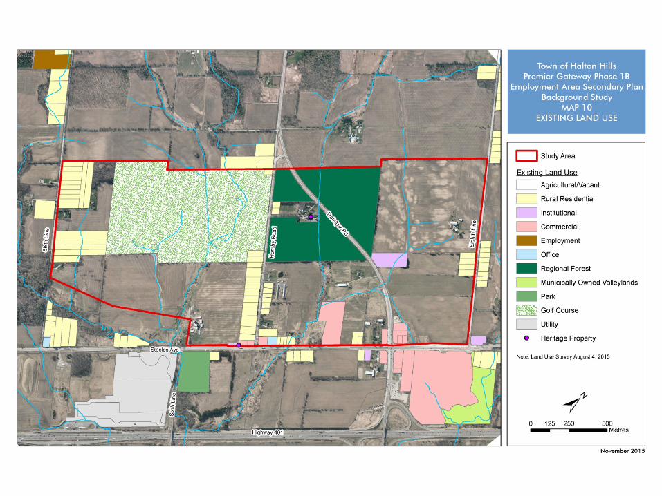
• Existing Land Use – The majority of the larger parcels are used for
agriculture. – The existing land uses are well established and
some are unlikely to redevelop in the short term (e.g. Coulson Forest Tract, rural residential development).
• Cultural Heritage Features – No designated properties but 2 sites listed on the
Heritage Register – 8285 Hornby Road and 12927 Steeles Avenue.
Current Influences
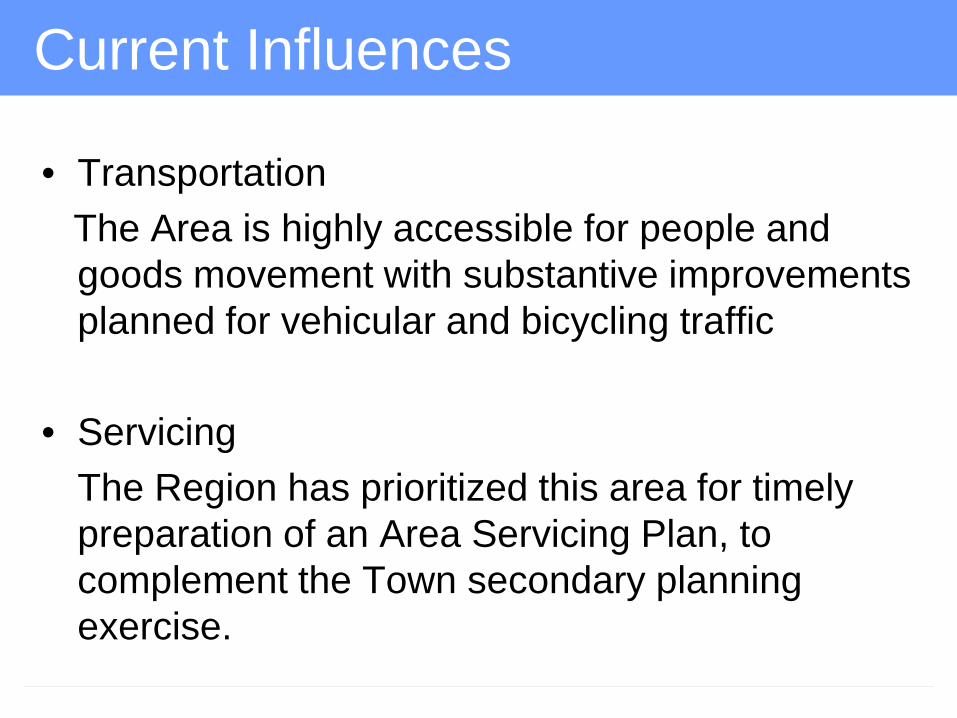
• Transportation The Area is highly accessible for people and
goods movement with substantive improvements planned for vehicular and bicycling traffic
• Servicing The Region has prioritized this area for timely
preparation of an Area Servicing Plan, to complement the Town secondary planning exercise.


Potential Additional Land Area
• Only “Future Strategic Employment Areas” have potential for employment uses: – Contiguous to Phase 1B – Outside GTA West corridor protection
• Potential development lands must be outside natural heritage system and hazard land.

Potential Additional Land
• Regional NHS and updated Floodplain provide the boundary for the non-developable area with a few exceptions but will be subject to refinement through ongoing SWS work
• Parcel 1 – West side of 8th Line/Northeast quadrant
Study Area – Field Crops and former Dairy operation – Developable area +/- 36 hectares

Potential Additional Land Area • Parcel 2
– West side of Hornby Road just north of Hornby Rural Residential Concentration;
– Occupied by Hornby Glen Golf Course and adjacent lands to the west (including RNHS);
– Developable area +/- 49 hectares. • Former James Snow property east of Hornby
Rd has potential for complementary uses.


Next Steps
• Consideration by Council of preferred development location
• Initiation of review of related official plan amendments
• Initiation of detailed Secondary Plan studies
Additional Land March /April 2016
ROPA/LOPA May/June 2016
Final Secondary Plan Area
Secondary Plan/ Subwatershed Study
OPA/Zoning 2017

Questions


![[PPT]PowerPoint Presentation - Electric Reliability Council · Web viewPresentation Overview Introduction to Electranix Background on Study Study Objectives Modeling Background Key](https://img.dokumen.tips/doc/110x75/5abec76a7f8b9ac0598d968d/pptpowerpoint-presentation-electric-reliability-council-viewpresentation.jpg)