Embed Size (px)
Citation preview

DRAFT
City of San Diego Midway Community Plan Area
Historic Resources Reconnaissance Survey: Historic Context & Survey Report
Prepared for
City of San Diego
Development Services Department, Planning Division 1222 First Avenue
San Diego, CA 92101
Prepared by
Galvin Preservation Associates Inc. 231 California Street
El Segundo, CA 90245
March 2012

DRAFT
i
Table of Contents
Executive Summary 1
Project Overview 2 Introduction 2 Public Participation 2 Survey Area 2
Methods 4
Criteria for Evaluating Properties 7 National Register of Historic Places 7 California Register of Historical Resources 8 San Diego Register of Historic Resources 10 California Historical Resource Status Codes 11
Historic Context Statement 12 Introduction 12 Spanish Period (1769-1822) 13 Mexican Period (1822-1846) 14 American Period (1846 - 1970) 15
Theme: Transportation Improvements and Early Industrial Development (1882 – 1914) 18 Theme: Military, Aerospace, and Related Industrial Development (1901 - 1953) 21 Theme: Post War Commercial and Residential Development (1945-1970) 26
Survey Results 32 Previously Identified Resources 32 Potential Individual Resources 34
Recommendations 41
Bibliography 42 Appendix A: Architectural Style Guide Appendix B: Data Table of All Surveyed Properties

DRAFT
1
Executive Summary
This report presents the results of a historic resources survey of the Midway/Pacific Highway Corridor Community Plan Area. In September 2009, the City of San Diego retained Galvin Preservation Associates Inc. (GPA) to complete this survey as part of its community plan update process. GPA conducted a reconnaissance-level survey of the community plan area, focusing on properties constructed prior to 1970. Surveyors identified properties that appeared eligible for individual designation, as well as geographically definable areas that appeared eligible for designation as historic districts. All identified properties were evaluated using the City of San Diego’s local designation criteria and documented in a Microsoft Access database provided by the City. All properties were assigned a corresponding California Historical Resource Status Code. In total, 228 properties were surveyed resulting in the identification of 45 potential individual resources.
In conjunction with the survey, GPA prepared a historic context statement for the Midway/Pacific Highway Corridor Community Plan Area. The historic context statement describes the broad patterns of development in the area, organized by period and then theme. It also identifies associated property types and registration requirements to aid in the City’s ongoing efforts to identify historic resources in the community plan area.
The survey was conducted by GPA on behalf of and under the guidance of the City of San Diego Development Services Department. The project was managed by Kelley Stanco, Senior Planner, and Cathy Winterrowd, Principal Planner, with the City of San Diego. The GPA project team consisted of professionals that meet the Secretary of Interior’s Professional Qualifications for Historic Preservation, including Teresa Grimes, Principal Architectural Historian; and Nicole Collum, Jennifer Krintz, and Elysha Dory, Architectural Historian IIs.

DRAFT
2
Project Overview
Introduction
In March 2008, the San Diego City Council unanimously approved a comprehensive update to the City’s General Plan. The plan sets out a long-range vision and policy framework for how the City should plan for projected growth and development, provide public services, and maintain the qualities that define San Diego over the next 20 to 30 years. It represents a shift in focus from how to develop vacant land to how to design infill development and reinvest in existing communities.
The General Plan also calls for the update of the City’s various community plans. As a policy document, community plans provide goals and objectives for the development of communities and designate where specific land uses should go and are further implemented by citywide and localized zoning programs. One of the goals of the update process will be to revise the Midway/Pacific Highway Corridor Community Plan to reflect current conditions and the long-term vision for the community, as well as align a number of existing plan elements with community plan update guidelines and elements of the recently approved General Plan. As a first step to updating the Midway/Pacific Highway Corridor Community Plan, the City commissioned the preparation of a reconnaissance survey of the area to identify potential historic resources constructed prior to 1970.
Public Participation
Throughout the community plan update process, the City engaged the public by conducting workshops and meetings. A Community Plan Update Advisory Committee (CPUAC) was formed. The function of the CPUAC is to facilitate community involvement and represent the interests of the residents and other stakeholder groups. On February 16, 2011, the Draft Historic Context Statement for the Midway/Pacific Highway Corridor Community Plan Area was presented at a CPUAC meeting. GPA and the City staff also provided an introduction to the known historic resources in the area and described how the survey fit into the larger community plan update process. During the meeting, the public was invited to comment on the significant themes related to the development of the community and on the location of significant historic resources.
Survey Area
The Midway/Pacific Highway Corridor Community Plan area encompasses approximately 800 acres of relatively flat land, which is situated north of Downtown between Old Town and the north end of the Peninsula Community Plan area. The community is comprised of two basic elements: the Midway area and the narrow, linear-shaped Pacific Highway Corridor. The Midway area consists of an urbanized commercial core containing numerous retail centers, motels and institutional facilities that cater to the needs of nearby residential and visitor populations.
DRAFT
3
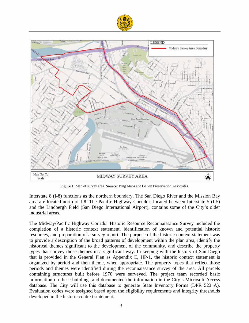
Figure 1: Map of survey area. Source: Bing Maps and Galvin Preservation Associates.
Interstate 8 (I-8) functions as the northern boundary. The San Diego River and the Mission Bay area are located north of I-8. The Pacific Highway Corridor, located between Interstate 5 (I-5) and the Lindbergh Field (San Diego International Airport), contains some of the City’s older industrial areas.
The Midway/Pacific Highway Corridor Historic Resource Reconnaissance Survey included the completion of a historic context statement, identification of known and potential historic resources, and preparation of a survey report. The purpose of the historic context statement was to provide a description of the broad patterns of development within the plan area, identify the historical themes significant to the development of the community, and describe the property types that convey those themes in a significant way. In keeping with the history of San Diego that is provided in the General Plan as Appendix E, HP-1, the historic context statement is organized by period and then theme, when appropriate. The property types that reflect those periods and themes were identified during the reconnaissance survey of the area. All parcels containing structures built before 1970 were surveyed. The project team recorded basic information on these buildings and documented the information in the City’s Microsoft Access database. The City will use this database to generate State Inventory Forms (DPR 523 A). Evaluation codes were assigned based upon the eligibility requirements and integrity thresholds developed in the historic context statement.

DRAFT
4
Methods
Introduction
The historic context statement and reconnaissance survey were developed in accordance with the Secretary of Interior’s Standards and Guidelines for Historic Preservation and National Register Bulletin #24, Guidelines for Local Survey: A Basis for Preservation Planning.
A historic context statement is a technical document that consists of specific sections recommended by the Secretary of the Interior in National Register Bulletin #24: Guidelines for Local Surveys. The bulletin defines a historic context as a body of information about historic properties organized by theme, place, and time. Historic context is linked with tangible historic resources through the concept of property type. A property type is a group of individual properties based on shared physical or associative characteristics. A historic context statement provides a framework for determining the relative significance of properties and evaluating their eligibility for landmark designation.
There are two types of historic resource surveys: reconnaissance and intensive. A reconnaissance survey includes a “once over” inspection of a community or neighborhood. Reconnaissance surveys are used to form the basis for more intensive, detailed survey efforts. During a reconnaissance survey, descriptive information about buildings, structures, and objects are collected and analyzed primarily through architecture and dates of construction.1 Property specific research is not conducted and evaluations are considered preliminary.
Project Approach
The approach employed to complete this project included the following:
1. Meeting with the City Staff. The project team met with the City staff to identify the specific needs of the survey and to gather information on previous studies and known historic resources. The project manager clarified the goals for the City and reviewed the project scope and schedule.
2. Existing Information. The project team collected and reviewed existing information on the area including: • Local landmark application forms. • Midway/Pacific Highway Corridor Community Plan. • Historical Resources Inventory for Middletown Area. • San Diego History, San Diego General Plan.
1 Historic Resource Survey Guidelines, City of San Diego, City Planning and Community Investment Division, July 2008, p. 1.
DRAFT
5
3. Contextual Research. The project team identified information gaps and conducted additional contextual research. Archival research was conducted at the San Diego Historical Society (historic photographs, historical documents and newspaper articles), San Diego Public Library (Historical San Diego Tribune newspaper database, San Diego city directories and newspaper clippings) and the Los Angeles Public Central Library (ProQuest Historical Los Angeles Times database and Sanborn maps). This information was used as a foundation for developing the historic contexts for the plan area.
4. Outline and Bibliography. The existing information and contextual research was used to develop the outlines and bibliographies for the historic context statement. The historic maps were used to identify the development patterns and determine the approximate build dates for the individual buildings. The general reference material was used to identify the significant themes and property types. The outline and bibliography were submitted to the City staff for comments and were revised accordingly.
5. Historic Context Statement. A historic context statement was developed for the plan area. The historic context establishes the significant themes and property types that reflect those themes. Eligibility requirements and integrity thresholds were developed based upon the reconnaissance survey using local designation criteria. In keeping with the history of San Diego that is provided in the General Plan as Appendix E, HP-1, the historic context statement is organized by period: Spanish, Mexican, and American. But as the resources associated with the first two periods are either gone, addressed by a separate historic context statement for archeological resources, or already designated, themes were only developed for the American period. The context statement was submitted to the City staff for comments and was revised accordingly.
6. Reconnaissance Survey. The project team conducted a reconnaissance level survey
of all properties constructed prior to 1970 in the plan area. The project team digitally photographed each property that appeared to have been constructed prior to 1970 and took field notes on the materials, condition, alterations, and integrity of each property.
7. Database. The City provided GPA with a Microsoft Access database that included a
record for all parcels included in the Community Plan Area. The assessor parcel number was included for each record. In most cases, the record also included a street address and year built. When the address and/or year built were missing, the project team attempted to obtain the information from Parcel Quest. In some cases, the information was not available. Thus, circa dates were developed and based upon the physical attributes of the subject buildings. The project team also completed the fields in the database involving the descriptive and physical features of each property constructed prior to 1970 and attached photographs to the records. The City will use

DRAFT
6
the information entered in the database to generate State Inventory Forms (DPR 523 A).
8. Final Report. All survey results were analyzed and synthesized into this final report,
including the historic context statement and reconnaissance survey data.

DRAFT
7
Criteria for Evaluating Properties
GPA worked with the City to identify buildings within the plan area that have the potential to meet federal, state, or local landmark criteria. The project team evaluated the buildings within their identified historic contexts to determine if they might be potentially eligible historic resources. Primarily, this project focused on City criteria to determine potential eligibility; however, surveyors also considered the National Register and California Register criteria in their evaluations. The following is a discussion of each set of the evaluation criteria.
National Register of Historic Places
The National Register is "an authoritative guide to be used by federal, state, and local governments, private groups and citizens to identify the nation's cultural resources and to indicate what properties should be considered for protection from destruction or impairment."2
Criteria
To be eligible for listing in the National Register, a property must be at least 50 years of age and possess significance in American history and culture, architecture, or archaeology. A property of potential significance must meet one or more of four established criteria:3
A. Associated with events that have made a significant contribution to the broad patterns of our history; or
B. Associated with the lives of persons significant in our past; or
C. Embody the distinctive characteristics of a type, period, or method of construction or that represent the work of a master, or that possess high artistic values, or that represent a significant and distinguishable entity whose components may lack individual distinction; or
D. Yield, or may be likely to yield, information important in prehistory or history. Physical Integrity Integrity is the ability of a property to convey its significance. To be listed in the National Register, a property must not only be shown to be significant under the criteria, but it also must have integrity. The evaluation of integrity is grounded in an understanding of a property's physical features and how they relate to its significance. The California Office of Historic Preservation and the City of San Diego utilizes the same aspects of integrity as the National Register.
2 Title 36 Code of Federal Regulations Part 60.2. 3 Title 36 Code of Federal Regulations Part 60.4.

DRAFT
8
Historic properties either retain integrity (this is, convey their significance) or they do not. Within the concept of integrity, the National Register criteria recognize seven aspects or qualities that, in various combinations, define integrity. These seven aspects include location, setting, design, materials, workmanship, feeling and association. To retain historic integrity a property will always possess several, and usually most, of the aspects. The retention of specific aspects of integrity is paramount for a property to convey its significance. Determining which of these aspects are most important to a particular property requires knowing why, where, and when the property is significant. The seven aspects of integrity are defined as follows:
• Location is the place where the historic property was constructed or the place where the historic event occurred.
• Design is the combination of elements that create the form, plan, space, structure, and style of a property.
• Setting is the physical environment of a historic property.
• Materials are the physical elements that were combined or deposited during a particular period of time and in a particular pattern or configuration to form a historic property.
• Workmanship is the physical evidence of the crafts of a particular culture or people during any given period in history or prehistory.
• Feeling is a property's expression of the aesthetic or historic sense of a particular period of time.
• Association is the direct link between an important historic event or person and a historic property.
Criteria Consideration G
Certain kinds of properties, like those less than 50 years of age, are not usually considered eligible for listing in the National Register. Fifty years is the general estimate of the time needed to develop historical perspective and to evaluate significance. These properties can be eligible for listing, however, if they meet special requirements called Criteria Considerations, in addition to meeting the regular requirements. National Register Bulletin #15 states that a property less than 50 years of age may be eligible for the National Register if it is of exceptional importance.4 Demonstrating exceptional importance requires the development of a historic context statement for the resource being evaluated, a comparative analysis with similar resources, and scholarly sources on the property type and historic context.
California Register of Historical Resources
In 1992, Governor Wilson signed Assembly Bill 2881 into law establishing the California Register. The California Register is an authoritative guide used by state and local agencies,
4 National Register Bulletin #15, p. 2.

DRAFT
9
private groups and citizens to identify historic resources and to indicate what properties are to be protected, to the extent prudent and feasible, from substantial adverse impacts.
The California Register consists of properties that are listed automatically as well as those that must be nominated through an application and public hearing process.5 The California Register automatically includes the following:
• California properties listed in the National Register and those formally Determined Eligible for the National Register;
• California Registered Historical Landmarks from No. 0770 onward; and
• Those California Points of Historical Interest that have been evaluated by the Office of Historic Preservation (OHP) and have been recommended to the State Historical Resources Commission for inclusion on the California Register.
The criteria for eligibility of listing in the California Register are based upon National Register criteria, but are identified as 1-4 instead of A-D. To be eligible for listing in the California Register, a property must be at least 50 years of age and possess significance at the local, state, or national level, under one or more of the following four criteria:
1. It is associated with events that have made a significant contribution to the broad patterns of local or regional history, or the cultural heritage of California or the United States; or
2. It is associated with the lives of persons important to local, California, or national history; or
3. It embodies the distinctive characteristics of a type, period, or method of construction or represents the work of a master, or possesses high artistic values; or
4. It has yielded, or has the potential to yield, information important in the prehistory or history of the local area, California, or the nation.
Historic resources eligible for listing in the California Register may include buildings, sites, structures, objects, and historic districts. Resources less than 50 years of age may be eligible if it can be demonstrated that sufficient time has passed to understand its historical importance. While the enabling legislation for the California Register is less rigorous with regard to the issue of integrity, there is the expectation that properties reflect their appearance during their period of significance.6
5 Public Resources Code Section 5024.1. 6 Public Resources Code Section 4852.

DRAFT
10
San Diego Register of Historic Resources
The Historical Resources Guidelines of the City of San Diego’s Land Development Manual identifies the criteria under which a resource may be historically designated. It states that any improvement, building, structure, sign, interior element and fixture, site, place, district, area, or object may be designated a historic resource by the City of San Diego Historical Resources Board if it meets one of the following designation criteria:
A. Exemplifies or reflects special elements of the City’s, a community’s, or a neighborhood’s, historical, archeological, cultural, social, economic, political, aesthetic, engineering, landscaping, or architectural development; or
B. Identified with persons or events significant in local, state, or national history; or
C. Embodies distinctive characteristics of a style, type, period, or method of construction or is a valuable example of the use of indigenous materials or craftsmanship; or
D. Is representative of the notable work of a master builder, designer, architect, engineer, landscape architect, interior designer, artist, or craftsman; or
E. Is listed or has been determined eligible by the National Park Service for listing in the National Register of Historic Places or is listed or has been determined eligible by the State Historic Preservation Office for listing in the California Register of Historical Resources; or
F. Is a finite group of resources related to one another in a clearly distinguishable way or is a geographically definable area or neighborhood containing improvements which have a special character, historical interest or aesthetic value or which represent one or more architectural periods or styles in the history and development of the City.
In addition to meeting one or more of the above criteria, a City of San Diego Register-eligible property must also retain sufficient integrity to convey its significance. Although the City’s municipal code does use a 45-year threshold to review properties, which may be adversely impacted by development, a property need not be 45 years of age to be eligible for listing on the City’s register.
The City’s historic preservation program provides for the designation of individually significant resources as well as historic districts. A historic district is defined by the City’s municipal code as “a significant concentration, linkage, or continuity of sites, buildings, structures, or objects that are united historically, geographically, or aesthetically by plan or physical development and that have a special character, historical interest, cultural or aesthetic value, or that represent one or more architectural periods or styles in the history and development of the City.”

DRAFT
11
California Historical Resource Status Codes
As part of this survey effort, once the properties were evaluated for their historic significance they were each assigned a California Historical Resource Status Code. The California Historical Resource Status Codes are codes that were created by the Office of Historic Preservation (OHP) to classify historical resources in the state’s inventory, which had been identified through a regulatory process or local government survey. The code system was initially created as National Register Status Codes in 1975 but has since been updated and changed in 2004 due to the ambiguity of the early coding system and changes in the needs of local governments’ registration programs statewide to convey the significance of resources for purposes of the California Environmental Quality Act (CEQA). Implicit within the status codes is a hierarchy reflecting the level of identification, evaluation, and designation to which a property had been subjected.
The evaluation instructions and classification system proscribed by OHP in its Instructions for Recording Historical Resources provide a three-digit evaluation code for use in classifying potential historic resources. The first digit indicates the general category of evaluation. The letter code indicates whether the resource is separately eligible (S), eligible as part of a district (D), or both (B). The third digit is a code that describes some of the circumstances or conditions of the evaluation. The following codes were used in this survey:
5S1. Individual property that is listed or designated locally.
5S3. Appears to be individually eligible for local listing or designation through survey evaluation.
6Z. Found ineligible for the National Register, California Register, or local designation through survey evaluation.

DRAFT
12
Historic Context Statement
Introduction
The Midway/Pacific Highway Corridor Community Plan area encompasses approximately 800 acres of relatively flat land, which is situated north of Downtown between Old Town and the north end of the Peninsula Community Plan area. The community is comprised of two basic elements: the Midway area and the narrow, linear-shaped Pacific Highway Corridor.
The Midway area consists of an urbanized commercial core containing numerous retail centers, motels and institutional facilities that cater to the needs of nearby residential and visitor populations. Wide streets, flat topography, and a mixture of large and small commercial buildings characterize the area. There are pockets of multi-family residential buildings in the western portion of the community, adjacent to the Peninsula Community Plan area. The Sports Arena, which is surrounded by acres of surface parking lots, is a focal point of the area. Interstate 8 (I-8) functions as the northern boundary. The San Diego River and the Mission Bay area are located north of I-8.
The Pacific Highway Corridor, located between Interstate 5 (I-5) and the Lindbergh Field (San Diego International Airport), contains some of the City’s older industrial areas. The image of the corridor is defined by large-scale buildings and unscreened commercial parking lots in the southern portion, and a group of smaller scale, low lying industrial buildings located between Witherby Street and Washington Street in the northern portion.
As part of the Midway/Pacific Highway Corridor Reconnaissance Survey, the following historic context statement was prepared. Historic context statements are intended to provide an analytical framework for identifying and evaluating resources by focusing on and concisely explaining what aspects of geography, history, and culture significantly shaped the physical development of a community or region’s land use patterns and built environment over time; what important property types were associated with those developments; why they are important; and what characteristics they need to have to be considered an important representation of their type and context.
The significant themes and property types identified in the context will assist City staff in identifying significant extant resources within the built environment. The pre-contact and early contact periods and associated archaeological and cultural resources are addressed separately in the archaeology study prepared for the Community Plan Update.
The following context statement is organized in the same fashion as the historic context statement in the General Plan in that it is divided into periods based upon the government in power. The Spanish and Mexican Periods are included only as background as there are no extant property types associated with these periods in the plan area. The designated and potential historic resources in the plan area date from the American Period. The themes that influenced the

DRAFT
13
development of the plan area during the American Period are discussed, as are the associated property types that represent those themes.
Spanish Period (1769-1822) 7
In spite of Juan Cabrillo's earlier landfall on Point Loma in 1542, the Spanish colonization of Alta California did not begin until 1769. Concerns over Russian and English interests in California motivated the Spanish government to send an expedition of soldiers, settlers, and missionaries to occupy and secure the northwestern borderlands of New Spain. This was to be accomplished through the establishment and cooperative inter-relationship of three institutions: the presidio, mission, and pueblo. In 1769 a land expedition led by Gaspár de Portola reached San Diego Bay, where they met those who had survived the trip by sea on the San Antonio and the San Carlos. Initially camp was made on the shore of the bay in the area that is now downtown San Diego. Lack of water at this location, however, led to moving the camp in May to a small hill closer to the San Diego River and near the Kumeyaay village of Cosoy. Father Junípero Serra arrived in July of the same year to find the presidio serving mostly as a hospital. The Spanish built a primitive mission and presidio structure on the hill near the river. The first chapel was built of wooden stakes and had a roof made of tule reeds. Brush huts and temporary shelters were also built.
Just four months after the colonial project was initiated, the Kumeyaay staged an uprising. The Kumeyaay seized some of their possessions; however, the Spaniards themselves were not taken.8 While the mission attracted a few converts, friction between the Kumeyaay and Spanish lingered. By 1772 a stockade was constructed and included barracks for the soldiers. The Spanish also constructed a storehouse for supplies, a house for the missionaries, and the chapel, which had been improved. The original log and brush huts were gradually replaced with buildings made of adobe bricks. Pitched roofs with rounded roof tiles eventually replaced flat earthen roofs. Clay floors were eventually lined with fired brick.
In August 1774, the Spanish missionaries moved the Mission San Diego de Alcalá to its present location six miles up the San Diego River valley (modern Mission Valley) near the Kumeyaay village of Nipaguay. Begun as a thatched jacal chapel and compound built of willow poles, logs, and tules, the new mission was sacked and burned in the Kumeyaay uprising of November 5, 1775. The first adobe chapel was completed in October 1776, and the present church was begun the following year. A succession of building programs through 1813 resulted in the final rectilinear plan that included the church, bell tower, sacristy, courtyard, residential complex, workshops, corrals, gardens and cemetery.9 Orchards, reservoirs, and other agricultural installations were built to the south on the lower San Diego River alluvial terrace and were irrigated by a dam and aqueduct system. The mission system had a great effect on all Native
7 This section was largely extracted from “Appendix E, HP-1 San Diego History” in the City of San Diego General Plan. Adopted March 10, 2008. 8 The uprising took place on August 12 and 15, 1769. http://www.kumeyaay.com/kumeyaay-history/40-spanish-contact.html; accessed September 1, 2011. 9 Neuerburg 1986.

DRAFT
14
American groups from the coast to the inland areas and was a dominant force in San Diego County.
As early as 1791, presidio commandants in California were given the authority to grant small house lots and garden plots to soldiers and their families and some time after 1800, soldiers and their families began to move down from Presidio Hill near the San Diego River. Historian William Smythe noted that Don Blas Aguilar, who was born in 1811, remembered at least 15 such grants below Presidio Hill by 1821, of which only five within the boundaries of what would become Old Town had houses in 1821. These included the retired commandant Francisco Ruiz adobe (now known as the Carrillo Adobe), another building later owned by Henry Fitch on Calhoun Street, the Ybanes and Serrano houses on Juan Street near Washington Street, and a small adobe house on the main plaza owned by Juan Jose Maria Marron.
Associated Property Types
There are no known or potential historic resources from the Spanish Period in the plan area. The La Playa Trail ran through the Midway area, generally corresponding to present-day Rosecrans Street. It was the main link between Old San Diego, the mission, and La Playa, which served as the port until Alonzo Horton founded New San Diego in 1869.10 Although it is considered the oldest European trail on the Pacific Coast, La Playa Trail is also known to have been an ancient Kumeyaay path.11 The San Diego Historical Society initiated a program of marking the 12-mile trail in the early 1930s. Rose Hanks designed a four-foot high concrete marker that
was placed in six locations. Olive trees were planted next to the markers and at half-mile intervals staggered from the left to the right side of the trail. One such marker is located west of the intersection of Midway Drive and Rosecrans Street.
Mexican Period (1822-1846) 12
In 1822 the political situation changed as Mexico won its independence from Spain and San 10 “Marker Designed for Historic Old La Playa Trail,” San Diego Union. July 9, 1933, p. 1. 11 La Playa Trail, http://www.laplayatrail.org/trail-history.html; acessed September 7, 2011. 12 This section was largely extracted from “Appendix E, HP-1 San Diego History” in the City of San Diego General Plan. Adopted March 10, 2008.
Figure 2: The Midway/Pacific Highway Corridor area was located on La Playa Trail. Source: http://www.laplayatrail.org/index.html

DRAFT
15
Diego became part of the Mexican Republic. The Mexican government opened California to foreign trade; began issuing private land grants in the early 1820s, creating the rancho system of large agricultural estates; secularized the Spanish missions in 1833; and oversaw the rise of the civilian pueblo. By 1827, as many as 30 homes existed around the central plaza in Old Town and in 1835, Mexico granted San Diego official pueblo status. At this time the town had a population of nearly 500 residents, later reaching a peak of roughly 600. But the location several miles away from navigable water was less than ideal. Imports and exports had to be carried over the La Playa Trail to anchorages in Point Loma.
Mission San Diego de Alcalá fared little better. In 1834 the Mexican government secularized the San Diego and San Luis Rey missions. The secularization in San Diego County had the effect of triggering increased Native American hostilities against the Californios during the late 1830s. The attacks on outlying ranchos, along with unstable political and economic factors helped San Diego's population decline to around 150 permanent residents by 1840. San Diego's official pueblo status was removed by 1838, and it was made a sub-prefecture of the Los Angeles pueblo. The town and the ship landing area at La Playa (present Point Loma) were now the centers of activity in Mexican San Diego. When the Americans took over after 1846, the situation had stabilized somewhat, and the population had increased to roughly 350 non-Native American residents.13
Associated Property Types
There are no known or potential extant historic resources from the Mexican Period in the plan area.
American Period (1846 - 1970)
When United States military forces occupied San Diego in July 1846, the town's residents split on their course of action. Many of the town's leaders sided with the Americans, while other prominent families opposed the United States invasion. In December 1846, a group of Californios under Andres Pico engaged U.S. Army forces under General Stephen Kearney at the Battle of San Pasqual near present-day Escondido and inflicted many casualties. However, the Californio resistance was defeated in two small battles near Los Angeles and effectively ended by January 1847. The Americans assumed formal control with the Treaty of Guadalupe-Hidalgo in 1848 and introduced Anglo culture and society, American political institutions, and especially American entrepreneurial commerce.
On February 18, 1850, the California State Legislature formally organized San Diego County. The first elections were held at San Diego and La Playa on April 1, 1850 for county officers. San Diego grew slowly during the next decade. Old Town remained the largest development within San Diego, it occupied a total of 48,557 acres of former pueblo land and consisted of approximately 65 buildings, many of which were of adobe construction.14 A small portion of the
13 Killea 1966:24-32; Hughes 1975:6-7. 14Ibid.

DRAFT
16
Midway/Pacific Highway Corridor area (northeast of present-day Kurtz Street and northwest of present-day Witherby Street) was historically part of Old Town.
In the 1850s when the first attempt was made to build a city on the present area of downtown, a group of Old Town citizens bought the land to the south and established a rival subdivision closer to the bay. The subdivision began around present-day Witherby Street and extended south along the shoreline of the bay to about present-day A Street. The land was granted by Joshua H. Bean to a group of ten investors including Oliver S. Witherby, William H. Emory, Thomas W. Sutherland, Jose Maris Estudillo, and Charles P. Noell. The portion of the land that was
subdivided and laid out into streets, squares, blocks, and lots was designated Middletown. The Pacific Highway Corridor occupies the other, undivided portions referred to as the reservations and the tidelands.15
The development of Middletown, as well as Old Town, was stymied by a severe drought, followed by the onset of the Civil War. The troubles led to an actual drop in the town's population from 650 in 1850, to 539 in 1860.16 Not until land speculator and developer Alonzo Horton arrived in 1867 did San Diego begin to develop fully into an active American town.17
Alonzo Horton's development of New Town in 1867 began to swing the community focus away from Old Town and began the urbanization of San Diego. He purchased 800 acres and began an aggressive promotional campaign, offering free lots to anyone who would build a house worth $500 on it. Horton’s successful promotion attracted other speculators and developers to San Diego, and within the next five years 15 new subdivisions were laid out around Horton’s Addition.
Development centered on 5th Avenue and Market Street, and spread beyond downtown based on a variety of factors, including the availability of potable water and transportation corridors. Factors such as views and access to public facilities affected land values, which in turn affected the character of neighborhoods that developed.
15 Brandes, Dr. Ray. Historic Resources Inventory for the Middletown Area, University of San Diego, 1981. 16 Garcia 1975:77. 17 MacPhail 1979.
Figure 3: Historically, the Midway/Pacific Highway Corridor area included the southwest edge of Old Town and portions of Middletown at the mouth of the San Diego River. Source: Henshey's Map of San Diego, 1873.

DRAFT
17
1868 and 1869 were boom years, with steady growth over the next four years until the economic panic of 1873. Population dropped to 1,500 in 1875, but then rebounded. San Diego’s civic leaders continued to focus on the development of the railroad. Construction of the Santa Fe Railroad began in 1880 and the first trains arrived in San Diego in 1882, leading to a period of renewed and steady growth. During the late 1800s and early 1900s, the areas of Golden Hill, Uptown, Banker's Hill, and Sherman Heights, located on hills immediately adjacent to downtown, were developed.
This period of steady growth was followed by another boom that resulted in a population of 35,000 and a full-fledged land investment and speculation frenzy, which created 30 new real estate tracts countywide by 1888. These new tracts included the areas of Hillcrest and University Heights, located roughly two miles outside of the downtown core and accessed by new streetcar lines running along 4th Avenue and Switzer Canyon into the Uptown area. These and other first ring subdivisions located on the periphery of downtown became San Diego’s first streetcar suburbs. The boom resulted in over $10 million in new improvements, including paving, electrical street lights and railways, sewage systems, and new construction before ending suddenly when the bottom fell out of the real estate market in the spring of 1888. By the 1890’s the city’s population settled to around 17,000.
Although it would appear that the Midway/Pacific Highway Corridor area was conveniently located between Old Town and New Town, attempts at development floundered because of the swamp-like conditions. Historically, the Midway area was part of the San Diego River delta, comprising the flat land between the hill of the San Diego Presidio and the hills of Point Loma. The San Diego River switched back and forth between emptying into Mission Bay and emptying through the Midway area into the San Diego Bay. The silt it carried built sand bars and eventually blocked channels. To protect the main harbor from these deposits, the U.S. Army Corps of Engineers decided to make the Mission Bay route of the river permanent. In 1853 George Derby, an army land surveyor, engineered the construction of a dike just south of the present flood channel, extending northeasterly from what is now the junction of Midway Drive and Frontier Street. The building of this dike decided the supremacy of San Diego Bay. Later known as Derby’s Dike, it was rebuilt in 1877.18 Now gone, the Derby Dike Site at the foot of Presidio Hill is designated San Diego Historical Resources Board Site #28.
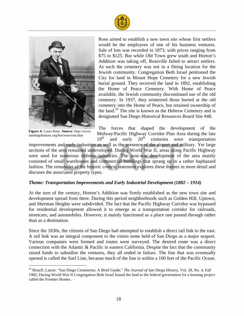
One of the early settlers to the area was Louis Rose, the first Jew in San Diego. He arrived in 1850 and began to purchase land between Old Town and La Playa. Eventually the area was called Roseville.19 Soon more Jews settled in San Diego. By 1861, they organized Adath Joshurun under the leadership of Marcus Schiller. Top priority would be acquiring land for a Jewish cemetery. Rose answered the need by deeding Adath Joshurun five acres on present-day Kenyon Street. Rose and Schiller were both buried there.
18 Papageorge, Nan Taylor. “The Role of the San Diego River in the Development of Mission Valley,” The Journal of San Diego History. Vol. 17, No. 2, Spring 1971. 19 While Roseville was based further south in the Point Loma area, it apparently reached into the southwest portion of Midway. Rose also owned property in Old Town.
DRAFT
18
Rose aimed to establish a new town site whose first settlers would be the employees of one of his business ventures. Sale of lots was recorded in 1873, with prices ranging from $75 to $125. But while Old Town grew south and Horton’s Addition was taking off, Roseville failed to attract settlers. As such the cemetery was not in a fitting location for the Jewish community. Congregation Beth Israel petitioned the City for land in Mount Hope Cemetery for a new Jewish burial ground. They received the land in 1892, establishing the Home of Peace Cemetery. With Home of Peace available, the Jewish community discontinued use of the old cemetery. In 1937, they reinterred those buried at the old cemetery into the Home of Peace, but retained ownership of the land.20 The site is known as the Hebrew Cemetery and is designated San Diego Historical Resources Board Site #48.
The forces that shaped the development of the Midway/Pacific Highway Corridor Plan Area during the late 19th and early 20th centuries were transportation
improvements and early industries as well as the presence of the airport and military. Yet large sections of the area remained undeveloped. During World War II, areas along Pacific Highway were used for numerous defense industries. The post-war development of the area mainly consisted of small warehouses and commercial buildings that sprang up in a rather haphazard fashion. The remainder of the historic context statement explores these themes in more detail and discuses the associated property types.
Theme: Transportation Improvements and Early Industrial Development (1882 – 1914)
At the turn of the century, Horton’s Addition was firmly established as the new town site and development spread from there. During this period neighborhoods such as Golden Hill, Uptown, and Sherman Heights were subdivided. The fact that the Pacific Highway Corridor was bypassed for residential development allowed it to emerge as a transportation corridor for railroads, streetcars, and automobiles. However, it mainly functioned as a place one passed through rather than as a destination.
Since the 1830s, the citizens of San Diego had attempted to establish a direct rail link to the east. A rail link was an integral component to the vision some held of San Diego as a major seaport. Various companies were formed and routes were surveyed. The desired route was a direct connection with the Atlantic & Pacific in eastern California. Despite the fact that the community raised funds to subsidize the ventures, they all ended in failure. The line that was eventually opened is called the Surf Line, because much of the line is within a 100 feet of the Pacific Ocean. 20 Bissell, Laurie. “San Diego Cemeteries: A Brief Guide,” The Journal of San Diego History, Vol. 28, No. 4, Fall 1982; During World War II Congregation Beth Israel leased the land to the federal government for a housing project called the Frontier Homes.
Figure 4: Louis Rose. Source: http://www. sandiegohistory.org/bio/rose/rose.htm

DRAFT
19
The line started as the California Southern Railroad. The first section opened in 1882 and connected National City to Oceanside, passing through the Midway/Pacific Highway Corridor Plan Area. The line became part of the Santa Fe Railroad’s transcontinental rail line in 1885 via an extension of the California Southern from Colton to Barstow. The line through the Midway/Pacific Highway Corridor Plan Area was located at the bottom of and along the bluff that separates the area from Old Town. Without a stop in the area, however, the railroad line failed to ignite development.
A real estate boom in the spring of 1887 brought thousands of people to Southern California, many of them traveling on the Santa Fe Railroad to San Diego. During the boom, developers realized the need for convenient public transportation. In 1887, San Diego’s Electric Rapid Transit Company introduced the first electric street railway system in the western U.S. It traversed the Pacific Highway Corridor from D Street (now Broadway) in downtown to Old Town along Arctic Street (now Kettner Boulevard). The line was called the San Diego & Old Town Railway. A number of other lines emerged and faded. No fewer than 17 streetcar and interurban companies vied for track space in downtown.21 Eventually John D. Spreckels consolidated virtually all of them under the banner of the San Diego Electric Railroad Company.
The streetcar line through the Midway/Pacific Highway Corridor Plan Area is remembered as the Old Number Sixteen. It traveled north on Kettner Boulevard, then to Hancock and the Five Points area. It generally paralleled the Santa Fe Railroad line until it turned south around Witherby to connect to Barnett. The line serviced the Marine Corps Recruit Depot. Even during the 1930s, streetcar passengers traveling through the area described it as a salt marsh with open meadows.22 During the early 1940s, the line was discontinued and the tracks were paved over in an effort to improve the roadway for automobiles.23
Pacific Highway was one of the first paved roads through the area. At one time, it was part of Highway 101. While the southern terminus of Highway 101 is now Los Angeles, it used to travel all the way south through San Diego to the Mexican border in San Ysidro. However, this part was decommissioned and replaced in the late 1960s by Interstate 5. Significant portions of Highway 101 were historically part of El Camino Real, the route that connected Alta California’s missions, presidios, and pueblos. It served as the main north-south road in California until the 1920s. Highway 101 was one of the first highways designated by the Bureau of Public Roads in 1925. Existing sections of roadway were designated as routes and marked by signs so that motorists could find their way from one town to the next. Long distance automobile runs became a popular form of amusement, and soon auto camps were developed to provide over night accommodations.
21 Holle, Gena. “Transit in San Diego: ASCE Anniversary Project,” The Journal of San Diego History, Vol. 48, No. 1, Winter 2002. 22 Locker, Zelma Bays. “Remembering Old Number Sixteen,” The Journal of San Diego History, Vol. 23, No. 4, Fall 1977. 23 “Opening of Side Streets Seen Between Kettner, Highway,” San Diego Union, January 19, 1940.

DRAFT
20
During the late 19th and early 20th centuries, development in the area remained limited. There were a few isolated residential and commercial buildings. Located at 1751 Hancock Avenue, one of the earliest businesses in the area was the Mission Brewery. August Lang, a German immigrant purchased block 183 of the Middletown Addition in 1912 for the purposes of building a brewery. He hired another German immigrant as his architect, Richard Griesser. The quality of the local water was noted as an important reason for locating in San Diego. A bottling plant was constructed across Washington Street. With the impending passage of the National Prohibition Act, the brewery closed in 1918. The property was sold to the American Agar Company in 1923. The Mission Brewery is designated San Diego Historical Resources Board Site #232 and is also listed in the National Register of Historic Places.
Associated Property Types
While the early transportation improvements during the late 19th and early 20th centuries influenced the later development of the plan area, there are no directly related property types remaining. The research indicated that industrial buildings were constructed in the plan area during this period; the only one remaining is the Mission Brewery, which is already listed. According to the reconnaissance survey, the other buildings remaining from this period are isolated single-family residences.
Residential – Single-family Residences
A few individuals constructed small houses in the plan area in the early part of the 20th
century. They are not concentrated in any particular area, but rather scattered about. Most can be described as vernacular turn of the century cottages or Craftsman bungalows. They are one-story in height, sheathed in wood clapboard or shingles, and covered by gabled roofs. Some have been converted to commercial uses.
Criteria: San Diego Register Criteria A, B & C
Evaluation of Individual Resources: Single-family residences may be individually significant under Criterion A as a rare surviving example of a property type that played an important role in the development of the community. Examples of this property type may also be eligible under Criterion B if they were the homes of persons significant in local history. Additionally, single-family residences may be eligible under Criterion C if they embody the distinctive characteristics of a style, type, period, or method of construction. These buildings will possess the character-
Figure 5: The Mission Brewery is listed in the National Register of Historic Places. Source: http:/www.sandiegohistory. org/collections/brewery/brewery.htm

DRAFT
21
defining features of the style they represent (see the Architectural Styles in Appendix I). Considering the fact that there were once many but now few, even representative examples of single-family residential types and styles may qualify.
Essential Factors of Integrity: Under Criterion B, location, setting, feeling, and association must be strongly present. Setting, design, materials, and feeling must be retained in the evaluation under Criterion C. In both cases, the use of the building may have changed. It is assumed that the general setting will have changed since the period of significance; however, the immediate setting should remain intact.
Theme: Military, Aerospace, and Related Industrial Development (1901 - 1953)
As early as 1900, San Diegans initiated efforts to attract the attention of the Navy Department in hopes that officials would choose it for naval bases and other shore activities. The military presence in San Diego began in 1901 with the establishment of the Navy Coaling Station in Point Loma. William Kettner is credited with the expansion of the military presence during the 1920s. In 1908, Kettner, a local businessman and recent transplant to San Diego, headed the program to welcome Theodore Roosevelt’s “Great White Fleet” to San Diego harbor in April as it completed a circumnavigation of the world. Kettner immediately recognized the benefit of a military presence in San Diego, which would bring federal resources and national attention to the City. San Diego's harbor required immediate attention. Dredging was urgently needed to enable large
ships to enter. It seemed a logical sequence would then follow: goods, trade, employment, and the development of a respectable commercial center. Upon his election to Congress in 1912, Kettner eventually convinced George Dewey, Admiral of the Navy, that the dredging of San Diego Bay was not only feasible, but also advantageous to the Navy. With Dewey’s endorsement, the Senate Commerce Committee came forth with several large appropriations for San Diego.
Kettner brought congressmen, senators, and high ranking government officials from all over the United States through the 1915 Exposition grounds, including Franklin D. Roosevelt, Assistant Secretary of the Navy, who gave Kettner the impression he felt Naval recruits would fare better, health-wise, in a climate such as San Diego’s. Kettner was introduced to Colonel Joseph Pendleton and Major General George Barnett. Kettner caught Barnett's attention and convinced him of his idea for the location of a new Marine base in Dutch Flats south of present-day Barnett
Figure 6: Marine Corps Recruit Depot under construction. Source: http://www.sandiegohistory.org/timeline/images/6917.jpg

DRAFT
22
Avenue and Pacific Highway.24 Together Kettner and Barnett reached Roosevelt, already enthusiastic about San Diego as the location for a new Naval Training Center. Both the Naval Training Center and the Marine Corps Recruit Depot were built in the early 1920s. Construction on the low-lying Dutch Flats area was accomplished only after a massive dredging and filling operation. Although they are located outside of the Midway/Pacific Highway Corridor Plan Area, they had a profound influence over the development of the area.
The development of the aerospace industry in San Diego also began in the Dutch Flats area. In 1922, T. Claude Ryan opened up a flying school in the Dutch Flats area, which led to the opening of a manufacturing plant. Ryan Airlines developed some of the most creative designs in aviation history, including a custom M 1 monoplane for Charles Lindbergh. Lindbergh tested the plane called the Spirit of St. Louis at Ryan Field before his 1927 nonstop solo flight from New York to Paris. The first regularly scheduled airline in America, the San Diego – Los Angeles Airline, operated out of this field beginning in 1925.25 In 1934 Ryan formed the Ryan Aeronautical Company, and the school eventually became a subsidiary. During World War II, the school trained thousands of Army pilots. Ryan also had contracts with the Navy to build aircraft. Teledyne acquired the company in 1968. Now gone, Ryan Field was located near the intersection of Midway and Barnett Avenues.26 The Dutch Flats/Ryan Field site was designated as HRB Site #249 in 1990.
Inspired by Lindbergh’s historic flight, the City of San Diego passed a bond issue in 1928 for construction of a two-runway municipal airport. Lindbergh himself encouraged the idea and agreed to lend his name to it. Dedicated on August 16, 1928, it was called San Diego Municipal Airport – Lindbergh Field. The airport was the first federally certified airport to serve all types of
24 Shragge, Abraham. “I Like the Cut of Your Jib: Culture of Accommodation Between the U.S. Navy and Citizens of San Diego, California, 1900-1951,” The Journal of San Diego History, Vol. 48, No. 3, Summer 2002. 25 City of San Diego Historical Site Board Register Form, no date. 26 Ryan Aeronautical Company http://www.centenitalofflight.gov/essay/Aerospace/Ryan; accessed January 26, 2010.
Figure 7: Ryan Field was located in the Dutch Flats area near the present-day intersection of Midway and Barnett Avenues. Source: http://www. dmairfield.org/places/sandiego_ca/images/Ryan_Field_SDAM.jpg

DRAFT
23
aircraft, including seaplanes. The original terminal was located on the northeastern side of the field, along Pacific Highway.
World War II brought significant change to the airfield when the Army Air Corps took it over in 1942 to support the war effort. The infrastructure of the airport was improved to handle the heavy bombers being manufactured in the region during the war. This transformation, including the 8,750-foot runway, made the airport jet ready long before jet passenger plans came into widespread service. After the war, commercial air service at Lindbergh Field expanded rapidly. In 1960, Lindbergh Field gained its first jet service.
The greatest impact to San Diego’s aerospace industry was the arrival of Consolidated Aircraft. The company was founded in 1923 by Reuben H. Fleet in Buffalo, New York. He served as a pilot in the U.S. Army during World War I and organized the first airmail service in 1918. In 1935, Fleet moved the company to San Diego because the weather in Buffalo was not suitable for test flights much of the year. Consolidated Aircraft constructed a new plant on the northeast side of Lindbergh Field. In his dedicatory address, Major Fleet noted that, “We have now $9 million of unfilled orders which will occupy the new plant at 80% capacity on a one-shift basis for a year and a half. We have 874 employees now, should have 2,000 within six months and about 3,000 next summer….Our directors seriously questioned the advisability of moving here [to San Diego] because we were in the valley of the world’s worst depression. Finally we made up our minds to have faith in the future….”27
By the end of the Depression, 9,000 employees worked for Consolidated and the physical plant doubled in size. Still not large enough, another plant was constructed between Pacific Highway and Kurtz Street, northwest of Witherby Street in 1943. That same year Vultee Aircraft Inc. bought operating control of Consolidated Aircraft and became Consolidated Vultee Aircraft 27 Wagner, William. Reuben Fleet and the Story of Consolidated Aircraft. Fallbrook: Aero Publishing Inc., 1976, p. 182-183.
Figure 8: Consolidated Aircraft, early 1940s, looking southwest. Source: http://www.spawar.navy.mil/sti/visualmedia/photos/otc40s.html.
DRAFT
24
(Convair). Convair was headquartered in San Diego. A majority interest in Convair was purchased by General Dynamics in 1953. The company continued to produce aircraft and aircraft components until being sold to McDonnell Douglas in 1994.
Consolidated Aircraft was the giant among San Diego manufacturing companies and brought about the establishment of smaller firms, all designed to produce aircraft tooling, parts, and sub-assemblies. During the war years, San Diego’s population soared due to a massive influx of military personnel and defense workers. The population of San Diego County grew from 289,348 in 1940 to over 400,000 in 1945. The impact of the population growth affected housing, transportation, and schools.
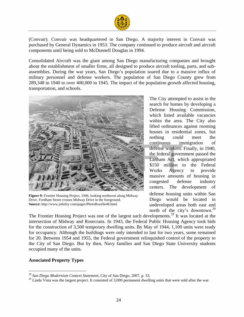
The City attempted to assist in the search for homes by developing a Defense Housing Commission, which listed available vacancies within the area. The City also lifted ordinances against rooming houses in residential zones, but nothing could meet the continuous immigration of defense workers. Finally, in 1940, the federal government passed the Lanham Act, which appropriated $150 million to the Federal Works Agency to provide massive amounts of housing in congested defense industry centers. The development of defense housing units within San Diego would be located in undeveloped areas both east and north of the city’s downtown.28
The Frontier Housing Project was one of the largest such developments.29 It was located at the intersection of Midway and Rosecrans. In 1943, the Federal Public Housing Agency took bids for the construction of 3,500 temporary dwelling units. By May of 1944, 1,100 units were ready for occupancy. Although the buildings were only intended to last for two years, some remained for 20. Between 1954 and 1955, the Federal government relinquished control of the property to the City of San Diego. But by then, Navy families and San Diego State University students occupied many of the units. Associated Property Types
28 San Diego Modernism Context Statement, City of San Diego, 2007, p. 33. 29 Linda Vista was the largest project. It consisted of 3,000 permanent dwelling units that were sold after the war.
Figure 9: Frontier Housing Project, 1946, looking northwest along Midway Drive. Fordham Street crosses Midway Drive in the foreground. Source: http://www.johnfry.com/pages/PhotoRozelle48.html.

DRAFT
25
Property types associated with this theme include industrial buildings, which can be categorized by type relating to their specific function. The two most common types of industrial buildings present in the plan area are multi-use warehouses such as the building at 1929 Hancock Avenue and light manufacturing buildings like the one at 3430 Hancock Avenue. They are mostly concentrated in two areas: the Pacific Highway Corridor and the northeast area of Midway. The residential buildings specifically constructed to house defense workers have been demolished.
Industrial – Multi-use Warehouses
There are numerous multi-use warehouses in the plan area that are concentrated in the two areas described above. Warehouses used for industrial or commercial purposes generally have the same physical characteristics. More often than not, these buildings were designed without the benefit of an architect. Most constructed during this period have reinforced concrete or steel-framed structures. The development of steel truss roof systems allowed for large unbroken expanses of floor areas for the storage of goods. Many of the warehouses in the plan area are utilitarian in design and box-like in shape. Some are sheathed in sheet metal, while others are concrete block structures. They may have flat or gabled roofs. A few Quonset huts are present in the area and are used as warehouses. While some warehouses have loading docks, others have large sliding doors so that automobiles and trucks can drive directly into the building.
Criteria: San Diego Register Criteria A & C
Evaluation of Individual Resources: Multi-use warehouses may be individually significant under Criterion A, if they reflect a special element of the plan area’s historical or economic development and are directly related to this theme. They must be strongly associated with a company or business enterprise that played an important role in the history of the military, aerospace, and related industrial development of the plan area. These buildings may also be eligible under Criterion C if they embody the distinctive characteristics of a style, type, period, or method of construction. Good examples of multi-use warehouses will reflect their original function and
the era in which they were constructed. A few buildings or structures on a single parcel should be evaluated as a single resource. Large collections of buildings or structures on multiple parcels may be evaluated as individual resources or as historic districts, as appropriate.
Essential Factors of Integrity: Location, setting, association, and feeling are the essential factors of integrity under Criterion A. Setting, design, materials, and workmanship must be strongly present in the evaluation of integrity under Criterion C.
Industrial – Light Manufacturing Buildings
Figure 10: 1929 Hancock Avenue

DRAFT
26
Light manufacturing buildings tend to be more substantial in size and construction than warehouses. In terms of architectural treatment, they fall into two categories: those clothed in the popular styles of the day and those purely functional and utilitarian in design. The application of a style is often limited to the façade or front office portion of the building. Most constructed during this period have reinforced concrete or steel-framed structures. Unlike warehouses with solid exterior walls, the spaces between the columns are filled with steel-framed windows or maximum daylight. Light manufacturing buildings often feature repeating rows of north facing clerestory windows that create a saw tooth roof shape. Operable sections allow for ventilation.
Criteria: San Diego Register Criteria A & C
Evaluation of Individual Resources: Light manufacturing buildings may be individually significant under Criterion A, if they reflect a special element of the plan area’s historical or economic development and are directly related to this theme. They must be strongly associated with a company or business enterprise that played an important role in the history of the military, aerospace, and related industrial development of the plan area. Buildings that exemplify the architectural development of the plan area will possess the character-defining features of the style they represent (see the Architectural Styles in Appendix I). These buildings may also be eligible under Criterion C if they embody the distinctive characteristics of a style, type, period, or method of construction. Good examples of light manufacturing buildings will reflect their original function and the era in which they were constructed. A few buildings or structures on a single parcel should be evaluated as a single resource. Large collections of buildings or structures on multiple parcels may be evaluated as individual resources or historic districts, as appropriate.
Essential Factors of Integrity: Under Criterion A, location, setting, feeling, and association must be strongly present. Setting, design, materials, and workmanship must be strongly present in the evaluation of integrity under Criterion C. Manufacturing equipment should not play a role in the evaluation of integrity as it is replaced as technology changes.
Theme: Post War Commercial and Residential Development (1945-1970)
After World War II small warehouses and industrial buildings began to fill in the undeveloped areas along the Pacific Highway Corridor. The Consolidated Aircraft plant continued to be a strong visual element and economic force in the area. The Midway area gave way to commercial strip and shopping center development that mainly catered to nearby residential and visitor populations. Streets were widened, removed, and renamed to facilitate the movement of automobiles. Interstate 5 and 8 were constructed, which formed rigid barriers between the neighborhoods on the north and east.

DRAFT
27
Figure 11: The Loma Theater opened in 1944. Source: http://www.sandiegohistory.org/collections/ theaters/theaters.htm.
Prior to World War II, the commercial and residential development of the area was random and sparse. A few homesteaders constructed small houses, but the earth was too sandy or salty for agriculture. Commercial businesses were largely related to the airport, aircraft plants, and military bases. The city directory for 1941 lists one house and one business on Midway south of Rosecrans. The few other businesses in the area were mostly gas stations and drive-in restaurants like Topsy’s and the Bali. The Loma Theater opened in 1944, just before the end of war. However, it is more closely associated with the post-war history of the area. It was designed by the renowned theater architect S. Charles Lee. The Sound of Music opened in the theater in
1965 and played for an astounding 133 weeks. The theater closed in 1988 and is now a book store.
During the 1950s, several of the large parcels occupied by the Frontier Housing Project were purchased by the City of San Diego and later sold for development. According to an article in the San Diego Union, the population of the area declined by 10,000, which caused a major drop in sales at local retail establishments. A master plan was developed for 500 acres, but failed to attract interest. Instead commercial business continued to be oriented toward the automobile and mainly consisted of freestanding buildings surrounded by large surface parking lots. Consequently, they are physically and architecturally disconnected from each other. The 1956 Sanborn map documents the presence of several motels and auto camps in the area interspersed with single-family residences, commercial buildings, and vacant lots. Businesses that required large flat parcels such as lumberyards, drive-in theaters, and nurseries also began to locate in the area. For example, the Midway Drive-in Theater opened in 1948 at the intersection of Midway Drive and West Point Loma Boulevard. It was demolished in 1981 and replaced with an apartment complex.
The character of the area that exists today began to take shape during the 1960s. Modern commercial buildings were constructed on vacant lots or replaced older commercial and residential buildings. The building at 3564 Kettner Boulevard is one of several automobile showrooms that were constructed during this decade. Automobile related businesses such as service stations and garages were also attracted to the Pacific Highway area. This can be attributed to the car culture that blossomed after World War II as well as the development of two freeways in the area, Interstate 5 and 8. Multi-family residential complexes also began appearing in the Midway area during the 1960s. The Loma Portal Apartment complex at 3131 Cauby Street is representative of this type.

DRAFT
28
The greatest change to the area in the 1960s was the construction of the International Sports Arena. It was constructed by Trepte Construction Company and designed by Victor Meyer, an architect who was vice president of development and design. As early as the 1950s, San Diego had been seeking to attract professional sports franchises. Robert Breitbard acquired the Gulls, then a member of the Western Hockey League and then laid plans for the construction of an indoor arena. The land was formerly part of the Frontier
Housing Project and owned by the City of San Diego; however, the $6,500,000 for construction was privately financed. The arena opened in November of 1966. It was designed for seating 13,500 hockey and 16,000 for other sporting and public events. Within a year a professional basketball team, the San Diego Rockets, was added. The Gulls continued to play in the arena until 1995 when the team disbanded. A variety of restaurants cropped up in the area to feed hungry sports fans before or after games.
Associated Property Types
The San Diego Modernism Historic Context Statement was prepared in 2007. It should be used in the evaluation of property types from the post-war period. Property types associated with this theme in the plan area include residential and commercial buildings. Residential buildings are almost exclusively apartment buildings, while commercial buildings are represented by a wide variety of types including restaurants, retail buildings, shopping centers, motels, gas stations, branch banks, grocery stores, and automobile dealerships. Residential buildings are concentrated in the Midway area, northwest of Rosecrans Avenue. Post-war commercial buildings are found throughout the plan area. Those in the Pacific Highway Corridor tend to be oriented toward the airport such as rental car businesses. When only one or two examples of a property type from the period were observed in the field, separate registration requirements were not developed.
Residential – Single-family Residences
Sanborn maps from the 1950s indicate that at one time there were significant concentrations of single-family residences in the area. They were usually mixed with commercial and industrial uses. Most have been demolished so those that remain are isolated. There is one small pocket of single-family residences near Rosecrans and Lytton. Most single-family residences are one-story in height and have no particular style. A few have Minimal Traditional characteristics.
Criteria: San Diego Register Criterion C
Figure 12: San Diego International Sports Arena, artist’s rending. Source: http://www.the-doors world.com/pics/clubs%2Bhallen/ USA/ Offene%20 Arena/San-Diego-International-Spo.jpg

DRAFT
29
Evaluation of Individual Resources: Single-family residences may be individually significant under Criterion C if they embody the distinctive characteristics of a style, type, period, or method of construction. These buildings will possess the character-defining features of the style they represent (see the Architectural Styles in Appendix I as well as the San Diego Modernism Historic Context Statement).
Essential Factors of Integrity: Setting, design, materials, and workmanship must be strongly present in the evaluation of integrity under Criterion C.
Residential - Apartment Buildings
The post-war period was marked by the construction of an increasing number of apartment buildings. This was largely in response to the overall housing shortage that created a need for higher density to accommodate the influx of new residents. It should be noted that apartment buildings from this period typically include at least six units and usually more. The two most common multi-
family housing types in the area are dingbats and apartment complexes. Dingbats are two-story apartment buildings with parking tucked under the second story. They are rectangular in shape and entry to the units is from the exterior. There are also several large apartment complexes in the plan area. They are typically comprised of two-story buildings with very minimal setbacks and surface parking lots or carports along the edges. Open space takes the form of interior courtyards, often occupied by swimming pools. These buildings typically have flat roofs, steel sash windows, and minimal ornamentation. While they make no specific references to historical styles, they are not truly modern. Stylistically they are best described as Minimal Traditional because of their solid walls and punched windows. In some cases they have Googie style elements.
Criteria: San Diego Register Criterion C
Evaluation of Individual Resources: Apartment buildings may be individually significant under Criterion C if they embody the distinctive characteristics of a style, type, period, or method of construction. These buildings will possess the character-defining features of the style they represent (see the Architectural Styles in Appendix I as well as the San Diego Modernism Historic Context Statement).
Essential Factors of Integrity: Setting, design, materials, and workmanship must be strongly present in the evaluation of integrity under Criterion C.
Figure 13: 3131 Cauby Street

DRAFT
30
Commercial – Restaurants
There are numerous restaurants in the plan area. Most are located in one-story freestanding buildings surrounded by surface parking lots. While it can be said that virtually all are oriented toward customers arriving by automobile, only some were developed as drive-ins with curbside service. Restaurants constructed toward the end of the period featured drive-through windows. Regional and national restaurant chains also formed during this period and constructed outlets in the plan area including Denny’s and IHOP. The designs of such buildings are usually based on prototypes that can be found throughout the country.
Criteria: San Diego Register Criterion C
Evaluation of Individual Resources: Restaurants may be individually significant under Criterion C if they embody the distinctive characteristics of a style, type, period, or method of construction. These buildings will possess the character-defining features of the style they represent (see the Architectural Styles in Appendix I as well as the San Diego Modernism Historic Context Statement).
Essential Factors of Integrity: Setting, design, materials, and workmanship must be strongly present in the evaluation of integrity under Criterion C. Signage may have changed unless it was an integral component of the architecture.
Commercial – Retail Stores
Popular from the 1930s through the 1970s, the stand-alone retail building is noted for it accommodation of the automobile. These detached single-use buildings feature a dedicated surface parking lot on one or more sides. They may or may not share a common front setback with neighboring commercial buildings. These buildings can take various forms and styles. They typically have flat roofs, steel sash windows or storefronts, and minimal ornamentation.
Criteria: San Diego Register Criterion C
Evaluation of Individual Resources: Retail stores may be individually significant under Criterion C if they embody the distinctive characteristics of a style, type, period, or method of construction. These buildings will possess the character-defining features of the style they represent (see the Architectural Styles in Appendix I as well as the San Diego Modernism Historic Context Statement).
Figure 14: 3335 Midway Drive
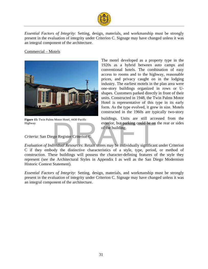
DRAFT
31
Essential Factors of Integrity: Setting, design, materials, and workmanship must be strongly present in the evaluation of integrity under Criterion C. Signage may have changed unless it was an integral component of the architecture.
Commercial – Motels
The motel developed as a property type in the 1920s as a hybrid between auto camps and conventional hotels. The combination of easy access to rooms and to the highway, reasonable prices, and privacy caught on in the lodging industry. The earliest motels in the plan area were one-story buildings organized in rows or U-shapes. Customers parked directly in front of their units. Constructed in 1948, the Twin Palms Motor Hotel is representative of this type in its early form. As the type evolved, it grew in size. Motels constructed in the 1960s are typically two-story buildings. Units are still accessed from the exterior, but parking could be on the rear or sides of the building.
Criteria: San Diego Register Criterion C
Evaluation of Individual Resources: Retain stores may be individually significant under Criterion C if they embody the distinctive characteristics of a style, type, period, or method of construction. These buildings will possess the character-defining features of the style they represent (see the Architectural Styles in Appendix I as well as the San Diego Modernism Historic Context Statement).
Essential Factors of Integrity: Setting, design, materials, and workmanship must be strongly present in the evaluation of integrity under Criterion C. Signage may have changed unless it was an integral component of the architecture.
Figure 15: Twin Palms Motor Hotel, 4430 Pacific Highway

DRAFT
32
Survey Results The survey focused on built resources within the Midway/Pacific Highway Corridor Community Plan Area constructed before 1970 that have not been previously identified or designated as historic resources. Based on these criteria, the project team recorded a total of 228 properties. Information, such as physical characteristics, alterations, and integrity level, was entered in the City’s Access database. Additionally, each surveyed property was evaluated using the City’s local designation criteria and assigned a California Historical Resource Status Code.
Previously Identified Resources To inform the context statement, the project team compiled a list of previously identified resources. In addition to the Access database, the City gave the project team a list of properties designated by the San Diego Historical Resources Board. Based on these two sources, as well as independent research in state and national databases, the project team concluded that the survey area contains four properties that were identified and designated as historic resources before the start of this project. It should be noted, however, that the Mission Brewery is designated as one Historical Resources Board Site (#232), but it includes two buildings on two parcels. The previously identified resources are grouped by type and/or location and organized by applicable status codes:
Map Key Address APN HRB Site
Number Historic Name Year Built Status Code
1 & 2 1751 Hancock Street 451590063 451590065 232 Mission Brewery/
American Agar Co. 1918, 1925,
1930 5S1
3 Kenyon Street 4412902818 48 Hebrew Cemetery Site N/A 5S1
4 Bounded by Barnett Avenue, Midway Drive, Rosecrans Street, and Sports Arena Boulevard
N/A 249 Dutch Flats/Ryan Field N/A 5S1
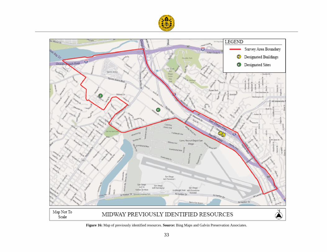
DRAFT
33
Figure 16: Map of previously identified resources. Source: Bing Maps and Galvin Preservation Associates.

DRAFT
34
Potential Individual Resources The survey identified 45 potential individual resources that appear to be eligible for local listing under the City’s designation criteria. All of these meet the eligibility requirements set forth in the context statement under San Diego Criteria A and/or C.
Map Key Address APN Criteria; Reason Year Built Status
Code 1 3002 Barnett Avenue 4504500600 C; Representative example of
Streamline Moderne architecture applied to a commercial building.
1942 5S3
2 3030 Barnett Avenue 4504502400 C; Excellent example of late Spanish Colonial Revival architecture.
1962 5S3
3 3225 Bean Street 4516903200 Quonset hut with moderate integrity. More information required on other examples of the property type in San Diego.
1946 5S3
4 2802 Cadiz Street 4504502600 C; Excellent example of late Spanish Colonial Revival architecture.
1947 5S3
5 2802 Cadiz Street 4504502500 C; Excellent example of late Spanish Colonial Revival architecture.
1947 5S3
6 3648 California Street 4516901100 C; Representative example of an early single-family residence.
1914 5S3
7 3131 Cauby Street 4508021000 C; Excellent example of a Contemporary apartment complex in the context of Post-war Commercial and Residential Development.
1970 5S3
8 3202 Duke Street 4412501100 C; Representative example of a Contemporary hospital building.
1964 5S3
9 3630 Enterprise Street 4504900600 C; Representative example of a late Spanish Colonial Revival commercial building in the context of Postwar Commercial and Residential Development.
1948 5S3
10 1895 Hancock Street 4506411300 C; Excellent example of a commercial building with Streamline Moderne influences in the context of Postwar Commercial and Residential Development.
1959 5S3
11 1929 Hancock Street 4506411200 C; Excellent example of a Contemporary commercial building constructed of brick in the context of Postwar Commercial and Residential Development.
1950 5S3
12 3235 Hancock Street 4415700700 C; Representative example of a Contemporary commercial building in the context of Postwar Commercial and Residential
1953 5S3

DRAFT
35
Development. 13 3430 Hancock Street 4415811400 C; Representative example of a
Contemporary industrial building. 1961 5S3
14 3132 Jefferson Street 4415500300 C; Representative example of an International style commercial building in the context of Postwar Commercial and Residential Development.
1945 5S3
15 3211 Jefferson Street 4415500700 C; Representative example of a Contemporary commercial building in the context of Postwar Commercial and Residential Development.
1941 5S3
16 3320 Kemper Street 4412703200 C; Representative example of a Contemporary commercial building in the context of Postwar Commercial and Residential Development.
1968 5S3
17 2727 Kettner Boulevard 4516540200 C; Excellent example of a Contemporary commercial building in the context of Postwar Commercial and Residential Development.
1965 5S3
18 2750 Kettner Boulevard 4516530500 C; Excellent example of a Contemporary industrial building in the context of Postwar Commercial and Residential Development.
1959 5S3
19 3554 Kettner Boulevard 4516901700 C; Excellent example of an International Style commercial building in the context of Post-war Commercial and Residential Development.
C. 1955 5S3
20 2075 Kurtz Street 4506010200 C; Representative example of an International style commercial building in the context of Postwar Commercial and Residential Development.
1949 5S3
21 2790 Kurtz Street 4415602200 C; Representative example of an industrial building in the International style with good integrity.
1963 5S3
22 3467 Kurtz Street 4413301100 C; Excellent example of an International Style commercial building in the context of Post-war Commercial and Residential Development.
1952 5S3
23 2810 Lytton Street 4504120800 C; Rare surviving example of a Custom Ranch style commercial building in the context of Postwar Commercial and Residential Development.
1954 5S3
24 2701 Midway Drive 4504800500 C; Representative example of C.1970 5S3

DRAFT
36
Brutalism applied to an institutional building; high integrity.
25 2820 Midway Drive 4416200500 C; Representative example of a Modern commercial block building with high integrity in the context of Postwar Commercial and Residential Development.
1960 5S3
26 2850 Midway Drive 4416200400 C; Representative example of a Contemporary commercial building with high integrity in the context of Postwar Commercial and Residential Development.
1945 5S3
27 3310 Midway Drive 4416502400 Older residence with good integrity on rear of lot. Need to establish the original date of construction and name of the original owner.
C. 1915 5S3
28 3311 Midway Drive 4508010100 Older residence with fair integrity. Need to confirm the original date of construction and determine the name of the original owner.
1930 5S3
29 3323 Midway Drive 4413602800 C; Excellent example of a Contemporary commercial building in the context of Post-war Commercial and Residential Development.
1964 5S3
30 3233 Midway Drive 4508010300 Older residence with good integrity on rear of lot. Need to establish the original date of construction and name of the original owner.
C. 1925 5S3
31 3493 Noell Street 4506321000 C; Representative example of a Streamline Moderne commercial building with high integrity.
1941 5S3
32 1215 Nutmeg Street 5330110100 Quonset hut with high integrity. More information required on other examples of the property type in San Diego.
1946 5S3
33 3165 Pacific Highway 4516010600 A; Industrial building associated with expansion of Consolidated Aircraft during WWII. Significant in the context of Military, Aerospace, and Related Industrial Development.
1942 5S3
34 4085 Pacific Highway 4505701600 C; Representative example of a Streamline Moderne commercial building with fair integrity in the context of Post-war Commercial and Residential Development.
1955 5S3
35 4203 Pacific Highway 4505500800 A; Industrial building associated with the expansion of Consolidated Aircraft. Significant in the context of Military, Aerospace, and Related Industrial Development.
C. 1940 5S3

DRAFT
37
36 4430 Pacific Highway 4415602000 C; Rare surviving example of a motel in the context of Postwar Commercial and Residential Development.
C. 1945 5S3
37 1411 Palm Street 4516510300 C; Good example of an Art Deco commercial building with high integrity in the context Post-war Commercial and Residential Development.
1947 5S3
38 3045 Rosecrans Place 4504200100 C; Representative example of a Contemporary commercial building with high integrity in the context Post-war Commercial and Residential Development.
1959 5S3
39 3051 Rosecrans Place 4504121800 C; Excellent example of a Contemporary commercial building in the context of Postwar Commercial and Residential Development.
1962 5S3
40 3065 Rosecrans Place 4504121900 C; Excellent example of a Contemporary commercial building in the context of Post-war Commercial and Residential Development.
1961 5S3
41 3135 Rosecrans Place 4504200400 C; Excellent example of a Streamline Moderne movie theater in the context of Post-war Commercial and Residential Development.
1945 5S3
42 3251 Rosecrans Street 4504300700 George Dewey Elementary School. More research required on other examples of the property type in San Diego.
1945 5S3
43 3822 Sherman Street 4415811600 C; Representative example of a Contemporary commercial building with high integrity in the context Post-war Commercial and Residential Development.
1964 5S3
44 3500 Sports Arena Blvd. 7602450700 A; Sports Arena appears eligible in the context of Post-war Commercial and Residential Development.
1966 5S3
45 3642 Sports Arena Blvd. 4504900800 Walter Anderson Nursery. More research required on other examples of the property type in San Diego.
C. 1955 5S3
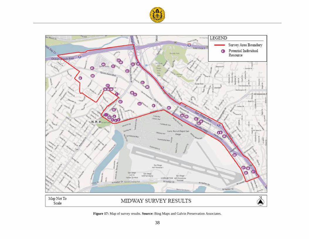
DRAFT
38
Figure 17: Map of survey results. Source: Bing Maps and Galvin Preservation Associates.

DRAFT
39
Representative Photographs:
3131 Cauby Street 2727 Kettner Boulevard
3554 Kettner Boulevard 2810 Lytton Street
3135 Rosecrans Place 3500 Sports Arena Boulevard

DRAFT
40
3233 Midway Drive 3310 Midway Drive
1215 Nutmeg Street 3225 Bean Street
3251 Rosecrans Street 3642 Sports Arena Boulevard

DRAFT
41
Recommendations The following recommendations are for the ongoing identification, evaluation, and designation of historic resources within the Midway/Pacific Highway Corridor Community Plan Area and for the revision of the applicable sections of the community plan. They are based on standard preservation practice and guidelines as outlined by the National Park Service, the State Office of Historic Preservation, and the National Trust for Historic Preservation. They are also consistent with the Historic Preservation Element in the City of San Diego General Plan.
Individually Significant Properties The survey identified several potential individually significant properties. It is recommended that these properties be surveyed at the intensive level to determine whether or not these buildings are eligible for designation.
Properties with Social or Cultural Significance Properties in this survey have been identified primarily as either representative of significant patterns of development in plan area or for their architectural merit (as an excellent example of a building type or architectural style). There may be additional properties within the plan area which possess historic significance for social or cultural reasons (such as an association Additional work with members of the community to identify and evaluate such properties for potential historic significance and future designation is recommended.

DRAFT
42
Bibliography
Books and Manuscripts
Engstrand, Iris Wilson. San Diego: California’s Cornerstone. San Diego, California: Sunbelt Publications, 2005.
Joyce, Barry Alan. A Harbor Worth Defending: A Military History of Point Loma. San Diego, California: Cabrillo Historical Association, 1995.
Linder, Bruce. San Diego’s Navy: An Illustrated History. Annapolis, Maryland: Naval Institute Press, 2001.
McKeever, Michael. A Short History of San Diego. San Francisco, California: Lexibos, 1985.
Pourade, Richard F. The History of San Diego: Time of the Bells. San Diego: Union-Tribune Publishing Co., 1961.
Pourade, Richard R. The History of San Diego: The Silver Dons. San Diego: Union-Tribune Publishing Co., 1963.
Smythe, William E. History of San Diego 1542-1908. San Diego: The History Company, 1908.
Maps
Insurance Maps of San Diego California vol. 4. New York: Sanborn Company, 1940.
Insurance Maps of San Diego California vol. 4. New York: Sanborn Company, 1940 corr. 1947.
Insurance Maps of San Diego California vol. 4. New York: Sanborn Company, 1956.
Newspapers and Periodicals
“Aero Plant Crew Large,” Los Angeles Times. March 20, 1936, p. 16.
“Auto Usurps Early Homes,” San Diego Union. February 21, 1960, p. A15.
Bissell, Laurie. “San Diego Cemeteries: A Brief Guide,” The Journal of San Diego History. Vol. 28, No. 4, Fall 1982.
“Building Sold by Consolidated for $2,700,000,” Los Angeles Times. November 26, 1952, p. A7.
“Case Firm Wins Heritage Award for Restoration,” Los Angeles Times. June 2, 1985, p. I6.
“City Area Proposed for 1969 World Fair,” San Diego Union. May 11, 1962, p. A21.

DRAFT
43
“City’s Marriage with Defense Bloomed in ‘30s,” San Diego Union Tribune. November 22, 1992.
“City’s Street Names Stretch All the Way into Dusty History,” San Diego Union. November 2, 1975, p. F1.
“Consolidated Sale to Vultee Competed,” Los Angeles Times. November 29, 1941, p. 1.
“Construction on Aircraft Plant Under Way Soon,” Los Angeles Times. May 5, 1935, p. D1.
“Convair to Move Unit to New Base,” Los Angeles Times. February 11, 1955, p. 18.
Covington, Donald. “Dryden, David Owen: A Builder in the Craftsman Style,” The Journal of San Diego History. Vol. 37, No. 1, Winter 1991.
“Crosstown Freeway Takes Shape,” San Diego Union. July 15, 1959.
Eddy, Lucinda. “War Comes to San Diego,” The Journal of San Diego History. Vol. 39, No. 1-2, Winter-Spring 1993.
“Federal Project Honors Blakely, Upshur, Gearing,” San Diego Union. August 31, 1941.
“Fifty Going by Plane to Dedication,” Los Angeles Times. October 20, 1935, p. 3.
Filner, Bob. “Dealing with the Decline in San Diego’s Defense Industry,” The San Diego Weekly. Vol. 9, No. 16, January 15-21, 1992.
“For Defense Industry, Cutbacks Bring Corporate Re-Evaluations,” San Diego Tribune. January 28, 1991.
Gabrielson, Ed. “Mission Bay Aquatic Park: The History of Planning and Land Acquisitions,” The Journal of San Diego History. Vol. 48, No. 1, Winter 2002.
Harrison, Donald H. “Bouquet of Roses: The Stories Behind San Diego Places Named for Louis Rose,” The Journal of San Diego History. Vol. 53, No. 1, 1985.
“Historic Trail in Use Again,” Los Angeles Times. June 6, 1940, p. A18.
Holle, Gena. “Transit in San Diego: ASCE Anniversary Project,” The Journal of San Diego History. Vol. 48, No. 1, Winter 2002.
“Housing Project Sale Approved,” Los Angeles Times. November 12, 1954, p. A15.
“Huge Plant to Rise at San Diego,” Los Angeles Times. April 14, 1935, p. D7.
“Jet Use of Lindbergh Field OK’d,” Los Angeles Times. August 13, 1964, p. 20.

DRAFT
44
Liwag, Ernie. “Craft Beer in San Diego Society,” The Journal of San Diego History. Vol. 53, No. 1, 2007.
“Marker Designed for Historic Old La Playa Trail,” San Diego Union. July 9, 1933, p. 1.
May, Ronald V. “The Fort That Never Was on Ballast Point,” The Journal of San Diego History. Vol. 31, No. 2, Spring 1985.
“Mayhem on Ice: and Major-League Basketball in the Wings,” San Diego Magazine. 1966.
McGrew, Clarence A. “Old Rosy,” San Diego Historical Society Quarterly. Vol. 4, No. 3, July 1958.
Middlebrook, R.P. “The High Iron to La Jolla,” San Diego Historical Society Quarterly. Vol. 7, No. 1, January 1961.
“Midway Area Development Planned,” San Diego Union. May 6, 1956, p. F12.
“More Women Preparing for Aircraft Engineering,” Los Angeles Times. November 28, 1942, p. 14.
O’Connor-Ruth, Annie V. “Mercantile to Macdonald’s: Commercial Strips in San Diego,” The Journal of San Diego History. Vol. 38, No. 3, Summer 1992.
“$1 Million Townhouse Site Covers 10 Acres,” Los Angeles Times. June 8, 1975, p. K26.
“Opening of Side Streets Seen Between Kettner, Highway,” San Diego Union. January 19, 1940.
Papageorge, Nan Taylor. “The Role of the San Diego River in the Development of Mission Valley,” The Journal of San Diego History. Vol. 17, No. 2, Spring 1971.
“Plane Factory Addition Pends,” Los Angeles Times. August 23, 1940, p. 27.
“Plane Plant to Expand,” Los Angeles Times. February 29, 1940, p. 8.
“Plane Plants May Merge,” Los Angeles Times. November 25, 1941, p. 1.
“Plans Told for Large Addition to Plane Plant,” Los Angeles Times. March 29, 1936, p. F4.
“San Diego Blight Cleanup Proposed,” Los Angeles Times. September 18, 1960, p. D12.
“San Diego County Freeway Routes OK’d ,” Los Angeles Times. April 29, 1965, p. A11.
“San Diego Gets New Air Plant,” Los Angeles Times. June 26, 1935, p. 10.
Sheehan, Margot. “The Frontier They Want us to Forget.” San Diego’s Weekly Reader. September 10, 1992.

DRAFT
45
Shragge, Abraham J. “’I Like the Cut of Your Jib’: Cultures of Accommodation Between the U.S. Navy and Citizens of San Diego California, 1900-1951,” The Journal of San Diego History. Vol. 48, No. 3, Summer 2002.
“Sports Arena Building Keeps Ahead of Schedule,” San Diego Tribune. no date.
“Sports Arena Site Approved at San Diego,” Los Angeles Times. January 28, 1955, p. 18.
Stern, Norton B. and William M. Kramer. “The Rose of San Diego,” The Journal of San Diego History. Vol. 19, No. 4, Fall 1973.
“To be Country’s Finest,” Los Angeles Times. March 5 1919, p. II1.
“Trail of California’s First White Man Traced,” Los Angeles Times. December 1, 1929, p. E1.
“U.S. Wartime Housing Vanishes,” San Diego Tribune. June 28, 1955.
“WPA Guidebook: Points of Interest in San Diego’s Past,” San Diego Union-Tribune. August 19, 1992.
Planning Documents and Landmark Applications
Brandes, Dr. Ray. Historical Resources Inventory for Middletown Area, San Diego, California, San Diego, California: University of San Diego, January 1981.
City of San Diego Historical Site Board Register Dutch Flats/Ryan Field, no date.
City of San Diego Historical Site Board Register Hebrew Cemetery Site, no date.
City of San Diego Historical Site Board Register Mission Brewery/American Agar Company, no date.
Council of the City of San Diego, “Historic Preservation Element” in City of San Diego General Plan. Resolution Number R-303473. Adopted March 10, 2008.
Council of the City of San Diego, “Appendix E, HP-1 San Diego History” in City of San Diego General Plan. Resolution Number R-303473. Adopted March 10, 2008.
Midway/Pacific Corridor Community Plan and Local Coastal Program Land Use Plan, San Diego, California: City of San Diego Planning Department, 2006. San Diego Modernism Historic Context Statement, San Diego, California: City of San Diego Planning Department, 2007.

DRAFT
46
Appendix A

DRAFT
47
Architectural Style Guide
The architectural character of the Midway/Pacific Highway Corridor Community Plan Area reflects the fact that it was mostly developed after World War II. A few homesteaders constructed small houses in the plan area in the early part of the 19th century. They are not concentrated in any particular area, but rather scattered about. Most can be described as vernacular turn of the century cottages or Craftsman bungalows. The Pacific Highway Corridor contains some of the city’s oldest industrial areas including multi-use warehouses and light manufacturing buildings. More often than not, these buildings are purely functional and utilitarian in design. But in some cases they were clothed in the popular styles of the day ranging from Mission Revival to Streamline Moderne. The Midway area consists mostly of post-war commercial and some institutional and multi-family residential buildings. While most can be generally described as Contemporary, a few examples International Style and Googie/Futurists can also be found. The styles discussed below are those currently represented among the potential historic resources identified in the plan area. These include those styles that are prevalent in this area, or are represented by prominent examples. This typology does not establish historic significance. Rather, it describes the existing population of buildings constructed prior to 1980 in this portion of the city. This style guide should be used in conjunction with other adopted to City Contexts, such as the San Diego Modernism Historic Context Statement, when evaluating resource types.

DRAFT
48
Spanish Colonial Revival Enormously popular in Southern California from the late 1910s through the late 1930s, the Spanish Colonial Revival style emerged from a conscious effort by architects to emulate older Spanish architectural traditions, and break with Eastern colonial influences. The style attained widespread popularity throughout Southern California following the 1915 Panama-California Exposition in San Diego, designed by chief architect Bertram Grosvenor Goodhue. At the peak of its popularity, design features of other regions of the Mediterranean were often creatively incorporated, including those of Italy, France, and North Africa. The style was applied to a broad range of property types including commercial, residential, and institutional. Red clay tile roofs or flat roofs rimed by parapets trimmed in red clay tile and stucco exterior cladding are the most common features. Because of the extensive vocabulary of the style, designs could be endlessly varied. Character-Defining Features Primary
• Horizontal massing and emphasis • Flat, gabled, or hipped roofs with red clay tiles • Smooth or textured stucco exteriors • Asymmetrical facades
Secondary • Wood-framed casement or double-hung windows, typically with divided lites • Arched colonnades, window or door openings • Decorative grilles of wood, wrought iron, or plaster • Decorative terra cotta or tile work • More elaborate versions may display balconies, patios, or towers
3630 Enterprise Avenue

DRAFT
49
Craftsman The Craftsman style of architecture grew out of the late 19th century English Arts and Crafts movement. It reflected a conscious search for the supposed simplicity of a pre-industrial time when objects revealed the skill and craftsmanship of the laborer; and further, a rejection of the highly ornamental Victorian era aesthetic. The Craftsman style was most commonly applied to domestic architecture and ranged from custom-designed two-story houses to modest bungalows that were mass-produced. Craftsman style houses are characterized by their glorification of natural materials and promotion of outdoor living with a typically generous front porch. Custom-designed houses in San Diego often featured workmanship and design of high quality and represent the Craftsman style at its peak of expression. Although the bungalow has been closely associated with the Arts and Crafts movement and the Craftsman style of architecture, it refers to a type of house rather than a style of architecture. The Craftsman bungalow became the dominant residential style in Southern California during the first two decades of the 20th century. Craftsman bungalows generally have shingled exteriors and broad front porches supported by stone, clinker brick, or stuccoed piers. Other character-defining features include low-pitched gabled roofs with wide overhanging eaves and exposed rafter tails. Character-Defining Features Primary
• One to two stories in height • Building forms that respond to the site • Low-pitched gabled roofs • Shingled exteriors, occasionally clapboard or
stucco • Partial or full-width front porches
Secondary
• Overhanging eaves with exposed rafters, beams, or braces • Stout porch piers, often of river rock or masonry • Wood-framed windows, often grouped in
multiples • Widely proportioned front doors
3310 Midway Drive
3311 Midway Drive

DRAFT
50
Streamline Moderne Influenced by the Cubism and Modern movements in Europe, Moderne structures were characteristically smooth walled and asymmetrical, with little unnecessary ornamentation and simple aerodynamic curves of concrete, plaster, and glass block. The popularization of this new modern style was reinforced by the government during the Depression as government funded New Deal projects such as the 1936-38 San Diego Civic Center (now the County Administration Center) adopted the style as the embodiment of government efficiency. This new Streamline style was a stark contrast to the lavishly ornamented Art Deco and Period Revival buildings of the pre-Depression years, which had come to represent government waste and excess. Examples of the Streamline Moderne style can be found on almost every building type including commercial, multi-family residential apartments, and some single-family residences. Character-Defining Features Primary
• Horizontal massing and emphasis • Flat roofs with coping or flat parapets • Smooth stucco or concrete exteriors • Asymmetrical façades
Secondary • Horizontal accents, or “speedlines”, and
restrained detailing • Curved building corners, railings,
overhangs, and coping with horizontal projections above doorways and at cornice lines
• Steel sash windows • Corner windows • Glass block accents • Round “porthole” windows and nautical
theme
3493 Noell Street
1895 Hancock Avenue
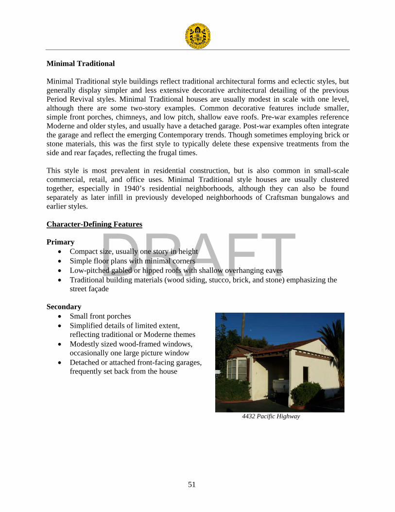
DRAFT
51
Minimal Traditional Minimal Traditional style buildings reflect traditional architectural forms and eclectic styles, but generally display simpler and less extensive decorative architectural detailing of the previous Period Revival styles. Minimal Traditional houses are usually modest in scale with one level, although there are some two-story examples. Common decorative features include smaller, simple front porches, chimneys, and low pitch, shallow eave roofs. Pre-war examples reference Moderne and older styles, and usually have a detached garage. Post-war examples often integrate the garage and reflect the emerging Contemporary trends. Though sometimes employing brick or stone materials, this was the first style to typically delete these expensive treatments from the side and rear façades, reflecting the frugal times. This style is most prevalent in residential construction, but is also common in small-scale commercial, retail, and office uses. Minimal Traditional style houses are usually clustered together, especially in 1940’s residential neighborhoods, although they can also be found separately as later infill in previously developed neighborhoods of Craftsman bungalows and earlier styles. Character-Defining Features Primary
• Compact size, usually one story in height • Simple floor plans with minimal corners • Low-pitched gabled or hipped roofs with shallow overhanging eaves • Traditional building materials (wood siding, stucco, brick, and stone) emphasizing the
street façade Secondary
• Small front porches • Simplified details of limited extent,
reflecting traditional or Moderne themes • Modestly sized wood-framed windows,
occasionally one large picture window • Detached or attached front-facing garages,
frequently set back from the house
4432 Pacific Highway

DRAFT
52
International Style The International Style was a major worldwide architectural trend during the 1920s and 30s and reflected the formative decades of Modernism prior to World War II. Although the International Style originated in Western Europe, it transcended any national or regional identity because International Style architecture made no reference to local vernaculars or traditional building forms. The style quickly migrated to the United States as architects fled from war torn Europe. In Los Angeles, immigrant architects Rudolph Schindler and Richard Neutra were instrumental in popularizing the style. The emergence of International Style architecture in San Diego came later with most examples built after 1935. The International Style is characterized by a radical simplification of form and a complete rejection of ornament. Common features of the style include square and rectangular building footprints, simple cubic or extruded rectangular forms, horizontal bands of windows, and strong right angles. Predominant building materials include concrete, smooth stucco, brick, and, glass. Character-Defining Features Primary
• Single or groups of rectangular masses
• Flat roofs (cantilevered slabs or parapets)
• Exterior materials including concrete, brick, and stucco
• Lack of applied ornamentation • Asymmetrical facades
Secondary
• Horizontal bands of flush windows
• Steel sash windows, typically casement
• Windows meeting at corners
3467 Kurtz Street
3251 Rosecrans Street

DRAFT
53
Futurist – Googie The Futurist style of Modern architecture began after World War II as Americans became entranced with technology and the Space Age. At that time, America was also being transformed by a car culture. As automobile use increased, roadside architecture evolved. It was intended to attract the consumer with bright colors, oversized lighted signage, and exaggerated forms. In short, the building was the billboard. The Futurist style was used overwhelmingly on coffee shops, gas stations, motels, restaurants, and retail buildings. The name “Googie” comes from the well-known coffee shop in Los Angeles called Googies, which was designed by renowned Modernist architect John Lautner in 1949. Futurist architecture is also referred to as “Coffee House Modern”, ”Populuxe”, “Doo-Wop”, and “Space Age”. Futurist architecture was popular throughout the 1950s and fell out of favor by the mid-60s, as America became more sophisticated in its understanding and interpretation of space travel and futurist technology. Futurist architectural design often incorporates sharp angles, boomerang or flying saucer shapes, large expanses of glass, exposed steel structural elements, and dramatic roof overhangs. The basic form and size of Futurist buildings varies significantly from building to building. An abstract arrangement of shapes and textures is typical. Character-Defining Features Primary
• Abstract, angular, or curved shapes • Expressive roof forms such as upswept, butterfly, parabolic, boomerang, or folded-plate • Assortment of exterior materials including stucco, concrete block, brick, stone, plastic,
and wood siding • Large and expansive plate glass windows
Secondary • Bright colors • Screen block and shadow block accents • Thematic ornamentation including
Polynesian and Space Age motifs • Prominent signage (neon or lighted)
3045 Rosecrans Place

DRAFT
54
Custom Ranch
Custom Ranch construction is differentiated from Tract Ranch because these homes were typically custom-designed with a specific client in mind. Designers of these custom homes include such noted San Diego designers as Cliff May, Richard Wheeler, CJ Paderewski, and Weir Brothers Construction. Cliff May was instrumental in popularizing the Ranch style in California with his book and articles published by Sunset Magazine. The Ranch style became the post-war era’s most prevalent type of residential construction in San Diego. Custom Ranch houses are generally much more lavish than their tract counterparts; they frequently included a large landscaped property, with a deep street setback creating a generous front yard. These homes may also feature larger garages, motor courts, servant’s quarters, expanded kitchens, and generous living spaces. Like Tract Ranch housing, materials and detailing are generally traditional. Typical exterior materials include wood siding, stone, concrete block, brick, and even adobe. Detailing may include paneled wood doors, divided lite windows, wood shutters, and prominent chimneys. Character-Defining Features Primary
• Usually one story in height • Horizontal massing, wide to the street • Prominent low-pitched gabled or hipped roofs with wide overhanging eaves • Expensive building materials (wood shingle roofing, wood siding, brick, stone, and
adobe), more generous in materials and craftsmanship than tract homes
Secondary • Custom details (wood shutters, large wood windows, or large prominent brick or stone
chimneys) • Sprawling floor plan frequently “L” or “U” shaped around a central courtyard • Large attached carports or garages
3821 Sports Arena Boulevard

DRAFT
55
Contemporary
Contemporary tract houses represented a growing sophistication of the residential homebuyer and an increasing public demand for housing that reflected the latest styles. They employed modern features such as interior courtyards, aluminum-framed windows, sliding-glass doors, and attached carports or garages; and flexible plans, allowing the homebuyer to customize their properties. In addition to its use as a style for tract housing, the Contemporary style was ubiquitous in San Diego during the 1950s and 1960s for commercial buildings. These buildings display many of the same design features as Contemporary style homes, such as angular massing, varied materials, and unusual roof forms, especially on freestanding commercial buildings. Signage for street front commercial buildings in the Contemporary style was generally large, with bold freestanding letters attached to façades that were frequently lighted in order to attract passing motorists. For Contemporary buildings with private parking lots such as grocery stores, signage was frequently taller and rose above the building itself, serving as a beacon in large parking areas. Character-Defining Features Primary
• Horizontal, angular massing • Strong roof forms including flat, gabled,
shed, or butterfly, typically with wide overhanging eaves
• Non-traditional exterior finishes including vertical wood siding, concrete block, stucco, flagstone, and mullion-free glass
Secondary • Large windows, often steel or
aluminum • Sun shades, screens, or shadow
block accents • Distinctive triangular, parabolic,
or arched forms • “Eyebrow” overhangs on
commercial buildings • Integrated, stylized signage on
commercial buildings
3065 Rosecrans Place
3323 Midway Drive

DRAFT
56
Appendix B

DRAFT
57
Table of All Surveyed Properties30: NUM STREET SUFFIX APN YEAR BUILT STATUS CODE 1747 HANCOCK ST 4515903000 1913 5S1 2741 MENDONCA DR 4504600500 5S1 2120 WASHINGTON ST 4515906300 1913 5S1 3002 BARNETT AV 4504500600 1942 5S3 3030 BARNETT AV 4504502400 1962 5S3 3225 BEAN ST 4516903200 1946 5S3 2802 CADIZ ST 4504502600 1947 5S3 2802 CADIZ ST 4504502500 1947 5S3 3648 CALIFORNIA ST 4516901100 1914 5S3 3131 CAUBY ST 4508021000 1970 5S3 3202 DUKE ST 4412501100 1964 5S3 3630 ENTERPRISE ST 4504900600 1948 5S3 1895 HANCOCK ST 4506411300 1959 5S3 1929 HANCOCK ST 4506411200 1950 5S3 3235 HANCOCK ST 4415700700 1953 5S3 3430 HANCOCK ST 4415811400 1961 5S3 3132 JEFFERSON ST 4415500300 1945 5S3 3211 JEFFERSON ST 4415500700 1941 5S3 3320 KEMPER ST 4412703200 1968 5S3 2727 KETTNER BL 4516540200 1965 5S3 2750 KETTNER BL 4516530500 1959 5S3 3554 KETTNER BL 4516901700 c.1955 5S3 2075 KURTZ ST 4506010200 1949 5S3 2790 KURTZ ST 4415602200 1963 5S3 3467 KURTZ ST 4413301100 1952 5S3 2810 LYTTON ST 4504120800 1954 5S3 2701 MIDWAY DR 4504800500 c.1970 5S3 2820 MIDWAY DR 4416200500 1960 5S3 2850 MIDWAY DR 4416200400 1945 5S3 3233 MIDWAY DR 4508010300 c.1925 5S3 3310 MIDWAY DR 4416502400 c.1925 5S3 3311 MIDWAY DR 4508010100 1930 5S3
30 Circa dates were assigned to buildings for one of the following reasons: 1.) The date in the City’s database appeared to be incorrect, so surveyors assigned an estimated date; 2.) The property has multiple buildings from different periods, but only one construction date in the database. The dates were not changed in the database, because it does not allow the inclusion of “c.” to indicate that it is not factual. As a result, this table does not match the database exactly.

DRAFT
58
NUM STREET SUFFIX APN YEAR BUILT STATUS CODE 3323 MIDWAY DR 4413602800 1964 5S3 3493 NOELL ST 4506321000 1941 5S3 1215 NUTMEG ST 5330110100 1946 5S3 3165 PACIFIC HY 4516010600 1942 5S3 4085 PACIFIC HY 4505701600 1955 5S3 4203 PACIFIC HY 4505500800 1935 5S3 4430 PACIFIC HY 4415602000 c.1945 5S3 1411 PALM ST 4516510300 1947 5S3 3045 ROSECRANS PL 4504200100 1959 5S3 3051 ROSECRANS PL 4504121800 1962 5S3 3065 ROSECRANS PL 4504121900 1961 5S3 3135 ROSECRANS PL 4504200400 1945 5S3 3251 ROSECRANS ST 4504300700 1945 5S3 3822 SHERMAN ST 4415811600 1964 5S3 3500 SPORTS ARENA BL 7602450700 1966 5S3 3642 SPORTS ARENA BL 4504900800 c.1955 5S3 3518 BARNETT AV 4505210200 1933 6Z 3528 BARNETT AV 4505210300 1951 6Z 3610 BARNETT AV 4505220100 1970 6Z 2745 CADIZ ST 4504501300 1952 6Z 2814 CADIZ ST 4504501900 1951 6Z 2843 CADIZ ST 4504120400 1950 6Z 2905 CADIZ ST 4504120300 1946 6Z 2911 CADIZ ST 4504120200 c.1945 6Z 3704 CAM DEL RIO SOUTH 4415700100 1970 6Z 3535 CAM DEL RIO WEST 4415500500 1953 6Z 3720 CAM DEL RIO WEST 4415700200 1954 6Z 3846 CAM DEL RIO WEST 4415700900 1961 6Z 3677 CAM DEL RIO WEST 4415502600 1964 6Z 3175 CAUBY ST 4508021500 1962 6Z 3388 CHANNEL WY 4411822500 1959 6Z 3431 CHANNEL WY 4411842000 c.1960 6Z 3691 COUTS ST 4505701700 1954 6Z 3535 ENTERPRISE ST 4505210600 1947 6Z 3525 ESTUDILLO ST 4506310900 1941 6Z 3250 FORDHAM ST 4412900300 1956 6Z 3777 GAINES ST 4415702400 1964 6Z 3799 GAINES ST 4415702300 1964 6Z

DRAFT
59
NUM STREET SUFFIX APN YEAR BUILT STATUS CODE 3801 GAINES ST 4415701900 1943 6Z 3849 GAINES ST 4415701300 1953 6Z 3852 GAINES ST 4415501800 c.1965 6Z 3875 GAINES ST 4415501400 1961 6Z 3780 GREENWOOD ST 4415823000 c.1959 6Z 1691 HANCOCK ST 4515903200 1954 6Z 1922 HANCOCK ST 4506411000 1966 6Z 2036 HANCOCK ST 4506120200 1925 6Z 2050 HANCOCK ST 4506112300 1968 6Z 2102 HANCOCK ST 4505831300 1968 6Z 2122 HANCOCK ST 4505830500 1964 6Z 2175 HANCOCK ST 4505840800 1950 6Z 2175 HANCOCK ST 4505840900 1949 6Z 3024 HANCOCK ST 4415701800 1965 6Z 3025 HANCOCK ST 4415702800 1955 6Z 3110 HANCOCK ST 4415702000 1964 6Z 3235 HANCOCK ST 4415703100 1953 6Z 3304 HANCOCK ST 4415812100 1961 6Z 3315 HANCOCK ST 4415821600 1960 6Z 3319 HANCOCK ST 4415821500 c.1945 6Z 3322 HANCOCK ST 4415812000 1964 6Z 3341 HANCOCK ST 4415821300 1957 6Z 3351 HANCOCK ST 4415821200 1958 6Z 3366 HANCOCK ST 4415811700 1967 6Z 3375 HANCOCK ST 4415821100 1960 6Z 3403 HANCOCK ST 4415821000 1961 6Z 3417 HANCOCK ST 4415820900 c.1945 6Z 3419 HANCOCK ST 4415820800 c.1945 6Z 3420 HANCOCK ST 4415811500 1962 6Z 3425 HANCOCK ST 4415823700 1964 6Z 3452 HANCOCK ST 4415811200 1958 6Z 3455 HANCOCK ST 4415820500 1961 6Z 3459 HANCOCK ST 4415820400 1966 6Z 3460 HANCOCK ST 4415811100 c.1963 6Z 3465 HANCOCK ST 4415820300 1961 6Z 3468 HANCOCK ST 4415811000 1963 6Z 3477 HANCOCK ST 4415820200 1961 6Z 3597 HANCOCK ST 4415304500 c.1960 6Z

DRAFT
60
NUM STREET SUFFIX APN YEAR BUILT STATUS CODE 3647 HANCOCK ST 4415304200 c.1950 6Z 4019 HICOCK ST 4415305900 c.1960 6Z 2504 INDIA ST 5330401100 1936 6Z 2518 INDIA ST 5330401200 1910 6Z 2528 INDIA ST 5330401300 1914 6Z 3127 JEFFERSON ST 4415503200 1965 6Z 3133 KEMPER ST 4507520700 1962 6Z 3152 KEMPER ST 4507510800 1963 6Z 3155 KEMPER ST 4507520300 1961 6Z 3181 KEMPER ST 4507520500 1961 6Z 3191 KEMPER ST 4507520600 1961 6Z 3350 KEMPER ST 4412706100 1969 6Z 3622 KEMPER CT 4507511900 1965 6Z 3622 KEMPER CT 4507510500 1964 6Z 2501 KETTNER BL 5330401000 1948 6Z 2555 KETTNER BL 5330400700 1940 6Z 2559 KETTNER BL 5330400600 1965 6Z 2641 KETTNER BL 5330402100 1946 6Z 2814 KETTNER BL 4516520500 c.1950 6Z 3338 KETTNER BL 4516060200 c.1955 6Z 3634 KETTNER Bl 4516904500 1940 6Z 2053 KURTZ ST 4506010300 1961 6Z 2065 KURTZ ST 4506010600 c.1949 6Z 2165 KURTZ ST 4505701800 1955 6Z 2750 KURTZ ST 4415602400 1949 6Z 2950 KURTZ ST 4415600200 1965 6Z 3220 KURTZ ST 4415700500 1955 6Z 3233 KURTZ ST 4416000500 1970 6Z 3280 KURTZ ST 4415702900 1957 6Z 3304 KURTZ ST 4415823100 c.1959 6Z 3320 KURTZ ST 4415823200 c.1959 6Z 3342 KURTZ ST 4415823300 1959 6Z 3356 KURTZ ST 4415821900 1966 6Z 3495 KURTZ ST 4413300100 1964 6Z 3520 KURTZ ST 4413403100 1965 6Z 3520 KURTZ ST 4413403000 c.1965 6Z 3602 KURTZ ST 4413400502 1959 6Z 3602 KURTZ ST 4413400501 1959 6Z

DRAFT
61
NUM STREET SUFFIX APN YEAR BUILT STATUS CODE 3608 KURTZ ST 4413401001 1959 6Z 3608 KURTZ ST 4413401002 1959 6Z 3612 KURTZ ST 4413400302 1958 6Z 3612 KURTZ ST 4413400301 1958 6Z 3620 KURTZ ST 4413401900 1970 6Z 3934 LA SALLE ST 4411832000 1948 6Z 3938 LA SALLE ST 4411831900 1965 6Z 3943 LA SALLE ST 4411821100 c.1945 6Z 3946 LA SALLE ST 4411831400 1947 6Z 4004 LA SALLE ST 4411831500 c.1950 6Z 4005 LA SALLE ST 4411820900 1951 6Z 4021 LA SALLE ST 4411820700 1918 6Z 2734 LYTTON ST 4504500300 1960 6Z 2790 LYTTON ST 4504500100 1962 6Z 2830 LYTTON ST 4504120900 1946 6Z 2844 LYTTON ST 4504121000 1941 6Z 2846 LYTTON ST 4504121500 c. 1949 6Z 2902 LYTTON ST 4504121700 1962 6Z 2918 LYTTON ST 4504121400 1936 6Z 2720 MIDWAY DR 4416200700 1950 6Z 2740 MIDWAY DR 4416201300 1961 6Z 2790 MIDWAY DR 4416201200 1959 6Z 3038 MIDWAY DR 4416300600 1954 6Z 3048 MIDWAY DR 4416300700 1953 6Z 3164 MIDWAY DR 4416400300 1957 6Z 3196 MIDWAY DR 4416400700 1940 6Z 3225 MIDWAY DR 4508010500 1966 6Z 3305 MIDWAY DR 4508010200 c.1940 6Z 3335 MIDWAY DR 4413602600 1970 6Z 3577 MIDWAY DR 4413000100 1968 6Z 3602 MIDWAY DR 4412702300 1967 6Z 3604 MIDWAY DR 4412701000 1955 6Z 3737 MIDWAY DR 4412502200 1959 6Z 3777 MIDWAY DR 4412502100 1970 6Z 3019 MOORE ST 4415701500 1958 6Z 3112 MOORE ST 4415501900 1947 6Z 3128 MOORE ST 4415502200 1947 6Z 3146 MOORE ST 4415503400 1949 6Z

DRAFT
62
NUM STREET SUFFIX APN YEAR BUILT STATUS CODE 3205 MOORE ST 4415701000 1956 6Z 3206 MOORE ST 4415502500 1964 6Z 1220 OLIVE ST 4516520400 1959 6Z 3703 PACIFIC HY 4515904300 1951 6Z 3895 PACIFIC HY 4506320500 1945 6Z 3923 PACIFIC HY 4506310800 1950 6Z 3955 PACIFIC HY 4506020500 1937 6Z 3957 PACIFIC HY 4506020600 1937 6Z 3959 PACIFIC HY 4506020700 1934 6Z 4025 PACIFIC HY 4506010500 1945 6Z 4306 PACIFIC HY 4505000900 1941 6Z 4320 PACIFIC HY 4505000800 1949 6Z 4420 PACIFIC HY 4415602100 1950 6Z 4450 PACIFIC HY 4415601800 1948 6Z 3418 PICKETT ST 4415810300 c.1950 6Z 3424 PICKETT ST 4415810400 1959 6Z 3464 PICKETT ST 4415812300 1959 6Z 3494 PICKETT ST 4415810700 1959 6Z 3776 RILEY ST 4415700600 1954 6Z 3904 RILEY ST 4415500400 1941 6Z 3251 ROSECRANS PL 4507400900 1945 6Z 3342 ROSECRANS ST 4508021400 c.1950 6Z 3381 ROSECRANS ST 4504703700 1964 6Z 3540 ROSECRANS ST 4416300300 1964 6Z 3802 ROSECRANS ST 4415701700 1964 6Z 3820 ROSECRANS ST 4415701600 1970 6Z 3860 ROSECRANS ST 4415501600 1953 6Z 3896 ROSECRANS ST 4415501500 1963 6Z 3826 SHERMAN ST 4415810100 1966 6Z 3860 SHERMAN ST 4415401300 1966 6Z SHOUP DR 4504600100 c.1945 6Z 2821 SPORTS ARENA BL 4504900700 c.1955 6Z 3171 SPORTS ARENA BL 4416301200 1961 6Z 3655 SPORTS ARENA BL 4412703000 1968 6Z 3820 SPORTS ARENA BL 4415900600 1970 6Z 3821 SPORTS ARENA BL 4412705200 1970 6Z 4004 SPORTS ARENA BL 4411810800 c.1955 6Z 3027 ST CHARLES ST 4504501200 1952 6Z

DRAFT
63
NUM STREET SUFFIX APN YEAR BUILT STATUS CODE 3441 SUTHERLAND ST 4515905200 1950 6Z 3935 WESTERN ST 4411831200 1947 6Z 3175 WING ST 4413602000 1970 6Z 3225 WING ST 4413601100 1970 6Z