Embed Size (px)
Citation preview

2018
PRELIMINARY KNKT.18.04.12.04
Aircraft Accident Investigation Report
PT. Lion Mentari Airlines
Boeing 737-800; PK-LOO
Djalaluddin Airport, Gorontalo
Republic of Indonesia
29 April 2018
KOMITE NASIONAL KESELAMATAN TRANSPORTASI REPUBLIC OF INDONESIA

This Preliminary Report published by the Komite Nasional Keselamatan
Transportasi (KNKT), Transportation Building, 3rd Floor, Jalan Medan
Merdeka Timur No. 5 Jakarta 10110, Indonesia.
The report is based upon the initial investigation carried out by the KNKT
in accordance with Annex 13 to the Convention on International Civil
Aviation, the Indonesian Aviation Act (UU No. 1/2009) and Government
Regulation (PP No. 62/2013).
The preliminary report consists of factual information collected until the
preliminary report published. This report will not include analysis and
conclusion.
Readers are advised that the KNKT investigates for the sole purpose of
enhancing aviation safety. Consequently, the KNKT reports are confined to
matters of safety significance and may be misleading if used for any other
purpose.
As the KNKT believes that safety information is of greatest value if it is
passed on for the use of others, readers are encouraged to copy or reprint
for further distribution, acknowledging the KNKT as the source.
When the KNKT makes recommendations as a result of its
investigations or research, safety is its primary consideration.
However, the KNKT fully recognizes that the implementation of
recommendations arising from its investigations will in some cases
incur a cost to the industry.
Readers should note that the information in KNKT reports and
recommendations is provided to promote aviation safety. In no case is
it intended to imply blame or liability.
Jakarta, June 2018
KOMITE NASIONAL
KESELAMATAN TRANSPORTASI
CHAIRMAN
SOERJANTO TJAHJONO

i
TABLE OF CONTENTS
TABLE OF CONTENTS ........................................................................................................ i
TABLE OF FIGURES ......................................................................................................... iii
ABBREVIATIONS AND DEFINITIONS .......................................................................... iv
SYNOPSIS .............................................................................................................................. vi
1 FACTUAL INFORMATION ......................................................................................... 1
1.1 History of the Flight............................................................................................... 1
1.2 Injuries to Persons.................................................................................................. 3
1.3 Damage to Aircraft ................................................................................................ 3
1.4 Other Damage ........................................................................................................ 4
1.5 Personnel Information ........................................................................................... 4
1.5.1 Pilot in Command ..................................................................................... 4
1.5.2 Second in Command ................................................................................ 4
1.6 Aircraft Information............................................................................................... 5
1.6.1 General ..................................................................................................... 5
1.7 Meteorological Information ................................................................................... 6
1.8 Aids to Navigation ................................................................................................. 8
1.9 Communications .................................................................................................... 9
1.10 Aerodrome Information ....................................................................................... 11
1.11 Flight Recorders................................................................................................... 11
1.11.1 Flight Data Recorder (FDR) ................................................................... 11
1.11.2 Cockpit Voice Recorder ......................................................................... 11
1.12 Wreckage and Impact Information ...................................................................... 12
1.13 Medical and Pathological Information ................................................................ 13
1.14 Fire ....................................................................................................................... 13
1.15 Survival Aspects .................................................................................................. 14
1.16 Tests and Research .............................................................................................. 14
1.17 Organizational and Management Information ..................................................... 14
1.17.1 PT. Lion Mentari Airlines ...................................................................... 14
1.17.2 Djalaluddin Airport operator .................................................................. 15
1.17.3 BMKG Office at Djalaluddin ................................................................. 15
1.18 Additional Information ........................................................................................ 15
1.19 Useful or Effective Investigation Techniques ..................................................... 15

ii
2 FINDINGS...................................................................................................................... 16
3 SAFETY ACTION ........................................................................................................ 18
4 SAFETY RECOMMENDATIONS ............................................................................. 19
4.1 Djalaluddin Airport Operator .............................................................................. 19
5 APPENDICES................................................................................................................ 21
5.1 Notice to pilot ...................................................................................................... 21

iii
TABLE OF FIGURES
Figure 1: The nose landing gear collapsed backward ............................................................. 3
Figure 2: Damage on the right engine cowling ....................................................................... 3
Figure 3: Satellite weather image at 1015 UTC ...................................................................... 7
Figure 4: Satellite weather image at 1022 UTC ...................................................................... 7
Figure 5: Satellite weather image at 1030 UTC ...................................................................... 7
Figure 6: RNAV procedure for runway 27 ............................................................................. 8
Figure 7: VOR/DME approach procedure runway 27 ............................................................ 9
Figure 8: The main wheel marks and the last aircraft position ............................................. 12
Figure 9: Left and right engine thrust reversers condition .................................................... 13
Figure 10: The emergency exits and deployed slide on the right side of the aircraft ........... 13

iv
ABBREVIATIONS AND DEFINITIONS
ACC : Area Control Centre
AOC : Airline Operator Certificate
ARFF : Airport rescue and Fire Fighting
ATPL : Airline Transport Pilot License
AWOS : Automatic Weather Observation System
BMKG : Badan Meteorologi, Klimatologi dan Geofisika – (Meteorology,
Climatology and Geophysics Agency of Indonesia)
C of A : Certificate of Airworthiness
C of R : Certificate of Registration
C : Celsius
CB : Cumulonimbus
CPC : Cabin Pressure Controller
CPL : Commercial Pilot License
CVR : Cockpit Voice Recorder
DGCA : Directorate General of Aviation
FA : Flight Attendant
FCOM : Flight Crew Operating Manual
FCTM : Flight Crew Training Manual
FDR : Flight Data Recorder
ft : Feet
hPa : Hectopascal
ICAO : International Civil Aviation Organization
KNKT : Komite Nasional Keselamatan Transportasi is the investigation
authority of Indonesia also known as National Transportation
Safety Committee (NTSC)
LT : Local Time
MHz : Mega Hertz
Nm : Nautical Miles
OVC : Overcast
PA : Passenger Address
PF : Pilot Flying
PIC : Pilot in Command
PM : Pilot Monitoring

v
psi : Pounds per square inch
RNAV/GNSS : Area Navigation / Global Navigation Satellite Systems is the
aircraft capability that allows to navigate from point to point,
defined by Latitude/Longitude and independent of any ground-
based system
QFE : Query: Field Elevation
QNH : Query: Nautical Height / Query: Newlyn Harbour
QRH : Quick Reference Handbook
SIC : Second in Command
TBA : To be advised
UTC : Universal Coordinated Time
VOR : Very High Frequency Omni-Range
VOR/DME : Very High Frequency Omni-Range / Distance Measuring
Equipment

vi
SYNOPSIS
A Boeing B 373-900 registered PK-LOO was being operated by PT. Lion Mentari Airline
(Lion Air) on 29 April 2018 as schedule passenger flight from Sultan Hasanuddin
International Airport, Makassar to Djalaluddin Airport, Gorontalo. The Pilot in Command
(PIC) acted as Pilot Monitoring (PM) and the Second in Command (SIC) acted as Pilot Flying
(PF).
The pilot conducted instrument approach to runway 27 when heavy rain on the final and
airport area. A pilot of an ATR aircraft that previously landed informed to the LNI 892 pilot
that when they were making the approach, heavy rain on final area.
At 1040 UTC, the aircraft touched down, the spoiler automatically deployed and the PF
selected the engine thrust reversers. The pilots felt that suddenly the rain became very heavy
and only able to see the runway lights on the left side of the runway. The aircraft stopped on
the left side runway shoulder at approximately 1,200 meters from the beginning runway 27 on
heading 310. The nose landing gear collapsed.
After the aircraft stopped and completed the Emergency on Ground procedure the radio
communication and passenger address system became unserviceable. The pilot commanded
evacuation to FA 1 directly.
The FA 1 and FA 4 who were on the front cabin immediately opened the front doors and
initiated the evacuation. The FA 2 and FA 3 who were on the aft cabin and the FA 5 who was
on the center cabin did not notice that the passenger evacuation had been initiated.
The Djalaluddin Tower controller unable to communicate to the pilot however, the controller
aware that the aircraft experienced abnormality. The controller notified the Airport Rescue
and Fire Fighting (ARFF) by handy talky radio and the crash bell had not been connected to
the new location of the ARFF station. The ARFF personnel after received notification
immediately proceed to the position of aircraft stopped to assist the evacuation. No one
injured on this accident and the aircraft had substantially damage.
KNKT issue safety recommendations to Djalaluddin Airport Operator to address identified
safety issues.
The investigation is continuing and KNKT plans to complete the investigation within 12
months since the day of the occurrence. Should any further relevant safety issues emerge
during the course of the investigation, KNKT will immediately bring the issues to the
attention of the relevant parties and publish as required.

1
1 FACTUAL INFORMATION
1.1 History of the Flight
A Boeing 737-800 registered PK-LOO was being operated by PT. Lion Mentari
Airlines (Lion Air) on 29 April 2018 as scheduled passenger flight from Sultan
Hasanuddin International Airport, Makassar (WAAA) to Djalaluddin Airport
Gorontalo1 (WAMG) with flight number LNI 892. The Pilot in Command (PIC) acted
as Pilot Flying (PF) and the Second in Command (SIC) acted as Pilot Monitoring (PM)
on this flight. On board the flight were 181 persons, consisted of two pilots, five flight
attendants and 174 passengers. The flight departed Sultan Hasanuddin International
Airport, Makassar at 0928 UTC2 (1728 LT) and cruised at altitude of 33,000 feet. The
flight until commenced for descend was uneventful.
At 1008 UTC, the PM informed the Djalaluddin Tower controller that the flight
maintained 33,000 feet and estimated time of arrival was 1040 UTC, thereafter the PM
requested for weather information of Djalaluddin Airport. Djalaluddin Tower
controller acknowledged the message and informed the weather conditions were wind
calm, visibility 2,500 meters, weather slight rain, cloud3 FEW CB (cumulonimbus)
800 feet and overcast 800 feet, temperature 26°C, dew point 24 °C, QNH4 1,008 hPa
and QFE5 1,006 hPa with additional remark that the CB on approach area.
At 1016 UTC, the PM informed the Djalaluddin Tower controller that the flight was
descending to altitude of 25,000 feet and passed altitude of 29,000 feet and the aircraft
position was on radial 211 at 84 Nm from Gorontalo. The PM requested clearance for
descend to lower altitude. Djalaluddin Tower controller advised the pilot to fly direct
to waypoint PRAMU6 and descend to altitude of 10,000 feet. The PM acknowledged
the message and requested for the latest ground visibility and was informed that the
visibility was 2,800 meters.
At 1025 UTC, the PM reported to Djalaluddin Tower controller the altitude was
approaching 10,000 feet and was instructed to descend to 7,000 feet. A few minutes
later the PM informed that the position was 12 Nm to waypoint PRAMU and
approaching altitude 7,000 feet. The Djalaluddin Tower controller advised to maintain
altitude 7,000 feet for a while.
1 Djalaluddin Airport Gorontalo will be named as Gorontalo for the purpose of this report.
2 UTC the 24-hour clock used in this report to describe the time of day as specific events occurred is in Coordinated
Universal Time (UTC). Local time that be used in this report is Waktu Indonesia Tengah (WITA) or Central Indonesia
Standard Time which is UTC +8 hours.
3 Cloud amount is assessed in total which is the estimated total apparent area of the sky covered with cloud. The
international unit for reporting cloud amount for FEW is when the clouds cover 1/8 up to 2/8 area of the sky and
overcast (OVC) is when the clouds all area of the sky.
4 QNH indicating the atmospheric pressure adjusted to mean sea level and when this value is set on an aircraft's
altimeter, will cause the altimeter to read altitude above mean sea level within a certain defined region
5 QFE indicating the atmospheric pressure adjusted to aerodrome elevation and when this value is set on an aircraft's
altimeter, will cause the altimeter to read altitude zero when the aircraft on ground.
6 Waypoint PRAMU is located at about 17 Nm on bearing 136° from Gorontalo.

2
At 1028 UTC, Djalaluddin Tower controller advised the pilot to descend to altitude of
5,800 feet and issued clearance to make VOR/DME approach runway 27 then advised
to report when leaving waypoint PRAMU. The PM acknowledged the message.
At 1030 UTC, the PM reported that the aircraft was descending from altitude of 5,800
feet and leaving waypoint PRAMU. The Djalaluddin Tower controller advised the
pilot to report when runway was in sight.
At 1032 UTC, Djalaluddin Tower controller informed the pilot that rain over the field
and requested the aircraft position. The PM acknowledged the information and
reported that the aircraft was on final course runway 27.
At 1033 UTC, a pilot of an ATR aircraft that previously landed informed to the LNI
892 pilot that when they were making the approach, the final area was heavy rain. The
PM acknowledged the information. There was no pilot discussion to anticipate the
reported heavy rain.
The Djalaluddin Tower controller informed the pilot that the wind direction was 150°
with velocity of 7 knots, QNH 1,008 hPa and issued landing clearance if the pilot able
to see the runway. The PM acknowledged the message and would inform when they
were able to see the runway.
The pilot requested for high intensity of runway light to the controller and was
informed that the runway light had been set to maximum intensity.
At 1034 UTC, the PM informed the Djalaluddin Tower controller that the runway was
in sight. The Djalaluddin Tower controller then issued landing clearance for LNI 892
since the controller was able to see the aircraft landing light.
At 1040 UTC, the aircraft touched down, the autobrake operated, the spoiler
automatically deployed and the PF selected the engine thrust reversers. The pilots felt
that suddenly the rain became very heavy and only able to see the runway lights on the
left side of the runway. The crew felt the aircraft impact and stopped. The aircraft
stopped on the left side runway at approximately 1,200 meters from the beginning
runway 27 and the last aircraft heading was 310°.
The pilot attempted to contact the Djalaluddin Tower controller but was not received
by the controller. The Djalaluddin Tower controller was also attempted to contact the
pilot, but the pilot did not receive the controller message.
The Djalaluddin Tower controller could not clearly see the aircraft position however,
the controller aware that the aircraft experienced abnormality. The controller notified
the Airport rescue and Fire Fighting (ARFF) by handy talky radio. The crash bell had
not been connected to the ARFF station since the ARFF station moved to the new
location few months before.
The ARFF personnel immediately proceed to the position of aircraft stopped to assist
the evacuation after received the notification.
All passengers were evacuated using escape slides on the forward cabin doors.

3
1.2 Injuries to Persons
No one injured as a result of this accident.
1.3 Damage to Aircraft
The aircraft substantially damaged. The nose landing gear collapsed backward and
impacted the forward lower fuselage resulted in dent on this area. The engine
cowlings were broken.
Figure 1: The nose landing gear collapsed backward
Figure 2: Damage on the right engine cowling

4
1.4 Other Damage
Two runway lights damaged after impacted with the aircraft.
1.5 Personnel Information
1.5.1 Pilot in Command
Gender : Male
Age : 57 years old
Nationality : Indonesian
Marital status : Married
Date of joining company : 15 January 2003
License : ATPL
Date of issue : 6 June 1991
Aircraft type rating : Boeing 737 NG
Instrument rating validity : 31 May 2019
Medical certificate : First class
Last of medical : 23 November 2017
Validity : 23 May 2018
Medical limitation : TBA
Last line check : 12 June 2017
Last proficiency check : 9 April 2018
Flying experience
Total hours : 24,863 hours
Total on type : 8,585 hours
Last 90 days : 271 hours
Last 60 days : 175 hours
Last 24 hours : 3 hours 50 minutes
This flight : 1 hour 12 minutes
1.5.2 Second in Command
Gender : Male
Age : 24 years old
Nationality : Indonesian
Marital status : Single

5
Date of joining company : 26 December 2015
License : CPL
Date of issue : 7 May 2014
Aircraft type rating : Boeing 737 NG
Instrument rating validity : 30 June 2018
Medical certificate : First class
Last of medical : 6 April 2018
Validity : 6 October 2018
Medical limitation : TBA
Last line check : -
Last proficiency check : 19 June 2017
Flying experience
Total hours : 2,188 hours 22 minutes
Total on type : 2,188 hours 22 minutes
Last 90 days : 247.85 hours
Last 60 days : 160.35 hours
Last 24 hours : 3 hours 50 minutes
This flight : 1 hour 12 minutes
1.6 Aircraft Information
1.6.1 General
Registration Mark : PK-LOO
Manufacturer : Boeing Company
Country of Manufacturer : United states of America
Type/Model : Boeing 737-8GP
Serial Number : 39814
Year of Manufacture : 2014
Certificate of Airworthiness
Issued : 28 April 2018
Validity : 27 April 2019
Category : Transport
Limitations : None
Certificate of Registration
Registration Number : 3461
6
Issued : 28 April 2017
Validity : 27 April 2020
Time Since New : 10,661 hours
Cycles Since New : 7,960 cycles
Last Major Check : C01 (2 Agustus 2017)
Last Minor Check : P-12 (18 April 2018)
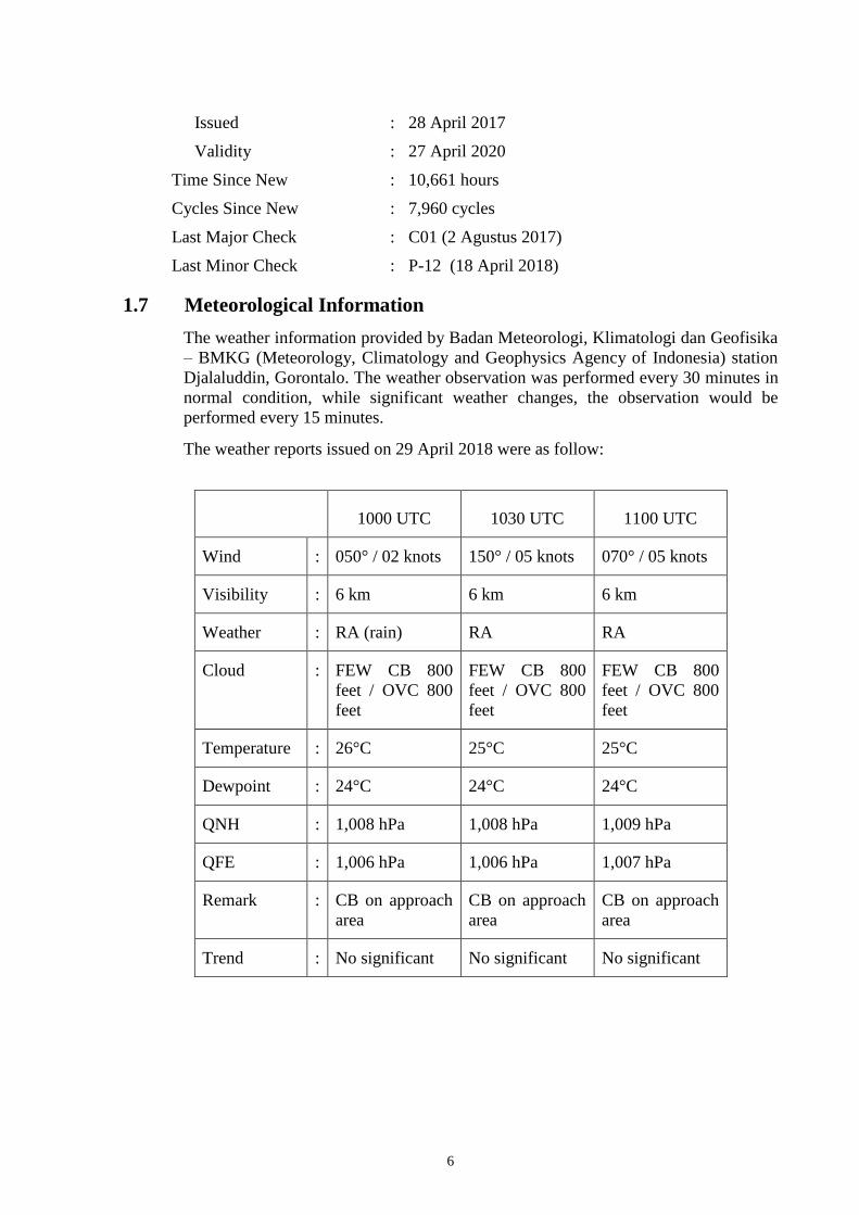
1.7 Meteorological Information
The weather information provided by Badan Meteorologi, Klimatologi dan Geofisika
– BMKG (Meteorology, Climatology and Geophysics Agency of Indonesia) station
Djalaluddin, Gorontalo. The weather observation was performed every 30 minutes in
normal condition, while significant weather changes, the observation would be
performed every 15 minutes.
The weather reports issued on 29 April 2018 were as follow:
1000 UTC 1030 UTC 1100 UTC
Wind : 050° / 02 knots 150° / 05 knots 070° / 05 knots
Visibility : 6 km 6 km 6 km
Weather : RA (rain) RA RA
Cloud : FEW CB 800
feet / OVC 800
feet
FEW CB 800
feet / OVC 800
feet
FEW CB 800
feet / OVC 800
feet
Temperature : 26°C 25°C 25°C
Dewpoint : 24°C 24°C 24°C
QNH : 1,008 hPa 1,008 hPa 1,009 hPa
QFE : 1,006 hPa 1,006 hPa 1,007 hPa
Remark : CB on approach
area
CB on approach
area
CB on approach
area
Trend : No significant No significant No significant

7
The satellite weather images recorded by meteorology station in Gorontalo were as
follows:
Figure 3: Satellite weather image at 1015 UTC
Figure 4: Satellite weather image at 1022 UTC
Figure 5: Satellite weather image at 1030 UTC
Airport location
Airport location
Airport location

8
1.8 Aids to Navigation
Gorontalo equipped with Very High Frequency Omni Range (VOR) identified as
GTO broadcast on frequency 113.5 MHz.
The instrument approach procedures for runway 27 were VOR/DME approach7 and
RNAV/GNSS8 approach.
Figure 6: RNAV procedure for runway 27
7 VOR/DME approach (Very High Frequency Omni-Range / Distance Measuring Equipment) is the instrument approach
procedure when the track and distance refer to the VOR ground base navigation aid.
8 RNAV/GNSS (Area Navigation/ Global Navigation Satellite Systems) is the aircraft capability that allows to navigate
from point to point, defined by Latitude/Longitude and independent of any ground-based system.

9
Figure 7: VOR/DME approach procedure runway 27
1.9 Communications
All communications between air traffic controller and the pilots were recorded by
ground based automatic voice recording equipment and Cockpit Voice Recorder
(CVR) for the duration of the flight. The quality of the aircraft’s recorded
transmissions was good.

10
The excerpt of communication between the Djalaluddin Tower controller and the
pilot is as follow:
At 1008 UTC, the pilot informed the Djalaluddin Tower controller (controller) that
they were maintaining altitude of 33,000 feet, on radial 212 from GTO (VOR)
and estimate time of arrival was 1040 UTC. The pilot requested for weather
information.
The controller informed the weather condition was wind calm, visibility 2,500
meters, weather slight rain, cloud FEW CB 800 feet and overcast 800 feet,
temperature 26°C, dew point 24°C, QNH 1,008 hPa, QFE 1,006 hPa and
remark the CB in approach area.
At 1016 UTC, the pilot reported that the flight was descending to altitude of
25,000 feet and passed altitude of 29,000 feet, and the aircraft position was on
radial 211 at 84 Nm from Gorontalo. The pilot requested clearance for descend
to lower altitude. The controller advised the pilot to fly direct to waypoint
PRAMU and descend to altitude 10,000 feet.
The pilot acknowledged the message and requested for the latest ground
visibility. The controller informed that the visibility was 2,800 meters.
At 1025 UTC, the pilot reported to the controller that the altitude was approaching
10,000 feet and was instructed to descend to 7,000 feet.
A few moments later the pilot informed that the aircraft position was 12 Nm to
waypoint PRAMU and approaching altitude 7,000 feet. The controller advised
to maintain 7,000 feet for a while.
At 1028 UTC, the controller advised the pilot to descend to 5,800 feet and issued
clearance to make VOR/DME approach runway 27 then advised to report when
leaving waypoint PRAMU. The PM acknowledged the message.
At 1030 UTC, the pilot reported that the aircraft was descending from altitude of
5,800 feet and leaving waypoint PRAMU. The controller advised the pilot to
report when the runway in sight.
At 1032 UTC, the controller informed that rain over the field and requested position
of the aircraft. The pilot acknowledged the information and reported that the
aircraft was on final course runway 27.
At 1033 UTC, a pilot of an ATR aircraft that previously landed informed to the LNI
892 pilot that when they were making the approach the final area was heavy
rain. The pilot acknowledged the information.
The controller informed that the wind direction was 150° with velocity of 7
knots, QNH 1,008 hPa and issued landing clearance when the runway was in
sight. The pilot acknowledged the message and would inform when runway
was in sight.
At 1034 UTC, the pilot reported that the runway was in sight and the controller
issued landing clearance.
At 1036 UTC, the controller confirmed whether the aircraft position was on the grass.
At 1038 UTC, the controller confirmed whether the pilot requiring any assistant.

11
After the aircraft stopped, both controller and pilot attempted to communicate and
failed. The pilot also attempted to make announcement through passenger address
system which was also failed.
1.10 Aerodrome Information
Airport Name : Djalaluddin Airport
Airport Identification : WAMG / GTO
Airport Operator : Directorate General of Civil Aviation (DGCA)
Coordinate : 0°38’14” N; 122°50’55” E
Elevation : 124 feet
Runway Direction : 09 – 27 (094° – 274°)
Runway Length : 2,500 meters
Runway Width : 45 meters
Surface : Asphalt
1.11 Flight Recorders
The aircraft was equipped with Flight Data Recorder (FDR) and Cockpit Voice
Recorder (CVR). Both recorders recovered from the aircraft and transported to
KNKT recorder facility for data download process.
1.11.1 Flight Data Recorder (FDR)
The FDR data are as follows:
Manufacturer : Honeywell
Type/Model : Solid state
Part Number : 980-4750-009
Serial Number : 02878
The FDR data was successfully downloaded. The FDR contained data of 1,274
parameters of 53 hours and 40 minutes or 31 flight sectors including the accident
flight. The detail information of the FDR will be included in the final report.
1.11.2 Cockpit Voice Recorder
The CVR data are as follow:
Manufacturer : Honeywell
Type/Model : Solid state
Part Number : 980-6022-001
Serial Number : 120-16054

12
The CVR data was successfully downloaded. The CVR contained data of two hours
and four minutes consisted of one hour 34 minutes of standard quality data and 30
minutes good quality data of four channels including the accident flight. The detail
information of the CVR will be included in the final report.
1.12 Wreckage and Impact Information
The touch down mark could not be determined. Based on the marks of the main
wheel, it was likely that the aircraft touched down on the touchdown zone and on the
center line.
Figure 8: The main wheel marks and the last aircraft position

13
Both engine thrust reversers were on deploy position. Muds were found on both
engine intakes and the thrust reverser doors, while the engine exhausts were clean of
mud.
Figure 9: Left and right engine thrust reversers condition
The flaps were found on full down position.
The left and right front door escape slides were deployed, while the over-wing exit
windows and aft doors were close.
Figure 10: The emergency exits and deployed slide on the right side of the
aircraft
1.13 Medical and Pathological Information
After the accident, alcohol and drug test were performed to all crew, the result
indicated that all crew were not affected by drug or alcohol.
1.14 Fire
There was no evidence of fire in-flight or post-impact fire.

14
1.15 Survival Aspects
After the aircraft stopped, the pilots commanded “Attention Crew on Station”,
followed by the flight attendants checking the outside condition through the viewing
windows. The FA 5 who were on the aft cabin, moved to the center cabin and
checked the outside condition through the passenger windows. All flight attendants
did not see any hazard to open all emergency exits in case the evacuation required.
After commanded “Attention Crew on Station”, the pilots performed Emergency on
the Ground procedure. One item on the procedure required pilot decision to
command evacuation. The PIC then commanded the SIC to command evacuation.
The SIC commanded evacuation to the FA 1 using passenger address (PA) system
but the PA system did not functioning. The PIC asked the SIC to knock on the
cockpit door and open it to command for evacuation directly to the FA 1. The SIC
did as it told.
The FA 1 received the command for evacuation and passed it to the FA 4 and both
flight attendants immediately opened the forward cabin doors, deployed the escape
slides and initiated the passenger evacuation. Both FA shouted to the passengers to
evacuate immediately.
During the evacuation, the flight attendant noticed the ARFF arrived and assisted the
evacuation from the outside. The ARFF personnel advised the passengers to slow
down the evacuation.
Most of the passengers stood up and block the view toward the front cabin made the
FA 2 and FA 3 who were on the aft cabin and the FA 5 who was on the center cabin
did not notice the passenger evacuation had been initiated. They only noticed that the
passengers were slowly moving forward and assumed normal disembarkation
initiated.
The flight attendants noticed that the area surround aircraft was dark and the lighting
was only from the ARFF vehicles.
1.16 Tests and Research
Upon the issuance of this preliminary report, no test or research was conducted. Any
test or research conducted during the investigation, the result will be included in the
final report.
1.17 Organizational and Management Information
1.17.1 PT. Lion Mentari Airlines
Aircraft Owner : SMBC Aviation Capital Limited
Address : IFSC House, IFSC, Dublin 1, Ireland
Aircraft Operator : PT. Lion Mentari Airlines, Indonesia
(Lion Air)
Address : Jl. Gajah Mada No. 7, Jakarta Pusat, Indonesia
AOC Number : AOC 121-010

15
Lion Air operated total of 116 aircrafts consisting of 3 Airbus A330, 35 Boeing 737 -
800, 70 Boeing 737-900ER, and 8 Boeing 737 MAX, which served more than 120
destinations, domestic and international, and operated up to 630 flights daily.
1.17.2 Djalaluddin Airport operator
Djalaluddin Airport operated by the Directorate General of Civil Aviation (DGCA).
Detail information of the airport operator including the procedure will be included in
the final report.
1.17.3 BMKG Office at Djalaluddin
The meteorological services for Djalaluddin Airport were provided by BMKG office
station Gorontalo.
Other than visual observation by meteorology observer, the weather was also
observed with Automatic Weather Observation System (AWOS). The AWOS
information provided to the controller on a display in tower cab.
Since 25 April 2018, the AWOS system was unserviceable and BMKG office station
Gorontalo and Airnav Indonesia Branch Office Gorontalo established a media
communication to distribute weather information.
The unserviceable AWOS had made up date weather information did not available in
the tower cab. The controller should call to BMKG observer requesting the update
weather information.
1.18 Additional Information
The investigation is continuing and KNKT plans to complete the investigation within
12 months since the day of the occurrence. Should any further relevant safety issues
emerge during the course of the investigation, KNKT will immediately bring the
issues to the attention of the relevant parties and publish as required.
1.19 Useful or Effective Investigation Techniques
The investigation was conducted in accordance with the KNKT approved policies
and procedures, and in accordance with the standards and recommended practices of
Annex 13 to the Chicago Convention.

16
2 FINDINGS9
According to factual information during the investigation, the KNKT identified
initial findings as follows:
1. The aircraft had valid Certificate of Airworthiness (C of A) and Certificate of
Registration (C of R).
2. The pilots held valid licenses and medical certificates.
3. On the first contact, when the aircraft was maintained 33,000 feet, the weather
condition reported was wind calm, visibility 2,500 meters, weather slight rain,
cloud FEW CB (cumulonimbus) 800 feet and overcast 800 feet, with additional
remark that the CB on approach area. The weather condition was above the
minima requirement for instrument approach runway 27.
4. A pilot of an ATR aircraft that previously landed informed to the LNI 892 pilot
that when they were making the approach the final area was heavy rain. The
LNI 892 pilot acknowledged the information.
5. The Automatic Weather Observation System (AWOS) of the meteorology
station Gorontalo was unserviceable 5 days before the accident flight. The
unserviceable AWOS had made up date weather information did not available
in the tower cab. The controller should call to BMKG observer requesting the
update weather information.
6. At 1040 UTC, the aircraft touched down, the spoiler automatically deployed
and the PF selected the engine thrust reversers. The pilots felt that suddenly the
rain became very heavy and only able to see the runway lights on the left side
of the runway.
7. The aircraft stopped on the left side runway shoulder at approximately 1,200
meters from the beginning runway 27 and the aircraft heading was 310°.
8. After completion of the Emergency on Ground procedure, the pilot unable to
communicate with the controller and the Passenger Address system did not
work. The instruction for evacuation was provided verbally direct to the Flight
Attendant 1 (FA 1).
9. The FA 1 and FA 4 initiated the passenger evacuation from the forward cabin
doors, while FA 5 who was on the center cabin and FA 2 and FA 3 who were
on the aft cabin did not know that the passenger evacuation had been initiated
and did not initiated passenger evacuation.
10. The Djalaluddin Tower controller could not clearly see the aircraft position
however, the controller aware that the aircraft experienced abnormality. The
controller notified the Airport rescue and Fire Fighting (ARFF) by handy talky
radio since the crash bell had not been connected to the new location of the
ARFF station.
9 Findings are statements of all significant conditions, events or circumstances in the accident sequence. The findings are
significant steps in the accident sequence, but they are not always causal, or indicate deficiencies. Some findings point
out the conditions that pre-existed the accident sequence, but they are usually essential to the understanding of the
occurrence, usually in chronological order.

17
11. The ARFF personnel after received notification immediately proceed to the
position of aircraft stopped to assist the evacuation.
12. No one injured in this accident and the aircraft substantially damaged. The
nose landing gear collapsed backward and impacted the forward lower fuselage
resulted in dent on this area. The engine cowlings broken. Two runway lights
were found broken.
18
3 SAFETY ACTION
At the time of issuing this Preliminary Report, the KNKT had been informed of
safety actions taken by aircraft operator resulting from this accident. The safety
actions consisted of corrective training for both pilots including simulator training
and flight attendants on duty which focused on emergency procedure.
The Safety and Security Directorate issued safety recommendations for related
department:
1. To add scenario on recurrent simulator for all pilots, including tire-cornering and
wave-off exercises.
2. To revise all the OM-C that states “No take-off or landing in heavy rain. When
the RWY is contaminated” to “No take-off or landing in heavy rain or when the
RWY is contaminated”
3. To revise the OM-C on WAMG/GTO for VOR DME approach RWY 27 into
step by step procedures and specified the final approach fix is changed to the 12
Nm point (CF27) and landing configuration has been achieved.
4. Obtain approval from regulator (DGCA) for Lion Air of RNAV (GNSS)
approach.
5. to review evacuation procedure.
6. To determine alternate signal for command “evacuate” when PA/interphone
communication system suddenly failed, to the following example of, in the
condition such FA1 identify that PA system is fail to function, immediately
she/he will use megaphone to initiate evacuation command.
7. To include “increasing situational awareness in any abnormal condition” into
‘one-minute silent review’ item.
The Safety and Security Directorate also issued Safety Information for all pilots
(detail is attached on the Appendices of this report) contained:
1. To respect of Stabilization Approach criteria
2. To respect of Mandatory Missed Approach criteria
3. To increase awareness when weather deterioration occurs such as time by time
visibility reduction
4. To ensure, implement anything related to requirement, prohibition or limitation
stated in OM-C
5. To review crew coordination and standard call out during approach
6. To increase crew assertiveness, particularly as pilot monitoring

19
4 SAFETY RECOMMENDATIONS
KNKT acknowledge the safety actions taken by aircraft operator and consider that
the safety actions were relevant to improve the safety of the operation.
KNKT issued safety recommendations airport operator to address safety issues
identified in this report.
4.1 Djalaluddin Airport Operator
04.B-2018-12.1
The crash bell had not been connected to the Airport Rescue and Fire Fighting
(ARFF) station. KNKT recommend Djalaluddin Airport Operator to establish all
equipment required for the standard airport services.

20
5 APPENDICES
5.1 Notice to pilot