Embed Size (px)
Citation preview
iii
Preface
This volume of the annual hydrologic data report of Iowa is one of a series of annual reports that document hydrologic data gathered from the U.S. Geological Survey’s surface- and ground-water data-collection networks in each State, Puerto Rico, and the Trust Territories. These records of streamflow, ground-water levels, and quality of water provide the hydrologic information needed by local, State, and Federal agencies, and the private sector for developing and managing our Nation’s land and water resources.
This report is the culmination of a concerted effort by dedicated personnel of the U.S. Geological Survey who collected, compiled, analyzed, verified, and organized the data, and who typed, edited, and assembled the report. The authors had primary responsibility for assuring that the information contained herein is accurate, complete, and adheres to Geological Survey policy and established guidelines.
Personnel in charge of the field units are:
Joseph G. Gorman, Western Field Unit
Robert D. Goodrich, Eastern Field Unit
The data were collected, computed and processed by the following personnel:
K.D. Becher J.C. McVay
J.F. CervenyD.E. ChristiansenD.T. ConellA.R. ConklingA.L. DonnellyD.A. EashN.C. ElmendorfE.E. FischerA. GroteJ.S. HansenJ.W. HarmsK.S. HouselR.L. KopishS.M. LinhartG.R. LittinJ.VJ.J.MS.DMP.J.S.S.
This report was prepared in cooperation with the State of Io
J. Moline.E. MillerF. NaniaA. Nason.J. NoonA. Rundquist.J. Schnoebelen.K. SegretoK. SmithR. SondagR. StraderA. Thul
wa and with other agencies under the general supervision of
Greg M. Nalley, Chief Hydrologic Surveillence Section, and Rob G. Middlemis-Brown, Center Director, Iowa.
REPORT DOCUMENTATION PAGE Form ApprovedOMB No. 0704-0188
NSN 7540-01-280-5500
1. AGENCY USE ONLY (Leave blank)
Public reporting burden for this collection of information is estimated to average 1 hour per response, including the time for reviewing instructions, searching existing data sources, gathering and maintaining the data needed, and completing and reviewing the collection of information. Send comments regarding this burden estimate or any other aspect of this collection of information, including suggestions for reducing this burden, to Washington Headquarters Services, Directorate for Information Operations and Reports, 1215 Jefferson Davis Highway, Suite 1204, Arlington, VA 22202-4302, and to the Office of Management and Budget, Paperwork Reduction Project (0704-0188), Washington, DC 20503.
2. REPORT DATEJanuary 31, 2005 A
3. REPORT TYPE AND DATES COVEREDnnual, 1 Oct. 2003 - 30 Sept. 2004
5. FUNDING NUMBERS
4. TITLE AND SUBTITLEWater Resources Data, Iowa, Water Year 2004 Volume 1: Surface Water and Precipitation
6. AUTHOR(S)G.M. Nalley, J.G. Gorman, R.D. Goodrich, V.E. Miller, and K.S. Housel
8. PERFORMING ORGANIZATION
7. PERFORMING ORGANIZATION NAME(S) AND ADDRESS(ES)U.S. Geological Survey, Water Resources DivisionP.O. Box 1230Iowa City, IA 52244
REPORT NUMBER
USGS-WRD-IA-04-1
10.AGENCY REPORT NUMBERSPONSORING / MONITORING
9. SPONSORING / MONITORING AGENCY NAME(S) AND ADDRESS(ES)U.S. Geological Survey, Water Resources DivisionP.O. Box 1230Iowa City, IA 52244
USGS-WRD-IA-04-1
11. SUPPLEMENTARY NOTES
Prepared in cooperation with the Iowa Department of Natural Resources–Geological Survey; Iowa Department of Transportation; and Federal agencies.
12a. DISTRIBUTION / AVAILABILITY STATEMENT
No restrictions on distribution. This report may be purchased from:
National Technical Information ServiceSpringfield, VA 22161
12b. DISTRIBUTION CODE
13. ABSTRACT (Maximum 200 words)
Water resources data for Iowa for the 2004 water year consists of records of stage, discharge, and water quality of streams; stage, and/or contents of lakes and reservoirs; ground-water levels and water quality of ground-water wells. This report volume contains discharge records for 134 gaging stations; stage or contents for 9 lakes and reservoirs and 3 streams; water quality for 4 stream-gaging stations; sediment records for 11 stream-gaging stations; and precipitation record for 7 precipitation stations. Also included are data for 90 crest-stage partial-record stations.
5
6.
14. SUBJECT TERMS 1
1
18. SECURITY CLASSIFICATION 19. SECURITY CLASSIFICATION
*Iowa, *Hydrologic data, *Surface water, *Water quality, Flow rates, Gaging stations, Lakes, Reservoirs, Chemical analyses, Sediment, Water temperatures, Sampling sites, Water levels, Water analyses, Data collection.
StandPrescr298-10
. NUMBER OF PAGES
473
PRICE CODE17. SECURITY CLASSIFICATIONOF REPORT
Unclassified
OF THIS PAGEUnclassified
OF ABSTRACTUnclassified
20. LIMITATION OF ABSTRACT
ard Form 298 (Rev. 2-89)ibed by ANSI Std 239-182

v
CONTENTSPage
Preface . . . . . . . . . . . . . . . . . . . . . . . . . . . . . . . . . . . . . . . . . . . . . . . . . . . . . . . . . . . . . . . . . . . . . . . . . . . . . . . . . . . . . . . . . . . . iiiSurface-water stations, in downstream order, for which records are published in this volume . . . . . . . . . . . . . . . . . . . . . . . . viiDiscontinued surface-water discharge or stage-only stations . . . . . . . . . . . . . . . . . . . . . . . . . . . . . . . . . . . . . . . . . . . . . . . . . . . xiDiscontinued surface-water-quality stations . . . . . . . . . . . . . . . . . . . . . . . . . . . . . . . . . . . . . . . . . . . . . . . . . . . . . . . . . . . . . . xiiiIntroduction . . . . . . . . . . . . . . . . . . . . . . . . . . . . . . . . . . . . . . . . . . . . . . . . . . . . . . . . . . . . . . . . . . . . . . . . . . . . . . . . . . . . . . . . . 1Cooperation . . . . . . . . . . . . . . . . . . . . . . . . . . . . . . . . . . . . . . . . . . . . . . . . . . . . . . . . . . . . . . . . . . . . . . . . . . . . . . . . . . . . . . . . . 1Summary of hydrologic conditions . . . . . . . . . . . . . . . . . . . . . . . . . . . . . . . . . . . . . . . . . . . . . . . . . . . . . . . . . . . . . . . . . . . . . . 2
Precipitation . . . . . . . . . . . . . . . . . . . . . . . . . . . . . . . . . . . . . . . . . . . . . . . . . . . . . . . . . . . . . . . . . . . . . . . . . . . . . . . . . . . . . . 2Downstream order and station number . . . . . . . . . . . . . . . . . . . . . . . . . . . . . . . . . . . . . . . . . . . . . . . . . . . . . . . . . . . . . . . . . . . 8Special networks and programs . . . . . . . . . . . . . . . . . . . . . . . . . . . . . . . . . . . . . . . . . . . . . . . . . . . . . . . . . . . . . . . . . . . . . . . . . 9Explanation of stage- and water-discharge record . . . . . . . . . . . . . . . . . . . . . . . . . . . . . . . . . . . . . . . . . . . . . . . . . . . . . . . . . . 10
Data Collection and Computation . . . . . . . . . . . . . . . . . . . . . . . . . . . . . . . . . . . . . . . . . . . . . . . . . . . . . . . . . . . . . . . . . . . . 10Data Presentation . . . . . . . . . . . . . . . . . . . . . . . . . . . . . . . . . . . . . . . . . . . . . . . . . . . . . . . . . . . . . . . . . . . . . . . . . . . . . . . . . 11Identifying Estimated Daily Discharge . . . . . . . . . . . . . . . . . . . . . . . . . . . . . . . . . . . . . . . . . . . . . . . . . . . . . . . . . . . . . . . . 13Accuracy of Field Data and Computed Results . . . . . . . . . . . . . . . . . . . . . . . . . . . . . . . . . . . . . . . . . . . . . . . . . . . . . . . . . . 13Other Data Records Available . . . . . . . . . . . . . . . . . . . . . . . . . . . . . . . . . . . . . . . . . . . . . . . . . . . . . . . . . . . . . . . . . . . . . . . 14
Explanation of Precipitation Records . . . . . . . . . . . . . . . . . . . . . . . . . . . . . . . . . . . . . . . . . . . . . . . . . . . . . . . . . . . . . . . . . . . . 14Data Collection and Computation . . . . . . . . . . . . . . . . . . . . . . . . . . . . . . . . . . . . . . . . . . . . . . . . . . . . . . . . . . . . . . . . . . . . 14Data Presentation . . . . . . . . . . . . . . . . . . . . . . . . . . . . . . . . . . . . . . . . . . . . . . . . . . . . . . . . . . . . . . . . . . . . . . . . . . . . . . . . . 14
Explanation of Water-Quality Records . . . . . . . . . . . . . . . . . . . . . . . . . . . . . . . . . . . . . . . . . . . . . . . . . . . . . . . . . . . . . . . . . . . 15Collection and Examination of Data . . . . . . . . . . . . . . . . . . . . . . . . . . . . . . . . . . . . . . . . . . . . . . . . . . . . . . . . . . . . . . . . . . 15Water Analysis . . . . . . . . . . . . . . . . . . . . . . . . . . . . . . . . . . . . . . . . . . . . . . . . . . . . . . . . . . . . . . . . . . . . . . . . . . . . . . . . . . . 15
Surface-Water-Quality Records . . . . . . . . . . . . . . . . . . . . . . . . . . . . . . . . . . . . . . . . . . . . . . . . . . . . . . . . . . . . . . . . . . . . . . . . 15Classification of Records . . . . . . . . . . . . . . . . . . . . . . . . . . . . . . . . . . . . . . . . . . . . . . . . . . . . . . . . . . . . . . . . . . . . . . . . . . . 15Accuracy of the Records . . . . . . . . . . . . . . . . . . . . . . . . . . . . . . . . . . . . . . . . . . . . . . . . . . . . . . . . . . . . . . . . . . . . . . . . . . . 16Arrangement of Records. . . . . . . . . . . . . . . . . . . . . . . . . . . . . . . . . . . . . . . . . . . . . . . . . . . . . . . . . . . . . . . . . . . . . . . . . . . . 16On-Site Measurements and Sample Collection . . . . . . . . . . . . . . . . . . . . . . . . . . . . . . . . . . . . . . . . . . . . . . . . . . . . . . . . . . 16Water Temperature. . . . . . . . . . . . . . . . . . . . . . . . . . . . . . . . . . . . . . . . . . . . . . . . . . . . . . . . . . . . . . . . . . . . . . . . . . . . . . . . 16Sediment . . . . . . . . . . . . . . . . . . . . . . . . . . . . . . . . . . . . . . . . . . . . . . . . . . . . . . . . . . . . . . . . . . . . . . . . . . . . . . . . . . . . . . . . 17Laboratory Measurements . . . . . . . . . . . . . . . . . . . . . . . . . . . . . . . . . . . . . . . . . . . . . . . . . . . . . . . . . . . . . . . . . . . . . . . . . . 17Data Presentation . . . . . . . . . . . . . . . . . . . . . . . . . . . . . . . . . . . . . . . . . . . . . . . . . . . . . . . . . . . . . . . . . . . . . . . . . . . . . . . . . 17Remark Codes . . . . . . . . . . . . . . . . . . . . . . . . . . . . . . . . . . . . . . . . . . . . . . . . . . . . . . . . . . . . . . . . . . . . . . . . . . . . . . . . . . . 18Water-Quality Control Data . . . . . . . . . . . . . . . . . . . . . . . . . . . . . . . . . . . . . . . . . . . . . . . . . . . . . . . . . . . . . . . . . . . . . . . . . 18Blank Samples . . . . . . . . . . . . . . . . . . . . . . . . . . . . . . . . . . . . . . . . . . . . . . . . . . . . . . . . . . . . . . . . . . . . . . . . . . . . . . . . . . . 18Reference Samples . . . . . . . . . . . . . . . . . . . . . . . . . . . . . . . . . . . . . . . . . . . . . . . . . . . . . . . . . . . . . . . . . . . . . . . . . . . . . . . . 19Replicate Samples . . . . . . . . . . . . . . . . . . . . . . . . . . . . . . . . . . . . . . . . . . . . . . . . . . . . . . . . . . . . . . . . . . . . . . . . . . . . . . . . 19Spike Samples . . . . . . . . . . . . . . . . . . . . . . . . . . . . . . . . . . . . . . . . . . . . . . . . . . . . . . . . . . . . . . . . . . . . . . . . . . . . . . . . . . . 19
Access to USGS Water Data . . . . . . . . . . . . . . . . . . . . . . . . . . . . . . . . . . . . . . . . . . . . . . . . . . . . . . . . . . . . . . . . . . . . . . . . . . . 20Definition of Terms. . . . . . . . . . . . . . . . . . . . . . . . . . . . . . . . . . . . . . . . . . . . . . . . . . . . . . . . . . . . . . . . . . . . . . . . . . . . . . . . . . 20Techniques of Water-Resources Investigations of the U.S. Geological Survey. . . . . . . . . . . . . . . . . . . . . . . . . . . . . . . . . . . . 37Surface-water records . . . . . . . . . . . . . . . . . . . . . . . . . . . . . . . . . . . . . . . . . . . . . . . . . . . . . . . . . . . . . . . . . . . . . . . . . . . . . . . . 37Crest-stage partial-record stations . . . . . . . . . . . . . . . . . . . . . . . . . . . . . . . . . . . . . . . . . . . . . . . . . . . . . . . . . . . . . . . . . . . . . . 487Index . . . . . . . . . . . . . . . . . . . . . . . . . . . . . . . . . . . . . . . . . . . . . . . . . . . . . . . . . . . . . . . . . . . . . . . . . . . . . . . . . . . . . . . . . . . . 497
vi
Page
Figures
Figure 1. Water year 2004 precipitation record for the National Weather Service’s designated Climatological Districts 3
Figure 2. Annual runoff for period of record at index stations. . . . . . . . . . . . . . . . . . . . . . . . . . . . . . . . 5Figure 3. Location of continuous-record and crest-stage gaging stations in Iowa, water year 2004. . . . 6Figure 4. Location of active sediment and surface-water quality stations in Iowa, water year 2004. . . 7Figure 5. Annual sediment discharge statistics at four long-term streamflow-gaging stations, water year
2004 8

vii
SURFACE-WATER STATIONS, IN DOWNSTREAM ORDER, FOR WHICH RECORDS ARE PUBLISHED IN THIS VOLUMEStation number Page
UPPER MISSISSIPPI RIVER BASIN(Map of Mississippi River basin gaging stations—northeast Iowa) . . . . . . . . . . . . . . . . . . . . . .38
Mississippi River:Upper Iowa River at Bluffton (d) . . . . . . . . . . . . . . . . . . . . . . . . . . . . . . . . . . . . . . . . . . . . 05387440 . . . . . . . . . . . . . 40Upper Iowa River at Decorah (d) . . . . . . . . . . . . . . . . . . . . . . . . . . . . . . . . . . . . . . . . . . . . 05387500 . . . . . . . . . . . . . 42Upper Iowa River near Dorchester (d) . . . . . . . . . . . . . . . . . . . . . . . . . . . . . . . . . . . . . . . . 05388250 . . . . . . . . . . . . . 44Bloody Run Creek near Marquette (dtsp) . . . . . . . . . . . . . . . . . . . . . . . . . . . . . . . . . . . . . . 05389400 . . . . . . . . . . . . . 46
Mississippi River at McGregor (dts) . . . . . . . . . . . . . . . . . . . . . . . . . . . . . . . . . . . . . . . . . . . . . 05389500 . . . . . . . . . . . . . 55Mississippi River at Clayton (d) . . . . . . . . . . . . . . . . . . . . . . . . . . . . . . . . . . . . . . . . . . . . . . . . . 05411500 . . . . . . . . . . . . . 62
(Map of Turkey and Maquoketa River basin gaging stations) . . . . . . . . . . . . . . . . . . . . . . . .64
TURKEY RIVER BASINTurkey River near Eldorado (d) . . . . . . . . . . . . . . . . . . . . . . . . . . . . . . . . . . . . . . . . . . . . . 05411850 . . . . . . . . . . . . . 66Turkey River above French Hollow Creek at Elkader (d) . . . . . . . . . . . . . . . . . . . . . . . . . 05412020 . . . . . . . . . . . . . 68
Volga River at Littleport (d) . . . . . . . . . . . . . . . . . . . . . . . . . . . . . . . . . . . . . . . . . . . . 05412400 . . . . . . . . . . . . . 70Turkey River at Garber (dc) . . . . . . . . . . . . . . . . . . . . . . . . . . . . . . . . . . . . . . . . . . . . . . . . 05412500 . . . . . . . . . . . . . 72
MAQUOKETA RIVER BASINMaquoketa River at Manchester (d) . . . . . . . . . . . . . . . . . . . . . . . . . . . . . . . . . . . . . . . . . . 05416900 . . . . . . . . . . . . . 77North Fork Maquoketa River near Fulton (d) . . . . . . . . . . . . . . . . . . . . . . . . . . . . . . . . . . . 05418400 . . . . . . . . . . . . . 79Maquoketa River near Maquoketa (dts) . . . . . . . . . . . . . . . . . . . . . . . . . . . . . . . . . . . . . . . 05418500 . . . . . . . . . . . . . 81Maquoketa River near Spragueville (cs) . . . . . . . . . . . . . . . . . . . . . . . . . . . . . . . . . . . . . . . 05418600 . . . . . . . . . . . . . 88
(Map of Mississippi and Wapsipinicon River basin gaging stations) . . . . . . . . . . . . . . . . . . . . .92Mississippi River:
Beaver Slough at Third Street Clinton (d) . . . . . . . . . . . . . . . . . . . . . . . . . . . . . . . . . . . . . 05420460 . . . . . . . . . . . . . 94Mississippi River at Clinton (dcts) . . . . . . . . . . . . . . . . . . . . . . . . . . . . . . . . . . . . . . . . . . . . . . . 05420500 . . . . . . . . . . . . . 96
WAPSIPINICON RIVER BASINWapsipinicon River near Tripoli (dcp) . . . . . . . . . . . . . . . . . . . . . . . . . . . . . . . . . . . . . . . . 05420680 . . . . . . . . . . . . 103Wapsipinicon River at Independence (d) . . . . . . . . . . . . . . . . . . . . . . . . . . . . . . . . . . . . . . 05421000 . . . . . . . . . . . . 110Wapsipinicon River at Anamosa (d) . . . . . . . . . . . . . . . . . . . . . . . . . . . . . . . . . . . . . . . . . . 05421740 . . . . . . . . . . . . 112Wapsipinicon River near De Witt (dc) . . . . . . . . . . . . . . . . . . . . . . . . . . . . . . . . . . . . . . . . 05422000 . . . . . . . . . . . . 114
Mississippi River:Crow Creek at Bettendorf (d) . . . . . . . . . . . . . . . . . . . . . . . . . . . . . . . . . . . . . . . . . . . . . . . 05422470 . . . . . . . . . . . . 119Duck Creek at 110th Avenue, Davenport (d) . . . . . . . . . . . . . . . . . . . . . . . . . . . . . . . . . . . 05422560 . . . . . . . . . . . . 121Duck Creek at Duck Creek Golf Course (d) . . . . . . . . . . . . . . . . . . . . . . . . . . . . . . . . . . . . 05422600 . . . . . . . . . . . . 123
(Map of Iowa River basin gaging stations) . . . . . . . . . . . . . . . . . . . . . . . . . . . . . .126
IOWA RIVER BASINIowa River near Rowan (dc) . . . . . . . . . . . . . . . . . . . . . . . . . . . . . . . . . . . . . . . . . . . . . . . . 05449500 . . . . . . . . . . . . 128
South Fork Iowa River Northeast of New Providence (dcp) . . . . . . . . . . . . . . . . . . . . 05451210 . . . . . . . . . . . . 133Iowa River at Marshalltown (d) . . . . . . . . . . . . . . . . . . . . . . . . . . . . . . . . . . . . . . . . . . . . . 05451500 . . . . . . . . . . . . 140
Timber Creek near Marshalltown (d) . . . . . . . . . . . . . . . . . . . . . . . . . . . . . . . . . . . . . 05451700 . . . . . . . . . . . . 142Richland Creek near Haven (d) . . . . . . . . . . . . . . . . . . . . . . . . . . . . . . . . . . . . . . . . . . 05451900 . . . . . . . . . . . . 144Salt Creek near Elberon (d) . . . . . . . . . . . . . . . . . . . . . . . . . . . . . . . . . . . . . . . . . . . . . 05452000 . . . . . . . . . . . . 146Walnut Creek near Hartwick (d) . . . . . . . . . . . . . . . . . . . . . . . . . . . . . . . . . . . . . . . . . 05452200 . . . . . . . . . . . . 148Big Bear Creek at Ladora (d) . . . . . . . . . . . . . . . . . . . . . . . . . . . . . . . . . . . . . . . . . . . . 05453000 . . . . . . . . . . . . 150
Iowa River at Marengo (d) . . . . . . . . . . . . . . . . . . . . . . . . . . . . . . . . . . . . . . . . . . . . . . . . . 05453100 . . . . . . . . . . . . 152Coralville Lake near Coralville (e) . . . . . . . . . . . . . . . . . . . . . . . . . . . . . . . . . . . . . . . . . . . 05453510 . . . . . . . . . . . . 154Iowa River below Coralville Dam near Coralville (d) . . . . . . . . . . . . . . . . . . . . . . . . . . . . 05453520 . . . . . . . . . . . . 156
Rapid Creek below Morse (p) . . . . . . . . . . . . . . . . . . . . . . . . . . . . . . . . . . . . . . . . . . . 05453600 . . . . . . . . . . . . 158Rapid Creek near Iowa City (d) . . . . . . . . . . . . . . . . . . . . . . . . . . . . . . . . . . . . . . . . . . 05454000 . . . . . . . . . . . . 160Clear Creek near Oxford (d) . . . . . . . . . . . . . . . . . . . . . . . . . . . . . . . . . . . . . . . . . . . . 05454220 . . . . . . . . . . . . 162Clear Creek near Coralville (d) . . . . . . . . . . . . . . . . . . . . . . . . . . . . . . . . . . . . . . . . . . 05454300 . . . . . . . . . . . . 164

viii SURFACE-WATER STATIONS, IN DOWNSTREAM ORDER, FOR WHICH RECORDS ARE PUBLISHED IN THIS VOLUME—Continued
Station number Page
UPPER MISSISSIPPI RIVER BASIN--ContinuedIowa River at Iowa City (d) . . . . . . . . . . . . . . . . . . . . . . . . . . . . . . . . . . . . . . . . . . . . . . . . 05454500 . . . . . . . . . . . . 166
South Branch Ralston Creek at Iowa City (e) . . . . . . . . . . . . . . . . . . . . . . . . . . . . . . . 05455010 . . . . . . . . . . . . 168Old Mans Creek near Iowa City (d) . . . . . . . . . . . . . . . . . . . . . . . . . . . . . . . . . . . . . . . 05455100 . . . . . . . . . . . . 170English River at Kalona (d) . . . . . . . . . . . . . . . . . . . . . . . . . . . . . . . . . . . . . . . . . . . . . 05455500 . . . . . . . . . . . . 172
Iowa River near Lone Tree (d) . . . . . . . . . . . . . . . . . . . . . . . . . . . . . . . . . . . . . . . . . . . . . . 05455700 . . . . . . . . . . . . 174(Map of Cedar River basin gaging stations) . . . . . . . . . . . . . . . . . . . . . . . . . . . . . .176
CEDAR RIVER BASINCedar River at Charles City (d) . . . . . . . . . . . . . . . . . . . . . . . . . . . . . . . . . . . . . . . . . . 05457700 . . . . . . . . . . . . 178
Little Cedar River near Ionia (d) . . . . . . . . . . . . . . . . . . . . . . . . . . . . . . . . . . . . . 05458000 . . . . . . . . . . . . 180Cedar River at Waverly (d) . . . . . . . . . . . . . . . . . . . . . . . . . . . . . . . . . . . . . . . . . . . . . 05458300 . . . . . . . . . . . . 182Cedar River at Janesville (d) . . . . . . . . . . . . . . . . . . . . . . . . . . . . . . . . . . . . . . . . . . . . 05458500 . . . . . . . . . . . . 184
West Fork Cedar River at Finchford (d) . . . . . . . . . . . . . . . . . . . . . . . . . . . . . . . . 05458900 . . . . . . . . . . . . 186Shell Rock River:
Winnebago River at Mason City (d) . . . . . . . . . . . . . . . . . . . . . . . . . . . . . . . 05459500 . . . . . . . . . . . . 188Willow Creek:Clear Creek:
Clear Lake at Clear Lake (e) . . . . . . . . . . . . . . . . . . . . . . . . . . . . . . 05460000 . . . . . . . . . . . . 190Shell Rock River at Shell Rock (d) . . . . . . . . . . . . . . . . . . . . . . . . . . . . . . . . . . . . 05462000 . . . . . . . . . . . . 192Beaver Creek at New Hartford (d) . . . . . . . . . . . . . . . . . . . . . . . . . . . . . . . . . . . . 05463000 . . . . . . . . . . . . 194
Cedar River at Cedar Falls (d) . . . . . . . . . . . . . . . . . . . . . . . . . . . . . . . . . . . . . . . . . . . 05463050 . . . . . . . . . . . . 196Black Hawk Creek at Hudson (d) . . . . . . . . . . . . . . . . . . . . . . . . . . . . . . . . . . . . . 05463500 . . . . . . . . . . . . 198
Cedar River at Waterloo (d) . . . . . . . . . . . . . . . . . . . . . . . . . . . . . . . . . . . . . . . . . . . . . 05464000 . . . . . . . . . . . . 200Wolf Creek near Dysart (d) . . . . . . . . . . . . . . . . . . . . . . . . . . . . . . . . . . . . . . . . 05464220 . . . . . . . . . . . . 202
Cedar River at Cedar Rapids (d) . . . . . . . . . . . . . . . . . . . . . . . . . . . . . . . . . . . . . . . . . 05464500 . . . . . . . . . . . . 204Hoover Creek at West Branch (d) . . . . . . . . . . . . . . . . . . . . . . . . . . . . . . . . . . . . 05464942 . . . . . . . . . . . . 206
Cedar River near Conesville (d) . . . . . . . . . . . . . . . . . . . . . . . . . . . . . . . . . . . . . . . . . 05465000 . . . . . . . . . . . . 208Iowa River at Wapello (dts) . . . . . . . . . . . . . . . . . . . . . . . . . . . . . . . . . . . . . . . . . . . . . . . . 05465500 . . . . . . . . . . . . 210
(Map of Skunk River basin gaging stations) . . . . . . . . . . . . . . . . . . . . . . . . . . . . . .220
SKUNK RIVER BASINSkunk River:
South Skunk River near Ames (d) . . . . . . . . . . . . . . . . . . . . . . . . . . . . . . . . . . . . . . . . 05470000 . . . . . . . . . . . . 222Squaw Creek at Ames (d) . . . . . . . . . . . . . . . . . . . . . . . . . . . . . . . . . . . . . . . . . . . 05470500 . . . . . . . . . . . . 224
South Skunk River below Squaw Creek near Ames (d) . . . . . . . . . . . . . . . . . . . . . . . 05471000 . . . . . . . . . . . . 226Squaw Creek near Colfax (dtsp) . . . . . . . . . . . . . . . . . . . . . . . . . . . . . . . . . . . . . . 05471040 . . . . . . . . . . . . 228
South Skunk River at Colfax (d) . . . . . . . . . . . . . . . . . . . . . . . . . . . . . . . . . . . . . . . . . 05471050 . . . . . . . . . . . . 237Indian Creek near Mingo (d) . . . . . . . . . . . . . . . . . . . . . . . . . . . . . . . . . . . . . . . . 05471200 . . . . . . . . . . . . 239
South Skunk River near Oskaloosa (d) . . . . . . . . . . . . . . . . . . . . . . . . . . . . . . . . . . . . 05471500 . . . . . . . . . . . . 241North Skunk River near Sigourney (d) . . . . . . . . . . . . . . . . . . . . . . . . . . . . . . . . . . . . 05472500 . . . . . . . . . . . . 243Cedar Creek near Oakland Mills (d) . . . . . . . . . . . . . . . . . . . . . . . . . . . . . . . . . . . . . . 05473400 . . . . . . . . . . . . 245Big Creek near Mt. Pleasant (d) . . . . . . . . . . . . . . . . . . . . . . . . . . . . . . . . . . . . . . . . . . 05473450 . . . . . . . . . . . . 247
Skunk River at Augusta (dcts) . . . . . . . . . . . . . . . . . . . . . . . . . . . . . . . . . . . . . . . . . . . . . . . 05474000 . . . . . . . . . . . . 249Mississippi River at Keokuk (d) . . . . . . . . . . . . . . . . . . . . . . . . . . . . . . . . . . . . . . . . . . . . . . . . . 05474500 . . . . . . . . . . . . 259
(Map of Des Moines River basin gaging stations) . . . . . . . . . . . . . . . . . . . . . . . . . . .262
DES MOINES RIVER BASINDes Moines River at Humboldt (d) . . . . . . . . . . . . . . . . . . . . . . . . . . . . . . . . . . . . . . . . . . . 05476750 . . . . . . . . . . . . 264
East Fork Des Moines River at Dakota City (d) . . . . . . . . . . . . . . . . . . . . . . . . . . . . . 05479000 . . . . . . . . . . . . 266Des Moines River at Fort Dodge (d) . . . . . . . . . . . . . . . . . . . . . . . . . . . . . . . . . . . . . . . . . . 05480500 . . . . . . . . . . . . 268
Boone River near Webster City (d) . . . . . . . . . . . . . . . . . . . . . . . . . . . . . . . . . . . . . . . 05481000 . . . . . . . . . . . . 270Des Moines River near Stratford (d) . . . . . . . . . . . . . . . . . . . . . . . . . . . . . . . . . . . . . . . . . . 05481300 . . . . . . . . . . . . 272Saylorville Lake near Saylorville (e) . . . . . . . . . . . . . . . . . . . . . . . . . . . . . . . . . . . . . . . . . 05481630 . . . . . . . . . . . . 274Des Moines River near Saylorville (dts) . . . . . . . . . . . . . . . . . . . . . . . . . . . . . . . . . . . . . . . 05481650 . . . . . . . . . . . . 276
Beaver Creek near Grimes (d) . . . . . . . . . . . . . . . . . . . . . . . . . . . . . . . . . . . . . . . . . . . 05481950 . . . . . . . . . . . . 283Des Moines River at Second Avenue at Des Moines (d) . . . . . . . . . . . . . . . . . . . . . . . . . . 05482000 . . . . . . . . . . . . 285

ixSURFACE-WATER STATIONS, IN DOWNSTREAM ORDER, FOR WHICH RECORDS ARE PUBLISHED IN THIS VOLUME—Continued
Station number Page
UPPER MISSISSIPPI RIVER BASIN--Continued(Map of Raccoon River basin gaging stations) . . . . . . . . . . . . . . . . . . . . . . . . . . . . .288
RACCOON RIVER BASINRaccoon River:
South Raccoon River:North Raccoon River near Sac City (d) . . . . . . . . . . . . . . . . . . . . . . . . . . . . . 05482300 . . . . . . . . . . . . 290
Black Hawk Lake at Lake View (e) . . . . . . . . . . . . . . . . . . . . . . . . . . . . . . . . . . . . . . . 05482315 . . . . . . . . . . . . 292North Raccoon River near Jefferson (d) . . . . . . . . . . . . . . . . . . . . . . . . . . . . 05482500 . . . . . . . . . . . . 294Middle Raccoon River near Bayard (d) . . . . . . . . . . . . . . . . . . . . . . . . . . . . . 05483450 . . . . . . . . . . . . 296Lake Panorama at Panora (e) . . . . . . . . . . . . . . . . . . . . . . . . . . . . . . . . . . . . . 05483470 . . . . . . . . . . . . 298Middle Raccoon River at Panora (d) . . . . . . . . . . . . . . . . . . . . . . . . . . . . . . . 05483600 . . . . . . . . . . . . 300
South Raccoon River at Redfield (d) . . . . . . . . . . . . . . . . . . . . . . . . . . . . . . . . . . 05484000 . . . . . . . . . . . . 302Raccoon River at Van Meter (d) . . . . . . . . . . . . . . . . . . . . . . . . . . . . . . . . . . . . . . . . . 05484500 . . . . . . . . . . . . 304Raccoon River near West Des Moines (d) . . . . . . . . . . . . . . . . . . . . . . . . . . . . . . . . . . 05484600 . . . . . . . . . . . . 306Raccoon River at 63rd Street Des Moines (d) . . . . . . . . . . . . . . . . . . . . . . . . . . . . . . . 05484650 . . . . . . . . . . . . 308
Walnut Creek at Des Moines (d) . . . . . . . . . . . . . . . . . . . . . . . . . . . . . . . . . . . . . 05484800 . . . . . . . . . . . . 310Raccoon River at Fleur Drive Des Moines (d) . . . . . . . . . . . . . . . . . . . . . . . . . . . . . . 05484900 . . . . . . . . . . . . 312
(Map of Lower Des Moines River basin gaging stations) . . . . . . . . . . . . . . . . . . . . . . . .314Des Moines River below Raccoon River at Des Moines (d) . . . . . . . . . . . . . . . . . . . . . . . 05485500 . . . . . . . . . . . . 316
Fourmile Creek near Ankeny (d) . . . . . . . . . . . . . . . . . . . . . . . . . . . . . . . . . . . . . . . . . 05485605 . . . . . . . . . . . . 318Fourmile Creek at Des Moines (d) . . . . . . . . . . . . . . . . . . . . . . . . . . . . . . . . . . . . . . . 05485640 . . . . . . . . . . . . 322North River near Norwalk (d) . . . . . . . . . . . . . . . . . . . . . . . . . . . . . . . . . . . . . . . . . . . 05486000 . . . . . . . . . . . . 324South River near Ackworth (d) . . . . . . . . . . . . . . . . . . . . . . . . . . . . . . . . . . . . . . . . . . 05487470 . . . . . . . . . . . . 326Middle River near Indianola (d) . . . . . . . . . . . . . . . . . . . . . . . . . . . . . . . . . . . . . . . . . 05486490 . . . . . . . . . . . . 328
Des Moines River near Runnells (d) . . . . . . . . . . . . . . . . . . . . . . . . . . . . . . . . . . . . . . . . . . 05487500 . . . . . . . . . . . . 330Walnut Creek near Prairie City (dtsp) . . . . . . . . . . . . . . . . . . . . . . . . . . . . . . . . . . . . . 05487540 . . . . . . . . . . . . 332Walnut Creek near Vandalia (d) . . . . . . . . . . . . . . . . . . . . . . . . . . . . . . . . . . . . . . . . . 05487550 . . . . . . . . . . . . 341White Breast Creek near Dallas (d) . . . . . . . . . . . . . . . . . . . . . . . . . . . . . . . . . . . . . . . 05487980 . . . . . . . . . . . . 350
Lake Red Rock near Pella (d) . . . . . . . . . . . . . . . . . . . . . . . . . . . . . . . . . . . . . . . . . . . . . . . 05488100 . . . . . . . . . . . . 352Des Moines River near Pella (d) . . . . . . . . . . . . . . . . . . . . . . . . . . . . . . . . . . . . . . . . . . . . . 05488110 . . . . . . . . . . . . 354
English Creek near Knoxville (d) . . . . . . . . . . . . . . . . . . . . . . . . . . . . . . . . . . . . . . . . 05488200 . . . . . . . . . . . . 356Des Moines River near Tracy (d) . . . . . . . . . . . . . . . . . . . . . . . . . . . . . . . . . . . . . . . . . . . . 05488500 . . . . . . . . . . . . 358
Cedar Creek near Bussey (d) . . . . . . . . . . . . . . . . . . . . . . . . . . . . . . . . . . . . . . . . . . . . 05489000 . . . . . . . . . . . . 360Des Moines River at Ottumwa (d) . . . . . . . . . . . . . . . . . . . . . . . . . . . . . . . . . . . . . . . . . . . 05489500 . . . . . . . . . . . . 362Des Moines River at Keosauqua (dc) . . . . . . . . . . . . . . . . . . . . . . . . . . . . . . . . . . . . . . . . . 05490500 . . . . . . . . . . . . 364
Fox River at Bloomfield (d) . . . . . . . . . . . . . . . . . . . . . . . . . . . . . . . . . . . . . . . . . . . . . 05494300 . . . . . . . . . . . . 369(Map of Big Sioux River basin gaging stations) . . . . . . . . . . . . . . . . . . . . . . . . . . . .372
MISSOURI RIVER BASINMissouri River:
BIG SIOUX RIVER BASINBig Sioux River:
Rock River below Tom Creek at Rock Rapids (d) . . . . . . . . . . . . . . . . . . . . . . . . . . . 06483290 . . . . . . . . . . . . 374Rock River near Rock Valley (d) . . . . . . . . . . . . . . . . . . . . . . . . . . . . . . . . . . . . . . . . 06483500 . . . . . . . . . . . . 376
Big Sioux River at Akron, IA (dcs) . . . . . . . . . . . . . . . . . . . . . . . . . . . . . . . . . . . . . . . . . 06485500 . . . . . . . . . . . . 378(Map of Missouri, Perry, Floyd, and Monona-Harrison Ditch River basins gaging stations) . . . . . . . . . . .384
Missouri River at Sioux City (dts) . . . . . . . . . . . . . . . . . . . . . . . . . . . . . . . . . . . . . . . . . . . . . . . 06486000 . . . . . . . . . . . . 386
PERRY CREEK BASINPerry Creek at 38th Street, Sioux City (d) . . . . . . . . . . . . . . . . . . . . . . . . . . . . . . . . . . . . . 06600000 . . . . . . . . . . . . 393
FLOYD RIVER BASINFloyd River at Alton (d) . . . . . . . . . . . . . . . . . . . . . . . . . . . . . . . . . . . . . . . . . . . . . . . . . . . 06600100 . . . . . . . . . . . . 395Floyd River at James (d) . . . . . . . . . . . . . . . . . . . . . . . . . . . . . . . . . . . . . . . . . . . . . . . . . . . 06600500 . . . . . . . . . . . . 397
Missouri River at Decatur (d) . . . . . . . . . . . . . . . . . . . . . . . . . . . . . . . . . . . . . . . . . . . . . . . . . . . 06601200 . . . . . . . . . . . . 399

x SURFACE-WATER STATIONS, IN DOWNSTREAM ORDER, FOR WHICH RECORDS ARE PUBLISHED IN THIS VOLUME—Continued
Station number Page
MISSOURI RIVER BASIN--Continued
MONONA-HARRISON DITCH BASINWest Fork Ditch at Hornick (d) . . . . . . . . . . . . . . . . . . . . . . . . . . . . . . . . . . . . . . . . . . . . . 06602020 . . . . . . . . . . . . 401Monona-Harrison Ditch near Turin (d) . . . . . . . . . . . . . . . . . . . . . . . . . . . . . . . . . . . . . . . . 06602400 . . . . . . . . . . . . 403
(Map of Little Sioux and Soldier River basins gaging stations) . . . . . . . . . . . . . . . . . . . . . .406
LITTLE SIOUX RIVER BASINLittle Sioux River:
Milford Creek:Spirit Lake near Orleans (e) . . . . . . . . . . . . . . . . . . . . . . . . . . . . . . . . . . . . . . . . . 06604000 . . . . . . . . . . . . 408West Okoboji Lake at Lakeside Laboratory near Milford (e) . . . . . . . . . . . . . . . 06604200 . . . . . . . . . . . . 410
Ocheyedan River near Spencer (d) . . . . . . . . . . . . . . . . . . . . . . . . . . . . . . . . . . . . . . . 06605000 . . . . . . . . . . . . 412Little Sioux River at Linn Grove (d) . . . . . . . . . . . . . . . . . . . . . . . . . . . . . . . . . . . . . . . . . . 06605850 . . . . . . . . . . . . 414Little Sioux River at Correctionville (d) . . . . . . . . . . . . . . . . . . . . . . . . . . . . . . . . . . . . . . . 06606600 . . . . . . . . . . . . 416
Maple River at Mapleton (d) . . . . . . . . . . . . . . . . . . . . . . . . . . . . . . . . . . . . . . . . . . . . 06607200 . . . . . . . . . . . . 418Little Sioux River near Turin (dc) . . . . . . . . . . . . . . . . . . . . . . . . . . . . . . . . . . . . . . . . . . . 06607500 . . . . . . . . . . . . 420
SOLDIER RIVER BASINSoldier River at Pisgah (d) . . . . . . . . . . . . . . . . . . . . . . . . . . . . . . . . . . . . . . . . . . . . . . . . . 06608500 . . . . . . . . . . . . 425
(Map of Boyer River basin and Missouri River main stem gaging stations) . . . . . . . . . . . . . . . . .428
BOYER RIVER BASINBoyer River at Logan (dc) . . . . . . . . . . . . . . . . . . . . . . . . . . . . . . . . . . . . . . . . . . . . . . . . . . 06609500 . . . . . . . . . . . . 430
Missouri River at Omaha (dcts) . . . . . . . . . . . . . . . . . . . . . . . . . . . . . . . . . . . . . . . . . . . . . . . . . 06610000 . . . . . . . . . . . . 435Missouri River at Nebraska City (dts) . . . . . . . . . . . . . . . . . . . . . . . . . . . . . . . . . . . . . . . . . . . . 06807000 . . . . . . . . . . . . 440
(Map of Nishnabotna and Nodaway River basins and Missouri River main stem gaging stations) . . . . . . . . .448
NISHNABOTNA RIVER BASINWest Nishnabotna River at Hancock (d) . . . . . . . . . . . . . . . . . . . . . . . . . . . . . . . . . . . . . . . 06807410 . . . . . . . . . . . . 450West Nishnabotna River at Randolph (d) . . . . . . . . . . . . . . . . . . . . . . . . . . . . . . . . . . . . . . 06808500 . . . . . . . . . . . . 452East Nishnabotna River near Atlantic (d) . . . . . . . . . . . . . . . . . . . . . . . . . . . . . . . . . . . . . . 06809210 . . . . . . . . . . . . 454East Nishnabotna River at Red Oak (d) . . . . . . . . . . . . . . . . . . . . . . . . . . . . . . . . . . . . . . . 06809500 . . . . . . . . . . . . 456Nishnabotna River above Hamburg (dc) . . . . . . . . . . . . . . . . . . . . . . . . . . . . . . . . . . . . . . . 06810000 . . . . . . . . . . . . 458
Missouri River at Rulo (d) . . . . . . . . . . . . . . . . . . . . . . . . . . . . . . . . . . . . . . . . . . . . . . . . . . . . . 06813500 . . . . . . . . . . . . 463
NODAWAY RIVER BASINNodaway River:Nodaway River at Clarinda (d) . . . . . . . . . . . . . . . . . . . . . . . . . . . . . . . . . . . . . . . . . . . . . . 06817000 . . . . . . . . . . . . 465
(Map of Nishnabotna and Nodaway River basins and Missouri River main stem gaging stations) . . . . . . . . .468
PLATTE RIVER BASINPlatte River:
One Hundred and Two River:East Fork One Hundred and Two River at Bedford (d) . . . . . . . . . . . . . . . . . . . . 06819185 . . . . . . . . . . . . 470
GRAND RIVER BASINGrand River:
Thompson River at Davis City (d) . . . . . . . . . . . . . . . . . . . . . . . . . . . . . . . . . . . . . . . . 06898000 . . . . . . . . . . . . 472
CHARITON RIVER BASINChariton River near Chariton (d) . . . . . . . . . . . . . . . . . . . . . . . . . . . . . . . . . . . . . . . . . . . . 06903400 . . . . . . . . . . . . 474
South Fork Chariton River near Promise City (d) . . . . . . . . . . . . . . . . . . . . . . . . . . . . 06903700 . . . . . . . . . . . . 476Rathbun Lake near Rathbun (e) . . . . . . . . . . . . . . . . . . . . . . . . . . . . . . . . . . . . . . . . . . . . . 06903880 . . . . . . . . . . . . 478Chariton River near Rathbun (d) . . . . . . . . . . . . . . . . . . . . . . . . . . . . . . . . . . . . . . . . . . . . . 06903900 . . . . . . . . . . . . 480Chariton River near Moulton (dc) . . . . . . . . . . . . . . . . . . . . . . . . . . . . . . . . . . . . . . . . . . . . 06904010 . . . . . . . . . . . . 482

xi
DISCONTINUED SURFACE-WATER DISCHARGE OR STAGE-ONLY STATIONS
The following continuous-record surface-water discharge or stage-only stations (gaging stations) in Iowa have been discontinued. Daily streamflow or stage records were collected and published for the period of record, expressed in water years, shown for each station. Discontinued project stations with less than 3 years of record have not been included. Information regarding these stations may be obtained from the District Office at the address given on the back side of the title page of this report.
[(d), discharge station; (e), elevation (stage only) station; *, currently operated as crest-stage partial-record station]
Station name Station numberDrainage area
(mi2) Period of record
Upper Iowa River near Decorah, Ia. (d) 05388000 568 1913-14; 1919-27, 1933-51
Paint Creek at Waterville, Ia. (d) 05388500 42.8 1952-73
Yellow River at Ion, Ia. (d) 05389000 221 1934-51
Sny Magill Creek near Clayton, Ia. (d) 05411400 27.6 1992-01
Turkey River at Spillville, Ia. (d) 05411600 177 1957-73; 1978-91
Big Springs near Elkader, Ia. (d) 05411950 103 1938; 1982-83; 1988-95
Turkey River at Elkader, Ia. (d) 05412000 891 1932-42
Unnamed Creek near Luana, Ia. (d) 05412056 1.15 1986-92
Silver Creek near Luana, Ia (d) 05412060 4.39 1986-98
Roberts Creek at St. Olaf, Ia. (d) 05412100 70.7 1986-01
Little Maquoketa River near Durango, Ia. (d) 05414500 130 1934-82
Maquoketa River near Manchester, Ia. (d) 05417000 305 1933-73
Maquoketa River near Delhi, Ia. (d) 05417500 347 1933-40
Bear Creek near Monmouth, Ia. (d) 05417700 61.3 1957-76
Maquoketa River above North Fork Maquoketa River near Maquoketa, Ia. (d)
05418000 938 1913-14
North Fork Maquoketa River at Fulton, Ia. (d) 05418450 516 1977-91
Elk River near Almont, Ia. (d) 05420300 55.9 1995-97
Wapsipinicon River near Elma, Ia. (d) 05420560 95.2 1958-92
Wapsipinicon River at Stone City, Ia. (d) 05421500 1,324 1903-14
Crow Creek at Eldridge, Ia. (d) 05422420 2.20 1977-82
Crow Creek at Mt. Joy, Ia. (d) 05422450 6.90 1977-82
Pine Creek near Muscatine, Ia. (d) 05448150 38.9 1975-82
Eagle Lake Inlet near Britt, Ia. (e) 05448285 3.83 1975-80
Eagle Lake Outlet near Britt, Ia. (e) 05448290 11.3 1975-80
West Branch (West Fork) Iowa River near Klemme, Ia. (d) 05448500 112 1948-58
East Branch (East Fork) Iowa River near Klemme, Ia. (d) 05449000 133 1948-76; 1977-95
Iowa River near Iowa Falls, Ia. (d) 05450000 665 1911-14
Upper Pine Lake at Eldora, Ia. (e) 05450500 14.9 1936-70
Lower Pine Lake at Eldora, Ia. (e) 05451000 15.9 1936-70
Iowa River near Belle Plaine, Ia. (d) 05452500 2,455 1939-59
Lake Macbride near Solon, Ia. (e) 05453500 27.0 1937-71
Ralston Creek at Iowa City, Ia. (d) 05455000 3.01 1924-87
Cedar River at Mitchell, Ia. (d) 05457500 826 1933-42
Shell Rock River near Northwood, Ia. (d) 05459000 300 1945-86
Shell Rock River at Marble Rock, Ia. (d) 05460500 1,318 1933-53
Shell Rock River at Greene, Ia. (d) 05461000 1,357 1933-42
Flood Creek near Powersville, Ia (d) 05461390 127 1996-98
Shell Rock River near Clarksville, Ia. (d) 05461500 1,626 1915-27; 1932-34
Fourmile Creek near Lincoln, Ia. (d) 05464130 13.8 1962-67; 1969-74; 1976-80
Half Mile Creek near Gladbrook, Ia. (d) 05464133 1.33 1962-67; 1969-74; 1976-80
Fourmile Creek near Traer, Ia. (d) 05464137 19.5 1962-74; 1975-80
Prairie Creek at Fairfax, Ia. (d) 05464640 178 1966-82
Lake Keomah near Oskaloosa, Ia. (e) 05472000 3.06 1936-71
Skunk River at Coppock, Ia. (d) 05473000 2,916 1913-44
Big Creek near Mount Pleasant, Ia. (d) 05473500 106 1955-79
Des Moines River at Estherville (d) 05476500* 1,372 1951-95

xii
East Fork Des Moines River near Burt, Ia. (d) 05478000 462 1951-74
Des Moines River near Fort Dodge, Ia. (d) 05479500 3,753 1911-13
Lizard Creek near Clare, Ia. (d) 05480000 257 1940-82
Des Moines River near Boone, Ia. (d) 05481500 5,511 1920-68
North Raccoon River near Newell, Ia. (d) 05482135* 233 1982-95
Storm Lake at Storm Lake, Ia. (e) 05482140 28.3 1970-75
Big Cedar Creek near Varina, Ia. (d) 05482170 80.0 1960-91
East Fork Hardin Creek near Churdan, Ia. (d) 05483000 24.0 1953-91
Hazelbrush Creek near Maple River, Ia. (d) 05483343 9.22 1990-94
Springbrook Lake near Guthrie Center, Ia. (e) 05483460 5.18 1936-71
Raccoon River at Des Moines, Ia. (e) 05485000 3,628 1902-03
Lake Ahquabi near Indianola, Ia. (e) 05487000 4.93 1936-71
White Breast Creek near Knoxville, Ia. (d) 05488000 380 1945-62
South Coal Creek near Bussey, Ia. (d) 05489090 12.9 1977-81
Muchakinock Creek near Eddyville, Ia (d) 05489190 70.2 1975-79
Lake Wapello near Drakesville, Ia. (e) 05490000 7.75 1936-71
Sugar Creek near Keokuk, Ia. (d) 05491000 105 1922-31; 1958-73
Fox River at Cantril, Ia. (d) 05494500 161 1940-51
Rock River at Rock Rapids, Ia. (d) 06483270 788 1959-74
Dry Creek at Hawarden, Ia. (d) 06484000 48.4 1948-69
West Branch Floyd River near Struble, Ia. (d) 06600300* 108 1955-95
Monona-Harrison Ditch near Blencoe, IA (d) 06602410 4,440 1939-42
Loon Creek near Orleans, Ia. (d) 06603920 31.0 1971-74
Spirit Lake Outlet at Orleans, Ia. (e) 06604100 75.6 1971-74
Milford Creek at Milford, Ia. (d) 06604400 146 1971-74
Little Sioux River at Spencer, Ia. (d) 06605100 990 1936-42
Little Sioux River at Gillett Grove, Ia. (d) 06605600 1,334 1958-73
Little Sioux River near Kennebeck, Ia. (d) 06606700 2,738 1939-69
Odebolt Creek near Arthur, Ia. (d) 06607000 39.3 1957-75
Maple River at Turin, Ia. (d) 06607300 725 1939-41
Little Sioux River near Blencoe, Ia. (d) 06607510 4,440 1939-42
Steer Creek near Magnolia, Ia. (d) 06609200 9.26 1963-69
Thompson Creek near Woodbine, Ia. (d) 06609590 6.97 1963-69
Willow Creek near Logan, Ia. (d) 06609600 129 1972-75
Indian Creek at Council Bluffs, Ia. (d) 06610500 6.92 1954-76
Mosquito Creek near Earling, Ia. (d) 06610520 32.0 1965-79
Waubonsie Creek near Bartlett, Ia. (d) 06806000 30.4 1946-69
West Nishnabotna River at Harlan, Ia. (d) 06807320 316 1977-82
West Nishnabotna River at (near) White Cloud, Ia. (d) 06807500 967 1918-24
Mule Creek near Malvern, Ia. (d) 06808000 10.6 1954-69
Spring Valley Creek near Tabor, Ia. (d) 06808200 7.6 1955-64
Davids Creek near Hamlin, Ia. (d) 06809000 26.0 1952-73
Tarkio River at Stanton, Ia. (d) 06811840* 49.3 1958-91
Tarkio River at Blanchard, Ia. (d) 06812000 200 1934-40
West Nodaway River at Villisca, Ia. (d) 06816500 342 1918-25
Platte River near Diagonal, Ia. (d) 06818750* 217 1969-91
East Fork One Hundred and Two River near Bedford, Ia. (d) 06819190 92.1 1959-83
Elk River near Decatur City, Ia. (d) 06897950* 52.5 1968-94
Weldon River near Leon, Ia. (d) 06898400 104 1959-91
Honey Creek near Russell, Ia. (d) 06903500 13.2 1952-62
Chariton River near Centerville, Ia. (d) 06904000 708 1938-59
DISCONTINUED SURFACE-WATER DISCHARGE OR STAGE-ONLY STATIONS--Continued
Station name Station numberDrainage area
(mi2) Period of record
xiii
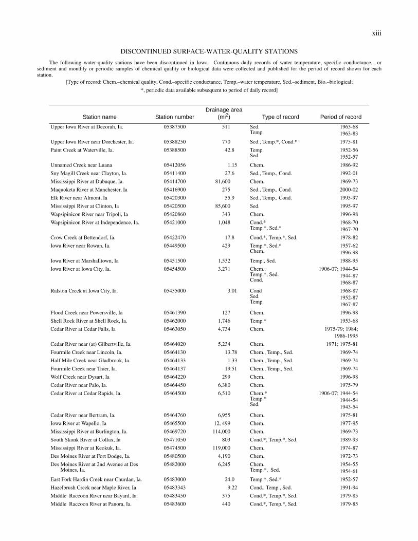
DISCONTINUED SURFACE-WATER-QUALITY STATIONS
The following water-quality stations have been discontinued in Iowa. Continuous daily records of water temperature, specific conductance, or sediment and monthly or periodic samples of chemical quality or biological data were collected and published for the period of record shown for each station.
[Type of record: Chem.–chemical quality, Cond.–specific conductance, Temp.–water temperature, Sed.–sediment, Bio.–biological;
*, periodic data available subsequent to period of daily record]
Station name Station numberDrainage area
(mi2) Type of record Period of record
Upper Iowa River at Decorah, Ia. 05387500 511 Sed.Temp.
1963-681963-83
Upper Iowa River near Dorchester, Ia. 05388250 770 Sed., Temp.*, Cond.* 1975-81
Paint Creek at Waterville, Ia. 05388500 42.8 Temp.Sed.
1952-561952-57
Unnamed Creek near Luana 05412056 1.15 Chem. 1986-92
Sny Magill Creek near Clayton, Ia. 05411400 27.6 Sed., Temp., Cond. 1992-01
Mississippi River at Dubuque, Ia. 05414700 81,600 Chem. 1969-73
Maquoketa River at Manchester, Ia 05416900 275 Sed., Temp., Cond. 2000-02
Elk River near Almont, Ia 05420300 55.9 Sed., Temp., Cond. 1995-97
Mississippi River at Clinton, Ia 05420500 85,600 Sed. 1995-97
Wapsipinicon River near Tripoli, Ia 05420860 343 Chem. 1996-98
Wapsipinicon River at Independence, Ia. 05421000 1,048 Cond.*Temp.*, Sed.*
1968-701967-70
Crow Creek at Bettendorf, Ia. 05422470 17.8 Cond.*, Temp.*, Sed. 1978-82
Iowa River near Rowan, Ia. 05449500 429 Temp.*, Sed.*Chem.
1957-621996-98
Iowa River at Marshalltown, Ia 05451500 1,532 Temp., Sed. 1988-95
Iowa River at Iowa City, Ia. 05454500 3,271 Chem..Temp.*, Sed.Cond.
1906-07; 1944-541944-871968-87
Ralston Creek at Iowa City, Ia. 05455000 3.01 CondSed.Temp.
1968-871952-871967-87
Flood Creek near Powersville, Ia 05461390 127 Chem. 1996-98
Shell Rock River at Shell Rock, Ia. 05462000 1,746 Temp.* 1953-68
Cedar River at Cedar Falls, Ia 05463050 4,734 Chem. 1975-79; 1984;1986-1995
Cedar River near (at) Gilbertville, Ia. 05464020 5,234 Chem. 1971; 1975-81
Fourmile Creek near Lincoln, Ia. 05464130 13.78 Chem., Temp., Sed. 1969-74
Half Mile Creek near Gladbrook, Ia. 05464133 1.33 Chem., Temp., Sed. 1969-74
Fourmile Creek near Traer, Ia. 05464137 19.51 Chem., Temp., Sed. 1969-74
Wolf Creek near Dysart, Ia 05464220 299 Chem. 1996-98
Cedar River near Palo, Ia. 05464450 6,380 Chem. 1975-79
Cedar River at Cedar Rapids, Ia. 05464500 6,510 Chem.*Temp.*Sed.
1906-07; 1944-541944-541943-54
Cedar River near Bertram, Ia. 05464760 6,955 Chem. 1975-81
Iowa River at Wapello, Ia 05465500 12, 499 Chem. 1977-95
Mississippi River at Burlington, Ia. 05469720 114,000 Chem. 1969-73
South Skunk River at Colfax, Ia 05471050 803 Cond.*, Temp.*, Sed. 1989-93
Mississippi River at Keokuk, Ia. 05474500 119,000 Chem. 1974-87
Des Moines River at Fort Dodge, Ia. 05480500 4,190 Chem. 1972-73
Des Moines River at 2nd Avenue at Des Moines, Ia.
05482000 6,245 Chem.Temp.*, Sed.
1954-551954-61
East Fork Hardin Creek near Churdan, Ia. 05483000 24.0 Temp.*, Sed.* 1952-57
Hazelbrush Creek near Maple River, Ia 05483343 9.22 Cond., Temp., Sed. 1991-94
Middle Raccoon River near Bayard, Ia. 05483450 375 Cond.*, Temp.*, Sed. 1979-85
Middle Raccoon River at Panora, Ia. 05483600 440 Cond.*, Temp.*, Sed. 1979-85
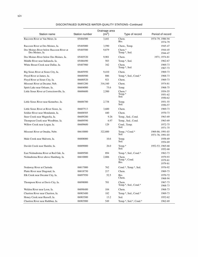
xiv
Raccoon River at Van Meter, Ia 05484500 3,441 Chem.Bio.
1974-79; 1986-941974-79
Raccoon River at Des Moines, Ia. 05485000 3,590 Chem., Temp. 1945-47
Des Moines River below Raccoon River at Des Moines, Ia.
05485500 9,879 Chem.*Temp.*, Sed.
1944-451944-47
Des Moines River below Des Moines, Ia. 05485520 9,901 Chem. 1971; 1974-81
Middle River near Indianola, Ia. 05486490 503 Temp.*, Sed. 1962-67
White Breast Creek near Dallas, Ia. 05487980 342 Chem.Temp.*, Sed.
1969-731967-73
Big Sioux River at Sioux City, Ia. 06485950 9,410 Chem. 1969-73
Floyd River at James, Ia. 06600500 886 Temp.*, Sed., Cond.* 1968-73
Floyd River at Sioux City, Ia. 06600520 921 Chem. 1969-73
Missouri River at Decatur, Neb. 06601200 316,160 Chem. 1974-81
Spirit Lake near Orleans, Ia. 06604000 75.6 Temp. 1968-75
Little Sioux River at Correctionville, Ia. 06606600 2,500 Chem.*Temp.*Sed.
1954-551951-621950-62
Little Sioux River near Kennebec, Ia. 06606700 2,738 Temp.Sed.
1951-551950-57
Little Sioux River at River Sioux, Ia. 06607513 3,600 Chem. 1969-73
Soldier River near Mondamin, Ia. 06608505 440 Chem. 1970-73
Steer Creek near Magnolia, Ia. 06609200 9.26 Temp., Sed., Cond. 1963-69
Thompson Creek near Woodbine, Ia. 06609590 6.97 Temp., Sed., Cond. 1963-69
Willow Creek near Logan, Ia. 06609600 129 Cond., Temp.Sed.
1972-751971-75
Missouri River at Omaha, Nebr. 06610000 322,800 Temp.,* Cond.*Sed.
1969-86; 1991-031971-76; 1991-03
Mule Creek near Malvern, Ia. 06808000 10.6 Temp.Sed.
1958-691954-69
Davids Creek near Hamlin, Ia. 06809000 26.0 Temp.*Sed.
1952-53; 1965-681952-68
East Nishnabotna River at Red Oak, Ia. 06809500 894 Temp.*, Sed., Cond.* 1962-73
Nishnabotna River above Hamburg, Ia. 06810000 2,806 Chem.Temp.*, Cond.Bio.
1979-931979-811979-81
Nodaway River at Clarinda 06817000 762 Cond.*, Temp.*, Sed. 1976-92
Platte River near Diagonal, Ia. 06818750 217 Chem. 1969-73
Elk Creek near Decatur City, Ia. 06897950 52.5 Bio.Chem.
1970-721968-94
Thompson River at Davis City, Ia. 06898000 701 Chem.Temp.*, Sed., Cond.*
1967-731968-73
Weldon River near Leon, Ia. 06898400 104 Chem. 1968-73
Chariton River near Chariton, Ia. 06903400 182 Temp.*, Sed., Cond.* 1969-73
Honey Creek near Russell, Ia. 06903500 13.2 Sed. 1952-62
Chariton River near Rathbun, Ia. 06903900 549 Temp.*, Sed.*, Cond.* 1962-69
DISCONTINUED SURFACE-WATER-QUALITY STATIONS--Continued
Station name Station numberDrainage area
(mi2) Type of record Period of record