Embed Size (px)
Citation preview

Journal of Geomatics Vol 10 No. 2 October 2016
© Indian Society of Geomatics
Predicting urban sprawl for Rajkot city using SLEUTH model and GIS techniques
Shaily R Gandhi1, Shashikant A. Sharma2 and Anjana Vyas1
CEPT University, Ahmedabad, India2Space Applications Centre, ISRO, Ahmedabad, India
Email: [email protected]
(Received: May 12, 2016; in final form: Sep 26, 2016)
Abstract: Unplaned Urban growth along with populationin the fast-growing urban world need to be monitored in orderto have proper preparadeness plan for sustainable urban habitat. Thus Urban growth models are used as planning toolsfor the analysis of urban sprawl. These models play vital role in the planning process for the city. This paper presents astudy that integrates the use of remote sensing, GIS and spatial modelling for predicting urban sprawl which has becomeone of the major challege in the fast growing world. The SLUETH is spatially explicit cellular automata model that hasbeen used to simulate future sprawl of Rajkot city. Sprawl has been predicted for 2031. Input maps for the built-up themeused for five years, i.e, 1980, 1992, 2001, 2005, and 2011; input layer for roads three years 2001, 2005, and 2011, oneexclusion layer, land use layer for two years 2005 and 2011, one slope layer and one hill shade layer.It took seven daysto calibrate each stage of this model and approximately took one month to calibrate the model for one scenario. Theresults of this study shows the possiblity of urban sprawl, and the type of landuse that would converted to urban (built-up). Results of SLEUTH showed that organic growth is predominant in Rajkot, which shows major growth would occurrealong the fringes of existing settlement. The sprawl is observed in the southern and the north western part of the city.This may be due to industrialisation. This study demonstrates the use of model – based prediction of urban sprawl inpreparation of the master plan for the city.
Keywords: Urban sprawl, Satellite imagery, GIS, Decision support system, SLEUTH model
1. Introduction
Urban is defined as all places with a municipality,corporation, cantonment board or notified town areacommittee, etc. and all other places which satisfied thefollowing criteria: i) A minimum population of 5,000;ii) At least 75 per cent of the male main workingpopulation engaged in non-agricultural pursuits; and iii)A density of population of at least 400 persons per sq.km. (Census of India 2011). According to Clark (1982),urban growth is a spatial and demographic process andrefers to the increased importance of towns and cities asa concentration of population within a particulareconomy and society. However, nowadays, the word‘urbanization’ means percentage of people living inurban areas in a region. Geographical InformationSystem techniques can be applied on remote sensingdata to map, monitor, measure, analysis, and model theurban sprawl. Remote Sensing can give detailedinformation about spatial and temporal information ofurban morphology, infrastructure, land cover / land usepatterns (Bhatta, 2010). Remote Sensing and GIS haveproved to be effective means for extracting andprocessing varied resolutions of spatial information formonitoring urban growth (Masser, 2001), and thereforeimportant in study of urban growths.
In developing countries such as India (Thangavel, 2000)and China (Yeh and Li, 2001), patterns of urban growth(compact or sprawling) have been studied in the contextof their special social and economic circumstances.There is no universal solution to prevent urban sprawl.However, it is recognized that scientific managementand planning should be based on a proper understandingof the spatial and temporal processes of urban growth.
This model was originally developed by Keith Clarke,University of California at Santa Barbara (Clarke et al.,1997). Its main purpose is to examine the type of urbangrowth in surrounding areas. It predicts both, urbangrowth and land use change. As the aim of this study isto model and forecast urban sprawl, the best suitedmodel will be the SLEUTH. This model has been testedon various cities in North America, Europe, China,South America, Portugal, Africa, Brazil, Egypt, Finland,India, Italy, Iran, Mexico, Netherlands, Oman, Spain,Taiwan, Thailand and Australia. Studies have beentaken up in India using SLEUTH model for Pune andHyderabad. SLEUTH Model is scale independent,dynamic and future oriented Model. It can be used underdifferent conditions by modifying some initial,conditions and changing input data layers. It can beapplied to all regions with different datasets (Yang andLo, 2003). In the SLEUTH model, the growth rules areuniform throughout a gridded representation ofgeographical space and are applied on a cell-by-cellbasis. A single time span is iteration of the CA, and allchanges are applied synchronously at the end of eachperiod (Clarke et al., 1997).
2. Study area
Rajkot was founded by the ruler of Sardhar in 1608 A.D. on the west bank of the river Aji as a small fortifiedtown which is now one of the most rapid developingcities in the state of Gujarat. Population of Rajkot was36151 in the year 1901, which has increased to 1286678by the Census year 2011. An area of Rajkot city was 5sq. km in 1901 which has reached to 68 sq. km by theend of 2011. Rajkot is situated in the middle of thepeninsular Saurashtra in central plains of Gujarat State
199

Journal of Geomatics Vol 10 No. 2 October 2016
of Western India at a height of 138 m above mean sealevel and it lies between latitude 20.18 N and longitude70.51 E. Rajkot city is well connected with other partsof the country by Rail, Road and Air. Rajkot city isdeveloped on the bank of river Aji. It has many naturalwater reservoirs (lakes) on the eastern part. The climatein the city is hot and dry. Figure 1 shows the study area.
3. Data used
Supplemented by LANDSAT Thematic Mapper andIRS LISS IV imagery are the major primary sources inthis research, fieldwork and interviews to capture localknowledge. Data used for this study are listed in table1.This study has been carried out on multi- date opticalremote sensing data. LANDSAT sensor series have along lasting history of image acquisition. LANDSATTM images have spatial resolution of 30 m. HighResolution Linear Imaging Self-Scanning System IV(LISS-IV) of IRS RESOURCESAT – 1 having spatialresolution of 5.8 m is used for mapping urban sprawl.These satellite images have been classified using digital
and visual image interpretation to create input layers.Thematic Maps of Ward boundary, Road Network,Slums Location have been provided from RajkotMunicipal Corporation GIS Department. GeneralDevelopment Control Regulations (GDCR) Report hasbeen provided from Rajkot Municipal CorporationCollector Office, Rajkot. This data is used to analyzesocio economical parameters effecting the urbangrowth. City Development plan was obtained fromRajkot Urban Development Authority. Thedemographic data is then combined with thematic mapsto provide an in depth understanding of the effect ofdifferent factors on urban sprawl. Thirty-one years ofmulti temporal data sets from different sources datingback from 1980 to 2011 have been utilized in order toprepare the input data sets. For statistical calibration ofthe model in this study at five temporal urban extends,three road layers and two land use layers along withslope and excluded and hill shade layer are taken on thesame spatial resolutions with same projected coordinatesystem and extent.
Figure 1: Study area (Source : IRS LISS IV 2011 image)
200
Journal of Geomatics Vol 10 No. 2 October 2016
© Indian Society of Geomatics
Table 1: List of data used for the study
Data Source
Remote sensingdata
LANDSATTM (30m)1980,1992,2001
IRSLISS IV(5.8 m)20052011
ASTERDEM(30 m)
Thematic MapsWard boundary,Road Network,Slums Location,GDCR Report
Rajkot Municipal CorporationCollector Office, Rajkot
City Develop-ment Plan
Rajkot Urban DevelopmentAuthority
Population data Census of India: 2001, 2011
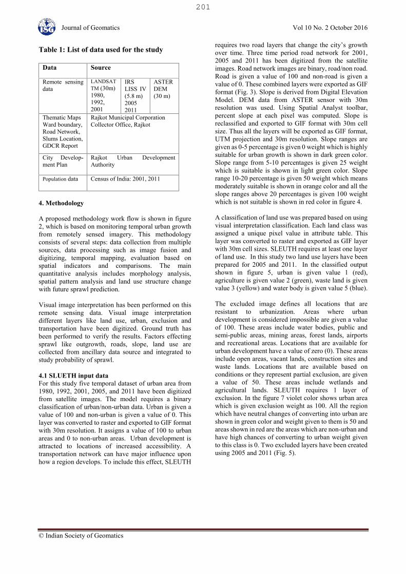
4. Methodology
A proposed methodology work flow is shown in figure2, which is based on monitoring temporal urban growthfrom remotely sensed imagery. This methodologyconsists of several steps: data collection from multiplesources, data processing such as image fusion anddigitizing, temporal mapping, evaluation based onspatial indicators and comparisons. The mainquantitative analysis includes morphology analysis,spatial pattern analysis and land use structure changewith future sprawl prediction.
Visual image interpretation has been performed on thisremote sensing data. Visual image interpretationdifferent layers like land use, urban, exclusion andtransportation have been digitized. Ground truth hasbeen performed to verify the results. Factors effectingsprawl like outgrowth, roads, slope, land use arecollected from ancillary data source and integrated tostudy probability of sprawl.
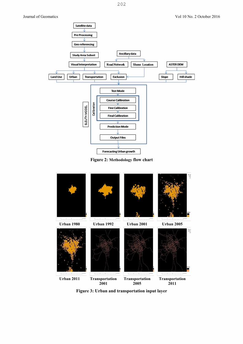
4.1 SLUETH input dataFor this study five temporal dataset of urban area from1980, 1992, 2001, 2005, and 2011 have been digitizedfrom satellite images. The model requires a binaryclassification of urban/non-urban data. Urban is given avalue of 100 and non-urban is given a value of 0. Thislayer was converted to raster and exported to GIF formatwith 30m resolution. It assigns a value of 100 to urbanareas and 0 to non-urban areas. Urban development isattracted to locations of increased accessibility. Atransportation network can have major influence uponhow a region develops. To include this effect, SLEUTH
requires two road layers that change the city’s growthover time. Three time period road network for 2001,2005 and 2011 has been digitized from the satelliteimages. Road network images are binary, road/non road.Road is given a value of 100 and non-road is given avalue of 0. These combined layers were exported as GIFformat (Fig. 3). Slope is derived from Digital ElevationModel. DEM data from ASTER sensor with 30mresolution was used. Using Spatial Analyst toolbar,percent slope at each pixel was computed. Slope isreclassified and exported to GIF format with 30m cellsize. Thus all the layers will be exported as GIF format,UTM projection and 30m resolution. Slope ranges aregiven as 0-5 percentage is given 0 weight which is highlysuitable for urban growth is shown in dark green color.Slope range from 5-10 percentages is given 25 weightwhich is suitable is shown in light green color. Sloperange 10-20 percentage is given 50 weight which meansmoderately suitable is shown in orange color and all theslope ranges above 20 percentages is given 100 weightwhich is not suitable is shown in red color in figure 4.
A classification of land use was prepared based on usingvisual interpretation classification. Each land class wasassigned a unique pixel value in attribute table. Thislayer was converted to raster and exported as GIF layerwith 30m cell sizes. SLEUTH requires at least one layerof land use. In this study two land use layers have beenprepared for 2005 and 2011. In the classified outputshown in figure 5, urban is given value 1 (red),agriculture is given value 2 (green), waste land is givenvalue 3 (yellow) and water body is given value 5 (blue).
The excluded image defines all locations that areresistant to urbanization. Areas where urbandevelopment is considered impossible are given a valueof 100. These areas include water bodies, public andsemi-public areas, mining areas, forest lands, airportsand recreational areas. Locations that are available forurban development have a value of zero (0). These areasinclude open areas, vacant lands, construction sites andwaste lands. Locations that are available based onconditions or they represent partial exclusion, are givena value of 50. These areas include wetlands andagricultural lands. SLEUTH requires 1 layer ofexclusion. In the figure 7 violet color shows urban areawhich is given exclusion weight as 100. All the regionwhich have neutral changes of converting into urban areshown in green color and weight given to them is 50 andareas shown in red are the areas which are non-urban andhave high chances of converting to urban weight givento this class is 0. Two excluded layers have been createdusing 2005 and 2011 (Fig. 5).
201
Journal of Geomatics Vol 10 No. 2 October 2016
Figure 2: Methodology flow chart
Urban 1980 Urban 1992 Urban 2001 Urban 2005
Urban 2011 Transportation2001
Transportation2005
Transportation2011
Figure 3: Urban and transportation input layer
202

Journal of Geomatics Vol 10 No. 2 October 2016
Figure 4: Slope and hill shade input layer
Figure 5: Land use input layers
203

Journal of Geomatics Vol 10 No. 2 October 2016
Figure 6: Input excluded layers
All these layers are given as input to SLEUTH modelwhich calibrates the data with predefined rules in whichthe parameters are modified on the basis of the inputdata. Once the data is ready model is calibrated forwhich the input file names are modified in the scenariofile. The model is run for coarse, fine, final andforecasting stages as shown in figure 2. In each of thestages the parameters are modified as the growth rule isapplied which leads to self-modification and give theoutput statistics. For selecting the range of Coefficientrange for the next step OSM (optimal SLEUTH Metric)is used and at the end it gives one value for coefficientfor inputting in the predict stage. Prediction is done onthe basis of the values obtained by calibrating theSLEUTH model. Output of the model is in graphical aswell as statistical format which is then projected in GISand analyzed. This model gives the future urban growthpattern.
4.2 SLUETH ImplementationIn SLUETH growth rules are applied on a cell-by-cellbasis and the array is synchronously updated at the endof each year. The modified array forms the basis forurban growth in each succeeding year. Potential cells forurbanization are selected at random and the growth rulesevaluate the properties of the cell and its neighbors such
as whether or not they are already urban, what theirtopographic slope are, how close they are to a road(Clarke and Gaydos, 1998)
In the model there are five factors controlling thebehavior of the system: Breed Factor (Coefficient)determines how likely a newly generated, detached orroad-influenced settlement is to begin its own growthcycle. Diffusion Factor (Coefficient) controls the overalldepressiveness of growth. Spread Coefficient controlshow much diffusion expansion occurs from existingsettlements. Slope Resistance influences the likelihoodof settlement extending up steeper slopes Road Gravityencourages new settlements to develop near thetransportation network (Clarke and Gaydos, 1998).
According to (Clarke et al., 1996), urbanization is thesum of the four types of the growth: SpontaneousGrowth models the development of urban settlements inundeveloped areas. Diffusive Growth permits theurbanization of isolated cells, which are flat enough tobe desirable locations for new urban spreading centers.Organic Growth promotes the expansion of establishedurban cells to their surroundings. Road InfluencedGrowth promotes the urbanization along thetransportation network because of increasedaccessibility.
204

Journal of Geomatics Vol 10 No. 2 October 2016
Newly urbanized cells must pass the random tests ofbreed and diffusion coefficient, slope resistance androad gravity. During the urban growth computation, asecond level of growth rules called “self-modification” prompted by an unusually high or lowgrowth rate above or below a threshold or criticalnumber (Clarke et al., 1996). In that case, the modelmodifies certain parameters to emphasize trend.Therefore, self-modification is quite important toensure reasonable results (Yang and Lo, 2003). Thefinishing values of all the coefficients were used tofind the final best values that describe the boom andboost periods in the system. This utility averages thefinishing coefficient values stored in the param.logfile, and returns set of five integers that represent thebest coefficient values resulting from the entireprocess of calibration, reflecting both the growth rules,and the self-modification rules (Silva and Clarke,2002).
4.3 SLUETH calibrationThe model runs in three modes; test mode, calibrationmode and the prediction mode. In test mode data istested for readiness of calibration and prediction. Thepurpose of the model calibration phase is to determinethe best-fit values for the five growth controlparameters including coefficients of diffusion, breedand spread, slope resistance and road gravity withhistorical urban extent data. (PROJECTGIGALOPOLIS, 2003). Optimum SLEUTH Metricwas developed by (Dietzel and Clarke, 2007) whichhelps to select the values for the next phase ofcalibration is used in this study. OSM (optimalSLEUTH Metric, product of compare, population,edges, clusters, slope, X- mean and Y- mean metricswas created) which provides most robust results forSLEUTH calibration. OSM code can be run usingthe control_stats.log file to find out the 'top 50' best fitvalues. Hence this helps in selecting the values for nextphase. Hence OSM is used to get the best fit values inthis study. (Dietzel and Clarke, 2007)
5. Results and discussions
Coarse calibration for predicting 2011 sprawlusing the past data has been performed by taking astep value of 20 with 3125 Monte Carlo iterations,followed by fine and final calibration using the stepvalues derived from the previous steps. In thisstudy OSM Values are used to define the step andstart end values for the next step.
From table 2 OSM code can be run usingthe control_stats.log file to find out the 'top 50' bestfit values. Hence this helps in selecting the valuesfor next phase. Here it is observed that OSM valueis 0.456 in coarse calibration which is consideredto be good which is refined to 0.459 in finecalibration and in final calibration value is 0.462.
From table 3 it is observed that OSM value is 0.564in coarse calibration which is considered to begood which is refined to 0.586 in fine calibrationand in final calibration value is 0.588. These valuesare high as the number of input has increased fromthe previous model and 0.588 is a good value.
From the above table 4 and 5 coefficient range isconsent for coarse stage. This starts changing fromFine where the range is almost similar to for all themodels but as we move towards final more of thevalues change as in this model both growth rulesand self-modification rules are the core of themodel. By running the model, a set of controlparameters is refined in the sequential calibrationphase. And the range is narrowed down in everystage. Comparison between best fit values derivedfrom the top OSM value in the final stage for boththe years’ prediction from the output of forecastingphase with Monte Carlo iteration as 200.
Table 2: OSM values and calibration data for 2011
Top50 :Coarse calibration (2011
Urban growth model)
OSM DiffBrd Sprd Slp Road
0.4566 25 75 75 50 50
0.4495 50 25 75 25 50
0.4411 25 100 100 75 100
Top50 :Fine calibration (2011 Urban
growth model)
OSM DiffBrd Sprd SlpRoad
0.4596 25 85 99 65 50
0.4541 25 45 93 25 60
0.4538 25 85 99 65 70
Top50 :Final calibration(2011Urban growth model)
OSM DiffBrd Sprd Slp Road
0.4628 25 75 98 55 60
0.4575 25 45 98 25 50
0.4536 25 85 95 65 65
205

Journal of Geomatics Vol 10 No. 2 October 2016
Table 3: OSM values and calibration data for 2031
Top50 :Coarse calibration
(2031 Land use Model)
OSM Diff Brd Sprd Slp Road0.5649 25 75 50 25 500.5554 50 25 100 50 500.5518 25 100 100 75 50
Top50 :Fine calibration
(2031 Land use Model)
OSM Diff Brd Sprd Slp Road0.5867 30 35 100 25 500.5763 45 45 90 75 500.5752 40 45 100 65 50
Top50 :Final calibration
(2031 Land use Model)
OSM Diff Brd Sprd Slp Road0.5834 36 41 94 55 500.5784 30 39 100 35 500.5753 36 39 100 55 50
Table 4: Coefficient values for 2011 urban growth model
Coarse Fine Final PredictStart Stop Start Stop Start Stop Best Fit
Diffusion 0 100 25 50 25 25 25Breed 0 100 25 100 45 85 75Spread 0 100 75 100 93 99 98Slope 0 100 25 75 25 65 55Roads 0 100 50 100 50 70 60
Table 5: Coefficient values for 2031 LULC growth model
Coarse Fine Final PredictStart Stop Start Stop Start Stop Best Fit
Diffusion 0 100 25 50 30 45 36Breed 0 100 25 75 35 45 41Spread 0 100 50 100 90 100 94Slope 0 100 25 75 25 75 55Roads 0 100 50 50 50 50 50
The self-modification internal cellular modelenhances phase changes. Thus the values of thecoefficient changes with change in input data.Diffusion shows the overall scatter of the growthwhich is moderate. It shows the opportunity for newurban centers. Breed show the likelihood of newsettlements being generated which is seen high whenonly 4 urban layers were given to predict 2011sprawl but it has greatly decreased on adding 2011data and has still gone down when Land Use data isadded. Spread shows the outward and inward fromexisting spreading center here the value of spread ishigh as we have seen over a period of time Rajkothas maximum development along its fringes. We cansay more people are moving out from urban Centerto suburbs (census 2011). Slope resistance is low andis not having much of effect as our study area is flatland and very less hilly region is present. Roadgravity shows the attraction of the urbanization toroads and diffusion of urbanization along the roads.Here in Rajkot City development has taken placealong the roads hence the value of this coefficient isalso high.
Similarly, it is observed that when the best fit valuesfor the predict stage is identified spread has thehighest influence with the value 94. Thus most of thedevelopment in 2031 would be along the fringes.Scope of development along the roads with best fitvalue 50 and slope having best fit value 55 aremoderate. Breed has best fit value 41 which showsvery less scope of new settlements being generated.Finally, we can say minimum growth will happendiffusion which has best fit value as 36.
5.1 Validation of the modelAccording to the avg.log file urban area of 2011 ispredicted as 72.25sq km (Pop: 80280.43, pixel size:30 x 30 m) and according to the actual data urbanarea of 2011 is predicted as 67.55 sq. km (Pop:75528, pixel size: 30 x 30 m).
This model gives 96.18 % matching urban pixels ofurban area with the actual urban area (see table 1).To validate the model prediction of 2011 has beencarried out using the past data, here over all accuracyurban model prediction for 2011 using the past yearsdata is 96.18%. And Users accuracy for urban is90.52% and producers accuracy for urban area is
206

Journal of Geomatics Vol 10 No. 2 October 2016
86.61%. Models with over all accuracy above 95%are considered acceptable hence we can useSLEUTH model for Rajkot city to predict the futuresprawl.
From figure 7 it is seen that urban area is predictedfrom 2006 to 2011 as 2005 was the last year datainput for this model the year wise area increase iscompared with projected population data for 2006 to2001 using the census data. Here it is seen that bothurban area and population both are growing in butthe gap between has narrowed with time whichshows that density of population is increasing withtime.
Maximum growth has happened due to spread ofspatial growth which means urban growth along thefringes, few new urban areas are observed as shownin figure 8 which have actually come up over thetime period. White color in the figure 8 shows thespread growth and red color shows the urban area of2005. As it is observed extensive growth along theroad in the east side near Lalpari Lake which did nottake place due to the lakes and land use in that areawas not suitable for urban growth. Growth on theNorth West side has also not taken place in actualscenario due to extensive industrialization.
From figure 9 it is seen how urban area is predictedfrom 2012 to 2031 as 2011 was the last year datainput for this model. The year wise area increase iscompared with projected population data for 2012 to2031 using the census data of the past years. Thegraph shows the how population is expected toincrease and in 2029 there is intersection inpopulation and urban growth area. Hence the gapbetween the population growth and urban area willbe decreased from 2012 to 2029 and inverse situationis observed from 2029 to 2031, changes will beobserved in the population density which willincrease till 2029 and will decrease after 2029.
Figure 7: Urban area predicted v/s population(2011 Urban model output)
Table 6: Accuracy assessment for SLEUTHmodel
Figure 8: Modelled prediction of growth typesRajkot 2011
Figure 9: Urban area predicted v/s population(2031 LULC model output)
Map (figure 10) shows the probability map in whichyellow color shows the existing urban area and grey
Urban Non-Urban Total Useraccuracy
Urban 65416 6852 72268 90.52%
Non-Urban 10112 361251 371363 97.28%
Total 75528 368103 443631Produceraccuracy
86.61% 98.14%
96.18%
Satellite Data
ModelPrediction
overall classification accuracy
207

Journal of Geomatics Vol 10 No. 2 October 2016
shows no probability of growth it covers water body,airport and all the land use which cannot beconverted to urban. Low value of diffusion and breedand high value of spread co-efficient is seen in theabove output and low slope indicates that growthclearly occurs at urban fringes. Spread growth is seenmaximum along the fringes of the city in alldirections maximum growth is seen in the southerndirection. More of sprawling is observed in thewestern part. There is industrial zone in the south andnorth western part makes it more prone to sprawlwhich is clearly seen in figure 10 in red color rangingfrom 70 to 100 percentage probability of growth.Maximum slums have been observed along rangeshown in shades of blue color. Road the river andother water bodies. Less of growth is observed Eastzone as it has more of Slums population. Increase insuburbs and exurbs have increased organic (edge)growth. There is low development in the east zone asit has two Lakes and this area falls under low linehence there is problem of water log age duringmonsoons. Less of growth occurs due to roadinfluence which is seen from 30 to 60 percentageprobability Influenced growth is seen in the easternalong the Jamnagar – Rajkot highway due toindustrialization and southern direction along thenational highway 8B which passes through Rajkotand goes towards Shapar in the south has also showngood amount of growth on both sides of the highway.
Figure 10: Probability of urban growth rajkot2031 (LULC)
Bhavnagar-Rajkot road which passes in easterndirection between the two lakes shows some road
influence growth along the highway. More growth isseen in the southern part and the north western regionof the city due to industrialization land use. In theabove figure 10 green color shows 10 to 30 percentprobability of urbanization. According to the avg.logfile urban area of 2031 is predicted as 141.93 sq. km(Pop: 157703.2, pixel size: 30 x 30 m). Predictionresults of this model can be used in preparing themaster plan for the city.
6. Conclusion
SLEUTH model is 96.18% accurate matching urbanpixels in the predicted urban area of 2011 and actualurban area identified from the satellite image forRajkot city. Rajkot has higher value for spreaddevelopment. Spread shows the outward and inwardfrom existing spreading center here the value ofspread is high as we have seen over a period of timeRajkot has maximum development along its fringes.We can say more people are moving out from urbancenter to suburbs. More Growth is seen in thesouthern part and the north western region of the cityin 2031 and 2031 prediction. Population growth rateis decreasing and urban growth rate is alsodecreasing. Minor changes are required in SLEUTHto improve performance in the Indian context as thismodel is scale independent, dynamic and futureoriented can be used under different conditions withsome modifications. By studying the outputs ofweighted overlay, growth rates, index and predictionmodel it has been observed that Higher growth isseen in the southern part and the north western regionof the city which could be the upcoming urban areas.
Acknowledgments
Authors are wishing to acknowledge timely helpprovided by Professor Keith C. Clark, University ofCalifornia Santa Barbara. The authors are alsothankful to Rajkot Municipal Corporation for theircooperation and support for this study. The authorsare highly thankful to CEPT University forproviding the computing facilities. This paper is apart of Minor study for PhD degree carried out byShaily Gandhi, CEPT University.
References
Bhatta, B. (2010). Analysis of Urban Growth andSprawl from Remote Sensing Data. Kolkata:Springer.
Census of India (2001). New Delhi: Government ofIndia.
Census of India (2011). New Delhi: Government ofIndia.
208

Journal of Geomatics Vol 10 No. 2 October 2016
Clarke, K.C. and L.J. Gaydos (1998). Loose-coupling a cellular automaton model and GIS: long-term urban growth prediction for San Francisco andWashington/Baltimore. International Journal ofGeographical Information Science, Vol 12, No. 7:699–714.
Clarke, K.C., S. Hoppen and L. Gaydos (1997). Aself-modifying cellular automaton model ofhistorical urbanization in the San Francisco Bayarea. Environment and Planning B, Vol 24, No. 2:247–261.
Clarke, K.C., S. Hoppen and L. Gaydos (1996).Methods and techniques for rigorous calibration ofcellular automaton model of urban growth. ThirdInternational Conference/Workshop on IntegratingGIS and Environmental Modeling, (p. 6). SantaFe,New Mexico.
Dietzel, C. and K.C. Clarke (2007). Toward OptimalCalibration of the SLEUTH Land Use ChangeModel. Transactions in GIS, Vol 11, No. 1: 29-45.
Gujarat Town Planning and Urban Development.(1976). General Development Control Regulations.Rajkot: Rajkot Urban Development Authority.
Masser, I. (2001). Managing our urban future: therole of remote sensing and geographic informationsystems. Habitat International, Vol. 25, No. 4: 503-512.
Oxford Dictionary (2000). Oxford AdvancedLearner’s Dictionary of Current English. Oxford:Oxford University Press.
PROJECT GIGALOPOLIS. (2003). Retrieved fromProject Gigalopolis: Urban and land cover modeling.Santa Barbara, CA: University of Santa Barbara:http://www.ncgia.ucsb.edu/projects/gig/
Rajkot Mulcipal Corporation. (2005). Rajkot CityDevelopment Plan. Rajkot: Rajkot UrbanDevelopment Authority.
Rajkot Municipal Corporation. (2012). Preparationof Second Generation City Development Plan forRMC as well as RUDA. Rajkot: CRISIL Risk andInfrastructure Solutions Limited.
Silva, E.A. and K.C. Clarke (2002). Calibration ofthe SLEUTH Urban Growth Model for Lisbon andPorto. Envionment and Urban Systems, Vol. 26, No.6: 525-552.
Thangavel, C. (2000). An empirical estimation of theeffects of some variables on land sub-division inMadras. Urban Studies, Vol. 37, No. 7: 1145-1156.
Yang, X. and C.P. Lo (2003). Modelling urbangrowth and landscape changes in the Atlantametropolitan area. International Journal ofGeographical Information Science, Vol. 17, No. 5:463–488.
Yeh, A.G. and X. Li (2001). Measurement andmonitoring of urban sprawl in a rapidly growingregion using entropy. Photogrammetric Engineering& Remote Sensing, Vol. 67, No. 1: 83-90.
209