Embed Size (px)
Citation preview
Preble County
Comprehensive Economic
Development Strategy
and
Land Use Plan
BOARD OF PREBLE COUNTY COMMISSIONERS
Commissioner Rodney Creech, President
Commissioner Christopher M. Day
Commissioner Denise Robertson
Adopted:

1
TABLE OF CONTENTS
Page #
Members and General Overview 2
Analysis of Recent Activity 4 Summary of Changes in Economic and Social Conditions 4 Report of Activities 5
General Description & Demographics of Preble County 6 Population 6 Income and Poverty 8 Human Resources and Labor Force 8 Healthcare Services 10
Agriculture 11 Housing 11 Education 13 Utilities and Infrastructure Capacities 14 Industrial Sites 15
Roadway Miles 16 Railroads 16 Technology/Communication 16 Recreational Opportunities 17 Arts & Culture 17
Land Use Management 18 The Plan in General 19 Definitions 20 Concept of Urban Transitional & Agricultural Areas 25 Preble County Major Land Uses 26 Agricultural 26 Residential 29 Commercial 31 Industrial 33 Open Space & Outdoor Recreational 35 Environmental Protection 37
The Plan for Transportation 40 Transportation Theory 42 Transportation Plan Recommendations 44
Preble County Vision 46
Action Plan 47 Basic Assumptions 47 Strategic Actions 48
Project Prioritization List 51
Economic Development Incentives 54
Evaluation 55
Attachments & Links List of Available Preble County Sites 57 Thoroughfare and Urban Transitional Area Map
2
Preble County Development Partnership (PCDP) Business Development Committee ______________________________________________________________________________
The Preble County Development Partnership (PCDP), a public/private entity, was formed in 2010 to address important growth and development issues while assisting in the creation of jobs and opportunity for everyone in Preble County. The PCDP continues to focus on business retention, new business recruitment, marketing and community outreach, and workforce development with a focus on the mission to advance, encourage, and promote the industrial, commercial, and civic development of Preble County.
Representing various sectors of Preble County’s economy, the individuals named below accepted the task of updating the County’s Comprehensive Economic Development Strategy (CEDS) that was initially developed in 2003. Their commitment and dedication to this project along with community input has enabled this updated Comprehensive Economic Development Strategy (CEDS) with the incorporation of the Preble County Comprehensive Land Use Plan (Adopted 1990, Revised 2000) to be put into place. Assistance was provided by engaging Mote & Associates, Inc. to direct these efforts with Susan Laux as the facilitator.
Bradley Collins City Manager, City of Eaton Chris Day Preble County Commissioner Joe Ferriell Assistant City Manager, City of Eaton Mary Gardner/Walt Hibner Vectren Energy Delivery of Ohio Art Harlan Executive Vice-President, Henny Penny Corp. Brad Kramer Director, Land Use Management Office Brenda Latanza Director, PCDP Matt Owen Executive Director, Chamber of Commerce Scott Roman Vice-President, LCNB National Bank Jeff Sewert Municipal Manager, Village of Lewisburg Jim Simon President, Simon Insurance Rachael Vonderhaar Representative, Preble County Farm Bureau
It is hoped that the product of the efforts can be easily seen within this document. Local information as well as regional and state sources have been used to compile the data in this report. The most pertinent information to Preble County’s most recent economic development accomplishments can be viewed in the Analysis section.
The future has been the focus of several discussions as well. These thoughts have been combined into a coherent statement that describes the type of place that Preble County will be in the future. This information can be found in the Vision section.
The Preble County Comprehensive Land Use Plan has been incorporated into this Economic Development Strategy as the two documents are directly related to the future of the County. The Thoroughfare and Urban Transitional Area Map can now be found as an attachment to provide a view of potential areas that are positioned for growth. Information describing Land Uses in the County can be found in the Land Use Management section.
Different ways to address issues raised in the analysis that are in keeping with the vision for the future are outlined in the Action Plan section.

3
The goals and priorities of the County have been compiled into the Project Prioritization List. A website link to a list of available buildings and sites for development purposes has also been added to the end of this document. This “living” list is continuously maintained by the Preble County Development Partnership so current information is readily available.
The Committee recognizes that good plans are not static. As such, a Committee will be tasked with updating the document on a regular basis with the next review to take place in February 2018. More about evaluating progress and updating the document is detailed in the concluding section of the document entitled Evaluation.

4
ANALYSIS OF RECENT ACTIVITY _____________________________________________________________________________________
Summary of Changes in Economic and Social Conditions Many activities have been initiated in recent years to enhance the current business community and to attract and create new businesses. The following represents some of the recent highlights of change to the Preble County community:
The Preble County Development Partnership was formed in 2010 to advance, encourage and promote the industrial, commercial and civic development of Preble County, Ohio. It is their goal to address important growth and development issues while assisting in the retention and creation of jobs and business opportunity.
YMCA/Youth Foundation facility opened in Eaton in 2003 and expanded in 2009; Sinclair Community College constructed an addition to the YMCA to provide local
secondary educational opportunities in 2009; and then developed in Eaton a 4,000 SF Manufacturing Lab which is the newest training facility for Sinclair’s Workforce Development initiative;
Eaton Community Schools over the last ten years have completed construction of a new high school, a middle school, and athletic facilities along with renovations to East Elementary and the addition of a new building to this campus that replaced Bruce Elementary;
Eaton constructed a municipal court facility in 2004; Kettering Medical Services constructed a $13 million emergency services facility in
Eaton that was opened in August 2015 (other services had been provided locally since 2003);
Commercial development on US 127 on the north side of Eaton has expanded with retail outlets and restaurants;
Reid Health opened an urgent care facility in Eaton in 2015; In 2006, Lam Research purchased the assets of the Bullen Ultrasonics Franklin
Street facility. It was renamed Bullen Semiconductor and then subsequently Silfex. A 100,000 SF expansion was completed in 2008;
Bullen closed their Camden Road facility and moved to their current location at Miller-Williams Road.
IAMS closed down its production facilities south of Lewisburg in Harrison Township in 2013, but the research and development division remains. The company was sold to MARS in 2014;
Cargill/Provimi NA purchased the production facilities used by IAMS in Harrison Township in 2014;
Pratt Industries (Lewisburg Corrugator) completed a 350,000 SF expansion to house new recycling activities which included creation of new jobs;
Henny Penny Corporation in Eaton completed a 46,000 SF expansion in 2015; Rexarc in West Alexandria needed road expansion that was completed with a
$360,000 grant from the Ohio Development Services Agency; DM Tool expansion on US 40 west of Lewisburg added 35,000 SF to the facility; and TimkenSteel completed an 8,000 SF expansion in 2013 at their St. Clair Plant in
Eaton.

5
Report of Activities The Preble County Development Partnership (PCDP) has taken the lead as the economic development center for the County. Through a private partnership merged with the prior public agency, local business and community leaders have joined forces to improve the economic climate of the County. Some of the activities and accomplishments of the PCDP thus far are as follows:
Committed $30,000 towards an Architectural Assessment at the Preble County Fairgrounds;
Received $20,000 through a DP&L Regional Economic Development Grant to support the cost of the updated Preble County CEDS and new website development;
Active with area businesses and organizations by participating in “Business Retention” visits in partnership with Eaton city officials, Job and Family Services, and JobsOhio;
Partnered in the update of the 2015 Preble County Consolidated Action Plan; Participated in the Dallas & Atlanta Site Selector Consultant visits with JobsOhio and
other regional economic developers; Works closely with JobsOhio to submit available land/building sites for selection
prospects; Participates in the Preble County Chamber of Commerce Business Expo with a
Grand Sponsorship; Participates annually in the National Manufacturing Day which is designed to
introduce students to manufacturing opportunities within the County; Sponsors numerous community events and organizations including the Eatonic
Music Festival, Bridges, Bikes and Blues Event, and the Preble County Historical Society Amphitheater;
Continues to work toward ACT Certified Work Ready Community certification within Preble County;
Works closely with educational partners to understand their training and development and to keep them apprised of business and industry training needs in the community;
Developed a new website and videos to highlight the advantages and amenities Preble County has to offer new business and families;
Creates and publishes a quarterly newsletter to inform investors and stakeholders of the Partnership’s goals, activities, and accomplishments;
Started a Revolving Loan Fund for gap financing to small business; and Initiated a cooperative agreement with the Warren County Port Authority.
6
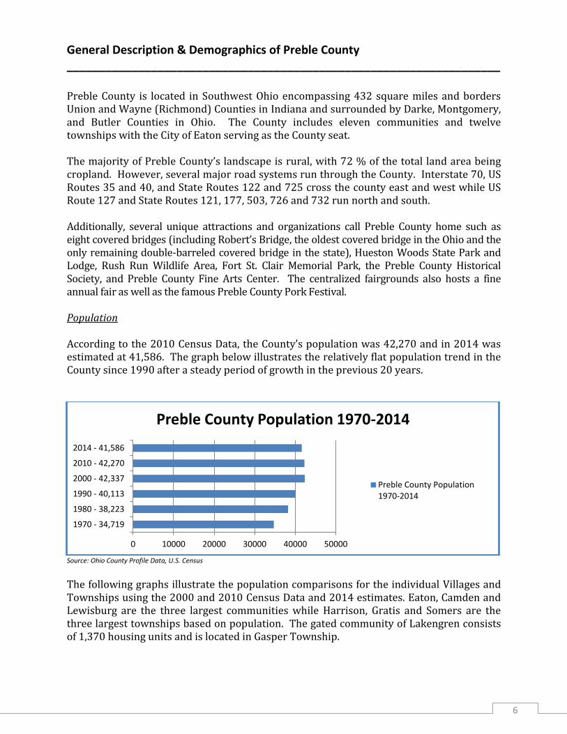
General Description & Demographics of Preble County ___________________________________________________________________ Preble County is located in Southwest Ohio encompassing 432 square miles and borders Union and Wayne (Richmond) Counties in Indiana and surrounded by Darke, Montgomery, and Butler Counties in Ohio. The County includes eleven communities and twelve townships with the City of Eaton serving as the County seat. The majority of Preble County’s landscape is rural, with 72 % of the total land area being cropland. However, several major road systems run through the County. Interstate 70, US Routes 35 and 40, and State Routes 122 and 725 cross the county east and west while US Route 127 and State Routes 121, 177, 503, 726 and 732 run north and south. Additionally, several unique attractions and organizations call Preble County home such as eight covered bridges (including Robert’s Bridge, the oldest covered bridge in the Ohio and the only remaining double-barreled covered bridge in the state), Hueston Woods State Park and Lodge, Rush Run Wildlife Area, Fort St. Clair Memorial Park, the Preble County Historical Society, and Preble County Fine Arts Center. The centralized fairgrounds also hosts a fine annual fair as well as the famous Preble County Pork Festival. Population According to the 2010 Census Data, the County’s population was 42,270 and in 2014 was estimated at 41,586. The graph below illustrates the relatively flat population trend in the County since 1990 after a steady period of growth in the previous 20 years.
Source: Ohio County Profile Data, U.S. Census
The following graphs illustrate the population comparisons for the individual Villages and Townships using the 2000 and 2010 Census Data and 2014 estimates. Eaton, Camden and Lewisburg are the three largest communities while Harrison, Gratis and Somers are the three largest townships based on population. The gated community of Lakengren consists of 1,370 housing units and is located in Gasper Township.
1970 - 34,719
1980 - 38,223
1990 - 40,113
2000 - 42,337
2010 - 42,270
2014 - 41,586
0 10000 20000 30000 40000 50000
Preble County Population 1970-2014
Preble County Population 1970-2014

7
Most communities have maintained steady populations since 2000 with minor fluctuations in Eaton, Camden, College Corner, and Verona.
PREBLE COUNTY VILLAGES
Source: Ohio Development Services Agency
The townships in the County have also remained steady over the last 15 years. Gasper Township has seen the biggest increase while the others, notably Somers and Washington Townships, have seen the largest decrease.
PREBLE COUNTY TOWNSHIPS
Source: Ohio Development Services Agency
0
1000
2000
3000
4000
5000
6000
7000
8000
9000
2000
2010
2014
0
500
1000
1500
2000
2500
3000
3500
4000
4500
5000
2000
2010
2014
8
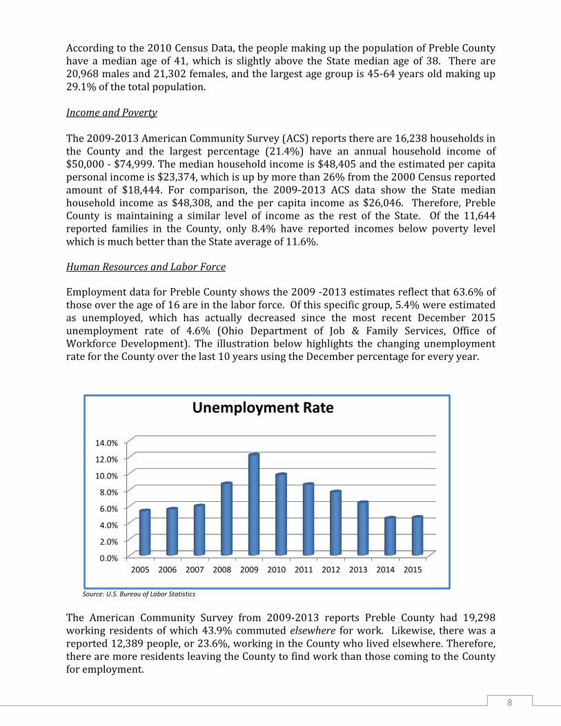
According to the 2010 Census Data, the people making up the population of Preble County have a median age of 41, which is slightly above the State median age of 38. There are 20,968 males and 21,302 females, and the largest age group is 45-64 years old making up 29.1% of the total population. Income and Poverty The 2009-2013 American Community Survey (ACS) reports there are 16,238 households in the County and the largest percentage (21.4%) have an annual household income of $50,000 - $74,999. The median household income is $48,405 and the estimated per capita personal income is $23,374, which is up by more than 26% from the 2000 Census reported amount of $18,444. For comparison, the 2009-2013 ACS data show the State median household income as $48,308, and the per capita income as $26,046. Therefore, Preble County is maintaining a similar level of income as the rest of the State. Of the 11,644 reported families in the County, only 8.4% have reported incomes below poverty level which is much better than the State average of 11.6%.
Human Resources and Labor Force
Employment data for Preble County shows the 2009 -2013 estimates reflect that 63.6% of those over the age of 16 are in the labor force. Of this specific group, 5.4% were estimated as unemployed, which has actually decreased since the most recent December 2015 unemployment rate of 4.6% (Ohio Department of Job & Family Services, Office of Workforce Development). The illustration below highlights the changing unemployment rate for the County over the last 10 years using the December percentage for every year.
Source: U.S. Bureau of Labor Statistics
The American Community Survey from 2009-2013 reports Preble County had 19,298 working residents of which 43.9% commuted elsewhere for work. Likewise, there was a reported 12,389 people, or 23.6%, working in the County who lived elsewhere. Therefore, there are more residents leaving the County to find work than those coming to the County for employment.
0.0%
2.0%
4.0%
6.0%
8.0%
10.0%
12.0%
14.0%
2005 2006 2007 2008 2009 2010 2011 2012 2013 2014 2015
Unemployment Rate

9
In terms of wages, the average weekly wage for private sector employees in the County is $633, according to 2013 data from the Ohio Development Services Agency. The State average, for comparison, is $839 making Preble County almost 25% lower than the State average. This would indicate that wages are not keeping up with the rest of the State. This could account for why residents are leaving to find work outside the County. The total annual wage breakdown of the top five private sector industries in the County, as reported for 2013 by the Ohio Development Services Agency including the number of establishments for each, is as follows:
PRIVATE SECTOR INDUSTRY ANNUAL PAYROLL
Manufacturing (53) $ 152,369,456
Trade, Transportation, Utilities (171) $ 49,281,674
Education and Health Services (58) $ 24,493,763
Professional and Business Services (69) $ 12,070,951
Leisure and Hospitality (70) $ 11,530,240
The educational and health related services industry employs the highest number of workers in the County with 4,339 (22.5%), but is followed closely by the manufacturing industry which employs 4,324 (22.4%) as seen in the first graph below. In Preble County alone, however, the strength and importance of the manufacturing industry is shown by pointing out the County’s top ten private employers in the second illustration, which could include residents of the County as well as others coming in from surrounding areas.
Source: Ohio Development Services Agency
Employment by Industry (Includes any employers outside the County)
Education/Healthcare, 22.5%
Manufacturing, 22.4%
Retail Trade, 11%
Arts/Food/Recreation, 8%
Construction, 7%
Professional/Management, 5.7%
Other Services, 5.7%
Transportation, 5.1%
Finance/Insurance, 3.9%
Wholesale Trade, 2.7%

10
Source: PCDP
Healthcare Services Preble County has seen substantial growth in the healthcare industry both in services offered and employment opportunities for residents. Its close proximity to the Dayton and Richmond, Indiana areas also provides easy access to multiple hospitals, medical centers, and nursing homes. The County has 19 physicians, 3 licensed nursing homes with 256 total beds, and 3 licensed residential care facilities with 123 total beds. Regional healthcare providers have invested in Preble County with plans for continued construction of new facilities. Available healthcare locations include:
Preble County Medical Center and various satellite doctor offices
Emergency Services Facility operated through Kettering Medical Services
Reid Health Urgent Care Facility in Eaton
Heartland of Eaton
Eaton Grand Manor Residential Care
Greenbriar Nursing Center in Eaton
Vancrest Health Care Center in Eaton
Trinity Mission (Foundations) outside of New Paris
Top 10 Preble County Private Employers
Neaton Auto Products, 1100
Henny Penny, 550
Parker-Hannifin, 400
Pratt/Lewisburg Container, 350
Lam Research/Silfex, 345
Wal-Mart, 295
Lewisburg Corrugator, 145
Provimi NA/Cargill, 104
International Paper Co., 102
Timken Steel, 90

11
Agriculture Agriculture in Preble County has historically been a strong sector of the economy. The 2012 Agriculture Census reports the total land in farms was 224,243 acres, which is an increase from 198,048 acres reported ten years earlier in 2002. Additionally, the number of farms is reported as 1,088 with an average acreage of 206; the largest number of farms (391) is between 10 and 49 acres. The estimated market value of the land and buildings for these farms is an average of $1,083,226 per farm and $5,256 average per acre. The market value of agricultural products sold in 2012 was $154,824,000 compared to $109,525,000 in 2007 which is a 41% increase over a five-year period. Sixty-six percent (66%) of that total market value represents crop sales while 34% represents livestock sales. The average market value of products sold per farm is $142,301. The total value gives Preble County a state ranking of 25th and a national ranking of 766th in agricultural production.
Preble County farms received a total of $4,689,000 in government payments in 2012 with the average per farm amount at $7,712. The average net cash income of operation per farm was $128,526 in 2012 according to the Census of Agriculture. Of the 1,088 farms in Preble County, 455 principal operators name farming as their primary occupation while 633 name another occupation. Also, 968 of those farms have a male principal operator leaving 120 designated with a female principal operator. The average age of the farmer is 55 years. Housing According to the 2010 Census Data, Preble County has 17,888 housing units of which 91% (16,341) were occupied and 9% (1,547) were vacant. In addition, 77% of those occupied units (12,561) were owner-occupied and 23% (3,780) were renter-occupied making the County’s home ownership rate higher than the State’s average which was 67%. The graphs below illustrate the comparisons in age for those owning homes or renting based on the 2010 Census Data.
Age of Home Owners
15-24, 1.3%
25-34, 9.4%
35-44, 16.1%
45-54, 22.3%
55-64, 22.7%
65+, 28.1%
Age of Renters
15-24, 8.3%
25-34, 22.1%
35-44, 20.4%
45-54, 19%
55-64, 12.9%
65+, 17.3%
12
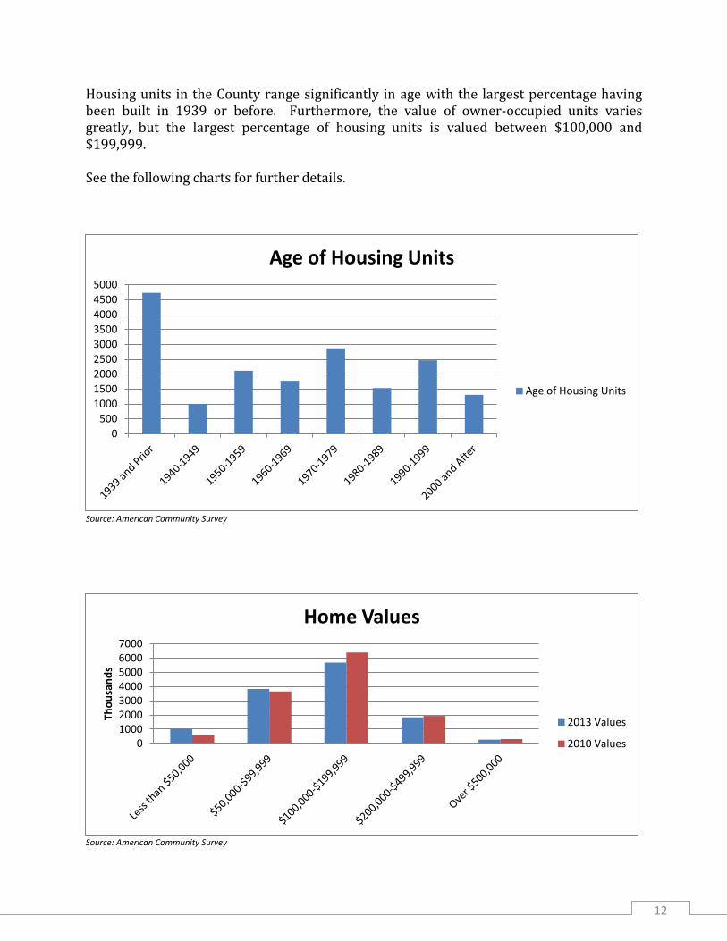
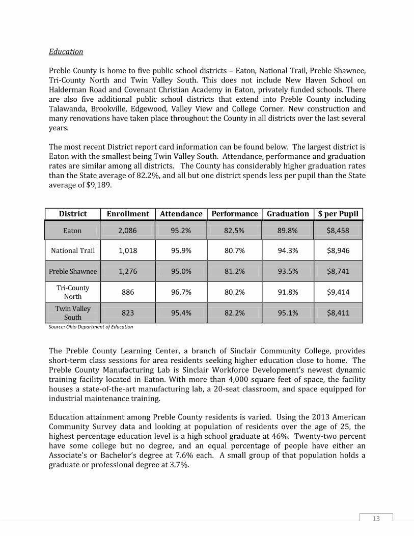
Housing units in the County range significantly in age with the largest percentage having been built in 1939 or before. Furthermore, the value of owner-occupied units varies greatly, but the largest percentage of housing units is valued between $100,000 and $199,999. See the following charts for further details.
Source: American Community Survey
Source: American Community Survey
0
500
1000
1500
2000
2500
3000
3500
4000
4500
5000
Age of Housing Units
Age of Housing Units
0 1000 2000 3000 4000 5000 6000 7000
Tho
usa
nd
s
Home Values
2013 Values
2010 Values
13
Education Preble County is home to five public school districts – Eaton, National Trail, Preble Shawnee, Tri-County North and Twin Valley South. This does not include New Haven School on Halderman Road and Covenant Christian Academy in Eaton, privately funded schools. There are also five additional public school districts that extend into Preble County including Talawanda, Brookville, Edgewood, Valley View and College Corner. New construction and many renovations have taken place throughout the County in all districts over the last several years. The most recent District report card information can be found below. The largest district is Eaton with the smallest being Twin Valley South. Attendance, performance and graduation rates are similar among all districts. The County has considerably higher graduation rates than the State average of 82.2%, and all but one district spends less per pupil than the State average of $9,189.
District Enrollment Attendance Performance Graduation $ per Pupil
Eaton 2,086 95.2% 82.5% 89.8% $8,458
National Trail 1,018 95.9% 80.7% 94.3% $8,946
Preble Shawnee 1,276 95.0% 81.2% 93.5% $8,741
Tri-County North
886 96.7% 80.2% 91.8% $9,414
Twin Valley South
823 95.4% 82.2% 95.1% $8,411
Source: Ohio Department of Education
The Preble County Learning Center, a branch of Sinclair Community College, provides short-term class sessions for area residents seeking higher education close to home. The Preble County Manufacturing Lab is Sinclair Workforce Development’s newest dynamic training facility located in Eaton. With more than 4,000 square feet of space, the facility houses a state-of-the-art manufacturing lab, a 20-seat classroom, and space equipped for industrial maintenance training.
Education attainment among Preble County residents is varied. Using the 2013 American Community Survey data and looking at population of residents over the age of 25, the highest percentage education level is a high school graduate at 46%. Twenty-two percent have some college but no degree, and an equal percentage of people have either an Associate’s or Bachelor’s degree at 7.6% each. A small group of that population holds a graduate or professional degree at 3.7%.
14
Utilities and Infrastructure Capacities With the newest centralized wastewater systems being constructed in the villages of West Elkton (2004) and Verona (2007), all of the incorporated municipalities of the County now offer sewer services. These facilities provide various types of treatment processes and vary in age. Many have undergone upgrades and expansions since their initial construction. All of the systems are owned and operated by the municipality in which they are located, with the exception of the West Elkton system. This system is known as Preble County Sewer District #3 and is owned and operated by the County. Since the facilities serving the Village of College Corner are located in Indiana, there was no information available to include in this report. With the exception of the Village of West Elkton, all of the other communities in Preble County own and operate water supply, treatment, and distribution systems along with fire protection for their residents. The current capacities of the water and wastewater facilities for the Preble County communities are shown in the charts on the following page. County Water Capacities in Gallons per Day (GPD)
Community Current Design Average Daily Use
Camden 400,000 200,000
Eaton 1,700,000 1,300,000
Eldorado 144,000 50,400
Gratis 288,000 73,000
Lewisburg 539,000 220,000
New Paris 400,000 110,000
Verona 144,000 31,000
West Alexandria 600,000 180,000
West Manchester 100,000 31,000
County Wastewater Capacities in Millions of Gallons per Day (MGPD)
Community Current Design Current Peak Average Daily Use
Camden 0.325 0.632 0.172
Eaton 1.900 5.000 1.400
Eldorado 0.144 0.072 0.050
Gratis 0.119 0.411 0.070
Lewisburg 0.261 0.800 0.110
New Paris 0.360 0.786 0.224
Verona 0.085 0.087 0.032
West Alexandria 0.300 0.600 0.120
West Elkton 0.025 Unknown 0.015
West Manchester 0.100 0.049 0.029

15
Industrial Sites Locations of industrial sites within the County include both occupied and unoccupied properties and are dispersed mostly between the City of Eaton and the various Villages. The Preble County Development Partnership maintains a list of current available development sites. A website link to that list is included at the end of this Plan and includes some shovel-ready locations. The largest concentrations of industrial and/or manufacturing facilities are located in the following locations:
City of Eaton – east, west and south borders
Village of Camden – north and west borders
Village of Eldorado – southwest border
Village of Lewisburg – west and south borders
Village of New Paris – north border
Village of West Alexandria – east border
In addition to the areas listed, there are some greenfield sites that could be considered for development. A “greenfield site” is a term used to describe a piece of undeveloped land currently used for agriculture or left to nature that is generally around a city or location having readily available utilities or transportation routes nearby. These sites have been identified as:
I-70/US 127 interchange;
I-70/US 40 interchange on the Ohio-Indiana border;
I-70/SR 503 interchange;
US 35 west of West Alexandria;
US 127 north of Eaton; and
Other sites that are close to the transportation routes of I-70, US 35, US 40, or US
127.
Some of these sites are not presently served by municipal water or sewer. A truck stop property on US 40 located at the Ohio-Indiana border is served by Indiana American Water and utilizes a package wastewater treatment plant. Several sites in the County have access to three phase electrical power and natural gas. Most of the sites are not currently zoned for commercial or industrial use, but could be rezoned for most business purposes.

16
Roadway Miles The graph below shows the various types of roadway miles and the County’s total in comparison to the overall State totals.
Roadway Preble County Miles State Miles
Township Roads 426.08 40,790.38
County Roads 255.34 29,169.93
State Routes 115.34 14,046.01
US Routes 62.51 3,917.66
Interstate 17.67 1,572.35
Source: Ohio Development Services, ODOT
Railroads According to the Preble County Engineer’s Office, the County has approximately 17 miles of railway which are operated by Norfolk Southern. The rail line comes in from the south through Camden and follows US 127 north to Eaton where it then veers northwest and travels along US 35 toward Richmond, Indiana. Located in the southern part of the County, in the Village of Camden, is Camden Yards Logistics Park. This facility provides rail for the rail-less, offering full-service logistics, experienced handling of materials, delivery or pickup, and just-in-time capabilities. The site encompasses 55 acres with three industrial rail spurs and approximately 25 car spots. The facility is serviced by Norfolk Southern. They also offer warehousing, transloading, and transportation services that include delivering or picking up product within a 200 mile radius. Camden Yards currently handles feed ingredients, paper, steel, utility poles, and roofing granules. This provides a unique opportunity for industry within the County to facilitate movement of both raw and finished product. Technology/Communication Preble County currently has several internet and cable access choices and providers. There are options for broadband access via wireless connection, satellite, and some cable/fiber connections, although they may be restricted to service areas of dense populations. Some local wi-fi wireless connection options exist for non-service areas of sparse residents.

17
Recreational Opportunities
Preble County is the home to numerous recreational opportunities that include camping sites at privately owned grounds such as Natural Springs Resort and Archway Campground both near the Village of New Paris, Cross’s Campground near the Village of Camden, and Hannon’s Camp America near College Corner. The Hueston Woods State Park is located in the southwest corner of the County consisting of nearly 3,000 acres and surrounds the 625-acre Acton Lake. Outdoor recreation such as hiking, fishing, canoeing, and fossil hunting are all available along with campsites, cabins, and a resort lodge. There is also an 18-hole golf course within the Park.
Most Preble County communities have at least one local park to provide summer recreational opportunities including little league baseball and softball, soccer, picnicking, playgrounds, etc. The City of Eaton is fortunate to have ten different park locations to provide many amenities to city and county residents. These include the historic Fort St. Clair Park and a community pool site which underwent complete renovation in 2016.
One of Preble County’s largest attractions is its collection of seven antique covered bridges scattered throughout the County. The oldest being Roberts Bridge built in 1829 which is part of the Eaton Park system, with the last one built in 1896 that is Warnke Bridge.
The Preble County Park District and Preble County Historical Society have both developed recreational opportunities for county residents over the last few years. These include the Garber Nature Center and the Preble County Amphitheater.
There are two public golf courses within the County as well as a commercial snow tubing hill on the north side of the Village of New Paris. Outside of Camden lies the G&J Kartway which hosts many races throughout the year. Close by is also the Mulberry Pheasantry which provides a great hunting experience. Arts & Culture
The Preble County Art Association was formed in 1965 as a fine arts guild dedicated to providing understanding, enlightenment, and participation in the fine arts through programs, classes, and exhibits. The Preble County Visual Art Center, located in Eaton, is owned and operated by the Preble County Art Association, and is dedicated as a “cultural opportunity facility” for all people of the community.
The Preble County Historical Society was organized in 1971 as is the resource responsible for preserving and promoting the knowledge and history of Preble County for all generations. Located on the Historical Center grounds near the Village of Gratis, the Amphitheater brings large crowds as it provides a unique facility for community events such as hands-on education and demonstrations, educational environmental programming, school and cultural events, and musical and theatrical performances.
In 2015 the Eaton Community Schools completed a new 77,000 SF middle school complete with a state-of-the-art auditorium known as the Eaton Performing Arts Center. The 588-seat facility hosts various community productions such as plays, concerts and awards ceremonies and attracts audiences from all over the region.
18
LAND USE MANAGEMENT _________________________________________________________________________________________________________ The following Comprehensive Land Use Plan focuses primarily on land use policies and is intended to guide action. The scope of the policies incorporates a broad perspective in the interest of providing flexibility in addressing many different situations and circumstances. These policies provide the general framework within which specific concerns can be identified, programs developed, and immediate actions selected. The objectives and policies contained in the Comprehensive Land Use Plan are not intended to be complete statements of all the County's operational procedures, but rather are primarily related to the physical aspects of the County's development. There are four significant reasons for the Plan:
1. The effects of most land uses (noise, traffic, visual impact, etc.) extend beyond the property boundaries. Sometimes the effects are good, such as pleasant scenery or well-organized neighborhoods, and sometimes the effects are bad - strips of non-farm residences along county roads affecting active farming operations or refuse from commercial businesses blowing onto surrounding residential or agricultural properties. Society often needs to prevent undesirable effects from destroying an adjacent neighbor's enjoyment and use of his property.
2. Public action is often needed to protect the environment and to coordinate projects such as roads, schools and other public facilities, and public utilities and services. To do this properly it is necessary to know how and where the County will develop. The Plan is the model for government and private action in this regard.
3. Governmental guidance of private land development promotes efficiency. For example, in a commercial area the businesses can share the use of parking lots and parking spaces, access drives and sidewalks. This results in enhanced property values, maximizes governmental services such as utilities and roads, and facilitates delivery of goods and services to the consumer.
4. The Land Use Plan serves to educate and inform the citizens. It describes how the County is planning future development, the issues involved, and the actions and strategies recommended to achieve the Plan. Thus, the Plan serves to communicate to the residents how the planning process works, the existing state of the County, and future development expectations.
Recommended land use patterns and supporting policies represent the major elements of the Land Use Plan and comprise a general plan consisting of location patterns, and respective policies set forth in the interest of achieving and maintaining compatibility between urban development and rural activities and resources within the County. Many related economic, environmental and social concerns must be addressed as they affect or are affected by physical development. The Land Use Plan can be achieved through the use of growth management tools such as zoning, subdivision regulations, performance standards, and building permits, and by voluntary compliance of private developers, landowners, and residents.

19
THE PLAN IN GENERAL
The Plan concerns the unincorporated areas of the County for which the County has the planning responsibility. However, land use plans for the incorporated areas of the County, where available, should be considered to ensure land use compatibility for the adjoining unincorporated and incorporated areas.
The Plan is designed to build upon and incorporate the existing desirable characteristics of the County and provide a common and consistent guide to land development in the County for developers, property owners, and public entities. The Plan must also remain flexible to be able to accommodate unforeseen conditions that may materialize in the future. Therefore, the Plan should be kept current through regular reviews and updates (approximately every 5 years) to ensure that its policies remain valid and effective.
To fully realize the benefits of the Plan, it must be implemented. Its recommendations must be undertaken and carried forward by the combined efforts of the public and private sectors. The public sector should take the lead in implementing the plan, and guide private sector investment by planning and guiding the location of public facilities such as thoroughfares, parks, sewer and water utilities. The public tools available to implement the Plan include zoning, subdivision regulations, building codes, and citizen participation. Zoning
Zoning is generally the most widely used tool by government in the planning and control of development. Zoning is defined as the legal regulation of the use of land and structures on the land in order to protect the general welfare, health and safety of the public. In Preble County zoning is utilized by the County, the City of Eaton, and most of the villages. All townships in Preble County are covered by the County Zoning Resolution administered by the County.
The Plan represents the official County Guide for future land development and should be used as a reference in the administration of rezoning proposals in the unincorporated areas of the County. In this regard, numerous court decisions have recognized the relationship of zoning regulations to a comprehensive land use plan, stating that zoning regulations should be based upon a comprehensive land use plan designed to promote the general welfare, health and safety of the public. Therefore, this relationship becomes an important tool for Plan implementation. To facilitate this relationship the county's zoning map should be progressively adjusted so that zoning districts are properly related to the Plan.
Subdivision Regulations
Subdivision regulations are another tool available for Plan implementation. Subdivision regulations govern the process of dividing land into parcels, blocks, and lots, and provide specific standards for streets, the configuration of building lots, utility system design, and construction standards. The Preble County Subdivision Regulations are referenced throughout the County Zoning Resolution, and are used to ensure that development within the various zoning districts meet both zoning and construction requirements.

20
Building Code
The regulation of building construction through a building code is another tool used by government to protect public health and safety. The code includes not only building regulations, but plumbing, mechanical and electrical regulations as well. Preble County has adopted the Ohio Board of Building Standards building codes as the building codes for the County. Issuance of building permits, inspections and enforcement of the codes are handled through the Preble County Land Use Management Office with the exception of residential construction within the City of Eaton. The City of Eaton provides these services through their Building Dept. Health codes, which control such things as private septic systems, are also used to protect public health and the Health Department is responsible for their enforcement.
Citizen Participation
It is essential that the residents of Preble County understand the planning issues confronting the community and the benefits to be derived from the implementation of the Plan. Although most of the new development can be controlled and directed through the legal means previously outlined, much of the control of development actually relies on private citizens and can be made more effective through group efforts. Programs of civic involvement which serve to tie together the individual efforts of the private sector and the Plan should be promoted.
DEFINITIONS The following terms, which appear in the Plan, are defined herein for clarification purposes.
AGRICULTURAL AREA - An area of the county wherein agriculture and agribusiness-supporting services prevail. This area is established
(1) to protect active farming enterprises from incompatible non-farm development whose effects would be detrimental to the continued future of the farming industry; and
(2) to protect land best suited for agricultural use, as well as natural resources in general, from the detrimental effects that often result from the encroachment of scattered urban-type uses.
AQUIFER - A geological unit in which porous permeable conditions exist, thereby providing the capacity for yielding usable amounts of water. AQUIFER RECHARGE AREA - An area that contains soils and geological features that are conducive to allowing significant amounts of surface water to percolate into the groundwater.
21
·
AGRICULTURE - As used in sections 303.02 to 303.25 of the Ohio Revised Code, “ agriculture” includes farming; ranching; algaculture meaning the farming of algae; aquaculture; apiculture; horticulture; viticulture; animal husbandry, including but not limited to, the care and raising of livestock, equine, and fur-bearing animals; poultry husbandry and the production of poultry and poultry products; dairy production; the production of field crops, tobacco, fruits, vegetables, nursery stock, ornamental shrubs, ornamental trees, flowers, sod or mushrooms; timber; pasturage; any combination of the foregoing; the processing, drying, storage, and marketing of agricultural products when those activities are conducted in conjunction with, but are secondary to, such husbandry or production. AGRICULTURAL SOILS, PRIME - Those soils which are best suited for the production of food, fiber, and other crops. Prime agricultural soils have been determined for Preble County based upon average yields per acre of principal crops and the capability grouping of each soil type. Prime agricultural soils fall within Capability Class 1 and Class 2 (often shown as Class I and Class II) as they are described in the Soil Survey of Preble County, published by the United States Department of Agriculture, Natural Resource Conservation Service. BUSINESS, GENERAL – Commercial uses which generally require locations on or near major thoroughfares and/or their intersections, and which tend, in addition to serving day-to-day needs of the community, also to supply the more durable and permanent needs of the whole community. General Business uses include but need not be limited to such activities as supermarkets; stores that sell hardware, apparel, footwear, appliances, and furniture; department stores; and discount stores. BUSINESS, HIGHWAY – Commercial uses which generally require locations on or near major thoroughfares and/or their intersections, and which tend to serve the motoring public. Highway Business uses include but need not be limited to such activities as filling stations; truck and auto sales and service; restaurants and motels; and commercial recreation. BUSINESS, OFFICE TYPE - Quasi-commercial uses which may often be transitional between retail business and/or manufacturing and residential uses. Office-type business generally accommodates such services as administrative, executive, professional, accounting, writing, clerical, stenographic and drafting. Institutional offices of a charitable, philanthropic, or religious or educational nature are also included. CLUSTER DEVELOPMENT – A form of development that permits a reduction in lot area and bulk requirements, provided there is no increase in the number of lots permitted under a conventional subdivision or increase in the overall density of development, and the resultant land area is devoted to open space, recreation, preservation of environmentally sensitive areas, or agriculture. Generally refers to a development pattern for residential, commercial, industrial, institutional or a combination of such uses in which the uses are grouped or "clustered" through a density transfer rather than a conventional lot-by-lot development.

22
COMPREHENSIVE ECONOMIC DEVELOPMENT STRATEGY (CEDS) - is a strategy-driven plan that provides direction for regional economic development. The primary goal is to help our county have a stronger, more diverse regional economy. While the CEDS’ most critical function is to provide a regional economic development framework, it also serves as a required vehicle through which some federal agencies such as the U.S. Department of Agriculture (USDA) evaluate requests for grant assistance. COMPREHENSIVE LAND USE PLAN (aka COMPREHENSIVE DEVELOPMENT PLAN), or THE PLAN – A plan including all attachments adopted by the Preble County Planning Commission and the Board of Preble County Commissioners describing both graphically and narratively the existing physical characteristics of the County as well as a proposed generalized land use pattern for the future. The plan provides goals, objectives and recommended policies to guide the development of major types of land use, thoroughfares, and other pertinent public facilities as well as the preservation of major aspects of the County’s environmental resources. DEVELOPING AREAS - The County’s Developing Areas – which include areas adjacent to Camden, Eaton, Lewisburg, New Paris and West Alexandria – are those located next to urban areas and are in the path of urban growth. The greatest asset of these developing areas is their large supply of undeveloped land that is now, or will in the future, be provided with urban facilities and services needed to support urban development. Urban expansion in these areas should be planned, staged, and generally contiguous to existing development. FREESTANDING GROWTH AREAS - Freestanding growth centers represent the larger village areas within the County and include Camden, Gratis, Lewisburg, New Paris and West Alexandria. Freestanding growth centers provide an alternative to large-city living and are communities that have the services and capacities to accommodate an urban population. These areas are somewhat similar to cities in that they provide a range of services and are generally able to accommodate a relatively full range of land uses. They are also more than just residential communities as many have an employment base within the community. These areas have public water and sewer facilities, generally higher levels of law enforcement and fire protection services, and usually have convenience retail services. Planning for growth in the transitional areas around the Freestanding Growth Areas should include evaluation of the impact of the development on the Freestanding Growth Area.
INDUSTRY, COTTAGE – A typically small-scale industry carried on at home by family
members using their own equipment.
INDUSTRY, GENERAL - A use engaged in the basic processing and manufacturing of
materials or products predominately from extracted or raw materials or a use engaged in the storage thereof, or in manufacturing processes using heavy machinery. Such uses generally require locations with ready access to major thoroughfares or rail lines.

23
INDUSTRY, LIGHT - A use engaged in the manufacturing – predominately from previously prepared materials of finished products or parts, including processing, fabrication, assembly, packaging, incidental storage, and distribution of such products, but generally excluding basic industrial processing as characterized by General Industry. INDUSTRIAL PARK - A planned, coordinated development of a tract of land with two or more separate industrial buildings. Such development is planned, designed, constructed and managed on an integrated and coordinated basis, with special attention given to onsite vehicular circulation, parking, building design and landscaping. INFRASTRUCTURE - Infrastructure consists of those facilities and services needed to support development such as utilities, thoroughfares, schools, emergency services, etc. ISSUE - A problem or concern which usually has multiple potential methods or strategies that may be pursued in its resolution. LAND USE - A description of how land is occupied or utilized.
LAND USE PLAN - See Comprehensive Land Use Plan.
OBJECTIVE - A measurable achievement a community desires to accomplish in the future. By itself, an objective is not particularly helpful in making day-to-day decisions, but it does provide a general direction for more specific statements to assist County decision makers. OPEN SPACE AREAS - Areas included for preservation, recreation or parks. Open space areas do not include Agricultural Areas. PLANNING – The decision-making process in which goals and objectives are established, existing resources and conditions analyzed, strategies developed, and regulations enacted to achieve the goals and objectives for the future development of the County. POLICE POWER - The authority of government to exercise controls to protect the public's health, safety, morals and general welfare. As distinct from eminent domain powers, in which government takes property, no compensation need be paid for the imposition of police power controls as they do not include the taking of property. POLICY – A statement or document of a public body that forms the basis for enacting legislation or making decisions. PREEMPT - The occupation or use of land such that it cannot be used for another purpose.

24
RURAL COMMUNITIES - Rural communities have historically served as retail service centers and transportation centers for the surrounding rural areas. These would include the communities of College Corner, Eldorado, Fairhaven, Morning Sun, New Westville, Verona, West Elkton and West Manchester. These communities provide locations where those not engaged in agriculture can live in a rural area under conditions less detrimental to the pursuit of farming. Most of these areas have sanitary sewer systems while some still have on-site waste disposal systems. Some of the communities have a public water system. Urban Transitional Areas for these communities should be the areas that are presently served, or able to be served, with central services such as water and sewer. URBAN CENTER - The City of Eaton represents the County’s Urban Center, both in size and location. It contains a developed core area along with substantial facilities for government, retail goods and services, and financial, medical and business services. URBAN TRANSITIONAL AREA - An area generally located between incorporated urban areas and Agricultural Areas wherein urban services can be reasonably extended to serve the urban expansion needs of townships and municipalities. The purpose of this area is to accommodate urban expansion needs within the foreseeable future. Residential development within the Urban Transitional Areas can be accommodated at a density compatible with the effective and economical provision of central utilities that can be provided at the time of development or within the near future.

25
THE CONCEPT OF URBAN TRANSITIONAL & AGRICULTURAL AREAS The establishment of Urban Transitional and Agricultural Areas represents a key element in the delineation of the Plan. This concept has been generally supported in County Planning and has provided a common perspective for many of the County's past developmental reviews. Urban Transitional Areas are generally located around existing incorporated areas where the necessary urban services can be extended to serve urban extension needs. The Urban Transitional Areas are shown on the Preble County Thoroughfare and Urban Transitional Map as a series of demarcation lines that delineate the projected land use expansion areas from the rural use areas. While the largest pattern of Urban Transitional Area is around the City of Eaton, other municipalities such as Gratis, Camden, College Corner, West Alexandria, Lewisburg, West Manchester, Eldorado, and New Paris have delineated Urban Transitional Areas as well. Local and national research has indicated that over the long run, limiting the spread of urban development substantially reduces the cost of providing public facilities and services. The information indicates that there could be significant advantages to the County, as a whole as well as to all the other governmental units, in working and planning for a more contiguous development pattern designed to control urban sprawl. Simply stated, the larger the geographic area that must be served by utilities, road systems, law enforcement, and fire protection, the more costly those services become with the increased service costs ultimately borne by the taxpayers. Additionally, unguided urban expansion has a detrimental effect upon active farming enterprises, reduces the amount of prime agricultural land available for farming, and can result in conflicts between the residences and the agricultural operators due to the dust, odors and noise associated with agricultural production and businesses. Therefore, the concept of Urban Transitional Areas and Agricultural Areas are further refined in the subsequent sections of the Plan. The Agricultural Areas located beyond the designated Urban Transitional Areas should be generally restricted to agriculture and related services, with non-farm residential, commercial and industrial development restricted in number and location.
26
PREBLE COUNTY MAJOR LAND USES Preble County’s land can be divided into six major land uses – agricultural, residential,
commercial, industrial, open space and outdoor recreation, and environmental protection.
It is necessary to have clear identification of the issues facing these land uses in conjunction
with objectives and policies that will protect and sustain them for years to come.
Agricultural Land Use
Agriculture remains the dominant use of the greatest majority of land in Preble County.
Therefore, preservation of the farming industry should be a major priority for the County
which is based on the following considerations:
It preserves a way of life and its unique cherished values;
It provides fresh, high quality food at a reasonable cost close to the consumer;
It contributes to a stable economy by providing job opportunities, income and a
market for the resources of production;
It contributes to the nation’s balance of payments by providing food for export;
It provides reserve food production capacity to meet the future needs of the world;
It provides wood products from woodlands;
It maintains the quality and beauty of the environment through the cleansing effect
of the supply of oxygen by growing plants and the filtering effects of plants and soil
on the water supply;
It maintains farm-associated wildlife habitats and provides for private outdoor
recreational areas for camping, fishing and hunting;
It provides areas for recycling of solid and liquid agricultural wastes;
It protects mineral resources from being preempted;
It provides productive, privately maintained agricultural open space with all its
accompanying environmental benefits, including rural aesthetics and enhanced air
and water quality; and
It protects the hydrological integrity of watersheds through the control of storm
water runoff and sediment drainage, protects aquifer recharge areas and provides
buffers for water supply and other natural areas.
Agricultural Areas are those that are characterized by prime agricultural soil groupings or
farming enterprises. Large, active farms often typify the predominant land use within
these areas. Although every township within the County contains some areas of prime
agricultural soils, the following townships contain the largest areas of such soils: Dixon,
Gasper, Harrison, Jackson, Lanier, Monroe, and Washington.
Agricultural Land Use Objectives

27
1. To encourage the preservation of agricultural land use areas and active farms and
protect them from the detrimental effects of non-farm development.
2. To formulate and implement specific programs and strategies which are designed to respond to the unique development issues and needs associated with the agribusiness community.
3. To recognize agricultural land as a beneficial use in and of itself, rather than as a temporary use which merely holds the land until such time as development is proposed.
4. To promote soil conservation practices and best management practices in order to
preserve topsoil, prevent excessive siltation and pollution of streams and aquifers, and to reduce, to a practical degree, the adverse effects of farming operations beyond the boundaries of the farms.
Agricultural Land Use Policies
1. The County will encourage non-farm development to locate in Urban Transitional Areas, as designated on the Preble County Thoroughfare and Urban Transitional Area Map.
2. The County zoning authorities will require all applicants for non-farm development to address, where pertinent, the proposal’s impact on the agricultural productivity of the subject area. This includes addressing such issues as the proposed development’s effects upon field drainage, the effects upon adjacent farms of converting the farmland to a non-agricultural use, and the effects of increased traffic on local roads.
3. Where agricultural land is being considered for future urban land use expansion, the
least productive agricultural land will be considered first. Decisions upon proposed expansions will be based upon such factors as evidence of the necessity of such expansion, developmental trends, suitability of the subject areas for farmland, desirable land use patterns, and proximity to active farming operations.
4. The County will discourage any development which conflicts with agricultural
productivity. For example, strip residential development which results in extensive development along the road frontage will particularly be discouraged.
5. The County will revise its Rural Zoning Resolution and Subdivision Regulations,
as necessary, in the interest of farmland protection. To accomplish this, the County should consider an array of various economic, social and environmental factors for evaluating rezoning proposals within Agricultural Areas. The considerations could include, but not be limited to, the following:
Availability of public sewer and water;
Suitability for onsite waste disposal and availability of water;
Prime and non-prime agricultural soil groupings;

28
Proximity to other non-farm residences and the number of other such residences;
Current use of the property;
Proximity to active farming enterprises; and
Adjacency to thoroughfares.
6. The County will encourage the scheduling or staging of utility services prior to, or at
the time of, development within areas designated as Urban Transitional Areas.
7. The County will support interested parties in the identification and implementation of programs and strategies for the protection of the agribusiness industry, such as farmland trusts, the purchase of developmental rights, and cluster development.
8. The County will support state enabling legislation that facilitates stronger incentives
and regulations for the preservation of agricultural land and active farming enterprises.
9. The County will encourage the rigorous use of environmental assessments
concerning the effect of federal and state projects upon agricultural land.

29
Residential Land Use The need for shelter is one of our most basic needs. No area of development is more crucial to our well-being than housing. Therefore, it is essential that all communities in the County seek to provide suitable housing for all citizens.
Residential Land Use Objectives
1. To balance the need to provide a sufficient amount of land to accommodate residential demand with the County’s goal to maintain a contiguous and efficient urban growth pattern, in order to protect the agribusiness industry and the rural character of Preble County.
2. To have housing available for all levels of income within an environment that is healthy, safe, convenient, and attractive.
3. To encourage development of executive level housing to fill a void in the current
market.
4. To encourage appropriate housing for the needs of the elderly and disabled.
5. To protect the integrity and stability of existing residential areas from the detrimental effects of incompatible land uses.
Residential Land Use Policies
1. Vacant tracts of land that are within current urban service areas should be preferred for development in an effort to promote the efficient extension of services and to fill in the existing Urban Transitional Areas, to the degree feasible. The County will encourage new development to be located within such areas and within the vicinity of existing developed areas contiguous to Urban Transitional Areas, and should discourage development in the Agricultural Areas.
2. The County will generally support more compact residential developments within urban areas, on smaller lots, and in more contiguous patterns of growth in order to eliminate development on increasingly larger lots which are costly to service and wasteful of land.
3. The cluster development concept will be encouraged by the County as an alternative
residential design as it is less intrusive upon the natural resources of the County.
4. The County Planning Commission will work towards the preparation of zoning and subdivision provisions, as needed, to accommodate cluster development proposals.
30
5. The County should encourage innovative energy conserving development. Considerable energy savings may be realized, including reduced transportation and fuel costs, by promoting development of existing vacant or underutilized tracts in proximity to existing urban areas with public services already in place.
6. The County should encourage the selection of multifamily housing sites and higher
density housing development sites on the basis of their potential for providing a safe, attractive and convenient living environment. In general, multifamily housing should be encouraged in proximity to intensive development areas that afford immediate access to shopping, employment and services facilities, open space and recreational resources, and existing or planned principal transportation corridors.
7. The County should encourage a broad range of housing types and densities so that a
choice of housing within appropriate areas is available to all Preble County residents.
8. The County should encourage proposals to develop specialized housing for the
elderly and disabled.
9. The County should recognize the value of existing housing and established neighborhoods by supporting improvement and rehabilitation efforts, both public and private.
10. The County should evaluate and modify its subdivision regulations, as pertinent, to
encourage the use of proven and innovative construction techniques and materials.
11. The County should clarify any of its regulations, zoning, building or subdivision that unnecessarily complicate the regulatory process.

31
Commercial Land Use Commercial areas throughout the County are important elements in the physical and economic development of communities.
Commercial Land Use Objectives
1. To provide viable commercial uses of appropriate function, size, and location to serve the commercial needs of Preble County’s residents.
2. To achieve harmoniously designed commercial facilities optimally compatible with surrounding land uses and adjacent thoroughfares.
3. To facilitate the development of new or rehabilitated commercial areas that complement, rather than compete with existing commercial facilities.
Commercial Land Use Policies
1. The County will encourage related and compatible businesses to be grouped in appropriate and suitably located areas. In this regard, four general types of commercial areas should be identified: municipal/community centers, general commercial areas, convenience business areas, and highway service areas.
2. The County will discourage over-zoning for commercial uses, recognizing that such over zoning often results in the creation of strip and scattered patterns of development and the over saturation of the market, which can cause an overall devaluation of commercial land.
3. The County will encourage new commercial development to cluster into planned shopping centers or “theme” centers or groupings based on the premise that convenient comparison shopping is healthy and economically beneficial to participating businesses.
4. The planning of commercial centers as a unified site design, with particular attention directed to the minimization and location of access drives and efficiency of interior circulation, will be encouraged. The County should assure that proposed sites are of adequate size to accommodate proper vehicle access, interior circulation, and sufficient parking.
5. The County will encourage commercial clusters and existing strip commercial areas to utilize access control measures, with the objective of minimizing traffic conflict with adjacent thoroughfares. These measures will be emphasized along major and minor arterial thoroughfares through such techniques as shared access points, limited numbers and locations of curb cuts, shared parking and service areas, and appropriate traffic control measures.
6. The County will control the development of highway service centers at freeway interchanges in an effort to protect the traffic-carrying capacities of the interchange area, and to provide safe and convenient access to highway-oriented service facilities.
In this regard, the following policies will be exercised:

32
a. Discourage premature or piecemeal development that would limit the options of coordinated development of freeway interchange at a later date; and
b. Focus attention on the location, number and design of access drives, interior circulation, and parking sufficiency, in the interest of achieving a unified site design which emphasizes safety, efficiency and convenience of traffic movement.
7. The County will evaluate commercial land use proposals with reference to the overall need and desirability for the proposed use at the particular location; the compatibility of the proposed development with surrounding existing and proposed land uses; the physical capabilities and characteristics of the land and infrastructure to serve the proposed development; and sufficiency of the specific site’s design to accommodate the proposed activities.
8. The County will require applicants for commercial developments of significant traffic-generation potential to provide traffic analysis data sufficient to evaluate the potential effect of the proposal on adjacent thoroughfares. If it is found that the traffic impact of the proposal will require thoroughfare improvements or traffic management devices, proportionate financial or land contributions will be required from the developer.
9. The County will recognize the City of Eaton as the traditional center of government, finance, entertainment and professional offices, and as the location of the larger and more specialized retail and services facilities serving residents.
10. The County will encourage commercial development within Urban Transitional Areas and that it be served by public utilities, including sanitary sewers.

33
Industrial Land Use Preble County is not generally characterized as an industrial area. However, industrial
development may encompass an array of activities beyond manufacturing, such as
wholesaling, construction, and research laboratories. Several communities within the
County have developed some form of an industrial park or organized industrial
development area, and they have active groups that promote industry in their community.
Evidence of this type of activity is particularly reflected in the City of Eaton and the Villages
of Camden, Lewisburg, New Paris and West Alexandria.
Industrial Land Use Objectives
1. To support the viability of existing industries by mitigating impediments to their
continuation and expansion.
2. To achieve adequate land areas for future industrial growth in locations that have
the greatest potential for such growth.
3. To achieve harmoniously designed industrial facilities that are compatible with
surrounding land areas and adjacent thoroughfares.
Industrial Land Use Policies
1. The County will require that, in general, industrial development be located in urban and Urban Transitional areas and served by public utilities, including sanitary sewers, with the exception of industries which are related to agriculture or are site-specific because of resource location, such as sand and gravel operations.
2. The County will prepare zoning provisions that are appropriate for the
accommodation of “cottage” or small scale industrial type enterprises within the County to ensure viable and compatible industrial operations within the County.
3. The County will discourage the over-zoning of land for industrial uses and will
ensure that such zoning is based upon projected needs. The determination of land needed for industrial uses will be based on realistic assessment of the future industrial growth which could be attracted to the County.
4. The County will plan for the location of industries in areas which are accessible to employees and convenient to highways and rail transportation when appropriate. Proximity to freeway interchanges is a particularly important factor in contemporary industrial location.
5. The County will encourage the clustering of industrial uses in planned industrial parks thus facilitating the planning and continued management of the complex in a unified design.

34
6. The County will encourage the location of industrial uses in areas with sufficient
expansion space to meet anticipated needs and future growth.
7. The County will utilize processes and local controls which encourage either retention of large lots or the consolidation of smaller parcels of industrially zoned land, in order to facilitate their use or reuse in a comprehensive fashion.
8. The County will discourage the location of incompatible uses within areas
designated for industrial expansion.
9. The County will review industrial land use proposals in light of the physical capabilities and characteristics of the land (e.g., relatively flat, well-drained areas); the overall need and desirability of the proposed use at the particular location; the compatibility of the proposed development with surrounding existing and proposed land uses; the suitability of the proposed industry’s characteristics with Preble County in general; and the existence of convenient access to thoroughfares and utilities such as sewer, water, gas and electricity of sufficient capacity to serve the infrastructure needs of the proposed industrial development. The sufficiency of the site design proposal will also be reviewed in terms of interior access and circulation, drainage, storage and loading facilities.
10. The County will encourage the provision of buffers in areas where potential conflicts
may arise as a result of industrial expansion. Natural buffers, such as green areas or landscaping, should be preferred. However, manmade buffers, such as screening, or land use buffers, such as office facilities, should also be considered where appropriate.
11. The County will, in conjunction with local economic development agencies, identify
the types of industries that are potentially suitable for location in Preble County, in terms of respective industry needs and environmental compatibility with the area.
12. The County will support the use of available development incentives in the interest
of attracting industrial growth to appropriate locations. In this regard, the County will recognize the need for new industry and employment opportunities in the smaller outlying communities and within and adjacent to the City of Eaton.
35
Open Space and Outdoor Recreational Land Use Recreational activities can take many forms and are dependent upon an individual’s personal preferences. Examples of recreation may include taking a walk, spending time with friends, boating, playing a team sport, hiking, or gardening, and may be provided by other individuals, churches, community organizations or governments. People have different recreational interests at different points of their lives and often have a wide variety of interests at any given time. Within this broad array of functions and facilities, this Plan focuses primarily on outdoor facilities that are essentially land-oriented and therefore more compatible with the land use focus. Advantages of Open Space Preservation In evaluating the desirability of preserving areas for permanent open space use, there are many physical, social and economic advantages which should be considered. First, preservation of open space areas often enhances the value of real estate in the vicinity. Therefore, the cost of acquiring open space land and the removal of it from the tax rates can be at least partially recovered by increasing land values around it. By the same token, homes in the vicinity of open space areas and park lands tend to maintain their value thereby protecting the community from losing tax dollars due to the depreciation of property values. Secondly, commercial and industrial firms base their site location decision upon the total environment of the community, of which parks and open space areas are an integral part. Lastly, some of the other advantages open space areas provide are acting as a natural buffer between incompatible uses, reducing stream pollution, lessening the danger of floods by absorbing rainwater, replenishing ground water supplies, and controlling soil erosion. Stream Valley Preservation The County’s rural, scenic atmosphere is a significant asset when attracting visitors and residents as well as maintaining existing residents, and this attractiveness should be protected. Although portions of the County will change as development takes place, its pleasant character can be retained through design that is sensitive to the environment and through effective open space preservation programs. In this regard, the County contains significant stream corridors which should be utilized in retaining its scenic qualities. Furthermore, preservation of these stream corridors can serve several other important functions such as providing green belts intertwined with developed land uses throughout the area. The plan for stream corridor preservation incorporates the concept of an open space recreational network within which linear facilities such as stream corridors and scenic thoroughfares are utilized to tie several County attractions together. Hiking and cycling trails can also be used to tie attractions together in a similar network fashion. In addition to providing such a network of attractive areas of natural environment, stream corridor preservation aids in maintaining a well-balanced cycle of water supply. In their natural state, stream valleys act as sponge areas that retard storm water runoff. This impediment of water helps to prevent flooding downstream by slowing the water flow and permitting it to penetrate into the ground, helps recharge subsurface water-bearing aquifers, and allows a more gradual water release during dry summer months.

36
When land is developed without regard for the natural stream valleys, the amount and rate of water runoff is increased. This causes greater volumes of water to pass downstream points in a given period of time and equal volumes of water to pass downstream points in shorter time periods, both of which tend to cause unnecessary damage to property. And, since the water is moving at a faster rate, it cannot replenish the ground water that supports the local water supply system. Furthermore, if the natural excess water storage in stream valleys is destroyed, all the water is discharged during wet periods, leaving little or no water flow during dry periods. This causes adverse effects on the “balance of nature,” as well as on sewer plant operations which are limited by stream flows.
Open Space and Outdoor Recreational Land Use Objectives
1. To achieve recreational and open space facilities of sufficient size and characteristics and to adequately serve the needs and interests of Preble County residents.
2. To preserve, protect and strengthen the established inventory of recreational and open space facilities within the County.
3. To recognize and foster, where feasible, a natural or manmade linkage of open space recreational areas within the County.
4. To establish an implementation strategy that utilizes existing programs, laws and public policies to work toward maintaining the County’s open space and recreational area needs.
Open Space and Outdoor Recreational Land Use Policies
1. The County should seek to preserve open space areas that border existing communities in the interest of curtailing urban sprawl, and to provide a recognizable and definitive urban pattern to such communities.
2. The County will encourage the utilization or preservation of non-useable areas for recreational uses or for open space needs. Such areas include flood plains, heavily forested locations, poor drainage sites, areas with steep slopes, or other places with unique natural features.
3. The County should encourage the development of combined or adjoining school, park, and recreational facilities in order that they may be given maximum and efficient use while reducing land costs.
4. The County will encourage the use of a full range of mechanisms to acquire and maintain natural open space and recreational areas. These mechanisms include public and private land acquisition, property dedications, use of easements, tax incentives, use of flexible zoning and subdivision regulations, and use of abandoned or unneeded right-of-ways and other alternative measures when and where feasible.
5. The County will support the Preble County Park District as a vehicle for accepting and managing park and open space area donations.
6. The County will encourage flexible zoning and subdivision regulations that provide incentives to preserve existing tree cover and unique natural features of various sites.
7. The County will continue to support the recreational plans and programs offered by the State of Ohio, the City of Eaton, and the various communities within the county.

37
Environmental Protection Land Use The attractiveness of Preble County’s landscape is one of its strongest assets. From wooded areas and picturesque stream valleys to its rolling fields, the County contains a wide range of representative Ohio land forms and natural resources, and it is this attractiveness that has helped fuel the urban development within the County. However, increased urban development often results in an increasing threat to the natural environment. Each land use change has effects which are often unanticipated and may produce undesirable results. Natural resources are both limited and interdependent, and the misuse, degradation or destruction of any resource alters the usefulness and availability of the others. This section of the Plan is designed to provide guidance on how the County’s physical resources can be used wisely to satisfy current needs while at the same time maintaining a high level of environmental quality. This will ensure that the needs of future generations can also be met. In the preparation of plans for environmental protection, the County supports a strategy that incorporates both pollution control and resource protection.
Pollution Control as reflected in this Plan is not limited to waste treatment facilities or technology such as emission control devises. Land design and management is recognized as one of the most effective and important approaches to preventing and controlling pollution. Appropriate location and siting of development and of waste treatment and disposal facilities, vegetation management, erosion control, and utilization of natural drainage systems and buffer areas are programs which can be quite effective in protecting the County’s environment if they are used consistently and in concert with resource protection programs.
Resource Protection recognizes that land and natural resources perform critical environmental functions, such as groundwater recharge and discharge, water quality improvement, erosion control, storage of flood waters, wildlife habitat and scenic beauty. Lands in urban and developing areas are particularly vulnerable to damage or destruction. It is important that these critical and vulnerable lands and resources are recognized and their environmental functions protected. The resource protection strategy reflected in this Plan recognizes the interrelationship of adjacent landscape types and the importance of protecting valuable ecological units and linkages. The Plan’s approach to resource protection is based primarily on a system of continuous open space corridors which recognizes that many of the lands and resources most in need of protection are associated with the Twin Creek and Seven Mile Creek corridors. The corridor approach also emphasizes the importance of continuity of environmental options and the protection of the land-water edges. Additional discussion of this corridor concept is contained in the Open Space and Outdoor Recreational Land Use section of the Plan.

38
Environmental Objectives
1. To recognize that the natural environment is an integrated system of interacting land, water and air resources, and to protect the health and stability of this resource system.
2. To regard land as a finite and irreplaceable resource, and to ensure that the use of it does not impair its value for future generations.
3. To provide a safe, healthful and visually pleasing environment in order to enhance
the quality of life for all Preble County residents. Environmental Policies
1. The County should protect flood plain and wetland areas throughout the County and emphasize their value as focal points of natural beauty and recreation.
2. The County should encourage preservation of wetlands and woodlands as essential components of the hydrologic system and as valuable wildlife habitat. The County should also encourage restoration or improvement of degraded wetland and woodland resources where possible.
3. The interrelationship of adjacent land types must be recognized to avoid dividing natural units or breaking important linkages.
4. The County should develop and promote a countywide system of open space corridors
as a basic structure and framework for resource protection and open space planning.
5. Some utilities, such as sanitary and storm sewers, must logically be located in open space corridors, and utilities and transportation facilities will also sometimes need to cross or encroach on the corridors in order to maintain needed system continuity or to serve facilities within the corridor. These conflicts should be resolved in a manner that protects the basic functions of the open space corridor while providing necessary utilities and transportation facilities in a cost-effective manner. The County should avoid encroachment when reasonable alternatives are available.
6. The County should seek to protect the quality and supply of groundwater as the
principal source of water supply and should encourage water conservation programs and efforts.
7. The County should seek to guide urban development to those locations where
adverse impact on ground and surface water quality are minimized.
8. The County should require the incorporation of natural drainage patterns in the design of urban development and measures that minimize or entrap pollutants before they enter surface waters.
9. The County should require the incorporation of storm water management practices,
such as detention and infiltration, in urban development in order to maintain groundwater recharge and avoid increases in runoff. The County should also seek to reduce erosion and runoff increase from land development and construction by requiring the preparation of plans that include the installation of erosion and runoff control practices.

39
10. The County should encourage programs that ensure the application of soil conservation
and livestock waste management practices on County farms.
11. The County will also consider such factors as soil types, drainage, and potential odor and noise from adjacent uses, such as active farming operations, when granting rezoning and conditional uses for non-farm residential development.
12. The County should seek to identify mineral, sand and gravel resources in Preble
County and ensure that urban development does not prevent or obstruct access to an adequate future supply of these resources.
13. The County should encourage the return of resource extraction and waste disposal
sites to a productive use through final site design and reclamation.
14. The County should seek to protect the scenic values of the Preble County landscape by supporting programs for preserving and enhancing vegetative cover, particularly on steep wooded slopes and along stream corridors.
15. The County should seek to protect and maximize public enjoyment of Preble
County’s scenic qualities and views by improving public access to public scenic areas and views, particularly stream and lake facilities.
16. The County should encourage the location and design of waste disposal sites and
facilities to minimize environmental impacts and health hazards. The County should support recycling and reuse of waste materials, with an emphasis on returning organic wastes to the land, recovery of the energy value of combustible material, and direct recovery and reuse of specific materials where technically and economically feasible.
17. The County should support programs to improve air quality and control and the
emission of air pollutants in the County, as well as evaluating the air quality impacts of proposed development and facilities.
40
THE PLAN FOR TRANSPORTATION ___________________________________________________________________
Introduction One of the most vital elements of Preble County is its transportation system. Streets and highways are essential to the orderly functioning of a rural county because they provide mobility for people and goods, as well as access to land. Functional planning for transportation must include highways, railways, transit and pedestrian ways.
Rural Transportation Characteristics In predominately rural areas such as Preble County, nearly 90% of all trips are made by automobile. This means that the family without access to a car has serious problems. Therefore, many County residents must own and maintain cars at the expense of other needs. Even in households with a car, some members may be “transportation handicapped” when the family breadwinner takes that vehicle to work and leaves the others stranded. The reasons for mobility problems within the County are obvious. Public transportation does not exist. Taxi services do not exist. Shopping areas are rarely within walking distance. Persons without telephones have difficulty arranging for ride sharing. There is little carpooling within the County. The aversion to carpooling here may be caused by drivers taking many trips and the fact that destinations are often widely scattered. Generally speaking, rural residents make more and longer auto trips than urban residents, and people in areas like Preble County make the most trips per day of all Americans. Furthermore, County residents often need to travel to several towns or locations outside the County in order to obtain a full range of services.
Inventory Thoroughfares are classified according to the functions they serve with respect to the total highway system. The main designations within such a functional classification are Arterials, which provide highway mobility; Collectors, which expedite movement within a localized area; and Locals, which serve as access to adjacent property. Preble County also has several Private roads. The functional classification of any thoroughfare is derived directly from the travel characteristics of its users. For example, the "main road" between two towns, such as West Alexandria and Lewisburg, is categorized as an Arterial because it functions in the same way as an interstate route between two major cities. However, the design of each of these types of roads is radically different because of the wide difference in traffic volume. (Note: the terms Freeway and Expressway are not functional classifications but describe geometric design types.)
41
Principal Arterials
The primary function of Principal Arterials is to provide a high level of mobility for relatively high volumes of traffic traveling over a relatively long distance between major destinations. Volumes may range from five-thousand ADT (Average Daly Traffic) on rural routes to in excess of thirty-thousand ADT on interstate routes. Interstate Route 70 is an example of such a thoroughfare through Preble County.
Minor Arterials
These thoroughfares accommodate traffic volumes which typically range between two-thousand to seven-thousand ADT in rural areas, and between five-thousand to ten-thousand ADT in urban areas. U.S. Route 127 and U.S. Route 35 are examples of such thoroughfares in Preble County.
Collectors
The primary function of Collectors is to expedite movement within a localized area. Collectors serve the dual functions of mobility and land access by connecting the Locals to the Arterials. Major Collectors have traffic volumes ranging between one-thousand to three-thousand ADT on rural routes, and two-thousand to ten-thousand ADT in urban areas. Minor Collectors typically have traffic volumes less than seven-hundred and fifty ADT. All County roads within Preble County can generally be classified as Collectors.
Locals
Local roads are designed for low speed and low traffic volumes. They provide the first access link between individual properties and the higher mobility highway system. All the township roads within Preble County can be classified as local roads. The few private roads that exist in the County, mostly within subdivisions, can also be classified as local roads; however, the maintenance of these roads is generally the responsibility of the owners or users of the road, as opposed to public roads.
Railways Although numerous rail lines have long been discontinued within the Miami Valley Region, Preble County is still served by an actively used rail facility which runs through the County from the south and west, serving Camden and Eaton.

42
Transportation Theory
Land Use – Transportation Cycle The development of transportation plans must be based upon a number of theoretical concepts about the way the County functions and the role of transportation. The first of these is an understanding of the relationship between transportation and land use. When transportation access to a parcel of land is improved, the land becomes more attractive and is often developed for commercial or residential use. As land is developed, the greater amount of activity leads to increased travel demand. This increased demand, over time, causes an overloading of the transportation facilities which respond with an increase in supply and capacity. The cycle is thereby repeated again with the increased accessibility affecting the pattern of land use. An example of this cycle can be seen along U.S. Route 127, particularly near the northern portion of the City of Eaton. U.S. Route 127, which was originally built to accommodate a lesser amount of traffic, has grown to attract an increasing amount of traffic, which has led to congestion. This, in turn, has resulted in the need for extensive improvements to the thoroughfare in the interest of improving its traffic-carrying capacity. The City of Eaton continues to work to improve adjacent and nearby streets as alternative routes for local drivers in an effort to reduce the Route 127 traffic.
Derived Demand The second theoretical concept underlying transportation planning is that of derived demand. This theory, which is related to the land use-transportation cycle, states that the demand for travel derives from the demand to do other things. In other words, most people do not travel just for the sake of traveling, but rather for specific purposes such as to work, shop or visit. Through this concept, it is possible to relate the amount of trips made to the level of land use activities. For example, the number of trips into a shopping center can be related to the size of the center and to the employment there. Therefore, it is possible to predict future travel patterns and volumes as a function of land use characteristics.
Impedance Minimization The third concept, impedance minimization, refers to the attempt to reduce the negative aspects of travel, such as cost, time, discomfort and inconvenience. Travelers behave in such a way as to minimize the impedance of travel as they perceive it. This concept is used to explain the choice of route of travel between two points (use of minimum time path); the mode of travel (combination of minimum cost, travel time and inconvenience); and the choice of destination (minimization of travel time to a place that serves the travel need).

43
Transportation Objectives
1. To achieve a convenient, safe, efficient and economical transportation system for the movement of people and goods within and through Preble County.
2. To achieve a transportation network that relates harmoniously with the existing, developing and planned land use patterns within Preble County.
3. To promote land use patterns and characteristics that will optimize the use of existing and planned transportation facilities and services, and to provide for choice in using alternative transportation modes where feasible.
Transportation Policies
1. The County will review all new major transportation proposals in the unincorporated areas of the County with regard to the purpose to the recommended improvement; the benefits expected to be achieved; the anticipated impacts of the proposal; the proposal’s ability to achieve area-wide transportation objectives; and the existence of other alternatives which would meet the objectives of the subject proposal.
2. The County will promote transportation planning that is coordinated among all affected jurisdictions within the County. This specifically includes pursuing the development of uniform thoroughfare standards wherever feasible. Reciprocal review of plans that affect more than one jurisdiction will also be a part of such program.
3. The County will evaluate new development proposals with regards to the potential impacts the development may be expected to have on the surrounding transportation system, as well as the sufficiency of the proposed development’s internal circulation plan.
4. Because improvements in the County’s Thoroughfare Plan are, to a large extent, required to accommodate the needs generated by development adjacent to the thoroughfares, the County will require developers to dedicate additional rights-of-way or to construct roadways designated in the County’s Thoroughfare Plan, and as described below.
In all cases, rights-of-way necessary to implement the Plan will be dedicated to the County at the time of development of the property.
In cases where there are missing segments in the traffic circulation system or where new thoroughfares are to be constructed, the developer will construct and dedicate to Preble County that portion of the thoroughfare that lies within or abuts the boundary lines of the development.
If for reasons of safety or system continuity, the County Engineer deems the improvement of the thoroughfare unfeasible at the time of development, the developer will provide a performance bond or other security for his share of the cost in lieu of undertaking construction at that time.
The above requirements will be implemented through appropriate land development regulations which may provide exemptions and waiver, modifications or variances where the existing road capacity in the area of the development is adequate to provide for the traffic generated by development.

44
5. The County will explore the development of appropriate criteria, standards and appropriate fee structures to equitably define the developer’s obligations and costs associated with the dedication or construction of necessary offsite road improvements.
6. The County, recognizing that roadways have significant impact in the drainage patterns of particular areas, shall include provisions within the standards to address existing and potential drainage problems through proper construction and continued maintenance. Such provisions should apply to the adequacy of storm sewer systems within urban areas and to the drainage patterns along rural roadways, particularly as they relate to field and ditch drainage. Such provisions shall also clearly define the responsibilities of the Developers and Landowners as they relate to the proper construction and continued maintenance of storm water management systems.
7. The County should support Access Management Regulations in all planning activities and should support the County Engineer in his role as local authority on roadway and drainage design.
Transportation Plan Recommendations In consideration of the above outlined concepts, a process has evolved for the planning of the County’s transportation facilities and service needs. Transportation planning activities must first be divided into three geographical levels: countywide planning, corridor-level planning and spot-improvement planning. Countywide Planning
Countywide planning is aimed at the development of an overall thoroughfare system for the entire County, taking into consideration the County’s relationship to adjacent counties. Preble County is served reasonably well by east-west and north-south thoroughfares that bisect the County through its northern and mid-portion in an east-west orientation, and through its eastern and central portion in a north-south orientation. The major concern must be maintaining the traffic-carrying capacity of these facilities through proper access control and interior circulation improvements, both of which are discussed in the next two sections of the Plan. Countywide Planning Recommendations
1. The County should seek to connect Collector roads to form a loop road system whenever possible.
2. The County should evaluate its standards and specifications for thoroughfares to assure adequacy and to avoid over-design that could be costly to construct and maintain, and wasteful of resources.
3. The Preble County Thoroughfare and Land Use Plan, when combined with ODOT Standards and the Preble County Subdivision Regulations, provides a guideline for planning the various thoroughfares throughout the County.
4. The County should actively support the City of Eaton’s efforts to manage through traffic.
45
Corridor Level Planning
Corridor level planning is aimed at improvements and controls along the County’s Principal Arterials such as U.S. Route 127, State Route 503 and U.S. Route 35. Such corridors can be used for positive purposes and if not properly managed, could be exploited at considerable public expense. These corridors have three major attributes:
1. They are vital to the transportation needs of the County;
2. The characteristics of these corridors and the land adjacent to them reflect the lifestyle of Preble County. A view of rural, uncluttered scenery gives people a positive impression of the County, and provides “a good feeling” of a place to live, work or visit; and
3. The free flow of traffic along these corridors promotes economic growth.
The two major threats to these corridors are (1) the numerous driveways connecting directly onto the thoroughfares reduce their efficiency and safety, and (2) the commercial development occurring along certain segments of the corridors contributes to inefficiency and detracts from the rural characteristics of the County.
Corridor Level Planning Recommendations
1. The County should seek to limit major intersections to essential locations.
2. The County should seek to protect the scenic nature of U.S. Route 127 through zoning measures and by encouraging landscaping and preservation of natural features with future roadway improvements.
Spot-Improvement Planning
Spot-improvement planning is aimed at the needs of particular intersections and road segments. As the use of land in Preble County changes, there is a corresponding change in the traffic along the County’s thoroughfares. Many of the County’s roads, which were satisfactory for the low traffic volumes associated with the rural economy of the past, were not designed to handle the increasing number of residences. Under certain conditions, the upgrading of a rural road may be counterproductive both to the taxpayer and to the resident. For example, if the road is upgraded, the maximum speed limit might also be increased, creating a greater probability that traffic accidents will be more numerous and more serious. In addition, the upgraded road may be exploited for development, resulting in greater vehicle traffic which would nullify the advantage of upgrading the road in the first place. Nevertheless, it is important that the County thoroughfares be maintained and improved as needed to provide safe and efficient travel. Spot-Improvement Planning Recommendations
1. The County should support a program of spot-improvements aimed at the needs of particular intersections and road segments.
2. The County should amend its subdivision regulations to require the developer to make necessary improvements to the thoroughfare that serves the development, in terms of widening, construction of parallel service roads, provision of drop-off lanes, or any other necessary measures.
46
PREBLE COUNTY VISION ___________________________________________________________________ Now and in the future, Preble County will continue to be an attractive place to live with an excellent quality of life that is supported by a strong and diversified economic base that allows prosperity to all residents. Preble County will strive to maintain a balance between the preservation of its traditional rural environment with a strong agricultural base and a diverse and expanded economic base with industrial, commercial and retail centers. Continued efforts will be made to attract desired employment along with shopping and restaurants to keep residents within the County for their daily needs. Preble County has a varied land use pattern that accommodates the needs and interests of all community residents to support a variety of housing, commercial and industrial development. Growth will be guided into those areas that are designated by the Preble County Thoroughfare and Urban Transitional Area Map included herein. Growth areas should have supporting infrastructure that does not place an undue burden on taxpayers. Road development will be planned and financed through careful planning and through the wise use of capital improvement funds. Water and sewer services will be provided in cooperation with existing utility systems to ensure the efficient and effective use of financial resources and to preserve open space areas. Preble County will preserve and protect its agricultural land, open space, streams, rivers and ground water supply to the extent that it is consistent with the desires of our citizens and to the extent that we can create a secure financial future for all residents. Preble County will be known for the open and inclusive manner in which public decisions are made. The decisions that are made will be characterized as global in perspective. Public sector decision making will be characterized by a cooperative working relationship between county government and the townships and villages. When public decisions are entertained, efforts will be made to invite and encourage extensive public participation. Preble County will provide a quality education for its youth. County residents will make substantial investments of time, support, and finances in public schools in order to develop a quality workforce and to supply future leaders for business, industry and government. Secondary education opportunities have been brought into the County to further workforce development efforts and provide college access close to home. This will allow our residents to improve their education without moving outside the County. Preble County will continue to take care of those residents who cannot care for themselves. This will be accomplished through philanthropic means, religious opportunities, assisted living facilities and the hard working people which make Preble County a pleasant place to live, work, and prosper. Healthcare availability has increased by creating partnerships with Reid Health from Richmond, Indiana, as well as the Kettering Health Network based in Dayton, Ohio. All of these features create a desirable community for Preble County residents to live, learn, work, and care for one another.
47
ACTION PLAN ___________________________________________________________________ Basic Assumptions
Areas in Preble County that would likely see the most growth will be the City of
Eaton, Lake Lakengren in Gasper Township, and areas along major highway access such as the Village of Lewisburg, Village of West Alexandria, Village of Gratis near Middletown, and the Village of New Paris near Richmond, Indiana.
Preble County saw growth in the Per Capita Income of its residents from 2005 to 2010 by 14%. The median income in the growth areas is expected to increase as new jobs develop in the County both in manufacturing and supporting roles of service and retail businesses.
Residents will continue to commute outside the County to work. The present average commuter time according to the US Census is approximately half an hour.
Continued replacement and development of new water mains and sewer lines around developed areas and along major transportation route corridors, as well as some rezoning, will encourage development in an organized manner.
By following the Comprehensive Land Use Plan, uncontrolled residential and industrial development should not be an issue. The Land Use Plan should control an orderly pattern for growth. Lack of such planning creates increased tax burdens to support all local services including schools.
All development whether public or private can be dependent upon financing assistance to become a reality. Preble County agencies, including the Preble County Development Partnership, can provide assistance locally through a private revolving loan fund established by their agency and an existing loan account that is available through the Preble County Commissioners. Other State and Federal incentives are available that include workforce development assistance, tax credits for job creation, and grants for infrastructure improvements. Preble County officials work together to facilitate new and expanding facilities through the use of such incentives. Some of these are presented in the Economic Development Incentives section herein.
The Strategic Actions described herein are based upon the community characteristics described in the Analysis, the community development approach described in the Vision, and the Basic Assumptions listed above. They are put forth in no particular order.

48
Strategic Action I
Support and encourage retention of existing and creation of new industrial investment that will retain workers in the community and provide additional jobs so residents do not have to travel outside of the County for employment opportunities.
Identify areas where industrial development can occur with minimum burden on local resources. The industrial areas should be:
served by major transportation arteries or have access to major roadways;
served by water and sewer; and
located in areas that have land use controls, such as zoning.
Public and private resources will be used to support and encourage industrial investment in the following areas (in no particular order):
The City of Eaton
The Villages of Lewisburg, West Alexandria, and Camden
Interstate 70 and U.S. 127 interchange and Interstate 70 and US 40 interchange Strategic Action II Support and encourage retention of existing and creation of new commercial investment in areas that will serve both local residents and those visiting the community.
Identify areas where commercial development can occur. The commercial areas should be:
served by major transportation arteries or have access to major roadways;
served by water and sewer; and
located in areas that have land use controls, such as zoning. Public and private resources and statutes will be used to encourage commercial development in the following areas: (in no particular order):
New Paris/Richmond US 40 corridor
Interstate 70 and U.S. 127 interchange
City of Eaton Strategic Action III Improve relationships with regional economic development partners to gain access to additional resources for marketing of the I-70 interchanges and the I-70/I-75 corridor.
Network with agencies such as JobsOhio/Dayton Development Coalition, Miami Valley Regional Planning Commission (MVRPC), Ohio Development Services Agency (ODSA), Ohio Department of Transportation (ODOT) etc. to increase State participation in economic development efforts of Preble County.
49
Strategic Action IV Coordinate the community development efforts undertaken by the Preble County Development Partnership to facilitate relationships among employers, community officials, and educational institutions to improve the quality of schools and assist in lifelong learning.
Develop educational programs with High Schools to meet workforce development needs and encourage students to stay in the Preble County community;
Achieve Certified Work Ready Community status and then maintain ACT Work Ready Community efforts;
Continue support of Sinclair Community College satellite campus (2-year facility) and their Preble County Manufacturing Lab ; and
Support establishment of Miami University satellite campus (4-year facility). Strategic Action V Develop relationship with the agricultural associates throughout the County to meet the needs of this most important part of the Preble County community.
Interaction with OSU Extension Office to collaborate on shared economic development goals; and
Support the annual Farm Science Review to attract agricultural business to Preble County for convenience of the farm community.
Strategic Action VI Coordinate the development of relationships between the Preble County Development Partnership and local officials of Townships, Villages, and the City of Eaton.
Maintain attendance of regular meetings with local government officials (Mayor’s Meetings & Trustee Meetings) to review and discuss development plans; and
Institute a formalized economic development marketing process in which Preble County community officials can participate.
Strategic Action VII Improve upon the relationship with the private sector, especially developers, landowners, financial institutions, and utility companies to more effectively use local resources to attract business and industry.
Through the utilization of all relationships, attracting new business and providing housing and other amenities to keep current and future residents living within the county can be achieved; and
Develop a forum by which area businesses can share concerns and future plans with community officials.
50
Strategic Action VIII Support and encourage residential investment that will meet the housing needs of diverse
residents, including the high-end home market which is absent in portions of the County:
Encourage new residential development in areas within or adjacent to community centers where many support services are available. Major residential development should occur in areas that are:
served by major transportation arteries or have access to major roadways; served by water and sewer; provided public safety services, community park facilities, etc.; and located in areas that have land use controls, such as zoning.
Establish relationships with local real estate brokers, residential developers, and home building companies to assist in locating prime areas for development of residential subdivisions.
Ensure development of new subdivision streets that adhere to strict local and state standards prior to acceptance by local governments to maintain and police.
Strategic Action IX Embrace and encourage an ongoing and continuous process of countywide community planning.
Revisit and revise the Comprehensive Land Use Plan and the Thoroughfare and Urban Transitional Area Map (aka “Map”) on a regular basis;
Develop a Comprehensive Countywide Infrastructure Plan based upon the current Comprehensive Land Use Plan and Map;
Develop implementation tools to support the Comprehensive Land Use Plan and Map and the Comprehensive Countywide Infrastructure Plan, including the use of governmental funding sources that are supported by government officials; and
Maintain open lines of communication with municipal and township officials by attending countywide meetings for organized planning efforts.
Responsible Parties to achieve these Strategic Actions include:
Preble County Development Partnership
Preble County Commissioners
Municipal and Township Officials
Local School Districts
Preble County and local Chambers of Commerce
Community Business Leaders
Land Use Management Office
Local and County Zoning Officials

51
PROJECT PRIORITIZATION LIST ___________________________________________________________________ 1. Construction of utilities to serve U.S. 40 corridor from S.R. 320 to Interstate 70
Develop financial alternatives with the Village of New Paris to extend water and sewer
services to the corridor area that have been estimated to cost +/- $3.0 million.
Develop a plan with all parties to create partnerships to retain and foster commercial growth in the area that is dependent upon utilities.
Utilize the previously completed marketing plan for the area to build on development
options and needs as presented.
2. Encourage development of executive level subdivisions/housing
A county committee needs to be appointed to develop relationships with local real estate leaders and banking institutions to encourage additional development of executive level subdivisions/housing in the County. Presently, the upper level management of many companies reside outside the County due to housing availability.
By encouraging higher-end housing, median incomes, housing values, and support for services will increase.
3. Development of overnight facilities for visitor related County business and events Similar to the process of development for executive level subdivision/housing,
relationships need to be established with business leaders and county leaders of recreational opportunities and events to determine the need for overnight facilities.
A professional marketing plan addressing the need could be used to attract developers of these facilities since the groundwork would exist. A unified effort may also be seen as attractive for an entrepreneur to venture into this market.
4. Maintain agricultural resources to sustain the existing culture Agriculture has and will be a mainstay for Preble County. This provides a unique
opportunity to attract business that compliments the needs of this industry. Many areas of the country cannot claim or sustain these trades.
Developing vital relationships within the agricultural industry with key leaders such as
USDA Farm Service Agency, Farm Credit Services, Farm Bureau, OSU Extension Office, and the Ohio Agri-Women could provide insight as to missing services that would help to sustain the farming culture of Preble County.

52
5. Create a formal marketing and retention plan to continue to attract new
occupants for existing vacant sites and maintain current business climate There is a need for both a formal marketing plan for the existing areas as well as a
Business Retention and Expansion plan. The County has several sites which are vacant and awaiting new business occupants.
The marketing plan should include analysis of how executive level housing and availability of overnight facilities would impact the attraction of new business and maintaining existing business.
6. Develop interchange at Interstate 70, Exit 14 at State Route 503/Lewisburg Water and wastewater facilities on the south side of the Exit 14 interchange in Harrison
Township were recently acquired by the Village of Lewisburg to enable retention of existing industry.
These facilities will allow Lewisburg and Harrison Township to work together for future development and expansion at the interchange.
Lewisburg is working towards an industrial site certification for a 165 acre tract located
on the west side of the community that has transportation access to US 40 and is adjacent to the newly expanded Lewisburg Corrugator facility.
7. Market sites at Rocky Run Industrial Park on U.S. Route 35 in Eaton Eaton is working towards an industrial site certification for a 55.42 acre site located on US 35
on the east side of Eaton that is located in the Rocky Run Industrial Park and zoned industrial.
Water and sanitary sewer services have been extended to the site and are available. There is also access to electric, natural gas, and fiber optic facilities.
8. Construction of bi-directional access at I-70 and U.S. 35, Exit 1, Route 40 Corridor Project should involve the construction of a bi-directional access ramp from I-70 at US 35.
Currently, only eastbound I-70 can exit south onto US 35. By completing this interchange, better access to US 40 can be achieved thus opening up the US 40 – I-70 development corridor to more traffic.
In addition to improving traffic safety and flow, this major reconstruction would be necessary to facilitate future industrial development. Coordination of this effort with the Ohio Department of Transportation will be critical.
53
9. Construct water and sewer services at Interstate 70, Exit 10 at U.S. 127
interchange
Project should involve construction of water treatment, water distribution, and wastewater collection and treatment in the interchange area. Currently, there are no water or wastewater systems in the planning area. Estimated costs to construct water and waste treatment systems range from $3.5 million to $6.5 million.
The optimal access of the area is readily apparent, as I-70 and US 127 are the major east-west and north-south traffic corridors for west-central Ohio. Preble County serves as the gateway to Ohio from the west. The lack of central water and wastewater services has hampered normal commercial and industrial development at this location.
In addition to providing needed infrastructure to encourage development in the area, the addition of water and wastewater treatment at the US 40 and I-70 corridor could facilitate future development east of Richmond, Indiana, and west of Lewisburg.

54
ECONOMIC DEVELOPMENT INCENTIVES ___________________________________________________________________
There are many financial incentives offered through Federal, State, and local programs. These consist of grants, low-interest loans, tax credits, and other aides that are available to encourage business retention and expansion. The State of Ohio has a network of regional partners known as JobsOhio that provide direct resources to Local Economic Development Organizations like the Preble County Development Partnership (PCDP). The Dayton Development Coalition provides these services as one of the six economic development partners in the State of Ohio. Together these entities match available programs with the needs of new and existing business. A listing of some of these programs is as follows with further information available through the PCDP.
Federal
US Economic Development Administration
US Department of Agriculture, Business & Cooperative Program
US Department of Housing & Urban Development State
Data Center Tax Abatement R&D Investment Tax Credit Ohio Enterprise Zone Program Community Reinvestment Area (CRA) JobsOhio Development Grant JobsOhio Growth Fund Loan JobsOhio Revitalization Loan Revitalization Program Phase II Fund Ohio Enterprise Bond Fund 166 Direct Loan Program Regional 166 Direct Loan Program R&D Investment Loan Fund Innovation Ohio Loan Fund JobsOhio Workforce Grant Economic Development Grant Roadwork Development (629) Grant Ohio Department of Transportation (ODOT) Jobs & Commerce Grant
Local
CDBG Revolving Loan Fund
Preble County Development Partnership Revolving Loan Fund
City of Eaton Job Creation Tax Credit
Local Community Reinvestment Areas (CRA)

55
EVALUATION ___________________________________________________________________ An essential component of the Comprehensive Economic Development Strategy is to evaluate the goals and objectives. Performance measures will be used to evaluate whether, and to what extent, the goals and objectives have been met. Evaluation of the CEDS is an on-going process that reviews the progress of the program. As short-term and long-term goals and objectives are met, the PCDP Business Development Committee will bi-annually review the CEDS to develop and support new and existing goals. This Committee will be tasked with developing a process to insure new goals and objectives are introduced into the process as needed. Performance Measures After the Business Development Committee identifies and prioritizes its project list for the County, it will then identify specific performance measures that will determine if the goals and objectives are being met. For example, if the Committee is to develop the area along the US 40 corridor between State Route 320 and the I-70 interchange, performance measures would include the creation of new businesses and the number of full-time and part-time employees added. Other performance measures that could be evaluated for the development project could include meeting certain wage levels, net revenue returned to local governments, and measures to insure the project is environmentally friendly. Job Retention and Job Creation A performance measure that the Business Development Committee will consider is to evaluate job retention and job creation. For example, if the committee identifies and prioritizes an industrial project that would ensure the company would remain viable, the project would be evaluated on the number of jobs that remained and or the number of jobs that were created as a result of the project. Increase of Tax Base Another performance measure that the Business Development Committee would use is the increase in taxes to the community as a result of new development. For local school districts, new development would increase the amount of property taxes that they receive. For communities, the creation of new jobs would result in an increase in local income tax that provides additional revenue. Finally, Preble County would receive additional property and sales tax that could be used locally. Communications and Marketing Improvements
Because there has been a lack of organized marketing efforts both internally and externally in the County, the Preble County Development Partnership was formed. This organization will be responsible for coordinating and marketing development on a countywide basis. The organization would also play a role in educating elected officials on the progress of development issues as well as foster a spirit of countywide collaboration and cooperation.
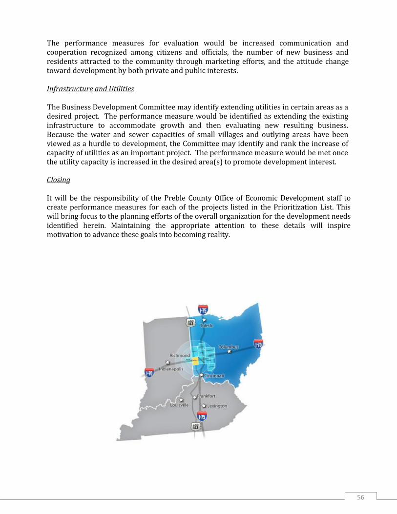
56
The performance measures for evaluation would be increased communication and cooperation recognized among citizens and officials, the number of new business and residents attracted to the community through marketing efforts, and the attitude change toward development by both private and public interests. Infrastructure and Utilities The Business Development Committee may identify extending utilities in certain areas as a desired project. The performance measure would be identified as extending the existing infrastructure to accommodate growth and then evaluating new resulting business. Because the water and sewer capacities of small villages and outlying areas have been viewed as a hurdle to development, the Committee may identify and rank the increase of capacity of utilities as an important project. The performance measure would be met once the utility capacity is increased in the desired area(s) to promote development interest.
Closing It will be the responsibility of the Preble County Office of Economic Development staff to create performance measures for each of the projects listed in the Prioritization List. This will bring focus to the planning efforts of the overall organization for the development needs identified herein. Maintaining the appropriate attention to these details will inspire motivation to advance these goals into becoming reality.

57
“To advance, encourage, and promote the industrial,
commercial and civic development of Preble County, Ohio.”
AVAILABLE DEVELOPMENT SITES ___________________________________________________________________
The Preble County Development Partnership maintains a list of current available development sites. The list can be accessed by visiting: www.pcdp.net and clicking on the “Available Sites and Buildings” block (tile). Next click “Search Now” to see list.
“A Countywide Effort”
The Committee and the Preble County Commissioners would like to express gratitude for those from around the county who contributed to this plan. Various citizens and community leaders offered valuable insight as to utilities, transportation and future growth expectations.
Village of West Manchester Village of West Elkton
City of Eaton
Village of Camden Village of Verona Village of Lewisburg
Village of College Corner
Village of Eldorado
Village of New Paris
Village of West Alexandria
Village of Gratis Lakengren P.O.A. Preble County Township Association
Preble County Preble County Chamber of Commerce Preble County Farm Bureau Engineer’s Office