Embed Size (px)
Citation preview

Pre-feasibility Report
Introduction and Brief History
The Block CY-ONHP-2018/2 was awarded to ONGC (100%) by GoI for hydrocarbon
exploration for a period of six years with extension of 2 years under HELP/OALP Bid Round-
III. The Block covers an area of 459.83 Sq.km in Onshore out of which 386.53Sq.km in
Tamil Nadu (14.74 Sq.km in Cuddalore Dt. and 371.79 Sq.km in Nagapattinam Dt) and
73.30 Sq.km in Karaikal district in Puducherry and the Maps & Coordinates given in
Annexure-I .
The RSC of the block was signed on 16.07.2019. As per RSC of CY-ONHP-2018/2, total
four wells are required to be drilled during six years of exploration period (Two exploration
phases). As per Article 14 of RSC, it is mandatory to obtain Environment Clearance for
drilling of wells.The block falls partly in the Ariyalur-Pondicherry sub basin towards the North,
in the saddle area between Kali and Madaman fields on the Porto Novo horst in the Central
part, and North of Karaikal High- Tranquebar sub-basin towards the South. The block covers
the areas West, South-west and South of Madanam NELP Block and extends upto the
Northern flank of Karakal ridge. Total Exploration period for the Block is for six years (6+2)
out of which Three years for Initial exploration Phase (with provision for one year extension
period) and Three years for subsequent Exploration Phase (with provision for one year
extension period).
The details of the Committed work program (CWP) scheduled to be completed in six years
are as given below.
BLOCK
Phase 1
(3 Years)
Phase 2
(3 Years)
CY-ONHP-
2018/2
459.83
Sq.km
1. 2D Acquisition, Processing and
Interpretation of 200 LKM (API)
2. 3D Acquisition, Processing and
Interpretation of 459 Sq.km (API)
3.Four Exploratory well to
3000m/Basement
4. Four Core analysis
Three Exploratory wells
(Each year One Exploratory
Well to be drilled)
Depending on the prospectivity and discovery, it is envisaged to drill 20 wells in the block
including CWP wells during various stages of exploration/ appraisal /development.

The available 3D seismic coverage and the data of drilled wells within the block CY-ONHP-
2018/2 has helped to bring out potential prospectivity for the Nanilam, Andimadam and
Basement Reservoirs. In view of establishment of hydrocarbon prospectivity and production
of oil in the nearby Basement structures to the east (Madanam & Tirunagari), in SW
(Panadanallur) and gas shows in Basement section in well CD-6 in Chidambaram area, the
potential of Basement play is envisaged in the present block. Major part of the block area
is envisaged to have prospectively for Andimadam, Bhuvanagiri plays and Basement.
Additionally shallow Tertiary plays could be targeted depending on the shallow prospectively
also.
1.1 Geological setting of the Block: Geology of the area in brief: The Block CY-ONHP-2018/2 extends from the Ariyalur-Pondicherry Sub-basin in the North
to Tranquebar Sub-basin in the South. The block falls partly in the Ariyalur-Pondicherry sub
basin towards the North, in the saddle area between Kali and Madaman fields on the Porto
Novo horst in the Central part, and North of Karaikal High- Tranquebar sub-basin towards
the South. The block covers the areas West, South-west and South of Madanam NELP
Block and extends upto the Northern flank of Karakal ridge with a total area of 459.83 Sq.
Km.
Cauvery basin is the southernmost sedimentary basin located along the East coast of India.
The basin came into existence during Upper Jurassic period through taphrogenic /
extensional block faulting of continental crust and relaxed subsidence. The tectonic
framework of the basin has been established from the interpretation of Gravity, Magnetic
and Seismic data.
The Tranquebar depression has more than 9 Km thick sedimentary sequence. The Northern
boundary of this sub-basin is defined by the Kumbakonam-Madam ridge which is oriented
in NE-SW direction and separates this sub-basin from Ariyalur-Pondicherry sub-basin.
Kumbakonam ridge plunges towards ENE forming saddle and emerges as Madanam ridge
towards east.(Fig-1)
A series of longitudinal faults trending NE-SW (parallel to the East coast trend) are the main
extensional faults associated with the syn-rift phase of basin formation and another
orthogonal fault system is trending NW-SE (parallel to the Dharwarian trend) dissecting the
older NE-SW trending fault. This fault system played major role in sediment deposition and
hydrocarbon accumulation and migration. Two oil and gas fields of Basement are located
on the Kumbakonam-Madanam ridge i.e. Madanam, Tirunagari and Pandanallur fields.
Pre-Cambrian Basement rocks in the Kumbakonam-Madam ridge is fractured and acts as
a reservoir rock.

1.2. Plays envisaged in the block and in the vicinity:
I. Established Plays:
Fractured Basement, Andimadam, Bhuvanagiri, Nannilam and Kamalapuram plays
were established in the vicinity of the Block (CY-ONHP-2018/2).
Plays Field
Basement Madanam, Tirunagari, PY-1
Andimadam Kuthalam, Kali
Bhuvanagiri Kuthalam
Nannilam PY-3, Nannilam
Kamalapuram Madanam, Tirunagari, Karaikal & Narimanam
Neravy Narimanam
II. Envisaged Plays with details:
Basement and Nannilam plays are envisaged in the Carved block CY-ONHP-2018/2.
Basement play is targeted in the saddle part between Madanam and Pandanallur
highs and Nannilam play in the northern flank of Karaikal High.
Basement Play: The Basement play is the primary target of exploration in the carved
out block in view of the presence of two fields namely Tirunagari and Madanam in
the adjoining areas. Basement is granitic gneiss. The Area of Interest is dissected by
number of ENE-WSW trending normal faults, which are affected by a few NNW-SSE
trending cross faults. A total number of 42 wells have penetrated Basement in this
carved out block, which includes 31 wells in Kuthalam Field, 7 wells in Kali field, MY1,
MY2, TD1 & TD2. In Kuthalam Field the drilled basement section is in the range 13
to 129m. Most of these wells have penetrated on an average about 40m into the
basement. None of the wells showed indications of hydrocarbons during drilling
except MY-1 in Basement. Only MY-1 has flowed minor amount of gas during testing
with FTHP-200 psi.
The time and depth map prepared close to top of Basement indicates that the area
of Interest is flanked on the North and South by two main depocenters namely
Ariyalur Pondicherry Sub-basin and Tranquebar sub-basin. The deepest part in AP
sub-basin is around KMR-1 (4700 ms) and in Tranquebar sub-basin around well
TKD-3 (5400 ms). (Plate-5-10). The Kumbakonam-Madanam high which separates
the AP sub-basin from Tranquebar sub basin is clearly discernible from the map.
Fracture Basement play is established in Madanam, Pandanallur and PY-1
structures. Madanam NELP Block is under production. Madanam-3 (MD-3) is
producing oil @ 115 m3/d & gas @ 11500 m3/d through 6mm bean. Madanam-7
(MD-7) is flowing Qo = 116m3/d (API=35.08°), Qg=9000m3/d. Other Oil and gas
producer drilled in Madanam structure are MD-5(TNG-1), MD-6, MD- 8 & MD-9.

In Pandanallur high also well PN-8 has established presence of commercial quantity
of hydrocarbon.
The time map prepared close to top of Basement indicates that the Madanam high
plunges towards the SW forming a saddle area in the AOI and further South-
westward raises towards the Kuthalam field. It seems to be a contiguous structure
extending towards south as saddle part falling between Pandanallur and Madanam
where hydrocarbon has been established in Basement.
In view of success in the nearby Basement structures, Madanam to the North / North-
East and Pandanallur in West, and in view of presence of gas shows in Basement
section in MY-1 well to the South, three prospects are firmed in the present block for
Basement play namely South of TPM-1 (Prospect-1), to the North-East of MY-1
(Prospect-2) and to the North-West of MY-1(Prospect-3).
Fracture Analysis Studies:
Ant-track volumes are made using the 3D seismic. Fracture analysis was carried out
using Ant-Track. Initially 3D PSTM (survey no’s) seismic volumes were loaded in
PETREL as the primary input. The data was conditioned using Structural
Smoothening with fault preservation method (vertical limit of data 1000ms to
4500ms). The Relative Acoustic Impedance (RAI) was applied on conditioned data
to boost low frequencies. The result from RAI volume was used as input for
generating Variance volume for edge detection. The discontinuities in the reflector
beds were identified through Variance volume and Chaos volume The variance
volume was used as input to generate Ant-track volume. Ant Track connects attribute
responses by using principles of swarm intelligence (“ants”). Aggressive directional
Ant-track was carried out with directions as NE & SW & all directions after several
iterations. The directions were decided from the analysis of fracture orientation &
intensity from FMI study of wells MD-5, MD-6, MD-7, MD-8, MD-9 &MD-10. The final
Ant track Volume was generated by applying directional aggressive Ant-track on the
different directional Ant-track volumes These Ant Track volumes enhanced the
visualization of fault and fracture pattern.
Horizon guided attributes were generated using the final Ant Track volume, in the
time windows of 20ms, 40ms, 60ms, 80ms, 100ms, 120ms, 140ms and 160ms below
the basement top. Fault likelihood volume also generated from Landmark software
to Faults & fracture trends. Horizon guided Mean attributes generated from basement
at different window intervals. Fault correlation from seismic data interpretation was
overlaid on both Ant track horizons & RMS attribute maps from Fault likelihood
volume. In addition to the correlated faults, many fractures were observed near the
discovery wells.
- Wells in Madanam Field dominantly show NE-SW(Rift trend) and NW-SE(Dharwarian trend) fracture trends.

- Rose diagram from FMI data shows NE-SW fracture trends in MDM-5, 6 & 7 and NW-SE fracture trends in MDM-8. Whereas, MDM-9 & 10 seems to have both NE-SW and NW-SW fracture trends.
- In the near vicinity of the proposed Basement Prospects(Prospect-1, 2 & 3), there
is no FMI data recorded apart from the above 6 wells of Madanam Field. - The fracture trends seen at the proposed Prospect-1, 2 & 3 in the Ant-Track Time
and Horizon slice indicate that the Fracture trend is dominantly NW-SE and is in line with the trend at the producing well MDM-8.
Nannilam : The Nannilam sands of the Upper Cretaceous age were deposited
during Campanian to Santonian age and is overlain by Portonova shale and K/T
unconformity respectively. This formation is sandwiched between two dominantly
argillaceous units namely Portonovo Shale above and Kudavasal Shale below with
conformable contacts. But in some place Nannilam is directly deposited over the
Turonian unconformity (TKD-1 & 2). Nannilam reservoir sands with 20% porosity are
feldspathic arkosic wackes with patchy calcite cement.
To the west of North Tranquebar sub-basin, Nannilam formation with thick sandstone
reservoirs is developed in Kuthalam-Kali areas. However, it is absent in the central
part of the sub-basin and again appear towards eastern part around Thirukkadaiyur
and Hariharankudal areas. The Nannilam sands encountered in TKD-1 and TKD-2
are shaled out in well TKD-3 & VNG-1. Nannilam sands were also developed along
the northern flank of Karaikal high and Strati-structural entrapment conditions are
envisaged. The Nannilam sands are envisaged to have been deposited as slope
fans from the nearest basement highs. The Nannilam sands of Kuthalam-Kali area
might have been deposited as slope fans from the Kumbakonam High on the West
and the Nannilam sands in the Northern flank of Karaikal high might have been
sourced from Karaikal high. Further towards the offshore in the PY-3 field
prospectivity of Nannilam sands have been commercially established on the flanks
of the median high in the offshore part of Tranquebar sub-basin. HC oil shows during
drilling were observed in Lr Nannilam in well AS-3. Based on the leads from PY-3
field similar prospectivity is envisaged from a slope fan which have been mapped on
the Northern flank of Karaikal high in the onland part of Tranquebar sub-basin.
Based on the log correlation of the wells in the carved out block and in the adjacent
areas where Nannilam sands have been encountered, the Nannilam sand pack is
divided into four Nannilam sand packs. These sand packs within the Nannilam
formation are envisaged to have been deposited as different fan lobes. One of the
fan feature interpreted on the available 3D and 2D seismic data is mapped. The top
of this fan corresponds to the second layer of the Nannilam sand pack. Two wells
namely TKD-1 and TN-1 have penetrated the fan which is mapped. However the
wells have not shown any hydrocarbon indications in Nannilam probable due to lack
of entrapment conditions. Two prospects which are four-way structural closure within

the fan with better entrapment condition have been identified within the carved out
block.
Potonovo Shale above Nannilam Formation would act as regional cap. The
intervening shales within Nannilam Formation may also act as cap rocks. Basement
controlled faults in the Basinal part of Tranquebar sub-basin extending up to
Nannilam Formation are envisaged as conduits for hydrocarbon migration.
1.3. Technical Justification for the Locations:
The Hydrocarbons have been discovered and commercial production established
from Basement in Madanam-Tirunagari and Pandanallur fields and from Andimadam
Formation in kali field in the nearby areas. Extension of Tirunagari field exists in the
block. Nannilam play is commercially established in the adjoining acreage in similar
geological set up.
Nannilam Formation is potential prospective play in Ariyalur Pondicherry and
Tranquebar sub basin. Hydrocarbons Shows observed in Basement, Bhuvanagiri,
Nannilam and Kamalapuram Formation in the study area. Based on further G&G
studies and previous exploratory drilling results it is proposed to drill about 20 wells
in the block CY-ONHP-2018/2 falling in Cuddalore and Nagapattinam district of Tami
Nadu and Karaikal district of Puducherry for establishment of hydrocarbons from the
potential plays identified from the exploratory efforts and understanding in these
areas.
As per the prospectively perception of the block, Twenty (20) Exploratory /
Development Wells may be required to be drilled during the exploration / appraisal/
development phases. These wells are planned to be drilled in the Cuddalore and
Nagapattinam district in Tamil Nadu and Karaikal district in Puducherry area falling
in the following coordinates (Annexure-I) of OALP block CY-ONHP-2018/2 boundary
and encompassing an area of 459.83 Sq.km out of which 14.74 Sq.km in Cuddalore
District. and 371.79 Sq.km in Nagapattinam District of Tamilnadu and 73.30 Sq.km
in Karaikal District in Puducherry.
The details of the locations (tentative - to be firmed up) are given below:
No of Wells
proposed to be
drilled
Type / Cat. TD (M)
Tentative
Objective
20 Expl. Test / ‘B’ 2500 to 5000m
Basement and Nannilam Formations and Tertiary
sediments.
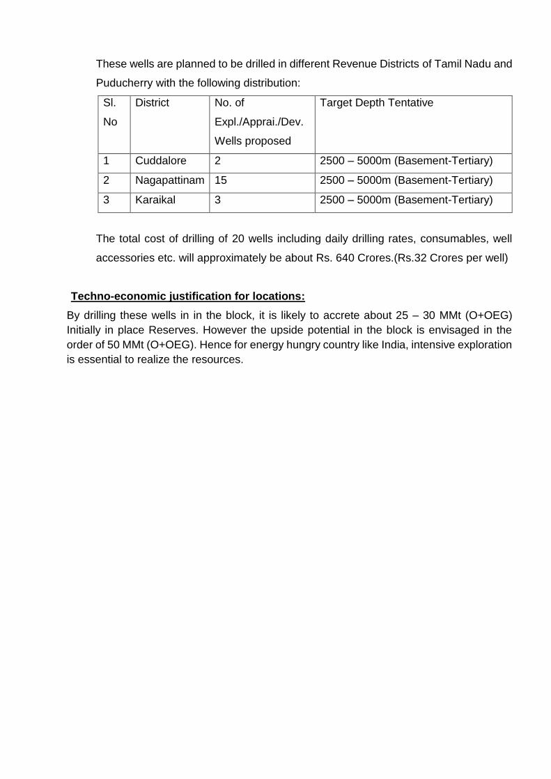
These wells are planned to be drilled in different Revenue Districts of Tamil Nadu and
Puducherry with the following distribution:
Sl.
No
District No. of
Expl./Apprai./Dev.
Wells proposed
Target Depth Tentative
1 Cuddalore 2 2500 – 5000m (Basement-Tertiary)
2 Nagapattinam 15 2500 – 5000m (Basement-Tertiary)
3 Karaikal 3 2500 – 5000m (Basement-Tertiary)
The total cost of drilling of 20 wells including daily drilling rates, consumables, well
accessories etc. will approximately be about Rs. 640 Crores.(Rs.32 Crores per well)
Techno-economic justification for locations:
By drilling these wells in in the block, it is likely to accrete about 25 – 30 MMt (O+OEG)
Initially in place Reserves. However the upside potential in the block is envisaged in the
order of 50 MMt (O+OEG). Hence for energy hungry country like India, intensive exploration
is essential to realize the resources.

Index Map Showing Prospects in L-I PML,NELP and awarded Block CY-ONHP-
2018/2
2
21
4
5
7
3
8
Block-I
PML
Boundar
6
10
11
9
Prospects
1)Kuthalam 2)Kali 3)Neyveli 4)Bhuvanagiri 5)Madanam
Prospects
6) Thirunagari 7) Pandanallur 8) Andimadam 9) Mattur-Pundi 10)PY-1 11)PY-3
Figure-1
CY_ONHP-2018/2

CY-ONHP-2018/2 (SW of Madanam Area)
Block:CY-ONHP-2018/2, (WGS-84)
Vertex Lat. (D M S) Long. (D M S)
1 11 17 00.000 079 44 00.000
2 11 17 00.000 079 45 00.000
3 11 16 00.000 079 45 00.000
4 11 16 00.000 079 44 00.000
5 11 15 00.000 079 44 00.000
6 11 15 00.000 079 43 00.000
7 11 12 00.000 079 43 00.000
8 11 12 00.000 079 44 00.000
9 11 11 00.000 079 44 00.000
10 11 11 00.000 079 45 00.000
11 11 10 00.000 079 45 00.000
12 11 10 00.000 079 47 00.000
13 11 11 00.000 079 47 00.000
14 11 11 00.000 079 48 00.000
15 11 12 00.000 079 48 00.000
16 11 12 00.000 079 49 00.000
17 11 13 00.000 079 49 00.000
18 11 13 00.000 079 50 00.000
19 10 54 00.000 079 50 00.000
20 10 54 00.000 079 48 00.000
21 10 55 00.000 079 48 00.000
22 10 55 00.000 079 45 00.000
23 10 57 00.000 079 45 00.000
24 10 57 00.000 079 46 00.000
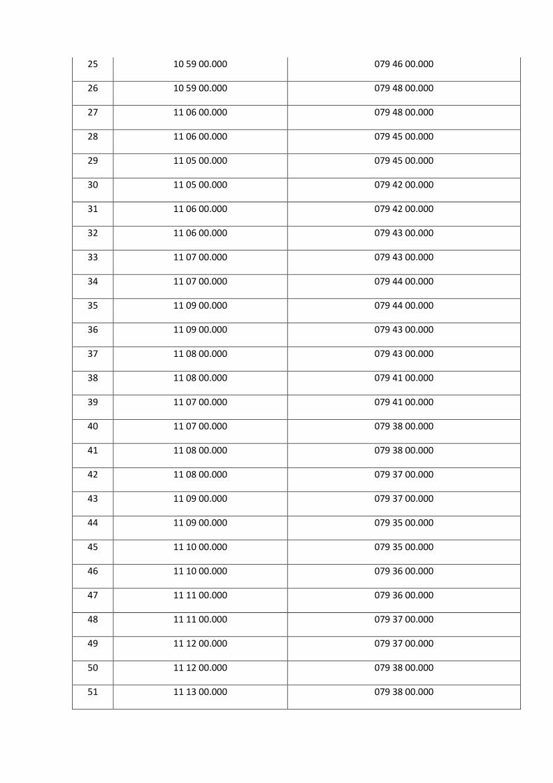
25 10 59 00.000 079 46 00.000
26 10 59 00.000 079 48 00.000
27 11 06 00.000 079 48 00.000
28 11 06 00.000 079 45 00.000
29 11 05 00.000 079 45 00.000
30 11 05 00.000 079 42 00.000
31 11 06 00.000 079 42 00.000
32 11 06 00.000 079 43 00.000
33 11 07 00.000 079 43 00.000
34 11 07 00.000 079 44 00.000
35 11 09 00.000 079 44 00.000
36 11 09 00.000 079 43 00.000
37 11 08 00.000 079 43 00.000
38 11 08 00.000 079 41 00.000
39 11 07 00.000 079 41 00.000
40 11 07 00.000 079 38 00.000
41 11 08 00.000 079 38 00.000
42 11 08 00.000 079 37 00.000
43 11 09 00.000 079 37 00.000
44 11 09 00.000 079 35 00.000
45 11 10 00.000 079 35 00.000
46 11 10 00.000 079 36 00.000
47 11 11 00.000 079 36 00.000
48 11 11 00.000 079 37 00.000
49 11 12 00.000 079 37 00.000
50 11 12 00.000 079 38 00.000
51 11 13 00.000 079 38 00.000

52 11 13 00.000 079 39 00.000
53 11 14 00.000 079 39 00.000
54 11 14 00.000 079 40 00.000
55 11 15 00.000 079 40 00.000
56 11 15 00.000 079 41 00.000
57 11 17 00.000 079 41 00.000
58 11 17 00.000 079 39 00.000
59 11 20 00.000 079 39 00.000
60 11 20 00.000 079 45 00.000
61 11 19 00.000 079 45 00.000
62 11 19 00.000 079 44 00.000
C1-C2 &C3-C4 (Follow the State Boundary)
C1 11 00 09.595 079 50 00.000
C2 10 59 11.728 079 48 00.000
C3 10 59 00.000 079 47 57.368
C4 10 59 00.000 079 47 36.316
49 11 12 00.000 079 37 00.000
50 11 12 00.000 079 38 00.000
51 11 13 00.000 079 38 00.000
52 11 13 00.000 079 39 00.000
53 11 14 00.000 079 39 00.000
54 11 14 00.000 079 40 00.000
55 11 15 00.000 079 40 00.000
56 11 15 00.000 079 41 00.000
57 11 17 00.000 079 41 00.000
58 11 17 00.000 079 39 00.000
59 11 20 00.000 079 39 00.000

60 11 20 00.000 079 45 00.000
61 11 19 00.000 079 45 00.000
62 11 19 00.000 079 44 00.000