Embed Size (px)
Citation preview

PRADHAN MANTRI KRISHI SINCHAI YOJANA
DISTRICT IRRIGATION PLAN
DISTRICT UJJAIN (M.P.)

PMKSY |PER DROP MORE CROP 2
DIP UJJAIN (M.P)
Substantial dependence on rainfall makes cultivation a high risk and less productive profession. Empirical evidences suggest that assured/protective irrigation/in-situ moisture conservation encourages farmers to invest more in farming technology and inputs leading to productivity enhancement and increased farm income.
Government of India is committed to accord high priority to water conservation and its management. To this effect the Cabinet Committee on Economic Affairs chaired by Hon’ble Prime Minister has accorded approval of Pradhan Mantri Krishi Sinchayee Yojana (PMKSY) in its meeting held on 1st July, 2015. Pradhan Mantri Krishi Sinchayee Yojana (PMKSY) has been formulated with the vision of extending the coverage of irrigation ‘Har Khet ko pani’ and improving water use efficiency ‘More crop per drop' in a focused manner with end to end solution on source creation, distribution, management, field application and extension activities. .
PMKSY will provide convergence to existing schemes of water management, thus bringing efficiency to the use of water. It aims at not just creating a water source but also in sustaining it. The overreaching vision of Pradhan Mantri Krishi Sinchayee Yojana (PMKSY) is to ensure access to some means of protective irrigation to all agricultural farms in the country, to produce ‘per drop more crop’, thus bringing much desired rural prosperity.
(Bhupendra Singh Thakur)
Minister, Transport, Science and Information Technology, Public Service Management, and
Chairperson District Planning Committee, District Ujjain
MESSAGE

PMKSY |PER DROP MORE CROP 3
DIP UJJAIN (M.P)
As per census 2011 60.78% population of the district lives in rural areas and is dependent on agriculture. 82% of the total geographical area is under agriculture. The net irrigated area to the gross cropped area is 39% and 61% of the area is rainfed. Thus the major cultivated area in the district depends on the monsoon and which is very uncertain. Also farmers of Ujjain district are unable to take the third crop because of the non availability of irrigation facilities, in summer (zaid). Soybean in Kharif and Wheat and Gram in Rabi season, are the major crop of the district. The area of horticulture crops is very less as they need assured irrigation which is not available. This results in low farm income of the farmer.
If assured irrigation is available to the farmers then not only double cropped area of the district will increase but also the possibility of third crop will increase. The area of horticulture crop will also increase. This will in turn increase the profitability and the net income of the farmers, thereby embodying the letter and spirit of Honourable Chief Minister of Madhya Pradesh to make “Agriculture a profitable and progressive venture. Pradhan Mantri Krishi Sinchai scheme will really prove a milestone for agriculture in Ujjain district. To sustain the yield and income crop diversification is necessary which is possible through assured irrigation facilities. PMKSY is targeted to provide water to every field and efficient use of the available water. With the successful implementation of the scheme farmers will be benefitted, ultimately improving their quality of life and enhancing the economic social capital of Ujjain, M.P. and the country.
Dated (Sanket Bhondve) Collector, District Ujjain (M.P.)
FOREWARD

PMKSY |PER DROP MORE CROP 4
DIP UJJAIN (M.P)
District irrigation plan is the corner stone for planning and implementation of PMKSY. Before preparation of DIP the available water resources were mapped on the tehsil map so the actual irrigation status of the district is known. DIP is prepared by the joint exercise of the concerned department. While preparing the water budget water demand from all the sectors (Crop, Domestic, Livestock and Industrial) is included and gaps identified. Priority is given to those areas where proper irrigation facilities are not available. As per the Central ground water report only Tarana tehsil is in grey zone while other tehsils are in dark zone and trending towards critacality. Thus major emphasis is given on rain water conservation, construction of water harvesting structures and farm ponds. For the efficient application of water, use of devices like sprinklers, drip and raingun will be promoted. Farmers will be trained for moisture conservation and efficient use of available water.
Renovation of old structures is also included in the plan. All the concerned departments have prepared their plan with the target to provide water to every field. The DIP of Ujjain district is prepared with the objective to enhance the physical access of water on the farm and expand cultivable area under assured irrigation (Har Khet ko
pani), and Improve on-farm water use efficiency to reduce wastage and increase availability both in duration and
extent.
Dated (Ruchika Chouhan) CEO, Zila Panchayat District, Ujjain (M.P.)
PREFACE

PMKSY |PER DROP MORE CROP 5
DIP UJJAIN (M.P)
I wish to express my sincere gratitude to Mr. Premchand Meena, Agriculture Production Commissioner, Dr. Rajesh Rajora Pricipal Secretary Agriculture and Mr. Manmohan Meena Director Agriculture for selecting Ujjain hdistrict under this project.
I would specially like to thank Mr. Kavindra Kiyawat, District Collector and Smt. Ruchika Chouhan, CEO Zila Panchayat for their constant encouragement, support and guidance.
I wish to express my sincere gratitude to the following
Mr. Mukul Jain EE Department of Water Resources, Mr. R.K. Shrivastav EE PHE, Dr. Sandeep Goyal Principal Scientist and Head MPRA division MAPCOST, Mr. R.S. Gujarati ASCO Badnagar, Mr. Ashwin Jahria ASCO Mahidpur MR. S.K. Shrivastav ASCO Ujjain Smt. Vinita Rai Assistant Director Agriculture, Ujjain Dr. G.G. Goswami Assistant Veternary officer, Ujjain Mr. Gulsher Ahmed Khan Assistant Engineer, Department of Water resources Mr.R.M. Tripathi SLR, Ujjain
ACKNOWLEDGEMENT

PMKSY |PER DROP MORE CROP 6
DIP UJJAIN (M.P)
Mr. Ashok Shitley Assistant Geohydrologist, Ujjain Mr. P.S. Rajput T.E. IWMP, Zila Panchayat, Ujjain Mr. Abhisar Hada P.O. MNREGA, Zila Panchayat, Ujjain Mr. Harsh Mishra Team Member Hydrologist, IWMP Zila Panchayat, Ujjain Mr. Abhisek Rathore Team Member Hydrologist, IWMP Zila Panchayat, Ujjain
Last but not the least I would like to thank all the field functionaries of the concerned department involved in preparation of DIP, all the Public representatives, Panchayat Sachivs and all the members of District Planning Committee of Pradahn Mantri Krishi Sinchai Yojana.
Dated (S.K. Sharma) Deputy Director Farmer Welfare and Agriculture Development, Ujjain

PMKSY |PER DROP MORE CROP 7
DIP UJJAIN (M.P)
CONTENTS
Executive Summary 12-18
Chapter I General Information of the
District 19-132
1.1 District Profile 19-23
1.2 Demography 24-104
1.3 Biomass and Livestock 105
1.4 Agro-ecology, Climate,
Hydrology and Topography 106-121
1.5 Land Use Pattern 122-124
1.6 Soil Profile 125-132
Chapter II District Water Profile 133-150
2.1 Area wise Crop wise Irrigation
Status 133-140
2.2 Production and Productivity of
Major Crops 141-143
2.3 Irrigation Based Classification 144
2.4 Drainage and River Basin 145-150
Chapter III Water Availability 151-154
3.1 Status of Water Availability 151-152

PMKSY |PER DROP MORE CROP 8
DIP UJJAIN (M.P)
3.2 Status of Ground Water
Availability 153
3.3 Existing Type of Irrigation 154
Chapter IV Water Requirement/Demand 155-162
4.1 Domestic Water Demand 155-156
4.2 Crop Water Requirement 157
4.3 Livestock Water Demand 158
4.4 Industrial Water Demand 158
4.5 Total Water Demand of the
District 159
4.6 Water Budget 160-162
Chapter V Strategic Action Plan for
Irrigation in District under
PMKSY
163-177
Annexure I PMKSY Year Wise Action Plan 178-183
Annexure II Detail Strategic Action Plan 184-439
PMKSY |PER DROP MORE CROP 9
DIP UJJAIN (M.P)
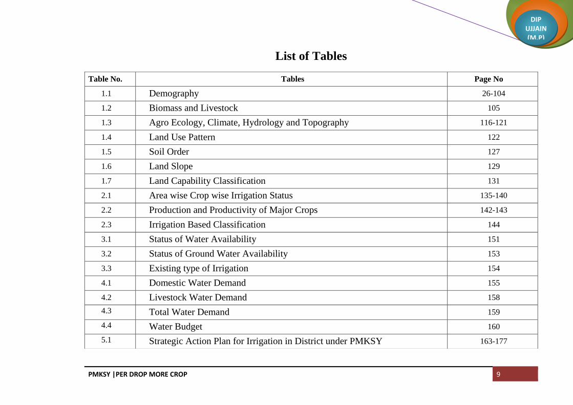
List of Tables
Table No. Tables Page No
1.1 Demography 26-104
1.2 Biomass and Livestock 105
1.3 Agro Ecology, Climate, Hydrology and Topography 116-121
1.4 Land Use Pattern 122
1.5 Soil Order 127
1.6 Land Slope 129
1.7 Land Capability Classification 131
2.1 Area wise Crop wise Irrigation Status 135-140
2.2 Production and Productivity of Major Crops 142-143
2.3 Irrigation Based Classification 144
3.1 Status of Water Availability 151
3.2 Status of Ground Water Availability 153
3.3 Existing type of Irrigation 154
4.1 Domestic Water Demand 155
4.2 Livestock Water Demand 158
4.3 Total Water Demand 159
4.4 Water Budget 160
5.1 Strategic Action Plan for Irrigation in District under PMKSY 163-177

PMKSY |PER DROP MORE CROP 10
DIP UJJAIN (M.P)
List of Maps
S.No. Particulars Page No
1 District Map 23
2 Geomorphology Map 107
3 Geology Map 109
4 Geohydrology Map 111
5 Agroclomatic Zones of Madhya Pradesh 113
6 Agro-ecological Sub Regions of Madhya Pradesh 114
7 Land Use Pattern 124
8 Soil Profile 126
9 Soil Order 128
10 Land Slope 130
11 Land Capability Classification 132
12 River and Water Bodies 146
13 Drainage Map 147
14 Lineament Map 148
15 Watershed Map 149
16 Land Irrigability 150
PMKSY |PER DROP MORE CROP 11
DIP UJJAIN (M.P)
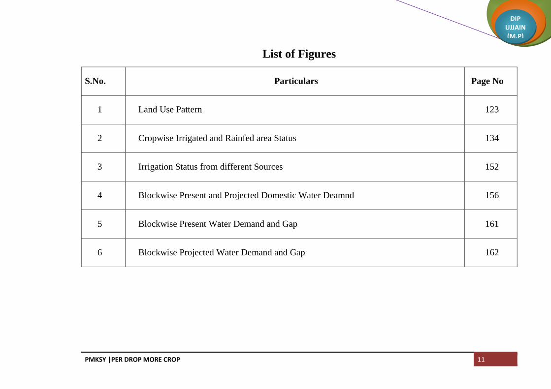
List of Figures
S.No. Particulars Page No
1 Land Use Pattern 123
2 Cropwise Irrigated and Rainfed area Status 134
3 Irrigation Status from different Sources 152
4 Blockwise Present and Projected Domestic Water Deamnd 156
5 Blockwise Present Water Demand and Gap 161
6 Blockwise Projected Water Demand and Gap 162

PMKSY |PER DROP MORE CROP 12
DIP UJJAIN (M.P)
INTRODUCTION
District Irrigation Plan (DIPs) is the cornerstone for planning and implementation of PMKSY. DIP has
identify the gaps in irrigation infrastructure after taking into consideration the District Agriculture Plans (DAPs)
already prepared for Rashtriya Krishi Vikas Yojana (RKVY) vis-à-vis irrigation infrastructure currently available
and resources that would be added during XII Plan from other ongoing schemes (both State and Central), like
Mahatma Gandhi National Rural Employment Guarantee Scheme(MGNREGS), Rashtriya Krishi Vikash Yojana
(RKVY), Rural Infrastructure Development Fund (RIDF), Member of Parliament Local Area Development
(MPLAD) Scheme, Member of Legislative Assembly Local Area Development (MLALAD) Scheme, Local body
funds etc.
DIP will present holistic irrigation development perspective of the district outlining medium to long term
development plans integrating three components viz. water sources, distribution network and water use applications
incorporating all usage of water like drinking & domestic use, irrigation and industry. Preparation of DIP was as
joint exercise of all participating departments. DIP is the compendium of all existing and proposed water resource
network system in the district. Emphasis is given for deriving potential benefit from low hanging fruits like
extending the reach/coverage of water source through effective distribution and application mechanism, reducing
the gap between potential created and utilized through more focus on command area development and precision
irrigation. Proper integration of creation of source like dams and water harvesting structures, distribution system like
canals and command area development works and precision farming to be made for deriving best possible use of
water resources.
EXECUTIVE SUMMARY

PMKSY |PER DROP MORE CROP 13
DIP UJJAIN (M.P)
BACKGROUND
PMKSY has been conceived amalgamating ongoing schemes viz. Accelerated Irrigation Benefit Programme
(AIBP) of the Ministry of Water Resources, River Development & Ganga Rejuvenation (MoWR, RD&GR),
Integrated Watershed Management Programme (IWMP) of Department of Land Resources (DoLR) and the On
Farm Water Management (OFWM) of Department of Agriculture and Cooperation (DAC). The scheme will be
implemented by Ministries of Agriculture, Water Resources and Rural Development. Ministry of Rural
Development is to mainly undertake rain water conservation, construction of farm pond, water harvesting structures,
small check dams and contour bunding etc. MoWR, RD &GR, is to undertake various measures for creation of
assured irrigation source, construction of diversion canals, field channels, water diversion/lift irrigation, including
development of water distribution systems. Ministry of Agriculture will promote efficient water conveyance and
precision water application devices like drips, sprinklers, pivots, rain-guns in the farm “(Jal Sinchan)”, construction
of micro-irrigation structures to supplement source creation activities, extension activities for promotion of scientific
moisture conservation and agronomic measures
Programme architecture of PMKSY will be to adopt a ‘decentralized State level planning and projectised
execution’ structure that will allow States to draw up their own irrigation development plans based on District
Irrigation Plan (DIP) and State Irrigation Plan (SIP). It will be operative as convergence platform for all water sector
activities including drinking water & sanitation, MGNREGA, application of science & technology etc. through
comprehensive plan. State Level Sanctioning Committee (SLSC) chaired by the Chief Secretary of the State will be
vested with the authority to oversee its implementation and sanction projects.

PMKSY |PER DROP MORE CROP 14
DIP UJJAIN (M.P)
VISION AND OBJECTIVE
The overreaching vision of Pradhan Mantri Krishi Sinchayee Yojana (PMKSY) will be to ensure access to
some means of protective irrigation to all agricultural farms in the country, to produce ‘per drop more crop’, thus
bringing much desired rural prosperity.
The major objective of PMKSY is to achieve convergence of investments in irrigation at the field level,
expand cultivable area under assured irrigation, improve on-farm water use efficiency to reduce wastage of water,
enhance the adoption of precision-irrigation and other water saving technologies (More crop per drop), enhance
recharge of aquifers and introduce sustainable water conservation practices by exploring the feasibility of reusing
treated municipal waste water for peri-urban agriculture and attract greater private investment in precision irrigation
system.
The broad objectives of PMKSY
a) Achieve convergence of investments in irrigation at the field level (preparation of district level and, if required,
sub district level water use plans).
b) Enhance the physical access of water on the farm and expand cultivable area under assured irrigation (Har Khet
ko pani),
c) Integration of water source, distribution and its efficient use, to make best use of water through appropriate
technologies and practices.

PMKSY |PER DROP MORE CROP 15
DIP UJJAIN (M.P)
d) Improve on-farm water use efficiency to reduce wastage and increase availability both in duration and extent.
e) Enhance the adoption of precision-irrigation and other water saving technologies (More Crop Per Drop).
f) Enhance recharge of aquifers and introduce sustainable water conservation practices
g) Ensure the integrated development of rainfed areas using the watershed approach towards soil and water
conservation, regeneration of ground water, arresting runoff, providing livelihood options and other NRM
activities.
h) Promote extension activities relating to water harvesting, water management and crop alignment for farmers and
grass root level field functionaries.
i) Explore the feasibility of reusing treated municipal waste water for peri-urban agriculture, and
j) Attract greater private investments in irrigation.
This will in turn increase agricultural production and productivity and enhance farm income.

PMKSY |PER DROP MORE CROP 16
DIP UJJAIN (M.P)
STRATEGY
To achieve above objectives, PMKSY will strategize by focusing on end-to end solution in irrigation supply
chain, viz. water sources, distribution network, efficient farm level applications, extension services on new
technologies & information etc. Broadly, PMKSY will focus on:-
a) Creation of new water sources; repair, restoration and renovation of defunct watersources; construction of water
harvesting structures, secondary & micro storage, groundwater development, enhancing potentials of traditional
water bodies at village level like Jal Mandir (Gujarat); Khatri, Kuhl (H.P.); Zabo (Nagaland); Eri, Ooranis
(T.N.); Dongs (Assam); Katas, Bandhas (Odisha and M.P.) etc.
b) Developing/augmenting distribution network where irrigation sources (both assured and protective) are available
or created;
c) Promotion of scientific moisture conservation and run off control measures to improve ground water recharge so
as to create opportunities for farmer to access recharged water through shallow tube/dug wells;
d) Promoting efficient water conveyance and field application devices within the farm viz, underground piping
system, Drip & Sprinklers, pivots, rain-guns and other application devices etc.;
e) Encouraging community irrigation through registered user groups/farmer producers’ organisations/NGOs; and
farmer oriented activities like capacity building, training and exposure visits, demonstrations, farm schools, skill
development in efficient water and crop management practices (crop alignment) including large scale awareness
on 3 more crop per drop of water through mass media campaign, exhibitions, field days, and extension activities
through short animation films etc.

PMKSY |PER DROP MORE CROP 17
DIP UJJAIN (M.P)
RATIONALE/JUSTIFICATION STATEMENT
As per census 2011 60.78% of the population lives in rural areas and is dependent on agriculture. 82% of the
total geographical area is under agricultureMajor crop of the district is Soybean in Kharif and Wheat and Gram in
Rabi. Gross cropped area of the district is 882067 hectare, net sown area is 500966 hectare and double cropped area
is 381101 hectare. The total area of horticulture crops is just 39170 hectare which is 7.81% of the net sown area.
Rainfed area of the district is 534496 and irrigated area is 347571 hectare. Agriculture in Ujjain district is
dependent on monsoon. If there is any deficit in rainfall then the area as well as yield of Rabi crop deacreases. If we
look at the present scenario of irrigation in Ujjain district, the major source of irrigation is tubewell. About 71.18
percent irrigation is through tubewell, 17 percent through open well and only 11.76 percent is surface irrigation. The
total surface water availability in the district is 0.20814 BCM. Thus the major source of irrigation is Ground water
and if we look at the ground water report provided by Central Ground Water board, out of 6 blocks of the district 3
blocks are over exploited, 2 blocks are semi critical and only one block is in safe zone. In some blocks the draft is
higher than recharge as a result of this the level of ground water is decreasing and if proper measures are not taken
to recharge the ground water then the day is not far when the situation of agriculture wil become worst. Thus there
is urgent need to maximize tha rain water harvesting and to increase the vailability of surface water.
Looking at the present scenario of irrigation, the DIP of Ujjain district is prepared with a view to harvest
maximum rain water and to icrease the water use efficiency.
Under AIBP total 25 surface minor irrigation schemes are planned in different blocks. The total capacity of
the structures planned underAIBP is 0.09301 BCM and irrigation potential is 15895 hectare. Through renovation of
7 water bodies 4372 hectare will be added under irrigation. Since Government land is not available for construction
of big structures thus the major thrust is given on samall structures on farmer‘s land. Total 4120 farm pond and

PMKSY |PER DROP MORE CROP 18
DIP UJJAIN (M.P)
balram talab are planned on farmer’s land, through which 18179 hectare area will bi irrigated. To increase the water
use efficiency distribution of pipeline, sprinklers and drip is planned so that maximum utilization of the available
water will be possible. In 7 Years after completion of the project total 0.215055 BCM surface water availability and
106250 hectare irrigation potential wiil be created.
As per the present cropping pattern, major crop is Soybean, Wheat and Gram. Horticulture crops cover just
7.81% area and this is because of non availability of assured irrigation facilities. Thus after implementation of the
scheme assured irrigation facilities will be available to the farmers. In 7 years increment of 50000 hectare area under
horticulture crops is planned. This will not only increase the farm income but also net profit. Approximate Rs.40,
000 to 50,000 per haectare net profit of farmers will increase after increase in the horticulture area.
In Rabi season high yielding and high water demanding Wheat varieties are sown. These varieties need
4-5 irrigation but 3-4 irrigation are available which results in yield decrease, also if there is deficit in rainfall then
the area as well as Yield of Wheat crop decreases. If surface water availability will increase then additional
irrigation will be available to wheat crop. This will result in increase in 7-10 Quintal of yield per hectare. Thus
Rs.15, 000 to 20,000 per hectare profit will increase.
Thus overall implementation of the project will enhance the physical access of water on the farm and
expand cultivable area under assured irrigation (Har Khet ko pani), and Improve on-farm water use efficiency to
reduce wastage and increase availability both in duration and extent.

PMKSY |PER DROP MORE CROP 19
DIP UJJAIN (M.P)
1.1 DISTRICT PROFILE:
BRIEF HISTORY OF THE DISTRICT
According to the Avantyakhand of the Skanda Purana, Avanipura, the capitalof the Avantis, was called
Ujjayini. The early history of Ujjain is lost in the midst of antiquity. As early as the time of the Aryan settlers, Ujjain
seems to have acquired importance. By the 6th century BC Avanti with its capital at Ujjaini, is mentioned in
Buddhist literature as one of the four great powers along with Vatsa, Kosala and Magadha.
As a great religious centre, Ujjain ranks equal to Banaras, Gaya and Kanchi. The names of Kalidasa and
Ujjaini are inextricably linked together in the Indian traditions. According to the Markandeya Purana, Ujjaini was
situated on the Shipra. Shipra was a tributary of the Charmanvati (Chambal) which rised from the Paripatra
(Pariyatra) mountain. Shipra was also known as Uttaravahini, i.e flowing towards the north in the Avantyakhand of
the Skanda Purana.
According to Tantras, it was the pithasthana at which the elbow of Sati fell, on the dismemberment of her
body by Lord Siva. Ujjayini was mentioned in almost all the Buddhist and Brahmanical records after the Rig Veda.
Ujjain is one of the seven sacred cities of India from time immemorial and the seat of great king like Pajjot,
Vikramajit and Sindhias. Ujjain was the chief town of the subah of Malwa.
On 26 January, 1977 the Government of Madhya Pradesh formed Ujjain division with headquarters of the
Commissioner at Ujjain, consisting of five districts, namely, Ujjain, Dewas, Ratlam and Mandsaur from Indore
division and Shajapur district from Bhopal division.
CHAPTER-I GENERAL INFORMATION OF THE DISTRICT

PMKSY |PER DROP MORE CROP 20
DIP UJJAIN (M.P)
One of the 12 Jyotirlingas in India, the lingam at the Mahakal is believed to be swayambhu (born of itself)
deriving currents of power (shakti) from within it self as against the other images and lingams which are ritually
established and invested with mantra-shakti. Poorna Kumbh is held at Ujjain once in every 12years at the bank of
Shipra River and is seen as one of the most sacred placesin India. On the occasion of Kumbh Mela the divinity and
spiritual aroma of Ujjain meets its highest peak when millions of pilgrims take dips and worship sacred River
Shipra.
DISTRICT AT A GLANCE
Ujjain district is situated in the northwestern part of Madhya Pradesh. It is located in the heart of Malwa
Plateau and is a pilgrim city. The district is bounded in the north by Mandsaur and Shajapur district, on the south by
Indore and Dewas district, on the west by Dhar and Ujjain district and again by Dewas and Shajapur district in the
east. District Ujjain lies on the geographical coordinates of 23°11’0”N, 75°46’0” E, and is falling in the Survey of
India Topo Sheet No. 46M, 46N and 55 A. Ujjain district is mainly agriculture-based district and its cropping
pattern is diversified. The district is well connected by roads and rail.
Ujjain is a tier 2 city, the largest city of the Indian state of Madhya Pradesh by population. It serves as the
headquarters of both Ujjain District and Ujjain Division. A central power city, Ujjain exerts a significant impact
upon commerce, finance, media, art, fashion, research, technology, education, and entertainment and has been
described as the commercial capital of the state. Located on the southern edge of Malwa Plateau, the city is located
190 km west of the state capital of Bhopal. Ujjain is the densely populated major city in the central province. The
Ujjain Metropolitan Area's population is the state's largest, with 3.2 million people living there. It is the 9th largest
city in India and 76th largest city in the world

PMKSY |PER DROP MORE CROP 21
DIP UJJAIN (M.P)
District head quarter is Ujjain. About 60.78 % of population lives in rural areas and 39.21% of population
lives in urban areas. The economy of Ujjain is mainly dependent on the agricultural activities of the nearby villages.
Ujjain agriculture is sensitive to changes in rainfall and failure of Monsoon cycles can lay devastating toll
agriculture and the local economy. Ujjain was previously a major industrial area having steel plants, soybean oil
plants, shree synthetics ltd and a dalda mill and was a great centre of the textile industry with a number of textile
mills in the city. Almost all the mills have since closed. Religious tourism is also a contributor to the economy,
especially during the Simhasta Mela.
ADMINISTRATIVE SETUP
Lying at a distance of 54 km from Indore, Ujjain is bounded on the north by Mandsaur and Shajapur districts,
on the south by Indore and Dewas districts, on the west by Dhar and Ratlam districts and by Dewas and Shajapur in
the east. The shape of the district is pentagonal with the eastern projection resembling the neck of tortoise. Total
population of the district was 1986864 persons (male 1016289 & Female 970575) as per 2011 Census.(Increase rate
16.12 during the ten years). According to Census 2011, the total numbers of villages in the district are 1101, out of
which 1095 villages are inhabited and 06 villages are un-inhabited. There are 7 tehsils and Six number of CD
blocks, in the district. Tehsil wise number of villages is Khacharod (109), Nagda (109), Mahidpur (224), Ghatiya
(128), Tarana (209), Ujjain (131) and Badnagar (191). Besides, as per urban classification, the district has nine
towns and 616 total Panchayats (612 Gram Panchayats, 6 Janpad Panchayats & 1 District Panchayats).The district is
the basic territorial unit of administration in the state as well as in India.
The Collector, as the head of the district administration is the lay functionary of the Government, having vast
powers and wide responsibilities. In many ways he is thelink between the state Government and the people. He is

PMKSY |PER DROP MORE CROP 22
DIP UJJAIN (M.P)
the custodian of law and order and the pivot of local administration. Collector is the Chief Executive Officer of the
district and as such he exercises general supervision over various departments in regard to their nontechnical work.
Coordination of the activities of various departments, control over local-self governing bodies ,execution of
Government schemes and miscellaneous functions, such as Panchayats, Census, Election and relief measures in time
of emergencies like floods, famine and epidemics, etc. come within his purview. The narrative on the organisational
set-up of the collectorate may be divided into three main functionaries viz.(i) Land revenue, land-records including
consolidation of land and other allied matters. (ii) Law and order and (iii) Development.
The Collector is assisted by Deputy Collectors, Tehsildars, naib tehsildars, revenue inspectors and 609
patwaris for administration of land revenue. The Collector is also associated with a number of other committees, the
most important being the District Advisory Committee. The Collector is also vested with statutory powers under
excise act to implement the excise and prohibition policy of the Government. Superintendent of Police is the head of
police department at the district headquarters. In order to facilitate proper and smooth Judiciary and administration
there are 26 police stations, 3 police out posts and one woman police station in the district. Judiciary is independent.
There is a district court headed by District and Session judge who is assisted by civil judges posted at tehsil level.

PMKSY |PER DROP MORE CROP 23
DIP UJJAIN (M.P)
Map 1: DISTRICT MAP UJJAIN

PMKSY |PER DROP MORE CROP 24
DIP UJJAIN (M.P)
1.2 DEMOGRAPHY
As per census 2011 the total number of villages in Ujjain district is 1,101 of which 1095 is inhabited and 6
villages is uninhabited. There are 389243 normal households, 714 institutional and 1481 are houseless. As per
census the total Population of the district is 1986864 of which the total male population is 1016289 and female
population is 970575. The Rural population of the district is 1207651 and the Urban Population is 779213. Thus
60.78 % of population lives in rural areas and 39.22% of population lives in urban areas. In ten years from 2001 to
2011 the population has grown to 16.12 %. The density of population is 326 persons per square kilometer. The Sex
ratio of the district is 95 females per 1000 males. 26.37 percent of the population is Scheduled Caste and 2.45
percent of the population is Scheduled Tribe. The total no of cultivators in the district is 289013.
DISTRICT HIGHLIGHTS - 2011 CENSUS
The district occupies 10th place in the state according to population.
The district occupies 26th rank in the state in terms of area having 6,091sq.km. which is 2.0 percent of the
total area of the state.
Literacy rate of Ujjain district is 72.3 percent and it occupies 13th position in the state. The female literacy
rate of the district is 60.7 percent.
Density wise the rank of the district is 8th in the state.
Ranking of the district according to the sex-ratio is 18th in the state.
Female work participation of the district is 33.8 percent of total female population. Rank of the district
according to female work participation is 27th.

PMKSY |PER DROP MORE CROP 25
DIP UJJAIN (M.P)
Population wise largest village is Kaytha of Tarana tehsil L.C.No.471803 with 8040 population and smallest
village is Amritnagar of Tarana tehsil L.C.No 471706 with population of only 15 persons.
Population wise largest town is Ujjain (M Corp) having population 515,215 and smallest is Gogapur (CT)
with 7,608 population.
Economy of the district is mainly dependent on agriculture and the district is famous for Mahakaleshwar
temple, Ujjain.
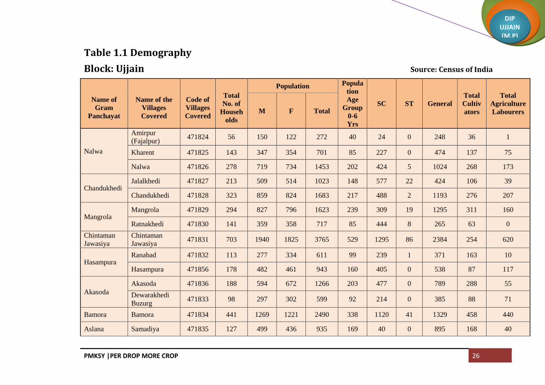
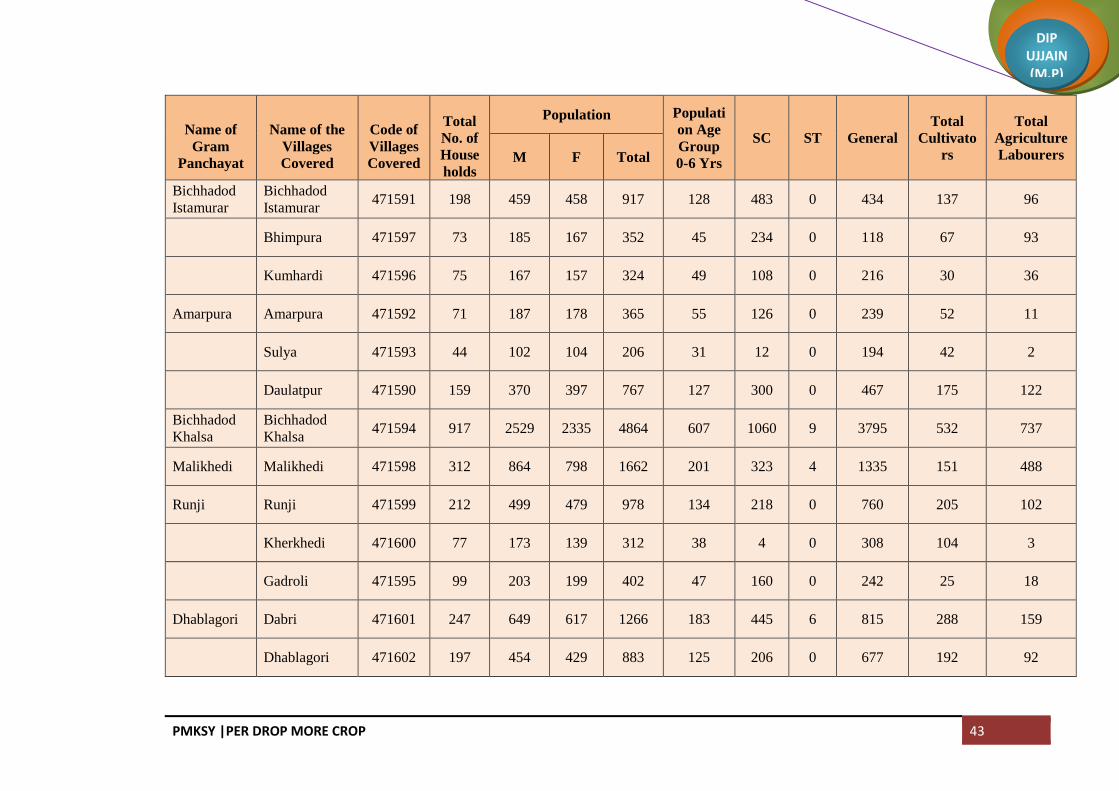
Blockwise population detail is given in Table 1.1
PMKSY |PER DROP MORE CROP 26
DIP UJJAIN (M.P)
Table 1.1 Demography
Block: Ujjain Source: Census of India
Name of
Gram
Panchayat
Name of the
Villages
Covered
Code of
Villages
Covered
Total
No. of
Househ
olds
Population Popula
tion
Age
Group
0-6
Yrs
SC ST General
Total
Cultiv
ators
Total
Agriculture
Labourers M F Total
Nalwa
Amirpur
(Fajalpur) 471824 56 150 122 272 40 24 0 248 36 1
Kharent 471825 143 347 354 701 85 227 0 474 137 75
Nalwa 471826 278 719 734 1453 202 424 5 1024 268 173
Chandukhedi Jalalkhedi 471827 213 509 514 1023 148 577 22 424 106 39
Chandukhedi 471828 323 859 824 1683 217 488 2 1193 276 207
Mangrola Mangrola 471829 294 827 796 1623 239 309 19 1295 311 160
Ratnakhedi 471830 141 359 358 717 85 444 8 265 63 0
Chintaman
Jawasiya
Chintaman
Jawasiya 471831 703 1940 1825 3765 529 1295 86 2384 254 620
Hasampura Ranabad 471832 113 277 334 611 99 239 1 371 163 10
Hasampura 471856 178 482 461 943 160 405 0 538 87 117
Akasoda
Akasoda 471836 188 594 672 1266 203 477 0 789 288 55
Dewarakhedi
Buzurg 471833 98 297 302 599 92 214 0 385 88 71
Bamora Bamora 471834 441 1269 1221 2490 338 1120 41 1329 458 440
Aslana Samadiya 471835 127 499 436 935 169 40 0 895 168 40

PMKSY |PER DROP MORE CROP 27
DIP UJJAIN (M.P)
Name of
Gram
Panchayat
Name of the
Villages
Covered
Code of
Villages
Covered
Total
No. of
Househ
olds
Population Popula
tion
Age
Group
0-6
Yrs
SC ST General
Total
Cultiv
ators
Total
Agriculture
Labourers M F Total
Aslana 471837 204 623 566 1189 173 340 256 593 174 148
Khemasa
Sabalpur
(Buchakhedi) 471838 98 287 253 540 96 476 0 64 26 307
Khemasa 471839 194 524 534 1058 176 568 1 489 161 197
Umariya
Khalsa
Umariya
Khalsa 471843 137 340 330 670 85 434 2 234 59 120
Erwas 471840 147 422 420 842 133 369 12 461 152 51
Kandariya Kandariya 471841 173 640 614 1254 192 935 4 315 157 18
Ajrana 471844 130 380 360 740 116 290 0 450 22 5
Talod Talod 471842 429 1281 1239 2520 326 850 2 1668 453 25
Tankariyapan
th Tankariyapanth 471845 251 728 727 1455 181 353 0 1102 115 399
Takwasa Takwasa 471846 269 735 756 1491 216 321 0 1170 367 3
Hamirkhedi Hamirkhedi 471847 301 829 771 1600 187 257 0 1343 624 211
Jhiroliya
Jhiroliya 471848 163 416 410 826 129 316 25 485 120 99
Badalkhedi 471849 65 170 147 317 39 184 0 133 42 98
Ramjankhedi 471850 36 103 98 201 42 52 23 126 28 1
Fatehabad Fatehabad 471851 376 946 888 1834 264 463 28 1343 221 412
Nilkanth Nilkanth 471852 254 682 646 1328 205 681 10 637 92 277

PMKSY |PER DROP MORE CROP 28
DIP UJJAIN (M.P)
Name of
Gram
Panchayat
Name of the
Villages
Covered
Code of
Villages
Covered
Total
No. of
Househ
olds
Population Popula
tion
Age
Group
0-6
Yrs
SC ST General
Total
Cultiv
ators
Total
Agriculture
Labourers M F Total
Kankariya
Chirakhan
Mundlasulema
n 471853 140 367 378 745 106 341 0 404 122 223
Kankariya
Chirakhan 471854 244 639 627 1266 167 696 0 570 140 143
Lekoda Lekoda 471855 696 1967 1886 3853 437 706 0 3147 1202 466
Gondiya Gondiya 471857 278 775 755 1530 211 564 8 958 464 115
Limbapiplya Limbapiplya 471858 279 799 788 1587 193 422 0 1165 460 237
Jarkhoda Jarkhoda 471860 211 760 726 1486 252 126 0 1360 491 95
Khetiyakhedi 471861 66 212 204 416 57 33 0 383 75 32
Karohan Karohan 471862 371 976 890 1866 237 619 2 1245 252 221
Jastikhedi 471859 60 191 190 381 53 48 0 333 142 24
Nayakhedi Nayakhedi 471863 135 355 339 694 111 195 0 499 98 129
Silodamori 471864 136 342 347 689 101 346 0 343 96 151
Ramwasa Ramwasa 471865 294 707 742 1449 211 276 6 1167 168 316
Matanakhurd 471868 130 356 327 683 97 218 0 465 158 78
Panthpiplai Panthpiplai 471866 398 1106 1074 2180 312 515 5 1660 341 353
Ninora Kithodarao 471867 120 287 303 590 72 181 0 409 60 71
Ninora 471874 452 1289 1179 2468 379 701 19 1748 202 94

PMKSY |PER DROP MORE CROP 29
DIP UJJAIN (M.P)
Name of
Gram
Panchayat
Name of the
Villages
Covered
Code of
Villages
Covered
Total
No. of
Househ
olds
Population Popula
tion
Age
Group
0-6
Yrs
SC ST General
Total
Cultiv
ators
Total
Agriculture
Labourers M F Total
Alampur
(Udana)
Sewarkhedi 471869 124 333 329 662 84 272 0 390 81 113
Alampur
(Udana) 471870 203 554 504 1058 111 196 1 861 126 192
Dhediya Dhediya 471871 330 807 708 1515 237 867 37 611 45 17
Mediya 471872 317 681 675 1356 263 751 102 503 25 38
Karadiya(Na
wakheda)
Karadiya
(Nawakheda) 471873 383 954 885 1839 340 956 5 878 66 6
Piplyaragho Piplyaragho 471875 185 589 567 1156 154 320 0 836 224 277
Chhayan 471876 92 264 242 506 69 450 0 56 10 169
Jamalpura
Jamalpura 471877 110 372 348 720 96 331 13 376 127 198
KokaLacsedi 471878 55 144 129 273 28 61 0 212 106 4
Magariya 471879 67 187 194 381 44 107 0 274 73 8
Gangedi Gangedi 471880 197 579 591 1170 172 149 0 1021 211 132
Brijrajkhedi 471881 154 447 473 920 132 352 0 568 135 130
Sikandari
Sikandari 471888 86 301 281 582 85 207 99 276 227 102
Gothada 471882 107 281 284 565 61 247 0 318 70 82
Jiwankhedi 471884 59 165 194 359 56 64 8 287 26 8
Daudkhedi Sawara Khedi 471883 38 162 171 333 49 0 0 333 34 3

PMKSY |PER DROP MORE CROP 30
DIP UJJAIN (M.P)
Name of
Gram
Panchayat
Name of the
Villages
Covered
Code of
Villages
Covered
Total
No. of
Househ
olds
Population Popula
tion
Age
Group
0-6
Yrs
SC ST General
Total
Cultiv
ators
Total
Agriculture
Labourers M F Total
Daudkhedi 471885 156 489 475 964 156 424 0 540 145 210
Chandmukh Chandmukh 471886 201 455 390 845 106 512 35 298 33 340
Palkhedi 471887 157 398 387 785 121 404 0 381 114 190
Undasa Hakkanipura 471889 172 476 457 933 147 267 67 599 103 129
Undasa 471890 235 637 610 1247 152 557 0 690 127 336
Sahabkhedi Sahabkhedi 471891 159 402 377 779 121 408 0 371 146 153
Nahariya 471893 170 459 475 934 137 416 0 518 217 19
Dhabla
Rehwari
Dhabla
Rehwari 471892 423 1044 1044 2088 329 1320 30 738 193 194
Badarkha
Berasiya
Badarkha
Berasiya 471894 239 754 747 1501 245 250 0 1251 207 126
Bakaniya Bakaniya 471895 343 923 829 1752 250 671 0 1081 179 189
Badodiya
Bhand
Sayarkhedi 471896 72 207 186 393 74 104 0 289 75 52
Dewankhedi 471897 65 178 168 346 45 117 0 229 48 101
Badodiya
Bhand 471898 207 466 493 959 172 622 0 337 95 226
Gunaikhalsa Gunaikhalsa 471899 181 528 481 1009 161 396 41 572 135 77
Piplyabichha 471900 136 335 301 636 89 421 0 215 100 38
Umariya Jambura 471901 160 393 408 801 100 323 10 468 147 154

PMKSY |PER DROP MORE CROP 31
DIP UJJAIN (M.P)
Name of
Gram
Panchayat
Name of the
Villages
Covered
Code of
Villages
Covered
Total
No. of
Househ
olds
Population Popula
tion
Age
Group
0-6
Yrs
SC ST General
Total
Cultiv
ators
Total
Agriculture
Labourers M F Total
Jagir Umariya Jagir 471902 163 411 387 798 108 225 0 573 110 192
Tajpur Tajpur 471903 1389 3994 3795 7789 1297 1225 15 6549 776 476
Bhainsoda
Amirpur
KusLacsedi 471904 94 291 282 573 96 273 0 300 61 109
Bhainsoda 471905 211 554 541 1095 161 594 3 498 121 269
Khajuriya
Kumawat
Derkhedi 471906 37 107 98 205 28 41 0 164 89 26
Khajuriya
Kumawat 471907 202 421 389 810 107 311 0 499 194 228
MoLacsedi 471909 49 130 124 254 31 159 0 95 54 55
Biaora Biaora 471908 341 1187 1235 2422 443 139 0 2283 506 180
Banskhedi
Khalsa
Banskhedi
Khalsa 471910 138 456 439 895 142 309 0 586 114 83
Tankariya Kazi 471924 83 236 218 454 82 188 0 266 108 157
Bodani 471925 97 295 269 564 72 332 0 232 153 172
Pingleshwar Pingleshwar 471911 208 618 600 1218 203 481 3 734 50 82
Harsodan
Harsodan 471912 554 1452 1308 2760 320 1551 14 1195 224 318
Chakjai
Rampur 471913 19 56 39 95 11 83 0 12 0 26
Jaiwantpur Jaiwantpur 471914 299 780 746 1526 272 360 92 1074 69 65
Karondiya Karondiya 471915 254 670 627 1297 183 630 22 645 100 65

PMKSY |PER DROP MORE CROP 32
DIP UJJAIN (M.P)
Name of
Gram
Panchayat
Name of the
Villages
Covered
Code of
Villages
Covered
Total
No. of
Househ
olds
Population Popula
tion
Age
Group
0-6
Yrs
SC ST General
Total
Cultiv
ators
Total
Agriculture
Labourers M F Total
Dhatrawada Dhatrawada 471916 279 733 720 1453 265 205 0 1248 156 3
Lalpur 471954 135 316 288 604 81 307 13 284 38 76
Manpura
Jawasiya
Kumar 471917 149 404 362 766 101 274 0 492 117 20
Manpura 471918 154 412 355 767 113 194 0 573 79 30
Surjanwasa Kesoni 471919 233 555 537 1092 137 607 0 485 134 212
Surjanwasa 471953 234 509 494 1003 162 729 0 274 35 292
Dudarsi Dudarsi 471920 159 352 346 698 83 384 0 314 75 128
Harnyakhedi 471926 159 367 384 751 90 420 0 331 77 310
Kadchhali Daukhedi 471921 77 207 177 384 43 127 0 257 49 82
Kadchhali 471922 169 415 417 832 100 328 0 504 96 37
Badhkummed Badhkummed 471923 476 1355 1319 2674 364 934 0 1740 519 435
Kadchha
Silarkhedi 471927 127 259 279 538 87 521 6 11 71 3
Kadchha 471929 168 445 447 892 146 394 0 498 58 68
Chenpur
Hanskhedi 471946 59 193 198 391 46 97 0 294 58 30
Nogawan Nogawan 471928 288 766 741 1507 199 243 1 1263 178 145
Matanakalan Matanakalan 471930 386 1125 1122 2247 364 369 23 1855 253 47

PMKSY |PER DROP MORE CROP 33
DIP UJJAIN (M.P)
Name of
Gram
Panchayat
Name of the
Villages
Covered
Code of
Villages
Covered
Total
No. of
Househ
olds
Population Popula
tion
Age
Group
0-6
Yrs
SC ST General
Total
Cultiv
ators
Total
Agriculture
Labourers M F Total
Datana Datana 471931 482 1275 1191 2466 338 753 4 1709 222 272
Chandesara Kuwariya 471932 80 220 216 436 75 62 0 374 57 74
Chandesara 471933 281 782 754 1536 219 331 13 1192 115 36
Chandesari Chandesari 471934 412 991 980 1971 322 833 3 1135 140 138
Khajuria
Rehwari
Khajuria
Rehwari 471935 266 659 601 1260 174 306 7 947 207 194
Kalyanpura 471937 150 399 404 803 107 284 0 519 193 169
Semaliyanasa
r
Semaliyanasar 471936 234 597 560 1157 156 496 0 661 164 279
Bhanwri 471938 68 200 207 407 64 125 0 282 77 49
Bolasa
Bolasa 471939 171 474 478 952 132 375 0 577 234 214
Dewarkhedi
Khurd 471940 51 119 108 227 33 0 0 227 38 37
Harnawada 471941 145 397 430 827 111 383 5 439 71 155
Kasampur
Khokariya 471942 83 310 315 625 127 10 0 615 177 25
Kasampur 471943 135 512 468 980 164 25 53 902 109 49
Nikewadi 471944 68 180 174 354 48 102 0 252 48 64
Narwar Narwar 471945 1241 3580 3450 7030 1068 2175 26 4829 492 258
Gaowdi Gaowdi 471947 318 916 890 1806 295 406 0 1400 239 89

PMKSY |PER DROP MORE CROP 34
DIP UJJAIN (M.P)
Name of
Gram
Panchayat
Name of the
Villages
Covered
Code of
Villages
Covered
Total
No. of
Househ
olds
Population Popula
tion
Age
Group
0-6
Yrs
SC ST General
Total
Cultiv
ators
Total
Agriculture
Labourers M F Total
Munjakhedi Munjakhedi 471948 281 838 796 1634 225 498 27 1109 321 268
Piploda
Dwarkadish
Madhopur 471949 95 270 252 522 83 153 29 340 91 77
Piploda
Dwarkadish 471950 573 1556 1556 3112 375 611 1 2500 339 660
Kachnariya Kachnariya 471951 297 621 591 1212 171 304 18 890 202 216
Palkhanda Palkhanda 471952 325 737 747 1484 196 498 5 981 120 219
TOWN Ujjain (M
Corp.) 802230 102401 264871 250344 515215 58972 104898 9673 400644 2819 4552
Total 131663 344901 327665 672566 81940 158363 11091 503112 24834 23655

PMKSY |PER DROP MORE CROP 35
DIP UJJAIN (M.P)
Block: Ghattiya
Name of
Gram
Panchayat
Name of the
Villages
Covered
Code of
Villages
Covered
Total
No. of
House
holds
Population Populati
on Age
Group
0-6 Yrs
SC ST General
Total
Cultivato
rs
Total
Agriculture
Labourers M F Total
Dhanda
Bhalla
Dhanda
Bhalla 471487 202 484 487 971 139 254 0 717 156 186
SaLacsedi 471500 115 319 307 626 90 313 0 313 154 39
Chhitar Devi Chhitar Devi 471488 200 538 526 1064 154 334 0 730 148 212
Ilahipur 471491 81 208 223 431 64 255 0 176 69 80
Borkheda
Bhalla Ahirkheda 471489 73 175 177 352 44 80 0 272 49 111
Borkheda
Bhalla 471490 141 379 352 731 85 212 0 519 177 57
Pipalyatah 471492 42 103 107 210 30 11 0 199 53 7
Gudha Gudha 471493 240 596 585 1181 173 556 0 625 165 222
Lasurdiya
Bazar
Lasurdiya
Bazar 471494 118 278 273 551 81 116 135 300 88 16
Jhokra 471495 54 149 163 312 42 132 0 180 95 23
Khoriya 471496 61 174 176 350 43 158 0 192 50 20
Ruie Ruie 471497 333 896 849 1745 214 328 93 1324 299 507

PMKSY |PER DROP MORE CROP 36
DIP UJJAIN (M.P)
Name of
Gram
Panchayat
Name of the
Villages
Covered
Code of
Villages
Covered
Total
No. of
House
holds
Population Populati
on Age
Group
0-6 Yrs
SC ST General
Total
Cultivato
rs
Total
Agriculture
Labourers M F Total
Semalyabibi 471498 56 136 118 254 35 83 0 171 91 72
Dhulmahu Dhabladhuta 471499 168 429 388 817 113 208 0 609 239 168
Dhulmahu 471529 214 536 536 1072 171 169 0 903 297 67
Pipalyahama Pipalyahama 471501 293 653 599 1252 164 381 0 871 256 53
Dhuletiya Dhuletiya 471509 205 495 434 929 137 210 0 719 427 40
Harigarh 471502 153 435 405 840 117 557 1 282 141 10
Banskhedi Banskhedi 471503 311 718 740 1458 205 644 1 813 132 235
Kaluheda Barothikheda 471504 73 186 161 347 40 13 0 334 87 8
Kaluheda 471505 466 1152 1102 2254 305 508 43 1703 251 389
Bhilkheda Borkhedi 471506 136 338 346 684 95 356 2 326 172 160
Bhilkheda 471507 180 458 427 885 192 5 0 880 127 117
Nawakheda
(Sutarkheda) 471574 122 298 327 625 116 318 2 305 240 4
Kishanpura 471508 78 192 183 375 78 144 0 231 66 12

PMKSY |PER DROP MORE CROP 37
DIP UJJAIN (M.P)
Name of
Gram
Panchayat
Name of the
Villages
Covered
Code of
Villages
Covered
Total
No. of
House
holds
Population Populati
on Age
Group
0-6 Yrs
SC ST General
Total
Cultivato
rs
Total
Agriculture
Labourers M F Total
Sipawara Naveli 471510 173 444 420 864 116 405 1 458 172 217
Sipawara 471525 231 566 529 1095 173 384 0 711 102 80
Bihariya Panched 471511 101 278 261 539 48 170 0 369 128 80
Bihariya 471512 190 511 539 1050 153 363 0 687 200 17
Motipura 471513 96 245 228 473 70 117 0 356 33 167
Panbihar Panbihar 471514 1159 2986 2996 5982 903 2523 220 3239 618 1028
Kithodajagir Gunaijagir 471515 134 331 326 657 88 158 0 499 7 22
Kithodajagir 471516 82 245 235 480 71 203 0 277 93 77
Kesarpur 471517 87 224 205 429 66 126 0 303 58 66
Kagdi
Karadiya
Kagdi
Karadiya 471518 168 457 461 918 170 365 0 553 314 160
Nipanya
Sunar 471519 150 311 284 595 81 359 0 236 126 129
Utesara Utesara 471558 145 396 357 753 148 612 2 139 78 133
Padmakhedi 471520 85 251 270 521 75 53 0 468 141 5

PMKSY |PER DROP MORE CROP 38
DIP UJJAIN (M.P)
Name of
Gram
Panchayat
Name of the
Villages
Covered
Code of
Villages
Covered
Total
No. of
House
holds
Population Populati
on Age
Group
0-6 Yrs
SC ST General
Total
Cultivato
rs
Total
Agriculture
Labourers M F Total
Samarkhedi 471556 40 107 101 208 28 111 0 97 53 9
Gunaya Gunaya 471521 127 316 349 665 102 348 0 317 186 143
Nanakhedi 471522 144 330 329 659 82 220 0 439 113 84
Madhavgarh 471549 66 178 156 334 60 0 59 275 9 47
Ralayata
bhoja
Ralayata
Mauja 471523 185 528 507 1035 167 639 5 391 197 117
Barkhedi
Khalsa 471524 69 178 172 350 68 116 0 234 63 32
Goyala
Buzurg
Goyala
Buzurg 471526 307 780 777 1557 233 608 0 949 279 230
Khalana Khalana 471527 292 780 743 1523 232 133 32 1358 255 448
Tumdawada Paroliya Jhali 471528 110 321 292 613 75 298 0 315 186 108
Tumdawada 471531 159 469 447 916 136 171 0 745 393 113
Jhirniya Khedla 471530 121 329 312 641 113 17 0 624 222 92
Jhirniya 471532 155 424 409 833 145 85 0 748 268 78
Sarola Singawada 471533 166 424 413 837 102 208 0 629 298 158

PMKSY |PER DROP MORE CROP 39
DIP UJJAIN (M.P)
Name of
Gram
Panchayat
Name of the
Villages
Covered
Code of
Villages
Covered
Total
No. of
House
holds
Population Populati
on Age
Group
0-6 Yrs
SC ST General
Total
Cultivato
rs
Total
Agriculture
Labourers M F Total
Sarola 471534 289 832 771 1603 279 121 24 1458 291 308
Amodiya Amodiya 471535 395 1214 1146 2360 334 678 45 1637 265 204
Chakrawada Chakrawada 471537 330 806 807 1613 223 582 13 1018 323 178
Nagpura Mahukhedi 471539 87 232 245 477 86 100 0 377 77 28
Nagpura 471536 126 351 338 689 138 82 27 580 82 207
Ajnoti 471538 58 139 143 282 44 15 18 249 39 18
Silodarawal Silodarawal 471543 225 515 451 966 114 355 0 611 194 177
Badwai 471540 138 308 342 650 68 323 0 327 58 204
Ilaskhedi 471541 93 210 198 408 64 320 0 88 61 130
Badodiya
Kazi Naikhedi 471542 193 426 405 831 132 204 19 608 92 72
Badodiya
Kazi 471546 207 585 576 1161 190 384 0 777 162 295
Ratadiya Ratadiya 471544 273 693 691 1384 229 364 45 975 129 706
Vinayaga Vinayaga 471545 107 289 286 575 75 165 0 410 152 194

PMKSY |PER DROP MORE CROP 40
DIP UJJAIN (M.P)
Name of
Gram
Panchayat
Name of the
Villages
Covered
Code of
Villages
Covered
Total
No. of
House
holds
Population Populati
on Age
Group
0-6 Yrs
SC ST General
Total
Cultivato
rs
Total
Agriculture
Labourers M F Total
Azampura 471548 185 463 478 941 114 423 0 518 207 53
Gonsa Gonsa 471547 287 787 711 1498 234 437 17 1044 110 27
Ramgarh Ramgarh 471550 193 496 492 988 133 400 0 588 87 270
Sulyakhedi 471552 56 171 163 334 42 4 0 330 222 7
Sodang Sodang 471551 239 724 669 1393 176 509 0 884 268 16
Wajirpur (Jogi
Khedi) 471553 81 208 191 399 74 1 0 398 50 43
Surasa Surasa 471554 212 523 531 1054 136 276 38 740 64 58
Badarkha
Babaji 471560 113 327 303 630 119 105 0 525 44 33
Kamed Kamed 471555 876 2303 2151 4454 686 1001 74 3379 215 538
Kaliyadeh Kaliyadeh 471557 309 1023 983 2006 343 274 0 1732 390 186
Jairampura Bormundla 471559 86 194 190 384 58 178 0 206 51 45
Jairampura 471561 104 261 256 517 89 427 6 84 78 139
Devikaradiya 471562 78 242 204 446 58 69 0 377 56 60

PMKSY |PER DROP MORE CROP 41
DIP UJJAIN (M.P)
Name of
Gram
Panchayat
Name of the
Villages
Covered
Code of
Villages
Covered
Total
No. of
House
holds
Population Populati
on Age
Group
0-6 Yrs
SC ST General
Total
Cultivato
rs
Total
Agriculture
Labourers M F Total
Bandka Bandka 471563 271 776 696 1472 221 667 7 798 75 61
Kadwali Piplai 471564 134 311 302 613 98 179 0 434 51 15
Kadwali 471565 105 254 264 518 71 47 0 471 67 107
Pipalya
Munjapta 471567 71 159 163 322 46 87 0 235 4 151
Jaithal Jaithal 471566 544 1393 1294 2687 358 677 0 2010 256 268
Shankarpurj
agir
Shankarpurjag
ir 471568 202 451 439 890 140 367 24 499 112 74
Ranaheda 471575 238 589 557 1146 176 219 12 915 144 30
Nipanya
Goyal Lacsaheda 471569 310 750 708 1458 271 530 0 928 137 352
Ishakpur 471570 71 242 259 501 77 157 12 332 92 71
Nipanya
Goyal 471571 177 381 389 770 119 195 2 573 84 103
Meen Silari 471572 102 257 222 479 69 189 0 290 117 73
Meen 471573 230 608 586 1194 184 370 2 822 222 28
Tulaheda Tulaheda 471576 305 811 727 1538 179 393 0 1145 236 94

PMKSY |PER DROP MORE CROP 42
DIP UJJAIN (M.P)
Name of
Gram
Panchayat
Name of the
Villages
Covered
Code of
Villages
Covered
Total
No. of
House
holds
Population Populati
on Age
Group
0-6 Yrs
SC ST General
Total
Cultivato
rs
Total
Agriculture
Labourers M F Total
Dhannakhed
i Dhannakhedi 471577 296 729 653 1382 262 1004 1 377 273 55
Nazarpur Nazarpur 471578 1131 2904 2862 5766 860 1841 106 3819 526 790
Ghatiya Ghatiya 471579 1220 3203 3109 6312 965 2009 68 4235 476 797
Jalwa Jalwa 471580 501 1283 1227 2510 362 689 2 1819 607 401
Kalukhedi Kalukhedi 471581 213 512 514 1026 183 396 111 519 155 122
Ralayati 471582 254 649 526 1175 116 434 0 741 532 65
Ralayata
Haibat
Ralayata
Haibat 471583 283 765 726 1491 217 502 0 989 160 382
Biramkhedi Biramkhedi 471584 163 445 405 850 127 138 0 712 209 113
Koyalkhedi 471585 153 403 415 818 139 60 0 758 70 221
Salamata Salamata 471586 171 427 370 797 119 311 0 486 64 12
Bhensa Khedi 471589 119 270 271 541 65 259 0 282 107 77
Chitawalya
Kheda
Chitawalya
Kheda 471587 239 599 570 1169 170 601 0 568 220 181
Jhitarkhedi Jhitarkhedi 471588 252 625 650 1275 152 605 0 670 184 267
PMKSY |PER DROP MORE CROP 43
DIP UJJAIN (M.P)
Name of
Gram
Panchayat
Name of the
Villages
Covered
Code of
Villages
Covered
Total
No. of
House
holds
Population Populati
on Age
Group
0-6 Yrs
SC ST General
Total
Cultivato
rs
Total
Agriculture
Labourers M F Total
Bichhadod
Istamurar
Bichhadod
Istamurar 471591 198 459 458 917 128 483 0 434 137 96
Bhimpura 471597 73 185 167 352 45 234 0 118 67 93
Kumhardi 471596 75 167 157 324 49 108 0 216 30 36
Amarpura Amarpura 471592 71 187 178 365 55 126 0 239 52 11
Sulya 471593 44 102 104 206 31 12 0 194 42 2
Daulatpur 471590 159 370 397 767 127 300 0 467 175 122
Bichhadod
Khalsa
Bichhadod
Khalsa 471594 917 2529 2335 4864 607 1060 9 3795 532 737
Malikhedi Malikhedi 471598 312 864 798 1662 201 323 4 1335 151 488
Runji Runji 471599 212 499 479 978 134 218 0 760 205 102
Kherkhedi 471600 77 173 139 312 38 4 0 308 104 3
Gadroli 471595 99 203 199 402 47 160 0 242 25 18
Dhablagori Dabri 471601 247 649 617 1266 183 445 6 815 288 159
Dhablagori 471602 197 454 429 883 125 206 0 677 192 92

PMKSY |PER DROP MORE CROP 44
DIP UJJAIN (M.P)
Name of
Gram
Panchayat
Name of the
Villages
Covered
Code of
Villages
Covered
Total
No. of
House
holds
Population Populati
on Age
Group
0-6 Yrs
SC ST General
Total
Cultivato
rs
Total
Agriculture
Labourers M F Total
Bhutiya Bhutiya 471603 244 572 513 1085 154 477 0 608 108 302
Anwalya 471607 220 476 450 926 135 328 0 598 54 123
Ujjainiya Ujjainiya 471604 581 1404 1311 2715 401 875 1 1839 385 180
Kalesar Kalesar 471605 187 469 455 924 138 91 0 833 169 97
Chonsala 471608 98 273 233 506 51 216 0 290 53 46
Guradiya
Gujar
Guradiya
Gujar 471609 406 997 1013 2010 368 198 3 1809 362 11
Banda Bamori 471611 180 436 416 852 104 90 0 762 180 137
Banda 471606 192 434 429 863 132 207 0 656 140 267
Khajuria
Sadar
Khajuria
Sadar 471610 269 635 663 1298 188 105 4 1189 203 353
Bisakhedi 471612 55 142 143 285 33 11 0 274 82 0
Rudaheda Rudaheda 471613 436 1140 1102 2242 361 956 0 1286 255 111
Barkhedi Jagir 471614 52 137 134 271 33 118 0 153 28 66
Total 27553 70808 68053 138861 20484 43211 1296 94354 21587 19413

PMKSY |PER DROP MORE CROP 45
DIP UJJAIN (M.P)
Block: Tarana
Name of
Gram
Panchayat
Name of
Villages
Covered
Code of
the
Villages
Covered
Total
No. of
House
holds
Population Populat
ion Age
Group
0-6 Yrs
SC ST General
Total
Cultivato
rs
Total
Agriculture
Labourers M F Total
Padsi Padsi 471615 134 639 327 312 639 191 0 448 29 4
Gunakhedi 471616 151 720 365 355 720 0 0 720 129 94
Jafarpurnera 471617 74 323 157 166 323 159 0 164 60 1
Suwasa Suwas 471618 180 896 468 428 896 267 0 629 178 103
Lacsmankhed
i 471636 94 589 298 291 589 128 0 461 97 69
Pat Pat 471619 355 1815 934 881 1815 789 1 1025 207 3
Ilamkhedi Bhariyakhedi 471620 75 371 193 178 371 133 0 238 73 107
Ilamkhedi 471622 108 567 283 284 567 413 0 154 200 80
Bhatkhedi 471624 53 233 115 118 233 6 0 227 0 0
Chandnyakhe
di Samtyakhedi 471621 92 479 242 237 479 224 0 255 181 22
Mayakhedi 471625 68 334 173 161 334 57 0 277 0 1
Chandnyakhe
di 471626 82 487 238 249 487 143 0 344 144 0
Jhalara Jhalara 471623 201 1146 592 554 1146 355 0 791 126 196
Jhalari 471627 108 437 222 215 437 268 0 169 48 2
PMKSY |PER DROP MORE CROP 46
DIP UJJAIN (M.P)
Name of
Gram
Panchayat
Name of
Villages
Covered
Code of
the
Villages
Covered
Total
No. of
House
holds
Population Populat
ion Age
Group
0-6 Yrs
SC ST General
Total
Cultivato
rs
Total
Agriculture
Labourers M F Total
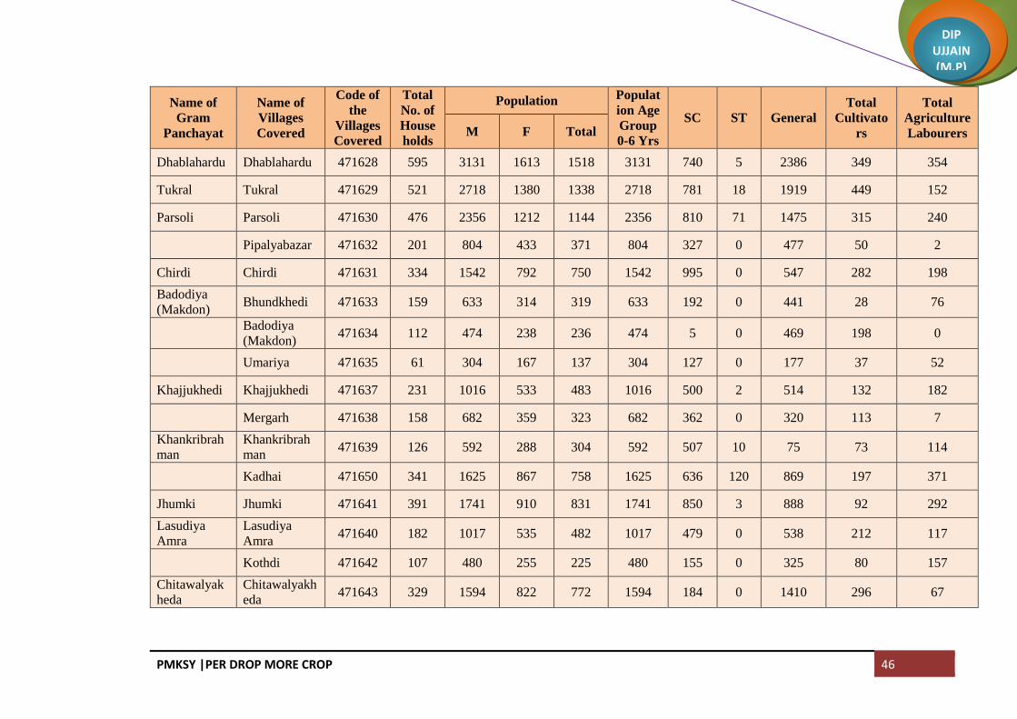
Dhablahardu Dhablahardu 471628 595 3131 1613 1518 3131 740 5 2386 349 354
Tukral Tukral 471629 521 2718 1380 1338 2718 781 18 1919 449 152
Parsoli Parsoli 471630 476 2356 1212 1144 2356 810 71 1475 315 240
Pipalyabazar 471632 201 804 433 371 804 327 0 477 50 2
Chirdi Chirdi 471631 334 1542 792 750 1542 995 0 547 282 198
Badodiya
(Makdon) Bhundkhedi 471633 159 633 314 319 633 192 0 441 28 76
Badodiya
(Makdon) 471634 112 474 238 236 474 5 0 469 198 0
Umariya 471635 61 304 167 137 304 127 0 177 37 52
Khajjukhedi Khajjukhedi 471637 231 1016 533 483 1016 500 2 514 132 182
Mergarh 471638 158 682 359 323 682 362 0 320 113 7
Khankribrah
man
Khankribrah
man 471639 126 592 288 304 592 507 10 75 73 114
Kadhai 471650 341 1625 867 758 1625 636 120 869 197 371
Jhumki Jhumki 471641 391 1741 910 831 1741 850 3 888 92 292
Lasudiya
Amra
Lasudiya
Amra 471640 182 1017 535 482 1017 479 0 538 212 117
Kothdi 471642 107 480 255 225 480 155 0 325 80 157
Chitawalyak
heda
Chitawalyakh
eda 471643 329 1594 822 772 1594 184 0 1410 296 67

PMKSY |PER DROP MORE CROP 47
DIP UJJAIN (M.P)
Name of
Gram
Panchayat
Name of
Villages
Covered
Code of
the
Villages
Covered
Total
No. of
House
holds
Population Populat
ion Age
Group
0-6 Yrs
SC ST General
Total
Cultivato
rs
Total
Agriculture
Labourers M F Total
TejLacsedi TejLacsedi 471644 216 916 465 451 916 45 0 871 71 50
Rawankhedi 471646 162 927 483 444 927 421 1 505 82 0
Godadi Khokariya 471645 140 715 365 350 715 76 0 639 103 1
Dhanyakhedi 471647 75 388 193 195 388 53 0 335 159 28
Godadi 471648 269 931 471 460 931 398 2 531 126 370
Lasudiya
Dhandu
Lasudiya
Dhandu 471649 143 695 365 330 695 33 3 659 132 39
Suchai 471675 107 515 271 244 515 492 0 23 18 6
Chikli Chikli 471651 343 1565 822 743 1565 676 0 889 138 187
Sumrakheda Sumrakheda 471776 494 2483 1220 1263 2483 1495 15 973 130 64
Hatyakhedi 471775 101 472 234 238 472 182 0 290 111 93
Bhodalya Sumrakhedi 471652 126 564 287 277 564 443 0 121 21 2
Bhodalya 471653 385 1620 849 771 1620 456 457 707 183 294
Rupakhedi Rupakhedi 471654 408 1931 1000 931 1931 816 8 1107 166 179
LaLacsedi 471655 132 703 356 347 703 275 0 428 60 104
Samanera Samanera 471656 399 2017 1050 967 2017 1015 0 1002 418 332
Hanumanti 471661 84 555 271 284 555 8 0 547 349 7
Dabdarajput Dabdarajput 471657 256 1266 626 640 1266 362 0 904 245 263

PMKSY |PER DROP MORE CROP 48
DIP UJJAIN (M.P)
Name of
Gram
Panchayat
Name of
Villages
Covered
Code of
the
Villages
Covered
Total
No. of
House
holds
Population Populat
ion Age
Group
0-6 Yrs
SC ST General
Total
Cultivato
rs
Total
Agriculture
Labourers M F Total
Dhuwakhedi Dhuwakhedi 471658 165 580 298 282 580 308 0 272 74 27
Pankhedi 471660 196 893 465 428 893 427 6 460 46 159
Pachola Pachola 471659 520 2623 1348 1275 2623 437 0 2186 358 82
Lasurdiya
Hameer Chunakhedi 471662 111 678 327 351 678 300 0 378 119 30
Lasurdiya
Hameer 471663 123 691 359 332 691 158 0 533 123 67
Shekhpur 471664 81 462 232 230 462 0 0 462 258 26
Kachnariya Kachnariya 471665 521 2607 1331 1276 2607 1111 0 1496 595 541
Bisankheda Khankrisultan 471666 151 668 348 320 668 97 451 120 45 111
Bisankheda 471736 205 886 457 429 886 519 176 191 42 11
Bisankhedi 471740 152 649 315 334 649 186 217 246 79 103
Khamli Khamli 471667 150 639 330 309 639 85 0 554 71 78
Tilawadi 471668 199 908 474 434 908 499 0 409 163 239
Tilawad Tilawad 471669 405 2160 1100 1060 2160 430 0 1730 563 259
Ranchikhedi 471670 29 133 61 72 133 29 0 104 2 60
Lodh Lodh 471671 305 1426 732 694 1426 732 1 693 312 223
Nanded Nanded 471672 1000 4517 2351 2166 4517 1507 78 2932 246 144
Keswal Keswal 471673 198 915 480 435 915 367 0 548 77 36

PMKSY |PER DROP MORE CROP 49
DIP UJJAIN (M.P)
Name of
Gram
Panchayat
Name of
Villages
Covered
Code of
the
Villages
Covered
Total
No. of
House
holds
Population Populat
ion Age
Group
0-6 Yrs
SC ST General
Total
Cultivato
rs
Total
Agriculture
Labourers M F Total
Jamunya 471687 67 312 153 159 312 23 0 289 39 0
Kanthadi Kanthadi 471674 327 1241 653 588 1241 786 4 451 6 4
Bagwada Manasa 471676 71 288 146 142 288 1 0 287 51 99
Ratnakhedi 471679 73 221 113 108 221 2 0 219 0 0
Bagwada 471680 134 644 332 312 644 58 0 586 85 40
Bukhari 471681 113 452 232 220 452 76 0 376 14 214
Harukhedi 471682 62 205 97 108 205 50 0 155 0 0
Salnakhedi Rehwari 471677 112 482 247 235 482 35 0 447 74 92
Salnakhedi 471678 158 667 346 321 667 136 17 514 104 1
Kadodiya Kadodiya 471683 1143 5302 2700 2602 5302 1057 307 3938 468 1078
Sarli Sarli 471693 234 1037 542 495 1037 644 18 375 372 157
Haidarpura 471684 111 433 225 208 433 229 0 204 57 89
Moyakheda 471685 76 314 161 153 314 109 0 205 85 80
Hasalpurjhirn
ya Chakya 471686 117 552 278 274 552 437 28 87 27 76
Hasalpurjhirn
ya 471688 135 633 321 312 633 72 0 561 48 7
Kankaryamir
pur 471690 93 345 167 178 345 72 0 273 3 1
Limbadit Limbadit 471689 431 1790 938 852 1790 502 98 1190 249 15
PMKSY |PER DROP MORE CROP 50
DIP UJJAIN (M.P)
Name of
Gram
Panchayat
Name of
Villages
Covered
Code of
the
Villages
Covered
Total
No. of
House
holds
Population Populat
ion Age
Group
0-6 Yrs
SC ST General
Total
Cultivato
rs
Total
Agriculture
Labourers M F Total
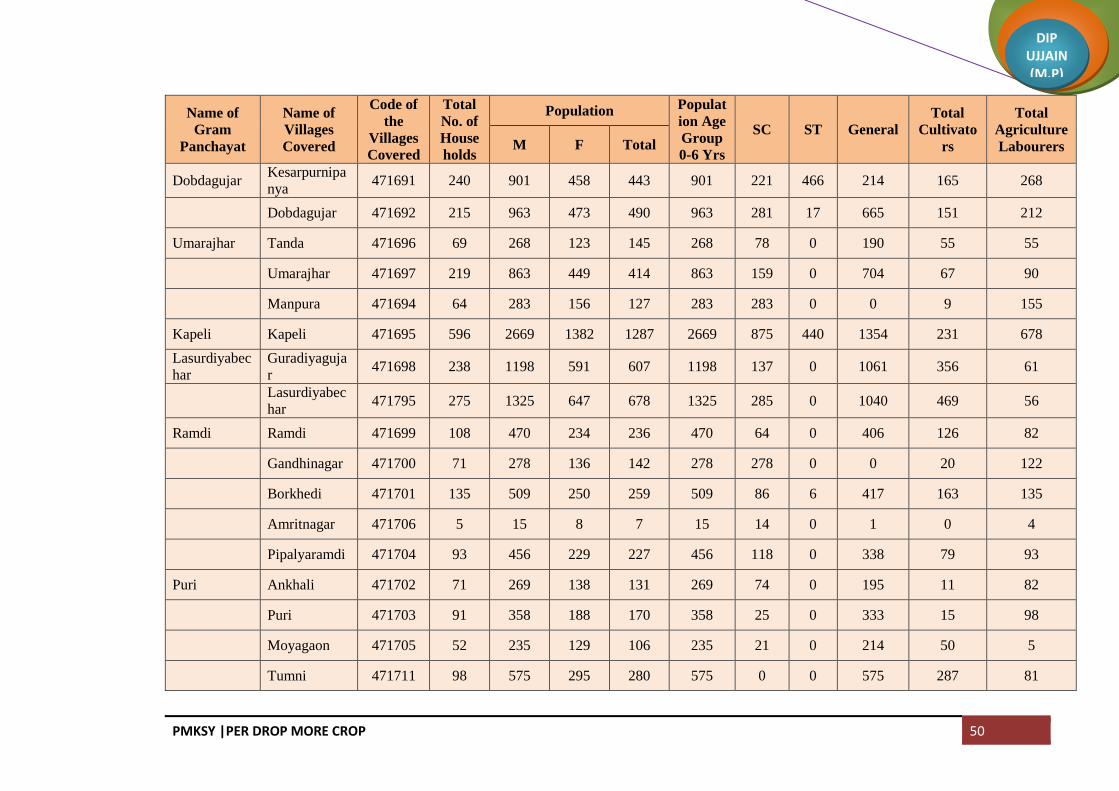
Dobdagujar Kesarpurnipa
nya 471691 240 901 458 443 901 221 466 214 165 268
Dobdagujar 471692 215 963 473 490 963 281 17 665 151 212
Umarajhar Tanda 471696 69 268 123 145 268 78 0 190 55 55
Umarajhar 471697 219 863 449 414 863 159 0 704 67 90
Manpura 471694 64 283 156 127 283 283 0 0 9 155
Kapeli Kapeli 471695 596 2669 1382 1287 2669 875 440 1354 231 678
Lasurdiyabec
har
Guradiyaguja
r 471698 238 1198 591 607 1198 137 0 1061 356 61
Lasurdiyabec
har 471795 275 1325 647 678 1325 285 0 1040 469 56
Ramdi Ramdi 471699 108 470 234 236 470 64 0 406 126 82
Gandhinagar 471700 71 278 136 142 278 278 0 0 20 122
Borkhedi 471701 135 509 250 259 509 86 6 417 163 135
Amritnagar 471706 5 15 8 7 15 14 0 1 0 4
Pipalyaramdi 471704 93 456 229 227 456 118 0 338 79 93
Puri Ankhali 471702 71 269 138 131 269 74 0 195 11 82
Puri 471703 91 358 188 170 358 25 0 333 15 98
Moyagaon 471705 52 235 129 106 235 21 0 214 50 5
Tumni 471711 98 575 295 280 575 0 0 575 287 81

PMKSY |PER DROP MORE CROP 51
DIP UJJAIN (M.P)
Name of
Gram
Panchayat
Name of
Villages
Covered
Code of
the
Villages
Covered
Total
No. of
House
holds
Population Populat
ion Age
Group
0-6 Yrs
SC ST General
Total
Cultivato
rs
Total
Agriculture
Labourers M F Total
Katwariya Katwariya 471707 219 1077 570 507 1077 344 358 375 117 178
Aurangpur 471710 79 527 283 244 527 177 0 350 58 66
Gudradiya Khutpala 471708 96 452 232 220 452 305 0 147 36 72
Gudradiya 471709 159 801 416 385 801 335 18 448 38 5
Karedi Karedi 471714 458 1939 958 981 1939 322 1 1616 344 114
LaLacseda LaLacseda 471713 167 810 407 403 810 40 0 770 308 7
Palkhanda 471715 64 306 153 153 306 268 0 38 14 0
Shankarpura 471716 37 181 99 82 181 178 0 3 61 37
Kharkhadi Merkhedi 471718 55 276 143 133 276 18 2 256 73 0
Jawaharnagar 471724 36 119 59 60 119 119 0 0 1 30
Kharkhadi 471722 180 764 386 378 764 0 0 764 60 359
Berchhi Suwagaon 471717 162 867 446 421 867 173 76 618 125 0
Berchhi 471719 232 1051 562 489 1051 80 0 971 322 9
Bordagujar Murdawan 471720 89 494 235 259 494 97 0 397 1 0
Bordagujar 471721 161 753 388 365 753 166 0 587 148 13
Kanardi Kanardi 471723 575 3159 1650 1509 3159 1367 22 1770 499 428
Devikheda Guthlai 471725 79 391 200 191 391 96 0 295 79 93

PMKSY |PER DROP MORE CROP 52
DIP UJJAIN (M.P)
Name of
Gram
Panchayat
Name of
Villages
Covered
Code of
the
Villages
Covered
Total
No. of
House
holds
Population Populat
ion Age
Group
0-6 Yrs
SC ST General
Total
Cultivato
rs
Total
Agriculture
Labourers M F Total
Krishna
Nagar 471726 13 77 42 35 77 9 0 68 18 8
Devikheda 471727 173 768 387 381 768 93 0 675 113 66
Junapani 471822 83 444 237 207 444 444 0 0 9 13
Naharkhedi Naharkhedi 471728 193 1000 515 485 1000 224 0 776 373 17
Barnawad 471730 163 775 375 400 775 0 0 775 375 51
Surajpura Surajpura 471729 247 944 467 477 944 83 846 15 75 106
Jharnawada 471739 178 878 447 431 878 432 101 345 40 74
Barkheda
Tarana
Barkheda
Tarana 471731 223 1063 542 521 1063 264 0 799 392 144
Khodrinipani
ya 471732 106 525 272 253 525 141 0 384 107 23
Itawa Itawa 471733 453 2213 1145 1068 2213 955 1 1257 487 545
Gangalyakhe
di 471734 147 822 439 383 822 442 0 380 101 105
Devli Devli 471735 322 1244 636 608 1244 320 110 814 223 136
Chhadawad Chhadawad 471737 504 2367 1201 1166 2367 996 164 1207 130 358
Tobrikheda Tobrikheda 471738 310 1304 659 645 1304 569 292 443 68 17
Noganwa Noganwa 471741 301 1302 677 625 1302 489 0 813 322 232
Gawdi Abadkhedi 471742 140 566 294 272 566 0 0 566 118 81
Gawdi 471743 236 1058 549 509 1058 215 0 843 105 111

PMKSY |PER DROP MORE CROP 53
DIP UJJAIN (M.P)
Name of
Gram
Panchayat
Name of
Villages
Covered
Code of
the
Villages
Covered
Total
No. of
House
holds
Population Populat
ion Age
Group
0-6 Yrs
SC ST General
Total
Cultivato
rs
Total
Agriculture
Labourers M F Total
Kakariyachan
d 471791 103 490 238 252 490 18 0 472 82 12
SaLacsedi Malikhedi 471744 126 660 356 304 660 397 0 263 74 154
SaLacsedi 471787 170 772 392 380 772 130 0 642 161 86
Khambukhed
i Sadikhedi 471745 72 375 191 184 375 77 0 298 98 22
Khambukhedi 471746 105 667 342 325 667 94 0 573 156 34
Siddhipurnip
anya
Siddhipurnipa
nya 471747 441 1961 982 979 1961 36 0 1925 293 116
Karanj Karanj 471748 539 2545 1303 1242 2545 1153 7 1385 354 588
Bagoda Bagoda 471749 292 1201 592 609 1201 153 132 916 175 9
Hajikhedi 471750 15 48 24 24 48 0 0 48 14 0
Dilodri Dilodri 471755 298 1590 794 796 1590 586 0 1004 246 183
Yashwantgar
h 471751 81 335 178 157 335 169 0 166 49 56
Chhapri Jhirnyabuzur
g 471752 99 383 186 197 383 78 0 305 130 69
Chhapri 471753 223 1038 534 504 1038 375 0 663 157 5
Samgi Samgi 471756 526 2392 1212 1180 2392 511 56 1825 347 391
Banjari Banjari 471757 212 1006 510 496 1006 271 0 735 351 231
Patiyalkhedi 471764 25 121 58 63 121 0 0 121 38 8

PMKSY |PER DROP MORE CROP 54
DIP UJJAIN (M.P)
Name of
Gram
Panchayat
Name of
Villages
Covered
Code of
the
Villages
Covered
Total
No. of
House
holds
Population Populat
ion Age
Group
0-6 Yrs
SC ST General
Total
Cultivato
rs
Total
Agriculture
Labourers M F Total
Titodi Titodi 471758 227 1028 528 500 1028 182 0 846 59 132
Rojwas 471759 145 617 306 311 617 471 0 146 81 1
Nenawad Suwarkota 471760 161 731 381 350 731 0 0 731 30 43
Nenawad 471761 609 3072 1578 1494 3072 971 6 2095 294 140
Limboda
Tarana
Yeshwantnag
ar 471762 117 474 226 248 474 0 0 474 0 1
Limboda
Tarana 471763 276 1119 574 545 1119 441 0 678 51 150
Golwa Fanya 471765 75 312 159 153 312 40 0 272 66 19
Golwa 471766 459 2237 1153 1084 2237 1243 0 994 481 547
Barandwa Barandwa 471767 493 2201 1136 1065 2201 1279 21 901 196 634
Kanasiya Kanasiya 471768 1355 6396 3322 3074 6396 1586 13 4797 570 613
Palduna Palduna 471769 152 843 428 415 843 397 0 446 108 94
Gujarkheda 471770 69 298 154 144 298 58 0 240 89 31
Lunyakhedi 471771 117 576 296 280 576 241 8 327 83 0
Sakari Anantkhedi 471772 112 510 265 245 510 302 0 208 146 74
Sakari 471773 124 607 310 297 607 317 0 290 264 90
Dudhli Dudhli 471774 323 1543 797 746 1543 629 0 914 215 19
Nanukheda Nanukheda 471779 226 1042 515 527 1042 169 1 872 250 203

PMKSY |PER DROP MORE CROP 55
DIP UJJAIN (M.P)
Name of
Gram
Panchayat
Name of
Villages
Covered
Code of
the
Villages
Covered
Total
No. of
House
holds
Population Populat
ion Age
Group
0-6 Yrs
SC ST General
Total
Cultivato
rs
Total
Agriculture
Labourers M F Total
Malhargarh 471777 60 289 140 149 289 115 0 174 86 7
Pipalyakayth
a Laxmipura 471778 132 719 377 342 719 501 5 213 95 299
Khandakhedi 471780 61 309 162 147 309 71 0 238 89 70
Gopali 471781 66 283 155 128 283 77 0 206 45 83
Pipalyakaytha 471782 145 783 421 362 783 302 0 481 104 91
Beejpadi Natakhedi 471783 152 622 315 307 622 294 0 328 145 316
Halukhedi 471784 110 553 277 276 553 318 0 235 64 79
Beejpadi 471785 110 528 269 259 528 256 0 272 47 20
Baghera Baghera 471786 360 1791 932 859 1791 729 208 854 194 246
Mundli Mundli 471788 187 915 454 461 915 638 0 277 135 99
Sadba 471790 162 820 426 394 820 186 0 634 155 73
Dubli Dubli 471789 329 1527 789 738 1527 738 5 784 226 296
Bhadsimba Bhadsimba 471792 300 1461 770 691 1461 597 86 778 165 229
Kawlikheda Kawlikheda 471793 250 1111 597 514 1111 559 0 552 92 25
Bhuki
Itwarpur 471794 118 473 240 233 473 276 0 197 17 50
Binjal 471797 87 479 235 244 479 202 0 277 35 33
Guradiyadon
gar
Guradiyadon
gar 471798 31 158 81 77 158 35 0 123 8 20
PMKSY |PER DROP MORE CROP 56
DIP UJJAIN (M.P)
Name of
Gram
Panchayat
Name of
Villages
Covered
Code of
the
Villages
Covered
Total
No. of
House
holds
Population Populat
ion Age
Group
0-6 Yrs
SC ST General
Total
Cultivato
rs
Total
Agriculture
Labourers M F Total
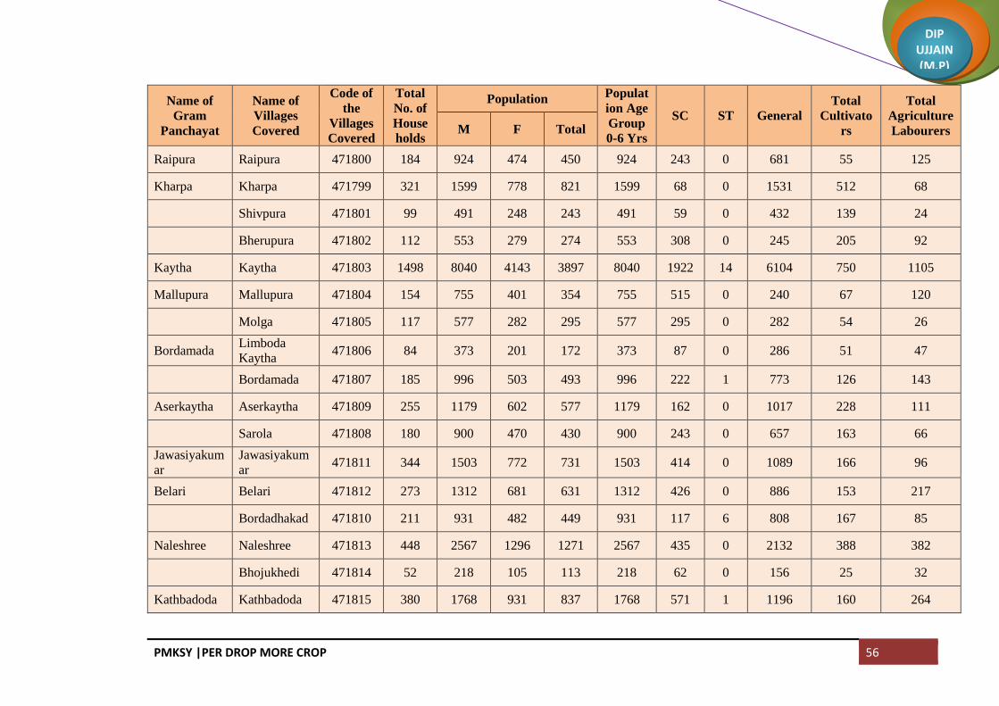
Raipura Raipura 471800 184 924 474 450 924 243 0 681 55 125
Kharpa Kharpa 471799 321 1599 778 821 1599 68 0 1531 512 68
Shivpura 471801 99 491 248 243 491 59 0 432 139 24
Bherupura 471802 112 553 279 274 553 308 0 245 205 92
Kaytha Kaytha 471803 1498 8040 4143 3897 8040 1922 14 6104 750 1105
Mallupura Mallupura 471804 154 755 401 354 755 515 0 240 67 120
Molga 471805 117 577 282 295 577 295 0 282 54 26
Bordamada Limboda
Kaytha 471806 84 373 201 172 373 87 0 286 51 47
Bordamada 471807 185 996 503 493 996 222 1 773 126 143
Aserkaytha Aserkaytha 471809 255 1179 602 577 1179 162 0 1017 228 111
Sarola 471808 180 900 470 430 900 243 0 657 163 66
Jawasiyakum
ar
Jawasiyakum
ar 471811 344 1503 772 731 1503 414 0 1089 166 96
Belari Belari 471812 273 1312 681 631 1312 426 0 886 153 217
Bordadhakad 471810 211 931 482 449 931 117 6 808 167 85
Naleshree Naleshree 471813 448 2567 1296 1271 2567 435 0 2132 388 382
Bhojukhedi 471814 52 218 105 113 218 62 0 156 25 32
Kathbadoda Kathbadoda 471815 380 1768 931 837 1768 571 1 1196 160 264

PMKSY |PER DROP MORE CROP 57
DIP UJJAIN (M.P)
Name of
Gram
Panchayat
Name of
Villages
Covered
Code of
the
Villages
Covered
Total
No. of
House
holds
Population Populat
ion Age
Group
0-6 Yrs
SC ST General
Total
Cultivato
rs
Total
Agriculture
Labourers M F Total
Malkheda 471816 122 643 312 331 643 172 0 471 88 58
Khajuria Khajuria 471817 271 1385 695 690 1385 571 0 814 132 300
Bhatuni Bhatuni 471818 266 1362 673 689 1362 410 3 949 230 122
Upadi Upadi 471819 258 1273 648 625 1273 214 1 1058 207 18
Khatikhedi Khatikhedi 471820 188 801 414 387 801 318 3 480 92 197
Barkhedakayt
ha 471821 140 647 338 309 647 130 4 513 81 73
Urban Tarana (NP) 802228 4521 24908 12825 12083 24908 5386 108 19414 769 864
Urban Makdon (NP) 802229 2388 11678 5936 5742 11678 3874 1046 6758 1286 1009
Total 51265 246707 126418 120289 246707 77762 6772 162173 33040 27441
PMKSY |PER DROP MORE CROP 58
DIP UJJAIN (M.P)
Block: Khachrod
Name of
Gram
Panchayat
Name of the
Villages
Covered
Code of
Villages
Covered
Total
No. of
House
holds
Population Populat
ion Age
Group
0-6 Yrs
SC ST General
Total
Cultivat
ors
Total
Agriculture
Labourers M F Total
Gothda
Gothda 471044 120 323 322 645 80 18 0 627 229 22
Lohachitara 471045 148 373 333 706 104 167 0 539 210 0
Kantharkhedi 471046 77 210 200 410 61 21 0 389 93 12
Napakhedi
Napakhedi 471047 124 317 317 634 80 132 1 501 123 123
Brahman
Khedi Khurd 471048 68 160 147 307 53 102 0 205 40 85
Padalyakhurd 471049 101 269 248 517 84 247 0 270 108 37
Shribach Shribachh 471050 233 616 610 1226 191 400 141 685 209 8
Banjari
Banjari 471051 390 935 911 1846 260 710 0 1136 346 25
Lasudiya
Daiyar 471052 7 19 19 38 12 25 0 13 8 0
Farnakhedi
Ramnagar 471053 135 340 348 688 91 176 0 512 1 0
Farnakhedi 471056 351 841 833 1674 223 440 39 1195 233 125
Meend Meen 471055 280 783 728 1511 221 514 122 875 336 107
Dodiya
Dodiya 471057 237 518 503 1021 171 355 0 666 140 473
Nareli 471058 157 397 403 800 105 380 0 420 1 487

PMKSY |PER DROP MORE CROP 59
DIP UJJAIN (M.P)
Name of
Gram
Panchayat
Name of the
Villages
Covered
Code of
Villages
Covered
Total
No. of
House
holds
Population Populat
ion Age
Group
0-6 Yrs
SC ST General
Total
Cultivat
ors
Total
Agriculture
Labourers M F Total
Sendari
Sendri 471059 205 562 547 1109 159 572 0 537 347 210
Dhaturiya 471054 83 235 270 505 97 31 0 474 300 0
Barkheda
jawra
Barkheda
Jaora 471060 214 626 633 1259 187 174 2 1083 658 26
Chapakheda Chanpa
Kheda 471061 516 1185 1193 2378 254 696 0 1682 609 205
Chapaner
Sakatkhedi 471062 227 584 611 1195 217 285 0 910 277 89
Chanpaner 471063 395 1058 1042 2100 281 496 8 1596 542 248
Mokdi Mokdi 471064 382 1011 978 1989 298 597 87 1305 707 98
Akyajageer
Tarod 471065 212 511 518 1029 147 608 11 410 317 122
Akyajagir 471066 341 871 865 1736 216 248 5 1483 574 143
Chandodiya Chandodiya 471067 223 622 639 1261 224 580 0 681 375 169
Kesariya Kesariya 471068 273 627 597 1224 167 407 2 815 212 333
Divel Divel 471069 248 647 639 1286 186 259 36 991 349 103
Ghinoda Ghinoda 471070 552 1508 1466 2974 349 576 233 2165 919 287
Bhensola Bhensola 471071 336 776 775 1551 197 462 7 1082 253 263
Panwasa Bhandla 471072 145 335 293 628 103 24 122 482 132 63

PMKSY |PER DROP MORE CROP 60
DIP UJJAIN (M.P)
Name of
Gram
Panchayat
Name of the
Villages
Covered
Code of
Villages
Covered
Total
No. of
House
holds
Population Populat
ion Age
Group
0-6 Yrs
SC ST General
Total
Cultivat
ors
Total
Agriculture
Labourers M F Total
Panwasa 471073 212 561 511 1072 153 681 12 379 297 193
Ringniya
Jalod 471074 89 227 205 432 64 147 0 285 75 64
Rigania 471075 236 559 561 1120 185 196 0 924 250 274
Batlawdi Batlawadi 471076 548 1276 1283 2559 428 1368 1 1190 718 454
Bordiya
Bordiya 471077 190 502 485 987 114 172 0 815 205 172
Khandwa 471078 162 414 415 829 136 516 0 313 216 251
Naredipata Naredipata 471079 214 566 558 1124 139 382 81 661 250 65
Unchaheda Unchaheda 471080 215 514 501 1015 119 466 16 533 120 72
Runkheda Runkheda 471081 299 829 792 1621 236 269 53 1299 297 230
Thadoda
Thadoda 471082 173 466 432 898 124 381 0 517 163 148
Dipakhedi 471086 53 140 130 270 38 13 0 257 60 19
Kanwas Kanwas 471083 370 937 883 1820 246 549 42 1229 372 3
Nandvasla
Nandwasla 471084 136 359 316 675 78 60 7 608 167 48
Sanasala 471085 133 370 374 744 118 441 114 189 115 97
Bhunwasa Bhanwasa 471087 291 652 663 1315 180 474 5 836 310 360

PMKSY |PER DROP MORE CROP 61
DIP UJJAIN (M.P)
Name of
Gram
Panchayat
Name of the
Villages
Covered
Code of
Villages
Covered
Total
No. of
House
holds
Population Populat
ion Age
Group
0-6 Yrs
SC ST General
Total
Cultivat
ors
Total
Agriculture
Labourers M F Total
Naredikhurd 471088 160 463 470 933 178 500 0 433 146 234
Kanchankhed
i
Kanchankhed
i 471089 255 669 644 1313 186 514 99 700 353 142
Kutlana 471090 196 452 436 888 134 348 1 539 191 214
Behlola Behlola 471091 348 915 927 1842 311 1080 2 760 205 284
Lekodiya
tank
Lekodiya
Tank 471092 289 756 660 1416 186 108 89 1219 238 158
Bhatkhedi
Bhat Khedi 471093 252 641 580 1221 157 403 49 769 336 207
Ghudawan 471094 164 377 426 803 122 366 22 415 185 120
Jhirmira
Jhirmira 471095 231 557 572 1129 174 195 0 934 381 184
Khurmundi 471097 134 291 256 547 97 54 0 493 117 62
Bedawniya Bedavanya 471096 377 948 847 1795 207 200 6 1589 376 196
Gidvaniya Gindwanya 471098 270 791 769 1560 191 948 1 611 465 143
Umarna
Umarna 471102 397 942 909 1851 292 1184 0 667 215 260
Umarni 471099 224 550 543 1093 186 305 3 785 119 76
Navtiya
Dadiya 471100 44 108 122 230 43 50 0 180 31 18
Nawatiya 471103 276 750 714 1464 231 792 201 471 211 107

PMKSY |PER DROP MORE CROP 62
DIP UJJAIN (M.P)
Name of
Gram
Panchayat
Name of the
Villages
Covered
Code of
Villages
Covered
Total
No. of
House
holds
Population Populat
ion Age
Group
0-6 Yrs
SC ST General
Total
Cultivat
ors
Total
Agriculture
Labourers M F Total
Biriyakhedi Beriyakhedi 471101 288 717 692 1409 203 544 1 864 148 42
Buranabad
Buranabad 471104 390 1009 981 1990 317 775 143 1072 286 201
Chowki
Junnardar 471105 187 526 437 963 172 622 53 288 118 140
Pachlasi Pachlasi 471106 329 896 903 1799 249 700 53 1046 268 184
Padsulya Padsulya 471107 231 596 544 1140 132 288 38 814 436 2
Kumharwadi
Kumharwadi 471108 272 642 611 1253 173 581 16 656 167 145
Siparda 471109 96 205 215 420 104 404 16 0 47 41
Sarwanakhac
harod 471110 149 366 382 748 124 133 0 615 194 15
Barlai
Palna 471111 205 461 447 908 178 748 1 159 65 316
Barlai 471112 196 487 486 973 158 334 253 386 440 121
Dupdawda
Dupdawada 471113 252 597 579 1176 169 246 391 539 176 171
Madawadi 471123 257 661 652 1313 207 648 2 663 648 46
Narsinghgad Narsinghgarh 471114 415 1053 980 2033 269 392 210 1431 483 628
Khedawda
Khedawada 471115 267 685 641 1326 183 499 55 772 186 249
Baramadkhed
a 471116 115 302 276 578 74 20 0 558 184 15

PMKSY |PER DROP MORE CROP 63
DIP UJJAIN (M.P)
Name of
Gram
Panchayat
Name of the
Villages
Covered
Code of
Villages
Covered
Total
No. of
House
holds
Population Populat
ion Age
Group
0-6 Yrs
SC ST General
Total
Cultivat
ors
Total
Agriculture
Labourers M F Total
Antalwasa 471117 122 343 308 651 116 289 93 269 271 6
Barthun
Barthun 471118 329 908 909 1817 277 1119 0 698 312 715
Rajpur Rayti 471119 146 354 386 740 139 33 554 153 246 120
Kamthana Kamthana 471120 431 1134 1071 2205 284 597 23 1585 954 393
Arjala Arjala 471121 238 608 636 1244 189 771 0 473 599 50
Madawda Madawada 471122 782 2142 2081 4223 537 618 989 2616 1675 487
Chirola Chirola 471124 316 851 804 1655 244 425 20 1210 640 353
Bhikampur Bhikampur 471125 440 1197 1167 2364 404 1080 1 1283 780 121
MaLacsedi
Tumni 471126 11 31 33 64 10 0 0 64 40 0
MaLacsedi 471127 125 312 292 604 61 87 0 517 150 41
Jalwal 471128 131 307 316 623 94 286 0 337 172 6
Khamriya Khamariya 471129 339 954 883 1837 340 843 79 915 389 535
Lasudiya
khema
Lasudiya
Khema 471130 274 675 671 1346 208 517 2 827 509 249
Bilwaniya Bilwaniya 471131 280 772 774 1546 239 592 0 954 551 181
Lusdawan Lusdawan 471132 240 650 652 1302 177 576 0 726 308 211

PMKSY |PER DROP MORE CROP 64
DIP UJJAIN (M.P)
Name of
Gram
Panchayat
Name of the
Villages
Covered
Code of
Villages
Covered
Total
No. of
House
holds
Population Populat
ion Age
Group
0-6 Yrs
SC ST General
Total
Cultivat
ors
Total
Agriculture
Labourers M F Total
Chak
Narayangarh 471133 29 70 51 121 17 6 115 0 5 69
Kamthani 471134 71 193 197 390 49 230 0 160 342 0
Nandiyasi
Khatakhedi 471135 117 256 244 500 88 296 5 199 130 170
Brahman
Khedi Kalan 471136 22 54 44 98 9 0 0 98 50 11
Nandiyasi 471138 282 764 688 1452 263 256 226 970 345 268
Bagedi
Bachhakhedi 471139 77 204 201 405 75 160 9 236 143 43
Bagedi 471140 278 613 599 1212 194 367 0 845 322 333
Chandvasla
Chandwasla 471141 195 499 487 986 138 172 36 778 479 17
Nimadi 471137 107 299 261 560 84 211 10 339 257 117
Badagaon Badagaon 471142 653 1837 1707 3544 518 1032 1 2511 909 299
Sandla Sandla 471143 381 962 916 1878 290 500 0 1378 511 180
Surel Surel 471144 338 894 829 1723 257 693 0 1030 290 133
Sadawda
Madgani 471145 67 158 148 306 50 297 8 1 26 0
Gidawada 471146 147 350 363 713 171 420 0 293 122 125
Sandawda 471147 243 566 518 1084 158 585 0 499 213 273
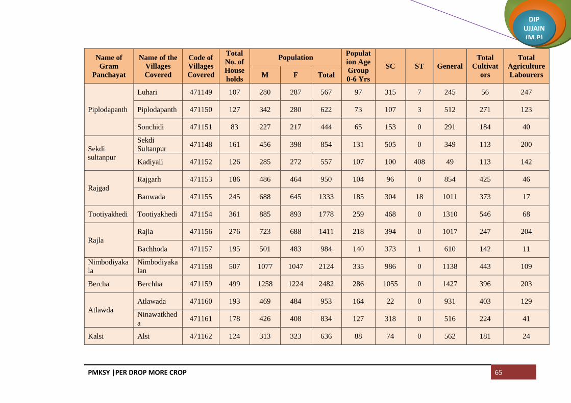
PMKSY |PER DROP MORE CROP 65
DIP UJJAIN (M.P)
Name of
Gram
Panchayat
Name of the
Villages
Covered
Code of
Villages
Covered
Total
No. of
House
holds
Population Populat
ion Age
Group
0-6 Yrs
SC ST General
Total
Cultivat
ors
Total
Agriculture
Labourers M F Total
Piplodapanth
Luhari 471149 107 280 287 567 97 315 7 245 56 247
Piplodapanth 471150 127 342 280 622 73 107 3 512 271 123
Sonchidi 471151 83 227 217 444 65 153 0 291 184 40
Sekdi
sultanpur
Sekdi
Sultanpur 471148 161 456 398 854 131 505 0 349 113 200
Kadiyali 471152 126 285 272 557 107 100 408 49 113 142
Rajgad
Rajgarh 471153 186 486 464 950 104 96 0 854 425 46
Banwada 471155 245 688 645 1333 185 304 18 1011 373 17
Tootiyakhedi Tootiyakhedi 471154 361 885 893 1778 259 468 0 1310 546 68
Rajla
Rajla 471156 276 723 688 1411 218 394 0 1017 247 204
Bachhoda 471157 195 501 483 984 140 373 1 610 142 11
Nimbodiyaka
la
Nimbodiyaka
lan 471158 507 1077 1047 2124 335 986 0 1138 443 109
Bercha Berchha 471159 499 1258 1224 2482 286 1055 0 1427 396 203
Atlawda
Atlawada 471160 193 469 484 953 164 22 0 931 403 129
Ninawatkhed
a 471161 178 426 408 834 127 318 0 516 224 41
Kalsi Alsi 471162 124 313 323 636 88 74 0 562 181 24

PMKSY |PER DROP MORE CROP 66
DIP UJJAIN (M.P)
Name of
Gram
Panchayat
Name of the
Villages
Covered
Code of
Villages
Covered
Total
No. of
House
holds
Population Populat
ion Age
Group
0-6 Yrs
SC ST General
Total
Cultivat
ors
Total
Agriculture
Labourers M F Total
Kalsi 471163 247 609 563 1172 167 139 0 1033 309 23
Parmarkhedi
Kilodiya 471164 169 439 426 865 137 86 0 779 195 18
Parmarkhedi 471165 177 421 416 837 112 194 0 643 147 30
Bhagatpuri 471166 197 500 440 940 128 266 319 355 31 6
Nipanya
Nipanya 471167 155 384 406 790 120 22 0 768 208 168
Geedgarh 471168 153 342 344 686 133 148 0 538 103 0
Hebatpur
Bhimpura 471169 155 400 338 738 126 371 120 247 9 0
Rohal Kalan
Rohal Kalan 471170 204 533 509 1042 168 342 0 700 204 92
Jalodiya
Khacharod 471175 216 514 483 997 105 247 0 750 354 147
Jhanjhakhedi
Jhanjhakhedi 471171 251 558 552 1110 234 789 2 319 170 1
Khajuriya 471172 130 318 326 644 96 220 0 424 203 5
Ratanyakhedi
Ratanyakhedi 471173 188 458 427 885 127 455 0 430 94 139
Banbani 471184 147 385 337 722 125 573 0 149 56 40
Rohalkhurd Rohalkhurd 471174 594 1649 1572 3221 478 839 45 2337 571 411
Akyakoli Kachnariya 471176 153 411 410 821 129 340 0 481 67 0

PMKSY |PER DROP MORE CROP 67
DIP UJJAIN (M.P)
Name of
Gram
Panchayat
Name of the
Villages
Covered
Code of
Villages
Covered
Total
No. of
House
holds
Population Populat
ion Age
Group
0-6 Yrs
SC ST General
Total
Cultivat
ors
Total
Agriculture
Labourers M F Total
Akyakoli 471177 225 613 599 1212 171 557 229 426 427 191
Heedi Heedi 471178 328 882 823 1705 247 551 0 1154 754 228
Antraliya
Kiradiya 471179 83 246 212 458 61 192 0 266 79 85
Antraliya 471180 167 433 447 880 155 209 0 671 148 7
Punakheda 471205 109 287 269 556 67 15 0 541 148 21
Borkheda
Pitramal
Borkheda
Pitramal 471181 335 847 844 1691 260 502 0 1189 518 233
Rupeta Rupeta 471182 872 2237 2141 4378 693 2434 6 1938 688 668
Banbana Banbana 471183 441 1165 1072 2237 344 871 7 1359 314 274
Takrawada Takrawada 471185 256 615 612 1227 203 920 5 302 85 83
Azimabad
Pardhi
Azimabad
Pardhi 471186 342 867 855 1722 288 1479 1 242 127 138
Amlawad
Junnardar
Amlawad
Junnardar 471187 385 778 757 1535 213 909 0 626 69 28
Lasudiya
Jaisingh 471188 183 424 407 831 146 466 0 365 328 161
Nayan Nayan 471189 482 1152 1116 2268 316 975 106 1187 229 329
Bhatisuda Bhatisuda 471190 395 954 905 1859 260 724 4 1131 270 374
Bhilsuda Bhilsuda 471191 363 850 789 1639 336 904 625 110 316 46
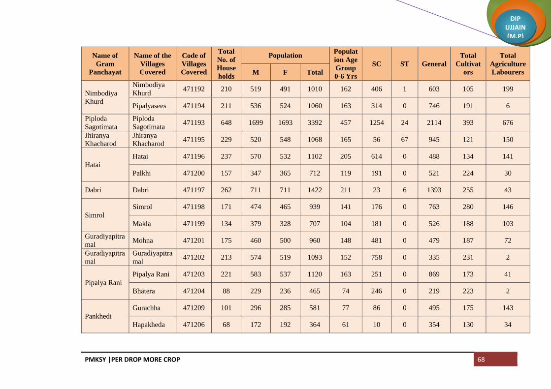
PMKSY |PER DROP MORE CROP 68
DIP UJJAIN (M.P)
Name of
Gram
Panchayat
Name of the
Villages
Covered
Code of
Villages
Covered
Total
No. of
House
holds
Population Populat
ion Age
Group
0-6 Yrs
SC ST General
Total
Cultivat
ors
Total
Agriculture
Labourers M F Total
Nimbodiya
Khurd
Nimbodiya
Khurd 471192 210 519 491 1010 162 406 1 603 105 199
Pipalyasees 471194 211 536 524 1060 163 314 0 746 191 6
Piploda
Sagotimata
Piploda
Sagotimata 471193 648 1699 1693 3392 457 1254 24 2114 393 676
Jhiranya
Khacharod
Jhiranya
Khacharod 471195 229 520 548 1068 165 56 67 945 121 150
Hatai
Hatai 471196 237 570 532 1102 205 614 0 488 134 141
Palkhi 471200 157 347 365 712 119 191 0 521 224 30
Dabri Dabri 471197 262 711 711 1422 211 23 6 1393 255 43
Simrol
Simrol 471198 171 474 465 939 141 176 0 763 280 146
Makla 471199 134 379 328 707 104 181 0 526 188 103
Guradiyapitra
mal Mohna 471201 175 460 500 960 148 481 0 479 187 72
Guradiyapitra
mal
Guradiyapitra
mal 471202 213 574 519 1093 152 758 0 335 231 2
Pipalya Rani
Pipalya Rani 471203 221 583 537 1120 163 251 0 869 173 41
Bhatera 471204 88 229 236 465 74 246 0 219 223 2
Pankhedi
Gurachha 471209 101 296 285 581 77 86 0 495 175 143
Hapakheda 471206 68 172 192 364 61 10 0 354 130 34

PMKSY |PER DROP MORE CROP 69
DIP UJJAIN (M.P)
Name of
Gram
Panchayat
Name of the
Villages
Covered
Code of
Villages
Covered
Total
No. of
House
holds
Population Populat
ion Age
Group
0-6 Yrs
SC ST General
Total
Cultivat
ors
Total
Agriculture
Labourers M F Total
Pankhedi 471207 66 216 209 425 63 51 2 372 206 22
Mundla 471211 109 300 307 607 82 219 0 388 235 115
Barkheda
Madan
Barkheda
Madan 471208 212 577 545 1122 196 449 2 671 419 42
Matra 471226 66 199 213 412 58 182 0 230 57 112
Guradiya
Sanga
Raiyapur 471210 91 180 191 371 65 79 0 292 66 60
Umariya 471212 179 330 328 658 106 331 0 327 188 152
Guradiya
Sanga 471213 311 794 726 1520 242 391 0 1129 246 173
Alot Jagir Alot Jagir 471214 329 877 854 1731 243 229 0 1502 530 318
Pipalya
Sarang
Chidi
Rawadiya 471215 82 246 237 483 60 133 0 350 175 0
Pipalya
Sarang 471217 92 260 233 493 64 172 0 321 242 110
Itawa 471249 136 368 337 705 94 397 0 308 135 280
Sarwana
Unhel
Sarwana
Unhel 471218 272 716 699 1415 208 689 0 726 341 46
Arolya
Dewda 471220 109 258 250 508 68 119 0 389 240 0
Jhiranya
Unhel
Jhiranya
Unhel 471219 100 265 278 543 70 138 0 405 189 97
Parolya
Padma 471221 106 269 265 534 74 134 0 400 153 0

PMKSY |PER DROP MORE CROP 70
DIP UJJAIN (M.P)
Name of
Gram
Panchayat
Name of the
Villages
Covered
Code of
Villages
Covered
Total
No. of
House
holds
Population Populat
ion Age
Group
0-6 Yrs
SC ST General
Total
Cultivat
ors
Total
Agriculture
Labourers M F Total
Jalodiya
Unhel
Rathda 471222 72 187 177 364 61 202 0 162 47 18
Jalodiya
Unhel 471223 111 298 294 592 99 62 0 530 219 8
KhimLacsedi 471224 87 241 206 447 76 103 0 344 151 39
Dallaheda
Dallaheda 471229 174 395 381 776 104 385 0 391 131 27
Mahu 471225 118 319 300 619 79 200 0 419 138 114
Dhoomaheda
Madhavgarh 471227 59 118 137 255 45 6 0 249 5 71
Dhoomaheda 471228 275 636 607 1243 200 599 0 644 107 387
Pipalya Molu Pipalya Molu 471230 274 634 623 1257 219 36 0 1221 147 47
Kundla
Bhakarda 471231 206 419 381 800 118 293 0 507 126 110
Kundla 471233 221 506 451 957 151 303 0 654 66 27
Bagla
Bagla 471232 139 334 322 656 122 7 0 649 84 0
Nagjhiri 471235 278 681 704 1385 268 282 0 1103 505 174
Chambal
Padlaya
Chambal
Padlaya 471234 361 864 806 1670 255 834 4 832 192 182
Barkheda
Najeek
Barkheda
Najeek 471236 285 671 674 1345 238 404 0 941 93 63
Chawand Chawand 471237 123 336 350 686 122 41 0 645 240 46

PMKSY |PER DROP MORE CROP 71
DIP UJJAIN (M.P)
Name of
Gram
Panchayat
Name of the
Villages
Covered
Code of
Villages
Covered
Total
No. of
House
holds
Population Populat
ion Age
Group
0-6 Yrs
SC ST General
Total
Cultivat
ors
Total
Agriculture
Labourers M F Total
Rajota 471238 115 291 306 597 89 208 0 389 224 98
Lekodiya
Anjana
Lekodiya
Anjana 471239 489 1205 1154 2359 333 820 33 1506 368 247
Paslod
Kalalkhedi 471240 209 513 506 1019 167 357 148 514 324 7
Paslod 471241 554 1495 1439 2934 461 954 28 1952 385 501
Akya Najik Akya Najik 471242 238 598 644 1242 222 486 0 756 315 340
Nawada Nawada 471243 334 884 951 1835 325 810 0 1025 204 79
Malikhedi
Chinkuganj 471244 119 284 297 581 104 146 0 435 90 68
Malikhedi 471245 371 989 896 1885 441 1354 3 528 192 346
Kankarda 471246 89 244 226 470 68 243 0 227 110 79
Bedawan Bedawan 471247 527 1337 1392 2729 287 290 0 2439 1178 307
Pagara
Didiyakhedi 471248 99 266 272 538 71 170 0 368 87 23
Baijnathkhed
i 471250 83 229 246 475 79 215 0 260 84 28
Pagara 471251 78 211 204 415 56 83 6 326 79 28
Roopakhedi 471253 148 390 362 752 118 151 0 601 270 60
Pipliyadhabi Pipalya Dabi 471252 337 831 795 1626 248 573 3 1050 244 312

PMKSY |PER DROP MORE CROP 72
DIP UJJAIN (M.P)
Name of
Gram
Panchayat
Name of the
Villages
Covered
Code of
Villages
Covered
Total
No. of
House
holds
Population Populat
ion Age
Group
0-6 Yrs
SC ST General
Total
Cultivat
ors
Total
Agriculture
Labourers M F Total
Surjakhedi
Surjakhedi 471254 195 479 479 958 166 111 0 847 233 369
Jiyajigarh 471260 83 243 235 478 77 252 47 179 142 8
Gurla Gurla 471256 321 881 820 1701 252 850 3 848 286 235
Karondiya
Lasudiyachu
wad 471255 155 373 335 708 73 294 0 414 145 325
Karondiya 471257 160 370 352 722 94 282 0 440 189 29
Rambaloda Ramabaloda 471258 342 896 862 1758 309 423 73 1262 517 133
Khokri
Khokri 471259 227 670 652 1322 246 369 460 493 195 154
Arolyajassa 471261 113 251 291 542 85 228 0 314 91 66
Urban Khacharod
(M) 802224 6239 17351 16840 34191 4149 3834 1333 29024 2472 735
Urban Nagda (M) 802225 20177 51373 48666 100039 11487 20020 1562 78457 368 429
Urban Unhel (NP) 802226 2582 7506 7268 14774 1886 1828 96 12850 1582 1261
Total 78600 202411 195045 397456 54932 112733 10830 273893 61813 32985

PMKSY |PER DROP MORE CROP 73
DIP UJJAIN (M.P)
Block: Badnagar
Name of
Gram
Panchayat
Name of
Villages
Covered
Code of
the
Villages
Covered
Total
No. of
House
holds
Population Populat
ion Age
Group
0-6 Yrs
SC ST General
Total
Cultivat
ors
Total
Agriculture
Labourers M F Total
Bhatpachlana Bhatpachlana 471955 1097 2896 2718 5614 761 1164 440 4010 581 540
Maloda Maloda 471956 304 818 752 1570 226 280 82 1208 364 7
Banbani
Banbani 471957 247 485 493 978 156 177 293 508 508 42
Bhunwasa 471958 131 402 395 797 105 127 59 611 413 14
Kajyakhedi 471959 56 148 163 311 41 44 42 225 144 40
Banderbela Banderbela 471960 235 662 633 1295 147 305 5 985 340 305
Limbas Limbas 471961 245 698 658 1356 183 491 122 743 422 148
Chirola
Chirola 471962 702 1938 1780 3718 502 673 58 2987 1111 548
Rathorkhedi 471968 103 285 235 520 77 193 0 327 191 97
Salwa Salwa 471963 306 863 864 1727 252 474 22 1231 335 141
Mungawada
Lasudiya 471964 78 206 199 405 59 269 0 136 89 58
Mungawada 471965 72 218 189 407 43 58 0 349 204 5
Karadwas 471969 92 194 182 376 64 100 0 276 83 11
Silodiya Mungawadi 471966 69 175 188 363 44 0 0 363 186 8

PMKSY |PER DROP MORE CROP 74
DIP UJJAIN (M.P)
Name of
Gram
Panchayat
Name of
Villages
Covered
Code of
the
Villages
Covered
Total
No. of
House
holds
Population Populat
ion Age
Group
0-6 Yrs
SC ST General
Total
Cultivat
ors
Total
Agriculture
Labourers M F Total
Silodiya 471967 208 620 545 1165 200 565 1 599 349 179
Amlawadkala
n
Dehta 471970 109 353 350 703 111 60 0 643 122 48
Kesharpura 471971 76 200 198 398 63 183 0 215 78 36
Amlawadkala
n 471972 200 486 476 962 133 138 17 807 249 46
Balodahasan
Mahudikhem
a 471973 79 197 193 390 51 116 0 274 125 72
Balodahasan 471974 103 287 288 575 86 141 10 424 138 132
Gaondidevsi 471977 115 294 267 561 63 52 12 497 206 96
Dunalja Dunalja 471975 250 727 682 1409 252 449 0 960 316 108
Udsinga
Paduniyakhet
a 471976 36 90 68 158 26 8 0 150 98 3
Udsinga 471978 277 713 632 1345 187 535 3 807 465 176
Kalyanpura
Kalyanpura 471979 222 660 622 1282 230 682 1 599 291 348
Kamanpur 472007 143 458 417 875 133 239 3 633 282 194
Mundat
Khedanaraya
n 471980 82 228 214 442 80 147 6 289 61 103
Mundat 471981 208 571 525 1096 157 473 9 614 166 187
Khandoda Khandoda 471982 234 622 615 1237 198 456 2 779 458 181

PMKSY |PER DROP MORE CROP 75
DIP UJJAIN (M.P)
Name of
Gram
Panchayat
Name of
Villages
Covered
Code of
the
Villages
Covered
Total
No. of
House
holds
Population Populat
ion Age
Group
0-6 Yrs
SC ST General
Total
Cultivat
ors
Total
Agriculture
Labourers M F Total
Simlawada 471983 120 329 330 659 104 124 11 524 221 114
Harnawada Harnawada 471984 208 577 591 1168 175 549 0 619 238 85
Onkarpura
Labaycha 471985 73 216 215 431 69 128 0 303 85 80
Semalkhedi 471986 32 73 64 137 24 24 0 113 53 12
Gurawada 471987 50 142 131 273 43 0 0 273 71 4
Onkarpura 471988 137 402 380 782 123 130 2 650 121 279
Sijawata Sijawata 471989 337 934 885 1819 287 545 6 1268 282 178
Gaondilodha Gaondilodha 471990 245 608 613 1221 195 875 14 332 194 348
Dhureri
Dhureri 471991 201 555 503 1058 119 227 59 772 157 70
Rajota 471992 167 414 404 818 145 816 1 1 40 385
Suneda
Suneda 471993 157 445 399 844 110 464 0 380 166 91
Chinchodiya 471994 82 246 246 492 84 0 0 492 203 24
Kiloli
Kiloli 471995 199 487 439 926 138 421 234 271 105 307
Namalpur 472096 75 180 177 357 48 94 34 229 103 45
Kharsodkhur
d
Kharsodkhur
d 471996 965 2518 2428 4946 643 1318 891 2737 923 743

PMKSY |PER DROP MORE CROP 76
DIP UJJAIN (M.P)
Name of
Gram
Panchayat
Name of
Villages
Covered
Code of
the
Villages
Covered
Total
No. of
House
holds
Population Populat
ion Age
Group
0-6 Yrs
SC ST General
Total
Cultivat
ors
Total
Agriculture
Labourers M F Total
Untwas Untwas 471997 343 773 751 1524 192 220 265 1039 227 339
Ranwa
Hatyakhedi 471998 62 159 173 332 54 149 16 167 82 71
Ranwa 471999 231 588 563 1151 185 455 0 696 238 352
Dantarwa
Dantarwa 472000 142 387 356 743 88 192 5 546 156 42
Rasulabad 472001 174 444 393 837 126 115 543 179 69 193
Molana Molana 472002 498 1349 1288 2637 332 586 1031 1020 547 636
Palwa Palwa 472003 326 862 827 1689 258 156 0 1533 484 249
Sanawada
Itawa 472004 183 462 449 911 116 257 11 643 222 163
Sanawada 472005 178 484 470 954 144 412 12 530 113 28
Rawadiyapee
r
Rawadiyapee
r 472006 221 507 495 1002 135 437 68 497 232 131
Mindka 472008 166 415 395 810 142 142 0 668 184 96
Balodakoran Balodakoran 472009 379 1074 1007 2081 316 147 128 1806 316 164
Ajdawada Ajdawada 472010 353 1012 991 2003 288 297 30 1676 603 252
Kharsodkalan Kharsodkalan 472011 1483 3943 3731 7674 1068 1523 68 6083 1381 1494
Ordi Ordi 472012 269 712 678 1390 222 639 1 750 471 231

PMKSY |PER DROP MORE CROP 77
DIP UJJAIN (M.P)
Name of
Gram
Panchayat
Name of
Villages
Covered
Code of
the
Villages
Covered
Total
No. of
House
holds
Population Populat
ion Age
Group
0-6 Yrs
SC ST General
Total
Cultivat
ors
Total
Agriculture
Labourers M F Total
NareLacsurd 472013 29 61 65 126 29 53 17 56 26 50
Bardiya Bardiya 472014 469 1049 1091 2140 354 350 56 1734 627 491
Nauganwa Nauganwa 472015 192 566 580 1146 146 83 9 1054 315 131
Khedawada
Khedawada 472016 599 1610 1574 3184 418 390 372 2422 868 414
Malgaondi 472017 131 327 344 671 89 248 223 200 100 88
Badganwa Badganwa 472018 361 952 964 1916 261 89 321 1506 669 315
Gajnikhedi
Maswadiyad
har 472019 158 476 450 926 113 146 327 453 253 290
Gajnikhedi 472020 382 1046 1004 2050 234 202 279 1569 564 328
Runija Runija 472021 512 1396 1264 2660 326 374 531 1755 277 288
Madhopura Madhopura 472022 565 1732 1653 3385 540 150 151 3084 710 383
BalodaLacsa BalodaLacsa 472024 702 1951 1777 3728 495 630 155 2943 954 667
Sundrabad Sundrabad 472025 322 793 789 1582 227 386 26 1170 405 255
Jalodsanjar Jalodsanjar 472026 307 812 839 1651 291 109 255 1287 521 317
Pachlanabil
Pachlanabil 472027 200 581 486 1067 176 312 0 755 336 111
Singawada 472028 74 224 194 418 63 195 0 223 124 83

PMKSY |PER DROP MORE CROP 78
DIP UJJAIN (M.P)
Name of
Gram
Panchayat
Name of
Villages
Covered
Code of
the
Villages
Covered
Total
No. of
House
holds
Population Populat
ion Age
Group
0-6 Yrs
SC ST General
Total
Cultivat
ors
Total
Agriculture
Labourers M F Total
Bidsingawad
a 472029 7 21 22 43 7 6 0 37 13 3
Meethikhedi 472030 96 252 227 479 69 199 2 278 87 159
Pitlawadiya
Pitlawadiya 472031 175 482 458 940 121 121 167 652 153 96
Tokra 472034 147 403 354 757 106 107 110 540 219 59
Birakhedi
Ranawada 472032 105 286 305 591 72 118 21 452 59 25
Birakhedi 472033 306 848 806 1654 265 260 79 1315 499 265
Jassakhedi
Balodaarsi 472035 126 286 284 570 92 138 139 293 73 76
Jassakhedi 472036 173 456 469 925 109 170 145 610 244 198
Jandla
Semaliya 472037 76 208 239 447 66 115 5 327 94 50
Jandla 472038 191 667 659 1326 204 38 168 1120 410 288
Garakhedi 472039 15 53 58 111 26 0 27 84 45 8
Peethakhedi 472040 21 54 45 99 11 0 0 99 46 0
Paduniyalodh
a 472041 41 118 103 221 31 21 147 53 28 66
Beesaheda
Beesaheda 472042 177 474 431 905 122 222 211 472 197 29
Kajlana 472043 125 399 358 757 102 160 213 384 71 120
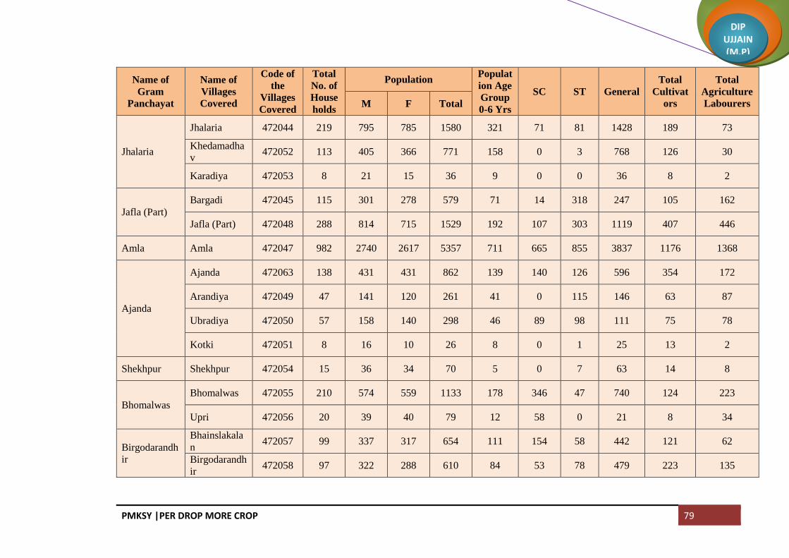
PMKSY |PER DROP MORE CROP 79
DIP UJJAIN (M.P)
Name of
Gram
Panchayat
Name of
Villages
Covered
Code of
the
Villages
Covered
Total
No. of
House
holds
Population Populat
ion Age
Group
0-6 Yrs
SC ST General
Total
Cultivat
ors
Total
Agriculture
Labourers M F Total
Jhalaria
Jhalaria 472044 219 795 785 1580 321 71 81 1428 189 73
Khedamadha
v 472052 113 405 366 771 158 0 3 768 126 30
Karadiya 472053 8 21 15 36 9 0 0 36 8 2
Jafla (Part)
Bargadi 472045 115 301 278 579 71 14 318 247 105 162
Jafla (Part) 472048 288 814 715 1529 192 107 303 1119 407 446
Amla Amla 472047 982 2740 2617 5357 711 665 855 3837 1176 1368
Ajanda
Ajanda 472063 138 431 431 862 139 140 126 596 354 172
Arandiya 472049 47 141 120 261 41 0 115 146 63 87
Ubradiya 472050 57 158 140 298 46 89 98 111 75 78
Kotki 472051 8 16 10 26 8 0 1 25 13 2
Shekhpur Shekhpur 472054 15 36 34 70 5 0 7 63 14 8
Bhomalwas
Bhomalwas 472055 210 574 559 1133 178 346 47 740 124 223
Upri 472056 20 39 40 79 12 58 0 21 8 34
Birgodarandh
ir
Bhainslakala
n 472057 99 337 317 654 111 154 58 442 121 62
Birgodarandh
ir 472058 97 322 288 610 84 53 78 479 223 135

PMKSY |PER DROP MORE CROP 80
DIP UJJAIN (M.P)
Name of
Gram
Panchayat
Name of
Villages
Covered
Code of
the
Villages
Covered
Total
No. of
House
holds
Population Populat
ion Age
Group
0-6 Yrs
SC ST General
Total
Cultivat
ors
Total
Agriculture
Labourers M F Total
Umariya Umariya 472059 336 1172 1172 2344 407 8 5 2331 715 228
Khandwasura
Khandwasura 472064 189 496 456 952 127 247 33 672 167 262
Likhoda 472060 192 546 487 1033 193 211 0 822 121 45
Jalodiya Jalodiya 472061 339 989 938 1927 259 346 21 1560 327 153
Bhidawad
Bhidawad 472068 363 965 951 1916 264 528 97 1291 660 369
Lohariya 472062 177 520 497 1017 145 269 294 454 364 261
Sarola
Sarola 472065 137 418 408 826 134 113 0 713 205 137
Dhaturiya 472066 118 366 362 728 100 180 7 541 231 191
Mundla 472067 123 304 336 640 100 143 16 481 231 84
Suklana
Rawadiyakal
an 472069 191 496 465 961 132 97 384 480 279 282
Suklana 472070 175 453 451 904 152 189 44 671 255 104
Lohana Lohana 472071 592 1512 1423 2935 368 597 350 1988 708 466
Khandwabibi
Kungara 472072 153 405 381 786 108 160 112 514 180 214
Khandwabibi 472073 172 411 431 842 150 224 86 532 208 191
Satwasa 472074 98 240 267 507 63 44 0 463 207 58
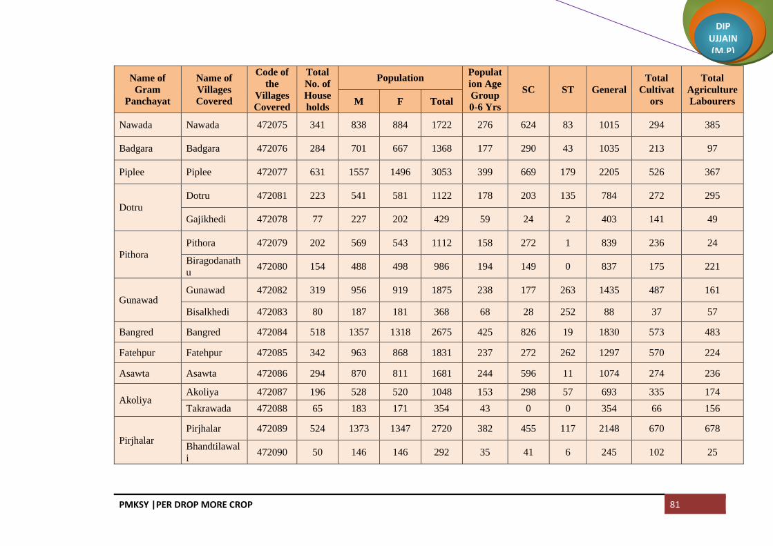
PMKSY |PER DROP MORE CROP 81
DIP UJJAIN (M.P)
Name of
Gram
Panchayat
Name of
Villages
Covered
Code of
the
Villages
Covered
Total
No. of
House
holds
Population Populat
ion Age
Group
0-6 Yrs
SC ST General
Total
Cultivat
ors
Total
Agriculture
Labourers M F Total
Nawada Nawada 472075 341 838 884 1722 276 624 83 1015 294 385
Badgara Badgara 472076 284 701 667 1368 177 290 43 1035 213 97
Piplee Piplee 472077 631 1557 1496 3053 399 669 179 2205 526 367
Dotru
Dotru 472081 223 541 581 1122 178 203 135 784 272 295
Gajikhedi 472078 77 227 202 429 59 24 2 403 141 49
Pithora
Pithora 472079 202 569 543 1112 158 272 1 839 236 24
Biragodanath
u 472080 154 488 498 986 194 149 0 837 175 221
Gunawad Gunawad 472082 319 956 919 1875 238 177 263 1435 487 161
Bisalkhedi 472083 80 187 181 368 68 28 252 88 37 57
Bangred Bangred 472084 518 1357 1318 2675 425 826 19 1830 573 483
Fatehpur Fatehpur 472085 342 963 868 1831 237 272 262 1297 570 224
Asawta Asawta 472086 294 870 811 1681 244 596 11 1074 274 236
Akoliya Akoliya 472087 196 528 520 1048 153 298 57 693 335 174
Takrawada 472088 65 183 171 354 43 0 0 354 66 156
Pirjhalar
Pirjhalar 472089 524 1373 1347 2720 382 455 117 2148 670 678
Bhandtilawal
i 472090 50 146 146 292 35 41 6 245 102 25

PMKSY |PER DROP MORE CROP 82
DIP UJJAIN (M.P)
Name of
Gram
Panchayat
Name of
Villages
Covered
Code of
the
Villages
Covered
Total
No. of
House
holds
Population Populat
ion Age
Group
0-6 Yrs
SC ST General
Total
Cultivat
ors
Total
Agriculture
Labourers M F Total
Daulatpur
Daulatpur 472091 117 333 307 640 76 79 21 540 128 39
Sohad 472092 122 309 297 606 68 260 36 310 100 121
Pacholi 472093 35 111 96 207 24 0 0 207 73 70
Dautardi 472094 62 186 180 366 63 49 49 268 47 35
Palduna Palduna 472095 535 1469 1397 2866 406 967 17 1882 907 715
Lacsesara
Maswadiyak
halsa 472097 144 420 398 818 90 272 0 546 259 229
Lacsesara 472098 205 607 581 1188 148 410 19 759 378 180
Narsinga Paslod 472099 166 410 416 826 118 364 0 462 160 177
Narsinga 472100 312 877 857 1734 218 289 8 1437 524 244
Dangwada Dangwada 472101 644 1672 1626 3298 414 669 203 2426 901 751
Baledi Baledi 472102 790 2184 2069 4253 587 1149 16 3088 819 766
Ghudawan
Ghudawan 472103 223 611 594 1205 184 297 7 901 254 213
Bhainsla
Khurd 472104 180 532 483 1015 150 507 54 454 193 223
Sarsana Sarsana 472105 235 628 609 1237 172 322 3 912 133 218
Jhumki
Jhumki 472109 176 463 474 937 146 550 0 387 260 188
Dharankhedi 472106 52 148 123 271 43 35 0 236 98 12

PMKSY |PER DROP MORE CROP 83
DIP UJJAIN (M.P)
Name of
Gram
Panchayat
Name of
Villages
Covered
Code of
the
Villages
Covered
Total
No. of
House
holds
Population Populat
ion Age
Group
0-6 Yrs
SC ST General
Total
Cultivat
ors
Total
Agriculture
Labourers M F Total
Patyakhedi
Karanpura 472107 91 204 197 401 57 249 0 152 69 65
Patyakhedi 472108 201 490 469 959 151 634 1 324 156 249
Jahangirpur Jahangirpur 472110 804 2188 2149 4337 696 1085 103 3149 667 724
Amlawadbika
Amlawadbik
a 472111 263 550 539 1089 168 156 0 933 297 330
MoLacsedi 472112 166 336 318 654 117 116 0 538 131 34
Malpura Malpura 472113 222 637 645 1282 212 244 215 823 349 264
Murarkhedi 472114 89 285 286 571 79 84 0 487 204 41
Palsoda Jamalpura 472115 169 442 419 861 140 285 0 576 155 230
Palsoda 472116 474 1148 1195 2343 376 1016 16 1311 405 695
Makdawan Makdawan 472117 390 1066 1027 2093 273 512 170 1411 621 320
Mahudialam Mahudialam 472118 149 406 371 777 107 335 51 391 212 166
Banbana 472120 99 302 286 588 103 198 114 276 103 101
Suwasa Suwasa 472119 605 1721 1616 3337 429 774 506 2057 1051 715
Kanjad Kanjad 472121 328 1096 1052 2148 375 246 28 1874 667 252
Aslawada Aslawada 472122 386 919 855 1774 289 663 22 1089 263 56
Kothdi Kothdi 472123 177 511 502 1013 148 374 2 637 146 121

PMKSY |PER DROP MORE CROP 84
DIP UJJAIN (M.P)
Name of
Gram
Panchayat
Name of
Villages
Covered
Code of
the
Villages
Covered
Total
No. of
House
holds
Population Populat
ion Age
Group
0-6 Yrs
SC ST General
Total
Cultivat
ors
Total
Agriculture
Labourers M F Total
Banya Khedi 472124 123 330 301 631 67 257 0 374 66 57
Kantharkhedi 472125 129 435 417 852 133 145 0 707 126 88
Narelakalan
Narelakalan 472126 169 351 326 677 119 439 2 236 50 40
Kalmoda 472127 97 374 347 721 140 166 0 555 161 8
Gulabkhedi 472128 71 188 168 356 36 55 34 267 151 6
Rupaheda
Sikandarkhed
a 472129 141 402 373 775 110 387 53 335 138 226
Rupaheda 472130 191 504 492 996 134 294 0 702 204 75
Maniyawada
Maniyawada 472131 189 518 539 1057 143 330 0 727 233 204
Surakhedi 472134 112 271 260 531 69 107 0 424 47 2
Bamnapati Bamnapati 472132 272 676 704 1380 221 422 8 950 273 276
Khadotiya
Khadotiya 472133 196 509 489 998 153 392 0 606 147 30
Chhankhedi 472138 101 235 244 479 68 413 0 66 58 183
Kulawada
Matangna 472135 180 484 468 952 164 368 0 584 204 52
Kulawada 472136 153 464 439 903 137 237 0 666 287 56
Ingoriya Ingoriya 472137 721 1926 1829 3755 497 1000 26 2729 455 547

PMKSY |PER DROP MORE CROP 85
DIP UJJAIN (M.P)
Name of
Gram
Panchayat
Name of
Villages
Covered
Code of
the
Villages
Covered
Total
No. of
House
holds
Population Populat
ion Age
Group
0-6 Yrs
SC ST General
Total
Cultivat
ors
Total
Agriculture
Labourers M F Total
Cheekali Cheekali 472139 504 1445 1401 2846 388 573 41 2232 485 493
Kadhai
Kadhai 472140 201 522 501 1023 161 459 1 563 341 140
Bhondwas 472142 82 226 212 438 64 224 8 206 104 79
Ghadsinga
Ghadsinga 472141 197 581 584 1165 177 460 0 705 406 219
Brahmanbad
oda 472143 59 168 164 332 45 169 0 163 93 56
Nimboda
Naharkhedi 472144 77 197 171 368 35 139 72 157 131 69
Nimboda 472145 215 604 624 1228 142 105 49 1074 373 226
Urban Badnagar (M
+ OG) 802231 6452 18733 17705 36438 4506 3419 1126 31893 1147 802
Total 50233 137685 131888 269573 38158 59160 16823 193590 54894 38769

PMKSY |PER DROP MORE CROP 86
DIP UJJAIN (M.P)
Block: Mahidpur
Name of
Gram
Panchayat
Name of the
Villages
Covered
Code of
Villages
Covered
Total
No. of
House
holds
Population Popula
tion
Age
Group
0-6
Yrs
SC ST General
Total
Cultivat
ors
Total
Agriculture
Labourers M F Total
Brahmankhe
da
Brahmankhe
da 471262 349 843 767 1610 244 760 4 846 182 100
Petlawad Petlawad 471263 277 807 765 1572 246 483 176 913 279 209
Koyal
Deoli 471264 169 417 399 816 146 414 3 399 17 147
Koyal 471265 273 713 610 1323 185 503 0 820 206 33
Bapaiya Bapaiya 471266 406 1030 983 2013 295 726 0 1287 428 76
Kanakedi
Eklaspur
Kanakedi
Eklaspur 471267 147 414 387 801 130 267 120 414 95 157
Karnawad 471268 165 486 478 964 207 247 0 717 224 263
Bawalya
Bawalya 471287 124 372 336 708 95 99 0 609 424 5
Chibdi 471288 78 232 198 430 63 21 0 409 106 16
Serankhedi 471269 58 146 163 309 53 103 0 206 86 3
Tarnod Tarnod 471270 314 932 863 1795 314 466 0 1329 606 66

PMKSY |PER DROP MORE CROP 87
DIP UJJAIN (M.P)
Name of
Gram
Panchayat
Name of the
Villages
Covered
Code of
Villages
Covered
Total
No. of
House
holds
Population Popula
tion
Age
Group
0-6
Yrs
SC ST General
Total
Cultivat
ors
Total
Agriculture
Labourers M F Total
Barukhedi
Barukhedi 471273 174 452 393 845 112 222 0 623 342 103
Sarwankheda 471271 161 391 389 780 134 190 0 590 200 130
Isankhedi Isankhedi 471272 460 1134 1157 2291 459 485 0 1806 333 527
Narayankhed
i
Jharawada 471274 102 361 317 678 117 215 0 463 116 75
Narayankhed
i 471275 134 325 342 667 96 308 0 359 21 11
Delchibuzurg Delchibuzurg 471276 417 1103 1012 2115 336 701 1 1413 135 382
Banjari Banjari 471277 242 649 605 1254 191 300 0 954 309 119
Mundlaparwa
l
Mundlaparwa
l 471278 281 661 686 1347 277 121 0 1226 175 160
Chitawad
Chitawad 471279 294 770 716 1486 272 97 3 1386 234 484
Rudrakheda 471373 123 328 352 680 154 208 403 69 26 3
Parwatkheda
Parwatkheda 471280 242 568 577 1145 215 496 0 649 78 281
Dubli 471372 122 310 302 612 115 253 0 359 87 27
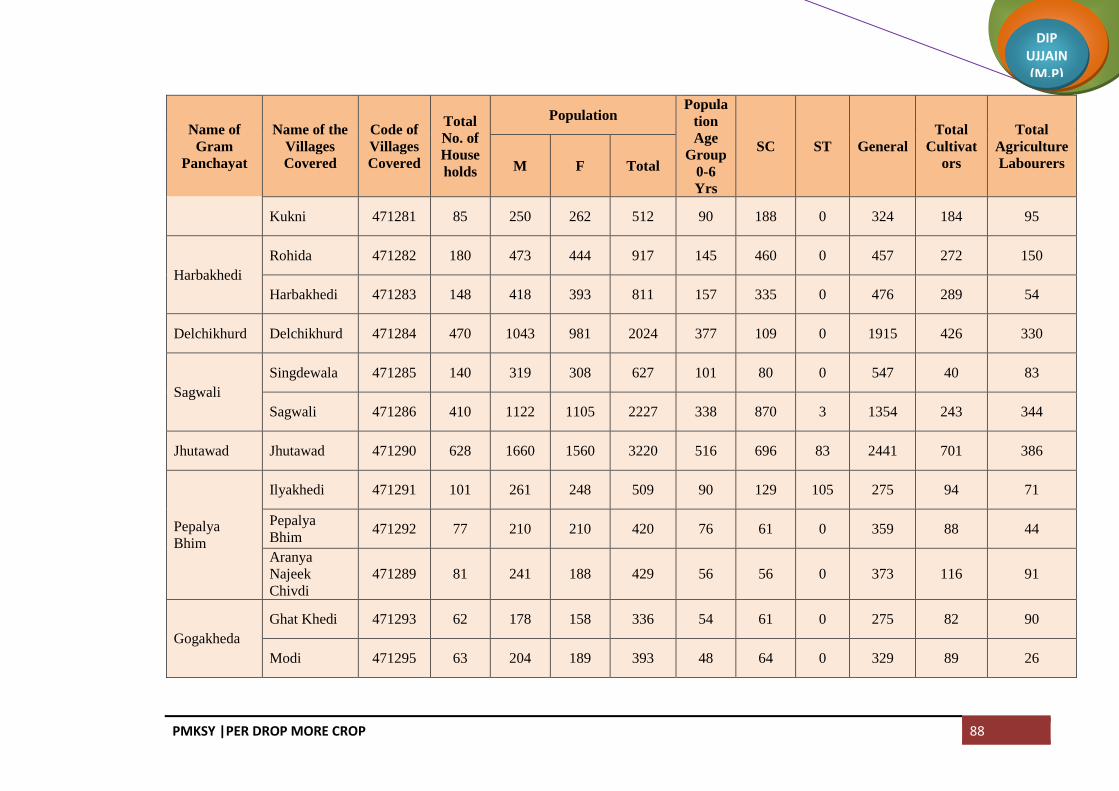
PMKSY |PER DROP MORE CROP 88
DIP UJJAIN (M.P)
Name of
Gram
Panchayat
Name of the
Villages
Covered
Code of
Villages
Covered
Total
No. of
House
holds
Population Popula
tion
Age
Group
0-6
Yrs
SC ST General
Total
Cultivat
ors
Total
Agriculture
Labourers M F Total
Kukni 471281 85 250 262 512 90 188 0 324 184 95
Harbakhedi
Rohida 471282 180 473 444 917 145 460 0 457 272 150
Harbakhedi 471283 148 418 393 811 157 335 0 476 289 54
Delchikhurd Delchikhurd 471284 470 1043 981 2024 377 109 0 1915 426 330
Sagwali
Singdewala 471285 140 319 308 627 101 80 0 547 40 83
Sagwali 471286 410 1122 1105 2227 338 870 3 1354 243 344
Jhutawad Jhutawad 471290 628 1660 1560 3220 516 696 83 2441 701 386
Pepalya
Bhim
Ilyakhedi 471291 101 261 248 509 90 129 105 275 94 71
Pepalya
Bhim 471292 77 210 210 420 76 61 0 359 88 44
Aranya
Najeek
Chivdi
471289 81 241 188 429 56 56 0 373 116 91
Gogakheda
Ghat Khedi 471293 62 178 158 336 54 61 0 275 82 90
Modi 471295 63 204 189 393 48 64 0 329 89 26

PMKSY |PER DROP MORE CROP 89
DIP UJJAIN (M.P)
Name of
Gram
Panchayat
Name of the
Villages
Covered
Code of
Villages
Covered
Total
No. of
House
holds
Population Popula
tion
Age
Group
0-6
Yrs
SC ST General
Total
Cultivat
ors
Total
Agriculture
Labourers M F Total
Gogakheda 471297 147 414 391 805 96 338 0 467 112 109
Ghatpeepalya
Aranyabena 471294 72 157 136 293 41 86 0 207 88 18
Ghatpeepalya 471310 233 527 496 1023 160 176 0 847 187 304
Dhablasiya
Dhablasiya 471304 324 627 614 1241 234 519 0 722 233 74
Munjakhedi 471296 146 407 440 847 128 329 0 518 172 0
Kanthariya
Kanthariya 471298 98 315 305 620 73 92 0 528 127 45
Barkhedakhu
rd 471299 112 302 259 561 97 205 0 356 136 138
Sipawara 471300 112 327 308 635 108 125 0 510 147 217
Semalya Semalya 471301 492 1277 1174 2451 386 590 0 1861 904 130
Bani
Bani 471302 190 632 605 1237 184 520 0 717 309 27
Rasulpura 471367 91 229 224 453 70 16 0 437 163 56
Nipaniyabada
r
Nipaniyabada
r 471355 208 609 587 1196 166 457 0 739 422 291

PMKSY |PER DROP MORE CROP 90
DIP UJJAIN (M.P)
Name of
Gram
Panchayat
Name of the
Villages
Covered
Code of
Villages
Covered
Total
No. of
House
holds
Population Popula
tion
Age
Group
0-6
Yrs
SC ST General
Total
Cultivat
ors
Total
Agriculture
Labourers M F Total
Katariya 471303 184 551 467 1018 145 267 0 751 445 73
Sumrakheda
Sanoriya 471305 108 305 267 572 87 125 0 447 208 80
Akyabajrang 471350 46 114 106 220 33 90 0 130 117 3
Sumrakheda 471351 171 423 375 798 132 414 0 384 24 457
Sakariya
Sukdi 471306 52 130 132 262 37 148 0 114 67 68
Sakariya 471346 165 453 434 887 104 167 0 720 123 1
Kanakhedi
Hamma 471344 115 333 275 608 91 53 0 555 164 18
Asadi
Aranyabagda 471307 160 371 354 725 92 311 0 414 50 261
Asadi 471308 217 547 533 1080 188 417 0 663 184 206
Bahadurpura 471309 89 219 216 435 69 132 0 303 62 5
Dungariya Dungariya 471311 231 591 587 1178 181 314 0 864 269 311
Ranayrapeer Ranayrapeer 471312 559 1432 1312 2744 406 1494 104 1146 390 425

PMKSY |PER DROP MORE CROP 91
DIP UJJAIN (M.P)
Name of
Gram
Panchayat
Name of the
Villages
Covered
Code of
Villages
Covered
Total
No. of
House
holds
Population Popula
tion
Age
Group
0-6
Yrs
SC ST General
Total
Cultivat
ors
Total
Agriculture
Labourers M F Total
MeLacsedi
Hajalyakhedi 471313 78 203 180 383 54 57 0 326 141 15
MeLacsedi 471314 142 296 302 598 102 123 7 468 248 8
Balah 471316 87 236 230 466 77 87 1 378 132 62
Shrawan
Borkhedi 471315 80 253 228 481 62 306 0 175 256 16
Shrawan 471319 217 611 586 1197 167 357 0 840 222 85
Ghatiyasaind
as
Ghatiyasaind
as 471317 278 665 649 1314 204 386 0 928 323 399
Bhadwa Bhadwa 471318 253 657 627 1284 209 353 0 931 589 192
Malya
Yashwantpur
a 471320 67 191 176 367 57 41 0 326 40 3
Malya 471321 245 645 600 1245 200 337 0 908 454 148
Tipukheda
Bolkhedaghat 471322 218 528 472 1000 140 132 0 868 79 8
Tipukheda 471323 212 433 439 872 142 57 0 815 187 73
Indokh Indokh 471324 422 1039 991 2030 349 354 117 1559 319 234

PMKSY |PER DROP MORE CROP 92
DIP UJJAIN (M.P)
Name of
Gram
Panchayat
Name of the
Villages
Covered
Code of
Villages
Covered
Total
No. of
House
holds
Population Popula
tion
Age
Group
0-6
Yrs
SC ST General
Total
Cultivat
ors
Total
Agriculture
Labourers M F Total
Mundlasondh
ya
Mundlasondh
ya 471325 364 925 881 1806 299 489 0 1317 409 143
Pipalya
Dhuma
Pipalya
Dhuma 471326 335 844 809 1653 275 698 0 955 351 327
Patakhedi
Sekli 471327 221 424 372 796 131 283 0 513 94 276
Patakhedi 471328 224 441 414 855 136 417 0 438 4 6
Bansingh
Bansingh 471329 354 856 786 1642 218 181 0 1461 513 2
Kachhaliyasa
iyad 471330 179 493 467 960 181 147 0 813 363 58
Mahudiya
Mahudiya 471333 153 440 441 881 127 422 0 459 146 89
Dhelwadi 471331 121 306 300 606 95 232 0 374 110 214
Lasudiyagoy
al
Lasudiyagoy
al 471332 252 618 623 1241 185 310 0 931 183 165
Bolkhedanau Bolkhedanau 471334 368 919 863 1782 295 365 31 1386 553 408
Rabdaniya
Ladanpur 471335 120 346 308 654 132 105 49 500 124 50
Rabdaniya 471336 152 387 392 779 131 193 0 586 240 89

PMKSY |PER DROP MORE CROP 93
DIP UJJAIN (M.P)
Name of
Gram
Panchayat
Name of the
Villages
Covered
Code of
Villages
Covered
Total
No. of
House
holds
Population Popula
tion
Age
Group
0-6
Yrs
SC ST General
Total
Cultivat
ors
Total
Agriculture
Labourers M F Total
Naharkheda 471337 104 267 266 533 103 244 0 289 84 3
Khardiya
Manpur
Khardiya
Manpur 471338 219 460 449 909 142 337 0 572 70 12
Kachhaliyach
and 471339 189 458 464 922 148 327 0 595 333 213
Nagguradiya Nagguradiya 471340 297 824 758 1582 202 909 0 673 490 103
Bamnai
Bamnai 471348 205 513 489 1002 167 293 0 709 198 71
Rudaheda 471341 115 296 267 563 84 287 0 276 182 129
Tolyakhedi 471342 44 92 101 193 28 130 0 63 15 40
Kallapipalya
Kallapipalya 471457 216 570 537 1107 202 350 0 757 489 63
Teelyakhedi 471447 67 174 169 343 59 138 0 205 87 52
Makla Makla 471343 714 1581 1509 3090 461 1155 3 1932 351 39
Lotiya
Junarda
Lotiya
Junarda 471345 339 879 858 1737 252 297 0 1440 384 397
Jharda Jharda 471347 1408 3415 3362 6777 941 1475 196 5106 412 790
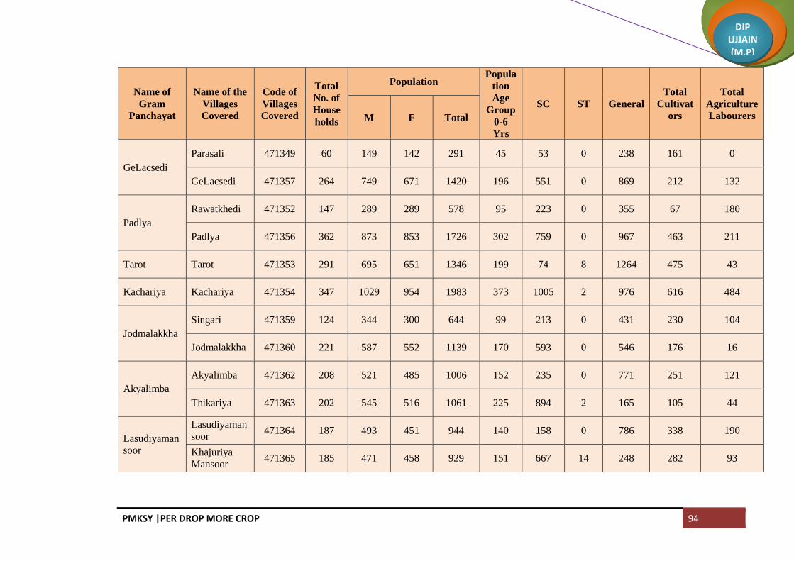
PMKSY |PER DROP MORE CROP 94
DIP UJJAIN (M.P)
Name of
Gram
Panchayat
Name of the
Villages
Covered
Code of
Villages
Covered
Total
No. of
House
holds
Population Popula
tion
Age
Group
0-6
Yrs
SC ST General
Total
Cultivat
ors
Total
Agriculture
Labourers M F Total
GeLacsedi
Parasali 471349 60 149 142 291 45 53 0 238 161 0
GeLacsedi 471357 264 749 671 1420 196 551 0 869 212 132
Padlya
Rawatkhedi 471352 147 289 289 578 95 223 0 355 67 180
Padlya 471356 362 873 853 1726 302 759 0 967 463 211
Tarot Tarot 471353 291 695 651 1346 199 74 8 1264 475 43
Kachariya Kachariya 471354 347 1029 954 1983 373 1005 2 976 616 484
Jodmalakkha
Singari 471359 124 344 300 644 99 213 0 431 230 104
Jodmalakkha 471360 221 587 552 1139 170 593 0 546 176 16
Akyalimba
Akyalimba 471362 208 521 485 1006 152 235 0 771 251 121
Thikariya 471363 202 545 516 1061 225 894 2 165 105 44
Lasudiyaman
soor
Lasudiyaman
soor 471364 187 493 451 944 140 158 0 786 338 190
Khajuriya
Mansoor 471365 185 471 458 929 151 667 14 248 282 93

PMKSY |PER DROP MORE CROP 95
DIP UJJAIN (M.P)
Name of
Gram
Panchayat
Name of the
Villages
Covered
Code of
Villages
Covered
Total
No. of
House
holds
Population Popula
tion
Age
Group
0-6
Yrs
SC ST General
Total
Cultivat
ors
Total
Agriculture
Labourers M F Total
Khoriya
Sumra
Mochikheda 471366 166 375 352 727 119 49 0 678 113 101
Khoriya
Sumra 471368 149 353 337 690 120 235 0 455 93 60
Piplikheda 471369 48 123 119 242 49 5 42 195 94 36
Dhulet
Ghiyakhedi 471374 51 155 155 310 47 105 0 205 63 14
Badgaon 471375 225 565 533 1098 212 367 0 731 190 193
Dhulet 471376 251 602 584 1186 202 476 6 704 163 266
Kadhai
Barapathar
(Part) 471377 10 20 17 37 5 33 0 4 3 11
Kadhai 471378 438 1143 1090 2233 392 965 3 1265 304 204
Bhimakheda
Tajpura
(Part) 471380 7 16 17 33 0 6 0 27 2 0
Bhimakheda
(Part) 471381 467 1248 1133 2381 376 168 2 2211 368 247
Kajikhedi
Kajikhedi 471382 109 271 248 519 75 71 0 448 107 43
Aamdi 471370 158 414 415 829 133 2 0 827 234 102

PMKSY |PER DROP MORE CROP 96
DIP UJJAIN (M.P)
Name of
Gram
Panchayat
Name of the
Villages
Covered
Code of
Villages
Covered
Total
No. of
House
holds
Population Popula
tion
Age
Group
0-6
Yrs
SC ST General
Total
Cultivat
ors
Total
Agriculture
Labourers M F Total
Sangvikheda 471371 82 191 169 360 54 0 0 360 118 90
Binpura
Binpura 471383 129 359 340 699 124 394 0 305 105 36
Tanda 471385 95 279 244 523 115 523 0 0 39 1
Lacsakhedi
Naharpur
Lacsakhedi
Naharpur 471386 319 904 841 1745 324 1176 0 569 112 181
Sekakhedi
Sekakhedi 471379 147 369 322 691 111 343 0 348 105 77
Chorwasa 471387 134 403 360 763 136 292 0 471 194 2
Dharakheda
Dharakheda 471388 130 322 358 680 97 225 0 455 201 0
Bagla 471390 194 469 420 889 140 337 0 552 105 2
Mahu
Mahu 471391 252 636 628 1264 226 357 0 907 292 99
Akyadhanga 471392 123 337 332 669 103 287 0 382 279 75
Narayna
Chiramya 471393 108 341 287 628 93 170 0 458 211 143
Narayna 471394 220 442 471 913 145 151 0 762 288 189

PMKSY |PER DROP MORE CROP 97
DIP UJJAIN (M.P)
Name of
Gram
Panchayat
Name of the
Villages
Covered
Code of
Villages
Covered
Total
No. of
House
holds
Population Popula
tion
Age
Group
0-6
Yrs
SC ST General
Total
Cultivat
ors
Total
Agriculture
Labourers M F Total
Baloda
Tulsapur 471395 97 268 244 512 113 51 0 461 181 28
Baloda 471396 94 281 277 558 59 142 0 416 237 43
Sherpur 471397 109 293 269 562 94 214 0 348 174 74
Aranya
Najeek
Sherpur
471398 39 107 89 196 22 60 0 136 62 27
Barkhedabuz
urg
Kukalkheda 471400 81 234 218 452 75 199 0 253 188 2
Barkhedabuz
urg 471401 186 491 409 900 94 212 0 688 531 11
Gangajalya
Kheda 471402 81 205 178 383 52 153 0 230 98 43
Kitiya
Moyakheda 471404 81 210 210 420 69 223 0 197 101 74
Kitiya 471405 191 488 497 985 120 380 0 605 200 30
Dongla
Dongla 471406 203 504 497 1001 152 283 0 718 194 24
Kanakhedi
Harbans 471467 126 330 310 640 101 156 0 484 35 105
Itawa Itawa 471407 194 484 456 940 148 235 0 705 234 105

PMKSY |PER DROP MORE CROP 98
DIP UJJAIN (M.P)
Name of
Gram
Panchayat
Name of the
Villages
Covered
Code of
Villages
Covered
Total
No. of
House
holds
Population Popula
tion
Age
Group
0-6
Yrs
SC ST General
Total
Cultivat
ors
Total
Agriculture
Labourers M F Total
Lasudiyashri
pat 471403 96 235 210 445 73 107 0 338 175 31
Bisalkhedi
Bisalkhedi 471389 168 405 378 783 134 291 3 489 80 64
Kuwandiya 471408 128 290 277 567 97 81 0 486 115 24
Pipalya Nath Pipalya Nath 471411 215 590 555 1145 165 209 0 936 260 285
Jawasyapanth
Jawasyapanth 471410 207 541 525 1066 167 400 0 666 359 162
Lacsakhedi
Umath 471412 38 102 112 214 25 3 0 211 121 13
Dhablikamm
a
Dhablikamm
a 471413 125 308 312 620 110 201 5 414 90 35
Dhablabeni 471409 195 469 462 931 149 150 0 781 104 28
Baijnath
Jharkhedi 471414 60 146 145 291 39 291 0 0 129 8
Ramnagar 471415 61 135 125 260 47 25 0 235 51 70
Baijnath 471416 139 350 351 701 84 228 1 472 104 109
Suhagpura Mendki 471417 144 323 312 635 99 98 0 537 100 64

PMKSY |PER DROP MORE CROP 99
DIP UJJAIN (M.P)
Name of
Gram
Panchayat
Name of the
Villages
Covered
Code of
Villages
Covered
Total
No. of
House
holds
Population Popula
tion
Age
Group
0-6
Yrs
SC ST General
Total
Cultivat
ors
Total
Agriculture
Labourers M F Total
Suhagpura 471418 252 579 537 1116 159 247 0 869 273 174
Guradiyadasa
Guradiyadasa 471361 196 508 477 985 149 235 0 750 357 20
Maukhedi 471420 137 362 370 732 88 351 0 381 260 130
Nipaniyaraju
Nipaniyaraju 471421 313 763 727 1490 277 464 1 1025 194 69
Somchidi 471422 59 196 168 364 51 0 0 364 85 27
Mahidpuriya 471423 14 46 44 90 19 0 0 90 23 1
Dhanodiya Dhanodiya 471424 298 723 633 1356 197 182 5 1169 668 6
Azmabad
Azmabad 471419 183 469 441 910 143 355 0 555 143 109
Mundlibhoj 471425 108 307 270 577 89 91 0 486 314 15
Padikheda
Padikheda 471426 128 372 338 710 90 48 0 662 455 0
Marukheda 471427 116 287 281 568 91 147 0 421 150 7
Dungarkhedi Simrol 471428 128 354 329 683 97 152 0 531 106 214

PMKSY |PER DROP MORE CROP 100
DIP UJJAIN (M.P)
Name of
Gram
Panchayat
Name of the
Villages
Covered
Code of
Villages
Covered
Total
No. of
House
holds
Population Popula
tion
Age
Group
0-6
Yrs
SC ST General
Total
Cultivat
ors
Total
Agriculture
Labourers M F Total
Dungarkhedi 471429 133 370 327 697 125 250 1 446 88 288
DeLacsedi 471430 60 147 147 294 56 116 0 178 34 99
Kheda
Madda
Kheda
Madda 471432 290 747 686 1433 209 188 0 1245 543 77
Neemkheda
Neemkheda 471433 214 561 558 1119 167 671 0 448 47 225
Khedla 471431 86 241 235 476 99 243 0 233 88 60
Nagpura
Nagpura 471358 189 453 424 877 119 430 0 447 234 39
Chhajjukhedi 471434 154 389 307 696 98 249 0 447 106 43
Nalkheda Nalkheda 471436 304 806 750 1556 267 363 0 1193 385 289
Khoriya
Padma
Khoriya
Padma 471435 190 484 490 974 137 472 0 502 178 200
Panodiya 471437 94 226 207 433 59 99 0 334 99 12
Kundikheda Kundikheda 471438 269 640 540 1180 140 229 0 951 248 111
Ghatiyajassa Jhangri 471439 73 195 165 360 50 47 0 313 95 28

PMKSY |PER DROP MORE CROP 101
DIP UJJAIN (M.P)
Name of
Gram
Panchayat
Name of the
Villages
Covered
Code of
Villages
Covered
Total
No. of
House
holds
Population Popula
tion
Age
Group
0-6
Yrs
SC ST General
Total
Cultivat
ors
Total
Agriculture
Labourers M F Total
Kanthari 471440 98 210 189 399 56 121 0 278 96 7
Samakota 471441 66 117 118 235 37 146 0 89 29 30
Ghatiyajassa 471442 135 274 276 550 96 175 0 375 64 60
Lasudiyanhat
a
Lasudiyanhat
a 471443 295 733 683 1416 230 860 0 556 100 512
Dongarkheda Dongarkheda 471444 316 823 808 1631 215 685 1 945 338 314
Bagni
Bagni 471448 124 316 280 596 68 279 0 317 116 212
Bhatkhedi 471445 175 381 368 749 122 470 0 279 2 176
Ghodabag 471446 65 183 184 367 64 0 0 367 191 8
Kason Kason 471449 225 641 641 1282 209 158 0 1124 221 277
ALacseda
ALacseda 471452 206 446 420 866 131 25 0 841 1 15
Bhavrasi 471453 93 232 220 452 72 73 0 379 76 1
Shakkarkhedi Shakkarkhedi 471454 285 759 691 1450 199 743 0 707 44 78

PMKSY |PER DROP MORE CROP 102
DIP UJJAIN (M.P)
Name of
Gram
Panchayat
Name of the
Villages
Covered
Code of
Villages
Covered
Total
No. of
House
holds
Population Popula
tion
Age
Group
0-6
Yrs
SC ST General
Total
Cultivat
ors
Total
Agriculture
Labourers M F Total
Jodmabirbha
n 471455 62 187 174 361 50 103 0 258 0 0
Kamalyakhed
i
Kamalyakhed
i 471450 104 279 257 536 73 133 0 403 47 13
Bilkheda 471451 71 164 164 328 52 196 0 132 27 71
Hajratpur 471456 83 191 187 378 39 13 0 365 63 48
Jawasiyasola
nki
Jawasiyasola
nki 471458 196 530 563 1093 178 163 0 930 212 352
Pipalya Harji 471459 173 341 316 657 104 63 0 594 167 23
Lasudiyadevs
i
Jhangra 471460 112 272 242 514 65 139 0 375 122 171
Lasudiyadevs
i 471461 144 412 396 808 90 168 0 640 143 98
Mundlidotru
Mundlidotru 471463 224 527 453 980 135 117 0 863 99 83
Kalapipal 471464 202 429 409 838 119 223 0 615 18 0
Balra 471465 82 216 212 428 71 198 0 230 158 39
Khedakhajuri
ya
Khedakhajuri
ya 471466 662 1578 1480 3058 419 1006 0 2052 306 350

PMKSY |PER DROP MORE CROP 103
DIP UJJAIN (M.P)
Name of
Gram
Panchayat
Name of the
Villages
Covered
Code of
Villages
Covered
Total
No. of
House
holds
Population Popula
tion
Age
Group
0-6
Yrs
SC ST General
Total
Cultivat
ors
Total
Agriculture
Labourers M F Total
Mahudi Mahudi 471469 285 647 629 1276 179 710 14 552 181 133
Mahudipura
Mahudipura 471468 176 483 437 920 104 289 49 582 193 9
Khurchanya
Pratap 471470 157 389 368 757 128 344 0 413 139 5
Hingoniya
Hingoniya 471471 167 475 459 934 123 330 1 603 262 260
Ranipura 471399 69 190 173 363 50 172 0 191 168 16
Malikhedi
Melaniya 471472 108 278 263 541 79 113 2 426 149 160
Malikhedi 471473 156 366 316 682 85 411 0 271 134 60
Khurchanya
Chandrabhan 471474 53 127 137 264 37 83 0 181 58 2
Barkhedibaza
r
Tajpur 471475 79 210 207 417 41 156 0 261 85 0
Barkhedibaza
r 471476 204 512 497 1009 165 251 188 570 499 8
Jagoti Jagoti 471477 1031 2546 2514 5060 738 2278 13 2769 660 289
Jelyakhedi Jelyakhedi 471478 257 642 617 1259 184 278 0 981 489 103

PMKSY |PER DROP MORE CROP 104
DIP UJJAIN (M.P)
Name of
Gram
Panchayat
Name of the
Villages
Covered
Code of
Villages
Covered
Total
No. of
House
holds
Population Popula
tion
Age
Group
0-6
Yrs
SC ST General
Total
Cultivat
ors
Total
Agriculture
Labourers M F Total
BeLacseda BeLacseda 471479 365 687 666 1353 159 468 0 885 396 111
Palwa Palwa 471480 304 739 709 1448 191 304 0 1144 436 370
Raghvi
Ramsara 471481 219 444 439 883 120 303 0 580 265 40
Raghvi 471482 189 450 467 917 139 268 0 649 121 25
Akyajassa
Akyajassa 471462 178 443 436 879 135 189 0 690 95 164
Lambikhedi 471483 133 377 351 728 110 101 0 627 189 50
Ghosla
Ghosla 471484 970 2555 2457 5012 764 1059 16 3937 341 1018
Loharwas 471485 76 200 191 391 53 59 0 332 59 69
Urban Mahidpur
(M + OG) 802227 6162 17572 16790 34362 5271 3361 68 30933 435 473
Urban Gogapur
(CT) 471486 1566 3769 3839 7608 1023 1544 62 6002 259 548
Total 51696 132838 126461 259299 40150 72064 1918 185317 46119 27783

PMKSY |PER DROP MORE CROP 105
DIP UJJAIN (M.P)
71.3 BIOMASS AND LIVESTOCK
Table 1.2 Biomass and Livestock Source: Livestock Census of India
Name of Block
Small Animals Large Animals Any
Other
Meat or
Milch
Animals
(No.)
Draft
Animal
(Buffalo/
yak/
bulls/any
other (Nos.)
Poultry
(No.)
Ducks
(No.)
Pigs
(No.)
Goats
(No.)
sheeps
(No.)
Indigenous
Cow (No.)
Hybrid
Cow
(No)
Indescriptive
Buffalo (No.)
Hybrid
Buffalo
(No.)
Ujjain 29967 0 55 31860 219 34001 9019 36537 10300 824
Ghattiya 7697 0 66 24198 42 26413 7940 24850 10709 129
Tarana 7868 0 123 34181 0 51303 8920 47093 8236 236
Mahidpur 14253 0 1018 35003 341 56670 8484 35523 7656 317
Khachrod 19608 0 630 45918 324 59004 12240 42024 850 770
Badnagar 12737 0 303 34250 695 49730 10832 44220 9971 528
Total 92130 0 2195 205410 1621 277121 57435 230247 47722 0 2804
PMKSY |PER DROP MORE CROP 106
DIP UJJAIN (M.P)
1.4 AGRO-ECOLOGY, CLIMATE, HYDROLOGY AND TOPOGRAPHY
GEOMORPHOLOGY AND TOPOGRAPHY
Physiographycally, Ujjain is situated on the Malwa Plateau in Central India. The Malwa region can be
broadly divided into central high lands with abrupt cliffs rising to elevation of more than 150m near Mograba which
is forms spectacular ranges of horizontal basalts with multiple scarps and low lying plains. In general, the Malwa
traps are dominated by various types of landforms which include lava plateau, lava plains, linear ridges, isolated
conical hills, mesa, butte, questa etc. which might have developed by the differential erosion of the thick sucession
of basaltic lava flows. The area is mostly characterized by erosional landforms.
The district lies on Malwa Plateau at a general elevation of 500 meter above mean sea level. The variation in
altitude ranges from 450 m above mean sea level to in the north to 558 m above mean sea level in the south. On the
whole the area is a broad undulating plateau with no marked hill ranges. The general slope is from south to north
marked by a number of small rivers, which latter joins the Chambal River. Map 2

PMKSY |PER DROP MORE CROP 107
DIP UJJAIN (M.P)
Map 2: Geomorphology Map of District Ujjain

PMKSY |PER DROP MORE CROP 108
DIP UJJAIN (M.P)
GEOLOGY
The term “Malwa” has been used for Ujjain District which is derived from the word ‘Malwa’ means, ‘Pearl’.The
geology of the Malwa region is dominated by a thick sequence (more than 1000m exposed) of flat lying basalt
flows. The northern boundary of the Malwa Plateau is marked by Kaimur scarp which runs in WNW-ESE
direction from west of Neemuch through Manasa, Kukdeshwar, Rampura and extends upto east of Bhanpura
where the continuity of the scarp is lost by a NW-SE trending strike ridge of Upper Vindhyan. However the
Sounthern boundary is marked by E-W trending Narmada Lineament exposing Nimar Sandstone at most places. The
eastern boundary is marked by numerous inliers of Vidhyan outcrops exposed near Bhopal and the western limit is
marked by the outcrops if highly folded and faulted Aravali Super Groups rocks.
The formation comprises of total 04 trappean flows of varying thickness and is the times interbedded with
fossiliferous intertrappean beds. The only rock found associated with this formation is basalt which is generally
vesicular/fragmentary. The vesicles are generally filled with secondary minerals like calcite and zeolites. The
characteristic red bole beds form the marker horizons between successive flows. Alluvium has been deposited along
the river valleys and forming symmetrical and asymmetrical terraces. The alluvium comprises unconsolidated and
semi-consolidated, friable yellowish and brownish sand, gravel, pebbles, sand, silt and clay. Map 3

PMKSY |PER DROP MORE CROP 109
DIP UJJAIN (M.P)
Map 3: Geology Map of Ujjain District

PMKSY |PER DROP MORE CROP 110
DIP UJJAIN (M.P)
HYDROGEOLOGICAL CONDITION
Hydrogeological studies of Deccan trap lava flow shows that the top amygdular and vesicular zone in
'Pahoehoe’ type flows and upper fragmentary and scoraceous zone in 'Aa’ type flows are more promising water
bearing zone. Such zones are 4 to 6 m. thick. The water table of the area is at shallower depths during the rainy
season but shallow dug wells go dry during summer indicating a higher water table fluctuation in the area. The
perennial rivers of the area are attributed to the discharge of groundwater into the river during summer. At few
localities in vicinity of the river, the flood plain and the terrace deposits serve as good aquifer and yield good
groundwater. It was noted that the amygdular and Vesicular zone developed at the top of flow constitutes the best
groundwater bearing horizon of the area.
Hydrogeological conditions of Deccan traps shows that the ground water in lava flows generally
occurs under water table and semi-confined to confined conditions whereas in Alluvium it occurs under
unconfined to confined conditions. Map 4

PMKSY |PER DROP MORE CROP 111
DIP UJJAIN (M.P)
Map 4: Geohydrology Map of Ujjain District

PMKSY |PER DROP MORE CROP 112
DIP UJJAIN (M.P)
AGROCLIMATIC CHARACTERS
Ujjain comes under the 9th Agro-climatic zone i.e. Malwa Plateau Zone. The Agro-ecological region 5 in the
Malwa Plateau as per NBSS & LUP (1993) has distinct characteristic feature i.e. I5D2 (Central highlands with
medium to deep black soils, semiarid climate and growing period 90-150 days) in Indore, Dhar, Ujjain, Ratlam,
Mandsaur, Neemuch, north west part of Shajapur and western part of Dewas district. Major cropping sysytem in
this zone is Soybean, Gram, Wheat and Maize. There are three Agro Ecological sub Regions in Ujjain: i) Ujjain +
Ghattiya ii) Tarana + mahidpur iii) khachrod + Badnagar. Map 5 and 6

PMKSY |PER DROP MORE CROP 113
DIP UJJAIN (M.P)
Map 5: Agroclimatic Zones of Madhya Pradesh

PMKSY |PER DROP MORE CROP 114
DIP UJJAIN (M.P)
Map 6: Agro-ecological Sub Regions in Ujjain

PMKSY |PER DROP MORE CROP 115
DIP UJJAIN (M.P)
CLIMATE
Due to its location in Central India (approx.76° E, 23° N), far from the sea, Ujjain has a moderately extreme
climate. Ujjain experiences a warm sub-tropical climate, typical of the North Central India.Winter: Winter starts in
the middle of November and is pleasant and cool with daytime temperature typically 20°C, though temperature can
drop significantly in the night. The night low is around 10°C. At the peak of winter, it can be as low as low as 2 to
3°C. The record low is +1.5°C. Summer: Summer starts in late March with temperature rising at its peak in May.
During Summer (April-June) the days are hot (35-40°C) with the peak summer (May) day temperature sometimes
touching 45°C. However, unlike other places in central India, the summer nights in Ujjain are something special.
Due to its location on the southern edge of the Malwa Plateau, however hot it may be during the day, in the late
evening, cool breeze starts which makes the evenings quite pleasant, referred to as Shab-e-Malwa. Rainfall: The
normal annual rainfall of Ujjain district is 906.2 mm. Ujjain district receive maximum rainfall during southwest
monsoon period i.e. June to November. About 92.1% of annual rainfall is received during monsoon season. The
surplus water for groundwater recharge is available only during the southwest monsoon period. The average
maximum and minimum temperature is 33°C and 16.5°C respectively. Block wise detail of rainfall and temperature
is given in Table 1.3

PMKSY |PER DROP MORE CROP 116
DIP UJJAIN (M.P)
Table 1.3 Agro Ecology, Climate, Hydrology and Topography
Block: Ujjain Source: Land Record and Hydrology
Lab
S.
No.
Agro
Ecological
Zone type
Type of
Terrain
Block
Area
(ha)
Normal
Annual
Rainfall
(mm)
Average
Monthly
Rainfall
(mm)
No of
Rainy
days
(no)
Average Weekly Temperature (̊C)
Period
Summer (April-
May) Winter (Oct-Mar) Rainy (June-Sept)
Min Max Mean Min Max Mean Min Max Mean
1 2 3 4 5 6 7 8 12 13 14 15 16 17 18 19 20
1
5 Central
Highland Plain 75337 907.1
Jan 8.8 3 9.48 23.74 16.61
2 Feb 3.7 0 12.67 30.45 21.56
3 Mar 4.6 5
4 Apr 0.6 4 18.73 37.74 28.2
5 May 6.4 0 23.21 39.37 32.5
6 Jun 110.5 10 23.97 36.06 30
7 Jul 278.0 12 23.34 30.33 26.83
8 Aug 286.0 11 22.32 29.96 26.14
9 Sep 161.1 3 21.16 33.42 27.29
10 Oct 27.1 0 18.35 34.89 26.62
11 Nov 13.1 0 15.59 32.37 23.98
12 Dec 7.2 0 9.8 26.64 18.22

PMKSY |PER DROP MORE CROP 117
DIP UJJAIN (M.P)
Block: Ghattiya
S.
No..
Agro
Ecological
Zone type
Type of
Terrain
Block
Area
(ha)
Normal
Annual
Rainfall
(mm)
Average
Monthly
Rainfall
(mm)
No of
Rainy
days
(no)
Average Weekly Temperature (̊C)
Period
Summer (April-
May) Winter (Oct-Mar) Rainy (June-Sept)
Min Max Mean Min Max Mean Min Max Mean
1 2 3 4 5 6 7 8 12 13 14 15 16 17 18 19 20
1
5 Central
Highland Plain 63946 907.1
Jan 8.8 3 9.48 23.74 16.61
2 Feb 3.7 1 12.67 30.45 21.56
3 Mar 4.6 3
4 Apr 0.6 2 18.73 37.74 28.2
5 May 6.4 0 23.21 39.37 32.5
6 Jun 110.5 10 23.97 36.06 30
7 Jul 278.0 12 23.34 30.33 26.83
8 Aug 286.0 11 22.32 29.96 26.14
9 Sep 161.1 3 21.16 33.42 27.29
10 Oct 27.1 1 18.35 34.89 26.62
11 Nov 13.1 0 15.59 32.37 23.98
12 Dec 7.2 0 9.8 26.64 18.22

PMKSY |PER DROP MORE CROP 118
DIP UJJAIN (M.P)
Block: Tarana
S.
No.
Agro
Ecological
Zone type
Type of
Terrain
Block
Area
(ha)
Normal
Annual
Rainfall
(mm)
Average
Monthly
Rainfall
(mm)
No of
Rainy
days
(no)
Average Weekly Temperature (̊C)
Period
Summer (April-
May) Winter (Oct-Mar) Rainy (June-Sept)
Min Max Mean Min Max Mean Min Max Mean
1 2 3 4 5 6 7 8 12 13 14 15 16 17 18 19 20
1
5 Central
Highland Plain 104275 944.4
Jan 7.6 3 9.48 23.74 16.61
2 Feb 1.6 0 12.67 30.45 21.56
3 Mar 1.9 3
4 Apr 0.7 2 18.73 37.74 28.2
5 May 3.4 0 23.21 39.37 32.5
6 Jun 118.8 10 23.97 36.06 30
7 Jul 285.8 12 23.34 30.33 26.83
8 Aug 311.8 12 22.32 29.96 26.14
9 Sep 160.7 2 21.16 33.42 27.29
10 Oct 34 0 18.35 34.89 26.62
11 Nov 10.8 0 15.59 32.37 23.98
12 Dec 7.3 0 9.8 26.64 18.22

PMKSY |PER DROP MORE CROP 119
DIP UJJAIN (M.P)
Block: Khachrod
S.
No.
Agro
Ecological
Zone type
Type of
Terrain
Block
Area
(ha)
Normal
Annual
Rainfall
(mm)
Average
Monthly
Rainfall
(mm)
No of
Rainy
days
(no)
Average Weekly Temperature (̊C)
Period
Summer (April-
May) Winter (Oct-Mar) Rainy (June-Sept)
Min Max Mean Min Max Mean Min Max Mean
1 2 3 4 5 6 7 8 12 13 14 15 16 17 18 19 20
1
5 Central
Highland Plain 129268 925.8
Jan 4.8 2 9.48 23.74 16.61
2 Feb 1.3 1 12.67 30.45 21.56
3 Mar 1.9 4
4 Apr 1.6 1 18.73 37.74 28.2
5 May 4.2 0 23.21 39.37 32.5
6 Jun 99.0 9 23.97 36.06 30
7 Jul 284.1 11 23.34 30.33 26.83
8 Aug 295.7 7 22.32 29.96 26.14
9 Sep 172.0 2 21.16 33.42 27.29
10 Oct 40.8 1 18.35 34.89 26.62
11 Nov 14.0 0 15.59 32.37 23.98
12 Dec 6.4 1 9.8 26.64 18.22

PMKSY |PER DROP MORE CROP 120
DIP UJJAIN (M.P)
Block: Badnagar
S.
No.
Agro
Ecological
Zone type
Type of
Terrain
Block
Area
(ha)
Normal
Annual
Rainfall
(mm)
Average
Monthly
Rainfall
(mm)
No of
Rainy
days
(no)
Average Weekly Temperature (̊C)
Period
Summer (April-
May) Winter (Oct-Mar) Rainy (June-Sept)
Min Max Mean Min Max Mean Min Max Mean
1 2 3 4 5 6 7 8 12 13 14 15 16 17 18 19 20
1
5 Central
Highland Plain 123595 864.3
Jan 6.6 1 9.48 23.74 16.61
2 Feb 1.4 1 12.67 30.45 21.56
3 Mar 1.3 3
4 Apr 1.2 4 18.73 37.74 28.2
5 May 7.7 0 23.21 39.37 32.5
6 Jun 99.3 10 23.97 36.06 30
7 Jul 258.5 11 23.34 30.33 26.83
8 Aug 274.1 7 22.32 29.96 26.14
9 Sep 155.6 3 21.16 33.42 27.29
10 Oct 34.1 0 18.35 34.89 26.62
11 Nov 17 0 15.59 32.37 23.98
12 Dec 7.5 0 9.8 26.64 18.22

PMKSY |PER DROP MORE CROP 121
DIP UJJAIN (M.P)
Block: Mahidpur
S.
No.
Agro
Ecological
Zone type
Type of
Terrain
Block
Area
(ha)
Normal
Annual
Rainfall
(mm)
Average
Monthly
Rainfall
(mm)
No of
Rainy
days
(no)
Average Weekly Temperature (̊C)
Period
Summer (April-
May) Winter (Oct-Mar) Rainy (June-Sept)
Min Max Mean Min Max Mean Min Max Mean
1 2 3 4 5 6 7 8 12 13 14 15 16 17 18 19 20
1
5 Central
Highland Plain 113453 889.6
Jan 5.1 2 9.48 23.74 16.61
2 Feb 2.7 1 12.67 30.45 21.56
3 Mar 1.9 2
4 Apr 0.7 0 18.73 37.74 28.2
5 May 6.8 1 23.21 39.37 32.5
6 Jun 94.3 11 23.97 36.06 30
7 Jul 276.9 12 23.34 30.33 26.83
8 Aug 289.9 8 22.32 29.96 26.14
9 Sep 154.2 2 21.16 33.42 27.29
10 Oct 38.4 0 18.35 34.89 26.62
11 Nov 9.6 0 15.59 32.37 23.98
12 Dec 9.1 0 9.8 26.64 18.22

PMKSY |PER DROP MORE CROP 122
DIP UJJAIN (M.P)
1.5 LAND USE PATTERN
The total geographical area of the district is 6.098 lacs hectares and out of total area about 5.00 lacs hectares
area is under cultivation while only 3149 hectares area is under forest and 82% of the total geographical area is
under agricultural crops, only 0.51% area is under forest. The gross cropped area of the district is 9.05799 lacs
hectares, net sown area is 4.99821 lacs hectares and area sown more than once is 4.059 lacs hectares. The cropping
intensity of the district is 176%.The percentage of land put to non agricultural use to the geographical area is 9.85%.
Permanent pastures and grazing land have been decreasing continuously and constitutes 5.24% of geographical area.
There is gradual increase observed in the land put to non agriculture use indicating environmental degradation and
change in the land use pattern. Land use pattern blockwise is given in Table and Map 7
Block
Total
Geographical
Area
Area under Agriculture
Area
Under
Forest
Land Not Available For
Agriculture
Fallow
Land
Pasture
land
and
Bushes
Gross
Cropped
Area (1)
Net
Sown
Area
(2)
Area
Sown
more
than once
(1-2)
Cropping
Intensity
(%)
Barren and
Uncultivable
Land
Area
Under
other
Uses
Old and
Current
Fallow
Ujjain 75337 109089 57325 51764 190 627 269 10737 1445 3581 1353
Ghattiya 63946 97135 52356 44779 185.5 217 448 6238 551 2918 1218
Tarana 104275 143831 83612 60219 172 2305 1370 8404 1100 7111 373
Khachrod 129268 184392 104410 79982 176.6
1396 13022 2573 7167 700
Badnagar 123595 209904 107426 102478 195
410 11148 275 3920 416
Mahidpur 113453 161448 94692 66756 170 1836 9505 249 5919 1252
Total 609874 905799 499821 405978 181 3149 5729 59054 6193 30616 5312
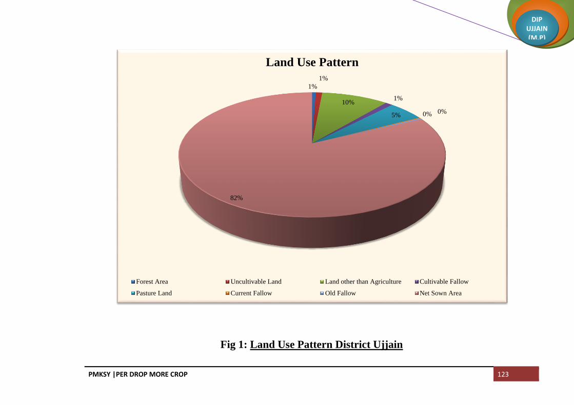
PMKSY |PER DROP MORE CROP 123
DIP UJJAIN (M.P)
Fig 1: Land Use Pattern District Ujjain
1%
1%
10%1%
5% 0% 0%
82%
Land Use Pattern
Forest Area Uncultivable Land Land other than Agriculture Cultivable Fallow
Pasture Land Current Fallow Old Fallow Net Sown Area

PMKSY |PER DROP MORE CROP 124
DIP UJJAIN (M.P)
Map 7: Land Use Pattern Map of District Ujjain

PMKSY |PER DROP MORE CROP 125
DIP UJJAIN (M.P)
1.6 SOIL PROFILE
Black cotton soils with heavy to light texture are found in the whole area. Light textured silty ‘Kankar’ and
admixtures of clay in the form of alluvium occur along the bank of major streams. . In Ujjain major soil type is
Black cotton soil in which deep black soil constitutes 539600 hectares (88.68%), medium deep black soil constitutes
11400 hectares (1.90%), and shallow black soil constitutes 57200 hectares (9.42%). The major soil order of the
distict is Vertisols. The district faces considerable problem of soil erosion, which is aided and abetted by faulty
forming practices and also by natural agents like wind and water. Map 8
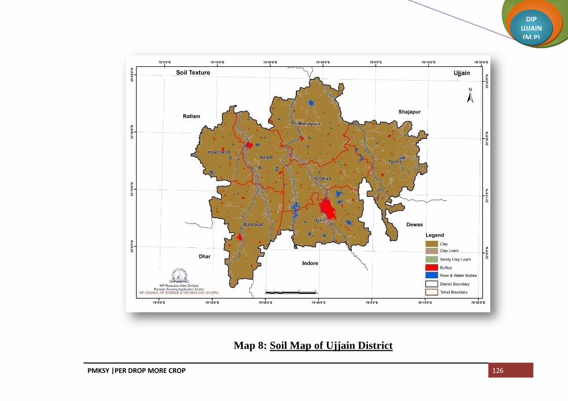
PMKSY |PER DROP MORE CROP 126
DIP UJJAIN (M.P)
Map 8: Soil Map of Ujjain District

PMKSY |PER DROP MORE CROP 127
DIP UJJAIN (M.P)
SOIL ORDER
The major soil order of the distict is Vertisols.Vertisols constitutes 61.67%, Inceptisols constitute 25.7% and
antisols constitute 9.55%. Area is given in Table 1.5 and Map 9
Table 1.5 Soil Order
S.No. Soil Order Area in sq km Area in ha
1 Inceptisols 1571 157100
2 Entisols 581.8 58180
3 Vertisols 3756.92 375692
4 River & Water Bodies 77.28 7728
5 Builtup 104 10400
Total 6091 609100
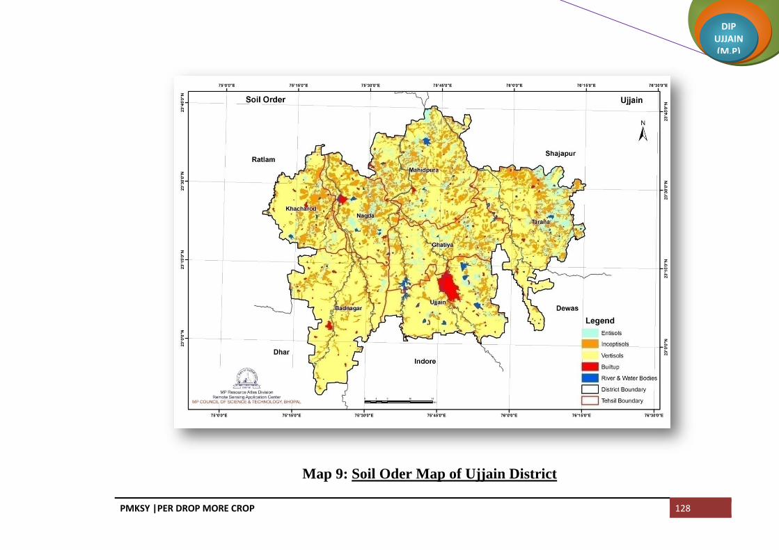
PMKSY |PER DROP MORE CROP 128
DIP UJJAIN (M.P)
Map 9: Soil Oder Map of Ujjain District

PMKSY |PER DROP MORE CROP 129
DIP UJJAIN (M.P)
SOIL SLOPE
Slope gradient is the inclination of the surface of the soil from the horizontal. It is generally measured with a
hand level. The difference in elevation between two points is expressed as percentageof the distance between those
points. If the difference in elevation is 1 meter over a horizontal distance of 100 meters, slope gradient is 1%. The
major land area of Ujjain district falls under very gently sloping class. 96.97% of the total geographical area falls
under very gently sloping (0-3%) class which is considered as nearly leveled. 2.9% area falls under gently sloping
class (3-8%), 0.08% area falls under moderate sloping (8-25%) class and only 0.03% falls under steep sloping class
(>25%). Detail is given in Table 1.6 and Map 10
Table 1.6 Land slope
S.No. Slope Area in sq km Area in ha
1 0-3 Percent 5907 590686
2 3-8 Percent 179 17910
3 8-25 Percent 5 501
4 Greater than 25 Percent 0.03 3
Total 6091 609100

PMKSY |PER DROP MORE CROP 130
DIP UJJAIN (M.P)
Map 10: Soil Slope Map of Ujjain District
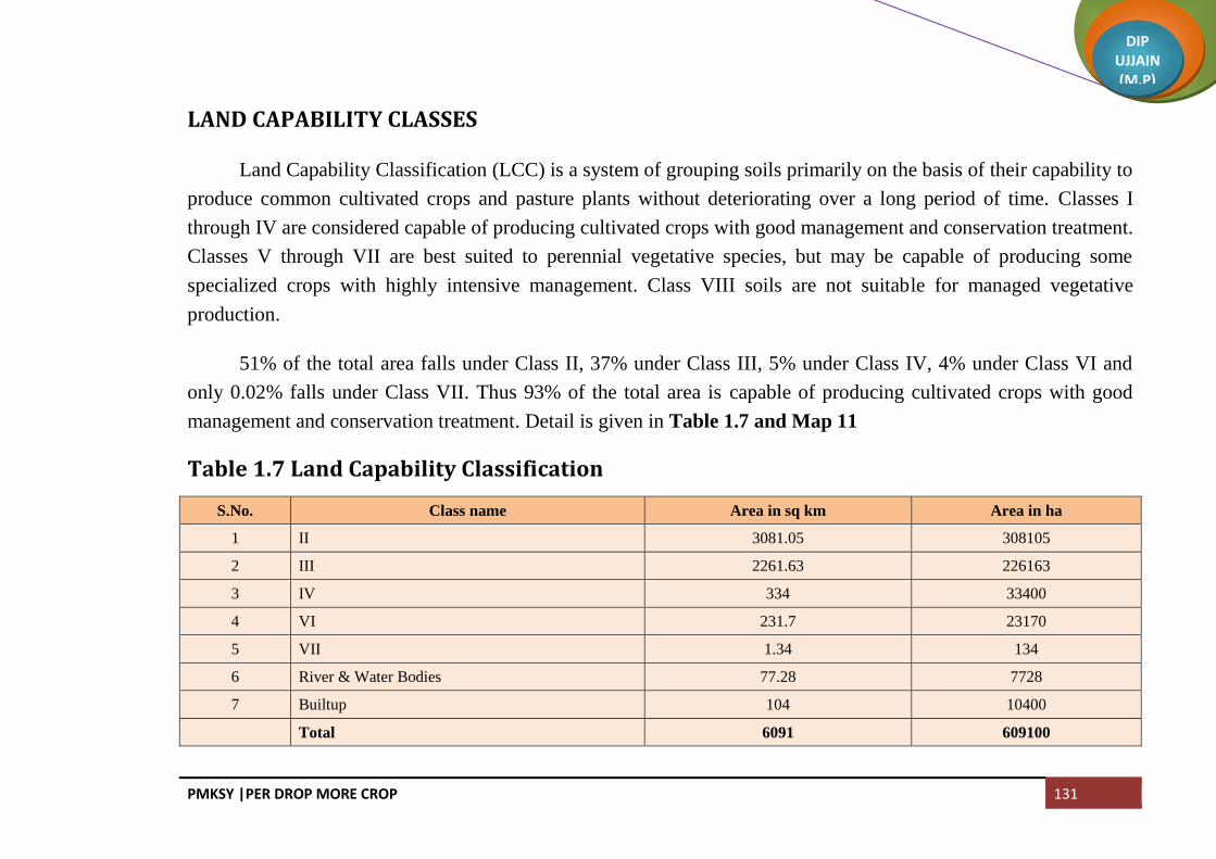
PMKSY |PER DROP MORE CROP 131
DIP UJJAIN (M.P)
LAND CAPABILITY CLASSES
Land Capability Classification (LCC) is a system of grouping soils primarily on the basis of their capability to
produce common cultivated crops and pasture plants without deteriorating over a long period of time. Classes I
through IV are considered capable of producing cultivated crops with good management and conservation treatment.
Classes V through VII are best suited to perennial vegetative species, but may be capable of producing some
specialized crops with highly intensive management. Class VIII soils are not suitable for managed vegetative
production.
51% of the total area falls under Class II, 37% under Class III, 5% under Class IV, 4% under Class VI and
only 0.02% falls under Class VII. Thus 93% of the total area is capable of producing cultivated crops with good
management and conservation treatment. Detail is given in Table 1.7 and Map 11
Table 1.7 Land Capability Classification
S.No. Class name Area in sq km Area in ha
1 II 3081.05 308105
2 III 2261.63 226163
3 IV 334 33400
4 VI 231.7 23170
5 VII 1.34 134
6 River & Water Bodies 77.28 7728
7 Builtup 104 10400
Total 6091 609100

PMKSY |PER DROP MORE CROP 132
DIP UJJAIN (M.P)
Map 11: Land Capability Map of Ujjain District

PMKSY |PER DROP MORE CROP 133
DIP UJJAIN (M.P)
2.1 AREA WISE CROP WISE IRRIGATION STATUS
The total net sown area in the district is 499821 hectares out of which 405978 is sown more than once (double
cropped area). The total area under Kharif crop is 498311 hectare and 407488 hectares area is under Rabi. Out of
this 39170 hectare area is under horticulture crops. In Kharif season 96.86% of the total area is under Soybean.
Other crops grown in Kharif season are Jowar, Maize, Arhar, Urad, Moong, Groundnut and Til. In Rabi Season
Wheat and Gram are the major crops. Other crops grown in Rabi season are Mustard, Pea and Linseed.
The total area under kharif crop is rainfed. In Rabi season out of the total area 373815 hectare aea is irrigated
and 33673 is rainfed. Out of the total area under horticulture crops 38184 is irrigated and 986 is rainfed. Because of
non availability of irrigation summer crop is not taken in the district. Block wise irrigation status is given in Table
2.1
CHAPTER II DISTRICT WATER PROFILE

PMKSY |PER DROP MORE CROP 134
DIP UJJAIN (M.P)
Fig 2: Cropwise Irrigated and Rainfed Status
63%
0%
25%
0%11%
1%
Irrigated Area
Cereals
Coarse Cereals
Pulses
Oil seeds
Horticulture Crops
other crops
1%
8%
88%
3%
Rainfed Area
Cereals
Coarse Cereals
Pulses
Oil seeds
Horticulture Crops
other crops

PMKSY |PER DROP MORE CROP 135
DIP UJJAIN (M.P)
Table 2.1 Area-wise, Crop-wise Irrigation Status
Block: Ujjain
Crop
type
Kharif (Area in ha) Rabi (Area in ha) Summer Crop (Area in
ha) Total (Area in ha)
Horticultural &
Plantation (Area in ha)
Irrigat
ed Rainfed Total
Irrigate
d
Rainfe
d Total
Irrigat
ed Rainfed Total
Irrigate
d Rainfed Total
Irrigate
d
Rainf
ed Total
Cereals 39385 0 39385 0 0 0 39385 0 39385 0 0 0
Coarse
Cereals 287 287 0 0 0 0 0 0 0 287 287 0 0 0
Pulses 157 157 6707 475 7182 0 0 0 6707 632 7339 0 0 0
Oil
seeds 55190 55190 2 14 16 0 0 0 2 55206 55208 0 0 0
Fibre 0 0 0 0 0 0 0 0 0 0 0 0 0 0
Any
other
crops
1422 1422 732 0 732 0 0 0 732 1422 2154 4621 97 4718
Total
57056 57056 46826 489 47315 0 0 0 46826 57547 104373 4621 97 4718

PMKSY |PER DROP MORE CROP 136
DIP UJJAIN (M.P)
Block: Ghattiya
Crop
type
Kharif (Area in ha) Rabi (Area in ha) Summer Crop (Area in
ha) Total (Area in ha)
Horticultural &
Plantation (Area in ha)
Irrigat
ed
Rainfe
d Total
Irrig
ated Rainfed Total
Irrigat
ed Rainfed Total
Irrigate
d Rainfed Total
Irrigate
d
Rainf
ed Total
Cereals 0 0 0 31495 0 31495 0 0 0 31495 0 31495 0 0 0
Coarse
Cereals 0 113 113 0 0 0 0 0 0 0 113 113 0 0 0
Pulses 0 159 159 6404 2354 8758 0 0 0 6404 2513 8917 0 0 0
Oil
seeds 0 50724 50724 84 33 117 0 0 0 84 50757 50841 0 0 0
Fibre 0 0 0 0 0 0 0 0 0 0 0 0 0 0 0
Any
other
crops
0 1276 1276 297 75 372 0 0 0 372 1276 1648 4046 75 4121
Total 0 52272 52272 38280 2462 40742 0 0 0 38355 54659 93014 4046 75 4121

PMKSY |PER DROP MORE CROP 137
DIP UJJAIN (M.P)
Block: Tarana
Crop
type
Kharif (Area in ha) Rabi (Area in ha) Summer Crop (Area in ha) Total (Area in ha) Horticultural &
Plantation (Area in ha)
Irrigat
ed
Rainfe
d Total
Irrig
ated Rainfed Total
Irrigate
d Rainfed Total
Irrigate
d Rainfed Total
Irrigat
ed
Rainf
ed Total
Cereals 0 0 0 31953 0 31953 0 0 0 31953 0 31953 0 0 0
Coarse
Cereals 0 377 377 0 0 0 0 0 0 0 377 377 0 0 0
Pulses 0 669 669 12377 8258 20635 0 0 0 12377 8927 21304 0 0 0
Oil
seeds 0 77396 77396 136 78 214 0 0 0 136 77474 77610 0 0 0
Fibre 0 0 0 0 0 0 0 0 0 0 0 0 0 0 0
Any
other
crops
0 5157 5157 331 238 569 0 0 0 331 5395 5726 6850 11 6861
Total 0 83599 83599 44797 8574 53371 0 0 0 44797 92173 136970 6850 11 6861

PMKSY |PER DROP MORE CROP 138
DIP UJJAIN (M.P)
Block: Khachrod
Crop
type
Kharif (Area in ha) Rabi (Area in ha) Summer Crop (Area in ha) Total (Area in ha) Horticultural &
Plantation (Area in ha)
Irrigat
ed Rainfed Total
Irrig
ated
Rainfe
d Total
Irrigate
d Rainfed Total
Irrigate
d Rainfed Total
Irrigat
ed
Rainf
ed Total
Cereals 0 0 0 47605 0 47605 0 0 0 47605 0 47605 0 0 0
Coarse
Cereals 0 1760 1760 0 0 0 0 0 0 0 1760 1760 0 0 0
Pulses 0 495 495 13528 5678 19206 0 0 0 13528 6173 19701 0 0 0
Oil
seeds 0 98941 98941 417 442 859 0 0 0 417 99383 99800 0 0 0
Fibre 0 2 2 0 0 0 0 0 0 0 2 2 0 0 0
Any
other
crops
0 3540 3180 659 0 659 0 0 0 659 3180 3839 11596 89 7938
Total 0 104378 104378 62209 6120 68329 0 0 0 62209 110858 172707 11596 89 7938
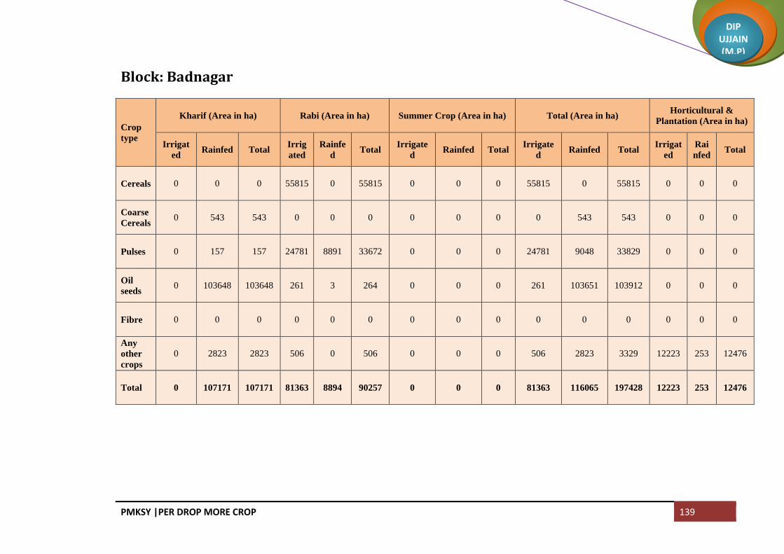
PMKSY |PER DROP MORE CROP 139
DIP UJJAIN (M.P)
Block: Badnagar
Crop
type
Kharif (Area in ha) Rabi (Area in ha) Summer Crop (Area in ha) Total (Area in ha) Horticultural &
Plantation (Area in ha)
Irrigat
ed Rainfed Total
Irrig
ated
Rainfe
d Total
Irrigate
d Rainfed Total
Irrigate
d Rainfed Total
Irrigat
ed
Rai
nfed Total
Cereals 0 0 0 55815 0 55815 0 0 0 55815 0 55815 0 0 0
Coarse
Cereals 0 543 543 0 0 0 0 0 0 0 543 543 0 0 0
Pulses 0 157 157 24781 8891 33672 0 0 0 24781 9048 33829 0 0 0
Oil
seeds 0 103648 103648 261 3 264 0 0 0 261 103651 103912 0 0 0
Fibre 0 0 0 0 0 0 0 0 0 0 0 0 0 0 0
Any
other
crops
0 2823 2823 506 0 506 0 0 0 506 2823 3329 12223 253 12476
Total 0 107171 107171 81363 8894 90257 0 0 0 81363 116065 197428 12223 253 12476

PMKSY |PER DROP MORE CROP 140
DIP UJJAIN (M.P)
Block: Mahidpur
Crop
type
Kharif (Area in ha) Rabi (Area in ha) Summer Crop (Area in ha) Total (Area in ha) Horticultural &
Plantation (Area in ha)
Irrigat
ed Rainfed Total
Irrig
ated
Rainfe
d Total
Irrigate
d Rainfed Total
Irrigate
d Rainfed Total
Irrigate
d
Rain
fed Total
Cereals 0 0 0 44261 0 44261 0 0 0 44261 0 44261 0 0 0
Coarse
Cereals 0 1112 1112 0 0 0 0 0 0 0 1112 1112 0 0 0
Pulses 0 783 783 9631 7008 16639 0 0 0 9631 7791 17422 0 0 0
Oil
seeds 0 87509 87509 890 17 907 0 0 0 890 87526 88416 0 0 0
Fibre 0 0 0 0 0 0 0 0 0 0 0 0 0 0 0
Any
other
crops
0 3945 3945 516 12 516 0 0 0 516 3945 4473 5706 58 5764
Total 0 93349 93349 55298 7037 62335 0 0 0 55298 100374 155684 5706 58 5764

PMKSY |PER DROP MORE CROP 141
DIP UJJAIN (M.P)
2.2 PRODUCTION AND PRODCTIVITY OF MAJOR CROPS
In kharif season major area is under Soybean. Out of the total area 98% the area is under Soybean. Area under
Soybean is totally rainfed. Production of Soybean totally depends on the rain and its distribution. When the rains are
good and evenly distribted then the production of Soybean is good bt when rains are scanty or there is uneven
distribution then the production of Soybea decreases as it happened in 2015 Kharif season because of the uneven
distribution of rainfall yield of Soybean reduced drastically resulted in low production and a big economic loss to
the farmers.
In Rabi season major crops are wheat and Gram. Wheat is sown only in irrigated condition and the production
depends on number of irrigation available in the season.Cropwise production and productivity is given in Table 2.2

PMKSY |PER DROP MORE CROP 142
DIP UJJAIN (M.P)
Table 2.2 Production and Productivity of Major Crops
Kharif Crops
Crops Area (ha)
Rainfed
Production (qtn/yr) Productivity or
Yield (kgs/ha)
Cost of Cultivation
(Rs/ha)
Rainfed
A Kharif
Coarse Cereals
Maize 4021 72378 1800 26600
Sorghum 171 2137 1250 25600
Pulses
Red gram 1149 12972 1129 24100
Black gram 973 10810 1111 24100
Green gram 298 1490 500 24100
Oilseeds
Soyabean 473180 7168677 1515 31100
Total Kharif 479792 7268464
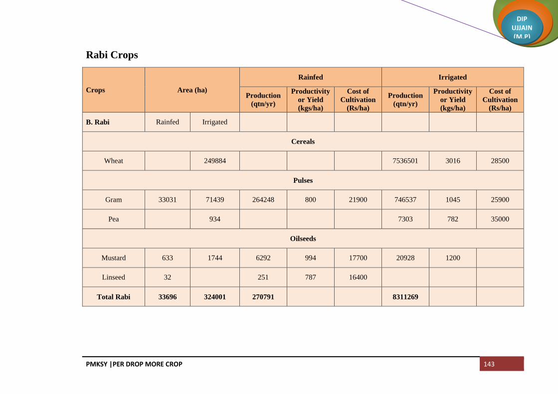
PMKSY |PER DROP MORE CROP 143
DIP UJJAIN (M.P)
Rabi Crops
Crops Area (ha)
Rainfed Irrigated
Production
(qtn/yr)
Productivity
or Yield
(kgs/ha)
Cost of
Cultivation
(Rs/ha)
Production
(qtn/yr)
Productivity
or Yield
(kgs/ha)
Cost of
Cultivation
(Rs/ha)
B. Rabi Rainfed Irrigated
Cereals
Wheat
249884
7536501 3016 28500
Pulses
Gram 33031 71439 264248 800 21900 746537 1045 25900
Pea
934
7303 782 35000
Oilseeds
Mustard 633 1744 6292 994 17700 20928 1200
Linseed 32
251 787 16400
Total Rabi 33696 324001 270791
8311269

PMKSY |PER DROP MORE CROP 144
DIP UJJAIN (M.P)
2.3 IRRIGATION BASED CLASSIFICATION
Net irrigated area is 347540 hectares and totally rainfed area is 534496 hectares. The net irrigated area to the
net cultivated area is 69.38% and net irrigated area195 to gross cropped area is 39.39%. Blockwise irrigation based
classification is given in Table 2.3
Table 2.3 Irrigation Based Classification
Name of Block
Irrigation (Area in in ha) Rainfed (Area in in ha)
Gross Irrigated Area Net Irrigated Area
Partially
Irrigated/Protective
Irrigation
Un-Irrigated or Totally
Rainfed
Ujjain 51447 51447 0 57642
Gattiya 42326 42326 0 54809
Tarana 51647 51647 0 92184
Khachrod 73805 73805 0 110587
Badnagar 93586 93586 0 116318
Mahidpur 61004 61004 0 100444
Total 373815 373815 0 531984

PMKSY |PER DROP MORE CROP 145
DIP UJJAIN (M.P)
2.4 DRAINAGE AND RIVER BASIN
Kshipra River is the main river in Ujjain area. It occupies western extremity of the town. River originates
from the hill called as kokri – bardi hills, developed about 11 km. southeast of Indore. The general course of the
river is towards northern direction. Khan River joins Kshipra at Triveni, at a distance of 6 km south of Ujjain city.
The other well-known river flowing in Ujjain district is Gambhir, Chamla, Chambal and Choti Kalisindh.Chambal
originates from a place known as Janapaspur at an elevation of 854 m above mean sea level in the Indore district.
The left bank tributaries of Chambal River are Bageri join the Chambal River Nagda and Kurel River near Uri. The
Chamla River originating from Dhar district join Chambal River near Piploda Sagoti Mata in Khachrod tehsil. Khan
River joins Chambal River near Ujjain and Gambhir River near Mahidpur.
The drainage pattern observed in the area is of dendritic nature, which is characterised by irregular branching
in all directions, with the tributaries joining the main stream.
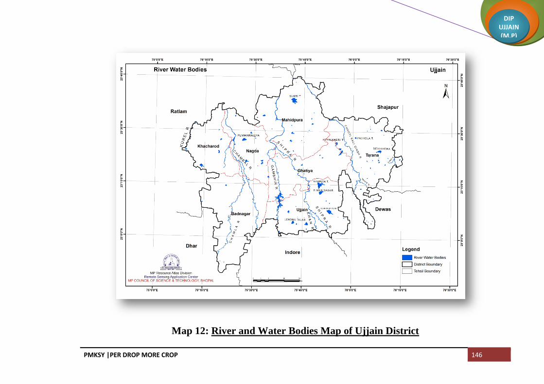
PMKSY |PER DROP MORE CROP 146
DIP UJJAIN (M.P)
Map 12: River and Water Bodies Map of Ujjain District

PMKSY |PER DROP MORE CROP 147
DIP UJJAIN (M.P)
Map 13: Drainage Map of Ujjain District

PMKSY |PER DROP MORE CROP 148
DIP UJJAIN (M.P)
Map 14: Lineament Map of Ujjain District

PMKSY |PER DROP MORE CROP 149
DIP UJJAIN (M.P)
Map 15: Watershed Map of Ujjain District

PMKSY |PER DROP MORE CROP 150
DIP UJJAIN (M.P)
Map 16: Land Irrigability Map of Ujjain District

PMKSY |PER DROP MORE CROP 151
DIP UJJAIN (M.P)
3.1 STATUS OF WATER AVAILABILTY
The irrigation facilities in Ujjain district are moderate. Surface water irrigation in the district is in the
developing stage. Groundwater is the main source of irrigation in the district Area under irrigation is 347571
hectares which is 69.38% of the net cultivated area. Tubewells are the major source of irrigation covering almost
71.13% of net irrigated area. Open wells constitutes 17.03%, canals constitutes 1.6% and tanks constitutes 1.3%
share of irrigated area. Status of water availability in Kharif and Rabi season is given in Table 3.1
Table 3.1 Status of Water Availability Source: Land Records
S.No. Sources Kharif Rabi Summer Total
1 Surface Irrigation
(i) Canal (Major &Medium Irrigation) 0 7187 0 7187
(ii) Minar Irrigation tanks 0 5102 0 5102
(iii) Lift Irrigation / Diversion 0 0 0 0
(iv) Various Water Bodies including rain water harvesting 0 27935 0 27935
(v) Treated effluent received from STP 0 0 0 0
(vi) Untreated effluent 0 0 0 0
(vii) Perennial sources of water 0 0 0 0
2 Ground water
(i) Open Well 0 65099 0 65099
(ii) Deep tube well 0 0 0 0
(iii) Medium tube well 0 268492 0 268492
Total 0 373815 0 373815
CHAPTER III WATER AVAILABILITY

PMKSY |PER DROP MORE CROP 152
DIP UJJAIN (M.P)
Fig 3: Irrigation Status from Different Sources
2% 1%
9%
17%
71%
Sourcewise Irrigation Status
Surface Irrigation
Canal (Major &Medium Irrigation)
Minor Irrigation tanks
Various Water Bodies including rain waterharvesting
Open Well
Medium tube well

PMKSY |PER DROP MORE CROP 153
DIP UJJAIN (M.P)
3.2 STATUS OF GROUND WATER AVAILABILITY
Ujjain district is underlain by mainly basaltic lava flows of Deccan trap. As per the report (2013) of Central
Ground Water Board North Central Region Government of India, Bhopal the dynamic ground water resources of the
district have been estimated for base year -2008/09 on block-wise basis. There are six assessment units (block) in
the district which fall under non-command (100 %). Mahidpur and Khachrod blocks of the district are categorized
as semi critical. Badnagar, Ghatia and Ujjain blocks are categorized as over exploited. Only one block namely
Tarana is Safe. The highest stage of ground water development is computed as 130 % in Ujjain block. The net
ground water availability in the district is 0.81209 BCM and ground water draft for all uses is 0.90744 BCM,
making stage of ground water development 99 % (109 % in 2003/04) as a whole for district. After making allocation
for future domestic and industrial supply for next 25 years, balance available ground water for future irrigation
would be 371ham. Blockwise status of ground water availability is given in Table 3.2
Table 3.2 Status of Ground Water Avilability Source: Ground Water Dept Unit BCM
Block Over Exploited Semi-Critical Safe Draft Recharge Gap
UJJAIN Over Exploited
0.16609 0.13507 (-)0.03101
GHATIYA Over Exploited
0.11544 0.12038 0.00494
TARANA
Safe 0.11067 0.15547 0.03892
MAHIDPUR
Semi-Critical
0.12262 0.18153 0.05335
KHACHROD
Semi-Critical
0.144 0.19573 0.05173
BADNAGAR Over Exploited
0.24862 0.21841 (-) 0.02449
Total 0.90744 1.00659 0.09915
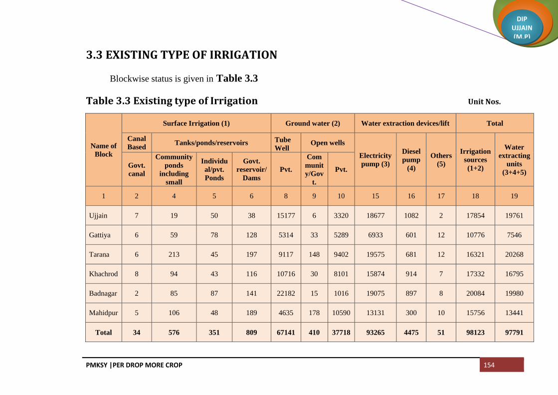
PMKSY |PER DROP MORE CROP 154
DIP UJJAIN (M.P)
3.3 EXISTING TYPE OF IRRIGATION
Blockwise status is given in Table 3.3
Table 3.3 Existing type of Irrigation Unit Nos.
Name of
Block
Surface Irrigation (1) Ground water (2) Water extraction devices/lift Total
Canal
Based Tanks/ponds/reservoirs Tube
Well Open wells
Electricity
pump (3)
Diesel
pump
(4)
Others
(5)
Irrigation
sources
(1+2)
Water
extracting
units
(3+4+5) Govt.
canal
Community
ponds
including
small
Individu
al/pvt.
Ponds
Govt.
reservoir/
Dams
Pvt.
Com
munit
y/Gov
t.
Pvt.
1 2 4 5 6 8 9 10 15 16 17 18 19
Ujjain 7 19 50 38 15177 6 3320 18677 1082 2 17854 19761
Gattiya 6 59 78 128 5314 33 5289 6933 601 12 10776 7546
Tarana 6 213 45 197 9117 148 9402 19575 681 12 16321 20268
Khachrod 8 94 43 116 10716 30 8101 15874 914 7 17332 16795
Badnagar 2 85 87 141 22182 15 1016 19075 897 8 20084 19980
Mahidpur 5 106 48 189 4635 178 10590 13131 300 10 15756 13441
Total 34 576 351 809 67141 410 37718 93265 4475 51 98123 97791

PMKSY |PER DROP MORE CROP 155
DIP UJJAIN (M.P)
4.1 DOMESTIC WATER DEMAND
As per census 2011 the total Population of the district is 1986864 of which Rural population of the district is
1207651 and the Urban Population is 779213. The average per cpita water requirement for Urban area is 135 litres
per day and for rural area is 70 litres per day. The present domestic gross water demand is 0.0671 BCM per annum
and the gross water demand projected for year 2020 is 0.0727 BCM. Block wise water demand is given in Table 4.1
Table 4.1 Domestic Water Demand Source: PHE Department Unit BCM
Block Population 2011 Population 2015 Present water Demand Projected Population in 2020 Water Demand in 2020
Ujjain Rural 157351 167666 0.0043 181515 0.0046
Urban 515215 548989 0.0271 594336 0.0293
Ghattiya Rural 138861 147964 0.0038 160186 0.0041
Tarana Rural 210713 224526 0.0057 243072 0.0062
Urban 36586 38984 0.0010 42204 0.0011
Khachrod Rural 250262 266667 0.0068 288694 0.0074
Urban 149004 158772 0.0041 171886 0.0044
Barnagar Rural 233135 248418 0.0063 268937 0.0069
Urban 36438 38827 0.0010 42034 0.0011
Mahidpur Rural 217329 231575 0.0059 250704 0.0064
Urban 41970 44721 0.0011 48415 0.0012
Total 1986864 2117108 0.0671 2291984 0.0727
CHAPTER IV WATER REQUIREMENT/DEMAND
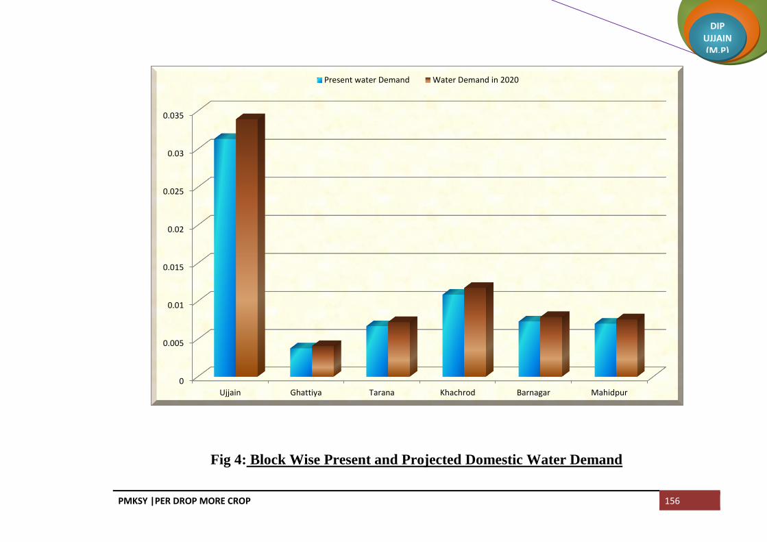
PMKSY |PER DROP MORE CROP 156
DIP UJJAIN (M.P)
Fig 4: Block Wise Present and Projected Domestic Water Demand
0
0.005
0.01
0.015
0.02
0.025
0.03
0.035
Ujjain Ghattiya Tarana Khachrod Barnagar Mahidpur
Present water Demand Water Demand in 2020

PMKSY |PER DROP MORE CROP 157
DIP UJJAIN (M.P)
4.2 CROP WATER REQUIREMENT:
Water requirement of a crop is the quantity of water needed for normal growth and yield and may be supplied
by precipitation or by irrigation or by both. Water is needed mainly to meet demand of evaporation (E),
Transpiration (T) and Metabolic needs of the plants, all together known as consumptive use (CU).
CU= E+T+ water needed for metabolic purpose.
Irrigation requirement is the total amount of water applied to a field to supplement rainfall and soil profile
contribution to meet the water needs of crops for optimum growth.
The Gross cropped area of the district is 882067 hectares of which 347571 is irrigated and rest is rainfed. In
zaid because of the non availability of water farmers are unable to take any crop. Water requirement for zaid crops
(10% of net sown area) as well as area left unsown in Rabi season because of non availability of irrigation water is
also considered while calculating the projected crop water requirement. The present crop water requirement is 3.751
BCM, existing water potential is 2.941BCM and water potential to be created is 0.809 BCM. The projected crop
water requirement by 2020 is 4.506 BCM and water potential to be created is 1.564BCM.
4.3 LIVES STOCK WATER DEMAND
The total livestock population is 795678 and the total water requiremwnt is 0.005812782 BCM. Presently the
water available for livestock is sufficient and there is no gap. The water requirement for 2020 is 0.00609893 BCM
and the water potential to be created by 2020 is 0.0002861 BCM. Blockwise detail is given in Table 4.2

PMKSY |PER DROP MORE CROP 158
DIP UJJAIN (M.P)
Table 4.2 Livestock Water Demand Source: Veternary Department
Block
Total Number
of Livestock
Present Water
Demand
(BCM)
Water
Demand in 2020(BCM)
Exiting Water Potential
(BCM)
Water Potential to be
Created (BCM)
UJJAIN 112972 0.000824692 0.00086592 0.000824692 0.0000412
GHATIYA 86278 0.00062999 0.00066138 0.00062999 0.0000314
TARANA 140936 0.001028935 0.00108028 0.001028935 0.0000513
MAHIDPUR 136211 0.00099426 0.00104406 0.00099426 0.0000498
KHACHROD 175063 0.00128188 0.00134186 0.00128188 0.0000600
BADNAGAR 144218 0.001053025 0.00110543 0.001053025 0.0000524
TOTAL 795678 0.005812782 0.00609893 0.005812782 0.0002861
4.4 INDUSTRIAL WATER DEMAND
The present industrial demand is 0.01563 BCM and the existing water potential is 0.0130629 BCM. The
projected water demand for 2020 is 0.01875 BCM and water potential to be created is 0.005697 BCM.

PMKSY |PER DROP MORE CROP 159
DIP UJJAIN (M.P)
4.5 TOTAL WATER DEMAND OF THE DISTRICT FOR VARIOUS SECTORS
The present water demand of the district for various saectors as a whole is 3.8391 BCM and projected for
2020 is 4.588 BCM. Detail is given in Table 4.3
Table 4.3 Total Water Demand
S.No. Block
Present Water Demand Projected Water Demand for 2020
Domestic crop Livestock Industrial Domestic crop Livestock Industrial
1 Ujjain 0.0313 0.4785 0.000824692 0.0000633 0.033924 0.5785 0.00086592 0.00001266
2 Ghattiya 0.0038 0.4228 0.00062999 0.004093 0.5078 0.00066138
3 Tarana 0.0067 0.5452 0.001028935 0.007289 0.6752 0.00108028
4 Khachrod 0.0109 0.7806 0.00128188 0.01557 0.011768 0.9356 0.00134186 0.003114
5 Badnagar 0.0073 0.8864 0.001053025 0.007945 1.0269 0.00110543
6 Mahidpur 0.0071 0.637 0.00099426 0.007642 0.7823 0.00104406
Total 0.06711686 3.7505 0.0058128 0.015633 0.07266 4.5063 0.0060989 0.0031267
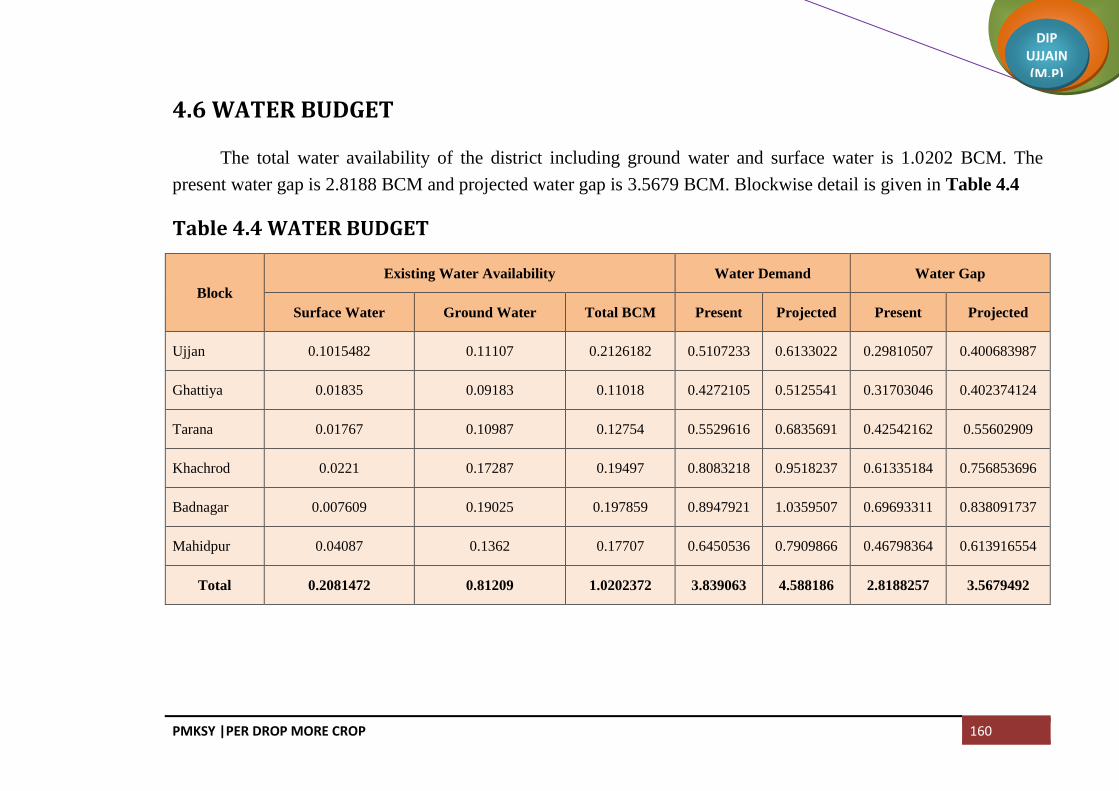
PMKSY |PER DROP MORE CROP 160
DIP UJJAIN (M.P)
4.6 WATER BUDGET
The total water availability of the district including ground water and surface water is 1.0202 BCM. The
present water gap is 2.8188 BCM and projected water gap is 3.5679 BCM. Blockwise detail is given in Table 4.4
Table 4.4 WATER BUDGET
Block
Existing Water Availability Water Demand Water Gap
Surface Water Ground Water Total BCM Present Projected Present Projected
Ujjan 0.1015482 0.11107 0.2126182 0.5107233 0.6133022 0.29810507 0.400683987
Ghattiya 0.01835 0.09183 0.11018 0.4272105 0.5125541 0.31703046 0.402374124
Tarana 0.01767 0.10987 0.12754 0.5529616 0.6835691 0.42542162 0.55602909
Khachrod 0.0221 0.17287 0.19497 0.8083218 0.9518237 0.61335184 0.756853696
Badnagar 0.007609 0.19025 0.197859 0.8947921 1.0359507 0.69693311 0.838091737
Mahidpur 0.04087 0.1362 0.17707 0.6450536 0.7909866 0.46798364 0.613916554
Total 0.2081472 0.81209 1.0202372 3.839063 4.588186 2.8188257 3.5679492

PMKSY |PER DROP MORE CROP 161
DIP UJJAIN (M.P)
Fig 5: Blockwise Present Water Demand and Gap
0
0.1
0.2
0.3
0.4
0.5
0.6
0.7
0.8
0.9
Ujjan Ghattiya Tarana Khachrod Badnagar Mahidpur
Present Water Demand in BCM Present Water Gap in BCM

PMKSY |PER DROP MORE CROP 162
DIP UJJAIN (M.P)
Blockwise Projected Water Demand and Gap
0
0.2
0.4
0.6
0.8
1
1.2
Ujjan Ghattiya Tarana Khachrod Badnagar Mahidpur
Projected Water Demand in BCM Projected Water Gap in BCM

PMKSY |PER DROP MORE CROP 163
DIP UJJAIN (M.P)
Strategic Action plan
After complete implementation of this plan about 106250 hectare area will be irrigated and about 0.215055
BCM surface water availability will be created. Strategic action plan block wise is given in the following Table 5
Table 5 Strategic Action Plan for Irrigation
AIBP
S.No
Name of
the
Blocks
Concerned
Department Activity
Total
Number
Command
Area/
Irrigation
Potential (Ha)
Period of
Implementation
(5/7 Yrs)
Estimated
Cost (in
Lacs Rs.)
1
Ghattiya WR Surface Minor Irrigation 2 1510 4 Years 4022.55
Tarana WR Surface Minor Irrigation 5 1820 5 Years 5635.05
Khachrod WR Surface Minor Irrigation 5 4075 5 Years 17181.38
Badnagar WR Surface Minor Irrigation 2 329 5 Years 1650.10
Mahidpur WR Surface Minor Irrigation 6 7016 5 Years 15637.35
Total 20 14750 5 years 44126.43
2
Ghattiya WR RRR of Water Bodies 2 371 3 Years 115.00
Khachrod WR RRR of Water Bodies 2 1564 2Years 433.57
Badnagar WR RRR of Water Bodies 1 183 5 Years 50.00
Mahidpur WR RRR of Water Bodies 2 2718 4Years 1123.00
Total 7 4836 2-5 years 1721.57
CHAPTER V STRATEGIC ACTION PLAN FOR IRRIGATION IN DISTRICT UNDER PMKSY

PMKSY |PER DROP MORE CROP 164
DIP UJJAIN (M.P)
Per Drop More Crop (Micro Irrigation)
S.No
Name of
the
Blocks
Concerned
Department Activity
Total
Number
Command
Area/
Irrigation
Potential (Ha)
Period of
Implementation
(5/7 Yrs)
Estimated
Cost (in Lacs
Rs.)
3
Ujjain FWAD Non DPAP Drip 350
5 years 298.90
Ghattiya FWAD Non DPAP Drip 320
5 years 273.28
Tarana FWAD Non DPAP Drip 400
5 years 341.60
Khachrod FWAD Non DPAP Drip 500
5 years 427.00
Badnagar FWAD Non DPAP Drip 480
5 years 409.92
Mahidpur FWAD Non DPAP Drip 450
5 years 384.30
Total 2500
5 years 2135.00
3.1
Ujjain Horticulture Non DPAP Drip 364
5 years 310.86
Ghattiya Horticulture Non DPAP Drip 364
5 years 310.86
Tarana Horticulture Non DPAP Drip 521
5 years 444.93
Khachrod Horticulture Non DPAP Drip 521
5 years 444.93
Badnagar Horticulture Non DPAP Drip 364
5 years 310.86
Mahidpur Horticulture Non DPAP Drip 352
5 years 300.61
Total 2486
5 years 2123.04

PMKSY |PER DROP MORE CROP 165
DIP UJJAIN (M.P)
Per Drop More Crop (Micro Irrigation)
S.No
Name of
the
Blocks
Concerned
Department Activity
Total
Number
Command
Area/
Irrigation
Potential (Ha)
Period of
Implementation
(5/7 Yrs)
Estimated
Cost (in Lacs
Rs.)
4
Ujjain FWAD Non DPAP Sprinkler 3725
5 years 745.02
Ghattiya FWAD Non DPAP Sprinkler 3235
5 years 647.01
Tarana FWAD Non DPAP Sprinkler 4951
5 years 990.27
Khachrod FWAD Non DPAP Sprinkler 9272
5 years 1854.33
Badnagar FWAD Non DPAP Sprinkler 8234
5 years 1646.82
Mahidpur FWAD Non DPAP Sprinkler 6917
5 years 1383.48
Total 36335
5 years 7266.93
4.1
Ujjain Horticulture Non DPAP Sprinkler 413
5 years 81.00
Ghattiya Horticulture Non DPAP Sprinkler 413
5 years 81.00
Tarana Horticulture Non DPAP Sprinkler 816
5 years 160.00
Khachrod Horticulture Non DPAP Sprinkler 816
5 years 160.00
Badnagar Horticulture Non DPAP Sprinkler 495
5 years 97.00
Mahidpur Horticulture Non DPAP Sprinkler 413
5 years 81.00
Total 3367
5 years 660.00

PMKSY |PER DROP MORE CROP 166
DIP UJJAIN (M.P)
Per Drop More Crop (Supplementary Water Management Activities)
S.No Name of
the Blocks
Concerned
Department Activity
Total
Number
Command Area/
Irrigation
Potential (Ha)
Period of
Implementation
(5/7 Yrs)
Estimated Cost
(in Lacs Rs.)
5
Ujjain FWAD
Drought Proofing through
Check Dams
1992 - 5Years 341.26
Ghattiya FWAD 1300 - 5 Years 251.10
Tarana FWAD 1472 - 5 Years 256.92
Khachrod FWAD 599 1648 5 Years 2152.00
Badnagar FWAD 310 1219 5 Years 1666.00
Mahidpur FWAD 816 3264 5 Years 2448.00
Total 6489 6131 5-7 Years 7115.28
6
Ujjain FWAD
Drought Proofing through
Water Harvesting Structures
263 124 5 Years 474.40
Ghattiya FWAD 293 170.8 5 Years 671.40
Tarana FWAD 480 240 5 Years 913.00
Khachrod FWAD 46 322 5 Years 460.00
Badnagar FWAD 50 350 5 Years 500.00
Mahidpur FWAD 2869 14345 5 Years 8607.00
Total 4001 15552 5 Years 11625.80
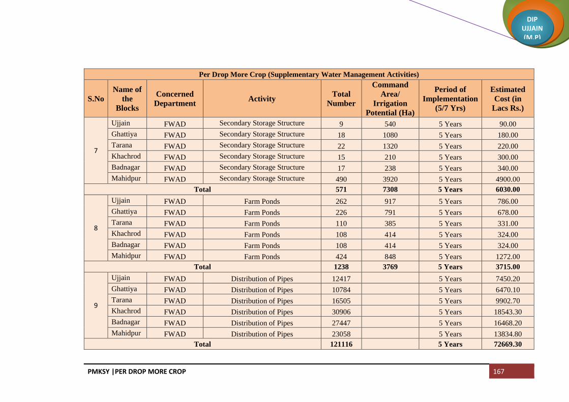
PMKSY |PER DROP MORE CROP 167
DIP UJJAIN (M.P)
Per Drop More Crop (Supplementary Water Management Activities)
S.No
Name of
the
Blocks
Concerned
Department Activity
Total
Number
Command
Area/
Irrigation
Potential (Ha)
Period of
Implementation
(5/7 Yrs)
Estimated
Cost (in
Lacs Rs.)
7
Ujjain FWAD Secondary Storage Structure 9 540 5 Years 90.00
Ghattiya FWAD Secondary Storage Structure 18 1080 5 Years 180.00
Tarana FWAD Secondary Storage Structure 22 1320 5 Years 220.00
Khachrod FWAD Secondary Storage Structure 15 210 5 Years 300.00
Badnagar FWAD Secondary Storage Structure 17 238 5 Years 340.00
Mahidpur FWAD Secondary Storage Structure 490 3920 5 Years 4900.00
Total 571 7308 5 Years 6030.00
8
Ujjain FWAD Farm Ponds 262 917 5 Years 786.00
Ghattiya FWAD Farm Ponds 226 791 5 Years 678.00
Tarana FWAD Farm Ponds 110 385 5 Years 331.00
Khachrod FWAD Farm Ponds 108 414 5 Years 324.00
Badnagar FWAD Farm Ponds 108 414 5 Years 324.00
Mahidpur FWAD Farm Ponds 424 848 5 Years 1272.00
Total 1238 3769 5 Years 3715.00
9
Ujjain FWAD Distribution of Pipes 12417
5 Years 7450.20
Ghattiya FWAD Distribution of Pipes 10784
5 Years 6470.10
Tarana FWAD Distribution of Pipes 16505
5 Years 9902.70
Khachrod FWAD Distribution of Pipes 30906
5 Years 18543.30
Badnagar FWAD Distribution of Pipes 27447
5 Years 16468.20
Mahidpur FWAD Distribution of Pipes 23058
5 Years 13834.80
Total 121116
5 Years 72669.30

PMKSY |PER DROP MORE CROP 168
DIP UJJAIN (M.P)
Per Drop More Crop (Supplementary Water Management Activities)
S.No Name of
the Blocks
Concerned
Department Activity
Total
Number
Command
Area/
Irrigation
Potential (Ha)
Period of
Implementation
(5/7 Yrs)
Estimated
Cost (in Lacs
Rs.)
10
Ujjain FWAD Diesel Pump/ Electric Pump 2483 - 5 Years 496.68
Ghattiya FWAD Diesel Pump/ Electric Pump 2157 - 5 Years 431.34
Tarana FWAD Diesel Pump/ Electric Pump 3301 - 5 Years 660.18
Khachrod FWAD Diesel Pump/ Electric Pump 6181 - 5 Years 1236.22
Badnagar FWAD Diesel Pump/ Electric Pump 5489 - 5 Years 1097.88
Mahidpur FWAD Diesel Pump/ Electric Pump 4612 - 5 Years 922.32
Total 24223 - 5 Years 4844.62
11
Ujjain FWAD Solar Pump 369 - 5 Years 2214.00
Ghattiya FWAD Solar Pump 241 - 5 Years 1446.00
Tarana FWAD Solar Pump 476 - 5 Years 2856.00
Khachrod FWAD Solar Pump 765 - 5 Years 4590.00
Badnagar FWAD Solar Pump 664 - 5 Years 3984.00
Mahidpur FWAD Solar Pump 579 - 5 Years 3474.000
Total 3094 - 5 Years 18564.00

PMKSY |PER DROP MORE CROP 169
DIP UJJAIN (M.P)
Per Drop More Crop (Supplementary Water Management Activities)
S.No
Name of
the
Blocks
Concerned
Department Activity
Total
Hectare
Command
Area/
Irrigation
Potential
(Ha)
Period of
Implementation
(5/7 Yrs)
Estimated
Cost (in
Lacs Rs.)
12
Ujjain FWAD Raised Bed and Furrow system 43741 5 Years 1312.23
Ghattiya FWAD Raised Bed and Furrow system 41059 5 Years 1231.77
Tarana FWAD Raised Bed and Furrow system 64736 5 Years 1942.08
Khachrod FWAD Raised Bed and Furrow system 82860 5 Years 2485.80
Badnagar FWAD Raised Bed and Furrow system 84664 5 Years 2539.92
Mahidpur FWAD Raised Bed and Furrow system 73765 5 Years 2212.95
Total 390825 5 Years 11724.75
13
Ujjain FWAD Land Levelling/ Bunding 5468 5 Years 546.80
Ghattiya FWAD Land Levelling/ Bunding 5132 5 Years 513.20
Tarana FWAD Land Levelling/ Bunding 8092 5 Years 809.20
Khachrod FWAD Land Levelling/ Bunding 10358 5 Years 1035.80
Badnagar FWAD Land Levelling/ Bunding 10583 5 Years 1058.30
Mahidpur FWAD Land Levelling/ Bunding 9221 5 Years 922.10
Total 48854 4885.40
14
Ujjain FWAD Nallah Bund 121 484 5 Years 605.00
Ghattiya FWAD Nallah Bund 191 764 5 Years 955.00
Tarana FWAD Nallah Bund 203 812 5 Years 1015.00
Khachrod FWAD Nallah Bund 14 196 5 Years 280.00
Badnagar FWAD Nallah Bund 99 1386 5 Years 1980.00
Mahidpur FWAD Nallah Bund 1958 14371 5 Years 3916.00
Total 2586 18013 5 Years 8751.00

PMKSY |PER DROP MORE CROP 170
DIP UJJAIN (M.P)
Per Drop More Crop (Supplementary Water Management Activities)
S.No
Name of
the
Blocks
Concerned
Department Activity
Total
Number
Command
Area/
Irrigation
Potential (Ha)
Period of
Implementation
(5/7 Yrs)
Estimated
Cost (in Lacs
Rs.)
15
Ujjain FWAD Percolation Tank 24
5 Years 192.00
Ghattiya FWAD Percolation Tank 138
5 Years 1104.00
Tarana FWAD Percolation Tank 148
5 Years 1184.00
Khachrod FWAD Percolation Tank 30
5 Years 300.00
Badnagar FWAD Percolation Tank 67
5 Years 670.00
Mahidpur FWAD Percolation Tank 266
5Years 5320.00
Total 673 0 5 Years 8770.00
16
Khachrod FWAD Dug Out Pond 120 460 5 Years 360.00
Badnagar FWAD Dug Out Pond 217 833 5 Years 651.00
Khachrod FWAD Periferal Bunds 461747 Rmt 5 Years 409.68
Badnagar FWAD Periferal Bunds 298622 Rmt 5 Years 424.00
Mahidpur FWAD Other Ground Water Recharge Structure 2146 3088 5 Years 1073.00
Total
4381 5 Years 2917.00
17
Ujjain FWAD Renovation of Tank/ Farm Ponds 61 3050 5 Years 183.00
Ghattiya FWAD Renovation of Tank/ Farm Ponds 17 850 5 Years 51.00
Tarana FWAD Renovation of Tank/ Farm Ponds 45 2250 5 Years 135.00
Khachrod FWAD Renovation of Tank/ Farm Ponds 130 91 5 Years 390.00
Badnagar FWAD Renovation of Tank/ Farm Ponds 125 88 3 Years 375.00
Mahidpur FWAD Renovation of Tank/ Farm Ponds 126 378 5 Years 378.00
Total 470 6707 5 Years 1512.00

PMKSY |PER DROP MORE CROP 171
DIP UJJAIN (M.P)
PMKSY WATERSHED/Ongoing WHS (Ongoing Projects IWMP)
S.No Name of
the Blocks
Concerned
Department Activity
Total
Number
Command Area/
Irrigation
Potential (Ha)
Period of
Implementation
(5/7 Yrs)
Estimated
Cost (in
Lacs Rs.)
18
Ghattiya RD Farm Pond 22 116.37 2-3 Year 50.02
Tarana RD Farm Pond 12 12 2-3 Year 51.72
Khachrod RD Farm Pond 15 38.95 1 Year 36.52
Badnagar RD Farm Pond 18 38.3 2-3 Year 77.87
Mahidpur RD Farm Pond
1 Year
Total 45 89.25 2-3 Year 216.13
18.1
Ghattiya RD Check dams 59 424.74 2-3 Year 325.26
Tarana RD Check dams 37 109.35 2-3 Year 147.81
Khachrod RD Check dams 25 126.95 1 Year 127.88
Badnagar RD Check dams 14 149.8 2-3 Year 147.12
Mahidpur RD Check dams 24 395.63 1 Year 277.49
Total 159 1206.47 2-3 Year 1025.56

PMKSY |PER DROP MORE CROP 172
DIP UJJAIN (M.P)
PMKSY WATERSHED/Ongoing WHS (Ongoing Projects IWMP)
S.No
Name of
the
Blocks
Concerned
Department Activity
Total
Number
Command
Area/
Irrigation
Potential (Ha)
Period of
Implementation
(5/7 Yrs)
Estimated
Cost (in
Lacs Rs.)
18.2
Ghattiya RD Percolation Tank 17 136.56 2-3 Year 90.64
Tarana RD Percolation Tank 30 98.6 2-3 Year 152.91
Khachrod RD Percolation Tank 7 32.3 1 Year 30.10
Badnagar RD Percolation Tank 6 44.55 2-3 Year 45.00
Mahidpur RD Percolation Tank 1 11.15 1 Year 7.25
Total 61 323.16 2-3 Year 325.90
18.3
Ghattiya RD Other Ground Water Recharge Structure 3
2-3 Year 14.49
Tarana RD Other Ground Water Recharge Structure 200
2-3 Year 7.98
Khachrod RD Other Ground Water Recharge Structure 10
1 Year 10.78
Badnagar RD Other Ground Water Recharge Structure
2-3 Year
Mahidpur RD Other Ground Water Recharge Structure
1 Year
Total 213 0 2-3 Year 33.25
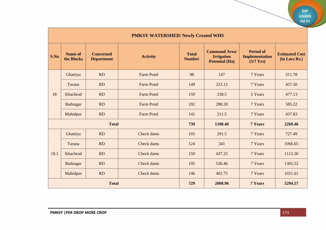
PMKSY |PER DROP MORE CROP 173
DIP UJJAIN (M.P)
PMKSY WATERSHED/ Newly Created WHS
S.No Name of
the Blocks
Concerned
Department Activity
Total
Number
Command Area/
Irrigation
Potential (Ha)
Period of
Implementation
(5/7 Yrs)
Estimated Cost
(in Lacs Rs.)
18
Ghattiya RD Farm Pond 98 147 7 Years 311.78
Tarana RD Farm Pond 149 223.12 7 Years 457.50
Khachrod RD Farm Pond 159 238.5 5 Years 477.13
Badnagar RD Farm Pond 192 288.28 7 Years 585.22
Mahidpur RD Farm Pond 141 211.5 7 Years 437.83
Total 739 1108.40 7 Years 2269.46
18.1
Ghattiya RD Check dams 105 291.5 7 Years 727.49
Tarana RD Check dams 124 341 7 Years 1066.65
Khachrod RD Check dams 159 437.25 7 Years 1113.30
Badnagar RD Check dams 195 536.46 7 Years 1365.52
Mahidpur RD Check dams 146 402.75 7 Years 1021.61
Total 729 2008.96 7 Years 5294.57

PMKSY |PER DROP MORE CROP 174
DIP UJJAIN (M.P)
PMKSY WATERSHED/ Newly Created WHS
S.No
Name of
the
Blocks
Concerned
Department Activity
Total
Number
Command
Area/
Irrigation
Potential (Ha)
Period of
Implementation
(5/7 Yrs)
Estimated
Cost (in Lacs
Rs.)
18.2
Ghattiya RD Percolation Tank 87 261 7 Years 935.35
Tarana RD Percolation Tank 128 382 7 Years 1371.41
Khachrod RD Percolation Tank 130 390 7 Years 1431.39
Badnagar RD Percolation Tank 160 367.56 5 to 7 Years 1755.67
Mahidpur RD Percolation Tank 124 351.5 7 Years 1313.49
Total 629 1752.06 5 to 7 Years 6807.31
18.3
Ghattiya RD Other Ground Water Recharge Structure 28
7 Years 103.93
Tarana RD Other Ground Water Recharge Structure 88
7 Years 152.38
Khachrod RD Other Ground Water Recharge Structure 88
7 Years 159.04
Badnagar RD Other Ground Water Recharge Structure 99
7 Years 195.07
Mahidpur RD Other Ground Water Recharge Structure 84
7 Years 145.94
Total 387 0 7 Years 756.36

PMKSY |PER DROP MORE CROP 175
DIP UJJAIN (M.P)
Convergence with MGNREGA
S.No
Name of
the
Blocks
Concerned
Department Activity
Total
Number
Command
Area/
Irrigation
Potential
(Ha)
Period of
Implementation
(5/7 Yrs)
Estimate
d Cost (in
Lacs Rs.)
19
Ujjain RD Water Conservation 625 1312 2 Year 2812.50
Ghattiya RD Water Conservation 150 315 2 Year 675.00
Tarana RD Water Conservation 54 113 2 Year 243.00
Khachrod RD Water Conservation 9 19 2 Year 40.50
Badnagar RD Water Conservation 241 506 2 Year 1084.50
Mahidpur RD Water Conservation 52 109 2 Year 234.00
Total 1131 2374 2 Year 5089.5
Ujjain RD Providing Infrastructure For Irrigation 66 99 1 Year 148.50
19.1
Ghattiya RD Providing Infrastructure For Irrigation 492 738 1 Year 1107.00
Tarana RD Providing Infrastructure For Irrigation 334 501 1 Year 751.50
Khachrod RD Providing Infrastructure For Irrigation 279 418 1 Year 627.75
Badnagar RD Providing Infrastructure For Irrigation 22 33 1 Year 49.50
Mahidpur RD Providing Infrastructure For Irrigation 488 732 1 Year 1098.00
Total 1681 2521 1 Year 3782.25

PMKSY |PER DROP MORE CROP 176
DIP UJJAIN (M.P)
Convergence with MGNREGA
S.No
Name of
the
Blocks
Concerned
Department Activity
Total
Number
Command
Area/
Irrigation
Potential (Ha)
Period of
Implementation
(5/7 Yrs)
Estimated
Cost (in
Lacs Rs.)
19.2
Ujjain RD Tubewell Recharge 2000 5 Year 460.00
Ghattiya RD Tubewell Recharge 1500 5 Year 345.00
Tarana RD Tubewell Recharge 2500 5 Year 575.00
Khachrod RD Tubewell Recharge 3000 5 Year 690.00
Badnagar RD Tubewell Recharge 2000 5 Year 460.00
Mahidpur RD Tubewell Recharge 2000 5 Year 460.00
Total 13000 0 1 Year 2990.00
Ujjain RD Land Development 321 1 Year 128.40
19.3
Ghattiya RD Land Development 295 1 Year 118.00
Tarana RD Land Development 96 1 Year 38.40
Khachrod RD Land Development 65 1 Year 26.00
Badnagar RD Land Development 607 1 Year 242.80
Mahidpur RD Land Development 166 1 Year 66.40
Total 1550 0 1 Year 620.00

PMKSY |PER DROP MORE CROP 177
DIP UJJAIN (M.P)
State Planned Scheme of Irrigation
S.No Name of the
Blocks
Concerned
Department Name of Scheme
Total
Number
Comman
d Area/
Irrigation
Potential
(Ha)
Period of
Implementati
on (5/7 Yrs)
Estimated
Cost (in
Lacs Rs.)
20
Ujjain FWAD Balram Talab 440 2200 5 Years 2200.00
Ghattiya FWAD Balram Talab 252 1260 5 Years 1260.00
Tarana FWAD Balram Talab 520 2600 5 Years 2600.00
Khachrod FWAD Balram Talab 742 3710 5 Years 3710.00
Badnagar FWAD Balram Talab 644 3220 5 Years 3220.00
Mahidpur FWAD Balram Talab 284 1420 5 Years 1420.00
Total 2882 14410 5 Years 14410.00
Externally Aided Projects
21 District
Ujjain
FWAD
(ATMA)
Exposure Visit for Farmers Out of
State 1200 5 Years 9.60
FWAD
(ATMA)
Exposure visit for farmers in the
state 900 5 Years 3.60
FWAD
(ATMA) Training Within District 2400 5 Years 6.00
FWAD
(ATMA) Training Within State 450 5 Years 4.50
FWAD
(ATMA) Farm School 60 5 Years 17.65
FWAD
(ATMA) Publicity and Literature 5 Years 4.50
Total 45.85
Grand Total 264823.94

PMKSY |PER DROP MORE CROP 178
DIP UJJAIN (M.P)
PMKSY Year Wise Action Plan
S.
No
Concer
ned
Ministr
y/
Depart
ment
Component
and Sub
Component
Activity
Total
Number/Capacity
(Cum)
Comma
nd
Area/Irr
igation
(Ha)
Period of Implementation (5/7 Year) Estimated Cost
Year Wise (Rs in Crore) Total
Estimat
ed Cost
(Rs. In
Crore)
Total
No
Capacity
(Cum) 2017-18 2018-19
2019-
20
2020-
21
2021-
22
2022-
23
1 WRD
AIBP
Surface
Minor
Irrigation
20 80780000 14750 110.32 110.32 75.01 75.01 70.60 441.26
RRR of
Water Bodies 7 8870000 4836 5.16 6.89 3.44 1.72 17.22
Sub Total 27 89650000 19586 115.48 117.20 78.46 76.74 70.60 0.00 458.48
Har Khet ko
Pani
Sub Total
2 RD
IWMP
Ongoing
Project
Farm Pond 45 71400 89.25 0.76 0.76 0.65 2.16
IWMP
Ongoing
Project
Check dams 159 965176 1206.47 3.59 3.59 3.08 10.26
IWMP
Ongoing
Project
Percolation
Tank 61 258528 323.16 1.14 1.14 0.98 3.26
ANNEXURE I PMKSY YEARWISE ACTION PLAN

PMKSY |PER DROP MORE CROP 179
DIP UJJAIN (M.P)
PMKSY Year Wise Action Plan
S.
No
Concer
ned
Ministr
y/
Depart
ment
Component
and Sub
Component
Activity
Total
Number/Capacity
(Cum)
Comma
nd
Area/Irr
igation
(Ha)
Period of Implementation (5/7 Year) Estimated Cost
Year Wise (Rs in Crore) Total
Estimat
ed Cost
(Rs. In
Crore)
Total
No
Capacity
(Cum) 2017-18 2018-19
2019-
20
2020-
21
2021-
22
2022-
23
IWMP
Ongoing
Project
Other
Ground
Water
Recharge
Structure
213 0 0.12 0.12 0.10 0.33
IWMP New
Project Farm Pond 739 886720 1108.4 3.40 4.54 4.54 4.54 3.40 2.27 22.69
IWMP New
Project Check dams 729 1607168 2008.96 7.94 10.59 10.59 10.59 7.94 5.29 52.95
IWMP New
Project
Percolation
Tank 629 1401648 1752.06 10.21 13.61 13.61 13.61 10.21 6.81 68.07
IWMP New
Project
Other
Ground
Water
Recharge
Structure
387 0 1.13 1.51 1.51 1.51 1.13 0.76 7.56
Sub Total 2962 5190640 6488.3 28.29 35.86 35.06 30.26 22.69 15.13 167.29
MGNREGA Water
Conservation 1131 1899200 2374 10.60 40.295 50.90
MGNREGA
Providing
Infrastructure
For Irrigation
1681 2016800 2521 37.82 37.82
MGNREGA Land
Development 1550 6.20 6.20

PMKSY |PER DROP MORE CROP 180
DIP UJJAIN (M.P)
PMKSY Year Wise Action Plan
S.
No
Concer
ned
Ministr
y/
Depart
ment
Component
and Sub
Component
Activity
Total
Number/Capacity
(Cum)
Comma
nd
Area/Irr
igation
(Ha)
Period of Implementation (5/7 Year) Estimated Cost
Year Wise (Rs in Crore) Total
Estimat
ed Cost
(Rs. In
Crore)
Total
No
Capacity
(Cum) 2017-18 2018-19
2019-
20
2020-
21
2021-
22
2022-
23
MGNREGA Tubewell
Recharge 13000 52000 5.98 5.98 5.98 5.98 5.98 29.90
Sub Total 17362 56895 60.60 46.275 5.98 5.98 5.98 0 124.81
3 Horticul
ture
Per Drop
More
Crop
Micro
Irrigation
Non DPAP
Sprinkler 3367 1.00 1.25 1.35 1.45 1.55 6.60
Non DPAP
Drip 2486 3.48 4.00 4.25 4.50 5.00 21.23
Sub Total 5853 4.48 5.25 5.60 5.95 6.55 0.00 27.83
4 Agricul
ture
Per Drop
More Crop
a. Micro
Irrigation
Non DPAP
Drip 2500 1.82 5.30 5.34 5.29 3.60 21.35
Non DPAP
Sprinkler 36335 8.50 16.56 16.55 16.56 14.49 72.67
Sub Total 38835 0 0 10.32 21.86 21.89 21.85 18.09 0 94.02

PMKSY |PER DROP MORE CROP 181
DIP UJJAIN (M.P)
PMKSY Year Wise Action Plan
S.
No
Concer
ned
Ministr
y/
Depart
ment
Component
and Sub
Component
Activity
Total
Number/Capacity
(Cum)
Comma
nd
Area/Irr
igation
(Ha)
Period of Implementation (5/7 Year) Estimated Cost
Year Wise (Rs in Crore) Total
Estimat
ed Cost
(Rs. In
Crore)
Total
No
Capacity
(Cum) 2017-18 2018-19
2019-
20
2020-
21
2021-
22
2022-
23
b. Other
Intervention
Drought
Proofing
through
Check Dams
6489 4904800 6131 9.88 16.375 16.72 14.80 13.37 71.15
Drought
Proofing
through
Water
Harvesting
Structures
4001 12441600 15552 22.05 25.08 24.03 23.08 22.01 116.26
Secondary
Storage
Structure
571 5846400 7308 11.00 12.7 13.00 12.20 11.4 60.30
Farm Ponds 1238 3015200 3769 6.50 8.20 8.18 7.88 6.38 37.15
Distribution
of Pipes 121116 0 78.00 169.20 166.78 168.7 144 726.69
Diesel Pump/
Electric
Pump
24223 0 4.8 11.82 11.71 11.54 8.56 48.45
Solar Pump 3094 0 19.20 45.70 44.40 42.50 33.84 185.64

PMKSY |PER DROP MORE CROP 182
DIP UJJAIN (M.P)
PMKSY Year Wise Action Plan
S.
No
Concer
ned
Ministr
y/
Depart
ment
Component
and Sub
Component
Activity
Total
Number/Capacity
(Cum)
Comma
nd
Area/Irr
igation
(Ha)
Period of Implementation (5/7 Year) Estimated Cost
Year Wise (Rs in Crore) Total
Estimat
ed Cost
(Rs. In
Crore)
Total
No
Capacity
(Cum) 2017-18 2018-19
2019-
20
2020-
21
2021-
22
2022-
23
Raised Bed
and Furrow
system
390825 0 0 31.00 31.00 30.00 25.00 117.25
Land
Levelling/
Bunding
48854 0 2.58 12.41 12.39 12.39 9.082 48.85
Nallah Bund 2586 14410400 18013 16.28 17.94 17.93 17.93 17.43 87.51
Percolation
Tank 673 0 15.54 18.04 18.44 18.44 17.24 87.70
Dug Out
Pond 337 1040000 1300 1.11 2.25 2.25 2.25 2.25 10.11
Periferal
Bunds 0 1.39 1.74 1.74 1.74 1.74 8.34
Other
Ground
Water
Recharge
Structure
2146 2470400 3088 2.13 2.15 2.15 2.15 2.15 10.73
Renovation
of Tank/
Farm Ponds
470 5365600 6707 2.72 3.79 3.79 2.41 2.41 15.12
Balram Talab 2882 11528000 14410 14.74 32.59 32.59 32.59 31.59 144.10
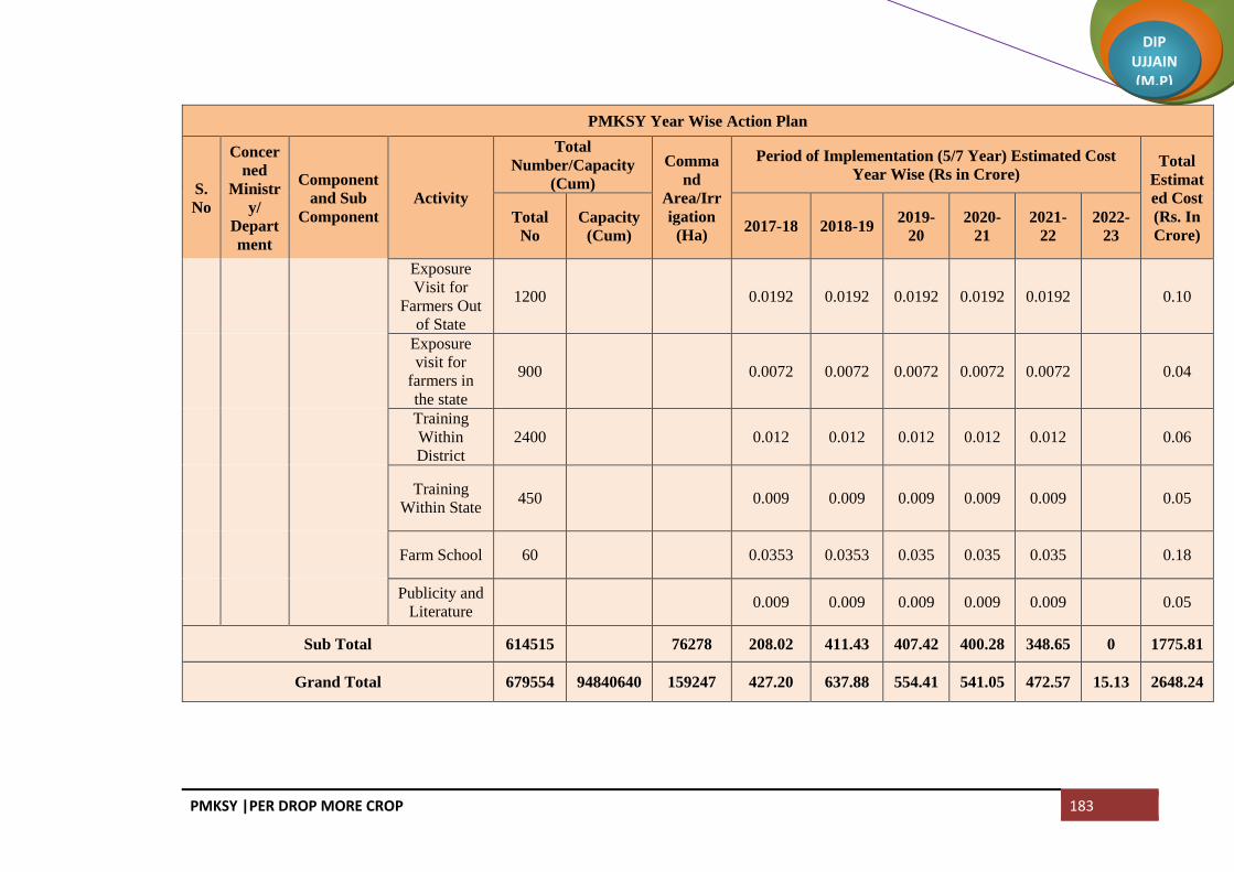
PMKSY |PER DROP MORE CROP 183
DIP UJJAIN (M.P)
PMKSY Year Wise Action Plan
S.
No
Concer
ned
Ministr
y/
Depart
ment
Component
and Sub
Component
Activity
Total
Number/Capacity
(Cum)
Comma
nd
Area/Irr
igation
(Ha)
Period of Implementation (5/7 Year) Estimated Cost
Year Wise (Rs in Crore) Total
Estimat
ed Cost
(Rs. In
Crore)
Total
No
Capacity
(Cum) 2017-18 2018-19
2019-
20
2020-
21
2021-
22
2022-
23
Exposure
Visit for
Farmers Out
of State
1200 0.0192 0.0192 0.0192 0.0192 0.0192 0.10
Exposure
visit for
farmers in
the state
900 0.0072 0.0072 0.0072 0.0072 0.0072 0.04
Training
Within
District
2400 0.012 0.012 0.012 0.012 0.012 0.06
Training
Within State 450 0.009 0.009 0.009 0.009 0.009 0.05
Farm School 60 0.0353 0.0353 0.035 0.035 0.035 0.18
Publicity and
Literature 0.009 0.009 0.009 0.009 0.009 0.05
Sub Total 614515 76278 208.02 411.43 407.42 400.28 348.65 0 1775.81
Grand Total 679554 94840640 159247 427.20 637.88 554.41 541.05 472.57 15.13 2648.24

PMKSY |PER DROP MORE CROP 184
DIP UJJAIN (M.P)
Village Wise Strategic Action Plan
1. AIBP
AIBP
Name of
the
Blocks
Name of
the Gram
Panchayat
Name of
Village Activity
Name of the
Project
Capacity
(MCM)
Comman
d Area/
Irrigation
Potential
(Ha)
Estimate
d Cost
(in Lacs
Rs.)
Latitude Longitude
Ghattiya Dhulmahu Dhulmahu Surface Minor
Irrigation Dhulmahu Tank 0.65 110 326.30 23°16'30" 75°38'15"
Bhilkheda Surface Minor
Irrigation Bhilkheda Tank 7.85 1400 3696.25 23°22'26" 75°43'41"
Total 8.50 1510.00 4022.55
Tarana Surface Minor
Irrigation
Bhagwatpura
Tank 0.25 150 233.76 23°43'30" 76°56'25"
Godadi Dhanyakhedi Surface Minor
Irrigation
Dhanyakhedi
Tank 0.45 80 222.21 23°47'00" 76°53'00"
Ramdi Borkhedi Surface Minor
Irrigation Borkhedi Tank 7.34 1320 4553.89 23°28'06" 76°09'06"
Dobragujar Dobragujar Surface Minor
Irrigation Dobragujar Tank 0.75 150 416.01 23°26'00" 76°05'40"
Itawa Itawa Surface Minor
Irrigation
Itawa Gangliya
Barrage 0.25 120 209.18 23°08'00" 75°28'00"
Total 9.04 1820 5635.05
ANNEXURE I

PMKSY |PER DROP MORE CROP 185
DIP UJJAIN (M.P)
AIBP
Name of
the
Blocks
Name of
the Gram
Panchayat
Name of
Village Activity
Name of the
Project
Capacity
(MCM)
Comman
d Area/
Irrigation
Potential
(Ha)
Estimate
d Cost
(in Lacs
Rs.)
Latitude Longitude
Khachrod Bagedi Bachhakhedi Surface Minor
Irrigation
Bachhakhedi
Tank 0.80 125 339.38 23°21'30" 75°21'10"
Bagedi Bagedi Surface Minor
Irrigation Bagedi Barrage 0.39 140 180.00 23°21'30" 75°21'20"
Shribach Shribach Surface Minor
Irrigation Shribach Barrage 0.63 150 162.00 23°31'00" 75°13'00"
Chandwasla Chandwasla Surface Minor
Irrigation Chandwasla 13.69 2460 8500.00 23°19'26" 75°20'50"
Nenawad
Kheda
Nenawad
Kheda
Surface Minor
Irrigation
Nenawad Kheda
Barrage 4.55 1200 8000.00 23°32'00" 76°13'00"
Total 20.06 4075 17181.38
Mahidpur Harbakhedi Harbakhedi Surface Minor
Irrigation
Harbakhedi
Barrage 18.02 3000 6960.60 23°38'32" 75°43'25"
Indokh Indokh Surface Minor
Irrigation Indokh Barrage 20.15 3083 7021.20 23°37'00" 75°36'00"
Gogakheda Ghatkhedi Surface Minor
Irrigation
Ghatkhedi
Barrage 1.20 300 400.00 23°37'30" 75°36'28"
Lasuriya
Nahata
Lasuriya
Nahata
Surface Minor
Irrigation
Lasuriya Nahata
barrage 1.20 300 405.00 23°34'50" 75°50'52"
Ghatpipliya Ghatpipliya Ghatpipliya
Barrage 0.69 242 447.60
Mhow Bagla Surface Minor
Irrigation Bagla Tank 0.36 91 402.95 23°25'30" 75°17'00"
Total 41.62 7016 15637.35
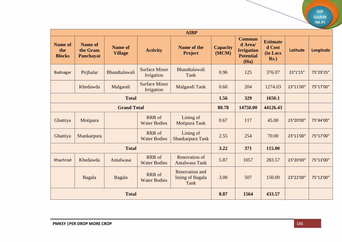
PMKSY |PER DROP MORE CROP 186
DIP UJJAIN (M.P)
AIBP
Name of
the
Blocks
Name of
the Gram
Panchayat
Name of
Village Activity
Name of the
Project
Capacity
(MCM)
Comman
d Area/
Irrigation
Potential
(Ha)
Estimate
d Cost
(in Lacs
Rs.)
Latitude Longitude
Badnagar Pirjhalar Bhandtalawali Surface Minor
Irrigation
Bhandtalawali
Tank 0.96 125 376.07 23°1'15" 75°29'25"
Khedawda Malgaodi Surface Minor
Irrigation Malgaodi Tank 0.60 204 1274.03 23°11'00" 75°17'00"
Total 1.56 329 1650.1
Grand Total 80.78 14750.00 44126.43
Ghattiya Motipura RRR of
Water Bodies
Lining of
Motipura Tank 0.67 117 45.00 23°20'00" 75°44'00"
Ghattiya Shankarpura RRR of
Water Bodies
Lining of
Shankarpura Tank 2.55 254 70.00 23°11'00" 75°17'00"
Total 3.22 371 115.00
Khachrod Khedawda Antalwasa RRR of
Water Bodies
Renovation of
Antalwasa Tank 5.87 1057 283.57 23°20'00" 75°13'00"
Bagala Bagala RRR of
Water Bodies
Renovation and
lining of Bagala
Tank
3.00 507 150.00 23°22'00" 75°12'00"
Total 8.87 1564 433.57

PMKSY |PER DROP MORE CROP 187
DIP UJJAIN (M.P)
AIBP
Name of
the
Blocks
Name of
the Gram
Panchayat
Name of
Village Activity
Name of the
Project
Capacity
(MCM)
Comman
d Area/
Irrigation
Potential
(Ha)
Estimate
d Cost
(in Lacs
Rs.)
Latitude Longitude
Mahidpur Arniyabhadur
pur
RRR of
Water Bodies
Renovation and
lining of
Arniyabahadurpur
Tank
22.36 2268 900.00 23°30'00" 75°42'00"
Bamnai Rudaheda RRR of
Water Bodies
Renovation and
lining of
Rudaheda Tank
3.71 450 223.00 23°37'30" 75°48'30"
Total 26.07 2718 1123.00
Badnagar Narela RRR of
Water Bodies
Lining of Narela
Tank 0.97 183 50.00 23°14'00" 75°22'00"
Total 0.97 183 50.00
Grand Total 39.13 4836.00 1721.57

PMKSY |PER DROP MORE CROP 188
DIP UJJAIN (M.P)
2. PER DROP MORE CROP (Supplementary Water Management Activities)
Block Ujjain (Latitude and Longitude of the particular village is given)
Name of
Gram
Panchayat
Name of the
Villages
Covered
Check
Dams
W.H.S. L / R Second
ary
storage
Structu
res
Farm
ponds
Nallah
Bunds
Percol
ation
Tanks
Renov
ation
of
water
Bodies
Balram
Talab Latitude Longitude
Capa
city
(200
Cum)
Capa
city
(800
Cum)
Nalwa
Amirpur(Fajalp
ur) 6 1 0 0 2 0 0 0 5 23.179078 75.647298
Kharent 11 1 0 0 2 1 0 0 5 23.17024 75.651722
Nalwa 14 2 2 1 2 2 1 1 7 23.152881 75.649263
Chandukhe
di
Jalalkhedi 5 2 2 0 2 2 0 1 4 23.178518 75.700592
Chandukhedi 12 1 1 0 2 2 0 1 4 23.156424 75.684799
Mangrola Mangrola 34 4 2 1 5 2 2 2 6 23.161268 75.730989
Ratnakhedi 6 1 1 0 2 1 0 1 4 23.145202 75.722764
Chintaman
Jawasiya
Chintaman
Jawasiya 24 2 2 1 2 2 1 2 5 23.126528 75.731116
Hasampura Ranabad 10 0 0 0 2 0 0 1 4 23.10153 75.718566
Hasampura 14 1 1 0 2 0 0 1 4 23.10599 75.74071
Akasoda
Akasoda 15 2 1 0 2 1 1 0 3 23.121889 75.659472
Dewarakhedi
Buzurg 26 2 2 0 2 2 1 0 4 23.142774 75.680329
Bamora Bamora 22 1 1 0 4 1 1 3 6 23.133315 75.70145

PMKSY |PER DROP MORE CROP 189
DIP UJJAIN (M.P)
Name of
Gram
Panchayat
Name of the
Villages
Covered
Check
Dams
W.H.S. L / R Second
ary
storage
Structu
res
Farm
ponds
Nallah
Bunds
Percol
ation
Tanks
Renov
ation
of
water
Bodies
Balram
Talab Latitude Longitude
Capa
city
(200
Cum)
Capa
city
(800
Cum)
Aslana Samadiya 11 1 0 0 2 0 0 4 23.13388 75.651398
Aslana 11 1 1 0 2 0 0 4 23.120184 75.640885
Khemasa
Sabalpur(Buch
akhedi) 12 0 0 0 2 1 0 2 23.110255 75.658383
Khemasa 24 1 1 0 2 1 1 0 5 23.094803 75.650248
Umariya
Khalsa
Umariya
Khalsa 5 0 0 0 2 0 0 0 2 23.071009 75.675624
Erwas 5 1 1 0 2 1 0 1 3 23.079923 75.639849
Kandariya Kandariya 11 1 1 0 2 1 0 1 5 23.072728 75.66171
Ajrana 22 1 1 0 2 1 0 0 2 23.058334 75.648385
Talod Talod 10 1 1 0 2 1 0 1 8 23.098446 75.685135
Tankariyap
anth Tankariyapanth 13 0 0 0 2 0 0 2 4 23.079168 75.698522
Takwasa Takwasa 13 1 1 0 1 1 0 0 4 23.055185 75.630637
Hamirkhedi Hamirkhedi 13 1 0 0 2 0 0 0 4 23.044536 75.640268
Jhiroliya
Jhiroliya 23 2 1 0 2 1 0 0 1 23.033861 75.652437
Badalkhedi 11 1 0 0 2 0 0 1 2 23.040101 75.669432
Ramjankhedi 12 1 1 0 2 1 0 0 2 23.016287 75.632971
Fatehabad Fatehabad 8 0 0 0 2 0 0 0 4 23.012894 75.675437

PMKSY |PER DROP MORE CROP 190
DIP UJJAIN (M.P)
Name of
Gram
Panchayat
Name of the
Villages
Covered
Check
Dams
W.H.S. L / R Second
ary
storage
Structu
res
Farm
ponds
Nallah
Bunds
Percol
ation
Tanks
Renov
ation
of
water
Bodies
Balram
Talab Latitude Longitude
Capa
city
(200
Cum)
Capa
city
(800
Cum)
Nilkanth Nilkanth 5 0 0 0 2 0 0 0 4 23.032134 75.692876
Kankariya
Chirakhan
Mundlasulema
n 5 1 0 0 2 0 0 1 4 23.030397 75.706367
Kankariya
Chirakhan 9 1 0 0 2 0 0 3 4 23.030475 75.727895
Lekoda Lekoda 10 1 1 1 3 0 1 3 8 23.054782 75.719051
Gondiya Gondiya 10 1 1 0 2 1 0 1 4 23.080298 75.743561
Limbapiply
a Limbapiplya 9 1 1 0 2 0 0 0 4 23.057845 75.753665
Jarkhoda Jarkhoda 12 1 1 0 2 1 0 1 2 23.039925 75.779567
Khetiyakhedi 12 1 1 0 2 1 0 0 2 23.042075 75.805165
Karohan Karohan 20 2 2 0 2 1 0 1 4 23.069642 75.785825
Jastikhedi 9 1 1 0 2 1 0 1 2 23.067391 75.773938
Nayakhedi Nayakhedi 13 1 1 0 2 1 0 0 2 23.061074 75.815223
Silodamori 7 1 0 0 2 0 0 0 4 23.050017 75.821488
Ramwasa Ramwasa 14 2 2 0 2 2 0 2 4 23.067886 75.833603
Matanakhurd 24 1 2 0 2 2 0 1 4 23.065122 75.85549
Panthpiplai Panthpiplai 22 2 1 0 2 1 0 1 4 23.045073 75.826102
Ninora Kithodarao 22 2 2 0 2 2 0 1 4 23.075522 75.850507
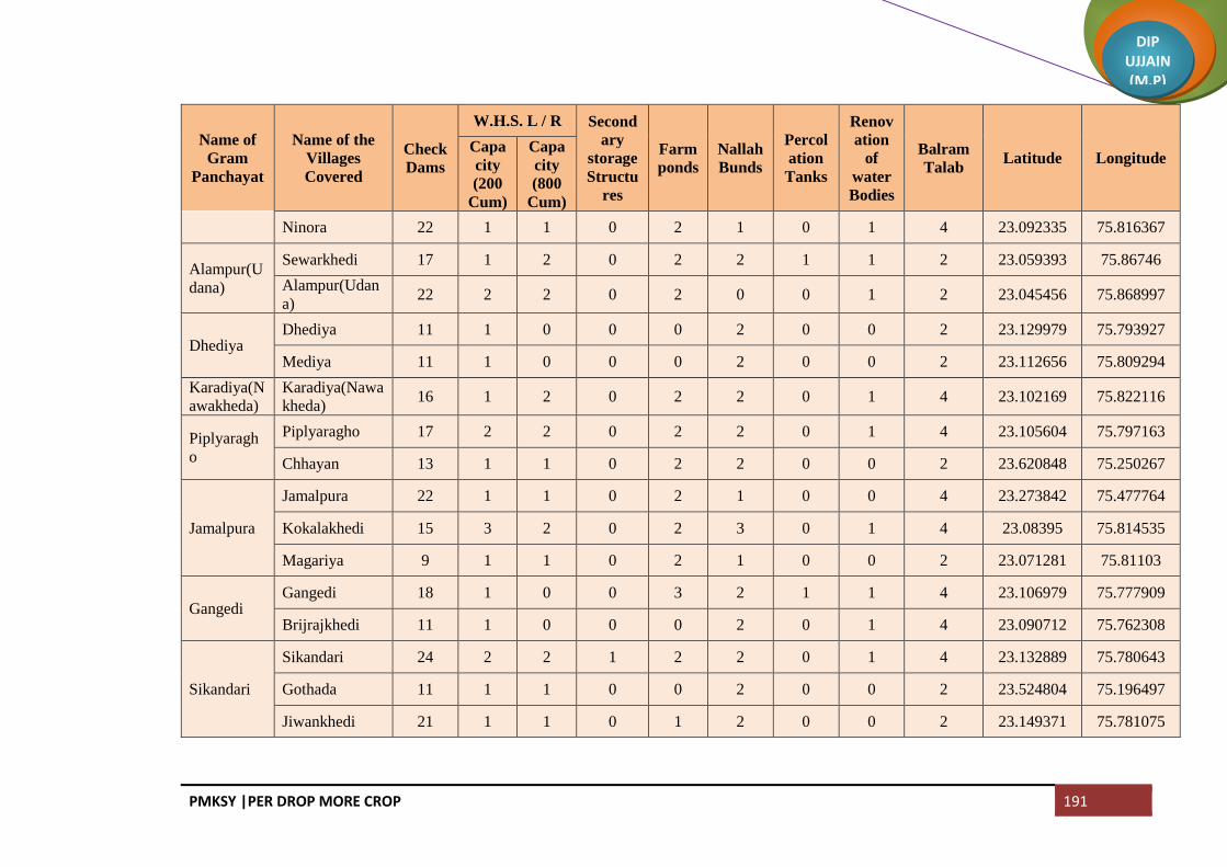
PMKSY |PER DROP MORE CROP 191
DIP UJJAIN (M.P)
Name of
Gram
Panchayat
Name of the
Villages
Covered
Check
Dams
W.H.S. L / R Second
ary
storage
Structu
res
Farm
ponds
Nallah
Bunds
Percol
ation
Tanks
Renov
ation
of
water
Bodies
Balram
Talab Latitude Longitude
Capa
city
(200
Cum)
Capa
city
(800
Cum)
Ninora 22 1 1 0 2 1 0 1 4 23.092335 75.816367
Alampur(U
dana)
Sewarkhedi 17 1 2 0 2 2 1 1 2 23.059393 75.86746
Alampur(Udan
a) 22 2 2 0 2 0 0 1 2 23.045456 75.868997
Dhediya Dhediya 11 1 0 0 0 2 0 0 2 23.129979 75.793927
Mediya 11 1 0 0 0 2 0 0 2 23.112656 75.809294
Karadiya(N
awakheda)
Karadiya(Nawa
kheda) 16 1 2 0 2 2 0 1 4 23.102169 75.822116
Piplyaragh
o
Piplyaragho 17 2 2 0 2 2 0 1 4 23.105604 75.797163
Chhayan 13 1 1 0 2 2 0 0 2 23.620848 75.250267
Jamalpura
Jamalpura 22 1 1 0 2 1 0 0 4 23.273842 75.477764
Kokalakhedi 15 3 2 0 2 3 0 1 4 23.08395 75.814535
Magariya 9 1 1 0 2 1 0 0 2 23.071281 75.81103
Gangedi Gangedi 18 1 0 0 3 2 1 1 4 23.106979 75.777909
Brijrajkhedi 11 1 0 0 0 2 0 1 4 23.090712 75.762308
Sikandari
Sikandari 24 2 2 1 2 2 0 1 4 23.132889 75.780643
Gothada 11 1 1 0 0 2 0 0 2 23.524804 75.196497
Jiwankhedi 21 1 1 0 1 2 0 0 2 23.149371 75.781075

PMKSY |PER DROP MORE CROP 192
DIP UJJAIN (M.P)
Name of
Gram
Panchayat
Name of the
Villages
Covered
Check
Dams
W.H.S. L / R Second
ary
storage
Structu
res
Farm
ponds
Nallah
Bunds
Percol
ation
Tanks
Renov
ation
of
water
Bodies
Balram
Talab Latitude Longitude
Capa
city
(200
Cum)
Capa
city
(800
Cum)
Daudkhedi Sawara Khedi 20 1 0 0 2 2 0 0 2 23.162125 75.775051
Daudkhedi 22 1 1 0 3 2 1 1 4 23.143748 75.768989
Chandmuk
h
Chandmukh 16 1 2 0 2 2 0 1 4 23.131443 75.76273
Palkhedi 10 1 0 1 2 0 0 4 23.119384 75.757186
Undasa Hakkanipura 10 1 0 0 0 2 0 0 2 23.217821 75.809098
Undasa 10 0 0 0 0 2 0 2 4 23.225535 75.832796
Sahabkhedi Sahabkhedi 21 1 0 0 0 0 0 1 3 23.236663 75.825739
Nahariya 10 1 1 0 0 0 0 0 4 23.241509 75.846614
Dhabla
Rehwari
Dhabla
Rehwari 16 1 1 0 1 2 0 0 4 23.255138 75.832964
Badarkha
Berasiya
Badarkha
Berasiya 12 1 0 0 1 0 2 0 4 23.228471 75.862438
Bakaniya Bakaniya 17 1 3 0 3 2 0 0 4 23.265705 75.859057
Badodiya
Bhand
Sayarkhedi 12 1 2 0 1 0 2 0 3 23.251338 75.861695
Dewankhedi 9 1 2 0 2 2 0 0 2 23.252567 75.872393
Badodiya
Bhand 11 1 2 0 2 1 2 1 3 23.241236 75.873953
Gunaikhals
a
Gunaikhalsa 16 1 3 0 3 2 0 0 4 23.271882 75.895868
Piplyabichha 17 1 2 0 2 2 0 0 4 23.264716 75.87893
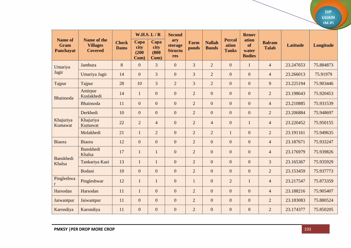
PMKSY |PER DROP MORE CROP 193
DIP UJJAIN (M.P)
Name of
Gram
Panchayat
Name of the
Villages
Covered
Check
Dams
W.H.S. L / R Second
ary
storage
Structu
res
Farm
ponds
Nallah
Bunds
Percol
ation
Tanks
Renov
ation
of
water
Bodies
Balram
Talab Latitude Longitude
Capa
city
(200
Cum)
Capa
city
(800
Cum)
Umariya
Jagir
Jambura 8 0 3 0 3 2 0 1 4 23.247653 75.884873
Umariya Jagir 14 0 3 0 3 2 0 0 4 23.266013 75.91979
Tajpur Tajpur 28 10 3 2 3 2 0 0 9 23.225194 75.903446
Bhainsoda
Amirpur
Kuslakhedi 14 1 0 0 2 0 0 0 2 23.198643 75.920453
Bhainsoda 11 0 0 0 2 0 0 0 4 23.210885 75.931539
Khajuriya
Kumawat
Derkhedi 10 0 0 0 2 0 0 0 2 23.206884 75.948697
Khajuriya
Kumawat 22 2 4 0 2 4 0 1 4 23.220452 75.950155
Molakhedi 21 1 2 0 2 2 1 0 2 23.191161 75.949635
Biaora Biaora 12 0 0 0 2 0 0 0 4 23.187671 75.933247
Banskhedi
Khalsa
Banskhedi
Khalsa 17 1 1 0 2 0 0 0 4 23.176979 75.939826
Tankariya Kazi 13 1 1 0 2 0 0 0 3 23.165367 75.935929
Bodani 10 0 0 0 2 0 0 0 2 23.153459 75.937773
Pingleshwa
r Pingleshwar 12 1 1 0 1 0 2 1 4 23.217547 75.873359
Harsodan Harsodan 11 1 0 0 2 0 0 0 4 23.188216 75.905407
Jaiwantpur Jaiwantpur 11 0 0 0 2 0 0 0 2 23.183083 75.880524
Karondiya Karondiya 11 0 0 0 2 0 0 0 2 23.174377 75.850205

PMKSY |PER DROP MORE CROP 194
DIP UJJAIN (M.P)
Name of
Gram
Panchayat
Name of the
Villages
Covered
Check
Dams
W.H.S. L / R Second
ary
storage
Structu
res
Farm
ponds
Nallah
Bunds
Percol
ation
Tanks
Renov
ation
of
water
Bodies
Balram
Talab Latitude Longitude
Capa
city
(200
Cum)
Capa
city
(800
Cum)
Dhatrawad
a
Dhatrawada 11 0 0 0 2 0 0 0 2 23.159667 75.847794
Lalpur 11 0 0 0 2 0 0 0 2
Manpura
Jawasiya
Kumar 14 1 0 0 2 0 0 1 2 23.147213 75.862538
Manpura 11 0 0 0 1 0 0 0 2 23.139776 75.850286
Surjanwasa Kesoni 11 0 0 0 2 0 0 0 4 23.16368 75.893651
Surjanwasa 11 0 0 0 2 0 0 0 4 23.170898 75.873254
Dudarsi Dudarsi 10 1 0 0 2 0 0 0 2 23.145557 75.897565
Harnyakhedi 11 1 0 0 2 0 0 0 4 23.140506 75.924172
Kadchhali Daukhedi 10 0 0 0 2 0 0 0 2 23.143629 75.769332
Kadchhali 20 1 1 0 2 1 0 0 4 23.128035 75.914559
Badhkumm
ed Badhkummed 11 0 0 0 2 0 0 0 4 23.155801 75.902111
Kadchha
Silarkhedi 16 0 0 0 2 0 0 1 2 23.115725 75.90794
Kadchha 22 2 1 0 2 1 0 1 4 23.117699 75.931372
Chenpur
Hanskhedi 13 1 0 0 2 0 0 0 2 23.101673 75.944075
Nogawan Nogawan 18 1 0 0 2 0 0 0 4 23.119631 75.949234
Matanakala
n Matanakalan 22 2 1 0 2 2 0 0 4 23.127071 75.870194

PMKSY |PER DROP MORE CROP 195
DIP UJJAIN (M.P)
Name of
Gram
Panchayat
Name of the
Villages
Covered
Check
Dams
W.H.S. L / R Second
ary
storage
Structu
res
Farm
ponds
Nallah
Bunds
Percol
ation
Tanks
Renov
ation
of
water
Bodies
Balram
Talab Latitude Longitude
Capa
city
(200
Cum)
Capa
city
(800
Cum)
Datana Datana 18 2 1 0 2 1 0 0 4 23.1026 75.891995
Chandesara Kuwariya 11 1 0 0 2 0 0 0 2 23.114757 75.833544
Chandesara 22 2 2 0 2 2 0 0 4 23.110603 75.851054
Chandesari Chandesari 22 2 2 0 2 2 0 0 4 23.12273 75.85483
Khajuria
Rehwari
Khajuria
Rehwari 19 1 1 0 2 0 0 0 4 23.08047 75.872279
Kalyanpura 11 1 1 0 2 1 0 0 3 23.185912 75.408323
Semaliyana
sar
Semaliyanasar 24 2 1 0 2 1 0 0 4 23.079332 75.89059
Bhanwri 11 0 0 0 2 0 0 0 2 23.061693 75.891362
Bolasa
Bolasa 16 0 0 0 2 0 0 0 2 23.052818 75.899043
Dewarkhedi
Khurd 22 2 1 0 2 1 0 0 2 23.046657 75.908398
Harnawada 16 0 0 0 2 0 0 0 2 23.052818 75.920157
Kasampur
Khokariya 18 2 2 0 2 2 0 0 3 23.038127 75.885396
Kasampur 18 1 1 0 2 0 0 0 4 23.03402 75.908055
Nikewadi 16 1 0 0 2 0 0 0 3 23.015852 75.896725
Narwar Narwar 33 3 2 1 4 1 1 2 8 23.085768 75.92799
Gaowdi Gaowdi 11 0 0 0 2 0 0 1 4 23.334977 76.013346

PMKSY |PER DROP MORE CROP 196
DIP UJJAIN (M.P)
Name of
Gram
Panchayat
Name of the
Villages
Covered
Check
Dams
W.H.S. L / R Second
ary
storage
Structu
res
Farm
ponds
Nallah
Bunds
Percol
ation
Tanks
Renov
ation
of
water
Bodies
Balram
Talab Latitude Longitude
Capa
city
(200
Cum)
Capa
city
(800
Cum)
Munjakhed
i Munjakhedi 10 0 0 0 2 0 0 0 4 23.076876 75.962587
Piploda
Dwarkadis
h
Madhopur 13 1 1 0 2 0 0 0 2 23.091406 75.97888
Piploda
Dwarkadish 24 2 2 1 3 1 1 2 8 23.069693 75.97836
Kachnariya Kachnariya 17 1 1 0 2 1 0 0 4 23.511313 75.497482
Palkhanda Palkhanda 22 2 2 0 2 2 0 0 5 23.420482 76.187483
NP Ujjain (M
Corp.) 0 0 0 0 0 0 0 0 0
NP Pandyakhedi 5 0 0 0 0 0 0 0 0
NP Shankarpur 12 1 0 0 2 0 0 0 3
NP Morukhedi 9 0 0 0 0 2 0 0 3
NP Chakajay
Rampur 15 0 0 0 2 0 0 0 2
NP Nimanwasa 11 0 0 0 2 0 0 0 2
NP Hamukhedi 10 0 0 0 2 0 0 0 2
NP Hariyakhedi 14 1 1 0 2 0 0 0 2
Total 1992 143 120 9 262 121 24 61 440

PMKSY |PER DROP MORE CROP 197
DIP UJJAIN (M.P)
Block Ghattiya
Name of
Gram
Panchayat
Name of the
Villages
Covered
Check
Dams
W.H.S. L / R Second
ary
storage
Structu
res
Farm
ponds
Nallah
Bunds
Percol
ation
Tanks
Renov
ation
of
water
Bodies
Balram
Talab Latitude Longitude
Capa
city
(200
Cum)
Capa
city
(800
Cum)
Dhanda
Bhalla Dhanda Bhalla 3 1 1 0 2 0 0 0 4 23.36658 75.659461
Salakhedi 15 2 1 0 2 0 1 0 4 23.373309 75.670027
Chhitar
Devi Chhitar Devi 2 0 1 1 1 2 2 0 7 23.353422 75.639034
Ilahipur 12 1 1 0 2 0 2 2 5 23.337068 75.625258
Borkheda
Bhalla Ahirkheda 0 1 1 0 6 0 4 0 5 23.336386 75.606242
Borkheda
Bhalla 0 2 0 0 7 0 4 0 7 23.329687 75.660919
Pipalyatah 28 2 2 0 9 3 2 0 5 23.323146 75.629162
Gudha Gudha 14 1 10 1 5 7 2 2 5 23.305607 75.630333
Lasurdiya
Bazar
Lasurdiya
Bazar 53 2 0 0 1 0 2 1 5 23.313445 75.646855
Jhokra 6 2 0 0 5 0 0 0 5 23.308798 75.663847
Khoriya 80 1 0 0 6 7 3 2 7 23.301454 75.646606
Ruie Ruie 20 2 2 0 7 4 3 0 5 23.289782 75.654881
Semalyabibi 12 1 2 0 4 2 2 1 7 23.304342 75.677043
Dhulmahu Dhabladhuta 5 1 1 1 1 1 0 0 0 23.28721 75.680308

PMKSY |PER DROP MORE CROP 198
DIP UJJAIN (M.P)
Name of
Gram
Panchayat
Name of the
Villages
Covered
Check
Dams
W.H.S. L / R Second
ary
storage
Structu
res
Farm
ponds
Nallah
Bunds
Percol
ation
Tanks
Renov
ation
of
water
Bodies
Balram
Talab Latitude Longitude
Capa
city
(200
Cum)
Capa
city
(800
Cum)
Dhulmahu 0 0 0 0 0 0 0 0 0 23.270623 75.66994
Pipalyaham
a Pipalyahama 17 1 1 0 6 2 3 0 3 23.353723 75.672849
Dhuletiya Dhuletiya 72 1 1 1 5 7 2 0 8 23.320384 75.696018
Harigarh 6 1 2 0 21 5 2 0 5 23.346037 75.687499
Banskhedi Banskhedi 90 1 1 0 5 0 5 0 7 23.322156 75.675756
Kaluheda Barothikheda 3 2 1 0 1 1 0 0 8 23.360188 75.717964
Kaluheda 6 10 2 0 9 3 4 0 10 23.348526 75.716333
Bhilkheda Borkhedi 9 1 2 0 7 3 1 0 2 23.676639 75.676481
Bhilkheda 6 1 2 0 5 2 1 0 5 23.357588 75.752211
Nawakheda
(Sutarkheda) 1 2 1 0 5 2 2 0 2
Kishanpura 4 2 2 0 3 2 1 0 4 23.351993 75.73822
Sipawara Naveli 78 2 2 0 6 4 5 0 5 23.300316 75.693392
Sipawara 63 1 1 0 8 5 4 0 7 23.301986 75.715382
Bihariya Panched 2 2 1 0 8 8 3 0 3 23.330876 75.711155
Bihariya 3 1 2 0 4 1 4 0 4 23.320626 75.727971
Motipura 3 1 2 0 9 7 0 0 4 23.333262 75.739303

PMKSY |PER DROP MORE CROP 199
DIP UJJAIN (M.P)
Name of
Gram
Panchayat
Name of the
Villages
Covered
Check
Dams
W.H.S. L / R Second
ary
storage
Structu
res
Farm
ponds
Nallah
Bunds
Percol
ation
Tanks
Renov
ation
of
water
Bodies
Balram
Talab Latitude Longitude
Capa
city
(200
Cum)
Capa
city
(800
Cum)
Panbihar Panbihar 7 2 2 1 11 8 2 0 8 23.315633 75.765647
Kithodajagir 0 1 1 0 3 2 1 1 3 23.287895 75.75031
Gunai Jagir 0 0 0 0 0 0 0 0 5 23.297685 75.734353
Kesarpur 7 2 1 1 2 1 4 0 1 23.295057 75.768435
Kagdi
Karadiya Kagdi Karadiya 1 1 1 0 7 7 2 0 7 23.284438 75.774934
Nipanya Sunar 8 2 1 0 7 6 0 0 2 23.290902 75.785062
Utesara Utesara 3 23.264604 75.801581
Padmakhedi 2 23.273137 75.79362
Samarkhedi 8 23.271402 75.778513
Gunaya Gunaya 6 3 3 0 1 0 0 0 2 23.279863 75.73395
Nanakhedi 4 2 2 1 0 0 0 0 1 23.274265 75.743563
Madhavgadh 12 1 2 0 2 1 0 0 5
Ralayata
bhoja Ralayata Mauja 8 3 1 0 1 1 0 0 0 23.268274 75.755193
Barkhedi
Khalsa 5 1 1 0 1 1 0 0 0 23.265199 75.772187
Goyala
Buzurg Goyala Buzurg 6 1 1 1 1 1 0 0 0 23.277333 75.698439
Khalana Khalana 7 1 1 0 1 0 0 0 0 23.273102 75.715675

PMKSY |PER DROP MORE CROP 200
DIP UJJAIN (M.P)
Name of
Gram
Panchayat
Name of the
Villages
Covered
Check
Dams
W.H.S. L / R Second
ary
storage
Structu
res
Farm
ponds
Nallah
Bunds
Percol
ation
Tanks
Renov
ation
of
water
Bodies
Balram
Talab Latitude Longitude
Capa
city
(200
Cum)
Capa
city
(800
Cum)
Tumdawad
a Paroliya Jhali 9 1 1 1 1 1 1 0 2 23.271687 75.640143
Tumdawada 0 0 0 0 0 0 0 0 0 23.254891 75.64598
Jhirniya Khedla 6 1 1 0 2 2 0 0 2 23.265593 75.682151
Jhirniya 151 0 50 0 9 5 0 0 2 23.250059 75.68361
Sarola Singawada 6 1 1 1 1 0 0 0 0 23.231863 75.645465
Sarola 6 2 1 0 1 1 0 0 2 23.239277 75.664519
Amodiya Amodiya 4 2 0 1 1 2 1 0 3 23.208909 75.652503
Chakrawad
a Chakrawada 6 1 0 0 1 1 0 0 3 23.251636 75.708157
Nagpura Mahukhedi 4 2 1 1 1 2 0 1 2 23.22348 75.680348
Nagpura 4 2 2 1 1 0 0 0 5 23.241305 75.672023
Ajnoti 5 1 2 1 1 1 0 0 7 23.227628 75.671247
Silodarawal Silodarawal 5 1 1 0 2 1 0 0 3 23.188556 75.681256
Badwai 6 1 1 0 3 1 0 0 5 23.191001 75.647611
Ilaskhedi 6 1 1 0 1 1 1 0 4 23.1925 75.663318
Badodiya
Kazi Naikhedi 4 1 1 0 1 1 0 0 5 23.206184 75.687523
Badodiya Kazi 9 2 1 1 1 1 1 0 5 23.227571 75.697064

PMKSY |PER DROP MORE CROP 201
DIP UJJAIN (M.P)
Name of
Gram
Panchayat
Name of the
Villages
Covered
Check
Dams
W.H.S. L / R Second
ary
storage
Structu
res
Farm
ponds
Nallah
Bunds
Percol
ation
Tanks
Renov
ation
of
water
Bodies
Balram
Talab Latitude Longitude
Capa
city
(200
Cum)
Capa
city
(800
Cum)
Ratadiya Ratadiya 6 1 1 0 1 1 0 0 5 23.196648 75.711866
Vinayaga Vinayaga 4 23.204005 75.726274
Azampura 5 23.229878 75.719236
Gonsa Gonsa 7 23.211851 75.751142
Ramgarh Ramgarh 0 0 0 0 0 0 0 0 5 23.252425 75.746266
Sulyakhedi 8 1 2 1 1 1 0 0 5 23.256762 75.777938
Sodang Sodang 5 23.240408 75.731464
Wajirpur (Jogi
Khedi) 8 23.21934 75.75398
Surasa Surasa 7 2 23.235099 75.81036
Badarkha
Babaji 4 23.257934 75.809188
Kamed Kamed 2 23.227607 75.792035
Kaliyadeh Kaliyadeh 4 23.251334 75.791132
Jairampura Bormundla 2 23.276001 75.811669
Jairampura 3 23.297918 75.798623
Devikaradiya 9 23.285935 75.805232
Bandka Bandka 5 23.304715 75.810418

PMKSY |PER DROP MORE CROP 202
DIP UJJAIN (M.P)
Name of
Gram
Panchayat
Name of the
Villages
Covered
Check
Dams
W.H.S. L / R Second
ary
storage
Structu
res
Farm
ponds
Nallah
Bunds
Percol
ation
Tanks
Renov
ation
of
water
Bodies
Balram
Talab Latitude Longitude
Capa
city
(200
Cum)
Capa
city
(800
Cum)
Kadwali Piplai 2 1 2 1 2 2 0 0 23.300652 75.827103
Kadwali 3 4 2 0 2 3 0 0 23.302071 75.844441
Piplya
Munjapta 2 2 2 0 3 1 0 0
Jaithal Jaithal 6 23.282483 75.821162
Shankarpur
jagir
Shankarpurjagi
r 3 23.326387 75.789949
Ranaheda 7 23.343883 75.791681
Nipanya
Goyal Lakhaheda 5 23.323398 75.814541
Ishakpur 6 23.325211 75.838745
Nipanya Goyal 7 23.313309 75.839861
Meen Silari 4 23.373666 75.749747
Meen 5 23.364999 75.768501
Tulaheda Tulaheda 7 23.34285 75.812333
Dhannakhe
di Dhannakhedi 6 23.36408 75.819669
Nazarpur Nazarpur 12 23.342253 75.843616
Ghatiya Ghatiya 13 23.378556 75.863501
Jalwa Jalwa 4 23.393307 75.887039
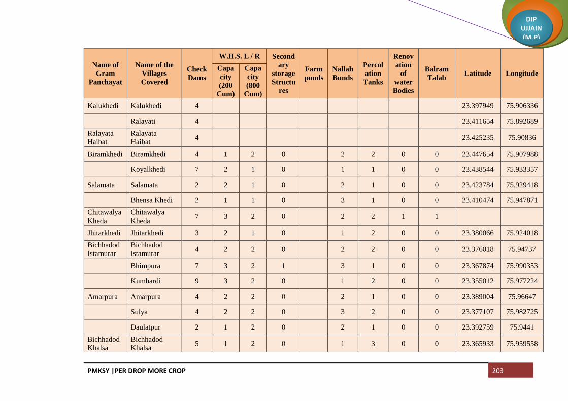
PMKSY |PER DROP MORE CROP 203
DIP UJJAIN (M.P)
Name of
Gram
Panchayat
Name of the
Villages
Covered
Check
Dams
W.H.S. L / R Second
ary
storage
Structu
res
Farm
ponds
Nallah
Bunds
Percol
ation
Tanks
Renov
ation
of
water
Bodies
Balram
Talab Latitude Longitude
Capa
city
(200
Cum)
Capa
city
(800
Cum)
Kalukhedi Kalukhedi 4 23.397949 75.906336
Ralayati 4 23.411654 75.892689
Ralayata
Haibat
Ralayata
Haibat 4 23.425235 75.90836
Biramkhedi Biramkhedi 4 1 2 0 2 2 0 0 23.447654 75.907988
Koyalkhedi 7 2 1 0 1 1 0 0 23.438544 75.933357
Salamata Salamata 2 2 1 0 2 1 0 0 23.423784 75.929418
Bhensa Khedi 2 1 1 0 3 1 0 0 23.410474 75.947871
Chitawalya
Kheda
Chitawalya
Kheda 7 3 2 0 2 2 1 1
Jhitarkhedi Jhitarkhedi 3 2 1 0 1 2 0 0 23.380066 75.924018
Bichhadod
Istamurar
Bichhadod
Istamurar 4 2 2 0 2 2 0 0 23.376018 75.94737
Bhimpura 7 3 2 1 3 1 0 0 23.367874 75.990353
Kumhardi 9 3 2 0 1 2 0 0 23.355012 75.977224
Amarpura Amarpura 4 2 2 0 2 1 0 0 23.389004 75.96647
Sulya 4 2 2 0 3 2 0 0 23.377107 75.982725
Daulatpur 2 1 2 0 2 1 0 0 23.392759 75.9441
Bichhadod
Khalsa
Bichhadod
Khalsa 5 1 2 0 1 3 0 0 23.365933 75.959558

PMKSY |PER DROP MORE CROP 204
DIP UJJAIN (M.P)
Name of
Gram
Panchayat
Name of the
Villages
Covered
Check
Dams
W.H.S. L / R Second
ary
storage
Structu
res
Farm
ponds
Nallah
Bunds
Percol
ation
Tanks
Renov
ation
of
water
Bodies
Balram
Talab Latitude Longitude
Capa
city
(200
Cum)
Capa
city
(800
Cum)
Malikhedi Malikhedi 9 1 1 0 2 3 1 1 23.359599 75.524449
Runji Runji 1 3 2 0 2 2 0 0 23.350883 75.930719
Kherkhedi 6 1 2 0 1 2 0 0 23.356557 75.939903
Gadroli 3 2 2 0 3 2 0 0 23.347889 75.959644
Dhablagori Dabri 8 1 2 0 1 1 0 0 23.363363 75.879714
Dhablagori 4 2 1 0 1 2 0 0 23.345712 75.871045
Bhutiya Bhutiya 3 1 2 0 1 3 0 0 23.322275 75.873212
Anwalya 9 2 2 0 2 4 0 0 23.31195 75.883769
Ujjainiya Ujjainiya 7 2 3 0 1 3 0 0 23.290141 75.869458
Kalesar Kalesar 1 2 2 0 3 1 1 1 23.341505 75.891322
Chonsala 2 3 2 0 2 1 0 0 23.338274 75.913381
Guradiya
Gujar Guradiya Gujar 9 3 2 0 3 3 0 0 23.331468 75.94064
Banda Bamori 1 2 1 0 3 1 1 1 23.317546 75.916728
Banda 5 3 2 0 1 1 1 1 23.324324 75.897331
Khajuria
Sadar Khajuria Sadar 9 4 2 0 2 2 0 0 23.311133 75.941326
Bisakhedi 3 3 2 0 3 3 0 0 23.31602 75.931627

PMKSY |PER DROP MORE CROP 205
DIP UJJAIN (M.P)
Name of
Gram
Panchayat
Name of the
Villages
Covered
Check
Dams
W.H.S. L / R Second
ary
storage
Structu
res
Farm
ponds
Nallah
Bunds
Percol
ation
Tanks
Renov
ation
of
water
Bodies
Balram
Talab Latitude Longitude
Capa
city
(200
Cum)
Capa
city
(800
Cum)
Rudaheda Rudaheda 12 23.294042 75.917535
Barkhedi Jagir 4 23.285449 75.929294
M.Corp Mohanpura 6
M.Corp Bherugadh 6
M.Corp Ahukhana 2
M.Corp Kolukhedi 4
M.Corp Bhadedmay
Chak 4
M.Corp Mojamkhedi 5
M.Corp Bhitrimay
Chak 0
M.Corp Khilchipur 6
Total 1300 106 187 18 226 191 138 17 252
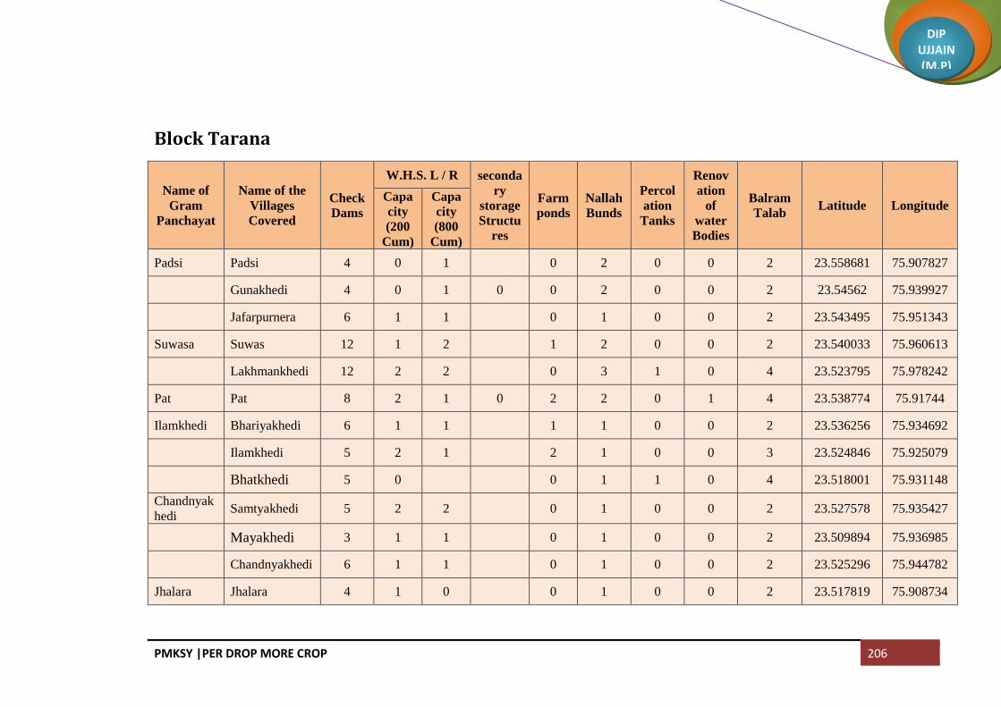
PMKSY |PER DROP MORE CROP 206
DIP UJJAIN (M.P)
Block Tarana
Name of
Gram
Panchayat
Name of the
Villages
Covered
Check
Dams
W.H.S. L / R seconda
ry
storage
Structu
res
Farm
ponds
Nallah
Bunds
Percol
ation
Tanks
Renov
ation
of
water
Bodies
Balram
Talab Latitude Longitude
Capa
city
(200
Cum)
Capa
city
(800
Cum)
Padsi Padsi 4 0 1 0 2 0 0 2 23.558681 75.907827
Gunakhedi 4 0 1 0 0 2 0 0 2 23.54562 75.939927
Jafarpurnera 6 1 1 0 1 0 0 2 23.543495 75.951343
Suwasa Suwas 12 1 2 1 2 0 0 2 23.540033 75.960613
Lakhmankhedi 12 2 2 0 3 1 0 4 23.523795 75.978242
Pat Pat 8 2 1 0 2 2 0 1 4 23.538774 75.91744
Ilamkhedi Bhariyakhedi 6 1 1 1 1 0 0 2 23.536256 75.934692
Ilamkhedi 5 2 1 2 1 0 0 3 23.524846 75.925079
Bhatkhedi 5 0 0 1 1 0 4 23.518001 75.931148
Chandnyak
hedi Samtyakhedi 5 2 2 0 1 0 0 2 23.527578 75.935427
Mayakhedi 3 1 1 0 1 0 0 2 23.509894 75.936985
Chandnyakhedi 6 1 1 0 1 0 0 2 23.525296 75.944782
Jhalara Jhalara 4 1 0 0 1 0 0 2 23.517819 75.908734

PMKSY |PER DROP MORE CROP 207
DIP UJJAIN (M.P)
Name of
Gram
Panchayat
Name of the
Villages
Covered
Check
Dams
W.H.S. L / R seconda
ry
storage
Structu
res
Farm
ponds
Nallah
Bunds
Percol
ation
Tanks
Renov
ation
of
water
Bodies
Balram
Talab Latitude Longitude
Capa
city
(200
Cum)
Capa
city
(800
Cum)
Jhalari 3 2 2 0 2 0 0 2 23.506014 75.923840
Dhablahard
u Dhablahardu 3 0 0 0 1 0 0 2 23.499887 75.896068
Tukral Tukral 6 1 1 0 1 0 1 4 23.470615 75.928025
Parsoli Parsoli 6 1 1 1 1 0 1 2 23.509975 75.943092
Pipalyabazar 7 1 1 0 1 0 0 2 23.439195 75.949787
Chirdi Chirdi 11 1 1 1 1 1 0 2 23.485652 75.975107
Badodiya
(Makdon) Bhundkhedi 7 2 2 1 1 0 0 2 23.556399 75.987478
Badodiya
(Makdon) 9 1 1 0 1 2 0 0 4 23.54145 75.977693
Umariya 6 1 2 1 2 0 0 2 23.537279 75.990053
Khajjukhed
i Khajjukhedi 8 1 1 1 2 0 0 2 23.513884 75.989929
Mergarh 4 1 1 1 2 0 0 2 23.500583 75.978342
Khankribra
hman
Khankribrahma
n 6 1 1 0 1 1 0 2 23.49215 75.995156
Kadhai 8 1 1 0 1 0 0 2 23.489001 76.009962
Jhumki Jhumki 9 1 3 0 1 1 0 2 23.54752 76.008926
Lasudiya
Amra Lasudiya Amra 8 2 2 1 1 2 0 2 23.51474 76.001464

PMKSY |PER DROP MORE CROP 208
DIP UJJAIN (M.P)
Name of
Gram
Panchayat
Name of the
Villages
Covered
Check
Dams
W.H.S. L / R seconda
ry
storage
Structu
res
Farm
ponds
Nallah
Bunds
Percol
ation
Tanks
Renov
ation
of
water
Bodies
Balram
Talab Latitude Longitude
Capa
city
(200
Cum)
Capa
city
(800
Cum)
Kothdi 5 2 2 1 1 1 0 2 23.503406 76.007644
Chitawalya
kheda
Chitawalyakhe
da 11 2 1 0 1 0 0 2 23.513537 76.019264
Tejlakhedi Tejlakhedi 10 2 2 0 1 1 0 2 23.546349 76.030435
Rawankhedi 12 2 1 0 1 0 0 2 23.530297 76.04846
Godadi Khokariya 5 2 1 0 1 0 0 2 23.551353 76.056976
Dhanyakhedi 4 0 0 1 0 4 23.550252 76.076632
Godadi 4 2 1 0 0 0 0 3 23.533088 76.076778
Lasudiya
Dhandu
Lasudiya
Dhandu 5 1 1 1 1 1 1 2 23.532786 76.102266
Suchai 6 1 1 0 1 0 0 2 23.510121 76.077633
Chikli Chikli 4 1 1 0 1 1 0 2 23.494627 76.034799
Sumrakhed
a Sumrakheda 7 1 1 0 1 1 1 2 23.258333 76.066563
Hatyakhedi 11 1 1 7 1 1 1 0 2 23.260446 76.030935
Bhodalya Sumrakhedi 5 2 1 0 1 0 0 2 23.518749 76.046535
Bhodalya 5 2 1 0 1 0 0 2 23.507445 76.053943
Rupakhedi Rupakhedi 10 1 1 1 1 0 0 2 23.472835 75.990188
Lalakhedi 6 1 1 1 2 1 0 2 23.465592 75.972163
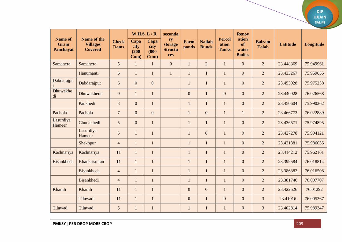
PMKSY |PER DROP MORE CROP 209
DIP UJJAIN (M.P)
Name of
Gram
Panchayat
Name of the
Villages
Covered
Check
Dams
W.H.S. L / R seconda
ry
storage
Structu
res
Farm
ponds
Nallah
Bunds
Percol
ation
Tanks
Renov
ation
of
water
Bodies
Balram
Talab Latitude Longitude
Capa
city
(200
Cum)
Capa
city
(800
Cum)
Samanera Samanera 5 1 1 0 1 2 1 0 2 23.448369 75.949961
Hanumanti 6 1 1 1 1 1 1 0 2 23.423267 75.959655
Dabdarajpu
t Dabdarajput 6 0 0 1 1 1 0 2 23.453028 75.975238
Dhuwakhe
di Dhuwakhedi 9 1 1 0 1 0 0 2 23.440928 76.026568
Pankhedi 3 0 1 1 1 1 0 2 23.450604 75.990262
Pachola Pachola 7 0 0 1 0 1 1 2 23.466773 76.022889
Lasurdiya
Hameer Chunakhedi 5 0 1 1 1 1 0 2 23.436571 75.974895
Lasurdiya
Hameer 5 1 1 1 0 1 0 2 23.427278 75.994121
Shekhpur 4 1 1 1 1 1 0 2 23.421381 75.986035
Kachnariya Kachnariya 11 1 1 1 1 1 0 2 23.414212 75.962161
Bisankheda Khankrisultan 11 1 1 1 1 1 0 2 23.399584 76.018814
Bisankheda 4 1 1 1 1 1 0 2 23.386382 76.016508
Bisankhedi 4 1 1 1 1 1 0 2 23.381746 76.007707
Khamli Khamli 11 1 1 0 0 1 0 2 23.422526 76.01292
Tilawadi 11 1 1 0 1 0 0 3 23.41016 76.005367
Tilawad Tilawad 5 1 1 1 1 1 0 3 23.402814 75.989347

PMKSY |PER DROP MORE CROP 210
DIP UJJAIN (M.P)
Name of
Gram
Panchayat
Name of the
Villages
Covered
Check
Dams
W.H.S. L / R seconda
ry
storage
Structu
res
Farm
ponds
Nallah
Bunds
Percol
ation
Tanks
Renov
ation
of
water
Bodies
Balram
Talab Latitude Longitude
Capa
city
(200
Cum)
Capa
city
(800
Cum)
Ranchikhedi 5 1 1 1 1 1 0 3 23.385584 75.99473
Lodh Lodh 4 2 1 1 0 3 23.421344 76.033949
Nanded Nanded 7 1 1 1 1 1 1 2 23.457797 76.043489
Keswal Keswal 7 1 1 0 1 1 0 2 23.469477 76.077404
Jamunya 5 1 0 1 1 0 0 2 23.453029 76.087075
Kanthadi 8 0 1 0 1 0 0 2 23.528177 76.086733
Bagwada Manasa 4 0 0 0 0 0 0 2 23.561972 76.154275
Ratnakhedi 6 1 2 0 1 0 0 1 23.555709 76.149689
Bagwada 9 1 1 0 0 0 0 4 23.550721 76.142173
Bukhari 6 0 1 0 1 0 0 2 23.545685 76.167493
Harukhedi 11 2 1 0 0 1 1 4 23.539342 76.163679
Salnakhedi Rehwari 7 1 1 0 0 0 0 0 2 23.564568 76.169038
Salnakhedi 5 1 0 0 0 1 0 3 23.554891 76.167664
Kadodiya Kadodiya 6 0 0 0 1 0 1 2 23.522931 76.142722
Sarli Sarli 3 0 0 1 0 1 0 4 23.456427 76.129225
Haidarpura 4 0 0 0 0 2 23.476956 76.135683
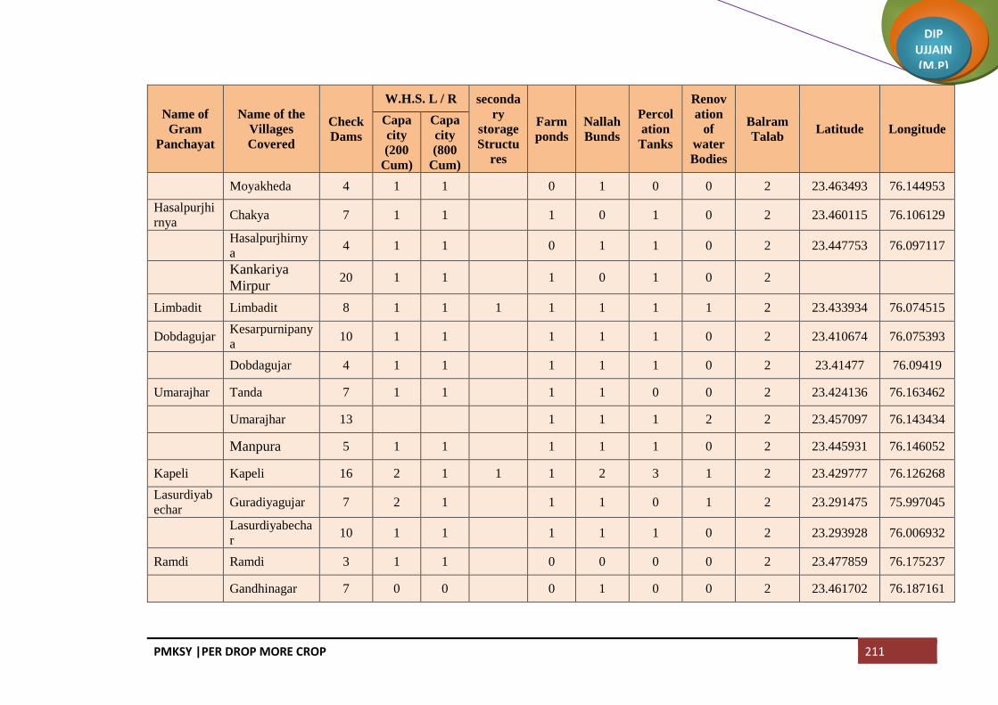
PMKSY |PER DROP MORE CROP 211
DIP UJJAIN (M.P)
Name of
Gram
Panchayat
Name of the
Villages
Covered
Check
Dams
W.H.S. L / R seconda
ry
storage
Structu
res
Farm
ponds
Nallah
Bunds
Percol
ation
Tanks
Renov
ation
of
water
Bodies
Balram
Talab Latitude Longitude
Capa
city
(200
Cum)
Capa
city
(800
Cum)
Moyakheda 4 1 1 0 1 0 0 2 23.463493 76.144953
Hasalpurjhi
rnya Chakya 7 1 1 1 0 1 0 2 23.460115 76.106129
Hasalpurjhirny
a 4 1 1 0 1 1 0 2 23.447753 76.097117
Kankariya
Mirpur 20 1 1 1 0 1 0 2
Limbadit Limbadit 8 1 1 1 1 1 1 1 2 23.433934 76.074515
Dobdagujar Kesarpurnipany
a 10 1 1 1 1 1 0 2 23.410674 76.075393
Dobdagujar 4 1 1 1 1 1 0 2 23.41477 76.09419
Umarajhar Tanda 7 1 1 1 1 0 0 2 23.424136 76.163462
Umarajhar 13 1 1 1 2 2 23.457097 76.143434
Manpura 5 1 1 1 1 1 0 2 23.445931 76.146052
Kapeli Kapeli 16 2 1 1 1 2 3 1 2 23.429777 76.126268
Lasurdiyab
echar Guradiyagujar 7 2 1 1 1 0 1 2 23.291475 75.997045
Lasurdiyabecha
r 10 1 1 1 1 1 0 2 23.293928 76.006932
Ramdi Ramdi 3 1 1 0 0 0 0 2 23.477859 76.175237
Gandhinagar 7 0 0 0 1 0 0 2 23.461702 76.187161

PMKSY |PER DROP MORE CROP 212
DIP UJJAIN (M.P)
Name of
Gram
Panchayat
Name of the
Villages
Covered
Check
Dams
W.H.S. L / R seconda
ry
storage
Structu
res
Farm
ponds
Nallah
Bunds
Percol
ation
Tanks
Renov
ation
of
water
Bodies
Balram
Talab Latitude Longitude
Capa
city
(200
Cum)
Capa
city
(800
Cum)
Borkhedi 4 1 1 0 1 1 0 2 23.473591 76.157034
Amritnagar 7 0 0 0 1 0 0 2 23.434699 76.197689
Pipalyaramdi 8 1 1 1 1 1 1 2 23.446348 76.183212
Puri Ankhali 11 1 1 0 0 1 1 0 2 23.461235 76.202531
Puri 11 1 1 0 1 1 0 2 23.470053 76.197421
Moyagaon 6 0 0 0 0 0 0 2 23.445243 76.203767
Tumni 3 1 1 0 1 0 0 2 23.489008 76.204797
Katwariya Katwariya 6 2 2 1 2 1 0 4 23.523781 76.227613
Aurangpur 8 0 0 0 1 0 0 2 23.496706 76.211048
Gudradiya Khutpala 6 2 1 1 1 0 0 2 23.434699 76.197689
Gudradiya 6 1 1 0 1 1 0 2 23.501035 76.233707
Karedi Karedi 17 1 2 1 1 1 1 2 23.415945 76.198509
Lalakheda Lalakheda 5 1 1 1 1 1 0 2 23.433744 76.136464
Palkhanda 11 1 2 1 1 1 0 2 23.420434 76.187609
Shankarpura 9 1 1 1 1 1 0 2 23.409722 76.179111
Kharkhadi Merkhedi 3 1 1 1 1 1 0 2 23.399028 76.205731

PMKSY |PER DROP MORE CROP 213
DIP UJJAIN (M.P)
Name of
Gram
Panchayat
Name of the
Villages
Covered
Check
Dams
W.H.S. L / R seconda
ry
storage
Structu
res
Farm
ponds
Nallah
Bunds
Percol
ation
Tanks
Renov
ation
of
water
Bodies
Balram
Talab Latitude Longitude
Capa
city
(200
Cum)
Capa
city
(800
Cum)
Jawahar
Nagar 0 1 1 0 0 1 0 3 23.353409 76.171482
Kharkhadi 6 1 1 1 1 1 0 3 23.418404 76.227446
Berchhi Suwagaon 3 1 1 0 1 1 0 2 23.386479 76.209484
Berchhi 10 2 1 1 1 1 0 3 23.387976 76.185108
Murdawan 6 1 1 0 1 1 0 2 23.375443 76.211451
Bordagujar 4 1 1 0 1 1 0 2 23.358346 76.208619
Kanardi Kanardi 10 1 1 0 1 1 0 2 23.352751 76.146881
Devikheda Guthlai 10 1 2 1 1 1 0 2 23.398926 76.140562
Junapani 12 1 1 1 1 0 0 3 23.379997 76.144567
Krishna Nagar 4 2 1 1 1 1 1 0 3 23.388527 76.140133
Devikheda 5 1 1 1 1 0 0 2 23.397902 76.160646
Naharkhedi Naharkhedi 6 1 1 0 1 1 0 3 23.38955 76.067869
Barnawad 14 1 1 1 0 1 0 2 23.391556 76.091417
Surajpura Surajpura 6 1 1 1 1 1 0 3 23.373787 76.078399
Jharnawada 4 1 1 0 1 1 0 2 23.355428 76.081145
Barkheda
Tarana
Barkheda
Tarana 5 1 1 1 1 1 0 2 23.394884 76.126346

PMKSY |PER DROP MORE CROP 214
DIP UJJAIN (M.P)
Name of
Gram
Panchayat
Name of the
Villages
Covered
Check
Dams
W.H.S. L / R seconda
ry
storage
Structu
res
Farm
ponds
Nallah
Bunds
Percol
ation
Tanks
Renov
ation
of
water
Bodies
Balram
Talab Latitude Longitude
Capa
city
(200
Cum)
Capa
city
(800
Cum)
Khodrinipaniya 5 1 1 1 1 1 0 2 23.368983 76.103465
Itawa Itawa 8 1 1 1 1 0 1 1 3 23.395932 76.041928
Gangalyakhedi 5 1 1 0 1 1 0 2 23.383343 76.031671
Devli Devli 7 1 1 1 1 1 0 2 23.411893 76.056007
Chhadawad Chhadawad 6 2 1 0 0 1 1 0 3 23.364177 76.644313
Tobrikheda Tobrikheda 4 1 0 1 1 0 2 23.368522 76.060192
Noganwa Noganwa 3 1 1 0 1 1 1 2 23.361025 76.009809
Gawdi Abadkhedi 9 1 1 1 1 1 0 3 23.347564 76.022298
Gawdi 8 0 0 0 0 2 23.334877 76.013544
Kakariyachand 6 1 1 1 1 1 0 2 23.344885 75.989769
Salakhedi Malikhedi 3 0 0 0 1 1 0 3 23.330852 76.031405
Salakhedi 3 1 1 1 0 1 0 3 23.323827 76.018197
Khambukh
edi Sadikhedi 3 1 1 1 1 1 0 3
23.32903 76.0771
Khambukhedi 6 1 1 0 1 1 1 0 3 23.336675 76.094438
Siddhipurni
panya
Siddhipurnipan
ya 16 2 1 1 1 1 1 3
23.347393 76.115467
Karanj Karanj 10 2 2 0 0 0 1 3 23.322548 76.102459

PMKSY |PER DROP MORE CROP 215
DIP UJJAIN (M.P)
Name of
Gram
Panchayat
Name of the
Villages
Covered
Check
Dams
W.H.S. L / R seconda
ry
storage
Structu
res
Farm
ponds
Nallah
Bunds
Percol
ation
Tanks
Renov
ation
of
water
Bodies
Balram
Talab Latitude Longitude
Capa
city
(200
Cum)
Capa
city
(800
Cum)
Bagoda Bagoda 11 1 3 0 0 1 1 3 23.299494 76.102318
Hajikhedi 5 1 1 1 0 1 1 1 2 23.288689 76.0951
Dilodri Dilodri 4 1 1 1 0 1 1 0 3 23.315301 76.149137
Yashwantgarh 6 1 1 0 1 1 1 2 23.341388 76.144502
Chhapri Jhirnyabuzurg 7 1 1 1 1 1 0 3 23.333837 76.128472
Chhapri 5 1 0 1 1 0 2 23.309381 76.117573
Samgi Samgi 12 0 3 1 1 1 1 0 3 23.356614 76.18435
Banjari Banjari 10 1 5 0 1 1 0 2 23.338801 76.200469
Patiyalkhedi 7 1 1 0 1 1 1 3 23.351882 76.21712
Titodi Titodi 13 2 2 1 1 0 0 2 23.326112 76.191285
Rojwas 8 2 3 1 1 0 0 2 23.315544 76.186603
Nenawad Suwarkota 2 2 1 1 1 0 0 2 23.379138 76.244455
Nenawad 14 2 2 1 1 1 0 2 23.372771 76.221672
Yeshwantnag
ar 7 1 2 0 1 1 1 3
Limboda
Tarana
Limboda
Tarana 10 5 2 1 1 0 1 2
23.347889 76.234195
Golwa Fanya 10 6 4 1 1 1 0 0 2 23.308482 76.170133

PMKSY |PER DROP MORE CROP 216
DIP UJJAIN (M.P)
Name of
Gram
Panchayat
Name of the
Villages
Covered
Check
Dams
W.H.S. L / R seconda
ry
storage
Structu
res
Farm
ponds
Nallah
Bunds
Percol
ation
Tanks
Renov
ation
of
water
Bodies
Balram
Talab Latitude Longitude
Capa
city
(200
Cum)
Capa
city
(800
Cum)
Golwa 21 5 1 1 1 0 1 2 23.303752 76.180775
Barandwa Barandwa 16 3 3 1 1 1 1 3 23.282755 76.171975
Kanasiya Kanasiya 14 2 2 1 2 1 2 1 3 23.300986 76.145271
Palduna Palduna 10 1 1 1 1 0 0 2 23.267576 76.106132
Gujarkheda 10 2 1 0 1 1 1 3 23.278885 76.120826
Lunyakhedi 6 1 1 0 0 0 0 0 23.264914 76.124414
Sakari Anantkhedi 5 1 1 0 1 1 0 2 23.248555 76.088192
Sakari 5 1 1 0 1 0 0 2 23.248476 76.099179
Dudhli Dudhli 6 1 1 1 1 1 0 3 23.250878 76.111454
Nanukheda Nanukheda 3 1 1 0 0 0 0 2 23.239993 76.060227
Malhargarh 5 1 1 0 0 0 0 2 23.252327 76.050051
Pipalyakayt
ha Laxmipura 5 1 1 0 1 1 1 2
23.227406 76.048539
Khandakhedi 8 1 1 0 1 1 0 3 23.246042 76.076688
Gopali 5 1 1 0 1 1 0 3 23.229197 76.07113
Pipalyakaytha 7 1 1 0 1 1 1 2 23.219911 76.077698
Beejpadi Natakhedi 9 1 1 0 1 1 0 2 23.293595 76.071066

PMKSY |PER DROP MORE CROP 217
DIP UJJAIN (M.P)
Name of
Gram
Panchayat
Name of the
Villages
Covered
Check
Dams
W.H.S. L / R seconda
ry
storage
Structu
res
Farm
ponds
Nallah
Bunds
Percol
ation
Tanks
Renov
ation
of
water
Bodies
Balram
Talab Latitude Longitude
Capa
city
(200
Cum)
Capa
city
(800
Cum)
Halukhedi 8 1 1 1 0 0 1 0 3 23.275496 76.065148
Beejpadi 10 2 3 1 0 0 1 1 2 23.271021 76.076183
Baghera Baghera 10 1 1 1 0 0 2 1 3 23.271717 76.088244
Mundli Mundli 3 1 1 0 1 1 0 3 23.303771 76.053809
Sadba 4 1 1 1 1 1 0 2 23.268435 76.047458
Dubli Dubli 9 1 1 0 1 1 0 2 23.285806 76.047097
Bhadsimba Bhadsimba 6 1 1 1 1 1 0 2 23.321517 75.988913
Kawlikheda Kawlikheda 5 1 1 0 1 1 0 3 23.311177 75.975128
Bhuki Itwarpur 8 1 1 1 1 0 0 2 23.305079 75.995481
Binjal 5 1 1 0 1 0 0 2 23.290296 75.98783
Guradiyado
ngar
Guradiyadonga
r 5 1 1 0 1 1 0 3
23.291303 75.999905
Raipura Raipura 6 2 1 0 1 1 1 2 23.278149 76.029307
Birgod 11 1 1 1 1 1 1 3 23.300763 76.023508
Kharpa Kharpa 5 1 1 0 0 0 0 2 23.276216 76.007074
Shivpura 7 1 1 1 1 1 0 2 23.255995 76.010187
Bherupura 7 1 1 1 1 1 0 2 23.245333 75.998865

PMKSY |PER DROP MORE CROP 218
DIP UJJAIN (M.P)
Name of
Gram
Panchayat
Name of the
Villages
Covered
Check
Dams
W.H.S. L / R seconda
ry
storage
Structu
res
Farm
ponds
Nallah
Bunds
Percol
ation
Tanks
Renov
ation
of
water
Bodies
Balram
Talab Latitude Longitude
Capa
city
(200
Cum)
Capa
city
(800
Cum)
Kaytha Kaytha 8 1 1 1 1 1 0 2 23.236479 76.018631
Mallupura Mallupura 3 1 1 0 1 1 0 2 23.21322 76.019354
Molga 3 1 1 0 1 1 0 2 23.202788 76.029552
Bordamada Limboda
Kaytha 6 1 1 0 1 1 1 3
23.193473 76.038227
Bordamada 5 1 1 1 1 1 0 3 23.192132 76.047926
Aserkaytha Aserkaytha 6 1 1 0 1 1 1 3 23.178132 76.082943
Sarola 5 1 1 1 1 1 0 3 23.191264 76.066809
Jawasiyaku
mar Jawasiyakumar 4 1 1 0 1 1 0 3
23.182551 76.101997
Belari Belari 6 1 1 1 0 1 0 2 23.138863 76.134784
Bordadhakad 8 1 1 1 1 1 0 3 23.198803 76.123026
Naleshree Naleshree 5 1 1 1 1 1 0 2 23.169014 76.047497
Bhojukhedi 4 1 1 0 1 1 0 2 23.147233 76.049643
Kathbadoda Kathbadoda 5 1 4 0 1 1 1 3 23.124072 76.064214
Malkheda 12 1 1 1 1 1 1 3 23.104968 76.667646
Khajuria Khajuria 7 1 1 1 1 1 1 3 23.099896 76.091687
Bhatuni Bhatuni 7 1 2 0 2 0 0 2 23.084023 76.07217

PMKSY |PER DROP MORE CROP 219
DIP UJJAIN (M.P)
Name of
Gram
Panchayat
Name of the
Villages
Covered
Check
Dams
W.H.S. L / R seconda
ry
storage
Structu
res
Farm
ponds
Nallah
Bunds
Percol
ation
Tanks
Renov
ation
of
water
Bodies
Balram
Talab Latitude Longitude
Capa
city
(200
Cum)
Capa
city
(800
Cum)
Upadi Upadi 7 1 1 1 1 1 1 2 23.086081 76.099524
Khatikhedi Khatikhedi 3 1 1 1 1 1 1 2 23.071275 76.08278
Barkhedakayth
a 6 1 3 0 2 1 0 3
23.05713 76.099885
NP Tarana (NP) 6 3 2 0 1 2 0 3
NP Makdon (NP) 5 1 1 1 2 2 1 1 4 23.506248 76.078793
NP Bhagwatpur 5 1 1 0 1 0 0 3 23.512229 76.105229
NP Barothiya 4 1 1 1 1 0 0 3 23.494283 76.066262
NP Delchi 7 1 1 1 0 2 1 1 2 23.474735 76.115473
NP Semalkhori 4 1 1 1 1 1 0 3 23.437898 76.203963
NP Ganga Talab 0 1 1 0 1 1 0 3 23.365478 76.14229
NP Khakriajana 4 1 1 1 1 0 0 2 23.313533 76.038786
NP Anklakhedi 4 1 1 0 1 1 0 2 23.314804 76.127103
Total 1472 240 240 22 110 203 148 45 520
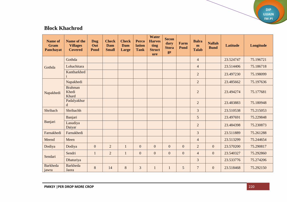
PMKSY |PER DROP MORE CROP 220
DIP UJJAIN (M.P)
Block Khachrod
Name of
Gram
Panchayat
Name of the
Villages
Covered
Dug
Out
Pond
Check
Dam
Small
Check
Dam
Large
Perco
lation
Tank
Water
Harves
ting
Struct
ure
Secon
dary
Stora
ge
Farm
Pond
Balra
m
Talab
Nallah
Bund Latitude Longitude
Gothda
Gothda 4 23.524747 75.196721
Lohachitara 4 23.514406 75.186718
Kantharkhed
i 2 23.497230 75.198099
Napakhedi
Napakhedi 2 23.485662 75.197636
Brahman
Khedi
Khurd
2 23.494274 75.177681
Padalyakhur
d 2 23.483883 75.180948
Shribach Shribachh 3 23.510538 75.215053
Banjari
Banjari 5 23.497691 75.229848
Lasudiya
Daiyar 2 23.484398 75.230873
Farnakhedi Farnakhedi 3 23.511889 75.261288
Meend Meen 4 23.513299 75.244654
Dodiya Dodiya 0 2 1 0 0 0 0 2 0 23.570200 75.290817
Sendari Sendri 1 2 1 0 0 0 0 4 0 23.540327 75.292860
Dhaturiya 3 23.533776 75.274206
Barkheda
jawra
Barkheda
Jaora 8 14 8 3 1 1 5 7 0 23.518468 75.292150

PMKSY |PER DROP MORE CROP 221
DIP UJJAIN (M.P)
Name of
Gram
Panchayat
Name of the
Villages
Covered
Dug
Out
Pond
Check
Dam
Small
Check
Dam
Large
Perco
lation
Tank
Water
Harves
ting
Struct
ure
Secon
dary
Stora
ge
Farm
Pond
Balra
m
Talab
Nallah
Bund Latitude Longitude
Chapakhed
a Chapakheda 4 9 3 1 1 0 4 7 0 23.584304 75.288724
Chapaner Sakatkhedi 1 2 1 0 0 0 0 3 0 23.610495 75.327843
Chanpaner 1 3 2 0 0 0 0 6 0 23.591734 75.319817
Mokdi Mokdi 0 3 2 0 0 0 0 8 0 23.577201 75.335171
Akyajageer Tarod 0 7 1 0 0 0 0 4 0 23.554046 75.334810
Akyajagir 4 14 4 1 2 0 5 4 0 23.559538 75.317344
Chandodiy
a Chandodiya 2 4 2 1 0 0 2 4 0 23.538365 75.326005
Kesariya Kesariya 1 3 1 0 0 0 0 2 0 23.531262 75.308850
Divel Divel 2 6 4 1 1 0 1 4 0 23.521623 75.332861
Ghinoda Ghinoda 8 23.504096 75.299639
Bhensola Bhensola 3 23.474320 75.236622
Panwasa Bhandla 2 23.460078 75.234093
Panwasa 4 23.442125 75.226797
Ringniya Jalod 1 23.472291 75.180900
Rigania 3 23.460502 75.180603
Batlawdi Batlawadi 8 23.471643 75.180900
Bordiya Bordiya 3 23.436597 75.174641
Khandwa 3 23.450136 75.191769
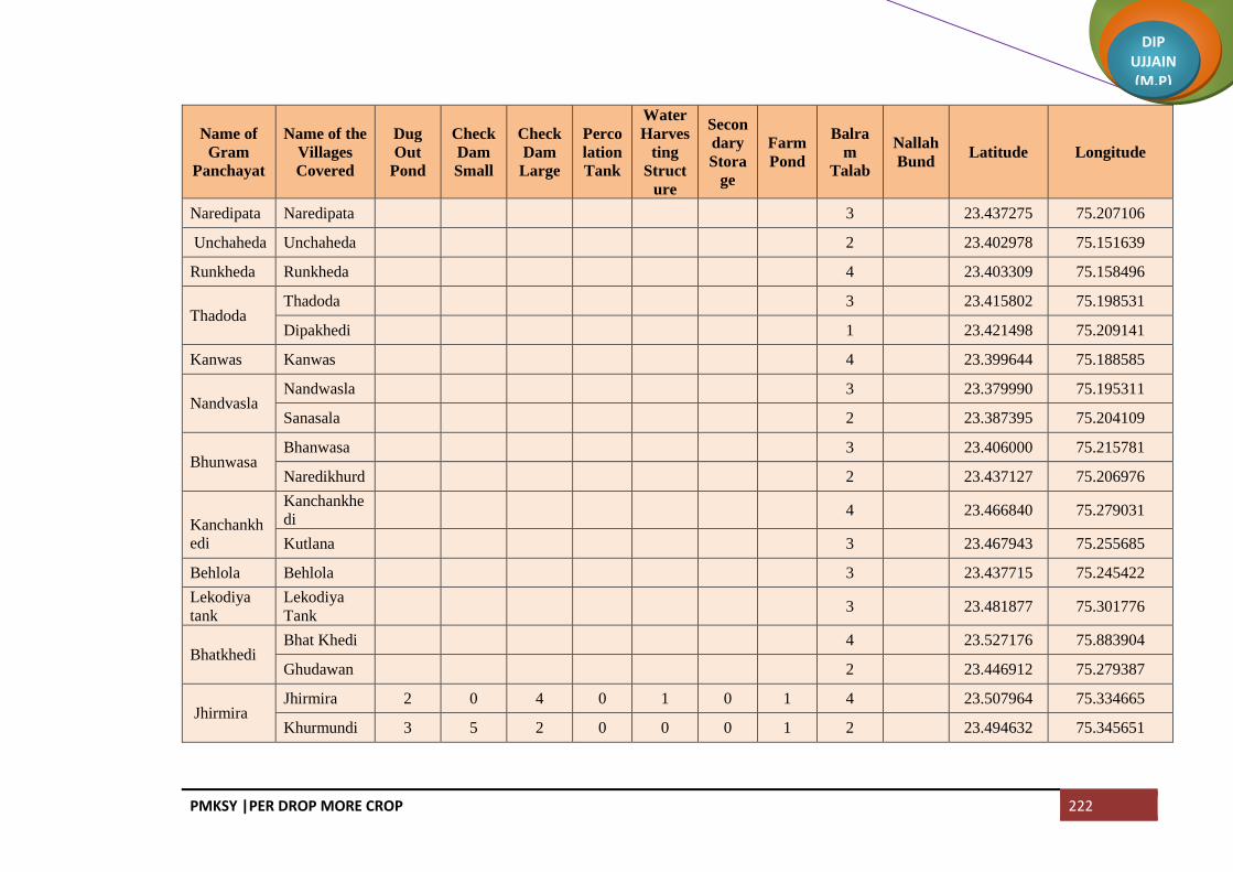
PMKSY |PER DROP MORE CROP 222
DIP UJJAIN (M.P)
Name of
Gram
Panchayat
Name of the
Villages
Covered
Dug
Out
Pond
Check
Dam
Small
Check
Dam
Large
Perco
lation
Tank
Water
Harves
ting
Struct
ure
Secon
dary
Stora
ge
Farm
Pond
Balra
m
Talab
Nallah
Bund Latitude Longitude
Naredipata Naredipata 3 23.437275 75.207106
Unchaheda Unchaheda 2 23.402978 75.151639
Runkheda Runkheda 4 23.403309 75.158496
Thadoda Thadoda 3 23.415802 75.198531
Dipakhedi 1 23.421498 75.209141
Kanwas Kanwas 4 23.399644 75.188585
Nandvasla Nandwasla 3 23.379990 75.195311
Sanasala 2 23.387395 75.204109
Bhunwasa Bhanwasa 3 23.406000 75.215781
Naredikhurd 2 23.437127 75.206976
Kanchankh
edi
Kanchankhe
di 4 23.466840 75.279031
Kutlana 3 23.467943 75.255685
Behlola Behlola 3 23.437715 75.245422
Lekodiya
tank
Lekodiya
Tank 3 23.481877 75.301776
Bhatkhedi Bhat Khedi 4 23.527176 75.883904
Ghudawan 2 23.446912 75.279387
Jhirmira Jhirmira 2 0 4 0 1 0 1 4 23.507964 75.334665
Khurmundi 3 5 2 0 0 0 1 2 23.494632 75.345651

PMKSY |PER DROP MORE CROP 223
DIP UJJAIN (M.P)
Name of
Gram
Panchayat
Name of the
Villages
Covered
Dug
Out
Pond
Check
Dam
Small
Check
Dam
Large
Perco
lation
Tank
Water
Harves
ting
Struct
ure
Secon
dary
Stora
ge
Farm
Pond
Balra
m
Talab
Nallah
Bund Latitude Longitude
Bedawniya Bedavanya 5 23.483228 75.324269
Gidvaniya Gindwanya 1 4 6 23.477861 75.361100
Umarna Umarna 2 1 3 2 23.443214 75.360896
Umarni 2 23.456443 75.379435
Navtiya Dadiya 2 23.445025 75.379435
Nawatiya 2 23.431087 75.355832
Biriyakhedi Beriyakhedi 1 5 2 0 1 1 2 3 2 23.465042 75.349589
Buranabad
Buranabad 3 23.449691 75.335289
Chowki
Junnardar 2 23.439454 75.314261
Pachlasi Pachlasi 3 23.414390 75.335404
Padsulya Padsulya 5 23.420376 75.366303
Kumharwa
di
Kumharwad
i 2 23.400599 75.314711
Siparda 2 23.393194 75.326556
Sarwanakha
charod 2 23.400205 75.338057
Barlai Palna 2 23.396858 75.244431
Barlai 5 23.379777 75.284160
Dupdawda Dupdawada 3 5 1 2 2 0 4 3 0 23.397077 75.276315
Madawadi 2 3 0 0 0 0 1 7 0 23.378012 75.286185

PMKSY |PER DROP MORE CROP 224
DIP UJJAIN (M.P)
Name of
Gram
Panchayat
Name of the
Villages
Covered
Dug
Out
Pond
Check
Dam
Small
Check
Dam
Large
Perco
lation
Tank
Water
Harves
ting
Struct
ure
Secon
dary
Stora
ge
Farm
Pond
Balra
m
Talab
Nallah
Bund Latitude Longitude
Narsinghga
d
Narsinghgar
h 5 23.367913 75.219213
Khedawda
Khedawada 3 23.347820 75.214922
Baramadkhe
da 3 23.334738 75.196125
Antalwasa 1 2 0 0 0 0 1 3 0 23.333635 75.218784
Barthun Barthun 1 4 2 0 0 0 1 3 0 23.333471 75.244963
Rajpur Rayti 0 3 1 0 0 0 1 3 0 23.320788 75.239470
Kamthana Kamthana 7 23.304218 75.274840
Arjala Arjala 0 1 0 0 0 0 0 6 0 23.359371 75.241932
Madawda Madawada 6 9 6 1 1 1 8 8 0 23.357007 75.284160
Chirola Chirola 8 23.274578 75.409551
Bhikampur Bhikampur 8 23.393516 75.357720
Malakhedi
Tumni 1 23.403127 75.377118
Malakhedi 2 23.386741 75.377541
Jalwal 2 8 3 0 1 0 2 2 23.370276 75.390507
Khamriya Khamariya 4 23.366393 75.349842
Lasudiya
khema
Lasudiya
Khema 6 23.357664 75.313958
Bilwaniya Bilwaniya 6 23.345857 75.314645
Lusdawan Lusdawan 4 23.332745 75.302589

PMKSY |PER DROP MORE CROP 225
DIP UJJAIN (M.P)
Name of
Gram
Panchayat
Name of the
Villages
Covered
Dug
Out
Pond
Check
Dam
Small
Check
Dam
Large
Perco
lation
Tank
Water
Harves
ting
Struct
ure
Secon
dary
Stora
ge
Farm
Pond
Balra
m
Talab
Nallah
Bund Latitude Longitude
Chak
Narayangarh 2 23.320450 75.300958
Kamthani 5 23.309494 75.295808
Nandiyasi
Khatakhedi 2 23.304248 75.309337
Brahman
Khedi Kalan 2 23.300701 75.309337
Nandiyasi 5 23.299361 75.347274
Bagedi
Bachhakhed
i 2 23.329868 75.330809
Bagedi 4 23.348967 75.349172
Chandvasla Chandwasla 5 23.323586 75.356495
Nimadi 4 23.313565 75.332754
Badagaon Badagaon 8 23.337424 75.395753
Sandla Sandla 3 10 7 2 2 1 6 6 4 23.315233 75.393368
Surel Surel 2 5 3 0 1 0 0 4 2 23.290981 75.382226
Sadawda
Madgani 2 6 3 1 1 0 2 2 2 23.349427 75.408308
Gidawada 2 23.339553 75.418918
Sandawda 1 2 2 0 1 0 2 3 23.325835 75.414587
Piplodapant
h
Luhari 2 23.290388 75.407402
Piplodapant
h 2 6 2 1 1 0 3 4 2 23.297952 75.426240
Sonchidi 1 2 1 1 1 3 23.316060 75.432144
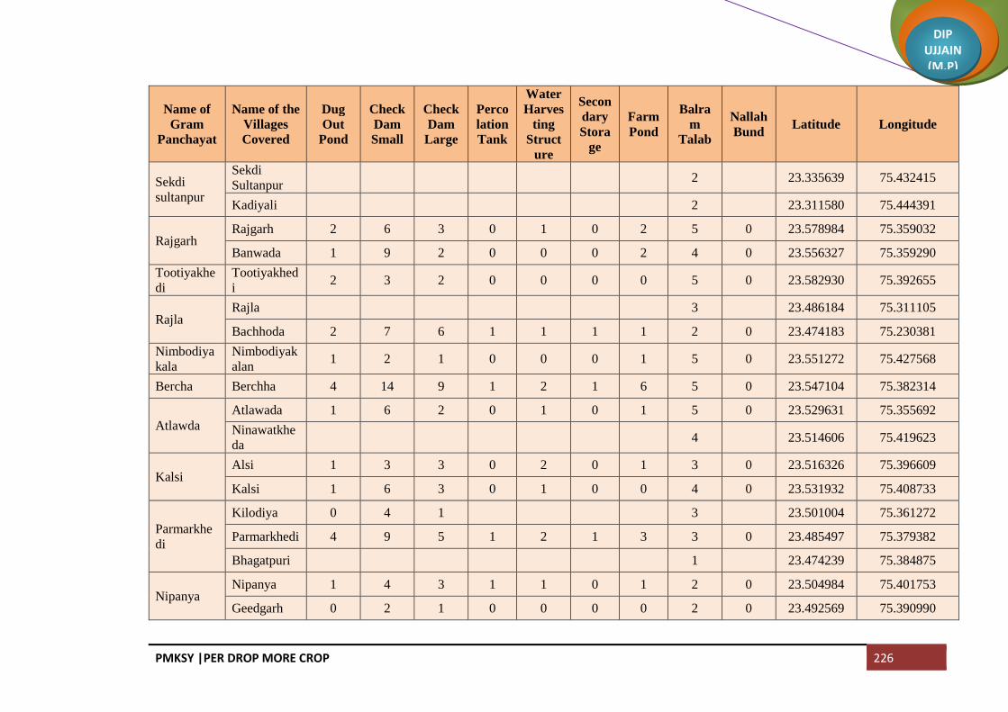
PMKSY |PER DROP MORE CROP 226
DIP UJJAIN (M.P)
Name of
Gram
Panchayat
Name of the
Villages
Covered
Dug
Out
Pond
Check
Dam
Small
Check
Dam
Large
Perco
lation
Tank
Water
Harves
ting
Struct
ure
Secon
dary
Stora
ge
Farm
Pond
Balra
m
Talab
Nallah
Bund Latitude Longitude
Sekdi
sultanpur
Sekdi
Sultanpur 2 23.335639 75.432415
Kadiyali 2 23.311580 75.444391
Rajgarh Rajgarh 2 6 3 0 1 0 2 5 0 23.578984 75.359032
Banwada 1 9 2 0 0 0 2 4 0 23.556327 75.359290
Tootiyakhe
di
Tootiyakhed
i 2 3 2 0 0 0 0 5 0 23.582930 75.392655
Rajla Rajla 3 23.486184 75.311105
Bachhoda 2 7 6 1 1 1 1 2 0 23.474183 75.230381
Nimbodiya
kala
Nimbodiyak
alan 1 2 1 0 0 0 1 5 0 23.551272 75.427568
Bercha Berchha 4 14 9 1 2 1 6 5 0 23.547104 75.382314
Atlawda
Atlawada 1 6 2 0 1 0 1 5 0 23.529631 75.355692
Ninawatkhe
da 4 23.514606 75.419623
Kalsi Alsi 1 3 3 0 2 0 1 3 0 23.516326 75.396609
Kalsi 1 6 3 0 1 0 0 4 0 23.531932 75.408733
Parmarkhe
di
Kilodiya 0 4 1 3 23.501004 75.361272
Parmarkhedi 4 9 5 1 2 1 3 3 0 23.485497 75.379382
Bhagatpuri 1 23.474239 75.384875
Nipanya Nipanya 1 4 3 1 1 0 1 2 0 23.504984 75.401753
Geedgarh 0 2 1 0 0 0 0 2 0 23.492569 75.390990

PMKSY |PER DROP MORE CROP 227
DIP UJJAIN (M.P)
Name of
Gram
Panchayat
Name of the
Villages
Covered
Dug
Out
Pond
Check
Dam
Small
Check
Dam
Large
Perco
lation
Tank
Water
Harves
ting
Struct
ure
Secon
dary
Stora
ge
Farm
Pond
Balra
m
Talab
Nallah
Bund Latitude Longitude
Hebatpur
Bhimpura 1 4 2 0 1 0 1 1 0 23.488572 75.401554
Rohal
Kalan
Rohal Kalan 1 5 1 1 0 0 0 3 0 23.516432 75.446604
Jalodiya
Khacharod 3 15 7 1 2 0 2 4 0 23.486571 75.442930
Jhanjhakhe
di
Jhanjhakhed
i 1 9 2 0 0 0 2 3 0 23.507201 75.428190
Khajuriya 0 3 23.489514 75.419623
Ratanyakhe
di
Ratanyakhe
di 0 4 1 0 0 0 0 1 0 23.490293 75.432125
Banbani 0 1 0 0 0 0 0 1 0 23.457392 75.450385
Rohalkhurd Rohalkhurd 0 7 1 0 0 0 0 6 0 23.514671 75.468339
Akyakoli Kachnariya 2 23.511539 75.497476
Akyakoli 5 23.504458 75.544737
Heedi Heedi 1 3 2 0 0 0 1 8 0 23.481751 75.557336
Antraliya
Kiradiya 3 8 5 1 1 1 3 2 23.469226 75.574873
Antraliya 0 4 2 0 0 0 0 2 23.458413 75.556786
Punakheda 2 23.438386 75.555793
Borkheda
Pitramal
Borkheda
Pitramal 1 9 3 1 0 0 2 6 23.479272 75.502698
Rupeta Rupeta 2 10 4 0 1 0 1 7 0 23.485803 75.475162
Banbana Banbana 6 6 5 1 1 1 6 4 0 23.450138 75.464004

PMKSY |PER DROP MORE CROP 228
DIP UJJAIN (M.P)
Name of
Gram
Panchayat
Name of the
Villages
Covered
Dug
Out
Pond
Check
Dam
Small
Check
Dam
Large
Perco
lation
Tank
Water
Harves
ting
Struct
ure
Secon
dary
Stora
ge
Farm
Pond
Balra
m
Talab
Nallah
Bund Latitude Longitude
Takrawada Takrawada 0 4 2 2 23.417388 75.398097
Azimabad
Pardhi
Azimabad
Pardhi 0 2 1 2 23.424835 75.415342
Amlawad
Junnardar
Amlawad
Junnardar 1 3 2 2 23.426340 75.424855
Lasudiya
Jaisingh 5 9 5 1 1 1 5 4 23.409643 75.435841
Nayan Nayan 3 23.422086 75.384047
Bhatisuda Bhatisuda 0 8 2 0 0 0 2 3 23.399107 75.418234
Bhilsuda Bhilsuda 3 6 5 1 1 1 3 4 23.382357 75.396257
Nimbodiya
Khurd
Nimbodiya
Khurd 0 1 2 23.380140 75.426160
Pipalyasees 2 23.393456 75.449255
Piploda
Sagotimata
Piploda
Sagotimata 5 23.366285 75.426556
Jhiranya
Khacharod
Jhiranya
Khacharod 2 23.525907 75.809376
Hatai Hatai 0 2 2 23.393822 75.487184
Palkhi 4 12 8 1 2 1 5 3 23.414864 75.490190
Dabri Dabri 3 23.429116 75.455169
Simrol Simrol 0 1 4 23.525973 75.810387
Makla 0 2 1 3 23.629510 75.766439
Guradiyapit
ramal Mohna 2 8 3 0 1 0 0 3 0 23.451795 75.486476

PMKSY |PER DROP MORE CROP 229
DIP UJJAIN (M.P)
Name of
Gram
Panchayat
Name of the
Villages
Covered
Dug
Out
Pond
Check
Dam
Small
Check
Dam
Large
Perco
lation
Tank
Water
Harves
ting
Struct
ure
Secon
dary
Stora
ge
Farm
Pond
Balra
m
Talab
Nallah
Bund Latitude Longitude
Guradiyapit
ramal
Guradiyapitr
amal 1 4 1 0 1 0 0 3 0 23.433368 75.502698
Pipalya
Rani
Pipalya Rani 0 5 2 0 0 0 0 3 23.455259 75.520894
Bhatera 2 8 5 1 2 1 2 3 23.459511 75.538232
Pankhedi
Gurachha 3 23.411763 75.582569
Hapakheda 3 23.440240 75.577301
Pankhedi 3 23.429181 75.582569
Mundla 4 23.425009 75.599603
Barkheda
Madan
Barkheda
Madan 5 23.425542 75.568545
Matra 2 23.421840 75.549577
Guradiya
Sanga
Raiyapur 2 23.438229 75.604320
Umariya 3 23.422605 75.623797
Guradiya
Sanga 3 23.420186 75.638362
Alot Jagir Alot Jagir 6 23.394611 75.615286
Pipalya
Sarang
Chidi
Rawadiya 3 23.388922 75.641001
Pipalya
Sarang 3 23.370505 75.639341
Itawa 2 23.356198 75.612014
Sarwana
Unhel
Sarwana
Unhel 4 23.400432 75.556486

PMKSY |PER DROP MORE CROP 230
DIP UJJAIN (M.P)
Name of
Gram
Panchayat
Name of the
Villages
Covered
Dug
Out
Pond
Check
Dam
Small
Check
Dam
Large
Perco
lation
Tank
Water
Harves
ting
Struct
ure
Secon
dary
Stora
ge
Farm
Pond
Balra
m
Talab
Nallah
Bund Latitude Longitude
Arolya
Dewda 3 23.369884 75.572532
Jhiranya
Unhel
Jhiranya
Unhel 3 23.394054 75.583969
Parolya
Padma 3 23.376841 75.584212
Jalodiya
Unhel
Rathda 1 23.441601 75.536526
Jalodiya
Unhel 2 23.429237 75.524003
Khimlakhed
i 2 23.419192 75.510337
Dallaheda Dallaheda 2 23.395874 75.536445
Mahu 2 23.418934 75.753647
Dhoomahe
da
Madhavgarh 1 23.387208 75.506808
Dhoomahed
a 2 23.397424 75.521813
Pipalya
Molu
Pipalya
Molu 3 23.373794 75.489569
Kundla Bhakarda 2 23.365097 75.461005
Kundla 1 23.355878 75.484007
Bagla Bagla 1 23.347368 75.459889
Nagjhiri 5 23.331134 75.471648
Chambal
Padlaya
Chambal
Padlaya 3 23.329400 75.446499
Barkheda Barkheda 1 23.327745 75.489501

PMKSY |PER DROP MORE CROP 231
DIP UJJAIN (M.P)
Name of
Gram
Panchayat
Name of the
Villages
Covered
Dug
Out
Pond
Check
Dam
Small
Check
Dam
Large
Perco
lation
Tank
Water
Harves
ting
Struct
ure
Secon
dary
Stora
ge
Farm
Pond
Balra
m
Talab
Nallah
Bund Latitude Longitude
Najeek Najeek
Chawand Chawand 3 23.312734 75.454533
Rajota 3 23.289533 75.461389
Lekodiya
Anjana
Lekodiya
Anjana 4 23.300405 75.475335
Paslod Kalalkhedi 4 23.339960 75.501335
Paslod 5 23.291650 75.510313
Akya Najik Akya Najik 4 23.298817 75.496110
Nawada Nawada 3 23.324040 75.518426
Malikhedi
Chinkuganj 1 23.376247 75.512884
Malikhedi 3 23.359780 75.524987
Kankarda 1 23.378059 75.537604
Bedawan Bedawan 8 23.460531 75.605782
Pagara
Didiyakhedi 1 23.356134 75.580202
Baijnathkhe
di 2 23.343014 75.593916
Pagara 2 23.325850 75.601061
Roopakhedi 3 23.315795 75.612329
Pipliyadhab
i
Pipalya
Dabi 3 23.309896 75.579995
Surjakhedi Surjakhedi 3 23.293142 75.618027

PMKSY |PER DROP MORE CROP 232
DIP UJJAIN (M.P)
Name of
Gram
Panchayat
Name of the
Villages
Covered
Dug
Out
Pond
Check
Dam
Small
Check
Dam
Large
Perco
lation
Tank
Water
Harves
ting
Struct
ure
Secon
dary
Stora
ge
Farm
Pond
Balra
m
Talab
Nallah
Bund Latitude Longitude
Jiyajigarh 3 23.270269 75.623367
Gurla Gurla 3 23.291544 75.502585
Karondiya
Lasudiyachu
wad 3 23.304792 75.558187
Karondiya 3 23.273113 75.530098
Rambaloda Ramabaloda 6 23.274518 75.581186
Khokri Khokri 3 23.267884 75.600073
Arolyajassa 2 23.262141 75.619725
NP Khacharod
(M) 3 8 4 1 1 1 3 8 0
NP Nagda (M) 5
Mehatwas 3 10 8 1 2 1
NP Unhel (NP) 8
Total 120 404 195 30 46 15 108 742 14

PMKSY |PER DROP MORE CROP 233
DIP UJJAIN (M.P)
Block Badnagar
Name of
Gram
Panchayat
Name of
Villages
Covered
Dug
Out
Pond
Check
Dam
Small
Check
Dam
Large
Percola
tion
Tank
Water
Harvesti
ng
Structur
e
Second
ary
Storage
(MIT)
Farm
Pond
Balram
Talab
Nallah
Bund Latitude Longitude
Bhatpachla
na
Bhatpachla
na 7 6 5 0 0 0 5 5 0 23.250506 75.294487
Maloda Maloda 5 23.241022 75.315326
Banbani
Banbani 2 2 1 1 1 0 5 1 23.260815 75.311721
Bhunwasa 2 3 2 1 0 1 2 5 2 23.284026 75.338293
Kajyakhedi 2 1 2 0 1 0 1 4 1 23.272515 75.337434
Banderbela Banderbela 5 23.252378 75.345967
Limbas Limbas 4 3 2 1 1 1 2 5 1 23.276063 75.371767
Chirola
Chirola 2 3 1 0 1 1 1 6 2 23.274651 75.410906
Rathorkhed
i 2 23.286951 75.430390
Salwa Salwa 1 1 1 0 0 0 2 5 1 23.245633 75.393139
Mungawad
a
Lasudiya 2 3 2 2 1 0 2 3 1 23.251190 75.425917
Mungawad
a 3 0 0 0 0 0 1 3 1 23.258445 75.441195
Karadwas 0 2 3 0 0 0 2 0 23.275240 75.432440
Silodiya
Mungawad
i 2 1 1 0 1 0 3 1 23.247116 75.445670
Silodiya 3 5 4 1 2 1 3 5 2 23.238046 75.431078

PMKSY |PER DROP MORE CROP 234
DIP UJJAIN (M.P)
Name of
Gram
Panchayat
Name of
Villages
Covered
Dug
Out
Pond
Check
Dam
Small
Check
Dam
Large
Percola
tion
Tank
Water
Harvesti
ng
Structur
e
Second
ary
Storage
(MIT)
Farm
Pond
Balram
Talab
Nallah
Bund Latitude Longitude
Amlawadka
lan
Dehta 2 23.282991 75.445670
Kesharpura 1 23.271403 75.453394
Amlawadk
alan 3 23.252084 75.462063
Balodahasa
n
Mahudikhe
ma 3 23.232449 75.450896
Balodahasa
n 4 2 0 1 0 0 2 0 23.212966 75.448407
Gaondidev
si 3 23.223063 75.431499
Dunalja Dunalja 3 2 2 1 0 0 4 1 23.229243 75.462919
Udsinga
Paduniyakh
eta 2 1 2 1 1 0 1 1 1 23.220865 75.413579
Udsinga 2 3 2 1 0 1 1 5 1 23.201258 75.417106
Kalyanpura Kalyanpura 3 2 3 1 1 1 1 3 2 23.185672 75.407286
Kamanpur 3 23.172890 75.396128
Mundat
Khedanara
yan 3 1 0 1 0 0 1 1 23.201119 75.447762
Mundat 3 23.188249 75.447762
Khandoda Khandoda 2 0 0 0 0 0 1 5 1 23.176704 75.437154
Simlawada 4 2 1 2 1 0 3 1
Harnawada Harnawada 4 1 1 0 0 0 1 3 1 23.207596 75.487035

PMKSY |PER DROP MORE CROP 235
DIP UJJAIN (M.P)
Name of
Gram
Panchayat
Name of
Villages
Covered
Dug
Out
Pond
Check
Dam
Small
Check
Dam
Large
Percola
tion
Tank
Water
Harvesti
ng
Structur
e
Second
ary
Storage
(MIT)
Farm
Pond
Balram
Talab
Nallah
Bund Latitude Longitude
Onkarpura
Labaycha 2 1 1 1 0 0 4 1 2 23.196783 75.466770
Semalkhedi 1 23.193943 75.494309
Gurawada 1 23.182090 75.494653
Onkarpura 3 1 1 1 1 0 2 3 2 23.186527 75.478087
Sijawata Sijawata 2 1 1 0 0 0 2 4 1 23.170076 75.463590
Gaondilodh
a
Gaondilodh
a 3 1 2 1 1 0 2 3 2 23.156661 75.467154
Dhureri Dhureri 3 1 1 1 0 0 2 3 1 23.142304 75.501043
Rajota 4 2 4 1 1 1 2 1 3 23.146329 75.482504
Suneda
Suneda 3 23.118625 75.501301
Chinchodiy
a 3 23.120203 75.517866
Kiloli Kiloli 3 23.107064 75.501598
Namalpur 3 23.096248 75.511256
Kharsodkh
urd
Kharsodkh
urd 6 23.118526 75.469040
Untwas Untwas 3 23.088195 75.450787
Ranwa Hatyakhedi 1 23.086774 75.450787
Ranwa 3 23.088195 75.489067
Dantarwa Dantarwa 4 1 1 2 1 0 1 2 2 23.104587 75.414571

PMKSY |PER DROP MORE CROP 236
DIP UJJAIN (M.P)
Name of
Gram
Panchayat
Name of
Villages
Covered
Dug
Out
Pond
Check
Dam
Small
Check
Dam
Large
Percola
tion
Tank
Water
Harvesti
ng
Structur
e
Second
ary
Storage
(MIT)
Farm
Pond
Balram
Talab
Nallah
Bund Latitude Longitude
Rasulabad 7 3 4 3 0 0 1 1 2 23.100718 75.429935
Molana Molana 6 23.100718 75.429935
Palwa Palwa 8 4 3 4 1 0 2 5 3 23.144346 75.429069
Sanawada Itawa 4 1 1 1 0 0 1 3 1 23.461516 75.745866
Sanawada 5 1 1 2 1 0 1 3 2 23.122024 75.415069
Rawadiyap
eer
Rawadiyap
eer 3 23.187767 75.370559
Mindka 2 23.160781 75.385065
Balodakora
n
Balodakora
n 4 23.181703 75.333750
Ajdawada Ajdawada 7 23.180903 75.358886
Kharsodkal
an
Kharsodkal
an 8 23.220246 75.368254
Ordi
Ordi 3 2 2 0 0 1 2 5 1 23.231489 75.338394
Narelakhur
d 1 23.234303 75.353653
Bardiya Bardiya 7 23.216574 75.325528
Nauganwa Nauganwa 5 3 3 6 3 1 6 4 3 23.224930 75.301132
Khedawada Khedawada 6 23.188903 75.290080
Malgaondi 1 23.174622 75.285874

PMKSY |PER DROP MORE CROP 237
DIP UJJAIN (M.P)
Name of
Gram
Panchayat
Name of
Villages
Covered
Dug
Out
Pond
Check
Dam
Small
Check
Dam
Large
Percola
tion
Tank
Water
Harvesti
ng
Structur
e
Second
ary
Storage
(MIT)
Farm
Pond
Balram
Talab
Nallah
Bund Latitude Longitude
Badganwa Badganwa 2 1 1 1 0 0 1 7 3 23.197264 75.254211
Gajnikhedi
Maswadiya
dhar 4 23.192452 75.233183
Gajnikhedi 7 3 2 1 0 0 1 7 4 23.173358 75.253267
Runija Runija 2 2 1 0 0 0 1 3 1 23.160597 75.268006
Madhopura Madhopura 3 1 1 0 1 0 8 2 23.141457 75.277446
Balodalakh
a
Balodalakh
a 6 23.156439 75.313754
Sundrabad Sundrabad 5 23.133221 75.311637
Jalodsanjar Jalodsanjar 6 23.136536 75.348286
Pachlanabil
Pachlanabil 4 23.138588 75.372147
Singawada 2 23.131752 75.389587
Bidsingawa
da 2 1 0 0 0 0 1 2 23.118697 75.386824
Meethikhe
di 1 23.109066 75.388455
Pitlawadiya Pitlawadiya 2
Tokra 1 1 1 2 1 0 1 3 1 23.086291 75.338623
Birakhedi Ranawada 4 2 1 1 1 0 4 1 1 23.118699 75.373047
Birakhedi 5 23.113853 75.353993
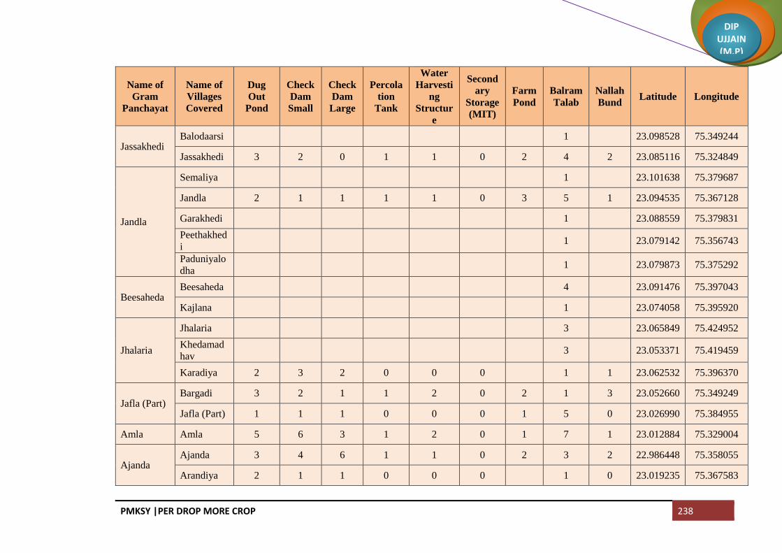
PMKSY |PER DROP MORE CROP 238
DIP UJJAIN (M.P)
Name of
Gram
Panchayat
Name of
Villages
Covered
Dug
Out
Pond
Check
Dam
Small
Check
Dam
Large
Percola
tion
Tank
Water
Harvesti
ng
Structur
e
Second
ary
Storage
(MIT)
Farm
Pond
Balram
Talab
Nallah
Bund Latitude Longitude
Jassakhedi Balodaarsi 1 23.098528 75.349244
Jassakhedi 3 2 0 1 1 0 2 4 2 23.085116 75.324849
Jandla
Semaliya 1 23.101638 75.379687
Jandla 2 1 1 1 1 0 3 5 1 23.094535 75.367128
Garakhedi 1 23.088559 75.379831
Peethakhed
i 1 23.079142 75.356743
Paduniyalo
dha 1 23.079873 75.375292
Beesaheda Beesaheda 4 23.091476 75.397043
Kajlana 1 23.074058 75.395920
Jhalaria
Jhalaria 3 23.065849 75.424952
Khedamad
hav 3 23.053371 75.419459
Karadiya 2 3 2 0 0 0 1 1 23.062532 75.396370
Jafla (Part) Bargadi 3 2 1 1 2 0 2 1 3 23.052660 75.349249
Jafla (Part) 1 1 1 0 0 0 1 5 0 23.026990 75.384955
Amla Amla 5 6 3 1 2 0 1 7 1 23.012884 75.329004
Ajanda Ajanda 3 4 6 1 1 0 2 3 2 22.986448 75.358055
Arandiya 2 1 1 0 0 0 1 0 23.019235 75.367583

PMKSY |PER DROP MORE CROP 239
DIP UJJAIN (M.P)
Name of
Gram
Panchayat
Name of
Villages
Covered
Dug
Out
Pond
Check
Dam
Small
Check
Dam
Large
Percola
tion
Tank
Water
Harvesti
ng
Structur
e
Second
ary
Storage
(MIT)
Farm
Pond
Balram
Talab
Nallah
Bund Latitude Longitude
Ubradiya 2 1 2 0 0 0 1 1 0 23.006911 75.360716
Kotki 1 23.000810 75.379513
Shekhpur Shekhpur 1 1 2 0 0 0 1 1 23.041033 75.398830
Bhomalwas Bhomalwas 3 23.025411 75.406241
Upri 2 1 1 1 1 0 1 1 2 23.011112 75.392250
Birgodaran
dhir
Bhainslakal
an 1 1 2 0 1 0 3 2 23.035995 75.425467
Birgodaran
dhir 2 1 1 0 0 0 3 1 23.043183 75.439715
Umariya Umariya 2 1 3 1 1 0 1 8 2 23.017274 75.422206
Khandwasu
ra
Khandwasu
ra 2 2 3 0 1 0 2 4 0 22.976729 75.383290
Likhoda 1 0 2 0 0 0 1 3 0 23.001776 75.387152
Jalodiya Jalodiya 2 1 2 1 1 1 2 4 2 22.991707 75.417174
Bhidawad Bhidawad 3 1 3 1 1 1 2 7 3 22.938916 75.348166
Lohariya 2 0 1 1 1 1 1 4 1 22.973345 75.335766
Sarola
Sarola 2 1 2 0 0 0 3 0 22.961125 75.371941
Dhaturiya 1 2 2 0 0 0 3 0 22.949823 75.374945
Mundla 4 6 6 1 1 1 2 3 1 22.938837 75.385503
Suklana Rawadiyak 6 5 7 1 1 1 4 4 2 22.948252 75.323487

PMKSY |PER DROP MORE CROP 240
DIP UJJAIN (M.P)
Name of
Gram
Panchayat
Name of
Villages
Covered
Dug
Out
Pond
Check
Dam
Small
Check
Dam
Large
Percola
tion
Tank
Water
Harvesti
ng
Structur
e
Second
ary
Storage
(MIT)
Farm
Pond
Balram
Talab
Nallah
Bund Latitude Longitude
alan
Suklana 4 2 6 1 1 1 2 3 0 22.917958 75.343333
Lohana Lohana 3 3 5 1 1 1 2 8 1 22.914381 75.366287
Khandwabi
bi
Kungara 2 2 4 0 0 0 1 3 0 22.903530 75.346716
Khandwabi
bi 2 2 2 1 1 0 3 0 22.880089 75.346530
Satwasa 1 2 2 1 1 1 3 3 1 22.879432 75.368261
Nawada Nawada 1 2 2 1 1 0 1 3 1 22.859880 75.349000
Badgara Badgara 2 4 4 1 0 0 1 3 0 22.843099 75.350339
Piplee Piplee 7 22.866708 75.400017
Dotru Dotru 4 22.891473 75.431523
Gajikhedi 3 22.884198 75.419249
Pithora
Pithora 3 22.930622 75.413567
Biragodana
thu 3 22.910226 75.415627
Gunawad Gunawad 5 22.935523 75.439058
Bisalkhedi 1 22.929832 75.469957
Bangred Bangred 2 3 5 0 0 0 2 6 2 22.956383 75.404300
Fatehpur Fatehpur 6 22.962278 75.449548

PMKSY |PER DROP MORE CROP 241
DIP UJJAIN (M.P)
Name of
Gram
Panchayat
Name of
Villages
Covered
Dug
Out
Pond
Check
Dam
Small
Check
Dam
Large
Percola
tion
Tank
Water
Harvesti
ng
Structur
e
Second
ary
Storage
(MIT)
Farm
Pond
Balram
Talab
Nallah
Bund Latitude Longitude
Asawta Asawta 3 22.994788 75.417174
Akoliya Akoliya 3 22.987700 75.465604
Takrawada 1 22.979245 75.479507
Pirjhalar
Pirjhalar 7 23.031151 75.464574
Bhandtilaw
ali 1 23.030756 75.489809
Daulatpur
Daulatpur 2 23.038654 75.512039
Sohad 3 2 1 1 0 0 1 1 23.048765 75.495351
Pacholi 1 23.026247 75.667179
Dautardi 1 23.013845 75.501771
Palduna Palduna 6 23.065823 75.463937
Lakhesara
Maswadiya
khalsa 5 3 2 3 3 0 2 3 1 23.079800 75.514406
Lakhesara 5 4 4 1 2 0 3 4 1 23.058558 75.510629
Narsinga Paslod 3 23.063533 75.531744
Narsinga 6 23.064558 75.542558
Dangwada Dangwada 5 23.091089 75.526861
Baledi Baledi 9 23.121239 75.556476
Ghudawan Ghudawan 3 23.446769 75.278596
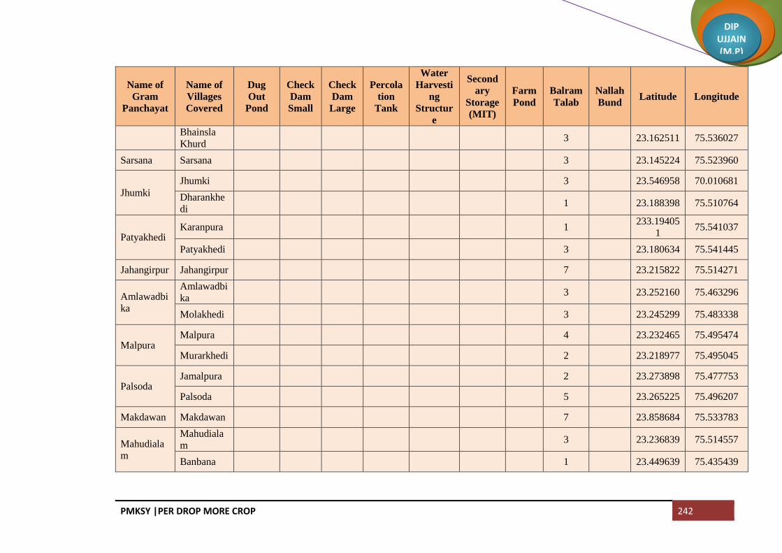
PMKSY |PER DROP MORE CROP 242
DIP UJJAIN (M.P)
Name of
Gram
Panchayat
Name of
Villages
Covered
Dug
Out
Pond
Check
Dam
Small
Check
Dam
Large
Percola
tion
Tank
Water
Harvesti
ng
Structur
e
Second
ary
Storage
(MIT)
Farm
Pond
Balram
Talab
Nallah
Bund Latitude Longitude
Bhainsla
Khurd 3 23.162511 75.536027
Sarsana Sarsana 3 23.145224 75.523960
Jhumki
Jhumki 3 23.546958 70.010681
Dharankhe
di 1 23.188398 75.510764
Patyakhedi Karanpura 1
233.19405
1 75.541037
Patyakhedi 3 23.180634 75.541445
Jahangirpur Jahangirpur 7 23.215822 75.514271
Amlawadbi
ka
Amlawadbi
ka 3 23.252160 75.463296
Molakhedi 3 23.245299 75.483338
Malpura Malpura 4 23.232465 75.495474
Murarkhedi 2 23.218977 75.495045
Palsoda Jamalpura 2 23.273898 75.477753
Palsoda 5 23.265225 75.496207
Makdawan Makdawan 7 23.858684 75.533783
Mahudiala
m
Mahudiala
m 3 23.236839 75.514557
Banbana 1 23.449639 75.435439
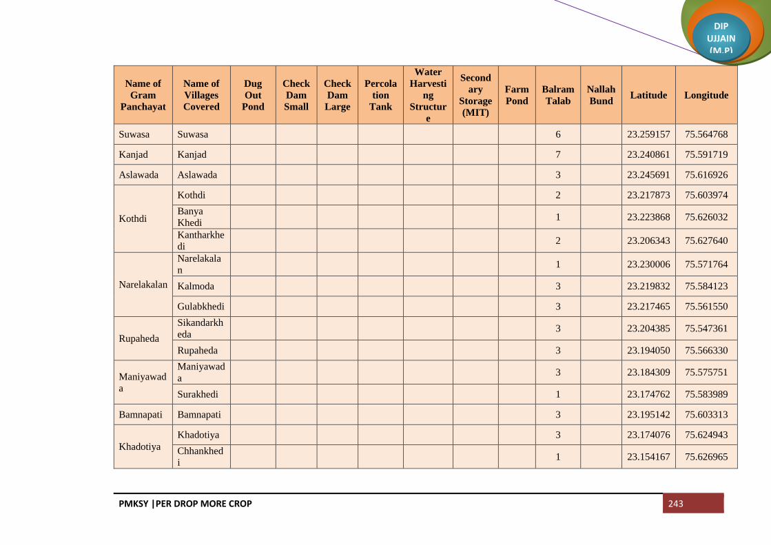
PMKSY |PER DROP MORE CROP 243
DIP UJJAIN (M.P)
Name of
Gram
Panchayat
Name of
Villages
Covered
Dug
Out
Pond
Check
Dam
Small
Check
Dam
Large
Percola
tion
Tank
Water
Harvesti
ng
Structur
e
Second
ary
Storage
(MIT)
Farm
Pond
Balram
Talab
Nallah
Bund Latitude Longitude
Suwasa Suwasa 6 23.259157 75.564768
Kanjad Kanjad 7 23.240861 75.591719
Aslawada Aslawada 3 23.245691 75.616926
Kothdi
Kothdi 2 23.217873 75.603974
Banya
Khedi 1 23.223868 75.626032
Kantharkhe
di 2 23.206343 75.627640
Narelakalan
Narelakala
n 1 23.230006 75.571764
Kalmoda 3 23.219832 75.584123
Gulabkhedi 3 23.217465 75.561550
Rupaheda
Sikandarkh
eda 3 23.204385 75.547361
Rupaheda 3 23.194050 75.566330
Maniyawad
a
Maniyawad
a 3 23.184309 75.575751
Surakhedi 1 23.174762 75.583989
Bamnapati Bamnapati 3 23.195142 75.603313
Khadotiya
Khadotiya 3 23.174076 75.624943
Chhankhed
i 1 23.154167 75.626965

PMKSY |PER DROP MORE CROP 244
DIP UJJAIN (M.P)
Name of
Gram
Panchayat
Name of
Villages
Covered
Dug
Out
Pond
Check
Dam
Small
Check
Dam
Large
Percola
tion
Tank
Water
Harvesti
ng
Structur
e
Second
ary
Storage
(MIT)
Farm
Pond
Balram
Talab
Nallah
Bund Latitude Longitude
Kulawada Matangna 3 23.171448 75.601927
Kulawada 3 23.219540 75.581801
Ingoriya Ingoriya 5 23.156139 75.569998
Cheekali Cheekali 5 23.139723 75.604845
Kadhai Kadhai 5 23.121630 75.593160
Bhondwas 3 23.123840 75.615218
Ghadsinga
Ghadsinga 5 23.103001 75.583621
Brahmanba
doda 1 23.112553 75.621301
Nimboda Naharkhedi 3 23.089500 75.622331
Nimboda 3 23.101895 75.603877
NP Badnagar
(M + OG) 2 1 1 2 1 0 3 7 3
Total 217 151 159 67 50 17 108 644 99

PMKSY |PER DROP MORE CROP 245
DIP UJJAIN (M.P)
Block Mahidpur
Name of
Gram
Panchayat
Name of the
Villages
Covered
Farm
Pond
Check
Dam
Small
Nallah
Bund
Percolation
Tank
Ground
Water
Recharge
WHS
Secondary
Storage
Structure
Balram
Talab Latitude Longitude
Brahmankh
eda
Brahmankhe
da 4 4 3 1 115 7 2 2 23.65566 75.544006
Petlawad Petlawad 2 6 - 3 0 6 4 1 23.63938 75.530874
Koyal Deoli 2 3 4 3 13 7 4 2 23.64249 75.559069
Koyal 3 3 6 2 15 9 3 2 23.62085 75.54592
Bapaiya Bapaiya 2 3 2 3 101 5 4 1 23.60708 75.521201
Kanakedi
Eklaspur
Kanakedi
Eklaspur 2 3 1 1 60 4 2 2 23.58387 75.521576
Karnawad 0 - 1 - 20 1 1 0 23.58835 75.541145
Bawalya
Bawalya 1 3 1 1 50 4 2 1 23.60019 75.604931
Chibdi 0 1 1 - 50 2 1 0 23.59697 75.587937
Serankhedi 0 1 - - 10 1 1 0 23.59091 75.570856
Tarnod Tarnod 2 4 1 1 60 5 2 1 23.58678 75.556423
Barukhedi
Barukhedi 2 4 30 3 0 34 4 1 23.54155 75.541566
Sarwankhed
a 1 1 20 2 0 21 3 1 23.56271 75.543797
Isankhedi Isankhedi 2 5 7 1 60 12 2 1 23.55303 75.568946
Narayankhe
di
Jharawada 1 3 20 1 0 23 2 1 23.52518 75.521652
Narayankhe
di 1 4 40 1 0 44 2 1 23.53147 75.553839
Delchibuzu
rg
Delchibuzur
g 1 9 4 1 65 13 2 1 23.53037 75.58182
Banjari Banjari 3 15 45 4 25 60 5 2 23.5213 75.602153
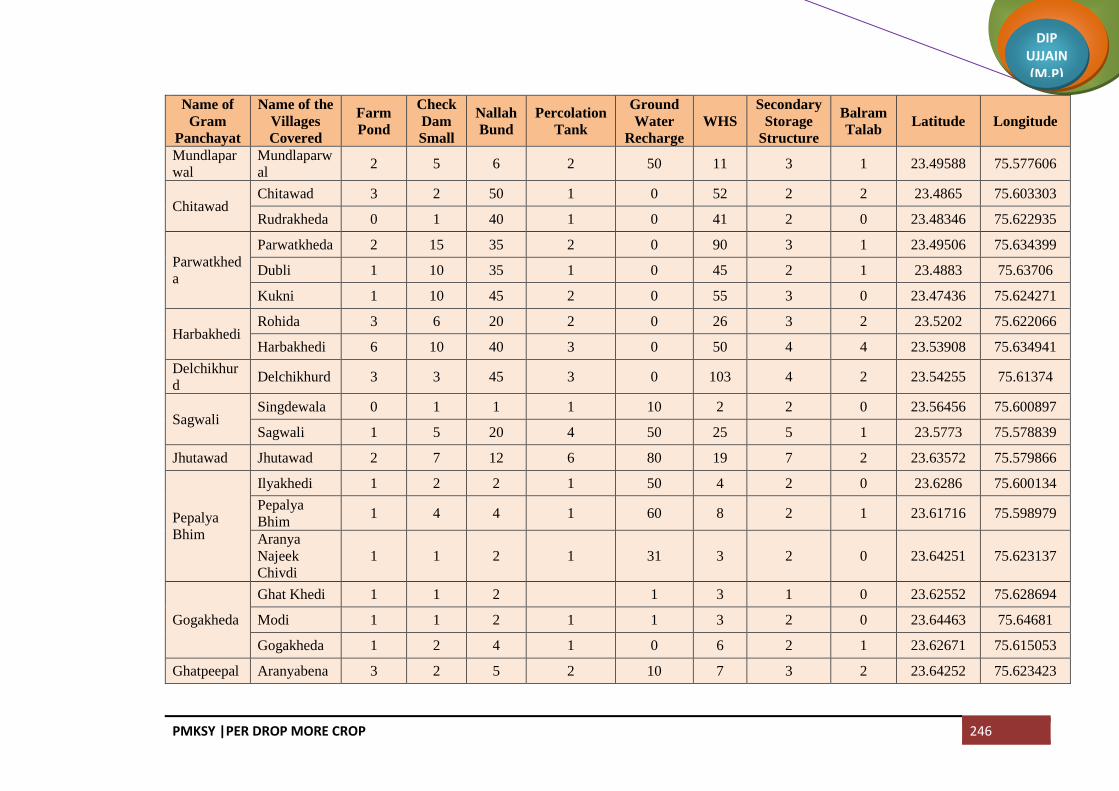
PMKSY |PER DROP MORE CROP 246
DIP UJJAIN (M.P)
Name of
Gram
Panchayat
Name of the
Villages
Covered
Farm
Pond
Check
Dam
Small
Nallah
Bund
Percolation
Tank
Ground
Water
Recharge
WHS
Secondary
Storage
Structure
Balram
Talab Latitude Longitude
Mundlapar
wal
Mundlaparw
al 2 5 6 2 50 11 3 1 23.49588 75.577606
Chitawad Chitawad 3 2 50 1 0 52 2 2 23.4865 75.603303
Rudrakheda 0 1 40 1 0 41 2 0 23.48346 75.622935
Parwatkhed
a
Parwatkheda 2 15 35 2 0 90 3 1 23.49506 75.634399
Dubli 1 10 35 1 0 45 2 1 23.4883 75.63706
Kukni 1 10 45 2 0 55 3 0 23.47436 75.624271
Harbakhedi Rohida 3 6 20 2 0 26 3 2 23.5202 75.622066
Harbakhedi 6 10 40 3 0 50 4 4 23.53908 75.634941
Delchikhur
d Delchikhurd 3 3 45 3 0 103 4 2 23.54255 75.61374
Sagwali Singdewala 0 1 1 1 10 2 2 0 23.56456 75.600897
Sagwali 1 5 20 4 50 25 5 1 23.5773 75.578839
Jhutawad Jhutawad 2 7 12 6 80 19 7 2 23.63572 75.579866
Pepalya
Bhim
Ilyakhedi 1 2 2 1 50 4 2 0 23.6286 75.600134
Pepalya
Bhim 1 4 4 1 60 8 2 1 23.61716 75.598979
Aranya
Najeek
Chivdi
1 1 2 1 31 3 2 0 23.64251 75.623137
Gogakheda
Ghat Khedi 1 1 2 1 3 1 0 23.62552 75.628694
Modi 1 1 2 1 1 3 2 0 23.64463 75.64681
Gogakheda 1 2 4 1 0 6 2 1 23.62671 75.615053
Ghatpeepal Aranyabena 3 2 5 2 10 7 3 2 23.64252 75.623423

PMKSY |PER DROP MORE CROP 247
DIP UJJAIN (M.P)
Name of
Gram
Panchayat
Name of the
Villages
Covered
Farm
Pond
Check
Dam
Small
Nallah
Bund
Percolation
Tank
Ground
Water
Recharge
WHS
Secondary
Storage
Structure
Balram
Talab Latitude Longitude
ya Ghatpeepaly
a 4 4 5 2 15 9 3 3 23.65515 75.636342
Dhablasiya Dhablasiya 1 5 2 1 7 1 1 23.61977 75.66081
Munjakhedi 1 5 2 1 1 7 2 1 23.62744 75.647313
Kanthariya
Kanthariya 1 4 4 1 2 8 2 1 23.60826 75.629176
Barkhedakh
urd 1 2 2 0 1 4 1 0 23.59437 75.621309
Sipawara 1 2 2 0 1 4 1 0 23.58081 75.61377
Semalya Semalya 3 5 50 5 0 55 6 2 23.55967 75.637244
Bani Bani 3 2 50 1 0 52 2 2 23.53186 75.658593
Rasulpura 3 1 35 1 0 36 2 2 23.51772 75.652242
Nipaniyaba
dar
Nipaniyabad
ar 6 2 3 2 2 5 3 4 23.56554 75.668821
Katariya 6 2 3 2 2 5 3 4 23.58717 75.652798
Sumrakhed
a
Sanoriya 1 1 1 1 5 2 2 1 23.62882 75.694958
Akyabajrang 1 0 1 0 5 1 1 1 23.62611 75.713651
Sumrakheda 2 1 2 1 10 3 2 1 23.61576 75.712059
Sakariya
Sukdi 1 0 1 0 0 1 1 0 23.64569 75.716721
Sakariya 1 1 1 1 1 2 2 1 23.63542 75.732956
Kanakhedi
Hamma 1 1 0 0 0 1 1 0 23.65355 75.765361
Asadi
Aranyabagd
a 0 1 1 4 1 2 0 23.66198 75.704161
Asadi 0 1 1 1 4 2 2 0 23.67189 75.719751
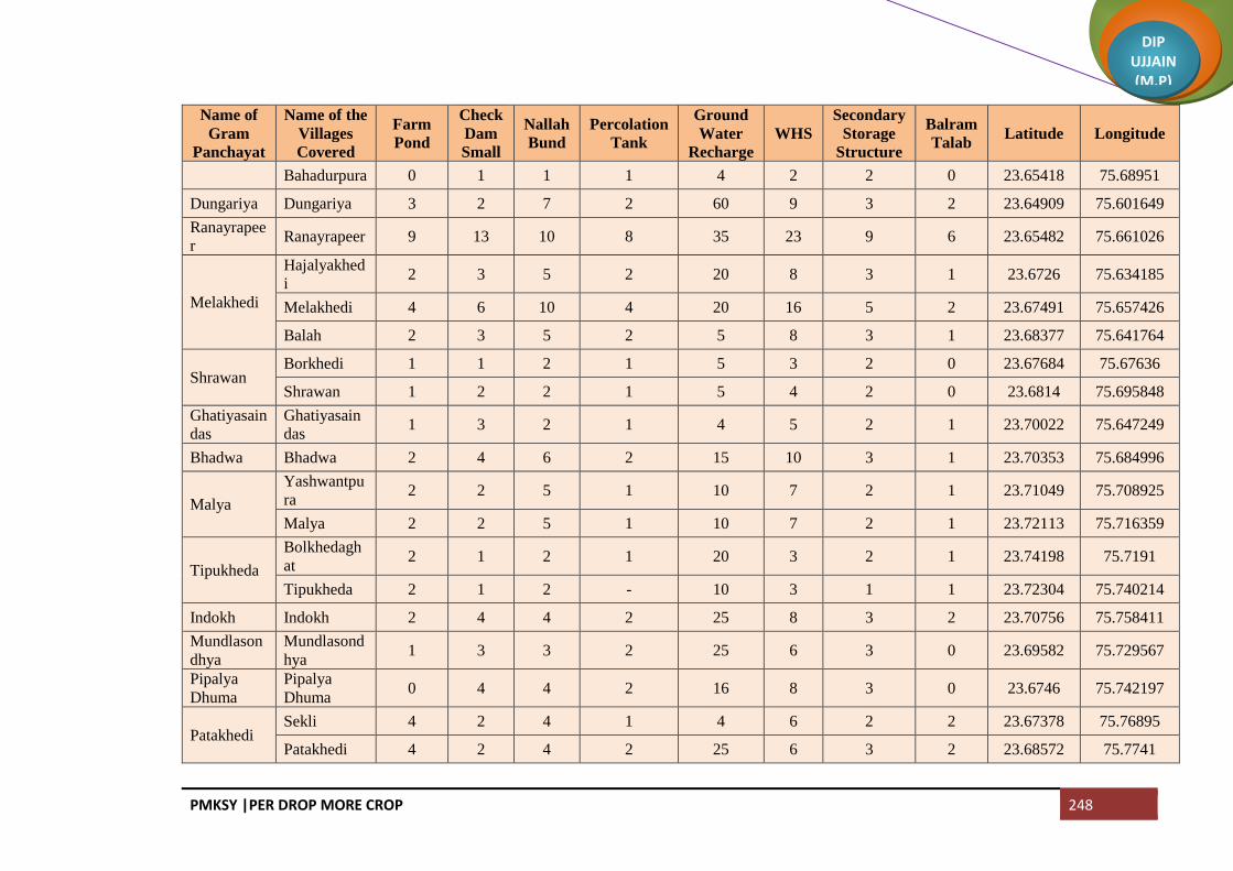
PMKSY |PER DROP MORE CROP 248
DIP UJJAIN (M.P)
Name of
Gram
Panchayat
Name of the
Villages
Covered
Farm
Pond
Check
Dam
Small
Nallah
Bund
Percolation
Tank
Ground
Water
Recharge
WHS
Secondary
Storage
Structure
Balram
Talab Latitude Longitude
Bahadurpura 0 1 1 1 4 2 2 0 23.65418 75.68951
Dungariya Dungariya 3 2 7 2 60 9 3 2 23.64909 75.601649
Ranayrapee
r Ranayrapeer 9 13 10 8 35 23 9 6 23.65482 75.661026
Melakhedi
Hajalyakhed
i 2 3 5 2 20 8 3 1 23.6726 75.634185
Melakhedi 4 6 10 4 20 16 5 2 23.67491 75.657426
Balah 2 3 5 2 5 8 3 1 23.68377 75.641764
Shrawan Borkhedi 1 1 2 1 5 3 2 0 23.67684 75.67636
Shrawan 1 2 2 1 5 4 2 0 23.6814 75.695848
Ghatiyasain
das
Ghatiyasain
das 1 3 2 1 4 5 2 1 23.70022 75.647249
Bhadwa Bhadwa 2 4 6 2 15 10 3 1 23.70353 75.684996
Malya
Yashwantpu
ra 2 2 5 1 10 7 2 1 23.71049 75.708925
Malya 2 2 5 1 10 7 2 1 23.72113 75.716359
Tipukheda
Bolkhedagh
at 2 1 2 1 20 3 2 1 23.74198 75.7191
Tipukheda 2 1 2 - 10 3 1 1 23.72304 75.740214
Indokh Indokh 2 4 4 2 25 8 3 2 23.70756 75.758411
Mundlason
dhya
Mundlasond
hya 1 3 3 2 25 6 3 0 23.69582 75.729567
Pipalya
Dhuma
Pipalya
Dhuma 0 4 4 2 16 8 3 0 23.6746 75.742197
Patakhedi Sekli 4 2 4 1 4 6 2 2 23.67378 75.76895
Patakhedi 4 2 4 2 25 6 3 2 23.68572 75.7741

PMKSY |PER DROP MORE CROP 249
DIP UJJAIN (M.P)
Name of
Gram
Panchayat
Name of the
Villages
Covered
Farm
Pond
Check
Dam
Small
Nallah
Bund
Percolation
Tank
Ground
Water
Recharge
WHS
Secondary
Storage
Structure
Balram
Talab Latitude Longitude
Bansingh
Bansingh 1 3 4 2 20 7 3 1 23.71204 75.777637
Kachhaliyas
aiyad 1 3 4 2 5 7 3 1 23.69437 75.80457
Mahudiya Mahudiya 1 4 4 1 6 8 2 0 23.69099 75.833383
Dhelwadi 1 4 4 - 6 8 1 0 23.70923 75.837846
Lasudiyago
yal
Lasudiyagoy
al 7 4 10 3 30 14 4 4 23.72734 75.843211
Bolkhedana
u
Bolkhedana
u 5 4 10 2 10 14 3 3 23.68054 75.813899
Rabdaniya
Ladanpur 2 1 1 1 10 2 2 2 23.65375 75.803366
Rabdaniya 4 2 3 1 15 5 2 2 23.66294 75.781222
Naharkheda 1 1 2 - 10 3 1 1 23.66483 75.798388
Khardiya
Manpur
Khardiya
Manpur 1 2 3 1 2 5 2 0 23.64392 75.820103
Kachhaliyac
hand 1 2 3 1 2 5 2 0 23.63605 75.803194
Nagguradiy
a Nagguradiya 5 5 5 2 18 10 3 4 23.61938 75.814181
Bamnai
Bamnai 1 2 4 1 2 6 2 0 23.6036 75.768426
Rudaheda 1 1 2 0 2 3 1 0 23.60671 75.803853
Tolyakhedi 1 2 2 0 2 4 1 0 23.50994 75.884918
Kallapipaly
a
Kallapipalya 1 4 3 1 1 7 2 0 23.49915 75.870988
Teelyakhedi 0 2 3 - 0 5 1 0 23.50994 75.884918
Makla Makla 6 7 10 2 0 17 3 4 23.62991 75.765744
Lotiya
Junarda
Lotiya
Junarda 2 2 2 5 12 4 6 2 23.65332 75.737795
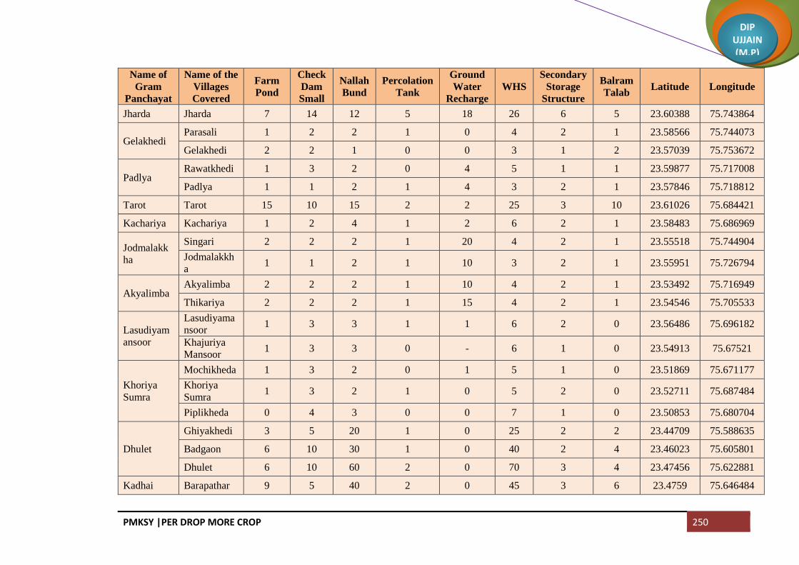
PMKSY |PER DROP MORE CROP 250
DIP UJJAIN (M.P)
Name of
Gram
Panchayat
Name of the
Villages
Covered
Farm
Pond
Check
Dam
Small
Nallah
Bund
Percolation
Tank
Ground
Water
Recharge
WHS
Secondary
Storage
Structure
Balram
Talab Latitude Longitude
Jharda Jharda 7 14 12 5 18 26 6 5 23.60388 75.743864
Gelakhedi Parasali 1 2 2 1 0 4 2 1 23.58566 75.744073
Gelakhedi 2 2 1 0 0 3 1 2 23.57039 75.753672
Padlya Rawatkhedi 1 3 2 0 4 5 1 1 23.59877 75.717008
Padlya 1 1 2 1 4 3 2 1 23.57846 75.718812
Tarot Tarot 15 10 15 2 2 25 3 10 23.61026 75.684421
Kachariya Kachariya 1 2 4 1 2 6 2 1 23.58483 75.686969
Jodmalakk
ha
Singari 2 2 2 1 20 4 2 1 23.55518 75.744904
Jodmalakkh
a 1 1 2 1 10 3 2 1 23.55951 75.726794
Akyalimba Akyalimba 2 2 2 1 10 4 2 1 23.53492 75.716949
Thikariya 2 2 2 1 15 4 2 1 23.54546 75.705533
Lasudiyam
ansoor
Lasudiyama
nsoor 1 3 3 1 1 6 2 0 23.56486 75.696182
Khajuriya
Mansoor 1 3 3 0 - 6 1 0 23.54913 75.67521
Khoriya
Sumra
Mochikheda 1 3 2 0 1 5 1 0 23.51869 75.671177
Khoriya
Sumra 1 3 2 1 0 5 2 0 23.52711 75.687484
Piplikheda 0 4 3 0 0 7 1 0 23.50853 75.680704
Dhulet
Ghiyakhedi 3 5 20 1 0 25 2 2 23.44709 75.588635
Badgaon 6 10 30 1 0 40 2 4 23.46023 75.605801
Dhulet 6 10 60 2 0 70 3 4 23.47456 75.622881
Kadhai Barapathar 9 5 40 2 0 45 3 6 23.4759 75.646484

PMKSY |PER DROP MORE CROP 251
DIP UJJAIN (M.P)
Name of
Gram
Panchayat
Name of the
Villages
Covered
Farm
Pond
Check
Dam
Small
Nallah
Bund
Percolation
Tank
Ground
Water
Recharge
WHS
Secondary
Storage
Structure
Balram
Talab Latitude Longitude
(Part)
Kadhai 30 10 50 2 0 60 3 20 23.44417 75.649231
Bhimakhed
a
Tajpura
(Part) 1 1 5 1 0 6 2 1 23.47756 75.664596
Bhimakheda
(Part) 2 4 3 2 0 7 3 1 23.48322 75.684142
Kajikhedi
Kajikhedi 1 2 12 2 0 14 3 1 23.48657 75.697527
Aamdi 1 1 7 1 0 8 2 1 23.50302 75.700531
Sangvikheda 1 1 12 1 0 13 2 0 23.4972 75.701217
Binpura Binpura 1 5 7 1 1 12 2 0 23.47518 75.7002
Tanda 0 1 2 - - 3 1 0 23.45809 75.700457
Lakhakhedi
Naharpur
Lakhakhedi
Naharpur 3 12 60 1 0 72 2 2 23.44758 75.672931
Sekakhedi Sekakhedi 2 2 30 2 0 32 3 1 23.46622 75.670088
Chorwasa 2 2 20 1 0 22 2 1 23.44553 75.692586
Dharakheda Dharakheda 2 4 30 3 0 34 4 2 23.4473 75.710328
Bagla 1 2 20 1 0 22 2 1 23.42502 75.695908
Mahu Mahu 15 15 70 1 0 85 2 10 23.42348 75.67276
Akyadhanga 6 30 30 1 0 60 2 4 23.41237 75.652589
Narayna Chiramya 1 3 35 1 0 38 2 1 23.3963 75.664434
Narayna 3 3 50 1 0 53 2 2 23.39749 75.681085
Baloda Tulsapur 0 5 25 0 30 1 0 23.41013 75.693763
Baloda 0 10 25 0 35 1 0 23.40036 75.704835

PMKSY |PER DROP MORE CROP 252
DIP UJJAIN (M.P)
Name of
Gram
Panchayat
Name of the
Villages
Covered
Farm
Pond
Check
Dam
Small
Nallah
Bund
Percolation
Tank
Ground
Water
Recharge
WHS
Secondary
Storage
Structure
Balram
Talab Latitude Longitude
Sherpur 0 10 25 0 35 1 0 23.38681 75.686896
Aranya
Najeek
Sherpur
0 10 25 1 0 35 2 0 23.37665 75.7002
Barkhedabu
zurg
Kukalkheda 1 2 2 1 2 4 2 0 23.41494 75.741914
Barkhedabu
zurg 1 6 4 1 6 10 2 0 23.40761 75.728438
Gangajalya
Kheda 1 2 2 1 2 4 2 0 23.40745 75.715993
Kitiya Moyakheda 1 - 1 - - 1 1 0 23.43203 75.740491
Kitiya 2 - 4 2 2 4 3 1 23.42799 75.757091
Dongla
Dongla 0 3 2 3 1 0 23.45216 75.763587
Kanakhedi
Harbans 0 3 1 3 1 0 23.44348 75.790436
Itawa
Itawa 0 1 2 3 1 3 4 0 23.46208 75.745004
Lasudiyashri
pat 0 1 2 2 - 3 3 0 23.43084 75.722602
Bisalkhedi Bisalkhedi 0 5 3 1 1 8 2 0 23.45463 75.728267
Kuwandiya 0 5 3 1 8 1 0 23.4662 75.726893
Pipalya
Nath Pipalya Nath 4 4 5 1 30 9 2 2 23.48203 75.774822
Jawasyapan
th
Jawasyapant
h 1 3 1 1 15 4 2 1 23.47737 75.753621
Lakhakhedi
Umath 1 2 1 1 10 3 2 1 23.49883 75.762319
Dhablikam
ma
Dhablikamm
a 1 3 4 1 5 7 2 1 23.49458 75.72158

PMKSY |PER DROP MORE CROP 253
DIP UJJAIN (M.P)
Name of
Gram
Panchayat
Name of the
Villages
Covered
Farm
Pond
Check
Dam
Small
Nallah
Bund
Percolation
Tank
Ground
Water
Recharge
WHS
Secondary
Storage
Structure
Balram
Talab Latitude Longitude
Dhablabeni 1 3 4 1 1 7 2 1 23.47641 75.71663
Baijnath
Jharkhedi 2 2 2 1 3 4 2 2 23.51152 75.700665
Ramnagar 1 2 2 1 3 4 2 1 23.52154 75.700155
Baijnath 2 3 3 1 4 6 2 2 23.51143 75.717699
Suhagpura Mendki 2 3 2 - 10 5 1 1 23.50553 75.729755
Suhagpura 2 2 2 1 10 4 2 1 23.50263 75.746138
Guradiyada
sa
Guradiyadas
a 2 2 2 1 15 4 2 1 23.53681 75.733072
Maukhedi 1 2 1 - 10 3 1 1 23.53808 75.750475
Nipaniyaraj
u
Nipaniyaraju 1 4 1 12 4 2 1 23.52301 75.77544
Somchidi 1 2 2 4 4 1 1 23.53553 75.785502
Mahidpuriya 0 2 2 4 4 1 0 23.53082 75.796396
Dhanodiya Dhanodiya 2 4 6 1 20 10 2 1 23.50354 75.789362
Azmabad Azmabad 1 2 2 - 10 4 1 1 23.52384 75.754762
Mundlibhoj 2 2 2 1 15 4 2 1 23.50527 75.774368
Padikheda Padikheda 3 3 3 1 30 6 2 2 23.48996 75.797798
Marukheda 3 2 2 - 30 4 1 2 23.50862 75.808876
Dungarkhe
di
Simrol 0 2 2 4 1 0 23.52604 75.809663
Dungarkhedi 1 6 2 1 1 8 2 0 23.54367 75.809967
Delakhedi 0 2 2 4 1 0 23.54997 75.798921
Kheda
Madda
Kheda
Madda 1 4 2 1 10 6 2 1 23.55352 75.825382

PMKSY |PER DROP MORE CROP 254
DIP UJJAIN (M.P)
Name of
Gram
Panchayat
Name of the
Villages
Covered
Farm
Pond
Check
Dam
Small
Nallah
Bund
Percolation
Tank
Ground
Water
Recharge
WHS
Secondary
Storage
Structure
Balram
Talab Latitude Longitude
Neemkheda Neemkheda 4 5 5 1 10 10 2 2 23.56849 75.826732
Khedla 4 10 5 10 15 1 2 23.56676 75.809394
Nagpura
Nagpura 2 2 2 1 10 4 2 1 23.55062 75.7522
Chhajjukhed
i 1 2 2 1 10 4 2 1 23.54708 75.785492
Nalkheda Nalkheda 5 10 8 1 14 18 2 3 23.5843 75.776607
Khoriya
Padma
Khoriya
Padma 1 3 4 1 9 7 2 1 23.5655 75.792571
Panodiya 1 3 4 1 9 7 2 1 23.58454 75.810424
Kundikhed
a Kundikheda 2 4 6 2 18 10 3 2 23.60635 75.823622
Ghatiyajass
a
Jhangri 1 2 4 1 2 6 2 1 23.61975 75.831272
Kanthari 1 2 4 1 2 6 2 1 23.60444 75.837995
Samakota 1 3 3 1 2 6 2 1 23.59344 75.83983
Ghatiyajassa 2 5 4 2 4 9 3 2 23.58057 75.833458
Lasudiyanh
ata
Lasudiyanha
ta 1 2 4 1 40 6 2 0 23.56483 75.849844
Dongarkhe
da
Dongarkhed
a 2 5 2 2 8 7 3 2 23.54742 75.87998
Bagni Bagni 2 2 2 2 2 4 3 1 23.52571 75.867999
Ghodabag 1 2 2 4 1 1 23.51975 75.884718
Kason Kason 2 2 2 1 10 4 2 1 23.53252 75.846682
Bhavrasi 2 2 4 1 10 6 2 1 23.4979 75.821837
Shakkarkhe
di
Shakkarkhed
i 2 7 2 1 9 2 2 23.47634 75.841089

PMKSY |PER DROP MORE CROP 255
DIP UJJAIN (M.P)
Name of
Gram
Panchayat
Name of the
Villages
Covered
Farm
Pond
Check
Dam
Small
Nallah
Bund
Percolation
Tank
Ground
Water
Recharge
WHS
Secondary
Storage
Structure
Balram
Talab Latitude Longitude
Kamalyakh
edi
Kamalyakhe
di 1 1 2 1 10 3 2 1 23.51318 75.854965
Bilkheda 1 1 1 1 10 2 2 1 23.50551 75.839304
Hajratpur 1 1 1 - 5 2 1 1 23.49631 75.851068
Jawasiyasol
anki
Jawasiyasola
nki 1 3 8 1 1 11 2 0 23.48125 75.89356
Pipalya
Harji 0 3 4 - - 7 1 0 23.47046 75.899983
Lasudiyade
vsi
Jhangra 0 2 1 10 3 1 0 23.4637 75.890023
Lasudiyadev
si 1 2 2 1 10 4 2 1 23.4737 75.87465
Mundlidotr
u
Mundlidotru 1 5 3 3 10 8 4 1 23.46058 75.823506
Kalapipal 1 3 1 1 10 4 2 0 23.43919 75.815495
Balra 0 2 1 1 5 3 2 0 23.47983 75.815769
Khedakhaju
riya
Khedakhajur
iya 7 25 55 5 15 80 6 5 23.46149 75.79289
Mahudi Mahudi 1 1 1 1 0 2 2 0 23.40637 75.765496
Mahudipur
a
Mahudipura 1 4 4 1 0 8 2 0 23.42977 75.77558
Khurchanya
Pratap 0 3 3 - 1 6 1 0 23.40818 75.791026
Hingoniya Hingoniya 1 3 4 1 1 7 2 0 23.39438 75.74054
Ranipura 1 2 4 1 - 6 2 0 23.38075 75.71831
Malikhedi
Melaniya 1 2 2 1 2 4 2 1 23.38196 75.763892
Malikhedi 1 1 2 1 1 3 2 0 23.37289 75.786877
Khurchanya
Chandrabha1 1 2 1 5 3 2 0 23.39176 75.799041

PMKSY |PER DROP MORE CROP 256
DIP UJJAIN (M.P)
Name of
Gram
Panchayat
Name of the
Villages
Covered
Farm
Pond
Check
Dam
Small
Nallah
Bund
Percolation
Tank
Ground
Water
Recharge
WHS
Secondary
Storage
Structure
Balram
Talab Latitude Longitude
n
Barkhediba
zar
Tajpur 0 5 3 1 8 1 0 23.37574 75.805354
Barkhedibaz
ar 1 6 3 1 9 2 0 23.38203 75.825274
Jagoti Jagoti 4 7 2 1 1 9 2 2 23.40197 75.80557
Jelyakhedi Jelyakhedi 0 0 1 0 23.42978 75.838636
Belakheda Belakheda 2 8 3 1 1 11 2 2 23.40523 75.845074
Palwa Palwa 1 5 10 2 1 15 3 1 23.42885 75.858885
Raghvi Ramsara 1 2 1 0 3 1 1 23.44176 75.838748
Raghvi 2 3 3 1 0 6 2 1 23.45335 75.844594
Akyajassa Akyajassa 1 4 6 1 1 10 2 0 23.466 75.855348
Lambikhedi 1 4 4 0 8 3 0 23.44925 75.862205
Ghosla Ghosla 2 10 35 1 5 45 2 3 23.44238 75.882244
Loharwas 0 0 0 0 0 0 1 0 23.43594 75.903567
NP Mahidpur
(M + OG) 0 0 0 0 0 0 1 0
NP Gogapur
(CT) 0 0 0 0 0 0 1 0
Total 424 816 1958 266 2146 2869 490 284

PMKSY |PER DROP MORE CROP 257
DIP UJJAIN (M.P)
Per Drop More Crop (Micro Irrigation)
Block Ujjain
Name of Gram
Panchayat
Name of the Villages
Covered Pipeline Sprinkler Drip
Diesel
Pump/Electric
Pump
Solar
Pump Latitude Longitude
Nalwa
Amirpur(Fajalpur) 18 5 1 4 3 23.179078 75.647298
Kharent 69 21 4 14 3 23.17024 75.651722
Nalwa 134 40 8 27 5 23.152881 75.649263
Chandukhedi Jalalkhedi 53 16 3 11 3 23.178518 75.700592
Chandukhedi 138 41 8 28 5 23.156424 75.684799
Mangrola Mangrola 156 47 9 31 5 23.161268 75.730989
Ratnakhedi 32 9 2 6 2 23.14520 75.722764
Chintaman Jawasiya Chintaman Jawasiya 127 38 8 25 5 23.126528 75.731116
Hasampura Ranabad 82 24 5 16 5 23.10153 75.718566
Hasampura 44 13 3 9 2 23.10599 75.74071
Akasoda Akasoda 144 43 9 29 5 23.121889 75.659472
Dewarakhedi Buzurg 44 13 3 9 2 23.142774 75.680329
Bamora Bamora 229 69 14 46 5 23.133315 75.70145
Aslana Samadiya 84 25 5 17 3 23.13388 75.651398

PMKSY |PER DROP MORE CROP 258
DIP UJJAIN (M.P)
Name of Gram
Panchayat
Name of the Villages
Covered Pipeline Sprinkler Drip
Diesel
Pump/Electric
Pump
Solar
Pump Latitude Longitude
Aslana 87 26 5 17 3 23.120184 75.640885
Khemasa Sabalpur(Buchakhedi) 13 4 1 3 1 23.110255 75.658383
Khemasa 81 24 5 16 3 23.094803 75.650248
Umariya Khalsa Umariya Khalsa 30 9 2 6 1 23.071009 75.675624
Erwas 76 23 5 15 2 23.079923 75.639849
Kandariya Kandariya 79 24 5 16 2 23.072728 75.66171
Ajrana 11 3 1 2 1 23.058334 75.648385
Talod Talod 227 68 14 45 5 23.098446 75.685135
Tankariyapanth Tankariyapanth 58 17 3 12 2 23.079168 75.698522
Takwasa Takwasa 184 55 11 37 3 23.055185 75.630637
Hamirkhedi Hamirkhedi 312 94 19 62 5 23.044536 75.640268
Jhiroliya
Jhiroliya 60 18 4 12 2 23.033861 75.652437
Badalkhedi 21 6 1 4 1 23.040101 75.669432
Ramjankhedi 14 4 1 3 1 23.016287 75.632971
Fatehabad Fatehabad 111 33 7 22 5 23.012894 75.675437
Nilkanth Nilkanth 46 14 3 9 1 23.032134 75.692876
Kankariya Chirakhan Mundlasuleman 61 18 4 12 2 23.030397 75.706367

PMKSY |PER DROP MORE CROP 259
DIP UJJAIN (M.P)
Name of Gram
Panchayat
Name of the Villages
Covered Pipeline Sprinkler Drip
Diesel
Pump/Electric
Pump
Solar
Pump Latitude Longitude
Kankariya Chirakhan 70 21 4 14 2 23.030475 75.727895
Lekoda Lekoda 601 180 36 120 8 23.054782 75.719051
Gondiya Gondiya 232 70 14 46 5 23.080298 75.743561
Limbapiplya Limbapiplya 230 69 14 46 5 23.057845 75.753665
Jarkhoda Jarkhoda 246 74 15 49 5 23.039925 75.779567
Khetiyakhedi 38 11 2 8 1 23.042075 75.805165
Karohan Karohan 126 38 8 25 2 23.069642 75.785825
Jastikhedi 71 21 4 14 2 23.067391 75.773938
Nayakhedi Nayakhedi 49 15 3 10 1 23.061074 75.815223
Silodamori 48 14 3 10 1 23.050017 75.821488
Ramwasa Ramwasa 84 25 5 17 2 23.067886 75.833603
Matanakhurd 79 24 5 16 2 23.065122 75.85549
Panthpiplai Panthpiplai 171 51 10 34 5 23.045073 75.826102
Ninora Kithodarao 30 9 2 6 1 23.075522 75.850507
Ninora 101 30 6 20 2 23.092335 75.816367
Alampur(Udana) Sewarkhedi 41 12 2 8 1 23.059393 75.86746
Alampur(Udana) 63 19 4 13 2 23.045456 75.868997

PMKSY |PER DROP MORE CROP 260
DIP UJJAIN (M.P)
Name of Gram
Panchayat
Name of the Villages
Covered Pipeline Sprinkler Drip
Diesel
Pump/Electric
Pump
Solar
Pump Latitude Longitude
Dhediya Dhediya 23 7 1 5 1 23.129979 75.793927
Mediya 13 4 1 3 1 23.112656 75.809294
Karadiya(Nawakheda) Karadiya(Nawakheda) 33 10 2 7 1 23.102169 75.822116
Piplyaragho Piplyaragho 112 34 7 22 2 23.105604 75.797163
Chhayan 5 2 0 1 1 23.620848 75.250267
Jamalpura
Jamalpura 64 19 4 13 2 23.273842 75.477764
Kokalakhedi 53 16 3 11 1 23.08395 75.814535
Magariya 37 11 2 7 1 23.071281 75.81103
Gangedi Gangedi 106 32 6 21 3 23.106979 75.777909
Brijrajkhedi 68 20 4 14 2 23.090712 75.762308
Sikandari
Sikandari 114 34 7 23 3 23.132889 75.780643
Gothada 35 11 2 7 1 23.524804 75.196497
Jiwankhedi 13 4 1 3 1 23.149371 75.781075
Daudkhedi Sawara Khedi 17 5 1 3 1 23.162125 75.775051
Daudkhedi 73 22 4 15 2 23.143748 75.768989
Chandmukh Chandmukh 17 5 1 3 1 23.131443 75.76273
Palkhedi 57 17 3 11 2 23.119384 75.757186
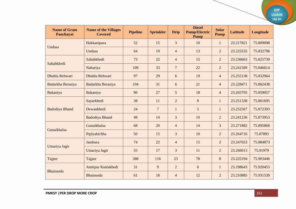
PMKSY |PER DROP MORE CROP 261
DIP UJJAIN (M.P)
Name of Gram
Panchayat
Name of the Villages
Covered Pipeline Sprinkler Drip
Diesel
Pump/Electric
Pump
Solar
Pump Latitude Longitude
Undasa Hakkanipura 52 15 3 10 1 23.217821 75.809098
Undasa 64 19 4 13 2 23.225535 75.832796
Sahabkhedi Sahabkhedi 73 22 4 15 2 23.236663 75.825739
Nahariya 109 33 7 22 2 23.241509 75.846614
Dhabla Rehwari Dhabla Rehwari 97 29 6 19 4 23.255138 75.832964
Badarkha Berasiya Badarkha Berasiya 104 31 6 21 4 23.228471 75.862438
Bakaniya Bakaniya 90 27 5 18 4 23.265705 75.859057
Badodiya Bhand
Sayarkhedi 38 11 2 8 1 23.251338 75.861695
Dewankhedi 24 7 1 5 1 23.252567 75.872393
Badodiya Bhand 48 14 3 10 2 23.241236 75.873953
Gunaikhalsa Gunaikhalsa 68 20 4 14 3 23.271882 75.895868
Piplyabichha 50 15 3 10 2 23.264716 75.87893
Umariya Jagir Jambura 74 22 4 15 2 23.247653 75.884873
Umariya Jagir 55 17 3 11 2 23.266013 75.91979
Tajpur Tajpur 388 116 23 78 8 23.225194 75.903446
Bhainsoda Amirpur Kuslakhedi 31 9 2 6 1 23.198643 75.920453
Bhainsoda 61 18 4 12 2 23.210885 75.931539

PMKSY |PER DROP MORE CROP 262
DIP UJJAIN (M.P)
Name of Gram
Panchayat
Name of the Villages
Covered Pipeline Sprinkler Drip
Diesel
Pump/Electric
Pump
Solar
Pump Latitude Longitude
Khajuriya Kumawat
Derkhedi 45 13 3 9 2 23.206884 75.948697
Khajuriya Kumawat 97 29 6 19 4 23.220452 75.950155
Molakhedi 27 8 2 5 1 23.191161 75.949635
Biaora Biaora 253 76 15 51 6 23.187671 75.933247
Banskhedi Khalsa
Banskhedi Khalsa 57 17 3 11 3 23.176979 75.939826
Tankariya Kazi 54 16 3 11 2 23.165367 75.935929
Bodani 77 23 5 15 3 23.153459 75.937773
Pingleshwar Pingleshwar 25 8 2 5 1 23.217547 75.873359
Harsodan Harsodan 112 34 7 22 2 23.188216 75.905407
Jaiwantpur Jaiwantpur 35 10 2 7 1 23.183083 75.880524
Karondiya Karondiya 50 15 3 10 2 23.174377 75.850205
Dhatrawada Dhatrawada 78 23 5 16 3 23.159667 75.847794
Lalpur 19 6 1 4 1
Manpura Jawasiya Kumar 59 18 4 12 3 23.147213 75.862538
Manpura 40 12 2 8 1 23.139776 75.850286
Surjanwasa Kesoni 67 20 4 13 2 23.16368 75.893651
Surjanwasa 18 5 1 4 1 23.170898 75.873254

PMKSY |PER DROP MORE CROP 263
DIP UJJAIN (M.P)
Name of Gram
Panchayat
Name of the Villages
Covered Pipeline Sprinkler Drip
Diesel
Pump/Electric
Pump
Solar
Pump Latitude Longitude
Dudarsi Dudarsi 38 11 2 8 1 23.145557 75.897565
Harnyakhedi 39 12 2 8 1 23.140506 75.924172
Kadchhali Daukhedi 25 7 1 5 1 23.143629 75.769332
Kadchhali 48 14 3 10 2 23.128035 75.914559
Badhkummed Badhkummed 260 78 16 52 7 23.155801 75.902111
Kadchha
Silarkhedi 36 11 2 7 1 23.115725 75.90794
Kadchha 29 9 2 6 1 23.117699 75.931372
Chenpur Hanskhedi 29 9 2 6 1 23.101673 75.944075
Nogawan Nogawan 89 27 5 18 3 23.119631 75.949234
Matanakalan Matanakalan 127 38 8 25 5 23.127071 75.870194
Datana Datana 111 33 7 22 5 23.1026 75.891995
Chandesara Kuwariya 29 9 2 6 1 23.114757 75.833544
Chandesara 58 17 3 12 2 23.110603 75.851054
Chandesari Chandesari 70 21 4 14 2 23.12273 75.85483
Khajuria Rehwari Khajuria Rehwari 104 31 6 21 4 23.08047 75.872279
Kalyanpura 97 29 6 19 5 23.185912 75.408323
Semaliyanasar Semaliyanasar 82 25 5 16 5 23.079332 75.89059
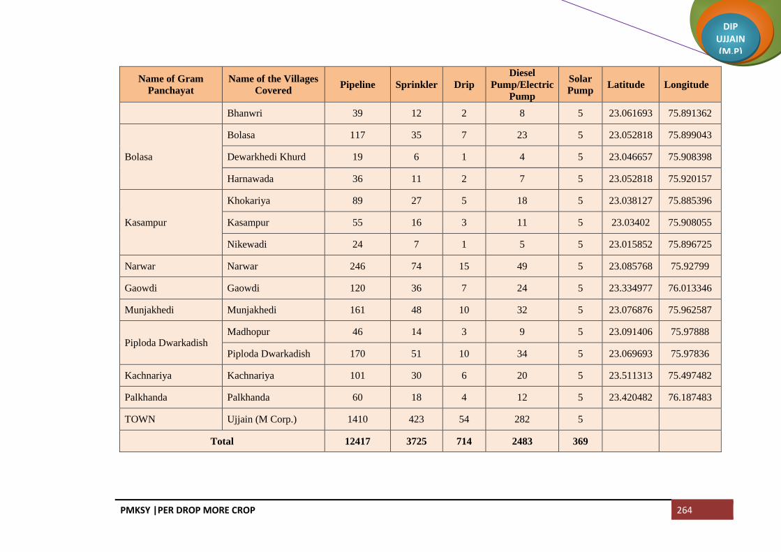
PMKSY |PER DROP MORE CROP 264
DIP UJJAIN (M.P)
Name of Gram
Panchayat
Name of the Villages
Covered Pipeline Sprinkler Drip
Diesel
Pump/Electric
Pump
Solar
Pump Latitude Longitude
Bhanwri 39 12 2 8 5 23.061693 75.891362
Bolasa
Bolasa 117 35 7 23 5 23.052818 75.899043
Dewarkhedi Khurd 19 6 1 4 5 23.046657 75.908398
Harnawada 36 11 2 7 5 23.052818 75.920157
Kasampur
Khokariya 89 27 5 18 5 23.038127 75.885396
Kasampur 55 16 3 11 5 23.03402 75.908055
Nikewadi 24 7 1 5 5 23.015852 75.896725
Narwar Narwar 246 74 15 49 5 23.085768 75.92799
Gaowdi Gaowdi 120 36 7 24 5 23.334977 76.013346
Munjakhedi Munjakhedi 161 48 10 32 5 23.076876 75.962587
Piploda Dwarkadish Madhopur 46 14 3 9 5 23.091406 75.97888
Piploda Dwarkadish 170 51 10 34 5 23.069693 75.97836
Kachnariya Kachnariya 101 30 6 20 5 23.511313 75.497482
Palkhanda Palkhanda 60 18 4 12 5 23.420482 76.187483
TOWN Ujjain (M Corp.) 1410 423 54 282 5
Total 12417 3725 714 2483 369

PMKSY |PER DROP MORE CROP 265
DIP UJJAIN (M.P)
Block Ghattiya
Name of Gram
Panchayat
Name of the
Villages Covered Pipeline Sprinkler Drip
Diesel
Pump/Electric
Pump
Solar
Pump Latitude Longitude
Dhanda Bhalla Dhanda Bhalla 78 23 8 16 1 23.36658 75.659461
Salakhedi 77 23 8 15 2 23.373309 75.670027
Chhitar Devi Chhitar Devi 74 22 6 15 2 23.353422 75.639034
Ilahipur 35 10 2 7 1 23.337068 75.625258
Borkheda Bhalla Ahirkheda 25 7 1 5 1 23.336386 75.606242
Borkheda Bhalla 89 27 9 18 3 23.329687 75.660919
Pipalyatah 27 8 2 5 1 23.323146 75.629162
Gudha Gudha 83 25 6 17 1 23.305607 75.630333
Lasurdiya Bazar Lasurdiya Bazar 44 13 3 9 1 23.313445 75.646855
Jhokra 48 14 3 10 1 23.308798 75.663847
Khoriya 25 8 2 5 1 23.301454 75.646606
Ruie Ruie 150 45 9 30 2 23.289782 75.654881
Semalyabibi 46 14 3 9 5 23.304342 75.677043
Dhulmahu Dhabladhuta 120 36 15 24 2 23.28721 75.680308
Dhulmahu 149 45 12 30 2 23.270623 75.66994
Pipalyahama Pipalyahama 128 38 8 26 2 23.353723 75.672849
Dhuletiya Dhuletiya 214 64 12 43 2 23.320384 75.696018

PMKSY |PER DROP MORE CROP 266
DIP UJJAIN (M.P)
Name of Gram
Panchayat
Name of the
Villages Covered Pipeline Sprinkler Drip
Diesel
Pump/Electric
Pump
Solar
Pump Latitude Longitude
Harigarh 71 21 4 14 1 23.346037 75.687499
Banskhedi Banskhedi 66 20 4 13 1 23.322156 75.675756
Kaluheda Barothikheda 44 13 3 9 1 23.360188 75.717964
Kaluheda 126 38 12 25 2 23.348526 75.716333
Bhilkheda Borkhedi 86 26 8 17 1 23.676639 75.676481
Bhilkheda 64 19 4 13 1 23.357588 75.752211
Nawakheda
(Sutarkheda) 120 36 7 24 2
Kishanpura 33 10 2 7 1 23.351993 75.73822
Sipawara Naveli 86 26 5 17 1 23.300316 75.693392
Sipawara 51 15 3 10 1 23.301986 75.715382
Bihariya Panched 64 19 4 13 1 23.330876 75.711155
Bihariya 100 30 6 20 1 23.320626 75.727971
Motipura 17 5 1 3 1 23.333262 75.739303
Panbihar Panbihar 309 93 20 62 3 23.315633 75.765647
Kithodajagir Kithodajagir 47 14 3 9 1 23.287895 75.75031
Kesarpur 29 9 2 6 1
Kagdi Karadiya Kagdi Karadiya 157 47 9 31 3 23.284438 75.774934
Nipanya Sunar 63 19 4 13 2 23.290902 75.785062
Utesara Utesara 39 12 2 8 1 23.264604 75.801581

PMKSY |PER DROP MORE CROP 267
DIP UJJAIN (M.P)
Name of Gram
Panchayat
Name of the
Villages Covered Pipeline Sprinkler Drip
Diesel
Pump/Electric
Pump
Solar
Pump Latitude Longitude
Padmakhedi 71 21 4 14 2 23.273137 75.79362
Samarkhedi 27 8 2 5 1 23.271402 75.778513
Gunaya Gunaya 93 28 6 19 2 23.279863 75.73395
Nanakhedi 57 17 3 11 1 23.274265 75.743563
Ralayata bhoja Ralayata Mauja 99 30 6 20 3 23.268274 75.755193
Barkhedi Khalsa 32 9 2 6 1 23.265199 75.772187
Goyala Buzurg Goyala Buzurg 140 42 8 28 3 23.277333 75.698439
Khalana Khalana 128 38 8 26 4 23.273102 75.715675
Tumdawada Paroliya Jhali 93 28 6 19 3 23.271687 75.640143
Tumdawada 197 59 12 39 5 23.254891 75.64598
Jhirniya Khedla 111 33 7 22 4 23.265593 75.682151
Jhirniya 134 40 8 27 4 23.250059 75.68361
Sarola Singawada 149 45 9 30 4 23.231863 75.645465
Sarola 146 44 9 29 4 23.239277 75.664519
Amodiya Amodiya 133 40 8 27 4 23.208909 75.652503
Chakrawada Chakrawada 162 48 10 32 5 23.251636 75.708157
Nagpura Mahukhedi 39 12 2 8 1 23.22348 75.680348
Nagpura 41 12 2 8 1 23.241305 75.672023
Ajnoti 20 6 1 4 1

PMKSY |PER DROP MORE CROP 268
DIP UJJAIN (M.P)
Name of Gram
Panchayat
Name of the
Villages Covered Pipeline Sprinkler Drip
Diesel
Pump/Electric
Pump
Solar
Pump Latitude Longitude
Silodarawal Silodarawal 97 29 6 19 3 23.188556 75.681256
Badwai 29 9 2 6 1 23.191001 75.647611
Ilaskhedi 31 9 2 6 1 23.1925 75.663318
Badodiya Kazi Naikhedi 46 14 3 9 1
Badodiya Kazi 81 24 5 16 3
Ratadiya Ratadiya 65 19 4 13 3 23.196648 75.711866
Vinayaga Vinayaga 76 23 5 15 2 23.204005 75.726274
Azampura 104 31 6 21 2 23.229878 75.719236
Gonsa Gonsa 55 17 3 11 2 23.211851 75.751142
Ramgarh Ramgarh 44 13 3 9 1 23.252425 75.746266
Sulyakhedi 111 33 7 22 2 23.256762 75.777938
Sodang Sodang 134 40 8 27 3 23.240408 75.731464
Wajirpur (Jogi
Khedi) 25 8 2 5 1
Surasa Surasa 32 10 2 6 1 23.235099 75.81036
Badarkha Babaji 22 7 1 4 1 23.257934 75.809188
Kamed Kamed 108 32 6 22 2 23.227607 75.792035
Kaliyadeh Kaliyadeh 195 59 12 39 4 23.251334 75.791132
Jairampura Bormundla 26 8 2 5 1 23.276001 75.811669
Jairampura 39 12 2 8 1 23.297918 75.798623

PMKSY |PER DROP MORE CROP 269
DIP UJJAIN (M.P)
Name of Gram
Panchayat
Name of the
Villages Covered Pipeline Sprinkler Drip
Diesel
Pump/Electric
Pump
Solar
Pump Latitude Longitude
Devikaradiya 28 8 2 6 1 23.285935 75.805232
Bandka Bandka 38 11 2 8 1 23.304715 75.810418
Kadwali Piplai 26 8 2 5 1 23.300652 75.827103
Kadwali 34 10 2 7 2 23.302071 75.844441
Jaithal Jaithal 128 38 8 26 5 23.282483 75.821162
Shankarpurjagir Shankarpurjagir 56 17 3 11 2 23.326387 75.789949
Ranaheda 72 22 4 14 2 23.343883 75.791681
Nipanya Goyal Lakhaheda 69 21 4 14 1 23.323398 75.814541
Ishakpur 46 14 3 9 1 23.325211 75.838745
Nipanya Goyal 42 13 3 8 1 23.313309 75.839861
Meen Silari 59 18 4 12 1 23.373666 75.749747
Meen 111 33 7 22 2 23.364999 75.768501
Tulaheda Tulaheda 118 35 7 24 2 23.34285 75.812333
Dhannakhedi Dhannakhedi 137 41 8 27 2 23.36408 75.819669
Nazarpur Nazarpur 263 79 16 53 3 23.342253 75.843616
Ghatiya Ghatiya 238 71 14 48 3 23.378556 75.863501
Jalwa Jalwa 304 91 18 61 3 23.393307 75.887039
Kalukhedi Kalukhedi 78 23 5 16 1 23.397949 75.906336
Ralayati 266 80 16 53 3 23.411654 75.892689
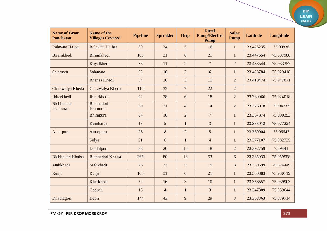
PMKSY |PER DROP MORE CROP 270
DIP UJJAIN (M.P)
Name of Gram
Panchayat
Name of the
Villages Covered Pipeline Sprinkler Drip
Diesel
Pump/Electric
Pump
Solar
Pump Latitude Longitude
Ralayata Haibat Ralayata Haibat 80 24 5 16 1 23.425235 75.90836
Biramkhedi Biramkhedi 105 31 6 21 1 23.447654 75.907988
Koyalkhedi 35 11 2 7 2 23.438544 75.933357
Salamata Salamata 32 10 2 6 1 23.423784 75.929418
Bhensa Khedi 54 16 3 11 2 23.410474 75.947871
Chitawalya Kheda Chitawalya Kheda 110 33 7 22 2
Jhitarkhedi Jhitarkhedi 92 28 6 18 2 23.380066 75.924018
Bichhadod
Istamurar
Bichhadod
Istamurar 69 21 4 14 2 23.376018 75.94737
Bhimpura 34 10 2 7 1 23.367874 75.990353
Kumhardi 15 5 1 3 1 23.355012 75.977224
Amarpura Amarpura 26 8 2 5 1 23.389004 75.96647
Sulya 21 6 1 4 1 23.377107 75.982725
Daulatpur 88 26 10 18 2 23.392759 75.9441
Bichhadod Khalsa Bichhadod Khalsa 266 80 16 53 6 23.365933 75.959558
Malikhedi Malikhedi 76 23 5 15 3 23.359599 75.524449
Runji Runji 103 31 6 21 1 23.350883 75.930719
Kherkhedi 52 16 3 10 1 23.356557 75.939903
Gadroli 13 4 1 3 1 23.347889 75.959644
Dhablagori Dabri 144 43 9 29 3 23.363363 75.879714

PMKSY |PER DROP MORE CROP 271
DIP UJJAIN (M.P)
Name of Gram
Panchayat
Name of the
Villages Covered Pipeline Sprinkler Drip
Diesel
Pump/Electric
Pump
Solar
Pump Latitude Longitude
Dhablagori 96 29 6 19 2 23.345712 75.871045
Bhutiya Bhutiya 54 16 3 11 1 23.322275 75.873212
Anwalya 27 8 2 5 1 23.31195 75.883769
Ujjainiya Ujjainiya 193 58 12 39 4 23.290141 75.869458
Kalesar Kalesar 85 25 5 17 2 23.341505 75.891322
Chonsala 27 8 2 5 1 23.338274 75.913381
Guradiya Gujar Guradiya Gujar 181 54 11 36 3 23.331468 75.94064
Banda Bamori 90 27 5 18 2 23.317546 75.916728
Banda 70 21 4 14 3 23.324324 75.897331
Khajuria Sadar Khajuria Sadar 102 30 6 20 3 23.311133 75.941326
Bisakhedi 41 12 2 8 1 23.31602 75.931627
Rudaheda Rudaheda 128 38 8 26 2 23.294042 75.917535
Barkhedi Jagir 14 4 1 3 1 23.285449 75.929294
Total 10784 3235 684 2157 241

PMKSY |PER DROP MORE CROP 272
DIP UJJAIN (M.P)
Block Tarana
Name of Gram
Panchayat
Name of Villages
Covered Pipeline Sprinkler Drip
Diesel
Pump/Electric
Pump
Solar
Pump Latitude Longitude
Padsi Padsi 15 4 1 3 1 23.558681 75.907827
Gunakhedi 65 19 4 13 2 23.54562 75.939927
Jafarpurnera 30 9 2 6 1 23.543495 75.951343
Suwasa Suwas 89 27 5 18 3 23.540033 75.960613
Lakhmankhedi 49 15 3 10 1 23.523795 75.978242
Pat Pat 104 31 6 21 2 23.538774 75.91744
Ilamkhedi Bhariyakhedi 37 11 2 7 1 23.536256 75.934692
Ilamkhedi 100 30 6 20 2 23.524846 75.925079
Chandnyakhedi Samtyakhedi 91 27 5 18 3 23.527578 75.935427
Chandnyakhedi 72 22 4 14 2 23.525296 75.944782
Jhalara Jhalara 63 19 4 13 2 23.517819 75.908734
Jhalari 24 7 1 5 1 23.506014 75.92384
Dhablahardu Dhablahardu 175 52 10 35 5 23.499887 75.896068
Tukral Tukral 225 67 13 45 5 23.470615 75.928025
Parsoli Parsoli 158 47 9 32 5 23.509975 75.943092
Pipalyabazar 25 8 2 5 1 23.439195 75.949787
Chirdi Chirdi 141 42 8 28 5 23.485652 75.975107
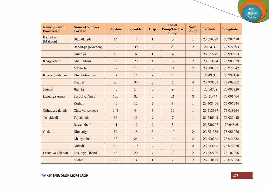
PMKSY |PER DROP MORE CROP 273
DIP UJJAIN (M.P)
Name of Gram
Panchayat
Name of Villages
Covered Pipeline Sprinkler Drip
Diesel
Pump/Electric
Pump
Solar
Pump Latitude Longitude
Badodiya
(Makdon) Bhundkhedi 14 4 1 3 1 23.556399 75.987478
Badodiya (Makdon) 99 30 6 20 2 23.54145 75.977693
Umariya 19 6 1 4 1 23.537279 75.990053
Khajjukhedi Khajjukhedi 66 20 4 13 2 23.513884 75.989929
Mergarh 57 17 3 11 2 23.500583 75.978342
Khankribrahman Khankribrahman 37 11 2 7 1 23.49215 75.995156
Kadhai 99 30 6 20 4 23.489001 76.009962
Jhumki Jhumki 46 14 3 9 1 23.54752 76.008926
Lasudiya Amra Lasudiya Amra 106 32 6 21 3 23.51474 76.001464
Kothdi 40 12 2 8 1 23.503406 76.007644
Chitawalyakheda Chitawalyakheda 148 44 9 30 1 23.513537 76.019264
Tejlakhedi Tejlakhedi 36 11 2 7 1 23.546349 76.030435
Rawankhedi 41 12 2 8 1 23.530297 76.04846
Godadi Khokariya 52 15 3 10 2 23.551353 76.056976
Dhanyakhedi 80 24 5 16 2 23.550252 76.076632
Godadi 63 19 4 13 2 23.533088 76.076778
Lasudiya Dhandu Lasudiya Dhandu 66 20 4 13 2 23.532786 76.102266
Suchai 9 3 1 2 2 23.510121 76.077633

PMKSY |PER DROP MORE CROP 274
DIP UJJAIN (M.P)
Name of Gram
Panchayat
Name of Villages
Covered Pipeline Sprinkler Drip
Diesel
Pump/Electric
Pump
Solar
Pump Latitude Longitude
Chikli Chikli 69 21 4 14 2 23.494627 76.034799
Sumrakheda Sumrakheda 65 20 4 13 2 23.258333 76.066563
Hatyakhedi 56 17 3 11 2 23.260446 76.030935
Bhodalya Sumrakhedi 11 3 1 2 1 23.518749 76.046535
Bhodalya 92 27 5 18 3 23.507445 76.053943
Rupakhedi Rupakhedi 83 25 5 17 3 23.472835 75.990188
Lalakhedi 30 9 2 6 1 23.465592 75.972163
Samanera Samanera 209 63 13 42 4 23.448369 75.949961
Hanumanti 175 52 10 35 5 23.423267 75.959655
Dabdarajput Dabdarajput 123 37 7 25 4 23.453028 75.975238
Dhuwakhedi Dhuwakhedi 37 11 2 7 1 23.440928 76.026568
Pankhedi 23 7 1 5 1 23.450604 75.990262
Pachola Pachola 179 54 11 36 5 23.466773 76.022889
Lasurdiya Hameer Chunakhedi 60 18 4 12 3 23.436571 75.974895
Lasurdiya Hameer 62 18 4 12 2 23.427278 75.994121
Shekhpur 129 39 8 26 4 23.421381 75.986035
Kachnariya Kachnariya 298 89 12 60 7 23.414212 75.962161
Bisankheda Khankrisultan 23 7 1 5 1 23.399584 76.018814

PMKSY |PER DROP MORE CROP 275
DIP UJJAIN (M.P)
Name of Gram
Panchayat
Name of Villages
Covered Pipeline Sprinkler Drip
Diesel
Pump/Electric
Pump
Solar
Pump Latitude Longitude
Bisankheda 21 6 1 4 1 23.386382 76.016508
Bisankhedi 40 12 2 8 1 23.381746 76.007707
Khamli Khamli 36 11 2 7 1 23.422526 76.01292
Tilawadi 82 24 5 16 4 23.41016 76.005367
Tilawad Tilawad 282 84 12 56 6 23.402814 75.989347
Lodh Lodh 156 47 9 31 4 23.421344 76.033949
Nanded Nanded 123 37 7 25 4 23.457797 76.043489
Keswal Keswal 39 12 2 8 1 23.469477 76.077404
Jamunya 20 6 1 4 1 23.453029 76.087075
Bagwada Manasa 26 8 2 5 1 23.561972 76.154275
Bagwada 43 13 3 9 1 23.550721 76.142173
Bukhari 7 2 0 1 1 23.545685 76.167493
Salnakhedi Rehwari 37 11 2 7 1 23.564568 76.169038
Salnakhedi 52 16 3 10 2 23.554891 76.167664
Kadodiya Kadodiya 234 70 14 47 5 23.522931 76.142722
Sarli Sarli 186 56 11 37 5 23.456427 76.129225
Haidarpura 29 9 2 6 1 23.476956 76.135683
Moyakheda 43 13 3 9 1 23.463493 76.144953

PMKSY |PER DROP MORE CROP 276
DIP UJJAIN (M.P)
Name of Gram
Panchayat
Name of Villages
Covered Pipeline Sprinkler Drip
Diesel
Pump/Electric
Pump
Solar
Pump Latitude Longitude
Hasalpurjhirnya Chakya 14 4 1 3 1 23.460115 76.106129
Hasalpurjhirnya 24 7 1 5 1 23.447753 76.097117
Limbadit Limbadit 125 37 7 25 5 23.433934 76.074515
Dobdagujar Kesarpurnipanya 83 25 5 17 2 23.410674 76.075393
Dobdagujar 76 23 5 15 2 23.41477 76.09419
Umarajhar Tanda 28 8 2 6 1 23.424136 76.163462
Umarajhar 34 10 2 7 1 23.457097 76.143434
Kapeli Kapeli 116 35 7 23 3 23.429777 76.126268
Lasurdiyabechar Guradiyagujar 178 53 11 36 3 23.291475 75.997045
Lasurdiyabechar 235 70 14 47 2 23.293928 76.006932
Ramdi Ramdi 63 19 4 13 2 23.477859 76.175237
Gandhinagar 10 3 1 2 1 23.461702 76.187161
Borkhedi 82 24 5 16 2 23.473591 76.157034
Pipalyaramdi 40 12 2 8 1 23.446348 76.183212
Puri Ankhali 6 2 0 1 1 23.461235 76.202531
Puri 8 2 0 2 1 23.470053 76.197421
Moyagaon 25 8 2 5 1 23.445243 76.203767
Tumni 144 43 9 29 3 23.489008 76.204797

PMKSY |PER DROP MORE CROP 277
DIP UJJAIN (M.P)
Name of Gram
Panchayat
Name of Villages
Covered Pipeline Sprinkler Drip
Diesel
Pump/Electric
Pump
Solar
Pump Latitude Longitude
Katwariya Katwariya 59 18 4 12 2 23.523781 76.227613
Aurangpur 29 9 2 6 1 23.496706 76.211048
Gudradiya Khutpala 18 5 1 4 1 23.434699 76.197689
Gudradiya 19 6 1 4 1 23.501035 76.233707
Karedi Karedi 172 52 10 34 5 23.415945 76.198509
Lalakheda Lalakheda 154 46 9 31 5 23.433744 76.136464
Palkhanda 7 2 0 1 1 23.420434 76.187609
Shankarpura 31 9 2 6 1 23.409722 76.179111
Kharkhadi Merkhedi 37 11 2 7 1 23.399028 76.205731
Kharkhadi 30 9 2 6 1 23.418404 76.227446
Berchhi Suwagaon 63 19 4 13 1 23.386479 76.209484
Berchhi 161 48 10 32 4 23.387976 76.185108
Bordagujar 74 22 4 15 1 23.358346 76.208619
Kanardi Kanardi 250 75 15 50 5 23.352751 76.146881
Devikheda Guthlai 40 12 2 8 1 23.398926 76.140562
Krishna Nagar 9 3 1 2 1 23.388527 76.140133
Devikheda 57 17 3 11 1 23.397902 76.160646
Naharkhedi Naharkhedi 187 56 11 37 5 23.38955 76.067869

PMKSY |PER DROP MORE CROP 278
DIP UJJAIN (M.P)
Name of Gram
Panchayat
Name of Villages
Covered Pipeline Sprinkler Drip
Diesel
Pump/Electric
Pump
Solar
Pump Latitude Longitude
Barnawad 188 56 11 38 5 23.391556 76.091417
Surajpura Surajpura 38 11 2 8 1 23.373787 76.078399
Jharnawada 20 6 1 4 1 23.355428 76.081145
Barkheda Tarana Barkheda Tarana 196 59 12 39 6 23.394884 76.126346
Khodrinipaniya 54 16 3 11 2 23.368983 76.103465
Itawa Itawa 244 73 15 49 5 23.395932 76.041928
Gangalyakhedi 51 15 3 10 2 23.383343 76.031671
Devli Devli 112 33 7 22 4 23.411893 76.056007
Chhadawad Chhadawad 65 20 4 13 3 23.364177 76.644313
Tobrikheda Tobrikheda 34 10 2 7 1 23.368522 76.060192
Noganwa Noganwa 161 48 10 32 6 23.361025 76.009809
Gawdi Abadkhedi 59 18 4 12 2 23.347564 76.022298
Gawdi 53 16 3 11 3 23.334877 76.013544
Kakariyachand 41 12 2 8 1 23.344885 75.989769
Salakhedi Malikhedi 37 11 2 7 1 23.330852 76.031405
Salakhedi 81 24 5 16 3 23.323827 76.018197
Khambukhedi Sadikhedi 49 15 3 10 1 23.32903 76.0771
Khambukhedi 78 23 5 16 2 23.336675 76.094438

PMKSY |PER DROP MORE CROP 279
DIP UJJAIN (M.P)
Name of Gram
Panchayat
Name of Villages
Covered Pipeline Sprinkler Drip
Diesel
Pump/Electric
Pump
Solar
Pump Latitude Longitude
Siddhipurnipanya Siddhipurnipanya 147 44 10 29 4 23.347393 76.115467
Karanj Karanj 177 53 8 35 4 23.322548 76.102459
Bagoda Bagoda 88 26 5 18 3 23.299494 76.102318
Hajikhedi 7 2 0 1 1 23.288689 76.0951
Dilodri Dilodri 123 37 7 25 4 23.315301 76.149137
Yashwantgarh 25 7 1 5 1 23.341388 76.144502
Chhapri Jhirnyabuzurg 65 20 4 13 2 23.333837 76.128472
Chhapri 79 24 5 16 2 23.309381 76.117573
Samgi Samgi 174 52 8 35 5 23.356614 76.18435
Banjari Banjari 176 53 8 35 5 23.338801 76.200469
Patiyalkhedi 19 6 1 4 1 23.351882 76.21712
Titodi Titodi 30 9 2 6 1 23.326112 76.191285
Rojwas 41 12 2 8 1 23.315544 76.186603
Nenawad Suwarkota 15 5 1 3 1 23.379138 76.244455
Nenawad 147 44 9 29 4 23.372771 76.221672
Limboda Tarana Limboda Tarana 26 8 2 5 5 23.347889 76.234195
Golwa Fanya 33 10 2 7 1 23.308482 76.170133
Golwa 241 72 11 48 6 23.303752 76.180775

PMKSY |PER DROP MORE CROP 280
DIP UJJAIN (M.P)
Name of Gram
Panchayat
Name of Villages
Covered Pipeline Sprinkler Drip
Diesel
Pump/Electric
Pump
Solar
Pump Latitude Longitude
Barandwa Barandwa 98 29 6 20 3 23.282755 76.171975
Kanasiya Kanasiya 285 86 13 57 8 23.300986 76.145271
Palduna Palduna 54 16 3 11 2 23.267576 76.106132
Gujarkheda 45 13 3 9 1 23.278885 76.120826
Lunyakhedi 42 12 2 8 1 23.264914 76.124414
Sakari Anantkhedi 73 22 4 15 3 23.248555 76.088192
Sakari 132 40 8 26 4 23.248476 76.099179
Dudhli Dudhli 108 32 6 22 4 23.250878 76.111454
Nanukheda Nanukheda 125 38 8 25 4 23.239993 76.060227
Malhargarh 43 13 3 9 1 23.252327 76.050051
Pipalyakaytha Laxmipura 48 14 3 10 1 23.227406 76.048539
Khandakhedi 45 13 3 9 1 23.246042 76.076688
Gopali 23 7 1 5 1 23.229197 76.07113
Pipalyakaytha 52 16 3 10 1 23.219911 76.077698
Beejpadi Natakhedi 73 22 4 15 2 23.293595 76.071066
Halukhedi 32 10 2 6 1 23.275496 76.065148
Beejpadi 24 7 1 5 1 23.271021 76.076183
Baghera Baghera 97 29 6 19 3 23.271717 76.088244

PMKSY |PER DROP MORE CROP 281
DIP UJJAIN (M.P)
Name of Gram
Panchayat
Name of Villages
Covered Pipeline Sprinkler Drip
Diesel
Pump/Electric
Pump
Solar
Pump Latitude Longitude
Mundli Mundli 68 20 4 14 2 23.303771 76.053809
Sadba 78 23 5 16 2 23.268435 76.047458
Dubli Dubli 113 34 7 23 2 23.285806 76.047097
Bhadsimba Bhadsimba 83 25 5 17 3 23.321517 75.988913
Kawlikheda Kawlikheda 46 14 3 9 2 23.311177 75.975128
Bhuki Itwarpur 9 3 1 2 1 23.305079 75.995481
Binjal 18 5 1 4 1 23.290296 75.98783
Guradiyadongar Guradiyadongar 4 1 0 1 1
Raipura Raipura 28 8 2 6 1 23.278149 76.029307
Kharpa Kharpa 256 77 11 51 7 23.276216 76.007074
Shivpura 70 21 4 14 2
Bherupura 103 31 6 21 3 23.245333 75.998865
Kaytha Kaytha 375 113 15 75 10 23.236479 76.018631
Mallupura Mallupura 34 10 2 7 1 23.21322 76.019354
Molga 27 8 2 5 1 23.202788 76.029552
Bordamada Limboda Kaytha 26 8 2 5 1 23.193473 76.038227
Bordamada 63 19 4 13 2 23.192132 76.047926
Aserkaytha Aserkaytha 114 34 7 23 4 23.178132 76.082943

PMKSY |PER DROP MORE CROP 282
DIP UJJAIN (M.P)
Name of Gram
Panchayat
Name of Villages
Covered Pipeline Sprinkler Drip
Diesel
Pump/Electric
Pump
Solar
Pump Latitude Longitude
Sarola 82 24 5 16 2 23.191264 76.066809
Jawasiyakumar Jawasiyakumar 83 25 5 17 2 23.182551 76.101997
Belari Belari 77 23 5 15 2 23.138863 76.134784
Bordadhakad 84 25 5 17 2 23.198803 76.123026
Naleshree Naleshree 194 58 8 39 5 23.169014 76.047497
Bhojukhedi 13 4 1 3 1 23.147233 76.049643
Kathbadoda Kathbadoda 80 24 5 16 3 23.124072 76.064214
Malkheda 44 13 3 9 1 23.104968 76.667646
Khajuria Khajuria 66 20 4 13 1 23.099896 76.091687
Bhatuni Bhatuni 115 35 7 23 3 23.084023 76.07217
Upadi Upadi 104 31 6 21 3 23.086081 76.099524
Khatikhedi Khatikhedi 46 14 3 9 1 23.071275 76.08278
Barkhedakaytha 41 12 2 8 1 23.05713 76.099885
Urban Tarana (NP) 385 115 12 77 10
Urban Makdon (NP) 643 193 20 129 15
Total 16505 4951 921 3301 476

PMKSY |PER DROP MORE CROP 283
DIP UJJAIN (M.P)
Block Khachrod
Name of Gram
Panchayat
Name of the
Villages Covered Pipeline Sprinkler Drip
Diesel
Pump/Electric
Pump
Solar
Pump Latitude Longitude
Gothda
Gothda 115 34 4 23 4 23.524747 75.196721
Lohachitara 105 32 4 21 4 23.514406 75.186718
Kantharkhedi 47 14 2 9 1 23.49723 75.198099
Napakhedi
Napakhedi 62 18 2 12 2 23.485662 75.197636
Brahman Khedi
Khurd 20 6 1 4 1 23.494274 75.177681
Padalyakhurd 54 16 2 11 2 23.483883 75.180948
Shribach Shribachh 105 31 4 21 3 23.510538 75.215053
Banjari Banjari 173 52 6 35 5 23.497691 75.229848
Lasudiya Daiyar 4 1 0 1 1
Farnakhedi Farnakhedi 117 35 4 23 3 23.511889 75.261288
Meend Meen 168 50 6 34 4 23.513299 75.244654
Dodiya Dodiya 70 21 2 14 2 23.570200 75.290817
Sendari Sendri 174 52 6 35 4 23.540327 75.29286043
Dhaturiya 150 45 5 30 3 23.533776 75.274206
Barkheda jawra Barkheda Jaora 329 99 11 66 7 23.518468 75.292150
Chapakheda Chanpa Kheda 305 91 10 61 7 23.584304 75.288724
Chapaner Sakatkhedi 139 42 5 28 3 23.610495 75.327843

PMKSY |PER DROP MORE CROP 284
DIP UJJAIN (M.P)
Name of Gram
Panchayat
Name of the
Villages Covered Pipeline Sprinkler Drip
Diesel
Pump/Electric
Pump
Solar
Pump Latitude Longitude
Chanpaner 271 81 9 54 6 23.591734 75.319817
Mokdi Mokdi 354 106 12 71 8 23.577201 75.335171
Akyajageer Tarod 159 48 5 32 4 23.554046 75.33481
Akyajagir 287 86 10 57 4 23.559538 75.317344
Chandodiya Chandodiya 188 56 6 38 4 23.538365 75.326005
Kesariya Kesariya 106 32 4 21 2 23.531262 75.308850
Divel Divel 175 52 6 35 4 23.521623 75.332861
Ghinoda Ghinoda 460 138 16 92 10 23.504096 75.299639
Bhensola Bhensola 127 38 4 25 3 23.474320 75.236622
Panwasa Bhandla 66 20 2 13 2 23.460078 75.234093
Panwasa 149 45 5 30 4 23.442125 75.226797
Ringniya Jalod 38 11 1 8 1 23.472291 75.1809
Rigania 125 38 4 25 3 23.460502 75.180603
Batlawdi Batlawadi 359 108 12 72 8 23.471643 75.180900
Bordiya Bordiya 103 31 3 21 3 23.436597 75.174641
Khandwa 108 32 4 22 3 23.450136 75.191769
Naredipata Naredipata 125 38 4 25 3 23.437275 75.207106
Unchaheda Unchaheda 60 18 2 12 2 23.402978 75.151639
Runkheda Runkheda 149 45 5 30 4 23.403309 75.158496

PMKSY |PER DROP MORE CROP 285
DIP UJJAIN (M.P)
Name of Gram
Panchayat
Name of the
Villages Covered Pipeline Sprinkler Drip
Diesel
Pump/Electric
Pump
Solar
Pump Latitude Longitude
Thadoda Thadoda 82 24 3 16 3 23.415802 75.198531
Dipakhedi 30 9 1 6 1 23.421498 75.209141
Kanwas Kanwas 186 56 6 37 4 23.399644 75.188585
Nandvasla Nandwasla 84 25 3 17 3 23.379990 75.195311
Sanasala 58 17 2 12 2 23.387395 75.204109
Bhunwasa Bhanwasa 155 47 5 31 3 23.406000 75.215781
Naredikhurd 73 22 2 15 2 23.437127 75.206976
Kanchankhedi Kanchankhedi 177 53 6 35 4 23.46684 75.279031
Kutlana 96 29 3 19 3 23.467943 75.255685
Behlola Behlola 103 31 3 21 3 23.437715 75.245422
Lekodiya tank Lekodiya Tank 119 36 4 24 3 23.481877 75.301776
Bhatkhedi Bhat Khedi 168 50 6 34 4 23.527176 75.883904
Ghudawan 93 28 3 19 2 23.446912 75.279387
Jhirmira Jhirmira 191 57 6 38 4 23.507964 75.334665
Khurmundi 59 18 2 12 2 23.494632 75.345651
Bedawniya Bedavanya 188 56 6 38 5 23.483228 75.324269
Gidvaniya Gindwanya 233 70 8 47 6 23.477861 75.361100
Umarna Umarna 108 32 4 22 3 23.443214 75.360896
Umarni 60 18 2 12 2 23.456443 75.379435

PMKSY |PER DROP MORE CROP 286
DIP UJJAIN (M.P)
Name of Gram
Panchayat
Name of the
Villages Covered Pipeline Sprinkler Drip
Diesel
Pump/Electric
Pump
Solar
Pump Latitude Longitude
Navtiya Dadiya 16 5 1 3 1 23.445025 75.379435
Nawatiya 106 32 4 21 2 23.431087 75.355832
Biriyakhedi Beriyakhedi 74 22 3 15 3 23.465042 75.349589
Buranabad Buranabad 143 43 5 29 3 23.449691 75.335289
Chowki Junnardar 59 18 2 12 2 23.439454 75.314261
Pachlasi Pachlasi 134 40 5 27 3 23.41439 75.335404
Padsulya Padsulya 218 65 7 44 5 23.420376 75.366303
Kumharwadi
Kumharwadi 84 25 3 17 2 23.400599 75.314711
Siparda 24 7 1 5 1 23.393194 75.326556
Sarwanakhacharod 97 29 3 19 2 23.400205 75.338057
Barlai Palna 33 10 1 7 1 23.396858 75.244431
Barlai 220 66 7 44 5 23.379777 75.28416
Dupdawda Dupdawada 88 26 3 18 3 23.397077 75.276315
Madawadi 324 97 11 65 7 23.378012 75.286185
Narsinghgad Narsinghgarh 242 72 8 48 5 23.367913 75.219213
Khedawda
Khedawada 93 28 3 19 3 23.34782 75.214922
Baramadkheda 92 28 3 18 3 23.334738 75.196125
Antalwasa 136 41 5 27 3 23.333635 75.218784
Barthun Barthun 156 47 5 31 3 23.333471 75.244963
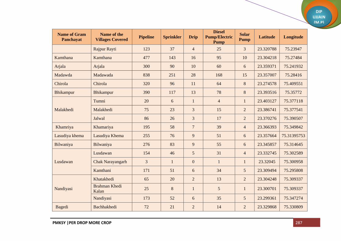
PMKSY |PER DROP MORE CROP 287
DIP UJJAIN (M.P)
Name of Gram
Panchayat
Name of the
Villages Covered Pipeline Sprinkler Drip
Diesel
Pump/Electric
Pump
Solar
Pump Latitude Longitude
Rajpur Rayti 123 37 4 25 3 23.320788 75.23947
Kamthana Kamthana 477 143 16 95 10 23.304218 75.27484
Arjala Arjala 300 90 10 60 6 23.359371 75.241932
Madawda Madawada 838 251 28 168 15 23.357007 75.28416
Chirola Chirola 320 96 11 64 8 23.274578 75.409551
Bhikampur Bhikampur 390 117 13 78 8 23.393516 75.35772
Malakhedi
Tumni 20 6 1 4 1 23.403127 75.377118
Malakhedi 75 23 3 15 2 23.386741 75.377541
Jalwal 86 26 3 17 2 23.370276 75.390507
Khamriya Khamariya 195 58 7 39 4 23.366393 75.349842
Lasudiya khema Lasudiya Khema 255 76 9 51 6 23.357664 75.31395753
Bilwaniya Bilwaniya 276 83 9 55 6 23.345857 75.314645
Lusdawan
Lusdawan 154 46 5 31 4 23.332745 75.302589
Chak Narayangarh 3 1 0 1 1 23.32045 75.300958
Kamthani 171 51 6 34 5 23.309494 75.295808
Nandiyasi
Khatakhedi 65 20 2 13 2 23.304248 75.309337
Brahman Khedi
Kalan 25 8 1 5 1 23.300701 75.309337
Nandiyasi 173 52 6 35 5 23.299361 75.347274
Bagedi Bachhakhedi 72 21 2 14 2 23.329868 75.330809
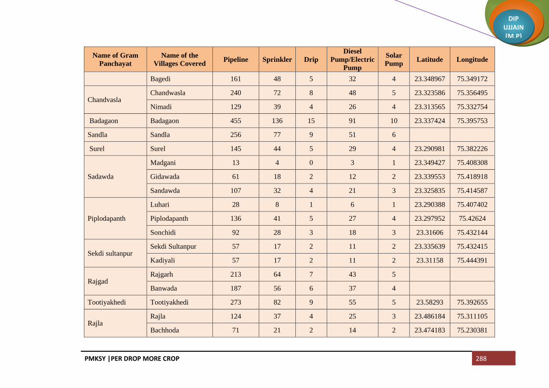
PMKSY |PER DROP MORE CROP 288
DIP UJJAIN (M.P)
Name of Gram
Panchayat
Name of the
Villages Covered Pipeline Sprinkler Drip
Diesel
Pump/Electric
Pump
Solar
Pump Latitude Longitude
Bagedi 161 48 5 32 4 23.348967 75.349172
Chandvasla Chandwasla 240 72 8 48 5 23.323586 75.356495
Nimadi 129 39 4 26 4 23.313565 75.332754
Badagaon Badagaon 455 136 15 91 10 23.337424 75.395753
Sandla Sandla 256 77 9 51 6
Surel Surel 145 44 5 29 4 23.290981 75.382226
Sadawda
Madgani 13 4 0 3 1 23.349427 75.408308
Gidawada 61 18 2 12 2 23.339553 75.418918
Sandawda 107 32 4 21 3 23.325835 75.414587
Piplodapanth
Luhari 28 8 1 6 1 23.290388 75.407402
Piplodapanth 136 41 5 27 4 23.297952 75.42624
Sonchidi 92 28 3 18 3 23.31606 75.432144
Sekdi sultanpur Sekdi Sultanpur 57 17 2 11 2 23.335639 75.432415
Kadiyali 57 17 2 11 2 23.31158 75.444391
Rajgad Rajgarh 213 64 7 43 5
Banwada 187 56 6 37 4
Tootiyakhedi Tootiyakhedi 273 82 9 55 5 23.58293 75.392655
Rajla Rajla 124 37 4 25 3 23.486184 75.311105
Bachhoda 71 21 2 14 2 23.474183 75.230381

PMKSY |PER DROP MORE CROP 289
DIP UJJAIN (M.P)
Name of Gram
Panchayat
Name of the
Villages Covered Pipeline Sprinkler Drip
Diesel
Pump/Electric
Pump
Solar
Pump Latitude Longitude
Nimbodiyakala Nimbodiyakalan 222 66 8 44 5 23.551272 75.427568
Bercha Berchha 198 59 7 40 5 23.547104 75.382314
Atlawda Atlawada 202 60 7 40 5 23.529631 75.355692
Ninawatkheda 112 34 4 22 4 23.514606 75.419623
Kalsi Alsi 91 27 3 18 3 23.516326 75.396609
Kalsi 155 46 5 31 4 23.531932 75.408733
Parmarkhedi
Kilodiya 98 29 3 20 3 23.501004 75.361272
Parmarkhedi 74 22 2 15 3 23.485497 75.379382
Bhagatpuri 16 5 1 3 1 23.474239 75.384875
Nipanya
Nipanya 104 31 4 21 2 23.504984 75.401753
Geedgarh 52 15 2 10 2 23.492569 75.39099
Hebatpur Bhimpura 5 1 0 1 1 23.488572 75.401554
Rohal Kalan Rohal Kalan 102 31 3 20 3 23.516432 75.446604
Jalodiya Khacharod 177 53 6 35 4 23.486571 75.44293
Jhanjhakhedi Jhanjhakhedi 85 26 3 17 3 23.507201 75.42819
Khajuriya 102 30 3 20 3 23.489514 75.419623
Ratanyakhedi Ratanyakhedi 47 14 2 9 1 23.490293 75.432125
Banbani 28 8 1 6 1 23.457392 75.450385
Rohalkhurd Rohalkhurd 286 86 10 57 6 23.514671 75.468339

PMKSY |PER DROP MORE CROP 290
DIP UJJAIN (M.P)
Name of Gram
Panchayat
Name of the
Villages Covered Pipeline Sprinkler Drip
Diesel
Pump/Electric
Pump
Solar
Pump Latitude Longitude
Akyakoli Kachnariya 34 10 1 7 1 23.511539 75.497476
Akyakoli 214 64 7 43 5 23.504458 75.544737
Heedi Heedi 377 113 13 75 8 23.481751 75.557336
Antraliya
Kiradiya 40 12 1 8 1 23.469226 75.574873
Antraliya 74 22 3 15 2 23.458413 75.556786
Punakheda 74 22 3 15 2 23.438386 75.555793
Borkheda Pitramal Borkheda Pitramal 259 78 9 52 6 23.479272 75.502698
Rupeta Rupeta 344 103 12 69 7 23.485803 75.475162
Banbana Banbana 157 47 5 31 4 23.450138 75.464004
Takrawada Takrawada 43 13 1 9 1 23.417388 75.398097
Azimabad Pardhi Azimabad Pardhi 64 19 2 13 2 23.424835 75.415342
Amlawad
Junnardar
Amlawad Junnardar 35 10 1 7 1
Lasudiya Jaisingh 164 49 6 33 4
Nayan Nayan 115 34 4 23 3 23.422086 75.384047
Bhatisuda Bhatisuda 135 41 5 27 3 23.399107 75.418234
Bhilsuda Bhilsuda 158 47 5 32 4
Nimbodiya Khurd Nimbodiya Khurd 53 16 2 11 1 23.38014 75.42616
Pipalyasees 96 29 3 19 2 23.393456 75.449255
Piploda
Sagotimata Piploda Sagotimata 197 59 7 39 5

PMKSY |PER DROP MORE CROP 291
DIP UJJAIN (M.P)
Name of Gram
Panchayat
Name of the
Villages Covered Pipeline Sprinkler Drip
Diesel
Pump/Electric
Pump
Solar
Pump Latitude Longitude
Jhiranya
Khacharod Jhiranya Khacharod 61 18 2 12 2 23.525907 75.809376
Hatai Hatai 67 20 2 13 2 23.393822 75.487184
Palkhi 112 34 4 22 3 23.414864 75.49019
Dabri Dabri 128 38 4 26 3 23.429116 75.455169
Simrol Simrol 140 42 5 28 4 23.525973 75.810387
Makla 94 28 3 19 3 23.62951 75.766439
Guradiyapitramal Mohna 94 28 3 19 3 23.451795 75.486476
Guradiyapitramal Guradiyapitramal 116 35 4 23 3 23.433368 75.502698
Pipalya Rani Pipalya Rani 87 26 3 17 3 23.455259 75.520894
Bhatera 112 33 4 22 3 23.459511 75.538232
Pankhedi
Gurachha 88 26 3 18 3 23.411763 75.582569
Hapakheda 65 20 2 13 3 23.44024 75.577301
Pankhedi 103 31 4 21 3 23.429181 75.582569
Mundla 118 35 4 24 4 23.425009 75.599603
Barkheda Madan Barkheda Madan 210 63 7 42 5 23.425542 75.568545
Matra 29 9 1 6 1 23.42184 75.549577
Guradiya Sanga
Raiyapur 33 10 1 7 1 23.438229 75.60432
Umariya 94 28 3 19 3 23.422605 75.623797
Guradiya Sanga 123 37 4 25 3 23.420186 75.638362
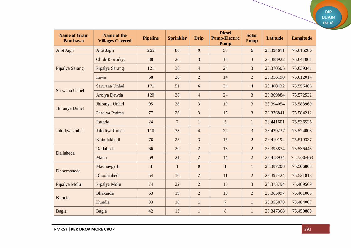
PMKSY |PER DROP MORE CROP 292
DIP UJJAIN (M.P)
Name of Gram
Panchayat
Name of the
Villages Covered Pipeline Sprinkler Drip
Diesel
Pump/Electric
Pump
Solar
Pump Latitude Longitude
Alot Jagir Alot Jagir 265 80 9 53 6 23.394611 75.615286
Pipalya Sarang
Chidi Rawadiya 88 26 3 18 3 23.388922 75.641001
Pipalya Sarang 121 36 4 24 3 23.370505 75.639341
Itawa 68 20 2 14 2 23.356198 75.612014
Sarwana Unhel Sarwana Unhel 171 51 6 34 4 23.400432 75.556486
Arolya Dewda 120 36 4 24 3 23.369884 75.572532
Jhiranya Unhel Jhiranya Unhel 95 28 3 19 3 23.394054 75.583969
Parolya Padma 77 23 3 15 3 23.376841 75.584212
Jalodiya Unhel
Rathda 24 7 1 5 1 23.441601 75.536526
Jalodiya Unhel 110 33 4 22 3 23.429237 75.524003
Khimlakhedi 76 23 3 15 2 23.419192 75.510337
Dallaheda Dallaheda 66 20 2 13 2 23.395874 75.536445
Mahu 69 21 2 14 2 23.418934 75.7536468
Dhoomaheda Madhavgarh 3 1 0 1 1 23.387208 75.506808
Dhoomaheda 54 16 2 11 2 23.397424 75.521813
Pipalya Molu Pipalya Molu 74 22 2 15 3 23.373794 75.489569
Kundla Bhakarda 63 19 2 13 2 23.365097 75.461005
Kundla 33 10 1 7 1 23.355878 75.484007
Bagla Bagla 42 13 1 8 1 23.347368 75.459889

PMKSY |PER DROP MORE CROP 293
DIP UJJAIN (M.P)
Name of Gram
Panchayat
Name of the
Villages Covered Pipeline Sprinkler Drip
Diesel
Pump/Electric
Pump
Solar
Pump Latitude Longitude
Nagjhiri 253 76 9 51 5 23.331134 75.471648
Chambal Padlaya Chambal Padlaya 96 29 3 19 3 23.3294 75.446499
Barkheda Najeek Barkheda Najeek 47 14 2 9 1 23.327745 75.489501
Chawand Chawand 120 36 4 24 3 23.312734 75.454533
Rajota 112 34 4 22 3 23.289533 75.461389
Lekodiya Anjana Lekodiya Anjana 184 55 6 37 4 23.300405 75.475335
Paslod Kalalkhedi 162 49 6 32 4 23.33996 75.501335
Paslod 193 58 7 39 5 23.29165 75.510313
Akya Najik Akya Najik 158 47 5 32 4 23.298817 75.49611
Nawada Nawada 102 31 3 20 3 23.32404 75.518426
Malikhedi
Chinkuganj 45 14 2 9 1 23.376247 75.512884
Malikhedi 96 29 3 19 3 23.35978 75.524987
Kankarda 55 17 2 11 1 23.378059 75.537604
Bedawan Bedawan 589 177 10 118 15 23.460531 75.605782
Pagara
Didiyakhedi 44 13 1 9 1 23.356134 75.580202
Baijnathkhedi 42 13 1 8 1 23.343014 75.593916
Pagara 40 12 1 8 1 23.32585 75.601061
Roopakhedi 135 41 5 27 3 23.315795 75.612329
Pipliyadhabi Pipalya Dabi 122 37 4 24 3 23.309896 75.579995

PMKSY |PER DROP MORE CROP 294
DIP UJJAIN (M.P)
Name of Gram
Panchayat
Name of the
Villages Covered Pipeline Sprinkler Drip
Diesel
Pump/Electric
Pump
Solar
Pump Latitude Longitude
Surjakhedi Surjakhedi 117 35 4 23 3 23.293142 75.618027
Jiyajigarh 71 21 2 14 2 23.270269 75.623367
Gurla Gurla 143 43 5 29 3 23.291544 75.502585
Karondiya Lasudiyachuwad 73 22 2 15 2 23.304792 75.558187
Karondiya 95 28 3 19 2 23.273113 75.530098
Rambaloda Ramabaloda 259 78 9 52 6 23.274518 75.581186
Khokri Khokri 98 29 3 20 3 23.267884 75.6000729
Arolyajassa 46 14 2 9 1 23.262141 75.619725
NP Khacharod (M) 1236 371 24 247 25
NP Nagda (M) 184 55 6 37 5
NP Unhel (NP) 791 237 25 158 15
Total 30906 9272 1021 6181 765

PMKSY |PER DROP MORE CROP 295
DIP UJJAIN (M.P)
Block Badnagar
Name of Gram
Panchayat
Name of Villages
Covered Pipeline Sprinkler Drip
Diesel
Pump/Electric
Pump
Solar
Pump Latitude Longitude
Bhatpachlana Bhatpachlana 291 87 9 58 6 23.250506 75.294487
Maloda Maloda 182 55 5 36 5 23.241022 75.315326
Banbani
Banbani 254 76 8 51 5 23.260815 75.311721
Bhunwasa 207 62 6 41 5 23.284026 75.338293
Kajyakhedi 72 22 2 14 3 23.272515 75.337434
Banderbela Banderbela 170 51 5 34 4 23.252378 75.345967
Limbas Limbas 211 63 6 42 5 23.276063 75.371767
Chirola Chirola 556 167 18 111 11 23.274651 75.410906
Rathorkhedi 96 29 3 19 2 23.286951 75.430390
Salwa Salwa 168 50 5 34 5 23.245633 75.393139
Mungawada
Lasudiya 45 13 1 9 1 23.251190 75.425917
Mungawada 102 31 3 20 3 23.258445 75.441195
Karadwas 42 12 1 8 1 23.275240 75.432440
Silodiya Mungawadi 93 28 3 19 3 23.247116 75.445670
Silodiya 175 52 5 35 5 23.238046 75.431078
Amlawadkalan Dehta 61 18 2 12 2 23.282991 75.445670
Kesharpura 39 12 1 8 1 23.271403 75.453394

PMKSY |PER DROP MORE CROP 296
DIP UJJAIN (M.P)
Name of Gram
Panchayat
Name of Villages
Covered Pipeline Sprinkler Drip
Diesel
Pump/Electric
Pump
Solar
Pump Latitude Longitude
Amlawadkalan 125 37 4 25 3 23.252084 75.462063
Balodahasan
Mahudikhema 63 19 2 13 2 23.232449 75.450896
Balodahasan 69 21 2 14 2 23.212966 75.448407
Gaondidevsi 103 31 3 21 3 23.223063 75.431499
Dunalja Dunalja 158 47 5 32 4 23.229243 75.462919
Udsinga Paduniyakheta 49 15 1 10 1 23.220865 75.413579
Udsinga 233 70 7 47 5 23.201258 75.417106
Kalyanpura Kalyanpura 146 44 4 29 3 23.185672 75.407286
Kamanpur 141 42 4 28 3 23.172890 75.396128
Mundat Khedanarayan 31 9 1 6 1 23.201119 75.447762
Mundat 83 25 2 17 3 23.188249 75.447762
Khandoda Khandoda 229 69 10 46 5 23.176704 75.437154
Simlawada 111 33 3 22 3
Harnawada Harnawada 119 36 4 24 3 23.207596 75.487035
Onkarpura
Labaycha 43 13 1 9 1 23.196783 75.466770
Semalkhedi 27 8 1 5 1 23.193943 75.494309
Gurawada 36 11 1 7 1 23.182090 75.494653
Onkarpura 61 18 3 12 3 23.186527 75.478087

PMKSY |PER DROP MORE CROP 297
DIP UJJAIN (M.P)
Name of Gram
Panchayat
Name of Villages
Covered Pipeline Sprinkler Drip
Diesel
Pump/Electric
Pump
Solar
Pump Latitude Longitude
Sijawata Sijawata 141 42 4 28 4 23.170076 75.463590
Gaondilodha Gaondilodha 97 29 3 19 3 23.156661 75.467154
Dhureri Dhureri 79 24 2 16 3 23.142304 75.501043
Rajota 20 6 1 4 1 23.146329 75.482504
Suneda Suneda 83 25 2 17 3 23.118625 75.501301
Chinchodiya 102 30 3 20 2 23.120203 75.517866
Kiloli Kiloli 53 16 2 11 2 23.107064 75.501598
Namalpur 52 15 2 10 2 23.096248 75.511256
Kharsodkhurd Kharsodkhurd 462 138 15 92 10 23.118526 75.469040
Untwas Untwas 114 34 3 23 3 23.088195 75.450787
Ranwa Hatyakhedi 41 12 1 8 1 23.086774 75.450787
Ranwa 119 36 4 24 3 23.088195 75.489067
Dantarwa Dantarwa 78 23 2 16 2 23.104587 75.414571
Rasulabad 35 10 1 7 1 23.100718 75.429935
Molana Molana 274 82 8 55 6 23.100718 75.429935
Palwa Palwa 242 73 7 48 5 23.144346 75.429069
Sanawada Itawa 111 33 3 22 3 23.461516 75.745866
Sanawada 57 17 2 11 2 23.122024 75.415069

PMKSY |PER DROP MORE CROP 298
DIP UJJAIN (M.P)
Name of Gram
Panchayat
Name of Villages
Covered Pipeline Sprinkler Drip
Diesel
Pump/Electric
Pump
Solar
Pump Latitude Longitude
Rawadiyapeer Rawadiyapeer 116 35 3 23 3 23.187767 75.370559
Mindka 92 28 3 18 2 23.160781 75.385065
Balodakoran Balodakoran 158 47 5 32 4 23.181703 75.333750
Ajdawada Ajdawada 302 90 9 60 7 23.180903 75.358886
Kharsodkalan Kharsodkalan 691 207 21 138 15 23.220246 75.368254
Ordi Ordi 236 71 7 47 5 23.231489 75.338394
Narelakhurd 13 4 0 3 1 23.234303 75.353653
Bardiya Bardiya 314 94 9 63 7 23.216574 75.325528
Nauganwa Nauganwa 158 47 6 32 4 23.224930 75.301132
Khedawada Khedawada 434 130 15 87 10 23.188903 75.290080
Malgaondi 50 15 2 10 1 23.174622 75.285874
Badganwa Badganwa 335 100 10 67 7 23.197264 75.254211
Gajnikhedi Maswadiyadhar 127 38 4 25 3 23.192452 75.233183
Gajnikhedi 282 85 10 56 7 23.173358 75.253267
Runija Runija 139 42 4 28 3 23.160597 75.268006
Madhopura Madhopura 355 107 11 71 8 23.141457 75.277446
Balodalakha Balodalakha 477 143 15 95 10 23.156439 75.313754
Sundrabad Sundrabad 203 61 6 41 5 23.133221 75.311637

PMKSY |PER DROP MORE CROP 299
DIP UJJAIN (M.P)
Name of Gram
Panchayat
Name of Villages
Covered Pipeline Sprinkler Drip
Diesel
Pump/Electric
Pump
Solar
Pump Latitude Longitude
Jalodsanjar Jalodsanjar 261 78 8 52 6 23.136536 75.348286
Pachlanabil
Pachlanabil 168 50 5 34 4 23.138588 75.372147
Singawada 62 19 2 12 2 23.131752 75.389587
Bidsingawada 7 2 0 1 1 23.118697 75.386824
Meethikhedi 44 13 1 9 1 23.109066 75.388455
Pitlawadiya Pitlawadiya 77 23 2 15 2
Tokra 110 33 3 22 3 23.086291 75.338623
Birakhedi Ranawada 30 9 1 6 1 23.118699 75.373047
Birakhedi 250 75 7 50 5 23.113853 75.353993
Jassakhedi Balodaarsi 37 11 1 7 1 23.098528 75.349244
Jassakhedi 122 37 4 24 4 23.085116 75.324849
Jandla
Semaliya 47 14 1 9 1 23.101638 75.379687
Jandla 205 62 6 41 5 23.094535 75.367128
Garakhedi 23 7 1 5 1 23.088559 75.379831
Peethakhedi 23 7 1 5 1 23.079142 75.356743
Paduniyalodha 14 4 0 3 1 23.079873 75.375292
Beesaheda Beesaheda 99 30 3 20 3 23.091476 75.397043
Kajlana 36 11 1 7 1 23.074058 75.395920

PMKSY |PER DROP MORE CROP 300
DIP UJJAIN (M.P)
Name of Gram
Panchayat
Name of Villages
Covered Pipeline Sprinkler Drip
Diesel
Pump/Electric
Pump
Solar
Pump Latitude Longitude
Jhalaria
Jhalaria 95 28 3 19 3 23.065849 75.424952
Khedamadhav 63 19 2 13 2 23.053371 75.419459
Karadiya 4 1 0 1 1 23.062532 75.396370
Jafla (Part) Bargadi 53 16 2 11 1 23.052660 75.349249
Jafla (Part) 204 61 6 41 5 23.026990 75.384955
Amla Amla 588 176 20 118 14 23.012884 75.329004
Ajanda
Ajanda 177 53 5 35 3 22.986448 75.358055
Arandiya 32 9 1 6 1 23.019235 75.367583
Ubradiya 38 11 1 8 1 23.006911 75.360716
Kotki 7 2 0 1 1 23.000810 75.379513
Shekhpur Shekhpur 7 2 0 1 1 23.041033 75.398830
Bhomalwas Bhomalwas 62 19 2 12 2 23.025411 75.406241
Upri 4 1 0 1 1 23.011112 75.392250
Birgodarandhir Bhainslakalan 61 18 2 12 2 23.035995 75.425467
Birgodarandhir 112 33 3 22 3 23.043183 75.439715
Umariya Umariya 358 107 11 72 8 23.017274 75.422206
Khandwasura Khandwasura 84 25 3 17 4 22.976729 75.383290
Likhoda 61 18 2 12 3 23.001776 75.387152

PMKSY |PER DROP MORE CROP 301
DIP UJJAIN (M.P)
Name of Gram
Panchayat
Name of Villages
Covered Pipeline Sprinkler Drip
Diesel
Pump/Electric
Pump
Solar
Pump Latitude Longitude
Jalodiya Jalodiya 164 49 5 33 4 22.991707 75.417174
Bhidawad Bhidawad 330 99 10 66 7 22.938916 75.348166
Lohariya 182 55 5 36 4 22.973345 75.335766
Sarola
Sarola 103 31 3 21 3 22.961125 75.371941
Dhaturiya 116 35 3 23 3 22.949823 75.374945
Mundla 116 35 3 23 3 22.938837 75.385503
Suklana Rawadiyakalan 140 42 4 28 4 22.948252 75.323487
Suklana 128 38 4 26 3 22.917958 75.343333
Lohana Lohana 354 106 11 71 8 22.914381 75.366287
Khandwabibi
Kungara 90 27 3 18 2 22.903530 75.346716
Khandwabibi 104 31 3 21 2 22.880089 75.346530
Satwasa 104 31 3 21 2 22.879432 75.368261
Nawada Nawada 147 44 4 29 3 22.859880 75.349000
Badgara Badgara 107 32 3 21 3 22.843099 75.350339
Piplee Piplee 263 79 10 53 7 22.866708 75.400017
Dotru Dotru 136 41 4 27 4 22.891473 75.431523
Gajikhedi 71 21 2 14 2 22.884198 75.419249
Pithora Pithora 118 35 4 24 3 22.930622 75.413567

PMKSY |PER DROP MORE CROP 302
DIP UJJAIN (M.P)
Name of Gram
Panchayat
Name of Villages
Covered Pipeline Sprinkler Drip
Diesel
Pump/Electric
Pump
Solar
Pump Latitude Longitude
Biragodanathu 88 26 3 18 3 22.910226 75.415627
Gunawad Gunawad 244 73 7 49 5 22.935523 75.439058
Bisalkhedi 19 6 1 4 1 22.929832 75.469957
Bangred Bangred 287 86 9 57 6 22.956383 75.404300
Fatehpur Fatehpur 285 86 9 57 6 22.962278 75.449548
Asawta Asawta 137 41 4 27 3 22.994788 75.417174
Akoliya Akoliya 168 50 5 34 3 22.987700 75.465604
Takrawada 33 10 1 7 1 22.979245 75.479507
Pirjhalar Pirjhalar 335 101 10 67 7 23.031151 75.464574
Bhandtilawali 51 15 2 10 1 23.030756 75.489809
Daulatpur
Daulatpur 64 19 2 13 2 23.038654 75.512039
Sohad 50 15 2 10 1 23.048765 75.495351
Pacholi 37 11 1 7 1 23.026247 75.667179
Dautardi 24 7 1 5 1 23.013845 75.501771
Palduna Palduna 454 136 14 91 10 23.065823 75.463937
Lakhesara Maswadiyakhalsa 130 39 4 26 3 23.079800 75.514406
Lakhesara 189 57 6 38 4 23.058558 75.510629
Narsinga Paslod 80 24 2 16 3 23.063533 75.531744

PMKSY |PER DROP MORE CROP 303
DIP UJJAIN (M.P)
Name of Gram
Panchayat
Name of Villages
Covered Pipeline Sprinkler Drip
Diesel
Pump/Electric
Pump
Solar
Pump Latitude Longitude
Narsinga 262 79 8 52 6 23.064558 75.542558
Dangwada Dangwada 451 135 15 90 10 23.091089 75.526861
Baledi Baledi 410 123 12 82 9 23.121239 75.556476
Ghudawan Ghudawan 127 38 4 25 3 23.446769 75.278596
Bhainsla Khurd 97 29 3 19 2 23.162511 75.536027
Sarsana Sarsana 67 20 2 13 2 23.145224 75.523960
Jhumki Jhumki 130 39 4 26 3 23.546958 70.010681
Dharankhedi 49 15 1 10 1 23.188398 75.510764
Patyakhedi Karanpura 35 10 1 7 1 233.194051 75.541037
Patyakhedi 78 23 2 16 2 23.180634 75.541445
Jahangirpur Jahangirpur 334 100 10 67 7 23.215822 75.514271
Amlawadbika Amlawadbika 149 45 4 30 3 23.252160 75.463296
Molakhedi 66 20 2 13 3 23.245299 75.483338
Malpura Malpura 175 52 5 35 4 23.232465 75.495474
Murarkhedi 102 31 3 20 2 23.218977 75.495045
Palsoda Jamalpura 78 23 2 16 2 23.273898 75.477753
Palsoda 203 61 6 41 5 23.265225 75.496207
Makdawan Makdawan 311 93 9 62 7 23.858684 75.533783
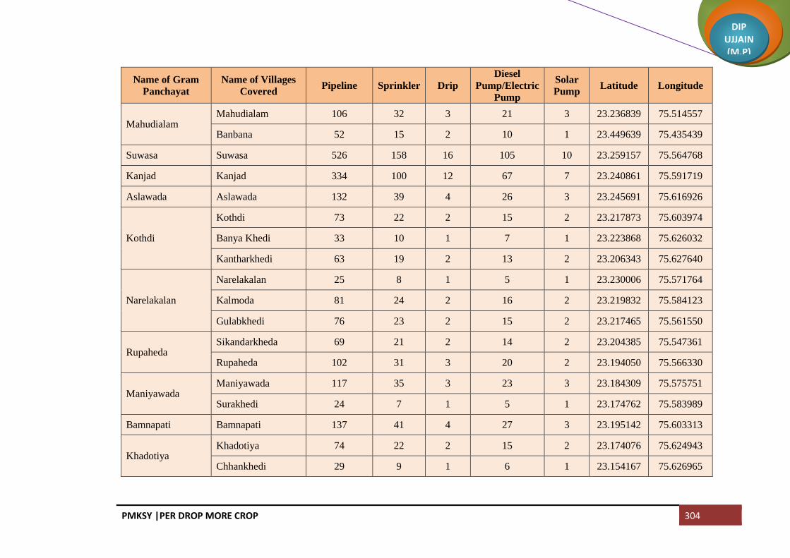
PMKSY |PER DROP MORE CROP 304
DIP UJJAIN (M.P)
Name of Gram
Panchayat
Name of Villages
Covered Pipeline Sprinkler Drip
Diesel
Pump/Electric
Pump
Solar
Pump Latitude Longitude
Mahudialam Mahudialam 106 32 3 21 3 23.236839 75.514557
Banbana 52 15 2 10 1 23.449639 75.435439
Suwasa Suwasa 526 158 16 105 10 23.259157 75.564768
Kanjad Kanjad 334 100 12 67 7 23.240861 75.591719
Aslawada Aslawada 132 39 4 26 3 23.245691 75.616926
Kothdi
Kothdi 73 22 2 15 2 23.217873 75.603974
Banya Khedi 33 10 1 7 1 23.223868 75.626032
Kantharkhedi 63 19 2 13 2 23.206343 75.627640
Narelakalan
Narelakalan 25 8 1 5 1 23.230006 75.571764
Kalmoda 81 24 2 16 2 23.219832 75.584123
Gulabkhedi 76 23 2 15 2 23.217465 75.561550
Rupaheda Sikandarkheda 69 21 2 14 2 23.204385 75.547361
Rupaheda 102 31 3 20 2 23.194050 75.566330
Maniyawada Maniyawada 117 35 3 23 3 23.184309 75.575751
Surakhedi 24 7 1 5 1 23.174762 75.583989
Bamnapati Bamnapati 137 41 4 27 3 23.195142 75.603313
Khadotiya Khadotiya 74 22 2 15 2 23.174076 75.624943
Chhankhedi 29 9 1 6 1 23.154167 75.626965

PMKSY |PER DROP MORE CROP 305
DIP UJJAIN (M.P)
Name of Gram
Panchayat
Name of Villages
Covered Pipeline Sprinkler Drip
Diesel
Pump/Electric
Pump
Solar
Pump Latitude Longitude
Kulawada Matangna 102 31 3 20 2 23.171448 75.601927
Kulawada 144 43 4 29 3 23.219540 75.581801
Ingoriya Ingoriya 228 68 7 46 5 23.156139 75.569998
Cheekali Cheekali 243 73 7 49 5 23.139723 75.604845
Kadhai Kadhai 171 51 5 34 5 23.121630 75.593160
Bhondwas 52 16 2 10 2 23.123840 75.615218
Ghadsinga Ghadsinga 203 61 6 41 5 23.103001 75.583621
Brahmanbadoda 47 14 1 9 1 23.112553 75.621301
Nimboda Naharkhedi 66 20 2 13 2 23.089500 75.622331
Nimboda 187 56 6 37 3 23.101895 75.603877
Urban Badnagar (M + OG) 574 172 17 115 12
Total 27447 8234 844 5489 664

PMKSY |PER DROP MORE CROP 306
DIP UJJAIN (M.P)
Block Mahidpur
Name of Gram
Panchayat
Name of the
Villages Covered Pipeline Sprinkler Drip
Diesel
Pump/Electric
Pump
Solar
Pump Latitude Longitude
Brahmankheda Brahmankheda 91 27 3 18 2 23.655658 75.544006
Petlawad Petlawad 140 42 5 28 3 23.639383 75.530874
Koyal Deoli 9 3 0 2 1 23.642485 75.559069
Koyal 103 31 4 21 2 23.620845 75.54592
Bapaiya Bapaiya 214 64 8 43 5 23.607082 75.521201
Kanakedi Eklaspur Kanakedi Eklaspur 48 14 2 10 1 23.583866 75.521576
Karnawad 112 34 4 22 2 23.588349 75.541145
Bawalya
Bawalya 212 64 8 42 5 23.600192 75.604931
Chibdi 53 16 2 11 2 23.596967 75.587937
Serankhedi 43 13 2 9 1 23.590911 75.570856
Tarnod Tarnod 303 91 11 61 7 23.586776 75.556423
Barukhedi Barukhedi 171 51 6 34 5 23.541546 75.541566
Sarwankheda 100 30 4 20 3 23.562711 75.543797
Isankhedi Isankhedi 167 50 6 33 3 23.553034 75.568946
Narayankhedi Jharawada 58 17 2 12 2 23.525178 75.521652
Narayankhedi 11 3 0 2 1 23.531474 75.553839

PMKSY |PER DROP MORE CROP 307
DIP UJJAIN (M.P)
Name of Gram
Panchayat
Name of the
Villages Covered Pipeline Sprinkler Drip
Diesel
Pump/Electric
Pump
Solar
Pump Latitude Longitude
Delchibuzurg Delchibuzurg 68 20 2 14 2 23.530372 75.58182
Banjari Banjari 155 46 6 31 4 23.521298 75.602153
Mundlaparwal Mundlaparwal 88 26 3 18 2 23.495875 75.577606
Chitawad Chitawad 117 35 4 23 3 23.486504 75.603303
Rudrakheda 13 4 0 3 1 23.483459 75.622935
Parwatkheda
Parwatkheda 39 12 1 8 1 23.495058 75.634399
Dubli 44 13 2 9 1 23.488297 75.63706
Kukni 92 28 3 18 2 23.474363 75.624271
Harbakhedi Rohida 136 41 5 27 3 23.520196 75.622066
Harbakhedi 145 43 5 29 4 23.539082 75.634941
Delchikhurd Delchikhurd 213 64 8 43 5 23.542545 75.61374
Sagwali Singdewala 20 6 1 4 1 23.564558 75.600897
Sagwali 122 36 4 24 3 23.577302 75.578839
Jhutawad Jhutawad 351 105 13 70 8 23.635715 75.579866
Pepalya Bhim
Ilyakhedi 47 14 2 9 1 23.628595 75.600134
Pepalya Bhim 44 13 2 9 1 23.617155 75.598979
Aranya Najeek
Chivdi 58 17 2 12 2 23.642511 75.623137

PMKSY |PER DROP MORE CROP 308
DIP UJJAIN (M.P)
Name of Gram
Panchayat
Name of the
Villages Covered Pipeline Sprinkler Drip
Diesel
Pump/Electric
Pump
Solar
Pump Latitude Longitude
Gogakheda
Ghat Khedi 41 12 1 8 1 23.625518 75.628694
Modi 45 13 2 9 1 23.644627 75.64681
Gogakheda 56 17 2 11 2 23.626709 75.615053
Ghatpeepalya Aranyabena 44 13 2 9 1 23.642519 75.623423
Ghatpeepalya 94 28 3 19 3 23.655146 75.636342
Dhablasiya Dhablasiya 117 35 4 23 3 23.619773 75.66081
Munjakhedi 86 26 3 17 2 23.627443 75.647313
Kanthariya
Kanthariya 64 19 2 13 2 23.608257 75.629176
Barkhedakhurd 68 20 2 14 2 23.594368 75.621309
Sipawara 74 22 3 15 2 23.580808 75.61377
Semalya Semalya 452 136 10 90 10 23.559665 75.637244
Bani Bani 155 46 6 31 4 23.531858 75.658593
Rasulpura 82 24 3 16 2 23.51772 75.652242
Nipaniyabadar Nipaniyabadar 211 63 8 42 4 23.565536 75.668821
Katariya 223 67 8 45 4 23.587167 75.652798
Sumrakheda
Sanoriya 104 31 4 21 2 23.62882 75.694958
Akyabajrang 59 18 2 12 2 23.626109 75.713651
Sumrakheda 12 4 0 2 1 23.615763 75.712059

PMKSY |PER DROP MORE CROP 309
DIP UJJAIN (M.P)
Name of Gram
Panchayat
Name of the
Villages Covered Pipeline Sprinkler Drip
Diesel
Pump/Electric
Pump
Solar
Pump Latitude Longitude
Sakariya
Sukdi 34 10 1 7 1 23.645685 75.716721
Sakariya 62 18 2 12 2 23.635417 75.732956
Kanakhedi Hamma 82 25 3 16 2 23.653547 75.765361
Asadi
Aranyabagda 25 8 1 5 1 23.661977 75.704161
Asadi 92 28 3 18 2 23.671893 75.719751
Bahadurpura 31 9 1 6 1 23.654177 75.68951
Dungariya Dungariya 135 40 5 27 3 23.649092 75.601649
Ranayrapeer Ranayrapeer 195 59 7 39 4 23.654816 75.661026
Melakhedi
Hajalyakhedi 71 21 3 14 2 23.672595 75.634185
Melakhedi 124 37 4 25 3 23.674908 75.657426
Balah 66 20 2 13 2 23.683765 75.641764
Shrawan Borkhedi 128 38 5 26 3 23.676835 75.67636
Shrawan 111 33 4 22 3 23.681395 75.695848
Ghatiyasaindas Ghatiyasaindas 162 48 4 32 4 23.700222 75.647249
Bhadwa Bhadwa 295 88 8 59 6 23.703526 75.684996
Malya Yashwantpura 20 6 1 4 1 23.710491 75.708925
Malya 227 68 3 45 5 23.72113 75.716359
Tipukheda Bolkhedaghat 40 12 1 8 1 23.741979 75.7191

PMKSY |PER DROP MORE CROP 310
DIP UJJAIN (M.P)
Name of Gram
Panchayat
Name of the
Villages Covered Pipeline Sprinkler Drip
Diesel
Pump/Electric
Pump
Solar
Pump Latitude Longitude
Tipukheda 94 28 3 19 2 23.723043 75.740214
Indokh Indokh 160 48 6 32 3 23.707562 75.758411
Mundlasondhya Mundlasondhya 205 61 7 41 5 23.69582 75.729567
Pipalya Dhuma Pipalya Dhuma 176 53 4 35 4 23.674603 75.742197
Patakhedi Sekli 47 14 2 9 1 23.673775 75.76895
Patakhedi 2 1 0 0 1 23.685723 75.7741
Bansingh Bansingh 257 77 10 51 6 23.712041 75.777637
Kachhaliyasaiyad 182 54 7 36 5 23.694369 75.80457
Mahudiya Mahudiya 73 22 3 15 2 23.690991 75.833383
Dhelwadi 55 17 2 11 2 23.709225 75.837846
Lasudiyagoyal Lasudiyagoyal 92 27 3 18 3 23.727336 75.843211
Bolkhedanau Bolkhedanau 277 83 8 55 6 23.680538 75.813899
Rabdaniya
Ladanpur 62 19 2 12 2 23.653745 75.803366
Rabdaniya 120 36 4 24 3 23.662943 75.781222
Naharkheda 42 13 2 8 1 23.66483 75.798388
Khardiya Manpur Khardiya Manpur 35 11 1 7 1 23.643917 75.820103
Kachhaliyachand 167 50 6 33 4 23.636054 75.803194
Nagguradiya Nagguradiya 245 74 10 49 5 23.619384 75.814181

PMKSY |PER DROP MORE CROP 311
DIP UJJAIN (M.P)
Name of Gram
Panchayat
Name of the
Villages Covered Pipeline Sprinkler Drip
Diesel
Pump/Electric
Pump
Solar
Pump Latitude Longitude
Bamnai
Bamnai 99 30 4 20 3 23.603604 75.768426
Rudaheda 91 27 3 18 3 23.606714 75.803853
Tolyakhedi 8 2 0 2 2 23.509941 75.884918
Kallapipalya Kallapipalya 245 73 10 49 5 23.499152 75.870988
Teelyakhedi 44 13 2 9 1 23.509941 75.884918
Makla Makla 176 53 6 35 4 23.629913 75.765744
Lotiya Junarda Lotiya Junarda 192 58 7 38 4 23.653317 75.737795
Jharda Jharda 206 62 10 41 5 23.603882 75.743864
Gelakhedi Parasali 81 24 3 16 3 23.585663 75.744073
Gelakhedi 106 32 4 21 3 23.570389 75.753672
Padlya Rawatkhedi 34 10 1 7 1 23.598765 75.717008
Padlya 232 69 8 46 5 23.578459 75.718812
Tarot Tarot 238 71 9 48 5 23.610257 75.684421
Kachariya Kachariya 308 92 15 62 7 23.58483 75.686969
Jodmalakkha Singari 115 35 4 23 3 23.555184 75.744904
Jodmalakkha 88 26 3 18 3 23.559511 75.726794
Akyalimba Akyalimba 126 38 5 25 3 23.534919 75.716949
Thikariya 53 16 2 11 2 23.545463 75.705533

PMKSY |PER DROP MORE CROP 312
DIP UJJAIN (M.P)
Name of Gram
Panchayat
Name of the
Villages Covered Pipeline Sprinkler Drip
Diesel
Pump/Electric
Pump
Solar
Pump Latitude Longitude
Lasudiyamansoor Lasudiyamansoor 169 51 6 34 4 23.564861 75.696182
Khajuriya Mansoor 141 42 5 28 3 23.549126 75.67521
Khoriya Sumra
Mochikheda 57 17 2 11 2 23.518685 75.671177
Khoriya Sumra 47 14 2 9 1 23.527106 75.687484
Piplikheda 47 14 2 9 1 23.508532 75.680704
Dhulet
Ghiyakhedi 32 9 1 6 1 23.447085 75.588635
Badgaon 95 29 3 19 3 23.460234 75.605801
Dhulet 82 24 3 16 3 23.474563 75.622881
Kadhai Barapathar (Part) 2 0 0 0 1 23.475902 75.646484
Kadhai 152 46 5 30 4 23.444171 75.649231
Bhimakheda Tajpura (Part) 1 0 0 0 1 23.47756 75.664596
Bhimakheda (Part) 184 55 7 37 4 23.483224 75.684142
Kajikhedi
Kajikhedi 54 16 2 11 2 23.486571 75.697527
Aamdi 117 35 4 23 3 23.503023 75.700531
Sangvikheda 59 18 2 12 2 23.497198 75.701217
Binpura Binpura 53 16 2 11 2 23.475175 75.7002
Tanda 20 6 1 4 1 23.45809 75.700457
Lakhakhedi Lakhakhedi 56 17 2 11 2 23.447576 75.672931
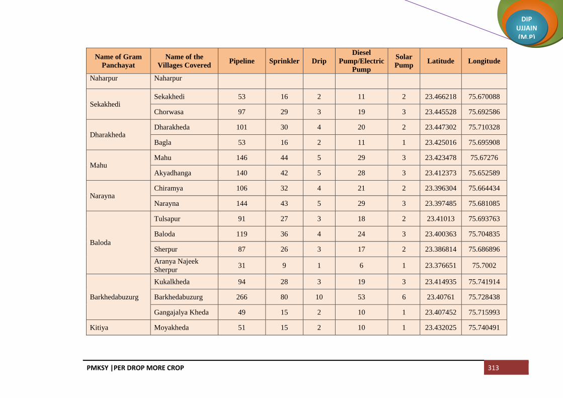
PMKSY |PER DROP MORE CROP 313
DIP UJJAIN (M.P)
Name of Gram
Panchayat
Name of the
Villages Covered Pipeline Sprinkler Drip
Diesel
Pump/Electric
Pump
Solar
Pump Latitude Longitude
Naharpur Naharpur
Sekakhedi Sekakhedi 53 16 2 11 2 23.466218 75.670088
Chorwasa 97 29 3 19 3 23.445528 75.692586
Dharakheda Dharakheda 101 30 4 20 2 23.447302 75.710328
Bagla 53 16 2 11 1 23.425016 75.695908
Mahu Mahu 146 44 5 29 3 23.423478 75.67276
Akyadhanga 140 42 5 28 3 23.412373 75.652589
Narayna Chiramya 106 32 4 21 2 23.396304 75.664434
Narayna 144 43 5 29 3 23.397485 75.681085
Baloda
Tulsapur 91 27 3 18 2 23.41013 75.693763
Baloda 119 36 4 24 3 23.400363 75.704835
Sherpur 87 26 3 17 2 23.386814 75.686896
Aranya Najeek
Sherpur 31 9 1 6 1 23.376651 75.7002
Barkhedabuzurg
Kukalkheda 94 28 3 19 3 23.414935 75.741914
Barkhedabuzurg 266 80 10 53 6 23.40761 75.728438
Gangajalya Kheda 49 15 2 10 1 23.407452 75.715993
Kitiya Moyakheda 51 15 2 10 1 23.432025 75.740491

PMKSY |PER DROP MORE CROP 314
DIP UJJAIN (M.P)
Name of Gram
Panchayat
Name of the
Villages Covered Pipeline Sprinkler Drip
Diesel
Pump/Electric
Pump
Solar
Pump Latitude Longitude
Kitiya 100 30 4 20 3 23.427985 75.757091
Dongla Dongla 97 29 3 19 2 23.452155 75.763587
Kanakhedi Harbans 18 5 1 4 1 23.443481 75.790436
Itawa Itawa 117 35 4 23 3 23.462077 75.745004
Lasudiyashripat 88 26 3 18 3 23.430844 75.722602
Bisalkhedi Bisalkhedi 40 12 1 8 1 23.454625 75.728267
Kuwandiya 58 17 2 12 1 23.466199 75.726893
Pipalya Nath Pipalya Nath 130 39 5 26 3 23.482025 75.774822
Jawasyapanth Jawasyapanth 180 54 6 36 4 23.477368 75.753621
Lakhakhedi Umath 61 18 2 12 2 23.498828 75.762319
Dhablikamma Dhablikamma 45 14 2 9 1 23.494575 75.72158
Dhablabeni 52 16 2 10 2 23.476414 75.71663
Baijnath
Jharkhedi 65 19 2 13 2 23.511522 75.700665
Ramnagar 26 8 1 5 1 23.521537 75.700155
Baijnath 52 16 2 10 2 23.511428 75.717699
Suhagpura Mendki 50 15 2 10 2 23.505532 75.729755
Suhagpura 137 41 5 27 3 23.50263 75.746138
Guradiyadasa Guradiyadasa 179 54 6 36 4 23.536807 75.733072

PMKSY |PER DROP MORE CROP 315
DIP UJJAIN (M.P)
Name of Gram
Panchayat
Name of the
Villages Covered Pipeline Sprinkler Drip
Diesel
Pump/Electric
Pump
Solar
Pump Latitude Longitude
Maukhedi 130 39 5 26 3 23.538075 75.750475
Nipaniyaraju
Nipaniyaraju 97 29 3 19 3 23.523009 75.77544
Somchidi 43 13 2 9 1 23.535528 75.785502
Mahidpuriya 12 3 0 2 1 23.530815 75.796396
Dhanodiya Dhanodiya 334 100 10 67 7 23.503541 75.789362
Azmabad Azmabad 72 21 3 14 2 23.523835 75.754762
Mundlibhoj 157 47 6 31 3 23.505272 75.774368
Padikheda Padikheda 228 68 8 46 5 23.48996 75.797798
Marukheda 75 23 3 15 2 23.50862 75.808876
Dungarkhedi
Simrol 53 16 2 11 2 23.526035 75.809663
Dungarkhedi 44 13 2 9 1 23.543674 75.809967
Delakhedi 17 5 1 3 1 23.549966 75.798921
Kheda Madda Kheda Madda 272 81 6 54 6 23.553522 75.825382
Neemkheda Neemkheda 24 7 1 5 1 23.568489 75.826732
Khedla 44 13 2 9 1 23.566758 75.809394
Nagpura Nagpura 117 35 4 23 3 23.55062 75.7522
Chhajjukhedi 53 16 2 11 2 23.547082 75.785492
Nalkheda Nalkheda 193 58 7 39 4 23.584301 75.776607

PMKSY |PER DROP MORE CROP 316
DIP UJJAIN (M.P)
Name of Gram
Panchayat
Name of the
Villages Covered Pipeline Sprinkler Drip
Diesel
Pump/Electric
Pump
Solar
Pump Latitude Longitude
Khoriya Padma Khoriya Padma 89 27 3 18 2 23.5655 75.792571
Panodiya 50 15 2 10 1 23.584537 75.810424
Kundikheda Kundikheda 124 37 4 25 3 23.606351 75.823622
Ghatiyajassa
Jhangri 48 14 2 10 1 23.619747 75.831272
Kanthari 48 14 2 10 1 23.604439 75.837995
Samakota 15 4 1 3 1 23.593439 75.83983
Ghatiyajassa 32 10 1 6 1 23.580574 75.833458
Lasudiyanhata Lasudiyanhata 50 15 2 10 1 23.564832 75.849844
Dongarkheda Dongarkheda 169 51 6 34 4 23.547417 75.87998
Bagni Bagni 58 17 2 12 2 23.525714 75.867999
Ghodabag 96 29 3 19 2 23.519747 75.884718
Kason Kason 111 33 4 22 2 23.532519 75.846682
Bhavrasi 38 11 1 8 1 23.497895 75.821837
Shakkarkhedi Shakkarkhedi 22 7 1 4 1 23.476339 75.841089
Kamalyakhedi
Kamalyakhedi 24 7 1 5 1 23.513184 75.854965
Bilkheda 14 4 0 3 1 23.505506 75.839304
Hajratpur 32 9 1 6 1 23.496306 75.851068
Jawasiyasolanki Jawasiyasolanki 106 32 4 21 3 23.481246 75.89356

PMKSY |PER DROP MORE CROP 317
DIP UJJAIN (M.P)
Name of Gram
Panchayat
Name of the
Villages Covered Pipeline Sprinkler Drip
Diesel
Pump/Electric
Pump
Solar
Pump Latitude Longitude
Pipalya Harji 84 25 3 17 3 23.470455 75.899983
Lasudiyadevsi Jhangra 61 18 2 12 2 23.463702 75.890023
Lasudiyadevsi 72 21 3 14 2 23.473699 75.87465
Mundlidotru
Mundlidotru 50 15 2 10 1 23.46058 75.823506
Kalapipal 9 3 0 2 1 23.439193 75.815495
Balra 79 24 3 16 2 23.479829 75.815769
Khedakhajuriya Khedakhajuriya 153 46 6 31 3 23.461491 75.79289
Mahudi Mahudi 91 27 3 18 3 23.40637 75.765496
Mahudipura Mahudipura 97 29 3 19 3 23.429771 75.77558
Khurchanya Pratap 70 21 3 14 2 23.408181 75.791026
Hingoniya Hingoniya 131 39 5 26 4 23.394376 75.74054
Ranipura 84 25 3 17 3 23.380748 75.71831
Malikhedi
Melaniya 75 22 3 15 2 23.381956 75.763892
Malikhedi 67 20 2 13 2 23.372892 75.786877
Khurchanya
Chandrabhan 29 9 1 6 1 23.39176 75.799041
Barkhedibazar Tajpur 43 13 2 9 1 23.375741 75.805354
Barkhedibazar 250 75 5 50 5 23.382034 75.825274

PMKSY |PER DROP MORE CROP 318
DIP UJJAIN (M.P)
Name of Gram
Panchayat
Name of the
Villages Covered Pipeline Sprinkler Drip
Diesel
Pump/Electric
Pump
Solar
Pump Latitude Longitude
Jagoti Jagoti 330 99 8 66 7 23.401967 75.80557
Jelyakhedi Jelyakhedi 245 73 5 49 5 23.429781 75.838636
Belakheda Belakheda 198 59 7 40 5 23.405231 75.845074
Palwa Palwa 218 65 8 44 5 23.428849 75.858885
Raghvi Ramsara 133 40 5 27 3 23.441762 75.838748
Raghvi 61 18 2 12 2 23.45335 75.844594
Akyajassa Akyajassa 48 14 2 10 1 23.465996 75.855348
Lambikhedi 95 28 3 19 3 23.449245 75.862205
Ghosla Ghosla 171 51 6 34 4 23.442384 75.882244
Loharwas 30 9 1 6 1 23.435936 75.903567
Urban Mahidpur (M +
OG) 218 65 8 44 4
Urban Gogapur (CT) 130 39 5 26 3
Total 23058 6917 802 4612 579

PMKSY |PER DROP MORE CROP 319
DIP UJJAIN (M.P)
Per Drop More Crop (On Farm development)
Block Ujjain
Name of the Gram Panchayat Name of the villages Covered Raised Bed Planting Land Levelling Latitude Longitude
Akasoda Akasoda 435 54 23.121889 75.659472
Akasoda Dewrakhedi Buzurg 178 22 23.142774 75.680329
Alampur Udana Alampur Udana 280 35 23.045456 75.868997
Alampur Udana Sewar Khedi 215 27 23.059393 75.86746
Aslana Aslana 287 36 23.120184 75.640885
Aslana Samadiya 182 23 23.13388 75.651398
Badkummed Badkummed 645 81 23.155801 75.902111
Badrakha Berasiya Badrakha Berasiya 298 37 23.228471 75.862438
Bakaniya Bakaniya 574 72 23.265705 75.859057
Bamora Bamora 715 89 23.133315 75.70145
Banskhedi khalsa Banskhedi khalsa 226 28 23.176979 75.939826
Banskhedi khalsa Bodani 178 22 23.153459 75.937773
Banskhedi khalsa Tankariya Kaji 176 22 23.165367 75.935929
Bhand badodiya Bhand badodiya 210 26 23.241236 75.873953
Bhand badodiya Devankhedi 91 11 23.252567 75.872393
Bhand badodiya Sayarkhedi 143 18 23.251338 75.861695
Bhensoda Amirpur (Khusalakhedi) 176 22 23.198643 75.920453

PMKSY |PER DROP MORE CROP 320
DIP UJJAIN (M.P)
Name of the Gram Panchayat Name of the villages Covered Raised Bed Planting Land Levelling Latitude Longitude
Bhensoda Bhensoda 337 42 23.210885 75.931539
Bolasa Bolasa 148 19 23.052818 75.899043
Bolasa Dewrakhedikhurd 153 19 23.046657 75.908398
Bolasa Harnawda 237 30 23.052818 75.920157
Byawara Byawara 421 53 23.187671 75.933247
Chandesara Chandesara 245 31 23.110603 75.851054
Chandesara Kuwariya 134 17 23.114757 75.833544
Chandmukh Chandmukh 211 26 23.131443 75.76273
Chandmukh Palkhedi 234 29 23.119384 75.757186
Chandukhedi Chandukhedi 585 73 23.156424 75.684799
Chandukhedi Jalal khedi 277 35 23.178518 75.700592
chintaman (Jawasiya) chintaman (Jawasiya) 953 119 23.126528 75.731116
Chndesari Chndesari 387 48 23.12273 75.85483
Datana Datana 550 69 23.1026 75.891995
Dautkhedi Dautkhedi 377 47 23.143748 75.768989
Dautkhedi Sawrakhedi 95 12 23.162125 75.775051
Dendiya Dendiya 83 10 23.129979 75.793927
Dendiya Mendiya 79 10 23.112656 75.809294
Dhabla rehwari Dhabla rehwari 362 45 23.255138 75.832964
Dhataravada Dhataravada 257 32 23.159667 75.847794

PMKSY |PER DROP MORE CROP 321
DIP UJJAIN (M.P)
Name of the Gram Panchayat Name of the villages Covered Raised Bed Planting Land Levelling Latitude Longitude
Dhataravada Lalpur 93 12
Dudarsi Dudarsi 267 33 23.145557 75.897565
Dudarsi Haranyakhedi 329 41 23.140506 75.924172
Fatahbaad Fatahbaad 356 44 23.012894 75.675437
Gangedi Brijrajkhedi 400 50 23.090712 75.762308
Gangedi Gangedi 504 63 23.106979 75.777909
Gawdi Gawdi 417 52 23.334977 76.013346
Gondiya Gondiya 623 78 23.080298 75.743561
Gunai Khalsa Gunai Khalsa 287 36 23.271882 75.895868
Gunai Khalsa Piplyabichha 170 21 23.264716 75.87893
hamirkhedi hamirkhedi 360 45 23.044536 75.640268
Harsodan Harsodan 664 83 23.188216 75.905407
Hasampura Hasampura 352 44 23.10599 75.74071
Hasampura Ranabad 190 24 23.10153 75.718566
Jamalpura Jamalpura 219 27 23.273842 75.477764
Jamalpura Kokalakhedi 217 27 23.08395 75.814535
Jamalpura Magariya 137 17 23.071281 75.81103
Jarkhoda Jarkhoda 475 59 23.039925 75.779567
Jarkhoda Khetiyakhedi 161 20 23.042075 75.805165
Jayvantpur Jayvantpur 126 16
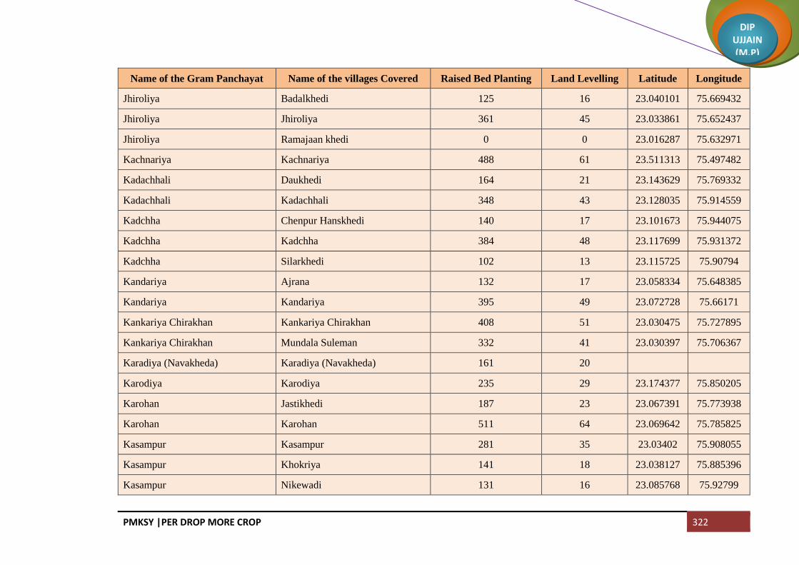
PMKSY |PER DROP MORE CROP 322
DIP UJJAIN (M.P)
Name of the Gram Panchayat Name of the villages Covered Raised Bed Planting Land Levelling Latitude Longitude
Jhiroliya Badalkhedi 125 16 23.040101 75.669432
Jhiroliya Jhiroliya 361 45 23.033861 75.652437
Jhiroliya Ramajaan khedi 0 0 23.016287 75.632971
Kachnariya Kachnariya 488 61 23.511313 75.497482
Kadachhali Daukhedi 164 21 23.143629 75.769332
Kadachhali Kadachhali 348 43 23.128035 75.914559
Kadchha Chenpur Hanskhedi 140 17 23.101673 75.944075
Kadchha Kadchha 384 48 23.117699 75.931372
Kadchha Silarkhedi 102 13 23.115725 75.90794
Kandariya Ajrana 132 17 23.058334 75.648385
Kandariya Kandariya 395 49 23.072728 75.66171
Kankariya Chirakhan Kankariya Chirakhan 408 51 23.030475 75.727895
Kankariya Chirakhan Mundala Suleman 332 41 23.030397 75.706367
Karadiya (Navakheda) Karadiya (Navakheda) 161 20
Karodiya Karodiya 235 29 23.174377 75.850205
Karohan Jastikhedi 187 23 23.067391 75.773938
Karohan Karohan 511 64 23.069642 75.785825
Kasampur Kasampur 281 35 23.03402 75.908055
Kasampur Khokriya 141 18 23.038127 75.885396
Kasampur Nikewadi 131 16 23.085768 75.92799

PMKSY |PER DROP MORE CROP 323
DIP UJJAIN (M.P)
Name of the Gram Panchayat Name of the villages Covered Raised Bed Planting Land Levelling Latitude Longitude
Khajuriya Kumawat Derkhedi 169 21 23.206884 75.948697
Khajuriya Kumawat Khajuriya Kumawat 195 24 23.220452 75.950155
Khajuriya Kumawat Molakhedi 157 20 23.191161 75.949635
Khajuriya Rehwari Kalyanpura 192 24 23.185912 75.408323
Khajuriya Rehwari Khajuriya Rehwari 450 56 23.08047 75.872279
Khemasa Khemasa 528 66 23.094803 75.650248
Khemasa Sabalpur (Buchakhedi) 118 15 23.110255 75.658383
Lekoda Lekoda 1269 159 23.054782 75.719051
Limba piplya Limba piplya 781 98 23.057845 75.753665
Mangrola Mangrola 550 69 23.161268 75.730989
Mangrola Ratnakhedi 250 31 23.145202 75.722764
Manpura Jawasiyakumar 326 41 23.147213 75.862538
Manpura Manpura 138 17 23.139776 75.850286
Matanakala Matanakala 450 56 23.065122 75.85549
Munjakhedi Munjakhedi 375 47 23.076876 75.962587
Nahariya Nahariya 210 26 23.241509 75.846614
Nahariya Sahabkhedi 184 23 23.236663 75.825739
Nalwa Amirpur (Fazalpura) 134 17 23.179078 75.647298
Nalwa Kharet 248 31 23.17024 75.651722
Nalwa Nalwa 525 66 23.152881 75.649263

PMKSY |PER DROP MORE CROP 324
DIP UJJAIN (M.P)
Name of the Gram Panchayat Name of the villages Covered Raised Bed Planting Land Levelling Latitude Longitude
Narwar Narwar 1649 206 23.085768 75.92799
Nayakhedi Nayakhedi 135 17 23.085768 75.92799
Nayakhedi Silodamori 286 36 23.050017 75.821488
Nilkanth Nilkanth 223 28 23.085768 75.92799
Ninora Kithodarav 238 30 23.075522 75.850507
Ninora Ninora 279 35 23.092335 75.816367
Nogawa Nogawa 632 79 23.119631 75.949234
Palkhanda Palkhanda 647 81 23.420482 76.187483
Panthpiplai Panthpiplai 452 56 23.045073 75.826102
Pawasa Pandyakhedi 74 9
Pawasa Pawasa 76 10 23.217547 75.873359
Pingaleshwar Pingaleshwar 303 38 23.217547 75.873359
Piplaya Ragho Chhayan 128 16 23.620848 75.250267
Piplaya Ragho Piplaya Ragho 247 31 23.105604 75.797163
Piploda Dwarkadhish Madopur 112 14
Piploda Dwarkadhish Piploda Dwarkadhish 943 118 23.069693 75.97836
Ramvaasa Matana Khurd 267 33 23.127071 75.870194
Ramvaasa Ramvaasa 260 33 23.067886 75.833603
Semaliya nasar Bhawri 128 16 23.061693 75.891362
Semaliya nasar Semaliya nasar 367 46 23.079332 75.89059

PMKSY |PER DROP MORE CROP 325
DIP UJJAIN (M.P)
Name of the Gram Panchayat Name of the villages Covered Raised Bed Planting Land Levelling Latitude Longitude
Sikandari Gothada 124 16 23.524804 75.196497
Sikandari Jivankhedi 102 13 23.149371 75.781075
Surjanwasa Kesuni 406 51 23.16368 75.893651
Surjanwasa Surjanwasa 269 34 23.170898 75.873254
Tajpur Tajpur 742 93 23.225194 75.903446
Talod Talod 1154 144 23.098446 75.685135
Tankriya Panth Tankriya Panth 394 49 23.079168 75.698522
Takvasa Takvasa 431 54 23.055185 75.630637
Umariya Khalsa Eravaas 315 39 23.079923 75.639849
Umariya Khalsa Umariya Khalsa 254 32 23.071009 75.675624
Umriya Jagir Jambura 446 56 23.247653 75.884873
Umriya Jagir Umriya Jagir 356 45 23.266013 75.91979
Undasa Hakkanipura 118 15 23.217821 75.809098
Undasa Undasa 672 84 23.225535 75.832796
NP Ujjain 752 94
Total 43741 5468

PMKSY |PER DROP MORE CROP 326
DIP UJJAIN (M.P)
Block Ghattiya
Name of the Gram
Panchayat
Name of the villages
Covered Raised Bed Planting Land Levelling Latitude Longitude
Amarpura Amarpura 344 43 23.389004 75.96647
Amarpura Dolatpur 213 27 23.392759 75.9441
Amarpura Sulya 203 25 23.377107 75.982725
Ambodiya Ambodiya 343 43 23.208909 75.652503
Badodiya Kazi Badodiya Kazi 510 64 23.227571 75.697064
Badodiya Kazi Nayi Khedi 215 27 23.206184 75.687523
Banda Bamori 331 41 23.317546 75.916728
Banda Banda 305 38 23.324324 75.897331
Bandka Bandka 304 38 23.304715 75.810418
Baskhedi Baskhedi 377 47 23.322156 75.675756
Bhilkheda Bhilkheda 305 38 23.357588 75.752211
Bhilkheda Borkhedi 174 22 23.676639 75.676481
Bhilkheda Kishanpura 238 30 23.351993 75.73822
Bhilkheda Sutarkheda Nayakheda 201 25
Bhutiya Awaliya 355 44 23.31195 75.883769
Bhutiya Bhutiya 286 36 23.322275 75.873212
Bichhdod Istmurar Bhimpura 92 11 23.367874 75.990353

PMKSY |PER DROP MORE CROP 327
DIP UJJAIN (M.P)
Name of the Gram
Panchayat
Name of the villages
Covered Raised Bed Planting Land Levelling Latitude Longitude
Bichhdod Istmurar Bichhdod Istmurar 414 52 23.376018 75.94737
Bichhdod Istmurar Kumardi 108 14 23.355012 75.977224
Bichhdod Khalsa Bichhdod Khalsa 655 82 23.365933 75.959558
Bihariya Bihariya 271 34 23.320626 75.727971
Bihariya Motipura 148 18 23.333262 75.739303
Bihariya Pached 246 31 23.330876 75.711155
Biramkhedi Biramkhedi 312 39 23.447654 75.907988
Biramkhedi Koyalkhedi 382 48 23.438544 75.933357
Borkheda Bhalla Ahirkheda 228 28 23.336386 75.606242
Borkheda Bhalla Borkheda Bhalla 345 43 23.329687 75.660919
Borkheda Bhalla Pipalyatah 151 19 23.323146 75.629162
Chakrawda Chakrawda 580 72 23.251636 75.708157
Chhitardevi Chhitardevi 349 44 23.353422 75.639034
Chhitardevi Ilahipur 181 23 23.279863 75.73395
Dhablagori Dabri 606 76 23.363363 75.879714
Dhablagori Dhablagori 312 39 23.345712 75.871045
Dhanda Bhalla Dhanda Bhalla 517 65 23.36658 75.659461
Dhanda Bhalla Salakhedi 191 24 23.373309 75.670027
Dhannakhedi Dhannakhedi 331 41 23.36408 75.819669

PMKSY |PER DROP MORE CROP 328
DIP UJJAIN (M.P)
Name of the Gram
Panchayat
Name of the villages
Covered Raised Bed Planting Land Levelling Latitude Longitude
Dhuletiya Dhuletiya 526 66 23.320384 75.696018
Dhuletiya Harigad Derikheda 252 32 23.279863 75.73395
Dhulmahu Dhabladhuta 279 35 23.28721 75.680308
Dhulmahu Dhulmahu 316 40 23.270623 75.66994
Ghattiya Ghattiya 824 103 23.378556 75.863501
Gonsa Gonsa 439 55 23.211851 75.751142
Goylabuzurg Goylabuzurg 494 62 23.277333 75.698439
Gudha Gudha 384 48 23.305607 75.630333
Gunaya Gunaya 268 33 23.279863 75.73395
Gunaya Nanakhedi 261 33 23.274265 75.743563
Guradiya Gurjar Guradiya Gurjar 765 96 23.279863 75.73395
Jaithal Jaithal 511 64 23.282483 75.821162
Jalwa Jalwa 877 110 23.393307 75.887039
Jayrampura Bormundala 214 27 23.276001 75.811669
Jayrampura Devikaradiya 76 10 23.285935 75.805232
Jayrampura Jayrampura 174 22 23.297918 75.798623
Jhirniya Jhirniya 231 29 23.250059 75.68361
Jhirniya khedla 160 20 23.265593 75.682151
Jhitarkhedi Jhitarkhedi 429 54 23.380066 75.924018

PMKSY |PER DROP MORE CROP 329
DIP UJJAIN (M.P)
Name of the Gram
Panchayat
Name of the villages
Covered Raised Bed Planting Land Levelling Latitude Longitude
Kadwali Kadwali 179 22 23.302071 75.844441
Kadwali Piplayi 125 16 23.300652 75.827103
Kadwali Piplya Munjapta 188 24
Kagdi Karadiya Kagdi Karadiya 202 25 23.284438 75.774934
Kagdi Karadiya Nipaniya Sunar 204 26 23.290902 75.785062
Kalesar Chosala 250 31 23.338274 75.913381
Kalesar Kalesar 252 31 23.341505 75.891322
Kaliyadeh Kaliyadeh 340 42 23.251334 75.791132
Kaluheda Barothi Kheda 93 12 23.360188 75.717964
Kaluheda Kaluheda 534 67 23.348526 75.716333
Kalukhedi Kalukhedi 332 42 23.397949 75.906336
Kalukhedi Ralayti 414 52 23.411654 75.892689
Kamed Kamed 233 29 23.227607 75.792035
Khalana Khalana 344 43 23.273102 75.715675
Kheda Chitawalya Kheda Chitawalya 306 38
Khjuriya Sadar Bisakhedi 170 21 23.31602 75.931627
Khjuriya Sadar Khjuriya Sadar 303 38 23.311133 75.941326
Kithoda Jagir Gunai Jagir 172 22 23.297685 75.734353
Kithoda Jagir Kesarpur 147 18 23.295057 75.768435

PMKSY |PER DROP MORE CROP 330
DIP UJJAIN (M.P)
Name of the Gram
Panchayat
Name of the villages
Covered Raised Bed Planting Land Levelling Latitude Longitude
Kithoda Jagir Kithoda Jagir 184 23 23.287895 75.75031
Lasudiya Bazar Jhokra 150 19 23.308798 75.663847
Lasudiya Bazar Khoyriya 143 18 23.301454 75.646606
Lasudiya Bazar Lasudiya Bazar 246 31 23.313445 75.646855
Malikhedi Malikhedi 421 53 23.359599 75.524449
Meen Meen 431 54 23.364999 75.768501
Meen Silari 185 23 23.373666 75.749747
Nagpura Ajnoti 141 18 23.227628 75.671247
Nagpura Mahukhedi 240 30 23.22348 75.680348
Nagpura Nagpura 253 32 23.241305 75.672023
Nazarpur Nazarpur 1181 148 23.342253 75.843616
Nipaniya Goyal Ishakpur 128 16 23.325211 75.838745
Nipaniya Goyal Lakhaheda 370 46 23.323398 75.814541
Nipaniya Goyal Nipaniya Goyal 379 47 23.313309 75.839861
Panbihar Panbihar 1586 198 23.315633 75.765647
Pipalyahama Pipalyahama 544 68 23.353723 75.672849
Ralayta bhoja Barkhedi 76 10 23.265199 75.772187
Ralayta bhoja Ralayta bhoja 312 39 23.268274 75.755193
Ralayta Haiwat Ralayta Haiwat 440 55 23.425235 75.90836

PMKSY |PER DROP MORE CROP 331
DIP UJJAIN (M.P)
Name of the Gram
Panchayat
Name of the villages
Covered Raised Bed Planting Land Levelling Latitude Longitude
Ramgadh Ramgadh 294 37 23.252425 75.746266
Ramgadh Sulyakhedi 98 12 23.256762 75.777938
Ratdiya Ratdiya 299 37 23.196648 75.711866
Rudaheda Barkhedi Jagir 116 15 23.285449 75.929294
Rudaheda Rudaheda 637 80 23.294042 75.917535
Runji Gadroli 218 27 23.347889 75.959644
Runji Kherkhedi 104 13 23.356557 75.939903
Runji Runji 389 49 23.350883 75.930719
Ruyi Ruyi 489 61 23.289782 75.654881
Ruyi Semalyabibi 200 25 23.304342 75.677043
Salamata Bhesakhedi 332 42 23.410474 75.947871
Salamata Salamata 165 21 23.423784 75.929418
Sarola Sarola 425 53 23.239277 75.664519
Sarola Singawada 241 30 23.231863 75.645465
Shankarpur Ranaheda 356 44 23.343883 75.791681
Shankarpur Shankarpur 374 47 23.326387 75.789949
Siloda Rawal Badbayi 186 23 23.19100 75.64761
Siloda Rawal Elas Khedi 219 27 23.1925 75.663318
Siloda Rawal Siloda Rawal 379 47 23.188556 75.681256

PMKSY |PER DROP MORE CROP 332
DIP UJJAIN (M.P)
Name of the Gram
Panchayat
Name of the villages
Covered Raised Bed Planting Land Levelling Latitude Longitude
Sipawara Naveli 321 40 23.300316 75.693392
Sipawara Sipawara 400 50 23.301986 75.715382
Sodhang JogiKhedi 130 16 23.21934 75.75398
Sodhang Sodhang 334 42 23.240408 75.731464
Surasa Badarkha Babaji 160 20 23.257934 75.809188
Surasa Surasa 197 25 23.235099 75.81036
Tulaheda Tulaheda 573 72 23.34285 75.812333
Tumdawada Paroliya Jhali 208 26 23.271687 75.640143
Tumdawada Tumdawada 435 54 23.254891 75.64598
Ujjainiya Ujjainiya 992 124 23.290141 75.869458
Untesara Padmakhedi 121 15 23.273137 75.79362
Untesara Samarkhedi 88 11 23.271402 75.778513
Untesara Untesara 181 23 23.264604 75.801581
Vinayga Ajampura 437 55 23.229878 75.719236
Vinayga Vinayga 161 20 23.204005 75.726274
Total 41059 5132

PMKSY |PER DROP MORE CROP 333
DIP UJJAIN (M.P)
Block Tarana
Name of the Gram
Panchayat
Name of the villages
Covered Raised Bed Planting Land Levelling Latitude Longitude
Aser Aser 405 51 23.178132 76.082943
Aser Sarola 384 48 23.191264 76.066809
Badodiya (Makdon) Badodiya (Makdon) 160 20 23.54145 75.977693
Badodiya (Makdon) Bhundkhedi 234 29 23.556399 75.987478
Badodiya (Makdon) Umariya 133 17 23.537279 75.990053
Baghera Baghera 464 58 23.271717 76.088244
Bagoda Bagoda 479 60 23.299494 76.102318
Bagoda Hajikhedi 130 16 23.288689 76.0951
Bagwada Bagwada 142 18 23.550721 76.142173
Bagwada Bukhari 165 21 23.545685 76.167493
Bagwada Harukhedi 58 7 23.539342 76.163679
Bagwada Manasa 59 7 23.561972 76.154275
Bagwada Ratnakhedi 82 10 23.145202 75.722764
Banjari Banjari 225 28 23.338801 76.200469
Banjari Patiyalkhedi 77 10 23.351882 76.21712
Barandwa Barandwa 663 83 23.282755 76.171975
Barkheda Tarana Barkheda Tarana 521 65 23.394884 76.126346
Barkheda Tarana Khodrinipaniya 349 44 23.368983 76.103465

PMKSY |PER DROP MORE CROP 334
DIP UJJAIN (M.P)
Name of the Gram
Panchayat
Name of the villages
Covered Raised Bed Planting Land Levelling Latitude Longitude
Beejpadi Beejpadi 156 19 23.271021 76.076183
Beejpadi Halukhedi 193 24 23.275496 76.065148
Beejpadi Natakhedi 400 50 23.293595 76.071066
Belari Belari 335 42 23.138863 76.134784
Belari Bordadhakad 210 26 23.198803 76.123026
Berchhi Berchhi 283 35 23.387976 76.185108
Berchhi Suagaon 164 21 23.386479 76.209484
Bhadsimba Bhadsimba 497 62 23.321517 75.988913
Bhatuni Bhatuni 504 63 23.084023 76.07217
Bhondiya Bhondiya 395 49 23.507445 76.053943
Bhondiya Sumrakhedi 174 22 23.518749 76.046535
Bisankheda Bisankheda 243 30 23.386382 76.016508
Bisankheda Bisankhedi 189 24 23.381746 76.007707
Bisankheda Khakri Sultan 124 16 23.399584 76.018814
Borda Gurjar Borda Gurjar 193 24 23.358346 76.208619
Borda Gurjar Murdawan 194 24 23.375443 76.211451
Bordamada Bordamada 315 39 23.192132 76.047926
Bordamada Limboda Kaytha 113 14 23.193473 76.038227
Chandnyakhedi Chandnyakhedi 126 16 23.525296 75.944782
Chandnyakhedi Mayakhedi 149 19 23.509894 75.936985

PMKSY |PER DROP MORE CROP 335
DIP UJJAIN (M.P)
Name of the Gram
Panchayat
Name of the villages
Covered Raised Bed Planting Land Levelling Latitude Longitude
Chandnyakhedi Samtyakhedi 116 15 23.527578 75.935427
Chhadawad Chhadawad 735 92 23.364177 76.644313
Chhapri Chhapri 331 41 23.309381 76.117573
Chhapri Jhirnyabuzurg 146 18 23.333837 76.128472
Chikli Chikli 506 63 23.494627 76.034799
Chirdi Chirdi 458 57 23.485652 75.975107
Chitawalyakheda Chitawalyakheda 531 66 23.513537 76.019264
Dabdarajput Dabdarajput 292 36 23.453028 75.975238
Devikheda Devikheda 168 21 23.397902 76.160646
Devikheda Guthlayi 94 12 23.398926 76.140562
Devikheda Junapani 273 34 23.379997 76.144567
Devikheda Krishna Nagar 134 17 23.388527 76.140133
Devli Devli 472 59 23.411893 76.056007
Dhablahardu Dhablahardu 671 84 23.499887 75.896068
Dilodri Dilodri 689 86 23.315301 76.149137
Dilodri Yashwantgarh 238 30 23.341388 76.144502
Dobda Gurjar Dobda Gurjar 418 52 23.41477 76.09419
Dobda Gurjar Kesharpur Nipaniya 281 35 23.410674 76.075393
Dubli Dubli 473 59 23.285806 76.047097
Dudhli Dudhli 330 41 23.250878 76.111454

PMKSY |PER DROP MORE CROP 336
DIP UJJAIN (M.P)
Name of the Gram
Panchayat
Name of the villages
Covered Raised Bed Planting Land Levelling Latitude Longitude
Gawdi Abadkhedi 232 29 23.347564 76.022298
Gawdi Gawdi 266 33 23.334877 76.013544
Gawdi Kakariyachand 147 18 23.344885 75.989769
Godadi Dhanyakhedi 164 21 23.550252 76.076632
Godadi Godadi 226 28 23.533088 76.076778
Godadi Khokariya 259 32 23.551353 76.056976
Golwa Fanya 178 22 23.308482 76.170133
Golwa Golwa 367 46 23.303752 76.180775
Gundaldiya Gundaldiya 190 24 23.501035 76.233707
Gundaldiya Khutpala 132 16 23.434699 76.197689
Guradiya Gurjar Guradiya Gurjar 305 38 23.291475 75.997045
Hasalpur Jhiranya Chakiya 232 29 23.460115 76.106129
Hasalpur Jhiranya Hasalpur Jhiranya 233 29 23.447753 76.097117
Hasalpur Jhiranya Kankariya Mirpur 236 29
Ilamkhedi Bhariyakhedi 58 7 23.536256 75.934692
Ilamkhedi Bhatkhedi 126 16 23.518001 75.931148
Ilamkhedi Ilamkhedi 123 15 23.524846 75.925079
Itawa Gangalyakhedi 129 16 23.383343 76.031671
Itawa Itawa 538 67 23.395932 76.041928
Jawasiyakumar Jawasiyakumar 550 69 23.182551 76.101997

PMKSY |PER DROP MORE CROP 337
DIP UJJAIN (M.P)
Name of the Gram
Panchayat
Name of the villages
Covered Raised Bed Planting Land Levelling Latitude Longitude
Jhalara Jhalara 446 56 23.517819 75.908734
Jhalara Jhalari 102 13 23.506014 75.92384
Jharnawada Jharnawada 473 59 23.355428 76.081145
Jharnawada Surajpura 146 18 23.373787 76.078399
Jhumki Jhumki 554 69 23.54752 76.008926
Kachnariya Kachnariya 511 64 23.414212 75.962161
Kadhai Kadhai 561 70 23.489001 76.009962
Kadhai Khakri Brahamman 92 11 23.49215 75.995156
Kadodiya Kadodiya 1402 175 23.522931 76.142722
Kanardi Kanardi 439 55 23.352751 76.146881
Kanasiya Kanasiya 915 114 23.300986 76.145271
Kanthadi Kanthadi 306 38 23.528177 76.086733
Kapeli Kapeli 975 122 23.429777 76.126268
Karanj Karanj 852 106 23.322548 76.102459
Karedi Karedi 614 77 23.415945 76.198509
Kathbadoda Bhalkheda 23.124072 76.064214
Kathbadoda Kathbadoda 643 80 23.124072 76.064214
Katwariya Aurangpur 272 34 23.496706 76.211048
Katwariya Katwariya 396 49 23.523781 76.227613
Kawlikheda Bhuki Itwarpur 125 16 23.305079 75.995481
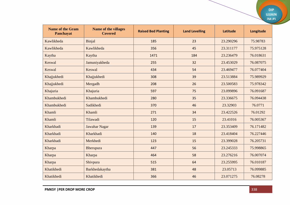
PMKSY |PER DROP MORE CROP 338
DIP UJJAIN (M.P)
Name of the Gram
Panchayat
Name of the villages
Covered Raised Bed Planting Land Levelling Latitude Longitude
Kawlikheda Binjal 185 23 23.290296 75.98783
Kawlikheda Kawlikheda 356 45 23.311177 75.975128
Kaytha Kaytha 1471 184 23.236479 76.018631
Keswal Jamuniyakheda 255 32 23.453029 76.087075
Keswal Keswal 434 54 23.469477 76.077404
Khajjukhedi Khajjukhedi 308 39 23.513884 75.989929
Khajjukhedi Mergadh 208 26 23.500583 75.978342
Khajuria Khajuria 597 75 23.099896 76.091687
Khambukhedi Khambukhedi 280 35 23.336675 76.094438
Khambukhedi Sadikhedi 370 46 23.32903 76.0771
Khamli Khamli 271 34 23.422526 76.01292
Khamli Tilawadi 120 15 23.41016 76.005367
Kharkhadi Jawahar Nagar 139 17 23.353409 76.171482
Kharkhadi Kharkhadi 140 18 23.418404 76.227446
Kharkhadi Merkhedi 123 15 23.399028 76.205731
Kharpa Bherupura 447 56 23.245333 75.998865
Kharpa Kharpa 464 58 23.276216 76.007074
Kharpa Shivpura 515 64 23.255995 76.010187
Khatikhedi Barkhedakaytha 381 48 23.05713 76.099885
Khatikhedi Khatikhedi 366 46 23.071275 76.08278

PMKSY |PER DROP MORE CROP 339
DIP UJJAIN (M.P)
Name of the Gram
Panchayat
Name of the villages
Covered Raised Bed Planting Land Levelling Latitude Longitude
Lalakheda Lalakheda 124 15 23.433744 76.136464
Lalakheda Palkhanda 90 11 23.420434 76.187609
Lalakheda Shankarpura 82 10 23.409722 76.179111
Lasudiya Amra Kothdi 334 42 23.51474 76.001464
Lasudiya Amra Lasudiya Amra 305 38 23.503406 76.007644
Lasudiya Hamir Chuna khedi 220 27 23.436571 75.974895
Lasudiya Hamir Lasudiya Hamir 267 33 23.427278 75.994121
Lasudiya Hamir Shekhpur 87 11 23.421381 75.986035
Lasurdiyabechar Guradiyadongar 103 13 23.291303 75.999905
Lasurdiyabechar Lasurdiyabechar 417 52 23.293928 76.006932
Limbadit Limbadit 475 59 23.433934 76.074515
Limboda Tarana Limboda Tarana 333 42 23.347889 76.234195
Limboda Tarana Yeshwantnagar 358 45
Lodh Lodh 542 68 23.421344 76.033949
Mallupura Mallupura 248 31 23.21322 76.019354
Mallupura Molga 268 34 23.202788 76.029552
Mundli Mundli 507 63 23.303771 76.053809
Mundli Sadba 184 23 23.268435 76.047458
Naharkhedi Barnawad 420 52 23.391556 76.091417
Naharkhedi Naharkhedi 451 56 23.38955 76.067869

PMKSY |PER DROP MORE CROP 340
DIP UJJAIN (M.P)
Name of the Gram
Panchayat
Name of the villages
Covered Raised Bed Planting Land Levelling Latitude Longitude
Naleshree Bhojukhedi 74 9 23.147233 76.049643
Naleshree Naleshree 391 49 23.169014 76.047497
Nanded Nanded 1362 170 23.457797 76.043489
Nanukheda Malhargarh 79 10 23.252327 76.050051
Nanukheda Nanukheda 272 34 23.239993 76.060227
Nenawad Nenawad 378 47 23.372771 76.221672
Nenawad Sabkota 80 10 23.379138 76.244455
Noganwa Noganwa 478 60 23.361025 76.009809
Pachola Pachola 568 71 23.466773 76.022889
Palduna Gujarkheda 92 12 23.278885 76.120826
Palduna Lunyakhedi 227 28 23.264914 76.124414
Palduna Palduna 415 52 23.267576 76.106132
Pankhedi Dhuwakhedi 186 23 23.440928 76.026568
Pankhedi Pankhedi 365 46 23.450604 75.990262
Pari Ankhali 65 8 23.461235 76.202531
Pari Moyaganv 61 8 23.445243 76.203767
Pari Pari 44 6
Pari Tumni 154 19 23.489008 76.204797
Parsi Gunakhedi 121 15 23.54562 75.939927
Parsi Jafarpurnera 61 8 23.543495 75.951343

PMKSY |PER DROP MORE CROP 341
DIP UJJAIN (M.P)
Name of the Gram
Panchayat
Name of the villages
Covered Raised Bed Planting Land Levelling Latitude Longitude
Parsi Parsi 304 38 23.558681 75.907827
Parsoli Parsoli 795 99 23.509975 75.943092
Parsoli Pipalyabazar 259 32 23.439195 75.949787
Pat Pat 563 70 23.538774 75.91744
Pipalyakaytha Gopali 144 18 23.229197 76.07113
Pipalyakaytha Khandakhedi 148 18 23.246042 76.076688
Pipalyakaytha Laxmipura 360 45 23.227406 76.048539
Pipalyakaytha Pipalyakaytha 238 30 23.219911 76.077698
Raipura Birgod 250 31 23.300763 76.023508
Raipura Raipura 221 28 23.278149 76.029307
Ramdi Amritnagar 23.434699 76.197689
Ramdi Borkhedi 149 19 23.473591 76.157034
Ramdi Gandhinagar 200 25 23.461702 76.187161
Ramdi Pipliya Ramdi 181 23 23.446348 76.183212
Ramdi Ramdi 94 12 23.477859 76.175237
Rupakhedi Lalakhedi 213 27 23.465592 75.972163
Rupakhedi Rupakhedi 339 42 23.472835 75.990188
Sakari Anantkhedi 195 24 23.248555 76.088192
Sakari Sakari 267 33 23.248476 76.099179
Salakhedi Malikhedi 250 31 23.330852 76.031405
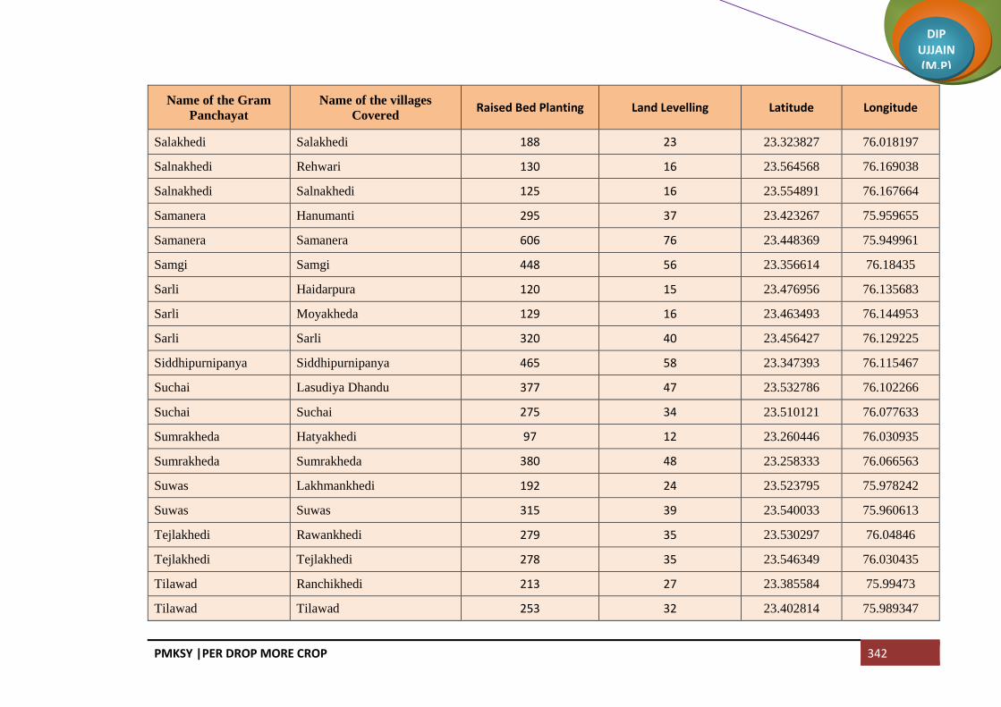
PMKSY |PER DROP MORE CROP 342
DIP UJJAIN (M.P)
Name of the Gram
Panchayat
Name of the villages
Covered Raised Bed Planting Land Levelling Latitude Longitude
Salakhedi Salakhedi 188 23 23.323827 76.018197
Salnakhedi Rehwari 130 16 23.564568 76.169038
Salnakhedi Salnakhedi 125 16 23.554891 76.167664
Samanera Hanumanti 295 37 23.423267 75.959655
Samanera Samanera 606 76 23.448369 75.949961
Samgi Samgi 448 56 23.356614 76.18435
Sarli Haidarpura 120 15 23.476956 76.135683
Sarli Moyakheda 129 16 23.463493 76.144953
Sarli Sarli 320 40 23.456427 76.129225
Siddhipurnipanya Siddhipurnipanya 465 58 23.347393 76.115467
Suchai Lasudiya Dhandu 377 47 23.532786 76.102266
Suchai Suchai 275 34 23.510121 76.077633
Sumrakheda Hatyakhedi 97 12 23.260446 76.030935
Sumrakheda Sumrakheda 380 48 23.258333 76.066563
Suwas Lakhmankhedi 192 24 23.523795 75.978242
Suwas Suwas 315 39 23.540033 75.960613
Tejlakhedi Rawankhedi 279 35 23.530297 76.04846
Tejlakhedi Tejlakhedi 278 35 23.546349 76.030435
Tilawad Ranchikhedi 213 27 23.385584 75.99473
Tilawad Tilawad 253 32 23.402814 75.989347

PMKSY |PER DROP MORE CROP 343
DIP UJJAIN (M.P)
Name of the Gram
Panchayat
Name of the villages
Covered Raised Bed Planting Land Levelling Latitude Longitude
Titodi Rojwas 201 25 23.315544 76.186603
Titodi Titodi 127 16 23.326112 76.191285
Tobrikheda Tobrikheda 258 32 23.368522 76.060192
Tukral Tukral 952 119 23.470615 75.928025
Umarajhar Manpura 130 16 23.445931 76.146052
Umarajhar Tanda 155 19 23.424136 76.163462
Umarajhar Umarajhar 289 36 23.457097 76.143434
Upadi Upadi 396 49 23.086081 76.099524
NP Makdon 585 73
NP Tarana 711 89
Total 64736 8092
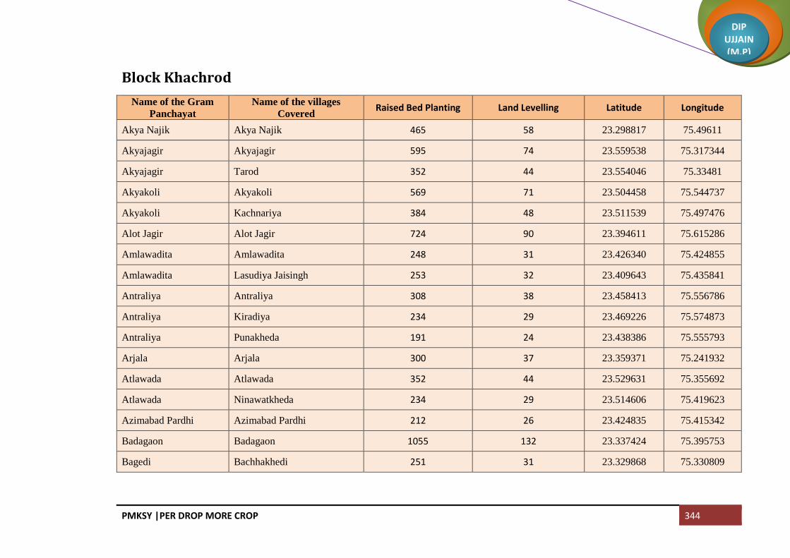
PMKSY |PER DROP MORE CROP 344
DIP UJJAIN (M.P)
Block Khachrod
Name of the Gram
Panchayat
Name of the villages
Covered Raised Bed Planting Land Levelling Latitude Longitude
Akya Najik Akya Najik 465 58 23.298817 75.49611
Akyajagir Akyajagir 595 74 23.559538 75.317344
Akyajagir Tarod 352 44 23.554046 75.33481
Akyakoli Akyakoli 569 71 23.504458 75.544737
Akyakoli Kachnariya 384 48 23.511539 75.497476
Alot Jagir Alot Jagir 724 90 23.394611 75.615286
Amlawadita Amlawadita 248 31 23.426340 75.424855
Amlawadita Lasudiya Jaisingh 253 32 23.409643 75.435841
Antraliya Antraliya 308 38 23.458413 75.556786
Antraliya Kiradiya 234 29 23.469226 75.574873
Antraliya Punakheda 191 24 23.438386 75.555793
Arjala Arjala 300 37 23.359371 75.241932
Atlawada Atlawada 352 44 23.529631 75.355692
Atlawada Ninawatkheda 234 29 23.514606 75.419623
Azimabad Pardhi Azimabad Pardhi 212 26 23.424835 75.415342
Badagaon Badagaon 1055 132 23.337424 75.395753
Bagedi Bachhakhedi 251 31 23.329868 75.330809

PMKSY |PER DROP MORE CROP 345
DIP UJJAIN (M.P)
Name of the Gram
Panchayat
Name of the villages
Covered Raised Bed Planting Land Levelling Latitude Longitude
Bagedi Bagedi 412 52 23.348967 75.349172
Banbana Banbana 673 84 23.450138 75.464004
Banjari Banjari 546 68 23.497691 75.229848
Banjari Lasudiya Daiyar 57 7 23.484398 75.230873
Banwada Banwada 514 64 23.556327 75.359290
Banwada Rajgarh 411 51 23.578984 75.359032
Barkheda Jaora Barkheda Jaora 365 46 23.518468 75.292150
Barkheda Madan Barkheda Madan 315 39 23.425542 75.568545
Barkheda Madan Matra 135 17 23.35978 75.524987
Barkheda Najeek Barkheda Najeek 269 34 23.327745 75.489501
Barlai Barlai 362 45 23.379777 75.28416
Barlai Palna 306 38 23.396858 75.244431
Barthun Barthun 380 47 23.333471 75.244963
Barthun Rajpur Rayti 335 42 23.320788 75.23947
Batlawadi Batlawadi 576 72 23.471643 75.180900
Bedavanya Bedavanya 665 83 23.483228 75.324269
Bedawan Bedawan 534 67 23.460531 75.605782
Behlola Behlola 387 48 23.437715 75.245422
Berchha Berchha 670 84 23.547104 75.382314

PMKSY |PER DROP MORE CROP 346
DIP UJJAIN (M.P)
Name of the Gram
Panchayat
Name of the villages
Covered Raised Bed Planting Land Levelling Latitude Longitude
Beriyakhedi Beriyakhedi 284 36 23.465042 75.349589
Bhanwasa Bhanwasa 591 74 23.406000 75.215781
Bhanwasa Naredibera 343 43
Bhat Khedi Bhat Khedi 344 43 23.527176 75.883904
Bhat Khedi Ghudawan 403 50 23.446912 75.279387
Bhatisuda Bhatisuda 579 72 23.399107 75.418234
Bhensola Farnakhedi 369 46 23.511889 75.261288
Bhikampur Bhikampur 640 80 23.474320 75.236622
Bhilsuda Bhilsuda 833 104 23.393516 75.35772
Bilwaniya Bilwaniya 128 16 23.488572 75.401554
Bordiya Bordiya 369 46 23.345857 75.314645
Borkheda Pitramal Borkheda Pitramal 387 48 23.436597 75.174641
Buranabad Buranabad 106 13 23.494274 75.177681
Buranabad Chowki Junnardar 600 75 23.274578 75.409551
Chambal Padlaya Chambal Padlaya 250 31 23.32045 75.300958
Chandodiya Chandodiya 463 58 23.3294 75.446499
Chandwasla Chandwasla 326 41 23.538365 75.326005
Chanpa Kheda Chanpa Kheda 431 54 23.323586 75.356495
Chanpaner Chanpaner 507 63 23.584304 75.288724
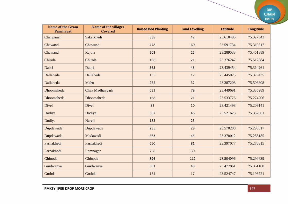
PMKSY |PER DROP MORE CROP 347
DIP UJJAIN (M.P)
Name of the Gram
Panchayat
Name of the villages
Covered Raised Bed Planting Land Levelling Latitude Longitude
Chanpaner Sakatkhedi 338 42 23.610495 75.327843
Chawand Chawand 478 60 23.591734 75.319817
Chawand Rajota 203 25 23.289533 75.461389
Chirola Chirola 166 21 23.376247 75.512884
Dabri Dabri 363 45 23.439454 75.314261
Dallaheda Dallaheda 135 17 23.445025 75.379435
Dallaheda Mahu 255 32 23.387208 75.506808
Dhoomaheda Chak Madhavgarh 633 79 23.449691 75.335289
Dhoomaheda Dhoomaheda 168 21 23.533776 75.274206
Divel Divel 82 10 23.421498 75.209141
Dodiya Dodiya 367 46 23.521623 75.332861
Dodiya Nareli 185 23
Dupdawada Dupdawada 235 29 23.570200 75.290817
Dupdawada Madawadi 363 45 23.378012 75.286185
Farnakhedi Farnakhedi 650 81 23.397077 75.276315
Farnakhedi Ramnagar 238 30
Ghinoda Ghinoda 896 112 23.504096 75.299639
Gindwanya Gindwanya 381 48 23.477861 75.361100
Gothda Gothda 134 17 23.524747 75.196721
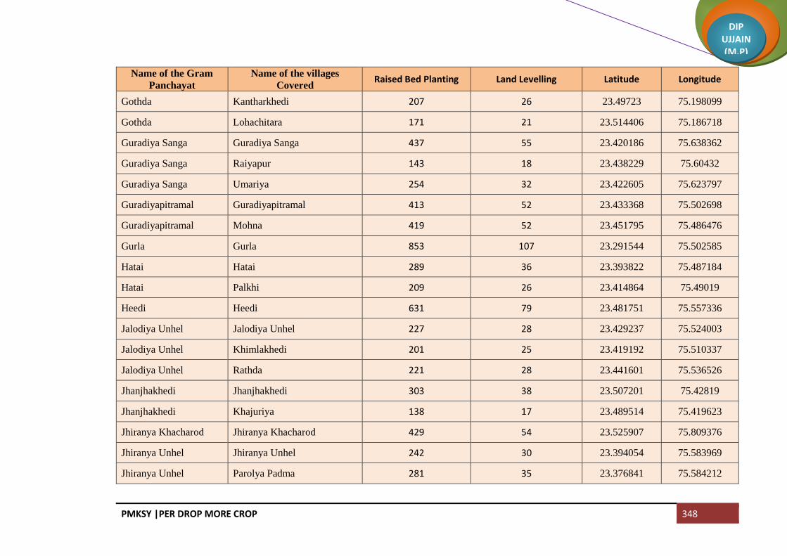
PMKSY |PER DROP MORE CROP 348
DIP UJJAIN (M.P)
Name of the Gram
Panchayat
Name of the villages
Covered Raised Bed Planting Land Levelling Latitude Longitude
Gothda Kantharkhedi 207 26 23.49723 75.198099
Gothda Lohachitara 171 21 23.514406 75.186718
Guradiya Sanga Guradiya Sanga 437 55 23.420186 75.638362
Guradiya Sanga Raiyapur 143 18 23.438229 75.60432
Guradiya Sanga Umariya 254 32 23.422605 75.623797
Guradiyapitramal Guradiyapitramal 413 52 23.433368 75.502698
Guradiyapitramal Mohna 419 52 23.451795 75.486476
Gurla Gurla 853 107 23.291544 75.502585
Hatai Hatai 289 36 23.393822 75.487184
Hatai Palkhi 209 26 23.414864 75.49019
Heedi Heedi 631 79 23.481751 75.557336
Jalodiya Unhel Jalodiya Unhel 227 28 23.429237 75.524003
Jalodiya Unhel Khimlakhedi 201 25 23.419192 75.510337
Jalodiya Unhel Rathda 221 28 23.441601 75.536526
Jhanjhakhedi Jhanjhakhedi 303 38 23.507201 75.42819
Jhanjhakhedi Khajuriya 138 17 23.489514 75.419623
Jhiranya Khacharod Jhiranya Khacharod 429 54 23.525907 75.809376
Jhiranya Unhel Jhiranya Unhel 242 30 23.394054 75.583969
Jhiranya Unhel Parolya Padma 281 35 23.376841 75.584212

PMKSY |PER DROP MORE CROP 349
DIP UJJAIN (M.P)
Name of the Gram
Panchayat
Name of the villages
Covered Raised Bed Planting Land Levelling Latitude Longitude
Jhirmira Jhirmira 342 43 23.507964 75.334665
Jhirmira Khurmundi 216 27 23.494632 75.345651
Kalsi Alsi 219 27 23.516326 75.396609
Kalsi Kalsi 336 42 23.531932 75.408733
Kamthana Kamthana 626 78 23.304218 75.27484
Kanchankhedi Kanchankhedi 352 44 23.46684 75.279031
Kanchankhedi Kutlana 287 36 23.467943 75.255685
Kanwas Kanwas 590 74 23.399644 75.188585
Karnawad Karnawad 617 77
Karondiya Karondiya 271 34 23.273113 75.530098
Karondiya Lasudiyachuwad 331 41 23.304792 75.558187
Kesariya Kesariya 367 46 23.531262 75.308850
Khamariya Khamariya 380 47 23.366393 75.349842
Khedawada Antalwasa 232 29 23.333635 75.218784
Khedawada Baramadkheda 263 33 23.334738 75.196125
Khedawada Khedawada 342 43 23.34782 75.214922
Khokri Arolyajassa 174 22 23.262141 75.619725
Khokri Khokri 378 47 23.267884 75.6000729
Kumharwadi Kumharwadi 446 56 23.400599 75.314711

PMKSY |PER DROP MORE CROP 350
DIP UJJAIN (M.P)
Name of the Gram
Panchayat
Name of the villages
Covered Raised Bed Planting Land Levelling Latitude Longitude
Kumharwadi Sarwanakhacharod 177 22 23.400205 75.338057
Kumharwadi Siparda 181 23 23.393194 75.326556
Kundla Bhakarda 239 30 23.365097 75.461005
Kundla Kundla 340 43 23.355878 75.484007
Lasudiya Khema Lasudiya Khema 426 53 23.357664 75.31395753
Lekodiya Anjana Lekodiya Anjana 647 81 23.300405 75.475335
Lekodiya Tank Lekodiya Tank 444 55 23.481877 75.301776
Lusdawan Chak Narayangarh 168 21 23.320450 75.300958
Lusdawan Kamthani 215 27 23.309494 75.295808
Lusdawan Lusdawan 522 65 23.332745 75.302589
Madawada Madawada 1248 156 23.357007 75.28416
Malakhedi Jalwal 249 31 23.370276 75.390507
Malakhedi Malakhedi 119 15 23.62951 75.766439
Malakhedi Tumni 173 22 23.403127 75.377118
Malikhedi Chinkuganj 309 39 23.388922 75.641001
Malikhedi Kankarda 292 36 23.378059 75.537604
Malikhedi Malikhedi 373 47 23.386741 75.377541
Meen Meen 422 53 23.42184 75.549577
Mokdi Mokdi 639 80 23.577201 75.335171

PMKSY |PER DROP MORE CROP 351
DIP UJJAIN (M.P)
Name of the Gram
Panchayat
Name of the villages
Covered Raised Bed Planting Land Levelling Latitude Longitude
Nagjhiri Bagla 102 13 23.347368 75.459889
Nagjhiri Nagjhiri 248 31 23.331134 75.471648
Nandiyasi Brahman Khedi Kalan 921 115 23.479272 75.502698
Nandiyasi Khatakhedi 168 21 23.304248 75.309337
Nandiyasi Nandiyasi 522 65 23.299361 75.347274
Nandwasla Nandwasla 280 35 23.379990 75.195311
Nandwasla Sanasala 246 31 23.387395 75.204109
Napakhedi Brahman Khedi Khurd 110 14 23.300701 75.309337
Napakhedi Napakhedi 179 22 23.485662 75.197636
Napakhedi Padalyakhurd 111 14 23.483883 75.180948
Naredipata Naredipata 596 75 23.437275 75.207106
Narsinghgarh Narsinghgarh 975 122 23.367913 75.219213
Nawada Nawada 457 57 23.32404 75.518426
Nawatiya Dadiya 221 28 23.429116 75.455169
Nawatiya Nawatiya 318 40 23.431087 75.355832
Nayan Nayan 337 42 23.422086 75.384047
Nimbodiya Khurd Nimbodiya Khurd 334 42 23.38014 75.42616
Nimbodiya Khurd Pipalyasees 354 44 23.393456 75.449255
Nimbodiyakalan Nimbodiyakalan 509 64 23.551272 75.427568

PMKSY |PER DROP MORE CROP 352
DIP UJJAIN (M.P)
Name of the Gram
Panchayat
Name of the villages
Covered Raised Bed Planting Land Levelling Latitude Longitude
Nipanya Bhimpura 347 43 23.488572 75.401554
Nipanya Geedgarh 158 20 23.492569 75.39099
Nipanya Nipanya 183 23 23.504984 75.401753
Pachlasi Pachlasi 809 101 23.41439 75.335404
Padalyakala Padalyakala 551 69
Padsulya Padsulya 285 36 23.420376 75.366303
Pagara Baijnathkhedi 127 16 23.343014 75.593916
Pagara Didiyakhedi 523 65 23.397424 75.521813
Pagara Pagara 248 31 23.32585 75.601061
Pagara Roopakhedi 218 27 23.315795 75.612329
Pankhedi Gurachha 301 38 23.411763 75.582569
Pankhedi Hapakheda 179 22 23.44024 75.577301
Pankhedi Mundla 274 34 23.425009 75.599603
Pankhedi Pankhedi 200 25 23.429181 75.582569
Panwasa Bhandla 241 30 23.460078 75.234093
Panwasa Panwasa 329 41 23.442125 75.226797
Parmarkhedi Bhagatpuri 80 10 23.474239 75.384875
Parmarkhedi Kilodiya 229 29 23.501004 75.361272
Parmarkhedi Parmarkhedi 336 42 23.485497 75.379382

PMKSY |PER DROP MORE CROP 353
DIP UJJAIN (M.P)
Name of the Gram
Panchayat
Name of the villages
Covered Raised Bed Planting Land Levelling Latitude Longitude
Paslod Kalalkhedi 225 28 23.33996 75.501335
Paslod Paslod 846 106 23.29165 75.510313
Pipalya Dabi Pipalya Dabi 699 87 23.309896 75.579995
Pipalya Molu Pipalya Molu 380 47 23.373794 75.489569
Pipalya Sarang Chidi Rawadiya 203 25 23.312734 75.454533
Pipalya Sarang Itawa 316 39 23.356198 75.612014
Pipalya Sarang Pipalya Sarang 217 27 23.370505 75.639341
Piploda Sagotimata Piploda Sagotimata 787 98 23.366285 75.426556
Piplodapanth Luhari 243 30 23.290388 75.407402
Piplodapanth Piplodapanth 335 42 23.297952 75.42624
Piplodapanth Sonchidi 171 21 23.31606 75.432144
Rajla Bachhoda 343 43 23.474183 75.230381
Rajla Rajla 481 60 23.486184 75.311105
Ramabaloda Ramabaloda 662 83 23.274518 75.581186
Rani Pipalya Bhatera 240 30 23.459511 75.538232
Rani Pipalya Rani Pipalya 536 67 23.455259 75.520894
Ratanyakhedi Banbani 218 27 23.457392 75.450385
Ratanyakhedi Ratanyakhedi 186 23 23.490293 75.432125
Rigania Jalod 206 26 23.472291 75.1809

PMKSY |PER DROP MORE CROP 354
DIP UJJAIN (M.P)
Name of the Gram
Panchayat
Name of the villages
Covered Raised Bed Planting Land Levelling Latitude Longitude
Rigania Rigania 306 38 23.460502 75.180603
Rohal Kalan Jalodiya Jagir 329 41 23.486571 75.44293
Rohal Kalan Rohal Kalan 429 54 23.516432 75.446604
Rohalkhurd Rohalkhurd 961 120 23.514671 75.468339
Runkheda Runkheda 510 64 23.403309 75.158496
Rupeta Rupeta 1170 146 23.485803 75.475162
Sandawda Gidawada 182 23 23.339553 75.418918
Sandawda Madgani 150 19 23.349427 75.408308
Sandawda Sandawda 439 55 23.325835 75.414587
Sandla Sandla 788 99 23.315233 75.393368
Sarwana Unhel Arolya Dewda 194 24 23.369884 75.572532
Sarwana Unhel Sarwana Unhel 510 64 23.400432 75.556486
Sekdi Sultanpur Kadiyali 154 19 23.31158 75.444391
Sekdi Sultanpur Sekdi Sultanpur 213 27 23.335639 75.432415
Sendri Dhaturiya 276 35 23.395874 75.536445
Sendri Sendri 311 39 23.540327 75.29286043
Shribachh Shribachh 404 50 23.510538 75.215053
Simrol Makla 291 36 23.418934 75.7536468
Simrol Simrol 291 36 23.525973 75.810387

PMKSY |PER DROP MORE CROP 355
DIP UJJAIN (M.P)
Name of the Gram
Panchayat
Name of the villages
Covered Raised Bed Planting Land Levelling Latitude Longitude
Surel Surel 607 76 23.290981 75.382226
Surjakhedi Jiyajigarh 145 18 23.270269 75.623367
Surjakhedi Surjakhedi 335 42 23.293142 75.618027
Takrawada Takrawada 138 17 23.417388 75.398097
Thadoda Dipakhedi 246 31 23.356134 75.580202
Thadoda Thadoda 242 30 23.415802 75.198531
Tootiyakhedi Tootiyakhedi 483 60 23.58293 75.392655
Umarna Umarna 318 40 23.443214 75.360896
Umarna Umarni 285 36 23.456443 75.379435
Unchaheda Unchaheda 262 33 23.402978 75.151639
NP Nagda 166 21
NP Unhel 1644 206
NP Kasba Khacharod 1302 163
Total 82860 10358

PMKSY |PER DROP MORE CROP 356
DIP UJJAIN (M.P)
Block Mahidpur
Name of the Gram
Panchayat
Name of the villages
Covered Raised Bed Planting Land Levelling Latitude Longitude
Ajamabad Ajamabad 336 42 23.523835 75.754762
Ajamabad Mundlibhoj 277 35 23.505272 75.774368
Akyajassa Akyajassa 231 29 23.465996 75.855348
Akyajassa Lambikhedi 240 30 23.449245 75.862205
Akyalimba Akyalimba 399 50 23.534919 75.716949
Akyalimba Thikariya 224 28 23.545463 75.705533
Alakheda Alakheda 380 48
Alakheda Bhavrasi 217 27 23.497895 75.821837
Asadi Arnya Bagda 305 38 23.661977 75.704161
Asadi Asadi 314 39 23.671893 75.719751
Asadi Bahadurpura 181 23 23.654177 75.68951
Bagni Bagni 180 22 23.525714 75.867999
Bagni Bhatkhedi 124 16
Bagni Ghodabag 120 15 23.519747 75.884718
Baijnath Baijnath 307 38 23.511428 75.717699
Baijnath Jharkhedi 128 16 23.511522 75.700665
Baijnath Ramnagar 140 17 23.521537 75.700155

PMKSY |PER DROP MORE CROP 357
DIP UJJAIN (M.P)
Name of the Gram
Panchayat
Name of the villages
Covered Raised Bed Planting Land Levelling Latitude Longitude
Baloda Arnya Najik 151 19 23.376651 75.7002
Baloda Baloda 118 15 23.400363 75.704835
Baloda Sherpur 299 37 23.386814 75.686896
Baloda Tulsapur 169 21 23.41013 75.693763
Bamnai Bamnai 303 38 23.603604 75.768426
Bamnai Rudaheda 304 38 23.606714 75.803853
Bamnai Tolyakhedi 111 14 23.509941 75.884918
Bani Bani 367 46 23.531858 75.658593
Bani Rasulpura 80 10 23.51772 75.652242
Banjari Banjari 442 55 23.521298 75.602153
Bansingh Bansingh 531 66 23.712041 75.777637
Bansingh Kachhaliyasaiyad 397 50 23.694369 75.80457
Bapaiya Bapaiya 624 78 23.607082 75.521201
Barkheda Buzurg Barkheda Buzurg 391 49 23.40761 75.728438
Barkheda Buzurg Gangajalyakheda 214 27 23.407452 75.715993
Barkheda Buzurg Kukalkheda 191 24 23.414935 75.741914
Barkhedibazar Barkhedibazar 376 47 23.382034 75.825274
Barkhedibazar Tajpur 196 24 23.375741 75.805354

PMKSY |PER DROP MORE CROP 358
DIP UJJAIN (M.P)
Name of the Gram
Panchayat
Name of the villages
Covered Raised Bed Planting Land Levelling Latitude Longitude
Barukhedi Barukhedi 367 46 23.541546 75.541566
Barukhedi Sarwankheda 450 56 23.562711 75.543797
Bawalya Bawalya 183 23 23.600192 75.604931
Bawalya Chibdi 206 26 23.596967 75.587937
Bawalya Serankhedi 114 14 23.590911 75.570856
Belakheda Belakheda 381 48 23.405231 75.845074
Bhadwa Bhadwa 449 56 23.703526 75.684996
Bhimakheda (Part) Bhimakheda (Part) 166 21 23.483224 75.684142
Bhimakheda (Part) Tajpura (Part) 49 6 23.47756 75.664596
Binpura Binpura 377 47 23.475175 75.7002
Binpura Tanda 178 22 23.45809 75.700457
Bisalkhedi Bisalkhedi 301 38 23.454625 75.728267
Bisalkhedi Kuwadiya 183 23 23.466199 75.726893
Bolkhedanau Bolkhedanau 529 66 23.680538 75.813899
Brahmankheda Brahmankheda 540 67 23.655658 75.544006
Chitawad Chitawad 725 91 23.486504 75.603303
Chitawad Rudrakheda 138 17 23.483459 75.622935
Delchibuzurg Delchibuzurg 803 100 23.530372 75.58182
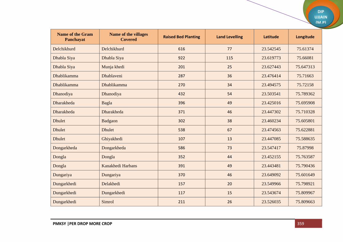
PMKSY |PER DROP MORE CROP 359
DIP UJJAIN (M.P)
Name of the Gram
Panchayat
Name of the villages
Covered Raised Bed Planting Land Levelling Latitude Longitude
Delchikhurd Delchikhurd 616 77 23.542545 75.61374
Dhabla Siya Dhabla Siya 922 115 23.619773 75.66081
Dhabla Siya Munja khedi 201 25 23.627443 75.647313
Dhablikamma Dhablaveni 287 36 23.476414 75.71663
Dhablikamma Dhablikamma 270 34 23.494575 75.72158
Dhanodiya Dhanodiya 432 54 23.503541 75.789362
Dharakheda Bagla 396 49 23.425016 75.695908
Dharakheda Dharakheda 371 46 23.447302 75.710328
Dhulet Badgaon 302 38 23.460234 75.605801
Dhulet Dhulet 538 67 23.474563 75.622881
Dhulet Ghiyakhedi 107 13 23.447085 75.588635
Dongarkheda Dongarkheda 586 73 23.547417 75.87998
Dongla Dongla 352 44 23.452155 75.763587
Dongla Kanakhedi Harbans 391 49 23.443481 75.790436
Dungariya Dungariya 370 46 23.649092 75.601649
Dungarkhedi Delakhedi 157 20 23.549966 75.798921
Dungarkhedi Dungarkhedi 117 15 23.543674 75.809967
Dungarkhedi Simrol 211 26 23.526035 75.809663

PMKSY |PER DROP MORE CROP 360
DIP UJJAIN (M.P)
Name of the Gram
Panchayat
Name of the villages
Covered Raised Bed Planting Land Levelling Latitude Longitude
Gelakhedi Gelakhedi 462 58 23.570389 75.753672
Gelakhedi Parasali 104 13 23.585663 75.744073
Ghatiya Jassa Ghatiya Jassa 211 26 23.580574 75.833458
Ghatiya Jassa Jhangri 108 13 23.619747 75.831272
Ghatiya Jassa Kanthariya 137 17 23.608257 75.629176
Ghatiya Jassa Samakota 81 10 23.593439 75.83983
Ghatiyasaindas Ghatiyasaindas 334 42 23.700222 75.647249
Ghatpeepalya Aranyabena 105 13 23.642519 75.623423
Ghatpeepalya Ghatpeepalya 254 32 23.655146 75.636342
Ghosla Ghosla 639 80 23.442384 75.882244
Ghosla Loharwas 217 27 23.435936 75.903567
Gogakheda Ghat Khedi 114 14 23.625518 75.628694
Gogakheda Gogakheda 334 42 23.626709 75.615053
Gogakheda Modi 202 25 23.644627 75.64681
Guradiyadasa Guradiyadasa 430 54 23.536807 75.733072
Guradiyadasa Maukhedi 181 23 23.538075 75.750475
Harbakhedi Harbakhedi 261 33 23.539082 75.634941
Harbakhedi Rohida 315 39 23.520196 75.622066

PMKSY |PER DROP MORE CROP 361
DIP UJJAIN (M.P)
Name of the Gram
Panchayat
Name of the villages
Covered Raised Bed Planting Land Levelling Latitude Longitude
Hingoniya Hingoniya 228 28 23.394376 75.74054
Hingoniya Ranipura 439 55 23.380748 75.71831
Indokh Indokh 432 54 23.707562 75.758411
Isankhedi Isankhedi 385 48 23.553034 75.568946
Itawa Itawa 420 53 23.462077 75.745004
Itawa Lasudiya Shripat 282 35 23.430844 75.722602
Jagoti Jagoti 902 113 23.401967 75.80557
Jawasiyapanth Jawasiyapanth 303 38 23.477368 75.753621
Jawasiyapanth Lakhakhedi Umath 416 52 23.498828 75.762319
Jawasiyasolanki Jawasiyasolanki 298 37 23.481246 75.89356
Jawasiyasolanki Pipalya Harji 197 25 23.470455 75.899983
Jelyakhedi Jelyakhedi 297 37 23.429781 75.838636
Jharda Jharda 901 113 23.603882 75.743864
Jhutawad Jhutawad 990 124 23.635715 75.579866
Jodmalakkha Chhingri 210 26
Jodmalakkha Jodmalakkha 114 14 23.559511 75.726794
Kachariya Kachariya 566 71 23.58483 75.686969
Kadhai Barapathar (Part) 336 42 23.475902 75.646484

PMKSY |PER DROP MORE CROP 362
DIP UJJAIN (M.P)
Name of the Gram
Panchayat
Name of the villages
Covered Raised Bed Planting Land Levelling Latitude Longitude
Kadhai Kadhai 517 65 23.444171 75.649231
Kajikhedi Aamdi 96 12 23.503023 75.700531
Kajikhedi Kajikhedi 177 22 23.486571 75.697527
Kajikhedi Sangvikheda 140 18 23.497198 75.701217
Kallapipalya Kallapipalya 239 30 23.499152 75.870988
Kallapipalya Teelyakhedi 339 42 23.509941 75.884918
Kamalyakhedi Bilkheda 223 28 23.505506 75.839304
Kamalyakhedi Hajratpur 127 16 23.496306 75.851068
Kamalyakhedi Kamalyakhedi 219 27 23.513184 75.854965
Kanakedi Eklaspur Kanakedi Eklaspur 415 52 23.583866 75.521576
Kanakedi Eklaspur Karnawad 303 38 23.588349 75.541145
Kanthariya Barkheda Khurd 114 14 23.594368 75.621309
Kanthariya Kanthariya 334 42 23.604439 75.837995
Kanthariya Sipawara 194 24 23.580808 75.61377
Kason Kason 704 88 23.532519 75.846682
Khardiya Manpur Kachhaliyachand 432 54 23.636054 75.803194
Khardiya Manpur Khardiya Manpur 152 19 23.643917 75.820103
Kheda Madda Kheda Madda 583 73 23.553522 75.825382

PMKSY |PER DROP MORE CROP 363
DIP UJJAIN (M.P)
Name of the Gram
Panchayat
Name of the villages
Covered Raised Bed Planting Land Levelling Latitude Longitude
Khedakhajuriya Khedakhajuriya 885 111 23.461491 75.79289
Khoriya Padma Khoriya Padma 509 64 23.5655 75.792571
Khoriya Padma Panodiya 307 38 23.584537 75.810424
Khoriya Sumra Khoriya Sumra 205 26 23.527106 75.687484
Khoriya Sumra Mochikheda 314 39 23.518685 75.671177
Khoriya Sumra Piplikheda 127 16 23.508532 75.680704
Kitiya Kitiya 265 33 23.427985 75.757091
Kitiya Moyakheda 403 50 23.432025 75.740491
Koyal Deoli 205 26 23.642485 75.559069
Koyal Koyal 575 72 23.620845 75.54592
Kundikheda Kundikheda 297 37 23.606351 75.823622
Lakhakhedi Naharpur Lakhakhedi Naharpur 316 39 23.447576 75.672931
Lasudiya Nahta Lasudiya Nahta 461 58 23.564832 75.849844
Lasudiyadevsi Jhangra 257 32 23.463702 75.890023
Lasudiyadevsi Lasudiyadevsi 39 5 23.473699 75.87465
Lasudiyagoyal Lasudiyagoyal 405 51 23.727336 75.843211
Lasudiyamansoor Khajuriya Mansoor 298 37 23.549126 75.67521
Lasudiyamansoor Lasudiyamansoor 487 61 23.564861 75.696182

PMKSY |PER DROP MORE CROP 364
DIP UJJAIN (M.P)
Name of the Gram
Panchayat
Name of the villages
Covered Raised Bed Planting Land Levelling Latitude Longitude
Lotiya Junarda Lotiya Junarda 496 62 23.653317 75.737795
Mahu Akyadhanga 245 31 23.412373 75.652589
Mahu Mahu 460 58 23.423478 75.67276
Mahudi Mahudi 478 60 23.40637 75.765496
Mahudipura Khurchanya Pratap 551 69 23.408181 75.791026
Mahudipura Mahudipura 344 43 23.429771 75.77558
Mahudiya Dhelwadi 144 18 23.709225 75.837846
Mahudiya Mahudiya 428 53 23.690991 75.833383
Makla Makla 1071 134 23.629913 75.765744
Malikhedi Khurchanya Chandrabhan 79 10 23.39176 75.799041
Malikhedi Malikhedi 198 25 23.372892 75.786877
Malikhedi Melaniya 332 42 23.381956 75.763892
Malya Malya 426 53 23.72113 75.716359
Malya Yashwantpura 116 15 23.710491 75.708925
Melakhedi Balah 103 13 23.683765 75.641764
Melakhedi Hajalyakhedi 145 18 23.672595 75.634185
Melakhedi Melakhedi 160 20 23.674908 75.657426
Mundlaparwal Mundlaparwal 409 51 23.495875 75.577606

PMKSY |PER DROP MORE CROP 365
DIP UJJAIN (M.P)
Name of the Gram
Panchayat
Name of the villages
Covered Raised Bed Planting Land Levelling Latitude Longitude
Mundlasondhya Mundlasondhya 706 88 23.69582 75.729567
Mundlidotru Balra 298 37 23.479829 75.815769
Mundlidotru Kalapipal 450 56 23.439193 75.815495
Mundlidotru Mundlidotru 135 17 23.46058 75.823506
Nag Guradiya Nag Guradiya 548 68 23.619384 75.814181
Nagpura Chhajjukhedi 239 30 23.547082 75.785492
Nagpura Nagpura 371 46 23.55062 75.7522
Nalkheda Nalkheda 662 83 23.584301 75.776607
Narayankhedi Jharawada 435 54 23.525178 75.521652
Narayankhedi Narayankhedi 304 38 23.531474 75.553839
Narayna Chiramya 278 35 23.396304 75.664434
Narayna Narayna 261 33 23.397485 75.681085
Nimkheda Khedla 139 17 23.566758 75.809394
Nimkheda Nimkheda 281 35 23.568489 75.826732
Nipaniyabadar Katariya 578 72 23.587167 75.652798
Nipaniyabadar Nipaniyabadar 418 52 23.565536 75.668821
Nipaniyaraju Mahidpuriya 99 12 23.530815 75.796396
Nipaniyaraju Nipaniyaraju 146 18 23.523009 75.77544

PMKSY |PER DROP MORE CROP 366
DIP UJJAIN (M.P)
Name of the Gram
Panchayat
Name of the villages
Covered Raised Bed Planting Land Levelling Latitude Longitude
Nipaniyaraju Somchidi 479 60 23.535528 75.785502
Padikheda Marukheda 344 43 23.50862 75.808876
Padikheda Padikheda 284 36 23.48996 75.797798
Padlya Padlya 405 51 23.578459 75.718812
Padlya Rawatkhedi 316 39 23.598765 75.717008
Palwa Palwa 585 73 23.428849 75.858885
Parwatkheda Dubli 131 16 23.488297 75.63706
Parwatkheda Kukni 250 31 23.474363 75.624271
Parwatkheda Parwatkheda 327 41 23.495058 75.634399
Patakhedi Patakhedi 261 33 23.685723 75.7741
Patakhedi Sekli 208 26 23.673775 75.76895
Pepalya Bhim Aranya Najeek Chivdi 187 23 23.642511 75.623137
Pepalya Bhim Ilyakhedi 172 21 23.628595 75.600134
Pepalya Bhim Pepalya Bhim 131 16 23.617155 75.598979
Petlawad Petlawad 524 65 23.639383 75.530874
Pipalya Dhuma Pipalya Dhuma 647 81 23.674603 75.742197
Pipalyanath Pipalyanath 382 48 23.482025 75.774822
Rabdaniya Ladanpur 208 26 23.653745 75.803366

PMKSY |PER DROP MORE CROP 367
DIP UJJAIN (M.P)
Name of the Gram
Panchayat
Name of the villages
Covered Raised Bed Planting Land Levelling Latitude Longitude
Rabdaniya Naharkheda 117 15 23.66483 75.798388
Rabdaniya Rabdaniya 321 40 23.662943 75.781222
Raghvi Raghvi 332 42 23.45335 75.844594
Raghvi Ramsara 189 24 23.441762 75.838748
Ranayrapeer Ranayrapeer 743 93 23.654816 75.661026
Sagwali Sagwali 556 69 23.577302 75.578839
Sagwali Singdewala 367 46 23.564558 75.600897
Sakariya Kanakhedi Hamma 368 46 23.653547 75.765361
Sakariya Sakariya 330 41 23.635417 75.732956
Sakariya Sukdi 133 17 23.645685 75.716721
Sekakhedi Chorwasa 315 39 23.445528 75.692586
Sekakhedi Sekakhedi 302 38 23.466218 75.670088
Semalya Semalya 791 99 23.559665 75.637244
Shakkarkhedi Jodmabirbhan 613 77
Shakkarkhedi Shakkarkhedi 114 14 23.476339 75.841089
Shrawan Borkhedi 222 28 23.676835 75.67636
Shrawan Shrawan 331 41 23.681395 75.695848
Suhagpura Mendhki 360 45 23.505532 75.729755

PMKSY |PER DROP MORE CROP 368
DIP UJJAIN (M.P)
Name of the Gram
Panchayat
Name of the villages
Covered Raised Bed Planting Land Levelling Latitude Longitude
Suhagpura Suhagpura 202 25 23.50263 75.746138
Sumrakheda Akyabajrang 56 7 23.626109 75.713651
Sumrakheda Sanoriya 247 31 23.62882 75.694958
Sumrakheda Sumrakheda 181 23 23.615763 75.712059
Tarnod Tarnod 383 48 23.586776 75.556423
Tarot Tarot 677 85 23.610257 75.684421
Tipukheda Bolkhedaghat 357 45 23.741979 75.7191
Tipukheda Tipukheda 245 31 23.723043 75.740214
NP Mahidpur 211 26
NP Gogapur 328 41
Total 73765 9225

PMKSY |PER DROP MORE CROP 369
DIP UJJAIN (M.P)
Block Badnagar
Name of the Gram
Panchayat
Name of the villages
Covered Raised Bed Planting Land Levelling Latitude Longitude
Ajanda Ajanda 378 47 22.986448 75.358055
Ajanda Arandiya 113 14 23.019235 75.367583
Ajanda Kotki 106 13 23.000810 75.379513
Ajanda Ubradiya 226 28 23.006911 75.360716
Ajdawada Ajdawada 891 111 23.180903 75.358886
Akoliya Akoliya 460 58 22.9877 75.465604
Akoliya Takrawada 240 30 22.979245 75.479507
Amla Amla 1922 240 23.012884 75.329004
Amlawadbika Amlawadbika 277 35 23.25216 75.463296
Amlawadbika Molakhedi 160 20 23.245299 75.483338
Amlawadkalan Amlawadkalan 371 46 23.252084 75.462063
Amlawadkalan Dehta 184 23 23.2829914 75.44567
Amlawadkalan Kesharpura 108 14 23.271403 75.453394
Asawta Asawta 764 96 22.994788 75.417174
Aslawada Aslawada 461 58 23.245691 75.616926
Badganwa Badganwa 783 98 23.197264 75.254211
Badgara Badgara 512 64 22.843099 75.350339
Baledi Baledi 1360 170 23.121239 75.556476

PMKSY |PER DROP MORE CROP 370
DIP UJJAIN (M.P)
Name of the Gram
Panchayat
Name of the villages
Covered Raised Bed Planting Land Levelling Latitude Longitude
Balodahasan Balodahasan 228 29 23.212966 75.448407
Balodahasan Gaondidevsi 243 30 23.223063 75.431499
Balodahasan Mahudikhema 102 13 23.232449 75.450896
Balodakoran Balodakoran 537 67 23.181703 75.33375
Balodalakha Balodalakha 1106 138 23.156439 75.313754
Balodalakha Nakuchakhedi
Bamnapati Bamnapati 604 75 23.195142 75.603313
Banbani Banbani 424 53 23.260815 75.311721
Banbani Bhunwasa 353 44 23.284026 75.338293
Banbani Kajyakhedi 201 25 23.272515 75.337434
Banderbela Banderbela 476 59 23.252378 75.345967
Bangred Bangred 1033 129 22.956383 75.4043
Bardiya Bardiya 692 86 23.216574 75.325528
Beesaheda Beesaheda 330 41 23.091476 75.397043
Beesaheda Kajlana 366 46 23.074058 75.39592
Bhatpachlana Bhatpachlana 1182 148 23.250506 75.294487
Bhidawad Bhidawad 695 87 22.938916 75.348166
Bhidawad Lohariya 498 62 22.973345 75.335766
Bhomalwas Bhomalwas 531 66 23.025411 75.406241
Bhomalwas Upri 94 12 23.011112 75.39225

PMKSY |PER DROP MORE CROP 371
DIP UJJAIN (M.P)
Name of the Gram
Panchayat
Name of the villages
Covered Raised Bed Planting Land Levelling Latitude Longitude
Birakhedi Birakhedi 618 77 23.113853 75.353993
Birakhedi Ranawada 217 27 23.118699 75.373047
Birgodarandhir Bhainslakalan 374 47 23.035995 75.425467
Birgodarandhir Birgodarandhir 290 36 23.043183 75.439715
Birgodarandhir Shekhpur 166 21 23.041033 75.398830
Cheekali Cheekali 832 104 23.139723 75.604845
Chirola Chirola 726 91 23.274651 75.410906
Chirola Rathorkhedi 159 20 23.286951 75.43039
Dangwada Dangwada 1272 159 23.091089 75.526861
Dantarwa Dantarwa 285 36 23.104587 75.414571
Dantarwa Rasulabad 284 36 23.100718 75.429935
Daulatpur Daulatpur 268 34 23.038654 75.512039
Daulatpur Dautardi 206 26 23.013845 75.501771
Daulatpur Pacholi 138 17 23.026247 75.667179
Daulatpur Sohad 312 39 23.048765 75.495351
Dhureri Dhureri 369 46 23.142304 75.501043
Dhureri Rajota 167 21 23.146329 75.482504
Dotru Dotru 668 84 22.891473 75.431523
Dotru Gajikhedi 238 30 22.884198 75.419249
Dunalja Dunalja 595 74 23.229243 75.462919

PMKSY |PER DROP MORE CROP 372
DIP UJJAIN (M.P)
Name of the Gram
Panchayat
Name of the villages
Covered Raised Bed Planting Land Levelling Latitude Longitude
Fatehpur Fatehpur 988 124 22.962278 75.449548
Gajnikhedi Gajnikhedi 504 63 23.173358 75.253267
Gajnikhedi Maswadiyadhar 433 54 23.192452 75.233183
Gaondilodha Gaondilodha 431 54 23.156661 75.467154
Ghadsinga Brahmanbadoda 131 16 23.112553 75.621301
Ghadsinga Ghadsinga 374 47 23.103001 75.583621
Ghudawan Bhainsla Khurd 437 55 23.162511 75.536027
Ghudawan Ghudawan 387 48 23.446769 75.278596
Gunawad Bisalkhedi 229 29 22.929832 75.469957
Gunawad Gunawad 909 114 22.935523 75.439058
Harnawada Harnawada 363 45 23.207596 75.487035
Ingoriya Ingoriya 665 83 23.156139 75.569998
Jafla (Part) Bargadi 343 43 23.05266 75.349249
Jafla (Part) Jafla (Part) 554 69 23.02699 75.384955
Jahangirpur Jahangirpur 1375 172 23.215822 75.514271
Jalodiya Jalodiya 998 125 22.991707 75.417174
Jalodsanjar Jalodsanjar 686 86 23.136536 75.348286
Jandla Garakhedi 48 6 23.088559 75.379831
Jandla Jandla 251 31 23.094535 75.367128
Jandla Paduniyalodha 139 17 23.079873 75.375292

PMKSY |PER DROP MORE CROP 373
DIP UJJAIN (M.P)
Name of the Gram
Panchayat
Name of the villages
Covered Raised Bed Planting Land Levelling Latitude Longitude
Jandla Peethakhedi 267 33 23.079142 75.356743
Jandla Semaliya 165 21 23.101638 75.379687
Jassakhedi Balodaarsi 197 25 23.098528 75.349244
Jassakhedi Jassakhedi 316 39 23.085116 75.324849
Jhalaria Jhalaria 494 62 23.065849 75.424952
Jhalaria Karadiya 100 13 23.062532 75.39637
Jhalaria Khedamadhav 208 26 23.053371 75.419459
Jhumki Dharankhedi 170 21 23.188398 75.510764
Jhumki Jhumki 282 35 23.546958 70.010681
Kadhai Bhondwas 176 22 23.12384 75.615218
Kadhai Kadhai 430 54 23.12163 75.59316
Kalyanpura Kalyanpura 306 38 23.185672 75.407286
Kalyanpura Kamanpur 415 52 23.17289 75.396128
Kanjad Kanjad 566 71 23.240861 75.591719
Khadotiya Chhankhedi 98 12 23.154167 75.626965
Khadotiya Khadotiya 292 36 23.174076 75.624943
Khandoda Khandoda 520 65 23.176704 75.437154
Khandoda Simlawada 373 47
Khandwabibi Khandwabibi 454 57 22.880089 75.34653
Khandwabibi Kungara 430 54 22.90353 75.346716

PMKSY |PER DROP MORE CROP 374
DIP UJJAIN (M.P)
Name of the Gram
Panchayat
Name of the villages
Covered Raised Bed Planting Land Levelling Latitude Longitude
Khandwabibi Satwasa 331 41 22.879432 75.368261
Khandwasura Khandwasura 530 66 22.976729 75.38329
Khandwasura Likhoda 201 25 23.001776 75.387152
Kharsodkalan Kharsodkalan 2186 273 23.220246 75.368254
Kharsodkhurd Kharsodkhurd 1814 227 23.118526 75.46904
Khedawada Khedawada 825 103 23.188903 75.29008
Khedawada Malgaondi 213 27 23.174622 75.285874
Kiloli Kiloli 467 58 23.107064 75.501598
Kiloli Namalpur 223 28 23.096248 75.511256
Kothdi Banya Khedi 163 20 23.223868 75.626032
Kothdi Kantharkhedi 197 25 23.206343 75.62764
Kothdi Kothdi 519 65 23.217873 75.603974
Kulawada Kulawada 359 45 23.21954 75.581801
Kulawada Matangna 281 35 23.171448 75.601927
Lakhesara Lakhesara 518 65 23.058558 75.510629
Lakhesara Maswadiyakhalsa 322 40 23.0798 75.514406
Limbas Limbas 622 78 23.276063 75.371767
Lohana Lohana 1420 178 22.914381 75.366287
Madhopura Madhopura 637 80 23.141457 75.277446
Mahudialam Banbana 286 36 23.449639 75.435439
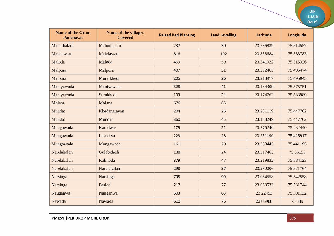
PMKSY |PER DROP MORE CROP 375
DIP UJJAIN (M.P)
Name of the Gram
Panchayat
Name of the villages
Covered Raised Bed Planting Land Levelling Latitude Longitude
Mahudialam Mahudialam 237 30 23.236839 75.514557
Makdawan Makdawan 816 102 23.858684 75.533783
Maloda Maloda 469 59 23.241022 75.315326
Malpura Malpura 407 51 23.232465 75.495474
Malpura Murarkhedi 205 26 23.218977 75.495045
Maniyawada Maniyawada 328 41 23.184309 75.575751
Maniyawada Surakhedi 193 24 23.174762 75.583989
Molana Molana 676 85
Mundat Khedanarayan 204 26 23.201119 75.447762
Mundat Mundat 360 45 23.188249 75.447762
Mungawada Karadwas 179 22 23.275240 75.432440
Mungawada Lasudiya 223 28 23.251190 75.425917
Mungawada Mungawada 161 20 23.258445 75.441195
Narelakalan Gulabkhedi 188 24 23.217465 75.56155
Narelakalan Kalmoda 379 47 23.219832 75.584123
Narelakalan Narelakalan 298 37 23.230006 75.571764
Narsinga Narsinga 795 99 23.064558 75.542558
Narsinga Paslod 217 27 23.063533 75.531744
Nauganwa Nauganwa 503 63 23.22493 75.301132
Nawada Nawada 610 76 22.85988 75.349

PMKSY |PER DROP MORE CROP 376
DIP UJJAIN (M.P)
Name of the Gram
Panchayat
Name of the villages
Covered Raised Bed Planting Land Levelling Latitude Longitude
Nimboda Naharkhedi 142 18 23.0895 75.622331
Nimboda Nimboda 510 64 23.101895 75.603877
Onkarpura Gurawada 82 10 23.18209 75.494653
Onkarpura Labaycha 220 28 23.196783 75.4667702
Onkarpura Onkarpura 223 28 23.186527 75.478087
Onkarpura Semalkhedi 116 15 23.193943 75.494309
Ordi Narelakhurd 76 10 23.234303 75.353653
Ordi Ordi 422 53 23.231489 75.338394
Pachlanabil Bidsingawada 43 5 23.118697 75.386824
Pachlanabil Meethikhedi 139 17 23.109066 75.388455
Pachlanabil Pachlanabil 513 64 23.138588 75.372147
Pachlanabil Singawada 244 31 23.131752 75.389587
Palduna Palduna 968 121 23.065823 75.463937
Palsoda Jamalpura 305 38 23.273898 75.477753
Palsoda Palsoda 590 74 23.265225 75.496207
Palwa Palwa 700 87 23.144346 75.429069
Patyakhedi Karanpura 181 23 233.194051 75.541037
Patyakhedi Patyakhedi 228 28 23.180634 75.541445
Piploo Piploo 845 106 22.866708 75.4000166
Pirjhalar Bhandtilawali 219 27 23.030756 75.489809

PMKSY |PER DROP MORE CROP 377
DIP UJJAIN (M.P)
Name of the Gram
Panchayat
Name of the villages
Covered Raised Bed Planting Land Levelling Latitude Longitude
Pirjhalar Pirjhalar 1172 147 23.031151 75.464574
Pithora Biragodanathu 418 52 22.910226 75.415627
Pithora Pithora 261 33 22.930622 75.413567
Pitlawadiya Pitlawadiya 351 44
Pitlawadiya Tokra 443 55 23.086291 75.338623
Ranwa Hatyakhedi 243 30 23.086774 75.450787
Ranwa Ranwa 296 37 23.088195 75.489067
Rawadiyapeer Mindka 316 40 23.160781 75.385065
Rawadiyapeer Rawadiyapeer 330 41 23.187767 75.370559
Runija Runija 815 102 23.160597 75.268006
Rupaheda Rupaheda 467 58 23.19405 75.56633
Rupaheda Sikandarkheda 163 20 23.204385 75.547361
Salwa Salwa 625 78 23.245633 75.393139
Sanawada Itawa 570 71 23.461516 75.745866
Sanawada Sanawada 370 46 23.122024 75.415069
Sarola Dhaturiya 307 38 22.949823 75.374945
Sarola Mundla 338 42 22.938837 75.385503
Sarola Sarola 306 38 22.961125 75.371941
Sarsana Sarsana 376 47 23.145224 75.52396
Sijawata Sijawata 800 100 23.170076 75.46359

PMKSY |PER DROP MORE CROP 378
DIP UJJAIN (M.P)
Name of the Gram
Panchayat
Name of the villages
Covered Raised Bed Planting Land Levelling Latitude Longitude
Silodiya Mungawadi 132 16 23.247116 75.44567
Silodiya Silodiya 342 43 23.238046 75.431078
Suklana Rawadiyakalan 421 53 22.948252 75.323487
Suklana Suklana 312 39 22.917958 75.343333
Sundrabad Sundrabad 618 77 23.133221 75.311637
Suneda Chinchodiya 136 17 23.120203 75.517866
Suneda Suneda 428 53 23.118625 75.501301
Suwasa Suwasa 656 82 23.259157 75.564768
Udsinga Paduniyakheta 251 31 23.220865 75.413579
Udsinga Udsinga 442 55 23.201258 75.417106
Umariya Umariya 459 57 23.017274 75.422206
Untwas Untwas 561 70 23.088195 75.450787
NP Badnagar 909 114
Total 84664 10583
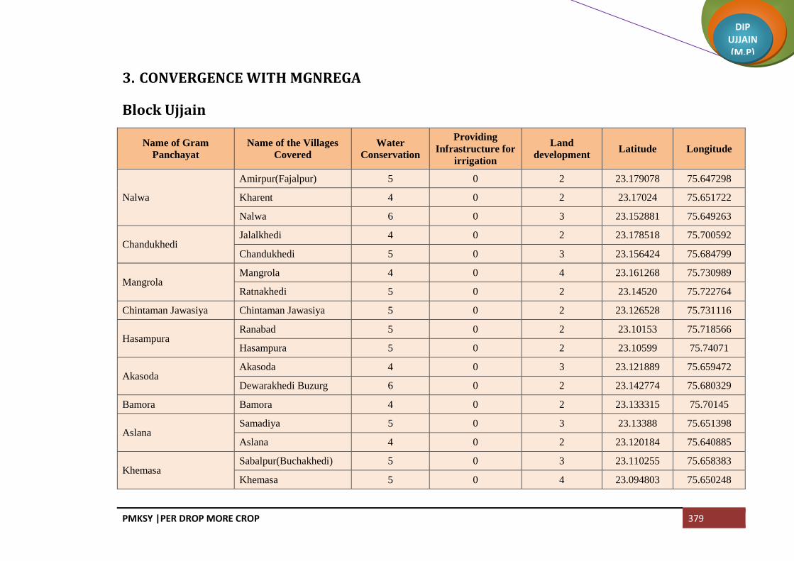
PMKSY |PER DROP MORE CROP 379
DIP UJJAIN (M.P)
3. CONVERGENCE WITH MGNREGA
Block Ujjain
Name of Gram
Panchayat
Name of the Villages
Covered
Water
Conservation
Providing
Infrastructure for
irrigation
Land
development Latitude Longitude
Nalwa
Amirpur(Fajalpur) 5 0 2 23.179078 75.647298
Kharent 4 0 2 23.17024 75.651722
Nalwa 6 0 3 23.152881 75.649263
Chandukhedi Jalalkhedi 4 0 2 23.178518 75.700592
Chandukhedi 5 0 3 23.156424 75.684799
Mangrola Mangrola 4 0 4 23.161268 75.730989
Ratnakhedi 5 0 2 23.14520 75.722764
Chintaman Jawasiya Chintaman Jawasiya 5 0 2 23.126528 75.731116
Hasampura Ranabad 5 0 2 23.10153 75.718566
Hasampura 5 0 2 23.10599 75.74071
Akasoda Akasoda 4 0 3 23.121889 75.659472
Dewarakhedi Buzurg 6 0 2 23.142774 75.680329
Bamora Bamora 4 0 2 23.133315 75.70145
Aslana Samadiya 5 0 3 23.13388 75.651398
Aslana 4 0 2 23.120184 75.640885
Khemasa Sabalpur(Buchakhedi) 5 0 3 23.110255 75.658383
Khemasa 5 0 4 23.094803 75.650248

PMKSY |PER DROP MORE CROP 380
DIP UJJAIN (M.P)
Name of Gram
Panchayat
Name of the Villages
Covered
Water
Conservation
Providing
Infrastructure for
irrigation
Land
development Latitude Longitude
Umariya Khalsa Umariya Khalsa 5 0 2 23.071009 75.675624
Erwas 5 0 2 23.079923 75.639849
Kandariya Kandariya 4 0 2 23.072728 75.66171
Ajrana 6 0 2 23.058334 75.648385
Talod Talod 4 0 3 23.098446 75.685135
Tankariyapanth Tankariyapanth 5 0 2 23.079168 75.698522
Takwasa Takwasa 4 0 2 23.055185 75.630637
Hamirkhedi Hamirkhedi 5 0 3 23.044536 75.640268
Jhiroliya
Jhiroliya 5 0 2 23.033861 75.652437
Badalkhedi 5 0 3 23.040101 75.669432
Ramjankhedi 6 0 4 23.016287 75.632971
Fatehabad Fatehabad 4 0 2 23.012894 75.675437
Nilkanth Nilkanth 5 0 2 23.032134 75.692876
Kankariya Chirakhan Mundlasuleman 4 0 2 23.030397 75.706367
Kankariya Chirakhan 5 0 2 23.030475 75.727895
Lekoda Lekoda 5 0 3 23.054782 75.719051
Gondiya Gondiya 5 0 2 23.080298 75.743561
Limbapiplya Limbapiplya 5 0 2 23.057845 75.753665
Jarkhoda Jarkhoda 4 0 3 23.039925 75.779567
Khetiyakhedi 6 0 2 23.042075 75.805165

PMKSY |PER DROP MORE CROP 381
DIP UJJAIN (M.P)
Name of Gram
Panchayat
Name of the Villages
Covered
Water
Conservation
Providing
Infrastructure for
irrigation
Land
development Latitude Longitude
Karohan Karohan 4 0 2 23.069642 75.785825
Jastikhedi 5 0 2 23.067391 75.773938
Nayakhedi Nayakhedi 4 0 3 23.061074 75.815223
Silodamori 5 0 2 23.050017 75.821488
Ramwasa Ramwasa 5 0 3 23.067886 75.833603
Matanakhurd 5 0 4 23.065122 75.85549
Panthpiplai Panthpiplai 5 0 2 23.045073 75.826102
Ninora Kithodarao 4 0 2 23.075522 75.850507
Ninora 6 0 2 23.092335 75.816367
Alampur(Udana) Sewarkhedi 4 0 2 23.059393 75.86746
Alampur(Udana) 5 0 3 23.045456 75.868997
Dhediya Dhediya 4 0 3 23.129979 75.793927
Mediya 5 0 4 23.112656 75.809294
Karadiya(Nawakheda) Karadiya(Nawakheda) 5 0 2 23.102169 75.822116
Piplyaragho Piplyaragho 5 0 2 23.105604 75.797163
Chhayan 6 0 2 23.620848 75.250267
Jamalpura
Jamalpura 4 0 2 23.273842 75.477764
Kokalakhedi 5 0 3 23.08395 75.814535
Magariya 4 0 2 23.071281 75.81103
Gangedi Gangedi 5 0 2 23.106979 75.777909

PMKSY |PER DROP MORE CROP 382
DIP UJJAIN (M.P)
Name of Gram
Panchayat
Name of the Villages
Covered
Water
Conservation
Providing
Infrastructure for
irrigation
Land
development Latitude Longitude
Brijrajkhedi 5 0 3 23.090712 75.762308
Sikandari
Sikandari 5 0 2 23.132889 75.780643
Gothada 5 0 2 23.524804 75.196497
Jiwankhedi 4 0 2 23.149371 75.781075
Daudkhedi Sawara Khedi 6 0 3 23.162125 75.775051
Daudkhedi 4 0 2 23.143748 75.768989
Chandmukh Chandmukh 5 0 3 23.131443 75.76273
Palkhedi 5 0 4 23.119384 75.757186
Undasa Hakkanipura 4 0 2 23.217821 75.809098
Undasa 6 0 2 23.225535 75.832796
Sahabkhedi Sahabkhedi 4 0 2 23.236663 75.825739
Nahariya 5 0 2 23.241509 75.846614
Dhabla Rehwari Dhabla Rehwari 4 2 3 23.255138 75.832964
Badarkha Berasiya Badarkha Berasiya 5 2 3 23.228471 75.862438
Bakaniya Bakaniya 5 3 4 23.265705 75.859057
Badodiya Bhand
Sayarkhedi 5 2 2 23.251338 75.861695
Dewankhedi 6 2 2 23.252567 75.872393
Badodiya Bhand 4 0 2 23.241236 75.873953
Gunaikhalsa Gunaikhalsa 5 2 2 23.271882 75.895868
Piplyabichha 4 2 3 23.264716 75.87893

PMKSY |PER DROP MORE CROP 383
DIP UJJAIN (M.P)
Name of Gram
Panchayat
Name of the Villages
Covered
Water
Conservation
Providing
Infrastructure for
irrigation
Land
development Latitude Longitude
Umariya Jagir Jambura 5 3 2 23.247653 75.884873
Umariya Jagir 5 3 2 23.266013 75.91979
Tajpur Tajpur 5 2 2 23.225194 75.903446
Bhainsoda Amirpur Kuslakhedi 5 2 3 23.198643 75.920453
Bhainsoda 4 2 2 23.210885 75.931539
Khajuriya Kumawat
Derkhedi 6 3 3 23.206884 75.948697
Khajuriya Kumawat 4 3 4 23.220452 75.950155
Molakhedi 5 2 2 23.191161 75.949635
Biaora Biaora 5 2 2 23.187671 75.933247
Banskhedi Khalsa
Banskhedi Khalsa 4 0 2 23.176979 75.939826
Tankariya Kazi 6 0 2 23.165367 75.935929
Bodani 4 0 3 23.153459 75.937773
Pingleshwar Pingleshwar 5 3 3 23.217547 75.873359
Harsodan Harsodan 4 0 4 23.188216 75.905407
Jaiwantpur Jaiwantpur 5 0 2 23.183083 75.880524
Karondiya Karondiya 5 2 2 23.174377 75.850205
Dhatrawada Dhatrawada 5 0 2 23.159667 75.847794
Lalpur 6 0 2
Manpura Jawasiya Kumar 4 0 3 23.147213 75.862538
Manpura 5 0 3 23.139776 75.850286

PMKSY |PER DROP MORE CROP 384
DIP UJJAIN (M.P)
Name of Gram
Panchayat
Name of the Villages
Covered
Water
Conservation
Providing
Infrastructure for
irrigation
Land
development Latitude Longitude
Surjanwasa Kesoni 4 3 4 23.16368 75.893651
Surjanwasa 5 2 2 23.170898 75.873254
Dudarsi Dudarsi 5 2 2 23.145557 75.897565
Harnyakhedi 5 3 2 23.140506 75.924172
Kadchhali Daukhedi 5 0 2 23.143629 75.769332
Kadchhali 4 0 3 23.128035 75.914559
Badhkummed Badhkummed 6 5 2 23.155801 75.902111
Kadchha
Silarkhedi 4 0 2 23.115725 75.90794
Kadchha 5 0 2 23.117699 75.931372
Chenpur Hanskhedi 5 0 3 23.101673 75.944075
Nogawan Nogawan 4 0 2 23.119631 75.949234
Matanakalan Matanakalan 6 0 3 23.127071 75.870194
Datana Datana 4 0 4 23.1026 75.891995
Chandesara Kuwariya 5 0 2 23.114757 75.833544
Chandesara 4 0 2 23.110603 75.851054
Chandesari Chandesari 5 0 2 23.12273 75.85483
Khajuria Rehwari Khajuria Rehwari 5 0 2 23.08047 75.872279
Kalyanpura 5 0 3 23.185912 75.408323
Semaliyanasar Semaliyanasar 6 0 3 23.079332 75.89059
Bhanwri 4 0 4 23.061693 75.891362

PMKSY |PER DROP MORE CROP 385
DIP UJJAIN (M.P)
Name of Gram
Panchayat
Name of the Villages
Covered
Water
Conservation
Providing
Infrastructure for
irrigation
Land
development Latitude Longitude
Bolasa
Bolasa 5 2 2 23.052818 75.899043
Dewarkhedi Khurd 4 2 2 23.046657 75.908398
Harnawada 5 2 2 23.052818 75.920157
Kasampur
Khokariya 5 0 2 23.038127 75.885396
Kasampur 5 0 3 23.03402 75.908055
Nikewadi 5 0 2 23.015852 75.896725
Narwar Narwar 4 3 2 23.085768 75.92799
Gaowdi Gaowdi 6 0 2 23.334977 76.013346
Munjakhedi Munjakhedi 4 0 3 23.076876 75.962587
Piploda Dwarkadish Madhopur 5 0 2 23.091406 75.97888
Piploda Dwarkadish 5 0 3 23.069693 75.97836
Kachnariya Kachnariya 5 0 4 23.511313 75.497482
Palkhanda Palkhanda 5 0 2 23.420482 76.187483
Total 625 66 321

PMKSY |PER DROP MORE CROP 386
DIP UJJAIN (M.P)
Block Ghattiya
Name of Gram
Panchayat
Name of the Villages
Covered
Water
Conservation
Providing
Infrastructure for
irrigation
Land
development Latitude Longitude
Dhanda Bhalla Dhanda Bhalla 1 4 2 23.36658 75.659461
Salakhedi 0 1 3 23.373309 75.670027
Chhitar Devi Chhitar Devi 1 2 2 23.353422 75.639034
Ilahipur 0 1 2 23.337068 75.625258
Borkheda Bhalla Ahirkheda 0 2 3 23.336386 75.606242
Borkheda Bhalla 1 3 2 23.329687 75.660919
Pipalyatah 1 1 1 23.323146 75.629162
Gudha Gudha 2 4 2 23.305607 75.630333
Lasurdiya Bazar Lasurdiya Bazar 2 5 4 23.313445 75.646855
Jhokra 1 1 2 23.308798 75.663847
Khoriya 0 1 1 23.301454 75.646606
Ruie Ruie 1 4 3 23.289782 75.654881
Semalyabibi 1 2 2 23.304342 75.677043
Dhulmahu Dhabladhuta 1 2 1 23.28721 75.680308
Dhulmahu 1 3 2 23.270623 75.66994
Pipalyahama Pipalyahama 1 4 3 23.353723 75.672849
Dhuletiya Dhuletiya 2 5 2 23.320384 75.696018
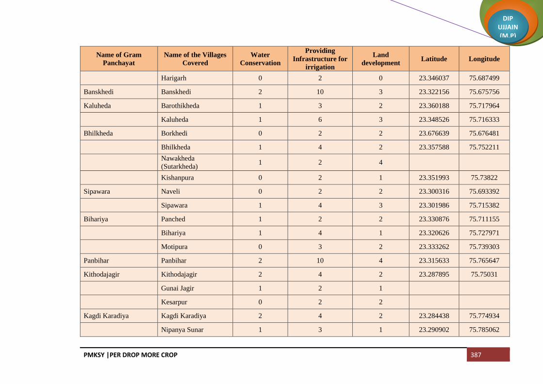
PMKSY |PER DROP MORE CROP 387
DIP UJJAIN (M.P)
Name of Gram
Panchayat
Name of the Villages
Covered
Water
Conservation
Providing
Infrastructure for
irrigation
Land
development Latitude Longitude
Harigarh 0 2 0 23.346037 75.687499
Banskhedi Banskhedi 2 10 3 23.322156 75.675756
Kaluheda Barothikheda 1 3 2 23.360188 75.717964
Kaluheda 1 6 3 23.348526 75.716333
Bhilkheda Borkhedi 0 2 2 23.676639 75.676481
Bhilkheda 1 4 2 23.357588 75.752211
Nawakheda
(Sutarkheda) 1 2 4
Kishanpura 0 2 1 23.351993 75.73822
Sipawara Naveli 0 2 2 23.300316 75.693392
Sipawara 1 4 3 23.301986 75.715382
Bihariya Panched 1 2 2 23.330876 75.711155
Bihariya 1 4 1 23.320626 75.727971
Motipura 0 3 2 23.333262 75.739303
Panbihar Panbihar 2 10 4 23.315633 75.765647
Kithodajagir Kithodajagir 2 4 2 23.287895 75.75031
Gunai Jagir 1 2 1
Kesarpur 0 2 2
Kagdi Karadiya Kagdi Karadiya 2 4 2 23.284438 75.774934
Nipanya Sunar 1 3 1 23.290902 75.785062

PMKSY |PER DROP MORE CROP 388
DIP UJJAIN (M.P)
Name of Gram
Panchayat
Name of the Villages
Covered
Water
Conservation
Providing
Infrastructure for
irrigation
Land
development Latitude Longitude
Utesara Utesara 1 3 2 23.264604 75.801581
Padmakhedi 1 2 3 23.273137 75.79362
Samarkhedi 1 3 2 23.271402 75.778513
Gunava Gunava 2 5 3 23.279863 75.73395
Nanakhedi 1 4 2 23.274265 75.743563
Ralayata bhoja Ralayata Mauja 1 5 3 23.268274 75.755193
Barkhedi Khalsa 1 4 3 23.265199 75.772187
Goyala Buzurg Goyala Buzurg 2 5 4 23.277333 75.698439
Khalana Khalana 2 6 5 23.273102 75.715675
Tumdawada Paroliya Jhali 1 3 2 23.271687 75.640143
Tumdawada 1 4 2 23.254891 75.64598
Jhirniya Khedla 1 2 3 23.265593 75.682151
Jhirniya 1 4 2 23.250059 75.68361
Sarola Singawada 1 2 3 23.231863 75.645465
Sarola 1 4 2 23.239277 75.664519
Amodiya Amodiya 2 6 3 23.208909 75.652503
Chakrawada Chakrawada 2 7 3 23.251636 75.708157
Nagpura Mahukhedi 1 3 2 23.22348 75.680348
Nagpura 2 4 3 23.241305 75.672023

PMKSY |PER DROP MORE CROP 389
DIP UJJAIN (M.P)
Name of Gram
Panchayat
Name of the Villages
Covered
Water
Conservation
Providing
Infrastructure for
irrigation
Land
development Latitude Longitude
Ajnoti 0 2 3
Silodarawal Silodarawal 1 5 2 23.188556 75.681256
Badwai 1 3 2 23.191001 75.647611
Ilaskhedi 0 2 3 23.1925 75.663318
Panbadodia Panbadodia 1 4 3
Naikhedi 1 2 2
Ratadiya Ratadiya 1 5 2 23.196648 75.711866
Vinayaga Vinayaga 1 4 3 23.204005 75.726274
Azampura 1 3 2 23.229878 75.719236
Gonsa Gonsa 2 4 2 23.211851 75.751142
Ramgarh Ramgarh 1 5 3 23.252425 75.746266
Sulyakhedi 1 3 2 23.256762 75.777938
Sodang Sodang 1 5 4 23.240408 75.731464
Wajirpur (Jogi Khedi) 1 3 2
Surasa Surasa 2 5 2 23.235099 75.81036
Badarkha Babaji 1 2 2 23.257934 75.809188
Kamed Kamed 1 4 2 23.227607 75.792035
Kaliyadeh Kaliyadeh 1 4 2 23.251334 75.791132
Jairampura Bormundla 1 4 3 23.276001 75.811669

PMKSY |PER DROP MORE CROP 390
DIP UJJAIN (M.P)
Name of Gram
Panchayat
Name of the Villages
Covered
Water
Conservation
Providing
Infrastructure for
irrigation
Land
development Latitude Longitude
Jairampura 1 5 2 23.297918 75.798623
Devikaradiya 0 4 3 23.285935 75.805232
Bandka Bandka 1 5 2 23.304715 75.810418
Kadwali Piplai 1 4 2 23.300652 75.827103
Kadwali 1 5 2 23.302071 75.844441
Jaithal Jaithal 2 10 2 23.282483 75.821162
Shankarpurjagir Shankarpurjagir 2 6 2 23.326387 75.789949
Ranaheda 1 4 1 23.343883 75.791681
Nipanya Goyal Lakhaheda 1 4 2 23.323398 75.814541
Ishakpur 1 3 2 23.325211 75.838745
Nipanya Goyal 1 4 2 23.313309 75.839861
Meen Silari 1 4 2 23.373666 75.749747
Meen 2 9 2 23.364999 75.768501
Tulaheda Tulaheda 2 7 3 23.34285 75.812333
Dhannakhedi Dhannakhedi 2 5 3 23.36408 75.819669
Nazarpur Nazarpur 3 3 2 23.342253 75.843616
Ghatiya Ghatiya 2 4 2 23.378556 75.863501
Jalwa Jalwa 2 6 3 23.393307 75.887039
Kalukhedi Kalukhedi 2 7 3 23.397949 75.906336

PMKSY |PER DROP MORE CROP 391
DIP UJJAIN (M.P)
Name of Gram
Panchayat
Name of the Villages
Covered
Water
Conservation
Providing
Infrastructure for
irrigation
Land
development Latitude Longitude
Ralayati 1 4 2 23.411654 75.892689
Ralayata Haibat Ralayata Haibat 2 5 2 23.425235 75.90836
Biramkhedi Biramkhedi 1 4 2 23.447654 75.907988
Koyalkhedi 2 4 3 23.438544 75.933357
Salamata Salamata 2 5 2 23.423784 75.929418
Bhensa Khedi 1 2 3 23.410474 75.947871
Chitawalya Kheda Chitawalya Kheda 2 4 3
Jhitarkhedi Jhitarkhedi 2 4 3 23.380066 75.924018
Bichhadod Istamurar Bichhadod Istamurar 2 5 2 23.376018 75.94737
Bhimpura 1 4 2 23.367874 75.990353
Kumhardi 1 3 3 23.355012 75.977224
Amarpura Amarpura 2 3 2 23.389004 75.96647
Sulya 1 3 2 23.377107 75.982725
Daulatpur 1 2 2 23.392759 75.9441
Bichhadod Khalsa Bichhadod Khalsa 2 4 3 23.365933 75.959558
Malikhedi Malikhedi 1 5 3 23.359599 75.524449
Runji Runji 2 4 3 23.350883 75.930719
Kherkhedi 1 2 1 23.356557 75.939903
Gadroli 1 4 1 23.347889 75.959644

PMKSY |PER DROP MORE CROP 392
DIP UJJAIN (M.P)
Name of Gram
Panchayat
Name of the Villages
Covered
Water
Conservation
Providing
Infrastructure for
irrigation
Land
development Latitude Longitude
Dhablagori Dabri 1 4 3 23.363363 75.879714
Dhablagori 1 4 3 23.345712 75.871045
Bhutiya Bhutiya 1 4 3 23.322275 75.873212
Anwalya 1 5 3 23.31195 75.883769
Ujjainiya Ujjainiya 1 5 2 23.290141 75.869458
Kalesar Kalesar 2 5 3 23.341505 75.891322
Chonsala 1 4 2 23.338274 75.913381
Guradiya Gujar Guradiya Gujar 2 5 2 23.331468 75.94064
Banda Bamori 1 5 2 23.317546 75.916728
Banda 1 3 2 23.324324 75.897331
Khajuria Sadar Khajuria Sadar 2 5 2 23.311133 75.941326
Bisakhedi 0 2 3 23.31602 75.931627
Rudaheda Rudaheda 2 5 3 23.294042 75.917535
Barkhedi Jagir 1 5 2 23.285449 75.929294
Total 150 492 295

PMKSY |PER DROP MORE CROP 393
DIP UJJAIN (M.P)
Block Tarana
Name of Gram
Panchayat
Name of the Villages
Covered
Water
Conservation
Providing
Infrastructure for
irrigation
Land
development Latitude Longitude
ASER Aserkaytha 1 1 0 23.178132 76.082943
ASER Sarola 0 1 0 23.191264 76.066809
BADODIYA Badodiya (Makdon) 1 2 1 23.54145 75.977693
BADODIYA Bhundkhedi 0 1 0 23.556399 75.987478
BADODIYA Umariya 0 1 0 23.537279 75.990053
BAGHERA Baghera 0 1 1 23.271717 76.088244
BAGODA Bagoda 1 1 1 23.299494 76.102318
BAGODA Hajikhedi 0 1 0 23.288689 76.0951
BAGWADA Bagwada 1 5 1 23.550721 76.142173
BAGWADA Bukhari 0 3 0 23.545685 76.167493
BAGWADA Harukhedi 0 4 0 23.539342 76.163679
BAGWADA Manasa 0 2 0 23.561972 76.154275
BAGWADA Ratnakhedi 1 3 0 23.145202 75.722764
BANJARI Banjari 0 1 1 23.338801 76.200469
BANJARI Patiyalkhedi 0 1 0 23.351882 76.21712
BARKHEDA Barkheda Tarana 1 2 1 23.394884 76.126346
BARKHEDA Khodrinipaniya 0 1 0 23.368983 76.103465
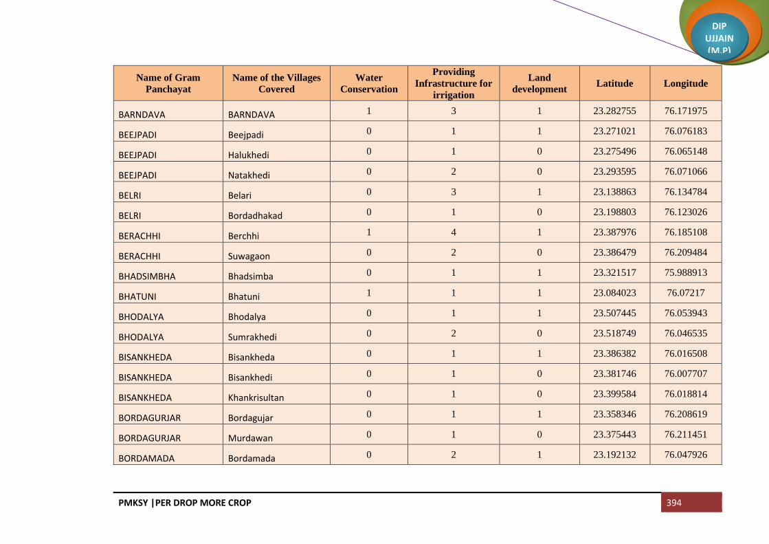
PMKSY |PER DROP MORE CROP 394
DIP UJJAIN (M.P)
Name of Gram
Panchayat
Name of the Villages
Covered
Water
Conservation
Providing
Infrastructure for
irrigation
Land
development Latitude Longitude
BARNDAVA BARNDAVA 1 3 1 23.282755 76.171975
BEEJPADI Beejpadi 0 1 1 23.271021 76.076183
BEEJPADI Halukhedi 0 1 0 23.275496 76.065148
BEEJPADI Natakhedi 0 2 0 23.293595 76.071066
BELRI Belari 0 3 1 23.138863 76.134784
BELRI Bordadhakad 0 1 0 23.198803 76.123026
BERACHHI Berchhi 1 4 1 23.387976 76.185108
BERACHHI Suwagaon 0 2 0 23.386479 76.209484
BHADSIMBHA Bhadsimba 0 1 1 23.321517 75.988913
BHATUNI Bhatuni 1 1 1 23.084023 76.07217
BHODALYA Bhodalya 0 1 1 23.507445 76.053943
BHODALYA Sumrakhedi 0 2 0 23.518749 76.046535
BISANKHEDA Bisankheda 0 1 1 23.386382 76.016508
BISANKHEDA Bisankhedi 0 1 0 23.381746 76.007707
BISANKHEDA Khankrisultan 0 1 0 23.399584 76.018814
BORDAGURJAR Bordagujar 0 1 1 23.358346 76.208619
BORDAGURJAR Murdawan 0 1 0 23.375443 76.211451
BORDAMADA Bordamada 0 2 1 23.192132 76.047926
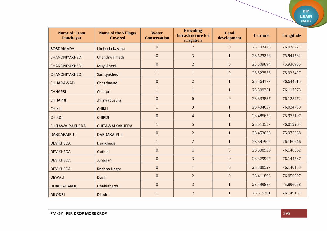
PMKSY |PER DROP MORE CROP 395
DIP UJJAIN (M.P)
Name of Gram
Panchayat
Name of the Villages
Covered
Water
Conservation
Providing
Infrastructure for
irrigation
Land
development Latitude Longitude
BORDAMADA Limboda Kaytha 0 2 0 23.193473 76.038227
CHANDNIYAKHEDI Chandnyakhedi 0 3 1 23.525296 75.944782
CHANDNIYAKHEDI Mayakhedi 0 2 0 23.509894 75.936985
CHANDNIYAKHEDI Samtyakhedi 1 1 0 23.527578 75.935427
CHHADAWAD Chhadawad 0 2 1 23.364177 76.644313
CHHAPRI Chhapri 1 1 1 23.309381 76.117573
CHHAPRI Jhirnyabuzurg 0 0 0 23.333837 76.128472
CHIKLI CHIKLI
1 3 1 23.494627 76.034799
CHIRDI CHIRDI
0 4 1 23.485652 75.975107
CHITAWALYAKHEDA CHITAWALYAKHEDA
1 5 1 23.513537 76.019264
DABDARAJPUT DABDARAJPUT
0 2 1 23.453028 75.975238
DEVIKHEDA Devikheda 1 2 1 23.397902 76.160646
DEVIKHEDA Guthlai 0 1 0 23.398926 76.140562
DEVIKHEDA Junapani 0 3 0 23.379997 76.144567
DEVIKHEDA Krishna Nagar 0 1 0 23.388527 76.140133
DEWALI Devli 0 2 0 23.411893 76.056007
DHABLAHARDU Dhablahardu 0 3 1 23.499887 75.896068
DILODRI Dilodri 1 2 1 23.315301 76.149137

PMKSY |PER DROP MORE CROP 396
DIP UJJAIN (M.P)
Name of Gram
Panchayat
Name of the Villages
Covered
Water
Conservation
Providing
Infrastructure for
irrigation
Land
development Latitude Longitude
DILODRI Yashwantgarh 0 1 0 23.341388 76.144502
DOBDAGUJAR Dobdagujar 1 3 0 23.41477 76.09419
DOBDAGUJAR Kesarpurnipanya 0 2 0 23.410674 76.075393
DUBLI Dubli 0 2 1 23.285806 76.047097
DUDHALI Dudhli 1 1 1 23.250878 76.111454
GAWDI Aabadkhedi 0 1 0 23.347564 76.022298
GAWDI Gawdi 1 1 1 23.334877 76.013544
GAWDI Kakariyachand 0 0 0 23.344885 75.989769
GODADI Dhanyakhedi 0 1 0 23.550252 76.076632
GODADI Godadi 1 3 1 23.533088 76.076778
GODADI Khokariya 0 1 0 23.551353 76.056976
GOLWA Fanaya 0 2 1 23.308482 76.180775
GOLWA Golwa 1 1 1 23.303752 76.170133
GUNDALIYA Gundaldiya 1 2 0 23.501035 76.233707
GUNDALIYA Khutpala 0 1 0 23.434699 76.197689
GURADIYAGUJAR Guradiyagujar 0 2 0 23.291475 75.997045
HASLPUR JHIRNYA Chakya 0 1 0 23.460115 76.106129
HASLPUR JHIRNYA Hasalpurjhirnya 1 1 1 23.447753 76.097117
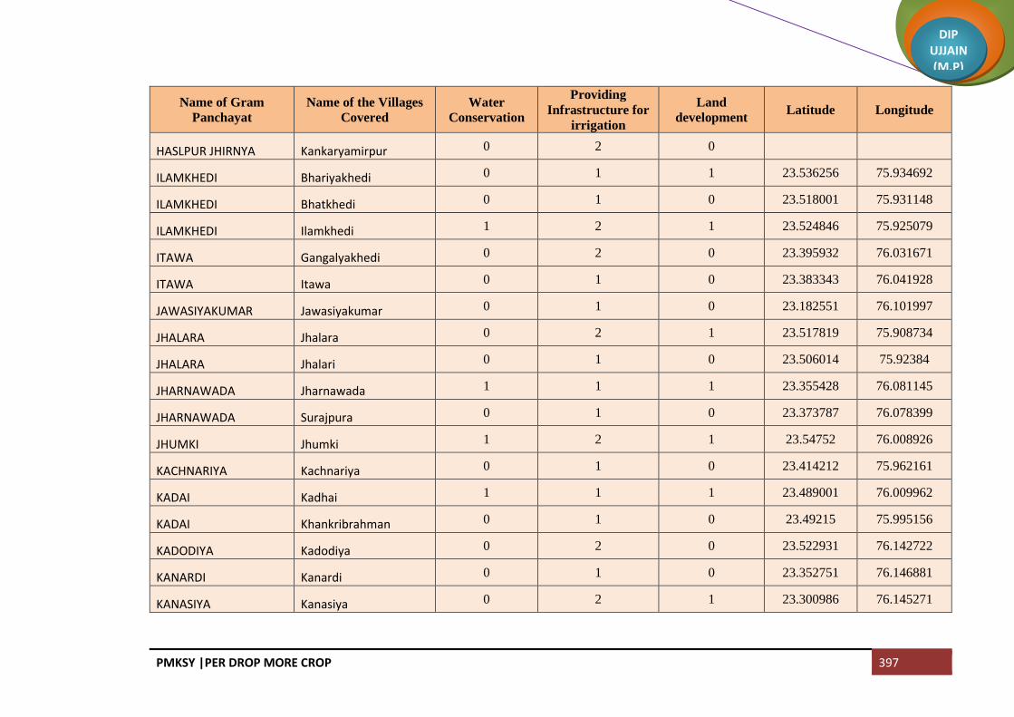
PMKSY |PER DROP MORE CROP 397
DIP UJJAIN (M.P)
Name of Gram
Panchayat
Name of the Villages
Covered
Water
Conservation
Providing
Infrastructure for
irrigation
Land
development Latitude Longitude
HASLPUR JHIRNYA Kankaryamirpur 0 2 0
ILAMKHEDI Bhariyakhedi 0 1 1 23.536256 75.934692
ILAMKHEDI Bhatkhedi 0 1 0 23.518001 75.931148
ILAMKHEDI Ilamkhedi 1 2 1 23.524846 75.925079
ITAWA Gangalyakhedi 0 2 0 23.395932 76.031671
ITAWA Itawa 0 1 0 23.383343 76.041928
JAWASIYAKUMAR Jawasiyakumar 0 1 0 23.182551 76.101997
JHALARA Jhalara 0 2 1 23.517819 75.908734
JHALARA Jhalari 0 1 0 23.506014 75.92384
JHARNAWADA Jharnawada 1 1 1 23.355428 76.081145
JHARNAWADA Surajpura 0 1 0 23.373787 76.078399
JHUMKI Jhumki 1 2 1 23.54752 76.008926
KACHNARIYA Kachnariya 0 1 0 23.414212 75.962161
KADAI Kadhai 1 1 1 23.489001 76.009962
KADAI Khankribrahman 0 1 0 23.49215 75.995156
KADODIYA Kadodiya 0 2 0 23.522931 76.142722
KANARDI Kanardi 0 1 0 23.352751 76.146881
KANASIYA Kanasiya 0 2 1 23.300986 76.145271

PMKSY |PER DROP MORE CROP 398
DIP UJJAIN (M.P)
Name of Gram
Panchayat
Name of the Villages
Covered
Water
Conservation
Providing
Infrastructure for
irrigation
Land
development Latitude Longitude
KAPELI Kapeli 1 1 1 23.429777 76.126268
KARANJ Karanj 0 1 0 23.322548 76.102459
KAREDI Karedi 1 2 1 23.415945 76.198509
KATHADI KATHADI
1 1 1 23.528177 76.086733
KATHBADODA Kathbadoda 1 2 1 23.124072 76.064214
KATHBADODA Malkheda 0 1 0
KATWARIYA Aurangpur 1 1 1 23.496706 76.227613
KATWARIYA Katwariya 0 2 1 23.523781 76.211048
KAWLIKHEDA Bhuki Itwarpur 0 1 0 23.305079 75.975128
KAWLIKHEDA Binjal 0 1 1 23.290296 75.995481
KAWLIKHEDA Kawlikheda 0 1 0 23.311177 75.98783
KAYTHA Kaytha 0 1 1 23.236479 76.018631
KESWAL Jamunya 0 2 0 23.453029 76.077404
KESWAL KESWAL
1 1 1 23.469477 76.087075
KHAJJUKHEDI KHAJJUKHEDI
0 1 1 23.513884 75.989929
KHAJJUKHEDI Mergarh 0 1 0 23.500583 75.978342
KHAJURIA KHAJURIA
1 2 1 23.099896 76.091687
KHAMBUKHEDI KHAMBUKHEDI
1 1 1 23.336675 76.094438

PMKSY |PER DROP MORE CROP 399
DIP UJJAIN (M.P)
Name of Gram
Panchayat
Name of the Villages
Covered
Water
Conservation
Providing
Infrastructure for
irrigation
Land
development Latitude Longitude
KHAMBUKHEDI Sadikhedi 0 3 1 23.32903 76.0771
KHAMLI Khamli 0 1 1 23.422526 76.01292
KHAMLI Tilawadi 0 1 0 23.41016 76.005367
KHARKHADI Jawaharnagar 0 1 0 23.353409 76.227446
KHARKHADI Kharkhadi 0 1 1 23.418404 76.171482
KHARPA Bherupura 0 1 0 23.245333 75.998865
KHARPA KHARPA
1 2 1 23.276216 76.007074
KHARPA Shivpura 0 1 1 23.255995 76.010187
KHATIKHEDI Barkhedakaytha 0 2 1 23.05713 76.099885
KHATIKHEDI Khatikhedi 1 1 1 23.071275 76.08278
LALAKHEDA Lalakheda 1 1 1 23.433744 76.136464
LALAKHEDA Palkhanda 0 1 0 23.420434 76.187609
LALAKHEDA Shankarpura 0 1 0 23.409722 76.179111
LASUDIYAAMARA Kothdi 0 1 0 23.51474 76.001464
LASUDIYAAMARA LASUDIYAAMARA
1 2 1 23.503406 76.007644
LASUDIYABECHAR Guradiyadongar 0 2 0 23.291303 75.999905
LASUDIYABECHAR Lasurdiyabechar 1 2 0 23.293928 76.006932
LASURDIYAHAMEER Chunakhedi 0 1 0 23.436571 75.974895

PMKSY |PER DROP MORE CROP 400
DIP UJJAIN (M.P)
Name of Gram
Panchayat
Name of the Villages
Covered
Water
Conservation
Providing
Infrastructure for
irrigation
Land
development Latitude Longitude
LASURDIYAHAMEER Lasurdiya Hameer 0 1 0 23.427278 75.994121
LASURDIYAHAMEER Shekhpur 0 1 0 23.421381 75.986035
LIMBADIT Limbadit 0 1 0 23.433934 76.074515
LIMBODA Limboda Tarana 0 2 1 23.347889 76.234195
LIMBODA Yeshwantnagar 0 1 0
LODH LODH
0 1 0 23.421344 76.033949
MALLUPURA MALLUPURA
1 2 1 23.21322 76.019354
MALLUPURA Molga 0 1 0 23.202788 76.029552
MUNDALI Mundli 0 2 1 23.303771 76.053809
MUNDALI Sadba 0 1 0 23.268435 76.047458
NAHARKHEDI Barnawad 0 1 0 23.391556 76.091417
NAHARKHEDI NAHARKHEDI
0 2 1 23.38955 76.067869
NALESHREE Bhojukhedi 0 1 0 23.147233 76.049643
NALESHREE NALESHREE
1 3 1 23.169014 76.047497
NANDED Nanded 0 4 1 23.457797 76.043489
NANUKHEDA Malhargarh 0 1 0 23.252327 76.050051
NANUKHEDA NANUKHEDA
0 2 1 23.239993 76.060227
NENAWAD NENAWAD
0 4 1 23.372771 76.221672

PMKSY |PER DROP MORE CROP 401
DIP UJJAIN (M.P)
Name of Gram
Panchayat
Name of the Villages
Covered
Water
Conservation
Providing
Infrastructure for
irrigation
Land
development Latitude Longitude
NENAWAD Suwarkota 0 2 0 23.379138 76.244455
NOGANWA Noganwa 0 1 0 23.361025 76.009809
PACHOLA Pachola 2 4 1 23.466773 76.022889
PADSI Gunakhedi 0 1 0 23.54562 75.939927
PADSI Jafarpurnera 0 1 0 23.543495 75.951343
PADSI Padsi 0 2 1 23.558681 75.907827
PALDUNA Gujarkheda 0 2 0 23.278885 76.120826
PALDUNA Lunyakhedi 0 1 0 23.264914 76.124414
PALDUNA Palduna 1 1 1 23.267576 76.106132
PANKHEDI Dhuwakhedi 0 1 0 23.440928 76.026568
PANKHEDI PANKHEDI
0 3 1 23.450604 75.990262
PARI Ankhali 0 2 1 23.461235 76.202531
PARI Moyagaon 0 2 0 23.445243 76.203767
PARI pari 1 1 1
PARI Tumni 0 1 0 23.489008 76.204797
PARSOLI Parsoli 0 1 1 23.509975 75.943092
PARSOLI Pipalyabazar 0 1 0 23.439195 75.949787
PAT Pat 1 2 1 23.538774 75.91744

PMKSY |PER DROP MORE CROP 402
DIP UJJAIN (M.P)
Name of Gram
Panchayat
Name of the Villages
Covered
Water
Conservation
Providing
Infrastructure for
irrigation
Land
development Latitude Longitude
PIPLYAKAYTHA Gopali 0 1 0 23.229197 76.07113
PIPLYAKAYTHA Khandakhedi 0 1 0 23.246042 76.076688
PIPLYAKAYTHA Laxmipura 0 2 1 23.227406 76.048539
PIPLYAKAYTHA Pipalyakaytha 1 1 0 23.219911 76.077698
RAMDI Amritnagar 0 3 0 23.434699 76.197689
RAMDI Borkhedi 0 1 0 23.473591 76.157034
RAMDI Gandhinagar 1 2 0 23.461702 76.187161
RAMDI Pipalyaramdi 1 1 0 23.446348 76.183212
RAMDI Ramdi 0 2 1 23.477859 76.175237
RAYPURA Birgod 0 1 0 23.300763 76.023508
RAYPURA RAYPURA
0 1 1 23.278149 76.029307
RUPAKHEDI Lalakhedi 0 1 0 23.465592 75.972163
RUPAKHEDI RUPAKHEDI
0 2 1 23.472835 75.990188
SAKARI Anantkhedi 0 0 0 23.248555 76.088192
SAKARI SAKARI
0 2 1 23.248476 76.099179
SALAKHEDI Malikhedi 0 1 0 23.330852 76.031405
SALAKHEDI SALAKHEDI
0 3 1 23.323827 76.018197
SALNAKHEDI Rehwari 0 1 0 23.564568 76.169038

PMKSY |PER DROP MORE CROP 403
DIP UJJAIN (M.P)
Name of Gram
Panchayat
Name of the Villages
Covered
Water
Conservation
Providing
Infrastructure for
irrigation
Land
development Latitude Longitude
SALNAKHEDI SALNAKHEDI
1 4 1 23.554891 76.167664
SAMANERA Hanumanti 0 0 0 23.423267 75.959655
SAMANERA SAMANERA
0 2 0 23.448369 75.949961
SAMGI Samgi 0 3 1 23.356614 76.18435
SARALI Haidarpura 0 1 0 23.476956 76.135683
SARALI Moyakheda 0 1 0 23.463493 76.144953
SARALI SARALI
1 4 1 23.456427 76.129225
SIDDHIPURNIPANIYA sankargarh 0 1 0
SIDDHIPURNIPANIYA Siddhipurnipanya 0 2 0 23.347393 76.115467
SUCHAI Lasudiya Dhandu 0 2 0 23.532786 76.102266
SUCHAI SUCHAI
1 4 1 23.510121 76.077633
SUMRAKHEDA Hatyakhedi 0 0 0 23.260446 76.030935
SUMRAKHEDA SUMRAKHEDA
1 1 1 23.258333 76.066563
SUWAS Lakhmankhedi 0 1 0 23.523795 75.978242
SUWAS SUWAS
0 2 1 23.540033 75.960613
TEJLAKHEDI Rawankhedi 0 1 0 23.530297 76.04846
TEJLAKHEDI TEJLAKHEDI
0 2 1 23.546349 76.030435
TILAWAD Ranchikhedi 0 1 0 23.385584 75.99473

PMKSY |PER DROP MORE CROP 404
DIP UJJAIN (M.P)
Name of Gram
Panchayat
Name of the Villages
Covered
Water
Conservation
Providing
Infrastructure for
irrigation
Land
development Latitude Longitude
TILAWAD TILAWAD
0 1 1 23.402814 75.989347
TITODI Rojwas 0 1 0 23.315544 76.186603
TITODI TITODI
0 2 1 23.326112 76.191285
TOBARIKHEDA TOBARIKHEDA
0 3 1 23.368522 76.060192
TUKRAL TUKRAL
0 4 1 23.470615 75.928025
UMRAJHAR Manpura 0 1 0 23.445931 76.146052
UMRAJHAR Tanda 1 2 0 23.424136 76.163462
UMRAJHAR UMRAJHAR
0 2 1 23.457097 76.143434
UPADI UPADI
0 2 1 23.086081 76.099524
Total 54 334 96

PMKSY |PER DROP MORE CROP 405
DIP UJJAIN (M.P)
Block Khachrod
Name of Gram
Panchayat
Name of the Villages
Covered
Water
Conservation
Providing
Infrastructure for
irrigation
Land
development Latitude Longitude
Gothda
Gothda 3 23.524747 75.196721
Lohachitara 2 23.514406 75.186718
Kantharkhedi 1 23.49723 75.198099
Napakhedi
Napakhedi 4 1 23.485662 75.197636
Brahman Khedi Khurd 0 23.494274 75.177681
Padalyakhurd 0 23.483883 75.180948
Shribach Shribachh 1 5 1 23.510538 75.215053
Banjari
Banjari 4 23.497691 75.229848
Lasudiya Daiyar 0
Farnakhedi Farnakhedi 0 1 23.511889 75.261288
Meend Meen 0 1 23.513299 75.244654
Dodiya Dodiya 0 23.570200 75.290817
Sendari
Sendri 2 1 23.540327 75.29286043
Dhaturiya 1 23.533776 75.274206
Barkheda jawra Barkheda Jaora 3 23.518468 75.292150
Chapakheda Chapakheda 2 23.584304 75.288724
Chapaner Sakatkhedi 1 2 23.610495 75.327843

PMKSY |PER DROP MORE CROP 406
DIP UJJAIN (M.P)
Name of Gram
Panchayat
Name of the Villages
Covered
Water
Conservation
Providing
Infrastructure for
irrigation
Land
development Latitude Longitude
Chanpaner 1 2 23.591734 75.319817
Mokdi Mokdi 1 23.577201 75.335171
Akyajageer
Tarod 1 0 23.554046 75.33481
Akyajagir 2 1 23.559538 75.317344
Chandodiya Chandodiya 1 5 1 23.538365 75.326005
Kesariya Kesariya 5 1 23.531262 75.308850
Divel Divel 5 1 23.521623 75.332861
Ghinoda Ghinoda 1 1 23.504096 75.299639
Bhensola Bhensola 2 23.474320 75.236622
Panwasa
Bhandla 0 23.460078 75.234093
Panwasa 2 1 23.442125 75.226797
Ringniya
Jalod 1 23.472291 75.1809
Rigania 2 1 23.460502 75.180603
Batlawdi Batlawadi 0 1 23.471643 75.180900
Bordiya
Bordiya 1 23.436597 75.174641
Khandwa 1 23.450136 75.191769
Naredipata Naredipata 2 1 23.437275 75.207106
Unchaheda Unchaheda 1 1 23.402978 75.151639
Runkheda Runkheda 2 1 23.403309 75.158496

PMKSY |PER DROP MORE CROP 407
DIP UJJAIN (M.P)
Name of Gram
Panchayat
Name of the Villages
Covered
Water
Conservation
Providing
Infrastructure for
irrigation
Land
development Latitude Longitude
Thadoda
Thadoda 2 1 23.415802 75.198531
Dipakhedi 2 23.421498 75.209141
Kanwas Kanwas 3 1 23.399644 75.188585
Nandvasla
Nandwasla 3 23.379990 75.195311
Sanasala 0 23.387395 75.204109
Bhunwasa
Bhanwasa 2 1 23.406000 75.215781
Naredikhurd 0 23.437127 75.206976
Kanchankhedi
Kanchankhedi 2 23.46684 75.279031
Kutlana 2 23.467943 75.255685
Behlola Behlola 3 1 23.437715 75.245422
Lekodiya tank Lekodiya Tank 3 23.481877 75.301776
Bhatkhedi
Bhat Khedi 2 1 23.527176 75.883904
Ghudawan 1 23.446912 75.279387
Jhirmira
Jhirmira 2 1 23.507964 75.334665
Khurmundi 0 23.494632 75.345651
Bedawniya Bedavanya 2 1 23.483228 75.324269
Gidvaniya Gindwanya 2 23.477861 75.361100
Umarna
Umarna 2 1 23.443214 75.360896
Umarni 0 23.456443 75.379435
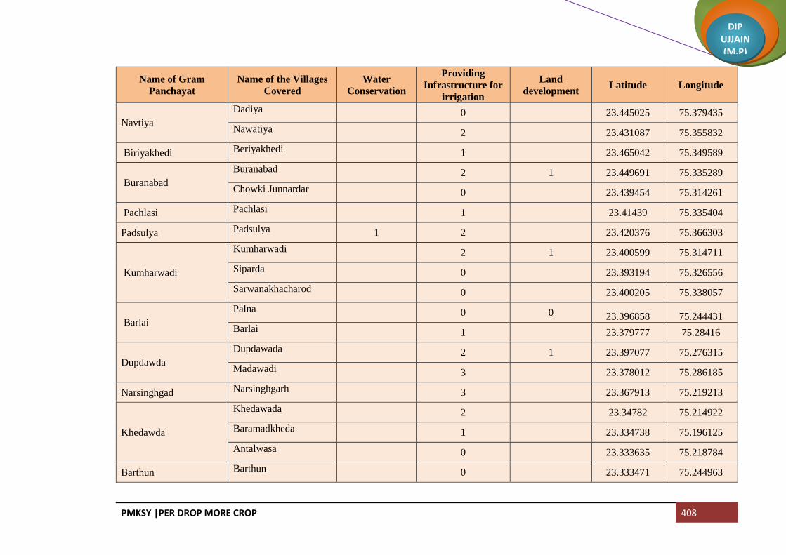
PMKSY |PER DROP MORE CROP 408
DIP UJJAIN (M.P)
Name of Gram
Panchayat
Name of the Villages
Covered
Water
Conservation
Providing
Infrastructure for
irrigation
Land
development Latitude Longitude
Navtiya
Dadiya 0 23.445025 75.379435
Nawatiya 2 23.431087 75.355832
Biriyakhedi Beriyakhedi 1 23.465042 75.349589
Buranabad
Buranabad 2 1 23.449691 75.335289
Chowki Junnardar 0 23.439454 75.314261
Pachlasi Pachlasi 1 23.41439 75.335404
Padsulya Padsulya 1 2 23.420376 75.366303
Kumharwadi
Kumharwadi 2 1 23.400599 75.314711
Siparda 0 23.393194 75.326556
Sarwanakhacharod 0 23.400205 75.338057
Barlai
Palna 0 0 23.396858 75.244431
Barlai 1 23.379777 75.28416
Dupdawda
Dupdawada 2 1 23.397077 75.276315
Madawadi 3 23.378012 75.286185
Narsinghgad Narsinghgarh 3 23.367913 75.219213
Khedawda
Khedawada 2 23.34782 75.214922
Baramadkheda 1 23.334738 75.196125
Antalwasa 0 23.333635 75.218784
Barthun Barthun 0 23.333471 75.244963

PMKSY |PER DROP MORE CROP 409
DIP UJJAIN (M.P)
Name of Gram
Panchayat
Name of the Villages
Covered
Water
Conservation
Providing
Infrastructure for
irrigation
Land
development Latitude Longitude
Rajpur Rayti 0 23.320788 75.23947
Kamthana Kamthana 2 23.304218 75.27484
Arjala Arjala 2 23.359371 75.241932
Madawda Madawada 1 3 23.357007 75.28416
Chirola Chirola 2 23.274578 75.409551
Bhikampur Bhikampur 3 23.393516 75.35772
Malakhedi
Tumni 0 23.403127 75.377118
Malakhedi 2 23.386741 75.377541
Jalwal 2 1 23.370276 75.390507
Khamriya Khamariya 2 23.366393 75.349842
Lasudiya khema Lasudiya Khema 4 23.357664 75.31395753
Bilwaniya Bilwaniya 2 23.345857 75.314645
Lusdawan
Lusdawan 1 2 1 23.332745 75.302589
Chak Narayangarh 0 23.32045 75.300958
Kamthani 0 23.309494 75.295808
Nandiyasi
Khatakhedi 0 23.304248 75.309337
Brahman Khedi Kalan 0 23.300701 75.309337
Nandiyasi 1 1 23.299361 75.347274
Bagedi Bachhakhedi 0 23.329868 75.330809

PMKSY |PER DROP MORE CROP 410
DIP UJJAIN (M.P)
Name of Gram
Panchayat
Name of the Villages
Covered
Water
Conservation
Providing
Infrastructure for
irrigation
Land
development Latitude Longitude
Bagedi 1 1 23.348967 75.349172
Chandvasla
Chandwasla 1 1 23.323586 75.356495
Nimadi 1 23.313565 75.332754
Badagaon Badagaon 5 23.337424 75.395753
Sandla Sandla 5 1
Surel Surel 1 23.290981 75.382226
Sadawda
Madgani 0 23.349427 75.408308
Gidawada 0 23.339553 75.418918
Sandawda 2 1 23.325835 75.414587
Piplodapanth
Luhari 0 23.290388 75.407402
Piplodapanth 1 1 23.297952 75.42624
Sonchidi 0 23.31606 75.432144
Sekdi sultanpur
Sekdi Sultanpur 1 1 23.335639 75.432415
Kadiyali 1 23.31158 75.444391
Rajgarh
Rajgarh 0
Banwada 2
Tootiyakhedi Tootiyakhedi 2 1 23.58293 75.392655
Rajla
Rajla 2 1 23.486184 75.311105
Bachhoda 2 23.474183 75.230381

PMKSY |PER DROP MORE CROP 411
DIP UJJAIN (M.P)
Name of Gram
Panchayat
Name of the Villages
Covered
Water
Conservation
Providing
Infrastructure for
irrigation
Land
development Latitude Longitude
Nimbodiyakala Nimbodiyakalan 2 23.551272 75.427568
Bercha Berchha 2 1 23.547104 75.382314
Atlawda
Atlawada 1 1 23.529631 75.355692
Ninawatkheda 1 23.514606 75.419623
Kalsi
Alsi 1 23.516326 75.396609
Kalsi 2 1 23.531932 75.408733
Parmarkhedi
Kilodiya 0 23.501004 75.361272
Parmarkhedi 2 1 23.485497 75.379382
Bhagatpuri 1 23.474239 75.384875
Nipanya
Nipanya 2 1 23.504984 75.401753
Geedgarh 0 23.492569 75.39099
Hebatpur Bhimpura 0 23.488572 75.401554
Rohal Kalan
Rohal Kalan 2 1 23.516432 75.446604
Jalodiya Khacharod 0 23.486571 75.44293
Jhanjhakhedi
Jhanjhakhedi 2 1 23.507201 75.42819
Khajuriya 1 23.489514 75.419623
Ratanyakhedi
Ratanyakhedi 2 1 23.490293 75.432125
Banbani 0 23.457392 75.450385
Rohalkhurd Rohalkhurd 2 1 23.514671 75.468339

PMKSY |PER DROP MORE CROP 412
DIP UJJAIN (M.P)
Name of Gram
Panchayat
Name of the Villages
Covered
Water
Conservation
Providing
Infrastructure for
irrigation
Land
development Latitude Longitude
Akyakoli
Kachnariya 1 1 23.511539 75.497476
Akyakoli 1 23.504458 75.544737
Heedi Heedi 2 23.481751 75.557336
Antraliya
Kiradiya 0 23.469226 75.574873
Antraliya 1 1 23.458413 75.556786
Punakheda 0 23.438386 75.555793
Borkheda Pitramal Borkheda Pitramal 2 23.479272 75.502698
Rupeta Rupeta 2 23.485803 75.475162
Banbana Banbana 3 23.450138 75.464004
Takrawada Takrawada 3 23.417388 75.398097
Azimabad Pardhi Azimabad Pardhi 1 23.424835 75.415342
Amlawad Junnardar
Amlawad Junnardar 0
Lasudiya Jaisingh 0
Nayan Nayan 2 1 23.422086 75.384047
Bhatisuda Bhatisuda 2 1 23.399107 75.418234
Bhilsuda Bhilsuda 2
Nimbodiya Khurd
Nimbodiya Khurd 2 23.38014 75.42616
Pipalyasees 0 23.393456 75.449255
Piploda Sagotimata Piploda Sagotimata 2
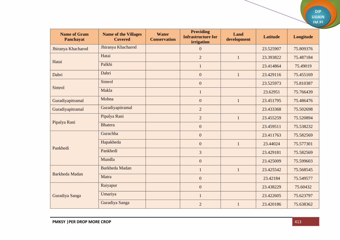
PMKSY |PER DROP MORE CROP 413
DIP UJJAIN (M.P)
Name of Gram
Panchayat
Name of the Villages
Covered
Water
Conservation
Providing
Infrastructure for
irrigation
Land
development Latitude Longitude
Jhiranya Khacharod Jhiranya Khacharod 0 23.525907 75.809376
Hatai
Hatai 2 1 23.393822 75.487184
Palkhi 1 23.414864 75.49019
Dabri Dabri 0 1 23.429116 75.455169
Simrol
Simrol 0 23.525973 75.810387
Makla 1 23.62951 75.766439
Guradiyapitramal Mohna 0 1 23.451795 75.486476
Guradiyapitramal Guradiyapitramal 2 23.433368 75.502698
Pipalya Rani
Pipalya Rani 2 1 23.455259 75.520894
Bhatera 0 23.459511 75.538232
Pankhedi
Gurachha 0 23.411763 75.582569
Hapakheda 0 1 23.44024 75.577301
Pankhedi 3 23.429181 75.582569
Mundla 0 23.425009 75.599603
Barkheda Madan
Barkheda Madan 1 1 23.425542 75.568545
Matra 0 23.42184 75.549577
Guradiya Sanga
Raiyapur 0 23.438229 75.60432
Umariya 1 23.422605 75.623797
Guradiya Sanga 2 1 23.420186 75.638362

PMKSY |PER DROP MORE CROP 414
DIP UJJAIN (M.P)
Name of Gram
Panchayat
Name of the Villages
Covered
Water
Conservation
Providing
Infrastructure for
irrigation
Land
development Latitude Longitude
Alot Jagir Alot Jagir 3 1 23.394611 75.615286
Pipalya Sarang
Chidi Rawadiya 0 23.388922 75.641001
Pipalya Sarang 4 23.370505 75.639341
Itawa 1 23.356198 75.612014
Sarwana Unhel
Sarwana Unhel 1 23.400432 75.556486
Arolya Dewda 0 23.369884 75.572532
Jhiranya Unhel
Jhiranya Unhel 2 1 23.394054 75.583969
Parolya Padma 0 23.376841 75.584212
Jalodiya Unhel
Rathda 0 23.441601 75.536526
Jalodiya Unhel 2 23.429237 75.524003
Khimlakhedi 0 23.419192 75.510337
Dallaheda
Dallaheda 2 1 23.395874 75.536445
Mahu 0 23.418934 75.7536468
Dhoomaheda
Madhavgarh 0 23.387208 75.506808
Dhoomaheda 2 23.397424 75.521813
Pipalya Molu Pipalya Molu 3 23.373794 75.489569
Kundla
Bhakarda 0 23.365097 75.461005
Kundla 1 23.355878 75.484007
Bagla Bagla 0 23.347368 75.459889

PMKSY |PER DROP MORE CROP 415
DIP UJJAIN (M.P)
Name of Gram
Panchayat
Name of the Villages
Covered
Water
Conservation
Providing
Infrastructure for
irrigation
Land
development Latitude Longitude
Nagjhiri 2 23.331134 75.471648
Chambal Padlaya Chambal Padlaya 1 1 23.3294 75.446499
Barkheda Najeek Barkheda Najeek 2 23.327745 75.489501
Chawand
Chawand 2 23.312734 75.454533
Rajota 0 23.289533 75.461389
Lekodiya Anjana Lekodiya Anjana 3 23.300405 75.475335
Paslod
Kalalkhedi 0 23.33996 75.501335
Paslod 2 1 23.29165 75.510313
Akya Najik Akya Najik 1 1 23.298817 75.49611
Nawada Nawada 3 1 23.32404 75.518426
Malikhedi
Chinkuganj 0 23.376247 75.512884
Malikhedi 2 1 23.35978 75.524987
Kankarda 0 23.378059 75.537604
Bedawan Bedawan 2 23.460531 75.605782
Pagara
Didiyakhedi 1 0 23.356134 75.580202
Baijnathkhedi 0 1 23.343014 75.593916
Pagara 3 23.32585 75.601061
Roopakhedi 0 23.315795 75.612329
Pipliyadhabi Pipalya Dabi 2 1 23.309896 75.579995

PMKSY |PER DROP MORE CROP 416
DIP UJJAIN (M.P)
Name of Gram
Panchayat
Name of the Villages
Covered
Water
Conservation
Providing
Infrastructure for
irrigation
Land
development Latitude Longitude
Surjakhedi
Surjakhedi 3 1 23.293142 75.618027
Jiyajigarh 0 23.270269 75.623367
Gurla Gurla 2 23.291544 75.502585
Karondiya
Lasudiyachuwad 0 23.304792 75.558187
Karondiya 0 1 23.273113 75.530098
Rambaloda Ramabaloda 2 23.274518 75.581186
Khokri
Khokri 2 1 23.267884 75.6000729
Arolyajassa 0 23.262141 75.619725
Total 9 293 70

PMKSY |PER DROP MORE CROP 417
DIP UJJAIN (M.P)
Block Badnagar
Name of Gram
Panchayat
Name of the Villages
Covered
Water
Conservation
Providing
Infrastructure for
irrigation
Land
development Latitude Longitude
Bhatpachlana Bhatpachlana 2 0 5 23.250506 75.294487
Maloda Maloda 1 0 2 23.241022 75.315326
Banbani Banbani 1 0 3 23.260815 75.311721
Bhunwasa 1 0 1 23.284026 75.338293
Kajyakhedi 1 0 1 23.272515 75.337434
Banderbela Banderbela 1 0 2 23.252378 75.345967
Limbas Limbas 1 0 1 23.276063 75.371767
Chirola Chirola 1 0 2 23.274651 75.410906
Rathorkhedi 1 0 1 23.286951 75.430390
Salwa Salwa 1 0 2 23.245633 75.393139
Mungawada Lasudiya 1 0 1 23.251190 75.425917
Mungawada 1 0 2 23.258445 75.441195
Karadwas 1 0 1 23.275240 75.432440
Silodiya Mungawadi 1 0 2 23.247116 75.445670
Silodiya 2 0 1 23.238046 75.431078
Amlawadkalan Dehta 1 0 2 23.282991 75.445670
Kesharpura 1 0 1 23.271403 75.453394
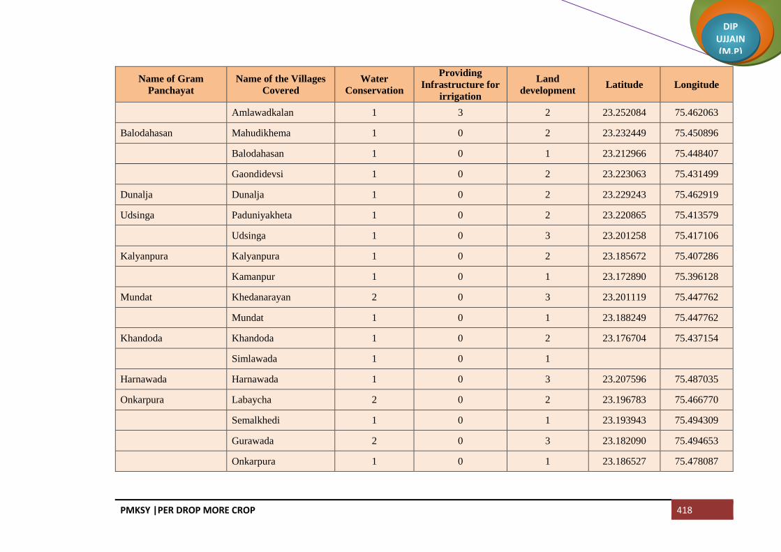
PMKSY |PER DROP MORE CROP 418
DIP UJJAIN (M.P)
Name of Gram
Panchayat
Name of the Villages
Covered
Water
Conservation
Providing
Infrastructure for
irrigation
Land
development Latitude Longitude
Amlawadkalan 1 3 2 23.252084 75.462063
Balodahasan Mahudikhema 1 0 2 23.232449 75.450896
Balodahasan 1 0 1 23.212966 75.448407
Gaondidevsi 1 0 2 23.223063 75.431499
Dunalja Dunalja 1 0 2 23.229243 75.462919
Udsinga Paduniyakheta 1 0 2 23.220865 75.413579
Udsinga 1 0 3 23.201258 75.417106
Kalyanpura Kalyanpura 1 0 2 23.185672 75.407286
Kamanpur 1 0 1 23.172890 75.396128
Mundat Khedanarayan 2 0 3 23.201119 75.447762
Mundat 1 0 1 23.188249 75.447762
Khandoda Khandoda 1 0 2 23.176704 75.437154
Simlawada 1 0 1
Harnawada Harnawada 1 0 3 23.207596 75.487035
Onkarpura Labaycha 2 0 2 23.196783 75.466770
Semalkhedi 1 0 1 23.193943 75.494309
Gurawada 2 0 3 23.182090 75.494653
Onkarpura 1 0 1 23.186527 75.478087

PMKSY |PER DROP MORE CROP 419
DIP UJJAIN (M.P)
Name of Gram
Panchayat
Name of the Villages
Covered
Water
Conservation
Providing
Infrastructure for
irrigation
Land
development Latitude Longitude
Sijawata Sijawata 1 0 2 23.170076 75.463590
Gaondilodha Gaondilodha 2 0 5 23.156661 75.467154
Dhureri Dhureri 1 4 2 23.142304 75.501043
Rajota 2 0 1 23.146329 75.482504
Suneda Suneda 1 0 2 23.118625 75.501301
Chinchodiya 1 0 1 23.120203 75.517866
Kiloli Kiloli 1 0 2 23.107064 75.501598
Namalpur 1 0 1 23.096248 75.511256
Kharsodkhurd Kharsodkhurd 4 4 2 23.118526 75.469040
Untwas Untwas 1 0 2 23.088195 75.450787
Ranwa Hatyakhedi 1 0 3 23.086774 75.450787
Ranwa 1 0 1 23.088195 75.489067
Dantarwa Dantarwa 2 0 5 23.104587 75.414571
Rasulabad 1 0 1 23.100718 75.429935
Molana Molana 1 0 2 23.100718 75.429935
Palwa Palwa 1 0 2 23.144346 75.429069
Sanawada Itawa 2 0 5 23.461516 75.745866
Sanawada 1 3 1 23.122024 75.415069

PMKSY |PER DROP MORE CROP 420
DIP UJJAIN (M.P)
Name of Gram
Panchayat
Name of the Villages
Covered
Water
Conservation
Providing
Infrastructure for
irrigation
Land
development Latitude Longitude
Rawadiyapeer Rawadiyapeer 2 0 2 23.187767 75.370559
Mindka 1 0 1 23.160781 75.385065
Balodakoran Balodakoran 1 0 2 23.181703 75.333750
Ajdawada Ajdawada 1 0 5 23.180903 75.358886
Kharsodkalan Kharsodkalan 5 0 2 23.220246 75.368254
Ordi Ordi 1 0 4 23.231489 75.338394
Narelakhurd 1 0 1 23.234303 75.353653
Bardiya Bardiya 1 0 2 23.216574 75.325528
Nauganwa Nauganwa 1 0 2 23.224930 75.301132
Khedawada Khedawada 1 0 4 23.188903 75.290080
Malgaondi 1 0 1 23.174622 75.285874
Badganwa Badganwa 1 0 2 23.197264 75.254211
Gajnikhedi Maswadiyadhar 2 0 4 23.192452 75.233183
Gajnikhedi 1 0 1 23.173358 75.253267
Runija Runija 1 0 2 23.160597 75.268006
Madhopura Madhopura 1 0 1 23.141457 75.277446
Balodalakha Balodalakha 1 0 4 23.156439 75.313754
Sundrabad Sundrabad 1 0 5 23.133221 75.311637

PMKSY |PER DROP MORE CROP 421
DIP UJJAIN (M.P)
Name of Gram
Panchayat
Name of the Villages
Covered
Water
Conservation
Providing
Infrastructure for
irrigation
Land
development Latitude Longitude
Jalodsanjar Jalodsanjar 1 0 4 23.136536 75.348286
Pachlanabil Pachlanabil 1 0 5 23.138588 75.372147
Singawada 1 0 2 23.131752 75.389587
Bidsingawada 1 0 4 23.118697 75.386824
Meethikhedi 1 0 5 23.109066 75.388455
Pitlawadiya Pitlawadiya 2 0 4
Tokra 1 0 3 23.086291 75.338623
Birakhedi Ranawada 1 0 4 23.118699 75.373047
Birakhedi 1 0 1 23.113853 75.353993
Jassakhedi Balodaarsi 3 0 2 23.098528 75.349244
Jassakhedi 1 0 4 23.085116 75.324849
Jandla Semaliya 1 0 6 23.101638 75.379687
Jandla 1 0 4 23.094535 75.367128
Garakhedi 1 0 4 23.088559 75.379831
Peethakhedi 1 0 3 23.079142 75.356743
Paduniyalodha 1 0 2 23.079873 75.375292
Beesaheda Beesaheda 3 0 4 23.091476 75.397043
Kajlana 1 0 3 23.074058 75.395920

PMKSY |PER DROP MORE CROP 422
DIP UJJAIN (M.P)
Name of Gram
Panchayat
Name of the Villages
Covered
Water
Conservation
Providing
Infrastructure for
irrigation
Land
development Latitude Longitude
Jhalaria Jhalaria 1 3 5 23.065849 75.424952
Khedamadhav 1 0 4 23.053371 75.419459
Karadiya 1 0 3 23.062532 75.396370
Jafla (Part) Bargadi 1 0 2 23.052660 75.349249
Jafla (Part) 1 0 4 23.026990 75.384955
Amla Amla 1 0 8 23.012884 75.329004
Ajanda Ajanda 2 0 4 22.986448 75.358055
Arandiya 1 0 3 23.019235 75.367583
Ubradiya 1 0 4 23.006911 75.360716
Kotki 1 0 2 23.000810 75.379513
Shekhpur Shekhpur 1 0 1 23.041033 75.398830
Bhomalwas Bhomalwas 1 0 5 23.025411 75.406241
Upri 1 0 1 23.011112 75.392250
Birgodarandhir Bhainslakalan 2 0 4 23.035995 75.425467
Birgodarandhir 1 0 3 23.043183 75.439715
Umariya Umariya 1 0 4 23.017274 75.422206
Khandwasura Khandwasura 1 0 5 22.976729 75.383290
Likhoda 1 0 3 23.001776 75.387152

PMKSY |PER DROP MORE CROP 423
DIP UJJAIN (M.P)
Name of Gram
Panchayat
Name of the Villages
Covered
Water
Conservation
Providing
Infrastructure for
irrigation
Land
development Latitude Longitude
Jalodiya Jalodiya 1 0 4 22.991707 75.417174
Bhidawad Bhidawad 1 0 6 22.938916 75.348166
Lohariya 1 0 4 22.973345 75.335766
Sarola Sarola 2 0 3 22.961125 75.371941
Dhaturiya 1 0 2 22.949823 75.374945
Mundla 1 0 4 22.938837 75.385503
Suklana Rawadiyakalan 2 0 5 22.948252 75.323487
Suklana 1 0 4 22.917958 75.343333
Lohana Lohana 1 0 6 22.914381 75.366287
Khandwabibi Kungara 2 0 4 22.903530 75.346716
Khandwabibi 1 0 3 22.880089 75.346530
Satwasa 1 0 2 22.879432 75.368261
Nawada Nawada 1 0 1 22.859880 75.349000
Badgara Badgara 1 0 4 22.843099 75.350339
Piplee Piplee 1 0 6 22.866708 75.400017
Dotru Dotru 1 0 4 22.891473 75.431523
Gajikhedi 1 0 3 22.884198 75.419249
Pithora Pithora 1 0 5 22.930622 75.413567

PMKSY |PER DROP MORE CROP 424
DIP UJJAIN (M.P)
Name of Gram
Panchayat
Name of the Villages
Covered
Water
Conservation
Providing
Infrastructure for
irrigation
Land
development Latitude Longitude
Biragodanathu 1 0 4 22.910226 75.415627
Gunawad Gunawad 1 0 3 22.935523 75.439058
Bisalkhedi 1 0 5 22.929832 75.469957
Bangred Bangred 1 0 2 22.956383 75.404300
Fatehpur Fatehpur 2 0 4 22.962278 75.449548
Asawta Asawta 1 0 1 22.994788 75.417174
Akoliya Akoliya 2 0 5 22.987700 75.465604
Takrawada 1 0 4 22.979245 75.479507
Pirjhalar Pirjhalar 2 0 4 23.031151 75.464574
Bhandtilawali 1 0 3 23.030756 75.489809
Daulatpur Daulatpur 1 0 4 23.038654 75.512039
Sohad 1 0 3 23.048765 75.495351
Pacholi 1 0 4 23.026247 75.667179
Dautardi 1 0 2 23.013845 75.501771
Palduna Palduna 4 0 1 23.065823 75.463937
Lakhesara Maswadiyakhalsa 1 0 6 23.079800 75.514406
Lakhesara 1 0 7 23.058558 75.510629
Narsinga Paslod 1 0 4 23.063533 75.531744

PMKSY |PER DROP MORE CROP 425
DIP UJJAIN (M.P)
Name of Gram
Panchayat
Name of the Villages
Covered
Water
Conservation
Providing
Infrastructure for
irrigation
Land
development Latitude Longitude
Narsinga 1 0 5 23.064558 75.542558
Dangwada Dangwada 1 3 6 23.091089 75.526861
Baledi Baledi 1 0 6 23.121239 75.556476
Ghudawan Ghudawan 3 0 4 23.446769 75.278596
Bhainsla Khurd 1 0 5 23.162511 75.536027
Sarsana Sarsana 1 0 3 23.145224 75.523960
Jhumki Jhumki 1 0 4 23.546958 70.010681
Dharankhedi 1 0 6 23.188398 75.510764
Patyakhedi Karanpura 1 0 4 233.194051 75.541037
Patyakhedi 2 0 2 23.180634 75.541445
Jahangirpur Jahangirpur 1 0 6 23.215822 75.514271
Amlawadbika Amlawadbika 1 2 4 23.252160 75.463296
Molakhedi 1 0 3 23.245299 75.483338
Malpura Malpura 2 0 2 23.232465 75.495474
Murarkhedi 1 0 4 23.218977 75.495045
Palsoda Jamalpura 1 0 3 23.273898 75.477753
Palsoda 1 0 5 23.265225 75.496207
Makdawan Makdawan 1 0 5 23.858684 75.533783

PMKSY |PER DROP MORE CROP 426
DIP UJJAIN (M.P)
Name of Gram
Panchayat
Name of the Villages
Covered
Water
Conservation
Providing
Infrastructure for
irrigation
Land
development Latitude Longitude
Mahudialam Mahudialam 2 0 4 23.236839 75.514557
Banbana 1 0 5 23.449639 75.435439
Suwasa Suwasa 1 0 6 23.259157 75.564768
Kanjad Kanjad 1 0 7 23.240861 75.591719
Aslawada Aslawada 1 0 8 23.245691 75.616926
Kothdi Kothdi 1 0 5 23.217873 75.603974
Banya Khedi 1 0 4 23.223868 75.626032
Kantharkhedi 1 0 3 23.206343 75.627640
Narelakalan Narelakalan 2 0 5 23.230006 75.571764
Kalmoda 1 0 4 23.219832 75.584123
Gulabkhedi 1 0 6 23.217465 75.561550
Rupaheda Sikandarkheda 1 0 4 23.204385 75.547361
Rupaheda 1 0 2 23.194050 75.566330
Maniyawada Maniyawada 2 0 5 23.184309 75.575751
Surakhedi 1 0 1 23.174762 75.583989
Bamnapati Bamnapati 1 0 4 23.195142 75.603313
Khadotiya Khadotiya 1 0 5 23.174076 75.624943
Chhankhedi 1 0 4 23.154167 75.626965

PMKSY |PER DROP MORE CROP 427
DIP UJJAIN (M.P)
Name of Gram
Panchayat
Name of the Villages
Covered
Water
Conservation
Providing
Infrastructure for
irrigation
Land
development Latitude Longitude
Kulawada Matangna 1 0 4 23.171448 75.601927
Kulawada 1 0 5 23.219540 75.581801
Ingoriya Ingoriya 4 0 3 23.156139 75.569998
Cheekali Cheekali 5 0 5 23.139723 75.604845
Kadhai Kadhai 1 0 2 23.121630 75.593160
Bhondwas 1 0 4 23.123840 75.615218
Ghadsinga Ghadsinga 5 0 2 23.103001 75.583621
Brahmanbadoda 1 0 3 23.112553 75.621301
Nimboda Naharkhedi 1 0 2 23.089500 75.622331
Nimboda 1 0 4 23.101895 75.603877
Total 241 22 607

PMKSY |PER DROP MORE CROP 428
DIP UJJAIN (M.P)
Block Mahidpur
Name of Gram
Panchayat
Name of the Villages
Covered
Water
Conservation
Providing
Infrastructure for
irrigation
Land
development Latitude Longitude
Brahmankheda Brahmankheda 1 5 2 23.655658 75.544006
Petlawad Petlawad 1 5 2 23.639383 75.530874
Koyal Deoli 2 1 23.642485 75.559069
Koyal 1 3 1 23.620845 75.54592
Bapaiya Bapaiya 5 1 23.607082 75.521201
Kanakedi Eklaspur Kanakedi Eklaspur 1 3 1 23.583866 75.521576
Karnawad 2 1 23.588349 75.541145
Bawalya
Bawalya 3 1 23.600192 75.604931
Chibdi 2 23.596967 75.587937
Serankhedi 23.590911 75.570856
Tarnod Tarnod 5 23.586776 75.556423
Barukhedi Barukhedi 2 1 23.541546 75.541566
Sarwankheda 3 1 23.562711 75.543797
Isankhedi Isankhedi 1 5 23.553034 75.568946
Narayankhedi Jharawada 2 23.525178 75.521652
Narayankhedi 3 23.531474 75.553839
Delchibuzurg Delchibuzurg 1 3 23.530372 75.58182
Banjari Banjari 5 1 23.521298 75.602153

PMKSY |PER DROP MORE CROP 429
DIP UJJAIN (M.P)
Name of Gram
Panchayat
Name of the Villages
Covered
Water
Conservation
Providing
Infrastructure for
irrigation
Land
development Latitude Longitude
Mundlaparwal Mundlaparwal 2 23.495875 75.577606
Chitawad Chitawad 5 2 23.486504 75.603303
Rudrakheda 1 1 23.483459 75.622935
Parwatkheda
Parwatkheda 3 23.495058 75.634399
Dubli 2 23.488297 75.63706
Kukni 23.474363 75.624271
Harbakhedi Rohida 2 23.520196 75.622066
Harbakhedi 2 23.539082 75.634941
Delchikhurd Delchikhurd 1 2 1 23.542545 75.61374
Sagwali Singdewala 3 23.564558 75.600897
Sagwali 2 23.577302 75.578839
Jhutawad Jhutawad 1 5 1 23.635715 75.579866
Pepalya Bhim
Ilyakhedi 1 2 1 23.628595 75.600134
Pepalya Bhim 3 1 23.617155 75.598979
Aranya Najeek Chivdi 1 1 23.642511 75.623137
Gogakheda
Ghat Khedi 1 23.625518 75.628694
Modi 2 23.644627 75.64681
Gogakheda 3 1 23.626709 75.615053
Ghatpeepalya Aranyabena 2 2 23.642519 75.623423

PMKSY |PER DROP MORE CROP 430
DIP UJJAIN (M.P)
Name of Gram
Panchayat
Name of the Villages
Covered
Water
Conservation
Providing
Infrastructure for
irrigation
Land
development Latitude Longitude
Ghatpeepalya 1 3 1 23.655146 75.636342
Dhablasiya Dhablasiya 3 23.619773 75.66081
Munjakhedi 2 23.627443 75.647313
Kanthariya
Kanthariya 1 2 23.608257 75.629176
Barkhedakhurd 2 1 23.594368 75.621309
Sipawara 1 1 23.580808 75.61377
Semalya Semalya 5 2 23.559665 75.637244
Bani Bani 3 2 23.531858 75.658593
Rasulpura 2 2 23.51772 75.652242
Nipaniyabadar Nipaniyabadar 1 3 2 23.565536 75.668821
Katariya 2 2 23.587167 75.652798
Sumrakheda
Sanoriya 1 23.62882 75.694958
Akyabajrang 1 23.626109 75.713651
Sumrakheda 2 23.615763 75.712059
Sakariya
Sukdi 1 23.645685 75.716721
Sakariya 2 23.635417 75.732956
Kanakhedi Hamma 1 23.653547 75.765361
Asadi Aranyabagda 1 23.661977 75.704161
Asadi 2 23.671893 75.719751

PMKSY |PER DROP MORE CROP 431
DIP UJJAIN (M.P)
Name of Gram
Panchayat
Name of the Villages
Covered
Water
Conservation
Providing
Infrastructure for
irrigation
Land
development Latitude Longitude
Bahadurpura 1 23.654177 75.68951
Dungariya Dungariya 1 5 3 23.649092 75.601649
Ranayrapeer Ranayrapeer 1 5 23.654816 75.661026
Melakhedi
Hajalyakhedi 1 23.672595 75.634185
Melakhedi 1 2 23.674908 75.657426
Balah 2 23.683765 75.641764
Shrawan Borkhedi 1 23.676835 75.67636
Shrawan 2 23.681395 75.695848
Ghatiyasaindas Ghatiyasaindas 3 1 23.700222 75.647249
Bhadwa Bhadwa 5 23.703526 75.684996
Malya Yashwantpura 2 1 23.710491 75.708925
Malya 1 3 1 23.72113 75.716359
Tipukheda Bolkhedaghat 1 2 23.741979 75.7191
Tipukheda 1 23.723043 75.740214
Indokh Indokh 2 23.707562 75.758411
Mundlasondhya Mundlasondhya 5 1 23.69582 75.729567
Pipalya Dhuma Pipalya Dhuma 1 2 23.674603 75.742197
Patakhedi Sekli 2 23.673775 75.76895
Patakhedi 1 2 23.685723 75.7741
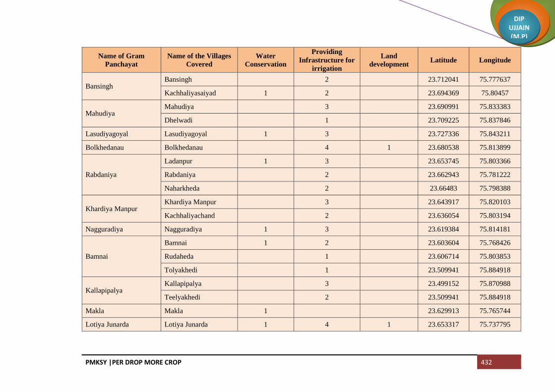
PMKSY |PER DROP MORE CROP 432
DIP UJJAIN (M.P)
Name of Gram
Panchayat
Name of the Villages
Covered
Water
Conservation
Providing
Infrastructure for
irrigation
Land
development Latitude Longitude
Bansingh Bansingh 2 23.712041 75.777637
Kachhaliyasaiyad 1 2 23.694369 75.80457
Mahudiya Mahudiya 3 23.690991 75.833383
Dhelwadi 1 23.709225 75.837846
Lasudiyagoyal Lasudiyagoyal 1 3 23.727336 75.843211
Bolkhedanau Bolkhedanau 4 1 23.680538 75.813899
Rabdaniya
Ladanpur 1 3 23.653745 75.803366
Rabdaniya 2 23.662943 75.781222
Naharkheda 2 23.66483 75.798388
Khardiya Manpur Khardiya Manpur 3 23.643917 75.820103
Kachhaliyachand 2 23.636054 75.803194
Nagguradiya Nagguradiya 1 3 23.619384 75.814181
Bamnai
Bamnai 1 2 23.603604 75.768426
Rudaheda 1 23.606714 75.803853
Tolyakhedi 1 23.509941 75.884918
Kallapipalya Kallapipalya 3 23.499152 75.870988
Teelyakhedi 2 23.509941 75.884918
Makla Makla 1 23.629913 75.765744
Lotiya Junarda Lotiya Junarda 1 4 1 23.653317 75.737795
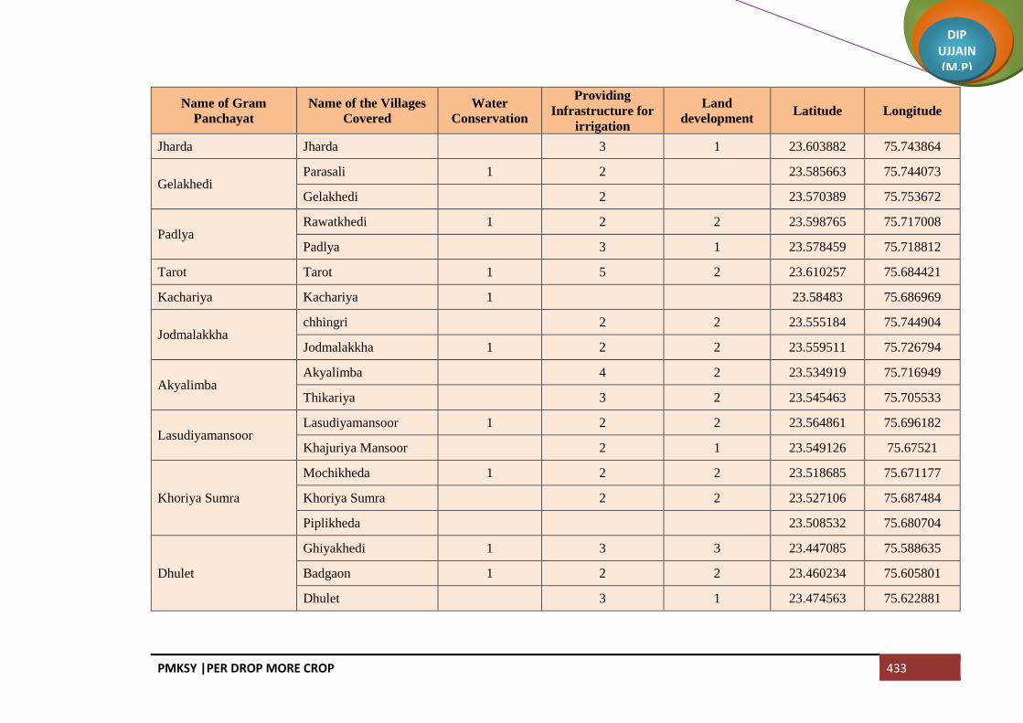
PMKSY |PER DROP MORE CROP 433
DIP UJJAIN (M.P)
Name of Gram
Panchayat
Name of the Villages
Covered
Water
Conservation
Providing
Infrastructure for
irrigation
Land
development Latitude Longitude
Jharda Jharda 3 1 23.603882 75.743864
Gelakhedi Parasali 1 2 23.585663 75.744073
Gelakhedi 2 23.570389 75.753672
Padlya Rawatkhedi 1 2 2 23.598765 75.717008
Padlya 3 1 23.578459 75.718812
Tarot Tarot 1 5 2 23.610257 75.684421
Kachariya Kachariya 1 23.58483 75.686969
Jodmalakkha chhingri 2 2 23.555184 75.744904
Jodmalakkha 1 2 2 23.559511 75.726794
Akyalimba Akyalimba 4 2 23.534919 75.716949
Thikariya 3 2 23.545463 75.705533
Lasudiyamansoor Lasudiyamansoor 1 2 2 23.564861 75.696182
Khajuriya Mansoor 2 1 23.549126 75.67521
Khoriya Sumra
Mochikheda 1 2 2 23.518685 75.671177
Khoriya Sumra 2 2 23.527106 75.687484
Piplikheda 23.508532 75.680704
Dhulet
Ghiyakhedi 1 3 3 23.447085 75.588635
Badgaon 1 2 2 23.460234 75.605801
Dhulet 3 1 23.474563 75.622881

PMKSY |PER DROP MORE CROP 434
DIP UJJAIN (M.P)
Name of Gram
Panchayat
Name of the Villages
Covered
Water
Conservation
Providing
Infrastructure for
irrigation
Land
development Latitude Longitude
Kadhai Barapathar (Part) 1 23.475902 75.646484
Kadhai 2 2 23.444171 75.649231
Bhimakheda Tajpura (Part) 23.47756 75.664596
Bhimakheda (Part) 4 2 23.483224 75.684142
Kajikhedi
Kajikhedi 2 2 23.486571 75.697527
Aamdi 1 23.503023 75.700531
Sangvikheda 1 23.497198 75.701217
Binpura Binpura 2 2 23.475175 75.7002
Tanda 2 1 23.45809 75.700457
Lakhakhedi Naharpur Lakhakhedi Naharpur 5 8 23.447576 75.672931
Sekakhedi Sekakhedi 2 2 23.466218 75.670088
Chorwasa 1 2 2 23.445528 75.692586
Dharakheda Dharakheda 1 2 23.447302 75.710328
Bagla 1 3 2 23.425016 75.695908
Mahu Mahu 2 2 23.423478 75.67276
Akyadhanga 1 3 2 23.412373 75.652589
Narayna Chiramya 1 3 2 23.396304 75.664434
Narayna 2 3 23.397485 75.681085
Baloda Tulsapur 1 3 3 23.41013 75.693763

PMKSY |PER DROP MORE CROP 435
DIP UJJAIN (M.P)
Name of Gram
Panchayat
Name of the Villages
Covered
Water
Conservation
Providing
Infrastructure for
irrigation
Land
development Latitude Longitude
Baloda 2 2 23.400363 75.704835
Sherpur 2 1 23.386814 75.686896
Aranya Najeek Sherpur 2 1 23.376651 75.7002
Barkhedabuzurg
Kukalkheda 1 2 23.414935 75.741914
Barkhedabuzurg 1 2 23.40761 75.728438
Gangajalya Kheda 1 2 23.407452 75.715993
Kitiya Moyakheda 2 23.432025 75.740491
Kitiya 2 1 23.427985 75.757091
Dongla Dongla 2 23.452155 75.763587
Kanakhedi Harbans 2 23.443481 75.790436
Itawa Itawa 3 23.462077 75.745004
Lasudiyashripat 23.430844 75.722602
Bisalkhedi Bisalkhedi 4 1 23.454625 75.728267
Kuwandiya 1 23.466199 75.726893
Pipalya Nath Pipalya Nath 1 2 1 23.482025 75.774822
Jawasyapanth Jawasyapanth 1 2 1 23.477368 75.753621
Lakhakhedi Umath 1 23.498828 75.762319
Dhablikamma Dhablikamma 1 3 2 23.494575 75.72158
Dhablabeni 2 2 23.476414 75.71663

PMKSY |PER DROP MORE CROP 436
DIP UJJAIN (M.P)
Name of Gram
Panchayat
Name of the Villages
Covered
Water
Conservation
Providing
Infrastructure for
irrigation
Land
development Latitude Longitude
Baijnath
Jharkhedi 1 1 23.511522 75.700665
Ramnagar 1 1 23.521537 75.700155
Baijnath 1 3 2 23.511428 75.717699
Suhagpura Mendki 2 1 23.505532 75.729755
Suhagpura 3 1 23.50263 75.746138
Guradiyadasa Guradiyadasa 2 2 23.536807 75.733072
Maukhedi 2 2 23.538075 75.750475
Nipaniyaraju
Nipaniyaraju 1 2 23.523009 75.77544
Somchidi 2 1 23.535528 75.785502
Mahidpuriya 2 23.530815 75.796396
Dhanodiya Dhanodiya 2 23.503541 75.789362
Azmabad Azmabad 2 1 23.523835 75.754762
Mundlibhoj 1 2 1 23.505272 75.774368
Padikheda Padikheda 2 23.48996 75.797798
Marukheda 2 23.50862 75.808876
Dungarkhedi
Simrol 2 23.526035 75.809663
Dungarkhedi 2 23.543674 75.809967
Delakhedi 1 23.549966 75.798921
Kheda Madda Kheda Madda 2 23.553522 75.825382

PMKSY |PER DROP MORE CROP 437
DIP UJJAIN (M.P)
Name of Gram
Panchayat
Name of the Villages
Covered
Water
Conservation
Providing
Infrastructure for
irrigation
Land
development Latitude Longitude
Neemkheda Neemkheda 2 23.568489 75.826732
Khedla 1 23.566758 75.809394
Nagpura Nagpura 1 2 2 23.55062 75.7522
Chhajjukhedi 2 2 23.547082 75.785492
Nalkheda Nalkheda 1 3 23.584301 75.776607
Khoriya Padma Khoriya Padma 2 23.5655 75.792571
Panodiya 2 23.584537 75.810424
Kundikheda Kundikheda 4 23.606351 75.823622
Ghatiyajassa
Jhangri 1 23.619747 75.831272
Kanthari 1 23.604439 75.837995
Samakota 1 23.593439 75.83983
Ghatiyajassa 1 2 23.580574 75.833458
Lasudiyanhata Lasudiyanhata 2 23.564832 75.849844
Dongarkheda Dongarkheda 3 1 23.547417 75.87998
Bagni Bagni 1 2 23.525714 75.867999
Ghodabag 2 23.519747 75.884718
Kason Kason 2 23.532519 75.846682
Bhavrasi 1 23.497895 75.821837
Shakkarkhedi Shakkarkhedi 2 23.476339 75.841089

PMKSY |PER DROP MORE CROP 438
DIP UJJAIN (M.P)
Name of Gram
Panchayat
Name of the Villages
Covered
Water
Conservation
Providing
Infrastructure for
irrigation
Land
development Latitude Longitude
Kamalyakhedi
Kamalyakhedi 1 2 1 23.513184 75.854965
Bilkheda 2 23.505506 75.839304
Hajratpur 1 23.496306 75.851068
Jawasiyasolanki Jawasiyasolanki 2 23.481246 75.89356
Pipalya Harji 2 1 23.470455 75.899983
Lasudiyadevsi Jhangra 2 23.463702 75.890023
Lasudiyadevsi 2 23.473699 75.87465
Mundlidotru
Mundlidotru 1 3 1 23.46058 75.823506
Kalapipal 2 1 23.439193 75.815495
Balra 2 1 23.479829 75.815769
Khedakhajuriya Khedakhajuriya 3 1 23.461491 75.79289
Mahudi Mahudi 3 23.40637 75.765496
Mahudipura Mahudipura 2 1 23.429771 75.77558
Khurchanya Pratap 2 23.408181 75.791026
Hingoniya Hingoniya 2 1 23.394376 75.74054
Ranipura 2 23.380748 75.71831
Malikhedi
Melaniya 1 23.381956 75.763892
Malikhedi 2 1 23.372892 75.786877
Khurchanya
Chandrabhan 2 23.39176 75.799041

PMKSY |PER DROP MORE CROP 439
DIP UJJAIN (M.P)
Name of Gram
Panchayat
Name of the Villages
Covered
Water
Conservation
Providing
Infrastructure for
irrigation
Land
development Latitude Longitude
Barkhedibazar Tajpur 2 23.375741 75.805354
Barkhedibazar 2 23.382034 75.825274
Jagoti Jagoti 3 23.401967 75.80557
Jelyakhedi Jelyakhedi 2 23.429781 75.838636
Belakheda Belakheda 3 23.405231 75.845074
Palwa Palwa 3 23.428849 75.858885
Raghvi Ramsara 2 23.441762 75.838748
Raghvi 3 23.45335 75.844594
Akyajassa Akyajassa 2 1 23.465996 75.855348
Lambikhedi 2 23.449245 75.862205
Ghosla Ghosla 2 23.442384 75.882244
Loharwas 2 23.435936 75.903567
Total 52 486 162