Embed Size (px)
Citation preview

Practical experiences with developing Linked Data applications
in the MELODIES project
Jon Blower
University of Reading
on behalf of MELODIES consortium

Photo by Susan Lesch, from Wikipedia
Sir Tim Berners-Lee“If … the Web made all
the online documents
look like one huge book,
[Linked Data] will
make all the data in the
world look like one huge
database.”

Linked Data: high-level viewpoint
• Linked Data builds bridges between data silos
• Based on wide agreement across communities
• Uses Web standards, not those of a particular community
3

Linked Data
Linked Data: technical viewpointhttp://5stardata.info

What does Linked Data mean for users?
5
?
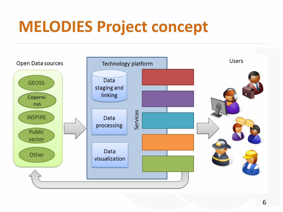
MELODIES Project concept
6
Coperni-cus

The MELODIES Services
7
Improving Emission Inventories
Urban Ecosystem Accounting
Desertification indicators
Customised crisis, disaster and risk
mapping
Site-specific information for land
management
Assessment of Good Environmental Status
for oceans
Marine transport
Groundwater modelling

Common themes
• Integration of data from multiple sources
• Cross-querying to generate new information

Example MELODIES service:Urban Explorer application
Urban Explorer Land Use / Land Cover themeSee http://www.melodiesproject.eu/node/33

Open Data inputs to Urban Explorer(Sources: OpenStreetMap, Prague authorities, LinkedGeoData.org, more)

Sentinel-1, EarthExplorer, Archives (Envisat, ERS, …)
Disaster events:EM-DAT, MunichRe Nathan, Darmouth Flood Observatory, National databases
Processing:
PublicLinked
Open Data
PrivateLinked Data
EFAS, EMS, HRL Layers, Local Component, EU-DEM, CLC
Input:
OpenStreetMap
www.terranea.dewww.eoxplore.com

Common themes
• Integration of data from multiple sources
• Cross-querying to generate new information
• Handling geospatial Linked Data

Geospatial Linked Data tools
13
• Strabon– spatiotemporal RDF store– GeoSPARQL / stSPARQL
support
• GeoTriples– Convert geospatial data to RDF
• Ontop-spatial– “Wrap” existing geo-databases
• SILK– Discover links in datasets

Sextant: visualizing and integrating time-evolving Linked Data
14

Common themes
• Integration of data from multiple sources
• Cross-querying to generate new information
• Handling geospatial Linked Data
• Handling raster/gridded data
– Satellite images, weather forecasts, …

The CoverageJSON data formathttps://covjson.org• Rich and efficient JSON encoding of geospatial
scientific data– n-D Gridded and non-gridded data
– continuous and categorical data
• Designed for web and mobile applications
• Bridge between science and Linked Data worlds– Metadata in JSON-LD (i.e. RDF in disguise)
– Data in JSON arrays for efficiency
– Can be used with no knowledge of RDF
16

Land cover remapping applicationyoutu.be/dxfmTkBdn90
17
• Data processed in-browser
• metadata is RDF “in disguise” using JSON-LD

Common themes
• Integration of data from multiple sources
• Cross-querying to generate new information
• Handling geospatial Linked Data
• Handling raster/gridded data
– Satellite images, weather forecasts, …
• Selecting appropriate vocabularies
• Publishing data to ensure maximum re-use

MELODIES CKAN portal
Data discovery / publishing using GeoDCAT-AP vocabulary
19
http://ckan-demo.melodiesproject.eu

20
https://developers.google.com/search/docs/data-types/datasets

Summary• Exploring Open Linked Data through eight real applications, with emphasis
on user’s point of view
• We are developing tools and standards for producing and using geospatiallinked data
• Application developers see benefits of Linked Data flexibility and ease of data integration– but data conversion is time-consuming– RDF is very unfamiliar to most– selecting vocabularies is a major barrier
• Need to build bridges to user communities to encourage adoption– Flexibility is good for data providers, very difficult for users– Consider other ways to represent links and semantics (e.g. JSON and JSON-LD)– Take opportunities to integrate with mass-market search
21