Embed Size (px)
Citation preview

Partners to the Past: Proceedings of the 2005 Ontario Archaeological Society Symposium Edited by James S. Molnar Copyright ©2007 The Ottawa Chapter of the Ontario Archaeological Society ISBN 978-0-9698411-2-8
Potatoes in the Pines: Depot Farms in Algonquin Park; with particular investigations at the Egan Farm, BkGl-1, Clancy Township Roderick MacKay, Bonnechere Cultural Heritage Project / Ottawa Chapter O.A.S. ABSTRACT Depot farms played a significant role in the support and supply of 19th Century square timber and sawlog extraction in the Ottawa Valley. The depot farm of John Egan (1847-1867?) on the Little Bonnechere River, within modern day Algonquin Park, was an example of such. The limited information and documentation of the farm is reviewed and placed in the context of activities on the river. Archaeological investigations of the farm fields and foundations adding to that historical record, carried out over six weeks of fieldwork between 2001 and 2005, are discussed and illustrated. RÉSUMÉ Les dépôts ont joué un rôle important dans la subsistance et l'approvisionnement de l'industrie du bois équarri et des billes de sciage dans la vallée de l'Outaouais au XIXe siPcle. Le dépôt de John Egan (1847-1867?) sur la petite riviPre BonnechPre, dans le parc Algonquin, en est un exemple. Nous passerons en revue la documentation limitée de cette exploitation et les replacerons dans le contexte des activités menées sur la riviPre. Nous discuterons et illustrerons aussi les enquLtes archéologiques que nous avons menées sur les champs et les fondations de la ferme pendant six semaines entre 2001 et 2005, et qui permettent d'enrichir ce dossier historique. Introduction From the early days of the timber industry on the Ottawa River, food was required for those doing the work of squaring and transporting massive white pine and red pine logs, be it by the men in the camboose shanties or their beasts of burden. Horses hauled the squared timbers through the bush to the timber roads, and pulled the heavily loaded sleighs down to the nearest river or lake. There the logs were stacked on the ice to await the spring thaw and the river drive of rafts of timber past Bytown / Ottawa and Montreal to the port of Quebec. The demands for feeding the horses alone were significant. For example, each year John Egan’s camps throughout the Ottawa Valley used 1200 tons of hay and 60,000 bushels of “oats and provender” (Russell 1853). There was little natural grass growing in the dark pine groves. Some hay substitute could be made from the “beaver hay” growing at the edge of marshes and on abandoned beaver pond sites, but it was not as nourishing as cultivated hay. As timber-making expanded, so did agriculture, sometimes as cause and effect, but always trailing behind the advance of the timber-makers. According to a report by A.J. Russell, “ the oats at an average cost of two shillings and three pence delivered; hay, four pounds per ton: ...thus give employment to hundreds of farmers in the valley of the Ottawa.” (Russell 1853) As timber-making activities moved up the tributaries of the Ottawa River it became ever more difficult to find crops grown close enough to be economically hauled to the bush

Potatoes in the Pines: Depot Farms in Algonquin Park Roderick MacKay ________________________________________________________________ operations. T.C. Keefer had observed earlier that, “Instead of importing from the States, or teaming from great distances, this country, if cultivated, should furnish the means of obtaining the timber within it” (Keefer 1847). Wherever suitable land could be found, and where permission had been obtained from the provincial government, farms were cleared on timber limits. These so-called Depot Farms varied in size from a few acres to well over a hundred acres. They were generally: built by logging companies to supply men and horses in their camps; close to areas being cut for squared timber or sawlogs; used to help defray costs of extensive transport of goods from Ottawa Valley farms; occupied by a single company, or in some cases by a series of companies over many years; and generally located near water. It is difficult to model areas of high potential for archaeology of the historic period at best, but the existence of some farms in areas well away from large waterways poses a problem for heritage protection. Depot Farms in Algonquin Park The area of focus in this paper is Algonquin Provincial Park, in the District of Nipissing. While not known for its farms, and in fact set aside as a park to protect against destruction of its major watersheds by forest clearance and agriculture, a few Depot Farms, now overgrown, are scattered throughout its townships. One of the methods of detecting very old depot farms is to look for piles of stones in the woods. The nature of the soil in the pinewoods of the Algonquin dome, and the reason for the piles of stone, is revealed in notations from the Petawawa River and Madawaska River respectively: “Potatoes planted here-- stony land” (Hawkins 1837); “The surface of Mr. Byer’s farm was at first found to be rather stony, and large boulders would occasionally interrupt the regularity of a plough furrow, but it had been considered worthy of being cleared of these encumbrances, and the stones had been collected and piled in heaps on the fields....”(Murray 1853). A cursory examination of almost any of the cleared fields in the Ottawa Valley will reveal that piles of stones are not unusual on farms on the Precambrian Shield. One of the earliest logged areas in current Algonquin Park was the headwaters of the Bonnechere River, at one time called the Little Bonnechere. This section of river was under timber limits as early as 1830. The river was explored by government surveyor James McNaughton in 1847, at which time John Egan occupied the south shore and Alexander Macdonell occupied the north. McNaughton noted on his 1848 map of the survey that a mill had been built on the river. Timber-maker John Egan reported to A.J. Russell that this mill had two saws and was capable of cutting 4000 feet of lumber. The mill was valued at 558 pounds sterling (Russell 1853). A considerable number of dams and slides were constructed by Egan on the Little Bonnechere between1837 and 1847. Roads extended up the shores of the Little Bonnechere, on both the limits of John Egan and those of Alexander McDonnell. By 1852 a tote road extended beyond the watershed, past White Partridge Lake and as far as Radiant Lake. This was roughly the same route surveyed as a potential roadbed for the Canada Central Extension of the Canadian Pacific Railway in 1874.
77

Potatoes in the Pines: Depot Farms in Algonquin Park Roderick MacKay ________________________________________________________________ Depot farms were developed in a number of locations in the upper watershed, including one at Basin Creek (Basin Depot), one at “The Village”, and the Depot Farm of John Egan, the subject of the rest of this paper. The farm occupies a forested northerly-facing slope of elevated land about 800 metres northwest of Little Hogan Lake or Clancy Lake in Clancy Township, Algonquin Provincial Park, District of Nipissing. The southerly end of the roughly rectangular shaped area containing piles of stones, and thus presumed to be formerly cleared fields, is quite steep, rising to the top of the hill northwest of Little Hogan Lake. The degree of slope lessens as one continues generally northwest and northeast through the former field area. A small creek on the north-facing slope nears the border the eastern edge. The creek flows from among rocks upstream from a small shallow pool and, based on the vegetation, probably flows all year long. This site now exists under cover of a fully developed forest that has been harvested selectively for pine and hardwoods on at least two separate occasions previously. At the eastern end of the farm, west of the small creek, lies a small cluster of foundations. Some of the foundations are undisturbed and fairly easily seen in their outline on the ground. Others have been modified by skidder tracks and other erosional factors. Additionally there is a stone fireplace. These structures are found among a number of trees, called variously wolf trees or pasture pine, which demonstrate a growth pattern suggestive of growth in an open area. These trees are not found elsewhere through the old fields, although multiple-trunk hardwood trees used to be common throughout, prior to the recent logging. The long-term objective of this study was to interpret the role of this depot farm in the context of the spatial relationship of historic sites within the Bonnechere watershed and the area that became Algonquin Provincial Park, and to use archaeological evidence and cultural materials to “document” the activities that occurred there. Historical Research This writer first learned of an old farm in the hills to the south west of the Bonnechere River while doing oral history interviews with “old-timers” in the winter of 1975-76. Hannah Hyland, who had been born on the Bonnechere River within present day Algonquin Park, recalled a large farm, which she attributed to the Perley Company (Hyland 1977). Jack Burchat, park ranger at Basin Depot for twenty-nine years, recalled that he had heard of a large farm that belonged to Barnet (Burchat 1975), but also mentioned the name “Higgins” (Burchat, pers. comm. 1978). John Joe Turner recalled seeing a very old over-grown farm on a hill south of the Bonnechere River. He related his experience from a time when he had repaired dams on the river, specifically the “Milldam”, in the fall of 1910.
Being the only young lad of the bunch and raring to go hunting, they gave me a one-shot gun and a box of cartridges, and they told me to hunt partridge on this old road, that was then newly cut. I went in on the road and I came to this place where all these stones were piled around the trees, and I wondered why they should have been so. I learned later, when I got
78

Potatoes in the Pines: Depot Farms in Algonquin Park Roderick MacKay ________________________________________________________________
back to camp. They had an old gentleman sit down and tell me the whole story. His grandfather had worked there many years before. With grub hoes they put in vegetables and potatoes and what have you. And naturally, it being hardwood country, they just threw grass seed and the grass seed caught readily.... The barns were full of the very best hay all the time (Turner 1976).
In an interview carried out by Ron Pittaway, Harry Autayo --- who had passed through the area when laying telephone wire as a park ranger --- recalled seeing a spring on the farm, and a well (Autayo 1979). The farm area had been logged in the 1960s, at which time the jobber on the site, Basil Visneskie, later recalled finding a “Forest Beauty stove” in pieces (Visneskie, pers. comm. 1979). John Fabian, a scaler, recalled finding a scythe blade and many piles of stones (Fabian, pers. comm. 1979). When John Egan’s timber limit on the south shore of the Little Bonnechere River was described in 1838, it was noted that, “the parties have the privilege of making the hay”. Egan operated that limit until his death in 1857, after which it was held by the trustees of his estate until 1867/68, and therein lay the depot farm. Although no maps showing the farm itself have been located, part of the map of the 1847 survey of the Bonnechere River by James McNaughton shows “timber” roads heading away from the Bonnechere River and Sawmill (the site now known as the Milldam) in a southerly, and uphill, direction. These roads head from “Mr. Eagan’s [sic] Road” in the general direction of the farm site. It should be noted that in Russell’s report mention is made of the “making” of a farm and erecting buildings on Grant’s Creek but no mention of a similar farm is made with respect to the Little Bonnechere River (Russell 1853). Recall that the sawmill was said to be in operation as early as 1848. If the farm did not exist then, there is evidence that it did soon after. According to the diary of Charles Thomas of Golden Lake, the farm on the Little Bonnechere was in operation at least as early as 1850: On September 30, 1850, Thomas wrote, “....in the evening Beaudoir and 4 men bound up to commence farming operations for J.E. and Co. on L.B. Chere” (MacKay 1996). Again, on October 20 he penned “Bill Burke sent us down a present of a bag of carrots by Mr. Egan’s Litt. B.C. farmers.” Since carrots take a few months to grow, the farm must have been in operation in the spring of that year, at least. No mention is made of the farm again, in the diary, until June of the following year, when on the 19th he recorded that some men went by in a three and a half fathom canoe “on their way up to the Little B. Chere farm.” Four days later he noted “Lepanne and Delochrie went past in the evening with the LBC farmers. They were 14 in all” and on July 8, “At night we had Dan Moore and two Canadians from Egan’s L.B.C. farm” (MacKay 1996). The Canada Census records of 1861 indicate a farm of 150 acres (60.7 ha) was owned by the Trustees of John Egan’s estate, one of seven reported in the territory that is now Algonquin Park (MacKay 1993). The farm was reported to be on the Little Bonnechere, the name given to the Bonnechere River above Round Lake. Unfortunately, as this was
79

Potatoes in the Pines: Depot Farms in Algonquin Park Roderick MacKay ________________________________________________________________ unsurveyed land, no specific location was given. From the census we learn that the farm had a cash value of $3,000, with 10 acres (4 ha) of oats, 6 acres (2.4 ha) of potatoes and the rest in pasture and hay. Livestock included twelve bulls or oxen, two cows, and eight horses. The agricultural census added that 120 other horses were associated with the farm, “employed to draw timber in their respective chantiers.... Half again as many horses were employed during the winter hauling supplies to the respective chantiers” (MacKay 1996). The township of Clancy was surveyed in 1891 by J.W. Fitzgerald, but examination of the field notes show the surveyors did not pass through the former farm area, although they passed just to the west, and farther away to the north, east and south. No mention of the abandoned farm was made in their report on the township. Field Work Attempts were made to locate the farm while interview sources were still alive in the late 1970s. After many explorations, the Depot Farm of John Egan with its stone piles and second-growth trees was located in October 1979. A year later came the discovery of a small building delineated by low earthen mounds, with an apparent doorway to the east. This foundation appeared to be next to a “road” down a swale. Although these findings were reported at that time to the Ministry of Natural Resources staff in writing, and later published (MacKay 1996), logging of the site occurred in the autumn of 2000. During the autumn of 2001 an examination the site was carried out by representatives of Ontario Parks, the Algonquin Forestry Authority and this writer to determine the extent of the former farm, designated BkGl-1. This work was also carried out to determine the extent of cultural features on the site, and to determine if damage to the cultural resources had occurred during logging operations on the site. While the damage to the site and construction of a new road was regrettable, “lemonade” could be made from the “lemons”. As a direct result of the writer’s expression of concern that the site had been logged, in the years following 2001: there was an increased awareness, by park staff and Algonquin Forestry Authority personnel, that the error should not be repeated; there was increased attention to cultural heritage protection by park staff; archaeologists were hired on a project basis to determine archaeological potential of certain sites, there was a review of historic site and archaeological site material in the Park’s NRVIS computer database, and courses on recognizing cultural features were run for field staff, including tree markers. There was also road access to the site, which facilitated this writer’s archaeological investigations.
80

Potatoes in the Pines: Depot Farms in Algonquin Park Roderick MacKay ________________________________________________________________
Figure 1. Plan of Egan farm, BkGl-1. In summer and late autumn 2001, piles of stone were counted and foundations were located and photographed. Over 600 (619) separate stone piles were counted. Their abundance appears to be greatest at the higher elevations of the farm, although they exist throughout the former fields. One observer, Forest Technician Ed Hovinga, noted that some of the piles near the crest of the hill seemed to line up, as if they had been part of a fence line. The number of stones per pile varies, from but a few in some to well over 230 individual stones in one pile which was dismantled. In 2001, four definite foundations (1, 2, 3, and 5) were located (Figure 1), along with other mounds or depressions on the forest floor which might indicate others, particularly a “deep hole” (foundation 4) some distance to the northwest. Rocks were visible in some of the foundations, but not noticed in others. A presumed fireplace structure of stone was also noted.
81
Potatoes in the Pines: Depot Farms in Algonquin Park Roderick MacKay ________________________________________________________________
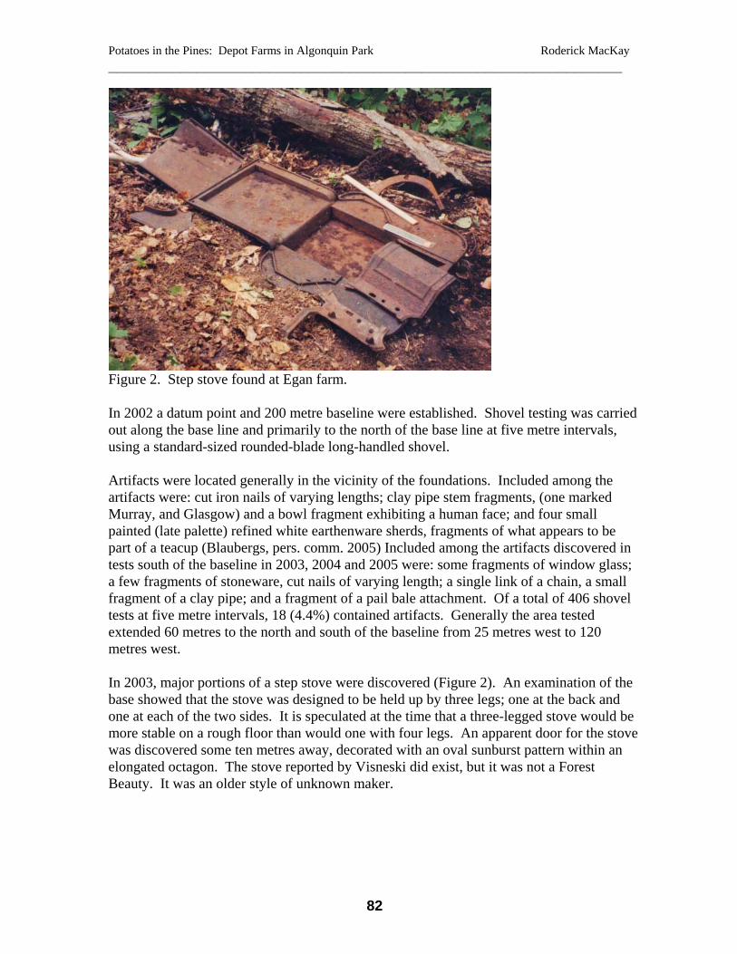
Figure 2. Step stove found at Egan farm. In 2002 a datum point and 200 metre baseline were established. Shovel testing was carried out along the base line and primarily to the north of the base line at five metre intervals, using a standard-sized rounded-blade long-handled shovel. Artifacts were located generally in the vicinity of the foundations. Included among the artifacts were: cut iron nails of varying lengths; clay pipe stem fragments, (one marked Murray, and Glasgow) and a bowl fragment exhibiting a human face; and four small painted (late palette) refined white earthenware sherds, fragments of what appears to be part of a teacup (Blaubergs, pers. comm. 2005) Included among the artifacts discovered in tests south of the baseline in 2003, 2004 and 2005 were: some fragments of window glass; a few fragments of stoneware, cut nails of varying length; a single link of a chain, a small fragment of a clay pipe; and a fragment of a pail bale attachment. Of a total of 406 shovel tests at five metre intervals, 18 (4.4%) contained artifacts. Generally the area tested extended 60 metres to the north and south of the baseline from 25 metres west to 120 metres west. In 2003, major portions of a step stove were discovered (Figure 2). An examination of the base showed that the stove was designed to be held up by three legs; one at the back and one at each of the two sides. It is speculated at the time that a three-legged stove would be more stable on a rough floor than would one with four legs. An apparent door for the stove was discovered some ten metres away, decorated with an oval sunburst pattern within an elongated octagon. The stove reported by Visneski did exist, but it was not a Forest Beauty. It was an older style of unknown maker.
82

Potatoes in the Pines: Depot Farms in Algonquin Park Roderick MacKay ________________________________________________________________
Figure 3. Reaping hooks or sickles from Figure 4. Scythe found at Egan farm. the Egan farm.
Figure 5. “Reconstruction” of the pieces of the step stove. The sytrofoam blocks and other supports have been digitally removed from this photo.
83

Potatoes in the Pines: Depot Farms in Algonquin Park Roderick MacKay ________________________________________________________________
Figure 6. Hayfork found at Egan farm. In an attempt to locate the legs of the stove a return trip was undertaken with a metal detector. In addition to finding three legs to the stove (one slightly different in pattern than the other two) other metal artifacts turned up in what appears to be a metal midden. Five shovel tests within the area of the metal midden revealed only a small clay pipe stem fragment. Among the approximately 140 artifacts found here were: stove parts; two felling axes; two reaping hooks or sickles (Figure 3), two metal shanty plates and fragments of others; wagon parts, two spoons, a hay fork (Figure 4), two lids, one tin, the other cast; two broken skillets, one oval, one round; parts which appear to be from a second stove; and a second decorated stove door, similar to the first. All artifacts were located on the site grid. On returning home, an attempt was made reconstruct the step stove. Pieces were held together by wire or supported by cardboard boxes and pieces of styrofoam. A photograph was taken of the stove and, using computer software the supports were “removed” from the photograph of the stove, producing a rough approximation of its original appearance (Figure 5). According to a material culture specialist at Parks Canada, this type of step stove was manufactured between 1836 and approximately 1875 (Dunning, pers. comm. 2003). Some pieces remain missing, and the placement of the second door cannot be determined, if indeed the doors belong to this stove. Other decorative parts, that fit, suggest they do. Max Pecoskie, a resident of the Hamlet of Bonnechere, recalled that generally old cookstoves were “pretty low.” He said that in his experience they were frequently placed on a box filled with sand, so the floor wouldn’t burn, and this might account in part for their short stature (Pecoski, pers. comm. 2003). Of considerable interest in 2004 was the discovery, under logging debris from two trees, of a sixth foundation (approximately 9.8 m in length by 5.3 metres in width) with mounds much lower and smaller in profile than any of the other foundation mounds around the site. Removal of as much of the debris as possible, revealed an indistinct mounded rectangular
84

Potatoes in the Pines: Depot Farms in Algonquin Park Roderick MacKay ________________________________________________________________ outline and a large pile of somewhat rectangular rocks at the east end. The piled rocks seemed too have been selected for flatness, as they seemed to differ from the rocks in other “typical” stone piles elsewhere in the vicinity. Rounded stones that may have been used to support a log foundation may have been moved by skidders or logs pulled through the foundation. A shovel test just to the east revealed a small fragment of window glass and mortar. The foundation was raked with a soft rake to remove the deep covering of pine needles. In 2005 Foundation Six was examined again. Settling of the remaining needles and leaves over the winter revealed, on the surface: a broad-axe (identified as a Blasdell axe from Bytown, pre-1856); a spade; and a broken scythe (identified by the stamp [Whit]ing and Cowan, Oshawa [1867-1872]; Figure 6). An excavation unit placed just to the west of the pile of stones in this foundation revealed a portion of a cast iron pot (or tea kettle?) and two fragments of a clay pipe (marked Henderson, and Montreal). A second unit was excavated into the side of a foundation mound of what had been identified as foundation two. This foundation is the largest on the site, measuring 10 metres by 12.4 metres, its long axis lying NE-SW. A small gap (1.5 m) exists in the northeast facing wall. Almost no artifacts were found in the unit, but this excavation made it apparent that the inside of the mound contained rounded rocks of varying size, possibly piled. An additional 15 shovel tests within this foundation, at one metre intervals, revealed pieces of mortar adjacent to the foundation mounds, and numerous cut nails of 4 cm length. These nails perhaps suggest a shingled roof. It cannot be determined if this was a large dwelling house or a barn with mortar between logs or whether the structure was of log or frame construction. Foundation One, first discovered in 1980, lies on a small plateau on a generally northeast facing slope, farthest away from the creek of the clustered foundations located to date. The angle of slope is gentle, with a slight increase in slope at the apparent front of the foundation. The axis of the foundation from front to back lies roughly east-west, with what appears to be a deliberate gap in the foundation walls facing east. A number of flattish stones and a few angular ones lie just downhill from this opening. Perhaps they were steps at one time. The dimensions of the inside of the foundation mounds suggest a length of 3.7 metres and a width of 2.7 metres. The outside dimensions are 6.1 metres by 4.5 metres. An ironwood tree growing in the bottom of this foundation was dated as beginning its growth about 1918. A large “wolf” pine grows immediately to the north of the foundation. Small indents in the side of a pine to the southwest suggest that something was once tied about it, just a metre or so above the ground. Shovel testing in the inside of the south wall revealed no artifacts, and no artifacts were found in nearby tests. Foundation Three lies approximately 25 metres easterly from Foundation Two. Like Foundation One it sits on the edge of a natural slope, with a fairly steep downward slope at what appears to be the entrance, where there is a gap in the foundation mounds. The foundation appears to be square, with inside dimensions of 4.9 metres on three walls and 5 metres on the northwestern wall. Outside dimensions are 7.2 metres by 6.6 metres. The 1.1 metre gap lies on the southeast wall. The northwestern wall lies generally along a
85

Potatoes in the Pines: Depot Farms in Algonquin Park Roderick MacKay ________________________________________________________________ southwest-northeast axis. A solid bottom to a test hole atop part of the mound at 60 metres on the base line, which passes directly through this foundation, suggested there is some stone in the mainly sand foundation mound. No artifacts were found here. Similar to Foundations One and Foundation Three is Foundation Five. This foundation lies a short distance east of Foundation Three, at about the same elevation along the same slope, and similarly appears partly embedded into the hillside. The foundation has been considerably modified by skidder activity on its north side and was surrounded by logging debris. The front of the foundation appears to lie facing southeast, toward the creek. Because of the modified nature of this foundation the measurements are difficult to determine, but it appears to have dimensions similar to Foundation One. No artifacts were found in the test holes in the vicinity of this foundation. A short distance downhill from foundations three and five is the structure first considered to be a fireplace. This feature is quite unusual according to Forest technician Ed Hovinga, who has visited many historic remains within Algonquin Park. It is a U-shaped structure of stones, oriented along a roughly north-south axis, with the open end of the feature facing south toward the creek 10.2 metres to the south. This feature is 2.8 metres long. Each side wall of piled flat rocks is 0.8 metres wide. The back wall is 0.5 metres wide. The walls are about 0.5 metres high. The opening within the structure is 0.6 metres wide and 2.3 metres long front to back. The feature is 32 metres roughly southeast from Foundation Three, and 14 metres roughly south of Foundation Five. Debris, comprising primarily leaves and sticks and thin soil covering the fireplace, was removed and screened. No surface artifacts were found. A shovel test was conducted in the centre of the depression within this structure, close to the closed end wall. No artifacts were recovered from this test. The deepest soil in this hole was quite reddish, but not significantly more so than other reddish soil underlying other parts of the site. A few small pieces of charcoal were found in this pit, but similar finds were made in tests quite distant from the fireplace. Despite the lack of extensive evidence of fire, this feature bears a striking resemblance to a sugar arch or furnace, a type of feature used for making maple syrup. Foundation Four was located some distance from the other foundations, roughly halfway along the long axis of the old farm fields. It was noticed by Jack Mihell, who found it because of its significant depth (0.8 metres) below the surrounding land. It appears to have dimensions of 4 metres by 3.2 metres, and an orientation of the longer dimension along a NE- SW axis. What appears to be a low foundation mound of up to 2 metres wide was observed on the eastern side. This feature was extensively modified by a skidder. The feature lies along a main skidder trail and it appears that a skidder passed directly through the foundation, down into it then back up on the other side. This feature was not within the area shovel tested and no additional data are available regarding it. A depression in the ground of only 40 cm, but oval in shape and appearing to be lined with rocks is suggestive of a well. This well lies about thirty metres southeast from Foundation Six, downhill toward the creek. This feature has not been further investigated, and no artifacts were found in nearby test holes.
86
Potatoes in the Pines: Depot Farms in Algonquin Park Roderick MacKay ________________________________________________________________ Interpretation Judging from the historical evidence, the apparent size of the area containing stone piles, and the discovery of agricultural artifacts likely used for cultivating and harvesting potatoes, oats, and hay, in conjunction with a broadaxe of the type used for squaring timbers, this was the depot farm of John Egan, timber-maker on the Little Bonnechere, mayor of Aylmer, Quebec, and member of the Quebec legislature. The farm likely would have been operated by a tenant farmer hired by the company. Even without the evidence provided by Charles Thomas that the farm was in operation at some scale in 1850, and the 1861 census, artifacts found on the site suggest an occupation period in mid 19th Century. Step stoves of the type found here were manufactured between 1836 and 1875. Human effigy pipes were apparently not uncommon in 19th Century Ontario, although no pipe fragment of this type has been found in the limited excavations at Basin Depot or the La Fleur site along the Bonnechere River. Murray clay pipes made in Glasgow date from approximately 1830 to 1860. Henderson clay pipes made in Montreal date from 1847 to 1876. (Bradley 2000) These pipes were relatively inexpensive and did not last long once use had begun. Archaeologist Jeff Earl suggested that the bore in the stem frequently clogged after only a few uses (Earl, J., pers.comm. 2003). The stem could be shortened for additional use only a few times before the pipe would be beyond use. Nails found in the vicinity of foundation two appear to of a kind that would be used to hold lath or shingles. A larger nail was found south of the known foundations. Nails found on the site were cut nails, common throughout the 19th Century. Had there been hand-forged nails present it would not necessarily have meant that the site pre-dated 1820, as hand-made nails can be made by blacksmiths even to this day. The hand painted refined white earthenware suggests that at least one drinking vessel used at the site was not just strictly utilitarian. Unfortunately, this type of ceramic was used from the 1830s to 1920, and is of little assistance in narrowing down the period of occupation. The scythe provides a more specific time reference, as Cowan had not joined Whiting prior to 1867 (Anonymous 2005). Dendro-chronological evidence suggests that most of the pines growing in or adjacent to open fields began growing prior to 1870, and that the white birch growing on the side of the sugar arch sprouted about 1860. Combined with the selling of Egan’s timber limits in 1867 or 1868, it would appear that the evidence suggests the farm was abandoned at that time, scarcely twenty years after it was cleared. This farm is unusual from other farms represented in the Algonquin Park historical zone system because it is so far from a waterway. The Bonnechere River differs from other river systems in the Park in having few large lakes along its course. Perhaps the location of a farm was best near a lake, but since there was no lake close to the centre of Egan’s timber limit this site was chosen as an alternative. The presence of a spring and resulting creek apparently made this location suitable year-round and, as they are on a slope unsuitable for fields, this probably determined the location of the buildings. It would appear that the farm was built where it was for various reasons. It may be that lumber from the nearby sawmill was used in some of the buildings on site. Its location on an upland area, among hardwoods, is consistent with practice of the times.
87

Potatoes in the Pines: Depot Farms in Algonquin Park Roderick MacKay ________________________________________________________________ In his report on his travels across the Ottawa-Huron Tract in 1829 Alexander Shirreff explained that hardwood land was considered as always being good land for agriculture at the time (Shirreff 1831). This opinion was verified by surveyor David Thompson who observed “ a very fine growth of Maple, Ash, Elm, Beach [sic] and a few Oaks, which always indicate a rich soil.... I had an auger to bore the ground and always found among the hardwoods from 6 to 12 inches of vegetable mould beneath which is a dark yellow soil of good quality”(Thompson 1843). By applying those opinions, judging from the growth of hardwoods on this elevated land, the soil here would have been considered good. Also, the higher elevation may have given better air drainage of cold air away from the crops than would be afforded by a farm at a lower elevation, thus providing for a slightly longer growing season. It has also been hypothesized that the Irish, in particular might have built farms in elevated locations to avoid blight of potatoes (Yaraskavitch, pers. comm. 2003). The benefit of a northern exposure is unknown, but the stone piles do not appear to extend to the west and south facing slopes. It is possible that some of the stone piles held up posts for wooden fences, but generally the stone piles appear simply to be located throughout the fields, seemingly more abundantly near the top of the ridge where it is perhaps more rocky. It is noted that as yet no definitive sign has been found of barns. It is also noted that it would be expected that a depot farm of this size would likely have included some sort of facility for blacksmithing or farrier work. The Canada Census of 1861 reported that the farm had 8 horses in 1860 and that 120 horses were associated with the farm, being deployed to various chantiers. An additional 60 horses were employed in hauling supplies during the winter. Horses’ hooves and shoes would have required attention every six weeks or so. However, that work could be carried out at the various camps, and the work of a farrier would not leave much, if any, evidence of the work. Sleighs on the other hand may have required maintenance of the iron parts and presuming this site was the main focus of activity in the Egan limits on the Little Bonnechere it is speculated that some evidence of blacksmithing on site should exist. However, none has been found. Where else could that work have been done? Swayze (2003) in examining 1938 aerial photographs has suggested evidence of a road connecting the Egan farm with a lumber camp on the banks of the Bonnechere River (BkGl-4), which in turn is interpreted as being connected with Milldam (BkGl-2). This would suggest that these individual sites form part of a larger complex of sites associated with the Egan activities. This was speculated by this writer in 1979, when it was proposed that a historic zone encompassing the Egan farm and Milldam be established. It is undetermined at this time just how much the surface and sub-soil have been affected by recent mechanized logging activities, and what – if any – additional archaeological features have been affected in the landscape between these three sites. It should be noted here that, in almost all cases, the depth at which artifacts were found on this site was only a few centimetres below the surface of the ground, well within the disturbance effects of an articulated skidder. It is thought that the fireplace feature may have been used for the production of maple sugar, since the farm is located on an upland site currently abundant with maple trees, and since ranges of forest were indicated on some period maps as sugar-bushes elsewhere in the
88

Potatoes in the Pines: Depot Farms in Algonquin Park Roderick MacKay ________________________________________________________________ larger area, specifically the Indian Doctor Ignace’s sugar-bush downstream at the Couchain lakes on the Bonnechere River on McNaughton’s map of 1848 (McNaughton 1848). Archaeologist Dave Croft, of Pembroke, upon examining photographs of the fireplace observed that he had seen similar fireplaces in his youth. A flat pan was set out over the long axis of the fireplace, with a curved space at the end built up higher to act as a chimney for the smoke. He said the syrup would be finished in a pot on a stove. There are at least two literature references to sugar furnaces or sugar arches. Photographs in a book on sugar-making in Lanark County show the general arch like structure and the placement of a flat pan for boiling sap which was placed on top (Smith 1996). Another source says that sometimes a “stone arch [was] built into the side of a hill” [over which a sap pan was placed]. “The average sap pan was about two and a half feet wide by seven feet long by eight inches deep... A pan like this on a good stone arch could evaporate about two forty five gallon barrels of sap per day, approximately two gallons of good maple syrup” (Hulbig 2003). Interestingly, the front of some sugar furnaces included stove-like doors. This may explain the lack of unburned wood inside, and also the “extra” stove components found in the metal midden. It is not known to what market the syrup or sugar was destined. Perhaps it went to the chantiers. Maple-syrup production is labour intensive, and it is unlikely it would be tolerated on a company farm unless it had more than a personal purpose. On hearing a description of the well, Max Pecoskie commented that the “well” opening was likely surrounded by a low wall of stones, covered with a wooden structure to prevent entry of animals or other contaminants. There might have been a counter-balanced pole to facilitate recovery of water from the well (Pecoski, pers. comm. 2003). It may be possible to determine if such was the case, through more intensive examination of the soil surrounding the apparent well. Mr. Pecoskie also “observed” that in olden days it was most usual to bank the sides of foundations with sand, especially if small foundations were to be used as root houses. He said the floor of a root house would also be primarily sand. Moisture in the soil would help prevent frost damage to vegetables stored therein. In contrast, he said that barns would not likely be built very close to wet areas and there would be no mounding of soil around the barns. He said the “cleaner” you could keep the bottom of the building the longer it would last. The barns would be built on round-topped corner stones. Through the years the stones would sink into the ground and the bottom logs would eventually rot. Mr. Pecoskie maintains a number of old barns on his current property. This description fits the conditions interpreted from the apparent outline of Foundation Six. This poses a concern, as Foundation Six does not appear to be barn size, and it also seems unlikely to be large enough to house many men in any degree of comfort. The Depot farm of John Egan apparently occupies a site at least 100 metres in dimension in both directions around some as yet determined “centre point”. It certainly is much more extensive in its “artifact field” than one would have known by the locating of one foundation in 1980. The nature of the forest cover and logging debris make it impossible to rule out the possibility of finding other areas on the farm that display cultural features other than the stone piles, which in themselves are significant. Although the site was logged in 2000, the site is not fully destroyed, although in some locations sub-surface stratigraphy
89

Potatoes in the Pines: Depot Farms in Algonquin Park Roderick MacKay ________________________________________________________________ likely has been permanently modified or destroyed by the effect of logging activities. Obviously from this research, some artifacts remain. It is significant that this farm operated for only about twenty years, back in the days of squared timber, and that it appears to have had only one owner, albeit a significant one. As such it should be included in any future revision of the Algonquin Park Historic Zone system, within the Algonquin Park Management Plan. Acknowledgements: Many people have contributed to this work over many years. My thanks first to field assistants, the late Kate MacKay, Sandra Barr, Barry Warner, Ron Tozer, Ron Pittaway, Alex MacKay, Roger Lupton, Douglas Kirk, and Tim van der Horn. Archaeological advice was provided by Tom Ballantine, Ellen Blaubergs, and Chris J.-Andersen. Thanks also to the staff of Algonquin Provincial Park and the staff of Bonnechere Provincial Park who provided permission to conduct research and logistical support respectively. Thanks to Joe Yaraskavitch and Jim Fraser for encouragement. Funding in the early years of this research on the Bonnechere River was provided by the Canada Council for the Arts and the Royal Canadian Geographical Society. References: Anonymous, 2005 Industries of Oshawa: A.S. Whiting/Cedar Dale Scythe Works,
http://www.oshawamuseum.org/virtualexhibits/industries/whiting.htm. Autayo, H., 1979 Oral History Interview of Harry Autayo by Ron Pittaway, November and
December 1979, Algonquin Park Museum Archives. Bradley, C.S., 2000 Smoking Pipes for the Archaeologist in K. Karklins, Ed. Studies in material
Culture Research, The Society for Historical Archaeology. Burchat, J., 1975 Oral History interview of Jack Burchat by Rory MacKay, Algonquin Park
Museum Archives.
90

Potatoes in the Pines: Depot Farms in Algonquin Park Roderick MacKay ________________________________________________________________ Hawkins, W., 1837 Map of the Petawawa River, Ontario Archives. Hulbig, J., 2003 Whispering Pines Three: A Haliburton Heritage Continued, Private Printing. Hyland, H., 1977 Oral History interview of Hannah (McGuey) Hyland by Rory MacKay,
Algonquin Park Museum Archives. Keefer, T.C. 1847 Appendix LL, Journals of the Legislative Assembly of the Province of Canada. MacKay, R., 1979 The Egan Farm, manuscript on file in Algonquin Park Museum Archives. 1996 Spirits of the Little Bonnechere; a History of Exploration, Logging and
Settlement, 1800 to 1920. Friends of Bonnechere Parks. 2002 Looking at Culture in the Park; Consideration of the Role of the Algonquin
Forestry Authority in Cultural Resource Management in Algonquin Provincial Park; A Contribution to the Independent Forest Audit, unpublished report on file in the Algonquin Park Visitor Archives.
MacKay, R. and W. Reynolds, 1993 Algonquin, Boston Mills Press, Toronto. McNaughton, J., 1848 map, Survey of Bonnechere River, Ontario Archives, 7931. Murray, A.,
1853 Geological Survey of Canada Report for Year 1853, Canada Sessional Papers, No. 52, Ottawa.
Russell, A., 1853 App MMMM, Journals of the Legislative Assembly of the Province of Canada. Shirreff, A., 1831 Topographical Notices of the Country Between the Mouth of the Rideau and
Penetanguishine on Lake Huron, Literary and Historical Society of Quebec, Transactions II, Series III, Quebec.
Smith, C., 1996 When the Sugar Bird Sings: The History of Maple Syrup in Lanark County, The
General Store Publishing House.
91

Potatoes in the Pines: Depot Farms in Algonquin Park Roderick MacKay ________________________________________________________________ Swayze, K., 2003 A Stage 1 Archaeological Assessment & Revisit of BkGl-2 Milldam & BkGl-3
Milldam Ranger Cabin on the Little Bonnechere River in Algonquin Provincial Park, Clancy Township, Nipissing District, unpublished report on file in the Algonquin Park Visitor Centre.
Thompson, D., 1843 “Letter to J.M. Higginson, Provincial Secretary, April 17, 1843", in F. Murray,
Muskoka and Haliburton 1615 -1875, Toronto: Champlain Society, University of Toronto press, 1963.
Turner, J.J., 1976 Oral History Interview of John Joe Turner by Rory MacKay, February 1976,
Algonquin Park Museum Archives.
92