Embed Size (px)
Citation preview

A POSITION PAPER FOR THE ERECTION OF A HISTORICAL MARKER
FROM THE NATIONAL HISTORICAL INSTITUTE (NHI) IN NAVAL, BILIRAN PROVINCE
By Prof. Rolando O. Borrinaga, Ph.D.*
Native of Naval, Biliran Province (*) Dr. Rolando O. Borrinaga is a Professor at the School of Health Sciences, University of the Philippines Manila, in Palo, Leyte. He is a member of the Board of Trustees of the Philippine National Historical Society (PNHS). His latest book, Leyte-Samar Shadows: Essays on the History of Eastern Visayas, published in 2008, includes four of his previous papers on the history of Biliran. In 2010, the Municipality of Naval, the capital town of Biliran Province, will commemorate the 150th anniversary of its creation as a separate parish and pueblo in 1860. To mark this religious, historical and cultural occasion, we submit this position paper to the National Historical Institute (NHI), which hopefully could serve as reference document for this government body to consider the production of an appropriate historical marker that memorializes our town’s contribution to national history, to be erected here preferably in time for the festivities next year. The NHI historical marker is proposed to be erected near the Caraycaray Bridge, 1.5 kms. southeast of Naval población, at the southern bank of the Caraycaray River. This place is the approximate “nerve-center” of many events in Naval history that are described in the narrative below. The area, now a rice field, is the ideal site for the proposed Bagasumbul Heritage Park Project, presently under preliminary discussion with key local officials and possible donors. The vicinity of Naval in recorded history
A. Site of a large Spanish shipyard from 1580s to early 1600s The Island of Biliran (see Fig. 1) was known as Isla de Panámao in the early Spanish chronicles and in the earliest map of the Philippines (see Fig. 2). The earliest known recorded account of Isla de Panámao is in the report of Thomas Cavendish’s voyage around the world in 1588. It said:
“The eight and twentieth day [of January 1588], in the morning about seven on the clock, riding at an anchor betwixt two Islands, we espied a frigate under her two coarses [ship masts?], coming out between two other islands, which (as we imagined) came from Manilla, sailing close aboard the shore, along the main Island of Panama[o]. Here we rode at anchor all that night, and perceived that certain Spaniards (which came from Manilla to Ragaun [sic], to fetch a new ship to the Kings, there built) has dispersed their band into two or three parts, and kept great watch in several steeds [small boats?], with fires, and shooting off their

2
pieces. The island [Panamao] had much plain ground in it, in many places, and many fair and straight trees do grow upon it, fit for mak[ing] excellent good masts for all sorts of ship. There are also mines of very fine gold in it, which are in the custody of the Indians…” (B&R 1903-1909, Vol. 15, 297).
The part of Panámao Island referred to in the Cavendish report may have been the plains of the present town of Naval, the widest in the island. A paper with an etymological analysis of the local place-names and context in the Cavendish account (Borrinaga, 2007) is found in Annex “A”. In 1600, there was already an unnamed village here, the one described as the nearby base of the Spanish, native and other workers in the first known Spanish shipyard in the Philippines on Isla de Panámao, and which had been visited by Jesuit missionaries based in Carigara starting in 1601, as reported by Fr. Pedro Chirino, S.J. (Chirino 1604, Ch. 76). The text of the full chapter of Father Chirino, “Of the Mission in Panamao,” is found in Annex “B”.
Although Father Chirino’s account seems to suggest that the Panámao shipyard was established around 1600, it appears that this facility was already in existence in the island when the Cavendish voyage passed by in 1588. A total of six galleons were reported to have been built in Isla de Panámao (Artigas 1914, 252). On one of these, Father Chirino sailed from the Philippines in July 1602 to report on the Jesuit missions in these islands to the Jesuit General Claudius Acquaviva (Chirino 1604, Ch. 76). However, the figure of six galleons, presumably reported by the Jesuits who first arrived in Leyte only in 1595, did not seem to include the ships that were built here before the arrival of the Jesuits in Leyte in 1595.
In a later account, Fr. Francisco Colin, S.J., described the destruction of the galleon named “Santo Tomas” at its construction site in Panámao, which translates into English as follows:
“Due to the typhoon [or probably cloudbursts], so much water from the mountains overflowed the riverbank in seemingly scandalous and rapturous way. As the floodwaters forced their way to the sea through the same river course and mouth, they also inundated the shipyard grounds, eroded the soil at the base of the scaffoldings that propped up the galleon that was being built, and tossed the boat into the water, resulting in its destruction” (Colin 1663, Vol. 1, 326; Lumapak 1957, 26).
The account of Father Colin provides hints of the vicinity in Naval town where the shipyard was located. This was along the Caraycaray River, based on local myth and folklore (Caraycaray River being believed as the path of “ghost ships” from Panamao - the mountain, not the island) (Borrinaga 2008a, 171); this river’s being the usual path of large floods caused by buhawi (cloudbursts) dropped in the mountains (in 25-year cycles until 1986, usually in the month of August); and the bald mountain range east of

3
Barangay Caraycaray (presumably the source of timber during the shipbuilding years centuries ago). The Spanish shipyard was transferred from Isla de Panámao to Cavite, probably after 1604, when the galleon “San Antonio,” which transported Father Chirino to Mexico in 1602, was lost in the high seas during its second voyage between Manila and Acapulco. The reason given for the transfer was “bad luck” for the ships built in Panámao (Lumapak 1957, 27). But the more likely reason was the onset of the Moro raids on Leyte in the first decade of 1600 (Borrinaga 2008b, 13-15).
B. Original población site of Biliran pueblo
Biliran was created as a separate pueblo (town) on 10 September 1712 (Chico 1957, 33). Its población (town center) was located in the vicinity of the present Barangay Caraycaray of Naval town (Lumapak 1957, 12). A circa-1770 map of Biliran indicates the poblacion’s location (see Fig. 3).
Biliran was next heard of in 1735, when several inhabitants of Leyte petitioned Governor-General Fernando Valdes y Tamon to allow them to resettle Biliran Island in Leyte. They claimed that the island had been abandoned for the past fifty years (sic) and was presently inhabited by bagamundos (vagabonds) due to the frequent Moro raids (Dery 1997, 25).
C. Classic example of the menace of the Moro raids in 1754
In 1754, presumably the year with the most number of Moro raids during the Spanish regime, the raids on Biliran pueblo became a classic example of the extent of destruction inflicted by this historical menace in the Philippines. The report of Governor-General Pedro Manuel de Arandia y Santestevan from Manila, dated 24 May 1755, provided details of the raids on Biliran pueblo in the section on Provincia de Catbalonga o Leite (sic, the province then composed of the islands of Samar and Leyte), which he mentioned twice in the narrative, indicating the prominence of that single event among other similar events (Dery 1997, Appendix 16). The English translation of the relevant three-paragraph texts pertaining to Biliran raids are as follows:
“On the twenty-sixth of May of this year [1754] there entered in the pueblo of Biliran of this Province of Leyte and Catbalonga [i.e. Samar] numerous Moros who went by land along the little river of Anas, a distance of one league and a half or two away from it. Thus, having reached the interior part of the mountain, they plundered the dwellings and wrought great devastation. They seized or captured many inhabitants with the exception of the gobernadorcillo [native mayor] who managed to escape. They plundered and stole all the jewels [alhajas, i.e., the sacred vessels such as chalices, ciboria, pyxes, monstrance, vestments, etc.] and the church furnishings. They razed and destroyed all the planted fields along with all the houses, so much so that there was no place to live or any plantations left to survive on.
4
“In this year and through the month of May, the Moros destroyed the Pueblo of Biliran in this jurisdiction and burned its church. They captured many inhabitants and took away the vestments and sacred vessels. Stubbornly they stayed and tarried there, creating thousands of hostilities, by which reason the natives all the more were scattered in all their deprivation …
“… (T)he Moros have caused this ‘miscarriage’ [i.e. devastation] on the twenty-six of May in this year of ‘54 [1754] in the pueblo of Biliran on the Island of Panamao, in the jurisdiction of Leyte. They razed this town and all the visitas [outlying settlements with chapels visited by a non-resident priest] and took along with them the precious jewels [i.e., sacred vessels, etc.] and ornaments of the church and all those of the priest. They took with them a portion of captives but with some fortune there escaped the Capitan [mayor] and the fiscal [treasurer] of the same pueblo. They also burned all the houses and destroyed the towns of this region and especially those of Biliran, Caybiran, Mapuyo and Maripipi.” (see Ibid., 243-245 for the Spanish text.)
The “only two” number of escapees in the third paragraph (only one in the first paragraph) seems exaggerated; the two pueblo officials probably just ransomed their way out of captivity using the pueblo’s assets in their possession.
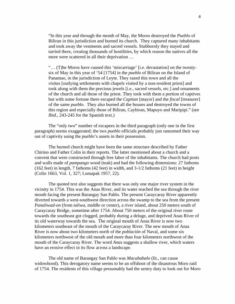
The burned church might have been the same structure described by Father Chirino and Father Colin in their reports. The latter mentioned about a church and a convent that were constructed through free labor of the inhabitants. The church had posts and walls made of pampango wood (teak) and had the following dimensions: 27 fathoms (162 feet) in length, 7 fathoms (42 feet) in width, and 3-1/2 fathoms (21 feet) in height (Colin 1663, Vol. 1, 327; Lumapak 1957, 22). The quoted text also suggests that there was only one major river system in the vicinity in 1754. This was the Anas River, and its water reached the sea through the river mouth facing the present Barangay San Pablo. The present Caraycaray River apparently diverted towards a west-southwest direction across the swamp to the sea from the present Panaliwad-on (from taliwa, middle or center), a river island, about 250 meters south of Caraycaray Bridge, sometime after 1754. About 750 meters of the original river route towards the southeast got clogged, probably during a deluge, and deprived Anas River of its old waterway towards the sea. The original mouth of Anas River is now two kilometers southeast of the mouth of the Caraycaray River. The new mouth of Anas River is now about two kilometers north of the población of Naval, and some six kilometers northwest of the old mouth and more than four kilometers northwest of the mouth of the Caraycaray River. The word Anas suggests a shallow river, which waters have an erosive effect in its flow across a landscape. The old name of Barangay San Pablo was Macababalo (lit., can cause widowhood). This derogatory name seems to be an offshoot of the disastrous Moro raid of 1754. The residents of this village presumably had the sentry duty to look out for Moro

5
raiders in the sea from their vantage location. They probably saw the sails and the boats of the raiders near the mouth of Anas River at the time. But they might not have bothered to alert the residents in the nearby lowlands and the swamps because the enemy boats did not enter the river. What the lookouts failed to reckon was that the raiders left their boats behind and hiked some five kilometers along the river and through the swamps to reach their unsuspecting target population, whom they captured en masse. As a result of the raid, many local residents presumably became widows and widowers, which life’s event they memorialized in the name of the negligent settlement.
D. Loss of población status
The event now recognized as the Biliran Religious Revolt in the 1760s and 1770s (Borrinaga 2006a), which has been memorialized by the National Historical Institute (NHI) with a historical marker installed at the Nasunugan Watchtower in Biliran town last year (2008), had a significant impact on the area of the present Naval. The población of Biliran pueblo was transferred away from here.
This historical episode started on 10 October 1765, when a government document published in Manila appointed a certain Don Gaspar Ignacio de Guevara as cura (parish priest) of San Juan Nepomuceno in Biliran pueblo (Kobak 1979, 152). A secular priest who hailed from Samar, he turned out to be deluded and heretical.
Padre Gaspar (as Guevara is known to folklore of the present-day Biliran town) created a new población by moving it away from its original site in now Sitio Ilawud of Barangay Caraycaray, Naval to a hilltop in what is presently known as Barangay Hugpa, some 6 kilometers northeast of the town proper of Biliran. The población transfer was presumably intended to avoid another disastrous Moro raid like what happened in 1754 (Borrinaga 2006a, 133).
The priest called the new site Albacea, the Spanish word for “executor of the testament” (Lumapak 1957, 12). Here he set up a sanctuary, enthroned himself in the “chair of Peter” with the royal throne in Biliran Island, and styled himself as the “first of the priests of the world” (Kobak 1979, 151-152).
From his sanctuary in the forest commune, Padre Gaspar spread his doctrines, granted indulgences, spread news of miracles in the Leyte-Samar region, recruited and sent out disciples to incite revolts, conferred sacred orders, gave out offices, legislated, threatened those who opposed him and, together with an “alcalde mayor” of Biliran whom he appointed, fought against the Franciscan friars in Samar and the Augustinians in Leyte. He ordained sub-deacons, and attracted a great number of followers, especially among the women. He was also cordially treated and sheltered by the Alcalde Mayor (governor) of Samar (which included Leyte until 1777), who also worked with him (Ibid.)

6
Padre Gaspar was captured by Moro raiders and was drowned to death near Tagasipol Islet north of the present Kawayan town shortly before 1775, about 10 years after his assumption as cura of Biliran (Lumapak 1957, 28).
As a result of the transfer of the población to the new hilltop location (Albacea), the old site in Sitio Ilawud became known as Binungtuan (i.e., “towned,” the past tense of bungto, the Waray word for town in verb form).
With Padre Gaspar’s transfer of the población, the geographical area that is now known as Naval was reduced to the status of a visita (village with satellite chapel) of Biliran pueblo. However, many residents of this visita also moved to a more elevated location two kilometers northeast of the old población in Sitio Ilawud. This settlement is still called Caraycaray.
E. From Bagasumbul to Naval
Neither Father Chirino nor Father Colin provided the name of the village that was the site of the Spanish shipyard on Panámao Island, which we theorized in the early part of this paper to have been located in the vicinity of Naval. And the report of the 1754 Moro raid merely mentioned the name of the pueblo (Biliran). As for the word Caraycaray, its modern definition is more of a geographic description, i.e., the shallow part of a river (with rapids). It is the Waray-waray equivalent of Anas, the name of the same river reported in 1755. Of some cultural significance, the present Caraycaray River was the boundary of two Bisayan languages until the 1960s. Most residents of Barangay Caraycaray south of the river were Waray-waray speakers until then, but the residents of Sitio Tabuk-Salug (lit., hamlet across the river) to the north of the river were Cebuano speakers. But recorded folklore has it that the ancient village in the vicinity of Naval was known as Bagasumbul (lit., like a symbol of a great victory or conquest). The etymology of this word and some its implications, including the theory that Lapu-lapu, the hero of the Battle of Mactan in 1521, was the embodiment of the Bagasumbul label, are found in Annex “A”.
The town of Naval owes its beginnings to Fr. Juan Inocentes Manco Garcia, who was the assistant parish priest and later parish priest of Biliran pueblo from around 1848 to 1861 (Souvenir Program 1966). By then the pueblo of Biliran had been reduced to the western half of the island, with the creation of Caibiran as a separate pueblo in 1828. And the place that would become Naval (the area around the old población in Sitio Ilawud) was already called Bagasumbul (Borrinaga 2008a, 22).
According to folklore, Padre Inocentes (as Father Garcia was known) would make trips to Almeria, the northernmost outpost of his assignment, from his parish base in Biliran población. Passing by the site of the present población of Naval, he would pause in his journey to admire the beautiful sweeping plains of the area. Struck by the flatness

7
and fertility of the land, he invited his relatives and friends from Dimiao, Bohol, and Danao, Cebu, to come and settle in this place (Souvenir Program 1966).
The new migrants settled on an area near Tubud (spring), some two hundred meters north of the present town plaza of Naval, and about three kilometers northwest of the village of Bagasumbul (in Sitio Ilawud), the población-turned-visita of Biliran pueblo. They were followed by other migrants from Panay and Negros (Borrinaga 2008a, 22).
In the early years, Padre Inocentes divided the land among the members of three regional migrant groups: the Cebuanos, the Boholanos, and the Hilonggos (Souvenir Program 1966). He also initiated the efforts to build the first church and convent of the new settlement and to dig irrigation canals for the rice fields of Bagasumbul (Tantuico 1980, 137).
Local landmarks known until the 1960s apparently served as coastal boundaries during the land distribution process initiated by Padre Inocentes. The use of Google Earth measurements in the Internet website would show that one-kilometer distances separated Sabang in the south to Aslum (a species of orange tree) in the north, from Aslum to Duha ka Punong Lubi (lit., two coconut trees, near the present Biliran Provincial Hospital), from Duha ka Punong Lubi to Laka (prob. May laka, lit., tree with a broken branch), and from Laka to Atipolo (another tree). Two-kilometer distances separate Atipolo from Agpangi (i.e., pangi tree), and from Agpangi to Jamurawon (molave tree), once a barangay of Naval.
The name Bagasumbul, which sounded “war-like,” was changed to the more “peaceful” name, Naval, in 1859 (Chico 1957, 28).
The gobernadorcillo (mayor) at the time was Severino Saberon. He was interested in instruction and in seeing the children in school. He had a solution for the lack of paper; he made them write on banana leaves using the ink of the nuus (squid) for their pens. For those boys who did not go to the schools, they were punished by being sent to the convent to serve as sacristanes (altar boys) (Borrinaga and Kobak 2006, 95).
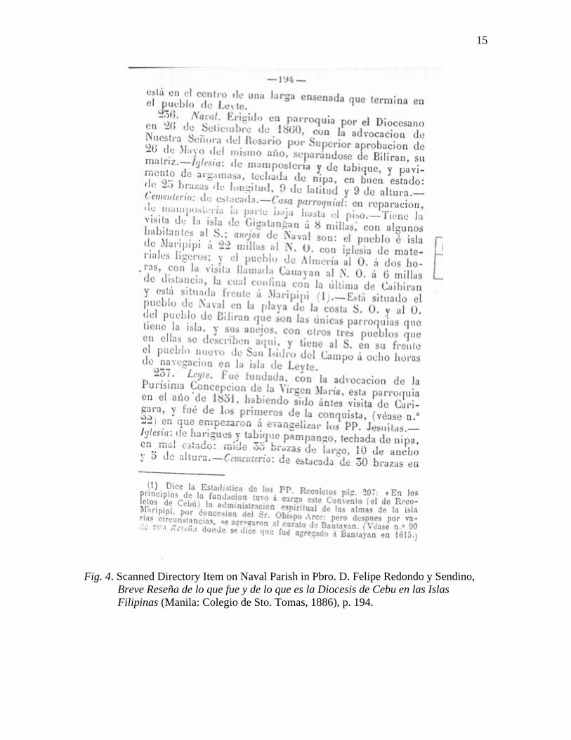
On 26 May 1860, Naval was granted Superior approval to exist as a parish separate from Biliran, its mother church. The parish was formally erected by the Diocese of Cebu on 26 September 1860, under the protection of Our Lady of the [Most Holy] Rosary (Redondo 1886). In August 1861, Fr. Santos de Santa Juana took up formal residence as the first parish priest of Naval, and served the town for 21 years until 1882 (Souvenir Program 1966).
F. “Hotbed” of Pulahan resistance during the early American period
The town of Naval was a “hotbed” of the Pulahan resistance during the early years of American occupation at the turn of the 20th-century. The details of this episode

8
are described in a new study that provides the most comprehensive account of the Pulahan movement in Leyte from 1902-1907 (Borrinaga 2008c). In early October 1902, Dios-dios (lit., God-god) rebels, their label before they were called Pulahanes, invaded Biliran Island from Samar for the second time. They “… made a determined attack on the small detachment of [Insular] constabulary
stationed at the town of Naval, hoping to capture their arms, but they were repulsed with considerable loss. The attack was kept for several nights in succession; and although the constabulary had lost several men, in killed or wounded, they held the band off, until [Constabulary Senior Inspector Peter] Borseth arrived in the scene with reinforcements. A vigorous campaign was again instituted, in which the towns [in Biliran] cooperated heartily, and after about six weeks’ work the island was again cleared of these religious fanatics. This time, however, those that were not killed or captured, instead of returning to Samar, made their way across to the island of Leyte …” (“Report of the Provincial Governor of Leyte [1903],” RPC 1904, 840).
The Constabulary station in Naval was the Spanish-era watchtower (now gone) in a swampy area of Sitio Ilawud, Barangay Caraycaray, located some three kilometers southeast of Naval población. After the first Pulahan invasion in April or May 1902, the rebels occupied this watchtower. But it was forcibly taken from them and turned into a station of the Constabulary who came to pacify the island (Borrinaga 2008c, 221). By September 11, 1902, just before the second Pulahan invasion, the Constabulary detachment in Naval was composed of 15 enlisted men, while the detachments in Biliran town and Caibiran also had 15 men each. They were among the 247 enlisted men and 6 inspectors assigned to Leyte Province (Ibid.). It is interesting to note that by June 15, 1904, although the focus of the Pulahan hostilities had moved elsewhere in Leyte, the station in Naval still had the second largest Constabulary detachment (with 31 enlisted men) outside of Tacloban (with 50 enlisted men and 5 officers) (“Station and Strength List … 1904,” RPC 1905, 56-57). According to a fellow writer (Bago, personal communication, 1989), many people from Naval “fled to the mountains when the Insulares [Constabulary] arrived in town” (presumably in 1902). Around 1905, the municipal president, Melecio Caneja, enticed the refugees living in the mountains with home-lots as incentives for them to resettle in the población.
G. Pueblo Day for Naval
On July 25, 2007, the Sangguniang Bayan of Naval approved during a public hearing to pass a legislation to adopt September 26, 1860 as the new “Pueblo Day” of the town. This was based on the most authoritative document available, the official parish directory of the Diocese of Cebu, which this writer acquired in 2004 and which provided

9
the date for the formal erection of Naval as a parish, an act that also legitimized its de facto pueblo status (see Fig. 3; English translation of text in Annex “C”).
The new date amended an erroneous date, September 23, 1869, which was enacted as Naval’s “Pueblo Day” in 1996 (Sangguniang Bayan, 1996) based on the claim in the paper of Chico, a secondary source, that this was the day Naval “became an independent town” (Chico 1957, 24). But the September 23 date was not corroborated by the Chico’s cited primary sources: Redondo (1886) and Artigas (1914). Both documents gave the September 26 date. And the year 1869 (instead of 1860 in Redondo) was a typographical error in the book of Artigas, who used Redondo as his source (Artigas 1914, 320). Of note, Redondo did not have an errata item about Naval in his directory.
Padre Inocentes was known to have named the new pueblo as Naval, in honor of its adopted patroness, Our Lady of the Most Holy Rosary, whose miraculous intercession assured the Spanish victory over the Dutch Navy during the historic “La Guerra Naval de Manila” in 1646 (Souvenir Program 1966; Chico, 1957, 27-78).
However, this writer is of the opinion that Padre Inocentes might have also entertained the idea of commemorating the successful defense of Bagasumbul, which he led as the assistant parish priest of Biliran against three waves of Moro attacks on this settlement in the 1830s (Chico 1957, 26). It appears that the impending separation of Bagasumbul from the mother town of Biliran in the 1850s was a highly charged and hysterical affair, and one marked by social tension and angry recriminations (Borrinaga 2006b). It seems the influential officials in Biliran población snubbed and refused to endorse Bagasumbul’s pueblo petition to the colonial authorities. Padre Inocentes apparently acted on the volatile situation by opting for an alternative method of creating a pueblo, that is, by establishing a separate parish using Naval as the name. For this, he only had to deal with the ecclesiastical authorities in Cebu. And he spared himself the trouble of softening the fixed decision on the issue among the officials in the mother town.
There is an evidence of the apparent haste involved in Naval’s creation as a parish. The novena for Our Lady of the Most Holy Rosary was actually one intended for Virgen de Lepanto (Bago, personal communication, 1989). It was probably the only novena material for the Virgin that was available in the convent when our pueblo’s first fiesta was celebrated on October 7, 1860, a first Sunday (shown in a reconstructed calendar), more than a week after the parish was erected. The same novena was used thereafter. The name Naval itself, instead of Bagasumbul, might have been intended by Padre Inocentes to please all interested parties in our pueblo’s creation. The folk perception has it that Naval was the “peaceful” name and Bagasumbul was “war-like.” Yet both names actually memorialized great naval victories, one (Naval) by the Spaniards

10
against the Dutch in 1646, the other (Bagasumbul) by our ancestors against the Moro raiders in the 1830s and against some unnamed famous enemy in the remote past. With benefit of hindsight, Naval now appears as an all-embracing name with a thread that links the centuries of our local history. Aside from its intended meaning (to memorialize a great naval victory), its maritime sense is associated with the meaning of Panámao (a fishing net), the old name of our island; the ship-building activities in our island around 1600; and the old meaning of Biliran (from bilir, the round-edged triangular corner of a boat), the later name of this island. Appeal to the NHI With the above documented narration of significant events in the history of the town of Naval, Biliran Province, as guide and reference, we hope the National Historical Institute (NHI) will expedite the drafting of the relevant text and appropriate funds for the production of a historical marker and its possible erection and unveiling in time for the commemoration next year of the 150th anniversary of Naval’s creation as a separate parish and pueblo in 1860. References Artigas y Cuerva, Manuel. Reseña de la Provincia de Leyte. Manila: Imprenta “Cultura
Filipina,” 1914. Bago, Alberto M. Personal communication, 1989. Mr. Bago grew up under the care of his
uncle, Msgr. Felix Sabenicio, who had served as parish priest of Naval from 1922-1930 and from 1931-1947.
Blair, Emma Helen and James Alexander Robertson (trans. and eds.). The Philippine
Islands, 1493-1898. Cleveland: Arthur H. Clark Co., 1903-1909 (Vol. 15). Borrinaga, George Emmanuel R. “The Pulahan Movement in Leyte (1902-1907),” The
Journal of History LIV: 1-4 (2008): 205-282. (c) Borrinaga, Rolando O. Leyte-Samar Shadows: Essays on the History of Eastern Visayas. Quezon City: New Day Publishers, 2008. (a) __________. “Disaster in Iti’s Land: The Tragic Social History of the Datu Class in
Leyte (1521-1621).” (Paper presented at the 8th International Conference on Philippine Studies, July 23-26, 2008, Philippine Social Science Center (PSSC) Commonwealth Avenue, Quezon City.) (b)
__________. “The Use of Etymology in Retracing the Local History of Biliran

11
Province.” (Paper presented at the National Historical Institute (NHI)-sponsored Seminar-Workshop on Oral and Local History in the Visayas, held at Silliman University, Dumaguete City on November 5-6, 2007.)
__________. “The Biliran Religious Revolt (1765-1774),” The Journal of History LII: 1-
4 (2006): 128-150. (a) __________. “Living in interesting times,” The Biliran Clarion, 20 November
2006, pp. 4, 10. (b) Borrinaga, Rolando O. and Cantius J. Kobak (trans.and eds.). The Colonial Odyssey of
Leyte (1521-1914). Quezon City: New Day Publishers, 2006. Chico, Eduardo A. A Short History of Naval. (Unpublished 1957 manuscript at the Leyte-
Samar Museum Library, Divine Word University, Tacloban City.) 44 pages. Chico’s date for the founding of Biliran pueblo, 10 September 1712, must have been sourced from Historia Geografica, Geologica y Estadistica by Agustin de la Cavada y Mendez de Vigo (Manila: Ramirez y Giraudier, 1876).
Chirino, Pedro, SJ. Relacion de las Islas Filipinas [1604] (English translation by Ramon
Echevarria). Manila: Historical Conservation Society, 1969. (The English translation is also found in Vols. XII and XIII of the Blair and Robertson collection.) It has a short chapter (Ch. 76) on the mission to Panamao.
Colin, Francisco, SJ. Labor Evangelica … [1663] (Nueva edicion ilustrada para la
critica de la historia general de la soberania de España en Filipinas por el P. Pablo Pastells, S.J.). Barcelona: Imprenta y Litografia de Henrich y Compania, 1900.
Dery, Luis Camara. The Kris in Philippine History: A Study of the Impact of Moro Anti-
Colonial Resistance, 1571-1896. Manila: By the Author, 1997. Kobak, Cantius J., OFM. “Don Gaspar de Guevara of Biliran Island, Leyte: A Legendary
Figure or a Historical Reality?” Leyte-Samar Studies XII: 2 (1979): 150-153. Lumapak, Menardo L. A Historical Research on Biliran. (Unpublished 1957
manuscript at the Leyte-Samar Museum Library, Divine Word University, Tacloban City.) 60 pages.
Mexico. Archivo General de la Nacion. Documentos del Ramo de Filipinas existentes en
el Archivo General de la Nacion de la Republica Mexicana. Año de 1755. Relacion de las Irrupciones que han hecho los Moros en las Provincias e Yslas de este Continente, desde el tiempo en que ultimamente se dio parte a Su Magestad hasta el presente, y desde el Yngreso del Gobierno del M. Y. Sr. Don Pedro Manuel de Arandia y Santestevan, Presidente Gobernador y Capitan General de estas Yslas. Manila, Mayo 24 de 1755. (The transcription of this document is

12
found in Appendix 16 of the book The Kris in Philippine History by Dr. Luis Camara Dery [Manila: By the Author, 1997].)
Murillo Velarde, Pedro, SJ. Historia de la Provincia de Philipinas de la Compania de
Jesus. Manila, 1749. Redondo y Sendino, Pbro. D. Felipe. Breve Reseña de lo que fue y de lo que es la
Diocesis de Cebu en las Islas Filipinas. Manila: Colegio de Sto. Tomas, 1886. Redondo mentioned the year of Biliran pueblo’s creation, 1712, but without a date; he cited Cavada as his source (see reference to Chico above).
“Report of the Provincial Governor of Leyte,” in Fourth Annual Report of the Philippine
Commission, 1903 (Part I). Washington, D.C.: Government Printing Press, 1904. pp. 836-853.
Sangguniang Bayan of Naval. Resolution No. 108, Series of 1996, “Resolution declaring
September 23, 1869 as the Official Recognition Day of Naval as a Pueblo by the Spanish Colonial Government,” August 28, 1996.
Sangguniang Bayan of Naval. Ordinance No. 20, Series of 1996, “An Ordinance
establishing a Pueblo Day Celebration every September 23 of the year thereafter in the Municipality of Naval, Biliran,” August 28, 1996.
Souvenir Program. Dedication of the New Parish Church, Holy Rosary Parish, Naval,
Leyte October 2, 1966. “Station and Strength List of Philippine Constabulary, June 15, 1904,” Fifth Annual
Report of the Philippine Commission, 1904. Bureau of Insular Affairs, War Department, Washington: Government Printing Office, 1905. pp. 56-57.
Tantuico, Francisco Jr. S. Leyte Towns: Histories/Legends. Tacloban City: Your Press,
1980.
Date: August 16, 2009

13
Fig.1. Map of Biliran Province

14
Fig. 2. Detail of Panámao Island and its vicinity in the 1744 Murillo map.
Fig. 3. Early Map of Biliran, ca. 1770. (Portion of an old Franciscan map of Leyte and
Samar for the Diocese of Cebu. Developed from microfilm by Fr. Cantius J. Kobak, OFM.)
15
Fig. 4. Scanned Directory Item on Naval Parish in Pbro. D. Felipe Redondo y Sendino,
Breve Reseña de lo que fue y de lo que es la Diocesis de Cebu en las Islas Filipinas (Manila: Colegio de Sto. Tomas, 1886), p. 194.

16
Annex “A”
The Use of Etymology in Retracing the Local History of Biliran Province
By Prof. Rolando O. Borrinaga, Ph.D.
School of Health Sciences University of the Philippines Manila
Palo, Leyte
(Paper presented at the National Historical Institute (NHI)-sponsored Seminar-Workshop on Oral and Local History in the Visayas, held at Silliman University, Dumaguete City on November 5-6, 2007. An earlier version of this paper, titled “From Bagasumbul to Naval: A Historical Review,” was presented at the Historical Lecture on Naval Pueblo Day at the Sangguniang Bayan Session Hall, Naval, Biliran Province on September 26, 2007, and at the Seminar-Workshop on Enhancing Content and Strategies in Teaching and Conducting Research in the Social Sciences, at Leyte Normal University, Tacloban City on October 15-17, 2007.) Introduction In this paper, I present the use of etymology in retracing the local history of Biliran Province, my home province in Eastern Visayas. As a method, establishing the etymology of key native words in the documents and the local milieu helps to define and integrate patterns out of historical data from a mix of sources that seem disparate at first glance but could actually be fitted in a logical framework or sequence. Webster’s dictionary (1988) defines etymology as “the tracing of a word or other form back as far as possible in its own language and to its source in contemporary or earlier languages.” The use of etymology gradually evolved in my own historical research and writing. I extensively used this approach in recreating the Biliran Religious Revolt from 1765 to1774 (Borrinaga 2006).
For this forum, I provide case illustrations of the use of etymology in retracing three sets of antecedent events in Biliran’s local history. Case 1: Puzzling words in Naval’s municipal history In a related paper, I used etymology to crack certain puzzles in the history of Naval, my hometown which is the capital of Biliran Province (Borrinaga, 2007). I had thought that our town’s heritage could be better understood if we could clarify the contexts and evolving meanings of four key words that are vital to our identity as a people. These words are: Naval, Bagasumbul, Sumbul, and Karaykaray.

17
These are what I found out in my research:
A. Naval –
- “Of or having to do with ships and shipping” (Webster’s dictionary 1988); connected with the sea.
- Adopted to commemorate the great victory of the Spanish Navy against the
Dutch Armada during the historic “La Guerra Naval de Manila” in 1646. The series of victories was attributed to the miraculous help of Our Lady of the Most Holy Rosary, the chosen patroness for our town (Souvenir Program 1966.) The name and its associated meaning would have pleased the church and government authorities at the time of our town’s creation.
- But Fr. Juan Inocentes Manco Garcia, the founder of our town, might have
also entertained the idea of commemorating the successful defense of Bagasumbul, the settlement’s old name, against three waves of Moro attacks, which recorded folklore claim he had led sometime in the 1830s (Chico 1957, 25-27). The parallel memorializing of a local heritage in the new name would have pleased the local participants of the anti-Moro struggle.
B. Bagasumbul –
- Spelling variants – Bagazumbol (Tantuico 1980, 136); Bagasumbol (Souvenir
Program 1966; Chico 1957, 27-28); Bagasumbul (Artigas 1914, 320). Evolving meanings:
1. “Like feathers (of tangbo).” (Tantuico 1980, 136).
Tangbo (Arundo vulgaris); other name, bugang. An erect grass that grows to a height of 1.5 to 3.5 meters. Grows abundantly in swamps and muddy streams. Dust brooms are made out of its panicles (www.stuartxchange.com/Tambo.html).
In bancas or in sailboats, people murmured “baga sumbul” – like feathers
- when they approached the [Inagawan/Banderahan] point (Tantuico 1980, 136).
2. “Somewhat pointed place (parece punta).” - (Souvenir Program 1966).
Traveling from Biliran to Almeria, the late Padre Inocentes would say they are going to a place beyond “bagasumbul,” that is, beyond the “somewhat pointed place” (Souvenir Program 1966).
The place referred to is known as Inagawan or Banderahan Point. The
name Inagawan (place of abduction), popularly used by the people of Barangay

18
Caraycaray, is a folkloric memorial of an event that happened during the second Moro raid in the 1830s. The raiders abducted a newly-married woman fishing in the area with her husband; the husband was not caught (Chico 1957, 26-27).
The name Banderahan, popularly used by people living in the poblacion,
refers to the flag pole erected on the point around the turn of the 20th century. It was either a geodetic survey marker or was used to signal for help or reinforcements by the Constabulary detachment camped at the old watchtower in Sitio Ilawud (Borrinaga 2002, 142). An interviewed local fisherman (Barotol 1990) said the base of the flag pole was already underwater some three fathoms deep. The original point (punta) had been eroded by the sea.
However, a U.S. Coast and Geodetic Survey area map (1899) labeled the
same point of land as Pta. Sabán (sic, Punta Sabang or Sabang Point). This label refers to the northern part of the mouth of Caraycaray River; Inagawan or Banderahan refers to the southern part.
3. “An obstacle to the enemies.” (Chico 1957, 9; his translation of Artigas’s cited
text.)
4. “The place was named after the founder of the said settlement, who happened to be called Bagasumb(u)l.” (Lepasana 1954, as quoted by Chico 1957, 9.)
5. “Embarrassment to the enemies (embarazo a los enemigos).” (Artigas 1914,
320.)
C. Sumbul –
- Spelling variants - zumbol (Tantuico 1980, 136); sumbul (Artigas 1914, 320); sumbol (Sanchez de la Rosa 1914); sombol (Sanchez 1711; Alcina 1668a).
- The spelling should be sumbul, to be faithful to the word’s phonetic sound.
- The early Jesuits knew that the Bisayan language and alphabet only had three
vowels: a, i, and u. There was also no letter z in the native alphabet. Yet, in the early years, their practice was to transcribe in Roman letters almost all “u” sounds with an “o” (Alcina 1668b). In later decades, they faithfully transcribed the “u” sounds in Roman letters, but did not abandon the previous spelling. Thus, for example, both doco and ducu (meaning, to bend one’s head) appear as entries in the oldest Bisayan dictionary by Father Sanchez (1711), which indiscriminately mixed up the o’s and the u’s in many words throughout the volume.
Evolving meanings:

19
1. Sumbol – plumage [feathered ornament] that they put in the prow of their sea-craft to know from where the wind comes (Sanchez de la Rosa 1914).
2. Sombol – the plumage that they place on the [wooden] projection of the prow
of the boat (Sanchez 1711).
3. Sombol – a plumage which they tie to the prow [of the boat] as a sign of their victory or as the greatest sign of conquest (Alcina 1668a).
D. Karaykaray –
- Spelling variants – Caraycaray (common usage); Karai-karai (Artigas 1914, 321).
Evolving meanings:
1. “Waray word for the wavelets and ripples produced by the rapid downstream flow of water through the declining shallows and barrier rocks between different water levels of a river” (Folk description noted by Borrinaga 1992).
2. “Stony and shallow part of the river where the water runs clear” (Makabenta
1979).
3. “The noise of the river that crosses this barrio [of Naval], and where there are many crocodiles” (Artigas 1914, 321).
4. “To walk behind the steps [of somebody], and a place for stopover (Sp.,
ventas; Bis., harapitan) of one in another” (Sanchez 1711). Analysis
The above presentation shows that the meaning and the complementary national and local contexts of the name Naval remained fixed and clear through time. There is hardly any room for confusion and misinterpretation of its intended meaning.
However, the three other words are more problematic, because their contexts and meanings evolved through time. They have been particularly trivialized in recorded interpretations in the recent past. Let us take the more familiar word Bagasumbul. By 1980, its meaning had drastically changed to “like feathers (of tangbo),” a grass species. In 1966, its meaning had been reduced to a geographic characteristic, a “somewhat pointed place (parece punta).” For some reason, these two recent meanings radically departed from the original reference to a trait of an actual person or of a people – “an obstacle to the enemies”

20
(Chico, 1957), the name of the founder of the settlement (Lepasana 1954), and “an embarrassment to the enemies” (Artigas 1914).
How and why were the old meanings forgotten? Was this part of some cultural cleansing process to rid ourselves of the perceived stigma of the “war-like” image of our ancestors? Perhaps some answer can be gleaned from the changing meaning of the word sumbul. The three recorded definitions all referred to a plumage, a feathered ornament that the natives placed on the prow of their boats. Originally, sumbul was a symbol of victory or great conquest, a war trophy self-made by victorious natives returning from their inter-barangay conflicts until the Spanish contact (Alcina 1668a). By 1711, when the local wars had ceased, the sumbul had been reduced to a mere decorative item in the native boats (Sanchez 1711). By 1914, this item had been grossly trivialized as a determiner of the wind’s direction (Sanchez de la Rosa 1914), a function better done by a small triangular banner or flaglet and not by an entire plumage. A similar fate of trivialization happened to the word karaykaray. In the past century, the meaning of the word had been reduced to aspects of a river and its water. Lost in the collective memory was its original reference to acts of people figuratively walking behind the steps of somebody (a great leader worthy to be followed?) and a place for stopover (for rest during travel or temporary alliances?) (Sanchez 1711). For purposes of contrast, let me make some statements using the recent and the oldest meanings of the familiar words bagasumbul and karaykaray. Statement A (with the new meanings): Tangbo grasses with feather-like panicles
(bagasumbul) thrive in bagasumbul, the somewhat pointed place, in the shallows of a river (karaykaray) of a village called Caraycaray.
Statement B (with the old meanings and the word sumbul added): A native chief
culturally equated as a symbol of a great victory or conquest (sumbul) once lived in a village that he was deemed the founder and was named after his moniker. Bagasumbul (like a symbol of a great victory or conquest), the person, was considered an obstacle or an embarrassment to the enemies. Many other people followed his footsteps (karaykaray) because of his feats and lived under his leadership, either permanently or as transients, near his domain in a riverside village called Caraycaray.
It is apparent that Statement A with the new meanings of the key words gives emphasis only on aspects of physical geography, while Statement B with the old meanings gives emphasis on attributes of actual humans, and not just geography.
The statement with the old meanings raises a set of intriguing questions: Who were the people who did caraycaray, that is, walked behind the steps [of somebody] in a place that also served as a stopover? Were they the followers of the person labeled as
21
Bagasumbul (like a symbol of a great victory or conquest)? What was this great victory or conquest represented by a sumbul in the folk mind? Lapulapu was Bagasumbul theory These were the questions that led me to theorize that the great victory suggested by the folk mind was probably the native victory over the Spaniards in the Battle of Mactan in April 1521, that the person referred to as Bagasumbul was Lapulapu of history, and that the people who walked behind his steps were the legions of Lapulapu followers who were among the earliest settlers of Barangay Caraycaray.
And so, after the writing of the annotated history of Naval in collaboration with several local intellectuals in 1989-1990, which was published in Kinaadman journal in 1992 (Borrinaga, et.al., 1992), I proceeded to write another paper with the tentative hypothesis that Lapulapu was the person attributed to as Bagasumbul in our folklore. The paper was published in the same journal in 1995 (Borrinaga 1995).
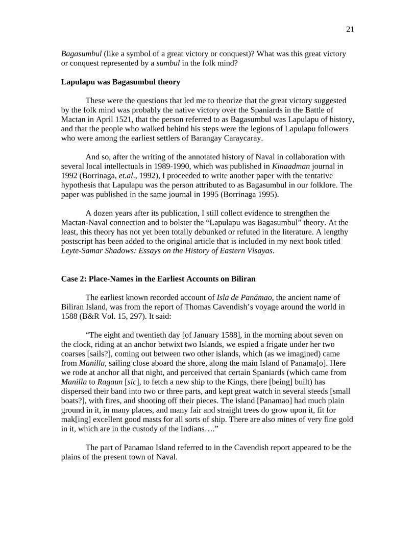
A dozen years after its publication, I still collect evidence to strengthen the Mactan-Naval connection and to bolster the “Lapulapu was Bagasumbul” theory. At the least, this theory has not yet been totally debunked or refuted in the literature. A lengthy postscript has been added to the original article that is included in my next book titled Leyte-Samar Shadows: Essays on the History of Eastern Visayas. Case 2: Place-Names in the Earliest Accounts on Biliran The earliest known recorded account of Isla de Panámao, the ancient name of Biliran Island, was from the report of Thomas Cavendish’s voyage around the world in 1588 (B&R Vol. 15, 297). It said:
“The eight and twentieth day [of January 1588], in the morning about seven on the clock, riding at an anchor betwixt two Islands, we espied a frigate under her two coarses [sails?], coming out between two other islands, which (as we imagined) came from Manilla, sailing close aboard the shore, along the main Island of Panama[o]. Here we rode at anchor all that night, and perceived that certain Spaniards (which came from Manilla to Ragaun [sic], to fetch a new ship to the Kings, there [being] built) has dispersed their band into two or three parts, and kept great watch in several steeds [small boats?], with fires, and shooting off their pieces. The island [Panamao] had much plain ground in it, in many places, and many fair and straight trees do grow upon it, fit for mak[ing] excellent good masts for all sorts of ship. There are also mines of very fine gold in it, which are in the custody of the Indians….” The part of Panamao Island referred to in the Cavendish report appeared to be the plains of the present town of Naval.

22
In 1600, there was already an unnamed village here, the one described as the nearby base of the Spanish, native and other workers in the first known Spanish shipyard in the Philippines on Isla de Panamao, and which had been visited by Jesuit missionaries based in Carigara starting in 1601 (Chirino 1604). Although Father Chirino seemed to suggest that the Panamao shipyard was established around 1600, it appears that this facility was already in existence in the island when the Cavendish voyage passed by in 1588. A total of six galleons were reported to have been built in Isla de Panámao (Artigas 1914, 252). Evolving meanings of Panamao Although I had known from childhood that the old name of Biliran was Panámao (read as pan-amaw, but now popularly pronounced as pa-na-maw), I did not know what this word meant. I learned the various meanings of this word over a long period. The following were its meanings through the centuries:
1. Panamao -- “The manner in catching all these large fish is: first with nets, which they call panamao and which they place in the sea, as they are accustomed to set them on land for wild hogs and other animals. In these they ordinarily catch the duyung [sea cows] …” (Alcina 1668, Part I, Book II, Ch. 16).
2. Panamao - island that gives a lot of sulfur (Sanchez 1711).
3. Panámao – large net called [by this name] (Sanchez de la Rosa 1914).
In terms of chronology, I learned about the 1668 definition in 2004, the 1914
definition in the early 1990s, and the 1711 definition just recently. Analysis In an earlier paper, I deemed it sufficient that I had established the meaning and correct pronunciation of Panámao (Borrinaga 2007). But I was also aware that there are other place-names and phenomena in my home province that still need to be placed in their proper contexts. I found the key to do this quite recently in the course of preparing this paper. I confronted the word Ragaun, the name of the place where a ship was built in Panámao Island, which I suspect the people of Capul Island off Camlaia (sic, Candaya, the name of Samar in 1588) supplied to the Cavendish expedition (B&R Vol. 15, 297). However, I never found any trace of this name in Biliran, and I could not also find it in two old Bisayan-Spanish dictionaries. Then I looked up the word in the Bikol-Spanish dictionary, knowing that Capul is close to the Bikol Region (Lisboa 1865). There I found the most likely word, ragaóp,

23
which meant “the noise [made by him that] gnawed with the mouth [something tough] like a bone or a hard thing.” Ragaun (sic, most likely Ragaóp) might not have been an actual place in Panámao. Rather, it was probably just a humorous label by the Capul informants for a visible collective activity – that is, eating -- among the shipyard workers based there. But a related word, Lúpâ, was and still is a place-name in Naval. This is a place between the present Sitio Tabuk-Salug (lit., across the river) of Barangay Caraycaray and Barangay Calumpang (a tree species) east of the town. In the oldest Bisayan dictionary (Sanchez 1711), lúpâ meant “the land of potters.” Suddenly, the three place-names – Panámao, Lúpâ and Ragaóp -- seem like pieces of a puzzle that fit their proper places. Panámao, the net, provided the large fish or wild game that were cut up or butchered and cooked in pots produced in Lúpâ, the eating of which food produced ragaóp sounds. It appears that the Spanish shipyard was established in Panámao Island not only because of the abundant supply of straight trees that were excellent for making ships, but also because of the abundant food supply from the local seas and forests. Unfortunately, the abundant supply of wood and food did not last long, and the ship-building activities from 1598 to early 1600s left an indelible mark on the local ecology and culture until the present. It seems the duyung (Halicore indica, the sea cows) were among the first to disappear, apparently due to the over-consumption of this easy-to-catch sea mammal. When the oldest Bisayan dictionary was compiled around 1616 (Sanchez 1711), the word panámao no longer reflected Father Alcina’s description of a large net. It simply referred to the “island that gives a lot of sulfur,” another precious commodity during the Spanish colonial years. Panámao Island was already associated with an important ingredient for gunpowder, and no longer with the trees used for ship-building. In my childhood years in the 1960s, I always wondered why the Mt. Camburok range four kilometers east of Naval, my hometown, and the mountains of Calubian across the Biliran Strait were mainly grass-grown and denuded of trees, while the higher mountains more than 10 kilometers away in the middle of Biliran Island still had thick forests. The reason I can infer now was that these low mountains and the plains of Naval were the sources of trees for the ship-building activities described in the Cavendish and the Chirino accounts. Another possible remnant of those ship-building years around 1600 is the tampo (lit., grouping), a death ritual cooperative still practiced in Barangay Caraycaray of Naval, the theorized site of the Spanish shipyard. It seems the deaths and burials of conscripted shipyard workers who had died away from their home villages and families were taken care of by contributions of rice and tuba (coconut wine) from fellow workers bound by a pact of cooperation. Only Barangay Caraycaray has this tradition in Biliran.

24
Case 3: History in a Panámao Legend Our island had a change of names from Panámao to Biliran between 1668 and 1712, the latter being the year Biliran pueblo was created (Borrinaga 2007). The name-switch was most likely influenced by the catastrophic eruption of the Panamao Volcano probably around 1669, a milestone year for Tacloban associated with a recorded “rain of ashes” in its vicinity (Tantuico 1980, 107). The natives probably decided the name-change on the belief that this would waylay the bad spirits in the destructive volcano (Borrinaga 1999; 2002). In the past, several authors had submitted various theories about the meaning of biliran. But the earliest definition of the word is found in the oldest Bisayan dictionary (Sanchez 1711). It has an entry for bilir or biliran, bildan, which refers to the “corner or a border of the ship or vessel.” Thus it is possible that biliran was the label introduced by the natives for the Spanish galleons and similar boats that were constructed here in the early 1600s. But this term failed to displace barco, or the later vapor, the Spanish-inspired labels. In 1675, the first seedlings of cacao (Theobroma cacao) imported from Mexico arrived in the country and were propagated by the Jesuit missionaries in Carigara, Leyte (PLEASE Foundation 1995). Cacao cultivation was probably part of their economic rehabilitation efforts for Isla de Panamao, a part of the Carigara Parish that was presumably damaged by the lahar from the recent volcanic eruption. In 1744, the first detailed map of the Philippines was drawn up by Jesuit Fr. Pedro Murillo Velarde. It was published in Manila in 1749 as part of his Historia de la Provincia de Filipinas de la Compania de Jesus (Murillo 1749). The cartographer was apparently confused about where Panamao Island was closest to Leyte. He bent the island and made it appear almost connected to the mainland in two areas - at the center and west of northern Leyte, respectively. In the same map, the northernmost point of Cebu, placed on almost the same latitude directly west of Panamao, was labeled Punta de Bululaqui.
Spanish traders who traveled on their cargo boats probably brought along with them a printed copy of Father Murillo’s map. In our vicinity, when they asked about Punta de Bululaqui, which could not be seen in the west from our island, they were presumably pointed instead to Bulalacao, a cove which swamps used to be the habitat of “sparkler” birds (presumably the blue heron) north of Panámao Island. Fairy Tales, Fleeting Facts The misrepresentation of local geography in the map apparently gave birth to the legend of Punta de Bulalacao in Isla de Panamao. This was supposedly the point of origin of Spanish galleons with fair-skinned and elegantly dressed men and women as passengers that brought cargoes of cacao seeds to Manila (Granali 1991). This local “fairy tale” appears to have been woven from two historical realities (the galleon constructions and the cacao cultivation) that happened decades apart in our island and a

25
mirage (Punta de Bulalacao) that arose from a crudely drawn map of our area. This three-component tale could be dated to have started around the 1750s. Associated with the “fairy tale” is the myth of a city at the top of the now-dormant Mt. Panamao, which had been ascribed as the source of the cacao-laden galleons. The historical reality behind this myth appears to be glow seen at night on the peak of this eruptive volcano around 1668. At that time, Jesuit Fr. Francisco Ignacio Alcina, who was stationed in Samar, had “often seen the mountains (sic) on the island of Panamao throwing out fire … especially on very dark and stormy nights” (Alcina 1668d). A folklore I learned from childhood was about people allegedly befriended or bewitched by fair-skinned enkantos (fairies) and transported in fancy vehicles to their “city” in Mt. Panamao. The phenomenon is represented by the word bugkut, commonly understood to mean “disappearance without a trace through abduction by the enkantos (fairies).” The ritual counter-measure to recover the disappeared person (called gibugkut) is for a group of people to conduct a noise barrage in front of some dakit tree (Ficus sp., Tag., balete) that is locally known to be haunted. However, stripped of its folkloric meaning, bugkut is pure and simple abduction or kidnapping (Tramp 1995). Its historical context appears to be the forced conscription by the Spanish authorities of able-bodied males from the surrounding areas to work in the Panámao shipyard around 1600. Some of the abductees were probably just picked up from their fields or fishing bancas and, even without informing their families, brought to Panámao. Many probably died in the workplace and could not return to their homes and villages, and their mysterious disappearances later became the grist of myth and legend. The “Biliran Commune” For a decade starting the mid-1760s, the myth of a “city” with glowing lights at night on a mountain in Panámao Island had a semblance of reality in the “Biliran Commune,” a self-sustaining communal society carved out of the foothills south of Biliran Island (Borrinaga 2006). The religious revolt instigated by the commune’s leader and supporters all over the region reached the height of notoriety around 1770, when the Augustinians started serving Leyte and the Franciscans started serving Samar following the expulsion of the Jesuits in 1768 (Borrinaga and Kobak 2006, 68-74; Cruikshank 1985, Ch. 1). I had written a paper about the Biliran Religious Revolt from 1765 to 1774, presented it in a forum like what we have now, and had it published in an academic journal (Borrinaga 2006). I need not present it again here. Suffice it to say that I made extensive use of etymology in piecing out that event largely from the meanings of numerous place-names and complemented by data from other documentary sources.
In the present paper, I expanded the use of etymology to three sets of antecedent events in the local history of Biliran Province. If this approach can be applied in my milieu, it can also be certainly applied in yours. Try it.

26
References: Alcina, Francisco Ignacio, SJ. Historia de las islas e indios de Bisayas … 1668. (a) Part
I, Book IV, Chapter 16; (b) Part I, Book III, Chapter 2; (c) Part I, Book II, Chapter 16; (d) Part I, Book II, Chapter 30. Three books of Part I of the Alcina manuscripts have been translated to English and published. See Kobak, Cantius J., OFM, and Lucio Gutierrez, OP (eds.), History of the Bisayan People in the Philippine Islands (Manila: UST Publishing House). Part I, Book I (Vol. 1) was published in 2002; Part I, Book II (Vol. 2) in 2004; and Part I, Book III (Vol. 3) in 2005. Part I, Book IV (Vol. 4) is in process of publication.
Artigas y Cuerva, Manuel. Reseña de la Provincia de Leyte. Manila: Imprenta “Cultura
Filipina,” 1914. Barotol, Dominador. Interview in 1990. Mr. Barotol, in his early 60s, had great
familiarity with the Inagawan terrain, where his clan still lives. Borrinaga, Rolando O. “From Bagasumbul to Naval: A Historical Review.” (Paper
presented at the 2007 Regional Seminar-Workshop on Enhancing Content and Strategies in Teaching and Conducting Research in the Social Sciences, Leyte Normal University, Tacloban City, October 15-17, 2007.)
Borrinaga, Rolando O. and Cantius J. Kobak. The Colonial Odyssey of Leyte (1521-
1914). Quezon City: New Day Publishers, 2006. Borrinaga, Rolando O. “The Biliran Religious Revolt (1765-1774),” The Journal of
History LII: 1-4 (2006): 128-150. __________. “Lapu-lapu in Biliran? (A Tentative Hypothesis),” Kinaadman XVII: 2
(1995): 207-214. Borrinaga, Rolando O., Bago, Alberto M., Granali, Bienvinido H., Gahum, Jose Sr., and
Abilar, Antonio A. “Beginnings of Naval, Biliran Island: A Revisionist Account,” Kinaadman XIV: 2 (1992): 129-140.
Borrinaga, Rolando O. “The legend of Punta de Bulalacao,” Philippine Daily Inquirer, 21
February 2004, p. A16. __________. “Lost meanings in Biliran,” Philippine Daily Inquirer, 5 October 2002, p.
A18. __________. “How Biliran got its name,” Philippine Daily Inquirer, 25 November 1999,
p. 19.

27
[Cavendish, Thomas.] “Expedition of Thomas Ca(ve)ndish,” in: Blair, Emma H. and James A Robertson (eds. and trans.), The Philippine Islands, 1493-1898 (Cleveland, Ohio, 1903-1909), Vol. 15, pp. 292-299.
Chico, Eduardo A. “A Short History of Naval.” (Unpublished Historical Term Paper,
Sacred Heart Seminary, Palo, Leyte, 1957.) 44 pp. Chirino, Pedro, SJ. Relacion de las Islas Filipinas [1604] (English translation by Ramon
Echevarria). Manila: Historical Conservation Society, 1969. (The English translation is also found in Vols. XII and XIII of the Blair and Robertson collection.) It has a short chapter (Ch. 76) on the mission to Panamao.
Granali, Ben. “Legend of Biliran: Isla de Panamao (Isle of Mystery and Magic),”
Women’s Journal, 14 May 1991, p. 14. http://www.stuartxchange.com/Tambo.html Lisboa, Marcos de, OFM. Vocabulario de la Lengua Bicol. Manila: 1865. Makabenta, Eduardo A. Binisaya-English English-Binisaya Dictionary. Quezon City:
EMANDSONZ, 1979. Murillo Velarde, Pedro, SJ. Historia de la Provincia de Philipinas de la Compania de
Jesus. Manila, 1749. PLEASE Foundation, “The Cross over Candaya,” in Leyte: 400 Years of Evangelization,
1995. (A three-chapter history of the Early Jesuit Era in Leyte in the published program for the 400th anniversary of the arrival of the Jesuits in Leyte on July 16, 1595). pp. 7-88.
Sanchez, Mateo, SJ. Vocabulario de la Lengua Bisaya. Manila: 1711. Sanchez de la Rosa, Antonio, OFM, and Antonio Valeriano Alcazar, OFM. Diccionario
Español-Bisaya para las Provincias de Samar y Leyte. Manila: Imp. y Lit. de Santos y Bernal, 1914.
Tantuico, Francisco Jr. S. Leyte Towns: Histories/Legends. Tacloban City: Your Press,
1980. Tramp, George Dewey Jr. Waray-English Dictionary. Kensington, MD: Dunwoody
Press, 1995. United States Coast and Geodetic Survey. Map of Leyte, 1899. Webster’s New World Dictionary of American English (Third College Edition). New
York: Simon and Schuster, Inc., 1988.

28
Annex “B”
Of the Mission to Panamao
Fr. Pedro Chirino, S.J.
(NOTE: The following text is an English translation of Chapter 76 of Jesuit Father Pedro Chirino’s Relacion de las Islas Filipinas, published in Rome in 1604. This translation was by Ramon Echevarria and published by the Historical Conservation Society in Manila in 1969. Chapter 76 is in pages 459-462 of the book.)
Panamao is one of the little islands adjacent to this island of Leyte, almost contiguous to it, being separated from it only by a strait so narrow that a ship can barely pass through. It abounds with timber and is therefore suitable for the construction of ships, as are many of these islands, and in December of 1601 the ship was here being built on which I was later to sail from those islands (in July of 1602). A large number of Spaniards, Indians and other workers had been gathered there for the construction work, and they gave Father Francisco Vicente, of our Society, who traveled from Carigara or Alang-alang to visit them and attend to their needs, very much to attend to. This priest went there at a most opportune time, as if led by the hand of God, to dispose the hearts of men, whom the divine hand had already predisposed by means of an incident that filled them with dread and apprehension. What had occurred was this. A Spanish-speaking Negro who was there in the service of the captain had his wife staying with him, and having had to leave the place to look for some materials required in the work, on his return one night found his wife with another man. Overcome by jealous rage he attacked them both with a spear, slaying the adulterer and leaving his wife for dead. The case was a very unfortunate one because the dead man was a young fellow who was well liked by everybody, and seeing him dead without the benefit of Confession, in such circumstances and at the hands of a Negro, albeit a just man, moved everyone to penitence. Just then Father Francisco Vicente arrived, and finding the harvest ready began by his sermons, talks and confessions to reap the ripened fruit, as related by the Father himself in one of his letters, which says:
“I arrived at Panamao on the Saturday of the last Sunday of Advent and the captain received me with great affection and obsequiousness. It is a large settlement of Spaniards and Indians that has gathered together there, and Our Lord gave us a good harvest of souls. Upon my arrival I addressed them and tried to win their affection, and immediately thereafter brought up the necessity for building a church. This was accomplished in such a manner that on the following day I said mass in it; I preached to them about sin, explaining its ugliness and its harms, etc., and in particular bringing to their minds the fresh lesson and sermon that Our Lord Himself had very recently preached to them. All were noticeably moved and decided to ask for Confession and the redress of their souls, and in order not to lose so ready a prize, I worked with all haste preaching now to the Spaniards and now to the Indians. That Sunday I delivered three sermons. In addition to this I tried to attract the chiefs and principal residents by means of private chats, explaining to them how they should make their confession.
29
“As they had heard that I was to be leaving immediately, right after the first day
of Advent, they begged me to stay at least until the third day in order that they might be able to make their confessions. I agreed, and from that moment those people began to come to me so devoutly, both Spaniards and Indians, that they created a furor. I lost no opportunity, exhorting, comforting, soothing, instructing and trying to attend to them wholeheartedly. The confessions began before dawn at about four in the morning: they came making general confessions of a whole lifetime, or of many years, weeping and sobbing, so that it was often necessary to hold the reins and encourage them, instead of having to find reasons for their compunction and grief, as is often the case.
“It happened at that time that some Spaniards had to leave for another small
island, and among these a few came to me hurriedly in order not to lose their opportunity, making up for the brief time at hand with their extraordinary devotion. The others, who did not even have that brief time available, deferred me until their return, deeply disappointed and full of holy envy for those who remained. In truth what took place within all those souls only God really knows; all I can say is that I have not seen greater penitence or more sincere devotions. There were persons who spent whole nights in tears with a crucifix in their hands. And so quiet were those days of Advent that they seemed like Good Friday: they all stayed in their houses, unless they wanted to go to mass or to talk to me about the salvation of their souls, showing in their grave and subdued faces the grace that Our Lord was bestowing upon them, and demonstrating their interior grief and the light Our Lord was giving them in their comings and goings from their homes to me with a thousand scruples and to satisfy their conscience. I offered a thousand blessings to God our Lord for having brought me there to provide so many benefits to so many souls. Many people assured me that they had never seen anything like it.
“I continued hearing confessions to dispose them as well as possible for the
season of Advent. I am certain that if I had to purchase at the cost of labors all the moments of joy and satisfaction I experienced while giving Communion to each of them (and at the same time, it seems to me, reading their hearts), not even a thousand trips from Spain could pay the price. I was supposed to leave on the fourth day of Advent but found it impossible to do so, because they begged and importuned me to stay longer, and also because some had not yet finished making their confessions. I therefore had to stay until Sunday.
“On Sunday we effected a reconciliation between the murderer and the adulteress. They embraced and forgave each other and very fervently made their confessions. On Monday morning I said mass at a little after two o’clock, since I would shortly have to be leaving; I did not do so secretly enough, however, for all the people with profuse fervor came to attend it. With tears and words they expressed their sorrow over my departure and pressed me to return soon in order to bring them renewed comfort. And so I returned thence, glorifying God. I left a little hospital for the sick and the poor, to which everyone contributed with alms or personal services: may it give glory to Our Lord Jesus Christ, from whom everything proceeds.”

30
Annex “C”
English Translation of Directory Item on Naval Parish [in Pbro. D. Felipe Redondo y Sendino, Breve Reseña de lo que fue y de lo que es la
Diocesis de Cebu en las Islas Filipinas (Manila: Colegio de Sto. Tomas, 1886), p. 194.]
236. Naval. Erected as a parish by the Diocese on September 26, 1860, under the protection of Our Lady of the [Most Holy] Rosary, with Superior approval on May 26 of the same year, separated from Biliran, its mother parish. - Church: of masonry, partitioned, with cement pavement, roofed with nipa shingles, in good state: 25 fathoms in length, 9 fathoms in width and 9 fathoms in height. - Cemetery: [fenced with] stakes. – Parish House (Convent): under repair, of masonry on the lower portion until the [elevated] floor. – The parish has for its visita the island of Gigatangan, about 8 miles [to the W.], with some inhabitants in its S. Covered by Naval are: the town and island of Maripipi, 22 miles to the N. W., with a church of light materials; the town of Almeria to the N. at two hours of sailing, which has a visita called Cauayan to its N. at 6 miles distance, which is bounded by Caibiran, and is located in front of Maripipi (1). - The location of the pueblo of Naval is along coast S. W. [of the island] and to the N. W. of the pueblo of Biliran, the only other parish in the island, and their respective anejos (parish coverages), the other three pueblos described here [Almeria, Maripipi, and Caibiran]. The parish faces in the S. the new town of San Isidro del Campo, about eight hours of sailing away in the island of Leyte.” ----------
(1) According to the Estadistica of the Recollect Fathers, p. 207: “In the principles of its foundation, it was the responsibility of this Convent (that of the Recollects of Cebu) to spiritually administer the souls of the island Maripipi, as a concession to Bishop Arce. But later, due to several circumstances, they were added to the [Jesuit] rectory of Bantayan.” (See No. 90 of this Reseña, where it is said that it was added to Bantayan in 1615.)