Embed Size (px)
Citation preview

Port of Greymouth Operations
Grey District Council Harbour Board Offices, 28 Gresson St, PO Box 382, Greymouth, Phone : 64-3-768 5666; Fax : 768 0646
Mobile Phones : Harbour Supervisor, 0274 353 424 Email : [email protected] 29th June 2017 TO VESSEL OPERATORS, MASTERS, PILOTS, FISH RECEIVERS AND COASTGUARD : _________________________________________________________________________________
North Beach Fishing LTD Fv Cook Canyon [email protected] GREYMOUTH
Darren Claridge Westfleet [email protected] GREYMOUTH Coastal Bulk Shipping Mv Anatoki [email protected]
Doug Smith Transport Logistics Ltd. [email protected] Christchurch
Grant King Harbour Holdings [email protected] GREYMOUTH Geoff Drake Talleys Fisheries Ltd [email protected] GREYMOUTH John Brown Westfleet Fish. Co-op [email protected] GREYMOUTH
Richard Pollock Richardson Fishing Co Fv. Resolution II
Fax 03 546 6015 [email protected]
Stuart Caie LINZ [email protected]
Coastguard Station West Coast Buller Coastguard
[email protected] GREYMOUTH
Harbourmaster, Westport For Your Information Email [email protected]
WESTPORT
Land Information NZ For Your Information Fax 04-4600161 [email protected]
WELLINGTON
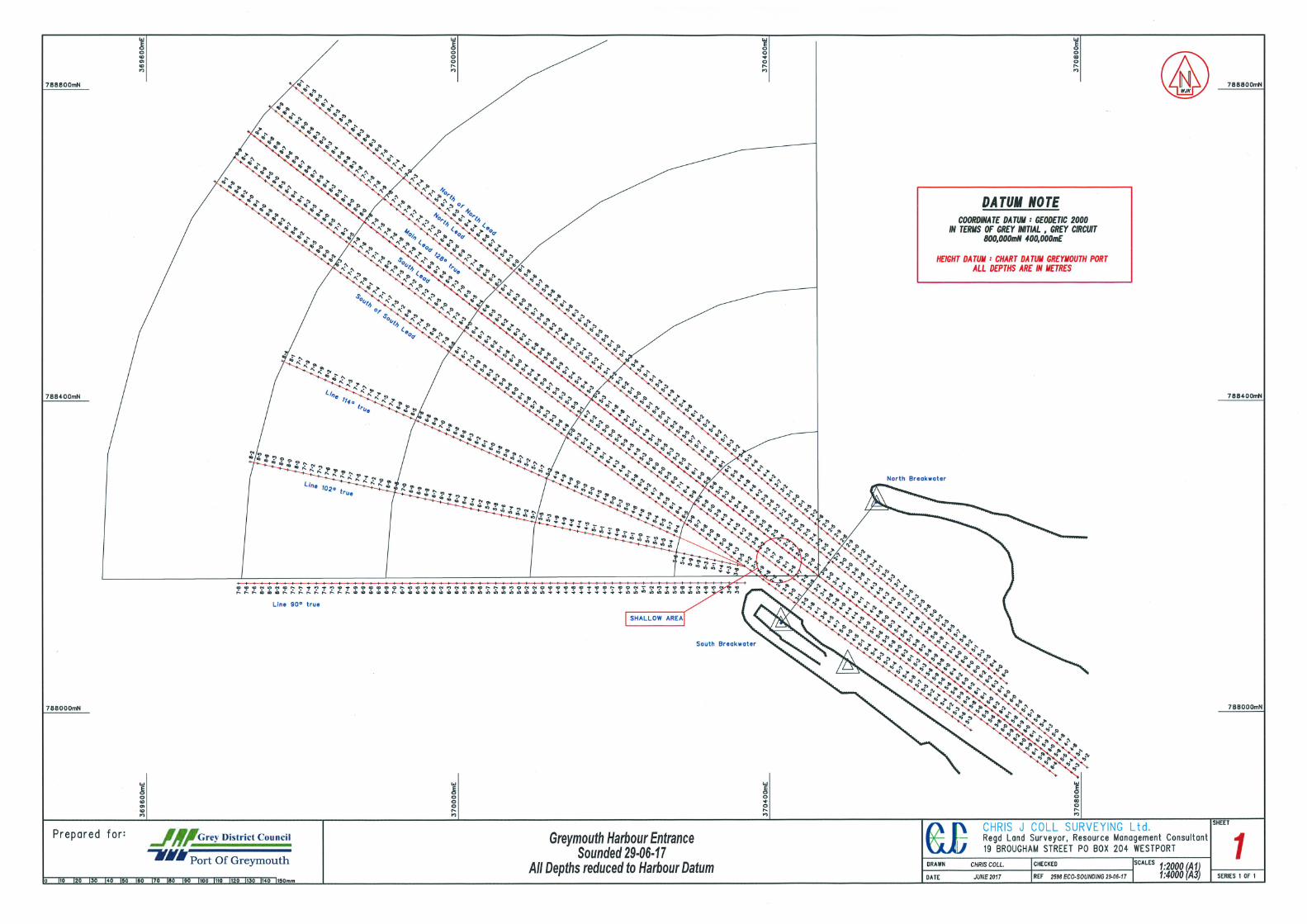
SOUNDINGS AT GREYMOUTH 1. Attached are details of the most recent soundings at Greymouth. 2. Please note the date of each sounding. As conditions may change daily, particularly the bar, lagoon entrance and river berths, there is no certainty that the depths shown remain current. Neither the Grey District Council nor its Port Management Services contractor gives any warranty as to the accuracy of these soundings. 3. If you require sounding charts to be faxed, please advise the location required. 4. As it is not always possible for us to make fax contact with vessels, operators are asked to check that vessels have received the information, and pass it on if necessary. Vessel masters are also asked to let us know when they are in fax range. RECOMMENDED MINIMUM UNDER KEEL CLEARANCES : (A) Bar: 0.9 metres plus two thirds the swell height with a minimum of 1.0 metre. (B) Turning circle and berths : 0.5 metres. PORT ENTRY AND DEPARTURE : Port entry or departure should not be made : (a) When waves are breaking on the bar or entrance. (b) when the blue light on the signal mast is flashing, unless advice that it is appropriate to do so has been received from a qualified and experienced person on shore. (Note : Absence of the flashing blue light does not necessarily indicate that the entrance is safe. If in doubt seek advice). DISCLAIMER : While the Grey District Council and its Port Management Services contractor have exercised all reasonable care and skill in carrying out and analysing these soundings, the Grey District Council and its Port Management Services contractor accept no liability in contract, tort or otherwise howsoever, for any loss, damage, injury or expense ( whether direct, indirect or consequential) arising out of the provision of this information to any person or organisations. SOUNDING ACCURACY VARIES plus or minus 0.4 METRES

PORT OF GREYMOUTH SOUNDINGS UPDATED 29th June 2017– sounding accuracy varies +/- 0.4 metres
LOCATION Bar plan available by fax on reques
LEAST DEPTHS BELOWCHART DATUM (METRES)
DATE SOUNDED
BAR : (Entrance is point on Centre Lead Between starboard & port entrance lights)
29th June 2017
North of North Lead 2.2m @ 52 metres outside entrance
North Lead : 129( T ) 2.2m @ 26 metres outside entrance
Centre (Main) Lead : 128 ( T ) 2.0m @ 28 metres outside entrance
South Lead : 127 ( T ) 0.5m @ 50 metres outside entrance 1.2m @ 70 metres outside entrance
South of South Lead 2.8m @ 52 metres outside entrance
Magnetic West : 2940 / 1140 True from / to South Breakwater
4.5m @ 288 metres outside entrance
Line 102 : 282/ 102 True from / to South Breakwater
3.6m @ 100 metres outside entrance
True West : 2700 / 900 True from / to South Breakwater
3.6m @ 96 metres outside entrance
. RIVER : 2.1 RIVER CHANNEL– MAIN LEAD FROM SIGNAL STATION UP TO LAGOON
ENTRANCE
North Lead
4.0 m @ 190m from main wharf head
10th Feb 2017
Centre Lead
3.9m @152m from main wharf head
10th Feb 2017
South Lead 3.5 @ 112m from main wharf head at Entrance of lagoon
10th 5eb 2017
2.2 RIVER WHARF – RICHMOND QUAY (pier numbers decrease upstream) NOTE : (Depths out to 30 metres from wharf) Crane Berth : Piers 200 to 170 4.5 @ 30 metres from wharf, maximum 5.0
4.3 @ 25 metres, maximum 5.0 10 February 2017
Concrete Deck Berth : Piers 170 to 148 5.5 @ 30 metres from wharf, maximum 5.6 5.5 @ 25 metres, maximum 5.6
10 February 2017
2.3 RIVER TURNING CIRCLE OUT TO 109 METRES FROM WHARF Swinging from Pier 137 (Concrete Deck – (Gravel) Berth)
5.0 metres at wharf 10th February 2017
Swinging from Pier 164 (Sea-Tow 80) (Anatoki – gravel)
3.9m @ 109 m radius, 4.4m @ 70 m radius
10th February 2017
Swinging from Pier 170 3.4 @ 100 m radius 10 February 2017
Swinging from Pier 200 4.5 @ 100 m radius, 10th Feb 2017 3: LAGOON
3.1 LAGOON ENTRANCE
West Side 0.2 metres 10 Feb 2015
Centre West 0.6 metres 10 Feb 2015 Centre East 0.9 metres 10 Feb 2015 East Side 2.6 metres 10 Feb 2015 3.2 MARTINS QUAY (EAST SIDE) FISH UNLOADING WHARF
Northern Unloading Berth 2.6 to 3.3 metres 10 Feb 2015 Central Unloading Berth (beside Westfleet) 2.7 to 3.3 metres 10 Feb 2015 Southern Unloading Berth (beside Talleys) 2.6 to 3.6 metres 10 Feb 2015
3.3 TRAVERSE ACROSS LAGOON MARTINS QUAY TO PACKERS QUAY
Sounding plan available at port on arrival
Between Compass Dolphin and Starboard Beacon
0.9 to 2.4 Metres 10 Feb 2015
3.4 PACKERS QUAY (WEST SIDE)
Mobil Fuel Berth 1.8 to 2.4 Metres 10 Feb