Embed Size (px)
Citation preview

Population and spatial growth:
diagnosis and implications for urban management of Bangui
(Central African Republic)
Cyriaque-Rufin Nguimalet Laboratoire de Climatologie, de Cartographie et d’Etudes Géographiques (LACCEG), Département de Géographie, Faculté des Lettres et Sciences
Humaines (Université de Bangui) – B. P. 1037, Bangui (RCA) mel : [email protected]
Paper presented to PRIPODE workshop on
Urban Population, Development and Environment Dynamics in Developing Countries
Jointly organized by CICRED, PERN and CIESIN
With support from the APHRC, Nairobi
11-13 June 2007
Nairobi, Kenya
1
Population and spatial growth : diagnosis and implications for urban management of Bangui (Central African Republic)
Cyriaque-Rufin Nguimalet Laboratoire de Climatologie, de Cartographie et d’Etudes Géographiques (LACCEG), Département de
Géographie, Faculté des Lettres et Sciences Humaines (Université de Bangui) – B. P. 1037, Bangui (RCA) mel : [email protected]
Résumé : La croissance démographique suscite l’extension spatiale en milieu urbain. Cela pose problème lorsque cette croissance spatiale n’est ordonnée ni canalisée par une politique d’urbanisation. Cette question est d’actualité à Bangui, capitale de la République centrafricaine, où l’anarchisme de l’occupation du sol y crée une ségrégation urbaine entre les quartiers (lotis et non-lotis) à cause de l’incapacité de l’administration locale à contrôler le territoire urbain. Celle-ci insinue un manque de cohérence dans la trame urbaine, avec comme corollaire une gestion urbaine difficile qui se traduit par une marginalisation des quartiers populaires ou non-lotis, i.e. n’ayant pas d’infrastructures urbaines, dans les processus de développement urbain. Ce travail analyse la composition actuelle du territoire urbain, colonisé surtout par des quartiers périphériques/populaires, selon une démarche diachronique. Le diagnostic réalisé établit en parallèle les effets induits de la croissance démographique et la non-maîtrise de l’espace urbain par les pouvoirs publics, avec des acteurs qui s’individualisent différemment dans les processus territoriaux. Les quartiers non-urbanisés se sont surtout installés dans des zones vulnérables (marécageuses et inondables) où manquent l’eau potable et les services d’assainissement de base. L’anarchisme dans les processus spatiaux semble « légalisé » par les pouvoirs publics n’ayant pas déployé d’efforts pour le résoudre. Ce travail suggère une recomposition appropriée des quartiers populaires en vue de leur intégration dans une dynamique urbaine globale, pour une nouvelle gouvernance du territoire urbain de Bangui.
Mots clés : Population, croissance spatiale, diagnostic, gestion urbaine
Population and sptial growth: diagnosis and implications for a urban management of Bangui (Central African Republic)
Summary: The demographic growth creates the spatial extension in towns. This issue is in fact poses a problem when this spatial growth is neither authorized nor regulated by a urbanizing policy. This topic of the day in Bangui, the capital city of Central African Republic, where anarchic occupation of soil creates in it a urban segregation between areas (alloted and non alloted) because of the inefficiency of the local administration on to control the urban territory. That one suggests a lack of consistency in the urban surroundings with as corollary, a difficult urban management that results in a marginalization of slums not alloted, for example those which lack of urban facilities in the rapid urban expanding process. This work aims at analyzing the present composition of urban territory especially colonized by working class districts according to a diachronic approach. The diagnosis draws a parallel between the induced effects of the demographic growth and that of the non mastery of the authorities of the urban space, with actors who become more and more individual in the territorial process. These non urbanized areas settle into vulnerable zones (marshy and flood) where drinking water crually lacks and basic cleanning-up services too. Anarchism in the spatial process seems to be “legalized” by the authorities that do not make effort to resolve it. This work suggests an appropriate reconstruction of these working class districts with a view to their integration into a global urban dynamics, for a new management of the urban territory of Bangui.
Keywords: Population, spatial growth, diagnosis, urban management
1. Introduction
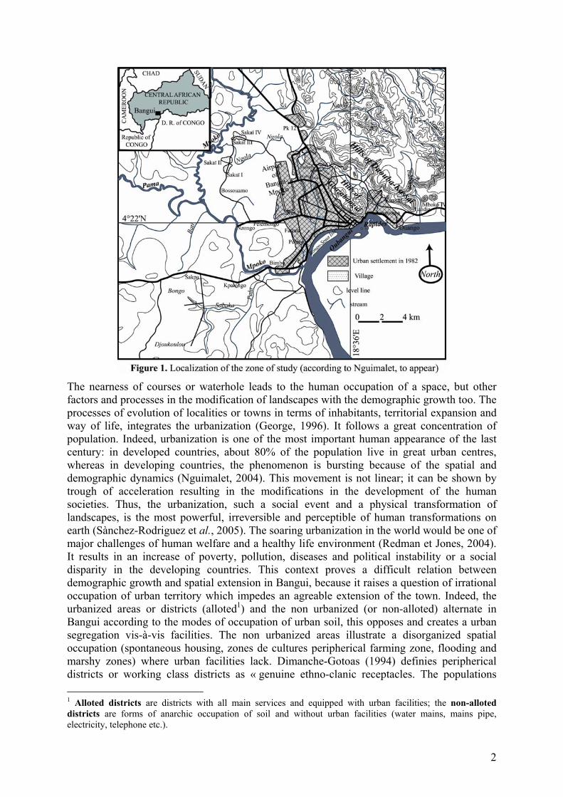
Located at 4°22’ to the North and 18°36’ to the East, the town of Bangui, the capital city of Central African Republic, is bordering the Oubangui river. Sprang up from « Rapides de l’Oubangui » on the roll of sandy slope of june 26th 1889, this past colonial military post has moved in times and space, in search of land out of water between Rapids and the confluence of the Mpoko river upstream, before to being definitively settled in 1892 on the rocky headland where Oubangui Hotel is perching now. The site is stuck between steep hillsides from west to east and the Oubangui river in the South, and stretches westward, the south west and the North in the sector of marshy plain. The presence of Gbazabangui Hills breaks the continuation of the town from east to west, creating a leadership between the east Ouango, Kassaï and Gbangouma group, and the west, with the marshy plain (Figure 1).
2
The nearness of courses or waterhole leads to the human occupation of a space, but other factors and processes in the modification of landscapes with the demographic growth too. The processes of evolution of localities or towns in terms of inhabitants, territorial expansion and way of life, integrates the urbanization (George, 1996). It follows a great concentration of population. Indeed, urbanization is one of the most important human appearance of the last century: in developed countries, about 80% of the population live in great urban centres, whereas in developing countries, the phenomenon is bursting because of the spatial and demographic dynamics (Nguimalet, 2004). This movement is not linear; it can be shown by trough of acceleration resulting in the modifications in the development of the human societies. Thus, the urbanization, such a social event and a physical transformation of landscapes, is the most powerful, irreversible and perceptible of human transformations on earth (Sànchez-Rodriguez et al., 2005). The soaring urbanization in the world would be one of major challenges of human welfare and a healthy life environment (Redman et Jones, 2004). It results in an increase of poverty, pollution, diseases and political instability or a social disparity in the developing countries. This context proves a difficult relation between demographic growth and spatial extension in Bangui, because it raises a question of irrational occupation of urban territory which impedes an agreable extension of the town. Indeed, the urbanized areas or districts (alloted1) and the non urbanized (or non-alloted) alternate in Bangui according to the modes of occupation of urban soil, this opposes and creates a urban segregation vis-à-vis facilities. The non urbanized areas illustrate a disorganized spatial occupation (spontaneous housing, zones de cultures peripherical farming zone, flooding and marshy zones) where urban facilities lack. Dimanche-Gotoas (1994) definies peripherical districts or working class districts as « genuine ethno-clanic receptacles. The populations 1 Alloted districts are districts with all main services and equipped with urban facilities; the non-alloted districts are forms of anarchic occupation of soil and without urban facilities (water mains, mains pipe, electricity, telephone etc.).
3
reconstitute a rural civilisation within the urban districts ». They are the main centres of this identification of constraints to their rise and therefore that of the whole town, because the diagnosis of territory brings elements of reflection for the action, characterized not only by potentialities of the territory, but the mobilization of actors (Lardon et al., 2005 ; Lardon et Piveteau, 2005). In this study, an exam of combined effects of demographic and anarchic growth of space suggests to realize the inconsistency of urban consistency and difficulties of an efficient urban management of Bangui, abounding in great number of peripherical districts. These difficulties of management results in the inefficiency of local administration to control the territory under its charge, because it must impose good rules for all, the only best way to take action in view with the town planning (Piermay, 1981). The anarchism of the soil occupation subdues the working class districts to forms of vulnerability of physical nature (urban floods) and socioeconomic (scarcity of drinking water and cleansing services, peripherical farming zones etc.). Thus, the approached topic bounds in the extension of urbanized spaces (soil occupation, comsuption of space) and the urbanization of way of life (benefit to the town, forms of urbanity) for that, Dimanche-Gotoas (1994) emphasizes on the social organization based on the rural way of life and to that based on the urban way of life such as in Bangui. This work will insist on the progress of working class districts as a brake to a coherent spatial dynamics, the diagnosis, and to look to a path to their integration into a global urban dynamics.
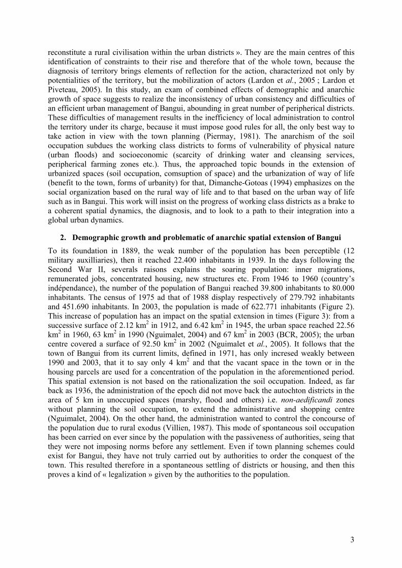
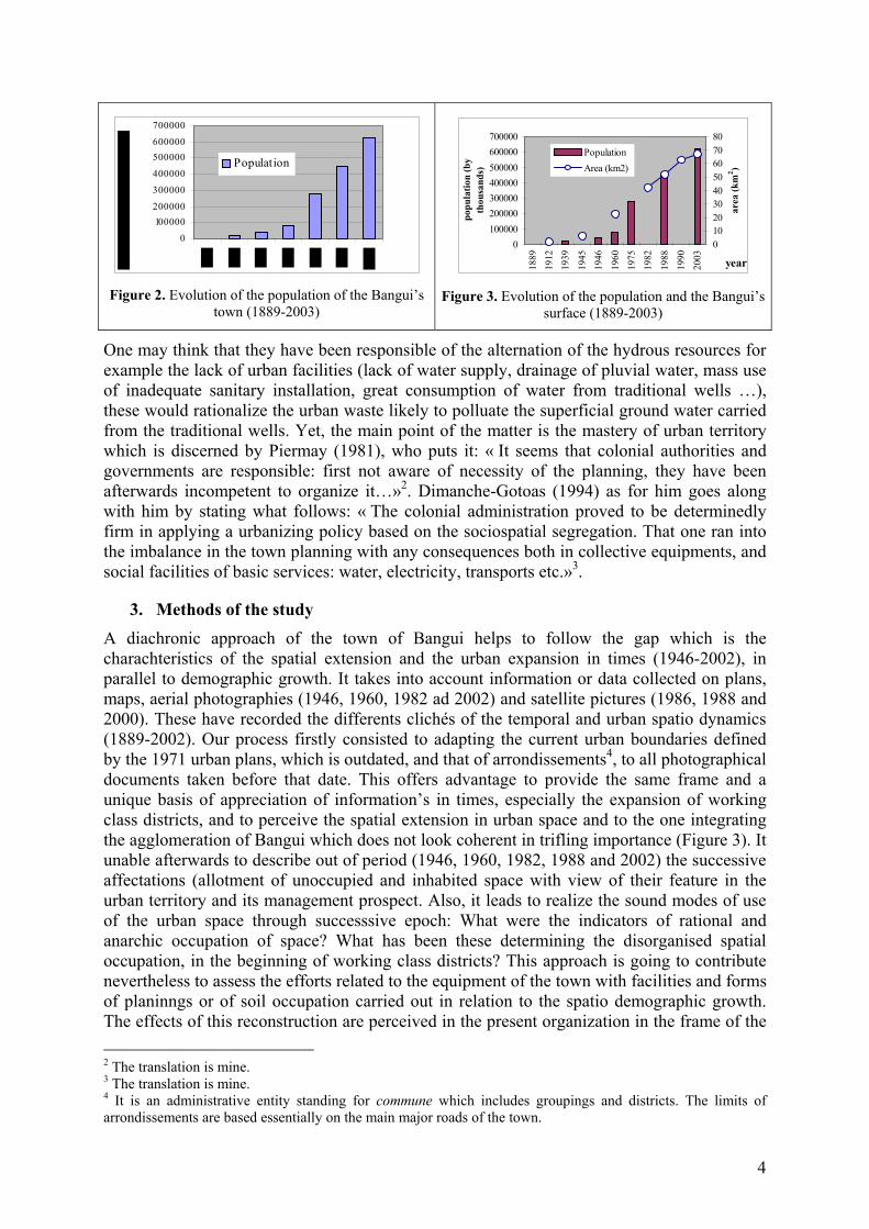
2. Demographic growth and problematic of anarchic spatial extension of Bangui To its foundation in 1889, the weak number of the population has been perceptible (12 military auxilliaries), then it reached 22.400 inhabitants in 1939. In the days following the Second War II, severals raisons explains the soaring population: inner migrations, remunerated jobs, concentrated housing, new structures etc. From 1946 to 1960 (country’s indépendance), the number of the population of Bangui reached 39.800 inhabitants to 80.000 inhabitants. The census of 1975 ad that of 1988 display respectively of 279.792 inhabitants and 451.690 inhabitants. In 2003, the population is made of 622.771 inhabitants (Figure 2). This increase of population has an impact on the spatial extension in times (Figure 3): from a successive surface of 2.12 km2 in 1912, and 6.42 km2 in 1945, the urban space reached 22.56 km2 in 1960, 63 km2 in 1990 (Nguimalet, 2004) and 67 km2 in 2003 (BCR, 2005); the urban centre covered a surface of 92.50 km2 in 2002 (Nguimalet et al., 2005). It follows that the town of Bangui from its current limits, defined in 1971, has only incresed weakly between 1990 and 2003, that it to say only 4 km2 and that the vacant space in the town or in the housing parcels are used for a concentration of the population in the aforementioned period. This spatial extension is not based on the rationalization the soil occupation. Indeed, as far back as 1936, the administration of the epoch did not move back the autochton districts in the area of 5 km in unoccupied spaces (marshy, flood and others) i.e. non-aedificandi zones without planning the soil occupation, to extend the administrative and shopping centre (Nguimalet, 2004). On the other hand, the administration wanted to control the concourse of the population due to rural exodus (Villien, 1987). This mode of spontaneous soil occupation has been carried on ever since by the population with the passiveness of authorities, seing that they were not imposing norms before any settlement. Even if town planning schemes could exist for Bangui, they have not truly carried out by authorities to order the conquest of the town. This resulted therefore in a spontaneous settling of districts or housing, and then this proves a kind of « legalization » given by the authorities to the population.
4
0
100000200000
300000
400000
500000600000
700000
Population
Figure 2. Evolution of the population of the Bangui’s
town (1889-2003)
0100000200000300000400000500000600000700000
1889
1912
1939
1945
1946
1960
1975
1982
1988
1990
2003 year
popu
latio
n (b
y th
ousa
nds)
01020304050607080
area
(km
2 )
PopulationArea (km2)
Figure 3. Evolution of the population and the Bangui’s
surface (1889-2003)
One may think that they have been responsible of the alternation of the hydrous resources for example the lack of urban facilities (lack of water supply, drainage of pluvial water, mass use of inadequate sanitary installation, great consumption of water from traditional wells …), these would rationalize the urban waste likely to polluate the superficial ground water carried from the traditional wells. Yet, the main point of the matter is the mastery of urban territory which is discerned by Piermay (1981), who puts it: « It seems that colonial authorities and governments are responsible: first not aware of necessity of the planning, they have been afterwards incompetent to organize it…»2. Dimanche-Gotoas (1994) as for him goes along with him by stating what follows: « The colonial administration proved to be determinedly firm in applying a urbanizing policy based on the sociospatial segregation. That one ran into the imbalance in the town planning with any consequences both in collective equipments, and social facilities of basic services: water, electricity, transports etc.»3.
3. Methods of the study A diachronic approach of the town of Bangui helps to follow the gap which is the charachteristics of the spatial extension and the urban expansion in times (1946-2002), in parallel to demographic growth. It takes into account information or data collected on plans, maps, aerial photographies (1946, 1960, 1982 ad 2002) and satellite pictures (1986, 1988 and 2000). These have recorded the differents clichés of the temporal and urban spatio dynamics (1889-2002). Our process firstly consisted to adapting the current urban boundaries defined by the 1971 urban plans, which is outdated, and that of arrondissements4, to all photographical documents taken before that date. This offers advantage to provide the same frame and a unique basis of appreciation of information’s in times, especially the expansion of working class districts, and to perceive the spatial extension in urban space and to the one integrating the agglomeration of Bangui which does not look coherent in trifling importance (Figure 3). It unable afterwards to describe out of period (1946, 1960, 1982, 1988 and 2002) the successive affectations (allotment of unoccupied and inhabited space with view of their feature in the urban territory and its management prospect. Also, it leads to realize the sound modes of use of the urban space through successsive epoch: What were the indicators of rational and anarchic occupation of space? What has been these determining the disorganised spatial occupation, in the beginning of working class districts? This approach is going to contribute nevertheless to assess the efforts related to the equipment of the town with facilities and forms of planinngs or of soil occupation carried out in relation to the spatio demographic growth. The effects of this reconstruction are perceived in the present organization in the frame of the 2 The translation is mine. 3 The translation is mine. 4 It is an administrative entity standing for commune which includes groupings and districts. The limits of arrondissements are based essentially on the main major roads of the town.
5
urban managements? On the other hand, it directs the diagnosis of urban territory, with a high number of working class districts where authorities, entrepreneurs and population who were main actors, interacted essentially. We understand how the actors have taken possession of the urban space.
The constraints to a efficient urban management of urban districts have been analysed in accordance with the current equipment of groups of districts (alloted and non alloted), and the ways of new management i.e. gouvernance5 of the town in relation to an integration of working class districts in global frame of urban extension.
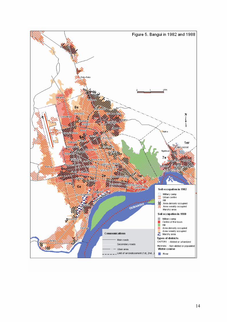
4. Forms of spatial growth of the town of Bangui The urban morphologies gained in times of: 1946 (Figure 4), 1960 (Figure 4), 1982 (Figure 5), 1988 (Figure 5) and 2002 (Figure 6), provide proof of the spatial growth and integrate at the same time the rationalism and anarchism that guided and kept the soil colonization going on within and on the outskirts of the town of Bangui. The outstanding periods of these transformations of urban territory distinguished themselves in 1946-1960 (Figure 4), with an extension of 16.08 km2, et en 1961-1982 where 51.13 km2 of space were conquered because not only of demographic growth, but also of the land pressure (Table I). Those figures make difference of the urban area and that of the agglomeration. The period 1983-2002 does not have experienced the same speed of growth or former periods because of the rarety of space to get and new forms of soil conquest in the urban space. It is during the recent period that the insanitary and unoccupied ground, marshy or flood, the former old quarry of laterite, and the grounds or vacant spaces in the housing concourse have been irrationally occupied by housings. This massive anarchic occupation displays non mastery of the spatial growth by the authorities, the local communities and the administrators. Table 1: Characteristics of spatial growth in Bangui (1912-2002)
Total Surface (km2) Enter period growth Agglomeration Urban zone Considered
period Spatial growth by
period (km2) 1912 2.12 - 1889-1912 0 1946 12.508 11.55 1913-1946 7.42 1960 21.240 20.685 1947-1960 16.08 1982 76.75 42.299 1961-1982 51.13 1986 89.039 50.847 1983-1986 12.28 1988 51.725 41.555 1987-1988 ? 2000 90.83 51.285 1989-2000 0.438 2002 92.50 58.70 2001-2002 7.415-1,67
In 1946, except the centre of the town and the Kassaï military camp, in the east of Gbazabangui hills which have been urbanized from Dumas’plan of 1930, and the Lakouanga district not truly the rest of housing was anarchic and went alongside the main center roads (n° 37 and 38, roads of Bimbo and Damara). The working class districts were Assana, Ngouciment, Magoumbala, Bafio, Mandaba, Ngarsoué and the Ndris village. On the other hand in 1960 (Figure 4), the works of improving the sanitation and the planinng undertaken in early 1950’s have transformed the urban lands cape. Some modern districts and residentials have extended the centre of the town: Batignolles, Lakouanga, Sica I and Assana. Others were appeared relatively isolated from urban centre: la Cité Christophe, Sica II and III, and le Camp des Castors. Then, the whole Km 5 and its surroundings have been efficient in road system, just as Malimaka and Boy-Rabé districts in part. The eastern part of the town, the 5 The gouvernance is defined as a process of officials coordination, of social groups, of institution to reach collectivelly discussed and defined goals (Cosandey et al., 2003).

6
working class districts border the roads (Ngaragba, Ouango), excepted the prison of Ngaragba, de St-Paul church and the College des Rapides and Lycée Pie XII, and the France Ambassy (residence).
From IGN (1972), the anarchic extension is amplified northward (Galabadja, Fou, Lipia and Gobongo districts) and the West (Bouca, Ndangué, Ngbéguéwé, Kolongo) of the town, especially with the opening of the Bangui-Mpoko International Airport in 1967 and the installation of UCCA, ICAT textile factory then UCATEX that definitively closed down in 1993. Others districts emerge in the centre of Bangui: Sara, Basse-Kotto and Ngouciment, and towards the South-west: Béa-Rex, Bacongo, Kpéténé, Langbassi; in the east, the Ngatoua district appeared. The rest of the non allotted districts are growing stronger in the same period. Yet, some new allotted districts come into existence: 36 villas and Benz-Vi after the transfer of the former aviation; Cité de Fatima and the 92 logements in the south-west. Besides, the former urbanized areas are expanded. Road system has improved in the Mamadou-Mbaïki, Sénégalais, Mustapha, Malimaka, Ndangué, Ngbéguéwé and Boy-Rabé districts. The empty and marshy zones have experienced a significant colonization in the heart of the town between Ngouciment, Mustapha and Basse-Kotto districts; it is just as with the progress of Kpéténé, Bacongo and Langbassi districts in the South-west whose the front was the Pétévo district. The marshy zone bordering the Oubangui river, designed to the plant settlement is weakly occupied.
Between 1982 and 1988 (Figure 5), the hue in the territorial extension is difficult to perceive and is resulted in 1988 by a slight colonization of vacant space especially by the densification of some districts (Kolongo, Bangui-Mpoko, Combattant, Damala, Boeing, Kpéténé, Béa-rex, Miskine, Fou, Boy-Rabé, Bafio et Gobongo) in comparison with 1982. The extensions of urban extra-periphery began to increasing in north, in west and in southwest of the town. Also in 1988, the works of road system of wide-mesh parcelling type have somehow changed the physionomy of some working class districts or slums (Combattant, Bangui-Mpoko etc.).
In 2002 (Figure 6), the urban extension is significant outside the area of the town, particularly in the southwest, to the east, in northwest and to the north. The trend is starting in 1988 and is resulting in swallowing by housing the Bangui-Mpoko international airport. A fringe of extra-urban extension can be seen in the east of Bangui, towards Ouango, Kassaï and Gbangouma. In 2002, the extension of the agglomeration has twice as much of that of the urban periphery.
5. Urbanism schemes and legalization of anachronism of soil conquest Since 1889, many plans (schemes) and studies have encouraged the growth of the town of Bangui. The first planning scheme of the site was drawn in 1892 and aimed at installing the military post on the hillsides to avoid recurrent floods of the Oubangui river (Villien, 1987). But the true plan would be the one drawn in 1930 february-march) by the geometrician Dumas (Boulvert, 1989a and b). In fact, the former planning of the town has started by the creation of urban facilities materialized by the development of small roads in 1908. Roads have been built in 1912 (year the post became Commune) to join the centre of town to native districts whose accesses were difficult due to a dense vegetation. These works of road system are amplifying in 1920, for it is matter of urgency to easy the traffic of first automobiles and motocycles.
In 1946, the urban structure includes the centre of the town and the native areas of the west, underequipped and of anarchic occupation; the two new residential estates are parted by non-built spaces, but connected by thoroughfares. Afterwards, an organizing plan of Bangui has been proposed by Fanny Joly, a town planner, in 1948 which has radio concentric feature (Lemotomo, 1977). The purpose of this plan of Bangui is to: (i) bring closer the urban core,

7
the working population carrying on either in administration and services or in trade and industry; (ii) organize, in regional frame, housing of farming population around thier renovated and developed activities. This one has not been noticed in its main lives only by the first objective. Analyzing the spatial organization of Bangui, Dresch (1948) noticed that the districts (area), industrial areas (Figure 5)… without any any spectations of residential areas. The european town’s/district spread by bringing about ‘nomadization’ (wandening authochton districts) five years ago. This author by another way suggested the importance of sweetening works of marshy ground (soil embankment and tree planting, eucalyptus) before the implementation of the scheme of the town planning. By another way, Depret (1967) has proposed a plan of urbanism whose crux is the development of a transversal axis east-west or «triomphal axis», the strenghtening of the meeting point of that one and that of the former aviation runaway (Figure 5), which will be widened and turn into a very important avenues: the present Avenue des Martyrs connecting the Bangui-Mpoko international Airport to the University of Bangui. Validated in 1971, this plan (scheme) does not have definite propositions as temporally spatial form, and does not limit a systematic cutting out of the town of Bangui in various zones without clear links, according to Lemotomo (1977). This author thinks that it is a temporal plan as the previous one. The hierarchy of the road system is not certain, its geometry and the orientation of roads are arbitrary. This document indeed lacks of precisions to the making of plan of details and does not provide accurate indications concerning buildings.
From the fore going, it seems that the Dumas 1930 Plans and F. Joly’s 1948, and the 1971 urbanism scheme that stem from Depret’s plan (1967) partially used, have determined and oriented fundamentally the physionomy of the present town of Bangui. One can point out here an anachronism of the matter of mastery of the urban space since the colonial era till nowadays. This one can be grasped by the persistence of spontaneous modes of the soil occupation inducing a concentration of housing and persons on a given space without any precise rules. As a result, the authorities passivety is more proved any time (present colonial administration) that could resolve the anarchic soil occupation favouring the working class districts, moreover, this trend has been taken into consideration into F. Joly’s plan. This shows again that they tacitly accept the « savage » urbanization without truly integrating those groups of districts which stem the new plans to the development of the town. Indeed, authorities did not consider the planning of the land for the housing of the large families as major objective. This would allow to prevent the course of the urbanization with support of concessionnaries and merchant services6 (SODECA, ENERCA, SOCATEL etc.) and local collectivities (road system, sanitary) as wella as launching of new works as maintenance and the reinforcement of the existing system (network) (Nguimalet, 2004). Such an attitude generates genuine consequences on the evolution of the population.
6. Effects of the anachronism of soil occupation in the urban surrounding and on the vulnerability of peripheric working class districts to water risks
The present urban surrounding of Bangui is inconsistent because working class districts alternate in there, the most installed (67% of urban area), and equipped districts with facilities (water network, drainage of pluvial waters, electricity etc.). The inefficiency of planning in urban scale, and more particularly in spontaneous developed districts, which would constitute the two third of the urban space with 44.6 km2, are the reasons. The lack of urban facilities has only marginalized the working class districts and delaid their integration in a global process of urban developement. This entails strongest densities of the urban population (more 6 SODECA: Central African Water Company; ENERCA: Central African Energy; SOCATEL: Central African of Telecommunications.
8
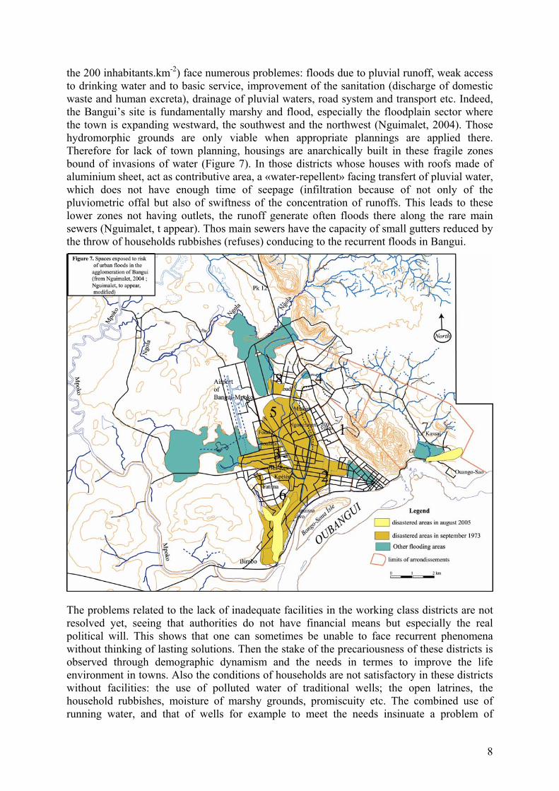
the 200 inhabitants.km-2) face numerous problemes: floods due to pluvial runoff, weak access to drinking water and to basic service, improvement of the sanitation (discharge of domestic waste and human excreta), drainage of pluvial waters, road system and transport etc. Indeed, the Bangui’s site is fundamentally marshy and flood, especially the floodplain sector where the town is expanding westward, the southwest and the northwest (Nguimalet, 2004). Those hydromorphic grounds are only viable when appropriate plannings are applied there. Therefore for lack of town planning, housings are anarchically built in these fragile zones bound of invasions of water (Figure 7). In those districts whose houses with roofs made of aluminium sheet, act as contributive area, a «water-repellent» facing transfert of pluvial water, which does not have enough time of seepage (infiltration because of not only of the pluviometric offal but also of swiftness of the concentration of runoffs. This leads to these lower zones not having outlets, the runoff generate often floods there along the rare main sewers (Nguimalet, t appear). Thos main sewers have the capacity of small gutters reduced by the throw of households rubbishes (refuses) conducing to the recurrent floods in Bangui.
The problems related to the lack of inadequate facilities in the working class districts are not resolved yet, seeing that authorities do not have financial means but especially the real political will. This shows that one can sometimes be unable to face recurrent phenomena without thinking of lasting solutions. Then the stake of the precariousness of these districts is observed through demographic dynamism and the needs in termes to improve the life environment in towns. Also the conditions of households are not satisfactory in these districts without facilities: the use of polluted water of traditional wells; the open latrines, the household rubbishes, moisture of marshy grounds, promiscuity etc. The combined use of running water, and that of wells for example to meet the needs insinuate a problem of
9
management of the quality of water and has generated the sanitary risks in those districts (Nguimalet et al., 2005). Thus, the increase of the population in the town by arrondissement between 1988 and 2003 (Figure 2), is 171.081 inhabitants, could not complicate the formentioned cases and the hypothetic development of the town. The 6th, 4th and 8th arrondissements of Bangui have the highest rate of growth between 68% to 87%, and the weaker (15% to 24%) feature the 1st, 3rd and 2nd arrondissements in that period; only the 5th displays a medium rate (34%). The first group of arrondissement (6th, 4th and 8th) is characterized by a strong demographic dynamism and referred to peripheric working class districts densily populated. This dynamic growth exists not only by the fact of anarchic occupation of soil but by the available space to be conquered in those arrondissements which run into urban peripheries to south-west, north-north-east and to north-north-west. The second stands out demographic dynamisms noticed in urban districts. In this group, the standard of living (1st), the saturation of the viable space or to be conquered (3rd) and the obstacle of Oubangui river and its bed of flood (2nd) explain the weak demographic growth. This opposition between groups of alloted and non alloted districts (Figure 8) throws into relief difficulties to sort out, to favour a harmonious development of the town of Bangui, by thinking of a new vision of working class districts which lack of urban facilities.
7. Different elements of conquest of territory, deficit of urban gouvernance, and roles of officials in the territory process
What deserves to be raised here is that the urbanization of the town of Bangui is always done together with anarchic occupation of soil (Figure 8). The evolution of two modes of spatial conquest is controlled by a relative weakness of the planification of the soil (rational mode), showing the mastery of urban space by authorities and also by an observation of land property regime canalizing the expansion of the working class districts (irrational mode). This raises the complexity of the territoriality notion in Bangui because from commune to groupings7 or districts, the territorial limits are blurred. If in alloted districts, roads and streets easy the traffic, in return working class districts maze of back street helps to move about or to nip in and out the houses in the inhabitatnts parcels. In connection with that, Piermay (1981) noticed: « Few limits are clearly defined. Those of the commune are marked on the maps – with any variation of details – but not well carried on the ground; to find them require a minimum of skills and instruments for measurement. The internal limits of agglomeration (groupings, districts) have ever been noticed on maps; one paradoxal exception is that of arrondissements, without true existence whose limits follow thoroughfares and are easily identifiable8». This account shows clearly the deficit of urban gouvernance that one can see through an ineffective administration with skills and responsabilities sometimes uncertain and conflictual between services and chiefs of districts. With these modes of occupation of the soil, some main categories of actors are standing out who are authorities (administration, cadastre, local communities, chiefs of village or district), the housing contractors (SICA, Hirondelle, Société Nationale d’Habitat), and the resident population (city-dwellers, farmers, artists or craftmens…). The fourth is identified by the dealers (tradesmen, coffee growers, pisciculturists, rice growers, various housing contractors etc.) which had farming and land expoitation in the urban area and sometimes in the agglomeration of Bangui.
Authorities were inefficient and lax in terms of control of territorial extension and also of positive impact on the life conditions of urban households. Their actions were ponctual in times and incoherent, giving rise to some residentials scattered among the working class
7 It is a group of districts with their respective chiefs gathered under the control of a notable within a commune. A grouping is synonymous of canton. 8 The translation is mine.

10
districts (Figures 4 and 5). The instruments of execution of authorities were housing companies (SICA, SNH, Hirondelle…). These targeted actions match with the idea of F. Joly’s plan that wanted to bring together but nearer the urban nucleus the working population, having occupiend after the districts or residentials. These actors interacted by different territorial processes in the urban space. Those processes or elements of urban conquest, rational or not, are the deforestation, various clearings, cultivations, quarries of laterite, quarry of stone (roads, buildings, airport, private and public schools etc.), the sudden colonization of marshy zones reparian… One has noticed more process entitling an irrational occupation there (clearings, deforestation, cultuvation…) that those insinuating a spatial occupation permitted (roads construction, public buildings etc.). Thus, we notice that the use of spaces is restricted to spontaneous housing seeing that there is not now a viable housing policy. As we know, SNH at the time participated to the development of some residentials. This shows that the organization of urban territory hardly has precise rules, hence, the inconsistency that characterize the preponderance of the actors over the urban space or over the present composition of the resident population.
With regard to housing companies which have been instruments of execution of authorities, Dimanche-Gotoas (1994) showed that the first construction companies of housing was set up in 1947, performing a block of 48 houses for hire purchase. The administration sollicitude was to favour first expatriates and then emancipated natives. From 1952 to 1953, thirty of houses were built to Camp des Castors (Figure 4) thanks to the financings of Crédit de l’Afrique Equatoriale Française and of the Caisse Centrale de la France d’Outre-Mer. In 1954, a cooperative was set up in the pilot-village of Castors which was in charge to build other lodgings. From 1955 to 1956, it has built 98 houses and would be turned into a «Société Immobilière en Afrique Equatoriale Française» (SIAEF). That company becomes «Société Immobilière des Constructions Africaines» (SICA) in 1958. Its accomplishments had given rise to residentials SICA I, SICA II and SICA III (Figure 4). From 1964 to 1970, authorities through urbanism and cadastre administration have built inexpensive lodgings in Benz-Vi, Fatima and Cité des Sinistrés (Figure 5). Some private companies and institutions have taken up, especially ASECNA and MOCAF Breuvery, settled in 1953 in Bangui, have built lod gings for their personnel. In 1966, the SICA is rationalized and became «Société Nationale de l’Habitat» (SNH). Which company had continued the works undertaken by SICA that is why SNH has successively realized the 36 villas, the 9 villas, the OCAM residences (now 14 villas), the 92 logements and the programme of 500 logements, executed in part and carry the name of 200 villas (Figure 5), some prefabricated houses called «Soweto» referring to one of South African’s town, donor. In 1983, SNH was dissolved but it has played a great part in the spatial extension of the town of Bangui in times, through different denominations, in building authorized lodging among working class districts (Figures 4 and 5).
Apart the lodging Companies in Bangui, one notices the link of these modes of spatial occupation, for example the alloted or non alloted sectors, is noticeable by the unachieved characteristics of planning or the road service of urban facilities in space. Indeed, we find the selvage of alloted districts the peripheric districts because, either financial means provided by the authorities are not enough to bring the work to an end, or the lack of plans of details related to urban scheme of 1971 does not lead to make viable those districts. Then, the discontinuity of the survey of the streets inside certain districts: Malimaka, Miskine, Km 5, Cité des Sinistrés etc. (Figures 4 and 5), coincides with the presence of marshes which clearings would have required heavy means. These arguments tempt to explain the non urbanization of most of districts of the town of Bangui which poses a global problem and local management and the urban development.
11
8. Discussion and conclusion: implication for an efficient urban management This study has analized indirectly the attitude of authorities, landowners, from the modern laws, vis-à-vis urban territory of Bangui. As for Piermay (1981), the notion of territory is thought unevenly there. This brings confusion when modern attitudes combined behavior inherited from rural environment, which are noticeable in the modes of the occupation of soil, attesting the inefficiency of authorities to manage the urban territory. According to this author, «a failure of local administration is closely bound to a former situation of non urbanism. A cahotic notion of territorry is not less unclear than those of districts of the Commune. The link between the two phenomena is evident, without it being possible to determine the previous feature of one of the two9». This statement is enough to point out the difficulties of the management of urban territory in Bangui at the very beginning; hence, it is necessary to foresee a possible restructuration of these non urbanized territories from available resources but also by taking into account an accurate plan and flexible viabilization.
Owing to the fact that the spatial and demographic combined growth causes an increase of needs of inhabitants only a reconsideration of these peripheric districts will lead to resolve durably the anarchic feature of the occupation of the soil, and to offer appropriate alternatives to populations of these districts till now short of urban facilities. We know that the 1971 urban scheme timeless, unaccurate in its plan of details has only privileged the thoroughfares, which have unfortunately been built as planned. The next is the anarchic spatial extension of the most of the urban districts. Yet, Piermay (op. cit.) does not find natural a revalorization of those districts when he declares: «operational delimitations are impossible because of lack of streets, inversely. The services in charge of urbanism lack of interlocutors to begin the necessary participation of inhabitants to the remodelling of the town10». Besides, we think that the diagnosis done by the author is relevant and can be used as basis to any alternative aiming at delimitating these districts and to push actors to a new gouvernance of the town of Bangui. Thus, the solution which seems more appropriate is to take into account the composition of the working class districts in their current forms, in order to bring out their potentialities leading to their revalorization and their effective integration. It will surely base on an accurate delimitation of these (from one district to another), by involving the local communities, notables, chiefs of districts from pedestrian walking, the track or roads suitable for motorcycle, streams and sometimes centre lines of road lining them. Because of the difficulties of urbanization and even of the non urbanization of their majority, this delimitation of districts by arrondissement looks as a credible alternative taking part in a spatial approach efficient to forementioned problems. It will allow to circumcrible or to target the districts and landlocked sector with intent to «viabilize» them, to equip them with facilities according to the plans of accurate details entitling to provide basic services.
This perspective would open a new frame to the urban management of Bangui, such a partnership would regroup the different actors (authorities, private companies, civil society, associations, districts development comities) around table. This partnership could have advantage of a institutional democratic legetimacy to give rise to interesting ideas useful to the reconstruction of those working class districts, such as, gathering financing and other exterior partners to which local actors would join to the partnership could have a leading team or a coordinator who would assure the interface between actors (public sector, companies and organization of civil society) and silent partners in place of societies or institutions which would assure this role in order to resolve the lack of urban facilities in the peripheric districts. Even if it entails authorities or local communities to support such a process to equip those
9 The translation is mine. 10 The translation is mine.

12
districts little by little with useful equipment and enliven them with a regard for improving the life environment of the households and the development of the capital Bangui. This would serve as prelude to the new gouvernance of urban territory which could call for a continuity in the action. Acknowledgements: The author very sincerely thanks, Mrs. Alfred Bangara, Technician in Geomatics and GIS of the Laboratory of Climatology, Mapping and Geographical Studies (LACCEG), and Hermann Djimapo, Master in English, both painstakingly contribute to the achieve of this article. The first concerns himself with numerical data processing (aerial, satellite images) which are developed in this paper in the forms of figures and tables. The second with the translation of the text into English.
9. References Boulvert Y., 1989a, Bangui 1889-1989 : Atlas. ORSTOM, IGN-France, Paris, 20 planches.
Boulvert Y., 1989b, Bangui 1889-1989. Points de vue et témoignages. SEPIA, Saint-Maur (France), 311 p.
Bureau Central du Recensement (BCR), 2005, La République centrafricaine en chiffres. Résultats du Recensement Général de la Population et de l’Habitation (RGPH) de décembre 2003. République centrafricaine, Ministère de l’Economie, du Plan et de la Coopération Internationale, Direction Générale de la Statistique, des Etudes Economiques et Sociales, Bangui, 23 p.
Cosandey C., 2003, sous la direction de, Les eaux courantes. Géographie et environnement. - Editions BELIN, Coll. Géographie, Paris, 240 pp.
Depret R., 1967, Bangui : urbanisme et habitat. Rapport de mission. Coopération française/RCA, Dir. Urb. Cadast., 55 p.
Dresch J., 1948, Villes congolaises : étude de géographie urbaine et sociale. Rev. Géographie Humaine et d’Ethnologie, 3, juillet-septembre, p. 13.
George P., 1996, Dictionnaire de la géographie. PUF, 5e édition, Paris, 452 p.
Dimanche-Gotoas L., 1994, L’urbanisation de Bangui : politiques de logement, de l’alimentation en eau, en électricité et de transport. Mém. Maîtrise (1994), Fac. Lettres & Sci. Hum., Université de Bangui (RCA),
IGN (Institut Géographique National), 1972, Carte topographique de la ville de Bangui à 1 : 10 000e, Paris.
Lardon S., Lelli L., Piveteau V., 2005, Editorial : le diagnostic des territoires. Géocarrefour, 80 (2), 2005, 71-74.
Lardon S., Piveteau V., 2005, Méthodologie de diagnostic pour le projet de territoire : une approche par les modèles spatiaux. In : Le diagnostic des territoires, Lardon S., Lelli L., Piveteau V. (eds), Géocarrefour, 80 (2), 2005, 75-90.
Lemotomo E., 1977, Bangui, étude urbaine. Thèse Doctorat 3e cycle, Géographie, Univ. Paris I-Sorbonne, Paris, 327 p.
Nguimalet C.-R., 2004, Le cycle et la gestion de l’eau à Bangui (République centrafricaine). Approche hydrogéomorphologique du site d’une Capitale africaine. Thèse doctorat, Géographie, Urbanisme et Aménagement, Université Lumière Lyon 2 (France), Lyon, 447 p.
Nguimalet C.-R., à paraître, Effects of forest clearings around Bangui: urban floods in densely populated districts of the Central African Republic. In : Dynamic of forest ecosystems in Central Africa during the Holocene, Past – Present – Future, J. Runge (eds), Palaeoecology of Africa, 28.
Nguimalet C.-R., Balikouzou-Hinna D. A., Rasoanantoandro Gothard-Bassebe M. C., Semballa S., 2005, Gestion de la qualité de l'eau, conflits et risques dans la ville de Bangui (République centrafricaine). In : La pénurie d’eau : donnée naturelle ou question sociale ?, A. Rivière-Honegger et J.-P. Bravard, éds, Géocarrefour, 80 (4), 2005, 325-334.
Piermay J.-L., 1981, Pouvoirs et territoires dans l’administration locale de la ville de Bangui (République Centrafricaine). Recherches Géographiques, 18, Strasbourg, 115-126.
Redman C. L., Jones N. S., 2004, The environmental, social and health dimensions of urban expansion. Produced for Population-Environment Research Network cyberseminar, 29 nov.-15 déc. 2004, 12 p.
Sànchez-Rodriguez R., Seto K. C., Simon D., Solecki W. D., Kraas F., Lauman G., 2005, Science Plan. Urbanization and global environmental change. IHDP, Report, 15, Bonn, 64 p.

13
Villien F., 1987, Bangui, citadinité et ruralité d’une ville d’Afrique centrale. Thèse doctorat d’Etat, Université Bordeaux III, 2 livres, 1063 p.
14

15

16