Embed Size (px)
Citation preview

.
Poplar Street Bridge
Conducted for East-West Gateway Council of Governments
By HDR Engineering, Inc.
September 12, 2012(note: designed to be printed on 11x17” paper using color ink)
Independent Review

Table of Contents
1. Introduction and Scope of Review .................. 1
2. Previously Studied Alternatives ...................... 2
3. Enhancements and New Alternatives ............. 6
4. Recommendations ......................................... 15
Poplar Street Bridge Independent Review 1
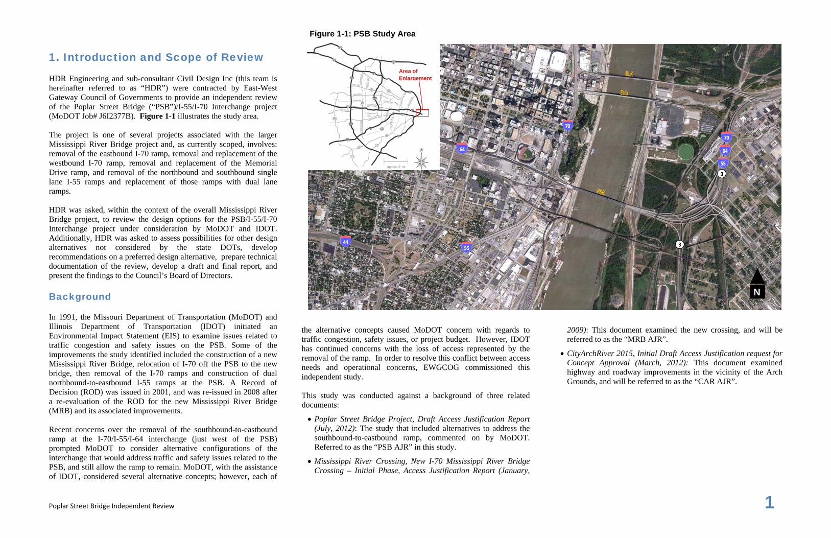
1. Introduction and Scope of Review HDR Engineering and sub-consultant Civil Design Inc (this team is hereinafter referred to as “HDR”) were contracted by East-West Gateway Council of Governments to provide an independent review of the Poplar Street Bridge (“PSB”)/I-55/I-70 Interchange project (MoDOT Job# J6I2377B). Figure 1-1 illustrates the study area. The project is one of several projects associated with the larger Mississippi River Bridge project and, as currently scoped, involves: removal of the eastbound I-70 ramp, removal and replacement of the westbound I-70 ramp, removal and replacement of the Memorial Drive ramp, and removal of the northbound and southbound single lane I-55 ramps and replacement of those ramps with dual lane ramps. HDR was asked, within the context of the overall Mississippi River Bridge project, to review the design options for the PSB/I-55/I-70 Interchange project under consideration by MoDOT and IDOT. Additionally, HDR was asked to assess possibilities for other design alternatives not considered by the state DOTs, develop recommendations on a preferred design alternative, prepare technical documentation of the review, develop a draft and final report, and present the findings to the Council’s Board of Directors. Background In 1991, the Missouri Department of Transportation (MoDOT) and Illinois Department of Transportation (IDOT) initiated an Environmental Impact Statement (EIS) to examine issues related to traffic congestion and safety issues on the PSB. Some of the improvements the study identified included the construction of a new Mississippi River Bridge, relocation of I-70 off the PSB to the new bridge, then removal of the I-70 ramps and construction of dual northbound-to-eastbound I-55 ramps at the PSB. A Record of Decision (ROD) was issued in 2001, and was re-issued in 2008 after a re-evaluation of the ROD for the new Mississippi River Bridge (MRB) and its associated improvements. Recent concerns over the removal of the southbound-to-eastbound ramp at the I-70/I-55/I-64 interchange (just west of the PSB) prompted MoDOT to consider alternative configurations of the interchange that would address traffic and safety issues related to the PSB, and still allow the ramp to remain. MoDOT, with the assistance of IDOT, considered several alternative concepts; however, each of
the alternative concepts caused MoDOT concern with regards to traffic congestion, safety issues, or project budget. However, IDOT has continued concerns with the loss of access represented by the removal of the ramp. In order to resolve this conflict between access needs and operational concerns, EWGCOG commissioned this independent study. This study was conducted against a background of three related documents:
Poplar Street Bridge Project, Draft Access Justification Report (July, 2012): The study that included alternatives to address the southbound-to-eastbound ramp, commented on by MoDOT. Referred to as the “PSB AJR” in this study.
Mississippi River Crossing, New I-70 Mississippi River Bridge Crossing – Initial Phase, Access Justification Report (January,
2009): This document examined the new crossing, and will be referred to as the “MRB AJR”.
CityArchRiver 2015, Initial Draft Access Justification request for Concept Approval (March, 2012): This document examined highway and roadway improvements in the vicinity of the Arch Grounds, and will be referred to as the “CAR AJR”.
Figure 1-1: PSB Study Area
N
3
3
70
64
55
70
64
55 44
Area of Enlargement

Poplar Street Bridge Independent Review 2
2. Previously Studied Alternatives HDR was asked to evaluate six different alternatives that could preserve the southbound-to-eastbound movement at the PSB/I-55/I-70 interchange. Figure 2-1 illustrates the six alternatives (as commented on by MoDOT), which have also been addressed as part of the PSB AJR. Five of these alternatives are at the interchange itself, while one is located further south on I-55. The five interchange modification options have two features in common:
Provision of a realigned two-lane westbound off-ramp just west
of the PSB, splitting to a two-lane westbound-to-southbound direct-connector ramp (Ramp D) and a single-lane westbound-to-northbound direct-connector ramp (Ramp C, immediately widening to two lanes after the diverge). See Figure 2-2 for ramp labeling convention.
Provision of a two-lane northbound-to-eastbound ramp (Ramp A).
Design Criteria/Evaluation Table 2-1 summarizes the design criteria used by MoDOT to evaluate alternatives, and these are the criteria adopted for HDR’s evaluation. MoDOT’s review essentially consigned issues to one of three categories: Unacceptable (meaning an element did not meet standards), Undesirable (meaning an element might meet minimum standards but did not meet typical standards), and a third category containing issues that were worth noting. The study team examined MoDOT’s concerns with each of the options in light of the design criteria to verify concerns and begin to build an understanding from which to develop additional alternatives. Table 2-2 summarizes MoDOT’s concerns and the study team’s response. The remainder of this chapter describes the review of each alternative.
Table 2-1: Design Criteria for Evaluation
Mainline Ramps
Roadway Type
Functional Classification Interstate - Level of Service C (D min) C Design Year 2035 2035 Design Speed (mph) 50 30 Access Control Full Full
Cross-Section Lane Widths (ft) 12 12
Paved Shoulders (ft)
left 10’ (6’ for 4-lane) 4’ (6’ for 2-lane)
right 10’ 8’ (10’ for 2-lane) (2’ for directional)
Superelevation (max) 4% 6%
SE Transition Length (ft) 180 80 @ 6%
Geometrics Horizontal Curvature (min radius) 755 231’ @ 30 mph
Grades (max) ascending 6% 5% (7% abs max)
descending 3% (4% abs max) 5% (7% abs max)
min for drainage 0.5% 0.5%
Minimum Stopping Sight Distance (ft) 395 200 @ 30 mph
Vertical Curves (min K)
Crest 84 19 – 30 mph
Sag 96 37 – 30 mph
Minimum Vertical Clearance (ft)
over Interstate and State Routes 16.5 * 16.5 *
over local roads 15.0 * 15.0 *
over Railroads 23.0 23.0
* 14 ft (abs min) * 14 ft (abs min)

Poplar Street Bridge Independent Review 3
Figure 2-1: MoDOT Concerns with Proposed PSB Options
Option 5: Ramp B under I-64 (right exit), outside merge; Memorial realign 7th Street U-Turn
Option 1: Ramp B under I-64 (right exit), inside merge Option 2: Ramp B under I-64 (left exit), outside merge; I-44 realign
Alternative 2A: Ramp B under I-64 (right exit), outside merge;I-44 slight realign; Memorial realign
Option 3: Ramp B over I-64 (right exit), outside merge
N N N
N
N
N

Poplar Street Bridge Independent Review 4
Table 2-2: Review of MoDOT Concerns with Proposed PSB Options
Issue Response Mitigation possible? Standard Ref Issue Response Mitigation possible? Standard Ref
Option 1: Ramp B under I-64 (right exit), inside merge Option 3: Ramp B over I-64 (right exit), outside merge
UA Sharp radius & low design speed (25 mph) Agree: R = 200' Pier arrangement prohibits increasing
radius 30 mph Design
Speed: R=231' (6% super)
AASHTO Table 3-9 UA 7.1% ramp grade
Agree. Caused by req'd 14'6" clearance over WB I-64 + 6' structure
depth
(1) Move VPI to Sta 15+00, EL 512.90; results in 6.7% grade in, 4.61% grade out; hold K=20, L=230'
(2) Reduce structure depth so grade can be reduced 7% max, 25-30 mph AASHTO Sec
10.9.6
UA Sub-Standard taper Agree: L = 190' None. Longer taper will result in widening of PSB structure. 800' (50:1) AASHTO
Fig 10-69 UD Sharp radius & low design speed (30 mph) R=235' Increasing to R=340' (35 mph) is not possible because
curve would overlap upstream curve. 30 mph Design Speed: R=231'
(6% super) AASHTO Table 3-9
UA Left-side merge (linked to taper)
Not clearly unacceptable per AASHTO. Considered to be
undesirable. Right-side merges are explored in other
options. Right-side merge AASHTO Sec 10.9.6 UD I-44 ramp merge with I-55
ramp Agree. It is undesirable to merge a ramp into a directional interchange
ramp movement. None. Merge would have to occur on main span of PSB
structure to avoid this situation N/A N/A
UD 10-foot deep excavation along I-44
Agree. Required for I-44 to cross under Ramp 4, which crosses
under Ramp 1
1) Ramp 4 over Ramp 1 results in unacceptable grades
2) Ramp 4 under ex. I-44 results in unacceptable 9+% grade
7% max, 25-30 mph; 6% max, 40 mph
AASHTO Sec 10.9.6
Option 5: Ramp B under I-64 (right exit), outside merge; Memorial realign
UA Sharp radius & low design speed (25 mph) - SB-to-
EB Agree. R=152.50'
Increasing radius to 231 ft (30 mph) would not fit between piers and would substantially increase skew
angle over Ramp 2 30 mph Design Speed: R=231'
(6% super) AASHTO Table 3-9
Potential conflicts between excavation & I-64 bridge
footings (Bent 8)
Agree. Excavations are unacceptably close to I-64 pier
foundations.
None with this option. I-44 excavation is required for Ramp 4 to pass under Ramp 1
and over I-44 at the location shown. N/A N/A UA Short tapered ramp merge
(SB) Agree. L=240'. Taper is also located
on outside of curve for Ramp 1, an undesirable location.
Longer taper will result in wider pavement section under RR bridge. May not have enough span length under RR
bridge for wider pavement. 800' (50:1) AASHTO Fig
10-69
UD 7% ramp grade (SB-to-EB)
Result of minimizing earthwork impacts for relocated Memorial Ramp
Grade might be reduced to 5% by moving VPIs to Sta 3+50.42 & Sta 6+76.31. May cause more ROW issues
at Sta 4+80 7% max, 25-30 mph; 6% max,
40 mph AASHTO Sec
10.9.6 Option 2: Ramp B under I-64 (left exit), outside merge; I-44 realign
UA Sharp radius & low design speed (25 mph) Agree: R=150'
Increasing radius to 231' (30 mph) may fit between piers, but would substantially increase skew angle over Ramp 2 and
require additional I-44 excavation
30 mph Design Speed: R=231' (6%
super) AASHTO Table 3-9 UD I-44 ramp merge with I-55
ramp Agree. It is undesirable to merge a ramp into a directional interchange
ramp movement. None. Merge would have to occur on main span of PSB
structure to avoid this situation N/A N/A
UD Left-side exit from I-44 to PSB
Agree. Left-side ramps should be avoided.
None. This option explores a left-side exit of a realigned SB I-44. Right-side exit AASHTO
Sec 10.9.6
UD 16-foot deep excavation along I-44
Agree. Caused by bringing I-44 vertical curve under TRRA bridge to current standards for 50 mph
design speed
Design sag curve for comfort criteria, AASHTO eq 3-51; reduces excavation to
about 9 ft; still undesirable K=96; 50mph sag AASHTO
Table 3-36
7th Street U-turn
30-mph curve Agree. R=231' Increasing to R=340' (35 mph) is not possible because the curve would interfere with several existing buildings.
30 mph Design Speed: R=231' (6% super)
AASHTO Table 3-9
UD I-44 ramp merge with I-55 ramp
Agree. It is undesirable to merge a ramp into a directional interchange
ramp movement.
None. Merge would have to occur on main span of PSB structure to avoid this
situation N/A N/A
Alternative 2A: Ramp B under I-64 (right exit), outside merge; I-44 slight realign; Memorial realign
No access to PSB from Memorial Drive
Agree. Memorial Drive is cut off from Ramp 4 due to the left lane
exit of Ramp 4 from SB I-44.
None with this option. Not enough room for Memorial Drive traffic to weave across
I-44 traffic and reach Ramp 4. N/A N/A UA Substandard tapered on-
ramp to SB I-55 Agree. L=250' Longer taper would interfere with Ramp 1 merge downstream. 800' (50:1) AASHTO Fig
10-69
Potential conflicts between excavation & I-64 bridge
footings (SB thru)
Agree. Excavations are unacceptably close to I-64 pier
foundations.
None with this option. Substantial I-44 excavation is required for Ramp 4 to pass under I-64 and over I-44 at location shown.
N/A N/A UD Excavation along I-44 relocation - SB
Agree. Caused by bringing I-44 vert curve under TRRA bridge to current standards for 50 mph design speed
Design sag curve for comfort criteria, AASHTO eq 3-51; reduces excavation depth, still undesirable K=96; 50mph sag AASHTO
Table 3-36
Potential conflicts between excavation & I-64 bridge
footings (NB thru)
Agree. Excavations are unacceptably close to I-64 pier
foundations.
None with this option. Substantial I-44 excavation is required for Ramp 4 to pass under I-64 and over I-44 at location shown.
N/A N/A UD Sharp radius & low design speed (30 mph) - SB-to-
EB R=235' Increasing to R=340' (35 mph) is not possible because
curve would overlap upstream curve. 30 mph Design Speed: R=231'
(6% super) AASHTO Table 3-9
Abbreviations for MoDOT Ratings: UA = Unacceptable UD = Undesirable
UD I-44 ramp merge with I-55 ramp
Agree. It is undesirable to merge a ramp into a directional interchange
ramp movement. None. Merge would have to occur on main span of PSB
structure to avoid this situation N/A N/A
Potential conflicts between excavation & I-64 bridge
footings (SB thru) Agree. Excavations are unacceptably
close to I-64 pier foundations. None with this option. Substantial I-44 excavation is
required for Ramp 4 to pass under I-64 and over I-44 at the location shown.
N/A N/A

Poplar Street Bridge Independent Review 5
The discussion of each option below makes use of a ramp-labeling convention used in previous analyses, as shown in Figure 2-2. Option 1 Ramp B under I-64 (right exit), inside merge Option 1 generally attempts to preserve Ramp B on its existing alignment, joining Ramp A from the left side. With Option 1, the grade of I-44 through the interchange would need to be lowered significantly in order to provide necessary vertical clearances to accommodate both Ramp B and a widened, realigned Ramp D (westbound-to-southbound) under the I-64 mainline. Excavation for this lowering would potentially conflict with the I-64 bridge piers. In addition, the Ramp B curvature would provide an undesirable design speed of 30 mph and the left-side taper would be unacceptably short (due to proximity to the PSB abutment). The study team generally agreed with MoDOT’s assessment, and could not identify modifications to improve the concept. Option 2 Ramp B under I-64 (left exit), outside merge; I-44 realign Option 2 would bend I-44 out to allow provision of a left-exit for Ramp B, which would still travel under Ramp D and the I-64 mainline, but would rise above Ramp A to join it from the right side. As with Option 1, the grade of I-44 through the interchange would need to be lowered significantly in order to provide necessary vertical clearances to accommodate the ramp changes. The excavation for this lowering would conflict with the I-64 bridge piers. In addition, the Ramp B curvature would provide an undesirable design speed of 30 mph and the merge with Ramp A would be undesirable. Also, this option would cut off access to PSB from Memorial Drive. The study team generally agreed with MoDOT’s assessment and could not identify modifications to improve the concept. Option 3 Ramp B over I-64 (right exit), outside merge Option 3 would elevate Ramp B to the highest vertical level at the interchange, above I-64 mainline and Ramp A. Ramp B would merge with Ramp A from the right. The problems of undesirable ramp curvature and an undesirable merge would remain with this alternative and MoDOT indicated that Ramp B would provide an unacceptable grade. The study team generally agreed with MoDOT’s
assessment, although it was felt that the ramp grade could be reduced with one of two techniques identified in Table 2-2. Option 5 Ramp B under I-64 (right exit), outside merge; Memorial realign Option 5 bears many similarities to Option 2, except instead of realigning I-44, it would curve the Memorial Drive Ramp westward to allow development of a right-exit for Ramp B. Ramp B would travel under Ramp D and I-64 mainline, but over I-44 mainline and Ramp A. The problems of undesirable ramp curvature and an undesriable merge would remain with this alternative, and MoDOT indicated that Ramp B and the realigned Memorial Drive Ramp would provide unacceptable grades. The study team generally agreed with MoDOT’s assessment, although it was felt that the Ramp B grade could be possibly reduced with one of two techniques identified in Table 2-2. 7th Street U-Turn This option would eliminate Ramp B and move the southbound-to-eastbound movement about a half-mile south of the interchange, creating a U-turn ramp in the vicinity of Seventh Street. MoDOT’s primary stated concern with this option was the design speed of the ramp, which would be difficult to increase. The study team agreed with this assessment. In addition, it would be desirable to avoid the out-of-direction travel required by this option, if possible. Alternative 2A Ramp B under I-64 (right exit), outside merge; I-44 slight realign; Memorial realign Alternative 2A is essentially a combination of Options 2 and 5, slightly realigning both I-44 mainline and the Memorial Drive ramp to allow a right-exit from southbound I-44 onto southbound Memorial Drive, and a subsequent left-exit to a realigned Ramp B, which would merge with Ramp A from the right. The problems of undesirable ramp curvature and an undesirable merge would remain with this alternative, along with undesirable excavation along I-44 (including potential conflicts with I-64 bridge footings). In addition, the Memorial Drive on-ramp to I-55 would exhibit a substandard taper. The study team generally agreed with MoDOT’s assessment and could not identify modifications to improve the concept.
A
B
C
D
Figure 2-2: Previously Used Ramp-Labeling Convention, Adopted for This Analysis
To PSB
64
70
55
N

Poplar Street Bridge Independent Review 6
Potential Right-of-Way Needs with Option A
N
Area of Potential Right-of-Way Acquisition
64
55
70
3. Enhancements & New Alternatives The study team explored potential additional options that could address concerns about the removal of Ramp B while meeting local and regional mobility needs. Figure 3-2, later in this chapter, illustrates these options. The discussion below summarizes the study team’s evaluation of the options. All Options are compared against a Base Option, also known as AJR Option 8. This option was the preferred option resulting from the PSB AJR. Relevant features of the Base Option include removal of Ramp B (southbound-to-eastbound), and conversion of Ramp A (northbound-to-eastbound) to a two-lane ramp. It should be noted that the study team examined the cost estimate previously produced for this option, and (using the methodology described below) was able to find ways to reduce the cost estimate by nearly $16 million (from $49.5 million to $33.9 million). Methodology Operational Analysis The alternatives were compared from a traffic operational perspective, using the VISSIM microsimulation software. The analysis was conducted for the p.m. peak hour, the period during which Ramp B sees the heaviest traffic flow as commuters return home from downtown St. Louis to destinations east of the Mississippi River. The horizon year for the analysis was 2035, consistent with recent studies. The analysis was based on traffic density, measured in terms of passenger cars per mile per lane. Table 3-1 summarizes density ranges from the Highway Capacity Manual that are typically used to characterize freeway operations on an A-to-F scale known as level of service (LOS). LOS F indicates over-capacity conditions. Figures 3-1 and 3-3, later in this chapter, illustrate the comparative results of the operational analyses; results for individual options are discussed further in the text with each option. Cost Estimation The study team evaluated the cost estimates that were developed for each of the options described in Chapter 2. These project scoping estimates are based on preliminary plan quantities and historical unit cost data from previous projects. The total project cost estimates include removal of improvements, mobilization, surveying,
engineering, construction administration, utility relocations, right of way, and a contingency to account for unknown factors. Based on the original project estimate, the overall total project cost of the Base Option, also known as AJR Option 8, was approximately $49.5 million. The study team utilized the project costs from the Base Option and compared the historical unit bid prices against more recent bid tabulations. The historical bid prices seem to be conservative as compared to recent project awards. This may be a function of an extremely robust “transportation economy” at the time the original planning level cost estimating was undertaken. The overall economy has been in decline, which has helped to make bids more competitive and less costly. The use of an inflated historical base unit bid price is compounded when other project costs are developed as a percentage of those pay items and then an overall project contingency is added on at the end of the cost estimate. Bridge construction is the largest cost component. The study team used a unit price of $225 per square foot of deck area instead of $300 per square foot used by MoDOT. This base unit price differential and other similarly modified unit prices, combined with the multiple layers of compounding in the estimating methodology, results in large variations in project cost estimates. The study team believes the estimates performed as part of this study reflect reasonable expectations for the cost of these projects. The adjustment of the historical bid prices to more recent unit bid prices resulted in a reduction in the overall project cost for the Base Option from $49.5 million to $33.9 million. The overall project costs for any additional design options that were developed by the design team were developed using these updated unit bid prices. Table 3-3, presented at the end of this chapter, is a summary cost estimate comparison for all options studied. Ramp B Preservation Options The three options described below attempted to preserve the southbound-to-eastbound movement at the PSB/I-55/I-70 interchange. One of the primary geometric/safety/operational issues identified by MoDOT with all concepts to date that have attempted to preserve this movement, is the merge movement required where Ramp B (southbound-to-eastbound) joins with Ramp A (northbound-to-eastbound) and the I-64 eastbound through movement. In all concepts studied to date, this equates to five lanes (two on mainline I-64, two on Ramp A, and one on Ramp B) approaching the four-lane PSB – requiring a lane-drop and merge. The existing bridge abutment location and bridge width constrain this merge to a short,
undesirable distance. Each of the three alternatives below attempts to improve the merge situation by separating the locations at which the on-ramps join I-64. Option A SB-to-EB Loop On-Ramp | Cost: $61M Option A would convert Ramp B from a direct connector to a single-lane loop ramp with a design speed of 25 mph. Constructing a loop would allow Ramp B to join I-64 550 feet west of the PSB bridge abutment, separating the Ramp B merge from Ramp A, allowing both lanes unimpeded flow onto PSB. This option would require new right-of-way to construct. As the graphic on this page illustrates, Option A would potentially impact a building and several parking lots.
As Figure 3-1 illustrates, Option A would operate fairly similar to the Base Option south and west of the interchange. However, there are some significant differences: While Option A continues to indicate a forecasted LOS F on
eastbound I-64 west of the interchange, the projected density values would be as much as 20 percent higher than those of the base case, meaning that delays and queues would be much heavier with this option than with the Base Option.
The loop ramp would operate at unacceptable levels of service, with queues and delay spilling back to southbound Memorial Drive and the southbound I-44 (previously I-70) mainline.
Therefore, from an operational perspective, Option A is considered inferior to the Base Option.
Table 3-1: LOS Values
LOS Density
A 0-11 B 11-18 C 18-26 D 26-35 E 35-45 F >45
Poplar Street Bridge Independent Review 7
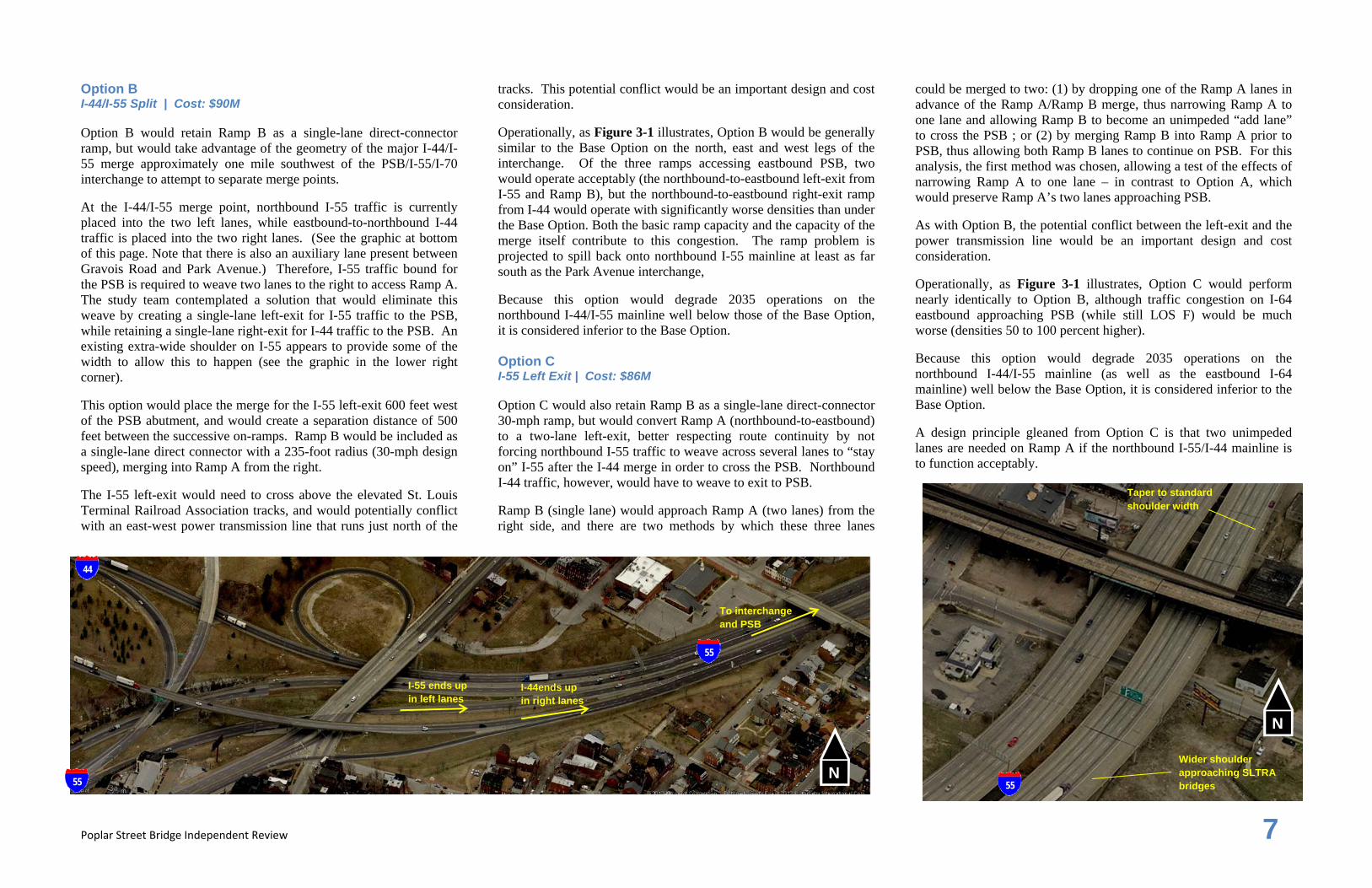
Option B I-44/I-55 Split | Cost: $90M Option B would retain Ramp B as a single-lane direct-connector ramp, but would take advantage of the geometry of the major I-44/I-55 merge approximately one mile southwest of the PSB/I-55/I-70 interchange to attempt to separate merge points. At the I-44/I-55 merge point, northbound I-55 traffic is currently placed into the two left lanes, while eastbound-to-northbound I-44 traffic is placed into the two right lanes. (See the graphic at bottom of this page. Note that there is also an auxiliary lane present between Gravois Road and Park Avenue.) Therefore, I-55 traffic bound for the PSB is required to weave two lanes to the right to access Ramp A. The study team contemplated a solution that would eliminate this weave by creating a single-lane left-exit for I-55 traffic to the PSB, while retaining a single-lane right-exit for I-44 traffic to the PSB. An existing extra-wide shoulder on I-55 appears to provide some of the width to allow this to happen (see the graphic in the lower right corner). This option would place the merge for the I-55 left-exit 600 feet west of the PSB abutment, and would create a separation distance of 500 feet between the successive on-ramps. Ramp B would be included as a single-lane direct connector with a 235-foot radius (30-mph design speed), merging into Ramp A from the right. The I-55 left-exit would need to cross above the elevated St. Louis Terminal Railroad Association tracks, and would potentially conflict with an east-west power transmission line that runs just north of the
tracks. This potential conflict would be an important design and cost consideration. Operationally, as Figure 3-1 illustrates, Option B would be generally similar to the Base Option on the north, east and west legs of the interchange. Of the three ramps accessing eastbound PSB, two would operate acceptably (the northbound-to-eastbound left-exit from I-55 and Ramp B), but the northbound-to-eastbound right-exit ramp from I-44 would operate with significantly worse densities than under the Base Option. Both the basic ramp capacity and the capacity of the merge itself contribute to this congestion. The ramp problem is projected to spill back onto northbound I-55 mainline at least as far south as the Park Avenue interchange, Because this option would degrade 2035 operations on the northbound I-44/I-55 mainline well below those of the Base Option, it is considered inferior to the Base Option. Option C I-55 Left Exit | Cost: $86M Option C would also retain Ramp B as a single-lane direct-connector 30-mph ramp, but would convert Ramp A (northbound-to-eastbound) to a two-lane left-exit, better respecting route continuity by not forcing northbound I-55 traffic to weave across several lanes to “stay on” I-55 after the I-44 merge in order to cross the PSB. Northbound I-44 traffic, however, would have to weave to exit to PSB. Ramp B (single lane) would approach Ramp A (two lanes) from the right side, and there are two methods by which these three lanes
could be merged to two: (1) by dropping one of the Ramp A lanes in advance of the Ramp A/Ramp B merge, thus narrowing Ramp A to one lane and allowing Ramp B to become an unimpeded “add lane” to cross the PSB ; or (2) by merging Ramp B into Ramp A prior to PSB, thus allowing both Ramp B lanes to continue on PSB. For this analysis, the first method was chosen, allowing a test of the effects of narrowing Ramp A to one lane – in contrast to Option A, which would preserve Ramp A’s two lanes approaching PSB. As with Option B, the potential conflict between the left-exit and the power transmission line would be an important design and cost consideration. Operationally, as Figure 3-1 illustrates, Option C would perform nearly identically to Option B, although traffic congestion on I-64 eastbound approaching PSB (while still LOS F) would be much worse (densities 50 to 100 percent higher). Because this option would degrade 2035 operations on the northbound I-44/I-55 mainline (as well as the eastbound I-64 mainline) well below the Base Option, it is considered inferior to the Base Option. A design principle gleaned from Option C is that two unimpeded lanes are needed on Ramp A if the northbound I-55/I-44 mainline is to function acceptably.
Wider shoulder approaching SLTRA bridges
Taper to standard shoulder width
55
N
55
44
55
I-44ends up in right lanes
To interchange and PSB
N
I-55 ends up in left lanes

Poplar Street Bridge Independent Review 8
Figure 3-1: Operational Performance – 4-Lane PSB Alternatives (P.M. Peak Hour)
SB-to-EB Loop On-Ramp A
B I-44/I-55 Split C I-55 Left Exit
AJR Option 8 Base
N

Poplar Street Bridge Independent Review 9
MLK Bridge/IL-3 Connection | Cost: $17M With the Ramp B preservation options not showing operational promise, the study team looked for options that would eliminate Ramp B but still provide the desired regional access (most notably from downtown to the Sauget area immediately south of PSB on the Illinois side). In exploring possibilities, the study team examined the Martin Luther King (MLK) Bridge (less than a mile north of the PSB). On the Illinois side of the Mississippi River, MLK currently connects to I-70/I-64, but only provides connections to and from the east. IL-3 continues south from this location, but direct connections between it and MLK do not currently exist. The study team examined an option involving the creation of an eastbound-to-southbound ramp from MLK merging with I-64 and subsequently exiting to IL-3. The graphic below illustrates the location of this connection in relation to Ramp B.
The new connector would replace the function of Ramp B, serving movements from downtown across the Mississippi River. Depending on the origin point in downtown, many trips could get shorter using this new route. The graphic above includes some reference distances. The operational analysis for this study (see Figure 3-1) focused on peak-hour traffic conditions at the I-70/I-64/I-55 interchange, and from that perspective, the MLK Option would have the same operations as the Base Option, because both options remove Ramp B from the interchange. Further investigation of this option would need to include detailed looks at the I-70/MLK ramps, and the IL-3/MLK ramps, to make sure capacity is optimized.
The MLK bridge itself has adequate capacity to accommodate this re-routed traffic, especially given that MLK eastbound p.m. peak-hour traffic is expected to significantly decrease (by approximately half) once MRB is constructed. In addition, after traffic bound for IL-3 exited MLK onto southbound I-70, it would stay in the right lane of traffic and no weaves across mainline traffic would be necessary. The fact that this movement is in the reverse commute direction indicates that capacity should be sufficient. IDOT, in cooperation with MoDOT, has been developing a rehabilitation project (already programmed on the STIP) for the MLK Bridge to address known structural deficiencies in the truss spans. Construction costs for this project are currently shown in MoDOT’s STIP as Project J6P2386 for Fiscal Year 2015. The total cost of this project including funding from both DOT’s is estimated at $8M. Following completion of this project, the MLK Bridge is anticipated to remain a safe and functional connection across the Mississippi River for the foreseeable future and an adequate alternative for making the connection to southbound Illinois Route 3. Based on the fact that the operations of the MLK Option would be similar to those of the Base Option, coupled with the fact that the MLK Option would preserve direct and safe access between downtown and areas south of I-64 on the east side of the Mississippi River, adding the MLK Option to the Base Option is considered preferable to the Base Option alone. PSB Widening | Cost: $21M The study team’s exploration of options to retain Ramp B underlined the fundamental problem at the east abutment of the PSB: the capacity constraint represented by the four eastbound lanes on the bridge. Any option that attempts to approach PSB with five lanes will ultimately suffer operational difficulties associated with merging heavy traffic streams. The obvious “flip side” answer to reducing to four approach lanes would be to widen PSB to provide five eastbound lanes. Typically, bridge widening would be a very costly endeavor, well outside the scope of the improvements currently being considered at the I-55/I-64/I-70 interchange. However, as the study team investigated the PSB structure type and design, it was clear that a unique opportunity may exist to widen the structure at a reasonable cost, while enhancing the overall performance of this important river crossing.
The proposed approach to widen PSB is not to add girders and substructure as would be expected for a typical widening, but to slide the southern (eastbound) bridge to the south approximately 9 feet. The step-by-step process for this widening is:
1) Infill the space between columns with an extension of reinforced concrete essentially creating a wall pier;
2) Extend the southern nose of the pier to support a cap widening to the south;
3) Place the southern cap widening; 4) Remove the shear keys and struts from previous seismic
retrofits; 5) Prepare the cap and girders for sliding; 6) Time the slide with the removal and reconstruction of the I-55
ramps when only two lanes of I-64 need to be maintained; 7) Close access to eastbound PSB and slide the bridge 9 feet to
the south; 8) Reopen to two lanes of eastbound I-64 only; 9) Drop the left lane of westbound I-64 on PSB; 10) Remove a portion of the inside overhangs from both the
eastbound and westbound bridges; 11) Drop in and attach new crossframes between the inside
girders of the eastbound and westbound bridges;
70 Existing Ramp B
Potential MLK/IL-3 Connector
55
64
3
70
64
55
3
N
~1.3mi
~0.9mi
~1.0mi
~1.0mi
Two existing two-girder systems (looking east from west bank)

Poplar Street Bridge Independent Review 10
12) Infill the orthotropic deck between the two bridges; 13) Construct new median barrier; 14) Reconstruct shear keys and struts as required from previous
seismic retrofits; 15) Reopen to all lanes of traffic including a fifth lane of traffic
on eastbound PSB. 16) Widen Illinois approach to PSB, in order connect the fifth
eastbound lane to the existing add lane on the off-ramp to southbound IL-3.
This process will result in a single four girder, redundant, structure that carries four lanes of westbound traffic and five lanes of eastbound traffic. There is also an opportunity to implement a reversible lane with this modified structure. The modified structural system can more efficiently carry traffic by taking advantage of the increased torsional stiffness of the superstructure. The live load distribution benefits of this new system are illustrated in Table 3-2.
Table 3-2: Live Load Distribution Comparisons
No. Of Lanes Loaded Multiple # Wheel Lines
To No. Of Girders
Total EBD WBD Presence Exterior Girder In System Two Girder System
1 1 ‐ 1.2 2.75 2 2 2 ‐ 1 3.84 2 3 3 ‐ 0.85 3.96 2 4 4 ‐ 0.65 3.08 2
Four Girder System 1 1 ‐ 1.2 1.78 4 2 2 ‐ 1 2.75 4 3 3 ‐ 0.85 3.23 4 4 4 ‐ 0.65 3 4 5 5 ‐ 0.65 3.4 4 6 5 1 0.65 3.65 4 7 5 2 0.65 3.78 4 8 5 3 0.65 3.72 4 9 5 4 0.65 3.54 4
‐ Distribution Factors For 2 Girder System Calculated Using Lever Rule
‐ Distribution Factors For 4 Girder System Calculated Using Rigid Rotation Analogy
The potential for PSB widening allowed the study team to re-examine Options A, B, and C with five receiving lanes on the bridge rather than four. The results are described below. Operational outputs are shown in Figure 3-3. Option A+ SB-to-EB Loop On-Ramp + Widened PSB | Cost: $83M If PSB carried five eastbound lanes, the Ramp B loop-ramp and the two-lane Ramp A would not need to merge, and the current two lanes on I-64 could continue to carry through as the two left lanes on PSB. Operationally, Option A+ would operate almost identically to the Base Option, and the loop-ramp would also operate acceptably. Although eastbound I-64 traffic west of the interchange would continue to operate at LOS F, densities would decrease (improve) by as much as 20 percent. Thus, Option A+ is considered an improvement over the Base Option. Option B+ I-44/I-55 Split + Widened PSB | Cost: $111M If PSB carried five lanes, all three Option B ramps connecting to eastbound PSB – Ramp A, the I-55 left-exit, and the I-44 right-exit – could carry onto the PSB without dropping or merging. Operationally, the single-lane I-44-to-PSB right-exit would continue to suffer, but with shorter back-ups than standard Option B (not all the way back to the Park Avenue interchange). To function acceptably, the I-44 right-exit would need two unimpeded lanes, which would require six lanes approaching the five-lane PSB under this scenario. Thus, the I-55 left-exit does not “buy” the needed capacity. Because of the poor ramp operations, Option B+ is considered inferior to the Base Option. Option C+ I-55 Left Exit + Widened PSB | Cost: $107M If PSB carried five eastbound lanes, the Ramp B direct connector and the two-lane Ramp A exit would not need to merge, and the current two lanes on I-64 could continue to carry through as the two left lanes on PSB. Operationally, Option C+ functions better than any of the other Options described up to this point, including the Base Option.

Poplar Street Bridge Independent Review 11
Figure 3-2: Additional PSB Options Studied
Alt Descr Include MLK/SB 3?
Lanes on PSB Scenario Include
MRB? Include
CAR 2015? Peak Hour
Base AJR Option 8 + MLK Y 4 2035 Y Y PM Option A
SB-to-EB Loop On-Ramp N 4 2035 Y Y PM
Option A+ N 5 2035 Y Y PMOption B
I-44/I-55 split N 4 2035 Y Y PM
Option B+ N 5 2035 Y Y PMOption C
I-55 Left Exit N 4 2035 Y Y PM
Option C+ N 5 2035 Y Y PMOption D Split I-64 (3rd Lane) Y 5 2035 Y Y PM
Option A:
SB‐to‐EB Loop On‐Ramp
Option B:
I‐44/I‐55 Split
Option C:
I‐55 Left Exit
Option D:
Split I‐64
Base:
AJR Option 8 + MLK
MLK/IL‐3 Connection
PSB Slide to Provide 5 Lanes
N
N
N
N
N
N
Pier and cap extension on south side of
bridge
New crossframes
Orthotropic deck infill and new barrier
Concrete infill system between
columns to support cap
2 lanes
2 lanes
2 lanes
add remove
Memorial Drive braid over SB 44 loop ramp
1 lane
2 lanes
2-lane left exit
2 lanes
1 lane
Exit includes 3rd EB thru lane
3rd thru lane rejoins I-64
6th St on-ramp joins as 4th lane then tapers
2-lane ramp becomes 4th/5th EB lanes
2 lanes 2 lanes
2 lanes 2 lanes
1 lane, right exit, from I-44
1 lane, left exit, from I-55
1 lane

Poplar Street Bridge Independent Review 12
I-64 Capacity Enhancement (Option D) | Cost: $111M
Of the eight options examined up to this point (Base, Base + MLK, A/A+, B/B+, C/C+), none would be able to address a fundamental problem in the vicinity of the interchange: the constrained two-lane capacity of eastbound I-64 west of the interchange. Because this issue is left unaddressed, all of the alternatives would operate at LOS F on this portion of I-64 during the p.m. peak hour (albeit some with “better” F’s than others). This problem is not one the study team was necessarily tasked with solving. However, once a five-lane eastbound PSB became a consideration, a further question arose: What is the best use of five eastbound lanes? Is it to accommodate three lanes of ramp traffic and two lanes of I-64 mainline traffic? Or is there an alternative that could allow three lanes of I-64 traffic to access PSB? The study team noted that at the current Sixth Street off-ramp from eastbound I-64, the freeway reduces from three lanes to two (the exit is a “trap” lane). Without a doubt, this is the bottleneck that contributes most significantly to existing and future congestion on I-64 during the p.m. peak hour. Because I-64 is a double-deck structure at this location, widening the eastbound mainline (the lower deck) would be a very expensive proposition. The study team considered a potential solution that would not involve widening the double-deck structure. Under this option, dubbed the “Split 64 Option”, a third lane of capacity would be gained using the existing Sixth Street exit, and creating (in essence) a collector-distributor (C-D) roadway that would extend parallel to the I-64 structure on its south side, connecting back where the Sixth Street on-ramp ties back in to I-64 (See graphic below). The exit could be marked “Sixth Street/IL-3”, but regular p.m. commuters would come to realize that it could be used by any traffic desiring to cross PSB. In this way, three lanes of the eastbound I-64 mainline could be carried onto PSB. The MLK/IL-3 connector would be a necessary complement to this configuration, because PSB would only be able to accept two additional lanes, and analysis of previous options demonstrated clearly that Ramp A (northbound-to-eastbound) must carry two unimpeded lanes. Therefore, Ramp B would need to be eliminated to ensure optimum functionality of the Split 64 Option, and the MLK/IL-3 connector is the best substitute for Ramp B.
There are also a number of ramp changes to and from 6th Street and Broadway that would be implemented as part of this enhancement. These changes include:
1) The current access from Broadway to westbound I-64 would be reconfigured to carry eastbound I-64 to southbound Broadway;
2) The off-ramp from eastbound I-64 to 6th Street would be reconfigured to become the 6th Street to westbound I-64 on ramp;
3) The existing 6th Street ramp to eastbound I-64 will be adjusted and merged into I-64 in advance of the two lane ramp from I-55.
These ramp improvements would enhance access to and from I-64 and PSB and should be completed with the addition of the 3rd lane of capacity on eastbound I-64. See the sketch included with Figure 3-1 for conceptual layout of these ramp modifications. Figure 3-3 illustrates the operational results for the Split 64 Option (including the MLK/IL-3 connector). I-64 west of PSB would improve from LOS F to LOS C with this option. It must be noted that northbound I-55/I-44 mainline south of the interchange would operate at LOS D/E, but no portion is forecasted to operate at LOS F.
Approximate Sixth Street Ramp Departure Point
Potential 3rd Lane Rejoin Point
New Ramp for 3rd Lane N
64
To PSB

Poplar Street Bridge Independent Review 13
Figure 3-3: Operational Performance – 5-Lane PSB Alternatives (P.M. Peak Hour)
Split I-64 D
SB-to-EB Loop On-Ramp A+
B+ I-44/I-55 Split
C+ I-55 Left Exit
N

Poplar Street Bridge Independent Review 14
Figure 3‐4: Cost Estimates, PSB Alternatives (print from Excel)
Table 3-3: Cost Estimates, PSB Alternatives
Option Estimated By Subtotal
Removal Of Improvements
(10%)
Mobilization (6%)
Surveying (0.91%)
Design Engineering
(10%)
Construction Admin (5%)
Contingency (20%) Misc Grand Total
Components of Alternatives
Base ‐ AJR Alt. 8 MoDOT $32,593,633 $3,259,363 $1,955,618 $296,602 $3,259,363 $1,629,682 $6,518,727 $0 $49,512,988 HDR $22,339,768 $2,233,977 $1,340,386 $203,292 $2,233,977 $1,116,988 $4,467,954 $0 $33,936,342 Option 3 MoDOT $31,027,492 $3,102,749 $1,861,650 $282,350 $3,102,749 $1,551,375 $6,205,498 $0 $47,133,863
HDR $19,391,969 $1,939,197 $1,163,518 $176,467 $1,939,197 $969,598 $3,878,394 $0 $29,458,340 Split 64 ‐ Initial HDR $5,101,551 $510,155 $306,093 $46,424 $510,155 $255,078 $1,020,310 $0 $7,749,766 Split 64 ‐ Final HDR $20,723,395 $2,072,340 $1,243,404 $188,583 $2,072,340 $1,036,170 $4,144,679 $0 $31,480,909 Option A (Loop Ramp) HDR $18,019,023 $1,801,902 $1,081,141 $163,973 $1,801,902 $900,951 $3,603,805 $0 $27,372,698 PSB Slide HDR $14,056,831 $1,405,683 $843,410 $127,917 $1,405,683 $702,842 $2,811,366 $0 $21,353,732 Option B (I‐44/I‐55 Split) HDR $36,687,393 $3,668,739 $2,201,244 $333,855 $3,668,739 $1,834,370 $7,337,479 $0 $55,731,819 Option C (I‐55 Left Exit) HDR $34,323,300 $3,432,330 $2,059,398 $312,342 $3,432,330 $1,716,165 $6,864,660 $0 $52,140,525 MLK/IL‐3 Connector HDR $10,784,663 $1,078,466 $647,080 $98,140 $1,078,466 $539,233 $2,156,933 $500,000 $16,882,982
Alternatives
Option 3 Base + Option 3 MoDOT $63,621,125 $6,362,113 $3,817,268 $578,952 $6,362,113 $3,181,056 $12,724,225 $0 $96,646,851 HDR $41,731,737 $4,173,174 $2,503,904 $379,759 $4,173,174 $2,086,587 $8,346,347 $0 $63,394,682 Base, MLK Base + MLK Connector HDR $33,124,431 $3,312,443 $1,987,466 $301,432 $3,312,443 $1,656,222 $6,624,886 $500,000 $50,819,323Alt D, init Base + MLK + PSB Slide + Split 64 ‐ Initial HDR $52,282,813 $5,228,281 $3,136,969 $475,774 $5,228,281 $2,614,141 $10,456,563 $500,000 $79,922,821
Alt D, final Base + MLK + PSB Slide + Split ‐ 64 Initial + Split 64 ‐ Final HDR $73,006,208 $7,300,621 $4,380,372 $664,356 $7,300,621 $3,650,310 $14,601,242 $500,000 $111,403,731
Option A Base + Option A HDR $40,358,791 $4,035,879 $2,421,527 $367,265 $4,035,879 $2,017,940 $8,071,758 $0 $61,309,039
Option A+ Base + Option A + PSB Slide HDR $54,415,622 $5,441,562 $3,264,937 $495,182 $5,441,562 $2,720,781 $10,883,124 $0 $82,662,771
Option B Base + Option B HDR $59,027,161 $5,902,716 $3,541,630 $537,147 $5,902,716 $2,951,358 $11,805,432 $0 $89,668,160
Option B+ Base + Option B + PSB Slide HDR $73,083,992 $7,308,399 $4,385,040 $665,064 $7,308,399 $3,654,200 $14,616,798 $0 $111,021,892
Option C Base + Option C HDR $56,663,068 $5,666,307 $3,399,784 $515,634 $5,666,307 $2,833,153 $11,332,614 $0 $86,076,867
Option C+ Base + Option C + PSB Slide HDR $70,719,899 $7,071,990 $4,243,194 $643,551 $7,071,990 $3,535,995 $14,143,980 $0 $107,430,599

Poplar Street Bridge Independent Review 15
4. Recommendations
Based on the findings of this analysis, the study team recommends a program of phased improvements that would ultimately have a substantial, positive regional impact on commute traffic. The reason to take this long-term view is that, if these recommendations are adopted, short-term construction would need to be designed to anticipate long-term construction (as described below). Recommended phases are as follows (illustrated in Figure 3-4): Phase 1: MLK Connector, Ramp C, Ramp D Construction Timeline: 2015 (bundled with CAR 2015) Estimated Cost: $42.7 million – Total $17.0 million – MLK Connector $25.7 million – Ramps C & D, Remove Ramp B The MLK connector could be constructed immediately (and could even be a stand-alone IDOT project). In conjunction with the MLK connector, Ramp B could be removed if its condition necessitates such action. In addition, Ramps C and D would be reconstructed to their ultimate configurations to integrate with the CAR 2015 project, and to time well with the MRB opening in 2015. Users would immediately see some initial incremental operational benefits, as capacity at the interchange would be improved.
Phase 2: PSB Slide, Ramp A, 64 Split Initial Construction Timeline: 2016 (after MRB Opening) Estimated Cost: $37.3 million – Total $21.3 million – PSB Slide $8.3 million – Ramp A $7.7 million – 64 Split Initial
It is important to slide PSB after MRB is open to traffic, to allow for an alternative route across the Mississippi River during construction. The study team envisions that the Slide could be accomplished in a long (3-day) weekend, during which a complete closure of eastbound PSB would be necessary. Subsequently, while the infill and ramp work were underway, the two eastbound I-64 lanes could be maintained across PSB, but it is envisioned that northbound I-55 traffic would be diverted to the Jefferson Barracks Bridge, and westbound I-70 traffic would be diverted to the MRB. During this phase, it is envisioned that Ramp A (northbound-to-eastbound) would be reconstructed to its ultimate two-lane configuration (furthering the need for diversion to the Jefferson Barracks Bridge). An initial component of the 64 Split could also be
constructed – extending the Sixth Street on-ramp as an unimpeded “add lane” using the third lane of the PSB, positioning this connection in its correct ultimate location. Users would continue to see incremental benefits from this phase, as capacity would increase on PSB and Ramp A, while the elimination of the Sixth Street on-ramp’s need to merge would smooth eastbound flow in advance of PSB. Phase 3: 64 Split Final Construction Timeline: As soon as funding is available Estimated Cost: $31 million
Phase 3 would complete the “C-D” connection between the Sixth Street off-ramp and on-ramp, effectively creating a third lane of capacity for eastbound I-64. Also included in this phase is reconfiguring the on- and off-ramps to 6th Street and Broadway. It would be ideal to bundle this work with Phase 2 if funding were available, but it can be broken out as a separate phase if funding conditions dictate.
Concluding Remarks The total estimated cost for all three recommended phases is $111 million. This recommendation offers the following benefits: It would maintain convenient access to IL-3 southbound from I-
70 and downtown St. Louis (via MLK Bridge), fulfilling the function of existing Ramp B. In the longer term, when I-70 also has a direct connection to IL-3, the MLK Bridge would become part of a strong, redundant system of connections to communities on the east side of the Mississippi River (also including the I-64/Sixth Street ramps).
It would provide safety and capacity at the I-70/I-64/I-55 interchange equivalent to the PSB AJR recommendations, PLUS it would address a long-term, previously intractable issue that has been a top priority for the public: eliminating the significant eastbound p.m. peak-hour congestion on I-64 approaching the PSB. It would increase eastbound capacity of the PSB by 25 percent.
It would be expected to improve the PSB structurally by converting it from two two-girder systems to a single four-girder system.
The recommendations allow the overall project to be phases in modules as funding becomes available. Each phase would improve operations and safety over the next, could operate independently of the next, and could be designed to easily anticipate the next. Each phase was also developed with the intent of integrating and complementing improvements that are planned and underway - namely CAR 2015 and MRB.
While the study team is confident in our findings, we do recommend that this set of recommendations be subjected to more detailed analysis to further understand the operational, safety, and cost implications for the region.
Figure 3-4: Recommended Three-Phase Improvement Strategy


