Embed Size (px)
Citation preview

Vaucluse Diamond Bay Ocean Discharges
Pollution Study Report (PRP 305)

Vaucluse Diamond Bay Ocean Discharges | Pollution Study Report (PRP 305) Page | 1
Document history and status
Revision Date Revision details
A 09-02-2017 Draft released for Project Team review.
B 17-02-2017 Updated for Sydney Water management review, incorporating Project Team review comments.
C 24-02-2017 Updated to incorporate additional review comments.
D 28-02-2017 Updated to incorporate comments from Sydney Water Executive.
E 03-03-2017 For Sydney Water Managing Director review. Updated to incorporate comments from Sydney Water Corporate Public Affairs and Legal.
01 31-05-2017 Final report, addressing NSW EPA and NSW Health comments.
02 25-10-2017 Final report, version 2, addressing NSW EPA and NSW Health comments.
Document status
Register file no. 2017/00000592
Approved by Paul Plowman, General Manager, Liveable City Solutions
Prepared by Cathy O’Rourke, Senior Environmental Scientist, Integrated Systems Planning
Reviewed by Judith Winder (Project Manager), Service Planning and Asset Strategy
PRP Project Team (as per Project Plan)
Vaucluse Diamond Bay Ocean Discharges | Pollution Study Report (PRP 305) Page | 2
Table of contents
1 Introduction .............................................................................................................................. 6
1.1 Report structure ............................................................................................................................... 6
1.2 Objectives ......................................................................................................................................... 7
1.3 Background ...................................................................................................................................... 7
2 Method ...................................................................................................................................... 9
3 Key legislation and guidelines ............................................................................................. 11
3.1 Commonwealth legislation ............................................................................................................ 11
3.2 NSW legislation .............................................................................................................................. 12
3.3 Guidelines and objectives ............................................................................................................. 14
4 Stakeholder engagement ...................................................................................................... 21
5 Study area ............................................................................................................................... 23
5.1 Location .......................................................................................................................................... 23
5.2 Wastewater infrastructure ............................................................................................................. 23
5.3 Catchment details .......................................................................................................................... 26
5.4 Wastewater discharge characteristics ......................................................................................... 28
5.5 Existing environment ..................................................................................................................... 42
5.6 Waterway values ............................................................................................................................ 51
6 Hazards and potential impacts ............................................................................................. 52
6.1 Public health ................................................................................................................................... 53
6.2 Environment ................................................................................................................................... 57
7 Risk assessment .................................................................................................................... 61
7.1 Risk assessment framework ......................................................................................................... 61
7.2 Problem formulation ...................................................................................................................... 63
7.3 Risk analysis ................................................................................................................................... 64
7.4 Risk evaluation ............................................................................................................................... 67
8 Limitations and gaps in knowledge ..................................................................................... 69
9 Conclusion ............................................................................................................................. 78
10 References .............................................................................................................................. 79
11 Appendices ............................................................................................................................. 83
Appendix A. PRP 305 for EPL No. 1688 ................................................................................................. 84
Appendix B. Bondi Wastewater Treatment System EPL (No. 1688) ................................................... 85
Appendix C. VDB Ocean Discharges Project Plan for Pollution Study, August 2016 ...................... 86
Appendix D. Vaucluse Diamond Bay Pollution Study Stakeholder Engagement Outcomes Report, February 2017 .................................................................................................................... 87
Appendix E. Influent monitoring data for Vaucluse and Diamond Bay Outfalls ............................... 88
Appendix F. Pilot Modelling of Impacts of Discharges from Vaucluse and Diamond Bay Outfalls 89

Vaucluse Diamond Bay Ocean Discharges | Pollution Study Report (PRP 305) Page | 3
Appendix G. Review of Pilot Modelling – Vaucluse and Diamond Bay Plume Study ....................... 90
Appendix H. Sydney Water’s corporate risk matrix ............................................................................. 91
Appendix I. Bath-to-Beach risk pathway mapping for VDB outfalls ................................................. 92
Appendix J. VDB PRP environment and public health risk assessment .......................................... 93
Appendix K. Risk assessment peer review report, February 2017 ..................................................... 94
Figures
Figure 1-1 Overview map of the Vaucluse Wastewater System sub-catchments and ocean outfall locations 8
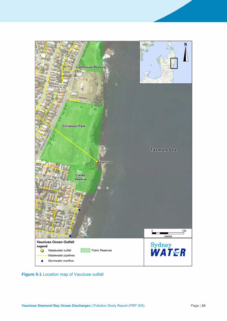
Figure 5-1 Location map of Vaucluse outfall .................................................................................................. 24
Figure 5-2 Location map of Diamond Bay outfalls .......................................................................................... 25
Figure 5-3 Land use zoning within the Vaucluse Wastewater System catchment (source: Woollahra LEP 2014 and Waverley LEP 2012) ................................................................................................................ 27
Figure 5-4 Concentration contour for copper to achieve concentration below ANZECC 2000 trigger value for toxicants. .................................................................................................................................................. 34
Figure 5-5 Concentration contour for nitrogen to achieve concentration below ANZECC 2000 trigger value for nutrient stressors. ............................................................................................................................... 35
Figure 5-6 Enterococci statistics for combined impact of the three VDB discharges (95th percentile) ........... 38
Figure 5-7 Excerpt from NSW marine protected areas map (source: NSW DPI)........................................... 46
Figure 5-8 Location of Vaucluse artificial reef (deployed by DPI Fisheries), in relation to the VDB outfalls. . 47
Figure 5-9 Vaucluse Diamond Bay heritage map ........................................................................................... 50
Figure 7-1 Sydney Water risk management process ..................................................................................... 62
Tables
Table 2-1 Vaucluse Diamond Bay pollution study methodology ....................................................................... 9
Table 3-1 Summary of the guidelines for recreational water (source: NHMRC 2008) ................................... 18
Table 4-1 Summary of key findings from engagement with potential user groups ......................................... 21
Table 5-1 Land use zoning within the Vaucluse and Diamond Bay catchments (source: Woollahra LEP 2014 and Waverley LEP 2012) ......................................................................................................................... 26
Table 5-2 Discharge volume limits (EPL 1688) ............................................................................................... 28
Table 5-3 Median annual wastewater flows from the Vaucluse Diamond Bay outfalls, 2006 to 2015 ........... 29
Table 5-4 VDB influent monitoring data, compared to typical composition of untreated domestic wastewater (Metcalf & Eddy Inc 1991) ....................................................................................................................... 30
Table 5-5 Summary of chemical contaminant component of VDB influent monitoring data. Data is presented as 50th percentile (%ile) values with required dilution rates to attain ANZECC (2000) triggers for protection of 95% of species in marine environments. ............................................................................ 31
Table 5-6 Outline of enterococci limits mapped during wastewater modelling for discharges from the VDB outfalls (adapted from NHMRC 2008 and OEH 2016) ............................................................................ 39
Table 5-7 Heritage listed items located near the VDB outfalls ....................................................................... 48
Table 6-1 Summary of potential hazards considered for general wastewater discharges ............................. 52
Table 6-2 Summary of potential impacts of the VDB wastewater discharges to public health ....................... 55
Table 6-3 Summary of potential impacts of the VDB wastewater discharges to environmental values ......... 60
Table 7-1 Summary of risk analysis results for the VDB outfalls .................................................................... 66
Table 8-1 Current knowledge gaps identified and assumptions applied during this study, relating to the VDB outfalls ..................................................................................................................................................... 70

Vaucluse Diamond Bay Ocean Discharges | Pollution Study Report (PRP 305) Page | 4
Glossary
Term Definition
ANZECC Australian and New Zealand Environment and Conservation Council
ARMCANZ Agriculture and Resources Management Council of Australia and New Zealand
DB1 Diamond Bay 1 (north)
DB2 Diamond Bay 2 (south)
DPI Department of Primary Industries
EKAMS Sydney Water’s Effluent Knowledge and Management System
EPA NSW Environment Protection Authority
EPL Environment Protect Licence
NHMRC National Health and Medical Research Council
OEH NSW Office of Environment and Heritage
Pilot model Serving as a tentative model for future experiment or development.
PRP Pollution Reduction Program
VDB Vaucluse Diamond Bay
VC Vaucluse outfall
VOOS Vaucluse Ocean Outfall System
VWS Vaucluse wastewater system
WHO World Health Organisation
WWTP Wastewater treatment plant
50th percentile A statistical measure meaning 50% (or half) of values in a certain dataset are at or lower than this value. This is also referred to as the median value. Eg if the 50th percentile for student exam scores was 65, then half of students scored 65 or less in the exam.
95th percentile A statistical measure meaning 95% of values in a certain dataset are at or lower than this value. Eg if the 95th percentile for student exam scores was 86, then 95% of students (or 95 out of every 100 students) scored 86 or less in the exam.

Vaucluse Diamond Bay Ocean Discharges | Pollution Study Report (PRP 305) Page | 5
Executive summary
In April 2016, the NSW Environment Protection Authority (the EPA) applied a Pollution Reduction Program (PRP) for a pollution study regarding Sydney Water’s three ocean outfalls at Vaucluse and Diamond Bay (VDB), on Sydney Water’s Environment Protection Licence for the Bondi Wastewater Treatment System (EPL 1688). This pollution study report addresses the requirements of PRP 305.3, by presenting the outcomes of a risk assessment, including environment and public health risks, and identifying critical knowledge gaps.
Sydney Water’s corporate risk management framework and the Australian Guidelines for Managing Risks in Recreational Waters (NHMRC 2008) were employed for the risk assessment component of the study. A collaborative, staged approach was undertaken, overseen by a Sydney Water risk specialist. The study team comprised of cross-functional technical experts from across Sydney Water, including the areas of environment, health, community relations, policy, and strategy. Supporting evidence was gathered by literature review, stakeholder engagement, and wastewater dispersion modelling.
Recent evidence suggests up to 2,000 people per year participate in primary contact recreation activities (e.g. spear fishing, scuba diving, swimming, rock fishing) near these outfalls. Based on use and water quality estimation, the risk to public health in the waters immediately adjacent to the outfalls was rated ‘very high’, meaning that primary contact with the most contaminated waters may indicate significant risk of high levels of illness transmission. Risk to users would decrease with distance from the outfalls. This has been demonstrated visually through interpretation of wastewater dispersion modelling results in line with the NHMRC 2008 guidelines. These guidelines provide guidance on the suitability of the receiving waters for primary contact recreation. The water quality of nearby recreational beaches (eg Bondi) is regularly monitored and rated by Beachwatch rate as ‘good’ or better. There is no indication of any impact on beaches from these outfalls.
Risks to the aquatic ecosystem values of the waterway were rated as ‘high’, due to the continuous operation of the outfalls and the estimated one- to ten-year timescale required for reversibility of impacts. As with the risk to public health, risks to the environment would decrease with distance from the outfalls. The spatial extent of potential environmental impacts cannot be reliably predicted, due to identified knowledge gaps.
An independent peer review of the risk assessment confirmed that, while conservative (ie overestimating the risks), the approach adopted by Sydney Water was appropriate, the supportive evidence used was adequate, and that the conclusions drawn are valid.
Many gaps in knowledge were identified, including limited data available on environmental impacts to the receiving waters, a lack of validated dispersion modelling, and limited information about human use of the receiving waters. These gaps in knowledge create uncertainty, which may affect the outcomes of the risk assessment. Despite this, the risk assessment conducted is considered suitable, given the information available.

Vaucluse Diamond Bay Ocean Discharges | Pollution Study Report (PRP 305) Page | 6
1 Introduction
Sydney Water provides essential wastewater services to our customers in Sydney, the Blue Mountains, and the Illawarra. Our principal objectives are to protect public health, protect the environment, and be a successful business.
Three outfalls at Vaucluse and Diamond Bay (VDB) currently discharge untreated wastewater into the ocean. These three outfalls are the only untreated wastewater outfalls in Sydney Water’s system.
The EPA has issued a Pollution Reduction Program (PRP 305, Appendix A) to Sydney Water under the Bondi Wastewater Treatment System Environmental Protection Licence (Bondi EPL) No. 1688 (Appendix B). PRP 305 requires Sydney Water to assess the level of risk to the environment and public health posed by these three outfalls.
As part of this pollution study, Sydney Water thoroughly reviewed existing information about the outfalls and the receiving environment. To seek new information, Sydney Water engaged with stakeholders including government agencies, local interest groups, and potential recreation users of the area. Pilot wastewater dispersion modelling was carried out to identify the area of potential impact from these outfalls. All this information has been considered in a risk assessment, which has identified the potential environmental and public health risks of the VDB outfalls, as well as gaps in knowledge that may restrict our understanding of these risks.
1.1 Report structure
This report describes the findings of the pollution study, and is structured as follows:
Chapter 1 provides context and background information about the VDB outfalls.
Chapter 2 describes the methodology employed to conduct the pollution study.
Chapter 3 presents a review of legislation and guidelines considered.
Chapter 4 outlines the stakeholder engagement approach implemented during the study.
Chapter 5 describes the study area and the existing environment near the outfalls, and provides details about the discharge characteristics.
Chapter 6 summarises the hazards and potential impacts of the wastewater discharges from the VDB outfalls, as identified during the literature review.
Chapter 7 discusses the findings of the VDB risk assessment.
Chapter 8 identifies the critical knowledge gaps in understanding the potential impacts of the outfalls, and describes the assumptions and limitations of this study.

Vaucluse Diamond Bay Ocean Discharges | Pollution Study Report (PRP 305) Page | 7
1.2 Objectives
This pollution study assesses the level of risk to the environment and public health posed by discharging untreated wastewater from Sydney Water’s three ocean outfalls at Vaucluse and Diamond Bay. The risk assessment is based on a literature review of all existing relevant information on these discharges and their impacts that is publicly available or held by Sydney Water.
This study also identifies critical knowledge gaps in understanding the risks to the environment and public health of these ocean discharges.
1.3 Background
The VDB outfalls are part of the Vaucluse Peninsula wastewater system (VWS), which comprises three sub-catchments: Vaucluse, Diamond Bay 1, and Diamond Bay 2. A map of the three catchment areas and the respective outfalls is shown in Figure 1-1. The Vaucluse outfall was established in 1916, DB1 in 1932, and DB2 in 1936. They discharge wastewater from the suburbs of Watsons Bay, Vaucluse, Diamond Bay, Rose Bay North, and parts of Dover Heights, servicing over 10,500 people.
The EPA licences the discharges from the three outfalls as part of Sydney Water’s EPL for the Bondi Wastewater Treatment System (Bondi EPL). There is no treatment plant for these outfalls, therefore all wastewater from the catchment areas is continuously discharged untreated into the Tasman Sea. The VDB outfalls discharge about four megalitres of wastewater daily. The VWS represents around 0.3% of Sydney Water’s total dry weather wastewater discharges.
In April 2016, the EPA issued Sydney Water with PRP 305 requiring a pollution study to assess the level of risk to the environment and public health posed by the outfalls. The study also requires identification of critical knowledge gaps limiting our understanding of potential risks. The findings of the study are presented in this report.

Vaucluse Diamond Bay Ocean Discharges | Pollution Study Report (PRP 305) Page | 8
Figure 1-1 Overview map of the Vaucluse Wastewater System sub-catchments and ocean outfall locations

Vaucluse Diamond Bay Ocean Discharges | Pollution Study Report (PRP 305) Page | 9
2 Method
This pollution study has been carried out in accordance with the Project Plan prepared by Sydney Water dated August 2016 (Appendix C). The draft Project Plan was provided to the EPA for review on 2 July 2016. The EPA responded on 28 July 2016 requesting minor amendments, and the plan was updated accordingly.
To address the objectives of this study, the methodology outlined in Table 2-1 has been employed.
Table 2-1 Vaucluse Diamond Bay pollution study methodology
Method Description
Literature review A review was conducted of relevant reports, standards, guidelines, and scientific studies to identify the potential environmental and public health risks of the VDB outfalls. Information has been gathered from Sydney Water archives, scientific journals, government agencies, and universities. Findings from this literature review are incorporated throughout the report. Information gathered during this literature review was considered as part of the risk assessment (Chapter 7), to enable an evidence-based approach to quantifying potential risk. Gaps in knowledge and limitations of available information are captured throughout the report and summarised in Chapter 8.
Stakeholder engagement
As part of this pollution study, Sydney Water contacted government agencies, local interest groups, and potential recreation users of the areas adjacent to the outfalls. The approach and outcomes of the stakeholder engagement process are presented in the Vaucluse Diamond Bay Pollution Study Stakeholder Engagement Outcomes Report, February 2017 (outcomes report, Appendix D), and discussed in Chapter 4.
Pilot wastewater modelling and observation
Sydney Water conducted computer modelling (also called numerical modelling) to simulate how the wastewater disperses from the VDB outfalls and the resulting water quality in the area. A detailed description of the methodology used to carry out the modelling, and associated limitations, is provided in the report in Appendix F.
Two different models were run – one looking at water movement (hydrodynamics) and one looking at water quality. Although the models have used all available information, they were uncalibrated and provide only an approximate indication of potential impacts. This is because there is limited relevant data about the seafloor elevation, ocean currents, and mixing characteristics in the immediate area, and bacterial die-off rate. This information is required to compare with the model results and validate that the model assumptions, to accurately represent actual conditions in the environment.
Section 5.4.3 summarises the results of the modelling. The UNSW Water Research Laboratory (WRL) conducted an independent peer review of the modelling approach and its outcomes (section 5.4.3 and Appendix G).

Vaucluse Diamond Bay Ocean Discharges | Pollution Study Report (PRP 305) Page | 10
Method Description
A desktop assessment of the visible plume from the three outfalls was also conducted. This involved analysis of historic aerial imagery of the site obtained from Nearmap (www.nearmap.com.au). Aerial images were available dating back to 2009, with a total of 47 images analysed. Analyses relied on discerning differences in water colour and clarity near the outfalls, to evaluate how the wastewater discharges disperse when they enter the receiving waters. There are many limitations associated with assessing the visible plumes from the outfalls in this way, but the purpose was to gain an approximate, real-world understanding of how the wastewater discharges behave in the receiving environment.
Analysis of discharge characteristics
An analysis of the quantity and quality of the wastewater discharges from the VDB outfalls was undertaken using Sydney Water influent monitoring data. Sampling is undertaken at the closest accessible maintenance hole or access point to the outfalls. This monitoring gathers wastewater quality and quantity information. Available wastewater data includes suspended solids, oil and grease, biological oxygen demand (BOD), ammonia, nitrogen, phosphorous, and heavy metals.
Risk assessment The risk assessment determined the potential environmental and public health risks of the wastewater discharges. Details about the risk assessment process and results are presented in Chapter 7 and Appendix J. The risk assessment process adopted Sydney Water’s corporate risk management framework and corporate risk matrix. In addition, the public health component of the risk assessment was carried out using the Australian Guidelines for Managing Risks in Recreational Waters (NHMRC 2008). Other documents considered as part of the risk assessment process include the Standards Australia handbook HB 203:2012, Managing environment-related risk, the NSW Marine Estate Management Authority’s (MEMA) Threat and Risk Assessment Framework for the NSW Marine Estate (MEMA 2015), and the Victorian Environment Protection Authority’s (VIC EPA) Guidelines for risk assessment of wastewater discharges to waterways (VIC EPA 2009).
The risk assessment was undertaken in three stages, as described in section 7.1. Information and data gathered through the methods described in this table were incorporated into the risk assessment. Each outfall was considered individually to see if the level of risk differed. However, the risk assessment presented covers all outfalls, as there was no discernible difference in risk between the three.
As with the wastewater modelling, an independent peer review of the risk assessment was carried out to provide an impartial perspective on the analysis undertaken and assess validity of the results. The peer review was carried out by Dr Dan Deere from Water Futures (Appendix K).

Vaucluse Diamond Bay Ocean Discharges | Pollution Study Report (PRP 305) Page | 11
3 Key legislation and guidelines
3.1 Commonwealth legislation
3.1.1 Environment Protection and Biodiversity Conservation Act 1999
The Environment Protection and Biodiversity Conservation Act 1999 (the EPBC Act) is the Australian Government’s central piece of environmental legislation. It provides a legal framework to protect and manage nationally and internationally important flora, fauna, ecological communities and heritage places. These are defined in the EPBC Act as matters of national environmental significance.
The pilot modelling undertaken as part of this study indicates that the wastewater discharges are very unlikely to extend into Commonwealth Waters. The potential impact area of the outfalls (section 5.4.3) reaches approximately 500 m offshore, about 5 km from the Commonwealth Waters boundary. In addition, there are no Commonwealth marine reserves near the outfalls. As such, potential impacts will not impact a Commonwealth marine matter of national environmental significance.
The EPBC Act lists nationally threatened species and ecological communities and migratory species as matters of national environmental significance. A search of the EPBC Protected Matters Search Tool identified several threatened species known to occur in the environment offshore of the outfalls, including the critically endangered Grey Nurse Shark (Carcharias taurus (east coast population)). The area is also potential habitat for several EPBC listed species, including the Humpback Whale listed as vulnerable, and a number of threatened turtles. Actions that have, or are likely to have, a significant impact on a matter of national environmental significance would require assessment under the EPBC Act. These species are considered in Chapter 5.
Key Threatening Processes
The EPBC Act lists key threatening processes, which threaten or may threaten the survival, abundance or evolutionary development of a native species or ecological community. Listing as a key threatening process enables a threat abatement plan to be developed and actions put in place that are binding on the Commonwealth and its agencies. While not a regulatory requirement for Sydney Water, the key threatening process of Injury and fatality to vertebrate marine life caused by ingestion of, or entanglement in, harmful marine debris has been considered to help identify potential impacts of wastewater discharges at VDB (See Chapter 6). Harmful marine debris includes plastics and other solid non-biodegradable floating material, which has been observed in the receiving waters of the VDB outfalls (see Chapter 5). The draft threat abatement plan for this key threatening process (DoEE 2017) lists species that may be adversely impacted by this key threatening process, which includes species known to occur in the area around the VDB outfalls (see section 5.5.3).

Vaucluse Diamond Bay Ocean Discharges | Pollution Study Report (PRP 305) Page | 12
3.1.2 Historic Shipwrecks Act 1976
Shipwrecks off the NSW coast, and associated relics, are protected by the Historic Shipwrecks Act 1976 (Shipwrecks Act). The Shipwrecks Act protects all shipwrecks more than 75 years old, regardless of whether their physical location is known.
The Shipwrecks Act aims to ensure that historic shipwrecks are protected for their heritage values and maintained for recreational, scientific, and educational purposes. It also seeks to control actions that may result in damage, interference, removal, or destruction of an historic shipwreck or associated relic. Divers often use shipwreck sites for recreational purposes, but must not remove relics or disturbed the physical fabric of these sites.
There are three shipwreck sites near the outfalls registered on the Australian National Shipwrecks Database (Figure 5-9). Two of these shipwrecks have confirmed locations (Dunbar and Annie M Miller), with remnants of the third (Rosa) not found. The heritage significance of these sites is described in section 5.5.4. There are no historic shipwreck protected zones near the outfalls. This has been considered as part of the waterway values (Chapter 5.6).
3.2 NSW legislation
3.2.1 Protection of the Environment Operations Act 1997
The Protection of the Environment Operations Act 1997 (POEO Act) regulates water, air, and noise pollution, as well as the transport and disposal of waste. The POEO Act is the primary legislation regulating environmental impacts of wastewater servicing.
The operation of wastewater (sewage) treatment systems is a scheduled activity under Clause 36 of Schedule 1 of the POEO Act. Therefore, an Environment Protection Licence (EPL) is required under Part 3.2 of this Act. EPLs are a central means to control the impacts of pollution in NSW and are issued by the EPA. Thus, the operation of Sydney Water’s wastewater services is primarily regulated by the EPA. Each of Sydney Water’s wastewater systems (network and treatment) has an EPL. These licences provide Sydney Water with a defence against regulatory action for polluting the environment, provided it complies with conditions of the EPLs.
The Vaucluse Peninsular wastewater systems (including the Vaucluse, Diamond Bay 1, and Diamond Bay 2 systems) form part of the Bondi wastewater system, which is licensed under EPL No. 1688. This pollution study was issued to Sydney Water under the Bondi EPL. Table 5-2 of this report details the discharge limits for each of the three outfalls, specified in the Bondi EPL.
Section 45 of the POEO Act lists the matters to be considered by the regulatory authority in exercising its licensing functions. For activities likely to cause water pollution, the regulatory authority is to consider the environmental values of water affected by the activity, and practical measures to restore or maintain those environmental values. The environmental values of the receiving waters of the VDB outfalls are identified in section 5.6 of this report, and considered as part of the risk assessment undertaken for this study (see Chapter 7).

Vaucluse Diamond Bay Ocean Discharges | Pollution Study Report (PRP 305) Page | 13
3.2.2 Marine Estate Management Act 2014
The Marine Estate Management Act 2014 (Marine Estate Act) provides for strategic and integrated management of the NSW marine estate (marine waters, coasts, and estuaries). The marine estate is managed by the Marine Estate Management Authority (MEMA). The receiving environment of the VDB outfalls, including the rock platforms, is located within the NSW marine estate.
Marine protected areas are parts of the NSW marine estate managed to conserve marine biodiversity and support marine science, recreation and education. These include marine parks, aquatic reserves, and national parks and nature reserves. There are no marine parks located near the VDB outfalls. The nearest aquatic reserves are North Harbour Aquatic Reserve, Bronte-Coogee Aquatic Reserve, and Cabbage Tree Bay Aquatic Reserve (Figure 5-7). All of these aquatic reserves are located outside of the areas potentially impacted by the outfalls (as per the modelling described in section 5.4.3), and are unlikely to be affected by the wastewater discharges. Sydney Harbour National Park is the nearest National Park, located 1.2 km north of the Vaucluse outfall at the northern tip of South Head peninsula.
The Marine Estate Act requires public authorities (including Sydney Water) to have regard to the marine estate management strategy, as relevant to their functions. MEMA is currently developing this management strategy, and a draft threat and risk assessment (TARA) has been completed to inform this. The draft state-wide TARA is currently out for review. Priority threats identified relating to water quality include wastewater (sewage) and septic runoff in estuaries.
In response to recommendations from the Independent Scientific Audit of NSW Marine Parks, MEMA commenced a project to develop options for enhancing marine biodiversity conservation within the Hawkesbury Shelf marine bioregion. This project is called the Hawkesbury Shelf Marine Bioregion Assessment, and it is occurring concurrently with development of the marine estate management strategy. Much of the material collated for the state-wide TARA is relevant to the bioregion assessment. The area around the VDB outfalls lies within the Hawkesbury Shelf Marine Bioregion, thus the bioregion assessment has been considered as part of this study.
3.2.3 Fisheries Management Act 1994 and Biodiversity Conservation Act 2016
The Fisheries Management Act 1994 (FM Act) aims to conserve, develop and share the fishery resources of NSW for the benefit of present and future generations. The FM Act includes listings of threatened species, populations and ecological communities of fish and marine vegetation and key threatening processes.
As noted in section 5.5.3, the receiving waters of the VDB outfalls are known habitat of the Grey Nurse Shark, which is listed as a critically endangered species under the FM Act (and critically endangered under the EPBC Act). The area is outside the nearest listed critical habitat and buffer zone for the grey nurse shark at Magic Point (Maroubra). The receiving waters of the VDB outfalls is also known habitat of the Weedy Seadragon, listed as a protected fish under the FM Act.
These waters also potential habitat for several species listed under the Biodiversity Conservation Act 2016, including the Humpback Whale listed as vulnerable, and a number of threatened turtles.

Vaucluse Diamond Bay Ocean Discharges | Pollution Study Report (PRP 305) Page | 14
3.2.4 Coastal Management Act 2016
The objectives of the new Coastal Management Act 2016 are to balance social, economic, and environment interests by promoting a coordinated approach to coastal management. When the Act commences, it will replace the current Coastal Protection Act 1979. The Act will provide a framework for strategic management of NSW coastal areas, promoting the principles of ecologically sustainable development.
The Act aims to ensure the coordinated planning and management of the coast and supports public participation in these activities. This is consistent with the aims of the Marine Estate Act, as the coastal zone forms part of the marine estate.
The Act divides the coastal zone into four coastal management areas. Coastal zones in the vicinity of the VDB outfalls include the coastal environment area, coastal use area, and coastal vulnerability area.
The aim of the coastal environment area is to protect the values, assets, and features of the included waters and the natural features on the adjoining land. At VDB this includes state waters (ocean to 3 nautical miles offshore) and the adjoining coastal headlands and rock platforms. The objectives of this area include protecting and enhancing coastal environmental values, enhancing biological diversity and ecosystem integrity, reducing threats to the coastal environment, and maintaining and improving water quality. Potential impacts of the VDB outfalls on the receiving environment are outlined in section 6.2.
Coastal use areas aim to protect and enhance the scenic, social, and cultural values of the coast in these areas. Development in this area should ensure adequate consideration of the specific public interest in coastal areas. The coastal use area at VDB includes the cliff top shoreline adjacent to the outfalls. This area is commonly used for walking, picnicking, and sightseeing (see Chapter 4).
The coastal vulnerability area is land subject to current and future coastal hazards. These hazards predominately relate to erosion, instability, and inundation. At VDB, this area includes the shore adjacent to the Diamond Bay outfalls. The coastal hazards identified in the Act are unlikely to be impacted by the VDB wastewater discharges, and are not considered further as part of this study.
3.3 Guidelines and objectives
3.3.1 National Water Quality Management Strategy
The Australian National Water Quality Management Strategy (NWQMS) aims to protect the nation’s water resources. It promotes improving water quality while supporting the businesses, industry, environment, and communities that depend on water for their continual development. The NWQMS was introduced in 1992 by the Australian Government (in conjunction with state and territory governments) in response to growing community concern about the condition of the nation’s water bodies, and the need to manage them in an environmentally sustainable way.
The NWQMS is a joint strategy developed by two Ministerial Councils – the Agriculture and Resources Management Council of Australia and New Zealand (ARMCANZ) and the Australian

Vaucluse Diamond Bay Ocean Discharges | Pollution Study Report (PRP 305) Page | 15
and New Zealand Environment and Conservation Council (ANZECC). The Australian National Health and Medical Research Council (NHMRC) is involved in aspects of the strategy that affect public health.
The NWQMS aims to meet future needs by providing policies, a process, and national guidelines for water quality management. A key component of the NWQMS is the Australian and New Zealand Guidelines for Fresh and Marine Water Quality, more commonly known as the ‘ANZECC guidelines’ (ANZECC 2000), which are discussed below.
3.3.2 Australian and New Zealand Guidelines for Fresh and Marine Water Quality (ANZECC guidelines)
The ANZECC guidelines (ANZECC 2000) are the agreed national framework for assessing and conserving ambient water quality in rivers, lakes, estuaries, and marine waters. The ANZECC guidelines establish:
a generic set of environmental values and human uses for waterways
technical methods for assessing and measuring whether waterways support these values.
It is noted that the ANZECC guidelines are currently under review.
The ANZECC guidelines are primarily based on the principles of ecologically sustainable development, as well as the policies and principles of the NWQMS. They are intended to provide government, industry, consultants, and community groups with a sound set of tools to enable the assessment and management of ambient water quality in a wide range of water resource types, and according to designated environmental values (ANZECC 2000).
Section 2.1.3 of the ANZECC guidelines outlines the environmental values of waterways. Environmental values are particular values or uses of the environment that are important for a healthy ecosystem or for public benefit, welfare, safety or health (ANZECC 2000). They require protection from the effects of pollution, waste discharges and deposits. Research and stakeholder consultation carried out for this study has revealed that the following waterway values apply to the receiving waters adjacent to the VDB outfalls:
aquatic ecosystems (marine flora and fauna)
primary contact recreation (spear fishing, diving, swimming)
secondary contact recreation (rock fishing, boating)
aesthetic uses (cliff-top walking)
aquatic food consumption (eating molluscs, crustaceans, and fish caught in the area)
heritage values (local heritage values of the adjacent cliff-top reserves).
For each environmental value, the ANZECC guidelines identify water quality characteristics or ‘indicators’ used to assess whether the condition of the water supports that value. These have been incorporated into the Marine Water Quality Objectives for NSW Ocean Waters, Sydney

Vaucluse Diamond Bay Ocean Discharges | Pollution Study Report (PRP 305) Page | 16
Metropolitan and Hawkesbury-Nepean (NSW Marine Water Quality Objectives), which are discussed below.
3.3.3 Marine Water Quality Objectives for NSW Ocean Waters, Sydney Metropolitan and Hawkesbury-Nepean
The NSW Marine Water Quality Objectives were published in October 2005 by the then NSW Department of Environment and Conservation (DEC). They were developed as part of a program to set water quality objectives for all major waterways in NSW.
The NSW Marine Water Quality Objectives are based on the ANZECC guidelines (ANZECC 2000). They provide guideline and/or reference levels to inform planning and management decisions affecting marine water quality. The objectives apply to the waters that adjoin the NSW coast and extend three nautical miles from the shore.
The objectives provide a way to assess the environmental values and uses that the community places on NSW oceans, and identify steps to protect these values and uses. The five key objectives and associated environmental values are:
Aquatic ecosystems – to maintain or improve the ecological condition of ocean waters.
Primary contact recreation – to maintain or improve ocean water quality so that it is suitable for activities such as swimming and other direct water contact sports.
Secondary contact recreation – to maintain or improve ocean water quality so it is suitable for activities such as boating and fishing where there is less bodily contact with the waters.
Visual amenity – to maintain or improve ocean water quality so that it looks clean and is free of surface films and debris.
Aquatic foods – to maintain or improve ocean water quality for the production of aquatic foods for human consumption (whether derived from aquaculture or recreational, commercial or indigenous fishing).
Wastewater discharges from the VDB outfalls present a potential threat to the water quality of the receiving ocean environment, and subsequently are a risk to the values and uses of this waterway. All five of the Marine Water Quality Objectives apply to the receiving waters of the VDB outfalls, based on the waterway values identified and described in section 5.6.
3.3.4 Guidelines for safe recreational water environments Volume 1 – Coastal and fresh waters
The World Health Organisation’s Guidelines for safe recreational water environments Volume 1 – Coastal and fresh waters (WHO 2003) provides a review and assessment of the health hazards encountered during recreational use of coastal and freshwater environments. The guidelines also outline monitoring, control and prevention strategies relating to the hazards associated with these environments.
Vaucluse Diamond Bay Ocean Discharges | Pollution Study Report (PRP 305) Page | 17
The primary aim of the WHO 2003 guidelines is to protect public health. The guidelines address a wide range of hazard types, and provide background information on types of recreational water activity to enable informed readers to interpret the guidelines in light of local and regional circumstances.
The WHO 2003 guidelines are intended to be used as the basis for the development of inter- national and national approaches to controlling the health risks from hazards that may be encountered in recreational water environments. In addition, the guidelines also provide a framework for local decision-making, and advocate for an integrated approach to management of recreational water environments.
The Australian Guidelines for Managing Risks in Recreational Waters (NHMRC 2008) were developed based on the WHO 2003 guidelines. As such, the NHMRC 2008 guidelines are the main public health guidelines relevant to the VDB outfalls and this study, and are discussed below.
3.3.5 Guidelines for Managing Risks in Recreational Waters
The Australian Guidelines for Managing Risks in Recreational Waters, prepared by the National Health and Medical Research Council (NHMRC), aim to protect the health of humans from threats posed by the recreational use of coastal, estuarine, and fresh waters (NHMRC 2008). The guidelines apply to any natural water body used for recreational purposes. They were developed to ensure that recreational water environments are managed as safely as possible, so that as many people as possible can benefit from using them.
While the NHMRC 2008 guidelines are not mandatory, they have been adopted in all Australian states and territories. This encourages a nationally harmonised approach to managing the quality of natural waters used for recreation. The guidelines were adopted for use in NSW in May 2009.
The NHMRC 2008 guidelines include classifications for recreational activities, based on the degree of contact with the water involved during the activity. The amount of water contact directly influences the likelihood of being injured or contracting illness (WHO 2003). The guidelines list three categories of recreation:
Primary contact, where the whole body or the face and trunk are frequently immersed or the face is frequently wet by spray, and where it is likely that some water will be swallowed or inhaled, or come into contact with ears, nasal passages, mucous membranes or cuts in the skin (eg swimming, diving, surfing or whitewater canoeing).
Secondary contact, where only the limbs are regularly wet and greater contact (including swallowing water) is unusual (eg boating, fishing, wading), and including occasional and inadvertent immersion through slipping or being swept into the water by a wave.
Aesthetic uses, passive recreation where there is normally no contact with water (eg angling from shore), or where water is incidental to the activity (such as sunbathing on a beach).
Under the NHMRC 2008 guidelines, discharge of untreated wastewater to recreational waters is considered to be a risk to public health. While the waters adjacent to the VDB outfalls are not formally recognised as recreational environments given the poor accessibility of the coastline,

Vaucluse Diamond Bay Ocean Discharges | Pollution Study Report (PRP 305) Page | 18
recent stakeholder consultation suggests that recreation activities from each category are occurring, including fishing, diving, and boating (see Chapter 4). Therefore, the NHMRC 2008 guidelines are being considered in this pollution study.
The NHMRC 2008 guidelines focus on assessing and managing hazards and hazardous events within a risk management framework. This risk management framework relies on an understanding of the full range of potential hazards that require management in recreational waters. Hazards identified in the guidelines that may result from the VDB outfall discharges, in the context of suitability for recreational use, are listed in Table 3-1.
These potential hazards can cause adverse health outcomes in recreational water users. However, the actual level of risk is dependent on many factors, and can be determined by application of the guidelines to measured data. Table 3-1 outlines the guidelines that relate to the potential resultant hazards from the VDB outfalls (as per Table 1.5 of the NHMRC 2008 guidelines).
Table 3-1 Summary of the guidelines for recreational water (source: NHMRC 2008)
Characteristic Guideline Comment
Microbial quality Preventive risk management practices should be adopted to ensure that designated recreational waters are protected against direct contamination by fresh faecal material, particularly of human or domesticated animal origin.
The main health risks are from enteric viruses and protozoa.
Cyanobacteria and algae in coastal and estuarine waters
Coastal and estuarine recreational water bodies should not contain:
≥ 10 cells/mL Karenia brevis and/ or have Lyngbya majuscula and/or Pfiesteria present in high numbers.
A situation assessment and alert levels framework for the management of algae/ cyanobacteria in recreational waters has been developed that allows for a staged response to the presence and development of blooms.
Chemical hazards Water contaminated with chemicals that are either toxic or irritating to the skin or mucous membranes are unsuitable for recreational purposes.
Chemical contamination can result from point sources (eg industrial outfalls) or from run-off (eg from agricultural land). All chemical contaminants should be assessed on a local basis.
Physical hazards Recreational water bodies and adjacent areas should be free of physical hazards, such as floating or submerged objects that may lead to injury. Where permanent hazards exist, for example rips and sandbars, appropriate warning signs should be clearly displayed.
Injuries related to these objects (eg plastics, sharps, food scraps, wipes and rags) may result during activities such as swimming, diving and water skiing.
pH 6.5-8.5 A wider pH range of 5–9 is acceptable for water with a very low buffering capacity.
Dissolved oxygen >80% When considered with colour and turbidity, dissolved oxygen is an indicator of the extent of eutrophication of the water body.

Vaucluse Diamond Bay Ocean Discharges | Pollution Study Report (PRP 305) Page | 19
Characteristic Guideline Comment
Aesthetic aspects Recreational water bodies should be aesthetically acceptable to recreational users. The water should be free from visible materials that may settle to form objectionable deposits; floating debris, oil, scum and other matter; substances producing objectionable colour, odour, taste or turbidity; and substances and conditions that produce undesirable aquatic life.
Consumer complaints are a useful guide to the suitability of water for recreational use.
The NHMRC 2008 guidelines recognise that certain groups of users may be more exposed to hazards than others, including children, the elderly, those with disabilities, tourists, and people from culturally or linguistically diverse backgrounds. Most of these groups would be unable to access the receiving waters of the VDB outfalls due to the hazardous terrain of the surrounding areas. However, they may be exposed through secondary contact recreation (eg boating or fishing), or may consume seafood obtained from the area. Tourists and people from culturally or linguistically diverse backgrounds may also be more exposed to the hazards than others, as they may be unfamiliar with local conditions and hazards in the waterway.
Beachwatch program
Beachwatch was established in 1989 in response to community concern over the impact of wastewater pollution at Sydney's ocean beaches. The Beachwatch program is run by OEH and involves collaboration with other agencies (eg councils, Sydney Water) to monitor and report on the state of beaches in NSW.
Beachwatch monitors water at swimming locations to assess the level of faecal contamination and subsequently the suitability of the water for recreational use. The program follows the NHMRC 2008 guidelines, testing for enterococci as an indicator for the detection of faecal contamination in recreational waters. Water quality monitoring is a key aspect of the NHMRC 2008 guidelines’ preventive approach to managing recreational waters.
Beachwatch monitoring data is published in the annual State of the Beaches report, which assigns Beach Suitability Grades to swimming locations. These grades provide an assessment of the suitability of a swimming location for recreation over time and are based on a combination of sanitary inspection (identification and rating of potential pollution sources at a beach) and microbial assessment (water quality measurements gathered over previous years).
Monitoring does not occur close to the VDB outfalls as the adjacent waters are not recognised by OEH as swimming locations due to the ruggedness of the coastline. The nearest ocean Beachwatch monitoring points to the VDB outfalls are Bondi Beach, about 3.5 kilometres to the south, and Shelly Beach and South Steyne Beach (Manly), about 6.5 kilometres to the north. Beachwatch monitoring also takes place at the harbour beaches on the western side of Vaucluse peninsula, with the nearest monitoring points at Watsons Bay and Parsley Bay.

Vaucluse Diamond Bay Ocean Discharges | Pollution Study Report (PRP 305) Page | 20
Since the deepwater ocean outfalls were commissioned in the early 1990s, Beachwatch monitoring has returned consistently good results for the nearest swimming locations. Each of the nearby beaches have received Beach Suitability Grades of ‘Good’ or better since the NHMRC guidelines were adopted in NSW in May 2009. This is consistent with pilot modelling of the three outfalls, which shows that discharge from the outfalls would not impact these recreational beaches.
3.3.6 Australian Guidelines for Sewerage Systems, Effluent Management
The Australian Guidelines for Sewerage Systems, Effluent Management (ARMCANZ and ANZECC 1997) were developed as part of the NWQMS, and forms part of a series of documents called Guidelines for Sewerage Systems, covering wastewater systems as a whole. These guidelines describe the principles and practice for managing effluent from wastewater treatment plants, and help to identify and select appropriate management methods.
The guidelines highlight that effluent management aims to return treated wastewater to the environment in a way which the community accepts after considering both environmental and cost factors. The underlying principle of managing effluent discharges to coastal waters is maintaining the environmental values of those waters (ARMCANZ and ANZECC 1997).
The Guidelines for Effluent Management note that a mixing zone around the discharge point is usually specified, beyond which the environmental values are maintained. Many discharges are designed to take account of naturally occurring dilution and disinfection processes at the discharge site. The guidelines note that, if not properly managed, contaminants in wastewater such as phosphorus, nitrogen, heavy metals, suspended solids, and those with high oxygen demand can cause undesirable changes in aquatic ecosystems, and potentially lead to public health issues.
While the effects of most ocean discharges are statistically insignificant when compared to total loads in the oceans, there may be locally significant effects. The VDB discharges are untreated and discharge close to the surface, therefore they may impact the local environmental values (section 5.6). Potential impacts from these discharges and associated risks are explored in Chapters 6 and 7.

Vaucluse Diamond Bay Ocean Discharges | Pollution Study Report (PRP 305) Page | 21
4 Stakeholder engagement
As part of this pollution study, Sydney Water contacted government agencies, stakeholder interest groups, and potential recreation users of the areas adjacent to the outfalls. Outcomes of the stakeholder engagement process are presented in the Vaucluse Diamond Bay Pollution Study Stakeholder Engagement Outcomes Report, February 2017 (outcomes report, Appendix D).
Government agencies and stakeholder interest groups were contacted to request existing studies and environmental monitoring data that could help inform the assessment of the environmental and public health risks of the outfalls. Stakeholders contacted included NSW Health, NSW Office of Environment and Heritage, NSW Department of Primary Industries, universities, and the Sydney Institute of Marine Science (SIMS). The full list of stakeholders contacted is provided in the outcomes report.
Potential recreation users of the study area (walking, abseiling, rock fishing, diving, swimming and spearfishing) were contacted to understand the frequency and nature of the activities being undertaken. Those who were contacted were asked to complete a verbal survey. The information collected has been used in this pollution study to help assess potential risks to public health from the three outfalls. The list of user groups contacted (removing identifying information for privacy reasons) is provided in the outcomes report.
These discussions have revealed that individuals and organised groups carry out recreation activities along the cliff-tops, rock platforms and waters surrounding the three wastewater outfalls at Vaucluse, Diamond Bay North (DB1), and Diamond Bay South (DB2).
Findings from these surveys are described in detail in the outcomes report, and summarised in Table 4-1. The types of recreation activities have been categorised using the Guidelines for Managing Risks in Recreational Water (NHMRC 2008). Based on the numbers below, Sydney Water estimates that around 2000 people per year undertake primary contact recreation in the areas near the outfalls.
Table 4-1 Summary of key findings from engagement with potential user groups
Activity Summary of Findings
Primary contact recreation
Spearfishing, which may involve diving and swimming occurs at least weekly near all three outfall locations. Users also reported regularly eating fish, crustaceans, and molluscs caught from this area. There are estimates of up to 100 people undertaking this activity during an average one-month period. As many people would be visiting the area on multiple occasions, we have used the average figure of 80 people per month to estimate average annual visitation.
Scuba diving occurs weekly to monthly, mostly in the waters around Rosa Gully. Two organised (commercial) groups were identified. Respondents reported diving away from visible outfall plumes, however there is the possibility of primary contact. About 50-100 people are estimated to be
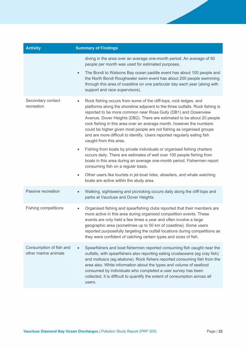
Vaucluse Diamond Bay Ocean Discharges | Pollution Study Report (PRP 305) Page | 22
Activity Summary of Findings
diving in the area over an average one-month period. An average of 50 people per month was used for estimated purposes.
The Bondi to Watsons Bay ocean paddle event has about 100 people and the North Bondi Roughwater swim event has about 200 people swimming through this area of coastline on one particular day each year (along with support and race supervisors).
Secondary contact recreation
Rock fishing occurs from some of the cliff-tops, rock ledges, and platforms along the shoreline adjacent to the three outfalls. Rock fishing is reported to be more common near Rosa Gully (DB1) and Oceanview Avenue, Dover Heights (DB2). There are estimated to be about 20 people rock fishing in this area over an average month, however the numbers could be higher given most people are not fishing as organised groups and are more difficult to identify. Users reported regularly eating fish caught from this area.
Fishing from boats by private individuals or organised fishing charters occurs daily. There are estimates of well over 100 people fishing from boats in this area during an average one-month period. Fishermen report consuming fish on a regular basis.
Other users like tourists in jet-boat rides, abseilers, and whale watching boats are active within the study area.
Passive recreation Walking, sightseeing and picnicking occurs daily along the cliff-tops and parks at Vaucluse and Dover Heights.
Fishing competitions Organised fishing and spearfishing clubs reported that their members are more active in this area during organised competition events. These events are only held a few times a year and often involve a large geographic area (sometimes up to 50 km of coastline). Some users reported purposefully targeting the outfall locations during competitions as they were confident of catching certain types and sizes of fish.
Consumption of fish and other marine animals
Spearfishers and boat fishermen reported consuming fish caught near the outfalls, with spearfishers also reporting eating crustaceans (eg cray fish) and molluscs (eg abalone). Rock fishers reported consuming fish from the area also. While information about the types and volume of seafood consumed by individuals who completed a user survey has been collected, it is difficult to quantify the extent of consumption across all users.

Vaucluse Diamond Bay Ocean Discharges | Pollution Study Report (PRP 305) Page | 23
5 Study area
5.1 Location
The Vaucluse and Diamond Bay (VDB) outfalls are part of the Vaucluse peninsula wastewater system (VWS), which comprises three sub-catchments: Vaucluse (VC), Diamond Bay 1 (DB1), and Diamond Bay 2 (DB2). The VWS is located within the local government areas (LGA) of Woollahra and Waverley, on the peninsula of land bound by South Head to the north, Sydney Harbour to the west, the Tasman Sea to the east, and Rose Bay-Dover Heights to the south. A map of the VWS, highlighting the three catchment areas and the respective outfalls, is shown in Figure 1-1.
The three VDB outfalls are situated within the cliff face on the eastern side of the peninsula, and discharge wastewater from the VWS directly into the Tasman Sea. The VC outfall is located within the suburb of Vaucluse in the Woollahra LGA. It is the northern-most outfall, situated at the base of an 80 m high cliff, below the southern corner of Christison Park.
The DB1 and DB2 outfalls are located within the Waverley LGA, in the suburbs of Vaucluse and Dover Heights, respectively. DB1 is situated about 60 m north of Kimberly Street, south of Rosa Gully, at the base of a 25-30 m high cliff. DB2 is located about 250 m south of DB1, at the base of a 25-30 m high cliff adjacent to the eastern extent of Oceanview Avenue (Eastern Reserve).
5.2 Wastewater infrastructure
The VWS services the suburbs of Watsons Bay, Vaucluse, Diamond Bay, Rose Bay North, and parts of Dover Heights, a total population of over 10,500 people. It comprises three separately enclosed systems, the Vaucluse (VC), Diamond Bay 1 (DB1), and Diamond Bay 2 (DB2) ocean outfall wastewater systems. There is no receiving wastewater treatment plant, therefore each of the three systems continuously discharge raw (untreated) wastewater to the Tasman Sea via three cliff face submerged outfalls (see Figure 1-1).
The VC system services a catchment extending from South Head to Clairvaux Road, an area of about 290 ha comprising the suburbs of Watsons Bay and parts of Vaucluse. The length of this system is about 3 km. Wastewater flows gravitate westward towards Sydney Harbour, and are pumped by five small pumping stations to two major branch pipelines. The two pipelines converge at Parsley Bay Reserve, where wastewater then travels east to the VC outfall via the Vaucluse Ocean Outfall Sewer (VOOS). The VOOS comprises a 990 mm by 600 mm ovoid pipe, which discharges sub-tidally, about 6 m below sea level. The system has been in operation for just over 100 years, being commissioned in 1916. A map of the VC discharge point is shown in Figure 5-1.
The two Diamond Bay ocean outfall systems (DB1 and DB2) service much smaller catchments than the VC system. They were the last systems in the Sydney Water network to be built without treatment facilities. The location of the DB1 and DB2 outfall points is shown in Figure 5-2.
Vaucluse Diamond Bay Ocean Discharges | Pollution Study Report (PRP 305) Page | 24
Figure 5-1 Location map of Vaucluse outfall

Vaucluse Diamond Bay Ocean Discharges | Pollution Study Report (PRP 305) Page | 25
Figure 5-2 Location map of Diamond Bay outfalls
Vaucluse Diamond Bay Ocean Discharges | Pollution Study Report (PRP 305) Page | 26
The DB1 outfall services an area of about 39 ha, comprising parts of Vaucluse and Dover Heights. The outfall is a 225 mm diameter wastewater pipe built in 1932. It is located at the base of a 25-30 m high cliff and discharges at sea level. Wastewater flows by gravity towards the coast, eventually connecting at vertical sewer shafts, then discharging via a tunnel to the ocean. There are no wastewater pumping stations within the catchment.
The DB2 system operates in a similar way to DB1. DB2 was established in 1936 and comprises a 300 mm diameter wastewater pipe, which also discharges at the high-tide level at the base of a 25-30 m high cliff. The DB2 outfall is about 250 m south of DB1. The catchment includes parts of Vaucluse and Dover Heights, covering an area of about 27 ha. The DB2 system also has no wastewater pumping stations, with flows fed by gravity. Several stormwater drains discharge over the cliff top to the north and south of DB1 and DB2.
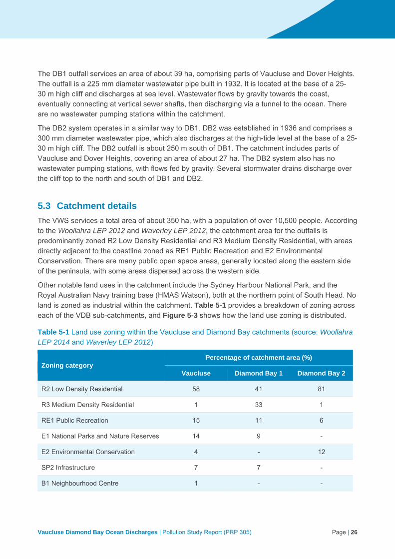
5.3 Catchment details
The VWS services a total area of about 350 ha, with a population of over 10,500 people. According to the Woollahra LEP 2012 and Waverley LEP 2012, the catchment area for the outfalls is predominantly zoned R2 Low Density Residential and R3 Medium Density Residential, with areas directly adjacent to the coastline zoned as RE1 Public Recreation and E2 Environmental Conservation. There are many public open space areas, generally located along the eastern side of the peninsula, with some areas dispersed across the western side.
Other notable land uses in the catchment include the Sydney Harbour National Park, and the Royal Australian Navy training base (HMAS Watson), both at the northern point of South Head. No land is zoned as industrial within the catchment. Table 5-1 provides a breakdown of zoning across each of the VDB sub-catchments, and Figure 5-3 shows how the land use zoning is distributed.
Table 5-1 Land use zoning within the Vaucluse and Diamond Bay catchments (source: Woollahra LEP 2014 and Waverley LEP 2012)
Zoning category Percentage of catchment area (%)
Vaucluse Diamond Bay 1 Diamond Bay 2
R2 Low Density Residential 58 41 81
R3 Medium Density Residential 1 33 1
RE1 Public Recreation 15 11 6
E1 National Parks and Nature Reserves 14 9 -
E2 Environmental Conservation 4 - 12
SP2 Infrastructure 7 7 -
B1 Neighbourhood Centre 1 - -

Vaucluse Diamond Bay Ocean Discharges | Pollution Study Report (PRP 305) Page | 27
Figure 5-3 Land use zoning within the Vaucluse Wastewater System catchment (source: Woollahra LEP 2014 and Waverley LEP 2012)
Sources of wastewater within the VWS are predominantly residential, with some commercial. The commercial facilities are located in small pockets dispersed across the peninsula. The majority of the commercial land use comprises food service outlets such as restaurants, hotels, cafes, bakeries, and catering facilities (GHD 2008). Some of these have a large number of visitors using the amenities, for example entertaining venues such as HMAS Watson and the Gap Bluff Centre, Doyles Restaurant, and Watsons Bay Hotel.

Vaucluse Diamond Bay Ocean Discharges | Pollution Study Report (PRP 305) Page | 28
Two aged care facilities are also located within the Vaucluse catchment: Hall & Pryor Vaucluse Aged Care Home (63 beds), and the newly opened Mark Moran Vaucluse nursing home facility and retirement village (nursing home has 91 beds, and retirement village has 190 suites).
In a 2008 study by GHD for Sydney Water (GHD 2008), 84 properties were identified as ‘commercial’ type properties under the Sydney Water Property Tables. The 84 commercial properties identified are located within five main commercial areas:
corner of Cliff Street and Military Road (predominantly comprising of Watsons Bay Hotel and other Restaurants)
corner of Gap Road and Dunbar Street (predominantly food outlets)
corner of Clarke Street and Old South Head Road (predominantly food outlets and retail)
corner of New South Head Road and Petrarch Avenue (predominantly high density churches), and
Burge Street and Young Street (cemetery and Vaucluse Nursing Home).
There are 15 trade waste permits in the VWS catchment area, all commercial discharges. None of these trade waste permits are from premises within the DB2 catchment area. There are no industrial discharges in the catchment of Vaucluse or Diamond Bay north or south.
5.4 Wastewater discharge characteristics
5.4.1 Volume
The three VDB outfalls are licenced discharge points under EPL 1688 for the Bondi Wastewater Treatment System. Each point has a discharge volume limit specified in the EPL (Table 5-2).
Table 5-2 Discharge volume limits (EPL 1688)
Outfall EPL discharge point number Volume/mass Limit (ML/day)
Diamond Bay 1 (north) 9 30
Diamond Bay 2 (south) 10 10
Vaucluse 11 30
The VWS services most of the population on the Vaucluse peninsula. The VC outfall discharges about 70% of the untreated wastewater, DB1 (north) discharges about 18%, and DB2 (south) about 12%. Average flow from the three VDB outfalls is shown in Table 5-3.
The total average volume of wastewater discharged from the three outfalls is about 4 megalitres per day, well within the EPL discharge limits noted above. To draw a comparison, the average dry weather flow from the Bondi WWTP, via the deep ocean outfall, is 115 megalitres per day. The Bondi catchment has an area of 3,900 ha, and an equivalent population of 623,000 people (2014).

Vaucluse Diamond Bay Ocean Discharges | Pollution Study Report (PRP 305) Page | 29
Table 5-3 Median annual wastewater flows from the Vaucluse Diamond Bay outfalls, 2006 to 2015
Year
Median annual flow (ML/d)* Annual rainfall
(mm) Vaucluse Diamond Bay No 1 (north)
Diamond Bay No 2 (south)
Total
2006 2.85 0.58 0.46 3.89 1,045
2007 2.68 0.71 0.48 3.87 1,484
2008 2.91 0.71 0.45 4.07 1,145
2009 2.55 0.71 0.4 3.66 883
2010 2.97 0.77 0.51 4.25 1,140
2011 2.77 0.71 0.48 3.96 1,237
2012 2.91 0.71 0.57 4.19 1,131
2013 2.4 0.71 0.48 3.59 1,255
2014 2.05 0.59 0.4 3.04 788
2015 2.7 0.67 0.5 3.87 1,377
Median (n = 10)
2.74 0.71 0.48 3.88 1,143
* Flow data is based on daily sampling
5.4.2 Wastewater quality
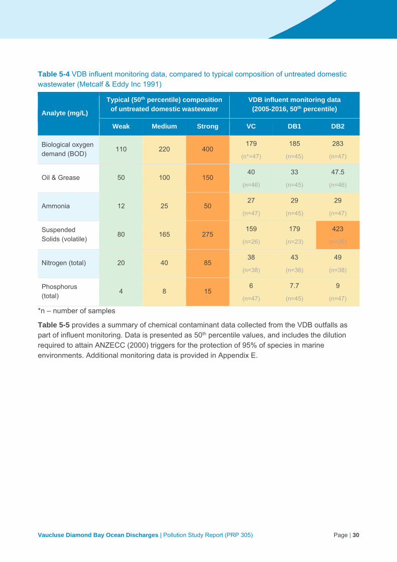
As noted in section 5.3, the catchment areas for these three wastewater systems comprise predominantly residential and commercial properties, with no industrial activity occurring. Sydney Water undertakes operational monitoring throughout the wastewater collection network, gathering wastewater quality information for analytes such as suspended solids, biological oxygen demand, oil and grease, ammonia, nitrogen, phosphorous, and heavy metals. Analysis of key constituents of the wastewater discharges confirms that the discharges for the three outfalls are mostly characteristic of medium strength typical domestic wastewater (Table 5-4).
Results for DB2 revealed high levels of fats, grease and oils, and suspended solids, at a value greater than the typical level for high strength domestic wastewater. The biological oxygen demand of DB2 is also higher than the other discharges, but still around the range of medium strength domestic wastewater. While the discharge volume is smaller, the DB2 system has no wastewater pumping stations and few commercial properties. It is also noted that, due to the small size of the Vaucluse and Diamond Bay catchments, there is only a short time frame between wastewater entering the system and discharging at the cliff face. DB2 has the smallest catchment size of the three.
Vaucluse Diamond Bay Ocean Discharges | Pollution Study Report (PRP 305) Page | 30
Table 5-4 VDB influent monitoring data, compared to typical composition of untreated domestic wastewater (Metcalf & Eddy Inc 1991)
Analyte (mg/L)
Typical (50th percentile) composition of untreated domestic wastewater
VDB influent monitoring data (2005-2016, 50th percentile)
Weak Medium Strong VC DB1 DB2
Biological oxygen demand (BOD)
110 220 400 179
(n*=47)
185
(n=45)
283
(n=47)
Oil & Grease 50 100 150 40
(n=46)
33
(n=45)
47.5
(n=46)
Ammonia 12 25 50 27
(n=47)
29
(n=45)
29
(n=47)
Suspended Solids (volatile)
80 165 275 159
(n=26)
179
(n=23)
423
(n=26)
Nitrogen (total) 20 40 85 38
(n=38)
43
(n=36)
49
(n=38)
Phosphorus (total)
4 8 15 6
(n=47)
7.7
(n=45)
9
(n=47)
*n – number of samples
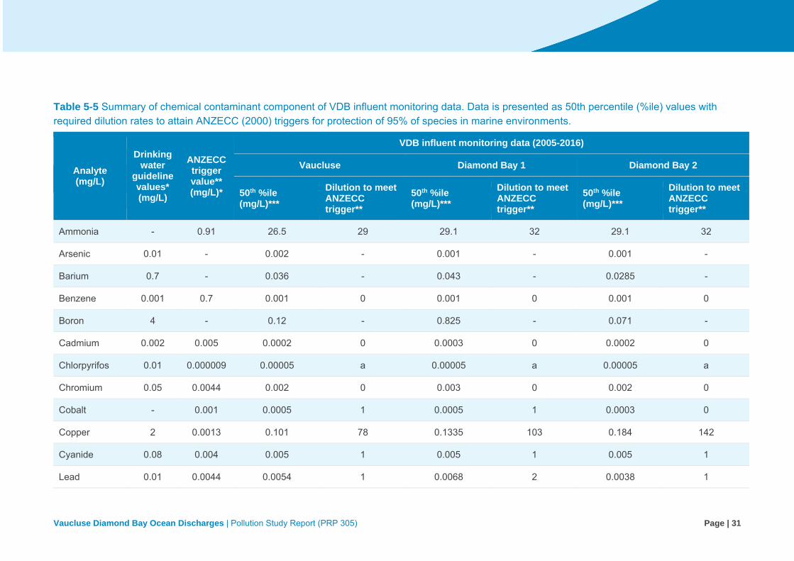
Table 5-5 provides a summary of chemical contaminant data collected from the VDB outfalls as part of influent monitoring. Data is presented as 50th percentile values, and includes the dilution required to attain ANZECC (2000) triggers for the protection of 95% of species in marine environments. Additional monitoring data is provided in Appendix E.
Vaucluse Diamond Bay Ocean Discharges | Pollution Study Report (PRP 305) Page | 31
Table 5-5 Summary of chemical contaminant component of VDB influent monitoring data. Data is presented as 50th percentile (%ile) values with required dilution rates to attain ANZECC (2000) triggers for protection of 95% of species in marine environments.
Analyte (mg/L)
Drinking water
guideline values* (mg/L)
ANZECC trigger value** (mg/L)*
VDB influent monitoring data (2005-2016)
Vaucluse Diamond Bay 1 Diamond Bay 2
50th %ile (mg/L)***
Dilution to meet ANZECC trigger**
50th %ile (mg/L)***
Dilution to meet ANZECC trigger**
50th %ile (mg/L)***
Dilution to meet ANZECC trigger**
Ammonia - 0.91 26.5 29 29.1 32 29.1 32
Arsenic 0.01 - 0.002 - 0.001 - 0.001 -
Barium 0.7 - 0.036 - 0.043 - 0.0285 -
Benzene 0.001 0.7 0.001 0 0.001 0 0.001 0
Boron 4 - 0.12 - 0.825 - 0.071 -
Cadmium 0.002 0.005 0.0002 0 0.0003 0 0.0002 0
Chlorpyrifos 0.01 0.000009 0.00005 a 0.00005 a 0.00005 a
Chromium 0.05 0.0044 0.002 0 0.003 0 0.002 0
Cobalt - 0.001 0.0005 1 0.0005 1 0.0003 0
Copper 2 0.0013 0.101 78 0.1335 103 0.184 142
Cyanide 0.08 0.004 0.005 1 0.005 1 0.005 1
Lead 0.01 0.0044 0.0054 1 0.0068 2 0.0038 1

Vaucluse Diamond Bay Ocean Discharges | Pollution Study Report (PRP 305) Page | 32
Analyte (mg/L)
Drinking water
guideline values* (mg/L)
ANZECC trigger value** (mg/L)*
VDB influent monitoring data (2005-2016)
Vaucluse Diamond Bay 1 Diamond Bay 2
50th %ile (mg/L)***
Dilution to meet ANZECC trigger**
50th %ile (mg/L)***
Dilution to meet ANZECC trigger**
50th %ile (mg/L)***
Dilution to meet ANZECC trigger**
Manganese 0.5 - 0.0332 - 0.0345 - 0.0265 -
Mercury 0.001 0.0004 0.0001 0 0.0001 0 0.0001 0
Molybdenum 0.05 - 0.001 - 0.001 - 0.001 -
Napthalene - 0.07 0.0001 0 0.0001 0 0.0001 0
Nickel 0.2 0.07 0.003 0 0.004 0 0.003 0
Phenol - 0.4 0.011 0 0.021 0 0.017 0
Selenium 0.01 - 0.005 - 0.005 - 0.005 -
Silver - 0.0014 0.0003 0 0.0003 0 0.0002 0
Vanadium - 0.1 0.001 0 0.001 0 0.001 0
Zinc - 0.015 0.100 7 0.174 12 0.104 7
1, 1, 2-trichloroethane
- 1.9 0.001 0 0.001 0 0.001 0
* Guideline values for health, from Table 10.6 of the Australian Drinking Water Guidelines 6, Version 3.3 (NHMRC 2011) ** Trigger vales for toxicants at level of protection for 95% of aquatic organisms in marine environment (Table 3.4.1 of ANZECC 2000) *** Total concentrations a Guideline below detection limit

Vaucluse Diamond Bay Ocean Discharges | Pollution Study Report (PRP 305) Page | 33
Sydney Water analysed data for over 100 chemicals and identified that the highest risk constituent is copper. Pilot modelling estimated that copper is likely to be above the ANZECC (2000) trigger value for protection of species in marine environments (Table 5-5) for an area reaching about 35 m offshore, and 80 m along the coast at the Vaucluse outfall (Figure 5-4). A dilution of 150 times would be required to bring copper below the ANZECC trigger value. The analyte requiring the next highest dilution rate to fall below ANZECC trigger values is ammonia, requiring 30 times dilution, and then zinc, requiring about 10 times dilution. In an ocean environment, these dilutions are attained very quickly, as indicated by pilot modelling. It is also noted that the levels of most constituents in the wastewater prior to dilution by oceanic waters is similar or lower than corresponding levels in typical urban stormwater (based on DEC 2006).
The nutrient concentrations in outfall discharges present a potential stressor for bio-stimulation of the receiving waters. Nutrient dilution rates of about 400 times would be required to meet the ANZECC trigger values for nutrient stressors (nitrogen slightly more than phosphorous). Pilot modelling is only able to provide an indicative extent of these dilutions. Pilot modelling indicated that this represents an area extending about 60 m offshore and 240 m alongshore at Vaucluse; 15 m offshore and 70 m alongshore at DB1; and 30 m offshore and 110 m alongshore at DB2 (Figure 5-5).
Figure 5-4 and Figure 5-5 represent the estimated maximum possible extents using a conservative tracer (Copper or TN) simulated over a period from July 2015 to June 2016. The modelling work has not been verified by monitoring. The cliff face outfalls discharge at the surface zone where hydraulic conditions are very complex and difficult to be modelled. A nearfield mixing zone was assumed to be 20x20x1m at the discharge location to reflect the breaking wave effect. This assumption may overestimate the nearfield mixing, but these impact zones are much smaller than the faecal contamination zone presented in the next section.
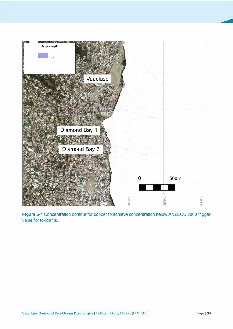
Vaucluse Diamond Bay Ocean Discharges | Pollution Study Report (PRP 305) Page | 34
Figure 5-4 Concentration contour for copper to achieve concentration below ANZECC 2000 trigger value for toxicants.
Vaucluse
Diamond Bay 1
Diamond Bay 2
0 500m
34
05
00
34
10
00
34
15
00
34
20
00
34
25
00
251000
251500
252000
252500
Copper (ug/L)
1.3
00:00:00 01-Jan-2016
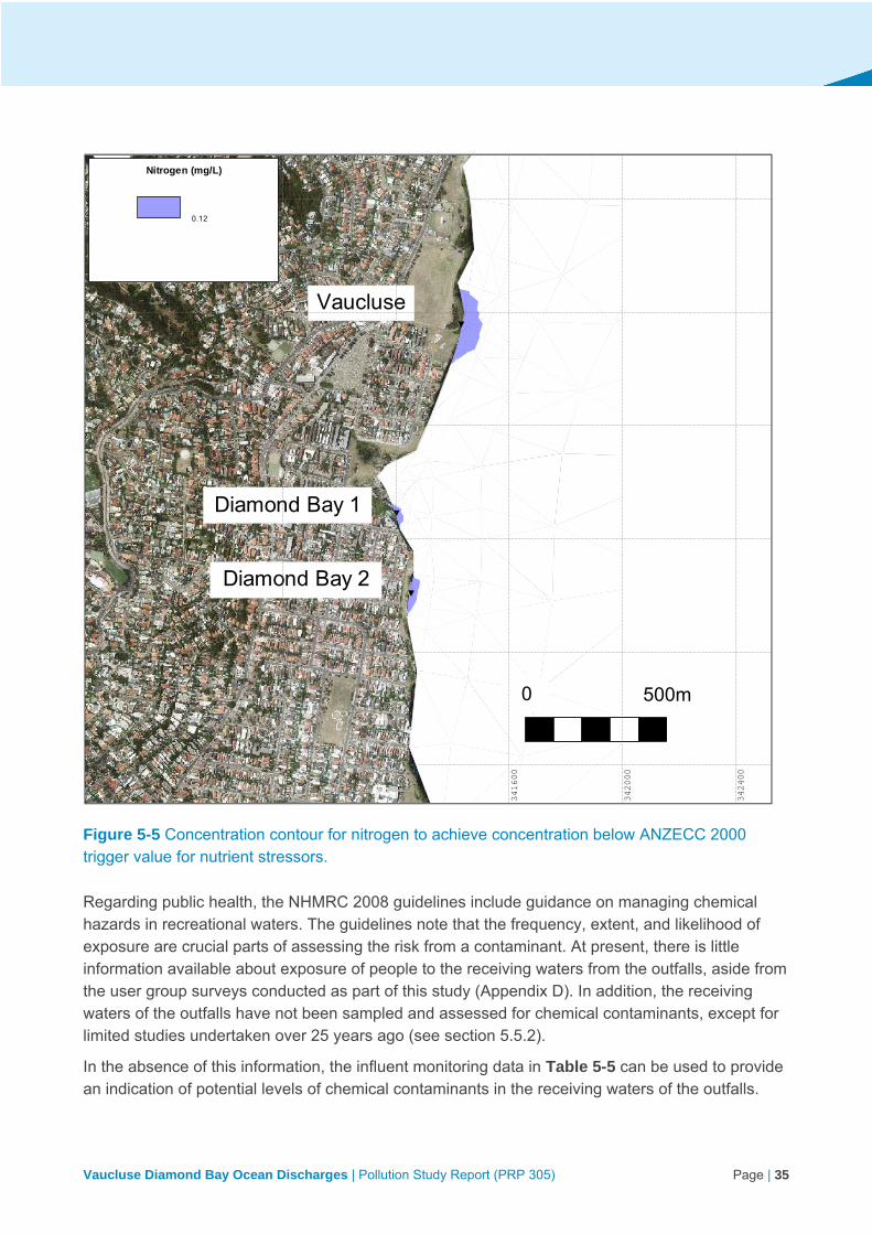
Vaucluse Diamond Bay Ocean Discharges | Pollution Study Report (PRP 305) Page | 35
Figure 5-5 Concentration contour for nitrogen to achieve concentration below ANZECC 2000 trigger value for nutrient stressors.
Regarding public health, the NHMRC 2008 guidelines include guidance on managing chemical hazards in recreational waters. The guidelines note that the frequency, extent, and likelihood of exposure are crucial parts of assessing the risk from a contaminant. At present, there is little information available about exposure of people to the receiving waters from the outfalls, aside from the user group surveys conducted as part of this study (Appendix D). In addition, the receiving waters of the outfalls have not been sampled and assessed for chemical contaminants, except for limited studies undertaken over 25 years ago (see section 5.5.2).
In the absence of this information, the influent monitoring data in Table 5-5 can be used to provide an indication of potential levels of chemical contaminants in the receiving waters of the outfalls.
Vaucluse
Diamond Bay 1
Diamond Bay 2
0 500m
34
04
00
34
08
00
34
12
00
34
16
00
34
20
00
34
24
00250800
251200
251600
252000
252400
252800
Nitrogen (mg/L)
0.12
00:00:00 01-Jan-2016

Vaucluse Diamond Bay Ocean Discharges | Pollution Study Report (PRP 305) Page | 36
The NHMRC guidelines highlight a study by Mance et al. (1984) that suggests environmental quality standards for chemicals in recreational waters should assume that recreational water makes only a relatively minor contribution to total water intake (approximately 10%, or 200 millilitres out of 2 litres of water per day). This provides for a simple screening approach, in which a substance occurring in recreational water at a concentration of 10 times that stipulated in the drinking water guidelines may merit further consideration (NHMRC 2008).
For those chemical contaminants tested during influent monitoring, all were at concentrations lower than drinking water guideline values (using 95th percentile values from 10 years’ worth of sampling). The only exceptions were cadmium at Vaucluse and lead at DB2, but both levels were still well within 10 times the drinking water guideline values. As these values were collected from within the pipe, they would decrease further once the wastewater is discharged into the receiving waters and begins to disperse and dilute. The concentrations of chemical contaminants in the receiving waters would be highest closest to the outfalls, and would decrease with distance from the outfalls. Based on this limited assessment, the risks posed by chemical contaminants to recreational users of the waterway could be considered low.
As well as potential impacts from toxicants and nutrients, there are other wastewater constituents that may generate potential impacts for which there are no measurements available. This includes gross pollutants, endocrine disrupting chemicals, microplastics, and emerging chemicals of concern. In addition, as the discharge wastewater is not treated, there is no capture of solid materials (eg toilet paper, sanitary products, wet wipes). These can be visible on the water surface and in the water column. Information about gross pollutants being discharged from the outfalls is limited to observations from past Sydney Water studies (EMU 1990; EP Consulting 2002), and responses to user group surveys (Appendix D). This is further discussed in sections 5.5.2 and 6.2.

Vaucluse Diamond Bay Ocean Discharges | Pollution Study Report (PRP 305) Page | 37
5.4.3 Pilot wastewater modelling and observations
Pilot modelling
Pilot modelling was carried out as part of this study to determine the likely extent of the wastewater impact from the three VDB discharges. A report describing the modelling methodology and limitations is provided in Appendix F. This pilot modelling used three dimensional, finite element models RMA-10 (hydrodynamics) and RMA-11 (water quality), and has been undertaken using all available information. The model has not been validated and calibrated with nearshore field data. The UNSW Water Research Laboratory (WRL) was engaged to conduct an independent peer review of the modelling process and outcomes (see below and Appendix G).
The pilot modelling used enterococci as this is the most appropriate indicator for the detection of faecal contamination in recreational waters, as supported by the NHMRC 2008 guidelines. As such, it is useful for assessing and managing public health risk for recreational use of marine waters. These NHMRC 2008 guidelines represent a major revision to the previous guidelines, such as ANZECC (2000), by focusing on the assessment and management of hazards to minimise health risks. Under the NHMRC 2008 guidelines, waterways can be graded for their suitability for primary contact recreation where the microbial assessment includes both the 95th percentile (%ile) enterococci (cfu/100ml), which translates into an estimated probability of illness based on World Health Organization research, and the sanitary inspection that considers the site susceptibility to faecal pollution. This is the approach adopted by the NSW OEH Beachwatch Program (see section 3.3.5), and the pilot modelling used in this study.
Figure 5-6 shows the pilot modelling results for enterococci levels through dispersion at the 95th %ile, in line with the NHMRC 2008 guidelines. The enterococci limits mapped correlate with the microbial assessment categories (MAC) defined in the NHMRC guidelines and used for Beachwatch classification (Table 5-6). The four categories (A to D) relate to levels of risk of illness, determined from key epidemiological studies, whereby the greatest risk off illness occurs in the areas mapped as Category D, and decreases further offshore. Category A represents the lowest risk of illness for those conducting primary contact recreation. Importantly, nearby swimming beaches, such as Bondi, are unaffected (which is supported by Beachwatch data, see section 3.3.5).
Whilst a biological indicator was used to examine potential impacts on public health, it is noted that there are other contaminants in wastewater that can pose health risks, such as chemical contaminants. Chemical constituents of the wastewater discharges are discussed in section 5.4.2. It was determined that for all chemical constituents tested, levels were below drinking water guideline values, or within 10 times these values, which is considered acceptable for recreational waters (as per the NHMRC 2008 guidelines). Based on this limited assessment, the risks posed by chemical contaminants to recreational users of the waterway could be considered low. Furthermore, analysing the wastewater discharges using enterococcus as an indicator would likely capture any risks posed by chemical constituents of the discharges, as the area of potential impact is larger for microbial risks.

Vaucluse Diamond Bay Ocean Discharges | Pollution Study Report (PRP 305) Page | 38
Figure 5-6 Enterococci statistics for combined impact of the three VDB discharges (95th percentile)
0 0.5 km 1 km
Bondi Beach
33
80
00
34
00
00
34
20
00
34
40
00
34
60
00
248000
250000
252000
254000
Enterococci with Die-off (cfu/100mL)
501
201
41
10
00:00:00 01-Jan-2016
D- Very poor
C - Poor
B - Fair
A -Good

Vaucluse Diamond Bay Ocean Discharges | Pollution Study Report (PRP 305) Page | 39
Table 5-6 Outline of enterococci limits mapped during wastewater modelling for discharges from the VDB outfalls (adapted from NHMRC 2008 and OEH 2016)
Area Category 95th percentile enterococci (cfu/100ml)
Basis of derivation (NHMRC 2008)
Beachwatch suitability grades (OEH 2016)
A <40 No illness seen in most epidemiological studies
Good: Location has generally good microbial water quality and water is considered suitable for swimming most of the time. Swimming should be avoided during and for up to one day following heavy rain.
B 41-200 Upper threshold is above the threshold of illness transmission reported in most studies
Fair: Microbial water quality is generally suitable for swimming, but because of the presence of significant sources of faecal contamination, extra care should be taken to avoid swimming during and for up to three days following rainfall or if there are signs of pollution such as discoloured water or odour or debris in the water.
C 201-500 Represents a substantial elevation in the probability of adverse health outcomes
Poor: Location is susceptible to faecal pollution and microbial water quality is not always suitable for swimming. During dry weather conditions, ensure that the swimming location is free of signs of pollution, such as discoloured water, odour or debris in the water, and avoid swimming at all times during and for up to three days following rainfall.
D >500 Above this level there may be a significant risk of high levels of illness transmission
Very poor: Location is very susceptible to faecal pollution and microbial water quality may often be unsuitable for swimming. It is generally recommended to avoid swimming at these sites.
Vaucluse Diamond Bay Ocean Discharges | Pollution Study Report (PRP 305) Page | 40
Area of potential impact
The pilot modelling estimates the geographic scale of potential impacts from the outfalls.
A precautionary position is being adopted and the areas of Category D and Category C are considered to have substantial public health risk for primary contact recreation in those waters i.e. swimming, snorkelling and spearfishing (refer to Table 5-6 for basis of derivation). Experts from NSW Health and Environment Protection Authority concur with this position.
Enterococcus was selected as the indicator for modelling, as it is a highly sensitive indicator for wastewater pollution. This also allowed the ranges mapped to be correlated with NHMRC and Beachwatch classifications, aiding interpretation of the results in the context of public health risk. Potential impacts on human health are described in the context of the NHMRC 2008 guidelines and Beachwatch suitability grading in Table 5-6. These risks are further explored in Chapter 7.
Due to the dynamic nature of the receiving waterway, the area potentially impacted by the outfalls could change under different conditions (wind direction, currents, tides, etc.). To address this, a sensitivity analysis was carried out as part of the pilot modelling, and the most conservative input data was used to run the model (see Appendix F). Figure 5-6 therefore represents a worst-case scenario, based on available information, of the area potentially impacted by these wastewater discharges. It would be unlikely for the area potentially impacted by the wastewater discharges to be larger than that depicted in the modelling results. However, as the pilot modelling results have not been calibrated or validated, there remains some uncertainty about the extent of the area impacted by the outfalls. This is highlighted as a knowledge gap in Chapter 8.
The only area where there is some certainty of impact is the area immediately adjacent to each outfall. These areas are exposed to continual discharges of untreated wastewater, and some people are accessing these waters for primary contact recreation. Potential environmental and public health impacts of the wastewater discharges become less certain with increased distance from the outfalls, and the risk is likely to decrease with increased distance from the outfalls. This is explored further in the risk assessment conducted as part of this study, detailed in Chapter 7.
Assumptions and limitations
Details about the methodology employed to conduct the pilot modelling, including assumptions applied and limitations, are provided in Appendix F. The pilot model was fit for purpose, but only provides an approximate indication of the area potentially impacted by the outfalls. There is limited monitoring data for the receiving environment, and therefore inadequate data available to verify the model.
Verification and calibration of the model would require information such as localised high resolution LIDAR data, supplemented by traditional based hydrosurvey for the immediate (<500 m) zones about each outfall; and local current data, eg assessed using dye tracers and deploying current meters. In addition, there is very little information about the water quality of the receiving environment (see section 5.5.2, below). As such, it is not possible at present to validate the model against field data. Environmental monitoring and model validation are beyond the scope of this study, and are identified as a gap in knowledge in Chapter 8.
Vaucluse Diamond Bay Ocean Discharges | Pollution Study Report (PRP 305) Page | 41
Peer review
An independent peer review of the modelling was carried out to provide an impartial perspective on the analysis undertaken (Appendix G). Brett Miller from the Water Research Laboratory at the University of NSW was engaged to carry out this peer review. Mr Miller is an expert in hydrodynamic and water quality modelling, in particular the dispersion of effluent from outfalls in rivers, estuaries, and the ocean.
The peer review evaluates the model and outcomes. The reviewer noted that while the predicted zones of impact (probability and risk based) were reasonable, further field investigations were recommended (eg water quality data or dye release monitoring) to verify impact zone boundaries.
Nearmap analysis
In addition to the pilot modelling, a visual assessment and estimation of the visible plume was conducted using aerial imagery in Nearmap. Historic aerial photos of the study area were used to make a qualitative assessment of the visible plumes emanating from each outfall, and their dispersion behaviour. Visual assessment of 47 Nearmap aerial images from 2009 to 2016 revealed the wastewater plumes are visible around 75% of the time. The extent of the visible plume observed in historic aerials was confined to the area mapped as Category D in Figure 5-6, above.
At DB1 and DB2, the wastewater plume was observed to have a milky tinge, appearing whiter in colour, whereas the plume at Vaucluse often appears to be browner in colour. Observations from Nearmap show the plume mostly hugs the shoreline in areas where the waves are breaking. The furthest extent of the visible plume for each outfall from the available aerials was about 150 m offshore. Interestingly, the results of the pilot modelling show the wastewater discharges behaving in a similar manner upon entering the receiving waters, whereby the modelled discharges spread north and south along the coastline more so than extending eastwards away from the coast.
The findings are also in line with anecdotal evidence from stakeholder engagement (Appendix D) and observations made during past studies. The EP Consulting (2002) study recorded a visible plume at each outfall site. The Vaucluse plume was observed to extend several hundred metres to the south, differentiated by oil and grease and brown discolouration. The DB1 plume was observed to extend throughout the southern end of Rosa Gully, discernable by particulate rich water with oil and grease on the surface. The DB2 plume was noted to be smaller in sized, and visible due to oil and grease on the surface.
There are many limitations associated with assessing the visible plumes from the outfalls in this way, and it is recognised that elevated levels of wastewater constituents may not be visible to the naked eye. The purpose of this visual assessment is to gain an approximate, real-world understanding of how the wastewater discharges behave in the receiving environment, particularly in the nearshore area, and compare this to the modelling results. It is not a definitive measure of the extent of the wastewater discharges, but adds another dimension to the analysis.

Vaucluse Diamond Bay Ocean Discharges | Pollution Study Report (PRP 305) Page | 42
5.5 Existing environment
Below is a summary of the receiving environment adjacent to the VDB outfalls, based on a desktop review of literature. The receiving environment of these outfalls is defined as the adjacent receiving waters (i.e. the Tasman Sea along the east coast of the Vaucluse peninsula), and the local atmosphere near the outfalls (onshore and over the water).
While numerous studies have been carried out to gather data about Sydney’s deepwater ocean outfalls (at North Head, Bondi, and Malabar), little data exists for the receiving environment of the VDB outfalls, particularly at a scale relevant to this study. The most notable studies were carried out by or on behalf of Sydney Water (EMU 1990; The Ecology Lab 1990; EP Consulting 2002), during investigations into identifying alternative servicing arrangements for the outfalls.
Based on this information, the following provides a description of the receiving environment of the outfalls. This information is later used to assess the potential impacts and risks of the outfalls.
5.5.1 Oceanography and hydrodynamics
The VDB outfalls and receiving waters are located within the Hawkesbury Shelf marine bioregion. This area of coastline has high wave action and is located close to the continental shelf. The immediate coastline is rugged and boulder banks lie near shore on rock platforms. The platforms are sandy and about 18 meters deep, extending out variable distances but typically less than half a kilometre. Coastal wind and onshore local currents influence water movement in this area (Wood et al. 2013). These processes, together with episodic intrusions of water of differing temperatures and compositions, upwelling, and discharges from estuaries, contribute to the variability of characteristics such as temperature and nutrient concentrations.
During onshore current conditions, potential pollution hazards may occur as outfall discharges are likely to accumulate at the coast. In contrast, during offshore current conditions, minimal or no pollution hazard would be expected due to dispersion of pollutants (Connell Wagner 1990).
Beyond the shelf the area is strongly influenced by the East Australian Current (EAC), a strong, western boundary current. The EAC has been shown to exhibit seasonal characteristics, being faster and lying closer to the shelf in summer compared with winter (Ridgway and Hill 2009). Sydney is downstream of the EAC separation zone within a region where eddies are the dominant feature that influence circulation on the shelf.
At present, there is limited data on the bathymetry and hydrodynamics of the area immediately adjacent to the outfalls. The pilot modelling undertaken (section 5.4.3) used the single beam survey bathymetric dataset collected by Public Works in the 1980s (Geoscience Australia 2009). However, there is no bathymetry data available for the nearshore zone, about 250 m from the outfalls. This is recognised as a knowledge gap in Chapter 8.
5.5.2 Receiving water quality
There is minimal information available about water quality in the receiving waterway of the VDB wastewater discharges. This is highlighted as gap in knowledge, as documented in Table 8-1. The wastewater modelling and influent monitoring analysis described in sections 5.4.2 and 5.4.3 were

Vaucluse Diamond Bay Ocean Discharges | Pollution Study Report (PRP 305) Page | 43
carried out as part of this study due to the limited information available about receiving water quality.
The main source of information is from the EMU (1990) study conducted by Sydney Water to inform an environmental assessment. This study involved modelling of dilutions and microbiological sampling of the adjacent waters. Both near- and far-field modelling were carried out as part of the study (EMU 1990). The study found that dilutions 100 m from the outfall are in the range of 100-300:1, and at 500 m from the outfall dilutions range from 1000-5000:1. This shows that dilutions from far-field processes are greater than those attributed to near-field processes. The study did not account for bacteria ‘sudden kill’, or wave action, therefore the findings were considered conservative. The EMU (1990) modelling used some local current data gathered as part of the study from a current meter deployed about 250 m east of the DB1 outfall. The study noted potential errors associated with extrapolating the data retrieved from the current mooring and the hydrographic profiles used in the modelling.
Some microbiological sampling was undertaken as part of the EMU (1990) study. Grab samples were collected for bacteriological analysis from an inflatable boat, and analysed for total coliforms, faecal coliforms, and faecal streptococci. Samples were collected adjacent, north, and south of the three outfalls, and at three depths offshore (15 m, 27 m, and 30m). Three additional sites were sampled for background data. Samples were also taken at the outlets of DB1 and DB2 and near adjacent stormwater drains. There were 28 sampling sites in total.
The results showed the highest counts recorded in the areas immediately adjacent to the outfalls, and that microbiological quality of the seawater at VDB is closely linked with the movement of local currents. When onshore currents prevailed, the effluent discharged was slow to dissipate, and when offshore currents prevailed dissipation rates increased. A visual assessment of the conditions at the outfalls was carried out in 2002 by EP Consulting. The assessment noted that as discharges increased to the morning peak flow, effluent plumes were visible from the water surface. The plume from the Vaucluse outfall was observed to extend for hundreds of metres to the south and was differentiated from the marine water by a layer of oil and grease on the surface. Brown discolouration of the water was also evident.
Analysis of wastewater monitoring data also provides an estimate of the area potentially impacted by toxicants in the discharges (section 5.4.2). Pilot modelling and analysis of wastewater influent monitoring data, undertaken as part of this study, provides an estimate of the area potentially impacted by biological contaminants in the wastewater discharged from the outfalls (section 5.4.3). Conclusions from previous studies at VDB are largely inconclusive due to flaws in methodologies and sampling efforts applied (EMU 1990; The Ecology Lab 1990; EP Consulting 2002). This is further discussed in section 6.2
Gross pollutants have been observed in the receiving waters of the outfalls during past Sydney Water studies and in the user group surveys. The EMU (1990) study noted that ‘floating rubbish’ was observed at the three outfall sites, and that paper and similar foreign material was observed in photoquadrats at Vaucluse. The EP Consulting (2002) study noted some ‘gross sewage derived solid items’ were observed floating at or near the surface, with items such as baby wipes and tampons observed in underwater surveys. User survey responses highlighted that items such as
Vaucluse Diamond Bay Ocean Discharges | Pollution Study Report (PRP 305) Page | 44
plastics, sanitary products, and toilet paper have been observed in the receiving waters of the outfalls (Appendix D). The potential impacts of gross pollutants on the receiving environment of the outfall is discussed in section 6.2.
5.5.3 Marine ecology
The geographic location of the outfalls is characterised by high sandstone cliffs with narrow fringing reef platforms, providing a relatively small intertidal area. The rocky shoreline in this area is typical of that of the of the Sydney region, with wave cut platforms below near vertical cliffs (EMU 1990). Subtidally, the area is characterised by a steep drop-off to relatively deep water in close proximity to the shore. The habitat is predominantly vertical wall reef and reef flat, with barren boulder banks with no significant areas of sand present in the area surveyed (depth <20 metres). Sandy areas tended to be coarse, occurring amongst the boulders.
The study by EP Consulting (2002) identified three habitats common to all three outfall locations:
Vertical wall community – dominate by sponges, variety of brown and red algae, ascidian, and barnacles.
Barren boulders – dominated by encrusting coralline algae.
Reef flat with kelp (not present at DB1) and tufting algae – characterised by brown algae Ecklonia radiata (kelp) and erect coralline algae.
There are similarities in the assemblages at all three outfall locations, the main difference being the extent of each habitat type. At the Vaucluse outfall, the reef flat was shallower and narrower, and terminated at the barren boulder bank, which drops off rapidly to deeper water close to the discharge (approximately 50 metres).
The EMU (1990) study reported that the community structure immediately around the outfalls consists of intertidal rock platforms and subtidal substrates with species such as Coralline Algae, Kelp, Cunjevoi, Tufted Coralline Algae, Green Algae, Surf Barnacles, Tube Worms, Periwinkles and Limpets. Most of the species identified during the study were found in the reef flat zone.
Neither of these ecological studies were able to adequately assess the shallow water in the rock shelf area adjacent to the outfalls, due to safety concerns about accessing these rocky, rough waters. As such, there is a significant gap in information about the area likely to have been impacted that greatest by the outfalls. This is captured as a gap in knowledge in Table 8-1.
The discharge environment at the two DB outfalls was generally similar in bathymetry and the distribution of habitats present (EP Consulting 2002). The main difference between the two locations was found to be the dominant flora in the reef flat assemblage. At DB1, the reef flat and the tops of barren boulder bank were dominated by kelp and erect coralline algae. At DB2, kelp was absent from the surveyed area and the reef flat and tops of boulders were dominated by tufting algal species.
This study identified the reef flat habitat was degraded in areas, as evident by the presence of barren areas and ‘brown fuzz’. This ‘brown fuzz’ is a matrix of algae, bacteria and hydroids (colonies of tiny stinging jellies), and grows opportunistically in response to effluent discharges
Vaucluse Diamond Bay Ocean Discharges | Pollution Study Report (PRP 305) Page | 45
(Campbell et al 2014; Fraschetti et al. 2006; Ajani et al. 1999; Underwood and Chapman 1996). This assemblage was observed at all three outfall locations within the reef flat habitat below the point of discharge. The absence of this assemblage further away from the discharge point may be indicative of an increase in health of the marine environment with distance from the outfalls (EP Consulting 2002). There is evidence that wastewater discharges may promote algal growth in the immediate area around the outfalls (EP Consulting 2002), which is indicative of a nutrient-enriched environment (Petrenko et al. 1997; Roberts and Scanes 1999; Ajani et al. 1999). Effluent plumes were also visible at times at the surface (EP Consulting 2002).
The EMU (1990) study suggested that subtidal benthos had not suffered major impacts from the outfalls, although this only referred to a depth range of 9 to 18 metres (about 50 metres offshore). In shallower water, on the reef flats closer to the discharge points, there may be adverse impacts. However, due to a lack of sampling data this remains unknown. It was concluded that it is likely the VDB wastewater discharges affect inter-tidal communities on a relatively small scale (ie up to tens of metres from the outfall) (EMU 1990).
Several threatened species are known to occur in the environment offshore of the outfalls, including the critically endangered Grey Nurse Shark. The area is also potential habitat for several threatened species, including the Humpback Whale, and a number of threatened turtles. The area is also known habitat of the Weedy Seadragon, which is protected under the FM Act. Refer to Chapter 3.
As noted in section 5.5.2, previous studies and user group survey responses describe observations of gross pollutants in the receiving waters of the outfalls. The reef provides natural depressions where materials such as cigarette butts and finer solids pool. This potentially impacts habitat and may leave the reef devoid of algal cover (EP Consulting 2002).
The nearest marine protected areas are North Harbour, Cabbage Tree Bay (Manly), and Bronte-Coogee but there is no evidence of impact from the outfalls (Figure 5-7).

Vaucluse Diamond Bay Ocean Discharges | Pollution Study Report (PRP 305) Page | 46
Figure 5-7 Excerpt from NSW marine protected areas map (source: NSW DPI)
Sydney’s first artificial reef was deployed off the coast of Vaucluse on 12 October 2011 by the NSW Department of Primary Industries (DPI). The project was funded by the NSW Recreational Fishing Trust. It is located about 1.2 km off the coast from The Gap at 38 m depth (see Figure 5-8).

Vaucluse Diamond Bay Ocean Discharges | Pollution Study Report (PRP 305) Page | 47
The nearest VDB outfall to the reef is Vaucluse, located about 1.8 km southeast. At this distance, it is considered unlikely that the discharges from the outfall would adversely affect the water quality or ecosystem at the artificial reef site. The location of the reef is outside of the Category B, C, and D areas modelled in the pilot modelling (see section 5.4.3).
DPI put in place a long-term monitoring program for the artificial reef, and under this program released three monitoring reports (DPI 2012; DPI 2013; DPI 2015). Monitoring showed that fish rapidly colonised the artificial reef, with rapid recruitment of new species (a total of 49 species identified by the end of 2014) (DPI 2015). There is evidence that the artificial reef is providing a diverse range of species for recreational fishers to target.
Figure 5-8 Location of Vaucluse artificial reef (deployed by DPI Fisheries), in relation to the VDB outfalls.

Vaucluse Diamond Bay Ocean Discharges | Pollution Study Report (PRP 305) Page | 48
5.5.4 Heritage
There are several items of non-indigenous heritage significance located near the VDB outfalls, as outlined in Table 5-7. A map showing the locations of these heritage sites (including shipwrecks) in relation to the VDB outfalls is presented in Figure 5-9. The potential impact of the VDB outfalls on the heritage significance of these items is discussed in section 6.2.
Table 5-7 Heritage listed items located near the VDB outfalls
Heritage item Listing Proximity to outfalls
Heritage significance
Macquarie Lighthouse
Commonwealth 270 m north of VC
Built in 1883, it is the site of Australia’s first lighthouse, and thus represents the longest continuously operating site of a navigational beacon in Australia. The lighthouse is in original condition.
It is also recognised for its outstanding landscape value, and historic significance relating to its association with the colonial Governor Lachlan Macquarie.
Vaucluse Outfall Local
(S170 register)
N/A The Vaucluse Outfall is historically significant as it is tangible evidence of wastewater engineering practices at the time of its construction (in 1916).
It is also one of two small outfall sewerage systems in the eastern suburbs that serviced the peninsula (the other being the Diamond Bay systems).
Diamond Bay Outfalls (No. 1 and No. 2)
Local
(S170 register)
N/A As per the Vaucluse Outfall, the Diamond Bay Outfalls are historically significant due to their evidence of historical engineering and construction practices (including drilling), built between 1932 and 1936.
Bicentennial Coastal Walk (Item no. 343)
Local
(Woollahra LEP)
On the cliff top, directly adjacent to VC
Strong historical links to the earliest days of the European Settlement of Australia, and thus has high social and historic significance.
Coastal Sandstone Escarpment Conservation Area (Item no. C37)
Local
(Waverley LEP)
On the cliff top, directly adjacent to DB1 and DB2
Natural landscape escarpment of considerable scenic value. Part of the character of Sydney's eastern beaches and foreshore.
Rosa Shipwreck
(not found)
Ship wrecked in Rosa Gully, no remnants found.
The Rosa was a 164 tonne Italian timber brig. It sank on 11 July 1853 after striking the cliff near present-day Rosa Gully, following a voyage from the South Sea Islands. No remnants of the ship have been found.

Vaucluse Diamond Bay Ocean Discharges | Pollution Study Report (PRP 305) Page | 49
Heritage item Listing Proximity to outfalls
Heritage significance
Dunbar Shipwreck 1.5 km north of VC
The Dunbar was wrecked on 20 August 1857 after colliding with the cliffs near Macquarie Lighthouse. 121 people perished. The site has historical, archaeological, social, and interpretive significance.
The wreck is representative of the dangers associated with immigrant travel in the gold rush period (1850s). It lies in water about 11 m deep.
Annie M Miller Shipwreck 1.8 km east of DB2
The Annie M Miller was a steel screw steamer, built in Glasgow, UK in 1928. The ship was wrecked on 8 February 1929.
The remains lie in a depth of 43 metres on sand abreast of Rosa Gully, and have substantially collapsed. This wreck is recognised as a popular dive site in Sydney.

Vaucluse Diamond Bay Ocean Discharges | Pollution Study Report (PRP 305) Page | 50
Figure 5-9 Vaucluse Diamond Bay heritage map

Vaucluse Diamond Bay Ocean Discharges | Pollution Study Report (PRP 305) Page | 51
5.6 Waterway values
As described in section 3.3.2, the ANZECC guidelines (ANZECC 2000) establish a generic set of environmental values and human uses for waterways, and the technical methods for assessing and measuring whether waterways support these values. These values were incorporated into the NSW Marine Water Quality Objectives (DEC 2005).
Through the research and stakeholder engagement carried out as part of this study, the following waterway values have been found to apply to the receiving environment adjacent to the VDB outfalls:
primary contact recreation (eg spear fishing, diving)
secondary contact recreation (eg rock fishing, boating)
aquatic food consumption (eating catches, such as fish, shellfish, and crustaceans)
aquatic ecosystems (marine biota and habitat)
aesthetic uses (eg cliff-top walking, picnicking)
heritage values (non-indigenous heritage items located along adjacent cliff-top reserves; marine heritage items (shipwrecks) located offshore from the outfalls)
These waterway values therefore effectively define the scope of the risk assessment carried out as part of this study (Chapter 7).
For each environmental value of water, the ANZECC guidelines (ANZECC 2000) outline key issues or hazards that may be a problem in the waterway, and provide key indicators that measure whether there may be a risk to environmental values being achieved. This includes guidelines for chemical and physical parameters in water and sediment, as well as biological indicators.
The hazards and potential impacts of the wastewater discharges from the VDB outfalls are assessed in the context of these waterway values in Chapter 6, below.
The risk assessment process considered the NSW Marine Estate Management Authority’s (MEMA) Threat and Risk Assessment Framework for the NSW Marine Estate (MEMA 2015) and Victorian Environment Protection Authority’s (VIC EPA) Guidelines for risk assessment of wastewater discharges to waterways (VIC EPA 2009), which both refer to the assessment of benefits or beneficial uses of a waterway. For this study, the terms benefits and beneficial uses are used interchangeably with ‘waterway values’, and all refer to the values listed above.
Vaucluse Diamond Bay Ocean Discharges | Pollution Study Report (PRP 305) Page | 52
6 Hazards and potential impacts
Wastewater discharges from the VDB outfalls are a potential risk to the water quality of the receiving ocean environment, and subsequently to the values and uses of this waterway. The purpose of this study is to assess this risk. The VDB discharges are untreated and discharge close to the surface. As such, they may impact the local waterway values (section 5.6).
Assessing risks to waterway values requires identifying hazards that may adversely affect these values. Hazards are defined as any physical (eg scouring, sediment deposition), chemical (eg toxicants) or biological entity (eg bacteria) that can induce a harmful response in a value (VIC EPA 2009). Possible interactions between multiple hazards should also be considered.
Table 6-1 provides a summary of ANZECC waterway values, the water quality impacts, and associated potential hazards from wastewater outfalls in general. Not all of these potential hazards are necessarily relevant to VDB, but all have been considered to ensure a robust assessment. Heritage values were not included in ANZECC waterway values but were considered.
Table 6-1 Summary of potential hazards considered for general wastewater discharges
Waterway value
Water quality impacts Potential hazards
Recreation and aesthetics
Health Microbial hazards (pathogens, eg enteric viruses and protozoa)
Toxicity (chemical contamination)
Dissolved oxygen (should be >80%)
pH (should be within 6.5-8.5)
Contaminated aerosols
Gross pollutants (eg sharps, nappies, wet wipes)
Aesthetic aspects (eg clarity, colour, odour)
Odour Gaseous emissions
Nuisance growth of aquatic plants, scums, algae
Nutrients
Turbidity
Visible plume Oil and grease
Turbidity and colour
Aquatic ecosystems
Stress of aquatic organisms and ecosystem (indicator species, reduce species diversity)
Habitat modification (sediment)
Gross pollutants
Toxicity (chemical contamination)
Heavy metals
pH
Dissolved oxygen

Vaucluse Diamond Bay Ocean Discharges | Pollution Study Report (PRP 305) Page | 53
Waterway value
Water quality impacts Potential hazards
Increased algal growth (reduced habitat for aquatic plants)
Nutrients
Turbidity
Suspended solids
Smothering of benthic fauna
Suspended solids
Gross pollutants
Aquatic food consumption
Health Microbial hazards (pathogens)
Toxicity (chemical contamination)
A number of factors may influence impacts associated with these water quality values, including:
the demographic of recreational users
ocean conditions (wind speed/direction, currents, tides)
volume and quality of discharges
mobility of marine fauna (affecting exposure)
weather (eg storms), and
distance from the outfalls.
Chapter 6 explores potential impacts of the VDB wastewater discharges on receiving waterway values and are presented by reference to public health and environmental risks. This information establishes the foundation for the risk assessment (Chapter 7).
6.1 Public health
Stakeholder engagement carried out for this study has revealed that individuals and organised groups carry out recreation activities along the cliff-tops, rock platforms and waters surrounding the three wastewater outfalls at VDB (Chapter 4). Activities undertaken include primary contact recreation (spearfishing, diving, swimming), secondary contact recreation (rock fishing, boating), and aesthetic uses (walking, sightseeing, and picnicking on cliff tops). It was also made apparent that people are consuming seafood caught from the area, including fish, molluscs (eg abalone), and crustaceans (eg crayfish). However, it is noted that:
The waters adjacent to the VDB outfalls are not formally recognised as recreational environments given the poor accessibility of the coastline in this area.
Accessibility to the immediate area is hazardous due to the surrounding terrain. This also means it is unlikely that traditionally at-risk groups (such as children, the elderly, or those with illnesses) would be able to access the area.
The area is used by small numbers of people.

Vaucluse Diamond Bay Ocean Discharges | Pollution Study Report (PRP 305) Page | 54
Despite limitations in accessibility, at-risk groups (such as those above) may be exposed to the receiving waters of the outfalls through secondary contact recreation (eg boating or fishing), or may consume seafood obtained from the area.
Hazards identified in the NHMRC guidelines that may result from the VDB outfall discharges, in the context of suitability for recreational use, include microbial contaminants, algae and cyanobacteria, chemicals, and aesthetic factors. These hazards have the potential to cause adverse health outcomes in recreational water users. The risk depends on the type and concentration of microbes present, the exposure pathway, the susceptibility of the individual and the duration of exposure.
Wastewater-related health risk arises from the likelihood of pollution and (where pollution occurs) the degree of pathogen destruction through treatment (NHMRC 2008). In the case of VDB, the likelihood of pollution is very high, as the pollution source is a continual discharge, and the discharge is untreated. Direct discharge of untreated wastewater into recreational areas presents a risk to public health (NHMRC 2008).
Targeted epidemiological studies undertaken overseas have shown some adverse health outcomes (including gastrointestinal and respiratory infections) may be associated with faecally polluted recreational waters (WHO 2003). The most frequent of these appears to be enteric illness, but other potential health risks include skin and respiratory infections (NHMRC 2008).
There may be potential risks with consuming organisms caught from areas near wastewater outfalls (ANZECC 2000). The potential risk would depend on the level of exposure the organism has had with the contaminants, with less-mobile (sessile, sedentary) organisms likely to be a higher risk than highly mobile organisms such as some fish.
Ocean discharges of wastewater can also impact aesthetic values, through turbidity, scums or odour. This may cause nuisance for local residents and tourists, and may lessen the psychological benefits of tourism (WHO 2003).
Table 6-2 provides a summary of potential impacts of the VDB wastewater discharges to the waterway values that relate to public health.

Vaucluse Diamond Bay Ocean Discharges | Pollution Study Report (PRP 305) Page | 55
Table 6-2 Summary of potential impacts of the VDB wastewater discharges to public health
Public health
Value Relative to outfalls Potential impact Justification
Primary Contact Recreation
Designated Recreational Beaches
Bondi (3.5 km south)
Shelly Beach and South Steyne Beach (Manly), about 6.5 km north
Low risk (Class A, NHMRC 2008) “Water is considered suitable for swimming most of the time”
Beachwatch (every 6 days) – Very Good (DEC 2016)
Low pathogen indicator - Enterococci 95%ile <40cfu/100ml
No evidence that designated recreation areas are impacted by the VDB wastewater discharges.
Primary & Secondary Contact
Potential area of impact near the VDB outfalls
As per Figure 5-6 Unsuitable for primary contact recreation as per guidance in Table 5-6
Impacts from aerosols – not well understood, possible respiratory risk from direct spray
Precautionary exclusion (shortfall outfalls not suitable based on the NHMRC 2008 guidelines)
Modelling indicates enterococci 95%ile >500 cfu/100ml (section 5.4.3)
Monitoring (EMU 1990) indicates enterococci likely to be high during onshore currents and variable during offshore currents
For aerosols, research indicates within 1 hr of deposition, desiccation stress and solar radiation independently reduced coliform viability by up to 99.8% and 99.98% (Hughes 2003).

Vaucluse Diamond Bay Ocean Discharges | Pollution Study Report (PRP 305) Page | 56
Public health
Value Relative to outfalls Potential impact Justification
Aquatic Seafood consumption
Area of potential impact unknown
Unsuitable for use
NB. Precautionary principle has been applied. Waters immediately adjacent to outfalls, possibly extending to Category C waters (Figure 5-6) may be unsuitable for shellfish and other sedentary organisms and uncooked seafood. Potential risks would decrease with distance from the outfalls. The risks of cooked fish likely to be lower. However, no testing of contaminants in organisms near the outfalls has been undertaken as part of this study.
The ANZECC guidelines highlight that it is generally accepted that food species should not be grown in, or harvested from, waters likely to be exposed to wastewater contamination (ANZECC 2000).
The NSW Food Authority recommends eating shellfish harvested only under a recognised commercial program (foodauthority.nsw.gov.au/industry/shellfish)
NSW Shellfish Industry Manual (NSW Food Authority 2015) notes that a seafood business must not cultivate spat, or cultivate, harvest or collect shellfish from an area designated by the Food Authority as a closed safety zone. Closed safety zones include part of a shellfish growing/harvest area that lies adjacent to a wastewater (sewage) outfall.
Aesthetic uses Passive activities such as walking, sightseeing, and picnicking on cliff tops near outfalls (30-80 m above)
Impacts from aerosols – not well understood, possible respiratory risk from direct spray
Visual impacts and odour from wastewater plume
Research indicates within 1 hr of deposition, desiccation stress and solar radiation independently reduced coliform viability by up to 99.8% and 99.98% (Hughes 2003).
Oil and grease can be seen on the water surface, as well as other solid objects (EMU 1990; EP Consulting 2002). Brown discolouration of marine water is also evident at times. Visible plume discernible 75% of the time in available aerial imagery (section 5.4.3).

Vaucluse Diamond Bay Ocean Discharges | Pollution Study Report (PRP 305) Page | 57
6.2 Environment
Discharge of untreated wastewater to the marine environment is a potential threat to the ecosystem values of the receiving waters. Wastewater outfalls can have significant effects on the patterns of distribution of macrobenthic assemblages, on the long-term growth and primary productivity of marine intertidal macrophytes, on diversity and abundance of algae and invertebrates, and on species diversity of sponges (Roberts 1996). Some key potential impacts of general wastewater discharges on marine environments include:
reduced water quality
changes in species diversity and abundance, relating to impacts on water quality and habitat availability
accumulation of contaminants in marine organisms and sediments
accumulation of debris and sediment in the marine environment.
Pollutants discharged from outfalls may impact receiving waters in many ways. The bioaccumulation of restricted substances (eg trace metals and organochlorines) can occur in biota, resulting in adverse impacts on marine organisms and/or posing a health risk to human consumers of seafood (Ajani et al. 1999). Excessive organic enrichment can cause increased growth of aquatic plants or degradation of biota, and the discharge of settleable solids may cause smothering and degradation of benthic and intertidal communities (ANZECC 2000). Studies have shown that certain characteristics of wastewater discharges can impact the intertidal benthic communities adjacent to discharge points, either by increasing the number of predators or competitors, or reducing the abundance of a species due to light reduction or other toxic effect (Ajani et al. 1999).
Previous studies (EMU 1990; EP Consulting 2002) show that discharges from the VDB outfalls are having some impact on the marine environment around the outfalls (section 5.5). It is noted that the outcomes of these studies were largely inconclusive, due to the complexity involved in collecting samples from this rugged and highly dynamic area of coastline.
In 1990, The Ecology Lab prepared a report describing the existing environment of the VDB outfalls, including a review of relevant literature available at the time. The report concluded that, on the basis of published studies, the VDB outfalls probably affect intertidal communities, on a relatively small scale (ie tens of metres). Conclusions from the EMU (1990) study suggest that subtidal benthos had not suffered major impacts as a result of the VDB outfalls in the depth range of 9 m to 18m, but that there may be an effect in shallower waters (which has not been measured). This is supported by other studies, such as Roberts (1984), which found that, at Point Piper, Cronulla, most outfall impacts occurred at depths of 6 to 9 m, where the benthos was dominated by macroinvertebrates.
The report prepared by The Ecology Lab (1990) also concluded that, based on published studies at the time, the VDB outfalls may act as a source of contamination of organochlorines and trace

Vaucluse Diamond Bay Ocean Discharges | Pollution Study Report (PRP 305) Page | 58
metals. McLean et al. (1989) analysed trace metal concentrations in red morwong muscle tissue, collected from Diamond Bay. Concentrations of all trace metals except mercury were below NHMRC recommended levels. Lincoln-Smith (1989) found that high levels of organochlorines and trace metals bioaccumulate near the DB2 outfall. This was considered surprising given the high proportion of domestic discharges. Analysis of Sydney Water influent monitoring data suggests that heavy metal contamination from the outfalls is likely to be low (section 5.4.2). Further studies involving analysis of receiving water quality would be required to determine potential contamination resulting from the outfalls.
A study by Scanes and Philip (1995) on the environmental impacts of the deepwater ocean outfalls off the coast of Sydney reported changes in the abundance of fish caught near the outfalls. It was considered most likely that the decreases in abundance observed resulted from certain species avoiding some physical characteristics of the plumes, such as colour, noise, or reduced salinity, as the plumes were not acutely toxic. Lincoln-Smith (1985) surveyed fish communities at two outfall sites, at Vaucluse and Turrimetta Head. The study found substantial variation with depth of rocky reef fish abundance. Results found that, at the time of survey (spring 1983), the Vaucluse outfall had similar population sizes to those recorded at other reefs in the Sydney region. However, this survey was limited to a single depth range and does not provide information about the Diamond Bay outfalls. Fish surveys were also conducted as part of the EMU (1990) study, however significant limitations of the study meant that no conclusions about the effects of the outfalls on rocky reef fish could be made (The Ecology Lab, 1990).
Koop and Hutchings (1996) reported on a series of studies, collectively referred to as the Sydney Environmental Monitoring Programme (EMP), investigating the environmental impacts of the deepwater outfalls. They measured the environmental performance of the outfalls against a range of criteria related to impacts on marine ecosystems and human utilisation of marine resources. Commissioning of the deepwater outfalls led to the recovery of degraded areas in in shore waters (near the former cliff face outfalls). Most studies from the EMP did not detect environmental impacts related to the deepwater outfalls. The study cited the difficulties of researching environmental impacts of outfalls due to a lack of ‘before impact’ data to compare to.
A study by Roberts (1996) assessed patterns in subtidal marine assemblages near the deepwater outfall at North Head, Sydney. The study found that assemblages associated with the deepwater outfall had undergone some changes since it was commissioned in 1990. The number of species at the outfall had decreased by December 1992 and remained significantly lower than at the control sites in all subsequent sampling periods.
Conversely, a study by Coleman (1997) on the deepwater ocean outfalls offshore of Sydney supported the findings of Koop and Hutchings (1996), finding few adverse short term impacts associated with commissioning of the outfalls, but significant improvements at sites close to the former shoreline outfalls. The study notes that the findings of statistically significant changes in biota close to the deepwater outfalls in some research may be attributable to the highly variable nature of the marine environment offshore of Sydney.
A commonly documented impact of wastewater discharges in marine environments is the absence of important habitat-forming macroalgae (Coleman et al. 2008; Campbell et al. 2014). An absence
Vaucluse Diamond Bay Ocean Discharges | Pollution Study Report (PRP 305) Page | 59
of the macroalga, crayweed, has been recorded along an urbanised coast in NSW (between Port Stephens and Ulladulla) (Coleman et al. 2008). Dense canopies of this species were once common on shallow sublittoral reefs north and south of Sydney (about half a century ago). However, this study found no individuals of this species along 70 km of this stretch of rocky coastline. Recolonisation of this habitat-forming algal has not occurred on Sydney reefs despite improved water quality, protection of its habitat, and frequent long-distance dispersal of the species. Campbell et al. (2014) attribute this to heavy wastewater discharges along the metropolitan coast during the 1970s and 1980s. It is therefore possible that the VDB wastewater discharges could affect the growth of habitat-forming macroalgae, which could affect the types and numbers of marine species that inhabit the waters adjacent to the outfalls.
Kelp abundance and successful recruitment of juveniles can be influenced by many factors, including physical disturbance (such as storms) and physico-chemical parameters (such as nutrient availability, irradiance, temperature) and complex interactions of these parameters (Ajani et al. 1999). It is more likely that the discharge of wastewater provides an array of physico-chemical conditions that may enhance kelp growth and survival, for example, the addition of nutrient-rich effluent. This can lead to “nuisance growth” of algae in coastal waters.
One of the key impacts of the VDB outfalls on the receiving environment relates to the potential impacts of gross pollutants on the marine ecosystem. As the discharge wastewater is not treated, there is no capture of solid materials (eg toilet paper, sanitary products, wet wipes). These can be visible on the water surface and in the water column. Non-biodegradable solids, or marine debris, are recognised as a key threatening process under the EPBC Act. Marine debris poses a risk to marine organisms. A threat abatement plan for marine debris (DoEE 2017) is established under the EPBC Act and lists species that may be impacted and this includes species that are known to occur in the waters adjacent to the VDB outfalls (as per a search of the EPBC Protected Matters Search Tool). This has been considered when identifying potential impacts.
Some studies have identified that the recovery period required for an environment to return to pre-impact condition following exposure to wastewater discharges can be lengthy. Smith and Shackley (2006) suggest that the timescale for full recovery to occur and for new equilibrium communities to be established is likely to take several years. Their study assessed changes in the marine environment following the cessation of an untreated wastewater discharge at Mumbles Head, Swansea Bay (Wales, UK). They observed an increase in the diversity of deposit feeders, especially amphipods, and a decrease in the diversity of filter feeders, especially polychaetes, which they attributed to the significant reduction in suspended particulate organic matter and wastewater contaminants to Swansea Bay. Smith and Shackley (2006) cited additional studies that supported lengthy recovery periods (five years, to greater than a decade) for environmental recovery following exposure to wastewater discharges (Moore and Rodger 1991; Rosenberg 1973).
Table 6-3 provides a summary of the potential impacts of the VDB wastewater discharges to the environmental values of the receiving waters.

Vaucluse Diamond Bay Ocean Discharges | Pollution Study Report (PRP 305) Page | 60
Table 6-3 Summary of potential impacts of the VDB wastewater discharges to environmental values
Environment
Value Relative to outfalls
Potential impact Justification
Ecosystem health and habitat availability
The spatial extent of impacts cannot be reliably predicted (most impacts observed on reef flat area in previous studies)
Stress to ecosystem and organisms
Reduced habitat availability
Possible reduced species diversity when compared with similar environments without outfalls (reference sites)
The reef flat habitat is degraded in areas, evident by the presence of ‘brown fuzz’. Brown fuzz is a matrix of algae, bacteria, and hydroids (EP Consulting 2002). This assemblage has been associated with wastewater discharges in other studies (AWT 1999).
Wastewater favouring the growth of some types of green algae (such as Ulva and Enteromorpha), blue-green algae, and in some cases, several species of red algae (The Ecology Lab 1990). Possibly indicative of biostimulation. Evidence of reef platform being inhabited by opportunistic species (The Ecology Lab 1990; EP Consulting 2002).
Particulate material was present in the water column at all depths at the outfall sites (EMU 1990). Accumulation of coarse sediment and wastewater derived material observed in natural depressions on reef flat (EP Consulting 2002).
Floating rubbish was recorded during all studies (EMU 1990; EP Consulting 2002), and noted during user group surveys. Harmful marine debris is recognised under the EPBC Act as a key threatening process, which can harm marine organisms through ingestion or entanglement. Some materials that do not break down readily (eg baby wipes, sanitary products, clothing, rubber items, plastic wrappers) have been observed entrapped in kelp and sea-urchin spines (EPC 2002).
Heritage values Visible plume sited up to 200 m offshore from outfalls
Reduced value of heritage items due to impacts on aesthetic values
Unknown impacts on shipwreck sites
Odour recorded from cliff tops during previous studies (EMU 1990; EP Consulting 2002), and site visit on 19 December 2016. Reports of odour during stakeholder engagement.
Oil and grease can be seen on the water surface, as well as other solid objects. Discolouration of marine water is also evident at times. Visible plume discernible 75% of the time in available aerial imagery (see section 5.4.3).

Vaucluse Diamond Bay Ocean Discharges | Pollution Study Report (PRP 305) Page | 61
7 Risk assessment
The objective of this pollution study is to assess the level of risk to the environment and public health posed by the three VDB outfalls (see section 1.2). This risk assessment draws on information obtained from the literature review, stakeholder engagement, and dispersion modelling, to identify and characterise the risks associated with the outfalls.
In addition, the risk assessment highlights the key knowledge gaps to understanding the potential impacts and risks of these wastewater discharges (see Chapter 8).
7.1 Risk assessment framework
The risk assessment process followed Sydney Water’s corporate risk management framework and applied Sydney Water’s corporate risk matrix (Appendix F). Sydney Water uses a single, common process for risk management, compatible with the Australian Standard AS/NZS ISO 3100:2009 Risk management – Principles and guidelines. The diagram in Figure 7-1 illustrates the main steps in the risk management process, and the key questions that are asked during each step. In addition, the public health component of the risk assessment was carried out using the Australian Guidelines for Managing Risks in Recreational Waters (NHMRC 2008).
The risk assessment process also considered the Standards Australia handbook HB 203:2012, Managing environment-related risk, the NSW Marine Estate Management Authority’s (MEMA) Threat and Risk Assessment Framework for the NSW Marine Estate (MEMA 2015), and the Victorian Environment Protection Authority’s (VIC EPA) Guidelines for risk assessment of wastewater discharges to waterways (VIC EPA 2009). The Sydney Water risk management framework shown in Figure 7-1, aligns with these guidelines.
The risk assessment was undertaken in three stages (as per step 5 of the risk management process):
1) Problem formulation – identification of risk pathways through application of Sydney Water’s ‘Bath-to-Beach’ risk assessment method. This method involves analysing risk across the supply chain to establish causal links through which risks are realised. This process generated a conceptual model to establish a foundation for the risk analysis undertaken in stage 2.
2) Risk analysis – consideration of the risk pathway mapping from stage 1 to classify the risks of the outfall discharges to waterway values of the receiving environment. This focused on risks to the environment and public health, and involved determining the probability and magnitude of an adverse effect with specific consequences occurring to the waterway values.
3) Risk evaluation – evaluation and reporting of the problem formulation and risk analysis results, providing information needed for decision-making and risk management.
All of the information and data gathered through the methods described in Chapter 2 was considered as part of the risk assessment. The three outfalls were considered individually to determine if the level of risk differed at each location.

Vaucluse Diamond Bay Ocean Discharges | Pollution Study Report (PRP 305) Page | 62
Results of the risk assessment are presented in Appendix J, and evaluated in section 7.4, below.
Figure 7-1 Sydney Water risk management process
7.1.1 Peer review process
An independent peer review of the risk assessment was carried out to provide an impartial perspective on the analysis undertaken and assess the validity of the results. The peer review was undertaken by Dr Dan Deere from Water Futures, an expert in water science specialising in water quality risk assessment and management planning. Results of this peer review are outlined in section 7.4.

Vaucluse Diamond Bay Ocean Discharges | Pollution Study Report (PRP 305) Page | 63
7.2 Problem formulation
The problem formulation stage is used to determine the scope and focus of the risk assessment. For this risk assessment, problem formulation involved the identification of risk pathways by applying Sydney Water’s ‘Bath-to-Beach’ risk assessment method. This method involves analysing risk across the supply chain of the wastewater system to establish causal links through which risks are realised. This is an integrated assessment approach, incorporating all aspects of the discharge that may affect the beneficial uses and values being assessed.
The risk pathways were mapped during a preliminary risk assessment workshop, held at the Sydney Water Head Office on 30 November 2016. This was a collaborative process, involving subject-matter experts from the VDB Project Team, and overseen by a representative from Sydney Water’s Risk team.
This risk pathway mapping generated a conceptual model that established a foundation for stage 2 of the risk assessment process. This conceptual model is shown in Appendix I. The outcomes of the risk pathway modelling identified that the discharges from the VDB outfalls could lead to risks associated with the following aspects:
Public Health (stock health (i.e. aquatic food), sickness resulting from ingestion, and sickness resulting from dermal exposure)
Environment (aquatic ecology health)
Customer well-being (waterway amenity, and social costs)
7.2.1 Beneficial uses of waterway
A key component of the problem formulation stage is identifying the beneficial uses (or values) of the impacted waterway. Beneficial uses are defined in VIC EPA 2009 as “current or future environmental values or uses of surface waters that communities want to protect”. The values of the receiving waters adjacent to the VDB outfalls are highlighted in section 5.6. These waterway values formed the aspects assessed as part of the risk assessment, and were considered throughout the process.
The VIC EPA 2009 guidelines highlight the importance of consulting with external stakeholder interest groups as part of the risk assessment process, particularly to gain further insight into beneficial uses and values of the waterway. Chapter 4 describes the stakeholder engagement to fill the gap in knowledge, undertaken as part of this study. The information gathered provided local knowledge that primary contact recreation takes place in the receiving waters, which was key to this risk assessment, particularly in the context of risks to public health.
7.2.2 Hazards and potential impacts
Chapter 6 provides a summary of the hazards and potential impacts identified during the literature review component of this study. These were considered in the context of the values identified for the receiving environment of the VDB outfalls. Factors influencing the likelihood of these impacts

Vaucluse Diamond Bay Ocean Discharges | Pollution Study Report (PRP 305) Page | 64
occurring were also recognised. This information was fundamental to the risk analysis process undertaken in stage 2.
7.2.3 Risk assessment focus area
During early stages of problem formulation, the Project Team identified a significant gap in understanding the spatial extent of impacts from the outfalls. As there has been no quantitative assessment of water quality in the receiving waters of the VDB wastewater discharges, it is difficult to determine the risks to environment and public health in these receiving waters.
Given the limited information available about the potential impacts of the VDB outfalls, and limited studies on the health and use of the receiving environment, wastewater pilot modelling was carried out as part of this study (section 5.4.3). The modelling results provided an indication of the area potentially impacted by the outfalls, particularly in terms of public health risk. Pilot modelling carried out for this study has been presented in line with the NHMRC 2008 guideline limits for enterococci in recreational waters (Figure 5-6).
Influent monitoring data was applied in an effort to estimate the area potentially affected by toxicants and nutrients in the wastewater discharges (section 5.4.2). Pilot modelling results suggest that potential impacts from toxicants and nutrients in the wastewater discharges are likely to decrease with distance from the outfalls. However, the spatial extent of impacts cannot be reliably predicted due to identified knowledge gaps. In addition, chemical contaminants in the wastewater discharges were at levels lower than 10 times drinking water guideline levels, which is considered low risk for recreational waters as per the NHMRC 2008 guidelines.
Application of the Sydney Water risk assessment framework has been limited to the areas immediately adjacent to the three outfalls, as there is greater certainty about usage of this area and potential exposure to pollutants. Given the information available around levels of contamination immediately adjacent to the outfalls and the use of these waters for recreation (primary and secondary contact), it is possible to quantify the risk in the immediate area adjacent to the outfalls. The level of risk becomes less certain with increased distance from the outfalls.
Beyond the area immediately adjacent to the outfalls, it is more appropriate to apply the NHMRC 2008 guidelines to describe potential risks to human health. This is depicted visually in Figure 5-6 and explained in terms of the guidelines in Table 5-6. Describing the potential risks in this way is less speculative, and provides a more meaningful way of communicating the risk.
7.3 Risk analysis
The risk analysis stage involved determining the probability and magnitude of adverse effects on the beneficial uses and values of the receiving waterway (VIC EPA 2009). The results of research undertaken for this study and the outputs of the problem formulation stage provided the basis for analysing risks of the VDB discharges.
Sydney Water’s corporate risk matrix (Appendix F) was applied to assess and quantify the magnitude of risks identified in the areas immediately adjacent to the oufalls. In addition to

Vaucluse Diamond Bay Ocean Discharges | Pollution Study Report (PRP 305) Page | 65
assessing the public health and environmental risks associated with the VDB outfalls, the risk assessment also considered impacts on the community, safety, customers, and compliance. The risk analysis results are presented in a spreadsheet, categorised by drivers from the risk matrix (Appendix J).
The risk analysis process was also a collaborative effort, involving people from all areas of Sydney Water. A risk analysis workshop was held on 16 January 2017, again overseen by a representative from Sydney Water’s Risk team. The focus of the workshop was to use the risk pathway mapping from stage 1 to expand upon and rank the potential risks of the outfalls.
The risk pathways were scored collectively, starting with public health. The Sydney Water corporate risk matrix was used to determine the likelihood and consequence of risks identified, and the risk to public health was agreed to be ‘very high’. Other aspects of the risk assessment were discussed, and subsequent risk scoring was carried out by the relevant technical experts from the Project Team. The wider Project Team were then invited to conduct a review of the scoring.
A summary of the risk analysis outcomes is provided in Table 7-1.
Beyond the immediate receiving waters of the wastewater discharges, potential risks to public health have been depicted and described in terms of the NHMRC 2008 guidelines, using the modelling undertaken as part of this study (Figure 5-6 and Table 5-6).
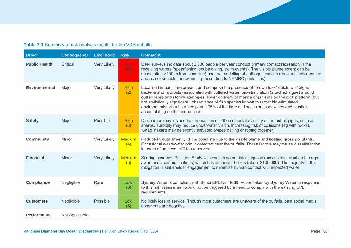
Vaucluse Diamond Bay Ocean Discharges | Pollution Study Report (PRP 305) Page | 66
Table 7-1 Summary of risk analysis results for the VDB outfalls
Driver Consequence Likelihood Risk Comment
Public Health Critical Very Likely Very high (1)
User surveys indicate about 2,000 people per year conduct primary contact recreation in the receiving waters (spearfishing, scuba diving, swim events). The visible plume extent can be substantial (>100 m from coastline) and the modelling of pathogen indicator bacteria indicates the area is not suitable for swimming (according to NHMRC guidelines).
Environmental Major Very Likely High (2)
Localised impacts are present and comprise the presence of “brown fuzz” (mixture of algae, bacteria and hydroids) associated with polluted water, bio-stimulation (attached algae) around outfall pipes and stormwater pipes, lower diversity of marine organisms on the rock platform (but not statistically significant), observance of fish species known to target bio-stimulated environments, visual surface plume 75% of the time and solids such as wipes and plastics accumulating on the ocean floor.
Safety Major Possible High (3)
Discharges may include hazardous items in the immediate vicinity of the outfall pipes, such as sharps. Turbidity may reduce underwater vision, increasing risk of collisions (eg with rocks). ‘Snag’ hazard may be slightly elevated (wipes balling or roping together).
Community Minor Very Likely Medium(4)
Reduced visual amenity of the coastline due to the visible plume and floating gross pollutants. Occasional wastewater odour detected near the outfalls. These factors may cause dissatisfaction in users of adjacent cliff top reserves.
Financial Minor Very Likely Medium(5)
Scoring assumes Pollution Study will result in some risk mitigation (access minimisation through awareness communications) which has associated costs (about $100,000). The majority of this mitigation is stakeholder engagement to minimise human contact with impacted water.
Compliance Negligible Rare Low (6)
Sydney Water is compliant with Bondi EPL No. 1688. Action taken by Sydney Water in response to this risk assessment would not be triggered by a need to comply with the existing EPL requirements.
Customers Negligible Possible Low (6)
No likely loss of service. Though most customers are unaware of the outfalls, past social media comments are negative.
Performance Not Applicable
Vaucluse Diamond Bay Ocean Discharges | Pollution Study Report (PRP 305) Page | 67
7.4 Risk evaluation
The risk evaluation stage involves assessing the problem formulation and risk analysis results, to provide information needed for decision-making and risk management (VIC EPA 2009). It involves determining whether the risks identified, and their magnitude, are acceptable, tolerable, or require treatment.
The highest risk identified related to the use of the receiving waters for primary contact recreation in the areas immediately adjacent to the outfalls, which presents a risk to public health. In line with Sydney Water’s corporate risk management process, a risk of ‘very high’ to public health has high priority for attention, and requires immediate action. Initial assessment of public health risk for those with primary contact with the most contaminated waters may indicate significant risk of high levels of illness transmission. As such, the Project Team immediately started informing internal stakeholders of the findings to determine next steps.
It was apparent from the stakeholder engagement process that awareness about the outfalls is poor in some sections of the community. Some people who were already aware of the outfalls had misconceptions around their function, attributing them to stormwater outlets or wastewater overflow points. While some people are aware that the outfalls discharge wastewater, a number of people commented that they believe the discharges are treated to some extent. As soon as Sydney Water learned people were accessing the area, NSW Health was informed. The Project Team worked with NSW Health to develop messages for a fact sheet, which was distributed to user groups in late December 2016. This fact sheet recommended users avoid the area around the outfalls.
While Sydney Water has already taken action to inform user groups about the outfalls, further action is being explored. As such, Sydney Water is exploring how to increase public awareness about the outfalls and associated risk, to ensure people can make informed, voluntary decisions regarding recreational use of the receiving waters.
It should also be noted that the Sydney Water corporate risk matrix is very conservative regarding potential risks to public health, because it is also applied to assess risks related to drinking water.
Risks to the aquatic ecosystem values of the waterway were ranked as ‘high’ during the risk assessment process, for the areas immediately adjacent to the outfalls. This risk level also triggers a response under the Sydney Water corporate risk management process. As further discussed in Chapter 8, while there are several gaps in knowledge regarding the actual impact the VDB outfalls are having on the receiving environment, there is a consensus in the literature that some impact is occurring. Determining the extent of this impact would require addressing some of the identified gaps in knowledge.
7.4.1 Peer review findings
The independent peer review conducted by Dr Dan Deere confirmed that, while conservative, the risk assessment approach adopted by Sydney Water was appropriate, the supportive evidence

Vaucluse Diamond Bay Ocean Discharges | Pollution Study Report (PRP 305) Page | 68
used was adequate, and that the conclusions drawn were valid. The peer review report is provided in Appendix K.
The peer reviewer considered the risk ratings to be conservative (ie overestimating risk), due to the inability of the Sydney Water corporate risk matrix to adequately discount the relatively small scale of the outfalls and the voluntary nature of human exposure.
As noted above, the risk matrix is very conservative regarding potential risks to public health, due to its use in assessing risks to drinking water. In recreational water environments, only a limited number of people would be exposed intermittently to water quality risks. This is in contrast to the large scale of impacts that could result from drinking water quality issues. In addition, those exposed to recreational water quality risks are more likely to be healthy and resilient, as associated activities are usually highly physical. By contrast, drinking water risks can affect a wide spectrum of the population, including vulnerable persons like the very young, the elderly, or those with illnesses.
The ‘high’ risk rating for the environment is the result of the time potentially required to reverse the impacts, which was considered to be one to ten years. The time criterion does not allow for consideration of the relatively localised scale of potential impacts.
There was one discrepancy noted in the peer review report relating to the risk score assigned to safety. The reviewer considered a rating of ‘high’ to be more appropriate to classify the safety risks of the outfalls. This related to potential public safety risks associated with sharps being disposed of via the wastewater system and subsequently discharged into the receiving waters at VDB. The peer reviewer identified two main risks in relation to sharps. The first is the potential to spread pathogens between bloodstreams. There is a low likelihood of this occurring since pathogens would not persist for long periods in wastewater on the sharp objects themselves. The other risk is that sharps of all kinds (including but not limited to needles) present in wastewater would present a risk of skin puncture. Skin punctures in the presence of wastewater, stormwater and marine environments are, like any cuts, a potential route of infection. Following the peer review, Sydney Water reassessed the risk analysis scoring, and agreed that the score for safety should be increased to ‘high’. While the change in rating has been documented, it does not alter the outcome of the risk assessment, as actions taken to address public health risks would inevitably manage safety risks too.
The peer review report included considerations around the potential for risks to change in the future, and the importance of assessing this while making long-term planning decisions. Increased risk in the future was considered likely for public health and environment.

Vaucluse Diamond Bay Ocean Discharges | Pollution Study Report (PRP 305) Page | 69
8 Limitations and gaps in knowledge
Gaps in knowledge are sources of uncertainty that may limit the ability to adequately assess risk (VIC EPA 2009). While undertaking this study, it became apparent that there are many gaps in knowledge that may affect our understanding of the risks posed by the VDB outfalls.
When beginning the study, the main sources of uncertainty were around the extent of impacts from these wastewater discharges, the effect of these discharges on the marine environment, and understanding how the public interacts with the receiving environment. This uncertainty was targeted through pilot modelling wastewater dispersion in the receiving waters (section 5.4.3), engaging with stakeholders and potential user groups (Chapter 4), and carrying out an extensive review of existing literature.
This has led to an increased understanding of the waterway values for the receiving environment, especially relating to recreational use of waters. However, there were a number of uncertainties and limitations associated with the methods used in this study, requiring assumptions to be made when interpreting the results. In addition, the knowledge gained in turn created additional questions, which identified current gaps that can limit our understanding of how these outfalls may impact the waterway values.
Table 8-1 provides a summary of the gaps in knowledge identified during this study and, where relevant, details about the limitations presented and assumptions made. Some of the gaps in knowledge identified could be addressed by carrying out additional studies. While it is considered unlikely that additional studies would reduce the risk ratings determined during the risk assessment, gathering further information may reduce the uncertainty around the spatial and temporal extent of human health and environment impacts from the outfalls. This would enable an analysis of risk at different spatial and temporal scales, and provide an increased understanding of the impacts of these wastewater discharges.

Vaucluse Diamond Bay Ocean Discharges | Pollution Study Report (PRP 305) Page | 70
Table 8-1 Current knowledge gaps identified and assumptions applied during this study, relating to the VDB outfalls
Aspect Gaps in knowledge Assumptions and comments
Receiving water modelling (pilot model) of the potential area of impact
Predictions from pilot modelling should be recognised as having significant uncertainty due to gaps in available data (eg local bathymetry data, measurement and verification of local nearshore currents, and local wind data)
The pilot model was fit for purpose, but only provides an approximate indication of the area potentially impacted by the wastewater discharges. The methodology applied during the modelling, and associated limitations, are outline din the report in Appendix F. Despite limitations and uncertainty, the peer review report noted that predicted zones of impact identified in the pilot modelling seem reasonable (Appendix G).
The model peer review recommended localised high resolution LIDAR data, supplemented by traditional based hydrosurvey for the immediate (<500 m) zones about each outfall. Near shore wave driven current could be assessed using dye tracers and collecting. Local current data from current meters. This additional information would be required to verify and calibrate the model
Area of potential impact of the wastewater discharges
No water quality monitoring in the receiving waters of the VDB outfall has been undertaken since the EMU 1990 bacteriological water quality study.
Despite the lack of water quality monitoring, the conservative likelihood of pollution in the immediate receiving waters is very high, as the pollution source is a continual discharge, and the discharge is untreated (section 3.3.5). Direct discharge of untreated wastewater into recreational areas presents a risk to public health (NHMRC 2008). There is uncertainty around the level of pollution with distance from the outfall. The pilot modelling presents a conservative estimate of this, but has not been validated with field data.
The peer review process confirmed that sophisticated modelling is not necessary to complete the risk assessment, as there is no question about the presence of untreated wastewater near to the discharges, and the subsequent risk of human exposures and environmental impacts of those discharges. However, additional data would be required to accurately quantify the level of risk on different spatial and temporal scales.

Vaucluse Diamond Bay Ocean Discharges | Pollution Study Report (PRP 305) Page | 71
Aspect Gaps in knowledge Assumptions and comments
Public health Stakeholder engagement for this study confirms some people are using the receiving environment of the outfalls for recreation. However, specific information about numbers of recreation users and the split of activities between each outfall is not available.
The user group survey had a relatively small sample size and the information collected was largely qualitative. The extent of stakeholder engagement was limited by the short timeframe over which this study was conducted. Further studies could be done to better understand the number of people conducting activities in this area that result in exposure to wastewater discharges.
Despite this, there is anecdotal evidence to suggest up to 2,000 people per year are conducting primary contact recreation in the receiving waters of the VDB outfalls. This includes within the potential impact area identified during the wastewater modelling (section 5.4.3), which represents an area not recommended for swimming in line with the NHMRC 2008 guidelines.
Based on this, it is reasonable to conclude that the risk to public health in the area immediately adjacent to the outfalls is ‘very high’. The peer review findings support the conclusions of the risk assessment, citing their validity given the evidence considered.
There is uncertainty around the extent of health risks from human exposure to the receiving waters of the outfalls.
Results of the pilot modelling provide a conservative estimate of the area adjacent to the outfalls that may be unsuitable for swimming, in accordance with the NHMRC 2008 guidelines (see Figure 5-6 and Table 5-6). The highest risk exists in the areas immediately adjacent to the outfalls, and decreases with distance from the outfalls. Due to limitations of the modelling, including lack of calibration and validation, there is uncertainty as to the extent of the areas unsuitable for swimming in the receiving waters.
The NHMRC 2008 guidelines suggest that the risk associated with human exposure to faecally polluted recreational waters can be assessed directly via epidemiological studies or indirectly through quantitative microbial risk assessment (QMRA). Neither of these types of studies have been carried out for the VDB outfalls. Further studies may provide clarity around the spatial and temporal extents, and variability, of impacts from the outfalls. This would help strengthen an understanding of the potential risks to human health.

Vaucluse Diamond Bay Ocean Discharges | Pollution Study Report (PRP 305) Page | 72
Aspect Gaps in knowledge Assumptions and comments
Aquatic ecosystem health
Direct and indirect impacts on organisms as a result of the wastewater discharges have not been specifically or comprehensively tested.
Limited monitoring has been undertaken on the marine environment of the VDB receiving waters, the most recent undertaken about 15 years ago (EMU 1990; EP Consulting 2002). Past studies have cited the difficulty in accessing the receiving waters of the outfalls, resulting in limited sampling. Furthermore, there has been no statistical analysis of data collected. The study undertaken for Sydney Water in 1990 (EMU 1990) was critiqued due to limitations of the methodology and the inconclusive nature of the results presented (The Ecology Lab 1990).
Despite these limitations, the results of the studies, combined with evidence from the scientific literature, support the conclusion that aquatic ecosystem impacts are likely. Importantly, the risk assessment peer review found that there was sufficient evidence to inform the semi-quantitative environmental risk assessment conducted as part of this study.
No assessment of algal or cyanobacterial quality has been undertaken in the receiving waters adjacent to the outfalls.
Marine algal toxins can result in adverse effects to human health through dermal contact and inhalation, as well as ingestion (NHMRC 2008). These toxins can bioaccumulate in shellfish and fish that are subsequently eaten by humans.
An assessment of the potential impacts of cyanobacteria and marine algae in the receiving waters of the VDB outfalls was not possible due to a lack of information available.

Vaucluse Diamond Bay Ocean Discharges | Pollution Study Report (PRP 305) Page | 73
Aspect Gaps in knowledge Assumptions and comments
Lack of pre outfall information about the receiving environment makes it difficult to draw conclusions about the potential impacts of the discharges.
There is no baseline data available for the marine environment adjacent to the VDB outfalls, as the outfalls have been in operation for around 100 years. This makes it difficult to assess any changes to the receiving environment that are the result of the wastewater discharges.
In lieu of this information, the condition of the receiving environment could be assessed against comparable reference sites that are not affected by wastewater discharges. These sites should have similar physical and hydrodynamic characteristics. This could provide an indication of what the marine ecosystem adjacent to the VDB outfalls should look like without impacts from the wastewater discharges.
However, there are limitations associated with drawing comparisons between VDB and scientific studies. There exists few substantive studies for the area, and that other studies are difficult to draw comparisons from due to differences in treatment levels, discharge volumes and characteristics (ie catchments), discharge location (mostly offshore), receiving environment (eg bathymetry), etc).
Gross pollutants Gross pollutants in the VDB wastewater systems are not monitored; therefore potential impacts from gross pollutants on the receiving environment are largely unknown. While there is evidence of gross pollutants in the waters adjacent to the outfalls, from previous studies and survey of user groups (sections 5.4.2 and 6.2), the types, quantity, and fates of these gross pollutants have not been measured.

Vaucluse Diamond Bay Ocean Discharges | Pollution Study Report (PRP 305) Page | 74
Aspect Gaps in knowledge Assumptions and comments
Aquatic food There is currently little data on the accumulation of pollutants in marine organisms in the receiving waters of the VDB outfalls.
Limited studies have been undertaken on the accumulation of contaminants in organisms inhabiting the receiving waters of the VDB outfalls (Chapter 6). There may be a higher risk associated with certain types of organisms due to the way contaminants accumulate in their tissues. For example, accumulation of contaminants may be lower in organisms that are highly mobile (such as certain fish), as opposed to sessile or sedentary organisms (such as abalone or crayfish).
An important pathway to consider for the exposure of chemicals to humans from recreational waters is via consumption of seafood (NHMRC 2008). Certain chemicals are known to bioaccumulate in marine organisms. Therefore, despite relatively small concentrations of chemicals in the waters themselves, seafood caught from the area adjacent to the outfalls may contain a higher concentration of these chemicals. Research shows accumulation of chemicals is more likely in the organs (eg liver) than in the more commonly consumed muscle (flesh) of these animals (Scanes 1996). Further studies on seafood bioaccumulation in the vicinity of the outfalls would be required to adequately assess this risk.
Stakeholder engagement for this study confirms some people are consuming fish and other marine organisms caught from the receiving waters adjacent to the VDB outfalls. However, specific information about the quantity and types of organisms being consumed is not known.
As discussed above, there were some limitations to the user group survey conducted as part of this study. Further studies could be undertaken to better understand the quantity and types of marine animals being caught from the area adjacent to the VDB outfalls and consumed.
There is also little information available on how animals caught are prepared before being eaten, for example if and how they are cooked. Preparation methods may also affect the risk associated with consuming animals caught from areas near wastewater outfalls. The NSW Food Authority website recommends that seafood caught for recreation should always be thoroughly cooked before eaten, and never eaten raw.
Due to these uncertainties, Sydney Water would apply messaging recommending that no aquatic organisms be collected and consumed from the potential impact area (precautionary).

Vaucluse Diamond Bay Ocean Discharges | Pollution Study Report (PRP 305) Page | 75
Aspect Gaps in knowledge Assumptions and comments
Sediment contamination
There has been no sediment sampling and analysis undertaken to determine the presence (or otherwise) of pollutants in bottom sediments of the receiving waters.
Many contaminants have low solubility in water and may accumulate in sediments (NHMRC 2008). This is a concern if the sediment is disturbed and resuspended or if recreational users are in close contact with the sediment.
Sediment contamination in Sydney Harbour has been studied extensively, but there has been no information gathered around contamination of bottom sediments in the area adjacent to the VDB wastewater discharges.
Heritage Potential impacts of the wastewater discharges on nearby shipwrecks are unknown.
Three shipwreck sites are located near the outfalls (section 5.4.3), one just outside the modelled area of potential impact (Dunbar). There is no apparent literature available on the potential impacts of wastewater discharges on shipwrecks. As such, it is unclear how the heritage significance of shipwrecks in the vicinity of the VDB outfalls may be affected by the wastewater discharges. Impacts from the outfalls are more likely to relate to human use of these sites for recreation (diving, fishing). Shipwrecks attract divers because they serve as artificial reefs, attracting marine life, and can have historical or archaeological significance.

Vaucluse Diamond Bay Ocean Discharges | Pollution Study Report (PRP 305) Page | 76
Aspect Gaps in knowledge Assumptions and comments
Risk assessment Lack of quantitative data meant a largely qualitative risk assessment process was adopted. As highlighted in the VIC EPA 2009 guidelines, there are issues of potential bias in qualitative estimates.
The risk assessment process relied closely on a desktop study of existing data (including carrying out pilot wastewater modelling), literature, and guidelines, as well as predominately anecdotal evidence from the stakeholder engagement process, to assess the level of risk associated with the outfalls. In addition, the risk assessment and pilot modelling were peer reviewed by industry experts.
Findings of the risk assessment peer review acknowledged that there is sufficient evidence available to complete a semi-quantitative screening level risk assessment using the Sydney Water corporate risk matrix. Assessment of human health risks also relied on the modelling results, presented in terms of the NHMRC 2008 guidelines.
The peer review findings also confirmed that undertaking further monitoring would not necessarily alter the outcomes of the risk assessment, particularly in relation to public health. This is especially valid for the immediate area around the outfalls, where there is likely some level of impact. A more detailed risk assessment is needed only when the additional information will improve our understanding of the threat and what can be done to manage it (MEMA 2015).
The risk analysis process was highly collaborative, involving qualified subject-matter experts from across Sydney Water (including from the areas of environment, health, community relations, policy, and risk). This reduces the potential for bias usually associated with qualitative risk assessment.
Spatial scale of impacts from the VDB outfalls has not been verified.
As discussed above, there has been limited analysis of the receiving environment adjacent to the VDB outfalls. As such, the spatial extent of impacts has not been verified. Far-field impacts (if any) are particularly poorly understood.
Assessment of impacts relies upon the results of pilot wastewater modelling, analysis of influent monitoring data, and a review of the limited information available from past studies.
The peer review process suggested that sophisticated modelling is not necessary for the purpose of completing this risk assessment, as there is currently no question about the presence of untreated wastewater near to the discharges and the risk of human exposures and environmental impacts of those discharges. Risks to human health beyond this area are less certain.
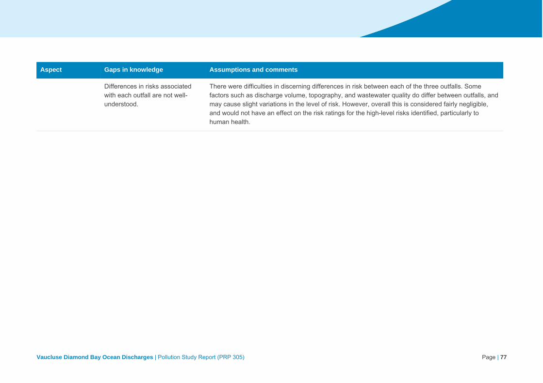
Vaucluse Diamond Bay Ocean Discharges | Pollution Study Report (PRP 305) Page | 77
Aspect Gaps in knowledge Assumptions and comments
Differences in risks associated with each outfall are not well-understood.
There were difficulties in discerning differences in risk between each of the three outfalls. Some factors such as discharge volume, topography, and wastewater quality do differ between outfalls, and may cause slight variations in the level of risk. However, overall this is considered fairly negligible, and would not have an effect on the risk ratings for the high-level risks identified, particularly to human health.

Vaucluse Diamond Bay Ocean Discharges | Pollution Study Report (PRP 305) Page | 78
9 Conclusion
The EPA issued Sydney Water with a PRP (PRP 305) requiring an assessment of the level of risk to the environment and public health posed by the three cliff face ocean outfalls at Vaucluse and Diamond Bay (PRP 305). The EPA also sought the identification of any critical knowledge gaps relevant to understanding these risks.
The risk assessment process followed Sydney Water’s corporate risk management framework and the NHMRC 2008 guidelines. The highest risk identified related to the use of the receiving waters immediately adjacent to the outfalls for primary contact recreation. The risk assessment shows that this presents a ‘very high’ risk to public health. Risk to users would decrease with distance from the outfalls. The environmental risk associated with the outfalls was ranked as ‘high’, due to the continual operation of the outfalls and the estimated one to ten year timescale required for reversibility of impacts. While the potential for environmental impacts is expected to decrease with distance from the outfalls, the spatial extent of impacts cannot be reliably predicted.
Many gaps in knowledge were identified, including limited data available on impacts to the receiving environment, a lack of validated or sophisticated dispersion modelling, and limited information about human use of the receiving waters. However, there is sufficient evidence to support the risk assessment outcomes, despite the identified knowledge gaps.
An independent peer review of the risk assessment confirmed that, while conservative, the approach adopted by Sydney Water was appropriate, the supportive evidence used was adequate, and that the conclusions drawn were valid.

Vaucluse Diamond Bay Ocean Discharges | Pollution Study Report (PRP 305) Page | 79
10 References
Ajani PA, Roberts DE, Smith AK, and Krogh M 1999, ‘The Effect of Sewage on Two Bioindicators at Port Stephens, New South Wales, Australia’, Ecotoxicology, vol. 8, pp. 253-267.
ANZECC 2000, Australian and New Zealand Guidelines for Fresh and Marine Water Quality, Australian and New Zealand Environment and Conservation Council, Agriculture and Resource Management Council of Australia and New Zealand.
FSANZ 2002, Food Standards Code, Food Standards Australia New Zealand, Canberra/ Wellington.
ARMCANZ and ANZECC 1997, Australian Guidelines for Sewerage Systems, Effluent Management, Australian and New Zealand Environment and Conservation Council, Agriculture and Resource Management Council of Australia and New Zealand.
AWT 2001, Preliminary Review of Environmental Factors – Vaucluse Diamond Bay Sewerage Diversion Scheme, for Sydney Water, Australian Water Technologies, Sydney.
Campbell AH, Marzinelli EM, Verges A, Coleman MA, and Steinberg PD 2014, ‘Towards Restoration of Missing Underwater Forests’, PLoS ONE, vol. 9, no. 1, e84106.
Coleman, ME, Kelaher, BP, Steinberg, PD and Millar, AJK 2008, ‘Absence of a large brown macroalga on urbanized rocky reefs around Sydney, Australia, and evidence for historical decline’, Journal of Phycology, vol 44, pp. 987-901.
Connell Wagner 1990, Vaucluse Diamond Bay Sewerage Outfalls: Sewage Management Options Review of Environmental Factors, for Sydney Water, Connell Wagner Pty Ltd, Sydney.
DEC 2005, Marine Water Quality Objectives for NSW Ocean Waters, Sydney Metropolitan and Hawkesbury-Nepean, Department of Environment and Conservation (NSW), Sydney.
DEC 2006, Managing Urban Stormwater – Harvesting and Reuse, Department of Environment and Conservation (NSW), Sydney.
DoEE 2017, Draft Threat Abatement Plan for the impacts of marine debris on vertebrate marine life, Department of Environment and Energy, Canberra.
DPI 2015, Sydney offshore artificial reef, Environmental Monitoring Report – Final Report, April 2015, NSW Department of Primary Industries, Sydney.
DPI 2014, Sydney Offshore Artificial Reef (EPBC 2008/4176 – SD2008/882), Annual Environmental Monitoring Report (Year 2), NSW Department of Primary Industries, Sydney.
DPI 2012, Sydney Offshore Artificial Reef (EPBC 2008/4176 – SD2008/882), Annual Environmental Monitoring Report, October 2011-October 2012, NSW Department of Primary Industries, Sydney.
EMU 1990, An environmental survey around the Diamond Bay and Vaucluse ocean outfalls, Sydney Water, Sydney.

Vaucluse Diamond Bay Ocean Discharges | Pollution Study Report (PRP 305) Page | 80
EP Consulting 2002, DRAFT Marine Environment Existing Conditions Assessment – Vaucluse and Diamond Bay Ocean Outfalls, for Sydney Water, EP Consulting Group Pty Ltd, Sydney.
Evans & Peck 2012, Vaucluse Diamond Bay Wastewater Improvement Strategy - Final Report, for Sydney Water, Evans & Peck Pty Ltd, Sydney.
GHD 2008, Report for Vaucluse Sewerage System Investigation Vaucluse, for Sydney Water, for Sydney Water, GHD Australia, Sydney.
Fraschetti S, Gambi C, Giangrande A, Musco L, Terlizzi A, and Danovaro R 2006, ‘Structural and functional response of meiofauna rocky assemblages to sewage pollution’, Marine Pollution Bulletin, vol. 52, pp. 540-548.
Hughes KA 2003, ‘Aerial dispersal and survival of sewage-derived faecal coliforms in Antarctica’, Atmospheric Environment, vol. 37, pp. 3147-3155.
Jordan A, Davies P, Ingleton T, Foulsham E, Neilson J and Pritchard T 2009, Seabed habitat mapping of the continental shelf of NSW, NSW Department of Environment, Climate Change and Water, Sydney.
Koop K and Hutchings P 1996, ‘Editorial: Disposal of Sewage to the Ocean - a Sustainable Solution?’, Marine Pollution Bulletin, vol. 33, no. 7-12, pp. 121-123.
Lincoln-Smith MP 1985, ‘The development and application of visual survey procedures for fish communities on shallow rocky reefs’, MSc thesis, University of Sydney, 185 pp.
Lincoln-Smith MP 1989, ‘Improving multispecies rocky reef fish census by counting different groups of species using different procedures’, Environmental Biology of Fishes, vol. 26, no. 1, pp. 29-37.
Manidis Roberts 2003, Vaucluse, Diamond Bay & Rose Bay Sewerage Improvements – Draft Planning Report – A strategic review of project planning, for Sydney Water, Manidis Roberts Consultants, Sydney.
Manidis Roberts 2002, Preliminary Community Consultation Report - Vaucluse, Diamond Bay and Rose Bay Sewerage Improvements, for Sydney Water, Manidis Roberts Consultants, Sydney.
MEMA 2015, Threat and Risk Assessment Framework for the NSW Marine Estate, NSW Marine Estate Management Authority, Department of Primary Industries, Nelson Bay.
Metcalf and Eddy Inc 1991, Wastewater Engineering Treatment, Disposal, and Reuse (3rd Ed), MrGraw-Hill, Sydney.
NHMRC 2011, Australian Drinking Water Guidelines 6, Version 3.3, National Health and Medical Research Council, Canberra.
NHMRC 2008, Guidelines for Managing Risks in Recreational Waters, National Health and Medical Research Council, Canberra.
NSW Food Authority 2015, NSW Shellfish Industry Manual, NSW Food Authority, Sydney.

Vaucluse Diamond Bay Ocean Discharges | Pollution Study Report (PRP 305) Page | 81
OEH 2016, State of the Beaches Report 2015-2016, Office of Environment and Heritage NSW, Sydney.
Otway NM, Gray CA, Craig JR, McVea TA, and Ling JE 1996, ‘Assessing the Impacts of Deepwater Sewage Outfalls on Spatially- and Temporally-Variable Marine Communities’, Marine Environmental Research, vol. 41, no. 1, pp 45-71.
Petrenko AA, Jones BH, Dickey TD, LeHaitre M, and Moore C 1997, ‘Effects of a sewage plume on the biology, optical characteristics, and particle size distributions of coastal waters’, Journal of Geophysical Research, vol. 102, no. 11, pp. 25,061-25,071.
Ridgway K and Hill K 2009, ‘East Australian Current’, In A Marine Climate Change Impacts and Adaptation Report Card for Australia 2012 (Poloczanska ES, Hobday AJ and Richardson AJ (eds)).
Roberts DE 1984, ‘Biological survey of Potter Point Sewage Outfall, Cronulla, NSW’, State Pollution Control Commission internal paper, SPCC, Sydney.
Roberts DE and Scanes P 1999, ‘PR Spatial Patterns in the Macrobenthic Assemblages Inhabiting Kelp (Ecklonia radiata) Forests Exposed to Sewage Effluent’, Australasian Journal of Ecotoxicology, vol. 5, pp. 89-102.
Scanes P 1996, ‘‘Oyster Watch': Monitoring Trace Metal and Organochlorine Concentrations in Sydney's Coastal Waters’, Marine Pollution Bulletin, vol. 33, no. 7-12, pp. 226-238.
Scanes P and Philip N 1995, ‘Environmental Impact of Deepwater Discharge of Sewage off Sydney, NSW, Australia’, Marine Pollution Bulletin, vol. 31, no. 4-12, pp. 343-346.
Sydney Water 2011, Vaucluse Diamond Bay Wastewater Strategy, Strategic Planning Report - July 2011, Sydney Water, Sydney.
Sydney Water 2002a, Project Needs Assessment - Vaucluse, Diamond Bay and Rose Bay Sewerage Improvements, Sydney Water, Sydney.
Sydney Water 2002b, Financial Assessment Report - Vaucluse, Diamond Bay and Rose Bay Sewerage Improvements, Sydney Water, Sydney.
The Ecology Lab 1990, Vaucluse and Diamond Bay Outfalls – Review of Environmental Factors – Marine Ecology, for Sydney Water, The Ecology Lab Pty Ltd, Sydney.
Underwood AJ and Chapman MG 1996, ‘Subtidal Assemblages on Rocky Reefs at a Cliff-face Sewage Outfall (North Head, Sydney, Australia): What Happened When the Outfall was Turned Off?’, Marine Pollution Bulletin, vol. 33, no. 7-12, pp. 293-302.
VIC EPA 2009, Guidelines for risk assessment of wastewater discharges to waterways, VIC Environment Protection Authority, Melbourne.
WHO 2003, Guidelines for safe recreational water environments Volume 1 – Coastal and fresh waters, Geneva.
Wood JE, Roughan M and Tate PM 2013, ‘Annual cycling in wind, temperature and along shore currents on the Sydney shelf’, Coasts and Ports 2013: 21st Australasian Coastal and Ocean

Vaucluse Diamond Bay Ocean Discharges | Pollution Study Report (PRP 305) Page | 82
Engineering Conference and the 14th Australasian Port and Harbour Conference. Engineers Australia, 2013.

Vaucluse Diamond Bay Ocean Discharges | Pollution Study Report (PRP 305) Page | 83
11 Appendices

Vaucluse Diamond Bay Ocean Discharges | Pollution Study Report (PRP 305) Page | 84
Appendix A. PRP 305 for EPL No. 1688

Vaucluse Diamond Bay Ocean Discharges | Pollution Study Report (PRP 305) Page | 85
Appendix B. Bondi Wastewater Treatment System EPL (No. 1688)

Vaucluse Diamond Bay Ocean Discharges | Pollution Study Report (PRP 305) Page | 86
Appendix C. VDB Ocean Discharges Project Plan for Pollution Study, August 2016

Vaucluse Diamond Bay Ocean Discharges | Pollution Study Report (PRP 305) Page | 87
Appendix D. Vaucluse Diamond Bay Pollution Study Stakeholder Engagement Outcomes Report, February 2017

Vaucluse Diamond Bay Ocean Discharges | Pollution Study Report (PRP 305) Page | 88
Appendix E. Influent monitoring data for Vaucluse and Diamond Bay Outfalls

Vaucluse Diamond Bay Ocean Discharges | Pollution Study Report (PRP 305) Page | 89
Appendix F. Pilot Modelling of Impacts of Discharges from Vaucluse and Diamond Bay Outfalls

Vaucluse Diamond Bay Ocean Discharges | Pollution Study Report (PRP 305) Page | 90
Appendix G. Review of Pilot Modelling – Vaucluse and Diamond Bay Plume Study

Vaucluse Diamond Bay Ocean Discharges | Pollution Study Report (PRP 305) Page | 91
Appendix H. Sydney Water’s corporate risk matrix

Vaucluse Diamond Bay Ocean Discharges | Pollution Study Report (PRP 305) Page | 92
Appendix I. Bath-to-Beach risk pathway mapping for VDB outfalls

Vaucluse Diamond Bay Ocean Discharges | Pollution Study Report (PRP 305) Page | 93
Appendix J. VDB PRP environment and public health risk assessment

Vaucluse Diamond Bay Ocean Discharges | Pollution Study Report (PRP 305) Page | 94
Appendix K. Risk assessment peer review report, February 2017

SW 2017/00000592 © Sydney Water. All rights reserved.
![LCD-77-305 Department of Defense Air Pollution …DOCUMENT RESUME 02793 - [A2033111] Department of Defense Air Pollution Control: Progress and Delays. LCD-77-305; B-166506. Jujy 18,](https://img.dokumen.tips/doc/110x75/5fe07709dc806f48a83beb0c/lcd-77-305-department-of-defense-air-pollution-document-resume-02793-a2033111.jpg)