Embed Size (px)
Citation preview

Point Thomson Export Pipeline
Right-of-Way Lease, ADL 418975
Commissioner’s Analysis and Proposed Decision
Alaska Department of Natural Resources
State Pipeline Coordinator’s Office
411 West 4th
Avenue, Suite 2
Anchorage, AK 99501
September 19, 2012

Point Thomson Export Pipeline
Commissioner’s Analysis and Proposed Decision September 19, 2012
i
Purpose of Analysis and Proposed Decision
The Right-of-Way Leasing Act (Alaska Statute 38.35) sets forth the procedures governing an
application for an oil or gas pipeline right-of-way across State lands. Under this Act, the
Commissioner of the Department of Natural Resources is granted all powers necessary to lease
State land for pipeline right-of-way purposes. In leasing land for pipeline right-of-way purposes,
the Commissioner must make a written finding that the applicant is fit, willing, and able to
perform the transportation or other acts proposed in a manner that will be required by the present
or future public interest. Additionally, prior to granting a right-of-way lease, the Commissioner
is required to prepare an analysis of the application.
The following document is the Commissioner’s Analysis and Proposed Decision for the
application for a right-of-way lease across State lands for the Point Thomson Export Pipeline that
was submitted by Point Thomson Export Pipeline LLC on August 4, 2010. The pipeline is
proposed to cross state lands from Point Thomson to Badami Central Facilities Pad. The public
comment period for this Analysis and Proposed Decision is September 20 through 5:00pm
October 30, 2012. Written comments may be faxed to (907) 269-6880 or submitted by U.S. Mail
or in person to:
Alaska Department of Natural Resources
State Pipeline Coordinator’s Office
411 West 4th
Avenue, Suite 2
Anchorage, AK 99501
Public hearings for the right-of-way lease application and Commissioner’s Analysis and
Proposed Decision have been scheduled at the following locations. Comments will be accepted
verbally and/or in writing at the hearings.
Barrow Inupiat Heritage Center: October 23, 2012
Kaktovik Community Center: October 24, 2012
Nuiqsut Kisik Community Center: October 25, 2012
Fairbanks Westmark Hotel: October 29, 2012

Point Thomson Export Pipeline
Commissioner’s Analysis and Proposed Decision September 19, 2012
ii
Contents
Purpose of Analysis and Proposed Decision ................................................................................... i
I. Introduction ................................................................................................................................. 1
Nature of the Request .................................................................................................................. 1
Applicant ..................................................................................................................................... 1
Project Description ...................................................................................................................... 1
Right-of-Way Location ............................................................................................................... 4
General Export Pipeline Design .................................................................................................. 4
II. Administrative Actions .............................................................................................................. 6
State Pipeline Coordinator’s Office ............................................................................................ 6
AS 38.35 Right-of-Way Lease Development and Purpose ......................................................... 7
Public Notice of Application (AS 38.35.070) ............................................................................. 8
Administrative Record ................................................................................................................ 9
SPCO Participation in Federal NEPA Process ............................................................................ 9
Public Hearings on Commissioner’s Analysis and Proposed Decision ...................................... 9
III. Land Status of Proposed Leasehold ........................................................................................ 10
Title ........................................................................................................................................... 10
Classification ............................................................................................................................. 10
Mineral Order ............................................................................................................................ 11
Third Party Interests .................................................................................................................. 11
Access ........................................................................................................................................ 11
Easements .................................................................................................................................. 12
Access to Navigable and Public Waters .................................................................................... 12
IV. Fish, Wildlife, and Biotic Resources ...................................................................................... 12
Fish ............................................................................................................................................ 12
Wildlife ...................................................................................................................................... 13
Birds .......................................................................................................................................... 15
Cover Types and Vegetation ..................................................................................................... 16
V. North Slope Borough and Adjacent Communities .................................................................. 19
Introduction ............................................................................................................................... 19
Recreation and Tourism ............................................................................................................ 19
Sport Fishing and Hunting ........................................................................................................ 20
Cultural Resources .................................................................................................................... 20
Kaktovik .................................................................................................................................... 21
Community Overview ........................................................................................................... 21
Subsistence Activities ............................................................................................................ 21
Nuiqsut ...................................................................................................................................... 23
Community Overview ........................................................................................................... 23
Subsistence Activities ............................................................................................................ 24
Prudhoe Bay .............................................................................................................................. 25

Point Thomson Export Pipeline
Commissioner’s Analysis and Proposed Decision September 19, 2012
iii
VI. Technical Capability of the Applicant .................................................................................... 26
Reviewed Documents ................................................................................................................ 26
Background ............................................................................................................................... 26
Codes, Regulations and Standards ............................................................................................ 27
Transported Product (Fluid and Flow) ...................................................................................... 27
Geotechnical .............................................................................................................................. 28
Hydrology and Waterway Crossings ......................................................................................... 28
Pipe Physical Characteristics .................................................................................................... 29
Design Life ................................................................................................................................ 30
VII. Financial Capability of the Applicant ................................................................................... 30
EEHC as the Guarantor ............................................................................................................. 32
EMPCo as the Financier ............................................................................................................ 32
VIII. Analysis of Application and Proposed Right-of-Way ......................................................... 32
Criterion 1. ................................................................................................................................ 33
Criterion 2. ................................................................................................................................ 42
Criterion 3. ................................................................................................................................ 43
Criterion 4. ................................................................................................................................ 51
Criterion 5. ................................................................................................................................ 52
CONCLUSION ............................................................................................................................. 53
COMMISSIONER’S PROPOSED DECISION AND ACTION ................................................. 55
Tables
Table 1. Subsistence Harvest in Kaktovik by Resource, 19921 .................................................... 23
Table 2. Subsistence Harvest in Nuiqsut by Resource, 19931 ...................................................... 25
Table 3: Main drainages................................................................................................................ 28
Table 4: Pipe Characteristics ........................................................................................................ 29
Figures
Figure 1: Pipeline Location Map .................................................................................................... 3
Figure 2: North Slope Community Map ....................................................................................... 18
Figure 3: Relationship of Applicant to ExxonMobil and Affiliates ............................................. 31
Attachments
Attachment A: Draft Right-of-Way Lease and Stipulations
Attachment B: Design Basis
Attachment C: Public Notice of the AS 38.35 Application
Attachment D: Mineral Order
Attachment E: Third Party Interests
Attachment F: Acronyms and Abbreviations
Attachment G: References

Point Thomson Export Pipeline
Commissioner’s Analysis and Proposed Decision September 19, 2012
1
I. Introduction
Nature of the Request
On August 4, 2010, Point Thomson Export Pipeline LLC (PTE Pipeline LLC), a wholly owned
subsidiary of Exxon Mobil Corporation (ExxonMobil), applied to the State of Alaska for a non-
exclusive Alaska Statute (AS) 38.35 Right-of-Way Lease for the purpose of constructing and
operating a 22-mile oil pipeline on the Arctic Coastal Plain. The purpose of the pipeline is to
export oil from the proposed facilities on the Thomson Sand Reservoir to the existing Badami
Pipeline, where the oil would be transported to the Trans-Alaska Pipeline System (TAPS). The
entire proposed pipeline is located on State of Alaska land.
The Department of Natural Resources (DNR) Commissioner (Commissioner) is mandated, in
accordance with AS 38.35.100, to determine whether PTE Pipeline LLC is fit, willing, and able
to perform the transportation or other acts proposed in a manner required by the present or future
public interest. Per AS 38.35.080, the Commissioner must also analyze the proposed action and
proposed lease on state land, including a review of the applicant’s technical and financial
capabilities related to construction and operation of an oil pipeline, as proposed in the project
description and application.
The Commissioner has all powers necessary and proper to implement AS 38.35 and to grant
leases of State land for these purposes. With the exception of signing the Right-of-Way Lease,
the State Pipeline Coordinator’s Office (SPCO) administers these authorities on behalf of the
Commissioner.
Applicant
The applicant, PTE Pipeline LLC, is a newly formed company created specifically for the
purposes of constructing and operating the proposed Point Thomson Export Pipeline (PTEP).
The applicant is a wholly owned subsidiary of ExxonMobil Pipeline Company (EMPCo).
EMPCo would finance the PTEP project. ExxonMobil is the parent company of EMPCo.
Section VII of this document describes the corporate structure in more detail.
Project Description
The proposed Point Thomson Project is located entirely on state land in the North Slope Borough
of Alaska, approximately 60 miles west of Kaktovik, on the coast of Lion Bay. The proposed
PTEP would extend approximately 22 miles from the new field’s Central Production Facility
(CPF) to a point of connection with the existing Badami Sales Oil Pipeline at the Badami Central
Facilities Pad. ExxonMobil proposes to produce gas and hydrocarbon liquids (condensate and

Point Thomson Export Pipeline
Commissioner’s Analysis and Proposed Decision September 19, 2012
2
oil) from the Thomson Sand Reservoir and explore other hydrocarbon resources in the Point
Thomson area. The Point Thomson Project comprises two major components: the Initial
Production System (IPS), which includes development wells, infield gathering lines, processing
facilities, and support infrastructure; and the PTEP.
Discovered in 1977, the Point Thomson field is a high-pressure gas and gas-liquid hydrocarbon
reservoir located approximately 60 miles east of Prudhoe Bay. The Thomson Sand Reservoir
has both onshore and offshore components that would be developed from onshore pads using
long-reach drilling technology. Extracted oil would be shipped to market via the proposed
pipeline (PTEP) to the Badami Pipeline (owned by BP Transportation Alaska Inc. (BPTA))
within the Badami field (operated by Savant Alaska LLC), with ultimate delivery to the TAPS.
The IPS facilities are being developed as a gas-cycling project. Produced gas, water, and liquid
hydrocarbons will be delivered from the wells to the CPF, where the liquid hydrocarbons will be
separated from the production stream and processed to the TAPS sales quality specifications.
The hydrocarbons will then be shipped through PTEP and existing pipeline systems to TAPS
Pump Station 1. The remaining gas will be compressed and re-injected into the Point Thomson
reservoir at the Central Pad. The IPS component of the Point Thomson Project would be
authorized under a lease with the DNR Division of Oil and Gas.
PTEP will be elevated a minimum of seven feet above the tundra surface on vertical and
horizontal support members (VSMs and HSMs). Other PTEP facilities include a small pad near
the Badami Pipeline for a leak-detection and metering skid, and a small pipeline crossing pad
450 feet south of the Badami pad, to allow for ice road crossings. The PTEP construction will be
conducted from ice roads over two winter seasons in 2012/13 and 2013/14. Hydrostatic testing
of the line is proposed to begin in the summer of 2014, with operations scheduled to commence
in 2015. The projected commercial life of the pipeline is 30 years; however, the operational life
of the pipeline is projected to be longer with proper maintenance and operating procedures.
The proposed route is roughly parallel to the coast. Where practical, water crossings have been
avoided; otherwise water crossings are relatively minor and all are above grade. Crossings
above the water will aid in monitoring and inspection. The route is primarily dictated by the
coastal locations of the facilities. The pipeline is a sufficient distance from the coast, in keeping
with other oil and gas development along the Beaufort coast, such as the Northstar and Badami
pipelines. This buffer zone will help protect PTEP from damage associated with coastal
locations in this area, such as ocean erosion, ice ride-up, and accidental ballistics damage from
hunting on the ice near shore.
The Point Thomson Project area is accessible by seasonal ice roads, coastal barging, tundra
travel, and helicopter. No gravel or permanent roads exist near the project area or are proposed
along the PTEP route.
Point Thomson Export Pipeline
Commissioner’s Analysis and Proposed Decision September 19, 2012
3
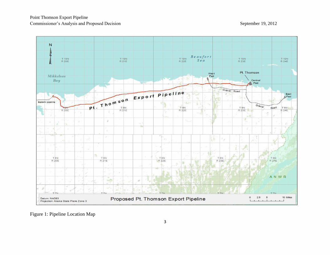
Figure 1: Pipeline Location Map

Point Thomson Export Pipeline
Commissioner’s Analysis and Proposed Decision September 19, 2012
4
Right-of-Way Location
The project is within the Arctic Coastal Plain of the North Slope. The topography of the area is
mainly a smooth plain rising very gradually from the Arctic Ocean to the foothills of the Brooks
Range, 180 meters above sea level. The soils are generally poorly drained in most areas and the
terrain is marked with permafrost-related features (Gallant et al 1995). The Arctic Coastal Plain
has low-to-moderate seismic activity and no active faults (USGS 2012).
PTEP originates at the Point Thomson Central Pad (ADL 47558, 47559, 47570, 47571) and
terminates at the Badami Sales Oil Pipeline, both located on the North Slope of Alaska. The
proposed length for PTEP is approximately 22 miles. The entire length of the proposed pipeline
is on undeveloped State lands that include uplands and submerged lands. A detailed legal
description of both the construction and operations right-of-way (ROW) is available as Exhibit B
of the Right-of-Way Lease (Attachment A).
Construction Right-of-Way: In the August 2010 application, PTE Pipeline LLC requested a
temporary 400-foot wide construction ROW, with 200 feet on either side of the centerline. The
construction ROW covers approximately 1,166 acres of State land.
Operations Right-of-Way: The width of the permanent right-of-way on State lands for operation
of the pipeline will be 100 feet, except at specific locations where a wider right-of-way may be
requested. The final operational ROW is anticipated to encompass 266.5 acres of state land.
General Export Pipeline Design
The Design Basis, Attachment B, describes the proposed pipeline as approximately 22 miles in
length with an actual outside diameter of 12.75-inches. The proposed pipeline would be made
of high-yield carbon steel (API 5L-X65), with a maximum allowable operating pressure of
approximately 2,035 pounds per square inch. The minimum mainline pipeline wall thickness is
0.406 inches, including a corrosion allowance of 0.125 inches. The PTEP wall thickness would
be greater in some areas in close proximity to the coast to prevent leaks in the event of accidental
bullet strikes from coastal hunters. An external coating of fusion-bonded epoxy (FBE) and three
inches of polyurethane foam insulation, with a non-reflective galvanized sheet metal outer jacket,
would be employed on the PTEP, consistent with Arctic construction. The pipeline will be
designed and built to federal pipeline requirements in accordance with the US Code of Federal
Regulations (CFR), Title 49, Part 195.
The pipeline is expected to have an initial throughput of approximately 10,000 barrels per day
(bpd). The pipeline would have the capacity to handle a larger throughput - up to 70,000 bpd -
commensurate with full field development.

Point Thomson Export Pipeline
Commissioner’s Analysis and Proposed Decision September 19, 2012
5
The proposed PTEP will be supported on VSMs its entire length (approximately 2,200 total
VSMs), except for three road crossings where the pipeline would be in casings in the elevated
road bed. The three crossings are near the West Pad, near the existing gravel mine site and
reservoir near Badami, and at a new gavel Rig Crossing Pad 450 feet south of the Badami CPF.
The VSMs would have "Ztype" expansion loops to permit extension and shortening of the
pipeline due to thermal effects. The VSMs will be designed and installed to provide at least
seven feet of clearance between the lowest point of any element being supported by VSMs (e.g.,
pipe insulation, including pipeline attachments such as tuned vibration absorbers, and electrical
communication cables) and the ground surface. The configurations of pipelines on each VSM,
along with the site-specific geotechnical conditions, govern the diameter, wall thickness, and
depth of embedment of the VSMs into the ground. Between the CPF and the junction to the
West Pad, the VSMs are designed to carry both an eight-inch diameter gathering line and the
PTEP. The VSMs between CPF and the West Pad may also support power and fiber optic cables
for the West Pad operations. No power or communications cables would extend to Badami;
rather, microwave communication would be used between Point Thomson and Badami.
The PTEP is proposed to connect to the Badami pipeline through a receiving facility that would
include a pig receiver and leak detection module, and instrumentation and electrical module that
allows each pipeline to be internally inspected by means of pigging. A leak detection metering
skid would be installed on a new small gravel pad (estimated to be less than 0.3 acres) near the
existing Badami flare access road. Additionally, a 40-foot by 40-foot gravel pipeline crossing
pad, located approximately 450 feet south of the existing Badami pad, would be constructed with
a cased pipeline to facilitate the Badami Unit's ongoing development.
The PTEP would be constructed using standard winter North Slope construction practices,
utilizing ice roads and pads. Additional temporary storage and staging lay-down areas on
seasonal ice pads would be required to support pipeline construction; however, space on existing
or new gravel pads at the Point Thomson Central Pad or the Badami Central Facilities Pad may
be used for temporary storage, along with existing staging and storage pads in Deadhorse.
Construction personnel would be housed in a camp on a gravel pad at Badami or on a single
season ice pad in the Badami unit, or may be co-located with facilities construction personnel at
Point Thomson. Warm-up shacks and on-site sanitation facilities would be provided along the
construction ROW. These facilities would be installed prior to and during the pipeline
construction season and removed before spring breakup when the construction is complete.
The applicant plans to conduct maintenance, inspection, emergency response, and repairs using
support facilities on the Point Thomson Central Pad. The CPF would be staffed with full-time
operations and support personnel for operations and maintenance activities. Emergency response
for the PTEP would be staged from the Point Thomson CPF, Badami, Deadhorse, or other
locations as necessary.

Point Thomson Export Pipeline
Commissioner’s Analysis and Proposed Decision September 19, 2012
6
II. Administrative Actions
State Pipeline Coordinator’s Office
The SPCO was created by Administrative Order (AO) 121 in 1990 (superseded by AO 134 in
1993 and supplemented by AO 187 in 2001). The purpose of the SPCO was to have a DNR
office that was dedicated to the work of issuing right-of-way leases under AS 38.35, the Right-
of-Way Leasing Act, and coordinate the State’s efforts related to other federal right-of-way grant
processes.
The SPCO is the state component in the Joint Pipeline Office (JPO). This office, originally
created for a major gas pipeline project, currently coordinates state and federal activities
associated with the TAPS right-of-way and other common carrier pipelines where state and
federal agencies share oversight responsibilities. Multiple state and federal agencies participate
in the JPO:
State Agencies
Department of Commerce, Community and Economic Development
Department of Environmental Conservation
Department of Fish & Game
Department of Health & Social Services
Department of Labor & Workforce Development
Department of Law
Department of Natural Resources
Department of Public Safety
Department of Revenue
Department of Transportation & Public Facilities
Division of Homeland Security & Emergency Management
Regulatory Commission of Alaska
Alaska Oil & Gas Conservation Commission
Federal Agencies
Department of Defense: Army Corps of Engineers
Department of Homeland Security: Coast Guard; Transportation Security Administration
Department of the Interior: Bureau of Land Management/Office of Pipeline Monitoring
Department of Transportation: Pipeline & Hazardous Materials Safety Administration
Environmental Protection Agency

Point Thomson Export Pipeline
Commissioner’s Analysis and Proposed Decision September 19, 2012
7
AS 38.35 Right-of-Way Lease Development and Purpose
The AS 38.35 right-of-way lease is a complex technical and legal document that grants a
revocable interest in state land for the purposes of constructing and operating a common carrier
hydrocarbon pipeline. As part of the effort in preparing this document, the SPCO works closely
with multiple agencies, often from different levels of government, in ensuring that the Lease
fully represents both protection and development of State resources.
AS 38.35 and Alaska Administrative Code (AAC) 11 AAC 80 govern SPCO right-of-way leases
for common carrier pipelines. These statutes and regulations outline the process for issuing
rights-of-way along with the rigorous standards that applicants must meet.
11 AAC 80.005 contains the 59 questions required in applications for right-of-way leases. Upon
receipt and confirmation by the SPCO that the application is complete, the SPCO issues a 60-day
public notice of the application, per AS 38.35.070. At that time, the SPCO begins work on the
Commissioner’s Analysis and Proposed Decision, which includes the “fit, willing, and able
determination,” required pursuant to AS 38.35.100. Included in this analysis is a detailed
description of the applicant, project area, current resources, potential impact by the proposed
project, and ways in which the SPCO has mitigated potential impacts (typically done through
terms of the individual right-of-way leases). AS 38.35.100 requires the ADNR Commissioner to
also specifically address the following questions:
1. Will the proposed use of the right-of-way unreasonably conflict with existing uses of
the land involving a superior public interest?
2. Does the applicant have the technical and financial capability to protect state and
private property interests?
3. Does the applicant have the technical and financial capability to take action to the
extent reasonably practical to:
3A. prevent any significant adverse environmental impact, including but not
limited to, erosion of the surface of the land and damage to fish, wildlife and their
habitat?
3B. undertake any necessary restoration or re-vegetation?
3C. protect the interests of individuals living in the general area of the right-of-
way who rely on fish, wildlife and biotic resources of the area for subsistence
purposes?
4. Does the applicant have the financial capability to pay reasonably foreseeable
damages for which they may become liable or claims arising from the construction,
operation, maintenance, or termination of the pipeline?

Point Thomson Export Pipeline
Commissioner’s Analysis and Proposed Decision September 19, 2012
8
5. Does the applicant agree that in the construction and operation of a pipeline within
the right-of-way it will comply with, and require contractors and their subcontractors
to comply with, applicable and valid laws and regulations regarding the hiring of
residents of the state currently in effect or that take effect subsequently?
AS 38.35.120 contains required covenants for all SPCO right-of-way leases. Remaining lease
and stipulation terms are based upon the SPCO’s historical review of leases, along with detailed
engineering and environmental analyses of the area and project.
The draft Commissioner’s Analysis and Proposed Decision and draft lease and stipulations are
circulated among SPCO liaison agencies for review prior to being public noticed for comment.
The documents provided for public review include input from several State agencies and reflect
the expertise of biologists, pipeline and civil engineers, attorneys, and natural resource and
environmental specialists.
If there are no major changes to the analysis or lease or stipulations, the Commissioner can then
issue a final determination and offer the lease to the project proponent.
It is important to note that an AS 38.35 right-of-way lease is a stand-alone DNR land
authorization for all pipeline activities (including construction, operations and maintenance) that
take place within the leased lands. Many activities that may normally require a permit from
DNR – such as ice roads or the development of staging areas for construction – are handled
through the SPCO as execution of the lease and stipulations. When such activities are
anticipated, the applicant approaches the SPCO, which then coordinates with all of the necessary
DNR divisions prior to issuing an approval.
Additionally, an AS 38.35 pipeline right-of-way lease includes specific protocols and processes
for approval or acceptance of the required design basis, construction plan, operations plans, and
mitigation measures, prior to certain activities taking place. The SPCO works closely with other
agencies to ensure that the SPCO’s authorization meets current policies, regulations and
pertinent industry standards. The AS 38.35 right-of-way lease does not absolve the lessee from
obtaining and keeping current non-DNR permits (including federal and local authorizations) that
are necessary for pipeline construction, operation, maintenance, and termination activities.
Public Notice of Application (AS 38.35.070)
Coordinate state agencies, as defined in AS 38.35.230, were furnished copies of the PTEP Right-
of-Way Lease Application. The SPCO posted the application on its website, made hard copies
publicly available, and sent notices of application (Attachment C) to local post offices and
libraries. The SPCO also sent public notice letters to interested parties, state and local
government agencies, cities, towns, and Alaska Native Claims Settlement Act (ANCSA)
Regional and Village Corporations within the vicinity of the proposed pipeline. Public notices

Point Thomson Export Pipeline
Commissioner’s Analysis and Proposed Decision September 19, 2012
9
were published in the Anchorage Daily News (August 19, 2010), Fairbanks Daily News Miner
(August 19, 2010), and the Arctic Sounder (August 19, 2010).
Per AS 38.35.200, the public notice solicited objections from an applicant or competing
applicant or a person who has direct financial interest affected by the lease. The SPCO received
one letter addressing the project from the Northern Alaska Environmental Center.
Administrative Record
The Point Thomson Export Pipeline Right-of-Way Lease application (ADL 418975) documents,
including maps, figures, and other information contained within the case file, constitute the
administrative record used in this Commissioner’s Analysis and Proposed Decision. Included in
the record are the Plan of Operations (submitted to the DNR Division of Oil and Gas) and the
Point Thomson Project Environmental Impact Statement (EIS) documents, prepared in support
of the National Environmental Protection Act (NEPA) by the U.S. Army Corps of Engineers
(USACE) and a team of cooperating agencies that includes the State of Alaska. These
documents were also submitted to the SPCO and were reviewed as part of the analysis of the
project.
SPCO Participation in Federal NEPA Process
The State of Alaska routinely cooperates with the federal government in the development and
review of EIS documents through the NEPA process. The DNR Office of Project Management
and Permitting (OPMP) is the lead state agency for the entire Point Thomson project; the SPCO
is jointly participating in the review as it relates to the AS 38.35 pipeline. As part of the NEPA
process, the SPCO attended Point Thomson public open house meetings coordinated by the
USACE for the EIS in the following locations and dates:
Barrow, December 15, 2011
Kaktovik, December 10, 2011
Nuiqsut, December 13, 2011
Fairbanks, December 7, 2011
Anchorage, December 5, 2011
Comments heard at these meetings have been incorporated into this Analysis, as appropriate.
Public Hearings on Commissioner’s Analysis and Proposed Decision
Concurrent with issuing the Commissioner’s Analysis and Proposed Decision, DNR has
provided public notice of the availability of copies of this analysis and attachments, and of the
opportunity to provide written comments. Additionally, the DNR will hold public hearings
regarding this analysis in the communities of Barrow, Kaktovik, Nuiqsut and Fairbanks (hearing
Point Thomson Export Pipeline
Commissioner’s Analysis and Proposed Decision September 19, 2012
10
dates and locations are listed on page i, Purpose of Analysis and Proposed Decision). The
Commissioner will consider written comments received within the comment period, September
20, 2012 to October 30, 2012, and oral and written comments from the public hearings.
III. Land Status of Proposed Leasehold
Title
Seven title reports (RPT 1954, RPT 1998, RPT 1999, RPT 2000, RPT 2001, RPT 2002, and RPT
2003) were completed by the DNR, Division of Mining, Land and Water for the lands
encompassed by the proposed PTEP ROW. The title reports confirmed the State of Alaska holds
fee title to the land and mineral estate.
The State of Alaska received title to these lands via General Purpose Grant from the United
States of America as part of the Alaska Statehood Act of 1958. Additionally, the State of Alaska
holds title to all submerged lands acquired via the Submerged Lands Act Amendment of 1988,
the Common Law Doctrine of Riparian Rights, or by patent.
Generally, the state land crossed by this proposed pipeline right-of-way is neither occupied nor
scheduled or classified for any disposal.
Classification
The lands encompassed by this application were classified as Resource Management (RMG)
under Classification (CL) 618 and are subject to ADL 50666, North Slope Area Special Use
Lands.
A land classification establishes the apparent best use of an area, with the presumption that all
other uses are compatible unless specifically prohibited. According to 11 AAC 55.200, land
classified as RMG is either land that might have a number of important resources, but for which
a specific resource allocation decision is not possible at this time, or is land that contains one or
more resource values, none of which is sufficiently high value to merit designation as a primary
use. CL 618 did not prohibit any specific uses for the lands in the project area.
ADL 50666, North Slope Area Special Use Lands, designates all lands in the Umiat Meridian
(UM) as “special use lands.” This designation requires that, in addition to permitting
requirements under 11 AAC 96.010, permits are required for geophysical activity, other
exploration activity, construction activity, and transportation activity, except along established
roads. This requirement does not prohibit the development of lands within the Umiat Meridian
or the development of permitted easements and rights-of-way.

Point Thomson Export Pipeline
Commissioner’s Analysis and Proposed Decision September 19, 2012
11
Nothing in the management actions designating the units described above precludes the State
from issuing an AS 38.35 Right-of-Way for the development, construction, and continued
operation of a pipeline across State land in the project area.
Mineral Order
Pursuant to AS 38.05.185(a) and AS 38.05.300(a), the Commissioner may close lands to mineral
entry or mining when the Commissioner finds that mining would be incompatible with
significant surface uses on the state lands. The lands within the proposed project area are open to
mineral entry. Mineral Order (MO) 1126 is being noticed concurrently with this
Commissioner’s Analysis and Proposed Decision, and would close the lands within this right-of-
way leasehold to mineral entry. MO 1126 would affect only the lands encompassed in the
leasehold and would be finalized with the issuance of a Lease for the PTEP ROW. Please see
Attachment D for a complete description of the Mineral Order.
The land encompassed by the Badami Pipelines is closed to mineral entry by Mineral Closing
Order (MCO) 728.
Third Party Interests
The Point Thomson Export Pipeline does not conflict with any known third party interests
previously granted by the State of Alaska. Third party interests on lands within the proposed
right-of-way are portrayed in Attachment E and include temporary water use permits,
exploratory wells, oil and gas leases, land use permits, material sites, and municipal selections.
The PTEP is proposed to terminate at a connection with the Badami pipeline. Badami facilities
in this area include the Badami pad, dock, storage pad, airstrip, a mine site/reservoir, and the
gravel roads to connect the other infrastructure. Badami activities are permitted under various
leases and permits with the State of Alaska.
All identified third party interests will be notified of this Commissioner’s Analysis and Proposed
Decision.
Access
Other than air access to a small airstrip south of the proposed pipeline origin, there is no
developed access to the proposed project area from any community or road system. The project
area can also be accessed from undeveloped beach landings along the coast. Gravel roads
located near the proposed project area are for oil and gas exploration activities that connect the
Badami pad, airstrip, dock, storage pad, and mine site/reservoir. Access for the construction of
the pipeline would be facilitated by ice roads during winter construction seasons. Proposed
monitoring of the project area would be accomplished by air or approved tundra vehicles, and

Point Thomson Export Pipeline
Commissioner’s Analysis and Proposed Decision September 19, 2012
12
planned repairs or maintenance would be completed in winter from ice pads, ice roads, and
existing gravel pads.
Easements
A Revised Statute (RS) 2477 easement, RST 1043 Bullen-Staines River Trail, travels from
Bullen Point easterly along two different routes. The northern route leads to the shore of Lion
Bay, approximately one mile west of the Point Thomson Central Pad, and the southern route
leads to the northwest corner of the Arctic National Wildlife Refuge (ANWR). The proposed
pipeline route intersects the RS 2477 easement at three separate locations. According to records
in the RST file, winter use of this route likely began in 1955 by the U.S. Air Force for the
purpose of installing a Distant Early Warning Line, also known as the DEW Line. RST 1043 is
in nominated status and has not yet been accepted as a qualifying RS 2477 easement.
Section line easements are public rights-of-way for the construction of highways over public
lands that run along section lines of the rectangular survey system. These easements exist along
all section lines within the proposed PTEP project area. Lands acquired by the State of Alaska
after March 26, 1951, such as those in the project area, are subject to a 100-foot section line
easement (50 feet measured on either side of the section line) that remains in existence unless
vacated by proper authority. Prior to survey the State asserts the easements exist centered on the
protracted section line; however, the easement must be surveyed before it can be used. These
easements do not prohibit the development of a pipeline right-of-way across the affected section
lines.
Access to Navigable and Public Waters
The State reserves a public access easement to and along all public or navigable water bodies
that border or are included in the State lands encompassed by the proposed right-of-way lease.
No public access easement may be obstructed or otherwise rendered incapable of reasonable use
for the purposes for which it was reserved without a written decision by the Commissioner.
IV. Fish, Wildlife, and Biotic Resources
AS 38.35.100 requires the Commissioner’s Analysis and Proposed Decision to consider specific
aspects of the environment and those resources within the right-of-way area. Section IV of this
document is an introduction to the existing fish, wildlife and biotic resources of the area, as well
as their habitat. Within Section VIII, the analysis section, these resources are discussed in
relation to the proposed PTEP.
Fish
Ninespine stickleback, juvenile Dolly Varden, and an occasional small Arctic grayling
seasonally occur in the streams at or near the proposed pipeline right-of-way crossings (Winters
Point Thomson Export Pipeline
Commissioner’s Analysis and Proposed Decision September 19, 2012
13
and Morris 2004). Ninespine stickleback were the most common fish species found in the
project area streams. Juvenile Dolly Varden were not numerous and likely dispersed from the
Canning River to the east or the Shaviovik River system to the west, the nearest systems
supporting known overwintering areas for Dolly Varden (Winters and Morris 2004). The one
Arctic grayling captured in L Creek likely came from the Shaviovik River system, the closest
river system with known Arctic grayling population. Although Arctic grayling are considered to
be a freshwater species, they can occur in and move through low salinity nearshore Beaufort Sea
waters, particularly when periods of favorable winds and high freshwater runoff combine to
produce low salinity waters along the coast (Hemming 1993, 1996).
The streams within the project area are small coastal plain originating streams with low flow
throughout much of the summer. As these streams are generally shallow near the proposed
pipeline crossings, they are expected to freeze to the bottom during winter and not provide
significant overwintering habitat. The presence of ninespine stickleback in early July in streams
distant from known overwintering streams does indicate that some limited areas of unfrozen
water exist in each of these stream systems in late winter that provides overwintering habitat for
ninespine stickleback (Winters and Morris 2004).
Wildlife
Mammals
Terrestrial mammals
Eighteen species of terrestrial mammals, including voles, shrews, weasels (ermine), arctic and
red foxes, wolves, muskoxen, brown bears, moose, and caribou, exist in the vicinity of the
project area (ADF&G 2008). Mammal survey efforts in the area have focused almost
exclusively on large mammals. Aerial surveys have documented distribution and movement of
caribou and sightings of muskoxen, moose, and grizzly bears (Lenart 2007; Lenart 2009; Lenart
2011). With the exception of fox dens almost no research has been done in the project area on
small mammals. Other work on the Arctic Coastal Plain, however, shows that herbivorous
rodents can be very numerous and are important prey for many birds and mammals, thus play a
key role in the ecosystem. Shrews feed on insects and other small invertebrates, helping control
insect populations, and are prey for a variety of mammalian and avian predators (ADF&G 2008).
Caribou in the proposed project area are predominately from the Central Arctic herd (CAH).
There is some use by the Porcupine caribou herd (PCH), and rare use by animals from the
Teshekpuk Lake herd (TCH). Herds are identified by their calving grounds (Skoog 1968). The
CAH has two calving segments. The easterly segment calves on the east side of the
Sagavanirktok River and sometimes overlaps a portion of the project area. The western segment
calves on the west side of the Sagavanirktok River in an area that includes the Prudhoe Bay and
Kuparuk oilfields as well as some of the smaller satellite oil fields. In recent years there has

Point Thomson Export Pipeline
Commissioner’s Analysis and Proposed Decision September 19, 2012
14
been considerable mixing of the two segments both within and between years. When the CAH
was first recognized in the mid-1970’s, its population was estimated at 4,000-6,000 animals. In
2008 the estimate had risen to approximately 66,800 animals (Lenart 2009). There were several
years of population decline in the interim, but overall the population remains robust in a region
that includes some of the oldest and largest oilfield developments in Alaska. The eastern half of
the population likely encounter the Badami pipeline as well. Both segments of the CAH
encounter TAPS each summer.
The greatest use of the Point Thomson project area by the CAH occurs between late June and
mid-August during periods of insect harassment. During this period, caribou seek relief from
mosquitoes and flies. When mosquito harassment begins, caribou typically congregate in large
groups and move to the Beaufort coast where onshore winds provide relief from insect
harassment in July (Lenart 2009). In late July when mosquito harassment declines and the
oestrid flies are predominant, caribou seek relief in unvegetated or elevated sites. In areas of
human activity, caribou seek the shade of buildings, elevated pipelines, and parked vehicles. The
CAH can move long distances along the coast for continued relief; the PCH usually moves south
into the foothills during the insect season (Arthur and Del Vecchio 2009; Russell et al 1993).
Caribou travel extensively across the North Slope. Telemetry studies show that the CAH makes
extensive east-west movements through the project area in the summer months (Arthur and Del
Vecchio 2009). Some animals from the PCH also migrate west into the project area, though the
herd’s predominant range is in ANWR and the Yukon Territory. The PCH, in contrast to the
CAH, has not had the exposure to oilfield activity or pipeline crossings. There is some overlap
of the Central Arctic and Porcupine herds that allows for mingling (Pedersen and Coffing 1984;
Griffith et al 2002). In the 1980’s more frequent mixing of the two herds was documented.
Caribou are a significant subsistence resource for communities on the arctic coastal plain.
Harvests in the region, not specifically the project area, occur predominantly in the summer and
early fall, June–October, though caribou are harvested throughout the year (Braem et al 2011).
In the project area, harvest is primarily by Kaktovik residents of CAH animals when they are
along the coast. There is some non-subsistence harvest of CAH caribou along the Dalton
highway outside of the project area.
Grizzly bears are known to occur during summer in the Point Thomson area, although preferred
habitat along major river corridors lies outside of the project area. Grizzly bears may also occur
along the coast wherever marine mammal carcasses wash ashore. Grizzly bears hibernate from
September/October through April/May.
Muskoxen occur infrequently in the project area. The low frequency of use is likely because of
the absence of preferred riparian habitat (Reynolds et al 2002). The proposed project area is
relatively flat with low-growing vegetation that typically is covered with wind-packed snow in

Point Thomson Export Pipeline
Commissioner’s Analysis and Proposed Decision September 19, 2012
15
winter. Stands of riparian willow used by muskoxen in summer are largely absent from the area.
Muskoxen are more likely to occur in the major river drainages east and west of the project area
(Lenart 2011).
Arctic foxes can be encountered in the project area year round. Red foxes are also found on the
North Slope (ADF&G 2008). In late March and early April, foxes begin to den and have kits.
Arctic foxes are attracted to areas of human activity and artificial food sources, particularly if
waste management is poor or if humans actively feed foxes.
Marine mammals
Bowhead whales, polar bears, beluga whales, bearded seals, ringed seals, and spotted seals are
all present in the Beaufort Sea (ADF&G 2008). Walrus are uncommon in the Beaufort Sea, but
are found occasionally (Fuller and George 1997). The U.S. Fish and Wildlife Service (USFWS)
manages the polar bear, which is listed as a threatened species under the Endangered Species Act
of 1973, as amended (USFWS 2012).
Polar bears may occur in the project area at any time of the year, but occur most frequently from
August through April (Armstrup 2002). Denning females may be in or near the project area
from late November to early April.
Birds
A total of 180 primarily migratory bird species have been recorded in ANWR from the Brooks
Range to the Beaufort Sea, east of the PTEP point of origin. Some of the species are common
North Slope or coastal migrants, such as Pacific loons, tundra swans, snow geese, Canada geese,
American golden plover, upland sandpiper, semi-palmated and Baird’s sandpipers, common
snipe, and Lapland longspur. Other birds are casual (irregular) visitors, such as horned and red-
necked grebes, mallards, northern shovelers, wigeons, merganser, and northern harriers. The
golden eagle is a common summer resident on the North Slope. Pomarine and long-tailed
jaegers are common breeders and summer residents of the North Slope (USFWS 2012a).
Seventy three species of birds have been recorded as breeders, migrants, or visitors to the Point
Thomson area. Species of waterfowl (and other water birds), shorebirds, predatory species,
ptarmigan and passerines are likely to be within or in proximity to the project area (Kendall
2006; Rodrigues 2002; Rodrigues 2002a). Birds migrating into the project area follow one of
two major flyways. They approach along the western coast of the Beaufort following the Pacific
Flyway, or follow the Mackenzie River valley in from Canada depending on where they
overwinter. Very few birds stay in the project area year-round. The average number of nesting
birds found on test plots within the study area was 13 which is low compared with other study
spots typically located near already developed areas. This has been attributed to the fact the area

Point Thomson Export Pipeline
Commissioner’s Analysis and Proposed Decision September 19, 2012
16
chosen for the Point Thomson pipeline is drier than other study sites that have been monitored in
association with other developments (Rodrigues 2002a).
Of the 73 bird species recorded in the Point Thomson area, 21 species currently are considered
priority species by the State for conservation. The 21 species are of conservation concern
because their breeding populations are small, isolated, and/or declining, or there are known
population threats during the breeding or non-breeding seasons.
Included in the State’s list of priority species for conservation are the federally-listed spectacled
eider and Steller’s eider and the federal candidate species (yellow-billed loon). The Steller’s
eider and spectacled eider are listed as threatened species (USFWS 2012) and are uncommon or
casual visitors, rarely or uncommonly breeding along the coast (USFWS 2012a). The yellow-
billed loon, an uncommon migrant along the coast and a rare migrant across the coastal plain, is
a candidate for an endangered or threatened species listing (USFWS 2012; USFWS 2012a).
The USFWS, under the Migratory Bird Treaty Act of 1918 (16 USC 703-712), has regulatory
authority for migratory birds and would review the project pursuant to this authority. In
addition, the USFWS would review the project with respect to the Bald Eagle Protection Act (16
USC 668-668c) and the Endangered Species Act of 1973 (as amended). The Point Thomson
Project Environmental report details many of the birds found in the region, even if they are not
regularly seen in the project area. It has been reviewed for this summary, but readers wanting
additional information of the many groups of birds and individual birds of interest should go to
the report.
Cover Types and Vegetation
The Arctic Coastal Plain is characterized as an ecoregion that is poorly drained, treeless and
underlain by permafrost. Due to the poor soil drainage, wet graminoid herbaceous communities
are the primary vegetation cover. The poor drainage also results in the creation of thaw lakes,
which are present in abundance throughout the region (Gallant et al 1995).
Wetlands are described as lands where water saturation is the primary determinant in relationship
between soil and the types of plants and animals living in the soil and on the soil surface
(Cowardin et al 1979). The Department of Natural Resources defines freshwater wetlands as
“…those environments characterized by rooted vegetation that is partially submerged either
continuously or periodically by surface water not exceeding 3 meters in depth” (6 AAC
80.900(19)).
Wetlands totaled 71 percent of the project area studied with water bodies (29 percent) and
uplands (less than one percent) comprising the remaining cover types (USACE 2012). The most
prevalent wetland cover classes included wet tundra (28 percent), moist tundra (22 percent) and
moist/wet tundra (17 percent) complexes. Studies conducted for the Point Thomson project

Point Thomson Export Pipeline
Commissioner’s Analysis and Proposed Decision September 19, 2012
17
evaluated select wetland functions including hydrologic (flood flow moderation and conveyance
and shoreline and bank stabilization), biogeochemical (production and export of organic matter
and maintenance of soil thermal regime), and habitat and faunal community support (waterbird
support, terrestrial mammal support, resident and diadromous fish support, threatened and
endangered species support and scarce and valued habitat). Summaries of the acreages and
detailed study results are available in the Final Environmental Impact Statement (USACE 2012).
Vegetation studies in the project vicinity found that vegetation in the project area is dominated
by sedge and dwarf shrub species adaptable to the cold temperatures and high moisture content
of the soil (Gallant et al 1995; Noel and Funk 1990).
To date, no known federally-listed threatened or endangered plants have been identified on the
Alaska Coastal Plain. Fourteen plant species identified as imperiled or critically imperiled by the
Alaska National Heritage Program potentially inhabit the area, however none were found during
project-related vegetation surveys (USACE 2012).
USFWS describes scarce and valued habitat as “Habitats that are widely recognized as highly
valuable on the Arctic Coastal Plain: brackish meadows, and ponds supporting pendent grass,
Arctophila fulva” (USACE 2012). The USFWS considers Arctophila fulva wetlands as high
value habitat for the species it evaluated and that the habitat type is relatively scarce or becoming
scarce on a national or ecoregional basis (USACE 2012).

Point Thomson Export Pipeline
Commissioner’s Analysis and Proposed Decision September 19, 2012
18
Figure 2: North Slope Community Map

Commissioner’s Analysis and Proposed Decision September 19, 2012
19
V. North Slope Borough and Adjacent Communities
Introduction
The Point Thomson Project area is located entirely within the North Slope Borough. The North
Slope Borough is the regional municipal government for Northern Alaska, formed in 1972, as a
result of the passage of ANCSA and the discovery of oil. Encompassing the entire north coast of
Alaska and bordered to the south by the Brooks Range, the North Slope Borough is the largest
borough in Alaska. Although the North Slope Borough makes up more than 15 percent of the
state, with an area of 88,817 square miles, fewer than 7,500 residents, mostly Inupiat Eskimos,
live in the area (DCCED 2012a).
While there are no North Slope Borough communities within the immediate vicinity of the
proposed pipeline right-of-way, the communities of Prudhoe Bay (Deadhorse), Nuiqsut, and
Kaktovik are in closest proximity to the project area. Prudhoe Bay is the only North Slope
Borough community with road access, which is limited during the winter months; all other North
Slope Borough communities are classified as rural and are accessible only by ice road, plane or
boat. The approximate point-to-point distance at the closest point between the pipeline right-of-
way and each community are as follows: Nuiqsut at 91 miles west, Prudhoe Bay at 30 miles
west, and Kaktovik at 61 miles east. The eastern boundary of ANWR is approximately six miles
east of the origination point of the right-of-way lease.
The North Slope Borough government is largely funded by oil and property tax revenues, which
enable it to provide communities with public services, infrastructure and employment. In a letter
dated January 18, 2012 to the USACE, the Borough Mayor indicated support for the Point
Thomson Project, noting the proposed onshore facility was a “sensible and responsible
approach” for accessing off shore oil and gas resources. The letter further stated the
development, “if properly managed and mitigated, will contribute to the economic well-being of
the North Slope and the State of Alaska.” Additionally, having entered into a Memorandum of
Understanding in July 2012 for coordination of oil and gas projects, the DNR Commissioner and
North Slope Borough Mayor signed a joint letter dated August 27, 2012 urging the USACE to
issue the Record of Decision for Pt. Thomson on time (thereby completing the EIS process),
citing the significant beneficial impacts of the project to both the State and the Borough.
Recreation and Tourism
Limited recreational activities exist along the project areas, mostly occurring within ANWR and
along the Dalton Highway. Individuals may park along the highway and travel by foot, all-
terrain vehicle, boat, or small aircraft to access remote areas. Tourists can fly or drive to
Prudhoe Bay/Deadhorse, but can only access the Prudhoe Bay Unit and adjacent unitized
operating areas through approved tour operators. Public access is allowed on State lands that are
not unitized operating areas.

Commissioner’s Analysis and Proposed Decision September 19, 2012
20
Backpacking, hunting, fishing, and other forms of recreation also occur; however, due to the
remoteness of the area and limited road access, these activities are widely dispersed. Alaska’s
natural resources form the basis of the state’s tourism industry. Natural resource based tourism
includes visits to national and state parks, viewing wildlife and scenery, back country travel,
rafting and boating, skiing and winter sports, ship cruises, photography, fishing, and hunting.
Alaska’s cultural diversity and unique history help make it a major tourist attraction.
Tourism use in or near the proposed pipeline right-of-way is not a major contributor to the local
economy, but guided hunting and recreational tours are a possible component. Tours are
operating in ANWR, east of the project, some based out of Kaktovik, and along the Dalton
Highway to Prudhoe Bay, west of the project. Borough residents expressed a desire to the North
Slope Borough for increased local employment opportunities; one suggestion was to include
local residents of Kaktovik in apprentice programs for outfitter-guides (URS 2005).
Sport Fishing and Hunting
The proposed pipelines fall within State Game Management Unit (GMU) 26B. Within GMU
26B, the area in and around Prudhoe Bay is closed to the taking of big game, with the remainder
of the area open. The state restrictions must be verified prior to hunting. The animal and the
time of year could establish whether a permit is required, if only bow and arrow hunting is
allowed, and if it is open to both residents and nonresidents. Hunting and fishing regulations
may vary between federal and state lands. The proposed project area exists entirely on state
lands.
Cultural Resources
The National Register of Historic Places (36 CFR 800) is the Nation’s official list of historic
places worthy of preservation. In general, a site on the National Register is more than 50 years
old, unless it has exceptional national, state, or local significance. Native sacred sites or
traditional cultural properties may also be eligible for the National Register. The Alaska Office
of History and Archaeology (OHA) and the North Slope Borough Inupiat History, Language,
and Culture Commission are some primary sources for archaeological and historic land use data
for the North Slope.
The National Historic Preservation Act (NHPA) established the State Historic Preservation
Office (SHPO) and the Section 106 Review Process for the purpose of preserving historical and
archaeological sites. As the lead federal agency managing the Point Thomson Project’s NEPA
Process, the USACE is responsible for ensuring compliance with NHPA requirements. The
Section 106 consultation process was initiated and a number of historic sites were identified near
the project area, but undiscovered sites may also exist.

Commissioner’s Analysis and Proposed Decision September 19, 2012
21
Kaktovik
Community Overview
The village of Kaktovik is 61 miles east of the right-of-way origination point on Barter Island.
The village is located within ANWR and has a population of approximately 239 (Bureau of the
Census 2010). The permanently settled community has relocated three times: in 1947, 1953, and
1965. The City of Kaktovik was incorporated in 1971; within the community exists Kaktovik
Village, a federally recognized tribe. Kaktovik is primarily an Inupiat community, with 89
percent of its population made up of American Indian or Alaska Natives and one percent made
up of a mixed race background. The Kaktovik people have an established pre-historic and
historic presence in the project area. Kaktovik residents rely heavily upon caribou, bowhead
whale and other marine mammals, and non-salmon fish species for subsistence. Unemployment
is high in Kaktovik, due to the remote location. Most residents work in education, village
services, or for the North Slope Borough. Air travel provides the only year-round access
(DCCED 2012a).
Subsistence Activities
The proposed project area has been traditionally, and is presently, used by the residents of
Kaktovik for subsistence harvest of marine mammals, terrestrial mammals, birds, fish and plants.
Lifetime use areas historically extend from the Canadian border west to the Kuparuk River along
the coastline (Pedersen 1979). The most recent mapping effort documented contemporary
harvest and use areas from 1996 to 2006 (SRB&A 2010). These use areas extended far east into
Canada and west from the Canadian border to within a few miles of the Sagavaniktok River.
The most intensely used areas along the coast extend from the border to the vicinity of Bullen
Point (SRB&A 2010).
Three species — bowhead, caribou, and Dolly Varden comprised 84 percent of Kaktovik’s total
subsistence harvest by weight in 1992. In that year, the community harvested an estimated 561
pounds of bowhead per person, 99 pounds of caribou per person, and 80 pounds of Dolly
Varden/Arctic char. Generally, marine mammals (bowhead whale in particular) and caribou
constitute the greatest portion of the annual subsistence harvest by edible pounds, but other
resources such as various seal and non-salmon fish species are important contributors to the wild
food diet. Significant inter-annual variation may occur in subsistence harvests depending on the
timing and abundance of migratory species, weather conditions, etc. Should fall whale hunts
prove unsuccessful other species will take on increased importance (USACE 2012).
Bowhead whales are a primary subsistence species for Kaktovik. Kaktovik residents harvest
bowhead during the fall migration along the Beaufort Sea, generally within 30 miles of Barter
Island (SRB&A 2010). Kaktovik is one of 11 Alaska Native whaling communities participating
in the Alaska Eskimo Whaling Commission. Kaktovik’s primary area for bowhead whaling
Commissioner’s Analysis and Proposed Decision September 19, 2012
22
activities is along the central arctic coast between the Katakturuk River in the west and easterly
to Angun Point and up to 21 miles offshore of Barter Island (SRB&A 2010). While the bowhead
whales pass close to Point Thomson, there is no reported whaling in that area (SRB&A 2010).
Ringed and bearded seal are also important subsistence species for the residents of Kaktovik.
Ringed seals are typically hunted close to Kaktovik, but bearded seals are hunted along the coast
from Prudhoe Bay to the Canadian border (SRB&A 2010). Walrus are rare in the Kaktovik area,
but Kaktovik residents will harvest them during other subsistence activities.
Caribou are second only to bowhead whale in terms of their importance to the subsistence diet of
Kaktovik. Kaktovik harvested an average of 150 caribou per study year between 1981 and 2003
(USACE 2012). For years in which per capita harvest information exists, the community took an
average of 123 pounds of caribou per person. The proportion of caribou harvested on the coast
during the 15 years of data has varied from 51 to 78 percent annually (Pedersen and Coffing
1984; Pedersen 1990; ADF&G 2003; NSB 2003).
The caribou are hunted throughout the year, although recent harvests have tended to be
concentrated in the summer. Averages of approximately 65 percent of the caribou harvested
were taken from coastal sites primarily in July and August by hunters in boats. The coastal area
and barrier islands are the most important areas for summer caribou hunting, when boats are used
to travel the coast as far west as Bullen Point. The Point Thomson project area is within these
hunting areas and is frequented by both the Porcupine and Central Arctic herds. Much of the
winter hunting areas are to the south and inland of the project area, with some overlap near the
pipeline right-of-way origin at the central processing facility. Kaktovik residents hunt caribou
more intensively east of the project area, within the boundaries of ANWR. Most caribou are
harvested in July and August, but harvests occur throughout the year (SRB&A 2010).
Additional terrestrial animals are harvested for subsistence use by local communities. Dall
sheep, musk ox, and moose have been harvested by Kaktovik residents, but these are a small
component of the subsistence harvest for the community (Fuller and George 1997). Kaktovik
residents’ hunting areas for moose for the last ten years have been entirely within ANWR; wolf
and wolverine are hunted in ANWR and Canada (SRB&A 2010).
Kaktovik residents significantly rely on fish, such as Dolly Varden, Arctic char and Arctic cisco,
harvested along the barrier islands in the summer (Fuller and George 1997). More recent
information suggests that most, if not all, of Kaktovik residents’ fish harvests occur east of the
Canning River, but historic use areas of some fish, such as burbot, extend along the coast as far
west Mikkelsen Bay (SRB&A 2010).
Residents of Kaktovik have historically used the project area for waterfowl hunting; harvesting
eider, ducks, and other birds along the coast as far west as Sagavanirktok River and as far east as
the Mackenzie Delta, and inland into ANWR (SRB&A 2010). Subsistence waterfowl hunts in
Commissioner’s Analysis and Proposed Decision September 19, 2012
23
the project areas typically occur in May and June, with some activity through September
(SRB&A 2010). Harvests of waterfowl resources by residents of Kaktovik include the take of
Pacific brant, Canada geese, snow geese, and eiders.
Plants utilized by Kaktovik residents include berries, wild potato, wild rhubarb, and willow
(Fuller and George 1997; SRB&A 2009).
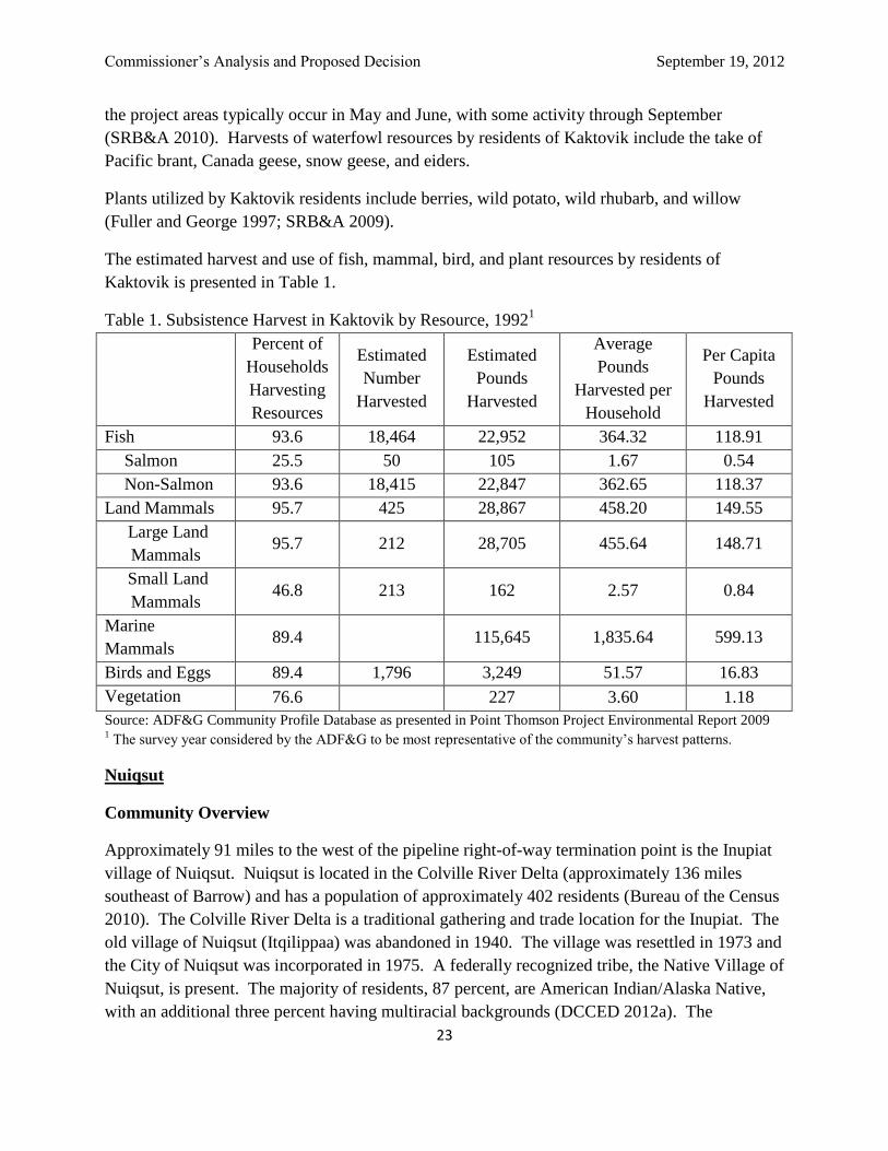
The estimated harvest and use of fish, mammal, bird, and plant resources by residents of
Kaktovik is presented in Table 1.
Table 1. Subsistence Harvest in Kaktovik by Resource, 19921
Percent of
Households
Harvesting
Resources
Estimated
Number
Harvested
Estimated
Pounds
Harvested
Average
Pounds
Harvested per
Household
Per Capita
Pounds
Harvested
Fish 93.6 18,464 22,952 364.32 118.91
Salmon 25.5 50 105 1.67 0.54
Non-Salmon 93.6 18,415 22,847 362.65 118.37
Land Mammals 95.7 425 28,867 458.20 149.55
Large Land
Mammals 95.7 212 28,705 455.64 148.71
Small Land
Mammals 46.8 213 162 2.57 0.84
Marine
Mammals 89.4 115,645 1,835.64 599.13
Birds and Eggs 89.4 1,796 3,249 51.57 16.83
Vegetation 76.6 227 3.60 1.18
Source: ADF&G Community Profile Database as presented in Point Thomson Project Environmental Report 2009 1 The survey year considered by the ADF&G to be most representative of the community’s harvest patterns.
Nuiqsut
Community Overview
Approximately 91 miles to the west of the pipeline right-of-way termination point is the Inupiat
village of Nuiqsut. Nuiqsut is located in the Colville River Delta (approximately 136 miles
southeast of Barrow) and has a population of approximately 402 residents (Bureau of the Census
2010). The Colville River Delta is a traditional gathering and trade location for the Inupiat. The
old village of Nuiqsut (Itqilippaa) was abandoned in 1940. The village was resettled in 1973 and
the City of Nuiqsut was incorporated in 1975. A federally recognized tribe, the Native Village of
Nuiqsut, is present. The majority of residents, 87 percent, are American Indian/Alaska Native,
with an additional three percent having multiracial backgrounds (DCCED 2012a). The
Commissioner’s Analysis and Proposed Decision September 19, 2012
24
community is predominantly Inupiat Eskimos and practices a traditional subsistence lifestyle.
Unemployment is high in Nuiqsut; the Kuukpik Native Corporation, village school, and North
Slope Borough are the major employers. Air travel provides the only year-round access
(DCCED 2012a).
Over 30 years, oil field installations have expanded westward from Prudhoe Bay to the extent
that the community feels surrounded (URS 2005). As noted in the community profile prepared
for the North Slope Borough, “the locations of Nuiqsut residents’ subsistence harvest activities
have shifted as petroleum development has grown around the community. Hunters are not using
areas to the east of the village in the same manner and extent as in prior years” (URS 2005).
Subsistence Activities
The proposed project area is also used by the residents of Nuiqsut for subsistence harvest of fish,
marine mammals, terrestrial mammals, birds, and plants. The contemporary subsistence
economy relies primarily on bowhead whales taken in the fall, fishing in summer and fall, and
caribou taken year-round (Braem et al 2011). In 1993, Nuiqsut residents harvested an estimated
742 pounds of wild foods per person, of which 228 pounds are caribou, 213 pounds were
bowhead whale, and 248 pounds were various non-salmon fishes.
Community “lifetime” subsistence use areas extended along the Arctic coast from just east of
Barrow all the way to Kaktovik (Pedersen 1986). The areas east of Prudhoe Bay, however,
tended to be offshore and associated with hunting marine mammals. Some use of the coast in the
vicinity of Mikkelson Bay is apparent from that mapping effort. More recent mapping efforts
that spanned the years 1996-2006 did not document use of the project area, except bowhead
whaling and the hunting of seals offshore (SRB&A 2010).
Nuiqsut residents hunt the Western Arctic, Central Arctic, and Teshekpuk herds (Braem et al
2011). While the residents of Nuiqsut do not frequently hunt caribou in the Point Thomson area,
they hunt the Central Arctic Herd that migrates through the project area. Herds hunted by
Nuiqsut residents intermingle with other caribou herds in the project area (SRB&A 2010; Braem
et al 2011; Lenart 2009).
Additional terrestrial animals are harvested for subsistence use by Nuiqsut residents, but these
are a small component of the subsistence harvest (Fuller and George 1997). Nuiqsut residents
primarily hunt moose along the Colville River and its tributaries and hunt wolf and wolverine
while hunting caribou outside the project area (SRB&A 2010).
Bowhead whales are a primary subsistence species for the community of Nuiqsut. Hunters from
Nuiqsut travel to Cross Island, from which they base their whaling effort, and hunt bowhead
whales along the coast between Oliktok Point in the west and Camden Bay in the east. This
region includes stretches off the coast of the proposed Point Thomson project area. Historically,

Commissioner’s Analysis and Proposed Decision September 19, 2012
25
Nuiqsut residents harvest seals from Cross Island and along the same stretch of coast, though a
greater number of seals are harvested west of the project area, north of Nuiqsut in Harrison Bay
(SRB&A 2010; Fuller and George 1997).
Nuiqsut residents typically hunt geese between Fish Creek and Itkillik River, far west of the
project area, and hunt eider occasionally as far east as the coast of ANWR (SRB&A 2010).
Subsistence waterfowl hunts in the project areas typically occur in May and June, with some
activity through September (SRB&A 2010). Nuiqsut residents hunt white-fronted geese, Black
brant, and Common eiders; these species migrate through the project area (Fuller and George
1997).
Nuiqsut residents primarily harvest Arctic and least cisco and broad whitefish (Fuller and George
1997), but the primary harvest locations for these and other fish are in the Colville River and its
tributaries, not in the project area (SRB&A 2010).
Plants utilized by Nuiqsut residents include berries, wild potato, wild rhubarb, and willow (Fuller
and George 1997; SRB&A 2009).
The estimated harvest and use of fish, mammal, bird, and plant resources by residents of Nuiqsut
is presented in Table 2.
Table 2. Subsistence Harvest in Nuiqsut by Resource, 19931
Percent of
Households
Harvesting
Resources
Estimated
Number
Harvested
Estimated
Pounds
Harvested
Average
Pounds
Harvested per
Household
Per Capita
Pounds
Harvested
Fish 80.6 71,897 90,490 994.39 250.62
Salmon 35.5 272 1,009 11.09 2.79
Non-Salmon 79.0 71,626 89,481 983.30 247.83
Land Mammals 75.8 1,290 87,390 960.33 242.03
Large Land
Mammals 74.2 691 87,306 959.41 241.80
Small Land
Mammals 41.9 599 84 0.93 0.23
Marine Mammals 37.1 113 85,216 936.44 236.01
Birds and Eggs 75.8 3,558 4,325 47.53 11.98
Vegetation 71.0 396 4.36 1.10
Source: ADF&G Community Profile Database as presented in Point Thomson Project Environmental Report 2009 1 The survey year considered by the ADF&G to be most representative of the community’s harvest patterns.
Many of the marine mammal, fish, and terrestrial mammal species harvested by North Slope
residents in areas other than the project area migrate through the project area. These include

Commissioner’s Analysis and Proposed Decision September 19, 2012
26
bowhead whales and other marine mammals, caribou, migratory waterfowl, and several species
of fish. Thus, activities associated with exploration, construction, and production phases of this
project that affect those species will affect the subsistence of communities other than Kaktovik
and Nuiqsut.
Prudhoe Bay
Prudhoe Bay/Deadhorse is located adjacent to the Beaufort Sea at the northern end of the Dalton
Highway, east of Nuiqsut and 498 miles north of Fairbanks. Prudhoe Bay/Deadhorse is an
industrial settlement that can be accessed by the Dalton Highway, which is subject to closure in
winter months, and by the Prudhoe Bay Deadhorse Airport. Established to support oil and gas
development, Prudhoe Bay/Deadhorse is not a traditional community. Due to safety and security
reasons, access to the oilfields is restricted to oilfield workers and visitors with special permits.
According to the 2011 Alaska Department of Labor, Prudhoe Bay/Deadhorse has a population of
2,174; however, as many as several thousand transient workers are there at any given time,
working in oil and gas development-related jobs (DCCED 2012a).
VI. Technical Capability of the Applicant
Reviewed Documents
This section is based primarily on a Design Basis (Attachment B) and the Issue-for-Construction
(IFC) drawings for the pipeline, both prepared by PTEP. The Design Basis and the IFC
drawings will undergo minor changes prior to pipeline construction. Stipulation 1.4.2.4 of the
Draft Lease (Attachment A) requires PTEP to submit the Final Design for formal acceptance by
the State Pipeline Coordinator. In addition, per Stipulation 3.2 of the Draft Lease, modifications
to the contents of the Design Basis after acceptance must also be submitted to and accepted by
the State Pipeline Coordinator.
Background
PTEP is part of ExxonMobil Corporation and its affiliated companies. This group of companies
is the largest oil and gas producer in the world. They have operated oil and gas pipelines
throughout the world. ExxonMobil has participated in oil and gas projects in the Alaskan,
Canadian and Russian arctic environments. The SPCO Engineering Section coordination with
ExxonMobil has demonstrated that PTEP is backed by significant technical resources. In
particular, ExxonMobil’s upstream Research Center in Houston is well respected throughout the
industry for technical expertise, and they have access to deep resources in engineering design
and technical procurement.

Commissioner’s Analysis and Proposed Decision September 19, 2012
27
Codes, Regulations and Standards
The Design Basis and IFC drawings establish minimum engineering requirements for a safe and
environmentally sound installation on the AS 38.35 lease. They reference codes, regulations,
and standards under which the pipeline is to be constructed. Examples are listed below. For a
full list, refer to the Design Basis.
1. Code of Federal Regulations, Title 49, Part 195, "Transportation of Hazardous Liquids by
Pipeline"
2. American Welding Society (AWS) D1.1/D1., Structural Welding Code—Steel
3. API 5L, Specification for Line Pipe
4. API 6D, Pipeline Valves
5. API 1104, Welding Pipelines and Related Facilities
6. ASCE 7-05, Minimum Design Loads for Buildings and Other Structures
7. ASME B31.4, "Pipeline Transportation Systems for Liquid Hydrocarbons and Other
Liquids,"
8. ASME B 16.5, Pipe Flanges and Flanged Fittings
9. International Building Code
10. NFPA70, National Electrical Code
In addition to codes and standards, the PTEP will be regulated by local, state and federal
authorities. In particular, it will incorporate shut-off valves, emergency access, and a leak
detection system, in accordance with the 18 AAC 75, Oil and Hazardous Substances Pollution
Control. It will also be jurisdictional to the Code of Federal Regulations, Title 49, Part 195.
This is the principal regulatory authority for pipelines in the United States and is implemented by
the U.S. Department of Transportation, Pipeline and Hazardous Materials Safety Administration
(PHMSA). The state agencies participating in the SPCO and PHMSA are both members of the
Joint Pipeline Office and routinely work together on pipeline oversight.
Transported Product (Fluid and Flow)
The product transported by the PTEP will consist of natural gas liquids. These are heavier-end
hydrocarbons stripped from gas production. The pipeline is estimated to carry one-seventh its
design capacity at startup, which leaves open the potential for other fields in this area to be tied
into this pipeline in the future.
Estimated physical properties of the fluid are:
Viscosity (cP) 5.046 (standard conditions)
Specific Gravity 0.841
API Gravity 37

Commissioner’s Analysis and Proposed Decision September 19, 2012
28
Component Mole Fractions (mol %) consist of principally hexanes to C27 with only 0.07% CO2
and minor amounts of water moisture. The natural gas liquids contain less than 1% methane,
ethanes and propanes (C1-C3), and contain approximately 3% butanes and pentanes (C4&C5).
The fluid is primarily composed of C6-C27 hydrocarbons. It is characterized as having roughly
similar physical properties to TAPS, and classified as "sweet," meaning that it has little or no
sulfur compounds. The SPCO technical review found no fluid components that are defined as
significantly increasing corrosion or accelerating other damage to pipelines beyond industry
accepted standards.
Geotechnical
The onshore area on which the Point Thomson facilities will be developed is underlain by "cold"
permafrost. The permafrost depth (the active layer thickness) under the undisturbed tundra
surface typically is less than three feet. The near-surface soils consist of an ice-rich layer of
organic and silty soils that extend to depths of eight feet or less. Below this layer, a sand and
gravel layer extends to depths of 50 feet or more.
Typical moisture contents in the surface layer ranges by weight from about ten to over 100
percent. Frozen silts with more than 25 percent thawed moisture contents have "excess ice" and
are prone to strength loss and shrinkage if allowed to thaw. Therefore, in VSM design, only the
soil beneath the active layer is counted upon for restraint against side (wind), downward or
upward (frost heave) loads.
Each PTEP VSM will be embedded a minimum of 15 feet below the ground surface. During
boring this depth will be extended for areas of massive ice. This is typical of North Slope
pipelines. The applicant has investigated the issue of warming permafrost on the North Slope
and concluded that "... trends measured follow the pattern one would expect for soils responding
to warming ambient temperatures: more rapid change near the ground surface, lower rates of
change at depth. Measured values are approximately 0.08 F/year at 50 meters depth to
0.28°F/year at 20 meters depth. These correspond to warming from 2.4°F to 8.4°F at their
respective depths over a 30-year service life for the PTEP."
Hydrology and Waterway Crossings
The topography is flat, typical of the Alaskan North Slope coast. The pipeline route does not
cross major waterways, but does cross several small drainages; all these crossings will be on
VSMs, above the water and the stream banks. The main drainage areas are shown in Table 3.
Table 3: Main drainages
Drainage (sq mi) 100-yr flow (cfs)
West Badami Creek 51.5 3600
Middle Badami Creek 23.5 1900
East Badami Creek 93.0 5500
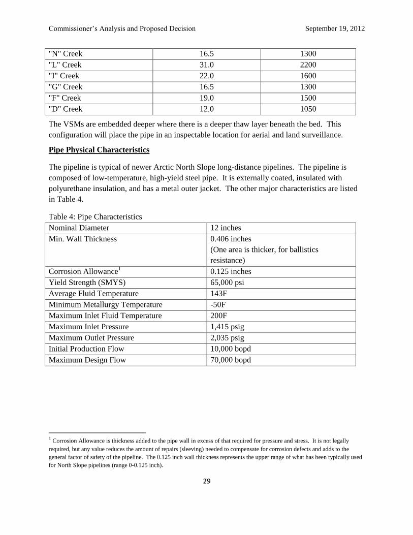
Commissioner’s Analysis and Proposed Decision September 19, 2012
29
"N" Creek 16.5 1300
"L" Creek 31.0 2200
"I" Creek 22.0 1600
"G" Creek 16.5 1300
"F" Creek 19.0 1500
"D" Creek 12.0 1050
The VSMs are embedded deeper where there is a deeper thaw layer beneath the bed. This
configuration will place the pipe in an inspectable location for aerial and land surveillance.
Pipe Physical Characteristics
The pipeline is typical of newer Arctic North Slope long-distance pipelines. The pipeline is
composed of low-temperature, high-yield steel pipe. It is externally coated, insulated with
polyurethane insulation, and has a metal outer jacket. The other major characteristics are listed
in Table 4.
Table 4: Pipe Characteristics
Nominal Diameter 12 inches
Min. Wall Thickness 0.406 inches
(One area is thicker, for ballistics
resistance)
Corrosion Allowance1 0.125 inches
Yield Strength (SMYS) 65,000 psi
Average Fluid Temperature 143F
Minimum Metallurgy Temperature -50F
Maximum Inlet Fluid Temperature 200F
Maximum Inlet Pressure 1,415 psig
Maximum Outlet Pressure 2,035 psig
Initial Production Flow 10,000 bopd
Maximum Design Flow 70,000 bopd
1 Corrosion Allowance is thickness added to the pipe wall in excess of that required for pressure and stress. It is not legally
required, but any value reduces the amount of repairs (sleeving) needed to compensate for corrosion defects and adds to the
general factor of safety of the pipeline. The 0.125 inch wall thickness represents the upper range of what has been typically used
for North Slope pipelines (range 0-0.125 inch).

Commissioner’s Analysis and Proposed Decision September 19, 2012
30
Design Life
The design life of the pipeline is 30 years, which coincides with the length of the proposed lease.
At the end of the lease, the pipeline would need to be evaluated for useful life, should the
applicant want to renew the lease.
A 30-year design life does not indicate that the pipeline and associated structures will be used up,
failure-prone, or requiring replacement at the end of the lease. Engineering design life is
established from a combination of technical, regulatory, economic, and commercial
considerations. There are various definitions of design life; however, for the purposes of this
lease it can be defined as the period over which the systems, components, and structure are
required to perform their primary functions with acceptable safety, regulatory, and
environmental performance, and with an acceptable probability that they will not experience
large failures, require extensive replacements, or need significant repairs.
VII. Financial Capability of the Applicant
The total cost to construct the Point Thomson Export Pipeline is estimated at $204 million. The
cost to operate the pipeline on an annual basis is estimated at $26 million.
The applicant, PTE Pipeline LLC, is a newly formed company created specifically for the
purpose of constructing and operating the proposed PTEP. PTE Pipeline LLC is a wholly owned
subsidiary of EMPCo. EMPCo will financially support PTE Pipeline LLC’s efforts to construct
and operate the pipeline.
EMPCo is a wholly owned affiliate of Exxon Mobil Corporation (ExxonMobil). ExxonMobil
assets in Alaska include unit and lease interest in several other North Slope holdings. Through
its ownership interest in ExxonMobil Alaska Production, Inc., ExxonMobil holds a 14.34%
working interest in Duck Island Unit, a 2.30% interest in Beechey Point Unit, a 2.53% interest in
Kuparuk River Unit, a 36.40% working interest in Prudhoe Bay Unit, and a 75% interest in the
South Granite Point Unit of Cook Inlet (DNR Division of Oil & Gas 2012). ExxonMobil
produces oil in North America, Europe, Africa, the Middle East, Asia, and Australia.
ExxonMobil has full or partial ownership in 36 refineries and sells a wide range of petroleum
products commercially. ExxonMobil also has a chemical brand which produces and sells a wide
range of products (ExxonMobil 2012).
In support of the Commissioner’s Analysis and Proposed Decision, and in response to the State’s
request for a parental guaranty from the applicant’s parent company, PTE Pipeline LLC
submitted to the SPCO financial information, including a corporate structure schematic outlining
the relationship of Exxon Mobil Corporation and its affiliates. PTE Pipeline LLC has requested
that the State accept Exxon Equity Holding Co. (EEHC) as the parental guarantor for
ExxonMobil and has submitted EEHC’s “Consolidated Financial Statements; December 31,

Commissioner’s Analysis and Proposed Decision September 19, 2012
31
2011, 2010 and 2009” for review. These documents have been submitted confidentially to the
SPCO under AS 38.05.035.
Exxon Mobil
Corporation
Exxon Pipeline
Holdings Inc.
Exxon Equity Holding
Company
ExxonMobil Pipeline
Company
PTE Pipeline LLC
Company relationships shown in solid lines
represent direct 100% ownership
Company relationships shown in dashed
lines represent indirect 100% ownership
Figure 3: Relationship of Applicant to ExxonMobil and Affiliates
Exxon Mobil Corporation, via its affiliates, has been a long time operator in Alaska both in terms
of exploration and development of oil and gas resources. Exxon Mobil Corporation is in good
standing with the Alaska Department of Commerce, Community, and Economic Development
(DCCED); the most recent biennial report was filed with DCCED on December 6, 2010
(DCCED 2012).
ExxonMobil Pipeline Company operates an extensive network of pipelines in the United States,
which facilitates the transportation of more than 27 million barrels of crude per day. Included in
that network are the Crude Oil Pipelines Silvertip System in Montana, the M-70 Pipeline System
in central California, the Mokena Pipeline in Illinois, and hundreds of miles of pipeline in
Louisiana and Texas. EMPCo has joint interests in product pipelines like West Shore Pipeline
and the Wolverine Pipeline Company, and crude pipelines like Mustang Pipe Line.
EEHC, as the proposed guarantor for PTE Pipeline LLC, is a wholly owned consolidated
subsidiary of Exxon Mobil Corporation. EEHC was created for the sole purpose of providing
financial support for its affiliates. As of December 2010, EEHC had approximately 70
guaranties outstanding, including a guaranty for TAPS, of which EMPCo is a 20.34% owner.
Commissioner’s Analysis and Proposed Decision September 19, 2012
32
EEHC as the Guarantor
The Commissioner has reviewed the financial statements provided by EEHC in consideration of
EEHC guaranteeing the actions and activities of PTE Pipeline LLC. These financial statements
were verified by the independent auditor Price Waterhouse & CO. S.R.L. In its confidential
report, Price Waterhouse & CO. S.R.L. stated that the audits were conducted in accordance with
auditing standards generally accepted in the United States, and that the financial statements fairly
present the financial position of EEHC as of the effective year 2011.
EEHC’s financial statements, filed confidentially with the SPCO under AS 38.05.035, show
sufficient equity on the balance sheets to provide the guaranty for this project. In addition to
this, EEHC receives counter indemnities for outstanding guaranties from other affiliates. The
combined indemnity guarantees and equity entitles EEHC to recover sufficient payments for the
purposes of guaranteeing the PTE Pipeline LLC pipeline.
EMPCo as the Financier
The Commissioner requested, via the AS 38.35 application, an annual financial statement and
balance sheet for EMPCo, the financier and owner of PTE Pipeline LLC. In response, PTE
Pipeline LLC has confidentially submitted to the Commissioner financial statements from
EMPCo for 2010 and 2011. According to the documents, EMPCo has demonstrated that it has
the financial capability to support the proposed construction, estimated at $204 million,
excluding contingency, and the continued annual operational costs, estimated at $26 million.
VIII. Analysis of Application and Proposed Right-of-Way
Pursuant to the State of Alaska’s Right-of-Way Leasing Act, the Commissioner must evaluate
the Applicant’s technical and financial capabilities to perform the transportation, or other acts
proposed, in a manner that is consistent with the present or future public interest.
Fit, Willing and Able Criteria
In accordance with AS 38.35.100, there are specific criteria that must be evaluated in the analysis
of an application filed under AS 38.35.50. If the Commissioner makes a favorable
determination, a lease may be offered to the applicant. In making the determination, the
Commissioner must consider these following criteria:
1. Will the proposed use of the right-of-way unreasonably conflict with existing uses of
the land involving a superior public interest?
2. Does the applicant have the technical and financial capability to protect state and
private property interests?

Commissioner’s Analysis and Proposed Decision September 19, 2012
33
3. Does the applicant have the technical and financial capability to take action to the
extent reasonably practical to:
3A. prevent any significant adverse environmental impact, including but not
limited to, erosion of the surface of the land and damage to fish, wildlife and their
habitat?
3B. undertake any necessary restoration or re-vegetation?
3C. protect the interests of individuals living in the general area of the right-of-
way who rely on fish, wildlife and biotic resources of the area for subsistence
purposes?
4. Does the applicant have the financial capability to pay reasonably foreseeable
damages for which they may become liable or claims arising from the construction,
operation, maintenance, or termination of the pipeline?
5. Does the applicant agree that in the construction and operation of a pipeline within
the right-of-way it will comply with, and require contractors and their subcontractors
to comply with, applicable and valid laws and regulations regarding the hiring of
residents of the state currently in effect or that take effect subsequently?
Analysis
Criterion 1. Will the proposed use of the right-of-way unreasonably conflict with existing
uses of the land involving a superior public interest?
Land uses along the pipeline corridor include subsistence harvest, mineral and material sites, oil
and gas development, hunting and fishing, and public trails. General information about the
natural resources, community use and other existing conditions in and near the proposed project
area can be found in sections “IV. Fish, Wildlife, and Biotic Resources” and “V. North Slope
Borough and Adjacent Communities” on pages 12 and 19, respectively.
The Commissioner’s Analysis and Proposed Decision evaluates the existing uses in relation to
the proposed pipeline project. This document identifies potential conflicts and, where necessary,
discusses measures to mitigate these conflicts. The ROW lease incorporates required mitigation
measures as stipulations that are effective during construction, operation, maintenance and
termination of the pipeline.
Existing Uses
Subsistence Use of the Project Area
Residents in Kaktovik and Nuiqsut have expressed concern that pipelines and oil and gas
development affect caribou populations and change their migration patterns and behaviors.

Commissioner’s Analysis and Proposed Decision September 19, 2012
34
Disturbance of caribou may have an impact on the subsistence hunting patterns of the residents.
Development activities may disrupt caribou migration patterns by creating physical obstructions
or by causing noise and motion that cause caribou to avoid the area. Calving and insect relief
migrations are sensitive to human developments and activities; in particular, pipelines paralleled
by roads with high traffic levels inhibit caribou passage (Shideler 1986). Some studies have
indicated that pipeline crossing frequencies are not affected by pipelines in the absence of traffic,
implying that it is the combination of road and pipeline that becomes a migration obstruction
(Curatolo and Reges 1986). This could result in caribou moving as far as 2.5 miles inland,
requiring subsistence hunters to travel farther. Herds can become habituated to the infrastructure
and developments, as documented by caribou calving and insect relief migrations around the
Kuparuk facilities (Lawhead 1999). Recent studies suggest that herds are able to cross pipelines
elevated a minimum of five feet above ground in areas such as the Alpine pipelines, which have
infrastructure without human activity (Lawhead and Prichard 2010).
Industrial noise can also divert bowhead whales. The bowhead harvest in the fall is a major part
of the subsistence resources used by the residents of Kaktovik, and to a lesser extent the residents
of Nuiqsut (SRB&A 2009). Subsistence use of other resources, such as the harvest of furbearers
and waterfowl, could also be affect by developments in the project area.
Subsistence Related Mitigation Measures
PTE Pipeline LLC has committed to consulting local communities about construction and
maintenance operations to aid in the identification of means to avoid potential conflicts with and
provide emergency assistance to subsistence users and local travelers. Since 2008, PTE Pipeline
LLC has attended whaling meetings in the local communities and met with the leadership and
communities of Nuiqsut and Kaktovik about subsistence hunting and traditional knowledge
(ExxonMobil Corporation 2012). 49 CFR 195 requires that a pipeline operator maintain a
liaison with public agencies and appropriate public officials to prepare for any hazardous
emergency. Federal regulations require that a pipeline operator must develop and implement a
written continuing public education program that follows the guidance provided in the American
Petroleum Institute’s Recommended Practice 1162.
The proposed PTEP would be constructed during the winter season, decreasing direct conflicts
between migrating caribou and most human activities. By constructing in the winter using ice
roads, the likelihood of construction noise and activity disturbing calving or migrating caribou is
diminished. Summer activities along the pipeline would be minimal and there would not be a
gravel road constructed along the pipeline, which could cause an additional barrier or disturbance
to caribou in the area. Winter construction also minimizes the impacts to migratory birds and
mammals that are important to the subsistence lifestyle of local communities.

Commissioner’s Analysis and Proposed Decision September 19, 2012
35
North Slope Borough zoning ordinances (Code of Ordinances Title 19, Chapter 19.70.050
(L)(5)(a)) call for above-ground pipelines to be elevated for wildlife crossings a minimum of
seven feet from the ground to the bottom of the pipe. The seven-foot height of the PTEP is
intended to ensure that caribou are physically able to cross under the pipeline, even in the
presence of drifted snow. The applicant’s preferred location for the pipeline avoids caribou
calving grounds, but instead crosses caribou insect relief areas (Arthur and Del Vecchio 2009).
Choosing this route allows the applicant to construct a shorter line that has a smaller footprint on
important habitat areas.
Industrial noise may divert migrating bowhead whales; however, the applicant would work with
the Alaska Eskimo Whaling Commission (AEWC) to schedule limited barge traffic and utilize a
local marine mammal observer and subsistence monitor to help minimize potential conflicts
(USACE 2011). PTE Pipeline LLC included as design measures to minimize impacts: requiring
routing aircraft flights to generally fly at a 1,500-foot altitude following a path inland from the
coast, consulting with subsistence users to understand current subsistence activities and patterns,
employing local subsistence representatives during active construction and drilling, and
informing nearby individuals and organizations about project activities that may affect
subsistence use or access.
Stipulation 1.20 of the Draft Lease (Attachment A) prohibits PTEP employees and contractors
from hunting, fishing, and trapping within the right-of-way or using project equipment for those
activities. These measures should discourage increased competition for fish and wildlife
resources in the area, protecting opportunities for subsistence users. While Stipulation 1.20
prohibits PTEP employees and contractors from hunting in association with their work on the
pipeline, the general public will not be prohibited from hunting in the pipeline project area.
Stipulation 1.13 of the Draft Lease ensures that no restriction of public use or access to the PTEP
corridor would be permitted in the immediate vicinity of the pipeline and related facilities, unless
approved in writing by the Commissioner, in the case of an emergency that threatens any person
or property, or in the case of need to prevent immediate harm to any person or property.
ExxonMobil developed a Subsistence Mitigation Program which was submitted to the North
Slope Borough to comply with Title 19 of the borough Land Management Regulations
(ExxonMobil 2012a). The program outlines ExxonMobil’s commitment to maintain a positive
working relationship with affected groups, specific operational measures and commitments,
specific design measures, support for whaling activities, and subsistence consultation and user
engagement.
Subsistence mitigation measures ExxonMobil has incorporated in the Program include:
Routinely consulting with subsistence users to understand current and changing
subsistence activities and patterns, identifying impacts that may have occurred, and ways
to prevent reoccurrence.

Commissioner’s Analysis and Proposed Decision September 19, 2012
36
Employing local Subsistence Representatives during active construction and drilling.
Implementing applicable protective measures of the CAA with the AEWC and Kaktovik
and Nuiqsut Whaling Captains' Associations.
Avoiding interference with bowhead whales during the fall migration period by
designating preferred routes inside the barrier islands for coastal barging and planning to
complete sealift barging prior to the fall migration.
Conducting marine activities prior to or after the Kaktovik and Nuiqsut fall bowhead
whale subsistence hunts, unless other arrangements are made.
Installing the PTEP and gathering lines on VSMs with a minimum 7-foot height above
tundra, including vibration dampeners or cables, to allow free passage by wildlife,
particularly caribou.
Requiring routine aircraft flights (e.g., transportation of personnel and cargo) to generally
fly at a 1 ,500-foot altitude following a path inland from the coast to avoid disturbance to
wildlife and subsistence activities, except as required for takeoffs and landings, safety,
weather, and operational needs, or as directed by air traffic control.
Making subsistence-related training mandatory for the North Slope-based Project
workforce, including protection of subsistence resources, lands, and wildlife.
Prohibiting hunting and fishing by ExxonMobil employees and contractors while
personnel are assigned to, and working in, the Point Thomson area.
Designing Project features (e.g., color, lighting schemes, and buried/suspended cables) to
minimize visual impact to subsistence resources.
DNR requires that special safeguards be in place for natives and others subsiding on the biotic
resources of the general area of the proposed pipeline ROW. The stipulations attached to the
Point Thomson lease addressing wildlife, design parameters, and the timing of construction in
conjunction with the ExxonMobil Subsistence Mitigation Plan that is required by the North
Slope Borough serve to mitigate possible impacts to subsistence users of the area.
Cultural Resources
The discovery of any historic or pre-historic sites within the pipeline corridor would require
activity to stop until the site is evaluated by cultural resource specialists and protective measures
put in place, if required. Construction and other pipeline activities without proper study and
observation could cause damage to cultural resources.
Cultural Resources Mitigation Measures
The USACE, as the lead federal agency managing the Point Thomson Project’s NEPA Process,
is responsible for ensuring review requirements under NHPA are met by initiating the Section
106 Review Process.

Commissioner’s Analysis and Proposed Decision September 19, 2012
37
On August 2, 2011, the USACE initiated the Section 106 consultation with the SHPO for the
Point Thomson Project. Since this time, the USACE, SHPO, ExxonMobil, and other parties
have been consulted on the project. This consultation has involved the development of a
Programmatic Agreement (PA) in accordance with 36 CFR 800.124[b]. On August 7, 2012, the
USACE distributed the most recent version of a draft PA, which is a legally binding agreement
between the lead federal agency, the SHPO, the applicant, and other consulting parties. Included
in the PA, as an accompanying document, is the confidential Cultural Resource Management
Plan (CRMP).
The CRMP serves as a guide for the PA Signatories and consulting parties regarding the
identification, assessment and treatment of cultural resources in the project area. The CRMP was
submitted to the OHA and shared with the SPCO; the document identified a number of known
and recorded archaeological sites in or adjacent to the Point Thomson Project area. Some
examples are historic shipwrecks, particularly those associated with whaling activities that are
often found near waterways, and tools left behind by Native ancestors may be as old as 11,800
years, or as recent as 8,800 years. Archeological resources left behind by commercial whalers in
the 1800s, summer traders, and commercial fur-trappers may exist in the pipeline area. Although
prior surveys have not produced many archeological sites, undiscovered sites may still exist in
the project areas and need to be preserved and protected during pipeline construction, operation,
and termination activities. A sensitivity map within this plan has been created to establish
sensitive areas that should be avoided or developed only under close supervision.
Under the NHPA Section 106, the SHPO’s review and signature on the PA is required; it is also
a requirement in the Draft Lease Stipulations 1.4 and 1.19. Additionally, in the event of any
realignment of the pipeline rights-of-way corridor, SHPO would provide additional review for
potential effects to cultural resources.
Minerals and Materials
There are no active mining claims within or near the project area.
One gravel site exists in the immediate area of the proposed right-of-way. The gravel site is
ADL 416096 (formerly ADL 415456), the inactive Badami Creek Mine Site, within Sec 14-15,
T9N, R20E, UM. The proposed pipeline route crosses through the footprint for the inactive
material site for Badami Creek Mine, ADL 415456.
The abandoned Bullen Point gravel pad is near the proposed right-of-way in Sec 34, T10N,
R21E, UM. The pad is permitted to Exxon Mobil for remediation under LAS 27517. The
Bullen Point site is approximately 1.5 miles north of the proposed pipeline route.
To the south of the proposed pipeline origin is ADL 416095, the master material site for Point
Thomson, in Sec 14-15, T9N, R23E, UM. ADL 416095 was used as a gravel site under ADL

Commissioner’s Analysis and Proposed Decision September 19, 2012
38
415140 and later as ADL 415544. The material site for Point Thomson is approximately two
miles south and east of the proposed pipeline route.
Potential conflicts between surface mineral use and the proposed project include any future
mining claims that might be staked in the project area. Since no current mining claims exist,
there are no current conflicts.
The Badami Creek Mine Site, ADL 416096 (formerly ADL 415456) is inactive. The Badami
use under ADL 415456 was completed by 2002, and the site was flooded and reclaimed as
required. The material site contract for ADL 415456 expired January 13, 2002, and the case was
closed. DNR established ADL 416096 in 2011 to better track material sites in the Northern
Region, but this case file does not indicate current activity at the site. PTE Pipeline LLC plans a
short road crossing near the existing gravel mine site/reservoir that would be installed through a
casing placed in the road bed gravel constructed on top of the tundra.
The applicant proposes to develop one gravel mine site (ADL 416095), located approximately
two miles south of the pipeline origin, to supply the gravel needed for project access roads and
oil and gas development facilities. The proposed development of the pipeline would be by ice
road, with gravel needed at three production pads, an airstrip, on 12 miles of infield roads, and
on several ancillary pads. The proposed gravel mine site was chosen to minimize the impact on
lake habitat in the area and to keep the mine site to the minimum footprint needed to produce
gravel, stage mining supplies, and provide temporary overburden storage. Mining would all take
place during a single winter season, and for that season the mine site would be accessed by ice
road. During the construction of project facilities, mined gravel would be removed from the
stockpile location via a combination of gravel and ice roads.
Minerals and Materials Mitigation Measures
Potential conflicts between surface mineral use and the proposed project would be mitigated by
the establishment of MO 1126, an action proposed to be issued concurrently with the issuance of
a Right-of-Way Lease. MO 1126 would prohibit mineral entry, location, and mining activity
within the leasehold boundaries. Since no current mining claims exist, there are no conflicts.
Potential conflicts between prior Badami mine site use and the pipeline route would be mitigated
by responsible design and placement of the pipeline.
Mineral resources should not be affected by these projects. Commercial mining activities do not
take place in this area, therefore there is no mechanical mining that may damage or threaten the
pipeline. Recreational gold panning may take place along the rivers and streams. Hand panning
should not affect the pipeline.

Commissioner’s Analysis and Proposed Decision September 19, 2012
39
Oil and Gas Development
Oil and gas exploration and development is an existing use of the land in the project area.
Eighteen active oil and gas leases have been issued under lands crossed by the proposed pipeline,
and oil and gas well sites have been drilled near the project area.
Oil &Gas Leases – The pipeline Right-of-Way is projected to cross several competitive oil and
gas leases (issued under AS 38.05.180):
ADL 390825 (Tract BS2006-116), 390998 (Tract NS2006-0891), and 391001 (Tract
NS2006-0894) leased to AVCG, LLC
ADL 367010 (Badami Unit, Tract 5), 367011 (Badami Sands, Tract 6), 365533 (Badami
Sands, Tract 7), 365535 (Badami Sands, Tract 10), and 375093 (Badami Sands, Tract 9)
leased to Savant Alaska, LLC
ADL 47568 (C23-153 T9N-R22E-UM), ADL 47569 (C23-154 T9N-R23E-UM), ADL
47570 (C23-155 T9N-R23E-UM), leased to Chevron U.S.A. Inc.
ADL 47559 (C23-144 T10N-R23E-UM); ADL 47566 (C23-151 T9N-R22E-UM), ADL
47560 (C23-145 T10N-R23E-UM), ADL 47561 (C23-146 T10N-R22E-UM), ADL
51667 (Section 30 & 31, T10N, R23E, UM), leased to Exxon Mobil Corporation
ADL 47562 (C23-147 T10N-R22E-UM), 47567 (C23-152 T9N-R22E-UM), leased to
Devon Energy Production Company, L.P.
Oil Well sites – Some test drilling has taken place near the project area. The following oil and
gas well sites are located near the proposed right-of-way.
LAS 14764 (Exxon Mobil Corporation, exploratory well) – Pt Thomson Unit 4
LAS 14766 (Exxon Mobil Corporation, exploratory well) – Pt Thomson Unit 6
LAS 16417 (Exxon Mobil Corporation, exploratory well) – Pt Thomson Unit 2
LAS 16827 (Exxon Mobil Corporation, exploratory well) – Pt Thomson Unit 1
LAS 16828 (Exxon Mobil Corporation, exploratory well) – Pt Thomson Unit 3
LAS 17603 (Conoco Inc., exploratory well) – Badami 1
LAS 17649 (Humble Oil & Refining, exploratory well) – E Mikkelsen Bay St 1
When issuing oil and gas leases, the State of Alaska reserves the right to authorize others by
grant, lease, or permit to enter upon and use the leased land for non-exclusive easements and
rights-of-way, provided such entry prevents unnecessary or unreasonable interference with the
rights and operations of the oil and gas lease (11 AAC 83.150). The presence of the oil and gas
leases does not prohibit the authorization or development of a pipeline right-of-way.
Similarly, development of a pipeline right-of-way across the leases referenced above does not
prohibit or interfere with the development of the leases. AS 38.35.120(a)(12) requires that a
Right-of-Way Lease may not unduly interfere with occupancy and use of the land within the

Commissioner’s Analysis and Proposed Decision September 19, 2012
40
lease by the state, its grantees, permittees, or other lessees of any part of the right-of-way not
actually occupied or required by the pipeline, for necessary operations.
Oil and Gas Development Mitigation Measures
The pipeline would be built more than a quarter mile from the drilled wells that are, in many
cases, “plugged and abandoned” wells. The presence of these wells does not conflict with the
construction of the pipeline.
Hunting and Fishing
ADF&G manages hunting and fishing activities statewide. No specific harvest information is
available for the pipeline corridor; however information for the general geographic area is
tabulated. The project area falls within GMU 26 and more specifically subunit 26B. In the
regulatory years 2000-2001 through 2007-2008, total caribou harvest was estimated at 604 to
1,091 animals (Lenart 2009). Most of the harvest occurs outside of the project area, primarily
along the Dalton Highway. Caribou harvest in the project area would most likely be along the
coast during summer by residents of Kaktovik and possibly by residents of Nuiqsut.
No open season occurred for muskoxen occurred during regulatory years 2005-2006 through and
2008 -2009 (Lenart 2011).
The 2005-2006 brown bear harvest in GMU 26B totaled three bears (Lenart 2007).
There are no known commercial recreational fisheries in the streams crossed by the export
pipeline right-of-way. Ninespine stickleback, juvenile Dolly Varden, and an occasional small
Arctic grayling occur in the streams at or near the proposed pipeline right-of-way crossings
(Winters and Morris 2004).
Hunting and Fishing Mitigation Measures
The proposed Point Thomson export pipeline would be an elevated pipeline; any long-term
impact to subsistence and non subsistence resources, other than temporary access issues during
construction and maintenance, should be minimal. The design basis and construction and
operation procedures have been designed to minimize the negative impact to individuals using
the area for subsistence purposes. A minimum height of seven feet is proposed for the export
pipeline in part to ensure passage of large mammals and to allow snowmachines to pass safely
under the pipeline during winter. Increased pipeline wall thickness is proposed where accidental
bullet strikes from hunting activities might occur.
As an elevated line on State land, it is determined that the pipeline right-of-way as proposed and
the activities that would occur within the right-of-way over the life of the pipeline would have a
minimal and short-term impact on existing and continued uses of the area as identified.

Commissioner’s Analysis and Proposed Decision September 19, 2012
41
Operation of the pipeline is not expected to result in any long term effects to fish or wildlife or
change habitat use. Wildlife could be disturbed during pipeline construction and maintenance
activities, but these impacts should be short-term, would occur in winter when most wildlife is
not in the project area, and should not be significant. Additionally, the State would be imposing
mitigation measures for additional protections of fish, wildlife, and their habitat through
Stipulation 1.4.3, 1.20, and 2.6 of the Draft Lease (Attachment A).
Access
On the western side of the proposed right-of-way there is a gravel access road that services the
Badami Mine Site/Reservoir and a gravel access road between the Badami Airstrip and Badami
Central Facilities Pad. These gravel roads are supportive infrastructure for the Badami
operations. Aside from this infrastructure, there is no other development or established
settlement in the immediate vicinity.
Located in the project area is an identified RS 2477 easement, the Bullen-Staines River Trail.
The Bullen-Staines River Trail historically traveled from Bullen Point easterly along two
different routes. The northern route led to the shore of Lion Bay, approximately one mile west
of the Point Thomson Central Pad, and the southern route led to the northwest corner of ANWR.
This trail is historic, used some time prior to 1955, but is no longer used, has not been surveyed,
and cannot be located on the ground.
Public access will be maintained except as needed for safety in emergencies or as approved in
writing by the Commissioner. Access within and between Badami sites would not be blocked by
the Point Thomson pipeline; at road crossings the pipeline would be in casings in the elevated
road bed.
Access Mitigation Measures
Though the historic RS2477 route is not actively used, PTE Pipeline LLC has designed an
additional vertical loop into the pipeline route near “I” Creek, to protect and provide for future
use of this trail. The clear space minimums on the vertical loop are higher and wider than
permitted load sizes on the Dalton Highway and would allow access for low impact tundra
vehicles such as Rolligons, Steigers, and Tuckers. As required by Stipulation 1.13.5 of the Draft
Lease, any access restrictions on RS2477 rights-of-way require prior written approvals by the
State Pipeline Coordinator and the Division of Mining, Land and Water. In the event that future
upgrades to these rights-of-way are approved, the Lessee may be responsible for accommodating
these upgrades.

Commissioner’s Analysis and Proposed Decision September 19, 2012
42
Summary
The Draft Lease and Stipulations, in addition to other State, federal and local requirements,
contain substantial mitigation measures to protect existing uses of the land and to mitigate
possible conflicts with existing and future uses. In addition, prior to permission to construct, the
State will review and accept numerous plans detailing how measures to protect cultural
resources, fish and wildlife, and biotic resources will be implemented. The Commissioner is
satisfied that the proposed PTEP project will not result in an unreasonable conflict with existing
uses of the land involving a superior public interest.
Criterion 2. Does the Applicant have the technical and financial capability to protect state
and private property interests?
The Right-of-Way Leasing Act requires consideration of the applicant’s technical capability to
protect state and private property interests. From a pipeline management perspective, important
protection factors include the development of comprehensive design, construction, and operation
requirements and plans, with an emphasis on safety, quality, and efficient operation.
Prior to initiating construction activities, Stipulation 1.4 (Attachment A) requires the applicant to
submit for State review and approval numerous engineering documents and project-specific
plans developed to meet all the Draft Lease and Stipulations requirements. The purpose of the
plans is to avoid, abate, and diminish problems that may arise from the project. In addition,
Stipulation 1.4.4 requires a Quality Management Program in effect during all phases of pipeline
activities (see Criterion 3 on page 43 for a more detailed description of the program). All plans
and the quality management program must be approved by the SPCO prior to issuing a Notice-
to-Proceed or Written Authorization allowing construction activities.
The engineering documents include:
A Design Basis and Criteria
An Engineering Analysis and Report on the Seismic Design of the Pipeline
A Final Design of the Pipeline
Plans that must cover Construction, Operation, Maintenance, and Termination activities include:
Camps
Work Pads
Erosion and Sedimentation Control
Fire Control
Stream, River, and Floodplain Crossings
Control, Sanitation and Disposal of Hazardous Waste and Hazardous Substances
Disposal of Overburden, and Excess and Excavated Material
Cultural Resource Preservation

Commissioner’s Analysis and Proposed Decision September 19, 2012
43
Groundwater Control
Restoration and Revegetation of Disturbed Areas
Fish and Wildlife Protection
Access to the Pipeline and Methods for Access Road Construction including Ice Roads
Control, Cleanup, and Disposal of Hazardous Substances
Use of Pesticides, Herbicides, Preservatives, and Other Chemicals
Construction in Wetlands
Handling of Solid and Liquid Waste
Managing Human/Carnivore Interaction
Emergency Preparedness
The design basis includes, but is not limited to, the design criteria, functional and technical
requirements, reports, maps, sketches, and drawings, including the basis for project site. The
SPCO Engineering Section reviewed the design basis; excerpts of their can be found in the
“Technical Capability of the Applicant” section on page 26. The SPCO Engineering Section
recommends that the design be accepted by the Commissioner.
As for the applicant’s financial capabilities, please see the discussion in “Financial Capability of
the Applicant” on page 30 and Criterion 4 on page 51. DNR will require an unconditional
guaranty from Exxon Equity Holding Company, as outlined in the Draft Lease. The
Commissioner has found that the applicant has the financial resources to pay all reasonably
foreseeable damages for claims arising from construction, operation, maintenance and/or
termination of the project. The Commissioner is therefore satisfied that PTE Pipeline LLC has
the technical and financial capabilities to protect state and private property interests.
Criterion 3. Does the applicant have the technical and financial capability to take action to
the extent reasonably practical to:
3A. prevent any significant adverse environmental impact, including but not limited
to, erosion of the surface of the land and damage to fish, wildlife and their habitat?
Prevention of harm to land, waters, and biotic resources involves two key steps: 1) Identification
of the fish and wildlife resources in the area of the project and their sensitivities to project
activities or facilities; and 2) Application of appropriate environmental protection criteria in the
planning and design phases of the project. The Point Thomson Project Environmental Report
(Attachment III to the PTEP application) describes general information and environmental
consequences to lands in the pipeline corridor, and proposed methods to mitigate those impacts,
including:
Workers would be required to take part in environmental training regarding the proper
actions to take when working in areas frequented by wildlife, particularly species such as

Commissioner’s Analysis and Proposed Decision September 19, 2012
44
foxes and ravens that are attracted to areas of human activity because of their association
of such activity with food or garbage.
A comprehensive Pipeline Integrity Management Program would be implemented to
address construction, operation, maintenance, and termination procedures of the proposed
pipeline to avoid damage or harm to state lands or waters in or near the pipeline corridor.
This plan would comply with the requirements of a Pipeline Integrity Management
Program, as defined in 49 CFR 195.
Exxon Mobil Development Company (EMDC), on behalf of PTE Pipeline LLC, is
developing Point Thomson project-specific pipeline construction specifications that
address winter construction practices and draw upon Arctic engineering best practices
and Exxon Mobil’s Global Practices.
The pipeline would be above ground suspended on VSMs, with very little direct impact
to the tundra surface. Most planned repairs or maintenance would be completed in winter
from ice pads, ice roads, and existing gravel pads.
In addition, Stipulation 1.4.4 of the Draft Lease (Attachment A) requires that the PTE Pipeline
LLC’s Quality Management Program (QMP) be approved prior to issuance of a Notice-to-
Proceed. The QMP must include the documented, planned, and systematic actions necessary to
provide evidence that PTE Pipeline LLC is satisfying the Right-of-Way Lease requirements for
maintaining or protecting pipeline integrity, health, safety, and the environment. PTE Pipeline
LLC’s QMP requires it to conduct performance audits in compliance with commitments in the
application and supporting documents as approved by the Commissioner.
Prior to construction, the Right-of-Way Lease also requires PTE Pipeline LLC to submit plans
that address the work schedule and other information related to the construction of the Point
Thomson Export Pipeline (see Stipulation 1.4 of the Draft Lease). The plans will be used by the
State to develop a comprehensive construction oversight strategy. Additionally, as discussed in
Criterion 2, Stipulation 1.4 requires plans, such as Stream, River and Floodplain Crossings;
Erosion and Sedimentation Control; Fire Control; Fish and Wildlife Protection; Use of
Pesticides, Herbicides, Preservatives, and other Chemicals; and Managing Human/Carnivore
Interaction. These plans must provide sufficient detail and scope to determine if they are
consistent with requirements of the Draft Lease. All applicable State and Federal requirements
must be incorporated into the plans.
Finally, prior to oil being transported through the pipeline, PTE Pipeline LLC must develop and
submit a Surveillance and Maintenance Program, as required by Stipulation 1.7 of the Draft
Lease, to detect and abate situations that endanger health, safety, the environment, or the
integrity of the pipeline.
Commissioner’s Analysis and Proposed Decision September 19, 2012
45
Possible Impacts to Fish, Wildlife, and Bird Resources and Proposed Mitigation Measures
The SPCO, in consultation with ADF&G and the Alaska Department of Environmental
Conservation, has reviewed the project for environmental impacts. No significant impacts were
identified; however the potential for minor impacts exists. The following is a discussion of
possible minor impacts and proposed mitigation measures.
Fish
The export pipeline will be elevated at all stream crossings and should have minimal effects to
stream banks and stream beds. Vertical expansion loops are proposed for the pipeline at the East
Badami Creek crossing to limit the amount of hydrocarbons that could be lost in the event of a
pipeline leak or rupture.
Possible impacts to fish resources include loss of winter habitat through water withdrawal,
impingement, or entrainment of fish in water withdrawal equipment, and possible disruption of
stream flow during breakup from ice bridges. Measures to address these concerns are discussed
below.
Water withdrawal for construction of ice roads and pads during pipeline construction and during
operation and maintenance would come from fish-bearing flooded former gravel mine sites and
from natural water bodies, both fish-bearing and non fish-bearing. Winter water withdrawal
limits and screened water intake requirements would be placed on ADF&G fish habitat permits
issued to the project proponent to ensure protection of fish resources in these water bodies.
Additional conditions on ADF&G fish habitat permits issued for construction of the ice bridges
across streams along the pipeline alignment include breaching or weakening any temporary ice
roads at stream crossings following completion of use and before breakup occurs to reduce
potential impacts to stream banks and to minimize disruption of movements of fish.
Wildlife
Pipeline construction and maintenance activities may adversely affect wildlife through noise,
vibration, disruption of movements, attraction to artificial food sources, and human presence.
Measures identified in the Point Thomson Right-of-Way application to address these concerns
are discussed below:
Construction and maintenance activities would generally be conducted in the winter from ice
roads, ice pads, and frozen lakes. This minimizes adverse effects to fish and wildlife habitat, and
to fish, birds and terrestrial mammals, most of which are not present in the project area in the
winter.
Commissioner’s Analysis and Proposed Decision September 19, 2012
46
The elevated pipeline design facilitates passage of caribou and other wildlife and would be
suspended at a minimum of seven feet above the tundra surface.
All construction, operation, maintenance, and termination activities would be conducted under a
Letter of Authorization (LOA) from the USFWS. This LOA would incorporate a Polar Bear and
Wildlife Interaction Plan (PBWIP), drafted and attached to their application as Attachment IV,
that would identify specific measures that would be taken to protect polar bears and humans.
The potential for impacts to polar bears is more likely to occur in the winter construction season
when females den. Surveys would be performed to detect polar bear dens prior to construction
and efforts would be made to avoid disturbance to denning bears.
The PBWIP would also address measures to avoid grizzly bear, fox, and other wildlife
encounters, and would present specific actions to be taken in the event of an encounter. Known
brown bear dens would be identified in coordination with ADF&G and avoided during
construction.
Other species (in addition to bears) that could be affected by construction include those that have
a tendency to become habituated to human activity – such as Arctic foxes and common ravens.
These species are often attracted to areas of human activity because of their association of such
activity with food or garbage. Measures would be incorporated to ensure that food materials are
properly stored and food wastes are disposed of properly. Workers would be required to take
part in environmental training regarding the proper actions to take when working in areas
frequented by foxes and other species of wildlife.
Industrial noise can also divert bowhead whales; low altitude fixed wing aircraft and seismic or
drilling noise can affect the behavior and migration patterns of bowheads (Richardson et al
1990). Bowheads have shown some desensitization to industrial noise and sometimes approach
operating drill ships within a few kilometers (Richardson et al 1990). The Point Thomson
Export Pipeline would not have a direct off-shore component, but barge support for the Point
Thomson Project would move through known bowhead habitat.
Birds
As pipeline construction would occur during winter when most birds are not in the area, few
adverse effects to birds should occur.
Construction and operation of the proposed pipeline is not expected to result in any long term
effects to fish, birds, or wildlife or change habitat use. Wildlife could be disturbed during
pipeline construction and maintenance activities, but these impacts should be short-term, would
occur in winter when most wildlife is not in the project area, and should not be significant.

Commissioner’s Analysis and Proposed Decision September 19, 2012
47
Summary
DNR has reviewed the proposed measures to prevent erosion of the surface of the land and
damage to fish, wildlife, and their habitat and determined them to be acceptable. Prior to
permission to construct, the State will review for acceptance individual plans intended to
undertake erosion and sedimentation control. The Commissioner is therefore satisfied that PTE
Pipeline LLC has the technical capabilities to prevent, to the extent reasonably practical, any
significant adverse environmental impact, including but not limited to, erosion of the surface of
the land and damage to fish, wildlife and their habitat.
3B. undertake any necessary restoration or re-vegetation?
As discussed above, Stipulation 1.4 of the Draft Lease requires plans to detect and abate serious
and irreparable impacts to vegetation and tundra habitat. Additionally, the applicant has
designed the pipeline using standard North Slope specifications, including winter construction
from ice pads. Stipulation 2.5 of the Draft Lease requires trained personnel to monitor
construction to identify damage to the tundra from pipeline activities and take preventative and
corrective action, as appropriate, to achieve restoration to the satisfaction of the Pipeline
Coordinator. Corrective action typically involves documenting the damage, conducting a
summer inspection, and rehabilitating the disturbed area in a manner approved by the applicable
regulatory agencies. Stipulation 2.5 of the Draft Lease calls for stabilization practices, including,
but not limited to, the placement of mat binders, soil binders, rock, or gravel blankets or
structures. All disturbed areas must be left in a stabilized condition that minimizes erosion The
SPCO will require detailed abandonment procedures addressing restoration and revegetation
(among other things) prior to termination of pipeline operations.
Stipulation 1.4.3 of the Draft Lease also requires a plan for Restoration and Revegetation of
Disturbed Areas. The Draft Lease requires that the right-of-way be restored, rehabilitated, and
revegetated to the Commissioner’s satisfaction. Restoration must be conducted as soon as
practicable, and in accordance with the approved plan. Surface materials must be stockpiled and
stabilization practices be established and used to prevent erosion until restoration and
revegetation can be accomplished in a reasonably satisfactory manner.
DNR has reviewed the proposed measures to restore disturbed lands. Prior to permission to
construct, the State will review for acceptance individual plans intended to outline processes for
restoration and revegetation. Stipulation 2.5 of the Draft Lease provides additional guidelines
for restoration and revegetation of disturbed areas. The Commissioner is satisfied that PTE
Pipeline LLC has the technical capabilities to restore and revegetate areas as necessary.

Commissioner’s Analysis and Proposed Decision September 19, 2012
48
3C. protect the interests of individuals living in the general area of the right-of-way
who rely on fish, wildlife and biotic resources of the area for subsistence purposes?
While there are no permanent residents in the general project area, residents of Kaktovik (61
miles to the east of the pipeline origination) and Nuiqsut (91 miles to the west of the pipeline
termination) use the project region for hunting and gathering of subsistence resources. Residents
of Kaktovik access the project area in summer by boat primarily for harvesting caribou, fish, and
seals (SRB&A 2010). Furbearers and caribou may be harvested in winter in or near the project
area. Nuiqsut residents may also use the project area for subsistence purposes; however, recent
subsistence harvesting has occurred primarily west of the project area (SRB&A 2010).
The ADF&G, Subsistence Division develops community profiles for towns and villages around
the state to quantify utilization of subsistence resources. Tables in Section V of this document
show the estimated subsistence harvests in Kaktovik and Nuiqsut in 1992 and 1993, respectively
(these years are considered by ADF&G to be most representative of each community’s harvest
patterns).
Protection of subsistence users requires an understanding of many factors, including:
understanding the communities near the project area that rely on natural resources for
subsistence, which resources are used for subsistence, and the extent of associated subsistence
use (in harvest amounts and geographic use area). The primary seasons of use, relevant
socioeconomic information, and the nature of the potential effects the project could have on
users are key elements in a discussion of subsistence protection. In order to protect subsistence
users and/or mitigate potentially adverse project-related effects, this basic information is
necessary.
PTE Pipeline LLC began consultation activities with communities and local government
agencies in June 2008. These activities included presentations about the project, project review
and updates, workshops, and meetings about permit applications, among other things
(ExxonMobil Corporation 2012). Public scoping meetings were held in Fairbanks, Kaktovik,
Nuiqsut, Barrow, and Anchorage in January 2010. EIS public comment meetings were held in
Kaktovik, Nuiqsut, and Barrow in December 2011. From these studies and community
interactions, PTE Pipeline LLC has compiled a list of major, moderate, and minor resources
(USACE 2011). Of the major resources used by Kaktovik and Nuiqsut, the primary major
resources are caribou, bowhead whale, Dolly Varden, whitefish, and seal.
Design criteria and construction and operation procedures have been designed to minimize the
negative impact to individuals using the area for subsistence purposes. These measures, which
are also designed to protect the overall environment, include scheduling to minimize wildlife
disturbance, route selection, and design to minimize the adverse impacts to the environment.

Commissioner’s Analysis and Proposed Decision September 19, 2012
49
Local communities would be consulted about construction and maintenance operations, so
efforts can be made to avoid conflicts with subsistence users. EMDC, on behalf of PTE Pipeline
LLC, has an established, ongoing public consultation process with Kaktovik and Nuiqsut. PTE
Pipeline LLC has been working with the AEWC to establish a barging schedule that would not
conflict with subsistence whaling activities. Barging schedules would include seasonal closures
during whaling season. The barges would employ marine mammal observers to spot and assist
with avoiding marine mammals.
The pipeline would be constructed in the winter from ice roads, which reduces disturbance of
fish, fowl, and mammal subsistence species, as well as reducing impacts on subsistence
vegetation species through reducing ground disturbance. When possible, maintenance would be
conducted in winter when wildlife is not present, and any required summer maintenance would
be restricted to personnel directly involved in the maintenance and to that area where work is
required. Gravel access roads for year-round access to the pipeline would not be constructed,
resulting in less traffic and noise to disturb migrating wildlife. Few VSMs for the pipeline would
be installed in anadromous streams: six VSMs are proposed to be installed in the active
floodplain of East Badami Creek, two in L Creek, and one in E Creek. VSMs at these locations
are designed to resist pier scour, and will be located with consideration of stream centerline
location. The location of the pipe, and pipeline activities, are not expected to adversely affect
fish species in the streams within the project area. No changes to local or regional drainage
patterns that would affect terrestrial wildlife habits are expected to occur as a result of operation
of the elevated pipeline.
The elevated pipeline would be a minimum of seven feet above the tundra surface to allow
wildlife migrations. A vertical loop would be incorporated into the line near “I” Creek, to allow
sufficient access for public and industry transportation, which also serves as a wildlife crossing.
Additional vertical loops at either side of East Badami Creek would be employed to limit the
amount of oil that could be spilled in the event of a pipeline leak or rupture. During the public
meetings on the application, the SPCO heard concerns regarding the potential for bullet strikes
along PTEP from subsistence or other coastal hunters. In response to these comments, PTE
Pipeline LLC has modified the design to include thicker walls. The pipeline would be built with
a non-shiny exterior metal insulation wrap to minimize visual impacts.
Hunting, fishing, trapping, shooting, and camping within the right-of-way by the Lessee’s
agents, employees, and contractors is prohibited under Draft Lease Stipulation 1.20. Access to
the right-of-way by the public, including individuals living in the region and pursuing
subsistence resources, shall not be prohibited by PTE Pipeline LLC, as outlined under Draft
Lease Stipulation 1.13. Several stipulations in the Draft Lease provide additional protection to
the environment and those who rely on it: Stipulation 2.2 Pollution Control, 2.3 Disturbance of
Natural Waters, 2.5 Restoration and Revegetation, 2.6 Fish and Wildlife Protection, and 2.8
Vegetation. Additionally, the State Pipeline Coordinator reserves the right to restrict pipeline

Commissioner’s Analysis and Proposed Decision September 19, 2012
50
activities on state land during periods of wildlife breeding, nesting, lambing, or calving, and
during major migrations of wildlife, as well as during periods of fish spawning, rearing, and
migration (Draft Lease Stipulation 2.6.4). Impacts from pipeline termination activities would
also be short-term and similar to those described during construction.
During project planning and development, project representatives consulted with local residents
to identify and address local concerns during project design, construction, and operation. The
proposed minimum height of seven feet in part allows snowmachines to safely pass under the
pipeline during winter. Increased pipeline wall thickness is proposed where accidental bullet
strikes from hunting activities might be anticipated. Additional measures would be implemented
during construction and operations to facilitate continued subsistence access.
Summary
This document summarizes many of the studies conducted to evaluate the fish, wildlife and
biotic resources within and near the proposed pipeline corridor. In conjunction with these
efforts, the use of these resources by North Slope Borough residents, primarily the villages of
Kaktovik and Nuiqsut was analyzed. Based on this information and the specifics of the PTEP
construction plan and schedule, the Commissioner included provisions in the Draft Lease to
protect individuals in the area from potential project related impacts. For example, measures to
protect these resources include route selection and lower-impact design, as well as development
of plans to manage waste, water disturbance, and damage to vegetation, fish, and wildlife. A
complete listing of plans required prior to the issuance of a Notice-to Proceed for the project is
located in stipulation 1.4 of the Draft Lease. Additionally, Stipulation 1.20 of the Draft Lease
prohibits project employees from hunting and fishing thereby reducing additional hunting and
fishing pressure on resources in the project area. PTE Pipeline LLC has also developed
subsistence mitigation measures, as discussed on page 35.
Finally, construction and design parameters protect subsistence uses. Winter construction
minimizes or alleviates impacts to fish, wildlife and biotic resources because of a reduced
presence in the project area during the construction period. The raised pipeline design mitigates
impacts to big game migratory behavior by allowing free and unrestricted access across the
pipeline corridor. The same elevated design also provides unrestricted access for snowmachines
and other motorized vehicles.
DNR has reviewed and accepted the proposed measures to protect the interests of individuals
living in the general area of the right-of-way who rely on the fish, wildlife, and other biotic
resources. Prior to permission to construct, the State will review for acceptance individual plans
intended to outline the lessee’s processes for fish and wildlife protection, cultural resource
preservation, and human/carnivore interaction. Additional stipulations in the Draft Lease
address hunting, fishing, trapping, and fish and wildlife protection. The Commissioner is

Commissioner’s Analysis and Proposed Decision September 19, 2012
51
therefore satisfied that PTE Pipeline LLC has the technical capabilities to prevent, to the extent
reasonably practical, any significant adverse impact to fish, wildlife and biotic resources used by
individuals living in the general area of the right-of-way.
Criterion 4. Does the applicant have the financial capability to pay reasonably foreseeable
damages for which they may become liable on claims arising from the
construction, operation, maintenance or termination of the pipeline?
AS 38.35.100 requires the applicant to have financial capability to protect state and private
property interests and to take action to the extent possible: to prevent any significant adverse
environmental impact; to restore or re-vegetate disturbed areas; to protect the interests of
individuals in the general area who rely on fish, wildlife, and biotic resources for subsistence
purposes; and to pay reasonably foreseeable damages for which the applicant may become liable
on claims arising from the construction, operation, maintenance, and termination of the pipeline.
If the Commissioner were to determine, pursuant to AS 38.35.120(a)(14) and Section 11 of the
Draft Right-of-Way Lease, that the financial capabilities of the applicant are insufficient to meet
the requirements as stated above and protect the public from damage arising out of the
construction or operation of the pipeline for which the applicant may be liable, the
Commissioner may require that the applicant obtain and furnish liability and property damage
insurance from a company licensed to do business in the state and/or furnish other security or
undertaking upon the terms and conditions the Commissioner considers necessary.
In support of the Commissioner’s Analysis and Proposed Decision, and in response to the State’s
request for a parental guaranty from the applicant’s parent company, PTE Pipeline LLC
submitted confidential financial information, including a schematic of corporate structure, to the
SPCO for analysis. PTE Pipeline LLC has requested that the State accept EEHC as the parental
guarantor on behalf of parent company Exxon Mobil Corporation, and has submitted EEHC’s
“Consolidated Financial Statements; December 31, 2011, 2010 and 2009” for review. While the
applicant PTE Pipeline LLC is a newly formed company created specifically for the purposes of
constructing and operating the proposed Point Thomson Export Pipeline, it is a wholly owned
subsidiary of EMPCo and has that company’s resources for its financing purposes. PTE Pipeline
LLC will not require its own financing for the project, as all funding for the Point Thomson
Export Pipeline will be provided by its owner EMPCo. For the complete discussion of the
financial capabilities of PTE Pipeline LLC, please see “Financial Capability of the Applicant” on
page 30.
After consideration of the financial capability of the applicant, a limited liability company
(LLC), the Commissioner is requiring that parent company Exxon Mobil Corporation execute an
unconditional guaranty for the construction, operation, maintenance, and termination of the
pipeline. This unconditional parental guaranty requirement, found as Section 11 of the Draft
Commissioner’s Analysis and Proposed Decision September 19, 2012
52
Lease, provides that the guarantor shall satisfactorily guarantee the performance of all the
Lessee’s duties, obligations, and potential liabilities under and by virtue of the Lease.
Summary
DNR has reviewed the assets and confidential financial records of the applicant and determined
them to be acceptable. Prior to permission to construct, the State will require an unconditional
guaranty, meeting all the requirements of Section 11 of the Draft Lease. The Commissioner
therefore finds that the applicant has the current financial resources sufficient to unconditionally
guarantee the construction, operation, maintenance, and termination of the Point Thomson
Export Pipeline consistent with the terms of the Lease and all applicable laws and regulations.
The Lease provides a continuing right of the Commissioner to review the Lessee’s/guarantor’s
financial resources throughout the Lease term.
Criterion 5. Does the applicant agree that in the construction and operation of a pipeline
within the right-of-way that they will comply with, and require contractors
and their subcontractors to comply with, applicable and valid laws and
regulations regarding the hiring of residents of the state currently in effect or
that take effect subsequently?
As outlined in Section 10 of the Draft Lease, PTEP Pipeline LLC must require their Contractors
to abide by the terms of the Lease. With regard to hiring of residents of the state, Section 33 of
the Draft Lease states, “The Lessee shall, during Pipeline Activities, comply with, and require its
Contractors to comply with applicable and valid laws and regulations regarding the hiring of
residents of the State then in effect or that take effect subsequently.”
In accepting and signing the Lease, PTE Pipeline LLC agrees to be bound by the conditions in
the Lease and its attachments. ExxonMobil has documented Safety, Security, Health,
Environmental, and Product Safety policies, which are put into practice through a management
framework called the Operations Integrity Management System (OIMS). One portion of the
OIMS is devoted to Third Party Services. Through implementation of this OIMS, ExxonMobil
and PTE Pipeline LLC require contractors and subcontractors to adhere to permit stipulations
and regulations, as well as internal corporate policies, procedures, and expectations.
Summary
DNR has reviewed the proposed measures to require contractors and subcontractors to comply
with laws and regulations and determined them to be acceptable. The Commissioner is therefore
satisfied that PTE Pipeline LLC agrees to comply, and require Contractors to comply, with
applicable and valid laws and regulations regarding the hiring of residents of the state currently
in effect or that take effect subsequently.

Commissioner’s Analysis and Proposed Decision September 19, 2012
53
CONCLUSION
Transportation of hydrocarbons results in significant contributions to the general welfare of the
people of Alaska. It is State policy that the development, use, and control of a pipeline
transportation system be directed to make the maximum contribution to the development of the
human resources of this state, increase the standard of living for all its residents, advance
existing and potential sectors of its economy, strengthen free competition in its private enterprise
system, and protect its incomparable natural environment.
Developing the Point Thomson unit opens the Eastern North Slope to new development
opportunities and enhances current oil production. The Point Thomson Export Pipeline would
result in the extension of pipeline infrastructure east from the Badami pipeline to oil reserves
both on and offshore, to supplement other fields in the Prudhoe Bay oil field area. The Point
Thomson Export Pipeline has the potential to increase the flow in the TAPS line, and to make
access to natural gas resources in the Point Thomson field more economical and increase the
likelihood it can be developed. Initial development of the Point Thomson Unit will increase the
technical and geologic understanding of the complicated Point Thomson reservoir to help
determine the best way to maximize state resources.
The State is encouraging the applicant to fill jobs with residents, to the extent practical and
possible, as outlined in Section 33 of the Draft Lease and in accordance with AS 38.35.017. The
applicant shall comply with, and shall require contractors and subcontractors to comply with,
applicable laws and regulations regarding the hiring of residents of the State. Approximately
210 workers are expected to be employed at the peak of construction activity.
This Commissioner’s Analysis and Proposed Decision has reviewed and considered the
applicant’s proposals and commitments, as set out in their application and supporting
documentation for the Point Thomson Export Pipeline, and is intended to satisfy the AS
38.35.100 requirement that the Commissioner determine whether an applicant is fit, willing, and
able to perform the transportation or other acts proposed in a pipeline Right-of-Way Lease
application in a manner that is required by the present or future public interest. Based upon this
Commissioner’s Analysis and Proposed Decision, and subject to further consideration of any and
all comments and submissions that may be submitted during the course of the public comment
and hearing process for this Lease application, the Commissioner makes the following
determinations:
(1) The proposed Point Thomson Export Pipeline (PTEP) does not unreasonably conflict with
existing uses of the land involving a superior public interest. The PTEP right-of-way would
not unreasonably interfere with access to navigable or public waters, nor does it unreasonably
interfere with subsistence harvests or access to subsistence areas. The PTEP, as proposed,
does not conflict with state statutes, regulations or DNR policy.
Commissioner’s Analysis and Proposed Decision September 19, 2012
54
(2) With acceptance of the unconditional guaranty from Exxon Equity Holding Company
(EEHC), the approval of the design criteria which is part of the application, the approval of
the Quality Management Plan, and the willingness of PTE Pipeline LLC to execute the
Right-of-Way Lease, the applicant has the technical and financial capability to protect state
and private property interests. This decision is based on information provided in Section IV.
Safeguards for Persons, Property, the Public, and the Environment, and Section VI.
Financial Information from the pipeline right-of-way application and associated materials
referenced in the Administrative Record. The information demonstrates that PTE Pipeline
LLC is technically and financially capable to design, construct, operate, maintain, and
terminate the pipeline, in accordance with AS 38.35 and additional measures outlined in the
Lease. The financial assets and parental guaranty of EEHC demonstrate that PTE Pipeline
LLC has the financial resources to pay foreseeable damages on claims arising from
construction, operation, maintenance, and termination of the Point Thomson Export Pipeline.
(3) Based on the analysis of the information provided, PTE Pipeline LLC has the technical and
financial capability to take action to the extent reasonably practical to prevent any significant
adverse environmental impact, including erosion of the surface of the land and damage to
fish and wildlife and their habitat; to undertake any necessary restoration or revegetation; and
to protect the interests of individuals living in the general area of the Point Thomson Export
Pipeline who rely on fish, wildlife, and biotic resources of the area for subsistence purposes.
The Point Thomson Export Pipeline in general uses standard North Slope construction
designs. The SPCO conducted a technical review of the pipeline design, including stream
crossings and buried road crossings, for structural adequacy, pipeline integrity, safety, and
impacts on the environment. The design for the Point Thomson Export Pipeline is
acceptable. Other State agencies have reviewed the application for potential effects on fish
and wildlife, their habitat, and subsistence uses.
Prior to construction activities, PTE Pipeline LLC will be required (pursuant to Lease
Stipulation 1.4) to submit construction plans that include engineering documents, work
schedules, permits or authorizations required and their interrelationship, a map or maps
depicting the boundaries of the construction zone, and additional plans addressing: camps;
work pads; erosion and sedimentation control; fire control; stream, river and floodplain
crossings; control, sanitation and disposal of hazardous waste and hazardous substances;
disposal of overburden and excess and excavated material; cultural resource preservation;
groundwater control; restoration and revegetation of disturbed areas; fish and wildlife
protection; access to the pipeline and methods for access road construction including ice
roads; control, cleanup, and disposal of hazardous substances; use of pesticides, herbicides,
preservatives and other chemicals; construction in wetlands; handling of solid and liquid
waste; managing human/carnivore interaction; and emergency preparedness. PTE Pipeline

Commissioner’s Analysis and Proposed Decision September 19, 2012
55
LLC will not initiate any construction activity until the plans are reviewed and approved by
the State Pipeline Coordinator.
Prior to oil being transported through the pipeline, PTE Pipeline LLC will develop and
submit a surveillance and maintenance program (Lease Stipulation 1.7) to detect, abate, and
report on situations that endanger health, safety, environment or the integrity of the pipeline.
The program will be approved by the State Pipeline Coordinator and will be implemented
during maintenance, operation, and termination of the Point Thomson Export Pipeline.
(4) Based on confidential information provided, PTE Pipeline LLC, with the parental guaranty
from Exxon Equity Holding Company, has the financial capability to pay reasonably
foreseeable damages on claims that may arise from the construction, operation, maintenance,
and termination of the Point Thomson Export Pipeline. Exxon Equity Holding Company’s
Consolidated Financial Statements December 31, 2011, 2010 and 2009 indicate that the
company has the financial integrity and capability to provide a guaranty for this project. A
Report by Independent Auditors Price Waterhouse & Co. S.R.L verifies that Exxon Equity
Holding Company has the financial capability necessary to reasonably protect state and
public interests.
(5) PTE Pipeline LLC agrees in the Lease that, in the construction, maintenance, operation, and
termination of the Point Thomson Export Pipeline Project, they will comply with, and require
contractors and their subcontractors to comply with, all applicable and valid laws and
regulations regarding the hiring of residents of the state. The Right-of-Way Lease
encourages PTE Pipeline LLC, contractors and subcontractors to employ local and Alaska
residents and contractors for work performed on the leased area.
COMMISSIONER’S PROPOSED DECISION AND ACTION
Based on the foregoing, and supported by all information contained in and considered by this
Commissioner’s Analysis and Proposed Decision, the Commissioner reaches the preliminary
conclusion that the applicant is fit, willing and able to construct, operate, maintain and terminate
the proposed Point Thomson Export Pipeline as presented and described in their application for
AS 38.35 State Right-of-Way Lease, and directs that the following actions be taken:
1. The Department of Natural Resources shall make copies of this Commissioner’s Analysis
and Proposed Decision, copies of the Lease application and its supporting documents, and copies
of the draft PTEP Right-of-Way Lease available at cost to any member of the public requesting
copies.
2. The Department shall solicit written comments and provide for public hearings regarding
the leasing of state land for the PTEP Right-of-Way, as depicted in the application (ADL
418975), the Commissioner’s Analysis and Proposed Decision, and the Draft PTEP Right-of-