Embed Size (px)
DESCRIPTION
POES Microwave Products. Presented by Fuzhong Weng. Requirement, Science, and Benefit. Requirement/Objective Weather & Water: Weather and Water reduced loss of life, injury, and damage to the economy - PowerPoint PPT Presentation
Citation preview

Center for Satellite Applications and Research (STAR) Review 09 – 11 March 2010
Center for Satellite Applications and Research (STAR) Review 09 – 11 March 2010
Image:
MODIS Land Group,
NASA GSFC
March 2000
POES Microwave Products POES Microwave Products
Presented by
Fuzhong WengPresented by
Fuzhong Weng

2 Center for Satellite Applications and Research (STAR) Review
09 – 11 March 2010 Center for Satellite Applications and Research (STAR) Review
09 – 11 March 2010
Requirement, Science, and BenefitRequirement, Science, and Benefit
Requirement/Objective
• Weather & Water:• Weather and Water reduced loss of life, injury, and damage to the economy• Better, quicker, and more valuable weather and water information to support improved
decisions• Increases customer satisfaction with weather and water information and services
• Mission support• Data management, associated visualization technology, models, and related high
performance computing and communications
Science: How to produce robust satellite sounding products under global environment?
Benefit• Improving weather forecasting (e.g. hurricane/storm monitoring) using new products • Understand, assess, predict, mitigate, & adapt to climate variability and change
through uses of climate data records from the system

3 Center for Satellite Applications and Research (STAR) Review
09 – 11 March 2010 Center for Satellite Applications and Research (STAR) Review
09 – 11 March 2010
Challenges and Path ForwardChallenges and Path Forward
• Science challenges– How can the system performance under heavy precipitation conditions
be improved?– How sounding quality in lower troposphere be improved?
• Next steps– Prepare MIRS for JPSS applications– Generate improved retrievals over precipitating atmospheric conditions– More synergy in uses of other data to improve retrievals – High resolution microwave products
• Transition Path– MIRS system has been operational since 2008– Work with EMC, HRD, NHC, CWB on uses of MIRS products for
hurricane/Typhoon initialization – User workshops (July – August 2010)

4 Center for Satellite Applications and Research (STAR) Review
09 – 11 March 2010 Center for Satellite Applications and Research (STAR) Review
09 – 11 March 2010
Microwave Integrated Retrieval System (MIRS)
Microwave Integrated Retrieval System (MIRS)
• Research Description– In past, NESDIS does not produce operational microwave sounding products
from POES microwave instruments – Today, user community requested the sounding products under all weather
conditions
• Scientific Approaches – 1D-variational approach– All weather conditions – CRTM – Surface emissivity as a state vector
• Recent Science Accomplishments (~FY08 to present)– STAR science team has developed a flexible and robust physical retrieval
algorithm: Microwave Integrated Retrieval System applied to imagers, sounders, or a combination of imager and sounder, therefore getting rid of stove-pipe approaches
– Sounding products including temperature, water vapor and hydrometeor profiles have been generated from NOAA/METOP/DMSP satellites
– Surface products (snow, sea ice, surface emissivity, land surface temperature, rain rate) are also operationally produced and disseminated to user communities

5 Center for Satellite Applications and Research (STAR) Review
09 – 11 March 2010 Center for Satellite Applications and Research (STAR) Review
09 – 11 March 2010
MIRS CapabilityMIRS Capability
• MIRS is an operational system with a physical retrieval for microwave instruments and is first time producing all weather sounding products at NOAA/NESDIS
• MIRS is a modular design and uses the community radiative transfer model (CRTM) and allows for specific handling of instrument noises, forward model errors, a bias correction, and validation with in-situ data
• MIRS produces the microwave products from different satellite platforms and is independent of sensor configuration.

6 Center for Satellite Applications and Research (STAR) Review
09 – 11 March 2010 Center for Satellite Applications and Research (STAR) Review
09 – 11 March 2010 6
Atmosphere Temperature Profile Accuracy from NOAA-18 AMSU/MHS
Atmosphere Temperature Profile Accuracy from NOAA-18 AMSU/MHS
Accuracy for MIRS temperature profiles meets NPOESS IWORD requirements while that of water vapor profile is out of spec due to limited channels. Hyperspectral microwave sounding system is required.
Temperature Temperature Water Vapor Water Vapor

7 Center for Satellite Applications and Research (STAR) Review
09 – 11 March 2010 Center for Satellite Applications and Research (STAR) Review
09 – 11 March 2010 7
Total Precipitable Water (TPW) over All-SurfacesTotal Precipitable Water (TPW) over All-Surfaces
TPW is retrieved over all surface conditions. Shown are MIRS TPW compared to the products from global data assimilation system (GDAS) output. GDAS assimilates all satellite sensor data, conventional data and etc
TPW is retrieved over all surface conditions. Shown are MIRS TPW compared to the products from global data assimilation system (GDAS) output. GDAS assimilates all satellite sensor data, conventional data and etc
MIRS RetrievalMIRS Retrieval GDAS Analysis GDAS Analysis
8 Center for Satellite Applications and Research (STAR) Review
09 – 11 March 2010 Center for Satellite Applications and Research (STAR) Review
09 – 11 March 2010 8
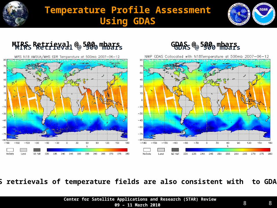
Temperature Profile Assessment Using GDAS
Temperature Profile Assessment Using GDAS
MIRS Retrieval @ 500 mbarsMIRS Retrieval @ 500 mbars GDAS @ 500 mbarsGDAS @ 500 mbars
MIRS retrievals of temperature fields are also consistent with to GDAS

9 Center for Satellite Applications and Research (STAR) Review
09 – 11 March 2010 Center for Satellite Applications and Research (STAR) Review
09 – 11 March 2010
Other Products from MIRS Other Products from MIRS
Tsfc 12/2009
23 GHz Emissivity 12/2009
Rainfall Rate 12/2009LWP 12/2/2009-12/6/2009
Sea-ice Monthly Averages - 2009
• MiRS Climate Monitoring– Time series
– Animations– Pentad, Weekly, Monthly maps
• Science and QC value

10 Center for Satellite Applications and Research (STAR) Review
09 – 11 March 2010 Center for Satellite Applications and Research (STAR) Review
09 – 11 March 2010
Challenges and Path ForwardChallenges and Path Forward
• Science challenges– How can the system performance under heavy precipitation conditions
be improved?– How sounding quality in lower troposphere be improved?
• Next steps– Prepare MIRS for JPSS applications– Generate improved retrievals over precipitating atmospheric conditions– More synergy in uses of other data to improve retrievals – High resolution microwave products
• Transition Path– MIRS system has been operational since 2008– Work with EMC, HRD, NHC, CWB on uses of MIRS products for
hurricane/Typhoon initialization – User workshops (July – August 2010)