Embed Size (px)
Citation preview

^
If) in
< i
D <
«/»/ /»«porr V" June 7990
PLRS GROUND-TO-GROUND PROPAGATION MEASUREMENTS
RONALD I. PRESNEU.
\
o- o o
Prtpand for:
CENTER FOR COMMUNICATIONS SYSTEMS (CENCOMS) U.S. ARMY COMMUNICATIONS RESEARCH AND
DEVELOPMENT COMMAND (CORADCOM) FORT MONMOUTH. NEW JERSEY 07703
Attention: MR. PAUL SASS
CONTRACT MDA903-78-C-0126
frOPS°*~ itPT)
DTIC ELECTE JUN 1 71985 2)
APPROVED FOR PUPUC REIEASF;
DISTRIBUTION 13 UNLIMITED iA) CHARED
F0BÜ«Np,-»-lC,,>Tl0N
APR 6 1984 2*
*WSECUWTV REVIWtOASO-P» •^»MMENTOfOEFfNSf
333 Rmtntwood A««nut Manlo Fark. California 0403S U.SA. (415) 3364200 CM«: SRI INTL MNF TWX: 010-373-1240
F
85 6 7 10 7 - ** - -• -« -- ■• ■■• • ■a, * J j dt "■ i i 11' i i fc^fc^^^,^^^. * i- i i-

UNCLASSIFIED SECURITY CLASSIFICATION OF THIS PACE (Whan Data Entarad)
REPORT DOCUMENTATION PAGE HBAD INSTRUCTIONS
BEFORE COMPLETING FORM
1. REPORT NUMBER 2. GOVT ACCESSION NO. 3. RECIPIENT'S CATALOG NUMBER
At±l£Lli :> 4. TITLE (and Subtltla)
PLRS GROUND-TO-GROUND PROPAGATION MEASUREMENTS
S. TYPE OF REPORT ft PERIOD COVERED
Final Report 1 Feb 1979 to 30 Juoe 1980
7. AUTHOR(t)
Ronald I. Presnell
•. PERFORMING ORC. REPORT NUMBER
SRI Project 8171 17 CONTRACT OR GRANT NUMBER(l)
Contract MDA903-78-C-0126
S. PERFORMING ORGANIZATION NAME AND ADDRESS
SRI International Menlo Park, California 94025
10. PROGRAM ELEMENT. PROJECT. TASK AREA • WORK UNIT NUMBERS
fll>910^ 11. CONTROLLING OFFICE NAME AND ADDRESS Center for Communications System U.S. Army Communications Research and
Development Command »__Ä. Fort Monmouth. New Jersey 07703
12. REPORT DATE
June 1980 13. NO. OF PAGES
102 IS. SECURITY CLASS, (of this rapertl
UNCLASSIFIED 14. MONITORING AGENCY NAME a ADDRESS (If «Iff. from Controlling Otftea)
18a. OECLASSIFICATION/DOWNGRADING SCHEDULE
IS. DISTRIBUTION STATEMENT (of ttili raoort)
APPROVED FOR PUBLIC RF'F/'F DISTRIBUTION 15 UNUMUCD A Accession For
BUS GRAAI DTIC TAB z Unannounced □ Justification
IT. DISTRIBUTION STATEMENT (of tf» afeatraci antarad in Black SO. H «Harant from ra»on)
IB. SUPPLEMENTARY NOTES
Distribution/
Availability Codes
Avail änd/or Special
IS. KEY WORDS (Contintaa on i
PLRS Digital communications Propagation measurements Foliage loss, .... .f IMffraction loss .
«1 and Montttv hv Mack numkar)
V, ?u «-■««RACT 'QomwiMa an r—ana aMa if Aaaaaary and Mannt* by B*»ak mm**)
RatUovave propagation measurements at 420 MHz to 450 MHz vere made in the field during October and November 1979» for the purpose of evaluating the per- formance of e single link of the Army's Position Location and Reporting System (PLRS) over short ground-to-ground communication paths obstructed by foliage and terrain. Tests were conducted under a variety of conditions aet by variables that included antenna height, path length, foliage situation, terrain-obstacle height, and frequency channel. <
f \ - '
DD 1 JAN 73 ■ *♦# 3 •omoN of i Nov es it
WCLASSiriM ITf SSCURITV CLASSIFICATION OF THIS PAOS (Whan Oau Ennraai
■• ■' -' -' d -"■ -» " -' •--■--•-» -■- -» . -■--■--• -• --■---■ a^üMaCafc^aMi

_ __ UNCLASSIFIED SECURITY CLASSIFICATION OF THIS PACE (Wh»n D«ti Entfd) 1». KEY WORDS (CoMinuad)
V"-
20 ABSTRACT (Continued)
Menage throughputs of 50 percent o' greater were achieved over most for- ested paths up to 2 km loag, and over &.. . simple diffraction paths up to 2.3 km long. However, PLRS failed to communicate on a medium-density, 800-m long foliage path with low antenna heights, and on a 300-m long terrain obstacle path. For simple foliage-obstructed paths, excess path loss (EPL) at antenna heights above undergrowth was found to correlate well with measurable tree-trunk density. EPL was measured to decrease with Increasing antenna height In almost all cases.
Round-trip errors in ranging (TO*) measurement over the single link reached values as great as 10 percent on most foliage paths. For 88 percent of the aeventeen propagation paths over simple terrain obstacles, range errors were less than 5 percent; however, in two cases these errors, caused by multipath, reached values of 22 percent and 370 percent.
Experimental results are compared with theoretical models and other foliage- loss field measurements. Extrapolation of measured-path-loss data are used to determine maximum communications range for a single PLRS link operating in forested environments.
PREVIOUS PACE IS BLANK
1U
(BACK) •OHM 'tMsni
■mnoN os i MOv atis OMOLITI
Dor;,i473 UNCLASSIFIED MCURlTV CLASSIFICATION OF THIS fSSi tWMM Dm ■«
.-•.v^'i^« -■ - »-- -.,-■; v-v.v^.

CONTENTS
LIST OF ILLUSTRATIONS vil
LIST OF TABLES ix
I INTRODUCTION 1
II SYSTEM DESCRIPTION 3
A. FLRS Terminals 3
B. Vans and Support Equipment ..... 5
C. Antennas 7
III SYSTEM CALIBRATION AND OPERATION 9
IV DATA REDUCTION AND ANALYSIS 13
V FIELD MEASUREMENTS 17
A. Peel Field 17
1. Site Description 17 2. Data 19
B. Duke Field 27
1. Site Description 27 2. Data 28
C. Basin Bayou 31
1. Site Description 31 2. Data 35 3. mi Test 37
D. Arnold Grid 40
1. Site Description 40 2. Data 40
E. Negro Hill 44
1. Site Description 44 2. Data 45
F. Fuller-Davidson Ridge 48
1. Site Description 48 2. Data 49
. .• . ...-._« ._i.\.i.

G. Powers Bridge Drop 50
1. Site Description SO 2. Data 51
H. Riley Creek Ridge 55
1. Site Description 55 2. Data 57
I. Meadows Hill , 60
1. Site Description 60 2. Data 60
VI DISCUSSION 71
VII COMPARISON OF JTIDS AND PLRS DATA 81
VIII CONCLUSIONS 8^
IX RECOMMENDATIONS 8$]
REFERENCES 91
vi
'- •'■ *'- •*- -*- •*- •' •'- ••-••-'•-»*-»•-»•-■'-■• ••-.•-••-.• .•..•.....'.•■-• -• -• '.' .-•.-.•'_• -» V -«'.» '-« -• *-« *->*-. •-«■■-- •-.•.•..*-•«•«•.-.• . . - .

ILLUSTRATIONS
1 Van and Antenna Tower Photograph 6
2 Antenna Pattern in the Vertical Plane 8
3 PLRS Calibration for 16 October 1979 10
4 BUU Power Amplifier Output Spectrum for Two Channels .... 11
5 PLRS PTU Data Printout Example 12
6 Free-Space Path-l-css Data 14
7 Peel Field Photograph 18
8 Peel Field Topographical Map 20
9 Peel Field Excess Path Loss vs Path Length 22
10 Peel Field Test Link Margin vs Path Length 23
11 Peel Field Excess Path Loss vs Frequency Channel 25
12 Peel Field Indicated Range vs Antenna Height, 400-m Path 26
13 Peel Field Indicated Range vs Antenna Height, 800-m Path 27
14 Duke Field Photograph 29
15 Duke Field Topographical Map 30
16 Duke Field Antenna Height vs Excess Path Loss 33
17 Basin Bayou Photograph 34
18 Basin Bayou Topographical Map 35
19 Basin Bayou Antenna Height vs Excess Path Loss 39
20 Arnold Grid Photograph 41
21 Arnold Grid Topographical Map 42
22 Arnold Grid Elevation Profile 43
23 Negro Hill Photograph 46
24 Negro Hill Topographical Map 47
25 Negro Hill Path Elevation Profiles 48
26 Terrain Obstacle Antenna Height vs Excess Path Loss 51
27 Negro Hill Indicated Range vs Antenna Height, Path B-D 52
vil
■■.. ,,•■.•.■■:•.'■■:■ .y-w.•.v.'-,>-,.''.'".'-.f.,uiv.>v•■[•.'^WIW-VCVCL1 =»•'.■.*.• *.•».:■ >. i.. .•..■>.•■..•■

I
28 Fuller-Davidson Ridge Photograph . 53
29 Fuller-Davidson Ridge Topographical Map 54
30 Fuller-Davidson Ridge Path Elevation Profiles 55
31 Fuller-Davidson Ridge Indicated Range vs Antenna Height, Path G-E 58
32 Powers Bridge Drop lopographlcal Map ..... 59
33 Powers Bridge Drop Path Elevation Profiles 60
34 Riley Creek Ridge Photograph 62
35 Riley Creek Ridge Topographical Map 63
36 Riley Creek Ridge Path Elevation Profiles 64
37 Meadows Hill Photograph 66
38 Meadows Hill Topographical Map 67
39 Meadows Hill Path Elevation Profiles , . . 68
40 Foliage Excess Path Loss vs Tree-Trunk Density 72
41 Peel Field Test Link Margin vs Path Length Extrapolation 75
42 Peel Field Required Transmitter Peak Power vs Desired Path Length 76
43 Terrain Obstacle Excess Path Loss vs Obstacle Angle .... 78
44 PLRS and JTIDS Antenna Height vs Excess Path Loss 82
45 PLRS and JTIDS Excess Path Loss vs Tree-Trunk Density 83
46 PLRS and JTIDS Excess Path Loss vs Obstacle Angle 85
vlll

TABLES
1 PLRS Frequency Chennels 4
2 Peel Field Test Link Mergln 21
3 Peel Field Excess Peth Loss 21
4 Peel Field Foliege Situetion et 400-m Peth 24
5 Duke Field Test Link Mergln 31
6 Duke Field Excess Peth Loss 32
7 Besin Beyou Test Link Mergln 36
8 Besln Beyou Excess Peth Loss 38
9 Arnold Grid Test Link Mergln end Excess Peth Loss 44
10 Negro Bill Test Link Mergln 49
11 Negro Hill Excess Peth Loss SO
12 Fuller-Oevldson Ridge Test Unk Mergln 56
13 Fuller-Oevldson Ridge Excess Peth Loss 57
14 Pavers Bridge Drop Test Link Mergln end Excess Peth Loss 61
15 Rlley Creek Ridge Test Link Mergln end Excess Peth Loss 65
16 Meedows Bill Test Unk Mergln 69
17 Meedows Kill Excess Peth Loss 69
Ix
--<----•-■ •._■ •.•-■■.••-■ • .-.•.• •. •.-•-■ -.•■-»•■••->•-.■-.•-. -»•■*-.•-/•-»■_.'^-■.'^•-.•j^-..' .•■-^'-.'• .•-.--• -• ..•-•.•.

I INTRODUCTION
During October and November 1979, radiowave propagation measurements
were made in the field using a military digital communication system
called Position Location Reporting System (PLRS). The purpose of the
measurements was to evaluate experimentally the capability of the PLRS
equipment and signal structure to communicate over short paths, obstructed
by foliage and terrain. A PLRS terminal was Installed in each of two
vans along with the necessary support and test equipment, antennas, and
towers. The vans were located at a variety of sites in and around Eglin
AFB, Florida and Arnold AFS, Tennessee to conduct propagation measure-
ments.
Hughes Aircraft Company outfitted the vans with electronic equip-
ment and carried out the propagation measurements in the field. SRI
International planned the tests, observed the field operations, and
made an Independent reduction and analysis of the data collected during
the field operation.
Path-loss measurements were made by measuring PLRS link margin.
That is, for each path measurement, attenuation in front of the receiver
was increased until the message throughput rate (MTR) reached a value
of 50 percent. Dependent variables r««.crded were attenuator setting
(AS), MTR, and time of arrival (TOA) range
Path-loss measurements were made under a variety of conditions set
by independent variables, which Included antenna height, path length,
foliage situation, obstacle height, and frequency channel. During the
field operation 187 measurements were made over 78 different paths at
9 sites.
Path-loss and ranging (TOA) measurements were made over a single
path at one time. Hence the measurements do not directly predict over-
all PLRS performance of a network of hundreds of PLRS units deployed

In a tactical situation. The data results are more appropriate for use
as inputs for a network model based on single paths.
I
* » * "• "• • • *• "• • *• "• - '» *. ... * * • ■ ' * '. .*• • **.".•• *.' *. . ". *• '» ". " » . * " *. N "'. . ' L\*_* aJ AA >1A. L*J*^A^ i~.t ■■> a. ■ tl, t, tl» SI^JL» LJL «'- **— a*- »— -* _ **—»*—»* ■ -* -' - - *£..*. * .* * - ^*. *' -* - » «' -.' - *' **- * - *' ~—'■ -' m -m ■" »*- ■*- ^ -

II SYSTEM DESCRIPTION
A. PLRS Terminals
PLRS is • digital position location system operating in the UHF
band and is designed for use in a tactical situation. The system uses
a synchronised spread spectrum (short-pulse) waveform for communications
in one of eight frequency channels in the 420 MHz to 450 MHz band. In
normal operation successive transmissions are hopped among the channels.
The system operates with many units in the network at one time using
time division multiple access (TDMA). The transmitted bursts are spread
to a 3-dB bandwidth of 3 MHz by modulation with a pseudonoise code se-
quence. The transmitter operates at a peak power of approximately 100 W,
and the receiver has a nominal sensitiv!/ of -105 dBm.
The PLRS equipment used during the propagation tests consisted of
two basic user units (BUU), one installed in the van and the other used
outside the van as a "manpack;" two user read out (URO) devices; two
selectable power adaptors (SPA); a modified portable test unit (PTU)
with associated teletype terminal; and two PLRS manpack antennas. The
PTU was installed in one van and the BUU, in the other van. Been termi-
nals were set up to transmit and receive, but path-loss measurements
were made in only one direction by the PTU receiving the messages. A
complete description of the PLRS system is given by Texas Instruments
(1979).
During the test measurements the PLRS equipment did not use the
frequency hop capability, but simply stepped sequentially through each
of the eight allocated center frequencies (spaced 3 MHz apart) listed
in Table 1.
Both hardware and firmware modifications were made to the PTU to
meet the requirements of the propagation measurements. These require-
ments are that the PTU be capable of delivering an RP power output of
■'■•■'- '- .'!•«--■'--•."- •'-»-• ■-•-.'-•.'■ .V.'.V.."»- .-'.-•■- .•.i.-'.-'.>V-.<.-.-. •»'' »•«"«"•«■ i/i''.-r-i>in' I-i

Table 1
PLRS FREQUENCY CHANNELS
Channel Frequency
(MHz)
0 425.75
1 428.75
2 431.75
3 434.75
4 437.75
5 440.75
6 443.75
7 446.75
100 W and that the unit have the capability of controlling the received
RF signal-power level input to it« RF assembly, which contains the re-
ceiver. The requirements were satisfied by adding a BUU power amplifier
to the FTU and by reconnecting the controllable step attenuator already
used by the FTU.
The FTU firmware was modified to allow the FTU to command the BUU
to transmit 100 messages for each attenuator setting for each frequency
channel. In addition, the FTU firmware was modified to add a routine to
format and print the test-data sheet with the test results for each MTR
measurement on the teletype terminal.
The FTU firmware also allowed a set of 16 TOA measurements made for
each frequency channel. Each TOA measurement was round trip. From the
set of 16 the printout listed the high, the low, and the average from
tfhlch the indicated range was calculated.
Mote that this TOA measurement and the following calculated Indi-
cated range procedure is not a normal PLRS operation, but was specifically
set up for these propagation tests. The normal PLRS network TOA
mm* mmmm.

measurement procedure involves multiple locations and a process of
multilateration that is much more complicated, but more accurate.
B. Vans and Support Equipment
The vans are Dodge CB400 commercial units with a maximum gr^ss
weight of 11,500 lbs. The vans have been modified with insulation, air
conditioning, windows, and lighting. Cabinets, benches, and shelving
has been added to provide storage and mounting space for the electronic
equipment.
The power subsystem consists of a power distribution panel and two
gasoline-engine-driven, 7-kW, 60-Hz generators. The generators are
mounted in sound-proofed boxes aft of the wheel wells. Access is pro-
vided externally by removable hatch covers. 400-Hz power (not used by
PLRS equipment) is provided by a 400/60-Hr rotary converter in each van.
In addition to the PLRS equipment, electronic test equipment in-
cluding an oscilloscope, signal generator, spectrum analyser, oscillo-
scope camera, and power meters are mounted on the tie-down shelving above
the equipment benches.
A 3-section, telescoping 65-ft antenna tower is carried collapsed
horizontally on the roof platform. The tower mount design allows the
tower base to be swung to the ground so that the tower can be erected
while attached to the van. After adjustments are made for leveling the
tower, an antenna mounted on top of the tower can be positioned from
22 ft to 65 ft high by a motorized lift mechanism.
Antenna heights below 22 ft are provided by a tripod placed on the
ground, on the van roof platform, or by a short, fixed pipe that is
mounted on the van roof. Figure 1 is a photo of one of the vans and its
antenna tower.
Voice communications between the two vans were provided by a citi-
zen's band transceiver mounted in each van with an antenna mounted ex-
ternally on the van. In addition, for backup, Motorola Banditalkies
(146 MHz PM) were used in the vans with externally mounted antennas.
.. ••.<'- «'.••. i. •'. .:. .•-. -.•-.-..•.••-v. _^.»- .>•-...•■ ,..:..,.,^...'.,'..-.t. .'-. -V- .-, .- . .-. .-. ■•..-. . .V. .•■•.•..•.•.•..••.■

•
._■ ,_« ..■ ._■•«." •_ •_- ._: ._: «_* t^L. ' »_• «- * ^_i m-L MJ^ '----«-«-»- i-*^ » * - * - »— ■ - • - I - * - - ' »-

C. Antennas
-PLRS uses three different types of antennas in the overall system.
All are vertically polarized and omnidirectional in the horizontal plane.
The manpack antenna can be used mounted directly on the manpack or
mounted on a mast for use by a surface vehicle. The master unit antenna
is similar, but with 3 dB more gain (a more narrow beam in the vertical
plane). The airborne unit antenna is a blade type mounted on an air-
craft surface. Its gain depends on the surface location of the mount.
The manpack antenna was used for all foliage-and terrain-obstacle propa-
gation measurements.
The PLRS unit in each van is connected to a vertically polarized
manpack antenna, which is a center-fed vertical dipole 1.2-wavelengths
long. The PLRS antenna has a gain of 5.6 dB over isotropic averaged
over the 420-MHz to 450-MHz band. Figure 2 is a vertical plane pattern
taken at 435 MHz. The exact lobe structure and size depends on the fre-
quency and the proximity to a ground plane. The horizontal plane pattern
is isotropic.
The PTU and BUU are connected to their respective antennas by
flexible coaxial cable and semiflexible, low-loss, foam-dielectric-line
1/2-in. diameter, a total length of about 75 ft. The total cable Ions
for each van is 1.5 dB to 2.0 dB.
« * * : i - -■ •**-»•- ' *•-'-•-"--•-*--'-•- - ■'- I■*■■* —*—*■•*■■* *- i —' ■'' ••-'•-'■-"•- •-■•■-- - *• *~-'M-

u ♦ -*
K
IK i
FIGURE 2 ANTENNA PATTERN IN THE VERTICAL PLANE
«-«-«-'"-•-•-•-»-•- fa •"- »- •-•--<-•-*-*»•»■*-«■'■■«-• «-* «-* «- "-^- "--•"'-,'"»-•"«-*-- '«-•-'«-•"«-'- tjäi >-'■ v" *

Ill SYSTEM CALIBRATION AND OPERATION
Every day of the field measurements operation, the two vans were
parked next to each other near the site for the day's measurements.
After the electronics In the van were warmed up, the vans were connected
by a 40-ft coaxial cable and 60-dB fixed attenuator. The PLRS units
were checked out and then synchronized.
Next a start of the test day collocation (STDC) test was performed.
The purpose of the STDC test was to verify the system sensitivity,
operability, and resetability. This was achieved by carrying out a PLRS
Readiness Test, which is a system self-check. A sensitivity check was
made by measuring the test system link margin through the coaxial cable
and attenuator for each frequency channel. Figure 3 shows a plot of HTR
versus AS for three frequency channels for the day, 16 October 1979.
The HTR goes from 90 percent to 10 percent with an AS change of about
4 dB. The AS that produces a 50-percent KIR is defined as the test link
margin. The BUU power amplifier power output was measured by use of the
spectrum analyzer coupled through a directional coupler. An example is
shown in Figure 4.
After the STDC test was completed, the vans were moved into position
for the first path-loss measurement at spots previously selected. The
antennas were raised into position by the three-section tower and path
measurements made. Figure 5 is a copy of a data printout from the PTU
terminal for a path measurement made during the day, 22 October 1979.
The data of primary interest is listed following "TIME" and it includes
the indicated average range, TOA high, average, and low for 16 measure-
ments. The TOA units are 12.5 ns and the TOA values includes a large
offset that is subtracted during the indicated range computation. The
indicated range values must be corrected by subtracting 62 m to correct
for cable delays. TOA measurements are made at zero AS. The channel
number and the HTR for 100 messages follow for each of eight AS listed
L-.--.T-.:%.-f..-:.v ., ^_ «_ «. HUM m* • - &^ r - * — i

110
100
70
I 60
80
in 19
30
20
10
i—i—i—i—i—i—i—r A CHANNEL 1
• CHANNEL 0
■ CHANNEL 7
CHANNEL NUMBER
01 M 93 14
ATTENUATOR SETTING — dB
07
ft
FIGURE 3 FIRS CALIBRATION FOR 16 OCTOBER 1979
10
'*■»■• * S *■ i * \m. -_--_.. '.. | - < - * -» - | m «.- «■— » -

FREQUENCY — 6MHz/divitk>n
FIGURE 4 BUU POWER AMPLIFIER OUTPUT SPECTRUM FOR TWO CHANNELS
above. All of the above are listed for each of eight frequency channels.
In addition to the path loss measured data, temperature, humidity, wind/
rain conditions, path length (estimated from a map or physically mea-
sured), and location data were recorded.
Path measurements were made at each of several antenna heights.
Then one of the vans was moved laterally 10 m and path measurements were
repeated at the same set of antenna heights. This procedure allowed for
an estimation of the effect of a slight antenna spatial shift on the
measured path loss.
11
.»-.«_ fc «_ . ■.■.I..»»I«.:»-..- .-••■ ...I..-.--■»• «.

< Hü IN > ST A ,041,02
tu MINI L ALL START > 040 INC • 02 ROVER 0
( PTU 10 ) FR S7 Ml V3S
w
( lUtt OUT) FR 07 MI VW
( IUU IN ) f A 07 N »13
( IUU OUT) FA OOCCI •
< PTU IN ) DI
< TIHE ) IMOI
22 13 3li23 TOA-Nl 10»-*« TOA-10 CHAN «TIN* 040 OSO 032 034 034 OSO 340 042
0.017 KH 11,313 11,111 11,110 0 TNIU* Of* Off 100 100 Ott 0001024 «04 s*t-
0.011 KM 31,110 11,100 31,107 i TNIU* 100 007 100 ON OfO 0031041 004 jr«7
0.012 KN 11,110 11,100 31,304 2 TMU* 100 Ott 100 OtO Ott 0031014 001 St.*
0.012 KM 11,111 11,1*0 33,107 3 TNIU* 100 Ott 100 Ott Ot7 0041034 000 ni st» 0.012 KM 11,111 11,100 13,304 4 TNIU* Ott 100 100 Ott OtO 0031033 001 ST. 3
0.011 KN 11,110 11,100 31,304 3 TNIU* 100 100 Ott 007 002 047101t 001 5<4
0.012 KM 11,111 11,10t 11,100 4 TNIU» Ott 004 Ott Ott Ott 037100t 000
0.000 KM 11,100 11,10« 11.304 7 TNIU* 000 Of 2 OtO OtO 00t 0311004 000 SVp Tr«-.T*P 1«**^
ICST 0 • 11 PTU OITI • Di PTU «NT • 2i
KATMI • «>T^ H" * WJNIOITI •
ouu pooti • o roLioot • **t*>Aj A
' AT
FIGURE S PLk*S PTU DATA PRINTOUT EXAMPLE
12
• ■.«...-.«.*». -'-»-*• i • ' ' ■ - ■ . ■■...■.■.■. ^

IV DATA REDUCTION AND ANALYSIS
Each set of eight (frequency channels) path measurements or cali-
bration data was reduced to a single average value. First each frequency
channel data was interpolated to find the AS that corresponded to a value
of 50-percent MTR. Then the average was computed for all eight values.
This average AS is the test link margin for the set of independent vari-
ables selected for that measurement. Note that operational link margins
will exceed the test link margins measured in this field measurement
program by 3 dB to 4 dB, the amount of cable lni in the PLRS test set-up.
The fourteen STDC test sensitivity measurements were reviewed first.
The mean value was found to be 93.6 dB with a standard deviation of 0.22
dB. The very low standard deviation Indicates that the PLRS system
amplitude stability over the three-week field operation was more than
adequate for the task.
All of the reduced test link margin (AS) data was then grouped by
site and path length. All of the path-loss measurements made under
free-space or nearly free-space conditions were plotted in Figure 6.
The straight line is the calculated path loss as a function of path
length. The measured AS data was plotted by normalising the two data
points at 200 m to place them on the calculated path-loss line, which
fixed the AS scale with respect to the calculated path-loss scale.
An alternate procedure would be to calculate the path loss from the
AS by the following equation:
AS (link margin) - PT - Lj ♦ CT - Lp ♦ CR - L^ - «^
where
P_ ■ Transmit power in dBm
L_ • Cable loss to the transmit antenna in dB
C_ ■ Transmit antenna gain in dBl
13
•-•■•-.•-.•-'••-.•-,-V-*.-.>-'.- .-%-•-'.-'.• •.-•.-•. -V----V-'--.? r.'-'A-j -'■■•-> .» '■• '.a 'J J ^2^^1**--±L**L^*±M±*-AJ^L±L »,?, ... * ,i, .1 .A .

9NIJLL9S W0J.VnN3.UV
8 8
<
o
I xu 5*
tu
8 8 * wv 82
•p — not M1V4 B3v«-nw4 oiiv-innvo
14
^ '-^^-*-•-*-•-'»-'«-■ -1 -•«'-•- •-"-•i',"i* --- '- •--'-•--- - »-• h -•-• *-••- «-• ikh fci fci^

Lp ■ Path loss between antennas in dB
G_ ■ Receive antenna gain in dBi
L_ ■ Cable loss to the transmit antenna in dB
R-_. ■ Receiver threshold in dBm
Although perfectly valid, this latter method depends on the accuracy
of the antenna gain data. Discrepancy between the two methods is 1 dB
and is not significant.
The Peel and Duke Field free-space data was taken with the antenna
height 20 ft over the treetops. The Basin Bayou free-space data was
taken at maximum antenna height that was over most, but not all the
treetops and that resulted in some excess path loss (EPL). EPL is de-
fined as any path loss exceeding line-of-sight, free-space path loss.
Once the relationship between free-space path loss and AS is set, the
EPL for all path measurements made may be readily calculated. The
"negative" EPL data at 800 m apparently results from some constructive
interference from the treetops reflection path with the direct path.
This apparently is demonstrated only on the long paths where the treetop
reflection path is at grazing incidence.
Although the MTR normally goes from 90 percent to 10 percent with
a received signal level change of 4 dB, the system cutoff characteristic
changes when the propagation path becomes non-line-of-sight. Multlpath
and phase distortion that are caused by ground foliage and terrain
obstacles in turn cause the normal system cutoff characteristics shown
in Figure 3 to become stretched-out or distorted. For measurements made
where the EPL was 0 dB to 20 dB, the system cutoff was Increased 1 dB to
2 dB. '«liiere the EPL was 20 dB to 40 dB, the system cutoff increased 6 dB
to 10 dB. In 27 cases out of 187 total or 14 percent, the system was
greatly confused by multlpath conditions and the system cutoff reached
as much as 40 dB or more. Those situations are subject to greatly vary-
ing interpretation and their data points have been flagged with the
symbol, $ on the tables. The accuracy of EPL values Is obviously de-
graded by the system cutoff stretch out by about 1/2 of the cutoff in-
crease. Thus 86 percent of the EPL values are accurate to ±5 dB or
better. The accuracy of the other 14 percent is no better than £10 dB.
IS
r
• _•. .• .•■ .••.>.i-•-.-.•-•-.•.■.• ■■...•-.-. .■. .■. .■. ........... ...•-.•. . . i—^-^i .-^-^—«__^^_^_^—._^_

V FIELD MEASUREMENTS
The field measurements were made over a three week period in October
and November. The first two weeks were spent at three sites, Peel Field,
Duke Field, and Basin Bayou, respectively, on the Eglin AFB reservation.
Description of those sites and others in the Eglin AFB reservation are
given by Presnell (19>9a). The Eglin sites were chosen primarily to
allow path measurements over and through ground foliage in a variety of
situations, but without significant variations in terrain height.
At the end of the first two weeks the vans were driven to the Arnold
AFS area near Tullahoma, Tennessee. The last week was spent making path
measurements at a variety of sites described by Presnell (1979b). All
but one of the sites near Arnold were selected to provide propagation
paths over terrain obstacles.
The following site and data descriptions are listed generally in
the order that altes were visited.
A. Peel Field
1. Site Description
The Infield of this airstrip Is slash pine, planted In 1964,
Measured by the angle method developed by Bitterlich (1948).
17 PNCVIOUt »AOC •S HANK
, \ thinned in 1977. It is of medium density with random tree spacing and B
with light underbrush. The tree-trunk density (basal area) measured
about 80 ft /acre and the tree heights measured 32 ft to 40 ft. This
site was chosen as suitable for a variety of clearing to clearing or
foliage immersion measurements (across the infield). Figure 7 is a
photograph showing the trees in the infield and part of the runway. The
runways are at least ISO ft wide and the area« on the outside of the
' _^ _'.AJ.. V

o
UJ
UJ a. D O
18
-r —• -* -» -- - ■ * - 1 - « ~ * ' 1 ' * ■ « ■ «-*-*■«-■■*■■%■ 1- W-.«L. •-. i- •-. .. . . <- ^- .

.% "..-..-..-.
runways «re naturally forested although the eastern end is quite sparse.
The one-story buildings are considerably removed from the runway. Figure 8
is a topographical nap of the field showing the location of the four paths
where measurements were made. As the elevation contours indicate the
ground slope was about 10-ft over the longest path (800 m).
2. Data
a. Path-Loss Measurements
The measured test link margins (AS) are listed in Table 2
for each combination of path length and antenna height. The double
numbers are the result of a 10-m lateral position shift and indicate
data sensitivity to a specific location.
The calculated (as described in Section IV) EPL data are
listed in Table 3 for each combination of path length and antenna height.
Antenna heights are also described relative to the trees. The EPL data
are also plotted In Figure 9 as a function of path length on a linear
scale, parametric In antenna height. Only the treetop antenna height,
which produces the lowest nonsero set of EPL values, appears to behave
in a linear fashion; that Is, the line can be extrapolated back through
the aero origin.
Figure 10 is a plot of the test link margin data contained
in Table 2. The right-hand scale Is total path loss, which is the sum
of EPL and the calculated free-space path loss.
A number of foliage situations were tested using the
400-m path length at Peel Field. First both vans were backed up to the
edge of the trees and the antennas set at a height of 13 ft, about 1/3
of the tree height. This siting was used to simulate a foliage immersion
to Immersion situation. The EPL measured 36 dB, as shown In Table 4.
One van was moved out away from the edge of the trees, 20 m along the
propagation path line; this siting simulated a foliage Immersion to
clearing situation and the EPL measured 35 dB. Then the van was moved
to 40 m from the trees with no measured change In EPL. Finally, the
19
mmmmmmmmmmmmmmmmmmmmmmmmmmmmmmmiemmmmmmmmmmmmmmm*

FIGURE 8 PEEL FIELD TOPOGRAPHICAL MAP
20
..._._. ..-.-..._.-. ,..._!_», '--■• ■•-•--- -.-.-.-■.-.-■-•-•-•-.-■.-...,•,

Table 2
PEEL FIELD TEST LINK MARGIN
Antenna Height* (ft)
Test Path
100 M (dB)
200 M (dB)
400 M (dB)
800 M (dB)
60 95 89 84 80
30 92 to 96b 84 to 85 74 58 to 60
22 87 to 88 71 to 74 52 to 68 $C 39 to 50 $C
13 71 to 75 •ma* 47 --
6 73 to 78 a» a* 44 $C < 0 $c
a Measured to antenna base, center of antenna is 2 ft higher-, b Indicates that at least 2 measurements were made for the
given nominal range; the values given are the extremes. c The symbol, $, indicates that the data are subject to
greatly varying interpretation because of system cut off stretch-out conditions.
Table 3
PEEL FIELD EXCESS PATH LOSS
Antenna Height* (ft)
Test Path
100 M (dB)
200 M (dB)
400 M (dB)
800 M (dB)
Free Space
Tree- tops
Upper Canopy
Trunks
Under- growth
60
30
22
13
6
0
-1 to 3b
7 to 8
20 to 24
17 to ;>2
0
4 to 5
15 to 18b
mm
0
9
15 to 31 $°
36
39 $
-3
17 to 19
27 to 38 $
a« a*
> 77 $
a Measured to antenna base, center of antenna Is 2 ft higher, b Indicates that at least 2 measurements were made for the given
nominal range; the values given are the extremes, c The symbol, $, indicates that the data are subject to greatly
varying Interpretation because of system cut off stretch-out conditions.
21
.•.•—■■-' ..--•......• ■"•■•■«■•V«. •-•-^ i • •-•«--^ •■■-••---• •-•■ - wi.. -^ •„».• i-«—^:^ ^^-^.^.^-^i^-i^—^-^-

100 200 400 PATH LENGTH — m
800
FIGURE 9 PEEL FIELD EXCESS PATH LOSS VS PATH LENGTH
first van was moved out 20 n and then 40 m. All of the EPL values are
within experimental error of each other and indicate that there is no
advantage in using available clearings for an antenna height of 13 ft
and a 400-m path length.
Figure 11 shows the effect of average ground foliage loss
oh the variation of loss between frequency channels. The EPL for each
individual channel Is plotted and grouped by path length and made para-
metric In antenna height. Loss variation between channels Is shown to
increase with average EPL and, therefore, path length and reaches a
maximum of 15 dB in the worst case.
22
.-..■. :». A. *•*••* -■-• • • ■*«*i

8P — SSOT RLVd 1VJL01
8 8 R
o z UJ
< a. CO > Z 5 tr < 2
Z
O _J UJ
iT -i ui if
o UI
8 8 8 8 •P — NI9MWV «Nil ASIA
23
. ^ -*. »-■-«-«. -*---*-*-■• ■ '■'- • - »'.«'-■-'-■'- I - »'■ •-»-'-•-•-•-•- -•-'-» --.-.■-•.;.■».•--.-■•- » --.--.■>-.•.•-•■

Table 4
PEEL FIELD FOLIAGE SITUATION AT 400-M PATH (Antenna Height—13 Ft)
Type of Path
Distance From Trees
(m) Excess Path Loss
(dB) Van 1 Van 2
Immersion to imnersion 0 0 36
Imnersion to clearing 0 20 35
Imnersion to clearing 0 40 35
Clearing to clearing 20 40 36
Clearing to clearing 40 40 34
b. Hanging Measurement■
One of the first tests carried out at Peel Field was to
make path measurements over a tape-measured length of 100 m on the run-
way. The results indicated that the TOA (ranging) measurements under
free-space conditions were very accurate. The indicated average range
values, once corrected by a fixed offset of 62 m, were accurate to at
least ±2 percent. The «ctual foliage path length at all sites was never
directly measured by tape, but rather calculated by taping distances
along the roads or pathways and using an assumed angle between the roads,
a method good enough only for nominal path length values.
Figures 12 and 13 are plots of Indicated range (corrected)
for the nominal 400-m and 800-m paths, respectively, at Peel Field. Each
frequency channel Is plotted Independently, but grouped by decreasing an-
tenna height and, therefore, increasing EPL. The figures Indicate that
at 65-ft antenna height (tero EPL) the Indicated ranges of 365 m and
24
■ — ■ • . - m - * ^ ■ .. • <-**- -•---*-•-•

'.V
tu z z <
> o z
>
<
UJ u X
UJ
K
8
S •P —
8 8 SS01 HIV* SS13X1
25
•- — • *- *- * ■■--•-•.••-- ■.-.-. ■-•-^•. - ----- .,.•.-.■. •.•..■...•■. ^^.-... M^*i*äai*A^^di

460
30 22
ANTENNA KelGHT — ft
FIGURE 12 PEEL FIELD INDICATED RANGE VS ANTENNA HEIGHT. 400-<n PATH
725 m respectively «re the true ranges and those data points are tightly
grouped. As the antenna height decreases the Indicated range data be*
cose spread and the average value increases. At 6-ft antenna height
the indicated range error is 4-35 m, and the data is spread ±20 m. For
the 800-a path the 65-ft antenna height (zero EPL) range data show an
average of 725 m and a standard deviation of 1.4 a. At the 6-ft antenna
height the indicated range error is 452 m and the standard deviation has
increased to 12 m.
26
»■-»«« * - - - - .v .•• ' •-•»•-••- 1 -«.»_*■ ■.»^-.-^e.-.._■. ■-,

820
ü SO 22
ANTENNA HEIGHT — ft
FIGURE 13 PEEL FIELD INDICATED RANGE VS ANTENNA HEIGHT. 800-m PATH
B. Duke Field
1. Site Description
At this location It a high density stand of Choctawhatchee
sand pine, planted In 1965, mver trimmed or pruned. The tops are heavy
with green foliage. The large amount of low branches (mostly without
needles) make for vary heavy apparent density. The tree-trunk density
measured 110 ft2/acre with tree heights 30 ft to 35 ft. The trees are
individually in rows and planted In strips 190-m wide running
}"'
27
.■ .■..-.-.-«.»_..-.•.. i t-.j.Oi- *- *- - *- '- - '* ■ •-■-'-•-•-'-•-•---• • -

; v
approximately north to south. They are separated by smaller strips of
the original growth, mostly scrub blackjack oak, bluejack esfc and
longleaf pine that are not as tall as the planted pines. The trees on
each iide of the road almost converge over the road in spots providing a
tunnel effect. Figure 14 is a photograph taken from the road. Figure 15
is a topographical map showing the location of the paths where measure-
ments were made. The elevation contours indicate that the ground slope
is about 15-ft down over the north half of the 800-m path and nearly
level over the shorter paths.
2. Data
a. Path-Loss Measurements
The measured test link margins (AS) are listed in Table 5
for each combination of path length and antenna height. The double
margin numbers are the result of a 10-m lateral position shift and indi-
cate data sensitivity to a specific location. The double antenna height
numbers indicate a measurement made from an antenna on the tower to an
antenna at a differing height on a tripod or the manpack on the ground.
The calculated EPL data are listed in Table 6 for each
combination of path length and antenna height. The EPL data for some of
the paths are plotted in Figure 16. The 800-m path data were taken
across four different strips of trees, and, therefore, the 800-m EPL
data cannot be compared to the shorter paths in a meaningful way.
b. tanking Measurements
Measurements were made at three path lengths (nominally,
200 m, 400 m, and 800 m) at Duke Field. The ranging data at 65-ft
antenna heights showed that the true path lengths were 203 m, 380 m, and
750 m, respectively. Indicated range values were spread and increased
in the same way as the Peel Field data as shown in Figures 12 and 13.
Also the data showed similar occasional wild points (deviation greater
than 120 percent). Indicated range data taken at low antenna heights
28
>'
Jt I»' ■ ^J j_

1
\i
29
-• '-' -* '-* -* —1 I ' ■ '-* » -»-»-> -«-*-»-*•-» » * .»^..-^■^»^. -■_*-«_«-, _._.. ._„-

FIGURE 15 DUKE FIELD TOPOGRAPHICAL MAP
30
.- ^./-.•-.-.-•...••>••>• ^- .■■..■•■■•.-•«■•«■•«-.<■:«.:. <.-^.' «.T».- !-•..-• »- ,':-.'V..\,.A-;'>'.-:L ..•• •-'-"■ ---•••- ----- -

Table 5
DUKE FIELD TEST LINK MARGIN
Antenna Height* (ft)
Teat Path 200 M (dB)
400 M (dB)
800 M (dB)
78 65 89 83
35 80 to 81b 61 to 68 59
22 61 to 63 48 to 51 $C 40 to 41
35, 6d 63 53 45
35, 1 »m 55 41
22, 6 ««■ 45 to 49 35
22, 1 mm» 45 to 47 30 to 32
a Measured to antenna bate, center of antenna la 2 ft higher,
b Indicates that at least 2 measurements were made for the given nominal range; the values given are the extremes,
c The symbol, $, indicates that the data are subject to greatly varying interpretation because of system cut off stretch-out conditions,
d Two different antenna heights are indicated.
ahovsd indicated range errors of +19 m, +28 m, and +10 m, respectively.
The 800-ra path showed less range error because, as discussed above, that
path was across four strips of trees, two of which were low density and
short.
C. Basin Bayou
1. Site Description
At this location a low to medium density stand of alash pine
was planted In 1952 and thinned in most areas later. The areas in which
31
■ - I

Table 6
DUKE FIELD EXCESS PATH LOSS
Antenna
Test Path
Height« 200 M 400 M 800 M ! (ft) (dB) (dB) (dB) |
Free •pace
65 0 0 -1
Tree- tops
35 8 to 9 15 to 22 18
Upper canopy
22 26 to 28b 32 to 35 SC 36 to 37
35, 6d 26 30 32
35, 1 « 28 36
22, 6 e»e» 34 to 38 42
22, 1 «#■» 34 to 36 45 to 47
a Measured to antenna base, center of antenna Is 2 ft higher.
b Indicates that at least 2 measurements were made for the given nominal range; the values given are the extremes,
c The symbol, $, indicates that the data are subject to greatly varying interpretation because of system cut off stretch-out conditions,
d Two different antenna heights are indicated.
the measurements were made had tree-trunk densities varying from 0 up to
90 ft2/acre with an average of about 50 ft /acre and with tree heights
varied from 50 ft to 70 ft. Many logging trails have been cut through
the area at irregular angles. The trees are mostly bare trunks from
40 ft on down. The area has relatively little underbrush and most of it
Is below 8-ft high and distributee' in an irregular way. Visually this
site appears very sparse with good visibility up to 200-* distance.
Figure 17 is a photograph taken In tin* area. Figure 18 la a topographical
32
jtmmm ^tttttmmmmmmmmmmmammmmmmmm^mamM

FIGURE It DUKC FIELD ANTENNA HEIGMT VS EXCESS PATH LOSS
33

z o. < c o o o X a. 3 O >- < as
2 m
E 3 Ü
34
fc-C-^-l .£ * » .* ' » " M . * -•-■ ....-»-■-.-•»-.-.-»--. -•» _-. _ --. _-» . . _-. _■»_•. _i :- -». M' '- v v h '- "- -'- -

FIGURE 18 BASIN BAYOU TOPOGRAPHICAL MAP
map of Che area, shoving the location of the paths where measurements
were made. The elevation contours indicate that the ground slope is
about 10 ft over the 2-km path and nearly level over the shorter paths.
The tree planting is irregular in almost all areas. One limited region
that only the 2-km path included has the trees planted in rows.
2. Data
a. Path Loss Measurements
The measured tesr link margins (AS) are listed in Table 7
for each combination of path length and antenna height. The double
35
• • -.■*-»*-»-*■»-»«-■ -' -■ - -• '-• -• *^BMta*i

Table 7
BASIN BAYOU TEST LINK MARGIN
Antenna
Test Path
Wet Dry Height8 300 M 600 M 1050 M 1050 M 2000 M (ft) (dB) (dB) (dB) (dB) (dB)
65 84 72 59 to 60 61 53
50 76 62 to 65b 47 49 40
35 72 60 to 63 41 to 46 $C 50 26
22 72 62 to 64 40 to 43 47 13
65, 6d -- — M -- 31
65, 1 ota -- 40 $ — 28
50, 6 «•«■ mm 39 ■»•• m «•
50, 1 mm* m » 37 «•« ««
35, 6 mm 53 $ 40 $ m» —
35, 1 — 51 39 ■»» 21
22, 6 m-m 38 to 55 38 $ m m —
22, I «*M 50 to 53 $ 35 — —
a Measured to antenna base, center of antenna is 2 ft higher, b Indicates that at least 2 measurements were made for the
given nominal range; the values given are the extremes. c The symbol, $, indicates that the data are subject to
greatly varying interpretation because of system cut off stretch-out conditions,
d Two different antenna heights are indicated.
margin numbers are the result of a 10-m lateral position shift and indi-
cate data sensitivity to a specific location. The double antenna height
numbers indicate a measurement made from Van 1 with an antenna on the
tower to Van 2 with an antenna at a differing height on a tripod or the
manpack on the ground.
36
—ä—•—-• -* ii • ■ • « •_ -*■ » • • -"-»-• - -," .* -." •." O * I * »--* 1 * 'jlu'J'' '•»*•' -* -■ J

The calculated EPL data are listed in Table 8 for each
combination of path length and antenna height. Because the tree distri-
bution is so irregular in the area where the path measurements were made,
the EPL data is not expected to be linearly related. At the 1050-m
path, data were taken on both a dry day and on a day after a morning
rain. Comparison of the EPL data indicates a 1-dB to 7-dB increase,
caused by wet foliage and trunks, depending on antenna height.
The EPL data are plotted in Figure 19 to indicate the
variation of EPL with antenna height. The data indicate that there is
no significant reduction of EPL below the upper canopy in the trunk area
where there is no green foliage and the number of branches is greatly
reduced for the path lengths measured. No explanation for this effect
is obvious.
The variation of EPL with antenna height for the 2000-m
path differs greatly from the other paths. However, because the foliage
density and undergrowth is highly variable from path to path at this
site, the unusual character of the 2000-m path is not thought to be
significant.
b. Ranging Measurements
Measurements were made at four path lengths (nominally,
300 m, 600 m, 1050 m, and 2000 m) at this site. The ranging data at 65-
ft antenna heights showed that the true path lengths were 287-m, 601-m,
1052-m, and 2039-m long. Indicated range values were spread and in-
creased in the same way as the Peel and Duke Field data. Indicated
range errors for all combinations of antenna heights and path lengths
were calculated and the values ranged from 0 to +102 m in a way that
showed no obvious trends except that Indicated range errors were usually
larger at tree trunk heights than at upper canopy heights.
3. EMI Test
On the afternoon of the last day of the visit to Basin Bayou
a brief test was carried out to look for electromagnetic interference
37
>*■»*> A -V - -I -1 JA _*§-'■ "l - «.-'■*■ *■■"»>'■ «-•;*, - ■ M\ -^-, '.* k^JM jft %/-*-*.- -.' ^ ■-*.«_' .>_'■«■■ «. i '.. M. : %. ' m.\ ^ _ ■_ ' >*-.•■ *. '..-«■* •- - - - - ^ . 1- :. * ... m. ■ m. \ . i - 1 -*-.»- '. ■

Table 8
BASIN BAYOU EXCESS PATH LOSS
Antenna Height« (ft)
Test Path
300 M (dB)
600 M (dB)
Wet 1050 M (dB)
Dry 1050 M (dB)
2000 M (dB)
Tree- tops
65 1 7 15 to 16 14 16
Upper Canopy
50 9 14 to 17b 28 26 29
Trunks 35 13 16 to 19 29 to 34 $C 25 43
Lower Trunks
22 13 15 to 17 32 to 35 28 56
65, 6d — -- • «• «••» 38
65, 1 M «■ w 35 $ — 41
50, 6 — — 36 «••a «•«■
50, 1 «• mt — 38 -- ■» a»
35, 6 — 27 $ 35 $ — mm
35, 1 w «» 28 36 mm. 48
22, 6 • ■» 24 tc 41 37 $ — »«•
22, 1 — 26 to 29 $ 40 -- mm
a Measured to antenna base, center of antenna is 2 ft higher. b Indicates that at least 2 measurements were made for the given
nominal range; the values given are the extremes. c The symbol, $, indicates that the data are subject to greatly vary-
ing interpretation because of system cut off stretch-out conditions. d Two different antenna heights are indicated.
(EMI) between PLRS and Joint Tactical Information Distribution System
(JTIDS). After both systems were warmed up and STDC tests carried out,
the vans were positioned for the 1050-m path. The JTIDS antennas were
mounted on the towers and set at a height of 22 ft. JTIDS had a test
38
.«-«.».„ ■.'.».».» ■■---»- *-■-*-?- *-■-*- ... «,. a- . - »- ■- ■- ^- *-- ^- *

70
.-.'
z a tu z <
2 » »- z <
20
10
300 m 600 1050 m 2000 m.
10 20 30 40 EXCESS PATH LOSS — dB
SO 60
FIGURE 19 BASIN BAYOU ANTENNA HEIGHT VS EXCESS PATH LOSS
. ■
link margin of about 20 dB. In the first van the PULS PTU and the
JTIDS terminal were operated inside the van. nie PLRS antenna for the
PTU vas mounted on the front of the roof of the van at a height of 10 ft.
The PLRS BUU was operated outside the other van as a manpack with an
antenna height of 1 ft. The manpe-k was positioned 50-m north of the
other van. PLRS had a test link margin of about SO dB. Mo effect was
found on the PLRS test link margin when JTIDS was switched on or off.
During these tests the spectrum analyser was used to look at both JTIDS
39
■'.V-V.'-V.'.-'i'--'..-.-•-.-•■-••-• ■■••■•■■•■■■.■■..•..■.■■.■■.;.''.V.>.<.f.',.>.f.w.fi-iii:.:i^amj^

and PLRS received signals. No interfering signals were found in the
JTIDS operating band. Interfering signals were found in the PLRS operat-
ing band, but they were determined to originate from the FPS-85 radar
located about 10 ml away and not from JTIDS.
The van at the western position was moved east so that the
path length was reduced to 500 m and again JTIDS was switched on and
off. This time the PLRS test link margin changed by about 3 dB.
No obvious EMI was expected between the two systems because
the third harmonic of the PLRS transmitter falls above the JTIDS operat-
ing band. This EMI test was not intended to be an exhaustive evaluation.
A more detailed test should be conducted especially at lower link margins
and under conditions more nearly simulating a typical tactical situation.
D. Arnold Grid
1. Site Description
The Arnold Grid is laid out in rectangular blocks in an area
about 4 km by 1/2 km. Most of the area is free from wires and has essen-
tially no traffic. The foliage is high density with random tree spacing. 2
The tree-trunk density measured 120 ft /acre with tree heights that mea-
sured 45 ft to 70 ft. The foliage is random mixture of pine and scrub
oak. The underbrush varies from light to dense. Figure 20 is a photo-
graph taken in the area. Figure 21 is a topographical map of the area
showing the location of the two paths. Figure 22 is an elevation profile
for the two path*. The vertical scale is exaggerated 30 to 1.
2. Data
a. Path Loss Measurements
The measured test link margins (AS) and calculated EPL
for each combination of path length and antenna height are listed in
Table 9. The EPL values for the two paths (1000 m and 2000 m) are not
comparable by path length for several reasons. The terrain is not »»
flat as shown In Figure 21. In addition, the site lacks a uniform
40
>•/• N* *.* "\\Y* %""»" '•* '»\*« "•* '• '» .*• "•*_*,w "^
'•»■■•-•-•■-•-■• -•-•»•*■•'-'■'-'*-'»-' «-' ■•'«- ■-•'>.,'i.,'-,'--''--'«-<-''vÄVv O. --W ^v'.v.r.-.w.- ■».■•.• .•-• •-• •-•■•- I" •-• - •- •-• -v- •-' v'-V »■'-

FIGURE 20 ARNOLD GRID PHOTOGRAPH
41
■ » » * ^M ^ t ^ » ^ » - fc^A^ _ •: ■ . i. - • . . • . _ .. «-■ . »^ •_ •.*-*-•. ■ ^ » - -^ ».-»-»-■■.»-»- »-iiiiin. ■

</
s^T" /Zi I Lr\l *f>-'4i*/7T
es
<
3
m i /I'—-1
1 2 d*fl4j *»
-y. ITS" ̂1
: "S.
f-
a;
W14 A *th
-i <
V
*'-
*v / ,' J
\\ - , ■Pi 'T -r-fCi-^A
J- • V i ' . * T / i " ' ^' \\ I s >i~
£ o
o z <
M
w a. o
* >^ .* \ i 1 If«
. •>
V
& <?
42
! * ' - a ^>-i^«~»- . i^_^ ■* '-*"« '--•- '-• -■'-*■ ->•-■•».- . » »».'> ...... -

a
r._
i—i—r
UJ
s g
i & I si
H § B 3
i n H — NOIJlVAill 1AUV11M
43

Table 9
ARNOLD GRID TEST LINK MARGIN AND EXCESS PATH LOSS
Antenna Height*
(ft)
Test Link Margin (dB)
Excess Path Loss (dB)
1000 M 2000 M 100C M 2000 M
Tree- tops
Upper Canopy
Trunks and Scrub
Trunks and Scrub
60
45
30
22
46 to 47b
24 to 26
18 to 20
12 to 13
40
27
15
4
28 to 29
49 to 51
55 to 57
62 to 63
29
42
54
65
a Measured to antenna base, center of antenna is 2 ft higher,
b Indicates that at least 2 measurements were made for the given nominal range; the values given are the extremes.
foliage type. The long straight roads parallel to the propagation paths
offer possible low-loss, indirect paths.
b. Ranging Measurements
The ranging data at 65-ft antenna heights that are shown
indicated ranges of 967 m and 1958 m for the two paths. At 22-ft an-
tenna heights the indicated range error was 466 m and 478 m, respectively.
E. Negro Hill
1. Site Description
Normandy Dam forms a lake whose water level is at 875 ft.
Negro Hill arises from the lake and has a peak of 1045 ft. Most of the
hill is foliated. Some of the trees had dropped their leaves by the
44
-» * « ' ■ »■-■•-*-***-*-* -»-.-»■---»'-«-»■-»-»-»-»-»-«-»-«-» i -* - -'

time of the measurements. Figure 23 is a photograph of the hill taken
from Position F. Figure 24 is a topographical map of the area and
shows the location of five positions where the vans were placed to make
path measurements. Measurements were made over the four paths indicated.
Figure 25 gives an elevation profile for each of the paths. The start
and end of each profile is the ground level at the position where the
van was parked. The vertical scale has been exaggerated 2 to 1.
2. Data
a. Path Loss Measurements
Table 10 lists the measured test link margins for the
four paths measured. Table 11 lists the calculated EPL for each combi-
nation of antenna height and path length. The EPL data for Path B-D
have been plotted in Figure 26.
b. Ranging Measurements
For this site and all of the following terrain obstacle
sites, it was not possible to raise the antenna to a sufficient height
to have a line-of-sight path; therefore, the true range estimates were
made by scaling distances from a topographical map. It is estimated
that these nomine1 path lengths are accurate to ±5 percent. For terrain
obstacle paths then, the absolute range error is unknown unless it ex-
ceeds ±5 percent.
The map acaled distances for Paths B-D, B-E, C-E, and
C-F are 1550 m, 1750 m, 1880 m, and 2250 m, respectively. The corrected
indicated range averaged for all antenna heights is 1595 m, 1720 m,
1874 m, and 2361 m, respectively. All of the range errors are less than
• 5 percent.
The TO* data for Path B-D have been plotted In Figure 27.
The 50-ft and 35-ft antenna height data show up to 9 percent (150-m)
spread in the indicated range. At 22-ft antenna height the TOA data
becomes more tightly grouped, which suggests that lowering the antennas
does some spatial filtering of multlpath that Is resolved in range.
45
- »'- **- »'^«*- «-*--*- ■ **■ -.'..-» -*- -A "-* - ■-* m> *---^*-^*-> ~» -*"i* j; i'r,-' -»-*« *■-** »»»*»»>» > >. _».•.,-.-- ,^i -!_-?_V-v.^

8 O X 0. -J _l X o ec o
ec O
46
*■* ^|fc|fcjjftii^

z _J < u I i
5 * O oc O
D o
47
Mi ^M.

DISTANCE — 2500
I
1000 2000 3000 4000 DISTANCE
6000 6000 7000 8000
FIGURE 25 NEGRO HILL PATH ELEVATION PROFILES
F. Fuller-Davidson Ridge
1. Site Description
This heavily wooded ridge has a peak of 1108 ft. On the NW
side of the ridge, Maysilles Road ends at Fuller Branch. The SE side of
the ridge is accessible by Bell Road. Figure 28 is a photograph of the
ridge taken from Position G. Figure 29 Is a topographical map of the
area and shows the location of four positions at which the vans were
placed to make path measurements. Measurements were made over the three
paths indicated. Figure 30 gives an elevation profile for each of the
paths. The start and end of each profile is the ground level at the
position where the van was parked. The vertical scale has been exaggerated
2 to 1.
48
-» -i,,-n ■ J -■« -» J» .-» v» -. -' -» ■ -» -» - .-.-...,.•-•. .. _...

3 Table 10
NEGRO HILL TEST LINK MARGIN
Antenna Height8
(ft)
Test Path
B-D 1550 M (dB)
B-E 1750 M (dB)
C-E 1880 M (dB)
C-F 2250 M (dB)
50 33 $b — ■»■■ 27 $
35 42 $ — — 30 $
22 47 — — —
35, 6C 47 48 45 38 $
22, 6 50 47 $ 45 42 $
a Measured to antenna base, center of antenna is 2 ft higher.
b The symbol, $, indicates that the data are subject to greatly varying interpretation because of system cut-off stretch-out con- ditions.
c Two different antenna heights are indicated,
2. Data
a. Path Loss Measurements
Test link margins for the three paths measured are given
in Table 12. The calculated EPL data is listed in Table 13. The EPL
data for Paths G-F and G-D have been plotted in Figure 26.
b. Ranging Measurements
The map scaled distances for Paths G-F, G-E, and G-D are
1150 m, 1420 m, and 1620 m, respectively. The corrected indicated
range averaged for all antenna heights is 1401 m, 1460 m, and 1680 m.
Path G-F shows a range error of +251 m or 22 percent. The other two
paths show range errors of less than 5 percent. The TOA data for Path
G-F have been plotted in Figure 31. At 22-ft antenna height the TOA
49
*-•-•-■ ,-■_■_. -.-.--«-1-.-........ _.^t.._..«_.«.......... ..

Table 11
NEGRO HILL EXCESS PATH LOSS
Antenna Height0
(ft)
Test Path
B-D 1550 M (dB)
B-E 1750 M (dB)
C-E 1880 M (dB)
C-F 2250 M (dB)
50 38 $b — — •m 41 $
35 29 $ «* mm — •m 38 $
22 24 — — ~
35, 6C 24 21 24 30 $
22, 6 21 23 $ 24 26 $
a Measured to antenna base, center of antenna is 2 ft higher.
b The symbol, $, indicates that the data are subject to greatly varying interpretation be-
cause of system cut-off stretch-out con- ditions.
c Two different antenna heights are indicated.
data become more tightly grouped, which again suggests that lowering the
antennas does some spatial filtering of multipath that is resolved in
range.
G. Powers Bridge Drop
1. Site Description
A heavily wooded ridge with peaks up to 1100 ft lies between
two sections of the Powers Bridge Road. The road runs NW along the top
df the ridge, makes a U turn to the SE and comes down to the Powers
Bridge. Near the bridge to the W, there is a large parking lot where
one of the vans was parked (Position B). Figure 32 is a topographical
map of the area and shows the location of 3 positions at which the vans
were placed to make path measurements. Measur "sents were made over the
50
1 - i. - * - * ....... * - i - .« - ft.- ... - a - *,,... « - *- r ■ '-'- •-•'- tLm ■'- «'- * - - - *- »-■'-•-»-* - »-»-«--<-■% -—— UA*A4i^A*A*li *-»^». ■-«-*.

60
50
40
x
I 30 < z z UJ K- z < 20
10
POWERS BRIDGE DROP B-C
A-B NEGRO HILL B-D
o
FULLER-DAVIDSON RIDGE
G-F
G-D
10 20 30 40 EXCESS PATH LOSS — dB
50 60 70
FIGURE 26 TERRAIN OBSTACLE ANTENNA HEIGHT VS EXCESS PATH LOSS
two paths indicated. Figure 33 gives an elevation profile for each of
the paths. The vertical scale has been exaggerated 2 to 1.
2. Data
a. Path Loss Measurements
Detu were taken at this site on two successive days. The
second day it rained. The measured test link margins and calculated EPL
data for the two paths measured are listed in Table 14. The EPL data
have been plotted in Figure 26 versus antenna height.
51
1 '_J- .-It .A.--» -•--*■" * -■»■ - ■■* x. *? »-.-»:. | _ t . -*-1* ■■-•'*- i—

i
tu (9 z < c o ui s u 5 z "
h-
60 35
ANTENNA HEIGHT
22
FIGURE 27 NEGRO HILL INDICATED RANGE VS ANTENNA HEIGHT. PATH B-D
52
-.•-.- .'• .^ . • -•• .v «"• ."• . - .-».•• »'• v- .•• /• .-- .*» .>.-.. ." <-' '-' <-'■ Ol ■--' O »."- v* %■'- >-*•. :\ \.". '-* v' ^-'. •-". ■-' --* ■>.'■ •-'. -■W ■ 5. - '- 1 -•-'-•-"- -'-<-»

a.
n o £
§ <r
> < Q
i K
s C
O
53
. \. • » ',■ i ■ ■ .-■■■■■- - ■ - •.•_..:...•:■«•.«_.»• «..•-..••-■•-.•-.•-■.••.-•■.•-»•-».•- «•-V. •-• .--« - I - I -•■-• » ■>-• -i 1 *~A. V-^-^^-^J.,

FIGURE 29 FULLER-DAVIDSON RIDGE TOPOGRAPHICAL MAP
54
..._.-._._.-._.-..-- - ... . - . I'I i' «i -' * * -••'-' ,:. .. ..t. . .- .-• ..: ■--!■■ ■_ .. _■- ;J-v. --■v .<!.■ ^

1200 1000 2000
DISTANCE — ft
3000 4000 8000 6000
600 1000
DISTANCE — m
1600
FIGURE 30 FULLER-DAVIDSON RIDGE PATH ELEVATION PROFILES
b. Ranging Measurements
The nap scaled distance for Paths A-B and B-C are 750 m
and 1000 m, respectively. The average corrected indicated range for 3
antenna heights was 780 n and 1020 m, respectively, less than 5 percent
error.
H. Riley Creek Ridge
1. Site Description
This ridge is heavily wooded with roads right at the base on
both sides. The ridge runs almost north to south providing east-to-west
55
«-«-«-•-■*- «- «- ■>- -- ■u . '- •- ■- •- ■ •- «- ■ «- ■«- *- •- ■ «- JA' <- " '-" - «-'«■■ '- «■ - ~*"' •-»•••■■.•-•-•-•--'--»•--■--•:-

i
!
Table 12
FULLER-DAVIDSON RIDGE TEST LINK MARGIN
Antenna Height* (ft)
Test Pat i
G-F 1150 M (dB)
G-E 1420 M (dB)
G-D 1620 M (dB)
50 28 $b •»«> 35
35 28 — 34
22 27 mm 32
50, 6C — -- 36
35, 6 29 $ 31 35
22, 6 27 $ 30 31
22, 1 mtm 30 • *»
Measured to antenna base, center of antenna is 2 ft higher. The symbol, $, Indicates that the data are subject to greatly varying interpretation because of system cut- off stretch-out conditions. Tvo different antenna heights are indicated.
paths up to 500 m. Figure 34 is a photograph of the ridge taken from
Position C. A topographical map of the area is shown in Figure 35. It
shows the location of four positions where the vans were placed to make
two path measurements. Figure 36 gives an elevation profile for each of
the paths. The vertical scale has been exaggerated 2 to 1. This site
i* unique because it provides the steepest elevation path angles to the
ground.
56
• * • ' • * • • * ■ • • -* • • ■•■•■*■•■•■' • - ' •■-■-• -*-»-•-• • i - *i-m

Table 13
FULLER-DAVIDSON RIDGE EXCESS PATH LOSS
Antenna Height« (ft)
Test Path
G-F 1150 M (dB)
G-E 1420 M (dB)
G-D 1620 M (dB)
50 46 $b » 35
35 46 — 37
22 47 — 39
50, 6C — ~ 34
35, 6 45 $ 40 35
22, 6 47 $ 41 40
22, 1 — 41 •»•»
Measured to antenna base, center of antenna is 2 ft higher. The symbol, $, Indicates that the data are subject to greatly varying interpretation because of system cut- off stretch-out conditions. Two different antenna heights are indicated.
2. Data
a. Path Loss Measurements
After the STDC test the vans were moved into Positions A
and C. A steady rain fell during the measurements. A link could not be
established at those locations at all. For that path an EPL of greater
than 82 dB was calculated (listed in Table 15). The vans were then
moved to Positions B and D. Two data readouts were taken, but only one
half of the frequency channels had positive link margins.
57
t .A -* . -.*_ -A. -• • * • -» ■A * '- ''

1.6
in (9 L O
I 5 z
U
♦ 8 8 0 o
i 0
§ o
i 9 8 §
_ 0
"
1 1 1 60 35
ANTENNA HEIGHT — ft
'■«,
FIGURE 31 FULLER-DAVIDSON RIDGE INDICATED RANGE VS ANTENNA HEIGHT. PATH G-E
b. Ranging Measurements
The map scaled distances for Paths D-B and C-A are 300 m
and 450 m, respectively. For Path D-B at antenna heights of 50 ft and
35 ft, the corrected Indicated range varied from a minimum of 354 m to
a maximum of 1466 m among all channels. Channel by channel the test link
margin varied from less than zero to 44 dB. The maximum range channel
had a test link margin of 38 dB and an indicated range error of 370 per-
cent. The north face of Pea Ridge located to the south of Path D-B
(see Figure 35) provides a good reflection surface for the very long
indicated ranges recorded during the measurements.
58
iMMiiiiMiMii^^

FIGURE 32 POWERS BRIDGE DROP TOPOGRAPHICAL MAP
59
HMÜÜ

1200 1000
DISTANCE — ft 2000 3000 4000
900 DISTANCE — m
1000
FIGURE 33 POWERS BRIDGE DROP PATH ELEVATION PROFILES
Table 14
POWERS BRIDGE DROP TEST LINK MARGIN AND EXCESS PATH LOSS
Antenna Height* (ft)
Test Link Margin (<JB)
Excess I
1 -M »ath Loss B)
A-B 750 M
B-C 1000 M (wet)
A-B
750 M
B-C 1000 M (wet)
50 45 41 32 34
35 40 31 38 44
22 41 31 36 44
13 •>*• 37 ■>** 37
a Measured to antenna base, center of antenna is 2 ft higher.
60
•-»*-»V-» •.»''•.-'•■. •.« •_.'• .'■ -•■-*■» •-.--»•«.•..,
-*-*'-»- *-» -»*-•- ■ '• ■,».•.,-,• •■•«.- ^-^. «_-_».. ^-i- ^-^ ..- ■_•■_._•,.

■»v
61
-»-»-«-»- - - - - -■-*-•-■-•- - » - ■ <■ ..■ -•

a. <
< u I a. < <r o o
UJ
D
Ui UJ c o >- UI
IX) n
tx
O iT
62
- »-■-■-•- «-■-«-■-.«-». -■.-.->-.-■>-•-.--..., — .....«.....^.«— «...-^.... .J. ^^.

DISTANCE — ft 1000 2000
500 DISTANCE — m
FIGURE 36 RILEY CREEK RIDGE PATH ELEVATION PROFILES
Table 15
RILEY CREEK RIDGE TEST LINK MARGIN AND EXCESS PATH LOSS
Antenna Height* (ft)
Test Link Margin (dB)
Excess Path Loss (dB)
D-B 300 M
C-A 450 M
D-B 300 M
C-A 450 M
50 <o $b < 0 > 85 $ > 82
a Measured to antenna base, center of antenna is 2 ft higher.
b The symbol, $, indicates that the data are sub- ject to greatly varying interpretation because of system cut-off stretch-out conditions.
63
~» ' • ■" ■ • i -«*-*' ■-■■'*'■ • •- ■-• ..- *- •-' -- ■>.• O ^: •- ■- ■ .*..»■ i

I. Meadows Hill
1. Site Description
Meadows Hill, almost 1100 ft high, is mostly clear on its west
side, forested at its peak and on the east side. Access on the west
side is provided by Cortner Road and two private roads. Access on the
north side is provided by Red Hill Road. There are high-voltage power
lines about 1.5 km to the northeast. Figure 37 it. a photograph taken
from Cortner Road. A topographical map of the area is shown in Figure 38.
It shows the location of six positions at which the vans were placed to
make four path measurements. Figure 39 gives an elevation profile for
each of the paths. The vertical scale has been exaggerated 2 to 1.
2. Data
a. Path Loss Measurements
Table 16 lists the measured test link margins for the
four paths measured. Table 17 lists the calculated EPL for each
combination of antenna height and path length. The FLRS equipment
failed to develop test link margin on only one of the four paths, the
shortest Path Al-D, 950 m, which has the largest obstacle angle.
b. Ranging Measurements
The map scaled distances for Paths Bl-E, A2-D, and B2-E
are 1500 m, 1750 m, and 1900 m, respectively. The average corrected
indicated range for all antenna heights is 1540 m, 1774 m, and 1995 m,
respectively, less than 5 percent error.
64
--* ■*■*- •-• •-* . %■ ..--. v ■ •- v -. - ■- • * • ■ « ■

X
cc
I o £
tu c 3 O
65
i__ »._ ■—■-»-*--*— . * — -\ -. •.. . * —. *.- tfc — »-,. ».^ ■ ■■---*-*-
-." ".* *.* ■

CL <
-i < O I CL. < EC
o a. O
D < LU Z
00 n
ec
o
66
UA^UAALI -"■'»'■ I 1_

(A
U. O oc OL
z o < > tu -I
X <
o < UJ 2
8 c O
»» — NOUVA313
67
*■•■•• -■*■"-'-'--"-•—*-'--'-*-*--'-•-*-'-'-*-•-t--' »-'-«-«-«--•■-»-■

Table 16
MEADOWS HILL TEST LINK MARGIN
Antenna Height« (ft)
Test Path
Al-D 950 M (dB)
Bl-E 1500 M (dB)
A2-D 1750 M (dB)
Bl-E 1900 M (dB)
13 — 24 21 --
6 — -._ ~ 22 to 25
< 0 27 37 --
6, 13 -- .. „_ 29
a Measured to antenna base, center of antenna is 2 ft higher,
b Two different antenna paths are indicated.
Table 17
MEADOWS HILL EXCESS PATH LOSS
Antenna Height* (ft)
Test : Path
Al-D 950 M (dB)
Bl-E 1500 M (dB)
A2-D i750 M (dB)
B2-E 1900 M (dB)
13 -_ 47 49 —
6 -- — •»«• 45 to 47
13, 6b > 75 45 33 --
6, 13 -- a a* -- 41
a Measured to antenna base, center of antenna is 2 ft higher
b Two different antenna paths are indicated.
68
' »■' «-•«-•«-- «-1--* <-'-»- <-' *■• *■*■ '-W«- ^-" •<- --• l'.--* ■«■■ ,^.,;.,^,-. ** '" ** * v ~~ - *- - '-■«-'■

VI DISCUSSION
Simple optical blockage effects would lead to the expectation that
EPL should be directly related to tree density. Figure 40 has been
plotted using data from three Eglin AFB sites; Peel, Duke, and Basin
Bayou. Only the treetop and upper canopy EPL data was used because it
is more directly related to tree-trunk density, which had been measured
during the original site surveys. At lower antenna heights undergrowth
is highly variable from site to site and not necessarily related to
trunk density. In Figure 40 data have been plotted for both the treetops
and the upper canopy. The 200-m data from Peel and Duke and the 300-m
data from Basin Bayou have been grouped together as has 400-m and 600-m
data. 200-m and 400-m paths were not available at Basin Bayou. Figure 40
clearly indicates that, at least for short paths, EPL is directly related
to trunk density at antenna heights above undergrowth level.
A review of all short and long path foliage data taken indicates
that EPL almost always increases with decreasing antenna heights. Even
at Basin Bayou, where it was possible, setting the antenna height at a
bare trunk level did not decrease the EPL significantly.
During the propagation measurements a test was made of the effect
of siting with respect to the foliage. At Peel Field using a 400-m
path, data was taken with one or both vans positioned either backed up
to the edge of the trees or moved 20 m or 40 m away. The EPL data are
summarized in Table 4. For an antenna height of 13 ft with 35-ft trees,
the EPL is not reduced by moving one or both antennas into the clearing.
This indicates that for this particular situation of antenna heights and
path length that the controlling propagation mode is directly through
the foliage, not over the tops of the trees.
Data taken at Basin Bayou for a 1050-m path on days when the foliage
and trunks were wet and compared to data taken on a dry day Indicates
that wet conditions can increase the EPL by as much as 20 percent in dB.
69
V-'«•-"»*- '«*- » -\*_ »'- •*- * - **- **- **»■ **- »*--«!- «*- ■.V**- *?- *'~ **- **- *- w- ■*■ i^\«i«i» ^■'«'■'* 1M tilil

f
»
s 8 8 IP — SS01 HlVd SS33X3
70
■ » - • ■*- «-- ■ ' - ' - I — I - « * * - * - *-- ■-*- fcJ --* O fci *-' *-' *-** *-'» ■

TOA data taken during the foliage tests indicate that indicated
range error can reach values of as much as +10 percent. Indicated range
spread among the eight frequency channels can increase by a factor of 10
in foliage conditions.
A comparison of the PLRS field measurements with those made in the
past by Saxton and Lane (1955), LaGrone (1960), Swarup and Tewari (1975),
and others indicates that most effects observed in the past are confirmed
by the PLRS measurements. These main effects are:
(a) EPL rate decrease with path length
(b) EPL increase with tree density
(c) EPL decrease with antenna height.
The value for EPL rate given by La Grone (1960), which summarized
measurements made by several researchers, was 0.15 dB/m for measurements
at 430 MHz. The PLRS measurements varied from 0.1 dB/m to 0.2 dB/m for
a variety of test conditions and thus bracket measurements made in the
past.
One of the most important effects observed during the foliage
measurements was the decrease of EPL rate with increasing path length.
This effect has been observed by Head (1960) and others and is an im-
portant factor in predicting the maximum range capability of PLRS. The
EPL data from Peel Field shown in Figure 9 indicates that EPL rate at
treetop antenna heights is essentially constant at 0.023 dB/m. At
undergrowth antenna height the EPL rate is 0.2 dB/m for the shortest
path and 0.09 dB/m for the longest path. At the upper canopy antenna
height the EPL rate also decreases by 2:1 from 0.08 to 0.04 dB/m. The
decrease in EPL rate indicates the presence of a propagation mode that
does not follow the shortest (straight line) and highest-loss path.
The ranging data indicates that the undergrowth level path range error
is no greater than +10 percent; therefore, the propagation path oust be
close to the shortest (straight line) path. The only possible location
can be along the treetops where the EPL rate is measured to have the
lowest value. This possibility was suggested by Head (1960) and labeled
the "leakage field."
71
*.»^»-«_^ »,«-«_, »- » - m -«.-»— ■■-

The presence of the Indirect-path propagation mode (leakage field)
makes the prediction of the ultimate range capability of PLRS difficult.
However, the test link margin data taken at Peel Field allows a reason-
able attempt to be made for situations similar to that site. Figure Al
shows the test link margin data plotted versus path length and then
extrapolated to zero margin to indicate the maximum possible communica-
tions range for a situation like Peel Field but with longer paths. The
extrapolation is based simply on the last range segment data slope.
(This extrapolation is also based on the measured test link margin. The
operational link margin is greater by 3 dB to 4 dB; thus, the maximum
path extrapolation should be a few percent greater.) Thus the maximum
range capability of PLRS could be as short as 800 m for a 6-ft antenna
height or as long as 2500 m for treetop antenna heights. Figure 42 is
a plot of the required transmitter peak power versus the desired path
length parametric in antenna height. This plot is a prediction based
on the extrapolated test link margins shown in Figure 41. This plot
underscores the relative lack of effectiveness of a factor of ten in-
crease in transmitter power in producing increased path length capability
in the presence of ground foliage.
During the 1960s a lossy dielectric slab model was developed by
Sachs and Wyatt (1968) and others. The model was intended to aid in
the understanding of path loss phenomena observed with a path immersed
in a jungle medium. This Is apparently the only theoretical model de-
veloped that is analogous to the foliage path situation. The model was
originally developed for long waves (frequencies below 100 KHz), and Is
based solely on RF loss by absorption. It makes no attempt to take into
account scattering effects. It does demonstrate the exponential loss
of signal. However, It requires the average foliage conductivity as an
input to the model. As it Is not possible to measure that parameter
directly during the field measurements, It Is not possible to compare
the model Independently against the PLRS measurements meaningfully.
A realistic model for the propagation of UHF waves in a forest en-
vironment must consider the usually random distribution in location,
size, and orientation of scattering elements. In addition the
72
"I ■ 'l it 1 'I

8P — SSOT HlVd 1VJ.01
8 8 8.
s
UJ
E (9 z
< a.
>
o < z
B o
3 o
8 •p —
8 9 NlOtfVW «Nil xsai
73

X
K
«M — M1MCM *V3* W1UINSNVH1 03Mlf>O3H
74
Li*.

electrical scattering, absorptive properties, and wind-induced motion
of the foliage need to be included in the model. Such a complete model
has not been developed thus far.
KPL data taken from the terrain obstacle path measurements have
been plotted in Figure 26. EPL has been plotted versus antenna height
using only the data in which equal antenna heights were used. Most of
the data points lie between 30-dB and 50-dB EPL. The Negro Hill data
show significantly different character from the rest of the data. The
fact that EPL for that particular path drops with antenna height indi-
cates strong spatial filtering that eliminates multipath problems, which
occur at the higher antenna heights. The hypothesis that multipath
modes vary as a function of antenna height is consistent with the TQA
data shown in Figure 27.
The same EPL data have been plotted against obstacle angle in
Figure 43. The obstacle angle is the largest of the two angles measured
between the obstacle peck and the line between the two antennas. Also
shown in Figure 43 is the theoretical curve for EPL caused by knife-edge
diffraction as described by Builington (1957). The average of the mea-
sured EPL data fall 15 dB to 20 dB above the theoretical curve. This
difference is easily explained by the presence of trees on the tops of
hills and ridges. In particular the 0* to 2* data come from the Powers
Bridge Drop site at which the ridge is heavily foliated. The fact that
the data do not follow a well-defined curve is explained by the lack of
a clearly defined knife-edge at any of the sites.
All of the indicated range data have been reviewed to look for the
presence of large errors. For the long (greater than 400-m) paths,
actual path lengths must be scaled from a topographical map; a process
that is limited to about ±5 percent accuracy. Comparing average indi-
cated range with map scaled path lengths produce two obvious cases in
which the 5 percent limit was exceeded. The first case is the Path C-F
at Fuller-Davidson Ridge where the range error was +251 m or 22 percent.
The second case is the Path C-A at Riiey Creek Ridge where the range
error was as much as 370 percent for a specific frequency channel. These
75
i»^^^s«ssftsftsksis*sMs*itosfliilsM

Ill -I ö Z < IU -i
(A >
o
< CL
111 u X 111
111
o z < a.
111
tp —
8 .3 SS01 HlVd SS33X3
76

two cases indicate again that a great many path modes exist at widely
varying signal levels. When the EPL for the direct path exceeds that
of the longer more wild paths, the PLRS system can then detect the
longer paths.
The data have been reviewed to study the spread between high TOA
and low TOA and the relation to propagation conditions. During system
calibration using coaxial cable to connect the BUU to the PTU, the TOA
high-low spread is 1 to 2 counts (12.5 ns or 2 m per count). The TOA
spread increases to 2 to 3 counts when antennas and line-of-sight propa-
gation are used, but it does not change with line-of-site path length.
For propagation through foliage with an EPL less than 20 dB, the TOA
spread remains at the 2 to 3-count level. For propagation through fol-
iage with an EPL greater than 30 dB, the TOA spread jumps to as much as
40 to 60 counts on some frequency channels, but remains at 2 to 6 counts
on others. As the EPL increases up to 70 dB no real change in the TOA
spread occurs.
For propagation over terrain obstacles the TOA spread can be greatly
increased. For paths with EPL around 20 dB, the TOA spread can be as
much as 100 counts. As the EPL increases up to 40 dB the TOA spread can
be as large as 200 counts, but not consistently; again some frequency
channels may have a TOA spread of only 2 to 3 counts.
The conclusion drawn from the TOA spread effects is that small
spreads are caused by phase distortion or unresolved multipath effects.
Large spreads indicate the presence of multipath that is resolved in
range by the PLRS system.
77

VII COMPARISON OF JTIDS AND PLRS DATA
The effect of foliage and terrain obstacles on PLRS and JTIDS
(Presnell, 1980) propagation paths is very similar. The main effect is
a large increase in path loss. Figure 44 shows a plot of EPL versus
antenna height for JTIDS and PLRS data taken at the Basin Bayou site
for the same three paths: 300 m, 600 m, and 1050 m. Only data from
three antenna heights (treetop, upper canopy, and bare trunks) are shown
for simplicity. For all three antenna heights JTIDS experiences higher
EPL than PLRS. The differential increase is the greatest at upper-canopy
antenna height. The foliage situation, however, is not as clear cut as
that figure would indicate. In Figure 45 EPL data from three sites:
Basin Bayou, Peel, and Duke are shown. JTIDS EPL is consistently higher
than PLRS EPL in the upper canopy. However, in the treetops the situation
is more confused with PLRS EPL higher half of the time and JTIDS higher
half of the time. Note that for all of the EPL datp discussed in this
section, JTIDS used a CP omnidirectional antenna and PLRS used a vertical
omnidirectional antenna. JTIDS polarization data indicate that CP pro-
duces an EPL several dB lower than the vertical; therefore, the JTIDS
EPL values would be several dB higher than actually measured if vertical
polarization had been used.
The effects o* the foliage situation on JTIDS and PLRS propagation
was essentially the same. If the antenna height is low compared to the
treetop height, moving one or both antennas into an adjacent clearing
does not reduce the EPL.
The effect of foliage on both JTIDS and PLRS propagation in the
frequency plane is similar. For both systems the adjacent frequency
channel amplitude differential can be as much as 20 dB to 30 dB. This
indicates that the controlling basic phenomena is microwave scattering
at both frequencies.
79 PREVIOUS PAGE IS BLANK

FIGURE 44 PLRS AND JTIDS ANTENNA HEIGHT VS EXCESS PATH LOSS
80

8 8 ■P — SS01 HlVd SS33X3
81

Figure 46 is a plot of EPL versus obstacle angle for both systems
operating with paths over terrain obstacles. As indicated PLRS has
slightly higher EPL values than JTIDS on the average for a given diffrac-
tion angle. If the JTIDS antenna had been vertically polarized the
terrain obstacle data would have been essentially independent of fre-
quency.
)*■+■
t.
I»m—
&
82

w _l O
Ul -i
ft O
-;f s
Ü x UJ
8
o
E
3
8 9 8 •P — M01 HIM 4 «33X3
83

VIII CONCLUSIONS
Ground-to-ground propagation measurements have been made using the
PLRS system. The acquired data have been reduced and analyzed. Data
taken on propagation paths through foliage clearly indicate that, at
least, for short paths the EPL is directly related to tree-trunk density
at antenna heights above undergrowth level. Data taken at all path
lengths through foliage shows that EPL almost always increases with de-
creasing antenna heights. PLRS successfully communicated over most of
the forested paths that were attempted up to 2 km. However, at 6-ft
antenna heights the maximum PLRS range capability measured 800 m under
medium tree density and undergrowth conditions. EPL rate was found con-
stant versus path length only at treetop antenna height. For all other
antenna heights EPL rate decreased with increasing path length. Appar-
ently, this is the effect of indirect path modes that are not sensed by
the PLRS system until the EPL for the direct path exceeds the 30-dB
level. The most plausible explanation for tiiese indirect path modes is
that the actual path is up to the treetops, along the treetop, and back
down. Such a mode is consistent with TOA ranging measurements made on
foliage paths. For an antenna height of 13 ft with 35-ft trees, the
EPL is not reduced by moving one or both antennas into any available
clearing. Wet foliage conditions can increase the EPL by as much as
20 percent in dB.
TOA data taken during the foliage tests indicate that indicated
range error can reach as much as +10 percent. Indicated range spread
among the eight frequency channels can increase by a factor of 10 in
foliage conditions.
Ground to ground propagation measurements have been made over ter-
rain obstacles with path length up to 2.3 km. Most of the EPL data
values are between 30 dB and 50 dB and exceed the value for theoretical
knife-edge diffraction loss by IS dB to 20 dB. TOA data taken indicate
85
THIS DOC H*& N»

that multipath modes vary as a function of antenna height. The variation
of EPL with antenna height was not consistent from site to site.
TOA data taken during the terrain obstacle tests showed that sig-
nificant indicated range error was found in two cases. The first case
occurred during a solid link with the range error equal to +251 m or
22 percent. The second case occurred during a link in which only a few
of the eight channels had link margin. In that situation the range
error was as much as 370 percent for a specific frequency channel. PLRS
failed to establish a link on a 300-m path with a terrain obstacle that
had an obstacle peak angle of 13°. That case had the worst terrain ob-
stacle of all the sites visited.
Data taken during both the foliage and terrain obstacle tests indi-
cate that a large spread between the high TOA and the low TOA is an in-
dication of the presence of multipath resolved in range by the PLRS sys-
tem. In 27 cases out of 187 total or 14 percent, the PLRS system suffered
a decrease in link margin because of multipath conditions.
86
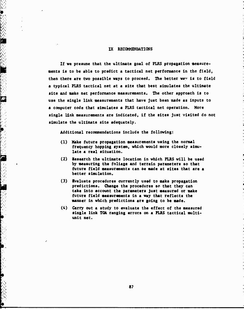
IX RECOMMENDATIONS
If we presume that the ultimate goal of PLRS propagation measure-
ments is to be able to predict a tactical net performance in the field,
then there are two possible ways to proceed. The better way is to field
a typical PLRS tactical net at a site that best simulates the ultimate
site and make net performance measurements. The other approach is to
use the single link measurements that have just been made as inputs to
a computer code that simulates a PLRS tactical net operation. More
single link measurements are indicated, if the sites just visited do not
simulate the ultimate site adequately.
Additional recommendations include the following:
(1) Make future propagation measurements using the normal frequency hopping system, which would more closely simu- late a real situation.
(2) Research the ultimate location in which PLRS will be used by measuring the foliage and terrain parameters so that future field measurements can be made at sites that are a better simulation.
(3) Evaluate procedures currently used to make propagation predictions. Change the procedures so that they can take into account the parameters just measured or make future field measurements in a way that reflects the manner in which predictions are going to be made.
(4) Carry out a study to evaluate the effect of the measured single link TOA ranging errors on a PLRS tactical multi- unit net.
87

REFERENCES
Bitterlich, W., "Die Wlnkelrahlprobe," Allgemein Forst-und Holrwirtschaft« liehe Zeltung. Vol. 59(1/2); 4-5 (1948).
Bullington, K., "Radio Propagation Fundamentals," The Bell Sy, Sea Tech. Jour.. Vol. 36, No. 3 (May 1957).
Bead, H. T., "The Influence of Trees on Television Field Strengths at Ultra-High Frequencies," Proc. IRE. Vol. 48, pp. 1016-1020 (June 1960).
LaGrone, A. H., "Forecasting Television Service Fields," Proc. IRE, Vol. 48, pp. 1009-1051 (June 1960).
Presnell, R. I., "JTIDS Ground-to-Ground Propagation Measurements," Final Report, Contract No. MDA903-78-C-0126, SRI Project No. 1056, SRI International, Menlo Park, CA (June 1980).
Presnell, R. I., "JTIDS Ground-to-Ground Propagation Test Site Survey— Eglln AFB," (October 1979a).
Presnell, R. I., "JTIDS Ground-to-Ground Propagation Test Site Survey- Arnold APS," (October 1979b).
Sachs, D. L. and P. J. Wyatt, "A Conducting-Slab Model for Electromag- netic Propagation Within a Jungle Medium," Radio Science, Vol. 3, No. 2 (February 1968).
Sexton, J. A. and J. A. Lane, "VHP and UHF Reception," Wireless World. Vol. 61, pp. 229-232 (May 1955).
Swarup, S. and R. K. Tevarl, "Propagation Characteristics of VHF/UHF Signals in Tropical Moist Deciduous Forest," Institution of Electronics and Telecommunications Engineers Journal. Vol. 21, No. 3 (March 1975).
Texas Instruments, Inc., "Tactical POS/NAV for Che 1991 Air/Land Battle Field," Signal. Vol. 33, No. 10 (August 1979).