Embed Size (px)
Citation preview

HESPERIA 72 (2003)
Pages 28I-320
1. The following organizations and individuals deserve our gratitude: the Greek Ministry of Culture, for generously granting the necessary permits, funding the excavations, and providing workers and equipment; the Osterreichisches Archaologisches Institut (Vienna and Athens), the University of Minnesota, and the Institut fRir Klassische Archaologie, Universitat Wien, for supporting the project; the Fitch Laboratory at the British School at Athens, for conduct- ing geophysical prospection; Spectra
Precision/Trimble, Vienna, for lending equipment; Dora Bakoli, Alexandra Charami, Panagiotis Defingos, Peter Glass, Dimitris Koutsodimos, Fritz Krinzinger, Veronika Mitsopoulou- Leon, Anne Salisbury, and Elena Vlachoianni for their support and cooperation. Ian K. Whitbread and Michael J. Boyd kindly contributed a report on the geophysical work carried out at the site. Special gratitude is also due to the anonymous Hesperia reviewers, whose comments consider- ably improved this article.
Funding was provided by the Greek Ministry of Culture, the Municipality of Plataies, the Jubilaumsfonds der Osterreichischen Nationalbank, the
..
Osterreichisches Archaologisches Institut, the University of Minnesota, and the Vienna City Council.
All of the photographs were taken by Konecny.
2. Hdt. 9.17-88. See Pritchett 1957; 1965, pp. 103-121; 1980, pp. 289-294; 1982, pp. 88-101; 1985, pp. 92-135; Lazenby 1993, pp. 217-247, with extensive bibliography.
PLATAIAI I N BOIOTIA
A PRELIMINARY REPORT OF THE
I996 200I CAMPAIGNS
AB STRACT
Recent research at Plataiai in southern Boiotia by the Plataiai Research Project (1996-2001) has added substantially to our knowledge of the site's history. Inhabited since the Neolithic period, Plataiai was protected by fortifications from the early 5th century B.C. onward. Under the aegis of King Philip 11 the settlement area was greatly enlarged. The circuit wall was shortened by the insertion of a diateichisma during Hellenistic times, and the citylaid out along an orthogonal grid. The settlement remained in this form until Late Roman times when a new fortification wall again constricted the perimeter. Occupa- tion continued until medieval times, when Plataiai was abandoned, replaced by two smaller villages nearby.
The battle of Plataiai, one of the most pivotal and decisive military en- . . . . . . gagements ln anequlty, conanues to c raw attenhon ln popu. bar accounts
as well as more scholarly treatises on the ancient world.l Various assump- tions and a wealth of speculative commentary exist on the battle in gen- eral and, more specifically, the reconstruction of the difficult topography in which it took place. The latter is complicated by the almost complete loss of the historical and natural markers mentioned by Herodotos in his narration of the events of 479 s.c.2 A preoccupation with the battle and the defeat of the Persian forces under Mardonios has overshadowed the
American School of Classical Studies at Athensis collaborating with JSTOR to digitize, preserve, and extend access to
Hesperiawww.jstor.org
®

282 V. ARAVANTINOS, A. KONECNY, AND R. T. MARCHESE
community from which this crucial event took its name. Plataiai was a town of stature prior to the early 5th century and, on more than one occa- sion, played an important role in shaping the history of central and south- ern Greece.
The Plataiai Research Project was consequently inaugurated in 1996 in order to gain a better understanding of the site and the role it played in the 5th and 4th centuries B.C. as well as in earlier periods of history. Work has focused largely on defining the site's sequence of habitation and the several building phases of the extensive fortification walls. Field survey in the initial years of investigation was followed by a multinational trial exca- vation sponsored by the Ephorate of Boiotia, the University of Vienna, and the University of Minnesota. After six seasons the site has yielded a substantial body of data that clarifies a number of questions for both the prehistoric and historic periods. Plataiai was more than a name associated with a famous conflict. It was also a prosperous community and an impor- tant part of the political development of central and southern Greece.3
GEOGRAPHICAL SETTING
The site of Plataiai is located in an extremely fertile district below the slopes of Mt. Kithairon in southwestern Boiotia (Fig. 1). The ancient town occupied a site of considerable importance in antiquity due to its strategic location between Thebes, Athens, Megara, and Corinth. Situated a few kilometers to the west of the major land route from central Greece across Kithairon toward the south into Attica and ultimately into the Peloponnese, Plataiai lay within easy reach of a number of aggressive states that coveted the site for economic and military reasons. The desire to control mountain passes from the Corinthian and Saronic Gulfs and the network of roads that passed through them- either into Boiotia in the north or via Athe- nian territory and the Corinthia to the Peloponnese in the south- placed a premium value on Plataiai in antiquity.
Although a more easily traversed southern route between the Corin- thian Gulf and the Aegean via the Isthmus of Corinth existed, an alter- nate route from the Gulf of Kreusis (modern Livadostra) and the Bay of Ayios Vassilios traversed the Parasopia, passed near Plataiai, and contin- ued, via the Asopos River, until it reached the straits of Euboia to the northeast.4 Although this diagonal course through the heart of Boiotia was important to the local population, its real value was as a route for interregional military campaigns. In this manner the "Kreusis-Euboian
3. For preliminary reports on the improve on this, the present article is evaluation and cannot yet be presented ongoing investigations at Plataiai, see intended as a concise, preliminary in great detail. A final report of the first Konecny 1998; Konecny, Boyd, and summary of the results of the 1996- phase of investigation at Plataiai is Whitbread 1999; Aravantinos and 2001 campaigns at the site. It does not, currently in preparation. Konecny 2000; Aravantinos, Konecny, however, replace prior reports, where 4. For this route see, e.g., Buck and Marchese 2001; Konecny, in press. more details are provided for findings 1979, p. 12; Buckler 1980, p.10; These provide piecemeal, sometimes presented here. Additionally, much of Kirsten 1950, col.2267; and Pritchett fragmentary, information on the various the material retrieved during survey 1965, pp.52-57. stages of the project as it developed. To and excavation is currently under

PLATAIAI IN BOIOTIA: I996-200I CAMPAIGNS 283
Haliartos 42 / - )
< @ ,5) lJ
b O X
C, 9 A,,o' C \ _ r \ I A f
X f -; Y X S-- ._ J f
I 9 )} -2
mu;A, X gSl )
e Lls isk , 0 0 ( : - . ; '; - i&t ;thit h;ht1W?1l . ' . - , ;0 - A Vd> ; ,,, 1,0,,_, REletfheldi
,! '9 n - r- - -
E .x004 0 S f X Vt / : 0' X
2 Megarian Plain -
Figure 1. Map of Plataiai and south- - - -- - ---- - - --- --- / - -- - - - - - --- -- westernBoiotia. A. Konecny o 1 2 _ 5 _ _ 10 km
road" offered one distinct advantage over the more accessible and heavily traveled "Corinthian road." By avoiding Corinthian territory and the west- ern Saronic Gulf, the road through Boiotia provided a possible alternative route to the Corinthian Gulf and, consequently, access to the northern Peloponnese if the southern route was blocked. The strategic potential that Plataiai possessed, however, could only be fully realized by a commu- nity of some substance. In essence, the control of Plataiai-by Thebes, Athens, or Corinth-would offer unique opportunities.
Plataiai's importance in the political affairs of central and southern Greece was enhanced by its favorable environment. The plain of Plataiai possessed arable land of high quality while the mountain slopes to the south made pasturage and the cultivation of olives possible. These slopes were also heavily wooded and could furnish substantial wealth in wood products. Plataiai was also provided with abundant sources of fresh water. This combination of resources must have been the primary reason for the establishment in the Neolithic period of a settlement at the base of the wide plateau that forms the ancient site of Plataiai. With a sustainable economic foundation-easy access to a continuous, secure supply of water and deep fertile soils in the immediate vicinity as well as access to build- ing materials from the slopes of Mt. Kithairon and a defendable location, Plataiai possessed the critical requirements for development and growth.

284 V. ARAVANTINOS, A. KONECNY, AND R. T. MARCHESE
It is evident, however, that the inhabitants of Plataiai faced a dilemma: unique strategic and economic factors guaranteed an important place in the political structure of central Greece but such opportunities also brought about specific consequences. The town could not stand alone as an inde- pendent entity, and its strategic and economic potential was too valuable to be ignored by the dominant states in the region.5
HISTORICAL PERSPECTIVE
Plataiai is well represented in historical commentary, especially that of the Classical period. In this manner, the site possessed a degree of importance not shared by comparable small communities in the region. Plataiai is first mentioned in the Catalogue of Ships for contributing troops to the Boiotian contingent that went to Troy, indicating that the site was of some impor- tance during the time from which Homer drew his sources.6 During the Archaic period the site developed into a prosperous town important enough to challenge the authority of Thebes. Although Thebes was able to domi- nate its southern neighbor and much of the Parasopia earlier in the Ar- chaic period, fierce antagonism toward their northern neighbor and a de- sire for autonomy led the Plataians to seek assistance from other cities. In 519 B.C. Plataiai appealed to Sparta and Athens. After arbitration by Corinth and a military engagement in which the Theban army was routed by the Athenians, Plataiai became a protectorate of Athens, a situation bitterly resented by Thebes.7
During the Persian Wars the Plataians, prompted by their special re- lationship with Athens, joined the side of the Greeks. No doubt their zeal to participate on the side of the Greeks was furthered by their antagonism toward Thebes, which championed the Persian cause. In 490 B.C., the citi- zens of Plataiai, according to Herodotos "all weapon-bearing citizens," contributed a substantial force to the Athenian victory at Marathon.8 In 480, Plataiai also provided a contingent of citizens to the Greek fleet at the battle at Artemision.9 After the retreat of the fleet from Artemi- sion, the population of Plataiai was evacuated in the face of Xerxes' inva- sion of central and southern Greece.10 The town suffered destruction by Persian troops, who without doubt were incited by their Theban allies to destroy it.1l
A year later, the Greek army under the Spartan king Pausanias crushed the Persians and their Greek allies a few kilometers to the east of the de- serted settlement. Following this victory over the remnant of Xerxes' grand army, the council of the Greek strategoi decided to name the battle after Plataiai. The town was also granted special and protected status.12 For five decades this special status safeguarded Plataiai's security. Nevertheless, when tensions rose in Greece prior to the outbreak of the Peloponnesian War, Thebes once again tried to impose its authority over its southern neighbor. Supported by a pro-Theban faction, 300 elite Theban hoplites gained access to Plataiai by treachery. After their unsuccessful attempt to subdue the remainder of the population, they were slaughtered. Knowing that this
5. See, e.g., the remarks in Buckler 1980, pp. 11-12.
6. II. 2.504. See, e.g., Amit 1973, pp. 61-63. The existence of a Bronze Age settlement at the site was first substantiated by excavations conducted by Andreas Skias in 1899 (Skias 1899) and later confirmed by John M. Fossey, who recognized Neolithic and Bronze Age pottery at the site (Fossey 1988, p. 109). Interestingly, in one of the Kadmeia Tablets a region is named that can be identified with the Parasopia; see Aravantinos 1999; Aravantinos, Godart, and Sacconi 2001 (tablet Av 104 [+] 191). The region was of some importance to the wanax of Thebes.
7. Hdt. 6.108. For aspects of Pla- taian history in the Archaic period, see Amit 1973, pp.61-67; Badian 1989; Buck 1979, pp. 42,91,99; Fossey 1991, pp.181-195; Prandi 1988, pp. 13-42.
8. Hdt. 6.108;Just. Epit. 2.9.9; Nep. Milt. 5. The last refers to 1,000 Plataian hoplites, probably an exagger- ated estimate.
9. Hdt.8.1;Thuc.3.54.2. 10. Hdt. 8.44. 11. Hdt.8.50; see also Amit 1973,
pp. 79-86; Prandi 1988, pp. 47-56. 12. Hdt.9.17-88; Thuc.2.71,3.58;
Plut.Arist.21. See also Badian 1989 for discussion of these events and the consequences for Plataiai.

PLATAIAI IN BOIOTIA: I996-200I CAMPAIGNS
285 would lead to renewed attack, Plataiai's protector, Athens, decided to evacu- ate the civilians and prepare the town for a siege.13 Thebes joined the Peloponnesians as an ally, most likely in exchange for a promise of support to regain control over Plataiai.
In the third year of the Peloponnesian War, after unsuccessful inva- sions of Attica, Sparta decided to draw a tight noose around Athens in order to conciliate its important ally Thebes, and probably also to secure the land route into Boiotia by conquering Plataiai. In 429 B.C. the Spartan and allied army appeared before the walls of Plataiai and, after indecisive negotiations, surrounded the town. In spite of its small size, the Plataian- Athenian garrison managed to withstand all attacks on the town, even when carried outwith hitherto-unknown ingenuity.14The besiegers settled down to break the town's resistance by protracted siege, intending to starve the defenders into submission. This took nearly two years to accomplish, during which time part of the garrison escaped in a daring counterattack. In the end the remaining Plataian-Athenian garrison was forced to ca- pitulate and was executed after a mock trial. Thebes, the real victor in the siege, decided, after a year of procrastination, to destroy the town.l5 Those who had escaped, as well as those already residing in Athens, had to re-
. . *.
maln ln exlle.
For nearly forty years the site lay barren; after the King's Peace in 386, the Spartans refounded Plataiai.16 Their motivation was probably based on the site's proximity to the "Boiotian road" over Mt. Kithairon as well as its nearness to the Gulf of Kreusis. Both were favorite Spartan points of entry into Boiotia, especially since such entry was supported by Plataiai's well-known and reasonably justified anti-Theban sentiment. The Plataians would remain pro-Spartan and therefore safeguard this Lakedaimonian bridgehead in Boiotia. Such concerns had taken on a more pronounced meaning shortly after the end of the Peloponnesian War when old politi- cal and military allegiances dissolved into a bewildering assortment of new attachments. This led to a restructuring of alliances as old allies became enemies and hereditary enemies friends. All of this was played out in and around the Isthmus of Corinth in the Corinthian War. Thebes, now opposed to Spartan hegemony in southern Greece, became Sparta's sworn enemy.
In this context the site of Plataiai took on renewed strategic impor- tance, precipitating its refoundation under Spartan auspices. Nevertheless, a decade later, prior to the battle of Leuktra in 371, a Theban army man- aged to conduct a successful surprise attack on Plataiai and once again forced its inhabitants into exile.l7 Plataiai was captured and destroyed. Shortly thereafter Sparta suffered a crushing defeat at the hands of the Thebans at Leuktra, a few kilometers to the west of Plataiai.18 No longer protected by a benefactor, the Plataians had to reconcile themselves to a lengthy exile at Athens. For the next thirty years the situation in southern Boiotia remained relatively stable.
The political structure of central and southern Greece was radically altered in 338 B.C. when Philip II of Macedon led his army to a resound- ing victory over the united armies of Athens and Thebes in the plain of
13. Thuc.2.2-6. See also Buck 1979, pp. 148-153; 1994, pp. 11-15; Prandi 1988, pp. 79-92.
14. Thuc.2.71-78; see also Kern 1999, pp. 97-111.
15. Thuc.3.20-24,52-68; see also Bruce 1968, pp. 196-197.
16. Paus.4.1.4. See also Buck 1994, pp.62-63, 68-69, 78-79, 87-88, 94, 99; Buckler 1980, pp. 15, 19-22.
17. Diod. Sic. 15.64; Xen. Hell. 6.3.1; Paus. 9.1.5. See also Buck 1994, pp. 103-104; Buckler 1980, pp. 19-22, 46; Kirsten 1950, cols.2309-2310; Prandi 1988, pp. 121-132. Sparta probably overextended its position in Greece after the King's Peace and even- tually, before 375 B.C., withdrew its guarantee of protection for Plataiai.
18. Xen. Hell. 6.4.4; Diod. Sic. 15.53.2; Plut. Pel. 30.3; Paus. 9.13.3-4.

286 V. ARAVANTINOS, A. KONECNY, AND R. T. MARCHESE
Chaironeia. The king treated the Athenians generously, their Theban al- lies less so. They had to accept a Macedonian garrison on the Kadmeia as well as surrender the town of Plataiai. The town's inhabitants or their offspring-were repatriated to the community.19 Three years later Thebes revolted against Alexander the Great. He descended with lightning speed on the unlucky town, took it by force, and let those Boiotians who were at his side decide the fate of their vanquished brethren. The Plataians and others did their best to make the sentence as harsh as possible. This re- sulted in the enslavement of all those who had survived the general massa- cre of the Theban defenders in the final assault on the city.20
Afterward, the Boiotian symmachoi of Alexander decided to refortify Plataiai, no doubt to establish a strong, pro-Macedonian base near the important route across Mt. Kithairon.21 It is also possible that many Boiotian as well as Plataian magistrates envisioned Plataiai as the new political and urban center for southern Boiotia since the destruction of Thebes had created a political vacuum in the region.22 This idea was fea- sible for a number of reasons, not least of which was the surprising size of the refounded town. By 331 B.C., the project had apparently not been fin- ished, since Alexander thought it necessary to dedicate a (probably sub- stantial) sum of money to the reconstruction of Plataiai after his victory at Gaugamela.23 Consequently, Alexander could secure his strategic interests in central Greece probably more of a problem for Antipatros than for himself while at the same time augmenting his propagandistic campaign in which he presented himself as the avenger of the destruction wrought on Greece by the Persians in 480 and 479 B.C.
After the death of Alexander, Plataiai remained faithful to the Mace- donian cause and fought, at least during the early phase of the Lamian War, against the Greek symmachoi.24 Afterward, any aspirations that the town might become the new political center of southern Boiotia evapo- rated with the refoundation of Thebes by Kassandros at or shortly after 317 B.C. As a direct result of this refoundation, Plataiai was relegated to a position of unimportance. However, the Eleutheria, initiated in the 5th century as a memorial celebration for the Greek victory in 479 B.C., con- tinued at Plataiai throughout the Hellenistic period.25 The festival was more than a local affair and gained regional as well as limited international fame. The effect that the Eleutheria had on Plataiai is well stated in a verse by Poseidippos, who remarked that only during the festive days of the celebration could Plataiai be regarded as a polis.26 In addition to celebrat- ing the Eleutheria, the town also organized the Lesser and Greater Daidala, both of which were of pan-Boiotian importance.27
Through all of this Plataiai remained, contrary to its position in the 6th through 4th centuries B.C., a loyal member of the Boiotian koinon. At the same time the town maintained cordial relations with Athens.28 In many respects, the shift in the geographical and political focus ofthe Greek world in the Hellenistic period overshadowed the limited regional impor- tance of communities like Plataiai. By the 3rd century B.C., Plataiai was relatively insignificant, one of many small rural poleis in Greece. This sta- tus did not change under Roman rule. The Eleutheria continued to be
19. Paus. 4.27.10; 9.1.8. 20. Arr. Anab. 1.9, passim; Diod.
Sic. 17.11, passim; Plut. Alex. 11.9. 21. Arr. Anab. 1.9, passim. 22. Already suggested by Kirsten
(1950, col. 2278). 23. Plut. Alex. 34.3. 24. Diod. Sic. 18.11. 25. Paus. 9.2.6; Schachter 1994,
pp. 138-141. 26. Cited by Herakleides Kritikos,
FHG II, 257 c 11 and 25. For the iden- tification of Dikaiarchos with the Hel- lenistic author Herakleides Kritikos, see RE VIII, 1912, cols. 484-486, s.v. Herakleides o KpeCxos (H. Schultz). The cults celebrated at Plataiai or within the boundaries of its territory are listed in Kirsten 1950, cols. 2318- 2330; Schachter 1981, pp. 7, 33, 52, 127-128, 158-159, 208, 242-250; 1986, pp. 11-12, 44, 55-56, 59-61, 115, 119-121, 199, 201; 1994, pp. 125- 143, 173-175.
27. Paus. 9.3.6; Schachter 1981, pp. 245-250.
28. See Kirsten 1950, col. 2314.

PLATAIAI IN BOIOTIA: I996-200I CAMPAIGNS 287
observed and in the 2nd century A.C. a level of style and sumptuous festiv- ity was observed during the reign of the philhellenic emperors Trajan and Hadrian. Fragments of a bilingual Latin and Greek copy of Diocletian's Edict of Prices found at the site indicate that the town continued to serve local economic needs as a place of trade in the 3rd century A.C.29 Plataiai's name also occurs in the Tabula Peutingeriana.30
During the Byzantine and medieval periods Plataiai constructed and supported ten or more churches3l and functioned as the suffragan see for southwestern Boiotia.32 The place remained important enough probably due to its straddling the strategic land route, or as the namesake of the still-famous battle in 479 B.C.-to warrant a visit by Mehmet Fatih, the conqueror of Constantinople and the Peloponnese in the 15th century.33 Sometime later, the Ottoman tax records list two villages with the name Kokla (Albanian settlements) in the vicinity of the ancient ruins.34 One of them probably developed into the modern village of Plataies (still some- times named KokAla in local parlance35). The village, however, lies off the site of the ancient and Byzantine town and thus the tax records most likely indicate that Plataiai's settlement history had, after nearly unbroken con- tinuity for several millennia, finally ended.
TOPO GRAPHY
The ruins of ancient Plataiai are situated along an extended but shallow projection of Mt. Kithairon and cover an area of approximately 89 hectares (Figs. 1-2). The broad, gently sloping plateau is bordered on its flanks by shallow dry valleys. Toward the north, the primary ridge of the site is di- vided into three subsidiary ridges of various size. The western portion ends in a separate plateau of approximately 11 ha, which is bordered on the north and west by rocky slopes. A substantial spring, the MzyocRYI Btouv, exists at its base. The use of the spring dates to distant antiquity and it continues to be employed today as a major source of fresh water for the cultivation of nearby fields and for livestock. Additional sources of fresh water are pro- vided by springs in the eastern valley as well as several springs noted by the American excavators during the 1890s (see below) and by Ernst Kirsten in the 1940s. A]1 originate from the subterranean groundwater resources of Mt. Kithairon. Many of these springs, however, have now been exhausted from the use of water for intensive agricultural cultivation on the site and in its immediate environs. The increased demand in nearby villages for water, especially in the later part of the 20th century, has also reduced the amount of fresh water available to the local population.36
As noted earlier, the availability of fresh water and arable land, with at least reasonable defensive capabilities, made Plataiai an attractive site for settlement. Although the plateau does not possess a prominent acropolis separated from the remainder of the site, no other site in the immediate environs offers comparable advantages. The remainder of the area that makes up ancient Plataiai, a series of undulating ridges and subtle depres- sions, no doubt was used as agricultural land prior to the Late Classical
29. Waldstein, Tarbell, and Rolfe 1889, pp.428-439. For a more detailed account of Plataiai's history during the Roman and Late Roman periods, see Kirsten 1950, cols. 2314-2318.
30 See Weber 1976, p.58 (s v Plateas)
31 See the site plan in Waldstein, Washington, and Hunt 1890, pl VII.
32. Tabula Imperii Byzantini I, pp.243-244, with evidence for the Early Byzantine period.
33. Gregorovius 1889, II, pp.390, 552.
34. This information was generously provided byJohn Bintliff (pers. comm., 1999,2001).
35. This was in fact the name of the village until it was renamed Plataies after its ancient predecessor; see, e.g., Kirsten 1950, col.2256, there spelled Kokla; Fossey 1988, p.102.
36. For relatively recent changes in the hydrological situation of the Para- sopia in general, see the extremely valuable remarks in Pritchett 1985, pp.95-96.

288 V. ARAVANTINOS, A. KONECNY, ANI) R. T. MARCHESE
/f
0 100 200 300m
in situ remains --------------- secure reconstruction
tentative reconstruction t//////// Areas of geophysical road grid overlay exploratlon
Figure 2. Plataiai 2000, site plan . Konecny

PLATAIAI IN BOIOTIA: I996-200I CAMPAIGNS 289
period, and later, in the 4th century B.C., was incorporated into the forti- fied perimeter of the site. The local topography, especially the shape of the plateau and its bordering valleys, necessitated the area's wholesale inclu- sion behind the fortification walls in order to satisfy the needs of the local population. Political considerations must also be taken into account in ex- plaining the impressive size of the town. Whatever the reason, ancient Plataiai after the 4th century B.C. covered a substantial area with imposing walls, towers, and gates.
HISTORY OF EXCAVATION AND RESEARCH
The archaeological site near the village of Kokla (modern Plataies) was identified as ancient Plataiai by George Wheler in the 17th century.37 Be- tween 1889 and 1891 an American expedition under the direction of Charles Waldstein undertook excavations at the ancient town.38 During the course of their work they unearthed the foundations of a Doric temple and several churches of Byzantine and medieval origin. A number of sig- nificant artifacts were also discovered, including the fragments of Dio- cletian's Edict of Prices noted above. The published site plan from these trial excavations, however, cannot be used to locate previously excavated areas with any degree of certainty. Methodologically, these early explora- tions of Plataiai were typical for their time and the results have never been adequately published. Nearly the same is true for excavations undertaken by the Greek archaeologist Andreas Skias in 1899.39 Among his finds were substantial fragments of a marble sarcophagus of Roman date depicting scenes from the Phaidra myth.40 Since he fixed the topographical setting of his exploratory trenches to the then-still-visible trenches of his Ameri- can predecessors, it is impossible to discern the exact location of his work.
Outside the town site, rescue excavations were often triggered by chance finds. Such operations have been conducted since the 1970s by the Ephorate of Boiotia and have yielded mostly graves and grave goods. In 1972 the ephor of Thebes, Theodoros Spyropoulos, excavated a multiple-burial site to the east of the town, which he interpreted as the Altar of Zeus Eleu- therios, founded after the Greek victory at Plataiai.41 Rescue excavations have been resumed recently by the Ephorate of Thebes at the site of the MeraRYl Bpvq and to the west of the town, in the area of an ancient cemetery.42
Although limited excavations have established an initial body of arti- factual data for the town, the best description and interpretation of the site is provided by Kirsten's article "Plataiai" in the Real-Encyclopadie.43 Even though an accurate assessment of the town was made, especially in the evaluation of the ancient testimony on Plataiai, Kirsten's article was in- tended only as a preliminary examination. The fundamental problem with his discussion, in an archaeological context, is that it was based primarily on the results of excavations undertaken half a century earlier, personal observations, and a limited number of aerial photographs. Three decades later, Fossey provided a short synopsis of Plataiai's history as part of his fundamental work on the overall settlement history of Boiotia.44 Like
37. Wheler 1682, p. 473. 38. Waldstein, Tarbell, and Rolfe
1889; Waldstein, Washington, and Hunt 1890; Washington 1891; Rich- ardson 1891.
39. Skias 1899. 40. Skias 1899; Bonanno-Aravan-
tinou 1988. 41. Spyropoulos 1973a,1973b;
Fossey 1988, p. 109. 42. The results will be published by
E. Vlachoianni in ArchDelt for 1998 and 1999 (forthcoming).
43. Kirsten 1950. 44. Fossey 1988, pp. 103-112.

V. ARAVANTINOS, A. KONECNY, AND R. T. MARCHESE 290
Wirsten, Fossey based his interpretation largely on the excavation reports of his predecessors. He also visited the site on a number of occasions and, in the process of inspecting the archaeological remains, made thorough notations on the distribution of ceramics. Despite the rich written testi- mony about the site, modern analysis has barely covered the intense occu- pational history of Plataiai.45 Added to this is the fact that only four years of excavations have been conducted at Plataiai between 1889 and 1998. As a consequence, a number of fundamental questions need to be resolved in order to coordinate the history of the settlement, as described in the ancient literature, with its archaeological remains.
ARCHAEOLOGICAL PROBLEMS
An obvious archaeological problem to address at Plataiai relates to the fortification system of the town, the most conspicuous and practically the only visible surface feature at the site. Four different phases of building activity can be distinguished. Prior to our work at the site, the extent, pres- ervation, layout, typology, and date of the walls were largely unknown. Although some effort was made by Waldstein and Washington, and later by Kirsten, to clarify the town's fortification complex, their results differed on several important issues, primarily the relative and absolute chronology of the circuit wall(s). Consequently, a reexamination of the Plataian forti- fications was desirable, especially in light of the recent advancements in the study of Greek fortifications.
Fortification complexes became a crucial part of Greek public archi- tecture at the end of the Archaic period and, over time, a fundamental element in the urban scheme of towns and cities. Unfortunately, the sys- tematic study of municipal fortifications has been either neglected or over- shadowed by the examination of more spectacular civic and religious ar- chitecture. Although an early period of fortification studies exists, primarily confined to the initial decades of the 20th century,46 the topic has gained renewed interest among a number of scholars only since the 1 970s. Excel- lent studies now exist many offering a solid foundation for a compara- tive examination of ancient municipal fortifications at a number of sites of greater historical importance than Plataiai, including Athens, Syracuse, Miletos, and Pergamon.47 All of these sites managed to safeguard their urban schema by an elaborate defensive network. Security, especially for a community that possessed high strategic value, could not be ignored or minimized as insignificant and it is interesting that smaller, less wealthy towns in the Greek countryside solved similar security problems by the construction of elaborate fortifications. A lack of excavated sites has meant that precise chronological parameters could not be established for many Greekfortification systems.The comparablywell preservedwalls at Plataiai provided an excellent opportunity to study an elaborate fortification com- plex that was attached to a rural community of moderate importance, es- pecially since ancient commentary offered a chronological framework for the Plataian walls.
45. One book has been written on Plataiai's history: Prandi 1988. It is concerned with historical and epi- graphical aspects of Plataiai and adds very little to the corpus of archaeologi- cal data for the town.
46. Much of this early work on fortifications was done by German scholars. The best examples can be found in Milet II.3; Milet III.2; and Wrede 1933.
47. See the pioneering work of Ohly 1965; Winter 1971; Garlan 1974; and Lawrence 1979. Since 1979 a number of additional monographs and articles have been published, including Cooper 2000; Corbet 1997; fC)ebord and Descat 1994; Gassner 2001; Held 1999; Karls- son 1992; Leriche 1992; Leriche and Treziny 1986; Marksteiner 1997; Poll- hammer 2002; Radt 1992; Rheidt 1992; Samos XV; Van de Maele and Fossey 1992; and Weiszl 1999.

PLATAIAI IN BOIOTIA: I996-200I CAMPAIGNS 29I
Directly above the source ofthe M£rocksI BRoucm, the outer face of a stretch of wall approximately 5 m in length is preserved in situ, representing the earliest extant fortification of Plataiai (Fig. 3). It consists of a course of large polygonal orthostate slabs set on a foundation of smaller blocks. Local breccia was used as building material. The slabs have a flat, nearly smooth front face on which parallel chisel marks are visible. The orthostates show the characteristic shapes of developed "Lesbian" polygonal masonry,49 and their edges are finely delineated and sharply cut. The blocks of the foun- dations on which the orthostates rest are also polygonal in shape, but their edges are less well cut. Their corresponding faces were only roughly worked and protrude a few centimeters from the horizontal plane of the wall. At this point the foundation, which consists of two or three superimposed courses of blocks, is firmly fixed in bedrock. Better-preserved parallels at other Greek sites indicate that, above the socle of stone masonry, this wall consisted of mudbrick.50
Along the western fringe of the acropolis two more short stretches of this wall were located. Their state of preservation is much worse and they consist only of foundations, but with characteristic features of"Lesbian"
48. Thuc. 2.78. 49. For"Lesbian" masonry, see, e.g.,
Wrede 1933, pp. 40-43; Scranton 1941, pp. 25-45; Winter 1971, pp. 80-90; and Eretria IV, pp. 38-45.
50. Cf. Eretria IV, pp. 38-45, pls. 1, 34, 36; Maier 1967, pp. 308-309; Ohly 1965,figs.51,54.
THE FORTIFICATION WALLS
The first three years (1996-1998) of activity by the Austrian archaeologi- cal expedition at Plataiai were devoted to survey and the construction of an updated site plan (Fig. 2). In the second, third, and fourth seasons, the Fitch Laboratory at the British School at Athens undertook geophysical prospection in and around the city walls (see below, pp. 315-317). One of the main objectives of the geophysical survey was to locate traces of the Spartan siege wall of 429-427 B.C. described by Thucydides.48 Although this wall was not identified, important data on the fortification circuit and the internal plan of the community were gathered. In many respects the geophysical survey provided a substantial database for determining the extent and architectonic design of Plataiai's different circuit walls. It did not, however, resolve the chronological issues associated with the separate phases of fortification construction. A gate complex in the largest circuit wall, located by geophysical means, was therefore chosen for excavation in 1999. The partial exposure of the Western Gate (Fig. 2), conducted in joint excavations by the Ephorate of Thebes and the University of Vienna, firmly established a chronology for its construction. The following year a larger portion of the gate complex and a small portion of a nearby building were exposed.
Based on research conducted between 1996 and 2000, four different fortification circuits can be discerned: 1) an earlycircuitwall on the acropo- 1iS; 2) a wall more than 3 krn long, which delineates the greatest extent of Plataiai; 3) a later insertion, a diateichisma, which dissected the southern portion of the 3-km wall and excluded the southernmost part of the town from the protected zone; and 4) a later circuit wall on the acropolis.
THE ACROPOLIS FORTIFICATION: FIRST PHASE

292 V. ARAVANTINOS, A. KONECNY, AND R. T. MARCHESE
Figure 3. Southwestern part of the acropolis: masonry of "Lesbian" style. A. Konecny
O 1 2m , _
masonry. Along the northern edge of the acropolis, subsequent building activity destroyed all traces of the wall. It is also evident that much of the earlier wall was robbed in later periods or was subject to erosion. Since the rocky northern edge ofthe plateau must itselfbe regarded as a natural line of defense, it seems very probable that the wall once followed this line. Along the eastern and southern borders of the acropolis, later building activity has completely covered all earlier remains. Only two dislocated blocks of"Lesbian" polygonal work were found outside the fortification line that delineated the acropolis at a later period. Their appearance indi- cates that the "Lesbian" wall once followed approximately the same line as the later wall around the acropolis.
The style of masonry employed in this early wall is one of the more conspicuous in Greek architecture and can be dated within well-defined chronological limits. "Lesbian" masonry is typical of the Late Archaic and Early Classical periods, especially in Boiotia, Phokis, and on Euboia, where it was frequently used for building fortifications. Better-preserved examples exist at Eretria and Delphi where distinct stylistic parallels are dated by excavation to the years around or shortly after 479 s.c.5l Consequently, it is reasonable to provisionally date the construction of this first phase of Plataiai's walls to the first decades of the 5th century B.C. It remains un- clear whether this wall was built before or after the sack of the town by Persian troops in 480 B.C.
THE CIRCUIT WALL FROM CA. 330 B.C.
At the southwestern edge of the acropolis a second wall is evident (Fig. 2). This wall follows the western ridge of the site toward the south, slightly changes direction twice and, after approximately 250 m, turns toward the east to form a recess. At its inner apex two towers flanked a gate, the so- called Western Gate. Its location and shape were confirmed by geophysi- cal investigations and later excavation (see below). To the south of this gate the wall continues southward along the edge of the ridge for another 700 m. In its course it changes direction several times, following the nat- ural terrain that afforded additional protection from attack. Approxi- mately 70 m to the north of the rocky lower slope of Mt. Kithairon the wall reaches a small elevation in the natural terrain, which is separated
51. Eretria IV, pp. 38-45; FdD II, pp. 35-121, esp. pp. 112-114.

PLATAIAI IN BOIOTIA: I996-200I CAMPAIGNS 293
S)--
t-m--'s _
.2s
W - - Ar o O mWO
a , _
- - - 0L
* | I
I
Figure 4. Large circuit wallR eastern C2 sector: front vlew (above) and ground plan (right). A. Konecny - . - S 10 m
from the mountain by a shallow saddle. Here it turns to the east at a right angle. After an additional 100 m it turns again to the northeast, where it descends along the eastern edge of the Plataian ridge.
From this point the wall continues over a distance of more than 1,600 m, slightly changing its direction several times in order to remain on the edge of the ridge. At a point just south of the modern asphalt road be- tween Plataies and Erythrai, two rectangular towers flank a badly pre- served gate (the Eastern Gate). After nearly a kilometer, at the northern end of the ridge, the wall terminates in a round tower (Fig. 2:R 3), after which it turns to the west at a right angle. From here the wall cuts across the eastern valley. At the bottom of this shallow trough, geophysical prospection located a possible third gate, the Northern Gate, which is cur- rently covered by silt. Toward the west the wall crosses the northern end of a ridge and terminates at its western flank in a tower. From here scant vestiges of the wall can be traced, indicating that the wall turned to the south. After a few meters all traces of the wall are lost. It must have crossed the valley between this ridge and the acropolis, but its course remains an open question. Scant traces of this wall exist along the northern and west- ern edge of the acropolis, but it seems to have followed the course of the earlier "Lesbian" fortification that it replaced.
The preservation of this structure is sufficient to allow recognition of diagnostic masonry characteristics, and although subtle differences exist along its circuit at several locations, the masonry is generally uniform in style and technique (Figs. 4, 5). The wall generally measured 3.20 m from the outer to the inner face. Both faces normally consisted of one row of large orthogonal or trapezoidal blocks of local breccia. The average height of the masonry was approximately 0.70 m. In many cases missing sections at the corners of the blocks were filled with small triangular or rectangular stone plugs, of which only a few remain in situ. The upper edge of this initial row of blocks was leveled to provide a secure and convenient base for the superimposed structure of the wall.

V. ARAVANTINOS, A. KONECNY, AND R. T. MARCHESE 294
O 1 2m
.
Since the wall often followed sloping terrain, the upper edge of each row of masonry was stepped in places to compensate for the change in elevation. In many cases the upper edges of the outer and inner faces of the wall were not of the same height. This depended on the decline of the slope perpendicular to the wall. The space between the outer and inner face of the wall was filled with densely packed rubble. The orthostate row rested on a foundation of smaller, more roughly worked blocks of the same material. Their faces projected about 0.20 m, and the gaps between the blocks remained unfilled. This foundation row rested on bedrock or in shallow foundation trenches in the local soil.
Rectangular towers were spaced unevenly along the entire circuit of the wall, ranging from 35 to more than 90 m apart. Their distribution was determined by the natural terrain in front of the wall; in areas where the wall was more vulnerable or accessible, towers were placed in close prox- imity and in a more systematic pattern. Their dimensions vary from place to place, but usually average approximately 5.60 m in width by 4.50 m in depth. Like the walls, the towers consist of a row of orthostates above one or more rows of foundation blocks. The side walls of the towers bond to the outer face of the curtain wall, which normally does not continue be- hind them.
At three locations semicircular or circular towers were employed in- stead of rectangular structures. One semicircular tower stood in front of the southern portion ofthe eastern branch ofthe fortification (Fig. 2:R 1). Its remains are barely preserved; only a few blocks are visible. A sec- ond example was located approximately 200 m north of the Eastern Gate (Fig. 2:R 2). Nearly half of its perimeter wall (with a diameter of ca. 12 m) stands in situ. This tower replaced a rectangular predecessor that belonged to the original fortification wall at this location (Fig. 6). The tower had a triangular extension that projected from the inner face of the wall toward the town. It is evident that the space on top of the structure had to be enlarged. A third tower (Fig. 2:R 3), circular in plan (ca. 10 m in diam- eter), forms the northern end of the eastern wall. It flanks the vulnerable point in the circuit where the wall changes direction along the top of the eastern ridge and appears to have belonged to the original fortification. No indication of a rectangular predecessor is evident on the surface and it is unlikely that one ever existed at this location.
Access to the top of the fortification walls was provided by staircases along the inner face of the wall. Each staircase had a stone foundation. An orthostate row identical to the inner face of the curtain wall and of the same height (ca. 0.70 m) constituted the lowest course of the staircase. In most cases the structures are bonded with the wall. Assuming a roughly
Figure 5. Large circuit wall, north- eastern sector: exterior front. A. Konecny

PLATAIAI IN BOIOTIA: I996-200I CAMPAIGNS 295
?
i S A, I
Figure 6. Large circuit wall, eastern sector: plan of semicircular tower (R 2) replacing rectangular tower. A. Konecny
o s lOm
even distribution of staircases along the wall, those still extant represent slightly less than half of their original number. Normally, but not in every case, staircases were located near a tower.52 Where towers are absent stair- cases could not be located, even though access to the battlements would have been required along a considerable length of the wall. The whole structure walls, towers, and staircases featured a level upper course of orthostates with rubble fill between the inner and outer surfaces. Given such a solid foundation, the wall is virtually certain to have possessed a massive upper structure of mudbrick.53
The style of masonry as well as a variety of architectural details strongly suggests that construction of the fortification wall took place in the 4th century B.C. Although minor differences exist, the parallels offered by similar walls at Athens and Eretria are striking.54 Historic evidence, as cited above, offers two possible dates for the circuit. The first is the refoundation of Plataiai as a Spartan protectorate after the King's Peace in 386 B.C., the
52. For such features cf. Lawrence 1979, pp. 343-355; Winter 1971, pp. 147-149.
53. For similar structures see Adam 1982, pp. 19-23; Lawrence 1979, pp. 205-207; Martin 1965, p. 358; Winter 1971, pp. 69-76.
54. C£ Ohly 1965; Eretria IV, p. 62, pls. 122, 123. Interestingly, the
wall lacks any resemblance in terms of masonry style, technique, and tacti- cal layout to either the fortifications of Boiotia known to have been built during the 4th century B.C., e.g., Khostia (Fossey 1981, pp. 37-78; Fossey and Morin 1986, pp. 119-145), Siphai (Schwandner 1977), Kreusis (Gauvin and Fossey 1985), or the
Attic border fortifications, one of which stands only a few kilometers southeast of Plataiai (Beschi 1968; Wrede 1924; Cooper 2000). Obvi- ously the architects and also the masons of the Plataian circuit fol- lowed a different tradition of wall construction.
--- XZ
,d,/ \ l

296 V. ARAVANTINOS, A. KONECNY, AND R. T. MARCHESE
second during the years after Philip II had refounded the town. The earlier date seems rather unlikely.The Plataians who had returned from exile would not have possessed the ability to build and sustain such an extended fortified precinct. Although the Spartans did, for a time, station a garrison at Plataiai,55 it would have been much more logical for them to keep the defensive perim- eter as small as possible and retain or renovate the fortifications that had delineated the city until its destruction in the Peloponnesian War. The later date, on the other hand, finds strong support in Arrian's report on the pro- ceedings after the sack of Thebes in 335, when the victors decided on the fortification of Plataiai.56 The donation by Alexander the Great after his victory at Gaugamela in 331 also suggests the later date) as it refers to a still decidedly unfinished state of the city's fortifications.
Excavations conducted at the Western Gate, discussed below, offer additional archaeological evidence that the wall was commissioned around or shortly after 330 B.C. The gateway, the construction of which can be securely dated by associated ceramics, cannot be imagined without the existence of the circuit wall. Stylistic and technical comparisons indicate that the gate and wall are contemporary, and that both features cannot date much later in the Hellenistic period.57 We thus conclude that the whole circuit was constructed shortly after the refoundation of Plataiai by Philip II, with Alexander's contribution to the effort primarily taking the form of financial support.
TH E DIATEICHISMA
Sometime after the construction of the circuit wall, the southern portion was abandoned in favor of a more coherent and reduced plan. Approxi- mately 70 m to the south of the southern apex of the circuit wall, the rocky slope of Mt. Kithairon increases in elevation. Within a hundred meters of the wall the ascending slope attains a height approximately equivalent to the level of the walkway behind the ramparts. This potentially dangerous situation would expose the defenders along this section of the wall to a barrage of missiles, especially after the rapid development of siege artil- lery in the Early Hellenistic period.58 The nearby slope of Mt. Kithairon offered a perfect opportunity to post catapults within convenient firing
Hellenistic fortifications, their charac- teristics and possible means for their identification, see, e.g., Bakhuizen 1982; 2000; Held 1999; Konecny 1997, pp.74-83; Marksteiner 1997, pp.163- 172; McNichoM 1986; 1997; PoM- hammer 2002; Samos XV, pp.64-99; Winter 1971; 1992, M1 with extensive bibliography.
58. Cf. Marsden 1969, pp.73-82; Winter 1971, pp.318-330; Lawrence 1979, pp.43-52; and the views of Kirsten (1950, col.2278).
55. Isoc.14.4. See also Buck 1994, pp. 78-79,94,99; Buckler 1980, pp.19-22,46; Kirsten 1950, cols.2309-2310; Prandi 1988, p.124.
56. Arr. Anab. 1.9, passim. 57. The large circuit closely resem-
bles fortifications that date into the Late Classical period and it lacks every component typical of Hellenistic city walls (see above, n.54). Hellenistic walls normally show a more even dis- tribution of towers and were solidly built in stone up to their battlements. Even if made from mudbrick, the
masonry socles of the walls generally attain a greater height in order to pro- vide better protection against attack. This was in response to the sophisti- cated means of siege warfare current in the 3rd century B.C. and later (see, e.g., Stahlin and Meyer 1934, pp. 8F93; Bakhuizen 2000). In many cases means for an active defense were integrated into the fortification, and large towers provided room and shelter for defen- sive artillery. Additionally, Hellenistic masonry is markedly different from the style employed in this circuit. For

PLATAIAI IN BOIOTIA: I996-200I CAMPAIGNS 297
O 1 2m .
Figure 7. Diateichisma, western 5 ^ ' >
sector: front view (abotve) and ground t
plan (right). A. Konecny ° 5 10 m
distance from the parapet. Clearing the wall of its defenders would have been an easy task and, therefore, this part of the circuit would have been the most vulnerable during an assault on the town.
This disadvantage was rectified by the insertion of a diateichisma. The new wall originated from a point ca. 150 m southeast of the Western Gate (see Fig. 2). More than 100 m of the original fortification wall leading up to the diateichisma was dismantled to bedrock. This decision was presum- ably based on a practical as well as tactical reason: potential attackers would not be able to take cover behind the discarded wall. From the point where it starts, the new wall follows a straight line for more than 350 m to the southeast. After two slight changes in direction to the north, it turns sharply to the northeast. From here it continues for approximately 250 m until it meets the course of the original circuit where it ends. At this juncture it is evident that the earlier wall leading into the diateichisma had also been dismantled for a considerable distance.
Both faces of the diateichisma, which has a thickness of 2.65 m, were built from rectangular or, more often, trapezoidal blocks quarried from the local breccia (Figs. 7, 8). The height of the courses that can still be in- spected ranges from 0.70 to 0.90 m while the blocks themselves are 0.90- 1.80 m in length. The upper and lower surfaces and joints were finely cut. The front faces of the blocks possess a slight bulge and feature densely set, parallel chisel marks that run either at a vertical or slightly oblique angle. Outwardly facing corners (at towers) bear vertical chamfers approxi- mately 0.10 m wide that were finished with a fine tool. The space between the two faces was filled with small, coarse blocks. The faces rested on a foundation of similarly worked blocks of lesser height. The foundation

298 V. ARAVANTINOS, A. KONECNY, AND R. T. MARCHESE
Figure 8. Diateichisma, western
sector: view of tower
blocks projected approximately 0.10 m from the first exposed course of masonry.
This part of the fortification circuit was also flanked by evenly spaced, 6.50-m-wide, rectangular towers approximately 45 m apart. They are bonded to the wall and were filled with the same tumble of coarse rocks. Behind every second tower a 10-m-long staircase led up to the top of the wall. In the western part of the diateichisma a sally port led through the wall to the right side (viewed from the interior of the fortress) of every tower that was served by a stairway. To date, four sally ports have been documented along this stretch of the diateichisma, as far as the southern- most apex. The eastern branch of the line appears not to have possessed this feature. The best-preserved part of the diateichisma is a tower in the western sector (Fig. 8). Three rows of blocks still rest in situ on top of a foundation three courses high. Part of the fourth row can be found toppled around the tower. It seems reasonable to assume that the wall and towers were constructed entirely from stone blocks.59 Inside, the structure con- tained a fill identical to that of the wall. No interior wall face was found, which suggests that the tower was solid at least to its preserved height, and probably up to the level of the walkway.
Little evidence is available to suggest a precise date for the construc- tion of the diateichisma. What is certain is that it was built after the origi- nal circuit wall.60 Stylistic and technical differences between the two walls are quite pronounced and indicate that some time intervened between
59. The exclusive use of stone blocks, however, must remain a work- ing hypothesis only. At Demetrias in Thessaly the towers of the fortification of the acropolis possessed socles of large, well-shaped ashlar that were several meters high. Above these socles rested massive bastions made of mud- brick. See Stahlin and Meyer 1934, pp. 80-93.
60. It cannot have been the original southern border of the city precinct after its enlargement under Philip and Alexander. In this case, the wall along the diateichisma should show the char- acteristics of the circuit, and the wall along the resulting"southern extension" toward the Kithairon should show different characteristics. In fact it is exactly the opposite. For technical and
stylistic reasons the large circuit must be regarded as the result of a coherent
. . anc . conanuous construchon process, give or take a few minor alterations in constricted areas along the wall, and the diateichisma a later addition or substitution. This question will find more elaboration in the forthcoming volume on Plataiai.

PLATAIAI IN BOIOTIA: I996-200I CAMPAIGNS 299
their construction. The even spacing of towers and the frequent and sys- tematic employment of sally ports are improvements over the tactical lay- out of the circuit wall and are typical features of Early Hellenistic for- tifications.6l As argued above, the danger posed by the proliferation of artillery in the decades following the death of Alexander as well as the generally unsettled conditions in Greece may have been sufficient cause for the Plataian magistrates to reconsider the exposed weakness of the original wall. The refoundation of Thebes by Kassandros certainly created an immediate if not urgent need for a shortened and better-protected cir- cuit wall in the southern quadrant, and the never-ending sequence of wars in the 3rd century B.C. provided further incentive to make Plataiai's forti- fication more steadfast. The exact chronology of the walls must await filr-
* . . . ther lnvestlgatlon.
THE ACROPOLIS FORTIFICATION: SECOND PHASE
Considerably later the Plataians constructed a new fortification wall. The Hellenistic diateichisma, made of stone, had probably remained in good shape, but the large circuit wall, consisting of a mudbrick superstructure on a stone socle, must have required considerable maintenance. It is highly likely that this wall had fallen into disrepair during the protracted peacefi conditions of Roman Achaia, and that much of its nondurable superstruc- ture suffered the effects of erosion and collapse over the centuries. More- over, the area requiring protection had considerably diminished. In a re- duced form the town did not need nor could it maintain such a large fortification wall. As a consequence, only the acropolis, the site of the ear- lier circuit wall of the Archaic and Early Classical periods, received a new perimeter wall.62 A well-preserved section of this wall cuts across the south- ern and eastern boundaries of the plateau. On the north and west, how- ever, it has almost completely disappeared, evident only as rock-cut beddings or scant stretches of wall, and often reusing portions of the earlier fortifi- cations along the crest of the acropolis.
In those areas of better preservation diagnostic evidence is available (Figs. 9, 10). The curtain wall is approximately 2.70 m wide with both the inner and outer faces of the wall constructed of reused material. The sur- face treatment of many of the blocks indicates that they had originally been employed in the Hellenistic diateichisma. Some column drums and a number of blocks of different workmanship may have originated from
61. See Kirsten 1950, col. 2278; McNicholl 1997, pp. 6-13, and passim; Winter 1971, pp. 115-125, 244. The wall shows startling similarities in its technical peculiarities as well as its masonry style to the walls of several cities in Phokis, especially Neon and Lilaia. The fortifications of these towns had been dismantled after the end of the Third Sacred War and new defensive perimeters were probably
built during the Early Hellenistic period (Diod. Sic. 16.60.1-3; Paus. 10.3.1-3; see also Buckler 1989, pp. 140-142; Fossey 1986, pp. 26-29, 46- 49; and also Tillard 1911, who provides an earlier chronology for the fortifica- tions of these cities).
62. Scant traces of this later peri- meter wall can be seen along the prominent crest of the acropolis, re- vealing characteristic features of later
fortification architecture (e.g., employ- ment of mortar). As discussed above ("The Acropolis Fortification: First Phase"), there is only slight evidence for the course of the Archaic city wall along the southern and eastern bor- ders of the acropolis. It must remain a hypothesis (albeit a very probable one) that the later wall retraced the line of its early predecessor in this area as well.

V. ARAVANTINOS, A. KONECNY, AND R. T. MARCHESE 3oo
S -
, - - (>XW -X-/A- - 0-- 2
e 2 ) t2)(g O 0 oC7
8e;W i1
g Figure 9. Later acropolis circuit wall, -- southern sector: front view (above)
0 5 10 m and ground plan (lefzt). A. Konecny
municipal buildings, many of which were probably dismantled as the wall was being constructed. Whenever possible, blocks were laid in horizontal courses. For this purpose building materials of similar dimensions were selected for placement in successive rows. This procedure resulted in a considerably uneven facade. Gaps that appeared between the blocks were filled either with smaller stones or broken bricks and tiles. The latter ele- ments were normally fixed in position with lime mortar. Otherwise, mor- tar was not used to bind the blocks together. The fill between the inner and outer faces consisted of densely packed rubble. No gateway or other type of entrance could be positively identified.
Along the southern and eastern sections of the later acropolis circuit wall, the remains of rectangular, or nearly rectangular, towers are evident. These towers measure approximately 5.50 x 6.00 m and feature a hollow lower story. The preserved walls are approximately 1.30 m thick, constructed of material similar to that used for the curtain wall. No systematic pattern can be seen in the construction of the towers: some are connected to the walls while others abut them. In one case an entrance into the lower chamber of the tower is preserved. In other cases the curtain wall continues without interruption behind the tower chamber, indicating that it could only have been reached via a ladder. The extent to which the interior chambers were elevated above the surrounding exterior cannot be judged due to a consid- erable amount of debris at the base of the wall. Along the northern and western sections of the circuit wall, only scant traces of towers exist. It nevertheless seems logical to assume that such structures were spaced at regular intervals to provide an opportunit,v for flanking fire on an attacker. The few towers preserved in this area reemploy the foundations of similar structures along the earlier circuit wall.

PLATAIAI IN BOIOTIA: I996-200I CAMPAIGNS 30I
Figure 10. Later acropolis circuit wall, southern sector: view of tower and curtain wall
The primary features of this small fortress are thus the intense reuse of building material for its construction and the employment of mortar, brick, and tile work. Earlier fortifications were dismantled in order to build the new wall. It is also clear that a number of municipal structures fell victim to this enterprise as well, which suggests a degree of urgency con- nected with the building program and supports a Late Antique date for its execution. The general turmoil that threatened the Balkans and the Greek mainland from the mid-3rd century A.C. onward probably provided the incentive to refortify Plataiai after several centuries of relative peace.63
THE INTERNAL MUNICIPAL SCHEMA
Inside the perimeter formed by the large circuit wall and the later dia- teichisma to the south, several features of the Hellenistic town are evident (Fig. 2). Near the town center are the remains of a Doric temple, excavated by the American expedition in 1891.64 The area is completely covered with debris and subsequent agricultural use has destroyed the ground plan. Approximately 150 m to the east of the temple is a shallow depression that opens to the north. Scant vestiges of walls follow the slight curve of the structure. Its shape, less than a semicircle in diameter, indicates a poorly preserved theater of moderate size. Finally, in 1899 Skias excavated a
occasional spolia interspersed (cf., e.g., the earliest parts of the fortress of Livadia; Bon 1937, pp. 187-208; Koilanou 1999). The Late Roman and Early Byzantine fortifications of Moesia and Thrace may be remote parallels, but even in those cases all of the walls were constructed in opus
caementicum, completely unlike the spoliae architecture of the late acropolis
fortification at Plataiai. The latter more closely resembles the so-called Heru- lian wall at Athens, built shortly after A.D. 287 (Agora MV, pp. 208-210). Procopius's testimony might better be interpreted as referring to aJustinianic renovation of an already existing late fortification of the acropolis.
64. Washington 1891.
63. A date in the reign of the emperorJustinian was proposed by Kirsten (1950, col. 2276), who based his suggestion on a remark by Proco- pius (Aed. 6.2.24). This seems unlikely. Boiotian fortifications of this period featured construction techniques that are quite distinct. Walls consisted of small and medium-sized unworked stones in a rich mortar bedding with

302 V. ARAVANTINOS, A. KONECNY, AND R. T. MARCHESE
substantial structure that he interpreted as part of Plataiai's agora.65 No trace of the structure is visible today.66
These were the more prominent buildings of Hellenistic Plataiai. A considerable number of additional walls and structures are scattered over the remainder of the site. Many are visible as surface features and either form continuous walls or a sequence of stones indicating walls. Additional wall segments are suggested by a change in the vegetation while other subsurface anomalies were located by geophysical means.67 If we con- sider these in combination, a rectangular grid of streets less than 5 m wide, bordered by blocks of houses measuring approximately 40 m east-west by 90 m north-south, was constructed for the site (Fig. 2). The main east- west axis of the grid was defined by a line betvween the Eastern and West- ern Gates. The road that followed this line was approximately 7 m wide and is considered the town's primary thoroughfare.
Several additional features scattered throughout the town appear to relate to the orthogonal schema. Shallow troughs and concentrations of stone debris conspicuously follow the municipal grid. A number oftroughs fit the general dimensions of known streets. The posited Northern Gate is related to a road following the north-south axis while the remains of a Roman bridge to the east of the town lay nearly exactly at the end of one of the postulated roads. Even some modern field boundaries correspond to this orthogonal system of roads and blocks. The assembled evidence thus indicates that, within the perimeter wall, the town was laid out as an orthogonally planned site with a series of streets, avenues, and standard- ized blocks of domestic buildings.68
THE SETTLEMENT SEQUENCE
From the beginning of the Plataiai Research Project, research has focused on discovering the location of the initial settlement and determining the length of habitation at the site.69 To address these questions, a survey was conducted each year, with a more extensive approach taken in 2001.7° The area was randomly sampled, as resources were insufficient to conduct a survey over the entire 89-ha site. A random pattern of transects was
65. Skias 1899. 66. Skias's vague description of the
location of the relevant trenches indi- cates that the structure should be sought a few hundred meters to the north of the theater cavea. Nothing more precise can be inferred from his report (Skias 1899).
67. Boyd and Whitbread 2000; Whitbread 2001. See also the contribu- tion by Whitbread and Boyd at the end of this article (pp. 315-317).
68. This grandiose scheme would have covered about 89 ha with at least 144 full-scale blocks, providing space (at eight houses per block) for 1,152 houses. Significant parts of the
settlement, however, were never cov- ered by ancient structures. In an area in the southwestern quadrant of the site within the diateichisma, the natural bedrock is exposed and shows no traces of having been worked. Similarly, the signs of ancient occupation in the southern part of the site are insignif- icant in comparison to those in the northern part and, south of the dia- teichisma, there is little evidence to suggest any systematic occupation in antiquity (see below).
69. See also the earlier discussions in Waldstein, Washington, and Hunt 1890, pp. 452-462; and Kirsten 1950, cols. 2275-2280.
70. Transects of differing lengths and orientation were walked to col- lect artifacts. Those ceramics that were considered diagnostic were drawn and photographed. Far from being complete, the surface survey covered approximately half of Plataiai. Such a procedure can provide only provisional answers to questions of settlement density and diachronic development. Final results must await a systematic and intensive site survey. The results thus far achieved nevertheless add considerably to our knowledge of Plataiai's habitation history.

PLATAIAI IN BOIOTIA: I996-200I CAMPAIGNS 3o3
Figure 11. Plan in 2000 of the areas \
surveyed. A. Konecny °. 10,0 200 300m
established, covering several major areas in the northern and northeastern part of the site, some at the western and eastern borders of the acropolis, one major area around the temple and the theater site, and additional areas in the southern part of the town within the diateichisma (Fig. 11). The territory south ofthe diateichisma was surveyed as well. A preliminary analy- sis of the surface finds that were collected indicates the following settle- ment pattern and diachronic use.
Settlement density was always greatest in the northern and north- western parts of the site. Early material was found on and around the acropolis plateau. The largest concentration of material occurred along its western edge. In this area pottery dates from the prehistoric through the Archaic and Classical periods as well as to the Hellenistic, Roman, and Byzantine periods. To the northeast of the acropolis, on the bottom of the valley that separates the plateau from the neighboring ridge, pottery does not antedate the Late Classical period. In the northeastern sector of the town, which is bordered to the north and east by the circuit wall, only material from ca. 350 B.C. and later was identified. The same is true for all other parts of the town except those in the immediate vicinity of the

V. ARAVANTINOS, A. KONECNY, AND R. T. MARCHESE 3o4
Doric temple, southeast of the acropolis, where pottery of Archaic date was intermingled with a considerable quantity of Late Classical and later ceramics.
The distribution of ceramics over the site makes it clear that the ear- liest focus of settlement activity was on the acropolis plateau, more pre- cisely along its western crest.7l This is not surprising since a major source of water, the MzyaBN Bpvq, exists at the base ofthe plateau and no doubt offered a key incentive for founding the settlement. The absence of any material earlier than ca. 350 B.C. from outside the acropolis strongly indi- cates that this area was incorporated into the town only at the time the large perimeter wall was constructed. The exception is the area around the Doric temple, where it is likely that an extraurban sanctuary existed in the Archaic period.72 The pre-4th century B.C. pottery found there is roughly contemporary with the first extant fortification walls of the town con- structed in "Lesbian" masonry.
Together the accumulated data suggest that, until 336 B.C., the town of Plataiai was primarily confined to the acropolis plateau, an area slightly over 11 ha.73 It was this settlement that was destroyed three times, first by the Persians and twice by the Thebans. The Spartan siege of 429-427 B.C.
invested a community that possessed a fortification wall approximately 1,300 m in length. It must nevertheless have taken an immense effort for the small garrison of 480 Plataians and Athenians to defend a wall of this size. Additional sherd scatter as well as concentrations of prehistoric- Archaic material to the west and north of the acropolis probably derives from slope wash or nearby early cemeteries.
From the remainder of the large area enclosed in ca. 330 B.C. by the circuit wall, only pottery later than ca. 350 B.C. has been retrieved. A high concentration was found in the northeastern quadrant of the town, in an area bordered to the north and east by the city wall and to the south ap- proximately to the site of the theater. The pottery includes material from the last decades of the Classical period as well as from the Hellenistic, Roman, Late Roman, and Byzantine periods. The temple terrace and its surroundings yielded equally high concentrations. To the south of the the- ater and temple, the density of pottery on the surface drops off dramati- cally, with an even more pronounced decline evident in the area south of the main road between the Western and Eastern Gates. In both areas neg- ligible amounts of ceramic debris, including roof tiles, were found. To the south of the diateichisma practically no pottery and only a few fragments of roof tiles could be identified.
Judging from the distribution of ceramic remains, Plataiai's popula- tion between ca. 330 B.C. and the Roman Imperial period inhabited the acropolis plateau and the territory north of the theater to the fortification walls. An additional area along the main thoroughfare between the West- ern and Eastern Gates was also inhabited, but as the conspicuous scarcity of pottery and roof tiles indicates, it did not remain in use for very long and was probably only intermittently occupied. Most probably, not long after the foundation of Hellenistic Plataiai, the focus of settlement activity shifted to the north. It is entirely likely that the population of Plataiai was insufficient to occupy the entire area behind the fortification walls and, as
71. This has already been noted in Pritchett 1965, p. 119; 1982, p. 92.
72. This statement is supported by Herodotos's description (9.52) of the last move of the Greek forces prior to the Battle of Plataiai. The Greek center, which had been ordered to retreat to a feature called"the island," did not stop there but continued to the Temple of Hera. This is described as lying in front of the city (cf. also Kirsten 1950, col. 2280).
73. See Fossey 1988, pp. 106-107; Kirsten 1950, cols. 2277-2280.

PLATAIAI IN BOIOTIA: I996-200I CAMPAIGNS 3o5
Figure 12. Western Gate: geophysi- cal plot, area 5/98. M. J. Boyd and I. K. Whitbread
a consequence, the inhabitants preferred to use land near the traditional centers of the town as their residence. The Late Roman settlement cannot be identified with any degree of certainty from the distribution of surface pottery. The same is true for the Byzantine and medieval periods, but it seems likely that all three habitation sequences were confined to the area of the late acropolis fortifications. The wide distribution of churches, prob- ably of medieval date, indicates that after the later acropolis fortification went out of use, settlement activity was more dispersed around several small nuclei.
EXCAVATING THE WESTERN GATE AND ADJACENT AREAS
In 1998 a geophysical survey was conducted in an area where the western branch of the enceinte forms a substantial recess to the east. Scant traces on the surface as well as topographical features indicated a possible forti- fied gate. Geophysical data revealed a structure characterized by two large bastionlike features in front of the curtain wall (Fig. 12).74 They seemed to have been linked by a massive wall that left open a thoroughfare between the northern end and the northern bastion. Behind both bastions the cur- tain wall appeared to continue to the east. The results confirmed both an entrance to the town here defining the western termination of the main street through the community and that this gateway was of a distinct courtyard type in plan.75 Since gates are focal points in fortification enclo- sures, it was assumed that well-stratified material existed below the sur- face debris that might provide a chronological base for the fortification walls. In addition, we hoped that excavation might clarify the shape of this unique feature.
In 1999 and 2000, guided by the geophysical profile, we partially exca- vated the northern and southern bastions, along the front wall and to the
74. See below, p. 316. 75. Open courtyard gates were com-
mon in the 4th century B.C.; see, e.g., Adam 1982, pp. 90-92; 1992, pp. 20- 32; Garlan 1974, p. 197; Schulz 2000, pp. 45-79; Winter 1971, pp. 219-229 (all with bibliography).

306 V. ARAVANTINOS, A. KONECNY, AND R. T. MARCHESE
b - C- X
- -W . * 27
I f _ _ _
D ' l l
. _g . _. g
. J
l l
l l
E° r - -
I
L . _ . _ . I
r
I
l
>N 1 r -
W.i L._
l
_ . n
'
l
. n
L
v J
) \ ° S 10m
\ \
Figure 13. Western Gate: plan A. Konecny
Figure 14. Western Gate: view from the north
76. For a more detailed description of the results achieved in tne gateway excavations and of the design of the structure, see Aravantinos and Konecny 2000; Aravantinos, Konecny, and Mar- chese 2001; and an article by Konecny that will appear in the proceedings of the 10th International Conference on Boiotian Studies held at Montreal in October 2001 (edited by J. M. Fossey).
rear at a feature that turned out to be the courtyard's rear wall (Fig. 13).76 Both bastions featured the same characteristics in masonry as the fortifi- cation walls and towers of the circuit. Over a low foundation an orthostate course of large, well-worked blocks was found in situ (Fig. 14). These blocks formed a level platform for a mudbrick structure, no part of which has remained in situ. Both bastions and the curtain walls behind them were bonded and therefore of the same building phase. Between the bastions the front of the courtyard was 9.80 m wide. To the east the continuation of the northern and southern branches of the wall flanked a nearly rectangu- lar courtyard 14.40 m wide and 9.70 m deep. This was closed to the rear by a wall that was only half as wide as the curtain wall.

PLATAIAI IN BOIOTIA: I996-200I CAMPAIGNS 3o7
: J l l
< T L
Figure 15. Western Gate: (a) original s _ /z t r 1 a _ _ ^ T Z (leslgn; rty Slnal deslgn. A. Konecny
Z r
\
O 10 20ml
A street led through the courtyard to the main road and eventually to the Eastern Gate. The front of the courtyard was closed by a massive wall that began at the inner corner of the southern bastion. At this point it abutted the bastions' front, which had previously been worked en face. It terminated 2.40 m short of the northern bastion where a secondary thresh- old, indicating the location of the gate, existed. The foundation trenches for this wall were less deep than were those of the two towers and the side and rear walls of the courtyard. The stylistic and technical features of its masonry are very similar to those of the other walls but not identical. There- fore, this wall should be considered a secondary addition to the gate.
In the courtyard a sequence of three floors was partially excavated. The earliest consisted of local red earth that covered the lower part of the orthostate row of the side walls and the towers that bordered the court- yard; this material had been brought in and laid on top of the local, clay- based alluvium. The upper edge of the foundation of the rear and front walls was level with this floor. It seems peculiar that the first floor of the courtyard already covered part of the socles of the wall, which appear to have been worked and thus presumably were intended to be visible. A sec- ond anomaly in the construction is that this was the case only for the lower portions of the bastions and the sections of the curtain wall that continue toward the east, but not for the front and rear walls. The only explanation possible is that the layout ofthe gate underwent a change of plan while the structure was still under construction. The original design had left the courtyard open at the front (Fig. 15), but this plan was apparently consid- ered unsatisfactory. As a consequence, the front of the courtyard was closed by the insertion of a cross wall. This must have occurred before the floor- ing was brought in and before the rear wall was built. The latter was con- structed thereafter to close the courtyard to the rear. Because it was no longer part of the original line of defense, the rear wall could be reduced to half the width of the fortification wall.
The earliest floor in the courtyard the red earth which covered the lowest part of the masonry of the bastions and the side walls contained

308 V. ARAVANTINOS, A. KONECNY, AND R. T. MARCHESE
little ceramic material. What was found, however, was significant. The latest components of the ceramic assemblage date into the last third of the 4th century B.C. (e.g., Fig. 16).77 As the floor must have been in place before the gate went into use, this pottery provides a terminus post quem for the completion of the structure. Since the gate cannot be regarded as isolated from the perimeter wall, both must be considered synchronous. Stylistic considerations and an analysis of the layout of the circuit in ques- tion make it quite improbable that this fortification originated in the Hel- lenistic period.78 The date provided by the ceramic material also coincides with the historical evidence in Arrian, Pausanias, and Plutarch. As noted earlier, the large perimeter wall of Plataiai should be regarded as the result of the town's refortification decreed after the sack of Thebes in 335 B.C.,
with financial support provided by Alexander the Great after his victory at Gaugamela in 331 B.C. The four years between the destruction of Thebes and the victory at Gaugamela would also have provided the Plataians with ample time for second thoughts concerning the gate's general plan.
The initial floor was covered by a second one that contained Hellenis- tic pottery. Over this a third floor of gravel was placed, at which time part of the rear wall was torn down to its foundation course, which remains in SitU.79 Obviously the thoroughfare had been too narrow and, before laying the new floor, which covered the foundations, the old and now useless doorjambs were removed. This renovation also involved inserting between the front wall and the northern bastion a new threshold made from several well-hewn blocks. Pottery from the gravel floor indicates that this devel- opment took place in the Roman period. Much later, when the circuit wall to which the gate belonged was abandoned, the whole gateway went out of use. A coin from the Antonine period found between two blocks of the southern bastion offers a tentative terminus post quem for its structural deterioration and abandonment.
Seven meters to the rear of the gate the main road that cut through the town to the Eastern Gate commences. Excavations in this area, espe- cially from under the lost road surfaces as well as flanking buildings, yielded a substantial amount of ceramic debris. This material had been deposited either in a thick stratum mixed with the local red soil or in medium-sized, densely packed deposits that were then covered with earth containing few ceramic remains. These deposits of pottery consisted nearly exclu- sively of two shapes: one-handled miniature cups and miniature kantharoi (Fig. 17). Both were probably of local origin. A few miniature skyphoi and negligible quantities of full-size closed and open vessels complete the nar- row spectrum of shapes.
yEX,0
O 1 Scm
Figure 16. Western Gate: slyphos base from the first functional floor. A. Konecny
77. This slyphos base parallels a shape that first appears in the Athenian Agora around 330 B.C. (see Agora X1I, p. 260, no. 352; Agora XXJX, p. 94, nos. 150-154).
78. See the discussion above and n. 57.
79. The chronology of the subse- quent building phases of the Western Gate must remain tentative until a detailed study of the excavated pottery has been undertaken. Both will appear in the forthcoming volume on Plataiai.

PLATAIAI IN BOIOTIA: I996-200I CAMPAIGNS 3o9
O 1 5an r
The identified shapes date to the early 4th century B.C. Given the overwhelming predominance of miniature drinking vessels, the deposit does not resemble a domestic assemblage but rather one of probable cultic origin and use.80 The circumstances for the deposit make it clear that the pottery- or the earth that had contained it had been used as a fill un- derneath both domestic floors and public areas. It seems highly likely that the material was retrieved from a discarded deposit of votive offerings from a nearby sanctuary and reused as convenient construction material.
Interestingly enough, the foundation trenches of the gate's original structure did not contain a single sherd. Only in the foundation trench of the front wall and in the first floor of the courtyard was ceramic material evident. This pottery, with the exception of only a few later sherds, was similar to that from under the road and inside the adjacent buildings. This discovery reaffirms our initial belief that the gate's original construction took place before the ceramic fill was deposited as a foundation for later floors and roads. The fortification wall was built first, construction at the rear of the gate beginning at a later date, but before the change of plan of the gateway had taken place.8l
Figure 17. Western Gate: miniature kantharos and three miniature cups from deposits to the east of the structure. A. Konecny
80. Close parallels to the shapes are found in late-5th- to early-4th-century assemblages at Olynthos (Olynthus XIII, nos. 707-714).
81. The front wall and earth floor must have been constructed after the road and adjacent structure had begun to be used. Otherwise there would not be fragments of miniature vessels
in the foundation trench of these features. Nevertheless, as no pottery was excavated in the foundation trenches of the original parts of the gate, it is highly probable that these trenches were filled before the sanc- tuary debris was deposited at the gate site.

r- _ i
3IO V. ARAVANTINOS, A. KONECNY, AND R. T. MARCHESE
Figure 18. Acropolis excavations, plan. A. Konecny and R. T. Marchese
: AW .
-
:
- r X f:L : -
:F -
o s
82. The area of the spring was first excavated in the 1960s by the local village authorities when a concrete basin was built at the site of the former laundry facility for the villagers of Plataies. No documentation of these activities exists. In 1998 the village decided to restore the area and, as a consequence, salvage excavations were resumed in 1998 and 1999, directed by
E. Vlachoianni, with the assistance of D. Koutsodemos, both from the Ephorate of Boiotia. They showed that a walled channel from the spring had been built in the Hellenistic period and then was later replaced, once in Roman times and again in the Byzan- tine period. For preliminary reports, see ArchDelt for 1998 and 1999 (forthcoming).
83. For a more detailed presentation of the archaeological data retrieved from the trenches on the acropolis, see Aravantinos, Konecny, and Marchese 2001. The pottery retrieved from the acropolis trenches is still under study by specialists. The dates presented here are based on a short survey of the material by the authors and must be regarded as
. . pre. lmlnary.
10m
ACROPOLIS EXCAVATIONS AND EARLY PLATAIAI
Surface survey of the western side of the acropolis, especially above the M£yoeXn Bpvq, revealed traces of settlement activity from as early as the Neolithic and Early Helladic (EH) I-II periods.82 In order to obtain a complete stratigraphic profile of early Plataiai, two trenches east of the Late Archaic city wall were excavated in 2000 (Fig. 18).83 In the southern trench, part of a rectangular structure was uncovered below a thin layer of

PLATAIAI IN BOIOTIA: I996-200I CAMPAIGNS 3II
disturbed earth. Two parallel walls and a third perpendicular one to the south probably formed a corridor. The walls consisted of small stones in a rich mortar bedding. They were preserved to a height of only 0.30-0.40 m and were presumably foundations. The fill between the walls yielded me- dieval ceramic material. To the west of the building was a well. The walls of this structure rested directly on top of a layer of debris that contained considerable amounts of broken roof tiles.
The associated pottery from this debris field dates the stratum to the very first decades of the 5th century B.C. (see, e.g., Fig. 19). The debris covered walls constructed from medium-sized polygonal blocks. The small size of the area excavated and the superimposed architectural remains from the medieval period inhibited the reconstruction of these earlier remains, but the dimensions of the walls and their inability to support a substantial superstructure indicate that they belong to a domestic building. A stratum into which these walls had been built yielded a moderate amount of ceram- ic material, the latest of which dates to the late 6th-early 5th century B.C.
(see, e.g., Fig. 20). The apparent hiatus between the Late Archaic and the medieval use
of the area is probably explained by thorough terracing in the area prior to the construction of the later structure. Post-Archaic strata were thereby simply removed. Pottery dating from the Classical, Hellenistic, and Ro- man periods was found in the medieval fill, indicating that this area was occupied in the earlier periods. The debris layer below the medieval struc- ture is dated by pottery to ca. 480 B.C. (see above). Although it is tantaliz- ing to assume that it may have resulted from clearing activities after the Persian sack of the town, further excavation in the area is clearly necessary to substantiate this claim. What is evident is that this debris covered an earlier structure of polygonal masonry that had seen use for a number of decades prior to its destruction.
E ///////////
s S////////X
O 1 5cm
I
Figure 19. Acropolis, southern trench: body fragment of lekythos from the Late Archaic/Early Classical debris layer. A. Konecny
O 1 5cm
Figure 20. Acropolis, southern trench: krater rim from the stratum below the debris. A. Konecny and D. Bakoli
In the northern trench a massive layer of debris covered the lowest layers of walls that formed the corner of a building (Fig. 18). Pottery from the fill within the walls dates this structure to the medieval period (Fig. 21). Roman, Hellenistic, and Classical strata were again missing, with the medieval walls set into a much earlier packing that consisted of a se- quence of earthen floors. Its uppermost level was covered by debris that yielded complete or nearly complete vessels, including distinctive Corin- thian imports that date the assemblage to the period shortly after 550 B.C.
(Figs. 22-24). Associated with this floor were badly preserved walls that formed the southeastern corner of a building. Below this another building was represented by wall foundations and another, lower floor of packed earth, clay, ash, and faunal remains. Occupational debris associated with

X---Wd .W(hi'9.-'l*_. ACA
* §)}§l}8)tt)lfUltttl)$l $1*11R
X wws | ..... ) ... . w ..................... ................ ... . t vw .. . ,
t// _s_z.rJsv . R < x o. - ^ .az-> -E.-F.w
///,X///'G7^itX# t
O 1 5cm . , _
3I2 V. ARAVANTINOS, A. KONECNY, AND R. T. MARCHESE
Figure 21. Acropolis, northern trench: Byzantine and medieval pottery from uppermost debris layer and fill within building walls
Figure 22. Acropolis, northern trench: Corinthian aryballos from the uppermost floor, Archaic period. D. Bakoli O 1 5cm
. .
Figure 23. Acropolis, northern trench: Corinthian kotyle from the uppermost floor, Archaic period. D. Bakoli
Figure 24. Acropolis, northern trench: locally produced(?) cup from the uppermost floor, Archaic period. A. Konecny O 1 5cm

PLATAIAI IN BOIOTIA: I996-200I CAMPAIGNS 3I3
Figure 25. Acropolis, southern trench: fragments of an EH jug from later strata
this floor included ceramic material dated to the second quarter of the 6th century. Below this structure a series of gravel floors are evident; they con- tinued under the Archaic buildings and date to the Subgeometric and Early Archaic periods, respectively. The excavation could not be continued into deeper levels.84
To the west of this sequence of occupational layers, a massive wall, approximately 1.75 m wide, followed the acropolis slope from south to north (Fig. 18). It consisted of small and medium-sized unworked field- stones in a clay bedding and showed a pronounced batter to its western (downhill) surface. Material on top of it and embedded into the clay of its uppermost preserved layer included Subgeometric pottery as the lat- est component. Directly to the west another wall made from crude blocks fixed in earth bedding was detected, again on a north-south axis. Part of a cross wall that runs from it toward the west may have formed a "com- partment" similar to structures often found in the walls of early Greek fortifications. It seems probable that this feature at Plataiai represents the foundation of the inner face of the Archaic city wall; traces of its outer face are preserved on the surface ca. 10 m to the south. The date of both walls has still to be confirmed by further excavation. Directly on top of this complex of walls is substantial debris deposited by continuous surface erosion.
A considerable amount of earlier pottery was found mixed into the material retrieved from both trenches. The sequence of datable material starts with fragments of Neolithic origin.85 Early Helladic material was relatively common, with EH I and predominantly EH II sherds making up most, if not all, of the sample (Fig. 25).86 Middle Helladic (MH) pot- tery includes diagnostic Gray Minyan and Matt-Painted wares, the former sometimes of very high quality (Figs. 26, 27). Bichrome ware from the transitional MH-Late Helladic (LH) period was also identified. Late Helladic pottery was abundant and continues into the LH IIIC period (Figs. 28, 29).87 Dark Age and Protogeometric ceramics also occur but in limited quantities (Fig. 30). Geometric ceramic remains are evident and the Subgeometric period is also represented (Fig. 31), with examples asso- ciated with the earliest stratified architectural deposits on the acropolis.
84. Unfortunately, the permit to . . . * . . . contlnue excavatlons ln thls area durlng
the following year was withheld. 85. Kalliopi Sarri, pers. comm.,
October 2002. Sarri will study the Neolithic material.
86. This assessment is based on a preliminary overview of the abundant material retrieved during excavations (see n. 83). The prehistoric pottery awaits a more detailed study.
87. As no Mycenaean ceramic specialist has yet studied the material, it would be unsound to attempt a more specific chronology, but we recognized LH IIIB-C pottery during our preliminary study.

3I4 V. ARAVANTINOS, A. KONECNY, AND R. T. MARCHESE
Figure 26. Acropolis, northern trench: MH Gray Minyan and coarse pottery from later strata
Figure 27. Acropolis, northern trench: MH Matt-Painted pottery from later strata
Figure 28. Acropolis, southern trench: LH pottery from later strata
Figure 29. Acropolis, northern trench: LH pottery from later strata
O 1 5cm * .
" _
Figure 30. Acropolis, northern trench: Dark Age and Geometric pottery from later strata
Figure 31. Acropolis, southern trench: Subgeometric deep bowl. D. Bakoli
X t - r --- t
i } / / Z
s , / /
^/# . // ./
/ / / r # S/
S / / // / / /
//zZz// r / }/// /r /
\/ //////// / w' . ,
/
w . //, ,

PLATAIAI IN BOIOTIA: I996-200I CAMPAIGNS 3I5
The ceramic remains clearly indicate that this part of Plataiai was settled from at least the fourth millennium through the third millennium B.C., with a possible hiatus during the EH III period.88 For the MH and LH periods the relative abundance of material suggests a substantial settle- ment at Plataiai, which probably continued to exist during the Dark Age. If the relative quantities of pottery may indeed be taken as an indicator of settlement floruit, Plataiai suffered a severe decline after the end of the Mycenaean period, slowly recovered in the Geometric period, and pros- pered in the late 7th and especially the 6th century s.c.89
GEOPHYSICAL SURVEY
Ian K. Whitbread of the University of Leicester and Michael J. Boyd of the British School at Athens kindly contributed the following report on geophysical explorations at Plataiai:
"The Fitch Laboratory conducted three seasons of geophysical pro- spection at Plataiai (1998-2000).9° The primary objectives of this research were to seek evidence of the 429-427 B.C. Spartan siege wall; identify ele- ments of the circuit walls (in particular the gateways); and verify the pos- tulated grid of internal roads within the city. Most of the prospection was carried out using a GeoScan RM15 resistance meter, with occasional use of a GeoScan FM36 fluxgate gradiometer. The RM15 was preferred since it detects structures through electrical resistance as a function of soil mois- ture. This is most appropriate when seeking buried walls or ditches, which are relatively dry or damp, respectively, in contrast to surrounding soil. The FM36 detects changes in the magnetic gradient at each sample point. Although the FM36 can detect magnetic differences attributable to the presence of buried structures, it is susceptible to interference from areas of burning and buried metal, which caused problems in a number of grids at Plataiai. The sizes ofthe survey grids were either 10 x 10 m or 20 x 20 m in area, depending on the terrain and the size offeatures being sought. Read- ings were undertaken at l-m intervals and subsequently processed using proprietary software and MapInfoR Professional with the add-on Vertical MapperR application.
"Exploration for traces of the siege wall to the north and west of the acropolis during the first two seasons was inconclusive (areas 1, 2, 3, 4/98, 2/99, and 1/00). This was not surprising given that Thucydides (2. 78; 3 .20- 21) described the wall as being made of mudbrick; any remains would have blended into the background earth. It was considered worthwhile to seek evidence of the ditches that Thucydides described having been dug on either side of the circumvallation. Although these features would have been refilled with local earth, it remained a possibility that some remnant evidence could be detected. Unfortunately, no anomalies were identified as potentially arising from such structures. Instead, the areas to the north and west of the acropolis revealed scant anomalies that might, in some cases, indicate structures (possibly boundary walls) erected outside the city walls, but without any evidence for their date, it is not possible to say more.
88. This hiatus remains to be con- firmed after the relevant material has been studied.
89. This pattern of settlement devel- opment during the earlier part of the first millennium B.C. seems to be typical for local centers in Boiotia that later attained the status of polis (cf. Bintliff 1999).
90. Konecny, Boyd, and Whitbread 1999; Boyd and Whitbread 2000; Whitbread 2001.
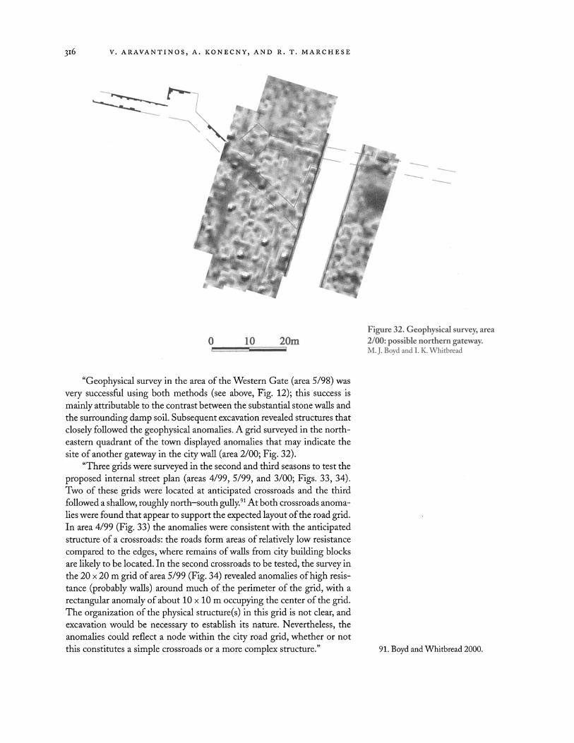
3I6 V. ARAVANTINOS, A. KONECNY, AND R. T. MARCHESE
- l * A:0w; | .,iX
< s r
\7
- - - --
Xt
Figure 32. Geophysical survey, area O 10 20m 2/00: possible northern gateway.
{ M. J. Boyd and I. K. Whitbread
"Geophysical survey in the area of the Western Gate (area 5/98) was very successful using both methods (see above, Fig. 12); this success is mainly attributable to the contrast between the substantial stone walls and the surrounding damp soil. Subsequent excavation revealed structures that closely followed the geophysical anomalies. A grid surveyed in the north- eastern quadrant of the town displayed anomalies that may indicate the site of another gateway in the city wall (area 2/00; Fig. 32).
"Three grids were surveyed in the second and third seasons to test the proposed internal street plan (areas 4/99, 5/99, and 3/00; Figs. 33, 34). Two of these grids were located at anticipated crossroads and the third followed a shallow, roughly north-south gully.9l At both crossroads anoma- lies were found that appear to support the expected layout of the road grid. In area 4/99 (Fig. 33) the anomalies were consistent with the anticipated structure of a crossroads: the roads form areas of relatively low resistance compared to the edges, where remains of walls from city building blocks are likely to be located. In the second crossroads to be tested, the survey in the 20 x 20 m grid of area 5/99 (Fig. 34) revealed anomalies of high resis- tance (probably walls) around much of the perimeter of the grid, with a rectangular anomaly of about 10 x 10 m occupying the center of the grid. The organization of the physical structure(s) in this grid is not clear, and excavation would be necessary to establish its nature. Nevertheless, the anomalies could reflect a node within the city road grid, whether or not this constitutes a simple crossroads or a more complex structure." 91. Boyd and Whitbread 2000.

PLATAIAI IN BOIOTIA: I996-200I CAMPAIGNS 3I7
l l
{ j-
l
l
Figure 33. Geophysical survey, area 4/99: crossroad. M. J. Boyd and I. K. Whitbread
Figure 34. Geophysical survey, area 5/99: internal feature at crossroad site. M. J. Boyd and I. K. Whitbread
O 10 20m r _
' / 0 10 20m I , . __ I
! , t |
CONCLUSION
After six years of research at Plataiai much has been achieved. The fortifica- tions of the town have been fully documented and their function and date of construction are now better understood. The chronology of the large circuit wall is now based on solid, excavated evidence. The results of sur- face survey have also provided valuable knowledge about the occupational sequence of the town and shed light on the difficult problems of settle- ment expansion and contraction throughout the site's history. The exca- vations on the acropolis have, despite their small scale, contributed sub- stantially to our understanding of Plataiai's history. The town's existence extended over a much longer period than had hitherto been anticipated from ancient commentary and the published results of earlier excavations at the site.

3r8 v. ARAVANTINOS, A. KONECNY, AND R. T. MARCHESE
Nevertheless, the conclusions drawn in this article must remain pro- visional until further work is carried out at the site. Enlarging the exca- vated area at the Western Gate will lead to a better understanding of the architectural sequences at this focal point of Plataiai's most extended for- tification circuit. Surface survey should continue on a regular and system- atic basis. Much information concerning the chronology and extent of the settlement during its long existence still awaits analysis. Of even greater importance is the continuation of excavations on the acropolis. The ce- ramic sequence in this area covers a span of approximately five millennia and indicates a potentially substantial community of Archaic date, remains of which are situated below the occupational debris of later periods. In this sense the preliminary results presented here on the first six years of the Plataiai Research Project should be regarded less as a report on objectives achieved than as the beginning of a promising reevaluation of settlement organization and development in southwestern Boiotia.
REFERENCES
Adam, J. P. 1982. L'architecture militaire gresque, Paris.
. 1992. "Approche et defense des portes dans le monde hellenise," in Van de Maele and Fossey 1992, pp. 5-43.
Agora = The Athenian Agora, Princeton. XII = B. A. Sparkes and L. Tal-
cott, Black and Plain Pottery of the 6th, 5th, and 4th Centuries B.C., 1970.
XIV = H. A. Thompson and R. E. Wycherley, The Agora of Athens: The History, Shape, and Uses of an Ancient City Center, 1972.
XXIX = S. I. Rotroff, Hellenistic Pottery:Athenian and Imported Wheelmade Table Ware and Related Material, 1997.
Amit, M. 1973. Great and Small Poleis: A Study in the Relations between the Great Powers and the Small Cities in Ancient Greece, Brussels.
Aravantinos, V. 1999. "Mycenaean Texts and Contexts at Thebes: The Discovery of New Linear B Archives at the Kadmeia," in Flo- reant studia Mycenaea. Akten des X. internationalen Mykenologischen Colloquiums in Salzburg, 1.- 5. Mai 1995, S. Hiller and O. Panagl, eds., Vienna, pp. 56-64.
Aravantinos, V., L. Godart, and A. Sacconi. 2001. Thebes: Fouilles de
la Cadme'e 1: Les tablettes de la Odos Pelopidou, Rome.
Aravantinos, V., and A. Konecny. 2000. "Plataiai: Die Kampagne 1999," OJh69, pp. 8-15.
Aravantinos, V., A. Konecny, and R. Marchese. 2001. "Plataiai: Die Kampagne 2000," OJh 70, pp. 9-19.
Badian, E. 1989. "Plataea between Athens and Sparta," in Boiotika: Vortrage vom 5. Internationalen Bootien-Kolloquium, Munchen, 13.-17. Juni 1986, H. Beister and J. Buckler, eds., Munich, pp. 95- 111.
Bakhuizen, S. C. 1982. "La grande batterie de Goritsa et l'artillerie defensive," in Leriche and Treziny 1986, pp. 315-322.
. 2000. A Greek City of the Fourth Century B. C., Milan.
Beschi, L. 1968. "La fortezza ellenica di Gyphtokastro," in Lesfortfica- tions depuis l'antiquite'jusque a moyen-age dans le mond mediterra- ne'en. Acts of the 8th Scientf c Confer- ence of the International Castles Insti- tute, Athens, pp. 127-145.
Bintliff,J. l999."The Origins and Nature of the Greek City-State and Its Significance for World Settlement History," in Les princes de la protohistoire et l'e'mer-
gence de l'etat. Actes de la table ronde internationale, Naples, 27-29 octobre 1994, P. Ruby, ed., Naples, pp.43-56.
Bon, L.1937."Forteresses medievales de la Grece centrale," BCH61, pp.136-208.
Bonanno-Aravantinou, M.1988. "Ot sapxofRayot P9,uatxt15 s°XtlS ttIS
BoXtag: EVVOZTLMf Hsp, in Ersqss Trls srocs psoss poscorssccov <ETCt)V. A dssf9ves avvs8Pso pOsst)rtxCt)> ySsTst)w, Thebes, 10-14 September 1986, A. Bekiaris, ed., Athens, pp.307-324.
Boyd, M. J., and I. K. Whitbread.2000. "Geophysical Studies at Plataiai in 1999," in Aravantinos and Konecny 2000, pp.12-15.
Bruce, I. A. F.1968. "Plataea and the Fifth-Century Boeotian Confed- eracy," Phoenix 22, pp.191-199.
Buck, R. J.1979. A History of Boeotia, Alberta.
. 1994. Boeotia and the Boeotian League, Alberta.
Buckler, J.1980. The Theban Hegemony, 371-362 B. C., Cambridge.
.1989. Philip II and the Sacred War, Leiden.
Cooper, F. A.2000. "The Fortifications of Epaminondas and the Rise of the Monumental Greek City," in City

PLATAIAI IN BOIOTIA: I996-200I CAMPAIGNS 3I9
Wall: The Urban Enceinte in Global Perspectizve, J. D. Tracy, ed., Cam- bridge, pp. 155-191.
Corbet,J.1997."Milet 1994-1995: Die Mauern sind die Stadt: Zur Stadtbefestigung des antiken Milet," t 1997, pp.249-284.
Debord, P., and R. Descat, eds.1994. Fortifications et defense du terri- toire en As ie Min eure occiden tale et me'ridionale. Acts of the Round Table, Istanbul 1993 (REA 96), Bordeaux.
Eretria IV = C. Krause, Das Westtor: Ergebnisse derAusgrabungen, 1964- 1968, Bern 1972.
FdD II = P. Amandry, Topographie et architecture. La colonne des Saxiens et le portique desAthe'niens, Paris 1953.
Fossey, J. M .1981. Kho'stia 1980, Montreal.
.1986. TheAncient Topography of Eastern Phokis, Amsterdam.
.1988. Topography and Popula- tion of Ancient Boeotia, Chicago.
. 1991. Epigraphica Boeotica 1: Studies in Boiotian Inscriptions, Amsterdam.
Fossey,J. M., andJ. Morin. 1986. Kho'stia 1983, Amsterdam.
Garlan, Y.1974. Recherches de poliorce'- tiquegresque, Paris.
Gassner, V.2001. "Neue Forschungen zu den fruhen Stadtmauern von Velia," in Akten des 8. Osterreich- ischen Archaologentags am Institut
fur KlassischeArchaologie der UniqJer- sitat Wien, 1999, F. Blakolmer and H. D. Szementhy, eds., Vienna, pp. 81-90.
Gauvin, G., and J. M. Fossey. 1985. "Livadhostra: Un releve topograph- ique des fortifications de l'ancienne Kreusis," in La Be'otie antique. Actes du Colloque international, Lyon, Saint-Etienne, 16-20 mai 1983, P. Roesch and G. Argoud, eds., Paris, pp. 77-86.
Gregorovius, F. 1889. Geschichte der StadtAthen im Mittelalter I-II, Munich.
Held, W.1999. "Loryma in Karien," IstMitt 49, pp. 159-196.
Karlsson, L. 1992. Fortification Towers and Masonry Techniques in the
Hegemony of Syracuse, 405-211 B.C.
(OpRom 46), Stockholm. Kern, P.-B. 1999. Ancient Siege Warfare,
Bloomington. Kirsten, E. 1950. "Plataiai," RE AX,
cols. 2255-2332. Koilanou, C.1999."A£tD86A,"
ArchDelt 49, B' 1 (1994), pp. 123-125.
Konecny, A. 1997. Hellenistische Turm- gehofte in Zentral- und Ostlykien, Vienna.
.1998. "Der Plataiai Survey, 1996-1997," OJhBeibl 67, pp. 53-62.
. In press. "The Walls of Pla- taiai: A Preliminary Report," Boeo- tian Studies 7-8.
Konecny, A., M. J. Boyd, and I. Whit- bread. 1999. "Der Plataiai Survey: Die Kampagne 1998," OJhBeibl68, pp. 41-52.
Lawrence, A. W. 1979. Greek Aims in Fortification, Oxford.
Lazenby, J.-F. 1993. The Defence of Greece, 490-479 B.C., Warminster.
Leriche, P. 1992. Lesfortfications gresques de Mycene a Alexandre (Dossiers d'archeologie 172), Paris.
Leriche, P., and H. Treziny, eds., 1986. LafortHcation dans l'histoire du mondegrec. Actes du Colloque inter- national, Valbonne, decembre 1982, Paris.
Maier, F.-G. 1967."Ausgrabungen in Alt Paphos: Stadtmauer und Belagerungswerke,"B 1967, pp.303-330.
Marksteiner, T. 1997. Die Befestigte Siedlungzvon Limyra. Studien zur zvorromischen Wehrarchitektur und Siedlungsentwicklung in Lykien unter besonderer Berucksichtigung der klassischen Periode, Vienna.
Marsden, E. W. 1969. Greek and Roman Artillery: Historical Dezvelopment, Oxford.
Martin, R. 1965. Manuel d'architecture gresque, Paris.
McNicholl, A.1986. "Developments in Techniques of Siegecraft and Fortifications in the Greek World, ca. 400-100 B.C.," in Leriche and Treziny 1986, pp.305-314.
. 1997. HellenisticEortifrations from theAegean to the Euphrates, Oxford.
Milet II.3 = A. von Gerkan, Die Stadt- mauern, Berlin 1935.
Milet III.2 = F. Krischen, Die Befestig- ungen zvon Herakleia am Latmos, Berlin 1922.
Ohly, D. 1965. "Kerameikosgrabung: Tatigkeitsbericht,1956-1961," k 1965, pp.360-376.
Olynthus XIII = D. M. Robinson, Vases Found in 1934 and l 938, Baltimore 1950.
Pollhammer, E.2002. "Das Kap Kolon- na: Eine Festung der Attaliden auf Agina," in Temenos: Festgabefur Flo- rens Felten und Stefan Hiller, B. Asa- mer et al., eds., Vienna, pp. 99-108.
Prandi, L.1988. Platea: Momenti e pro- blemi della storia di una polis, Padua.
Pritchett, W. K.1957. "New Light on Plataiai," AJA 61, pp. 9-28.
. 1965. Studies inAncient Greek Topography 1, Berkeley.
. 1980. Studies inAncient Greek Topography 3, Berkeley.
. 1982. Studies inAncient Greek Topography 4, Berkeley.
. 1985. Studies inAncient Greek Topography 5, Berkeley.
Radt, W.1992. "Die fruhesten Wehr- mauern von Pergamon und die zugehorigen Keramikfunde,"B 1992, pp.163-282.
Rheidt, K.1992. "Die obere Agora: Die Entwicklung des hellenis- tischen Stadtzentrums von Perga- mon,"B 1992, pp.235-282.
Richardson, R. B. 1891. "Votive In- scriptions from Plataia,"AJA 7, pp.407-421.
Samos XV = H. J. Kienast, Die Stadt- mauerzvon Samos, Bonn 1978.
Schachter, A.1981. The Cults of Boeotia 1: Acheloos to Hera (BICS Suppl. 38.1), London.
.1986. The Cults of Boeotia 2: Herakles to Poseidon (BICS Suppl. 38.2), London.
.1994. The Cults of Boeotia 3: Potnia to Zeus (BICS Suppl.38.3), London.
Schulz, A.2000. Die Stadtmauern zvon Neandria in der Troas (Asia Minor Studien 38), Bonn.
Schwandner, E. L.1977. "Die boot- ische Hafenstadt Siphai,"B 1977, pp.515-550.

320 V. ARAVANTINOS, A. KONECNY, AND R. T. MARCHESE
Scranton, R. L. 1941. Greek Walls, Cambridge, Mass.
Skias, A. 1899. "'Avacexa(pY1 £V X-
xaeae," Prakt 1899, pp. 42-56. Spyropoulos, T. 1973a. Eeda£C5 £x
BoeXeaq,"A 6, pp. 375-381. . 1973b. "Some Boiotian Dis-
coveries, I: Plataia," Teiresias 3, pp.2-3.
Stahlin, F., and E. Meyer. 1934. Pagasai und Demetrias, Berlin.
Tabula Imperii Byzantini I = J. Koder and F. Hild, Hellas und Thessalia, Vienna 1976.
Tillard, L. B. 1911."The Fortifications of Phokis," BSA 17, pp. 54-75.
Van de Maele, S., andJ. M. Fossey, eds. 1992. Fortif icationes antiquae, Amsterdam.
Waldstein, C., F. B.Tarbell, andJ. C. Rolfe. 1889. "Discoveries at Plataia in 1889,"AJA 5, pp. 428-442.
Waldstein, C., H. S. Washington, and W. Hunt. 1890. "Discoveries at Plataia in 1890,"AJA 6, pp. 445- 475.
Washington, H. S. 1891. "Excavations by the American School at Plataia in 1891,"AJA 7, pp. 390-405.
Weber, E. 1976. Tabula Peutingeriana: Codex Vindobonnensis 324, Kom- mentar, Graz.
Weiszl, M. 1999."Die Befestigungen der jungeren Stadtanlage von Pleuron in Aitolien," OJh 68, pp. 105-146.
Wheler, G. 1682. AJourney into Greece, London.
Whitbread, I. K.2001. "Geophysical Studies at Plataiai in 2000," in Aravantinos, Konecny, and Mar- chese 2001, pp.16-19.
Winter, F. E. 1971. Greek Fortif cations, r loronto.
.1986. "A Summary of Recent Work on Greek Fortifications in Greece and Asia Minor," in Leriche and Treziny 1986, pp.23- 38.
. 1992. "Philon of Byzantion and the Hellenistic Fortifications of Rhodos," in Van de Maele and Fossey 1992, pp.185-209.
Wrede,W. 1924."Phyle,"AM49, pp.153-224.
.1933. Attische Mauern, Athens.
Vassilis AraqJantinos
MUSEUM OF THEBES PLATEIA KERAMOPOULLOU 32-200 THEBES GREECE
Andreas Konecny
INSTITUT FUR KLASSISCHE ARCHAOLOGIE .. UNIVERSITAT WIEN
FRANZ KLEIN -GAS S E I A-II90 VIENNA A U S T R I A
Andreas . L . Konecny@univie . ac . at
Ronald 1: Marchese
UNIVERSITY OF MINNESOTA AT DULUTH DEPARTMENT OF SOCIOLOGY AND ANTHROPOLOGY 228 CINA HALL DULUTH, MINNESOTA 558I2
rm arche s @ub . d . um n . e du