Embed Size (px)
Citation preview

Planning Proposal
Amendment to the Blacktown Local Environmental Plan 2015
Riverstone Town Centre
January 2020

Page 1 of 39
Contents Introduction ............................................................................................................................................ 2
Summary ............................................................................................................................................... 2
Council consideration .......................................................................................................................... 3
Gateway Determination ....................................................................................................................... 4
Neighbourhood context ....................................................................................................................... 5
Economic and feasibility analysis ...................................................................................................... 8
The Planning Proposal ........................................................................................................................ 9
Part 1 – Objectives and intended outcomes ................................................................................ 9
Part 2 – Explanation of provisions ................................................................................................. 9
a. Land Zoning ........................................................................................................................ 10
b. Building height .................................................................................................................... 10
c. Incentive Height of Buildings Map ................................................................................... 11
d. Minimum subdivision lot size ............................................................................................ 11
e. Intention of allowing additional height on land in the Riverstone Town Centre .... 11
f. Design excellence .............................................................................................................. 12
g. Land reservation acquisition ............................................................................................. 12
Part 3 – Justification ....................................................................................................................... 14
Section A – Need for the Planning Proposal .......................................................................... 14
Section B – Relationships to strategic planning framework ................................................. 15
Section C – Environmental, social and economic Impact .................................................... 26
Part 4 – Mapping ............................................................................................................................ 34
Part 5 – Community Consultation ................................................................................................ 34
Part 6 – Project Timeline ............................................................................................................... 34
Appendix 1 .......................................................................................................................................... 35
Council resolution to prepare a Planning Proposal ................................................................... 35
Appendix 2 .......................................................................................................................................... 36
Mapping ........................................................................................................................................... 36
Appendix 3 .......................................................................................................................................... 37
Guidelines for Architectural Design Competition ....................................................................... 37
Appendix 4 .......................................................................................................................................... 38
Riverstone Town Centre Flood Hazard Mapping ...................................................................... 38

Page 2 of 39
Introduction This Planning Proposal explains the intended effect of and justification for the proposed amendment to Blacktown Local Environmental Plan 2015 (BLEP 2015) relating to the Riverstone Town Centre. It has been prepared in accordance with Section 3.33 of the Environmental Planning and Assessment Act 1979 and the Department of Planning Infrastructure and Environment (DPIE) documents ‘A guide to preparing local environmental plans’ and ‘A guide to preparing planning proposals’.
Summary This Planning Proposal seeks to amend BLEP 2015 in order to implement the strategies and recommendations contained within the Riverstone Town Centre Masterplan, as adopted by Council on 22 November 2017. This is Part 1 of a staged approach to implementation of the masterplan recommendations.
The Masterplan details Blacktown City’s strategic direction to shape, manage and revitalise commercial and residential growth within the Riverstone Town Centre over the next 20 years. The Masterplan provides an integrated land use planning and transport plan that responds to the anticipated growth in the area during this period. Our vision for the Riverstone Town Centre is to create a vibrant, sustainable centre with opportunities for the community.
Proposed key amendments to BLEP 2015 include:
• upzoning of land within the Riverstone Town Centre core area to B4 Mixed Use and R4 High Density Residential to enable a mix of commercial, retail and higher density residential uses
• changes to planning controls that relate to building heights to allow up to 20 m (6 storeys) and 32 m (10 storeys)
• changes to the Lot size map to align with the proposed zoning changes • identification of land to be acquired by Council for community uses • changes to the Design Excellence map to include land in the Riverstone Town
Centre • allowing additional building height up to 50 m (15 storeys) on land on land between
Pitt Street and Riverstone Parade, subject to an architectural design competition.
A copy of the Riverstone Town Centre Masterplan and the supporting economic and feasibility analysis, urban design analysis and transport assessment accompany this Planning Proposal.

Page 3 of 39
Council consideration Council resolved in July 2016 to prepare and exhibit a draft masterplan to manage and shape future growth and development in the Riverstone Town Centre. The draft masterplan was exhibited from 22 August to 30 September 2016. The exhibition included 4 masterplan options for the redevelopment of the town centre.
In November 2017, Council resolved to adopt Option 2 ‘The Main Street’ for inclusion in the final masterplan for the Riverstone Town Centre, based on consideration of the comparative performance of each option based on the criteria set out in the Masterplan and community feedback from public exhibition of the draft masterplan.
In February 2018, Council resolved to:
• prepare a Planning Proposal to amend Blacktown Local Environmental Plan 2015, and progress corresponding draft amendments to Blacktown Development Control Plan 2015, to implement the statutory elements of the land use planning strategy outlined in the Riverstone Town Centre Masterplan
• forward the Planning Proposal to the Department of Planning and Environment seeking a Gateway Determination to exhibit the proposal
• exhibit the Planning Proposal concurrently with draft amendments to Blacktown Development Control Plan 2015.
A copy of the Council resolution to prepare a Planning Proposal is at Appendix 1.
Page 4 of 39
Gateway Determination We received a conditional Gateway Determination on 6 August 2018. It required the following be undertaken prior to public exhibition:
• preparation of a flood study in consultation with the SES, INSW (Flood Risk Directorate) and Transport for NSW (TfNSW)
• consultation with the Government Architect of NSW and obtain the endorsement of the Secretary (or delegate) for the proposed Design Excellence Guidelines
• work with the Department of Planning and Environment to refine infrastructure funding, undertake sensitivity testing and consider if contributions towards the State and Regional Infrastructure should be captured
• clarify that the new incentive clause, to be inserted into Part 7 of BLEP 2015 is only a draft clause to state Council’s intent and is subject to changes when the LEP is finalised by Parliamentary Council
• submit a revised planning proposal to the Department for endorsement.
A revised Planning Proposal was submitted to the Department in August 2019. An amended Gateway Determination issued on 13 December 2019 required Council to exclude the area south of Garfield Road East from the Planning Proposal. This is to enable TfNSW to review the Garfield Road East road corridor and railway level crossing. This Planning Proposal is therefore further revised to exclude proposed amendments to planning controls from land south of Garfield Road East. The planning controls which apply to the land south of Garfield Road East will be reviewed at a later date.
The Planning Proposal has been updated as follows:
• Gateway Determination • Part 2 Explanation of provisions: land zoning, building height, incentive height of
buildings map, minimum lot size, intention of allowing additional height on land in the Riverstone Town Centre.
• Part 3 Section B Consistency with Ministerial Directions: o Direction 1.1 Business and Industrial Zones o Direction 4.3 Flood Prone Land o Direction 6.1 Approval and Referral Requirements
• Part 3 Section C(8): Flood Risk • Part 3 Section D(10): Infrastructure funding • Part 6 Project Timeline

Page 5 of 39
Neighbourhood context Riverstone is in the north of Blacktown LGA. While the outlying areas of Riverstone are administered under the State Environmental Planning Policy (Sydney Region Growth Centres) 2006 (Growth Centres SEPP), administration of the established areas of Riverstone including the Town Centre remain under BLEP 2015.
Riverstone was one of the first precincts within the North West Growth Area (NWGA) to be rezoned. Residential development in the outlying areas of the suburb is underway with the population in Riverstone anticipated to increase by up to 30,000 over the next 20 years.
Riverstone is an established community dating back to the mid-19th century with a strong rural heritage. The existing Town Centre is located opposite the railway station and comprises a minor shopping centre along Riverstone Parade and strip retail and commercial along Garfield Road East. The area is characterised by one to two storey buildings of varying ages and condition with street and at-grade car parking.
The Riverstone West Precinct of the NWGA is located on the western side of the railway line. This Precinct was rezoned for employment uses in 2009. While the Precinct is not yet developed, there is significant potential for future employment opportunities in close proximity to the Riverstone Town Centre.
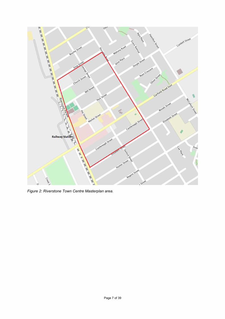
The Riverstone Town Centre Masterplan study area is located opposite the Riverstone Railway Station on Riverstone Parade. It is bound by the railway line to the west, King Street to the north, Piccadilly Street to the east and Elizabeth Street to the west, and incorporates the existing commercial area east of the railway station (see Figures 1 and 2). The study area is approximately 49.8 ha.
Transport for NSW are planning an upgrade to Garfield Road including consideration of the railway crossing as part of their overall network upgrades to support growth in the NWGA. The upgrade around the railway crossing is a long-term project, however, this has the potential to significantly impact on the viability of Garfield Road as a retail and commercial focus.
The future Garfield Road upgrade is the driving force behind the Riverstone Town Centre Masterplan. The Riverstone community, especially businesses, have been in limbo for many years due to delays in finalising the location of a grade-separated crossing. Implementation of this first stage of the masterplan will provide much-needed certainty and support to businesses, landowners and the local community. The Masterplan and its recommendations will benefit the Riverstone Town Centre both before and after upgrades to Garfield Road and the railway crossing.
The land use planning outcomes of the Masterplan are proposed to be implemented in stages. This initial Planning Proposal focuses on the core retail / commercial and higher density residential precincts as identified in the Masterplan. Consideration will be given to rezoning land south of Garfield Road East and the transitional precincts towards the periphery of the study area in future stages of implementation, following a review of market demand.

Page 6 of 39
Figure 1: Riverstone Town Centre – locality map in context of North West Growth Area.
Page 7 of 39
Figure 2: Riverstone Town Centre Masterplan area.

Page 8 of 39
Economic and feasibility analysis An Economic and Feasibility Analysis was undertaken by AEC Group to inform the Riverstone Town Centre Masterplan. The analysis found that, while the Town Centre is currently in decline, suffers from poor layout and lacks a retail anchor to attract patronage, the current location is appropriate and there are a number of factors which indicate the potential for a successful revitalised Town Centre at this location.
• The Town Centre is located at an established railway station on the T1 line and has good access to other public transport, car parking and exposure to passing traffic.
• Council’s investment in community and recreational facilities and the public domain will improve the profile of the Town Centre.
• The Riverstone and Alex Avenue Precincts within the NWGA were rezoned in 2010. Residential development of former rural lands within the Town Centre catchment area is underway, which will generate an increase in demand for retail, commercial and community facilities in the short term. Demand for shop-top housing within the town centre is projected in the medium term.
• Riverstone is located centrally within the NWGA and the Town Centre will benefit from increased patronage from the overall growth in population across the area.
• Development of the Riverstone West industrial and business area will increase the catchment for Riverstone Town Centre, both as a destination in itself and as a transport node servicing the employment lands.

Page 9 of 39
The Planning Proposal
Part 1 – Objectives and intended outcomes
The objective of this Planning Proposal is to amend BLEP 2015 to implement the strategies and recommendations contained within the Riverstone Town Centre Masterplan, as adopted by Council on 22 November 2017.
The intended outcome is a statutory framework which will:
• provide flexibility and incentive for redevelopment in the Riverstone Town Centre by amending zoning and maximum height of building controls
• identify key sites where additional building heights are available subject to an architectural design competition
• encourage design excellence in the Riverstone Town Centre area to ensure that future development delivers high quality and sustainable building design and an attractive and sustainable public domain
• create a transition in density from the Town Centre core area to surrounding lower density residential through a staged approach to implementation.
Part 2 – Explanation of provisions
The proposed objective and intended outcome of the Planning Proposal will be achieved by the following proposed amendments to the Blacktown Local Environmental Plan 2015.
1. Amend the BLEP 2015 Land Zoning Map (Sheet LZN_006) to upzone land in the Riverstone Town Centre core area to enable a mix of commercial, retail and higher density residential uses.
2. Amend the BLEP 2015 Height of Buildings Map (Sheet HOB_006) to allow up to 20 m and 32 m in the Town Centre core area.
3. Amend the BLEP 2015 Lot Size Map (Sheet LSZ_006) to remove the minimum subdivision lot size layer from land proposed to be rezoned to B4 and R4.
4. Amend the BLEP 2015 Incentive Height of Building Map (Sheet IHOB_006) to identify a key site in the Riverstone Town Centre where a bonus building height increases the maximum height of buildings to 50 m, subject to an architectural design competition.
5. Amend BLEP 2015 Design Excellence Map (Sheet DEX_006) to identify the Riverstone Town Centre Masterplan study area north of Garfield Road East as ‘Design excellence’.
6. Amend BLEP 2015 Land Reservation Acquisition Map (Sheet LRA_006) to identify a total of 8 lots to be acquired by Council for community uses.
The built form controls in the Blacktown Development Control Plan 2015 are under review and will be amended in relation to the Riverstone Town Centre if required.

Page 10 of 39
a. Land Zoning
Proposed amendments to BLEP 2015 are found in the Land Zoning Map (Sheet LZN_006). Refer to maps showing existing land zoning and proposed changes to land zoning at Appendix 2.
Proposed changes to land zoning
1. Land bound by Church Street, Piccadilly Street, Park Street, Riverstone Parade and Mill Street Park is to be rezoned to R4 High Density Residential. This will permit high density residential development in close proximity to Riverstone Railway Station and the new Riverstone Town Centre core area. The area proposed to be rezoned to R4 supports the proposed new Riverstone Town Centre core. This area is currently zoned R2 Low Density Residential, with the exception of the Riverstone-Schofields Memorial Club on the corner of Mill Street and Riverstone Parade which is zoned RE2 Private Recreation. The proposed rezoning across the Riverstone Town Centre area will refocus business, community and recreation activities into the new core area along Market Street.
2. Land bound by Park Street, Piccadilly Street, Market Street and Pitt Street is to be rezoned to B4 Mixed Use. The proposed rezoning will assist in refocussing core Riverstone Town Centre activity along Market Street, which is to function as the new main street. The B4 zone will permit development of shop top housing above retail, commercial, entertainment and community uses within the new Riverstone Town Centre core area. Moving the Riverstone Town Centre core from Garfield Road East to Market Street will overcome current issues with a Riverstone Town Centre bisected by an arterial road with limited pedestrian access, and facilitate the establishment of a revitalised, pedestrian-friendly Riverstone Town Centre in an orderly manner prior to the Garfield Road East and railway crossing upgrade. This area spans two blocks and is currently zoned R2 Low Density Residential.
b. Building height
This Planning Proposal proposes to amend the BLEP 2015 Height of Buildings Map (Sheet HOB_006). Additional height is focussed around the heart of the new proposed Main Street and within 400 m of the railway station, stepping down progressively in height with distance from the railway station. Please refer to maps showing existing maximum building height and proposed changes to maximum building height at Appendix 2.
In addition, this Planning Proposal seeks to allow for an incentive height of buildings on key sites that will be subject to an architectural design competition. Refer to ‘c. Incentive Height of Buildings Map’, below.
Proposed changes to building height
1. A maximum height of building control of 32 m (10 storeys) is proposed for the land located directly adjacent to the train station and predominantly within 400 m of the railway station, bound by Mill Street, George Street, Garfield Road East and Riverstone Parade. The land is located at the heart of the Riverstone Town Centre.

Page 11 of 39
The land is either currently zoned B2 Local Centre and will retain this zoning, or is proposed to be rezoned to B4 Mixed Use or R4 High Density Residential.
2. A maximum height of building control of 20 m (6 storeys) is proposed for the land bound by Mill Street Park, Church Street, Piccadilly Street, Market Street (opposite the swimming centre), George Street and Mill Street. This land is proposed to be rezoned partly R4 and partly B4. This area of land is greater than 400 m from the railway station.
c. Incentive Height of Buildings Map
This Planning Proposed seeks to create a new map, BLEP 2015 Incentive Height of Buildings Map (Sheet IHOB_006), see Appendix 2. The Map will identify land to which a new or an amended clause will apply (see “e. Intention of allowing additional height on land in the Riverstone Town Centre”).
The land shown on the IHOB Map has been identified as it has the potential to provide:
• iconic built form outcomes demonstrating design excellence • additional residential development yields very close to the railway station • improvements to the public domain and streetscape • additional opportunities for mixed use development, increasing the diversity of
employment, retail and commercial opportunities.
d. Minimum subdivision lot size
The Planning Proposal seeks to amend BLEP 2015 Lot Size Map (Sheet LSZ_006) to remove the minimum subdivision lot size layer from land which is proposed to be rezoned to B4 Mixed Use and R4 High Density Residential. Under the proposed rezoning, land is anticipated to be consolidated to enable more intense development. A minimum lot size of 450 m2 is not an appropriate planning control for the proposed new zones. Please refer to the proposed Lot Size Map at Appendix 2.
e. Intention of allowing additional height on land in the Riverstone Town Centre
This Planning Proposal refers to a clause in Part 7 of BLEP 2015, proposed as part of a Planning Proposal in relation to the Blacktown and Mount Druitt CBDs. The intention of the clause is to allow development which exceeds the maximum building height indicated by the Height of Buildings map where:
• development which exceeds the maximum building height may only be considered on sites which are identified on the Incentive Height of Buildings Map
• development must not exceed the maximum building height identified on the Incentive Height of Buildings Map for that site
• development consent must not be granted for a development which proposes a building height between the maximum height identified on the Height of Buildings Map and the maximum height identified on the Incentive Height of Buildings map, unless an architectural design competition has been held in relation to the proposed development
Page 12 of 39
• the architectural design competition must be conducted in accordance with Council’s Architectural Design Competition Guidelines (see Appendix 3).
In relation to Riverstone Town Centre, this Planning Proposal seeks to provide additional development potential on the land identified on the Incentive Height of Buildings Map. The consent authority may consider a development application (DA) for a site identified on the Incentive Height of Buildings Map (Sheet IHOB_006) where the proposed building height exceeds the proposed maximum building height of 32 m up to a maximum building height of 50 m. Prior to lodgement of the DA, the proponent must undertake an architectural design competition in relation to the proposed development. The competition must be conducted in accordance with Council’s Architectural Design Competition Guidelines.
The requirement for an architectural design competition is intended to encourage innovative design solutions that achieve high quality, well designed development which responds to the gateway site and its role in the Riverstone Town Centre. The Competition Guidelines include a design integrity phase, intended to ensure that design quality is maintained through the development application, design and construction stages.
Only development which is of an excellent design and which can demonstrate appropriate levels of activity and/or density will be considered at the incentive height. The DA will need to address all potential impacts, including traffic and circulation, environmental and amenity impacts, as well as the proposal’s consistency with the Masterplan, its objectives and identified outcomes.
f. Design excellence
This Planning Proposal seeks to amend BLEP 2015 Design Excellence Map (Sheet DEX_006) to identify the Riverstone Town Centre Masterplan study area north of Garfield Road East as ‘design excellence’. Refer to Proposed Design Excellence Map at Appendix 2.
The application of Clause 7.7 ‘Design excellence’ to the Riverstone Town Centre masterplanned area is intended to ensure that future development exhibits design excellence that contributes to the natural, cultural, visual and built character values of Riverstone.
g. Land reservation acquisition
This Planning Proposal seeks to amend BLEP 2015 Land Reservation Acquisition Map (Sheet LRA_006) to identify 8 lots to be acquired by Council for community uses to enable implementation of the Masterplan. The lots are currently zoned R2 Low Density Residential and are mostly detached one or two storey dwelling houses, with 18 Market Street used as the Riverstone-Schofields sub-branch of the RSL. The area to be acquired is 4,695.8 m2, approximately 23% of the total block.
The lots identified for future acquisition are within the block bounded by Park, George, Market Street and Pitt Streets. This block has been identified as the site of future community facilities to service the NWGA since at least 2010, when Section 7.11 Contributions Plan No 20 Riverstone and Alex Avenue Precincts were prepared. Contributions Plan No 20 identified the 8 lots for future acquisition, with the estimated cost of acquisition apportioned over 4 precincts considered to benefit from the future community facilities. The future use of

Page 13 of 39
the block was reiterated in the Riverstone Town Centre Masterplan, which identified various community uses including a library, child care, community resources hub and village green.
Please refer to the map of land to be acquired by Council for community use at Appendix 2.

Page 14 of 39
Part 3 – Justification
Section A – Need for the Planning Proposal
1. Is the Planning Proposal a result of any strategic study or report?
Yes. The Planning Proposal facilitates the implementation of the strategies and recommendations contained within the Riverstone Town Centre Masterplan, as adopted by Blacktown City Council on 22 November 2017. The Masterplan is consistent with Blacktown Planning Strategy 2036 and the relevant metropolitan and regional strategies.
2. Is the Planning Proposal the best means of achieving the objectives or intended outcomes, or is there a better way?
Yes. Implementation of the Riverstone Town Centre Masterplan entails changes to the statutory framework for the area in order to achieve the objectives of encouraging growth through flexible design controls, promoting high quality building design and creating an attractive and sustainable public domain. Amendment to BLEP 2015 can only be achieved by means of a Planning Proposal.

Page 15 of 39
Section B – Relationships to strategic planning framework
3. Is the Planning Proposal consistent with the objectives and actions of the applicable regional, sub-regional or district plan or strategy (including any exhibited draft plans or strategies)?
(a) Greater Sydney Region Plan 2018
The Greater Sydney Region Plan, A metropolis of three cities – connecting people, released March 2018, sets out a vision for Greater Sydney which aims to rebalance the region by placing housing, jobs, services, infrastructure and quality public and private spaces within easier reach of more residents. This vision is translated into 10 Directions for achieving the 30 minute city across a metropolis of three connected cities.
This Planning Proposal generally supports the principles in A metropolis of three cities, seeking to cluster increased residential density, community facilities, essential services and retail, commercial and employment opportunities close to key public transport infrastructure, in a high quality, well-designed environment which creates great places to live, recreate, socialise and work.
This Planning Proposal specifically supports the following Directions and Objectives in A metropolis of three cities.
• Direction: A city for people o Objective 7: Communities are healthy, resilient and socially connected.
• Direction: Housing the city o Objective 10: Greater housing supply o Objective 11: Housing is more diverse and affordable
• Direction: A city of great places o Objective 12: Great places that bring people together.
• Direction: Jobs and skills for the city o Objective 22: Investment and business activity in centres.
(b) Central City District Plan 2018
The 2018 Greater Sydney Region Plan and District Plans identify Blacktown LGA as located within the Central City District and part of the Central River City. The Riverstone Town Centre is located in the land release area to the west of the district. The priorities of the Central City District Plan include creation of healthy, integrated, liveable places which offer opportunities for socially connected communities; to increase housing supply, choice and affordability, with access to jobs and services. It also renews centres creating employment opportunities and great places to live.
This Planning Proposal supports the following in the Central City District Plan 2018:
• Planning Priority C4: Fostering healthy, creative, culturally rich and socially connected communities
• Planning Priority C5: Providing housing supply, choice and affordability with access to jobs, services and public transport
• Planning Priority C6: Creating and renewing great places and local centres, and respecting the District’s heritage

Page 16 of 39
• Planning Priority C10: Growing investment, business opportunities and jobs in strategic centres.
The Masterplan will provide for a new Main Street spine to the Riverstone Town Centre which connects retail, commercial, community, residential, school and sporting uses in a highly permeable layout which encourages walking and use of public transport.
The planning controls in this Planning Proposal are supported by the Blacktown Development Control Plan (DCP). It facilitates well-designed public places and spaces with high levels of amenity and functionality. Identifying the Riverstone Town Centre master planned area north of Garfield Road East as land to which BLEP 2015 Clause 7.7 applies will require all DAs to exhibit ‘design excellence’ to the satisfaction of the consent authority. Clause 7.7 prescribes matters to which the consent authority must have regard when considering whether a development satisfies the clause.
There is significant community interest in preserving links to Riverstone’s heritage. This is reflected in the retention of a Main Street layout with a ‘country town’ aspect, whereby at the street level built form will be permitted to a maximum height of two stories with setbacks maximised above two stories. This will activate the streets by creating a vibrant environment while reducing the appearance of bulk at street level. The masterplan retains and preserves heritage items including the Parrington Terrace strip of shops, the Bicentennial Museum and Riverstone Police Station.
4. Is the Planning Proposal consistent with a Council’s local strategy or other local strategic plan?
The Blacktown Planning Strategy 2036 is our key strategic land use planning document to facilitate and manage future growth and development within the City of Blacktown to 2036. It identifies that by 2036, Blacktown LGA is predicted to grow to approximately 500,000 people and 180,000 dwellings.
Key strategies and actions under the strategy include:
• Strategy 5: Planning for urban renewal. Prepare and implement a detailed masterplan for Riverstone as one of the key Urban Renewal Precincts within the City
• Strategy 6: Planning for housing. Investigate an increase in housing densities through the preparation of masterplans for the nominated Urban Renewal Precincts within the City. Riverstone is a nominated Urban Renewal Precinct
• Strategy 3: Planning for a growing population. Plan for the predicted population growth by ensuring there is sufficient zoned and serviced land to meet the increased demand in housing, employment, infrastructure, open space & recreation, culture & entertainment and community services & facilities.
This Planning Proposal will facilitate implementation of the adopted Riverstone Town Centre Masterplan. This specifically implements Strategy 5 and Strategy 6 of the Blacktown Planning Strategy 2036 and supports Strategy 3.

Page 17 of 39
5. Is the Planning Proposal consistent with applicable State Environmental Planning Policies?
A review of the SEPPs has been undertaken and the consistency of the Planning Proposal with the applicable SEPPs is summarised in the table below This Planning Proposal does not contain provisions that will contradict or would hinder the application of these SEPPs.
The outlying areas of Riverstone are administered under the Growth Centres SEPP. The established areas of Riverstone including the Riverstone Town Centre remain under BLEP 2015. Land to which the Growth Centres SEPP applies will form a large part of the catchment which the Town Centre will service. This Planning Proposal does not seek amendments which would inhibit the operation of the Growth Centres SEPP.
SEPP Comment SEPP No 19 Bushland in Urban Areas
Consistent The Riverstone Town Centre master planned area is located at the existing town centre. The land has been developed previously and the presence of urban bushland is minimal. The application of this SEPP will be assessed at DA stage.
SEPP No 33 Hazardous and Offensive Development
Not applicable This Proposal does not recommend a land use zoning which would permit development for industries which are hazardous, potentially hazardous, offensive or potentially offensive.
SEPP No 55 Remediation of Land
Consistent The ‘Riverstone Precinct Land Capability and Contamination Report’ prepared by SMEC dated November 2007, included the Riverstone Town Centre in the study area. This Assessment did not identify any contamination constraints which would preclude this Planning Proposal. Site-specific contamination studies will be assessed at DA stage.
SEPP No 65 Design Quality of Residential Apartment Development
Consistent SEPP 65 is likely to apply to future development at the DA stage.
SEPP (Affordable Rental Housing) 2009
Consistent
SEPP (Building Sustainability Index: BASIX) 2004
Consistent
SEPP (Educational Establishments and Child Care Facilities) 2017
Consistent The Planning Proposal does not seek amendment which is inconsistent with the Education SEPP. This SEPP may apply to future development.
SEPP (Exempt and Complying Development Codes) 2008
Consistent
SEPP (Housing for Seniors or People with a Disability) 2004
Consistent
SEPP (Infrastructure) 2007
Consistent

Page 18 of 39
SEPP (State and Regional Development) 2011
Consistent The Planning Proposal does not seek amendment which is inconsistent with this SEPP.
SEPP (Sydney Region Growth Centres) 2006
Consistent The Riverstone Town Centre master planned area is not administered under the Growth Centres SEPP. It is surrounded by land to which the Growth Centres SEPP applies and will form the catchment area to be serviced by Riverstone Town Centre. The Planning Proposal does not seek amendment which is inconsistent with the Growth Centres SEPP.
Sydney Regional Environmental Plan No 20 – Hawkesbury-Nepean River (No 2 – 1997)
Consistent The intensification of use and residential density which would result from the Planning Proposal is consistent with SREP No 20. Development must demonstrate compliance with SREP No 20, assessed at DA stage.

Page 19 of 39
6. Is the Planning Proposal consistent with applicable Ministerial Directions?
Section 9.1 Ministerial Directions of the Environmental Planning and Assessment Act 1979 provides local planning directions and are to be considered when rezoning land.
The following table outlines the consistency of the Planning Proposal to relevant Directions:
DIRECTION CONSISTENCY
1 Employment and Resources
1.1 Business and Industrial Zones Consistent The Proposal seeks to revitalise the Riverstone Town Centre by creating a new ‘Main Street’ and shifting the commercial and retail core away from the current constrained location bisected by an arterial road which is anticipated to be affected by future transport network upgrades. The Planning Proposal proposes approximately 4.2 ha of B4 Mixed Use zone and increased building height limits. The area of B2 zoned land north of Garfield Road East and directly adjacent to the railway station will not be reduced. The proposed amendments will encourage developer interest and investment in the Riverstone Town Centre and the creation of additional residential potential will generate demand for retail and commercial services which will contribute to the viability and sustainability of the Riverstone Town Centre. The proposed amendments include identifying the Riverstone Town Centre north of Garfield Road East as an area to which Clause 7.7 ‘Design excellence’ applies, ensuring that all new development which requires consent must contribute to natural, cultural, visual and built character values. The location of the Riverstone Town Centre is suitable for the proposed increase in density and yield, being on the Richmond railway line, accessible from key arterial roads and in the centre of the North West Growth Area. Development yield estimates and analysis are provided in the attached Riverstone Town Centre Masterplan.
1.2 Rural Zones Not applicable
1.3 Mining, Petroleum Production and Extractive Industries
Not applicable
1.4 Oyster Aquaculture Not applicable
1.5 Rural lands Not applicable
2 Environment and Heritage
2.1 Environment Protection Zones Not applicable The subject area is an established Town Centre which is predominantly clear of vegetation. There

Page 20 of 39
is no Environment Protection Zone within nor adjacent to the subject area.
2.2 Coastal Protection Not applicable
2.3 Heritage Conservation Consistent The Riverstone Town Centre area contains a number of local heritage items identified in BLEP 2015. The Planning Proposal does not seek amendment to the Heritage Map nor to Clause 5.10 Heritage Conservation in BLEP 2015. Acknowledgement of the history and heritage of Riverstone within the Town Centre was an important concern raised during community consultation on the Masterplan. The Masterplan provides for the preservation of key heritage items within the Town Centre area. This includes provision to establish a curtilage around key heritage buildings, enhance key sites by establishment of surrounding public domain, provision of heritage interpretation materials and signage, and incorporation of design elements (such as choice of landscaping, paving, lighting, street furniture, views, building setbacks) which communicate a sense of heritage. Please refer to the Masterplan for further detail. There are no known items, objects, areas or places of indigenous heritage significance in the Town Centre area.
2.4 Recreation Vehicle Areas Not applicable
2.5 Application of E2 and E3 Zones and Environmental Overlays in Far North Coast LEPs
Not applicable
3 Housing, Infrastructure and Urban Development
3.1 Residential Zones Consistent The Proposal seeks to amend zoning from R2 Low Density Residential to R4 High Density Residential and B4 Mixed Use. This will provide for development including apartments and shop top housing located within an established Town Centre in an area well serviced by amenities and public transport. This will increase the choice of building types and encourage increased usage of existing and revitalised public infrastructure and public transport. The proposed increase in building height will encourage more efficient use of the available land. The proposed identification of the Riverstone Town Centre area north of Garfield Road East as land to which Clause 7.7 Design Excellence applies will encourage good design in new development in the area.
3.2 Caravan Parks and Manufactured Home Estates
Not applicable
3.3 Home Occupations Not applicable The Proposal is not inconsistent with this Direction.

Page 21 of 39
3.4 Integrating Land Use and Transport Consistent The Riverstone Town Centre Masterplan is consistent with the aims, objectives and principles of the referenced documents Improving Transport Choice and The Right Place for Business and Services. The urban design strategy strongly supports integration of land use with access to transport options. The Masterplan proposes to: • cluster high density and high yield
development around a core retail/commercial core and within walking distance of public transport
• encourage shared usage of centrally-located multi-storey car parking to encourage multi-purpose trips and minimise trip-generating development
• improve pedestrian safety and access • improve the appeal of public transport usage
(rail and bus). This in turn will increase the incidence of walking or cycling to public transport nodes
• increase linkages and permeability within the Town Centre area and linkages to the neighbouring area eg pedestrian bridge to Riverstone West Precinct (future employment area)
• integration of cycleways and shared paths within the master planned area with the precinct-wide cycle network
• address local connectivity north and south of Garfield Road following the road upgrade, and
• discourage heavy vehicle traffic in the Town Centre.
3.5 Development Near Licensed Aerodromes
Not applicable
4 Hazard and Risk
4.1 Acid Sulphate Soils Not applicable The sites are not located on the Springwood/Riverstone Acid Sulfate Soil Risk Map
4.2 Mine Subsidence and Unstable Land Not applicable The site is not identified as being within a Mine Subsidence District.
4.3 Flood Prone Land Justifiable inconsistency Flood affectation is a recognised constraint for development in the Riverstone Town Centre study area. As requested by the Gateway Determination, Council prepared a flood study in consultation with the SES, INSW (Flood Risk Directorate) and TfNSW. We met on 3 October 2018 to discuss the requirements for the flood study. We

Page 22 of 39
prepared a Flood Hazard Mapping Report based on the advice received at this meeting. The Report is Appendix 4. The Report provides guidance on potential flooding constraints to inform appropriate land uses and planning controls that should be considered to best manage flood risk. It also outlines the planning considerations for the flood hazard risk outside of future buildings. It found that high density residential development would be suitable on the properties most at risk, provided that future buildings are designed with structural soundness controls. This is to ensure structural stability up to the nominated design flood. The Report showed that there will be no flood hazard risk inside all future buildings in the Town Centre, for the 1:100 ARI, if they comply with Clause 7.1 of BLEP 2015. The Report also found a part of the Town Centre is ‘flood prone land’, being land susceptible to flooding by the probable maximum flood (PMF) event, as defined in the Floodplain Development Manual 2005 (see Figure 4, Appendix 4). The parcel of land bound by Mill Street, Pitt Street and Riverstone Parade (Lots 36-40, Sec 5 DP 1479) is flood prone. This land is at or below the level of a 1:100 ARI flood event (Figure 2, Appendix 4). It will have a flood depth of up to 3.5 m. In this area, 5 properties with a total area of approximately 1987 m2 is proposed to be up-zoned from RE2 to R4 to enable higher density development. Council has strong flood risk management tools to ensure development is carried out in accordance with the principles and guidelines of the Floodplain Development Manual 2005 and NSW Flood Prone Land Policy. These include BLEP 2015 Clause 7.1, Blacktown Council Engineering Guide for Development and the Blacktown Development Control Plan 2015. The Masterplan, on which the Planning Proposal is based, identifies land where intensification of development is unsuitable due to flood risk (land which is at or below 2.5 m below the 1:100 ARI). The flood hazard risk to buildings and people in the Town Centre will be managed through a design solution. This will be assessed at the development application stage. This Planning Proposal does not seek to amend or remove this provision and is therefore consistent with paragraph (4) of Direction 4.3. The Planning Proposal is inconsistent with paragraphs (5) and (6) of Direction 4.3 in that it seeks to rezone land within a flood planning area from RE2 Private Recreation to R4 High Density Residential and set development controls on the rezoned land. However, this is considered a

Page 23 of 39
minor inconsistency because the development issues are mitigated at the DA stage pursuant to Clause 7.1 of BLEP 2015.
4.4 Planning for Bushfire Protection Not applicable The Riverstone Town Centre is not bushfire prone land.
5 Regional Planning
5.1 Implementation of Regional Strategies Not applicable
5.2 Sydney Drinking Water Catchment Not applicable
5.3 Farmland of State and Regional significance on the NSW Far North Coast
Not applicable
5.4 Commercial and Retail Development along the Pacific Highway, North Coast
Not applicable
5.5 Revoked 18/6/10 Not applicable
5.6 Revoked 10/7/08 Not applicable
5.7 Revoked 10/7/08 Not applicable
5.8 Second Sydney Airport: Badgerys Creek Not applicable
5.9 North West Rail Link Corridor Strategy Not applicable
5.10 Implementation of Regional Plans Consistent The Proposal will facilitate the revitalisation of an established town centre, creating a vibrant and resilient retail and commercial core which will provide local services and jobs to support the rapid residential expansion in the NWGA, clustered at a railway station and sites for potential additional residential density. This supports the Greater Sydney Region Plan 2018 A Metropolis of Three Cities – connecting people directions and objectives: • Direction: A city for people
o Objective 7: Communities are healthy, resilient and socially connected
• Direction: Housing the city o Objective 10: Greater housing supply o Objective 11: Housing is more diverse and
affordable • Direction: A city of great places
o Objective 12: Great places that bring people together
• Direction: Jobs and skills for the city o Objective 22: Investment and business
activity in centres. See also Section B(3) of this Planning Proposal.
6 Local Plan Making
6.1 Approval and Referral Requirements Consistent This Proposal does not introduce additional provisions into the LEP which will require the concurrence, consultation or referral of a DA to a Minister or public authority, nor seek to identify development as designated development.

Page 24 of 39
The Proposal seeks to identify land in the Riverstone Town Centre study area north of Garfield Road East as land to which the existing BLEP 2015 Clause 7.7 ‘Design excellence’ applies. The Town Centre will be a high-profile area with potential to accommodate a significant increase in custom; at the same time it has strong community interest in and support for its rich history. In this context it is appropriate to seek to apply Clause 7.7 to ensure that new development is appropriate for the location and relationship with other development, respects the heritage of the Riverstone area, considers the public domain, accessibility and circulation requirements and exhibits high standards of architectural design. The Proposal also seeks to allow additional height on land identified on the Incentive Height of Buildings Map, for development which proposes a building height between 32 m up to a maximum height of 50 m, subject to an architectural design competition. The land identified as having potential for development to an additional height is in a key gateway location opposite the railway station. The application of a requirement for an architectural design competition is appropriate to promote innovative design solutions that achieve high quality buildings and spaces on key sites in the Town Centre which respond to the context of the site, its role in the Town Centre and which suitably address all potential impacts and consistency with the Masterplan.
6.2 Reserving Land for Public Purposes Consistent This Planning Proposal identifies 8 sites for acquisition by Council for community uses. This is necessary to enable the implementation of the Masterplan and provide sufficient consolidated land to serve the needs of a growing community, in a suitable location in close proximity to key public transport and the new Town Centre core. Location of community facilities centrally to the new Main Street is fundamental to the creation of a vibrant and connected Town Centre, featuring key destinations, essential open space and public domain in a walkable context. Blacktown City Council is the relevant public authority for acquisition for land. The 8 sites for future acquisition will be used as a community resources hub servicing the Riverstone, Alex Avenue, Riverstone East and Area 20 Precincts.
6.3 Site Specific Provisions Not applicable
7 Metropolitan Planning
7.1 Implementation of A Plan for Growing Sydney
Consistent The Planning Proposal aligns with Direction 3.1 of A Plan for Growing Sydney which is to ‘revitalise existing suburbs’, to deliver more

Page 25 of 39
housing in centres on the public transport network. The revitalisation of the Riverstone Town Centre will provide an essential retail and commercial precinct and community resource hub which will support the growing population in the area. The Planning Proposal facilitates the delivery of well-planned greenfield precincts (Direction 2.4) and supports the West Central subregion priority to build great places to live. As of 18 March 2018, the current metropolitan plan for the Greater Sydney Region is A Metropolis of Three Cities. The Planning Proposal is consistent with the current metropolitan plan, see Direction 5.10 above.
7.2 Implementation of Greater Macarthur Land Release Investigation
Not applicable
7.3 Parramatta Road Corridor Urban Transformation Strategy
Not applicable
7.4 Implementation of North West Priority Growth Area Land Use and Infrastructure Implementation Plan
Consistent The Riverstone Town Centre is not located within the NWGA. The outlying areas of Riverstone are located within the NWGA and form an essential part of the catchment for the Town Centre. The Planning Proposal does not seek amendments to BLEP 2015 which will be inconsistent with the implementation of the NWGPA Land Use and Infrastructure Implementation Plan. The Planning Proposal seeks to revitalise the Riverstone Town Centre, which will provide local services and employment opportunities for the future residents within the NWGA.
7.5 Implementation of Greater Parramatta Priority Growth Area Interim Land Use and Infrastructure Implementation Plan
Not applicable
7.6 Implementation of Wilton Priority Growth Area Interim Land Use and Infrastructure Implementation Plan
Not applicable
7.7 Implementation of Glenfield to Macarthur Urban Renewal Corridor
Not applicable

Page 26 of 39
Section C – Environmental, social and economic Impact
7. Is there any likelihood that critical habitat or threatened species, populations or ecological communities, or their habitats, will be adversely affected as a result of the proposal?
No. The Riverstone Town Centre was established in the mid-19th Century. There are no known critical habitats or threatened species, populations or ecological communities in the study area.
8. Are there any other likely environmental effects as a result of the planning proposal and how are they proposed to be managed?
Flood Risk
The majority of the Riverstone Town Centre is identified as ‘flood prone land’, being land susceptible to flooding by the PMF event. Much of the Town Centre is identified as a Low Flood Risk Precinct in Blacktown Council’s GIS mapping. Refer to the Flood Risk Map at Figure 4 Appendix 4.
The Masterplan considered flood risk and notes that mitigation measures must be taken into account at DA stage in the design of specific developments, in accordance with BLEP 2015 Clause 7.1 and the requirements of the Blacktown City Council Engineering Guide for Development 2005 and Blacktown Development Control Plan 2015 (DCP). While it is acknowledged that not all areas will be suitable for development due to flood risk, it is not considered that the level of flood affectation warrants precluding the opportunity for development in appropriate locations within the study area which demonstrate they are capable of satisfying safety requirements.
Blacktown Local Environmental Plan 2015 Clause 7.1 ‘Flood planning’ applies to development in the Riverstone Town Centre. This provides that development consent must not be granted unless the consent authority is satisfied that the development:
(a) is compatible with the flood hazard of the land (b) will not significantly adversely affect flood behaviour (c) incorporates appropriate measures to manage risk to life from flood (d) will not significantly adversely affect the environment, and (e) is not likely to result in unsustainable social and economic costs to the community as
a consequence of flooding.
The north-west portion of the Riverstone Town Centre study area is identified as a Moderate or High Flood Risk Precinct. This land comprises of a Blacktown Council Depot, Mill Street Park and the Riverstone Bowling Club. The Masterplan recognises flood affectation as a constraint on development in the study area. Intensification of development is not proposed on land which is significantly affected by flood risk, such as the land between Church Street and King Street addressing Riverstone Parade as this land is at or below 2.5 m below the 1:100 year flood level. Please refer to the map identifying constraints and challenges in the Riverstone Town Centre study area, at Figure 2 Appendix 4.
A Flood Hazard Mapping Report was prepared based on the advice received from NSW SES, Infrastructure NSW and TfNSW. The Report provides guidance on potential flooding

Page 27 of 39
constraints to inform appropriate land uses and planning controls that should be considered to best manage flood risk. The Report is at Appendix 4.
The Report showed that there will be no flood hazard risk inside all future buildings in the Town Centre for land below the 1:100 ARI, if they comply with Clause 7.1 of BLEP 2015. The Report outlined the planning considerations for the flood hazard risk outside of future buildings. It found that high density residential development would be suitable on the properties most at risk, provided that future buildings are designed with structural soundness controls. This is to ensure structural stability up to the nominated design flood. There are only 5 properties most at risk, covering a total 1,987 m2.
The flood hazard risk to buildings and people in the Town Centre will be managed through a design solution. This will be assessed at the development application stage.
9. Has the Planning Proposal adequately addressed any social and economic effects?
Revitalisation will have a positive social and economic impact
The Planning Proposal, by facilitating the implementation of the Riverstone Town Centre Masterplan, will have a positive social and economic impact on the local community. Revitalisation of the Riverstone Town Centre will provide much-needed local services and employment opportunities for the catchment area which includes the rapidly developing North West Growth Area.
The Masterplan includes a number of measures aimed at increasing the cohesion and vitality of the Town Centre. These include provision of a community resources hub to meet the needs of the Riverstone, Alex Avenue, Riverstone East and Area 20 Precincts within the NWGA. A new Village Square will be located adjacent to the community resources hub along the new retail / commercial core, creating a shared community destination. The existing Riverstone Swimming Centre will be redesigned and better incorporated within the greater Riverstone Town Centre area.
The proposed rezoning across the Riverstone Town Centre area will refocus business, community and recreation activities into the new core area along Market Street, providing opportunities to support the community in the future.
Economic analysis
An Economic and Feasibility Analysis was undertaken by AEC Group to inform the Riverstone Town Centre Masterplan and assist in identifying the range and scale of uses that may be feasible for the Town Centre. The analysis found that, while the Town Centre is currently in decline, suffers from poor layout and lacks a retail anchor to attract patronage, the current location is appropriate and there are a number of factors which indicate the potential for a successful revitalised Town Centre at this location.
• The Riverstone Town Centre is located at an established railway station on the T1 line and has good access to other public transport, car parking and exposure to passing traffic.
• Council’s investment in community and recreational facilities and the public domain will improve the profile of the Town Centre.

Page 28 of 39
• Riverstone is located centrally within the NWGA and the Town Centre will benefit from increased patronage from the overall growth in population across the area.
• Riverstone and Alex Avenue Precincts were rezoned in 2010. Residential development of former rural lands within the Riverstone Town Centre catchment area is underway, which will generate an increase in demand for retail and commercial services and community facilities in the short term.
• Demand for residential apartments is projected for the short term, providing more diversity in dwelling choice as land prices continue to rise in the greater Sydney area.
• Demand for shop-top housing within the town centre is projected in the medium term. New residents within the Town Centre will further increase demand and contribute to the sustainability and vitality of the Centre.
Challenges to the redevelopment of the Riverstone Town Centre include existing-use land values, small lot patterns, fragmented land ownership and competition from new centres in the NWGA. The Analysis suggests that initial development is likely to deliver high density residential development as this provides a quick win for developers. This, however, will allow a critical mass of residents to build, generating demand for non-residential uses and encouraging investment in the development potential of the new Town Centre core along Market Street. Investment in the two blocks largely in Council ownership, redeveloping the Swimming Centre and establishment of a multi-functional Community Resources Hub and Village Square (with potential for shop top housing above), will provide significant improvement in the public domain and general perception of the area, provide a purposive destination and generate additional demand for retail and commercial services. Consideration will be given to rezoning land south of Garfield Road East and the transitional precincts towards the periphery of the study area in future stages of implementation, following a review of market demand.
It is noted that the estimate of population and dwelling growth in the NWGA in the Analysis is based on dwelling completion rates between 2011 and 2014. In our opinion, this will not provide an accurate portrayal of the current rate of growth in the NWGA. During the initial years following the rezoning of large areas of undeveloped land, few dwellings are likely to be completed. The initial development phase must necessarily concern subdivision of large tracts of land, construction of roads, drainage and other civil infrastructure and provision of essential utilities infrastructure before the first dwelling is constructed. Therefore retail, commercial, community, recreation, transport and residential demand may occur more rapidly than forecast in the Economic and Feasibility Analysis.
Development yield estimates
The Economic and Feasibility Analysis (February 2018) has estimated long-term development yields across the Town Centre Study Area resulting from the adopted Masterplan option.
• Retail floor space 12,373 m2, plus a major supermarket at 4,000 m2 floor space. • Commercial floor space 9,373 m2. • Residential floorspace 475,561 m2 or approximately 3,800 units. • Community facilities floor space 5,000 m2.

Page 29 of 39
Social infrastructure
The Masterplan provides for additional social infrastructure to accommodate the intensification of use in a revitalised Riverstone Town Centre. The block bounded by Pitt Street, Park Street, Market Street and George Street is identified in the Riverstone Precinct Plan under the Growth Centres SEPP as the site of a new Community Resources Hub and Village Green, providing for the additional potential population in the Town Centre as well as surrounding areas. The hub is to include a library, child care, youth support, cultural, community and social service functions and multi-purpose areas available for a range of community uses.
The existing Swimming Centre has the potential to be redeveloped to provide a comprehensive new sports facility for the local community. Significant open space is also to be retained at Mill Street Park, with the potential for additional open space to be considered in the future if the Council Depot site between King Street and Church Street is relocated.
Heritage
The Masterplan acknowledges the importance of Riverstone’s heritage and provides for a number of means to retain and celebrate local cultural heritage. This includes the retention of a Main Street layout with a ‘country town’ aspect, preservation of listed heritage items and their integration within the Town Centre, interpretative signage linking to Aboriginal and European cultural heritage, proposed site-specific development controls intended to preserve heritage aspects such as curtilage requirements, building setbacks at upper levels, preferred colour schemes, finishes and materials.

Page 30 of 39
Section D – State and Commonwealth interests
10. Is there adequate public infrastructure for the Planning Proposal?
Transport, roads and traffic
A Transport Assessment was undertaken by ARUP to support the development of the Masterplan. The Assessment found a high level of dependency on private vehicles, limited frequency of and access to public transport, limited pedestrian and cycling facilities, significant heavy vehicle traffic and significant traffic congestion in the Riverstone Town Centre. A copy of the Traffic Assessment will accompany this Planning Proposal.
There are a number of planned updates to public infrastructure which will support the proposed intensification of use envisioned by the Masterplan.
• Garfield Road is the primary east-west road connection for the Riverstone Town Centre. Upgrades to Garfield Road, including consideration of the Riverstone railway crossing, are planned by TfNSW as part of the North West Growth Centre Road Network Strategy. It is anticipated this will assist in relieving traffic congestion around the Town Centre.
• TfNSW is planning a major upgrade to Bandon Road. This will create an east-west corridor between Richmond Road, Marsden Park and Windsor Road at Vineyard, north of Riverstone. The corridor includes provision for a grade-separated crossing of the railway line. The proposed upgrade to Bandon Road will provide an alternative route to Garfield Road which will serve to reduce some of the heavy vehicle traffic through the Riverstone Town Centre study area.
• The Sydney Metro Northwest commenced operation in 2019. Tallawong Station is approximately 4.5km from the Riverstone Town Centre, potentially providing an additional transport option. The metro will become more viable as a public transport option for the Town Centre if the State Government extends the Sydney Metro line westward along the reserved transport investigation corridor, opening up potential access from the T1 line at Schofields Station. Extension of the Sydney Metro through to Marsden Park and beyond is identified in Future Transport 2056’s Greater Sydney Services and Infrastructure Plan (March 2018) as ‘2036 new major transit’ (Figure 24).
• As the NWGA is populated, regular review of services along the T1 line by Transport for NSW will ensure that service provision meets customer demand. Improvements to the T1 Western Line are flagged in the Infrastructure Plan as part of medium term initiatives (2026 network, Page 80). The project to duplicate the railway line to the neighbouring Schofields Station has resulted in significant improvements to service provision levels, including increased frequency of services, additional commuter car parking and a new bus interchange. Extension of the duplication project through Riverstone to Vineyard, as formerly proposed, would provide significant incentive to potential commuters to increase public transport usage, thus mitigating the impact of the proposed revitalisation of the Riverstone Town Centre on the road network.
Upgrades within the wider road network in the vicinity of the Riverstone Town Centre will also support the Planning Proposal.

Page 31 of 39
• Windsor Road is a principle arterial road. It has been widened to three lanes in each direction from Schofields Road to take into account increased demand from Schofields Road and Rouse Hill Town Centre.
• Schofields Road has been upgraded to four lanes between Windsor Road and Railway Terrace (Riverstone Parade). Schofields Road is planned to become a ‘transit boulevard’ providing four lanes (with the potential to upgrade to six lanes if required) between Richmond Road and Windsor Road and providing for pedestrian, cyclist and bus usage.
• Richmond Road is also a principle arterial road. It has been upgraded and widened significantly in each direction up to Garfield Road, with plans to extend works to the South Creek floodplain in Marsden Park at the extent of the NWGA. Future works include provision for pedestrian, cyclist and bus usage and potential to upgrade to six lanes if required in the future.
Improvements to the wider road network as well as population growth will enable provision of a more frequent bus service, providing incentive for take up. The improvements to the road network will also provide for better connectivity for more active transport uses such as walking and cycling.
Precinct planning for Riverstone West provides for a spine road running north-south between Garfield Road and Bandon Road, parallel with Riverstone Parade. The spine road will service the employment precinct. Once constructed, it will provide an alternative route to Riverstone Parade for industrial vehicles.
Social infrastructure
There is sufficient existing and additional planned social infrastructure in the neighbouring Growth Centres Precincts to absorb some of the additional demand generated by the Planning Proposal. The existing primary school on Garfield Road East will be retained. Three primary schools and a new K-12 school planned within the Riverstone Precinct will also be provided. Health service facilities for day-to-day needs can be accommodated within the Riverstone Town Centre. Public hospitals are located at Blacktown, Mount Druitt and Windsor, with a new hospital planned at Rouse Hill.
The site of the future proposed Community Resources Hub is predominantly in Council ownership. Acquisition of the remaining lots will be funded from Section 7.11 contributions. Delivery of the range of community and recreation facilities required by the growing residential and business community and aspects of the public domain will be more problematic due to current restrictions on Council funding options which restrict allocation of Section 7.11 contributions to an ‘essential works’ list and limit the ability to levy additional funds through the rates system.
Utility services
The Riverstone Town Centre is located in an established area with utilities such as water, sewage, electricity and communications available. The infrastructure may require upgrading to accommodate the increased demand. The potential upgrades can be undertaken by the service providers in an orderly manner as demand will be achieved incrementally over the long term.
Open space
The Masterplan shows that there is a significant amount of existing or planned open space within 5km of the Riverstone Town Centre. This covers a range from regional areas including

Page 32 of 39
Rouse Hill Regional Park and the network of open space along Eastern Creek (with potential future linkages to Western Sydney Parklands); active sports and recreation areas including new facilities in the NWGA; local parks; and urban areas planned within the revitalised Town Centre including a new Village Green.
The open space provision for the Riverstone Town Centre is calculated at 0.53 hectares per 1000 people, with a total requirement estimated at 4.24 hectares. The Masterplan provides for a Public Domain and Open Space Strategy to meet this requirement within the Riverstone Town Centre area through existing and planned new open space.
The open space requirement is based on the ratio of open space to population being lower in dense urban areas than in low density residential areas, in recognition of the physical restrictions in locating district level open space in high density areas. The open space within town centres will focus on civic space and small scale, high quality park areas, with an expectation that future residents and workers will travel a short distance outside the Town Centre itself to access district level open space.
Section 7.11 contributions will provide infrastructure and services for open space to accommodate demand generated by specific development. Provision of additional open space facilities and embellishment will be funded through this mechanism.
Infrastructure funding
The Gateway Determination required Council to work with the DPIE to refine infrastructure funding, undertake sensitivity testing and consider if contributions towards the State and Regional Infrastructure should be captured.
Council met with the Director of Planned Precinct Infrastructure Delivery from the DPIE on 5 October 2018. Based on the meeting it was agreed that:
• the new SIC will apply to all new additional dwellings within the Riverstone Town Centre area
• a new Determination will be drafted. The new Determination is not anticipated to include a clause which excludes land which was zoned for urban purposes prior to the commencement of the Growth Centres SEPP
• the new SIC will not apply to land zoned for industrial or commercial purposes, but will apply to shop top housing.
Funding for local infrastructure to support intensification of land uses at the Riverstone Town Centre will be captured through S7.11 developer contributions.
11. What are the views of State and Commonwealth public authorities consulted in accordance with the Gateway determination?
The Gateway Determination issued on 6 August 2018 required the following public authorities be consulted.
• Sydney Water • Endeavour Energy • Telstra • Office of Environment and Heritage • Transport for NSW • Roads and Maritime Services • State Emergency Service

Page 33 of 39
• Infrastructure NSW (Flood Risk Directorate) • Government Architect of NSW
The Determination required the various public authorities be given at least 21 days to comment on the proposal. Consultation with public authorities will take place concurrently with public exhibition of the Planning Proposal.

Page 34 of 39
Part 4 – Mapping
The Planning Proposal is accompanied by the following maps at Appendix 2. These maps are provided in support of the Planning Proposal and to illustrate the proposed amendments to BLEP 2015 sought by means of the Planning Proposal.
• Riverstone Town Centre – Existing Land Zoning Map • Riverstone Town Centre – Proposed Changes to Land Zoning Map • Riverstone Town Centre – Existing Maximum Building Height Map • Riverstone Town Centre – Proposed Changes to the Maximum Building Height Map • Riverstone Town Centre – Existing Lot Size Map • Riverstone Town Centre – Proposed Changes to the Lot Size Map • Riverstone Town Centre – Proposed Incentive Height of Building Map • Riverstone Town Centre – Proposed Design Excellence Map • Riverstone Town Centre – Proposed Land to be acquired by Council for community
use
Part 5 – Community Consultation
The Gateway Determination issued on 6 August 2018 required the Planning Proposal be on public exhibition for 28 days.
Public consultation will take place in accordance with the Gateway Determination, in accordance with Sections 3.34 of the Environmental Planning & Assessment Act 1979.
Part 6 – Project Timeline
The table below provides a proposed timeline for finalisation of the Planning Proposal.
Milestones Anticipated delivery
Forward Planning Proposal to the Department May 2018
Date of Gateway Determination August 2018
Resubmission of the Planning Proposal to the DPIE to get permission to go on public exhibition August 2019
Completion of required technical information & Government agency consultation (Pre-exhibition) August 2019
Date of altered Gateway Determination December 2019
Commencement of public exhibition January 2019
Completion of public exhibition February 2020
Completion of consideration of submissions & Government agency consultation (Post-exhibition) April 2020
Report to Council (outcome of exhibition & recommendations) May 2020
Submit final LEP to the Department for finalisation June 2020

Page 35 of 39
Appendix 1
Council resolution to prepare a Planning Proposal
The minutes of the Ordinary Council Meeting of 28 February 2018, resolving to prepare a Planning Proposal to amend Blacktown Local Environmental Plan 2015 and forward this to DPE for a Gateway Determination.

Page 36 of 39
Appendix 2
Mapping
The following maps are provided in support of this Planning Proposal:
• Riverstone Town Centre – Existing Land Zoning Map • Riverstone Town Centre – Proposed Changes to Land Zoning Map • Riverstone Town Centre – Existing Maximum Building Height Map • Riverstone Town Centre – Proposed Changes to Maximum Building Height Map • Riverstone Town Centre – Existing Lot Size Map • Riverstone Town Centre – Proposed Changes to the Lot Size Map • Riverstone Town Centre – Proposed Incentive Height of Building Map • Riverstone Town Centre – Proposed Design Excellence Map • Riverstone Town Centre – Proposed Land to be acquired by Council for community
use

Page 37 of 39
Appendix 3
Guidelines for Architectural Design Competition

Page 38 of 39
Appendix 4
Riverstone Town Centre Flood Hazard Mapping