Embed Size (px)
Citation preview

PLANNING FOR BUSH FIRE PROTECTIONA guide for councils, planners, fire authorities and developersNOVEMBER 2019

© State of New South Wales through the NSW RURAL FIRE SERVICE 2019
ISBN 978-0-646-99126-9
The NSW RURAL FIRE SERVICE (NSW RFS) encourages the availability, dissemination and exchange of public information. You may copy, distribute, display, download and otherwise freely deal with this material for personal, in-house or non-commercial use, on the condition that you include the copyright notice © State of New South Wales through the NSW RURAL FIRE SERVICE 2019 on all such uses. In the event that you wish to copy, distribute, display, download, store, or use this material for a purpose other than personal, in‑house or non‑commercial use, you must obtain permission from the NSW RFS by writing to the following address:
Commissioner NSW RURAL FIRE SERVICE Locked Mall Bag 17 Granville NSW 2142
DISCLAIMER STATEMENT While the material within this publication is current at the time of writing changes in circumstances after the time of publication may impact on the accuracy of the material. Individuals are responsible for ensuring they have the most current version of this publication.
The information and material contained herein is general in nature and is intended for your use and information. The New South Wales Rural Fire Service (NSW RFS) disclaims, to the extent permitted by law, all warranties, representations or endorsements, express or implied, with regard to the material contained herein. The NSW RFS does not warrant or represent that the material contained herein is free from errors or omissions, or that it is exhaustive. Users should exercise their own skill and care with respect to its uses. You must not assume that this material will be suitable for the particular purpose that you had in mind when using it.
The NSW RFS disclaims any liability (including but not limited to liability by reason of negligence) to the users of the material for any loss, damage, cost or expense whether direct, indirect, consequential or special, incurred by, or arising by reason of, any person using or relying on the material and whether caused by reason of, any error, omission or misrepresentation in the material or otherwise. Users of the Website will be responsible for making their own assessment of the material and should verify all relevant representations, statements and information with their own professional advisers.
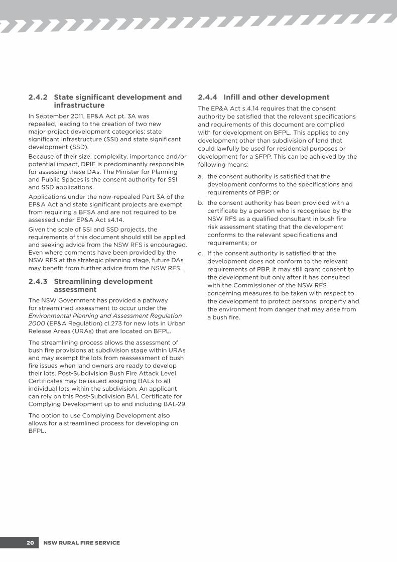
Ministerial ForewordI like many believe in the age-old adage, ‘if you fail to plan, you plan to fail’ and for this reason I am delighted to know that communities across NSW will have access to this resource to help foster greater resilience.
Planning for Bush Fire Protection 2019 is a fantastic resource, particularly as we live in one of the most bush fire prone places in the world.
Over time, as our population increases, the issue of preparing for and mitigating against the risk of bush fire has become increasingly complex.
One of our most important assets during a bush fire is a well prepared community.
Since 2001, Planning for Bush Fire Protection has been considered industry best practice in the provision of bush fire protection standards. A pre‑release version of Planning for Bush Fire Protection 2018 was published on the NSW Rural Fire Service website in August 2018 which has been developed based on extensive industry and public consultation. Planning for Bush Fire Protection 2019 is a refined version of the pre-release.
Improved government policy, industry standards, technology and research following significant fire events now sees Planning for Bush Fire Protection 2019 continue to evolve, and provide improved protection for people and their properties in bush fire prone areas.
The NSW Rural Fire Service has a statutory obligation to protect life, property and the environment. The National Disaster Resilience Strategy (COAG 2011) emphasises the importance of the strategic planning system in contributing to the creation of safer and sustainable communities. The National Disaster Resilience Strategy identifies risk‑based land management and planning arrangements as a vital component in building disaster resilient communities.
The NSW Office of Emergency Management 2017 State Level Emergency Risk Assessment listed land use planning as a top priority for NSW over the next 5 years.
Planning for Bush Fire Protection 2019 builds on the outcomes and lessons of bush fire events experienced over the past decade including the 2009 Black Saturday bush fires in Victoria.
It also draws upon the better understanding and experience of fire events in NSW, including those which impacted areas like the Blue Mountains, Coonabarabran and Southern Highlands in 2013, and Tathra 2018.
With lessons learned from major bush fire events, along with changes to building code and construction standards, this substantially revised 2019 edition of Planning for Bush Fire Protection is intended for use by councils, town planners, fire authorities, developers, planning and bush fire consultants, surveyors, building practitioners and approval authorities.
While the updated Planning for Bush Fire Protection 2019 focuses on ensuring developments are provided with appropriate bush fire protection measures, it also aims to streamline processes for people building in bush fire prone areas.
The principles in this edition of Planning for Bush Fire Protection 2019 will significantly assist those involved in building safe communities within bush fire prone areas, and help to increase resilience and public confidence through the NSW land use planning process. This revised version strikes an appropriate balance of flexibility, the environment, community safety and housing affordability.
I commend the work of the NSW Rural Fire Service in putting this enhanced resource together and encourage its use as widely as possible.
Minister for Police and Emergency Services, the Honourable David Elliott MP
3PLANNING FOR BUSH FIRE PROTECTION - 2019

1 INTRODUCTION 9
1.1 Aim and objectives ..................................................................................................................................................................10
1.2 Bush fire protection principle ..............................................................................................................................................10
1.3 Limitations of this document...............................................................................................................................................11
1.4 How to use this document ...................................................................................................................................................12
2 FRAMEWORK 16
2.1 Legal framework .......................................................................................................................................................................18
2.2 Bush fire prone land mapping .............................................................................................................................................18
2.3 Strategic planning ...................................................................................................................................................................19
2.4 Development assessment .....................................................................................................................................................19
2.5 Construction provisions: the National Construction Code (NCC) and bush fire standards ........................21
2.6 Other NSW RFS bush fire safety programs ...................................................................................................................21
2.7 Bush Fire Survival Plans.........................................................................................................................................................22
3 BUSH FIRE PROTECTION MEASURES 24
3.1 Introduction ................................................................................................................................................................................26
3.2 Asset Protection Zones (APZ) ............................................................................................................................................26
3.3 Building construction, siting and design .........................................................................................................................29
3.4 Access arrangements .............................................................................................................................................................29
3.5 Water supply and utilities ....................................................................................................................................................30
3.6 Emergency management arrangements ........................................................................................................................31
3.7 Landscaping ...............................................................................................................................................................................31
4 STRATEGIC PLANNING 32
4.1 Strategic principles ..................................................................................................................................................................34
4.2 Strategic planning in bush fire prone areas ...................................................................................................................34
4.3 Regional strategies and plans .............................................................................................................................................36
4.4 Local Environmental Plans (LEPs) ...................................................................................................................................36
4.5 Development Control Plans (DCPs) ..................................................................................................................................37
4.6 Masterplans and Precinct Plans .........................................................................................................................................37
Contents
4 NSW RURAL FIRE SERVICE

5 RESIDENTIAL AND RURAL RESIDENTIAL SUBDIVISIONS 38
5.1 Background ................................................................................................................................................................................40
5.2 Specific objectives ...................................................................................................................................................................42
5.3 Bush fire protection measures ............................................................................................................................................42
6 SPECIAL FIRE PROTECTION PURPOSE DEVELOPMENTS 49
6.1 Introduction ................................................................................................................................................................................50
6.2 Specific objectives ...................................................................................................................................................................50
6.3 Objectives for specific uses .................................................................................................................................................51
6.4 Development of existing SFPP facilities ..........................................................................................................................52
6.5 Minor development in SFPP facilities ...............................................................................................................................53
6.6 Alpine resorts ............................................................................................................................................................................53
6.7 SFPP developments in grassland areas ...........................................................................................................................54
6.8 Bush fire protection measures ............................................................................................................................................54
7 RESIDENTIAL INFILL DEVELOPMENT 62
7.1 Introduction ................................................................................................................................................................................64
7.2 Home-based occupations .....................................................................................................................................................64
7.3 Specific objectives ...................................................................................................................................................................64
7.4 Bush fire protection measures ............................................................................................................................................65
7.5 Additional construction requirements .............................................................................................................................69
7.6 Fences and gates ....................................................................................................................................................................70
7.7 Determination of the BAL ....................................................................................................................................................71
7.8 Better bush fire outcomes ....................................................................................................................................................71
7.9 Grassland Deeming Provisions ..........................................................................................................................................71
8 OTHER DEVELOPMENT 72
8.1 Introduction ................................................................................................................................................................................74
8.2 Other residential development ...........................................................................................................................................74
8.3 Other non-residential development ..................................................................................................................................76
5PLANNING FOR BUSH FIRE PROTECTION - 2019

AppendicesAPPENDIX 1 SITE ASSESSMENT METHODOLOGY 80
A1.1 Application ........................................................................................................................................................................... 80
A1.2 Determine vegetation formation ................................................................................................................................. 80
A1.3 Grassland assessment .......................................................................................................................................................83
A1.4 Determine slope ..................................................................................................................................................................83
A1.5 Determine effective slope .............................................................................................................................................. 84
A1.6 Determine appropriate fire weather areas ............................................................................................................... 84
A1.7 Determine Bush Fire Attack Level ...............................................................................................................................85
A1.8 Shielding ................................................................................................................................................................................ 86
A1.9 Exotic vegetation ................................................................................................................................................................87
A1.10 Low threat vegetation – exclusions .............................................................................................................................88
A1.11 Assessing remnant bushland and narrow vegetation corridors .......................................................................88
A1.12 Comprehensive APZ, BAL and vegetation class tables ...................................................................................... 89
APPENDIX 2 SUBMISSION REQUIREMENTS, PERFORMANCE BASED SOLUTIONS AND BUSH FIRE DESIGN BRIEFS 95
A2.1 Submission requirements for a BFSA .........................................................................................................................95
A2.2 Submission requirements for infill development ................................................................................................... 96
A2.3 Submission requirements for Complying Development ......................................................................................97
A2.4 Submission requirements and assessment methods for performance based solutions .........................97
A2.5 Bush Fire Design Brief (BFDB) ..................................................................................................................................... 98
A2.6 Bush Fire Management Plan .......................................................................................................................................... 98
A2.7 Qualified consultants ....................................................................................................................................................... 99
A2.8 Pre-DA advice ................................................................................................................................................................... 99
APPENDIX 3 ACCESS 100
A3.1 Vertical clearance ........................................................................................................................................................... 100
A3.2 Vehicle turning requirements ...................................................................................................................................... 100
A3.3 Vehicle turning head requirements ............................................................................................................................102
A3.4 Passing bays .......................................................................................................................................................................103
A3.5 Parking .................................................................................................................................................................................103
A3.6 Kerb dimensions ................................................................................................................................................................104
A3.7 Services ...............................................................................................................................................................................104
A3.8 Local Area Traffic Management (LATM) ................................................................................................................104
A3.9 Road types .........................................................................................................................................................................105
APPENDIX 4 ASSET PROTECTION ZONE STANDARDS 106
A4.1 Asset Protection Zones ................................................................................................................................................. 106
Abbreviations .....................................................................................................................................................................................109
Definitions .............................................................................................................................................................................................110
References ............................................................................................................................................................................................. 113
6 NSW RURAL FIRE SERVICE

Table 4.2.1 35 Bush Fire Strategic Study
Table 5.1.4a 42 Equivalent values for FFDI and GFDI
Table 5.3a 43Performance criteria and acceptable solutions for APZs for residential and rural residential subdivisions
Table 5.3b 44Performance criteria and acceptable solutions for access for residential and rural residential subdivisions
Table 5.3c 47Performance criteria and acceptable solutions for water, electricity and gas services for residential and rural residential subdivisions
Table 5.3d 48Water supply requirements for non-reticulated developments or where reticulated water supply cannot be guaranteed
Table 6.8a 55Performance criteria and acceptable solutions for APZs and construction for SFPP development
Table 6.8b 57Performance criteria and acceptable solutions for access for SFPP development
Table 6.8c 59Performance criteria and acceptable solutions for water, electricity and gas services for SFPP development
Table 6.8d 61Performance criteria and acceptable solutions for emergency management plans for SFPP development
Table 7.4a 65Performance criteria and acceptable solutions for residential infill development
Table 7.9a 71Grassland Deeming Provisions
Table 8.2.2 75Issues and considerations specific to multi-storey residential development
Table A1.7 85Radiant heat flux exposure and appropriate Bush Fire Attack Level (BAL)
Table A1.9 87Exotic vegetation conversions
Table A1.12.1 89Minimum distances for APZs – SFPP developments
Table A1.12.2 90Minimum distances for APZs – residential subdivision development, FFDI 100 areas (<29kW/m2)
Table A1.12.3 90Minimum distances for APZs – residential subdivision development, FFDI 80 areas (<29kW/m2)
Table A1.12.4 90Allowable Outer Protection Area distances (m), within an APZ for forest vegetation
Table A1.12.5 91Determination of Bush Fire Attack Level, FFDI 100 – residential developments
Table A1.12.6 92Determination of Bush Fire Attack Level, FFDI 80 – residential development
Table A1.12.7 93Determination of Bush Fire Attack Level, FFDI 50 – alpine areas
Table A1.12.8 94Vegetation formation details
Table A3.2 100Minimum curve radius for turning vehicles
List of tables
Figure 1.5 14Step-by-step guide on how to use PBP
Figure 2.4 23Assessment process for developments in bush fire prone areas
Figure 3.1 26BPMs in combination
Figures A1.2 81
Figure A1.4 83Determining slope
Figure A1.5 84Effective slope
Figure A1.8a 86Radiant heat impact and shielding
Figure A1.8b 86Plan view of radiant heat impact and shielding
Figure A3.1 100Vertical clearance
Figure A3.2a 101Swept path width for turning vehicles
Figure A3.2b 101Roundabout swept path
Figure A3.3 102Multipoint turning options
Figure A3.4 103Passing bays
Figure A3.5 103Hydrants and parking bays
Figure A3.6 104Carriageway kerb clearance dimensions
Figure A3.9a 105Perimeter road widths
Figure A3.9b 105Non-perimeter road widths
Figure A3.9c 105Property access road widths
Figure A4.1 108Typical Inner and Outer Protection Areas
List of figures
7PLANNING FOR BUSH FIRE PROTECTION - 2019

8 NSW RURAL FIRE SERVICE

Planning for Bush Fire Protection 2019 (PBP) provides development standards for designing and building on bush fire prone land in New South Wales. PBP provides standards and guidance for:
strategic land use planning to ensure that new development is not exposed to high bush fire risk;
creating new residential and rural residential subdivision allotments;
special fire protection purpose (SFPP) development taking account of occupant vulnerability;
bush fire protection measures (BPMs) for new buildings; and
upgrading and maintaining existing development.
PBP is applicable to all development on bush fire prone land (BFPL) in NSW. The general principles underlying this document are that:
a suite of BPMs are required to reduce the impact of a bush fire;
protection measures are governed by the degree of threat posed to a development and the vulnerability of occupants;
minimising the interface of a development to the hazard reduces the bush fire risk to the development; and
good practice in planning, building and management reduces the risk to developments and their occupants, and increases their resilience.
1 INTRODUCTION
9PLANNING FOR BUSH FIRE PROTECTION - 2019

1.1 Aim and objectivesAll development on BFPL must satisfy the aim and objectives of Planning for Bush Fire Protection (PBP).
The aim of PBP is to provide for the protection of human life and minimise impacts on property from the threat of bush fire, while having due regard to development potential, site characteristics and protection of the environment.
The objectives are to:
afford buildings and their occupants protection from exposure to a bush fire;
provide for a defendable space to be located around buildings;
provide appropriate separation between a hazard and buildings which, in combination with other measures, prevent the likely fire spread to buildings;
ensure that appropriate operational access and egress for emergency service personnel and occupants is available;
provide for ongoing management and maintenance of BPMs; and
ensure that utility services are adequate to meet the needs of firefighters.
1.2 Bush fire protection principlesBush fire protection can be achieved through a combination of strategies which are based on the following principles:
control the types of development permissible in bush fire prone areas;
minimise the impact of radiant heat and direct flame contact by separating development from bush fire hazards;
minimise the vulnerability of buildings to ignition and fire spread from flames, radiation and embers;
enable appropriate access and egress for the public and firefighters;
provide adequate water supplies for bush fire suppression operations;
focus on property preparedness, including emergency planning and property maintenance requirements; and
facilitate the maintenance of Asset Protection Zones (APZs), fire trails, access for firefighting and on site equipment for fire suppression.
10 NSW RURAL FIRE SERVICE

1.3 Limitations of this documentDue to a range of limitations, the measures contained in this document do not guarantee that loss of life, injury and/or property damage will not occur during a bush fire event. Limitations of this document include, but are not limited to uncertainties in the following areas:
Fire Danger Index;
fuel loads;
existing developments;
human behaviour; and
maintenance.
1.3.1 Fire Danger IndexIt may be possible that days of higher Fire Danger Index (FDI) may be experienced than the FDI levels used in this document. This may result in fire situations where conditions challenge survivability of buildings and their occupants.
1.3.2 Fuel loadsFuel loads and vegetation classes used in this document are specific to NSW.
PBP has adopted a system of assessing fuel accumulation rates based on vegetation formations and time since last fire (Forestry Commission of NSW, 1991). This has also been supported by published literature on fuel loads (i.e. Good, 1994, Watson, 2005, Cheney and Sullivan, 1997).
In some instances fuel loads in an area may be higher than those used in this document. This can influence bush fire behaviour and the potential impact on property.
1.3.3 Existing developmentsThe requirement to consider BPMs for development in bush fire prone areas was introduced on 1 August 2002. Existing developments that were built prior to August 2002, may have limited or no BPMs incorporated into the design of the building. This also presents major challenges for the design of alterations and additions to existing buildings.
1.3.4 Human behaviourA person’s behaviour in times of bush fire may be unpredictable. A person may have good intentions to stay and defend their property from bush fire, but may change their mind once they experience the stress and anxiety associated with the heat, noise, flames and burning embers. Even where a development can comply with PBP, unpredictable human behaviour can be a limiting factor and may result in injury, death or loss of property.
All occupants in a bush fire prone area are advised to prepare a Bush Fire Survival Plan, available to download at NSW RFS website www.rfs.nsw.gov.au.
1.3.5 MaintenanceAn unprepared property is not only a risk to the building owner/occupant, but may also present an increased danger to neighbouring buildings and firefighters. Even buildings which are built to comply with PBP are placed at risk through poor maintenance.
Post bush fire research recorded by the New South Wales Rural Fire Service (NSW RFS) indicates that proper maintenance of dwellings and their curtilage significantly improves the survivability of structures.
Advice regarding the maintenance and protection of existing buildings can be found on the NSW RFS website at www.rfs.nsw.gov.au.
11PLANNING FOR BUSH FIRE PROTECTION - 2019

1.4 How to use this documentApplications for development on BFPL should include a bush fire assessment report. This report must demonstrate that the proposal satisfies the requirements of PBP. All applications must meet the Aim and Objectives of PBP.
PBP uses a performance based approach, and identifies objectives and detailed performance criteria to satisfy desired outcomes and meet the Aim and Objectives. Ultimately, any performance based approach must demonstrate that bush fire protection is afforded to a proposed development commensurate with the assessed level of bush fire risk and the characteristics of the occupants.
This can be achieved by either applying the identified acceptable solutions, or by preparing a performance based solution.
A performance based solution must be designed to achieve the appropriate level of protection by tailoring a package of measures which meet the intent and performance criteria relevant to the proposed development.
BPMs are set out in Chapter 3. Performance criteria and acceptable solutions are shown for each specified development type in Chapters 5‑8.
Refer to Figure 1.5 for further information on how to use PBP.
1.4.1 Bush fire protection measuresBPM’s are the relevant specifications and requirements that need to be satisfied to improve life safety, property protection and community resilience to bush fire attack.
They include:
APZs;
Access;
Construction, siting and design;
Landscaping;
Services; and
Emergency and evacuation planning.
1.4.2 IntentFor each BPM, a broad intent is outlined. The ensuing performance criteria and acceptable solutions are designed to ensure that the general intent for each BPM is met.
1.4.3 Performance criteria Performance criteria are the outcomes that need to be achieved to satisfy the intent. The performance criteria can be satisfied in one of the following ways:
acceptable solutions; or
performance based solution; or
the combination of the above.
1.4.4 Acceptable solutionsChapters 5-8 identify acceptable solutions which are considered by the NSW RFS as meeting the performance criteria.
12 NSW RURAL FIRE SERVICE

1.4.5 Performance based solutionsPerformance based solutions allow flexibility and innovation in responding to site‑specific opportunities and constraints while still meeting the identified performance criteria. They also allow the consideration of a broad range of issues and information, including bush fire risk, community expectations, environmental protection and the application of new science, processes and technologies.
Performance based solutions must provide substantiated evidence and clearly demonstrate how the specific objectives and performance criteria are to be satisfied.
When performance based solutions are proposed, they will be assessed on their merits and individual circumstances. In these circumstances, a Bush Fire Design Brief (BFDB) process can be undertaken which would involve early agreement on the key elements and acceptance criteria from all stakeholders including the NSW RFS.
Performance based solutions may be undertaken for any of the BPMs detailed in Chapter 3 and supported in accordance with the submission requirements in Appendix 2.
1.4.6 PBP guidance materialsPBP guidance materials are prepared and published by the NSW RFS in order to support and clarify matters within PBP. Guidance materials (i.e. fact sheets and practice notes) should be reviewed in the preparation of bush fire assessment reports and can be found on the NSW RFS website at www.rfs.nsw.gov.au.
13PLANNING FOR BUSH FIRE PROTECTION - 2019

Step-by-step guide on how to use PBP
Figure 1.5
STEP 2
Review aim and objectives
Read Chapter 1 which sets out the aim and objectives of PBP.
STEP 3
Determine type of application
Read Chapter 2 to determine the type of application:
1. Planning proposal.
2. Development Control Plan amendment, state significant infrastructure (SSI) or state significant development (SSD).
3. Residential or rural residential subdivision.
4. Complying Development.
5. SFPP development.
6. Residential infill development.
7. Other development.
STEP 4
Identify relevant legislative requirements
Is a bush fire safety authority required? Check the Rural Fires Act 1997 and the Rural Fires Regulation 2013
cl. 45 and cl. 46 (or superseding document).
Is the proposed development a Complying Development or is a DA required?
Check relevant planning instruments, such as the State Environmental Planning Policy (Exempt and Complying Development Codes) 2008.
STEP 1
Does PBP apply?
Is the land mapped as bush fire prone? Check the local bush fire prone land map.
PBP does not apply.
NONOIs the development potentially exposed to a bush fire threat and likely to be referred under EP&A Act s.4.15?
YES
Follow steps 2-7
YES
Follow steps 2-7
14 NSW RURAL FIRE SERVICE

STEP 5
Identify the relevant BPMs
Read Chapter 3 which explains the BPMs.
Read the detailed specifications and requirements for your relevant development type.
Residential – Read Chapter 5 and 7.
SFPP – Read Chapter 6.
Other – Read Chapter 8.
Grasslands – Read relevant chapters.
STEP 6
Determine solutions
Determine the acceptable solutions required for each measure. Can they all be complied with?
Adopt the acceptable solutions that have been set out.
Alternatively prepare a performance based solution.
4. Complying Development.
5. SFPP development.
6. Residential infill development.
7. Other development.
Demonstrate compliance
Prepare a package of measures for submission with the development application, demonstrating compliance with the performance criteria either through acceptable solutions or performance based solutions.STEP 7
15PLANNING FOR BUSH FIRE PROTECTION - 2019

16 NSW RURAL FIRE SERVICE

PBP is intended to enhance community resilience to bush fires. Bush fire should be considered in every phase of development, from regional plans, land-use zoning, Masterplans, subdivisions to individual building applications.
Comprehensive consideration of bush fire in the planning system requires a sound understanding of the hazards and risks, as well as consideration of strategic planning and development controls that will adequately mitigate these identified risks, as outlined in the National Disaster Resilience Strategy, (COAG 2011).
2 FRAMEWORK
17PLANNING FOR BUSH FIRE PROTECTION - 2019

2.1 Legal frameworkThe Environmental Planning and Assessment Act 1979 (EP&A Act) and the Rural Fires Act 1997 (RF Act) were amended on 1 August 2002 to enhance bush fire protection in the development assessment process.
The NSW land use planning framework provides, in broad terms, two main phases: strategic planning and development assessment.
PBP provides the foundation for the application of bush fire protection during both of these phases of development. Appropriate consideration of bush fire hazards at the strategic planning phase is required by the EP&A Act s.9.1(2) and PBP should be considered in applying the Section 9.1 Direction.
At the development assessment phase, development on land that is identified as being bush fire prone must comply with PBP. Some types of development on BFPL can be undertaken as Complying Development and must also comply with PBP.
A bush fire safety authority (BFSA) is required from the NSW RFS for residential and rural residential subdivision and SFPP developments on BFPL. An application for a BFSA must address the extent to which the development complies with PBP.
Building work on BFPL must also comply with the requirements of the National Construction Code (NCC). The NCC contains the technical provisions for the design and construction of buildings. Under the Deemed to Satisfy provisions of the NCC, building work on BFPL must comply with Australian Standard 3959:2018 Construction of buildings in bushfire-prone areas (AS 3959) or the National Association of Steel Framed Housing (2014) Steel Framed Construction in Bush Fire Areas (NASH Standard). This does not apply however in Bush Fire Attack Level ‑ Flame Zone (BAL‑FZ), or where modified by the specific conditions of the relevant development consent.
2.2 Bush fire prone land mappingThe identification of BFPL in NSW is required under the EP&A Act s.10.3.
BFPL Maps provide the trigger for the various development assessment provisions.
The Commissioner of the NSW RFS designates what constitutes BFPL and how it is to be mapped. Each council prepares a map in accordance with the guidelines and submits the map to the NSW RFS for certification by the Commissioner. These maps are required to be recertified at least every five years and the Commissioner may make direct changes to a BFPL Map at any time.
Guidelines for the mapping of BFPL can be found on the NSW RFS website at www.rfs.nsw.gov.au.
You can determine whether a site is mapped as being bush fire prone by referring to the BFPL Map which is held by the local council, or on the NSW RFS website.
The BFPL Map is a trigger for the consideration of BFPL Maps for new development. It is not intended as a detailed measure of risk. The map does not form part of the site assessment process, which must be carried out in accordance with Appendix 1.
A consent authority can refer a development application (DA) to the NSW RFS under the provisions of EP&A Act s.4.15, even where it is not mapped as BFPL.
18 NSW RURAL FIRE SERVICE

2.3 Strategic planning Strategic planning is the preparation of planning instruments and policies and includes the making of Local Environmental Plans (LEPs), Development Control Plans (DCPs), housing strategies and other planning instruments that identify proposed uses and land zonings. This also includes any associated strategic proposals and studies.
The strategic planning phase of development is particularly important in contributing to the creation of safer and sustainable communities (COAG 2011). It is an effective way of achieving bush fire protection objectives in new developments.
Strategic bush fire planning and studies are needed to avoid high risk areas, ensure that zoning is appropriate to allow for adequate emergency access, egress, and water supplies, and to ensure that future compliance with this document is achievable.
The most important objective for strategic planning is to identify whether new development is appropriate subject to the identified bush fire risk on a landscape scale. An assessment of proposed land uses and potential for development to impact on existing infrastructure is also a key element of the strategic planning process in bush fire prone areas. Land use planning policies can be introduced to limit the number of people exposed to unacceptable risk.
Planning instruments and policies can ensure bush fire management principles are given appropriate consideration at all stages of the planning and development process.
Once development has been assessed as being appropriate in its bush fire prone context, it will need to be capable of complying with PBP. The ability of proposed land uses and associated future developments to comply with PBP will be assessed at the strategic planning stage. The expectation will be that the development will be able to comply with PBP at the DA stage.
2.4 Development assessmentThe provisions of this document apply to all development on land which is bush fire prone (see section 2.2 of this document). This document may also apply where proposals are referred to the NSW RFS under other referral instruments such as EP&A Act s.4.15.
If a development of a type not specifically addressed in this document is proposed on BFPL, the development must meet the Aim and Objectives of PBP and the consent authority can refer the proposal to the NSW RFS for advice. The NSW RFS will advise which specific standards apply to that development. In these circumstances, the development proposal will be a performance based solution and in more complex cases, this may be achieved collaboratively through the BFDB process.
The vast majority of DAs in NSW are assessed by local councils. Councils may assess DAs for certain developments on BFPL that are compliant with this document without the need to refer the proposal to the NSW RFS.
In certain cases building work may not require development consent and can proceed through the Exempt or Complying Development process if the development type is covered by a State Environmental Planning Policy (SEPP) or the relevant LEP.
For further information on development types, please contact the local council or the NSW Department of Planning, Industry and Environment (DPIE).
See Figure 2.4 for a flow chart showing the development assessment process for developments on BFPL.
2.4.1 Development requiring a BFSAProposals for subdivision and SFPP development on BFPL require an approval from the NSW RFS in the form of a BFSA under RF Act s.100B.
Development requiring a BFSA is considered Integrated Development under EP&A Act s.4.46.
The BFSA is critical in ensuring these key developments are designed and located in a manner that is suitable to protect human life and facilitate appropriate operational firefighting arrangements. This is a means by which the NSW RFS Commissioner fulfills their statutory obligation to ensure the protection of the community, including firefighters from the impacts of bush fire.
19PLANNING FOR BUSH FIRE PROTECTION - 2019
2.4.2 State significant development and infrastructure
In September 2011, EP&A Act pt. 3A was repealed, leading to the creation of two new major project development categories: state significant infrastructure (SSI) and state significant development (SSD).
Because of their size, complexity, importance and/or potential impact, DPIE is predominantly responsible for assessing these DAs. The Minister for Planning and Public Spaces is the consent authority for SSI and SSD applications.
Applications under the now-repealed Part 3A of the EP&A Act and state significant projects are exempt from requiring a BFSA and are not required to be assessed under EP&A Act s4.14.
Given the scale of SSI and SSD projects, the requirements of this document should still be applied, and seeking advice from the NSW RFS is encouraged. Even where comments have been provided by the NSW RFS at the strategic planning stage, future DAs may benefit from further advice from the NSW RFS.
2.4.3 Streamlining development assessment
The NSW Government has provided a pathway for streamlined assessment to occur under the Environmental Planning and Assessment Regulation 2000 (EP&A Regulation) cl.273 for new lots in Urban Release Areas (URAs) that are located on BFPL.
The streamlining process allows the assessment of bush fire provisions at subdivision stage within URAs and may exempt the lots from reassessment of bush fire issues when land owners are ready to develop their lots. Post-Subdivision Bush Fire Attack Level Certificates may be issued assigning BALs to all individual lots within the subdivision. An applicant can rely on this Post‑Subdivision BAL Certificate for Complying Development up to and including BAL-29.
The option to use Complying Development also allows for a streamlined process for developing on BFPL.
2.4.4 Infill and other developmentThe EP&A Act s.4.14 requires that the consent authority be satisfied that the relevant specifications and requirements of this document are complied with for development on BFPL. This applies to any development other than subdivision of land that could lawfully be used for residential purposes or development for a SFPP. This can be achieved by the following means:
a. the consent authority is satisfied that the development conforms to the specifications and requirements of PBP; or
b. the consent authority has been provided with a certificate by a person who is recognised by the NSW RFS as a qualified consultant in bush fire risk assessment stating that the development conforms to the relevant specifications and requirements; or
c. If the consent authority is satisfied that the development does not conform to the relevant requirements of PBP, it may still grant consent to the development but only after it has consulted with the Commissioner of the NSW RFS concerning measures to be taken with respect to the development to protect persons, property and the environment from danger that may arise from a bush fire.
20 NSW RURAL FIRE SERVICE

2.4.5 Exempt and Complying Development
Some straightforward residential, commercial and industrial development can be undertaken as Exempt or Complying Development under various SEPPs and LEPs.
Exempt Development is minor building works that can be carried out without development approval, such as decks, garden sheds, carports and fences.
Complying Development can be undertaken on lower risk BFPL up to and including BAL-29 where the appropriate construction requirements and all other relevant development standards have been met. Complying Development is not permitted on higher risk BFPL (BAL-40 or BAL-FZ) and a DA is required in these circumstances.
Specified development requirements and standards apply to new development, including alterations and additions, to ensure the relevant provisions of this document are met. This allows for Complying Development on BFPL, while maintaining an appropriate assessment regime for managing bush fire risk.
In certain circumstances, a BAL Certificate must be obtained from the local council or a person recognised by the NSW RFS as a suitably qualified consultant in bush fire assessment, stating that the development is not located in BAL-40 or BAL-FZ.
The development must also meet the identified development standards within the relevant SEPP or LEPs.
2.5 Construction provisions: the National Construction Code (NCC) and bush fire standards
The NCC is a performance based code which comprises the Building Code of Australia (BCA) as Volumes 1 and 2 and the Plumbing Code of Australia as Volume 3.
The NCC contains Performance Requirements and Deemed-to-Satisfy provisions relating to the construction of buildings in bush fire prone areas. In NSW, these provisions apply to Class 1, 2 and 3 buildings, Class 4 parts of a building, Class 9 buildings that are SFPPs, and associated class 10a buildings and decks.
The construction requirements of AS 3959 and the National Association of Steel-framed Housing (NASH) Standard are a Deemed-to-Satisfy solutions in the NCC, as varied in NSW, for buildings in designated bush fire prone areas.
2.6 Other NSW RFS bush fire safety programs
The following NSW RFS programs provide a number of strategies designed to address bush fire protection for the community at a local government or regional level. These provisions are not considered as BPMs for proposed development.
2.6.1 Bush Fire Risk Management PlanThe preparation of a Bush Fire Risk Management Plan (BFRMP) is the responsibility of the Bush Fire Management Committee (BFMC).
The objectives of the local BFRMP are to:
reduce the number of human‑induced bush fire ignitions that cause damage to life, property and the environment;
manage fuel to reduce the rate of spread and intensity of bush fires while minimising environmental/ecological impacts;
reduce the community’s vulnerability to bush fires by improving its preparedness; and
effectively contain fires with the potential to cause damage to life, property or the environment.
Enquiries concerning BFRMPs can be directed to the appropriate NSW RFS Fire Control Centre.
21PLANNING FOR BUSH FIRE PROTECTION - 2019

2.6.2 Hazard Reduction CertificatesA Bush Fire Hazard Reduction Certificate (HRC) provides environmental approval to carry out bush fire hazard reduction works. The HRC must be consistent with the Bush Fire Environmental Assessment Code and the BFRMP. The HRC details the conditions that are to be adhered to when implementing the bush fire hazard reduction works.
Enquiries on HRCs can be directed to the appropriate NSW RFS Fire Control Centre.
2.6.3 Community Protection PlansThe aim of the Community Protection Plan (CPP) program is to improve the community and firefighters’ capacity to prepare for, act during, and survive bush fires. A CPP requires a detailed analysis of communities considered to be exposed to a significant bush fire risk, and ensures that the bush fire risks can be fully understood and adequately treated.
Enquiries on CPPs can be directed to a NSW RFS Planning and Environment Service Centre on 1300 679 737.
2.6.4 Neighbourhood Safer PlacesA Neighbourhood Safer Place (NSP) is a location where people facing an immediate threat to their personal safety or property can gather and seek shelter from the impact of a bush fire. They are the last resort option for those in bush fire situations.
Enquiries on NSPs can be directed to the NSW RFS Planning and Environment Service Centres on 1300 679 737.
2.6.5 10/50 Vegetation Clearing SchemePeople living in a bush fire prone area may be eligible to undertake certain clearing practices around an existing dwelling and other specified structures under the 10/50 Vegetation Clearing Scheme. The scheme may only be applied to existing buildings and may not be used in the development assessment process.
The scheme allows people in a 10/50 Vegetation Clearing Entitlement Area to:
remove, destroy or prune trees on their property within 10 metres of a home, without seeking approval; and
remove, destroy or prune any vegetation such as shrubs (but not trees) on their property within 50 metres of a home, without seeking approval, if the clearing is carried out in accordance with the 10/50 Vegetation Clearing Code of Practice.
The 10/50 Vegetation Clearing Scheme does not permit you to clear trees or other vegetation contrary to conditions in your development consent or other approvals under the EP&A Act.
You can find out more, including if your property is in a 10/50 Vegetation Clearing Entitlement Area on the NSW RFS website: www.rfs.nsw.gov.au.
2.7 Bush Fire Survival PlansPeople living in a Bush Fire Prone Area should prepare a Bush Fire Survival Plan which is revised annually prior to the bush fire season.
A Guide to Making a Bush Fire Survival Plan has been developed by the NSW RFS to assist residents in the preparation of their plan and can be found at the NSW RFS website.
The Guide provides information on bush fire risk and suggests simple steps as to how individuals and families can protect themselves and their property in the event of a bush fire. On days of catastrophic fire weather, the NSW RFS recommends leaving early as the only safe option.
22 NSW RURAL FIRE SERVICE

23PLANNING FOR BUSH FIRE PROTECTION - 2019
Figure 2.4Assessment process for developments in bush fire prone areas
Is the land mapped bush fire prone? Check BFPL Map or Section 10.7 Certificate.
Is there any area of vegetation nearby that could support a fire?
Is it a DA or Complying Development? Refer to EP&A Act s4.14 and SEPPs.
Complying Development
Has a BAL Certificate been issued?
Refer to SEPP for other applicable development codes
Obtain BAL Certificate from local council or recognised bush fire consultant.
DA
Does the DA comply?
Where necessary, consent authority to refer to appropriately accredited bush fire consultant or NSW RFS for advice.
Is it a State Significant Matter?
Is it a Planning Proposal?
Is it a subdivision or SFPP?
Consent authority or certifier to determine application
Apply NCC construction standards, ie AS 3959 or NASH Standard and specific conditions of development consent
Consent authority to refer to NSW RFS for a BFSA.
Does the Infrastructure SEPP or other planning instrument apply?
Consent authority to consult with the NSW RFS who will provide advice.
DPIE will determine in consultation with NSW RFS.
There are no further requirementsConsult with consent
authority or certifier to determine whether there are any bush fire requirements.
Consent authority to check EP&A Act s.9.1(2) direction compliance with PBP.

24 NSW RURAL FIRE SERVICE

BPMs can mitigate the impact of bush fire attack on people and assets.
The types of protection measures include APZs, access, landscaping, water supply, building design and construction and emergency management arrangements. These measures assist building survival during a bush fire. They also contribute to the safety of firefighters and members of the community occupying buildings during the passage of a bush fire front.
There are a range of different BPMs which should be applied in combination based upon the development type and the level of bush fire risk.
All requirements for BPMs that relate to the development must be provided, as required by this document.
3 BUSH FIRE PROTECTION MEASURES
25PLANNING FOR BUSH FIRE PROTECTION - 2019

3.1 IntroductionA significant part of NSW is classified as BFPL and local circumstances vary widely as do potential land uses. PBP recognises this and promotes detailed site analysis and the application of a combination of BPMs to achieve an acceptable outcome.
Figure 3.1BPMs in combination
Bush Fire Behaviour
Access
Landscaping
Emergency ManagementArrangments
Asset Protection Zone
Building Construction
& Design
Water Supply & Utilities
3.1.1 Applying the BPMs in combinationThe design of BPMs should be incorporated at the earliest stages of development. Acceptable bush fire protection proposals will involve a combination of different BPMs depending on their suitability and importance to the particular type of development and different levels of potential bush fire attack.
Appropriate combinations of BPMs not only depend on geographic location and site circumstances but also on the nature of the proposed use, distinguishing between the following development types:
residential and rural-residential subdivision with a dwelling entitlement;
SFPP development;
infill development; and
other developments (i.e. commercial community and other uses which are not classified as residential or SFPP).
These development types are required to achieve specific objectives which relate to particular circumstances. The acceptable solutions and performance criteria in this document acknowledge that the measures work in combination to improve the capacity for bush fire protection.
Research on bush fire behaviour under a range of location, weather, vegetation and slope conditions has demonstrated the significance of reduced fuel loads and separation distance in limiting the bush fire threat from ember attack through to direct flame contact.
3.2 Asset Protection Zones (APZ)An APZ is a buffer zone between a bush fire hazard and buildings. The APZ is managed to minimise fuel loads and reduce potential radiant heat levels, flame, localised smoke and ember attack. The appropriate APZ distance is based on vegetation type, slope and the nature of the development.
The APZ can include roads or properties managed to be consistent with APZ standards set out in Appendix 4 and the NSW RFS document Standards for Asset Protection Zones. A fuel-reduced, physical separation between buildings and bush fire hazards is a key element in the suite of bush fire measures and has a major influence on the type of construction necessary to mitigate bush fire attack.
Appendix 1 provides the required methodology for determining the APZ based on vegetation type, slope and FFDI.
For new residential development, APZ requirements are based on radiant heat level exposure to buildings not exceeding 29kW/m² (calculated on a flame temperature of 1090 Kelvin).
For many SFPPs, larger APZs are required because of the characteristics of occupants. This means a lower radiant heat threshold is required in order to allow for evacuation of occupants and emergency services to operate in support of the most at-risk members of the community.
For most SFPP developments, 10kW/m² (calculated on a flame temperature of 1200 Kelvin) is the maximum exposure at any point of the building wall or façade and where emergency services may be supporting or evacuating occupants from the building.
This is to ensure there is an area for firefighters to defend the property and allow access to and from the building. Chapter 6 identifies the performance criteria and acceptable solutions for APZs for SFPP developments.
26 NSW RURAL FIRE SERVICE

Information relating to the creation and management of APZs is detailed in Appendix 4 of this document and in the NSW RFS document “Standards for Asset Protection Zones” which is available on the NSW RFS website www.rfs.nsw.gov.au.
A fundamental premise for APZs is that they are provided within the property in such a way that the owner/occupant will be able to maintain the area in perpetuity.
Where possible, buildings should be sited so as to reduce exposure to bush fire attack and provide suitable defendable space around a building.
3.2.1 Staged developmentsOften an indefinite time lag can occur between one or more stages of development which can result in persons and property being unprotected in the event of a bush fire. A development site that is vegetated but is to be developed and sold in stages will require the creation of APZs that need to be maintained sequentially until the final phase of development is completed to afford each stage of the development the appropriate level of bush fire protection.
Therefore, in staged developments, APZs need to be provided during all stages, and provisions included that ensure ongoing maintenance is undertaken until such time as land is developed. If an easement or covenant is established for the purpose of an APZ it can be extinguished when a bush fire hazard is permanently removed (i.e. when development occurs).
The responsibility for the maintenance of APZs at each stage of development must be clearly defined within the easement or covenant.
3.2.2 APZs on slopes over 18 degreesAPZs on slopes greater than 18 degrees present ongoing maintenance difficulties and may have reduced effectiveness. Challenges in these circumstances may include the following:
management practices may be difficult;
the environmental consequences of ground clearing (destabilisation of the slope resulting in landslip, slump, erosion or landslide) may not be acceptable; and
vegetation is more readily available to a fire, significantly reducing the advantage of having an APZ.
Where it can be demonstrated that these issues can be effectively managed, APZs on steeper slopes may be considered. Where there are effective slopes in excess of 18 degrees it must be demonstrated that
management can occur. A management plan must be submitted with the DA to provide details on how the APZ will be implemented and maintained. The management plan should include, but not be limited to:
The mechanical means necessary to complete the management required;
A schedule for maintenance to occur to ensure the APZ is regularly managed; and
The relevant body responsible for maintaining the APZ.
3.2.3 APZs on environmentally protected lands
Where environmentally sensitive vegetation such as endangered ecological communities are to be cleared for the purposes of an APZ, the proposals will need to be carefully considered.
In some cases, a development may be proposed on land with a split zoning (i.e. part residential and part environment protection zone). BPMs may not necessarily be compatible with all zones. It should not be assumed that an APZ can extend into an adjoining non-compatible area, therefore any environmental constraints should be assessed by the appropriate authority.
3.2.4 Defendable spaceDefendable space is an area within the Inner Protection Area (IPA) of an APZ adjoining a building. This space provides a safe working environment in which efforts can be undertaken to defend the structure, before and after the passage of a bush fire.
The physical size of the development will determine whether the defendable space is provided as pedestrian access or will require sufficient space for vehicular movements. Vegetation within the defendable space should be kept to an absolute minimum and the area should be free from combustible items and obstructions.
27PLANNING FOR BUSH FIRE PROTECTION - 2019

3.2.5 APZs on adjoining landAn APZ imposed by a development consent condition must be maintained for the lifetime of the development, unless modified by a subsequent consent. In order to guarantee that an APZ can be managed in perpetuity, APZs should be contained within the overall development site and not on adjoining lands.
APZs on adjoining land are not encouraged. Where an APZ is proposed on adjoining land, a guarantee must be provided that the land will be managed in perpetuity. In order to achieve this, the land should have an easement under the Conveyancing Act 1919 s.88B to ensure:
surety of APZ and the correct management prescriptions; and
that management occurs in a binding legal agreement in perpetuity.
These situations shall be assessed on their merits.
In such circumstances, the proponent will need to obtain written confirmation from the relevant parties that the easement will continue in perpetuity and that the land subject to the easement will be maintained in a suitable manner. In all cases, the owner of adjoining land must provide written consent for the easement, which shall be lodged with the DA.
Generally the owner/occupier of the land who has benefited from the easement shall be responsible for maintaining the APZ. Where an APZ easement has been established to the benefit of a community title, it shall be maintained in accordance with a Plan of Management.
Neither the NSW RFS nor a council has the power to impose an APZ on an adjoining landowner for new development. It is therefore the developer’s responsibility to negotiate with adjoining land owner/s as part of the DA process. Easements should not be considered where the adjoining land is used for a public purpose and where vegetation management is not likely or cannot be legally granted (eg, National Park, bushland reserve, critical habitat, ‘coastal wetlands’ or ‘littoral rainforests’ mapped in the Coastal Management SEPP).
In circumstances where an APZ is proposed on adjoining land, it will be considered as a performance based solution. In addition, the NSW RFS cannot be considered a party to the easement.
3.2.6 Plans of ManagementPlans of Management (PoM) are required where developments propose to establish APZs off site on lands belonging to council or government where there is no guaranteed commitment to future management. The adopted PoM provides the assurance that an APZ will be managed in perpetuity.
PoMs are also required where APZs are proposed off site, on lands which may have periodic management but may not meet the ongoing requirements of an APZ. Such lands include council bushland reserves, Crown Lands, Open Space and easements for drainage and services.
Before APZs can be accepted for these types of situations, it must be demonstrated that a management regime is in place to ensure ongoing compliance with APZ requirements. The content of a PoM should include:
the prescribed APZ requirements and its treatment details (e.g. IPA and OPA widths and fuel loads);
the predicted timing intervals of the management options;
notification of any transition arrangements for management or ownership alterations which occur as a result of land dedication or acquisition;
demonstration that the relevant authority has the necessary experience, resources and funds to undertake the directions; and
acknowledgement of responsibility from the adjoining landholder that the APZ will be managed in perpetuity.
Any proposed dedication of land which requires council maintenance should include a written approval from that council and a PoM to comply with PBP.
28 NSW RURAL FIRE SERVICE

3.3 Building construction, siting and design
The appropriate design and construction of buildings enhance their survivability from bush fires. Construction measures should not be applied as a stand-alone mitigation solution, but should form part of a suite of BPMs. This should also include APZs, appropriate access, water supply and landscaping.
Building design needs to ensure adequate protection of vulnerable building elements. Construction standards are outlined in AS 3959 and the NASH Standard to provide various levels of protection for different building elements.
The level of building construction standard required is based on the FFDI, type of vegetation, the effective slope and the size of APZ. Appendix 1 provides the required methodology for assessing the building construction standards referred to in AS 3959 and the NASH Standard as BALs.
The construction requirements of the NCC are applied in addition to variations to these standards which are discussed in Chapter 7.
3.4 Access arrangementsDesign of access roads shall enable safe access and egress for residents attempting to leave the area at the same time that emergency service personnel are arriving to undertake firefighting operations.
Chapters 5-8 detail performance criteria and acceptable solutions for access arrangements, relevant to the development type. Specific access design principles are included in Appendix 3.
In a bush fire prone area, the purpose of the road system is to:
provide firefighters with access to structures, allowing more efficient use of firefighting resources;
provide evacuation routes for firefighters and the public; and
provide access to areas of bush fire hazard for firefighting and hazard mitigation purposes.
Roads shall provide sufficient width and other dimensions to ensure safe unobstructed access and allow firefighting crews to operate equipment around the vehicle. Road width is defined as the trafficable width from kerb to kerb or the inside edge of the table drain.
Dead-end roads should be avoided. However, where they are present, they must incorporate a sufficient turn‑around area to minimise the need for vehicles to make multipoint turns.
3.4.1 Perimeter roadsA perimeter road should be provided to separate bush land from urban areas, allowing more efficient use of firefighting resources. A perimeter road is located on the outer extremity of a local area or subdivision and usually runs parallel to the bush land interface.
The perimeter road provides space to conduct active firefighting operations and hazard reduction activities. In developments where no perimeter road exists, property defence in a bush fire event may be more difficult.
3.4.2 Non-perimeter roadsNon-perimeter roads are the interconnecting roads between the perimeter roads and the existing and/or broader road network. These roads form a link for firefighting operations by providing access for emergency vehicles, a safe space for conducting property protection, and a suitable road network for egress of residents.
3.4.3 Property access roadsProperty access is any access from private land onto the public road system. In rural areas, in particular isolated rural properties, operational difficulties can be experienced in accessing buildings. Examples include water crossings and roads which may be cut off by fire or other hazardous conditions. As a result, the location and standards of property access roads should be carefully considered.
3.4.4 Fire trailsFire trails are used as access for firefighters in operational situations, as fire containment lines and for APZ maintenance.
Fire trails are not required for compliance with PBP. A fire trail is not a substitute for a road, nor is it considered an appropriate trade‑off for the provision of perimeter, non-perimeter or property road access requirements.
The RF Act pt.3B provides for the establishment, maintenance, protection, certification and registration of fire trails by the NSW RFS Commissioner outside of the DA process.
29PLANNING FOR BUSH FIRE PROTECTION - 2019

Where fire trails are incorporated into a development, they must be designed, constructed and maintained in accordance with the NSW RFS Fire Trail Standards and the NSW RFS Fire Trail Design, Construction and Maintenance Manual to ensure that firefighter safety is not compromised. The responsibility and mechanism for the ongoing management of the fire trail must be clearly identified within the DA. Where the responsibility for fire trail maintenance is placed on a third party, this must be subject to a written agreement from the third party in question.
Where a Registered Fire Trail exists on a property, the function and overall access through the landscape must be carefully considered. These trails have been identified by the local BFMC and are considered of strategic importance for fire access in the area. At the time of development, the NSW RFS will need to consider any impacts the proposed development will have on the current and/or proposed fire trail network.
Importantly, if a fire trail is adopted as part of a development design, it may not necessarily mean that it is a Strategic Fire Trail for the purposes of the NSW RFS Fire Trail Standards.
3.5 Water supply and utilities An adequate supply of water is essential for firefighting purposes. In addition, gas and electricity should be located so as not to contribute to the risk of fire or impede the firefighting effort.
Suitable water supply arrangements shall be provided for firefighting that meet the NSW RFS requirements. It is essential to ensure that any water sources are maintained at the appropriate capacity (see Chapters 5-7).
Where a non-reticulated water supply is provided or the reticulated water supply is deemed inadequate, an additional on site stored supply of water for firefighting will be required. Non‑reticulated water is a supply that is not piped by council or a water authority and includes rainwater, ground water or surface water.
From a firefighting point of view, any source of available water may be used during a bush fire event and tanks are not always the most practical option. In light of the above, and the increasing demand for sustainable and efficient use of our water resources, the NSW RFS prefers that water is solely dedicated for firefighting purposes. As such, water holding structures such as tanks, swimming pools and dams can be considered as long as they are accessible, reliable and adequate. Nevertheless, where a water supply is provided it must be available for the life time of the development.
Water capacities, access for firefighters (tanker or pedestrian) and the provision of appropriate connections must also be considered when determining if a proposed water source is suitable.
Where a Static Water Supply (SWS) is provided, a SWS sign should be installed in a visible location on the street front. Regular testing of firefighting equipment should also occur to ensure that it is maintained in working order.
30 NSW RURAL FIRE SERVICE

3.6 Emergency management arrangements
SFPP developments are identified as being more vulnerable to the effects of bush fire. This is because the occupants may have a mental or physical impairment, may experience language difficulties, may be unaware of their surroundings or the bush fire risk and may be unable to self-evacuate.
Due to their vulnerability, a higher degree of planning and emphasis on emergency management is required for all SFPP developments. It is imperative that emergency management arrangements are identified at the development planning phase for these developments. An indication of proposed emergency management arrangements should be provided with the DA. A Bush Fire Emergency Evacuation and Management Plan must be prepared for any SFPP development.
Emergency planning arrangements are not required for residential developments. However, anyone living in a bush fire prone area should prepare a Bush Fire Survival Plan, which is available on the NSW RFS website: www.rfs.nsw.gov.au.
3.7 LandscapingThe type, location and ongoing maintenance of landscaping is considered a necessary BPM.
For information about appropriate landscaping, refer to the NSW RFS document Standards for Asset Protection Zones, from the NSW RFS website: www.rfs.nsw.gov.au. and Appendix 4 of this document.
31PLANNING FOR BUSH FIRE PROTECTION - 2019

32 NSW RURAL FIRE SERVICE

Strategic planning is the first stage in the planning process. It is needed to ensure that businesses and future development are not exposed to an unacceptable risk of bush fire.
The strategic planning phase includes state-level planning, regional planning, LEPs, DCPs and Masterplans or Precinct Plans.
4 STRATEGIC PLANNING
33PLANNING FOR BUSH FIRE PROTECTION - 2019

4.1 Strategic principlesStrategic planning occurs at a state, regional and local government level. It often covers a large area, can include a number of different land uses, and establishes longer term development options.
Land use planning can be an effective tool in minimising or avoiding the impact of natural hazards such as bush fire. From a risk management perspective, the safest approach is always to avoid high risk areas. Local land use strategies and LEPs should consider and identify land affected by natural hazards and direct development away from inappropriate and constrained lands.
In a bush fire context, strategic planning must ensure that future land uses are in appropriate locations to minimise the risk to life and property from bush fire attack. Services and infrastructure that facilitate effective suppression of bush fires also need to be provided for at the earliest stages of planning.
The bush fire risk is considered at the macro‑scale, looking at fire runs, steep slopes and any areas of isolation. The amount of proposed development interfacing vegetation will also be considered.
Firefighting access and evacuation potential must be considered and an assessment of traffic volumes and evacuation routes will be required. The potential for these evacuation routes to be non‑trafficable during a bush fire event will be factored into the assessment.
Some specific locations have significant fire history and are recognised as known fire paths. These areas may require detailed analysis. The broad principles which apply to this analysis are:
ensuring land is suitable for development in the context of bush fire risk;
ensuring new development on BFPL will comply with PBP;
minimising reliance on performance‑based solutions;
providing adequate infrastructure associated with emergency evacuation and firefighting operations; and
facilitating appropriate ongoing land management practices.
Strategic planning should provide for the exclusion of inappropriate development in bush fire prone areas as follows:
the development area is exposed to a high bush fire risk and should be avoided;
the development is likely to be difficult to evacuate during a bush fire due to its siting in the landscape, access limitations, fire history and/or size and scale;
the development will adversely effect other bush fire protection strategies or place existing development at increased risk;
the development is within an area of high bush fire risk where density of existing development may cause evacuation issues for both existing and new occupants; and
the development has environmental constraints to the area which cannot be overcome.
The relevant BPMs in Chapters 5-8 of this document are to be considered at the strategic planning stage to ensure that future development can comply with PBP.
4.2 Strategic planning in bush fire prone areas
Strategic development proposals in bush fire prone areas require the preparation of a Strategic Bush Fire Study. The level of information required for such a study will be dependent upon the nature of any planning instrument changes, scale of the proposal, the bush fire risk and its potential impact upon the wider infrastructure network. The Strategic Bush Fire Study provides the opportunity to assess whether new development is appropriate in the bush fire hazard context. It also provides the ability to assess the strategic implications of future development for bush fire mitigation and management.
A Strategic Bush Fire Study must include, as a minimum, the components in Table 4.2.1.
Once these strategic issues have been addressed, an assessment of whether the proposal can comply with this document should be carried out. If the strategic issues cannot be resolved then the proposal cannot comply with PBP and will not be supported by the NSW RFS.
34 NSW RURAL FIRE SERVICE

Table 4.2.1Bush Fire Strategic Study
ISSUE DETAIL ASSESSMENT CONSIDERATIONSBush fire landscape assessment
A bush fire landscape assessment considers the likelihood of a bush fire, its potential severity and intensity and the potential impact on life and property in the context of the broader surrounding landscape.
The bush fire hazard in the surrounding area, including:
Vegetation
Topography
Weather
The potential fire behaviour that might be generated based on the above;
Any history of bush fire in the area;
Potential fire runs into the site and the intensity of such fire runs; and
The difficulty in accessing and suppressing a fire, the continuity of bush fire hazards or the fragmentation of landscape fuels and the complexity of the associated terrain.
Land use assessment
The land use assessment will identify the most appropriate locations within the masterplan area or site layout for the proposed land uses.
The risk profile of different areas of the development layout based on the above landscape study;
The proposed land use zones and permitted uses;
The most appropriate siting of different land uses based on risk profiles within the site (i.e. not locating development on ridge tops, SFPP development to be located in lower risk areas of the site); and
The impact of the siting of these uses on APZ provision.
Access and egress A study of the existing and proposed road networks both within and external to the masterplan area or site layout.
The capacity for the proposed road network to deal with evacuating residents and responding emergency services, based on the existing and proposed community profile;
The location of key access routes and direction of travel; and
The potential for development to be isolated in the event of a bush fire.
Emergency services
An assessment of the future impact of new development on emergency services.
Consideration of the increase in demand for emergency services responding to a bush fire emergency including the need for new stations/brigades; and
Impact on the ability of emergency services to carry out fire suppression in a bush fire emergency.
Infrastructure An assessment of the issues associated with infrastructure and utilities.
The ability of the reticulated water system to deal with a major bush fire event in terms of pressures, flows, and spacing of hydrants; and
Life safety issues associated with fire and proximity to high voltage power lines, natural gas supply lines etc.
Adjoining land The impact of new development on adjoining landowners and their ability to undertake bush fire management.
Consideration of the implications of a change in land use on adjoining land including increased pressure on BPMs through the implementation of Bush Fire Management Plans.
35PLANNING FOR BUSH FIRE PROTECTION - 2019

4.3 Regional strategies and plansRegional strategies and plans are for specific areas or regions across NSW. They are prepared in partnership with state and local governments, communities and business. Regional strategies and plans set a clear direction for these future growth areas over the longer term.
These strategies and plans should incorporate the bush fire strategic planning principles set out in section 4.1 while having regard for the priorities of state and local governments in identifying appropriate areas for growth.
The NSW RFS is a key stakeholder and should be consulted in the development of regional strategies and plans to ensure that appropriate strategies are developed and future conflicts do not occur.
4.4 Local Environmental Plans (LEPs)LEPs are legal planning documents that inform planning decisions for local government areas. Through land use zoning and development controls, they impose standards to control development. The planning controls within the LEP are updated and reviewed through the Gateway process, which includes the following steps:
the preparation of a planning proposal;
the issuing of a Gateway determination;
community and other consultation on the planning proposal (as required);
finalising the planning proposal;
drafting of the LEP (legal instrument);
making the plan; and
notification of the LEP on the NSW Government Legislation website.
The planning controls within an LEP may be updated and reviewed through a planning proposal. A planning proposal explains the intended effect of an amendment to a LEP and provides the justification for making it. The level of information required in a planning proposal is proportionate to the complexity.
4.4.1 Consideration of bush fire IssuesWhen preparing a draft LEP or planning proposal, local councils are required to apply the EP&A Act s.9.1(2). Direction 4.4 Planning for Bush Fire Protection applies to planning proposals that affect, or are in close proximity to, land mapped as BFPL. Under these directions, draft LEPs should follow the below objectives:
i. to protect life, property and the environment from bush fire, by discouraging the establishment of incompatible land uses in bush fire prone areas; and
ii. to encourage sound management of bush fire prone areas.
Under Direction 4.4, a relevant authority must consult with the Commissioner of the NSW RFS during the preparation of a draft LEP and take into account any comments made. The draft LEP shall also have regard to PBP.
As part of the consultation process with the NSW RFS, a bush fire assessment is required to be submitted to demonstrate compliance with the s9.1(2) Directions and PBP. Where the proposal is of a strategic nature, this should take the form of a Strategic Bush Fire Study as outlined in section 4.2.
It is encouraged that key bush fire issues are identified early in the LEP process through consultation with the NSW RFS. Wherever possible, this should take place prior to the proposal being submitted to the Gateway process in order to identify key bush fire issues upfront.
Where an application for rezoning is for residential or SFPP development on BFPL, it shall include an indicative development layout. This enables an assessment of the suitability of the land for the proposed development given the bush fire risk and existing land uses. The proposal must demonstrate that the required APZs can be met on the development site and that the road network can support evacuation demands numbers in the event of an emergency. It is important that new development does not increase the level of bush fire risk to the existing community. A traffic report prepared by a suitably qualified traffic consultant may be required in circumstances where issues relating to access/egress are identified.
In addition to the review of any layout designs, consideration must also be given to the LEP provisions relating to minimum lot sizes to ensure appropriate APZs can be accommodated within future subdivisions.
Careful consideration should be given to other critical infrastructure development, that may impact on or be effected by bush fire events.
36 NSW RURAL FIRE SERVICE

4.5 Development Control Plans (DCP)DCPs, prepared in accordance with the EP&A Act, are used to help achieve the objectives of the LEP by providing specific, comprehensive requirements for certain types of development or locations (e.g. for urban design or heritage precincts and properties).
Some DCP requirements may have implications for the provision of BPMs.
These items could include, but are not limited to:
environmentally protected lands;
landscaping;
open space;
vehicle access;
parking;
building design;
secondary dwellings;
dual and multiple occupancy; and
site specific Masterplans.
When amendments are proposed to a DCP, an assessment of whether the amendments comply with, or may conflict with the requirements of PBP should be carried out. Consultation with the NSW RFS is recommended.
4.6 Masterplans and Precinct Plans Masterplans and Precinct Plans combine written information, maps and diagrams to outline strategic plans or broad guideline for future development. Masterplanning provides an opportunity to undertake constraint mapping and identify BPMs in accordance with PBP at a larger regional level. Consultation with the NSW RFS should occur during the development of any Masterplan or Precinct Plan on BFPL with consideration given to fire history and the potential impacts from bush fire.
37PLANNING FOR BUSH FIRE PROTECTION - 2019

38 NSW RURAL FIRE SERVICE

For the purposes of this document, subdivision of land is the creation of lots for residential or rural residential purposes.
Where a new dwelling entitlement is created, it is important to ensure that appropriate BPMs are provided within the new allotment. This allows for protection measures to be fully incorporated at the design stage of development.
5 RESIDENTIAL AND RURAL RESIDENTIAL SUBDIVISIONS
39PLANNING FOR BUSH FIRE PROTECTION - 2019

5.1 BackgroundUnder the EP&A Act, subdivision is defined as the division of land into two or more parts that, after the division, would be adapted for separate occupation, use or disposition. The definition of the term subdivision in the EP&A Act also includes boundary adjustments.
A BFSA is required from the NSW RFS for subdivision on BFPL under RF Act. The RF Reg identifies certain subdivision types that are excluded from the requirement for a BFSA.
Subdivision can occur across a range of different forms such as residential, rural-residential and rural. Certain subdivisions may pose significant challenges from a planning and/or bush fire risk perspective and may require additional considerations.
The subdivision stage of land development provides an opportunity for early consideration of siting and access and for the incorporation of the appropriate combination of BPMs.
Re-vegetation or creation of riparian corridors as part of a subdivision development needs to be addressed in subdivision proposals. DCPs, Plans of Management and Vegetation Management Plans need to recognise the creation of potential future and unmapped BFPL. Vegetation regrowth or vegetation corridors may create issues for future development if bush fire risks are not assessed appropriately.
5.1.1 Isolated subdivision Subdivision for the creation of isolated developments, particularly in rugged, heavily timbered country, poses significant challenges from a planning and/or bush fire risk perspective. Additional considerations for isolated subdivisions are provided in this section.
Where developments are located in isolated areas, occupants may need to travel large distances through bush fire prone vegetation, and firefighters may be hindered from providing assistance. For this reason, the conditions placed upon isolated developments reflect the need for occupants to be more self‑sufficient in regards defending their properties.
Consideration should be given, where practical, to grouping of rural-residential buildings into clusters which allow for the establishment of APZs around a group of dwellings rather than having to ensure individual protection for a large number of scattered dwellings. The clustering of dwellings provides for better protection through consolidated vegetation management practices.
The NSW RFS has seen an increase in developments involving the subdivision of large rural blocks into smaller rural-residential allotments. In these circumstances, developers, designers and Consent Authorities need to be made aware that additional BPMs, such as those set out below, will be a requirement to allow for safer and appropriate outcomes for future occupants.
On days of catastrophic fire weather, the NSW RFS recommends leaving early as the only safe option.
Any proposal for this type of development that does not meet the acceptable solutions for subdivision will require the applicant to complete a performance based solution, which may include a BFDB.
To demonstrate the suitability of the proposed subdivision, the following provisions will need to be considered:
access and egress within the developable land and along the adjoining public road system shall include safety provisions for attending emergency service vehicles and evacuating residents, including road widths and management of vegetation along road verges. Clearing or modifying vegetation in roadside verges of existing road reserves may not be permitted;
subdivision design shall include perimeter roads separating developable lots from hazardous bushland areas. The objective of perimeter roads is to not only provide a fuel free area adjacent to the hazard but to also ensure suitable unrestricted access for firefighting and fire management purposes. Maintenance of perimeter roads shall be the responsibility of the cluster community;
access for maintenance of APZ and other fuel management activities;
larger APZs outside of the range prescribed in PBP and increased Bush Fire Attack Level (BAL) to proposed buildings to create a safer area for occupants and firefighters remaining on site; and
firefighting water supply and associated firefighting equipment (i.e. pump and hose) for each dwelling in addition to any reticulated water supplies.
There are circumstances where increasing density on the site is just not acceptable given the bush fire risk.
40 NSW RURAL FIRE SERVICE

5.1.2 Strata subdivision of existing buildings
A BFSA is required for the strata subdivision of a building except where a development consent has been granted in accordance with EP&A Act s. 4.14.
Consideration should be given as to whether the arrangement will lead to increased densities (see 8.2.1) and vulnerability of future residents.
Emergency planning is critical and should be implemented prior to formal adoption of the strata arrangements. The performance criteria within Chapter 5 of this document must be applied to the building. A property management plan should be prepared and upgrading for ember protection should be considered. Arrangements must be established in a Community Management Statement (e.g. body corporate by‑laws) that addresses fire management strategies for the development and takes into account the following:
continued management of APZs, water supplies and fire trails;
a right of carriageway for fire management purposes;
approved hazard reduction proposals that involve the land;
consultation between the Strata Executive and the appropriate fire agency to confirm contact details and legalities involved with permissions for fire management works on the land together with any other community engagement advice for the occupants; and
preparation of a Bush Fire Survival Plan for each household.
5.1.3 Existing dwellingsWhile all new dwellings within a subdivision must comply with PBP, there may be existing dwellings located on the land that would benefit from BPMs.
Conditions may therefore be applied to the subdivision consent requiring the existing structure to be upgraded to provide ember protection and water supplies for fire fighting.
Advice regarding the maintenance, upgrading and protection of existing buildings can be found on the NSW RFS website www.rfs.nsw.gov.au.
5.1.4 Subdivision in grassland hazard areasThe risk posed by grass fires is different to that of fires in other vegetation types. Grass fires burn at a higher intensity and spread more rapidly with a shorter residence time. Embers produced by grass fires are smaller and fewer in number than those produced from forest fires.
At residential subdivision stage, an assessment must be carried out to determine whether an APZ can be provided around the proposed development to avoid flame contact. Subdivision will not be supported where the development would be BAL-40 or BAL-FZ. The APZ distances identified in Tables A1.12.2 and A1.12.3 provide the acceptable solutions for meeting this threshold.
All of the other performance criteria and acceptable solutions within Tables 5.3a to 5.3d apply to residential and rural residential proposals in grassland hazard areas. Table 5.1.4a (see over) provides the relevant FFDI to utilise for grassland hazard areas.
5.1.5 Performance based subdivisionsWhere subdivisions are proposed via performance based solutions, a legal mechanism must be created to ensure that further development is consistent with the approved subdivision.
Conditions of consent may require legal easements, BAL Plans and/or Plans of Management and specific bush fire requirements recorded on Section 10.7 Certificates. These issues will need to be addressed as part of the BFDB process for the subdivision.
41PLANNING FOR BUSH FIRE PROTECTION - 2019

5.2 Specific objectivesThe specific objectives for residential and rural residential subdivisions with a dwelling entitlement are as follows:
minimise perimeters of the subdivision exposed to the bush fire hazard (hourglass shapes, which maximise perimeters and create bottlenecks should be avoided);
minimise vegetated corridors that permit the passage of bush fire towards buildings;
provide for the siting of future dwellings away from ridge-tops and steep slopes, within saddles and narrow ridge crests;
ensure that APZs between a bush fire hazard and future dwellings are effectively designed to address the relevant bush fire attack mechanisms;
ensure the ongoing maintenance of APZs;
provide adequate access from all properties to the wider road network for residents and emergency services;
provide access to hazard vegetation to facilitate bush fire mitigation works and fire suppression; and
ensure the provision of an adequate supply of water and other services to facilitate effective firefighting.
5.3 Bush fire protection measuresThe BPMs for residential and rural residential subdivisions include measures relating to APZs, access to structures and water supply, fire trail access, and provision of water. Electricity and gas services should be provided so that they don’t add to the bush fire risk to buildings.
All requirements for BPMs that relate to the development must be provided, unless where specific circumstances apply to render a BPM irrelevant (i.e. no landscaping required).
Table 5.1.4aEquivalent values for FFDI and GFDI
FOREST FIRE DANGER INDEX (FFDI) GRASSLAND FIRE DANGER INDEX (GFDI)
50 70
80 110
100 130
42 NSW RURAL FIRE SERVICE

5.3.1 APZsIntent of measures: to provide sufficient space and maintain reduced fuel loads to ensure radiant heat levels
at the buildings are below critical limits and prevent direct flame contact.
Table 5.3aPerformance criteria and acceptable solutions for APZs for residential and rural residential subdivisions.
PERFORMANCE CRITERIA ACCEPTABLE SOLUTIONS
The intent may be achieved where:
ASS
ET
PR
OTE
CTI
ON
ZO
NE
S
potential building footprints must not be exposed to radiant heat levels exceeding 29 kW/m² on each proposed lot.
APZs are provided in accordance with Tables A1.12.2 and A1.12.3 based on the FFDI.
APZs are managed and maintained to prevent the spread of a fire towards the building.
APZs are managed in accordance with the requirements of Appendix 4.
the APZs is provided in perpetuity. APZs are wholly within the boundaries of the development site
APZ maintenance is practical, soil stability is not compromised and the potential for crown fires is minimised.
APZs are located on lands with a slope less than 18 degrees.
LAND
SCAP
ING landscaping is designed and managed to
minimise flame contact and radiant heat to buildings, and the potential for wind-driven embers to cause ignitions.
landscaping is in accordance with Appendix 4; and
fencing is constructed in accordance with section 7.6.
43PLANNING FOR BUSH FIRE PROTECTION - 2019

5.3.2 AccessIntent of measures: to provide safe operational access to structures and water supply for emergency services, while residents are seeking to evacuate from an area.
Table 5.3bPerformance criteria and acceptable solutions for access for residential and rural residential subdivisions.
PERFORMANCE CRITERIA ACCEPTABLE SOLUTIONS
The intent may be achieved where:
AC
CE
SS (
GE
NE
RA
L R
EQ
UIR
EM
EN
TS)
firefighting vehicles are provided with safe, all-weather access to structures.
property access roads are two-wheel drive, all-weather roads;
perimeter roads are provided for residential subdivisions of three or more allotments;
subdivisions of three or more allotments have more than one access in and out of the development;
traffic management devices are constructed to not prohibit access by emergency services vehicles;
maximum grades for sealed roads do not exceed 15 degrees and an average grade of not more than 10 degrees or other gradient specified by road design standards, whichever is the lesser gradient;
all roads are through roads;
dead end roads are not recommended, but if unavoidable, are not more than 200 metres in length, incorporate a minimum 12 metres outer radius turning circle, and are clearly sign posted as a dead end;
where kerb and guttering is provided on perimeter roads, roll top kerbing should be used to the hazard side of the road;
where access/egress can only be achieved through forest, woodland and heath vegetation, secondary access shall be provided to an alternate point on the existing public road system; and
one way only public access roads are no less than 3.5 metres wide and have designated parking bays with hydrants located outside of these areas to ensure accessibility to reticulated water for fire suppression.
the capacity of access roads is adequate for firefighting vehicles.
the capacity of perimeter and non-perimeter road surfaces and any bridges/causeways is sufficient to carry fully loaded firefighting vehicles (up to 23 tonnes); bridges/causeways are to clearly indicate load rating.
there is appropriate access to water supply.
hydrants are located outside of parking reserves and road carriageways to ensure accessibility to reticulated water for fire suppression;
hydrants are provided in accordance with the relevant clauses of AS 2419.1:2005 ‑ Fire hydrant installations System design, installation and commissioning; and
there is suitable access for a Category 1 fire appliance to within 4m of the static water supply where no reticulated supply is available.
44 NSW RURAL FIRE SERVICE

PERFORMANCE CRITERIA ACCEPTABLE SOLUTIONS
The intent may be achieved where:
PE
RIM
ETE
R R
OA
DS
access roads are designed to allow safe access and egress for firefighting vehicles while residents are evacuating as well as providing a safe operational environment for emergency service personnel during firefighting and emergency management on the interface.
are two‑way sealed roads;
minimum 8m carriageway width kerb to kerb;
parking is provided outside of the carriageway width;
hydrants are located clear of parking areas;
are through roads, and these are linked to the internal road system at an interval of no greater than 500m;
curves of roads have a minimum inner radius of 6m;
the maximum grade road is 15 degrees and average grade of not more than 10 degrees;
the road crossfall does not exceed 3 degrees; and
a minimum vertical clearance of 4m to any overhanging obstructions, including tree branches, is provided.
NO
N-P
ER
IME
TER
RO
AD
S access roads are designed to allow safe access and egress for firefighting vehicles while residents are evacuating.
minimum 5.5m carriageway width kerb to kerb;
parking is provided outside of the carriageway width;
hydrants are located clear of parking areas;
roads are through roads, and these are linked to the internal road system at an interval of no greater than 500m;
curves of roads have a minimum inner radius of 6m;
the road crossfall does not exceed 3 degrees; and
a minimum vertical clearance of 4m to any overhanging obstructions, including tree branches, is provided.
Table 5.3b Continued
45PLANNING FOR BUSH FIRE PROTECTION - 2019

PERFORMANCE CRITERIA ACCEPTABLE SOLUTIONS
The intent may be achieved where:
PR
OP
ER
TY
AC
CE
SS
firefighting vehicles can access the dwelling and exit the property safely.
There are no specific access requirements in an urban area where an unobstructed path (no greater than 70m) is provided between the most distant external part of the proposed dwelling and the nearest part of the public access road (where the road speed limit is not greater than 70kph) that supports the operational use of emergency firefighting vehicles.
In circumstances where this cannot occur, the following requirements apply:
minimum 4m carriageway width;
in forest, woodland and heath situations, rural property access roads have passing bays every 200m that are 20m long by 2m wide, making a minimum trafficable width of 6m at the passing bay;
a minimum vertical clearance of 4m to any overhanging obstructions, including tree branches;
provide a suitable turning area in accordance with Appendix 3;
curves have a minimum inner radius of 6m and are minimal in number to allow for rapid access and egress;
the minimum distance between inner and outer curves is 6m;
the crossfall is not more than 10 degrees;
maximum grades for sealed roads do not exceed 15 degrees and not more than 10 degrees for unsealed roads; and
a development comprising more than three dwellings has access by dedication of a road and not by right of way.
Note: Some short constrictions in the access may be accepted where they are not less than 3.5m wide, extend for no more than 30m and where the obstruction cannot be reasonably avoided or removed. The gradients applicable to public roads also apply to community style development property access roads in addition to the above.
Table 5.3b Continued
46 NSW RURAL FIRE SERVICE

5.3.3 Services – Water, electricity and gas Intent of measures: to provide adequate services of water for the protection of buildings during and after the passage of a bush fire, and to locate gas and electricity so as not to contribute to the risk of fire to a building.
Table 5.3cPerformance criteria and acceptable solutions for water, electricity and gas services for residential and rural residential subdivisions.
PERFORMANCE CRITERIA ACCEPTABLE SOLUTIONS
The intent may be achieved where:
WA
TER
SU
PP
LIE
S
adequate water supplies is provided for firefighting purposes.
reticulated water is to be provided to the development where available;
a static water and hydrant supply is provided for non-reticulated developments or where reticulated water supply cannot be guaranteed; and
static water supplies shall comply with Table 5.3d.
water supplies are located at regular intervals; and
the water supply is accessible and reliable for firefighting operations.
fire hydrant, spacing, design and sizing complies with the relevant clauses of Australian Standard AS 2419.1:2005;
hydrants are not located within any road carriageway; and reticulated water supply to urban subdivisions uses a ring main
system for areas with perimeter roads.
flows and pressure are appropriate.
fire hydrant flows and pressures comply with the relevant clauses of AS 2419.1:2005.
the integrity of the water supply is maintained.
all above-ground water service pipes are metal, including and up to any taps; and
above-ground water storage tanks shall be of concrete or metal.
ELEC
TRIC
ITY
SERV
ICES
location of electricity services limits the possibility of ignition of surrounding bush land or the fabric of buildings.
where practicable, electrical transmission lines are underground; where overhead, electrical transmission lines are proposed as
follows: lines are installed with short pole spacing of 30m, unless
crossing gullies, gorges or riparian areas; and no part of a tree is closer to a power line than the distance set
out in ISSC3 Guideline for Managing Vegetation Near Power Lines.
GA
S SE
RV
ICE
S
location and design of gas services will not lead to ignition of surrounding bushland or the fabric of buildings.
reticulated or bottled gas is installed and maintained in accordance with AS/NZS 1596:2014 ‑ The storage and handling of LP Gas, the requirements of relevant authorities, and metal piping is used;
all fixed gas cylinders are kept clear of all flammable materials to a distance of 10m and shielded on the hazard side;
connections to and from gas cylinders are metal; polymer‑sheathed flexible gas supply lines are not used; and above-ground gas service pipes are metal, including and up to
any outlets.
47PLANNING FOR BUSH FIRE PROTECTION - 2019

Table 5.3dWater supply requirements for non-reticulated developments or where reticulated water supply cannot be guaranteed.
DEVELOPMENT TYPE WATER REQUIREMENTS
Residential lots (<1,000m2) 5,000L/lot
Rural-residential lots (1,000-10,000m2) 10,000L/lot
Large rural/lifestyle lots (>10,000m2) 20,000L/lot
Multi-dwelling housing (including dual occupancies)
5,000L/dwelling
48 NSW RURAL FIRE SERVICE

An SFPP development is one which is occupied by people who are considered to be at-risk members of the community. In a bush fire event, these occupants may be more susceptible to the impacts of bush fire.
Evacuating at-risk members of the community is more challenging because they may be physically or psychologically less able to relocate themselves or are unfamiliar with their surroundings.
Examples of SFPP developments are schools, hospitals, nursing homes and tourist accommodation.
6 SPECIAL FIRE PROTECTION PURPOSE DEVELOPMENTS
49PLANNING FOR BUSH FIRE PROTECTION - 2019

6.1 IntroductionUnder RF Act s.100B, a BFSA from the NSW RFS is required for SFPP development. As such, an Integrated Development approval may be required under of the EP&A Act s.4.46.
The specific development types which are considered as SFPP development are listed within the RF Act. The RF Reg also details specific development types which are either excluded from the requirement for a BFSA or are considered as additional SFPP developments for which a BFSA is required.
The nature of SFPP developments means that occupants may be more vulnerable to bush fire attack for one or more of the following reasons:
they may be less aware in relation to bush fire impacts;
they may have reduced capacity to evaluate risk and respond adequately to the bush fire threat;
they may present operational difficulties for evacuation and or management;
they may be more vulnerable to stress and anxiety arising from bush fire threat and smoke;
there may be significant communication barriers;
supervision during a bush fire may be difficult; and
they may be unfamiliar with the area.
The specific objectives, performance criteria and acceptable solutions for SFPP developments as defined by the RF Act and RF Reg are given in sections 6.2 to 6.8 of this document.
Different vulnerability characteristics have been identified for certain developments which are classified as SFPP under the RF Act and RF Reg. Varied performance criteria and acceptable solutions are identified for these particular uses in section 6.3. These SFPP developments may not be provided for in Table A1.12.1 and will need to be assessed on a performance basis on their own merits.
6.2 Specific objectivesDue to the vulnerable nature of the occupants of SFPP developments, there is more reliance on the provision of an APZ and emergency management.
The specific objectives for SFPP developments are to:
minimise levels of radiant heat, localised smoke and ember attack through increased APZ, building design and siting;
provide an appropriate operational environment for emergency service personnel during firefighting and emergency management;
ensure the capacity of existing infrastructure (such as roads and utilities) can accommodate the increase in demand during emergencies as a result of the development; and
ensure emergency evacuation procedures and management which provides for the special characteristics and needs of occupants.
The intent and performance criteria within the tables in section 6.8 must be satisfied for SFPP development.
50 NSW RURAL FIRE SERVICE

6.3 Objectives for specific usesParticular SFPP developments demonstrate different characteristics and may require different levels of protection. As such, tailored objectives are specified for these development types, though a BFSA is still required under RF Act s.100B.
Typically, reasons for setting tailored objectives include, but are not limited to:
lower occupancy levels;
the presence of a resident/manager on site, thereby improving the potential for informed emergency evacuation decisions; and
construction under AS 3959 or NASH Standard may be impractical (i.e. tents and caravans).
Varied performance criteria and acceptable solutions are given for specific types of SFPP development in Tables 6.8a to 6.8d.
Although construction levels or APZ requirements differ, it is imperative that water provision, emergency management and access provisions are provided commensurate with occupancy levels, assessed level of risk and characteristics of occupants.
The following commentary outlines particular matters for consideration for specific types of lower risk SFPP developments.
6.3.1 Specific tourism uses Some SFPP development is occupied on a short-term basis by people who are unaware of their surroundings and the appropriate procedure to follow in the event of a bush fire. Short‑term accommodation (six weeks or less) must meet the varied performance criteria in Tables 6.8a to 6.8d.
The NSW RFS defines long‑term accommodation as exceeding six weeks in duration and considers that long-term occupants will be familiar with their surrounds, safe refuge areas and evacuation routes. As such, long-term accommodation may be treated as standard residential development and therefore needs to meet a radiant heat threshold of 29kW/m².
Caravan parks – Standard type caravans and motor homes used for short-term tourist accommodation generally cannot achieve any level of construction under AS 3959 or NASH Standard. The emphasis is therefore placed on APZs and emergency management, with consideration given to leaving early and non-operation on days of elevated bush fire danger.
Camping – No construction requirements for tents are provided in AS 3959 or NASH Standard. Camping is permissible within the APZ of a caravan or tourist park, provided the other relevant BPMs (e.g. emergency management arrangements) are in place. Careful consideration should be given to the suitability of camping in bush fire prone areas on days of elevated bush fire danger.
Primitive camping – Primitive camping is generally more remote from urban areas, and is defined as having only a limited range of facilities. This is covered by the Local Government (Manufactured Home Estates, Caravan Parks, Camping Grounds and Moveable Dwellings) Regulation 2005. The NSW RFS discourages the use of primitive camp grounds in high risk and isolated bush fire prone areas during periods of elevated bush fire danger.
Bed and breakfast and farmstay accommodation It is assumed that there is a manager on site who is aware of the bush fire risk and appropriate emergency response procedures and due to the low occupancy rates, the resources and time required for emergency evacuation are reduced. The potential for informed emergency evacuation decisions is therefore improved. As such, the setback and construction requirements of BAL-29 can be applied.
Holiday Lets - Where a building is proposed to be used as a holiday let in an area with reticulated water, it does not back onto public reserves, and the setback and construction requirements of BAL-29 can be applied, they should be treated as a residential infill arrangement. Alternatively, a performance based solution will be required demonstrating adequate levels of bush fire safety before such a proposal can be supported by the NSW RFS.
Ecotourism – Due to its focus on the natural environment and creating minimal impact, the principles of ecotourism and the establishment of APZs for bush fire mitigation are often in conflict. All relevant parties must accept that there is an increase for the potential for loss of structures due to the competing objectives to reduce the environmental footprints of these types of developments. The emphasis is therefore placed on emergency management, leaving early and non-operation on days of extreme or catastrophic fire weather.
At least one building must be provided on site that can be used as a refuge for the maximum number of occupants on site. The building must have a minimum 10kW/m² APZ, be constructed to BAL-12.5 and have vehicular access. Cabins must be within a 100m walking distance of the refuge building.
51PLANNING FOR BUSH FIRE PROTECTION - 2019

6.3.2 Specific residential-based SFPP Manufactured home estates – Manufactured
housing can be built to achieve all levels of construction required under the NCC. However, SEPP 36—Manufactured Home Estates does not require a separate development consent for each manufactured home after development consent is given for the estate.
Due to the nature of manufactured home estates, there is no mechanism within the development consent process to ensure that the dwellings will be constructed to the standards applied within AS 3959 or NASH Standard. Therefore, the acceptable solution for manufactured housing is the provision of an APZ which achieves 10kW/m² commensurate with SFPP development in line with Table A1.12.1.
Where evidence can be provided which confirms that dwellings within the manufactured home estate will be constructed to the appropriate construction standards under AS 3959 or NASH Standard, an APZ can be provided which meets 29kW/m² in line with Tables A1.12.2 - A1.12.3.
Home based child care - Due to their residential setting and lower occupant numbers, this use is not considered to be a SFPP. The specific standards for home-based child care can be found in Chapter 7. It should be noted that there are other forms of child care which are considered to be SFPP development, including centre based child care and school based child care.
Tertiary institutions - Tertiary institutions such as universities and TAFEs may accommodate large numbers of people with various physical capabilities.
Where the university or TAFE includes accommodation, the residential component is SFPP.
Other uses in tertiary institutions may not be defined as SFPP by the RF Reg but require approval under the EP&A Act s4.14. This may include assembly occupancies (see Chapter 8).
6.4 Development of existing SFPP facilities
In circumstances where new building projects within existing SFPP developments are proposed, an appropriate combination of BPMs are required.
This will involve the BFDB process where relevant stakeholders agree on the basis for any assessment and measures that will result in a better bush fire
outcome for the proposal. The NSW RFS should be consulted early in the design stage. Refer to Appendix 2 for more detailed information on the BFDB process.
The intention for any building work occurring within an existing SFPP development is to achieve a better bush fire outcome than if the development did not proceed. Achieving this may require a combination of measures including improved construction standards, APZs and evacuation management. This may result in a level of retrofitting of existing buildings and managing other portions of the site (i.e. APZs) to ensure an improved level of bush fire protection.
Intensification of the use or increase in occupancy must consider the risk to occupants and firefighters. Where practically achievable, full compliance should be provided before variations to the required BPMs are considered. Proposals that involve internal alterations only, are not subject to any specific requirements unless the proposal results in a change of use, re-purpose and/or involves an increase in occupants.
Existing SFPP facilities constructed without the benefit of current bush fire requirements need to consider providing a designated safe refuge building to accommodate all occupants. The safe refuge shall provide a radiant heat threshold of no greater than 10kW/m² and a minimum BAL-12.5 construction.
Existing services such as water supplies and access may also require upgrading.
Existing structures located within an APZ may be problematic for a new building due to the potential risk of building to building fire spread. Where this occurs, a performance based solution will be required to provide a safer outcome.
A Bush Fire Emergency Management Plan that is consistent with the NSW RFS publication: A Guide to Developing a Bush Fire Emergency Management and Evacuation Plan, and the Australian Standard AS 3745:2010 Planning for emergencies in facilities will be required to be prepared for the existing facility.
The objectives that apply to existing SFPP development are as follows:
provide an appropriate defendable space;
site the building in a location which ensures appropriate separation from the hazard to minimise potential for material ignition;
provide a better bush fire protection outcome for existing buildings;
52 NSW RURAL FIRE SERVICE

new buildings should be located as far from the hazard as possible and should not be extended towards or situated closer to the hazard than the existing buildings (unless they can comply with section 6.8);
ensure there is no increase in bush fire management and maintenance responsibility on adjoining land owners without their written confirmation;
ensure building design and construction enhances the chances of occupant and building survival; and
provide for safe emergency evacuation procedures including capacity of existing infrastructure (such
as roads).
6.5 Minor development in SFPP facilities
Minor development includes the following:
Internal works;
Flag poles;
Aerials and antennas;
Satellite dishes;
Paved areas;
Earth works and draining;
Class 10a structures located further than 6m from a habitable building; and
Minor non-structural building alterations (external) such as the following:
painting, plastering, cement rendering, cladding, attaching fittings or decorative work;
the replacement of an external window, glazing areas or a door (however, the opening and/ or external glazed area of the window or door must not be increased in size);
the repair to or replacement of a non-structural wall or roof cladding;
the installation of a security screen or grill to a door or window or a security door;
the repair to or replacement of a balustrade; and
re-stumping or repairing structure foundations without increasing the height of the structure.
The development types listed above do not have any influence on potential bush fire impacts and the bush fire protection of the building. For this reason, the NSW RFS does not consider that a BFSA is necessary for the development types listed above. Wherever applicable, the building elements concerned will need to comply with the requirements of AS 3959 or NASH Standard under the NCC.
6.6 Alpine resorts
Alpine resorts are located within the Kosciuszko National Park and include:
Thredbo;
Perisher – including Perisher, Smiggin Holes, Mount Blue Cow and Guthega;
Charlotte Pass;
Selwyn Snow Resort;
Ski Rider Hotel;
Kosciuszko Tourist Park;
Sponars Chalet; and
Bullocks Flat Terminal.
The alpine resorts are located within the environmentally significant setting of the Kosciusko National Park. The alpine resort areas are predominantly used for short- term tourist accommodation and are considered to be SFPP development. Much of the existing building stock has not been constructed to current requirements for development in a bush fire prone area.
Leasehold arrangements combined with conflicting land management objectives present challenges in achieving APZs for SFPP developments in the alpine areas.
The specific objectives that apply to SFPP infill development in the alpine resort areas are as follows:
provide an appropriate defendable space;
provide a better bush fire protection outcome for existing structures (e.g. via ember protection measures);
ensure new building work complies with the construction standards set out in AS 3959;
to ensure ongoing management and maintenance responsibilities are in place where APZs are proposed outside of the sub lease or leasehold area;
written consent from the land managers is provided for all proposed works outside of the sub lease or leasehold area;
proposed APZs outside of the sub lease or leasehold area are supported by a suitable legal mechanism to ensure APZs are managed under a binding legal agreement in perpetuity;
ensure building design and construction standards enhance the chances of occupant and building survival; and
53PLANNING FOR BUSH FIRE PROTECTION - 2019

provide safe emergency evacuation procedures.
Any additional construction requirements should be commensurate with the following:
the scope of the proposed works, including any increase in size and footprint of the building;
any additional capacity for the accommodation of guests and/or staff on site; and
the cost associated with the proposed upgrade of any building.
The NSW RFS has an expectation that a better bush fire outcome is achieved where new development is proposed in association with existing facilities.
As the bulk of existing structures in alpine areas are not constructed to appropriate bush fire standards, longer term plans should be developed to pro-actively enhance the overall bush fire protection.
6.7 SFPP developments in grassland areas
A Grassland Fire Danger Index (GFDI) is one of the factors used to calculate APZ distances for SFPP development in grassland hazard areas. The APZ values for SFPP development in grassland hazard areas are shown in Table A1.12.1 in Appendix 1.
6.8 Bush fire protection measuresThe BPMs for SFPP developments should be provided to minimise the risk of fire spread to buildings and take into account the increased vulnerability of the occupants.
54 NSW RURAL FIRE SERVICE

PERFORMANCE CRITERIA ACCEPTABLE SOLUTIONS
The intent may be achieved where:
ASS
ET
PR
OTE
CTI
ON
ZO
NE
S
radiant heat levels of greater than 10kW/m² (calculated at 1200K) will not be experienced on any part of the building.
the building is provided with an APZ in accordance with Table A1.12.1 in Appendix 1.
APZ maintenance is practical, soil stability is not compromised and the potential for crown fires is minimised.
APZs are located on lands with a slope less than 18 degrees.
APZs are managed and maintained to prevent the spread of fire to the building.
the APZ is provided in perpetuity.
the APZ is managed in accordance with the requirements of Appendix 4 of this document, and is wholly within the boundaries of the development site;
APZ are wholly within the boundaries of the development site; and
other structures located within the APZ need to be located further than 6m from the refuge building.
VARIATIONS
Camping and primitive camping: no performance criteria applicable.
N/A.
Bed and breakfast and farmstay: the building will not be exposed to radiant heat levels exceeding 29kW/m² (1090K).
an APZ is provided in accordance with Tables A1.12.2 or A1.12.3 in Appendix 1 of this document around the entire building or structure.
Ecotourism: radiant heat levels of greater than 10kW/m² (1200K) are not experienced by emergency service personnel and occupants during firefighting and emergency management around a building on site that can be used as a refuge.
an APZ is provided in accordance with Table A1.12.1 in Appendix 1 of this document around the entire refuge building or structure.
Manufactured home estates: APZs achieve radiant heat levels that are commensurate with the construction standard for the proposed dwellings.
an APZ in accordance with Table A1.12.1 in Appendix 1 of this document is provided to all new dwellings; or
an APZ in accordance with Table A1.12.2 or A1.12.3 in Appendix 1 of this document is provided where it is demonstrated that all new dwellings will be constructed in accordance with BAL-29.
6.8.1 APZs and building constructionIntent of measures: to provide suitable building design, construction and sufficient space to ensure that radiant heat levels do not exceed critical limits for firefighters and other emergency services personnel undertaking operations, including supporting or evacuating occupants.
Table 6.8aPerformance criteria and acceptable solutions for APZs and construction for SFPP development.
55PLANNING FOR BUSH FIRE PROTECTION - 2019

PERFORMANCE CRITERIA ACCEPTABLE SOLUTIONS
The intent may be achieved where:
LAN
DSC
AP
ING landscaping is designed and managed
to minimise flame contact and radiant heat to buildings, and the potential for wind-driven embers to cause ignitions.
landscaping is in accordance with Appendix 4; and
fencing is constructed in accordance with section 7.6.
CO
NST
RU
CTI
ON
STA
ND
AR
DS
the proposed building can withstand bush fire attack in the form of wind, embers, radiant heat and flame contact.
a construction level of BAL-12.5 under AS 3959 or NASH Standard and section 7.5 of PBP is applied.
VARIATIONS
Camping and primitive camping: no performance criteria applicable.
N/A.
Bed and breakfast and farmstay: the proposed building can withstand bush fire attack in the form of wind, embers, radiant heat and flame contact.
construction is applied in accordance with Appendix 1 of PBP.
Ecotourism: the proposed refuge building can withstand bush fire attack in the form of wind, embers, radiant heat and flame contact.
a construction level of BAL-12.5 or greater is applied to the refuge building in accordance with AS 3959 or NASH Standard and 7.5 of PBP.
Manufactured home estates: the proposed manufactured home can withstand bush fire attack in the form of wind, embers, radiant heat and flame contact.
Where an APZ is provided in accordance with Table A1.12.1 in Appendix 1 of this document the construction standards for BAL‑12.5 shall apply; or
Where an APZ is provided in accordance with Table A1.12.2 or A1.12.3 in Appendix 1 of this document the construction standards for BAL-29 shall apply.
Ecotourism
occupants of the ecotourism facility are provided with appropriate shelter in the event of a bush fire.
a refuge building is provided; the refuge building must have sufficient space for
all occupants and comply with the occupancy levels permissible for that structure; and
the refuge building must be constructed to BAL-12.5 or greater in accordance with AS 3959 or NASH Standard and 7.5 of PBP.
All APZ modelling for the purposes of SFPP development is based on a flame temperature of 1200 Kelvin (K).
Table 6.8a Continued
56 NSW RURAL FIRE SERVICE

6.8.2 AccessIntent of measures: to provide safe operational access for emergency services personnel in suppressing a bush fire, while residents are accessing or egressing an area.
Table 6.8bPerformance criteria and acceptable solutions for access for SFPP development.
PERFORMANCE CRITERIA ACCEPTABLE SOLUTIONS
The intent may be achieved where:
AC
CE
SS
firefighting vehicles are provided with safe, all-weather access to structures and hazard vegetation.
SFPP access roads are two-wheel drive, all-weather roads;
access is provided to all structures; traffic management devices are constructed to not
prohibit access by emergency services vehicles; access roads must provide suitable turning areas in
accordance with Appendix 3; and one way only public access roads are no less than 3.5
metres wide and have designated parking bays with hydrants located outside of these areas to ensure accessibility to reticulated water for fire suppression.
VARIATIONS
Primitive camping: Firefighting vehicles are provided with safe, all-weather access to structures and hazard vegetation.
access is provided in accordance with the property access requirements of Table 5.3b.
Bed and breakfast and farmstay: Firefighting vehicles are provided with safe, all-weather access to structures.
access is provided in accordance with the property access requirements of Table 5.3b.
Ecotourism: fire fighting vehicles are provided with safe, all-weather access to the proposed refuge building.
vehicular access is provided to the refuge building from a public road in accordance with property access requirements of Table 5.3b;
accommodation is within 100m of the refuge building; and
pedestrian paths from accommodation to the refuge building/s are provided and clearly signposted.
the capacity of access roads is adequate for firefighting vehicles.
the capacity of road surfaces and any bridges/causeways is sufficient to carry fully loaded firefighting vehicles (up to 23 tonnes); bridges and causeways are to clearly indicate load rating.
there is appropriate access to water supply.
hydrants are located outside of parking reserves and road carriageways to ensure accessibility to reticulated water for fire suppression;
hydrants are provided in accordance with the relevant clauses of AS 2419.1:2005; and
there is suitable access for a Category 1 fire appliances to within 4m of the static water supply where no reticulated supply is available.
57PLANNING FOR BUSH FIRE PROTECTION - 2019

PERFORMANCE CRITERIA ACCEPTABLE SOLUTIONS
The intent may be achieved where:
PE
RIM
ETE
R R
OA
DS
perimeter access roads are designed to allow safe access and egress for firefighting vehicles while occupants are evacuating as well as providing a safe operational environment for emergency service personnel during firefighting and emergency management on the interface.
there are two‑way sealed roads; minimum 8m carriageway width kerb to kerb; parking is provided outside of the carriageway width; hydrants are to be located clear of parking areas; there are through roads, and these are linked to the
internal road system at an interval of no greater than 500m;
curves of roads have a minimum inner radius of 6m; the maximum grade road is 15 degrees and average
grade of not more than 10 degrees; the road crossfall does not exceed 3 degrees; and a minimum vertical clearance of 4m to any
overhanging obstructions, including tree branches, is provided.
NO
N-P
ER
IME
TER
RO
AD
S
non-perimeter access roads are designed to allow safe access and egress for firefighting vehicles while occupants are evacuating.
minimum 5.5m carriageway width kerb to kerb; parking is provided outside of the carriageway width; hydrants are located clear of parking areas; there are through roads, and these are linked to the
internal road system at an interval of no greater than 500m;
curves of roads have a minimum inner radius of 6m; the maximum grade road is 15 degrees and average
grade of not more than 10 degrees; the road crossfall does not exceed 3 degrees; and a minimum vertical clearance of 4m to any
overhanging obstructions, including tree branches, is provided.
Table 6.8b Continued
58 NSW RURAL FIRE SERVICE

6.8.3 Services – Water, gas and electricity Intent of measures: to provide adequate services of water for the protection of buildings during and after the passage of a bush fire, and to locate gas and electricity so as not to contribute to the risk of fire to a building.
Table 6.8cPerformance criteria and acceptable solutions for water, electricity and gas services for SFPP development.
PERFORMANCE CRITERIA ACCEPTABLE SOLUTIONS
The intent may be achieved where:
WA
TER
SU
PP
LY
an adequate water supply for firefighting purposes is installed and maintained.
reticulated water is to be provided to the development, where available; or
a 10,000 litres minimum static water supply for firefighting purposes is provided for each occupied building where no reticulated water is available.
VARIATIONS
Caravan and camping grounds: an adequate water supply for firefighting purposes is installed and maintained.
Primitive camping: an adequate water supply for firefighting purposes is installed and maintained.
either a reticulated water supply is provided or a 10,000 litres minimum water supply on site.
water supplies are located at regular intervals.
the water supply is accessible and reliable for firefighting operations.
fire hydrant spacing, design and sizing comply with the relevant clauses of AS 2419.1:2005;
hydrants are not located within any road carriageway; and
reticulated water supply to SFPPs uses a ring main system for areas with perimeter roads.
flows and pressure are appropriate. fire hydrant flows and pressures comply with the relevant clauses of AS 2419.1:2005.
the integrity of the water supply is maintained.
all above-ground water service pipes external to the building are metal, including and up to any taps.
water supplies are adequate in areas where reticulated water is not available.
a connection for firefighting purposes is located within the IPA or non hazard side and away from the structure; a 65mm Storz outlet with a ball valve is fitted to the outlet;
ball valve and pipes are adequate for water flow and are metal;
supply pipes from tank to ball valve have the same bore size to ensure flow volume;
underground tanks have an access hole of 200mm to allow tankers to refill direct from the tank;
a hardened ground surface for truck access is supplied within 4m of the access hole;
above-ground tanks are manufactured from concrete or metal;
raised tanks have their stands constructed from non‑combustible material or bush fire‑resisting timber (see Appendix F AS 3959);
unobstructed access is provided at all times; tanks on the hazard side of a building are provided
with adequate shielding for the protection of firefighters; and
underground tanks are clearly marked,
59PLANNING FOR BUSH FIRE PROTECTION - 2019

PERFORMANCE CRITERIA ACCEPTABLE SOLUTIONS
The intent may be achieved where:
WA
TER
SU
PP
LIE
S
(continued from previous page)
water supplies are adequate in areas where reticulated water is not available.
all exposed water pipes external to the building are metal, including any fittings;
where pumps are provided, they are a minimum 5hp or 3kW petrol or diesel-powered pump, and are shielded against bush fire attack; Any hose and reel for firefighting connected to the pump shall be 19mm internal diameter; and
fire hose reels are constructed in accordance with AS/NZS 1221:1997 Fire hose reels, and installed in accordance with the relevant clauses of AS 2441:2005 Installation of fire hose reels.
ELE
CTR
ICIT
Y S
ER
VIC
ES
location of electricity services limits the possibility of ignition of surrounding bush land or the fabric of buildings.
where practicable, electrical transmission lines are underground;
where overhead, electrical transmission lines are proposed as follow:
lines are installed with short pole spacing (30m), unless crossing gullies, gorges or riparian areas; and
no part of a tree is closer to a power line than the distance set out in accordance with the specifications in ISSC3 Guideline for Managing Vegetation Near Power Lines.
GA
S SE
RV
ICE
S
location and design of gas services will not lead to ignition of surrounding bushland or the fabric of buildings.
reticulated or bottled gas is installed and maintained in accordance with AS/NZS 1596:2014 and the requirements of relevant authorities, and metal piping is used;
all fixed gas cylinders are kept clear of all flammable materials to a distance of 10m and shielded on the hazard side;
connections to and from gas cylinders are metal; if gas cylinders need to be kept close to the
building, safety valves are directed away from the building and at least 2m away from any combustible material, so they do not act as a catalyst to combustion;
polymer‑sheathed flexible gas supply lines to gas meters adjacent to buildings are not to be used; and
above-ground gas service pipes external to the building are metal, including and up to any outlets.
Table 6.8c Continued
60 NSW RURAL FIRE SERVICE

6.8.4 Emergency management planning Intent of measures: to provide suitable emergency and evacuation arrangements for occupants of SFPP developments.
Table 6.8d Performance criteria and acceptable solutions for emergency management plans for SFPP development.
PERFORMANCE CRITERIA ACCEPTABLE SOLUTIONS
The intent may be achieved where:
EM
ER
GE
NC
Y M
AN
AG
EM
EN
T
a Bush Fire Emergency Management and Evacuation Plan is prepared.
Bush Fire Emergency Management and Evacuation Plan is prepared consistent with the:
The NSW RFS document: A Guide to Developing a Bush Fire Emergency Management and Evacuation Plan;
NSW RFS Schools Program Guide; Australian Standard AS 3745:2010 Planning for emergencies
in facilities; and Australian Standard AS 4083:2010 Planning for emergencies
– Health care facilities (where applicable).
the Bush Fire Emergency Management and Evacuation Plan should include planning for the early relocation of occupants.
Note: A copy of the Bush Fire Emergency Management and Evacuation Plan should be provided to the Local Emergency Management Committee for its information prior to occupation of the development.
VARIATIONS
Caravan and camping grounds: a Bush Fire Emergency Management and Evacuation Plan is prepared.
Primitive camping: a Bush Fire Emergency Management and Evacuation Plan is prepared.
Ecotourism: a Bush Fire Emergency Management and Evacuation Plan is prepared.
a Bush Fire Emergency Management and Evacuation Plan is prepared consistent with the NSW RFS document: A Guide to Developing a Bush Fire Emergency Management and Evacuation Plan, and AS 3745:2010;
for proposals in isolated or remote areas which involve large travel distances through bush fire prone vegetation, the following issues should be determined and addressed:
the amount of travel likely to be generated during an emergency evacuation;
the capacity of the broader road network to facilitate safe emergency evacuation;
limitations/constraints inherent in the road system; and management of potential traffic conflicts (such as emergency
vehicles versus evacuating members of the public).
the Bush Fire Emergency Management and Evacuation Plan must consider a mechanism for the early relocation of occupants on days when adverse fire weather is notified or adverse fire activity occurs in the local government area in which the development operates.
Note: A copy of the Bush Fire Emergency Management and Evacuation Plan shall be provided to the Local Emergency Management Committee for its information prior to occupation of the development.
appropriate and adequate management arrangements are established for consultation and implementation of the Bush Fire Emergency Management and Evacuation Plan.
an Emergency Planning Committee is established to consult with residents (and their families in the case of aged care accommodation and schools) and staff in developing and implementing an Emergency Procedures Manual; and
detailed plans of all emergency assembly areas including on site and off‑site arrangements as stated in AS 3745:2010 are clearly displayed, and an annually emergency evacuation is conducted.
61PLANNING FOR BUSH FIRE PROTECTION - 2019

62 NSW RURAL FIRE SERVICE

Residential infill development refers to the development of land by the erection of, alteration or addition to, a dwelling which does not require the spatial extension of services including public roads, electricity, water or sewerage and is within an existing lot.
7 RESIDENTIAL INFILL DEVELOPMENT
63PLANNING FOR BUSH FIRE PROTECTION - 2019

7.1 IntroductionThe requirement to address BPMs for new development was introduced on 1 August 2002. Development approved before this time may not provide BPMs in accordance with this document.
Under EP&A Act s4.14, all development on BFPL must comply with PBP. The consent authority must be satisfied that the development conforms to PBP, if not it must consult with the Commissioner of the NSW RFS. Infill developments will be considered in accordance with the acceptable solutions and performance criteria specified in section 7.4.
For other types of residential development, including dual occupancy, granny flats and multi‑unit residential developments, please refer to Chapter 8.
In most cases, infill development proposals will be constrained by:
existing lot size;
existing subdivision patterns;
existing access and water provisions; and
existing built forms surrounding the subject site.
Where a development expectation arises from the zoning of the land to build, rebuild, alter or add to a dwelling in pre-existing subdivisions, attempts should be made to find a solution taking into account the level of risk present. The expectation of building or altering a house is recognised even though the ability to provide for APZs or access requirements now required for residential development may not be possible.
7.2 Home-based occupationsHome-based occupations may occur within existing dwellings. Some home-based occupations include more occupants that are less familiar with their surroundings and may require increased protection.
7.2.1 Home-based child careHome-based child care is excluded from the definition of a child care facility under the Standard Instrument—Principal LEP. These facilities have specific requirements, as they have some distinct differences to SFPP developments:
they have an established limit to the number of occupants;
they are required to submit evacuation information prior to licensing, which details the procedures for safe evacuation of all occupants during an emergency;
At least one person on site is a resident and should therefore be aware of the bush fire risk and evacuation procedure;
there is a different ratio of staff to occupants than other SFPPs; and
they are covered under clause 30 of SEPP (Educational Establishments and Child Care Facilities) 2017 which requires them to meet certain standards including the submission of an Emergency Management and Evacuation Plan, access to a public road and access to water supply in order to be Complying Development.
7.3 Specific objectivesProposals for infill development are to:
provide a defendable space to enable unimpeded access for firefighting around the building;
provide better bush fire outcomes on a redevelopment site than currently exists, commensurate with the scale of works proposed;
design and construct buildings commensurate with the bush fire risk;
provide access, services and landscaping to aid firefighting operations;
not impose an increased bush fire management and maintenance responsibility on adjoining land owners; and
increase the level of bush fire protection to existing dwellings based on the scale of the proposed work and level of bush fire risk.
64 NSW RURAL FIRE SERVICE

7.4 Bush fire protection measuresThe BPMs for residential infill development include provisions relating to APZs, access, water supply, electricity and gas services, construction standards, landscaping and emergency evacuation. In order to create appropriate separation between a dwelling and the bush fire
hazard, APZs commensurate with those specified for new subdivision must be provided. The acceptable solutions for residential development proposals need to comply with Tables A1.12.2 and A1.12.3. Applications proposing BAL-40 and BAL-FZ construction are performance based.
Table 7.4aPerformance criteria and acceptable solutions for residential infill development.
PERFORMANCE CRITERIA ACCEPTABLE SOLUTIONS
The intent may be achieved where:
ASS
ET
PR
OTE
CTI
ON
ZO
NE
S
APZs are provided commensurate with the construction of the building; and
A defendable space is provided.
an APZ is provided in accordance with Table A1.12.2 or A1.12.3 in Appendix 1.
APZs are managed and maintained to prevent the spread of a fire to the building.
APZs are managed in accordance with the requirements of Appendix 4 of PBP.
the APZ is provided in perpetuity. APZ maintenance is practical, soil
stability is not compromised and the potential for crown fires is minimised.
APZs are wholly within the boundaries of the development site.
APZ are located on lands with a slope less than 18 degrees.
Home-based child care: the building must not be exposed to radiant heat levels exceeding 29kW/m² (1090K).
an APZ is provided in accordance with Table A1.12.2 or A1.12.3 in Appendix 1.
Intent of measures: to minimise the risk of bush fire attack and provide protection for emergency services personnel, residents and others assisting firefighting activities.
65PLANNING FOR BUSH FIRE PROTECTION - 2019

PERFORMANCE CRITERIA ACCEPTABLE SOLUTIONS
The intent may be achieved where:
AC
CE
SS
firefighting vehicles are provided with safe, all-weather access to structures and hazard vegetation.
property access roads are two-wheel drive, all-weather roads.
the capacity of access roads is adequate for firefighting vehicles.
the capacity of road surfaces and any bridges/causeways is sufficient to carry fully loaded firefighting vehicles (up to 23 tonnes), bridges and causeways are to clearly indicate load rating.
there is appropriate access to water supply.
hydrants are provided in accordance with the relevant clauses of AS 2419.1:2005;
There is suitable access for a Category 1 fire appliance to within 4m of the static water supply where no reticulated supply is available.
firefighting vehicles can access the dwelling and exit the property safely.
at least one alternative property access road is provided for individual dwellings or groups of dwellings that are located more than 200 metres from a public through road;
There are no specific access requirements in an urban area where an unobstructed path (no greater than 70m) is provided between the most distant external part of the proposed dwelling and the nearest part of the public access road (where the road speed limit is not greater than 70kph) that supports the operational use of emergency firefighting vehicles.
In circumstances where this cannot occur, the following requirements apply:
minimum 4m carriageway width; in forest, woodland and heath situations,
rural property roads have passing bays every 200m that are 20m long by 2m wide, making a minimum trafficable width of 6m, at the passing bay;
a minimum vertical clearance of 4m to any overhanging obstructions, including tree branches;
property access must provide a suitable turning area in accordance with Appendix 3;
curves have a minimum inner radius of 6m and are minimal in number to allow for rapid access and egress;
the minimum distance between inner and outer curves is 6m;
the crossfall is not more than 10 degrees; maximum grades for sealed roads do not
exceed 15 degrees and not more than 10 degrees for unsealed roads; and
a development comprising more than three dwellings has formalised access by dedication of a road and not by right of way.
Note: Some short constrictions in the access may be accepted where they are not less than 3.5m wide, extend for no more than 30m and where the obstruction cannot be reasonably avoided or removed. The gradients applicable to public roads also apply to community style development property access roads in addition to the above.
Table 7.4a Continued
66 NSW RURAL FIRE SERVICE

PERFORMANCE CRITERIA ACCEPTABLE SOLUTIONS
The intent may be achieved where:
WA
TER
SU
PP
LIE
S
an adequate water supply is provided for firefighting purposes.
reticulated water is to be provided to the development, where available; and
a static water supply is provided where no reticulated water is available.
water supplies are located at regular intervals; and
the water supply is accessible and reliable for firefighting operations.
fire hydrant spacing, design and sizing comply with the relevant clauses of AS 2419.1:2005;
hydrants are not located within any road carriageway; and
reticulated water supply to urban subdivisions uses a ring main system for areas with perimeter roads.
flows and pressure are appropriate. fire hydrant flows and pressures comply with the relevant clauses of AS 2419.1:2005.
the integrity of the water supply is maintained.
all above-ground water service pipes external to the building are metal, including and up to any taps.
a static water supply is provided for firefighting purposes in areas where reticulated water is not available.
where no reticulated water supply is available, water for firefighting purposes is provided in accordance with Table 5.3d;
a connection for firefighting purposes is located within the IPA or non-hazard side and away from the structure; 65mm Storz outlet with a ball valve is fitted to the outlet;
ball valve and pipes are adequate for water flow and are metal;
supply pipes from tank to ball valve have the same bore size to ensure flow volume;
underground tanks have an access hole of 200mm to allow tankers to refill direct from the tank;
a hardened ground surface for truck access is supplied within 4m;
above-ground tanks are manufactured from concrete or metal;
raised tanks have their stands constructed from non‑combustible material or bush fire‑resisting timber (see Appendix F of AS 3959);
unobstructed access can be provided at all times; underground tanks are clearly marked; tanks on the hazard side of a building are
provided with adequate shielding for the protection of firefighters;
all exposed water pipes external to the building are metal, including any fittings;
where pumps are provided, they are a minimum 5hp or 3kW petrol or diesel-powered pump, and are shielded against bush fire attack; any hose and reel for firefighting connected to the pump shall be 19mm internal diameter; and
fire hose reels are constructed in accordance with AS/NZS 1221:1997, and installed in accordance with the relevant clauses of AS 2441:2005.
Table 7.4a Continued
67PLANNING FOR BUSH FIRE PROTECTION - 2019

PERFORMANCE CRITERIA ACCEPTABLE SOLUTIONS
The intent may be achieved where:
ELEC
TRIC
ITY
SERV
ICES
location of electricity services limits the possibility of ignition of surrounding bush land or the fabric of buildings.
where practicable, electrical transmission lines are underground; and
where overhead, electrical transmission lines are proposed as follows:
lines are installed with short pole spacing (30m), unless crossing gullies, gorges or riparian areas; and
no part of a tree is closer to a power line than the distance set out in accordance with the specifications in ISSC3 Guideline for Managing Vegetation Near Power Lines.
GA
S SE
RV
ICE
S
location and design of gas services will not lead to ignition of surrounding bushland or the fabric of buildings.
reticulated or bottled gas is installed and maintained in accordance with AS/NZS 1596:2014 and the requirements of relevant authorities, and metal piping is used;
all fixed gas cylinders are kept clear of all flammable materials to a distance of 10m and shielded on the hazard side;
connections to and from gas cylinders are metal; polymer‑sheathed flexible gas supply lines are not
used; and above-ground gas service pipes are metal, including
and up to any outlets.
CO
NST
RU
CTI
ON
STA
ND
AR
DS
the proposed building can withstand bush fire attack in the form of embers, radiant heat and flame contact.
BAL is determined in accordance with Tables A1.12.5 to A1.12.7; and
construction provided in accordance with the NCC and as modified by section 7.5 (please see advice on construction in the flame zone).
proposed fences and gates are designed to minimise the spread of bush fire.
fencing and gates are constructed in accordance with section 7.6.
proposed Class 10a buildings are designed to minimise the spread of bush fire.
Class 10a buildings are constructed in accordance with section 8.3.2.
Home-based child care: the proposed building can withstand bush fire attack in the form of wind, localised smoke, embers and expected levels of radiant heat.
an APZ is provided in accordance with Table A1.12.2 or A1.12.3 in Appendix 1 of this document around the entire building or structure; and
the existing dwelling is required to be upgraded to improve ember protection. This is to be achieved by enclosing or covering openings with a corrosion-resistant steel, bronze or aluminium mesh with a maximum aperture of 2mm. Where applicable this includes the openable portion of the windows, vents, weepholes and eaves, but does not include roof tile spaces. Weather strips, draught excluders or draught seals shall be installed at the base of side hung external doors as per AS 3959. The subfloor space must be enclosed.
Table 7.4a Continued
68 NSW RURAL FIRE SERVICE

PERFORMANCE CRITERIA ACCEPTABLE SOLUTIONS
The intent may be achieved where:
LAN
DSC
AP
ING
landscaping is designed and managed to minimise flame contact and radiant heat to buildings, and the potential for wind-driven embers to cause ignitions.
compliance with the NSW RFS ‘Asset protection zone standards’ (see Appendix 4);
a clear area of low-cut lawn or pavement is maintained adjacent to the house;
fencing is constructed in accordance with section 7.6; and
trees and shrubs are located so that: the branches will not overhang the roof; the tree canopy is not continuous; and any proposed windbreak is located on
the elevation from which fires are likely to approach.
EM
ER
GE
NC
Y M
AN
AG
EM
EN
T
Home-based child care: a bush fire emergency and evacuation management plan is prepared.
a Bush Fire Emergency Management and Evacuation Plan is prepared by the operator consistent with the NSW RFS publication: A Guide to Developing a Bush Fire Emergency Management and Evacuation Plan, and the AS 3745:2010.
Note: the above specifications and requirements apply in relation to residential infill developments but may be used to guide the application of BPMs for ‘other’ developments (see Chapter 8).
7.5 Additional construction requirements
To ensure the performance criteria for construction standards given in section 7.4 can be met, PBP adopts additional measures over and above AS 3959 and NASH Standard as follows:
construction measures for ember protection at BAL‑12.5 and BAL‑19 provided by AS 3959;
construction measures for development in BAL‑FZ; and
requirements over and above the performance criteria contained within AS 1530.8.1 and AS 1530.8.2 apply in regards to flaming.
7.5.1 Ember protectionBased on the findings from the 2009 Victorian Bush Fires Royal Commission, PBP aims to maintain the safety levels previously provided by AS 3959:1999 in relation to ember protection at lower Bush Fire Attack Levels.
In particular, the areas addressed are in relation to:
sarking; subfloor screening; floors; verandas, decks, steps, ramps and landings; timber support posts and beams; and fascias and bargeboards.
Table 7.4a Continued
69PLANNING FOR BUSH FIRE PROTECTION - 2019

7.5.2 NSW State Variations under G5.2(a)(i) and 3.10.5.0(c)(i) of the NCC
Certain provisions of AS 3959 are varied in NSW based on the findings of the Victorian Bush Fires Royal Commission and bush fire industry research.
The following variations to AS 3959 apply in NSW for the purposes of NSW G5.2(a)(i) of Volume One and NSW 3.10.5.0(c)(i) of Volume Two of the NCC;
clause 3.10 of AS 3959 is deleted and any sarking used for BAL‑12.5, BAL‑19, BAL‑29 or BAL‑40 shall:
be non‑combustible; or comply with AS/NZS 4200.1, be installed on the outside of the frame and have a flammability index of not more than 5 as determined by AS 1530.2; and
clause 5.2 and 6.2 of AS 3959 is replaced by clause 7.2 of AS 3959, except that any wall enclosing the subfloor space need only comply with the wall requirements for the respective BAL; and
clause 5.7 and 6.7 of AS 3959 is replaced by clause 7.7 of AS 3959, except that any wall enclosing the subfloor space need only comply with the wall requirements for the respective BAL; and
fascias and bargeboards, in BAL-40, shall comply with:
clause 8.4.1(b) of AS 3959; or clause 8.6.6 of AS 3959.
7.5.3 Construction in the flame zoneThe flame zone is the area that has significant potential for sustained flame contact during a bush fire. The flame zone is determined by the calculated distance at which the radiant heat of the design fire exceeds 40kW/m².
The NCC references AS 3959 and the NASH Standard. The NSW variation to the NCC excludes both AS 3959 and the NASH Standard as a Deemed to Satisfy solution for buildings that are required to be constructed to BAL‑FZ as defined in AS 3959.
Although Chapter 9 of AS 3959 and the NASH Standard has not been adopted, they should still be used as a basis for a performance based solution demonstrating compliance with the performance requirements of the NCC and PBP for construction in the flame zone.
All flame zone developments should be sited and designed to minimise the risk of bush fire attack. Buildings should be designed and sited in accordance with appropriate siting and design principles to ensure the safest protection from bush fire impacts.
7.5.4 Flaming Materials that allow flaming can be problematic and are not supported by the NSW RFS for the following reasons:
flaming materials increase the exposure of other elements of construction and the adjoining structure to flame contact after a bush fire front has passed; and
flaming materials will potentially increase the exposure of occupants of the building to radiant heat, direct flame contact, smoke after a bush fire front has passed.
This increase in exposure can contribute to the risk of loss of life and compromise the ability of residents to defend their property and egress from the building once the bush fire front has passed.
In addition, it can reduce the ability of occupants to make safe and effective decisions about their safety.
Where there is potential for materials of construction to ignite as a result of bush fire attack, the proposed building solution generally fails the construction performance criteria for residential infill development.
For development which may be subject to flame contact (BAL-40 and BAL-FZ), systems tested in accordance with AS 1530.8.1 and AS 1530.8.2 respectively will be considered, except that there is to be no flaming of the specimen except for:
window frames that have passed the criteria of AS 1530.8.1 and AS 1530.8.2, may be approved provided their flaming is not considered to compromise the safety of other elements of the building; and
use of other minor elements which allow flaming may be considered provided they do not compromise the integrity of the fire safety of the building (examples include address numbers, house names, decorative artwork, etc).
Flaming of other more significant elements of the building (such as aesthetic wall cladding) is considered to pose an unacceptable risk and will not be supported.
7.6 Fences and gatesFences and gates in bush fire prone areas may play a significant role in the vulnerability of structures during bush fires. In this regard, all fences in bush fire prone areas should be made of either hardwood or non-combustible material.
However, in circumstances where the fence is within 6m of a building or in areas of BAL-29 or greater, they should be made of non-combustible material only.
70 NSW RURAL FIRE SERVICE

7.7 Determination of the BAL The modelling procedure for the assessment of the BAL in PBP uses the input values and the Detailed Method for Determining the BAL - Method 2 in AS 3959.
The BAL tables in Appendix 1 replace the tables in AS 3959 in NSW.
7.8 Better bush fire outcomes Where an alteration and addition is proposed to a dwelling built prior to 2002 and the existing building has little or no BPMs incorporated into its design, consideration must be given to upgrading the existing structure.
The new works are required to comply with the NCC. Consideration should be given to whether strict compliance with the NCC is the best outcome for the property or whether a more balanced holistic outcome that addresses the entire building is more appropriate.
Where it is determined that strict compliance with the NCC for the alterations and additions is not the best outcome for the site, a full performance based solution should be prepared. The performance based solution should address the best bush fire protection solution for the entire site and seek to apply BPMs in combination. The BFDB process may be the most appropriate way of determining the criteria for this kind of proposal (refer to Appendix 2).
Where it is not demonstrated and agreed that the proposal is the best outcome for the site as a whole, strict compliance with the NCC will be required.
7.9 Grassland Deeming ProvisionsThe risk posed by grass fires is different to that of fires in other vegetation types. Grass fires burn at a higher intensity and spread more rapidly with a shorter residence time. Embers produced by grass fires are smaller and fewer in number than those produced from forest fires.
In recognition of the characteristics of grassland fire behaviour, the NSW RFS has developed a simplified set of Deeming Provisions for residential infill development. This process provides another acceptable set of simple requirements for infill development located in a grassland hazard area. A site assessment as detailed in Appendix 1 is not required, nor is referral to the NSW RFS.
Where an APZ of 50m can be provided, no further BPMs are required. Where an APZ of 20-49m can be provided, the set of provisions shown in Table 7.9a apply. However where the Grassland Deeming Provisions cannot be achieved or a merit based approach is desired, the standard assessment process outlined in Appendix 1 must be adopted. The maximum slope for the Deeming Provisions is restricted to 15 degrees downslope.
Note: Please note that GFDI and not FFDI values apply to grassland areas. The GFDI values shown in Table 5.1.4a have been used to calculate the APZ distances for grassland areas in Appendix 1 and shall also be used for relevant performance based solutions.
For developments in grassland hazard areas where the deeming provisions are applied, compliance with Table 7.9a is prescribed as a variation for the purposes of NSW G5.2(a)(i) of Volume One and NSW 3.10.5.0(c)(i) of Volume Two of the NCC.
The deeming provisions and the residential infill development APZ tables are derived from different methodologies, however both are considered compliant outcomes.
Table 7.9aGrassland Deeming Provisions
BUSH FIRE PROTECTION MEASURE GRASSLAND DEEMING PROVISIONS
APZ
limited to a maximum of 15 degrees downslope;
minimum APZ of 20m is provided between the building and the hazard;
the APZ is wholly within the boundaries of the development site; and
the APZ is maintained as a mown area with grass heights less than 100mm.
Construction construction in accordance with BAL-12.5 of AS 3959 and section 7.5 of PBP.
Access comply with the property access provisions in Table 5.3b.
Water supply comply with the water supply provisions in Table 7.4a.
Landscaping comply with the relevant provisions in Appendix 4, noting that
other vegetation bush fire hazards cannot be present if these provisions are to apply.
71PLANNING FOR BUSH FIRE PROTECTION - 2019

72 NSW RURAL FIRE SERVICE

Other development refers to any type of development that is not covered by Chapters 5 to 7 of this document. This includes commercial uses, industrial uses, infrastructure and development which involves large numbers of people.
8 OTHER DEVELOPMENT
73PLANNING FOR BUSH FIRE PROTECTION - 2019

8.1 IntroductionThere are other developments where bush fire provisions or requirements need to be applied, that align with the unique features of the development type.
In order to comply with PBP the following conditions must be met:
satisfy the aim and objectives of PBP outlined in Chapter 1;
consider any issues listed for the specific purpose for the development set out in this chapter; and
propose an appropriate combination of BPMs.
It is important to ensure that a defendable space is provided for the size and scale of the development.Proposed measures must operate in combination to minimise the impact of bush fire and ensure that access and services are adequate.
8.2 Other residential developmentResidential development, other than single dwellings and subdivisions, covered in this section must also meet the requirements of Chapter 7.
8.2.1 Increased residential densities In some situations increased densities may not be appropriate having regard to the strategic principles (see section 4.1), even though zoning has been approved for the proposed use. A Bush Fire Strategic Study may be required for these proposals as part of the broader BFDB process.
Increased resident densities of existing lots that are bush fire prone may heighten the level of risk to the occupants. The presence of additional dwellings can impact on the evacuation and sheltering of residents during a bush fire.
Where a new dwelling or dwellings are proposed on existing lots which already contain one or more dwellings, this is considered to be an increase in residential density and can include the following:
dual occupancy; multi‑dwelling housing; secondary dwellings; rural workers dwellings; and boarding houses.
This increase in residential density does not necessarily require a subdivision approval. However, the same principles and criteria associated with subdivisions in bush fire prone areas will apply. This includes ensuring an APZ based on a radiant heat threshold of 29kW/m² for any new dwellings, along with suitable provision for construction, access, water and landscaping.
Where there is an existing dwelling within the subject site and a second building can otherwise comply with the provisions of this document, it may be necessary to upgrade the existing dwelling to provide:
ember protection; improved water availability; suitable access; and APZs.
8.2.2 Multi-storey residential development Buildings exceeding three storeys in height are consid-ered to be multi-storey buildings. The rise in storeys shall be calculated as per the definition in Volume 1 of the NCC 2019. A residential flat building under the meaning within the Standard Instrument LEP is a multi-storey building in the context of PBP.
Multi-storey buildings are required to comply with the performance criteria within Chapter 5, including the requirement for an APZ which meets a threshold of 29kW/m². There are additional considerations associated with multi-storey residential buildings and the key issues are as follows:
Population - higher resident densities can pose issues for emergency management;
Location – bush fire impacts can be increased where high rise buildings are located in higher elevations or on ridge tops;
Egress - is more challenging and places an increased demand on road infrastructure during evacuation;
Construction - there is a higher external façade surface area that may be exposed to bush fire attack and:
car and storage facilities on the ground level can provide an additional fuel loading;
balconies and external features can easily trap embers which can ignite combustible materials.
Height -the height can result in increased exposure to convective heat.
In addition to the requirements in Chapter 5, the following table provides the considerations for multi-storey buildings in bush fire prone areas to ensure that the design of a building and its warning and suppression system adequately address bush fire risk.
74 NSW RURAL FIRE SERVICE

Table 8.2.2 Issues and considerations specific to multi‑storey residential development.
ISSUE SPECIFIC CONCERN TECHNICAL CONSIDERATIONS
Population Impact on existing community and infrastructure.
What capacity does the existing infrastructure have to allow evacuation of existing and proposed residents in the event of a bush fire?
Location of Building
Locating on ridge tops emphasises the risk of convective plume interaction and wind related impacts.
Can the building be located away from ridge tops to areas that have a reduced bush fire exposure?
If unavoidable, what is the impact on the risk to the building?
Is this risk appropriate for the building and occupant numbers?
Design Fire Different elements of the flame could have different impacts on different levels of the building; and
The whole building could be impacted by ember attack and multiple floors could be alight simultaneously.
What are the flame dimensions, including the flame angle?
Where is the hottest part of the flame located? How would this impact on the proposed building?
How would the warning and suppression systems in the building cope with this?
Egress Elevations exposed to bush fire risk.
How does the emergency evacuation procedure take account of the location of bush fire prone vegetation?
Building construction
Performance of the building façade in a bush fire scenario.
What wall and cladding materials are proposed and what is proposed for the openings/penetrations (i.e. windows and doors)?
How does the proposed building construction deal with fire spread from the vegetation to the inside of the building?
Is compliance with AS 3959 sufficient to ensure that the bush fire risk is mitigated?
Is this appropriate for the design fire scenario?
Are there balconies proposed? What may be stored on the balconies? Can there be restrictions on what is stored
on the balconies due to fire risk?
Balconies may contain external features which could ignite and contribute to building ignition and fuel loads.
Car Parking Lower storey car park could be subject to ember attack and high radiant heat loads.
Is the warning and suppression system designed to take account of bush fire impact?
Where are exits located? Are they guiding occupants away from the car park?
Other Considerations
Access for fire fighters may be restricted or challenging; and
What would this mean for fire suppression? How would warning and suppression
systems take account of this? What would this mean for evacuation?
Risk implications of floor to floor fire spread.
75PLANNING FOR BUSH FIRE PROTECTION - 2019

Because of the challenges that multi-storey buildings pose when located in bush fire prone areas, a performance based solution should be prepared which will include a BFDB. Heads of consideration for the performance based solution include the following:
Location – multi-storey buildings should not be located along ridges or slopes with significant fire runs.
Existing infrastructure – when multi-storey developments are proposed, the fire protection provided during potential bush fire emergencies needs to be considered, particularly in terms of evacuating occupants along the road network and the availability of water supplies for firefighting.
External facades – these may be subject to an increased exposure to radiant heat and also convection columns. Modelling may be needed and APZs may need to be increased over and above those specified to account for this.
Egress – the risk associated with occupant egress is higher in multi-storey buildings than for lower-rise structures and therefore adequate emergency egress during a bush fire emergency should be addressed.
Such developments should only be considered on BFPL if an analysis based on the requirements of Chapter 5, can demonstrate that the above issues do not pose an unacceptable risk.
8.2.3 Historic buildingsIn relation to buildings identified as having heritage significance, the usual requirements for bush fire protection may conflict with the conservation of significant heritage fabric and/or its setting. Development affecting heritage issues and related requirements, should be considered on an individual basis.
The application of PBP is to be considered in the context of the conservation principles, processes and practices of the Illustrated Burra Charter (Australia ICOMOS, 2013).
The development of a suitable bush fire safety proposal that considers constraints of heritage issues may require a performance based solution and therefore may require a BFDB.
8.3 Other non-residential developmentOther non-residential development includes development that is not used for residential purposes or may have a dual usage.
8.3.1 Buildings of Class 5 to 8 under the NCC
Under the building classification system within the NCC, Class 5 to 8 buildings include offices, shops, factories, warehouses, public car parks and other commercial and industrial facilities.
The NCC does not provide for any bush fire specific performance requirements for these particular classes of buildings. As such AS 3959 and the NASH Standard are not considered as a set of Deemed to Satisfy provisions, however compliance with AS 3959 and the NASH Standard must be considered when meeting the aims and objectives of PBP.
Whilst bush fire is not captured in the NCC for Class 5-8 buildings, the following objectives will be applied in relation to access, water supply and services, and emergency and evacuation planning:
to provide safe access to/from the public road system for firefighters providing property protection during a bush fire and for occupant egress for evacuation;
to provide suitable emergency and evacuation (and relocation) arrangements for occupants of the development;
to provide adequate services of water for the protection of buildings during and after the passage of bush fire, and to locate gas and electricity so as not to contribute to the risk of fire to a building; and
provide for the storage of hazardous materials away from the hazard wherever possible.
The general fire safety construction provisions of the NCC are taken as acceptable solutions however construction requirements for bush fire protection will need to be considered on a case-by-case basis.
Where a mixed use development is proposed to have a SFPP component, an appropriate mix of BPMs should be applied consistent with the SFPP provisions in Chapter 6.
8.3.2 Class 10 structures The NCC defines a Class 10 building as a non‑habitable building or structure such as a:
a. Class 10a – a non-habitable building being a private garage, carport, shed or the like; or
b. Class 10b – a structure being a fence, mast, antenna, retaining or free-standing wall, swimming pool, or the like; or
c. Class 10c – a private bush fire shelter
There is no bush fire protection requirements for Class 10a buildings located more than 6m from a dwelling in bush fire prone areas. Where a Class 10a building is located within 6m of a dwelling it must be constructed in accordance with the NCC.
76 NSW RURAL FIRE SERVICE

8.3.3 Private bush fire sheltersUnder the NCC, a private bush fire shelter is a Class 10c structure “associated with, but not attached to, or part of a Class 1a dwelling that may, as a last resort, provide shelter for occupants from immediate life threatening effects of a bush fire” (NCC 2019).
In NSW, any proposal to construct a private bush fire shelter on BFPL will be subject to the provisions of EP&A Act s4.14. For applications on land that is not identified as bush fire prone, the consent authority can consider bush fire matters under EP&A Act s4.15.
Regardless of the level of bush fire attack, all private bush fire shelters need to comply with Performance Requirement P2.7.6 of the NCC. The Performance Standard for Private Bushfire Shelters published by the Australian Building Codes Board (ABCB) in 2014 provides guidance in demonstrating compliance with the Performance Requirement. Where it is proposed to construct a private bush fire shelter compliance is required with Table 2.4 – Acceptance Criteria of the Performance Standard for Private Bushfire Shelters 2014.
In addition, design and construction of a private bush fire shelter must be informed by appropriately qualified and experienced practitioners. Given the life safety risks that an inadequately designed and poorly maintained private bush fire shelter can present to occupants, a conservative approach to this matter is required.
Although the Performance Standard for Private Bushfire Shelters 2014 allows for the design and construction of private bush fire shelters based on the calculated BAL using the methodology contained in AS 3959, the NSW RFS requires that in all cases private bush fire shelters be designed for BAL‑FZ. Private bush fire shelters need to be designed on a performance basis. However, private bush fire shelters are not accepted as an offset for compliance of the dwelling with AS 3959 or the NASH Standard and the BPMs outlined in PBP.
It must be emphasised that private bush fire shelters should not be relied on as the sole answer to reducing the risk to residents in bush fire prone areas. For existing development, consideration should be given to upgrading existing buildings, increasing the separation of dwellings from bush fire hazards and implementing other BPMs before contemplating a private bush fire shelter.
The preparation of a well thought out bush fire survival plan is pivotal to reducing the risk of loss of life during a bush fire.
8.3.4 Community bush fire refugesCommunity bush fire refuges need to comply with the design and Construction of Community Bush Fire Refuges Handbook published by the ABCB.
In NSW, any proposal to construct a community bush fire refuge should be referred to the NSW RFS.
8.3.5 Wind and solar farmsWind and solar farms require special consideration and should be provided with adequate clearances to combustible vegetation as well as firefighting access and water.
The following should be provided for wind and solar farms:
a minimum 10m APZ for the structures and associated buildings/infrastructure; and
the APZ must be maintained to the standard of an IPA for the life of the development.
Infrastructure for the purposes of requiring APZ excludes:
road access to the site; and
power or other services to the site and associated fencing.
Essential equipment should be designed and housed in such a way as to minimise the impact of bush fires on the capabilities of the infrastructure during bush fire emergencies. It should also be designed and maintained so that it will not serve as a bush fire risk to surrounding bush.
A Bush Fire Emergency Management and Operations Plan should identify all relevant risks and mitigation measures associated with the construction and operation of the wind or solar farm. This should include:
detailed measures to prevent or mitigate fires igniting;
work that should not be carried out during total fire bans;
availability of fire‑suppression equipment, access and water;
storage and maintenance of fuels and other flammable materials;
notification of the local NSW RFS Fire Control Centre for any works that have the potential to ignite surrounding vegetation, proposed to be carried out during a bush‑fire fire danger period to ensure weather conditions are appropriate; and
appropriate bush fire emergency management planning.
It is important to be aware of operations that may be carried out on days of Total Fire Ban and any prohibited activities or exemptions that are notified by the Commissioner of the NSW RFS under the RF Act s.99.
77PLANNING FOR BUSH FIRE PROTECTION - 2019

8.3.6 Mining (underground and open cut) and petroleum production
Where mining and associated activities are carried out on BFPL, consideration should be given to any hazards and risks associated with bush fire. It may be necessary to implement measures to control and manage any identified hazards and risks.
Petroleum exploration and production may also be a consideration in bush fire prone areas. Petroleum includes coal seam gas (CSG). As a minimum, a 10m APZ should be provided around any infrastructure associated with mining and petroleum production.
Given the potential hazard and risks, a Bush Fire Emergency Management and Operations Plan should be prepared to cover any mining activities and petroleum production undertaken on BFPL, with consideration to the same provisions detailed in section 8.3.5 for wind and solar farms.
8.3.7 Telecommunications towersTelecommunication sites are sites that hold infrastructure associated with mobile phones, internet, microwave radio links, trunk mobile radio or private mobile radio.
Essential telecommunication infrastructure should be designed in such a way as to minimise the impact of bush fires and ensure that communications capabilities are not compromised during bush fire emergencies. BPMs should be commensurate with the bush fire risk and criticality of the infrastructure.
In order to determine the level of bush fire risk and to develop a suitable suite of protection measures, the NSW RFS should be consulted.
There should be a minimum APZ around the tower/ buildings/associated infrastructure which will increase based on the assessed level of risk and criticality.
Telecommunication towers should be constructed from non-combustible materials, and designed to mitigate the risk of flame damage, ember attack and radiant heat.
The APZ is only concerned with the underlying infrastructure required to support telecommunication services. These are predominately structures and buildings. Infrastructure requiring APZs does not include:
road access to the site; power to the site; and associated fencing.
The APZ must be managed to the standard of an IPA. The IPA must be free from surface fuel and elevated fuel with minimum canopy cover.
An access strategy should be prepared that details the access arrangements for firefighting and APZ maintenance.
Generally, critical telecommunications infrastructure will be identified in a Bush Fire Risk Management Plan. Other operational planning should be undertaken for critical infrastructure associated with telecommunications.
8.3.8 Outdoor events in bush fire prone areas
Outdoor events often cater for large numbers of people in isolated locations, can continue over a number of days and may include on site accommodation. They include music festivals, cultural festivals, sporting events, and regional shows. Events that involve overnight camping, multiple days, or attract large numbers of people in high risk or isolated bush fire prone areas during the bush fire danger period require careful consideration. Such events create a number of logistical and operational issues if evacuation is required due to a bush fire.
Crowd control and operational access at the venue during bush fire events can prove to be challenging especially if they are held in remote locations.
Other considerations for outdoor events on BFPL are outlined below:
holding events outside the gazetted bush fire danger period for the area;
areas of accommodation should be strategically located to ensure maximum time to warn and evacuate people who may be sleeping and slow to respond. This also ensures that highly flammable and combustible materials, such as tent fabric, vehicle fuels and gas cookers are in areas that will not facilitate the spread of fire;
a Bush Fire Emergency Management and Evacuation Plan must be prepared that is acceptable to relevant stakeholders, including crowd management and security. It should be consistent with the NSW RFS document: A guide to developing a bush fire emergency management and evacuation plan;
access and egress routes for emergency services and patrons in the event that evacuation is required;
a refuge building of suitable capacity to contain all participants and staff that complies with the NSW RFS Neighborhood Safer Place Guidelines (see www.rfs.nsw.gov.au);
an open air bush fire emergency assembly area capable of accommodating all participants and staff that complies with the NSW RFS Neighborhood Safer Place Guidelines (see www.rfs.nsw.gov.au);
a suitable method of staging evacuation, ensuring that evacuation flow is directed through different stages/areas of the site, moving from areas of higher risk to lower risk;
expected evacuation timeframes;
on severe or higher fire danger rating days the event will not proceed;
78 NSW RURAL FIRE SERVICE
advance warning to patrons identifying that the event is located on BFPL and giving advice on any fire restrictions;
ability to cease and override P.A. and audio systems throughout the site to announce emergency warnings, alerts or safety information, which can be clearly heard from all areas of the site; and
a prescribed ratio of trained fire wardens to participants.
A suitable package of other protection measures should be proposed based on individual event characteristics which considers the following:
bulk water supplies on site that are specifically allocated to firefighting purposes;
unobstructed APZs of suitable width surrounding the site along the boundaries adjacent to the bush fire threat. Slashing of grassed areas needs to occur in the lead-up to the event and maintained throughout its duration;
emergency management planning during the event organisation stage to be undertaken in consultation with the NSW RFS and all other relevant stakeholders; and
fires for cooking and heating in approved fire places only and addressed by a Fire Management Plan.
8.3.9 Hazardous industrySome developments are considered by their very nature to be hazardous, as much for their ability to start bush fires as their susceptibility to bush fire impacts. New developments of this nature should be avoided on BFPL. However, where hazardous industries are proposed, prior consultation with the NSW RFS and preparation of a performance based solution, potentially including a BFDB, will be required.
In preparation of a performance based solution or BFDB, the Fire Safety Study prepared under the DPIE Hazardous Industry Planning and Assessment Papers (HIPAPs) should be considered. This study provides details of all credible fire hazards and the associated fire prevention and mitigation measures for the development. The BFDB must address the appropriate protection measures to be provided commensurate with the bush fire hazards and associated risks. Care should also be taken to ensure that such facilities do not impact on existing developments.
Hazardous industries include but are not limited to:
power generating works;
sawmills;
junk yards;
liquid fuel depots;
hazardous industries/storage;
chemical industries/storage;
service stations;
ammunition storage/manufacture; and
fireworks manufacture/storage.
8.3.10 Commercial and industrial development
Commercial and industrial development on BFPL is captured by EP&A Act s.4.14 where a manager’s residence is included in the proposal. Where no residential component is included, commercial and industrial development is addressed through the aim and objectives of PBP (see Chapter 1 of this document).
A suitable package of BPMs should be proposed commensurate with the assessed level of risk to the development. The scale of the development and numbers of people likely to be occupying the building will be directly relevant to the BPMs proposed.
The provisions within Chapter 7 of this document should be used as a base for the development of a package of measures. Each development will be assessed on its own individual merits.
8.3.11 Public assembly buildingsPublic assembly buildings are not defined as SFPP by the RF Reg but require referral under EP&A Act s.4.14 to the NSW RFS. Buildings used for public assembly with a floor space area of greater than 500m² are required to consider bush fire. These developments will be treated technically as SFPP due to the evacuation challenges presented by large numbers of occupants.
Assembly buildings can accommodate large numbers of persons of various physical capabilities. Emergency management planning for these developments must account for the total number of occupants and be commensurate with the level of risk. These developments must not experience radiant heat levels of greater than 10kW/m² on any part of the building. Assembly buildings include places of public worship.
Due to the variation in risk associated with the occupants of assembly buildings, a variety of bush fire safety solutions may apply based on the merits of the situation.
79PLANNING FOR BUSH FIRE PROTECTION - 2019

A1.1 ApplicationThe following methodology must be used to determine BALs and appropriate APZs. It is the acceptable solutions methodology applicable in NSW.
For further details on each of the steps below, see the related sections or tables in this document.
This Appendix replaces Section 2 of AS 3959 for the purposes of NSW G5.2(a)(i) of Volume One and NSW 3.10.5.0(c)(i) of Volume Two of the NCC . It must also be used to determine the relevant BAL for the purposes of the NASH Standard under NSW 3.10.5.0(d)(i) of Volume Two of the NCC.
Identify APZsStep 1: Determine vegetation formation in all
directions around the building to a distance of 140 metres (refer to A1.2);
Step 2: Determine the effective slope of the land from the building for a distance of 100 metres (refer to A1.4 and A1.5);
Step 3: Determine the relevant FFDI for the council area in which the development is to be undertaken (refer to A1.6); and
Step 4: Match the relevant FFDI, vegetation formation and effective slope to determine the APZ required from the appropriate table of this Appendix (refer to A1.7).
Identify construction requirementsStep 1: Follow steps 1 ‑ 3 above;
Step 2: Determine the separation distance by measuring from the edge of the unmanaged vegetation to the closest external wall;
Step 3: Match the relevant FFDI, appropriate vegetation, distance and effective slope to determine the appropriate BAL using the relevant tables at the end of this section (A1.12.5, A1.12.6 and A1.12.7); and
Step 4: Refer to Section 3 in AS 3959 and NASH Standard to identify appropriate construction requirements for the calculated BAL.
A1.2 Determine vegetation formationIdentify all the vegetation formations for each aspect of the development within 140 metres of the development site or asset as per Keith (2004). This includes vegetation both within and external to the site boundaries.
Where mixes of vegetation formations are located together, the vegetation formation providing the greater hazard shall be used for the purpose of assessment. The combination of vegetation and slope that yields the worst case scenario shall be used.
The determination of the BALs is based on a worst case scenario and a calculation derived from maximum fuel loads. Consideration should also be given to any clearing, re-vegetation or landscaping likely to occur.
A1.2.1 About the classification systemThe vegetation classification system used within this document is based on the Keith (2004) framework. Available fuel loads are based on recent information provided by:
The University of Wollongong’s (UoW) Fuels Modelling Project;
The University of Melbourne (UoM) which reference the fuel classifications found in Keith (2004); and
CSIRO Ecosystems Sciences and Bushfire Dynamics and Applications.
For the purposes of bush fire assessment in NSW, vegetation formations are as per Keith (2004) (excepting heathlands which includes two sub-formations rather than one, and are based largely on vegetation height).
APPENDIX 1SITE ASSESSMENT METHODOLOGY
This appendix sets out the methodology to undertake a site bush fire attack assessment in relation to the application of appropriate APZs and associated construction levels.
All references to ‘Keith (2004)’ within this Appendix is a reference to the publication ‘Ocean Shores to Desert Dunes’ – David Keith (2004).
80 NSW RURAL FIRE SERVICE

Wet Sclerophyll Forest High open tree canopy dominated by tall (typically >30m), straight trunked eucalypt species. Luxuriant understorey composed of soft leaved shrubs, ferns and herbs. Many understorey plants are rainforest species. Found on moderately fertile soils in areas of high (>900mm) rainfall.
Photo courtesy Ken Turner
RainforestClosed and continuous complex tree canopy composed of relatively soft, horizontal-held leaves. Generally lacking in eucalypts. Understorey is typically ferns and herbs. Vines often present in canopy and/or understorey.
Occurs mainly in areas that are reliably moist, less prone to fires than sclerophyll forests and have soils of moderate to high fertility. Typically coastal and escarpment locations.
Photo courtesy Ross Peacock
Figure A1.2Description of vegetation formations.
Dry Sclerophyll ForestOpen tree canopy dominated by eucalypt species (typically 10-30m in height) with crowns that touch and overlap. Canopy allows most sunlight to penetrate supporting growth of a prominent understorey layer varying between hard-leaved shrubs to luxuriant soft leaved shrubs, ferns and herbs.
Photo courtesy Ross Peacock
81PLANNING FOR BUSH FIRE PROTECTION - 2019

GrasslandMaritime Grasslands, Temperate Montane Grasslands, Western Slopes Grassland, Riverine Plain Grasslands and Semi-arid Floodplain Grasslands.
Dominated by perennial grasses and the presence of broad-leaved herbs on flat topography. Lack of woody plants.
Plants include grasses, daisies, legumes, geraniums, saltbushes and copperburrs.
Photo courtesy Mark Hawkins
Short HeathShrubby vegetation less than 2 metres in height. Often more open in canopy. Principal plant species include banksias, spider flowers, wattles, legumes, eucalypts, tea trees, paperbarks, she oaks, grass trees, cord rushes and sedges. Grasses are scarce.
Not found in arid and semi arid locations.
Photo courtesy Corey Shackleton
Tall HeathShrubby vegetation greater than 2 metres tall. Principal plant species include banksias, spider flowers, wattles, legumes, eucalypts, tea trees, paperbarks, she oaks, grass trees, cord rushes and sedges. Grasses are scarce.
Not found in arid and semi arid locations.
Includes Hawkesbury Sandstone vegetation with scattered overstorey trees and predominately healthy understorey and coastal heath. May include some mallee eucalypts in coastal locations.
Photo courtesy Waminda Parker
WoodlandDominated by an open to sparse layer of eucalypts with the crowns rarely touching. Typically 15-35m high (may be shorter at sub-alpine altitudes). Diverse ground cover of grasses and herbs. Shrubs are sparsely distributed. Usually found on flat or undulating ground.
Photo courtesy Catherine Ryland
82 NSW RURAL FIRE SERVICE

A1.3 Grassland assessmentWhere the vegetation formation is determined to be grassland the following applies. For all other vegetation formations please refer to A1.4-A1.7 below.
If the vegetation formation is grassland and a 20m-49m APZ can be provided, the Grassland Deeming Provisions may be applicable. There would be no need for further assessment (please refer to section 7.9).
Where a 20m APZ cannot be provided or a full site assessment methodology is required please refer to A1.4-A1.7 below.
Where 50m APZ can be provided, there are no further requirements.
A1.4 Determine slopeSlope assessment is derived from the most detailed contour data available, such as topographic maps displaying contour intervals determined when land is surveyed.
The slope is to be categorised into one of following classes, relative to the location of the hazard:
all upslope vegetation (considered 0 degrees);
>0 to 5 degrees downslope vegetation;
>5 degrees to 10 degrees downslope vegetation;
>10 degrees to 15 degrees downslope vegetation; and
>15 degrees to 20 degrees downslope vegetation.
APZ tables within PBP are provided for acceptable solutions with slopes of up to 20 degrees. Effective slopes are to be assessed with hazards on slopes in excess of 20 degrees will require a detailed performance assessment. This may include a consideration of the potential flame length and its impact on the proposed development. Please see section A1.5 for information on determining the effective slope.
Figure A1.4Determining slope.
83PLANNING FOR BUSH FIRE PROTECTION - 2019

A1.5 Determine effective slopeThe slope of the land under the classified vegetation has a direct influence on the rate of fire spread, the intensity of the fire and the ultimate level of radiant heat flux.
The effective slope is the slope of the ground under the hazard (vegetation). It is not the slope between the vegetation and the building (slope located between the asset and vegetation is the site slope).
In identifying the effective slope, it may be found that there are a variety of slopes covering different distances within the vegetation. The effective slope is considered to be the slope under the vegetation which will most significantly influence the bush fire behaviour for each aspect (see Figure A1.5 below).
This is usually the steepest slope. In situations where this is not the case, the proposed approach must be fully justified.
Vegetation located closest to an asset may not necessarily be located on the effective slope.
A1.6 Determine appropriate fire (weather) areas
For all development requiring an APZ, the relevant FFDI must be identified. The FFDI measures the degree of danger of fire in Australian vegetation. For the purposes of PBP, the FFDI required to be used for development assessment purposes is based on local government boundaries.
The 1:50 year fire weather scenario for most of the state was determined as FFDI 80, however, a number of areas including the Greater Sydney, Greater Hunter, Illawarra, Far South Coast and Southern Ranges Fire Areas have higher FFDIs which are set at 100.
To assist in identifying your LGA and the appropriate FFDI, please consult the NSW RFS website which provides information on LGAs and their appropriate FFDIs.
Figure A1.5Effective slope.
downslope
HAZARD - Effective SlopeBuilding envelope APZ
Measure to wall
illustration
84 NSW RURAL FIRE SERVICE

A1.7 Determine Bush Fire Attack LevelOnce steps A1.2-A1.6 have been completed, the APZ or Bush Fire Attack Level can be determined in Tables A1.12.5, A1.12.6 and A1.12.7 below. Table A1.7 provides a description of each Bush Fire Attack Level.
Table A1.7Radiant heat flux exposure and appropriate Bush Fire Attack Level (BAL).
Heat flux exposure
Description AS 3959 construction level
N/A Minimal attack from radiant heat and flame due to the distance of the building from the vegetation, although some attack by burning debris is possible. There is insufficient threat to warrant specific construction requirements.
BAL-LOW
≤12.5 Attack by burning debris is significant with radiant heat (not greater than 12.5kW/m²). Radiant heat is unlikely to threaten building elements (such as unscreened glass). Specific construction requirements for ember protection and accumulation of debris are warranted.
BAL-12.5
>12.5≤19
Attack by burning debris is significant with radiant heat flux (not greater than 19kW/m²) threatening some building elements (such as screened glass). Specific construction requirements for embers and radiant heat are warranted.
BAL-19
>19
≤29
Attack by burning debris is significant and radiant heat flux (not greater than 29kW/m²) threatens building integrity. Specific construction requirements for ember and higher levels of radiant heat are warranted. Some flame contact is possible.
BAL-29
>29≤40
Radiant heat flux and potential flame contact could threaten building integrity.
BAL-40
>40 Significant radiant heat and significantly higher likelihood of flame contact from the fire front will threaten building integrity and result in significant risk to residents.
BAL-FZ
Note: Attack from burning debris increases with the Bush Fire Attack Level. Source AS 3959.
85PLANNING FOR BUSH FIRE PROTECTION - 2019

Area shielded from radiant heat
Area impacted by radiant heat
Bushland(Fire Hazard)
Existing Development
Managed land
Existing Development
Area shielded from radiant heat
Area impacted by radiant heat
A1.8 ShieldingWhere an elevation is shielded from direct radiant heat arising from bush fire attack, then the construction requirements for that elevation can be reduced to the next lower BAL.
Proposals to apply radiant heat shielding from another structure must be accompanied by a detailed performance based solution addressing siting, view factor exposure and consideration of the potential fire spread from adjoining structures.
An elevation is considered to not be exposed to the source of bush fire attack if the line of sight between that elevation and the source of bush fire attack are obstructed by another part of the building.
The shielding of an elevation shall apply to all the elements of the wall but shall not apply to subfloors or roofs.
The construction requirements for a shielded elevation shall not be less than that required for BAL-12.5.
Reduced construction requirements do not apply where any elevation is BAL‑FZ unless justified with an appropriate performance based demonstration of the shielding.
Figure A1.8aRadiant heat impact and shielding.
Area shielded from radiant heat
Area impacted by radiant heat
Bushland(Fire Hazard)
Existing Development
Managed land
Existing Development
Area shielded from radiant heat
Area impacted by radiant heat
Figure A1.8bPlan view of radiant heat impact and shielding.
86 NSW RURAL FIRE SERVICE

A1.9 Exotic vegetationIn certain parts of NSW there are many communities of exotic vegetations that may cover large areas.
The four main exotic species include:
Camphor Laurel Cinnamomum camphora: (large tree);
Privet Ligustrum sinense, Ligustrum lucidum: (large shrub);
Lantana Lantana camara, Lantana montevidensis: (woody vine); and
Running Bamboo Phyllostachys spp: (large grass).
Check with the local Council for additional weed and exotic vegetation information for your area.
These plant species have been declared environmental weeds as their control is significantly challenging. They generally occupy rich alluvial and volcanic soils. Under adverse fire weather conditions these plants can contribute to the intensity of bush fires.
Camphor Laurel trees have a significant amount of leaf fall, especially when stressed by drought or frost.
Anecdotal evidence obtained from previous fire events indicates that although these trees generally do not carry a canopy fire, they commonly support intense surface fires.
Exotic species display similar fire behaviour characteristics to some of the native vegetation classifications with lower fuel loads. Table A1.9 can be used to convert the vegetation formations and fuel loads where the predominant vegetation formation is demonstrated over a distance of 140 metres to be an exotic species. Where a mixture of exotic and native vegetation exists, the vegetation fuel loads having the most influence on fire behaviour will apply.
For other exotic vegetation types not identified in Table A1.9, an assessment should be undertaken to determine the most appropriate appropriate fuel loads to apply. This should take into account the structure and fuel loads and may require consultation with the NSW RFS.
Table A1.9Exotic vegetation conversions
PREDOMINANT VEGETATION TYPE < or equal to 70% canopy cover
>70% canopy cover
Vegetation formation in AS 3959
Exotic vegetation (Camphor Laurel, Privet) or woody weeds (such as Lantana) mix
Woodland Rainforest
Rainforest or woody weeds (such as Lantana) mix Woodland Rainforest
Bamboo mixed with exotic vegetation Tall heath Woodland
Bamboo mixed with rainforest vegetation Woodland Rainforest
87PLANNING FOR BUSH FIRE PROTECTION - 2019

A1.10 Low threat vegetation – exclusionsModified landscapes, coastal wetlands and riparian areas vary significantly in structure and composition, but are generally considered as bush fire hazards, with the exception of saline wetlands. The following exclusions of AS 3959 apply, and are not required to be considered for the purposes of PBP, as detailed below:
Single areas of vegetation less than 1 hectare in area and greater than 100 metres separation from other areas of Category 1 or 2 vegetation.
Multiple areas of vegetation less than 0.25 hectares in area and not within 20m of the site, or each other or of other areas of vegetation being classified vegetation.
Strips of vegetation less than 20 metres in width (measured perpendicular to the elevation exposed to the strip of vegetation) regardless of length and not within 20m of the site or 2 each other, or other areas of vegetation being Category 1, 2 or 3 vegetation.
Vegetation regarded as low threat due to factors such as flammability, moisture content or fuel load, including grassland managed in a minimal fuel condition, mangroves and other saline wetlands, maintained lawns, golf courses such as playing areas and fairways, maintained public reserves and parklands, sporting fields, vineyards, orchards, banana plantations, market gardens and other non-curing crops, cultivated gardens, arboretums, commercial nurseries, nature strips and windbreaks. Note: 1. Minimal fuel condition means there is insufficient fuel available to significantly increase the severity of the bush fire attack (recognizable as short cropped grass for example, to a nominal height of 100 mm). 2. A windbreak is considered a single row of planted trees located on a boundary and used as a screen or to reduce the effect of wind on the leeward side of the trees.
Existing areas of managed gardens and lawns within curtilage of buildings.
Non-vegetated areas, including waterways, roads, footpaths, buildings and rocky outcrops.
A1.11 Assessing remnant bushland and narrow vegetation corridors
The size and shape of small areas of vegetation influences the behaviour of bush fires and the associated risk to the built environment. Small or narrow parcels of vegetation have less opportunity to support fully developed bush fires because of their limited size.
There are two recognized pathways for assessing remnant bushland or narrow vegetated corridors. An assessment can either follow the simplified approach or the short fire run approach. The two approaches should not normally be used simultaneously to assess a patch of vegetation.
A1.11.1 Simplified approachThe simplified approach provides an acceptable method for assessing remnant vegetation. Remnant vegetation is a parcel of vegetation with a size of less than 1 Ha or a shape that provides a potential fire run that could threaten buildings not exceeding 50m. These remnants are considered a low hazard and APZ setbacks and building construction standards for these may be the same as for rainforests.
The effective slope is to be determined under the remnant that provides the most significant bush fire behavior.
A1.11.2 Short fire runSmall or narrow parcels of vegetation that are less likely to support fully developed bush fires are referred to as a short fire run (SFR).
Before any SFR proposal is developed, the NSW RFS should be consulted for their agreement that the SFR approach is appropriate for the parcels being considered.
Assessment of SFRs is undertaken by determining the reduced head fire width and flame length of the SFR, as appropriate, then calculating the amount of radiant heat impacting the site. From this modelling, APZs may be calculated which are less than those required for larger bushland parcels.
The SFR method is based on AS 3959 Method 2.
Proposals for the SFR methodology need to be prepared as a performance based solution and should go through the BFDB process.
88 NSW RURAL FIRE SERVICE

A1.12 Comprehensive APZ, BAL and vegetation class tablesThe following pages contain detailed tables for determining BALs, minimum distances for APZs, and vegetation fuel loads, as listed below.
TABLE INDEX
SFPP developments
A1.12.1 Minimum distances for APZs - SFPP developments <10kW/m2 @ 1200K
Residential subdivision
A1.12.2 Minimum distances for APZs - residential development FFDI 100 areas
<29kW/m² @ 1090K
A1.12.3 Minimum distances for APZs - residential development FFDI 80 areas <29kW/m² @ 1090K
A1.12.4 Allowable Outer Protection Area distances (m), within an APZ for forest vegetation
Residential development
A1.12.5 Determination of BALs - FFDI 100 - residential developments
A1.12.6 Determination of BALs - FFDI 80 - residential developments
A1.12.7 Determination of BALs - FFDI 50 - residential developments
A1.12.8 Vegetation formation details
Table A1.12.1Minimum distances for APZs – SFPP developments (<10kW/m2, 1200K)
KEITH VEGETATION FORMATION
EFFECTIVE SLOPEUp slopes and flat >0°-5° >5°-10° >10°-15° >15°-20°
Distance (m) from the asset to the predominant vegetation formation
Rainforest 38 47 57 69 81
Forest (wet and dry sclerophyll) including Coastal Swamp Forest, Pine Plantations and Sub-Alpine Woodland
67 79 93 100 100
Grassy and Semi-Arid Woodland (including Mallee) 42 50 60 72 85
Forested Wetland (excluding Coastal Swamp Forest) 34 42 51 62 73
Tall Heath 50 56 61 67 72
Short Heath 33 37 41 45 49
Arid-Shrublands (acacia and chenopod) 24 27 30 34 37
Freshwater Wetlands 19 22 25 28 30
Grassland 36 40 45 50 55
89PLANNING FOR BUSH FIRE PROTECTION - 2019
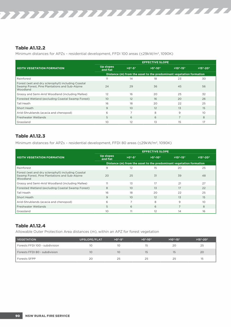
Table A1.12.2Minimum distances for APZs – residential development, FFDI 100 areas (<29kW/m2, 1090K)
KEITH VEGETATION FORMATION
EFFECTIVE SLOPEUp slopes and flat >0°-5° >5°-10° >10°-15° >15°-20°
Distance (m) from the asset to the predominant vegetation formation
Rainforest 11 14 18 23 30
Forest (wet and dry sclerophyll) including Coastal Swamp Forest, Pine Plantations and Sub-Alpine Woodland
24 29 36 45 56
Grassy and Semi-Arid Woodland (including Mallee) 12 16 20 25 32
Forested Wetland (excluding Coastal Swamp Forest) 10 12 16 20 26
Tall Heath 16 18 20 22 25
Short Heath 9 10 12 13 15
Arid-Shrublands (acacia and chenopod) 6 7 8 9 10
Freshwater Wetlands 5 6 6 7 8
Grassland 10 12 13 15 17
Table A1.12.3Minimum distances for APZs – residential development, FFDI 80 areas (<29kW/m2, 1090K)
KEITH VEGETATION FORMATION
EFFECTIVE SLOPEUp slopes and flat >0°-5° >5°-10° >10°-15° >15°-20°
Distance (m) from the asset to the predominant vegetation formation
Rainforest 9 12 15 20 25
Forest (wet and dry sclerophyll) including Coastal Swamp Forest, Pine Plantations and Sub-Alpine Woodland
20 25 31 39 48
Grassy and Semi-Arid Woodland (including Mallee) 11 13 17 21 27
Forested Wetland (excluding Coastal Swamp Forest) 8 10 13 17 22
Tall Heath 16 18 20 22 25
Short Heath 9 10 12 13 15
Arid-Shrublands (acacia and chenopod) 6 7 8 9 10
Freshwater Wetlands 5 6 6 7 8
Grassland 10 11 12 14 16
Table A1.12.4Allowable Outer Protection Area distances (m), within an APZ for forest vegetation
VEGETATION UPSLOPE/FLAT >0°-5° >5°-10° >10°-15° >15°-20°
Forests FFDI 100 - subdivision 10 10 15 20 25
Forests FFDI 80 - subdivision 10 10 15 15 20
Forests SFPP 20 25 25 25 15
90 NSW RURAL FIRE SERVICE

Table A1.12.5Determination of BAL, FFDI 100 – residential developments
KEITH VEGETATION FORMATIONBUSH FIRE ATTACK LEVEL (BAL)
BAL-FZ BAL-40 BAL-29 BAL-19 BAL-12.5Distance (m) asset to predominant vegetation class
ALL
UP
SLO
PE
AN
D F
LAT
LAN
D
Rainforest < 8 8 -< 11 11 -< 16 16 -< 23 23 -< 100
Forest (wet and dry sclerophyll) including Coastal Swamp Forest, Pine Plantations and Sub-Alpine Woodland
< 18 18 -< 24 24 -< 33 33 -< 45 45 -< 100
Grassy and Semi-Arid Woodland (including Mallee) < 9 9 -< 12 12 -< 18 18 -< 26 26 -< 100
Forested Wetland (excluding Coastal Swamp Forest) < 7 7 -< 10 10 -< 14 14 -< 21 21 -< 100
Tall Heath < 12 12 -< 16 16 -< 23 23 -< 32 32 -< 100
Short Heath < 7 7 -< 9 9 -< 14 14 -< 20 20 -< 100
Arid-Shrublands (acacia and chenopod) < 5 5 -< 6 6 -< 9 9 -< 14 14 -< 100
Freshwater Wetlands < 4 4 -< 5 5 -< 7 7 -< 11 11 -< 100
Grassland < 8 8 -< 10 10 -< 15 15 -< 22 22 -< 50
> 0
> 5
DE
GR
EE
S –
DO
WN
SLO
PE
Rainforest < 11 11 -< 14 14 -< 21 21 -< 29 29 -< 100
Forest (wet and dry sclerophyll) including Coastal Swamp Forest, Pine Plantations and Sub-Alpine Woodland
< 22 22 -< 29 29 -< 40 40 -< 54 54 -< 100
Grassy and Semi-Arid Woodland (including Mallee) < 12 12 -< 16 16 -< 23 23 -< 32 32 -< 100
Forested Wetland (excluding Coastal Swamp Forest) < 9 9 -< 12 12 -< 18 18 -< 26 26 -< 100
Tall Heath < 13 13 -< 18 18 -< 26 26 -< 36 36 -< 100
Short Heath < 8 8 -< 10 10 -< 15 15 -< 22 22 -< 100
Arid-Shrublands (acacia and chenopod) < 5 5 -< 7 7 -< 11 11 -< 16 16 -< 100
Freshwater Wetlands < 4 4 -< 6 6 -< 8 8 -< 12 12 -< 100
Grassland < 9 9 -< 12 12 -< 17 17 -< 25 25 -< 50
> 5
> 1
0 D
EG
RE
ES
– D
OW
NS
LOP
E
Rainforest < 14 14 -< 18 18 -< 26 26 -< 37 37 -< 100
Forest (wet and dry sclerophyll) including Coastal Swamp Forest, Pine Plantations and Sub-Alpine Woodland
< 28 28 -< 36 36 -< 49 49 -< 65 65 -< 100
Grassy and Semi-Arid Woodland (including Mallee) < 15 15 -< 20 20 -< 28 28 -< 39 39 -< 100
Forested Wetland (excluding Coastal Swamp Forest) < 12 12 -< 16 16 -< 23 23 -< 33 33 -< 100
Tall Heath < 15 15 -< 20 20 -< 29 29 -< 40 40 -< 100
Short Heath < 9 9 -< 12 12 -< 18 18 -< 25 25 -< 100
Arid-Shrublands (acacia and chenopod) < 6 6 -< 8 8 -< 12 12 -< 18 18 -< 100
Freshwater Wetlands <5 5 -< 6 6 -< 10 10 -< 14 14 -< 100
Grassland < 10 10 -< 13 13 -< 20 20 -< 28 28 -< 50
> 1
0 >
15
DE
GR
EE
S –
DO
WN
SLO
PE
Rainforest < 17 17 -< 23 23 -< 34 34 -< 46 46 -< 100
Forest (wet and dry sclerophyll) including Coastal Swamp Forest, Pine Plantations and Sub-Alpine Woodland
< 36 36 -< 45 45 -< 60 60 -< 77 77 -< 100
Grassy and Semi-Arid Woodland (including Mallee) < 19 19 -< 25 25 -< 36 36 -< 49 49 -< 100
Forested Wetland (excluding Coastal Swamp Forest) < 15 15 -< 20 20 -< 29 29 -< 41 41 -< 100
Tall Heath < 17 17 -< 22 22 -< 32 32 -< 44 44 -< 100
Short Heath < 10 10 -< 13 13 -< 20 20 -< 29 29 -< 100
Arid-Shrublands (acacia and chenopod) < 7 7 -< 9 9 -< 14 14 -< 20 20 -< 100
Freshwater Wetlands < 5 5 -< 7 7 -< 11 11 -< 16 16 -< 100
Grassland < 11 11 -< 15 15 -< 23 23 -< 32 32 -< 50
> 1
5 >
20
DE
GR
EE
S –
DO
WN
SLO
PE
Rainforest < 23 23 -< 30 30 -< 42 42 -< 56 56 -< 100
Forest (wet and dry sclerophyll) including Coastal Swamp Forest, Pine Plantations and Sub-Alpine Woodland
< 46 46 -< 56 56 -< 73 73 -< 92 92 -< 100
Grassy and Semi-Arid Woodland (including Mallee) < 24 24 -< 32 32 -< 44 44 -< 59 59 -< 100
Forested Wetland (excluding Coastal Swamp Forest) < 19 19 -< 26 26 -< 37 37 -< 50 50 -< 100
Tall Heath < 19 19 -< 25 25 -< 36 36 -< 49 49 -< 100
Short Heath < 11 11 -< 15 15 -< 23 23 -< 32 32 -< 100
Arid-Shrublands (acacia and chenopod) < 7 7 -< 10 10 -< 16 16 -< 23 23 -< 100
Freshwater Wetlands < 6 6 -< 8 8 -< 13 13 -< 18 18 -< 100
Grassland <13 13 -< 17 17 -< 26 26 -< 36 36 -< 50
91PLANNING FOR BUSH FIRE PROTECTION - 2019

Table A1.12.6Determination of BAL, FFDI 80 – residential development
KEITH VEGETATION FORMATIONBUSH FIRE ATTACK LEVEL (BAL)
BAL-FZ BAL-40 BAL-29 BAL-19 BAL-12.5Distance (m) asset to predominant vegetation class
ALL
UP
SLO
PE
AN
D F
LAT
LAN
D
Rainforest < 7 7 -< 9 9 -< 14 14 -< 20 20 -< 100
Forest (wet and dry sclerophyll) including Coastal Swamp Forest, Pine Plantations and Sub-Alpine Woodland
< 15 15 -< 20 20 -< 29 29 -< 40 40 -< 100
Grassy and Semi-Arid Woodland (including Mallee) < 8 8 -< 11 11 -< 16 16 -< 22 22 -< 100
Forested Wetland (excluding Coastal Swamp Forest) < 6 6 -< 8 8 -< 12 12 -< 18 18 -< 100
Tall Heath < 12 12 -< 16 16 -< 23 23 -< 32 32 -< 100
Short Heath < 7 7 -< 9 9 -< 14 14 -< 20 20 -< 100
Arid-Shrublands (acacia and chenopod) < 5 5 -< 6 6 -< 9 9 -< 14 14 -< 100
Freshwater Wetlands < 4 4 -< 5 5 -< 7 7 -< 11 11 -< 100
Grassland < 7 7 -< 10 10 -< 14 14 -< 20 20 -< 50
> 0
> 5
DE
GR
EE
S –
DO
WN
SLO
PE
Rainforest < 9 9 -< 12 12 -< 17 17 -< 25 25 -< 100
Forest (wet and dry sclerophyll) including Coastal Swamp Forest, Pine Plantations and Sub-Alpine Woodland
< 19 19 -< 25 25 -< 35 35 -< 47 47 -< 100
Grassy and Semi-Arid Woodland (including Mallee) < 10 10 -< 13 13 -< 19 19 -< 28 28 -< 100
Forested Wetland (excluding Coastal Swamp Forest) < 8 8 -< 10 10 -< 15 15 -< 22 22 -< 100
Tall Heath < 13 13 -< 18 18 -< 26 26 -< 36 36 -< 100
Short Heath < 8 8 -< 10 10 -< 15 15 -< 22 22 -< 100
Arid-Shrublands (acacia and chenopod) < 5 5 -< 7 7 -< 11 11 -< 16 16 -< 100
Freshwater Wetlands < 4 4 -< 6 6 -< 8 8 -< 12 12 -< 100
Grassland < 8 8 -< 11 11 -< 16 16 -< 23 23 -< 50
> 5
> 1
0 D
EG
RE
ES
– D
OW
NS
LOP
E
Rainforest < 11 11 -< 15 15 -< 22 22 -< 32 32 -< 100
Forest (wet and dry sclerophyll) including Coastal Swamp Forest, Pine Plantations and Sub-Alpine Woodland
< 24 24 -< 31 31 -< 43 43 -< 57 57 -< 100
Grassy and Semi-Arid Woodland (including Mallee) < 12 12 -< 17 17 -< 24 24 -< 34 34 -< 100
Forested Wetland (excluding Coastal Swamp Forest) < 10 10 -< 13 13 -< 20 20 -< 28 28 -< 100
Tall Heath < 15 15 -< 20 20 -< 29 29 -< 40 40 -< 100
Short Heath < 9 9 -< 12 12 -< 18 18 -< 25 25 -< 100
Arid-Shrublands (acacia and chenopod) < 6 6 -< 8 8 -< 12 12 -< 18 18 -< 100
Freshwater Wetlands < 5 5 -< 6 6 -< 10 10 -< 14 14 -< 100
Grassland < 9 9 -< 12 12 -< 18 18 -< 26 26 -< 50
> 1
0 >
15
DE
GR
EE
S –
DO
WN
SLO
PE
Rainforest < 14 14 -< 20 20 -< 29 29 -< 40 40 -< 100
Forest (wet and dry sclerophyll) including Coastal Swamp Forest, Pine Plantations and Sub-Alpine Woodland
< 30 30 -< 39 39 -< 52 52 -< 68 68 -< 100
Grassy and Semi-Arid Woodland (including Mallee) < 16 16 -< 21 21 -< 31 31 -< 42 42 -< 100
Forested Wetland (excluding Coastal Swamp Forest) < 12 12 -< 17 17 -< 25 25 -< 35 35 -< 100
Tall Heath < 17 17 -< 22 22 -< 32 32 -< 44 44 -< 100
Short Heath < 10 10 -< 13 13 -< 20 20 -< 29 29 -< 100
Arid-Shrublands (acacia and chenopod) < 7 7 -< 9 9 -< 14 14 -< 20 20 -< 100
Freshwater Wetlands < 5 5 -< 7 7 -< 11 11 -< 16 16 -< 100
Grassland < 10 10 -< 14 14 -< 21 21 -< 30 30 -< 50
> 1
5 >
20
DE
GR
EE
S –
DO
WN
SLO
PE
Rainforest < 19 19 -< 25 25 -< 36 36 -< 49 49 -< 100
Forest (wet and dry sclerophyll) including Coastal Swamp Forest, Pine Plantations and Sub-Alpine Woodland
< 38 38 -< 48 48 -< 63 63 -< 81 81 -< 100
Grassy and Semi-Arid Woodland (including Mallee) < 20 20 -< 27 27 -< 38 38 -< 52 52 -< 100
Forested Wetland (excluding Coastal Swamp Forest) < 16 16 -< 22 22 -< 32 32 -< 43 43 -< 100
Tall Heath < 19 19 -< 25 25 -< 36 36 -< 49 49 -< 100
Short Heath < 11 11 -< 15 15 -< 23 23 -< 32 32 -< 100
Arid-Shrublands (acacia and chenopod) < 7 7 -< 10 10 -< 16 16 -< 23 23 -< 100
Freshwater Wetlands < 6 6 -< 8 8 -< 13 13 -< 18 18 -< 100
Grassland < 12 12 -< 16 16 -< 24 24 -< 34 34 -< 50
92 NSW RURAL FIRE SERVICE

Table A1.12.7Determination of BAL, FFDI 50 – alpine areas
KEITH VEGETATION FORMATIONBUSH FIRE ATTACK LEVEL (BAL)
BAL-FZ BAL-40 BAL-29 BAL-19 BAL-12.5Distance (m) asset to predominant vegetation class
ALL
UP
SLO
PE
AN
D F
LAT
LAN
D
Rainforest < 5 5 -< 7 7 -< 10 10 -< 15 15 -< 100
Forest (wet and dry sclerophyll) including Coastal Swamp Forest, Pine Plantations and Sub-Alpine Woodland < 11 11 -< 15 15 -< 22 22 -< 30 30 -< 100
Grassy and Semi-Arid Woodland (including Mallee) < 6 6 -< 8 8 -< 12 12 -< 17 17 -< 100
Forested Wetland (excluding Coastal Swamp Forest) < 5 5 -< 6 6 -< 9 9 -< 13 13 -< 100
Tall Heath < 12 12 -< 16 16 -< 23 23 -< 32 32 -< 100
Short Heath < 7 7 -< 9 9 -< 14 14 -< 20 20 -< 100
Arid-Shrublands (acacia and chenopod) < 5 5 -< 6 6 -< 9 9 -< 14 14 -< 100
Freshwater Wetlands < 4 4 -< 5 5 -< 7 7 -< 11 11 -< 100
Alpine Complex < 4 4 -< 6 6 -< 8 8 -< 12 12 -< 100
Grassland < 6 6 -< 8 8 -< 11 11 -< 17 17 -< 50
> 0
> 5
DE
GR
EE
S –
DO
WN
SLO
PE
Rainforest < 6 6 -< 8 8 -< 12 12 -< 18 18 -< 100
Forest (wet and dry sclerophyll) including Coastal Swamp Forest, Pine Plantations and Sub-Alpine Woodland < 14 14 -< 18 18 -< 26 26 -< 36 36 -< 100
Grassy and Semi-Arid Woodland (including Mallee) < 7 7 -< 10 10 -< 14 14 -< 21 21 -< 100
Forested Wetland (excluding Coastal Swamp Forest) < 6 6 -< 8 8 -< 11 11 -< 16 16 -< 100
Tall Heath < 13 13 -< 18 18 -< 26 26 -< 36 36 -< 100
Short Heath < 8 8 -< 10 10 -< 15 15 -< 22 22 -< 100
Arid-Shrublands (acacia and chenopod) < 5 5 -< 7 7 -< 11 11 -< 16 16 -< 100
Freshwater Wetlands < 4 4 -< 6 6 -< 8 8 -< 12 12 -< 100
Alpine Complex <5 5 -< 6 6 -< 10 10 -< 14 14 -< 100
Grassland < 7 7 -< 9 9 -< 13 13 -< 19 19 -< 50
> 5
> 1
0 D
EG
RE
ES
– D
OW
NS
LOP
E
Rainforest < 8 8 -< 11 11 -< 16 16 -< 23 23 -< 100
Forest (wet and dry sclerophyll) including Coastal Swamp Forest, Pine Plantations and Sub-Alpine Woodland < 17 17 -< 22 22 -< 32 32 -< 43 43 -< 100
Grassy and Semi-Arid Woodland (including Mallee) < 9 9 -< 12 12 -< 17 17 -< 25 25 -< 100
Forested Wetland (excluding Coastal Swamp Forest) < 7 7 -< 9 9 -< 14 14 -< 20 20 -< 100
Tall Heath < 15 15 -< 20 20 -< 29 29 -< 40 40 -< 100
Short Heath < 9 9 -< 12 12 -< 18 18 -< 25 25 -< 100
Arid-Shrublands (acacia and chenopod) < 6 6 -< 8 8 -< 12 12 -< 18 18 -< 100
Freshwater Wetlands < 5 5 -< 6 6 -< 10 10 -< 14 14 -< 100
Alpine Complex < 5 5 -< 7 7 -< 11 11 -< 16 16 -< 100
Grassland < 7 7 -< 10 10 -< 15 15 -< 22 22 -< 50
> 1
0 >
15
DE
GR
EE
S –
DO
WN
SLO
PE
Rainforest < 10 10 -< 13 13 -< 20 20 -< 29 29 -< 100
Forest (wet and dry sclerophyll) including Coastal Swamp Forest, Pine Plantations and Sub-Alpine Woodland < 21 21 -< 28 28 -< 39 39 -< 52 52 -< 100
Grassy and Semi-Arid Woodland (including Mallee) < 11 11 -< 15 15 -< 22 22 -< 31 31 -< 100
Forested Wetland (excluding Coastal Swamp Forest) < 9 9 -< 12 12 -< 18 18 -< 26 26 -< 100
Tall Heath < 17 17 -< 22 22 -< 32 32 -< 44 44 -< 100
Short Heath < 10 10 -< 13 13 -< 20 20 -< 29 29 -< 100
Arid-Shrublands (acacia and chenopod) < 7 7 -< 9 9 -< 14 14 -< 20 20 -< 100
Freshwater Wetlands < 5 5 -< 7 7 -< 11 11 -< 16 16 -< 100
Alpine Complex < 6 6 -< 8 8 -< 12 12 -< 18 18 -< 100
Grassland < 8 8 -< 12 12 -< 17 17 -< 25 25 -< 50
> 1
5 >
20
DE
GR
EE
S –
DO
WN
SLO
PE
Rainforest < 13 13 -< 17 17 -< 26 26 -< 36 36 -< 100
Forest (wet and dry sclerophyll) including Coastal Swamp Forest, Pine Plantations and Sub-Alpine Woodland < 26 26 -< 34 34 -< 47 47 -< 63 63 -< 100
Grassy and Semi-Arid Woodland (including Mallee) < 14 14 -< 19 19 -< 28 28 -< 38 38 -< 100
Forested Wetland (excluding Coastal Swamp Forest) < 7 7 -< 15 15 -< 23 23 -< 32 32 -< 100
Tall Heath < 19 19 -< 25 25 -< 36 36 -< 49 49 -< 100
Short Heath < 11 11 -< 15 15 -< 23 23 -< 32 32 -< 100
Arid-Shrublands (acacia and chenopod) < 7 7 -< 10 10 -< 16 16 -< 23 23 -< 100
Freshwater Wetlands < 6 6 -< 8 8 -< 13 13 -< 18 18 -< 100
Alpine Complex < 7 7 -< 9 9 -< 14 14 -< 21 21 -< 100
Grassland <10 10 -< 13 13 -< 20 20 -< 28 28 -< 50
93PLANNING FOR BUSH FIRE PROTECTION - 2019

Table A1.12.8Vegetation formation details.
VEGETATION SURFACE AND ELEVATED (t/ha)
OVERALL FUEL LOAD INCLUDING BARK AND
CANOPY (t/ha)
VEGETATION HEIGHT (m)
Rainforest 10 13.2 NA
Forest (wet and dry sclerophyll) including Coastal Swamp Forest, Pine Plantations and Sub-Alpine Woodland
22 36.1 NA
Grassy and Semi-Arid Woodland (including Mallee) 10.5 20.2 NA
Forested Wetland (excluding Coastal Swamp Forest) 8.2 15.1 NA
Tall Heath 36.9 36.9 3
Short Heath 15 15 1.5
Arid-Shrublands (acacia and chenopod) 6.2 6.2 1.5
Freshwater Wetlands 4.4 4.4 1
Alpine Complex 5.8 5.8 1
Grassland 6 6 NA
94 NSW RURAL FIRE SERVICE

APPENDIX 2 SUBMISSION REQUIREMENTS, PERFORMANCE BASED SOLUTIONS AND BUSH FIRE DESIGN BRIEFSThis appendix details the information requirements for the range of DAs on BFPL and the submission requirements where a performance based solution is proposed.
A2.1 Submission requirements for a BFSAThe detailed information to be contained within a Bush Fire Assessment Report submitted to the NSW RFS as outlined in RF Reg cl.44 is:
(a) a description (including the address) of the property on which the development the subject of the application is proposed to be carried out;
(b) a classification of the vegetation on and surrounding the property (out to a distance of 140 metres from the boundaries of the property) in accordance with the system for classification of vegetation contained in Planning for Bush Fire Protection;
(c) an assessment of the slope of the land on and surrounding the property (out to a distance of 100 metres from the boundaries of the property);
(d) identification of any significant environmental features on the property;
(e) the details of any threatened species, population or ecological community identified under the Threatened Species Conservation Act 1995 that is known to the applicant to exist on the property;
(f) the details and location of any Aboriginal object (within the meaning of the National Parks and Wildlife Act 1974) or Aboriginal place (within the meaning of that Act) that is known to the applicant to be situated on the property;
(g) a bush fire assessment for the proposed development (including the methodology used in the assessment) that addresses the following matters:
(i) the extent to which the development is to provide for setbacks, including Asset Protection Zones;
(ii) the siting and adequacy of water supplies for fire fighting;
(iii) the capacity of public roads in the vicinity to handle increased volumes of traffic in the event of a bush fire emergency;
(iv) whether or not public roads in the vicinity that link with the fire trail network have two‑way access;
(v) the adequacy of arrangements for access to and egress from the development site for the purposes of an emergency response;
(vi) the adequacy of bush fire maintenance plans and fire emergency procedures for the development site;
(vii) the construction standards to be used for building elements in the development;
(viii) the adequacy of sprinkler systems and other fire protection measures to be incorporated into the development;
(h) an assessment of the extent to which the proposed development conforms with or deviates from the standards, specific objectives, performance criteria and acceptable solutions set out in Chapters 5‑8 of PBP; and
(i) identify any fire trails that exist on the property that are on the Register of Certified Fire Trails under RF Act s.62O.
95PLANNING FOR BUSH FIRE PROTECTION - 2019

A2.1.1 SubdivisionsThe submission requirements given above for a BFSA are applicable to subdivision on BFPL. Additional considerations for subdivision are outlined below.
In order to allow for flexibility at the building design stage of development, building envelopes are not always identified at the subdivision stage. A conceptual plan drawn to scale identifying building envelopes may be requested to demonstrate that individual lots are capable of providing a suitable APZ and compliant BALs. Unless otherwise specified, a building envelope of 15m by 15m will be assumed.
Where staged development is proposed, the bush fire assessment report must explain how the provisions of this document will be satisfied for each stage of the development. This is particularly important to ensure that appropriate APZs will be provided at all stages of development. Special attention must also be given to the provision of emergency access and egress and the provision of water supplies.
In relation to significant environmental features, threatened species, endangered populations, endangered ecological communities and Aboriginal heritage issues, sufficient information is required to ascertain that environmental issues are not a constraint to development. Approval for the loss or removal of environmental assets is the role of the consent authority.
A2.2 Submission requirements for infill development
Infill development proposals on BFPL must be accompanied by bush fire assessments and reports demonstrating compliance with PBP.
In particular, the following must be addressed:
a statement that the site is BFPL;
the location, extent and vegetation formation of any bushland on or within 140 metres of the site;
the slope and aspect of the site and of any BFPL within 100 metres of the site;
any features on or adjoining the site that may mitigate the impact of a bush fire on the proposed development;
a statement assessing the likely environmental impact of any proposed BPMs;
a site plan showing access, water supplies, APZs, BAL requirements and building footprint in relation to the bush fire hazards; and
calculated BAL construction levels.
For smaller proposals, this can be done relatively simply using the NSW RFS Single Dwelling Application Kit which can be found on the NSW RFS website www.rfs.nsw.gov.au and is to be accompanied by a diagram identifying the requirements detailed above.
For more complex applications or performance based solutions, a recognised consultant should be engaged to prepare a bush fire assessment report and a Bush Fire Management Plan. (see A2.6).
96 NSW RURAL FIRE SERVICE

A2.3 Submission requirements for Complying Development
Some SEPPs and LEPs permit certain development on BFPL where the appropriate standards are met.
Complying Development may be undertaken on lower risk BFPL where the appropriate construction requirements for BFPL and all other relevant development standards have been met. It should however be noted that the NSW RFS is not a participant in any part of this approval process.
For Complying Development, a BAL Certificate from the local council or a recognised consultant stating that the BAL of the development is not BAL-40 or BAL-FZ as applicable must be obtained prior to the issue of a Complying Development Certificate (CDC). Although not required, the NSW RFS encourages BAL Certificates to state the relevant BAL that applies to the Complying Development in question.
Complying Development is not permitted on BAL-40 or BAL-FZ. If a development is assessed as being in BAL-40 or BAL-FZ then a DA will need to be lodged with the local council.
Specific development requirements and development standards have been added to the relevant SEPPs and LEPs that apply to new development, including alterations and additions, on lower risk BFPL.
A2.4 Submission requirements and assessment methods for performance based solutions
To achieve compliance with PBP, proposals must comply with either the acceptable solutions or a performance criteria.
For performance based applications, it must be demonstrated how the product, design or material can meet the performance criteria of this document including the intent of measures and also, the aim and objectives. All performance based solutions should be accompanied by a Bush Fire Management Plan (see A2.6).
A performance based solution will only comply with PBP when the assessment methods used satisfactorily demonstrate compliance with the performance criteria.
Performance based solutions must be assessed using one or more of the assessment methods. In some cases, the development of a performance based solution will include the BFDB process.
Assessment methodsAssessment methods are the means by which a proponent demonstrates that a solution achieves the performance criteria.
The assessment methods described below are applicable to the assessment of performance based solutions to determine that they comply with the relevant performance criteria, as appropriate.
a. Evidence to support that the use of a material, form of construction or design meets the performance criteria as described in PBP;
b. Verification methods such as a test, inspection, calculation or other method that determines whether a performance-based solution complies with the relevant performance criteria; and
c. Comparison with the acceptable solutions.
All Verification Methods must be acceptable to the appropriate authority. NCC 2019 contains new Verification Methods that can be used to demonstrate compliance with the relevant NCC Performance Requirements for buildings in bush fire prone areas.
Where Verification Methods GV5 of Volume One or V2.7.2 of Volume Two of the NCC are used to demonstrate compliance with NSW GP5.1 (Volume One) or NSW P2.7.5 (Volume Two), this is considered to be a performance solution for the purposes of PBP and the proposal must be referred to the NSW RFS.
97PLANNING FOR BUSH FIRE PROTECTION - 2019

A2.5 Bush Fire Design Brief (BFDB)A BFDB is the first step in a performance based solution and forms the basis of the ensuing analysis.
It is the process that defines the scope of work for the bush fire analysis and report. One of the main reasons for the BFDB is to translate performance criteria into objective parameters and criteria that can then be evaluated in the bush fire analysis.
The BFDB requires involvement of all relevant stakeholders and their agreement on the ground rules for the ensuing bush fire analysis. It is important to note that the BFDB usually precedes the detailed analysis and report, but may occur after the analysis has been completed as long as all relevant stakeholders agree on the parameters and criteria used. However, in order to minimise design risk, the BFDB should be undertaken before detailed analysis and documentation occurs.
The BFDB is an important part of the performance based design process, as it allows the objectives, proposed design, analysis methods, assumptions and acceptance criteria to be agreed on in order to validate the bush fire analysis. The compliance approach needs to be agreed on as part of the BFDB. The approach may be based on equivalency to the acceptable solutions, direct compliance with the performance criteria, or a combination.
The complexity of the BFDB will vary depending on the complexity of the bush fire issues being considered.
The process by which the BFDB is undertaken shall be documented as part of the bush fire analysis report.
The BFDB is not in itself an agreement as to the acceptability of the proposed solution. Rather, it focuses on the methods of analysis which will be used in evaluating whether the proposed design is adequate and appropriate.
The process undertaken for a BFDB should follow that for a Fire Engineering Brief described in the International Fire Engineering Guidelines (2005)
A2.6 Bush Fire Management Plan Preparation of a Bush Fire Management Plan (BFMP) is recommended for developments in bush fire prone areas.
A BFMP should detail all bush fire safety aspects of the proposed development including:
APZ locations and management details;
Landscaping requirements including indicative design layout and vegetation density thresholds;
Access provisions such as locations, passing bays and alternate emergency access;
Water supplies and bush fire suppression systems (including drenching systems, static water supply, natural water sources etc.);
Schedule of the BAL requirements and building footprints as well as any specific construction details (i.e. bush fire shutter operating instructions);
Details regarding the Bush Fire Emergency Management and Evacuation Plan; and
Any other essential bush fire safety requirements.
98 NSW RURAL FIRE SERVICE

A2.7 Qualified consultantsEP&A Act 1979 s.4.14 and certain SEPPs allow councils and certifiers to utilise persons recognised by the NSW RFS as a qualified consultant in bush fire risk assessment.
Given the complexity of performance based solutions, it is recommended that they are undertaken and fully justified by qualified consultants.
In order for a consultant to be recognised by the NSW RFS as being qualified, they must demonstrate a number of requirements as part of a recognised accreditation scheme.
A2.8 Pre-DA adviceThe NSW RFS provides a pre-DA advice service as a means for proponents of development to seek information and obtain clarity about the NSW RFS position on a proposal before a formal DA is lodged with the consent authority.
The pre-DA advice service is intended for more complex proposals which raise issues in relation to compliance with this document. This may involve instances where a performance based solution is proposed or where bush fire protection issues are raised in strategic or rezoning planning processes.
Further information on the pre-DA advice service can be found online at NSW RFS website www.rfs.nsw.gov.au.
99PLANNING FOR BUSH FIRE PROTECTION - 2019

APPENDIX 3ACCESSThis appendix provides design principles for emergency service vehicle access.
A3.1 Vertical clearance An unobstructed clearance height of 4 metres should be maintained above all access ways including clearance from building construction, archways, gateways and overhanging structures (e.g. ducts, pipes, sprinklers, walkways, signs and beams). This also applies to vegetation overhanging roads.
Figure A3.1Vertical clearance.
A3.2 Vehicle turning requirementsCurved carriageways should be constructed using the minimum swept path as outlined in Table A3.2.
Table A3.2Minimum curve radius for turning vehicles.
Curve radius (inside edge in metres)
Swept path (metres width)
< 40 4.0
40 - 69 3.0
70 - 100 2.7
> 100 2.5
100 NSW RURAL FIRE SERVICE

Swept path width
Outer radius
Inner radius
The radius dimensions given are for wall to wall clearance where body overhangs travel a wider arc than the wheel tracks (vehicle swept path). The swept path shall include an additional 500mm clearance either side of the vehicle.
Figure A3.2aSwept path width for turning vehicles.
Swept path width
Outer radius
Inner radius
Example of a swept path as applied to a roundabout. The distance between inner and outer turning arcs allows for expected vehicle body swing of front and rear overhanging sections (the swept path).
Figure A3.2bRoundabout swept path.
101PLANNING FOR BUSH FIRE PROTECTION - 2019

Normal road width
12000
Normal road width
12000
12000
12000
Normal road width
Normal
road width
12000
Norm
al road w
idth
Normal road width
Normal road width
12000
12000
R 30000
R 6000R 6000
R 6000
Normal road width
12000
Normal road width
12000
12000
12000
Normal road width
Normal
road width
12000
Norm
al road w
idth
Normal road width
Normal road width
12000
12000
R 30000
R 6000R 6000
R 6000
Type C Type D
Normal road width
12000
Normal road width
12000
12000
12000
Normal road width
Normal
road width
12000
Norm
al road w
idth
Normal road width
Normal road width
12000
12000
R 30000
R 6000R 6000
R 6000
A3.3 Vehicle turning head requirementsDead ends that are longer then 200m must be provided with a turning head area that avoids multipoint turns. “No parking” signs are to be erected within the turning head.
The minimum turning radius shall be in accordance with Table A3.2. Where multipoint turning is proposed the NSW RFS will consider the following options:
Type A Type B
Figure A3.3Multipoint turning options.
102 NSW RURAL FIRE SERVICE

A3.5 Parking Parking can create a pinch point in required access. The location of parking should be carefully considered to ensure fire appliance access is unimpeded. Hydrants shall be located outside of access ways and any parking areas to ensure that access is available at all times.
Figure A3.5Hydrants and parking bays.
A3.4 Passing baysThe construction of passing bays, where required, shall be 20m in length and provide a minimum trafficable width at the passing point of 6m.
Figure A3.4
Passing bays can provide advantages when designed correctly. Poor design can and does severely impede access.
103PLANNING FOR BUSH FIRE PROTECTION - 2019

A3.6 Kerb dimensionsAll kerbs constructed around access roads should be no higher than 250mm and free of vertical obstructions at least 300mm back from the kerb face to allow clearance for front and rear body overhang.
A3.7 ServicesHydrant services should be located outside the carriageway and parking bays to permit traffic flow and access. Setup of standpipes within the carriageway may stop traffic flow. Hydrant services shall be located on the side of the road away from the bush fire threat where possible.
A3.8 Local Area Traffic Management (LATM)
The objective of LATM is to regulate traffic an acceptable level of speed and traffic volume within a local area.
Traffic engineers and planners should consider LATM devices when planning for local traffic control and their likely impact on emergency services. LATM devices by their nature are designed to restrict and impede the movement of traffic, especially large vehicles.
Where LATM devices are provided they are to be designed so that they do not impede fire vehicle access.
Figure A3.6Carriageway kerb clearance dimensions.
Min. 300mm
Max. 250mm
Road
Kerb
104 NSW RURAL FIRE SERVICE

A3.9 Road types
A3.9.1 Perimeter Roads Perimeter roads are to be provided with a minimum clear width of 8m. Parking and hydrants are to be provided outside of carriageways. Hydrants are to be located outside of carriageways and parking areas.
Figure A3.9aPerimeter road widths.
A3.9.2 Non-perimeter RoadsNon-perimeter roads shall be provided with a minimum clear width of 5.5m. Parking is to be provided outside of the carriageway and hydrants are not to be located in carriageways or parking areas.
Figure A3.9bNon-perimeter road widths.
A3.9.3 Property accessProperty access roads are to be a minimum of 4m wide.
Figure A3.9cProperty access road widths.
Perimeter Roads = 8m to kerb
Non-perimeter roads = 5.5m to kerb
Property access road4m wide carriage way
105PLANNING FOR BUSH FIRE PROTECTION - 2019

APPENDIX 4ASSET PROTECTION ZONE REQUIREMENTS
In combination with other BPMs, a bush fire hazard can be reduced by implementing simple steps to reduce vegetation levels. This can be done by designing and managing landscaping to implement an APZ around the property.
Careful attention should be paid to species selection, their location relative to their flammability, minimising continuity of vegetation (horizontally and vertically), and ongoing maintenance to remove flammable fuels (leaf litter, twigs and debris).
This Appendix sets the standards which need to be met within an APZ.
A4.1 Asset Protection ZonesAn APZ is a fuel-reduced area surrounding a building or structure. It is located between the building or structure and the bush fire hazard.
For a complete guide to APZs and landscaping, download the NSW RFS document Standards for Asset Protection Zones at the NSW RFS Website www.rfs.nsw.gov.au.
An APZ provides:
a buffer zone between a bush fire hazard and an asset;
an area of reduced bush fire fuel that allows for suppression of fire;
an area from which backburning or hazard reduction can be conducted; and
an area which allows emergency services access and provides a relatively safe area for firefighters and home owners to defend their property.
Bush fire fuels should be minimised within an APZ. This is so that the vegetation within the zone does not provide a path for the spread of fire to the building, either from the ground level or through the tree canopy.
An APZ, if designed correctly and maintained regularly, will reduce the risk of:
direct flame contact on the building;
damage to the building asset from intense radiant heat; and
ember attack.
The methodology for calculating the required APZ distance is contained within Appendix 1. The width of the APZ required will depend upon the development type and bush fire threat. APZs for new development are set out within Chapters 5, 6 and 7 of this document.
In forest vegetation, the APZ can be made up of an Inner Protection Area (IPA) and an Outer Protection Area (OPA).
106 NSW RURAL FIRE SERVICE

A4.1.1 Inner Protection Areas (IPAs)The IPA is the area closest to the building and creates a fuel-managed area which can minimise the impact of direct flame contact and radiant heat on the development and act as a defendable space. Vegetation within the IPA should be kept to a minimum level. Litter fuels within the IPA should be kept below 1cm in height and be discontinuous.
In practical terms the IPA is typically the curtilage around the building, consisting of a mown lawn and well maintained gardens.
When establishing and maintaining an IPA the following requirements apply:
Trees
tree canopy cover should be less than 15% at maturity;
trees at maturity should not touch or overhang the building;
lower limbs should be removed up to a height of 2m above the ground;
tree canopies should be separated by 2 to 5m; and
preference should be given to smooth barked and evergreen trees.
Shrubs create large discontinuities or gaps in the
vegetation to slow down or break the progress of fire towards buildings should be provided;
shrubs should not be located under trees; shrubs should not form more than 10% ground
cover; and clumps of shrubs should be separated from
exposed windows and doors by a distance of at least twice the height of the vegetation.
Grass grass should be kept mown (as a guide grass
should be kept to no more than 100mm in height); and
leaves and vegetation debris should be removed.
A4.1.2 Outer Protection Areas (OPAs)An OPA is located between the IPA and the unmanaged vegetation. It is an area where there is maintenance of the understorey and some separation in the canopy. The reduction of fuel in this area aims to decrease the intensity of an approaching fire and restricts the potential for fire spread from crowns; reducing the level of direct flame, radiant heat and ember attack on the IPA.
Because of the nature of an OPA, they are only applicable in forest vegetation.
When establishing and maintaining an OPA the following requirements apply:
Trees
tree canopy cover should be less than 30%; and canopies should be separated by 2 to 5m.
Shrubs
shrubs should not form a continuous canopy; and shrubs should form no more than 20% of
ground cover.
Grass
grass should be kept mown to a height of less than 100mm; and
leaf and other debris should be removed.
An APZ should be maintained in perpetuity to ensure ongoing protection from the impact of bush fires. Maintenance of the IPA and OPA as described above should be undertaken regularly, particularly in advance of the bush fire season.
107PLANNING FOR BUSH FIRE PROTECTION - 2019

Figure A4.1Typlical Inner and Outer Protection Areas.
108 NSW RURAL FIRE SERVICE
downslope
APZ
BushlandBuilding envelope Outer Protection AreaInner Protection Area
Measure to wall
APZ
BushlandBuilding envelope Outer Protection AreaInner Protection Area
vertical considerations
horizontal considerations

AbbreviationsAS 3959 Australian Standard AS 3959:2018 Construction of buildings in bush fire-prone areas
AS 2419.1:2005 Australian Standard AS 2419.1:2005 Fire hydrant installations System design, installation and commissioning
AS/NZS 1221:1997 Australian Standard AS/NZS 1221:1997 Fire hose reels
AS 2441:2005 Australian Standard AS 2441:2005 Installation of fire hose reels
AS 3745:2010 Australian Standard AS 3745:2010 Planning for emergencies in facilities
AS/NZS 1530.8.1 Australian Standard AS 1530.8.1:2018 Methods for fire tests on building materials, components and structures - Tests on elements of construction for buildings exposed to simulated bush fire attack - Radiant heat and small flaming sources
AS/NZS 1530.8.2 Australian Standard AS 1530.8.2:2018 Methods for fire tests on building materials, components and structures - Tests on elements of construction for buildings exposed to simulated bush fire attack - Large flaming sources
AS/NZS 1596:2014 Australian Standard AS/NZS 1596:2014 The storage and handling of LP Gas
APZ Asset Protection Zone
BAL Bush Fire Attack Level
BCA Building Code of Australia
BFPL Bush fire prone land
BFPL Map Bush fire prone land map
BFDB Bush Fire Design Brief
BPM Bush fire protection measure
BFSA Bush fire safety authority
DA Development application
DCP Development Control Plan
DPIE NSW Department of Planning, Industry and Environment
EP&A Act Environmental Planning and Assessment Act 1979
FDI Fire Danger Index
FFDI Forest Fire Danger Index
GFDI Grassland Fire Danger Index
IPA Inner Protection Area
kW/m2 Kilowatts per metre squared
LEP Local Environmental Plan
NASH National Association of Steel Framed Housing (2014) Steel Framed Construction in Bush Fire Areas
NCC National Construction Code
OPA Outer Protection Area
PBP Planning for Bush Fire Protection 2019
RF Act Rural Fires Act 1997
RF Reg Rural Fires Regulation 2013
NSW RFS NSW Rural Fire Service
SEPP State Environmental Planning Policy
SFPP Special fire protection purpose
SFR Short fire run
SSD State significant development
SSI State significant infrastructure
URA Urban Release Area
ABBREVIATIONS, DEFINITIONS AND REFERENCES
109PLANNING FOR BUSH FIRE PROTECTION - 2019

A word or expression used in this document has the same meaning as it has in the EP&A Act or the Standard Instrument – Principal Local Environmental Plan, unless otherwise defined in this document.
References in this document to legislation or a policy, guideline or standard are taken to be references to that legislation or a policy, guideline or standard as amended from time to time.
Acceptable solutionMeasures which have been deemed to meet the specified performance criteria.
Assembly pointAn area or building or structure that is used to assemble people or that have evacuated from a site in an emergency situation.
Asset Protection Zone (APZ)A fuel-reduced area surrounding a built asset or structure which provides a buffer zone between a bush fire hazard and an asset. The APZ includes a defendable space within which firefighting operations can be carried out. The size of the required APZ varies with slope, vegetation and FFDI.
Australian Standard AS 3959 (AS 3959)AS 3959:2018 Construction of buildings in bush fire-prone areas, Standards Australia, 2018.
BAL certificateA certificate issued to identify the BAL of a proposed development in the complying development process.
Bush fire assessment reportA report submitted with the DA which establishes compliance with PBP. The report determines the extent of bush fire attack and the proposed mitigation measures. See also RF Reg cl.44.
Bush Fire Attack Level (BAL)A means of measuring the severity of a building’s potential exposure to ember attack, radiant heat and direct flame contact. In the NCC, the BAL is used as the basis for establishing the requirements for construction to improve protection of building elements.
Bush fireAn unplanned fire burning in vegetation; also referred to as wildfire.
Bush fire attackAttack by burning embers, radiant heat or flame generated by a bush fire.
Bush fire hazardAny vegetation that has the potential to threaten lives, property or the environment.
Bush fire prone land (BFPL)An area of land that can support a bush fire or is likely to be subject to bush fire attack, as designated on a bush fire prone land map.
Bush fire prone land map (BFPL)A map prepared in accordance with NSW RFS requirements and certified by the Commissioner of the NSW RFS under EP&A Act 1979 s.10.3(2).
Bush fire protection measures (BPMs)A range of measures used to minimise the risk from a bush fire that need to be complied with. BPMs include APZs, construction provisions, suitable access, water and utility services, emergency management and landscaping.
Bush fire riskIs the likelihood and consequence of a bush fire igniting, spreading and causing life loss or damage to buildings of value to the community.
Bush fire safety authority (BFSA)An approval by the Commissioner of the NSW RFS that is required for a subdivision for residential or rural residential purpose or for a SFPP development listed under section 100B of the RF Act.
CertifierAs defined in the EP&A Act 1979, those with authority to issue Part 6 certificates and Complying Development Certificates (CDCs).
Complying developmentComplying Development is a combined planning and construction approval for specified development that can be determined through a assessment by a council or private accredited certifier.
Consent authorityAs defined in the EP&A Act 1979, in relation to development consents, usually the local council.
Definitions
110 NSW RURAL FIRE SERVICE

Defendable spaceAn area adjoining a building that is managed to reduce combustible elements free from constructed impediments. It is a safe working environment in which efforts can be undertaken to defend the structure, before and after the passage of a bush fire.
Development As defined in the EP&A Act 1979.
Development application (DA)An application for consent to carry out development such as building, subdivision, or the use of a building or land.
Applications are normally made to the local council.
Development footprintThe building envelope or area shown on a plan on which buildings and associated APZs are proposed to be located.
Ecologically sustainable development As defined in Section 6 of the Protection of the Environment Administration Act (NSW) 1991.
Effective slopeThe land beneath the vegetation which most significantly effects fire behaviour, having regard to the vegetation present.
ExitA doorway opening to a road or open space, as defined in the NCC.
Fire Danger Index (FDI)The chance of a fire starting, its rate of spread, its intensity and the difficulty potential for its suppression, according to various combinations of air temperature, relative humidity, wind speed and both the long‑ and short‑term drought effects.
PBP refers to the Forest Fire Danger Index calculated by the McArthur Mk 5 Forest Fire Danger Meter using the equations published by Noble, I.R., Bary, G.A.V., and Gill, A.M., 1980.
Grassland Fire Danger Index (GFDI) values are calculated by the McArthur Mk 4 Grassland Fire Danger Meter using the equations published by Purton, C.M., 1982.
Flame zoneThe distance from a bush fire at which there is considered to be significant potential for sustained flame contact to a building. The flame zone is determined by the calculated distance at which the radiant heat from the design fire exceeds 40kW/m².
GrasslandsGrassed areas capable of sustaining a fire. Under AS 3959, this is identified as low open shrubland, hummock grassland, closed tussock grassland, tussock grassland, open tussock, sparse open tussock, dense sown pasture, sown pasture, open herbfield, and sparse open herb field.
Grass, whether exotic or native, which is regularly maintained at or below 10cm in height (including maintained lawns, golf courses, maintained public reserves, parklands, nature strips and commercial nurseries) is regarded as managed land.
Grassland Deeming ProvisionsAn acceptable solution applying to properties in grassland hazard areas which can be used instead of the site assessment procedure in AS 3959.
Infill developmentRefers to the development of land by the erection of or addition to a building, which is within an existing allotment and does not require the spatial extension of services. Existing services may include public roads, electricity, water or sewerage.
Inner Protection Area (IPA)The component of an APZ which is closest to the asset (measured from unmanaged vegetation). It consists of an area maintained to minimal fuel loads so that a fire path is not created between the hazard and the building.
Integrated developmentAs referred to under EP& A Act s.4.46 (formerly s.91), an integrated development is one that requires development consent and approval from one or more government agencies, and is not a State Significant Development (SSD) or Complying Development.
Isolated developmentDevelopment which is located predominantly in native bushland or is considered to be within a remote area. Access and evacuation may be challenging due to distances that are required to be travelled through bush fire prone areas.
Local Environmental Plan (LEP)An environmental planning instrument prepared under Part 3 of the LEPs guide planning decisions and the ways in which land is used through zoning and development controls.
111PLANNING FOR BUSH FIRE PROTECTION - 2019

Managed landLand that has vegetation removed or maintained to a level that limits the spread and impact of bush fire. This may include developed land (residential, commercial or industrial), roads, golf course fairways, playgrounds, sports fields, vineyards, orchards, cultivated ornamental gardens and commercial nurseries. Most common will be gardens and lawns within curtilage of buildings. These areas are managed to meet the requirements of an APZ.
Multi-storey buildingsBuildings exceeding three storeys in height are considered to be multi-storey buildings. The rise in storeys should be the calculated as per the definition within Volume 1 of the NCC 2019.
National Construction Code (NCC)The National Construction Code, published by the Australian Building Codes Board, comprising the Building Code of Australia as Volumes One and Two, and the Plumbing Code of Australia as Volume Three.
Outer Protection Area (OPA)The outer component of an APZ, where fuel loads are maintained at a level where the intensity of an approaching bush fire would be significantly reduced. Applies to forest vegetation only.
Performance based solutionA method of complying with the performance criteria other than by an acceptable solutions.
Primitive campingA site which is part of a commercially operated venture where there may already be a site for a tent and a fire pit.
Setback The distance required by planning provisions to separate a building from the bush fire hazard, street frontage or from adjacent buildings or property boundaries.
Short fire runA parcel or area of vegetation which is considered to be of lower risk than the design fire associated with that in AS 3959 due to its size, shape, and orientation to buildings. This has a design fire head width of less than 100m.
Special fire protection purpose (SFPP) developmentsDevelopments where the vulnerable nature of the occupants means that a lower radiant heat threshold needs to be accommodated for in order to allow for the evacuation of occupants and emergency services.
State Environmental Planning Policy (SEPP)An environmental planning instrument prepared under Part 3 of the EP&A Act 1979.
Subdivision As defined in the EP&A Act 1979.
Suitably qualified consultantA consultant providing bush fire assessments and BAL Certificates who has been accredited by a recognised accreditation scheme.
Tourist accommodationA building or place that provides temporary or short-term accommodation on a commercial basis including backpackers accommodation, bed and breakfast accommodation, farmstay accommodation, hotel or motel accommodation and serviced apartments.
Vegetation classificationVegetation types identified using the formations and classifications within Ocean Shores to Desert Dunes: The Native Vegetation of New South Wales and the ACT (Keith, 2004).
112 NSW RURAL FIRE SERVICE

Alexander, M.E. (1982) “Calculating and Interpreting Forest Fire Intensities.” Can. J. Bot. 60;349‑357
AUSLIG (1990) “Atlas of Australian Resources. Third Series, Volume 6, Vegetation”. Commonwealth of Australia
Australia ICOMOS (2004) Illustrated Burra Charter.
Australian Building Codes Board (2019). National Construction Code Volume One - Building Code of Australia. ABCB
Australian Building Codes Board (2019). National Construction Code Volume two - Building Code of Australia. ABCB.
Australian Building Codes Board (2014). Performance Standards for Private Bushfire Shelters. ABCB.
Australian Building Codes Board (2014). Design and Construction of Community Bushfire Refuges. ABCB.
Butler B.W., Cohen, J.D. (1998). Firefighter safety zones: how big is big enough? Fire Management Notes. Vol. 58, 13–16.
Butler, B.W., Cohen, J.D. (1998). Firefighter safety zones: a theoretical model based on radiative heating. International Journal of Wildland Fire. Vol. 8, 73–77.
Byram, G.M. (1959). Combustion of Forest Fuels in: “Forest Fire Control and Use” (Ed. Davis, K.P.) McGraw-Hill, New York.
Catchpole, W.R., Bradstock, R.A., Choate, J., Fogarty, L.G., Gellie, N., McCarthy, G.J., McCaw, W.L., Marsen-Smedley, J.B. and Pearce, G. (1998) Co-operative Development of Equations for Heathland Fire Behaviour. In ‘Proc. 3rd Int. Conference. Forest Research and 14th Conf. on Fire and Forest Meteorology”. (Ed. Viegas, D.X.) Luso, Coimbra, Portugal, 631-645.
Cheney P. and Sullivan A. (undated) “Comment on Risk Analysis Process for NSW”. CSIRO Forest and Forest Products Division.
Cheney P. and Sullivan A. (2008) Grassfires. CSIRO Publishing.
COAG (2011) National Disaster Resilience Strategy.
CSIRO (2000) “Review of Current Methodology of Assessment of Bush fire Hazard and the Prescription of Appropriate Separation Distances and Building Standards. The Development of a Robust Model to Achieve this for Different Vegetation Types”. Client Report 901, CSIRO Forestry and Forest Products Divisions Bush fire Behaviour and Management Team, ACT.
CSIRO (2005) “Review of Methodology for prescribing separation distances between structures and vegetation.” Client Report No.1537, CSIRO Forestry and Forest Products Division, Feb. 2005.
Douglas, G.B. and Ellis, P. (2001) “Integrating Land Use Planning and Construction Standards for Protection of Bush Fires in NSW – a Model”. Bushfire 2001, Christchurch, New Zealand.
Douglas, G.B. and Tan, Z. (2005) Integrating Site Assessment and Performance Planning Outcomes for Bushfire Prone Areas at “Planning for Natural Hazards – How we can Mitigate the Impacts?” Symposium, University of Wollongong, 2-5 February 2005, Wollongong.
Douglas, G.B., Tan Z. and Midgley S. (2006) A Verification Method for Evaluating Alternative Building Solutions in Bushfire‑Prone Areas at International Fire Safety Engineering Conference 2006, Gold Coast, 23 May 2006.
Forestry Commission of NSW (1991) Control Burning in Eucalypt Forests, Metric Conversion of McArthur Leaflet 80, Sydney.
Gill, A.M. et al. (ed)(1981) “Fire and the Australian Biota” Australian Academy of Science, Canberra.
Good R. (1994) “Fuel Dynamics, Preplan and Future Research Needs”. Pers. Communication.
Haddad, S.G. (1982) “A Systematic Approach to Risk Assessment for Major Plants”, CHEMECA ’82, University of Sydney.
Keith, D.A. (2004). Ocean Shores to Desert Dunes: The Native Vegetation of New South Wales and the ACT. NSW Department of Environment and Conservation.
Luke R.H. and McArthur, A.G. (1978) “Bush Fires in Australia” Australian Government Publishing Service, Canberra.
References
113PLANNING FOR BUSH FIRE PROTECTION - 2019

National Association of Steel Framed Housing (2014). “Steel Framed Construction in Bush Fire Areas. NASH
Noble, I.R., Bary, G.A.V. and Gill, A.M. (1980) McArthur’s fire‑danger meters expressed as equations. Aust. J. Ecology 5;201‑203.
NSW Department of Planning, Industry and Environment (2013) Circular PS 13-006 EP&A Amendment (Bushfire Prone Land) Regulation 2014.
NSW Department of Planning, Industry and Environment (2012) Circular PS 12-004 Development assessment on bush fire prone land ‑ Section 79BA.
NSW Department of Planning, Industry and Environment (2013) Circular PS 13-003 Proclamation of certain provisions of the EP&A Amendment Act 2012.
NSW Department of Planning, Industry and Environment (2010) PS 10-028 Environmental Planning & Assessment Amendment Act 2008 - Commencement Proclamation ‑ bush fire prone land
NSW Department of Planning, Industry and Environment (2012) Circular PS 12-003 Initiatives to improve housing supply
Purton, C.M. (1982). Equations for the McArthur Mark 4 Grassland Fire Danger Meter. Bureau of Meteorology, Meteorological Note 147.
Raj, P. (2008). A review of the criteria for people exposure to radiant heat flux from fires. Journal of Hazardous Materials. Vol. 169, issue 1, 61-71.
Ramsay, C and Rudolph, L (2003) “Landscape and Building Design for Bush fire Areas”. CSIRO Publishing, Collingwood.
Ramsay G.C. and Dawkins D. (eds), (1993) “Building in bush fire prone areas – information and advice”, Standards Australia [SAA HB 36-1993].
Resources and Energy NSW (2016). ISSC 3 Guide for the Managing Vegetation in the Vicinity of Electrical Assets. NSW Government
Rural Fire Service NSW (2005) “Standards for Asset Protection Zones”
Standards Australia (1997). “AS/NZS 1221 Fire hose reels”.
Standards Australia (2005). “AS 2441 Installation of fire hose reels”.
Standards Australia (2005). “AS 2419.1 Fire hydrant installations - System design, installation and commissioning”.
Standards Australia (2010). “AS 3745:2010 Planning for emergencies in facilities”.
Standards Australia (2018). “AS/NZS 1530.8.1 Methods for fire tests on building materials, components and structures - Tests on elements of construction for buildings exposed to simulated bush fire attack ‑ Radiant heat and small flaming sources”.
Standards Australia (2018). “AS 3959, Construction of buildings in bush fire prone areas”.
Standards Australia (2018). “AS/NZS 1530.8.2 Methods for fire tests on building materials, components and structures - Tests on elements of construction for buildings exposed to simulated bush fire attack ‑ Large flaming sources”.
Standards Australia (2014). “AS/NZS 1596 The storage and handling of LP Gas”.
Watson P. (2005) Chapter 9 Fuel Accumulation in “Fire Frequencies for Western Sydney’s Woodlands: Indications from Vegetation Dynamics” Doctor of Philosophy, University of Western Sydney.
Webster, Joan (2000), “The Complete Bushfire Safety Book.” Random House.
Wilson A.A.G (1984) “Assessing the Bushfire Hazard of Houses: A Quantitative Approach”. Rural Fire Research Centre, Vic.
Wilson, A.A.G. and Ferguson I.S. (1984) “Australian Forestry”, pp230‑236. “Fight or Flee? – A Case Study of the Mount Macedon Bush Fire”.
114 NSW RURAL FIRE SERVICE

115PLANNING FOR BUSH FIRE PROTECTION - 2019

DP
P13
24
Postal addressNSW Rural Fire Service Locked Bag 17 GRANVILLE NSW 2142
Social Media www.facebook.com/nswrfs/
@NSWRFS
Street addressNSW Rural Fire Service 4 Murray Rose AvenueSydney Olympic Park NSW 2127
T (02) 8741 5555 F (02) 8741 5550www.rfs.nsw.gov.au