Embed Size (px)
Citation preview

PLANNING COMMITTEE 26th June 2014
References: P/2013/4196 01101/F/P1
Address: Swan Court, White Lion Court, 5 Swan Street, Isleworth.
Proposal Demolition of the existing buildings and the construction of 139 homes and 1,094.4 sqm (GEA) of commercial floorspace (A1/A2/A3/A4/B1/D1/D2) within buildings ranging from 3 to 5 storeys with associated access, ground level and basement car parking, cycle parking, refuse/recycling storage and hard and soft landscaping (Amended plans)
Application received: 28/11/13
1.0 SUMMARY 1.1 The application proposes the demolition of the existing building on site and the
erection of a mixed use development comprising of 139 residential units, 1,094m2 of commercial floorspace with associated parking and landscaping.
1.2 An existing Prior Approval Consent has been granted at the site for a change of use
of the existing offices to 90 residential units. This permission under the Prior Approval legislation can now be implemented and does not include any s106 contributions.
1.3 The proposed loss of the existing office floorspace at the site is considered
acceptable based on the evidence of marketing provided, the fact that site would not be sequentially preferable for office development of this scale and is in accordance with the provisions of the NPPF and the EDPD.
1.4 The proposed residential element of the development would provide much needed
housing, including affordable housing (20%), would unlock the site‟s potential and enhance its sustainability.
1.5 The development takes the opportunity to enhance the character and appearance of
the Conservation Area, by replacing a dated, unattractive existing building and providing a high quality development with a comparable scale and a design that has a resonance with the site context, which would create a sense of place, improve connectivity within the area, provide high quality public and private spaces and result in a highly sustainable development, whilst not harming neighbours‟ living conditions.
1.6 It has been demonstrated that the development, even in a worst case scenario,
would not harm local highway conditions nor result in a significant increase in trips to the site (including when taking account of the extant permission at the Nazareth House site). The parking provision is considered appropriate and with safeguarding measures would not result in a harmful impact upon local parking conditions.

1.7 Approval, subject to safeguarding conditions and a s106 agreement, is recommended.
2.0 SITE 2.1 The site, which has an area of 0.78 ha, contains a 1980‟s office building that
comprises Swan Court, White Lion Court and No.5 Swan Street. The building forms part of a number of developments that were built in the area during the 1980s.
2.2 The site is rectangular in shape and the existing building comprises of three storey
offices (and a gym use) set around two courtyards (containing a floorspace of 7,559m2). The site is predominately vacant. The building also incorporates a multi storey car park (including pay and display) with approximately 285 car parking spaces and an additional 18 off street spaces. The building itself is not listed nor are there any Tree Preservation Orders within the site boundary.
2.3 The existing building is of a post-modern architecture. It is predominantly 3 storeys in
height (with a large expanse of roofspace), with the section next to the river raised at approximately 2m. The Building is characterised by red brick, with stone window surrounds, the fenestration frames are coated blue in colour. The roofs are red tiled and pitched, with either substantial overhanging or finished with parapet walls.
Figure 1: Site plan

Site Designations and surrounding context 2.3 The site is bound by Swan Street to the north; Lion Wharf Road to the south; the
River Thames and the Isleworth Ait (identified as a Site of Regional and Metropolitan Importance for Nature Conservation and used for boat maintenance) to the east, and the courtyard yard area of some two-three storey commercial units to the west that front Upper Square.
2.4 The site is within the Isleworth Riverside Conservation Area and the eastern edge of
the site, forming the existing riverside walk, is located within the buffer zone of the Royal Botanic Gardens at Kew World Heritage Site (WHS), which is located further to the north-east beyond the Ait. The site is also located within the Hampton to Wandsworth Thames Policy Area. An existing working crane is positioned adjacent to the riverwalk.
2.5 Syon Park to the north is also a Site of Special Scientific Interest (SSSI). A number
of grade two listed buildings are located close to the site, including the Old Blue School on the northern side of Swan Street. Nos.1-4 Swan Street are also locally listed.
2.6 To the south the site is bound by Lion Wharf Road with Herons Place a residential
development beyond. Beyond this is the Isleworth House site (Previously known as Nazareth House) which contains the Red House, the Grade II Listed White House and the entrance lodge and gates to Nazareth House are also Grade II listed.
Accessibility
2.7 The Application Site has a Public Transport Accessibility Level (PTAL) of 2 (poor).
The site is located to the south east of Isleworth Railway Station (approximately 19 minutes walk) which has regular connections to London Waterloo. The Site is also served by the H37 bus (it stops along South Street) which connects Hounslow and North Sheen and also stops at St Margaret‟s Railway Station and Richmond Railway and Underground Station.
2.8 The site is located close to a number of local facilities provided along the nearby
South Street (designated as a Minor Neighbourhood Centre). 3.0 RELEVANT SITE HISTORY 3.1 01011/F/P1 Prior approval under class J for the change of use from
B1(a) Office use to C3 residential use (90 units).
Approved 26/4/14
3.2 It should be noted that this permission under the Prior Approval legislation, which can now be implemented, does not include any s106 contributions and involves the conversion of the existing building into 90 private residential units.

4.0 DETAILS OF THE PROPOSAL 4.1 The proposal seeks planning permission for the demolition of the existing building on
the site. The existing sub station at the western end of the Swan Street frontage and the existing crane along the Thames frontage would be retained.
4.2 The site would then be redeveloped to provide a mixed use (residential led)
development comprising of 139 residential units (1, 2 and 3 bedrooms) and 1,094m2 of commercial floorspace (flexible uses – A1,A2,A3,A4,B1,D1,D2).
Site layout and heights
4.3 The proposed development would have frontages along Swan Street, Lion Wharf
Road and along the River Thames boundary. A new mews street is created through the site running south to north connecting Lion Wharf Road with Swan Street.
4.4 Residential units would be set along the frontages and around the new mews street
and a central courtyard area. The footprint of the building would be similar to the existing building footprint but would include significant set backs along the Thames frontage and more modest set backs along both the Lion Wharf Road and Swan Street frontages, assisting in creating improved pavements widths. A significant set back along Swan Street at the eastern side of the site opens up the river frontage when viewed from the west.
Figure 2: Site layout
4.5 Fronting the southern side of Swan Street and the riverwalk to the east at ground
level would be the commercial units, providing active frontages, with residential apartments on the upper levels. A number of residential units are positioned in the west side of the elevation. An additional commercial unit is located in the south east corner of the site facing onto the riverwalk.
4.6 Fronting the northern side of Lion Wharf Road will be residential units at ground and
upper levels with front door access. The western-most part of the site will be occupied by a mews of townhouses with integral garages.
4.7 The development would be predominantly three or four storeys with some five storey
elements positioned within the centre of the site. The height along the Thames frontage would be four storey, the height along Lion Wharf Road would be three storey with a set back fourth storey and along Swan Street would be a combination of three and four storeys with a set back fifth storey in the centre of the elevation.
Housing
4.8 The application involves the provision of 139 residential units. The mix of units would
be:
4.9 The units would be in a variety of tenures including townhouses, duplex apartments
and apartments. 4.10 20% of the units (28 units) would be secured as affordable housing units. These
would be located in Blocks A, B, C and D (Final location subject to further discussion with a registered provider). The affordable units would be Affordable Rent units (64%) and Shared Ownership (34%) and would include a range of unit sizes, including a number of three bedroom units.
4.11 10% of the residential units would be wheelchair adaptable units and all the units
would be built to Lifetime Home Standards.
Amenity and landscaping 4.12 In respect of amenity space for the proposed residential units the proposal includes
private space accommodated through the provision of private gardens (for the town houses), roof terraces and balcony space. This would deliver a total of 2,070m2 of private amenity space.

4.13 In addition semi private communal courtyards would be provided within the centre of the site and along the river frontage, as well as a smaller soft landscaped area in the south-west corner of the site, fronting Lion Wharf Road (total 1,351m2). Further to this semi private and public realm enhancements are proposed:
The mews Street would comprise of a semi-private space (710m2) designed for use by the occupiers of the mews houses but would be accessible to members of the public, particularly those looking to move between Lion Wharf Road and Swan Street. It will allow private vehicles to access the integral townhouse garages and emergency vehicles to access the internal courtyard, as well as future residents to use the space for amenity purposes achieved by creating „Home Zone‟ design through appropriate landscaping and street furniture.
Old Blue School Square - The existing square to the south of the Old Blue School which is currently dominated by hand standing and parking would be re-landscaped to provide a more attractive space and setting for the adjacent Listed building.
Riverside walk – The existing riverside walk would be increased in size (as a result of the building line being set back into the site) and has been designed to enhance the public‟s experience in using the riverside walk. It will increase the amount of space given over to the riverside walk compared to the existing situation and increase the level of planting and landscaping, which would be secured within the s106 so as to remain open to the public 24 hours a day.
Increased set backs – As noted above by setting the proposed building line further into the site has allowed for increased planting, landscaping and wider pavements along both the Swan street and Lion Wharf Road frontages as well as opening up a view towards the river along Swan Street.
Figure 3: Site landscape plan
4.14 Throughout the proposed development approximately 375m2 of children‟s playspace will be provided including as part of the communal amenity space and along the riverside walkway.
4.15 The proposal also includes a contribution towards enhancement and maintenance of
the adjacent Isleworth Green area as part of the s106 agreement.
Commercial 4.16 The quantum of proposed commercial floorspace would be 1094m2 (reduced from
1,891m2 as a result of the amendments to the original scheme). A flexible range of uses (A1/A2/A3/A4/B1/D1/D2) would be sought for the commercial floorspace. Dependent on the end use the development could generate employment opportunities of between 14-75 jobs.
4.17 The commercial floorspace is split into three areas of the development. Two areas face onto Swan Street (including one space that spans both the ground and first floor) and one smaller space is provided at ground floor in the south east corner adjacent to the river walkway.
4.18 In respect of the commercial units in the south east corner of the development it has
been agreed that as part of the s106 this space would be marketed for a community or river related use and offered at a peppercorn rent for three years.
Parking and access
4.19 The application involves the demolition of the existing multi storey car park on the
site (285 parking spaces) as well as parking provided in the area to the south of the Old Blue School and off-street spaces along the north elevation of Lion Wharf Road (18 spaces).
4.20 The proposed development would create a basement car park, a ground floor car
park and garages for a number of the Mews houses. A total of 223 vehicle parking spaces are proposed.
4.21 The basement car park, accessed from Lion Wharf Road would contain 168 spaces
for the residential units (including disabled spaces). In addition 9 spaces are provided as part of re-provision of spaces that are owned by the Old Blue School
4.22 The ground floor car park accessed from Swan Street would contain 46 spaces.
These would serve the commercial uses proposed and provide a number of pay and display spaces for public use. 4 of these spaces would be disabled spaces.
4.23 8 internal garages serving the town houses are proposed and are accessed from the
Mews Street (from Swan Street) 4.24 In terms of access, concerns raised during pre-application discussions have resulted
in the access to the three parking areas being split between Swan Street and Lion Wharf Road as well as the repositioning of the basement car park entrance along Lion Wharf Road to ensure no conflict with the Herons Place vehicular access.

4.25 20% of the residential parking spaces would be provided with electrical charging
points with an additional 20 % passive future provision as required by the London Plan.
4.26 In total 159 cycle parking spaces will be provided for the future residents (and visitors) of the scheme along with 39 cycle parking spaces for the commercial users. Both of these levels of provision comply with the minimum cycle parking standards outlined within the London Plan.
4.27 Servicing would take place from Swan Street and Lion Wharf Road. It is proposed
that double yellow lines be placed along the north side of Lion Wharf Road and 12m along the south side to ensure that there would be no disruption to vehicles using the turning area at the end of the road (the cost of this would be secured within the s106/278 agreement). Turning for servicing vehicles can also take place around the new square to the south of the Old Blue School and adjacent to Town Wharf.
Amended Plans
4.28 A number of amendments have been made to the original scheme following
comments made by statutory consultees, local residents (including comments made at the Local Meeting) and officers. The amendments can be summarised as:
• Reduction in height of the buildings fronting the River Thames and Lion
Wharf Road (five to four storeys);
• Reduction in the quantum of commercial floorspace from 1,891.3 sqm (GEA) to 1,094.4 sqm (GEA);
• Change of use of the accommodation fronting Swan Street from
commercial use to residential use; • Internal revisions will also result in a slight amended housing mix; • Amendments to the elevational appearance of the scheme and the
footprint of the scheme fronting Lion Wharf Road; • Reduction in residential car parking provision from 180 spaces to 169
Spaces in response to TfL and GLA concerns; • Block A footprint revisions – the section next to the existing
substation has been located further away from Swan Street; • The „mews‟ courtyard landscape design has been amended; • The roof of Block B has been lowered as the pitch has been made
shallower; • Gable end has been introduced to the White Lion Road elevation of
Block F;

• The proposed landscaping treatment along White Lion Road has been
revised - soft landscape features have been added; • Changes to the location of the servicing arrangements close to the
Town Wharf Pub; • Further details of green roofs / brown roofs.
Increase in the number of cycle parking provision from 186 to 198 spaces
Statement of Community Involvement
4.29 The Applicant has noted that they held two public consultation exhibitions prior to the
submission of the planning application. The first of these exhibitions was held on the 6th and 8th December 2012. The second was held on 5th and 7th July 2013.
4.30 In addition the applicant notes that they met with local resident groups including the
Herons Place Residents Association, as well as organising an exhibition for Members which took place on the 4th July 2013.
4.31 The applicant has also undertaken pre-application discussion with statutory bodies
(Such as the GLA and TfL) and the Local Planning Authority. 4.32 Subsequent to the application being submitted the applicant agreed, at the request
of members, local residents and officers, to host a local meeting‟ to discuss the development and this was held on the 26th February 2014 (Chaired by Councillor Mayne). The Local Meeting was well attended and involved a presentation from the Applicant and design team followed by questions and comments from local residents.
Supporting information
4.33 The application is supported by the following reports:
Ecological Statement (plus addendum)
Heritage Statement (plus addendum)
Transport Assessment and travel Plan (plus addendum)
Statement of community involvement (plus addendum)
Daylight/Sunlight overshadowing report (plus addendum)
Design and Access Statement (inc landscape strategy) (plus addendum)

Sustainability Statement (plus addendum)
Energy Statement (plus addendum)
Office Review (plus addendum)
Noise survey (plus addendum)
Flood risk assessment (plus addendum)
Socio-economic report (plus addendum)
Planning Statement
Air Quality Assessment (plus addendum)
Confidential Financial Viability Assessment
5.0 CONSULTATION 5.1 Consultation letters were sent to statutory consultees, neighbouring boroughs, local
amenity societies and neighbouring residents on the 29/11/14. 5.2 Site and press notices were also posted advertising a Major development. 5.3 Following receipt of further information, all persons originally consulted, and those
that had made submissions in response to the first consultation were re-consulted by letter on 20th May, with new site notices also posted and the information added to the website and made available at local libraries.
5.4 The application was included on the Pending Decisions List (Week 52, 20 Dec - 3rd
January 2014) sent to ward members of the Isleworth and Brentford Area Forum and was available on the Council‟s website for information.
Responses
59 responses and a petition of 280 signatures were received in response to the initial consultation objecting to the original proposal, commenting:
Summary of representation
Proposed Uses/principle
See paragraphs 7.2-7.42
Overdevelopment
Too many units proposed
The office marketing report contains a number of inaccuracies.
Would put an unacceptable strain on local infrastructure: Education, health, sewers
Harm to local wildlife
Would harm the Isleworth Ait
Will result in flood risk
S106 moneys should be spent within the immediate area
Reverse sensitivities could harm the viability of the adjacent Boat building works
Design –
See paragraphs 7.122-7.182
It is unfortunate that the existing buildings are to be demolished. These buildings, erected in the 1980‟s, were perceptively designed to reflect the local area.
Contrary to the Thames Landscape Strategy
Lack of amenity space
Over-bearing
Negative impact on the historic streetscape and the listed buildings in the immediate surrounds
Harmful to the setting of the Old Blue School
Design typology inappropriate for the area
Harm to the Conservation Area
Harms the village character of the area
Harm to heritage assets
Over development
Excessive scale
The design is a missed opportunity
Excessive height
Design not in keeping with surrounding area
Poor quality architecture
The style is non-descript, not belonging to any period
Poor design will effect house prices
The lions and adding decorative brickwork and metal balconies should be retained to make the construction more attractive.
The decorative black lion mooring rings are to be retained within the new development
Neighbours’ living conditions
See paragraphs 7.183-7.207
Loss of privacy to neighbours at Heron Place
Loss of light to properties within Herons Place
Overshadowing of properties in Heron Place
Noise and disturbance during construction
Parking and highways
See paragraphs 7.208-7.234
Would add to congestion
Would result in safety issues whilst crossing local roads
Would effect servicing of the Boat works along Lion Wharf Road
Would create problems in accessing Herons Place.
Will compound rat running problems
Would result in overspill parking
Insufficient parking is proposed
S106 should be used to improve local roads
Parking controls should be introduced
Will impact negatively upon H37
Would harm local junctions
The impact of the scheme in compunction with the Nazareth House development has not been assessed.
The supporting Transport Assessment has taken account of the committed development at the nearby Nazareth House site i.e. cumulative impact forms the basis of assessment.
5.6 Following the amendments made by the applicant and the additional public
consultation an additional 12 representations were received maintaining their initial objections and noting that changes made to the scheme were minimal.
5.7 Issues raised in support
Representation
Will be of benefit to the area
New residents will assist in meeting housing need
Beneficial to local retailers
5.8 Responses from statutory bodies
LB Richmond upon Thames No response
Greater London Authority (Mayor) Neither
London Plan policies on the principle of development (1055 of offices, mix of uses), urban design, heritage, the River Thames, flood risk, inclusive access, sustainable
development and transport are relevant to this application. The application complies with the majority of these policies and is strongly supported but further information is needed in order to fully comply with the London Plan. The potential remedies to issues of non-compliance are set out below:
Principle of development: The principle of the loss of offices and other commercial uses on the site in favour of a high quality residential led mixed-use scheme with flexible commercial uses, is strongly supported. Housing: The level of affordable housing will need to be independently verified and the findings confirmed to the GlA, this should include details of tenure split and rent levels. The residential quality is generally high, although the single aspect north facing units should be removed. The child yield will need updating in light of the final affordable provision and play provision revised accordingly.

Urban design, heritage, River Thames Policy Area: Officers support the design, layout, massing and height of the buildings, and welcome the ground floor interactions and introduction of a new pedestrian route and areas of public realm. Officers are satisfied that the design of the development respects the setting of heritage assets and responds to the sites Thames frontage location. Flood risk: The scheme is broadly acceptable in this regard and complies with London Plan Policy 5.13, although the applicant is advised to ensure that flood waters cannot enter the basement from other routes and that new occupiers are signed up to receive flood warnings Inclusive access: Overall the scheme responds well to the principles of inclusive design, although further detail is required on the access routes wheelchair users would take to access the wheelchair accessible residential units, and commercial units from Blue Badge parking spaces and the public realm. Climate change: The energy hierarchy has been followed and 35% carbon dioxide savings proposed. This falls short of the London Plan target of 40%, either further measures should be incorporated or a contribution to carbon off-setting secured. In addition the use of air source heat pumps should be clarified and details of the location of the photovoltaics provided. Transport: In order to comply with the transport policies of the London Plan, TfL officers require the following amendments/information to be provided; reduction in the residential car parking provision; further detail on commercial land uses to an appropriate provision of cycle and car parking (including Blue Badge spaces and EVCP's); detail on where shower and changing facilities will be provided; any improvements identified in the PER5 audit, car club, the CPMP and travel plan should all be secured through the
section 106 agreement, and; a CLP, CMP and D5P should be secured by condition.
Should Members resolve to grant permission the application must be referred to Mayor (as the application is a referable application under the Mayor of London Act
Transport for London Neither
1. Although the applicant has reduced the residential parking by 12 spaces, this is still not in accordance with the London Plan. As stated in TfL‟s previous comments (03/01/13), the census data for Isleworth ward shows that the car ownership in the area is less than one per dwelling. Therefore TfL believe the car parking provision can still be further reduced.
2. The Transport Statement Addendum states that the additional spaces are required to safeguard against the potential for overspill parking in the surrounding area. TfL request a parking audit of the surrounding spaces is undertaken to justify the need for the additional spaces in excess of London Plan standards and TfL‟s requests.
3. The applicant has also identified the need to re-provide the existing pay and display parking spaces. TfL requests an audit is also undertaken of the existing use of the
car park to justify this need.
4. TfL still has concerns of the parking provision for the commercial land use. Depending on the final outcome of the use, it could lead to an excessive number of parking spaces been provision and will not encourage sustainable travel.
5. Whilst the applicant‟s commitment to providing a Car Parking Management Plan is welcomed, TfL requests the condition also includes the requirement for final spaces provided for the commercial use to be in accordance with standards for each specific land use as set out in the London Plan policy 6.13.
6. TfL welcomes the applicant‟s commitment to provide two car club parking spaces. It is suggested these are located on the ground floor to encourage residents to use the scheme. As previously requested, TfL also requests the applicant funds one year‟s free car club membership for all residents.
7. It is understood that JMP, on behalf of Hounslow have requested nine car parking spaces are provided within the development for an existing lease arrangement with Old Blue School Building. Additional information is requested on this lease, including timescale and requirements.
8. Although many of TfL‟s issues have been commented on in the addendum. The applicant should confirm a Delivery and Servicing Plan and Constriction Logistics Plan will be secured through condition and provide an update on the PERS audit and any following discussions.
Thames Water No objection
Heathrow Airport No objection
Environment Agency No objection subject to safeguarding conditions
Port of London Authority No objection
No objection subject to safeguarding conditions in relation to Riparian life saving equipment, access to the slipway, external lighting and construction methods.
English Heritage (Archaeology) No response
English Heritage No objection
No objection noting:
No additional impact upon the setting of the Grade I Registered Landscape of The Old Deer Park , across the Thames in the LB of Richmond
„As English Heritage‟s representative on the Thames Landscape Strategy Hampton to Kew., I would like to emphasise that should your Council approve this application, every effort should be made to enhance the riparian environment in the locality for all to enjoy ,

and that the ground floor areas of the development should have public access which will facilitate appropriate activities in order to achieve this‟.
7.20 Non-statutory responses from interested parties
43. Isleworth Society Objection
“whilst in principle we welcome development of the site for residential use, we wish to lodge objections about this particular application, for the following reasons.
DESIGN AND APPEARANCE. A unique riverside site has become available for development and an opportunity arisen to replace unsympathetic buildings with buildings designed to improve and reinforce the special character and appearance of the area. The site falls within the Isleworth Riverside Conservation Area, the Thames Policy Area, the Blue Ribbon Network, Metropolitan Open Land, the buffer zone of the Kew Gardens World Heritage Site and in close proximity to several Grade ll listed buildings and buildings locally listed as being of townscape character However, we are disappointed that the applicants have submitted an application for a development which is unacceptable in terms of massing/height/design and the detrimental impact on the adjacent townscape by failure to respect the proportions of neighbouring buildings and the character of the Isleworth Riverside Conservation Area in general and the riverside in particular. The design of the proposed development is bland with a lack of any specific design and without any architecturally redeeming features. The proposed buildings fail to relate to the context or character of the adjacent area, and fail to preserve or enhance the relationship with the eastern side of the site which has several Grade ll listed buildings including the Old Blue School, John Day House and Northumberland House. The proposed buildings, especially on the river frontage are too tall, dense and unattractive. There is an underwhelming provision of amenity space within the site and an opportunity to substantially improve the public realm has been ignored.
The application fails to meet the criteria of several polices within the London Plan, Hounslow UDP, Thames Landscape Strategy (please refer to attached Addendum).
TRAFFIC/ACCESS. We have serious concerns about the traffic flow emanating from the site and the impact on the surrounding area, plus the impact on parking in the wider surrounding area.
The applicants have submitted a traffic survey which states there is no problem with rat-running along North Street, Manor House Way and Church Street to reach Twickenham Road (09.Transport Statement + Travel Plan dated November 2013, page 20, item 2.8). However this observation relates only to traffic originating from residents of Herons Place using Lion Wharf Road on their way to Twickenham Road. Isleworth Ward Members and Hounslow traffic officers are well aware of a very significant problem with 'rat running' in the immediate area. The problem is well documented and is regularly on the agenda of the Isleworth and Brentford Area Forum. At the moment traffic calming measures have been proposed for both Church Street and North Street to help alleviate the 'rat run' traffic. With the development fully occupied this will add to the general level of traffic flow and contention at various points.
In addition, due to the lack of information regarding 'on street ' parking in the vicinity of the

development, it has not been possible to determine the impact this will have on other residents living close by (Osprey House, Northumberland House, Lawrence Parade) which have fixed parking allocations and have to use the streets for some of the time. The 35 extra spaces allowed for may not be sufficient. A full traffic survey needs to be carried out in order that the impact of the scheme can be properly determined.
RETAIL UNITS. We have concerns about the proposed number of retail units as there are already existing empty retail units in the nearby Lawrence Parade, units which have remained unlet for a long period. The riverside development at Brentford is an example of where restaurants/retail units have failed because of lack of passing trade. The examples given by the applicants in the Design and Access Statement of purportedly similar developments include Kew Bridge and Kingston. These cannot be compared with the Swan Court site as the Kew Bridge site fronts a major roundabout and the Kingston Riverside retail units are all restaurants and the site is adjacent to a major town centre.
45. Thames Landscape Strategy (Based on Initial submission)
Neither
The Thames Landscape Strategy would also ask you to pay particular attention to the following TLS local guidance for Isleworth when considering the above planning application. 10.3G Retain the domestic scale of buildings on the Middlesex bank, with particular concern for the Isleworth skyline. As redevelopment opportunities arise, high buildings should be replaced with lower structures which complement the surrounding town and landscape This is supported by the following strategic policy: LBH UDP (2003) Policies ENV-B.1.1. New Development, ENV- B.1.2 High Buildings or Structures Affecting Sensitive Areas I would also remind the council of the following extract from the Thames Landscape Strategy 2012 Review: 4.10.25: „At low tide, the river channel can empty exposing the muddy riverbed. Stone boardwalks link the Town Wharf with the working boatyards opposite. The old Town Wharf area has been considerably redeveloped over the past three decades creating a quiet riverside walk that more than any other centre along the Arcadian Thames retains a distinctly village feel‟. I would also remind the council of the following strategic guidance notes from the Thames Landscape Strategy: Strategic Guidance LC:1 „New development and initiatives within the Strategy area should be judged against the paramount aim of conserving and enhancing the unique character of the Thames Landscape as defined by the Strategy‟. Strategic Guidance LC:2 Enhance the river as the central feature in the landscape, conserving its bends, islands and open spaces to define the distinct communities along its banks and promoting the water and towpaths as a linear link between the separate villages. Strategic Guidance LC:4 Conserve and where appropriate re-instate the exceptional

network of visual connections which has evolved over the last four centuries. Strategic Guidance LC:5 Identify, conserve and reveal the main landmarks of the area, with particular concern for the frame and backdrop to the view. Where appropriate new development should contribute fresh landmarks and foci to work with the existing urban pattern. Strategic Guidance LC:6 Conserve the distinct characters of the different waterfronts. New developments should be inspired by their context, complementing the particular style, colours and materials of each waterfront and contribute to the public enjoyment of the river edge spaces. Wherever possible the established diversity of riverfront uses should be retained as part of a varied and vital community. Strategic Guidance LC 7 Restore or redesign small, municipal waterside parks to make the most of the river and enhance nature conservation interest. Encourage the involvement of local interest groups to create spaces they casn use and enjoy. Strategic Guidance LC:8 Provide advice and assistance on private riparian garden tree planting, maintenance and bank treatments, and control housing heights and setbacks to minimise intrusion into the river landscape and retain the sense of rural green space and wildlife interest between and through towns.
Guidance RL13 Ensure that the main connections between the river and gateway sites are maintained to a high standard. Ensure that places of arrival at the river are legible and welcoming and that information – both- site and on-site is appropriate to its location and provides enough information for an informed visit.
Swan Court Action Group Objection
1. I still consider the style of the building to be too massive and too much of a block, of a style that is completely unsympathetic to neighbouring buildings. It is typical of inner city riverside developments where the river is much wider than at the Ait and the prevailing height and style of existing buildings is quite different from that of Old Isleworth. In this respect I believe it directly contravenes 11 policies in the London Plan, the Isleworth Riverside Conservation Area Character Appraisal prepared by LBH itself in 2006, Thames Landscape recommendations, Hounslow‟s UDP and the National Planning Policy Framework. I don‟t see how all these can be ignored.
2. The proposed 139 units results in a development which is still too dense and in my
opinion would put too great a strain on local amenities. The amenity space provided is minimal and there is an acknowledged shortfall in school provision. In spite of assurances about the H37 route being within capacity I know from experience that it is overloaded at peak travel times.
3. The drive for maximum profit is maintaining the proposed number of units at 139.
This combined with the GLA determination to reduce the ratio of parking spaces will inevitably lead to hugely increased demand for parking spaces off site which are already at capacity. I understand that 9 parking spaces belong to the Old Blue School which further decreases the allocation for residents. The increased traffic generated by a large number of new residents and by deliveries

and visitors will change the existing mood of this location and spoil the quiet enjoyment of the riverside area which many value for recreation. The additional traffic will impact on busy lanes and roads which already pose a safety risk to pedestrians using North Street and Lower Square. The site is bounded by two cul de sacs with a business at the end of each (Town Wharf & Woods‟ Boatyard) and deliveries already experience difficulties (ref photo previously sent) I imagine this problem will multiply significantly when the demolition and building work begins.
Old Isleworth Four Roads Association Objection
Whilst we have no objection to development of the site for residential use, we do object to the unacceptable design, density and height of the proposal which is unsympathetic to the riverside setting and the Isleworth Riverside Conservation Area. Comments on revised submission: We have viewed the amended plans and the objections raised in our previous letter dated 6 February 2014 still stand. In addition we are concerned that the guidance provided by the Thames Landscape Strategy in their letter to the London Borough of Hounslow dated 16 February 2014 has not been taken into consideration by either the developers or the borough planners.
Whilst we have no objection to development of the site for residential use, we do object to the unacceptable design, density and height of the proposal which is unsympathetic to the riverside setting and the Isleworth Riverside Conservation Area.
We have concerns about the traffic implications of the proposed development, especially in terms of parking in the wider surrounding area including the Four Roads area (Algar Road, Byfield Road, Tolson Road and part of Worple Road) as parking space is already at a premium in these roads 24 hours a day.
6.0 POLICY
Determining applications for full or outline planning permission
6.1 When determining applications for planning permission, the authority is required to have regard to (a) the development plan, so far as is material, (b) any local finance considerations, so far as is material, and (c) to any other material considerations. Local finance considerations means the Community Infrastructure Levy, or a grant or other financial assistance that has been, or will or could be, provided to a relevant authority (such as the Council, the Mayor of London, the Homes and Communities Agency, etc.) by a Minister of the Crown.
6.2 In addition, the determination must be made in accordance with the development
plan unless material considerations indicate otherwise.

The National Planning Policy Framework
6.3 The National Planning Policy Framework (NPPF) came into force on 27 March 2012 and has replaced national policies and guidance formerly contained in Planning Policy Statements and Planning Policy Guidance notes and some other documents. The Local Planning Authority (LPA) considers that, where pertinent, the NPPF is a material consideration and as such, it will be taken into account in decision-making as appropriate.
The Development Plan
6.4 The Development Plan for the Borough comprises the Council's Unitary Development Plan (other than those policies that are wholly inconsistent with the National Planning Policy Framework), Employment Development Plan Document, Brentford Area Action Plan and the London Plan 2011 and Revised Early Minor Alterations to the London Plan 2013.
The emerging Local Plan and London Plan
6.5 On the 25th February 2014 a full meeting of the Borough Council approved the Proposed Submission draft of the Local Plan for consultation and submission to the Secretary of State. As emerging policy, the Local Planning Authority (LPA) considers that the emerging Local Plan is capable of being a material consideration. The LPA considers that in general limited weight can be given to this until the Plan is formally submitted to the Secretary of State in the summer, and it will gain more weight as it progresses through the examination process towards adoption.
6.6 The Mayor of London published Further Alterations to the London Plan (FALP) for consultation in January 2014; these have now been submitted to the Secretary of State for examination, which will commence in September 2014. When adopted, this will amend the London Plan; until that time the Local Planning Authority (LPA) considers that the amended policies of the emerging FALP as capable of being a material consideration in planning decisions.
Determining applications for conservation area consent
6.7 In considering whether to grant planning permission with respect to any buildings or other land in a conservation area, special attention shall be paid to the desirability of preserving or enhancing the character or appearance of the conservation area.
Determining applications in respect of listed buildings
6.8 In considering whether to grant planning permission for development which affects a listed building or its setting, the authority shall have special regard to the desirability of preserving the building or its setting or any features of special architectural or historic interest which it possesses.
7.0 ASSSESSMENT 7.1 The key planning issues are considered to be as follows: 1. Principle of development

Regeneration and sustainable development Loss of existing uses and employment Proposed uses
Employment and economic activity
New Housing
2. Environmental Considerations Flood risk
Contamination, Air quality, Ecology Archaeology
3. Housing Quality
Density Unit Design and layout Internal Noise environment Waste and recycling
4. Affordable housing 5. Design and appearance
.
6. Impacts on Neighbours
(i) Outlook and privacy (ii) Daylight and sunlight (iii) Noise and other disturbance
7. Traffic and Parking
Transport assessment Parking and access
8. Energy and sustainability 9. Equalities and Accessibility
1 Principle of the development
Regeneration and sustainable development
7.2 The National Planning Policy Framework (NPPF) emphasises three elements to sustainable development: economic, social and environmental, with new development to make a positive contribution to each.
7.3 One of the main principles running through the NPPF is the „presumption in favour of
sustainable development‟ (paragraph 14). This means that development proposals

which accord with an up-to-date development plan should be approved by the determining authority.
7.4 The Unitary Development Plan (UDP) seeks sustainable development and
regeneration to meet the primary objectives of the plan which include:
IMP.3: To promote area regeneration, particularly in areas of the Borough which require physical improvement, and the enhancement of the quality of life, housing and employment opportunities for local people.
IMP.5: To promote a good quality of natural and built environment specifically in relation to high quality of building and urban design, the improvement of the Green Belt, and enhancing the riverside environment of the Thames.
IMP.6: To encourage the provision of appropriate planning obligations in association with new development.
IMP.7: To have regard to the relationship of UDP policies, proposals and objectives with other London Boroughs, adjoining districts and counties.
7.5 The site is not allocated within the existing Unitary Development Plan. However it is
allocated as a Proposals Site within the Emerging Local Plan. This states that the site is allocated for mixed use development (Residential, commercial and car parking) and was identified within the Strategic Housing Land Availability Assessment (SHLAA) as it has a potential housing capacity during the plan period.
7.6 As noted within the site history the applicant has been granted Prior Approval
consent for the conversion of the existing building into 90 residential units. The building can therefore be converted to residential use without planning permission and without any s106 contributions.
Loss of existing uses and employment
7.7 The proposed development would see the demolition of the existing building
resulting in a loss of 7,051m2 of office floor space (inc 700m2 of D1 gym use). It should be noted that of marketable office floorspace only 21.7% is currently occupied..
7.8 Policy EP4 of the Employment Development Plan Document (EDPD) is relevant and relates to change of use of an office outside of town centres and key office locations. It says a change of use is acceptable if:
A. the existing use of the site for offices is detrimental to amenity of the surrounding area, OR
B. evidence is provided of the active marketing of the site for offices for a period of at least one year; AND
C. the proposed use is compatible with the amenity of the surrounding area. 7.9 The existing office use has no adverse impacts on the amenity of the surrounding
area, albeit as a high trip generating use this quantum of floorspace would be
unlikely to be acceptable in this location based on current planning policy in the interest of reducing vehicle trips and maximising the vitality of town centres and other preferred office locations.
7.10 The applicant has submitted an Office Review to support their application. This
shows that a large part of the building is vacant. The report highlights the majority of the existing office floorspace has been vacant for a significant period of time.
7.11 The report confirms that the building have been unsuccessfully marketed for office
use for at least 5 years with limited interest and no success in terms of securing new occupiers. This is despite the Applicant having used a number of incentives as well as lowering the rent levels, increasing car parking ratios and refurbishing White Lion Court. The Applicant has undertaken a extensive marketing campaign using the services of two agents concurrently in order to maximise exposure. This joint marketing campaign has included the following:
• Letting boards erected at the Application Site; • The production of a marketing brochure which has been made
available on the Agent‟s website; • Marketing details provided on the Estates Gazette property link and
Focus websites; • Marketing details circulated to all Central London agents and local and
Regional agents approximately every four months; • Regular mailings to local commercial businesses; • Advertised within the Heathrow and Thames Valley Commercial
Property Register which is a quarterly publication; and • Following the refurbishment of White Lion Court an „Agent Launch‟ took
Place. This open day was attended by approximately 55 London and local agents.
7.12 It is considered that the extensive marketing of large amounts of office floorspace
(for 5/6 years for White Lion Court/ Swan Court consecutively) at the site is indicative of current market conditions, and provides sufficient evidence.
7.13 The Office Review also assesses alternative office supply in the local area (a
catchment of 1.5miles, taking in Richmond and Twickenham as the nearest town centres) and shows a large alternative supply, much of which has better access by public transport. The report also looks at pipeline supply and at demand for offices, and summarises that the loss of the office floorspace in this building would not have a detrimental impact on the office supply in Isleworth, or the wider area.
7.14 Indeed the Planning Statement notes that it is considered that Isleworth is not a
sought-after location for office-based businesses and that there is a lack of demand in this location. An assessment of the wider Old Isleworth Area has identified a vacancy rate of 81% overall. This is in part because there is significant competition from other locations within LB Hounslow and LB Richmond which are likely to be a more attractive location for office-based operators. Indeed from an office user perspective Isleworth is not identified as an office location and from a planning policy perspective is not sequentially preferable.
7.15 As part of the submission of further information (May 2014) the applicant has provided an addendum note in respect of the loss of office floropsace. This confirms that „since the Original Submission was received the existing offices have continued to be marketed unsuccessfully. Therefore it is still considered that the existing buildings do not have a viable future life as offices and that the redevelopment of the Site for a mixed use scheme comprising residential and commercial uses is necessary to bring it back into full use‟.
7.16 It should be noted that the NPPF states that Planning policies should avoid the long
term protection of sites allocated for employment use where there is no reasonable prospect of a site being used for that purpose. Land allocations should be regularly reviewed. Where there is no reasonable prospect of a site being used for the allocated employment use, applications for alternative uses of land or buildings should be treated on their merits having regard to market signals and the relative need for different land uses to support sustainable local communities.”
7.17 Furthermore as noted above the applicant has recently secured Prior Approval
consent for the conversion of the existing office buildings to residential use (90 homes). Therefore the applicant could convert the existing office buildings to residential use outside of this Full Planning Application.
. 7.18 Overall it is considered that based on the evidence provided, the fact that site would
not be sequentially preferable for office development of this scale and when taking account of the recent prior approval consent at the site that the loss of offices is accepted and is in accordance with the provisions of the NPPF and the EDPD.
Proposed uses
7.19 The proposed mixed-used development would be residential led but would contain of 1,094.4m2 commercial floorspace (flexible uses of A1/A2/A3/A4/B1/D1/D2 as well as 139 residential units. Notwithstanding that the loss of the office floorspace on the site is considered acceptable, the re-provision of some commercial floorspace could be acceptable In principle as these uses are consistent with the three elements of sustainable development with them capable of making a significant contribution to the economy, social life and environment of the local area. Commercial uses within a residential led scheme scan also help create active frontages, support future residents and the wider community by providing services as well as creating some employment opportunities.
Employment and economic activity
7.20 The mix of uses proposed is consistent with paragraph 70 of the NPPF, which says
that to deliver the social, recreational and cultural facilities and services the community needs, planning policies and decisions should:
plan positively for the provision and use of shared space, community facilities (local shops, meeting places, sports venues, public houses) and other local services to enhance the sustainability of communities and residential environments;
ensure an integrated approach to considering the location of housing, economic uses and community facilities and services.

7.21 One of the core planning principles of the NPPF is to proactively drive and support
sustainable economic development to deliver the homes, business and industrial units, infrastructure and thriving local places that the country needs. The NNPF also states that significant weight should be placed on the need to support economic growth through the planning system.
7.22 Whilst a net loss of office floorspace is proposed 1,094.4m2 of commercial floorspace
is proposed as part of the development. This is consistent with the site‟s designation in the Emerging Local Plan. In addition this floorspace would be dependent on final use, generate between 14-75 employment opportunities, going someway to replacing the lost employment capacity at the site.
7.23 The applicant has sought to maximise the opportunities for attracting a range of potential commercial occupiers by applying for flexible range of uses (classes A1/A2/A3/A4/B1/D1/D2 uses) for the commercial floorspaces. This assists in ensuring that the commercial units are occupied at the earliest opportunity thereby providing local services and facilities for local residents, the potential for employment opportunities and active frontages. In addition, it should be noted that the applicant has offered a reduced rent for the proposed commercial unit in the south-eastern corner of the site to help to facilitate the opportunity for a community-based end user to occupy this space.
7.24 When noting the limited size and scale of the commercial floorspace proposed and when noting the existing site use it is not considered that the commercial floorspace would harm the vitality and viability of any nearby Centres in accordance with UDP Policy S.3.1.
7.25 The larger of the three commercial spaces is provided along Swan Street. The rationale for this approach is that this is where the main footfall around the application site occurs and therefore the provision of commercial uses in these locations will help to maintain active frontages as well ensuring that new commercial occupiers benefit from passing customers. In addition, Swan Street has a more commercial character than Lion Wharf Road.
7.26 The provision of commercial space within the south east corner of the site adjacent to the riverwalk is designed to create an active frontage along the waterfront, as well as being more appropriate than residential use in this location given the proximity of the working crane and boat yard servicing that takes place.
7.27 The provision of pay and display parking within the ground floor car park would also help support the proposed commercial uses, re-provides some of the lost multi storey car park spaces and help support surrounding commercial uses.
7.28 In addition the construction phase of the development would provide additional
employment opportunities. If approved, obligations to secure construction training and job brokerage to enhance skills and opportunities for local people would be within the s106.
Suitability of the site for housing
7.29 In considering the principle of housing on the site there are no concerns regarding the loss of existing uses, but the new housing must also be appropriately located to ensure satisfactory living conditions for residents with account given to any environmental constraints.
7.30 It is well documented that there is a significant, urgent, need for additional housing
across London. In respect of Housing Supply the NPFF and the housing policies of the London Plan and UDP support new housing on previously developed sites such as this.
7.31 Paragraph 51 of the NPPF states that authorities should normally approve
applications for change to residential use and any associated development from commercial buildings (currently in B Use class) where there is an identified need for additional housing in that area.
7.32 In accordance with paragraph 47 of the NPPF, the Borough has a good supply of
deliverable housing and presently exceeds its annual minimum housing target of 470 dwellings per year from the London Plan 2011. As of April 2013 the Borough meets its five year housing supply requirement (5 year target of 2,468 including a 5% buffer) as there are 4,025 dwellings deliverable, though this target is likely to be increased soon to approximately 822 dwellings per year following a review of the Greater London Authority’s Strategic Housing Land Availability Assessment in 2013 and the publication of draft Further Alterations to the London Plan in January 2014 . The revised housing targets are reflected in the current draft Local Plan that underwent consultation in October 2013 (“Revised Site Allocations for the Local Plan”) and March/April 2014 (“Local Plan Proposed Submission Draft”).
7. 33 These housing targets are not maximums and local authorities are encouraged to exceed them subject to adequate infrastructure being available and impacts being acceptable or adequately mitigated in order to provide greater housing choice and availability as demand is increasing with rising population growth and household formation in London. Notably the draft Local Plan estimates that the population of the Borough will increase by 12% over the next 20 years amounting to 30,000 new residents and an annual average increase of 1,749 households to 2021 indicating a significant need for additional housing which the subject scheme would help meet.
7.34 Policy 3.3 of the London Plan (Increasing Housing Supply) recognises the
need for more homes within London in order to promote opportunity and provide a real choice for all Londoners. For Hounslow the annual housing target has been set at providing more than 4,700 new homes.
7.35 Given the scheduled increase in local housing targets, which are expected to be
adopted with revisions to the London Plan in early 2014, the Council will be seeking to achieve a significant increase in housing provision and to make efficient use of underused brownfield sites such as this.
7.36 In light of this defined need for additional housing the subject site is allocated as a Proposal Site for mixed use development (including residential) within the Emerging
Local Plan and forms part of the Borough‟s future housing delivery targets. Indeed the provision of 139 new homes as part of these proposals would assist in addressing the wider housing need within London and within the Borough in terms of achieving the proposed increased London Plan housing targets. In addition 20% of the units would be secured as affordable housing units (this is discussed further below).
7.37 In terms of the impact upon surrounding infrastructure the applicant has submitted a socio economic report to support the application. Firstly it should be noted that the Prior Approval Consent at the site means 90 residential units can be provided within the existing building without any s106 mitigation (i.e. no contribution to local education provision, no employment opportunities, no design enhancements).
7.38 In respect of education the proposal would generate a need for an additional 11 primary school places and 8 secondary school places. In accordance with the Planning Obligations SPD the applicant has agreed to a contribution of £318,253 towards education provision within the Borough. This would be secured within a s106 agreement.
7.39 In respect of local health care provision ten GP Practices have been identified within close proximity to the Application Site and four Dental Practices (a number of these are within the London Borough of Richmond). The site is also within walking distance of West Middlesex Hospital.
7.40 The submitted assessment has identified that sufficient GP provision exists within walking distance of the application site to accommodate all residents from the proposed development.
7.41 Thames Water have raised no objection to the proposed development in respect of impact upon local sewer network. Conclusion
7.42 Overall it is considered that the mixed use redevelopment of the site is justified in principle. This is in light of (i) the loss of office floorspace being accepted in accordance with the NPPF and EDPD,(ii) the ability to provide much needed housing and (iv) in light of the emerging local plan and the existing prior approval consent at the site (v) and in view of the benefits of regenerating the site for a mix of uses both in terms of unlocking the site‟s potential and enhancing its sustainability.
2. Is the site suitable for residential development in terms of flood risk,
contamination, air quality, ecology and archaeology?
Flood Risk
7.43 London Plan Policy 5.12 covers flood risk management and risk, with this also considered in the NPPF and various UDP policies regarding flooding and drainage.
7.44 The application is supported by a Flood Risk Assessment, which outlines
the potential for the site to be impacted by flooding, the potential impacts of the development on flooding both onsite and in the vicinity, and the proposed measures which can be incorporated into the development to mitigate the identified risks.
7.45 The site, which is positioned adjacent to the River Thames, is located within Flood Zones 1, 2 and 3A. The Flood Risk Statement notes that whilst there is a potential risk of flooding from fluvial influences on the River Thames this is likely to only result in minimal raising of the River in this location and the site is protected by existing flood defences. To ensure flood risk to the site or elsewhere is not increased, the following mitigation measures are proposed:
Maintain existing flood defence line for the site and surrounds through construction of a new building to the flood defence levels recommended for 2100 (with a flood water level of 6.28m and defence level of 6.70m).
Consider raising ground levels outside of the site (i.e. adjacent to northern edge of site) to meet the future flood defence levels recommended for 2100 and thereby provide defence to the area surrounding the site.
Incorporate a surface water drainage strategy based upon SuDS principals, with this looking to continue to use the existing drainage arrangement with a discharge to the River Thames and if required, attenuation of surface water runoff provided through the use of a suitable attenuation solution within the courtyard areas.
A Flood Defence Consent (FDC) will be required from the Environment Agency to in order for permission to be given to undertake any works in relation to the existing flood defences.
7.46 The Environment Agency have been consulted and have no objection subject to safeguarding conditions on any approval. The proposal is therefore acceptable in flood risk terms. Contamination
7.47 London Plan Policy 5.21 says appropriate measures should be taken to ensure that
development on previously contaminated land does not activate or spread contamination, with UDP policy ENV-P.1.8 having similar objectives.
7.48 As a previously developed site, ground contamination can be a significant
constraint to housing development. Should permission be granted, remedial and protective measures would be required prior to commencement of works and would be secured by way of safeguarding conditions. Air quality
7.49 The NPPF says planning decisions should ensure that any new development in Air
Quality Management Areas is consistent with the local air quality action plan. It also requires the planning system to prevent both new and existing developments
contributing or being put at unacceptable risk or being adversely affected by unacceptable levels of air pollution.
7.50 London Plan policy 7.14 aims to improve air quality in London and requires
development to minimise increased exposure to existing poor air quality, make provision to address local air quality problems and promote the greater use of sustainable transport modes through travel plans, and ultimately be „air quality neutral‟ through not leading to a deterioration of existing air quality. UDP policies ENV-P.1.6 and T.5.1, also consider air quality, alongside the Council‟s Air Quality Supplementary Planning Document (SPD).
7.51 The site is within the Air Quality Management Area (AQMA) that covers the whole
Borough and by definition suffers from poor air quality. Thus, careful consideration needs to be given to granting planning permission for residential accommodation. However, AQMA‟s do not differentiate levels of pollution between different areas and, in reality, there are differences on the ground. Whilst the designation of an AQMA is indicative of a certain level of air quality, this in itself does not prevent development in such areas.
7.52 Although noting the entire Borough is an AQMA, current UDP policy and government
advice sets guidance on reducing and assessing the air quality implications of development and providing mitigation as appropriate rather than prescribing the acceptability of developing new homes in areas where air quality is currently poor, unless mitigation is not practical. At a strategic level this site is presently included in the draft Local Plan for a proposed use for mixed use development including residential and it optimises use of previously developed land.
7.53 An air quality report has been submitted, which assesses the air quality implications of the proposed development both in terms of during construction and use of the site following completion.
7.54 The report concludes that impacts would be satisfactory with appropriate mitigation. In this regard construction impacts would be minimised through detailed on site management to reduce emissions associated with construction traffic and dust and other airborne pollutants from demolition and construction.
7.55 For the completed development there is predicted to be negligible change in NO2
and particle emissions for neighbouring properties and so change in air quality for neighbours would be imperceptible. Generally, residential development has less of an impact on air quality than employment development, as a residential use will result in fewer car trips. In addition it should be noted that overall the number of car parking spaces would be reduced when compared to the existing situation.
7.56 Further to this, recycling previously developed land for mixed use development, coupled with cycling measures, the incorporation of a Travel plan, the provision of electric vehicle charging points all have the potential to produce fewer traffic-related pollutants to air quality.
7.57 Safeguarding conditions would ensure that mitigation measures are applied during the construction phase through the submission and implementation of an

Environmental Construction Plan and would also require electric vehicle charging points. The s106 would secure a Travel Plan.
7.58 It is considered that the air quality environment at the site would be acceptable for residential development and details of ventilation will be secured by condition.
Ecology
7.59 London Plan Policy 7.19 (Biodiversity and access to nature) states that where possible development proposals should make a positive contribution to the protection, enhancement, creation and management of biodiversity.
7.60 An Ecology report has been submitted as part of the application. This notes the
limited ecology value within the existing subject site, indeed the site bears no designation in regard of nature conservation value and is currently wholly developed by buildings and hard standing. The report also looks at the impact upon surrounding ecology. An addendum to the ecology report has been submitted commenting on the nature of the bat survey conducted.
7.61 The proposals include areas of landscaped open space and green/brown roofs.
There would be a significant net increase in both shrub, soft landscaping and tree planting across the site and these would all create opportunities for the incorporation of bird boxes and bat boxes as artificial habitat for nesting and roosting. These elements would make a localised contribution to biodiversity within the built environment by creating opportunities for wildlife to utilise new habitat features at the site. As these features add to the present opportunities for wildlife at the site, they represent a local biodiversity enhancement.
7.62 It is considered the development, which replaces an existing building, would have no discernable impact upon surrounding ecology such as at the Isleworth Ait and the nearby SSSI in Syon Park. Disruption during construction would be mitigated by a Construction Environmental Management Plan, which would be required by condition.
7.63 Natural England have been consulted and have raised no objection to the proposal.
7.64 Overall it is considered that the proposed scheme would have a beneficial impact upon local ecology. The proposed enhancement measures would be secured by safeguarding condition. Archaeology
7.65 UDP policy ENV – B.3.2: Sites of Archaeological Importance aims to protect the archaeological heritage of the borough and requires pre-application assessment of relevant sites. It should be noted that part of the site is also located within an Archaeology Priority Area.
7.66 The site is within an area of Archaeological Priority Area and therefore as part of the
demolition and construction works archaeological investigation in consultation with English Heritage would be required and would be secured by safeguarding condition.

3 Housing Quality
7.67 A core planning principle of the NPPF is to seek to secure high quality design and a
good standard of amenity for all existing and future occupants of land and buildings. The government also seeks to ensure delivery of a wide choice of high quality homes.
7.68 London Plan Policy 3.5 (Quality and Design of Housing Developments) states that all
new housing developments should enhance the quality of local places, taking account of physical context, local character and density. All new dwellings should have adequate sized rooms and layouts, meet the changing needs of Londoners over their lifetimes and address climate change. London Plan Policy 3.8 (Housing Choice) states that all new, housing should be built to The Lifetime Homes standards.
7.69 The London Plan Housing Supplementary Planning Guidance (SPG) (2012) has minimum standards that set a baseline for quality and design that new homes should aim to meet. The guidance also provides „good practice‟ standards that are likely to lead to exemplary design. The standards must be read in relation to other strategic objectives of the London Plan with there being a need to give consideration to viability and the need to ensure an appropriate level of housing supply alongside the effects design has on the living conditions of occupants. The standards are consistent with the aims and intent of the Council‟s own older guidelines (UDP policy H.4.1 and UDP SPG) for form and design, daylight and sunlight, privacy and spacing between buildings, private amenity space, roads, parking and noise.
Density 7.70 In respect of density London Plan policy 3.4 seeks to optimise housing potential,
taking into account local context and character, the design principles set out elsewhere in the plan, and public transport capacity. Development should optimise housing output for different types of location within relevant density ranges. Density is a tool against which an initial appraisal is made. It is a useful guide to the nature of the development and can be used to ensure that new development reflects the character of an area, but is not a determinant in its own right and should not be applied mechanistically as density is a fairly crude tool for measuring scale and massing.
7.71 The site is in an urban area and has a PTAL of 2. This results in the density range
guideline varying from between 200-450 habitable rooms / hectare. The proposed density would be 561.4 hr/ha which exceeds the range given in the London Plan. Again whilst density is not in itself a reason for refusal any shortfall in providing an acceptable standard of accommodation, such as in terms of internal rooms sizes, could be an indicator of too great a density proposed on this site. Higher densities do not always indicate poor design.
7.72 The GLA as part of their stage 1 comments have no objection to the density and have commented that ‘The quality of the scheme is high, and responds to the surrounding context creating a number of urban blocks, addressing the two streets and the riverside walk. The scheme also provides a good mix of dwelling types

including larger units and town houses in a Mews, with generous amenity space and new areas of public realm. The size of the footprint and the building height proposed is not too dissimilar to the footprint of the existing offices or the contextual building heights in the area. Taking all these factors into account it is clear that the scheme does not display any of the typical symptoms of over development and GLA officers do not therefore object to the density of the scheme in principle‟.
7.73 It should also be noted that the NPPF states at paragraph 173 that „Pursuing sustainable development requires careful attention to viability and costs in plan-making and decision-taking. Plans should be deliverable. Therefore, the sites and the scale of development identified in the plan should not be subject to such a scale of obligations and policy burdens that their ability to be developed viably is threatened‟. A viability assessment has been submitted and independently reviewed. The conclusion from this report is that any further reduction in the quantum of development is likely to make the scheme unviable to deliver in current market conditions.
7.74 Ultimately, whilst the proposed density is above the range established by the London Plan, the merits of the scheme and quality of the accommodation provided needs to be taken into consideration. These issues are addressed in the following sections of this report.
Unit Design and Layout
(i) Mix
7.75 London Plan Policy 3.8 says development proposals should aim to meet local needs by providing an adequate mix of dwelling sizes and mix of tenures to reflect local and strategic demand, with all dwellings to meet Lifetime Homes standards.
7.76 The Council‟s strategic housing objectives given in the emerging Local Plan (Policy
SC3 Housing mix) seeks a Borough wide preferred housing mix of one-bed, two-bed, and three-bed dwellings. The proposed development comprises a mixture of unit types (duplexes, apartments and town houses) including one, two and three bedroom accommodation. No studio accommodation is proposed and 12.2% of the residential accommodation is proposed to be three bedrooms. It should be noted that an additional 41.7% of the homes are 2bedroom 4 person homes which is defined as family housing within the London Plan. It is considered that the mix is appropriate for the subject site, creates a variety of accommodation and would help crate a balanced community.
(ii) Internal space standards
7.77 London Plan Table 3.3 sets minimum space standards for new dwellings. This gives a minimum gross internal floor area for new homes relative to the number of occupants, whilst also taking account of commonly required furniture and the spaces needed for different activities and moving around, in line with the „Lifetime Home‟ standards.
7.78 The internal size of the proposed units is generous, meeting and often exceeding the London Plan requirements, ensuring a high standard of accommodation would result. Units would also comply with Lifetime Home standards.

7.79 10% of the proposed homes (14 units) will be provided as adaptable wheelchair homes designed in accordance with the GLA‟s Wheelchair accessible housing Best Practice Guidance (2007) and the Mayor‟s Housing SPG.
(iii) Daylight/sunlight and outlook
7.80 In addition to adequate floor areas, units should have good quality outlook and natural light, ideally being dual aspect, as this can provide better daylight and sunlight, cross-ventilation, mitigation of air and noise pollution, and offer a choice of views and more flexible use of rooms. The Housing SPG recommends that where possible the provision of dual aspect dwellings should be maximised and that visual and acoustic privacy should be provided.
7.81 The UDP Supplementary Planning Guidance (February 1997) states that new
development should adhere to the criteria set out in „Building Research Establishment (BRE) Report: Site layout Planning for Sunlight and Daylight – A Good Practice Guide (SLP) (1991)‟. This aims to help ensure good conditions in the local environment, considered broadly, with enough sunlight and daylight on or between buildings for good interior and exterior conditions‟.
7.82 The Mayors Housing SPG, states “Developments should avoid single aspect
dwellings that are north facing, exposed to noise levels above which significant adverse effects on health and quality of life occur, or contain three or more bedrooms”.
7.83 A daylight/ sunlight report supporting the application notes that „The proposed
residential units have also been designed so that habitable rooms will receive adequate daylight in accordance with the BRE guidance and the Mayor‟s Housing SPG‟.

7.84 Indeed in respect of daylight the report demonstrates that 95% of the proposed rooms would achieve or exceed the recommended minimum daylight requirements. In relation to those rooms that do not, all except one 1 bed flat will have at least one room that achieves the recommended levels and the one that does not is only marginally short which is unlikely to discernable.
7.85 A large number of the units proposed would be dual aspect providing a high
standard of accommodation. Where single aspect units are proposed these benefit from good levels of daylight and sunlight.
7.86 Two of the proposed units would be single aspect, north facing units (1.4% of total).
This is considered acceptable in this case as the units benefit from good outlook across the square to the south of the Old Blue School and meet the BRE requirements for daylight. It is further noted that both of these units are one bedroom units and not family accommodation.
7.87 More generally the layout and floor plans show many apartments would have high
quality outlooks across generous internal courtyards, across public spaces and towards the river to the west.
7.88 Overall it is considered that the proposals have been carefully designed and the units
would benefit from a good standard of light in accordance with the BRE guidance.
(iv) Privacy
7.89 The UDP SPG recommends a minimum distance of 21m between opposing windows of habitable rooms. The more recently adopted Mayors Housing SPG is more flexible than the UDP SPG with it recognising that older planning guidance for privacy sought to achieve visual separation between dwellings by setting minimum distances of between 18-21m between habitable rooms, with these distances being useful yardsticks for privacy. However it also says that adhering rigidly to these measures can limit the variety of urban space and housing types, and sometimes unnecessarily restrict density. The Housing SPG requires each dwelling to be provided with an adequate level of privacy in relation to neighbouring property, the street and other public spaces.
7.90 It is considered that the proposed units would have acceptable levels of privacy. The units facing each other across internal courtyards would generally achieve 21m separation distances or greater between habitable rooms, satisfying the Hounslow SPG guidelines. The distance between the townhouses and the apartments on the opposite side of the mews street would be 18.2m and it is considered that this distance is sufficient to ensure adequate privacy and indeed in common within an urban environment. Additionally as noted above, is in compliance with London Plan guidelines. It is further noted that this situation would be for future residents only and would not affect any existing neighbours.
7.91 Often a lack of privacy between apartments occurs where a building turns a corner and two separate units are within close proximity of each other. This scheme has been carefully designed to ensure that individual units are spread across corners

where possible meaning they would not directly look into opposing habitable rooms at short distances.
7.92 In respect of ground floor units along Swan Street and Lion Wharf Road these are
normally duplex units with individual front doors and habitable rooms on the upper floors, they also benefit from having defensive space (soft planting) in front of them. Two ground floor apartments are proposed along Swan Street and these have been provided within defensible space underneath the proposed colonnade ensuring adequate privacy for future residents.
7.93 Overall the blocks and apartments within the development are positioned in a
manner that enables windows and balconies to be placed so as to avoid undue overlooking and appropriate privacy levels are created.
(v) Amenity space
Private and communal amenity space
7.94 The provision of good quality, private, useable, amenity space and children‟s play
areas is key in all levels of the planning framework. It should be noted that the subject site is not within an area of open space deficiency and is within close proximity of Syon Park, Silverhall Park (with playground), Redlees Park (with playground) and Isleworth Green, as well as benefitting from the amenity of the adjacent River Thames. In addition Isleworth Leisure centre is within walking distance of the site.
7.95 UDP Supplementary Planning Guidance (1997) states that flatted developments
should provide communal amenity space with safe and convenient pedestrian access that is well landscaped and maintained and screened from parking areas and roads. The standard for each flat with three habitable rooms and under is 25m², with four habitable rooms is 30m² and with five or more habitable rooms is 40m².For houses the standard is 50m² for a 3 bed house.
7.96 However, the more recent Mayor‟s Housing SPG identifies the provision of a
minimum of 5m2 for residential accommodation for 1 or 2 persons and an extra 1m2 per additional occupant. Based of the Hounslow SPG standard the subject development would generate a requirement for 3,735m2 of amenity space.
7.97 The proposed development will deliver 2,070m2 of private amenity space, including
rear gardens for the townhouses and balconies and roof terraces for the apartments. An additional 490m2 amenity space would be provided in two private communal courtyards. Within the communal courtyards adequate defensible space for units facing onto these spaces is provided.
7.98 The proposal also creates new public realm space. By setting the western building
line back into the site compared with the existing building the riverwalk area is increased and enhanced (this would now have has an area of 773m2) with planting and street furniture. The space would be become much more useable and of a higher quality and character befitting its position on the River. This space would be
required to remain open to the public on a 24 hours basis (subject to force majeure) and this would be secured within the s106.
7.99 An additional 710m2 semi public realm is created within the new mews street running
between Lion Wharf Road and Swan Street, which provides some doorstep amenity within this „Home zone‟ space. The proposal also involves enhancing (additional planting and cycle parking) the square to the south of the Old Blue school, which is currently dominated by parking and hard surfacing. In line with the BRE Guidelines all the amenity areas would receive adequate sunlight (50% of each area will enjoy 2 hours of sunlight on the 21st March).
7.100 The applicant also proposes to make a financial contribution, secured by a S106
agreement, to provide additional facilities and enhance existing facilities at Isleworth Green (located on the junction of Swan Street and North Street). The future residents of the proposed development and the wider community would also benefit from the use of this public open space and from the improvements proposed.
7.101 London Plan Policy 3.6 seeks to ensure that all children and young people have safe
access to good quality amenity space. The Mayor‟s Shaping Neighbourhoods: Play and Informal Recreation SPG gives guidance recommends a minimum of 10sqm of play space for each child that is likely reside in the development.
7.101 The Play SPG says larger developments should incorporate play space on site,
however if there is existing provision within an acceptable distance of a proposed development, financial contributions toward off-site play space as an alternative to new provision may be considered, though play space for under-fives must be on-site. The guidance states that the play space for older children must be within reasonable and safe walking distance of new housing, with it recommended that the maximum walking distance for 5 to 11 year olds is 400m, and for the 12+children 800m.
7.102 As a result of the amendments to the scheme and the revised housing mix, it is proposed that the scheme would generate a children playspace requirement of 281.2m2. It is proposed to provide 375m2 of children‟s playspace throughout the site and the landscaping plans demonstrate this. Taking into account the quantum of surrounding open space within the surrounding area and the potential for a S106 financial contribution to be made towards the improvement of Isleworth Green and/or the provision of new children‟s play equipment within the surrounding area (noting the playground within Silverhall Park is within walking distance to the site) it is considered that the proposed is acceptable and makes adequate provision for children‟s play with older children to utilise off-site areas.
7.103 Overall, it is therefore considered that the proposed development would deliver a
high level and high quality amenity space provision, satisfying the London Plan requirement and meeting the intent of the Hounslow SPG requirement by providing a variety of spaces including both communal amenity space and public realm from which future residents of the proposed development and the wider community would befit from.
Internal Noise Environment 7.104 This issue of exposure to noise is referred to under UDP Policy ENV-B.1.1
(New development); new development and the uses being proposed should ensure protection from any adverse impact of external noise.
7.105 The submitted noise report, which included taking account of noise generated by the boat operation on the Ait, confirms that the proposed residential units would achieve a suitable internal noise environment. Indeed additional mitigation above the minimum required is proposed and this would help prevent any reverse sensitivity issue arising in the south west corner of the site by minimising the impact of the adjacent boatyard on the closest proposed units, which in turn reduces the potential for noise complaints against the operation of the boatyard.
7.106 Detailed measures and mitigation suggested to ensure a satisfactory internal noise environment would be secured by safeguarding condition.
Waste and recycling
7.107 New housing developments should provide space for composting facilities and
readily accessible recycling facilities (ENV-P.2.4). These should be in convenient, locations screened to protect the local environment.
7.108 Waste associated with the proposed development will be stored within refuse storage areas within the basement. On the day of collection refuse bins will be transferred by building management from the individual basement level stores to an on-site storage accessed from Lion Wharf Road.
7.109 Swept path analysis and tracking drawings have been provided showing how a refuse vehicle can access and egress from the site via Lion Wharf Road and Swan Street. The provision is considered acceptable and details/continued maintenance of the Refuse Strategy would be confirmed as part of a safeguarding condition.
Conclusion
7.110 The submitted plans demonstrate that the scheme would see all dwellings meet the minimum internal size standards, have an appropriate mix, meet Lifetime Homes requirements and in general have good outlook, privacy and access to light, as well as adequate provision of amenity space and enhanced public realm. A high standard of accommodation would be created.
4 Affordable housing 7.111 The NPPF and London Plan emphasise the importance of providing affordable
housing and this is a priority for the local authority. Policy 3.13 of the London Plan requires developments of 10 or more dwellings to include affordable housing and this is a key objective of the Council. The provision of affordable housing contributes towards sustainable local communities. People on different income levels all need a choice of where they can live, close to family and community networks and accessible to workplaces.

7.112 The Council seeks the maximum proportion of affordable housing achievable on-site in accordance with the London Plan in order to contribute towards the Mayor's target of at least 13,200 more affordable homes per year in London over the term of the Plan. In Hounslow this equates to approximately 41% of all new housing provision. Within this is an objective to achieve 60% of the affordable housing provision for social rent and 40% for intermediate tenures. Affordable Housing is the focus of one of the new Council Administration Pledges for the next four years, seeking an additional 3000 affordable homes within the next four years.
7.113 Policy 3.12 of the Plan states that in negotiating affordable housing in private schemes, boroughs should seek the maximum reasonable amount of affordable housing having regard to their affordable housing targets, the need to encourage rather than restrain residential development and the individual circumstances of the site. Targets should be applied flexibly, taking account of individual site costs, the availability of public subsidy, the implications of phased development including provision for re-appraisal and other scheme requirements.
7.114 The property mix of the affordable housing element is important as the Borough‟s
housing need is for a range of housing types both for affordable rent and affordable intermediate tenures. The London Plan Policy 3A.5 states the need to provide a range of housing choices taking into account the housing requirements of different groups.
7.115 The application proposes 20% affordable housing (a total 28 units). These have been
proposed in the following mix
· 18 affordable rented units (64%) comprising: - 6 x 1bed 2persons apartments - 4 x 2b3p apartments - 6 x 2b4p apartments - 2 x 3b5p apartments
· 10 intermediate units (36%) comprising:
- 2 x 1b2p apartments - 5 x 2b3p apartments - 3 x 2b4p apartments
7.116 It is considered that the proposed affordable housing tenure split comprising 64%
affordable rented and 36% intermediate units, which broadly matches the policy requirement for 60% affordable rent and 40% intermediate housing. The level of affordable rents being charged and form of intermediate tenure will need to be discussed with the appointed Registered Provider to ensure affordability to local residents.
7.117 The mix of unit types within each affordable housing tenure is acceptable. Family
units located within the affordable rented element would be conveniently located in the scheme with appropriate private amenity space.

7.118 The applicant has submitted that based upon their viability appraisal any affordable housing provision beyond the 20% level would make the scheme unviable. The applicant‟s viability assessment has been independently reviewed by a consultant on the Council‟s behalf.
7.119 The viability assessment shows that with the affordable offer proposed the development is marginally unviable and therefore it is agreed that the affordable provision is acceptable and in accordance with policy.
7.120 However, the appraisal represents a snapshot in time and so the figures involved are
subject to change. Therefore it is appropriate to require viability to be reviewed during the various stages of the development. The applicant has agreed to a review mechanism and this would be included in a section 106 agreement where if viability increases to an agreed level then additional affordable housing contributions will be made.
7.121 It is considered that the proposed affordable housing offer is acceptable and is policy
compliant. The proposal would make a welcome contribute to the Borough‟s affordable housing targets.
5 Design and appearance
(i) Urban design
7.122 The NPPF states good quality design is an integral part of sustainable development and that decision takers should always seek high quality design. It states that achieving good design is about creating places, buildings or spaces that work well for everyone, look good, will last well, and adapt for the needs of future generations, with good design responding in a practical and creative way to both the function and identity of a place, putting land, water, drainage, energy, community, economic, infrastructure and other such resources to the best possible use. The NPPF also says permission should be refused for development of poor design that fails to take the opportunities available for improving the character and quality of an area and the way it functions. It is proper to seek to promote or reinforce local distinctiveness.
7.123 However it makes clear that planning permission should not be refused for buildings
and infrastructure that promote high levels of sustainability because of concern about incompatibility with an existing townscape, if mitigated by good design (unless the concern relates to a designated heritage asset and the impact would cause material harm to the asset or its setting which is not outweighed by the proposal‟s economic, social and environmental benefits).
7.124 It also has a requirement for development to achieve a good design and states that
new development should respond to local character and history, and reflect the identity of local surroundings and materials, while not preventing or discouraging appropriate innovation.
7.125 London Plan Policy 7.4 (Local Character) sets out that buildings should provide a
high quality design response to the urban grain, street pattern, natural features, human scale and the historic environment and is supported by Policy 7.6

(Architecture) which seeks to promote high architectural and design quality appropriate to its context.
7.126 Policy ENV-B.1.1 of the UDP promotes high quality design that enhances the overall environmental quality and townscape. New buildings must relate satisfactorily to adjoining and neighbouring buildings and spaces. The scale, massing, siting, size and height of these buildings should be respected by new development, although this need not exclude original innovative design. Any new development must create a positive image for the area in terms of design, use, scale, format and site layout, providing a distinct development that offers a striking design and pleasant environment for people within and outside the site.
7.127 It is considered that delivering an appropriate, high quality design is a key issue for the subject scheme given the site is located within a sensitive context. It forms part of the Isleworth Riverside Conservation Area, is bound by the River Thames (Thames Policy Area/MOL) and is adjacent to the Kew Gardens Buffer Zone (easternmost part of the site, the riverwalk, is located within).
7.128 In addition the site is surrounding by a number of both Listed and Locally Listed Buildings including the Old blue School (Grade II Listed) and Nos.1-4. Swann Street (Locally listed).
Existing Building
7.129 Until the 1980s the area to the east of Lower Square and south of Swan Street and Upper Square (the area including the subject site), all of which had fine buildings many since listed, was part of (Pevsner notes) a “muddle of decaying riverside industry, with gaps caused by war damage and slum clearance”. A planning consultation which included choices of new roads, infilling and / or clean sweep approaches was held in the mid 1980s; the built outcome was a further and more finely grained piece of "instant townscape", created by Speyhawk in the later 1980s,
7.130 The existing building on the subject site, forms part of this wider Speyhawk development, and is of a post-modern architecture, edged and created within its own large site a series of spaces. It is predominantly 3 storey in height (commercial height), albeit with significant mass and bulk within the roofscape, with the section next to the river raised at approximately 2m. The buildings are built in red brick, with stone window surrounds. The fenestration, probably aluminium, is coated blue in colour and the roofs are red tiled and pitched, with either substantial overhanging or finished with parapet walls.
7.131 Whilst of a 1980s postmodern style the building has little architectural merit. It
appears heavy and bulky as a result of its external materials (dark and oppressive), its lack of animation with elevations dominated by brick with a visually heavy roof. The fenestration with white panels and blue detailing is also considered inappropriate within this setting. This 1980‟s development appears dated and has no resonance with either the heritage of the subject site or the immediate locality nor does it have any resonance with its riverside setting.
7.132 It creates an unattractive end to a vista when viewed from the river further to north
and from All Saints Churchyard and the London Apprentice riverbank, where poor

design, the use of materials, lack of articulation in the elevation and lack of a break in the buildings mass compounds the negative or at best neutral impact the building has on local views.
7.133 Its relationship with Lion Wharf Road is poor with large areas of blank façades fronting the public realm and there is no footpath to the River along the northern side of the road. This lack of active edges and natural surveillance promotes the perception of an unsafe and unwelcoming environment. The large dark opening created by the existing multi storey car park further detracts from the character and appearance of that road and the surrounding Conservation Area as well as detracting from views towards the river.
7.134 In respect of Swan Street the building projects northwards across the street to
almost connect with the adjacent building to the north, Saracen House. This creates a physical and visual barrier, disrupting views to the river and detracting from the legibility of the site (i.e. the building currently gives no indication that Swan Street is adjacent to the river).
7.135 Equally its interaction with the riverfront is poor as a result of the high ground floor
windows set above a tall brick plinth. There is no soft landscaping along the river frontage and the elevation lacks vibrancy or interest. Whilst the space created (existing riverwalk) is reasonably generous in width the existing building cannot be said to add to its character. Indeed the fact that the building is predominantly vacant further reduces the attractiveness of the space, particularly at night with a marked lack of activity and being without the benefit of natural surveillance.
7.136 It is noted that the Isleworth Riverside Conservation Area Appraisal does not identify
any of the buildings or structures on the Application Site as having any historical merit or of making a contribution to the Conservation Area.
7.137 Overall it is considered that the existing building does not positively contribute to the character and appearance of the Isleworth Riverside Conservation area. The demolition of the building, subject to a suitable replacement being proposed, is therefore acceptable.
7.138 This view is supported by the GLA who have noted that „The demolition of the
existing buildings in the conservation area raises no strategic concern, as the buildings are of little architectural merit that are only making a neutral contribution to the area‟.
Proposed Design approach
7.139 As noted above the site is within the Isleworth Riverside Conservation Area. The
conservation area extends along the Thames from the edge of the Syon Park estate to the borough boundary (as amended 1994) along the River Crane at Railshead Bridge on Richmond Road to include the riverside Isleworth House estate with its listed convent buildings. To the north it edges the historic route of London Road, to the south west parts of Twickenham Road and the historic estates immediately the other side.

7.140 The Conservation Area appraisal notes that „At the south end of the narrow Church Street (the end closest to the subject site), “the centre of the village has two squares which were created mostly between 1986-8: an instant townscape arose with terrace houses, office and a riverside pub, all developed by Speyhawk, in the stagey picturesque mode” (Pevsner). The style has been adopted as dockland housing using balconies, timber, different colour brick and terracotta. “The new buildings start by the canal with Bridge Wharf (Edgington Spink and Hyne, 1981) and continue round until Town Wharf, a large pub with terraces (Hunt Thompson Associates) to Lion Wharf (Broadway Malyan, 1987) more post-modern in style.
7.141 This provides a story of an area that has been through various stages of transition in
respect of the predominant urban form and that not one character, period or architectural treatment is predominant. Indeed several parts of the Conservation Area have different characters and contexts such as the Village character of Church Street and the more commercial post modern character of the area to the south of the Old Bleu School.
7.142 In respect of the subject site in 1933 a warehouse type building with a gable end was
in situ with associated industrial activities and works. Over the years genuine industrial use has all but disappeared from the area, and as with many other riverside or prime locations the changes from this to a more mixed use environment ensued. In the case of the subject site and its immediate surrounds 1980‟s post modern buildings represented a transition in built form that has shaped this section of the Conservation Area over the last two decades. As previously noted it is considered that many of these developments and specifically the existing building, whilst forming a significant part of the existing site context failed to enhance the Conservation Area and have no resonance with the areas heritage assets or the river itself.
7.143 The development known as Millside House (20 Church Street) is a later addition to
the area and was an attempt to create buildings that reflected the previous industrial uses of site and uses the waterside location to inform an architectural approach of a water related building. The building is characterised by four storey high gable end roofs fronting the river and retained a crane feature along on the riverbank.
7.144 The design approach now adopted seeks to draw inspiration from the history of the
site and surrounding area, specifically the legacy of industrial and river related operations. The design rationale has a strong basis and takes account of the local distinctiveness in respect of the urban grain, evolving street patterns and the historic environment in accordance with the principles of London plan Policy 7.4 ( Local Character).
7.145 This approach is considered more appropriate than the post modern architecture that
it seeks to replace. The „warehouse/industrial‟ architectural approach taken is considered appropriate when noting that the themes appropriate to the area are still to suggest the near-ness of the Thames on one side, particularly because the main watercourse is separated off and screened by the trees on Isleworth Ait and the fact that there was industrial activity on the subject site and there is still industrial boat-repair and use of the Ait‟s edge along the adjacent tidally affected water course.

7.146 The re-occurring use of the gable-end, architectural form breaks down the elevations of the proposal, establishes a coherent architectural languages and is reminiscent of waterfront warehouse buildings. The gables would continue a rhythm of bays that can be seen to the north at 20 Church Street and to the south at Herons Place creating a visual connection with the existing townscape from surrounding views. Gable features area associated with waterways and is an example of the design rationale being inspired by the site context.
7.147 The fact that the design has kept the massing, architecture and palette of materials
simple given the sensitivity of the context is welcomed. It is considered that the external appearance and materials used (predominantly a buff coloured stock brick as well as stone and timber cladding and slate on the pitched roofs) would be of a high quality and be reflective of the character of the buildings within the surrounding area. The materials are similar to local materials such as london clay and the facing brick proposed would have a far greater variety in tone than the existing, oppressive, red bricks that dominate the existing building. This careful choice of materiality further emphasises the appropriateness of the design rationale put forward.
Overall layout and massing
7.148 The proposed layout significantly improves the buildings‟ relationship with the
adjacent streets and public realm by providing increased active frontages onto these spaces and creating increased permeability. The concept to split the uses creating a distinct northern commercial edge at the eastern side of Swan Street and a southern residential edge along Lion Wharf Road responds well to the existing site context and reinforces the character of the distinct sides of the site, and this is welcomed.
7.149 The proposal to accommodate the main car park within the basement is particularly
welcomed, as it ensures security and does not impact on the quality of the public realm. The smaller courtyard car park will also be hidden behind the elevations of the apartment block with the podium communal garden over which will ensure that there is minimal visual impact
7.150 The proposed building footprint has been set back from the existing building footprint
in a number of locations which results in an improvement compared to the existing situation, reducing the impression of massing on adjacent streets and allowing improved footways and ground floor landscaping.
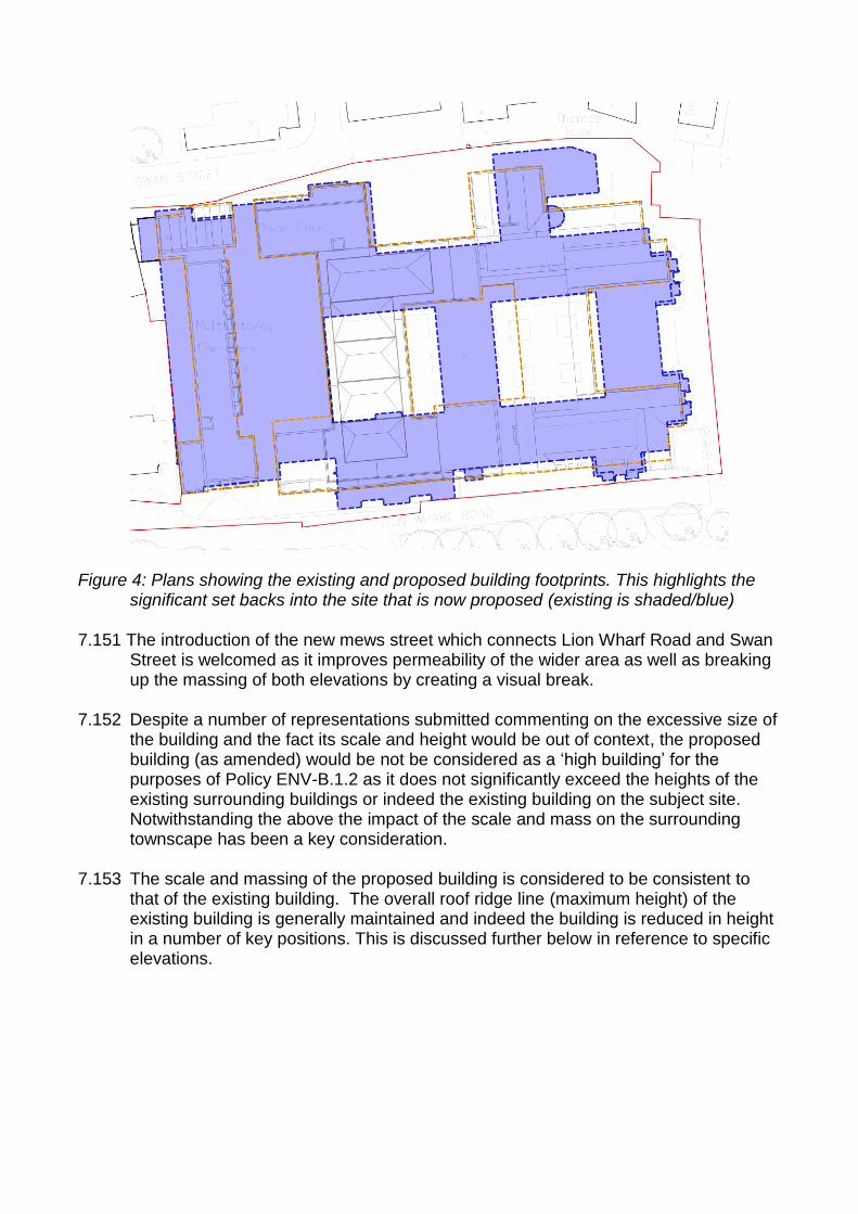
Figure 4: Plans showing the existing and proposed building footprints. This highlights the
significant set backs into the site that is now proposed (existing is shaded/blue) 7.151 The introduction of the new mews street which connects Lion Wharf Road and Swan
Street is welcomed as it improves permeability of the wider area as well as breaking up the massing of both elevations by creating a visual break.
7.152 Despite a number of representations submitted commenting on the excessive size of
the building and the fact its scale and height would be out of context, the proposed building (as amended) would be not be considered as a „high building‟ for the purposes of Policy ENV-B.1.2 as it does not significantly exceed the heights of the existing surrounding buildings or indeed the existing building on the subject site. Notwithstanding the above the impact of the scale and mass on the surrounding townscape has been a key consideration.
7.153 The scale and massing of the proposed building is considered to be consistent to
that of the existing building. The overall roof ridge line (maximum height) of the existing building is generally maintained and indeed the building is reduced in height in a number of key positions. This is discussed further below in reference to specific elevations.
Figure 5 : Proposed Lion Wharf Road elevation – red line depicts outline of existing building.
Figure 6: Proposed Swan Street elevation – red line depicts outline of existing building. 7.150 The GLA have commented that „The massing and architecture of the scheme
presents no strategic concern‟… the size of the footprint and the building height proposed is not too dissimilar to the footprint of the existing offices or the contextual building heights in the area, and as commended before, the design incorporates various area of public space which is supported‟.
7.151 The scale and massing of the proposed building, when taken with the significant
increases in set back of the built form into the site result in a building that is appropriate for the subject site. The heights and mass are broken up with changes in elevational treatment, a variety of building lines and changes in height that create the sense of a collection or family of buildings rather than the one significant mass that characterised the existing building. The design thereby ensures that the elevations are not overbearing and indeed create a sympathetic urban transition with surrounding buildings.
(I) Lion Wharf Road
7.152 Despite being in what could be described as an urban area, Lion Wharf Road has a more domestic feel than that of Swan Street albeit it has an entrance to the existing multi storey car park and receives some traffic servicing the boat uses along the Ait and traffic accessing Heron‟s Place. The character of the road is compromised by the existing building as a result of its lack of active frontages, unrelieved brickwork and the large „black hole‟ opening serving the existing car park.

Figure 7 : Existing and proposed views along Lion Wharf Road 7.153 The development is considered to provide an opportunity to create a more positive
relationship with the Herons Place development to the south, as well as enhancing the character of the road itself. The transition of urban form has been an important consideration.
7.154 The three storey „tower‟ feature at the far west of the elevation has reference to the
existing tower feature in that part of the site, provides a marker that demonstrates the start of the development (assisting legibility) as well as providing interest in elevational treatment. A landscaped area is provided at the base of this part of the development helping to soften what is currently a very hard urban edge.
7.155 The proposed design for this elevation also successfully creates a more domestic
scale along the frontage with duplex apartments with front doors and small areas of soft landscaping. These are an effective treatment to add to the feeling of being with a „street‟ and provides active frontages which help create an impression of a human scale, ensuring the buildings create a positive relationship with street level activity

and people feel comfortable with their surroundings in accordance with London plan Policy 7.4 (Local Character).
7.156 The use of a variety of heights across this elevation, the introduction of two gable
ends, as well as several breaks in the building line all assist in breaking up the massing to ensure an appropriate impact upon the street scene. The set back of fourth floor (by 1.5m) and the removal of the part of the top storey (5th storey) above Block F which fronts onto Lion Wharf Road has further reduced the impression of scale along the street and helps create a suitable transition in urban form with the three storey Herons Place houses to the south.
7.157 The use of timber cladding on the gable on the corner of Lion Warf Road and the
riverfront highlights the corner as a local landmark and punctuates the prominent use of brick. The use of this contrasting material also has resonance with the Ait opposite and the existing tree screen along the south side of the road.
7.158 Overall it is considered that the proposed development would enhance the character
and appearance of the road and provide a more active, domestic edge to the road.
(ii)Swan Street
7.159 The amended plans have resulted in the first, when viewed from the west, gable end building, being set back into the site ensuing a suitable relationship with No.4 Swan Street that does not „cramp‟ the setting of this existing building (the existing substation would remain and separate the new development from No.4). The maintaining of set backs through this elevation is welcomed, as is the retention and enhancement of the space to the south of the Old Blue School, which serves to soften the street through increased soft landscaping and tree planting and also respects the setting of the Listed Old Blue School by keeping the building mass well away from this heritage asset and provides a more attractive setting.
7.160 The proposal would also result in a significant enhancement to the views along Swan
Street (west to east) by setting the proposed north elevation of the building back away from Saracen House, which has created a direct vista and glimpses of the river.
(iii) Thames frontage
7.161 UDP Policy IMP.5.2 (Thames Policy Area) states that LBH will seek to enhance the
status and viability of the River Thames. UDP Policy ENV-W1.1 (Design in the Thames Policy Area) states that development proposals within the Thames Policy Area should respect the design of buildings next to the River, enhance the relationship and setting of the River and wherever possible open up views and create public routes along and across the Thames.
7.162 The site is located within the Hampton to Wandsworth Thames Policy Area and
therefore the Thames Landscape Strategy Guidance is a consideration and London Plan Blue Ribbon Policies are also relevant.

7.163 The Thames Landscape Strategy Guidance for Isleworth notes that (10.3G) the aspiration is „Retain the domestic scale of buildings on the Middlesex bank, with particular concern for the Isleworth skyline. As redevelopment opportunities arise, high buildings should be replaced with lower structures which complement the surrounding town and landscape.‟
7.164 The proposed Thames elevation has been amended to create a more sensitive
impression upon the River and riverwalk. This has included the gables being reduced from five storeys to four storeys and the central part of the elevation being reduced so that it is now lower than the exiting building ridge. The proposed elevation when read in conjunction with the proposed building footprint, that includes significant set backs away from the River when compared with the existing building, result in an elevation that complements the town and landscape and creates a more sensitive urban face to the river than the existing situation.
7.165 It is further considered that in comparative terms, due to the aforementioned set
backs and changes in height that, despite the top of the gables projecting beyond the height of the existing building in certain part of the frontage, the overall impression of scale and mass is actually reduced.
Figure 8: This shows the amended river elevation and shows that whilst the three projecting gables are higher than the existing building at certain parts of the site the overall elevation is also lower in several places
Figure 9: This image shows the significant set backs from the river now proposed when compared with the existing building on the site. The existing footprint is shaded.
7.166 It is considered that the proposed development would create an improved
relationship with the river by replacing an existing building that is dated and characterised by a design that has no resonance with the water, with a building that that has an architectural typology that is inspired by and associated with the water and water relate industry.
7.167 This „warehouse/wharf‟ typology directly relates to the river setting and demonstrates
a development inspired by its context (in accordance with Thames Landscape Guidance LC:6).
7.168 As a result of set backs proposed along Swan Street the development would open
up the river from the west. The proposed set back in the centre of the Thames

elevation to provide an amenity area further reduces the impression of mass on the river and also enhances the quality of the river walk as well as encouraging uses and activity around the blue ribbon network. The „C shape block layout to the riverfront maximizes river views and increases sunlight penetration as well as serving to set the building back into the site and ensuring that the building does not have an overbearing impact upon the riverwalk/river.
Figure 10: Existing and proposed Thames elevation 7.169 The proposed elevation with the variety in the building lines and the central set back
section has a far greater degree of modelling than the existing building elevation. The projecting gables create a far more interesting elevation than the existing building and animate and punctuate the skyline to enhance the views of the site to the benefit of the charter and appearance of surrounding area.
7.170 The proposal would result in an improved river elevation, creating a building with an
appropriate scale to the riverside setting with set backs that ensure it would not result in an overbearing addition and would be more in keeping with the riverside context than the existing building.
7.171 The proposal would maintain and improve access to the exiting slipway, would
enhance the river walk (both in terms of area and quality through increased landscaping and natural surveillance. The increase in the soft landscaping and planting adjacent to the river would also have the potential to increase the habitat

and biodiversity value of the Thames embankment in accordance with London plan Policy 7.28 (Restoration of the Blue Ribbon network) and the proposals also encourage activity along the river frontage both in respect of the enhanced riverwalk but also with added natural surveillance from the proposed residential units and the commercial elements at either corner.
7.172 The Thames elevation proposals are therefore considered to be in accordance with
the intent of the Thames Landscape strategy and London Plan design and blue ribbon polices including policy 7.27(Blue ribbon network: supporting infrastructure and recreational use).
Heritage and Conservation
7.173 The NPPF states that local authorities should conserve heritage assets in accordance with their significance. Paragraph 128 of the NPPF requires, where relevant, an assessment of the impact of a development on the significance of the setting of any heritage asset.
7.174 London Plan Policy 7.8 (Heritage Assets and Archaeology) states that development
affecting heritage assets and their settings should conserve their significance, by being sympathetic to their form, scale, materials and architectural detail.
7.175 UDP Policy ENV-B.2.2 (Conservation Areas) states that development should
preserve and/or enhance the character or appearance of existing (and proposed) Conservation Areas. The Conservation Area appraisal notes that pressures on the area include „the scale of proposed development, which even at a long distance can affect vistas and settings, by the Thames and the effect of higher-density residential and tall buildings of alien bulk and mass on existing character of small scale buildings and small-grain layouts‟. It also highlights a guiding principle noting that the riverside setting is picturesque – whether currently hard or soft edged – new development and extensions should respect this scale and character‟.
7.176 The applicant has noted that „The scheme has been designed carefully with
appropriate heights, massing and architectural detailing reflective of the context, to minimise impact on the nearby listed buildings, in particular Old Blue School and the WHS. Visuals contained in the design and access statement demonstrate that there would be minimal, if any, impact on the setting of the World Heritage Site at Kew Gardens‟.
7.177 In respect of Kew, when noting the significant separation distances involved, the fact
that the site is shielded in part by the Isleworth Ait and the fact that the height and scale of the proposed building when compared to the existing building is comparable, that the proposed development would not result in any harmful impact upon the setting of, or views from, the World Heritage site nor would it harm the Old Deer Park to the east.
7.178 It should be noted that whilst the easternmost part of the site is within the WHS
buffer zone, this only relates to the riverwalk area and no building are proposed within this WHS buffer zone. This view is agreed with English Heritage who have noted that there would be „No additional impact upon the setting of the Grade I

Registered Landscape of The Old Deer Park, across the Thames in the LB of Richmond‟
7.179 The impact of the development upon the setting of the Grade II Listed Old Blue
School has also been carefully considered. Currently the existing development can, at best, be said to have a neutral impact upon the setting of the building. Its dark mass of brickwork creates a contrast against which the Old Blue School is set when viewed from Lower Square, however the white panels and blue window detailing is considered to detract from its setting and the two existing projecting turret features detract from the prominence of the clock tower and disrupt the silhouette of the roof castellation. The proposed development has been designed to reduce the height against the back drop of the Old Blue School compared to the ridge line of the existing building, removes the distracting and incongruous turret features and comprises of brickwork that would be sympathetic to the Old Blue Schools exterior treatment. As result it is considered that the proposed development results in a positive impact upon its setting. An amended comparison image has been submitted to demonstrate this following concerns raised at the Local meeting..
7.180 In respect of wider river views the position of the Ait means the site is only be readily
visible from the north (albeit it would be visible from the Heron Place riverwalk), specifically from All Saints Church and from the riverbank, with most river traffic on the other side of the Ait. As previously discussed the proposed development would result in an appropriate high quality addition to the townscape. The GLA have noted that „The proposed scheme is high quality and will contribute more greatly to the character of the conservation area‟.
7.181 Overall in respect of the Conservation Area it is considered, as described in the
sections above, that the proposed development would, by replacing a building that fails to contribute to the value of the Conservation Area with a building of comparable scale but with a inspired and sensitive to the site context, enhance the character and appearance of the Conservation Area in accordance with policy ENV-B.2.2 of Unitary Development Plan.
Conclusion 7.182 It is considered that the development offers the opportunity to enhance the character
and appearance of the Conservation Area, by replacing an dated, unattractive existing building and providing a high quality development that has architectural integrity and a resonance with the site context, which would create a sense of place, improve connectivity within the area, provide high quality public and private spaces and result in a highly sustainable development.
6. Impacts on neighbours 7.183 The NPPF requires sustainable development, and as part of this development
should aim to minimise adverse effects on the local environment, which includes neighbouring properties.
7.184 UDP policy ENV-B.1.1 (New Development) states that new development
should "ensure adequate daylight and sunlight reaches properties, and
minimise any detrimental impact on adjoining properties, by applying the Council's adopted standards (see SPG)".
7.185 It should be noted that the proposed development replaces an existing building on site and is comparable in terms of size and scale.
7.186 The proposed development has been designed to ensure that it minimises its impact on surrounding residential properties. Indeed a number of amendments have been made both during the pre-application stage and during the application to ensure any impact is acceptable. The heights and massing of the proposed building have been reduced in certain places to ensure an acceptable impact upon neighbours‟ living conditions. Indeed the proposed building would be generally set further away from boundaries with neighbouring properties than the existing building line.
7.187 Whilst the impact upon privacy, daylight/sunlight and noise is discussed below, it is
noted that the development results in a number of other benefits for immediate neighbours:
Improved permeability from north to south through the proposed mews street linking Lion Wharf Road with Swan Street and Church Street beyond.
Improved pavements/pedestrian realm along the northern elevation of Lion Wharf Road.
Improved safety and security in the area when compared with a predominately vacant building that may fall into disrepair.
Natural surveillance of the river end of Lion Wharf Road, assisting in safety and security.
Enhanced public realm and amenity along the riverwalk and at the space to the south of the Old Blue School
Additional commercial use
(i) Outlook and privacy
7.188 In respect of outlook it is considered that by replacing an unattractive, dated building
with a high quality mixed use development with significantly more visual interest that where views of the site from neighbouring properties are apparent these would be enhanced. This is especially true of properties to the east of the site where the proposed east elevation of the mews houses would replace an unattractive and dominant multi-storey car park elevation.
7.189 UDP Policy H.4.1 requires proposals to, amongst other things, have regard
to standards and guidelines for privacy and spacing between buildings. These are set out at Appendix 1 of the UDP, which recommends a distance of 21m between habitable room windows that directly face one another.
7.190 The Mayors‟ Housing SPG notes that design proposals should demonstrate how habitable rooms within each dwelling are provided with an adequate level of privacy in relation to neighbouring property, the street and other public spaces.
7.191 It goes on to note that in the past, planning guidance for privacy has been concerned with achieving visual separation between dwellings by setting a minimum distance of 18 – 21m between facing homes (between habitable room and habitable room as opposed to between balconies or terraces or between habitable rooms and balconies/terraces). These can still be useful yardsticks for visual privacy, but adhering rigidly to these measures can limit the variety of urban spaces and housing types in the city, and can sometimes unnecessarily restrict density
7.192 It is considered that there would be no unacceptable overlooking of habitable rooms
or gardens within Herons Place, as a result of the significant separation distances achieving the more onerous 21m UDP SPG requirement (exception being the distance to the flank window of No.1 which serves a stairwell and achieves 20.03m). In addition it should be noted that the closest Herons Place houses are orientated east - west rather than having their main rooms looking towards the subject site (north). The Herons Place properties also benefit from significant tree screening along the boundary along Lion Wharf Road.
Figure 11: Diagram showing separation distances between site and Herons Place
7.193 Notwithstanding the above, the elevation facing Lion Wharf Road has been designed to further reduce any perception of overlooking by setting the fourth storey back from the front building line (by 1.5m – see amended plans) and by introducing internal/enclosed balconies where possible. In addition the building is generally set back from the footway when compared to the existing building.
7.194 It is not considered that the proposed development would result in any loss of privacy to adjoining properties to the west. The existing sub station would remain ensuring a degree of separation between the proposed building and No.4 Swan Street. The proposed habitable rooms within the west elevation of the proposed development would face onto the courtyard parking area and would not result in any habitable room to habitable room overlooking. Where views of the western boundary of the set are apparent the proposed building would be further set into the site and
would provide a higher quality outlook when compared with the existing multi storey car park elevation.
7.195 In respect of No.2 Richmond Road, which bounds the site to the west along Lion Wharf Road this is currently in office use and therefore there would be no impact upon habitable rooms. In any case the proposed tower element adjacent to this property would generally maintain the front building line of the existing building ensuring no greater impact would result.
7.196 The proposed north elevation would be set further in from the south elevation of Osprey House than the existing building ensuing no harm to neighbours‟ living conditions would result. (ii) Daylight and sunlight
7.197 Policy ENV-B.1.1 of the UDP says new development should ensure adequate daylight and sunlight reaches adjoining properties
7.198 An assessment has been undertaken in accordance with the BRE Guidance „Site
Layout Planning for Daylight and Sunlight: A Guide to Good Practice‟ 2011. Failure does not necessarily mean the impact would be unacceptable and the BRE requirements are advisory, and as they are used for urban and suburban areas they should be applied flexibly to take account of varying densities.
Sunlight 7.199 The guidelines require that all windows within 90 degrees of due south be
considered. It states that if the window achieves 25% of Annual Probable Sunlight Hours (APSH), including at least 5% of annual probable sunlight hours during the winter months or more than 0.8 times its existing value, the implementation of the proposals should not have an adverse effect on sunlight. The guidelines however also state that sunlight is less important in relation to bedrooms. It should be noted that the development is positioned directly to the North of the Herons Place development and therefore would have no impact upon sunlight at those neighbouring properties.
7.200 Rooms within Osprey House (to the north) and the Swan Pub and 2-4 Swan Street would all achieve the required annual probable sunlight hours. Daylight
7.201 The BRE Guidelines state that if the VSC calculated at the centre of each window is 27% or more, then enough light should be reaching the window. If with the new development in place the window does not achieve 27% VSC but is more than 0.8 times it former value then the guidelines state that skylight is unlikely to be seriously affected.
7.202 The impact upon Osprey House, the Swan Pub, Nos.2-4 Swan Street and Nos.1, 2, 12 Herons place all satisfy the BRE test in respect of daylight and any reduction would indiscernible.
7.203 It is therefore considered that the proposed development would have an acceptable impact upon daylight and sunlight levels at neighbouring properties. (iii) Noise and other disturbance
7.204 UDP Policy ENV-P.1.5 (Noise pollution), which states that the Council will not allow any development proposals that could result in unacceptable levels of noise nuisance to nearby existing or future occupiers. The stated reason for the policy is to protect the amenity of adjacent occupiers, the aim being to reduce as far as practicable noise from all sources.
7.205 Although most neighbouring properties are separated from the site by roads, there is
still likely to be some disturbance from construction activity. The relative limited scale of the development would mean that the proposal if implemented is not likely to consist of multiple phases and therefore disruption should only be for a limited period.
7.206 Notwithstanding the above, the applicant would be required as part of the s106 to
enter into a Considerate Contractor scheme which when taken with safeguarding conditions controlling hours of construction and requiring the implementation of a Construction Environmental Management Plan (measures to limit noise and dust as well managing the delivery and servicing of construction vehicles) ensures any disturbance to neighbours during the construction period would be minimised and is acceptable.
(iv) Conclusion
7.207 Subject to safeguarding conditions the proposed development, which replaces an existing building of comparable scale, would as a result of its appropriate design, layout and nature not result in any harmful impact upon neighbours‟ living conditions.
7 Traffic and Parking Transport Assessment
7.208 The NPPF includes a core principle on the need to actively manage patterns of
growth to make the fullest possible use of public transport, walking and cycling, and focus significant development in locations that can be made sustainable. It requires all developments that would generate significant levels of movement to be supported by a Transport Assessment and says that development should only be prevented or refused on transport grounds where the residual cumulative impacts of development are severe.
7.209 Paragraph 32 of the NPPF states that „all developments that generate significant
amounts of movement should be supported by a Transport Statement or Transport Assessment. Plans and decisions should take account of whether: • the opportunities for sustainable transport modes have been taken up
depending on the nature and location of the site, to reduce the need for major transport infrastructure;

• safe and suitable access to the site can be achieved for all people; and
• improvements can be undertaken within the transport network that cost effectively limit the significant impacts of the development. Development should only be prevented or refused on transport grounds where the residual cumulative impacts of development are severe.
7.210 The application is supported by a Transport Assessment (including addendum).
The Council has engaged external Transport Consultants to review the submitted Transport Assessment and the submission has also been reviewed by Council Traffic Officers and Transport for London.
(i)Trip generation, junction modelling and public transport 7.211 The Transport Assessment compares the existing trip generation to the site with the
proposed trip generation once the development is completed.
Figure *: Trip generation existing and proposed
7.212 This assessment highlights that the proposed development would result in less trips
to and from the site during peak hours when compared with the existing development. Specifically based on this analysis it is apparent that the proposed redevelopment would result in a net decrease of 2 and 9 vehicle trips to and from the site during the weekday morning and evening peak hours respectively compared to the existing site use, if fully occupied. Overall there would be a decrease of 4 person trips to and from the site during the morning peak hour and 11 person trips during the evening peak hour.
7.213 The trip generation assessment is based on the existing offices being fully occupied,
which could be the case without further planning permission being required and the reason for the reduction in trips is the overall reduction in parking at the site and when noting that office use (existing) is a high trip generating use. There is nothing to prevent the building from being fully occupied and therefore, in accordance with the Department for Transport‟s (DfT) document Guidance on Transport Assessment, the person trips which might realistically be generated by any extant planning permission or permitted uses have been calculated. The development therefore is shown to be acceptable in terms of impact upon the local highway network and is in accordance with planning policy.
7.214 Notwithstanding the above, it is noted that the existing building is approximately 25% occupied and subsequently officers requested a further, worst case, assessment of the existing trip generation based on this occupancy. This was completed and showed a limited increase in trips during the peak hours, albeit it the levels would not result in an unacceptable impact upon the function of the adjacent junction. This

conclusion has been fully reviewed and agreed with the Council‟s External Traffic Consultants.
The trip generation assessment is used to model the potential impacts upon the
capacity and operation of local junctions if the development was approved. The modelling assessment makes no adjustment for the existing traffic entering / exiting the site, rather the proposed traffic associated with the new residential development has been added to the existing flows. The modelling also includes traffic generated by committed developments including the extant permission at the Nazareth house site. This presents a worst case scenario as no discount has been made for the existing commercial element potentially operating at full capacity.
The modelling results on the adjacent roundabout show that there is spare capacity in both the AM and PM peaks. The junction continues to operate within capacity even with the proposed and committed development in place.
7.215 Concerns raised in representations from neighbouring residents that the surrounding
roads, including Lion Wharf Road, would not be able to cope with the increase in traffic generated by the proposed 139 units is therefore considered to be not supported by evidence. Indeed these views do not take account of the fact that the development replaces an existing high trip generating development or the fact that less car parking overall is proposed, which again would reduce the potential impact upon surrounding road network.
7.216 The Transport Assessment also notes that the development would not result in the
H37 reaching planned capacity within peak hours. Transport for London have confirmed they are satisfied that the development would have an acceptable impact upon the H37 bus capacity. Notwithstanding the above, in accordance with the SPD Planning Obligations a contribution to bus services / infrastructure within the immediate area has been secured as part of a s106 agreement.
7.217 A number of representations received raised the concern that the development
would result in additional „rat running‟ along North Street and Church Street. The wider issue of „rat running‟ to avoid delays on Twickenham Road is being addressed with junction and highway improvements at Twickenham Road and traffic calming measures along Church Street.
7.218 In terms of the subject application‟s implication on this wider issue and
notwithstanding the conclusion of the Transport Assessment (which would mean there would be less trips generated by the proposed development compared with the existing use and ergo there would be less potential for „rat running‟), the Transport Assessment includes a survey of vehicle movement behaviours (using Heron's Place as a proxy for a residential development which may have similar travel behaviour to that of the Site). The surveys were recorded using ANPR cameras (automatic Number Plate Recognition) at set points on the road network. The results showed that of the 31 vehicles that left Heron's Place on the morning of 10th July 2013, none went via Manor House Way or Church Street. Whilst not infallible, this would suggest that the residents of the proposed development are in any case unlikely to rat run.

7.219 Again notwithstanding the „rat running‟ survey within the Transport Assessment it is not considered, based on the proposed trip generation, when compared with the existing use of the site as offices, that the development would result in any additional unacceptable pressure on Church Street, North Street or Manor House Way.
Parking and access 7.220 London Plan Policy 6.13 (Parking) states that the Mayor wishes to see an
appropriate balance being struck between promoting new development and preventing excessive car parking provision that can undermine cycling, walking and public transport use. Based upon this maximum parking standards are provided.
7.221 Developments must provide parking and servicing facilities in accordance with the
Council's standards under UDP Policy T.1.4 (Car and cycle parking and servicing facilities for developments).The Council's parking standards state that they are regarded as maximum standards and that reduction can be considered dependent on the level of public transport accessibility.
7.222 The site has a PTAL level of 2 (poor) with the main connection being the H37 bus which connects Hounslow, Isleworth and Richmond. It is noted that the site is in close proximity to services within the minor neighbourhood centre of South Street. A parking provision towards the maximum standards would be considered appropriate in this case.
7.223 The existing multi storey car park, accessed from both Swan Street and Lion Wharf
Road, would be demolished as part of the proposals (a loss of 285 spaces) as well as a number of off street spaces (18 spaces). The proposal would result in a total parking provision at the site of 223 (a reduction of three spaces as a result of the amended plans – reduced in respect to the GLA/TfL concerns that excessive parking was being proposed).
7.224 The proposed site would have three areas of parking provision, a basement car park,
a ground floor car park in the centre of the site and internal garages for a number of the Townhouses. The access to these parking areas has been split across both Lion Wharf Road (basement car park) and Swan Street (for ground floor car park and mews houses parking) to ensure that the individual roads can operate successfully. In addition the Lion Wharf Road basement car park access has been repositioned during the pre-application stage to avoid conflict with the vehicular access to Herons Place.
7.225 The final allocation of commercial and pay-and-display spaces within the ground
floor car park (total of 46) are not known at this stage (dependent on final uses provided in the commercial units) and the parking provision would be allocated as part of a Car Park Management Plan agreed with officers and secured within the s106 prior to any use commencing. The quantum of commercial parking is considered acceptable in that it would support the commercial space on site, as well as providing visitor spaces to benefit the wider area and replace some of the lost spaces in the, to be demolished, multi storey car park.

7.226 The number of residential car parking spaces proposed is 168, which equates to
approximately 1.2 spaces per residential unit. This is just short of the maximum level of car parking standards that the Council allows for new residential developments. In addition to this, nine car parking spaces have been re-provided for the Old Blue School Building. Disabled parking is provided in accordance with policy standards. The scheme also intends to deliver 20% electrical charging points, with a further 20% passive provision, which is welcomed (secured by condition).
7.227 It should be noted that a number of representations from neighbours have cited
concern that insufficient parking is provided for the 139 proposed units. However the GLA and TfL take the opposing view stating that the amount of residential parking proposed is excessive noting that the census data for Isleworth ward shows that the car ownership in the area is less than one per dwelling. Therefore TfL believe the car parking provision can still be further reduced to 128 for the residential component (168 proposed) and it is further noting that the provision is excessive in respect of the London Plan standards.
7.228 However, officers consider the proposed provision is appropriate in this context, this
is taking account of local circumstances the fact that there is an overall reduction in parking provision at the site and the sites relatively low PTAL score and note that the provision is within the Council‟s Maximum parking standards, albeit at the higher end of this range. The parking levels proposed are considered to create an appropriate balance between promoting new development and satisfying the principles of planning policies to reduce reliance on vehicle trips and encourage more sustainable modes of transport. These sustainable measures are embodied by the development proposals and it is considered that through measures such as travel planning, the provision of significant cycle parking and the provision of car club spaces that the proposed development would be acceptable.
7.229 As noted above it is considered that the residential parking provision is acceptable
and indeed any increase in parking, over the Council‟s maximum standards, could not be justified in policy terms and would be unsustainable. With the parking levels provided and the measures to encourage more sustainable modes of transport secured within a s106 it is not considered that the development would result in any unacceptable overspill parking on local streets.
7.230 The Transport Assessment, at the request of officers, includes a parking beat of the
immediate area. This concludes that „across the whole of the surveyed area, some 367 spaces are available. Of this total, a maximum of 133 spaces (36%) were available between the hours of 1700-1800 falling to a minimum available provision of 60 spaces (16%) between the hours of 1400-1500. An average of 109 spaces were available throughout the day indicating that sufficient on street parking is currently provided in this area to accommodate demand although during peak periods, there is limited spare capacity. The use of existing on street parking has been taken into account when determining the appropriate level of car parking for the development‟.
7.231 As a further safeguarding measure it is proposed that the s106 contains obligations
upon the applicant to undertake parking beat surveys at an annual period post completion, which if demonstrating parking levels increase to an agreed threshold,

would trigger the funding for consultation, on and subsequently implementation of a local Controlled Parking Zone (CPZ) in the area. The s106 would also restrict any future resident of the development from obtaining a parking permit. This would further ensure that the development would have no unacceptable impact upon local parking conditions.
7.232 Cycle parking would be provided in accordance with London Plan standards. With
155 for the residential units (meeting the London Plan 1 cycle space for 1 and 2 bedroom units and 2 space for 3+ bed units), 4 residential visitor cycle spaces (based on the London Plan 1 space per 40 homes); and the remaining 39 cycle spaces for the commercial/public use units. The residential spaces would be secured within the basement and the commercial space would be secured within the ground floor car park with additional spaces (Sheffield stand) within the square to the south of the Old Blue school.
7.233 In addition to the measures noted above (Travel Plan, CPZ etc) the s106 would also secure a 278 agreement in respect of installing double yellow lines along the northern side of Lion Wharf Road (and 12m along the south side) and appropriate „no through route‟ signage to ensure that the subject site and the boat yard can be serviced satisfactorily. The s106 would also, in line with the SPD Planning Obligation include a contribution of £189,547, which would be spent on improvements to local bus stops and highway improvements within the vicinity of the development (this amount would include funding of the CPZ).
Conclusion
7.234 Overall it is considered that the proposed development is acceptable in transport and
traffic terms. It has been demonstrated that the development, even in a worst case scenario would not harm the operation of the closest junction or result in a significant increase in trips to the site (including when taking account of the extant permission at the Nazareth House site). The parking provision is considered appropriate and with safeguarding measures would not result in a harmful impact upon local parking conditions. Therefore the residual cumulative impacts of development are not severe and in accordance with the NPPF the development is acceptable.
8 Energy and sustainability 7.235 As a large development, the proposal can make a substantial contribution to
sustainable development in the Borough and it is important that it recognises and adopts sustainable development principles. The proposal constitutes the redevelopment of a brownfield site in accordance with sustainable development principles.
7.236 Sustainability underpins many policies of the UDP and the London Plan. These require developments to be sustainable in transport terms, to minimise waste, include energy efficiency measures and promote the use of renewable energy, and not significantly increase the requirement for water supply or surface water drainage.
7.237 London Plan policy 5.2 sets out a minimum target reduction for carbon dioxide emissions in buildings of 25% over the Target Emission Rates outlined in the national Building Regulations (this will rise to 40% for applications received after October 1st, 2013). The emissions reduction target should be achieved in accordance with the “be lean, be clean, be green” hierarchy:
Be Lean: The reduction of energy demand and CO2 emissions from using less energy, in particular by adopting sustainable and passive design and construction measures;
Be Clean: Proposals for the reduction of energy demand and CO2 emissions through supplying energy efficiently;
Be Green: Renewable energy technologies to be incorporated. 7.238 The proposed development is supported by Energy and Sustainability Assessments.
The energy statement has been submitted which outlines a combination of „lean‟, „clean‟ and „green‟ measures to reduce Co2 emissions.
7.239 In respect of being „Lean‟ energy efficiency is prioritised through the use of an enhanced fabric specification and efficient gas boilers, resulting in a 12% CO2 reduction over Part L (2010) Building Regulations. Air source heat pumps will be installed within the commercial spaces only in order to meet the small space heating demand. This system is considered most efficient and practical.
7.240 In respect of being „Green‟ 681m2 of Photovoltarics would be installed on the roof of the development PVs could contribute 41 tonnes/annum to the reduction of site CO2 emissions This is equivalent to further 23% reduction in scheme regulated CO2.
7.241 There are no district heating networks nearby and unlikely to be in the future given the low density characteristics of the surrounding area. Therefore the applicant is not proposing a site wide network, which is acceptable. Combined heat and power is also not proposed, given the intermittent heat load, which is accepted in this instance.
7.242 Including the reductions from energy efficiency measures, the proposed amount of PV and the use of air source heat pumps for the commercial units, this results in a reduction of 32% compared to a 2010 Building Regulations compliant development. This falls short of the London Plan CO2 reduction target, hence the applicant is proposing to make a £745 cash in lieu contribution relating to shortfall. Assuming 30 years, the cash in-lieu contribution equates to £22,350 (£745 x 30) and this is the amount that is to be provided and has been agreed by the applicant and the GLA. The contribution would be secured within the s106 agreement. Sustainable Design and construction
7.243 London Plan policy 5.3 relates to sustainable design and construction and states the following:
'A – The highest standards of sustainable design and construction should be achieved in London to improve the environmental performance of new developments and to adapt to the effects of climate change over their lifetime.

B - Development proposals should demonstrate that sustainable design standards are integral to the proposal, including its construction and operation, and ensure that they are considered at the beginning of the design process.
C - Major development proposals should meet the minimum standards outlined in the Mayor's supplementary planning guidance and this should be demonstrated within a design and access statement. The standards include measures to achieve other policies in this Plan and the following sustainable design principles:
a minimising carbon dioxide emissions across the site, including the building and services (such as heating and cooling systems) b avoiding internal overheating and contributing to the urban heat island effect c efficient use of natural resources (including water), including making the most of natural systems both within and around the buildings d minimising pollution (including noise, air and urban run-off) e minimising the generation of waste and maximising reuse or recycling; f avoiding impacts from natural hazards (including flooding).‟
7.244 The Mayors Housing SPG states that it is good practice for designers to achieve a
minimum of Level 4 of the Code for Sustainable Homes in all new developments.
7.245 The Supporting sustainability report notes that „through the incorporation of sustainable design and construction methods, energy, water and waste saving measures, as well as open/green space provision and measures to enhance the ecological value of the site, the proposed development is considered high quality and sustainable‟.
7.246 The key sustainability features proposed as part of the development include:
The proposed development will benefit from excellent levels of energy efficiency, with „Be Lean‟ measures improving over Part L 2010 baseline by 14% for the residential dwellings and 7% for the non-residential;
100% of the proposed development is on previously developed land;
Water efficiency measures and devices will be installed in the homes to achieve a maximum daily water usage of 105 litres/person/day;
Surface water run-off will be reduced from existing levels in accordance the Code for Sustainable Homes mandatory requirements;
Where practical, building materials will be sourced locally to reduce transportation pollution and support the local economy. All timber will be purchased from responsible forest sources. Materials will be selected based on their environmental impact, with preference given to high rated materials from the BRE Green Guide to Specification where possible;
7.247 The sustainability and energy strategies would result in all proposed homes
achieving a Code for Sustainable Homes rating of Level 4 and all new build commercial spaces achieving BREEAM „Very Good‟. The implementation of the strategies would be secured by safeguarding condition.
7.248 The proposals have been assessed by the GLA and the Council‟s Sustainability
Consultants and it is considered that the proposal is acceptable and is compliant with

Policy, ensuing that the development has adopted sustainability principles and makes a significant contribution to sustainable development within the borough.
9 Equalities and Accessibility
Equalities
7.249 In response to its Equalities Duties and the Equality Act 2010, following a relevance test, available at:: http://www.hounslow.gov.uk/index/council_and_democracy/equality/eias/en vironment_eias.htm
Relevant Section of Relevance Test
Major development
Accessibility
7.250 London Plan policy 7.2 requires all new development in London to achieve the highest standards of accessible and inclusive design. Other polices including those on housing design (3.5), housing choice (3.8), visitor infrastructure (4.5), and neighbourhoods (7.1) include requirements for the proposed uses within the development, as well as the design of the public realm, car parking facilities, and pedestrian environment. In particular the requirements for this development are:
7.251 All residential units will be designed to be Lifetime Homes compliant and that 10%
(14 units) would be wheelchair accessible or easily adaptable homes. Typical flat layouts and plans of the wheelchair accessible homes and a Lifetime Homes statement have been included to illustrate these features (including potential for stair lift, width of corridors and lift specification. The location of the wheelchair accessible/adaptable units have been indicated on the plan, and the fact that they are fairly dispersed around the eastern section of the building, and not clustered together around one core is welcomed. A safeguarding condition would secure this.
7.252 As noted above in the Traffic and Parking section adequate provision of disabled parking is proposed in both the residential and commercial car parks.
7.253 Safeguarding condition would require further details of disabled access through the site would be secured by condition. Therefore it is considered that the proposal satisfies the requirements of London Plan Policy 7.2.
8.0 Planning Obligations 8.1 A planning obligation may be required to control the impact of a development
particularly in circumstances where the desired restrictions go beyond the scope of planning conditions. In accordance with section 106 of the Town and Country Planning Act 1990, the local authority will enter into a legal agreement with the applicant (including anyone else who has a legal interest in the land) to secure planning obligations.

8.2 Paragraph 203 of the NPPF says local planning authorities should consider whether otherwise unacceptable development could be made acceptable through the use of conditions or planning obligations. Planning obligations should only be used where it is not possible to address unacceptable impacts through a planning condition. Whilst paragraph 204 says obligations should only be sought where they meet all of the following tests:
necessary to make the development acceptable in planning terms directly related to the development; and fairly and reasonably related in scale and kind to the development.
8.3 Planning obligations can include financial obligations requiring monetary contributions to the local authority to fund works or services as well as in-kind obligations requiring specific actions to be performed by specific parties.
8.4 Hounslow‟s Planning Obligations Supplementary Planning Document (SPD) sets out in principle what kinds of planning applications will require planning obligations and in broad terms how monies will be spent on projects related to the proposed development.
8.5 The SPD says the Council recognises that in specific instances planning obligations may be a significant factor that affects development viability. In this regard it is recognised that there may be circumstances where a developer may consider that it is not feasible for the proposed development to meet all the requirements set out in local, regional and national planning policies and still be economically viable (for example, where development specific costs are exceptionally high). The onus will be on the developer to provide information regarding the viability of the scheme. In these circumstances, the Council will review the range and nature of obligations
8.6 The following sections discuss the need for planning obligations arising from the development and its impacts.
(i) Affordable Housing - Secure the 20% on site provision (plus review mechanism to
capture any uplift in values) (ii) Highways/Transport - Financial contributions towards public transport and local
highway improvements including CPZ – £189,547. Plus 278 agreement in respect of traffic order relating to Lion Wharf Road – insertion of yellow lines)
(iii) Amenity Space - Provision of amenity space, including children‟s play space and
private amenity space is important in achieving good quality housing, whilst wider recreational needs are met by larger areas of open space for which new housing can add to demand for. The proposed development only partly meets the UDP private amenity space standard albeit meets the more recent London plan requirements. Using the SPD formulae for private amenity space shortfall, play space, and open space, a contribution of £43,200 could be required.
(iv) Education - Contribution to local education provision - £189,547 (v) Employment and Construction Training

A key aim of sustainability is to maintain economic growth. Employment and training contributes towards this aim, and jobs and skills for local people can reduce the need to travel. The SPD seeks obligations for strategies in respect of training during construction activity as well as job brokerage, the latter looking to secure local people employment. The proposed development would displace some existing jobs, but overall it would result in a potential 14-75 jobs being created. The applicant has agreed that construction training opportunities would be provided by the development contractor for the duration of the works and additional funding of job brokerage of £110,00.
(Vi) Community Use – Commercial unit in south west corner of site to be marketed for a
community use/water related use with a peppercorn rent for three years (definition of appropriate uses to be defined).
(Vii) Riverwalk – To maintain and keep open for public access the enhanced riverside walk
(Viii) Decorative Lion Mooring posts – To retain these decorative features and to reuse
them as part of the development. (ix) Considerate Contractors Scheme -Owing to the scale of the development the
developer should register with the Considerate Contractors Scheme. This will ensure the site activity is monitored by an experienced industry professional to assess their performance against the eight point Code of Considerate Practice which includes the categories Considerate, Environment, Cleanliness, Good Neighbour, Respectful, Safe, Responsible and Accountability.
(xii) Carbon offset - This is required to offset the shortfall in recommended CO2
emissions relating to the development and has been agreed with the GLA - £22,350 (Xiii) Travel Plan – Measures to encourage more sustainable modes of transport and
reduce reliance on private vehicles including the provision of a car club 8.7 The table below summarises the contributions discussed above.
Obligation SPD formula/ criteria Required/
Recommended Proposed
Affordable housing
41% of dwellings, subject to viability
(60% rented tenure 40% shared ownership)
Yes
20% on site provision based on scheme
viability.
Deferred contribution should viability
improve.
Transport/Highways
£189,547
Travel Plan (TP) Yes
CPZ
Highway improvements
Bus improvements
Travel Plan
No parking permits for

residents
Public realm
Preferable that large schemes make direct improvements to the
public
Yes, direct improvements
Direct improvements comprising enhanced riverside walk, new
Mews Street, enhanced square to the south of the Old
Blue School
Amenity/ Open Space
£43,200 as UDP standard part met.
Yes. Towards
enhancement of Isleworth Green
Education
£318,253,95 for primary and
secondary school places
£318,253,95 for primary and
secondary school places
Agreed
Employment & Training
Construction training & job brokerage
Yes Construction company
to provide training strategy.
Considerate contractors
scheme N/A Yes Agreed.
Carbon offset N/A £22,350 Contribution to be
used locally
Riverwalk N/A Yes To remain publically
accessible.
Decorative Lion mooring posts
N/A Yes To be retained within
the development
Community use N/A Yes
Use of commercial unit adjacent to the
Thames to be marketed for range of community/river relate uses and peppercorn
rent/or in lieu payment.
9.0 COMMUNITY INFRASTRUCTURE LEVY
9.1 Some new developments granted planning permission on or after 1st April 2012 will be liable to pay Community Infrastructure Levy (CIL) to the Mayor of London with respect to the funding of Crossrail. This is at the rate of £35 per m2 of new floor space where the net floor area increase exceeds 100 m2, or where a new unit is created.
9.2 This proposal is liable to pay CIL. Based on the net increase in floor area this is

estimated as being £273,910 (NB/ This does not include any affordable housing relief that the applicant may claim).
10.0 RECOMMENDATION
Approval 1 That planning permission be granted subject to the following conditions and securing the abovementioned planning obligations by the prior completion of a satisfactory legal agreement or unilateral undertaking made under Section 106 of the Town and Country Planning Act 1990 and or other appropriate legislation, the exact terms of which shall be negotiated by appropriate officers within the Department of Regeneration, Economic Development and Environment on the advice of the Assistant Director Corporate Governance. 2 The satisfactory legal agreement or unilateral undertaking outlined above shall be completed and planning permission issued by 26/8/14 or such extended period as may be agreed in writing by appropriate officers within the Department of Regeneration, Economic Development and Environment or within Legal Services. 3 If the legal agreement or unilateral undertaking is not completed by the date specified above (or any agreed extended period), then the Assistant Director – Community Safety, Regulatory and Development Services or Head of Development Management is hereby authorised to refuse planning permission for the reason that the proposal should include planning obligations required to make the development acceptable in planning terms in accordance with Regulation 122 of the Community Infrastructure Levy Regulations 2010, development plan policies and the Planning Obligations SPD, as described in this Report. 4 Following the grant of planning permission, where (a) requested to enter into a deed of variation or legal agreement in connection with the planning permission hereby approved and by the person(s) bound by the legal agreement authorised in paragraph 1 above, and (b) where the planning obligations are not materially affected, and (c) there is no monetary cost to the Council, the Assistant Director – Community Safety, Regulatory & Development Services or Head of Development Management is hereby authorised (in consultation with the Chair of the Planning Committee and upon the advice of the Assistant Director Corporate Governance) to enter into a legal agreement(s) (deed of variation) made under Sections 106 and/or 106A of the Town and Country Planning Act 1990 and or other appropriate legislation. 5 If planning permission is refused, the Assistant Director Community Safety, Regulatory and Development Services or Head of Development Management (in consultation with the Chair of the Planning Committee) is hereby authorised to approve any further application for planning permission validated within 12 months of the date of refusal of planning permission, provided that it (a) duplicates the planning application, and (b) that there has not been any material change in circumstances in the relevant planning considerations, and

that a satisfactory legal agreement or unilateral undertaking securing the obligations set out in the Report is completed within any specified period of time.
Draft Safeguarding conditions
1 Time limit
2 In accordance with detailed plan
3 Construction Environmental management Plan
4 Construction Logistics Plan
5 Hours of construction
6 Contamination (J12)
7 Archaeology
8 Condition EA 1 In line with Thames Estuary 2100 (TE2100) guidance, prior to any demolition or construction works taking place on site detailed plans and cross sections shall be submitted to and approved by the local planning authority showing the proposed flood defence at a height of 6.7m AOD. The plans should demonstrate the defence will be capable of defending the site and surrounds for the lifetime of the development.
9 Condition EA 2 During construction an effective flood defence shall be maintained at all times to at least the statutory flood defence level of 5.94m AOD. Details of any temporary defences required to meet this requirement shall be submitted and approved by the local planning authority prior to any demolition activities.
10 Condition EA 3 Prior to any demolition or construction works taking place on site a Flood Management Plan shall be submitted to and approved by the local planning authority. This should detail any encroachment onto areas of undefended tidal floodplain during the works and propose measures to minimise and mitigate its impact.
11 Materials (samples)
12 Waste and recycling
13 SUDS
14 Landscape management
15 Landscaping
16 Boundary Treatment
17 Bird hazard Management
18 Restriction on permitted development (townhouses)
19 External lighting
20 Ecology
21 Delivery and servicing plan
22 Energy
23 Sustainable Construction

24 Code for Homes
25 Noise – internal mitigation
26 Air quality – internal mitigation
27 Accessibility strategy
28 Commercial units hours of opening
29 Commercial units – details of flues/plant
30 Commercial units – restriction on amplified music
31 Car park management plan
32 PLA - riparian life saving equipment
Informatives 1.To assist applicants, the London Borough of Hounslow has produced planning policies and written guidance, which are available on the Council's website. The Council also offers a pre-application advice service. In this case, the scheme was submitted in accordance with guidance following pre application discussions. 2. Any works over Mean High Water require a River Works Licence from the PLA. This includes temporary works such as scaffolding and any works proposed to the river wall, including any new outfalls. The applicant is advised to contact the PLA‟s Licensing Department ([email protected]) to discuss this matter further
Background Papers:
The contents of planning file referenced on the front page of this report, save for exempt or confidential information as defined in the Local Government Act 1972, Sch. 12A Parts 1 and 2