Embed Size (px)
Citation preview

1 PC Resolution No. 21-3835
PLANNING COMMISSION RESOLUTION NO. 21-3835
A RESOLUTION OF THE PLANNING COMMISSION OF THE CITY OF IRVINE, CALIFORNIA, RECOMMENDING CITY COUNCIL APPROVAL OF A ZONE CHANGE (00850336-PZC) TO AMEND THE ZONING ORDINANCE TO REPLACE REFERENCES TO ORANGE COUNTY GREAT PARK WITH GREAT PARK; FILED BY THE CITY OF IRVINE
WHEREAS, the City of Irvine has an adopted Zoning Ordinance; and
WHEREAS, the City of Irvine has initiated Zoning Ordinance Amendment 00850336-PZC; and
WHEREAS, Zone Change 00850336-PZC is necessary to update the Zoning Ordinance to change the name of the Orange County Great Park to the Great Park to better reflect the park’s location, identity, ownership and operation.
WHEREAS, the proposed Zone Change is considered a "project" as defined by the California Environmental Quality Act (CEQA); and
WHEREAS, Pursuant to Section 4 of the City of Irvine California Environmental Quality Act (CEQA) procedures and Article 5 of the CEQA Guidelines, it has been determined that the proposed project is covered by the General Rule Exemption [Section 15061(b)(3)], for projects where it can be seen with certainty that the activity in question will have no significant effect on the environment; and
WHEREAS, the Planning Commission of the City of Irvine has considered information presented by staff and other interested parties at a public hearings held on September 16, 2021.
NOW, THEREFORE, the Planning Commission of the City of Irvine DOES HEREBY RESOLVE as follows:
SECTION 1. That the above recitals are true and correct and are incorporated herein.
SECTION 2. That pursuant to Section 4 of the City of Irvine California Environmental Quality Act (CEQA) procedures and Article 5 of the CEQA Guidelines, it has been determined that the proposed project is covered by the General Rule Exemption [Section 15061(b)(3)], for projects where it can be seen with certainty that the activity in question will have no significant effect on the environment.
PC ATTACHMENT 3 - RESOLUTION

2 PC Resolution No. 21-3835
SECTION 3. The Planning Commission recommends that the City Council find that the findings required by Section 2-38-7 of the City of Irvine Zoning Ordinance for approval of a Zone Change have been made as follows: A. The proposed Zone Change is consistent with the City of Irvine General Plan.
The purpose of this action is to change the name of the Orange County Great Park to the Great Park to better reflect the park’s location, identity, ownership and operation. A concurrent General Plan Amendment to similarly document the change in name and ensure consistency between these documents.
B. The proposed Zone Change is consistent with any applicable Concept Plan. There is no Concept Plan associated with this project.
C. The proposed Zone Change meets all the requirements set forth within Division 8 for the dedication of permanent open space through a specified phased implementation program for affected planning areas and zoning districts.
This project is not required to dedicate open space because there is no development associated with the Zone Change.
D. The proposed Zone Change is in the best interest of the public health, safety, and
welfare of the community. The Zone Change is consistent with all applicable provisions of the Zoning
Ordinance and is in the best interest of the community’s health, safety, and welfare.
E. Based upon information available at the time of approval, adequate sewer and
water lines, utilities, sewage treatment capacity, drainage facilities, police protection, fire protection/emergency medical care, vehicular circulation and school facilities will be available to serve the area affected by the proposed Zone Change when development occurs.
The proposed project does not include any specific development. The Zone
Change is limited to incorporating minor revisions to land use limitations. F. If the proposed Zone Change affects land located within the coastal zone, the
proposed Zone Change will comply with the provisions of the land use plan of the certified local coastal program.
The project does not include any development within the coastal zone.

3 PC Resolution No. 21-3835
SECTION 4. Based on the above findings, the Planning Commission of the City of Irvine DOES HEREBY RECOMMEND City Council approval of Zone Change 00850336-PZC as outlined in Exhibit A.
PASSED AND ADOPTED by the Planning Commission of the City of Irvine at a regular hearing held on the 16th day of September 2021, by the following vote:
AYES COMMISSIONERS: NOES COMMISSIONERS:
ABSENT COMMISSIONERS:
ABSTAIN COMMISSIONERS:
Unless an appeal is filed prior to the expiration of the 15-day appeal period at 5 p.m. on Friday, October 1, 2021, this approval shall become effective on Saturday, October 2, 2021.
CHAIR OF THE PLANNING COMMISSION FOR THE CITY OF IRVINE
SECRETARY OF THE PLANNING COMMISSION FOR THE CITY OF IRVINE
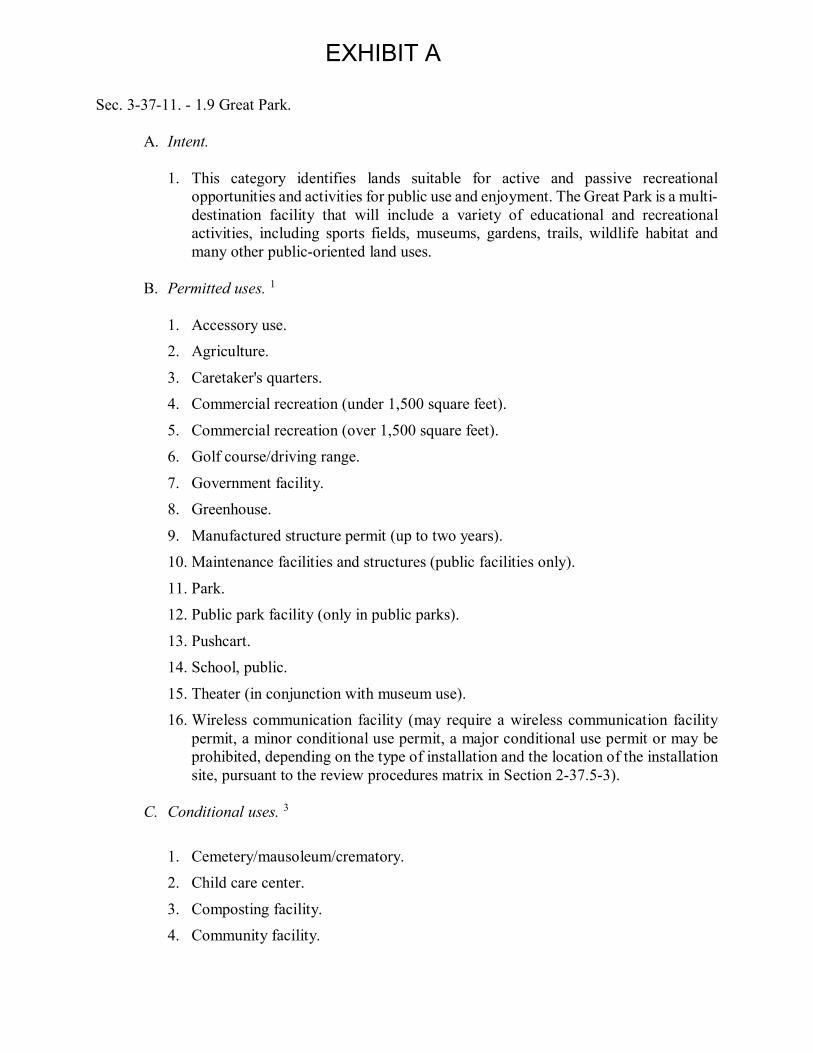
EXHIBIT A
Sec. 3-37-11. - 1.9 Great Park.
A. Intent.
1. This category identifies lands suitable for active and passive recreationalopportunities and activities for public use and enjoyment. The Great Park is a multi-destination facility that will include a variety of educational and recreationalactivities, including sports fields, museums, gardens, trails, wildlife habitat andmany other public-oriented land uses.
B. Permitted uses. 1
1. Accessory use.2. Agriculture.
3. Caretaker's quarters.4. Commercial recreation (under 1,500 square feet).
5. Commercial recreation (over 1,500 square feet).6. Golf course/driving range.
7. Government facility.8. Greenhouse.
9. Manufactured structure permit (up to two years).10. Maintenance facilities and structures (public facilities only).
11. Park.12. Public park facility (only in public parks).
13. Pushcart.14. School, public.
15. Theater (in conjunction with museum use).16. Wireless communication facility (may require a wireless communication facility
permit, a minor conditional use permit, a major conditional use permit or may beprohibited, depending on the type of installation and the location of the installationsite, pursuant to the review procedures matrix in Section 2-37.5-3).
C. Conditional uses. 3
1. Cemetery/mausoleum/crematory.2. Child care center.
3. Composting facility.4. Community facility.

[Type here]
5. Concrete recycling facility. 6. Funeral home/mortuary.
7. Manufactured structure (over two years). 8. Outdoor sales.
9. Outdoor vendor. 10. Parking structure.
11. Restaurant. 12. Retail and/or service business, general (except drive through).
13. Stable, private. 14. Stable, public.
15. Utility building and facility.
D. Minimum site size 1 acre E. Maximum site coverage n/a
F. Maximum building height 4 50 feet G. Building setbacks5from:
Freeways, transportation corridors 50 feet Major highways 50 feet
Primary highways 42 feet Secondary highways:
In nonresidential areas 35 feet In residential areas 25 feet
Commuter highways and local streets 15 feet Interior boundary if adjacent to residential uses:
Side 35 feet Rear 20 feet Interior boundary if adjacent to nonresidential uses:
Side n/a Rear n/a
Building to building 10 feet 1 Some permitted uses may have to conform to or fulfill conditions of approval imposed in conjunction with previous discretionary approvals. Additionally, a Master Plan application may need to be processed (see Chapter 2-17).

[Type here]
2 Reserved. 3 A Master Plan application may be required in addition to a conditional use permit (see Chapter 2-17). 4 Maximum height may be exceeded subject to review and approval through a Master Plan review or equivalent. 5 Exceptions to these building setback requirements appear on the setback exceptions matrix in Section 3-27-2. (Ord. No. 10-03, § 3, 4-13-10; Ord. No. 13-07 , 4(Exh. A), 12-10-13) CHAPTER 9-30. - PLANNING AREA 30 (GREAT PARK)[11] Footnotes: --- (11) --- Editor's note— Ord. No. 09-02, § 3, adopted March 24, 2009, amended the Code by amending the title of Chapter 9-30. Sec. 9-30-1. - Land use zoning map.
(See Planning Area 30 map following Section 9-30-3) (Code 1976, § V.E-830.1; Ord. No. 96-18, § 4, 12-10-96; Ord. No. 03-18, § 4, 6-10-03; Ord. No. 06-18, § 4, 10-24-06; Ord. No. 08-09, § 4, 8-12-08) Sec. 9-30-2. – Introduction
A. Location. Planning Area 30 is located in the eastern part of the City and is a part of the former Marine Corps Air Station, El Toro, now closed and subject to civilian reuse. It is bordered on the south by Interstate 5 (Santa Ana Freeway). The Southern California Regional Rail Authority (SCRRA) rail lines generally serve as the northern border of the planning area. The site abuts portion of the Irvine Spectrum to the east and west (Irvine Spectrum 2 - Planning Area 35 and Irvine Spectrum 3 - Planning Area 32).
B. Development. Of utmost importance to the City of Irvine is the development of the
Great Park at the former MCAS El Toro site in Planning Areas 30 and 51. The City also wishes to assure a financially viable development with the orderly development of public infrastructure and public open space amenities at no cost to the taxpayer.
Within Planning Area 30, the Great Park plan includes a wildlife corridor and other transportation-related public land uses as well as opportunities for the private development of agriculture, medical and science, vehicle-related commercial, and transit oriented development. In order to develop the uses and at the intensities shown in Section 9-30-3 Statistical Summary, property-owners must enter into development agreements which will require the dedication of land and the development of funding of infrastructure improvements in excess of the City's standard requirements, and the commitment to long-term maintenance of public facilities.

[Type here]
Interim activities will occur on the site after the purchase of the property by private parties and prior to the complete development of the land. These activities may include agricultural and nursery operations as well as other interim activities involving short-term use of the land. Interim activities other than agriculture will be allowed for a maximum period of two years. A one year extension may be approved by the Assistant City Manager and an additional two-year extension may be granted with the approval of a conditional use permit. An efficient street system and a system of bikeways and pedestrian paths are provided. Roadways are designed with sufficient capacity for the projected traffic volumes at full development of the planning areas. (Code 1976, § V.E-830.2; Ord. No. 96-18, § 4, 12-10-96; Ord. No. 99-03, § 3,2-9-99; Ord. No. 00-02, § 4, 2-8-00; Ord. No. 00-03, § 4, 2-22-00; Or. No. 03-18, § 4,6-10-03; Ord. No. 06-18, § 4, 10-24-06; Ord. No. 11-12, § 4(Exh. A), 9-13-11 ) Sec. 9-30-3. - Statistical analysis.
Planning Area: 30 Base Zone Great Park General Plan Category
Zoning Number
Zoning District
Maximum Regulatory Dwelling Units
Additive Dwelling Units2
Maximum Regulatory Square Feet
Additive Square Feet2
Gross Acres
Agriculture* 1.1 Exclusive Agriculture 0 0 0 0 13
Wildlife Corridor 1.4 Preservation 0 0 0 0 61
Transit Oriented Development
3.2 Transit Oriented Development
0 0
Special Development Requirements **
0 129
Auto 4.3 Vehicle-Related Commercial
0 0 102,000 0 34
Research and Development 5.4B General
Industrial 0 0 1,600,000 0 121
Major Roadways n/a n/a 0 0 0 0 40
Unallocated Dwelling Units 1
n/a n/a 0 0 0 0 0
Total 0 0 ** 1,755,500 0 398

[Type here]
*The total Agriculture acreage for PA 30 and PA 51 combined is 130 acres. **Not shown is the portion of the Transit Oriented Development intensity that will be allocated through the Master Plan process (see Section 9-30-6(B)). Notes on maximum intensities: In order to develop the overlay zone uses and intensities for Planning Area 30, the property owner has entered into a development agreement, which requires the dedication of land and the development or funding of infrastructure improvements in excess of the City's standard requirements and the commitment to long-term maintenance of public facilities (Section 9-30-2). 1 Unallocated dwelling units represent those units remaining in a planning area that may be built anywhere in the same planning area. These units are within the maximum development intensity for the planning area; and, therefore, placement of unallocated dwelling units into any residential category within the planning area for purposes of development is determined to be consistent with the General Plan and Zoning Code with regard to intensity allocation only, provided that placement is otherwise consistent with site specific zoning regulations and that any potential environmental impacts are adequately addressed, including traffic impacts, pursuant to CEQA. 2 See Section 9-0-3.C, Building Intensity Standards. (Code 1976, § V.E-830.3; Ord. No. 96-18, § 4, 12-10-96; Ord. No. 00-03, § 4, 2-22-00; Ord. No. 03-18, § 4, 6-10-03; Ord. No. 06-18, § 4, 10-24-06; Ord. No. 09-08, § 4, 9-8-09; Ord. No. 11-12, § 4(Exh. A), 9-13-11 ; Ord. No. 12-09, § 3(Exh. A), 5-22-12 )

[Type here]
(Code 1976, § V.E-830.3; Ord. No. 96-18, § 4, 12-10-96; Ord. No. 00-03, § 4, 2-22-00; Ord. No. 03-18, § 4, 6-10-03; Ord. No. 06-18, § 4, 10-24-06; Ord. No. 09-08, § 4, 9-8-09; Ord. No. 11-12, § 4(Exh. A), 9-13-11 ) Sec. 9-30-4. - Land use regulations.

[Type here]
The permitted and conditional uses for the zoning designations are given in Chapter 3-37. These uses are also referenced in the land use matrix, Section 3-3-1.
(Code 1976, § V.E-830.4; Ord. No. 96-18, § 4, 12-10-96; Ord. No. 00-03, § 4, 2-22-00; Ord. No. 03-18, § 4, 6-10-03; Ord. No. 06-18, § 4, 10-24-06) Sec. 9-30-5. - General development standards.
See Chapter 3-37 (Development Standards).
(Code 1976, § V.E-830.5; Ord. No. 96-18, § 4, 12-10-96; Ord. No. 00-03, § 4, 2-22-00; Ord. No. 03-18, § 4, 6-10-03; Ord. No. 06-18, § 4, 10-24-06) Sec. 9-30-6. - Special development requirements.
A. Affordable housing. See Chapter 2-3 Affordable Housing Implementation Procedures. B. Transit oriented development. The 3.2 Transit Oriented Development District extends
between Planning Areas 30 and 51. Development of the 3.2 Transit Oriented Development District shall be in accordance with the implementation of a Master Plan for 3.2 Transit Oriented Development, as defined in E below. The maximum intensity of development of the 3.2 Transit Oriented Development District within Planning Areas 30 and 51 shall not exceed 666,600 square feet of Institutional (education) and 951,300 square feet of Medical and Science. A remote airport terminal and maintenance facility with a maximum intensity of 53,500 square feet will also be developed within the 3.2 Transit Oriented Development District in Planning Area 30. 1,269 density bonus units granted pursuant to State law, Section 2-3, and City Council Resolution 08-2926 can be located either in Planning Area 30 (in the 3.2 Transit Oriented Development District) or in Planning Area 51 (in the 3.2 Transit Oriented Development District or 8.1 Trails and Transit Oriented Development District).
The following planning standards shall apply throughout the 3.2 Transit Oriented Development District:
1. Clustering of residential units shall be encouraged to provide for neighborhood parks as well as public and private open space areas within the project.
2. Total average daily trips (ADT) shall not exceed the trip budget established for the development within the Great Park (C below). The developer shall provide additional traffic analysis for the review and approval of the Director of Community Development to support the consideration of trip reduction design standards and integration with mass transit systems.
3. Vertical and horizontal integration of commercial office and retail land uses into the residential development shall be encouraged, where feasible.
4. Pedestrian connections within and between the 3.2 Transit Oriented Development District, the Irvine Transportation Center and the public areas of the Great Park shall be provided. An emphasis on pedestrian, way-finding signage and graphics, and the integration of the approved commercial retail and

[Type here]
office uses shall facilitate pedestrian access in lieu of automobile access to the site amenities.
5. Neighborhood parks requirements shall be provided in accordance with City of Irvine standards. Community park requirements shall be met through participation in the dedication in the Development Agreement adopted by the City in July of 2005, as amended by the Amended and Restated Development Agreement adopted pursuant to City Council Ordinance 09-09.
6. The Planning Commission shall make a specific finding that the Master Plan meets the intent of the Transit Oriented Development planning standards.
C. Trip budget. Based on the socioeconomic-based trip generation average daily trip
(ADT) rates used to analyze the Great Park traffic impacts, the total trips for the entire Great Park project area are not to exceed 148,910 ADT, not including the ADT associated with the 1,269 density bonus units granted pursuant to State law, Section 2-3, and City Council Resolution 08-2926, which shall be located upon approval of a subdivision map containing such units.
Total trips for this planning area may not exceed 31,863 ADT except as follows. The 31,863 do not include the ADT associated with the 1,269 density bonus units granted pursuant to State law, Section 2-3, and City Council Resolution 08-2926, which shall be located upon approval of a subdivision map containing such units. Dwelling units and square footage allocated to the 3.2 Transit Oriented Development District will be divided between Planning Areas 30 and 51 through the implementation of a Master Plan for Transit Oriented Development. A total of 3,186 ADT (ten percent of the vehicle trips allocated to Planning Area 30) may be transferred between Planning Area 51 and Planning Area 30 in conjunction either with the approval of a traffic study or a Master Plan. Any transfer of vehicle trips between planning areas will be subject to review in accordance with the approval of a traffic study or a Master Plan. Any transfer of vehicle trips between planning areas will be subject to review in accordance with the requirements of the City's traffic study guidelines.
D. Development Tracking and Monitoring Report. The development in Planning Area 30 is subject to specific limits as follows:
1. Maximum square footage—See Section 9-30-3, Statistical Analysis.
2. Maximum residential units—See Section 9-30-3, Statistical Analysis. 3. Maximum daily vehicle trips - 31,863 ADT, not including the ADT associated
with the 1,269 density bonus units granted pursuant to State law, Section 2-3, and City Council Resolution 08-2926, which shall be located upon approval of a subdivision map containing such units.
Building permits which would cause one or more of these maximums to be exceeded shall not be issued. Building permits and discretionary applications: Prior to the approval of any discretionary application and prior to the issuance of each building permit for new development, the applicant

[Type here]
shall submit to the Community Department a table documenting the cumulative total of approved development within Planning Area 30, in a manner meeting the approval of the Community Development Director. For the purpose of this section, "applicant" shall mean the developer who will actually develop the land. In conjunction with issuance of any building permit, the applicant shall submit a Planning Area Development Monitoring Report for review and approval of the Director of Community Development. The Planning Area Development Monitoring Report shall include the allocation of trips to the proposed discretionary case or building permit to ensure that the aggregate projected traffic does not exceed the vehicle trip limits established for PA 30. The Planning Area Development Monitoring Report shall include, but not limited to, the accounting of trips (average daily) used in each discretionary case application or building permit application. Approval by the Director of Community Development shall be based upon the determination that the allocations shown do not exceed the maximum trips established for Planning Area 30, not including the ADT associated with the 1,269 density bonus units granted pursuant to State law, Section 2-3, and City Council Resolution 08-2926, which shall be located upon approval of a subdivision map containing such units; and that the allocation is generally consistent with the General Plan, zoning and other applicable regulatory documents. The Planning Area Development Monitoring Report may be updated by the applicant and is subject to review and approval by the Director of Community Development. The purpose of the Great Park Planning Area 30 Development Monitoring Report is to monitor the growth and update the project's components.
E. Review process. Prior to the commencement of any private development in the 3.2 Transit Oriented Development, 4.3 Vehicle-Related Commercial, or 5.4B General Industrial Zoning Districts within Planning Area 30, the Planning Commission shall review and approve a Master Plan for the specific project, containing the following information for the specific development proposed:
1. Location, acreage, types of land use and estimated square footages or number
of dwelling units for each area.
2. A community design program, which characterizes the design features of the development, including signage design, fencing design, landscape themes, architectural theme, and other community design features. The location for a future City entry statement shall be reserved in the 4.3 Vehicle-Related Commercial Zoning District near the Bake Parkway/I-405 interchange.
3. Landscape treatments, including:
a. Planning area edge and entry widths and general character. b. Special landscaping themes, if any.
c. Palette of plant materials, walls, and hardscape for areas in and adjacent to the public rights-of-way.
d. Ownership of landscape areas. 4. Wildlife corridor edge condition treatments, consistent with the Irvine Wildlife
Corridor Plan, including:

[Type here]
a. Light and noise mitigation programs and techniques. b. Palette of compatible plant materials.
c. Walls, fences, and/or barrier mechanisms to protect the wildlife corridor from unwanted intrusions.
5. Existing and planned uses on adjoining properties and transition from surrounding areas to the Mixed-Use Transit Oriented Development.
6. Access to the project site and on-site pedestrian and vehicular patterns. The use of pedestrian bridges to cross Alton, Barranca, and/or Marine Way is especially encouraged.
7. Other information as required by the Director of Community Development.
8. The Master Plan application shall be accompanied by maps, text, or other documentation to satisfy the above requirements. The form and content of such submittals shall be made to the satisfaction of the Director of Community Development.
F. Changes in boundaries and/or intensities:
1. Boundaries and acreages in the Great Park plan are approximate and shall be established
by Master Plan approval (E above). 2. The trip budget for the planning area may be increased by 10 percent, subject to the
transfer provisions of C above.
G. Trails plan. In conjunction with the submittal of the master tract map the applicant shall submit a conceptual Master Landscape and Trails Plan or a detailed exhibit depicting potential trail connections on site to the City's existing or planned regional trail network.
In addition, in conjunction with subsequent tract maps, Master Plans or building permit submittals, whichever comes first, the applicant shall provide a specific and detailed trails plan depicting the exact location, alignment and connectivity of on-site trails to the City's existing or planned regional trail network.
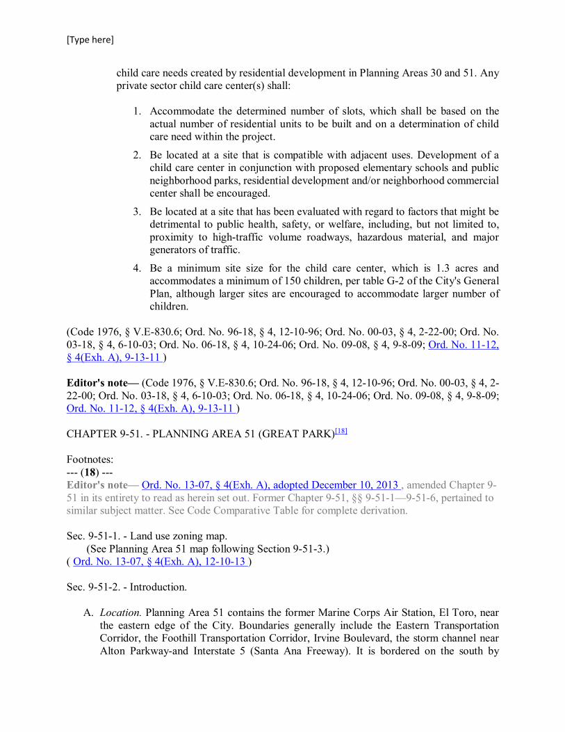
H. Child care. The need for child care facilities shall be recognized in the development of Heritage Fields. Prior to the approval of the first residential tentative tract map that causes the total combined approved residential dwelling units, excluding senior housing units, to reach 1,400 in Planning Areas 30 and 51, the developer shall submit a child care needs study to the Director of Community Services for approval. Based on the presumption that generally need for private child care facilities will be triggered at 3,500 dwelling units (units with children), the purpose of the study will be to identify any unmet need for child care as a result of residential development within Planning Areas 30 and 51. Upon approval of the study by the Director of Community Services which demonstrates that an unmet need exists that is created by residential development in Planning Areas 30 or 51, the developer shall identify ways to provide unmet private
[Type here]
child care needs created by residential development in Planning Areas 30 and 51. Any private sector child care center(s) shall:
1. Accommodate the determined number of slots, which shall be based on the
actual number of residential units to be built and on a determination of child care need within the project.
2. Be located at a site that is compatible with adjacent uses. Development of a child care center in conjunction with proposed elementary schools and public neighborhood parks, residential development and/or neighborhood commercial center shall be encouraged.
3. Be located at a site that has been evaluated with regard to factors that might be detrimental to public health, safety, or welfare, including, but not limited to, proximity to high-traffic volume roadways, hazardous material, and major generators of traffic.
4. Be a minimum site size for the child care center, which is 1.3 acres and accommodates a minimum of 150 children, per table G-2 of the City's General Plan, although larger sites are encouraged to accommodate larger number of children.
(Code 1976, § V.E-830.6; Ord. No. 96-18, § 4, 12-10-96; Ord. No. 00-03, § 4, 2-22-00; Ord. No. 03-18, § 4, 6-10-03; Ord. No. 06-18, § 4, 10-24-06; Ord. No. 09-08, § 4, 9-8-09; Ord. No. 11-12, § 4(Exh. A), 9-13-11 ) Editor's note— (Code 1976, § V.E-830.6; Ord. No. 96-18, § 4, 12-10-96; Ord. No. 00-03, § 4, 2-22-00; Ord. No. 03-18, § 4, 6-10-03; Ord. No. 06-18, § 4, 10-24-06; Ord. No. 09-08, § 4, 9-8-09; Ord. No. 11-12, § 4(Exh. A), 9-13-11 ) CHAPTER 9-51. - PLANNING AREA 51 (GREAT PARK)[18] Footnotes: --- (18) --- Editor's note— Ord. No. 13-07, § 4(Exh. A), adopted December 10, 2013 , amended Chapter 9-51 in its entirety to read as herein set out. Former Chapter 9-51, §§ 9-51-1—9-51-6, pertained to similar subject matter. See Code Comparative Table for complete derivation. Sec. 9-51-1. - Land use zoning map.
(See Planning Area 51 map following Section 9-51-3.) ( Ord. No. 13-07, § 4(Exh. A), 12-10-13 ) Sec. 9-51-2. - Introduction.
A. Location. Planning Area 51 contains the former Marine Corps Air Station, El Toro, near the eastern edge of the City. Boundaries generally include the Eastern Transportation Corridor, the Foothill Transportation Corridor, Irvine Boulevard, the storm channel near Alton Parkway-and Interstate 5 (Santa Ana Freeway). It is bordered on the south by
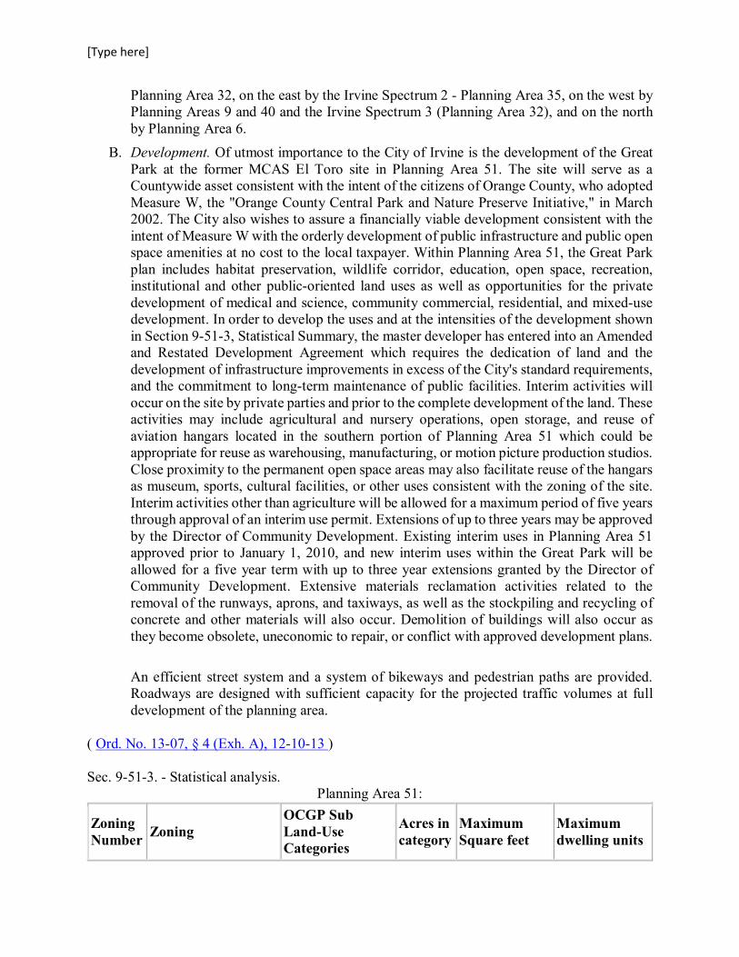
[Type here]
Planning Area 32, on the east by the Irvine Spectrum 2 - Planning Area 35, on the west by Planning Areas 9 and 40 and the Irvine Spectrum 3 (Planning Area 32), and on the north by Planning Area 6.
B. Development. Of utmost importance to the City of Irvine is the development of the Great Park at the former MCAS El Toro site in Planning Area 51. The site will serve as a Countywide asset consistent with the intent of the citizens of Orange County, who adopted Measure W, the "Orange County Central Park and Nature Preserve Initiative," in March 2002. The City also wishes to assure a financially viable development consistent with the intent of Measure W with the orderly development of public infrastructure and public open space amenities at no cost to the local taxpayer. Within Planning Area 51, the Great Park plan includes habitat preservation, wildlife corridor, education, open space, recreation, institutional and other public-oriented land uses as well as opportunities for the private development of medical and science, community commercial, residential, and mixed-use development. In order to develop the uses and at the intensities of the development shown in Section 9-51-3, Statistical Summary, the master developer has entered into an Amended and Restated Development Agreement which requires the dedication of land and the development of infrastructure improvements in excess of the City's standard requirements, and the commitment to long-term maintenance of public facilities. Interim activities will occur on the site by private parties and prior to the complete development of the land. These activities may include agricultural and nursery operations, open storage, and reuse of aviation hangars located in the southern portion of Planning Area 51 which could be appropriate for reuse as warehousing, manufacturing, or motion picture production studios. Close proximity to the permanent open space areas may also facilitate reuse of the hangars as museum, sports, cultural facilities, or other uses consistent with the zoning of the site. Interim activities other than agriculture will be allowed for a maximum period of five years through approval of an interim use permit. Extensions of up to three years may be approved by the Director of Community Development. Existing interim uses in Planning Area 51 approved prior to January 1, 2010, and new interim uses within the Great Park will be allowed for a five year term with up to three year extensions granted by the Director of Community Development. Extensive materials reclamation activities related to the removal of the runways, aprons, and taxiways, as well as the stockpiling and recycling of concrete and other materials will also occur. Demolition of buildings will also occur as they become obsolete, uneconomic to repair, or conflict with approved development plans.
An efficient street system and a system of bikeways and pedestrian paths are provided. Roadways are designed with sufficient capacity for the projected traffic volumes at full development of the planning area.
( Ord. No. 13-07, § 4 (Exh. A), 12-10-13 ) Sec. 9-51-3. - Statistical analysis.
Planning Area 51:
Zoning Number Zoning
OCGP Sub Land-Use Categories
Acres in category
Maximum Square feet
Maximum dwelling units
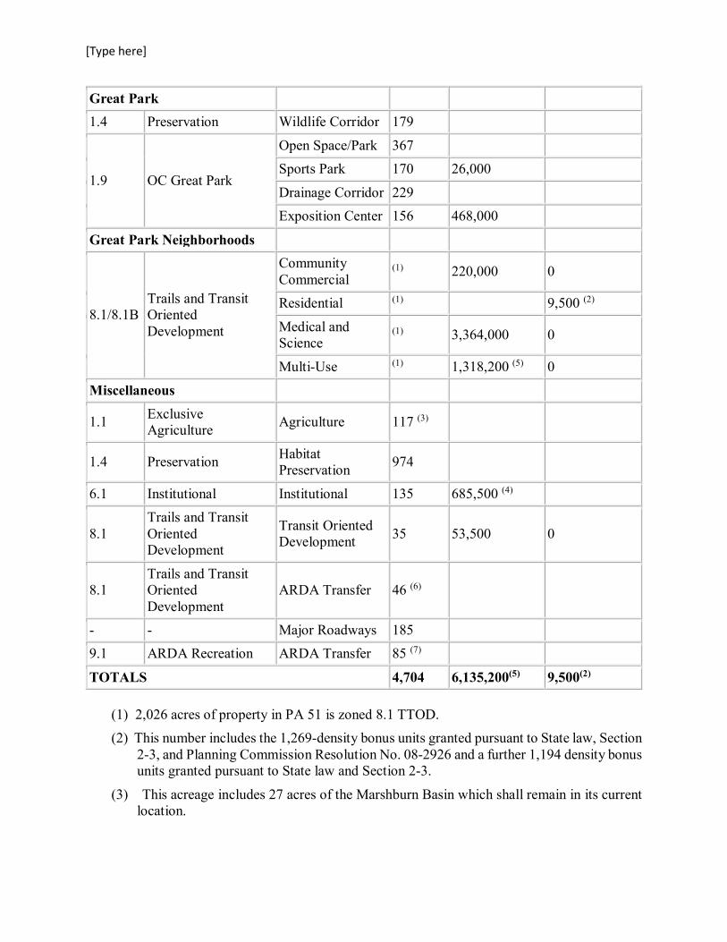
[Type here]
Great Park 1.4 Preservation Wildlife Corridor 179
1.9 OC Great Park
Open Space/Park 367 Sports Park 170 26,000
Drainage Corridor 229 Exposition Center 156 468,000
Great Park Neighborhoods
8.1/8.1B Trails and Transit Oriented Development
Community Commercial
(1) 220,000 0
Residential (1) 9,500 (2)
Medical and Science
(1) 3,364,000 0
Multi-Use (1) 1,318,200 (5) 0
Miscellaneous
1.1 Exclusive Agriculture Agriculture 117 (3)
1.4 Preservation Habitat Preservation 974
6.1 Institutional Institutional 135 685,500 (4)
8.1 Trails and Transit Oriented Development
Transit Oriented Development 35 53,500 0
8.1 Trails and Transit Oriented Development
ARDA Transfer 46 (6)
- - Major Roadways 185 9.1 ARDA Recreation ARDA Transfer 85 (7)
TOTALS 4,704 6,135,200(5) 9,500(2)
(1) 2,026 acres of property in PA 51 is zoned 8.1 TTOD. (2) This number includes the 1,269-density bonus units granted pursuant to State law, Section
2-3, and Planning Commission Resolution No. 08-2926 and a further 1,194 density bonus units granted pursuant to State law and Section 2-3.
(3) This acreage includes 27 acres of the Marshburn Basin which shall remain in its current location.

[Type here]
(4) Includes 122,500 square feet for institutional facilities, 300,000 square feet for County facilities, and 263,000 square feet of "McKinney Act" warehousing.
(5) See Section 9-51-6.S (Land Use Conversions). Adjustments to the Statistical Table in accordance with Section 9-51-6.S (Land Use Conversions) do not require a zone change.
(6) 40.5 acre portion of ARDA Transfer Site and 5.5 acres Police Site per Amended and Restated Development Agreement pursuant to City Council Ordinance No. 09-09 is not a part of the Great Park or within the Great Park boundaries.
(7) 85 acre portion of ARDA Transfer Site per Amended and Restated Development Agreement pursuant to City Council Ordinance No. 09-09 is not a part of the Great Park or within the Great Park boundaries.
Notes on maximum intensities: In order to develop the permitted uses and intensities for Planning Area 51, the master developer has entered into the Amended and Restated Development Agreement pursuant to City Council Ordinance No. 09-09, which requires the dedication of land and the development of infrastructure improvements in excess of the City's standard requirements, and the commitment to long-term maintenance of public facilities (Section 9-51-2).

[Type here]
GREAT PARK NEIGHBORHOODS DEVELOPMENT DISTRICTS

[Type here]
( Ord. No. 13-07, § 4(Exh. A), 12-10-13 ; Ord. No. 19-20 , § 4(Exh. A), 12-10-19) Sec. 9-51-4. - land use regulations.
The permitted and conditional uses for the zoning designations are given in Chapter 3-37. These uses are also referenced in the land use matrix, Section 3-3-1.
( Ord. No. 13-07, § 4(Exh. A), 12-10-13 ) Sec. 9-51-5. - General development standards.
See Chapter 3-37 (Development Standards). ( Ord. No. 13-07, § 4(Exh. A), 12-10-13 )
[Type here]
Sec. 9-51-6. - Special development requirements.
A. Affordable housing. See Chapter 2-3 Affordable Housing Implementation Procedures. B. Trails and Transit Oriented Development. The Trails and Transit Oriented Development
Zoning District allows a variety of uses on the same site consistent with the Great Park land use category as defined in the General Plan. The Trails and Transit Oriented Development Zoning District land use designation allows for a mix of residential, commercial, recreational, and educational uses that support a multi-use environment and which are complementary to the Irvine Station and to the Great Park. Pedestrian paths and trails, including, but not limited to, bike paths, sidewalks, and recreational trails, shall be encouraged in the Trails and Transit Oriented Development Zoning District. The variety of trail types and transit choices are intended to provide connectivity to the Great Park, to the Irvine Station, to public open space outside the Great Park, and to other nearby areas.
8.1 Trails and Transit Oriented Development Zoning District intensity.
The maximum residential intensity shall not exceed 9,500 dwelling units. The maximum nonresidential intensity in the Great Park Neighborhoods OCGP sub land use category of the Trails and Transit Oriented Development Zoning District shall not exceed: 220,000 square feet of Community Commercial, 3,364,000 square feet of Research and Development/Medical and Science, and 1,318,200 square feet of Multi-Use.
Development intensity shall be recorded in a Trails and Transit Oriented Development District Development Intensity Database and monitored administratively by the Director of Community Development following the Master Plan approval by the Planning Commission (E below). The following planning standards shall apply throughout the 8.1 Trails and Transit Oriented Development Zoning District:
1. Promote residential communities that are physically connected to each other. Foster
community and connectedness between adjacent land uses.
2. Promote livability, transportation efficiency, and walkability. 3. Promote diversity of land uses. Allow residential dwelling units to be mixed with
other uses providing choice in location, type and size based on compatibility with the surrounding uses.
4. Promote the development of trails that serve as recreational opportunities and as transportation connections between residential uses, commercial, and industrial uses, the Great Park and transportation hubs.
5. Encourage clustering of residential units, where feasible, to provide for opportunities to develop public and private open spaces within the development.
6. Promote a diversity of housing types to accommodate a range of economic levels and age groups to live within a community.
7. Provide appealing and functional pedestrian street environments to promote pedestrian activity.
[Type here]
8. Vertical and horizontal integration of commercial office and retail land uses into the residential development should be encouraged, where feasible.
9. Total average daily trips (ADT) shall not exceed the trip budget established for the development within the Great Park (C below). The developer shall provide additional traffic analysis for the review and approval of the Director of Community Development to support the consideration of trip reduction design standards and integration with transit systems.
10. Neighborhood parks shall be provided in accordance with City of Irvine Park Code. Community park requirements shall be met through participation in the original dedication in the Development Agreement adopted by the City in July 2005, as amended by the Amended and Restated Development Agreement adopted pursuant to City Council Ordinance 09-09.
11. The introduction of land uses that are not specified in the permitted and conditionally permitted uses but fit within the intent of the Trails and Transit Oriented Development Zoning District (Section 3-37-39) shall be encouraged subject to an initial determination by the Director of Community Development and subsequently, subject to a conditional use permit approved by the Planning Commission.
12. Prior to approval of a Master Plan for development of areas within the Trails and Transit Oriented Development Zoning District site (E below), the Planning Commission shall make a specific finding that the Master Plan meets the intent of the Trails and Transit Oriented Development Zoning District planning standards.
13. Pedestrian connections within and between the Irvine Station, the public areas of the Great Park and the adjacent development shall be provided. An emphasis on pedestrian, way-finding signage and graphics, and the integration of nonresidential uses shall facilitate pedestrian access in lieu of automobile access to the site amenities.
C. Trip budget. Based on the socioeconomic-based trip generation average daily trip (ADT)
rates used to analyze the Great Park traffic impacts, the total trips for the entire Great Park project area are not to exceed 148,910 ADT, not including the ADT associated with the 1,269 density bonus units granted pursuant to State law, Section 2-3, and Planning Commission Resolution No. 08-2926, and 1,194 density bonus units subsequently granted pursuant to State law.
D. Great Park Development Monitoring Database. The purpose of the Database is to monitor the development intensity and trips in Planning Area 51 and update the allocated intensity for all parcels as they develop.
1. The development in Planning Area 51 is subject to specific limits as follows:
a. Maximum square footage - see Section 9-51-3, Statistical Analysis. b. Maximum residential units - see Section 9-51-3, Statistical Analysis.

[Type here]
c. Maximum daily vehicle trips - 148,910 ADT, not including the ADT associated with any density bonus units granted from time to time pursuant to State law and Section 2-3 of the Zoning Ordinance (Affordable Housing Implementation Procedure), including Planning Commission Resolution No. 08-2926 (Density Bonus Agreement).
2. In conjunction with the submittal of any of the following development applications
that allocates (or reallocates) development intensity: 1) subdivision map, 2) lot merger, or 3) lot line adjustment or in conjunction with the submittal of a building permit for properties located in Planning Area 51, the master developer shall submit documentation to the Director of Community Development identifying the following:
a. A unique reference number that identifies the data record;
b. Project name; c. Legal description for each parcel;
d. Addresses affiliated with each building, if applicable; e. Land use designation, by square footage, for each building or lot;
f. Number of residential units; g. The cumulative and remaining square footage and residential units of
remaining development (including ADT); and h. A comprehensive summary describing the square footage of nonresidential
development and the total number of residential units of all Development Districts in Planning Area 51 (including ADT).
E. Review process. Prior to the commencement of any private development in the 1.9 Great
Park, 8.1 Trails and Transit Oriented Development or 6.1 Institutional Zoning Districts within Planning Area 51, the City shall review and approve a Master Plan for the specific project, containing the following information for the specific development proposed:
1. Location, acreage, types of land use and estimated square footages or number of
dwelling units for each area.
2. A community design program, which characterizes the design features of the development, including signage design, fencing design, landscape themes, architectural theme, and other community design features.
3. Landscape treatments including:
a. Planning area edge and entry widths and general character. b. Special landscaping themes, if any.
c. Palette of plant materials, walls, and hardscape for areas in and adjacent to the public rights-of-way.
[Type here]
d. Ownership of landscape areas. 4. Wildlife corridor edge condition treatments, consistent with the Irvine Wildlife
Corridor Plan, including: 5. Light and noise mitigation programs and techniques.
6. Palette of compatible plant materials. 7. Walls, fences, and/or barrier mechanisms to protect the wildlife corridor from
unwanted intrusions. 8. Other information as required by the Director of Community Development. The
application for said Master Plan shall be accompanied by maps, text, or other documentation to satisfy the above requirements. The form and content of such submittals shall be made to the satisfaction of the Director of Community Development.
A. Changes in boundaries and/or intensities. Boundaries and acreages in the Great Park plan
are approximate and shall be established by Master Plan approval (E above). B. Reuse of existing facilities. The former MCAS El Toro site has a number of facilities
suitable for civilian reuse, including warehouses, hangars, and other buildings. The zoning accommodates a number of these existing facilities, encouraging adaptive reuse wherever possible. Some existing facilities can possibly be adapted for civilian use on a long-term, permanent basis; others can serve interim uses during development of the site. For example, aviation hangars located in the southern portion of Planning Area 51 could be appropriate for reuse as warehousing, manufacturing, or motion picture production studios. Close proximity to the permanent open space areas may also facilitate reuse of the hangars as museum, sports, cultural facilities, or other uses consistent with the zoning of the site.
Prior to the issuance of occupancy permits for any existing structure, a fire life-safety evaluation of the structure, including recommendations for improvements required for compliance with current Building Codes adopted by the City for the use of existing structures, and plans for any required improvements shall be submitted to the Chief Building Official for review and approval.
C. Recycling operations. Existing runways are located on a substantial portion of the site planned for open space and related uses. Runways, aprons, and associated taxiways exist on the site reflecting its prior usage as a Marine Corps air station. In order to use the site for urban purposes, the runways will be removed. Concrete and asphalt from the runways intended to be removed will be crushed and, where feasible, used as aggregate base or recycled for other roadway or development uses. The runways will be removed in a sequential manner. The removal of most of the runway paving is anticipated. Some portion of runway may be preserved for use as playing surfaces and parking areas or for historic purposes. Demolition of the runways is to occur in accordance conjunction with the phasing program adopted by the City and Master Developer pursuant to the Amended and Restated Master Implementation Agreement. Stockpiled material will be placed in designated areas and distributed as required to provide aggregate for development projects. Once the material has been used, the land will become available for development. Concrete recycling facilities and stockpiling of demolished or

[Type here]
recycled material are considered an appropriate interim land use, subject to the approval of a minor conditional use permit.
D. Trails plan. In conjunction with the submittal of the master tract map the applicant shall submit a conceptual Master Landscape and Trails Plan or a detailed exhibit depicting potential trail connections on site to the City's existing or planned regional trail network. In addition, in conjunction with subsequent tract maps, Master Plans or building permit submittals, whichever comes first, the applicant shall provide a specific and detailed trails plan depicting the exact location, alignment and connectivity of on-site trails to the City's existing or planned regional trail network.
E. Child care. The need for child care facilities shall be recognized in the development of Planning Area 51. In 2011, the City approved a Child Care Need Analysis for the first 4,894 residential units in Planning Area 51. That study indicated that the child care needs generated by those residential units will be satisfied within Planning Area 51. Prior to the approval of the first residential tentative tract map that causes the total combined approved residential dwelling units, excluding senior housing units, to reach 6,300 in Planning Area 51, the Master Developer of Great Park Neighborhoods shall submit another child care needs study to the Director of Community Services for review and approval. Upon approval of the Study by the Director of Community Services, the Master Developer of Great Park Neighborhoods shall identify ways to provide any unmet private child care needs created by their residential development in Planning Area 51. Any private sector child care center(s) shall:
1. Accommodate the determined number of slots, which shall be based on the actual
number of residential units to be built and on a determination of child care need within the project.
2. Be located at a site that is compatible with adjacent uses. Development of a child care center in conjunction with proposed elementary schools and public neighborhood parks, religious institutions, affordable housing developments, residential development and/or neighborhood commercial center shall be encouraged.
3. Be located at a site that has been evaluated with regard to factors that might be detrimental to public health, safety, or welfare, including, but not limited to, proximity to high-traffic volume roadways, hazardous material, and major generators of traffic.
F. Edge conditions. Prior to the grading of development pads within those portions of
Development Districts adjacent to the Great Park, the applicant shall submit a pre-application, for the review and approval by the Director of Community Development that provides a detailed design for the edge conditions where the development abuts the Great Park. The design detail should demonstrate an attractive edge between the private development and the public park. Private residential development is encouraged and preferred to face outward toward the park and provide for architectural cohesion between the two land uses.
G. Transit. Prior to the recordation of the first residential tract map in any Development District (except Development District 8) in the Great Park Neighborhoods development,

[Type here]
the applicant shall prepare, fund, and work in cooperation with the City to develop a transit study, consistent with the City's 30-year Transit Vision Plan approved by the City Council in April 2009, ensuring that a route for the iShuttle is identified. At a minimum, the route should circulate along "O" Street, Irvine Boulevard, and Marine Way (or similar) and the study should contemplate a route circulating along "LQ" Street and "B" Street as well. The master developer shall identify strategic shuttle stop locations based upon developer's approved Master Plans. The master developer will continue to work cooperatively with the City, the Irvine Company, and other agencies to help identify and secure funding for the new iShuttle route identified in the transit study.
H. Charging stations for electric vehicles. To the extent feasible, the applicant shall install electric vehicle charging stations at the commercial retail components of the project in District 1 North and District 4. The parking spaces in these centers will include electric vehicle charging devices. Reserved.
I. Reciprocal Use of Recreational Amenities. Prior to the issuance of the first building permit for any dwelling unit other than model homes, in a particular Development District (i.e., District 1 North, 1 South, 4, 7, or 8), the applicant shall provide evidence to the Director of Community Development of a framework for a reciprocal use agreement or CC&Rs for private recreational amenities to be available for use by homeowners within the applicable Development Districts. If the master developer elects to allow reciprocal use among homeowners in other Development Districts of certain amenities, the use agreement or CC&Rs shall be finalized and executed to incorporate each subsequent district prior to the issuance of the first building permit for any dwelling unit other than model homes in that subsequent district.
J. Orange Bike Program. The developer shall incorporate a bike share program into their development program that takes advantage of, and expands upon, the "Orange Bike Program" being implemented by the Great Park Corporation with an emphasis on connecting the Great Park Neighborhoods to the Great Park. The bike share program shall tap into marketing opportunities for other existing programs that exist regionally, such as the one that currently exist at the University of California, Irvine. In addition, the program shall be promoted through the developer's home sales program.
K. District character. Each neighborhood within Planning Area 51 has a distinct character:
1. Development District 1: A horizontally mixed-use community featuring a significant main-street style town center and employment area. With up to approximately 1.5 million square feet of nonresidential uses, this district may contain a variety of land uses and businesses including, among other uses, commercial services, entertainment, hotel, accessory retail and restaurants; office, medical and research facilities; amenities such as a civic facility, schools, religious institutions, child care, and neighborhood parks. A FAR range from 0.25—1.5 allows for both a low-level campus-like setting as well as higher-density, multi-story buildings.
[Type here]
The circulation within the residential uses consists of a modified grid network, creating multiple vehicular, bicycle, and pedestrian routes. Tree-lined streets with wide landscaped parkways are located throughout the residential neighborhoods and emphasize a small-scale community atmosphere.
The nonresidential uses are generally west of "O" Street and along Trabuco, the main western gateway to the OCGP. Allowing up to 2,226 dwelling units, this district offers a highly diverse residential market: multifamily attached, single-family attached, single-family detached, and may include affordable units.
2. Development District 2: Area-wide employment center with a majority of the area dedicated to low- to mid-rise buildings housing a variety of uses including, among other uses, high-tech, manufacturing, research and development, and office-style businesses. A FAR range from 0.25—1.5 allows for both a low-level campus-like setting as well as higher-density, multi-story buildings. The land uses will be similar in nature to the surrounding Spectrum Planning Areas. District-serving accessory retail is encouraged to serve employees. Arterial Backbone streets with a complete pedestrian sidewalk network are expected in this district to accommodate traffic and pedestrians.
3. Development District 3: Area-wide employment center with a majority of the area dedicated to low- to mid-rise buildings housing a variety of uses including, among other uses, high-tech, manufacturing, research and development, and office-style businesses. A FAR range from 0.25—1.5 allows for both a low-level campus-like setting as well as higher-density, multi-story buildings. Residential uses are limited to a maximum of 400 dwelling units on 20 percent or less of the district's land area and are intended to allow for the possibility for high density (average densities of 20 du/ac or greater) and/or affordable dwelling units located in conjunction with the Master Affordable Housing Plan. District-serving accessory retail is encouraged to serve employees. Arterial Backbone streets with a complete pedestrian sidewalk network are expected in this district to accommodate traffic and pedestrians.
4. Development District 4: Primarily a residential suburban neighborhood providing area-wide services and retail. This community includes a small main-street or town center style commercial district. This neighborhood's circulation consists of a modified grid network, creating multiple vehicular, bicycle, and pedestrian routes throughout the neighborhood. Tree-lined streets with wide landscaped parkways are located throughout, emphasizing a small-scale neighborhood atmosphere. In addition to bordering the OCGP, neighborhood parks are strategically located to put all residents within easy walking distance. A maximum of 1,102 dwelling units will be located in this district, offering a highly diverse residential market: multifamily attached, single-family attached, single-family detached units, and may include affordable housing. Up to 70,000 square feet of neighborhood and OCGP serving commercial land uses are allowed. Other land uses may include, among other uses, schools, religious institutions, and child care facilities.
5. Development District 5: Primarily a residential suburban neighborhood with an average density of 5—12.5 du/ac, characterized by a majority single-family

[Type here]
detached, single-family attached product types and may include affordable housing. Nonresidential land uses are limited to 10-percent or less of the district's land area and are intended to provide neighborhood services and/or conveniences. The district is characterized by narrow, slow-speed streets, and pedestrian trails. Other land uses may include, among other uses, schools, religious institutions, and child care facilities. Residential neighborhoods within this district are unique due to the adjacency of the Wildlife Corridor, Agua Chinon Open Space Corridor and the Great Park. Therefore, open space linkages are abundant for this district encouraging alternative means of transportation, such as walking and bicycling. To accomplish the desired vision, a maximum of 3,700 residential units are allowed along with a maximum of 100,000 square feet of neighborhood serving commercial development.
6. Development District 6: Mixed-use urban core serving as a regional destination, with nonresidential uses such as, without limitation, mid- to high-rise office, corporate headquarters, research and development, medical, and cultural/institutional/entertainment facilities of regional interest. This district is characterized by a high floor area ratio and a walkable character. Residential neighborhoods will feature high-density, multi-story residential units (average densities of 20 du/ac or greater within the area south of future Marine Way), which may include affordable housing units. Vertical mixed uses within buildings are allowed (i.e., ground floor office or retail with residential above). The development pattern is focused on increasing density with approaching proximity to the Irvine Station. The focus is to create a thriving, walkable, mixed-use community with a diverse mix of land uses, architecture, landmarks and outdoor gathering places to create a walkable urban environment that encourages on-street pedestrian activity and reduces dependence on the automobile for everyday needs. To accomplish the desired vision, this district will contain a minimum of 1,200 dwelling units and a minimum of 150,000 square feet of nonresidential development with a goal of a minimum jobs to housing ratio of 2:1 within one-half mile of the Irvine Station.
7. Development District 7: This district is a primarily residential suburban neighborhood with a lower average density of 5—10 du/ac for a maximum of 840 dwelling units, characterized by single-family detached, single-family attached products types, and may include affordable housing. Access to regional trails and open space is maximized through the Agua Chinon riding and hiking trail, which bisects the district, and the existing open space to the east (El Toro Wildlife Preserve). Compatible edge conditions and interface is required between the residential uses and these features. Roundabouts, traffic calming devices, narrowed street widths, and pedestrian trails are characteristic of this district. Other land uses may include, among other uses, schools, religious institutions, and child care facilities.
8. Development District 8: This district is primarily a residential suburban neighborhood with a lower average density of 5—10 du/ac for a maximum of 892 dwelling units, characterized by single-family detached, single-family attached product types, and may include affordable housing. Less than 10 percent of the district may be designated for neighborhood serving uses including, but not limited

[Type here]
to, religious institutions and childcare for a maximum of 21,000 square feet. Roundabouts, traffic calming devices, narrowed street widths, park space, and pedestrian trails are characteristic of this district.
Notes:
a. The maximum number of residential dwelling units per Development District can be increased by up to 10% of the total allowable dwelling units in Planning Area 51 as long as the total number of units within Planning Area 51 does not exceed the total established in Section 9-51-3 (Statistical Analysis). Any increase to the number of residential units designated in an approved Master Plan will require a modification to said Master Plan in accordance with Chapter 2-19.
b. The maximum amount of nonresidential square footage mentioned above can be increased by up to 10% in District 1, 5% in District 4, and 1% in Districts 5 and 8, based on the total allowable nonresidential square footage in Planning Area 51 as long as the total square footage within Planning Area 51 does not exceed total established in Section 9-51-3 (Statistical Analysis).
L. Alternative setback standards. Alternative setback standards for setbacks internal to the
planning area may be approved in conjunction with any subsequent Planning Commission approval. A description of the proposed setbacks and how they differ shall be submitted. The Planning Commission will consider the following criteria and make appropriate findings, if necessary:
1. General character. Relationship in scale, bulk, coverage, and density with
surrounding land uses.
2. Quality of Life. Whether the proposed alternative standard will result in an adverse impact on existing neighborhoods.
3. Suitability. The physical suitability of the site for the proposed project. 4. Limitations. Such setbacks shall not be uses to deviate from setbacks established
for village edges.
M. Nonresidential land use conversions. The "Heritage Fields Project 2012 General Plan Amendment and Zone Change Traffic Impact Analysis, approved (insert approval date) 2013" or subsequent traffic analysis approvals amending these assumptions analyzed 1,318,200 square feet of Multi-Use (Office) in Planning Area 51. If any other nonresidential land uses within the 8.1 TTOD Zoning District are proposed in lieu of Multi-Use (Office), the square footage may be adjusted accordingly within the Zoning Statistical Table without the need for a zone change.
N. Future traffic analysis. Subsequent discretionary applications shall require further traffic analysis, if revisions occur that are different (i.e., creates materially different trip generation resulting in new or altered traffic impacts) than the assumptions in the "Heritage Fields Project 2012 General Plan Amendment and Zone Change Traffic Impact Analysis, approved (insert approval date) 2013" or subsequent traffic analysis approvals amending
[Type here]
these assumptions. The traffic analysis for the conversion, depending on the proposed use, may include a long-term/General Plan build-out analysis. This requirement will address any land use conversions between Multi-Use (Office) and other nonresidential land uses as provided in Section 9-51-6.S (Land Use Conversions) that differ from those assumed in the 2012 traffic analysis and approval or subsequent approvals and that may result in new or altered traffic impacts. Any future traffic analysis shall be used to update the Great Park Development Monitoring Database. Notwithstanding the requirements of City Council Ordinance 03-20 (The NITM program), The Director of Community Development may waive this requirement if the applicant can demonstrate that these revisions do not result in significant differences compared to the underlying traffic analysis.
1. Conversion to other nonresidential uses within the Multi-Use category is subject to a traffic analysis to assess traffic impacts due to the change in land use. To the degree other uses are proposed above their maximum limits, a corresponding adjustment in allowable Multi-Use (Office) intensity shall occur in terms of equivalent traffic generation based on a.m. peak, p.m. peak, and average daily trips (ADT). The adjustment will be based on Socioeconomic (SED) trip rates derived from ITAM 8.4-10, and using an average trip generation rate (12.55 ADT, 1.13 a.m. peak hour trips, 1.21 p.m. peak hour trips per 1,000 square feet of office use) and applicable rates for any proposed non-office use based on trip generation rates in table 3-1 of the approved "Heritage Fields Project 2012 General Plan Amendment and Zone Change Traffic Impact Analysis, approved (insert approval date) 2013." If the proposed non-office use and associated trip generation rate is not included in table 3-1, the Director of Community Development shall approve the application of an appropriate rate.
O. Land sales - special development requirements. Any purchase agreement for the sale of land for initial development (excluding sales once the initial development has occurred and excluding sales for public uses) in PA 51 shall include a recorded deed or special land use restriction (SLUR) or covenants, conditions and restrictions (CC&Rs) document with the following:
1. The legal tract and lot number(s); 2. County Recorder's recordation number which will be reflected on the recorded
grant deed; 3. The maximum number of residential units (by type - single-family or multifamily);
and 4. The maximum nonresidential square footage by land use with maximum ADT.
P. The SLUR, and any subsequent modification to the SLUR, shall be recorded by the County of Orange Recorder's Office. Within 30 days of recordation (or any amendments thereafter), the developer shall provide documentation of the information identified in Section 9-51-6.D.d.i—iv above to the Director of Community Development.
( Ord. No. 13-07, § 4(Exh. A), 12-10-13 )


![No. XIII. · An Act for establishing Municipal Institutions. [27th October, 1858.] W HEREAS it is expedient to establish Municipal Institutions in' certain Cities Towns and Districts](https://img.dokumen.tips/doc/110x75/604cdff25b8b8a112a7e4756/no-xiii-an-act-for-establishing-municipal-institutions-27th-october-1858.jpg)


![[CORRECTED COPY] CHAPTER 63 - New Jersey · W HEREAS, The State largely has employed a “carrot” approach to incentivizing consolidation and service sharing for over 30 years,](https://img.dokumen.tips/doc/110x75/5ec3ad60ff54c004e93d6c80/corrected-copy-chapter-63-new-jersey-w-hereas-the-state-largely-has-employed.jpg)