Embed Size (px)
Citation preview
18-1
PITTSBURGH, PA DISTRICT This District comprises part of eastern Ohio, western Pennsylvania, southwestern New York, northern West Virginia, and northwestern Maryland embraced in
drainage basin of Ohio River and Tributaries above mile 127 (below Pittsburgh, PA), immediately upstream from New Martinsville, WV.
IMPROVEMENTS Navigation Page 1. Allegheny River, PA........................................18-2 2. Construction of Locks & Dams,
Ohio River ..............................................18-2 3. Monongahela River, PA & WV.......................18-2 4. Open-Channel Work, Ohio River ....................18-3 5. Tygart Lake, WV.............................................18-3 6. Other Authorized Navigation Projects.............18-4 Flood Control - Local Protection 7. Elkins, WV ......................................................18-4 8. Johnstown, PA.................................................18-4 9. Punxsutawney, PA...........................................18-5 10. Saw Mill Run, Pittsburgh, PA .......................18-5 11. West Virginia & Pennsylvania
Flood Control .........................................18-5 Flood Control – Reservoirs 12. Berlin Lake, OH ............................................18-6 13. Conemaugh River Lake, PA ..........................18-6 14. Crooked Creek Lake, PA...............................18-7 15. East Branch, Clarion River Lake, PA ............18-7 16. Kinzua Dam & Allegheny Reservoir,
PA & NY................................................18-7 17. Loyalhanna Lake, PA ....................................18-8 18. Mahoning Creek Lake, PA ............................18-8 19. Michael J. Kirwan Dam & Reservoir, OH.....18-8 20. Mosquito Creek Lake, OH.............................18-9 21. Ohio River Basin (Pittsburgh District) ..........18-9 22. Shenango River Lake, PA & OH...................18-9 23. Stonewall Jackson Lake, WV ........................18-10 24. Tionesta Lake, PA .........................................18-10 25. Union City Dam, PA .....................................18-11 26. Woodcock Creek Lake, PA ...........................18-11 27. Youghiogheny River Lake, PA & MD ..........18-12 28. Inspection of Completed Flood
Control Projects......................................18-12 29. Other Authorized Flood Control Projects ......18-12 30. Flood Control Work under Special
Authorization..........................................18-12
Environmental Page 31. Conemaugh River Basin, Nanty Glo, PA,
Environmental Restoration .................... 18-12 32. South Central, PA Environmental
Improvement Program .......................... 18-13 33. Three Rivers Wet Weather
Demonstration Project ........................... 18-13 34. Formerly Used Sites Remedial Action
Program (FUSRAP)............................... 18-13 General Investigations 35. Surveys.......................................................... 18-14 36. Collection & Study of Basic Data ................. 18-14 37. Preconstruction, Engineering & Design ........ 18-14 Tables Table 18-A Cost & Financial Statement .............. 18-15 Table 18-B Authorizing Legislation..................... 18-22 Table 18-C Other Authorized Navigation
Projects .................................................. 18-26 Table 18-E Other Authorized Flood Control
Projects .................................................. 18-27 Table 18-G Deauthorized Projects ....................... 18-28 Table 18-H Allegheny River Statistics................. 18-29 Table 18-I Monongahela River Statistics ............. 18-30 Table 18-J Monongahela River Total Costs......... 18-31 Table 18-K Ohio River Basin Reservoirs............. 18-31 Table 18-L Inspection of Completed Flood
Control Projects ..................................... 18-32 Table 18-M Flood Control Work Under
Special Authorization............................. 18-33
REPORT OF THE SECRETARY OF THE ARMY ON CIVIL WORKS ACTIVITIES FOR FY 2007
18-2
Navigation 1. ALLEGHENY RIVER, PA
Location. The Allegheny River is 321 miles long. It rises in northern Pennsylvania, flows northwestward into New York, thence generally southwestward to Pittsburgh, PA, where it joins with Monongahela River to form the Ohio. (See Geological Survey Charts for western Pennsylvania and southwestern New York.)
Existing Project. The project consists of eight locks and dams to afford slack-water navigation for a length of 72 miles from Pittsburgh, PA to above East Brady, PA. Controlling depth through canalized portion is 9’ at normal pool level. Channel width varies from a minimum of 200’ to full width of river at mouth. Existing project is complete, the last lock, No. 9, was placed in service in 1938. Navigation channel has been widened at certain points and, in general, maintained to project depth, thus affording adequate depth for passage of commercial tows.
Local Cooperation. Fully complied with. Terminal Facilities. City of Pittsburgh constructed
a modern wharf for river freight. There are numerous privately maintained terminals and docks, consisting of tipples, various types of hoists, chutes, and pipelines for use in loading and unloading coal, stone, sand, gravel, petroleum products, steel products and other commodities. Transshipment of freight between river and railroads is handled at privately owned river-to-rail terminals. Existing private terminals are adequate for shipments and receipt in Pittsburgh District of type of commerce now in existence.
Licenses. The Federal Energy Regulatory Commission granted license for construction on non-federal hydropower facilities on the abutment side of the dam at the following locations: Lock 5, Allegheny - FERC license 3671, generating capacity 9.3 megawatt, start of operation October 1988; Lock 6, Allegheny - FERC license 3494, generating capacity 8.6 megawatt, start of operation December 1988; Lock 8, Allegheny - FERC license 3021, generating capacity 13.6 megawatts, start of operation November 1990; Lock 9, Allegheny - FERC license 3021, generating capacity 18.0 megawatts, start of operation November 1990.
Operations & Maintenance, General. In FY 2007, land wall filling valve and hydraulic line repairs at CW Bill Young Lock and Dam were completed for $877,000 and hydraulic cross over lines were replaced at Lock & Dam 9 for $291,000. Generator Surge Protection and Transfer Switch at CW Bill Young for $4,000.
2. CONSTRUCTION OF LOCKS & DAMS, OHIO RIVER
See this heading under Ohio River portion.
3. MONONGAHELA RIVER, PA & WV Location. Formed by junction of Tygart and West
Fork Rivers about one mile south of Fairmont, WV, and flows northerly for 128.7 miles to its junction with
Allegheny River, forming Ohio River at Pittsburgh, PA. (See Geological Survey Charts for southwestern Pennsylvania and northern West Virginia.)
Previous Project. For details see Annual Report for
1963, page 1070. Existing Project. Provides for improvement of
river by nine locks and dams to afford slack-water navigation for its entire length from Pittsburgh to above Fairmont, WV. Original Locks and Dams 7, 8 and 9 were replaced by new Locks and Dams 7 and 8 in 1925. Increased traffic necessitated enlargement and improvement of Locks and Dams 1 to 6 between Pittsburgh and Rices Landing, PA, by building two parallel chambers and fixed concrete dams during 1905 and 1932. Locks and Dam 1 were eliminated in 1938 by raising Emsworth Dam, Ohio River. Reconstruction of Lock 2 was completed in 1953 to provide two modern navigation chambers. The existing Locks and Dam 2 were originally completed in 1907; major modifications were made in 1923 and 1924, and in 1926 the upper guard and guide walls were extended. Construction of Maxwell Locks and Dam and the reconstruction of Dam 4 have allowed for removal of obsolete Locks and Dams 5 and 6. Small and antiquated original Locks and Dams 10 to 15, inclusive, have been replaced by three modern structures. Morgantown Lock and Dam, initial step in replacement program, was completed in 1950 replacing Locks and Dams 10 and 11. Hildebrand Lock and Dam, next upstream, was completed in 1959 replacing Locks and Dams 12 and 13. Raising crest of Dam 8 was also completed in 1959 as part of upper river improvement and eliminates restricted depth in upper reach of pool. Opekiska Lock and Dam were completed in 1967 replacing Locks and Dams 14 and 15. Completion of this link in upper river replacement program provides for entire river length of minimum channel depth of 9’, varying in width from a minimum of 250’ to practically full width at mouth.
Locks and Dam 3 showed advanced stages of deterioration and, because of its strategic location and its importance to industry throughout the greater Pittsburgh area and the nation, emergency remedial work had to be done in 1977. Major rehabilitation of Locks and Dam 3 was completed on October 27, 1980.
The Water Resources Development Act of 1986 authorized the replacement of Lock and Dam 7 with Grays Landing Lock and Dam and the construction of a new lock landward of the existing lock at Lock and Dam 8 (renamed Point Marion Lock and Dam). In accordance with the provisions of this act, 50% of the total cost of construction for the Grays Landing and Point Marion projects was derived from the Inland Waterways Trust Fund. Construction of a new lock at Point Marion was completed and put into service in December 1993. Construction of a new lock at Grays Landing was completed and put into service in May 1993. Construction of the dam at Grays Landing was completed in December 1995.
Supplemental Appropriations Act of 1985 for Engineering and Design and Land Acquisition and Water Resources Development Act of 1986; PL 99-662, Sec.301 (a) Water Resources Development Act of

PITTSBURGH, PA DISTRICT
18-3
1992; PL 102-580, Sec. 10 Authorized the Navigation improvements to replace the fixed crest dam at Locks and Dam 2 with a gated dam; raises the existing pool 2 by 5’, construct twin 84’x720’ locks at Locks and Dam 4, and eliminates Locks and Dam 3; lowering the existing pool 3 by 3.2’. Authorized cost of $750,000,000. Cost of construction is to be paid equally from the general fund of the Treasury and the Inland Waterways Trust Fund.
Local Cooperation. None required. Terminal Facilities. City of Pittsburgh constructed
a modern wharf for freight. Boat landings are maintained by some municipalities along the river. A large number of tipples at mines and various types of hoists at manufacturing plants and sand and gravel supply companies are maintained for private use in loading and unloading coal, coke, billets, steel products, sand, gravel, and other commodities. These terminals and docks are not available for general commerce. A number of docks and pipelines are also privately maintained for petroleum and acid products. Marine ways are maintained by some of the larger industries. These are also several terminals for rail-to-river and river-to-rail transfer. Facilities are considered adequate for existing commerce.
Operations during Fiscal Year. Work continues on cultural resources and finalizing real estate actions for the remainder of the Grays Landing and Point Marion projects. The present projects consist of 84 acres of fee land and 403.3 acres of easement. The Water Resources Development Act of 1992 authorized the District to proceed with navigation improvements on the Lower Monongahela River. Locks and Dams (L/D) 2, 3 and 4 are located within 50 miles of the “Point” in Pittsburgh. The authorized Lower Mon Project is a two-for-three improvement that will replace the 100-year old fixed-crest dam at L/D 2 with a gated dam (Braddock Dam) and replace the 70-year old, undersized Locks 4 with new twin 84’ x 720’ locks. The 100-year old L/D 3 will be removed and a new navigation pool will be established that will be 5’ higher between Braddock and Elizabeth and 3.2’ lower between Elizabeth and Charleroi. The project will adjust all municipally owned facilities adversely affected by these river level changes and dredge existing Pool 3. In addition, the Port Perry Railroad Bridge crossing at river mile 11.7 will be adjusted to accommodate the higher pool level under a cost sharing contract with Norfolk Southern Railroad. The new Braddock Dam is fully operational, dedicated on 27 May 2004, with contract completion in July 2004. Focus is now shifting to construction of the new locks at the Charleroi L/D. Approximately $381 million of project construction contract work has been undertaken through FY 2007, including the new Braddock Dam; approach dikes for the new Charleroi Locks; initial Pool 3 dredging; relocations for West Elizabeth, McKeesport, Elizabeth, Dravosburg, Glassport, Charleroi and Mon Valley sewage; site development for the new Charleroi Locks; demolition of the existing river chamber at the Charleroi Locks; and construction of the Charleroi River Wall. Continuing are the construction of the Charleroi Locks River Wall, design
for other project features, and construction of Pool 2 relocations. Awarded contracts for miscellaneous Government furnished items for Charleroi Locks including: Miter Gates, Filling Valves, Floating Mooring Bits, Mooring Cells, Maintenance Bulkheads, and Sheet Piling.
Operations & Maintenance, General. In FY 2007, Charleroi upstream Lock Gates were replaced and the middle wall emptying valve was renovated for $1,146,000. The lower approach to Braddock was dredged for $387,000. Braddock repair upper 110’ chamber gates for $1,013,000. Lock 3 Mon River renovated downstream lock gates for $602,000. 4. OPEN-CHANNEL WORK, OHIO RIVER
See this heading under Ohio River portion.
5. TYGART LAKE, WV Location. Tygart Lake is located on the Tygart
River in Taylor and Barbour Counties, north central WV. The lake is approximately 26 road miles due east of Clarksburg, WV and 30 road miles south of Morgantown. The dam is situated 22.7 river miles above the mouth of the Tygart River at Fairmont, or 2.25 miles upstream from Grafton, WV, and about 78 miles south of Pittsburgh, PA. (See Geological Survey Charts for Fairmont, Thornton, and Belington, WV.)
Existing Project. A reservoir for low water regulation and flood control. Dam is concrete gravity type with an uncontrolled center spillway flanked by abutment sections joining valley sides. Project was authorized by Public Works Administration January 11, 1934, and adopted by 1935 River and Harbor Act. For further project description see Annual Report for 1962. Authorized project is complete. Reservoir is in operation for low water control in Monongahela River and for purpose of flood protection in Monongahela and Ohio Valleys. Construction of dam was started in 1935 and placed in operation in 1938. Present project lands consist of 2,662.9 acres in fee, flowage easements over 1,216.9 acres and 1,731.9 acres of other easements. The project includes a Class C Visitor Center at the dam site and a day use picnic area outside the office, although no significant recreation exists on Corps managed land.
Tygart Dam was selected as a Dam Safety Assurance Project in March 1996. The Evaluation Report was initiated in March 1994 to address spillway capacity and structural stability in relation to the probable maximum flood event. Findings of the report concluded that under present conditions, the probable maximum flood would overtop the dam and cause failure. The report recommends protecting the dam from failure to include downstream erosion protection and stilling basin modifications. The Design Memorandum was completed in September 1998 and Plans and Specifications were completed in July 1999. The construction contract was advertised in August 1999 and awarded to Joseph B. Fay Co. on September 28, 1999 for $5,628,929. The Notice to Proceed was
REPORT OF THE SECRETARY OF THE ARMY ON CIVIL WORKS ACTIVITIES FOR FY 2007
18-4
issued in October 1999 and work was completed in November 2002. The project features included construction of a new road to provide access to the left. bank abutment of the dam, new concrete channels consisting of a concrete wall (end sill) and concrete slope paving on the downstream side of the dam, new concrete lagging retaining walls on the left and right banks of the dam, modification of the existing parapet wall, and minor repairs to the roadway decking. The project is now in compliance with current Dam Safety Guidelines.
Local Cooperation. The State of West Virginia has assumed responsibility for the development and operation of hunting and fishing areas as well as the Tygart Lake State Park. Controlled releases for downstream navigation and recreation are also coordinated with others to the extent feasible. No local cooperation is required at completed project; however, future recreational developments are subject to certain conditions of non-federal cost-sharing under Federal Water Project Recreation Act of 1965. A cost-sharing agreement was executed with the West Virginia Department of Recreation in May 1981.
Licenses. The Federal Energy Regulatory Commission granted a license to the City of Grafton for construction of a non-federal hydropower facility at this project (FERC license 11851). The deadline for the start of project construction originally expired in 1995. The developer was granted an extension which expired in 2004. The City of Grafton then submitted an application for a preliminary permit on 26 March 2004, which was denied on 07 February 2007, by FERC, and is currently being appealed by the City. However, a permit has currently been issued to “Tygart LLC”.
Operations during Fiscal Year. Operations & Maintenance, General: Reservoir was operated for benefit of flood control and low water regulation, as required, and project structures were operated and maintained in a serviceable condition throughout the year. In FY 2002007, plans and specs were initiated for replacing the 7 dam service gates for $52,000. Estimated flood control benefits achieved by this project for FY 2007 were $1,163,000 and, revised to reflect damages prevented in downstream districts as well as Pittsburgh District, were $1,153,618,000. Activities under reservoir management program comprising sanitation measures, conservation, land management, and operation and maintenance of public use facilities continued. This work was limited in scope as the State of West Virginia has jurisdiction over most of the recreation in the reservoir area.
6. OTHER AUTHORIZED NAVIGATION PROJECTS
See Table 18-C on other authorized navigation projects.
Flood Control - Local Protection 7. ELKINS, WV
Location. On Tygart River in north central
Randolph County, WV, about 155 miles south of Pittsburgh, PA. It is at downstream end of a long, broad reach of upper Tygart Valley, about 75 miles above mouth of river. (See Geological Survey Chart for Elkins, WV.)
Existing Project. Provides flood protection by diverting flood discharges from upstream arm of loop of natural river channel into an artificial cutoff channel, thereby bypassing City of Elkins. Improvement is designed to accommodate discharges equivalent to maximum flood of reasonable expectancy. Project construction was started in May 1946 and completed in May 1949. Completed work, except that portion of channel maintained by federal government, has been operated and maintained by City of Elkins since March 31, 1949. Present project lands consist of 32.04 acres in fee and 526.01 acres in easements. Project was authorized by 1938 Flood Control Act. For further project description see Annual Report for 1962, page 1222. Federal cost of completed project was $1,772,627; estimated non-federal cost for lands, easements, and rights-of-way was $40,000.
Local Cooperation. Fully complied with. Operations during Fiscal Year. Operation &
Maintenance, General: routine investigations routine investigations and inspections were made. Project was inspected in 2007. Total benefits through September 2006, revised to reflect damages prevented in downstream districts as well as Pittsburgh District, were $23,936,000.
8. JOHNSTOWN, PA Location. Project is located in southwestern
Cambria County, PA, about 58 miles east of Pittsburgh, PA. It is in a deep and comparatively narrow valley at junction of Stoney Creek and Little Conemaugh River, which unite to form Conemaugh River. (See Geological Survey Chart for Johnstown, PA.)
Existing Project. Provides for increased channel capacity by enlarging and realigning channels and protecting banks with concrete pavement. Improvement designed to accommodate discharges equivalent to those of March 1936 flood, maximum natural flow of record, and minimum of over-bank flow and to practically eliminate damages there from. Project construction began in August 1938 and was completed in November 1943. Footer protection for Unit 4 was completed in November 1949. Present project lands consist of easements over 199 acres. Project was authorized by Flood Control Acts of 1936 and 1937. For further project description see Annual Report for 1962, page 1215.
The Project Design Memorandum was approved in June 1995. The major rehabilitation work is to be accomplished under the Construction, General (CG) appropriation at an estimate cost of $32,500,000. Contract plans and specifications were initiated in July 1995. The CG project was physically complete in September 2004 at a cost of $30,000,000. The Construction, General work consisted of the repair of 54 existing wall sections, slope paving and replacement of balustrade (safety) wall. Also included

PITTSBURGH, PA DISTRICT
18-5
in the major rehabilitation is all the necessary Operation and Maintenance (O&M) funded work. The O&M work estimated to cost $7,500,000 consists of concrete spall repairs, slope paving joint repairs, sediment removal and miscellaneous repairs. $2,535,047 of O&M funded work was completed in FY 2005 and about $3,000,000 of O&M funded work remains to be complete subject to availability of funds. The FY 1991 Energy and Water Resources Development Appropriations Act authorized and directed the Corps to undertake a major rehabilitation of the existing project.
Local Cooperation. The rules of local cooperation for the rehabilitation of the existing project are governed by the FY 1991 Energy and Water Resources Appropriations Act. Pursuant to this act, the City of Johnstown will have a limited role in securing the needed rights of access to non-federal structures included in the line of protection and will hold and save the United States from damages due to construction or operation and maintenance of the work on the non-federal structures, except for damages due to the fault or negligence of the United States or its contractors.
Operations during Fiscal Year. Operations & Maintenance, General: In FY 2007, routine inspections and investigations were made. Plans and specifications were initiated for a flood wall replacement and channel maintenance. Total flood damages prevented by the project through September 30, 2007 were estimated to be $805,349,000.
9. PUNXSUTAWNEY, PA
Location. Borough of Punxsutawney is on Mahoning Creek in Jefferson County, PA, about 85 miles northeast of Pittsburgh, PA. It is on a comparatively wide, alluvial flood plain about 52 miles above mouth of stream and 30 miles above Mahoning Creek flood control dam. (See Geological Survey Charts for Punxsutawney and Smicksburg, PA.)
Existing Project. Provides flood protection by channel enlargement, dikes, and walls. Improvement is designed to accommodate discharges 20% greater than that of maximum flood of record. Construction was accomplished by construction of four units. Construction started in May 1946 and was completed in June 1950. Present project lands consist of perpetual easements over 72.6 acres. Completed works, except that portion of channel maintained by the Federal government, have been operated and maintained by Borough of Punxsutawney since July 31, 1950. Project was authorized by 1938 Flood Control Act. For further project description see Annual Report for 1962, page 1209.
Local Cooperation. Fully complied with. Operations during Fiscal Year. In FY 2007
operation activities continued and routine investigations and inspections were made. Project was inspected in 2007. The estimated flood control benefits in 2006 were $472,000; total flood control benefits through September 2006 were $98,684,000.
10. SAW MILL RUN, PITTSBURGH, PA Location: The project is located within the City of
Pittsburgh, Allegheny County, at Ohio River mile 0.7 and traverses upstream from the mouth of Saw Mill Run approximately 4,700 L.F.
Existing Project: The proposed project was authorized in the 1986 WRDA in accordance with the Chief of Engineers report dated January 30, 1978. The 1996 WRDA increased the project estimate to $12,780,000 and increased to $22,000,000 in the FY04 Appropriations Act. This project was included in the FY97 appropriations as a new construction start.
In October 1997, a Project Cooperation Agreement was executed with the City of Pittsburgh. In June 1998, the District executed a Memorandum of Agreement (MOA) for the purpose of allowing the District to acquire the real estate and complete relocation work on behalf of the city. With the MOA executed and the funds for this effort transferred to the District in July 1998, real estate acquisition was initiated, and was completed in November 2000. Plans and specifications for the project were completed in March 2000 and the construction contract was advertised in November 2000. The contract was awarded in April 2001 for $12,881,875. The current construction contract was completed in May 2004 and turned over to the City of Pittsburgh for operation and maintenance responsibilities in June 2004.
Local Cooperation: The City of Pittsburgh is the local sponsor for this project and is responsible for real estate acquisition and relocation design and construction. The project will be cost shared 75% federal and 25% non-federal in accordance with the requirements of the 1986 WRDA.
Operations during Fiscal Year: Due to contract overruns and unforeseen conditions certain project features were deleted from the existing construction contract in order to maintain project cost within funding constraints. The project was completed to a 5-year level of protection in 2006. The plans and specifications were completed in 2007 and included a base contract with two options. Construction to complete the project to the authorized 20 year level of protection is scheduled to start in 2008.
11. WEST VIRGINIA & PENNSYLVANIA FLOOD CONTROL
Location. Projects under this program in the Pittsburgh District are located in the Tygart River Basin in West Virginia and the lower Allegheny River in Pennsylvania. The priority (named in the legislation) communities located in West Virginia are Phillipi, Belington, Parsons and Rowlesburg. The priority communities in Pennsylvania are New Bethlehem, Clymer, Benson, Hooversville, Meyersdale, Connellsville and Dubois. Section 581 of the Water Resources Development Act of 1996 authorizes the Secretary of the Army to design and construct flood control measures for these priority communities at a level of protection sufficient to prevent future losses from flooding equivalent to that which occurred in

REPORT OF THE SECRETARY OF THE ARMY ON CIVIL WORKS ACTIVITIES FOR FY 2007
18-6
January 1996, but at least no less than a 100 year level of protection. Project development will consist of developing a least cost plan including structural and/or non-structural elements, to provide the authorized level of protection without guard to a benefit/cost ratio.
Local Cooperation. The reconnaissance phase is 100% federally funded. The Detailed Project Report (DPR), Plans and Specifications and Construction phases are cost shared at 65% federal funds and 35% non-federal funds. A Design Agreement is required to design efforts and a Project Cooperation Agreement is required prior to the project construction. In September 1998, Director of Civil Works, HQUSACE, approved the District’s request for a waiver of the up-front cost sharing for the design portion of the West Virginia projects. The basis for the approval of the waiver was that the priority communities in West Virginia qualified for a reduced cost share (5%) based on the ability to pay provisions of Section 103(m) of the Water Resources Development Act of 1986.
In Pennsylvania, the General Management Plans for the seven communities were completed in January 1999. Project Study Plans (PSP) for the seven communities was completed in July 2000. Design Agreements are being prepared and current plans call for the execution of these agreements pending the local sponsors’ ability to obtain the non-federal cost share. Design Agreements were executed for the Meyersdale and Hooversville projects in FY 2001.
In West Virginia, the PSPs for the two communities were completed in September 1998 and approved in November 1998. Since no Design Agreement is required for these communities, work on the Detailed Project Reviews started in December 1998. Least cost plans and locally preferred plans for both communities have been developed. A decision to implement a Flood Warning System for the two communities as the first phase of the projects was made in September 1999. An interim DPR for the Flood Warning System was submitted in November 2001. Installation of the Flood Warning System was completed. The Philippi DPR was completed in FY 2004 and approved in FY 2005. Operation during Fiscal Year. In Pennsylvania, a Detailed Project Report was executed for the Clymer Project.
In West Virginia, Design Phase continued for Philippi. Design the Philippi project. Flood Control – Reservoirs 12. BERLIN LAKE, OH
Location. Dam is on Mahoning River about 73 miles above its confluence with Shenango River. It is about 10 miles above existing Milton Reservoir Dam and 35 miles upstream from Warren, Ohio. Reservoir is in Portage, Mahoning and Stark Counties, OH. (See Geological Survey charts for Warren, Ravenna, and Alliance, OH.)
Existing Project. A reservoir for flood control and water supply. Dam consists of a partially controlled, concrete gravity, center spillway flanked by rolled-earth
fill abutment sections joining valley sides. Authorized project is complete and in operation for flood control and low water regulation purposes in industrialized Mahoning Valley below. Construction of dam was started in January 1942 and completed in June 1943. Present project lands consist of 6,885.3 acres in fee and 1,098.7 acres in easements. For further project description, see Annual Report for 1962, page 1233.
Local Cooperation. None required at completed project; however, future recreational developments are subject to certain conditions of non-Federal cost-sharing under Federal Water Project Recreation Act of 1965.
Operations during Fiscal Year. Operations & Maintenance, General: Reservoir was operated as required and necessary repairs were made to structures and appurtenances in FY 2007 Estimated flood control benefits achieved by this reservoir for FY 2007 were $91,640,000; total flood control benefits through September 2007 were $1,092,618,000.
13. CONEMAUGH RIVER LAKE, PA Location. Dam is on Conemaugh River in Indiana
and Westmoreland Counties, PA, 7.5 miles above junction of Conemaugh River and Loyalhanna Creek, which form the head of the Kiskiminetas River. It is about 2 miles northeast of Tunnelton, PA, and about 42 miles east of Pittsburgh, PA. Reservoir is in Westmoreland and Indiana Counties, PA. (See Geological Survey Charts for Latrobe, New Florence and Elders Ridge, PA.)
Existing Project. A flood control reservoir dam of concrete gravity type with a gate-controlled center spillway flanked by abutment sections joining valley sides and an earth embankment ending in right abutment. Authorized project is complete. Reservoir system is designed for protection of Pittsburgh and reduction of flood heights in upper Ohio Valley, generally. Present project lands consist of 7608.7 acres in fee and 522.8 acres in easements. Project authorized by Flood Control Acts of 1936 and 1938. For further project description see Annual Report for 1962, page 1217.
Local Cooperation. None required by law. Licenses. A non-federal hydropower project
utilizing Conemaugh Lake was constructed downstream of the dam under FERC Licenses 3207. The 15-megawatt project began commercial operation on February 6, 1989. It is owned by National Renewable Resources, Inc.
Operations during Fiscal Year. Operation & Maintenance, General: In FY 2007, flood capacity reduction sediment survey was initiated $6,000. Reservoir was operated for benefit of flood control as required, and necessary repairs were made to structures and appurtenances. Estimated flood control benefits achieved by this reservoir for FY 2007 were $15,527,000; total flood control benefits through September 2007, revised to reflect damages prevented in downstream districts as well as Pittsburgh District, were $2,144,930,000. Activities under reservoir management program comprising sanitation measures,

PITTSBURGH, PA DISTRICT
18-7
conservation, land management and operation and maintenance of public use facilities were continued.
14. CROOKED CREEK LAKE, PA
Location. Dam is on Crooked Creek 6.7 miles above junction of creek with Allegheny River near Ford City, PA, and about 32 miles northeast of Pittsburgh, PA. (See Geological Survey Charts for Freeport and Elders Ridge, PA.)
Existing Project. A flood control reservoir dam of earth-fill type with separate uncontrolled saddle spillway and tunnel outlet works. Authorized project is complete. Reservoir is in operation as a unit of a coordinated reservoir system designed for protection of Pittsburgh and reduction of flood heights in upper Ohio Valley, generally. Construction of dam was started in March 1938 and completed in October 1940. Present project lands consist of 2,561.7 acres in fee and 100.22 acres in easements. Project was authorized by Flood Control Acts of 1936 and 1938. For further project description see Annual Report for 1962, page 1213.
Local Cooperation. None required by law Operations during Fiscal Year. Operations &
Maintenance, General: Reservoir was operated for benefit of flood control, as required and necessary repairs were made to structures and appurtenances. The lease with Manor Township for the Armstrong Horse Park remained in effect. Congress has mandated the transfer of 97.48 acres of fee land to Manor Township for operation of the Armstrong Horse Park. Estimated flood control benefits achieved by this reservoir for FY 2007 were $2,344,000; total benefits achieved through September 30, 2007, revised to reflect damages prevented in down stream districts as well as Pittsburgh District, were estimated at $537,348,000. Activities under reservoir management program comprising sanitation measures, conservation, land management, and operation and maintenance of public-use facilities continued.
15. EAST BRANCH, CLARION RIVER LAKE, PA
Location. Dam is in Elk County, PA on East Branch of Clarion River above Middle Fork, 7.3 miles above junction of East and West branches of Clarion River at Johnsonburg, PA, and about 105 miles northeast of Pittsburgh, PA. Reservoir is in Elk County, PA. (See Geological Survey Chart for Mount Jewett, PA.)
Existing Project. A reservoir for flood control and low-water regulation. Dam is rolled-earth fill type with gate-controlled concrete tunnel under right abutment and a paved uncontrolled spillway on left abutment slope. Authorized project is complete. Reservoir is in operation for low-water regulation purposes in Clarion River Valley below and for flood control as a unit of a coordinated reservoir system for protection of Pittsburgh and upper Ohio Valley, generally. Construction of dam was started in June 1947 and completed in July 1952. Present project lands consist of 287.2 acres in fee and 1,296.7 acres in easements.
Project was selected for construction under general authorization for Ohio River Basin in Flood Control Acts of 1938 and 1944. For further project description. See Annual Report for 1962, page 1206.
Local Cooperation. None required by law. Operations during Fiscal Year. Operations
& Maintenance, General: reservoir was operated for flood control and low-water regulation, as required; and necessary repairs were made to structures and appurtenances. Volunteers continued to apply limestone sand to tributary streams in an effort to neutralize acid mine drainage into the lake. For the past 7 years, the East Branch Habitat Group (formerly the Elk County Fishermen and Watershed Group) has installed fish habitat structures in the lake under the guidance of the Pennsylvania Fish and Boat Commission’s Adopt-A-Lake Program. Thirty of thirty one camp sites have been redesigned and/or enlarged with sixteen of the sites having 20/30/50 amp electrical service installed. Nine “walk-in” tent sites are planned when funding becomes available which will bring the total campsites available to the authorized forty-one campsites.. Some reservoir management activity was performed throughout the year comprising sanitation measures, conservation, land management and operation of public-use facilities. Estimated flood control benefits achieved by this reservoir for FY 2007 were $2,393,000; Total flood control benefits for this reservoir through September 30, 2007 were $83,963,000.
16. KINZUA DAM & ALLEGHENY RESERVOIR, PA & NY
Location. Dam site is on Allegheny River 7 miles above Warren, PA, and 198 miles above mouth of river at Pittsburgh, PA. Reservoir is in Warren and McKean Counties, PA, and Cattaraugus County, NY. (See Geological Survey Charts for Warren and Kinzua, PA-NY, and Randolph and Salamanca, NY.)
Existing Project. Reservoir provides flood control, low water regulation and recreation. Dam consists of a combination concrete gravity structure and rolled earth embankment with gate-controlled spillway and discharge conduits controlled by slide-gates in gravity section. Construction of project, initiated in February 1960, is complete. Construction of dam was started in September 1960 and completed in December 1965. Development of recreation area at Onoville under a cost-sharing agreement with Cattaraugus County was completed in June 1978. Present project lands consist of 2,646 acres in fee and easements over 22,420.0 acres. For further details see Annual Report for 1962, page 1202. Project was authorized by Flood Control Acts of 1936, 1938 and 1941.
Local Cooperation. None required by law. Licenses. The Federal Power Commission granted a
license to Pennsylvania Electric Company and Cleveland Electric Illuminating Company on December 28, 1965, for the joint construction, operation and maintenance of a 435-megawatt pumped-storage installation (FPC Project No. 2280). The project is
REPORT OF THE SECRETARY OF THE ARMY ON CIVIL WORKS ACTIVITIES FOR FY 2007
18-8
complete. Present ownership is with First Energy Corporation. Operations during Fiscal Year. Operations and Maintenance, General: In FY 2007, the dam sump pumps were replaced for $147,000. Reservoir was operated for benefit of flood control, hydropower, fish and wildlife, recreation and low water regulation, as required and necessary repairs were made to structures and appurtenances. Estimated flood control benefits achieved by this reservoir for FY07 were $49,798,000. Total flood control benefits for this reservoir through September 30, 2007 were $1,181,770,000.
17. LOYALHANNA LAKE, PA
Location. Dam is on Loyalhanna Creek, 4.5 miles above junction of creek with Conemaugh River at Saltsburg, PA, and about 29 miles east of Pittsburgh, PA. Reservoir is in Westmoreland County PA. (See Geological Survey Chart for Latrobe, PA).
Existing Project. A flood control reservoir dam of concrete gravity type with a gate-controlled center spillway flanked by abutment sections joining valley sides, and an earth embankment section ending in left abutment. Authorized project is complete. Reservoir is in operation as a unit of a coordinated reservoir system designed for protection of Pittsburgh and reduction of flood heights in upper Ohio Valley, generally. Construction of dam was started in October 1939 and completed in June 1942. Present project lands consist of 3,330.8 acres in fee and easements over 86.7 acres. Project was authorized by Flood Control Acts of 1936 and 1938. For further project description see Annual Report for 1962, page 1219.
Local Cooperation. None required by law. Operations during Fiscal Year. Operations &
Maintenance, General: In FY 2007, the reservoir was operated for benefit of flood control, as required and necessary repairs were made to structures and appurtenances. Estimated flood control benefits achieved by this project for FY 2007 were $2,721,000. Total benefits for this reservoir through September 30, 2007 were $517,135,000. Activities under reservoir management program comprising sanitation measures, conservation, land management and operation and maintenance of public use facilities continued.
18. MAHONING CREEK LAKE, PA
Location. Dam is on Mahoning Creek in Armstrong County, PA, 22.9 miles above junction of creek with Allegheny River. It is about 6.50 miles southeast of New Bethlehem, PA, and about 51 miles northeast of Pittsburgh, PA. Reservoir is in Armstrong, Indiana and Jefferson Counties, PA. (See Geological Survey Charts for Rural Valley and Smicksburg, PA).
Existing Project. A flood control reservoir dam of concrete gravity type with a gate-controlled center spillway flanked by abutment sections joining valley sides. Authorized project is complete. Reservoir is in operation as a unit of a coordinated reservoir system designed for protection of Pittsburgh and reduction of flood heights in upper Ohio Valley, generally.
Construction of dam started in February 1939 and was completed in June 1941. Present project lands consist of 2,519.36 acres in fee and easements over 83.5 acres. Project was authorized by Flood Control Acts of 1936 and 1938. For further project description see Annual Report for 1962, page 1210.
Operations during Fiscal Year. Operations & Maintenance, general: Reservoir was operated for benefit of flood control, as required and necessary repairs were made to structures and appurtenances. In FY 2007, estimated flood damages prevented by this project were $4,382,000; total benefits through September 30, 2007, revised to reflect damages prevented in downstream districts as well as Pittsburgh District, were $666,916,000. Activities under reservoir management program comprising sanitation measures, conservation, land management and operation and maintenance for public-use facilities continued. 19. MICHAEL J. KIRWAN DAM & RESERVOIR, OH
Location. Dam site is on West Branch of Mahoning River which joins Mahoning River at Newton Falls, OH. It is 11 miles above mouth of branch and about 15 miles upstream from Warren, OH. Reservoir is in Portage County, OH. (See Geological Survey Charts for Ravenna, Garrettsville, Chagrin Falls, and Kent, OH.)
Existing Project. Reservoir provides flood control, low-water regulation and recreation. Dam consists of a rolled-earth embankment structure with gate-controlled outlet works and an uncontrolled side-hill spillway through left abutment. Authorized project is completed and in operation for flood control and low water regulation purposes. Present project lands consist of 6,298.9 acres fee and easements over 27.9 acres. For further description see Annual Report for 1962, page 1231 (West Branch Reservoir, Mahoning River, Ohio). Project was authorized by 1958 Flood Control Act (H. Doc. 191, 85th Cong. 1st sess.), with local contribution requirements modified by Flood Control Act of 1960. Federal costs of completed project are $17,370,000. Local interests contributed $3,230,000 during period of construction bringing initial project cost to $20,600,000. The State of Ohio has a lease from the Secretary of the Army for development and operation of recreation facilities in the reservoir area.
Local Cooperation. Local interests must contribute $5,200,000 for water pollution abatement and for municipal and industrial water supply purposes, of which $3,230,000 was paid in cash during construction. Unpaid balance at time project is placed in operation, $1,970,000, will be paid in cash at that time or on an annual basis. Of the unpaid balance of contributed funds due and payable, payment in full of Trumbull County’s share in the amount of $663,040 has been received. Mahoning County elected to pay their share ($1,306,960) in 50 annual installments of $50,323.32, including interest.
Operations during Fiscal Year. Operations & Maintenance, General: Reservoir was operated for benefit of flood control and low-flow augmentation, as required and necessary repairs were made to structures
PITTSBURGH, PA DISTRICT
18-9
and appurtenances. Estimated flood control benefits achieved by this project for FY 2007 were $32,430,000. Total benefits for this reservoir through September 30, 2007 were $521,261,000. Activities under reservoir management program comprising sanitation measures, conservation, land management, and operation and maintenance of public-use facilities continued. This work was limited in scope as state of Ohio has jurisdiction over most of the recreation in reservoir area.
20. MOSQUITO CREEK LAKE, OH
Location. Dam is on Mosquito Creek, 12.6 miles above junction of creek with Mahoning River at Niles, OH, and about 18 miles northwest of Youngstown, OH. (See Geological Survey Charts for Bristolville and Kinsman, OH, and PA.)
Existing Project. A reservoir for flood control, low-water regulation and water supply storage. Dam is rolled-earth fill type with outlet facilities through dam, and an uncontrolled natural wasteway to discharge overflow from reservoir. Authorized project is complete and in operation for flood control and low-water regulation purposes in industrialized Mahoning and Beaver Valleys below. Construction of dam was started in July 1943 and was ready for beneficial use in January 1944. Present project lands consist of 11,180.4 acres in fees and easements over 276.0 acres. State of Ohio has a license from Secretary of the Army for development and operation of recreation facilities in reservoir area. Project was selected for construction under general authorization for Ohio River Basin in 1938 Flood Control Act. For further project description see Annual Report for 1962, page 1228.
Local Cooperation. There is a water supply agreement with the City of Warren for municipal and industrial water storage in an amount equal to 11.1% of total reservoir storage. The City makes annual payments for this storage. No other local cooperation is required at completed project; however, future recreational developments are subject to certain conditions of non-Federal cost-sharing under Federal Water Project Recreation Act of 1965.
Operations during Fiscal Year. Operation & Maintenance, General: Reservoir was operated for benefit of flood control and low-flow regulation as required and necessary repairs were made to structures and appurtenances. . Plans and specs were initiated for automating the gate controls and electrical rehab in the control tower for $78,000. Estimated flood control benefits achieved by this reservoir for 2007 were $19,955,000. Total flood control benefits for this reservoir through September 30, 2007 were $218,268,000. Activities under reservoir management program comprising sanitation measures, conservation, land management and operation and maintenance of certain public-use facilities continued. This work was limited in scope as State of Ohio has jurisdiction over most of the recreation in reservoir area.
21. OHIO RIVER BASIN (PITTSBURGH DISTRICT)
Location. A series of dikes, floodwalls, channel improvements, and reservoirs/lakes in Ohio River Basin within Pittsburgh District.
Existing Project. Individual projects considered in comprehensive plan within Pittsburgh District. (See Tables 18-B, 18-E and 18-K on Acts authorizing existing projects, local protection projects and reservoirs.)
Operations during Fiscal Year. New Work: none by the United States except as stated in individual projects. Completed local protection projects operated and maintained by local interests, including those projects for which individual reports have been included. 22. SHENANGO RIVER LAKE, PA & OH
Location. Dam is on Shenango River about 0.8 mile above Sharpsville, PA, and about 33 miles above junction of river with Mahoning River, which unite near New Castle, PA, to form Beaver River. Reservoir is in Mercer County, PA and Trumbull County, OH. (See Geological Survey Chart for Kinsman, OH, and Shenango, PA.)
Existing Project. A reservoir for flood control, low-flow augmentation and recreation. Dam consists of a concrete gravity structure with gate-controlled outlet works and an uncontrolled center spillway section. Authorized project is complete. Reservoir is in operation for low-water regulation purposes in Shenango River valley below and for flood control as a unit of a coordinated reservoir system for protection of Shenango River valley and the Beaver and upper Ohio River Valley, generally. Construction of dam was started in March 1963 and completed in May 1965. Present project lands consists of 14,485.94 acres in fee and easements over 198 acres. Approximately 65.94 acres in abandoned railroad right-of-way were acquired for project use. Future work consists of completion of project lands of any additional recreation facilities as required to serve the public needs. For further project description, see Annual Report for 1962, page 1230. Project was authorized by 1938 Flood Control Act.
Local Cooperation. None required by law. Operations during Fiscal Year. Operations and
Maintenance, General: Reservoir was operated for benefit of flood control and low-flow augmentation, as required and necessary repairs were made to structures and appurtenances. In FY 2007, a new tertiary filter for the Shenango Recreation Area sewage treatment plant was purchased for $136,000. Estimated flood control benefits achieved by this reservoir for FY 2007 were $6,190,000; Total flood control benefits for this reservoir through September 30, 2007 were $146,923,000. Continuing activities under the reservoir management program are comprised of sanitation measures, conservation, land management and operation and maintenance.

REPORT OF THE SECRETARY OF THE ARMY ON CIVIL WORKS ACTIVITIES FOR FY 2007
18-10
23. STONEWALL JACKSON LAKE, WV Location. In Lewis County, North Central West
Virginia, on the West Fork River, which joins the Tygart River at Fairmont, WV to form the Monongahela River. Dam site is located on Route 30 at Brownsville, WV, about 4 miles south of Weston and 72 miles above mouth of West Fork River at Fairmont, WV. (See Geological Survey Charts for Weston and Crawford, WV.)
Existing Project. Provides for construction of a reservoir for flood control, water supply, water quality control, area redevelopment and recreation. Dam is concrete gravity type, 95’ high and 620’ long. Outlet works consist of two multi-level sluices and three fixed-level sluices, spillway is uncontrolled. Storage capacity is 74,650 acre-feet controlling an area of 102 square miles. A station hydropower plant completed in 1995 supplies power to the dam, with excess power being sold to an electric utility company. Project was authorized by 1966 Flood Control Act. Estimated initial federal cost for new work (1991) is $231,000,000 (includes an estimated $24,900,000 reimbursement by non-federal interests.) Present project lands consist of 20,451 acres in fee and easements over 398 acres.
The Corps worked with the State of West Virginia to revise the Master Plan to incorporate higher revenue producing recreation facilities, including a lodge, golf course, cabins and camping. The revised Master Plan was approved by the Corps in 1992. The FY92 Energy and Water Development Appropriations Act allow the state cost-sharing credits for all of these facilities except the golf course. In March 1994, the State and the Assistant Secretary of the Army for Civil Works executed an amendment to the 1977 Stonewall Jackson Lake Recreation Cost-Sharing Contract to reflect these credits.
The state must design and build the approved remaining recreation facilities by March 2006, in accordance with the schedule and conditions set forth in the amended contract. The state broke ground in July 2001 for the $50,000,000 Stonewall Resort, which includes a 200-room lodge, conference center, spa, cabins and more camping areas, in addition to a championship 18-hole golf course that is not eligible for cost share credit. By the end of FY 2002, the state had essentially completed and opened to the public all facilities except miscellaneous recreation facilities. The District is currently completing miscellaneous real estate actions related to the original construction with the project
Local Cooperation. The reservoir contains 2,200 acre feet of storage designated for the purpose of municipal and industrial water storage. The storage is not under contract and there are no prospects of near-term water supply agreements. In accordance with the Federal Water Project Recreation Act local interests are required to administer project land and water areas for recreation and fish and wildlife enhancement to make arrangements for repayment, under the provisions of the Water Supply Act of 1958, as amended, of that part of the construction cost and annual operation, maintenance and replacement costs allocated to municipal and industrial water supply, an amount presently estimated
at $4,350,000 for construction; and $15,000 annually for operations, maintenance and replacements. Also, in accordance with Federal Water Project Recreation Act, local interests are required to administer project land and water areas for recreation and fish and wildlife enhancement, pay, contribute in kind or repay (which may be through user fees) with interest, one-half of the separable first costs of the reservoir project allocated to recreation and fish and wildlife enhancement, an amount presently estimated at $24,810,000, bear all costs of operation, maintenance and replacement of recreation and fish and wildlife land and facilities, the amount involved being currently estimated on an average annual basis to be $457,000, exercise to the full extent of their legal capability, control against removal of stream flow made available for water quality control; and contribute to the control of pollution of streams subject to low-flow augmentation by adequate treatment or other methods of controlling wastes at their source. The requirements of Section 221 were amended in 1971 to exempt assurances for future demands for water supply pursuant to the Water Supply Act of 1958 from the contractual requirements of the Act. Accordingly, the city of Weston, WV has provided assurances that it will enter into a water supply contract with the Department of the Army within a period of time which will permit paying out the costs allocated to the water supply storage within the life of the project. A recreation cost-sharing contract, in accordance with the requirements of the Federal Water Project Recreation Act, PL 89-72, was executed by the State of West Virginia on March 27, 1977. Local cooperation assurances for recreation cost-sharing were executed by the Governor and Attorney General of West Virginia on May 29, 1973. In this connection, Section 8 of PL 92-222 deleted the requirement that the State of West Virginia “hold and save the United States free from damages resulting from water rights claims due to construction and operation of the project.” Legislation relieving Stonewall Jackson Lake, WV, project of the requirements of Section 221, PL 96-611 was contained in Water Resources Development Act of 1974 signed by the President on March 7, 1974.
Operations during Fiscal Year. Operations and Maintenance, General: Reservoir was operated for benefit of flood control and low-flow augmentation, as required and necessary repairs were made to structures and appurtenances. Estimated flood control benefits achieved for this project for FY 2007 were $8,153,000; total flood control benefits through September 30, 2007, were $163,130,000. Activities under reservoir management program comprising sanitation measures, conservation, land management, and operation and maintenance of public-use facilities continued. This work was limited in scope as State of West Virginia has jurisdiction over most of the recreation in reservoir area.
24. TIONESTA LAKE, PA
Location. Dam is on Tionesta Creek, 1.25 miles above junction of creek with Allegheny River at Tionesta, PA, and about 78 miles northeast of Pittsburgh, PA. Reservoir is entirely in Forest County,
PITTSBURGH, PA DISTRICT
18-11
PA. (See Geological Survey Charts for Tionesta, Tidioute and Sheffield, PA.)
Existing Project. A flood control reservoir dam of earth fill type with separate uncontrolled saddle spillway and tunnel outlet works. Authorized project is complete. Reservoir is in operation as a unit of a coordinated reservoir system designed for protection of Pittsburgh and reduction of flood heights in upper Ohio Valley, generally. Construction of dam was started in May 1938 and completed in January 1941. Present project lands consists of 2,794.77 acres in fee and easement over 13.1 acres. Approximately 2.53 acres of fee were disposed at the project. Future work consists of provision on project lands of additional recreational facilities as required to serve public needs. Project was authorized by Flood Control Acts of 1936 and 1938. For further project description see Annual Report for 1962, page 1203.
Local Cooperation. None required by law. Operations during Fiscal Year. Operation &
Maintenance, General: reservoir was operated for benefit of flood control, as required and necessary repairs were made to structures and appurtenances. Estimated flood control benefits achieved for this project for FY 2007 were $13,694,000; total flood control benefits through September 30, 2007, were $536,630,000. Activities under reservoir management program comprising sanitation measures, conservation, land management and operation and maintenance of public-use facilities continued.
25. UNION CITY DAM, PA
Location. In Erie County, northwestern PA, on French Creek, a tributary of Allegheny River. Dam site is 24 miles upstream from Cambridge Springs, PA, and 41 miles upstream from Meadville, PA. (See Geological Survey Chart for Union City, PA - NY.)
Existing Project. A flood control reservoir dam of earth embankment non-gated type with uncontrolled side-channel spillway. Outlet works consist of a lower outlet located in valley floor constructed of reinforced concrete conduit 8’ by 4.5’ and an upper outlet consisting of an uncontrolled slot 9.5’ wide through the north end of the ogee weir in the spillway. Dam is 1,420’ long at top rising 88’ above streambed and provides gross capacity of 47,640 acre-feet from a drainage area of 222 square miles. Project authorization was modified to provide for a conservation pool and addition of recreation facilities. On November 5, 1974, a referendum proposal was defeated by the constituents of Erie County in regard to the cost-sharing for construction of recreation facilities. In view of the foregoing, all action toward implementation of the authorized project modification was discontinued. Reservoir is operated as one of a two-reservoir system for reduction of flood stages in French Creek Basin between dam site and mouth, Allegheny River from Franklin, PA, to Pittsburgh, PA, inclusive, and upper Ohio River Valley. Initial highway relocations were completed in October 1968 and remaining highway relocations were completed in May 1972. Construction of the dam was started in July 1968 and completed in
September 1971. Present project lands consist of 161.4 acres in fee and easements over 2,410.29 acres. Existing project was authorized by 1962 Flood Control Act.
Local Cooperation. Local interests are required to inform affected interests in French Creek Basin at least annually, that the system of reservoirs of which Union City Dam is a part, will not provide protection against maximum floods. On November 10, 1964 the Department of Forests and Waters of the Commonwealth of Pennsylvania furnished formal assurances of local cooperation in respect to notifying local interests at least annually that the system of reservoirs will not provide protection against maximum floods. A referendum on the ballot during the November 1974 election regarding the approval to cost-share the maintenance of a summer pool was defeated by the local voters.
Operations during Fiscal Year. Operation & Maintenance, General: maintenance of the structure and appurtenances was performed as required. This dam acted as an uncontrolled detention type dam during the fiscal year. Estimated flood control benefits achieved for this project for FY 2007 were $7,232,000; Total flood control benefits for this reservoir through September 30, 2007, revised to include downstream districts, were $67,347,000.
26. WOODCOCK CREEK LAKE, PA
Location. In Crawford County, northwestern PA, on Woodcock Creek, a tributary of French Creek. Dam site is about 4.1 miles above mouth of Woodcock Creek and about 5 miles northeast of Meadville, PA. (See Geological Survey Chart for Meadville, PA.)
Existing Project. A flood-control reservoir dam of rolled-earth embankment type, gate-controlled outlet works with a 6 foot-wide by 7.75 foot-high conduit and uncontrolled saddle spillway on the left abutment. Dam is 4,650’ long at top rising 90’ above streambed and provides for gross capacity of 20,000 acre-feet from a drainage area of 46 square miles. Reservoir is operated as one of a two-reservoir system for reduction of flood stages in French Creek Basin between dam site and mouth. Allegheny River from Franklin, PA, to Pittsburgh, PA, inclusive, and upper Ohio River Valley. Authorized project is complete. Construction of dam was started in July 1970 and completed in July 1973. Land acquired for project consists of 1,731.5 acres in fee and easements over .56 acres. Project was authorized for flood control and recreation by 1962 Flood Control Act. Storage for water quality control was added to the project during the preconstruction planning stage.
Local Cooperation. Local interests must inform affected interests in French Creek Basin at least annually, in a manner satisfactory to District Engineer, that a system of reservoirs of which Woodcock Creek is a part, will not provide protection against maximum floods. Pennsylvania Department of Forests and Waters assumed responsibility of local cooperation for project.
Operations during Fiscal Year. Operation & Maintenance, General: maintenance of the structure

REPORT OF THE SECRETARY OF THE ARMY ON CIVIL WORKS ACTIVITIES FOR FY 2007
18-12
and appurtenances was performed as required.. Estimated flood control benefits achieved by this project for FY 2007 were $1,439,000; Total flood control benefits achieved by this project through September 30, 2007, revised to include downstream districts were $31,249,000. Activities under reservoir management program comprising sanitation measures, conservation, land management and operation and maintenance of public use facilities continued.
27. YOUGHIOGHENY RIVER LAKE, PA & MD
Location. Dam is on Youghiogheny River about 74.2 miles above its junction with Monongahela River at McKeesport, PA. It is 1.2 miles upstream from Confluence, PA, and about 57 miles southeast of Pittsburgh, PA. Reservoir is in Fayette and Somerset Counties, PA, and Garrett County, MD. (See Geological Survey Charts for Confluence, PA, Accident, MD, West Virginia and Pennsylvania.)
Existing Project. Reservoir for flood control, low-flow augmentation, pollution abatement, and recreation purposes. Dam is rolled-earth fill type with separate uncontrolled side channel spillway and tunnel outlet works. Authorized project is complete. For flood control, reservoir is operated as a unit of a coordinated reservoir system designed for protection of Pittsburgh and reduction of flood heights in upper Ohio Valley, generally. Construction of dam was started in June 1940 and completed in May 1944. Present project lands consist of 3,914.9 acres in fee and easements over 0.62 acres.
Project was selected for construction under general authorization for Ohio River Basin in 1938 Flood Control Act. For further project description see Annual Report for 1962, page 1223.
Local Cooperation. None required. Licenses. A non-federal hydropower project
utilizing releases from Youghiogheny River Lake was constructed in accordance with FERC License 3623. D/R Hydro Company is the authorized representative of the Licensee, Youghiogheny Hydroelectric Authority, and is responsible for operation of the plant. It has a 10-megawatt capacity. The plant began commercial operation on December 7, 1989.
Operations during Fiscal Year. Operations & Maintenance, General: Reservoir was operated for benefit of flood control and low flow augmentation, as required and necessary repairs were made to structures and appurtenances. In FY 2007, renovations to one of the service gates were completed for $145,000. Total flood control benefits achieved by this project through September 30, 2007 were $3,227,000; revised to include damages prevented in downstream districts, were $526,645,000. Activities under reservoir management program comprising sanitation measures, conservation, land management and operation and maintenance of public use facilities continued.
28. INSPECTION OF COMPLETED FLOOD CONTROL PROJECTS
Flood Control Act of June 22, 1936, and subsequent
acts require local interests to furnish assurances that they will maintain and operate certain local protection projects after completion in accordance with regulations prescribed by Secretary of the Army. District Engineers are responsible for administration of these regulations within boundaries of their respective districts. Inspections were made of completed units transferred to local interests for maintenance and operation and local interests were advised, as necessary, of measures required to maintain these projects in accordance with standards prescribed by regulations. (See Table 18-L for dates of inspections.)
Costs for FY 2007 were $112,728; total cost to September 30, 2006 was $2,959,479.
29. OTHER AUTHORIZED FLOOD CONTROL PROJECTS
See Table 18-E on other authorized flood control projects. 30. FLOOD CONTROL WORK UNDER SPECIAL AUTHORIZATIONS
For emergency bank protection pursuant to Section 14, 1946 Flood Control Act, PL 79-526, as amended
See Table 18-M. For flood control activities pursuant to Section
205, 1948 Flood Control Act, PL 80-858, as amended See Table 18-M. For aquatic ecosystem restoration pursuant to
Section 206, 1996 WRDA, PL 104-303, as amended See Table 18-M. For modification for improvement of the
environment pursuant to Section 1135, 1986 WRDA, PL 99-662, as amended
See Table 18-M. For flood control and coastal emergencies
pursuant to 1955 Emergency Flood Control Funds Act, PL 84-99 and antecedent legislation
See Table 18-M.
Environmental 31. CONEMAUGH RIVER BASIN, NANTY GLO, PA ENVIRONMENTAL RESTORATION
Location. Conemaugh River Basin is an area of 1,372 square miles located in southwestern Pennsylvania in Cambria and Indiana Counties. The Nanty Glo project is located in the headwaters of South Branch Blacklick Creek in the Borough of Nanty Glo, Cambria County.
Existing Projects. Authorized by WRDA 1992 (PL 102-580), Section 331, the Conemaugh River Basin Reconnaissance Report completed in February 1994 identified seven sites as candidates for ecosystem restoration studies. Remediation of a site at Nanty Glo, PA was identified as highest priority. The project

PITTSBURGH, PA DISTRICT
18-13
involves restoration of environmental damage caused by the abandoned Webster Coal Mine. Its discharge accounts for much of the acid load in the creek and approximately 5% of the acid load downstream at the Corps’ Conemaugh River Lake. Water from the mine is discharged into Pergrin Run, approximately 1,300’ upstream from its confluence with South Branch Blacklick Creek. The project will involve a passive treatment system consisting of dual vertical flow ponds and a wetland. The project will treat the Webster Mine discharge, design flow of 450 gallons per minute with a PH of 3.0. The vertical flow ponds provide 3.9 acres of surface treatment area and the wetland provides 2.3 acres of surface treatment area. A pipe will carry water from Webster Mine to the vertical flow ponds. The PH of the treated design flow discharged from the wetland to Pergrin Run will be 6.5 Project implementation will restore the lower seven miles of the creek and promote return of a viable fishery to the waters.
Notice to proceed issued September 20, 2002. Amount of contract was $4,200,000. Contractor was Charles J. Merlo Construction Incorporated. Contract was completed in October 2004.
Local Cooperation. The non-federal cost-sharing sponsor is the Cambria County Conservation and Recreation Authority (CCCRA). CCCRA has been the cost-sharing partner on this project since inception in l994. The CCCRA will cost share 25% of total project costs.
Operations during Fiscal Year. None. Closeout scheduled in FY 2007 32. SOUTH CENTRAL, PA ENVIRONMENTAL IMPROVEMENT WORK
Location. Projects under this program in the Pittsburgh District are located in the South Central, PA counties of Allegheny, Armstrong, Cambria, Fayette, Greene, Indiana, Somerset Washington and Westmoreland.
Existing Projects. Section 313 authorizes the Secretary of the Army to establish a program to provide design and construction assistance to non-federal interests in south central Pennsylvania including projects for waste water treatment and related facilities, water supply, storage, treatment, and distribution facilities, and surface water resource protection and development. A total of 44 projects are physically complete. The largest project was a regional wastewater treatment plant and interceptor system for the Forest Hills Municipal Authority located in the suburbs of Johnstown, PA.
Local Cooperation. Legislation requires the project to be cost shared at no more than 75% federal funds and a minimum of 25% non-federal funds. Project Cooperation Agreements are executed between the Corps of Engineers and the non-federal sponsors. Operation and maintenance of the projects will be at 100% non-federal costs.
Operations during Fiscal Year. During FY07 completed work at Northmoreland County Parks, National Pike, Morgan Township, Franklin Township,
(Greene County), Fayette City, Sutersville-Sewickley and the Central Mainline Sanitary Sewer. Continued construction for the Menallen Sanitary Sewer and Lower Ten Mile Projects. Continued design of projects at Mt Pleasant, Parks Township, Washington Township and Elrama. 33. THREE RIVERS WET WEATHER DEMONSTRATION PROJECT
Location. The Three Rivers Wet Weather Demonstration Program administers grants to Allegheny County communities for innovative, cost-effective, watershed-based methods of wet weather sewer overflow elimination and management.
Existing Project. The District is working with the Three Rivers Wet Weather Demonstration Program under Section 219 of the 1992 WRDA, as amended. Under this program, the District is authorized to provide assistance to non-federal interests for carrying out water-related environmental infrastructure and resource protection and development project in Allegheny County. These projects include wastewater treatment and related facilities and water supply, storage, treatment and distribution facilities. Projects worked on during FY07 were Sheraden Park and Homestead Run.
Local Cooperation Allegheny County Sanitary Authority (ALCOSAN) is the cost sharing partner for the Sheraden Park project. The project is cost shared 75% federal and 25% non-federal. Munhall Borough is the cost sharing partner for the Homestead Run project.
Operations during Fiscal Year. In FY 2007, a total of $55K was expended on the Three Rivers Wet Weather Demonstration Project. District executed a Project Cooperation Agreement and completed plans and specifications for the Sheraden Park project. The Sheraden Park project will reconfigure the combined sewer to remove the stream inflow from the sewer and reduce combined sewer discharges. This includes storm sewer re-routing. The Homestead Run cost sharing partner, Munhall Borough, is negotiating with other affected communities regarding funding of the project. Once the funding commitments have been obtained, the letter report will be finalized. A design agreement to prepare plans and specifications will follow.
Other projects will be identified as funds become available.
34. FORMERLY USED SITES REMEDIAL ACTION PROGRAM (FUSRAP)
Location. Shallow Land Disposal Area (SLDA) is a 44-acre site in Armstrong County, Pennsylvania, about 23 miles east-northeast of Pittsburgh.
Existing Project. The site includes ten trenches containing estimated 23,500-36,000 cubic yards of potentially contaminated waste and soil. The total trench surface-area is 1.2 acres. The trenches are separated into two general areas; one area containing trenches 1 through 9 and a second area containing trench 10. Uranium and thorium contaminated wastes

REPORT OF THE SECRETARY OF THE ARMY ON CIVIL WORKS ACTIVITIES FOR FY 2007
18-14
consisting of process wastes; equipment, scrap and trash from the nearby Apollo nuclear fuel fabrication facility were disposed of in the SLDA between 1961 and 1970. The uranium in the trenches is present at various levels of enrichment from highly depleted to highly enrich. Americium and plutonium, whose presence is attributed to storage of equipment used in the Parks Facility, have been detected in surface soils in trench 10 area. Nuclear Materials and Equipment Corporation (predecessor of current owner BWX Technologies) conducted the disposals according to the Atomic Energy Commission regulations. The NRC license requires BWXT to properly maintain the site to ensure the protection of workers and the public.
PL 107-117, Section 8143 directs the Corps of Engineers to clean up radioactive waste at the SLDA site, consistent with the Memorandum of Understanding between the United States Nuclear Regulatory Commission and United States Army Corps of Engineers dated July 5, 2001 for the coordination of cleanup and decommissioning of FUSRAP sites with NRC-licensed facilities and in accordance with Section 611 of PL 106-60. The SLDA site will be remediated following the Comprehensive Environmental Response, Compensation and Liability Act (CERCLA) process.
Local Cooperation. The project is currently conducted with congressionally authorized FUSRAP funds.
Operations during Fiscal Year. In FY 2007, significant accomplishments for Parks Township, PA Shallow Land Disposal Area included the completion of the Proposed Plan and the Record of Decision (ROD).and the initiation of the remedial design for $1,000,000. The ROD recommends excavation and disposal of radioactively contaminated material out of state at a licensed facility. The remedial design is scheduled to be completed in FY08.
General Investigations 35. SURVEYS Navigation Studies $2,214,000 Flood Damage Prevention Studies 0 Special Studies 113,322 Review of Authorized Projects 74 Miscellaneous Activities 54,547 Coordination with other Federal Agencies 30,662
Total Federal Cost for Fiscal Year $1,690,015 36. COLLECTION & STUDY OF BASIC DATA
Federal costs this fiscal year were $137,465 for flood plain management services.
37. PRECONSTRUCTION, ENGINEERING & DESIGN Mon River, WV (project close out) $0 Weirton Port, WV 0
Total Federal Cost for Fiscal Year $0

PITTSBURGH, PA DISTRICT
18-15
TABLE 18-A COST & FINANCIAL STATEMENT Section Total Cost to in Text Project Funding FY04 FY05 FY06 FY07 Sep. 30, 2007 NAVIGATION:
1 Allegheny River, PA
New Work
Approp. --- --- --- --- Cost --- --- --- --- Maint. Approp. 5,533,000 4,622,000 4,037,000 5,730,281 19,922,281 Cost 5,548,222 4,604,298 3,935,426 5,723,622 19,811,568
2 Emsworth PA New Work
Approp. --- --- --- --- Cost --- --- --- --- Maint. Approp. --- --- --- --- Cost --- --- --- 1,699 1,699 Major
Rehab.
Approp. --- --- --- --- Cost --- --- --- ---
3 Monongahela River,
New Work
PA & WV Approp. 31,490,000 25,072,000 49,745,000 31,636,000 137,943,000 Cost 31,357,032 21,900,187 40,179,338 13,230,747 106,667,304 Maint. Approp. 12,756,000 13,953,683 16,221,000 12,467,000 55,397,683 Cost 12,838,109 12,181,346 16,997,244 13,456,041 55,472,740 Major
Rehab.
Approp. --- --- --- --- Cost --- --- --- ---
4 Ohio River New Work
Approp. --- --- --- --- Cost --- --- --- --- Maint. Approp. --- --- --- 21,506,112 21,506,112 Cost --- --- --- 19,465,202 19,465,202 Major
Rehab.
Approp. --- --- --- --- Cost --- --- --- ---
4 Ohio River Open Channel
New Work
Approp. --- --- --- --- Cost --- --- --- --- Maint. Approp. --- --- --- 196,191 196,191 Cost --- --- --- 202,428 202,428

REPORT OF THE SECRETARY OF THE ARMY ON CIVIL WORKS ACTIVITIES FOR FY 2007
18-16
Major Rehab.
Approp. --- --- --- --- Cost --- --- --- ---
5 Tygart Lake, WV
New Work
Approp. -37,398 --- --- --- -37,398 Cost --- --- --- --- Maint. Approp. 5,075,085 4,981,000 1,437,000 945,564 12,438,649 Cost 5,052,989 4,720,543 1,725,411 960,249 12,459,192 Major
Rehab.
Approp. --- --- --- --- Cost --- --- --- ---
FLOOD CONTROL – LOCAL PROTECTION
Chartiers Creek, PA
New Work
Approp. --- --- --- --- Cost --- --- --- ---
7 Elkins, WV New Work
Approp. --- --- --- --- Cost --- --- --- --- Maint. Approp. 16,000 17,000 14,000 17,000 64,000 Cost 15,937 16,998 14,071 15,814 62,820
8 Johnstown, PA
New Work
Approp. --- --- --- --- Cost --- --- --- --- Maint. Approp. 761,000 2,525,500 987,000 149,105 4,422,605 Cost 761,058 2,535,047 946,102 169,685 4,411,892 Major
Rehab.
Approp. 282,000 0 0 282,000 9 Punxsutawney
PA New Work
Approp. --- --- --- --- Cost --- --- --- --- Maint. Approp. 14,000 16,000 12,000 14,000 56,000 Cost 14,121 15,916 12,249 13,686 55,972
10 Saw Mill Run, New Work
Pittsburgh, PA Approp. 1,348,000
430,000 688,000 2,940,000
5,406,000
Cost 1,351,214 408,327 72,987 2,322,664 4,155,192 11 South Central
PA New Work
Approp. --- --- --- ---

PITTSBURGH, PA DISTRICT
18-17
Cost --- --- --- 763,897 763,897 12 Turtle Creek,
PA New Work
Approp. --- --- --- --- 26,681 Cost --- --- --- --- 26,681
13 West Virginia &
New Work
Pennsylvania Flood
Approp. 104,936 --- 1,010,000 1,114,936
733,990
Cost 13,202 --- 230,284 490,504
FLOOD CONTROL - RESERVOIR
12 Berlin Lake, OH
New Work
Approp. --- --- --- --- Cost --- --- --- --- Maint. Approp. 2,014,435 1,896,000 1,413,000 1,692,500 7,015,935 Cost 2,040,799 1,859,966 1,454,474 1,548,485 6,903,724
13 Conemaugh River
New Work
Lake, PA Approp. --- --- --- Cost --- --- --- Maint. Approp. 883,018 925,000 951,000 1,135,000 3,894,018 Cost 908,671 895,137 968,110 1,108,702 3,880,620
14 Crooked Creek Lake, PA
New Work
Approp. --- --- --- --- Cost --- --- --- --- Maint. Approp. 1,333,327 1,062,000 949,000 1,132,850 4,477,177 Cost 1,345,217 974,098 1,039,855 1,126,748 4,485,918
15 East Branch, Clarion
New Work
River Lake, PA
Approp. --- --- --- ---
Cost --- --- --- --- Maint. Approp. 918,156 1,037,000 904,000 899,000 3,758,156
Cost 933,744 799,926 1,043,266 893,160 3,670,096
16 Kinzua Dam & Allegheny
New Work
Reservoir, Approp. --- --- --- --- PA & NY Cost --- --- --- --- Maint. Approp. 1,392,000 1,185,000 1,422,000 1,620,309 5,619,309 Cost 1,393,246 894,789 1,685,955 1,587,577 5,561,567
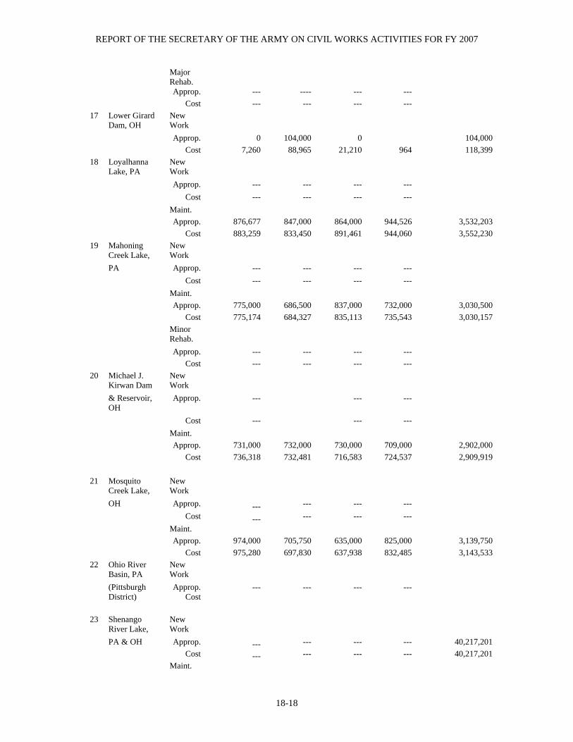
REPORT OF THE SECRETARY OF THE ARMY ON CIVIL WORKS ACTIVITIES FOR FY 2007
18-18
Major Rehab.
Approp. --- ---- --- --- Cost --- --- --- ---
17 Lower Girard Dam, OH
New Work
Approp. 0 104,000 0 104,000 Cost 7,260 88,965 21,210 964 118,399
18 Loyalhanna Lake, PA
New Work
Approp. --- --- --- --- Cost --- --- --- --- Maint. Approp. 876,677 847,000 864,000 944,526 3,532,203 Cost 883,259 833,450 891,461 944,060 3,552,230
19 Mahoning Creek Lake,
New Work
PA Approp. --- --- --- --- Cost --- --- --- --- Maint. Approp. 775,000 686,500 837,000 732,000 3,030,500 Cost 775,174 684,327 835,113 735,543 3,030,157 Minor
Rehab.
Approp. --- --- --- --- Cost --- --- --- ---
20 Michael J. Kirwan Dam
New Work
& Reservoir, OH
Approp. --- --- ---
Cost --- --- --- Maint. Approp. 731,000 732,000 730,000 709,000 2,902,000 Cost 736,318 732,481 716,583 724,537 2,909,919
21 Mosquito Creek Lake,
New Work
OH Approp. --- --- --- --- Cost --- --- --- --- Maint. Approp. 974,000 705,750 635,000 825,000 3,139,750 Cost 975,280 697,830 637,938 832,485 3,143,533
22 Ohio River Basin, PA
New Work
(Pittsburgh District)
Approp. Cost
--- --- --- ---
23 Shenango
River Lake, New Work
PA & OH Approp. --- --- --- --- 40,217,201 Cost --- --- --- --- 40,217,201 Maint.
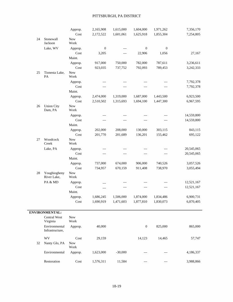
PITTSBURGH, PA DISTRICT
18-19
Approp. 2,165,908 1,615,000 1,604,000 1,971,262 7,356,170 Cost 2,172,522 1,601,061 1,625,918 1,855,304 7,254,805
24 Stonewall Jackson
New Work
Lake, WV Approp. 0 --- 0 0 Cost 3,205 --- 22,906 1,056 27,167 Maint. Approp. 917,000 750,000 782,000 787,611 3,236,611 Cost 923,035 737,752 792,093 789,453 3,242,333
25 Tionesta Lake, PA
New Work
Approp. --- --- --- --- 7,792,378 Cost --- --- --- --- 7,792,378 Maint. Approp. 2,474,000 1,319,000 1,687,000 1,443,500 6,923,500 Cost 2,510,502 1,315,693 1,694,100 1,447,300 6,967,595
26 Union City Dam, PA
New Work
Approp. --- --- --- --- 14,559,800 Cost --- --- --- --- 14,559,800 Maint. Approp. 202,000 208,000 130,000 303,115 843,115 Cost 201,770 201,689 136,201 155,462 695,122
27 Woodcock Creek
New Work
Lake, PA Approp. --- --- --- --- 20,545,065 Cost --- --- --- --- 20,545,065 Maint. Approp. 737,000 674,000 906,000 740,526 3,057,526 Cost 734,957 670,159 911,408 738,970 3,055,494
28 Youghiogheny River Lake,
New Work
PA & MD Approp. --- --- --- --- 12,521,167 Cost --- --- --- --- 12,521,167 Maint. Approp. 1,686,245 1,506,000 1,874,000 1,834,486 6,900,731 Cost 1,690,919 1,471,603 1,877,810 1,830,073 6,870,405
ENVIRONMENTAL: Central West
Virginia New Work
Environmental Infrastructure,
Approp. 40,000 0 825,000 865,000
WV Cost 29,159 14,123 14,465 57,747 32 Nanty Glo, PA New
Work
Environmental Approp. 1,623,000 -30,000 --- --- 4,186,337
Restoration Cost 1,576,311 11,584 --- --- 3,988,866

REPORT OF THE SECRETARY OF THE ARMY ON CIVIL WORKS ACTIVITIES FOR FY 2007
18-20
Ohio Environmental
New Work
Infrastructure, OH
Approp. 43,000 1,286,000 657,500 1,214,000 3,200,500
Cost 11,896 698,230 103,121 92,847 906,094 33 South Central,
PA New Work
Environmental Approp. 158,925 0 4,455,000 6,967,000 11,580,925
Improvement Program
Cost 9,085,540 1,615 3,204,848 1,396,312 13,688,315
34 Three Rivers Wet
New Work
Weather Demo
Approp. 46,000 390,000 668,000 2,094,250 3,198,250
Cost 58,668 58,784 184,831 61,906 364,189 35 Formerly Used
Sites New Work
Remedial Action
Approp. 3,180,000 1,220,000 1,410,000 1,000,000 6,810,000
Program Cost 3,221,682 1,295,445 1,085,681 744,935 6,347,743
1 Includes $2,453,737 from emergency relief funds and $1,250,049 from public works funds. 2 Includes $64,365 public works acceleration, executive funds (1963) and $191,400 provided from the Productive Employment Appropriations Act (PL 98-8) 1983 funds. Also includes $995,000 appropriated and expended for major maintenance at L&D 2, 3 & 4. 3Includes amounts appropriated to date for: Point Marion, L&D 8, PA - $113,013,400 for CG and IWTF, $3,322,057 for raising crest of dam in 1958-9, $2,086,438 for original reconstruction years 1923-26 and $618,758 for AE&D. Grays Landing, L&D 7, PA - $172,793,200 for CG and IWTF, and $803,000 for AE&D. L&D 2, 3 & 4 - $237,481,700 for CG and IWTF. 4 Includes amounts expended to date on: Point Marion, L&D 9, PA - $112,667,403 for CG and IWTF, $3,322,057 for raising crest of dam in 1958-9, $2,086,438 for original reconstruction years 1923-6 and $618,758 for AE&D. Grays Landing, L&D 7, PA - $172,751,744 for CG and IWTF, and $803,000 for AE&D. L&D 2, 3 & 4 - $237,123,612 for CG and IWTF. 5 Includes $22,549 public works acceleration, executive funds (1963), $742 for maintenance for previous project and $582,000 provided from the Productive Employment Appropriations Act (PL 98-8) 1983 funds. 6 Includes $22,549 public works acceleration, executive funds (1963), $742 for maintenance for previous project and $464,508 provided from the Productive Employment Appropriations Act (PL 98-8) 1983 funds. 7 Includes $1,999,995 emergency relief funds, $10,000,000 public work funds, $234,000 Code 711 funds and $412,088 Code 713 funds, $462,000 appropriated to and $218,374 expended on the Dam Safety Assurance Program - CG; excludes $409,622 contributed by local interest. 8 Includes $89,000 provided from the Productive Employment Appropriations, Act (PL 98-8) 1983 funds. Also includes $425,000 appropriated to and $424,493 expended on the Dam Safety Assurance Program O&M. 9 Includes $33,423 from emergency relief funds. 10 Excludes $180,485 for new work expended from contributed funds. 11 Includes $283,988 provided from the Productive Employment Appropriations Act (PL 98-8) 1983 funds. 12 Includes $1,542,500 Code 711 funds, $809,700 Code 712 funds and $99,111 Code 713 funds; excludes $100,000 contributed by local interest. 13 Includes $40,000 provided from the Productive Employment Appropriations Act (PL 98-8) 1983 funds. Includes $7,679 appropriated to and expended from M&O of dams in FY97 and $703,407 expended to date on M&O of dams. 14 Includes $5,351 from emergency relief funds and $328,000 Code 711 funds. 15 Includes $63,788 from emergency relief funds. Also includes $278,044 Code 711 funds. 16 Includes $45,000 provided from the Productive Employment Appropriations Act (PL 98-8) 1983 funds. Includes $1,918 appropriated to and expended from M&O of dams in FY97 and $697,646 expended to date on M&O of dams. 17 Includes $156,812 Code 711 funds. 18 Includes $322,000 provided from the Protective Employment Appropriations Act (PL 98-8) 1983 funds. Also includes $12,674 appropriated to and $12,674 expended to date on M&O of dams. 19 Includes $2,791 emergency relief funds, $14,622 Code 711 funds, $568,265 Code 713 funds; excludes $389,370 contributed by local interest. 20 Includes $7,339 from emergency relief funds and $274,669 Code 711 funds. 21 Includes $256,000 provided from the Protective Employment Appropriations Act (PL 98-8) 1983 funds. Also includes $104,866 appropriated to and $104,864 expended to date on M&O of dams. 22 Includes $25,671 emergency relief funds, $162,381 Code 711 funds, $561,247 Code 713 funds; excludes $500,086 contributed by local interests. 23 Includes $25,671 emergency relief funds, $162,381 Code 711 funds, $561,247 Code 713 funds; excludes $456,611 contributed by local interests. 24 Includes $74,900 Code 711 funds; excludes $4,585,627.29 for new work contributed by local interest. 25 Includes $315,500 provided from the Protective Employment Appropriations Act (PL 98-8) 1983 funds. Also includes $3,174 appropriated to

PITTSBURGH, PA DISTRICT
18-21
and $3,713 expended to date on M&O of dams. 26 Includes $122,729 Code 711 funds and $94,900 Code 713 funds. 27 Includes $8,914 from emergency relief funds. 28 Includes $1,730,100 Code 711 funds and $1,618,300 Code 713 funds. 29 Includes $152,000 provided from the Protective Employment Appropriations Act (PL 98-8) 1983 funds. Also includes $11,896 appropriated to and $11,891 expended to date on M&O of dams. 30 Includes $2,303,076 Code 711 funds ($256,760 provided from the Productive Employment Appropriations Act PL 98-8, 1983 funds), $275,900 Code 712 funds, and $24,201 emergency relief funds. 31 Includes $2,303,077 Code 711 funds, ($256,531 provided from the Productive Employment Appropriations Act PL 98-8, 1983 funds), $275,900 Code 712 funds, and $24,201 emergency relief funds. 32 Includes $203,000 provided from the Protective Employment Appropriations Act (PL 98-8) 1983 funds. Also includes $9,362 appropriated to and $9,360 expended to date on M&O of dams. 33 Includes $1,671,366 Code 711 funds. 34 Includes $1,671,366 Code 711 funds. 35 Includes $85,000 provided from the Productive Employment Appropriations Act (PL 98-8) 1983 funds). 36 Includes $2,846,263 Code 711 funds ($293,000 provided from the Productive Employment Appropriations Act. (PL 98-8) 1983 funds). 37 Includes $591,000 provided from the Protective Employment Appropriations Act (PL 98-8) 1983 funds. Also includes $22,240 appropriated to and $22,236 expended to date on M&O of Dams. 38 Includes $1,840,000 (non-federal) original construction cost and an additional $4,205,000 (non-federal) contributed and $4,159,759 (non-federal) expended to date. 39 Includes $701,504 appropriated to and $701,504 expended to date on M&O of dams. 40 Includes $104,684 appropriated to and $104,683 expended to date on M&O of dams. 41 Includes $4,225,188 (non-federal) contributed and expended to date. 42 Includes $285,000 (non-federal) contributed funds and $282,914 (non-federal) expended to date. 43 Includes $4,894,000 appropriated to date for Rehab O&M and $2,925,000 appropriated to date for Rehab Construction, General. Also includes $222,000 (non-federal) contributed funds to date. 44 Includes $4,880,202 expended to date for Rehab O&M and $2,824,695 expended to date for Rehab Construction, General. Also includes $205,323 (Non-federal) expended to date. 45 Includes $701,504 appropriated to and $701,504 expended to date on M&O of dams. 46 Includes $3,244,435 (non-federal) contributed funds and $2,565,808 (non-federal) expended to date. 47 Includes $131,618 (non-federal) contributed funds and $102,016 (non-federal) expended to date. 48 Includes $480,560 (non-federal) contributed funds and $440,103 (non-federal) expended to date. 49 Includes $867,703 (non-federal) contributed funds and $852,806 (non-federal) expended to date. 50 Includes $125,000 (non-federal) contributed funds and $99,511 (non-federal) expended to date.

REPORT OF THE SECRETARY OF THE ARMY ON CIVIL WORKS ACTIVITIES FOR FY 2007
18-22
TABLE 18-B AUTHORIZATION LEGISLATION Section in Text
Authorizing Act Date
Project and Work Authorized
Documents
1. Allegheny River, PA Aug 5, 1886 For lock and dam 1. (Fixed dam contemplated. Sep 29, 1891
Secretary of War authorized change to a moveable dam.) Annual Report, 1886, p. 1545 Annual Report, 1891, p. 2366
Jun 3, 1896 For locks and dams 2 and 3. H. Doc. 204, 54th Cong., 1st Sess. Annual Report 1896, p. 2212
Jul 25, 1912 For locks and dam 4 to 8 inclusive. H. Doc. 540, 62nd Cong., 2nd Sess. Jul 3, 1930 For a depth of 9’ in the lower 61 miles. H. Doc. 356, 71st Cong., 2nd Sess. Aug 30, 19351 Replace lock and dam 1 by a dredged channel, 9’ deep
and 200’ wide up to lock 2, and construct new locks and Dams 2 and 3, to replace existing locks and dams 2 and 3.
Rivers and Harbors Committee, Doc. 16, 72nd Cong., 1st Sess.
Aug 30, 19351 Construct locks and dam 9, raising crest of dam 8, and Dredging a navigable channel to head of pool 8.
H. Doc. 721, 71st Cong., 3rd Sess. Rivers and Harbors Committee, Doc. 27, 73rd Cong., 2nd Sess.
Jun 26, 19342 Operation and care of locks and dams provided for with funds from War Department appropriation for rivers and harbors.
3. Monongahela River, PA & WV Mar 3, 1899 Enlarge and improve lock and dam 6, additional work at lock
3; new repair steamer and new dredge boat with equipment; all at an estimated cost of $185,556.
Annual Report, 1897, p. 2423
Jun 13, 1902 Rebuild lock and dam 2 at estimated cost of $655,961. (Estimate increased in 1910 to $698,961.)
Annual Report, 1909, p. 1756
Mar 3, 1905 Acquisition of land and additional improvements at 5 and 6 At a cost of $7,850.
Annual Report, 1904, p. 460
Mar 3, 1905 Rebuild lock and dam 3 at estimated cost of $589,196. H. Doc. 209, 58th Cong., 2nd Sess. Mar 2, 1907 Reconstruct lock and dam 5 at estimated cost of $756,042. H. Doc. 209, 58th Cong., 2nd Sess. Mar 4, 1913 Reconstruct lock and dam 6 at estimated cost of $356,400.
(Estimate increased in 1916 to $418,860.) H. Doc. 1217, 62nd Cong., 3rd Sess.
Sep 22, 1922 Additional improvements at estimated cost as follow: Guide walls and guard walls, 1 to 6, $1,255,130; lengthen land chamber of lock 3 to 720’, $787,722; new chamber (360’ $1,161, 24 long), lock 4, $699,786; lock and dam 7, Lock and dam 8, $1,165,758; lock and dam 7 second chamber, $419,126; Lock and dam 8 second chamber, $504,465; reconstruction dam 4, $397,211; marine ways, repair plant, office and warehouse, $250,000 for a total of $6,640,439.
H. Doc. 288, 67th Cong., 2nd Sess.
Jul 3, 1930 Construct new locks and dam 2.5 miles below existing structure, at estimated cost of $2,175,000 in lieu of work authorized at old lock and dam 4.
Rivers and Harbors Committee, Doc. 22, 70th Cong., 2nd Sess.
Jan 31, 19313 Chief of Engineers authorized to locate new locks and dam 4 above existing structure and on such site as they may deem most desirable.
Jun 26, 19342 Operation and care of locks and dams provided for with funds from War Department appropriations for rivers and harbors.
May 17, 1950 Modification of existing project as follows: Provide 2 new locks and dams similar to Morgantown lock and dam to replace existing locks and dams 12 to 15 inclusive. Provide a movable crest on existing dam 8 to raise existing pool full elevation 4’. Provide a navigation channel of 300’ minimum bottom width and a 9’ project depth above lock and dam 8. Provide an extension of navigable channel of upper Monongahela River, into lower Tygart River for 2.1 miles at a maximum bottom width of 200’ and a 9’ project depth.
S. Doc. 100, 81st Cong., 1st Sess.
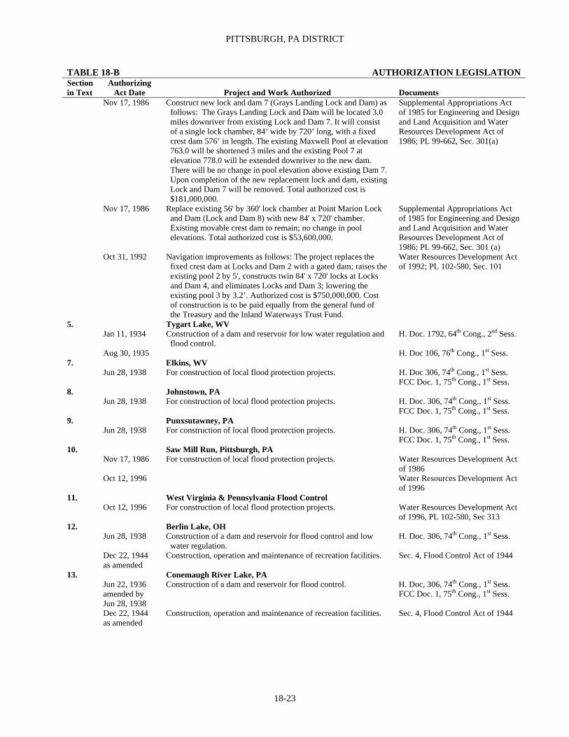
PITTSBURGH, PA DISTRICT
18-23
TABLE 18-B AUTHORIZATION LEGISLATION Section in Text
Authorizing Act Date
Project and Work Authorized
Documents
Nov 17, 1986 Construct new lock and dam 7 (Grays Landing Lock and Dam) as follows: The Grays Landing Lock and Dam will be located 3.0 miles downriver from existing Lock and Dam 7. It will consist of a single lock chamber, 84’ wide by 720’ long, with a fixed crest dam 576’ in length. The existing Maxwell Pool at elevation 763.0 will be shortened 3 miles and the existing Pool 7 at elevation 778.0 will be extended downriver to the new dam. There will be no change in pool elevation above existing Dam 7. Upon completion of the new replacement lock and dam, existing Lock and Dam 7 will be removed. Total authorized cost is $181,000,000.
Supplemental Appropriations Act of 1985 for Engineering and Design and Land Acquisition and Water Resources Development Act of 1986; PL 99-662, Sec. 301(a)
Nov 17, 1986 Replace existing 56' by 360' lock chamber at Point Marion Lock and Dam (Lock and Dam 8) with new 84' x 720' chamber. Existing movable crest dam to remain; no change in pool elevations. Total authorized cost is $53,600,000.
Supplemental Appropriations Act of 1985 for Engineering and Design and Land Acquisition and Water Resources Development Act of 1986; PL 99-662, Sec. 301 (a)
Oct 31, 1992 Navigation improvements as follows: The project replaces the fixed crest dam at Locks and Dam 2 with a gated dam; raises the existing pool 2 by 5', constructs twin 84' x 720' locks at Locks and Dam 4, and eliminates Locks and Dam 3; lowering the existing pool 3 by 3.2’. Authorized cost is $750,000,000. Cost of construction is to be paid equally from the general fund of the Treasury and the Inland Waterways Trust Fund.
Water Resources Development Act of 1992; PL 102-580, Sec. 101
5. Tygart Lake, WV Jan 11, 1934 Construction of a dam and reservoir for low water regulation and
flood control. H. Doc. 1792, 64th Cong., 2nd Sess.
Aug 30, 1935 H. Doc 106, 76th Cong., 1st Sess. 7. Elkins, WV Jun 28, 1938 For construction of local flood protection projects. H. Doc 306, 74th Cong., 1st Sess.
FCC Doc. 1, 75th Cong., 1st Sess. 8. Johnstown, PA Jun 28, 1938 For construction of local flood protection projects. H. Doc. 306, 74th Cong., 1st Sess.
FCC Doc. 1, 75th Cong., 1st Sess. 9. Punxsutawney, PA Jun 28, 1938 For construction of local flood protection projects. H. Doc. 306, 74th Cong., 1st Sess.
FCC Doc. 1, 75th Cong., 1st Sess. 10. Saw Mill Run, Pittsburgh, PA Nov 17, 1986 For construction of local flood protection projects. Water Resources Development Act
of 1986 Oct 12, 1996 Water Resources Development Act
of 1996 11. West Virginia & Pennsylvania Flood Control Oct 12, 1996 For construction of local flood protection projects. Water Resources Development Act
of 1996, PL 102-580, Sec 313 12. Berlin Lake, OH Jun 28, 1938 Construction of a dam and reservoir for flood control and low
water regulation. H. Doc. 306, 74th Cong., 1st Sess.
Dec 22, 1944 as amended
Construction, operation and maintenance of recreation facilities. Sec. 4, Flood Control Act of 1944
13. Conemaugh River Lake, PA Jun 22, 1936
amended by Jun 28, 1938
Construction of a dam and reservoir for flood control. H. Doc, 306, 74th Cong., 1st Sess. FCC Doc. 1, 75th Cong., 1st Sess.
Dec 22, 1944 as amended
Construction, operation and maintenance of recreation facilities. Sec. 4, Flood Control Act of 1944

REPORT OF THE SECRETARY OF THE ARMY ON CIVIL WORKS ACTIVITIES FOR FY 2007
18-24
Section in Text
Authorizing Act Date
Project and Work Authorized
Documents
14. Crooked Creek Lake, PA Jun 22, 1936
amended by Jun 28, 1938
Construction of a dam and reservoir for flood control. H. Doc. 306, 74th Cong., 1st Sess. FCC Doc. 1, 75th Cong., 1st Sess.
Dec 22, 1944 as amended
Construction, operation and maintenance of recreation facilities. Sec. 4, Flood Control Act of 1944
15. East Branch, Clarion River Lake, PA Jun 28, 1938 Construction of a dam and reservoir for flood control and low
water regulation. H. Doc. 306, 74th Cong., 1st Sess.
Dec 22, 1944 as amended
Construction, operation and maintenance of recreation facilities. Sec. 4, Flood Control Act of 1944
16. Kinzua Dam & Allegheny Reservoir, PA & NY Jun 22, 1936
amended by Jun 28, 1938 modified by Aug 18, 1941
Construction of a dam and reservoir for flood control and low Water regulation and recreation.
H. Doc. 306, 74th Cong., 1st Sess. FCC Doc. 1, 75th Cong., 1st Sess.
Construction of a dam and reservoir for flood control, pollution Abatement, low water regulation and recreation.
H. Doc. 300, 76th Cong., 1st Sess.
Dec 22, 1944 Construction, operation and maintenance of recreation facilities. Sec. 4, Flood Control Act of 1944 17. Lower Girard Dam, OH Design and construction assistance to non-federal interests Sec 507, WRDA 1996 PL 104-303 For repair and rehabilitation of the Lower Girard Dam 18. Loyalhanna Lake, PA Jun 22, 1936
amended by Jun 28, 1938
Construction of a dam and reservoir for flood control. H. Doc. 306, 74th Cong., 1st Sess. FCC Doc. 1, 75th Cong., 1st Sess.
Dec 22, 1944 as amended
Construction, operation and maintenance of recreation facilities. Sec. 4, Flood Control Act of 1944
19. Mahoning Creek Lake, PA Jun 22, 1936
amended by Jun 28, 1938
Construction of a dam and reservoir for flood control. H. Doc. 306, 74th Cong., 1st Sess. FCC Doc. 1, 75th Cong., 1st Sess.
Dec 22, 1944 as amended
Construction, operation and maintenance of recreation facilities. Sec. 4, Flood Control Act of 1944
20. Michael J. Kirwan Dam & Reservoir, OH Jul 3, 1958 Construction of a dam and reservoir for flood control, water
Supply, low water regulation and recreation. H. Doc. 191, 85th Cong., 1st Sess.
Jul 14, 1960 To define cost-sharing arrangement for municipal and industrial water supply and water for pollution abatement purposes.
PL 86-645
21. Mosquito Creek Lake, OH Jun 28, 1938 Construction of a dam and reservoir for flood control and low
water regulation. H. Doc. 306, 74th Cong., 1st Sess.
Dec 22, 1944 as amended
Construction, operation and maintenance of recreation facilities. Sec. 4, Flood Control Act of 1944
22. Ohio River Basin (Pittsburgh District) Aug 28, 1937 Construct levees, floodwalls and drainage structures for
protection of cities and towns in Ohio River Basin. Projects to be selected by Chief of Engineers with approval of Secretary of War at a cost not to exceed $24,877,000 for construction.
Flood Control Committee, Doc. 1, 75th Cong., 1st Sess.
Jun 28, 1938 Approved general comprehensive plan for flood control and other purposes in Ohio River Basin as may be advisable at discretion of Secretary of War and Chief of Engineers, and for initiation and partial accomplishment of plan, authorized $75,000,000 for reservoirs and $50,300,000 for local flood protection works.
Flood Control Committee, Doc. 1, 75th Cong., 1st Sess.
Aug 18, 1941 Additional $45 million for prosecution of comprehensive plan for Ohio River Basin.
H. Doc. 300, 76th Cong., 1st Sess.

PITTSBURGH, PA DISTRICT
18-25
Section in Text
Authorizing Act Date
Project and Work Authorized
Documents
Dec 22, 1944 Additional $70 million for further prosecution of comprehensive plan for Ohio River Basin, including additional projects in tributary basins.
H. Doc. 762, 77th Cong., 2nd Sess.
Jul 24, 1946 Additional $125 million for further prosecution of comprehensive plan including additional projects in tributary basins.
H. Doc. 506, 78th Cong., 1st Sess.
May 17, 1950 Additional $100 million for prosecution of comprehensive plan for Ohio River Basin
S. Doc. 20, 81stCong., 1st Sess.
Dec 30, 1963 Additional $150 million for further prosecution of comprehensive plan for flood control and other purposes in Ohio River Basin.
PL 88-253, 88th Cong., 1st Sess.
Jun 18, 1965 Additional $89 million for further prosecution of comprehensive plan for Ohio River Basin.
H. Doc. 6755, 89th Cong., 1st Sess.
May 12, 1967 Additional $38 million for further prosecution of comprehensive plan for Ohio River Basin.
PL 90-17, 90th Cong., 1st Sess.
Aug 13, 1968 Additional $35 million for further prosecution of comprehensive plan for Ohio River Basin.
PL 90-483, 90th Cong., 2nd Sess.
Jun 19, 1970 Additional $69 million for further prosecution of comprehensive plan for Ohio River Basin.
H. Doc. 15166, 91st Cong., 2nd Sess.
Mar 7, 1974 Additional $120 million for further prosecution of comprehensive plan for Ohio River Basin.
H. Doc. 10203, 93rd Cong. River Basin Monetary Authorization Act of 1974
Oct 22, 1976 Authorized Phase I design memorandum stage of advanced engineering and design of the project for abatement of acid mine drainage in the Clarion River Basin, PA.
Water Resources Development Act of 1976; PL 94-587, Sec. 101 (a)
23. Shenango River Lake, PA & OH Jun 28, 1938 Construction of a dam and reservoir for flood control and low
water regulation and recreation. H. Doc. 306, 74th Cong., 1st Sess. FCC Doc. 1, 75th Cong., 1st Sess.
Dec 22, 1944 as amended
Construction, operation and maintenance of recreation facilities. Sec. 4, Flood Control Act of 1944
24. Stonewall Jackson Lake, WV Nov 7, 1966 Construction of a dam and reservoir for flood control, water
supply, water quality control, area redevelopment and recreation. S. Doc. 109, 89th Cong., 2nd Sess.
25. Tionesta Lake, PA Jun 22, 1936
amended by Jun 28, 1938
Construction of a dam and reservoir for flood control and low water regulation.
H. Doc. 306, 74th Cong., 1st Sess. FCC Doc. 1, 75th Cong., 1st Sess.
Dec 22, 1944 as amended
Construction, operation and maintenance of recreation facilities. Sec. 4, Flood Control Act of 1944
26. Union City Dam, PA Oct 23, 1962 Construction of a dam and reservoir for flood control. S. Doc. 95, 87th Cong., 2nd Sess. 27. Woodcock Creek Lake, PA Oct 23, 1962 Construction of a dam and reservoir for flood control, recreation
and storage for water quality control. S. Doc. 95, 87th Cong., 2nd Sess.
28. Youghiogheny River Lake, PA & MD Jun 28, 1938 Construction of a dam and reservoir for flood control, low-flow
Augmentation and pollution abatement purposes. H. Doc. 306, 74th Cong., 1st Sess. FCC Doc. 1, 75th Cong., 1st Sess.
Dec 22, 1944 as amended
Construction, operation and maintenance of recreation facilities. Sec. 4, Flood Control Act of 1944
33. South Central, PA Environmental Improvement Program Oct 31, 1992 Construction of local flood protection projects. Water Resources Development Act
of 1992; PL 102-580, Sec 313 34. Three Rivers Wet Weather Demonstration Project Oct 31,1992 Environmental infrastructure Water Resources Development Act
Of 1992, PL 102-850, Sec 219 35. Formerly Used Sites Remedial Action Program (FUSRAP) Jul 5, 2001 Coordination on cleanup and decommissioning of the FUSRAP
sites. PL 107-117, Sec 8143
1 Included in the Emergency Relief Program, April 8, 1935. 2 Permanent Appropriations Repeal Act. 3 Public Res. 117, 71st Cong., 3rd Sess.

REPORT OF THE SECRETARY OF THE ARMY ON CIVIL WORKS ACTIVITIES FOR FY 2007
18-26
TABLE 18-C
OTHER AUTHORIZED NAVIGATION PROJECTS (See Section 6 of Text)
Project
Status
For Last Full Report See
Annual Report
Construction
Cost to September 30, 2007
Operations and Maintenance Allegheny River, PA Open-Channel Work Completed 1934 197,000 133,940 Buckhannon River, WV1,2 Completed 1893 5,500 Cheat River, WV1,2 Completed 1895 12,997 Pittsburgh Harbor, PA Completed 1922 110,663 81,613 1 Abandonment recommended in H. Doc. 467, 69th Cong., 1st Sess. 2 No commerce reported.

PITTSBURGH, PA DISTRICT
18-27
TABLE 18-E OTHER AUTHORIZED FLOOD CONTROL PROJECTS (All Projects Not Specifically Identified in Text)
Project and Status
For Last Full Report See Annual Report For
Construction (Federal Cost)
Non-Federal Cost
Cost to September 30, 2007
Operations and Maintenance
Flood Protection Specifically Authorized Projects Completed:
Bradford, PA 1962 7,601,763 1,895,000 Brookville, PA 1963 964,976 289,000 Buckhannon, WV 1972 1,568,661 75,000 Butler, PA 1970 1,556,181 534,000 DuBois, PA 1979 4,464,607 910,000 Johnsonburg, PA 1958 674,664 130,000 Kittanning, PA, Part 1 1949 130,317 2,000 Latrobe, PA 1951 207,659 44,400 Latrobe, PA 1970 2,556,652 698,000 Olean, NY 1954 3,217,531 597,000 Portage, PA 1965 150,386 14,900 Portville, NY 1954 2,070,484 353,000 Reynoldsville, PA 1959 385,494 26,000 Ridgeway, PA (Elk Creek) 1964 628,888 465,000 Salamanca, NY 1972 2,880,535 4,180,720 Turtle Creek, PA 1998 22,500,079 323,000 Washington, PA 1964 789,093 113,000 Wellsville, OR Section 1 1965 483,910 Wellsville, OR Section 11 1956 157,633 152,200 Youngstown, OH 1976 3,621,134
Specifically Authorized Projects Deferred: Benwood, WV 1954 81,028 Chartiers Creek, PA 1998 26,592,965
Authorized by Chief of Engineers Completed: Amsterdam, OH 1964 183,072 22,500 Big Run, PA 1965 364,208 35,900 Burgettstown, PA 83,129 Friendsville, MD 41,529 2,200 Girty’s Run, Millvale, PA 1986 2,655,934 701,722 Grantville, PA -- 75,908 3,000 Leetonia, OH -- 89,299 17,200 Oil City, PA -- 43,595 Oil City Ice Control Structures 1987 3,927,792 25,000 Root Creek, Bolivar, NY 1986 1,591,436 Slovan, PA -- 57,811 Sykesville, PA -- 184,246 9,000 Tarentum, PA 1964 136,591 24,600 Tenmile Creek at Marianna, PA 1981 1,554,428 West Little Pine Creek, Etna, PA -- 2,021,852 86,200 Wilmore, PA -- 96,853 1,300
Authorized by Chief of Engineers Active: Ridgeway & Vicinity (Clarion River)2 1979 132,464
Authorized by Chief of Engineers Inactive: Black Fork at Hendricks, WV 1972 6,800 Oakdale, PA -- 14,127 Rouseville, PA -- 1,642 Wallace, WV1 -- 11,035 Weston Mills, Olean, NY -- 50,100 Weston Mills, Portville, NY -- 52,100
Reservoirs Rowlesburg Lake, WV 1977 2,873,799
1 Lacks local support. 2 No longer economically justified.

REPORT OF THE SECRETARY OF THE ARMY ON CIVIL WORKS ACTIVITIES FOR FY 2007
18-28
TABLE 18-G DEAUTHORIZED PROJECTS Project
For Last Full Report See Annual Report for
Date Deauthorized
Federal Funds
Expended
Contributed Funds
Expended Adena, OH (Short Creek) Aug 5, 1977 13,452 Allegany, NY Unit I (Allegheny River)1 Nov 17, 1986 4,100 Allegany, NY Unit II (Five Mile Creek Area)1 1975 Nov 17, 1986 64,851 Bellaire, OH May 6, 1981 76,487 Brackenridge, Tarentum and Natrona, PA1 Nov 17, 1986 Brilliant, OH Aug 5, 1977 Brockway, PA (Allegheny River Basin) Aug 5, 1977 194 Clarington, OH Aug 5, 1977 Coraopolis, PA Aug 5, 1977 Dillonvale, OH (Short Creek) Aug 5, 1977 16,884 Eagle Creek Reservoir, OH Jan 1, 1990 100,000 Empire-Stratton, OH1 Nov 17, 1986 33,031 Follansbee, WV Aug 5, 1977 Freeport, PA (Allegheny River) Aug 5, 1977 Industry, PA Aug 5, 1977 Kittanning, PA, Part 11 (Allegheny River) Nov 6, 1977 Lake Chautauqua and Chadakoin River, NY2 1965 Mar 2, 1970 190,722 Lake Erie-OW Canal, OH and PA - 1935 Act 1972 May 6, 1981 1,342,000 Leetsdale, PA Nov 17, 1986 Martins Ferry, OH1 1941 Nov 17, 1986 25,164 McKees Rocks, PA Oct 3, 1978 Mingo Junction, QH Aug 5, 1977 Moundsville, WV1 Nov 17, 1986 Muddy Creek Dam, PA1 1977 Nov 17, 1986 402,459 Neville Island, PA1 Nov 17, 1986 New Cumberland, WV Aug 5, 1977 New Kensington and Parnassus, PA1 Nov 17, 1986 Pittsburgh, PA (Golden Triangle) Oct 3, 1978 Pittsburgh, PA (North Side) Oct 3, 1978 Pittsburgh, PA (The Strip) Oct 3, 1978 Powhaten Point, OH1 Nov 17, 1986 Proctor, WV1 Nov 17, 1986 Redbank Creek Lake, PA Aug 5, 1977 156,377 Rochester, PA1 Nov 17, 1986 St. Marys, PA (Allegheny River Basin) Aug 5, 1977 13,529 Smith Ferry, PA Aug 5, 1977 Uniontown, PA 1956 Jan 1, 1990 Warwood, WV1 Nov 17, 1986 Wellsburg, WV Aug 5, 1977 6,387 West Bridgewater, PA Aug 5, 1977 Wheeling, WV1 1954 Nov 17, 1986 189,067 Wheeling, WV (North Wheeling)1 Nov 17, 1986 Wheeling, WV (Wheeling Island)1 Nov 17, 1986 21,700 Wilcox, PA3 Mar 5, 1955 16,761 Woodlands, WV1 Nov 17, 1986 Youghiogheny River, PA and MD (Canalization)1, 4 1971 Nov 17, 1986 232,863 1 Deauthorized under Water Resource Act of 1986 (PL 99-662). 2 Local interests failed to meet requirements of cooperation, authority for project expired Mar 2, 1970. 3 Local interests failed to meet requirements of cooperation, authority for project expired Mar 5, 1955. 4 Includes $47,195 construction costs expended under previous project and $1,700 O&M costs expended under previous project.

PITTSBURGH, PA DISTRICT
18-29
TABLE 18-H ALLEGHENY RIVER, PA, LOCKS AND DAMS (See Section 1 of Text)
Dimensions
Depth on Miter Sills at Normal Pool Level1
Character of Foundation
Type of Construction
No.
Mile
s Abo
ve
Mou
th
Nearest Town
Width of
Chamber (feet)
Available Length
to Full
Width (feet)
Upper Lift at
Normal Pool
Level (feet)
Normal Pool
Elevation (feet, mean
sea level)
Lower (feet)
Upper (feet)
Lock
Dam
Kind of Dam
Lock
Dam Pe
rcen
t C
ompl
ete
Yea
r O
pen
to N
av
Actual Cost
2 6.7 Aspinwall, PA 56 360 11.0 721.0 12.0 10.9 Rock Rock Fixed Concrete Concrete 100 19342 1,763,485 3 14.5 Cheswick, PA 56 360 13.8 734.8 10.8 11.8 Rock Pile-Rock Fixed Concrete Concrete 100 19342 1,875.665 4 24.2 Natrona, PA 56 360 10.6 745.4 10.0 8.5 Rock Rock Fixed Concrete Concrete 100 1927 1,707.690 5 30.4 Freeport, PA 56 360 11.6 757.0 10.5 10.3 Piling Crib-Pile Fixed Concrete Concrete 100 1927 1,940,537 6 36.3 Clinton, PA 56 360 12.4 769.4 10.6 10.8 Rock Crib-Pile Fixed Concrete Concrete 100 1928 1,523,959 7 45.7 Kittanning, PA 56 360 13.0 782.4 9.8 10.9 Piling Steel Sheet
Piling Fixed Concrete Concrete 100 1930 1,460,008
8 52.6 Templeton, PA 56 360 17.8 800.2 10.4 13.8 Rock Rock Fixed Concrete Concrete 100 1931 2,848,920 9 62.2 Rimer, PA 56 360 22.0 822.2 10.5 11.3 Rock Rock Fixed Concrete Concrete 100 1938 2,510,373 Abandoned lock and dam 1 591,187 Abandoned lock and dam 2 544,929 Abandoned lock and dam 3 310,103 Demolishing old dam 1 26,001 Dredging channel 1,055,003 Total 18,157,860 1 All depths as shown are on guard sills and are controlling depth. 2 Dates shown represent replacement structures. TABLE 18-I MONONGAHELA RIVER, PA, LOCKS AND DAMS
(See Section 3 of Text)
Dimensions
Depth on Miter Sills at Normal
Pool Level1
Character of Foundation
Type of
Construction
No.
Mile
s Abo
ve
Mou
th
Nearest Town
Width of
Chamber (feet)
Available Length to
Full Width
(feet)
Upper Lift at
Normal Pool
Level (feet)
Normal Pool
Elevation
(feet, mean
sea level)
Lower (feet)
Upper (feet)
Lock
Dam
Kind Of Dam
Lock
Dam
Perc
ent
Com
plet
e
Yea
r O
pen
to
Nav
Actual Cost
2 11.2 Braddock, PA
56 110
360 720
8.7 718.7 16.0 16.0 Rock Crib-Pile
Fixed Concrete Concrete 100 19532 145,057,0685.7
3 23.8 Elizabeth, PA
563 360 720
8.2 726.9 11.6 11.9 Rock Crib-Pile
Fixed Concrete Concrete 100 1907 58,132,8045,8
4 41.5 Charleroi, PA
563 360 720
16.6 743.5 10.7 20.0 Piles Piles Gated Concrete Concrete 100 19322 106,155,0625,6
--
61.2 Maxwell Locks and Dam - Maxwell, PA
843 720 19.5 763.0 15.0 20.5 Rock Rock Gated Concrete Concrete 100 19642 30,110,8895

REPORT OF THE SECRETARY OF THE ARMY ON CIVIL WORKS ACTIVITIES FOR FY 2007
18-30
TABLE 18-I MONONGAHELA RIVER, PA, LOCKS AND DAMS (See Section 3 of Text)
Dimensions
Depth on Miter Sills at Normal
Pool Level1
Character of Foundation
Type of
Construction
No.
Mile
s Abo
ve
Mou
th
Nearest Town
Wid
th
of
Cha
mbe
r (f
eet)
Available Length to
Full Width
(feet)
Upper Lift at
Normal Pool
Level (feet)
Normal Pool
Elevation (feet, mean
sea level)
Lower (feet)
Upper (feet)
Lock
Dam
Kind Of Dam
Lock
Dam Pe
rcen
t C
ompl
ete
Yea
r O
pen
to N
av
Actual Cost
--
82.2 Grays Landing Locks and Dam, PA
84 720 15.0 778.0 18.0 26.0 Rock Rock Fixed Concrete Concrete 100 1994 173,573,5869
--
90.8 Point Marion Locks and Dam, PA
84 720 19.0 797.0 16.2 16.2 Rock Rock Gated Concrete Concrete 100 19932 118,694,65610
--
102.0 Morgantown Locks and Dam, PA
84 600 17.0 814.0 14.5 17.8 Rock Rock Gated Concrete Concrete 100 1950 8,778,0005
--
108.0 Hildebrand Locks and Dam, 6 miles Morgantown, WV
84 600 21.0 835.0 15.0 14.0 Rock Rock Gated Concrete Concrete 100 1959 12,506,8295
--
115.4 Opekiska Locks And Dam, 13.4 miles Morgantown, WV
84 600 22.0 857.0 14.0 17.8 Rock Rock Gated Concrete Concrete 100 1964 25,179,6225
Marine Ways, etc. 250,000 Abandoned lock and dam 1 1,019,9075 Abandoned lock and dam 4 780,8165 Abandoned lock and dam 5 1,074,8125 Abandoned lock and dam 6 770,4495 Abandoned lock and dam 7 2,853,5805 Abandoned lock and dam 8 245,90010 Abandoned lock and dam 9 191,0005 Abandoned lock and dam 10 210,4455 Abandoned lock and dam 11 227,6685 Abandoned lock and dam 12 200,5505 Abandoned lock and dam 13 190,6915 Abandoned lock and dam 14 210,1275 Abandoned lock and dam 15 175,8295 Dredging channel 587,8995 Total 655,658,1335 1 All depths as shown are on guard sills and controlling depth. 2 Dates shown for locks and dams number 2 to 8 inclusive represent reconstruction. 3 2 chamber. 4 Includes $3,322,057 for raising crest of dam (1958-9), $2,086,438 for original reconstruction (1923-6), $618,758 AE&D costs for replacement of lock, and $112,667,403 for replacement of lock ($56,215,160 CG funds; $56,452,243 from Inland Waterways Trust Fund). 5 Actual cost may include estimated costs which have been footnoted as necessary. 6 Includes $2,173,767 for original reconstruction (1931-2) and $15,080,304 for reconstruction of dam (1963-7). 7 Includes $16,967,114 for reconstruction of locks. 8 Includes $15,857,000 for major rehabilitation. 9 Includes AE&D costs for proposed lock ($803,000) as well as $172,692,644 expended in CG and IWTF. 10 Includes $213,776 original project and $2,639,804 for reconstruction (1925).

PITTSBURGH, PA DISTRICT
18-31
TABLE 18-J MONONGAHELA RIVER, PA & WV TOTAL COSTS OF EXISTING PROJECT TO END OF FISCAL YEAR
(See Section 3 of Text) Funds New Work Operations & Maintenance,
General Total
Regular $661,059,8321, 3 $386,988,4322 $1,048,048,2641, 2, 3 Maintenance and Operation 452,623 Public Works Acceleration Exec 22,549
Total $661,059,8321, 3 $386,988,4322 $1,048,523,4361, 2, 3 1 Includes $5,420,541 for new work for previous projects. 2 Includes $20,446,587 expended between July 7, 1897 and June 30, 1937 on operation and care of works of improvement under revisions of permanent appropriation for such purposes and excludes $742 for maintenance of previous projects. 3 Includes $15,857,000 for major rehabilitation of L/D 3. TABLE 18-K OHIO RIVER BASIN (PITTSBURGH DISTRICT)
RESERVOIRS (See Section 22 of Text) Tributary Basin and Reservoir Stream Total Cost Allegheny: Conemaugh River, PA Conemaugh River $ 46,012,411 Crooked Creek, PA Crooked Creek 4,482,933 East Branch, Clarion River, PA Clarion River 9,539,586 Kinzua Dam and Allegheny Reservoir, PA and NY Allegheny River 112,226,0761 Loyalhanna, PA Loyalhanna Creek 5,727,531 Mahoning Creek, PA Mahoning Creek 7,144,973 Tionesta, PA Tionesta Creek 7,792,378 Union City, PA French Creek 14,559,800 Woodcock Creek, PA Woodcock Creek 20,545,065 Beaver: Berlin, OH Mahoning River 8,739,987 Michael J. Kirwan, OH Mahoning River 17,376,097 Mosquito Creek, OH Mosquito Creek 4,253,029 Shenango River, PA and OH Shenango River 40,217,201 Monongahela: Stonewall Jackson Lake, WV West Fork River 212,520,731 Youghiogheny River, PA and MD Youghiogheny River 12,521,167 1 Includes $2,921,000 for dam rehabilitation.

REPORT OF THE SECRETARY OF THE ARMY ON CIVIL WORKS ACTIVITIES FOR FY 2007
18-32
TABLE 18-L INSPECTION OF COMPLETED FLOOD CONTROL PROJECTS (See Section 29 of Text)
Project
Date of Inspection
Project
Date of Inspection
Project
Date of Inspection
Baldwin Borough Dec 2006
Friendsville, PA Mar 2007 Portage, PA May 2007
Bolivar, PA Oct 2006
Gilpin Township Jun 2007 Portville, NY Oct 2006
Bradford, PA
May 2007 Johnstown, PA Sep 2007 Punxsutawney, PA Nov 2006
Canonsburg/Houston, PA
Jul 2007 Kittanning, PA Jan 2007 Reynoldsville-Sandy Lick Creek
Jun 2007
Confluence Borough
Aug 2007 Latrobe Borough Jul 2007 Salamanca, NY Oct 2006
Darlington Township Feb 2007 Leetonia, OH May 2007 Shaler Township Jul 2007
Derry Borough & Derry Township
Jun 2007 Marianna, PA Jan 2007 Southmont Borough
Aug 2007
Eldred Borough
Sep 2007 New Kensington, PA Jun 2007 Tarentum, PA May 2007
Franklin Borough
Aug 2007 Oil City, PA Aug 2007 Wilmore, PA Apr 2007
Freeport Township Feb 2007 Olean, NY
Oct 2006 Youngstown, OH Aug 2007
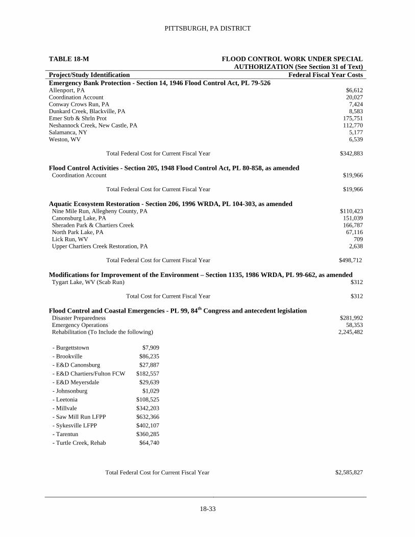
PITTSBURGH, PA DISTRICT
18-33
TABLE 18-M FLOOD CONTROL WORK UNDER SPECIAL AUTHORIZATION (See Section 31 of Text)
Project/Study Identification Federal Fiscal Year Costs Emergency Bank Protection - Section 14, 1946 Flood Control Act, PL 79-526 Allenport, PA $6,612 Coordination Account 20,027 Conway Crows Run, PA 7,424 Dunkard Creek, Blackville, PA 8,583 Emer Strb & Shrln Prot 175,751 Neshannock Creek, New Castle, PA 112,770 Salamanca, NY 5,177 Weston, WV 6,539
Total Federal Cost for Current Fiscal Year $342,883 Flood Control Activities - Section 205, 1948 Flood Control Act, PL 80-858, as amended Coordination Account $19,966
Total Federal Cost for Current Fiscal Year $19,966
Aquatic Ecosystem Restoration - Section 206, 1996 WRDA, PL 104-303, as amended Nine Mile Run, Allegheny County, PA $110,423 Canonsburg Lake, PA 151,039 Sheraden Park & Chartiers Creek 166,787 North Park Lake, PA 67,116 Lick Run, WV 709 Upper Chartiers Creek Restoration, PA 2,638
Total Federal Cost for Current Fiscal Year $498,712
Modifications for Improvement of the Environment – Section 1135, 1986 WRDA, PL 99-662, as amended Tygart Lake, WV (Scab Run) $312
Total Cost for Current Fiscal Year $312
Flood Control and Coastal Emergencies - PL 99, 84th Congress and antecedent legislation Disaster Preparedness $281,992 Emergency Operations 58,353 Rehabilitation (To Include the following)
- Burgettstown $7,909 - Brookville $86,235 - E&D Canonsburg $27,887 - E&D Chartiers/Fulton FCW $182,557 - E&D Meyersdale $29,639 - Johnsonburg $1,029 - Leetonia $108,525 - Millvale $342,203 - Saw Mill Run LFPP $632,366 - Sykesville LFPP $402,107 - Tarentun $360,285 - Turtle Creek, Rehab $64,740
Total Federal Cost for Current Fiscal Year
2,245,482
$2,585,827

OHIO RIVER For actual construction of locks and dams, and operation and care of completed structures, the Ohio River is divided into three sections under immediate supervision and direction of District Engineers at Pittsburgh, Huntington, and Louisville. Pittsburgh section extends 127 miles from head of river at Pittsburgh, PA, to a point immediately upstream from New Martinsville, WV, and includes Emsworth, Dashields, Montgomery, New Cumberland, Pike Island, and Hannibal Locks and Dams. Huntington section
extends 311 miles from mile 127 to 438 immediately upstream from Foster, KY, and includes Willow Island, Belleville, Racine, Robert C. Byrd, Greenup, and Captain Anthony Meldahl Locks and Dams. Louisville section extends 543 miles from mile 438 to mouth of river, and includes Markland and McAlpine Locks and Dams (with Louisville and Portland Canal), Cannelton, Newburgh, John T. Myers, and Smithland Locks and Dams, and Locks and Dams 52 and 53.
Improvements
Navigation 1. Construction of locks and dams on Ohio River………………………………….19-1
2. Open channel work, Ohio River…………...19-4
General Investigations 1. Upper Ohio Navigational Study……….…..19-5
Tables Table 19-A Cost and Financial Statement…...19-6 Table 19-B Authorizing Legislation………....19-6 Table 19-C Not Applicable Table 19-D Not Applicable
Table 19-E Not Applicable Table 19-F Not Applicable Table 19-G Not Applicable Table 19-H Construction of Locks and Dams On Ohio River, Total Cost of Existing Project…………………19-7 Table 19-I Federal Energy Regulatory Commission Licenses of Locks and Dams, Ohio River…..……...19-7 Table 19-J Ohio River Locks and Dams Statistics……...………………...19-8
Navigation
1. CONSTRUCTION OF LOCKS AND DAMS ON OHIO RIVER
Location. The Ohio River is formed by junction of Allegheny and Monongahela Rivers at Pittsburgh, PA, and flows generally southwesterly for 981 miles to join Mississippi River near Cairo, IL. For description of river see page 1227, 1932 Annual Report.
Previous Projects. For details see page 1907 of 1915 Annual Report.
Existing project. Provides for improvement of entire river by construction of locks and dams to provide channel depth of 9 feet and for widening Louisville and Portland Canal at Louisville, KY. Project provides for two locks (110 feet by 600 feet and 56 feet by 360 feet) at Emsworth, Dashields and Montgomery. The dams at Emsworth and Montgomery are movable crests while at Dashields it is a fixed crest. Below Montgomery Locks and Dam, the existing project consists of fixed dams with
movable crests with two locks (110 by 1,200 feet and 110 by 600 feet) at New Cumberland, Pike Island, Hannibal, Willow Island, Belleville, Racine, Greenup, Captain Anthony Meldahl, Markland, Cannelton, Newburgh, and John T. Myers; two locks 110 by 1,200 feet at Robert C Byrd and Smithland; 110- by 1,200-foot temporary locks in addition to the existing locks at Locks and Dams 52 and 53, and reconstruction to provide a 110- by 1,200-foot lock in addition to existing locks and a fixed dam with two sections of movable crest at McAlpine Locks and Dam; widening Louisville and Portland Canal to 500 feet. Auxiliary lock 56 by 360 feet at McAlpine Locks and Dam has been inoperative since failure of downstream lock gates in December 1972. Rehabilitation of existing Locks and Dams 52 and 53 was started in September 1979 under the purview of Section 6, March 1909 Act. Mound City was also considered authorized under purview of 1909 Act, and preconstruction planning was performed in the period 1965 to 1972. The ruling of the U.S. District Court, District of Columbia, on September 6, 1974, with reference to Lock and Dam 26, Mississippi River, would
19-1
REPORT OF THE SECRETARY OF THE ARMY ON CIVIL WORKS ACTIVITIES FOR FY 2007
also apply to this project. Consequently, it is no longer considered authorized. Operation and care of locks and dams were included in project July 1, 1935, under provisions of Permanent Appropriations Repeal Act of June 26, 1934. Estimated Federal cost of new work, is $3,600,490,636. Foregoing estimate does not include expenditures on previous projects. Various items previously included in this project are considered inactive or unnecessary and are excluded from foregoing cost estimate. See page 693, Annual Report, 1968, for items and estimated cost. Under authority of 1910 River and Harbor Act, Louisville and Portland Canal was widened to 200 feet; Locks and Dams 40 and 42 eliminated; Locks and Dams 1 and 2 replaced by Emsworth Locks and Dam; Lock and Dam 3 replaced by Dashields Locks and Dam; and Locks and Dams 4, 5, and 6 replaced by Montgomery Locks and Dam. Locks and Dams 24, 25, and 26 were replaced by Robert C. Byrd Locks and Dam authorized by August 30, 1935, Act, and constructed under project for improving lower Kanawha River. Locks and Dams 7, 8, and 9 were replaced by New Cumberland Locks and Dam; Locks and Dams 10 and 11 were replaced by Pike Island Locks and Dam; Locks and Dams 12, 13, and 14 were replaced by Hannibal Locks and Dam; Locks and Dams 15, 16, and 17 were replaced by Willow Island Locks and Dam; Locks and Dams 18, 19, and 20 were replaced by Belleville Locks and Dam; Locks and Dams 21, 22, and 23 were replaced by Racine Locks and Dam; Locks and Dams 27, 28, 29, and 30 were replaced by Greenup Locks and Dam; Locks and Dams 31, 32, 33, and 34 were replaced by Captain Anthony Meldahl Locks and Dam; Locks and Dams 35, 36, 37, 38, and 39 were replaced by Markland Locks and Dam; the Louisville and Portland Canal at McAlpine Locks and Dam was widened to 500 feet. Locks and Dams 43, 44, and 45 were replaced by Cannelton Locks and Dam; Locks and Dams 46 and 47 were replaced by Newburgh Locks and Dam; Locks and Dams 48 and 49 were replaced by John T. Myers Locks and Dam, and Locks and Dams 50 and 51 were replaced by Smithland Locks and Dam, as modifications to existing project under purview of Section 6, March 3, 1909 Act, reducing total number of structures to 20. The Water Resources Development Act of 1974 combined the Newburgh Bank Protection Works project with the Newburgh Locks and Dam project. A December 1981 Act established the Falls of the Ohio National Wildlife Conservation Area near McAlpine Locks and Dam to protect and preserve existing fossilized coral and a diversity of wildlife. A November 17, 1988 Act authorized a replacement structure for Locks & Dams 52 & 53 at Olmsted, IL. A November 28, 1990 Act authorized an interpretive center at the Falls of the Ohio National Wildlife Conservation Area near McAlpine Locks & Dam and a replacement of the existing 110 foot x 600 foot lock at McAlpine Locks &
Dam, IN & KY. Table 19-J contains data relative to various features of locks and dams included in existing project. For list of principal towns and cities along Ohio River with their mileage below Pittsburgh, PA, see page 1060, 1962 Annual Report. See Table 19-I for licenses.
Navigation system of 20 locks and dams is in operation and 9-foot navigation throughout length of river is generally available at all times. At certain unstable bars project depth is maintained by dredging, supplemented by contraction works. (See “Open Channel Work, Ohio River.”) Table 19-J shows cost and year completion of locks and dams now in operation. New Cumberland, Pike Island, Hannibal, Willow Island, Belleville, Racine, Greenup, Captain Anthony Meldahl, Markland, McAlpine, Cannelton, Newburgh, John T. Myers, and Smithland replacement locks and dams are in operation, replacing 39 old low-lift locks and dams. For total cost of existing project, see Table 19-H.
Terminal facilities. Modern public terminals, with warehouses, equipped with operating machinery for transferring materials, have been constructed by private interests at some of the larger cities and towns. A list of terminals on Ohio River is revised annually and can be obtained from Division Engineer, U.S. Army Engineer Division, Great Lakes & Ohio River, Cincinnati, Ohio.
Operations during fiscal year. New work by contract and hired labor: Emsworth Locks and Dam: The major rehabilitation is ongoing and consists of providing two sets of emergency bulkheads, providing permanent erosion protection downstream of the dams, replacing 13 lift gates and associated electrical and mechanical systems, and rehabilitation of the two service bridges. $14.9M was appropriated and $13.1M was expended in FY 2006. A $18.9M contract to replace the Back Channel Dam Gates was awarded in Sep 2005 and is ongoing, plans and specifications and a hydraulic model study of the erosion protection are ongoing, the emergency bulkheads have been fabricated and were delivered in July 2006.
Greenup Locks and Dam: WRDA 2000 authorized improvements to Greenup L&D, KY and OH. Preconstruction Engineering and Design is underway consisting of geotechnical investigations, design report for the lock extension, mitigation model studies, and archaeological, historical, cultural, and biological work. PED is scheduled for completion in 2009. In FY 2004 the following security measures were completed under contract for $2,668,000. Physical security improvements included fencing, window and door hardening, and the hardening of other access points into buildings and electronic security improvements included the installation of intrusion detection systems, CCTV
19-2

OHIO RIVER
surveillance, and a system for electronic access control to critical areas of the projects. In FY 2007 a contract was awarded in September to rebuild the crane at the project at an estimated cost of $2,483,000. The work should be completed in FY 2008 pending availability of funds.
Robert C. Byrd Locks and Dam: The existing project, constructed under project for improving lower Kanawha River, was placed in operation in August 1937. The dimensions of the original lock chambers and poor approach conditions, particularly to downstream traffic, had created a higher than normal accident rate to the structure with corresponding hazards and delays to traffic. The Water Resources Development Act of 1976 authorized Phase I studies for 1,200-foot locks in a bypass canal. These studies are complete.
Initial Construction. General funds for the continuation of engineering activities were received in September 1985. Real estate acquisition is complete. The contract for the Locks was awarded in October 1987 and the new locks were put into operation in 1993. The contract for the Dam Rehabilitation was awarded in June 1993 and is 99 percent complete. Remaining work on the Dam Rehabilitation Contract consists of repair to gear five and resolution of litigation. The total estimated cost of the project is $383,200,000 , which is 50 percent federal cost and 50 percent Inland Waterways Trust Fund cost.
In FY 2005, the following security measures were completed under contract for $2,822,000. Physical security improvements included fencing, window and door hardening, and the hardening of other access points into buildings and electronic security improvements including the installation of intrusion detection systems, CCTV surveillance, and a system for electronic access control to critical areas of the projects.
Falls of the Ohio National Wildlife Conservation Area Was authorized by 97-137 on December 29,1981 and modified by Public Law 101-640 on November 28, 1990 to design and construct an interpretive center. The Conservation Area protects 1,000 acres, which consists of birdlife and other wildlife. Planning consisted of efforts to define facilities to be cost shared with local interests. All Real Estate tracts have been acquired and one tract remains in a condemnation trial. A construction contract to construct the cost-shared recreation facilities was awarded on 30 September 1993, and completed in February 1995. The Indiana Department of Natural Resources manages the area under a Public Park and Recreation Lease granted on 1 January 1992. A portion of the Ohio River Shoreline within the Conservation Area abutting the location of Emery Crossing Road in the vicinity of the historic town of Clarksville, Indiana, collapsed into the river in the spring of 2004, exposing remnants of a prehistoric village and one human burial site. Consequently, an
extensive investigation and limited recovery preceded bank stabilization construction, which was closely coordinated with the Indiana State Historic Preservation Office. Construction to restore the bank and provide a base for Town of Clarksville to rebuild the road was completed in July 2005, including a modification to increase toe protection by placing rock berm between road collapse repair and Mill Creek Bridge.
John T. Myers Locks and Dam: Construction
was initiated in June 1965. All work is complete. An extension of the existing 600-foot x 110-foot auxiliary lock chamber to a 1,200-foot x110-foot chamber was authorized by the WRDA of 2000 in Public Law 106-541 on 11 December 2000. This effort will give the J.T. Myers project twin 1,200-foot locks for inland navigation tow traffic. Preconstruction and Design efforts are underway consisting of the preparation of geotechnical investigations, design reports for the lock extension and aquatic mitigation, hydraulic model studies, and economic and archeological, historical, cultural and biological work were completed in September 2004. A construction contract for the first site preparation was awarded in September 2004 for $392,000. Ongoing Preconstruction and Design efforts consisting of the preparation of design reports and plans and specifications for the lock extension, aquatic mitigation, and miter gate storage pier continue.
McAlpine Locks and Dam: A replacement of the existing 110 foot x 600 foot lock with a new 100 foot x 1,200 foot lock was authorized by WRDA of 1990 in Public Law 101-640. Construction has been initiated. A contract to construct a cofferdam and demolish the 360 foot and 600 foot locks was awarded in May 2000 and was completed March 2003. A contract to construct a boat mooring facility was awarded 4 April 2002 for $2,680,000 and was completed in April 2004. A contract to construct the new 1,200 foot lock and an access bridge to Shipping port Island was awarded on 24 September 2002 for $221,441,468. The lock contract is approximately 65% complete at the end of FY 06. $308,730,000 has been allocated for the lock replacement and ancillary efforts.
Olmsted Locks & Dam: A replacement structure for Locks and Dams 52 & 53 was authorized by the WRDA of 1988 in Public Law 100-676 on 17 November 1988. Engineering during construction continued to support the dam construction contract. ERDC continued to perform hydraulic model studies of the shell placement for the dam construction. The Dam construction contract was awarded on 28 January 2004. Notice to proceed was issued on 18 February 2004, mobilization efforts continued and placement of scour stone began. Construction of the precast yard continued.
19-3

REPORT OF THE SECRETARY OF THE ARMY ON CIVIL WORKS ACTIVITIES FOR FY 2007
Progress was approximately 20%. New contracts were awarded for the construction of the Storage Building, overlaying the county road and adding drain holes to the maintenance bulkheads. In FY 07, $88,190,400 was expended on the Olmsted project and $110,032,500 was obligated.
Emsworth Locks and Dam: In FY 2006, emergency bulkheads were purchased for $797,000, completed security improvements for $56,000, repaired dam gate trucks for $101,000, and repaired miter gates fpr $373,000. Total maintenance cost for FY06 was $1,389,000 Dashields Locks and Dam: In FY 2006: completed repairs to the access road for $254,000, completed security improvements at $254,000, and repaired miter gates for $488,000. Total maintenance cost for FY06 was $997,000. Montgomery Locks and Dam: FY 2006: security improvements for $1,044,000, repaired the land wall filling valve & operating machinery for $427,000, and completed a structural assessment of the dam gates for $171,000. Total maintenance cost for FY06 was $1,688,000.
New Cumberland Locks and Dam: In FY 2006: security improvements were completed for $595,000. Total maintenance cost for FY06 was $711,000. Pike Island Locks and Dam: In FY 2006, security improvements were completed for $178,000, renovation of the land wall filling valve for $932,000, and initiated design of new miter gates for $208,000. Total maintenance cost for FY06 was $1,354,000. Hannibal Locks and Dam: In FY 2006: dredging was completed for $338,000, security improvements for $161,000, renovation of the land wall emptying valve for $842,000, and emergency repairs to miter gate quoin seals for $412,000. Total maintenance cost for FY06 was $1,805,000.
Captain Meldahl Locks and Dam: A contract was awarded in September 2005 to fabricate the first of two sets of replacement miter gates at an estimated cost of $6,138,000. Fabrication should be completed in FY 2009 pending availability of funds. In FY 2006 the following security measures were completed under contract for $1,819,000: Physical security improvements included fencing, window and door hardening, and the hardening of other access points into buildings and electronic security improvements included the installation of intrusion detection systems, CCTV surveillance, and a system for electronic access control to critical areas of the projects. In FY 2007 the emergency
gate at the project was rehabilitated, the first in a Division-wide initiative.
Racine Locks and Dam: In FY 2006 the following security measures were completed under contract for $2,034,000: Physical security improvements included fencing, window and door hardening, and the hardening of other access points into buildings and electronic security improvements included the installation of intrusion detection systems, CCTV surveillance, and a system for electronic access control to critical areas of the projects.
Belleville Locks and Dam: In FY 2006 the following security measures were completed under contract for $907,000: Physical security improvements included fencing, window and door hardening, and the hardening of other access points into buildings and electronic security improvements included the installation of intrusion detection systems, CCTV surveillance, and a system for electronic access control to critical areas of the projects.
Willow Island Locks and Dam: In FY 2006 the following security measures were completed under contract for $2,335,000: Physical security improvements included fencing, window and door hardening, and the hardening of other access points into buildings and electronic security improvements included the installation of intrusion detection systems, CCTV surveillance, and a system for electronic access control to critical areas of the projects.
Operation and maintenance, general. Locks and dams operated as required and necessary repairs and improvements made thereto and to operator's quarters, grounds and esplanades. Costs were $19,011,303 for Huntington District, $33,493,849 for Louisville District and $17,885,603 for Pittsburgh District.
2. OPEN CHANNEL WORK, OHIO RIVER
Location. Under jurisdiction of District Engineer in whose district work is located. Portion of river included in project extends 981.0 miles from head of river at Pittsburgh, PA, to mouth of Cache River (Mound City, IL). Open channel improvement from mouth of Cache River to mouth of Ohio River is under jurisdiction of Mississippi River Commission.
Existing Projects. Before completion of canalization project, no project depth had been fixed by Congress under project for open channel work; but, in order to properly aid packet and barge navigation, it was necessary to secure a low-water channel with a minimum
19-4

OHIO RIVER
19-5
depth of 4 to 6 feet, and a width, depending upon difficulty of running channel, of 400-600 feet; also, to permit movement of large coal tows, which movement occurred at stages of water exceeding 10 feet, it was necessary to remove points of projecting bars which formed at various locations along river. Accomplishment of this purpose involved concentration of current by closing back channels at islands with low dams, contraction and straightening wide open channels by low dikes, dredging bars and shoals, and removal of snags and wrecks. Incidental to direct improvement of Ohio River is construction and maintenance of ice piers as required for protection of river craft. Stage of extreme high water on Ohio River varies from 46 feet at Pittsburgh, PA, to 80 feet at Cincinnati, OH, with 57.2 feet at Louisville, KY (head of falls, 53.8 feet at Evansville, IN, and 59.5 feet at Cairo, IL (mouth of river). Estimated cost of new work is $16.16 million, exclusive of following items which are considered inactive: Ice piers authorized by 1927 River and Harbor Act; reforestation of sloughs of Kentucky Peninsula near Evansville, IN, authorized by 1930 River and Harbor Act; dredging to widen channel at certain points; and placing revetment at various points. Estimated cost of these items is $6,565,000. Operation of snag boats on Ohio River below Pennsylvania State line was included in project July 1, 1935, under provisions of Permanent Appropriations Repeal Act of June 26, 1934. See Table 19-B for authorizing legislation.
New work under this project is substantially complete, since it is not anticipated that work on inactive portion of project will be accomplished. In addition to dredging, local stabilization of channel has been effected at various points by construction of dikes and revetment. Work, which remains, consists of dredging to widen channels at certain points to project depth.
Local cooperation. River and Harbor Act of January 21, 1927, authorizing construction of ice piers for general open channel work, imposes condition that before work is begun on any pier, local interests convey to the United States free of cost such riparian rights as may be deemed necessary in connection with the improvements at locality (H. Doc. 187, 67th Congr., 2nd Sess.). Existing ice piers are adequate for present purposes and local cooperation is not needed since no additional construction is under consideration. River and Harbor Act of July 3, 1930, provides for reforestation of sloughs of Kentucky Peninsula and bank protection and that no expense shall be incurred by the United States for acquiring lands required for purpose of this improvement (H. Doc. 409, 69th Congr., 1st Sess.). Erosion occurs on a periodic basis depending on winter high water conditions. As erosion occurs, local cooperation may be required.
Operations during fiscal year. Operation and maintenance, general: Dredging was done where required to provide an adequate and dependable channel of project depth at minimum pool conditions. Dikes and revetments were maintained and routine work of maintaining navigation aids, removing snags, making channel studies, hydrographic surveys and mapping was performed as required. Channel soundings, hydrographic surveys, stream gauging operations, channel inspections and aids to navigation, and miscellaneous inspections and reports cost $2,667,190. In FY 2007 dredging by contract in the Huntington District was 263,144 cubic yards at $1,436,597 Louisville District 575,733 cubic yards at $2,398,611, and Pittsburgh District 0 cubic yards at $0. General Investigations: 1. UPPER OHIO NAVIGATIONAL STUDY Emsworth, Dashields and Montgomery (EDM) are the uppermost Lock and Dam structures on the Ohio River and are located at river miles 6.2, 13.3 and 33.7 respectively, below the “Point” in Pittsburgh, Pennsylvania. All three have dual lock chambers, 110’ x 600’ (main) and 56’ x 360’ (auxiliary). These lock chambers are smaller than the typical 110’ x 1200’ Ohio River locks and are considered undersized compared to the other downstream Ohio River navigation facilities, are 60 to 70 yeas old, have already been rehabilitated to extend their useful lives and have a critical need for structural reconstruction or additional rehabilitation. Study of EDM will include investigation lock navigation modernization strategies. The site-specific EDM feasibility report was Congressionally added in the Fiscal Year 2003 Omnibus Act. The District has prepared a Project Management Plan (PMP) for the feasibility study. The PMP was approved by the Great Lakes and Ohio River Division Office in Cincinnati, Ohio, on August 17, 2004. The Study is proceeding with activities associated with the “without project condition” and preparation for a Feasibility Scoping Meeting to be scheduled during June 2007. In FY 2006, the Project Video was completed; Project Management Plan revised, NEPA Scoping Meeting organized, the Reliability Analysis continued and the Economic Studies were initiated for a cost of $944,200.00.

REPORT OF THE SECRETARY OF THE ARMY ON CIVIL WORKS ACTIVITIES FOR FY 2007
TABLE 19-A COST AND FINANCIAL STATEMENT See Section Total Cost to in Text Project Funding FY 04 FY 05 FY 06 FY 07 Sep 30, 2007 (footnotes) 1. Construction of Locks New Work & Dams on OH River Approp. 91,405,500 $126,064,000 187,142,000 198,789,000 3,071,467,761 1 3 5 10 17 21 Cost 91,463,496 124,778,359 183,948,033 170,808,334 3,038,741,102 1 3 6 11 12 15 16 18
Maint.
22 23
Approp. 61,196,872 1,532,276,171 75,822000 73,897,245 1,764,389,903 2 4 19
Cost 81,649,531 81,532,852,504 71,754,957 72,043,821 1,756,316,125 2 13 14 19 20
Rehab.
Approp. 0 0 0 0 0 0
Cost 0 0 0 0 0 0
Rehab.(O&M)
Approp. 650,000 82,394,487 0 0 33,914,252
Cost 644,000 79,664,870 211,868 1,699 34,127,819
2. Open Channel New Work
Work, Ohio River Approp. - - - - - 8
Cost - - - - - 8
Maint.
Approp. 5,087,369 6,024,550 5,631,000 5,077,559 216,462,098 7 9
Cost 5,429,552 6,011,444 5,076,387 6,312,422 216,805,578 7 9
Rehab.
Approp. - - - -
Cost - - - -
1 Includes $17,003,761 for previous 6-foot canalization project. 13 Excludes $2,140 transferred to project without
2 Includes $36,943,217 expended from 1885 to 1937 on operation reimbursement.
and care of work of improvement under provisions of permanent 14 Excludes surplus property valued at $73,832 transferred to
indefinite appropriations for such purposes. Project without reimbursement.
3 Includes $215,812 public works acceleration, executive 1963. 15 Includes $87,724,158 prior construction cost.
4 Includes $38,766 public works acceleration, executive 1963. 16 Excludes surplus property valued at $297,385 transferred to
5 Excludes $251,769 contributed funds for new work. Project without reimbursement.
6 Excludes $250,102 contributed funds for new work. 17 Includes $549,392 Code 710 Funds, $572,162 Code 711 Funds,
7 Excludes $1,621,349 expended in operation of snag boats under $532,677 Code 712 Funds and $1,759,812 Code 713 Funds.
provisions of permanent indefinite appropriation for such pur- 18 Includes $549,392 Code 710 Funds, $342,162 Code 711 Funds,
poses, and $267 transferred to project without reimbursement. $532,677 Code 712 Funds and $1,989,812 Code 713 Funds.
8 Includes $1,040,236 Public Works funds. 19 Includes $2,158,073 Funds provided from The Productive
9 Includes $1,000 for removal of obstructions in Licking River Employment Appropriations Act of 1983 (PL 98-8).
under authority of Section 3, R&H Act of 1930. 20 Includes $920,945 cost for operations & care of previous projects.
10 Includes $100,000 placed in FY 1971 Budget Reserve. 21 Includes $1,194,084,250 Inland Waterways Trust Funds.
11 Excludes $3,899 transferred from project without reimbursement. 22 Includes $1,191,720,604 Inland Waterways Trust Funds.
12 Surplus property valued at $3,553 transferred to project with- 23 Excludes $9,525,437 settlement from the U S Treasury Dept.
out reimbursement. Judgment Fund.
19-6

OHIO RIVER
Table 19-B Authorizing Legislation
See Date of Section Authorizing in Text Act Project and Work Authorized Documents 2. Open Channel Work, Ohio River March 3, 1827 Project adopted by this act originally covered entire length of Ohio River from its mouth near Cairo to Pittsburgh, a distance of 981 miles. It provided for removal of all obstructions, which tend to endanger steamboat navigation. January 21, 1927 Construct ice piers as a part of allotted from appropriations for general H. Doc. 187, 67th Cong., open channel work. 2nd Sess.
July 3, 1930 Reforestation of sloughs on Kentucky Peninsula near Evansville, H. Doc. 409, 69th Cong., IN, and a 200-foot strip along bank and for bank protection 1st Sess.
at an estimated cost of $200,000.
July 3, 1958 Act of March 3, 1827, modified to include maintenance of existing H. Doc. 434, 84th Cong., Licking River Channel within lower 3-mile limit of river slack water, 2nd Sess. at an estimated increase of $1,000 in cost of average annual maintenance.
Locks and Dams, Ohio River December 29, 1981 Act of December 29, 1981, established the 1,000-acre Falls of the Ohio H.R. 2241, PL97-137, National Wildlife Conservation Area, at a cost not to exceed $300,000. Title II, 95 Stat. 1710 October 17, 1986 Act of October 17, 1986 authorized lock replacement, PL 99-622, 99th Cong improvement, and rehabilitation at Gallipolis Lock and Dam, Ohio River, Ohio and West Virginia for 1200 –foot locks to provide a uniform lockage system thought the central reach of the Ohio River at a total cost of $285,000,000. November 17, 1988 Act of November 17, 1988 authorized a replacement structure for PL 100-676, 100th Cong.,
Locks and Dams 52 and 53 at Olmsted, Illinois. 2nd Sess. November 17 1988 Act of November 17, 1988 prohibited conveyance to the state of West PL 100-676, 100th Cong.. Virginia the land known as Lesage/Greenbottom Swamp that was acquired by he United States for mitigation purposes in connection with the Gallipolis Locks and Dam replacement project. November 28, 1990 Act of November 28, 1990, modified PL 97-137 by authorizing an PL 101-640, 101st Cong.,
interpretive center at Falls of the Ohio National Wildlife 2nd Sess. Conservation Area, at an estimated total cost of $3,200,000.
November 28, 1990 Act of November 28, 1990 authorized a modernization of the existing PL 101-640, 101st Cong.,
110 foot x 600 foot lock at McAlpine Locks and Dam, Indiana and 2nd Sess. Kentucky at a total cost of $219,600,000 with one-half appropriated from the Treasury and one-half from the Inland Waterways Trust Fund.
October 31, 1992 Act of October 31, 1992 renamed the Gallipolis Locks and Dam to the PL 102-580, 102nd Cong.,
Robert C. Byrd Locks and Dam. 2nd Sess. October 1, 1996 Act of October 1, 1996 renamed the Uniontown Locks and Dam PL 104-303, 104th Cong.
to the John T. Myers Locks and Dam. October 31, 2000 Act of October 31, 2000 authorized a modernization of the existing PL 106-541, 106th Cong. 110’ x 600’ lock at John T. Myers Locks and Dam, Indiana and Kentucky at a total cost of $181,700,000 with one-half appropriated
19-7

REPORT OF THE SECRETARY OF THE ARMY ON CIVIL WORKS ACTIVITIES FOR FY 2007
from the Treasury and one-half from the Inland Waterways Trust Fund. October 31, 2000 Act of October 31, 2000 authorized a modernization of the existing PL 106-541, 106th Cong. 110’ x 600’ lock at Greenup Locks and Dam, Kentucky and Ohio, at a total cost of $175,500,000 with one-half appropriated from the Treasury and one-half from the Inland Waterway Trust Fund. October 31, 2000 Act of October 31, 2000 authorized projects for ecosystem restoration on PL 106-541, 106th Cong. Ohio River Mainstem, Kentucky, Illinois, Indiana, Ohio, West Virginia and Pennsylvania at a total cost of $307,700,000 with an estimated Federal cost of $200,000,000 and an estimated non-Federal cost of $107,700,000.
Table 19-H Construction of Locks and Dams on Ohio River Total Cost of Existing Project to September 30, 2007 (See Section 1 of Text) Operations and Maintenance
Funds New Work General Rehabilitation Total Regular 5,553,491,515 1,480,632,011 1,540,707,299 8,574,830,825Public Works 3,258,368 0 0 3,258,368Emergency Relief 1,217,837 19,000 0 1,236,837Maintenance & Operation 14,572,267 14,572,267 0 29,144,534Public Works Acceleration 254,578 38,766 0 293,344Executive 1963 0 0 0 0Total 5,572,794,565 1,495,262,044 1,540,707,299 8,608,763,908 1Excludes $36,943,217 expended from 1885 to 1937 under permanent indefinite appropriation.
2Excludes $920,945 cost for operation and care of previous projects.
3Excludes $87,724,158 prior construction cost.
4Includes $33,914,252 cost for O & M Rehabilitation. Note: All other cost variations are listed in the Footnotes of Table 19-A.
19-8

OHIO RIVER
19-9
Table 19-I Federal Energy Regulatory Commission Licenses At Locks and Dams, Ohio River
Markland Dam McAlpine Dam Racine Dam Greenup Dam Hannibal Dam F.E.R.C License 2,211 289:1,000 P-2570 P-2614 3,206 License Public Service Co. Louisville Gas AEP Co. Hamilton, OH City of New of Indiana and Electric Co. Martinsville, WV Annual Charge $ 45,000 $ 95,000 $ 50,000 $ 227,900 0 Collections to end of Fiscal Year 2007 $1,744,166.62 $9,765,353.94 $2,343,078 $5,884,886 $197,589.03
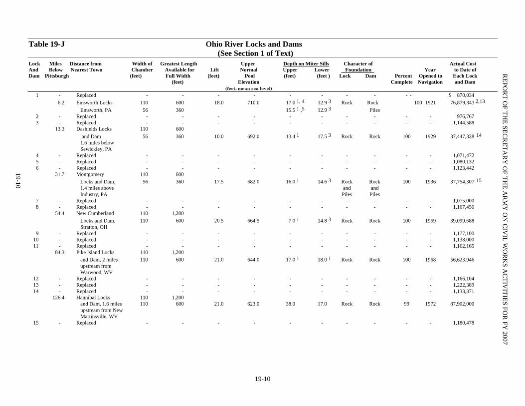
Table 19-J Ohio River Locks and Dams (See Section 1 of Text) Lock Miles Distance from Width of Greatest Length Upper Depth on Miter Sills Character of Actual Cost And Below Nearest Town Chamber Available for Lift Normal Upper Lower Foundation Year to Date of Dam Pittsburgh (feet) Full Width (feet) Pool (feet) (feet ) Lock Dam Percent Opened to Each Lock (feet) Elevation Complete Navigation and Dam (feet, mean sea level) 1 - Replaced - - - - - - - - - - $ 870,034 6.2 Emsworth Locks 110 600 18.0 710.0 17.0 1, 4 12.9 3 Rock Rock 100 1921 76,879,343 2,13 Emsworth, PA 56 360 15.5 1 ,5 12.9 3 Piles 2 - Replaced - - - - - - - - - - 976,767 3 - Replaced - - - - - - - - - - 1,144,588 13.3 Dashields Locks 110 600 and Dam 56 360 10.0 692.0 13.4 1 17.5 3 Rock Rock 100 1929 37,447,328 14 1.6 miles below Sewickley, PA 4 - Replaced - - - - - - - - - - 1,071,472 5 - Replaced - - - - - - - - - - 1,080,132 6 - Replaced - - - - - - - - - - 1,123,442 31.7 Montgomery 110 600 Locks and Dam, 56 360 17.5 682.0 16.0 1 14.6 3 Rock Rock 100 1936 37,754,307 15 1.4 miles above and and Industry, PA Piles Piles 7 - Replaced - - - - - - - - - - 1,075,000 8 - Replaced - - - - - - - - - - 1,167,456 54.4 New Cumberland 110 1,200 Locks and Dam, 110 600 20.5 664.5 7.0 1 14.8 3 Rock Rock 100 1959 39,099,688 Stratton, OH 9 - Replaced - - - - - - - - - - 1,177,100 10 - Replaced - - - - - - - - - - 1,138,000 11 - Replaced - - - - - - - - - - 1,162,165 84.3 Pike Island Locks 110 1,200 and Dam, 2 miles 110 600 21.0 644.0 17.0 1 18.0 1 Rock Rock 100 1968 56,623,946 upstream from Warwood, WV 12 - Replaced - - - - - - - - - - 1,166,104 13 - Replaced - - - - - - - - - - 1,222,389 14 - Replaced - - - - - - - - - - 1,133,371 126.4 Hannibal Locks 110 1,200 and Dam, 1.6 miles 110 600 21.0 623.0 38.0 17.0 Rock Rock 99 1972 87,902,000 upstream from New Martinsville, WV 15 - Replaced - - - - - - - - - - 1,180,478
REPO
RT O
F THE SEC
RETA
RY
OF TH
E AR
MY
ON
CIV
IL WO
RK
S AC
TIVITIES FO
R FY
2007
19-10
19-10

Table 19-J Ohio River Locks and Dams (continued) (See Section 1 of Text) Lock Miles Distance from Width of Greatest Length Upper Depth on Miter Sills Character of Actual Cost And Below Nearest Town Chamber Available for Lift Normal Upper Lower Foundation Year to Date of Dam Pittsburgh (feet) Full Width (feet) Pool (feet) (feet) Lock Dam Percent Opened to Each Lock (feet) Elevation Complete Navigation and Dam (feet, mean sea level) 16 - Replaced - - - - - - - - - - 1,275,532 161.7 Willow Island 110 1,200 Locks and Dam, 110 600 20.0 602.0 35.0 15.0 Rock Rock 100 1972 78,173,881 2.7 miles above and Waverly, WV Piles 17 - Replaced - - - - - - - - - - 1,362,591 18 - Replaced - - - - - - - - - - 927,091 19 - Replaced - - - - - - - - - - 1,213,848 20 - Replaced - - - - - - - - - - 936,696 103.9 Belleville 110 1,200 Locks and Dam, 110 600 22.0 582.0 37.0 15.0 3 Rock Rock 100 1968 62,591,255 0.3 mile below and Piles Reedsville, OH 21 - Replaced - - - - - - - - - - 1,484,562 22 - Replaced - - - - - - - - - - 1,218,798 23 - Replaced - - - - - - - - - - 1,851,488
OH
IO R
IVER
19-11 237.5 Racine Locks 110 1,200 and Dam, 1.5 110 600 22.0 560.0 18.0 15.0 Rock Rock 100 1971 64,922,680 miles below and Piles Letart Falls, OH 24 - Replaced - - - - - - - - - - 1,187,542 25 - Replaced - - - - - - - - - - 1,925,205 26 - Replaced - - - - - - - - - - 1,307,241 279.2 Robert C. Byrd Locks and Dam, 0.7 mile below 6 Hogsett, WV Robert C. Byrd 110 1,200 - - - - - - - - 3,452,066 Modernization 27 Rehab Dam and New Locks 110 1,200 23.0 538.0 18.0 15.0 Rock Rock 100 1992 368,605,876 16 27 - Replaced - - - - - - - - 28 - Replaced - - - - - - - - - - 1,063,133 29 - Replaced - - - - - - - - - - 1,088,802 30 - Replaced - - - - - - - - - - 1,579,618 341.0 Greenup Locks 110 1,200 and Dam, 4.9 110 600 30.0 515.0 18.01 13.0 Rock Rock 100 1959 57,464,191 miles below Greenup, KY 31 - Replaced - - - - - - - - - - 1,359,231 32 - Replaced - - - - - - - - - - 2,951,216 33 - Replaced - - - - - - - - - - 1,937,166
19-11

Table 19-J Ohio River Locks and Dams (continued) (See Section 1 of Text) Lock Miles Distance from Width of Greatest Length Upper Depth on Miter Sills Character of Actual Cost And Below Nearest Town Chamber Available for Lift Normal Upper Lower Foundation Year to Date of Dam Pittsburgh (feet) Full Width (feet) Pool (feet) (feet) Lock Dam Percent Opened to Each Lock (feet) Elevation Complete Navigation and Dam (feet, mean sea level) 34 - Replaced - - - - - - - - - - 3,437,057 436.2 Captain Anthony 110 1,200 Meldahl Locks 110 600 30.0 485.0 18.0 1 15.0 Rock Rock 100 1962 74,188,216 and Dam, 2.2 miles above Foster, KY 35 - Replaced - - - - - - - - - - 1,894,942 36 - Replaced - - - - - - - - - - 3,704,535 37 - Replaced - - - - - - - - - - 1,297,924 38 - Replaced - - - - - - - - - - 2,857,040 531.5 Markland Locks 110 1,200 and Dam, 1 mile 110 600 35.0 455.0 50.0 15.0 Rock Piles 100 1963 63,019,403 above Markland, IN 39 - Replaced - - - - - - - - - - 2,222,448 40 - Eliminated - - - - - - - - - - 41 - - - - - - - - - - - - 7,658,134 6 Falls of the N/A N/A N/A N/A 0 N/A 2,367,918 Ohio, 1 mile above McAlpine 604.0 McAlpine Locks 110 1,200 49.0 12.0 and Dam 37.0 420.0 11.0 Rock Rock 100 1961 421,280,079 6,7,18 42 - Eliminated - - - - - - - - - - 43 - Replaced - - - - - - - - - - 2,592,242 44 - Replaced - - - - - - - - - - 2,819,930 45 - Replaced - - - - - - - - - - 3,202,890 720.7 Cannelton Locks 110 1,200 25.0 383.0 38.0 13.0 Rock Rock 100 1972 99,032,866 9 and Dam, 110 600 3 miles above Cannelton, IN 46 - Replaced - - - - - - - - - - 3,129,028 776.1 Newburgh Locks 110 1,200 and Dam, 16 110 600 16.0 358.0 32.0 16.0 Rock Pile 99 1975 104,496,840 miles above Evansville, IN 47 - Replaced - - - - - - - - - - 4,415,526 48 - Replaced - - - - - - - - - - 3,062,710
REPO
RT O
F THE SEC
RETA
RY
OF TH
E AR
MY
ON
CIV
IL WO
RK
S AC
TIVITIES FO
R FY
2007
19-12
19-12

19-13
Table 19-J Ohio River Locks and Dams (continued) (See Section 1 of Text) Lock Miles Distance from Width of Greatest Length Upper Depth on Miter Sills Character of Actual Cost And Below Nearest Town Chamber Available for Lift Normal Upper Lower Foundation Year to Date of Dam Pittsburgh (feet) Full Width (feet) Pool (feet) (feet) Lock Dam Percent Opened to Each Lock (feet) Elevation Complete Navigation and Dam (feet, mean sea level) 49 - Replaced - - - - - - - - - - 3,325,964 846.0 John T. Myers 110 1,200 Locks and Dam, 110 600 22.0 342.0 34.0 12.0 Rock Rock 99 1975 109,125,797 20
3.5 miles below Uniontown, KY 50 - Replaced - - - - - - - - - - 3,571,762 51 - Replaced - - - - - - - - - - 4,370,566 918.5 Smithland Locks 110 1,200 and Dam, 2 110 1,200 22.0 324.0 34.0 12.0 Rock Rock 99 1980 273,725,470 miles above Smithland, KY 52 938.9 1.4 miles below 110 600 12.0 302.0 15.4 11.0 Pile Pile 100 1928 13,337,747 10 Brookport, IL 938.9 1.4 miles below 110 1,200 12.0 302.0 15.4 11.0 Pile Pile 100 1969 10,197,516 Brookport, IL (New lock) 53 962.6 10.8 miles 110 600 13.4 290.0 15.4 9.6 8 Pile Pile 100 1929 10,004,240 11 above Mound City, IL 962.6 10.8 miles 110 1,200 13.4 290.0 15.4 9.6 Pile - 100 1982 38,570,920 above Mound City, IL (New lock) 964.4 Olmsted Locks & 110 1,200 21.0 300.0 18.0 18.0 Pile Pile 52 2013 867,841,507 17 Dam at Olmsted, IL 974.2 Mound City - - - - - - - - - - 1,539,470 12
OH
IO R
IVER
TOTAL $2,577,615,892 19
Lock and Dam, 1 mile below Mound City, IL
19-13

Table 19-J Ohio River Locks and Dams (Continued) Footnotes 1 Depths are on emergency dam foundation and re-controlling depths. 2 Change from fixed dam to lift-gate dam completed in 1938. 3 Depths are on poiree dam foundation and are controlling depths. 4 Land chamber. 5 River chamber. 6 Lock and Dam 41 completed with 110- by 600-foot lock in 1921. Completed with new dam and raised canal and lock wall in 1928. Auxiliary 56- by 360-foot lock constructed in 1929-30. Reconstruction and modernization began 1956, renamed McAlpine Locks and Dam in 1960. Operation of auxiliary lock suspended in 1971. 7 Existing structures are complete except for deferred alteration of railroad bridge. Construction of the new 110 foot x 1,200 foot lock began in September 2002. 8 Dam below not yet constructed. Depth on lower miter sill at lower water. 9 Excludes $2,219,975 payment for settlement of damage to dam caused by barge accident in April 1978. 10 Major rehabilitation ($8,876,000) initiated in FY 79 is complete. 11 Major rehabilitation ($4,593,572) initiated in FY 79 is complete.
12 For preconstruction planning 1965 to 1972. No longer considered authorized. (See Section 1 of Text.) 13 Includes $37,485,870 for major rehabilitation completed in FY 84 14 Includes $33,914,252 for major rehabilitation completed in FY 90 (O&M funds). 15 Includes $33,016,696 for major rehabilitation completed in FY 89. 16 Includes $207,026,141 Inland Waterways Trust Funds. 17 Includes $478,015,864 Inland Waterways Trust Funds. 18 Includes $221,779,486 Inland Waterways Trust Funds. 19 Exclusive of $7,013,405 details below. 20
Includes $102,190,120 original construction cost, $5,205,058 PED costs and $1,730,619 Inland Waterways Trust Funds for Lock Improvement. Additional Features Entering into Cost of Project Louisville and Portland Canal and Indiana chute $5,359,203 (under previous project). Examinations, survey contingencies, plants, and miscellaneous 966,232 Waterfront Development at Huntington, WV (Greenup Pool) 19,170 Recreation facilities, pool area, Gallipolis Locks and Dam. 668,800 Total 7,013,405
REPO
RT O
F THE SEC
RETA
RY
OF TH
E AR
MY
ON
CIV
IL WO
RK
S AC
TIVITIES FO
R FY
2007
19-14
Grand Total $2,584,629,297
19-14
20-1
BUFFALO, NY DISTRICT The District comprises northern OH, northwestern PA and western and northern NY, embracing U.S. waters of Lake Erie exclusive of a small portion of the western end, Lake Ontario, and St. Lawrence River, with their tributary drainage basins from boundaries between the states of OH and MI to international boundary line east of Frontier, NY.
IMPROVEMENTS Navigation Page 1. Ashtabula Harbor, OH ........................... 20-2 2. Black Rock Channel and Tonawanda Harbor, NY ............................................. 20-2 3. Buffalo Harbor, NY ................................ 20-3 4. Cleveland Harbor, OH ......................….. 20-3 5. Conneaut Harbor, OH ............................. 20-5 6. Dunkirk Harbor, NY................................ 20-5 7. Erie Harbor, PA ...................................... 20-5 8. Fairport Harbor, OH ............................... 20-6 9. Great Sodus Bay Harbor, NY.................. 20-6 10. Huron Harbor, OH............................... 20-6 11. Irondequoit Bay, NY……………….….. 20-7 12. Little Sodus Bay Harbor, NY .............… 20-7 13. Lorain Harbor, OH ................................. 20-7 14. Oak Orchard, NY ................................... 20-8 15. Olcott Harbor, NY……………………... 20-8 16. Oswego Harbor, NY............................... 20-9 17. Ottawa River, MI & OH....................…. 20-9 18. Port Clinton Harbor, OH ....................... 20-9 19. Rochester Harbor, NY ........................... 20-9 20. Rocky River, OH……............................ 20-10 21. Sandusky Harbor, OH .......................... 20-10 22. Sturgeon Point, NY .............................. 20-10 23. Toledo Harbor, OH .............................. 20-10 24. Toussaint River, OH ............................ 20-11 25. Vermilion Harbor, OH ......................... 20-11 26. West Harbor, OH ................................. 20-11 27. Wilson Harbor, NY .............................. 20-12 28. Project Condition Surveys: NY,OH,PA 20-12 29. Great Lakes Sediment Transport Model.20-12
Navigation Work Under Special Authorization 30. New York State Canal System ...............20-12 Shore Protection 31. Presque Isle Peninsula, Erie, PA .......... 20-13
Flood Control Page 32. Mt. Morris Lake, NY Genesee River….......20-13 33. Surveillance of Northern Boundary Waters: NY, OH, PA…………………………………..……..20-14 Environmental Restoration 34. Ohio Environmental Infrastructure ……… 20-14 35. Onondaga Lake, NY…………………….. 20-14 36. GL Fishery & Ecosystem Restoration….. 20-14 Miscellaneous 37. National Emergency Preparedness Program 20-15 38. Regulatory Functions Program ................ 20-15 39. Formerly Utilized Sites Remedial Action Program (FUSRAP)…………………................ 20-15 Tables Table 20-A Cost and Financial Statement ..... 20-17 Table 20-B Authorizing Legislation .............. 20-24 Table 20-C Other Authorized Navigation Projects ........................................................... 20-42 Table 20-D Other Authorized Shore Protection Projects ........................................... 20-43 Table 20-E Other Authorized Flood Control Projects ............................................................ 20-44 Table 20-F .......................................................….N/A Table 20-G Deauthorized Projects ................. 20-45 Table 20-H Flood Control and Coastal Emergencies (FC&CE) ................................... 20-47 Table 20-I General Investigations .................. 20-48 Table 20-J Work Under Special Authorities.. 20-50 Table 20-K Inspection of Completed Flood Control Projects ............................................... 20-53
REPORT OF THE SECRETARY OF THE ARMY ON CIVIL WORKS ACTIVITIES FOR FY 2007
20-2
NAVIGATION
1. ASHTABULA HARBOR, OH
Location. On the south shore of Lake Erie, at mouth of Ashtabula River, 59 miles easterly from Cleveland, OH. (See NOAA Nautical Chart 14836.)
Previous projects. For details see pg. 1963 of Annual Report for 1915, and pg. 1593 of Annual Report for 1938.
Existing project. For description see pgs. 1297-1299 of the 1966 Annual Report. Federal cost of completed project is $12,240,147. Non-Federal costs of $5,743,000, including contribution of $47,000, were for construction of access roads, docks, storage and handling facilities and dockside dredging. (See Table 20-B for authorizing legislation.)
Local cooperation. Fully complied with. Local interests contributed $47,000 for work authorized by 1936 and 1970 Acts.
Terminal facilities. There are sixteen piers and wharves. Coast Guard owns one facility. Ten facilities are along banks of Ashtabula River and six are on south side of outer harbor. Eleven terminals have railroad connections and six have mechanical handling facilities. Facilities are considered adequate for existing commerce. (See Port Series No. 42, revised 1972, Corps of Engineers.)
Operations and results during fiscal year. Operations: Federal funds for Project Condition Surveys cost $152,768. Maintenance: A total of $2,102,359 was expended by the Buffalo & Detroit Districts’ government floating plants. Completed the rebuild of 273 linear feet (one side) of laid-up breakwater construction on the East Breakwater utilizing government plant and hired labor. This work included 2082 tons of armor stone and 900 tons of core stone used to complete the breakwall construction. Costs associated with the Ashtabula River Partnership Project for removal of contaminated sediments from the Ashtabula River totaled $467,051. Executed a Project Cooperation Agreement (PCA) for the O&M/312a dredging to formalize the cost sharing agreement with the non-Federal sponsor, developed and finalized the plans and specifications, developed the project acquisition strategy and received approval from the PARC and attempted to secure the USEPA RAC Contractor to perform the dredging. $123,541 was spent conducting sediment sampling from Station 120 down through the entire outer harbor. Sediment samples included core samples within and along the sides of the Federal navigation channels to investigate the potential of PCB contamination
migration from the upstream environmental dredging project. A total of 82 sampling sites were sampled and 134 analyses conducted. The results of these analyses were used in part to determine the extent to which the USACE portion of the environmental dredging project needed to be expanded, and to make open-lake placement suitability determinations. 2. BLACK ROCK CHANNEL AND TONAWANDA HARBOR, NY
Location. Improvement is essentially that of upper
13.5 miles of Niagara River from its head at Lake Erie, Buffalo, NY, to and including Tonawanda Harbor, NY. It comprises improvements formerly designated by three titles; Lake Erie entrance to Black Rock Harbor and Erie Basin, NY, Black Rock Harbor and Channel, NY and Tonawanda Harbor and Niagara River, NY. (See NOAA Nautical Chart 14832.)
Previous projects. For details, see items 5 and 7, pg. 1970 of Annual Report for 1915, and pg. 1612 of Annual Report for 1938.
Existing project. For description of existing project and Federally owned Black Rock ship lock, see pg. 1548 of Annual Report for 1962. Improvement of guide pier at Black Rock Lock, as authorized by 1935 Act was de-authorized by Congress in Aug 1977. Cost for completed portion of new work is $10,457,093. Enlarging of existing 21-foot turning basin and deepening lower 1,500 feet of Tonawanda Inner Harbor from 16 to 21 feet, authorized by the 1954 Act, was de-authorized by Congress in May 1981, and is excluded from foregoing cost. Non-Federal costs are estimated at $1,540,000 for costs incurred by NY State for construction of Erie Basin and protecting breakwater, and construction and extension of Bird Island Pier, and by other local interest for relocation of utilities. (See Table 20-B for authorizing legislation.)
Local cooperation. Fully complied with for existing project. Contract for cost-shared recreation development at completed projects (Code 713 program) was executed by the NY State Department of Environmental Conservation, Albany, NY on Apr 16, 1985, and was approved by the Assistant Secretary of the Army and Chief of Engineers on May 3, 1985.
Terminal facilities. Two facilities are along the upstream end of the channel. Below Black Rock Lock and at Tonawanda Harbor there are 13 privately owned terminals. There are two state-owned barge canal terminals at Tonawanda, NY, and several marine service and supply docks for recreational and other small craft. The Corps owns a wharf adjacent to Black Rock Lock that is private. Ten terminals

BUFFALO, NY DISTRICT
20-3
have railroad connections and six mechanical-handling facilities. Facilities considered adequate for existing commerce. (Port Series No. 41, revised 1971, Corps of Engineers.) Operations and results during fiscal year Operations: Project Condition Surveys cost $26,000, Public Visitation Tracking at Bird Island Pier cost $2,203, National Historic Preservation Act Compliance cost $4,078 and Operation and Care of Lock cost $654,037. Maintenance: Facility security was improved through the addition of an upgraded monitoring system that also extended the amount of the project that is covered by the system at a cost of $29,956. The lock was cleared of submerged debris that had periodically interfered with operation of the lock gates. This clearing was accomplished by in-house divers in order to return the lock to service without delay to vessel traffic. The dive team also installed a temporary water line to replace a broken line and returned the lock to operation by recovering debris that threatened to interfere with operating gates as a result of a minor vessel accident. Initial studies and planning were accomplished for improvements to signage at the project and necessary repairs to the sewage and water systems that service the lock. These projects will continue into FY 2008 and activities will include additional engineering design and construction by contract. At a cost of $263,155, all ordinary maintenance required during FY 2007 was accomplished with minimal impact on commercial and recreational navigation interests. 3. BUFFALO HARBOR, NY
Location. At eastern end of Lake Erie, at head of Niagara River, 176 miles easterly from Cleveland, OH. (See NOAA Nautical Charts 14820 and 14833.)
Previous projects. For details see pg. 1967 of Annual Report for 1915 and pg. 1606 of Annual Report for 1938.
Existing project. For description see pg. 1368 of Annual Report for 1963. In addition, on Dec 15, 1980, OCE authorized the removal of bridge abutments of South Michigan Avenue Bridge. New work for completed project cost $18,837,601. Estimated non-Federal costs were $9,188,000 for deepening, widening, and improving Buffalo River and ship canal, constructing piers, retaining walls, and dikes and performing dockside dredging. (See Table 20-B for authorizing legislation.)
Local cooperation. Fully complied with. Terminal facilities. There are 27 piers, wharves,
and docks of which five are on the outer harbor, nine are on the Lackawanna, Union, and Buffalo Ship Canals, and thirteen are located along the deep-draft section of the Buffalo River. Gateway Metroport,
Division of Gateway Trade Center, Inc., owns and operates, for the former Bethlehem Steel Corp., wharves at Lackawanna for the receipt and shipment of general cargo and bulk commodities. Buildings of the former steel plant are utilized for transit and long-term storage of cargo as required. The Niagara Frontier Transportation Authority owns Terminals A and B in the outer harbor used for handling general cargo. Twenty terminals have railroad connections. The city of Buffalo owns a slip on the right bank of Buffalo River just north of Michigan Avenue Bridge for mooring the city fireboat. Coast Guard facilities are at the mouth of Buffalo River along the left bank. (See Port Series No. 41, revised 1991, U.S. Army Corps of Engineers.)
Operations and results during fiscal year. Operations: Project Condition Surveys cost $44,137, Water Control Management and Data Collection cost $37,992, and Sediment Sampling, Analysis and Evaluation cost $15,893. Maintenance: Environmental Compliance Activities cost $38,016. The funds were used to collect soil and sediment samples from the Buffalo Harbor Dike #4 confined disposal facility (CDF), and reference samples from Lake Erie and Buckhorn State Park. These samples were subjected to aquatic and terrestrial bioaccumulation tests for polynuclear aromatic hydrocarbons (PAHs) and metals. Testing was conducted by the USACE Engineering Research Design Center (ERDC). Initial labor for Structure Repair CDF#4 cost $4,889 before the project was cancelled and Annual Snagging and Clearing of harbor debris cost $27,757. 4. CLEVELAND HARBOR, OH
Location. On south shore of Lake Erie, at mouth of Cuyahoga River, 176 miles westerly from Buffalo, NY. (See NOAA Nautical Chart 14839.)
Previous projects. For details see pg. 1962, Annual Report for 1915, and pg. 1585, Annual Report for 1938.
Existing project. For description of existing project, as authorized through the 1966 modification, see pg. 1269 of Annual Report for 1967. Further improvements in the interest of commercial navigation and recreational navigation were authorized in the 1985 Supplemental Appropriations Act (PL 99-88). For details of the commercial navigation portion of the project, see pg. 20-4 of the Annual Report for 1995. For details of the recreational navigation portion of the project, see pg. 20-3 of Annual Report for 1994. The Water Resources Development Act of 1986 (PL 99-662) and the FY 88 Energy and Water Appropriations Act (PL 100-202) authorized the recreational navigation

REPORT OF THE SECRETARY OF THE ARMY ON CIVIL WORKS ACTIVITIES FOR FY 2007
20-4
project. These acts authorized additional undefined improvements to Cleveland Harbor. A portion of the project was de-authorized by the Inter-model Surface Transportation Efficiency Act of 1991. Estimated total Federal cost of the existing project is $33,852,100 (Oct 1991) exclusive of undefined, inactive and deferred portions of the project. The amount of $29,315,100 is for completed work and the balance of $4,537,000 is for new work. Estimated non-Federal cost is $13,740,000 (Oct 1991) of which $9,203,000 is actual cost for completed work and the balance of $4,537,000 is required for work authorized by PL 99-88, PL 99-662, and PL 100-202. Remaining work authorized by 1946 River and Harbor Act, consisting of widening and deepening the right bank of Cuyahoga River at the downstream end of Cut 4, is considered inactive and excluded from foregoing cost estimate. Estimated Federal cost (1966) of this portion is $85,600 and non-Federal cost (1966) $5,000,000. Remaining work authorized by 1958 R&H Act, consisting of planning and replacement of bridges number 19 (E.L.R.R.) and 32 (B. & O.R.R.) and widening Cuyahoga and Old River channels, and remaining work authorized by the 1960 R&H Act, consisting of deepening the remainder of the Cuyahoga River from bridge number 1 to and including the Old River to a depth of 27 feet, has been classified as deferred and is also excluded from foregoing estimate. Estimated Federal cost (Oct 1976) of this portion is $18,033,300 and estimated non-Federal cost (Oct 1976) is $21,251,000. The 1989 Energy and Water Development Appropriations Act (PL 101-101) authorized the Corps to begin a Reconnaissance study of the Cuyahoga River, to address the concerns of boat traffic congestion and related risks, accidents and safety of the public. Preliminary plans were studied to alleviate the commercial navigation problem and inadequate width and depth, in the Old and Cuyahoga Rivers. The cost of this Reconnaissance study was $250,000. The Reconnaissance Report recommended a feasibility study for one plan, which has three structural features, and the potential for yielding commercial (priority) outputs. The non-Federal sponsor did not commit to provide its total share of the cost of the feasibility phase of the study. Therefore, the study was reclassified as "inactive". (See Table 32-B for authorizing legislation.) A confined disposal facility (CDF) (Dike 10B) was constructed adjacent to the Burke Lakefront Airport for containment of dredged material from Cleveland Harbor. The rubble mound structure was designed to hold material unsuitable for open-lake disposal. The sixty-eight (68) acre site should provide sufficient CDF capacity for approximately twenty years. The project was
constructed with Federal O&M funds at a cost of $17,500,000 and was completed in 1998.
Terminal facilities. Fifty-one piers, wharves, and docks are situated in the Port of Cleveland. Eleven are located in the east and west basins of the outer harbor; 7 along the banks of the Old River and 17 and 16 along the right and left banks of the Cuyahoga River, respectively. Twenty-two terminals have both railroad connections and mechanical-handling facilities. The Corps owns a wharf at the foot of East 9th Street. The city of Cleveland owns and operates a wharf for mooring the city fireboat. U.S. Coast Guard vessels are moored east of the foot of 9th Street in the east basin. (See Port Series No. 43, revised 1989, U.S. Army Corps of Engineers.) Operations and results during fiscal year. Operations: Federal funds for Project Condition Surveys cost $44,000. Phase II of the Dredged Material Management Plan (DMMP), a feasibility-level management plan study was continued and a draft DMMP and Environmental Impact Statement was substantively completed at a cost of $394,718. Policy compliance and independent technical reviews were completed. Two public meetings were held in Cleveland to keep the public and key stakeholders informed of the DMMP’s progress. Coordination with the Cleveland area Federal and non-Federal municipal and regulatory agencies and the non-Federal cost-sharing sponsor continued in FY07. Maintenance: Maintenance Dredging cost $1,864,849 to remove approximately 183,687 cubic yards of shoaled material from the Cuyahoga River. Fall Dredging included: Station 799+67 - 790+00, 120' wide, and Station 790+00 - 783+00, 60' wide. Spring Dredging included: Station 799+67 - 790+00, 120' wide, Station 790+00 - 753+00, 100' - 120' wide, Station 326+00 - 341+75, 60' wide (Old River), and Station 300+00 - 304+10, 50' wide (Old River). CDF 12 Fill Management Plan, cost $1,917,565: Continued work on the development of the Fill Management Plan (FMP) including the bidding and award of a contract for perimeter berm raising and weir construction. CDF 10B Fill Management Plan, cost $250,428: Completed second and final phase of planned FMP work. Activities included design and construction of the phase 2 south-side berm raising and surveys of the CDF site. Engineering & Design for the West Pierhead construction totaled $63,272 and is 75% complete. Proposed construction includes encasing the pierhead by installing of approximately 250 LF of steel sheet pile wall, fog signal building removal, and concrete cap replacement. Coordination with SHPO continued to mitigate adverse effects on the two historic structures on the pierhead. E&D on the Ohio Area Office Finger Pier Repair continued with total expenditures
BUFFALO, NY DISTRICT
20-5
of $4,811 for final payment of geotechnical investigation contract. A total of $467,969 was expended to complete the rebuild of 40 linear feet (two sides) of breakwater construction on the West and East Arrowhead Breakwaters utilizing government plant and hired labor. This work included 190 tons of armor stone and 240 tons of core stone used to complete the breakwall construction. A total of $40,560 was expended to complete the removal of debris that has accumulated in the Cleveland Harbor and Cuyahoga River utilizing government plant and hired labor. The work is required to allow the safe passage of commercial and recreational harbor traffic. There were 4 calls regarding hazards to navigation within the Federal channel reported by the USCG last year after rainfall events caused a large amount of debris to become submerged in the Cuyahoga River and Cleveland Harbor. 5. CONNEAUT HARBOR, OH
Location. On the south shore of Lake Erie, at mouth of Conneaut River, 73 miles easterly from Cleveland, OH. (See NOAA Nautical Chart 14824.)
Previous projects. For details see pg. 1964, Annual Report for 1915.
Existing project. For description see pg. 1274 of Annual Report for 1967. Actual costs for new work for completed portion of the project were $7,541,369. For completed work, non-Federal costs were $200,000 for dockside dredging and removal of existing dolphins. The most southerly 300 feet of the 1,670-foot long shore arm, authorized by the R&H Act of 1910, was de-authorized Oct. 96. (See Table 20-B for authorizing legislation.)
Local cooperation. Fully complied with for completed portion of project.
Terminal facilities. There are seven piers and wharves. Six are privately owned and operated and located in inner harbor. Remaining facility is city owned on the south side of outer harbor. Six terminals have railroad connections and four mechanical-handling facilities. (See Port Series No. 42, revised 1972, Corps of Engineers.) Operations and results during fiscal year. Operations: Federal funds for Project Condition Surveys cost $33,221 and Sediment Sampling, Analysis and Evaluation cost $7,679. Maintenance: West Pier construction was initiated in May 2006 and was completed and closed-out in FY07. Construction in place is valued at $634,583 including S&A and E&D during construction costs. The construction contract was awarded for $1,749,156 in September 2005 and final contract cost was $1,582,548. Work includes installation of 420 LF of steel sheet pile
wall, steel h-piles, rock anchors, 300 LF of stone pier repair, installation of a new concrete cap and miscellaneous fendering/cleat fixtures. 6. DUNKIRK HARBOR, NY Location. On south shore of Lake Erie, 37 miles southwesterly from Buffalo, NY. (See NOAA Nautical Chart 14823.)
Previous projects. For details see pg. 1966 of Annual Report for 1915, and pg. 1604 of Annual Report for 1938.
Existing project. For description of completed portion of existing project see pg. 32-8 of Annual Report for 1976. For description of small boat harbor project as authorized under Section 201 of Flood Control Act of 1965, see pg. 32-8 of Annual Report for 1978. Actual costs for completed work are $3,010,024. Actual non-Federal costs are $1,961,000. (See Table 20-B for authorizing legislation.) Local cooperation. Fully complied with.
Terminal facilities. Facilities consist of private docks for recreational craft and privately owned servicing and storage handling facilities for recreational and other small craft. Operations and results during fiscal year. Operations: Federal funds for Project Condition Surveys cost $3,000. 7. ERIE HARBOR, PA
Location. On southerly side of bay formed by Presque Isle Peninsula, on south shore of Lake Erie, 78 miles westerly from Buffalo, NY. (See NOAA Nautical Chart 14835.)
Previous projects. For details see pg. 1965 of Annual Report for 1915 and pg. 1600 of Annual Report for 1938.
Existing projects. For description see pgs. 1363-64 of the Annual Report for 1963. The FY 93 Appropriations Act (PL102-377) authorized the planning, design and dredging of an access channel and berthing area. Entire project modification authorized by 1945 River and Harbor Act, providing for deepening channel and basin, both 23 feet deep, to Penn Central Company coal docks at westerly end of harbor, was de-authorized by Congress in Aug 1977. Actual costs for new work for completed portion of project were $2,860,906. Extension of north pier portion, authorized by 1899 Act was de-authorized in Nov 1981. A portion of work authorized by 1960 Act, deepening strips adjacent to north and south piers, was de-authorized in Aug 1982. Non-Federal costs for completed work were $51,000 for providing ore dock and dredging slip adjacent thereto. (See Table 20-B for authorizing legislation.)

REPORT OF THE SECRETARY OF THE ARMY ON CIVIL WORKS ACTIVITIES FOR FY 2007
20-6
Local cooperation. Fully complied with. Terminal facilities. Sixteen piers and wharves, of
which twelve are privately owned and operated. Erie International Marine Terminal No. 1 owned by Port Commission, city of Erie, is along main waterfront on south side of Presque Isle Bay and Coast Guard facilities are on north side. Two offshore oil docks are on Lake Erie. Eight terminals have railroad connections and six mechanical-handling facilities. Facilities are considered adequate for existing commerce. (See port Series No. 42, revised 1972, Corps of Engineers.) Operations and results during fiscal year. Operations: Federal funds for Project Condition Surveys cost $3,112. 8. FAIRPORT HARBOR, OH
Location. On south shore of Lake Erie at mouth of Grand River, 33 miles easterly from Cleveland, OH. (See NOAA Nautical Chart 14837.)
Previous projects. For details see pg. 1963 of Annual Report for 1915, and pg. 1590 of Annual Report for 1938.
Existing project. For description of existing project, see pg. 1526 of Annual Report for 1962. Total Federal cost of $2,591,000 is actual cost for completed portion of project. Total non-Federal cost is $101,000 for bulkheads and dockside dredging for completed portion of project. (See Table 20-B for authorizing legislation.)
Local cooperation. See pg. 32-11 of 1976 Annual Report regarding assurances of local cooperation for work authorized by R&H Act of 1927.
Terminal facilities. Sixteen piers and wharves, all along banks of Grand River. Coast Guard owns one facility. Nine terminals have railroad connections and ten mechanical-handling facilities. Facilities considered adequate for existing commerce. (See Port Series No. 42, revised 1972, Corps of Engineers.) Operations and results during fiscal year. Maintenance: $7,194 was expended to develop a Scope of Work and initiate design for fabrication and installation of safety ladders at the East Pier by in-house floating plant. Initial labor for Structure Repair cost $8,308. $50,591 was spent on environmental permit work, application for 401 certification, development of plan and specifications, development of bid documents, and stakeholder coordination before the cancellation of Maintenance Dredging.
9. GREAT SODUS BAY HARBOR, NY Location. On Sodus Bay, which is a nearly land-locked indentation on south shore of Lake Ontario, 29 miles westerly from Oswego, NY. (See NOAA Nautical Chart 14814.) Previous project. For details, see pg. 1972 of Annual Report for 1915, and pg. 1526 of Annual Report for 1938. Existing project. For description, see pg. 1380 of Annual Report for 1963. Improvements authorized by 1962 Act, consisting of deepening lake approach channel, entrance channel and inner approach channel were deauthorized by Congress in Aug 1977. Actual costs of new work for completed portion of project were $249,187. Costs incurred by local interests are not available. (See Table 20-B for authorization legislation.) Local cooperation. Fully complied with. Terminal facilities. Facilities consist of private docks for recreational craft and privately owned servicing and storage handling facilities for recreational and other small craft. Operations and results during fiscal year. There were no Operations or Maintenance activities conducted in the harbor this FY. 10. HURON HARBOR, OH
Location. On south shore of Lake Erie at mouth of Huron River, 47 miles westerly from Cleveland, OH. (See NOAA Nautical Chart 14843.)
Previous project. For details, see pg. 1961 of Annual Report for 1915, and pg. 1576 of Annual Report for 1938.
Existing project. For description, see pg. 1347 of Annual Report for 1963 and pg. 32-12 of Annual Report for 1978. Cost of completed portion of existing project was $4,834,006. Construction of detached breakwater as authorized by 1962 R&H Act was de-authorized Jan 1, 1990. Non-Federal costs of $163,000 were incurred by local interests in 1963 for dockside dredging of areas between Federal improvement and terminal facilities. (See Table 20-B for authorizing legislation.)
Local cooperation. Fully complied with. Terminal facilities. Six privately owned wharves
and docks, one along left bank of Huron River and remainder along right bank. Four terminals have railroad connections and four mechanical-handling facilities. Facilities are regarded as adequate for existing commerce. (See Port Series No. 42, revised 1972, Corps of Engineers.) Operations and results during fiscal year. Operations: Federal funds for Project Condition Surveys cost $18,811. Maintenance: $87,846 was

BUFFALO, NY DISTRICT
20-7
spent on environmental permit work, application for 401 certification, development of plan and specifications, development of bid documents, and stakeholder coordination before the cancellation of Maintenance Dredging. 11. IRONDEQUOIT BAY, NY
Location. On south shore of Lake Ontario, 4 miles east of Rochester, NY at mouth of Irondequoit Creek, Monroe County, NY. (See NOAA Nautical Charts 14804 and 14815).
Existing project. For details of existing project, see pg. 32-7 of Annual Report for FY 87. Total estimated project cost is $15,363,000 (Oct 1994) including $3,582,000 Federal (which includes the COE $3,536,000 and the USCG $46,000) and $11,781,000 non-Federal, including a cash contribution of $2,661,000, lands and damages $290,000 and the cost of a movable highway bridge $8,830,000. Existing project was authorized by 1958 River and Harbor Act (H. Doc. 332, 84th Cong., 2nd sess.).
Local cooperation. The Buffalo District has a Local Cooperation Agreement with New York State, executed April 20, 1983.
Terminal facilities. Facilities consist of private docks for recreational craft and privately owned servicing and storage handling facilities for recreational and other small craft. Operations and results during fiscal year. There were no Operations or Maintenance activities conducted in the harbor this FY. 12. LITTLE SODUS BAY HARBOR, NY Location. Little Sodus Bay, on south shore of Lake Ontario, 15 miles west of Oswego, NY. (See NOAA Nautical Chart 14803.) Previous projects. For details see page 1973 of Annual Report for 1915, and page 1628 of Annual Report for 1938. Existing project. For description see page 1378 of Annual Report for 1958. New work for completed project cost $69,066. Non-Federal costs of $6,000 were incurred for channel dredging. (See Table 20-B for authorizing legislation.) Local cooperation. Not required. Terminal facilities. Facilities consist of private docks for recreational craft and privately owned servicing and storage handling facilities for recreational and other small craft. Operations and results during fiscal year. There were no Operations or Maintenance activities conducted in the harbor this FY.
13. LORAIN HARBOR, OH Location. On south shore of Lake Erie at mouth of Black River, 25 miles westerly from Cleveland, OH. (See NOAA Nautical Chart 14841.)
Previous projects. For details, see pg. 1961 of Annual Report for 1915, and pg. 1580 of Annual Report for 1938.
Existing project. For description see pgs. 1319-22 of the Annual Report for 1966. Federal cost of new work is $20,475,000. Deepening and widening remainder of Black River Channel at Cut 1 and construction of bank stabilization, authorized by 1960 Act and modified by 1965 Act was de-authorized Jan 1, 1990. A portion of work authorized by 1960 Act, dredging of 15-to-25 foot wide strips adjacent to the U.S. East and West Piers were also de-authorized Jan 1, 1990. Total non-Federal cost is $3,000 contributed by local interests towards construction of west shore arm. (See Table 20-B for authorizing legislation.) The Water Resources Development Act (WRDA) of 1986 (PL 99-662) authorized construction of commercial navigation improvements consisting of two bend cuts on the Black River to widen and straighten the channel between the Norfolk and Western Railroad Bridge and the 21st Street Bridge. These cuts are to be excavated to the existing channel depth of 27 feet. The authorized plan also includes widening the Upper Turning Basin at the existing depth of 21 feet. Estimated costs for this work are $2,290,000 Federal and $1,510,000 non-Federal (Oct 1989). This portion of the project has been classified deferred. On Mar 12, 1986, the Chief of Engineers under authority of Section 107 of the 1960 River and Harbors Act, as amended, authorized construction of a small boat harbor that was completed in Jul 1987. The project consists of a 225-foot detached rubble mound breakwater and an 800-foot long rubble mound breakwater attached to the east breakwater shorearm in the east basin of the outer harbor. Construction costs for this project, including supervision and administration, were $775,025 Federal and $775,025 non-Federal.
Local cooperation. For completed work, local interests contributed $3,000. Work authorized by 1960 Act (and modified by 1965 Act) is de-authorized. All other conditions fully complied with. On Mar 25, 1986, the city of Lorain, OH signed the Local Cooperation Agreement (LCA), for the Section 107 project. For details see pg. 32-7 of Annual Report for 1986. For details of LCA for deferred project authorized by the 1986 WRDA, see pgs. 32-9 of the Annual Report for FY 87. Terminal facilities. There are 23 piers and wharves, of which three are on the outer harbor and

REPORT OF THE SECRETARY OF THE ARMY ON CIVIL WORKS ACTIVITIES FOR FY 2007
20-8
the remainder is along banks of Black River. Two are owned by the city. Eight terminals have railroad connections and 15 mechanical-handling facilities. Facilities are considered adequate for existing commerce. (See Port Series No. 42, revised 1972, Corps of Engineers.) Operations and results during fiscal year. Operations: Federal funds for Project Condition Surveys cost $52,904. Costs for continuing Phase II of the DMMP were $206,459 and included preparation of the draft DMMP and Environmental Impact Statement, survey of the Lorain Contained Disposal Facility, preparation of the Fish and Wildlife Coordination Act report by the U.S. Fish and Wildlife Service, and independent technical review (ITR) of the preliminary draft report. Extensive coordination with the Lorain area Federal and non-Federal municipal and regulatory agencies continued in 2007. Maintenance: Environmental Compliance Activities cost $9,924. Funds were used for labor to update and complete the Lorain Harbor CDF Evaluation Report. A total of $546,663 was expended on completing the rebuild of 190 linear feet (one side) of breakwater construction on the East Breakwater utilizing government plant and hired labor. This work included 708 tons of armor stone and 300 tons of core stone used to complete the breakwall construction. Dredging cost $25,910 to develop bid documents and negotiate contract award with 8A contractor. Physical dredging will occur in FY08. At the conclusion of the 2006 dredging season, the CDF was considered to be essentially filled to capacity. $ 320,579 was spent to construct an engineered 4-6 foot earthen berm around the perimeter of the CDF to extend the life of the structure by increasing its capacity. An 8(a) contract was awarded to construct the perimeter berm and construction was completed in September 2007. 14. OAK ORCHARD, NY
Location. On south shore of Lake Ontario, at
mouth of Oak Orchard Creek, 33 miles westerly of Rochester, NY. (See NOAA Nautical Chart 14805.)
Previous project. For details see pg. 628 of Annual Report for 1905.
Existing project. For description of completed existing project see pg. 32-14 of 1975 Annual Report. Actual Federal cost for completed project was $1,613,500. Estimated non-Federal cost is $270,000 (Jul 1971) including cash contribution of $170,700 and $54,002 for recreational facilities and remainder for lands and construction of wharf. Existing project was authorized by the 1945 River and Harbor Act (H. Doc. 446, 78th Cong., 2nd sess.).
Local cooperation. Fully complied with. Local interests contributed $224,702.
Terminal facilities. There is no commercial navigation at Oak Orchard Harbor. Terminal facilities consist of private docks for recreational craft. Operations and results during fiscal year. There were no Operations or Maintenance activities conducted in the harbor this FY. 15. OLCOTT HARBOR, NY Location. On south shore of Lake Ontario at mouth of Eighteen Mile Creek about 18 miles east of mouth of Niagara River and 63 miles by water west of Rochester, N.Y. (See NOAA Nautical Chart 14806.) Previous project. For details see page 1971 of Annual Report for 1915 and page 1621 of Annual Report for 1938. Existing project. For description see page 1555 of Annual Report for 1962. Cost of new work for completed project was $1,500 exclusive of amount expended on previous projects, all of which was contributed by local interests. (See Table 20-B for authorizing legislation.) The authorized modification to the existing project consists of breakwaters to provide optimum harbor protection a stone jetty and recreational fishing facilities including a footbridge, walkways and guardrails, access facilities, sanitary facilities and parking areas. The estimated cost of the authorized modification is $17,000,000 (Oct. 1990) of which $8,500,000 is Federal and $8,500,000 is non-Federal. Modification of the existing project was authorized by the 1986 Water Resources Development Act (WRDA) (PL 99-662). Local cooperation. Fully complied with for completed project. Local interests contributed $1,500. Modifications authorized by the 1986 WRDA will require local interests to pay 50% of project cost including lands easements, right-of-way and dredge disposal areas. They are also responsible for construction of necessary docks and berthing spaces, construction of launching ramp, parking areas, sanitary facilities, and necessary access roads. After construction, non-Federal responsibilities would include fishing facility maintenance, except for the aids to navigation. Terminal facilities. Facilities consist of private docks for recreational craft and privately owned servicing and storage handling facilities for recreational and other small craft. Operations and results during fiscal year. There were no Operations or Maintenance activities conducted in the harbor this FY.
BUFFALO, NY DISTRICT
20-9
16. OSWEGO HARBOR, NY
Locations. On South shore of Lake Ontario, at mouth of Oswego River, 59 miles easterly from Rochester, NY. (See NOAA Nautical Chart 14813.)
Previous projects. For details see pg. 1973 of Annual Report for 1915, and pg. 1630 of Annual Report for 1938.
Existing project. For description see pgs. 1383-84 of the Annual Report for 1963. Completed portion of project cost $7,242,039 and non-Federal costs for completed work were $4,440,000 for lands, dockside dredging, construction of terminal wharves, and cargo handling facilities. Deepening a 200-foot wide strip along harbor line east of mouth of Oswego River, remaining feature of work authorized by the 1930 Act, was de-authorized Jan 1, 1990. Deepening to 22 feet a 150-foot wide strip along harbor line in west outer harbor, remaining feature of work authorized by 1940 Act, was de-authorized in May 1981. The portion of the Federal Channel from the southernmost alignment of the Route 68 Bridge upstream to the northernmost alignment of Lake Street Bridge authorized by the 1910 R&H Act as amended by the 1935 R&H Act was de-authorized Oct 96. (See Table 20-B for authorizing legislation.) Local cooperation. Fully complied with. Terminal facilities. There are seven piers and wharves in the harbor and along the river channel. The Port of Oswego owns and operates a general cargo terminal at the mouth of the Oswego River. The Port Authority also operates a grain elevator west of the mouth of the river. The U.S. Coast Guard moors patrol and environmental research vessels west of the mouth of the river. Operations and results during fiscal year. Maintenance: Conducted detailed site investigation and survey and began development of evaluation and rating system for ashlar (laid-up) structures in Oswego and across the Great Lakes at a cost of $89,412. $41,009 was spent on environmental permit work, application for 401 certification, development of plan and specifications, development of bid documents, and stakeholder coordination before the cancellation of Maintenance Dredging. 17. OTTAWA RIVER, MI & OH Location. At westerly end of Lake Erie, at Toledo, OH 99 miles westerly from Cleveland, OH (See NOAA Nautical Chart 14847). Existing project. The project was found to have benefits which are 100% recreational in nature. Therefore, it has a low national priority for budgetary purposes and was not funded in FY06. A public hearing was held on 12 April 2005 by Ohio
Environmental Protection Agency on the Corps’ application for a Section 401 Water Quality Certification and there was tremendous local support. Since more than one year elapsed without a response from the State of Ohio, the Corps considered the request for certification to be waived. The Michigan Department of Environmental Quality expressed their opposition to the project for environmental reasons. Ongoing work included coordination with the Ottawa River Remediation Team and interested members of Congress. The project, originally authorized under provisions of Section 201 of the Rivers & Harbors Act, (PL 89-298) by the House and Senate Committees on Public Works Resolutions, dated December 15 and 17, 1970, respectively, was continued by the 1990 Water Resources Development Act (PL 101-640). Local cooperation. The potential local sponsor is the city of Toledo, OH. The local sponsor must provide 50% of the total project cost that includes lands, easements, rights-of-way, and relocations. Operations and results during fiscal year. No funds were appropriated or spent during FY07. 18. PORT CLINTON HARBOR, OH Location. Comprises lower half-mile of Portage River. River empties into Lake Erie 72 miles westerly from Cleveland, OH. (See NOAA Nautical Chart 14820.) Existing project. Provides for parallel jetties at river mouth and a channel in Lake Erie and Portage River with a project depth of 10 feet. For additional details, see pg. 1899 of Annual Report for 1951. (See Table 20-B for authorizing legislation.) Terminal facilities. A total of 11 docks exist; one public fish dock, one private sand dock, one private fuel dock, one lumber dock, one coal dock and five private docks. The village of Port Clinton owns a dock at the foot of Madison Avenue that is open to the public. A shipyard builds small boats. Terminal facilities are adequate for existing commerce. Operations and results during fiscal year. Maintenance: Expended $146 to finalize the FY06 environmental work and permitting required for future Maintenance Dredging. 19. ROCHESTER HARBOR, NY Location. On south shore of Lake Ontario, at mouth of Genesee River, 59 miles westerly from Oswego, NY. (See NOAA Nautical Chart 14815.)
Previous project. For details see pg. 1471 of Annual Report for 1915, and pg. 1623 of Annual Report for 1938.
REPORT OF THE SECRETARY OF THE ARMY ON CIVIL WORKS ACTIVITIES FOR FY 2007
20-10
Existing project. For description see pg. 1556 of Annual Report for 1962. Actual cost for new work for completed project is $2,191,514. Non-Federal costs are estimated at $2,260,000, all for 1960 Act, for lands, relocation of submarine cable crossing, relocations of small docks and boathouses, dockside dredging, structure modifications, and replacement of Baltimore & OH coal loader. (See Table 20-B for authorizing legislation.) Local cooperation. Complied with except provision for replacement of coal loading facility as required by River and Harbor Act of Jul 14, 1960.
Terminal facilities. There are 3 docks at Rochester Harbor. The city of Rochester owns an 830-foot long wharf at the entrance to the Genesee River. Three storage buildings at the terminal, formerly used as transit sheds, have approximately 100,000 square feet of storage space. Approximately 3 acres of open storage area is located at the upper end of the facility. The facility has not been used for handling cargo for over 10 years. The U.S. Coast Guard moors search and rescue vessels at the mouth of the Genesee River. Another private facility is located 1.6 miles above the Stutson Street Bridge. Operations and results during fiscal year. Maintenance: $63,685 was spent on environmental permit work, application for 401 certification, development of plan and specifications, development of bid documents, and stakeholder coordination before the cancellation of Maintenance Dredging. 20. ROCKY RIVER, OH Location. At mouth the of the Rocky River which empties into Lake Erie seven miles westerly from Cleveland, OH. (See NOAA Nautical Chart 14826.) Existing project. For description see pg. 1329 of Annual Report for 1966. Federal cost for completed project was $343.494 and non-Federal cost was a cash contribution of $249,346. (See Table 20-B for authorizing legislation.) Local cooperation. Fully complied with. Local interests contributed $249,346 for new work. Terminal facilities. Facilities consist of private docks for recreational craft and privately owned servicing and storage handling facilities for recreational and other small craft. Operations and results during fiscal year. There were no Operations or Maintenance activities conducted in the harbor this FY. 21. SANDUSKY HARBOR, OH Location. On south shore of Lake Erie, in southeastern portion of Sandusky Bay, 50 miles
westerly from Cleveland, OH. (See NOAA Nautical Chart 14845.)
Previous project. For description see pgs. 1511-12 of Annual Report for 1962. Actual costs for new work for completed project were $6,250,121, excluding $325,000 contributed by local interests. Non-Federal costs for completed project are estimated at $675,000, including $325,000 cash contribution and the remaining $350,000 is for dockside dredging adjacent to deepening channels authorized by 1960 Act. (See Table 20-B for authorizing legislation.)
Local cooperation. Fully complied with. Local interests contributed $325,000 for new work.
Terminal facilities. Fourteen piers and wharves, three at west end of harbor and remainder along dock channel. One is a base for state-owned fish research and patrol boats. One publicly owned and six privately owned used for mooring fishing boats and recreational craft and for ferry service. Five terminals have railroad connections and five mechanical-handling facilities. Facilities are considered adequate for existing commerce. (See Port Series No. 42, revised 1972, Corps of Engineers.) Operations and results during fiscal year. Operations: Federal funds for Project Condition Surveys cost $37,696. Maintenance: Finalization of FY06 Maintenance Dredging contract cost -$14,431. 22. STURGEON POINT, NY Location. On south shore of Lake Erie, 17 miles southwest of Buffalo, NY and 22 miles northeast of Dunkirk, NY. (See Geological Survey map of Angola, NY.) Existing project. For description of existing project, see pg. 20-11 of Annual Report for 1991. Federal project cost is $ 1,460,000. Non-Federal project cost is $1,475,000. In addition, the local sponsor provided associated costs for upland development of $1,000,000. Local cooperation. The Buffalo District has a properly executed Local Cooperation Agreement with the Town of Evans, NY, signed Oct 26, 1987. Operations and results during fiscal year. There were no Operations or Maintenance activities conducted in the harbor this FY. 23. TOLEDO HARBOR, OH
Location. Comprises lower seven miles of Maumee River and channel through Maumee Bay to Lake Erie. Maumee River has its source in northern Indiana and empties into Lake Erie. Harbor is at the

BUFFALO, NY DISTRICT
20-11
westerly end of Lake Erie, 99 miles westerly from Cleveland, OH. (See NOAA Nautical Chart 14847.)
Previous projects. For details see pg. 1959 of Annual Report for 1915, and pg. 1565 of Annual Report for 1938.
Existing project. For description of existing project see pgs. 32-18 and 32-19 of the Annual Report for 1978. Cost of completed existing project was $15,567,147. (See Table 20-B for authorizing legislation.)
Local cooperation. Fully complied with. Terminal facilities. Thirty-five piers, wharves and
docks are located in the Port of Toledo. Seven are located on Maumee River; and 28 are equally divided along the right and left banks of the lower seven miles of the Maumee River. The Toledo-Lucas County Port Authority Facility No. 1 Wharf handles conventional and containerized general cargo as well as an increasing amount of miscellaneous bulk materials. Fifteen of the terminals have railroad connections and mechanical handling facilities. (See Port Series No. 44, revised 1989, U.S. Army Corps of Engineers.) Operations and results during fiscal year. Operations: Federal funds for Project Condition Surveys cost $85,000, and $5,966 was spent for completion of final coordination, review, and approval of the DMMP. Maintenance: Closeout of FY06 Environmental Compliance Activities cost -$609. Initiation of temporary emergency repairs to the Island 18 Weir cost $67,732. Work included hydrographic and land surveys of impacted areas, installation of temporary siltation controls, design of remedial measures, development of bid documents, contractor negotiations and contract award. Maintenance Dredging cost $1,950,828 to remove 600,000 cubic yards of shoaled material from the Maumee Bay [Station 550+00 - 735+00, 300' wide, and Station 800+00 - 860+00, 300' wide]. $956,664 was expended to remove 115,000 cubic yards of shoaled material from the Maumee River [Station 120+00 - 153+00, 200' wide]. 24. TOUSSAINT RIVER, OH Location. At westerly end of Lake Erie, 8 miles west of Port Clinton and 22 miles east of Toledo, Ohio. (See NOAA Nautical Chart 14847.) Existing project. For description of existing project, pg 20-12 of Annual Report for 1991. (See Table 20-B for authorizing legislation.) Project is deferred due to discovery of unexploded ordnance in the dredging area. Local cooperation. The Buffalo District has a properly executed Local Cooperation Agreement with Carroll Township, OH, signed Apr 3, 1991.
Operations and results during fiscal year. There were no Operations or Maintenance activities conducted in the harbor this FY. 25. VERMILION HARBOR, OH
Location. On south shore of Lake Erie at mouth of Vermilion River, 37 miles westerly from Cleveland, OH. (See NOAA Nautical Chart 14826.) Existing project. For description of existing project see pgs. 32-17 and 32-18 of the Annual Report for 1975. Actual Federal cost for the completed existing project was $1,156,118. Estimated non-Federal cost for new work is $754,679 including cash contribution of $740,679 and remainder for relocation of submarine cable and construction of public wharf. (See Table 20-B for authorizing legislation.)
Local cooperation. Fully complied with. Local interests contributed $740,679.
Terminal facilities. Facilities consist of private docks for recreational craft and privately owned servicing and storage handling facilities for recreational and other small craft. A reconnaissance study to alleviate the ice-jam and free-flow flooding of the river was completed in 1986 at a cost of $180,000. The proposed project was an ice-retention structure. The non-Federal sponsor did not commit to provide its total share of the cost of the feasibility study; the project was therefore reclassified as "inactive". Operations and results during fiscal year. There were no Operations or Maintenance activities conducted in the harbor this FY. 26. WEST HARBOR, OH Location. On the southwest shore of Lake Erie, 13 miles northeast of Port Clinton, OH. (See NOAA Nautical Chart 14847.) Existing project. For description of existing project, see pg. 32-10 of Annual Report for 1983. Total Federal cost for new work was $3,303,898. Total non-Federal cost for new work was $3,922,000 including cash contribution of $3,795,000. Existing project was authorized by 1965 River and Harbor Act (H. Doc. 245, 88th Cong., 2nd sess.). Local cooperation. See pg. 32-20 of 1978 Annual Report for requirements of local cooperation. By letter dated Jan 31, 1978, state of OH stated its intent to furnish assurances of local cooperation, and executed LCA was received on Mar 9, 1981. Terminal facilities. Commerce at the harbor presently consists of recreational boating and affiliated activities. Operations and results during fiscal year.

REPORT OF THE SECRETARY OF THE ARMY ON CIVIL WORKS ACTIVITIES FOR FY 2007
20-12
There were no Operations or Maintenance activities conducted in the harbor this FY. 27. WILSON HARBOR, NY
Location. At mouth of east branch of Twelve-Mile Creek, which enters Lake Ontario 12 miles easterly of mouth of Niagara River, and 67 miles westerly of Rochester Harbor, NY. (See NOAA Nautical Chart 14806.)
Previous projects. For details see pg. 2395 of Annual Report for 1889, and pg. 628 of Annual Report for 1905.
Existing project. For description of existing project see pg. 32-18 of Annual Report for 1975. Actual Federal cost for completed existing project was $477,904. Estimated non-Federal costs are $774,000 that includes cost of $16,000 for previously completed work. Remainder of non-Federal costs is for work required for 1968 R&H Act including cash contribution of $166,988. (See Table 20-B for authorizing legislation.)
Local cooperation. Fully complied with. Terminal facilities. Facilities consist of private
docks for recreational craft and privately owned servicing and storage handling facilities for recreational and other small craft. Facilities are considered adequate for existing commerce. Operations and results during fiscal year. There were no Operations or Maintenance activities conducted in the harbor this FY. 28. PROJECT CONDITION SURVEYS: NY, OH & PA Condition surveys performed in FY07 by the Buffalo District crew cost $507,189. Project Date of Survey Cattaraugus Creek July 2007 Niagara River June 2007 Toussaint River, NY August 2007 Barcelona, NY July 2007 Cooley Canal, OH June 2007 Great Sodus Bay, NY June 2007 Irondequoit Bay, NY March 2007 Little Sodus Bay, NY June 2007 Olcott, NY June 2007 Port Ontario, NY September 2007 Wilson, NY August 2007 Ogdensburg October 2006 29. GREAT LAKES SEDIMENT TRANSPORT MODEL PROGRAM The ultimate goal of the Great Lakes Tributary Modeling program is to support state and local
measures that will reduce the loading of sediments and pollutants to navigation channels and Area of Concerns, and thereby reduce costs for navigation maintenance and promote the restoration of beneficial uses. Black River $24,920 Cattaraugus Creek 57,537 Cuyahoga River 67,232 Eighteenmile Creek 6 Genesee River 2,770 Niagara River 65,731 Oak Orchard 23,403 Swan Creek 36,758 Coordination Account 28,100 Review of Previous Studies 24,984 Total GLSTMP $331,440
NAVIGATION WORK UNDER SPECIAL AUTHORIZATION
30. NEW YORK STATE CANAL SYSTEM Location. The New York State Canal System runs primarily east-west through New York State. It consists of four components: Erie Canal, Oswego Canal, Cayuga/Seneca Canal, and Champlain Canal. Existing Project. Reimburse the state of New York 50% of non-Federal operation, maintenance and rehabilitation costs as well as make capital improvements. Sec. 1105, WRDA 1986 and Sec. 553, WRDA 1996 and Sec 341, WRDA 1999 authorized the existing project. Local Cooperation. Fully complied with. Terminal Facilities. Numerous piers, wharves and locks used for recreational craft. Operations and Results during fiscal year. No funds were appropriated or spent during FY07.
SHORE PROTECTION 31. PRESQUE ISLE PENINSULA, ERIE, PA
Location. At Erie, PA, on south shore of Lake Erie, 78 miles southwest of Buffalo, NY and 102 miles east-northeast of Cleveland, OH. (See NOAA Nautical Charts 14824 and 14835.)
Existing Project. For description of completed portion of existing project see pg. 1393 of Annual Report for 1963. For details of project authorized by the 1974 Water Resources Development Act (WRDA), 1976 WRDA and 1986 WRDA, see pg. 32-14 of Annual Report for FY 87. Actual Federal cost for the authorized beach nourishment project modifications through FY 92 is $16,879,000 which

BUFFALO, NY DISTRICT
20-13
includes $5,646,000 for completed work authorized by the 1954 and 1960 R&H Acts and 1974 WRDA Act and $11,233,000 for completed work authorized by the 1976 WRDA Act. Actual non-Federal cost for the authorized project and modifications through FY 92 is $8,798,000 which includes $3,983,000 for completed work authorized by 1954 and 1960 R&H Acts and 1974 WRDA Act and $4,815,000 for completed work authorized by the 1976 WRDA Act. Beach nourishment as authorized by the 1976 WRDA was completed in FY 91. The estimated Federal cost (June 2003) for the 55 breakwaters project is $56,310,000. This estimate includes $13,435,000 for the initial construction and $42,875,000 for 50 years of post-construction beach nourishment. The estimated non-Federal cost for the breakwater project is also $56,310,000. (See Table 20-B for authorizing legislation.) Local Cooperation. Fully complied with for completed project as authorized by 1954 and 1960 R&H Acts and 1974 WRDA Act. An agreement between the United States of America and the Commonwealth of Pennsylvania, acting through the Department of Environmental Resources was entered into on Feb 21, 1979 for the annual nourishment which was extended by the 1976 WRDA Act. Operations and Results during fiscal year. New Work: Project activities included general engineering support and project supervision. The Federal cost-share for the annual beach nourishment contract was not provided due to limited project funding. The annual nourishment activities were started in 1993 and were scheduled to continue for 50 years. Completed work in FY07 included site inspections, contract administration for aerial photography monitoring, development of plans and specifications for beach nourishment (used by the local cost-share project sponsor), and coordination with regulatory agencies, at a cost of $91,839.
FLOOD CONTROL
32. MORRIS LAKE, GENESEE RIVER, NY
Location. Dam is on Genesee River 66.9 miles above river mouth and about 32 miles southwesterly of Rochester, NY. Reservoir is in Livingston and Wyoming Counties, NY. (See Ecological Survey maps of Nunda and Portage, NY).
Existing Project. For description of existing project, as authorized by 1944 Flood Control Act, see pg. 1575 of Annual Report for 1962. New work for completed project cost $23,365,559. In addition, $5,000 contributed funds were expended for new work.
Local Cooperation. None required. Local interests contributed $5,000 for new work. Operations and results during fiscal year. Operations: Federal funds for the Operation of the Dam, Reservoir, and Service Facilities, Facility Security Operations and Real Estate Management Activities were accomplished by hired labor resulting in a cost of $534,816. Cost for Environmental Management System Maintenance and Improvement was $4,517. Cost for Cooperative Stream Gauging Program was $156,000 with an additional cost of $238,680 for Water Control Management. Seismic Instrumentation Support cost $8,731. Cost for Flood Emergency Planning totaled $14,999. Cost for Operation of the Visitor Center and Recreation Facilities totaled $209,066. Cost for Environmental Stewardship totaled $27,206. The Dam Safety Program cost $59,894. Maintenance: Cost for Environmental Compliance Activities totaled $120,024. Cost for Debris Removal totaled $249,626 at the face of the Mt. Morris Dam to insure that debris would not block the culverts in the dam and/or prevent culvert gate closing to continue to provide flood damage reduction. Debris boom sections along the valley floor were replaced due to deterioration of existing wooden sections at a cost of $148,192. Sections along gorge walls are to be replaced in out-years. The North Training Wall Revetment project started in FY06 was completed at an additional cost of $683,944. Data Collection Platforms cost $31,991. Maintenance and Repair of the Dam, Recreation Features and Facility Security Maintenance cost $326,223. A Hydraulic Replacement Study, started in FY 2006, issued a final report and initiated prototype testing at a cost of $64,694. The northern enclosure roof at the dam had numerous leaks and was replaced at a cost of $45,072. Project boundaries monuments were placed at a cost of $49,239 in order to properly delimit the project. Repairs were made to the operating gate hydraulic cylinder packing glands at a cost of $101,466. This work included design and installation of replacement packing glands that prevent the infiltration of water into the dam during high pool conditions. 33. SURVEILLANCE OF NORTHERN BOUNDARY WATERS: NY, OH & PA Cost for providing consulting engineering services to the following International Joint Commission Boards and Committees: the International St. Lawrence River Board of Control, it’s Working Committee and its Operations Advisory Group; the International St.
REPORT OF THE SECRETARY OF THE ARMY ON CIVIL WORKS ACTIVITIES FOR FY 2007
20-14
Lawrence River Committee on River Gaging; the International Niagara River Board of Control and its Working Committee; and the International Niagara Committee totaled $670,033 for FY07. Buffalo District also supports the Coordinating Committee on Great Lakes Basic Hydraulic and Hydrologic Data, and the International Lake Ontario-St. Lawrence Study.
ENVIRONMENTAL RESTORATION 34. OHIO ENVIRONMENTAL INFRASTRUCTURE Location. The program is applicable to the entire state of Ohio and falls within the Buffalo District boundary and includes at present, a total of 16 project sites. These sites are Chardon (04), Fremont (04), Lafayette (04), Concord (05), Jenera (05), Perry Village (05), Benton Ridge (06), Cuyahoga River (06), Elyria (06), Fulton County (06), Lake County (06), Norwalk (06), Ottawa (06), Parma (06), Summit County (06) and Toledo (06). During 2007, three projects were completed. Fremont (04), Perry Village (05), and Fulton County (06). Existing Project. The Ohio Environmental Infrastructure Program was authorized under Section 594 of Water Resources Development Act of 1999 (PL 106-53) for the purpose of providing Federal assistance for design and/or construction of water related environmental infrastructure, resource protection and development projects. Projects implemented as parts of this program typically address combined sewer overflows, sewer treatment plants and sewer line extensions. In FY07, the Federal cost was approximately $3,071,800 (75%) and the non-Federal share was approximately $767,950 (25%). Local Cooperation. The projects are cost-shared 75% Federal and 25% non-Federal. The current authorized Federal appropriation limit is $240 million. Operations and results during fiscal year. Ongoing: Project management for four design (Cuyahoga River, Norwalk, Parma, and Toledo 4) and 12 design/construction projects (Benton Ridge, Chardon, Concord, Elyria, Fremont, Fulton County, Jenera, Lafayette, Lake County, Ottawa, Perry Village and Summit County) cost $3,071,405. 35. ONONDAGA LAKE, NY Location. The project area is located in the Onondaga Lake watershed in Onondaga County, NY and includes the city of Syracuse. Onondaga Lake is part of the Oswego River basin, which is tributary to
Lake Ontario. It is also part of the New York State Canal System. Existing Project. The Onondaga Lake Partnership project (OLP) involves two major efforts: a) USACE leadership of the OLP and watershed-scale planning through General Investigation (GI) appropriations and b) USACE implementation of cost-shared planning, design and construction projects and grants in the Onondaga Lake watershed through Construction General (CG) appropriations. Projects implemented as part of this program typically address combined sewer overflows (CSOs), hydrogeology, habitat restoration, non-point source pollution, and related water resource impairments. The total project cost for USACE leadership of the OLP and completion of a comprehensive watershed study through General Investigation appropriations is estimated to be $8.5 million, which is 100 percent Federal expense. The total project cost for planning, design and construction of cost-shared OLP projects and grants through Construction General appropriations is estimated to be $42.86 million, with the Federal costs anticipated to be $30 million (70%) and the non-Federal share of $12.86 million (30%). Local Cooperation. The Construction General projects are cost-shared 70% Federal and 30% non-Federal. The current authorized Federal appropriation limit is $30 million. Operations and results during fiscal year. On going: Project management of USACE leadership of the OLP and watershed-scale planning totaling $535,000 (Federal). Project management for 2 individual planning and design projects totaling $1,042,600 (Federal) and $446,800 (non-Federal) and 6 grants cost-shared with Onondaga County totaling $10,684,000 (Federal) and $4,578,400 (non-Federal). Completed work: Project management for 1 grant cost-shared with Onondaga County totaling $682,500 (Federal) and $292,500 (non-Federal). New work: Project management for 1 grant cost-shared with City of Syracuse totaling $388,500 (Federal) and $166,500 (non-Federal). One new grant agreement was executed in FY 2007. Total Federal obligations were $3,125,889. Total Federal expenditures were $2,516,344. 36. GREAT LAKES FISHERY & ECOSYSTEM RESTORATION Location. The program is applicable to the Great Lakes basin; specifically Lake Superior, Lake Michigan, Lake Huron (including Lake St. Clair), Lake Erie, Lake Ontario (including the St. Lawrence River to the 45th parallel of latitude), connecting channels, and historically connected tributaries. Lakes Erie, Ontario and the Niagara and St.

BUFFALO, NY DISTRICT
20-15
Lawrence rivers are generally with in the Buffalo District boundary. Projects within the Buffalo District include Cattaraugus Creek, NY; Chautauqua Creek, NY; and Ballville Dam, OH. Existing Project. The Great Lakes Fisheries and Ecosystem Restoration program is authorized under Section 506 of Water Resources Development Act of 2000 (PL 106-541, 114 STAT. 2645) for the purpose of a variety of ecosystem restoration projects including riparian habitat and wetland restoration, dam removal to reestablish free flowing tributaries, construction of fish passage over exiting structures, improving spawning and nursery habitat, erosion and sedimentation control, and construction of facilities to preserve historic fish stocks. Local Cooperation. The projects are cost-shared 65% Federal and 35% non-Federal. The current authorized Federal appropriation limit is $100 million. Operations and results during fiscal year. Completion of Preliminary Restoration Plans and initiated feasibility studies for Cattaraugus Creek, NY, Chautauqua Creek, NY, and Ballville Dam, OH, at a cost of $162,805.
MISCELLANEOUS
37. NATIONAL EMERGENCY PREPAREDNESS PROGRAM (NEPP) Local Preparedness $ 6,381 National Emergency Facilities 15,282 Total NEPP $21,663 38. REGULATORY FUNCTIONS PROGRAM Permit Evaluation $3,293,414 Enforcement 476,906 Administrative Appeals 7,895 Compliance 388,575 Total Regulatory $4,166,790 39. FORMERLY UTILIZED SITES REMEDIAL ACTION PROGRAM (FUSRAP) Buffalo District began work in FUSRAP in October 1997 when Congress transferred this Program from the Department of Energy (DOE) to the Corps. Total FUSRAP expenditures for the fiscal year were $31,271,277. The accomplishments for these sites are briefly stated in the following paragraphs.
Niagara Falls Storage Site, Lewiston, NY – Accomplishments include completion of the Remedial Investigation (RI) data evaluation, completion of the draft RI report, completion of the draft US Department of Homeland Security Site Assistance Visit Security Report, completion of the annual environmental surveillance technical memorandum, continuation of the Feasibility Study, continuation of the site maintenance and security program, and continuation of environmental outreach and public participation activities with local stakeholders. Total expenditures were $3,018,540. Rattlesnake Creek (Ashland 1), Tonawanda, NY The Rattlesnake Creek Project Construction Report and Site Closeout Report for the Ashland Sites were finalized. Additionally, litigation against Ashland Chemical to recover remediation costs from Ashland 2 resulted in a consent decree that has been signed by the parties and is now in the final approval process with the court. The final settlement amount was $2.75M. A completion ceremony was held in September 2006 and the Administrative Record was transferred to the U.S. Department of Energy (USDOE). Responsibility for the Ashland sites will be assumed by the USDOE on October 31, 2008. Total expenditures were $259,527. Linde Site, Tonawanda, NY – Funds were used to continue soils remedial action, issue the Record of Decision for the Groundwater Operable Unit, and complete the Proposed Plan for the Tonawanda Landfill/Mudflats Vicinity Property. Total expenditures were $16,077,238. Seaway Industrial Park, Tonawanda, NY – Funds were used to continue work on the Feasibility Study Addendum (FSA), and conduct internal review of the draft Proposed Plan (PP). Total expenditures were $308,091. Luckey Site, Luckey, OH – Funds were used to prepare and conduct internal review of a draft Record of Decision (ROD) for the Groundwater Operable Unit, and conduct annual groundwater sampling and testing. Total expenditures were $395,376. Painesville Site, Painesville, OH – Funds were used to complete the remediation work plans, mobilize to the site, and begin site remediation. Total FY expenditures were $7,696,958. Former Harshaw Chemical Co., Cleveland, OH – Funds were used to complete the Remedial Investigation Report, complete the Historic Photographic Analysis, complete the Potentially

REPORT OF THE SECRETARY OF THE ARMY ON CIVIL WORKS ACTIVITIES FOR FY 2007
20-16
Responsible Parties / Site Ownership & Operational History, award the contract for supplemental remedial investigation field sampling and analysis required for the RIR Addendum, and initiate technical project planning for the Feasibility Phase. Total expenditures were $1,922,910. Scioto Laboratory Complex, Marion, OH – Funds totaling $13,455 were used to complete the investigations and submit the Preliminary Assessment to Corps Headquarters. Guterl Specialty Steel Corp., Lockport, NY – Funds were used to initiate on-site sampling of soils, sediments, buildings, and groundwater and begin laboratory analysis required to continue the Remedial Investigation. Total expenditures were $1,305,710. Superior Steel, Carnegie, PA – Funds were used to finalize a Preliminary Assessment report and perform a preliminary legal liability analysis. Total expenditures were $138,396. Joslyn Manufacturing and Supply Site, Fort Wayne, IN – Funds were used to complete and submit the Site Investigation report to Corps Headquarters. Total expenditures were $121,207. Project Closeouts – The following costs were used for project financial closeout: Dayton Unit I - $746; Old Warehouse, Dayton, OH - $2,765; Dayton Unit III - $1,025; Dayton Unit IV - $1,445; and Bliss and Laughlin Steel, Buffalo, NY - $7,888.
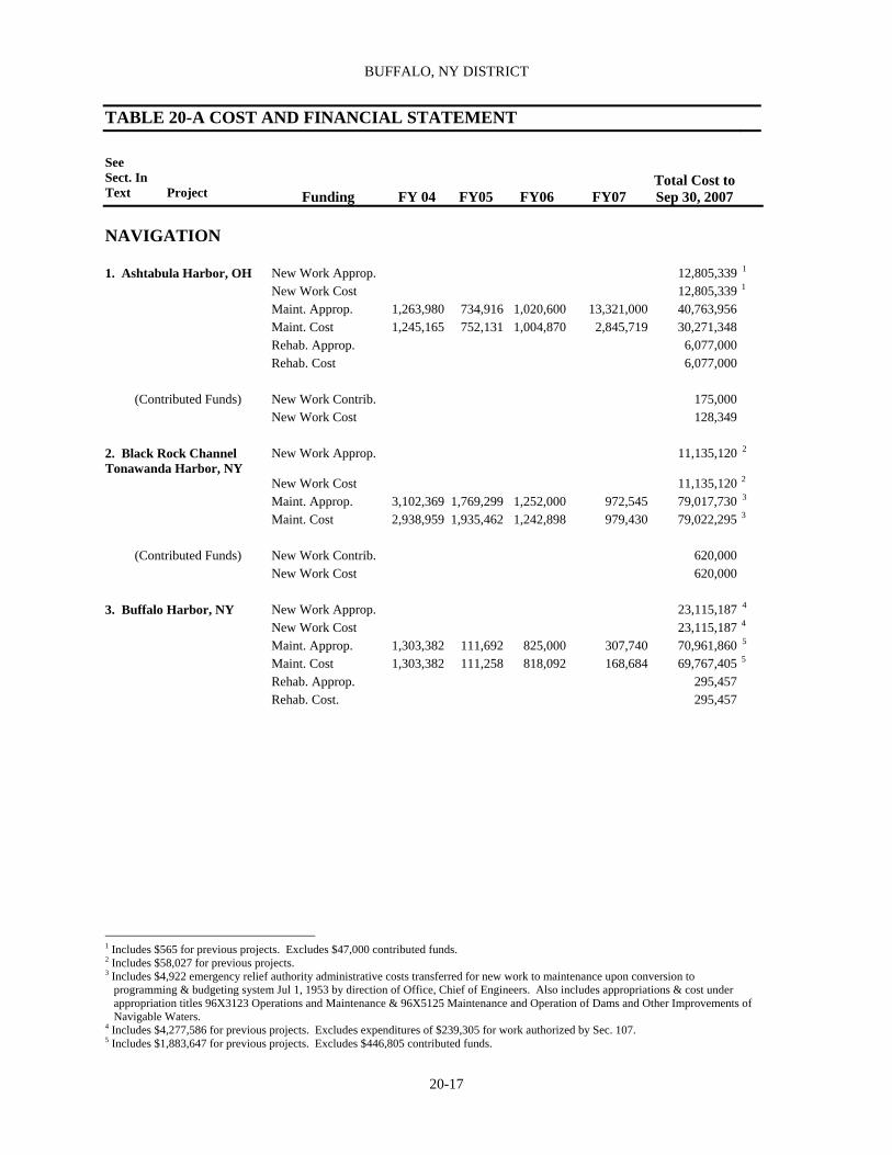
BUFFALO, NY DISTRICT
20-17
TABLE 20-A COST AND FINANCIAL STATEMENT
See Sect. In Text Project
Funding
FY 04
FY05
FY06
FY07
Total Cost to Sep 30, 2007
NAVIGATION
1. Ashtabula Harbor, OH New Work Approp. 12,805,339 1
New Work Cost 12,805,339 1
Maint. Approp. 1,263,980 734,916 1,020,600 13,321,000 40,763,956 Maint. Cost 1,245,165 752,131 1,004,870 2,845,719 30,271,348 Rehab. Approp. 6,077,000 Rehab. Cost 6,077,000
(Contributed Funds) New Work Contrib. 175,000 New Work Cost 128,349
2. Black Rock Channel Tonawanda Harbor, NY
New Work Approp. 11,135,120 2
New Work Cost 11,135,120 2
Maint. Approp. 3,102,369 1,769,299 1,252,000 972,545 79,017,730 3 Maint. Cost 2,938,959 1,935,462 1,242,898 979,430 79,022,295 3
(Contributed Funds) New Work Contrib. 620,000
New Work Cost 620,000
3. Buffalo Harbor, NY New Work Approp. 23,115,187 4 New Work Cost 23,115,187 4
Maint. Approp. 1,303,382 111,692 825,000 307,740 70,961,860 5 Maint. Cost 1,303,382 111,258 818,092 168,684 69,767,405 5
Rehab. Approp. 295,457 Rehab. Cost. 295,457
1 Includes $565 for previous projects. Excludes $47,000 contributed funds. 2 Includes $58,027 for previous projects. 3 Includes $4,922 emergency relief authority administrative costs transferred for new work to maintenance upon conversion to programming & budgeting system Jul 1, 1953 by direction of Office, Chief of Engineers. Also includes appropriations & cost under appropriation titles 96X3123 Operations and Maintenance & 96X5125 Maintenance and Operation of Dams and Other Improvements of Navigable Waters. 4 Includes $4,277,586 for previous projects. Excludes expenditures of $239,305 for work authorized by Sec. 107. 5 Includes $1,883,647 for previous projects. Excludes $446,805 contributed funds.

REPORT OF THE SECRETARY OF THE ARMY ON CIVIL WORKS ACTIVITIES FOR FY 2007
20-18
4. Cleveland Harbor, OH New Work Approp. 36,550,299 1 New Work Cost 36,550,299 6
Maint. Approp. 3,939,294 4,008,911 3,846,000 5,036,354 247,588,058 2 Maint. Cost 3,932,911 4,020,081 3,823,190 5,048,172 247,576,744 7
Rehab. Approp. 16,404,903 Rehab. Cost 16,404,903
(Contributed Funds) New Work Contrib. 1,083,178 New Work Cost 1,083,178 Maint. Contrib. 7,750,725 Maint. Cost 7,660,723
5. Conneaut Harbor, OH New Work Approp.
8,346,641 3
New Work Cost 8,346,641 1
Maint. Approp. 734,497 334,126 1,463,000 720,492 19,563,158 4 Maint. Cost 734,497 334,126 1,462,432 675,483 19,517,583 2
Rehab. Approp. 651,850 Rehab. Cost 651,850
6. Dunkirk Harbor, NY New Work Approp. 3,010,024 5 New Work Cost 3,010,024 3
Maint. Approp. 269,586 37,968 3,000 6,689,040 Maint. Cost 269,270 38,284 3,000 6,689,039 Rehab. Approp. 1,950,000 6 Rehab. Cost 1,950,000 4
7. Erie Harbor, PA New Work Approp. 3,597,873 7
New Work Cost 3,597,873 5
Maint. Approp. 136,620 50,887 3,000 24,259,466 8 Maint. Cost 136,620 50,887 3,112 24,259,577 6
Rehab. Approp. 1,154 Rehab. Cost 1,154
8. Fairport Harbor, NY New Work Approp. 2,959,611 9 New Work Cost 2,959,611 7 Maint. Approp. 1,112,346 973,781 65,612 29,908,576 Maint. Cost 1,102,060 983,084 501 66,094 29,908,576
1 Includes $1,564,154 for previous projects. & appropriation & cost of $16,596 for modification authorized for construction under authority of Sec. 107, 1960 R&H Act. 2 Includes appropriations & cost under appropriation titles 96X3123 Operations and Maintenance & 96X5125 Maintenance and Operations of Dams and Other Improvements of Navigable Waters. Excludes $201,960 contributed funds. 3 Includes $805,272 for previous projects. 4 Includes $39,784 for previous projects. 5 Includes $811,250 for previous projects. Excludes $11,000 contributed funds. 6 Includes $176,520 for previous projects. 7 Includes $736,967 for previous projects. 8 Includes $104,900 for previous projects. Excludes $154,500 contributed funds. 9 Includes $368,940 for previous projects.

BUFFALO, NY DISTRICT
20-19
29. Great Lakes Sediment Transport Model
New Work Approp. New Work Cost Maint. Approp. Maint. Cost Rehab. Approp. Rehab. Cost New Work Approp.
320,000290,178
283,000278,959
350,000 331,440
953,000900,577
9. Great Sodus Bay Harbor, NY
New Work Cost
Maint. Approp. 347,901 149,095 3,773,288
Maint. Cost 347,901 149,095 3,773,288
Rehab. Approp.
Rehab. Cost
10. Huron Harbor, OH New Work Approp. 5,103,795 1 New Work Cost 5,103,795 1
Maint. Approp. 91,191 811,123 94,000 105,846 26,490,237 Maint. Cost 91,191 811,041 93,270 106,657 26,490,236 Rehab. Approp. 247,030 Rehab. Cost 247,030
(Contributed Funds) New Work Approp. 63,079 New Work Cost 63,079
11. Irondequoit Bay, NY 12. Little Sodus Bay Harbor, NY
New Work Approp. New Work Cost Maint. Approp. Maint. Cost Rehab. Approp. Rehab. Cost New Work Approp.
13,98113,981
3,535,6513,535,651
1,046,4951,046,459
301,394
2
New Work Cost 301,394 2
Maint. Approp. 2,976 382,605 6,075,592 Maint. Cost 2,976 382,605 6,075,591 Rehab. Approp. 742,822 Rehab. Cost 742,822
13. Lorain Harbor, OH
New Work Approp.
22,240,670
3
New Work Cost 22,240,670 3
Maint. Approp. 3,082,831 3,307,785 798,000 1,173,000 54,456,111 Maint. Cost 3,084,709 3,308,439 797,681 1,162,440 54,445,136
(Contributed Funds) New Work Contrib. 845,551 New Work Cost 845,551
1 Includes $269,789 for previous projects. 2 Includes $232,328 for previous projects. 3 Includes $292,203 for new work for previous projects. Excludes $3,000 contributed funds. Also excludes appropriation and cost of 29,570 under authority of Sec. 197, 1960 R&H Act.

REPORT OF THE SECRETARY OF THE ARMY ON CIVIL WORKS ACTIVITIES FOR FY 2007
20-20
14. Oak Orchard, NY New Work Approp. 1,586,996 1
New Work Cost 1,586,996 4
Maint. Approp. 151,081 (34) 976,544 Maint. Cost 151,081 (34) 976,545
15. Olcott Harbor, NY New Work Approp. 2,025,210 2 New Work Cost 1,754,694 1
Maint. Approp. 5,000 696,604 3 Maint. Cost 5,000 704,735 2
Rehab. Approp. 14,447 4 Rehab. Cost 14,477 3
16. Oswego Harbor, NY New Work Approp. 8,430,016 5 New Work Cost 8,430,016 4
Maint. Approp. 204,639 1,027,997 130,269 12,547,675 6 Maint. Cost 204,639 1,024,500 3,345 130,420 12,544,328 5 Rehab. Approp. 307,590 Rehab. Cost 307,590
17. Ottawa River, MI & OH New Work Approp. 158,000 22,000 670,000 New Work Cost 145,656 68,393 18 604,715
18. Port Clinton Harbor, OH
New Work Approp.
New Work Cost
Maint. Approp. 19,827 177,551 1,391,454 Maint. Cost 19,877 177,496 146 1,391,742 Rehab. Approp. Rehab. Cost
Port Ontario, NY New Work Approp. 2,369,621 7 New Work Cost 2,368,989 6
Maint. Approp. 34,235 Maint. Cost 34,235 (Contributed Funds) New Work Contrib. 1,361,335
New Work Cost 1,361,335
19. Rochester Harbor, NY New Work Approp. 2,439,308 8 New Work Cost 2,439,308 7
Maint. Approp. 623,509 143,868 63,685 26,273,471 Maint. Cost 623,509 143,868 63,685 26,273,450 Rehab. Approp. - Rehab. Cost -
1 Excludes $224,702 contributed funds. 2 Includes $140,210 for previous projects. Excludes $1,500 contributed funds. 3 Includes $38,959 for previous projects. Excludes $5,000 contributed funds. 4 Excludes $186,000 Public Works Acceleration Act. 5 Includes $1,187,977 for previous projects. 6 Includes $945,684 for previous projects. 7 Includes $50,000 for previous projects. 8 Includes $247,794 for previous projects.

BUFFALO, NY DISTRICT
20-21
20. Rocky River, OH New Work Approp. 343,494 New Work Cost 343,494
Maint. Approp. 289,322 2,834 5,497,116 Maint. Cost 289,990 2,834 5,482,237
21. Sandusky Harbor, OH
New Work Approp.
6,727,270
1
New Work Cost 6,727,270 1
Maint. Approp. 43,299 718,454 787,000 21,977 27,855,237 Maint. Cost 43,299 718,373 785,793 23,265 27,854,629 Rehab. Approp. 675,606 Rehab. Cost 675,606
(Contributed Funds) Maint. Contrib. 15,445
Maint. Cost 15,445 22. Sturgeon Point, NY New Work Approp. 1,718,700 2
New Work Cost 1,718,140 2
Maint. Approp. 12,487 14,887 180,792 Maint. Cost 12,487 14,787 100 180,790
(Contributed Funds) New Work Contrib. 1,299,008
New Work Cost 1,299,008 23. Toledo Harbor, OH New Work Approp. 17,191,842 3
New Work Cost 17,191,842 3 Maint. Approp. 3,445,688 3,129,443 3,034,400 3,293,000 147,669,241 Maint. Cost 3,445,688 3,129,409 2,814,216 3,065,581 144,221,603
24. Toussaint River, OH Maint. Approp. 208,189 13,841 1,162,372 Maint. Cost 208,189 13,841 1,189,370 (Contributed Funds) Maint. Contrib. 64,557 254,368
Maint. Cost 64,557 254,367 25. Vermilion Harbor, OH New Work Approp. 1,156,118 4
New Work Cost 1,156,118 4
Maint. Approp. 298,251 (2,779) 4,161,413 Maint. Cost 298,251 (2,779) 4,161,413 Rehab. Approp. 139,775 Rehab. Cost 139,775
1 Includes $477,149 for previous projects. Excludes $325,000 contributed funds. 2 Excludes $5,000 contributed funds. 3 Includes $1,624,695 for previous projects 4 Excludes $740,679 contributed funds.

REPORT OF THE SECRETARY OF THE ARMY ON CIVIL WORKS ACTIVITIES FOR FY 2007
20-22
26. West Harbor, OH New Work Approp. 3,303,898 New Work Cost 3,303,863 Maint. Approp. 319,664 (31,398) 2,358,250 Maint. Cost 319,664 (31,398) 2,358,250 (Contributed Funds) New Work Contrib. 3,795,000
New Work Cost 3,795,000
27. Wilson Harbor, NY New Work Approp. 535,246 1
New Work Cost 535,246 1
Maint. Approp. 3,000 173,631 1,370,282
Maint. Cost 3,000 173,631 1,370,282
30. New York State Canal System, NY
New Work Approp 580,000 444,000
8,587,000
New Work Cost 560,516 456,218 7,326 8,579,674
SHORE PROTECTION
31. Presque Isle Peninsula, Erie, PA
New Work Approp. 463,000 276,000 459,000 90,000 37,347,049
New Work Cost 494,445 277,984 456,897 91,839 37,342,137 Maint. Approp. 4,978 Maint. Cost 4,978
(Contributed Funds) New Work Contrib. 500,000 620,000 620,000 90,000 28,740,369 New Work Cost 549,396 680,574 623,231 93,378 28,025,619
FLOOD CONTROL 32. Mount Morris Lake, Genesee River, NY
New Work Approp. 23,365,559 2
New Work Cost 23,365,559 2 Maint. Approp. 2,337,818 2,372,209 2,923,000 2,729,481 48,139,374
Maint Cost 2,334,606 2,349,659 2,546,854 3,074,380 48,402,440
ENVIRONMENTAL RESTORATION
34. Ohio Environmental Infrastructure
New Work Approp. 1,530,000 2,417,000 3,906,400 1,929,552 12,197,952
New Work Cost 1,447,558 1,679,222 1,355,765 3,071,405 9,968,256
35. Onondaga Lake, NY New Work Approp. 2,979,200 3,238,000 3,134,000 0 16,418,762 New Work Cost 1,707,179 1,726,479 1,767,402 2,516,344 12,782,964
(Contributed Funds) New Work Contrib. (47,187) (284,550) (193) (11,262) 4,711,280
New Work Cost 296,754 6,389 102,450 163,038 4,679,687
1 Includes $57,342 for previous projects. Excludes $166,998 contributed funds. 2 Includes study cost of $117,000 under authority Sec 205, 1948 Flood Control Act. Excludes $17,493 in contributed cost.

BUFFALO, NY DISTRICT
20-23
36. Great Lakes Fishery & Ecosystem Restoration
New Work Approp. 85,000 29,000 224,000 338,000
New Work Cost 19,695 67,130 162,805 249,630
(Contributed Funds) New Work Contrib. New Work Cost

REPORT OF THE SECRETARY OF THE ARMY ON CIVIL WORKS ACTIVITIES FOR FY 2007
20-24
Table 20-B AUTHORIZING LEGISLATION
See Section
Acts
Work Authorized
Documents
1 ASHTABULA HARBOR, OH Jun 3, 1896 Construction of breakwater. Annual Report, 1895, p.
2132 Mar 3, 1905
Jun 25, 1910 Enlarge outer harbor by extending west breakwater and constructing new east breakwater pier heads on lakeward ends of breakwaters; remove part of old east breakwater.
H. Doc. 654. 61st Cong., 2nd sess.
Mar 2, 1919 Extend west breakwater to shore; dredge outer harbor to a depth of
20 feet. H. Doc. 997, 64th Cong., 1st sess.
Aug 30, 1935 Remove portion of east breakwater to extend breakwaters to present
dimensions and dredging restrictions in portion of west basin. H. Doc. 43, 73rd Cong., 1st sess.
Aug 26, 1937 Dredge channel through outer harbor, channel of approach to Penn
Central Co. slip, channel Ashtabula River, to and in turning basin all to present project dimensions; remove portion of old east inner breakwater and Maintenance to 24-foot depth of portion of outer harbor.
Rivers and Harbors Committee Doc. 78, 74th Cong., 2nd sess.
Mar 2, 1945 Extend river channel to present project limit. H. Doc. 321, 77th Cong., 1st
sess. River & Harbor Act of 1945, PL 79-14
Sep 3, 1954 Dredging approach channel and turning basin in east outer harbor to
25-foot depth. H. Doc. 486, 83rd Cong., 2nd sess. River & Harbor Act of 1954, PL 83-780
Jul 14, 1960 A depth of 29 feet in soft and 30 feet in hard material in entrance
channel to just inside outer ends of Breakwaters, thence 28 feet in soft and 29 feet in hard material in a channel to inner breakwater, thence 27 feet in soft and 28 feet in hard materials in a channel extending to Penn Central Co. slip and extending 2000 feet up Ashtabula River, 22 feet in hard material in turning area; and 28 feet in soft and 29 feet in hard material in areas adjacent to 250-foot section of inner breakwater when that section is removed as now authorized.
H. Doc. 148, 86th Cong., 1st sess. River & Harbor Act of 1960, PL 86-645
Oct 27, 1965 Dredging approach channel and turning basin in east outer harbor to
28 feet in soft material and 29 feet in hard material. H. Doc. 269, 89th Cong., 1st sess.1 River & Harbor Act of 1965, PL 87-874
ASHTABULA RIVER, OH ENVIRONMENTAL DREDGING Nov 28, 1990
as amended, Aug 17, 1999, Dec 11, 2000
The Secretary may remove and remediate, as part of operation and maintenance of a navigation project, contaminated sediments outside the boundaries of and adjacent to the navigation channel. The Secretary may remove and remediate contaminated sediments from the waters of the United States, in general, for the purpose of environmental enhancement and water quality improvement if such removal is requested by a non-Federal sponsor and the sponsor agrees to pay 65% of the cost of the removal and remediation.
PL 101-640; PL 106–53; PL 106–541
1 Contains latest published map.

BUFFALO, NY DISTRICT
20-25
Table 20-B AUTHORIZING LEGISLATION
See Section
Acts
Work Authorized
Documents
Oct 12, 1996 Amended PL 101-640 to include Ashtabula River, OH as priority
work. PL 104-303
2 BLACK ROCK CHANNEL AND TONAWANDA HARBOR,
NY Aug 11, 1888
Jun 3, 1896 Dredging channel through horseshoe reef at outlet of Lake Erie and Tonawanda Inner Harbor to 16 feet.
H. Ex. Doc. 83, 50th Cong., 1st sess., Annual Report. 1888, p. 206 and Annual Report, 1897., pp.3116-3120
Jun 13, 1902 Deepening Tonawanda Creek to 16 feet. H. Doc. 143, 56th Cong., 1st
sess. and Annual Report, 1900 p. 4152
Jun 13, 1902 Aug 8, 1917
Dredging channel from Buffalo outer harbor to foot of Maryland St., Buffalo, to 21 feet.
H. Doc. 125, 56th Cong., 2nd sess., and Annual Report 1901, p. 3343
Mar 3, 1905 Dredging channel from foot of Maryland St., Buffalo, to natural
deep water pool upstream from Tonawanda Harbor to 21 feet; construction of ship lock and bridge; and repair of Bird Island pier towpath wall.
H. Doc. 428, 58th Cong., 2nd sess.
Jul 27, 1916 Dredging channel along Tonawanda Island, with turning basin at its
downstream end at the foot of the Island, to 21 feet. H. Doc. 658, 63rd Cong., 2nd sess.
Mar 2, 1919 Mar 2, 1945
Dredging triangular area at junction with Buffalo north Entrance channel.
H. Doc. 1004, 65th Cong., 2nd sess. & H. Doc. 92, 79th Cong., 1st sess. H. Doc. 981, 66th Cong., 2nd sess. River & Harbor Act of 1945, PL 79-14
Sep 22, 1922 Widening channel at foot of Maryland St., Buffalo. H. Doc. 289, 68th Cong., 1st
sess. Mar 3, 1925 Widening canal south of International Bridge and removal of
westerly end of Rattlesnake Island shoal. H. Doc. 981, 66th Cong., 3d sess.
Jun 26, 19341 Operation and care of improvements provided for with funds from
War Department appropriations for rivers and harbors. H Doc. 28, 73d Cong., 1st sess.
Aug 30, 19352 Removal of rock shoals in Lake Erie entrance to canal, and in canal south of Ferry Street Bridge, to 22 feet; enlargement of North Tonawanda turning basin; extension of Bird Island Pier; improvement of guide pier at the lock; and elimination of upper 150 feet of Tonawanda Creek channel from the project.3
H. Doc. 28, 73rd Cong., 1st sess.
Mar 2, 1945 Widening Lake Erie entrance to canal. H. Doc. 92, 79th Cong., 1st
sess.4 River & Harbor Act of 1945, PL 79-14
1 Permanent Appropriations Repeal Act. 2 Authorized May 28, 1935 by Emergency Relief Administration Act of 1935. 3 Improvement of guide pier at Black Rock Lock was de-authorized by Congress in Aug 1977. 4 Contains latest published map.

REPORT OF THE SECRETARY OF THE ARMY ON CIVIL WORKS ACTIVITIES FOR FY 2007
20-26
Table 20-B AUTHORIZING LEGISLATION
See Section
Acts
Work Authorized
Documents
Sep 3, 1954 Deepen lower 1,500 feet of Tonawanda inner harbor and enlarge
turning basin. H. Doc. 423, 83rd Cong., 2nd sess.1 2 River & Harbor Act of 1954, PL 83-780
3 BUFFALO HARBOR, NY May 20, 1826 Construction of south pier (extended in 1868).3 Annual Report, 1868, pp.
222 –232
Jun 23, 1866 Construction of old breakwater.3 Annual Report, 1868, pp. 232 –236
Jun 23, 1874 Extension of old breakwater.3 Annual Report, 1876, pt. 2,
pp. 569 and 573 Jun 3, 1896 Stony Point and south breakwater.3 Annual Report, 1895, p.
3153. H. Doc. 72, 55th Cong., 1st sess., and Annual Report, 1897, p. 3245
Mar 3, 1899
Mar 3, 1909 North breakwater.3
Jun 6, 1900
Jun 18, 1902 Deepening entrance channel to inner harbor and removing rock shoal therein.
Specified in acts.
Mar 2, 19074 Dredging at entrance to canals at South Buffalo in outer harbor.3 Specified in act. Mar 2, 1907 South entrance breakwater.3 H. Doc. 240, 59th Cong., 1st
sess. Jun 25, 1910 Extension of Federal project to Commercial St. and removal of
Watson elevator site. H. Doc. 298, Rivers and Harbors Committee Doc. 2, 61st Cong., 2nd sess.
Jul 25, 1912 Deepening areas A, B, D, in outer harbor to 21 feet, C in North
entrance to 23 feet. H. Doc. 550, 62nd Cong., 2nd sess.
Mar 2, 1919 Deepening areas F and G in outer harbor to 21 feet. H. Doc. 1139, 64th Cong., 1st
sess. Jan 21, 1927 Removal of shoal between entrance channel to Buffalo River and
Erie Basin to 21 feet. H.Doc. 481, 68th Cong., 2nd sess.
Jul 3, 1930 Deepening areas H, I, and K in outer harbor 21 feet. Rivers and Harbors
Committee Doc. 1, 71st Cong., 1st sess.
1 Classified deferred. 2 Contains latest published map. 3 Completed under previous projects. 4 Also Sundry Civil Act of Mar 3, 1905.

BUFFALO, NY DISTRICT
20-27
Table 20-B AUTHORIZING LEGISLATION
See Section
Acts
Work Authorized
Documents
Aug 30, 19351 Extension of south entrance and south breakwaters, deepening outer harbor to present project dimensions, and removal of shoals on approach to south entrance.
H. Doc. 46, 73rd Cong., 1st sess.
Aug 30, 1935
Mar 2, 194541 Maintenance of channels in Buffalo River and Buffalo Ship Canal to 21 feet in cooperation with city of Buffalo.
Rivers and Harbors Committee Doc. 54, 74th Cong., 1st sess.
Jul 14, 1960 Deepening North and Buffalo River entrance channels, and
deepening and maintaining Buffalo River and Buffalo Ship Canal to present project dimensions.
H. Doc. 352, 78th Cong., 1st sess. River & Harbor Act of 1960, PL 86-645
Oct 23, 1962 Deepening approach to south entrance channels, and deepen to 30
feet in outer area and 29 feet in inner area of southerly part of outer harbor.
H. Doc. 151, 86th Cong., 1st sess. River & Harbor Act of 1962, PL 87-874
1962
Deepening portion of outer harbor to 27 feet over a width of 500 feet for 2,500 feet northward from 28-foot project area, widening within 1,700 feet to limits within 150 feet of breakwater axis and 75 feet from harbor line and continuing within these limits for 7,000 feet. Elimination of 25-foot wide strip between presently authorized and proposed easterly dredging limits easterly 50 foot wide undredged strip in existing 23-foot depth project area, extending northerly from 27-foot depth to Buffalo River entrance channel. Previously authorized but uncompleted portions or work authorized by 1935 Act, combined within this act as a single improvement.
H. Doc. 451, 87th Cong., 2nd sess.
Jul 14, 1960
as amended Removal of abandoned abutments of South Michigan Bridge. Sec. 107 of River & Harbors
Act of 1960, PL 86-645. Authorized Chief of Engineers Dec 15, 1980
BUFFALO HARBOR and RIVER, NY ENVIRONMENTAL
DREDGING Nov 28, 1990
as amended, Aug 17, 1999, Dec 11, 2000
The Secretary may remove and remediate, as part of operation and maintenance of a navigation project, contaminated sediments outside the boundaries of and adjacent to the navigation channel. The Secretary may remove and remediate contaminated sediments from the waters of the United States, in general, for the purpose of environmental enhancement and water quality improvement if such removal is requested by a non-Federal sponsor and the sponsor agrees to pay 65% of the cost of the removal and remediation.
PL 101-640; PL 106–53; PL 106–541
Oct 12, 1996 Amended PL 101-640 to include Buffalo Harbor and River, NY as
priority work. PL 104-303
4 CLEVELAND HARBOR, OH Mar 3, 1875 West breakwater. Annual Report, 1876, p. 558 Aug 5, 1886 Part of east breakwater.2 H. Ex. Doc. 116, 48th Cong.,
2nd Sess., and Annual Report, 1886, p. 1865
1 Authorized in part by Public Works Administration, Sep 6, 1933. 2 Completed under previous projects.

REPORT OF THE SECRETARY OF THE ARMY ON CIVIL WORKS ACTIVITIES FOR FY 2007
20-28
Table 20-B AUTHORIZING LEGISLATION
See Section
Acts
Work Authorized
Documents
Aug 11, 1888 Extension of east breakwater. H. Ex. Doc. 189, 50th Cong.,
2nd sess., and Annual Report, 1888, p. 2005
Jun 3, 1896 Reconstruction of piers.1 H. Doc. 326, 54th Cong., 1st
sess., and Annual Report, 1896, p. 2949
Mar 3, 1899 Dredging channel between piers and outer harbor to depth of 19 feet;
dredging to depth of 23 feet in any portion of harbor is discretion of Secretary of War.
H. Doc. 156, 55th Cong., 2nd sess., and Annual Report, 1899, pp. 3075 and 3078
Jun 13, 1902 Arrowhead breakwater and extension of east breakwater. H. Doc 118, 56th Cong., 2nd
sess. Mar 2, 1907
Jun 25, 1910 Removal of deflecting arm of old east breakwater and closure of gap between old and new east breakwaters.
No printed report.
Jul 27, 1916 Pierhead at easterly end of east breakwater. H. Doc 891, 63rd Cong., 2nd
sess.
Aug 8, 1917 Aug 29, 1937
Maintenance and improvement of channels in Cuyahoga and Old Rivers to a depth of 21 feet to a point 2,000 feet upstream from Clark Ave. viaduct and 18-foot turning basin.
H. Doc. 707, 63rd Cong., 2nd sess., & Rivers and Harbors Committee Doc. 84, 74th Cong., 2nd sess.
Aug 30, 19352 Deepening outer harbor and channel between piers to present project
dimensions, construction of 400-foot spur breakwater at gap in shore arm of west breakwater, removal of easterly 150 feet of west breakwater, elimination from project of a 298-foot southerly extension on west pier, and abandonment of inner 932 feet of shore arm of west breakwater.
H. Doc. 477, 72nd Cong., 2nd sess.
Aug 30, 19353 Maintenance dredging in Cuyahoga and Old Rivers for one year as
an emergency measure. Rivers and Harbors Committee Doc. 39, 74th Cong., 1st sess.
Mar 2, 19454 Maintenance extension of Cuyahoga River channel. Extension,
maintenance, and improvement to a depth of 21 feet of Cuyahoga River channel to present project limit.5 6
Specified in act. H. Doc. 95, 79th Cong., 1st sess. River & Harbor Act of 1945, PL 79-14
Jul 24, 1946 Improvement of Cuyahoga and Old Rivers to a depth of 23 feet and
replacement or pier construction of 7 railroad bridges.7 H. Doc. 629, 79th Cong., 2nd sess. River & Harbor Act of 1946, PL 79-525
1 Completed under previous projects. 2 Authorized by Public Works Administration, Sep 6, 1933. 3 Authorized in part by Public Works Administration, Sep 6, 1933. 4 First Deficiency Appropriations Act approved Apr 1, 1944. 5 Deepening left half of channel extension was eliminated from project by 1962 R&H Act. 6 Authorized by Defense Plant Corp. May 19, 1942. 7 Widening Cuyahoga River downstream at end of Cut 4 classified inactive.
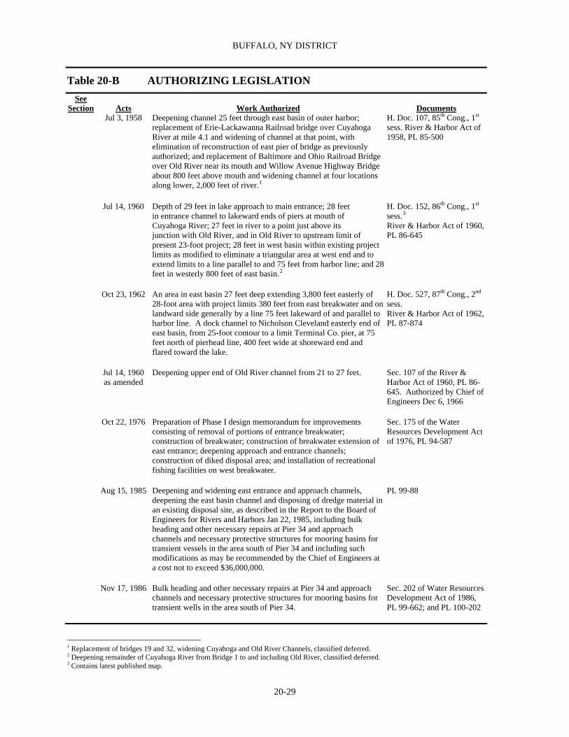
BUFFALO, NY DISTRICT
20-29
Table 20-B AUTHORIZING LEGISLATION
See Section
Acts
Work Authorized
Documents
Jul 3, 1958 Deepening channel 25 feet through east basin of outer harbor; replacement of Erie-Lackawanna Railroad bridge over Cuyahoga River at mile 4.1 and widening of channel at that point, with elimination of reconstruction of east pier of bridge as previously authorized; and replacement of Baltimore and Ohio Railroad Bridge over Old River near its mouth and Willow Avenue Highway Bridge about 800 feet above mouth and widening channel at four locations along lower, 2,000 feet of river.1
H. Doc. 107, 85th Cong., 1st sess. River & Harbor Act of 1958, PL 85-500
Jul 14, 1960 Depth of 29 feet in lake approach to main entrance; 28 feet
in entrance channel to lakeward ends of piers at mouth of Cuyahoga River; 27 feet in river to a point just above its junction with Old River, and in Old River to upstream limit of present 23-foot project; 28 feet in west basin within existing project limits as modified to eliminate a triangular area at west end and to extend limits to a line parallel to and 75 feet from harbor line; and 28 feet in westerly 800 feet of east basin.2
H. Doc. 152, 86th Cong., 1st sess.3 River & Harbor Act of 1960, PL 86-645
Oct 23, 1962 An area in east basin 27 feet deep extending 3,800 feet easterly of
28-foot area with project limits 380 feet from east breakwater and on landward side generally by a line 75 feet lakeward of and parallel to harbor line. A dock channel to Nicholson Cleveland easterly end of east basin, from 25-foot contour to a limit Terminal Co. pier, at 75 feet north of pierhead line, 400 feet wide at shoreward end and flared toward the lake.
H. Doc. 527, 87th Cong., 2nd sess. River & Harbor Act of 1962, PL 87-874
Jul 14, 1960
as amended Deepening upper end of Old River channel from 21 to 27 feet. Sec. 107 of the River &
Harbor Act of 1960, PL 86-645. Authorized by Chief of Engineers Dec 6, 1966
Oct 22, 1976 Preparation of Phase I design memorandum for improvements
consisting of removal of portions of entrance breakwater; construction of breakwater; construction of breakwater extension of east entrance; deepening approach and entrance channels; construction of diked disposal area; and installation of recreational fishing facilities on west breakwater.
Sec. 175 of the Water Resources Development Act of 1976, PL 94-587
Aug 15, 1985 Deepening and widening east entrance and approach channels,
deepening the east basin channel and disposing of dredge material in an existing disposal site, as described in the Report to the Board of Engineers for Rivers and Harbors Jan 22, 1985, including bulk heading and other necessary repairs at Pier 34 and approach channels and necessary protective structures for mooring basins for transient vessels in the area south of Pier 34 and including such modifications as may be recommended by the Chief of Engineers at a cost not to exceed $36,000,000.
PL 99-88
Nov 17, 1986 Bulk heading and other necessary repairs at Pier 34 and approach
channels and necessary protective structures for mooring basins for transient wells in the area south of Pier 34.
Sec. 202 of Water Resources Development Act of 1986, PL 99-662; and PL 100-202
1 Replacement of bridges 19 and 32, widening Cuyahoga and Old River Channels, classified deferred. 2 Deepening remainder of Cuyahoga River from Bridge 1 to and including Old River, classified deferred. 3 Contains latest published map.
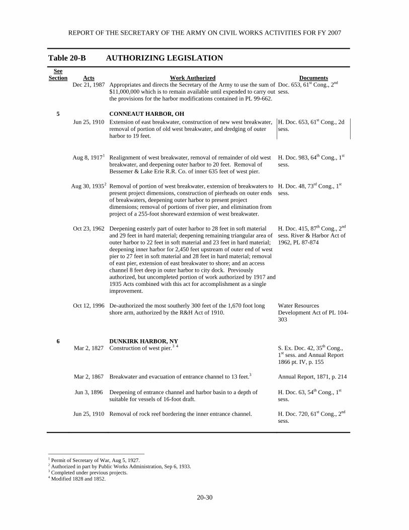
REPORT OF THE SECRETARY OF THE ARMY ON CIVIL WORKS ACTIVITIES FOR FY 2007
20-30
Table 20-B AUTHORIZING LEGISLATION
See Section
Acts
Work Authorized
Documents
Dec 21, 1987 Appropriates and directs the Secretary of the Army to use the sum of $11,000,000 which is to remain available until expended to carry out the provisions for the harbor modifications contained in PL 99-662.
Doc. 653, 61st Cong., 2nd sess.
5 CONNEAUT HARBOR, OH Jun 25, 1910 Extension of east breakwater, construction of new west breakwater,
removal of portion of old west breakwater, and dredging of outer harbor to 19 feet.
H. Doc. 653, 61st Cong., 2d sess.
Aug 8, 19171
Realignment of west breakwater, removal of remainder of old west breakwater, and deepening outer harbor to 20 feet. Removal of Bessemer & Lake Erie R.R. Co. of inner 635 feet of west pier.
H. Doc. 983, 64th Cong., 1st sess.
Aug 30, 19352 Removal of portion of west breakwater, extension of breakwaters to
present project dimensions, construction of pierheads on outer ends of breakwaters, deepening outer harbor to present project dimensions; removal of portions of river pier, and elimination from project of a 255-foot shoreward extension of west breakwater.
H. Doc. 48, 73rd Cong., 1st sess.
Oct 23, 1962 Deepening easterly part of outer harbor to 28 feet in soft material
and 29 feet in hard material; deepening remaining triangular area of outer harbor to 22 feet in soft material and 23 feet in hard material; deepening inner harbor for 2,450 feet upstream of outer end of west pier to 27 feet in soft material and 28 feet in hard material; removal of east pier, extension of east breakwater to shore; and an access channel 8 feet deep in outer harbor to city dock. Previously authorized, but uncompleted portion of work authorized by 1917 and 1935 Acts combined with this act for accomplishment as a single improvement.
H. Doc. 415, 87th Cong., 2nd sess. River & Harbor Act of 1962, PL 87-874
Oct 12, 1996 De-authorized the most southerly 300 feet of the 1,670 foot long
shore arm, authorized by the R&H Act of 1910. Water Resources Development Act of PL 104-303
6
DUNKIRK HARBOR, NY Mar 2, 1827 Construction of west pier.3 4 S. Ex. Doc. 42, 35th Cong.,
1st sess. and Annual Report 1866 pt. IV, p. 155
Mar 2, 1867 Breakwater and evacuation of entrance channel to 13 feet.3 Annual Report, 1871, p. 214 Jun 3, 1896 Deepening of entrance channel and harbor basin to a depth of
suitable for vessels of 16-foot draft. H. Doc. 63, 54th Cong., 1st sess.
Jun 25, 1910 Removal of rock reef bordering the inner entrance channel. H. Doc. 720, 61st Cong., 2nd
sess.
1 Permit of Secretary of War, Aug 5, 1927. 2 Authorized in part by Public Works Administration, Sep 6, 1933. 3 Completed under previous projects. 4 Modified 1828 and 1852.
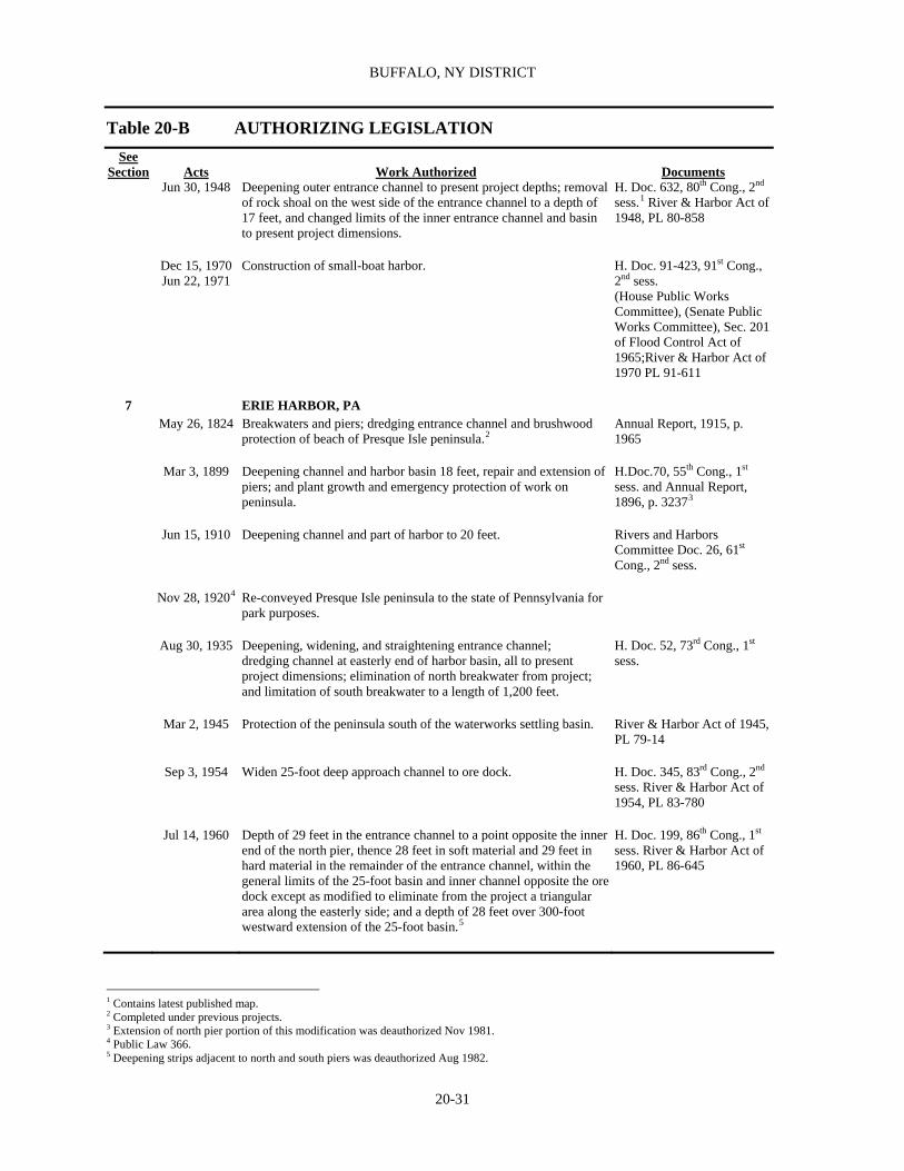
BUFFALO, NY DISTRICT
20-31
Table 20-B AUTHORIZING LEGISLATION
See Section
Acts
Work Authorized
Documents
Jun 30, 1948 Deepening outer entrance channel to present project depths; removal of rock shoal on the west side of the entrance channel to a depth of 17 feet, and changed limits of the inner entrance channel and basin to present project dimensions.
H. Doc. 632, 80th Cong., 2nd sess.1 River & Harbor Act of 1948, PL 80-858
Dec 15, 1970
Jun 22, 1971 Construction of small-boat harbor. H. Doc. 91-423, 91st Cong.,
2nd sess. (House Public Works Committee), (Senate Public Works Committee), Sec. 201 of Flood Control Act of 1965;River & Harbor Act of 1970 PL 91-611
7 ERIE HARBOR, PA May 26, 1824 Breakwaters and piers; dredging entrance channel and brushwood
protection of beach of Presque Isle peninsula.2 Annual Report, 1915, p. 1965
Mar 3, 1899 Deepening channel and harbor basin 18 feet, repair and extension of
piers; and plant growth and emergency protection of work on peninsula.
H.Doc.70, 55th Cong., 1st sess. and Annual Report, 1896, p. 32373
Jun 15, 1910 Deepening channel and part of harbor to 20 feet. Rivers and Harbors
Committee Doc. 26, 61st Cong., 2nd sess.
Nov 28, 19204 Re-conveyed Presque Isle peninsula to the state of Pennsylvania for
park purposes. Aug 30, 1935 Deepening, widening, and straightening entrance channel;
dredging channel at easterly end of harbor basin, all to present project dimensions; elimination of north breakwater from project; and limitation of south breakwater to a length of 1,200 feet.
H. Doc. 52, 73rd Cong., 1st sess.
Mar 2, 1945 Protection of the peninsula south of the waterworks settling basin. River & Harbor Act of 1945,
PL 79-14 Sep 3, 1954 Widen 25-foot deep approach channel to ore dock. H. Doc. 345, 83rd Cong., 2nd
sess. River & Harbor Act of 1954, PL 83-780
Jul 14, 1960 Depth of 29 feet in the entrance channel to a point opposite the inner
end of the north pier, thence 28 feet in soft material and 29 feet in hard material in the remainder of the entrance channel, within the general limits of the 25-foot basin and inner channel opposite the ore dock except as modified to eliminate from the project a triangular area along the easterly side; and a depth of 28 feet over 300-foot westward extension of the 25-foot basin.5
H. Doc. 199, 86th Cong., 1st sess. River & Harbor Act of 1960, PL 86-645
1 Contains latest published map. 2 Completed under previous projects. 3 Extension of north pier portion of this modification was deauthorized Nov 1981. 4 Public Law 366. 5 Deepening strips adjacent to north and south piers was deauthorized Aug 1982.

REPORT OF THE SECRETARY OF THE ARMY ON CIVIL WORKS ACTIVITIES FOR FY 2007
20-32
Table 20-B AUTHORIZING LEGISLATION
See Section
Acts
Work Authorized
Documents
Oct 23, 1962 Depth of 27 feet in soft material and 28 feet in hard material in approach area to Duquesne Marine Terminal. Previously authorized but uncompleted portion of work authorized by 1935 Act is combined with this act as a single improvement.
H. Doc. 340, 87th Cong., 2nd sess.32 River & Harbor Act of 1962, PL 87-874
8 FAIRPORT HARBOR, OH Mar 3, 18251 Construction of piers. Annual Report, 1889, pp.
2147-2153 Jun 3, 1896
Mar 3, 1905 Breakwaters and dredging outer harbor to a depth of 18 feet. H. Doc. 347, 54th Cong., 1st
sess. and Annual Reports, 1896, p. 2956; 1903, p. 2084. 1905, p. 2349
Mar 2, 1919 1,400-foot extension of east breakwater, present project dimension
of east pier, and deepening to 19 feet. H. Doc. 206, 63rd Cong., 1st sess.
Jan 21, 1927
Jul 3, 1930 4,000-foot extension of east breakwater at limit of cost to the United States of $715,000.
H. Doc. 592, 69th Cong., 2nd sess. Rivers and Harbors Committee Doc 13, 70th Cong., 1st sess.
Aug 30, 19352 Deepening of outer harbor and entrance channel to present
dimensions; extending the west breakwater to present project dimensions with pierhead at its outer end; removal of west pier, and construction of bulkhead on west side of river channel.
H. Doc. 472, 72nd Cong., 2nd sess.
Aug 26, 1937 Dredging of 21 and 24-foot river channels and turning basin in
Grand River to present project dimensions. Rivers and Harbors Committee Doc. 79, 74th Cong., 2nd sess.
Jul 24, 1946 Dredging of 8-foot river channel. H. Doc. 706, 79th Cong., 2nd
sess.32 River & Harbor Act of 1946, PL 79-525
9 GREAT SODUS BAY HARBOR, NY Mar 2, 1829 Construction of piers and breakwater. Annual Report, 1876 pt. II p.
589 Aug 2, 1882 Extension of piers to 15-foot contour in the lake. Annual Report, 1881, p.
2442 Mar 3, 1925 Deepening and widening of channel to 180 foot depth and
150 foot width. H. Doc. 192, 68th Cong., 1st sess.
Jul 3, 1930 Widening channel lakeward of piers to 250 feet. Rivers and Harbors
Committee Doc. 17, 70th Cong., 1st sess.
Aug 30, 1935 Dredging channel to present project dimensions. Rivers and Harbors
Committee Doc.
1 Modified 1830, 1881, and 1890. New work completed under previous projects. 2 Partly included in Public Works Administration Program, Nov 15, 1933.

BUFFALO, NY DISTRICT
20-33
Table 20-B AUTHORIZING LEGISLATION
See Section
Acts
Work Authorized
Documents
23, 72nd Cong., 1st sess.
36 GREAT LAKES FISHERY & ECOSYSTEM RESTORATION Dec 11, 2000 Provides $100M of authority of plan, design, & construct individual
projects that support the restoration of the fishery, ecosystem and beneficial uses of the GL. GLFER is an existing Federal program that is specific to the GL & can respond to the recommendations of the Strategy of the GL Regional Collaboration for wetlands & aquatic habitat protection & restoration. Projects will also support state/local efforts to implement Remedial Action Plans to restore beneficial use impairments at GL AOC.
Section 506 of the Water Resources Development Act (WRDA), P.L 106-541
10 HURON HARBOR, OH Mar 2, 1905 Extension of west pier, construction of east breakwater, removal of
part of old east pier; deepening of channel to 19 feet; and dredging of sheltered area.
H. Doc. 122, 58th Cong., 2nd sess.
Mar 2, 1919 Widening river to 200 feet; removal of remainder of old east pier,
construction of new spur pier, enlargement of sheltered area; and closure of beach at shore end of west pier.
H. Doc. 5, 63rd Cong., 1st sess.
Aug 30, 19351 Extension of west pierhead at its outer end; removal of outer end of
east breakwater and construction pierhead on new outer end; widening and deepening channel to present project dimensions; enlargement of turning basin at head of channel; shore protection west of west pier, and elimination from project construction of spur pier and dredging sheltered area outside channel limits.
H. Doc. 478, 72nd Cong., 2nd sess.
Oct 23, 1962 Depths of 29 feet in approach channel, 28 feet in entrance
channel, 27 feet in river channel, 21 feet in turning basin and abandonment of lakeward end of existing approach channel.
H. Doc. 165, 87th Cong., 1st sess.32 River & Harbor Act of 1962, PL 87-874
11 IRONDEQUOIT BAY, NY
Jul 3, 1958 Construction entrance channel 9 feet deep and 100 feet wide, extending from 9-foot depth in Lake Ontario to junction with inner bay channels, a distance of about 1,300 feet; inner channel, 8 feet deep and 100 feet wide, from entrance channel to deep water in bay, a distance of about 3,035 feet, access channel 8 feet deep, 100 feet wide and 500 feet in length from the inner bay channel to the west; two stone rubble-mound structures 1,350 feet and 750 in length at the natural entrance; and recreational facilities.
H. Doc. 332, 84th Cong., 2nd sess.
12 LITTLE SODUS BAY HARBOR, NY
Aug 30, 1852 West entrance pier. Annual Report, 1874, p. 256 Jun 23, 1866 Extension of west pier and construction of west breakwater, and
dredging channel to 12 feet deep, 400 feet wide. Annual Report, 1874, p. 256
Mar 3, 1871 East pier and east breakwater. Annual Report, 1871, p. 234 Mar 3, 1881 Extension of piers lakeward to 15.5-foot contour, and dredging Annual Report, 1881, pp.
1 Partly included in Public Works Administration Program, Nov 15, 1933.

REPORT OF THE SECRETARY OF THE ARMY ON CIVIL WORKS ACTIVITIES FOR FY 2007
20-34
Table 20-B AUTHORIZING LEGISLATION
See Section
Acts
Work Authorized
Documents
channel to 15.5 feet. 2444 and 2446 Jun 13, 1902 Extension of east pier 300 feet lakeward. Annual Report, 1901, p.
3364
13 LORAIN HARBOR, OH Mar 3, 1899 Breakwaters and extension of piers to present dimensions. H. Doc. 131, 55th Cong., 2nd
sess., and Annual Report 1898, p. 2718.
Mar 2, 1907 Extend 18-foot channel from inner end of piers to Erie Avenue
Bridge. H. Doc. 560, 60th Cong., 1st sess.
Jun 25, 1910 Extend breakwaters and dredge to depth of 19 feet in outer harbor. H. Doc. 644, 61st Cong., 2nd
sess. Aug 8, 1917 Extend breakwaters to present dimensions. H. Doc. 980, 64th Cong., 1st
sess. Aug 8, 1917 Deepen outer harbor and river channel of Erie Avenue Bridge to 20
feet. H. Doc. 985, 64th Cong., 1st sess.
Jul 3, 1930 Extend 20-foot channel to American Shipbuilding Co. Drydock. H. Doc. 587, 69th Cong., 2nd
sess. Aug 30, 1935 Widen 2 bends in river and enlarge turning basin opposite National
Tube Co. dock.1 H. Doc. 469, 72nd Cong., 2nd sess.
Aug 30, 1935 Approach channel to municipal pier. Senate Committee print, 73rd Cong., 2nd sess.
Aug 30, 1935
Deepen outer harbor and river channel to American Shipbuilding Co. Drydock 2 present project dimensions and extension of river channel to upper end of National Tube Co. dock with turning basin opposite that dock. Maintenance dredging in Black River from American Shipbuilding Co. Drydock 2. Upper end of National Tube Co. dock was authorized Apr 7, 1934, by Public Works Administration.
Doc. 51, 74th Cong., 1st sess. Rivers and Harbors Committee
Aug 30, 1935 Enlarging turning basin opposite National Tube Co. Dock to present
project dimensions. Specified in act.
Mar 2, 1945 Turning basin in bend of Black River immediately upstream from
Baltimore & Ohio RR coal dock. H. Doc. 161, 77th Cong., 1st sess. River & Harbor Act of 1945, PL 79-14
1 Authorized by Public Works Administration, Sep 6, 1933.

BUFFALO, NY DISTRICT
20-35
Table 20-B AUTHORIZING LEGISLATION
See Section
Acts
Work Authorized
Documents
Jul 14, 1960 Replace Norfolk and Western Railway swing bridge with a vertical lift bridge; construct two detached arrowhead breakwaters lakeward of existing breakwaters; construct extension of east breakwater, to shore; remove 300 feet of lakeward end of west breakwater; remove outer 1,100 feet east pier; deepen lake approach to 29 feet, 800-foot wide outer harbor channel to 27 feet; widen river channel at bends; and construct a new turning basin 21 feet deep near upstream limit of existing project.1
H. Doc. 166, 86th Cong., 1st. sess. River and Harbor Act of 1960, PL 86-645.
Jul 14, 1960
As amended Construction of a 225 foot detached rubble mound breakwater and an 800 foot long rubble mound breakwater attached to the east breakwater shore arm I in the east basin of the outer harbor.
River and Harbor Act of 1960, PL 86-645. Authorized Chief of Engineers Mar 12, 1986
Nov 17, 1986 Two bed cuts on Black River between the Norfolk and Western
Railroad Bridge and 21st Street Bridge, excavated to existing channel depth of 27 feet. Widening Upper Turning Basin at existing authorized depth of 21 feet.2
H. Doc. 124, 99th Cong., 1st sess. Water Resources Development Act of 1986, PL 99-662
32 MT. MORRIS LAKE, GENESEE RIVER, NY Dec 22, 1944 Construction of a concrete gravity dam and reservoir. H. Doc. 615, 78th Cong., 2nd
sess. Flood Control Act of 1944, PL 78-534
Jan 3, 1992 Construct a visitor center at Mt. Morris Dam to be known as the “William B. Hoyt II Visitor Center.”
Sec. 103 of the Water Resources Development Act of 1992, PL 102-580
30 NEW YORK STATE BARGE CANAL, NY
Nov 17, 1986 Authorizes the Secretary to reimburse the state of New York for 50% of the cost of operating, maintaining and rehabilitating the New York State Barge Canal. The Federal contribution shall be limited in any fiscal year to $5,000,000, or 50% of the expenditures in that fiscal year, whichever is the lesser.37
Sec. 1105 of the Water Resources Development Act of 1996, PL 99-662
Oct 12, 1996 The Secretary may make capital improvements to the New
York State Canal System for the purposes of rehabilitation, renovation, preservation, and maintenance of the New York State Canal System and its related facilities. The Federal share of the cost of capital improvements shall be 50%, up to a limit of $8,000,000.
Sec. 553, Water Resources Development Act of 1996, PL 104-303 as amended by Sec 341 of the Water Resources Development Act of 1996, PL 104-303
34
OHIO ENVIRONMENTAL INFRASTRUCTURE, OH
Aug 17, 1999
Multiple projects for providing Federal assistance for design and/or construction of water related environmental infrastructure, resource protection and development projects often by reimbursement to non-Federal sponsor.
Section 594 of Water Resources Development Act of 1999, PL 106-53
15 OLCOTT HARBOR, NY Mar 2, 1867 Dredging a channel 11 feet deep between parallel piers. Annual Report, 1866, pt. III,
p. 15 pt. IV, p. 158
1 Deepening and widening remainder of Black River Channel at Cut 1 has been de-authorized. 2 Classified deferred.

REPORT OF THE SECRETARY OF THE ARMY ON CIVIL WORKS ACTIVITIES FOR FY 2007
20-36
Table 20-B AUTHORIZING LEGISLATION
See Section
Acts
Work Authorized
Documents
Mar 4, 1913 Deepening channel to 12 feet and maintenance of west pier. H. Doc. 780, 62nd Cong., 2d
sess. Nov 17, 1986 Construct the project for Navigation, Report of the Chief of
Engineers Sec. 601 of Water Resources Development Act of 1986, PL 99-662
35
ONONDAGA LAKE, NY
Nov 16, 1990 The Assistant Secretary of the Army for Civil Works, the administrator of the Environmental Protection Agency, and the Governor of the State of New York, acting jointly, shall convene a management conference for the restoration and management of Onondaga Lake and develop a management plan. Repealed by Section 573 of Water Resources Development Act of 1999, PL 106-53.
Title IV of the Great Lakes Critical Programs Act of 1990, PL 101-596
Nov 28, 1990
The Assistant Secretary of the Army for Civil Works, the administrator of the Environmental Protection Agency, and the Governor of the State of New York, acting jointly, shall convene a management conference for the restoration and management of Onondaga Lake and develop a management plan. This is a Reaffirmation of PL 101-596. Repealed by Section 573 of Water Resources Development Act of 1999, PL 106-53.
Sec. 411 of the Water Resources Development Act of 1990, PL 101-640
Oct 31, 1992 The Secretary is authorized to design and construct projects to
address water quality problems associated with storm water discharges from large storm events for the watershed areas of Onondaga County and Syracuse, New York, from which waters discharge into Onondaga Lake, New York. The design of projects shall ensure the development of effective Federal and non-Federal actions, which will contribute toward compliance with the Federal Water Pollution Control Act. Total project cost shall be shared at 75% Federal and 25% non-Federal. Operation and maintenance cost shall be 100% non-Federal. Project physically complete in FY03, financially complete in FY04.
Water Resources Development Act of 1992, PL 102-580
Aug 17, 1999 Secretary of the Army to lead Partnership for the development and
implementation of Onondaga Lake improvement projects. Repeals Title IV of the Great Lakes Critical Programs Act of 1990 and section 411 of the Water Resources Development Act of 1990.
Section 573 of Water Resources Development Act of 1999, PL 106-53
16 OSWEGO HARBOR, NY Jul 11, 1870 Construction of outer west breakwater.1 Annual Report, 1870, pp. 54,
220 and 221 Mar 2, 1907 Repair of outer west breakwater under Plan (A).2 H. Doc. 55, 58th Cong., 2nd
sess.
1 Completed under previous projects. 2 Replacement of bridges 19 and 32, widening Cuyahoga and Old River Channels, classified deferred.

BUFFALO, NY DISTRICT
20-37
Table 20-B AUTHORIZING LEGISLATION
See Section
Acts
Work Authorized
Documents
Jul 3, 1930 Construction of arrowhead breakwaters; deepening outer harbor between arrowhead breakwaters; west outer harbor east of Erie-Lackawanna coal dock, and Oswego River north of Seneca St., to 21 feet; and deepening west outer harbor, west of Erie-Lackawanna coal dock, to 16 feet.1
Rivers and Harbors Committee Doc. 24, 71st Cong., 2nd sess.
Aug 30, 1935 Widening channel to harbor line in Oswego River north of Seneca
Street. Rivers and Harbors Committee Doc. 7, 74th Cong., 1st sess.
Oct 17, 1940 Closing gap in west breakwater; deepening west outer harbor, west
of east line of Erie-Lackawanna coal dock, to project depth.2 H. Doc. 96, 76th Cong., 1st sess.
Jun 30, 1948 Construction of east outer breakwater; removal of the inner end of
east arrowhead breakwater; and dredging channel and basin in east outer harbor.3
H. Doc. 722, 80th Cong., 2nd sess. River & Harbor Act of 1948, PL 80-858
Sep 3, 1954 Construction of detached breakwater at harbor entrance and removal
of shoals in approach to harbor entrance to 25 feet deep. H. Doc. 487, 81st Cong., 2nd sess. River & Harbor Act of 1948, PL 83-780
Oct 23, 1962 Depth of 27 feet in lake approach channel; 25 feet deep in outer harbor channel 800 feet wide from entrance gap to a turning basin 25 feet deep about 750 by 1,100 feet, at mouth of Oswego River; depth of 24 feet in earth and 25 feet in hard material in river channel from turning basin to upstream end of Port of Oswego Authority’s east side terminal, a distance of about 1,600 feet; relocation of Federal project limits in Oswego River upstream of 24-foot channel to Federal project limit at north line of West Seneca St., on lines parallel to 50 feet channel ward of established harbor lines; elimination of maintenance of inner west breakwater and elimination of modification authorized by River and Harbor Act of 1948.
H. Doc. 471, 87th Cong., 2nd sess. River & Harbor Act of 1962, PL 87-874
Oct 12, 1996 De-authorized the portion of the Federal Channel authorized by the
R&H Act of 1910 as amended by the R&H Act of 1935, from the southernmost alignment of the Route 68 Bridge upstream to the northernmost alignment of the Lake St. Bridge.
Water Resources Development Act of 1996, PL 104-303
17 OTTAWA RIVER HARBOR, MI, OH Dec 17, 1970 6-foot deep, 16,500 foot long channel in Ottawa River and 8-foot
deep, 15,000-foot channel in Maumee Bay. H. Doc. 396, 91st Cong., 2d sess. House and Senate Committees on Public Works Resolutions
Nov. 28, 1990 Continuation of authorization Sec. 107 of Water Resources
Development Act of 1990, PL 101-640.
18 PORT CLINTON HARBOR, OH Jun 10, 1872 Parallel stone and pile jetties at mouth of river, east jetty 2,200 feet
long and west jetty 1,980 feet long extending to 10-foot contour in lake channel 10 feet deep and 100 feet wide for outer 4,200 foot length and 200 feet wide for inner 800 foot length to Highway
Annual Report, 1875, p. 295
1 Deepening a 200-foot strip along harbor line east of mouth of Oswego River is de-authorized. 2 Deepening to 22 feet a 150-foot wide strip in west outer harbor de-authorized in May 1981. 3 Modification eliminated by River and Harbor Act of Oct 26, 1962.

REPORT OF THE SECRETARY OF THE ARMY ON CIVIL WORKS ACTIVITIES FOR FY 2007
20-38
Table 20-B AUTHORIZING LEGISLATION
See Section
Acts
Work Authorized
Documents
Bridge. PORT ONTARIO, NY Mar 2, 1945 Construct harbor of refuge. H. Doc. 446, 78th Cong., 2d
sess. River & Harbor Act of 1945, PL 79-14
Nov 17, 1986 Maintain harbor of refuge. Sec. 615 of Water Resources
Development Act of 1986, PL 99-662
31 PRESQUE ISLE PENINSULA, ERIE, PA
Sep 3, 1954 Construction of groin system, seawall, bulkhead, placement of beach material at waterworks reservation and along remainder of peninsula; removal of portions of existing structures.
H. Doc. 231, 81st Cong., 1st sess. Flood Control Act of 1954, PL 83-780
Jul 14, 1960 Periodic nourishment of shores for a 10-year period. H. Doc. 397, 86th Cong., 2nd
sess. Flood Control Act of 1960, PL 86-645
Mar 7, 1974 Periodic nourishment of shore for a 5-year period. H. Doc. 796, 93rd Cong., 2nd
sess. Water Resources Development Act of 1974, PL 93-251
Oct 22, 1976 Preparation of Phase I design memorandum for improvements
consisting of construction of five sections of spaced offshore breakwaters and replenishment of beach area with sand fill.
Sec. 101 of Water Resources Development Act of 1976, PL 94-587
Nov 17, 1986 Construct offshore breakwaters and restore beaches. Sec. 501 of Water Resources
Development Act of 1986, PL 99-662
19 ROCHESTER, HARBOR, NY Mar 2, 1829 Construction of piers.1 Annual Report, 1874, p. 247
Aug 2, 1882 Extension of piers to 15 foot contour in the lake. Concrete
superstructure on piers.1 Annual Report, 1881, p. 2437; Annual Report, 1905, p. 2383
Jun 25, 1910 Deepening channel to 20 feet. H. Doc. 342, 61st Cong., 2nd
sess. Aug 30, 19352 Dredging of the entrance channel and turning basin, and the
elimination of the inner ends of the east and west piers, all to present project dimensions.
H.Doc. 484, 72nd Cong., 2nd sess.
Mar 2, 1945 Maintenance of existing channel upstream of the Penn
Central Co. Bridge. H. Doc. 139, 76th Cong., 1st sess. River & Harbor Act of 1945, PL 79-14
1 Completed under previous projects. 2 Authorized May 28, 1935 by Emergency Relief Administration Act of 1935.

BUFFALO, NY DISTRICT
20-39
Table 20-B AUTHORIZING LEGISLATION
See Section
Acts
Work Authorized
Documents
Jul 14, 1960 Depth of 24 feet in the channel from the lake to the west pier, depth
of 23 feet between the piers and in the lower river to the Penn Central Co. Bridge, including the existing turning basin; depth of 21 feet from the bridge to the upstream project limit, with suitable widening at the bends; and turning basin 21 feet deep and 650 feet wide adjacent to the improved channel, with two mooring dolphins.
H. Doc. 409, 86th Cong., 2nd sess.1 River & Harbor Act of 1960, PL 86-645
Jul 14, 1960
Nov 28, 1990 A navigation project for the mouth of the Genesee River in Rochester, New York, by development and implementation of wave surge control measures.
Sec. 107 River & Harbor Act of 1960, PL 86-645; Water Resources Development Act of 1990, PL 101-640
20 ROCKY RIVER HARBOR, OH Jun 10, 1872 East pier and dredging of channel. Annual Report 1871, p. 211
Aug 26, 1937 Extension of east pier and deepening channel to present project
dimensions. H. Doc. 70, 75th Cong., 1st sess.
Oct 27, 1965 Realign and extend channel and construct an anchorage basin. H. Doc. 352, 88th Cong., 2nd
sess. River & Harbor Act of 1965, PL 89-298
SACKETS HARBOR, NY Aug 2 1882 Deepening harbor area to 12 feet. Sen. Ex. Doc. 29, 47th Cong.,
1st sess. Aug 13, 1888 Construct timber crib mooring place, and brush and stone jetty. Annual Report, 1888 pt. III,
p. 2086 Build 2 stone groins (OCE-June 8, 1896) Annual Report, 1896, pt. III,
p. 3160 Mar 2, 1945 Deepening to project dimensions. H. Doc. 732, 79th Cong., 2d
sess. River & Harbor Act of 1945, PL 79-14
21 SANDUSKY HARBOR, OH Mar 3, 1899 Construction of channel protection works. H. Doc. 362, 55th Cong., 2nd
sess. and Annual Report 1898, p. 2708
Jun 13, 1902 Widening of Straight and Dock channels and deepening to 19 feet. H. Doc. 120, 56th Cong., 2nd
sess. Mar 2, 1919 Extension of east jetty to total length of 6,000 feet, with pierhead on
outer end; deepening of the outer, straight, and easterly portion of dock channel to 20 feet.
H. Doc. 982, 64th Cong., 1st sess.
Jan 21, 1927 Deepening of dock channel to 22 feet. H. Doc. 584, 69th Cong., 2nd
sess. Aug 30, 1935 Enlargement of turning basin and construction rock dike. Rivers and Harbors
Committee Doc. 2, 73rd
1 Contains latest published map.
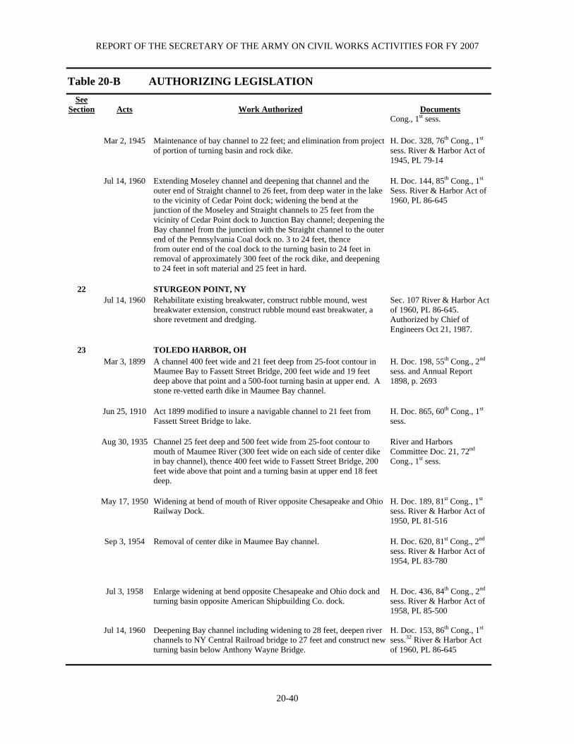
REPORT OF THE SECRETARY OF THE ARMY ON CIVIL WORKS ACTIVITIES FOR FY 2007
20-40
Table 20-B AUTHORIZING LEGISLATION
See Section
Acts
Work Authorized
Documents
Cong., 1st sess. Mar 2, 1945 Maintenance of bay channel to 22 feet; and elimination from project
of portion of turning basin and rock dike. H. Doc. 328, 76th Cong., 1st sess. River & Harbor Act of 1945, PL 79-14
Jul 14, 1960 Extending Moseley channel and deepening that channel and the
outer end of Straight channel to 26 feet, from deep water in the lake to the vicinity of Cedar Point dock; widening the bend at the junction of the Moseley and Straight channels to 25 feet from the vicinity of Cedar Point dock to Junction Bay channel; deepening the Bay channel from the junction with the Straight channel to the outer end of the Pennsylvania Coal dock no. 3 to 24 feet, thence from outer end of the coal dock to the turning basin to 24 feet in removal of approximately 300 feet of the rock dike, and deepening to 24 feet in soft material and 25 feet in hard.
H. Doc. 144, 85th Cong., 1st Sess. River & Harbor Act of 1960, PL 86-645
22 STURGEON POINT, NY Jul 14, 1960 Rehabilitate existing breakwater, construct rubble mound, west
breakwater extension, construct rubble mound east breakwater, a shore revetment and dredging.
Sec. 107 River & Harbor Act of 1960, PL 86-645. Authorized by Chief of Engineers Oct 21, 1987.
23 TOLEDO HARBOR, OH Mar 3, 1899 A channel 400 feet wide and 21 feet deep from 25-foot contour in
Maumee Bay to Fassett Street Bridge, 200 feet wide and 19 feet deep above that point and a 500-foot turning basin at upper end. A stone re-vetted earth dike in Maumee Bay channel.
H. Doc. 198, 55th Cong., 2nd sess. and Annual Report 1898, p. 2693
Jun 25, 1910 Act 1899 modified to insure a navigable channel to 21 feet from
Fassett Street Bridge to lake. H. Doc. 865, 60th Cong., 1st sess.
Aug 30, 1935 Channel 25 feet deep and 500 feet wide from 25-foot contour to
mouth of Maumee River (300 feet wide on each side of center dike in bay channel), thence 400 feet wide to Fassett Street Bridge, 200 feet wide above that point and a turning basin at upper end 18 feet deep.
River and Harbors Committee Doc. 21, 72nd Cong., 1st sess.
May 17, 1950 Widening at bend of mouth of River opposite Chesapeake and Ohio
Railway Dock. H. Doc. 189, 81st Cong., 1st sess. River & Harbor Act of 1950, PL 81-516
Sep 3, 1954 Removal of center dike in Maumee Bay channel. H. Doc. 620, 81st Cong., 2nd
sess. River & Harbor Act of 1954, PL 83-780
Jul 3, 1958 Enlarge widening at bend opposite Chesapeake and Ohio dock and
turning basin opposite American Shipbuilding Co. dock. H. Doc. 436, 84th Cong., 2nd sess. River & Harbor Act of 1958, PL 85-500
Jul 14, 1960 Deepening Bay channel including widening to 28 feet, deepen river channels to NY Central Railroad bridge to 27 feet and construct new turning basin below Anthony Wayne Bridge.
H. Doc. 153, 86th Cong., 1st sess.32 River & Harbor Act of 1960, PL 86-645

BUFFALO, NY DISTRICT
20-41
Table 20-B AUTHORIZING LEGISLATION
See Section
Acts
Work Authorized
Documents
24 TOUSSAINT RIVER, CARROLL TOWNSHIP, OH Jul 14, 1960 Dredged channel from the mouth of the Toussaint River, 2,100 feet
into Lake Erie, 4 feet below LWD, 150 feet wide in Lake Erie and tapered to 100 feet at the river mouth.
Sec. 107 of the River & Harbor Act of 1960, PL 86-645. Authorized by Chief of Engineers Sep 29, 1990.
25 VERMILION HARBOR, OH Jul 4, 1836 Parallel piers and dredging channel to 8 feet deep. Annual Report, 1880 Mar 3, 1875 Deepening of channel to 12 feet. Annual Report, 1874, p. 219 Mar 3, 1905 Reconstruction of piers. H. Doc. 252, 58th Cong., 2nd
sess. Jul 3, 1958 New entrance formed by two overlapping arrowhead breakwaters
and extension of existing river channel upstream to Liberty St. Bridge.
H. Doc. 231, 85th Cong., 1st sess. River & Harbor Act of 1958, PL 85-500.
26 WEST HARBOR, OH
Oct 27, 1965 Construction of arrowhead breakwaters, entrance channel and access channel.
H. Doc. 245, 88th Cong., 2nd sess. River & Harbor Act of 1965, PL 89-298.
27 WILSON HARBOR, NY Mar 2, 1945 Entrance channel 80 feet wide and 8 feet deep; and restore east and
west piers. H. Doc. 679, 76th Cong., 2nd sess. River & Harbor Act of 1945, PL 79-14.
Aug 13, 1968 Extend existing channel 300 feet; and construct new channel 3,800
feet long through Tuscarora Bay. H. Doc. 112, 90th Cong., 1st sess.
Rehabilitate existing breakwater, construct rubble mound west
breakwater extension, construct rubble mound east Breakwater, a shore revetment and dredging.
Sec. 107 of River & Harbor Act of 1960, PL 86-645. Authorized by Chief of Engineers Oct 21, 1987.

REPORT OF THE SECRETARY OF THE ARMY ON CIVIL WORKS ACTIVITIES FOR FY 2007
20-42
TABLE 20-C OTHER AUTHORIZED NAVIGATION PROJECTS For Last Cost to Full Report Sep 30, 2007 See annual Operations &
Project Status Report For Construction Maintenance Barcelona Harbor, NY Active 2001 $1,185,853 $2,465,775 Big (Cunningham) Creek, OH Completed -1 19,763 2 - Black River Harbor, NY Completed -1 42,401 - Buffalo Small Boat Harbor, NY Completed 1994 602,016 3 - Cattaraugus Harbor, NY Active 2000 4,804,060 4 378,578
Cattaraugus Creek, NY Completed -2 57,410 - Cooley Canal, OH Active - 2,311,289 264,128 Geneva-on-the Lake, OH Active 1990 3,145,176 5 10,168 Grasse River Massena, NY Completed 1891 9,000 2 - Kelleys Island, OH Active 19745 129,874 -
Little River at Cayuga Island, NY Active 1969 46,804 6 6,580 Morristown Harbor, NY Active 1949 6,221 13,218 Niagara Remedial Works, NY7 Completed 1966 6,069,395 510,819 Niagara River, NY8 Active 1964 559,457 9 311,840 Ogdensburg Harbor, NY Active 1987 1,720,466 10 1,436,688 11
Pultneyville Harbor, NY13 Completed 1934 68,219 20,087 Rochester Harbor Wave Surge, NY Completed 2001 1,800,769 1,713,189 Sandusky River, OH14 Completed 1894 58,000 2 557 1 Only information available is in index to reports of Chief of Engineers. 2 Amount includes maintenance; not separable. 3 Excludes $593,216 contributed funds. 4 Excludes $2,566,529 contributed funds. 5 Excludes $3,261,375 contributed funds. 6 Annual Report for Detroit District. 7 Includes local interest’s contribution of $25,742. 8 Cost of operation and maintenance of this project will be settled directly by concerned power agencies. No further appropriations will be made to this project. 9 Construction of compensating works as authorized by 1930 R&H Act was authorized by Congress in Aug 1977. 10 Includes local interest contribution of $27,563. 11 Includes $271,380 for previous projects. Excludes $57,000 contributed funds. 12 Includes $130,512 for previous projects. 13 Abandonment recommended in H. Doc. 275, 64th Cong., 1st sess. 14 Abandonment recommended in Ex. Doc. 16, 35th Cong., 1st sess.
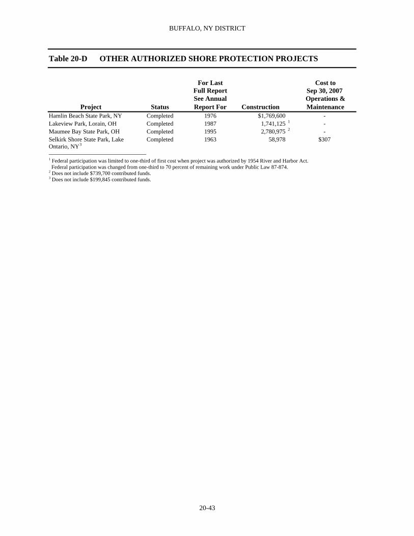
BUFFALO, NY DISTRICT
20-43
Table 20-D OTHER AUTHORIZED SHORE PROTECTION PROJECTS
Cost to For Last Full Report
Sep 30, 2007
See Annual Operations & Project Status Report For Construction Maintenance
Hamlin Beach State Park, NY Completed 1976 $1,769,600 - Lakeview Park, Lorain, OH Completed 1987 1,741,125 1 - Maumee Bay State Park, OH Completed 1995 2,780,975 2 - Selkirk Shore State Park, Lake Ontario, NY3
Completed 1963 58,978 $307
1 Federal participation was limited to one-third of first cost when project was authorized by 1954 River and Harbor Act. Federal participation was changed from one-third to 70 percent of remaining work under Public Law 87-874. 2 Does not include $739,700 contributed funds. 3 Does not include $199,845 contributed funds.

REPORT OF THE SECRETARY OF THE ARMY ON CIVIL WORKS ACTIVITIES FOR FY 2007
20-44
Table 20-E OTHER AUTHORIZED FLOOD CONTROL PROJECTS
For Last Cost To Full Report Sep 30, 2007 See Annual Operations &
Project Status Report For Construction Maintenance Auburn, NY, Owasco Outlet Completed 1962 $ 371,985 1 - Batavia and Vicinity, Tonawanda Creek, NY Completed 1957 335,385 - Camp Perry, OH Completed 19672 275,000 3 -Cayuga Creek, Cheektowaga, NY4 Completed 1984 1,404,500 - Cuyahoga River Basin, OH Active 1985 1,117,000 - Dansville and Vicinity, Canaserga Creek, NY Active 1985 490,300 - Fremont, OH, Sandusky River Completed 1976 8,589,824 5 - Ithaca, Cayuga Inlet, NY Completed 1978 3,929,300 6 - Lackawanna, NY, Smokes Creek Completed 1971 3,542,068 7 - Lancaster, Cayuga Creek, NY Completed 1954 79,730 - Marsh Creek, Geneva, NY Completed - 226,429 - Montour Falls, Oswego River Basin, NY Completed 1954 1,681,785 - Onondaga Creek, Nedrow, NY4 Completed 1964 330,231 - Ottawa, OH Deferred 1989 374,000 - Owasco Inlet and Outlet, Montiville And Dry Creek, State Ditch and Crane Brook, NY8
Deferred 1950 281,559 -
Point Place, Toledo, OH Completed 1990 9,885,733 9 - Reno Beach-Howard Farms, OH Completed 1997 5,483,192 10 - Scajaquada Creek, NY Completed 1985 4,944,852 - Syracuse, Oswego River Basin, NY Completed 1954 3,349,248 - Warsaw, NY Oatka Creek4 Completed 1969 558,317 11 -Wellsville, NY, Genesee River Completed 1978 3,145,303 12 - 1 Excludes cost of $188,732 under Public Law 88-99, Flood Control and Coastal Emergencies Appropriation, incurred for project rehabil- itation as a result of damages due to storm Agnes, Jun 1972. 2 Annual Report for Detroit District. 3 Includes local interest contribution of $125,000. 4 Project authorized by Chief of Engineers. 5 Includes local interest contribution of $6,944. Excludes cost of $383,786 under Public Law 84-99. Flood Control and Coastal Emergencies Appropriation, for emergency restoration of levees damaged during 1973. 6 Includes local interest contribution of $99,999. Excludes cost of $104,005 under Public Law 84-99. Flood Control and Coastal Emergencies Appropriation, incurred for project rehabilitation as a result of damages due to storm Agnes, Jun 1972. 7 Includes local interest contribution of $50,000. 8 In-active portion of work for State Ditch has been done by local interest and work on Crane Brooks has been deferred at the request of local interests. 9 Excludes $1,871,631 in contributed funds. 10 Excludes $475,994 in contributed funds. 11 Excludes cost of $26, 807 under Public Law 84-99, Flood Control and Coastal Emergencies Appropriation, incurred for project rehabilitation as a result of damages due to storm Agnes, Jun 1972. 12 Includes local interest contribution of $50,000. Excludes cost of $374,042 under Public Law 84-99, Flood Control and Coastal Emergency Appropriation, incurred for project rehabilitation as a result of damages due to storms.

BUFFALO, NY DISTRICT
20-45
TABLE 20-G DEAUTHORIZED PROJECTS
Project
For Last
Full Report See Annual Report For
Date Deauthorized
Federal Funds
Expended
ContributedFunds
Expended Black Rock Channel and Tonawanda Harbor, NY 1935 R&H Act1
1962 Aug-77 - -
Black Rock Channel and Tonawanda Harbor, NY 1954 R&H Act
1962 May-81 -
Buffalo Harbor Drift Removal, NY - Dec-92 - - Buffalo Ship Canal, Buffalo, NY - Dec-92 - - Caledonia, Genesee River, NY 1950 FC Act 1950 Jan-90 - - Cape Vincent Harbor, NY 1945 R&H Act 1962 Nov-86 - Chittenango Creek and Tributaries, NY 1944 FC Act 1948 Jan-90 12,464 - Conneaut Harbor, OH R&H Act, 1910 (southerly 300 feet of shorearm)
1997 Oct-96 - -
Conneaut Harbor, OH 1966 R&H Act, 1990 WRDA 1995 Nov-95 - - Crane Creek State Park, OH 1962 R&H Act 19682 Nov-79 - - Cuyahoga River Basin 1970 FC Act - Apr-99 - - Dansville & Vicinity 1948 FC Act - Apr 98 - Dunkirk Harbor, NY WRDA 1986 - Dec-92 - - Eastlake, Chagrin River, OH 1965 FC Act 1976 Jan-90 506,344 - Edgewater Park, OH 1954 R&H Act - Jan-90 - - Elk Creek Harbor, PA 1966 R&H Act 1978 Dec-92 101,500 - Erie Harbor, PA 1899 R&H Act 1963 Nov-81 - - Erie Harbor, PA 1945 R&H Act 1963 Aug-77 - - Erie Harbor, PA 1960 R&H Act 1963 Aug-82 - - Fairhaven Beach State Park, NY 1958 R&H Act - Jan-90 - - Fairport Harbor, OH 1960 R&H Act 1995 Nov-95 67,000 - Fairport Harbor, OH Sec. 201 1965 FC Act 1995 Nov-95 - - Fort Niagara State Park, NY Sec. 201 1965 FC Act - Jan-90 - - Grandview Bay Harbor, NY 1945 R&H Act 1948 Aug-77 1,524 - Great Sodus Bay Harbor, NY 1941 R&H Act 1963 Aug-77 - - Hamlin Beach Harbor, NY 1968 R&H Act 1973 Jan-90 72,052 - Hammondsport, Oswego River Basin, NY 1941 FC Act
1951 Nov-83 29,000 -
Huron Harbor, NY 1962 R&H Act3 1963 Jan-90 - - Ithaca, NY – Cascadilla Creek 1941 FC Act 1950 Aug-77 8,159 - Ithaca, NY – Fall Creek 1941 FC Act 1950 Aug-77 12,300 Lorain Harbor, OH – Sec. 107, R&H Act 1960 (Portion of small boat basin)
1998 Oct-96 - -
Lorain Harbor, OH 1960 R&H Act, modified by 1965 R&H Act4
1966 Jan-90 -
Maumee River, above Toledo, OH 1872 Act 1971102 Nov-77 12,000 - Ottawa River, OH (Blanchard) - Apr –02 1 Extension of guide pier only: other improvements completed. 2 Annual Report For Detroit District. 3 Breakwater. 4 Uncompleted portion.
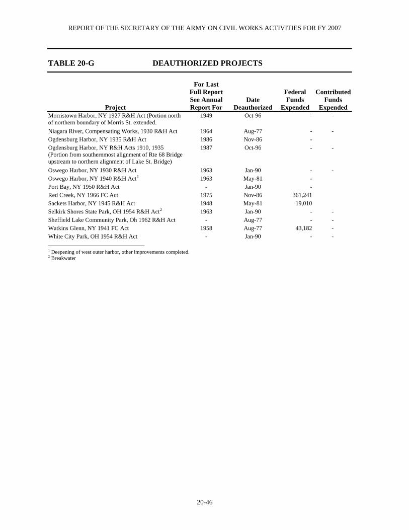
REPORT OF THE SECRETARY OF THE ARMY ON CIVIL WORKS ACTIVITIES FOR FY 2007
20-46
TABLE 20-G DEAUTHORIZED PROJECTS
Project
For Last
Full Report See Annual Report For
Date Deauthorized
Federal Funds
Expended
ContributedFunds
Expended Morristown Harbor, NY 1927 R&H Act (Portion north of northern boundary of Morris St. extended.
1949 Oct-96 - -
Niagara River, Compensating Works, 1930 R&H Act 1964 Aug-77 - - Ogdensburg Harbor, NY 1935 R&H Act 1986 Nov-86 - Ogdensburg Harbor, NY R&H Acts 1910, 1935 (Portion from southernmost alignment of Rte 68 Bridge upstream to northern alignment of Lake St. Bridge)
1987 Oct-96 - -
Oswego Harbor, NY 1930 R&H Act 1963 Jan-90 - - Oswego Harbor, NY 1940 R&H Act1 1963 May-81 - Port Bay, NY 1950 R&H Act - Jan-90 - Red Creek, NY 1966 FC Act 1975 Nov-86 361,241 Sackets Harbor, NY 1945 R&H Act 1948 May-81 19,010 Selkirk Shores State Park, OH 1954 R&H Act2 1963 Jan-90 - - Sheffield Lake Community Park, Oh 1962 R&H Act - Aug-77 - - Watkins Glenn, NY 1941 FC Act 1958 Aug-77 43,182 - White City Park, OH 1954 R&H Act - Jan-90 - - 1 Deepening of west outer harbor, other improvements completed. 2 Breakwater
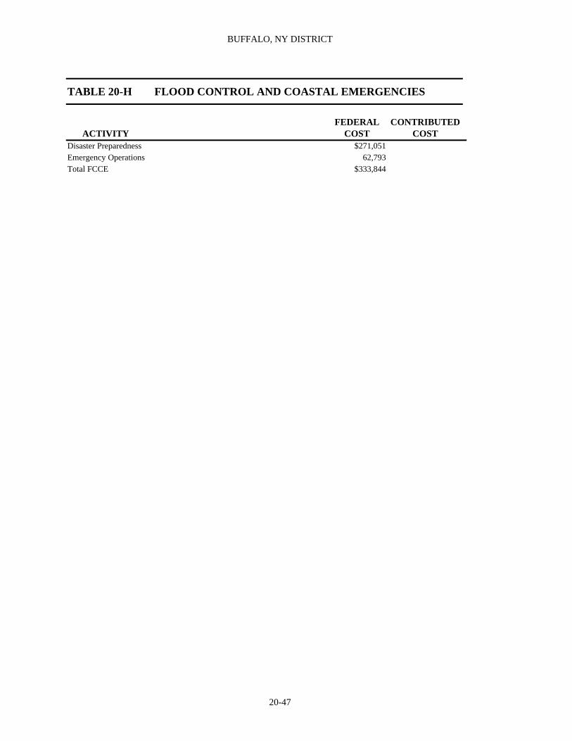
BUFFALO, NY DISTRICT
20-47
TABLE 20-H FLOOD CONTROL AND COASTAL EMERGENCIES
FEDERAL CONTRIBUTED
ACTIVITY COST COST Disaster Preparedness $271,051 Emergency Operations 62,793 Total FCCE $333,844

REPORT OF THE SECRETARY OF THE ARMY ON CIVIL WORKS ACTIVITIES FOR FY 2007
20-48
TABLE 20-I GENERAL INVESTIGATIONS
GENERAL INVESTIGATIONS
OPERATIONS & MAINTENANCE
NON-FEDERAL
SURVEYS SPECIAL STUDIES Onondaga Lake NY PL 101-596 347,853 Buffalo River Environmental Dredging, NY 38,127 Western Lake Erie Basin, OH 590,180 MISCELLANEOUS ACTIVITIES Special Investigations 24,343 Review of FERC Licenses 5,227 Interagency Water Resource Development 20,050 National Estuary Studies 3,535 North American Waterfowl Management Plan 2,044 COORDINATION WITH OTHER GOVERNMENT AGENCIES AND NON-FEDERAL INTERESTS PAS Negotiation Funds 50,075 PAS – NY – Amherst Soil Study 122 PAS – NY – Barge Canal Embank Analysis 74PAS – NY – Oak Orchard Creek 2,164Eighteenmile Creek, Niagara County, NY 30,635 PAS – NY – Black River 371 COLLECTION AND STUDY OF BASIC DATA
INTERNATIONAL WATER STUDIES International Water Studies 69,995 FLOOD PLAIN MANAGEMENT SERVICES Flood Plain Management Services 47,886 Technical Services 24,309 Quick Responses 3,924 FWPM Program Services 103 HYDROLOGIC STUDIES General Hydrologic Studies 5,096 PRE-CONSTRUCTION, ENGINEERING AND DESIGN ECOSYSTEM RESTORATION PROJECTS Ashtabula River Environmental Dredging 376 -376
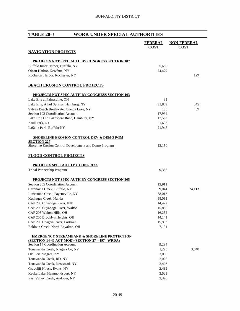
BUFFALO, NY DISTRICT
20-49
TABLE 20-J WORK UNDER SPECIAL AUTHORITIES
FEDERAL COST
NON-FEDERAL COST
NAVIGATION PROJECTS PROJECTS NOT SPEC AUTH BY CONGRESS SECTION 107Buffalo Inner Harbor, Buffalo, NY 5,680Olcott Harbor, Newfane, NY 24,479Rochester Harbor, Rochester, NY 129 BEACH EROSION CONTROL PROJECTS PROJECTS NOT SPEC AUTH BY CONGRESS SECTION 103 Lake Erie at Painesville, OH 31Lake Erie, Athol Springs, Hamburg, NY 31,859 545Sylvan Beach Breakwater Oneida Lake, NY 105 69Section 103 Coordination Account 17,994Lake Erie Old Lakeshore Road, Hamburg, NY 17,562Krull Park, NY 1,698LaSalle Park, Buffalo NY 21,948 SHORELINE EROSION CONTROL DEV & DEMO PGM SECTION 227 Shoreline Erosion Control Development and Demo Program 12,150 FLOOD CONTROL PROJECTS PROJECTS SPEC AUTH BY CONGRESS Tribal Partnership Program 9,336 PROJECTS NOT SPEC AUTH BY CONGRESS SECTION 205 Section 205 Coordination Account 13,911Cazenovia Creek, Buffalo, NY 99,044 24,113Limestone Creek, Fayetteville, NY 58,018Keshequa Creek, Nunda 38,091CAP 205 Cuyahoga River, IND 14,472CAP 205 Cuyahoga River, Walton 15,855CAP 205 Walton Hills, OH 16,252CAP 205 Brooklyn Heights, OH 14,141CAP 205 Chagrin River, Eastlake 15,853Baldwin Creek, North Royalton, OH 7,191 EMERGENCY STREAMBANK & SHORELINE PROTECTION (SECTION 14-46 ACT MOD) (SECTION 27 – 1974 WRDA) Section 14 Coordination Account 9,234Tonawanda Creek, Niagara Co, NY 1,225 3,840Old Fort Niagara, NY 3,055Tonawanda Creek, RD, NY 2,008Tonawanda Creek, Newstead, NY 2,408Graycliff House, Evans, NY 2,412Keuka Lake, Hammondsport, NY 2,522East Valley Creek, Andover, NY 2,390

REPORT OF THE SECRETARY OF THE ARMY ON CIVIL WORKS ACTIVITIES FOR FY 2007
20-50
TABLE 20-J WORK UNDER SPECIAL AUTHORITIES (Continued) FEDERAL
COST NON-FEDERAL
COST EMERGENCY STREAMBANK & SHORELINE PROTECTION (SECTION 14-46 ACT MOD) (SECTION 27 – 1974 WRDA) Tonawanda Creek, Lockwood, NY 2,618Lake Ontario, Albion Water 18,138Minnick Road, Tonawanda Creek 147,954Tonawanda Creek, Riddle Road, NY 2,514Ottawa River, Shoreland Drive, Toledo, OH 68,092 SNAGGING & CLEARING Section 208 Coordination Account 3,692 MISCELLANEOUS PROJECT MODIFICATION TO IMPROVE ENVIRONMENT SECTION 1135 Rochester Navigation Channel, NY 15,476Times Beach Environmental Improvement 4,151Conneaut Harbor East State Park, OH 47 AQUATIC ECOSYSTEM RESTORATION SECTION 206 South Park Lake 103,147Little Cuyahoga River, Akron, OH 426 ESTUARY HABITAT RESTORATION PROGRAM Euclid Creek, OH 15,127 WETLAND/OTHER AQUATIC HABITAT RESTORATION, OH Maumee Bay Habitat Restoration, OH 64,409Lorain Sewage Treatment Plant, OH 10,569Ottawa River, OH 49,192Section 204 Coordination Account 9,119792 Wynn Road, Oregon, OH 64,646

BUFFALO, NY DISTRICT
20-51
TABLE 20-K INSPECTION OF COMPLETED FLOOD CONTROL PROJECTS
No. Project Name Body of Water City State Date Inspected
NEW YORK
1 Back River Road Genesee River Amity NY Not Inspected
2 Bird Island Pier Rehabilitation Niagara River Buffalo NY Not Inspected
3 Blasdell Creek Blasdell Creek Hamburg NY 30 Aug 2007
4 Block Church Road Tonawanda Creek Royalton NY Not Inspected
5 Caneadea Sewage Treatment Plant
Genesee River Houghton NY 23 Aug 2007
6 Catherine and Shequaga Creeks
Catherine/ Shequaga Creeks
Montour Falls NY 19 Jul 2007
7 Cattaraugus Creek Cattaraugus Creek Arcade NY 23 Aug 2007
8 Cattaraugus Creek Harbor
Lake Erie Irving NY Not Inspected
9 Cayuga Creek (Cheektowaga) Cayuga Creek Cheektowaga NY 13 Sep 2007
10 Cayuga Creek (Lancaster) Cayuga Creek Lancaster NY 12 Jun 2007
11 Cayuga Inlet Off Cayuga Lake Ithaca NY 11 Sep 2007
12 Cazenovia Creek Clearing and Snagging
Cazenovia Creek West Seneca NY Not Inspected
13 Cazenovia Creek Ice Control Structure
Cazenovia Creek West Seneca NY Not Inspected
14 Cold Spring and Putnam Brooks
Cold Spring Brook and Putnam Brooks
Weedsport NY Not Inspected
15 Conesus Lake Outlet Off Conesus Lake Livonia NY 14 Jun 2007
16 Dunkirk Harbor
Lake Erie Dunkirk NY Not Inspected
17 Ellicott Creek Ellicott Creek Amherst/Tonawanda NY 12 Sep 2007
18 Ellicott Creek Clearing and Snagging
Ellicott Creek Amherst/Tonawanda NY 12 Sep 2007
19 Fredonia Sewage Treatment Plant
Lake Erie Dunkirk NY 30 Aug 2007
20 Fredonia Sewage Treatment Plant Sewerline
Canadaway Creek Dunkirk NY 30 Aug 2007
21 Glen Brook Clearing and Snagging
Glen Brook Hammondsport NY 19 Jul 2007
22 Glen Brook Concrete Flume Off Keuka Lake Hammondsport NY 19 Jul 2007
23 Irondequoit Bay
Irondequoit Bay/ Lake Ontario
Irondequoit NY Not Inspected
24 Kashong Creek Kashong Creek Geneva NY 18 Jul 2007
25 Keshequa Creek - Emerg. Streambank Protection
Keshequa Creek Nunda NY 20 Jul 2007

REPORT OF THE SECRETARY OF THE ARMY ON CIVIL WORKS ACTIVITIES FOR FY 2007
20-52
TABLE 20-K INSPECTION OF COMPLETED FLOOD CONTROL PROJECTS
No. Project Name Body of Water City State Date Inspected
NEW YORK (continued)
26 Keshequa Creek Clearing and Snagging
Keshequa Creek Nunda NY 20 Jul 2007
27 Keuka Lake Outlet Clearing and Snagging
Keuka Lake Penn Yan NY 18 Jul 2007
28 Keuka Lake Outlet Control Structure
Keuka Lake Outlet Penn Yan NY 18 Jul 2007
29 Lake Erie State Park Lake Erie Brocton NY Not Inspected
30 Marsh Creek Marsh Creek Geneva NY 18 Jul 2007
31 New York State Thruway Bridge
Cattaraugus Creek Irving NY Not Inspected
32 NFTA Small Boat Harbor Lake Erie Buffalo NY Not Inspected
33 Niagara River Retaining Wall Niagara River Tonawanda NY Not Inspected
34 Ninemile Creek (Amboy) Ninemile Creek Amboy NY Not Inspected
35 Ninemile Creek (Camillus) Ninemile Creek Camillus NY Not Inspected
36 Oak Orchard Beach Lake Ontario State Parkway
Lake Ontario Kendall NY Not Inspected
37 Oatka Creek Oatka Creek Warsaw NY 23 Aug 2007
38 Onondaga Creek (Nedrow) Onondaga Creek Nedrow NY 13 Sep 2007
39 Onondaga Creek (Syracuse) Onondaga Creek Syracuse NY 13 Sep 2007
40 Onondaga Lake Dam and Reservoir
Onondaga Creek Syracuse NY 13 Sep 2007
41 Owasco Inlet Off Owasco Lake Moravia NY 11 Sep 2007
42 Owasco Outlet (Auburn) Off Owasco Lake Auburn NY 12 Sep 2007
43 Owasco Outlet (Port Byron) Owasco Outlet Port Byron NY 12 Sep 2007
44 Port Ontario Harbor
Lake Ontario Port Ontario NY Not Inspected
45 Rochester Harbor Wave Surge Reduction Project
Lake Ontario Rochester NY Not Inspected
46 Rogers Cemetery Genesee River Amity NY Not Inspected
47 Route 20A Bridge Genesee River Geneseo NY Not Inspected
48 Salmon River Town/Village Salmon River Malone NY 22 Aug 2007
49 Scajaquada Creek Scajaquada Creek Cheektowaga NY 13 Sep 2007
50 Seneca Falls Sewage Treatment Plant
Seneca River Seneca Falls NY 18 Jul 2007
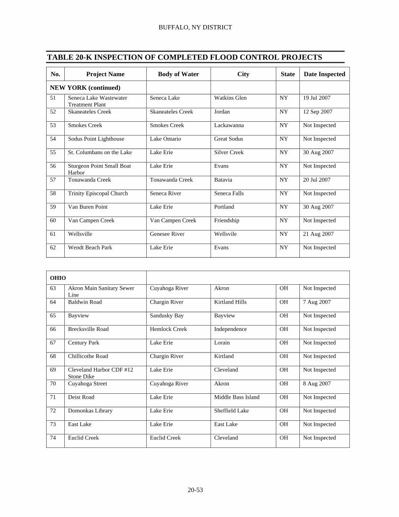
BUFFALO, NY DISTRICT
20-53
TABLE 20-K INSPECTION OF COMPLETED FLOOD CONTROL PROJECTS
No. Project Name Body of Water City State Date Inspected
NEW YORK (continued)
51 Seneca Lake Wastewater Treatment Plant
Seneca Lake Watkins Glen NY 19 Jul 2007
52 Skaneateles Creek Skaneateles Creek Jordan NY 12 Sep 2007
53 Smokes Creek Smokes Creek Lackawanna NY Not Inspected
54 Sodus Point Lighthouse Lake Ontario Great Sodus NY Not Inspected
55 St. Columbans on the Lake Lake Erie Silver Creek NY 30 Aug 2007
56 Sturgeon Point Small Boat Harbor
Lake Erie Evans NY Not Inspected
57 Tonawanda Creek Tonawanda Creek Batavia NY 20 Jul 2007
58 Trinity Episcopal Church Seneca River Seneca Falls NY Not Inspected
59 Van Buren Point Lake Erie Portland NY 30 Aug 2007
60 Van Campen Creek Van Campen Creek Friendship NY Not Inspected
61 Wellsville Genesee River Wellsvile NY 21 Aug 2007
62 Wendt Beach Park Lake Erie Evans NY Not Inspected
OHIO
63 Akron Main Sanitary Sewer Line
Cuyahoga River Akron OH Not Inspected
64 Baldwin Road Chargin River Kirtland Hills OH 7 Aug 2007
65 Bayview Sandusky Bay Bayview OH Not Inspected
66 Brecksville Road Hemlock Creek Independence OH Not Inspected
67 Century Park Lake Erie Lorain OH Not Inspected
68 Chillicothe Road Chargin River Kirtland OH Not Inspected
69 Cleveland Harbor CDF #12 Stone Dike
Lake Erie Cleveland OH Not Inspected
70 Cuyahoga Street Cuyahoga River Akron OH 8 Aug 2007
71 Deist Road Lake Erie Middle Bass Island OH Not Inspected
72 Domonkas Library Lake Erie Sheffield Lake OH Not Inspected
73 East Lake Lake Erie East Lake OH Not Inspected
74 Euclid Creek Euclid Creek Cleveland OH Not Inspected

REPORT OF THE SECRETARY OF THE ARMY ON CIVIL WORKS ACTIVITIES FOR FY 2007
20-54
TABLE 20-K INSPECTION OF COMPLETED FLOOD CONTROL PROJECTS
No. Project Name Body of Water City State Date Inspected
OHIO (continued)
75 Euclid Creek Emerg. Rehab Euclid Creek Cleveland OH Not Inspected
76 Euclid General Hospital Lake Erie Euclid OH 5 Sep 2007
77 Fremont Sandusky River Fremont OH 25 Sep 2007
78 Geneva-on-the-Lake Small Boat Harbor
Lake Erie Geneva OH 6 Sep 2007
79 Hospice of the Western Reserve
Lake Erie Cleveland OH Not Inspected
80 Lakeshore Park Lake Erie Ashtabula OH Not Inspected
81 Lakeview Park Lake Erie Lorain OH Not Inspected
82 Linwood Park Lake Erie Vermilion OH Not Inspected
83 Lorain Small Boat Harbor Lake Erie Lorain OH Not Inspected
84 Maumee Bay State Park Maumee Bay/ Lake Erie
Lucas County OH Not Inspected
85 Mayfield Road Chargin River Gates Mills OH 7 Aug 2007
86 Mentor Beach Park Lake Erie Mentor OH 5 Sep 2007
87 North Portage Path Cuyahoga River Akron OH Not Inspected
88 Oak Harbor Wastewater Treatment Plant
Portage River Oak Harbor OH 25 Sep 2007
89 Oregon Municipal Water Supply
Maumee Bay/ Lake Erie
Oregon OH 26 Sep 2007
90 Pier 34 North Coast Harbor Lake Erie Cleveland OH Not Inspected
91 Point Place Maumee Bay/ Ottawa River
Toledo OH 26 Sep 2007
92 Reno Beach-Howard Farms Lake Erie Jerusalem Township OH 27 Sep 2007
93 Riverview Road Cuyahoga River Cuyahoga Falls OH 8 Aug 2007
94 Sand Road Lake Erie Catawba Island OH 28 Sep 2007
95 Sims Park Lake Erie Euclid OH Not Inspected
96 Solon Road Chargin River Chagrin Falls OH 9 Aug 2007
97 South Perimeter Rd (Kelly's Island)
Lake Erie Kelley’s Island OH Not Inspected
98 Sperry Road Chagrin River Kirtland Hills OH 7 Aug 2007
99 St. Joseph Life Center Lake Erie Cleveland OH Not Inspected
100 State Road 163 Lake Erie Marblehead OH 28 Sep 2007
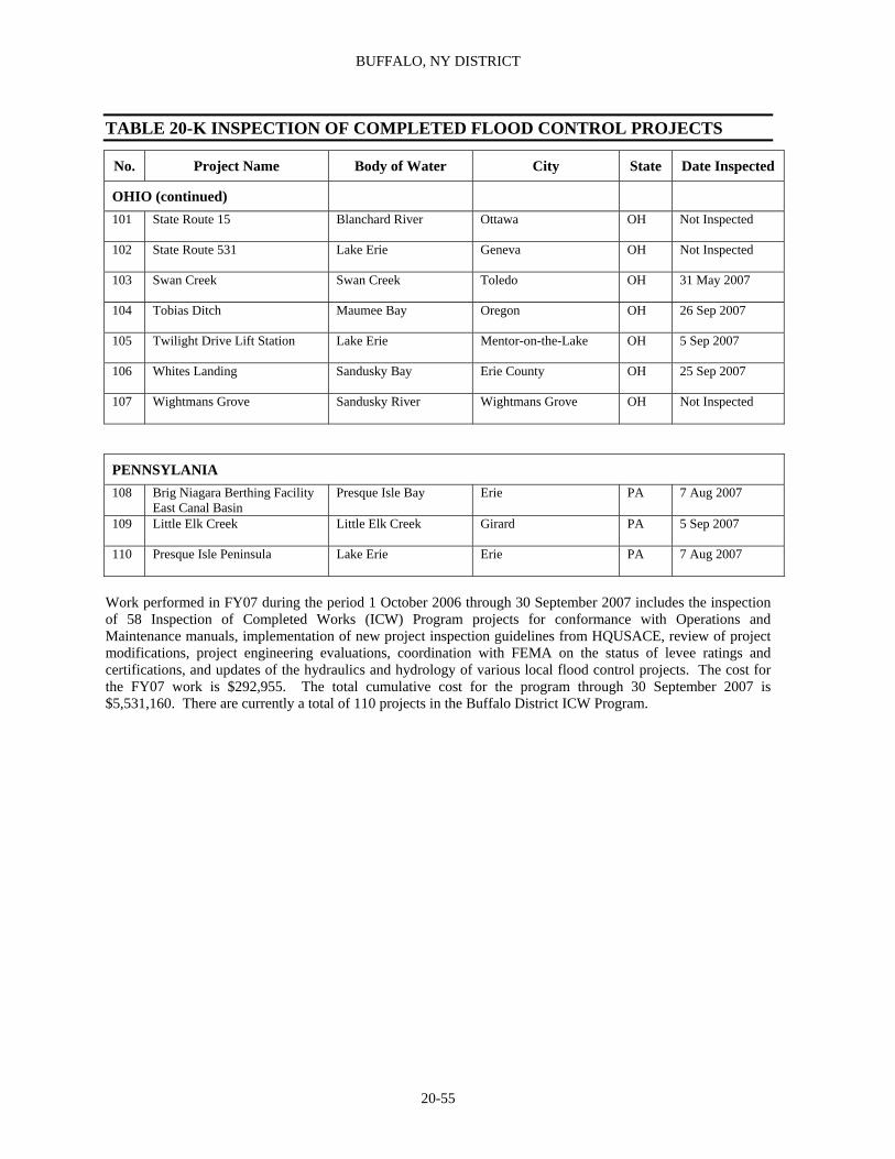
BUFFALO, NY DISTRICT
20-55
TABLE 20-K INSPECTION OF COMPLETED FLOOD CONTROL PROJECTS
No. Project Name Body of Water City State Date Inspected
OHIO (continued)
101 State Route 15 Blanchard River Ottawa OH Not Inspected
102 State Route 531 Lake Erie Geneva OH Not Inspected
103 Swan Creek Swan Creek Toledo OH 31 May 2007
104 Tobias Ditch Maumee Bay Oregon OH 26 Sep 2007
105 Twilight Drive Lift Station Lake Erie Mentor-on-the-Lake OH 5 Sep 2007
106 Whites Landing Sandusky Bay Erie County OH 25 Sep 2007
107 Wightmans Grove Sandusky River Wightmans Grove OH Not Inspected
PENNSYLANIA 108 Brig Niagara Berthing Facility
East Canal Basin Presque Isle Bay Erie PA 7 Aug 2007
109 Little Elk Creek Little Elk Creek Girard PA 5 Sep 2007
110 Presque Isle Peninsula Lake Erie Erie PA 7 Aug 2007
Work performed in FY07 during the period 1 October 2006 through 30 September 2007 includes the inspection of 58 Inspection of Completed Works (ICW) Program projects for conformance with Operations and Maintenance manuals, implementation of new project inspection guidelines from HQUSACE, review of project modifications, project engineering evaluations, coordination with FEMA on the status of levee ratings and certifications, and updates of the hydraulics and hydrology of various local flood control projects. The cost for the FY07 work is $292,955. The total cumulative cost for the program through 30 September 2007 is $5,531,160. There are currently a total of 110 projects in the Buffalo District ICW Program.
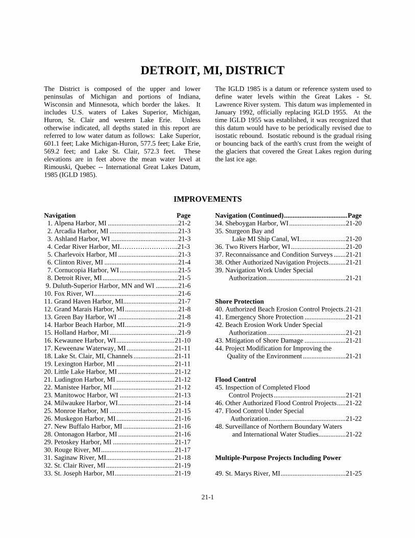
21-1
DETROIT, MI, DISTRICT
The District is composed of the upper and lower peninsulas of Michigan and portions of Indiana, Wisconsin and Minnesota, which border the lakes. It includes U.S. waters of Lakes Superior, Michigan, Huron, St. Clair and western Lake Erie. Unless otherwise indicated, all depths stated in this report are referred to low water datum as follows: Lake Superior, 601.1 feet; Lake Michigan-Huron, 577.5 feet; Lake Erie, 569.2 feet; and Lake St. Clair, 572.3 feet. These elevations are in feet above the mean water level at Rimouski, Quebec -- International Great Lakes Datum, 1985 (IGLD 1985).
The IGLD 1985 is a datum or reference system used to define water levels within the Great Lakes - St. Lawrence River system. This datum was implemented in January 1992, officially replacing IGLD 1955. At the time IGLD 1955 was established, it was recognized that this datum would have to be periodically revised due to isostatic rebound. Isostatic rebound is the gradual rising or bouncing back of the earth's crust from the weight of the glaciers that covered the Great Lakes region during the last ice age.
IMPROVEMENTS Navigation Page 1. Alpena Harbor, MI .........................................21-2 2. Arcadia Harbor, MI ........................................21-3 3. Ashland Harbor, WI .......................................21-3 4. Cedar River Harbor, MI……………………..21-3 5. Charlevoix Harbor, MI ...................................21-3 6. Clinton River, MI ...........................................21-4 7. Cornucopia Harbor, WI ..................................21-5 8. Detroit River, MI ............................................21-5 9. Duluth-Superior Harbor, MN and WI .............21-6 10. Fox River, WI.................................................21-6 11. Grand Haven Harbor, MI................................21-7 12. Grand Marais Harbor, MI...............................21-8 13. Green Bay Harbor, WI ...................................21-8 14. Harbor Beach Harbor, MI...............................21-9 15. Holland Harbor, MI ........................................21-9 16. Kewaunee Harbor, WI..................................21-10 17. Keweenaw Waterway, MI ............................21-11 18. Lake St. Clair, MI, Channels ........................21-11 19. Lexington Harbor, MI ..................................21-11 20. Little Lake Harbor, MI .................................21-12 21. Ludington Harbor, MI ..................................21-12 22. Manistee Harbor, MI ....................................21-12 23. Manitowoc Harbor, WI ................................21-13 24. Milwaukee Harbor, WI.................................21-14 25. Monroe Harbor, MI ......................................21-15 26. Muskegon Harbor, MI ..................................21-16 27. New Buffalo Harbor, MI ..............................21-16 28. Ontonagon Harbor, MI .................................21-16 29. Petoskey Harbor, MI ....................................21-17 30. Rouge River, MI...........................................21-17 31. Saginaw River, MI........................................21-18 32. St. Clair River, MI ........................................21-19 33. St. Joseph Harbor, MI...................................21-19
Navigation (Continued).....................................Page 34. Sheboygan Harbor, WI.................................21-20 35. Sturgeon Bay and Lake MI Ship Canal, WI...........................21-20 36. Two Rivers Harbor, WI................................21-20 37. Reconnaissance and Condition Surveys .......21-21 38. Other Authorized Navigation Projects..........21-21 39. Navigation Work Under Special Authorization..............................................21-21 Shore Protection 40. Authorized Beach Erosion Control Projects.21-21 41. Emergency Shore Protection ........................21-21 42. Beach Erosion Work Under Special Authorization..............................................21-21 43. Mitigation of Shore Damage ........................21-21 44. Project Modification for Improving the Quality of the Environment .........................21-21 Flood Control 45. Inspection of Completed Flood Control Projects ..........................................21-21 46. Other Authorized Flood Control Projects.....21-22 47. Flood Control Under Special Authorization.............................................21-22 48. Surveillance of Northern Boundary Waters and International Water Studies................21-22 Multiple-Purpose Projects Including Power 49. St. Marys River, MI......................................21-25

REPORT OF THE SECRETARY OF THE ARMY ON CIVIL WORKS ACTIVITIES FOR FY 2007
21-2
General Investigations 50. Surveys .........................................................21-27 51. Collection and Study of Basic Data..............21-27 Tables Table 21-A Cost & Financial Statement.............21-29 Table 21-B Authorizing Legislation...................21-40 Table 21-C Other Authorized Navigation Projects ..........................................21-51 Table 21-D Not Applicable Table 21-E Other Authorized Flood Control Projects .........................................21-56 Table 21-F Multiple Purpose Projects, Including Power, St. Marys River, MI:
Existing Project...............................21-56 Table 21-G Deauthorized Projects .....................21-57 Table 21-H Features of Existing Project ............21-60 Table 21-I Fox River, WI: Locks & Dams .........21-61 Table 21-J Reconnaissance & Condition Surv ...21-62 Table 21-K Navigation Work Under Special Authorization.................................21-63 Table 21-L Emergency Shore Protection ...........21-64 Table 21-M Beach Erosion Work Under Special Authorization.................................21-65 Table 21-N Mitigation of Shore Damage ...........21-65 Table 21-O Environmental Restoration……….. 21-66 Table 21-P Flood Control Under Special Authorization.................................21-69
NAVIGATION
1. ALPENA HARBOR, MI Location. At mouth of Thunder Bay River which empties into Thunder Bay, Lake Huron. Harbor is 100 miles southeast of Cheboygan Harbor, MI. River has its source in Montmorency and Alpena Counties, MI. (See NOAA Nautical Chart 14864.) Previous Project. For details see page 1957 of Annual Report for 1915 and page 1548 of Annual Report for 1938. Existing Project. Provides for a bay channel 200 feet wide and 25 feet deep from deep water in Thunder Bay to a point 300 feet lakeward of the Alpena Light; thence an entrance channel 24 feet deep, narrowing to a width of 100 feet at a point 700 feet upstream from the light; a river channel 100 feet wide, 23 feet deep to Second Avenue Bridge; thence 18.5 feet deep and 75 feet wide for 1,600 feet to upper limit of Federal project; a turning basin at upstream end of project, basin at river mouth 19 feet deep, trapezoidal in shape, with a maximum width of 700 feet including the channel width and a maximum length of 900 feet along the channel line, including removal of existing rubble breakwater; and a breakwater about 550 feet long paralleling lakeward side of new turning basin. Work authorized by the 1965 River and Harbor Act, which consists of the proposed turning basin and breakwater reconfiguration, was deauthorized by the Water Resources Development Act (WRDA) OF 1986; Public
Law (PL) 99-662, November 17, 1986, 99th Congress, Title X. Local Cooperation. Fully complied with. Terminal Facilities. Several commercial docks along Thunder Bay River used primarily for receipt of coal and petroleum products. Also a municipal marina basin about 0.25 mile southwest of river mouth. Facilities are considered adequate for existing commerce. Operations During Fiscal Year. Maintenance: Condition surveys performed by Government forces cost $19,693. A contract for maintenance dredging was awarded this FY in the amount of $564,457. The contract was 29% complete at the end of the FY removing approximately 25,141 cubic yards of shoal material at a cost of $162,000. Existing project was completed in 1939. The modification of existing project at Alpena Harbor, as authorized by the 1965 River and Harbor Act, was reclassified into an inactive status May 22, 1969 based on an unfavorable benefit-cost ratio. In 1975 the modification was recommended and reviewed for deauthorization, which was withdrawn by Congressional Resolution the same year. Subsequently, the work authorized by the 1965 Act was deauthorized by the WRDA of 1986. Project features are in excellent condition. Total cost of the existing project to end of FY was $2,654,423, of which $337,394 was for new work and $2,317,029 for maintenance.

DETROIT, MI, DISTRICT
21-3
2. ARCADIA HARBOR, MI Location. On east shore of Lake Michigan, 193 miles northeasterly from Chicago, IL, and 15 miles northerly from Manistee, MI. (See NOAA Nautical Chart 14907.) Existing Project. Provided for maintenance dredging of the existing harbor built by private interests, for a period of five years. The five years covered by this project were the calendar years 1905 to 1909, inclusive. Funds were also appropriated and maintenance was performed in calendar years 1911, 1912, 1913 and 1915, inclusive. There is at present no approved project for the improvement of this harbor. (See Table 21-B for authorizing legislation.) Local Cooperation. None required. Terminal Facilities. Dock facilities are considered adequate for existing recreational traffic. Operations During Fiscal Year. Maintenance: Condition surveys performed by Government forces cost $6,020. Existing project was completed in 1909. Varying depths of 5-12 feet exist in the channel at present. Maintenance of the harbor is based on providing a 9-foot depth. Piers and revetments are in good condition. Total cost of the existing project to end of FY was $5,882,792. 3. ASHLAND HARBOR, WI Location. At head of Chequamegon Bay, on south shore of Lake Superior, about 65 miles east of Duluth, MN. (See NOAA Nautical Chart 14974.) Existing Project. A west channel 20 and 21 feet deep and an east basin 25 and 27 feet deep, both all protected by an 8,000-foot breakwater. For additional details see page 1008 of Annual Report for 1965. (See Table 21-B for authorizing legislation.) Local Cooperation. Fully complied with. Terminal Facilities. City of Ashland owns 4,150 feet of waterfront for future public needs. Wharves for handling coal, ore, limestone, logs and pulpwood are served by railroads. Detail on actual port and harbor facilities is in Port Series No. 49 (revised 1999) prepared and published by the Water Resources Support Center. Facilities are considered adequate for
existing commerce. Handling of ore and logs has been discontinued for the present. Operations During Fiscal Year. Maintenance: Condition surveys were performed by Government forces at a cost of $7,196. Work authorized prior to 1960 Act was completed in 1950. Work authorized by 1960 Act was completed in November 1962. Navigation structures are in fair condition. Total cost of the existing project to end of FY was $6,785,120 of which $1,695,645 was for new work and $5,089,475 was for maintenance. 4. CEDAR RIVER HARBOR, MI Location. At mouth of Cedar River on west shore of Green Bay, an arm of Northern Lake Michigan, about 68 miles north of City of Green Bay. Nearest harbors are Menominee, MI, 27 miles southwest and at Escanaba, MI, 20 miles northeast. (See NOAA Nautical Chart 14909.) Existing Project. Two parallel entrance piers, a west pier 230 feet long and a rubblemound east pier 875 feet long with a sport fishing walkway; an entrance channel 100 feet wide and 10 feet deep from that depth in Green Bay to mouth of Cedar River about 900 feet long; and inner channel in Cedar River 1,400 feet long, 80 feet wide, and 8 feet deep upstream to about 150 below State Route 35 bridge; and a turning basin 150 feet wide near upstream end of inner bridge channel. (See Table 21-B for authorizing legislation.) Local Cooperation. No local sponsor has been identified. Terminal Facilities. There are no permanent docking, mooring or handling facilities. Operations During Fiscal Year. Maintenance: Condition surveys, and miscellaneous inspections and reports performed by Government forces cost $41,306. Project features are in excellent condition. Total cost to end of FY was $4,491,279 of which $408,000 was for new work and $4,083,279 for maintenance. 5. CHARLEVOIX HARBOR, MI Location. On east shore of Lake Michigan, 276 miles northeasterly from Chicago, IL, and 75 miles northerly
REPORT OF THE SECRETARY OF THE ARMY ON CIVIL WORKS ACTIVITIES FOR FY 2007
21-4
from Frankfort, MI. (See NOAA Nautical Chart 14942.) Existing Project. A channel 24 feet deep in Lake Michigan and a river channel 23 feet deep in the lower and upper channels connecting Lake Michigan with Lake Charlevoix via Round Lake. The channels are protected where needed by piers and revetments. For additional details see page 1476 of Annual Report for 1962. (See Table 21-B for authorizing legislation.) Section 25 of the WRDA of 1988 provides authorization pertaining to the South Pier to Charlevoix Harbor. It states, "The Secretary shall take such action as may be necessary to restore recreational uses established prior to May 1, 1988, or provide comparable recreation uses at the South Pier to Charlevoix Harbor project, Charlevoix, Michigan in order to mitigate any adverse impact on recreational uses resulting from reconstruction of the South Pier..." Local Cooperation. None required except the latest project modification is subject to the following: Provide without cost to the United States, all lands, easements, and rights-of-ways required for construction and subsequent maintenance of the modified project upon the request of the Chief of Engineers, including suitable areas determined by the Chief of Engineers to be required in the general public interest for initial and subsequent disposal of excavated materials and any necessary retaining dikes, bulkheads, and embankments, therefore, or the cost of such retaining works; hold and save the United States free from damages due to the constructing and maintenance of the modified project, except for damages due to the fault or negligence of the United States or its contractors; provide and maintain without cost to the United States depths in berthing areas and local access channels serving the terminal commensurate with the depths provided in the related project areas; accomplish, without cost to the United States, such alterations of submarine utility crossing as are required by the modified project; establish regulations prohibiting discharge of pollutants into the waters of the harbor by users thereof which regulations shall be in accordance with applicable laws or regulations of Federal, State and local authorities responsible for pollution prevention and control; if acquiring lands, easements and rights-of-ways for construction of the project, local interests will comply with the applicable provisions of the Uniform Relocation Assistance and Real Property Acquisition Policies Act of 1971; PL 91-646, approved January 2, 1971; contribute all costs in excess of $1,000,000 should the total cost of construction of the general navigation facilities exceed that amount, in accordance with provisions of Section 107 of the 1960 River and Harbor Act, as amended.
The total first cost of construction (1975) is estimated at $625,000. Terminal Facilities. Several small landing places in Round Lake at Charlevoix for handling fish and miscellaneous commodities, a wharf for petroleum products at west end of Lake Charlevoix, and coal wharves at Advance and Boyne City. Charlevoix, Boyne City, and East Jordan provide public docks for small craft. Facilities considered adequate for existing commerce. Operations During Fiscal Year. Maintenance: Condition surveys performed by Government forces cost $20,822. Location and removal of obstructions was performed using the Cranebarge MANITOWOC at a cost of $91,117. Existing project was completed in 1939 except for the latest modification. Navigation structures are in good to fair condition with miscellaneous repairs scheduled in future years. Total cost of the existing project to end of FY was $12,669,736, of which $180,623 was for new work, $11,359,717 for maintenance (Bank Stabilization $46,352), and $1,129,396 for rehabilitation. 6. CLINTON RIVER, MI Location. Has its sources in Oakland County, MI, flows easterly about 60 miles and empties into Anchor Bay in northwestern part of Lake St. Clair. (See NOAA Nautical Chart 14850). Previous Project. For details see page 1958 of Annual Report for 1915, and page 1556 of Annual Report for 1938. Existing Project. An entrance channel in Anchor Bay 8 feet deep, 300 feet wide at 8-foot depth contour in the bay, gradually decreasing to 50 feet wide at about 1,000 feet upstream from mouth of Clinton River, a length of about 4,600 feet; a channel 8 feet deep and 50 feet wide in the river about 38,700 feet long from entrance channel upstream to Mt. Clemens at Cass Avenue; closing old channel and making a cutoff at Shoemakers Bend; closing Catfish Channel; construction of revetments as needed in the river; and a harbor basin, 5 feet deep and 11 acres in area at entrance along bay channel, protected by breakwaters on north and south sides. (See Table 21-B for authorizing legislation). Local Cooperation. Fully complied with.

DETROIT, MI, DISTRICT
21-5
Terminal Facilities. River is used exclusively by recreational craft. There are numerous public and private wharves along the river below the city. They are considered adequate. Operations During Fiscal Year. Maintenance: Condition surveys performed by Government forces cost $10,121. Existing project was completed in 1966. Total cost of the existing project to end of FY was $9,396,807, of which $549,798 was for new work (includes $289,752 contributed funds), $5,050,829 for maintenance and $3,796,180 for diked disposal. 7. CORNUCOPIA HARBOR, WI Location. At mouth of Siskiwit River on south shore of Lake Superior, 49 miles east from Duluth, MN. (See NOAA Nautical Chart 14973). Existing Project. Provides for an entrance channel between piers; an irregular-shaped turning basin; two inner channels, and reconstruction and Federal maintenance of deflection dike and entrance piers constructed by local interests. Project depths are 10 feet between piers and 8 feet in turning basin and inner channels. For additional details see page 1010 of Annual Report for 1965. (See Table 21-B for authorizing legislation). Location cooperation. Fully complied with. Terminal Facilities. About 1,000 linear feet of privately owned docking space is available. Operations During Fiscal Year. Maintenance: Condition surveys performed by Government forces cost $5,747. Work authorized by earlier Act was completed in 1939. Work authorized in 1954 was completed in 1963. Navigation structures are in fair to good condition; repairs will be scheduled in future years. Total cost of the existing project to end of FY was $2,042,167, of which $462,653 was for new work and $1,579,514 for maintenance. 8. DETROIT RIVER, MI Location. One of the Great Lakes connecting channels, 31 miles long, flows south from Lake St. Clair to Lake Erie. (See NOAA Nautical Chart 14848.)
Previous Project. For details see page 1958 of Annual Report for 1915, and page 1541 of Annual Report for 1938. Existing Project. Improving Detroit River main channels to provide 25.5-foot draft navigation; improving certain auxiliary and side channels; and construction of various water level and crosscurrent control structures. Details are in accompanying Table 21-H. Project depths are referred to local low water datum planes which correspond to low water datums for Lakes St. Clair and Erie, 572.3 and 569.2 feet above mean water level at Rimouski, Quebec, IGLD 1985. (See Table 21-B for authorizing legislation.) Local Cooperation. Fully complied with. No local cooperation is required for modifications authorized by Acts of July 1946 and March 1956. The uncompleted portion of the project authorized by the 1946 and the 1956 R & H Acts, construction of the Compensating Works, with the uncompleted portion of the Trenton Channel modification approved Aug. 13, 1968, were deauthorized Dec. 31, 1989, in accordance with Section 1001 of the WRDA of 1986 (PL 99-662). Terminal Facilities. Numerous commercial installations used for handling coal, iron ore, limestone, steel products, petroleum products, and other items such as overseas general cargo. Detail on actual port and harbor facilities is in Port Series No. 45 (revised 1996) prepared and published by the Water Resources Support Center. Facilities are considered adequate for existing commerce. Operations During Fiscal Year. Maintenance: Condition surveys, environmental studies, confined disposal facility monitoring, support of water control center, and miscellaneous inspections and reports performed by Government forces cost $1,517,586. Safety maintenance performed by hired labor cost $5,792. Location and removal of obstructions was performed using the U.S. Cranebarge VELER at a cost of $1,259,848. A contract for maintenance dredging was awarded and completed this FY, removing approximately 159,416 cubic yards of shoal material at a cost of $996,826. Real estate activities, engineering and design and supervision and administration cost $464,569. Latest modification of connecting channels project in the Detroit River is complete except for compensating works. Pertinent data concerning channels covered by project at end of FY are set forth in Table 21-H. Total cost of the existing project to end of FY was $274,081,890, of which $76,877,357 was for new work ($75,346,669 regular funds and $1,530,688 Public

REPORT OF THE SECRETARY OF THE ARMY ON CIVIL WORKS ACTIVITIES FOR FY 2007
21-6
Works Funds), $154,733,948 (includes $361,235 Section 150 contributed funds) for maintenance and $42,470,585 for diked disposal. 9. DULUTH-SUPERIOR HARBOR, MN AND WI Location. At extreme western end of Lake Superior. Cities of Duluth, MN, and Superior, WI, are on north and south sides, respectively. (See NOAA Nautical Chart 14975.) Previous Projects. See page 1246 of Annual Report for 1962. Existing Project. Provides for rebuilding canal piers at Duluth entry, replacement or construction of piers and breakwater at Superior entry and dredging approaches and channels within harbor, St. Louis Bay, and St. Louis River. Channels vary in depth from 32 to 28 feet in entrances, are 27 feet deep in iron-ore route channels, and are from 20 to 23 feet deep in inner channels. (See Table 21-B for authorizing legislation.) For details of authorized channel dimensions and dimensions of structures, see pages 1246 and 1247 of Annual Report for 1962 and page 1011 of Annual Report for 1965. Portion of project for deepening Twenty-first Avenue West channel was deauthorized Dec. 31, 1989, in accordance with Section 1001 of the WRDA of 1986 (PL 99-662). The WRDA of 1986 authorized modifications to the project to deepen the western portions of North and South Channels, the entire Upper Channel and the Minnesota Channel to 27 feet LWD; widen the Cross Channel to provide a minimum turning basin of 1,500 feet; widen the bend at the Arrowhead Bascule Bridge to 600 feet; and construct an upland confined disposal facility. The current recommended plan involves only the mechanical dredging of the Cross Channel Turning Basin with disposal at the Erie Pier CDF. The remainder of the project is now unscheduled. Local Cooperation. Fully complied with for completed portion of project. Local cooperation items for the newly authorized project in the WRDA of 1986 (PL 99-662), are as described in House Document 150, 86th Congress, 1st Session and also includes, as a result of PL 99-662, construction cost sharing. Terminal Facilities. There are 113 docks or terminals including some 54 major ones; all but one privately owned. Detail on actual port and harbor
facilities is in Port Series No. 49 (revised 1999) prepared and published by the Water Resources Support Center. Facilities for handling iron ore, coal, limestone, petroleum, steel and scrap iron, cement, general cargo, and grain are believed adequate for most existing commerce. Operations During Fiscal Year. Maintenance: Operation and maintenance of the museum performed by Government forces and contract cost $268,622. Operation and maintenance of service facilities and park pier performed by hired labor cost $211,978. Condition surveys, environmental studies, confined disposal facility monitoring, support of water control center, and miscellaneous inspections and reports performed by Government forces and contract cost $798,474. Safety maintenance performed by hired labor cost $3,081. Duluth and Superior Entry Breakwater repairs were performed using the U.S. Derrickbarge SCHWARTZ at a cost of $668,032. The contract for Superior Entry Repairs to the South Revetment awarded in FY 05 continued at a cost of $140,088. Supervision and administration cost $343,638. A maintenance dredging contract awarded in FY 05 was closed out at a cost of $150,022. A maintenance dredging contract was awarded this FY in the amount of $1,464,770. The contract was 19% complete at the end of the FY removing approximately 15,085 cubic yards of shoal material at a cost of $278,233. Engineering and design cost $364,173. Work authorized prior to 1960 Act was completed in June 1956. Under the 1960 Act, work on the outer harbor, included in House Document 150, was completed in June 1965. Work in the inner harbor, included in House Document 196, started in May 1963, was completed in November 1968 except for 21st Avenue West channel portion which was deauthorized December 31, 1989. Of the work authorized in WRDA 1986, only the Cross Channel dredging has been completed (September 1994). All other authorized improvements are unscheduled. The United States owns 34.90 acres of land in fee in Minnesota and Wisconsin of which 2.15 acres are used for a vessel yard. Navigation structures are in poor to excellent condition; repairs are scheduled in the near future. Total cost of the existing project to end of FY was $131,182,021, of which $17,226,343 was for new work (includes $331,685 contributed funds), $100,844,019 for maintenance, $1,556,249 for diked disposal and $11,555,410 for rehabilitation. 10. FOX RIVER, WI
DETROIT, MI, DISTRICT
21-7
Location. Rises in Columbia County, WI, and flows about 176 miles northerly into Green Bay. Wolf River, physically a main river but by designation a tributary of Fox River, rises in central part of Fort County, WI and flows southerly. (See NOAA Nautical Chart 14916 for Lake Winnebago and lower Fox River.) Previous Projects. See page 1368 of Annual Report for 1962. Existing Project. Deepening and widening channel of Fox River from DePere 7 miles above mouth to confluence of Wolf River, a total length of 59 miles, to 6 feet, with 9.6 feet in rock cut below DePere lock and 7 feet in other rock cuts on lower river below Menasha lock; construction and reconstruction of 19 locks and 9 dams; a concrete retaining wall at Kaukauna; construction and maintenance of harbors having depths of 6 feet on Lake Winnebago; widening Neenah Channel to 100 feet, with a 6-foot depth for about 1 mile; and dredging, snagging, and otherwise improving Wolf River 47 miles from its mouth to New London, depth to be 4 feet. Cost of completed portion of project is $513, 424 for the lower river exclusive of previous projects. The uncompleted portion of the project authorized by the River and Harbor Act of 1925, was deauthorized Dec. 31, 1989, in accordance with Section 1001 of the WRDA of 1986 (PL 99-662). Section 332 of the WRDA of 1992 authorized the transfer of the navigation system to the State of WI subject to agreement; however, water regulation and dam operation will be continued by the Federal government. (See Table 21-B for authorizing legislation.) Local Cooperation. None required. Terminal Facilities. Wharf and landing facilities are, in general, adequate for existing needs. (See Table 21-I on locks and dams, Fox River, WI.) Operations During Fiscal Year. Maintenance: Condition surveys, environmental activities, archeological management and investigations, and miscellaneous inspections and reports were performed by Government forces and contract at a cost of $345,826. Cooperative stream gaging was performed at a cost of $61,000. Real Estate activities cost $2,483. The operation and maintenance of nine (9) dams and ten (10) overflow weirs totaled $732,164. A contract for repairs to the Kaukauna Dike was awarded this FY in the amount of $135,115. Geophysical surveys, software and administration activities to the Kaukauna Dike began at a cost of $117,586.
Existing project is complete except for the inactive portion. Nineteen original locks and nine original dams were rebuilt. (See Table 21-I for year of completion of each). Structures and dredging in pools have increased original depths generally about 2 feet. Work remaining to complete project consists of dredging in upper portion of Wolf River, and rock removal and deepening of Neenah Channel on lower Fox River, which are no longer considered necessary. The dams tainter gates are receiving new hoist mechanisms. Existing dams repairs are underway or programmed in the near future; but many of the locks are in extremely poor condition. Total cost of the existing project to end of FY was $101,423,946, of which $3,753,334 was for new work and $97,670,612 for operation and maintenance. Between July 5, 1884 and June 30, 1935, funds in the amount of $3,706,187 were expended on operation and care of works of improvement under provisions of permanent indefinite appropriation for such purposes. 11. GRAND HAVEN HARBOR AND GRAND RIVER, MI Location. Harbor is on east shore of Lake Michigan, 108 miles northeasterly from Chicago, IL, and 23 miles northerly from Holland, MI. River rises in Jackson County, MI, and flows 260 miles westerly into Lake Michigan. (See NOAA Nautical Chart 14933, and Geological Survey Grand Rapids quadrangle.) Previous Project. For details see page 1949 of Annual Report for 1915, and page 1481 of Annual Report for 1938. Existing Project. An entrance channel protected by parallel piers and revetments at mouth of Grand River, a deep draft channel in river extending to Spring Lake, a turning basin, and a shallow draft channel in river extending 14.5 miles upstream to Bass River. Project depths are 23 feet in entrance channel, 21 feet in river to turning basin, 18 feet in turning basin and channel to Spring Lake, and 8 feet in upper Grand River channel. For additional details see page 1461 of Annual Report for 1962. Dredging on northerly side of inner channel is considered inactive. Estimated cost of this portion (1954) is $38,600. The WRDA of 1986 authorized modifications to deepen the harbor entrance and river channels to 29 and 27 feet, respectively; and provides for a new and larger turning basin. Estimated cost (Oct 90) is $20,400,000, which includes $11,754,000 Federal and $8,646,000 non-Federal. (See Table 21-B for authorizing legislation.) Local Cooperation. Fully complied with for
REPORT OF THE SECRETARY OF THE ARMY ON CIVIL WORKS ACTIVITIES FOR FY 2007
21-8
completed portions of project. Local cooperation items for the newly authorized project in the WRDA of 1986 (PL 99-662), are as described in House Document 661, 76th Congress, 3d Session, and also includes, as a result of PL 99-662, construction cost sharing requirements as follows: a. Contribute in cash 25 percent of the total cost of construction of general navigation facilities, exclusive of aids to navigation, a contribution presently estimated at $4,246,000. The estimated cash contribution of $4,246,000 to be paid in lump sum, prior to initiation of construction, or in annual installments during the construction period at a rate proportionate to the proposed or scheduled expenditure of Federal funds as required by the Chief of Engineers, or under another arrangement satisfactory to the Secretary of the Army, the final apportionment of cost to be made after actual costs have been determined; and b. Repay, with interest, over a period of up to 30 years following project completion, 10 percent of the total cost of construction of general navigation facilities, an amount presently estimated at $2,040,000. The Secretary of the Army may count against all or part of the 10 percent repayment, the amount of the local contribution of lands, easements, rights-of-ways, dredged/demolition material disposal sites and relocations. In no case are these costs to count against the cash payment during construction, and in no case would the amount waived exceed 10 percent of project cost. Terminal Facilities. Several wharves exist for handling coal, limestone, sand and gravel, petroleum products, fish, and miscellaneous commodities. There is also a car-ferry slip, which is inactive. The State and local agencies provide recreational boating facilities, which are open to all on equal terms. Facilities are considered adequate for existing commerce. Operations During Fiscal Year. Maintenance: Condition and structure surveys performed by Government forces cost $6,980. A contract for maintenance dredging the Outer harbor was awarded and completed this FY, removing approximately 42,849 cubic yards of shoal material at a cost of $251,514. Supervision and administration cost $132,555. Existing project was substantially completed in 1949. For additional details on completion of existing project see page 1463 of Annual Report for 1982. Condition of navigation structures range from good to poor with portions in a general state of deterioration and are scheduled for repairs. Total cost of the existing project
to end of FY was $44,370,115 of which $1,458,469 was for new work, $41,317,633 for maintenance (includes $15,585 contributed funds), $780,400 diked disposal and $813,613 for rehabilitation. 12. GRAND MARAIS HARBOR, MI Location. On south shore of Lake Superior, 93 miles west of Sault Ste. Marie, MI (See NOAA Nautical Chart 14962.) Existing Project. Provides for a channel protected by parallel piers and for closing natural entrance channel with a pile dike. Project depths are 18 feet between piers and 20 feet in lake approach. For additional details see page 1449 of Annual Report for 1962. (See Table 21-B for authorizing legislation.) Local Cooperation. None required. Terminal Facilities. Several small piers, a Coast Guard Station, and a small boat pier and launching ramp built by the State of Michigan provide facilities adequate for present traffic. Operations During Fiscal Year. Maintenance: Condition surveys performed by Government forces cost $2,941. Value engineering studies and structural design repairs performed by Government forces and contract cost $38,813. Existing project is complete except for widening a portion of channel from 250 to 300 feet. Project now being maintained to 19 and 15 feet below I.G.L.D., in lieu of 20 and 18 feet, which is adequate for current usage. The Pile Dike Breakwater is severely deteriorated and no longer maintained; major repair is required to make the Breakwater functional. Total cost of the existing project to end of FY was $4,505,897, of which $1,055,871 was for new work and $3,450,026 for maintenance. 13. GREEN BAY HARBOR, WI Location. At mouth of Fox River, at head of Green Bay, about 180 miles from Milwaukee, WI, via Sturgeon Bay Canal, and about 49 miles southwest of Menominee Harbor, MI and WI. (See NOAA Nautical Chart 14918.) Previous Projects. See page 1366 of Annual Report for 1962.

DETROIT, MI, DISTRICT
21-9
Existing Project. See Chicago District 1979 Annual Report, Table 30-C, page 30-30. For more detailed description of project see page 1216 of Annual Report for 1963. Cost of completed portion of project is $9,335,000 Federal, and non-Federal cost is $490,000 including $100,000 contributed funds. Local interests requested that the inactive portion of the 1962 River and Harbor Act, consisting of dredging the reach from 150 feet downstream of the Chicago & Northwestern Railway Bridge to 1,700 feet upstream of this bridge, be reactivated and the authorization modified to include deepening the adjacent turning basin and modifying the Chicago & Northwestern Railway Bridge to provide increased horizontal clearance. Estimated cost of this portion (1990) is $6,130,000; $4,030,000 Federal and $2,100,000 non-Federal which includes $1,970,000 local contribution. Section 601c of the WRDA of 1986 authorized deepening the Fox River Channel, Green Bay, WI, to 27 feet. (See Table 21-B for authorizing legislation.) Local Cooperation. Fully complied with for existing project. Terminal Facilities. There are 16 wharves for handling coal, petroleum products, cement, limestone, general overseas cargo and miscellaneous commodities. Facilities are considered adequate for existing commerce. Operations During Fiscal Year. Maintenance: Condition and structure surveys, and miscellaneous inspections and reports performed by Government forces cost $232,268. Maintenance of the confined disposal facility cost $2,000. Safety maintenance performed by hired labor cost $3,734. A contract was awarded and completed this FY for maintenance dredging, removing approximately 124,000 cubic yards of shoal material at a cost of $2,266,999. Supervision and administration cost $152,542. Existing project is complete. The 1962 modification was started in November 1966 and completed in September 1973, except for dredging the reach from 150 feet downstream of the Chicago & Northwestern Railway Bridge to 1,700 feet upstream of this bridge. Dredging of the turning basin above C & N.W. Railway Bridge was commenced in August 1938. The turning basin was enlarged under authority of Section 5 of the Rivers and Harbors Act of March 4, 1915, in order to provide sufficient area for the large ships that use it. The work was performed as part of a maintenance dredging contract in September and October 1973. East revetment at Grassy Island was
entirely removed in July 1935. Dredging Fox River and entrance channel to Tail Point Light was completed in September 1967. Total cost of the existing project to end of FY was $79,617,582 ($78,676,781 regular funds and $940,800 Public Works Funds), $9,946,395 for new work, $61,766,876 for maintenance and $7,904,311 for diked disposal. The new work cost does not include $100,000 contributed funds. 14. HARBOR BEACH HARBOR, MI Location. On west shore of Lake Huron about 60 miles north of Port Huron, MI. (See NOAA Nautical Chart 14862). Existing Project. Harbor of refuge protected by three breakwaters; a main entrance 23 feet deep; and an anchorage area 21 feet deep. For additional details see page 1485 of Annual Report for 1962. (See Table 21-B for authorizing legislation). Local Cooperation. None required. Terminal Facilities. Coal and limestone are received at a private wharf. In addition, there is a public recreational craft pier, a Coast Guard pier, and several small installations engaged in docking and servicing light-draft commercial and recreational vessels. These facilities satisfy current commerce and traffic requirements. Operations During Fiscal Year. Maintenance: A contract was awarded and completed this FY for maintenance dredging, removing approximately 16,097 cubic yards of material at a cost of $381,201. Supervision and administration cost $17,194. Existing project was completed in 1928. For additional details on completion of existing project see page 1485 of Annual Report for 1962. Navigation structures are in good condition. Total cost of the existing project to end of FY was $17,532,802, of which $1,200,598 was for new work, $15,894,600 for maintenance, $243,100 for diked disposal and $194,504 for rehabilitation. 15. HOLLAND HARBOR, MI Location. On east shore of Lake Michigan 95 miles northeasterly from Chicago, IL, and 23 miles southerly from Grand Haven, MI. (See NOAA Nautical Chart 14932.)
REPORT OF THE SECRETARY OF THE ARMY ON CIVIL WORKS ACTIVITIES FOR FY 2007
21-10
Previous Project. For details see page 1948 of Annual Report for 1915, and page 1478 of Annual Report for 1938. Existing Project. An outer breakwater protected approach channel in Lake Michigan, an entrance channel to Lake Macatawa protected by piers and revetments, a channel through Lake Macatawa into Black River, and a turning basin. Project depths are 23 feet in outer portion of approach channel decreasing to 21 feet at outer end of inner piers, 21 feet to upper end of project, and 18 feet in turning basin. For additional details see page 1458 of Annual Report for 1962. The uncompleted portion of the project, widening bend of entrance channel into Lake Macatawa, was deauthorized Dec, 31, 1989, in accordance with Section 1001 of the WRDA of 1986 (PL 99-662). (See Table 21-B for authorizing legislation.) Local Cooperation. Fully complied with for completed portions of project. Terminal Facilities. Wharves are at inner end of Lake Macatawa and used for handling coal, building materials, petroleum products, and miscellaneous commodities. Two shipbuilding yards are on south shore of the lake. Holland provides a public wharf for small craft. Facilities are considered adequate for existing commerce. Operations During Fiscal Year. Maintenance: Condition and structure surveys performed by Government forces cost $162,367. Repairs to the breakwater were performed using the Cranebarge MANITOWOC at a cost of $68,375. A contract for maintenance dredging the Outer harbor was awarded and completed this FY, removing approximately 38,728 cubic yards of shoal material at a cost of $178,900. Supervision and administration cost $91,325. Existing project, with exception of widening bend in revetted entrance channel authorized by Act of September 3, 1954, was completed in 1957. For additional details on completion of existing project, see page 1460 of Annual Report for 1962. Navigation structures are in good to fair condition with repairs anticipated within the next 5 years. Total cost of the existing project to end of FY was $38,738,253, of which $1,392,827 was for new work ($1,180,502 regular funds, $176,620 for previous project and $35,705 contributed funds), $35,179,674 for maintenance, $1,663,300 for diked disposal and $502,452 for rehabilitation.
16. KEWAUNEE HARBOR, WI Location. On west shore of Lake Michigan, about 105 miles north of Milwaukee, WI, and about 78 miles from Green Bay, via Sturgeon Bay Canal. Harbor is at mouth of Kewaunee River. (See NOAA Nautical Chart 14908.) Previous Projects. See page 1375 of Annual Report for 1962. Existing Project. See Chicago District 1979 Annual Report, Table 30-C, page 30-31. Costs of completed project are $603,021 Federal, and $9,000 non-Federal, exclusive of amount expended on previous projects. Uncompleted portion (estimated $200,000, July 1965) of 1935 River and Harbor Act is considered inactive, and excluded from present cost estimate. The portion authorized by the 1960 River and Harbor Act was deauthorized in 1977. (See Table 21-B for authorizing legislation.) Local Cooperation. Fully complied with. Terminal Facilities. Two car-ferry slips, a petroleum tank farm, a Corps of Engineers project office, and several fish wharves. Facilities are considered adequate for existing commerce. Operations During Fiscal Year. Maintenance: Condition surveys performed by Government forces cost $197. Active portion of existing project is complete. The north pier was completed in 1897 and the remaining portion is in generally good condition. Rehabilitation of the south pier was completed in June 1967. Construction of north breakwater and shore connection, except for a gap of 150 feet about 830 feet from shoreward end, and removal of outer 706.5 linear feet of north pier was commenced in September 1935 and completed in June 1937. Removed 500 linear feet of north pier in April/May 1963 and widened and deepened the adjacent channel in 1965. Outer end of the north pier was struck and severely damaged by car ferry vessel in October 1973 and a 24-foot section at outlet end was subsequently removed, thus reducing the structure to a length of 626 feet. Dredging entrance channel in interior basin to the existing project depth was commenced in April and completed in October 1938. Kewaunee River is navigable to about 6.5 miles above mouth for craft drawing not more than 4 feet. Navigation structures range from fair to good condition. Total cost of the existing project to end of

DETROIT, MI, DISTRICT
21-11
FY was $13,540,841, of which $758,333 was for new work ($338,333 regular and $420,000 Emergency Relief Funds) $9,203,747 for maintenance, $2,961,461 for diked disposal and $617,300 for rehabilitation. 17. KEWEENAW WATERWAY, MI Location. In Lake Superior across Keweenaw Peninsula in upper peninsula of Michigan. The west entrance is 169 miles east of Duluth, MN. (See NOAA Nautical Chart 14972.) Existing Project. A navigable channel, minimum width 300 feet, 25 miles long, partially natural and partially artificial, across Keweenaw Peninsula via Portage Lake. For details see page 1121 of Annual Report for 1963. (See Table 21-B for authorizing legislation.) The uncompleted portion of the project for navigation at Keweenaw Waterway, Houghton County, MI, authorized by the River and Harbor Act of Aug. 30, 1935, PL 409, 73rd Congress, which consists of extending the lower entrance breakwater by 2,000 feet, including the necessary alteration or replacement of structures due to channel deepening, was deauthorized by the WRDA of 1986; PL 99-662, Nov. 17, 1986, 99th Congress, Title X. Local Cooperation. None required. Terminal Facilities. Six coal docks, a petroleum dock, and several general merchandise and miscellaneous wharves, all privately owned. Facilities are considered adequate for existing commerce. Also present is a government constructed recreational area with facilities to include a picnic area and small boat landing range. Operations During Fiscal Year. Condition surveys performed by Government forces cost $6,883. Active portion of the project is complete. Lower entry piers are in fair condition. It is anticipated repairs will be required within the next ten years. Upper entry breakwaters are in good condition, but require annual stone maintenance due to severity of the wave climate. Total cost of the existing project to end of FY was $37,427,347, of which $5,974,141 was for new work, $29,929,706 for maintenance and $1,523,500 for diked disposal. 18. LAKE ST. CLAIR, MI, CHANNELS MI
Location. Lake St. Clair, a section of Great Lakes connecting channels, is an expansive shallow basin having a vessel track length of about 15 miles from mouth of St. Clair River to head of Detroit River. (See NOAA Nautical Chart 14850.) Previous Project. For details see page 2882, Annual Report for 1896; pages 1957-58, Annual Report for 1915; and page 1539, Annual Report for 1938. Existing Project. An improved channel through Lake St. Clair 800 feet wide, 27.5 feet deep, and about 14.5 miles long; extending from mouth of Southeast Bend cutoff channel at lower end of St. Clair River to head of Detroit River Channel. (See Table 21-B for authorizing legislation.) Local Cooperation. None required. Terminal Facilities. None. Operations During Fiscal Year. Maintenance: Condition surveys performed by Government forces cost $78,097. Total cost of the existing project to end of FY was $22,420,596, of which $7,675,357 was for new work ($6,666,762 regular funds and $1,008,595 Public Works Funds), $9,625,439 for maintenance, and $5,119,800 for diked disposal. 19. LEXINGTON HARBOR, MI Location. On southwest shore of Lake Huron, 20 miles north of Port Huron, MI. (See NOAA Nautical Chart 14862.) Existing Project. Provides for two offshore breakwaters opening to the southeast and totaling about 2,400 feet long with provisions for recreational fishing on the main breakwater; an anchorage and maneuver area of about 5 acres, 8 feet deep; and a flared approach channel 10 feet deep, decreasing to 160 feet in width through the breakwaters. Project also provides for recreational fishing facilities. Estimated (1979) Federal cost of new work is $1,647,306 excluding $1,088,888 to be contributed by local interests. (See Table 21-B for authorizing legislation.) Local Cooperation. Assurances of local cooperation were furnished by the Michigan Department of Natural Resources to the Secretary of the Army. The cash contribution was $1,088,888.
REPORT OF THE SECRETARY OF THE ARMY ON CIVIL WORKS ACTIVITIES FOR FY 2007
21-12
Terminal Facilities. An existing public fishing pier of open pile construction is not adequate for existing and prospective commerce. Complete boating facilities are planned by State and local agencies in connection with the harbor construction. Operations During Fiscal Year. Maintenance: Miscellaneous report cost $28. The existing project was completed during FY 1977. Navigation structures are in fair condition. Total cost of the existing project to end of FY was $6,615,603 of which $3,107,192 (includes $1,088,888 contributed funds) was for new work and $3,508,411 for maintenance. 20. LITTLE LAKE HARBOR, MI Location. On south shore of Lake Superior 21 miles west of Whitefish Point and 30 miles east of Grand Marais, MI. (See NOAA Nautical Chart 14962.) Existing Project. Provides for a small-craft harbor of refuge by dredging an entrance channel 12 feet deep from Lake Superior into Little Lake, suitably protected by breakwaters and revetments. (See Table 21-B for authorizing legislation.) Local Cooperation. Fully complied with. Terminal Facilities. Only terminal facility at project consists of a public dock built by the State of Michigan for light-draft craft. Operations During Fiscal Year. Maintenance: Condition surveys performed by Government forces cost $7,352. This project is considered complete; however, because of shifting sand, the harbor entrance shoals rapidly with the result that full project depth is not usually available. Navigation structures are in good condition. Total cost of the existing project to end of FY was $6,242,915, of which $600,478 was for new work (includes $57,670 contributed funds) and $5,642,437 for maintenance. 21. LUDINGTON HARBOR, MI Location. On east shore of Lake Michigan, 156 miles northeasterly from Chicago, IL, and 67 miles northerly from Grand Haven, MI. (See NOAA Nautical Chart 14937.)
Previous Project. For details see page 1951 of Annual Report for 1915, page 1491 of Annual Report for 1938, and page 1307 of Annual Report for 1963. Existing Project. Provides for an exterior basin in Lake Michigan protected by north and south breakwaters, north breakwater is 1,800 feet long and south breakwater 1,700 feet long, 550 feet apart at outer ends, diverging at an angle of 90 degrees, with shore connections, 1,103 and 2,004 feet long, respectively; for dredging exterior basin to 18 feet deep with a maximum width of 1,500 feet; for a channel with a depth of 29 feet from deep water in Lake Michigan decreasing to 27 feet at the west end of the north pier, over a maximum width of 600 feet; thence a channel with a depth of 27 feet, over a minimum width of 230 feet with necessary widening at Pere Marquette Lake; and for inner piers and revetments, 1,649 feet long on north and sufficiently long on the south for turn at Pere Marquette Lake. The estimated (1977) Federal cost for new work is $8,250,000. Estimated total cost for local interests is $147,000. (See Table 21-B for authorizing legislation.) Local Cooperation. Fully complied with. Terminal Facilities. In addition to main terminal of Chesapeake & Ohio Railway Company consisting of three car ferry slips, a wharf, and warehouses, there are several wharves which handle coal, limestone, and miscellaneous commodities. Facilities are adequate for existing commerce. Operations During Fiscal Year. Maintenance: Condition surveys performed by Government forces cost $79,107. Repairs to the breakwater were performed using the Cranebarge MANITOWOC at a cost of $67,956. A contract that was awarded last FY for maintenance dredging was completed this FY, removing 48,484 cubic yards of material at a cost of $348,617. Existing project was completed in 1918. For additional details on completion of existing project see page 1469 of Annual Report for 1962. Structures are in good condition except for the south breakwater head that needs repair. Total cost of the existing project to end of FY was $32,794,078, of which $8,532,202 was for new work, $23,903,963 for maintenance, and $357,913 for rehabilitation. The maintenance cost does not include $136,286 contributed funds. 22. MANISTEE HARBOR, MI Location. On east shore of Lake Michigan, 179
DETROIT, MI, DISTRICT
21-13
miles northeasterly from Chicago, IL, and 26 miles northerly from Ludington, MI. (See NOAA Nautical Chart 14938.) Previous Project. For details see page 1952 of Annual Report for 1915, and page 1493 of Annual Report for 1938. Existing Project. An entrance channel in Lake Michigan protected by a breakwater, piers, and revetment; a channel in Manistee River to Manistee Lake; and Federal participation in cost of replacing Maple Street Bridge. Project depths are 25 feet in entrance channel and 23 feet in river channel. For additional details see page 1470 of Annual Report for 1962. (See Table 21-B for authorizing legislation.) Local Cooperation. Fully complied with. Terminal Facilities. Installations are on both sides of river and on Manistee Lake. Commerce handled includes coal, sand, salt, and general cargo. In addition, there is a Government wharf and a State and City owned recreational craft pier which is open to the public. These facilities satisfy current commerce requirements. Operations During Fiscal Year. Maintenance: Condition surveys performed by Government forces cost $6,243. A contract was awarded and completed this FY for maintenance dredging, removing approximately 86,484 cubic yards of material at a cost of $363,772. Existing project was completed in August 1967. For additional details on completion of existing project see page 1470 of Annual Report for 1962. Navigation structures range from generally fair to good condition. Total cost for existing project to end of FY was $18,158,486, of which $2,696,522 was for new work, $14,087,800 for maintenance, and $1,374,164 for rehabilitation. 23. MANITOWOC HARBOR, WI Location. On west shore of Lake Michigan about 79 miles north of Milwaukee, WI, and about 106 miles from Green Bay Canal. (See NOAA Nautical Chart 14922.) Previous Projects. See page 1379 of Annual Report for 1962.
Existing Project. The total estimated (Oct. 1981) project cost is $3,080,000; the Federal cost is $1,085,000 and non-Federal cost is $1,995,000, which is a cash contribution. See Chicago District Annual Report for 1979, Table 30-C. For detailed description see page 1228 of Annual Report for 1963. Estimated costs (1970) of new work for 1968 modification are $81,000 Federal and $30,000 non-Federal which includes a cash contribution of $18,000. Work on the 1968 modification was postponed until 1982. The portion authorized by the 1962 River and Harbor Act was deauthorized Dec. 31, 1989, in accordance with Section 1001 of the WRDA of 1986 (PL 99-662). (See Table 21-B for authorizing legislation.) Construction of a small boat harbor within the existing harbor was authorized by the Chief of Engineers, June 26, 1979, and 720-foot channel extension affirmed in July 1982, under authority of Section 107, 1960 River and Harbor Act, as amended. Local Cooperation. Fully complied with for completed modifications. For 1968 modification local interests must make an annual cash contribution equivalent to 50% of the annual costs associated with construction and maintenance of the channel extension until such time that a second user utilizes the channel extension. Such a contribution is presently estimated at $9,206; additional assurances require that the sponsor provide without cost to the United States all lands, easements, and rights-of-way required for construction and subsequent maintenance, including suitable areas determined by the Chief of Engineers to be required in the general public interest for initial and subsequent disposal of dredged materials, and the necessary retaining dikes, bulkheads and embankments therefor or the costs of such retaining works; hold and save the United States free from damages due to the construction works and subsequent use, operation, and maintenance of the project, not including damages due to the fault or negligence of the United States or its contractors; provide and maintain without cost to the United States adequate berthing areas at the docks adjacent to the improvement; accomplish at no cost to the United States all relocations and alterations of utilities necessary for the project; assume full responsibility for all project first costs in excess of the Federal cost limitation of $2,000,000; and comply with the Uniform Relocation Assistance and Real Property Acquisition Policies Act of 1970.
REPORT OF THE SECRETARY OF THE ARMY ON CIVIL WORKS ACTIVITIES FOR FY 2007
21-14
Terminal Facilities. Three car-ferry slips, a grain elevator, one shipbuilding yard, and three other wharves used for handling coal, building materials, cement, and miscellaneous commodities. While these facilities are considered adequate for existing commerce, it is believed the city should provide a suitable wharf with warehouse and railway connection open to the general public. Operations During fiscal year. Maintenance: Condition and structure surveys and environmental studies performed by Government forces cost $54,693. Repairs to the breakwater were performed using the Cranebarge MANITOWOC at a cost of $125,280. An adjustment was made to the FY 05 maintenance dredging contract in the amount of -$8,120. A contract was awarded and completed this FY for maintenance dredging, removing approximately 32,565 cubic yards of material at a cost of $467,655. Engineering and design cost $16,998. Existing project is complete except for the 1962 and 1968 modifications. The 1962 modification was deauthorized December 31, 1990. Work on the 1968 modification was essentially completed in FY 83. The Federal modification, adopted July 15, 1985, included the expansion of the new entrance channel to the Section 107 project and extension of the rubblemound breakwater. Dredging a channel through the outer basin to existing project depth and removal of a portion of old north stub pier at the river entrance were completed in December 1937. Dredging river channel was completed in July 1942. South Breakwater, Section E, is in fair condition and is programmed for repair. Total cost of the existing project to end of FY was $18,270,941 of which $3,960,044 was for new work (includes $1,911,130 contributed funds), $11,229,141 for maintenance (includes $66,735 contributed funds), and $3,081,756 for diked disposal. 24. MILWAUKEE HARBOR, WI Location. On west shore of Lake Michigan about 85 miles north of Chicago, IL, and about 83 miles west of Grand Haven, MI. (See NOAA Nautical Chart 14924.) Previous Projects. See page 1385 of Annual Report for 1962. Existing Project. See Chicago District Annual Report for 1979, Table 30-C, page 30-26. For detailed description see page 1232 of Annual Report for 1963.
Completed new work costs are $6,934,804 Federal and $478,000 non-Federal, exclusive of amount expended on previous projects. The uncompleted portion authorized by the 1935 River and Harbor Act was deauthorized Dec. 31, 1989, in accordance with Section 1001 of the WRDA of 1986 (PL 99-662). Uncompleted portion of 1945 River and Harbor Act was deauthorized in 1977. (See Table 21-B for authorizing legislation.) Local Cooperation. Complied with for Acts of March 2, 1945, October 23, 1962, and July 14, 1960, except deauthorized portion of 1945 Act. Act of Aug. 30, 1935, provided that original dredging of outer harbor area be done by city of Milwaukee and city of Milwaukee be reimbursed at actual cost but not to exceed 10 cents per cubic yard, place measurement, for original dredging done subsequent to authorization of work by Congress. Agreement covering dredging was executed by Secretary of War, Feb. 23, 1934, after this work was originally authorized as part of public works program. City was reimbursed for 10 percent of dredging. Terminal Facilities. There are 4 car-ferry slips, and 57 other wharves, private and municipal, used for handling coal, grain, building materials, cement, petroleum products, and miscellaneous commodities. As facilities in inner harbor were inadequate for existing commerce, Milwaukee Harbor Commission has constructed nine docks in the outer harbor for handling general cargo. Detail on actual port and harbor facilities is in Port Series No. 48 (revised 1994) prepared and published by the Water Resources Support Center. Operations During Fiscal Year. Maintenance: Condition and structure surveys, soil borings, and miscellaneous inspections and reports performed by Government forces and contract cost $81,961. Repairs to the breakwater were performed using the Cranebarge MANITOWOC at a cost of $306,341. A Dredged Material Management Plan (DMMP) was initiated this FY at a cost of $162,693. A contract was awarded and completed this FY for maintenance dredging, removing approximately 72,000 cubic yards of material at a cost of $765,600. Existing project is complete except for inactive portions. The 1962 modification was completed in July 1967. North breakwater and shore connection, 9,954 feet long, was completed in August 1925. North pier was completed in 1905 and construction of south pier was completed in November 1910. Construction of south breakwater and shore connection was completed in October 1929. Before modification of

DETROIT, MI, DISTRICT
21-15
August 30, 1935, City of Milwaukee also dredged most of the area in the outer harbor south of inner entrance piers and lakeward of pierhead line to more than 21 feet below datum without cost to the United States. City of Milwaukee also dredged a portion of the area of the outer harbor north of inner entrance piers to provide an approach channel to the passenger and auto pier opposite East Claybourn Street. Work on the 1945 modification was completed in August 1957, except for the uncompleted portion, which consists of dredging the Milwaukee River from Buffalo Street to upper limit of the project at Humboldt Avenue. The uncompleted portion of the project authorized by the 1945 Rivers and Harbors Act was deauthorized in 1977. Navigation structures range from fair to excellent condition. Total cost of the existing project to end of FY was $79,430,801, of which $8,231,024 was for new work, $52,103,292 for maintenance (includes $322,471 contributed funds), $6,380,925 for diked disposal and $12,715,560 for rehabilitation. 25. MONROE HARBOR, MI Location. On lower reach of River Raisin, which empties into Lake Erie and is 36 miles south of Detroit, MI. (See NOAA Nautical Chart 14830.) Existing Project. Provides for a channel in Lake Erie and River Raisin to city of Monroe, for a turning basin, and for riprapping protecting dikes at river mouth. Project depths are 21 feet to turning basin, 18 feet in turning basin, and 9 feet to upstream end of project. For additional details see page 1490 of Annual Report for 1962. Project feature for riprapping protecting dikes is considered inactive. Estimated cost of this feature (1954) is $90,000. (See Table 21-B for authorizing legislation.) The WRDA of 1986 authorized modifications to deepen the River Raisin portion of the existing 200-foot navigation channel from 21 to 27 feet between existing turning basin and the river's mouth; deepen the lake channel from 21 to 28 feet, and widen the channel from 200 to 500 feet, for a distance of approximately 47,000 feet from the river's mouth to the Maumee Bay Entrance Channel; dredge a new turning basin 24 feet deep, with a diameter of at least 1,600 feet, at the river's mouth; and construct a 190 acre confined disposal area in Plum Creek Bay behind which would enable the creation of a 700 acre marsh. Estimated total cost (Oct. 88) is $150,200,000; $59,000,000 Federal and $91,200,000 non-Federal, which includes a cash contribution of $19,650,000.
Local Cooperation. Fully complied with for completed portion of project. Local cooperation items for the newly authorized project in the WRDA of 1986 (PL 99-662), are as described in the Rivers and Harbors Committee Document 22, 71st Congress, 1st Session; R & H Comm. Doc. 12, 72d Congress, 1st Session, and 45, 75th Congress, 1st Session, and also includes, as a result of PL 99-662, construction cost sharing as follows: a. Contribute in cash 25 percent of the total cost of construction of general navigation facilities, exclusive of aids to navigation, a contribution presently estimated at $19,650,000. The estimated cash contribution of $19,650,000 to be paid in lump sum prior to initiation of construction, or in annual installments during the construction period at a rate proportionate to the proposed or scheduled expenditure of Federal funds as required by the Chief of Engineers, or under another arrangement satisfactory to the Secretary of the Army, the final apportionment of cost to be made after actual costs have been determined; b. Repay, with interest, over a period of up to 30 years following project completion, 10 percent of the total cost of construction of general navigation facilities, an amount presently estimated at $7,860,000. The Secretary of the Army may count against all or part of the 10 percent repayment, the amount of the local contribution for lands, easements, rights-of-way, dredged/demolition material disposal sites and relocations. In no case are these costs to count against the cash payment during construction, and in no case would the amount waived exceed 10 percent of project cost; and c. The confined dike area construction is a non-Federal responsibility and is estimated to cost $70,156,000. Terminal Facilities. Several privately owned docks and a municipal terminal. Port of Monroe Authority built a steel and concrete wharf on southeast side of turning basin for commercial use. Detail on actual port and harbor facilities is in Port Series No. 45 (revised 1996) prepared and published by the Water Resources Support Center. Facilities are considered adequate for existing commerce. Operations During Fiscal Year. Maintenance: Condition surveys performed by Government forces cost $30,651. A contract for maintenance dredging was awarded and completed this FY, removing 49,000 cubic yards of material at a cost of $214,220. A contract for maintenance dredging was awarded in the amount of $446,300.
REPORT OF THE SECRETARY OF THE ARMY ON CIVIL WORKS ACTIVITIES FOR FY 2007
21-16
Total cost of the existing project to end of FY was $63,434,007, of which $987,340 was for new work (includes $300,000 contributed by the Port Commission of Monroe) $23,757,085 for maintenance (includes $166,667 contributed funds: $125,000 by Consolidated Paper Company and $41,667 by River Raisin Company) and $38,689,582 for diked disposal (includes $83,182 contributed funds). 26. MUSKEGON HARBOR, MI Location. On east shore of Lake Michigan, 114 miles northeasterly from Chicago, IL, and 80 miles easterly from Milwaukee, WI. (See NOAA Nautical chart 19434.) Previous Project. For details see page 1950 of Annual Report for 1915; page 1399, Annual Report for 1924; and page 1484, Annual Report for 1938. Existing Project. A breakwater protected outer basin in Lake Michigan and an entrance channel from Lake Michigan to Muskegon Lake protected by piers and revetments. Project depths vary from 29 feet in the lakeward portion of the outer basin to 27 feet in the channel between the inner piers to Muskegon Lake. For additional details see page 1303 of Annual Report for 1963. (See Table 21-B for authorizing legislation.) Local Cooperation. Fully complied with. Terminal Facilities. Several privately owned wharves primarily for commercial use. Details on actual port and harbor facilities are in Port Series, No. 48 (revised 1981) prepared and published by the Water Resources Support Center. Facilities are considered adequate for existing commerce. Operations During Fiscal Year. Maintenance: Condition surveys performed by Government forces cost $6,456. Repairs to the breakwater were performed using the Cranebarge MANITOWOC at a cost of $113,141. Existing project, including latest project modification, was completed in 1965. For additional details on completion of existing project see page 1465 of Annual Report for 1962. Navigation structures are in good condition. Total cost of the existing project to end of FY was $32,649,106, of which $3,017,110 was for new work, $15,807,696 for maintenance, and $13,824,300 for rehabilitation.
27. NEW BUFFALO HARBOR, MI Location. At mouth of Galien River on southeast shore of Lake Michigan in Berrien County, about 45 miles easterly from Chicago, IL. (See NOAA Nautical Chart 14905). Existing Projects. Provides for an entrance channel 10 feet deep by 80 feet wide and 850 feet long, to mouth of Galien River; new north and south breakwaters 1,305 and 740 feet long, respectively, and deepening inner channel to Galien River to 8 feet and 80 feet wide and 1,250 feet long. (See Table 21-B for authorizing legislation). Local Cooperation. Fully complied with. Terminal Facilities. One village owned boat ramp and three privately operated marinas, and a private boat club facility. Operations During Fiscal Year. Maintenance: Condition surveys performed by Government forces cost $8,055. Existing project is complete. The North and South Breakwaters are in fair condition. It is anticipated repairs will be required within the next five years. Total cost of the existing project to end of FY was $8,435,194, of which $2,472,183 was for new work (includes $1,186,467 contributed funds), $5,781,511 for maintenance, and $181,500 for diked disposal. 28. ONTONAGON HARBOR, MI Location. About 140 miles east of Duluth, MN, on south shore of Lake Superior, at mouth of Ontonagon River; provides the only refuge for small craft between the Keweenaw Waterway upper entrance and Black River Harbor. (See NOAA Nautical Chart 14965.) Previous Project. For details see page 1931 of Annual Report for 1915, and page 1406 of Annual Report for 1938. Existing Project. Provides for approach channel 16 feet deep, a channel between piers with 17- and 15-foot depths, an inner basin 12 feet deep, and maintenance of channels, basin, and entrance piers. Completed project cost $19,619. See page 1100 of Annual Report for 1966 for details. A modification authorized by 1962 River and Harbor Act provides for increasing depths of channels, construction of an inner basin and a

DETROIT, MI, DISTRICT
21-17
sedimentation basin. (See Table 21-B for authorized legislation.) The turning basin feature of the project for navigation at Ontonagon Harbor, Ontonagon County, MI, authorized by the River and Harbor Act of 1962, was deauthorized by the WRDA of 1986; PL 99-662 (Section 1002) Nov. 17, 1986, 99th Congress, Title X. The channel modification project authorized by the 1962 River and Harbor Act was deauthorized Dec. 31, 1989, in accordance with Section 1001 of the WRDA of 1986 (PL 99-662). Local Cooperation. None required. Terminal Facilities. There are no publicly owned wharves. There are three coal wharves, an oil receiving facility, and a few small fish wharves. Facilities are considered adequate for existing commerce. Operations During Fiscal Year. Maintenance: Condition surveys performed by Government forces cost $978. The contract for maintenance dredging awarded last FY was completed this FY at a cost of $3,121. A contract for maintenance dredging was awarded and completed this FY, removing approximately 36,128 cubic yards of shoal material at a cost of $341,490. Engineering and design, and supervision and administration cost $307,823. All work authorized under previous Acts was completed in 1938. Navigation structures range from fair to excellent condition. Several areas along the piers have had tie rod failures and repairs are underway. Total cost of the existing project to end of FY was $29,795,416, of which $953,903 was for new work, $28,820,513 for maintenance and $21,000 for diked disposal. 29. PETOSKEY HARBOR, MI Location. This harbor is on the east shore of Lake Michigan about 50 miles south of the Straits of Mackinac. (See NOAA Nautical Chart 14913.) Previous Project. For details see page 1954 of Annual Report for 1915, page 1547 of Annual Report for 1931, and page 2024 of Annual Report for 1949. Existing Project. Provides for a breakwater extending from shore 1,345 feet long of stone-filled timber crib, concrete capped, and rubblestone construction that protects the municipal pier. (See Table 21-B for authorizing legislation.)
Local Cooperation. None required. Terminal Facilities. There is a municipal pier about 635 feet long plus several recreational craft piers. These installations satisfy current commerce and traffic requirements. Operations During Fiscal Year. Maintenance: Condition surveys performed by Government forces cost $6,017. Breakwater repairs were performed using the Cranebarge MANITOWOC at a cost of $126,572. The existing project was complete in 1938. Breakwater is in fair overall condition. Total cost of the existing project to the end of FY was $1,526,631 of which $123,839 was for new work and $1,402,792 for maintenance. 30. ROUGE RIVER, MI Location. Rises in Oakland and Washtenaw Counties, MI, 30 miles long, flows southeasterly through Wayne County, and joins Detroit River at westerly limit of city of Detroit. (See NOAA Nautical Chart 14854.) Previous Project. For details see page 1530 of Annual Report for 1932, and page 1558 of Annual Report for 1938. Existing Project. Provides for: (a) Main channel from Detroit River through Short Cut Canal extending to upstream limit of the project, a distance of 3.5 miles. Project depths are 25 and 21 feet in navigation channel, 21 feet in turning basin, and 13 feet in upper reach of project. (b) Old Channel from Detroit River extending to junction of Old Channel with Short Cut Canal. Project depths are 25, 18, 17, and 21 feet. For additional details see page 1324 of Annual Report for 1963. In 1973, work authorized by the 1962 River and Harbor Act was reclassified from the active to inactive category. Estimated cost (1972) of this work is $880,000. Except for dredging 25-foot channel 1,150 feet upstream from mouth of Old Channel, work authorized in Act of Aug. 30, 1935, is considered inactive. Estimated cost (1958) of inactive portion is $255,000. Work authorized by Act of July 3, 1958, is considered inactive. Estimated cost (1960) of this work is $210,000. (See Table 21-B for authorizing legislation.) Local Cooperation. Act of Oct. 23, 1962, requires local interests to provide lands and rights-of-way for construction upon request of the Chief of Engineers; hold the United States free from damages; provide
REPORT OF THE SECRETARY OF THE ARMY ON CIVIL WORKS ACTIVITIES FOR FY 2007
21-18
terminal facilities to accommodate prospective commerce considered in report of District Engineer; dredge and maintain areas between the Federal improvement and terminal facilities to depths commensurate with improved Federal channel; make alterations in docks, bulkheads and other structures, and take such other measures as may be necessary to assure stability of banks adjacent to channel; and provide bridge protection. The assurances of local cooperation for the River and Harbor Act of 1962 were furnished by the Michigan State Waterways Commission and accepted on Jan. 7, 1965. Fulfillment of all items of local cooperation has not been accomplished. Terminal Facilities. Numerous large commercial docks for handling various type cargo. Details on actual port and harbor facilities are contained in the Port Series No. 45 (revised 1984) prepared and published by the Water Resources Support Center. Facilities are considered adequate for existing commerce. Operations During Fiscal Year. Maintenance: Condition surveys performed by Government forces cost $60,483. The contract for maintenance dredging awarded last FY was completed this FY, removing approximately 64,000 cubic yards of material at a cost of $309,424. Work authorized before 1962 modification is complete or deauthorized. For additional details on completion of existing project see Annual Report for 1962. Total cost of the existing project to end of FY was $41,317,641, of which $675,251 was for new work ($29,563 was expended from Emergency Relief Act Funds), $25,735,072 for maintenance and $14,907,318 for diked disposal. 31. SAGINAW RIVER, MI Location. Formed by union of Tittabawassee and Shiawassee Rivers, 22 miles long, and flows northerly into extreme inner end of Saginaw Bay, Lake Huron. Cities of Saginaw and Bay City are on the river. (See NOAA Nautical Chart 14867.) Previous Project. For details, see page 1957 of Annual Report for 1915; and page 1550 of Annual Report for 1938. Existing Project. Provides for an entrance channel 27 feet deep and 350 feet wide from 27-foot contour in Saginaw Bay to river mouth; thence a channel 26 feet deep and 200 feet wide to New York Central
Railroad Bridge at Bay City; thence 22 feet deep and 200 feet wide to C&O Railroad Bridge in Saginaw; thence 16.5 feet deep and 200 feet wide to upstream limit at Green Point. Project also provides for five turning basins; one 25 feet deep at Essexville, 600 feet wide with a maximum length of 1,850 feet; one 22 feet deep on east side of channel about 1 mile upstream from Cass Avenue in Bay City, 650 feet wide and 1,000 feet long; one 20 feet deep at Carrollton, 100 to 300 feet wide and 900 feet long; one 20 feet deep downstream from C&O Bridge in Saginaw, 650 feet wide and 1,000 feet long; and one 15 feet deep between Bristol Street Bridge and New York Central Railroad Bridge in Saginaw. (See Table 21-B for authorizing legislation.) Local Cooperation. Fully complied with. Terminal Facilities. Numerous large commercial docks for handling a great variety of cargo. Details on actual port and harbor facilities are in Port Series No. 45 (revised 1996) prepared and published by the Water Resources Support Center. Facilities are considered adequate for existing commerce. Operations During Fiscal Year. Maintenance: Condition surveys, environmental studies, support of water control center and miscellaneous inspections and reports performed by Government forces and contract cost $599,228. The contract awarded in FY 05 for the construction of the confined disposal facility for placement of dredged disposal material for upper Saginaw River using Construction General funds continued at a cost of $404,779. Engineering, design, and supervision and administration cost $32,196. The contract for maintenance dredging awarded last FY was completed this FY, removing approximately 26,928 cubic yards of material at a cost of $348,928. A contract was awarded this FY for maintenance dredging in the amount of $1,296,663. Mobilization cost $144,000. Real estate activities, engineering and design, and supervision and administration cost $463,006. Existing project is complete except for small part of the work authorized by the Act of October 23, 1962. Section D (Sixth Street Turning Basin) of the 1962 Act is complete except for the channel portion, which is pending modification. Total cost of the existing project to end of FY was $110,884,278, of which $17,053,310 was for new work (includes $321,809 for contributed funds), $72,879,080 for maintenance, and $20,951,888 for diked disposal.

DETROIT, MI, DISTRICT
21-19
32. ST. CLAIR RIVER, MI Location. A 40 mile long section of Great Lakes connecting channels which flows southerly from Lake Huron and discharges into Lake St. Clair. (See NOAA Nautical Chart 14852.) Existing Project. Provides for channels through St. Clair River, which, at low water datum, are suitable for vessels drawing 25.5 feet. Project also provides for improvement of North Channel outlet, 100 feet wide and 10 feet deep, for recreational craft. Project depths are referred to low water datums for Lakes Huron and St. Clair; 577.5 and 572.3 feet above mean water level at Rimouski, Quebec, IGLD 1985. (See Tables 21-B and 21-H for authorizing legislation and features of existing project.) Act of July 24, 1946, provides for widening and deepening of southeast bend and improvement of outlet of north channel at an estimated cost (1986) of $870,000; $435,000 Federal and $435,000 non-Federal. On June 16, 1969, the Director of Civil Works approved substitution of the middle channel of the St. Clair River for the authorized north channel. Subsequently, however, the work authorized by the River and Harbor Act of July 24, 1946, was deauthorized by the WRDA of 1986; PL 99-662, Nov. 17, 1986, 99th Congress, Title X. Local Cooperation. None required. Terminal Facilities. This improvement serves through commerce, between the upper and lower Great Lakes, and has not materially influenced terminal facilities along its route. A number of privately owned piers and wharves are at Port Huron, Marysville, St. Clair, and Marine City, MI, which handle coal, limestone, petroleum products, wood-pulp, salt and general cargo. These installations satisfy present commerce requirements. Operations During Fiscal Year. Maintenance: Condition surveys, miscellaneous inspections and reports performed by Government forces cost $369,218. Maintenance activities at the confined disposal facility cost $44,669. Obstruction removal were performed using the U.S. Cranebarge VELER at a cost of $9,087. Real estate activities cost $30,260. Existing project is complete. Total cost of the existing project to end of FY was $54,078,839 of which $19,213,246 was for new work and $34,865,593 for maintenance 33. ST. JOSEPH HARBOR, MI
Location. On east shore of Lake Michigan, 60 miles easterly from Chicago, IL, and 24 miles southerly from South Haven, MI. (See NOAA Nautical Chart 14930.) Previous Project. For details see page 1945 of Annual Report for 1915, and page 1470 of Annual Report for 1938. Existing Project. Provides for protecting mouth of St. Joseph River by two piers, 250 to 325 feet apart at their inner and outer ends, respectively, having lengths of 2,758 feet on north side and 2,603 feet on south side; for a channel 21 feet deep from Lake Michigan to mouth of Benton Harbor Canal, a length of about 6,900 feet with widths of 265 feet at outer end of piers, 190 feet at inner end of piers and revetments, thence generally 215 feet to lower end of turning basin, increasing to 250 feet above the turning basin to mouth of Paw Paw River, thence generally 110 feet in Paw Paw River to mouth of Benton Harbor Canal; for dredging channel in Benton Harbor Canal up to west line of Riverview Drive extended northerly, to 18 feet deep and 80 feet wide; and a turning basin 18 feet deep on north side of channel above mouth of Morrison Channel and a turning basin 18 feet deep near mouth of Paw Paw River. Public Law 88-88 declared a portion of Benton Harbor Canal a non-navigable stream. (See Table 21-B for authorizing legislation.) Local Cooperation. Fully complied with. Terminal Facilities. Several commercial wharves for handling coal, building materials, petroleum products, and miscellaneous commodities. A package freight terminal and a public docking facility is also available. Facilities considered adequate for existing commerce. Operations During Fiscal Year. Maintenance: Condition surveys performed by Government forces cost $5,421. A contract for maintenance dredging the outer channel was awarded and completed this FY, removing approximately 35,565 cubic yards of material at a cost of $257,850. Engineering, design, and supervision and administration cost $106,614. Existing project was completed in 1956. For additional details on completion of existing project see page 1454 of Annual Report for 1962. Navigation structures are in generally good condition. Total cost of the existing project to end of FY was $38,106,880, of which $1,804,485 was for new work, $34,702,103 for maintenance, $638,076 for diked disposal and $962,216 for rehabilitation.
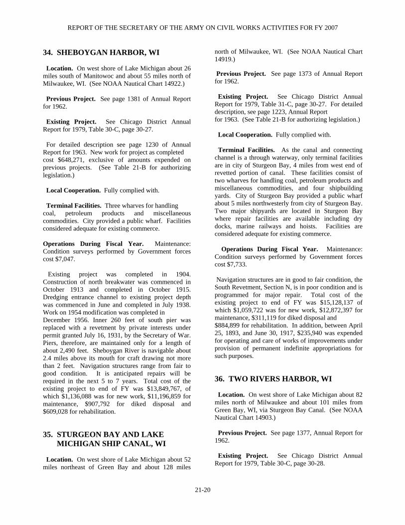
REPORT OF THE SECRETARY OF THE ARMY ON CIVIL WORKS ACTIVITIES FOR FY 2007
21-20
34. SHEBOYGAN HARBOR, WI Location. On west shore of Lake Michigan about 26 miles south of Manitowoc and about 55 miles north of Milwaukee, WI. (See NOAA Nautical Chart 14922.) Previous Project. See page 1381 of Annual Report for 1962. Existing Project. See Chicago District Annual Report for 1979, Table 30-C, page 30-27. For detailed description see page 1230 of Annual Report for 1963. New work for project as completed cost $648,271, exclusive of amounts expended on previous projects. (See Table 21-B for authorizing legislation.) Local Cooperation. Fully complied with. Terminal Facilities. Three wharves for handling coal, petroleum products and miscellaneous commodities. City provided a public wharf. Facilities considered adequate for existing commerce. Operations During Fiscal Year. Maintenance: Condition surveys performed by Government forces cost $7,047. Existing project was completed in 1904. Construction of north breakwater was commenced in October 1913 and completed in October 1915. Dredging entrance channel to existing project depth was commenced in June and completed in July 1938. Work on 1954 modification was completed in December 1956. Inner 260 feet of south pier was replaced with a revetment by private interests under permit granted July 16, 1931, by the Secretary of War. Piers, therefore, are maintained only for a length of about 2,490 feet. Sheboygan River is navigable about 2.4 miles above its mouth for craft drawing not more than 2 feet. Navigation structures range from fair to good condition. It is anticipated repairs will be required in the next 5 to 7 years. Total cost of the existing project to end of FY was $13,849,767, of which $1,136,088 was for new work, $11,196,859 for maintenance, $907,792 for diked disposal and $609,028 for rehabilitation. 35. STURGEON BAY AND LAKE MICHIGAN SHIP CANAL, WI Location. On west shore of Lake Michigan about 52 miles northeast of Green Bay and about 128 miles
north of Milwaukee, WI. (See NOAA Nautical Chart 14919.) Previous Project. See page 1373 of Annual Report for 1962. Existing Project. See Chicago District Annual Report for 1979, Table 31-C, page 30-27. For detailed description, see page 1223, Annual Report for 1963. (See Table 21-B for authorizing legislation.) Local Cooperation. Fully complied with. Terminal Facilities. As the canal and connecting channel is a through waterway, only terminal facilities are in city of Sturgeon Bay, 4 miles from west end of revetted portion of canal. These facilities consist of two wharves for handling coal, petroleum products and miscellaneous commodities, and four shipbuilding yards. City of Sturgeon Bay provided a public wharf about 5 miles northwesterly from city of Sturgeon Bay. Two major shipyards are located in Sturgeon Bay where repair facilities are available including dry docks, marine railways and hoists. Facilities are considered adequate for existing commerce. Operations During Fiscal Year. Maintenance: Condition surveys performed by Government forces cost $7,733. Navigation structures are in good to fair condition, the South Revetment, Section N, is in poor condition and is programmed for major repair. Total cost of the existing project to end of FY was $15,128,137 of which $1,059,722 was for new work, $12,872,397 for maintenance, $311,119 for diked disposal and $884,899 for rehabilitation. In addition, between April 25, 1893, and June 30, 1917, $235,940 was expended for operating and care of works of improvements under provision of permanent indefinite appropriations for such purposes. 36. TWO RIVERS HARBOR, WI Location. On west shore of Lake Michigan about 82 miles north of Milwaukee and about 101 miles from Green Bay, WI, via Sturgeon Bay Canal. (See NOAA Nautical Chart 14903.) Previous Project. See page 1377, Annual Report for 1962. Existing Project. See Chicago District Annual Report for 1979, Table 30-C, page 30-28.

DETROIT, MI, DISTRICT
21-21
For detailed description see page 1226 of Annual Report for 1963. Completed project cost $147,463, exclusive of the amount expended on previous projects. The 1935 River and Harbor Act portion of project is essentially complete, except for dredging a 10-foot width along each side of the entrance channel between the piers. The uncompleted portion of the project authorized by the 1935 R & H Act was deauthorized Dec. 31, 1989, in accordance with Section 1001 of the WRDA of 1986 (PL 99-662). (See Table 21-B for authorizing legislation.) Local Cooperation. Fully complied with. Terminal Facilities. A coal wharf and several fishing wharves. City provided a wharf for receipt of petroleum products and public use. Facilities considered adequate for existing commerce. Operations During Fiscal Year. Maintenance: Condition surveys performed by Government forces cost $6,998. Value engineering studies and structural design repairs performed by Government forces and contract cost $104,647. Existing project is complete except for portion deauthorized in December 1989. Present width of channel is considered adequate for present and reasonably prospective commerce. North Pier was completed in 1908. North Revetment, completed in 1917, was rebuilt in May to August 1962. Dredging entrance channel and inner basin to existing project depth was commenced in March and substantially completed in May 1937. Navigation structures range from fair to good condition and are under repair. Total cost of the existing project to end of FY was $13,569,962, of which $360,320 was for new work, $11,964,113 for maintenance, $1,187,472 for diked disposal and $58,057 for minor rehabilitation 37. RECONNAISSANCE AND CONDITION SURVEYS See Table 21-J. 38. OTHER AUTHORIZED NAVIGATION PROJECTS See Table 21-C. 39. NAVIGATION WORK UNDER SPECIAL AUTHORIZATION
See Table 21-K.
BEACH EROSION CONTROL 40. AUTHORIZED BEACH EROSION CONTROL PROJECTS River and Harbor Act of 1962, as amended, Beach Erosion Control. None. 41. EMERGENCY SHORE PROTECTION See Table 21-L. 42. BEACH EROSION WORK UNDER SPECIAL AUTHORIZATION See Table 21-M. 43. MITIGATION OF SHORE DAMAGES See Table 21-N. 44. PROJECT MODIFICATION FOR IMPROVING THE QUALITY OF THE ENVIRONMENT See Table 21-O FLOOD CONTROL 45. INSPECTION OF COMPLETED FLOOD CONTROL PROJECTS DATE OF NAME OF PROJECT INSPECTION Fort Wayne, IN.............................................Apr 2007 Mt. Clemons, Clinton River Spillway, MI...May 2007 Red Run Drain Clinton River, MI ...............May 2007 Grodi Road, MI ...........................................June 2007 Sebewaing, MI.............................................June 2007 Labo Island, MI ........................................... July 2007 Millman Island, MI...................................... July 2007 Hampton Township, MI .............................. Aug 2007 Estral Beach, MI .......................................... Aug 2007

REPORT OF THE SECRETARY OF THE ARMY ON CIVIL WORKS ACTIVITIES FOR FY 2007
21-22
Operations During Fiscal Year. Maintenance: Miscellaneous inspections and reports performed by Government forces and contract cost $216,754. Total cost to the end of FY was $4,537,017. 46. OTHER AUTHORIZED FLOOD CONTROL PROJECTS See Table 21-E. 47. FLOOD CONTROL WORK UNDER SPECIAL AUTHORIZATION Emergency Flood Control Activities, Flood Fighting (Public Law 84-99 and PL 93-288 and Antecedent Legislation). FY Cost for Project and Location Sep 30, 2007 Disaster Preparedness................................... $378,163 Emergency Operations ..................................... $4,919 Rehabilitation ................................................. $36,507 Flood control activities pursuant to Section 205 of the 1948 Flood Control Act, as amended. See Table 21-P. Flood control activities pursuant to Section 208 of the 1954 Flood Control Act. Snagging and clearing activities pursuant to Section 208 of the Flood Control Act of 1954, as amended. None. 48. SURVEILLANCE OF NORTHERN BOUNDARY WATERS AND INTERNATIONAL WATER STUDIES International Activities. The Detroit District has successfully supported the International Joint Commission (IJC) for many years. This has included numerous engineering and scientific assignments supporting the Commission's boards of control, working committees, and study boards. The Detroit District conducted the following activities, specifically for the IJC Boards and Committees:
a. Semi-Annual Meetings. Members of the Detroit District staff attended the semi-annual meetings
of the three Great Lakes Boards of Control. They also attended the spring and fall appearances of the Boards before the IJC, in Windsor, Ontario, in May 2007, and the fall appearances, in Ottawa, Ontario in October 2007. b. International Lake Superior Board of Control. The Detroit District Engineer is the United States Regulation Representative of this Board. In support of the U.S. Section of the Board, the District provided monthly Lake Superior outflow recommenda-tions based upon a review of the hydrologic factors that influence the monthly regulation decisions for Lake Superior. These recommendations were based upon the use of probability forecasts of water supplies routed through the lakes using the approved operating regulation plan, Plan 1977-A. Plan 1977-A has been in operational use since June 1990. The District's program to evaluate the hydraulic rating of the Compensating Works in the St. Marys River was continued in 2006 with measurements at various ½ gate equivalent settings. This lead to a decision in FY 2007 to change the ½ gate equivalent setting to 8 inches open to more closely approximate the actual flow. Water supplies in the Lake Superior basin continued to be below average during FY 2007, resulting in very low water levels. Lake Superior levels were below average since April 1998, which is the longest period of below average monthly levels in the 1918-2006 period of record. New record low water levels were recorded for Lake Superior in September and October 2007. Due to the record low water levels, the IJC asked the Board to determine if deviations from the regulation plan were advisable to help alleviate low water conditions. District staff conducted a thorough analysis for the Board, which resulted in a recommendation to continue following the regulation plan flows and not deviate. The deviations would have resulted in only small increases to Lake Superior levels, while causing additional impacts elsewhere in the system. Precipitation in the basin was very heavy in late September and October 2007 and that raised the lake above record lows more than any regulation plan deviations could have done. The Board is required by the IJC to hold at least one public meeting each year to inform them of the Board's activities and to solicit feedback regarding activities and current issues. As such, the District participated in the Board's FY 2007 annual meeting held in September 2007 in Sault Ste Marie, Michigan. A presentation was made, discussing the current water levels conditions, future trends and the Board’s role in water level management. After the presentation, questions and general discussion was held between all interested

DETROIT, MI, DISTRICT
21-23
parties. The IJC’s International Upper Great Lakes Study Board was also in attendance and addressed questions related to the study which had just begun. The District also disseminates extensive Board information to the public, the media and user interests via news releases, letters and the Board's web page. Hydropower peaking and ponding causes flow and water level variations in the St. Marys River downstream of the power plants. With water levels and Lake Superior outflows below average, these fluctuations have become a concern to commercial navigation. The District continues to provided significant technical support to the Board to evaluate this issue and make a recommendation on peaking and ponding operations. In March 2006, the IJC approved continuation of peaking and ponding indefinitely, subject to prior approval by the Board at the beginning and middle of each month. This approval is basically for five years, or until completion of the International Upper Great Lakes Study is completed. District staff provide ongoing technical support to the Board for these peaking and ponding recommendations. To help answer questions abut environmental impacts of peaking and ponding, the Board contracted with Dr. Mark Bain to review available literature and help make a recommendation about lowering the threshold at which peaking and ponding is restricted. Based on the outcome of this work, the Board recommended that the IJC lower the threshold by one foot. This was accepted by the IJC and implemented in late 2007. In October 2005, the IJC revised its plan for an Upper Great Lakes Study. District staff contributed heavily to this Plan of Study revision. Its directive focused on reviewing IJC Orders of Approval for Lake Superior outflow regulation and water lever impacts on affected interests in the upper Great Lakes system from Lake Superior downstream through Lake Erie. The revised plan assumes no changes to the Treaties and other bi-lateral agreements between Canada and the United States will be made. Two issues were added for consideration in the study. The first, looking at possible physical changes in the upper St. Clair River which could impact water level changes on the upstream (Michigan-Huron) and downstream lakes (St. Clair and Erie). The second issue involves incorporating lessons learned from the nearly complete lake Ontario – St. Lawrence River Study, which may help streamline the study. The study began in FY 2007 and several District staff are actively involved. c. International Niagara Board of Control, International Niagara Working Committee, and International Niagara Committee. The District provides direct technical support and consulting
engineering services to this Board and its Committees. The Chief of the Great Lakes Hydraulics and Hydrology Office is a member of the Niagara Working Committee. Under the auspices of the Committee, the Detroit District, with Canada, computes, coordinates, and publishes the monthly flows in the Niagara River. The Detroit District and the Water Survey of Canada routinely conduct discharge measurements in the lower Niagara River at the Cableway Section. This is part of a continuing effort to verify the Ashland Avenue stage-discharge equations. The Ashland Avenue equations are used to compute the flow out of the Maid-of-the-Mist Pool, which encompasses the total flow over the American and Canadian Falls, to ensure that the hydropower plants operate within the terms of the Niagara Treaty. Information, including flow measurements taken at the Cableway section in the spring and fall of 2007, has been evaluated to determine if the existing equations are adequate to represent the present hydraulic regime over the Niagara Falls. Upon recommendation of this evaluation, work has begun on re-deriving the Ashland Avenue equation. Discharge measurements at the Cableway Section, to verify the Ashland Avenue rating curve, are scheduled every three years with the next measurements set for 2010. Discharge measurements are also made routinely in the Welland Canal. These are part of the continuing effort to verify the ratings for the Welland Canal supply weir. Data collected to date indicates that the present equations may be underestimating the flow. Revision of the ratings is being evaluated. The last sets of measurements were made in 2007 and the next measurements at this section are scheduled for 2010, in accordance with the three-year schedule. Due to the dynamic nature of the Niagara River at the Niagara Falls, the District is also involved with periodic verification of the rating curves for the flow in the American Falls Channel and for the Niagara River flow out of Lake Erie. Discharge measurements are made in the American Falls Channel on a five-year schedule. Due to an alteration of the bridge used for measurements, alternate sites and different technologies needed to be investigated for the measurement series that was originally scheduled for 2005. In the Spring of 2007, a set of measurements were taken, upstream of the original bridge location, at the American Falls NOAA water level gauge. This section allowed for use of a tethered boat with a bottom mounted ADCP. The next set of measurements is scheduled for 2012.
REPORT OF THE SECRETARY OF THE ARMY ON CIVIL WORKS ACTIVITIES FOR FY 2007
21-24
Discharge measurements are made at the International Railway Bridge Section to verify the rating equations for the flow out of Lake Erie. The rating equation based on the Buffalo gage was recently revised based on measurements collected at this section since 1974. Measurements are made at the International Railway Bridge Section on a three-year schedule. The last set of measurements was made in 2006, and the next is scheduled for 2009. d. Great Lakes Basin Studies. During the past year, the District has been compiling data to be used in the International Upper Great Lakes Study to evaluate the hydraulics of the St. Clair River. Bathymetric data was collected for the main stem of the river, from Fort Gratiot down to Algonac. Discharge data from 1962 to present was summarized to look for changes in the flows over time. Dredging records were researched and summarized to look for changing sedimentation patterns. Coordinating Committee on Great Lakes Basic Hydraulic and Hydrologic Data. The Chief of the Great Lakes Hydraulics and Hydrology Office is the U.S. Secretary to this Committee. Other Office personnel also hold membership on the three subcommittees: the Vertical Control-Water Levels, Hydraulics, and Hydrology. The District continued its support of Committee operations pertaining to the coordination of basic hydraulic and hydrologic data with Canada. District efforts have also continued to closely coordinate the formats of the U.S. and Canadian water level bulletins in order to avoid confusion and to better inform the public. Efforts continued in 2007 on refinement of a coordinated Great Lakes regulation and routing model (CGLRRM). The Corps uses this model to evaluate levels and flows in the Great Lakes system from Lake Superior to Lake Ontario. A user-friendly graphical user interface (GUI) is also being finalized. This GUI will allow the user to change input parameters easily to evaluate the effects of different scenarios on water levels. The CGLRRM has been developed under the guidance of the Coordinating Committee with support from Environment Canada, Buffalo District, and the Hydrologic Engineering Center (HEC). During FY 2007, the District continued development and/or supported development of 1- and 2-dimensional hydrodynamic models of all the Great Lakes connecting channels. These models can be used to analyze effects of dredging, channel encroachments, and any other changes to river cross-sections. These
models will also serve as valuable tools in answering the many “what if” questions that are asked about the rivers. Field Operations. In addition to field operations conducted in support of the IJC, and as a continuing and ongoing mission, the Detroit District conducts hydraulic flow measurements throughout the Great Lakes Connecting Channels and St. Lawrence River system. This capability is unique among the Corps Districts (and other federal agencies) on the Great Lakes. During FY 2007, the Detroit District continued gathering hydraulic data using the ADCP (Acoustic Doppler Current Profiler) instrumentation at several sections on the lower St. Marys River, the upper and lower Detroit River, the St. Clair River, and the Niagara River. These hydraulic data sets are currently being used to develop two-dimensional flow models of the river systems, and to help refine the flow retardation estimates for weed conditions through the growing season. As an ongoing mission, during the winter months the District monitors the extent of ice in the St. Marys, St. Clair, and Detroit Rivers. Water levels are monitored continuously at key water level gages in these rivers to detect possible ice jams and potential flooding. The Corps and other governmental agencies, including the National Weather Service and the Coast Guard, can use this information to provide advance warning to area residents and to trigger emergency actions. Currently, data are obtained through phone access of these gages or from a satellite data relay to the District’s water management data system and remote laptop personal computers. These systems provide water level information to the District office within minutes of data collection. Water Management Data System. In FY 2007, the Detroit District continued to provide an extensive variety of water management products for the entire Great Lakes system, based on the water level gage network, on its Internet web pages. Weather information and meteorological data are also received and processed within the District and available on the Internet. The Detroit District has 21 active data collection platforms (DCPs). In FY 2007, the Detroit District continued implementation of the Corps of Engineers Water Management Software (CWMS) suite with its initial prototype development being placed on modernizing the Lake Winnebago watershed outflow management. Great Lakes Hydrology. The Great Lakes Hydraulics and Hydrology Office uses water supply forecasts routinely in forecasting water levels on all the Great

DETROIT, MI, DISTRICT
21-25
Lakes and regulating the outflows from Lake Superior. Studies to improve the existing Great Lakes water level forecasting system, including investigations into the factors affecting the Great Lakes water balance relationship (i.e., runoff, over-lake precipitation, evaporation, ice retardation, etc.) and use of real-time hydrologic data such as the new National Weather Service Doppler radar networks were continued during FY 2007. Work continued with the Cold Regions Research and Engineering Laboratory (CRREL) to improve snow water equivalent estimates used for supply forecasting. Great Lakes Water Levels. The Great Lakes Hydraulics and Hydrology Office continued to make routine short-term (30 day) and long-term (six month) Great Lakes still water level forecasts. These forecasts are distributed in the form of weekly, semi-monthly and monthly news releases and bulletins. The Monthly Bulletin of Lake Levels for the Great Lakes, containing a six-month projection of Great Lakes water levels, has a circulation of about 5,000 copies per month by mail and 1,000 by email. Included with the monthly bulletin on a quarterly basis is an informational enclosure entitled Great Lakes Update, which covers various topics of interest pertaining to the water resource management of the Great Lakes. Water levels on the Great Lakes started FY 2007 below average on Lakes Superior, Michigan-Huron and St. Clair. Lake Erie was right on average, while Lake Ontario was above average. A very dry summer caused the upper lakes to stay well below average later in FY 2007, finishing the year lower than they started. The lower lakes had a better summer, staying generally above average, but finishing the year slightly below average. Media and public attention has increased as the upper lakes continue to stay low, especially in the fall when Lake Superior set new record lows. Office personnel provided essential expertise regarding water level forecasts, recorded lake levels, and the potential impacts of these water levels on interested parties. These parties include members of Congress, state and local officials, news media, navigation and power interests, property owners, and recreational boaters. Water level information is supplied to the public via the District's web pages, telephonic and written responses to inquiries, presentations to various interest groups, and interviews with the news media. The total cost for FY 2007 under the Surveillance of Northern Boundary Waters was $2,864,736.
MULTIPLE-PURPOSE PROJECTS INCLUDING POWER 49. ST. MARYS RIVER, MI Location. A Great Lakes connecting channel about 63 miles long, flows southeasterly between State of Michigan and Providence of Ontario, Canada, from eastern end of Lake Superior into northern end of Lake Huron. (See NOAA Nautical Charts 14882, 14883, and 14884.) At Sault Ste. Marie, MI, about 14 miles downstream from Lake Superior, there are four parallel locks and a hydroelectric power plant. Previous Project. For details see page 1955, Annual Report for 1915; and page 1529, Annual Report for 1938. Existing Project. Channels permitting 25.5-foot draft navigation in St. Marys River and Lake Superior and Lake Huron approaches thereto; constructing and operating four locks and two canals; constructing an electric plant of 14,000 kilowatt capacity (45,000 kilowatt ultimate capacity) constructing anchorage areas in river above and below locks; and constructing various other works in conjunction with project. Subsequently, in 1932, the Unit 10 powerhouse was installed raising the capacity to 18,400 kilowatts (45,000 ultimate capacity). Original State Locks were operated and maintained under permanent indefinite appropriation from Jun. 9, 1881, to Nov. 2, 1886, after which they were destroyed by excavation for the Poe Lock in 1896. Weitzel Lock, destroyed in 1942 by excavation for the MacArthur Lock, was operated and maintained under the same appropriation from Sep. 1, 1881, to Jun. 30, 1935. Poe Lock was operated and maintained under the same appropriation from Aug. 3, 1896, Davis Lock from Oct. 21, 1914, and Sabin Lock from Sep. 18, 1919, to end of FY 1935. The 1,200-foot by 110-foot new Poe Lock was authorized in 1962 and put into operation in 1968. Details of existing project are set forth in Table 21-F. Project depths are referred to low water datum corresponding to sloping surface of river as follows: Above locks: When water surface of Lake Superior is at elevation 601.1 feet and at upstream side of locks is 600.6 feet above mean water level at Rimouski, Quebec, IGLD 1985. Below locks: When water surface at downstream side of locks is at elevation 578.4 feet and Lake Huron is 577.5 feet above mean water level at Rimouski, Quebec, IGLD
REPORT OF THE SECRETARY OF THE ARMY ON CIVIL WORKS ACTIVITIES FOR FY 2007
21-26
1985. Estimated (1974) cost for new work is $163,087,000. (See Table 21-B for authorizing legislation.) The WRDA of 1986 authorized construction of a second lock 1,294 feet in length, 115 feet in width, and 32 feet in depth, adjacent to the existing lock. The replacement lock is to be located in the North Canal of the St. Marys Falls Canal at Sault Ste. Marie, MI, on the site of the existing Davis and Sabin Locks. Material removed during construction of the replacement lock will be placed on the Northwest Pier to serve as a windbreak for downbound vessels approaching the lock. Estimated cost (Oct. 90) is $174,200,000 Federal and $93,800,000 non-Federal. Local Cooperation. Fully complied with for completed portion of project. Local cooperation items for the newly authorized project in the WRDA of 1986 (PL 99-662), are as follows: (a) Provide without cost to the United States all lands, easements, and rights-of-way necessary for implementation and later maintenance of the proposed project, and for aids to navigation upon the request of the Chief of Engineers, including suitable areas determined by the Chief of Engineers to be required in the general public interest for initial and later disposal of dredged/demolition material and including necessary retaining dikes, bulkheads, and embankments therefore, or the costs of such retaining works; (b) Hold and save the United States free from damages due to the implementation and maintenance of the project, not including damages due to the fault or negligence of the United States or its contractors; (c) Accomplish without cost to the United States such alterations and relocations of pipelines, powerlines, cables, sewer, water supply, drainage, and other utilities, structures, and improvements made necessary by the project. (Any such costs of the items on Federal property at the locks, would be part of the total construction cost and not separable local sponsor cost.); (d) Contribute in cash 25 percent of the total cost of construction of general navigation facilities, exclusive of aids to navigation, a contribution presently estimated at $67,000,000. The estimated cash contribution of $67,000,000 to be paid in lump sum prior to initiation of construction, or in annual installments during the construction period at a rate proportionate to the proposed or scheduled expenditure of Federal funds as required by the Chief of Engineers, or under another arrangement satisfactory to the Secretary of the Army,
the final apportionment of cost to be made after actual costs have been determined; (e) Repay, with interest, over a period of up to 30 years following project completion, 10 percent of the total cost of construction of general navigation facilities, an amount presently estimated at $26,800,000. The Secretary of the Army may count against all or part of the 10 percent repayment, the amount of the local contribution for lands, easements, rights-of-way, dredged/demolition material disposal sites and relocations. In no case are these costs to count against the cash payment during construction, and in no case would the amount waived exceed 10 percent of project cost; and (f) Any construction needed to prevent/mitigate for erosion or shoaling attributed to the lock would be cost shared in the same proportion as the project. Terminal Facilities. This improvement serves through commerce between Lake Superior and lower lakes and has not materially influenced terminal facilities at localities along its route. Three piers at Sault Ste. Marie receive coal and petroleum products. Limestone is shipped from a pier at Drummond Island. Vessel refueling stations are at Lime Island and village of DeTour; they receive coal and petroleum products. Present terminals satisfy current traffic requirements. Operations During Fiscal Year. New Work: Construction of a replacement lock. The St. Marys River project includes four navigation locks: MacArthur, Poe, Davis and Sabin. Currently, the MacArthur and Poe service loaded commercial vessel traffic. The Davis Lock is rarely used and the Sabin Lock is in disrepair and has been closed for several years. The new lock will replace the Davis and Sabin Locks in the North Canal of the St. Marys Falls Canal. As a minimum, the new lock would have the same dimensions as the 1200-foot by 110-foot Poe Lock. FY07 funds in the amount of $608,304 were expended to continue limited work on the design documentation reports (DDR) for the guide walls, channel excavation and lock chamber. The detailed structure survey of the proposed construction area was completed. Additionally, a preliminary report assessing the capacity of Class 1 railroads as related to Soo navigation traffic was initiated. Operations, maintenance, and care of locks: Two canals and three locks were operated (the fourth lock, Sabin, was in caretaker status) as required. Necessary repairs and improvements were made thereto and to appurtenant structures and equipment. Canals were open to navigation 297 days during the

DETROIT, MI, DISTRICT
21-27
period 1 October 2006 through 30 September 2007. A total of 8,446 vessels, aggregating 82,171,192 short tons of freight and 90,722 passengers passed through the MacArthur, Davis and Poe Locks. Total cost for operation, maintenance, and care of the locks during the FY was $13,338,011. Powerhouse and equipment: A total of 156,725,400 kilowatt-hours of power was generated this FY. Income from the sale of power, sent to the U.S. Treasury, amounted to $1,316,525. Total cost of operation and maintenance for two hydroelectric powerhouses during the FY was $920,616. Other operation and care items: Buildings and grounds were operated and maintained, condition surveys, operations studies, environmental activities, safety compliance, archeological and cultural management, real estate, and miscellaneous inspections and reports were performed by Government forces and contract at a cost of $1,319,430. The contract for repairs to the West Center Pier, Soo Locks, awarded last FY was completed this FY at a cost of $400,739. Channels and canals: St. Marys River channels and canal approach depths were surveyed by sweeping. Location and removal of obstructions were performed by hired labor using the U.S. Derrickbarge NICOLET and the U.S. Cranebarge HARVEY at a cost $1,838,421. Recreational facilities: Information center, Visitors center, comfort stations, park fountain, and observation and overlook platforms were operated and maintained at a cost of $445,029. Visitors entering the Soo Locks Visitors Center numbered 367,111. Visitors to the observation platforms overlooking the locks numbered 292,862. Total visitors to the Soo Locks Park numbered 394,367. A grand total of 485,089 people (includes tour boat visitors of 90,722) visited the Soo Locks. Total project costs in FY07 amounted to $18,262,246. Project in effect prior to modification of March 21, 1956, is complete and work authorized by 1956 modification to provide a safe draft of 25.5 feet for both upbound and downbound traffic is also complete. Public Works Acceleration Funds used for maintenance were $118,000. Total cost of the existing project to end of FY was $702,682,391, of which $170,800,152 was for new work and $531,882,239 for maintenance (includes $340,400 contributed funds).
GENERAL INVESTIGATIONS 50. SURVEYS FY Cost for Project and Location Sep 30, 2007 Reconnaissance and Feasibility Studies Detroit River Master Plan MI ........................ $14,959 Great Lakes Navigation System, MI..........$1,088,036 John Glenn Great Lakes Basin Program MI .... .$2,969 John Glenn Great Lakes Recreational Boat ......$1,375 Watershed and Ecosystem Restoration Reconnaissance and Feasibility Studies Lower Fox River, WI.............................................$86 Rouge River Supplemental Study, MI............$11,424 Coordination Studies with Other Agencies Coop w/Other Water Agencies.........................$1,955 FERC Licensing Activities ...............................$3,935 Interagency Water Resources Development...$16,029 North American Water Fowl Mgmt Planning ..$1,863 National Estuary Studies ..................................$4,405 Special Investigations .....................................$24,978 Sec 22 Planning Assistance to States & Tribes: Great Lakes Remedial Action Program...........$-7,421 Federal amount shown, studies cost shared equally with partner include: Ingham County GIS, MI...................................$5,807 PAS Negotiation Funds, MI ...........................$18,977 PAS Onieda Nation GIS .................................$65,464 PAS Mequon Dam Evaluation..........................$1,172 PAS Muskegon County GIS.................................$-16 Pike River, WI .......................................................$22 DNR Shawano Lake Survey, WI.........................$835 MMSD, Lower Menominee River, WI................$523 51. COLLECTION AND STUDY OF BASIC DATA FY Cost for Project and Location Sep 30, 2007 Flood Plain Mgmt Services Program FPMS Unit......................................................$55,996 Technical Services..........................................$37,603 Quick Responses ............................................$10,011

REPORT OF THE SECRETARY OF THE ARMY ON CIVIL WORKS ACTIVITIES FOR FY 2007
21-28
No Federal Emergency Management Agency’s
Community Assistance Program Study or Flood Insurance Studies in FY07.
International Water Studies………………… $24,305
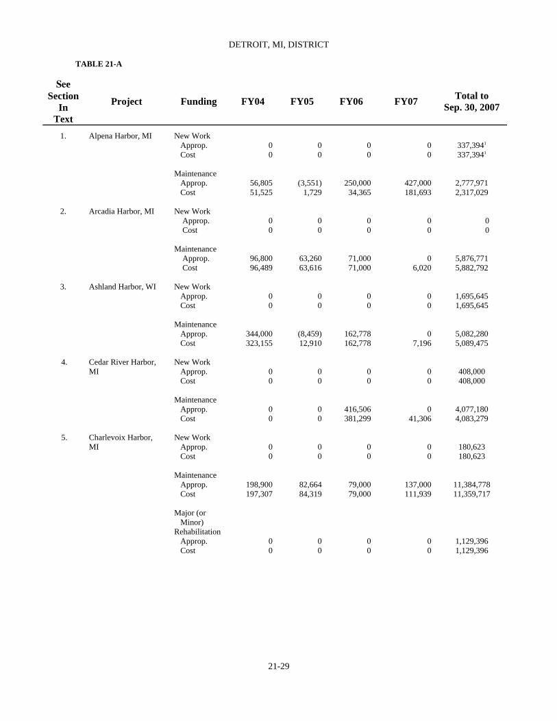
DETROIT, MI, DISTRICT
TABLE 21-A
21-29
See Section
In Text
Project Funding FY04 FY05 FY06 FY07 Total to Sep. 30, 2007
1. Alpena Harbor, MI New Work Approp. Cost Maintenance Approp. Cost
0 0
56,805 51,525
0 0
(3,551) 1,729
0 0
250,000 34,365
0 0
427,000 181,693
337,3941 337,3941
2,777,971 2,317,029
2. Arcadia Harbor, MI New Work
Approp. Cost Maintenance Approp. Cost
0 0
96,800 96,489
0 0
63,260 63,616
0 0
71,000 71,000
0 0
0 6,020
0 0
5,876,771 5,882,792
3.
Ashland Harbor, WI New Work Approp. Cost Maintenance Approp. Cost
0 0
344,000 323,155
0 0
(8,459) 12,910
0 0
162,778 162,778
0 0
0 7,196
1,695,645 1,695,645
5,082,280 5,089,475
4. Cedar River Harbor, MI
New Work Approp. Cost Maintenance Approp. Cost
0 0
0 0
0 0
0 0
0 0
416,506 381,299
0 0
0 41,306
408,000 408,000
4,077,180 4,083,279
5.
Charlevoix Harbor, MI
New Work Approp. Cost Maintenance Approp. Cost Major (or Minor) Rehabilitation Approp. Cost
0 0
198,900 197,307
0 0
0 0
82,664 84,319
0 0
0
0
79,000 79,000
0 0
0 0
137,000 111,939
0 0
180,623 180,623
11,384,778 11,359,717
1,129,396 1,129,396
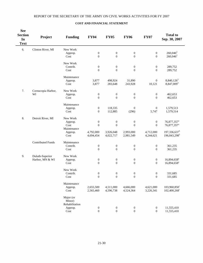
REPORT OF THE SECRETARY OF THE ARMY ON CIVIL WORKS ACTIVITIES FOR FY 2007
COST AND FINANCIAL STATEMENT
21-30
See Section
In Text
Project Funding FY04 FY05 FY06 FY07 Total to Sep. 30, 2007
6. Clinton River, MI
New Work Approp. Cost New Work Contrib. Cost Maintenance Approp. Cost
0 0
0 0
3,877 3,877
0 0
0 0
498,924 283,648
0 0
0 0
31,890 243,928
0 0
0 0
0 10,121
260,0462
260,0462
289,752 289,752
8,840,1263
8,847,0093
7.
Cornucopia Harbor, WI
New Work Approp. Cost Maintenance Approp. Cost
0 0
0 0
0 0
118,335 112,885
0 0
0 (296)
0 0
0 5,747
462,653 462,653
1,579,513 1,579,514
8. Detroit River, MI
Contributed Funds
New Work Approp. Cost Maintenance Approp. Cost Maintenance Contrib. Cost
0 0
4,792,000 4,694,454
0 0
0 0
3,926,048 4,022,717
0 0
0 0
2,993,000 2,981,549
0 0
0 0
4,712,000 4,244,621
0 0
76,877,3574 76,877,3574
197,336,6375
196,843,2985
361,235 361,235
9.
Duluth-Superior Harbor, MN & WI
New Work Approp. Cost New Work Contrib. Cost Maintenance Approp. Cost Major (or Minor) Rehabilitation Approp. Cost
0 0
0 0
2,655,500 2,565,460
0 0
0 0
0 0
4,511,000 4,596,738
0 0
0 0
0 0
4,666,000 4,524,364
0 0
0 0
0 0
4,621,000 3,226,341
0 0
16,894,6586 16,894,6586
331,685 331,685
103,960,8507
102,400,2687
11,555,410 11,555,410

DETROIT, MI, DISTRICT
TABLE 21-A
21-31
See Section
In Text
Project Funding FY04 FY05 FY06 FY07 Total to Sep. 30, 2007
10. Fox River, WI
New Work Approp. Cost Maintenance Approp. Cost
0 0
12,434,000 16,238,131
0 0
1,802,913 1,831,723
0 0
1,466,000 1,407,246
0 0
2,138,000 1,259,059
3,753,3348 3,753,3348
98,615,3149,10
97,670,6129,10
11. Grand Haven Harbor,
MI Section 111 Contributed Funds Section 111
New Work Approp. Cost New Work Contrib. Cost Maintenance Approp. Cost Maintenance Approp. Cost Major (or Minor) Rehabilitation Approp. Cost
0 0
0 0
697,100 695,219
0 0
0 0
0 0
0 0
575,360 568,868
0 0
0 0
0 0
0 0
1,638,000 1,646,389
0 0
0 0
0 0
0 0
453,000 391,049
0 0
0 0
1,283,46911 1,283,46911
175,000 175,000
39,031,38712 39,969,40212
15,585 15,585
813,613 813,613
12. Grand Marais Harbor,
MI
New Work Approp. Cost Maintenance Approp. Cost
0 0
(32,579) 62,891
0 0
146,438 146,497
0 0
805,000 267,442
0 0
498,000 41,754
1,055,871 1,055,871
4,443,830 3,450,026
13.
Green Bay Harbor, WI
New Work Approp. Cost Maintenance Approp. Cost
0 0
2,065,600 2,086,261
0 0
3,402,371 3,387,341
0 0
2,557,000 2,506,461
0 0
2,596,000 2,657,543
9,946,39513,14
9,946,39513,14
69,698,74615
69,671,18715
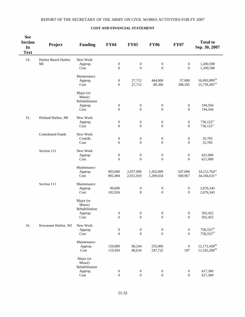
REPORT OF THE SECRETARY OF THE ARMY ON CIVIL WORKS ACTIVITIES FOR FY 2007
COST AND FINANCIAL STATEMENT
21-32
See Section
In Text
Project Funding FY04 FY05 FY06 FY07 Total to Sep. 30, 2007
14.
Harbor Beach Harbor MI
New Work Approp. Cost Maintenance Approp. Cost Major (or Minor) Rehabilitation Approp. Cost
0 0
0 0
0 0
0 0
27,712 27,712
0 0
0 0
444,000 89,306
0 0
0 0
57,000 398,395
0 0
1,200,598 1,200,598
16,093,99916
15,739,30516
194,504 194,504
15.
Holland Harbor, MI Contributed Funds Section 111 Section 111
New Work Approp. Cost New Work Contrib. Cost New Work Approp Cost Maintenance Approp. Cost Maintenance Approp. Cost Major (or Minor) Rehabilitation Approp. Cost
0 0
0 0
0 0
903,600 902,494
99,600 102,926
0 0
0 0
0 0
0 0
2,057,000 2,051,010
0 8
0 0
0 0
0 0
0 0
1,202,000 1,209,654
0 0
0 0
0 0
0 0
0 0
547,000 500,967
0 0
0 0
736,12217 736,12217
35,705 35,705
621,000 621,000
34,212,76418 34,166,63118
2,676,343 2,676,343
502,452 502,452
16.
Kewaunee Harbor, WI
New Work Approp. Cost Maintenance Approp. Cost Major (or Minor) Rehabilitation Approp. Cost
0 0
120,000 119,450
0 0
0 0
86,244 86,634
0 0
0 0
255,000 247,732
0 0
0 0
0 197
0 0
758,33319
758,33319
12,172,45820
12,165,20820
617,300 617,300
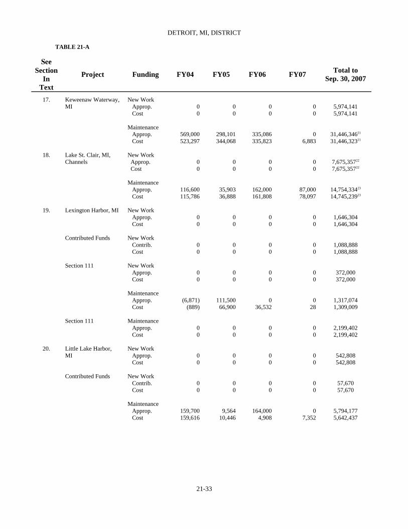
DETROIT, MI, DISTRICT
TABLE 21-A
21-33
See Section
In Text
Project Funding FY04 FY05 FY06 FY07 Total to Sep. 30, 2007
17.
Keweenaw Waterway, MI
New Work Approp. Cost Maintenance Approp. Cost
0 0
569,000 523,297
0 0
298,101 344,068
0 0
335,086 335,823
0 0
0 6,883
5,974,141 5,974,141
31,446,34621
31,446,32321
18. Lake St. Clair, MI, Channels
New Work Approp. Cost Maintenance Approp. Cost
0 0
116,600 115,786
0 0
35,903 36,888
0 0
162,000 161,808
0 0
87,000 78,097
7,675,35722 7,675,35722
14,754,33423
14,745,23923
19. Lexington Harbor, MI
Contributed Funds Section 111 Section 111
New Work Approp. Cost New Work Contrib. Cost New Work Approp. Cost Maintenance Approp. Cost Maintenance Approp. Cost
0 0
0 0
0 0
(6,871) (889)
0 0
0 0
0 0
0 0
111,500 66,900
0 0
0 0
0 0
0 0
0 36,532
0 0
0 0
0 0
0 0
0 28
0 0
1,646,304 1,646,304
1,088,888 1,088,888
372,000 372,000
1,317,074 1,309,009
2,199,402 2,199,402
20. Little Lake Harbor,
MI Contributed Funds
New Work Approp. Cost New Work Contrib. Cost Maintenance Approp. Cost
0 0
0 0
159,700 159,616
0 0
0 0
9,564 10,446
0 0
0 0
164,000 4,908
0 0
0 0
0 7,352
542,808 542,808
57,670 57,670
5,794,177 5,642,437

REPORT OF THE SECRETARY OF THE ARMY ON CIVIL WORKS ACTIVITIES FOR FY 2007
COST AND FINANCIAL STATEMENT
21-34
See Section
In Text
Project Funding FY04 FY05 FY06 FY07 Total to Sep. 30, 2007
21.
Ludington Harbor, MI Section 111 Section 111
New Work Approp. Cost New Work Approp. Cost Maintenance Approp. Cost Maintenance Approp. Cost Major (or Minor) Rehabilitation Approp. Cost
0 0
0 0
293,800 289,315
0 0
0 0
0 0
0 0
476,175 480,716
0 0
0 0
0 0
0 0
399,170 50,316
0 0
0 0
0 0
0 0
177,000 495,680
0 0
0 0
7,912,20224
7,912,20224
620,000 620,000
23,101,43525 22,071,22325
832,740 832,740
357,913 357,913
22.
Manistee Harbor, MI
New Work Approp. Cost Maintenance Approp. Cost Major (or Minor) Rehabilitation Approp. Cost
0 0
556,700 556,714
0 0
0 0
391,757 391,731
0 0
0 0
5,170 4,867
0 0
0 0
447,000 370,015
0 0
2,696,52226
2,696,52226
14,165,14127
14,087,80027
1,374,164 1,374,164
23. Manitowoc Harbor, WI Contributed Funds Contributed Funds
New Work Approp. Cost New Work Contrib. Cost Maintenance Approp. Cost Maintenance Contrib. Cost
0 0
0 0
72,700 72,654
0 0
0 0
0 0
389,000 115,617
0 0
0 0
0 0
405,468 264,427
0 0
0 0
0 0
647,000 656,506
0 0
2,048,91428 2,048,91428
1,911,130 1,911,130
14,649,14229
14,244,16229
79,648 66,735

DETROIT, MI, DISTRICT
TABLE 21-A
21-35
See Section
In Text
Project Funding FY04 FY05 FY06 FY07 Total to Sep. 30, 2007
24.
Milwaukee Harbor, WI Contributed Funds
New Work Approp. Cost Maintenance Approp. Cost Maintenance Contrib. Cost Major (or Minor) Rehabilitation Approp. Cost
0 0
302,800 302,584
0 0
0 0
0 0
836,197 834,376
0 0
0 0
0 0
749,000 533,786
0 0
0 0
0 0
1,157,000 1,316,595
0 0
0 0
8,231,02430 8,231,02430
58,219,40331 58,161,74631
322,471 322,471
12,715,560 12,715,560
25.
Monroe Harbor, MI Contributed Funds Contributed Funds
New Work Approp. Cost New Work Contrib. Cost Maintenance Approp. Cost Maintenance Contrib. Cost
0 0
0 0
41,400 170,606
0 0
0 0
0 0
140,764 140,783
0 0
0 0
0 0
438,000 437,049
0 0
0 0
0 0
476,000 244,871
0 0
687,340 687,340
300,000 300,000
62,428,89832
62,196,81832
249,84933 249,84933
26.
Muskegon Harbor, MI Section 111 Section 111
New Work Approp. Cost New Work Approp. Cost Maintenance Approp. Cost Maintenance Approp. Cost Major (or Minor) Rehabilitation Approp. Cost
0 0
0 0
415,715 333,995
0 0
0 0
0 0
0 0
78,806 160,525
0 0
0 0
0 0
0 0
466,000 465,957
0 0
0 0
0 0
0 0
214,000 119,597
0 0
0 0
2,912,11034 2,912,11034
105,000 105,000
12,636,54235 12,542,09635
3,265,600 3,265,600
13,824,300 13,824,300

REPORT OF THE SECRETARY OF THE ARMY ON CIVIL WORKS ACTIVITIES FOR FY 2007
COST AND FINANCIAL STATEMENT
21-36
See Section
In Text
Project Funding FY04 FY05 FY06 FY07 Total to Sep. 30, 2007
27.
New Buffalo Harbor, MI Contributed Funds
New Work Approp. Cost New Work Contrib. Cost Maintenance Approp. Cost
0 0
0 0
358 358
0 0
0 0
108,421 108,421
0 0
0 0
70,000 68,060
0 0
0 0
0 8,055
1,285,716 1,285,716
1,186,467 1,186,467
5,956,89636 5,963,01136
28. Ontonagon Harbor, MI
New Work Approp. Cost Maintenance Approp. Cost
0 0
660,000 650,118
0 0
511,242 475,839
0 0
421,000 342,811
0 0
549,000 653,412
953,90337 953,903371
28,860,81038
28,841,51338
29. Petoskey Harbor, MI
New Work Approp. Cost Maintenance Approp. Cost
0 0
0 0
0 0
0 0
0 0
434,187 307,615
0 0
0 132,589
123,839
123,839
1,396,775 1,402,792
30. Rouge River, MI New Work
Approp. Cost Maintenance Approp. Cost
0 0
161,900 163,569
0 0
291,688 292,346
0 0
770,000 420,093
0 0
20,000 369,907
675,25139 675,25139
40,642,39040
40,642,39040
31. Saginaw River, MI (Federal Funds) Contributed Funds
New Work Approp. Cost New Work Contrib. Cost Maintenance Approp. Cost
0 0
0 0
1,407,500 1,409,606
0 0
0 0
1,611,047 1,578,328
100,000
2,904
0 0
3,419,323 2,878,696
1,724,000 1,374,495
0 0
3,541,000 1,555,162
16,741,12741 16,294,52641
13,600 13,600
96,391,43942 93,830,96842

DETROIT, MI, DISTRICT
TABLE 21-A
21-37
See Section
In Text
Project Funding FY04 FY05 FY06 FY07 Total to Sep. 30, 2007
32. Saint Clair River, MI New Work Approp. Cost Maintenance Approp. Cost
0 0
1,050,000 1,035,634
0 0
682,323 684,234
0 0
817,000 815,513
0 0
519,000 453,234
19,213,246 19,213,246
34,948,84243 34,865,59343
33.
Saint Joseph Harbor, MI Section 111 Section 111
New Work Approp. Cost New Work Approp. Cost Maintenance Approp. Cost Maintenance Approp. Cost Major (or Minor) Rehabilitation Approp. Cost
0 0
0 0
624,000 626,430
102,900 104,649
0 0
0 0
0 0
908,070 835,359
0 91
0 0
0 0
0 0
1,213,000 1,280,069
0 0
0 0
0 0
0 0
448,000 369,885
0 0
0 0
976,48544 976,48544
828,000 828,000
26,608,03445 26,521,44345
8,818,736 8,818,736
962,216 962,216
34.
Sheboygan Harbor, WI
New Work Approp. Cost Maintenance Approp. Cost Major (or Minor) Rehabilitation Approp. Cost
0 0
506,000 482,386
0 0
0 0
1,348,935 1,358,218
0 0
0 0
6,005 20,166
0 0
0 0
0 7,047
0 0
1,136,08846 1,136,08846
12,097,78747 12,104,65147
609,028 609,028

REPORT OF THE SECRETARY OF THE ARMY ON CIVIL WORKS ACTIVITIES FOR FY 2007
COST AND FINANCIAL STATEMENT
21-38
See Section
In Text
Project Funding FY04 FY05 FY06 FY07 Total to Sep. 30, 2007
35.
Sturgeon Bay, WI, and Lake Michigan Ship Canal, WI
New Work Approp. Cost Maintenance Approp. Cost Major (or Minor) Rehabilitation Approp. Cost
0 0
86,400 86,386
0 0
0 0
1,164,770 1,164,348
0 0
0 0
228,000 226,184
0 0
0 0
0 7,733
0 0
1,059,72248 1,059,72248
13,178,08349 13,183,51649
884,899 884,899
36.
Two Rivers Harbor, WI
New Work Approp. Cost Maintenance Approp. Cost Major (or Minor) Rehabilitation Approp. Cost
0 0
72,910 72,972
0 0
0 0
303,510 302,657
0 0
0 0
379,055 144,693
0 0
0 0
0 111,645
0 0
360,32050 360,32050
13,275,18751 13,151,58551
58,057 58,057
48.
Surveillance of Northern Boundary Waters
New Work Approp. Cost Maintenance Approp. Cost
0 0
3,049,600 3,056,291
0 0
2,927,000 2,811,002
0 0
2,749,000 2,767,393
0 0
2,870,000 2,864,736
0 0
92,256,43252 92,099,09852
49.
St. Marys River, MI Contributed Funds
New Work Approp. Cost Maintenance Approp. Cost Maintenance Contrib. Cost
2,006,000 1,861,811
19,974,747 24,092,899
0 0
2,110,000 1,942,965
16,637,450 14,792,830
0 0
1,480,000 1,643,824
15,784,000 16,122,955
0 0
507,000 608,305
18,601,000 18,262,246
0 0
170,931,07153 170,800,15253
533,748,60054,55 531,541,83954,55
340,400 340,400

DETROIT, MI, DISTRICT
TABLE 21-A
21-39
See Section
In Text
Project Funding FY04 FY05 FY06 FY07 Total to Sep. 30, 2007
1Includes $18,889 for previous projects. 2Includes $25,500 for previous projects. 3Includes $3,796,180 for previous projects. 4Includes $2,097,254 for previous projects. 5Includes $42,470,585 for diked disposal. 6Includes $1,547,195 for previous projects. 7Includes $1,556,249 for diked disposal. 8Includes $3,239,910 for previous projects. 9Includes $89,309 for previous projects. 10Includes $42,084 expended for M&O of Dams. (Excludes $10 expended in FY99). 11Includes $1,204,500 for diked disposal. 12Includes $13,437 for previous project and $780,400 for diked disposal. 13Includes $506,437 for previous projects. 14Excludes $100,000 contributed funds. 15Includes $8,918 for previous projects and $7,642,642 for diked disposal. 16Includes $243,100 for diked disposal. 17Includes $176,620 for previous projects. 18Includes $127,598 for previous projects and $1,663,300 for diked disposal. 19Includes $149,312 for previous projects. 20Includes $88,364 for previous projects and $2,961,461 for diked disposal. 21Includes $402,242 for previous projects and $1,523,500 for diked disposal. 22Includes $656,000 for previous projects. 23Includes $235,346 for previous projects and $5,119,800 for diked disposal. 24Includes $491,416 for previous projects. 25Excludes $136,286 contributed funds. 26Includes $354,999 for previous projects. 27Includes $150,910 for previous projects. 28Includes $400,126 for previous projects. 29Includes $54,288 for previous projects and $3,081,756 for diked disposal.
30Includes $1,293,220 for previous projects. 31Includes $459,305 for previous projects and $6,380,925 for diked disposal. 32Includes $38,606,400 for diked disposal. 33Includes $83,182 contributed funds - diked disposal. 34Includes $613,408 for previous projects. 35Includes $446,183 for previous projects. 36Includes $181,500 for diked disposal. 37Includes $284,802 for previous projects. 38Includes $113,326 for previous projects and $21,000 for diked disposal. 39Includes $50,084 for previous projects. 40Includes $56,608 for previous projects and $14,907,318 for diked disposal. 41Includes $962,556 for previous projects. 42Includes $20,951,888 for diked disposal ($1,671,660 public works fund and $49,419 emergency relief funds) 43Includes $420,000 expended for M&O of Dams. 44Includes $503,113 for previous projects. 45Includes $638,076 for diked disposal. 46Includes $487,817 for previous projects. 47Includes $87,131 for previous projects and $907,792 for diked disposal. 48Includes $323,419 for previous projects. 49Includes $219,730 for previous projects and $311,119 for diked disposal. 50Includes $212,857 for previous projects. 51Includes $33,113 for previous projects and $1,187,472 for diked disposal. 52Includes $3,973,897 for previous projects. 53Includes $2,904,807 for previous projects. 54Includes $13,100 for diked disposal. 55Includes $799,947 expended for M&O of Dams.

REPORT OF THE SECRETARY OF THE ARMY ON CIVIL WORKS ACTIVITIES FOR FY 2007 TABLE 21-B AUTHORIZING LEGISLATION
21-40
See Sec.
Date of Authorizing Act
Project and Work Authorized
Documents
1. Sep. 19, 1890 Mar. 2, 1919 Sep. 22, 1922 Aug. 30, 1935 Oct. 27, 1965 Nov. 17, 1986
ALPENA HARBOR, MI Channel depth of 16 ½ feet. Rubblemound breakwater for protecting channel on south
side and widening entrance channel. 21 and 18½ foot channel depths and turning basin. Present project dimensions. New turning basin. Removal
of old breakwater and construction of new breakwater. Deauthorization of the feature authorized by the 1965
River and Harbor Act.
Annual Report, 1889, p. 2288. H. Doc. 830, 65th Cong., 2d Sess., and Rivers & Harbors Comm. Doc. 1, 67th Cong., lst Sess. Rivers and Harbors Comm. Doc. 42, 72d Cong., lst. Sess. H. Doc. 151, 88th Cong., 1st. Sess.1 H. R. 6 (formerly S. 1567), 99th Cong., 2d Sess. (WRDA of 1986).
2. Mar. 3, 1905
ARCADIA HARBOR, MI Maintenance of existing 12-foot channel.
H. Doc. 194, 58th Cong., 2d Sess.
3. Aug. 5, 1886 Aug. 11, 1888 Mar. 3, 1899 Jun. 6, 1990 Aug. 8, 1917 Jul. 3, 1930 Aug. 30, 1935 Mar. 2, 1945 Jul. 14, 1960
ASHLAND HARBOR, MI Breakwater 7,900 feet long and dredging to remove a shoal. Appropriation of $60,000 for 'Continuing improvements
on enlarged project' (On completion of Poe Lock in 1896, with available depth of 20 feet, dredging at Ashland Harbor was carried to a similar depth.)
Detached breakwater extending 4,700 feet out from shore at a point 2,600 feet east of main breakwater (prolonged) and parallel thereto.
Project modified by omitting detached breakwater and defining depth and extend of channel to be dredged.
Widening part of present channel for entrance channel and for basin in eastern part of harbor.
Deepening east basin to 25 feet and west channel, as far as 8th Ave. West, extended to 21 feet.
Widening west channel to 750 feet at its westerly end Deepening portions of east basin and west channel to 27
and 21 feet, respectively.
H. Ex. Doc. 89, 48th Cong., 2d Sess. Annual Reports, 1886, p. 1674; and 1887, p. 1966. H. Ex. Doc. 89, 48th Cong., 2d Sess. Annual Reports, 1886, p. 1674; and 1887, p. 1966. H. Doc. 1698, 64th Cong., 2d Sess. S. Doc. 133, 71st Cong., 2d Sess Rivers and Harbors Committee Doc. 46, 82d Cong., 1st Sess. H. Doc. 337, 77th Cong., 1st Sess. H. Doc. 165, 86th Cong., 1st Sess.1
4.
Aug. 2, 1882 Oct. 28, 1965
CEDAR RIVER HARBOR, MI Dredge an entrance channel (datum at 580.69 feet above
mean tide at New York) and construct two parallel piers extending lakeward from mouth of Cedar River.
Modification of project to provide for two parallel entrance piers including a new rubblemound east pier with a sport fishing walkway; an entrance channel from Green Bay to mouth of Cedar River, and a turning basin.
S. Ex. Doc. 12th, 47th Cong., 1st Sess. H. Doc. 248, 89th Cong., 1st Sess.
5.
Aug. 14, 1876 Aug. 2, 1882 Jun 13, 1902 Jun. 20, 1938 Nov. 17, 1988
CHARLEVOIX HARBOR, MI Channel from Lake Michigan to Round Lake protected
where needed by piers and revetments. Channel from Round Lake to Lake Charlevoix. Project depth increased to 15 feet. Project depth increased to 18 feet. Restore recreational uses or provide comparable
S. Ex. Doc. 16, 44th Cong., 1st 0ess. and Annual Report 1876, p. 523. No Prior Survey of Estimates. No Prior Survey of Estimates. S. Doc. 163, 75th Cong., 3rd Sess.1 H. Doc. 1098, 100th Cong., 2d Sess.

DETROIT, MI, DISTRICT
AUTHORIZING LEGISLATION
21-41
See Sec.
Date of Authorizing Act
Project and Work Authorized
Documents
Mar. 29, 1977
recreational uses at the South Pier. Project depth increased to 24 and 23 feet, and
construction of revetment upstream of Highway Bridge.
Sec. 25 of the WRDA of 1988. Section 107, 1960 Rivers and Harbors Act.
6.
Aug. 5, 1886
CLINTON RIVER, MI Channel in River and Lake St. Clair, Pile Dike, Closing
channels and making Cutoff, and revetments as needed.
S. Doc. 199, 46th Cong., 2d Sess. Annual Report, 1880, p. 2062, and H. Doc. 210, 44th Cong.,2d Sess.
7.
Aug. 26, 1936 Sep. 3, 1954
CORNUCOPIA HARBOR, WI Entrance channel 50 feet wide and 10 feet deep between
existing piers from bay to a turning basin 200 feet long, 8 feet deep, with maximum width of 180 feet, with 150- and 300-foot inner channels each 50 feet wide and 8 feet deep.
Reconstruction and Federal maintenance of ease and west entrance piers, a 25-foot extension of west pier and a 300-foot extension of existing westerly inner channel at a depth of 8 feet and a width of 50 feet.
S. Committee, 75th Cong., 1st Sess. H. Doc. 434, 83rd Cong., 2d Sess.1
8. Jun. 13, 1902 Mar. 3, 1905 Jun. 25, 1910 Mar. 4, 1913 Mar. 2, 1907 Jun. 25, 1910 Mar. 2, 1919 Jul. 3, 1930 Aug. 30, 1935 3 Aug. 26, 1937 Mar. 2, 1945 Jul. 24, 1946 22
May 17, 1950 4
Mar. 21, 1956 22
DETROIT RIVER, MI Amherstburg Channel and removal of Grosse Ile Shoal. Fighting Island Channel. Livingstone Channel. Channel Depths of 26 and 25 feet. Channel to Wyandotte 21 feet deep and 300 feet wide
through Middle Ground opposite Head of Fighting Island.
Trenton Channel and Turning Basin (West of Grosse Ile).
American Channel North of Belle Isle between Windmill Point and Fairway Slip, Detroit.
Deepen Westerly 300 feet of Amherstburg Channel and Ballards Reef Channel below Livingstone Channel to 27 feet to provide depths adequate for 24-foot draft navigation when governing Lakes are at Datum, with necessary widening at approaches and bends and construction of necessary compensating works, Detroit River.
Extend Turning Basin in Trenton Channel 600 feet. Dredge through East Draw of lower Grosse Ile Bridge and extend 300-foot width of Channel North of lower Grosse Ile Bridge.
Channel Depth of 28.5 feet throughout downbound and Two-Way Channels, except in upper (27.7-foot depth) and lower (29-foot depth), Livingstone Channel, and in upbound Channel; 27-foot depth in Ballards Reef Channel below junction with Livingstone Channel, 27.5-foot depth in westerly 300-foot width of Limekiln Crossing and Amherstburg Reaches, and 28.5-foot depth in westerly 300-foot width of Hackett Beach, with necessary compensation works. Also 28.5-foot depth in Lake Erie from Detroit River to Pelee Passage
H. Doc. 712, 56th Cong., 1st. Sess. and 40, 58th Cong., 3rd Sess. H. Doc. 17, 62d Cong., 1st Sess. H. Doc. 266, 59th Cong., 1st Sess.; 676, 61st Cong., 2d Sess.; and 322, 65th Cong., 1st Sess. H. Doc. 253, 70th Cong., 1st. Sess. Rivers and Harbors Committee Doc. 1, 72d Cong., 1st Sess.1 H. Doc. 205, 75th Cong., 1st Sess. H. Doc. 734, 79th Cong., 2d Sess. H. Doc. 335, 80th Cong., 1st Sess. S. Doc. 30, 81st Cong., 1st Sess.1 S. Doc. 71, 84th Cong., 1st Sess.1

REPORT OF THE SECRETARY OF THE ARMY ON CIVIL WORKS ACTIVITIES FOR FY 2007 TABLE 21-B AUTHORIZING LEGISLATION
21-42
See Sec.
Date of Authorizing Act
Project and Work Authorized
Documents
Jul. 14, 1960 Aug. 13, 1968 22
Shoal, inclusive. Trenton Channel: Deepen to 25 feet, where necessary,
Wyandotte Reach from Detroit River to Upper Grosse Ile Bridge, about 5.5 miles, deepen to 28 feet and widen to 300 feet below Upper Grosse Ile Bridge to and including a Turning Basin 28 feet deep and 15 feet across in area outside project limits.
Trenton Channel: Deepen to 28 feet and widen to 300 feet from Upper Turning Basin at Trenton to Gibraltar, about 20,500 feet from downstream: Construct a Turning Basin at Gibraltar at a depth of 28 feet, width of 830 feet, and length of 1,500 feet: Build compensating works to maintain water levels.
H. Doc. 319, 86th Cong., 2d Sess.1 H. Doc. 338, 90th Cong., 2d Sess.1
9. Jun. 3, 1896 Jun. 13, 1902 Mar. 2, 1907 May 28, 1908 5 Jul. 27, 1916 Mar. 2, 1919 Jan. 21, 1927 Jul. 30, 1930 3 Aug. 30, 1930 3 Jul. 16, 1952 4,6 Jul. 14, 1960 7,22 Oct. 4, 1961 Nov. 17, 1986
DULUTH-SUPERIOR HARBOR, MN AND WI Dredging. Rebuilding piers at Superior Entry. Enlarge plan for Superior Entry and additional dredging
near draw span of Burlington Northern railway bridge. Dredging additional area of basin inside Duluth entrance
to 22-foot depth. Enlarging Superior Harbor Basin. Removal of shoal point at southerly end of East Gate
Basin. Howards Bay Channel, 20 feet deep. Deepening and widening channels and basins. Deepen Superior Front Channel and a portion of East
Gate Basin to 25 feet. Present project dimensions of channels and basin. Abandons northerly portion of 21st Avenue West
Channel. Deepen portions of the North and South Channels, the
entire Upper Channel and Minnesota Channel to 27 feet; widen the Cross Channel turning basin to 1,500 feet; widen the bend at the Arrowhead Bascule Bridge to 600 feet, and construct an upland CDF.
H.Ex. Doc. 59, 53d Cong., 3rd Sess. and Annual Report, 1895, p. 2538. H. Doc. 82, 59th Cong., 2d Sess. H. Doc. 221, 60th Cong., 1st Sess. H. Doc. 651, 64th Cong., 1st Sess. H. Doc. 1018, 64th Cong., 1st Sess. H. Doc. 145, 69th Cong., 1st Sess., and Rivers and Harbors Committee Doc. 32, 71st Cong., 2d Sess. H. Doc. 482, 72d Cong., 2d Sess. H. Doc. 374, 82d Cong., 2d Sess. H. Doc. 150, 86th Cong., 1st Sess.; H. Doc. 196, 86th Cong., 1st Sess. H. Doc. 204, 99th Cong., 2d Sess. Sec. 202a of WRDA of 1986.
10. Aug. 5, 1886 Sep. 19, 1890 Jun. 3, 1896 Jun. 3, 1896 Jun. 13, 1902 Mar. 2, 1907 Mar. 3, 1925 8,22 Jun. 26, 1934 9
FOX RIVER, WI Improvement of Fox River. Dredging Fond du Lac Harbor on Lake Winnebago. Improvement of Wolf River. Improvement of Stockbridge, of Calumet and Miller Bay,
and of Brothertown Harbor, on Lake Winnebago. Increased depth in rock cuts on lower river, widen
Neenah Channel, and a concrete retaining wall at Kaukauna.
Operation and care of locks and dams provided for with
Annual Report, 1885, pp. 2041-2045 (plan of a board approach Dec. 10, 1884, as modified by Corps of Engineers, May 14, 1886). H. Ex. Doc. 24, 51st Cong., 1st Sess. Annual Report, 1890, p. 2390. No prior survey or estimates. No prior survey or estimates. No prior survey or estimates. H. Doc. 294, 68th Cong., 1st Sess.1

DETROIT, MI, DISTRICT
AUTHORIZING LEGISLATION
21-43
See Sec.
Date of Authorizing Act
Project and Work Authorized
Documents
Jul. 3, 1958 10 Oct. 31, 1992
funds from War Department appropriations for rivers and harbors.
Sec. 108, Federal project structure, appurtenances, and real property of Upper Fox River, WI, be disposed of to State of Wisconsin.
Sec. 332 authorized transfer of navigation system to
Wisconsin subject to agreement, Federal government to continue water regulation/dam operation.
S. Bill 3910, 85th Cong., 2d Sess. Public Law 102-580 (WRDA of 1992).
11. Jun. 23, 1866 Jun. 14, 1880 Sep. 19, 1890 Jul. 13, 1892 Jul. 3, 1930 Aug. 26, 1937 Mar. 2, 1945 Nov. 17, 1986
GRAND HAVEN HARBOR, MI Piers and Revetments. Piers and Revetments. Piers and Revetments. Piers and Revetments. Present Project dimensions of Harbor channel to Grand
Trunk Car Ferry Slip and River Channel. Eliminating all of that portion of Grand River above Bass River, Consolidation of Projects for Harbor and River.
Channel to Spring Lake. Present Project Dimensions of Harbor Channel from Car
Ferry Slip to Grand Trunk Railway Bridge and Turning Basin.
Deepen the harbor entrance channel and harbor river channel to 29 and 27 feet, respectively; provide a new and larger turning basin, trapezoidal in shape, 1,200 feet long at the channel, 300 feet long at the shore, 800 feet at a right angle to the channel, and 18 feet deep.
S. Ex. Doc 42, 35th Cong., 1st. Sess. S. Ex. Doc 42, 35th Cong., 1st. Sess. S. Ex. Doc 42, 35th Cong., 1st. Sess. S. Ex. Doc 42, 35th Cong., 1st. Sess. S. Doc. 88, 71st Cong., 2d Sess. Rivers and Harbors Committee Doc. 1, 75th Cong., 3rd Sess.1 H. Doc. 661, 76th Cong., 3rd Sess.1 H. Doc. 227, 98th Cong., 2d Sess. Sec. 202a of WRDA of 1986.
12. Jun. 14, 1880 Jun. 14, 1880 May 17, 1950
GRAND MARAIS HARBOR, MI Existing project, except for pile dike. For pile dike. 800-foot extension of West Pier.
Specified in Act, Annual Report 1881, p. 2050 Annual Report, 1895, p. 351 H. Doc. 751, 80th Cong., 2nd Sess.
13.
Jun. 23, 1866 Jul. 13, 1892 Jun. 26, 1910 Aug. 8, 1917 Mar. 3, 1925 Aug. 30, 1935 2 Aug. 26, 1937 Mar. 2, 1945 Oct. 23, 1962 Nov. 17, 1986
GREEN BAY HARBOR, WI Outer Channel and revetment at Grassy Island.12 Inner channel.13 Turning basin at DePere. Maintenance of turning basin at DePere. Increasing depth of inner channel and turning basin to 18
feet. Deepen outer channel to 22 feet with widening and
straightening inside of Tail Point Bend, widen channel in Fox River through city of Green Bay to 22 feet.
Turning basin above Chicago & North Western R.R. Bridge.
Turning basin at mouth of East River. Deepen and widen 9 miles of entrance channel to 26 by
500 feet; 3.6 miles of entrance channel to 24 by 300 feet; and 3.2 miles of existing Fox River to 24 feet deep.
Deepen the Fox River channel at Green Bay, WI, to 27 feet.
Annual Report, 1867, p. 70. Unpublished report approved Aug. 3, 1892. H. Doc. 222, 61st Cong., 2d Sess. H. Doc. 1017, 64th Cong., 1st Sess. H. Doc. 294, 68th Cong., 1st Sess. Rivers and Harbors Committee Doc. 40, 72d Cong., 2d Sess. Rivers and Harbors Committee Doc. 73, 74th Cong., 2d Sess. H. Doc. 95, 76th Cong., 1st Sess. H. Doc. 470, 87th Cong., 2d Sess.1 H.R. 6 (formerly S. 1567), 99th Cong., 2d Sess. (WRDA of 1986,
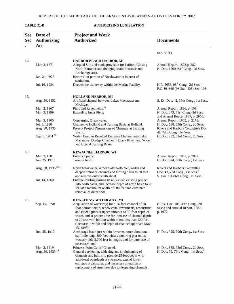
REPORT OF THE SECRETARY OF THE ARMY ON CIVIL WORKS ACTIVITIES FOR FY 2007 TABLE 21-B AUTHORIZING LEGISLATION
21-44
See Sec.
Date of Authorizing Act
Project and Work Authorized
Documents
Sec. 601c).
14.
Mar. 3, 1871 Jan. 21, 1927 Jul. 16, 1984
HARBOR BEACH HARBOR, MI Adopted Site and made provision for harbor. Closing
North Entrance and dredging Main Entrance and Anchorage area.
Removal of portion of Breakwater in interest of sanitation.
Deepen the waterway within the Marina Facility.
Annual Report, 1873,p. 282 H. Doc. 1700, 64th Cong., 2d Sess. H.R. 5653, 98th Cong., 2d Sess,; P.O. 98-360 (98 Stat. 405) Sec. 105.
15. Aug. 30, 1852 Mar. 2, 1867 Mar. 3, 1899 Mar. 3, 1905 Jul. 3, 1930 Aug. 30, 1935 Sep. 3, 1954 22
HOLLAND HARBOR, MI Artificial channel between Lakes Macatawa and
Michigan.12 Piers and Revetments.12 Extending Inner Piers. Converging Breakwater. Channel to Holland and Turning Basin at Holland. Present Project Dimensions of Channels at Turning
Basin. Widen Bend in Revetted Entrance Channel into Lake
Macatawa, Dredge Channel in Black River, and Widen and Extend Turning Basin.
S. Ex. Doc. 42, 35th Cong., 1st Sess. Annual Report, 1866, p. 106. H. Doc. 272, 51st Cong., 2d Sess.; and Annual Report 1887, p. 2950. Annual Report, 1905, p. 2176; H. Doc. 588, 69th Cong., 2d Sess. Rivers and Harbors Committee Doc. 48, 74th Cong., 1st Sess. H. Doc. 282, 83rd Cong., 2d Sess.
16.
Mar. 3, 1881 Jun. 25, 1910 Aug. 30, 1935 2,14 Jul. 14, 1960
KEWAUNEE HARBOR, WI Entrance piers. Turning basin. North breakwater, remove old north pier, widen and
deepen entrance channel and turning basin to 20 feet and remove outer south shoal.
Enlarge existing turning basin, extend existing project into north basin, and increase depth of north basin to 20 feet at a maximum width of 500 feet and eliminate removal of outer shoal.
Annual Report, 1881, p. 2082. H. Doc. 324, 60th Cong., 1st Sess. Rivers and Harbors Committee Doc. 43, 72d Cong., 1st Sess.1 S. Doc. 19, 86th Cong., 1st Sess.1
17.
Sep. 19, 1890 Jun. 25, 1910 Mar. 2, 1919 Aug. 30, 1935 15
KEWEENAW WATERWAY, MI Acquisition of waterway; for a 16-foot channel of 70-
foot bottom width, renew canal revetments, reconstruct and extend piers at upper entrance to 30-foot depth of water, and at proper time for increase of channel depth to 20 feet with bottom width of not less than 120 feet (increase in width and depth of channel approved May 15, 1898).
Anchorage basin just within lower entrance about one-half mile long, 800 feet wide; a mooring pier on its westerly side 2,000 feet in length, and for purchase of necessary land.
Princess Point Cutoff Channel. General deepening, widening and straightening of
channels and basins to provide 25-foot depth with additional overdepth at entrances, extend lower entrance breakwater, and necessary alteration or replacement of structures due to deepening channels.
H. Ex. Doc. 105, 49th Cong., 2d Sess.; and Annual Report, 1887, p. 1977. H. Doc. 325, 60th Cong., 1st Sess. H. Doc. 835, 63rd Cong., 2d Sess. H. Doc. 55, 73rd Cong., 1st Sess.1

DETROIT, MI, DISTRICT
AUTHORIZING LEGISLATION
21-45
See Sec.
Date of Authorizing Act
Project and Work Authorized
Documents
Nov. 17, 1986
Deauthorization of the uncompleted portion of the project authorized by the 1935 Rivers and Harbors Act.
H.R. 6 (formerly S. 1567), 99th Cong., 2d Sess. (WRDA of 1986).
18. Aug. 5, 1886 Jul. 13, 1892 Jun. 13, 1902 Mar. 2, 1919 Jul. 3, 1930 Aug. 30, 1933 3 Mar. 21, 1956
LAKE ST. CLAIR, MI, CHANNELS Two Dikes. Deepening Canal and dredging Channel at Grosse Pointe. Second Canal for downbound vessels. 21-foot depth in Grosse Pointe Channel for about 5.25
miles. 25-foot depth through Canals and Channel through Lake
St. Clair. Removal of Center Dike and widening Channel to 700
feet. Deepening Channel to 27.5 feet and abandonment of
Channel above mouth of Southeast bend cutoff Channel.
Annual Report, 1885, p. 2150. H. Doc. 297, 51st Cong., 2d Sess. H. Doc. 234, 56th Cong., 2d Sess. H. Doc. 188, 65th Cong., 1st Sess. H. Doc. 253, 70th Cong., 1st Sess. Rivers and Harbors Committee Doc. 3, 72d Cong., 1st Sess. S. Doc. 71, 84th Cong., 1st Sess.1
19. Oct. 27, 1965
LEXINGTON HARBOR, MI Approach Channel and Maneuver Area Protected by
Breakwaters.1
H. Doc. 301, 88th Cong., 2d Sess.1
20. Mar. 2, 1945
LITTLE LAKE HARBOR, MI 12-foot deep Channel from Lake Superior into Little
Lake Breakwaters and Revetments.
H. Doc. 446, 78th Cong., 2d Sess.1
21. Mar. 2, 1867 Mar. 3, 1899 Mar. 2, 1907 Dec. 31, 1970
LUDINGTON HARBOR, MI Entrance Piers. Pier Extension, Reconstruction and repairs to existing
structures and present project dimensions of Channel. Breakwaters, Shore Connections, and Removal of outer
ends of the two inner piers. Deepen Channels and widen opening between
breakwaters.
Annual Report, 1867, p. 114.16 H. Doc. 273, 54th Cong., 2d Sess.; and Annual Report, 1897, p. 2951. H. Doc. 62, 59th Cong., 1st Sess.; and Rivers and Harbors Committee Doc. 3, 59th Cong., 2d Sess.16 H. Doc. 342, 91st Cong., 2d Sess.1
22. Mar. 2, 1867 Sep. 19, 1890 Jul. 25, 1912 Jul. 3, 1920 Mar. 2, 1945 Jul. 14, 1960
MANISTEE HARBOR, MI Entrance Piers. Extending Channel 8,000 feet to connect with Manistee
Lake, and further Pier extension. Depth of 20 feet in Outer Harbor 570 feet wide to Outer
end of South Pier 18 feet deep in river, South Breakwater with shore connection, and extend North Pier if required.
23-foot depths in entrance channel and 21-foot depths in River Channel.
Remove old South Revetment, Construct new South Pier and Revetment, and widen river entrance Channel.
Present project dimensions of Channel through Outer Basin and River, and Federal participation in cost of replacing Maple Street Bridge.
Annual Report, 1867, p. 115. Annual Report, 1891, P. 2678. H. Doc. 599, 62d Cong., 2d Sess. S. Doc. 131, 71st Cong., 2d Sess. H. Doc. 380, 77th Cong., 1st Sess. H. Doc. 358, 86th Cong., 2d Sess.
23. Mar. 2, 1907 Aug. 30, 1935 17
MANITOWOC HARBOR, WI Breakwaters. Present project dimensions of channel through outer
basin, removal of old north stub pier, and approach
H. Doc. 62, 59th Cong., 1st Sess., as modified by Rivers and Harbors Comm. Doc. 3, 59th Cong., 2d Sess. Rivers and Harbors Committee Doc. 39, 73rd Cong., 2d Sess.

REPORT OF THE SECRETARY OF THE ARMY ON CIVIL WORKS ACTIVITIES FOR FY 2007 TABLE 21-B AUTHORIZING LEGISLATION
21-46
See Sec.
Date of Authorizing Act
Project and Work Authorized
Documents
Aug. 26, 1937 Oct. 23, 1962 29 Dec. 31, 1968 (Sec. 107 of 1960 R & H) Jun. 26, 1979
channel to a proposed city terminal south of shore end of south breakwater.
Channel in river. Deepen Lake approach to 25 feet by 800 feet wide,
deepen outer harbor to 25 feet, river channel to 23 feet to 8th Street, and Upper River Channel to 22 feet to Soo Line R.R.
Dredge River Channel to 12 feet from Soo Line R.R. 720 feet upstream.
Construct 765-foot long stone Breakwater, and
rubblemound bulkhead; construct 360-foot long entrance Breakwater; dredge 16,500 cubic yards for entrance channel.
Rivers and Harbors Committee Doc. 80, 74th Cong., 2d Sess. H. Doc. 479, 87th Cong., 2d Sess. Jun. 1967 Detailed Project Report Apr. 1982 Supplement.1 Sec. 107, 1960 Rivers and Harbors Act.
24. Aug. 30, 1852 Mar. 3, 1883 Mar. 2, 1907 Sep. 22, 1922 Aug. 30, 1935 22 Mar. 2, 1945 18 Jul. 14, 1960 Oct. 23, 1962
MILWAUKEE HARBOR, WI North Pier.12 Inner 7,600 feet of breakwater.12 South pier. Extending north breakwater 1,000 feet. Extend north breakwater; a south breakwater; present
project dimensions of inner entrance channel. Dredging a portion of outer harbor to 21-foot depth. Dredging river channels to 21-foot depth. Deepen South Menominee and Burnham Canals to 21
feet. Deepen an approach channel to 30 feet by 800 feet wide
and 300 feet wide through breakwater; deepen entrance channel 28 feet through piers, outer harbor to 28 feet south of entrance channel, and a channel to 27 feet in Milwaukee River to Buffalo Street, and in Kinnickinnic River to Chicago & North Western R.R. bridges.
S. Doc. 175, 25th Cong., 2d Sess. Annual Report, 1881, p. 2122. Annual Report, 1906, p. 1752 (No prior survey or estimate affecting breakwater extensions). H. Doc. 804, 66th Cong., 2d Sess. H. Doc. 289, 72d Cong., 1st Sess. S. Doc. 29, 76th Cong., 1st Sess. H. Doc. 285, 86th Cong., 2d Sess. H. Doc. 134, 87th Cong., 1st Sess.1
25. Feb. 24, 1835 19 Jul. 3, 1930 Jul. 14, 1932 21 Nov. 17, 1986
MONROE HARBOR, MI 9-foot channel, protecting Revetments and Piers. 21-foot channel, dikes and turning basin.20 Modified Conditions of Local Cooperation imposed by
Act of Jul. 3, 1930. Deepen portion of existing navigation channel to 27 feet;
deepen lake channel to 28 feet; widen the channel from 200 to 500 feet; dredge a new turning basin 24 feet deep, 1,600 feet wide at river's mouth; and construct a 190 acre CDF in Plum Creek Bay to enable creation of a 700 acre marsh behind the CDF.
Annual Report, 1872, p. 237. Rivers and Harbors Committee Doc. 22, 71st Cong., 1st Sess. Rivers and Harbors Committee Doc. 12, 72d Cong., 1st Sess.; 45, 75th Cong., 1st Sess.1 H. R. 6 (formerly S. 1567), 99th Cong., 2d Sess. (WRDA of 1986).
26.
Jun. 13, 1902 Mar. 3, 1925 Aug. 30, 1935 Oct. 23, 1962
MUSKEGON HARBOR, MI Piers and Revetments. Breakwaters. Repairing Revetments around Car Ferry Slip. Channel deepening and present project dimensions of
channel. Piers and Revetments.
H. Doc. 104, 56th Cong., 2d Sess. H. Doc. 494, 67th Cong., 4th Sess. Rivers and Harbors Committee Doc. 64, 75th Cong., 1st Sess.1 H. Doc. 474, 87th Cong., 2d Sess.1

DETROIT, MI, DISTRICT
AUTHORIZING LEGISLATION
21-47
See Sec.
Date of Authorizing Act
Project and Work Authorized
Documents
27.
Oct. 23, 1962
NEW BUFFALO HARBOR, MI Entrance channel 10 feet deep by 80 to 180 feet wide and
850 feet long to mouth of Galien River, new north and south breakwaters 1,305 and 740 feet, respectively
Deepening inner channel to Galien River to 8 feet and 80 feet wide and 1, 250 feet long.
H. Doc. 474, 87th Cong., 2d Sess.
28. Jun. 25, 1910 Aug. 26, 1937 Oct. 23, 1962 29 Nov. 17, 1986 Jan. 3, 1996
ONTONAGON HARBOR, MI Channel 17 feet deep and 150 feet wide through bar and
15 feet deep and 100 feet wide between piers, and pier maintenance.
Modified project widths and provide inner basin. Enlarging and deepening the existing harbor basin. Deauthorization of the turning basin feature of the project
authorized by the 1962 Rivers and Harbors Act. Reauthorization of the turning basin feature which was
deauthorized (Sec. 1002) in WRDA 86.
H. Doc. 602, 61st Cong., 2d Sess. S. Committee print, 74th Cong., 2d Sess. H. Doc. 287, 87th Cong., 2d Sess. H. R. 6 (formerly S. 1567), 99th Cong., 2d Sess. (WRDA of 1986). Sec. 363 (e) of WRDA 1996
29.
Aug. 18, 1894 Jun. 13, 1902
PETOSKEY HARBOR, MI Breakwaters according to larger of two projects. Removal of north breakwater and extension of west
breakwater if cost did not exceed $170,000.
Annual Report 1890, p. 2673 Annual Report 1895, p. 2819 Annual Report 1896, p. 2722
30. Aug. 8, 1917 Aug.30, 19352,24,25 Jul. 3, 1958 2 Oct. 23, 1962 2
ROUGE RIVER, MI 21-foot channel via the Shortcut Canal 25-foot channel at mouth of Old Channel, 1,425 feet long
and adjacent to latter; 21-foot channel extending from junction of Old Channel and Shortcut Canal into Old Channel to Detroit, Toledo & Ironton R.R. Bridge.
Old Channel; 100 feet wide from Peerless Cement Corp. to Junction with Shortcut Canal widened to 150 feet at 2 bends.
25-foot channel over modified limits from Detroit River to Jefferson Avenue (via Shortcut Canal).
H. Doc. 1063, 64th Cong., 2d Sess.23 H. Doc. 125, 85th Cong., 1st. Sess. H. Doc. 509, 87th Cong., 2d Sess.1
31. Jun. 25, 1910 Jul. 3, 1930 Aug. 26, 1937 Jun. 20, 1938 Sep. 3, 1954 Oct. 23, 1962
SAGINAW RIVER, MI Channel 200 feet wide, with depth of 18.5 feet in Bay and
16.5 feet in River. Project Depth of 18.5 feet extended up River to Saginaw. Turning Basin. Present project channel dimensions from Bay to Sixth
Street Bridge in Saginaw. New Channel in Bay, 350 feet wide and 24 feet deep
from 24-foot contour to River Mouth, Project Depth of 24 feet in River Channel up to Detroit & Mackinac Railway Bridge, Project Depth of 22 feet in River Channel up to Sixth Street Bridge, Turning Basins at Essexville and Carrollton, and elimination of present Channel in Bay.
Deepen Bay Channel, Deepen River Channel to Detroit & Mackinac Bridge, Extend 22-foot project above Sixth Street Bridge, Deepen Essexville Turning Basin, and
H. Doc. 740, 61st Cong., 2d Sess. Rivers and Harbors Committee Doc. 30, 71st Cong., 2d Sess. Rivers and Harbors Committee Doc. 21, 75th Cong., 1st Sess. H. Doc. 576, 75th Cong., 3rd Sess. H. Doc. 500, 83rd Cong., 2d Sess. H. Doc. 554, 87th Cong., 2d Sess.

REPORT OF THE SECRETARY OF THE ARMY ON CIVIL WORKS ACTIVITIES FOR FY 2007 TABLE 21-B AUTHORIZING LEGISLATION
21-48
See Sec.
Date of Authorizing Act
Project and Work Authorized
Documents
Oct. 27, 1965
Construct 2 new Turning Basins.3 Deepen River Channel to 25 feet, from Detroit &
Mackinac Bridge to New York Central Railroad Bridge.
H. Doc. 240, 89th Cong., 1st Sess.1
32.
Jul. 13, 1892 Jul. 8, 1930 Mar. 2, 1945 Jul. 24, 1946 22 Mar. 21, 1956 22 Nov. 17, 1986
ST. CLAIR RIVER, MI 20-foot Channel in the River. Deepen Channel to 25 and 26 feet, and Compensating
Works. Widening Channel at Southeast Bend to 700 feet. Widen and deepen Southeast Bend and improve Outlet of
North Channel, St. Clair River. Deepen and further improve Channels in St. Clair River
between limits of 27.1 to 30 feet to provide safe navigation by vessels with drafts of 25.5 feet. A cutoff Channel in Canada at Southeast Bend and abandon old Southeast Bend Channels.
Deauthorization of the work authorized by the Rivers and Harbors Act of Jul. 24, 1946.
H. Doc. 207, 51st Cong., 2d Sess. H. Doc. 253, 70th Cong., 1st Sess. H. Doc. 309, 77th Cong., 1st Sess. H. Doc. 335, 80th Cong., 1st Sess. S. Doc. 71, 84th Cong., 1st Sess. H. R. 6 (formerly S. 1567), 99th Cong., 2d Sess. (WRDA of 1986).
33.
Mar. 3, 1875 Jun. 14, 1880 Mar. 3, 1899 Aug. 30, 1935 Jun. 2, 1937 Mar. 2, 1945 Jul. 3, 1958
ST. JOSEPH HARBOR, MI Interior Revetments.26 Benton Harbor Canal.26 Present project dimensions of piers and a turning basin. Present project dimensions of the channel and turning
basin near mouth of Paw Paw River. Abandon easterly 1,000 feet of canal above west line of
9th street. Turning basin above mouth of Morrison Channel and
eliminate turning basin near mouth of Paw Paw River. Maintenance of turning basin near mouth of Paw Paw
River
H. Ex. Doc. 160, 43rd Cong., 2d Sess., and Annual Report, 1875, pt. 1, p. 162. Annual Report, 1880, pp. 2030, 2031, 2049, and 2055. H. Doc. 307, 55th Cong., 2d Sess., and Annual Report, 1898, p. 2496. Rivers and Harbors Committee Doc. 52, 74th Cong., 1st Sess. H. Doc. 129, 76th Cong., 1st Sess. S. Doc. 95, 84th Cong., 2d Sess.1
34. Mar. 2, 1907 Jan. 21, 1927 Aug. 30, 1935 Sep. 3, 1954
SHEBOYGAN HARBOR, WI North breakwater. Preserving south pier as part of project, providing turning
basin, and elimination of proposed south breakwaters. Present project dimensions of channel. Widen and deepen outer harbor entrance channel to 450
feet, widen and deepen river channel from present project limit to north side of Jefferson Avenue.
H. Doc. 62, 59th Cong., 1st Sess. H. Doc. 475, 68th Cong., 2d Sess. Rivers and Harbors Committee Doc. 47, 74th Cong., 1st Sess. H. Doc. 554, 82d Cong., 2d Sess.1
35. Mar. 3, 1873 Jul. 13, 1892 Jun. 13, 1902 Aug. 30, 1935
STURGEON BAY AND LAKE MICHIGAN SHIP CANAL, WI
Breakwaters.12 Acquisition of the canal. Canal revetments and consolidation of canal and harbor
works. Present project dimensions of channels and elimination of
H. Ex. Doc. 34, 42d Cong., 2d Sess.; Annual Report, 1872, p. 171. H. Ex. Doc. 106, 49th Cong., 2d Sess. H. Doc. 117, 56th Cong., 2d Sess. Rivers and Harbors Committee
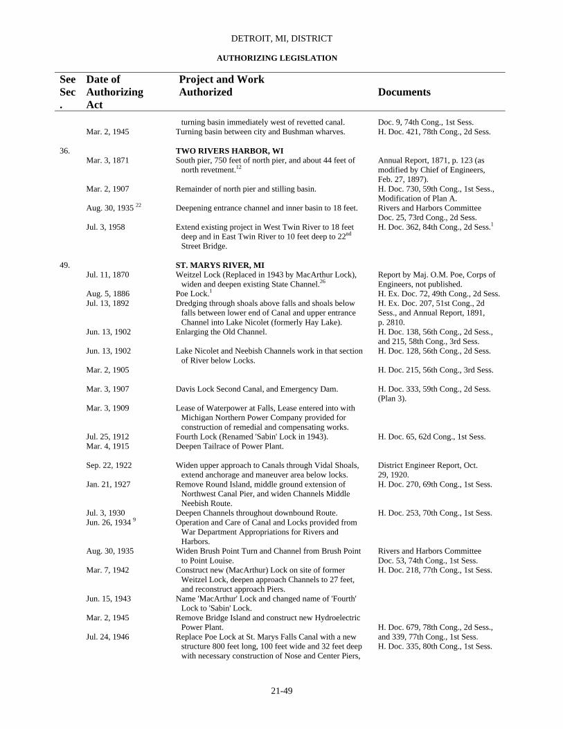
DETROIT, MI, DISTRICT
AUTHORIZING LEGISLATION
21-49
See Sec.
Date of Authorizing Act
Project and Work Authorized
Documents
Mar. 2, 1945
turning basin immediately west of revetted canal. Turning basin between city and Bushman wharves.
Doc. 9, 74th Cong., 1st Sess. H. Doc. 421, 78th Cong., 2d Sess.
36. Mar. 3, 1871 Mar. 2, 1907 Aug. 30, 1935 22 Jul. 3, 1958
TWO RIVERS HARBOR, WI South pier, 750 feet of north pier, and about 44 feet of
north revetment.12 Remainder of north pier and stilling basin. Deepening entrance channel and inner basin to 18 feet. Extend existing project in West Twin River to 18 feet
deep and in East Twin River to 10 feet deep to 22nd
Street Bridge.
Annual Report, 1871, p. 123 (as modified by Chief of Engineers, Feb. 27, 1897). H. Doc. 730, 59th Cong., 1st Sess., Modification of Plan A. Rivers and Harbors Committee Doc. 25, 73rd Cong., 2d Sess. H. Doc. 362, 84th Cong., 2d Sess.1
49.
Jul. 11, 1870 Aug. 5, 1886 Jul. 13, 1892 Jun. 13, 1902 Jun. 13, 1902 Mar. 2, 1905 Mar. 3, 1907 Mar. 3, 1909 Jul. 25, 1912 Mar. 4, 1915 Sep. 22, 1922 Jan. 21, 1927 Jul. 3, 1930 Jun. 26, 1934 9 Aug. 30, 1935 Mar. 7, 1942 Jun. 15, 1943 Mar. 2, 1945 Jul. 24, 1946
ST. MARYS RIVER, MI Weitzel Lock (Replaced in 1943 by MacArthur Lock),
widen and deepen existing State Channel.26 Poe Lock.1 Dredging through shoals above falls and shoals below
falls between lower end of Canal and upper entrance Channel into Lake Nicolet (formerly Hay Lake).
Enlarging the Old Channel. Lake Nicolet and Neebish Channels work in that section
of River below Locks. Davis Lock Second Canal, and Emergency Dam. Lease of Waterpower at Falls, Lease entered into with
Michigan Northern Power Company provided for construction of remedial and compensating works.
Fourth Lock (Renamed 'Sabin' Lock in 1943). Deepen Tailrace of Power Plant. Widen upper approach to Canals through Vidal Shoals,
extend anchorage and maneuver area below locks. Remove Round Island, middle ground extension of
Northwest Canal Pier, and widen Channels Middle Neebish Route.
Deepen Channels throughout downbound Route. Operation and Care of Canal and Locks provided from
War Department Appropriations for Rivers and Harbors.
Widen Brush Point Turn and Channel from Brush Point to Point Louise.
Construct new (MacArthur) Lock on site of former Weitzel Lock, deepen approach Channels to 27 feet, and reconstruct approach Piers.
Name 'MacArthur' Lock and changed name of 'Fourth' Lock to 'Sabin' Lock.
Remove Bridge Island and construct new Hydroelectric Power Plant.
Replace Poe Lock at St. Marys Falls Canal with a new structure 800 feet long, 100 feet wide and 32 feet deep with necessary construction of Nose and Center Piers,
Report by Maj. O.M. Poe, Corps of Engineers, not published. H. Ex. Doc. 72, 49th Cong., 2d Sess. H. Ex. Doc. 207, 51st Cong., 2d Sess., and Annual Report, 1891, p. 2810. H. Doc. 138, 56th Cong., 2d Sess., and 215, 58th Cong., 3rd Sess. H. Doc. 128, 56th Cong., 2d Sess. H. Doc. 215, 56th Cong., 3rd Sess. H. Doc. 333, 59th Cong., 2d Sess. (Plan 3). H. Doc. 65, 62d Cong., 1st Sess. District Engineer Report, Oct. 29, 1920. H. Doc. 270, 69th Cong., 1st Sess. H. Doc. 253, 70th Cong., 1st Sess. Rivers and Harbors Committee Doc. 53, 74th Cong., 1st Sess. H. Doc. 218, 77th Cong., 1st Sess. H. Doc. 679, 78th Cong., 2d Sess., and 339, 77th Cong., 1st Sess. H. Doc. 335, 80th Cong., 1st Sess.

REPORT OF THE SECRETARY OF THE ARMY ON CIVIL WORKS ACTIVITIES FOR FY 2007 TABLE 21-B AUTHORIZING LEGISLATION
21-50
See Sec.
Date of Authorizing Act
Project and Work Authorized
Documents
Mar. 21, 1956 Jul. 9, 1956 Nov. 17, 1986
and widen and deepen Channel across Point Iroquois Shoals and in Lake Nicolet to provide wider anchorage and maneuver areas in St. Marys River.
Deepen to provide a Project Safe Draft of 25.5 feet over full width to downbound and 2-way Channels (including anchorage areas) and over Westerly 300-foot width of upbound Middle Neebish Channel, when levels of Lakes Superior and Huron are at their respective LWD's.
Repeal Authorization of Bridge as a part of Project, authorize alteration with cost to be apportioned by Sec. 6, Truman Hobbs Act, Jun. 21, 1940.
Construct a second large lock 1,294 feet in length, 115 feet in width, and 32 feet in depth, adjacent to the existing lock. The replacement lock is to be located in the North Canal of the St. Marys Falls Canal at Sault Ste. Marie, MI, on the site of the existing Davis and Sabin Locks.
S. Doc. 71, 84th Cong., 1st Sess.1 None. H. R. 6 (formerly S. 1567), 99th Cong., 2d Sess. (WRDA of 1986).
1Contains latest published map. 2Including Emergency Relief Administration Work authorized May 28, 1935. 3Included in Public Works Administration Program September 6, 1933. 4This modification deauthorized August 5, 1977, under Section 12, Public Law 93-251. 5Administrative Act, Section 4. 6Public Law 568, 82d Congress. 7Public Law 388, 87th Congress. 8This portion inactive. 9Permanent Appropriations Repeal Act. 10Transfer completed June 1962. 11Amended 1868, 1879, 1892. 12Completed under previous project. 13Included in Public Works Administration Program January 3, 1934. 14Inactive portion; removal of 200 linear feet of north pier, widening inner 200 feet of channel through outer basin, and closing gap in north shore connection of breakwater. 15Latest published map is in Annual Report, 1914, p. 2974. 16Latest published map in Annual Report, 1914, p. 2914. 17Superseded by Act of October 23, 1962. 18Uncompleted portion was deauthorized in 1977 (dredging Milwaukee River from Buffalo Street Bridge to North Humboldt Avenue Bridge). 19Modified by Act of June 10, 1872. 20Riprapping of protecting dikes portion of project is inactive. 21War Department Appropriations Act. 22Uncompleted portion deauthorized December 31, 1989, under Section 1001, P.L. 99-662. 23Contains latest published maps. See also map with Rivers and Harbors Committee Doc. 19, 72d Cong., 1st Sess. 24Except for dredging 25-foot channel to 1,150 feet upstream of mouth of old channel, work authorized in this Act is considered inactive. 25This modification deauthorized August 5, 1977, under Section 12, Public Law 93-251. 26Completed under previous projects. Public Law 130, 75th Cong., 1st Sess. 27Work recommended in H. Doc. 588, 64th Cong., 1st Sess. 28Deauthorized in 1977. 29This modification deauthorized December 31, 1989, under Section 1001, P.L. 99-662. 30Latest published map is in H. Doc. 588, 64th Cong., 1st Sess. 31Latest published map is in H. Doc. 2053, 64th Cong., 2d Sess.
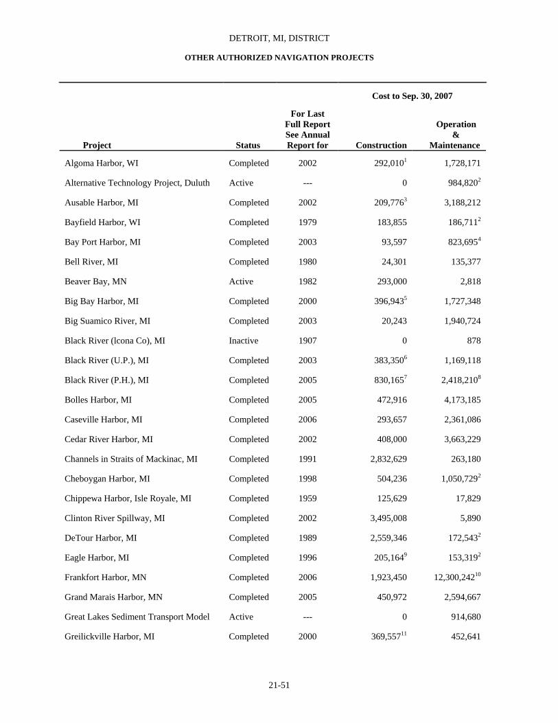
DETROIT, MI, DISTRICT
OTHER AUTHORIZED NAVIGATION PROJECTS
21-51
Cost to Sep. 30, 2007
Project
Status
For Last
Full Report See Annual Report for
Construction
Operation & Maintenance
Algoma Harbor, WI Completed 2002 292,0101 1,728,171
Alternative Technology Project, Duluth Active --- 0 984,8202
Ausable Harbor, MI Completed 2002 209,7763 3,188,212
Bayfield Harbor, WI Completed 1979 183,855 186,7112
Bay Port Harbor, MI Completed 2003 93,597 823,6954
Bell River, MI Completed 1980 24,301 135,377
Beaver Bay, MN Active 1982 293,000 2,818
Big Bay Harbor, MI Completed 2000 396,9435 1,727,348
Big Suamico River, MI Completed 2003 20,243 1,940,724
Black River (lcona Co), MI Inactive 1907 0 878
Black River (U.P.), MI Completed 2003 383,3506 1,169,118
Black River (P.H.), MI Completed 2005 830,1657 2,418,2108
Bolles Harbor, MI Completed 2005 472,916 4,173,185
Caseville Harbor, MI Completed 2006 293,657 2,361,086
Cedar River Harbor, MI Completed 2002 408,000 3,663,229
Channels in Straits of Mackinac, MI Completed 1991 2,832,629 263,180
Cheboygan Harbor, MI Completed 1998 504,236 1,050,7292
Chippewa Harbor, Isle Royale, MI Completed 1959 125,629 17,829
Clinton River Spillway, MI Completed 2002 3,495,008 5,890
DeTour Harbor, MI Completed 1989 2,559,346 172,5432
Eagle Harbor, MI Completed 1996 205,1649 153,3192
Frankfort Harbor, MN Completed 2006 1,923,450 12,300,24210
Grand Marais Harbor, MN Completed 2005 450,972 2,594,667
Great Lakes Sediment Transport Model Active --- 0 914,680
Greilickville Harbor, MI Completed 2000 369,55711 452,641
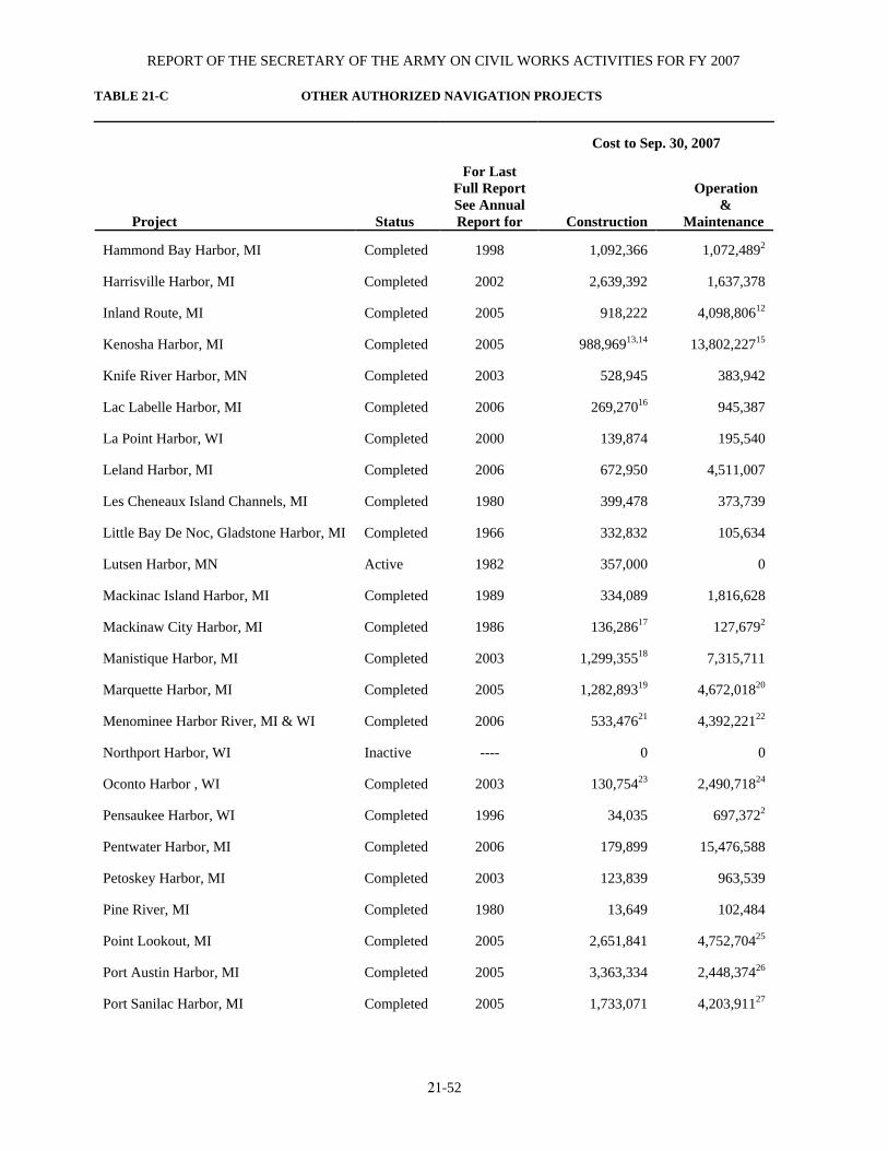
REPORT OF THE SECRETARY OF THE ARMY ON CIVIL WORKS ACTIVITIES FOR FY 2007 TABLE 21-C OTHER AUTHORIZED NAVIGATION PROJECTS
21-52
Cost to Sep. 30, 2007
Project
Status
For Last
Full Report See Annual Report for
Construction
Operation & Maintenance
Hammond Bay Harbor, MI Completed 1998 1,092,366 1,072,4892
Harrisville Harbor, MI Completed 2002 2,639,392 1,637,378
Inland Route, MI Completed 2005 918,222 4,098,80612
Kenosha Harbor, MI Completed 2005 988,96913,14 13,802,22715
Knife River Harbor, MN Completed 2003 528,945 383,942
Lac Labelle Harbor, MI Completed 2006 269,27016 945,387
La Point Harbor, WI Completed 2000 139,874 195,540
Leland Harbor, MI Completed 2006 672,950 4,511,007
Les Cheneaux Island Channels, MI Completed 1980 399,478 373,739
Little Bay De Noc, Gladstone Harbor, MI Completed 1966 332,832 105,634
Lutsen Harbor, MN Active 1982 357,000 0
Mackinac Island Harbor, MI Completed 1989 334,089 1,816,628
Mackinaw City Harbor, MI Completed 1986 136,28617 127,6792
Manistique Harbor, MI Completed 2003 1,299,35518 7,315,711
Marquette Harbor, MI Completed 2005 1,282,89319 4,672,01820
Menominee Harbor River, MI & WI Completed 2006 533,47621 4,392,22122
Northport Harbor, WI Inactive ---- 0 0
Oconto Harbor , WI Completed 2003 130,75423 2,490,71824
Pensaukee Harbor, WI Completed 1996 34,035 697,3722
Pentwater Harbor, MI Completed 2006 179,899 15,476,588
Petoskey Harbor, MI Completed 2003 123,839 963,539
Pine River, MI Completed 1980 13,649 102,484
Point Lookout, MI Completed 2005 2,651,841 4,752,70425
Port Austin Harbor, MI Completed 2005 3,363,334 2,448,37426
Port Sanilac Harbor, MI Completed 2005 1,733,071 4,203,91127
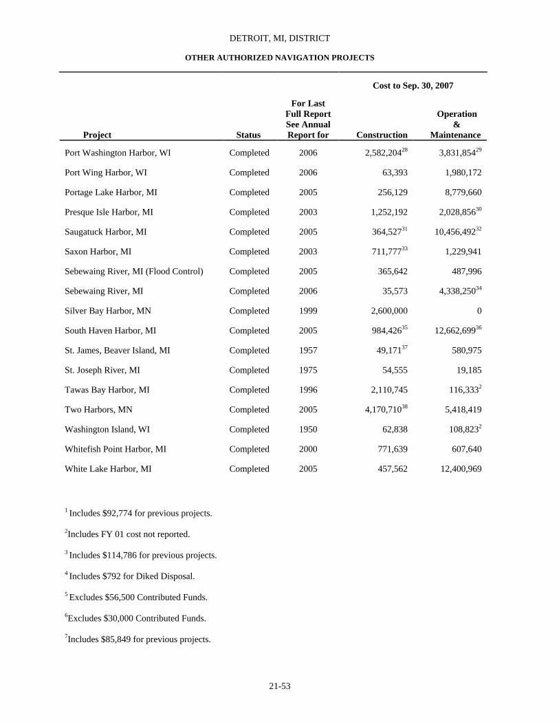
DETROIT, MI, DISTRICT
OTHER AUTHORIZED NAVIGATION PROJECTS
21-53
Cost to Sep. 30, 2007
Project
Status
For Last
Full Report See Annual Report for
Construction
Operation & Maintenance
Port Washington Harbor, WI Completed 2006 2,582,20428 3,831,85429
Port Wing Harbor, WI Completed 2006 63,393 1,980,172
Portage Lake Harbor, MI Completed 2005 256,129 8,779,660
Presque Isle Harbor, MI Completed 2003 1,252,192 2,028,85630
Saugatuck Harbor, MI Completed 2005 364,52731 10,456,49232
Saxon Harbor, MI Completed 2003 711,77733 1,229,941
Sebewaing River, MI (Flood Control) Completed 2005 365,642 487,996
Sebewaing River, MI Completed 2006 35,573 4,338,25034
Silver Bay Harbor, MN Completed 1999 2,600,000 0
South Haven Harbor, MI Completed 2005 984,42635 12,662,69936
St. James, Beaver Island, MI Completed 1957 49,17137 580,975
St. Joseph River, MI Completed 1975 54,555 19,185
Tawas Bay Harbor, MI Completed 1996 2,110,745 116,3332
Two Harbors, MN Completed 2005 4,170,71038 5,418,419
Washington Island, WI Completed 1950 62,838 108,8232
Whitefish Point Harbor, MI Completed 2000 771,639 607,640
White Lake Harbor, MI Completed 2005 457,562 12,400,969
1 Includes $92,774 for previous projects. 2Includes FY 01 cost not reported. 3 Includes $114,786 for previous projects. 4 Includes $792 for Diked Disposal. 5 Excludes $56,500 Contributed Funds. 6Excludes $30,000 Contributed Funds. 7Includes $85,849 for previous projects.
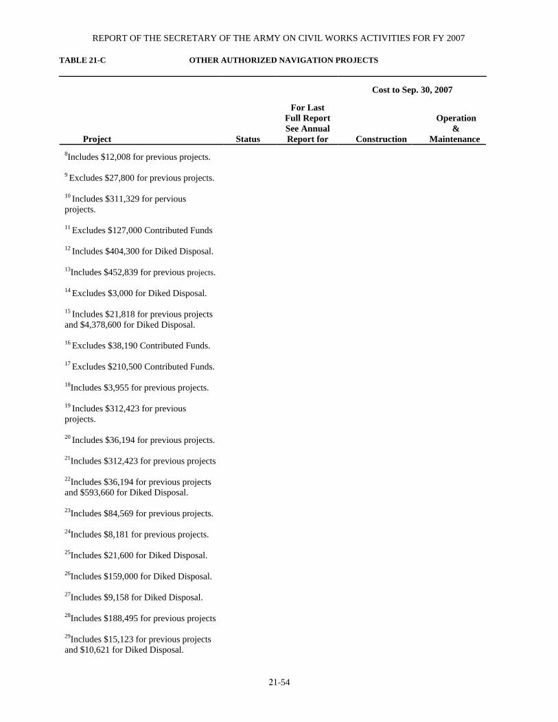
REPORT OF THE SECRETARY OF THE ARMY ON CIVIL WORKS ACTIVITIES FOR FY 2007 TABLE 21-C OTHER AUTHORIZED NAVIGATION PROJECTS
21-54
Cost to Sep. 30, 2007
Project
Status
For Last
Full Report See Annual Report for
Construction
Operation & Maintenance
8Includes $12,008 for previous projects. 9 Excludes $27,800 for previous projects. 10 Includes $311,329 for pervious projects. 11 Excludes $127,000 Contributed Funds 12 Includes $404,300 for Diked Disposal. 13Includes $452,839 for previous projects. 14 Excludes $3,000 for Diked Disposal. 15 Includes $21,818 for previous projects and $4,378,600 for Diked Disposal. 16 Excludes $38,190 Contributed Funds. 17 Excludes $210,500 Contributed Funds. 18Includes $3,955 for previous projects. 19 Includes $312,423 for previous projects. 20 Includes $36,194 for previous projects. 21Includes $312,423 for previous projects
22Includes $36,194 for previous projects and $593,660 for Diked Disposal. 23Includes $84,569 for previous projects. 24Includes $8,181 for previous projects. 25Includes $21,600 for Diked Disposal. 26Includes $159,000 for Diked Disposal. 27Includes $9,158 for Diked Disposal. 28Includes $188,495 for previous projects 29Includes $15,123 for previous projects and $10,621 for Diked Disposal.

DETROIT, MI, DISTRICT
OTHER AUTHORIZED NAVIGATION PROJECTS
21-55
Cost to Sep. 30, 2007
Project
Status
For Last
Full Report See Annual Report for
Construction
Operation & Maintenance
30ncludes $16,500 for Diked Disposal. 31Includes $90,232 for previous projects. 32Includes $117,554 for previous projects 33Excludes $50,193 Contributed Funds. 34Includes $15,000 for previous projects 35Includes $187,233 for previous projects 36 Includes $131,239 for previous projects and $42,381 for Diked Disposal. 37Excludes $7,500 Contributed Funds. 38 Includes $48,404 National Recovery Act for new work funds.

REPORT OF THE SECRETARY OF THE ARMY ON CIVIL WORKS ACTIVITIES FOR FY 2007
21-56
TABLE 21-E OTHER AUTHORIZED FLOOD CONTROL PROJECTS
Cost to Sep. 30, 2007
Project
Status
For Last
Full ReportSee Annual Report for
Construction
Operation &
Maintenance
Kawkawlin River, MI 1,2 Completed 1999 1,000,000 470,500
Kalamazoo River (Battle Creek) MI 3,4 Deferred 1975 4,471,235 ----
Paw Paw Lake, MI Completed 1989 3,589,000 ----
Saginaw River-1958 Act Flint MI Completed 2003 24,928,359 6,453,831
Upper Peninsula of Michigan, MI5 Active ---- ---- 20,288,263
Upper River Rouge, MI6 Inactive 1968 7,935 ----
River Rouge, MI Completed 1981 31,960,332 ---- 1Excludes $204,559 Contributed Funds. 2Excludes 228,748 Contributed Funds.
3Includes $108,335 Contributed Funds.
4Uncompleted portion deauthorized Dec. 31, 1989, in accordance with Section 1001 of the W.R.D.A. of 1986 (PL 99-662). 5Project authorized in FY02. No costs were expended in FY02. 6Planning indefinitely suspended due to lack of local cooperation.
TABLE 21-F MULTIPLE PURPOSE PROJECTS, INCLUDING POWER ST. MARYS RIVER, MI: EXISTING PROJECT
(SEE SECTION 49 OF TEXT) Lock
Davis
Sabin
MacArthur
New Poe
Miles Above Mouth 47 47 47 47 Clear Width of Chamber Feet 80 80 80 110 Length Between Gate Quoins Feet 1,350 1,350 800 1,200 Lifts Feet 21.7 21.7 21.7 21.7 Depth Over Upper Breast Walls1 Feet 24.3 24.3 31 32 Depth Over Lower Breast Walls1 Feet 23.1 23.1 31 32 Foundation Rock Rock Rock Rock Type of Construction Concrete Concrete Concrete Concrete Estimated Cost $6,200,0002 $3,275,0003 $12,909,440 $39,000,000 Actual Cost $2,200,0005 $1,750,0006 $12,718,8064,7 $34,813,066 Completed (Open to Commerce) Oct. 21, 1914 Sep. 18, 1919 Jul. 11, 1943 Jun. 26, 1969 Emergency Dam for South Canal North Canal Miles Above Mouth 47 47 Estimated Cost -9 $300,000 Type Steel Stoplogs
Recessed Into Lock Masonry
Steel Stoplogs Recessed
Into Lock Masonry
Cost Completed -9 $169,2248 Year Completed 1943 1922 (Modified 1963) 1At low water datum 600.6 above and 578.4 below. 2Includes cost of North Canal. 3Includes cost of canal excavations to provide necessary approaches to lock, canal walls, piers, and emergency dam, $662,919. 4Excludes cost of deepening and enlarging South Canal, $1,653,378. 5Excludes cost of North Canal, $2,572,611.
6Excludes cost of canal excavation to provide necessary approaches to lock, canal walls, piers, and emergency dam, $662,919. 7Excluding cost of lower guard gates which were never installed. 8Including engineering office and inspection. 9Not separate from cost of locks.
Note: Limiting draft to locks is determined by depth over breast walls.

DETROIT, MI, DISTRICT
21-57
TABLE 21-G DEAUTHORIZED PROJECTS
Project
For Last
Full Report See Annual Report For
Date Deauthorized
Federal Funds
Expended
Contributed Funds
Expended
Beaver Bay, MN (Mar. 2, 1945 R&H Act)
1982 Jul 1995 295,818 0
Berrien County, MI (St. Joseph Shore) beach erosion control (1958 Flood Control Act)
1963 Nov 1986 0 0
Black River Harbor, Alcona County, MI (Authorized Dec.17, 1979, under Section 201 of the 1965 Flood Control Act)
1971 Dec 1989 0 0
Black River Harbor, MI (Aug. 30, 1935 R&H Act)
1976 Nov 1977 0 0
Cross Village, MI (October 13, 2001 WRDA 96, Sec 328)
1983 Oct 2001 364,000 0
Detroit River, Trenton Chnl., MI (May 17, 1950 R&H Act)
1976 Aug 1977 0 0
Detroit River, Trenton Chnl., MI (Uncompleted portion) (Aug. 13, 1968 R&H Act)
1976 Dec 1989 159,300,000 0
Duluth-Superior Inner Harbor, MN and WI (Jul. 14, 1960 R&H Act)
1990 Dec 1989 14,562,100 0
Forestville Harbor, MI (1968 R&H Act)
1969 Nov 1986 0 0
Grand Haven Harbor, MI (Mar. 2, 1945 R&H Act)
1976 Nov 1977 0 0
Grand River at Grandville, MI (Oct. 27, 1965 Flood Control Act)
1966 Nov 1977 0 0
Great Lakes Connecting Channels, MI1 (Uncompleted portion) (R&H Acts of 1946 and 1956)
1990 Dec 1989 93,993,349 0
Green Bay Harbor, Brown County, WI (1962 Modification)
1999 April 1999 4,030,000 1,970,000
Harbors of Washington Island, WI (R&H Act of 1937)
1950 Dec 1989 62,838 0
Holland Harbor Entrance Channel, MI (Uncompleted portion) (Sep. 3, 1954 R&H Act)
1962 Dec 1989 0 0
Kalamazoo River, Battle Creek, MI (Uncompleted portion) (1954 Flood Control Act)
1975 Dec 1989 6,656,668 108,332
Kalamazoo River, Kalamazoo, MI (Jul. 3, 1958 Flood Control Act)
1975 Dec 1989 416,822 0

REPORT OF THE SECRETARY OF THE ARMY ON CIVIL WORKS ACTIVITIES FOR FY 2007 TABLE 21-G (Continued) DEAUTHORIZED PROJECTS
21-58
Project
For Last
Full Report See Annual Report For
Date Deauthorized
Federal Funds
Expended
Contributed Funds
Expended
Kenosha Harbor, WI (Uncompleted portion) (Oct. 23, 1962 R&H Act)
1990 Dec 1989 552,000 43,000
Kewaunee River, WI (1960 R&H Act)
1976 Aug 1977 0 0
Lansing (Grand River), MI (Jul. 3, 1958 Flood Control Act)
1971 Jun 1981 7,000 0
Lower Fox River, WI (Uncompleted portion) (Mar. 3, 1925 R&H Act)
1990 Dec 1989 3,753,334 0
Lutsen Harbor, MN (Mar. 2, 1945 R&H Act)
1990 Jul 1995 357,000 0
Manitowoc Harbor, WI (Oct. 23, 1962 R&H Act)
1990 Dec 1989 0 0
Milwaukee Outer Harbor, WI (Uncompleted portion) (R&H Act of 1935)
1990 Dec 1989 6,937,804 478,000
Northport Harbor, WI (Authorized in 1972 under Section 201 of the 1965 Flood Control Act)
- Dec 1989 132,000 0
Ontonagon Harbor, MI (R&H Act of 1962)
1990 Dec 1989 27,482 0
Pentwater Harbor, MI (Jul. 13, 1892 R&H Act)
1976 Nov 1977 0 0
Port Washington Harbor, WI (Portion) (Sec. 501(17) of WRDA 1996)
2003 Jan 1996 0 0
Racine Harbor, WI (Mar. 2, 1907; Aug. 26, 1937; and Mar. 2, 1945 R&H Acts, and Section 107 of the 1960 R&H Act)
1963 May 1986 9,441,554 0
Red Run Drain, Lower Clinton River, MI (1970 Flood Control Act)
1983 Nov 1986 3,823,000 0
Rogers City Harbor, MI (Jun. 25, 1910 R&H Act)
1926 Aug 1977 5,892 0
Rouge River, MI (Oct 23, 1962 R&H Act)
1976 Aug 1977 22,000 0
Rouge River, MI (Jul. 3, 1958 R&H Act)
1976 Aug 1977 12,000 0
Rouge River, MI (Aug. 30, 1935 R&H Act)
1976 Aug 1977 0 0
Saginaw River, MI (Midland on Tittabawassee River)
1983 May 1997 5,125,000 1,611,500

DETROIT, MI, DISTRICT
21-59
Project
For Last
Full Report See Annual Report For
Date Deauthorized
Federal Funds
Expended
Contributed Funds
Expended
St. Clair River Compensating Works, MI (Jul. 3, 1930 R&H Act)
1976 Aug 1977 0 0
South Milwaukee Harbor, WI (1836 Flood Control Act)
1906 Aug 1977 0 0
St. Marys River (MacArthur Lock Guard Gates), MI (Mar. 7, 1942 R&H Act)
1977 Oct 1978 0 0
Two Rivers Harbor, WI (Uncompleted portion) (Aug. 30, 1935 R&H Act)
1990 Dec 1989 147,463 0
1Includes Detroit and St. Clair Rivers.
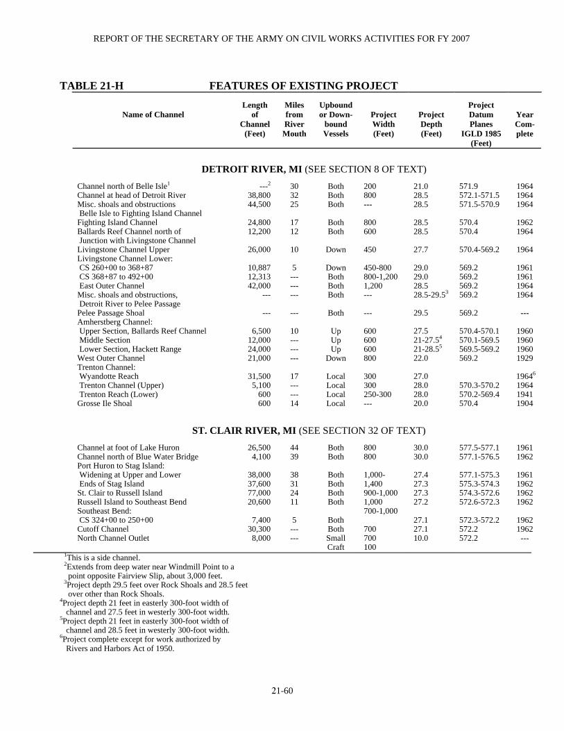
REPORT OF THE SECRETARY OF THE ARMY ON CIVIL WORKS ACTIVITIES FOR FY 2007
21-60
TABLE 21-H FEATURES OF EXISTING PROJECT
Name of Channel
Length
of Channel
(Feet)
Miles from River Mouth
Upbound or Down-
bound Vessels
Project Width (Feet)
Project Depth (Feet)
Project Datum Planes
IGLD 1985 (Feet)
Year Com-plete
DETROIT RIVER, MI (SEE SECTION 8 OF TEXT) Channel north of Belle Isle1 Channel at head of Detroit River Misc. shoals and obstructions Belle Isle to Fighting Island Channel Fighting Island Channel Ballards Reef Channel north of Junction with Livingstone Channel Livingstone Channel Upper Livingstone Channel Lower: CS 260+00 to 368+87 CS 368+87 to 492+00 East Outer Channel Misc. shoals and obstructions, Detroit River to Pelee Passage Pelee Passage Shoal Amherstberg Channel: Upper Section, Ballards Reef Channel Middle Section Lower Section, Hackett Range West Outer Channel Trenton Channel: Wyandotte Reach Trenton Channel (Upper) Trenton Reach (Lower) Grosse Ile Shoal
---2
38,800 44,500
24,800 12,200
26,000
10,887 12,313 42,000
---
---
6,500 12,000 24,000 21,000
31,500 5,100 600 600
30 32 25
17 12
10 5
--- --- ---
---
10 --- --- ---
17 --- --- 14
Both Both Both
Both Both
Down
Down Both Both Both
Both
Up Up Up
Down
Local Local Local Local
200 800 --- 800 600 450 450-800 800-1,200 1,200 --- --- 600 600 600 800 300 300 250-300 ---
21.0 28.5 28.5 28.5 28.5 27.7 29.0 29.0 28.5 28.5-29.53 29.5 27.5 21-27.54 21-28.55 22.0 27.0 28.0 28.0 20.0
571.9 572.1-571.5 571.5-570.9 570.4 570.4 570.4-569.2 569.2 569.2 569.2 569.2 569.2 570.4-570.1 570.1-569.5 569.5-569.2 569.2 570.3-570.2 570.2-569.4 570.4
1964 1964 1964
1962 1964
1964
1961 1961 1964 1964
---
1960 1960 1960 1929
19646 1964 1941 1904
ST. CLAIR RIVER, MI (SEE SECTION 32 OF TEXT)
Channel at foot of Lake Huron Channel north of Blue Water Bridge Port Huron to Stag Island: Widening at Upper and Lower Ends of Stag Island St. Clair to Russell Island Russell Island to Southeast Bend Southeast Bend: CS 324+00 to 250+00 Cutoff Channel North Channel Outlet
26,500 4,100
38,000 37,600 77,000 20,600
7,400
30,300 8,000
44 39
38 31 24 11 5
--- ---
Both Both
Both Both Both Both
Both Both Small Craft
800 800 1,000-1,400 900-1,000 1,000 700-1,000 700 700 100
30.0 30.0 27.4 27.3 27.3 27.2 27.1 27.1 10.0
577.5-577.1 577.1-576.5 577.1-575.3 575.3-574.3 574.3-572.6 572.6-572.3 572.3-572.2 572.2 572.2
1961 1962
1961 1962 1962 1962
1962 1962 ---
1This is a side channel. 2Extends from deep water near Windmill Point to a point opposite Fairview Slip, about 3,000 feet. 3Project depth 29.5 feet over Rock Shoals and 28.5 feet over other than Rock Shoals. 4Project depth 21 feet in easterly 300-foot width of channel and 27.5 feet in westerly 300-foot width. 5Project depth 21 feet in easterly 300-foot width of channel and 28.5 feet in westerly 300-foot width. 6Project complete except for work authorized by Rivers and Harbors Act of 1950.

DETROIT, MI, DISTRICT
21-61
TABLE 21-I FOX RIVER, WI: LOCKS AND DAMS (SEE SECTION 10 OF TEXT)
Depth at Normal Pool
Name of Lock and Dam
Miles from
Green Bay
Nearest Town
Dis-tance
(miles)
Clear Width (feet)
Avail-able
Length (feet)
Lift (feet)
Breast Wall1 (feet)
Lower Miter
Sill (feet)
Character of Foundation
Kind of Dam
Type of Construction
Year Com-plete
Actual Cost
DePere lock2 7.1 DePere --- 36.0 146.0 8.9 10.3 12.0 Rock --- Concrete 1936 $229,308 DePere dam2 7.2 DePere --- --- --- --- --- --- Rock Fixed3,4 Concrete 1929 209,536 Little Kaukauna lock2 13.0 DePere 6 36.0 146.0 7.2 8.0 9.5 Clay --- Concrete 1938 362,427 Little Kaukauna dam2 13.1 DePere 6 --- --- --- --- --- Clay & Gravel Fixed3,4 Piers and concrete 1926 179,398 Rapide Croche lock2 19.2 Wrightstow 2 36.0 146.0 8.3 8.8 9.3 Rock --- Concrete 1934 228,738 Rapide Croche dam2 19.3 Wrightstow 2 --- --- --- --- --- Rock Fixed3,4 Concrete 1930 118,975 Kaukauna fifth lock2 22.8 Kaukauna --- 35.6 144.0 9.1 6.7 9.3 Rock --- Composite 1898 13,3105 Kaukauna fourth lock2 23.1 Kaukauna --- 36.6 144.1 10.2 6.9 6.0 Rock --- Stone masonry 1879 37,536 Kaukauna third lock2 23.3 Kaukauna --- 30.6 144.0 10.2 6.9 6.3 Rock --- Stone masonry 1879 39,948 Kaukauna second lock2 23.4 Kaukauna --- 35.0 144.0 9.6 6.0 6.0 Rock --- Stone masonry 1903 24,313 Kaukauna first lock2 23.6 Kaukauna --- 35.1 144.4 11.0 6.9 6.0 Rock --- Stone masonry 1883 38,704 Kaukauna dam2 24.0 Kaukauna --- --- --- --- --- --- Rock Fixed3,4 Concrete 1931 123,763 Kaukauna guard lock 24.0 Kaukauna --- 40.0 --- --- 9.4 --- Rock --- Stone masonry 1891 12,630 Little Chute combined lock: Lower 24.4 Little Chute 1 35.4 146.5 10.9 6.0 8.6 Rock --- Stone masonry 1879 102,304 Upper 25.4 Little Chute 1 36.3 144.1 10.6 7.6 6.0 Hardpan --- Stone masonry 1879 --- Little Chute second lock2 26.4 Little Chute --- 35.0 144.2 13.8 8.0 6.1 Rock --- Stone masonry 1881 48,555 Luttle Chute first (guard) lock1 26.5 Little Chute --- 35.4 --- --- 6.6 --- Rock --- Stone masonry 1904 7,8175 Little Chute dam2 26.6 Little Chute --- --- --- --- --- --- Rock Fixed3,4 Concrete 1932 82,554 Cedars lock2 27.3 Little Chute 1 35.0 144.0 9.8 6.8 7.3 Rock --- Stone masonry 1888 34,972 Cedars dam3 27.4 Little Chute 1 --- --- --- --- --- Rock Fixed3,4 Concrete 1933 84,973 Appleton fourth lock2 30.7 Appelton 1 35.0 144.0 7.6 8.1 7.9 Rock --- Stone masonry 1907 40,893 Appleton lower dam2 30.9 Appleton 1 --- --- --- --- --- Rock Fixed3,4 Concrete 1934 73,903 Appleton third lock2 31.3 Appleton --- 35.0 144.0 8.7 6.0 8.6 Rock --- Stone masonry 1900 32,238 Appleton second lock2 31.6 Appleton --- 35.1 144.6 9.6 6.9 6.0 Clay --- Stone masonry 1901 22,940 Appelton first lock2 31.9 Appleton --- 35.0 144.7 10.0 6.6 6.0 Rock --- Stone masonry 1884 36,004 Appleton upper dam 32.2 Appleton --- --- --- --- --- --- Rock Fixed3 Concrete 1940 151,558 Menasha lock2 37.0 Menasha --- 35.4 144.0 8.5 7.2 8.0 Clay --- Composite 1899 19,3265 Menasha dam2 37.8 Menasha --- --- --- --- --- --- Hardpan Fixed3 Concrete 1937 84,686
1Depth shown is on breast wall, which is controlling depth for upper pool. 2Original structure built prior to assumption of control by United States on Sep. 18, 1872.
3Provided with sluices. 4Flash boards used. 5Partially rebuilt.

REPORT OF THE SECRETARY OF THE ARMY ON CIVIL WORKS ACTIVITIES FOR FY 2007
21-62
TABLE 21-J RECONNAISSANCE & CONDITION SURVEYS Name of Project
Date Survey Conducted
ALGOMA HARBOR, WI............................................................................................................. .MAY 2007 BAYFIELD HARBOR, WI….......................................................................................................... .JUL 2007 BIG SUAMICO RIVER, WI.............................................................................................................SEP 2007 BLACK RIVER HARBOR, (GOGEBIC CO.), MI ......................................................................... JUN 2007 EAGLE HARBOR, MI .....................................................................................................................SEP 2007 GRAND TRAVERSE BAY HARBOR, MI .....................................................................................SEP 2007 HARRISVILLE HARBOR, MI ...................................................................................................... AUG 2007 KENOSHA HARBOR, WI ...............................................................................................................JUL 2007 KNIFE RIVER, MN..........................................................................................................................SEP 2007 LELAND HARBOR, MI.................................................................................................................. JUN 2007 MARQUETTE HARBOR, MI ..........................................................................................................JUL 2007 OCONTO HARBOR, WI................................................................................................................ AUG 2007 PENTWATER HARBOR, MI .........................................................................................................APR 2007 PORT SANILAC HARBOR, MI ......................................................................................................JUL 2007 PORT WING HARBOR, WI ............................................................................................................SEP 2007 PORTAGE LAKE HARBOR, MI.................................................................................................... JUN 2007 SAUGATUCK HARBOR, MI ....................................................................................................... MAY 2007 SAXON HARBOR, WI.................................................................................................................... JUN 2007 SOUTH HAVEN, HARBOR, MI ................................................................................................... AUG 2007 TAWAS BAY HARBOR, MI ...........................................................................................................JUL 2007 WHITEFISH POINT HARBOR, MI ............................................................................................... JUN 2007

DETROIT, MI, DISTRICT
21-63
TABLE 21-K ...............NAVIGATION WORK UNDER SPECIAL AUTHORIZATION PROJECT/STUDY/LOCATION
STATUS
Federal
Costs for FY 07
Non-Federal
Costs for FY 07
Total
Costs for FY 07
Navigation activities pursuant to Section 107. Public Law 86-645 (pre-authorization). Navigation activities pursuant to Section 107 of the River and Harbor Act of 1960, as amended.
Coordination Account Coordination 6,378 --- 6,378 City of Mackinac Island Harbor Breakwater, MI Feasibility Activities 5,919 --- 5,919 Detroit River Navigation Improvement, MI Feasibility Activities 0 --- 0 Duluth (McQuade Road) Harbor, MN Construction 410,417 1,153,842 1,564,259 Escanaba, MI Feasibility Activities 0 --- 0 Grand Portage Harbor, MN Feasibility Activities 0 --- 0 Knife Harbor, MN Feasibility Activities 9,462 --- 9,462 Lakeshore State Park, Milwaukee, WI Feasibility Activities 7,666 --- 7,666 North Michigan College, Traverse City Feasibility Activities 9,711 --- 9,711 Ontonagon River, MI Feasibility Activities (729) --- (729) Rouge River, MI Feasibility Activities 0 --- 0 Saugatuck Harbor, Kalamazoo River, MI Feasibility Activities 0 --- 0 Two Harbors, MN Feasibility Activities 35,796 --- 35,796 Total 484,620 1,153,842 1,638,462
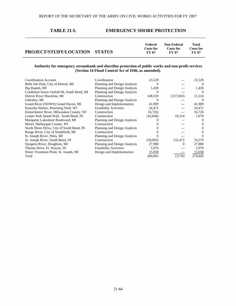
REPORT OF THE SECRETARY OF THE ARMY ON CIVIL WORKS ACTIVITIES FOR FY 2007
21-64
TABLE 21-L EMERGENCY SHORE PROTECTION ______________________________________________________________________________ PROJECT/STUDY/LOCATION
STATUS
Federal
Costs for FY 07
Non-Federal
Costs for FY 07
Total
Costs for FY 07
Authority for emergency streambank and shoreline protection of public works and non-profit services (Section 14 Flood Control Act of 1946, as amended).
Coordination Account Coordination 23,529 --- 23,529 Belle Isle Park, City of Detroit, MI Planning and Design Analysis 0 --- 0 Big Rapids, MI Planning and Design Analysis 1,430 --- 1,430 Combined Sewer Outfall #6, South Bend, MI Planning and Design Analysis 0 --- 0 Detroit River Shoreline, MI Construction 148,559 (137,043) 11,516 Gibraltar, MI Planning and Design Analysis 0 --- 0 Grand River (NOWS) Grand Haven, MI Design and Implementation 41,909 --- 41,909 Kenosha Harbor, Retaining Wall, WI Feasibility Activities 54,472 --- 54,472 Kinnickinnic River, Milwaukee County, WI Construction 16,726) --- 16,726 Leeper Park Island Wall, South Bend, IN Construction (16,644) 18,314 1,670 Marquette Lakeshore Boulevard, MI Planning and Design Analysis 0 -- 0 Mosel, Sheboygan County, WI Construction 0 --- 0 North Shore Drive, City of South Bend, IN Planning and Design Analysis 0 --- 0 Rouge River, City of Southfield, MI Construction 0 --- 0 St. Joseph River, Niles, MI Planning and Design Analysis 0 --- 0 St. Joseph River, South Bend, IN Construction (58,093) 132,472 74,379 Sturgeon River, Houghton, MI Planning and Design Analysis 27,980 0 27,980 Thieme Drive, Ft. Wayne, IN Feasibility Activities 5,976 --- 5,976 Water Treatment Plant, St. Joseph, MI Design and Implementation 15,058 --- 15,058 Total 260,902 13,743 274,645

DETROIT, MI, DISTRICT
21-65
TABLE 21-M BEACH EROSION WORK UNDER SPECIAL AUTHORIZATION ______________________________________________________________________________ PROJECT/STUDY/LOCATION
STATUS
Federal
Costs for FY 07
Non-Federal
Costs for FY 07
Total
Costs for FY 07
Beach Erosion activities pursuant to Section 103 of the 1962 River and Harbor Act.
Bay Point Peninsula, City of Luna Pier Feasibility Activities 0 --- 0 Lakewalk Park, Duluth, MN Feasibility Activities 0 --- 0 Total 0 --- 0
Shoreline Erosion Control Development and Demonstration Activities pursuant to Section 227 of the Water Resources Development Act of 1966
Shoreline Erosion Control Development & Demonstration Prgm
17,599 --- 17,599
TABLE 21-N MITIGATION OF SHORE DAMAGES PROJECT/STUDY/LOCATION
STATUS
Federal Costs for
FY 07
Non-Federal Costs for
FY 07
Total Costs for
FY 07
Mitigation of Shore Damages pursuant to Section 111 of the River and Harbor Act of 1968 Saugatuck Harbor, MI Feasibility Activities 0 --- 0 Grand River (NOWS) Grand Haven, MI Feasibility Activities 0 --- 0 Total 0 0
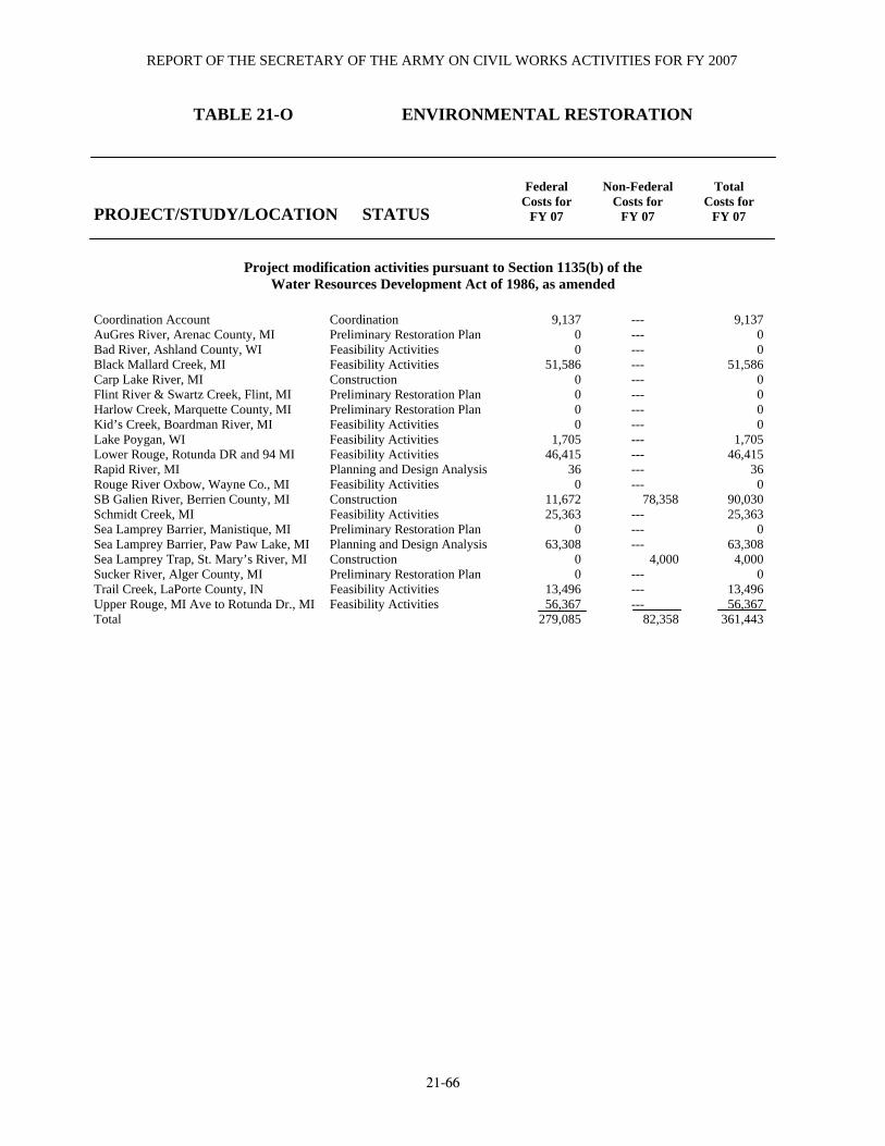
REPORT OF THE SECRETARY OF THE ARMY ON CIVIL WORKS ACTIVITIES FOR FY 2007
21-66
TABLE 21-O ENVIRONMENTAL RESTORATION
PROJECT/STUDY/LOCATION
STATUS
Federal
Costs for FY 07
Non-Federal
Costs for FY 07
Total
Costs for FY 07
Project modification activities pursuant to Section 1135(b) of the Water Resources Development Act of 1986, as amended
Coordination Account Coordination 9,137 --- 9,137 AuGres River, Arenac County, MI Preliminary Restoration Plan 0 --- 0 Bad River, Ashland County, WI Feasibility Activities 0 --- 0 Black Mallard Creek, MI Feasibility Activities 51,586 --- 51,586 Carp Lake River, MI Construction 0 --- 0 Flint River & Swartz Creek, Flint, MI Preliminary Restoration Plan 0 --- 0 Harlow Creek, Marquette County, MI Preliminary Restoration Plan 0 --- 0 Kid’s Creek, Boardman River, MI Feasibility Activities 0 --- 0 Lake Poygan, WI Feasibility Activities 1,705 --- 1,705 Lower Rouge, Rotunda DR and 94 MI Feasibility Activities 46,415 --- 46,415 Rapid River, MI Planning and Design Analysis 36 --- 36 Rouge River Oxbow, Wayne Co., MI Feasibility Activities 0 --- 0 SB Galien River, Berrien County, MI Construction 11,672 78,358 90,030 Schmidt Creek, MI Feasibility Activities 25,363 --- 25,363 Sea Lamprey Barrier, Manistique, MI Preliminary Restoration Plan 0 --- 0 Sea Lamprey Barrier, Paw Paw Lake, MI Planning and Design Analysis 63,308 --- 63,308 Sea Lamprey Trap, St. Mary’s River, MI Construction 0 4,000 4,000 Sucker River, Alger County, MI Preliminary Restoration Plan 0 --- 0 Trail Creek, LaPorte County, IN Feasibility Activities 13,496 --- 13,496 Upper Rouge, MI Ave to Rotunda Dr., MI Feasibility Activities 56,367 --- 56,367 Total 279,085 82,358 361,443

DETROIT, MI, DISTRICT
21-67
TABLE 21-O ENVIRONMENTAL RESTORATION
PROJECT/STUDY/LOCATION
STATUS
Federal
Costs for FY 07
Non-Federal
Costs for FY 07
Total
Costs for FY 07
Aquatic Ecosystem Restoration – Projects for aquatic ecosystem restoration and protection projects, for the purpose of improving the environment pursuant to Section 206 of the
Water Resources Development Act of 1996. Coordination Account Coordination 0 --- 0 Belle Isle Piers, Detroit, MI Plans and Specifications 0 --- 0 Berrien County, Watervliet Dam, MI Cass River, Cit of Vassar, MI
Planning and Design Analysis Feasibility Activities
0 0
---
0 0
Centerville Creek, Cleveland, WI Preliminary Restoration Plan 0 --- 0 Clearwater Lake, MI Preliminary Restoration Plan 0 --- 0 Concordia University, WI Preliminary Restoration Plan 0 --- 0 Detroit River, City of Trenton, MI Feasibility Activities 8,405 --- 8,405 Dowagiac River, Cassopolis, MI Preliminary Restoration Plan 0 --- 0 Homer Lake, St. Joseph River Planning and Design Analysis 0 --- 0 Houghton Lake, MI Preliminary Restoration Plan 0 --- 0 Koontz Lake, IN Plans and Specifications 0 --- 0 Lower Menomonee River Valley, Milwaukee,WI
Preliminary Restoration Plan 0 --- 0
Mallett’s Creek, Wastenaw County Preliminary Restoration Plan 0 --- 0 Marion Mill Pond, Village of Marion, Osceola Feasibility Activities 0 --- 0 Menomonee, WI Feasibility Activities 0 --- 0 Oak Creek, WI Planning and Design Analysis 0 --- 0 Otsego Lake, MI Planning and Design Analysis 0 --- 0 Pike River, WI Preliminary Restoration Plan 0 --- 0 Secord and Smallwood Lakes, Gladwin Co.MI Feasibility Activities 0 --- 0 Trinity Creek, City of Mequon, WI Planning and Design Analysis 0 --- 0 Underwood Creek, Wauwatosa, WI Preliminary Restoration Plan 0 --- 0 Total 8,405 --- 8,405

REPORT OF THE SECRETARY OF THE ARMY ON CIVIL WORKS ACTIVITIES FOR FY 2007
21-68
TABLE 21-O ENVIRONMENTAL RESTORATION
PROJECT/STUDY/LOCATION
STATUS
Federal
Costs for FY 07
Non-Federal
Costs for FY 07
Total
Costs for FY 07
Aquatic plant control activities pursuant to Section 302 of the River and Harbor Act of 1965 (PL 89-298).
Aquatic Plant Control --- --- --- Total --- --- ---
Environmental infrastructure pursuant to Section 219e of the Water Resources Development Act of 1999, as amended
Genesee County Drain, Genesee County, MI Design Review 329,934 142,395 472,329 Nagaunee, MI Design Review 6,438 15,693 22,131 Twelve Towns Darin Retention Treatment Design Review 48,700 49,211 97,911 Total 385,072 207,299 592,371
Environmental infrastructure pursuant to Section 506 of the Water Resources Development Act of 2000, as amended
Great Lakes Fishery & Ecosystem Restoration 326,125 --- 326,125 Total 326,125 --- 326,125
Environmental infrastructure pursuant to Section 154 of the Consolidated Appropriations Act of 2001, as amended.
Northern Wisconsin Env Assistance Various Stages 3,467,586 --- 3,467,586 Total 3,467,586 --- 3,467,586
Environmental infrastructure pursuant to Section 569 of the Water Resources Development Act of 1999, as amended.
Northeastern Minnesota, MN (MV&LR) Various Stages 689,299 --- 689,299 Total 689,299 --- 689,299
Ecosystem Restoration – Section 204 beneficial use of dredged material in connection with dredging. Projects in connection with dredging use of dredged material activities pursuant to Section 204 of the
Water Resources Development Act of 1992, as amended. Cat Island Chain, Brown County, WI Feasibility Activities 55,272 --- 55,272 21st Ave; West Channel, Duluth, MN Coordination Account
Feasibility Activities Coordination
3,499 4,442
--- ---
3,499 4,442
Total 63,213 --- 63,213
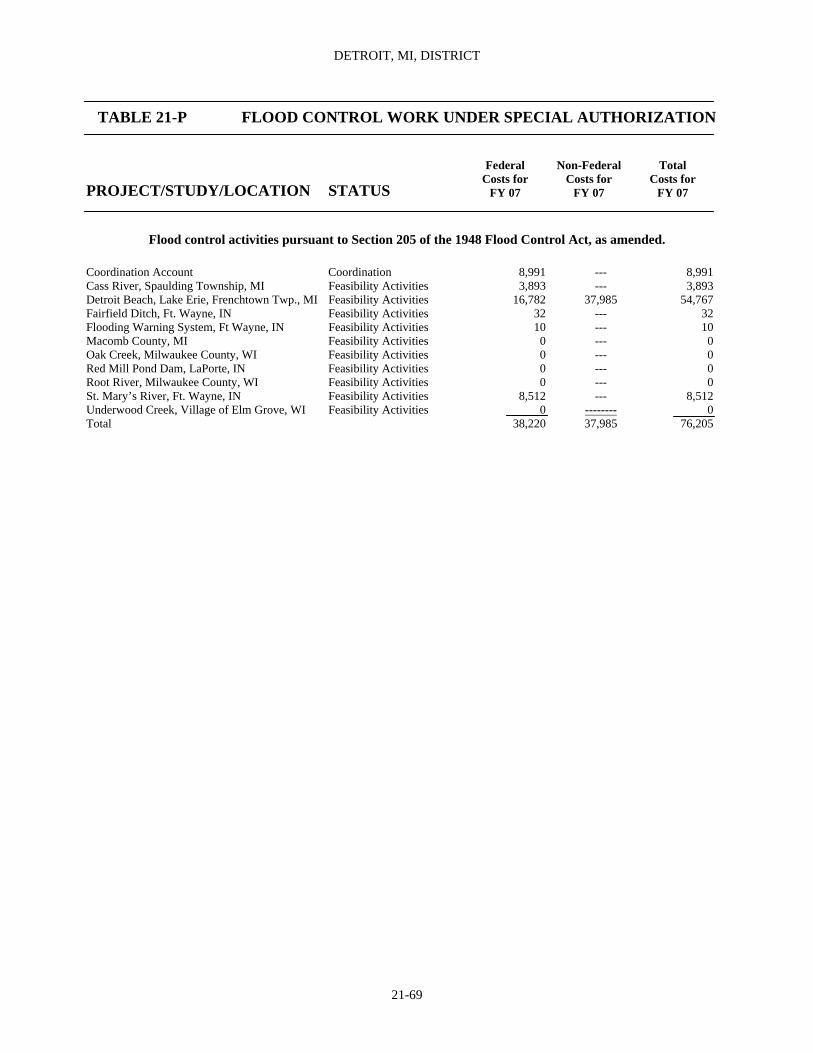
DETROIT, MI, DISTRICT
21-69
TABLE 21-P FLOOD CONTROL WORK UNDER SPECIAL AUTHORIZATION PROJECT/STUDY/LOCATION
STATUS
Federal
Costs for FY 07
Non-Federal
Costs for FY 07
Total
Costs for FY 07
Flood control activities pursuant to Section 205 of the 1948 Flood Control Act, as amended. Coordination Account Coordination 8,991 --- 8,991 Cass River, Spaulding Township, MI Feasibility Activities 3,893 --- 3,893 Detroit Beach, Lake Erie, Frenchtown Twp., MI Feasibility Activities 16,782 37,985 54,767 Fairfield Ditch, Ft. Wayne, IN Feasibility Activities 32 --- 32 Flooding Warning System, Ft Wayne, IN Feasibility Activities 10 --- 10 Macomb County, MI Feasibility Activities 0 --- 0 Oak Creek, Milwaukee County, WI Feasibility Activities 0 --- 0 Red Mill Pond Dam, LaPorte, IN Feasibility Activities 0 --- 0 Root River, Milwaukee County, WI Feasibility Activities 0 --- 0 St. Mary’s River, Ft. Wayne, IN Feasibility Activities 8,512 --- 8,512 Underwood Creek, Village of Elm Grove, WI Feasibility Activities 0 -------- 0 Total 38,220 37,985 76,205
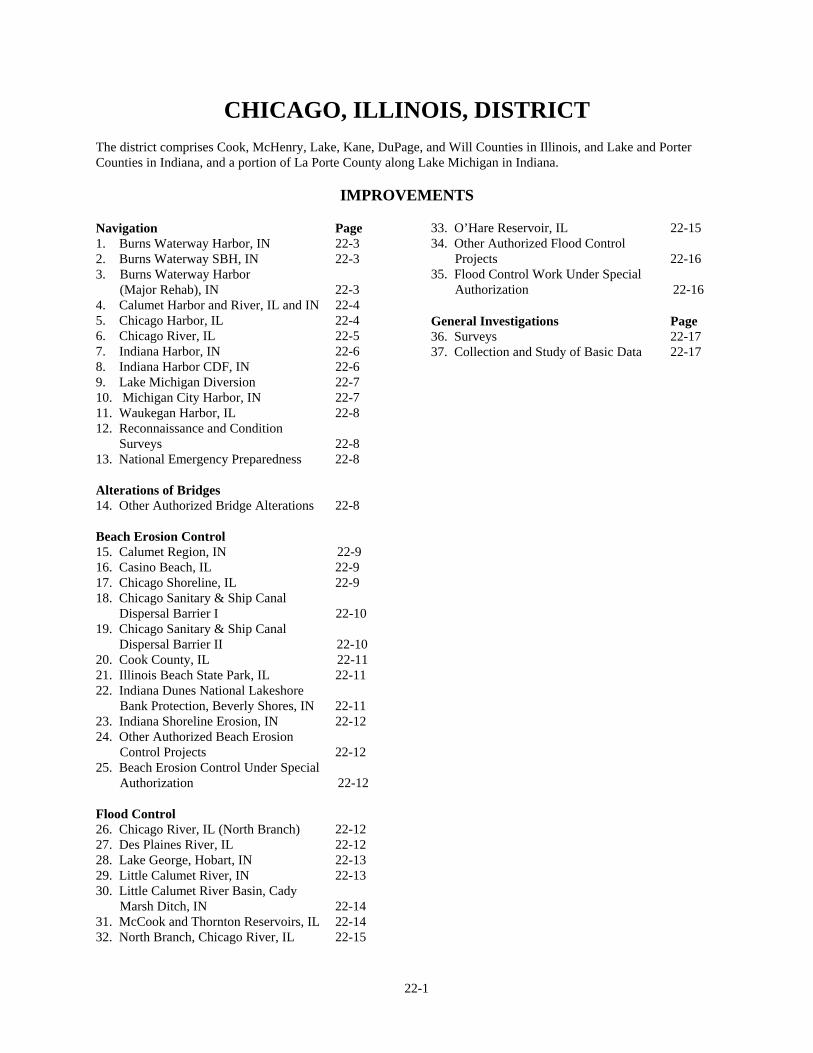
22-1
CHICAGO, ILLINOIS, DISTRICT The district comprises Cook, McHenry, Lake, Kane, DuPage, and Will Counties in Illinois, and Lake and Porter Counties in Indiana, and a portion of La Porte County along Lake Michigan in Indiana. IMPROVEMENTS Navigation Page 1. Burns Waterway Harbor, IN 22-3 2. Burns Waterway SBH, IN 22-3 3. Burns Waterway Harbor
(Major Rehab), IN 22-3 4. Calumet Harbor and River, IL and IN 22-4 5. Chicago Harbor, IL 22-4 6. Chicago River, IL 22-5 7. Indiana Harbor, IN 22-6 8. Indiana Harbor CDF, IN 22-6 9. Lake Michigan Diversion 22-7 10. Michigan City Harbor, IN 22-7 11. Waukegan Harbor, IL 22-8 12. Reconnaissance and Condition Surveys 22-8 13. National Emergency Preparedness 22-8 Alterations of Bridges 14. Other Authorized Bridge Alterations 22-8 Beach Erosion Control 15. Calumet Region, IN 22-9 16. Casino Beach, IL 22-9 17. Chicago Shoreline, IL 22-9 18. Chicago Sanitary & Ship Canal Dispersal Barrier I 22-10 19. Chicago Sanitary & Ship Canal Dispersal Barrier II 22-10 20. Cook County, IL 22-11 21. Illinois Beach State Park, IL 22-11 22. Indiana Dunes National Lakeshore
Bank Protection, Beverly Shores, IN 22-11 23. Indiana Shoreline Erosion, IN 22-12 24. Other Authorized Beach Erosion
Control Projects 22-12 25. Beach Erosion Control Under Special
Authorization 22-12
Flood Control 26. Chicago River, IL (North Branch) 22-12 27. Des Plaines River, IL 22-12 28. Lake George, Hobart, IN 22-13 29. Little Calumet River, IN 22-13 30. Little Calumet River Basin, Cady
Marsh Ditch, IN 22-14 31. McCook and Thornton Reservoirs, IL 22-14 32. North Branch, Chicago River, IL 22-15
33. O’Hare Reservoir, IL 22-15 34. Other Authorized Flood Control
Projects 22-16 35. Flood Control Work Under Special
Authorization 22-16 General Investigations Page 36. Surveys 22-17 37. Collection and Study of Basic Data 22-17
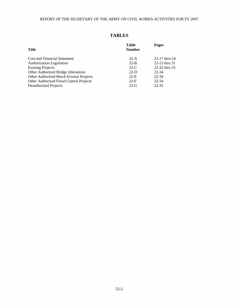
REPORT OF THE SECRETARY OF THE ARMY ON CIVIL WORKS ACTIVITIES FOR FY 2007
22-2
TABLES Table Pages Title Number Cost and Financial Statement 22-A 22-17 thru-24 Authorization Legislation 22-B 22-23 thru 31 Existing Projects 22-C 22-32 thru 33 Other Authorized Bridge Alterations 22-D 22-34 Other Authorized Beach Erosion Projects 22-E 22-34 Other Authorized Flood Control Projects 22-F 22-34 Deauthorized Projects 22-G 22-35

CHICAGO, ILLINOIS, DISTRICT
22-3
Navigation 1. BURNS WATERWAY HARBOR, IN Location. Northwestern Indiana on the southern shore of Lake Michigan in Porter County, 28 miles southeast of Chicago Harbor. (See NOAA Nautical Chart Numbers 14905 and 14926.) Previous Projects. None. Existing Project. Provides for (a) a rubblemound north breakwater 4,630 feet long and a rubblemound breakwater west arm 1,200 feet long, for a total breakwater length of 5,830 feet; (b) an approach channel 30 feet deep and 400 feet wide; (c) an outer harbor 28 feet deep; (d) an east harbor arm 27 feet deep and 620 feet wide; and (e) a west harbor arm 27 feet deep and 620 feet wide. The project was authorized by the River and Harbor Act of October 27, 1965 (Public Law 89-298; House Document Number 160, 88th Congress, 1st Session). The authorizing act also provided the Secretary of the Army with the authority to reimburse the State of Indiana for expenditure of funds used to construct such portions of the project as approved by the Chief of Engineers and constructed under the supervision of the Chief of Engineers (See tables 22-B,C). Local Cooperation. Fully complied with. Terminal Facilities. Eleven berths are available at the facilities owned and administered by the Indiana Port Commission. One berth, committed to grain, is located on the outer harbor. Four berths on the East Harbor Arm are dedicated to handling dry and liquid bulk commodities. The East Harbor Arm also includes a small-boat harbor designed to accommodate working tugs for vessel assistance and barge movement. On the West Arm there are six berths. Although one berth is available for dry bulk cargoes, these berths are primarily used for the shipment and receipt of general cargo. Additionally, the Indiana Port Commission, through a lease, administers the west side of the West Harbor Arm for barge fleeting. The remaining available harbor berthing on the east side of the East Harbor Arm is privately owned. Operations and Results During Period. Dredging was performed near the Bailey (NIPSCO) Intake Structure at a cost of $368,816 for hired labor, $14,617 for work by other Corps of Engineers, $2,100 for contracted engineering services and $2,242,155 for construction contracts. Structural
maintenance costs were $401,800 for stone, and $9,230 for hired labor and other services. Economic data analysis of $19,500 for work by other Corps of Engineers. Total costs for the fiscal year 2007 were $3,936,538 federal. Dredging was performed at Burns Harbor Channel at a cost of $234,382 for hired labor, $36,479 for work by other Corps of Engineers, $607,459 for construction contracts. Condition at End of Fiscal Year. Total costs to September 30, 2007 were $47,958,538 of which $13,599,900 was for new work ($13,584,000 federal and $15,900 non-federal) and $34,358,638 ($34,250,276 federal and $108,362 non-federal) for was maintenance. 2. BURNS WATERWAY SBH, IN Location. Northwestern Indiana on the southeast shore of Lake Michigan in Porter County, at the mouth of the Burns Waterway, approximately 27 miles southeast of Chicago Harbor. (See NOAA Nautical Chart Numbers 14905 and 14926.) Previous Projects. None Existing Project. Provides for (a) a rubblemound west breakwater 1,043 feet long; (b) a rubblemound north breakwater 678 feet long; and (c) channel improvements of 5,200 linear feet with 145,000 cubic yards of dredged material used for beach nourishment (See table 22-C). Local Cooperation. Fully complied with. Terminal Facilities. There are several marinas located along Burns Waterway and Burns Ditch. The principal marina, which is owned and operated jointly by the City of Portage and the Little Calumet River Basin Commission, was built in 1996 to comply with the local cooperation agreement. The commodities handled at this harbor are fresh fish caught as a result of charter boat fishing. Operations and Results During Period. Sediment sampling and testing costs were $897 for hired labor. Condition at End of Fiscal Year. Total costs of the existing project to September 30, 2007 were $7,834,493 of which $3,770,558 was for new work ($2,000,000 federal and $1,770,558 non-federal), and $4,063,935 for maintenance (federal). 3. BURNS WATERWAY HARBOR (MAJOR REHAB), IN

REPORT OF THE SECRETARY OF THE ARMY ON CIVIL WORKS ACTIVITIES FOR FY 2007
22-4
Location. The project is located in northwestern Indiana on the southern shore of Lake Michigan in Porter County. Existing Project. The rehabilitation project consists of constructing a segmented reef breakwater system, 75 feet lakeward of the northern section of the existing rubblemound breakwater. The project provides for seven reef segments, one 1,575 feet long and six 375 feet long with 25 feet spacing between segments Local Cooperation. None required. Operations and Results During the Period. New Work: Following construction completion in 1998, project closeout was completed in 1999. Condition at the End of Fiscal Year. The construction contract was financially completed. The total cost of the existing project to September 30, 2007 was $13,384,200. 4. CALUMET HARBOR AND RIVER, IL and IN Location. Northeastern Illinois, on the southwest shore of Lake Michigan in Cook County, 15 miles south of Chicago Harbor, within the corporate limits of the City of Chicago, except for breakwaters, and approach channel and an anchorage area which are in Indiana. (See NOAA Nautical Chart Numbers 14926 and 14929.) Previous Projects. For details see page 1400 of Annual Report for 1962. Existing Project. Provides for (a) a stone-filled timber crib breakwater 6,714 feet long; (b) a stone-filled double-row steel sheet pile detached breakwater 5,007 feet long; (c) an approach channel 29 feet deep and 3,200 feet wide; (d) an outer harbor anchorage area 28 feet deep and 3,000 feet wide; (e) an entrance channel 27 feet deep and 230 to 290 feet wide; (f) a channel in the Calumet River 27 feet deep and at least 200 feet wide to the north side of 130th Street; (g) three turning basins designated as numbers, 1, 3, and 5; and (h) a channel extending into Lake Calumet at a width of about 1,000 feet. The project was authorized by the River and Harbor Acts of March 3, 1899, June 13, 1902, August 30, 1935, July 14, 1960, October 23, 1962, and October 27, 1965 (See tables 22-B,C).
Local Cooperation. Fully complied with. Terminal Facilities. Thirty six docks, wharves, and terminals are available. The Illinois International Port District owns four wharves, two grain elevators, one dock, and one terminal. The United States Government owns one stone dock. The most important cargoes handled are general cargo, grain, iron ore and concentrates, coal, and cement. Some docks are vacant and some docks are dedicated to handling barge traffic from the Illinois Waterway Project. Operations and Results During Period. Completed removal of concrete block navigation channel obstruction near the 106th Street Bridge left descending bank off the Cronimet Dock at a cost of $34,500 for construction contracts. Dredging was performed at a cost of $254,720 for hired labor, $28,854 for work by other corps of Engineers and $1,622,085 for construction contracts. Detached Breakwater repairs were completed by the Detroit floating plant at a cost of $349,187 for material, $262,812 for hired labor, $812,602 for work by the other Corps of Engineers and $85,967 for work by the Federal Agency. Total costs for the fiscal year FY07 were $3,450,727 federal. Condition at End of Fiscal Year. The existing project is complete. Total costs of the existing project to September 30, 2007 were $86,082,219 of which $22,578,567 was for new work ($19,541,964 federal funds and $3,036,603 public works funds), $58,0875,651 for maintenance ($57,238,984 federal and $836,667 non-federal funds) and $5,428,001 federal funds for rehabilitation. 5. CHICAGO HARBOR, IL Location. Northeastern Illinois on the southwest shore of Lake Michigan in Cook County, within the corporate limits of the City of Chicago. (See NOAA Nautical Chart Numbers 14926, 14927, and 14928.) Previous Projects. See page 1396 of Annual Report for 1962. Existing Project. Provides for (a) a stone-filled timber crib shore and extension breakwater 2,250 feet long; (b) a stone-filled timber crib exterior breakwater 5,421 feet long; (c) a rubblemound and stone-filled concrete caisson southerly extension to the exterior breakwater 4,944 feet long, exclusive of a 582-foot entrance gap enclosing an outer basin of about 970 acres; (d) a stone-filled timber crib north

CHICAGO, ILLINOIS, DISTRICT
22-5
pier 960 feet long; (e) a stone-filled timber crib north inner breakwater 4,034 feet long with a 304-foot shore return and a 754-foot gap; (f) a stone-filled timber crib south inner breakwater 2,544 feet long, enclosing an inner basin of approximately 224 acres; (g) a lake approach channel 29 feet deep and 800 feet wide; (h) a channel and maneuver area inside the exterior breakwater and southerly extension breakwater 28 feet deep with a maximum width of 1,300 feet; (i) an entrance channel 21 feet deep and (j) the Chicago Harbor Lock. The Chicago Lock was constructed in 1938 by the Metropolitan Water Reclamation District of Greater Chicago. The deep-draft lock is 600 feet long, 80 feet wide, and 23 feet deep over the sill and is of steel cellular design. The project was authorized by the River and Harbor Acts of July 11, 1870, June 14, 1880, March 3, 1899, July 25, 1912, March 2, 1919 and October 23, 1962 (See table 22-B). Lock operation and maintenance responsibilities, in the interest of navigation, were transferred to the Federal Government pursuant to Public Law 98-63 approved July 30, 1983; Section 107 of the Public 97-88; and the Memorandum of Agreement between the Department of Army and the Metropolitan Water Reclamation District of Greater Chicago. Local Cooperation. Fully complied with. Terminal Facilities. There are five docks with 18 berths for passenger excursion boats and 10 berths for visiting large vessels. The most important cargoes handled through the lock are petroleum products, in addition to sugar and non-metallic minerals. Operations and Results During Period. The Chicago Harbor Lock was operated by contract at a cost of $1,049,136. Bulkhead storage lease was $18,964. The Lock Control House modification was completed by AE contract at a cost of $6,116 and $45,455 for design review work by other Corps of Engineers. Construction of the new control house was completed at a cost of $1,060,447. In-house hired labor costs required to operate and maintain the project during the period were as follows: $105,960 for Lock Contract S&A, and for Lock Maintenance, $292,856 for Control House contract S&A and $20,613 for work by other Corps of Engineers. Miscellaneous equipment and services required for the support of the lock and control house were procured at a cost of $23,165. Total costs for FY07 were $2,622,712 federal.
Condition at End of Fiscal Year. The existing project is complete. Total costs to September 30, 2007 were $76,335,665 of which $6,193,701 was for new work, $68,655,364 was for maintenance, $1,326,600 for rehabilitation and $160,000 Harbor and Dams funds. The approved Major Rehabilitation of the Lock (Gates, Control House and Concrete Repair) has not been completed. 6. CHICAGO RIVER, IL Location. Northeastern Illinois, in Cook County within the corporate limits of the City of Chicago. (See NOAA Nautical Chart Numbers 14926, 14927 and 14928.) Previous Projects. See page 1394 of Annual Report for 1962. Existing Project. Provides for (a) a channel 21 feet deep in the main river from its mouth at Rush Street to the junction of the North and South Branches (0.7 miles); (b) a channel 21 feet deep in the North Branch from the junction to North Avenue (2.22 miles); (c) a channel 21 feet deep on the North Branch Canal (1.04 miles); (d) a 21-foot deep North Branch Turning Basin just south of North Avenue; and (e) a channel 9 feet deep in the North Branch from North Avenue to Addison Street (authorized but not constructed). The project was authorized by the River and Harbor Acts of March 3, 1899, June 13, 1902, March 2, 1907, and July 24, 1946 (See tables 22-B, C). The portion of the project authorized by the River and Harbor Act of 1946 is presently being restudied to confirm economic feasibility. Local Cooperation. Fully complied with for completed modifications. The River and Harbor Act of July 24, 1946, which provided for the improvement of the channel, is subject to the condition that local interests furnish assurances that they will hold the United States government free from damages that may result from construction and maintenance of the improvement. Requirement has not been complied with. Terminal Facilities. Six docks are available. The most important cargoes handled are sand, gravel and crushed rock, non-metallic minerals and scrap iron. Operations and Results During Period. Water control activities were performed by hired labor at a cost of $88,779, by other Corps of Engineers at a cost $12,282 and by other federal agencies at a cost of $196,211. Routine operations were conducted at a

REPORT OF THE SECRETARY OF THE ARMY ON CIVIL WORKS ACTIVITIES FOR FY 2007
22-6
cost of $16,410 for hired labor. Total costs for FY07 were $313,682 federal. Condition at End of Fiscal Year. The project is complete except for dredging the channel between North Avenue and Addison Street as authorized by the 1946 River Harbor Act. Channel maintenance for the reach from Clark Street to head of navigation has been deferred pending location and approval of suitable dredged material disposal site. Head of navigation for deep-draft vessels is North Avenue, 5.97 miles from the Michigan Avenue bridge. Total costs of the existing project to September 30, 2007 were $20,242,500 of which $1,500,565 was for new work and $18,741,935 was for maintenance. 7. INDIANA HARBOR, IN Location. Northwestern Indiana, on the southwest shore of Lake Michigan in Lake County, 19 miles southeast of Chicago Harbor. (See NOAA Nautical Chart Numbers 14926 and 14929.) Previous Projects. For details see page 1943 of Annual Report for 1915, and page 1520 of Annual Report for 1938. Existing Project. Provides for (a) a northerly rubblemound breakwater 1,120 feet long; (b) an easterly concrete capped caisson breakwater 201 feet long with a rubblemound extension 2,324 feet long; (c) a lake approach channel 29 feet deep and 800 feet wide; (d) an anchorage and maneuver basin 28 feet deep; (e) a main canal entrance channel 27 feet deep and 280 feet wide; (f) a main canal 22 feet deep; (g) a turning basin 22 feet deep; (h) the Forks Turning Basin 22 feet deep; (i) the Lake George Branch 22 feet deep; and (j) the Calumet River Branch 22 feet deep. The project was authorized by the River and Harbor Acts of March 4, 1913, March 2, 1919, March 20, 1922, July 3, 1930, August 30, 1935, August 28, 1937, and July 14, 1960 (See tables 22-B, C). Local Cooperation. Substantially complied with. See FY 1986 Annual Report for full requirements. Terminal Facilities. Fifteen docks and wharves are available. Six docks handle iron ore and limestone. Six docks are for handling petroleum products and three docks for handling gypsum, scrap metal and steel, and bulk products. However, not all docks are presently being used for the shipment or receipt of waterborne commodities.
Operations and Results During Period. Routine operations for budget preparation were conducted at a cost of $2,211 for work by other Corps of Engineers. The preparation of dredging plans and specifications were continued at a cost of $38,801 for hired labor. A/E services to produce plans for offloading the standard hydraulic barge into CDF were hired at a cost of $105,201. The preparation of an operations plan for the Confined Disposal Facility was continued at a cost of $367,197 for hired labor. Total costs for FY07 were $513,410 federal. Condition at End of Fiscal year. The existing project is complete. Total costs of the existing project to September 30, 2007 were $21,829,665 of which $4,909,648 ($4,897,148 federal and $12,500 non-federal contributed funds) was for new work and $16,920,017 (federal) for maintenance. Channel maintenance has been deferred pending construction of suitable Confined Disposal Facility. 8. INDIANA HARBOR AND CANAL CONFINED DISPOSAL FACILITY (CDF), IN Location. The navigation project is located on the southwestern shore of Lake Michigan within the City of East Chicago, Lake County, Indiana, 4-1/2 miles east of the Indiana-Illinois state line and 17 miles from downtown Chicago, Illinois. A CDF will be constructed at the Energy Cooperative Incorporate (ECI) site in East Chicago, Illinois. Existing Project. IHC is an authorized Federal navigation project with an entrance channel and outer harbor protected by breakwaters, and an inner harbor which includes the Indiana Harbor Canal and its two branches, the Lake George Branch, which extends west for a distance of 6,800 feet, and the Calumet River Branch which extends to the south for about 2 miles where it joins the Grand Calumet River. The harbor has not been dredged since 1972, when the United States Environmental Protection Agency determined that disposal in Lake Michigan was no longer acceptable due to the polluted character of the harbor sediments. A 4.8 million cubic yards capacity CDF will be constructed on the 164 acres of land adjacent to the Lake George Branch of the IHC, formerly occupied by an oil refinery owned by the Atlantic Richfield Company and subsequently acquired by ECI. The ECI property currently has open Resource Conservation and Recovery Act (RCRA) status due to the contaminated soil and groundwater that exists on the site. Use of this site for the CDF is contingent
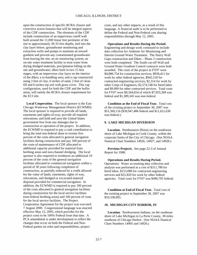
CHICAGO, ILLINOIS, DISTRICT
22-7
upon the construction of specific RCRA closure and corrective action features that will be integral aspects of the CDF construction. The elements of the CDF include construction of an impervious cutoff wall built around the 11,000 linear feet perimeter of the site to approximately 30-35 feet depths, tied into the clay layer below; groundwater monitoring and extraction wells and pumps to maintain an inward gradient and prevent any contaminated groundwater from leaving the site; an air monitoring system; an on-site water treatment facility to treat water from drying dredged materials, precipitation falling on the site and groundwater; dikes built in two 15 feet stages, with an impervious clay layer on the interior of the dikes; a re-handling area; and a cap constructed using 3 feet of clay, 6 inches of sand, 2 feet of clean fill and 6 inches top soil with grass cover. This cap configuration, used for both the CDF and the buffer areas, will satisfy the RCRA closure requirement for the ECI site. Local Cooperation. The local sponsor is the East Chicago Waterway Management District (ECWMD). The local sponsor is required to provide all lands, easements and rights-of-way; provide all required relocations; and hold and save the United States government free from any damages due to construction or operation of the project. In addition, the ECWMD is required to pay a cash contribution to bring the total non-federal share to twenty-five percent of the costs allocated to general navigation facilities during construction and pay 100 percent of the costs of maintenance of CDF allocated to additional capacity provided for material from berthing areas and non-channel dredging. The local sponsor is also required to reimburse an additional 10 percent of the costs of the general navigation facilities allocated to commercial navigation within a period of 30 years following completion of construction, as partially reduced by a credit allowed for the value of lands, easements, rights of way, relocations, and dredged or excavated material disposal provided for commercial navigation. In addition, the ECWMD is required to pay 100 percent of the costs allocated to general navigation facilities during construction for the local service facilities (non-federal berthing areas) and 100 percent of costs for the local service facilities. The Project Cooperation Agreement for the project was executed 7 August 2000. Congressional language was enacted effective May 12, 2005, which provides for the project costs to be 100% Federal from that date. A PCA amendment is under development to reflect the changes that occur on both the Federal and Non-Federal parties on roles and responsibilities, project
costs, and any other impacts, as a result of this language. A financial audit is to be performed to define the Federal and Non-Federal cost sharing responsibilities through May 12, 2005. Operations and Results During the Period. Engineering and design work continued to include data collection for Ambient Air Monitoring and Interim Ground Water Treatment. The Slurry Wall Gaps construction and Dikes – Phase 2 construction were both completed. The South cut-off Wall and Ground Water Gradient Control contracts were both awarded. The costs of the project in FY07 were $4,886,754 for construction services, $928,411 for work by other federal agencies, $942,518 for contracted engineering services, $2,314 for work by other Corps of Engineers, $2,574,748 for hired labor and $9,909 for other contracted services. Total costs for FY07 were $9,344,654 of which $7,955,309 was federal and $1,389,345 was non-federal. Condition at the End of Fiscal Year. Total cost of the existing project to September 30, 2007 was $51,569,116 ($39,947,486 federal and $11,621,630 non-federal.) 9. LAKE MICHIGAN DIVERSION Location. Northeastern Illinois on the southwest shore of Lake Michigan in Cook County, within the corporate limits of the City of Chicago. (See NOAA Nautical Chart Numbers 14926, 14927, and 14928.) Previous Projects. See page 22-3 of Annual Report for 1988. Operations and Results During Period. Operations: Water accounting data collection and analysis was performed at a cost of $311,788 for hired labor, $153,088 for contracted engineering services and $31,829 for work by other federal agencies. Total costs for FY07 was $496,705 federal. Condition at End of Fiscal Year. Total cost of the existing project to September 30, 2007 was $10,338,005. 10. MICHIGAN CITY HARBOR, IN Location. Northwestern Indiana, on the southeast shore of Lake Michigan in La Porte County, 38 miles southeast of Chicago Harbor. (See NOAA Nautical Chart Numbers 14905 and 14926.)
REPORT OF THE SECRETARY OF THE ARMY ON CIVIL WORKS ACTIVITIES FOR FY 2007
22-8
Previous Projects. See page 1407 of Annual Report for 1992. Existing Project. Provides for (a) a stone-filled timber crib detached breakwater 1,304 feet long; (b) a pile and steel sheeting west pier 835 feet long; (c) a stone-filled timber crib, pile and steel sheeting east pier 2,276 feet long; (d) a stone-filled timber crib east breakwater 1,000 feet long; (e) an entrance channel 18 feet deep and 425 feet wide; (f) a turning basin No. 1, 18 feet deep; (g) a channel in Trail Creek 18 feet deep; (h) an outer basin 12 feet deep in the northerly portion and 8 feet deep in the southerly portion; and (i) a channel in Trail Creek 6 feet deep and 50 feet wide from turning basin No. 2 to the E Street bridge. The project was authorized by the River and Harbor Acts of March 3, 1899, March 3, 1905, January 21, 1927, August 30, 1935, and Section 107 of July 14, 1960, River and Harbor Acts, September 30, 1966 (See tables 22-B, C). Local Cooperation. Fully complied with. Terminal Facilities. There are several marinas in the lower mile of Trail Creek. The commodity handled at this harbor is fresh fish. Operations and Results During Period. Routine operations were conducted at cost of $18,086 for hired labor. The development of future dredging plans budgets and facts sheets were conducted at a cost of $55,327 for hired labor. Total costs for FY07 were $55,327 federal. Condition at End of Fiscal Year. Total costs of existing project to September 30, 2007 were $24,763,336 of which $1,574,158 was for new work ($1,543,646 federal and $30,512 non-federal funds), $21,570,508 for maintenance ($21,515,508 federal and $55,000 non-federal) and $1,618,670 for rehabilitation (federal funds). 11. WAUKEGAN HARBOR, IL Location. Northeastern Illinois on the west shore of Lake Michigan in Lake County, 38 miles north of Chicago Harbor. (See NOAA Nautical Chart Numbers 14904 and 14905.) Previous Projects. See page 1392 of Annual Report for 1962. Existing Project. Provides for (a) a northerly stone-filled timber crib breakwater 588 feet long; (b)
a stone-filled reinforced concrete caisson shore connection 270 feet long; (c) a stone-filled double-row steel sheeting shore connection 640 feet long; (d) a single-row steel sheeting shore connection 398 feet long; (e) a stone-filled timber crib north pier 998 feet long; (f) a single-row steel sheet piling north pier 444 feet long; (g) a steel piling revetment 632 feet long; (h) a stone-filled timber crib pier 1,399 feet long; (i) a stone-filled double-row pile and sheeting south pier 1,712 feet long; (j) an entrance channel 22 feet deep and 390 feet wide; (k) a channel between the piers 18 feet deep and 200 feet wide; (l) an inner basin 18 feet deep; and (m) an anchorage area in the southwest corner of the inner basin 8 feet deep. An authorized, but as yet constructed project modification provides for (a) an entrance channel 27 feet deep, (b) a channel between the piers 23 feet deep and (c) an inner basin and channel extension 23 feet deep. The project was authorized by the River and Harbor Acts of June 3, 1902, July 13, 1930, and March 2, 1945, and on December 17,1970 by delegated authority under Section 201 of the Rivers and Harbor Act of October 27, 1965. (See tables 22-B, C). The portion of the project authorized by the 1970 modification is being restudied to confirm economic feasibility. Local Cooperation. Fully complied with for completed portions. The Dec. 17, 1970 modification, which provides for modifications to the channel, is subject to the conditions that local interests furnish assurances that they will hold the United States government free from damages from construction and maintenance of the improvement and that certain lands, easements and rights-of-way be provided. Terminal Facilities. Four docks are available. The commodities handled at this harbor are gypsum and building cement. Operations and Results During Period. Dredging was performed on the approach channel at a cost of $99,658 for the hired labor and $721,589 for the construction contracts. The preparation of the outer harbor dredging plans and specifications were continued at a cost of $186,474 for hired labor. Coordination meetings and planning with the EPA to dredge the inner harbor were continued at a cost of $18,288 for hired labor and $58,983 for contracted engineering services. Total costs for FY07 were $1,084,992 federal. Condition at End of Fiscal Year. The existing project is complete except for the 1970 modification, which is being restudied. Maintenance of the channel between the pier to the head of navigation has been
CHICAGO, ILLINOIS, DISTRICT
22-9
deferred pending location, approval and probable construction of a suitable dredged material disposal site. Total costs of existing project to September 30, 2007 were $24,487,497 of which $823,026 was for new work and $23,664,471 was for maintenance. 12. RECONNAISSANCE AND CONDITION SURVEYS In Fiscal Year 2007 Project Condition Surveys were performed at a cost of $135,842. 13. NATIONAL EMERGENCY PREPAREDNESS Fiscal Year 2007 costs for management and mobilization planning were $0. Alteration of Bridges 14. OTHER AUTHORIZED BRIDGE ALTERATIONS See table 22-D. Beach Erosion Control 15. CALUMET REGION, IN Location. This project is located in Northwestern Indiana in the counties of Benton, Jasper, Lake, Newton and Porter. Existing Project. The project was authorized by Water Resources Development Act 1992, Section 219, as amended by WRDA 1996, Section 504 and WRDA 1999, Section 502, FY04 Appropriation Bill, Section 145. This project consists of providing technical planning, design and construction to non-federal interests who have environmental infrastructure needs. These needs include the development of wastewater treatment and related facilities and water supply, treatment and distribution facilities. Local Cooperation. The local sponsors are Gary Sanitary District, Hammond Sanitary District, Chesterton, Portage, Cedar Lake, New Chicago, Valparaiso, Lake Station and Whiting. Operations and Results During Period. Executed a letter report for Lake Station and Cedar Lake. Costs for Cedar Lake in FY07 were $192,918 federal and $42,141 non-federal. Costs for Lake Station in FY07 were $85,987 federal. Executed a
PCA for the city of Portage at a cost of $227,751 federal and $35,386 non-federal. Three construction contracts were awarded for the City of Cedar Lake, the City of Hammond, the City of Hammond, and the Town of Valparaiso. The costs for Hammond in FY07 were $2,407,369 federal and $897,800 non-federal. The costs for the Town of Valparaiso were $744,170 non-federal and $744,170 non-federal. The costs for the City of New Chicago were $10,252 federal and $2,028 non-federal. Costs for the City of Gary were $2,877 federal. Costs for other hired labor and miscellaneous services were $21,726 federal and $37,625 non-federal. Total costs for the fiscal year FY07 were $5,077,415 of which $3,318,265 was federal and $1,759,150 was non-federal. Condition at End of Fiscal Year. The total cost of the existing project to September 30, 2007 was $7,083,113 of which $5,204,965 was federal and $1,878,148 was non-federal. 16. CASINO BEACH, IL Location. Casino Beach is located along the Lake Michigan shoreline at Jackson Park in Chicago, Illinois. Existing Project. The Casino Beach project was authorized by Section 501 (a) of the 1986 Water Resources Development Act. The project consists of rehabilitating 1,800 feet of the Casino jetty by encasing the existing timber pile and stone structure in steel sheet piling and a concrete cap. Local Cooperation. The local project sponsor is the Chicago Park District. The local sponsor is required to provide all lands, easements and rights-of-way; complete all necessary relocations; hold and save the United States free from damages due to construction or operation of the project; operate and maintain the completed project; and make cash contribution toward the cost of construction. Operations and Results During Period. No work was performed in FY2007. Condition at End of Fiscal Year. Construction is complete. The total cost of the existing project to September 30, 2007 was $2,465,517 federal and $2,499,481 non-federal. 17. CHICAGO SHORELINE, IL Location. The project area includes 9.2 miles of revetment reconstruction within 24 miles of publicly owned shoreline along Lake Michigan in Chicago,

REPORT OF THE SECRETARY OF THE ARMY ON CIVIL WORKS ACTIVITIES FOR FY 2007
22-10
Illinois. Existing Project. The Chicago Shoreline project was authorized by the 1996 and 1999 Water Resources Development Act (WRDA). The Federally supportable plan consists of constructing rubblemound revetments along 16,750 and 25,400 feet of the shoreline in the Lincoln Park and Burnham Park areas, respectively. Other project features include: revetments near the Adler Planetarium and at Meigs Field; a breakwater to protect the South Filtration Plant near 78th Street; and nourishment of a short reach of shoreline near Fullerton Avenue and 31st Street. The local sponsor prefers to substitute steel sheet pile step stone revetments (the locally preferred plan, or LPP) for the rubblemound revetments in the Lincoln and Burnham Park areas. They have agreed to pay the increased cost above the federally supportable plan. The LPP is the authorized plan. Local Cooperation. This project has three separate Project Cooperation Agreements (PCA’s). The first PCA, for the Reach 5 breakwater reconstruction, was executed on 28 April 1997. The second PCA, for Section 215 work, was executed on 7 August 1998, and covers construction of three portions of the project: 1,000 feet of revetment at Belmont Harbor in Reach 2, an 800 foot stretch of shoreline at 31st Street beach in Reach 4 (both of these are being constructed by the non-federal sponsor), and revetment reconstruction from 31st to 33rd streets in Reach 4 (Corps work). The project Cooperation Agreement for the balance of the project work was executed on 17 May 1999, implementing section 206 of WRDA 92 which allows the non-federal sponsor to perform a significant portion of the work. Design and construction of the project is well underway. Project construction is estimated to be completed in the year 2007. The local sponsor is required to provide all lands, easements, and rights-of-way; complete all necessary relocations; hold and save the United States free from damages due to construction or operation of the project; operate and maintain the completed project; perform work for credit towards their cash contribution; and make cash contribution toward the cost of any outstanding balance. Operations and Results During Period. Construction continued for Belmont to Diversey South and at 40th to 41st Street Beach. Engineering and design work was continued on 43rd to 45th Street and Fullerton-Theatre on the Lake. Design work was
initiated for Diversey Revetment. The costs for FY07 were $13,421,465 for construction services, $125,525 for work by other Corps of Engineers, $6,880 for contracted engineering services and $2,119,341 for hired labor. Total costs for the fiscal year FY07 were $15,673,211 of which $12,989,883 was federal and $2,683,328 was non-federal. Condition at End of Fiscal Year. The total cost of the existing project to September 30, 2007, was $234,481,414 of which $165,041,324 is federal and $69,440,090 is non-federal cash and $31,984,136 is non-federal in-kind services. 18. CHICAGO SANITARY & SHIP CANAL DISPERSAL BARRIER I, IL Location. The Chicago Sanitary & Ship Canal (CSSC) is a man-made waterway in Northeastern Illinois that connects the Chicago River and the Des Plaines River. Existing Project. The CSSC was authorized by Nonindigenous Aquatic Nuisance Prevention and Control Act of 1990 (P.L. 101-636, 11/29/90, as amended through 10/26/96); Section 2309 of P.L. 109-234, Emergency Supplemental Appropriations Act. The project consists of an array of DC electrodes which were installed on the channel bottom of the CSSC. When power is provided, an electric field is created within the water that repels fish in order to prevent or reduce the dispersal of nonindigenous aquatic species between the Great Lakes and the Mississippi River drainage basins. Local Cooperation. None required. Operations and Results During Period. Continued operation and maintenance of barrier. The costs for FY07 were $12,234 for contracted engineering services, $149,335 for hired labor, $144 for work by other Corps of Engineers and $44,187 for other contracted services. Total costs for FY07 were $205,756 federal. Condition at End of Fiscal Year. The total cost of the existing project to September 30, 2007, was $3,878,471 of which all is federal. 19. CHICAGO SANITARY & SHIP CANAL DISPERSAL BARRIER II, IL Location. The Chicago Sanitary & Ship Canal (CSSC) is a man-made waterway in Northeastern Illinois that connects the Chicago River and the Des
CHICAGO, ILLINOIS, DISTRICT
22-11
Plaines River. Existing Project. The CSSC was authorized by Section 1135, Water Resources Development Act 1986 (Continuing Authority Program), Section 345 of PL. 108-335, District of Columbia Appropriations Act, 2005. A second permanent dispersal barrier is needed to provide continued protection against nuisance species. Barrier II will also be an electric field barrier, but will include design improvements identified during monitoring and testing of the demonstration barrier. Barrier II is being constructed in two phases, IIA and IIB. The first phase consists of construction of two underwater electrode arrays and one control house. This control house will be able to operate one of the two arrays. The second phase consists of construction of a second control house that will allow both arrays to be operated at the same time. Local Cooperation. The local sponsor is the Illinois Department of Natural Resources – Office of Water Resources (IDNR-OWR). Operations and Results During Period. The costs of FY07 were $120,271 for contracted services, $186,592 for hired labor, $101,482 for work by other corps of Engineers and $30,759 for work by federal agencies. Total project costs for FY07 were $439,104 of which $317,842 was federal and $121,262 was non-federal. Condition at End of Fiscal Year. The total cost of the existing project to September 30, 2007, was $8,504,057 of which $6,476,179 was federal and $2,027,878 was non-federal. 20. COOK COUNTY ENVIRONMENTAL INFRASTRUCTURE, IL Location. Northeastern Illinois. Existing Project. The Cook County Environmental Infrastructure project was authorized by WRDA 1992 (PL 102-580), Section 219(f)(54), as amended in the Consolidated Appropriations Act of 2001, (PL 106-554), see HR 4577, Chapter 14, Division B, Section 108; Section 142 of the FY 2004 Energy and Water Resources Appropriation (PL 108-137). This project provides technical planning, design and construction assistance to non-federal interests who have environmental infrastructure needs in Cook County, IL. These needs may be related, but not limited, to the development and protection of
water supply and waste water systems; combined sewer overflows; and remediation of adverse water quality impacts and storm water impacts to waste water systems. Currently the projects identified applicable to this authorization are Calumet Park, Flossmoor, Brookfield Zoo, Chicago Heights, Berwyn and Olympia Fields. Local Cooperation. Varies by community. Operations and Results During Period. Continued planning for the PCA execution and the construction of sewer improvements at two schools in Calumet Park. Coordinated with Brookfield Zoo on the proposed water, sanitary and storm line replacement, repairs and extensions. Coordinated with Flossmoor, Berwyn and Olympia Fields on possible future stormwater drainage and water system improvement projects. Total costs for FY07 were $782,755 federal and $164,360 non-federal. Condition at End of Fiscal Year. The total costs of the existing project to September 30, 2007 were $1,621,016 of which $1,362,906 was federal and $258,110 was non-federal. 21. ILLINOIS BEACH STATE PARK, IL Location. Northeastern Illinois on the west shore of Lake Michigan along the 9-mile reach of shoreline immediately south of the Illinois-Wisconsin State line. (See NOAA Nautical Chart Numbers 14901 and 14904.) Previous Projects. None. Existing Project. Provides for annual beach nourishment and construction of a sediment trap at the south end of the State Park. The project would entail placement of coarse-graded sediment at six stockpile sites at the rate of 124,000 cubic yards in the first year, 104,000 cubic yards in the second year, and 60,000 cubic yards in the third year. Thereafter, 60,000 cubic yards would be placed at the northernmost stockpile annually. The sediment trap would consist of a rubble-mound groin, with a total length of 600 feet from the base of the dunes (400 feet lakeward from the shoreline), with a crest height of about +8 feet above Low Water Datum (LWD). The project was conditionally authorized in Section 501 (b) of the 1986 Water Resources Development Act subject to a report by the Corps of Engineers and approval by the Secretary of the Army. A Feasibility Review Conference was held in April 1991. As a result, the District Engineer was directed to terminate

REPORT OF THE SECRETARY OF THE ARMY ON CIVIL WORKS ACTIVITIES FOR FY 2007
22-12
work on this project and to submit a letter report to the Congress summarizing the feasibility study and the results of the Washington level review. Work on the feasibility report was resumed in FY 1994 as directed by the Assistant Secretary of the Army for Civil Works in response to a letter from Congressman John Porter, 10th Congressional District of Illinois. Local Cooperation. The local project sponsor would be required to provide all lands, easements and rights-of-way; accomplish all required relocations; hold and save the United State free from damages; and provide a cash contribution. Operations and Results During Period. No work was performed in FY07. Condition at End of Fiscal Year. Total cost of the existing Feasibility study to September 30, 2007 was $344,291. 22. INDIANA DUNES NATIONAL LAKESHORE BANK PROTECTION, BEVERLY SHORES, IN Location. Northwestern Indiana, on the southeast shore of Lake Michigan in Porter County, about 35 miles southeast of Chicago Harbor. (See NOAA Nautical Chart Numbers 14095 and 14926.) Existing Project. Provides for placement of 13,000 feet of stone revetment and periodic repair of riprap to maintain the full length of Lake Front Drive in Beverly Shores, Indiana. The current project was authorized by Public Laws 97-88 and 98-63. Local Cooperation. Fully complied with. Project lands are held by the National Park Service. Operations and Results During Period. No work was performed during this reporting period. Condition at End of Fiscal Year. Total costs of existing project to September 30, 2007 were $2,956,000 of which $660,000 was for new work and $2,296,000 was for maintenance. 23. INDIANA SHORELINE EROSION, IN Location. On the south end of Lake Michigan along a two-mile reach of shore west of Michigan City Harbor, Indiana. (See NOAA Nautical Chart Numbers 14095 and 14926.) Existing Project. The project consists of beach
nourishment along approximately two miles of beach between Michigan City Harbor and Beverly Shores, Indiana, requiring an initial placement of 264,500 cubic yards of sand. Periodic replenishment of about 264,500 cubic yards of sand at five year intervals would be required throughout the life of the project. The project was authorized for construction by Section 501 of the Water Resources Development Act of 1986. Estimated federal cost (1997) for new work is $184,000,000, including future beach nourishment. Local Cooperation. None required. Operations and Results During Period. Continued monitoring of project and development of the Costal Monitoring Report. Total Federal costs for FY07 were $173,159 for hired labor, $53,220 for work by other federal agencies and $1,075 for work by other Corps of Engineers. Condition at End of Fiscal Year. Initial construction was completed. The total cost of the existing project to September 30, 2007 is $11,822,072 (Federal). 24. OTHER AUTHORIZED BEACH EROSION CONTROL PROJECTS See table 22-E. 25. BEACH EROSION CONTROL UNDER SPECIAL AUTHORIZATION Beach erosion control activities pursuant to Section 103 of the Rivers and Harbors Act of 1962, as amended. None. Flood Control 26. CHICAGO RIVER, IL (NORTH BRANCH) Location. Northern Illinois, in Cook and Lake Counties. Existing Project. Provides for clearing the channel of the North Branch of the Chicago River of fallen trees, roots, and other debris and objects which contribute to the flooding, unsightliness, and pollution of the river. The project extends from Wolf Point in Chicago, Illinois, to its source just south of Rockland Road east of Libertyville, Illinois. The project was authorized by the River and Harbor Act of December 31, 1970 (Section 116) and amended by the River and Harbor Act of March 7, 1974 and the

CHICAGO, ILLINOIS, DISTRICT
22-13
Water Resources Development Act of 1986. Local Cooperation. The 1970 Act provided that local interests furnish without cost to the United States all lands, easements, rights-of-way, and disposal areas necessary for construction of the project; hold and save the United States free from damages due to construction; maintain and operate all works after completion without cost to the United States; and agree to bear all costs in excess of $200,000 for completing construction. The 1974 Act provided that the United States will maintain the channel free of trees, roots, debris and objects at a cost not to exceed $150,000 per year with non-federal interests paying 25 percent of the cost of maintenance. The 1986 Water Resources Development Act changed the cost sharing to require that non-federal interests pay 50 percent of the cost of maintenance plus the cost of disposal. The requirements are fully complied with. Operations and Results During Period. No work was performed during this reporting period. Condition at End of Fiscal Year. Total cost of existing project to September 30, 2007 was $4,775,908 of which $231,884 was for new work ($191,884 federal funds and $40,000 contributed funds), and $4,543,807 was for maintenance ($2,768,632 federal funds and $1,775,175 non-federal contributed funds). 27. DES PLAINES RIVER, ILLINOIS Location. The Upper Des Plaines River is located in the northeastern Illinois counties of Lake and Cook. Its 67 miles flow through 33 communities, which are part of the Chicago metropolitan area. Existing Project. The Des Plaines flood control project was authorized by Section 101(b) (10) of the 1999 Water Resources Development Act. The optimized project provides a maximum 0.12 foot reduction in stage for the 100-year flood, and the levee features meet the FEMA criteria for 100-year protection. The project consists of six features to construct (three in Lake County and three in Cook County), environmental mitigation, and a flood warning plan. The project adds 1,975 acre-feet of storage by constructing 6 features: a lateral storage area in Van Patton Woods (412 acre-feet); enlarging the existing North Fork Mill Creek Dam by elevating the crest of spillway (500 acre-feet); and excavating the existing reservoirs at Buffalo Creek (476 acre-feet) and at Big Bend Lake (587 acre-feet). The
remaining 2 project features are levees with appurtenant interior drainage features. Levee 37 raises portions of Des Plaines River Road and Milwaukee Avenue between Palatine Road and Euclid Avenue from 0.5 to 5 feet over a total length of 8,500 feet. Levee 50 is a combination levee/flood wall in the City of Des Plaines between Dempster Road and the Chicago and Northwestern railroad. The length of this levee would be about 2,600 feet and the length of the floodwall would be 2,115 feet. Local Cooperation. The nonfederal sponsor is the Illinois Department of Natural Resources (IDNR). IDNR is required to provide all lands, easements and rights-of-way; complete all required utility relocations; hold and save the United States free from damages due to construction or operation of the project; provide the required interior drainage improvements; operate and maintain the completed project; and make a cash contribution toward the cost of construction. Operations and Results During the Period. Completed LLR. Continued engineering and design work for Levee 37 in FY07 at a federal cost of $669,568 for hired labor (GI), $185,587 for contracted engineering services (CG) and $511,184 for hired labor (CG). Condition at End of Fiscal Year. Total cost of the existing project to September 30, 2007 is $5,959,658 of which ($2,092,687 (GI), $3,452,529 (CG) and non-Federal cost $414,442). 28. LAKE GEORGE, HOBART, IN Location. Lake George in Hobart, Indiana and Deep River watershed upstream of the lake through Lake Station, Indiana. Existing Project. The project consists of the removal of silt, aquatic growth and other material and the construction of silt traps or other devices to prevent and abate the deposition of sediment. Project was authorized by Section 602 of the Water Resources Development Act (WRDA) of 1986. Local Cooperation. Section 602(b), Water Resources Development Act of 1986 applies. By letter dated March 9, 1987 the City of Hobart, Indiana indicated that it was a potential local project sponsor and applied for credit for previous work applicable to the project under the provisions of Section 104 (d) of the 1986 WRDA. By letter dated March 19, 1999, the City of Hobart, Indiana withdrew interest in the
REPORT OF THE SECRETARY OF THE ARMY ON CIVIL WORKS ACTIVITIES FOR FY 2007
22-14
project. Operations and Results During Period. Project was terminated in FY99. Condition at End of Fiscal Year. Pre-construction engineering and design was terminated. Total cost of the existing project to September 30, 2007 is $1,314,167. 29. LITTLE CALUMET RIVER, IN Location. The Little Calumet River project is located in northwest Indiana between the Illinois-Indiana State line and the Conrail Railroad in east Gary, Indiana. Existing Project. The project consists of replacing 9.5 miles of existing spoil bank levees with 12.2 miles of new levees, floodwalls, closure and appurtenant structures between the Illinois-Indiana State line and Cline Avenue; construction of 9.7 miles of set-back levees in Gary; a diversion structure at Hart Ditch; permanent evacuation of 29 structures in the Black Oak area of Gary; flood proofing 38 residential structures in Gary; modifying 7 miles of channel and 3 accompanying bridge culvert modifications; modifying one highway bridge; construction of 16.8 miles of hiking trails and accompanying recreation support facilities; and preservation of 788 acres of wetlands with wildlife mitigation measures. The project was authorized by Section 401 of the Water Resources Development Act of 1986. The construction contract for Stages II-3A, III and V-1 levee segment and the Stage I-4 demolition contract were completed .Completed construction on East Remediation, and Stage IV-2B. Local Cooperation. The local sponsor is the Little Calumet River Basin Development Commission. The local cooperation agreement was signed on August 16, 1990. The local sponsor is required to provide all lands, easements and rights-of-ways; provide all required relocations; and hold and save the United States from any damages due to construction or operation of the project. In addition, the local sponsor is required to pay a five percent cash contribution for structural flood control measures, fifty percent for recreation features and twenty-five percent for fish and wildlife enhancements. A memorandum of agreement with the local sponsor to design non-federal improvements was signed on May 20, 1992.
Operations and Results During Period. Continued construction on Stage VI-1North, Stage VI-1 South, Stage VI-2 and Landscaping Contract 2. Initiated construction of Burr Street Betterment Levee Phase II. Completed Wetland Mitigation construction. Initiated engineering and design for Stage V-2 in the west reach. Project costs for FY 2007 were $7,244,209 for construction services, $2,161,403 for hired labor, $56,378 for work by other federal agencies, $740,629 for work by other Corps of Engineers, $244,639 for contracted engineering services and $54,682 for other contracted services. Condition at End of Fiscal Year. Continue with construction contracts. Total cost of existing project to September 30, 2007 were $127,820,571 of which $116,267,161 was federal, $9,356,733 was non-federal and $2,196,677 was non-federal betterment. 30. LITTLE CALUMET RIVER BASIN, CADY MARSH DITCH, IN Location. Cady Marsh is located in Lake County, Indiana. The Ditch is a tributary of the Little Calumet River system in northwest Indiana and flows through the Towns of Griffith and Highland, Indiana. Existing Project. The Cady Marsh Ditch flood control project was authorized by Section 401 (a) of the 1986 Water Resources Development Act. The project provides for diverting flood flows from Cady Marsh Ditch to the Little Calumet River through a diversion system under Arbogast Avenue in Griffith. Specifically, the project consists of improving 1,290 feet of Cady Marsh Ditch between Colfax and Arbogast Avenues in Griffith, constructing approximately 5,000 feet of large conduit pipes under Arbogast Avenue, excavating an open channel approximately 2,850 feet long from the north end of Arbogast Avenue to the Little Calumet River, and constructing interior drainage improvements. Local Cooperation. The local project sponsor is the Town of Griffith, IN. The local sponsor is required to provide all lands, easements and rights-of-way; complete all required utility relocations; hold and save the United States free from damages due to construction or operation of the project; provide the required interior drainage improvements; operate and maintain the completed project; and make a cash contribution toward the cost of construction. Operations and Results During the Period. Initiated engineering and design for the Cady Marsh Ditch Channel and interior drainage improvements.

CHICAGO, ILLINOIS, DISTRICT
22-15
Continued construction on the Genis Pump Station. Completed work on the 10 foot Diversion Tunnel under Arbogast Road construction contract. Project costs for FY 2007 were $341,824 for construction services, $249,411 for hired labor, $146,374 for contracted engineering services and $183,392 for work by other Corps of Engineers.
Condition at End of Fiscal Year. Construction is in progress. Total costs of the existing project to September 30, 2007 were $24,824,742 of which $19,949,354 was federal and $4,875,388 was non-federal. 31. McCOOK AND THORNTON RESERVOIRS, IL Location. The McCook Reservoir will be located near the communities of McCook, Justin and Bedford Park, Illinois at the existing Metropolitan Water Reclamation Solids Management Area. The Thornton Reservoir will be located in the community of Thornton, Illinois at the existing Thornton Quarry. Existing Project. The project consists of converting two quarries into flood storage reservoirs. The McCook Reservoir will have a storage volume of 21,400 acre-feet (7 billion gallons); the Thornton Reservoir will have a volume of 24,200 acre-feet (7.9 billion gallons). The reservoirs will store floodwater from tunnels constructed or under construction by the U.S. Environmental Protection Agency and the Metropolitan Water Reclamation District of Greater Chicago as part of the Tunnel and Reservoir Project (TARP). The project was authorized by Section 3 of the Water Resources Development Act of 1988. Local Cooperation. The Metropolitan Water Reclamation District of Greater Chicago will be the local sponsor and provide the required local cooperation. The local sponsor is required to provide all lands, easements and rights-of-way; provide all required relocations; and hold and save the United States government free from any damages due to construction or operation of the project. In addition, local sponsors are required to pay a cash contribution to bring the total non-federal share of the flood control improvements to twenty-five percent of the total project cost. The Project Cooperation Agreement for the McCook Reservoir was executed on May 10, 1999. The project Cooperation Agreement for the Thornton Reservoir was executed on September 18, 2003. Operations and Results During the Period.
Continued construction on the Pumps & Motors contract and on the Distribution Tunnels, Gates & Valves contract. Continued Stage 2 Cutoff Wall construction. Continued engineering and design work for the Main Tunnel. Gates & Valves P&S. Project costs for FY07 were $20,347,862 for construction services, $2,397,728 for hired labor, $273,967 for contracted engineering services and $72,504 for work by other Corps of Engineers. Condition at End of Fiscal Year. Construction and engineering and design work are in progress. Total costs of the existing project to September 30, 2007 were $170,851,630 of which $141,634,958 was federal and $29,216,672 was non-federal. 32. NORTH BRANCH, CHICAGO RIVER, IL Location. The North Branch Chicago River Basin is located north of the City of Chicago in suburban Cook and Lake Counties. Existing Project. The project was authorized by the Water Resources Development Act of 1986 and consists of constructing two excavated floodwater storage reservoirs on the West Fork and one excavated reservoir on the Middle Fork. Section 401 of the 1986 Act also included authorization to reimburse non-federal interests 50 percent of the costs of planning and construction for three existing reservoirs on the West Fork, known as Techny Reservoirs, and the existing Mid Fork Reservoir on the Middle Fork. In July 1990, the federal government reimbursed the non-federal interests $4,467,298 for the Techny and Mid Fork Reservoirs. The total federal cost was $4,537,435 for these reservoirs. Reservoir 27 in the Village of Bannockburn, is located on the West Fork, 12.7 miles above its confluence with the North Branch Chicago River. It has a floodwater storage capacity of 525 acre-feet. The reservoir construction was completed in June 1990. Reservoir 29A is located 9.6 miles above the mouth of the West Fork and 3.1 miles south of Reservoir 27. The floodwater storage capacity is 575 acre-feet. Two project features, channel relocation and construction of two bridges, are a non-federal responsibility. Reservoir 29A was substantially completed in September 1994. Reservoir 15 is located near the City of Green Oaks on the Middle Fork, 22.1 miles above its confluence with the North Branch Chicago River. The floodwater storage capacity is 500 acre-feet. The reservoir is approximately 42 feet deep except in the sedimentation pool area which is about 15 feet deeper. Construction of Reservoir 15 was completed
REPORT OF THE SECRETARY OF THE ARMY ON CIVIL WORKS ACTIVITIES FOR FY 2007
22-16
in May 1992. The local sponsor has contributed $550,100 for the non-federal improvements for Reservoir 29A. Local Cooperation. The local sponsor is required to provide all lands, easements and rights-of-way; provide all required relocations; and hold and save the United States government free from any damages due to construction or operation of the project. In addition, local sponsors are required to pay a cash contribution to bring the total non-federal share of the flood control improvements to twenty-five percent of the total project cost. Operations and Results During Period. Total cost in FY07 was $0 federal. Condition at End of Fiscal Year. The existing project is 100% complete. Total costs of the existing project to September 30, 2006 were $31,758,971 of which $25,006,588 is federal and $2,259,085 is non-federal required contributions. This total also includes the $4,493,298 non-federal cost for the Techny and Mid Fork Reservoirs. Non-federal betterment funds of $550,101 have been expended on bridge and channel betterments at Reservoir 29A. A total of $7,576,668 in non-federal funds has been expended on investigations in connection with the clean-up of soils contaminated with lead shot pellets at Reservoirs 29A. Non-federal betterment funds in the amount of $38,500 were expended for work on an impact assessment. A total of $11,166 (non-federal betterment) was spent at Reservoir 27 for the Illinois Tollway project. 33. O'HARE RESERVOIR, IL Location. The reservoir is located in an unincorporated portion of Elk Grove Township in Northwestern Cook County, Illinois about 1 mile northwest of Chicago O'Hare International Airport. Existing Project. The project consists of a 1,050 acre-foot capacity reservoir, excavated to a depth of 80 feet. The reservoir has been constructed at the terminus of the existing system of 6.6 miles of deep tunnels, constructed under the U.S. Environmental Protection Agency and the Metropolitan Water Reclamation District of Greater Chicago Tunnel and Reservoir Project (TARP). The project was authorized by Section 401 of the Water Resources Development Act of 1986. Local Cooperation. The local sponsor is the Metropolitan Water Reclamation District of Greater
Chicago. The local cooperation agreement for the first construction contract, creek relocation, was signed on July 31, 1990. The local sponsor is required to provide all lands, easements and rights-of-way; provide all required relocations; and hold and save the United States government free from any damages due to construction or operation of the project. In addition, the local sponsor is required to pay a cash contribution of five percent of the total project costs. The local cooperation agreement for the remainder of the project, reservoir excavation and lining, was signed July 29, 1991. Operations and Results During Period. No work was preformed in FY07. Condition at End of Fiscal Year. The total costs of the existing project to 30 September 2007 were $39,273,198 of which ($30,614,201 federal and $6,033,516 non-federal and non-federal improvement costs were $2,652,481) 34. OTHER AUTHORIZED FLOOD CONTROL PROJECTS See table 22-F. 35. FLOOD CONTROL WORK UNDER SPECIAL AUTHORIZATION Emergency flood control activities, repair, flood fighting and rescue work (Public Law 99, 84th Congressional antecedent legislation). Fiscal Year Costs Program to September 30, 2007 Disaster Preparedness $0 Flood control activities pursuant to Section 205 of Flood Control Act of 1965, as amended: Fiscal Year 2007 costs were $342,931 federal and $139,772 non-federal for flood control activities. A total of $22,874 was spent on the Section 205 Coordination Account. Fox River, McHenry Co., IL, construction phase was completed at the cost of $825 federal and $1,034 non-federal. Libertyville Estates, IL, construction phase continued at the cost of $2,408 federal. Monticello Avenue, Chicago, P & S were continued at the cost of $2,541 federal. South Suburban Area of Chicago continued at $45,793 federal. Deer Creek construction continued at a cost of $284,356 federal and $123,267 non-federal. Section 14, Emergency Streambank and Shoreline

CHICAGO, ILLINOIS, DISTRICT
22-17
Protection: Fiscal Year 2007 costs were $136,658 federal and $0 non-federal. A total of $20,271 was spent on Section 14 Coordination Account. North Park University PDA was continued at a cost of $116,388 federal and $0 non-federal. Village of Riverside construction costs were $0 federal and $0 non-federal. Section 1135, Project modification to improve Environment: Fiscal Year 2007 Federal costs were $24,745 and non-Federal costs were $0. Indian Ridge Marsh P&S were continued at a cost of $24,745 federal. Section 206, Aquatic Ecosystem Restoration: Fiscal Year 2007 costs were $2,344,330 federal and $1,425,771 non-federal. Sqaw Creek, Lake County, IL DPR continued at a cost of $8,132 federal. Northside PREP/Von Steuben Chicago construction continued at $341 federal and $7,708 non-federal. Butler Lake, IL, P&S continued at a cost of $108,894 federal and $157,877 non-federal. Hoffman Dam, IL, DPR continued at a cost of $78,642 federal. Wolf Lake, IN, P&S continued at a cost of $1,650,346 federal and $1,260,186 non-federal. Grass Lake, Fox River, IL, PDA was continued at a cost of $25,075 federal. Lockport Prairie Nature Preserve, IL, DPR was continued at $136,276 federal. Cedar Lake, IN, DPR was continued at a cost of $240,563 federal. Orland Park DPR continued at $78,325 federal. Eugene Field, IL continued at a cost of $10,255 federal. Long Lake DPR continued at $2,838 federal. Morton Arboretum continued at $962 federal. Fort Sheridan Forest Preserve Coastal Habitat continued at $3,680. Section 107, Navigation Harbor: Fiscal Year 2007 costs were $7,955,309 federal and $1,389,345 non-federal. General Investigations 36. SURVEYS Fiscal Year 2007 costs were $1,497,355 federal and (-$57,636) non-federal. Itemized as follows: Federal Non-federal Flood Damage Prevention Studies $669,568 (-$232,202) Shoreline Protection $24,698 $0 Special Studies $890,993 $0
Review Authorized Projects $ 0 $0 Miscellaneous Activities $42,866 $0 Coordination Studies (-$130,770) $174,566 37. COLLECTION AND STUDY OF BASIC DATA Fiscal Year 2007 costs were $96,296 federal and $0 non-federal itemized as follows: Federal Non-federal International Water Studies $1,000 $ 0 Flood Plain Management Services $95,000 $ 0 Hydrologic Studies $296 $ 0

REPORT OF THE SECRETARY OF THE ARMY ON CIVIL WORKS ACTIVITIES FOR FY 2007
22-18
TABLE 22-A COST AND FINANCIAL STATEMENT
See Total CostSection To in Text Project Funding FY 04 FY 05 FY 06 FY 07 Sept. 30, 2007
1. Burns Waterway New Work:
Harbor, IN Approp. 0 0 0 0 13,584,000 (Federal Funds) Cost 0 0 0 0 13,584,000 (O&M) Maint: Approp. 2,186,000 3,790,000 1,049,000 3,526,000 34,500,864 Cost 2,170,980 3,787,165 427,115 3,936,538 34,250,276 (Contributed New Work: Funds) Contrib. 0 0 0 0 15,900 Cost 0 0 0 0 15,900 Maint: Contrib. 0 0 0 0 108,362 Cost 0 0 0 0 108,362
2. Burns Waterway New Work: Small Boat Harbor, IN Approp. 0 0 0 0 2,000,000 (Federal Funds) Cost 0 0 0 0 2,000,000 (O&M) Maint: Approp. 0 0 0 0 4,063,935 Cost - 1,288 405 0 897 4,063,935 (Contributed New Work: Funds) Contrib. 0 0 0 0 1,770,558 Cost 0 0 0 0 1,770,558
3. Burns Waterway New Work: Harbor (Major Rehab), IN Approp. 0 0 0 0 13,384,200 (Federal Funds) Cost 0 0 0 0 13,384,200 (Contributed New Work: (O&M) Contrib. 0 0 0 0 0 Cost 0 0 0 0 0
4. Calumet Harbor and New Work: River, IL and IN Approp. 0 0 0 0 22,578,567 1/ (Federal Funds) Cost 0 0 0 0 22,578,567 1/ (O&M) Maint: Approp. 3,006,000 1,632,000 712,000 3,555,000 57,482,168 2/ Cost 2,978,977 1,639,161 599,786 3,450,727 57,238,984 2/ Rehab: Approp. 0 0 0 0 5,428,001 3/ Cost 0 0 0 0 5,428,001 3/ (Contributed Maint: Funds) Contrib. 0 0 0 0 836,667 Cost 0 0 0 0 836,667

CHICAGO, ILLINOIS, DISTRICT
22-19
TABLE 22-A COST AND FINANCIAL STATEMENT
See Total CostSection To in Text Project Funding FY 04 FY 05 FY 06 FY 07 Sept. 30, 2007
5. Chicago Harbor, IL New Work: (Federal Funds) Approp. 0 0 0 0 4,788,827 4/ (O&M) Cost 0 0 0 0 4,788,827 4/ Maint: Approp. 3,392,000 3,704,000 5,546,000 1,620,000 70,240,507 Cost 3,403,277 2,542,219 5,568,957 2,622,712 70,060,238 Rehab: Approp. 0 0 0 0 1,326,600 Cost 0 0 0 0 1,326,600 (Harbor and Dam Funds) Maint: Approp. 0 0 0 0 160,000 Cost 0 0 0 0 160,000
6. Chicago River, IL New Work: (Federal Funds) Approp. 0 0 0 0 1,500,565 5/ (O&M) Cost 0 0 0 0 1,500,565 5/ Maint: Approp. 338,000 310,000 343,000 336,000 18,771,116 6/ Cost 337,575 309,523 342,194 313,682 18,741,935 6/
7. Indiana Harbor, IN New Work: (Federal Funds) Approp. 0 0 0 0 4,897,148 7/ (O&M) Cost 0 0 0 0 4,897,148 7/ Maint: Approp. 289,934 839,000 296,000 543,000 16,963,499 8/ Cost 285,560 775,818 349,669 513,410 16,920,017 8/ (Contributed New Work: Funds) Contrib. 0 0 0 0 12,500 Cost 0 0 0 0 12,500
8. Indiana Harbor, Confined New Work: Disposal Facility, IN Approp 5,410,000 5,197,000 7,920,000 20,250,000 53,604,000 (Federal Funds) Cost 5,293,384 5,948,518 6,854,992 7,955,309 39,947,486 (CG 212-075535) (Contributed New Work: Funds) Conrib. 1,500,000 3,250,000 3,000,000 -35,595 12,243,859 Cost 1,231,034 4,506,798 1,139,425 1,389,345 11,621,630
9. Lake Michigan Maint: Diversion, IL Approp. 495,000 512,000 485,000 545,000 10,505,200 (Federal Funds) Cost 491,685 476,880 405,215 496,705 10,338,005 (O&M)
10. Michigan City New Work: Harbor, IN Approp. 0 0 0 0 1,543,646 9/ (Federal Funds) Cost 0 0 0 0 1,543,646 9/
(O&M)
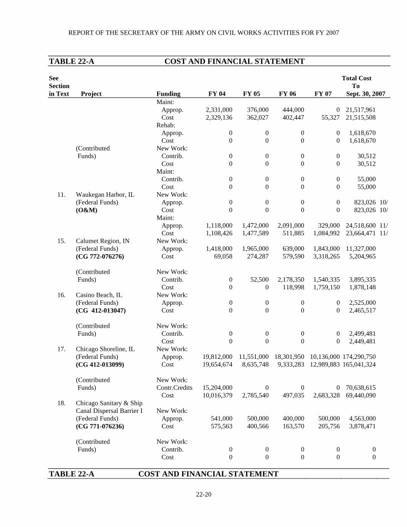
REPORT OF THE SECRETARY OF THE ARMY ON CIVIL WORKS ACTIVITIES FOR FY 2007
22-20
TABLE 22-A COST AND FINANCIAL STATEMENT
See Total Cost Section To in Text Project Funding FY 04 FY 05 FY 06 FY 07 Sept. 30, 2007
Maint: Approp. 2,331,000 376,000 444,000 0 21,517,961 Cost 2,329,136 362,027 402,447 55,327 21,515,508 Rehab: Approp. 0 0 0 0 1,618,670 Cost 0 0 0 0 1,618,670 (Contributed New Work: Funds) Contrib. 0 0 0 0 30,512 Cost 0 0 0 0 30,512 Maint: Contrib. 0 0 0 0 55,000 Cost 0 0 0 0 55,000
11. Waukegan Harbor, IL New Work: (Federal Funds) Approp. 0 0 0 0 823,026 10/ (O&M) Cost 0 0 0 0 823,026 10/ Maint: Approp. 1,118,000 1,472,000 2,091,000 329,000 24,518,600 11/ Cost 1,108,426 1,477,589 511,885 1,084,992 23,664,471 11/
15. Calumet Region, IN New Work: (Federal Funds) Approp. 1,418,000 1,965,000 639,000 1,843,000 11,327,000 (CG 772-076276) Cost 69,058 274,287 579,590 3,318,265 5,204,965 (Contributed New Work: Funds) Contrib. 0 52,500 2,178,350 1,540,335 3,895,335 Cost 0 0 118,998 1,759,150 1,878,148
16. Casino Beach, IL New Work: (Federal Funds) Approp. 0 0 0 0 2,525,000 (CG 412-013047) Cost 0 0 0 0 2,465,517 (Contributed New Work: Funds) Contrib. 0 0 0 0 2,499,481 Cost 0 0 0 0 2,449,481
17. Chicago Shoreline, IL New Work: (Federal Funds) Approp. 19,812,000 11,551,000 18,301,950 10,136,000 174,290,750 (CG 412-013099) Cost 19,654,674 8,635,748 9,333,283 12,989,883 165,041,324 (Contributed New Work: Funds) Contr.Credits 15,204,000 0 0 0 70,638,615 Cost 10,016,379 2,785,540 497,035 2,683,328 69,440,090
18. Chicago Sanitary & Ship Canal Dispersal Barrier I New Work: (Federal Funds) Approp. 541,000 500,000 400,000 500,000 4,563,000 (CG 771-076236) Cost 575,563 400,566 163,570 205,756 3,878,471 (Contributed New Work: Funds) Contrib. 0 0 0 0 0 Cost 0 0 0 0 0
TABLE 22-A COST AND FINANCIAL STATEMENT
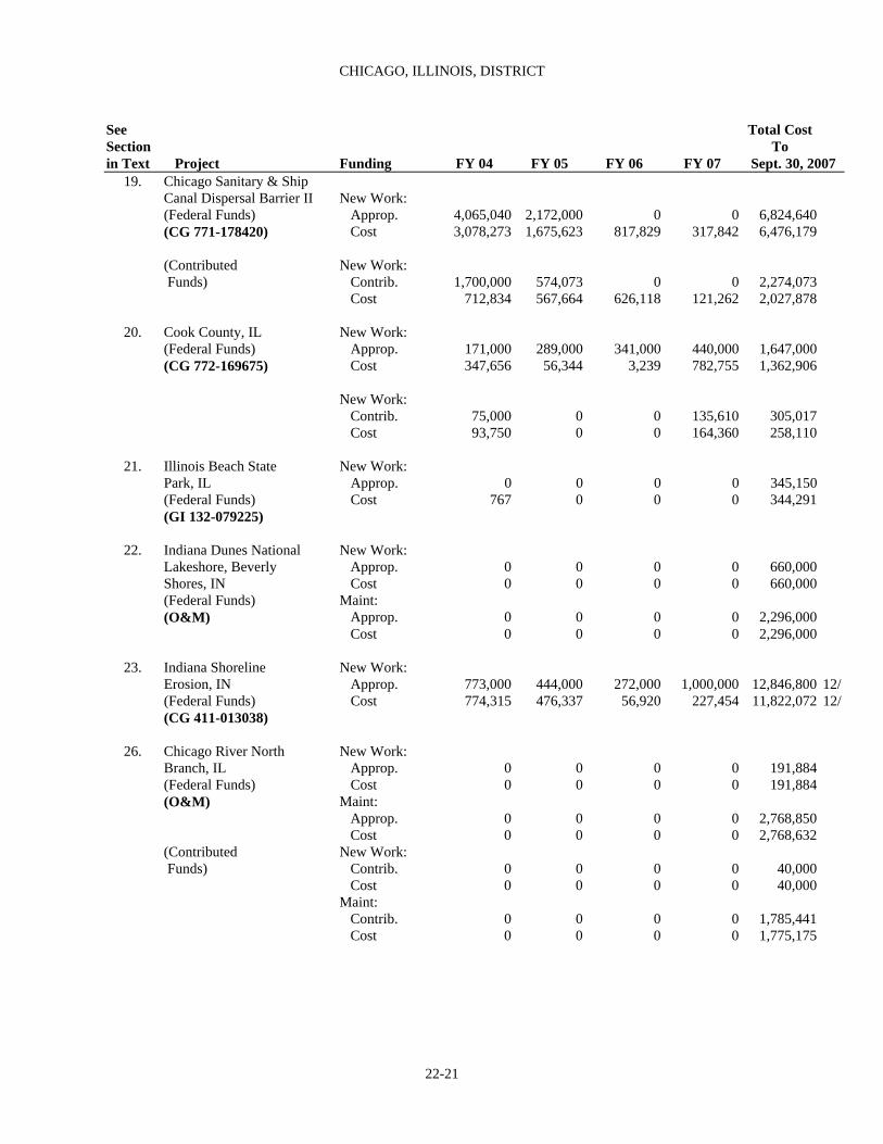
CHICAGO, ILLINOIS, DISTRICT
22-21
See Total CostSection To in Text Project Funding FY 04 FY 05 FY 06 FY 07 Sept. 30, 2007
19. Chicago Sanitary & Ship Canal Dispersal Barrier II New Work: (Federal Funds) Approp. 4,065,040 2,172,000 0 0 6,824,640 (CG 771-178420) Cost 3,078,273 1,675,623 817,829 317,842 6,476,179
(Contributed New Work: Funds) Contrib. 1,700,000 574,073 0 0 2,274,073 Cost 712,834 567,664 626,118 121,262 2,027,878
20. Cook County, IL New Work:
(Federal Funds) Approp. 171,000 289,000 341,000 440,000 1,647,000 (CG 772-169675) Cost 347,656 56,344 3,239 782,755 1,362,906
New Work: Contrib. 75,000 0 0 135,610 305,017 Cost 93,750 0 0 164,360 258,110
21. Illinois Beach State New Work: Park, IL Approp. 0 0 0 0 345,150 (Federal Funds) Cost 767 0 0 0 344,291 (GI 132-079225)
22. Indiana Dunes National New Work: Lakeshore, Beverly Approp. 0 0 0 0 660,000 Shores, IN Cost 0 0 0 0 660,000 (Federal Funds) Maint: (O&M) Approp. 0 0 0 0 2,296,000
Cost 0 0 0 0 2,296,000
23. Indiana Shoreline New Work: Erosion, IN Approp. 773,000 444,000 272,000 1,000,000 12,846,800 12/ (Federal Funds) Cost 774,315 476,337 56,920 227,454 11,822,072 12/ (CG 411-013038)
26. Chicago River North New Work: Branch, IL Approp. 0 0 0 0 191,884 (Federal Funds) Cost 0 0 0 0 191,884 (O&M) Maint: Approp. 0 0 0 0 2,768,850 Cost 0 0 0 0 2,768,632 (Contributed New Work: Funds) Contrib. 0 0 0 0 40,000 Cost 0 0 0 0 40,000 Maint: Contrib. 0 0 0 0 1,785,441 Cost 0 0 0 0 1,775,175

REPORT OF THE SECRETARY OF THE ARMY ON CIVIL WORKS ACTIVITIES FOR FY 2007
22-22
TABLE 22-A COST AND FINANCIAL STATEMENT
See Total CostSection To in Text Project Funding FY 04 FY 05 FY 06 FY 07 Sept. 30, 2007
27. Des Plaines River (PED), IL New Work: (Federal Funds) Approp. 0 0 495,000 750,000 2,178,968
(GI ; 451- & 651-) Cost 432 43,189 445,962 669,568 2,092,687 New Work: (Contributed Contrib. 0 0 0 0 414,989 Funds) Cost -24,689 0 27,950 (-232,202) 182,240 (CG 511-010249) New Work: (Federal Funds) Approp. 309,000 1,367,000 3,559,000 6,000,000 11,634,968 Cost 386,887 1,229,819 843,681 696,771 3,452,529 (Contributed New Work: Funds) Contrib. 0 0 0 0 0 Cost 0 0 0 0 0
28. Lake George, Hobart, IN New Work:
(CG 511-008196) Approp. 0 0 0 0 1,320,000 Federal Funds Cost 0 1,500 0 0 1,314,167
29. Little Calumet River, IN New Work: (Federal Funds) Approp. 3,990,000 4,886,000 8,435,000 14,000,000 120,072,300 13/ (CG 511-075325) Cost 3,577,567 5,328,106 8,311,393 10,501,940 116,267,161 13/ (Contributed New Work: Funds Required) Contrib. 256,000 300,000 2,503,000 636,335 10,551,207 Cost 190,568 258,977 2,125,250 6,211 9,356,733 (Non-Federal New Work: Improvements) Contrib. 0 0 0 0 2,207,500 Cost 0 0 0 0 2,196,677
30. Little Calumet River, New Work: Cady Marsh Ditch, IN Approp. 3,477,000 5,142,000 8,118,000 4,000,000 23,673,600 (Federal Funds) Cost 1,310,595 7,221,486 8,667,703 679,580 19,949,354 (CG 511-012385) (Contributed Funds) Contrib. 0 2,570,029 2,250,000 125,000 4,945,029 Cost 0 2,036,322 2,597,645 241,421 4,875,388
31. McCook and Thornton New Work:
Reservoirs, IL Approp. 20,024,000 27,771,800 25,825,000 25,825,000 130,734,400 (Federal Funds) Cost 19,774,562 27,587,622 17,660,719 17,660,719 121,939,191 (CG 511-012574) New Work: (Contributed Contrib. 15,505,400 0 0 0 39,895,400 Funds) Cost 12,806,005 (-6,513,827) (-7,075,941) 3,396,294 29,216,672
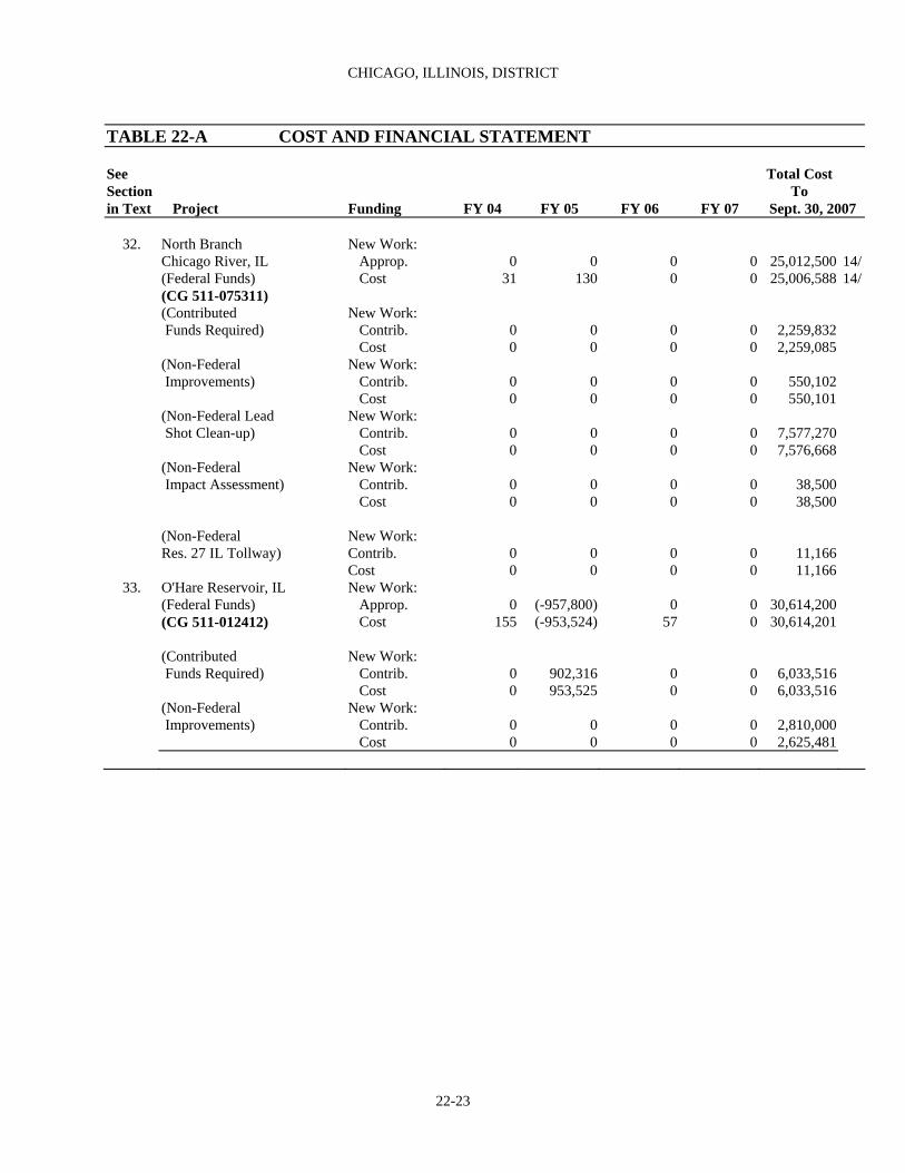
CHICAGO, ILLINOIS, DISTRICT
22-23
TABLE 22-A COST AND FINANCIAL STATEMENT
See Total CostSection To in Text Project Funding FY 04 FY 05 FY 06 FY 07 Sept. 30, 2007
32. North Branch New Work:
Chicago River, IL Approp. 0 0 0 0 25,012,500 14/ (Federal Funds) Cost 31 130 0 0 25,006,588 14/ (CG 511-075311) (Contributed New Work: Funds Required) Contrib. 0 0 0 0 2,259,832 Cost 0 0 0 0 2,259,085 (Non-Federal New Work: Improvements) Contrib. 0 0 0 0 550,102 Cost 0 0 0 0 550,101 (Non-Federal Lead New Work: Shot Clean-up) Contrib. 0 0 0 0 7,577,270 Cost 0 0 0 0 7,576,668 (Non-Federal New Work: Impact Assessment) Contrib. 0 0 0 0 38,500 Cost 0 0 0 0 38,500 (Non-Federal New Work: Res. 27 IL Tollway) Contrib. 0 0 0 0 11,166 Cost 0 0 0 0 11,166
33. O'Hare Reservoir, IL New Work: (Federal Funds) Approp. 0 (-957,800) 0 0 30,614,200
(CG 511-012412) Cost 155 (-953,524) 57 0 30,614,201 (Contributed New Work: Funds Required) Contrib. 0 902,316 0 0 6,033,516 Cost 0 953,525 0 0 6,033,516 (Non-Federal New Work: Improvements) Contrib. 0 0 0 0 2,810,000 Cost 0 0 0 0 2,625,481
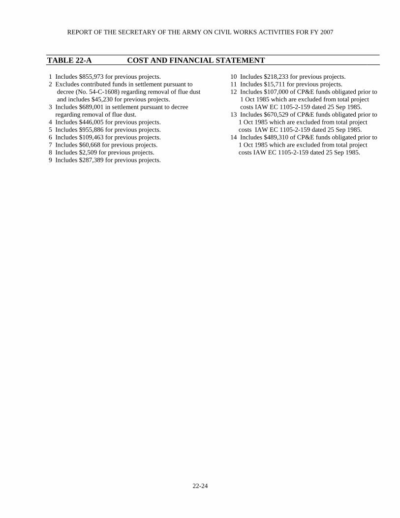
REPORT OF THE SECRETARY OF THE ARMY ON CIVIL WORKS ACTIVITIES FOR FY 2007
22-24
TABLE 22-A COST AND FINANCIAL STATEMENT 1 Includes $855,973 for previous projects. 10 Includes $218,233 for previous projects. 2 Excludes contributed funds in settlement pursuant to 11 Includes $15,711 for previous projects. decree (No. 54-C-1608) regarding removal of flue dust 12 Includes $107,000 of CP&E funds obligated prior to and includes $45,230 for previous projects. 3 Includes $689,001 in settlement pursuant to decree
1 Oct 1985 which are excluded from total project costs IAW EC 1105-2-159 dated 25 Sep 1985.
regarding removal of flue dust. 4 Includes $446,005 for previous projects. 5 Includes $955,886 for previous projects.
13 Includes $670,529 of CP&E funds obligated prior to 1 Oct 1985 which are excluded from total project costs IAW EC 1105-2-159 dated 25 Sep 1985.
6 Includes $109,463 for previous projects. 7 Includes $60,668 for previous projects. 8 Includes $2,509 for previous projects.
14 Includes $489,310 of CP&E funds obligated prior to 1 Oct 1985 which are excluded from total project costs IAW EC 1105-2-159 dated 25 Sep 1985.
9 Includes $287,389 for previous projects.

CHICAGO, ILLINOIS, DISTRICT
22-25
TABLE 22-B AUTHORIZING LEGISLATION
Acts Work Authorized Documents
BURNS WATERWAY HARBOR, IN (See Section 1 and 3 of Text) Oct. 27, 1965 Provides for breakwater and channel to present dimensions and Public Law, 89-298, depths, a north breakwater, west bulkhead, approach channel and H. Doc. 160. 88th Cong., outer harbor, east and west harbor arms. 1st Sess. Nov. 20, 2004 Provides for the dredging of sediments accumulating at the water Sec. 121 of Conf Rpt intake structure of the Bailey Generating Plant (NIPSCO) at HR 4818 100% federal cost or $100,000. Report 108-792 Nov. 8, 2007 Provides a study to determine if damage prevention or mitigation Sec. 1009, WRDA 2007 project is feasible.
BURNS WATERWAY SBH, IN (See Section 2 of Text)
Jul. 14, 1960 Provides for a 700-foot north breakwater, a 950-foot west breakwater Detailed Project Report Sec. 107 an entrance channel 11-feet deep, a harbor-of-refuge area 10 feet detailed February 1983. deep and a channel in Burns Waterway 6 feet deep. CALUMET HARBOR AND RIVER, IL AND IN (See Section 4 of Text) Mar. 3, 1899 Outer harbor protected by breakwaters. Annual Report, 1896, pp. 2584 et Seq. and H. Doc. Jun. 13, 1902 277, 54th Cong., 1st Sess. Mar. 3, 1905 Five turning basins. H. Doc. 172, 54th Cong., 2nd Sess. Jun. 25, 1910 Provided for shape and dimensions of turning basins. H. Doc. 346, 60th Cong., 1st Sess. Sep. 22, 1922 Consolidated the two projects for Calumet Harbor and Calumet River. Aug. 30, 19351,2 Detached breakwater, dredging outer harbor to existing project depth H. Doc. 494, 72nd Cong., and dimensions; deepen river entrance channel and river to existing 2nd Sess. project depths; widen and straighten river channel; five turning basins to same depth as adjacent channel. Aug. 30, 1935 Dredging area A and B in south end of Lake Calumet and an entrance H. Doc. 180, 73rd Cong., channel 300 feet wide and 21 feet deep. 2nd Sess. Mar. 2, 19453 An approach channel to harbor 3,200 feet wide and 28 feet deep H. Doc. 233, 76th Cong., through shoals outside breakwater and closing existing gap between 1st Sess. breakwaters. Jul. 14, 196013 Depth of 29 feet in lake approach to 28 feet in outer harbor, and 27 H. Doc. 149, 86th Cong., feet in river entrance up to E.J. & E. Ry. Bridge. 1st Sess.8
Oct. 23, 196213 Deepen, widen and straighten channel in Calumet River from E.J. and H. Doc. 87th Cong., E. Ry. Bridge, to and including turning basins 1, 3 and 5 to 27 feet; 2nd Sess.5 enlarge turning basins 3 and 5; channel into Lake Calumet to 27 feet deep for 3,000 feet and a width of 1,000 feet; and eliminate turning basins 2 and 4 from project. Oct 27, 196513 Modification of Act of Oct 23, 1962. Protection for Elgin, Joliet and H.R. 973, 89th Cong., Eastern Railway Bridge over the Calumet River, to permit dredging to 1st Sess. full width of the south draw to depth of 27 feet, and temporary protection for center pier and south abutment of the New York, Chicago and St. Louis Railroad Bridge (Nickel Plate) to permit dredging of full width of south bridge draw to depth of 27 feet prior to its replacement.

REPORT OF THE SECRETARY OF THE ARMY ON CIVIL WORKS ACTIVITIES FOR FY 2007
22-26
TABLE 22-B AUTHORIZING LEGISLATION
Acts Work Authorized Documents CHICAGO HARBOR, IL (See Section 5 of Text) Jul. 11, 1870 Inner breakwaters and inner basin. H. Ex. Doc. 114, 41st Cong. 2nd Sess. and Annual Report 1870, pp. 1562-1567 Jun. 14, 1880 Exterior breakwater. Annual Report 1870, pp. 1562-1567 Mar. 3, 1899 Present project depth in basin and entrance to Chicago River. Annual Report 1897, pp. 2790-2791 Jul. 25, 1912 Shore-arm and southerly extension of exterior breakwater H.Doc 710, Cong, 2d Sess Mar. 2, 1919 Modification of area to be dredged in inner basin. H.Doc 1303, 64th Cong, 1st Sess. Mar 3, 1931 Shore-arm extension of exterior breakwater transferred to Lincoln Public Law 797, 71st Cong Park Commissioners. Mar. 2, 1945 Resumption of jurisdiction over shore-arm extension breakwater Public Law 14, 79th Cong. and over certain navigable waters in Lake Michigan which lie in northwestern part of outer harbor. Oct. 23, 1962 Deepen a lake approach channel to 29 by 800 feet wide for 6,600 feet; H.Doc. 485, 87th Cong., deepen channel and maneuver area inside harbor entrance to 28 by 2nd Sess.4 1,300 feet wide. Dec. 4, 1981 Provides for lock operations and maintenance responsibilities in the Sec. 107 of P.L. 97-88 Jul. 30, 1983 interests of navigation. P.L. 98-63 CHICAGO SHIP AND SANITARY CANAL DISPERSAL BARRIER I (See Section 18 of Text) Nov. 29, 1990 Provide a Barrier Demonstration Project to prevent non-indigenous Sec 1202( i )(3) of aquatic species from traveling between the Mississippi River and P.L. 101-636 Great Lakes drainage basins Oct. 26, 1996 Funding increased to complete project. P.L. 101-636, Amended Nov. 8, 2007 The 2 barriers are considered a single project; 100% federal project; Sec. 3061, WRDA 2007 upgrade and & make permanent existing barrier; finish construction of barrier II; operate & maintain Barrier I & II to optimize effectiveness; conduct a study of options and technologies to improve efficacy of barriers; credit states; and a feasibility study to prevent spread of invasive species between Great Lakes and Mississippi River Basin and other aquatic pathways. CHICAGO SHIP AND SANITARY CANAL DISPERSAL BARRIER II (See section 19 of Text) Oct. 18, 2004 Provide a Permanent Barrier to prevent non-indigenous aquatic Sec. 345 of P.L. 108-335 species from traveling between the Mississippi River and Great Lakes drainage basins Nov. 8, 2007 The 2 barriers are considered a single project; 100% federal project; Sec. 3061, WRDA 2007 upgrade and & make permanent existing barrier; finish construction of barrier II; operate & maintain Barrier I & II to optimize effectiveness; conduct a study of options and technologies to improve efficacy of barriers; credit states; and a feasibility study to prevent spread of invasive species between Great Lakes and Mississippi River Basin and other aquatic pathways.
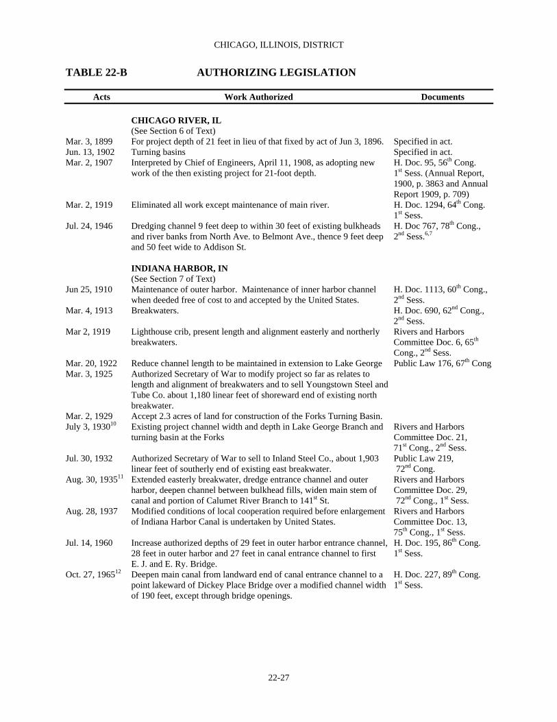
CHICAGO, ILLINOIS, DISTRICT
22-27
TABLE 22-B AUTHORIZING LEGISLATION
Acts Work Authorized Documents CHICAGO RIVER, IL (See Section 6 of Text) Mar. 3, 1899 For project depth of 21 feet in lieu of that fixed by act of Jun 3, 1896. Specified in act. Jun. 13, 1902 Turning basins Specified in act. Mar. 2, 1907 Interpreted by Chief of Engineers, April 11, 1908, as adopting new H. Doc. 95, 56th Cong. work of the then existing project for 21-foot depth. 1st Sess. (Annual Report, 1900, p. 3863 and Annual Report 1909, p. 709) Mar. 2, 1919 Eliminated all work except maintenance of main river. H. Doc. 1294, 64th Cong. 1st Sess. Jul. 24, 1946 Dredging channel 9 feet deep to within 30 feet of existing bulkheads H. Doc 767, 78th Cong., and river banks from North Ave. to Belmont Ave., thence 9 feet deep 2nd Sess.6,7 and 50 feet wide to Addison St. INDIANA HARBOR, IN (See Section 7 of Text) Jun 25, 1910 Maintenance of outer harbor. Maintenance of inner harbor channel H. Doc. 1113, 60th Cong., when deeded free of cost to and accepted by the United States. 2nd Sess. Mar. 4, 1913 Breakwaters. H. Doc. 690, 62nd Cong., 2nd Sess. Mar 2, 1919 Lighthouse crib, present length and alignment easterly and northerly Rivers and Harbors breakwaters. Committee Doc. 6, 65th Cong., 2nd Sess. Mar. 20, 1922 Reduce channel length to be maintained in extension to Lake George Public Law 176, 67th Cong Mar. 3, 1925 Authorized Secretary of War to modify project so far as relates to length and alignment of breakwaters and to sell Youngstown Steel and Tube Co. about 1,180 linear feet of shoreward end of existing north breakwater. Mar. 2, 1929 Accept 2.3 acres of land for construction of the Forks Turning Basin. July 3, 193010 Existing project channel width and depth in Lake George Branch and Rivers and Harbors turning basin at the Forks Committee Doc. 21, 71st Cong., 2nd Sess. Jul. 30, 1932 Authorized Secretary of War to sell to Inland Steel Co., about 1,903 Public Law 219, linear feet of southerly end of existing east breakwater. 72nd Cong. Aug. 30, 193511 Extended easterly breakwater, dredge entrance channel and outer Rivers and Harbors harbor, deepen channel between bulkhead fills, widen main stem of Committee Doc. 29, canal and portion of Calumet River Branch to 141st St. 72nd Cong., 1st Sess. Aug. 28, 1937 Modified conditions of local cooperation required before enlargement Rivers and Harbors of Indiana Harbor Canal is undertaken by United States. Committee Doc. 13, 75th Cong., 1st Sess. Jul. 14, 1960 Increase authorized depths of 29 feet in outer harbor entrance channel, H. Doc. 195, 86th Cong. 28 feet in outer harbor and 27 feet in canal entrance channel to first 1st Sess.
E. J. and E. Ry. Bridge. Oct. 27, 196512 Deepen main canal from landward end of canal entrance channel to a H. Doc. 227, 89th Cong. point lakeward of Dickey Place Bridge over a modified channel width 1st Sess. of 190 feet, except through bridge openings.
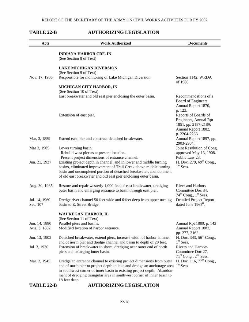
REPORT OF THE SECRETARY OF THE ARMY ON CIVIL WORKS ACTIVITIES FOR FY 2007
22-28
TABLE 22-B AUTHORIZING LEGISLATION
Acts Work Authorized Documents
INDIANA HARBOR CDF, IN (See Section 8 of Text) LAKE MICHIGAN DIVERSION (See Section 9 of Text) Nov. 17, 1986 Responsible for monitoring of Lake Michigan Diversion. Section 1142, WRDA of 1986 MICHIGAN CITY HARBOR, IN (See Section 10 of Text) East breakwater and old east pier enclosing the outer basin. Recommendations of a Board of Engineers, Annual Report 1870, p. 123. Extension of east pier. Reports of Boards of Engineers, Annual Rpt 1851, pp. 2187-2189; Annual Report 1882, p. 2264-2266. Mar, 3, 1889 Extend east pier and construct detached breakwater. Annual Report 1897, pp. 2903-2904. Mar 3, 1905 Lower turning basin. Joint Resolution of Cong. Rebuild west pier as at present location. approved May 13, 1908. Present project dimensions of entrance channel. Public Law 23. Jun. 21, 1927 Existing project depth in channel, and in lower and middle turning H. Doc. 279, 69th Cong., basins, eliminated improvement of Trail Creek above middle turning 1st Sess. basin and uncompleted portion of detached breakwater, abandonment of old east breakwater and old east pier enclosing outer basin. Aug. 30, 1935 Restore and repair westerly 1,000 feet of east breakwater, dredging River and Harbors outer basin and enlarging entrance to basin through east pier. Committee Doc 34, 74th Cong., 1st Sess. Jul. 14, 1960 Dredge river channel 50 feet wide and 6 feet deep from upper turning Detailed Project Report Sec. 107 basin to E. Street Bridge. dated June 19658. WAUKEGAN HARBOR, IL (See Section 11 of Text) Jun. 14, 1880 Parallel piers and basins. Annual Rpt 1880, p. 142 Aug. 3, 1882 Modified location of harbor entrance. Annual Report 1882, pp. 277, 2162. Jun. 13, 1902 Detached breakwater, extend piers, increase width of harbor at inner H. Doc. 343, 56th Cong., end of north pier and dredge channel and basin to depth of 20 feet. 1st Sess. Jul. 3, 1930 Extension of breakwater to shore, dredging near outer end of north Rivers and Harbors piers and enlarging inner basin. Committee Doc 27, 71st Cong., 2nd Sess. Mar. 2, 1945 Dredge an entrance channel to existing project dimensions from outer H. Doc. 116, 77th Cong., end of north pier to project depth in lake and dredge an anchorage area 1st Sess. in southwest corner of inner basin to existing project depth. Abandon- ment of dredging triangular area in southwest corner of inner basin to 18 feet deep. TABLE 22-B AUTHORIZING LEGISLATION
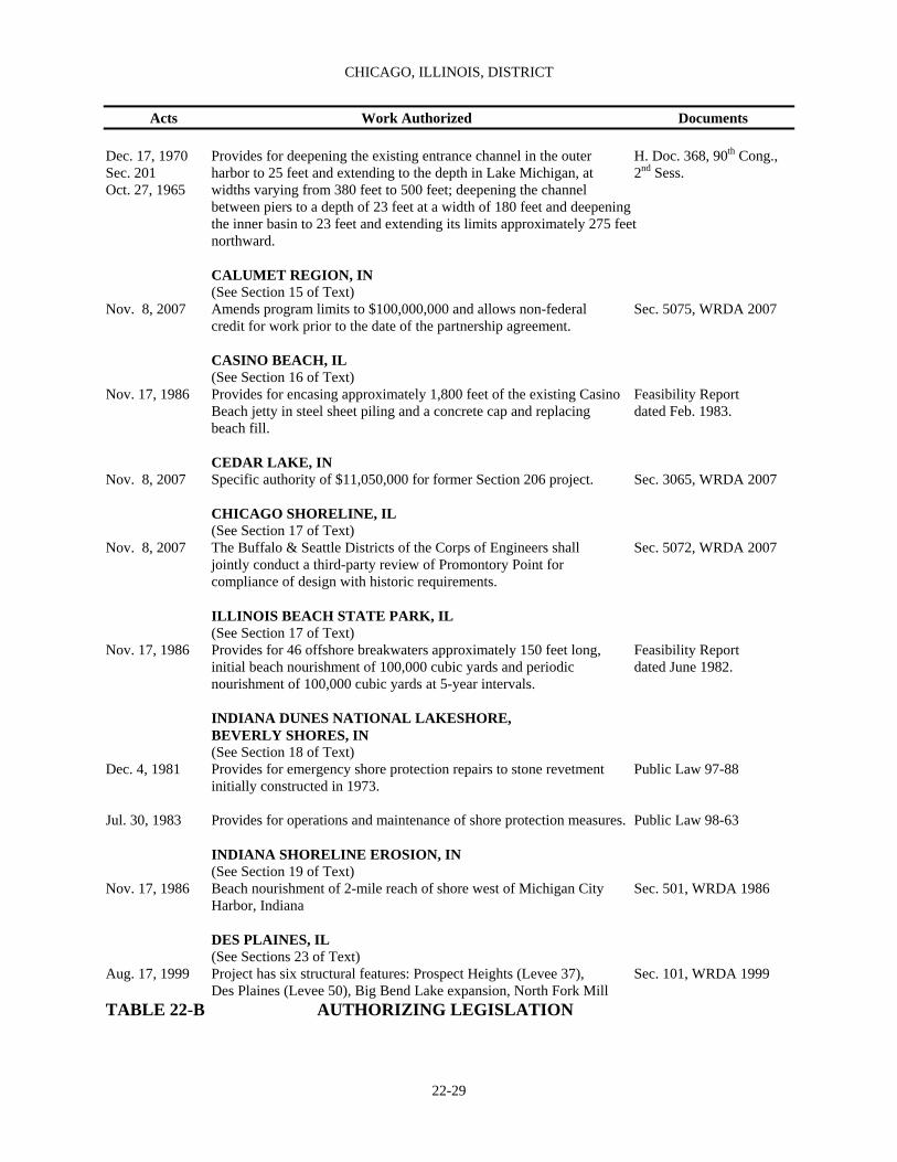
CHICAGO, ILLINOIS, DISTRICT
22-29
Acts Work Authorized Documents Dec. 17, 1970 Provides for deepening the existing entrance channel in the outer H. Doc. 368, 90th Cong., Sec. 201 harbor to 25 feet and extending to the depth in Lake Michigan, at 2nd Sess. Oct. 27, 1965 widths varying from 380 feet to 500 feet; deepening the channel between piers to a depth of 23 feet at a width of 180 feet and deepening the inner basin to 23 feet and extending its limits approximately 275 feet northward. CALUMET REGION, IN (See Section 15 of Text) Nov. 8, 2007 Amends program limits to $100,000,000 and allows non-federal Sec. 5075, WRDA 2007 credit for work prior to the date of the partnership agreement.
CASINO BEACH, IL (See Section 16 of Text) Nov. 17, 1986 Provides for encasing approximately 1,800 feet of the existing Casino Feasibility Report Beach jetty in steel sheet piling and a concrete cap and replacing dated Feb. 1983. beach fill. CEDAR LAKE, IN Nov. 8, 2007 Specific authority of $11,050,000 for former Section 206 project. Sec. 3065, WRDA 2007
CHICAGO SHORELINE, IL (See Section 17 of Text) Nov. 8, 2007 The Buffalo & Seattle Districts of the Corps of Engineers shall Sec. 5072, WRDA 2007 jointly conduct a third-party review of Promontory Point for compliance of design with historic requirements.
ILLINOIS BEACH STATE PARK, IL
(See Section 17 of Text) Nov. 17, 1986 Provides for 46 offshore breakwaters approximately 150 feet long, Feasibility Report initial beach nourishment of 100,000 cubic yards and periodic dated June 1982. nourishment of 100,000 cubic yards at 5-year intervals.
INDIANA DUNES NATIONAL LAKESHORE, BEVERLY SHORES, IN
(See Section 18 of Text) Dec. 4, 1981 Provides for emergency shore protection repairs to stone revetment Public Law 97-88 initially constructed in 1973. Jul. 30, 1983 Provides for operations and maintenance of shore protection measures. Public Law 98-63
INDIANA SHORELINE EROSION, IN
(See Section 19 of Text) Nov. 17, 1986 Beach nourishment of 2-mile reach of shore west of Michigan City Sec. 501, WRDA 1986 Harbor, Indiana DES PLAINES, IL (See Sections 23 of Text) Aug. 17, 1999 Project has six structural features: Prospect Heights (Levee 37), Sec. 101, WRDA 1999 Des Plaines (Levee 50), Big Bend Lake expansion, North Fork Mill TABLE 22-B AUTHORIZING LEGISLATION

REPORT OF THE SECRETARY OF THE ARMY ON CIVIL WORKS ACTIVITIES FOR FY 2007
22-30
Acts Work Authorized Documents Creek dam raise, Buffalo Creek expansion, Van Patten Woods lateral storage area. LAKE GEORGE, HOBART, IN (See Section 24 of Text) Nov. 17, 1986 Removal of silt, aquatic growth and construction of silt traps. Sec. 602, WRDA 1986. LITTLE CALUMET RIVER, IN (See Section 25 of Text) Nov 17, 1986 Provides for levee construction, a diversion control structure at the Sec. 401, WRDA 1986 mouth of Hart Ditch. Permanent evacuation of a portion of the Black Oak area of Gary and non-structural flood proofing measures in Gary. Nov. 19, 2005 Authorizes project to exceed original Section 902 (b) cost limits. New Sec. 127 of P.L. 109-103 total cost of $198,000,000; fed share is $148,500,000; non-fed share is $49,500,000. LITTLE CALUMET RIVER BASIN, CADY MARSH DITCH, IN (See Section 26 of Text) Nov. 17, 1986 Widening and deepening 1,250 feet of Cady Marsh Ditch, installing Feasibility Report 4,880 feet of pipe and excavating 2,850 feet of open channel. dated April 1984 McCOOK AND THORNTON RESERVOIRS, IL (See Section 27 of Text) Nov. 17, 1988 Provides for construction of two floodwater storage reservoirs in the Sec. 3, WRDA 1988 quarries of the same name. NORTH BRANCH CHICAGO RIVER, IL (See Sections 22 and 28 of Text) Nov. 17, 1986 Construction of three reservoirs and reimbursement to locals for 50% H. Doc. 100-72, 100th of the costs of Techny and Mid-Fork Reservoirs Cong., 1st Sess., Sec. 401, WRDA 1986. Dec. 31, 1970 Clearing fallen trees, roots and other debris and objects which River and Harbor Act contribute to flooding. (Sec. 116) O’HARE RESERVOIR, IL (See Section 29 of Text) Nov. 17, 1986 Provides for a 1,050 acre-foot excavated reservoir. Sec. 401, WRDA 1986 THORNTON RESERVOIR, IL (See Section 31 of Text) Nov. 8, 2007 Allows the construction of the flood control project by Sec. 5157, WRDA 2007 non-federal interests.
LAKE MICHIGAN WATERFRONT (See Section 125 of Text) Nov. 19, 2005 Provides ecosystem restoration and the management of Sec. 125 of P.L. 109-103 Contaminates along Lake Michigan and related areas in Lake Porter Counties, Indiana. TABLE 22-B AUTHORIZING LEGISLATION

CHICAGO, ILLINOIS, DISTRICT
22-31
Acts Work Authorized Documents 1. Included in Public Works Administrative Program 7. Contains latest published map of North Branch Sep. 6, 1943 and Dec. 16, 1933. above North Ave. 2. Uncompleted portion was deauthorized in 1977 8. Contains latest published map. (dredging in front of U.S. Steel Corp.) 9. Completed under previous project. 3. Uncompleted portion was deauthorized in 1977 10. Uncompleted portion was deauthorized in 1977 (breakwater closure). (widen and deepen Lake George Branch). 4. Contains latest map of harbor. Uncompleted portion 11. Include in Public Works Administration Program is inactive. Sep. 6, 1933 and Jul. 25, 1934. Uncompleted 5. Contains latest map of river. portion was deauthorized in 1977 (widen and 6. Latest published map is in Annual Report for 1914, deepen main canal and Calumet River Branch). opposite p. 2928. 12. Project deauthorized in 1977.
13. Project deauthorized in 1989.

REPORT OF THE SECRETARY OF THE ARMY ON CIVIL WORKS ACTIVITIES FOR FY 2007
22-32
TABLE 22-C EXISTING NAVIGATION PROJECTS
See Section Length Width Depth
In Text Project Item (feet) (feet) (feet) 1. Burns Waterway North Breakwater 4,630 ____ ____ Harbor, IN West Breakwater 1,200 ____ ____ Approach Channel 2,200 400 30 Outer Harbor 3,700 Varies 28 East Harbor Arm 2,100 620 27 West Harbor Arm 3,800 620 27 2. Burns Waterway North Breakwater 678 ____ ____ SBH, IN West Breakwater 1,043 ____ ____ Approach Channel 1,200 200 11 Burns Waterway 5,593 100 9 4. Calumet Harbor Northerly Crib Breakwater 6,714 ____ ____ and River, IL and IN Southerly Steel Breakwater 5,007 ____ ____ North Pier 2,450 ____ ____ Chicago Confined Disposal Facility 2,979 ____ ____ Approach Channel 9,700 3,200 29 Outer Harbor 10,500 3,000 28 River Entrance 3,000 290 27 Elgin, Joliet & Eastern Railway Bridge 21,000 200 27 to turning basin No. 3 Turning Basin No. 3 to Turning Basin No.5 8,000 Variable 27 Approach into Lake Calumet 4,000 400 27 Extension in Lake Calumet 3,000 1,000 27 Turning Basins 1, 3 and 5 ____ ____ 27 5. Chicago Harbor, IL Shore Arm Extension 2,250 ____ ____ Exterior Breakwater 5,421 ____ ____ Exterior Breakwater Southerly Extension 4,944 ____ ____ North Inner Breakwater 4,034 ____ ____ South Inner Breakwater 2,544 ____ ____ North Pier 960 ____ ____ Approach Channel 6,600 800 29 Channel and maneuver 2,200 1,300 28 Lock 600 80 23 Inner Basin 1,270 740 21 Entrance Channel 7,300 190-470 21 6. Chicago River, IL Main Branch of Chicago River 3,800 190-390 21 North Branch of Chicago River 11,100 91-390 21 North Branch Canal 5,500 56-210 21 North Branch Turning Basin ____ ____ 21

CHICAGO, ILLINOIS, DISTRICT
22-33
TABLE 22-C EXISTING NAVIGATION PROJECTS
See Section Length Width Depth
In Text Project Item (feet) (feet) (feet) 7. Indiana Harbor, IN Northerly Breakwater 1,120 ____ ____ Easterly Breakwater 2,525 ____ ____ Approach Channel 7,200 800 29 Outer Harbor 7,200 Varies 28 Entrance Channel 3,600 65-280 27 Main Channel 7,400 61-210 22 Turning Basin ____ ____ 22 Lake George Branch 3,700 64-160 22 Calumet River Branch 2,500 160-260 22 9. Michigan City Harbor Detached Breakwater 1,304 ____ ____ IN West Pier 835 ____ ____ East Pier 2,276 ____ ____ East Breakwater 1,000 ____ ____ Entrance Channel 1,900 150-425 18 Main Channel 2,400 120-150 18 Outer Basin 900 900 8-12 Trail Creek 3,000 50-100 8 Trail Creek 2,300 50 6 10. Waukegan Harbor, IL North Breakwater and Shore Connection 1,896 ____ ____ North Pier into North Revetment 2,074 ____ ____ South Pier 3,111 ____ ____ Entrance Channel 3,250 390 22 Channel to Inner Basin 1,700 200 18 Inner Basin 1,650 375-500 18 Anchorage Area ____1 ____1 8 1Area of about 6 acres.

REPORT OF THE SECRETARY OF THE ARMY ON CIVIL WORKS ACTIVITIES FOR FY 2007
22-34
TABLE 22-D OTHER AUTHORIZED BRIDGE ALTERATION Cost to September 30, 2004
For Last Full Report See Annual Operation and Project Report For Construction Maintenance Calumet River Bridges1 1967 $1,625,068 ____ 1Transferred to Department of Transportation in accordance with Section 6(g) of the Act of October 16,1966. P.L. 89-670 TABLE 22-E OTHER AUTHORIZED BEACH EROSION PROJECTS Cost to September 30, 2004
For Last Full Report See Annual Operation and Project Report For Construction Maintenance Mt. Baldy, Indiana Dunes National Lakeshore, IN 1984 $1,500,000 ____ Hollywood-Ardmore Beach, Chicago, IL 1982 237,271 ____ Evanston, IL 1979 766,052 ____ Lake Michigan-Lake Bluff, IL 1976 244,889 ____ Lake Michigan-Lake Forest, IL1 1975 65,611 ____ Illinois Shore of Lake Michigan, Kenilworth, IL2 1975 5,200 ____ 1Authorized by River and Harbor Act of 1954. 2Uncompleted portion deauthorized in 1977. TABLE 22-F OTHER AUTHORIZED FLOOD CONTROL PROJECTS Cost to September 30, 2004
For Last Full Report See Annual Operation and Project Report For Construction Maintenance Lake Michigan, Edgewater/Rogers Park Communities, Chicago, IL 1989 $2,062,347 ____ Kankakee River Ice Management 1993 44,791 ____

CHICAGO, ILLINOIS, DISTRICT
22-35
TABLE 22-G DEAUTHORIZED PROJECTS For Last Full Report Federal Contributed See Annual Date Funds Funds Report For Deauthorized Expended Expended Illinois Shore of Lake Michigan, Winnetka, IL 1975 1977 ---- ---- Illinois Shore of Lake Michigan, Chicago, IL 1975 1977 ---- ---- Kankakee River, IL and IN Levee between Shelby Bridge and Baum’s Bridge in IN 1938 Nov 17, 1986 ---- ---- Little Calumet River, IL and IN Little Calumet River and Tributaries, IL and IN 1968 Nov 17, 1986 53,136 ---- Calumet Harbor and River, IL and IN Widening and straightening the Calumet River in the vicinity of 106th Street and closing the gap between breakwaters, and dredging minor shoals in the outer harbor. 1990 Jan 1, 1990 ---- ---- Wilmington Ice Control Demonstration ---- Nov 18, 1991 ---- ----
NASHVILLE, TN, DISTRICT This district comprises portions of southern Kentucky, southwestern Virginia, western North Carolina, northern Georgia and Alabama, northeastern Mississippi and practically
all of Tennessee except western portion, and embraces drainage basins of Tennessee and Cumberland Rivers and their tributaries.
IMPROVEMENTS Navigation Page 1. Chickamauga Lock and Dam, TN…………….… 23-2 2. Cumberland River, TN and KY.............................23-2 3. Kentucky Lock Addition, KY................................23-2 4. Tennessee River, TN, AL and KY.........................23-3 5. Tennessee-Tombigbee Waterway, AL and MS................................................................. 23-3 6. Navigation Work Under Special Authorization ........................................................ 23-4 Alteration of Bridges 7. Authorized Alteration of Bridges.......................... 23-4 Flood Control 8. Big South Fork National River and Recreation Area, KY and TN ............................... 23-4 9. Black Fox, Murfree & Oaklands Springs, TN…. 23-4 10. Hamilton County, TN............................................ 23-4 11. Martins Fork Lake, KY......................................... 23-5 12. Middlesboro, Cumberland River Basin, KY ........ 23-5 13. Tug and Levisa Forks of the Big Sandy River and Cumberland River, W VA, VA and KY............................................................ 23-5 14. Ohio River Basin (Nashville Dist.) ...................... 23-6 15. Inspection of completed flood control projects ................................................................. 23-6 16. Flood control work under special authorization.......................................................... 23-6 Multiple-Purpose Projects, Including Power 17. Center Hill Lake, Ohio River Basin, TN............... 23-6 18. Dale Hollow Lake, Ohio River Basin, TN and KY............................................................ 23-6 19. J. Percy Priest Dam and Reservoir, Ohio River Basin, TN ........................................…........ 23-7 20. Laurel River Lake, Ohio River Basin, KY............ 23-7 21. Wolf Creek Dam - Lake Cumberland, Ohio River Basin, KY ................................................... 23-7 General Investigations 22. Surveys................................................................. 23-8 23. Collection and study of basic data .................….. 23-8 24. Preconstruction Engineering and Design ..…….. 23-8
Tables Page Table 23-A Cost & Financial Statement.....…........... 23-9 Table 23-B Authorizing Legislation ......................... 23-12 Table 23-C Other Authorized Navigation Projects.........................………………... 23-15 Table 23-D Not Applicable ...................................... Table 23-E Other Authorized Flood Control Projects………........................................ 23-16 Table 23-F Other Authorized Multiple-Purpose Projects, Including Power...…………… 23-16 Table 23-G Deauthorized Projects ............................ 23-17 Table 23-H Cumberland River, TN & KY, Principal Features................................... 23-18 Table 23-I Tennessee River Lock Dimensions..…... 23-20 Table 23-J Tennessee River Total Cost of Existing Project ..................…………… 23-22 Table 23-K Ohio River Basin (Nashville District) Local Protection ...................... 23-22 Table 23-L Reservoirs .......................…................... 23-22 Table 23-M Inspection of Completed Flood Control Projects ..........………………... 23-23 Table 23-N Flood Control Work Under Special Authorization …........……………......... 23-23
23-1
REPORT OF THE SECRETARY OF THE ARMY ON CIVIL WORKS ACTIVITIES FOR FY 2007
NAVIGATION
1. CHICKAMAUGA LOCK AND DAM, TN Location. Chickamauga Lock is seven miles northeast of Chattanooga at Tennessee River Mile 471 in Hamilton County, TN. Existing Project. The 60 feel x 360 feel lock has been in operation since 1940 and passes over 1.1 million tons of traffic each year. Soon after construction, TVA recognized that an alkali aggregate reaction problem (commonly called concrete growth) existed throughout the project. This expansion of the concrete leads to stability concerns throughout the structure and misalignment of mechanical components. The problem will continue to affect lock operations and eventually result in closure of the lock. TVA and the Corps have determined the lock could remain open until at least 2010 with annual aggressive maintenance but costs to maintain the lock will begin to exceed replacement costs. Lock closure would be a significant impact to the region and result in lost access to over 300 miles of the upper Tennessee River. This reach includes the city of Knoxville, TN, 2 TVA nuclear power plants, numerous industries and recreation facilities, and the DOE facilities at Oak Ridge, TN. Project Description. The existing lock will be replaced through construction of a 110 ft x 600 ft lock riverward of the existing structure and downstream of the dam. The project was authorized for construction by PL 108-7 and includes at least three major construction contracts; road, bridge and utilities relocations; cofferdam construction; and construction of the new lock and decommissioning of the existing lock. Based on an estimated construction cost of $364.6 M, the new lock project has a benefit/cost ratio of 1.1 @ 7%. Activities during fiscal year. FY 2007 funds were used to complete road and bridge relocations and continue cofferdam construction. Lock design also continued for a planned FY 2010 lock construction award. 2. CUMBERLAND RIVER, TN AND KY Location. Formed by junction of Poor and Clover Forks in Harlan County, KY, about 694.2 miles above its mouth, and flows west to Burnside, KY, from whence it makes a loop southwestward into Tennessee, passes Nashville, and returns northwestward to Kentucky, emptying into Ohio River near Smithland, KY (See Geological Survey base maps of Tennessee and Kentucky.) Previous projects. For details see pages 1898 and 1901 of Annual Report for 1915, and page 1208 of Annual Report for 1938, and pages 1069 and 1070 of Annual Report for 1962. Existing project. For details, see Annual Report for FY02. Local cooperation. Under modified project for 9-foot navigation and multiple-purpose development, recreation features of reservoir components are subject to certain conditions of non-Federal cost-sharing under Federal Water Project Recreation Act of 1965. Terminal facilities. There are 42 terminals on the Cumberland River (5 Municipally owned and open for public
use; 5 government owned facilities and 32 privately owned facilities). A total of 18 terminals have railroad connections. Principal commodities handled are petroleum products, stone, sands, gravel, coal, coke, iron, steel, chemicals and grain. Facilities considered adequate for existing commerce. For further information see page 695 of Annual Report for 1969. Operations during fiscal year. New work: None. Maintenance: Operations and Maintenance work included continued spillway gate repairs at Old Hickory Dam. Utility improvements were made at Harpeth River Campground on Cheatham Lake and the electric service was upgraded at Cedar Creek Campground on Old Hickory Lake. The roofs were replaced at Cheatham Power Plant and Lake Barkley Shop Building. An estimated 25.3 million tons of commodities were locked through the Cumberland River Locks. Commercial lockages were approximately 6,100 and 4,100 recreational craft were also locked through. Total sales energy generated at Barkley Dam (572,892,562 kw-hr) was made available through Southeastern Power Association to the Tennessee Valley Authority, Southern Illinois Power Cooperative, Big Rivers Rural Electric Cooperative Corporation, and Indiana Statewide Rural Electric Cooperative, Inc., Hoosier Energy Division. Total sales energy generated at Cheatham Dam (137,797,505 kw-hr), Cordell Hull (273,633,885 kw-hr), and Old Hickory (337,336,420 kw-hr) was made available for distribution. Activities under reservoir management program comprising malaria control, shoreline sanitation, land management and disposal, and maintenance of public-use facilities continued. 3. KENTUCKY LOCK ADDITION, KY Location. Kentucky Lock and Dam is located in western Kentucky at Mile 22.4 of the Tennessee River between Livingston and Marshall Counties. Existing Project. Kentucky L&D was completed in 1945 by the Tennessee Valley Authority. TVA continues to operate the dam and powerhouse while operation of the 110’x600’ navigation lock is the responsibility of the Nashville District. Products from 20 states pass through the system of Kentucky and Barkley Locks, the lower-most locks on the Tennessee and Cumberland Rivers, respectively. Over 80% of the commercial tows hauling these products pass through KY Lock instead of Barkley Lock because of difficult and costly navigation on the Cumberland River below Barkley. Since most of the tows are greater than 600’ in length, they must perform a time-consuming double lockage to transit through the existing 600’ long KY Lock. This results in average delays of between four to six hours per tow under existing traffic levels. Since the traffic levels are expected to grow in the near future, these delays will also increase. The last traffic forecast developed in 1995 estimated that 43 M tons of products would be transported through the Kentucky-Barkley system in the year 2000. Actual tonnage for the system in 1997 was 43.5 M tons and decreased slightly in the following few years. The system has seen increased tonnage in the last few years with 2006 tonnage at 42.5 M tons. It typically costs
23-2
NASHVILLE, TN, DISTRICT
a tow over $400/hour to wait in line at the lock. Construction of a new 1200’ lock would eliminate the delay time in the near term and drastically shorten it for forecasted traffic levels past the year 2020. Project Description. The 1992 Kentucky Lock Feasibility report recommended a new 110’ X 1200’ lock adjacent and landward of the existing 110’ X 600’ lock. The project was authorized for construction in WRDA 96. Average annual benefits attributed to a new lock are $71M (Oct. ’03). Most of these benefits are associated with improving the performance of the lock by reducing traffic delays and disruptive lock outages for maintenance and major rehabilitation work. Based on an estimated construction cost of $663.5M (Oct. ’07), the new lock project has a Benefit/Cost ratio of 2.5 (@7%). Other project features in addition to the new lock itself are three major relocation efforts: 1) four large TVA transmission towers, 2) about 2 miles of the Paducah and Louisville Railway, including a major river bridge, and 3) about 2 miles of U.S. Highway 62, also on a new major river bridge. Activities during fiscal year. FY 2007 funding of $20.1 M was used mainly to continue construction on the $98M Bridge Superstructure contract. By the end of FY 2007, this contract was 28% complete. Limited advances in the design of the lock were also funded in FY 2007. 4. TENNESSEE RIVER, TN, AL AND KY Location. Formed by junction of French Broad and Holston Rivers in eastern Tennessee, 4.4 miles above Gay Street Bridge at Knoxville, flows southwest into northern Alabama, thence in a generally westerly course across north Alabama, to northeast boundary of Mississippi, thence nearly due north across Tennessee and Kentucky, entering Ohio River at Paducah, 652.1 miles from junction of French Broad and Holston Rivers. (See Geological survey base map of Tennessee River Basin.) Previous projects. For details see pages 1902-1906, Annual Report for 1915; pages 1190-1194, 1196-1216, and 1220-1222, Annual Report for 1929; and page 1216, Annual Report for 1938. Existing project. Originally provided for permanent improvement of river for a navigable depth of 9 feet at low water from mouth about 650 miles to Knoxville, TN. Only work performed by the Corps was construction of locks at General Joe Wheeler Dam and Wilson Dam. Tennessee Valley Authority program provided for obtaining authorized 9-foot project by construction of high dams and locks and utilization of certain locks and dams previously constructed under jurisdiction of the Corps. (See Table 23-B for Authorizing Legislation.) Subsequent construction by the TVA of Melton Hill Dam extends navigable channel of Tennessee River system up the Clinch River about 38 miles above damsite (mile 23.1) to vicinity of Clinton, TN. (See table 23-I on Tennessee River.) In accordance with general navigation laws placing control and supervision over navigable waters under direction of Secretary of the Army, the Corps of Engineers operates and maintains all locks, and
maintains navigation channels and safety harbors by performing all necessary maintenance dredging and snagging operations. For information concerning other functions of the Corps under division of responsibilities for Tennessee River since adoption of Tennessee Valley Authority Act of 1933, see page 1084 of Annual Report for 1962. Local cooperation. Authorization requires no local cooperation in construction of alternate system of low dams. It does, however, provide that if high dams are built before the United States builds projected locks and low dams which are to be replaced, the United States shall contribute to cost of substituted structures an amount equal to estimated cost of works of navigation for which substitution is made. Terminal facilities. There are 150 terminals on the Tennessee River (13 municipally owned, 15 government owned facilities and 122 privately owned facilities). A total of 79 terminals have railroad connections. Principal commodities handled are petroleum products, stone, sand, gravel, coal, coke, grain, chemicals, iron, and steel. Facilities considered adequate for existing commerce. A list of terminals is revised annually and can be obtained from Division Engineer, Ohio River Division, Corps of Engineers, Cincinnati, Ohio. For further information see page 698 of Annual Report for 1969. Operations during fiscal year. Maintenance: Major maintenance included reinstallation of the upper lift gate and new gate chains at Wilson Main Lock which was damaged severely when struck by a barge and was subsequently removed for repairs. The Auxiliary Lock was also struck and was repaired. Installation was begun on the replacement tow haulage unit at Pickwick Auxiliary Lock. Replacement gear boxes were purchased. Channel dredging was performed on the Hiwassee River mile 12.0 – 12.7. Approximately 18,400 cubic yards of silt and sand were removed. Two mooring cells were constructed at mile 299. An estimated 53.9 million tons of commodities were locked through the Tennessee River Locks. Commercial lockages were approximately 16,700 and 17,500 recreational craft were also locked through. The long-term aggressive maintenance program65 continues to keep the Chickamauga Lock operational. Major maintenance to keep the lock operational included a dewatering and revisions to the upstream approach wall shear keys for structural support and to allow for continued Alkali-Aggregate Reaction (AAR) concrete growth. The downstream riverwall anchor bars and strut arm were repaired and the design for the lower miter gate anchorage replacement was completed. We created our first yearly instrumentation report, repaired instruments and installed new crack meters. 5. TENNESSEE-TOMBIGBEE WATERWAY, AL AND MS Location. West Central Alabama and Northeastern Mississippi; in Marengo, Sumter, Greene and Pickens Counties, Alabama, and Noxubee, Lowndes, Clay, Monroe, Itawamba, Prentiss and Tishomingo Counties, Mississippi. Existing project. For details, see Annual Report for FY02.
23-3

REPORT OF THE SECRETARY OF THE ARMY ON CIVIL WORKS ACTIVITIES FOR FY 2007
Local cooperation. Authorization requires local interests to construct, maintain and operate all highway bridges, construct and maintain all highway relocations or alterations, make and maintain alterations as required to sewer, water supply and drainage facilities, assume cost of operation and maintenance of utility crossings, provide and maintain as required suitable and adequate river and canal terminals in accordance with plans approved by the Secretary of the Army and the Chief of Engineers. Operations during fiscal year. The Mobile District is responsible for operation and maintenance of the entire Tennessee-Tombigbee Waterway. The project is 100% complete. 6. NAVIGATION WORK UNDER SPECIAL AUTHORIZATION Navigation activities pursuant to Sec. 107, Public Law 86-645, as amended (preauthorization). During FY07 no funds were expended for Section 107 projects.
ALTERATION OF BRIDGES 7. AUTHORIZED ALTERATION OF BRIDGES Work on Woodland Street Bridge, under Truman-Hobbs Act, was initiated in 1965 and completed in 1966. Costs were $987,632. For details see page 922 of Annual Report for 1967.
FLOOD CONTROL 8. BIG SOUTH FORK NATIONAL RIVER AND RECREATIONAL AREA, KY AND TN Location. The project is located in Northeastern Tennessee and Southeastern Kentucky along the Big South Fork River and its tributaries in Pickett, Scott, Fentress, and Morgan Counties, Tennessee, and McCreary County, Kentucky. Existing project. A National River and Recreation Area was established in accordance with the concept included in the interagency report prepared pursuant to section 208 of Flood Control Act of 1968. Total acreage was not to exceed 125,000 acres. The act specifically established the National Area for the purpose of preserving and interpreting the scenic, biological, archeological and historical resources of the river gorge area and developing the natural recreational potential of the area. The project was authorized by the Water Resource Development Acts of 1974, 1976, and 1986. (See table 23B for authorizing legislation). The authorized cost (ceiling) for the project was $156,122,000. $112,588,920 was appropriated to the Corps of Engineers for design and construction of park facilities. The first construction contract was awarded in June 1981. By Memorandum of Agreement dated 1 October 1990 jurisdiction of the area was transferred to The Department of Interior. Local cooperation. None required.
Operation during fiscal year. The Memorandum of Agreement between the Department of Army and the Department of Interior, transferring jurisdiction of the Big South Fork National River and Recreation Area, itemized activities to be completed by the Army. No construction items were completed this fiscal year. 9. BLACK FOX, MURFREE, AND OAKLAND SPRINGS, TN Location. Black Fox, Murfree, and Oaklands Springs, wetlands lie in Murfreesboro, Tennessee. Existing project. Project features include trails, boardwalks, observation platforms, parking, removing exotic invasive vegetation, and planting native species. At Oaklands, the existing ante-bellum mansion will be enhanced by planting tree species native to Tennessee. Ecosystem restoration features include the creation of additional wetlands and in-stream structures. Murfree Springs plans include demolishing several existing buildings to provide space for an environmental education center and creating additional wetland habitat. Only ecosystem restoration measures will be constructed at Black Fox. Funding was provided from FY95 thru FY02 for Master Plan, Design, and Construction on Murfree, Oaklands and Black Fox. The Oaklands Phase I and Murfree Springs Phase II contracts were awarded in Sep 01 and construction continued through FY02 and FY03. Construction at Black Fox was initiated in Oct 01 and completed in Dec 02. A supplement to the decision document was completed in May 02 and approved by the Assistant Secretary of the Army for Civil Works in Dec 02. FY03 appropriations were used to bring the Phase I Oaklands and Phase II Murfree contracts to 99% completion. Design of Oaklands Phase II and Murfree Phase III and the interpretive features was also initiated. FY04 appropriations were used to complete design of Oaklands Phase II and Murfree Phase III, initiate fabrication and installation of the signs and initiate a design contract. In FY05, carryover funds were used to initiate construction of Oaklands Phase II and Murfree Phase III. Sign installation and the final design contract were also completed. FY06 funds were used to bring Oaklands Phase II to 85% completion and Murfree Phase III to 95% completion. Additional trees and native vegetation were also added to both sites. Local cooperation. The project authorization by WRDA 96 and the City of Murfreesboro, TN is the local sponsor. Cost sharing is 75% Federal and 25% non-Federal. Real estate costs over 25% will be borne by the Federal Government. Operations during fiscal year. FY07 carryover funds were used to complete Oaklands Phase II and Murfree Phase III. Design of Oaklands Phase III was begun. 10. HAMILTON COUNTY STREAMBANK STABILIZATION, TN Location. The project is on the Tennessee River, in central Chattanooga, TN from approximate river mile 464 to 468.
23-4

NASHVILLE, TN, DISTRICT
The bank stabilization consists of stone protection at 5 sites along this reach of the river. Existing project: High floodwaters have caused slope failures and erosion along both previously protected and unprotected areas of the riverbank. Endangered facilities include a large interceptor sewer line (which serves a major portion of North Chattanooga), riverwalk trails, observation decks, fishing piers, drain pipes, ramps, power poles, roads, bridge abutments and parks/recreation facilities. Streambank protection is stone armament using graded limestone (referred to as “riprap”). Local cooperation: WRDA of 1996 authorized $7.5 M (Federal) for Streambank Stabilization. Hamilton County was the project's sponsor; the City of Chattanooga also sponsored the project through a separate agreement with Hamilton County. Chattanooga and Hamilton County provided funding to initiate a feasibility study in FY97 under our Work for Others Program. This information was the basis for development of the Detailed Project Report (DPR). The project was completed and fiscally closed-out during FY05. Operations during fiscal year: None. 11. MARTINS FORK LAKE, KY Location. Dam located at mile 15.6 on Martins Fork of Clover Fork, Cumberland River, about 10 miles southeast of city of Harlan, with reservoir extending about 6 miles upstream within Harlan County, southeastern Kentucky. Existing project. Multiple-purpose improvement Combining flood control with water quality control and recreation development adopted by 1965 Flood Control Act (H.Doc. 244, 89th Cong.), in general accordance with recommendations. Dam is concrete type, 504 feet long and rising 97 feet above streambed. Outlet works provide for release of water from reservoir at varying levels. Drainage area above damsite is 55.7 square miles. At full pool level, spillway crest at elevation 1341 above mean sea level, reservoir will cover 578 acres and contain 21,120 acre-feet of storage capacity. Provision is made for 17,450 acre-feet of reservoir capacity between elevations 1341 and 1300 for control of floods in winter and spring season, and 14,360 acre-feet (El. 1341-1310) during summer and fall, in conjunction with which storage of 3,090 acre-feet would be available on a seasonal basis to meet streamflow requirements for water quality control and fish life below the dam. A minimum permanent pool of 3,670 acre-feet, 274 acres in extent, is available during the potential flood seasons; and during late spring and summer when flood storage can be reduced, the lake is operated generally at a higher level (El. 1310) to maintain a larger surface area of 340 acres for recreation and provide the required seasonal storage for releases of water during critical low-flow periods. Project prevents a major portion of average annual flood losses at Harlan and results in significant stage reductions with related benefits along rural reaches and to other urban areas downstream. Actual cost of project including $95,000 code 710 funds is $20,479,911. First
construction contract awarded in December 1972. Project completed for beneficial use in September 1978. Local cooperation. Federal Water Project Recreation Act of 1965 (P.L. 89-72) applies in regard to non-Federal participation in recreation development, in addition to which local interests are to provide certain safeguards to ensure functioning of reservoir as intended. In May 1981 a final recreation cost-sharing contract with Harlan County was approved and certain recreation facilities have been jointly developed by the Corps and the County. These facilities, consisting of a swimming beach and a picnic area are now operated and maintained by Harlan County. Recreation investment to date (Corps and Local) is about $100,000. Operations during fiscal year. New work: None. Maintenance: Operations and Maintenance work included replacement of the project backup generator. 12. MIDDLESBORO, CUMBERLAND RIVER BASIN, KY Location. At Middlesboro, Ky., on Yellow Creek, a tributary entering Cumberland River about 660 miles above its mouth. Existing project. A system of canals and levees around one side of town, arranged so as to divert most headwaters of Yellow Creek away form present channel through heart of city. Protection is thus afforded in large measure to life and property within business district and a large part of residential section. For project details, see page 1088 of Annual Report for 1962. Local cooperation. None required. Operations during fiscal year. New work: None. Maintenance: Only routine maintenance. 13. TUG AND LEVISA FORKS OF THE BIG SANDY RIVER AND UPPER CUMBERLAND, WV, VA AND KY Location. The project is located in the State of West Virginia and the Commonwealths of Kentucky and Virginia. The Cumberland portion consists of the Upper Cumberland River Basin, above Cumberland Falls, KY. The basin is approximately 100 miles in length, averaging 30 miles in width at the lower portion and 10 miles in width upstream at Harlan KY. The Big Sandy Basin is within the Huntington District and the Cumberland within the Nashville District. Existing project. Provides for flood control measures for communities in the Tug and Levisa Forks and Upper Cumberland River Basins. The Cumberland portion has been assigned to the Nashville District. Only activities of the Nashville District are reported herein. Estimated Federal cost of new work under jurisdiction of the Nashville District is $464,087,000. The project was authorized by the Energy and Water Development Appropriation Act of 1981, Section 202 of PL 96-367. Local cooperation. Flood protection costs for City of Cumberland, Middlesborough, Harlan County, and Clover Fork Projects are shared with their sponsors in accordance with provisions defined by WRDA 86. The sponsors have
23-5
REPORT OF THE SECRETARY OF THE ARMY ON CIVIL WORKS ACTIVITIES FOR FY 2007
responsibility to operate and maintain such works upon completion of construction. Operations during fiscal year. Nonstructural evacuations and floodproofings continued in the Clover Fork, Poor Fork, and Cumberland River basins. Plans and specifications and real estate work continued for structural elements at the City of Cumberland. 14. OHIO RIVER BASIN (NASHVILLE DISTRICT) Location. A series of levees, floodwalls, channel improvements, and reservoirs in Ohio River Basin within Nashville District. Existing project. The general comprehensive plans approved for flood control and other purposes in Ohio River Basin is set forth in legislation listed in Table 23-B. Individual projects, local protection projects and lakes, considered in comprehensive plan within Nashville District are listed in Table 23-K. 15. INSPECTION OF COMPLETED FLOOD CONTROL PROJECTS Flood Control Act of June 22, 1936, and subsequent acts, requires local interests furnish assurances they will maintain and operate certain local protection projects after completion in accordance with regulations prescribed by Secretary of the Army. District Engineers are responsible for administration of these regulations within their respective districts. Maintenance inspections were made during fiscal year of completed protective works in localities transferred to local interests for maintenance and operation. Local interests were advised, as necessary, of measures required to maintain projects in accordance with standards prescribed by regulations. Fiscal year cost was $36,381. Total cost to September 30, 2007 was $769,082. For project inspection data see table 23-M. 16. FLOOD CONTROL WORK UNDER SPECIAL AUTHORIZATION Flood control and coastal emergencies (Public Law 99, 84th Cong., and antecedent legislation). Actual Federal cost for the fiscal year was $314,592 for disaster preparedness.
MULTIPLE-PURPOSE PROJECTS, INCLUDING POWER
17. CENTER HILL LAKE, OHIO RIVER BASIN, TN Location. Dam is on Caney Fork River, 26.6 miles above its confluence with Cumberland River (mile 309.2) at Carthage, TN. It is in DeKalb County, TN., about 55 miles east of Nashville, and 14 miles southeast of Carthage, TN. Reservoir extends about 64 miles up main stream and about 10 miles up Falling Water River and lies within DeKalb, Putnam, White, and Warren Counties, TN. Existing project. A combination earth and concrete gravity-type dam, hydroelectric powerplant, and reservoir for primary purposes of flood control and power production, with
a permanent pool for public use and conservation purposes. In addition to main dam structure, provision was made for a rolled-earth dike to close a saddle in reservoir rim near damsite. For further details, see page 1099 of 1962 Annual Report. Local cooperation. None required on completed project. Recreation development subject to certain conditions of non-Federal cost-sharing under Federal Water Project Recreation Act of 1965. Operations during fiscal year. New work: None. Maintenance: Dam was operated and structure and its appurtenance maintained as required. Operation of powerplant was continuous except for normal interruptions and necessary shutdowns for inspection and maintenance purposes. Total sales energy generated (126,822,200 kw-hr) was made available through the Southeastern Power Association to Tennessee Valley Authority for distribution. Activities under reservoir management involved land management, public relations, and maintenance of public use facilities Operations and Maintenance work included replacement of the power plant roof. Four launching ramps were extended due to lowering of the lake level. Dam Safety: A Major Rehabilitation Evaluation report was approved in August 2006. The NED plan, and optimum plan, is to install permanent cutoff walls and supplemental grouting into the main embankment and saddle dam foundations. Grouting is also proposed to arrest seepage along both abutments, rims, and the concrete dam. For environmental mitigation, the recommended plan also includes manufacture and installation of an orifice gate (bulkhead with openings) on the upstream side of a sluice to provide the optimum amount of minimum flow of 200 cfs. The plan also includes rehabilitation of the powerhouse station service generator so it can be safely run, if needed, to augment flow for water quality downstream of the dam. The recommendation yields net NED annual benefits of over $36M and has a Benefit-to-Cost ratio of 3.4. The total cost of the plan is $263M (fully funded costs). The remediation project is estimated to be completed by the end of 2014. Funds expended during FY 2007 totaled $3.06M for preparation of construction contract documents, exploratory drilling, haul road construction, and intensive public education. 18. DALE HOLLOW LAKE, OHIO RIVER BASIN, TN AND KY Location. Dam is on Obey River, 7.3 miles above its confluence with Cumberland River (mile 380.9) at Celina, TN. It is in Clay County, TN, and about 80 miles northeast of Nashville, TN 28 miles north of Cookeville, TN, and 3 miles east of Celina, TN. Reservoir extends about 51 miles up main stream, 10 miles up East Fork, and 6 miles up West Fork of Obey River, and lies within Cumberland and Clinton Counties, KY, and Clay, Pickett, Overton, and Fentress Counties, TN. Existing project. A concrete gravity-type dam, hydro-electric powerplant, and reservoir for primary purposes of
23-6
NASHVILLE, TN, DISTRICT
flood control and power production with a permanent pool for public use and conservation purposes. See page 1096 of 1962 Annual Report for project details. Cost of project including $2,195,600 code 710 funds and $150,000 non-Federal funds recreation facilities under the completed projects program is $28,317,746. Local cooperation. None required on completed project; future recreation development subject to certain conditions of non-Federal cost-sharing under Federal Water Project Recreation Act of 1965. Operations during fiscal year. New work: None. Maintenance: Dam was operated and structures and appurtenances maintained as required. Operation of powerplant was continuous except for normal interruptions and necessary shutdowns for inspection and maintenance purposes. Total sales energy generated (65,078,000 kw-hr) was made available through the Southeastern Power Association to Tennessee Valley Authority for distribution. Activities under reservoir management program involved public relations, and management and maintenance of public-use facilities. Work continued to convert the power plant to remote control operation. 19. J. PERCY PRIEST DAM AND RESERVOIR, OHIO, RIVER BASIN, TN Location. Damsite is on Stones River, 6.8 miles above its confluence with Cumberland River (mile 205.9); in Davidson County, TN.; and about 7 miles east of Nashville, TN. Reservoir extends southeasterly from dam about 32 miles along main stream, 10 miles up East Fork, 6.5 miles up West Fork, and for shorter distances up other tributaries of Stones River; and lies within Davidson, Rutherford, and Wilson Counties, TN. Existing project. A combination earth and concrete gravity-type dam, hydroelectric powerplant, and reservoir for primary purposes of flood control, power production and recreation. For further details see page 703 of 1969 Annual Report. Cost of project including $3,260,400 under code 710 funds and $46,000 non-Federal funds for recreation facilities under the completed projects program is $56,914,039. Local cooperation. Recreation development subject to certain conditions of non-Federal cost-sharing under Federal Water Project Recreation Act of 1965. Operations during fiscal year. New work: None. Maintenance: Dam was operated and structures and appurtenances maintained as required. Total sales energy generated (28,957,300 kw-hr) was made available through Southeastern Power Association to Tennessee Valley Authority for distribution. Activities under reservoir management program involved public relations, fish and wildlife management, and maintenance of public-use facilities. Work was completed on replacement of the Anderson Rd Day Use Area Restroom. 20. LAUREL RIVER LAKE, OHIO RIVER BASIN, KY
Location. Damsite is at mile 2.3 on Laurel River, a tributary of Cumberland River, in south-central Kentucky. The two streams meet about 9 miles below Cumberland Falls, a prominent physiographic feature at head of Lake Cumberland, which is formed by Wolf Creek Dam. Reservoir extends 19.2 miles upstream to site of Corbin, KY water-supply dam and lies within Laurel and Whitley Counties. Existing project. Project approved in general accordance with recommendations of House Document 413, 86th Congress, by 1960 Flood Control Act, as amended by Public Law 88-253, was designed for purposes of flood control, power, and recreation as an integral unit of a coordinated plan for development of water resources of Cumberland River Basin. With the view of net gain in power potential on a system basis, the plan of improvement incorporated appropriate flood control storage in the proposed project and corresponding adjustment in operations of Wolf Creek Dam - Lake Cumberland for flood control and power, which in effect constituted a transfer of reservoir capacity without entailing a change in flood control benefits. Further detailed study giving full consideration to power capabilities and marketing arrangements indicated the advantage of maintaining present storage allocation at Wolf Creek and use of all available storage capacity of Laurel River Lake for power. The power plant is complete. Recreation was completed in FY86. Local cooperation. None required. Operations during fiscal year. New work: None. Maintenance: Dam was operated and structures and Appurtenances maintained as required. Total sales energy generated (38,293,000 kw-hr) was made available through Southeastern Power Association for distribution. Replacement SCADA equipment was purchased for the power plant. 21. WOLF CREEK DAM - LAKE CUMBERLAND, OHIO RIVER BASIN, KY Location. Wolf Creek Dam is on Cumberland River at mile 460.0 (above mouth) in Russell County, KY, about 10 miles southwest of Jamestown and 12 miles north of Albany, KY. Lake Cumberland extends 101 miles up main stream, 48 miles up South Fork of Cumberland River, in Russell, Clinton, Wayne, Pulaski, McCreary, Laurel, and Whitley Counties, KY. Existing project. A combination earth and concrete gravity-type dam, hydroelectric powerplant, and reservoir for primary purposes of flood control and power production, with a permanent pool for public-use and conservation purposes. See page 1094 of 1962 Annual Report for project details. Cost of project is $188,267,195. This cost includes $3,259,372 code 710 funds, $880,000 non-Federal funds for recreation facilities under the completed pro-gram, and $104,999,237 for major rehabilitation. WRDA 96 authorized an Uprate Project of the hydroelectric power-plant. Activity involving the integrity of the structure began in 1968 when a leak or seepage developed in the embankment. The major rehab embankment contract was physically completed in September 1982.
23-7

REPORT OF THE SECRETARY OF THE ARMY ON CIVIL WORKS ACTIVITIES FOR FY 2007
23-8
Local cooperation. None required on completed project; future recreation development subject to certain conditions of non-Federal cost-sharing under Federal Water Project Recreation Act of 1965. Operations during fiscal year. New work: None. Maintenance: Dam was operated and structures and appurtenances maintained as required. Operation of powerplant was continuous except for normal interruptions and necessary shutdowns for inspection and maintenance purposes. Total sales energy generated (537,779,200 kw-hr) was made available through Southeastern Power Association to Tennessee Valley Authority for distribution. Activities under reservoir management program involved land management activities, public relations, and maintenance of public-use facilities. Operations and Maintenance work included installing an alternate water supply to the Fish Hatchery, extending launching ramps, and awarding a contract for orifice gates due to lowering of the lake level. The power plant roof was replaced. Recreation Area Modernization continued, the road was paved and a contract was awarded to construct a showerhouse at Kendall Recreation. Dam Safety: Construction to repair foundation seepage problems began in January 2007. The three major components are: relocation of the Halcomb's Landing Boat Launching Facility; foundation grouting including a dual line grout curtain along the entire length of the earthen embankment; and installation of a concrete barrier wall to a depth of 275 feet. The work on Halcomb's Landing was completed in November 2007. The foundation grouting is approximately 60% complete. A request for proposals to install the concrete barrier wall was issued in December 2007 with anticipated award in July 2008. The fully funded construction costs are estimated at $317M. Funds expended during FY 2007 totaled $43.6M. GENERAL INVESTIGATIONS 22. SURVEYS Costs for this period were $407,572 for which $159,370 was for Flood Damage Prevention Studies, $31,635 for Special Studies, $61,920 for Miscellaneous Activities and $154,647 for Coordination With Other Agencies and Non-Federal Interests. 23. COLLECTION AND STUDY OF BASIC DATA Costs for this period were $178,170 for which $152,395 was for Floodplain Management Services and $25,775 for Hydrologic Studies. 24. PRECONSTRUCTION ENGINEERING AND DESIGN There were no funds expended for this activity during this fiscal year.

NASHVILLE, TN, DISTRICT
TABLE 23-A COST AND FINANCIAL STATEMENT See Section Total to In Text Project Funding FY04 FY05 FY06 FY07 Sept 30, 2007 1. Chickamauga Lock and New Work Dam, TN Approp. 3,856,567 15,104,000 9,900,000 27,000,000 59,138,010 Cost 3,598,691 6,363,153 13,261,486 18,733,807 45,227,147 2. Cumberland River New Work TN and KY Approp. 320,252,2401, 2, 3 Cost - - - - 320,252,2401, 2, 3
Maint. Approp. 25,063,897 27,356,000 24,758,000 23,966,599 672,441,2684
Cost 29,950,783 27,392,033 24,499,818 23,867,458 671,644,3625
3. Kentucky Lock New Work TN and KY Approp. 22,582,000 28,372,000 22,770,000 20,143,920 205,613,820 Cost 22,367,097 18,215,823 29,053,969 22,783,033 204,104,547 4. Tennessee River, New Work TN, AL, and KY Approp. - - - - 16,251,4286
Cost - - - - 16,251,4286
Maint. Approp. 13,815,000 15,496,300 17,959,000 17,827,425 421,526,6567
Cost 13,913,040 15,490,801 17,992,145 17,902,352 420,580,4868
Rehab. Approp. - - - - 400,000 Cost - - - - 400,000 5. Tenn.-Tombigbee New Work Waterway, AL and MS Approp. - - - - 749,013,050 Cost - - - - 749,013,050 8. Big South Fork National New Work River and Rec. Area, Approp. - - - - 112,588,9209
KY and TN Cost - 14,002 - - 112,588,90110
9. Black Fox/Oaklands New Work Springs, TN Approp. 681,300 1,369,611 96,000 450,000 11,552,611 Cost 508,139 512,113 647,732 872,211 11,035,661 10. Hamilton County, TN New Work Approp. 195,168 -79,979 - - 6,068,65311
Cost 548,985 32,268 - - 6,068,65312
11. Martins Fork Lake, KY New Work Approp. - - - - 20,479,911 Cost - - - - 20,479,911 Maint. Approp. 684,000 646,000 532,000 680,687 16,781,143 Cost 684,197 642,672 529,525 666,667 16,758,762 12. Middlesboro, Cumberland New Work River Basin, KY Approp. - - - - 817,83013
Cost - - - - 817,83013
Maint. Approp. 86,000 116,000 55,000 60,819 2,956,270 Cost 86,000 114,765 56,123 59,836 2,955,175 13. Tug & Levisa Forks of New Work the Big Sandy & Cumber- Approp. 17,287,331 1,338,232 5,334,000 2,219,000 401,783,33814
land River, WV, VA and KY Cost 8,812,003 8,158,597 8,298,164 5,219,620 399,786,67715
______________________________________________________________________________________________________________________________________________________________________
23-9

REPORT OF THE SECRETARY OF THE ARMY ON CIVIL WORKS ACTIVITIES FOR FY 2007
23-10
TABLE 23-A (continued) COST AND FINANCIAL STATEMENT See Section Total to In Text Project Funding FY04 FY05 FY06 FY07 Sept 30, 2007 17. Center Hill Lake, New Work Ohio River Basin, TN Approp. - - - - 53,412,02216
Cost - - - - 53,412,02217
Maint. Approp. 5,823,865 6,322,000 6,332,000 5,314,751 143,882,46718
Cost 5,583,007 6,181,665 6,531,796 5,551,949 143,761,64619
Rehab. Approp. - - 600,000 6,500,000 7,100,000
Cost - - - 3,055,246 3,055,246
18. Dale Hollow Lake New Work Ohio River Basin, Approp. - - - - 28,317,74620
TN and KY Cost - - - - 28,317,74621
Maint. Approp. 4,954,427 5,596,000 6,309,000 5,013,965 126,757,35422
Cost 4,809,799 5,336,748 6,080,318 5,294,226 126,303,68523
19. J. Percy Priest Dam and New Work Reservoir, Ohio River Approp. - - - - 56,914,03924 Basin, TN Cost - - - - 56,914,03925 Maint. Approp. 3,951,715 4,517,000 3,935,000 3,634,500 98,596,62926
Cost 3,809,178 4,132,756 4,227,702 3,820,855 98,520,48827 20. Laurel River Lake, New Work Ohio River Basin, KY Approp. - - - - 56,741,232 Cost - - - - 56,741,232 Maint Approp. 1,351,466 1,318,000 1,467,000 1,357,337 33,291,30228
Cost 1,335,410 1,340,887 1,402,305 1,415,654 33,269,91328
21. Wolf Creek Dam and New Work Lake Cumberland, Approp. - - - - 83,267,95829
Ohio River Basin, KY Cost - - - - 83,267,95829
Maint. Approp. 11,392,055 11,002,590 8,224,000 9,014,189 194,748,64330
Cost 10,361,180 9,214,786 9,707,097 10,909,633 193,075,51031
Rehab. Approp. - 100,000 8,800,000 44,000,000 157,899,23732
Cost - 33,073 3,244,441 43,595,001 151,871,75232
________________________________________________________________________________________

NASHVILLE, TN, DISTRICT TABLE 23-A COST AND FINANCIAL STATEMENT (continued)
23-11
1. Includes $9,707,354 for abandoned and/or replaced works under the old Cumberland River system. (Amount includes $826,253 for new work and $3,266,706 for maintenance on previous project.) 2. Includes $61,733 public works acceleration funds, and $102,966 contributed by the State of Kentucky and $6,750 contributed by metropolitan Nashville, TN. 3. Includes $298,000 funds provided from the Productive Employment Appropriation Act (PL 98-8) of 1983. 4. Includes $955,889 for special recreation use fees, and $2,628,257 for maintenance and operation of dams and other improvements of navigable waters, and $1,892,000 funds provided from the Productive Employment Appropriation Act (PL 98-8) of 1983. 5. Includes $955,889 for special recreation use fees, and $2,628,257 for maintenance and operation of dams and other improvements of navigable waters, and $1,892,000 funds provided 6. Includes $14,007,193 for new work and excludes $4,005,175 for maintenance on previous projects. 7. Includes $495,763 for maintenance and operation of dams and other improvements of navigable waters, and $764,000 funds provided from the Productive Employment Appropriation Act (PL 98-8) of 1983. 8. Includes $495,763 for maintenance and operation of dams and other improvements of navigable waters, and $764,000 funds provided from the Productive Employment Appropriation Act (PL 98-8) of 1983. 9. Includes $300,000 funds provided from the Productive Employment Appropriation Act (PL 98-8) of 1983. 10. Includes $300,000 funds provided from the Productive Employment Appropriation Act (PL 98-8) of 1983. 11. Includes $1,156,963 contributed by Hamilton County, TN 12. Includes $1,156,963 contributed by Hamilton County, TN 13. Includes $33,876 Emergency Relief Funds. 14. Includes $24,355,829 contributed by the State of Kentucky. 15. Includes $23,380,255 contributed by the State of Kentucky. 16. Includes $35,896 public works acceleration funds, and $148,000 funds provided from the Productive Employment Appropriation Act (PL 98-8) of 1983. 17. Includes $35,896 public works acceleration funds, and $148,000 funds provided from the Productive Employment Appropriation Act(PL 98-8) of 1983. 18. Includes $292,280 funds for special recreation use fees, and $1,083,678 for maintenance and operation of dams and other improvements of navigable waters, and $91,000 funds provided from the Productive Employment Appropriation Act (PL 98-8) of 1983. 19. Includes $292,280 funds for special recreation use fees, and $1,083,678 for maintenance and operation of dams and other improvements of navigable waters, and $91,000 funds provided from the Productive Employment Appropriation Act (PL 98-8) of 1983. 20. Includes $51,789 public works funds and $150,000 contributed by the State of Tennessee, and $341,000 funds provided from the Productive Employment Appropriation Act (PL 98-8) of 1983.
21. Includes $51,789 public works funds and $150,000 contributed by the State of Tennessee, and $341,000 funds provided from the Productive Employment Appropriation Act (PL 98-8) of 1983. 22. Includes $339,480 funds for special recreation use fees, and $1,083,678 for maintenance and operation of dams and other improvements of navigable waters, and $482,000 funds provided from the Productive Employment Appropriation Act (PL 98-8) of 1983. 23. Includes $1,083,678 funds for special recreation use fees, and $884,178 for maintenance and operation of dams and other improvements of navigable waters, and $482,000 funds provided from the Productive Employment Appropriation Act (PL 98-8) of 1983. 24. Includes $46,000 contributed by the Metropolitan Government, Nashville, TN. 25. Includes $46,000 contributed by the Metropolitan Government, Nashville, TN. 26. Includes $260,680 for special recreation use fees, and $1,226,978 for maintenance and operations of dams and other improvements of navigable waters, and $40,000 funds provided from the Productive Employment Appropriation Act (PL 98-8) of 1983. 27. Includes $260,680 for special recreation use fees, and $1,226,978 for maintenance and operations of dams and other improvements of navigable waters, and $40,000 funds provided from the Productive Employment Appropriation Act (PL 98-8) of 1983. 28. Includes $66,678 for maintenance and operations of dams and other improvements of navigable waters. 29. Includes $96,920 public works acceleration funds, and $880,000 contributed by the State of Kentucky. 30. Includes $82,048 public works acceleration funds, and $198,578 for maintenance and operation of dams and other improvements of navigable waters, and $278,780 funds for special recreation use fees, and $293,000 fund provided from the Productive Employment Appropriation Act (PL 98-8) of 1983. 31. Includes $82,048 public works acceleration funds, and $198,578 for maintenance and operation of dams and other improvements of navigable waters, and $278,780 funds for special recreation use fees, and $293,000 funds provided from the Productive Employment Appropriation Act (PL 98-8) of 1983. 32. Includes $104,999,237 for initial rehab project. This total also includes $203,757 for claim paid on the initial construction of the switchyard.

REPORT OF THE SECRETARY OF THE ARMY ON CIVIL WORKS ACTIVITIES FOR FY 2007 ____________________________________________________________________________________________________________ TABLE 23-B AUTHORIZING LEGISLATION See Date of Section Authorizing In Text Act Project and Work Authorized Documents
23-12
1. CHICKAMAUGA LOCK AND DAM, TN Feb 20, 2003 Authorize the construction of a replacement lock P. L. 108-7 2. CUMBERLAND RIVER BELOW NASHVILLE
Jul 13, 1892 Provision made for lock A Annual Report, 1890, p. 2151
Jun 25, 1910 Provision made for locks B to F, and for dredging H. Docs. 758, 60th Cong., 1st sess.; below lock F. and 1481, 60th Cong., 2d sess.1 Aug 30, 1935 Repairing dams A to F, inclusive, and surmounting H. Doc. 38, 73d Cong., 1st sess. same with movable crests Jul 24, 1946 Provision of 9-foot channel by the construction H. Doc. 761, 79th Cong., of 3 moderate height dams below Nashville, via, 2d sess. Kuttawa (Eureka), Dover, and Cheatham. Jun 19, 1952 Provision for hydroelectric power production as a function of Cheatham Dam. Sep. 3, 1954 Construction of Barkley (Lower Cumberland) dam S. Doc 81, 83d Cong., and reservoir project for navigation, flood control, 2d sess. hydroelectric power, and related purposes in lieu of Kuttawa and Dover navigation-only structures. Jul 14, 1960 Authorized change in alignment of Illinois Central H. Doc. 56, 86th Cong., Railroad. 2d sess. Oct 12, 1996 Authorized construction of Kentucky Lock WRDA 96 for navigation only. 2. CUMBERLAND RIVER ABOVE NASHVILLE Aug. 5, 1886 Provision made for locks and dams; the Secretary of Annual Report 1884, p. 1663 War to determine the final plan of improvement. Annual Report 1888, p. Dimensions of the locks fixed in accordance with 1622, and Annual Report reports of Mar. 30, 1887, and Nov. 25, 1890. 1892, p. 1933. Mar 2, 1907 Adoption of the report of the Board of Engineers, H. Doc. 699, 59th Cong., 1st sess. dated Feb. 26, 1906, limiting the lock and dam construction to locks and dams 1 to 7, and 21. Mar 2, 1919 Provision made for locks and dams 8 to 17. Rivers and Harbors Committee Doc. 10, 63d Cong., 2d sess.
Jun 5, 1920 Authorizes work to proceed in Tennessee without waiting for action of local interests in Kentucky.
Jul 3, 1930 Raising dam 1, 3 feet. Rivers and Harbors Committee
Doc. 26, 70th Cong., 2d sess. Jun 26, 19342 Operation and care of locks and dams provided for with funds from War Department appropriations for rivers and harbors. Jul 24, 1946 Construction of Old Hickory, Cordell Hull (Carthage), H. Doc. 761, 79th Cong., 2d sess. and Celina Dams above Nashville for navigation and the development of power resources.

NASHVILLE, TN, DISTRICT ____________________________________________________________________________________________________________ TABLE 23-B AUTHORIZING LEGISLATION (continued) ________________________________________________________________________________________________________________________ See Date of Section Authorizing In Text Act Project and Work Authorized Documents
23-13
Oct 1, 1980 Design and construct flood control measures for Sec. 202, PL 96-367 communities in the Upper Cumberland River basins. Oct 12, 1996 Authorized ecosystem restoration at three wetlands WRDA 96 and historic sites in Murfreesboro, TN.
Oct 12, 1996 Authorized hydropower update at Wolf Creek Dam WRDA 96 4. TENNESSEE RIVER Jul 3, 1930 Authorized navigable depth of 9 feet from mouth about H. Doc. 328, 71st Cong., 2d sess. 650 miles to Knoxville, Tennessee to be obtained by construction of low dams. May 18, 1933 Authorized TVA to construct such dams in the Tennessee River as will provide a 9 foot channel. Oct 12, 1996 Authorized flood damage reduction by nonstructural WRDA 96 methods in Hamilton County, TN. Oct 12, 1996 Authorized a study for a bank stabilization project on WRDA 96 the Tennessee River in Hamilton County, TN.
Oct 12, 1996 Authorized assistance to non-Federal interests for WRDA 96 environmental activities in Jackson County, AL. 14. OHIO RIVER BASIN, NASHVILLE DISTRICT Aug 28, 1937 Construct levees, floodwalls, and drainage structures Flood Control Committee Doc. 1,
for protection of cities and towns in Ohio River Basin. 5th Cong., 1st sess. Project to be selected by Chief of Engineers with approval of Secretary of War at a cost not to exceed $24,877,000 for construction. Jun 28, 1938 Approved general comprehensive plan for flood control Flood Control Committee Doc. 761, and other purposes in Ohio River Basin as may be 75th Cong., 3d sess. advisable at discretion of Secretary of War and Chief of
Engineers and for initiation and partial accomplishment of plan, authorized $75million for reservoirs and $50,300,000 for local flood protection works. Aug 18, 1941 Additional $45 million for prosecution of comprehensive plan for Ohio River Basin. Dec 22, 1944 Additional $70 million for further prosecution of H. Doc. 762, 77th Cong., 2d sess. comprehensive plan for Ohio River Basin. Jul 24, 1946 Additional $125 million for further prosecution of H. Doc. 506, 78th Cong., 1st sess. comprehensive plan. May 17, 1950 Additional $100 million for prosecution of comprehensive plan for Ohio River Basin. Dec 30, 1963 Additional $150 million for further prosecution of comprehensive plan for flood control and other purpose
in Ohio River Basin.
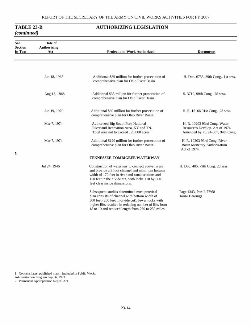
REPORT OF THE SECRETARY OF THE ARMY ON CIVIL WORKS ACTIVITIES FOR FY 2007 ____________________________________________________________________________________________________________ TABLE 23-B AUTHORIZING LEGISLATION (continued) ________________________________________________________________________________________________________________________ See Date of Section Authorizing In Text Act Project and Work Authorized Documents
23-14
Jun 18, 1965 Additional $89 million for further prosecution of H. Doc. 6755, 89th Cong., 1st sess. comprehensive plan for Ohio River Basin.
Aug 13, 1968 Additional $35 million for further prosecution of S. 3710, 90th Cong., 2d sess. comprehensive plan for Ohio River Basin. Jun 19, 1970 Additional $69 million for further prosecution of H. R. 15166 91st Cong., 2d sess. comprehensive plan for Ohio River Basin. Mar 7, 1974 Authorized Big South Fork National H. R. 10203 93rd Cong. Water River and Recreation Area, KY and TN. Resources Develop. Act of 1974 Total area not to exceed 125,000 acres. Amended by PL 94-587, 94th Cong. Mar 7, 1974 Additional $120 million for further prosecution of H. R. 10203 93rd Cong. River comprehensive plan for Ohio River Basin. Basin Monetary Authorization Act of 1974. 5.
TENNESSEE-TOMBIGBEE WATERWAY
Jul 24, 1946 Construction of waterway to connect above rivers H. Doc. 486, 79th Cong. 2d sess. and provide a 9 foot channel and minimum bottom width of 170 feet in river and canal sections and 150 feet in the divide cut, with locks 110 by 600 feet clear inside dimensions. Subsequent studies determined most practical Page 1343, Part I, FY68 plan consists of channel with bottom width of House Hearings 300 feet (280 feet in divide cut), fewer locks with higher lifts resulted in reducing number of lifts from 18 to 10 and reduced length from 260 to 253 miles. 1. Contains latest published maps. Included in Public Works Administration Program Sept. 6, 1993. 2. Permanent Appropriation Repeal Act.
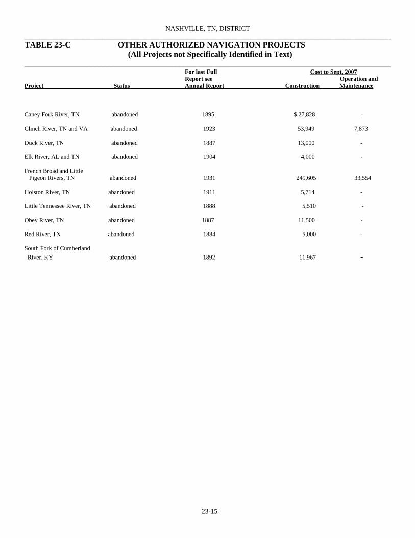
NASHVILLE, TN, DISTRICT ____________________________________________________________________________________________________________ TABLE 23-C OTHER AUTHORIZED NAVIGATION PROJECTS (All Projects not Specifically Identified in Text) __________________________________________________________________________________________
For last Full Cost to Sept, 2007 Report see Operation and Project Status Annual Report Construction Maintenance
23-15
Caney Fork River, TN abandoned 1895 $ 27,828 - Clinch River, TN and VA abandoned 1923 53,949 7,873 Duck River, TN abandoned 1887 13,000 - Elk River, AL and TN abandoned 1904 4,000 - French Broad and Little Pigeon Rivers, TN abandoned 1931 249,605 33,554 Holston River, TN abandoned 1911 5,714 - Little Tennessee River, TN abandoned 1888 5,510 - Obey River, TN abandoned 1887 11,500 - Red River, TN abandoned 1884 5,000 - South Fork of Cumberland River, KY abandoned 1892 11,967 -

REPORT OF THE SECRETARY OF THE ARMY ON CIVIL WORKS ACTIVITIES FOR FY 2007 ____________________________________________________________________________________________________________ TABLE 23-E OTHER AUTHORIZED FLOOD CONTROL PROJECTS
(All Projects not Specifically Identified in Text) ________________________________________________________________________________________________________________________ For last Full Cost to Sept, 2007 Report see Operation & Project Status Annual Report Construction Maintenance
23-16
Barbourville, KY completed 1963 $2,088,147 - Coal Creek and Tributaries (Lake City), TN completed 1962 460,134 - Corbin (Lynn Camp Creek), KY completed 1969 567,703 - Middlesboro (Yellow Creek), KY completed 1949 26,309 - Paint Rock River, AL completed 1967 544,173 - Pineville, KY completed 1963 1,679,126 - 1. Includes 9,950 contributed in funds. ___________________________________________________________________________________________________________ TABLE 23-F OTHER AUTHORIZED MULTIPLE-PURPOSE PROJECTS (Including Power) __________________________________________________________________________________________
For last Full Cost to Sept, 2007 Report see Operation and
Project Status Annual Report Construction Maintenance Barkley Dam and Lake beneficial use - $162,056,5391 $215,862,1622
Barkley, KY and TN Celina Dam, KY inactive - 222,575 - Cheatham Lock and Dam, TN beneficial use - 31,682,762 153,837,2122
Cordell Hull Lock and Dam, TN beneficial use - 79,874,492 113,352,3732 Old Hickory Lock and Dam, TN beneficial use - 52,266,412 188,592,6162 1. Includes $15,557,895 cost for Cross Creek. 2. Details given under “Cumberland River, TN and KY “ See Table 23-H
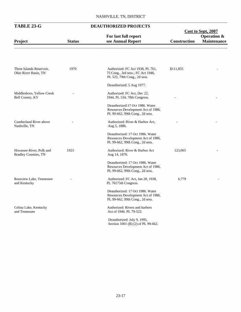
NASHVILLE, TN, DISTRICT ____________________________________________________________________________________________________________ TABLE 23-G DEAUTHORIZED PROJECTS Cost to Sept, 2007 For last full report Operation & Project Status see Annual Report Construction Maintenance ________________________________________________________________________________________________________________________
23-17
Three Islands Reservoir, 1970 Authorized: FC Act 1938, PL 761, $111,855 - Ohio River Basin, TN 75 Cong., 3rd sess.; FC Act 1946, PL 525, 79th Cong., 2d sess. Deauthorized: 5 Aug 1977. Middlesboro, Yellow Creek - Authorized: FC Act, Dec 22, Bell County, KY 1944, PL 534, 78th Congress. - - Deauthorized:17 Oct 1986. Water Resources Development Act of 1986, PL 99-662, 99th Cong., 2d sess. Cumberland River above - Authorized: River & Harbor Act, - - Nashville, TN Aug 5, 1886. Deauthorized: 17 Oct 1986. Water Resources Development Act of 1986, PL 99-662, 99th Cong., 2d sess. Hiwassee River, Polk and 1923 Authorized: River & Harbor Act 123,065 - Bradley Counties, TN Aug 14, 1876. Deauthorized: 17 Oct 1986. Water Resources Development Act of 1986, PL 99-662, 99th Cong., 2d sess. Rossview Lake, Tennessee - Authorized: FC Act, Jan 28, 1938, 6,779 - and Kentucky PL 76175th Congress. Deauthorized: 17 Oct 1986. Water Resources Development Act of 1986, PL 99-662, 99th Cong., 2d sess. Celina Lake, Kentucky Authorized: Rivers and harbors and Tennessee Act of 1946. PL 79-522. Deauthorized: July 9, 1995, Section 1001 (B) (2) of PL 99-662.

REPORT OF THE SECRETARY OF THE ARMY ON CIVIL WORKS ACTIVITIES FOR FY 2007 TABLE 23-H CUMBERLAND RIVER, TN AND KY: PRINCIPAL FEATURES
(See Section 2 of Text) _______________________________________________________________________________________ Dam and Reservoir Barkley Cheatham Old Hickory Cordell Hull
23-18
Nearest town Kuttawa, KY Ashland City, TN Old Hickory, TN Carthage, TN
11 miles. 9 miles 3 miles 5 miles Miles above mouth of river 30.6 148.7 216.2 313.5 Lock dimensions (feet)1 110 by 800 110 by 800 84 by 400 84 by 400 Lift at normal pool levels (feet) 57 26 60 59 Depths on guard-sills at 11, upper; 14, upper; 14, upper; 14, upper; minimum pool levels (feet) 13, lower 17, lower 13, lower 13, lower Character of foundation Rock Rock Rock Rock Dam: Type Concrete Concrete Concrete Concrete gravity and gravity gravity and gravity and earthfill earthfill earthfill Height 157 75 98 93 Length, exclusive of lock section (feet) 9,959 800 3,6052 1,1382
Spillway: Gross length (feet) 804 480 325 291 Net length opening (feet) 660 420 270 225 Crest gates: Type Tainter Tainter Tainter Tainter Number 12 7 6 5 Size (feet) 55 by 60 60 by 27 45 by 41 45 by 41 Operating levels at dam (feet, mean sea level): Maximum regulated 375 - 4503 5083
Normal operation: Full pool 359 385 - 508 Minimum pool 354 382 - 501 Minimum pool in advance of floods 346 - 442 499 Reservoir area (acres) 93,430 7,450 27,450 13,920 Reservoir capacity (acre-feet): Flood control 1,213,0003,4 - 125,0005 85,6005,6
Power drawdown 259,000 19,8007 63,000 20,500 Dead storage 610,000 84,200 357,000 204,800 Total 2,082,00 104,000 545,000 310,900 Canal: Length (mile) 1.75 - - - Bottom width (feet) 400 - - - Depth a minimum pool Level (feet) 11 - - - Power Development Number of units 4 3 4 3 Generator rating (kilowatts) 32,500 12,000 25,000 33,333 Total installation (kilowatts) 130,000 36,000 100,000 100,000 Percent of project completion Year opened to navigation 1964 1952 1952 1973 Cost9 $ 162,056,53910 $31,682,762 $52,266,412 $79,874,492

NASHVILLE, TN, DISTRICT ____________________________________________________________________________________________________________ TABLE 23-H CUMBERLAND RIVER, TN AND KY: PRINCIPAL FEATURES (continued) (See Section 2 of Text)
________________________________________________________________________________________________________________________
23-19
1. Clear width and length available for full width. 7. Daily pondage allowance; run-of-river project. 2. Exclusive of lock section. 8. Completed for full beneficial use. 3. Surcharge. 9. Includes recreation facility costs. 4. Normal operation (elv. 375-359) during nonflood season; 10. Includes $15,557,895 cost for Cross Creek.
flood control allowance to be increased to 1,472,000 acre-feet (elev. 375-354) during season of major floodflows. 5. Surcharge storage. 6. During flood season (3lev. 508-501); minimum 51,800 acre- feet (elev. 508-504) with normal operation during non-flood season.

REPORT OF THE SECRETARY OF THE ARMY ON CIVIL WORKS ACTIVITIES FOR FY 2007 TABLE 23-I TENNESSEE RIVER
(SEE SECTION 4 OF TEXT)
23-20
_______________Lift Dimensions_____________ Length
Width Avail- Minimum of able for Lift on Guard Sills Year
Miles Cham- Full Nor- Maxi- Opened Cost of Above Miles from ber Width mal mum Lower Upper Character of Navi- Kind Type of Each Lock Project1 Mouth Nearest Town (feet) (feet) (feet) (feet) (feet) (feet) Foundation gation of Dam Construction and Dam Kentucky 22.4 0.5 above Gilbertsville, KY 110 600 56 73.3 12.7 11.0 Limestone 1942 Fixed Concrete and 2
earthfill Pickwick Landing: Auxiliary lock 206.7 4.4 above Hamburg, TN 110 600 55 63.0 12.8 10.0 Limestone 1937 Fixed Concrete and 3 earthfill Main lock 206.7 4.4 above Hamburg, TN 110 1000 55 63.0 12.8 10.0 Limestone 1984 Fixed Concrete and 3
earthfill Wilson: Auxiliary lock 259.4 2.9 above Florence, AL 60 292 94 100.0 11.04 11.2 Limestone 1927 Fixed Concrete and $46,973,5405
300 earthfill Main lock 259.4 2.9 above Florence, AL 110 600 94 100.0 13.0 13.0 Limestone 1959 - - 7 General Joe Wheeler: Auxiliary lock 274.9 18.4 above Florence, AL 60 400 48 51.5 13.2 14.7 Limestone 1934 Fixed Concrete and 1,796,2956
earthfill Main lock 274.9 18.4 above Florence, AL 110 600 48 51.5 13.0 13.0 Limestone 1963 Fixed Concrete and 7
earthfill Guntersville: Auxiliary lock 349.0 9.1 below Guntersville, AL 60 360 39 45.0 11.8 13.0 Limestone 1937 Fixed - 3 & 7 Main lock 349.0 9.1 below Guntersville, AL 110 600 39 45.0 12.7 13.0 Limestone 1965 Fixed Concrete and 7
earthfill Nickajack: Auxiliary lock 424.7 39.4 below Chattanooga, TN 110 600 39 41.0 13.0 13.0 Limestone 1967 Fixed Concrete 7 Main lock 424.7 39.4 below Chattanooga, TN 110 800 39 41.0 13.0 13.0 Limestone Fixed Concrete 7 Chickamauga 471.0 6.9 above Chattanooga, TN 60 360 49 53.0 13.0 10.0 Limestone 1939 Fixed - 3 & 7 Watts Bar 529.9 6.8 above Breedenton, TN 60 360 58 70.0 11.8 12.0 Shale 1941 Fixed Concrete and 3
earthfill Fort Loudon 602.3 1.3 above Lenoir City, TN 60 360 72 80.0 11.8 12.0 Limestone 1943 Fixed Concrete and 3
earthfill Melton Hill 23.1 22.1 above Kingston, TN 75 400 54 60.0 13.0 13.0 Limestone 1963 Fixed Concrete 2 (Clinch R.)
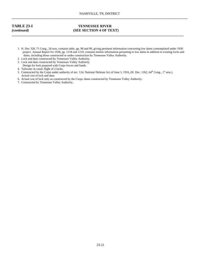
NASHVILLE, TN, DISTRICT ____________________________________________________________________________________________________________
TABLE 23-I TENNESSEE RIVER (continued) (SEE SECTION 4 OF TEXT) ________________________________________________________________________________________________
23-21
1. H. Doc 328, 71 Cong., 2d sess, contains table, pp. 98 and 99, giving pertinent information concerning low dams contemplated under 1930 project. Annual Report for 1938, pp. 1218 and 1219, contains similar information pertaining to low dams in addition to existing locks and dams, including those constructed or under construction by Tennessee Valley Authority. 2. Lock and dam constructed by Tennessee Valley Authority. 3. Lock and dam constructed by Tennessee Valley Authority. Design for lock prepared with Corps forces and funds. 4. Tailwater in canal; flight of 2 locks. 5. Constructed by the Corps under authority of sec. 124, National Defense Act of June 3, 1916, (H. Doc. 1262, 64th Cong., 1st sess.). Actual cost of lock and dam. 6. Actual cost of lock only as constructed by the Corps; dams constructed by Tennessee Valley Authority. 7. Constructed by Tennessee Valley Authority.

REPORT OF THE SECRETARY OF THE ARMY ON CIVIL WORKS ACTIVITIES FOR FY 2007 ____________________________________________________________________________________________________________ TABLE 23-J TENNESSEE RIVER, TN, AL, AND KY
TOTAL COST OF EXISTING PROJECTS TO SEPT 30, 2007 (See Section 3 of Text)
Funds New Work Channel Maintenance Operation & Total Maintenance
23-22
Regular $2,244,2361,2 $15,045,835 $405,468,461 $422,758,532 Maintenance - - 11,665 11,665 Increase of compensation - 5 - 5 rivers and harbors, 1919 (certified claims) Total $2,244,2361,2 $15,119,458 $405,480,126 $422,770,202 1. In addition, surplus property valued at $54,336 was transferred from the project without reimbursement. Excludes $4,005,175
expended between 18900 and June 30,1935, on operation and care of works of improvement under provisions of appropriation for such purposes.
2. Excludes $14,007,192 previous construction cost. __________________________________________________________________________________________ TABLE 23-K OHIO RIVER BASIN (NASHVILLE DISTRICT) LOCAL PROTECTION PROJECTS ____________________________________________________________________________________ Type of Estimated Cost Location Protection Federal Non-Federal Total Cumberland, KY Channel Improvement $520,000 $240,000 $760,0001
__________________________________________________________________________________________ TABLE 23-L RESERVOIRS ________________________________________________________________________________________________________________________
Total Federal
Tributary Basin and Reservoir Stream Cost ________________________________________________________________________________________________________________________ Center Hill Lake Caney Fork $53,412,0221
Dale Hollow Lake, TN and KY Obey River 28,167,7461,2
J. Percy Priest Dam & Reservoir, TN Stones River 56,868,0391,3,4
Laurel River Lake, KY Laurel River 56,741,2325
Martins Fork Lake, KY Martins Fork 20,479,911 _______________________________________________________________________________________________________________________ 1. Details of this project are in individual report. 4. Formerly Stewarts Ferry Reservoir. 2. Excludes $150,000 contributed by the State of Tennessee. 5. See “Other authorized multiple-purpose projects.” 3. Excludes $46,000 contributed by Metro Gov’t of Nashville, TN.

NASHVILLE, TN, DISTRICT
TABLE 23-M INSPECTION OF COMPLETED FLOOD CONTROL PROJECTS (See Section 15 of Text)
23-23
Project Date of Inspection
Barbourville, KY 25 Sep 2007 Corbin, KY 24 Sep 2007 Harlan, KY 27 Sep 2007 Middlesboro, KY 28 Sep 2007 Pineville, KY 26 Sep 2007 Rio Vista, KY 28 Sep 2007 Walls End, KY 26 Sep 2007 Williamsburg, KY 24 Sep 2007
______________________________________________________________________________________________________________________ ________________________________________________________________________________________________________________________ TABLE 23-N WORK UNDER SPECIAL AUTHORITIES __________________________________________________________________________________________
Flood Control (Section 205)
Project FY07 Cost Section 205 Coordination Account $ 16,122 Little Limestone Cr, TN 48,593 Dallas Branch, Huntsville, AL 5,499 Huntsville Spring Branch, AL 9,363 Swannanoa River Watershed, NC 20,930 Little River, Hopkinsville, KY 9,602 Beaver Creek & Tribs, Bristol, VA 34,729 Beaver Creek & Tribs, Bristol, TN 76,429 Metro Center Levee, Nashville, TN 40,425 Richland Creek, Nashville, TN 76,670 Total $ 338,362
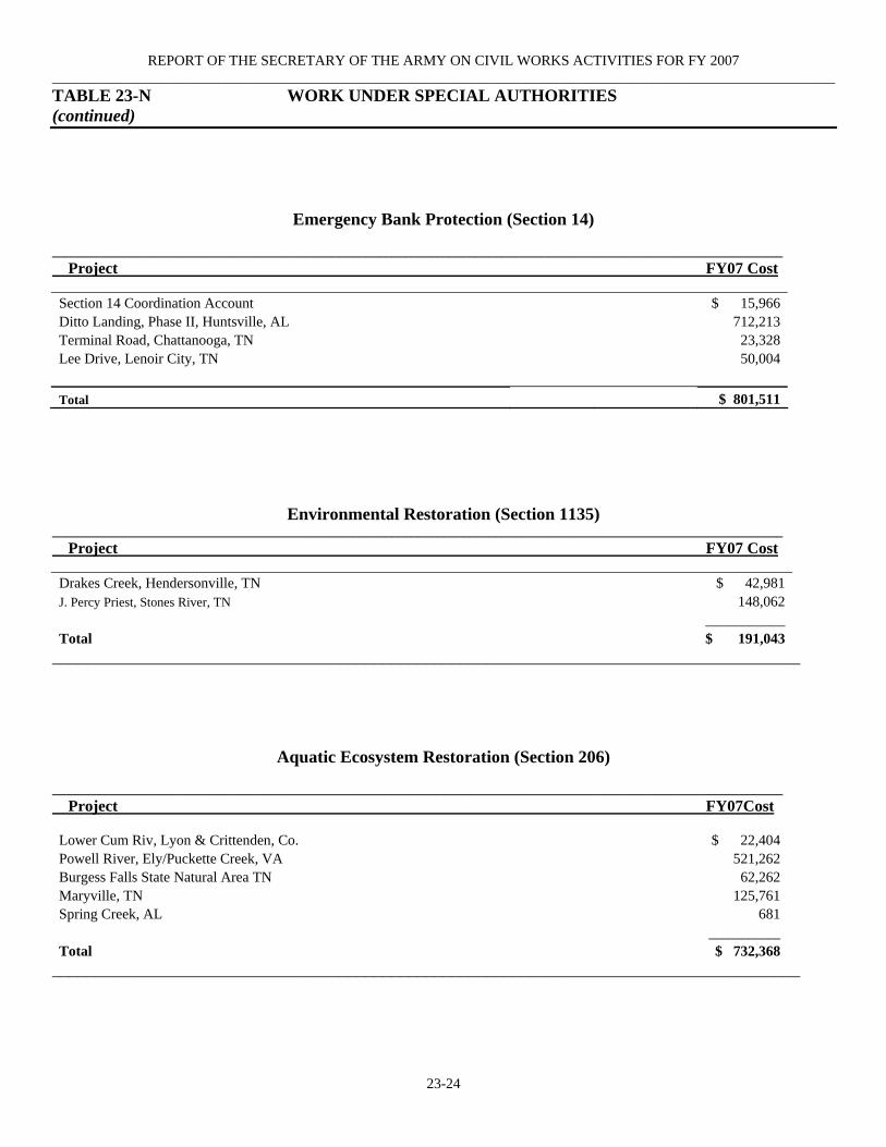
REPORT OF THE SECRETARY OF THE ARMY ON CIVIL WORKS ACTIVITIES FOR FY 2007 ____________________________________________________________________________________________________________ TABLE 23-N WORK UNDER SPECIAL AUTHORITIES (continued)
23-24
Emergency Bank Protection (Section 14)
________________________________________________________________________________________________________________ Project FY07 Cost Section 14 Coordination Account $ 15,966 Ditto Landing, Phase II, Huntsville, AL 712,213 Terminal Road, Chattanooga, TN 23,328 Lee Drive, Lenoir City, TN 50,004 Total $ 801,511
Environmental Restoration (Section 1135) ________________________________________________________________________________________________________________ Project FY07 Cost Drakes Creek, Hendersonville, TN $ 42,981 J. Percy Priest, Stones River, TN 148,062 ___________ Total $ 191,043
______________________________________________________________________________________
Aquatic Ecosystem Restoration (Section 206)
________________________________________________________________________________________________________________ Project FY07Cost Lower Cum Riv, Lyon & Crittenden, Co. $ 22,404 Powell River, Ely/Puckette Creek, VA 521,262 Burgess Falls State Natural Area TN 62,262 Maryville, TN 125,761 Spring Creek, AL 681 ___________ Total $ 732,368
______________________________________________________________________________________
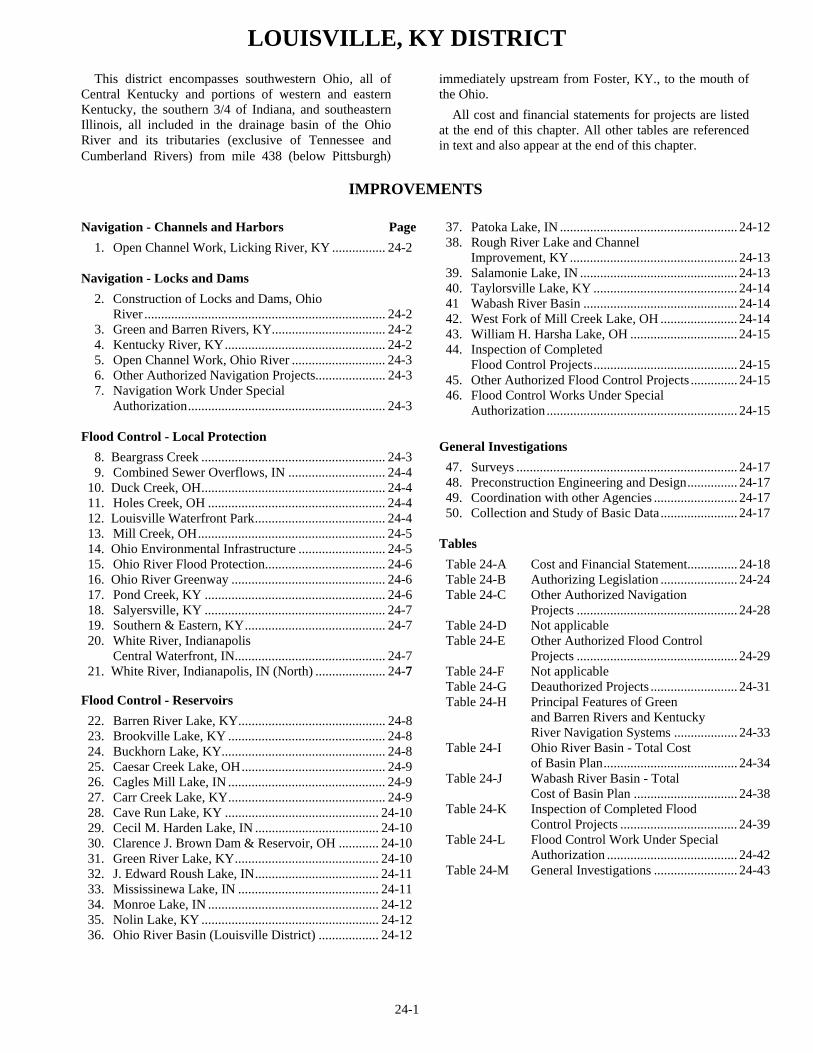
24-1
LOUISVILLE, KY DISTRICT
This district encompasses southwestern Ohio, all of Central Kentucky and portions of western and eastern Kentucky, the southern 3/4 of Indiana, and southeastern Illinois, all included in the drainage basin of the Ohio River and its tributaries (exclusive of Tennessee and Cumberland Rivers) from mile 438 (below Pittsburgh)
immediately upstream from Foster, KY., to the mouth of the Ohio.
All cost and financial statements for projects are listed at the end of this chapter. All other tables are referenced in text and also appear at the end of this chapter.
IMPROVEMENTS
Navigation - Channels and Harbors Page 1. Open Channel Work, Licking River, KY ................ 24-2
Navigation - Locks and Dams 2. Construction of Locks and Dams, Ohio River ........................................................................ 24-2 3. Green and Barren Rivers, KY.................................. 24-2 4. Kentucky River, KY................................................ 24-2 5. Open Channel Work, Ohio River ............................ 24-3 6. Other Authorized Navigation Projects..................... 24-3 7. Navigation Work Under Special Authorization........................................................... 24-3
Flood Control - Local Protection 8. Beargrass Creek ....................................................... 24-3 9. Combined Sewer Overflows, IN ............................. 24-4 10. Duck Creek, OH....................................................... 24-4 11. Holes Creek, OH ..................................................... 24-4 12. Louisville Waterfront Park....................................... 24-4 13. Mill Creek, OH........................................................ 24-5 14. Ohio Environmental Infrastructure .......................... 24-5 15. Ohio River Flood Protection.................................... 24-6 16. Ohio River Greenway .............................................. 24-6 17. Pond Creek, KY ...................................................... 24-6 18. Salyersville, KY ...................................................... 24-7 19. Southern & Eastern, KY.......................................... 24-7 20. White River, Indianapolis Central Waterfront, IN............................................. 24-7 21. White River, Indianapolis, IN (North) ..................... 24-7
Flood Control - Reservoirs 22. Barren River Lake, KY............................................ 24-8 23. Brookville Lake, KY ............................................... 24-8 24. Buckhorn Lake, KY................................................. 24-8 25. Caesar Creek Lake, OH........................................... 24-9 26. Cagles Mill Lake, IN ............................................... 24-9 27. Carr Creek Lake, KY............................................... 24-9 28. Cave Run Lake, KY .............................................. 24-10 29. Cecil M. Harden Lake, IN ..................................... 24-10 30. Clarence J. Brown Dam & Reservoir, OH ............ 24-10 31. Green River Lake, KY........................................... 24-10 32. J. Edward Roush Lake, IN..................................... 24-11 33. Mississinewa Lake, IN .......................................... 24-11 34. Monroe Lake, IN ................................................... 24-12 35. Nolin Lake, KY ..................................................... 24-12 36. Ohio River Basin (Louisville District) .................. 24-12
37. Patoka Lake, IN ..................................................... 24-12 38. Rough River Lake and Channel Improvement, KY.................................................. 24-13 39. Salamonie Lake, IN ............................................... 24-13 40. Taylorsville Lake, KY ........................................... 24-14 41 Wabash River Basin .............................................. 24-14 42. West Fork of Mill Creek Lake, OH ....................... 24-14 43. William H. Harsha Lake, OH ................................ 24-15 44. Inspection of Completed Flood Control Projects........................................... 24-15 45. Other Authorized Flood Control Projects .............. 24-15 46. Flood Control Works Under Special Authorization......................................................... 24-15
General Investigations 47. Surveys .................................................................. 24-17 48. Preconstruction Engineering and Design............... 24-17 49. Coordination with other Agencies ......................... 24-17 50. Collection and Study of Basic Data....................... 24-17
Tables Table 24-A Cost and Financial Statement............... 24-18 Table 24-B Authorizing Legislation ....................... 24-24 Table 24-C Other Authorized Navigation Projects ................................................ 24-28 Table 24-D Not applicable Table 24-E Other Authorized Flood Control Projects ................................................ 24-29 Table 24-F Not applicable Table 24-G Deauthorized Projects .......................... 24-31 Table 24-H Principal Features of Green and Barren Rivers and Kentucky River Navigation Systems ................... 24-33 Table 24-I Ohio River Basin - Total Cost of Basin Plan........................................ 24-34 Table 24-J Wabash River Basin - Total Cost of Basin Plan ............................... 24-38 Table 24-K Inspection of Completed Flood Control Projects ................................... 24-39 Table 24-L Flood Control Work Under Special Authorization ....................................... 24-42 Table 24-M General Investigations ......................... 24-43
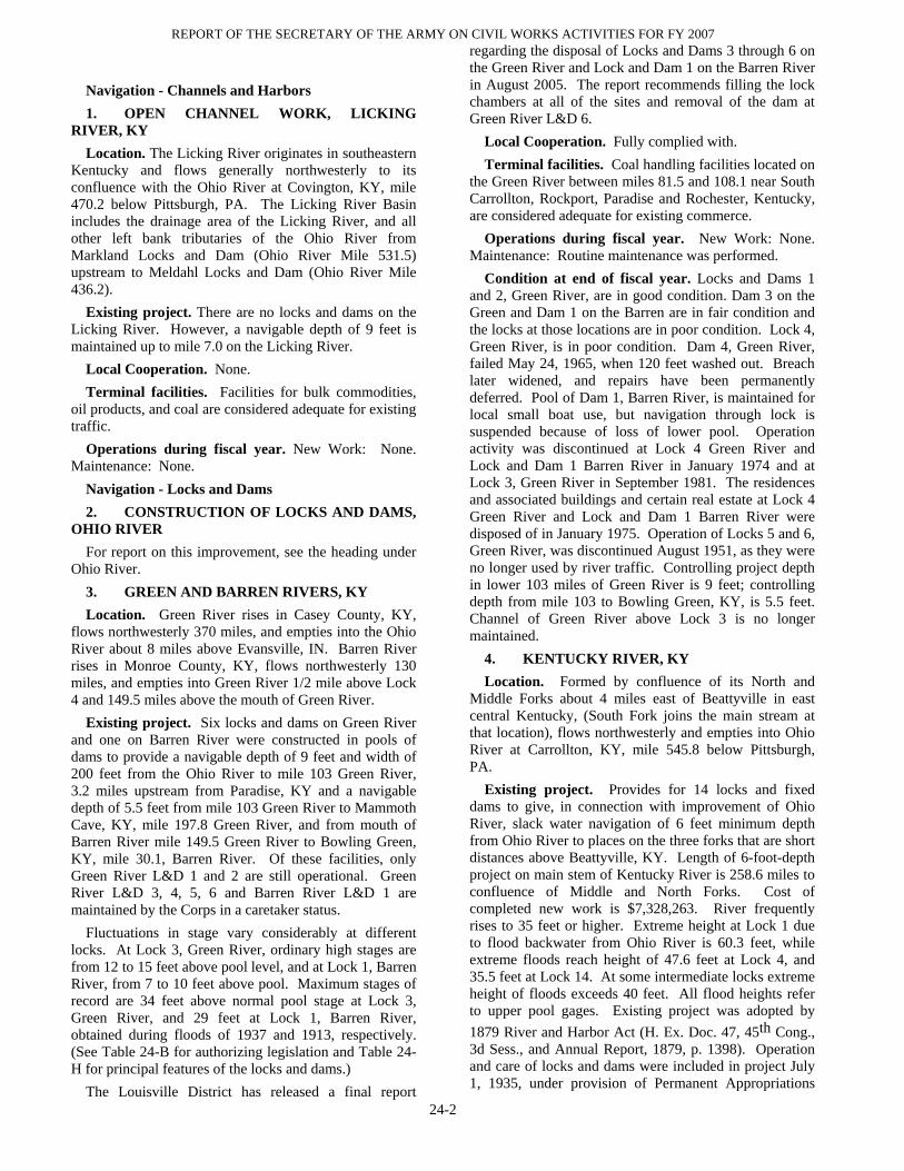
REPORT OF THE SECRETARY OF THE ARMY ON CIVIL WORKS ACTIVITIES FOR FY 2007
24-2
Navigation - Channels and Harbors 1. OPEN CHANNEL WORK, LICKING
RIVER, KY Location. The Licking River originates in southeastern
Kentucky and flows generally northwesterly to its confluence with the Ohio River at Covington, KY, mile 470.2 below Pittsburgh, PA. The Licking River Basin includes the drainage area of the Licking River, and all other left bank tributaries of the Ohio River from Markland Locks and Dam (Ohio River Mile 531.5) upstream to Meldahl Locks and Dam (Ohio River Mile 436.2).
Existing project. There are no locks and dams on the Licking River. However, a navigable depth of 9 feet is maintained up to mile 7.0 on the Licking River.
Local Cooperation. None. Terminal facilities. Facilities for bulk commodities,
oil products, and coal are considered adequate for existing traffic.
Operations during fiscal year. New Work: None. Maintenance: None.
Navigation - Locks and Dams 2. CONSTRUCTION OF LOCKS AND DAMS,
OHIO RIVER For report on this improvement, see the heading under
Ohio River. 3. GREEN AND BARREN RIVERS, KY Location. Green River rises in Casey County, KY,
flows northwesterly 370 miles, and empties into the Ohio River about 8 miles above Evansville, IN. Barren River rises in Monroe County, KY, flows northwesterly 130 miles, and empties into Green River 1/2 mile above Lock 4 and 149.5 miles above the mouth of Green River.
Existing project. Six locks and dams on Green River and one on Barren River were constructed in pools of dams to provide a navigable depth of 9 feet and width of 200 feet from the Ohio River to mile 103 Green River, 3.2 miles upstream from Paradise, KY and a navigable depth of 5.5 feet from mile 103 Green River to Mammoth Cave, KY, mile 197.8 Green River, and from mouth of Barren River mile 149.5 Green River to Bowling Green, KY, mile 30.1, Barren River. Of these facilities, only Green River L&D 1 and 2 are still operational. Green River L&D 3, 4, 5, 6 and Barren River L&D 1 are maintained by the Corps in a caretaker status.
Fluctuations in stage vary considerably at different locks. At Lock 3, Green River, ordinary high stages are from 12 to 15 feet above pool level, and at Lock 1, Barren River, from 7 to 10 feet above pool. Maximum stages of record are 34 feet above normal pool stage at Lock 3, Green River, and 29 feet at Lock 1, Barren River, obtained during floods of 1937 and 1913, respectively. (See Table 24-B for authorizing legislation and Table 24-H for principal features of the locks and dams.)
The Louisville District has released a final report
regarding the disposal of Locks and Dams 3 through 6 on the Green River and Lock and Dam 1 on the Barren River in August 2005. The report recommends filling the lock chambers at all of the sites and removal of the dam at Green River L&D 6.
Local Cooperation. Fully complied with. Terminal facilities. Coal handling facilities located on
the Green River between miles 81.5 and 108.1 near South Carrollton, Rockport, Paradise and Rochester, Kentucky, are considered adequate for existing commerce.
Operations during fiscal year. New Work: None. Maintenance: Routine maintenance was performed.
Condition at end of fiscal year. Locks and Dams 1 and 2, Green River, are in good condition. Dam 3 on the Green and Dam 1 on the Barren are in fair condition and the locks at those locations are in poor condition. Lock 4, Green River, is in poor condition. Dam 4, Green River, failed May 24, 1965, when 120 feet washed out. Breach later widened, and repairs have been permanently deferred. Pool of Dam 1, Barren River, is maintained for local small boat use, but navigation through lock is suspended because of loss of lower pool. Operation activity was discontinued at Lock 4 Green River and Lock and Dam 1 Barren River in January 1974 and at Lock 3, Green River in September 1981. The residences and associated buildings and certain real estate at Lock 4 Green River and Lock and Dam 1 Barren River were disposed of in January 1975. Operation of Locks 5 and 6, Green River, was discontinued August 1951, as they were no longer used by river traffic. Controlling project depth in lower 103 miles of Green River is 9 feet; controlling depth from mile 103 to Bowling Green, KY, is 5.5 feet. Channel of Green River above Lock 3 is no longer maintained.
4. KENTUCKY RIVER, KY Location. Formed by confluence of its North and
Middle Forks about 4 miles east of Beattyville in east central Kentucky, (South Fork joins the main stream at that location), flows northwesterly and empties into Ohio River at Carrollton, KY, mile 545.8 below Pittsburgh, PA.
Existing project. Provides for 14 locks and fixed dams to give, in connection with improvement of Ohio River, slack water navigation of 6 feet minimum depth from Ohio River to places on the three forks that are short distances above Beattyville, KY. Length of 6-foot-depth project on main stem of Kentucky River is 258.6 miles to confluence of Middle and North Forks. Cost of completed new work is $7,328,263. River frequently rises to 35 feet or higher. Extreme height at Lock 1 due to flood backwater from Ohio River is 60.3 feet, while extreme floods reach height of 47.6 feet at Lock 4, and 35.5 feet at Lock 14. At some intermediate locks extreme height of floods exceeds 40 feet. All flood heights refer to upper pool gages. Existing project was adopted by 1879 River and Harbor Act (H. Ex. Doc. 47, 45th Cong., 3d Sess., and Annual Report, 1879, p. 1398). Operation and care of locks and dams were included in project July 1, 1935, under provision of Permanent Appropriations

LOUISVILLE, KY DISTRICT
24-3
Repeal Act of June 26, 1934. (See Table 24-H for principal features of the locks and dams.)
On December 19, 1976, the lock operation schedules for commercial traffic and recreational craft on the Kentucky River System were reduced from continuous 24-hour year-round operation to two-shift year-round operation of Locks 1 through 4, intermittent daily operation of Locks 5 through 10, and intermittent operation five days weekly of Locks 11 through 14. Since that time the hours for operation of Locks 5 through 14 have been reduced in several increments. On October 1, 1981, Locks 5 through 14 were closed to traffic and placed in caretaker status. On May 21, 1985 Locks 5 though 14 were leased to the Commonwealth of Kentucky and were operated on weekends during the summer boating seasons through October 15, 1989 when the lease expired. The Commonwealth of Kentucky continued operation again under a lease agreement signed in 1990 with several extensions that allow the Commonwealth to operate the Locks until 2019. In 2001 the last commercial operator in pool 4 ceased operations ending federal interest in operating Locks and Dams 1 through 4. The Commonwealth of Kentucky now operates and manages Locks and Dams 1through 4 under Department of the Army Lease for Public Park and Recreation, which was granted March 1, 2002.
The FY 1993, 1994, 1996, 2000 and 2001 Energy and Water Development Appropriation Acts provided a total of $14.75 million to the Corps to repair the Kentucky River Locks and Dams 5 through 14 to ensure water supply prior to and in preparation for a direct transfer of ownership to the Commonwealth of Kentucky. This construction work was all completed by December 2001. During fiscal year 2002 construction of a visitors pavilion and restrooms were also initiated at Lock and Dam 14 and the work was completed in September 2003. In December 1996 the Assistant Secretary of the Army (CW) signed the first quitclaim transfer deed for Lock and Dam 10 for direct transfer from the Corps to the Commonwealth. Lock and Dam 6 were transferred in March 2005. The Kentucky River Authority (KRA) currently manages both facilities. The Corps continues efforts to transfer the remaining Locks and Dams 5, 7 through 9 and 11 through 14 to the Commonwealth. Locks 1-14 are now operated or maintained by the Kentucky River Authority.
Although Lock and Dam 10 was transferred to the Commonwealth of Kentucky, FY 2001 authorization language directed the Corps to take all measures to further stabilize and renovate Lock and Dam 10 for the purpose of extending the design life of the structure. The Corps is performing a detailed evaluation of the existing facility that will ultimately recommend a long-term method to “stabilize and renovate” including possibly raising Lock and Dam 10. The results of this evaluation will be presented in a report. Work on this evaluation is currently on hold due to the lack of Federal funding in FY 2007 Since construction of the plan that will be recommended is several years away, the Corps and KRA investigated what could be done to assure near-term safety and stability. Design was completed and a
construction contract was awarded in July 2005. Construction of this near-term work continued throughout FY 2006. The scope of the work involves stabilizing the existing dam.
Licenses. Federal Regulatory Commission License No. 539, to Kentucky Utilities Co., at Dam 7, Kentucky River, Annual charge, $4,400; total collections through September 30, 2007, $368,005.
Terminal facilities. Facilities for bulk commodities are considered adequate for existing traffic.
Operations during fiscal year. New Work: None. Maintenance: None.
Condition at end of fiscal year. Existing project was completed in 1917. Work accomplished was rehabilitation of the five old State locks and dams and construction of new Locks and Dams 6 to 14 inclusive. Repairs have been made to deteriorated locks and dams as required to keep locks in operation and maintain pool levels above dams except in extreme dry weather, when some pools fall below normal levels, details in Annual Reports for 1963, 1964, and 1965. Channel work was performed as required to provide for existing river traffic. Controlling navigable depth in length of river covered by existing project was 6 feet at end of fiscal year.
5. OPEN CHANNEL WORK, OHIO RIVER For report on this improvement, see this heading under
Ohio River. 6. OTHER AUTHORIZED NAVIGATION
PROJECTS See Table 24-C. 7. NAVIGATION WORK UNDER SPECIAL
AUTHORIZATION None. Flood Control - Local Protection 8. BEARGRASS CREEK, KENTUCKY Location. The project is located in eastern Jefferson
County in the suburbs of Louisville, Kentucky, along the South Fork of Beargrass Creek and Buechel Branch.
Existing Project. The project consists of construction of eight detention basins, about 2,000 linear feet of channel improvement, and 1,400 linear feet of floodwall/levee on the South Fork of Beargrass Creek and Buechel Branch. The project will provide protection to 830 structures (combination of residential and commercial). Of those structures, an estimated 314 will be removed from the 100-year flood plain. The 100-year flood plain will be reduced an average of 1.5 feet, as a result of project implementation. The project was authorized by the Water Resource Development Act of 1999. Estimated cost of the new work is $15,183,300 of which $9,867,375 is federal cost and $5,315,925 is non-federal cost.
Local Cooperation. The non-Federal cost sharing partner is the Louisville and Jefferson County Metropolitan Sewer District (MSD). A Preconstruction, Engineering and Design (PED) Phase cost sharing agreement with MSD was executed in January 1998. The
REPORT OF THE SECRETARY OF THE ARMY ON CIVIL WORKS ACTIVITIES FOR FY 2007
24-4
Chief of Engineers report approved the project in May 1998. A Project Cooperation Agreement (PCA) with MSD was executed in September 2001.
Operations during fiscal year. Work this year included continuation of Phase II(B) construction. All work for Phase II(B) was substantially completed in 2007.
Conditions at end of fiscal year. The project is about
98% complete. Design is complete for all three construction contracts. The first contract was awarded 4th quarter FY2002, the second contract was awarded 4th quarter FY2003, and the third contract was awarded 1st quarter FY 2006. Work on all three contracts is complete.
9. COMBINED SEWER OVERFLOWS, INDIANPOLIS, IN
Location. Indianapolis, IN. Existing Project. The existing project consists of
providing the City of Indianapolis technical, planning and design assistance for implementation of their Long Term Control Plan. The Long Term Control Plan is designed to improve water quality in Marion County and modernize the City’s 19th century sewer system that discharges raw sewage to local streams at 135 overflow points during wet weather events. Work was authorized under Section 219 of the Water Resources Development Act of 1992, as amended. Authorization for construction is contained in FY04 Energy & Water Development Act by amending Water Resources Development Act of 1992.
Local Cooperation. The non-federal cost sharing partner is the City of Indianapolis, Indiana. The Corps and the City of Indianapolis signed the Design Agreement in March 2003.
Operation during fiscal year. Continued technical planning and design assistance. Completed work on the Groundwater Management Plan for the deep tunnel alternative
Condition at end of fiscal year. Design work is about 35% complete for the Fall Creek/White River reach. Scopes of Work will be developed to continue technical design assistance. Construction of a CSO outfall relocation project will be performed pursuant to the completion of SHPO coordination, the execution of a PCA, and the acquisition of real estate.
10. DUCK CREEK, OH Location. The project area is located in the City of
Cincinnati and the Village of Fairfax in Hamilton County, Ohio. The project encompasses 3.2 miles of the stream and begins approximately 2 miles upstream of the confluence of Duck Creek with the Little Miami River.
Existing project. The project consists of approximately 7,100 feet of concrete flood wall, 3,300 feet of earth levee, 8,500 feet of riprapped stream bank, 1,200 feet of channel relocation, 1,150 feet of culvert, demolition of an abandoned highway bridge, widening of a railroad bridge, a pump station, and automatic road closure, and an emergency access road. Estimated cost of new work is $56,000,000 of which $51,800,000 is Federal
and $4,200,000 is non-Federal. The project was originally authorized by the Water Resources Development Act of 1996 and reauthorized by the Water Resources Development Act of 2000.
Local Cooperation. The non-Federal sponsors are the City of Cincinnati and the Village of Fairfax. The Project Cooperation Agreement (PCA) was executed in December 1997.
Operations during fiscal year. Work this year included design of the reach along Ilsco Corporation Property (Phase 4B – Part 2) and award of a contract (Phase 4B – Part 1) for construction of features from Madison Road southward to a railroad embankment at the end of Steele Place. The contract work consists of construction of floodwalls, levees, channel improvements, emergency access road, and an automated closures gate along Madison Road.
Condition at end of fiscal year. The project is about 62 percent complete overall with design approximately 85 percent complete.
11. HOLES CREEK, OH Location. Project area is located on Holes Creek in
West Carrollton, Montgomery County, Ohio. West Carrollton is situated in the southwestern portion of Ohio and is a suburb of Dayton. Holes Creek drains 28.2 square miles and empties into the Great Miami River at river mile 72.6.
Existing project. Project construction completed to date consists of approximately 4,300 feet of channel widening (80-foot bottom width) with associated bank protection. The box culvert type railroad bridge was replaced with a 70-foot clear span structure. Completed project provides protection to 420 structures in West Carrollton and Moraine. Remaining project includes construction of 2400-foot long by up to 6 feet high earthen levee/floodwall to protect nine commercial/ industrial structures and purchase and demolition of three structures. Estimated total cost (including additional work) is $12,750,000 Federal and $1,306,000 non-Federal.
Local Cooperation. The non-Federal cost-sharing partner is the Miami Conservancy District (MCD). MCD formed the Holes Creek/Owl Creek Conservancy Subdistrict to act as formal sponsor for this project. The Subdistrict entered into the Project Cooperation Agreement (PCA) with the Government in September 1996. Funds were provided to the Subdistrict by Montgomery County, the City of West Carrollton, the City of Moraine, and Miami Township. The PCA was amended subsequent to enactment of Section 594(a) of the Water Resources Development Act of 1999 to cap the non-Federal cost share amount to $1,305,650.
Operations during fiscal year. No work was performed this FY due to a lack of funding..
Conditions at end of fiscal year. Once federal funding is received, the plan for FY08 is to acquire the required real estate and initiate the construction contract.
12. LOUISVILLE WATERFRONT PARK,

LOUISVILLE, KY DISTRICT
24-5
LOUISVILLE, KY Location. Louisville, Jefferson County, Kentucky, on
the left bank of the Ohio River at river mile 603. Existing Project. The existing project is for design of
Phases II and III of the Louisville Waterfront Park public access and recreation project. The design is focused on restoration of the Big 4 Bridge for pedestrian use, and includes a spiral bridge to facilitate a bicycle path and potential emergency vehicle access. The design was authorized by the Conference Report for the Omnibus Consolidated and Emergency Supplemental Appropriations. The design agreement is limited to the spiral to the Big Four Bridge and renovating the bridge for pedestrian access to the Indiana side of the river. Construction authority was in the FY06 Energy and Water Development Act including use of unexpended design funds for construction.
Local Cooperation. The Pre-Construction Engineering and Design (PED) agreement was executed with the non-Federal cost sharing partner, the Louisville Waterfront Development Corporation (LWDC) in September 2004. $250,000 in non-Federal funds was received in September 2004 to begin design.
Operations during fiscal year. Work this year consisted of completing the plans and specs for the Renovations to the Big 4 Bridge contract.
Conditions at end of fiscal year. The only ongoing work for the Corps consists of completing the SHPO coordination and a Coast Guard permit.
13. MILL CREEK, OH Location. Project is located along the 18-mile length
of Mill Creek and three-fourths mile length of East Fork. Existing project. 17.5 miles of channel improvement,
2 miles of levees, three pumping plants, modification of 29 bridges, and the addition of two pumping units at the present Mill Creek Barrier Dam, located near the Ohio River, are included in the project. Acquisition and development with appropriate landscaping of 620 acres along the creek will be provided for high-density urban oriented recreational use.
Local Cooperation. Section 3, Flood Control Act of 1936 as amended, applies. An assurance agreement covering local cooperation requirements for the project consistent with Section 221 of the 1970 Flood Control Act and the Uniform Relocation Assistance and Real Property Acquisition Policies Act of 1970 was executed by the Millcreek Valley Conservancy District February 6, 1975, and for the Secretary of the Army March 28, 1975. A recreation cost-sharing contract was executed by the Conservancy District February 25, 1975, and approved by the Secretary of the Army May 28, 1975. A Contributed Funds Agreement for the General Reevaluation Report was executed in August 1998. An Operations and Maintenance Agreement for the completed portions of the project was also executed in August 1998.
Operations during fiscal year. The Sponsor and communities are evaluating financial capability and community support to resume project construction of the
channel modification plan as recommended in the March 2005 General Reevaluation Report. Design work was initiated for the remedial repairs at previously completed sections 1, 2, and 4A.
Condition at end of fiscal year. Construction of channel Sections 1, 2 ,3, 4A,and 7A (Phase 1) are complete. Original channel modification project is about 45 percent complete overall. The final GRR and EIS were completed by March 2005. If federal funding is received the plan for FY08 will be to complete the design and construction of remedial repairs at previously completed sections 1, 2, and 4A. These sections still need to have remedial repairs performed in order to turn over to the Sponsor for Operations and Maintenance.
14. OHIO ENVIRONMENTAL INFRASTRUCTURE SECTION 594 PROGRAM
Location. The project location includes the entire state of Ohio, which includes portions of the Louisville, Huntington, Buffalo, and Pittsburgh Districts. The program is for the design and construction assistance of environmental infrastructure projects.
Existing Projects: Under the Section 594 Authority, we have projects in varying states of progress in Clark, Clinton, Greene, and Montgomery Counties in Ohio.
Clark County – Springfield Applied Research and technology Park: PCA being developed for design and construction of a water storage tank and surface water protection facilities. PCA was executed in March 2006. Design and construction are underway.
Montgomery County – Tech Town Infrastructure Project: Design and construction of sewer infrastructure for High Tech Industrial site in Dayton, OH. PCA executed in FY04 and amended in 2007. Design is underway.
Montgomery County – University of Dayton Brown and Stewart Streets Redevelopment Project: PCA for design was being developed. Execution expected in FY 08.
Montgomery County – City of Dayton Northeast Quadrant Redevelopment Project: PCA for design was being developed. Execution expected in FY 08.
Clark County – Southwest Regional Wastewater Treatment Plant: PCA for design and construction was executed in June 2006. Construction was completed in 2007
Clinton County – Clinton-Massie School District: PCA for design and construction was executed in August 2006. Design is underway
Clark County – Springfield Hospital Project: PCA for design and construction was executed in 2007. Design is underway..
Clark County – Springfield AirPark Water Project: PCA for design and constructionwas executed in 2007. Design is underway.
Montgomery County – Trotwood Stream Restoration: PCA for design and construction executed October 2006.

REPORT OF THE SECRETARY OF THE ARMY ON CIVIL WORKS ACTIVITIES FOR FY 2007
24-6
Design is underway. Greene County – Yellow Springs Center for Business
and Education: PCA for design and construction was executed in 2007. Design is underway.
Local Cooperation. Five Project Cooperation Agreements were executed in 2007.
Operations during fiscal year. Work continued to develop PCAs for two projects. NEPA compliance activities were underway or completed for four projects.
Conditions at end of fiscal year. One project was completed. Design and construction work continued on five projects. PCAs for two projects were under development.
15. OHIO RIVER FLOOD PROTECTION
(INDIANA SHORELINE), IN Location. The six existing local flood protection
projects are located along the Indiana shore from Ohio River mile 492 in Lawrenceburg downstream to mile 792 in Evansville. They are in the communities of Evansville, Tell City, Cannelton, New Albany, Jeffersonville-Clarksville, and Lawrenceburg.
Existing project. Each of the six local flood projects was constructed by the Corps and have been locally operated and maintained. All six projects were constructed to protect against the 1937 flood plus three feet of freeboard. Rehabilitation measures are necessary at each of the six sites in order to maintain their integrity and to insure that they continue to provide the benefits for which they were designed. Rehabilitation would consist of slip lining (or where necessary replacement) of all pipes and culverts which are part of the flood protection facilities, replacing aging pump station equipment, restoring expansion joints and closures, and repairing, as needed, floodwalls and other structures. Estimated cost of new work is $7,390,000 of which $5,542,500 is Federal and $1,847,500 is non-Federal.
Local Cooperation. The following Project Cooperation Agreements (PCA) have been executed with the communities: Lawrenceburg PCA - September 1998, Evansville - November 1998, Tell City PCA - June 1998, Cannelton PCA - September 1999, New Albany – November 1999 and Jeffersonville-Clarksville – November 1999.
Operations during fiscal year. The Louisville District completed a construction contract to repair cracks and replace expansion joints in the Jeffersonville-Clarksville floodwall.
Conditions at the end of fiscal year. Project is about 75 percent overall with design 90 percent complete. The remaining project work consists of repairs to deteriorated corrugated metal drainage pipesin Jeffersonville-Clarksville and New Albany, Indiana. Most of the pipes will be repaired in FY 2008. However, some additional funds may be required to complete the project.
16. OHIO RIVER GREENWAY PUBLIC ACCESS, IN
Location. The Ohio River Greenway is a seven-mile linear corridor that extends from the City of Jeffersonville through the Town of Clarksville to the City of New Albany, Indiana, along the Ohio River Shoreline. The project extends from the Ohio River Mile 602 to Ohio River Mile 609. The corridor adjoins the McAlpine Locks and Dam project and the Falls of the Ohio National Wildlife Conservation Area on the Indiana side of the river.
Existing project. The project features consist of a vehicular parkway, pedestrian and multi-use paths, a bridge, and two levee cuts for additional access to the river. The project was authorized by the Water Resources Development Act of 1996. Estimated cost for the project is $41,700,000 of which $20,850,000 is federal cost and $20,850,000 is non-federal cost.
Local Cooperation. There are four non-federal sponsors: The Ohio River Greenway Development Commission, the City of New Albany, the Town of Clarksville, and the City of Jeffersonville. The Project Cooperation Agreement was executed 2 June 2003.
Operation during fiscal year. Work this year included substantial completion of construction on the first segment in Jeffersonville, IN. Work also included substantial completion of construction on the first segment in New Albany. A major modification for additional new work in New Albany was also issued in September 2007.
Condition at end of fiscal year. The project was approved for construction by the ASA(CW) in April 2000. Construction of the first segment in Clarksville was completed in 2004 and in New Albany and Jeffersonville in 2007. The project is approximately 20% complete overall.
17. POND CREEK, LOUISVILLE, KY Location. The project is located in the central and
eastern portions of the 126 square mile Pond Creek watershed in southern Jefferson County, Kentucky.
Existing project. The project consists of constructing a 1500 acre-feet detention basin storage facility along Northern Ditch. An existing abandoned rock quarry adjacent to Fishpool Creek will be converted to a detention basin. Approximately 2.4 miles of the Pond Creek channel will be enlarged as well as 1.5 miles of Northern Ditch. A multi-purpose maintenance road/recreation trail will be constructed along the length of the Pond Creek channel improvement. In addition, three inactive settling basins owned by the local sponsor will be converted into an environmental restoration site. Estimated cost for the project is $23,729,000 of which $18,047,000 is Federal and $5,682,000 is non-Federal. The project was authorized by the Water Resources Development Act of 1996.
Local Cooperation. The non-Federal cost-sharing partner is the Louisville and Jefferson County Metropolitan Sewer District (MSD). MSD has included all funds necessary for their cost share of the project in their capital budget plan. The Project Cooperation Agreement (PCA) was executed in March 1998.

LOUISVILLE, KY DISTRICT
24-7
Operations during fiscal year. Work this year included award of two construction contracts for Phase IV, the final phase of the project. The Northern Ditch channel improvement contract was awarded in January 2007. Real estate acquisition was completed and the base contract and option for the Pond Creek channel improvement contract was awarded in September 2007.
Conditions at end of fiscal year. The project is about 88 percent complete. Design is complete. The first three phases of the construction have been completed. Both contracts for the final phase of the project have been awarded and are underway.
18. SALYERSVILLE, KY Location. Project is located along the banks of the
Licking River from approximately mile 266 and 271 in Magoffin County, Kentucky along the Mountain Parkway about 75 miles southeast of Lexington, Kentucky.
Existing Project. The most cost-effective and feasible plan to provide the authorized level of protection (1978 flood protection) is called the “Cut-Thru Plan” and includes two channel cut-thrus, a barrier dam at the upstream cut-thru, and an 0.8-mile reach of channel improvement connecting the two cut-thrus. Estimated total cost of new work is $8,541,000 of which $7,730,000 is Federal and $811,000 is non-Federal.
Local Cooperation. The local sponsor qualifies for an “ability to pay” reduction pursuant to Section 103(m) of the 1986 Water Resource Development Act. Based on current costs and economics, the local sponsor share would be 9.5 percent of the total project cost. The Project Cooperation Agreement (PCA) was executed in August 1995. The construction contract was awarded in September 1996 and completed in July 1998.
Operations during fiscal year. Construction was completed in FY 99.
Conditions at the end of fiscal year. Project is complete, the two remaining tracts of land were acquired during the fiscal year. The only remaining action is to financially close out the project.
19. SOUTHERN AND EASTERN KENTUCKY ENVIRONMENTAL INFRASTRUCTURE SECTION 531 PROGRAM
Location. The project location comprises a 27 county region in southern and eastern Kentucky, which includes portions of Louisville, Huntington, and Nashville Districts. The program is for the design and construction assistance of environmental infrastructure projects.
Existing Projects. Under the Section 531 Authority, to date we have six projects complete. PCAs are being developed for two projects and two projects were underway.
Jackson County – McKee High School Extension: PCA was executed in March 2007.
Perry County – Vicco Wastewater Treatment and Collection Project: PCA executed November 2001. Design 95% complete in FY 2006.
Perry County – Regional Wastewater Treatment Plant
and Collection System. PCA was executed in June 2007. Work is authorized under Section 531 of the Water
Resources Development Act of 1996 (P.L. 104-303). Local Cooperation. Two Project Cooperation
Agreements were executed in FY 2007 for the Section 531 Program.
Operations during fiscal year. Work this year included initiation or continuation of design and construction on all projects and development of PCA’s for new projects.
Condition at end of fiscal year. Design continued on one project. Design was completed on one project. PCAs were executed for two projects.
20. WHITE RIVER, INDIANAPOLIS CENTRAL WATERFRONT, IN
Location. Project is located along the White River in the City of Indianapolis, IN.
Existing project. Project consists of infrastructure improvements such as public access parking, walkways, pedestrian bridges, landscaping, lighting, and water features. The project also includes continuous public access along both sides of the White River waterfront through the construction of walkways, bike paths, landscaped promenades, and the rebuilding and reconfiguring of the existing concrete slopewalls. Estimated cost of new work is $113,804,500 of which $52,475,000 is Federal and $61,329,500 is non-Federal.
Local Cooperation. The non-Federal sponsors are the White River State Park (State of Indiana) and the City of Indianapolis. All lands for the project have been acquired by the sponsors. The Project Cooperation Agreement (PCA) was executed in December 1997. Amendments to the PCA were executed in June 1999 to add the Upper Canal feature to the Project and in February 2001 to add the Beveridge Paper feature.
Operations during fiscal year. Work this year included fiscal completion of the final construction contract (Beveridge Paper).
Condition at end of fiscal year. Construction of the project is complete. The only remaining item is project closeout.
21. WHITE RIVER INDIANAPOLIS (NORTH),
IN Location. The project is located in metropolitan
Indianapolis, Indiana, along the northern reaches of the White River within Marion County.
Existing project. The project is located along 3 miles of the White River in the City of Indianapolis, IN, and consists of a combination of levees and floodwalls, rehabilitation of an existing pump station, two mitigation sites, and a flood warning system. Estimated cost of the project is $30,064,000 of which $22,548,000 is Federal and $7,516,000 is non-Federal.
Local Cooperation. The non-Federal cost-sharing partner is the City of Indianapolis, Department of Public Works.

REPORT OF THE SECRETARY OF THE ARMY ON CIVIL WORKS ACTIVITIES FOR FY 2007
24-8
Operations during fiscal year. The Corps continued construction of the Phase 3C section of the floodwall and levee within the Broad Ripple community of Indianapolis, Indiana.
Conditions at the end of fiscal year. The project is 40 percent complete. Construction is authorized and funding provided. The rehabilitation of the existing pump station and flood warning system are complete. Construction is proceeding on the Phase 3C Broad Ripple section and design continues on the Phase 3B South Warfleigh section.
Flood Control - Reservoirs 22. BARREN RIVER LAKE, KY Location. Dam is on Barren River, 79.5 miles above
its confluence with Green River and 10 miles northeast of Scottsville, KY. A flood control pool reservoir extends upstream about 40 miles in Barren and Allen Counties, KY. (See U.S. Geological Survey map of Lucas, KY.)
Existing project. A reservoir for flood control and allied purposes. Dam is rolled earth and rockfill, 146 feet high and 3,970 feet long, with gate-controlled outlet works and uncontrolled open-cut spillway. Total storage capacity is 815,200 acre-feet (768,000 for flood control and 46,600 for water supply storage). For further details, see page 1125 of Annual Report for 1962. Cost of the completed project is $27,479,717 including $2,335,055 Federal funds and $108,418 non-Federal funds for construction of recreation facilities under the completed projects program. Project was authorized by Flood Control Act of 1938.
Local Cooperation. None required by authorizing act. Under provision of Water Supply Act of 1958, contract with City of Glasgow for water supply storage was approved by Secretary of Army on October 4, 1965. Terms require City to pay $23,433, which is project cost allocated to water storage plus capitalized prepayment of proportionate share of operation, maintenance, and major replacement costs. A contract, with the Commonwealth of Kentucky for development of additional campsites, shoreline protection and breakwater extension at Barren River Lake State Park under the cost-sharing category of the completed projects program was approved by the Secretary of the Army November 4, 1977.
Operations during fiscal year. New work: Completed work on roadway, parking lot and boat ramp and dedicated the Port Oliver Recreation Area in Allen County. Maintenance: Routine maintenance was performed. During the 2007 flood season estimated damages of $147,000 were prevented. Visitor expenditures were $36,381,398.
Condition at end of fiscal year. Construction started in March 1960 and all major construction and relocation items were completed in October 1964. Project was placed in operation in March 1964. Land acquisition is complete.
23. BROOKVILLE LAKE, IN Location. Dam site is on East Fork of Whitewater
River, 2.4 miles above confluence with West Fork, and
about 1-1/2 miles north of Brookville, Indiana. The reservoir lies in Franklin and Union Counties, Indiana. (See U.S. Geological Survey map of Brookville, IN.)
Existing project. A reservoir for flood control and allied purposes. Dam is earthfill, 182 feet high and 3,004 feet long, with gate-controlled outlet works, and uncontrolled open spillway. Total storage capacity is 359,600 acre-feet (214,700 for flood control, 89,300 for water supply, and 35,500 for conservation). A minimum pool of 20,100 acre-feet is maintained. Cost of completed new work is $45,402,565 of which $37,905,073 is Federal cost and $7,497,492 is non-Federal contribution for water supply storage. Project was authorized by 1938 Flood Control Act.
Local Cooperation. None required by authorizing act. Contract with State of Indiana for water supply storage under provisions of Water Supply Act of 1958 was approved by Secretary of Army, August 5, 1965. Under terms of contract, State paid initial costs allocated to water supply feature of project plus capitalized prepayment of proportionate share of operation and maintenance costs.
Operation during fiscal year. New work: None. Maintenance: Routine maintenance was performed. During 2007 flood season flood damages of $521,000 were prevented. Visitor expenditures were $19,815,437.
Condition at end of fiscal year. Construction was started in November 1965 and project was placed in operation January 1974. Construction and land acquisition are complete.
24. BUCKHORN LAKE, KY Location. Dam is on Middle Fork of Kentucky River,
43.4 miles above mouth, and 0.5 mile upstream from Buckhorn, Perry County, KY. Reservoir extends upstream about 34 miles and lies in Leslie and Perry Counties, Kentucky. (See U.S. Geological Survey map of Buckhorn, KY.)
Existing project. A reservoir for flood control and allied purposes. Dam is earth and rockfill type, with gate controlled outlet works. Total storage capacity is 168,000 acre-feet, of which 157,600 are for flood control. For further details, see page 1120 of Annual Report for 1962. Cost of completed new work is $12,466,206 including $386,707 for construction of recreation facilities under the completed projects program. Existing project was authorized by general authorization for Ohio River Basin in 1938 Flood Control Act.
Local Cooperation. Department of Parks of the Commonwealth of Kentucky has undertaken management of certain lands and recreational facilities in accordance with license granted by Secretary of the Army on June 29, 1962.
Operations during fiscal year. New work: None. Maintenance: Routine maintenance was performed. Operation for flood control during 2007 flood season prevented damages of $202,000. Visitor expenditures were $12,150,483.
Condition at end of fiscal year. Construction started

LOUISVILLE, KY DISTRICT
24-9
in September 1956 and project was placed in operation in August 1960. All construction and land acquisition is complete for original project. A contractor began construction of a shower house and Class A campground facilities at the Trace Branch recreation area in late FY2003. These facilities, funded with the FY2002 Construction General appropriations, were physically complete in the 4th quarter of FY 2004.
25. CAESAR CREEK LAKE, OH Location. Dam site is on Caesar Creek, about 3.0
miles above its confluence with Little Miami River, in Warren County, OH, about 3.5 miles southeast of Waynesville, OH, and 10.5 miles northeast of Lebanon, OH. Reservoir lies in Warren, Clinton, and Green Counties, OH. (See U.S. Geological Survey map of Oregonia, OH.)
Existing project. Provides for construction of a reservoir for flood control and allied purposes. It includes an earth and rockfill dam, four saddle dams, outlet works and an uncontrolled saddle spillway. Total storage capacity of reservoir is 242,200 acre-feet, of which 148,500 acre-feet are reserved for flood control storage. Cost of new work is $62,881,010 Federal and $5,037,000 non-Federal reimbursement for water supply storage. Existing project was authorized by general authorization for Ohio River Basin in 1983 Flood Control Act.
Local Cooperation. None required. However, the State of Ohio requested inclusion in the project of storage for future municipal and industrial water supply uses. Contract with State of Ohio for water supply storage under provisions of Water Supply Act of 1958, as amended, was approved by Secretary of the Army, May 20, 1970. Under terms of contract, State will reimburse the Federal Government for costs allocated to water supply storage over a period not to exceed 50 years after use of this storage is initiated plus estimated annual amount for cost of operation, maintenance and major capital replacements required for the water supply facilities.
Operations during fiscal year. New work: None. Maintenance: Routine maintenance was performed. During the 2007 flood season estimated damages of $7,955,000 were prevented. Visitor expenditures were $38,995,294.
Condition at end of fiscal year. Construction was started in January 1968 and the project was placed in operation January 1978. Land acquisition is complete. All relocation and construction features are complete.
26. CAGLES MILL LAKE, IN Location. Dam is on Mill Creek, 2.8 miles above its
confluence with Eel River, in Putnam County, IN, and about 25 miles east of Terre Haute, IN. Reservoir extends upstream about 11 miles and is in Putnam and Owen Counties, IN. (See U.S. Geological Survey map of Poland, IN.)
Existing project. A reservoir for flood control and allied purposes. Dam is earth and rockfill embankment. Total storage capacity is 228,100 acre-feet, of which 201,000 acre-feet are for flood control. For details, see
Annual Report for 1962, page 1136. Cost of new work is $4,369,997, which includes $4,256,903 Federal funds, and $113,094 contributed funds for construction of recreation facilities under the completed projects program. Existing project was selected for construction under general authorization for Ohio River Basin in 1938 Flood Control Act.
Local Cooperation. None required. State of Indiana has undertaken development and management of recreation facilities for use of the public in reservoir area in accordance with license granted by Secretary of the Army on January 17, 1952. A contract with the Indiana Department of Natural Resources for expanding the boat ramp and parking area at Site 3, Lieber State Park, under the cost sharing category of the completed projects program was signed by the State of Indiana on August 26, 1981 and approved by the Deputy Chief of Engineers on March 26, 1982.
Operations during fiscal year. New Work: None. Maintenance: Routine maintenance was performed. During the 2007 flood season estimated damages of $15,865,000 were prevented. Visitor expenditures were $11,642,680.
Condition at end of fiscal year. Construction started in July 1948 and completed in June 1953. Recreation facilities constructed under the cost-sharing category of the completed projects program are complete.
27. CARR CREEK LAKE, KY Location. Dam site is 8.8 miles above mouth of Carr
Fork, a tributary of North Fork of Kentucky River, 16 miles upstream from Hazard, KY. The reservoir lies entirely within Knott County. (See U.S. Geological Survey maps of Carrie and Vicco, KY.)
Existing project. Provides for construction of a reservoir for flood control and allied purposes. Dam is rock and earth fill with impervious core, 720 feet long and 130 feet high, with uncontrolled open cut spillway through left abutment. Outlet works has two control gates and 8-foot diameter conduit to stilling basin. Total storage capacity is 47,700 acre-feet (31,600 for flood control and 4,300 for water quality control). A higher-level seasonal pool for recreation is provided. Cost of completed work is $51,854,826 including $76,724 for recreation facilities under the completed projects program. Project was authorized by the 1962 Flood Control Act.
Local Cooperation. None required for reservoir project. Division of Flood Control and Water Usage of Commonwealth of Kentucky gave assurance that encroachments on downstream channel capacity will be prevented. Under the terms of a new lease, the State of Kentucky assumed operation of the Irishman Creek Beach and Campground in 1996. This establishes a State Park at the lake and also provides the impetus for additional resort development. Project name was changed from Carr Fork Lake, KY to Carr Creek Lake, KY effective February 16, 1997 by Public law 104-303, October 12, 1996. An agreement was executed with the Carr Creek Lake Water Commission in September 2006

REPORT OF THE SECRETARY OF THE ARMY ON CIVIL WORKS ACTIVITIES FOR FY 2007
24-10
to provide up to 2 million gallons of water per day from the lake for water supply purposes.
Operations during fiscal year. New work: The Louisville District awarded a Construction funded construction contract for installation of shoreline protection and modifications to recreational facilities. The work is necessary to permit an increase in the summer pool elevation for water supply storage. Maintenance: Routine maintenance was performed. During the 2007 flood season estimated damages of $1,054,000 were prevented. Visitor expenditures were $15,885,891.
Condition at end of fiscal year. Project was placed in operation January 1976. Construction started in January 1966 is complete.
28. CAVE RUN LAKE, KY Location. Dam site is on Licking River, about 4 miles
upstream from U.S. Highway 60 near Farmers, KY, and 7 miles southwest of Morehead, KY. Reservoir will be in Rowan, Bath, Morgan, and Menifee Counties, KY. (See U.S. Geological Survey maps of Salt Lick and Morehead, KY.)
Existing project. Plan provides for construction of a reservoir for flood control and allied purposes. Dam is rolled earthfill, with gate controlled outlet works and uncontrolled open spillway. Total storage capacity is 614,700 acre-feet (438,500 for flood control and 28,300 for water quality control). Cost of new work is $81,159,541 of which $6,900,000 is U.S. Forest Service cost. Project was authorized by Flood Control Acts of June 22, 1936 and June 28, 1938.
Local Cooperation. None required. Operations during fiscal year. New work: Motor
control center was replaced and new controls, travel wiring, hoist cables and call buttons were installed in the elevator in the tower. Maintenance: Routine maintenance was performed. During the 2007 flood season estimated damages of $2,488,000 were prevented. Visitor expenditures were $9,819,791.
Condition at end of fiscal year. Project has been in operation since February 1974. Construction was started in June 1965 and is complete. Land acquisition is complete. All relocation and construction features are complete.
29. CECIL M. HARDEN LAKE, IN Location. Dam is on Raccoon Creek, 32.4 miles above
its confluence with Wabash River, and 25 miles northeast of Terre Haute, IN. At flood control pool, reservoir extends upstream about 15 miles in Parke and Putnam Counties, Indiana. (See U.S. Geological Survey Map of Mansfield, IN.)
Existing project. A rolled earth dam and reservoir, for flood control and allied purposes. Total storage capacity is 132,800 acre-feet of which 116,600 acre-feet area for flood control. For details, see Annual Report for 1962, page 1132. Cost of completed new work is $6,987,807 made up of $6,260,134 for the initial project and $373,678 Federal cost and $353,995 non-Federal
contribution in kind for recreation facilities under the completed projects program. Project was selected for construction under general authorization for Ohio River Basin in 1938 Flood Control Act. Project name was changed from Mansfield Lake to Cecil M. Harden Lake by Public Law 93-521, December 14, 1974.
Local Cooperation. State of Indiana has undertaken management of lands and recreational facilities in accordance with license granted by Secretary of the Army on April 19, 1961. A contract with the Indiana Department of Natural Resources, approved by the Secretary of the Army in May 1974, provided for that agency to design and construct certain additional recreation facilities at Cecil M. Harden, Huntington, Mississinewa, Monroe and Salamonie Lakes under the cost-sharing category of the completed projects program.
Operation during fiscal year. New work: None. Maintenance: Routine maintenance was performed. During the 2007 flood season estimated damages of $3,405,000 were prevented. Visitor expenditures were $29,211,014.
Condition at end of fiscal year. Construction started in October 1956 and all major items of work were completed December 1961. Land acquisition is complete. Project has been in operation since August 1960. Cost shared recreation facilities constructed by the State of Indiana under the completed projects program are completed.
30. CLARENCE J. BROWN DAM & RESERVOIR, OH
Location. Dam site is just east of Springfield, Clark County, OH, at mile 7.3 of Buck Creek, a tributary of Mad River. (See U. S. Geological Survey maps of New Moorefield and Springfield, OH.)
Existing project. A reservoir for flood control and allied purposes. It includes an earthfill dam, 6,620 feet long and 72 feet high, with gated outlet works and open cut spillway with concrete chute through right abutment. Total storage capacity of reservoir is 63,700 acre-feet (32,900 for flood control and 20,800 for water quality control). Federal cost of completed project is $22,083,660. Project was authorized by 1962 Flood Control Act. Project name was changed from Buck Creek Dam and Reservoir to Clarence J. Brown Dam and Reservoir by Public Law 90-46, July 4, 1967.
Local Cooperation. Assurances from City of Springfield, Springfield Conservancy District, and Clark County, Ohio, covering protection against detrimental channel encroachment below dam to mouth of Buck Creek, were accepted March 5, 1964.
Operations during fiscal year. New work: None Maintenance: Routine maintenance was performed. During the 2007 flood season $499,000 in damages were prevented. Visitor expenditures were $23,131,189.
Condition at end of fiscal year. Construction started in September 1966. Land acquisition and all major project features were completed in November 1973. The project was placed in operation in January 1974.

LOUISVILLE, KY DISTRICT
24-11
31. GREEN RIVER LAKE, KY Location. Dam site is 305.7 miles above mouth of
Green River in Taylor County, KY, about 8 miles south of Campbellsville. Reservoir lies in Taylor and Adair Counties. (See U.S. Geological Survey map of Cane Valley, KY.)
Existing project. A reservoir for flood control and allied purposes. Dam is earth and rockfill, 141 feet high and 2,350 feet long. Outlet works is slide gate-controlled and spillway open and uncontrolled. Total storage capacity is 723,200 acre-feet (560,600 for flood control and 64,500 for low-flow augmentation). Cost of completed new work is $33,462,330, consisting of $33,105,184 initial project funds, $40,001 for water supply, and $317,145 Federal funds for construction of recreation facilities under the completed projects program. Existing project was authorized under general authorization for Ohio River Basin in 1938 Flood Control Act.
Local Cooperation. None required by authorizing act. Taylor County, by lease approved by Secretary of Army February 15, 1968, undertook operation and maintenance of Smith Ridge public access area. In May 1980, the lease was amended to turn back responsibility for maintenance and operation of the site to the Corps. Under provision of Water Supply Act of 1958, contract with City of Campbellsville for water supply storage was approved by Secretary of Army April 23, 1969. Terms require city to repay, with interest and annual charges for operation, maintenance and major replacement, the investment cost of $85,765 allocated to its water supply storage space. The Department of Parks of the Commonwealth of Kentucky, by lease approved by Secretary of Army, October 4, 1971, has undertaken the management of the Lone Valley public access area.
Operations during fiscal year. New work: None Maintenance: Routine maintenance was performed. During the 2007 flood season estimated damages of $386,000 were prevented. Visitor expenditures were $37,404,797.
Condition at end of fiscal year. Construction began in August 1965 and all major construction and relocation items were completed in 1972. Project has been in operation since February 1969. Project including all land acquisition was completed in 1973. Construction of sanitary dump station for boats at Dam Site in conformance with EPA and State standards and rehabilitation of sewage treatment facilities, washhouses and restrooms at Smith Ridge site is complete.
32. J. EDWARD ROUSH LAKE, IN Location. Dam site is on Wabash River, about 2 miles
from Huntington, IN, and 411.4 miles above mouth. Reservoir is in Huntington and Wells Counties, IN. (See U.S. Geological Survey maps of Majenica and Mt. Etna, IN.)
Existing project. A reservoir for flood control and allied purposes. Dam consists of a rolled earth embankment 4,700 feet long and 89 feet high, a concrete spillway and outlet section 155 feet long, and a concrete
gravity section 310 feet long. Spillway is controlled by three gates, and outlet works by six sluices. Project also provides local flood protection for Markle, IN. Total storage capacity of reservoir is 153,100 acre-feet, of which 149,000 acre-feet is reserved for flood control storage. Cost for new work is $19,621,777 made up of $19,428,355 Federal cost for the initial project and $193,422 non-Federal contributed funds for low flow augmentation storage, and $155,354 non-Federal contribution in kind for recreation facilities under the completed projects program. Project was authorized by Flood Control Act of 1958. Project name was changed from Huntington Lake, IN to J. Edward Roush Lake, IN effective 16 February 1997 by Public law 104-303, 12 October 1996.
Local Cooperation. Local interests must contribute in cash an amount equal to one percent of project first cost. State of Indiana has met this obligation. Contract with the Indiana Department of Natural Resources, approved by the Secretary of the Army May 17, 1974, provided for that agency to design and construct certain additional recreational facilities at Cecil M. Harden, Huntington, Mississinewa, Monroe and Salamonie Lakes under the cost shared category of the completed projects program.
Operations during fiscal year. New work: None. Maintenance: Routine maintenance was performed. During the 2007 flood season estimated damages of $9,488,000 were prevented. Visitor expenditures were $3,942,000.
Condition at end of fiscal year. Land acquisition and all major construction complete. Project was placed in operation January 9, 1969. Cost shared recreation facilities constructed by the State of Indiana under the completed projects program are complete.
33. MISSISSINEWA LAKE, IN Location. Dam site is 7.1 miles above mouth of
Mississinewa River, which flows into Wabash River about 2 miles upstream from Peru, IN. At flood control pool level, reservoir extends upstream about 28 miles, in Wabash, Grant, and Miami Counties, IN. (See U.S. Geological Survey map of Peoria, IN.)
Existing project. Provides for construction of a reservoir for flood control and allied purposes. It includes an earthfill dam 137 feet high and 8,100 feet long, gate-controlled outlet works, and an uncontrolled open spillway through right abutment. Total storage capacity of reservoir is 368,400 acre-feet, of which 345,100 acre-feet are reserved for flood control storage. Cost for completed new work is $77,468,775 made up of $23,791,816 Federal cost for the initial project, $239,200 non-Federal contributed funds for low flow augmentation storage, $174,392 Federal cost and $174,392 non-Federal contribution in kind for recreation facilities under the completed projects program, and $53,088,975 for major rehabilitation. Project was authorized by the Flood Control Act of 1958.
Local Cooperation. Local interests must contribute in cash an amount equal to 1 percent of project first cost. State of Indiana assumed this obligation. A contract with

REPORT OF THE SECRETARY OF THE ARMY ON CIVIL WORKS ACTIVITIES FOR FY 2007
24-12
the Indiana Department of Natural Resources, approved by the Secretary of the Army in May 1974, provided for that agency to design and construct certain additional recreation facilities at Cecil M. Harden, Huntington, Mississinewa, Monroe and Salamonie Lakes under the cost-sharing category of the completed projects program.
Operations during fiscal year. New work: None. Maintenance: Routine maintenance was performed. During the 2007 flood season estimated damages of $22,692,000 were prevented. Visitor expenditures were $13,207,026.
Condition at end of fiscal year. Project was placed in operation in May 1968. Cost shared recreation facilities constructed by the State of Indiana under the completed projects program are complete. Construction was completed on cut-off wall contract .
34. MONROE LAKE, IN Location. Dam is on Salt Creek, a tributary of White
River, 25.9 miles above mouth, and 2 miles east of Harrodsburg, Monroe County, IN. At flood control pool level, reservoir will extend upstream 44 miles in Monroe, Brown, and Jackson Counties. (See U.S. Geological Survey map of Clear Creek, IN.)
Existing project. A reservoir for flood control and allied purposes. Dam is earth core and rock shell, with gate-controlled outlet works and uncontrolled open spillway. Total storage capacity is 441,000 acre-feet (258,800 for flood control and 159,900 for low flow augmentation.) Cost of completed new work is $16,570,774 consisting of $7,032,484 Federal funds, $7,797,604 non-Federal contributed funds for low-flow regulation storage and $870,343 Federal cost and $870,343 non-Federal contribution in kind for recreation facilities under the completed projects program. Project was authorized by 1958 Flood Control Act, modifying comprehensive plan for Ohio River Basin.
Local Cooperation. Section 3, 1944 Flood Control Act applies. Local interests must contribute 54.1 percent of project cost, this being the proportion allocated to low-flow regulation feature, plus a capitalized amount representing that part of average annual maintenance and operation cost allocated to low-flow regulation. State of Indiana assumed this cost-sharing obligation. A contract with the Indiana Department of Natural Resources, approved by the Secretary of the Army in May 1974, provided for that agency to design and construct certain additional recreation facilities at Cecil M. Harden, Huntington, Mississinewa, Monroe and Salamonie Lakes under the cost-sharing category of the completed projects program.
Operations during fiscal year. New work. None. Maintenance: Routine maintenance was performed. During the 2007 flood season estimated damages of $1,569,000 were prevented. Visitor expenditures were $31,126,292.
Condition at end of fiscal year. Project is complete and was placed in operation in February 1965. Cost shared recreation facilities constructed by the State of Indiana under the completed projects program are
complete. 35. NOLIN LAKE, KY Location. Dam is on Nolin River 7.8 miles above its
confluence with Green River, about 70 air miles southwest of Louisville, KY. Reservoir extends upstream about 57 miles and is in Edmonson, Grayson, Hart, and Hardin Counties, KY. (See U.S. Geological Survey maps of Nolin Reservoir and Dickeys Mill, KY.)
Existing project. A reservoir for flood control and allied purposes. Dam is rockfill-earth core type with gate-controlled outlet works, and uncontrolled open spillway. Total storage capacity is 609,400 acre-feet, of which 545,600 acre-feet is for flood control. For further details of project, see Annual Report for 1962, page 1124. Cost of new work is $17,193,278 including $2,594,274 for construction of recreation facilities. Project was selected for construction under general authorization for Ohio River Basin in 1938 Flood Control Act.
Local Cooperation. None required for authorized project. State of Kentucky contributed $18,195 for increased width of dam for public road. Kentucky assumed responsibility of the Brier Creek site to establish a State Park in 1996. Improvements are planned by Kentucky.
Operations during fiscal year. New work: None Maintenance: Routine maintenance was performed. During the 2007 flood season estimated damages of $109,000 were prevented. Visitor expenditures were $46,433,541.
Condition at end of fiscal year. Construction started in January 1959. Project was completed and placed in operation in March 1963.
36. OHIO RIVER BASIN (Louisville District) Location. Works covered by this project are a series
of levees, floodwalls, channel improvements, and reservoirs in Ohio River Basin within Louisville District.
Existing project. Individual projects considered in comprehensive plan within the Louisville District. (See Table 24-B for authorizing legislation and Table 24-I for cost and listing of projects in the basin plan.)
Operations during fiscal year. No costs were incurred except for the projects for which individual reports are given.
37. PATOKA LAKE, IN Location. Dam site is in Dubois County, IN, 118.3
miles above mouth of Patoka River, and 50 miles west-northwest of New Albany, IN. Reservoir extends into Dubois, Orange, and Crawford Counties. (See Geological Survey map of Cuzco, IN.)
Existing project. Reservoir for flood control and allied purposes. Dam is earth and rock fill, 1,550 feet long and 85 feet high, with gate-controlled outlet works and uncontrolled open spillway. Total storage capacity is 301,600 acre-feet (121,000 for flood control and 167,500 for water supply and water quality control). Cost of new work is $76,243,083 of which $56,060,638 is Federal cost for other construction, and $20,182,445 is non-Federal
LOUISVILLE, KY DISTRICT
24-13
contribution for water supply storage and recreation facilities. Project was authorized by 1965 Flood Control Act, and emergency measures and snagging and clearing the Patoka River downstream of Patoka Lake to ensure effective operation of the project for flood control was directed by 1981 Appropriation Act for Energy and Water Development.
Local Cooperation. Local interests are required to reimburse the Federal Government for costs allocated to water supply storage presently estimated at 29.316 percent of the joint-use facilities cost, exclusive of interests, plus $287,000 for the cost of operating and maintaining water supply storage for a period of 50 years, plus $42,000 for the cost of major capital replacements required for water supply storage space for a period of 50 years. Local interests are also required to pay, contribute in kind, or repay (which may be through user fees) with interest, one-half of the separable first cost of the project allocated to recreation. Present laws of the State of Indiana require that agency to make cash contributions during construction of the project. Local interests must also agree to prevent encroachments on channel of Patoka River from dam to mouth, and to pay allocated initial and annual maintenance and operation costs for water supply storage. Formal assurances of local cooperation, executed by the Indiana Natural Resources Commission, were accepted August 27, 1970. Contracts with State of Indiana for water supply and recreation were approved by the Secretary of the Army November 2, 1970.
Operations during fiscal year. New work: None. Maintenance: Routine maintenance was performed. During the 2007 flood season estimated damages of $4,329,000 were prevented. Visitor expenditures were $19,164,934.
Condition at end of fiscal year. Construction was started in July 1972. Engineering studies are complete. Real Estate relocation work is complete. All major features are complete. Permanent impoundment was started in February 1978 and the project was placed in operation about August 1980.
38. ROUGH RIVER LAKE AND CHANNEL IMPROVEMENT, KY
Location. Dam is on Rough River, 89.3 miles above its confluence with Green River, 160.3 miles above Ohio River, and about 60 miles southwest of Louisville, KY. Reservoir extends upstream about 30 miles and is in Breckinridge, Hardin, and Grayson Counties, KY. Channel improvement work is on Rough River, Barnett Creek, and West Fork of Barnett Creek. (See U.S. Geological Survey maps of McDaniels and Falls of Rough, KY.)
Existing project. Reservoir is for flood control and allied purposes. Dam is rolled earthfill type, with gate-controlled outlet works. Storage capacity is 334,380 acre-feet, of which 314,210 acre-feet is for flood control. Project also includes channel clearing of lower Rough River, and channel improvement on Barnett Creek, a tributary of Rough River. For further details, see page 1126 of Annual Report for 1962. Cost of completed new work is $11,064,087 including $890,008 Federal funds
and $22,612 non-Federal funds for construction of recreation facilities under the completed projects program. Existing project was selected for construction under general authorization for Ohio River Basin in 1938 Flood Control Act. Modification of previously approved plan to include channel improvement items was authorized by the 1944 Flood Control Act.
Local Cooperation. None required for construction of reservoir unit. Provisions of Section 3, Flood Control Act of 1936, are applicable to channel improvements. Assurances were obtained from Ohio County for channel improvement. Department of Parks, Commonwealth of Kentucky, has undertaken management of certain lands and recreation facilities in accordance with license granted by Secretary of the Army on August 18, 1961. A contract with the Commonwealth of Kentucky to improve and pave road at the Below Dam Area - State Park under the cost-sharing category of the completed projects program was approved by the Secretary of the Army November 4, 1977.
Operations during fiscal year. New work: None. Maintenance: Routine maintenance was performed. Deficiencies in the dam at Rough River have been identified through Dam Safety Assurance Program activities. Deficiencies existing at the dam are as follows: Embankment – a sinkhole formed on the downstream face of the dam in fall 2002. Indications are it resulted from the lack of a filter between the interior of the dam and a buried downstream rock toe. Stilling Basin –The stilling basin is inadequate resulting in expensive periodic repairs using Operation and Maintenance funds. Basin needs to be extended to approximately double its present length. Spillway –The spillway is inadequate. Instead of widening the spillway, the road across the dam will be raised 1.5 feet and a 3.5 foot tall highway barrier will be added to the upstream side of the road. That provides additional storage capacity to protect against probable maximum flood event. A Dam Safety Assurance Evaluation Report (DSAER) defining scope of corrective actions needed for the deficiencies was prepared and approved 1 July 2004. A $2.62 million construction contract for repairs to the rock toe of the embankment and raising the road across the dam was awarded in May 2006. Work on that contract was completed in 7 June 2007. Construction contract for extending the stilling basin was awarded 31 July 2007. Total cost of repairs is estimated at $7.2 million. During the 2007 flood season estimated damages of $4,782,000 were prevented. Visitor expenditures were $45,458,822.
Condition at end of fiscal year. Construction started in November 1955 and reservoir was placed in operation in June 1959. Land acquisition and all major items of construction and relocation are complete. The DSAER was approved 1 July 2004.
39. SALAMONIE LAKE, IN Location. Dam site is 3.1 miles above mouth of
Salamonie River, which enters Wabash River about 6 miles upstream from Wabash, IN. Reservoir extends upstream about 27 miles at flood control pool and lies in Wabash and Huntington Counties, IN. (See U.S.

REPORT OF THE SECRETARY OF THE ARMY ON CIVIL WORKS ACTIVITIES FOR FY 2007
24-14
Geological Survey maps of Lagro and Majenica, IN.) Existing project. Provides for construction of a
reservoir for flood control and allied purposes. It includes an earthfill dam with a maximum height of 133 feet and length of 6,100 feet, gate-controlled outlet works with a 16-foot-diameter conduit and an uncontrolled open spillway through right abutment. Total storage capacity of reservoir is 263,600 acre-feet, of which 250,500 acre-feet is for flood control storage. Cost for new work is $17,039,321 made up of $16,244,356 Federal cost for the initial project and $163,867 non-Federal contributed funds for low-flow augmentation storage and $315,549 Federal cost and $315,549 non-Federal contribution in kind for recreation facilities under the completed projects program. Project was authorized by Flood Control Act of 1958.
Local Cooperation. Local interests must contribute in cash an amount equal to one percent of project first cost. State of Indiana assumed this obligation. A contract with the Indiana Department of Natural Resources, approved by the Secretary of the Army in May 1974, provided for that agency to design and construct certain additional recreation facilities at Cecil M. Harden, Huntington, Mississinewa, Monroe, and Salamonie Lakes under the cost-sharing category of the completed projects program.
Operations during fiscal year. New work: None. Maintenance: Routine maintenance was performed. During the 2007 flood season estimated damages of $14,731,000 were prevented. Visitor expenditures were $11,476,562.
Condition at end of fiscal year. Land acquisition and all major construction and relocation contracts are complete. Reservoir was placed in operation in spring 1967. Cost shared recreation facilities constructed by the State of Indiana under the completed projects program are complete.
40. TAYLORSVILLE LAKE, KY Location. Dam site is in Spencer County, KY, 60.0
miles above the confluence of Salt River and Ohio River, 4 river miles above Taylorsville and 36.9 river miles above Shepherdsville, KY. (See U.S. Geological Survey map of Taylorsville, KY.)
Existing project. A reservoir for flood control and allied purposes. Dam is an earth and rock fill structure, 164 feet high and 1,280 feet long. Outlet works are slide gate controlled and spillway is uncontrolled open cut. Total storage capacity is 291,670 acre-feet (211,230 for flood control, winter months), and 52,245 for water quality and fish and wildlife. Cost of completed new work is $87,004,456, including $82,991,363 federal funds and $4,013,093 non-federal funds. Project was authorized by 1966 Flood Control Act.
Local Cooperation. Local interests must agree to administer project land and water areas for recreation; pay, contribute in kind, or repay (which may be through user fees) with interest one-half of the separable first costs of the project allocated to recreation; bear all costs of operation, maintenance, and replacement of recreation lands and facilities under P.L. 89-72. Local interests must
also agree to prevent encroachments on flow-carrying capacities of stream channels below the reservoir to the extent needed to provide reasonably effective reservoir operation. Commonwealth of Kentucky has indicated intent to fulfill requirements for recreation cost sharing and has assumed responsibility for channel encroachments and pollution control. The Commonwealth furnished assurance agreements covering prevention of encroachment on capacity of stream channels in April and May 1973 and executed the recreation cost sharing contract in April 1973. On April 2, 1980, the U.S. District Court for the Western District of Kentucky ruled that the 1973 recreation cost sharing contract between the Commonwealth and the United States that provided for repayment after completion was invalid under the Kentucky Constitution which prohibits one General Assembly from obligating future appropriations that would be binding on a subsequent legislature. In response to the Court’s ruling, the Commonwealth and the United States entered into a new contract providing for cash contributions. Contract was approved by the Secretary of the Army June 11, 1980. The contract was found to be valid and enforceable by the Court July 14, 1980.
Operations during fiscal year. New work: None. Maintenance: New controls, vain selector, and travel wiring were installed in the tower elevator. During the 2007 flood season estimated damages of $325,000 were prevented. Visitor expenditures were $18,915,711.
Condition at end of fiscal year. Engineering and design studies are complete. Land acquisition is 100 percent complete. Construction was started in June 1974. All major construction items are complete. The dam gates were closed in January 1983 for permanent impoundment. Dedication ceremony was May 28, 1983. Two sections of county road were washed out by heavy rainfall. Both sections were originally upgraded for project operation prior to washout. The repairs were completed by the Corps in 1996-97 at a cost of $700,000.
41. WABASH RIVER BASIN Location. Works covered by this project are located in
the Wabash River Basin, a drainage area of 33,100 square miles, covering parts of Indiana, Illinois, and Ohio.
Existing project. One local protection project and five reservoir projects were authorized for this basin plan. (See Table 24-B for authorizing legislation and Table 24-J for project list and total cost of basin plan.)
42. WEST FORK OF MILL CREEK LAKE, OH Location. Dam is on West Fork of Mill Creek 6.5
miles above its junction with Mill Creek and 2 miles northeast of Mount Health, OH, and 10 miles north of downtown Cincinnati. Reservoir extends upstream about 3 miles and is in Hamilton County, OH. (See U. S. Geological Survey map of Glendale, OH.)
Existing project. An earth embankment dam and a reservoir for flood control and allied purposes. Total storage capacity of reservoir is 11,300 acre-feet, of which 9,850 acre-feet is for flood control. For further details, see page 1119 of Annual Report for 1962. Cost of
LOUISVILLE, KY DISTRICT
24-15
completed new work is $4,722,463 made up of $3,092,941 Federal cost for the initial project, $520,800 non-Federal cost for sewer relocation and dam, $50,000 non-Federal contributed funds in fulfillment of project authorization and $529,361 Federal cost and $529,361 non-Federal contribution in kind for recreation facilities under the completed projects program. Existing project selected for construction under additional authorization for Ohio River Basin in 1946 Flood Control Act.
Local Cooperation. Local interests were to release necessary land under their control and give assurance that future channel encroachment below dam site would be prevented. For enlargement of reservoir to include a conservation pool, local interests would contribute one-half additional cost of such pool, including one-half cost of relocation of sanitary sewer, and agree to hold the United States free from damages resulting from its provision. Board of County Commissioners of Hamilton County, Ohio, adopted a resolution October 8, 1947, signifying willingness to fulfill requirements including provision of conservation pool. Assurances were executed on same date. A contract with the United States for relocation of sanitary sewer outside reservoir area in order to include conservation pool in project was accepted by Hamilton County, in which the United States paid one-half cost of such relocation work. Hamilton County Commissioners furnished $50,000, required as a local contribution toward additional cost of providing conservation pool. Hamilton County Park District has undertaken development and management of recreation facilities in reservoir area for use of the public in accordance with the license granted by Secretary of the Army on October 31, 1951. Contract for cost shared recreation development under the completed works program was executed by the Board of Park Commissioners, Hamilton County Park District, Ohio, in September 1975 and approved by the Chief of Engineers in December 1975.
Operations during fiscal year. New work: None. Maintenance: Routine maintenance was performed. During the 2007 flood season estimated damages of $10,000 were prevented. Visitor expenditures were $15,961,479.
Condition at end of fiscal year. Construction started in March 1949 and reservoir was placed in operation in December 1952. Project is complete. Cost shared recreation development under the completed projects program is complete.
43. WILLIAM H. HARSHA LAKE, OH Location. Dam site is on East Fork of Little Miami
River between Batavia and Williamsburg, OH, about 6.0 miles above Batavia and 32.6 miles above mouth of the Little Miami River. Entire project lies in Clermont County, OH. (See U.S. Geological Survey map of Batavia, OH.)
Existing project. A reservoir for flood control and allied purposes. It includes an earthfill dam, outlet works, an uncontrolled saddle spillway, and a dike to close a saddle north of spillway. Total storage capacity of reservoir is 294,800 acre-feet, of which 210,600 acre-feet
is reserved for flood control storage. Cost of completed new work is $52,023,157 and an estimated $3,485,840 non-Federal reimbursement for water supply storage. Existing project was authorized by general authorization for Ohio River Basin in 1938 Flood Control Act. Project name was changed from East Fork Lake to William H. Harsha Lake effective January 4, 1981, by Public Law 96-383, October 6, 1980.
Local Cooperation. None required. However, the State of Ohio requested inclusion in the project of storage for future municipal and industrial water supply uses. Contract with State of Ohio for water supply storage under provisions of Water Supply Act of 1958, as amended, was approved by Secretary of the Army, May 20, 1970. Under terms of contract, State will reimburse the Federal Government for costs allocated to water supply storage over a period not to exceed 50 years after use of this storage is initiated plus estimated annual amount for cost of operation, maintenance, and major capital replacements required for the water supply facilities.
Operations during fiscal year. New work: None. Maintenance: Routine maintenance was performed. During the 2007 flood season estimated damages of $164,000 were prevented Visitor expenditures were $39,638,775.
Condition at end of fiscal year. Construction was started in May 1970. Project is complete and reservoir was placed in operation in February 1978.
44. INSPECTION OF COMPLETED FLOOD CONTROL PROJECTS
Flood Control Act of June 22, 1936, and subsequent acts require local interests to maintain and operate local protection projects in accordance with regulations prescribed by Secretary of the Army. Inspections were made to determine extent of compliance and to advise interests as necessary to measures required to correct deficiencies. (See Table 24-K for the latest dates of inspection performed on the local protection projects, channel improvements, and bank revetments).
Fiscal year costs were $478,158. Total costs to September 30, 2007, were $7,489,134.
45. OTHER AUTHORIZED FLOOD CONTROL PROJECTS
See Table 24-E. 46. FLOOD CONTROL WORKS UNDER
SPECIAL AUTHORIZATION Environmental restoration activities pursuant to Section
1135, 1986 Water Resources Act, as Amended. There were no costs for fiscal year 2006.
Flood control activities pursuant to Section 205, 1948 Flood Control Act, Public Law 858, 80th Congress, as amended. Cost for fiscal year were $46,111 for six feasibility reports; $15,228 for plans and specifications on two projects; $4,450 for one project completing construction; and $19,967 for coordination activities.
Reflects federal cost only, for full costs see table 24-L.

REPORT OF THE SECRETARY OF THE ARMY ON CIVIL WORKS ACTIVITIES FOR FY 2007
24-16
Emergency bank protection (Section 14, 1946 Flood Control Act, Public Law 526, 79th Congress). Costs for fiscal year were $88,037 for four planning and design analyses; $44,174 for two projects under construction; and $21,448 for coordination activities.
Reflects federal cost only, for full cost see table 24-L. Clearing and Snagging (Section 208). Cost for fiscal
year was $9,420 for one Planning Design Analysis.
EMERGENCY MANAGEMENT and SECURITY BRANCH Emergency flood control; activities pursuant to Public Law 99, 84th Congress, and antecedent legislation. The Louisville District participated in the following emergency management activities. Civil Disaster Response. The pace of civil disaster deployments slowed drastically in FY07. Louisville District (LRL) provided 6 responders to Louisiana in response to Hurricane Katrina during FY07. The LRL Debris Planning and Response team (PRT) was alerted and mobilized in response to the October 2006 Buffalo, NY snowstorm. Three team members were actually deployed to provide technical assistance to local governments and conduct oversight for FEMA. LRL also provided a dam safety expert to Hawaii following an earthquake in October 2006. Disaster Equipment Resource Center. LRL retained the Disaster Equipment Resource Center mission in FY07. The mission includes procurement of all types of special equipment or services that are not part of the normal ESF #3 missions. The center was alerted several times but no actual operations were required. Local Government Liason Program. Headquarters USACE assigned coordination of the Local Government Liason (LGL) program to LRL in FY06. The LGL program involves training, certifying and deployment of a national cadre of volunteers who coordinate USACE and other Federal government support at the county and parish government level. The LRL EOC develops and maintains the standards for cadre membership, screens and accepts potential cadre members, manages and deploys the cadre, and works directly with FEMA and other federal and state agencies for its use. The District EM has the authority to speak for HQ USACE in this program. There were several alerts but no deployments during FY07. Assistance to State Governments under Public Law 84-99. District team members coordinated with both the States of Kentucky and Indiana on emergency related issues during FY07. Kentucky. Assistance to Kentucky included briefings to the Division of Emergency Management and other state agencies, hydrology forecasts and flood fight assistance. In January 2007, high water resulted in requests for sandbags for Christian County, pumps for the
city of Uniontown, and technical assistance for Livingston County and the City of Smithland in western Kentucky. Two responders were deployed for technical assistance and the cost of the response was $40,142.98. Indiana. In August 2007, high water in northwest Indiana caused closure of Interstate 80 near Chicago and resulted in a request for assistance for pumps and sandbags. LRL provided a rapidly deployable sandbag wall and pumps. Other assistance to Indiana included coordination following storm events, debris response training and participation in the ARDENT SENTRY homeland security exercise. Rehabilitation efforts under Public Law 84-99. The McGinnis Levee (Knox and Greene Counties, Indiana), an eligible non-federally constructed, operated and maintained levee was damaged by flooding in the Wabash River Basin in Indiana during January 2005. The Project Information Report (PIR) was prepared and submitted to LRD during FY05 for review and approval. The McGinnis Levee PIR was approved in FY06 but funding for repairs was not available until spring of 2006. The McGinnis Levee repair was completed in May 2007. Geographic Information Systems (GIS). The modeling group of the Emergency Management and Security (EM&S) Branch has developed the capability to assess incoming hurricane possible damage for CONUS and OCONUS interests in the Atlantic, Caribbean, Near Pacific and Far Pacific Basins. All models are based on ESRI’s ArcGIS 9.x and incorporate significant automation for model execution and display output production. These models, collectively referred to as Mission Models, are now widely shared though Federal agencies, State governments and local government interests. The new model capability allowed the participation with New York City Office of Emergency Management in a new effort to create detailed operational models to assess the potential impacts of hurricanes on the five boroughs that comprise the City. The effort was sponsored by Department of Homeland Security and New York District provided significant local support. The project was well received at the City-level and several presentations have been made to describe the efforts and results. The advanced modeling capability allowed for participation in a major two-week hurricane exercise for the Hawaiian Islands. The exercise, Makani Pahili 2007, involved various Federal, State and local agencies and included detailed response planning workshops with the end result intended to be a significantly updated hurricane plan for the islands. Inland Electronic Navigation Chart. Production of Inland Electronic Navigational Charts (IENC) continued. LRL is responsible for all quality control and some new production of the LRD’s electronic charts. New chart production includes more of the Tennessee River and the first seven miles of the Allegheny River. Updates and maintenance of the Ohio, Monongahela, Kanawha, Green,

LOUISVILLE, KY DISTRICT
24-17
Cumberland and Tennessee Rivers is on-going. The IENC program has now become involved in creating a Corps-wide Paper Navigation Chart Standard. Representatives from the district serve on this committee, which anticipates releasing the standard in early calendar year 2008. Critical Infrastructure Security Program. Over the past year, the Security Team has brought all eleven Critical Infrastructure Security Program (CISP) sites online and has been undergoing Contractor Field Testing (CFT), Performance Verification Testing (PVT), and four phases of Endurance Testing and Reporting. All testing is finished and the fine tuning of the equipment is winding down. Major inspections by the contractor and government inspectors are being accomplished at present. Inspections should be completed by June 08. Work remaining pertains to a small punch list of items at most sites, which includes lightning suppression at all of the sites that had been overlooked. All sites have passed the final endurance test and have been accepted to start a one year warranty period. Stability of the systems is still questionable due to the sensitivity of some of the equipment. These issues are being caused by the usage of Government mandated detection devices. Over the next year or two, these sensitivity issues will need to be addressed and appropriate action taken to eliminate the deficiencies. It seems that the HQ mandated equipment is not robust enough to handle the environment that we have subjected it to. All eleven sites have been included in the Central Monitoring System (CMS) at the District Office. The sites have all been certified by the Commander to meet Baseline Security Posture (BSP) as mandated by Division and HQ. Inspection of Completed Works Program National Levee Database. The U.S. Army Corps of Engineers embarked on a project to design, build, and maintain a National Levee Database (NLD). The NLD will contain pertinent information on levees in the Rehabilitation and Inspection Program to include location and geospatial information for all of the features of the project. The Louisville District was the first of five Districts designated to perform Pilot Projects of the NLD for the Corps. Initial District efforts consisted of preparing a levee inventory which included such digital information as as-builts, permits, design memorandums, O&M Manuals, cross-section locations identified for critical points for the risk analysis, and a comprehensive summary of transition points on the project for which the contractor acquired geospatial points in the field. The NLD will not only provide current information on each levee project, but it will also be used in the future for such efforts as emergency flood fighting, risk assessments, inspections, and FEMA certification. The contractor completed the initial field surveys and the draft database was quality assurance reviewed by the District. The contractor will be making additional surveys and corrections to the database. The final database is scheduled to be delivered to HQ by the end of January
2008. The NLD will be a living document with maintenance and updating continuing to occur in the future. FEMA Certification. Certification of local flood protection projects for FEMA will become a significant effort for the Corps during the next few years. During the FY, efforts continued with FEMA to outline the communities and projects where Map Modernization (MAPMOD) mapping was already being initiated in order to prioritize the flood protection projects where the Corps may be requested to perform certification efforts. The Louisville District is scheduled to perform a certification study for the City of Covington, Kentucky in early 2008. I-Walls. In order for the Corps to further implement lessons learned from Hurricane Katrina in New Orleans, all Corps Districts were required during this fiscal year to perform a Phase II evaluation of the I-Walls greater than 6 feet in height. The District reported 14 of the 16 projects greater than 6 feet in height do not meet the strictest interpretation of the USACE guidance. Many of the projects were found to have limited subsurface information. Since the construction of many of these projects on the Ohio River, numerous USACE reservoirs were constructed along tributaries to the Ohio River. The storage capacity of these reservoirs reduced the risk associated with a flood event equivalent to 1937, if an identical series of rainfall events were to occur today. On this basis, the Louisville District recommended that 10 projects be scheduled for additional evaluation in Phase III.
General Investigations 47. SURVEYS Fiscal year costs was $32,967 for one navigation study;
$253,863 for three flood damage prevention studies; $19,867 for one special studies; and $83,285 for four miscellaneous activities.
Reflects Federal cost only, for full cost see Table 24-M.
48. PRECONSTRUCTION ENGINEERING AND DESIGN
Fiscal year costs were $84 for one Navigation project; $358,079 for two flood control projects.
Reflects Federal cost only, for full cost see Table 24-M.
49. COORDINATION WITH OTHER AGENCIES
Fiscal year total cost was $7,149 for one coordination with other agencies project and $192,499 for ten planning assistance to states projects.
Reflects federal cost only, for full costs see Table 24-M.
50. COLLECTION AND STUDY OF BASIC

REPORT OF THE SECRETARY OF THE ARMY ON CIVIL WORKS ACTIVITIES FOR FY 2007
24-18
DATA Fiscal year total cost was $49,759 for three flood plain
management projects; and $8,008 for one hydrologic
study.

LOUISVILLE, KY DISTRICT
24-19
TABLE 24-A COST AND FINANCIAL STATEMENT CONTINUED
See Section Total to in Text Project Funding 2004 2005 2006 2007 Sep 30, 2007
Navigation - Channels and Harbors 1 Open Channel Work, New Work Licking River Approp. $ 0 $ 0 $ 0 $ 0 $ 0 Cost $ 0 $ 0 $ 0 $ 0 $ 0 Maint. Approp. 0 0 0 0 187,816 Cost 0 0 0 0 187,816 3 Navigation - Locks and Dams Green and Barren New Work Rivers, KY Approp. 0 0 0 0 13,808,222 1 Cost 0 0 0 0 13,808,222 Maint. Approp. 2,153,451 1,488,700 1,545,000 1,754,376 60,624,887 2 Cost 2,158,320 1,484,869 1,500,385 1,799,435 60,621,346 4 Kentucky River, KY New Work Approp. 650,825 1,172,990 0 0 8,387,439 3 Cost 878,433 244,011 832,586 144,992 8,305,841 Maint. Approp. 21,756 16,922 4,000 3,924 85,411,428 4 Cost 21,791 16,921 3,525 4,399 85,411,426 Minor Rehab. Approp. 0 0 0 0 556,956 Cost 0 0 0 0 556,956 Flood Control, Local Protection 8 Beargrass Creek New Work Approp. 3,424,000 2,706,375 461,0485 1,055,500 11,844,923 5 Cost 3,451,234 1,425,211 1,416,054 1,408,361 11,519,014 9 Duck Creek New Work Approp. 5,246,000 1,638,000 1,633,000 5,964,000 27,716,800 6 Cost 5,428,155 1,280,383 2,076,602 909,267 22,460,111 10 Holes Creek, OH New Work Approp. 15,000 280,000 0 0 10,219,265 7 Cost 54,222 160,155 175,930 9,934 10,204,290 11 Indianapolis CSO New Work Approp. 314,000 1,339,000 426,000 1,443,666 3,782,666 8 Cost 325,500 1,243,762 273,439 256,292 2,143,907 12 Louisville Waterfront Park New Work Approp. 30,000 853,000 612,000 0 1,615,000 9
Cost 1,502 685,221 184,827 467,867 1,459,122 13 Mill Creek, OH New Work Approp. 4,892,000 645,000 0 64,103 114,411,878 10 Cost 4,889,846 674,978 22,649 64,221 114,411,868 14 Ohio Environmental New Work Infrastructure Approp. 1,120,000 4,895,000 3,448,400 8,947,202 20,817,602 Cost 1,791,226 2,919,885 562,542 1,513,667 8,312,235

REPORT OF THE SECRETARY OF THE ARMY ON CIVIL WORKS ACTIVITIES FOR FY 2007
24-20
TABLE 24-A COST AND FINANCIAL STATEMENT CONTINUED
See Section Total to in Text Project Funding 2004 2005 2006 2007 Sep 30, 2007
15 Ohio River Flood New Work Protection (Indiana Approp. 2,000 685,000 140,000 7,217 5,137,383 11 Shoreline), IN Cost 1,484 94,202 171,188 412,504 4,982,397 16 Ohio River Greenway New Work Approp. 1,483,000 1,599,000 4,430,000 1,222,000 11,596,186 12 Cost 1,611,909 555,131 683,560 3,591,529 9,103,757 17 Pond Creek, KY New Work Approp. 294,000 171,000 58,000 8,523,306 19,011,642 13 Cost 315,032 78,337 143,058 1,163,538 11,333,715 18 Salyersville, KY New Work Approp. 0 0 0 0 8,480,019 14 Cost 0 2,654 45,592 0 8,464,688
19 Southern & Eastern, KY New Work Approp. 205,000 717,000 235,600 35,000 5,129,600 15 Cost 1,106,699 1,139,174 95,286 155,944 4,548,515 20 White River, Indpls New Work Central Waterfront, IN Approp. 0 0 0 0 56,756,000 16
Cost 4,828,268 1,544,674 66,816 125,746 56,596,389 21 White River, Indpls New Work (North), IN Approp. 1,654.000 1,342,000 3,086,000 3,546,000 17,813,573 17 Cost 2,131,525 704,687 459,453 3,749,276 13,906,237 Flood Control - Reservoirs 22 Barren River Lake, KY New Work Approp. 0 0 0 0 27,479,717 18 Cost 0 0 0 0 27,479,717 Maint. Approp. 2,237,074 2,656,800 2,651,000 2,267,234 53,595,301 19 Cost 2,276,450 2,415,675 2,512,696 2,632,968 53,572,915 23 Brookville Lake, IN New Work Approp. 0 0 0 0 45,402,565 20 Cost 0 0 0 0 45,402,565 Maint. Approp. 918,878 880,500 659,000 624,297 17,882,689 21 Cost 920,628 810,565 699,454 644,719 17,872,407

LOUISVILLE, KY DISTRICT
24-21
TABLE 24-A COST AND FINANCIAL STATEMENT CONTINUED
See Section Total to in Text Project Funding 2004 2005 2006 2007 Sep 30, 2007
24 Buckhorn Lake, KY New Work Approp. 0 0 0 0 12,466,206 22 Cost 225,815 2,593 0 0 12,466,206 Maint. Approp. 1,369,947 1,403,500 1,054,000 1,270,494 32,460,021 23 Cost 1,368,048 1,406,513 1,018,022 1,295,977 32,448,887
25 Caesar Creek Lake, OH New Work Approp. 0 0 0 0 62,881,010 Cost 0 0 0 0 62,881,010 Maint. Approp. 1,222,291 1,344,300 1,078,000 1,256,375 26,698,098 24
Cost 1,221,421 1,347,858 1,062,201 1,056,201 26,480,987
26 Cagles Mill Lake, IN New Work Approp 0 0 0 0 4,369,997 25 Cost 0 0 0 0 4,369,997 Maint. Approp. 598,349 692,600 533,000 604,982 16,764,631 Cost 605,133 693,258 522,635 603,211 16,752,473 27 Carr Creek Lake, KY New Work Approp. 0 0 0 0 51,854,826 26 Cost 976 5,225 0 22,902 50,890,207 Maint. Approp. 1,590,028 1,439,300 1,617,000 1,348,703 32,892,216 27 Cost 1,619,346 1,449,257 1,549,950 1,360,610 32,836,374 28 Cave Run Lake, KY New Work Approp. 0 0 0 0 81,159,541 28 Cost 0 0 0 0 81,159,541 Maint. Approp. 828,433 713,000 648,000 834,059 19,755,612 39 Cost 831,933 712,921 639,771 724,589 19,637,836 29 Cecil M. Hardin Lake, New Work IN Approp. 0 0 0 0 6,987,807 30 Cost 0 0 0 0 6,987,807 Maint. Approp. 631,974 670,800 610,000 793,192 20,300,282 Cost 637,443 670,394 603.622 782,945 20,283,218 30 Clarence J. Brown New Work Dam & Reservoir, Approp. 0 0 0 0 22,083,660 OH Cost 0 0 0 0 22,083,660 Maint. Approp. 1,259,643 1,394,200 772,000 760,154 19,152,359 31 Cost 1,232,801 1,233,686 929,646 782,393 19,133,124 31 Green River Lake, KY New Work Approp. 0 0 0 0 33,462,330 32 Cost 0 0 0 0 33,462,330 Maint. App Cost 2,150,740 2,648,290 1,749,164 1,963,350 47,547,160
rop. 2,131,306 2,644,100 1,759,000 2,001,329 47,595,503 33

REPORT OF THE SECRETARY OF THE ARMY ON CIVIL WORKS ACTIVITIES FOR FY 2007
24-22
TABLE 24-A COST AND FINANCIAL STATEMENT CONTINUED
See Section Total to in Text Project Funding 2004 2005 2006 2007 Sep 30, 2007
32 J. Edward Roush New Work Lake, IN Approp. 0 0 0 0 19,621,777 34 Cost 0 0 0 0 19,621,777 Maint. Approp. 1,009,466 874,200 571,000 1,206,775 19,854,020 Cost 1,066,518 874,149 556,638 1,201,520 19,834,224 33 Mississinewa Lake, IN New Work Approp. 11,802,000 13,365,000 1,912,050 43,897 79,427,547 35 Cost 11,809,949 13,379,380 1,776,233 73,248 79,318,256 Maint. Approp. 993,002 920,600 642,000 687,373 19,991,482 Cost 994,290 861,208 659,319 712,403 19,973,218 34 Monroe Lake, IN New Work Approp. 0 0 0 0 16,570,774 36 Cost 0 0 0 0 16,570,774 Maint. Approp. 677,245 606,700 608,000 759,126 19,286,580 37 Cost 675,850 608,311 602,033 760,120 19,280,341
35 Nolin Lake, KY New Work Approp. 0 0 0 0 17,193,278 38 Cost 0 0 0 0 17,193,278 Maint. Approp. 2,132,879 2,222,500 1,852,000 1,849,000 53,915,231 39 Cost 2,140,206 2,214,548 1,852,591 1,851,316 53,909,683 36 Ohio River Basin New Work Louisville District Approp. 0 0 0 0 1,526,142 Cost 0 0 0 0 1,526,142 37 Patoka Lake, IN New Work Approp. 0 0 0 0 76,629,008 40 Cost 0 0 0 0 76,243,085 Maint. Approp. 633,983 606,100 549,000 672,592 15,029,950 Cost 634,471 606,420 529,610 679,187 15,017,116 38 Rough River Lake & New Work Channel Improvement, Approp. 25,000 472,000 2,452,000 4,191,000 17,783,001 41 KY Cost 24,541 396,545 567,931 2,851,431 14,483,449 Maint. Approp. 2,829,769 2,314,500 1,958,000 2,749,931 54,569,292 42
Cost 2,888,752 2,332,052 1,959,819 2,692,091 54,508,743 39 Salamonie Lake, IN New Work Approp. 0 0 0 0 17,039,321 43 Cost 0 0 0 0 17,039,321 Maint. Approp. 647,794 608,600 564,000 1,050,927 16,839,175 Cost 654,361 610,351 532,166 1,057,397 16,812,927

LOUISVILLE, KY DISTRICT
24-23
TABLE 24-A COST AND FINANCIAL STATEMENT CONTINUED
See Section Total to in Text Project Funding 2004 2005 2006 2007 Sep 30, 2007
40 Taylorsville Lake, KY New Work Approp. 0 0 0 0 87,004,456 44 Cost 0 0 0 0 87,004,456 Maint. Approp. 896,048 782,200 708,000 933,621 19,657,133 Cost 905,464 784,043 702,817 900,827 19,619,053 42 West Fork of Mill New Work Creek Lake, OH Approp. 0 0 0 0 4,722,463 45 Cost 0 0 0 0 4,722,463
Maint. Approp. 1,032,600 421,000 421,315 421,315 12,648,336 Cost 437,739 910,380 467,657 480,601 12,151,069 43 William H. Harsha New Work Lake, OH Approp. 0 0 0 0 52,023,157 46 Cost 0 0 0 0 52,023,157
Maint. Approp. 692,067 843,700 629,000 782,478 18,078,867 47 Cost 692,478 841,788 628,434 752,950 18,044,260
1 Includes $85,000 public works funds. 2 Includes $2,000 emergency relief funds, $204,444
“maintenance and operation of dams and improvements of navigable waters” and $3,842,667 expended from 1888 to 30 June 1936, for operation and care from permanent indefinite appropriation. Includes $725,715 from Productive Employment Appropriation Act (PL 98-8) of 1983.
14 Includes $550,019 (non-federal) contributed funds received and $541,992 (non-federal) expended to date
15 Includes $917,572 Code 511 funds and $4,212,028 Code 772 funds received and $917,572 Code 511 funds and $3,630,993 Code 772 funds expended to date.
16 Includes $4,227,000 (non-federal) contributed funds received and $4,121,419 (non-federal) expended to date.
3 Includes $693,690 (non-federal) contributed funds received and $690,103 (non-federal) expended to date
17 Includes $3,765,000 (non-federal) contributed funds received and $2,656,839 (non-federal) expended to date.
4 Includes $316,871 under “maintenance and operation of dams and other improvements of navigable waters”, and $6,405,372 expended between July 5, 1885 and June 30, 1937 on operation and care from permanent indefinite appropriation. Includes $149,700 from Productive Employment Appropriation Act (PL 98-8) of 1983. Includes $57,000 (non-federal) contributed funds received and $45,194 (non-federal) expended to date.
18 Includes $2,224,948 Code 711 funds, $110,107 Code 713 Federal funds and $108,418 Code 713 non-Federal funds.
19 Includes $100,000 Supplemental funds; $326,900 Special Recreation Use Fees; and $668,025 "maintenance & operation of dams and other improvements of navigable water".
20 Includes $7,497,492 (non-federal) contributed funds and $100,706 Code 711 funds. 5 Includes $1,977,548 (non-federal) contributed funds
received and $1,949,598 (non-federal) expended to date 21 Includes $3,511 "maintenance and operation of dams and other improvements of navigable water." 6 Includes $1,285,099 (non-federal) contributed funds
received and $1,099,880 (non-federal) expended to date 22 Includes $61,451 public work acceleration executive 1963 funds, $143,088 Code 711 funds, and $243,619 Code 712 funds.
7 Includes $418,970 (non-federal) contributed funds received and $418,965 (non-federal) expended to date
8 Includes $945,666 (non-federal) contributed funds received and $503,282 (non-federal) expended to date
23 Includes $52,240 Special Recreation Use Fees and $336 “maintenance and operation of dams and other improvements of navigable water.” 9 Includes $400,000 (non-federal) contributed funds
received and $393,217 (non-federal) expended to date 24 Includes $5,476 "maintenance and operation of dams and other improvements of navigable water" and $15,000 non-federal contributed funds.
10 Includes $965,133 (non-federal) contributed funds received and $965,123 (non-federal) expended to date.
11 Includes $1,230,352 (non-federal) contributed funds received and $1,174,444 (non-federal) expended to date
25 Includes $35,814 Code 711 funds, $113,321 Code 713 funds, and $113,094 (non-federal) contributed funds received and expended to date. 12 Includes $3,972,000 (non-federal) contributed funds
received and $2,702,175 (non-federal) expended to date 26 Includes $76,724 Code 711 funds. 13 Includes $964,000 (non-federal) contributed funds
received and $677,527 (non-federal) expended to date 27 Includes $51,854 Special Recreation Use Fees. 28 Includes $6,900,000 of U.S. Forest Service Funds.
REPORT OF THE SECRETARY OF THE ARMY ON CIVIL WORKS ACTIVITIES FOR FY 2007
24-24
29 Includes $8,126 "maintenance and operation of dams and other improvements of navigable water."
30 Includes $19,683 Code 711 funds, $353,995 Code 713
funds, & $353,995 non-Federal contributions in kind for recreation facilities.
31 Includes $573 “maintenance and operation of dams and other improvements of navigable water”.
32 Includes $133,413 Code 711 funds, $183,732 Code 713 funds, and $40,001(non-federal) contributed funds.
33 Includes $114,280 Special Recreation Use Fees and $664,025 under "maintenance and operation of dams and other improvements of navigable water".
34 Includes $155,354 Code 713 funds and $193,422 (non-federal) contributed funds received and expended to date.
35 Includes $215,000 Code 711 funds, $174,392 Code 713 funds, $239,200 (non-federal) contributed funds and $174,392 non-Federal contribution in kind for recreational facilities, $53,133,872 in Code 817 funds for major rehab..
36 Includes $1,185 Code 711 funds, $869,158 Code 713 funds, $7,797,604 contributed funds and $870,343 non-Federal contribution in kind for recreational facilities.
37 Includes $54,460 from Productive Employment Appropriation Act (PL 98-8) of 1983.
38 Includes $21,897 public works acceleration executive 1963 funds and $2,594,274 Code 711 funds received and expended to date.
39 Includes $204,920 Special Recreation Use Fees and $52,000 Supplement Funds, $527,225 "maintenance and operation of dams and other improvements of navigable water".
40 Includes $20,568,369(non-federal) contributed funds received and $20,182,445 (non-federal) expended.
41 Includes $196,306 public works acceleration executive 1963 funds and $867,396 Code 711 funds, $22,612 Code 713 funds, and $22,612 (non-federal) contributed funds and $7,140,000 Code 540 funds.
42 Includes $236,640 Special Recreation Use Fees and $668,025 under "maintenance and operation of dams and other improvements of navigable water".
43 Includes $315,549 Code 713 funds, $163,867(non-federal) contributed funds, and $315,549 non-Federal contribution in kind for recreation facilities received and expended to date.
44 Includes $4,013,093 (non-federal) contributed funds received and expended to date.
45 Includes $529,361 Code 713 funds, $50,000 (non-federal) contributed funds, $529,361 non-Federal contribution in kind for recreation facilities, and $520,000 non-Federal cost for sewer relocation and dam.
46 Includes $58,571 for preconstruction planning, engineering and design completed before FY 1953.
47 Includes $8,764 "maintenance and operation of dams and other improvements of navigable water."

LOUISVILLE, KY DISTRICT
24-25
TABLE 24-B AUTHORIZING LEGISLATION Acts Work Authorized Documents GREEN AND BARREN RIVERS, KY (See Section 3 of Text) Aug 11, 1888 Purchase of original improvement H. Doc 111, 49th Cong., 2d Sess., Ann. Rept. 1887, p.1903 Mar 3, 1893 1 Construction of Lock 2, Green River Annual Report, 1891, p. 2439 Jul 13, 1892 Construction of Lock 5, Green River Jul 13, 1902 Construction of Lock 6, Green River Annual Report, 1891, p. 2478 Mar 3, 1905 2 Appropriated $5,000 for continuing improvements of Green River above mouth of Big Barren River, with provision “That the Secretary of War may, in his discretion, expend such portion of said amount as may be necessary for removal of snags in Nolin River.” Mar 3, 1909 Construct new Lock 1 and new Lock and Dam 2, Green River S. Doc. 82, 83d Cong., 2d Sess. Jul 3, 1930 2 Construct new locks at Dam 5, Green River and Dam 1, Rivers and Harbors Committee Barren River; modification of Dam 5, Green River, Doc. 2, 71st Cong., 1st Sess., widens bends in Bear Creek, KY and H. Doc. 685, 69th Cong., 2d Sess. Jun 26, 1934 3 Operation and care of locks and dams with War Department Appropriations for rivers and harbors Aug 30, 1935 2 Improvement of Nolin River H.D. 480, 72d Cong., 2d Sess. Sep 3, 1954 Channel enlargement of lower 103 miles of Green River revocation of S.D. 82, 83d Congress, 2d Sess. authorities for improvement of Bear Creek and Nolin River KENTUCKY RIVER (See Section 4 of Text) 1879 Existing project was adopted H. Ex, Doc 47, 45th Cong., 3d Sess., Ann. Rept. 1879, p.1398 Jun 26,1934 3 Operation and care of locks and dams Nov 17, 1986 Authorized disposition of Kentucky River Locks & Dams 5 through 14 Public Law 99-662, 99th Congress without any construction cost 2nd Session 1992 Appropriated not more than $300,000 to identify the most critical repair items Public Law 102 – 102nd Congress to enhance the dependability of the dams for their water supply function 2nd Session prior to transfer to the Commonwealth of Kentucky 1993 Appropriated $5,000,000 for critical maintenance work on Locks and Dams 5-14 Public Law 103- and directs the Corps to transfer those facilities to the Commonwealth of Kentucky 1995 Appropriated $3,000,000 to continue Locks and Dams 5-14 repairs in preparation Public Law 104-46, 104th Congress for transfer 1st Session Aug 26,1999 Appropriated $2,000,000 for work on lock and dam #10 Public Law 106-377, 106th Congress, 1st Session Dec 21, 2000 Authorization to stabilize and renovate lock and dam #10 Public Law 106-553, 106th Congress 1st Session
OHIO RIVER BASIN (Louisville Dist.) (See Section 36 of Text)
Aug 28, 1937 Construct levee, floodwalls, and drainage structures for protection Flood Control Committee of cities and towns in Ohio River Basin, projects to be selected Document 1, 75th Congress, by Chief of Engineers with approval of Secretary of War, at a cost 1st Session not to exceed $24,877,000 for construction
Jun 28, 1938 Approved general comprehensive plan for flood control and other purposes Flood Control Committee in Ohio River Basin as may be advisable in discretion of Secretary Document 1, 75th Congress, of War and Chief of Engineers, and for initiation and partial 1st Session accomplishment of plan, authorized $75 million for reservoirs and $50.3 million for local protection works, individual projects to be selected and approved by Chief of Engineers, subject to provision that authorization shall include diversion of Cache River above Cairo, Illinois, and protection of area north of Cairo drainage district by levees at an estimated cost of $2 million Aug 18, 1941 Additional $45 million for further prosecution of comprehensive plan for Ohio River Basin Dec 22, 1944 Additional $70 million for further prosecution of comprehensive plan H. Doc. 504, 78th Congress, for Ohio River Basin, including plan of improvement for flood control 2d Session and other purposes in Kentucky River Basin Flood protection works at Taylorsville, KY at an estimated cost of $129,350 S.D. 105, 78th Cong., 1st Sess.

REPORT OF THE SECRETARY OF THE ARMY ON CIVIL WORKS ACTIVITIES FOR FY 2007
24-26
TABLE 24-B AUTHORIZING LEGISLATION CONTINUED Acts Work Authorized Documents Channel improvement of lower Rough River and Barnett Creek at an H.D. 535, 78th Congress estimated cost of $360,000 2d Session Jul 24, 1946 Additional $125 million for further prosecution of comprehensive plan, H.D. 197, 80th Congress including plan of improvement for flood control in Wabash River 1st Session Basin, Illinois, and Indiana, at an estimated cost of $9,629,000 Also, West Fork of Mill Creek at an estimated cost of $1,527,000. H.D. 198, 80th Cong., 1st Session May 17, 1950 Additional $100 million for prosecution of comprehensive plan for Ohio River Basin, including necessary bank stabilization measures at New Harmony Bridge, Indiana, at an estimated cost of $500,000. Jul 3, 1958 Flood control Act of 1958 modified comprehensive plan to provide for H.D. 192, 85th Congress, Monroe Reservoir on Salt Creek, White River Basin, Indiana, at an 1st Session estimated cost to the United States of $4,350,000; cost to local interests, $5,141,000. Oct 23, 1962 Flood Control Act of 1962 deleted Jessamine Creek Reservoir on H.D. 423, 87th Congress, Kentucky River, Kentucky, from comprehensive plan for 2d Session Ohio River Basin Dec 30, 1963 Additional $150 million for further prosecution of Pub. Law 88-253, 88th Cong., comprehensive plan for Ohio River Basin 1st Session Jun 18, 1965 Additional $89 million for further prosecution of Public Law 89-42, 89th Cong., comprehensive plan for Ohio River Basin 1st Session May 12, 1967 Additional $38 million for further prosecution of Public Law 90-17, 90th Cong., comprehensive plan for Ohio River Basin 1st Session Aug 13, 1968 Additional $35 million for further prosecution of Public Law 90-483, 90th comprehensive plan for Ohio River Basin Cong., 2nd Session Jun 19, 1970 Additional $69 million for further prosecution of Public Law 91-282, 91st comprehensive plan for Ohio River Basin Cong., 2nd Session Mar 7, 1974 Additional $120 million for further prosecution of Public Law 93-251, 93rd comprehensive plan for Ohio River Basin Congress, 2nd Session Fifty-four local protection projects and one reservoir project in comprehensive plan for Ohio River Basin were deauthorized August 5, 1977, under Section 12, Water Resources Development Act of 1974 Two additional local protection projects in comprehensive plan for Ohio River Basin were deauthorized November 6, 1977, under Section 12, Water Resources Development Act of 1974 Nov 13, 1995 Directed use of $1,000,000 of funds appropriated in PL 104-46 for Public Law 104-46, 104th construction of the Ohio River Flood Protection, Indiana Project. Congress, 2nd Session
WABASH RIVER BASIN (See Section 41 of Text)
Aug 13, 1968 Construction of five multipurpose reservoirs and one local protection S.D. 96, 90th Congress, project in Wabash River Basin, IL & IN, with provision that construction 2nd Session of Big Walnut Lake, IN, project must be approved by the President. Authorization of $50 million for initiation of partial accomplishment of project Dec 29, 1981 Two multiple purpose reservoirs in Wabash River were deauthorized. Public Law 97-128, 97th Congress, 2nd Session May 1, 1997 Two Additional reservoir projects were deauthorized Public Law 99-662, 99th Congress, 2nd Session Public Law 100-676 100th Congress, 2nd Session
MIAMI RIVER BASIN, PLEASANT RUN, VICINITY FAIRFIELD, OH Nov 17, 1986 Three dry bed reservoirs and a channel improvement were authorized Public Law 99-662, 99th in Section 401 of the Water Resource Development Act of 1986. Congress, 2nd Session
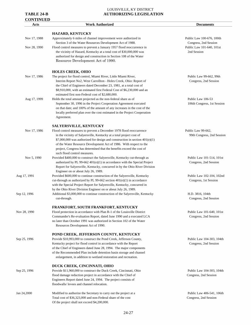
LOUISVILLE, KY DISTRICT
24-27
TABLE 24-B AUTHORIZING LEGISLATION CONTINUED Acts Work Authorized Documents HAZARD, KENTUCKY Nov 17, 1988 Approximately 6 miles of channel improvement were authorized in Public Law 100-676, 100th Section 3 of the Water Resources Development Act of 1988. Congress, 2nd Session Nov 28, 1990 Flood control measures to prevent a January 1957 flood reoccurrence in Public Law 101-640, 101st the vicinity of Hazard, Kentucky at a total cost of $30,000,000 was 2nd Session authorized for design and construction in Section 108 of the Water Resource Development Act of 1990.
HOLES CREEK, OHIO Nov 17, 1986 The project for flood control, Miami River, Little Miami River, Public Law 99-662, 99th Interim Report No2, West Carrollton - Holes Creek, Ohio: Report of Congress, 2nd Session the Chief of Engineers dated December 23, 1981, at a total cost of $8,910,000, with an estimated first Federal Cost of $6,230,000 and an estimated first non-Federal cost of $2,680,000. Aug 17, 1999 Holds the total amount projected as the non-federal share as of Public Law 106-53 September 30, 1996 in the Project Cooperation Agreement executed 106th Congress, 1st Session on that date; and 100% of the amount of any increases in the cost of the locally preferred plan over the cost estimated in the Project Cooperation Agreement. SALYERSVILLE, KENTUCKY Nov 17, 1986 Flood control measures to prevent a December 1978 flood reoccurrence Public Law 99-662, in the vicinity of Salyersville, Kentucky at a total project cost of 99th Congress, 2nd Session $7,000,000 was authorized for design and construction in section 401(e)(1) of the Water Resource Development Act of 1986. With respect to the project, Congress has determined that the benefits exceed the cost of such flood control measures. Nov 5, 1990 Provided $400,000 to construct the Salyersville, Kentucky cut-through as Public Law 101-514, 101st authorized by PL 99-662 401(e)(1) in accordance with the Special Project Congress, 2nd Session Report for Salyersville, Kentucky, concurred in by the Ohio River Division Engineer on or about July 26, 1989.
Aug 17, 1991 Provided $600,000 to continue construction of the Salyersville, Kentucky Public Law 102-104, 102nd cut-through as authorized by PL 99-662 section 401(e)(1) in accordance Congress, 1st Session with the Special Project Report for Salyersville, Kentucky, concurred in by the Ohio River Division Engineer on or about July 26, 1989. Sep 12, 1996 Additional $3,000,000 to continue construction of the Salyersville, Kentucky H.D. 3816, 104th
cut-through. Congress, 2nd Session FRANKFORT, SOUTH FRANKFORT, KENTUCKY Nov 28, 1990 Flood protection in accordance with Plan R-1 of the Louisville District Public Law 101-640, 101st Commander's Re-evaluation Report, dated June 1990 and a executed LCA Congress, 2nd Session no later than October 1991 was authorized in Section 102 of the Water
Resources Development Act of 1990. POND CREEK, JEFFERSON COUNTY, KENTUCKY Sep 25, 1996 Provide $10,993,000 to construct the Pond Creek, Jefferson County, Public Law 104-303, 104th Kentucky project for flood control in accordance with the Report Congress, 2nd Session of the Chief of Engineers dated June 28, 1994. The major components of the Recommended Plan include detention basin storage and channel
enlargement, in addition to wetland restoration and recreation.
DUCK CREEK, CINCINNATI, OHIO Sep 25, 1996 Provide $11,960,000 to construct the Duck Creek, Cincinnati, Ohio Public Law 104-303, 104th flood damage reduction project in accordance with the Chief of Congress, 2nd Session Engineers Report dated June 24, 1994. The project consists of floodwalls/ levees and channel relocation. Jan 24,2000 Modified to authorize the Secretary to carry out the project at a Public Law 406-541, 106th Total cost of $36,323,000 and non-Federal share of the cost Congress, 2nd Session Of the project shall not exceed $4,200,000.

REPORT OF THE SECRETARY OF THE ARMY ON CIVIL WORKS ACTIVITIES FOR FY 2007
24-28
TABLE 24-B AUTHORIZING LEGISLATION CONTINUED Acts Work Authorized Documents
NEW HARMONY, INDIANA Sep 25, 1996 Provide $2,100,000 for streambank erosion protection along the Wabash Public Law 104-303, 104th River at the town of New Harmony, Indiana. Congress, 2nd Session
WHITE RIVER, INDIANAPOLIS CENTRAL WATERFRONT, INDIANA Sep 12, 1996 Provide $7,000,000 for construction of recreation facilities and H.D. 3816, 104th rehabilitation of existing flood protection features in downtown Congress, 2nd Session Indianapolis along the White River. Aug 17, 1999 Authorized to undertake the riverfront alterations described in the Public Law 106-553, Central Indianapolis Waterfront Concept Plan, dtd Feb 1994 for the 106th Congress, 1st Session Canal Development(Upper Canal feature) and the Beveridge Paper feature, at a total cost not to exceed $25,000,000 of which$12,500,00 is the estimated Federal cost and $12,500,000 is the estimated non-federal cost. BEARGRASS CREEK, KENTUCKY Aug 17, 1999 The project for flood control, Beargrass Creek, Kentucky: Report of the Public Law 106-553, Chief of Engineers dtd May 12, 1998 at a total cost of $11,171,300 with 106th Congress, 1st Session an estimated Federal cost of $7,261,500 and an estimated non-federal cost of $3,909,800. 1 Deficiency act. 2 Authorization for Nolin River and Bear Creek revoked by Act of Sep. 3, 1954
3 Permanent Appropriations Repeal Act.

LOUISVILLE, KY DISTRICT
24-29
TABLE 24-C OTHER AUTHORIZED NAVIGATION PROJECTS (See Section 6)
For Last Cost to Sep 30, 2007 Full Report See Annual Operation and Name of Project Status Report Construction Maintenance Licking River Completed 1901 $ 13,045 $ 139,108 Rough River, KY Completed 1951 105,500 101,196 Tradewater River, KY Completed 1858 18,568 33,331 White River, IN Completed 1909 119,312 0

REPORT OF THE SECRETARY OF THE ARMY ON CIVIL WORKS ACTIVITIES FOR FY 2007
24-30
TABLE 24-E OTHER AUTHORIZED FLOOD CONTROL PROJECTS For Last Cost to Sep 30, 2007 Full Report See Annual Operation and Project and Status 1 Report Construction Maintenance Local Protection: Completed: Boone County, KY (Ohio River, Rabbit Hash) 1977 $ 392,443 - Brevoort Levee, IN (Wabash River) 1954 1,240,299 - Brookport, IL 1958 597,493 - Cannelton, IN 1959 2,068,391 - Canoe Creek, Henderson, KY 2 - 1,206,852 - Chaplin River, Perryville, KY 2 - 832,700 - Cincinnati, OH 1957 10,150,935 - Covington, KY 1965 7,862,937 - Dayton, KY 1987 13,177,345 - Delphi, IN (Wabash River) 1953 144,563 - England Pond Levee, IL (Wabash River) 1972 734,498 - English, IN (Little Blue River) 2 1965 372,353 - Evansville, IN 1997 43,906,502 - Frankfort, KY (North Frankfort) (Kentucky River) 3 8 1979 2,960,970 - Frankfort, South Frankfort, KY 1998 11,164,720 Gill Township Levee, IN (Wabash River) 1948 561,200 - Golconda, IL 1960 565,333 - Grassy Creek, Jackson County, IN (Muscatatuck River) 2 1953 70,304 - Greenfield Bayou, IN (Wabash River) - 157,935 - Harrisburg, IL 1959 870,015 - Hawesville, KY 1955 969,318 - Indianapolis, IN (Fall Creek Section) (White River) 1953 1,788,840 - Indian Creek, Corydon, IN 2 1964 300,143 - Indianapolis, IN (Warfleigh Section) (White River) 1976 153,410 - Jackson, KY (Kentucky River) 1957 130,952 - Jeffersonville-Clarksville, IN 1959 & 1996 4,836,361 - Lawrenceburg, IN 1953 2,473,414 - Lebanon Junction, KY (Salt River) 2 1967 130,417 - Levee Unit No. 5, Wabash River, IN 1987 7,517,464 - Levee Unit No. 8, White River, IN 1952 700,534 - Louisville, KY 9 - 415,000 - Louisville, KY 4 1975 26,721,438 - Lyford Levee Unit, IN (Wabash River) 1944 267,391 - Mason J. Niblack Levee, IN (Wabash River) 5 1987 4,337,617 - Miami River Basin, Pleasant Run, Vicinity Fairfield, OH 9 - 514,964 - (Great Miami River) Mill Creek, Jefferson County, KY 2 1973 292,710 - Mount Carmel, IL (Wabash River) 1972 1,980,675 - Muncie, IN (White River) 1956 887,835 - Neon-Fleming, KY (Kentucky River) 1963 86,532 - New Albany, IN 1957 5,375,471 - New Harmony Bridge, IL & IN (Wabash River) 2 7 1959 297,624 - Newburgh, IN (Ohio River) 6 1974 52,061 - Newport, KY 1959 7,512,987 - Paducah, KY 1959 4,761,551 - Panther Creek, KY (Green River) 2 1970 254,031 - Portland, IN (Salamonie River) 2 1962 237,657 - Reevesville, IL (Cache River) 1954 600,300 - Rochester & McCleary’s Bluff Levee, IL (Wabash River) 1972 1,079,236 - Rosiclaire, IL 1954 622,544 - Saline River & Tributaries, IL 1981 7,826,219 - Shawneetown, IL7 - 91,000 - Sturgis, KY 1972 1,826,778 - Taylorsville, KY (Salt River) 1952 378,050 - Tell City, IN 1956 932,229 - Terre Haute (Conover Levee), IN (Wabash River) 7 1965 14,913 - Town Creek, Harrodsburg, KY 2 1967 56,505 -

LOUISVILLE, KY DISTRICT
24-31
TABLE 24-E OTHER AUTHORIZED FLOOD CONTROL PROJECTS CONTINUED For Last Cost to Sep 30, 2007 Full Report See Annual Operation and Project and Status 1 Report Construction Maintenance Triplett Creek, Morehead, KY (Licking River) 2 1972 893,094 - Southwestern Jefferson County, KY 2003 70,049,492 - Uniontown, KY 1956 1,070,926 - Vincennes, IN (Wabash River) 7 1964 3,308,941 - Wabash River, New Harmony 2003 3,239,025 - West Fork Mill Creek, OH (Winton Road) 9 - 477,649 - West Terre Haute, IN (Wabash River) 1977 1,095,704 - Whitewater River, Hagerstown, IN 2 - 641,398 - Active: Inactive: Blue River, Salem, IN - 15,000 - Cache River, Upper Basin, Ill - 44,000 - Columbus, IN - 283,000 - Fairfield, OH - - - Hazard, KY - - - Kentucky River National Recreation Area - - - Licking River, KY - - - Mount Vernon, IN - 30,000 - Southwest Ohio Urban Waterfront Development - - - Vincennes, IL (Wabash River) 1964 - - Wabash River, York Township, Clark County, IL - - - West Fork Drakes Creek, TN & KY - 58,000 - Whitewater River & Tributaries, IN & OH - 112,000 - Reservoirs: Active: Inactive: Eagle Creek Lake, KY 1975 702,471 -
1 All projects are on Ohio River unless otherwise noted. 2 Authorized by the Chief of Engineers under Section 205, 1984 Flood Control Act, as amended. 3 Cost includes $161,098 cash contribution consisting of $105,118 from the City of Frankfort, KY and $55,980 from the Commonwealth of Kentucky. 4 Cost includes $1,716,301 cash contributions from the City of Louisville, KY. 5 Cost shown are for levee and pump plants. 6 The Water Resources Development Act of 1974 modified the Newburgh Locks & Dam project to include the bank protection works at Newburgh Locks & Dam project to include the bank protection works at Newburgh, IN. 7 Partially completed to form a useful unit. Remaining portions of project inactive. 8 Partially completed to form a useful unit. Remaining portions of project are active and inactive. 9 Advance Engineering and Design funded with General Investigations Appropriation.

REPORT OF THE SECRETARY OF THE ARMY ON CIVIL WORKS ACTIVITIES FOR FY 2007
24-32
TABLE 24-G DEAUTHORIZED PROJECTS For Last
Full Report Federal Contributed See Annual Date Funds Funds Project Report For Deauthorized Expended Expended
Flood Control - Local Protection: Adams Levee, IN (Wabash River) - 1978 $ - - Alton, IN - 1977 - - Anderson, IN (White River) 1940 1986 5,724 - Aurora, IN - 1977 35,420 - Bellevue, KY - 1977 19,023 - Bonpas Creek, IL (Wabash River) - 1981 - - Bromley, KY - 1977 - - California (Cincinnati), OH - 1977 16,465 - Carrollton, KY - 1977 9,713 - Caseyville, KY - 1986 - - Cave-in-Rock, IL - 1977 - - Cincinnati, OH (Unit 2) - 1977 - - Cincinnati, OH (Unit 4) - 1977 - - Cleves, OH - 1977 6,343 - Clinton, IN - 1977 6,848 - Cloverport, KY - 1986 - - Concordia, KY - 1986 - - Deer Creek, Prairie Levee, IN - 1977 - - Derby, IN - 1977 - - Elizabethtown, IL - 1977 - - Evansville, Howell II - 1992 - - Falmouth Lake - 1998 944,386 - Fletcher & Sunshine Gardens Levee, IN - 1977 3,361 - Frankfort, KY (Benson Creek) (Kentucky River) 1979 1992 - - Gallatin County Streambank Erosion, Area 1, Ohio River - 2002 - - Grandview, IN - 1977 8,497 - Honey Creek Levee, IN - 1977 - - Island Levee, IN (Wabash River) - 2002 355,963 - Leavenworth, IN - 1977 - - Levee Unit 1, Eel River, IN - 1977 - - Levee Unit 2, Eel River, IN - 1977 - - Levee Unit 2, East Fork White River, IN - 1977 - - Levee Unit 3, East Fork White River, IN 1938 1977 275 - Levee Unit 1, IL (Wabash River) 1973 1986 60,000 - Levee Unit 1, Little Wabash River, IL - 1977 - - Levee Unit 2, Little Wabash River, IL - 1977 - - Levee Unit 2, Wabash River, IL - 1977 - - Levee Units 3 and 4, Wabash River, IL 1938 1977 216 - Levee Unit 6, Wabash River, IL - 1977 9,922 - Levee Unit 17, Wabash River Basin, IN - 1977 - - Levee Unit 1, White River, IN - 1977 - - Levee Unit 7, White River, IN - 1977 - - Levee Unit 9, White River, IN - 1977 - - Levee Unit 10, White River, IN - 1977 - - Lewisport, KY - 1990 - - Louisville, KY (Partial) - 1986 - - Louisville Lake - 1998 2,355,395 - Ludlow, KY - 1977 14,503 - Madison, IN - 1977 - - Mauckport, IN - 1977 - - Marion, IN (Wabash River) 1979 1986 209,975 - McGinnis Levee, IN 1950 1977 71,049 - Metropolis, IL - 1986 10,575 -
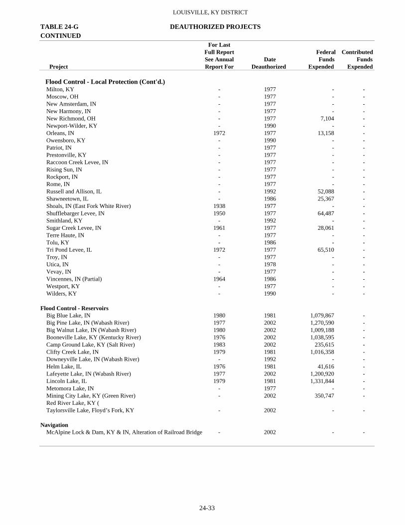
LOUISVILLE, KY DISTRICT
24-33
TABLE 24-G DEAUTHORIZED PROJECTS CONTINUED For Last
Full Report Federal Contributed See Annual Date Funds Funds Project Report For Deauthorized Expended Expended
Flood Control - Local Protection (Cont'd.) Milton, KY - 1977 - - Moscow, OH - 1977 - - New Amsterdam, IN - 1977 - - New Harmony, IN - 1977 - - New Richmond, OH - 1977 7,104 - Newport-Wilder, KY - 1990 - - Orleans, IN 1972 1977 13,158 - Owensboro, KY - 1990 - - Patriot, IN - 1977 - - Prestonville, KY - 1977 - - Raccoon Creek Levee, IN - 1977 - - Rising Sun, IN - 1977 - - Rockport, IN - 1977 - - Rome, IN - 1977 - - Russell and Allison, IL - 1992 52,088 - Shawneetown, IL - 1986 25,367 - Shoals, IN (East Fork White River) 1938 1977 - - Shufflebarger Levee, IN 1950 1977 64,487 - Smithland, KY - 1992 - - Sugar Creek Levee, IN 1961 1977 28,061 - Terre Haute, IN - 1977 - - Tolu, KY - 1986 - - Tri Pond Levee, IL 1972 1977 65,510 - Troy, IN - 1977 - - Utica, IN - 1978 - - Vevay, IN - 1977 - - Vincennes, IN (Partial) 1964 1986 - - Westport, KY - 1977 - - Wilders, KY - 1990 - - Flood Control - Reservoirs Big Blue Lake, IN 1980 1981 1,079,867 - Big Pine Lake, IN (Wabash River) 1977 2002 1,270,590 - Big Walnut Lake, IN (Wabash River) 1980 2002 1,009,188 - Booneville Lake, KY (Kentucky River) 1976 2002 1,038,595 - Camp Ground Lake, KY (Salt River) 1983 2002 235,615 - Clifty Creek Lake, IN 1979 1981 1,016,358 - Downeyville Lake, IN (Wabash River) - 1992 - - Helm Lake, IL 1976 1981 41,616 - Lafeyette Lake, IN (Wabash River) 1977 2002 1,200,920 - Lincoln Lake, IL 1979 1981 1,331,844 - Metomora Lake, IN - 1977 - - Mining City Lake, KY (Green River) - 2002 350,747 - Red River Lake, KY ( Taylorsville Lake, Floyd’s Fork, KY - 2002 - - Navigation McAlpine Lock & Dam, KY & IN, Alteration of Railroad Bridge - 2002 - -

REPORT OF THE SECRETARY OF THE ARMY ON CIVIL WORKS ACTIVITIES FOR FY 2007
24-34
TABLE 24-H NAVIGATION LOCKS AND DAMS PRINCIPAL FEATURES - GREEN & BARREN RIVERS AND KENTUCKY RIVER NAVIGATION SYSTEMS
Lock Dimensions Miles Greatest Length Lock above Available Upper Depth of Year and Mouth of Distance from Width of For Full Normal Pool Miter Sills Character of Percent Opened to Cost of Dam River Nearest Town Chamber Width Lift Elevation Upper Lower Foundation Complete Navigation Lock and Dam (feet) (feet) (feet msl) (feet) (feet) CONSTRUCTION OF LOCKS AND DAMS, OHIO RIVER - For report on this improvement see this heading under Ohio River.
GREEN AND BARREN RIVERS, KY (See Section 3 of Text) Green River New 1 9.1 Spottsville, KY 84.0 600.0 11.8 349.1 12.1 11.3 Shale and Coal 100 1956 2 $5,101,978 3 New 2 63.1 0.3 miles below Calhoun, KY 84.0 600.0 14.3 363.4 15.0 11.7 Shale 100 1956 4 4,799,271 5 3 108.5 0.3 miles below Rochester, KY 35.8 137.5 17.0 380.4 7.3 5.6 Rock 100 1836 6 121,377 4 149.0 Woodbury, KY 35.8 138.0 16.4 396.8 7.1 6.5 Rock 100 1839 7 125,718 5 168.1 0.3 miles below Glenmore, KY 56.0 360.0 15.2 412.0 8 12.0 9.3 Piles and Rock 100 1934 9 1,020,868 10 6 181.7 2.8 miles above Brownsville, KY 36.0 145.0 9.2 421.1 8.0 8.8 Gravel 100 1905 9 168,415 Barren River 1 15.0 11 0.3 miles above Greencastle, KY 56.0 360.0 15.2 412.0 12.0 9.3 Gravel 100 1841 12 871,565 13
KENTUCKY RIVER, KY (See Section 4 of Text) Kentucky River 1 4.0 3.8 miles above Carrolton, KY 38.0 145.0 8.2 14 430.0 8.2 4.8 Rock and Clay 100 1839 15 - 2 31.0 Lockport, KY 38.0 145.0 13.9 443.9 7.6 6.1 Rock 100 1839 15 - 3 42.0 Gest, KY 38.0 145.0 13.2 457.1 8.6 6.5 Rock 100 1844 15 1,350,385 16 4 65.0 1.0 mile below Frankfort, KY 38.0 145.0 13.2 470.3 6.4 6.3 Rock 100 1844 15 - 5 82.2 2.8 miles below Tyrone, KY 38.0 145.0 15.0 485.3 10.0 6.4 Rock 100 1844 15 17 - 6 96.2 21.6 miles below High Bridge, KY 52.0 147.0 14.0 499.3 9.4 6.4 Rock and Piles 100 1894 17 314,847 7 117.0 0.8 mile below High Bridge, KY 52.0 147.0 15.3 514.6 9.1 6.8 Rock 100 1897 17 290,788 8 139.9 4.7 miles above Camp Nelson, KY 52.0 146.0 18.7 533.6 10.6 6.0 Rock 100 1900 17 275,463 9 157.5 Valley View, KY 52.0 148.0 17.3 550.6 10.0 6.6 Rock 100 1907 17 237,646 10 176.4 1.0 mile below Ford, KY 52.0 148.0 17.0 567.6 9.0 6.0 Rock 100 1907 17 221,500 11 201.0 17.2 miles below Irvine, KY 52.0 148.0 18.0 585.6 10.0 6.0 Rock 100 1906 17 296,593 12 220.0 Ravenna, KY 52.0 148.0 17.0 602.6 9.6 6.0 Rock 100 1910 17 425,693 13 239.9 2.2 miles below Willow, KY 52.0 148.0 18.0 620.6 9.6 6.0 Rock 100 1915 17 461,476 14 249.0 Heidelberg, KY 52.0 148.0 17.0 63.6 8.6 6.0 Rock 100 1971 17 392,902
1 At normal pool Dam 48, Ohio River, Elev. 337.3, Green River datum (Elev. 338.0 Ohio River datum)
2 New Lock 1 placed in operation May 25, 1956, old Dam 1, completed 1835-40, replaced with new cellular concrete masonry dam constructed 1970-71 with O&M funds at cost of $822,000.
3 Does not include $179,110 cost of old Lock and Dam 1. 4 New Lock and Dam 2, placed in operation June 18, 1956. 5 Does not include $295,696 cost of old Lock and Dam 2. 6 Operation discontinued September 30, 1981. 7 Breaching of dam on May 24, 1965, stopped through traffic to Bowling Green, KY. 8 With moveable A-frame crest 3 feet high. 9 Operation discontinued August 1, 1951.
10 Does not include $179,434 cost of old Lock and Dam 5. Transferred to State, December 1996.
11 Distance from mouth of Green River is 164.5 miles. Lock closed to navigation as the result of loss of pool at Green River Lock and Dam 4 on May 24, 1965.
12 Piles in old gravel dam completed in 1934. 13 Includes $729,269 for new large lock completed in 1934. 14 At normal pool McAlpine Dam, Ohio River Elev. 421.8 Kentucky River datum (Elev. 420
Ohio River datum). 15 Reconstruction completed by United States in 1882. 16 Built by State of Kentucky. Cost given is for repairs by United States to Locks and Dams 1
through 5. Original construction costs to State were: L&D 1, $220,300; L&D 2, $151,983: L&D 3 $135,857; L&D 4, $131,607; and L&D 5, $137,436.
17 Lock was closed to traffic and placed in caretaker status in September 1982.

LOUISVILLE, KY DISTRICT
24-35
TABLE 24-I OHIO RIVER BASIN TOTAL COST OF BASIN PLAN (See Section 36 of Text)
LOCAL PROTECTION Estimated Cost Type of Project and Status 1 Construction Federal Non-Federal 2 Total Completed: Barnett Creek, KY (Rough River) 3 4 Channel improvement $ 144,000 $ 18,000 $ 162,000 Boone County, KY Bank Protection 392,443 83,000 475,443 Brookport, IL 5 6 Wall and levee 597,493 8,500 605,993 Cannelton, IN 5 7 Wall and levee 2,068,391 29,105 2,097,496 Cincinnati, OH 5 8 Wall and barrier dam 10,150,935 1,309,146 11,460,081 Covington, KY 5 9 Wall and levee 7,862,937 1,051,102 8,914,039 Dayton, KY Wall and levee 13,117,345 2,013,000 15,130,345 Delphi, IN (Wabash River) 5 10 Levee 144,563 17,164 161,727 England Pond Levee, IL (Wabash River) 11 Levee 734,498 107,000 841,498 Evansville, IN 4 Wall and levee 43,906,502 5,500,000 49,406,502 Frankfort, KY, North Frankfort (Kentucky River) 5 Wall and levee 2,960,970 272,100 3,233,070 Frankfort, KY (Kentucky River) South Frankfort 5 Wall 8,373,540 2,791,180 11,164,720 36 Golconda, IL 5 12 Wall and levee 565,333 10,900 576,233 Harrisburg, IL 5 10 Wall and levee 870,015 20,000 890,015 Hawesville, KY 5 13 Levee 969,318 42,593 1,011,911 Jackson, KY (Kentucky River) 5 8 Cutoff channel 130,952 3,000 133,952 Jeffersonville-Clarksville, IN 7 Wall and levee 4,226,361 590,888 4,817,249 Lawrenceburg, IN 5 Wall and levee 2,473,689 284,725 2,758,414 Louisville, KY 5 14 Wall and levee 25,005,137 1,716,301 26,721,438 Mason J. Niblack Levee, IN (Wabash River) 4 5 Levee and pump plants 4,337,617 109,200 4,446,817 New Albany, IN 5 8 Wall and levee 5,375,471 740,000 6,115,471 New Harmony Bridge, IL & IN (Wabash River) 5 7 Bank Protection 297,624 297,624 Newport, KY 5 7 Wall and levee 7,512,987 298,506 7,811,493 Paducah, KY 5 7 Wall and levee 4,761,551 232,000 4,993,551 Perryville, KY, Chapin River Channel Improvement 823,700 11,000 834,700 Reevesville, IL (Cache River) 5 15 Levee 600,300 40,000 640,300 Rochester and McCleary’s Bluff Levee, IL
(Wabash River) 11 Levee 1,079,236 100,000 1,179,236 Rough River, KY 3 4 Channel improvement 654,000 5,000 659,000 Southwest Jefferson County Wall and Levee 60,207,439 9,842,053 70,049,492 Sturgis, KY (Tradewater River) 11 Levee 1,826,778 93,000 1,919,778 Taylorsville, KY (Salt River) 5 16 Levee 378,050 63,309 441,359 Tell City, IN 5 14 Wall and levee 932,229 32,707 964,936 Uniontown, KY Levee 1,070,926 72,153 1,143,079 Vincennes, IN 5 17 (Wabash River)(completed portion) 5 Wall and levee 3,308,941 285,000 3,593,941 Wabash River, New Harmony, In Erosion Control 2,429,269 809,756 3,239,025 West Terre Haute, IN (Wabash River) Levee 1,095,704 150,000 1,245,704 Active: Salyersville, KY Channel Improvement 9,348,600 981,400 10,330,000 Inactive: Hazard, KY Channel Improvement - - -

REPORT OF THE SECRETARY OF THE ARMY ON CIVIL WORKS ACTIVITIES FOR FY 2007
24-36
TABLE 24-I OHIO RIVER BASIN CONTINUED TOTAL COST OF BASIN PLAN (See Section 36 of Text)
LOCAL PROTECTION Estimated Cost Type of Project and Status 1 Construction Federal Non-Federal 2 Total Deauthorized: Adams Levee, IN (Wabash River) 32 Levee $ 292,000 $ 14,000 $ 306,000 27 Alton, IN 30 Levee 255,000 40,000 295,000 Aurora, IN 31 Wall and levee 4,300,000 1,190,000 5,490,000 Bellevue, KY 30 Wall and levee 1,570,000 400,000 1,970,000 Bonpas Creek, IL (Wabash River) 5 33 Channel Improvement 1,080,000 630,000 1,710,000 28 Bromley, KY 30 Wall and levee 1,250,000 925,000 2,175,000 California (Cincinnati), OH 31 Wall and levee 1,750,000 720,000 2,470,000 Carrollton, KY 30 Wall and levee 2,220,000 97,000 2,317,000 Caseyville, KY 5 34 Levee 396,000 35,000 431,000 Cave-in-Rock, IL 30 Levee 661,000 125,000 786,000 Cincinnati, OH (Unit 2) 30 Wall and levee 16,800,000 2,900,000 19,700,000 Cincinnati, OH (Unit 4) 30 Wall 14,900,000 621,000 15,521,000 Cleves, OH 30 Levee 1,240,000 67,000 1,307,000 Clinton, IN (Wabash River) 30 Levee 77,000 9,000 86,000 Cloverport, KY 5 34 Wall and levee 728,000 193,000 921,000 Concordia, KY 5 34 Levee 590,000 55,000 645,000 Deer Creek Prairie Levee, IN (Wabash River) 30 Levee 213,000 10,000 223,000 24 Derby, IN 30 Wall and levee 553,000 67,000 620,000 Elizabethtown, IL 30 Wall and levee 559,000 153,000 712,000 Fletcher and Sunshine Gardens Levee, IN (Wabash River) 30 Levee 548,000 26,000 574,000 24 Frankfort, KY (Kentucky River) Benson Creek 5 Wall and Levee 3,340,000 1,150,000 4,490,000 22 Grandview, IN 30 Levee 580,000 133,000 713,000 Greenfield Bayou Levee, IN (Wabash River) 5 35 Levee 4,600,000 1,087,000 5,687,000 23
Honey Creek Levee, IN 30 Levee 653,000 32,000 685,000 Island Levee, IN (Wabash River) 5 35 Levee 4,630,000 528,000 5,158,000 23 Leavenworth, IN 30 Wall and levee 1,470,000 266,000 1,736,000 Levee Unit 1, Eel River, IN 30 Levee 204,000 40,000 244,000 Levee Unit 1, Little Wabash River, IL 30 Levee 2,850,000 164,000 3,014,000 27 Levee Unit 1, White River, IN 30 Levee 2,180,000 116,000 2,296,000 27 Levee Unit 17, IN 30 Levee 1,580,000 118,000 1,698,000 28 Levee Unit 2, Eel River, IN 30 Levee 2,090,000 715,000 2,805,000 Levee Unit 2, Little Wabash River, IL 30 Levee 3,410,000 136,000 3,546,000 28 Levee Unit 2, White River, IN 30 Levee 724,000 73,000 797,000 27 Levee Unit 6, Wabash River, IL 30 Levee 1,160,000 56,000 1,216,000 Levee Unit 7, White River, IN 30 Levee 1,490,000 88,000 1,578,000 27 Lewisport, KY 5 35 Wall and levee 610,000 243,000 853,000 24 Ludlow, KY 30 Wall and levee 2,540,000 745,000 3,285,000 Madison, IN 30 Levee 3,820,000 360,000 4,180,000 Mauckport, IN 30 Levee 506,000 105,000 611,000 McGinnis Levee, IN (Wabash River) 30 Levee 1,820,000 104,000 1,924,000 Metropolis, IL 5 34 Wall and levee 3,070,000 431,000 3,501,000 Milton, KY 30 Wall 2,480,000 41,000 2,521,000 Moscow, OH 30 Levee 1,170,000 372,000 1,542,000 New Amsterdam, IN 30 Levee 476,000 13,000 489,000 New Harmony Bridge, IL & IN (Wabash River) 37 Bank Protection 664,376 99,000 763,376 25
New Harmony, IN (Wabash River) 30 Levee 616,000 25,000 641,000 Wilder, KY 35 Wall and levee 10,800,000 959,000 11,759,000 26
1 All projects are on an Ohio River unless otherwise noted. 2 Latest cost estimate revision 1954 unless otherwise noted.

LOUISVILLE, KY DISTRICT
24-37
3 Part of Rough River Reservoir and Channel Improvement Project, KY.
4 Details of this project are in individual report. 5 Also see “Other authorized flood control projects.” 6 See Annual Report for 1958 for details. 7 See Annual Report for 1959 for details. 8 See Annual Report for 1957 for details. 9 See Annual Report for 1965 for details. 10 See Annual Report for 1953 for details. 11 See Annual Report for 1972 for details. 12 See Annual Report for 1960 for details. 13 See Annual Report for 1955 for details. 14 See Annual Report for 1962 for details. 15 Substitute project for Belknap, Karnak, and Ullin, IL,
complete. See Annual Report for 1954 for details. 16 See Annual Report for 1952 for details. 17 See Annual Report for 1956 for details. 18 Latest cost estimate revision 1988. 19 Latest cost estimate revision 1986. 20 Latest cost estimate revision 1984. 21 Latest cost estimate revision 1983. 22 Latest cost estimate revision 1976.
23 Latest cost estimate revision 1978. 24 Latest cost estimate revision 1960. 25 Latest cost estimate revision 1971. 26 Latest cost estimate revision 1977. 27 Latest cost estimate revision 1961. 28 Latest cost estimate revision 1973. 29 Latest cost estimate revision 1989. 30 Deauthorized Aug 05, 1977 under Section 12, Water
Resources Development Act of 1971 (P.L. 93-251). 31 Deauthorized Nov 06, 1977 under Section 12, Water
Resources Development Act of 1974 (P.L. 93-251). 32 Deauthorized Oct 03, 1978 under Section 12, Water
Resources Development Act of 1974 (P.L. 93-251). 33 Deauthorized May 06, 1981 under Section 12, Water
Resources Development Act of 1974 (P.L. 93-251). 34 Deauthorized Nov 17, 1986 under Section 12, Water
Resources Development Act of 1974 (P.L. 93-251). 35 Deauthorized Jan 01, 1990 under Section 1001 (b)(1), Water Resources Development Act of 1986 (P.L. 99-
662). 37 Deauthorized Jul 19, 1992.

REPORT OF THE SECRETARY OF THE ARMY ON CIVIL WORKS ACTIVITIES FOR FY 2007
24-38
TABLE 24-I OHIO RIVER BASIN CONTINUED TOTAL COST OF BASIN PLAN (See Section 36 of Text) RESERVOIRS Estimated Cost 1 Tributary Basin Reservoirs Status Stream Federal Non-Federal Total
Great Miami River: Brookville Lake, IN 2 Complete East Fork of Whitewater River $ 37,905,073 $ 7,497,492 3 $ 45,402,565 Metamora Lake, IN Deauthorized West Fork of Whitewater River 35,300,000 35,300,000 4 Green River: Barren River Lake, KY 2 Complete Barren River 27,371,299 108,418 5 27,479,717 Green River Lake, KY 2 Complete Green River 33,238,597 223,73313 33,462,330 Mining City Lake, KY Deauthorized Green River 69,100,000 69,100,000 4 Nolin Lake, KY 2 Complete Nolin River 17,193,278 17,193,278 Rough River Kentucky 2 Complete Rough River 10,620,389 22,612 10,643,001 Kentucky River: Booneville Lake, KY Deauthorized South Fork of Kentucky River 60,700,000 60,700,000 8 Buckhorn Lake, KY 2 Complete Middle Fork of Kentucky River 11,766,206 11,766,206 Carr Fork Lake, KY 2 Complete North Fork of Kentucky River 50,854,826 50,854,826 Eagle Creek Lake, KY Inactive Eagle Creek 27,800,000 - 27,800,000 14 Red River Lake, KY Deauthorized Red River 38,551,692 1,794,308 40,346,000 Licking River: Cave Run Lake, KY 2 Complete Licking River 81,162,282 81,162,282 7 Falmouth Lake, KY Deauthorized Licking River 125,000,000 125,000,000 8 Little Miami River: Caesar Creek Lake, OH 2 Complete Caesar Creek 62,893,882 5,037,000 9 67,930,882 William H. Harsha Lake, OH 2 Complete East Fork of Little Miami River 52,023,157 3,485,840 9 55,508,997 Mill Creek: West Fork of Mill Creek Lake, OH 2 Complete West Fork of Mill
Creek 3,622,302 1,100,16110 4,722,463 Wabash River: Cagles Mill Lake, IN 2 Complete Mill Creek 4,256,903 113,094 5 4,369,997 Cecil M. Harden Lake, IN 2 Complete Raccoon Creek 6,633,812 353,995 5 6,987,807 Monroe Lake, IN 2 Complete Salt Creek 7,902,827 8,667,94711 16,570,774 Patoka Lake, IN 2 Complete Patoka River 53,095,790 20,568,369 73,664,159
1 Latest cost estimate revision 1989 unless otherwise noted. 2 Details of this project given in individual report. 3 Cash contributions for water supply storage. 4 Latest cost estimate revision 1954. 5 For Code 713 recreation development. 6 Latest cost estimate revision 1975. 7 Includes $6,900,000 United States Forest Service cost. 8 Latest cost estimate revision 1979. 9 Reimbursement for water supply storage. 10 Includes $520,800 for non-Federal cost for sewer
relocation and dam, $50,000 for contributed funds in fulfillment
of project authorization, and $529,361 for Code 713 recreation development.
11 Includes $7,797,604 cash contribution for storage for low-flow regulation and $870,343 non-Federal contribution in kind for recreational facilities.
12 Includes $14,180,677 cash contribution for water supply storage, and $6,387,692 for initial recreation development.
13 For $183,732 Code 713 recreation development and $40,001 contributed funds.
14 Latest cost estimate 1974
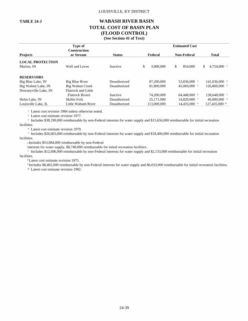
LOUISVILLE, KY DISTRICT
24-39
TABLE 24-J WABASH RIVER BASIN TOTAL COST OF BASIN PLAN
(FLOOD CONTROL) (See Section 41 of Text)
Type of Estimated Cost Construction Projects or Stream Status Federal Non-Federal Total
LOCAL PROTECTION Marion, IN Wall and Levee Inactive $ 3,900,000 $ 854,000 $ 4,754,000 2
RESERVOIRS Big Blue Lake, IN Big Blue River Deauthorized 87,200,000 53,836,000 3 141,036,000 4 Big Walnut Lake, IN Big Walnut Creek Deauthorized 81,800,000 45,069,000 5 126,869,000 4 Downeyville Lake, IN Flatrock and Little Flatrock Rivers Inactive 74,200,000 64,448,000 6 138,648,000 1 Helm Lake, IN Skillet Fork Deauthorized 25,171,000 14,829,000 7 40,000,000 8 Louisville Lake, IL Little Wabash River Deauthorized 113,000,000 14,435,000 9 127,435,000 10
1 Latest cost revision 1984 unless otherwise noted. 2 Latest cost estimate revision 1977. 3 Includes $38,190,000 reimbursable by non-Federal interests for water supply and $15,656,000 reimbursable for initial recreation facilities. 4 Latest cost estimate revision 1979. 5 Includes $26,663,000 reimbursable by non-Federal interests for water supply and $18,406,000 reimbursable for initial recreation facilities.
6 Includes $53,084,000 reimbursable by non-Federal interests for water supply, $8,749,000 reimbursable for initial recreation facilities. 7 Includes $12,696,000 reimbursable by non-Federal interests for water supply and $2,133,000 reimbursable for initial recreation
facilities. 8 Latest cost estimate revision 1975. 9 Includes $8,402,000 reimbursable by non-Federal interests for water supply and $6,033,000 reimbursable for initial recreation facilities.
10 Latest cost estimate revision 1982.

REPORT OF THE SECRETARY OF THE ARMY ON CIVIL WORKS ACTIVITIES FOR FY 2007
24-40
TABLE 24-K INSPECTION OF COMPLETED FLOOD CONTROL PROJECTS
(See Section 44 of Text) Date of Projects Inspection
Local Protection Projects Bardstown, KY Jul 2006 Brevoort Levee, IN Sep 2006 Brookport, IL Apr 2006 Cache River Levee, IL Aug 2003 Cannelton, IN Dec 2005 Cincinnati, OH Aug 2006 Covington, KY Aug 2006 Dayton, KY Aug 2006 Delphi, IN Sep 2006 England Pond Levee, IL Sep 2006 Evansville, IN Jul 2006 Frankfort, KY, North Frankfort June 2006 Gill Township Levee, IN Sep 2006 Golconda, IL Apr 2006 Harrisburg, IL Dec 2005 Hagerstown, IN Aug 2006 Hawesville, KY Dec 2005 Indianapolis, IN Aug 2006 Jeffersonville-Clarksville, IN Jul 2006 Lawrenceburg, IN Aug 2006 Lebanon Junction, KY Jul 2006 Levee Unit No. 5, Wabash River, IN Sep 2006 Levee Unit No. 8, Wabash River, IN Aug 2004 Louisville, KY Sep 2007 Lyford Levee, IN Sep 2006 Mason J. Niblack Levee, IN Jul 2006 Mount Carmel, IL Sep 2006 Muncie, IN Aug 2006 New Albany, IN Jul 2006 Newport, KY Aug 2006 Paducah, KY Jul 2007 Perryville, KY May 2005 Reevesville, IL May 2006 Rochester-McClearys Bluff Levee, IL Sep 2006 Rosiclare, IL Apr 2006 Rushville, IN Aug 2006 Shawneetown, IL Dec 2005 Southwestern Jefferson County, KY Sep 2007 Sturgis, KY Dec 2005 Taylorsville, KY Jul 2006 Tell City, IN Dec 2005 Terre Haute (Conover Levee), IN Jul 2006 Uniontown, KY Jul 2007 Vincennes, IN Aug 2007 West Terre Haute, IN Jul 2006 Channel Improvements Canoe Creek, Henderson, KY Jul 2004 Cypress Creek, McLean County, KY Sep 1998 Eel River, Brazil Waterworks, IN May 2003 English, IN (Little Blue River) Jun 1994 Grassy Creek, Jackson County, IN Sep 1995 Harrodsburg, KY (Town Creek) May 2005 Indian Creek, Corydon, IN Nov 2003 Jackson, KY (North Fork Kentucky River) Sep 1998

LOUISVILLE, KY DISTRICT
24-41
TABLE 24-K INSPECTION OF COMPLETED CONTINUED FLOOD CONTROL PROJECTS
(See Section 44 of Text)
Date of Projects Inspection
Channel Improvements Con’t. Lancassange Creek, Clark Co, IN Apr 2003 Lick Creek, Hartford City (Blackford County), IN Oct 2002 Mill Creek, Jefferson County, KY Apr 2003 Muscatatuck River, Crothersville, IN Oct 2002 Neon-Fleming, KY (North Fork Kentucky River) Nov 2002 Nicholasville (Town Fork) Vicinity, KY Apr 2003 Panther Creek, Curdsville, KY Sep 1998 Plum Creek, Spencer County, KY Apr 2003 Portland, IN (Salamonie River) Oct 2002 Rough River, Hartford, Ohio County, KY Nov 1999 Salamonie River, Wells County, IN Oct 2002 Saline River and Tributaries, IL Jul 2004 Tripplett Creek, Morehead, KY Nov 2002 Troublesome Creek, Hindman, KY Sep 1998 Wabash River, Adams County, IN Nov 1999 Whitesburg, KY (North Fork Kentucky River) Aug 1998 Bank Revetments Crooked Creek, City Garage, Madison, IN Mar 2004 Crooked Creek, John Paul Park, Madison, IN Mar 2004 Eagle Creek, Indianapolis, IN Jun 2003 East Fork White River, Brownstown, (Jackson County), IN Mar 2003 Eighteen Mile Island, Oldham County, KY Jun 1993 Great Miami River, Sidney, OH Aug 1995 Green River, Calhoun, KY (River Mile 63.6) Sep 1995 Green River, Calhoun, KY (River Mile 63.4) Sep 1998 Indian Creek, Burton Lane, Morgan County, IN Oct 1999 Licking River, Butler, KY Aug 1995 Lusk Creek, Golconda, IL Apr 2006 Little Miami River, Indian Hill, OH Nov 1999 Little Miami River, Milford, OH Jul 2005 Nameless Creek, Warren County, IN Jun 1995 North Fork, Kentucky River, Whitesburg, KY Oct 2002 Great Miami River, Ice Jam Flooding, Port Jefferson, OH Nov 1999 Ohio River, Brandenburg, KY Apr 2003 Ohio River, Carrolton, KY Feb 2003 Ohio River, Cloverport, KY Nov 2002 Ohio River, Daviess County, KY Sep 1998 Ohio River, Fort Massac State Park, IL Apr 2005 Ohio River, Hawesville, KY Sep 1998 Ohio River, Lewisport, KY Nov 2002 Ohio River, Madison, IN Mar 2004 Ohio River, Moscow, OH Jan 2000 Ohio River, Mount Vernon, IN Jul 2004 Ohio River, Newburgh, IN Jul 2004 Ohio River, Ohio Street, Evansville, IN Jul 2004 Ohio River, Otter Creek Park, KY Mar 2004 Ohio River, Owensboro, KY Sep 1998 Ohio River, Owensboro Riverport Authority, KY Feb 1995 Ohio River, Rabbit Hash, Boone County, KY May 2004 Ohio River, Rockport/Rockport Landing, IN Aug 1998 Ohio River, Sellersburg, IN Nov 2002 Ohio River, SR 66, Cannelton, IN Nov 2002 Ohio River, Troy, IN Nov 2002

REPORT OF THE SECRETARY OF THE ARMY ON CIVIL WORKS ACTIVITIES FOR FY 2007
24-42
TABLE 24-K INSPECTION OF COMPLETED CONTINUED FLOOD CONTROL PROJECTS
(See Section 44 of Text)
Date of Projects Inspection
Bank Revetments Con’t Ohio River, Upper River Road, Jefferson County, KY Jul 1991 Ohio River, Vanderburg County, IN Aug 1998 Patoka River, Jasper, IN Oct 1993 Patoka River, Winslow, IN Jul 1995 South Fork of Wildcat Creek, County Road 7 East, Tippecanoe County, IN May 2004 Stoner Creek, North Middletown, KY Jul 1994 Wabash River, near Merom, IN Aug 2004 Wabash River, New Harmony, IN Sep 2004 Wabash River, Terre Haute STP Outfall May 2005 Wabash River, Vigo County, County Road 83 West May 2005 Wabash River, Vigo County, Little Road May 2005 White River, Morgan County, Blue Bluff Road, IN Oct 1999 White River, Petersburg (Pike County), IN Jul 1995 Whitewater River, Levee Road, near Brookville, IN Apr 1995 Wastewater Treatment Plant, Great Miami River, Ross, OH Apr 1995

LOUISVILLE, KY DISTRICT
24-43
TABLE 24-L FLOOD CONTROL WORK UNDER SPECIAL AUTHORIZATION (See Section 46 of Text)
Fiscal Year Cost Federal Non-Fed Total
Environmental Restoration (Section 1135) None Flood Control (Section 205) Banklick Creek, Kenton County, KY 2 11,035 43,947 54,982 Beaver Creek, Frenchburg, KY 2 8,717 - 8,717 Coordination Account 8 19,967 - 19,967 Dugan Run, Urbana, OH 2 5,971 - 5,971 Elizabethtown, KY 2 173 - 173 Feather Creek, Clinton, IN 3 4,341 - 4,341 Hinkston Creek Mt. Sterling, KY 2 13,685 32,030 45,715 Pleasant Creek, Greenwood, IN 2 6,530 833 7,363 Rolling Fork River, Lebanon Junction, KY 5 4,450 - 4,450 White River, Anderson, IN 3 10,887 - 10,887 Emergency Bank Protection (Section 14) Coordination Account 8 21,448 - 21,448 Crooked Creek, Madison, IN 1 34,051 - 34,051 Hodgenville, KY 1 3,145 - 3,145 Rockport, IN 4 39,671 - 39,671 South Harrison Co., IN 1 17,860 - 17,860 South Harrison Co., Water Corp, IN 4 4,503 14,501 19,004 White River, Knox County, Hwy 358, KY 1 32,981 - 32,981 Snagging & Clearing (Section 208) Deer Creek, Webster Co., KY 1 9,420 - 9,420 Navigation – Rivers & Harbors (Sec 107) None Aquatic Ecosystem Restoration (Section 206) None 1 Planning and Design Analysis (PDA). 2 Feasibility Report. 3 Plans and Specifications. 4 Construction Funds Received or Construction Underway. 5 Construction Completed. 6 Study Terminated. 7 Preliminary Restoration Plan. 8 Coordination Account.

REPORT OF THE SECRETARY OF THE ARMY ON CIVIL WORKS ACTIVITIES FOR FY 2007
24-44
TABLE 24-M GENERAL INVESTIGATIONS (See Sections 47, 48, 49, & 50 of Text)
Fiscal Year Cost Projects Federal Non-Fed Total
SURVEYS Navigation Studies Ohio River Mainstem, Uniontown, KY, IL, IN $ 32,967 - 32.967 Flood Damage Prevention Studies Metro Louisville, Mill Creek, KY 120,586 89,739 210,325 Metropolitan Louisville, Southwest 89,161 16,230 105,392 Ohio River, Southeastern, IL 44,116 - 44,116 Special Studies Northern KY Riverfront Commons, KY 19,867 - 19,867 Miscellaneous Activities Federal Energy Regulatory Commission 11,413 - 11,413 Intra-Agency Water Resources Development 17,221 - 17,221 N. American Waterfowl Management Plan 2,060 - 2,060 Special Investigation, KY 52,591 - 52,591 PRECONSTRUCTION ENGINEERING AND DESIGN Navigation Project - Lock and Dams John T. Myers Locks and Dam 84 - 84 Flood Control Projects - Local Protection Ohio Riverfront Study, Cincinnati, OH 353,920 - 353,920 Licking River Watershed, Cynthiana, KY 4,159 - 4,159 COORDINATION WITH OTHER AGENCIES Coordination with other Agencies and Non-Federal Interest Coop w/other Water Agencies 7,149 - 7,149 Planning Assistance to States PAS-IN-Gibson Co. 1,239 1,154 2,393 PAS-IN-Lafayette, Tippecanoe Co. 6,182 5,814 11,996 PAS-IN-Lafayette, Wabash River 9,362 43,502 52,864 PAS-KY-City of Owensboro 3,151 5,156 8,307 PAS-KY-Harrodsburg. 8,596 - 8,596 PAS-KY-Radcliff, Hardin Co. 42,875 12,413 55,288 PAS-KY-Richmond 75,898 - 75,898 PAS-Negotiation Funds 35,181 - 35,181 PAS-OH-Sydney. 6,815 - 6,815 PAS-OH-Wolf Creek Watershed, Montgomery Co. 3,201 25,353 28,554 COLLECTION AND STUDY OF BASIC DATA Flood Plain Management Services Flood Plain Management Services 23,948 - 23,948 Quick Responses 9,435 - 9,435 Technical Service, General 16,376 - 16,376 Hydrologic Studies Hydrologic Studies 8,008 - 8,008
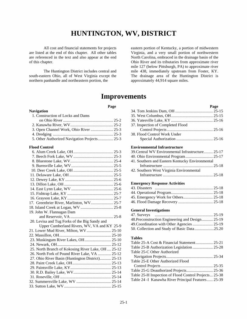
25-1
HUNTINGTON, WV, DISTRICT
All cost and financial statements for projects are listed at the end of this chapter. All other tables are referenced in the text and also appear at the end of this chapter. The Huntington District includes central and south-eastern Ohio, all of West Virginia except the northern panhandle and northeastern portion, the
eastern portion of Kentucky, a portion of midwestern Virginia, and a very small portion of northwestern North Carolina, embraced in the drainage basin of the Ohio River and its tributaries from approximate river mile 127 (below Pittsburgh, PA) to approximate river mile 438, immediately upstream from Foster, KY. The drainage area of the Huntington District is approximately 44,914 square miles.
Improvements
Page
Page Navigation 1. Construction of Locks and Dams on Ohio River ................................................. 25-2 2. Kanawha River, WV.......................................... 25-2 3. Open Channel Work, Ohio River ...................... 25-3 4. Dredging ........................................................... 25-3 5. Other Authorized Navigation Projects............... 25-3 Flood Control 6. Alum Creek Lake, OH....................................... 25-3 7. Beech Fork Lake, WV ....................................... 25-3 8. Bluestone Lake, WV.......................................... 25-4 9. Burnsville Lake, WV......................................... 25-5 10. Deer Creek Lake, OH ....................................... 25-5 11. Delaware Lake, OH ........................................... 25-5 12. Dewey Lake, KY ............................................... 25-6 13. Dillon Lake, OH ................................................ 25-6 14. East Lynn Lake, WV ......................................... 25-6 15. Fishtrap Lake, KY ............................................. 25-7 16. Grayson Lake, KY............................................. 25-7 17. Greenbrier River, Marlinton, WV...................... 25-7 18. Island Creek at Logan, WV ................................ 25-8 19. John W. Flannagan Dam and Reservoir, VA .......................................... 25-8 20. Levisa and Tug Forks of the Big Sandy and Upper Cumberland Rivers, WV, VA and KY 25-9 21. Lower Mud River, Milton, WV........................ 25-10 22. Massillon, OH................................................... 25-10 23. Muskingum River Lakes, OH.......................... 25-10 24. Newark, OH..................................................... 25-12 25. North Branch of Kokosing River Lake, OH .... 25-12 26. North Fork of Pound River Lake, VA ............. 25-12 27. Ohio River Basin (Huntington District)........... 25-13 28. Paint Creek Lake, OH...................................... 25-13 29. Paintsville Lake, KY........................................ 25-13 30. R.D. Bailey Lake, WV..................................... 25-14 31. Roseville, OH .................................................. 25-14 32. Summersville Lake, WV .................................. 25-14 33. Sutton Lake, WV .............................................. 25-15
34. Tom Jenkins Dam, OH ..................................... 25-15 35. West Columbus, OH......................................... 25-15 36. Yatesville Lake, KY ......................................... 25-16 37. Inspection of Completed Flood Control Projects ............................................. 25-16 38. Flood Control Work Under Special Authorization .................................... 25-16 Environmental Infrastructure 39.Central WV Environmental Infrastructure......... 25-17 40. Ohio Environmental Program........................... 25-17 41. Southern and Eastern Kentucky Environmental Infrastructure ................................................. 25-18 42. Southern West Virginia Environmental Infrastructure ................................................. 25-18 Emergency Response Activities 43. Disasters ......................................................... 25-18 44. Operational Program......................................... 25-18 45. Emergency Work for Others............................. 25-18 46. Flood Damage Recovery .................................. 25-18 General Investigations 47. Surveys ......................................................... 25-19 48.Preconstruction Engineering and Design........... 25-19 49.Coordination with Other Agencies .................... 25-19 50. Collection and Study of Basic Data...................25.20 Tables Table 25-A Cost & Financial Statement................. 25-21 Table 25-B Authorization Legislation .................... 25-28 Table 25-C Other Authorized Navigation Projects.............................................. 25-34 Table 25-E Other Authorized Flood Control Projects ................................................... 25-35 Table 25-G Deauthorized Projects.......................... 25-36 Table 25-H Inspection of Flood Control Projects... 25-38 Table 24 -I Kanawha River Principal Features...... 25-39
REPORT OF THE SECRETARY OF THE ARMY ON CIVIL WORKS ACTIVITIES FOR FY 2007
25-2
NAVIGATION 1. CONSTRUCTION OF LOCKS AND DAMS ON THE OHIO RIVER See this heading under Chapter 19 – Ohio River. 2. KANAWHA RIVER, WV Location. The Kanawha River is approximately 97 miles in length and is formed by the junction of the New and Gauley Rivers, a short distance above Kanawha Falls, WV, and flows generally northwesterly to the confluence with the Ohio River at Point Pleasant, WV. Previous projects. For details of previous projects see the Annual Reports for 1875, 1915 and 1938. Existing project. The existing project consists of three navigation structures on the Kanawha River. London Locks and Dam are located approximately 83 miles above the mouth of the Kanawha River and approximately two miles downstream from Montgomery, WV. Marmet Locks and Dam are located approximately 68 miles above the mouth of the Kanawha River at Marmet, WV. Winfield Locks and Dam are located approximately 31 miles above the mouth of the Kanawha River at Winfield, WV. The lower 31 miles of the Kanawha River are located in the Robert C. Byrd Locks and Dam navigation pool. For information about Robert C. Byrd Locks and dam, see Chapter 19 – Ohio River. This system of locks and dams provides a navigable depth of nine feet from the mouth of the Kanawha River to a point approximately 91 miles upstream. For further cost details see Table 25-A and Appendix C. Public Law 99-88 authorized the initiation of engineering and design and real estate acquisition for Winfield locks replacement, and WRDA 1986 authorized the construction of the project. The project consisted of construction of an additional 800 foot by 110 foot lock chamber adjacent to the existing locks and continued use of the riverward lock chamber and the navigation dam. The contracts for Lock Replacement are complete. Dedication of the new lock took place on November 21, 1997. The fully funded estimate is $236,300,000, which is 50 percent Federal cost and 50 percent Inland Waterways Trust Fund cost. Remaining activities include completion of the system environmental mitigation requirements and disposal of surplus lands to the National Guard.
Public Law 104-303 authorized construction of a new lock chamber at Marmet Locks and Dam. The plan includes construction of a new 800 foot by 110 foot lock chamber on the right descending bank landward of the existing locks and the continued use of the twin 360 foot by 56 foot chambers and rehabilitation of the existing navigation dam. Real estate acquisition activities, begun in FY 1998, are complete. The contract for lock replacement was awarded in May 2002 and is 80% complete. The fully funded estimate is $405,000,000, which is 50% Federal cost and 50% Inland Waterways Trust Fund cost. The new lock is scheduled to be operational in 2008 with all construction complete in 2009. The London Locks and Dam major rehabilitation efforts are complete For details, see the Annual Report for 2004. In addition to the navigation structures on the Kanawha River, the Corps of Engineers participated with the City of Charleston in construction of a riverfront park on the right descending bank near downtown Charleston. For details, see the Annual Report for 2005. In FY 2006, a contract was awarded for $2,500,000 for the bulkhead crane and rail replacement at Marmet. Security measures were completed at the London Locks and Dam at a cost of $690,000 in FY 2006; at the Marmet Locks and Dam at a cost of $686,000 in FY 2005; and at Winfield Locks and Dam at a cost of $1,736,000. Physical security improvements included fencing, window and door hardening, and the hardening of other access points into buildings. Electronic security improvements included the installation of intrusion detection systems, CCTV surveillance, and a system for electronic access control to critical areas of the projects. Local cooperation. All requirements for local cooperation have been completed. Terminal facilities. There are 100 terminals along the Kanawha River located from the mouth of the river to 30 miles east of Charleston, WV. These terminals are constructed principally of steel and wood mooring piles and steel pile mooring cells. Eighteen of these terminals have railroad connections. Five terminals are paved wharves and one is owned by the City of Charleston, WV. The remaining terminals are privately owned. The principal commodities handled are coal, chemicals,
HUNTINGTON, WV, DISTRICT
25-3
acids, cement, gasoline and oil, and sand and gravel. For further details see the 1962 Annual Report. Operations during the fiscal year. The locks and dams were operated as required and necessary repairs and improvements were made to the locks and dams as well as to the appurtenant structures and grounds. Channel inspections were conducted periodically. In FY 2007, 24,962 cubic yards at a cost of $159,929 was dredged by contract on the Kanawha River 3. OPEN CHANNEL WORK, OHIO RIVER See this heading under Chapter 19 – Ohio River. 4. DREDGING Channel inspections are conducted periodically on the Big Sandy River, Elk River, and the Portsmouth Harbor as necessary. No dredging was conducted on the Elk River or at the Portsmouth Harbor in FY 2007. During FY 2007, 236,211 cubic yards was dredged by contract on the Big Sandy River at a cost of $1,306,760. 5. OTHER AUTHORIZED NAVIGATION PROJECTS See Table 25-c.
FLOOD CONTROL 6. ALUM CREEK LAKE, OH Location. The damsite is located in Delaware County, OH, on Alum Creek, a tributary of Big Walnut Creek, approximately 26 miles above the mouth of Alum Creek and 15 miles north of Columbus, OH, and approximately 157 miles above the mouth of the Scioto River. The reservoir is located in Delaware County, OH. Existing project. The existing project consists of a rolled earthfill dam 93 feet in height and 10,200 feet in length with a gate controlled spillway located in the right abutment. The reservoir provides for a total storage of 134,800 acre-feet and controls a drainage area of approximately 123 square miles. See also Appendix A. Construction of the dam and
appurtenant works was initiated in August 1970 and completed in August 1974. A total of 405 tracts of land were acquired for the project. The non-Federal sponsor is required to reimburse the Government an estimated $27,880,000, exclusive of interest, for cost allocated to water supply. The Ohio Department of Natural Resources reimburses the Government $1,500,000 towards the principal and interest on this amount and $250,000 for the cost of providing the water annually. The total cost of the project was $56,267,422. Local cooperation. For details of required local cooperation see the 1981 Annual Report. Operations during the fiscal year. The entire project is complete. The project was operated for flood control as required and necessary repairs were made to the structure and appurtenances. During the fiscal year the project prevented flood damages estimated to be $10,833,,000. To date, the project has prevented an estimated $139,755,000 in flood damages. 7. BEECH FORK LAKE, WV Location. The damsite is located in Wayne County, WV, on Beech Fork Creek, a tributary of Twelvepole Creek, approximately four miles above the mouth of Beech Fork Creek and 20 miles above the confluence of Twelvepole Creek and the Ohio River. The reservoir is located in Wayne County, WV. Existing project. The existing project consists of a rolled earth-fill dam 86 feet in height and 1,080 feet in length, an uncontrolled spillway landward of the left abutment of the dam with a control structure at the upstream end. The reservoir provides a total storage of 37,540 acre-feet and controls a drainage area of approximately 78 square miles. Construction of the dam was initiated in December 1972 and completed in February 1977. See also Appendix A. A total of 485 tracts of land were acquired for the project. The total cost of the project was $41,987,500. Local cooperation. None required. Operations during the fiscal year. The entire project is complete. The project was operated for flood control as required and necessary repairs were made to the structure and appurtenances. To date the project has prevented an estimated $20,419,000 in flood damages.

REPORT OF THE SECRETARY OF THE ARMY ON CIVIL WORKS ACTIVITIES FOR FY 2007
25-4
8. BLUESTONE LAKE, WV Location. The damsite is located on the New River in Summers County, WV, approximately three miles above Hinton, WV, and one mile from the confluence of the New and Greenbrier Rivers. The reservoir is located in Summers County, WV, and Giles County, VA. Existing project. The existing project consists of a concrete gravity dam 165 feet in height and 2,048 feet in length. Appurtenant structures consist of a gated spillway 790 feet in length located in the channel section of the dam. The stilling pool is formed by a 23-foot-high weir located 364 feet downstream of 16 gated sluices through the spillway section and discharging into the stilling pool. Penstocks were installed at the time of construction to permit the future installation of hydropower. The reservoir provides for a total storage of 631,000 acre-feet and controls a drainage area of approximately 4,565 square miles. See also Appendix A. For further details see the 1939 and 1962 Annual Reports. Construction of the dam was initiated in January 1942 and completed in April 1952. A total of 338 tracts of land were acquired for the project. The total cost of the project was $29,458,652, which includes expenditures under the recreation at completed projects program. In FY 2000 Dam Safety Assurance activities were initiated at Bluestone Dam. The project has been categorized as Class II in the Corps' inventory based on the 2005 Portfolio Risk Assessment. Modifications include increasing the height of the dam 8 feet; installing over 600 anchors; constructing thrust blocks; constructing gate closures across State Route 20; modifying penstocks to supplement discharge capacity; and relocating electrical lines. The Phase 1 contract, consisting of construction of a temporary access bridge, modification to existing penstocks, and construction of concrete thrust block is complete. Phase 2A, consisting of constructing a fishing pier, Route 20 gate closure, east abutment, and miscellaneous other work, was awarded in June 2004 and is complete. Phase 2B, consisting of installation of anchors on critical monoliths, was awarded in August 2005 and is about 25% complete due to a bid protest which delayed the notice to proceed. Phase 2C is in the design stage. The fully funded estimate for this work is $232,000,000 (full Federal expense). Public Law 106-53, Section 361, authorized the Corps to implement a plan for debris management at Bluestone Lake, which included a multi-level intake
tower for passing drift through the dam, improved access to Leatherwood Landing to facilitate debris removal from the lake surface, improved operating equipment, a public awareness program, and downstream cleanup of manmade debris. In April 2001, a contract to construct the tower and other project features was awarded and is complete. The fully funded estimate for this work is $15,700,000. The Project Cooperation Agreement to provide for downstream cleanup is currently being developed and is expected to be executed in FY 2008. The public awareness program has been developed and is being conducted by non-Federal interests throughout the watershed. Security measures were completed at the project at a cost of 390,000 in FY 2006. Physical security improvements included fencing, window and door hardening, and the hardening of other access points into buildings. Electronic security improvements included the installation of intrusion detection systems, CCTV surveillance, and a system for electronic access control to critical areas of the projects. The Tri-Cities Power Authority (TCPA) has been authorized to develop and construct hydroelectric generating facilities at Bluestone Lake by Section 4 of the Flood Control Act of June 28, 1938 (52 Stat. 1217), as modified by Section 547 of Public Law 106-541 (commonly referred to as the Water Resources Development Act (WRDA) 2000) and Section 122 of Public Law 109-103 (commonly referred to as the Energy and Water Development Appropriations Act (E&WDDA) 2005). TCPA, an administrative entity established pursuant to Section 8-23-1 et seq. of the West Virginia code, is comprised of the West Virginia cities of Hinton, Philippi and White Sulphur Springs. WRDA 2000 requires TCPA to enter into a tri-party agreement with the Secretary of the Army (acting through the Commander, U.S. Army Corps of Engineers, Huntington District) and the Secretary of Energy (acting through the Administrator of the Southeastern Power Administration (SEPA)). The Huntington District, SEPA and TCPA are currently in the process of developing the tri-party agreement. Concurrently, TCPA is performing analyses and developing documentation for the NEPA process. As the Corps of Engineers is the lead Federal agency in this project, the Huntington District is providing oversight and input to the NEPA process. Local cooperation. None required.

HUNTINGTON, WV, DISTRICT
25-5
Operations during the fiscal year. The entire project is complete. The project was operated for flood control as required and necessary repairs were made to the structure and appurtenances. During the fiscal year the project prevented flood damages estimated to be $428,000. To date, the project has prevented an estimated $2,070,518,000 in flood damages. 9. BURNSVILLE LAKE, WV Location. The damsite is located in Braxton County, WV, on the Little Kanawha River, approximately two miles above Burnsville, WV, and 124 miles above the confluence of the Little Kanawha River and the Ohio River. The reservoir is located in Braxton County, WV. Existing project. The existing project consists of a rockfill embankment dam 89 feet in height and 1,400 feet in length with a gated spillway in the left abutment. The outlet works is an integral part of the spillway, consisting of five sluice gates and one low flow sluice. The reservoir provides for a total storage of 65,900 acre-feet and controls a drainage area of approximately 165 square miles. Construction of the dam was initiated in June 1974 and completed in January 1976. See also Appendix A. A total of 357 tracts of land were acquired for the project. The total cost of the project was $57,166,839. Local cooperation. None required. Operations during the fiscal year. The entire project is complete. The project was operated for flood control as required and necessary repairs were made to the structure and appurtenances. During the fiscal year the project prevented flood damages estimated to be $1,037,000. To date, the project has prevented an estimated $134,613,000 in flood damages. 10. DEER CREEK LAKE, OH Location. The damsite is located in Pickaway County, OH approximately seven miles south of Mount Sterling, OH, on Deer Creek, a tributary of the Scioto River, approximately 21 miles above the mouth of Deer Creek and approximately 106 miles above the mouth of the Scioto River. The reservoir is located in Pickaway and Fayette Counties, OH.
Existing project. The existing project consists of a rolled earth-filled dam 93 feet in height and 3,880 feet in length, a 741-foot concrete gravity channel section controlled by three tainter gates, an outlet works consisting of five gated sluices through a concrete spillway section discharging into a stilling basin and an earth dike 15 feet by 4,600 feet in a saddle located approximately four miles southwest of the damsite. The reservoir provides a total storage of 102,540 acre-feet and controls a drainage area of approximately 278 square miles. Construction of the dam was completed in May 1968. A total of 138 tracts of land were acquired for the project. For further project details see the 1965 Annual Report. See also Appendix A. The total cost of the project was $20,406,545, including expenditures under the recreation at completed projects program. Local cooperation. For details of required local cooperation see the 1981 Annual Report. Operations during the fiscal year. The entire project is complete. The project was operated for flood control as required and necessary repairs were made to the structure and appurtenances. The project prevented an estimated $1,919000 in flood damages during the fiscal year. To date, the project has prevented an estimated $67,565,000 in flood damages. 11. DELAWARE LAKE, OH Location. The damsite is located on the Olentangy River, approximately six miles north of Delaware, OH, and approximately 32 miles above the confluence of the Olentangy and Scioto Rivers at Columbus, OH. The reservoir is located in Delaware, Marion and Morrow Counties, OH. Existing project. The existing project consists of a rolled earth-fill dam 92 feet in height and 18,600 feet in length, a gate controlled ogee type spillway, and five outlet conduits in the channel. The reservoir provides for a total storage of 132,800 acre-feet and controls a drainage area of approximately 386 square miles. Construction of the dam was initiated in April 1946 and completed in July 1948. For further details see the 1962 Annual Report. See also Appendix A. Total real estate requirements of 7,703 acres of fee acquisition and 2,428 acres of flowage easements were acquired for the project. The total cost for the project was $7,631,821. Local cooperation. None required.
REPORT OF THE SECRETARY OF THE ARMY ON CIVIL WORKS ACTIVITIES FOR FY 2007
25-6
Operations during the fiscal year. The entire project is complete. The project was operated for flood control as required and necessary repairs were made to the structure and appurtenances. During the fiscal year the project prevented flood damages estimated to be $2,749,000. To date, the project has prevented an estimated $126,693,000 in flood damages. 12. DEWEY LAKE, KY Location. The damsite is located on Johns Creek, approximately seven miles southeast of Paintsville, KY, and approximately six miles above the confluence of Johns Creek and the Levisa Fork of the Big Sandy River. The reservoir is located in Floyd County, KY. Existing project. The existing project consists of an earthfill dam 118 feet in height and 913 feet in length, a controlled outlet works discharging through a channel excavated in the left abutment, and a rolled earth-fill dike blocking a low divide to Brandykeg Creek and the Levisa Fork. The reservoir provides for a total storage of 93,300 acre-feet and controls a drainage area of approximately 207 square miles. Construction of the dam was initiated in March 1946 and completed in July 1949. For further project detail see the 1965 Annual Report. See also Appendix A. Total real estate requirements for the project of 12,458 acres in fee acquisition and 1,170 acres in flowage easements were acquired for the project. The total cost of the project was $7,845,547, including expenditures for recreation under the completed project program. Dam safety assurance activities are complete at Dewey Dam. Modifications include raising the height of the main dike with compacted earth, construction of a parapet wall across the dam, addition a 125-foot auxiliary spillway, and restricting the existing spillway to its original design capacity by providing vertical restriction walls on each side. A construction contract was awarded in May 2000 and is 100% complete. The total cost for this work was $20,573,500 (full Federal expense). Local cooperation. None required. Operations during the fiscal year. The entire project is complete. The reservoir was operated for flood control as required and necessary repairs were made to the structure and appurtenances. During the fiscal year the project prevented flood damages estimated to be $6,690,000. To date, the project has
prevented an estimated $91,157,000 in flood damages. 13. DILLON LAKE, OH Location. The damsite is located on the Licking River, approximately six miles above the confluence of the Licking and Muskingum Rivers at Zanesville, Ohio. The reservoir is located in Muskingum County, OH. Existing project. The existing project consists of a rolled earth-fill dam 118 feet in height and 1,400 feet in length, a controlled outlet works discharging through a 20-foot conduit in the right abutment, an ungated 280-foot spillway adjacent to the left abutment of the dam, and two rolled earthfill dikes. The reservoir provides for a total storage of 274,000 acre-feet and controls a drainage area of approximately 748 square miles. Construction of the dam was completed in July 1959. For further project details see the 1962 Annual Report. See also Appendix A. Total real estate requirements of 8,232 acres in fee acquisition and 5,380 acres of flowage easements were acquired for the project. See also Appendix A. The total cost of the project was $30,218,135. In FY 2006 a contract was awarded for $1,360,000 for construction of the spill bridge. Local cooperation. None required. Operations during the fiscal year. The entire project is complete. The project was operated for flood control as required, and necessary repairs were made to the structure and appurtenances. During the fiscal year the project prevented flood damages estimated to be $23,349,000. To date, the project has prevented an estimated $594,290,000 in flood damages. 14. EAST LYNN LAKE, WV Location. The damsite is located in Wayne County, WV, approximately six miles southeast of Wayne, WV, 10 miles above the mouth of East Fork and 42 miles above the confluence of Twelvepole Creek and the Ohio River. The reservoir is located in Wayne County, WV. Existing project. The existing project consists of an earth-fill dam 113 feet in height and 652 feet in
HUNTINGTON, WV, DISTRICT
25-7
length, an uncontrolled spillway near the left abutment of the dam, and a 13-foot reinforced concrete tunnel in the right abutment with a control structure at the upstream end. The reservoir provides for a total storage of 82,500 acre-feet and controls a drainage area of approximately 133 square miles. A total of 552 tracts of land were acquired for the project. See also Appendix A. The total cost of the project was $85,872,963. Local cooperation. None required. Operations during the fiscal year. The entire project is complete The project was operated for flood control as required and necessary repairs were made to the structure and appurtenances. During the fiscal year the project prevented flood damages estimated to be $436,000. To date, the project has prevented an estimated $84,085,000 in flood damages. 15. FISHTRAP LAKE, KY Location. The damsite is located in Pike County, KY, on the Levisa Fork of the Big Sandy River, approximately 15 miles upstream from Pikeville, KY, approximately three miles above the confluence of Levisa and Russell Forks and 103 miles above the mouth of the Levisa Fork. The reservoir is located in Pike County, KY. Existing project. The existing project consists of a rock-fill dam 195 feet in height and 1,100 feet in length, a controlled spillway containing four tainter gates located in the valley wall adjacent to the left abutment of the dam; the outlet works consist of an intake structure with three conduits controlled by slide gates and discharging into a horseshoe shaped tunnel. The reservoir provides for a total storage of 164,360 acre-feet and controls a drainage area of approximately 392 square miles. The dam was completed in February 1969. See also Appendix A. A total of 1,301 tracts of land were acquired for the project. The total cost for the project was $54,754,126, which includes expenditures under the recreation at completed projects program. Local cooperation. None required. Operations during the fiscal year. The entire project is complete. The project was operated for flood control as required, and necessary repairs were made to the structure and appurtenances. During the fiscal year the project prevented flood damages estimated to be $154,030,000. To date, the project
has prevented an estimated $605,509,000 in flood damages. 16. GRAYSON LAKE, KY Location. The damsite is located in Carter County, KY, on the Little Sandy River approximately 49 miles above the confluence with the Ohio River, and 11 miles upstream from Grayson, KY. The reservoir is located in Carter County, KY. Existing project. The existing project consists of a random earthfill dam 120 feet in height and 1,460 feet in length, and a controlled outlet works discharging though a 14-foot spillway beyond the left abutment. The reservoir provides for a total storage of 119,000 acre-feet and controls a drainage area of approximately 196 square miles. The dam was completed in January 1968. See also Appendix A. A total of 484 tracts of land were acquired for the project The total cost of the project was $19,162,741, which includes expenditures for recreation facilities under the completed projects program. The non-Federal sponsor is required to reimburse the Government for cost allocated to water supply. The Rattlesnake Ridge Water District reimburses the Government $5,600 towards the principal and interest of the construction cost and $4,500 for the cost of providing the water annually. Local cooperation. None required. Operations during the fiscal year. The entire project is complete. The reservoir was operated for flood control as required and necessary repairs were made to the structure and appurtenances. During the fiscal year the project prevented flood damages estimated to be $380,000. To date, the project has prevented an estimated $107,841,000 in flood damages. 17.GREENBRIER RIVER, MARLINTON, WV Location. The Greenbrier River Basin is located in eastern West Virginia. The Greenbrier River flows 167 miles through the counties of Pocahontas, Greenbrier, Monroe, and Summers. The basin has a drainage area of 1,641 square miles. The town of Marlinton is located along the Greenbrier River, 109 miles upstream from its confluence with the New River. The project area includes approximately 4
REPORT OF THE SECRETARY OF THE ARMY ON CIVIL WORKS ACTIVITIES FOR FY 2007
25-8
miles of the Greenbrier River, the lower mile of Knapps Creek, and along Stony Creek downstream of the community of Campbelltown. Marlinton is served by WV Route 39 (WV 39) and US Route 219. The tributaries of Stony Creek (23 sq. mi. drainage area) and Knapps Creek (134 sq. mi. drainage area) both enter the Greenbrier River within the project area. The drainage area for the Greenbrier River at Marlinton is approximately 518 square miles. Existing Project. The plan for the Marlinton Local Protection Project consists of over 16,000 feet of levee/floodwall to be built on both sides of the river, protecting the downtown Marlinton and Riverside areas, with pump stations to handle interior drainage, in addition to utility relocations, acquisitions, and environmental mitigation. There will be four gate openings in the Marlinton section of the project, two for the Greenbrier Trail and two for town streets. The current project estimate is $93,500,000 and the project is to be cost shared 88% Federal and 12% non-Federal, in accordance with ability to pay legislation. The local share is $11,500,000 and is to be used for Lands, Easements, Real Estate, Relocations, and Disposal (LERRDs). The project was authorized by Sec 579 WRDA 1996, P.L. 104-303, as amended by Sec. 360 of WRDA 1999, P.L. 106-53; with this emendment $47,000,000 is authorized to be appropriated. Local cooperation. Local interests are required to provide all lands, easements, and rights-of-way; to verify or relocate buildings, utilities, roads, bridges (except railroad bridges), and other facilities where necessary; pay a cash contribution of at least 5%, as required by the Water Resources Development Act of 1986, of the costs allocated to flood control; and bear all costs of operation, maintenance, and replacement of flood control facilities. The local cost share to date has been deferred under a design waiver and is due to be paid back when the Project Cooperation Agreement is executed. Operations during the fiscal yearProject construction for this project has not started. Current estimated completion date is 2014 contingent on execution of a PCA in FY08.
18. ISLAND CREEK AT LOGAN, WV Location. The project is located at Logan, WV, at the confluence of the Guyandotte River and Island Creek. It consists of approximately 0.7 miles of channel improvement, construction of two retaining walls, and installation of a flood warning system. The proposed channel project, along with the flood warning system, will significantly reduce the threat to life and property. Existing Project. The recommended project includes widening the Island Creek channel to an 80-foot bottom width for a distance of 3,700 feet upstream of its confluence with the Guyandotte River. In two locations along this channel reach, post and panel retaining walls will be constructed to stabilize the creek bank behind adjacent commercial structures. The project also includes removal of an existing sandbar and implementation of a flood warning system. The project was authorized by Section 401 of the Water Resources Development Act of 1986 (P.L. 99-662) at a total cost of $86,000,000, with an estimated first Federal cost of $62,200,000 and an estimated first non-Federal cost of $23,800,000. Local cooperation. Local interests are required to provide all lands, easements, and rights-of-way; to verify or relocate buildings, utilities, roads, bridges (except railroad bridges), and other facilities where necessary; pay a cash contribution of at least 5%, as required by the Water Resources Development Act of 1986, of the costs allocated to flood control; and bear all costs of operation, maintenance, and replacement of flood control facilities. The sponsor’s financial partner (West Virginia Conservation Agency) currently has funds set aside to begin acquisition of LERRRDs. It is anticipated the sponsor will negotiate an agreement for the Corps to acquire real estate for the project on their behalf The total estimated cost of the project is $36,000,000, of which $10,070,000 is non-Federal. Operations during the fiscal year. Funds to initiate construction were appropriated in FY 2006. Construction on this project has not yet started. During the year, $99,841 was expended coordinating higher authority review of the general re-evaluation report and coordination of the draft PCA with the sponsor.

HUNTINGTON, WV, DISTRICT
25-9
19. JOHN W. FLANNAGAN DAM AND RESERVOIR, VA Location. The damsite is located in Dickenson County, VA, approximately four miles northwest of Haysi, VA, on the Pound River approximately two miles above the confluence of the Pound River and Russell Fork and approximately 150 miles above the mouth of the Big Sandy River. The reservoir is located in Dickenson County, VA. Existing project. The existing project consists of a rock-fill dam 250 feet in height and 970 feet in length, an outlet tunnel located near the left abutment of the dam with a control structure at the upstream end, and spillway controlled by six tainter gates located in a saddle just upstream from the damsite. The reservoir provides for a total storage of 145,700 acre-feet and controls a drainage area of approximately 221 square miles. The project was modified to include water quality control by adding control gates to the previously uncontrolled spillway, which increased the total storage capacity by 39,000 acre-feet. The dam was completed in December 1963. See also Appendix A. A total of 382 tracts of land were acquired for the project. The total cost of the project was $20,444,383, which includes expenditures under the recreation at completed projects program. The non-Federal sponsor is required to reimburse the Government for cost allocated to water supply. The John W. Flannagan Water Authority reimburses the Government $8,700 for the cost of providing the water annually. Local cooperation. None required. Operations during the fiscal year. The entire project is complete. The project was operated for flood control as required and necessary repairs were made to the structure and appurtenances. During the fiscal year the project prevented flood damages estimated to be $39,917,000. To date, the project has prevented an estimated $284,698,000 in flood damages. 20. LEVISA AND TUG FORKS OF THE BIG SANDY RIVER AND UPPER CUMBERLAND RIVER, WV, VA, AND KY Location. The Levisa and Tug Forks form the Big Sandy River at Louisa, KY. The Cumberland portion is the Upper Cumberland River basin above
Cumberland Falls, KY. The basin is approximately 100 miles in length and averages approximately 30 miles in width in the lower portion and approximately 10 miles in width above Harlan, KY. The Big Sandy Basin is within the Huntington District, and the Cumberland Basin is within the Nashville District. This report covers that portion of the project located in the Huntington District. Existing project. The authorizing language (Section 202 of PL 96-367, 1981) authorized the Corps of Engineers to design and construct such flood control measures as are determined to be necessary and advisable to prevent future flood damages at several named communities in the Tug and Levisa Forks and Upper Cumberland River Basins, such as occurred in April 1977. The plan includes levees, floodwalls, and pump stations; the floodproofing and evacuation of structures located in the flood hazard areas; and development of relocation sites for the affected areas. Work continues on an annual basis with available funding. Structural measures have been completed at West Williamson and Williamson, WV; South Williamson, KY; and Matewan, WV. Flood warning systems have been completed for the Levisa Basin and Tug Basin. Non-structural measures are complete at Williamson, WV; Matewan, WV; South Williamson, KY; Upper Mingo County, WV; Wayne County, WV and Hatfield Bottom, WV. The Kimball Town Hall/ Firestation Relocation construction contract, McDowell County awarded in September 2004 is complete. Subsequent legislation (WRDA 1986), required that non-Federal interests cost share construction at no less than 5%. The fully funded estimate for the project is $2,471,474,000, which includes $133,315,000 in non-Federal contributions. Local cooperation. Local cooperation requirements are met through execution of Project Cooperation Agreements (PCAs) with local sponsors as each project moves into the implementation phase. The agreements contain requirements in accordance with the cost sharing legislation outlined above. Operations during the fiscal year. Planning efforts to determine what is necessary and advisable to address flooding problems have been completed for the Levisa and Tug Fork Basins and are underway for Pike County in the Levisa Fork Basin and for Floyd County and Johnson County, in Kentucky. Implementation of structural and non-structural measures is underway throughout the project basins as follows:
REPORT OF THE SECRETARY OF THE ARMY ON CIVIL WORKS ACTIVITIES FOR FY 2007
25-10
West Virginia Elements: McDowell Co. – school relocations are complete for and will be intiated for Bradshaw Elementary and High Schools, in addition to the voluntary floodproofing and acquisition program. Kentucky LRH Elements: Floodproofing and acquisition continues for Pike and Martin Counties. Town of Martin, KY, construction of the Phase 1 redevelopment site is complete and will serve as the location of an alternative school, town hall, and police station. Detail Project Report (DPR) activities for Pike Levisa and Floyd County (Phase 1) are being reviewed and finalized. The Johnson County DPR continues. Virginia Elements: In Grundy, VA, construction continues on the levee/ringwall feature which was awarded in February 2006 and is 95% complete. Flood Warning and Emergency Evacuation Plans have been initiated for Buchanan and Dickenson Counties. To date, flood damages prevented in the area include: south willismson, KY: $1,826,000; and Willismson LPP, WV $3,801,000. 21. LOWER MUD RIVER, MILTON, WV Location. The project is located along the Mud River near Milton, WV. Existing Project. The plan will provide flood protection for the City of Milton, located in Cabell County, WV. The recommended plan is a levee, approximately 8,300 feet long, which would provide protection up to a 250-year flood event. Milton has experienced major flooding each decade since the 1960’s. The March 1997 flood of record was a 27-year event. A recurrence of that flood today would cause damages in excess of $31 million, and damage more than 350 residential structures, 80 businesses, and 20 public facilities. The project was authorized for construction by Sec. 580 WRDA 1996 (PL 104-30) as amended by Sec 340 WRDA 2000 (PL 106-54) and Section 3170 of WRDA 2007 (PL 110-114). Local cooperation. The cost share is prescribed as 75% Federal and 25% non-Federal. Local interests are required to provide all lands, easements, and rights-of-way; to verify or relocate buildings, utilities, roads, bridges (except railroad bridges), and other facilities where necessary; pay a cash
contribution of at least 5%, as required by the Water Resources Development Act of 1986, of the costs allocated to flood control; and bear all costs of operation, maintenance, and replacement of flood control facilities. The local sponsor for the project is the city of Milton. The West Virginia Conservation Agency has agreed to provide funding to meet the non-federal cost share. The sponsor supports the recommended flood protection project.
Operations during the fiscal year. During FY 2007, $452,891 was expended in the various activities related to this project. WRDA 2007 authorizes the construction of the recommended plan at a total cost of $57.1 million. Corrective language was provided to allow for construction and selection of the 250-year level of protection levee. The decision document will be submitted to HQUSACE for approval. Subsequent activities are premised on this approval. 22. MASSILLON, OH Location. The project is located in Stark County, on the Tuscarawas River, approximately 200 miles above the mouth of the Muskingum River. Existing project. The existing project consists of channel improvement to the Tuscarawas River, combined with the construction of drainage facilities, levees and pump stations. For further details see the 1962 Annual Report. Construction was initiated in July 1940 and completed in October 1951. The total cost of the project was $8,139,406. Local cooperation. None required. See the 1962 Annual Report for details of local contribution of work beyond the scope of the project. To date, the system has prevented an estimated $5,711,000 in flood damages. Operations during the fiscal year. Routine inspections were conducted to determine that the improved channel was maintained in satisfactory condition. 23. MUSKINGUM RIVER LAKES, OH Location. The Muskingum River and its tributaries lie in Southeast Ohio and drain approximately 8,000 square miles. The headwaters rise about 25 miles south of Lake Erie and flow into the Ohio River at Marietta, OH, 172 miles below

HUNTINGTON, WV, DISTRICT
25-11
Pittsburgh, PA. The reservoirs are located in Ashland, Carroll, Coshocton, Muskingum, Guernsey, Harrison, and Tuscarawas Counties. Existing project. The existing project consists of 14 reservoirs and appurtenant works in the Muskingum River Basin. The existing project was originally authorized by the Public Works Administration in February 1934. Construction of the system was initiated in January 1935 and completed in November 1938. The system was initially operated and maintained by the Muskingum Watershed Conservancy District of Ohio, the sponsoring agency, from July 1938 to August 1939 when operation and maintenance became the responsibility of the Corps of Engineers in accordance with the provisions of the 1939 Flood Control Act. For further project details, see the 1962 Annual Report. See also Appendix A. The total cost of the project was $41,247,815, which includes expenditures under the recreation at completed projects program. A significant Major Rehabilitation program was approved in December 1977 in order to assure the integrity of the existing 14 structures under the originally designed maximum pool conditions. Underseepage and abutment seepage problems are being corrected through the installation of downstream blankets, toe drains and/or relief wells and grouting. A related but separate program entitled Dam Safety Assurance has been initiated. Under current hydrologic design standards, deficiencies either exist or have been addressed in the spillways at the 16 projects in the Muskingum system. Corrective measures, including widening present spillways, constructing new spillways and installing parapet walls on top of the dams, have been completed at 8 of the 16 projects. Eight remaining projects with deficiencies need corrective measures. In some cases, new seismic criteria will require dams to be evaluated for seismic deficiencies and corrective measures will be taken if deficiencies are found. Dam Safety Assurance activities are 100% complete at Beach City Lake. Modifications involved upgrading spillway adequacy including raising the dam and dike, constructing a parapet wall, raising roadways, and modifying a railroad stoplog closure. The fully funded estimate for this work was $3,789,578, which includes $130,740 from the non-Federal sponsor, the Muskingum Watershed Conservancy District. Work was begun at Magnolia Levee, which protects the town of Magnolia during flood events, and is a part of the Bolivar Dam project. Magnolia Levee
experienced a seepage problem during high water and was in danger of failure. Construction was completed in FY 2005. The remaining activity is real estate closeout, which is expected to be completed in FY 2007. A Dam Safety Assurance Program Evaluation Report for Dover Dam has been submitted to LRD for approval. Muskingum Dam Safety seepage and stability analyses have been initiated at Bolivar and Mohawk Dams. A study of the operation of the existing projects is also underway, including an optimization study and analysis of water resource needs in the basin. A study of the outlet tunnels at Atwood, Clendening, Leesville, Piedmont, and Tappan has been conducted. In FY 2006, $150,000 was expended to complete the Muskingum Systems Operations Study. The report serves as the initial phase of the process to revitalize the Muskingum Reservoir System. It develops a preliminary plan of action for proceeding with projects under existing Corps authorities, and supports a legislative initiative for a comprehensive study with General Investigations funding. It documents the findings and assesses the current needs in the basin through a multidisciplinary strategy and a multifunctional team. The scope of renewal and revitalization is robust, multi-faceted, and estimated to cost more than $2,000,000,000 spanning several decades. The next phase would be the detailed study stage in which the Corps of Engineers would undertake a comprehensive assessment to further define and quantify the potential scope of problems and opportunities. Detailed studies to address the needs identified in the report could proceed under existing USACE authorities with multiple sources of funding - mainly the very limited operations and maintenance funds - or the Corps could await authorization of a comprehensive study before proceeding. The final phase of the process would be the implementation stage. In this phase the Corps would implement the program plan of action by proceeding without specific program authorization using existing authorities requiring feasibility reports to Congress on a project-by-project basis, or be directed to implement a comprehensive program following Congressional authorization. The USACE believes the most efficient means to address the revitalization of the Muskingum Basin is through a comprehensive program.

REPORT OF THE SECRETARY OF THE ARMY ON CIVIL WORKS ACTIVITIES FOR FY 2007
25-12
Local cooperation. All requirements for local cooperation have been met. For further details see the 1942 Annual Report. Operations during the fiscal year. The projects were operated for flood control as required, and necessary repairs were made to the structures and appurtenances. The system prevented an estimated $222,319,000 in flood damages during the fiscal year. To date, the system has prevented an estimated $3,556,992,000 in flood damages. 24. NEWARK, OH Location. The project is located in Licking County, OH at the junction of the North and South Forks of the Licking River, approximately 29 miles above the confluence with the Muskingum River at Zanesville, OH. Existing project. For details of the existing project see the 1981 Annual Report. Construction of the existing project was initiated in July 1940 and completed in November 1941. As a result of the 1968 Flood Control Act the existing project was modified to include improvement of the interior drainage facilities, construction of Log Pond Run diversion channel and modification of the North Fork Channel. Construction of the Log Pond Run diversion channel was awarded in September 1980 and completed in December 1981. The total cost of the project was $11,151,232. Local cooperation. For details of required and completed local cooperation see the 1981 Annual Report. Operations during the fiscal year. Routine inspections were conducted to determine that the improved channel was maintained in satisfactory condition. To date, the project has prevented an estimated $3,299,000 in flood damages. 25. NORTH BRANCH OF KOKOSING RIVER LAKE, OH Location. The damsite is located in Knox County, OH, on the North Branch of Kokosing River, approximately nine miles above the confluence of the Kokosing and North Branch Rivers, and two miles northwest of Fredericktown, OH. The reservoir is located in Knox County, OH.
Existing project. The existing project consists of a rolled-earth dam 70 feet in height and 1,400 feet in length with an uncontrolled spillway adjacent to the right abutment, and an uncontrolled, reinforced concrete outlet work located in the right abutment of the dam. The reservoir provides for a total storage of 14,885 acre-feet and controls a drainage area of approximately 45 square miles. A total of 56 tracts of land were acquired for the project. Construction of the dam was completed in May 1972. See also Appendix A. The total cost of the project was $6,665,985, which includes expenditures under the recreation at completed projects program. Local cooperation. None required. Operations during the fiscal year. The entire project is complete The project was operated for flood control as required and necessary repairs were made to the structure and appurtenances. 26. NORTH FORK OF POUND RIVER LAKE, VA Location. The damsite is located in Wise County, VA, on the North Fork of Pound River, approximately one mile upstream from the confluence of the North and South Forks which form the Pound River and approximately three miles upstream from Pound, VA. The reservoir is located in Wise County, VA. Existing project. The existing project consists of a rockfill dam, 122 feet in height and 600 feet in length, an uncontrolled spillway in a saddle upstream from the dam, and an outlet tunnel in the right abutment with a control structure at the upstream end. The reservoir provides a total storage of 11,300 acre-feet and controls a drainage area of approximately 17 square miles. Construction of the dam was completed in January 1966. See also Appendix A. A total of 127 tracts of land were acquired for the project. The total cost for the project was $6,186,901, which includes expenditures for recreation under the completed projects program. The non-Federal sponsor is required to reimburse the Government for cost allocated to water supply. The Town of Pound, VA reimburses the Government $5,000 for the cost of providing the water annually. Local cooperation. None required. Operations during the fiscal year. The entire project is complete. The project was operated as required for flood control and necessary repairs were

HUNTINGTON, WV, DISTRICT
25-13
made to the structure and appurtenances. During the fiscal year the project prevented flood damages estimated to be $2,463,000. To date, the project has prevented an estimated $15,477,000 in flood damages. 27. OHIO RIVER BASIN (HUNTINGTON DISTRICT) Location. The work covered by this project consists of a series of levees, floodwalls, channel improvements and dams and lakes in the Ohio River Basin within the Huntington District. Existing project. The existing project consists of the individual projects considered in the Ohio River Basin comprehensive plan within the Huntington District. Operations during the fiscal year. The completed local protection projects are operated and maintained by local interests, except for those local protection projects for which individual reports have been included. During the fiscal year the project prevented flood damages estimated to be $15,600,000. To date the project has prevented flood damages of an estimated cumulative total of $1,080,685,000. 28. PAINT CREEK LAKE, OH Location. The damsite is located in Ross County, OH, on Paint Creek, a tributary of the Scioto River, approximately 37 miles above the mouth of Paint Creek and 100 miles above the mouth of the Scioto River and approximately four miles east of New Parkersburg, OH. The reservoir is located in Ross and Highland Counties, OH Existing project. The existing project consists of a rock and random earth fill dam, 118 feet in height and 700 feet in length, a gate controlled spillway located near the right abutment, an outlet tunnel located in the right abutment with a control structure at the upstream end, and a random rockfill dike located at the right abutment of the spillway. The reservoir provides for a total storage of 145,000 acre-feet and controls a drainage area of approximately 576 square miles. Construction of the dam was completed in July 1973. See also Appendix A. A total of 257 tracts of land were acquired for the project. The total cost for the project was
$26,969,962, which includes expenditures under the recreation at completed projects program. The non-Federal sponsor is required to reimburse the Government for cost allocated to water supply. The Highland County Water Authority reimburses the Government 0.764% of annual operation and maintenance for the project towards principal and interest of the construction cost and $8,000 for the cost of providing the water annually. Local cooperation. For details of required local cooperation see the 1981 Annual Report. Operations during the fiscal year. The entire project is complete. The project was operated for flood control as required and necessary repairs were made to the structure and appurtenances. During the fiscal year the project prevented an estimated $21,000 in flood damages. During the fiscal year the project prevented flood damages estimated to be $93,000. To date, the project has prevented flood damages estimated to be $3,441,000. 29. PAINTSVILLE LAKE, KY Location. The damsite is located in Johnson County, KY, on Paint Creek, a tributary of the Levisa Fork of the Big Sandy River, approximately eight miles above the mouth of Paint Creek, and four miles west of Paintsville, KY. The reservoir is located in Johnson and Morgan Counties, KY. Existing project. The existing project consists of a rockfill dam 153 feet in height and 1,600 feet in length, an uncontrolled spillway located southwest of the right abutment of the dam, and an outlet tunnel in the right abutment with a control structure at the upstream end. The reservoir provides for a total storage of 73,500 acre-feet and controls a drainage area of approximately 93 square miles. Construction of the dam was initiated in September 1976 and was completed in September 1980. See also Appendix A. A total of 635 tracts of land were acquired for the project. The total cost of the project was $60,194,986. The local sponsor has reimbursed the Government $377,000 for the cost sharing portion of recreation development. Local cooperation. None required. Operations during the fiscal year. The project was operated for flood control as required and necessary repairs were made to the structure and appurtenances. During the fiscal year the project prevented flood damages estimated to be $1,223,000.

REPORT OF THE SECRETARY OF THE ARMY ON CIVIL WORKS ACTIVITIES FOR FY 2007
25-14
To date, the project has prevented flood damages estimated to be $19,722,000. 30. R. D. BAILEY LAKE, WV Existing project. The damsite is located in Wyoming County, WV, on the Guyandotte River approximately 108 miles above the confluence with the Ohio River and one mile east of Justice, WV. The reservoir is located in Mingo and Wyoming Counties, WV. Existing project. The existing project consists of a rolled rockfill dam with a concrete face, 310 feet in height and 1,397 feet in length, an uncontrolled spillway located in a saddle in the right abutment of the dam, and an outlet tunnel in the left abutment with a control structure located at the upstream end. The reservoir provides for a total storage of 203,700 acre-feet and controls a drainage area of approximately 540 square miles. Construction of the dam was initiated in November 1973 and completed in December 1979. See also Appendix A. A total of 2,109 tracts of land were acquired for the project. The total cost of the project was $261,251,678. Local cooperation. None required. Operations during the fiscal year. The entire project is complete. The project was operated for flood control as required and necessary repairs were made to the structure and appurtenances. During the fiscal year the project prevented flood damages estimated to be $6,692,000. To date, the project has prevented flood damages estimated to be $190,549,000. 30. ROSEVILLE, OH Location. The project is located in Muskingum and Perry Counties, OH on Moxahala Creek, approximately six miles from the confluence with Jonathan Creek, a tributary of the Muskingum River.
Existing project. The existing project consists of 7,291 feet of channel improvement; 6,400 feet of levee and railroad embankment enlargements; and the necessary appurtenances for interior drainage. The total cost of the project was $910,785. Construction was initiated in August 1959 and completed in October 1960. Local cooperation. All requirements for local cooperation have been completed. See also the 1962
Annual Report. Total costs of local requirements were $62,000. Operations during the fiscal year. Routine inspections of the improved portion of the project were conducted to determine that the project was maintained in satisfactory condition. During the fiscal year the project prevented flood damages estimated to be $15,000. To date, the project has prevented an estimated $1,347,000 in flood damages. 32. SUMMERSVILLE LAKE, WV Location. The damsite is located at Ruckers Bend in Nicholas County, WV on the Gauley River approximately 35 miles above the confluence of the Gauley and New River at Gauley Bridge, WV. The reservoir is located in Nicholas County, WV. Existing project. The existing project consists of a rockfill dam 390 feet in height and 2,280 feet in length, an outlet tunnel in the right abutment with a control structure located at the upstream end, an uncontrolled spillway located west of the right abutment and two earthfill dikes. The reservoir provides for a total storage of 413,400 acre-feet and controls a drainage area of 803 square miles. See also Appendix A. Construction of the dam was initiated in March 1960 and completed in March 1966. A total of 9,346 acres of land were acquired for the project. The total cost of the project was $48,375,884, which includes expenditures under the recreation at completed projects program. The non-Federal sponsor is required to reimburse the Government for cost allocated to water supply. The City of Summersville, WV reimburses the Government $4,100 towards the principal and interest of the construction cost and $1,700 for the cost of providing the water annually. Local cooperation. None required. Operations during the fiscal year. The entire project is complete. The project was operated for flood control as required and necessary repairs were made to the structures and appurtenances. During the fiscal year the project prevented flood damages estimated to be $3,048,000. To date, the project has prevented an estimated $632,512,000 in flood damages.
HUNTINGTON, WV, DISTRICT
25-15
33. SUTTON LAKE, WV Location. The damsite is located on the Elk River in Braxton County approximately one mile above Sutton, WV, and 101 miles above the mouth of the Elk River. The reservoir is located in Braxton and Webster Counties, WV. Existing project. The existing project consists of a concrete gravity dam 210 feet in height and 1,178 feet in length, a gated spillway in the channel section of the dam comprised of six tainter gates supported by piers, and an outlet works comprised of five gate sluices through the spillway section. The reservoir provides for storage of 265,300 acre-feet and controls a drainage area of 537 square miles. See also Appendix A. Construction of the dam was initiated in 1949 and completed in June 1960. The total cost of the project was $37,029,585. Local cooperation. None required. See the 1981 Annual Report for contributed funds. Operations during the fiscal year. The entire project is complete. The project was operated for flood control as required and necessary repairs were made to the structure and appurtenances. During the fiscal year the project prevented flood damages estimated to be $2,138,000. To date, the project has prevented an estimated $375,798,000 in flood damages. 34. TOM JENKINS DAM, OH Location. The damsite is located in Athens County, OH on the East Branch of Sunday Creek, a tributary of the Hocking River, approximately three miles north of Glouster, OH, and 57 miles above the mouth of the Hocking River. The reservoir is located in Athens County, OH. Existing project. The existing project consists of a rolled-earth dam, 84 feet in height and 944 feet in length, a controlled works discharging through a tunnel in the left abutment, and an uncontrolled spillway in the ridge running south from the damsite. The reservoir, known as Burr Oak Lake, provides for a total storage of 26,900 acre-feet and controls a drainage area of approximately 33 square miles. See also Appendix A. Construction of the project was initiated in March 1948 and completed in February 1950. A total of 100 acres of land were acquired for the project. The total costs of the project were $2,086,503, which includes expenditure under the
recreation at completed projects program. The non-Federal sponsor is required to reimburse the Government for cost allocated to water supply. The Ohio Department of Natural Resources reimburses the Government $1,500 for the cost of providing the water annually. Local cooperation. All requirements of local cooperation have been met. See also the 1962 Annual Report. Contributed funds in the amount of $575,000 have been received from the State of Ohio. Operations during the fiscal year. The entire project is complete. The project was operated for flood control as required and necessary repairs were made to the structure and appurtenances. During the fiscal year the project prevented flood damages estimated to be $8,000. To date, the project has prevented an estimated $26,525,000 in flood damages. 35. WEST COLUMBUS, OH Location. The project is located on the right bank of the Scioto River in the western part of the City of Columbus, OH, across the river from the downtown area in Franklin County. It is generally bounded by the Scioto River on the north, Interstate 71 on the east, and Frank Road on the south. The area being protected, approximately 2,800 acres, is completely urban with a mix of residential, industrial and commercial development. Existing project. The project under construction consists of a 7.2-mile system including levee, floodwall and high ground. It protects 6,170 structures and 2,800 acres of lands. Fourteen gate closures, interior drainage facilities, construction of two new pump stations and reworking two existing pump stations are included. The project has been operable for flood control since October 2002. Local cooperation. Local interests are required to provide all lands, easements, and rights-of-way; to verify or relocate buildings, utilities, roads, bridges (except railroad bridges), and other facilities where necessary; pay a cash contribution of at least 5%, as required by the Water Resources Development Act of 1986, of the costs allocated to flood control; and bear all costs of operation, maintenance, and replacement of flood control facilities. Operations during the fiscal year. Funds to initiate construction were appropriated in Fiscal Year
REPORT OF THE SECRETARY OF THE ARMY ON CIVIL WORKS ACTIVITIES FOR FY 2007
25-16
1993. The total estimated cost of the project is $150,000,000 of which $37,500,000 is non-Federal. 36. YATESVILLE LAKE, KY Location. The damsite is located in Lawrence County, KY on Blaine Creek, a tributary of the Big Sandy River, approximately five miles west of Louisa, KY, and 18 miles above the mouth of Blaine Creek. The reservoir is located in Lawrence County, KY. Existing project. The existing project consists of an earth and rockfill dam, 104 feet in height and 760 feet in length, and an uncontrolled spillway located one-half mile southeast of the right abutment of the dam. The outlet works consists of a 13-foot diameter tunnel through the left dam abutment. The reservoir provides for a total storage of 86,951 acre-feet and controls a drainage area of approximately 208 square miles. See also Appendix A. A total of 778 tracts of land were acquired for the project. Construction was completed in May 1995. The total cost of the project was $99,453,537. Local cooperation. None required. Operations during the fiscal year. The entire project is complete. The project was operated for flood control as required and necessary repairs were made to the structure and appurtenances. During the fiscal year the project prevented flood damages estimated to be $28,000. To date the project has prevented an estimated $23,586,000 in flood damages. 37. INSPECTION OF COMPLETED FLOOD CONTROL PROJECTS The Flood Control Act of June 22, 1936, and subsequent acts require local interests to furnish assurances that they will operate and maintain certain local protection projects after completion in accordance with regulations prescribed by the Secretary of the Army. District Engineers are responsible for the administration of these regulations within their respective districts. The Huntington District is responsible for inspecting projects within the district’s geographic boundaries in Kentucky, Ohio, and West Virginia. During the fiscal year, maintenance inspections were made of those
completed units transferred to local interests for operation and maintenance. Local interests were advised, as necessary, of measures required to maintain the projects in accordance with the standards prescribed by regulations. Total costs for fiscal year 2007 were $239,782; total costs through 2007 were $2,960,000. The flood control works inspected and the dates of inspection are tabulated in Table H. 38. FLOOD CONTROL WORK UNDER SPECIAL AUTHORIZATION Emergency bank protection activities pursuant to Section 14 of the 1946 Flood Control Act (PL 79-526), are tabulated as follows: Location FY 2007 Cost Sec 14, Coordination Account.............................$19,598 Kanawha River, Charleston, WV Magic Island.…21,455 7th St W. Ohio River Huntington, WV .......................376 Tuscarawas Co., Johnson County Rd, OH.............29,577 Flood control activities pursuant to Section 205 of the 1948 Flood Control Act (PL 80-852), are tabulated as follows: Location FY 2007 Cost Sec 205, Coordination Account...........................$18,061 Mercer County, WV ................................................1,828 Magazine Branch, Elk River, WV..............................475 Zimber Ditch, Stark Co, OH..................................18,076 Buckeye Lake, OH ..................................................8,335 North Sand Branch, Raleigh Co, WV......................7,826 WV Statewide FWS.................................................3,101 Brush Creek, Glady Fork, Princeton, WV ...............1,638 Hoods Creek, KY .......................................................238 Dick Creek, OH .....................................................10,966 Flood Control activities pursuant to Section 208 of the 1954 Flood Control Act (PL 83-780) are tabulated as follows: Location FY 2007 Cost Dickenson Co., VA..................................................2,435 Activities pursuant to Section 107 of the 1960 River and Harbor Act (PL 86-645) for small navigation projects are tabulated as follows: Location FY 2007 Cost Greenup Slackwater Harbor, KY...........................$6,598

HUNTINGTON, WV, DISTRICT
25-17
Activities pursuant to Section 1135 of WRDA 1986 (PL 99-662) for Project Modifications to Improve the Environment are tabulated as follows: Location FY 2007 Cost Sec 1135, Coordination Account.................................$ 0 Wills Creek, Mason Mine 280, OH .......................39,587 Activities pursuant to Section 206 of WRDA 1996 (PL 104-303) for Aquatic Ecosystem Restoration are tabulated as follows: Location FY 2007 Cost Sec 206, Coordination Account....................................$0 5th Avenue Dam Removal, Columbus, OH..........414,433 Watauga, NC ........................................................12,488
ENVIRONMENTAL INFRASTRUCTURE 39. CENTRAL WEST VIRGINIA ENVIRONMENTAL INFRASTRUCTURE Location: The project area consists of 18 counties in Central West Virginia and includes portions of Huntington, Pittsburgh, and Baltimore Districts. The program purpose is to provide design and construction assistance for environmental infrastructure and resource protection and development, including projects for wastewater treatment, water supply, and surface water resource protection and development. Only those projects which are publicly owned may participate in the program. Existing projects: In 2007 there were five projects underway in Huntington District: North Putnam PSD, Silverton PSD, Flatwoods – Canoe Run PSD, Cottageville PSD and Upper Fishers Branch/Guthrie. Work is authorized by Sec 571 of the Water Resources Development Act of 1999 (PL 106-53). Local Cooperation. The program requires reimbursable Project Cooperation Agreements to be executed with local sponsors that stipulate cost sharing provisions of 75% Federal and 25% non-Federal participation. Operating during the fiscal year: During the year, $308,061 was expended in Huntington District in the various activities related to this program. PCAs were executed for the Upper Fishers/Guthrie,
Silverton PSD, Flatwoods-Canoe Run PSD, and North Putnam Construction projects. 40. OHIO ENVIRONMENTAL PROGRAM Location: The program provides environmental infrastructure assistance to communities throughout the State of Ohio and includes portions of Huntington, Louisville, Pittsburgh, and Buffalo Districts. The program includes project design and construction assistance for wastewater treatment and related facilities, combined sewer overflows, water supply and storage and related facilities, mine drainage, environmental restoration, and surface water resource protection and development. Reimbursable projects are allowed. Existing project: In 2007 within Huntington District there were 18 projects underway in Ohio: ; Village of Hamden/Wellston; Pickaway County; Fayette County, Village of Bloomingburg; Morgan County, Bishopville; Village of Corning; Morgan County, Village of McConnelsville; Buckeye Lake; Muskingum County, City of Zanesville; Rushsylvania; Village of West Jefferson; City of Louisville; Stark County, Zimber Ditch; Gallia County; Hanover; Higginsport; Marysville; North Pickaway;, and New Albany. Work is authorized by Sec 594 of the Water Resources Development Act of 1999 (PL 106-53), as amended by FY 2006 Energy and Water Appropriations Act. Local cooperation: The program requires reimbursable Project Cooperation Agreements to be executed with local sponsors that stipulate cost sharing provisions of 75% Federal and 25% non-Federal participation. Operating during the fiscal year: During the year, $4,757,722 was expended in Huntington District in the various activities related to this program. During FY 2007 PCAs were executed for: North Pickaway, Marysville, Hanover, City of Louisville, Buckeye Lake, Gallia, and New Albany.

REPORT OF THE SECRETARY OF THE ARMY ON CIVIL WORKS ACTIVITIES FOR FY 2007
25-18
41. SOUTHERN AND EASTERN KENTUCKY ENVIRONMENTAL INFRASTRUCTURE Location: The project area consists of a 29 county region in southern and eastern Kentucky, which includes portions of the Huntington, Nashville, and Louisville Districts. The program provides for design and construction assistance of environmental infrastructure projects. The focus of the program is on wastewater treatment and collection systems. Reimbursable projects are allowed. Existing project: Within Huntington District, eight projects were underway in 2006 in eastern Kentucky. These were Barrenshee Creek, Fleming-Neon, Tug Valley Sewer, Henry Clay Area, Booneville, Pikeville – Indian Hills, Oakdale Christian High school and Morehead. Work is authorized by Sec 531 of the Water Resources Development Act of 1996 (PL 104-303); as amended by Sec 532 of Water Resources Development Act of 1999. Local cooperation: The program requires reimbursable Project Cooperation Agreements (PCAs) to be executed with local sponsors that stipulate cost sharing provisions of 75% federal and 25% non-federal. Operating during the fiscal year: During the year, $305,010 was expended in Huntington District in the various activities related to this program. A PCA was executed for Morehead, Hilltop Estates. 42. SOUTHERN WEST VIRGINIA ENVIRONMENTAL INFRASTRUCTURE Location. The project area consists of 16 counties in southern West Virginia (all within Huntington District). The program provides for design and construction assistance of environmental infrastructure, largely water supply and wastewater treatment facilities, in that region. Existing projects. In 2007, the program included the following seven projects: Boone Wastewater Treatment Plant and Extension Project, Kilsyth Wastewater Treatment Plan and Extension Project, Cool Ridge/Flat Top Wastewater Treatment Plan Project, and Piney Creek Sewer Interceptor Project, Marsh Fork Treatment Plant & Collection
System, Hinton Wastewater Collection System, and Anchor Road Water Extension. Work is authorized under Section 340 of the Water Resources Development Act of 1992 (PL 102-580) as amended by FY 2006 Energy and Water Appropriation Act. Local Cooperation: The program requires reimbursable Project Cooperation Agreements to be executed with local sponsors that stipulate cost sharing provisions of 75% Federal and 25% non-Federal participation. Operating during the fiscal year: During the year, $213,733 was expended in this program. A PCA was executed for Anchor Road Water Extension. EMERGENCY RESPONSE ACTIVITIES – FLOOD CONTROL AND COASTAL EMERGENCIES 43. DISASTERS The District’s Emergency Operations Center was activated once for flood and hurricane related disasters without any work for FEMA and three times for flood and hurricane related disasters with work for FEMA (through other COE). 44. OPERATIONAL PROGRAM AREAS FY 2007 costs were $501,958, with $416,324 for disaster preparedness and $85,634 for emergency operations. 45. EMERGENCY WORK IN SUPPORT OF OTHER FEDERAL AGENCIES The following was performed for FEMA, under the Stafford Act/Federal Response Plan : Disaster FY 2007 Cost May 2004 Flooding (WV) .....................................19,020 46. EMERGENCY FLOOD RECOVERY Flood recovery activities pursuant to Section 402 of the 2005 Emergency Supplemental Appropriations Act for Defense, the Global War on Terror and

HUNTINGTON, WV, DISTRICT
25-19
Tsunami Relief (PL 109-13), are tabulated as follows: Location FY 2007 Cost Ceredo Kenova, WV Levee Repairs....................$30,000 St. Mary’s, WV Road Embankment Repairs .........30,000
GENERAL INVESTIGATIONS 47. SURVEYS Fiscal year 2007 costs were $1,074,500 itemized as follows: Project and Location FY 2007 Cost Reconnaissance and Feasibility Studies South Charleston, WV Port .....................................6,189 South Charleston, WV Port (contributed)................2,230 Belpre, OH Riverfront Park.....................................1,627 Belpre, OH Riverfront Park (contributed) ...............9,698 Duck Creek, OH ......................................................3,232 Columbus Metro Area, OH......................................4,494 Columbus Metro Area, OH (contributed)..............22,107 WV Comprehensive ..............................................49,703 New River, Claytor Lake, VA ...............................13,960 New River, Claytor Lake, VA (contributed) ...........1,163 Muskingum Basin, Dillon Lake, OH.......................1,132 Muskingum Basin, Dillon Lake, OH (contributed) .1,846 Hocking River, Monday Creek, OH ...........................542 Hocking River, Monday Creek, OH (contributed) .....616 Little Kanawha River, WV......................................5,800 Cherry River Basin, WV .......................................62,360 Miscellaneous Activities Special Investigations ............................................69,978 FERC Licensing Activities ....................................15,159 American Heritage Rivers Navigation...................75,059 Interagency Water Resource Development ...........24,253 North American Waterfowl Management ..................981 48. PRECONSTRUCTION ENGINEERING AND DESIGN Fiscal year 2006 costs were $ 490,119 itemized as follows: Greenup Locks and Dam, KY and OH The project was authorized for construction by Section 101(b)(15) of WRDA 2000 at $175,500,000. The Greenup plan of improvement includes a 600-foot extension of the existing 600-foot auxiliary lock to provide an overall length of 1200 feet, extension of the downstream guide wall, filling and emptying system improvements, installation of a miter gate
quick change-out system (MGQCS) for faster repairs to the lock miter gates and environmental mitigation measures. Plans and specifications are complete for the mooring cells and a new miter gate. Work completed during FY 2006 included: design of the lock extension. Project and Location FY 2007 Cost Greenup L&D KY and OH................................$128,073 Parkersburg Riverfront Park, WV The project was authorized for construction by Section 557(1) of the WRDA 1999 (P.L. 106-53) at a total cost of $8,400,000, with an estimated Federal cost of $4,200,000 and an estimated non-Federal cost of $4,200,000. The project is an expansion and upgrade of an existing recreation facility cost-shared between the Corps and the City of Parkersburg, WV in the early 1980's. The current recreation facility is the primary river terminal for regular ferry service between West Virginia and the Blennerhassett Island Historic WV State Park. Visitor usage of the Parkersburg Riverfront Park for recreation at the site and access to the river is very high and increases annually. Visitor use demands are exceeding the planned uses of the site in the 1980's. A Limited Revaluation Report (LRR) of the 1998 Feasibility Study was completed in May 2004. PED Agreement was signed in August 2004 between Corps and City of Parkersburg. Project and Location FY 2007 Cost Parkersburg Riverfront Park, WV .....................$190,573 Parkersburg Riverfront Park, WV (contributed)....90,630 49. COORDINATION WITH OTHER
AGENCIES Fiscal year 2007 costs were $17,121 itemized as follows: Project FY 2006 Cost Coop. with Other Water Agencies...........................4,556 Planning Assistance to States – Negotiations ........21,802 PAS-OH, Marietta FMS ..........................................2,622 PAS-OH, Marietta FMS (contr) ............................... -657 PAS-WV, Mabscott Flood Analysis........................1,004 PAS-WV, Mabscott Flood Analysis (contr) ............5,466

REPORT OF THE SECRETARY OF THE ARMY ON CIVIL WORKS ACTIVITIES FOR FY 2007
25-20
50. COLLECTION AND STUDY OF BASIC
DATA Fiscal year 2006 costs were $155,838 itemized as follows: Project FY 2006 Cost National Flood Proofing Committee......................42,578 Flood Plain Management Services ........................60,815 Technical Services.................................................11,807 Quick Responses .....................................................2,982 Hydrologic Studies .....................................................902 SS-OH-White (Mason Run) FPMS, WV...............64,038

HUNTINGTON, WV, DISTRICT
25-21
Table 25-A Cost and Financial Statement See Total Cost
Section to In Text Project Funding FY 04 FY 05 FY 06 FY 07 Sep. 30, 2007
2 Kanawha River, WV New Work (existing project) Approp 27,853,699 1 Cost 27,853,699 1 Maint Approp 8,597,431 9,382,021 11,078,000 7,567,444 219,876,697 2 Cost 9,041,728 9,257,500 9,143,954 9,597,866 239,821,901 2 Rehab Approp 130,984 3 Cost 130,984 3
4 Portsmouth Harbor, OH Maint Approp -10,032 0 0 0 400,912 Cost -808 0 0 0 400,912
4 Big Sandy Harbor, KY Maint Approp 926,060 1,179,000 803,000 1,374,831 18,736,027 Cost 1,150,084 1,179,285 799,476 1,376,565 18,734,626
2 Elk River Harbor, WV Maint Approp 0 0 0 0 2,992,655 Cost 0 0 0 2,788 2,990,147
2 Charleston Riverfront New Work Park, WV Approp 0 0 0 0 4,370,121 Cost 0 0 0 0 4,370,121
2 Winfield L&D New Work Approp 460,000 534,000 216,000 5,298,000 234,069,656 4 Cost 428,756 447,183 319,817 279,231 229,246,608 5
2 Marmet L&D New Work Approp 54,338,000 60,764,000 72,764,000 65,300,000 357,452,972 6 Cost 54,348,055 60,667,543 72,132,242 30,348,912 351,669,310 7
2 London L&D New Work Approp 10,000 725 0 0 23,502,213 8 Cost 9,278 255 0 0 23,394,786 9
5 Alum Creek Lake, Oh New Work Approp 56,267,422 Cost 56,267,422 Maint Approp 892,465 1,165,772 887,879 1,096,831 19,638,706 10 Cost 882,870 1,060,071 999,815 1,053,718 19,591,865 10
6 Beech Fork Lake New Work Approp 41,987,500 Cost 41,987,500 Maint Approp 937,025 916,258 922,000 878,793 24,463,577 Cost 938,496 916,236 921,551 858,335 24,343,462

REPORT OF THE SECRETARY OF THE ARMY ON CIVIL WORKS ACTIVITIES FOR FY 2007
25-22
Table 25-A (Cont'd) Cost and Financial Statement See Total Cost
Section to In Text Project Funding FY 04 FY 05 FY 06 FY 07 Sep. 30, 2007
7 Bluestone Lake New Work Approp 29,458,652 11 Cost 29,458,652 11 Maint Approp 4,567,079 1,491,079 1,779,000 1,039,197 59,322,858 12 Cost 4,157,506 1,337,108 1,702,815 1,131,755 58,321,359 12 Dam Safety Approp 4,236,000 8,997,370 8,129,219 14,770,000 67,414,679 Cost 4,229,440 7,642,683 5,170,836 7,278,663 54,590,273
8 Burnsville Lake New Work Approp 57,166,839 Cost 57,166,839 Maint Approp 1,573,710 1,492,984 1,440,000 1,634,927 36,433,252 13 Cost 1,571,049 1,484,033 1,427,587 1,928,993 36,700,011 13
39 Central WV New Work Environmental Approp 144,000 464,000 535,000 2,952,000 4,295,000 Infrastructure Cost 139,753 122,345 113,386 308,061 883,452
10 Deer Creek Lake New Work Approp 20,406,545 14 Cost 20,406,545 14 Maint Approp 1,235,185 842,812 703,600 824,609 20,075,734 15 Cost 1,321,597 843,090 694,252 819,621 20,072,930 15
11 Delaware Lake New Work Approp 7,631,821 Cost 7,631,821 Maint Approp 806,900 1,015,618 866,000 1,048,000 25,240,501 16 Cost 846,599 918,575 892,941 973,158 25,095,621 16
12 Dewey Lake New Work Approp 7,845,547 17 Cost 7,845,547 17 Maint Approp 1,155,780 1,329,440 1,064,000 1,010,286 37,836,519 18 Cost 1,147,280 1,325,843 1,057,734 1,005,652 37,822,022 18 Dam Safety Approp 917,900 72,630 781 0 19,573,631 Cost 954,316 79,953 781 0 20,573,447

HUNTINGTON, WV, DISTRICT
25-23
Table 25-A (Cont'd) Cost and Financial Statement See Total Cost
Section to In Text Project Funding FY 04 FY 05 FY 06 FY 07 Sep. 30, 2007
13 Dillon Lake New Work Approp 30,218,135 19 Cost 30,218,135 19 Maint Approp 856,000 890,765 2,246,854 863,860 20,475,431 20 Cost 838,049 851,524 890,053 2,255,617 20,453,195 20
14 East Lynn Lake New Work Approp 85,872,963 Cost 85,872,963 Maint Approp 1,623,528 1,498,281 1,582,000 1,435,663 39,991,745 21 Cost 1,621,446 1,490,452 1,480,203 1,517,618 39,961,850 21
15 Fishtrap Lake New Work Approp 54,754,126 22 Cost 54,754,126 22 Maint Approp 1,607,107 1,511,964 1,390,000 1,290,666 35,852,876 23 Cost 1,591,759 1,524,487 1,323,227 1,290,817 35,865,097 23
16 Grayson Lake New Work Approp 19,162,741 24 Cost 19,162,741 24 Maint Approp 980,534 1,132,156 1,044,000 1,036,401 27,614,035 Cost 975,089 1,083,896 1,034,759 1,045,882 27,569,774
17 Greenbrier River, Marlinton New Work Approp 1,272,800 1,812,000 1,980,000 750,000 11,352,086 Cost 1,180,442 1,762,322 2,058,217 790,233 11,328,500
18 Island Creek at Logan New Work Approp 47,000 56,000 281,000 20,000 2,211,192 Cost 35,596 160,137 39,982 99,841 2,030,733
19 J. W. Flannagan New Work Approp 20,444,383 25 Cost 20,444,383 25 Maint Approp 1,201,474 1,250,063 1,212,000 1,199,926 35,184,191 26 Cost 1,205,244 1,231,239 1,228,055 1,198,567 35,176,602 26
20 Levisa and Tug Forks New Work Approp 38,547,000 29,608,000 30,800,000 8,660,000 593,547,246 27 Cost 35,514,101 28,847,468 25,002,378 24,853,009 584,483,437 27

REPORT OF THE SECRETARY OF THE ARMY ON CIVIL WORKS ACTIVITIES FOR FY 2007
25-24
Table 25-A (Cont'd) Cost and Financial Statement See Total Cost
Section to In Text Project Funding FY 04 FY 05 FY 06 FY 07 Sep. 30, 2007
21 Lower Mud river, Milton New Work
Approp 1,260,000 411,000 1,198,000 250,000 5,435,970 48 Cost 1,249,954 393,849 8,008,944 452,891 12,413,496 48
22 Massillon, Ohio New Work Approp 8,139,406 28 Cost 8,139,406 28 Maint Approp 17,000 25,800 23,000 475,510 Cost 16,913 25,840 12,980 462,442
23 Muskingum River New Work Dams and Lakes Approp 41,247,815 29 Cost 41,247,815 29 Maint Approp 9,318,199 7,563,697 6,128,000 8,358,374 186,049,586 30 Cost 9,236,473 7,389,812 6,279,100 7,412,364 184,062,231 30 Maint (Rehab) Approp 982,300 Cost 982,300 Rehab Approp 22,172,945 31 Cost 22,172,945 31 Dam Safety Approp 0 579,000 1,061,700 2,095,000 35,177,240 Cost 0 504,377 1,674,123 455,268 33,625,930
24 Newark Ohio New Work (Previous Project) Approp 845,916 Cost 845,916 Maint Approp 758,673 Cost 758,673 (Existing Project) New Work Approp 11,151,232 32 Cost 11,151,232 32
25 North Branch of New Work Kokosing River Approp 6,665,985 33 Cost 6,665,985 33 Maint Approp 174,000 145,743 112,000 151,373 6,368,733 Cost 172,589 146,874 107,925 153,894 6,363,901

HUNTINGTON, WV, DISTRICT
25-25
Table 25-A (Cont'd) Cost and Financial Statement See Total Cost
Section to In Text Project Funding FY 04 FY 05 FY 06 FY 07 Sep. 30, 2007
26 North Fork of New Work Pound River Lake Approp 6,186,901 34 Cost 6,186,901 34 Maint Approp 336,000 328,119 306,000 400,715 11,725,092 35 Cost 335,504 308,347 323,721 398,938 11,810,399 35
40 Ohio Environmental New Work Infrastructure Program Approp 1,954,000 10,947,000 3,921,700 -2,870,754 14,266,595 Cost 152,698 1,027,995 2,159,535 4,757,722 8,374,998
27 Ohio River Basin New Work Approp 355,861 36 Cost 355,861 36
28 Paint Creek Lake New Work Approp 26,969,962 37 Cost 26,969,962 37 Maint Approp 743,700 944,872 764,667 962,850 19,160,662 38 Cost 728,930 924,590 790,424 962,465 19,149,583 38
29 Paintsville Lake New Work Approp 60,194,986 Cost 60,194,986 Maint Approp 836,400 999,693 897,000 701,734 20,964,331 Cost 833,832 1,001,272 894,271 707,980 20,962,339
30 R. D. Bailey Lake New Work Approp 261,251,678 39 Cost 261,251,678 39 Maint Approp 2,032,600 1,536,234 1,530,000 1,877,900 39,380,682 40 Cost 2,018,095 1,545,195 1,492,092 1,664,545 39,102,370 40
31 Roseville, Ohio New Work Approp 910,785 Cost 910,785 Maint Approp 8,000 32,222 27,000 0 352,176 Cost 7,816 32,476 26,510 0 351,685

REPORT OF THE SECRETARY OF THE ARMY ON CIVIL WORKS ACTIVITIES FOR FY 2007
25-26
Table 25-A (Cont'd) Cost and Financial Statement See Total Cost
Section to In Text Project Funding FY 04 FY 05 FY 06 FY 07 Sep. 30, 2007
41 Southern and Eastern New Work
Kentucky Env. Approp -998,000 450,000 348,600 204,000 7,540,150 Infrastructure Cost 715,074 993,880 1,005,641 305,010 7,092,675
42 Southern West Virginia
Env. Infrastructure New Work Approp 215,000 3,770,000 2,257,000 3,074,000 18,745,446 41 Cost 589,936 1,516,574 4,063,700 213,733 15,401,204 41
32 Summersville Lake New Work Approp 48,375,884 42 Cost 48,375,884 42 Maint Approp 1,838,755 1,566,253 1,476,000 1,646,324 46,361,901 43 Cost 1,839,508 1,485,465 1,446,114 1,690,481 46,287,343 43
33 Sutton Lake New Work Approp 37,029,585 44 Cost 37,029,585 44 Maint Approp 2,023,291 2,583,000 1,859,688 1,595,397 53,925,388 45 Cost 2,002,783 2,035,381 2,407,126 1,634,340 53,910,910 45
34 Tom Jenkins Dam New Work Approp 2,086,503 46 Cost 2,086,503 46 Maint Approp 424,646 446,594 356,000 474,384 6,375,255 Cost 423,450 450,374 327,531 504,684 10,375,511
35 West Columbus New Work Approp 5,338,300 2,983,000 0 0 98,114,818 47 Cost 5,469,341 2,278,299 645,953 73,075 98,163,182 47
36 Yatesville Lake New Work Approp 99,456,500 Cost 99,453,537 Maint Approp 837,762 804,919 814,000 811,950 16,269,471 Cost 836,192 805,994 803,040 799,517 16,243,082
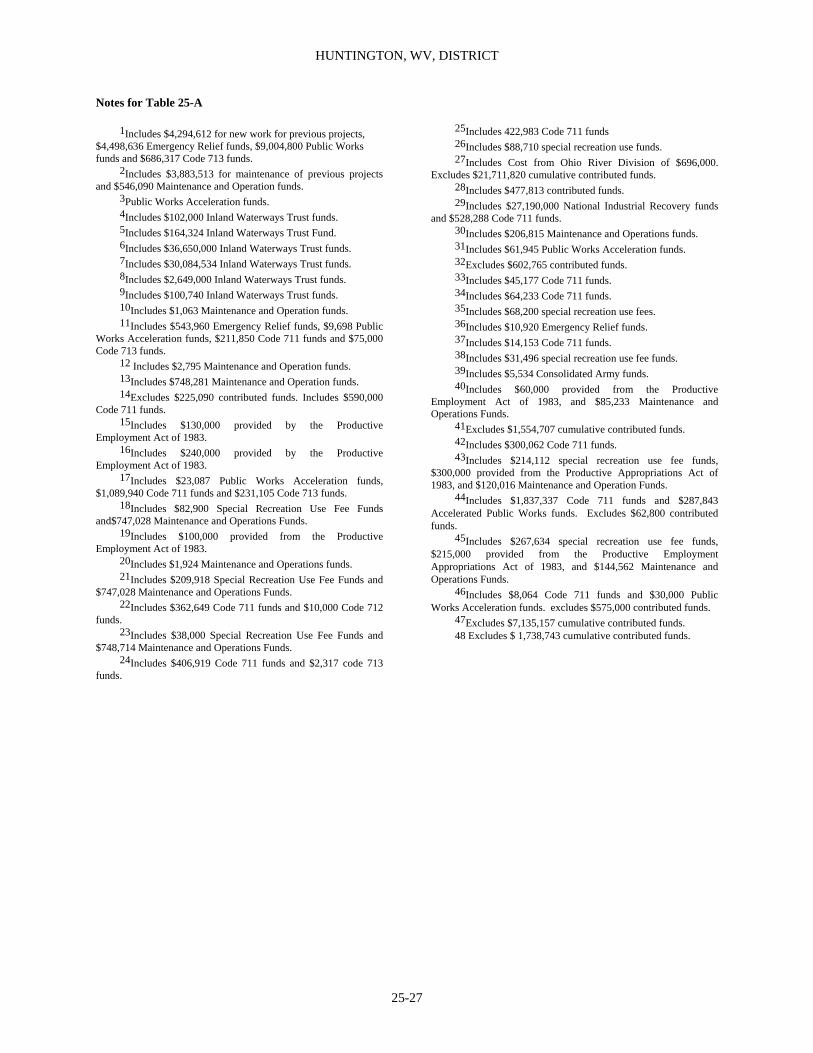
HUNTINGTON, WV, DISTRICT
25-27
Notes for Table 25-A 1Includes $4,294,612 for new work for previous projects, $4,498,636 Emergency Relief funds, $9,004,800 Public Works funds and $686,317 Code 713 funds. 2Includes $3,883,513 for maintenance of previous projects and $546,090 Maintenance and Operation funds. 3Public Works Acceleration funds. 4Includes $102,000 Inland Waterways Trust funds. 5Includes $164,324 Inland Waterways Trust Fund. 6Includes $36,650,000 Inland Waterways Trust funds. 7Includes $30,084,534 Inland Waterways Trust funds. 8Includes $2,649,000 Inland Waterways Trust funds. 9Includes $100,740 Inland Waterways Trust funds. 10Includes $1,063 Maintenance and Operation funds. 11Includes $543,960 Emergency Relief funds, $9,698 Public Works Acceleration funds, $211,850 Code 711 funds and $75,000 Code 713 funds. 12 Includes $2,795 Maintenance and Operation funds. 13Includes $748,281 Maintenance and Operation funds. 14Excludes $225,090 contributed funds. Includes $590,000 Code 711 funds. 15Includes $130,000 provided by the Productive Employment Act of 1983. 16Includes $240,000 provided by the Productive Employment Act of 1983. 17Includes $23,087 Public Works Acceleration funds, $1,089,940 Code 711 funds and $231,105 Code 713 funds. 18Includes $82,900 Special Recreation Use Fee Funds and$747,028 Maintenance and Operations Funds. 19Includes $100,000 provided from the Productive Employment Act of 1983. 20Includes $1,924 Maintenance and Operations funds. 21Includes $209,918 Special Recreation Use Fee Funds and $747,028 Maintenance and Operations Funds. 22Includes $362,649 Code 711 funds and $10,000 Code 712 funds. 23Includes $38,000 Special Recreation Use Fee Funds and $748,714 Maintenance and Operations Funds. 24Includes $406,919 Code 711 funds and $2,317 code 713 funds.
25Includes 422,983 Code 711 funds 26Includes $88,710 special recreation use funds. 27Includes Cost from Ohio River Division of $696,000. Excludes $21,711,820 cumulative contributed funds. 28Includes $477,813 contributed funds. 29Includes $27,190,000 National Industrial Recovery funds and $528,288 Code 711 funds. 30Includes $206,815 Maintenance and Operations funds. 31Includes $61,945 Public Works Acceleration funds. 32Excludes $602,765 contributed funds. 33Includes $45,177 Code 711 funds. 34Includes $64,233 Code 711 funds. 35Includes $68,200 special recreation use fees. 36Includes $10,920 Emergency Relief funds. 37Includes $14,153 Code 711 funds. 38Includes $31,496 special recreation use fee funds. 39Includes $5,534 Consolidated Army funds. 40Includes $60,000 provided from the Productive Employment Act of 1983, and $85,233 Maintenance and Operations Funds. 41Excludes $1,554,707 cumulative contributed funds. 42Includes $300,062 Code 711 funds. 43Includes $214,112 special recreation use fee funds, $300,000 provided from the Productive Appropriations Act of 1983, and $120,016 Maintenance and Operation Funds. 44Includes $1,837,337 Code 711 funds and $287,843 Accelerated Public Works funds. Excludes $62,800 contributed funds. 45Includes $267,634 special recreation use fee funds, $215,000 provided from the Productive Employment Appropriations Act of 1983, and $144,562 Maintenance and Operations Funds. 46Includes $8,064 Code 711 funds and $30,000 Public Works Acceleration funds. excludes $575,000 contributed funds. 47Excludes $7,135,157 cumulative contributed funds. 48 Excludes $ 1,738,743 cumulative contributed funds.
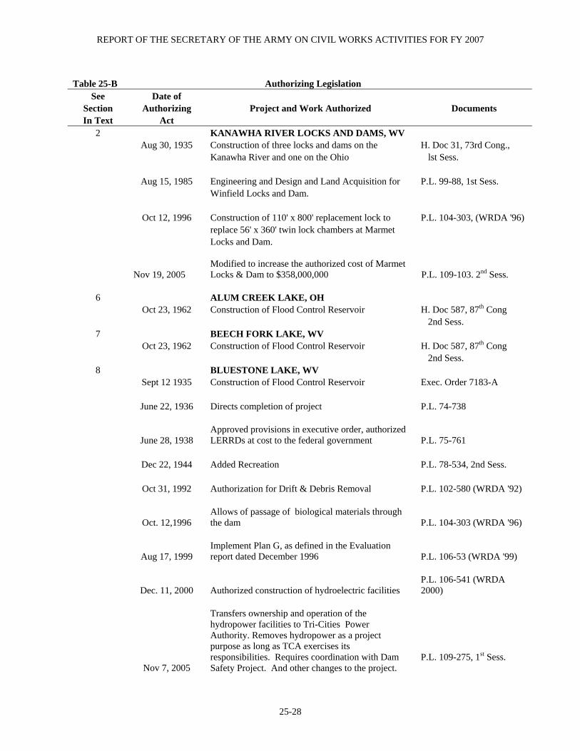
REPORT OF THE SECRETARY OF THE ARMY ON CIVIL WORKS ACTIVITIES FOR FY 2007
25-28
Table 25-B Authorizing Legislation
See Date of Section Authorizing Project and Work Authorized Documents In Text Act
2 KANAWHA RIVER LOCKS AND DAMS, WV Aug 30, 1935 Construction of three locks and dams on the H. Doc 31, 73rd Cong., Kanawha River and one on the Ohio lst Sess. Aug 15, 1985 Engineering and Design and Land Acquisition for P.L. 99-88, 1st Sess. Winfield Locks and Dam. Oct 12, 1996 Construction of 110' x 800' replacement lock to P.L. 104-303, (WRDA '96) replace 56' x 360' twin lock chambers at Marmet Locks and Dam.
Nov 19, 2005 Modified to increase the authorized cost of Marmet Locks & Dam to $358,000,000 P.L. 109-103. 2nd Sess.
6 ALUM CREEK LAKE, OH Oct 23, 1962 Construction of Flood Control Reservoir H. Doc 587, 87th Cong 2nd Sess.
7 BEECH FORK LAKE, WV Oct 23, 1962 Construction of Flood Control Reservoir H. Doc 587, 87th Cong 2nd Sess.
8 BLUESTONE LAKE, WV Sept 12 1935 Construction of Flood Control Reservoir Exec. Order 7183-A June 22, 1936 Directs completion of project P.L. 74-738
June 28, 1938 Approved provisions in executive order, authorized LERRDs at cost to the federal government P.L. 75-761
Dec 22, 1944 Added Recreation P.L. 78-534, 2nd Sess. Oct 31, 1992 Authorization for Drift & Debris Removal P.L. 102-580 (WRDA '92)
Oct. 12,1996 Allows of passage of biological materials through the dam P.L. 104-303 (WRDA '96)
Aug 17, 1999 Implement Plan G, as defined in the Evaluation report dated December 1996 P.L. 106-53 (WRDA '99)
Dec. 11, 2000 Authorized construction of hydroelectric facilities P.L. 106-541 (WRDA 2000)
Nov 7, 2005
Transfers ownership and operation of the hydropower facilities to Tri-Cities Power Authority. Removes hydropower as a project purpose as long as TCA exercises its responsibilities. Requires coordination with Dam Safety Project. And other changes to the project.
P.L. 109-275, 1st Sess.

HUNTINGTON, WV, DISTRICT
25-29
Table 25-B (Cont'd)
Authorizing Legislation
See Date of Section Authorizing In Text Act Project and Work Authorized Documents
9 BURNSVILLE LAKE, WV Jun 28, 1938 Construction of Flood Control Reservoir Flood Control Comm. Doc 1, 75th Cong, lst Sess. Dec 22, 1944 Added Recreation P.L. 78-534, 2nd Sess.
39 CENTRAL WEST VIRGINIA ENVIRONMENTAL INFRASTRUCTURE
Aug 17, 1999 Design and Construction Assistance for Environmental Infrastructure P.L. 106-53 (WRDA ’99)
10 DEER CREEK LAKE, OH
Jun 28, 1938 Construction of Flood Control Reservoir Flood Control Comm. Doc 1, 75th Cong, 1st Sess.
11 DELAWARE LAKE, OH Jun 28, 1938 Construction of Flood Control Reservoir Flood Control Comm. Doc 1, 75th Cong, lst Sess. Dec 22, 1944 Added Recreation P.L. 78-534, 2nd Sess.
12 DEWEY LAKE, OH Jun 28, 1938 Construction of Flood Control Reservoir Flood Control Comm. Doc 1, 75th Cong, lst Sess. Dec 22, 1944 Added Recreation P.L. 78-534, 2nd Sess.
13 DILLON LAKE, OH Jun 28, 1938 Construction of Flood Control Reservoir Flood Control Comm. Doc 1, 75th Cong, lst Sess. Dec 22, 1944 Added Recreation P.L. 78-534, 2nd Sess.
14 EAST LYNN LAKE, OH Jun 28, 1938 Construction of Flood Control Reservoir Flood Control Comm. Doc 1, 75th Cong, lst Sess.

REPORT OF THE SECRETARY OF THE ARMY ON CIVIL WORKS ACTIVITIES FOR FY 2007
25-30
Dec 22, 1944 Added Recreation P.L. 78-534, 2nd Sess.
Table 25-B (Cont'd) Authorizing Legislation See Date of
Section Authorizing In Text Act Project and Work Authorized Documents
15 FISHTRAP LAKE, OH
Jun 28, 1938 Construction of Flood Control Reservoir Flood Control Comm. Doc 1, 75th Cong, Dec 22, 1944 Added Recreation P.L. 78-534, 2nd Sess.
16 Jul 14, 1960 GRAYSON LAKE, KY Construction of Flood Control Reservoir H. Doc 440, 86th Cong 2nd Sess.
17 Oct 12, 1996 GREENBRIER RIVER, MARLINTON, WV
Project for Flood Control P.L. 104-303 (WRDA 96)
Aug 17, 1999 Modified to increase authorized appropriation to $47,000,000 P.L. 106-53 (WRDA 99)
18 Oct 17, 1986 ISLAND CREEK AT LOGAN, WV
Project for Flood Control P.L. 99-662 (WRDA 86)2nd Sess.
19 JOHN W. FLANNAGAN DAM AND RESERVOIR, VA
Jun 28, 1938 Construction of Flood Control Reservoir Flood Control Comm. Doc 1, 75th Cong, Dec 22, 1944 Added Recreation P.L. 78-534, 2nd Sess.
20
LEVISA AND TUG FORKS OF THE BIG SANDY RIVER, AND UPPER CUMBERLAND RIVER, WV, VA, AND KY
Oct 01, 1980 Construction of such Flood Control Measures P.L. 96-367, Sec 202 as deemed Necessary and Advisable
Oct 12, 1996 Modified to include Grundy, VA P.L. 104-303 (WRDA 96), 2nd session
Aug 17, 1999
Modified authorize the Secretary to take all necessary neasures to prevent future losses that would occur as a result of a flood equal in magnitude to a 100-year frequency event. in Martin, KY
P.L. 106-53 (WRDA 99), 1st session
Dec 11, 2000 Modified to direct the Secretary to determine the P.L. 106-543 (WRDA

HUNTINGTON, WV, DISTRICT
25-31
ability of Buchanan and Dickson Counties, VA to pay the non-Federal share of the cost of the project
2000), 2nd session
Table 25-B (Cont'd) Authorizing Legislation See Date of
Section Authorizing Project and Work Authorized Documents In Text Act
21 LOWER MUD RIVER, MILTON, WV
Oct 12, 1996
Conduct a limited re-evaluation of watershed plan and environmental impact statement prepared by the Natural Resources Conservation Service and may carry out the project PL 104-30 (WRDA 1996)
Dec 11, 2000 Directed to carry out flood damage reduction project PL 106-54 (WRDA 2000)
22 MASSILLON , OH Jun 28, 1938 Construction of Channel Improvement Project Flood Control Comm. Doc 1, 75th Cong, lst Sess.
23 MUSKINGUM RIVER LAKES, OH Feb 20, 1934 Construction of 14 Flood Control Reservoirs Public Work Admin Jun 28, 1938 Reimbursement to the Muskingum Conservancy Flood Control Comm. District a sum not to exceed actual expenditures Doc 1, 75th Cong, for project construction lst Sess. Aug 11, 1939 Operations and Maintenance assigned to the P.L. 76-396, 1st Sess Corps of Engineers
24 NEWARK, OH Jun 28, 1938 Construction of Channel Improvement Project Flood Control Comm. Doc 1, 75th Cong, lst Sess. Aug 13, 1968 Modification to Existing Project and Additional H. Doc 337, 90th Cong, Channel Improvement and Drainage Facilities 2nd Sess.
25 NORTH BRANCH OF KOKOSING RIVER LAKE, OH
Oct 23, 1962 Construction of Flood Control Reservoir H. Doc 220, 87th Cong 2nd Sess.
26 NORTH FORK OF POUND RIVER LAKE, VA Jul 14, 1960 Construction of Flood Control Reservoir H. Doc 645, 86th Cong, 2nd Sess.
40 OHIO ENVIRONMENTAL INFRASTRUCTURE PROGRAM
Aug 17, 1999 Design and Construction Assistance for P.L. 106-53, Sec 594 Environmental Infrastructure (WRDA '99)

REPORT OF THE SECRETARY OF THE ARMY ON CIVIL WORKS ACTIVITIES FOR FY 2007
25-32
Nov. 19, 2005 Modified to increase authorized amount to $60,000 P.L. 109-103, 2nd Sess.
Table 25-B (Cont'd) Authorizing Legislation See Date of
Section Authorizing Project and Work Authorized Documents In Text Act
28 PAINT CREEK LAKE, OH
Jun 28, 1938 Construction of Flood Control Reservoir Flood Control Comm. Doc 1, 75th Cong, lst Sess. Dec 22, 1944 Added Recreation P.L. 78-534, 2nd Sess.
29 PAINTSVILLE LAKE, KY Oct 27, 1965 Construction of Flood Control Reservoir H. Doc 246, 89th Cong, 1st Sess.
30 R. D. BAILEY LAKE, WV Oct 23, 1962 Construction of Flood Control Reservoir H. Doc 569, 87th Cong, 2nd Sess.
31 ROSEVILLE, OH Jun 28, 1938 Construction of Channel Improvement Project Flood Control Comm. Doc 1, 75th Cong, lst Sess.
41 SOUTHERN AND EASTERN KENTUCKY ENVIRONMENTAL INFRASTRUCTURE
Oct 12, 1996 Design and Construction Assistance for P.L. 104-303 (WRDA'96), Environmental Infrastructure
Aug 17, 1999 Modified to increase the authorized amount to $25,000,000 P.L. 106-53 (WRDA '99)
Feb. 20, 2003 Modified to insert Bath and Rowan Counties and to increase the authorized amount to $40,000,000 P.L. 108-7, 1st Sess.
42 SOUTHERN WEST VIRGINIA ENVIRONMENTAL INFRASTRUCTURE
Oct 31, 1992 Design and Construction Assistance for P.L. 102-580 (WRDA'92) Environmental Infrastructure
Oct 12, 1996 Modified to increase the amount to be appropriated to $20,000,000 P.L. 104-303 (WRDA ’96)
Aug 17, 1999 Modified to increase the amount to be appropriated to $40,000,000 P.L. 106-53 (WRDA ‘99)
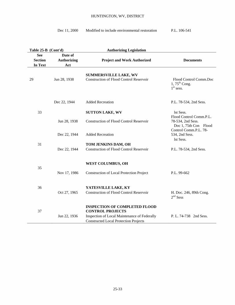
HUNTINGTON, WV, DISTRICT
25-33
Dec 11, 2000 Modified to include environmental restoration P.L. 106-541
Table 25-B (Cont'd) Authorizing Legislation See Date of
Section Authorizing Project and Work Authorized Documents In Text Act
SUMMERSVILLE LAKE, WV
29 Jun 28, 1938 Construction of Flood Control Reservoir Flood Control Comm.Doc 1, 75th Cong. 1st sess.
Dec 22, 1944 Added Recreation P.L. 78-534, 2nd Sess.
33 SUTTON LAKE, WV lst Sess.
Jun 28, 1938 Construction of Flood Control Reservoir Flood Control Comm.P.L. 78-534, 2nd Sess.
Dec 22, 1944 Added Recreation
Doc 1, 75th Con Flood Control Comm.P.L. 78-534, 2nd Sess.
lst Sess. 31 TOM JENKINS DAM, OH
Dec 22, 1944 Construction of Flood Control Reservoir P.L. 78-534, 2nd Sess.
35 WEST COLUMBUS, OH
Nov 17, 1986 Construction of Local Protection Project P.L. 99-662
36 YATESVILLE LAKE, KY Oct 27, 1965 Construction of Flood Control Reservoir H. Doc. 246, 89th Cong.
2nd Sess
37 INSPECTION OF COMPLETED FLOOD CONTROL PROJECTS
Jun 22, 1936 Inspection of Local Maintenance of Federally P. L. 74-738 2nd Sess. Constructed Local Protection Projects

REPORT OF THE SECRETARY OF THE ARMY ON CIVIL WORKS ACTIVITIES FOR FY 2007
25-34
Table 25-C Other Authorized Navigation Projects Cost to Sep 30, 2006
Project Status
For Last Full Report See
Annual Report For Construction
Operation and
Maintenance
Contributed Funds
Expended
Big Sandy River, WV and KY including Levisa and Tug Forks 1 and 2 completed 1952 1,586,236 15,698,111 131,473 Elk River, WV3 completed 1903 30,259 Gauley River, WV4 completed 1903 14,761 Guyandotte River, WV5 completed 1915 27,500 Little Kanawha River, WV6 completed 1960 470,536 1,023,854 Muskingum River, OH7 completed 1955 301,912 6,171,897 6,041 New River, WV and VA5 completed 1899 109,691
Scioto River at Portsmouth, OH 8 completed 1953 10,951 16,593
1In addition, $140,068 expended from funds transferred from Department of Commerce,
Under accelerated public works program, for repairs of eroded bank at Lock 3 on Big Sandy River, at Louisa, KY. 2Operations and maintenance suspended June 30, 1952. 3Work closed September 1902. Property transferred to Kanawha River improvements. 4Work closed September 1902. Abandonment recommended in H. Doc 467, 69th Congress. 5Work suspended. 6Operation and maintenance suspended June 30, 1951. 7Collections from licensed non-Federal hydroelectric utilities for use of dams on Muskingum River for fiscal years 1923-1953 were $79,154. 8P.L. 954, August 31, 1954, authorized Secretary of Treasury to pay Portsmouth Sand and Gravel Co. $75,000 in full settlement of claims against government for damages resulting from change in Scioto River Channel.

HUNTINGTON, WV, DISTRICT
25-35
Table 25-E Other Authorized Flood Control Projects Cost to Sep 30, 2006
Project
Status
For Last Full
Report See Annual
Report For Construction
Operation and
Maintenance
Contributed Funds
Expended Ashland, KY, LPP Completed 1954 3,718,839 --- --- Athens, OH, LPP Completed 1979 5,313,700 --- --- Augusta, KY Inactive --- 11,577 --- --- Catlettsburg, KY, LPP Completed 1963 3,854,361 --- --- Ceredo-Kenova, WV, LPP Completed 1955 2,753,551 --- --- Chillicothe, OH, LPP Completed 1986 20,373,314 --- --- Coal River, WV Inactive 1979 472,229 --- --- East Rainelle, WV, LPP Completed 1962 614,598 --- --- Galax, VA, LPP Completed 1953 480,536 --- --- Haysi, VA Inactive --- 2,656 --- --- Huntington, WV, LPP Completed 1956 7,172,840 --- --- Ironton, OH, LPP Completed 1952 2,604,646 --- --- Kehoe Lake, KY Deferred 1981 1,272,740 --- --- Martin, KY Active with
no current year
expenditures 1983 212,048 --- --- Maysville, KY, LPP Completed 1959 6,493,747 --- --- Newark, OH (Interior Drainage) Deferred 1983 --- --- --- Oceana, WV Deferred 1981 611,000 --- --- Parkersburg, WV, LPP Completed 1955 6,652,827 --- --- Pt. Pleasant, WV, LPP Completed 1955 2,919,578 --- --- Portsmouth - New Boston, OH, LPP Completed 1956 9,806,424 --- --- Princeton, WV, LPP Completed 1962 808,750 --- --- Russell, KY, LPP Completed 1953 552,493 --- --- Vanceburg, KY Inactive --- --- Williamson, WV, LPP Completed 1964 1,056,166 --- ---

REPORT OF THE SECRETARY OF THE ARMY ON CIVIL WORKS ACTIVITIES FOR FY 2007
25-36
Table 25-G Deauthorized Projects
Projects
For Last Full Report See
Annual Report For Date
Federal Funds
Expended Contributed Funds
Expended All projects listed in this table have been deauthorized in accordance with Section 12 of the Water Resources Development Act of 1974, P. L. 251, 93rd Congress Local Protection Projects Aberdeen, OH --- May 1981 1,334 --- Athalia, OH --- Aug 1977 --- --- Belpre, OH --- Nov 1977 --- --- Brooklyn, WV --- Nov 1979 --- --- Buena Vista, OH --- Aug 1977 --- --- Chambersburg, OH --- Nov 1986 --- --- Cheshire, OH --- Nov 1977 --- --- Chilo, OH --- Aug 1977 --- --- Clifton, WV --- Aug 1977 11,237 --- Coal Grove, OH --- Jan 1990 3,389 --- Columbus, OH --- Aug 1977 --- --- Dover, KY --- Jan 1990 --- --- Friendly, WV --- Aug 1977 --- --- Fullerton, KY --- Jan 1990 --- --- Gallipolis, OH --- Aug 1977 --- --- Greenup, KY --- Jan 1990 4,962 --- Hanging Rock, OH --- Aug 1977 --- --- Hartford, WV --- Aug 1977 --- --- Henderson, WV --- Aug 1977 --- --- Higginsport, OH --- Oct 1978 --- --- Hockingport, OH --- Aug 1977 --- --- Killbuck, OH --- Apr 2002 --- --- Letart, WV --- Aug 1977 --- --- Letart Falls, OH --- Aug 1977 --- --- Lower Guyandotte, River Basin, WV --- Nov 1986 17,721 --- Manchester, OH --- May 1981 --- --- Mansfield, OH --- Apr 2002 --- --- Mapleshade, OH --- Oct 1978 --- --- Marietta, OH --- Nov 1981 --- --- Mason, WV --- Aug 1977 --- --- Middleport, OH --- May 1981 9,783 --- Miller, OH --- Aug 1977 --- --- Millwood, WV --- Aug 1977 --- --- Nelsonville, OH --- Apr 2002 --- ---

HUNTINGTON, WV, DISTRICT
25-37
Table 25-G (Cont'd) Deauthorized Projects
Projects
For Last Full Report See
Annual Report For Date
Federal Funds
Expended Contributed Funds
Expended New Martinsville, WV --- Nov 1979 --- --- New Matamoras, OH --- Aug 1977 --- --- Newport, OH --- Aug 1977 --- --- Normal, KY --- Jan 1990 --- --- North Chillicothe, OH --- Apr 2002 --- --- Pomeroy, OH --- Aug 1977 --- ---
Portland, OH --- Aug 1977 --- --- Proctorville, OH --- Nov 1986 --- --- Racine, OH --- Aug 1977 --- --- Ripley, OH --- Oct 1978 7,523 --- Riverview, WV --- Aug 1977 --- --- St. Marys, WV --- Aug 1977 --- --- Sardis, OH --- Aug 1977 --- --- Sciotoville, OH --- Aug 1977 --- --- Sistersville, WV --- Aug 1977 --- --- South Point, OH --- Nov 1986 --- --- South Portsmouth, KY --- Jan 1990 --- --- Syracuse, OH --- Aug 1977 --- --- Waverly, WV --- Aug 1977 --- --- Williamstown, WV --- Nov 1979 --- --- Zanesville, OH --- May 1981 --- --- Reservoirs and Lakes Big Bend, WV --- Aug 1977 --- --- Big Darby, OH 1969 Nov 1979 3,349,568 --- Birch, WV --- Nov 1986 --- --- Frazeysburg, OH --- May 1981 5,000 --- Kehoe Lake, KY --- Jul 1992 1,273,000 --- Leading Creek, WV 1974 Jan 1990 272,880 --- Logan, OH --- Oct 1985 --- --- Millersburg, OH --- May 1981 --- --- Mill Creek, OH 1981 Nov 1985 1,602,702 --- Moores Ferry, VA --- Nov 1986 22,879 --- Mud River, WV --- Nov 1979 --- --- Panther Creek, WV 1976 Nov 1986 --- --- Poca, WV --- May 1981 --- --- Rocky Fork, OH 1950 Aug 1977 91,321 --- Salt Creek, OH 1975 Nov 1986 1,089,943 --- Utica, OH 1975 Jan 1990 757,550 --- West Fork, WV 1974 Jan 1990 663,192 --- White Oak Creek, OH --- Nov 1981 --- ---
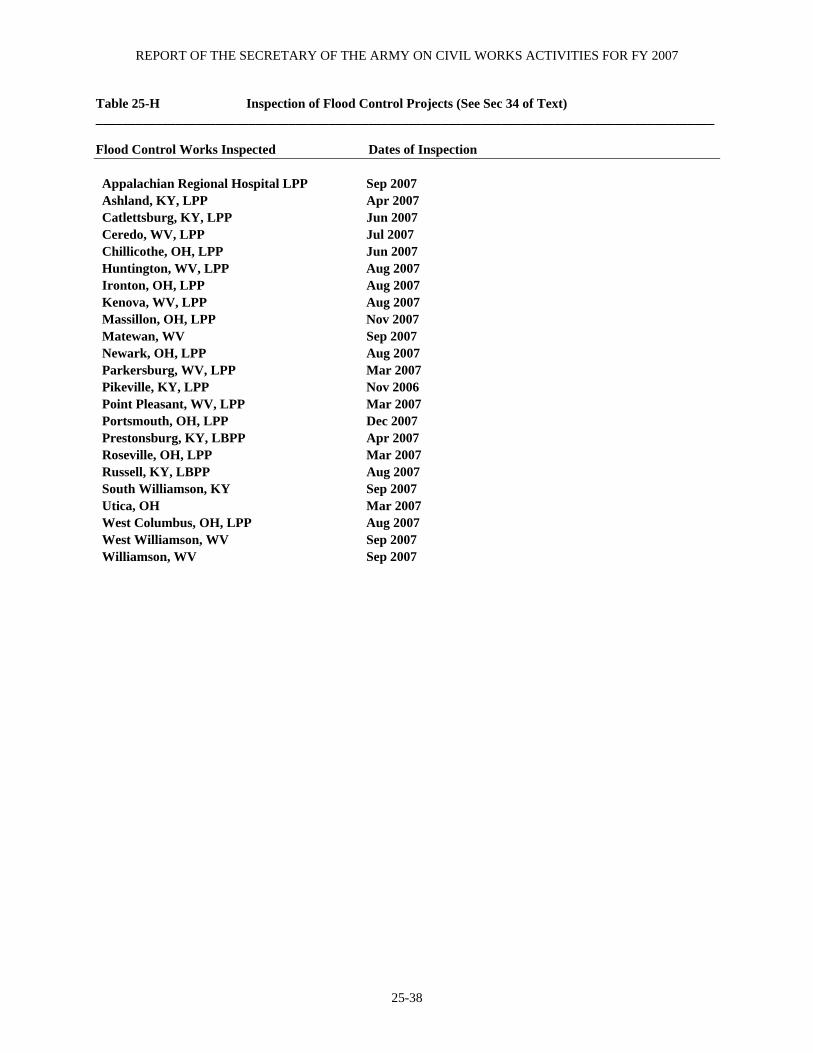
REPORT OF THE SECRETARY OF THE ARMY ON CIVIL WORKS ACTIVITIES FOR FY 2007
25-38
Table 25-H Inspection of Flood Control Projects (See Sec 34 of Text) _____________________________________________________________________________________________ Flood Control Works Inspected Dates of Inspection Appalachian Regional Hospital LPP Sep 2007 Ashland, KY, LPP Apr 2007 Catlettsburg, KY, LPP Jun 2007 Ceredo, WV, LPP Jul 2007 Chillicothe, OH, LPP Jun 2007 Huntington, WV, LPP Aug 2007 Ironton, OH, LPP Aug 2007 Kenova, WV, LPP Aug 2007 Massillon, OH, LPP Nov 2007 Matewan, WV Sep 2007 Newark, OH, LPP Aug 2007 Parkersburg, WV, LPP Mar 2007 Pikeville, KY, LPP Nov 2006 Point Pleasant, WV, LPP Mar 2007 Portsmouth, OH, LPP Dec 2007 Prestonsburg, KY, LBPP Apr 2007 Roseville, OH, LPP Mar 2007 Russell, KY, LBPP Aug 2007 South Williamson, KY Sep 2007 Utica, OH Mar 2007 West Columbus, OH, LPP Aug 2007 West Williamson, WV Sep 2007 Williamson, WV Sep 2007

HUNTINGTON, WV, DISTRICT
25-39
Table 25-I Kanawha River Locks and Dams (See Section 1 of Text) Lock and Dam London Marmet Winfield Distance from Nearest Town at London, WV at Belle, WV at Eleanor, WV Miles Above Mouth of River 82.8 67.7 31.1 Length of Reach (miles) 7.5 20.1 36.6 Width of Chamber (feet) 110 56 56 Greatest Length Available for Full Width (feet) 360 360 800 Lift (feet 24 24 24 Upper Normal Pool Elevation (feet, mean sea level) 590 614 566 Depth on Miter Sills
Upper (feet) 18 18 18
Lower (feet) 12 12 12
Character of Foundation Lock Concrete Concrete Concrete
Dam Rock and Wood piles Rock and Wood
piles Rock and Wood
piles Percent Complete 100% 100% 100% Year Opened to Navigation 1933 1934 1937 Actual Cost to Date $23,394,786 $292,152,972 $228,967,377