Embed Size (px)
Citation preview
Final Environmental Assessment
Pipeline Road Water Line Relocation City of Astoria, Oregon
FEMA-1956-DR-OR
August 2012
U.S. Department of Homeland Security
FEMA Region X
130 228th
Street SW
Bothell, WA 98021-9796
City of Astoria
FEMA Final Environmental Assessment for Astoria Pipeline Road Water Line Relocation
Contents Page ii
Final Environmental Assessment
Pipeline Road Water Line Relocation City of Astoria, Oregon
FEMA Public Assistance Program
FEMA-1956-DR-OR
FEMA Project Worksheet No. 6
Prepared for:
U.S. Department of Homeland Security
FEMA Region X
130 228th
Street SW
Bothell, WA 98021-9796
Contact: Science Kilner, Acting Regional Environmental Officer, (425) 487-4713,
August, 2012
FEMA Final Environmental Assessment for Astoria Pipeline Road Water Line Relocation
Contents Page iii
Table of Contents
1.0 INTRODUCTION ............................................................................................................................................ 6
1.1 AUTHORITY AND JURISDICTION ................................................................................................................................ 6
2.0 PURPOSE AND NEED ..................................................................................................................................... 6
3.0 LOCATION AND BACKGROUND ..................................................................................................................... 7
3.1 LOCATION ........................................................................................................................................................... 7 3.2 BACKGROUND ..................................................................................................................................................... 8
4.0 ALTERNATIVES ............................................................................................................................................ 10
4.1 ALTERNATIVE 1 – NO ACTION ALTERNATIVE ............................................................................................................ 11 4.2 ALTERNATIVE 2 – RELOCATE PIPELINE ROAD WATER LINE (PROPOSED ACTION) ............................................................. 11
5.0 AFFECTED ENVIRONMENT AND POTENTIAL IMPACTS ................................................................................. 14
5.1 PHYSICAL RESOURCES.......................................................................................................................................... 15 5.1.1 Geology and Soils ................................................................................................................................. 15 5.1.2 Climate and Climate Change ................................................................................................................ 15 5.1.3 Consequences of Alternatives .............................................................................................................. 16
5.2 WATER RESOURCES ............................................................................................................................................ 16 5.2.1 Coastal Zone ........................................................................................................................................ 16 5.2.2 Consequences of Alternatives .............................................................................................................. 17
5.3 BIOLOGICAL RESOURCES ...................................................................................................................................... 17 5.3.1 Vegetation ........................................................................................................................................... 18 5.3.2 Fish and Wildlife ................................................................................................................................... 18 5.3.3 Migratory Birds .................................................................................................................................... 18 5.3.4 Threatened and Endangered Species and Critical Habitat ................................................................... 19 5.3.5 Consequences of Alternatives .............................................................................................................. 19
5.4 CULTURAL RESOURCES ........................................................................................................................................ 20 5.4.1 Prehistoric Context (American Indian/Religious Sites/Tribal Interests) .............................................. 21 5.4.2 Historic Context .................................................................................................................................... 21 5.4.3 Historic Properties ................................................................................................................................ 23 5.4.4 Consequences of Alternatives .............................................................................................................. 23
5.5 SOCIOECONOMIC RESOURCES ............................................................................................................................... 24 5.5.1 Socioeconomics and Environmental Justice ......................................................................................... 24 5.5.3 Consequences of Alternatives .............................................................................................................. 25
6.0 CUMULATIVE EFFECTS ................................................................................................................................ 26
7.0 AGENCY COORDINATION AND PUBLIC INVOLVEMENT ............................................................................... 26
8.0 PERMITTING, PROJECT CONDITIONS, AND MITIGATION MEASURES........................................................... 27
9.0 CONCLUSION .............................................................................................................................................. 28
10.0 LIST OF PREPARERS .................................................................................................................................... 28
11.0 REFERENCES ............................................................................................................................................... 28
FEMA Final Environmental Assessment for Astoria Pipeline Road Water Line Relocation
Contents Page iv
Figures
Figure 1. Astoria Pipeline Road water line site location map........................................................ 8 Figure 2. DOGAMI landslide inventory map. ............................................................................... 9 Figure 3. Lower and upper Pipeline Road water line relocation sites. ........................................ 12 Figure 4. Aerial map showing construction debris disposal site and water line relocation site. . 13
Appendices
Appendix A – Public Notice
Appendix B – Cultural Resources Concurrence Letters
Appendix C – Resource Agency Consultation Letters
Appendix D – Oregon SHPO Concurrence
FEMA Final Environmental Assessment for Astoria Pipeline Road Water Line Relocation
Acronyms Page v
LIST OF ACRONYMS
APE Area of Potential Effects
BMPs Best Management Practices
CB Citizens Band radio
CEQ Council on Environmental Quality
CFR Code of Federal Regulations
cy cubic yards
DEQ Oregon Department of Environmental Quality
DLCD Oregon Department of Land Conservation and Development
DOGAMI Oregon Department of Geology and Mineral Industries
EA Environmental Assessment
EO Executive Order
ESA Endangered Species Act
F Fahrenheit
FEMA Federal Emergency Management Agency
FONSI Finding of No Significant Impact
HDPE high-density polyethylene
MG million gallons
MGD million gallons per day
OCMP Oregon Coastal Management Program
ODF Oregon Department of Forestry
NEPA National Environmental Policy Act
NHPA National Historic Preservation Act
NMFS National Marine Fisheries Service
NRHP National Register of Historic Places
SHPO State Historic Preservation Office/Officer
USFWS United States Fish and Wildlife Service
USGS United States Geological Survey
FEMA Final Environmental Assessment for Astoria Pipeline Road Water Line Relocation
4.0 Alternatives Page 6
1.0 INTRODUCTION
The City of Astoria (City) has applied through the Oregon Office of Emergency Management to
the U.S. Department of Homeland Security’s Federal Emergency Management Agency (FEMA)
for funding to relocate a section of its water line southeast of Astoria in Clatsop County, Oregon.
The water line was damaged during severe winter storms, flooding, mudslides, landslides, and
debris flows that occurred in the region from January 13-21, 2011. The event was declared a
Presidential disaster on February 17, 2011 (FEMA-1956-DR-OR). FEMA is proposing to fund
75 percent of the cost for this project through its Public Assistance Program.
1.1 Authority and Jurisdiction
The Robert T. Stafford Disaster Relief and Emergency Assistance Act of 1973 (Stafford Act), as
amended, provides federal assistance programs for both public and private losses sustained in
disasters. In accordance with the National Environmental Policy Act (NEPA) of 1969, FEMA
must evaluate the environmental consequences of proposed actions on the natural and human
environment before deciding to fund an action, including evaluating alternative means of
addressing the purpose and need for a federal action. The President’s Council on Environmental
Quality (CEQ) has developed a series of regulations for implementing NEPA. These regulations
are included in Title 40 of the Code of Federal Regulations (CFR), Parts 1500–1508.
This draft Environmental Assessment (EA) discloses the environmental effects of implementing
the Proposed Action or alternatives to that action. It is not a decision document itself, but rather
the analysis upon which the decision can be reached. It is prepared in accordance with both CEQ
and FEMA regulations for NEPA (44 CFR Part 10) to determine whether to prepare a Finding of
No Significant Impact or a Notice of Intent to prepare an Environmental Impact Statement (EIS).
If it is determined through the analysis that significant impacts would result from implementation
of the Proposed Action or alternatives, an EIS must be prepared to provide more detailed
information related to the significant impact(s) and define appropriate mitigation to reduce the
impact to insignificant levels. A single federal agency will lead the NEPA process with other
interested agencies acting on a cooperative basis.
2.0 PURPOSE AND NEED
The Stafford Act authorizes a wide range of federal assistance for states and local governments
significantly impacted by disasters or emergencies or both. The purpose of FEMA’s Public
Assistance grant program under the Stafford Act is to provide financial assistance to state, tribal,
and local governments, and certain types of private nonprofit organizations so that communities
can quickly respond to and recover from major disasters or emergencies declared by the
President. The need for the FEMA action is to restore domestic water services to the residents of
Astoria. .
Severe winter storms during the disaster incident period resulted in overland flooding and
saturated subsoils that caused an integral ground failure of the lower road. The ground
movement in turn damaged the City’s 21- inch diameter concrete and steel water line pipe buried
along the west shoulder of the road, including misalignment of 60 linear feet (LF) of the pipe and
FEMA Final Environmental Assessment for Astoria Pipeline Road Water Line Relocation
4.0 Alternatives Page 7
rupturing of one joint. The damage caused the loss of the City’s primary water supply to its
water service system.
Emergency repairs were implemented by the City and consisted of exposing 60 LF of the
pipeline to re-establish its grade and to restore the displaced bedding materials. The pipeline
break was temporarily repaired by welding a collar around the compromised pipe and restoring
water service to the City. The repairs are considered temporary, as the supporting ground and
subgrade has not been stabilized and is subject to potential re-activation of the landslide mass
and additional displacement of the pipeline and roadway subgrade.
The City determined there is a need to relocate the water line outside the high risk landslide
boundary identified at the current site. They also need to mitigate for continued destabilization
beyond the current limits of the landslide in order to reduce the likelihood of future damage to
the relocated water line.
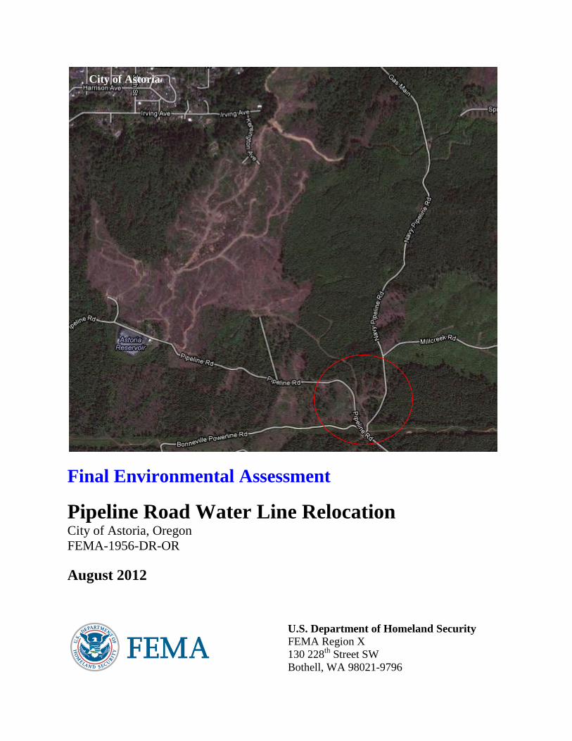
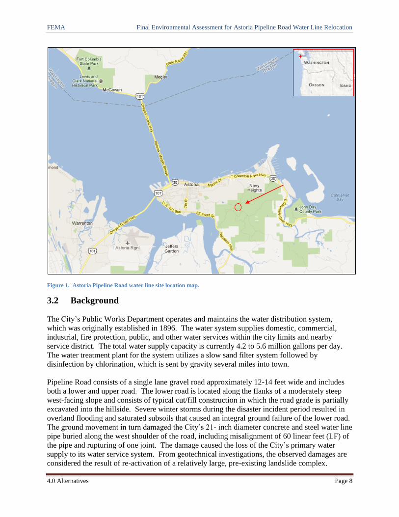
3.0 LOCATION AND BACKGROUND
3.1 Location
The City of Astoria is located on the south shore of the Columbia River on the northwestern tip
of Oregon. The proposed water line relocation along Pipeline Road would be constructed in a
forested area approximately one mile southeast of the city along a right-of-way through Oregon
Department of Forestry (ODF) land. Pipeline Road is located just north of its intersection with
Bonneville Powerline Road. The relocation site is located in Township 8 North, Range 9 West
in Section 15 of the Willamette Meridian at Latitude 46.17529o North, Longitude -123.79089
o
West. The project also includes a construction debris (fill) disposal site located .4 miles
northwest of the relocation site at Township 8 North, Range 9 West in Section 16 at Latitude
46.18010o North, Longitude -123.79721
o West. Figure 1 below shows the project location.
FEMA Final Environmental Assessment for Astoria Pipeline Road Water Line Relocation
4.0 Alternatives Page 8
Figure 1. Astoria Pipeline Road water line site location map.
3.2 Background
The City’s Public Works Department operates and maintains the water distribution system,
which was originally established in 1896. The water system supplies domestic, commercial,
industrial, fire protection, public, and other water services within the city limits and nearby
service district. The total water supply capacity is currently 4.2 to 5.6 million gallons per day.
The water treatment plant for the system utilizes a slow sand filter system followed by
disinfection by chlorination, which is sent by gravity several miles into town.
Pipeline Road consists of a single lane gravel road approximately 12-14 feet wide and includes
both a lower and upper road. The lower road is located along the flanks of a moderately steep
west-facing slope and consists of typical cut/fill construction in which the road grade is partially
excavated into the hillside. Severe winter storms during the disaster incident period resulted in
overland flooding and saturated subsoils that caused an integral ground failure of the lower road.
The ground movement in turn damaged the City’s 21- inch diameter concrete and steel water line
pipe buried along the west shoulder of the road, including misalignment of 60 linear feet (LF) of
the pipe and rupturing of one joint. The damage caused the loss of the City’s primary water
supply to its water service system. From geotechnical investigations, the observed damages are
considered the result of re-activation of a relatively large, pre-existing landslide complex.

FEMA Final Environmental Assessment for Astoria Pipeline Road Water Line Relocation
4.0 Alternatives Page 9
The landslide inventory map to the left
(State of Oregon DOGAMI IMS-31, dated
2010) shows the approximate location of
the damaged water line (highlighted in red)
and Pipeline Road within the damaged area
(highlighted in yellow). Emergency repairs
were implemented by the City and
consisted of exposing 60 LF of the pipeline
to re-establish its grade and to restore the
displaced bedding materials. The pipeline
break was temporarily repaired by welding
a collar around the compromised pipe and
restoring water service to the City. The
pipe was then backfilled and the roadway
was restored to its pre-damage condition.
As part of the emergency repairs, culverts were installed on both sides of the failure to transmit
stormwater runoff away from the failed landslide mass. The repairs are considered temporary, as
the supporting ground and subgrade has not been stabilized and is subject to potential re-
activation of the landslide mass and additional displacement of the pipeline and roadway
subgrade.
The City’s water supply comes from intakes on two lakes (Middle and Main Lakes) and
diversions in Bear Creek and Cedar (Waterworks) Creek. The total watershed area is about
3,155 acres, of which about 725 acres are within the Cedar Creek Watershed. The entire
watershed is owned and actively managed by the City. The City can switch among intakes as
needed, depending on weather and source conditions, and typically draws more water from the
creeks during the summer and more from the lakes in winter, due to turbidity fluctuations.
Three reservoirs within the watershed provide raw water storage for municipal use during high
demand periods. Bear Creek reservoir is formed by a concrete dam set in a narrow canyon and
forms the main lake which stores up to 220 million gallons (MG). The City’s treatment facilities
are located adjacent to the Bear Creek reservoir. Middle Lake is an earthen dam reservoir filled
by diverting a small tributary to Bear Creek and has a capacity of 50 MG. It is particularly
important because it can provide relatively clear water when winter storms make other sources
turbid. Wickiup Lake is formed by an earthen embankment and could provide about 100 MG of
storage; however its capacity currently is limited by bottom seepage. The leakage exceeds
inflow under normal operating conditions and is of no storage value during the late summer and
fall. The City is considering building an additional reservoir above Middle Lake for additional
storage.
Between the 1930s and 1950s, the watershed was nearly entirely logged and burned by its
previous private owners. Vigorous forest re-growth has allowed significant timber harvest over
the past two decades. Activities within the past three years have included new road construction,
Figure 2. DOGAMI landslide inventory map.

FEMA Final Environmental Assessment for Astoria Pipeline Road Water Line Relocation
4.0 Alternatives Page 10
road maintenance, thinning and limited clearcutting of timber, new sand filter construction, and
reservoir maintenance. In recent years, the City has taken steps to develop a comprehensive,
long-range management plan for the watershed. This has included a detailed watershed
evaluation by Oregon State University faculty and Clatsop County Extension, and plans for
identifying management goals and objectives.
4.0 ALTERNATIVES
In accordance with federal laws and FEMA regulations, the EA process for a proposed federal
action must include an evaluation of alternatives and a discussion of the potential environmental
consequences. This draft EA includes the analysis of two alternatives. Alternative 1 is the No
Action Alternative, which would entail no repairs or improvements to the water line at its
existing location along lower Pipeline Road. Alternative 2 would re-direct the water line uphill
and outside of the landslide area to upper Pipeline Road and is the Proposed Action Alternative.
Alternatives considered but not carried forward included ways to stabilize the portion of failed
landslide mass directly underlying the existing site to prevent further damage to the water line.
Subsurface investigations and detailed engineering analysis were conducted by Pacific
Geotechnical of Oregon City in the summer of 2011 to determine permanent subgrade
stabilization plan options (e.g., a cantilever sheetpile wall, a tie-back sheetpile wall, a rock
fill/shear key), combined with soil drainage improvements to intercept the failure surface and
resist lateral earth pressures resulting from future slide movements. Relocation of the pipeline
around the damaged area was also evaluated to determine the most feasible and cost effective
plan to restore the facility to its pre-disaster function.
The photo to the left shows the
approximate water line damage location
in red. The white line indicates inferred
limits of the landslide, with the arrows
indicating the relative direction of the
landslide movement.
Relocation options considered included
re-routing the water line at a greater
depth, possibly using deep horizontal
directional drilling, or re-routing the line
to the top of the hill to better protect it
from future movement.
The risk of re-activation of a deeper portion of the landslide or expansion of the landslide was
determined to be possible in the geotechnical analysis but could not be accurately assessed
without substantial additional effort. Therefore, the alternative evaluated for stabilizing or
relocating the water line deeper at the existing site was not investigated further since another
Photo 1. Location of damaged waterline (March 2011).

FEMA Final Environmental Assessment for Astoria Pipeline Road Water Line Relocation
4.0 Alternatives Page 11
alternative was identified that would meet the purpose and need. The relocation of the water line
to the top of the hill is the preferred alternative since it relocates the function outside of the
highest risk area, thereby reducing the likelihood of future damages. It is also the most cost
effective alternative.
4.1 Alternative 1 – No Action Alternative
Inclusion of a No Action Alternative in the environmental analysis and documentation is
required under NEPA. The alternative evaluates the effects of not providing eligible assistance
for a specific action and provides a benchmark against which the other alternatives may be
evaluated.
Under the No Action Alternative, FEMA would not provide funding to permanently repair the
water line along the lower Pipeline Road. The existing pipeline and site would continue to be at
risk from future land movement and this alternative would not meet the project’s purpose and
need, nor the City’s goals and objectives identified.
4.2 Alternative 2 – Relocate Pipeline Road Water Line (Proposed Action)
The City proposes to avoid the landslide area at the lower Pipeline Road and re-direct the water
line to the north, connecting and installing a 21-inch diameter high-density polyethylene (HDPE)
water line along the west side of the upper Pipeline Road. From this location it would connect
with the East Astoria water line vault to the south, adjacent to the intersection of Pipeline Road
and Bonneville Powerline Road. The lower Pipeline Road would be left open as a public road
and maintained by the county, with all drainage improvements in place to protect the road from
ponding water.
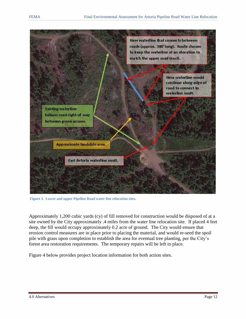
To connect to the upper Pipeline Road, the new pipeline would be re-routed north of the existing
site and cross undisturbed forested ground for approximately 300 linear feet (LF) before
proceeding along the right-of-way of the upper road. The new bypass route would be required to
be considerably longer than the damaged portion of pipeline (250 LF of pipeline within the
landslide area versus 595 LF for the proposed new route) due to the requirements of transitioning
from the lower road to the upper road, as well as the need to maintain a relatively moderate pipe
gradient and elevation to maintain stable water flow (see Figure 3, below). One spruce and two
hemlock trees would need to be removed from the undisturbed section (and possibly one
additional hemlock).
FEMA Final Environmental Assessment for Astoria Pipeline Road Water Line Relocation
4.0 Alternatives Page 12
Figure 3. Lower and upper Pipeline Road water line relocation sites.
Approximately 1,200 cubic yards (cy) of fill removed for construction would be disposed of at a
site owned by the City approximately .4 miles from the water line relocation site. If placed 4 feet
deep, the fill would occupy approximately 0.2 acre of ground. The City would ensure that
erosion control measures are in place prior to placing the material, and would re-seed the spoil
pile with grass upon completion to establish the area for eventual tree planting, per the City’s
forest area restoration requirements. The temporary repairs will be left in place.
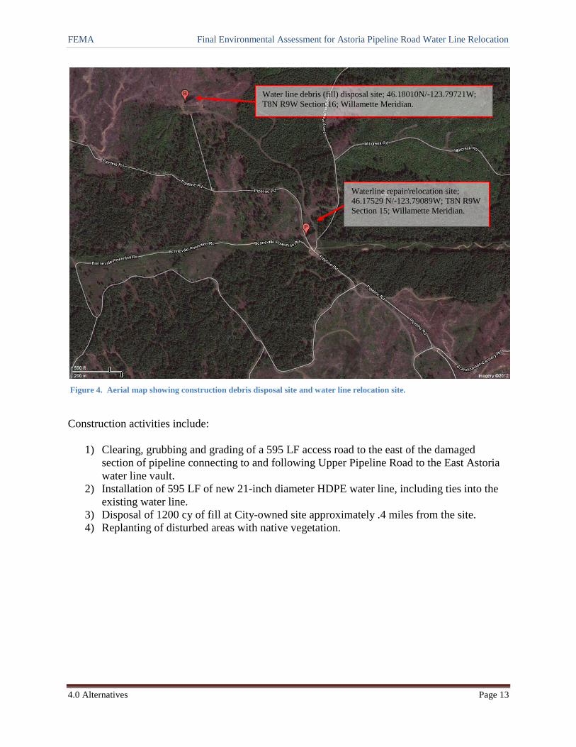
Figure 4 below provides project location information for both action sites.
FEMA Final Environmental Assessment for Astoria Pipeline Road Water Line Relocation
4.0 Alternatives Page 13
Figure 4. Aerial map showing construction debris disposal site and water line relocation site.
Construction activities include:
1) Clearing, grubbing and grading of a 595 LF access road to the east of the damaged
section of pipeline connecting to and following Upper Pipeline Road to the East Astoria
water line vault.
2) Installation of 595 LF of new 21-inch diameter HDPE water line, including ties into the
existing water line.
3) Disposal of 1200 cy of fill at City-owned site approximately .4 miles from the site.
4) Replanting of disturbed areas with native vegetation.
Water line debris (fill) disposal site; 46.18010N/-123.79721W;
T8N R9W Section 16; Willamette Meridian.
Waterline repair/relocation site;
46.17529 N/-123.79089W; T8N R9W
Section 15; Willamette Meridian.

FEMA Final Environmental Assessment for Astoria Pipeline Road Water Line Relocation
10.0 References Page 14
5.0 AFFECTED ENVIRONMENT AND POTENTIAL IMPACTS
The NEPA compliance process requires federal agencies to consider direct and indirect impacts
to the environment. For each resource category, the impact analysis follows the same general
approach in terms of impact findings. When possible, quantitative information is provided to
establish impacts. Qualitatively, these impacts will be measured as outlined below.
Impact Scale Criteria
None/Negligible The resource area would not be affected, or changes would be either non-
detectable or if detected, would have effects that would be slight and local.
Impacts would be well below regulatory standards, as applicable.
Minor Changes to the resource would be measurable, although the changes would be
small and localized. Impacts would be within or below regulatory standards,
as applicable. Mitigation measures would reduce any potential adverse effects.
Moderate Changes to the resource would be measurable and have both localized and
regional scale impacts. Impacts would be within or below regulatory
standards, but historical conditions are being altered on a short-term basis.
Mitigation measures would be necessary and the measures would reduce any
potential adverse effects.
Major Changes would be readily measurable and would have substantial
consequences on a local and regional level. Impacts would exceed regulatory
standards. Mitigation measures to offset the adverse effects would be required
to reduce impacts, though long-term changes to the resource would be
expected.
Impacts are disclosed based on the amount of change or loss to the resource from the baseline
conditions and may be direct or indirect. Direct impacts are caused by an action and occur at the
same time and place as the action. Indirect impacts are caused by an action and occur later in
time or are farther removed from the area, but are reasonably foreseeable. Cumulative impacts
are discussed in Section 6.0.
Resources that were not analyzed in detail include air quality, noise, traffic, and hazardous
materials. No effect to air quality is expected beyond small amounts of dust and exhaust from
short-term construction operations. No impacts are anticipated from noise or traffic beyond
short-term increased noise and traffic during construction, and the sites are remotely located in a
forested area that has minimal use other than as a water line route and forest access roads. No
potential hazardous materials were identified in or near the vicinity of the project. These
resources are not analyzed further in this document.
The following subsections discuss the regulatory settings and the environment and existing
conditions for each alternative. The discussion is broad and regional in nature. It does not
include a complete inventory of each resource, but does provide information to characterize
those resources. This section also identifies the potential effects and environmental
consequences of the two alternatives considered.

FEMA Final Environmental Assessment for Astoria Pipeline Road Water Line Relocation
10.0 References Page 15
5.1 Physical Resources
5.1.1 Geology and Soils
The project site is located in the foothills of the Coast Range. The rugged topography and wet
climate combined with the forces of ongoing tectonic uplift and stream down-cutting make the
Coast Range inherently prone to landslides. The rocks in this part of the range were generally
formed by volcanic eruptions associated with the creation of an offshore volcanic island chain
and by deposition of sediments in the surrounding shallow seas. These rocks have since been
attached to the continent, uplifted, and eroded to form the topography of the current-day Coast
Range.
The bedrock underlying the general area is believed to consist of Eocene-age marine sediments
from about 56 to 34 million years ago. Within the vicinity of the project site, from observations
and subsurface investigations reported by Pacific Geotechnical (August 19, 2011), the bedrock
was determined to be predominantly siltstone of the “Young’s Bay Member” Astoria formation.
This is described as mudstone and siltstone, with some beds of medium-grained sandstone.
The lower Pipeline Road is located below and west of a relatively small ridgetop, with a broad
swale occurring at the low point near the area of ground displacement from the landslide. As is
typical for this area, loose bodies of sediment (colluvial soils) have built up and mantle the
slopes, resulting from weathering of the parent bedrock materials. Just east of the ridgetop crest,
the upper Pipeline Road parallels the ridge and the lower road.
The Coast Range experiences many types of landslides. From a geotechnical memorandum
prepared for FEMA by Jason Holcomb, geotechnical specialist, on March 21, 2011, it is
Holcomb’s opinion that the observed damages at the lower Pipeline Road are a result of re-
activation of the upper (head scarp) of a relatively large, pre-existing landslide complex. The
cause of this re-activation appears to be associated with increased soil moisture resulting from
above normal precipitation during the declared event period. The DOGAMI landslide inventory
map previously shown in Figure 2 designates the subject landslide as inactive, suggesting that
the landslide had not exhibited evidence for movement within historic time. The City also
indicated that they had not experienced previous damage at this exact location since the water
line and access road were originally constructed in 1963, but did experience a previous pipeline
break approximately 50 to 100 feet to the northwest.
In the geotechnical report prepared by Pacific Geotechnical, it is their opinion that re-activation
and further movement of the landslide along the identified portions of the lower Pipeline Road is
likely and will adversely affect the water line in the future if not mitigated.
5.1.2 Climate and Climate Change
The Council on Environmental Quality (CEQ) has released guidance on how federal agencies
should consider climate change in their decision making process for actions. The suggested
threshold for when quantitative analysis should be done in NEPA documents is for an action to
release over 25,000 metric tons of greenhouse gases per year (CEQ 2010). Given the nature and
FEMA Final Environmental Assessment for Astoria Pipeline Road Water Line Relocation
10.0 References Page 16
small scale of the project and the lack of greenhouse gas releases, no further analysis was
completed on climate change because it would not meet the established threshold warranting
further consideration.
5.1.3 Consequences of Alternatives
Alternative 1 – No Action
Under this alternative, FEMA would not provide funding to permanently repair the water line
along the lower Pipeline Road. No construction activities beyond the emergency repair would
occur that would potentially impact physical resources. The site would remain subject to
potential re-activation of the landslide complex and damage to the water line and access road
would be likely in the future if mitigation measures to address the movement do not occur. The
impact intensity to the immediate physical resource would be relatively small and localized but
would have would have measurable regional scale impacts to the City’s water service district if
the water line is damaged, in terms of interruptions to its water supply. This would be
considered minor to moderate, depending on the scale of future land movements and the
resulting damage.
Alternative 2 – Relocate Water Line to Upper Pipeline Road (Proposed Action)
Existing topography and soil conditions at the proposed upper Pipeline Road water line
relocation site have been determined by Pacific Geotechnical to have more competent soils and
to be outside of the re-activated portion of the landslide. All construction vehicles would use the
existing road infrastructure to access both the relocation site and the construction debris (fill)
site. Best management practices (BMPs) required in Section 8.0 would ensure adequate
measures are applied before, during, and after construction to stabilize soils and control
stormwater runoff. Based on the relatively small scale of ground disturbance required to connect
the water line to the upper road and of adding fill to an area already cleared from logging at the
debris site, the impact intensity from the construction activities to physical resources would be
localized with minor impacts.
5.2 Water Resources 5.2.1 Floodplains (EO 11988) and Wetlands (EO 1190)
There are no surface water resources, including wetlands, within the project vicinity and the site
is not located in a floodplain, per Flood Insurance Rate Map Community Panel No.
41007C0241E. The closest stream, Mill Creek, is located over ½ mile to the northeast of the
relocation site and over ½ mile east of the construction fill disposal site. In addition, the closest
water reservoir is located over a mile to the west of each site.
5.2.1 Coastal Zone
The project is located in Oregon’s coastal zone, which includes all lands west of the summit of
the Coast Range to the coastal boundary. Projects occurring in the coastal zone must, to the
maximum extent practicable, be consistent with the Oregon Coastal Management Program
(OCMP). The lead agency responsible for applying the standards of the OCMP is the Oregon
FEMA Final Environmental Assessment for Astoria Pipeline Road Water Line Relocation
10.0 References Page 17
Department of Land Conservation and Development (DLCD). The DLCD reviews projects that
affect coastal resources to ensure that activities that may affect any coastal use or resources are
consistent with the enforceable policies of the OCMP. To be consistent with the enforceable
policies, proposed activities must be consistent with: 1) the statewide planning goals; 2) the
applicable acknowledged city or county comprehensive plan and implementing regulations; and
3) selected state authorities (e.g., those governing removal-fill, water quality, and fish and
wildlife protections).
5.2.2 Consequences of Alternatives
Alternative 1 – No Action
The No Action alternative does not include any FEMA action and no impacts to water resources
would occur. The emergency repair would not be subject to a consistency determination.
Alternative 2 – Relocate Water Line to Upper Pipeline Road (Proposed Action)
A site visit conducted by FEMA Environmental and Historic Preservation staff on February 9,
2012, confirmed no water resources occur in the project vicinity, other than the project is located
in Oregon’s coastal zone. Due to the distance of over ½ mile to the closest creek and the use of
BMPs during construction, there is no potential to affect stream water quality due to the release
of sediments from construction.
Consultation with the DLCD was initiated by the City to determine whether a state review for
consistency with the OCMP is required. The DLCD responded on March 19, 2012, that it does
not object to the federal funding under their Coastal Zone Management Act authority, provided
the City receives and complies with the conditions of all necessary local, state, and federal
permits. A copy of the letter is included in Appendix C. This is also a requirement of FEMA
funding and is included in Section 8.0. No direct or indirect effects to water resources are
anticipated from the Proposed Action.
5.3 Biological Resources
The project is located in the Astoria Basin of the Clatsop State Forest in northwest Clatsop
County. The basin is 4,270 acres and comprised almost entirely of accessible young forest
plantations. It is included in the overall Clatsop State Forest, which encompasses more than
154,000 acres in the northwest corner of Oregon, primarily in the eastern third of Clatsop
County. The state Board of Forestry sets management direction, and the Oregon Department of
Forestry (ODF) manages the forest. The ODF Astoria District administers approximately
137,000 acres of Clatsop State Forest, and Forest Grove and Tillamook districts administer the
remainder of the forest.
The Clatsop State Forest Recreation Management Plan outlines the implementation of recreation
management for the state forest through objectives and actions, activity zoning, and the type of
facilities ODF will develop and manage. The Astoria Basin is unzoned for motorized and non-
motorized use and receives a high level of recreational use due to both its location near Astoria
FEMA Final Environmental Assessment for Astoria Pipeline Road Water Line Relocation
10.0 References Page 18
and to a designated scenic highway (Highway 30). The proximity to urban areas contributes to a
high incidence of illegal activities, including garbage dumping and vandalism.
5.3.1 Vegetation
The Astoria Basin consists of dissected, densely forested land typical of coast range, and is
considered a hemlock zone, in which western hemlock, western red cedar, and Sitka spruce are
the major tree species. Also within this zone are large stands of Douglas-fir. Deciduous trees
characterized mainly by red alder occupy most drainages.
In the project vicinity vegetation is mostly younger conifer forests and the trees are less than 10
years old due to previous clear-cut logging. Shrub species include vine maple, sword fern,
huckleberry, elderberry, cascara, and bitter cherry over much of the district. These shrubs
generally flourish under open stands or in regeneration stands, but die out under the low light
conditions of closed conifer stands.
Noxious weeds occur throughout the county. The most common are: gorse, English ivy, tansy
ragwort, purple loosestrife, Himalaya knotweed, Japanese knotweed, giant knotweed, spartina
grass, Scotch broom, and Canadian thistle. The two that occur regularly on ODF lands are
Scotch broom and tansy ragwort. The Clatsop Weed Management Area Committee is a multi-
agency and multi-landowner committee formed to coordinate and address the problems
associated with noxious weeds in Clatsop County, and the ODF participates on the committee.
EO 13112, Invasive Species, was created to prevent the introduction of invasive species and to
provide for their control. The current efforts for controlling noxious weeds on ODF lands are
focused on Scotch broom and tansy ragwort, while monitoring other noxious weeds. Aerial
applied herbicides are utilized to target Scotch broom in conifer plantations. When tansy
ragwort grows in conjunction with Scotch broom, it is also controlled. In the past, ODF has
cooperated and provided locations for the release of the Cinnabar moths and the ragwort flea
beetles to help control tansy ragwort. ODF roadside herbicide applications and operations in the
Astoria District generally target alder and salmonberry, but when Scotch broom and tansy
ragwort grow in conjunction with these species, then additional control of these noxious weeds is
achieved.
5.3.2 Fish and Wildlife
The forest lands in the Astoria Basin are host to a variety of wildlife species, including Roosevelt
elk, black-tailed deer, black bear, coyote, bobcat, mountain lion, and many smaller mammal and
bird species. No surface water resources occur within the project vicinity and therefore no
aquatic species, including fish, would be affected by the project.
5.3.3 Migratory Birds
The Migratory Bird Treaty Act (MBTA) of 1918, as amended, provides federal protection for
migratory birds, their nests, eggs, and body parts from harm, sale, or other injurious actions. The
MBTA includes a “no take” provision. Consultation with the USFWS is required if an action is
determined to cause a potential take of migratory birds and determines measures to minimize or
FEMA Final Environmental Assessment for Astoria Pipeline Road Water Line Relocation
10.0 References Page 19
avoid these impacts. Habitat is protected when there is an active nest (a nest with chicks or eggs
being tended by an adult). Empty and abandoned nests and nonviable eggs are not protected, but
cannot be taken into possession without a permit from the USFWS. Permits are not required to
remove an empty or abandoned nest, or to remove or alter the structure the nest is built in or on.
The project is located in the statewide Pacific Flyway path for migratory birds. Many birds are
considered migratory birds, with the exception native resident species and a few introduced
species. A complete list of migratory birds can be found at 50 CFR Part 10.13. This policy
excludes eagle nests or nest trees and threatened or endangered species.
5.3.4 Threatened and Endangered Species and Critical Habitat
The Endangered Species Act (ESA) of 1973 directs federal agencies to consult with the USFWS
and NMFS when an action has the potential to affect any federally-listed threatened, endangered,
or proposed species, or would result in the destruction or adverse modification of designated or
proposed critical habitat. Threatened and endangered wildlife species within the ODF Astoria
District include northern spotted owls and marbled murrelets. Surveys have been conducted
since 1992 for the marbled murrelet and approximately 1,025 acres are designated as marbled
murrelet management areas. In addition, there are currently four spotted owl sites being
managed by the ODF. The presence of ESA species and their potential habitat require annual
surveys to determine species presence, location, and breeding status.
According to FEMA environmental mapping (ENVAS), based on Oregon Natural Heritage
Program (ORNHP) locality-based data on federally listed threatened and endangered species and
their critical habitat in Oregon, there are no federally-listed threatened, endangered, or proposed
species or critical habitat listed in the project vicinity. The bald eagle was de-listed in 2006.
ORNHP gets their species information from agencies that collect new data, including new sites,
removed sites, etc., and both the U.S. Fish and Wildlife Service and National Marine Fisheries
Service use the data provided by ORNHP to determine the location(s) in Oregon of species listed
under the ESA. No further review regarding ESA species or critical habitat is required.
5.3.5 Consequences of Alternatives
Alternative 1 – No Action
Under this alternative, no construction would occur and biological resources wouldn’t be
impacted from associated ground disturbing activities. No biological resources were impacted
by the emergency repair.
Alternative 2 – Relocate Water Line to Upper Pipeline Road (Proposed Action)
For the Proposed Action, one spruce, two hemlock, and possible one additional hemlock trees
would need to be removed from the undisturbed relocation section between the lower and upper
Pipeline Road, along with disturbance of the existing shrubs, grasses, and vegetation along the
water line route in this area. The vegetation loss would be small and localized and would affect
a relatively minor proportion of the native plant species and trees. Any replanting would be

FEMA Final Environmental Assessment for Astoria Pipeline Road Water Line Relocation
10.0 References Page 20
seeded with native vegetation and the alternative is in compliance with EO 13112 for invasive
species. In addition, there is substantial wildlife habitat available in the surrounding area and the
effect would be negligible to short or long-term natural processes sustaining wildlife populations.
The immediate project vicinity is not prime nesting habitat for migratory birds, as it has a
number of forest roads intersecting and paralleling each other and few trees or vegetation that
would be impacted between the lower and upper Pipeline Roads, or at the debris disposal site,
which has been clear-cut by logging in recent years. No eagle nest have been identified or are
known to occur in the immediate area. The surrounding area has ample habitat offering nesting,
brood rearing, foraging, and staging habitat for forest bird species. While it would be unlikely
for birds to nest in the immediate vicinity, they could still occur in the area.
For tree and vegetation removal that occurs from March 1 until August 31, the site needs to be
surveyed for the presence of nests to ensure compliance with the MBTA. Any active nests
identified would need to be flagged and construction would need to proceed with caution and
work around the nest(s) until the birds have fledged and moved to a new location. If an active
nest is destroyed, it is an unlawful take. However, once the nest is empty and the birds have
moved, it’s okay to remove or alter the structure the nest is built in or on and destroy the nest.
Empty or abandoned nests cannot be taken into possession without a permit. A condition is
included in Section 8.0 to ensure compliance with the MBTA.
For the Proposed Action, long-term impacts to biological resources are expected to be negligible.
5.4 Cultural Resources
Cultural resources are defined as any human-created sites, structures, or objects that are of
historical significance to the local area, region, state, or nation, in providing information and
education of ethnic, religious, or social groups, activities, or places. The National Historic
Preservation Act (NHPA) requires that federally-funded actions take into account cultural
resources in and around a project site, in cooperation with the state, tribes, and local
governments. Section 106 of the NHPA and its implementing regulations (36 CFR 800) outline
the procedures to be followed in the documentation, evaluation, and mitigation of impacts to
cultural resources.
The State Historic Preservation Officer (SHPO) is responsible for administering state-level
programs. Cultural resources include resources of historical and/or archaeological significance.
Subsurface prehistoric resources may take the form of stone tools and tool fragments, rock
concentrations, burned and/or unburned shell or bone, and/or darkened sediments containing
some of the above-mentioned constituents. Historic-era deposits can include fragments of glass,
ceramic and metal objects, milled and split lumber, and structure and feature remains such as
building foundations and refuse dumps. For purposes of this analysis, the term “archaeological
resources” is used to refer to prehistoric or historic subsurface sites or objects, and the term
“historic resources” is used to refer to above-ground historic structures and sites.
FEMA Final Environmental Assessment for Astoria Pipeline Road Water Line Relocation
10.0 References Page 21
This EA evaluates the potential project-related effects on cultural resources in accordance with
the requirements of Section 106, including consultation with the SHPO and Native American
tribes.
5.4.1 Prehistoric Context (American Indian/Religious Sites/Tribal Interests)
The earliest phases of human occupation of the Lower Columbia River region may date to as
early as 15,000 years ago, but the best-documented occurrences of Native American activities
are from a period referred to as the Young’s River Phase, dating to approximately 6000 to 8000
years ago. Native peoples were attracted to the region in part by the abundance of anadromous
fish in the Columbia River and numerous secondary waterways. Fish such as salmon were
readily harvested, and archaeological evidence from throughout prehistory indicates this was one
of the most important resources available to the native populations.
Traditional lifeways and social structures began to break down during the 19th century as
cultural stress increased dramatically as a result of sustained Euro-American influence.
Populations decreased precipitously due to introduced diseases, forced migration, and restricted
access to traditional resources.
Ethnographic Clatsop groups from the Astoria region had by the middle of the 19th century been
largely displaced from their traditional territory. When Lewis and Clark visited the Lower
Columbia River area in the winter of 1805-06, it was noted that the Clatsop and the Nehalem and
Tillamook peoples (tribal groups situated to the south) were inseparable and often
indistinguishable. On the southern Clatsop Plains, the journals of Lewis and Clark describe a
Clatsop-Nehalem community that was apparently fully socially and economically integrated. To
a certain extent, this blurring of social and ethnic ties proved disadvantageous to the Clatsop. By
the 1850s, many people of Chinookan-Clatsop descent had integrated with other peoples and
moved to the Grand Ronde and Siletz reservations, where these groups eventually received
federal recognition.
Never having maintained, at least not in a documentary sense, a distinct Clatsop organization and
government, the Clatsop-Nehalem Confederated Tribes failed to gain federal recognition in the
1980s. Despite this setback, the group has succeeded in establishing a strong cultural presence in
northwestern Oregon and continues to improve the lives of its members and to re-establish
traditional lifeways (Clatsop-Nehalem Website).
5.4.2 Historic Context
By the late 18th century, Europeans were regularly trading along the Oregon coast. In 1792,
Capt. Robert Gray found the mouth of the Columbia River and sailed in with his ship, the
Columbia Rediviva. This was followed by exploratory, trading, and trapping expeditions
throughout the Lower Columbia River region.
In 1805, the Lewis and Clark Expedition spent the winter at Fort Clatsop, just south of Astoria.
By the time they arrived, native inhabitants of the region were already well supplied with trade
goods. The expedition had hoped a ship would come by to take them back east, but instead

FEMA Final Environmental Assessment for Astoria Pipeline Road Water Line Relocation
10.0 References Page 22
endured a torturous winter of rain and cold, then returned east the way they came. The Lewis and
Clark expedition soon paved the way for future entrepreneurs and settlers. Astoria became the
first permanent American settlement west of the Rockies, dating from a fur trading post,
American Fur Company, set up by American investor John Jacob Astor in 1811. Astor founded
Fort Astoria and the City was named after him, although he never visited Astoria.
The United States and England went to war in 1812. In 1813 a British warship sailed into the
Columbia River to capture the post and take control of the fur trade. Astor’s fur traders beat
them to the punch by selling the post to the British North West Company. From 1813 to 1818,
the British owned Astoria and it was known as Fort George. In 1818, a treaty with England
established joint occupation of the Oregon Country, as it was called then, and the British did not
completely abandon Astoria until 1846.
American pioneers following the Oregon Trail began filtering into the port town in the mid-
1840s and the timber industry began to develop in the Lower Columbia River region. As the
Oregon Territory grew, improved canning techniques led to the establishment of various
canneries, in addition to sawmills, in Clatsop County and Astoria grew as a port city.
Scandinavian settlers primarily from Finland and Chinese soon became significant parts of the
population. The first U.S. Post Office west of the Rocky Mountains was established in Astoria
in 1847, and in 1876, the community was incorporated by the Oregon Legislative Assembly.
In 1883, and again in 1922, downtown Astoria was devastated by fire, partly because it was
mostly wood and entirely raised off the marshy ground on pilings. Even after the first fire, the
same format was used, and the second time around the flames spread quickly again, as collapsing
streets took out the water system. Frantic citizens resorted to dynamite, blowing up entire
buildings to stop the fire from going further.
Astoria has served as a port of entry for over a century and remains the trading center for the
lower Columbia basin, although it has long since been eclipsed by Portland, Oregon, and Seattle,
Washington, as an economic hub on the coast of the Pacific Northwest. Astoria's economy
initially centered on fishing, fish processing, and lumber. From 1921 to 1966, a ferry route
across the Columbia River connected Astoria with Pacific County, Washington. In 1945, about
30 canneries could be found along the Columbia. In 1966, the Astoria–Megler Bridge was
opened and replaced the ferries. It completed U.S. Route 101 and linked Astoria with
Washington on the opposite shore of the Columbia River by road.
In 1974, Bumblebee Seafood moved its headquarters out of Astoria and gradually reduced its
presence until 1980 when the company closed its last Astoria cannery. The timber industry
likewise declined, with Astoria Plywood Mill, the city's largest employer, closing in 1989. This
was followed by the Burlington Northern and Santa Fe Railway discontinuing service in 1996.
A hundred years ago, Astoria was the second largest city in Oregon with a population of 8,975.
The population now is approximately 10,000. Today, tourism, Astoria's growing art scene, and
light manufacturing are the main economic activities of the city and have helped it to rebound
from economic decline. After $10 million in pier improvements to accommodate cruise ships, it
has become a port of call for cruise ships since 1982.
FEMA Final Environmental Assessment for Astoria Pipeline Road Water Line Relocation
10.0 References Page 23
5.4.3 Historic Properties
Cultural resources are scattered throughout the Clatsop State Forest, mostly from the early
logging that took place. The Clatsop State Forest Recreation and Cultural Resource Inventory
and Assessment Report provides the first inventory of cultural resources on the forest (ODF,
2000). This inventory is not absolutely complete and accurate; however, it provides a foundation
of information the ODF Astoria District can use in management planning.
Federal regulations define the Area of Potential Effects (APE) as "the geographic area or areas
within which an undertaking may directly or indirectly cause changes in the character or use of
historic properties, if any such properties exist" [36 CFR Part 800.16(d)]. The APE for this
project includes the proposed construction footprints of the water line and roadway corridors and
the disposal site.
To determine if any previously documented prehistoric or historic-era cultural resources had
been documented within or in the immediate vicinity of the APE, FEMA archaeologist Allan
Johnson conducted archival research at the SHPO’s headquarters in Salem, Oregon, on April 12,
2012. The records search was conducted for a one-mile radius around each action site and the
following was found:
Water line relocation site:
No known archaeological sites are recorded within the APE for this site. One archaeological
survey has been conducted within a one-mile radius of the site. The survey is 1/3 mile south of
the water line relocation site and stretches for several miles. Three prehistoric lithics sites were
noted, but none of these sites were within the one-mile radius of the relocation site.
Construction debris (fill) disposal site:
No known archaeological sites are recorded within the APE for this site. One site was recorded
and one archaeological survey has been conducted within a one-mile radius of the site. The site
is ¾ mile north of debris (fill) disposal site and is listed as a historic refuse scatter and “not
eligible” for the National Register. The survey is also ¾ mile north of the disposal site and found
a historic refuse scatter.
The archival research conducted determined no archaeological sites, features, artifacts,
particularly sensitive landforms, or any cultural resources eligible for listing on the National
Register of Historic Places (NRHP) have been identified within the APE.
5.4.4 Consequences of Alternatives
Alternative 1 – No Action

FEMA Final Environmental Assessment for Astoria Pipeline Road Water Line Relocation
10.0 References Page 24
Under the No Action Alternative, FEMA would not provide funding to repair or relocate the
water line along Pipeline Road. No construction activities would occur that would potentially
affect cultural resources and no cultural resources were identified during the emergency repair.
Alternative 2 – Relocate Water Line to Upper Pipeline Road (Proposed Action)
The proposed water line relocation route is situated in an area that has been heavily disturbed by
logging activities. Subsurface ground disturbance to connect it to the upper Pipeline Road would
affect undisturbed ground for approximately 300 LF before proceeding along the right-of-way of
the upper road for the remaining 295 LF. The deposition of construction fill at the disposal site
would occur on land that has been cleared by logging and would not involve grubbing or
significant ground surface disturbance. Due to the lack of documented archaeological remains in
either vicinity, FEMA determined that subsurface testing was not necessary and that it is unlikely
that any currently undocumented historic properties (those listed or eligible for listing in the
NRHP) are present within the APE.
Based on the absence of reported cultural resources within the APE for the Proposed Action and
the remote location of the site without any streams or water resources within ½ mile of the
project vicinity, FEMA has concluded the Proposed Action would have little potential to
encounter archaeological resources. An inadvertent discovery clause will be required as a
condition of project approval (included in Section 8.0) and FEMA believes this further mitigates
the potential for adverse effects to historic properties.
Accordingly, and subject to any later unanticipated discoveries, FEMA has made a determination
of no historic properties affected for the Proposed Action, as outlined in 36 CFR Part
800.4(d)(1). FEMA sent a letter to the Oregon SHPO requesting concurrence that no historic
properties would be affected. In addition, letters were sent to representatives of the Confederated
Tribes of Grand Ronde Community of Oregon and the Confederated Tribes of Siletz Indians to
provide an opportunity for them to comment on historic properties of religious or cultural
importance to the Tribes that may be within the APE. A concurrence response from Oregon
SHPO received on June 11, 2012. No tribal comments were received.
The impact intensity to cultural resources is expected to be negligible. In the event that an
unanticipated discovery of a potential cultural resource occurs during construction, this would
elevate the level of impact. The intensity would be determined by the nature of the discovery.
All construction would be halted until FEMA has completed consultation with the SHPO and
Tribes and determines appropriate measures have been taken to ensure the project is in
compliance with the National Historic Preservation Act.
5.5 Socioeconomic Resources
5.5.1 Socioeconomics and Environmental Justice
EO 12898, Environmental Justice, directs federal agencies to identify and address, as
appropriate, disproportionately high and adverse human health or environmental effects on
minority and low-income populations in the United States resulting from federal programs,
FEMA Final Environmental Assessment for Astoria Pipeline Road Water Line Relocation
10.0 References Page 25
policies, and activities. Socioeconomic and demographic data for residents in the project vicinity
was reviewed to determine if a disproportionate number (defined as greater than 50 percent) of
minority or low-income persons have the potential to be affected by the alternatives considered.
For the purpose of evaluating Environmental Justice effects in this EA, the affected environment
is defined as the population of Astoria. The 2010 U.S. Census reported there were 9,477 people
living in Astoria, with 89.2 percent white, .6 percent black, 1.8 percent Asian, 0.1 percent Native
Hawaiian or other Pacific Islander, 1.1 percent American Indian or Alaska Native, 9.8 percent
Hispanic or Latino origin, and 3.3 percent two or more races. From 2006 to 2010, 14.0 percent
of the city population had incomes below the poverty level, compared to 12.8 percent for the
county.
5.5.2 Public Health and Safety
Public safety for the Clatsop State Forest is achieved through use of the Clatsop County Sheriff.
The ODF contracts with the Sheriff for one full-time officer to provide security and law
enforcement for the forest and will continue this practice in the future as funding is available.
Continuing the law enforcement program and the other associated efforts at current levels is
considered vital to providing a reasonable level of public safety and protection to the resource
and recreation facilities.
To enhance safety for recreation users travelling over forest roads, the ODF Astoria District
posts Citizens Band (CB) radio channels used for most mainline routes, providing a means to
monitor vehicle traffic and easy communication between drivers. ODF also provides
information and education to the public through a wide range of recreation guides, maps, and
brochures. As identified in the Astoria District Recreation Management Plan (2000), the District
provides updates concerning trail and road closures due to harvest operations, repair needs, or
other reasons.
5.5.3 Consequences of Alternatives
Alternative 1 – No Action
Under the No Action Alternative, FEMA would not provide funding to permanently repair the
water line along Pipeline Road and no construction activities would take place. The temporary
repair would continue to be vulnerable to future landslide events and the risk of loss of water
service, albeit temporary, would potentially affect residents of community, should such an event
occur again. The direct and indirect impacts to socioeconomic resources would continue to be
minor on a regional scale, but major to the residents affected.
Alternative 2 – Relocate Water Line to Upper Pipeline Road (Proposed Action)
Alternative 2 would relocate the water line along Pipeline Road outside of the re-activated
portion of the landslide at the current site where temporary repairs were conducted. The City
would post appropriate signage during construction as part of their standard operating procedures
to minimize potential adverse public safety concerns and to alert recreational users and forestry
FEMA Final Environmental Assessment for Astoria Pipeline Road Water Line Relocation
10.0 References Page 26
motorists of project activity and any traffic pattern changes. The City requires that all
construction activities are conducted in a safe manner in accordance with their policies. The
direct result would be a beneficial impact to the community as a whole related to reliable water
service. Impacts to public health and safety, including the health and safety of area residents
during construction and the protection of personnel involved in activities, are anticipated to be
negligible with the implementation of the City’s construction policies.
6.0 CUMULATIVE EFFECTS
Cumulative effects are those that result from the incremental effect of an action when added to
other past, present, and reasonably foreseeable future actions, regardless of what agency (federal
or non-federal) or person undertakes an action. Cumulative effects can result from individually
minor, but collectively significant, actions taking place over a period of time.
Under the No Action Alternative, potential impacts to the site itself and water service for the
City and its service district would occur if future landslide movements at the existing site occur.
In the geotechnical report prepared by Pacific Geotechnical, it is their opinion that further
movement of the landslide along the identified portions of the lower Pipeline Road is likely and
will adversely affect the water line in the future if not mitigated. Although it would require
further evaluation, the landslide that damaged the water line may be associated with other slides
in the vicinity and are thought to be in the process of re-activation. The intensity of the effects
would be determined by the nature and range of the future landslides and the ability of the City
to respond and repair the service.
Construction of the Proposed Action would create temporary disturbance to soil, but the areas of
disturbed soil would be properly compacted to eliminate future settling and erosion issues. The
effects from construction would be short-term and re-vegetation of the site would ensure there
would not be adverse cumulative impacts to physical resources, water resources, biological
resources, cultural resources, or socioeconomic resources. There is substantial habitat available
in the surrounding area and the effect would be minimal to long-term natural processes that
support habitat development. No cumulative project impacts are anticipated other than
beneficial. There would be long-term gain to area residents by having less vulnerable water
service by implementing the Proposed Action.
7.0 AGENCY COORDINATION AND PUBLIC
INVOLVEMENT
Several state agencies, in addition to two tribes, were consulted throughout the draft EA process
to gather valuable input and to meet regulatory requirements. Since there are not any streams,
wetlands, or ESA species in the project vicinity, consultation with federal agencies was not
required. Agencies and tribes directly contacted included the DLCD, SHPO, and the Siltez and
Grand Ronde tribes.
FEMA Final Environmental Assessment for Astoria Pipeline Road Water Line Relocation
10.0 References Page 27
FEMA’s draft EA was released and a public notice was posted at various locations in the City of
Astoria, with the draft EA available for viewing at City offices and on FEMA’s website at
https://www.fema.gov/environmental-planning-and-historic-preservation-
program/environmental-documents-and-public-notice-1. A copy of the public notice is included
in Appendix A.
The public had the opportunity to comment on the Draft EA for 30 days after the publication of
the Public notice. The comment period closed on July 18th
, 2012. No comments were received
on the Draft EA. In the public notice distributed with the draft EA, all recipients were notified
that after the public comment period ends, provided no substantive comments are received, the
final EA and a Finding of No Significant Impact (FONSI) will be available at the following
website: https://www.fema.gov/environmental-planning-and-historic-preservation-
program/environmental-documents-and-public-notice-1
8.0 PERMITTING, PROJECT CONDITIONS, AND
MITIGATION MEASURES
The City is required to obtain and comply with all local, state, and federal permits and
authorizations, as applicable, prior to implementing the Proposed Action. Implementation of the
Proposed Action shall comply with the scope of work in the FEMA Public Assistance grant
application.
The following mitigation measures are required as project conditions for FEMA funding:
1. Failure to obtain and comply with all appropriate local, state, and federal permits and
authorizations may jeopardize federal funding.
2. The City is responsible for selecting, implementing, monitoring, and maintaining
appropriate BMPs to control erosion and sediment, reduce spills and pollution, and
provide habitat protection. Areas of disturbed soil need to be properly compacted to
eliminate settling and erosion issues. Access roads and work areas must use existing
access ways whenever possible and minimize soil disturbance and compaction.
Revegetation of both Proposed Action sites should use species native to the project area
or region. Noxious or invasive species may not be used.
3. No construction material or debris shall be staged or disposed of in a wetland, even
temporarily. Excess and unsuitable excavated material shall not be sidecast into or
placed upslope of wetlands environments and shall be disposed of at the established
disposal location.
4. The City shall obtain all necessary state and local permits for disposal of the construction
debris at the proposed disposal site owned by the city.
5. In the event historically or archaeologically significant materials or sites (or evidence
thereof) are discovered during the implementation of the project or should any cultural
material (e.g., prehistoric stone tools or flaking, human remains, historic material caches)

FEMA Final Environmental Assessment for Astoria Pipeline Road Water Line Relocation
10.0 References Page 28
be encountered during construction, the project shall be halted in the immediate area
where materials are found and all reasonable measures taken to avoid or minimize harm
to property until such time as the applicant and FEMA, in consultation with the State
Historic Preservation Officer (SHPO), Tribes, and Oregon Emergency Management,
determines appropriate measures have been taken to ensure that the project is in
compliance with the National Historic Preservation Act. Under Oregon state law (ORS
358.905-995) it is a class B misdemeanor to impact an archeological site on public or
private land, and under state law (ORS 97.740-760) impacts to Native American graves
and cultural items are a Class C felony.
6. To ensure compliance with the Migratory Bird Treaty Act, if clearing of project area and
any activity that involves habitat destruction is conducted from March 1 through August
31 (the general bird nesting season), the City shall conduct a site survey of the project
area to determine if there are active migratory bird nests present. If an occupied nest is
discovered in a tree or in shrubs or grasses that would be impacted by project activities,
construction in the immediate vicinity shall be halted until the bird has evacuated or a
permit has been obtained from USFWS. The survey and any coordination exchange with
USFWS must be provided to FEMA at close-out. If no nests are found, construction
activities shall proceed with caution and keep an eye out for active bird nests. Empty or
abandoned nests can be removed but cannot be taken into possession without a permit.
Permits are not required to remove or alter the structure the nest is built in or on.
7. Any change to the approved scope of work will require re-evaluation for compliance with
NEPA and other laws and Executive Orders prior to project implementation.
9.0 Conclusion
The draft EA evaluated environmental and historic resources that could be affected by both the
No Action alternative and the Proposed Action alternative for the relocation of the Pipeline Road
water line. The evaluation did not identify any significant adverse impacts associated with
physical, water, biological, cultural, or socioeconomic resources, or hazardous materials.
Implementing the Proposed Action, along with any conditions associated with permits or
approvals, is expected to avoid or minimize adverse effects associated with the action. FEMA
prepared a final EA and FONSI.
10.0 List of Preparers Barbra Gimlin, Environmental Specialist
Bill Kerschke, Environmental Specialist
Mark Eberlein, Regional Environmental Officer
11.0 REFERENCES
Adams, Paul W. and Taratoot, Mark. Forest Engineering Department, Oregon State University,
Municipal Water Supplies from Forest Watersheds in Oregon, Fact Book and Catalog,
June 2001.
FEMA Final Environmental Assessment for Astoria Pipeline Road Water Line Relocation
10.0 References Page 29
City-Data.com. City data for Astoria, Oregon, www.city-data.com/city/Astoria-Oregon.html.
Accessed February 2012.
City of Astoria. Astoria Comprehensive Plan, as amended, water supply goals and policies. July
19, 2010.
City of Astoria. Official city website, www.astoria.or.us. Accessed February 2012.
City of Astoria. Resolution No. 11-26, establishing rules, regulations, rate changes, and
conditions for water service. December 19, 2011.
Clatsop County Historical Society. Information website at www.cumtux.org. Accessed
February 2010.
Clatsop Nehalem Confederated Tribes. Tribal website, including a brief history of the Clatsop-
Nehalem people, www.clatsop-nehalem.com/history.html. Accessed May 2012.
Earl, C. Astoria’s history along the tracks, www.old300.org. Accessed April 2010.
Federal Emergency Management Agency. Region X Geographic Information Systems
environmental mapping database (ENVAS). Accessed February 2012.
Holcomb, Jason. Geotechnical Memorandum, geotechnical observations, Astoria water line
distress. March 21, 2011.
Johnson, Allan. FEMA archaeologist, memorandum on records search at the Oregon SHPO
archaeological database for the proposed Astoria water line relocation. April 12, 2012.
Murray, Smith and Associates, Inc. Phase 1 Water Supply Project for Northwest Water Supply
Coastal Task Force. May 2009.
Oregon Department of Environmental Quality. Turbidity Analysis for Oregon Public Water
Systems, water quality in coast range drinking water source areas report. June 2010.
Oregon Department of Fish and Wildlife. Wildlife management, Saddle Mountain 10, Clatsop
State Forest, www.dfw.state.or.us. Accessed May 2012.
Oregon Department of Forestry. Astoria District Implementation Plan. June 2009.
Oregon Department of Forestry. Northwest Oregon State Forests Management Plan. 1998.
Oregon Department of Forestry. Western Oregon State Forests Habitat Conservation Plan.
1997.

FEMA Final Environmental Assessment for Astoria Pipeline Road Water Line Relocation
10.0 References Page 30
Oregon Department of Forestry. Clatsop State Forest, Astoria District Recreation Management
Plan. September 2000.
Pacific Geotechnical. Report of Geotechnical and Engineering Services, Pipeline Road Water
Main Services Project, Astoria, Oregon, Project No. 1497-001-00. August 19, 2011.
Quigley, Karen. Executive Director, Legislative Commission on Indian Services, personal
communication. April 18, 2012.
U.S. Census Bureau. Fact sheets for the Astoria, 2010 census, http://quickfacts.census.gov.
Accessed March 2012.
U.S. Climate Data. Astoria climate, www.usclimatedata.com. Accessed February 2012.
U.S. Department of Interior, Fish and Wildlife Service. National Wetlands Inventory mapping,
http://107.20.228.18/wetlands/wetlandsmapper.html#. Accessed May 3, 2011.
U.S. Department of Interior, Fish and Wildlife Service. Threatened and endangered species lists
for both the U.S. Fish and Wildlife Service and the National Marine Fisheries Service.
www.fws.gov/endangered. Accessed February 2012.
U.S. Environmental Protection Agency. Envirofacts system data search and Enviromapper,
www.epa.gov/enviro/index.html. Accessed April 2012.
U.S. Geological Survey. Oregon Geology, http://mrdata.usgs.gov/sgmc/or.html. Accessed April
2012.
FEMA Final Environmental Assessment for Astoria Pipeline Road Water Line Relocation
Appendices Page 31
APPENDIX A
Public Notice
FEMA Final Environmental Assessment for Astoria Pipeline Road Water Line Relocation
Appendices Page 32
PUBLIC NOTICE
The U.S. Department of Homeland Security’s
Federal Emergency Management Agency (FEMA)
Draft Environmental Assessment
FEMA-DR-1956-OR
City of Astoria Pipeline Road Water Line Relocation
Notice is hereby given that FEMA plans to assist the City of Astoria by providing partial funding
to relocate a section of its water line southeast of Astoria along Pipeline Road in Clatsop County,
Oregon. The water line was damaged during severe winter storms, flooding, mudslides,
landslides, and debris flows that occurred in the region from January 13-21, 2011. The event
was declared a Presidential disaster on February 17, 2011 (FEMA-1956-DR-OR). Federal
financial assistance would be provided pursuant to the authority of the Robert T. Stafford
Disaster Relief and Emergency Assistance Act, Public Law 93-288, as amended (Stafford Act).
FEMA has prepared a draft Environmental Assessment (EA) for the proposed project pursuant to
the National Environmental Policy Act (NEPA) of 1969 and FEMA’s implementing regulations.
The draft EA will be finalized after agency and public review and input. The EA evaluates
alternatives, including the No Action Alternative, which would not provide funding, and
Alternative 2, the Proposed Action, which would relocate the water line currently along lower
Pipeline Road to upper Pipeline Road, outside of an identified landslide area.
This notice will constitute as the final notice as required by Executive Order 11988, Floodplain
Management, and Executive Order 11990, Protection of Wetlands. If no significant issues are
identified during the comment period, FEMA will finalize the EA, issue a Finding of No
Significant Impact (FONSI), and fund the project.
The draft EA is available for viewing at the Astoria City Hall, Astoria Public Works Department,
and at www.fema.gov/plan/ehp/envdocuments/index.shtm for a 30-day public review and
comment period. Please submit your written comments to Science Kilner, FEMA Region X
Environmental Officer, no later than midnight on July 18, 2012. Comments can be submitted by:
1. By mail to: U.S. Department of Homeland Security
FEMA Region X
130 228th
Street SW
Bothell, WA 98021-9796
2. Fax at: (425) 487-4613
3 E-mail at: [email protected]
After the public comment period ends, the final EA and the FONSI will be available for viewing
at: www.fema.gov/plan/ehp/envdocuments/archives_index.shtm.
FEMA Final Environmental Assessment for Astoria Pipeline Road Water Line Relocation
Appendices Page 33
APPENDIX B
Cultural Resources Concurrence Letters
FEMA Final Environmental Assessment for Astoria Pipeline Road Water Line Relocation
Appendices Page 34
APPENDIX C
Resource Agency Consultation Letters

FEMA Final Environmental Assessment for Astoria Pipeline Road Water Line Relocation
Appendices Page 35
Oregon Coastal Management
Program Department of Land Conservation and
Development
635 Capitol Street, Suite 150
Salem, Oregon 97301-2540
Phone (503) 373-0050
FAX (503) 378-6033
http://www.oregon.gov/LCD/OCMP
March 19, 2012
Jeff Harrington
City of Astoria
1095 Duane St.
Astoria, OR 97103
Electronic Delivery
Project: Pipeline Rd. Water Main
Dear Mr. Harrington,
The Department of Land Conservation and Development (DLCD) has received your consistency determination
request for a project to replace a City of Astoria water line. The DLCD is the state’s designated coastal zone
management agency, and conducts consistency reviews to ensure that federal activities that affect any coastal use or
resource are consistent with the enforceable policies of the Oregon Coastal Management Program (OCMP). To be
consistent with the enforceable policies of the OCMP, proposed activities must be consistent with: 1) the statewide
planning goals; 2) the applicable acknowledged city or county comprehensive plan and implementing regulations;
and 3) selected state authorities (e.g. those governing removal-fill, water quality, and fish & wildlife protections).
This project is located in Oregon’s coastal zone and, depending on the scope and location of construction, may
affect coastal resources. If the federal nexus is limited to providing project funding DLCD does not object to the
federal funding under our CZMA authority, provided the applicant receives and complies with the conditions of all
necessary local, state, and federal permits. If the project requires a federal license or permit, such as one from the
U.S. Army Corps of Engineers, DLCD will conduct a full consistency review as part of the permitting phase. If the
project qualifies under the Corps nationwide permit program, DLCD has provided conditional advance concurrence.
Conditions generally require compliance with local planning requirements and state agency regulatory authorities.
If the project requires an individual permit, we will provide our detailed consistency determination through the
Corps process.
If you have any questions about this federal consistency review or the coastal management program, please contact
me at 503-373-0050 ext. 253 or by e-mail at: [email protected].
Sincerely,
/s/
Juna Hickner, Coastal State-Federal Relations Coordinator
FEMA Final Environmental Assessment for Astoria Pipeline Road Water Line Relocation
Appendices Page 36
APPENDIX D
Oregon SHPO Concurrence Letter
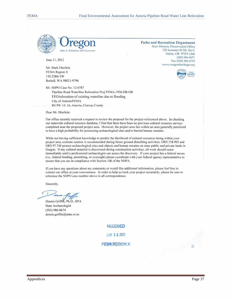
FEMA Final Environmental Assessment for Astoria Pipeline Road Water Line Relocation
Appendices Page 37